| THE English and French In North America 1689-1763 |
|
NARRATIVE AND CRITICAL
HISTORY OF AMERICA
EDITED
By JUSTIN WINSOR
LIBRARIAN OF HARVARD UNIVERSITY
CORRESPONDING SECRETARY MASSACHUSETTS HISTORICAL SOCIETY
VOL. V
BOSTON AND NEW YORK
HOUGHTON, MIFFLIN AND COMPANY
The Riverside Press, Cambridge
Copyright, 1887,
By HOUGHTON, MIFFLIN & CO.
All rights reserved.
The Riverside Press, Cambridge, Mass., U. S. A.
Electrotyped and Printed by H. O. Houghton & Company.
CONTENTS AND ILLUSTRATIONS.
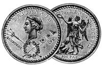
[The cut on the title shows the medal struck to commemorate the fall of Quebec.]
| CHAPTER I. | |
| PAGE | |
| Canada and Louisiana. Andrew McFarland Davis | 1 |
| Illustrations: La Présentation, 3; Autograph of Callières, 4; of Vaudreuil, 5; of Beauharnois, 7; of La Jonquière and of La Galissonière, 8; One of Céloron’s Plates, 9; Portrait of Lemoyne d’Iberville, with Autograph, 15; Environs du Mississipi (1700), 22; Portrait of Bienville, with Autograph, 26; Autograph of Lamothe, 29; of Lepinay, 31; Fac-simile of Bill of the Banque Royale, 34; Plans of New Orleans, 37, 38; View of New Orleans, 39; Map of the Mississippi, near New Orleans, 41; Fort Rosalie and Environs, 47; Plan of Fort Chartres, 54; Autograph of Vaudreuil, 57. | |
| Critical Essay | 63 |
| Illustrations: Autograph of La Harpe, 63; Portrait of Charlevoix, with Autograph, 64; Autograph of Le Page, 65; Map of the Mouths of the Mississippi, 66; Autograph of De Vergennes, 67; Coxe’s Map of Carolana, 70. | |
| Editorial Notes | 75 |
| Illustrations: Portrait of John Law, 75; his Autograph, 76. | |
| CARTOGRAPHY OF LOUISIANA AND THE MISSISSIPPI BASIN UNDER THE FRENCH DOMINATION. The Editor | 79 |
| Illustrations: Map of Louisiana, in Dumont, 82; Huske’s Map (1755), 84; Map of Louisiana, by Le Page du Pratz, 86. | |
| CHAPTER II. | |
| New England, 1689-1763. The Editor | 87 |
| Illustrations: Map of New England (1688), 88; Elisha Cooke, the Elder, 89; Seal of Massachusetts Province, 93; Bellomont, 97; Samuel Sewall, 100; Hertel, Seigneur de Rouville, 106; The Four Maquas (Indians), opp. 107; Draft of Boston Harbor, opp. 108; Ground Plan of Castle William, opp. 108; British Soldiers (1701-1714), 109; Gurdon Saltonstall, with Autograph, 112; William Dummer, 114; Jeremiah Dummer, 115; Elisha Cooke, the Younger, [iv]117; Thomas Prince, 122; Boston Light and Province Sloop, 123; Increase Mather, 125; Mather Byles, 128; George II., 130; Popple’s Map of New England, 134; An English Fleet, 136; Benjamin Pollard, 138; Autograph of Benning Wentworth, 139; Portrait and Autograph of George Berkeley, 140; William Shirley, 142; Popple’s Chart of Boston Harbor, 143. | |
| Critical Essay. The Editor | 156 |
| Illustrations: Hannah Adams, 160; John Gorham Palfrey, 161. | |
| Editorial Notes | 164 |
| Illustrations: Rhode Island Twelve-Pence Bill, 172; Rhode Island Three-Shillings Bill, 173; New Hampshire Five-Shillings Bill, 174; New Hampshire Three-Pounds Bill, 175; Plan of Fort Halifax, 182; Autograph of Wm. Lithgow, 182; of Jabez Bradbury, 183; Flanker of Fort Halifax, 183; Restoration of Fort Halifax, 184; Block House (1714), 185; Plans of Fort Anson, 187. | |
| CHAPTER III. | |
| Middle Colonies. Berthold Fernow | 189 |
| Illustrations: Autograph of Jacob Leisler, 189; of Lord Cornbury, 192; of Governor Fletcher, with Seal, 194; of Lovelace, 196; of Governor Hunter, with Seal, 196; of Rip van Dam, 198; of Governor Clinton, with Seal, 202; of Governor James De Lancey, with Seal, 205; of Governor Cadwallader Colden, with Seal, 206; of Governor Robert Monckton, with Seal, 206. | |
| Critical Essay. (Manuscript sources, by Mr. Fernow) | 231 |
| (Cartography and Boundaries of the Middle Colonies, by Mr. Fernow and the Editor) | 233 |
| Illustrations: Cadwallader Colden’s Map in fac-simile, 237; Map of Pennsylvania (1756), 239. | |
| Editorial Notes | 240 |
| Illustrations: Autograph of Daniel Horsmanden, 242; Views of New York (1732), 250; (1746), 251; (1761), 251; Plans of New York City (1695), 253; of New York and Perth Amboy Harbor (1732), 254; of New York (1755), 255; (1763), 256; (1764, by Bellin), 257; Heap’s East Prospect of Philadelphia (1754-1761), 258. | |
| CHAPTER IV. | |
| Maryland and Virginia. The Editor | 259 |
| Illustrations: Frederick, Lord Baltimore, 262; Alexander Spotswood, 266; Robert Dinwiddie, with Autograph, 269. | |
| Critical Essay | 270 |
| Illustrations: Map of Maryland, opp. 273; Map of Virginia (1738), 274; William Byrd, 275; Map of Northern Neck of Virginia (1736-1737), 277; William and Mary College, 279; Autograph of Hugh Jones, 280; Map of Part of Colonial Virginia, opp. 280; Fac-simile of Title of Apostolic Charity, by Thomas Bray (1700), 283. | |
| CHAPTER V.[v] | |
| The Carolinas. William J. Rivers | 285 |
| Illustrations: Map of North Carolina (1663-1729), 285; Autographs of the Lords Proprietors (Clarendon, Ashley, Albemarle, G. Carteret, Craven, John Berkeley, Will. Berkeley, James Colleton), 287; Map of Cooper and Ashley Rivers, 315; Plan of Charlestown, S. C. (1732), 330; View of Charlestown (1742), 331. | |
| Critical Essay. The Editor | 335 |
| Illustrations: Autograph of John Locke, 336; Shapley’s Sketch-Map of the Carolina Coast (1662), 337; Map (1666), 338; Lederer’s Map (1669-1670), 339; Morden’s Map (1687), 341; Plan of Charlestown (1704), 343; Autographs of John Archdale and John Oldmixon, 344; Carolina War-Map (1711-1715), 346; Indian Map of South Carolina (1730), 349; Moll’s Map of Carolina (1730), 351; Autograph of George Chalmers, 353. | |
| NOTE ON THE LATER HISTORIES OF CAROLINA. The Editor | 354 |
| CHAPTER VI. | |
| The English Colonization of Georgia, 1733-1752. Charles C. Jones, Jr. | 357 |
| Illustrations: General Oglethorpe, 362; Map of South Carolina and Georgia (1733), 365; Early View of Savannah, 368; Tomo-chi-chi Mico, 371; Map of the County of Savannah (Urlsperger), 373; Map of Coast Settlements before 1743, 375; Map of Coast from St. Augustine to Charlestown, S. C., with Map of Simon’s Island (Urlsperger), 379; Plan of St. Augustine (1763), 381; Map of Coast of Florida (1742), 382; Map of Harbor and Town of St. Augustine (1742), 383; Whitefield, 388. | |
| Critical Essay | 392 |
| Illustration: Handwriting of Oglethorpe, 393. | |
| CHAPTER VII. | |
| The Wars on the Seaboard: Acadia and Cape Breton. Charles C. Smith | 407 |
| Illustration: A French Frigate, 412. | |
| Critical Essay | 418 |
| AUTHORITIES ON THE FRENCH AND INDIAN WARS OF NEW ENGLAND AND ACADIA, 1688-1763. The Editor | 420 |
| Illustrations: Autographs of John Gyles, 421; of Francis Nicholson and Samuel Vetch, 422; View of Annapolis Royal, 423; Autographs of Vaudreuil, 424; of the Signers of the Conference, January 16, 1713-14 (J. Dudley, Francis Nicholson, William Tailer, W. Winthrop, Elisha Hutchinson, Samuel Sewall, J. Addington, Em. Hutchinson, Penn Townsend, Andrew Belcher, Edw. Bromfield, Ichabod Plaisted), 425; Fac-simile of the Title of Penhallow’s History [vi](1726), 426; of Church’s Entertaining Passages (1716), 427; Bellin’s Map of Port Royal, 428; View of Gut of Annapolis, 429; Autograph of Thomas Westbrook, 430; of John Lovewell, 431; Plan of Lovewell’s Fight, 433; Autographs of R. Auchmuty and W. Vaughan, 434; Portrait of Sir William Pepperrell, with Autograph, 435; his Arms, 436; Autographs of Edward Tyng and John Rous, 437; Gibson’s Picture of the Siege of Louisbourg, fac-simile, opp. 437; Autograph of Peter Warren, 439; of Richard Gridley, 440; Bellin’s Map of Cape Breton (1746), 440; Gridley’s Plan of Louisbourg (1745), 441, 442, 443; Plan of Attack on Louisbourg (1745), 444; Map of the Siege (1745), 445; Pepperrell’s Plan of the Siege (1745), 446; View of Louisbourg, 447; Plan of Island Battery, 448; View of the Entrance of Mines Basin, 449; View of Cape Baptist, 449; Autograph of Paul Mascarene, 450; Plan of Forts Beauséjour and Gaspereau, 451; Autograph of Charles Lawrence, 452; Map of Fort Beauséjour and Adjacent Country, 453; Colonel Monckton, with Autograph, 454; Autograph of John Winslow, 455; his Portrait, 456; Autograph of Colonel Murray, 460; Admiral Boscawen, with Autograph, 464; Map of Siege of Louisbourg (1758), 465; Views of Louisbourg and Harbor, 466; Portrait of General Wolfe, 467; Plan of Siege of Louisbourg (1758), 468, 469; Plan of the Attack, 470. | |
| MAPS AND BOUNDS OF ACADIA. The Editor | 472 |
| Illustrations: Lahontan’s Map of Acadia, 473; Map of the French Claim (1755), 478; of the English Claim (1755), 479; Jefferys’ Map of Nova Scotia, 480-481. | |
| CHAPTER VIII. | |
| The Struggle for the Great Valleys of North America. The Editor | 483 |
| Illustrations: French Soldier (1700), 484; British Infantry Soldier (1725), 485; Popple’s Map of Lakes Champlain and George (1732), 486; View of Quebec (1732), 488; British Footguard (1745), 489; French Soldier (1745), 489; Colden’s Map of the Region of the Great Lakes, 491; Autographs of Duquesne, 492; of Contrecœur, 493; of Jumonville, 493; of Villiers, 494; French Soldiers (1755), 497; Map of Fort Duquesne and Vicinity, 497; Contemporary Plan of Braddock’s Defeat, 499; Autograph of Sir William Johnson, 502; his Portrait, 503; Autograph of Montcalm, 505; Portraits of Lord Loudon, 506, 507; Plan of Albany, 508; Plan of Fort Frederick at Albany, 509; Autograph of Loudon, 510; The Forts at Oswego, 511; Fort Edward and Vicinity, 512, 513, 514; Fort St. Jean, 515; Fort William Henry, 516; View of the Site of Fort William Henry, 517; Plan of Attack on Fort William Henry, 518; Fort at German Flats, 519; Autograph of James Abercromby, 521; Lord Howe, 522; View of Ticonderoga, 523; Plan of Attack on Ticonderoga (1758), 524; Fort Frontenac, 525; Mante’s Map of Lake George, 526; Autograph of Jeff. Amherst, 527; Fort Stanwix, 528; Autographs of Generals Forbes and Vaudreuil, 530; Portrait of General Amherst, 531; Fort Pitt, 532; The New Fort Pitt, 533; Fort Niagara, 534; Fort George on Lake George, 535; Modern Map of Lake George, 536; Plan of Ticonderoga, 537; of Crown Point, 537; View of the Ruins of Crown Point, 538; Plan of Isle-aux-Noix, 539; Portrait of General Wolfe, 541; Plan of the Siege of Quebec (1759), 542; Contemporary Plan of Quebec, 543; Bougainville, 546; British Soldiers, 547; Montcalm, 548; Plan of Quebec as Surrendered, 549; View of Heights of Abraham, with Wolfe’s Monument, 551; Map of the Campaign of Lévis and Murray, 552; Plan of Quebec (1763), 553; View of Montreal (1761), 554; Plans of Montreal (1763, 1758 ), 555, 556; Map of Routes to Canada (1755-1763), 557; Robert Rogers, 558. | |
| Critical Essay[vii] | 560 |
| Illustrations: French Soldiers (1710), 562; Bonnecamp’s Map, 569; Fort Cumberland and Vicinity, 577; Contemporary Map of Dieskau’s Campaign, 585; Clement’s Plan of the Battle of Lake George, 586; Map of Forts George and Ticonderoga (1749-1760), 588; Crown Point Currency of New Hampshire, 590; General Townshend, 607. | |
| Notes | 611 |
| Illustrations: Autograph of William Smith, 618; Portrait of Garneau, 619; of James Grahame, 620. | |
| INDEX | 623 |
NARRATIVE AND CRITICAL
HISTORY OF AMERICA.
CHAPTER I.
CANADA AND LOUISIANA.
BY ANDREW McFARLAND DAVIS,
American Antiquarian Society.
THE story of the French occupation in America is not that of a people slowly moulding itself into a nation. In France there was no state but the king; in Canada there could be none but the governor. Events cluster around the lives of individuals. According to the discretion of the leaders the prospects of the colony rise and fall. Stories of the machinations of priests at Quebec and at Montreal, of their heroic sufferings at the hands of the Hurons and the Iroquois, and of individual deeds of valor performed by soldiers, fill the pages of the record. The prosperity of the colony rested upon the fate of a single industry,—the trade in peltries. In pursuit of this, the hardy trader braved the danger from lurking savage, shot the boiling rapids of the river in his light bark canoe, ventured upon the broad bosom of the treacherous lake, and patiently endured sufferings from cold in winter and from the myriad forms of insect life which infest the forests in summer. To him the hazard of the adventure was as attractive as the promised reward. The sturdy agriculturist planted his seed each year in dread lest the fierce war-cry of the Iroquois should sound in his ear, and the sharp, sudden attack drive him from his work. He reaped his harvest with urgent haste, ever expectant of interruption from the same source, always doubtful as to the result until the crop was fairly housed. The brief season of the Canadian summer, the weary winter, the hazards of the crop, the feudal tenure of the soil,—all conspired to make the life of the farmer full of hardship and barren of promise. The sons of the early settlers drifted to the woods as independent hunters and traders. The parent State across the water, which undertook to say who might trade, and[2] where and how the traffic should be carried on, looked upon this way of living as piratical. To suppress the crime, edicts were promulgated from Versailles and threats were thundered from Quebec. Still, the temptation to engage in what Parkman calls the “hardy, adventurous, lawless, fascinating fur-trade” was much greater than to enter upon the dull monotony of ploughing, sowing, and reaping. The Iroquois, alike the enemies of farmer and of trader, bestowed their malice impartially upon the two callings, so that the risk was fairly divided. It was not surprising that the life of the fur-trader “proved more attractive, absorbed the enterprise of the colony, and drained the life-sap from other branches of commerce.” It was inevitable, with the young men wandering off to the woods, and with the farmers habitually harassed during both seed-time and harvest, that the colony should at times be unable to produce even grain enough for its own use, and that there should occasionally be actual suffering from lack of food. It often happened that the services of all the strong men were required to bear arms in the field, and that there remained upon the farms only old men, women, and children to reap the harvest. Under such circumstances want was sure to follow during the winter months. Such was the condition of affairs in 1700. The grim figure of Frontenac had passed finally from the stage of Canadian politics. On his return, in 1689, he had found the name of Frenchman a mockery and a taunt.[1] The Iroquois sounded their threats under the very walls of the French forts. When, in 1698, the old warrior died, he was again their “Onontio,” and they were his children. The account of what he had done during those years was the history of Canada for the time. His vigorous measures had restored the self-respect of his countrymen, and had inspired with wholesome fear the wily savages who threatened the natural path of his fur-trade. The tax upon the people, however, had been frightful. A French population of less than twelve thousand had been called upon to defend a frontier of hundreds of miles against the attacks of a jealous and warlike confederacy of Indians, who, in addition to their own sagacious views upon the policy of maintaining these wars, were inspired thereto by the great rival of France behind them.
To the friendship which circumstances cemented between the English and the Iroquois, the alliance between the French and the other tribes was no fair offset. From the day when Champlain joined the Algonquins and aided them to defeat their enemies near the site of Ticonderoga, the hostility of the great Confederacy had borne an important part in the history of Canada. Apart from this traditional enmity, the interests of the Confederacy rested with the English, and not with the French. If the Iroquois permitted the Indians of the Northwest to negotiate with the French, and interposed no obstacle to the transportation of peltries from the upper lakes to Montreal and Quebec, they would forfeit all the commercial benefits which belonged to their geographical position. Thus their natural tendency was to join with the English. The value of neutrality was[3] plain to their leaders; nevertheless, much of the time they were the willing agents of the English in keeping alive the chronic border war.

LA PRÉSENTATION.
[After a plan in the contemporary Mémoires sur le Canada, 1749-1760, published by the Literary and Historical Society of Quebec (réimpression), 1873, p. 13.—Ed.]
Nearly all the Indian tribes understood that the conditions of trade were better with the English than with the French; but the personal influence of the French with their allies was powerful enough partially to overcome this advantage of their rivals. This influence was exercised not only[4] through missionaries,[2] but was also felt through the national characteristics of the French themselves, which were strongly in harmony with the spirit of forest life. The Canadian bushrangers appropriated the ways and the customs of the natives. They were often adopted into the tribes, and when this was done, their advice in council was listened to with respect. They married freely into the Indian nations with whom they were thrown; and the offspring of these marriages, scattered through the forests of the Northwest, were conspicuous among hunters and traders for their skill and courage. “It has been supposed for a long while,” says one of the officers of the colony, “that to civilize the savages it was necessary to bring them in contact with the French. We have every reason to recognize the fact that we were mistaken. Those who have come in contact with us have not become French, while the French who frequent the wilds have become savages.” Prisoners held by the Indians often concealed themselves rather than return to civilized life, when their surrender was provided for by a treaty of peace.[3]

Powerful as these influences had proved with the allies of the French, no person realized more keenly than M. de Callières, the successor of Frontenac, how incompetent they were to overcome the natural drift of the Iroquois to the English. He it was who had urged at Versailles the policy of carrying the war into the province of New York as the only means of ridding Canada of the periodic invasions of the Iroquois.[4] He had joined with Frontenac in urging upon the astute monarch who had tried the experiment of using Iroquois as galley-slaves, the impolicy of abandoning the posts at Michilimakinac and at St. Joseph. His appointment was recognized as suitable, not only by the colonists, but also by Charlevoix, who tells us that “from the beginning he had acquired great influence over the savages, who recognized in him a man exact in the performance of his word, and who insisted that others should adhere to promises given to him.” He saw accomplished what Frontenac had labored for,—a peace with the Iroquois in which the allied tribes were included. The Hurons, the Ottawas, the Abenakis, and the converted Iroquois having accepted the terms of the peace, the Governor-General, the Intendant, the Governor of Montreal, and the ecclesiastical authorities signed a provisional treaty on the 8th of September, 1700. In 1703, while the Governor still commanded the confidence of his countrymen, his career was cut short by death.

The reins of government now fell into the hands of Philippe de Vaudreuil, who retained the position of governor until his death. During the entire period of his administration Canada was free from the horrors of Indian invasion. By his adroit management, with the aid of Canadians adopted by the tribes, and of missionaries, the Iroquois were held in check. The scene in which startled villagers were roused from their midnight slumber by the fierce war-whoop, the report of the musket, and the light of burning dwellings, was transferred from the Valley of the St. Lawrence to New England. Upon Vaudreuil must rest the responsibility for the attacks upon Deerfield in 1704 and Haverhill in 1708, and for the horrors of the Abenakis war. The pious Canadians, fortified by a brief preliminary invocation of Divine aid, rushed upon the little settlements and perpetrated cruelties of the same class with those which characterized the brutal attacks of the Iroquois upon the villages in Canada. The cruel policy of maintaining the alliance with the Abenakis, and at the same time securing quiet in Canada by encouraging raids upon the defenceless towns of New England, not only left a stain upon the reputation of Vaudreuil, but it also hastened the end of French power in America by convincing the growing, prosperous, and powerful colonies known as New England that the only path to permanent peace lay through the downfall of French rule in Canada.[5]
Aroused to action by Canadian raids, the New England colonies increased their contributions to the military expeditions by way of Lake Champlain and the St. Lawrence, which had become and remained, until Wolfe’s success obviated their necessity, the recognized method of attack on Canada. During Vaudreuil’s time these expeditions were singularly unfortunate. Some extraneous incident protected Quebec each year.[6] It is not strange that such disasters to the English were looked upon by the pious French as a special manifestation of the interest taken in Canada by the Deity. Thanks were given in all parts of the colony to God, who had thus directly saved the province, and special fêtes were celebrated in honor of Notre Dame des Victoires.
The total population of Canada at this time was not far from eighteen thousand. The English colonies counted over four hundred thousand inhabitants. The French Governor, in a despatch to M. de Pontchartrain, called attention, in 1714, to the great disproportion of strength between the French and English settlements, and added that there could be little doubt that on the occasion of the first rupture the English would make a powerful effort to get possession of Canada. The English colonies were in themselves strong enough easily to have overthrown the French in America. In addition, they were supported by the Home Government; while Louis XIV., defeated, humiliated, baffled at every turn, was compelled supinely[6] to witness these extraordinary efforts to wrest from him the colonies in which he had taken such personal interest. Well might the devout Canadian offer up thanks for his deliverance from the defeat which had seemed inevitable! Well might he ascribe it to an interposition of Divine Providence in his behalf! Under the circumstances we need not be surprised that a learned prelate should chronicle the fact that the Baron de Longueuil, before leaving Montreal in command of a detachment of troops, “received from M. de Belmont, grand vicaire, a flag around which that celebrated recluse, Mlle. Le Ber, had embroidered a prayer to the Holy Virgin,” nor that it should have been noticed that on the very day on which was finished “a nine days’ devotion to Notre Dame de Pitié,” the news of the wreck of Sir Hovenden Walker’s fleet reached Quebec.[7] Such coincidences appeal to the imagination. Their record, amid the dry facts of history, shows the value which was attached to what Parkman impatiently terms this “incessant supernaturalism.” To us, the skilful diplomacy of Vaudreuil, the intelligent influence of Joncaire (the adopted brother of the Senecas), the powerful aid of the missionaries, the stupid obstinacy of Sir Hovenden Walker, and certain coincidences of military movements in Europe at periods critical for Canada, explain much more satisfactorily the escape of Canada from subjection to the English during the period of the wars of the Spanish Succession.
Although Vaudreuil could influence the Iroquois to remain at peace, he could not prevent an outbreak of the Outagamis at Detroit. This, however, was easily suppressed. The nominal control of the trade of the Northwest remained with the French; but the value of this control was much reduced by the amount of actual traffic which drifted to Albany and New York, drawn thither by the superior commercial inducements offered by the English.
The treaty of Utrecht, in 1713, established the cession of Acadia to the English by its “ancient limits.” When the French saw that the English pretension to claim by these words all the territory between the St. Lawrence River and the ocean, was sure to cut them off by water from their colony at Quebec, in case of another war, they on their part confined such “ancient limits” to the peninsula now called Nova Scotia. France, to strengthen the means of maintaining her interpretation, founded the fortress and naval station of Louisbourg.
About the same time the French also determined to strengthen the fortifications of Quebec and Montreal; and in 1721 Joncaire established a post among the Senecas at Niagara.[8]
In 1725 Vaudreuil died. Ferland curtly says that the Governor’s wife was the man of the family; but so far as the record shows, the preservation[7] of Canada to France during the earlier part of his administration was largely due to his vigilance and discretion. Great judgment and skill were shown in dealing with the Indians. A letter of remonstrance from Peter Schuyler bears witness that contemporary judgment condemned his policy in raiding upon the New England colonies; but in forming our estimate of his character we must remember that the French believed that similar atrocities, committed by the Iroquois in the Valley of the St. Lawrence, were instigated by the English.

The administration[9] of M. de Beauharnois, his successor, who arrived in the colony in 1726, was not conspicuous. He appears to have been personally popular, and to have appreciated fairly the needs of Canada. The Iroquois were no longer hostile. The days of the martyrdom of the Brebeufs and the Lallemands were over.[10] In the Far West a company of traders founded a settlement at the foot of Lake Pepin, which they called Fort Beauharnois. As the trade with the Valley of the Mississippi developed, routes of travel began to be defined. Three of these were especially used,—one by way of Lake Erie, the Maumee, and the Wabash, and then down the Ohio; another by way of Lake Michigan, the Chicago River, a portage to the Illinois, and down that river; a third by way of Green Bay, Fox River, and the Wisconsin,—all three being independent of La Salle’s route from the foot of Lake Michigan to the Kankakee and Illinois rivers.[11] By special orders from France, Joncaire’s post at Niagara had been regularly fortified. The importance of this movement had been fully appreciated by the English. As an offset to that post, a trading establishment had been opened at Oswego; and now that a fort was built at Niagara, Oswego was garrisoned. The French in turn constructed a fort at Crown Point, which threatened Oswego, New York, and New England.
The prolonged peace permitted considerable progress in the development of the agricultural resources of the country. Commerce was extended as much as the absurd system of farming out the posts, and the trading privileges retained by the governors, would permit. Postal arrangements were established between Montreal and Quebec in 1721. The population at that time was estimated at twenty-five thousand. Notwithstanding the[8] evident difficulty experienced in taking care of what country the French then nominally possessed, M. Varenne de Vérendrye in 1731 fitted out an expedition to seek for the “Sea of the West,”[12] and actually penetrated to Lake Winnipeg.
The foundations of society were violently disturbed during this administration by a quarrel which began in a contest over the right to bury a dead bishop. Governor, Intendant, council, and clergy took part. “Happily,” says a writer to whom both Church and State were dear, “M. de Beauharnois did not wish to take violent measures to make the Intendant obey him, otherwise we might have seen repeated the scandalous scenes of the evil days of Frontenac.”

After the fall of Louisbourg, in 1745, Beauharnois was recalled, and Admiral de la Jonquière was commissioned as his successor; but he did not then succeed in reaching his post. It is told in a later chapter how D’Anville’s fleet, on which he was embarked, was scattered in 1746; and when he again sailed, the next year, with other ships, an English fleet captured him and bore him to London.
In consequence of this, Comte de la Galissonière was appointed Governor of Canada in 1747. His term of office was brief; but he made his mark as one of the most intelligent of those who had been called upon to administer the affairs of this government. He proceeded at once to fortify the scattered posts from Lake Superior to Lake Ontario. He forwarded to France a scheme for colonizing the Valley of the Ohio; and in order to protect the claims of France to this vast region, he sent out an expedition,[13] with instructions to bury at certain stated points leaden plates upon which were cut an assertion of these claims. These instructions were fully carried out, and depositions establishing the facts were executed and transmitted to France. He notified the Governor of Pennsylvania of the steps which had been taken, and requested him to prevent his people from trading beyond the Alleghanies,[14][9] as orders had been given to seize any English merchants found trading there. An endeavor was made to establish at Bay Verte a settlement which should offset the growing importance of Halifax, founded by the English. The minister warmly supported La Galissonière in this, and made him a liberal money allowance in aid of the plan. While busily engaged upon this scheme, he was recalled. Before leaving, he prepared for his successor a statement of the condition of the colony and its needs.[15]

FAC-SIMILE OF ONE OF CÉLORON’S PLATES, 1749.
[Reduced from the fac-simile given in the Pennsylvania Archives, second series, vi. 80. Of some of these plates which have been found, see accounts in Parkman, Montcalm and Wolfe, i. 62, and Dinwiddie Papers, i. 95, published by the Virginia Historical Society. Cf. also Appendix A to the Mémoires sur le Canada depuis 1749 jusqu’à 1760, published by the Literary and Historical Society of Quebec, 1873 (réimpression).—Ed.]
By the terms of the peace of Aix-la-Chapelle, France in 1748 acquired possession of Louisbourg. La Jonquière, who was at the same time liberated, and who in 1749 assumed the government under his original appointment, did not agree with the Acadian policy of his predecessor. He feared the consequences of an armed collision with the English in Nova Scotia, which this course was likely to precipitate. This caution on his part brought down upon him a reprimand from Louis XV. and positive orders to[10] carry out La Galissonière’s programme. In pursuance of these instructions, the neck of the peninsula, which according to the French claim formed the boundary of Acadia, was fortified. The conservatism of the English officer prevented a conflict. In 1750, avoiding the territory in dispute, the English fortified upon ground admitted to be within their own lines, and watched events. On the approach of the English, the unfortunate inhabitants of Beaubassin abandoned their homes and sought protection under the French flag.
Notwithstanding the claims to the Valley of the Ohio put forth by the French, the English Government in 1750 granted to a company six hundred thousand acres of land in that region; and English colonial governors continued to issue permits to trade in the disputed territory. Following the instructions of the Court, as suggested by La Galissonière, English traders were arrested, and sent to France as prisoners. The English, by way of reprisal, seized French traders found in the same region.[16] The treaty of Aix-la-Chapelle had provided for a commission to adjust the boundaries between the French and the English possessions. By the terms of the treaty, affairs were to remain unchanged until the commission could determine the boundaries between the colonies. Events did not stand still during the deliberations of the commission; and the doubt whether every act along the border was a violation of the treaty hung over the heads of the colonists like the dispute as to the boundaries of Acadia, which was a constant threat of war. The situation all along the Acadian frontier and in the Valley of the Ohio was now full of peril. To add to the difficulty of the crisis in Canada, the flagrant corruption of the Intendant Bigot, with whom the Governor was in close communication, created distrust and dissatisfaction. Charges of nepotism and corruption were made against La Jonquière. The proud old man demanded his recall; but before he could appear at Court to answer the charges, chagrin and mortification caused his wounds to open, and he died on the 17th of May, 1752. Thereupon the government fell to the Baron de Longueuil till a new governor could arrive.
Bigot, whose name, according to Garneau, will hereafter be associated with all the misfortunes of France upon this continent, was Intendant at Louisbourg at the time of its fall. Dissatisfaction with him on the part of the soldiers at not receiving their pay was alleged as an explanation of[11] their mutinous behavior. He was afterward attached to the unfortunate fleet which was sent out to recapture the place. Later his baneful influence shortened the days and tarnished the reputation of La Jonquière.
In July, 1752, the Marquis Duquesne de Menneville assumed charge of the government, under instructions to pursue the policy suggested by La Galissonière. He immediately held a review of the troops and militia. At that time the number of inhabitants capable of bearing arms was about thirteen thousand. There existed a line of military posts from the St. Lawrence to the Mississippi, composed of Quebec, Montreal, Ogdensburg, Kingston, Toronto, Detroit, the Miami River, St. Joseph, Chicago, and Fort Chartres. The same year that Duquesne was installed, he took preliminary steps toward forwarding troops to occupy the Valley of the Ohio, and in 1753 these steps were followed by the actual occupation in force of that region. Another line of military posts was erected, with the intention of preventing the English from trading in that valley and of asserting the right of the French to the possession of the tributaries of the Mississippi. This line began at Niagara, and ultimately comprehended Erie, French Creek,[17] Venango, and Fort Duquesne. All these posts were armed, provisioned, and garrisoned.
All French writers agree in calling the peace of Aix-la-Chapelle a mere truce. If the sessions of the commissioners appointed to determine the boundaries upon the ante-bellum basis had resulted in aught else than bulky volumes,[18] their decision would have been practically forestalled by the French in thus taking possession of all the territory in dispute. To this, however, France was impelled by the necessities of the situation. Unless she could assume and maintain this position, the rapidly increasing population of the English colonies threatened to overflow into the Valley of the Ohio; and the danger was also imminent that the French might be dispossessed from the southern tributaries of the St. Lawrence. Once in possession, English occupation would be permanent. The aggressive spirit of La Galissonière had led him to recommend these active military operations, which, while they tended to provoke collision, could hardly fail to check the movement of colonization which threatened the region in dispute. On the Acadian peninsula the troops had come face to face without bloodshed. The firmness of the French commander in asserting his right to occupy the territory in question, the prudence of the English officer, the support given to the French cause by the patriotic Acadians, the military weakness of the English in Nova Scotia,—all conspired to cause the English to submit to the offensive bearing of the French, and to avoid in that locality the impending collision. It was, however, a mere postponement[12] in time and transfer of scene. The gauntlet thrown down at the mouth of the St. Lawrence was to be taken up at the headwaters of the Ohio.
The story of the interference of Lieutenant-Governor Dinwiddie; of George Washington’s lonely journey in 1753 across the mountains with Dinwiddie’s letter; of the perilous tramp back in midwinter with Saint-Pierre’s reply; of the return next season with a body of troops; of the collision with the detachment of the French under Jumonville; of the little fort which Washington erected, and called Fort Necessity, where he was besieged and compelled to capitulate; of the unfortunate articles of capitulation which he then signed,—the story of all these events is familiar to readers of our colonial history; but it is equally a portion of the history of Canada.[19] The act of Dinwiddie in precipitating a collision between the armed forces of the colonies and those of France was the first step in the war which was to result in driving the French from the North American continent. The first actual bloodshed was when the men under Washington met what was claimed by the French to be a mere armed escort accompanying Jumonville to an interview with the English. He who was to act so important a part in the war of the American Revolution was, by some strange fatality, the one who was in command in this backwoods skirmish. In itself the event was insignificant; but the blow once struck, the question how the war was to be carried on had to be met. The relations of the colonies to the mother country, and the possibility of a confederation for the purpose of consolidating the military power and adjusting the expenses, were necessarily subjects of thought and discussion which tended toward co-operative movements dangerous to the parent State. Thus in its after-consequences that collision was fraught with importance. Bancroft says it “kindled the first great war of revolution.”
The collision which had taken place could not have been much longer postponed. The English colonies had grown much more rapidly than the French. They were more prosperous. There was a spirit of enterprise among them which was difficult to crush. They could not tamely see themselves hemmed in upon the Atlantic coast and cut off from access to the interior of the continent by a colony whose inhabitants did not count a tenth part of their own numbers, and with whom hostility seemed an hereditary necessity. It mattered not whether the rights of discovery and prior occupation, asserted by the French, constituted, according to the law of nations, a title more or less sound than that which the English claimed through Indian tribes whom the French had by treaty recognized as British subjects. The title held by the strongest side would be better than the title based upon international law. Events had already anticipated politics. The importance of the Ohio Valley to the English colonies as an outlet to their growing population had been forced upon their attention.[13] To the French, who were just becoming accustomed to its use as a highway for communication between Canada and Louisiana, the growth of the latter colony was a daily instruction as to its value.
The Louisiana which thus helped to bring the French face to face with their great rivals was described by Charlevoix as “the name which M. de La Salle gave to that portion of the country watered by the Mississippi which lies below the River Illinois.” This definition limits Louisiana to the Valley of the Mississippi; but the French cartographers of the middle of the eighteenth century put no boundary to the pretensions of their country in the vague regions of the West, concerning which tradition, story, and fable were the only sources of information for their charts. The claims of France to this indefinite territory were, however, considered of sufficient importance to be noticed in the document on the Northwestern Boundary question which forms the basis of Greenhow’s History of Oregon and California. The French were not disturbed by the pretensions of Spain to a large part of the same territory, although based upon the discovery of the Mississippi by De Soto and the actual occupation of Florida. Neither were the charters of those English colonies, which granted territory from the Atlantic to the Pacific, regarded as constituting valid claims to this region. France had not deliberately set out to establish a colony here. It was only after they were convinced at Versailles that Coxe, the claimant of the grant of “Carolana,” was in earnest in his attempts to colonize the banks of the Mississippi by way of its mouth, that this determination was reached. As late as the 8th of April, 1699, the Minister of the Marine wrote: “I begin by telling you that the King does not intend at present to form an establishment at the mouth of the Mississippi, but only to complete the discovery in order to hinder the English from taking possession there.” The same summer Pontchartrain told the Governor of Santo Domingo[20] that the “King would not attempt to occupy the country unless the advantages to be derived from it should appear to be certain.” La Salle’s expedition in 1682 had reached the mouth of the river. His Majesty had acquiesced in it without enthusiasm, and with no conviction of the possible value of the discovery. He had, indeed, stated that “he did not think that the explorations which the Canadians were anxious to make would be of much advantage. He wished, however, that La Salle’s should be pushed to a conclusion, so that he might judge whether it would be of any use.”
The presence of La Salle in Paris after he had accomplished the journey down the river had fired the imagination of the old King, and visions of Spanish conquests and of gold and silver within easy reach had made him listen readily to a scheme for colonization, and consent to fitting out an expedition by sea. When the hopes which had accompanied the discoverer on his outward voyage gave place to accounts of the disasters[14] which had pursued his expedition, it would seem that the old doubts as to the value of the Mississippi returned.[21] It was at this time that Henri de Tonty, most faithful of followers, asked that he might be appointed to pursue the discoveries of his old leader.[22] Tonty was doomed to disappointment. His influence at Court was not strong enough to secure the position which he desired. In 1697[23] the attention of the Minister of the Marine was called by Sieur Argoud to a proposition made by Sieur de Rémonville to form a company for the same purpose. The memorial of Argoud vouches for Rémonville as a friend of La Salle, sets forth at length the advantages to be gained by the expedition, explains in detail its needs, and gives a complete scheme for the formation of the proposed company. From lack of faith or lack of influence this proposition also failed. It required the prestige of Iberville’s name, brought to bear in the same direction, to carry the conviction necessary for success.
Pierre Le Moyne d’Iberville was a native of Canada. He was born on the 16th of July, 1661,[24] and was reared to a life of adventure. His name and the names of his brothers, under the titles of their seigniories, are associated with all the perilous adventure of the day in their native land. They were looked upon by the Onondagas as brothers and protectors, and their counsel was always received with respect. Maricourt, who was several times employed upon important missions to the Iroquois, was known among them under the symbolic name of Taouistaouisse, or “little bird which is always in motion.” In 1697, when Iberville urged upon the minister the arguments which suggested themselves to him in favor of an expedition in search of the mouth of the Mississippi, he had already gained distinction in the Valley of the St. Lawrence, upon the shores of the Atlantic, and on the waters of Hudson’s Bay.[25] The tales of his wonderful successes on land and on sea tax the credulity of the reader; and were it not for the concurrence of testimony, doubts would creep in as to their truth. It seemed as if the young men of the Le Moyne family felt that with the death of Frontenac the days of romance and adventure had ended in Canada; that for the time being, at least, diplomacy was to succeed daring, and thoughts of trade at Quebec and Montreal were to take the place of plans for the capture of Boston and New York. To them the possibility of collision with Spaniards or Englishmen was an inducement rather than a drawback. Here perhaps, in explorations on the shores of the Gulf of Mexico, courage and audacity might find those rewards and honors for which the opportunity was fast disappearing in Canada. Inspired[15] by such sentiments, the enthusiasm of Iberville overcame the reserve of the King. The grandeur of the scheme began to attract his attention. It was clear that the French had not only anticipated the English in getting possession of the upper waters of the great river, but their boats had navigated its current from source to mouth.
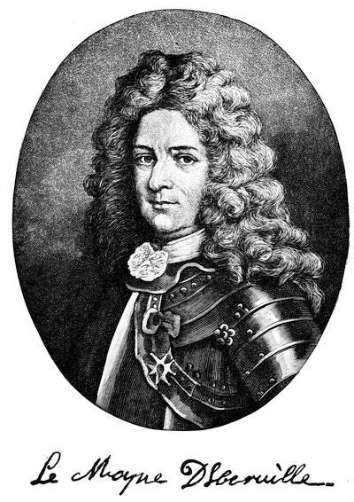
[This follows an engraving in Margry, vol. iv. J. M. Lemoine (Maple Leaves, 2d series, 1873, p. 1) styles him “The Cid of New France.”—Ed.]
If they could establish themselves at its entrance, and were able to control its navigation, they could hold the whole valley. Associated with these thoughts were hopes of mines in the distant regions of the upper Mississippi which might contribute to France wealth equal to that which Spain had drawn from Mexico. Visions of pearl-fisheries in the Gulf, and wild notions as to the[16] value of buffalo-wool, aided Iberville in his task of convincing the Court of the advantages to be derived from his proposed voyage.
In June, 1698, two armed vessels were designated for the expedition,—the “Badine,” which was put under the command of Iberville, and the “Marin,” under the Chevalier de Surgères. The correspondence between the Minister of the Marine and Iberville during the period of preparation shows that the Court earnestly endeavored to forward the enterprise.
Rumors were rife that summer at Rochelle that an expedition was fitting out at London[26] for the purpose of establishing a colony of French Protestants on the banks of the Mississippi. On the 18th of June Iberville wrote to the Minister to warn him of the fact. He had turned aside as a joke, he says, the rumors that his expedition was bound to the Mississippi, and he suggests that orders be sent him to proceed to the River Amazon, with which he could lay such stories at rest and deceive the English as to his movements. The instructions with which he was provided allege that he was selected for the command because of his previous record. He was left free to prosecute his search for the mouth of the river according to his own views. After he should have found it, he was to fortify some spot which should command its entrance. He was to prevent, at all hazards, any other nation from making a landing there. Should he find that be had been anticipated in the discovery, still he was to effect a landing if possible; and in case of inability to do so, he was to make a careful examination of affairs and report.
On the morning of the 24th of October, 1698,[27] the “Badine” and the “Marin” sailed from Brest, at which port they had put in after leaving Rochelle. They were accompanied by two transports, which formed a part of the expedition. The two frigates and one of the transports arrived at Santo Domingo on the 4th of December. The other transport arrived ten days after. The frigate “François,” under Chasteaumorand, was here added to the fleet as an escort to the American coast. On the 31st of December they sailed from Santo Domingo, and on the 23d of January, 1699, at half-past four in the evening, land was seen distant eight leagues to the northeast. In the evening fires were observed on shore. Pursuing a course parallel with the coast, they sailed to the westward by day and anchored each night. The shore was carefully reconnoitred with small[17] boats as they proceeded, and a record of the soundings was kept, of sufficient accuracy to give an idea of the approach to the coast. On the 26th they were abreast of Pensacola,[28] where they found two Spanish vessels at anchor, and the port in possession of an armed Spanish force, with whom they communicated. Still following the coast to the westward, they anchored on the 31st off the mouth of the Mobile River. Here they remained for several days, examining the coast and the islands. They called one of these islands Massacre Island, on account of the large number of human bones which they found upon it. Not satisfied with the roadstead, they worked along the coast, sounding and reconnoitring; and on the 10th of February came to anchor at a spot where the shelter of some islands furnished a safe roadstead. Preparations were at once begun for the work of exploration, and on the 13th Iberville left the ships for the mainland in a boat with eleven men. He was accompanied by his brother Bienville with two men in a bark canoe which formed part of their equipment. His first effort was to establish friendly relations with the natives. He had some difficulty in communicating with them, as his party was mistaken for Spaniards, with whom the Indians were not on good terms. His knowledge of Indian ways taught him how to conquer this difficulty. Leaving his brother and two Canadians as hostages in their hands, he succeeded on the 16th in getting some of the natives to come on board his ship, where he entertained them by firing off his cannons. On the 17th he returned to the spot where he had left his brother, and found him carrying on friendly converse with natives who belonged to tribes then living upon the banks of the Mississippi. The bark canoe puzzled them; and they asked if the party came from the upper Mississippi, which in their language they called the “Malbanchia.” Iberville made an appointment with these Indians to return with them to the river, and was himself at the rendezvous at the appointed time; but they failed him. Being satisfied now that he was near the mouth of the Mississippi, and that he had nothing to fear from the English, he told Chasteaumorand that he could return to Santo Domingo with the “François.” On the 21st that vessel sailed for the islands.
On the 27th the party which was to enter the mouth of the river left the ships. They had two boats, which they speak of as biscayennes, and two bark canoes. Iberville was accompanied by his brother Bienville, midshipman on the “Badine;” Sauvolle, enseigne de vaisseau on the “Marin;” the Récollet father Anastase, who had been with La Salle; and a party of men,—stated by himself in one place at thirty-three, and in another at forty-eight.[29]
On the afternoon of the 2d of March, 1699, they entered the river,—the Malbanchia of the Indians, the Palissado of the Spaniards, the Mississippi of to-day.
After a careful examination of the mouth of the river, at that time apparently in flood, Iberville set his little party at the hard work which was now before them, of stemming the current in their progress up the stream. His search was now directed toward identifying the river, by comparison with the published descriptions of Hennepin, and also by means of information contained in the Journal of Joutel,[30] which had been submitted to him in manuscript by Pontchartrain. At the distance, according to observations of the sun, of sixty-four leagues from the mouth of the river, he reached the village of the Bayagoulas, some of whom he had already seen. At this point his last doubt about the identity of the river was dissipated; for he met a chief of the Mougoulachas clothed in a cloak of blue serge, which he said was given to him by Tonty. With rare facility, Iberville had already picked up enough of the language of these Indians to communicate with them; and Bienville, who had brought a native up the river in his canoe, could speak the language passably well. “We talked much of what Tonty had done while there; of the route that he took and of the Quinipissas, who, they said, lived in seven villages, distant an eight days’ journey to the northeast of this village by land.” The Indians drew rude maps of the river and the country, showing that when Tonty left them he had gone up to the Oumas, and that going and coming he had passed this spot. They knew nothing of any other branch of the river. These things did not agree with Hennepin’s account, the truth of which Iberville began to suspect. He says that he knew that the Récollet father had told barefaced lies about Canada and Hudson’s Bay in his Relation, yet it seemed incredible that he should have undertaken to deceive all France on these points. However that might be, Iberville realized that the first test to be applied to his own reports would be comparison with other sources of information; and having failed to find the village of the Quinipissas and the island in the river, he must by further evidence establish the truth or the falsity of Hennepin’s account. This was embarrassing. The “Marin” was short of provisions, Surgères was anxious to return, the position for the settlement had not yet been selected, and the labor of rowing against the current was hard on the men, while the progress was very slow. Anxious as Iberville was to return, the reasons for obtaining further proof that he was on the Mississippi, with which to convince doubters in France, overcame his desires, and he kept on his course up the river. On the 20th he reached the village of the Oumas, and was gratified to learn that the memory of Tonty’s visit, and of the many presents which he had distributed, was still fresh in the minds of the natives. Iberville was now, according to his reckoning, about one hundred leagues up the river. He had been able to[19] procure for his party only Indian corn in addition to the ship’s provisions with which they started. His men were weary. All the testimony that he could procure concurred to show that the route by which Tonty came and went was the same as that which he himself had pursued, and that the division of the river into two channels was a myth.[31] With bitterness of spirit he inveighs against the Récollet, whose “false accounts had deceived every one. Time had been consumed, the enterprise hindered, and the men of the party had suffered in the search after purely imaginary things.” And yet, if we may accept the record of his Journal, this visit to the village of the Oumas was the means of his tracing the most valuable piece of evidence of French explorations in this vicinity which could have been produced. “The Bayagoulas,” he says, “seeing that I persisted in wishing to search for the fork and also insisted that Tonty had not passed by there, explained to me that he had left with the chief of the Mougoulachas a writing enclosed for some man who was to come from the sea, which was similar to one that I myself had left with them.” The urgency of the situation compelled Iberville’s return to the ships. On his way back he completed the circuit of the island on which New Orleans was afterward built, by going through the river named after himself and through Lake Pontchartrain. The party which accompanied him consisted of four men, and they travelled in two canoes. The two boats proceeded down the Mississippi, with orders to procure the letter from the Mougoulachas and to sound the passes at the mouth of the river.
On the 31st both expeditions reached the ships. Iberville had the satisfaction of receiving from the hands of his brother[32] the letter which Tonty had left for La Salle, bearing date, “At the village of the Quinipissas, April 20, 1685.”[33] The contents of the letter were of little moment, but its possession was of great value to Iberville. The doubts of the incredulous must yield to proof of this nature. Here was Tonty’s account of his trip down the river, of his search along the coast for traces of his old leader, and of his reluctant conclusion that his mission was a failure. In the midst of the clouds of treachery which obscure the last days of La Salle, the form of Tonty looms up, the image of steadfast friendship and genuine devotion. “Although,” he says, “we have neither heard news nor seen signs of you, I do not despair that God will grant success to your undertakings. I wish it with all my heart; for you have no more faithful follower than myself, who would sacrifice everything to find you.”
After his return to the ships, Iberville hastened to choose a spot for a fortification. In this he experienced great difficulty; but he finally selected Biloxi, where a defence of wood was rapidly constructed and by courtesy called a fort. A garrison of seventy men and six boys was landed, with stores, guns, and ammunition. Sauvolle, enseigne de vaisseau du roy,[20] “a discreet young man of merit,” was placed in command. Bienville, “my brother,” then eighteen years old, was left second in rank, as lieutenant du roy. The main object of the expedition was accomplished. The “Badine” and the “Marin” set sail for France on the 3d of May, 1699. For Iberville, as he sailed on the homeward passage, there was the task, especially difficult for him, of preparing a written report of his success. For Sauvolle and the little colony left behind, there was the hard problem to solve, how they should manage with scant provisions and with no prospect of future supply. So serious was this question that in a few days a transport was sent to Santo Domingo for food. This done, they set to work exploring the neighborhood and cultivating the friendship of the neighboring tribes of Indians. To add to their discomforts, while still short of provisions they were visited by two Canadian missionaries who were stationed among the Tonicas and Taensas in the Mississippi Valley. The visitors had floated down the river in canoes, having eighteen men in all in their company, and arrived at Biloxi in the month of July. Ten days they had lived in their canoes, and during the trip from the mouth of the river to Biloxi their sufferings for fresh water had been intense. Such was the price paid to satisfy their craving for a sight of their compatriots who were founding a settlement at the mouth of the river. On the 15th of September, while Bienville was reconnoitring the river at a distance of about twenty-three leagues from its mouth, he was astonished by the sight of an armed English ship of twelve guns.[34] This was one of the fleet despatched by Coxe, the claimant of the grant from the English Government of the province of Carolana.[35] The rumor concerning which Iberville had written to the Minister the year before had proved true. Bienville found no difficulty in persuading the captain that he was anticipated, that the country was already in possession of the French, and that he had better abandon any attempt to make a landing. The English captain yielded; but not without a threat of intention to return, and an assertion of prior English discovery. The bend in the river where this occurred was named English Turn. The French refugees, unable to secure homes in the Mississippi Valley under the English flag, petitioned to be permitted to do so as French citizens.[36] The most Christian King was not fond of Protestant colonists, and replied that he had not chased heretics out of his kingdom to create a republic for them in America. Charlevoix states that the same refugees renewed their offers to the Duke of Orleans when regent, who also, rejected them.
Iberville, who had been sent out a second time, arrived at Biloxi Dec. 7, 1699. This time his instructions were, to examine the discoveries made by Sauvolle and Bienville during his absence, and report[21] thereon. He was to bring back samples of buffalo-wool, of pearls, and of ores.[37] He was to report on the products of the country, and to see whether the native women and children could be made use of to rear silk-worms. An attempt to propagate buffaloes was ordered to be made at the fort. His report was to determine the question whether the establishment should be continued or abandoned.[38] Sauvolle was confirmed as “Commandant of the Fort of the Bay of Biloxi and its environs,” and Bienville as lieutenant du roy. Bienville’s report about the English ship showed the importance of fortifying the entrance of the river. A spot was selected about eighteen leagues from the mouth, and a fort was laid out. While they were engaged in its construction Tonty arrived. He had made his final trip down the river, from curiosity to see what was going on at its mouth.[39]
The colony was now fairly established, and, notwithstanding the reluctance of the King, was to remain. Bienville retained his position as second in rank, but was stationed at the post on the river. Surgères was despatched to France. Iberville himself, before his return, made a trip up the river to visit the Natchez and the Taensas. He was shocked, while with the latter tribe, at the sacrifice of the lives of several infants on the occasion of the temple being struck by lightning. He reported that the plants and trees that he had brought from France were doing well, but that the sugar-canes from the islands did not put forth shoots.
With the return of Iberville to France, in the spring of 1700, the romantic interest which has attached to his person while engaged in these preliminary explorations ceases, and we no longer watch his movements with the same care. His third voyage, which occupied from the fall of 1701 to the summer of 1702, was devoid of interest. On this occasion he anchored his fleet at Pensacola, proceeding afterward with one of his vessels to Mobile. A period of inaction in the affairs of the colony follows, coincident with the war of the Spanish Succession, during which the settlement languished, and its history can be told in few words. Free transportation from France to Louisiana was granted to a few unfortunate women and children, relatives of colonists. Some Canadians with Indian wives came down the river with their families. Thus a semblance of a settlement was formed. Bienville succeeded to the command, death having removed Sauvolle from his misery in the fall of 1701. The vitality of the wretched troops was almost equally sapped, whether stationed at the fort on the spongy foothold by the river side, or on the glaring sands of the gently sloping beach at Biloxi. Fishing, hunting, searching for pearls, and fitting out expeditions to discover imaginary mines occupied the time and the thoughts of the miserable colonists; while the sages across the water still pressed upon their attention the possibility of developing the trade in buffalo-wool, on which they built their hopes of the future of the colony. Agriculture was totally neglected; but hunting-parties[22] and embassies to Indians explored the region now covered by the States of Louisiana, Mississippi, Alabama, and Tennessee.
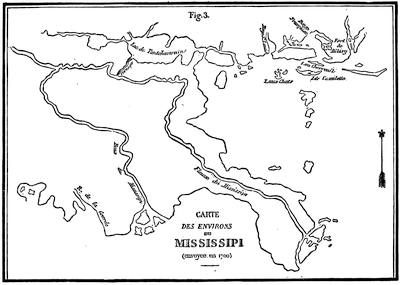
ENVIRONS DU MISSISSIPI, 1700.
[This is figure 3 of plate i. in R. Thomassy’s Géologie pratique de la Louisiane (1860), called “Carte des environs du Mississipi (envoyée à Paris en 1700).” He describes it (p. 208) as belonging to the Archives Scientifiques, and thinks it a good record of the topography as Iberville understood it. The material of this map and of another, likewise preserved in the Archives Scientifiques de la Marine, are held by Thomassy (p. 209) to have been unskilfully combined by M. de Fer in his Les Costes aux environs de la Rivière de Misisipi, 1701.
Thomassy also noted (p. 215) in the Dépôt des Cartes de la Marine, and found in the Bibliothèque Nationale, a copy of a map by Le Blond de la Tour of the mouths of the Mississippi in 1722, Entrée du Mississipi en 1722, avec un projet de fort, of which Thomassy gives a reproduction (pl. iii. fig. 1), and he considers it a map of the first importance in tracing the changes which the river has made in its bed. He next notes and depicts (pl. iii. fig. 2) a Plan particulier de l’embouchure du fleuve Saint-Louis, which was drawn at New Orleans, May 29, 1724, and is signed “De Pauger, Royal Engineer.” It assists one in tracing the early changes, being on the same scale as La Tour’s map.—Ed.]
Le Sueur[23] explored the upper Mississippi in search of mines. In 1700 Bienville and Saint-Denys scoured the Red River country in search of Spaniards, but saw none. In 1701 Saint-Denys was gone for six months on a trip to the same region, with the same result.[40] The records of these expeditions and the Relations of the fathers have preserved for us a knowledge of the country as it then was, and of the various tribes which then inhabited the Valley of the Mississippi. From them we obtain descriptions of the curious temples of the Natchez and Taensas; of the perpetual fire preserved in them; of the custom of offering as a sacrifice the first-fruits of the chase and the field; of the arbitrary despotism of their grand chief, or Sun; of the curious hereditary aristocracy transmitted through the female Suns;[41] of the strange custom of sacrificing human lives on the death of a Grand Sun. To be selected to accompany the chief to the other world was a privilege as well as a duty; to avoid its performance when through ties of blood or from other cause the selection was involuntary, was a disgrace and a dishonor.
We find records of the presence of no less than four of the Le Moyne brothers,—Iberville, Bienville, Sérigny, and Chateauguay. Iberville was rewarded in 1699 by appointment as chevalier of the Order of St. Louis; in 1702 by promotion to the position of capitaine de vaisseau; and in 1703 he was appointed commander-in-chief of the colony, which Pontchartrain in his official announcement calls “the colony of Mississippi.” These honors did not quite meet his expectations. He wanted a concession, with the title of count; the privilege of sending a ship to Guinea for negroes; a lead mine; in short, he wanted a number of things. He bore within his frame the seeds of disease contracted in the south; and in 1706, while employed upon a naval expedition against the English, he succumbed at Havana to an attack of yellow fever. With him departed much of the life and hope of the colony. Supplies, which during his life had never been abundant, were now sure to be scarce; and we begin to find in the records of the colony the monotonous, reiterated complaints of scarcity of provisions. These wails are occasionally relieved by accounts of courtesies exchanged with the Spanish settlements at Pensacola and St. Augustine.[24] The war of the Spanish Succession had brought Spain and France close together. The Spanish forts stood in the pathway of the English and protected Biloxi. When the Spanish commander called for help, Bienville responded with men and ammunition; and when starvation fairly stared the struggling Spanish settlement in the face, he shared with them his scant food. They in turn reciprocated, and a regular debit and credit account of these favors was kept, which was occasionally adjusted by commissioners thereto duly appointed. So few were the materials of which histories are ordinarily composed, during these years of torpor and inaction, that one of the historians of that time thus epitomizes a period of over a year: “During the rest of this year and all of the next nothing new happened except the arrival of some brigantines from Martinique, Rochelle, and Santo Domingo, which brought provisions and drinks which they found it easy to dispose of.”
France was too deeply engaged in the struggle with England to forward many emigrants. Canada could furnish but a scant population for the scattered settlements from Cape Breton to the Mississippi. The hardy adventurers who had accompanied Iberville in his search for the mouth of the Mississippi, and the families which had drifted down from Illinois, were as many as could be procured from her, and more than she could spare. The unaccustomed heat of the climate and the fatal fevers which lurked in the Southern swamps told upon the health of the Canadians, and sickness thinned their ranks. In the midst of the pressure of impending disasters which threatened the declining years of the most Christian King, the tardy enthusiasm in behalf of the colony, which his belief in its pearls and its buffalo-wool had aroused, caused him to spare from the resources of a bankrupt kingdom the means to equip and forward to the colony a vessel laden with supplies and bearing seventy-five soldiers and four priests. The tax upon the kingdom for even so feeble a contribution was enough to be felt at such a time; but the result was hardly worth the effort. The vessel arrived in July, 1704, during a period of sickness. Half of her crew died. To assist in navigating her back to France twenty soldiers were furnished. During the month of September the prevailing epidemic carried off the brave Tonty and thirty of the newly arrived soldiers. Given seventy-five soldiers as an increase to the force of a colony, which in 1701 was reported to number only one hundred and fifty persons, deduct twenty required to work the ship back, and thirty more for death within six weeks after arrival, and the net result which we obtain is not favorable for the rapid growth of the settlement. The same ship, in addition to supplies, soldiers, and priests, brought other cargo; namely, two Gray Sisters, four families of artisans, and twenty-three poor girls. The “poor girls” were all married to the resident Canadians within thirty days. With the exception of the visit of a frigate in 1701, and the arrival of a store-ship in 1703, this vessel is the only arrival outside of Iberville’s expeditions which is recorded in the Journal historique up to that date. The wars and[25] rumors of wars between the Indians soon disclosed a state of things at the South which in some of its features resembled the situation at the North. The Cherokees and Chickasaws were so placed geographically that they came in contact with English traders from Carolina and Virginia. Penicaut, when on his way up the river with Le Sueur, met one of these enterprising merchants among the Arkansas, of whom he says, “We found an English trader here who was of great assistance in obtaining provisions for us, as our stock was rapidly declining.” Le Sueur says, “I asked him who sent him here. He showed me a passport from the governor of Carolina, who, he said, claimed to be master of the river.” Thus English traders were here stumbling-blocks to the French precisely as they had been farther north. Their influence appears to have been used in stirring up the Indians to hostile acts, just as in New York the Iroquois were incited to attack the Canadians. The Choctaws, a powerful tribe, were on the whole friendly to the French. The wars in Louisiana were not so disastrous to the French as the raids of the Five Nations had proved in the Valley of the St. Lawrence. The vengeance of the Chickasaws was easily sated with a few Choctaw scalps, and perhaps with the capture of a few Indian women and children whom they could sell to the English settlers in Carolina as slaves. Hence the number of French lives lost in these attacks was insignificant.
The territory of Louisiana was no more vague and indefinite than its form of government. Even its name was long in doubt. It was indifferently spoken of as Louisiana or Mississippi in many despatches. Sauvolle was left as commander of the post when Iberville returned to France after his first voyage. In this office he was confirmed, and Bienville succeeded to the same position. True, the post was the colony then, but when Iberville was in Louisiana it was he who negotiated with the Indians; it was he of whom the Company of Canada complained for interfering with the trade in beaver-skins; it was he whom the Court evidently looked upon as the head of the colony even before he was formally appointed to the chief command. This chaotic state of affairs not only produced confusion, but it engendered jealousies and fostered quarrels. The Company of Canada found fault with Iberville for interfering with the beaver trade. The Governor of Canada claimed that Louisiana should be brought under his jurisdiction. Iberville insisted that the boundaries should be defined; and complained that the Canadians belittled him with the Indians when the two colonies clashed, by contrasting Canadian liberality with his poverty.
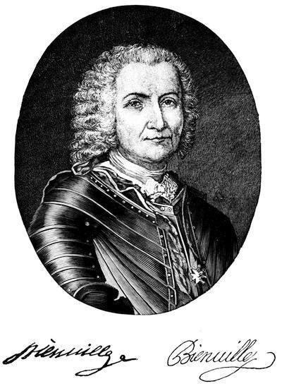
This follows an engraving given in Margry’s collection, vol. v. Other engravings, evidently from the same original, but different in expression, are in Shea’s Charlevoix, vol. i. etc.
Le Sueur, who by express orders had accompanied Iberville on his second voyage, was holding a fort on the upper Mississippi at the same time that “Juchereau de Saint-Denys,[42] lieutenant-général de la juridiction de Montréal,” was granted permission to proceed from Canada with twenty-four men to the Mississippi,[43] there to establish tanneries and to[27] mine for lead and copper. One Nicolas de la Salle, a purser in the naval service, was sent over to perform the duties of commissaire. The office of commissaire-ordonnateur was the equivalent of the intendant,—a counterpoise to the governor and a spy upon his actions. La Salle’s relation to this office was apparently the same as Bienville’s to the position of governor. A purser performed the duties of commissaire; a midshipman, those of commanding officer. Of course La Salle’s presence in the colony could only breed trouble; and we find him reporting that “Iberville, Bienville, and Chateauguay, the three brothers, are thieves and knaves capable of all sorts of misdeeds.” Bienville, on his part, complains that “M. de la Salle, purser, would not give Chateauguay pay for services performed by order of the minister.” This state of affairs needed amendment. Iberville had never reported in the colony after his appointment in 1703 as commander-in-chief. Bienville had continued at the actual head of affairs. In February, 1708, it was ascertained in the colony that M. de Muys had started from France to supersede Bienville, but had died on the way.
M. Diron d’Artaguette, who had been appointed commissaire-ordonnateur,[44] with orders to examine into the conduct of the officers of the colony and to report upon the condition of its affairs, arrived in Mobile in February, 1708. An attempt had apparently been made to organize Louisiana on the same system as prevailed in the other colonies. Artaguette made his investigation, and returned to France in 1711. During his brief stay the monotony of the record had been varied by the raid of an English privateer upon Dauphin (formerly Massacre) Island, where a settlement had been made in 1707 and fortified in 1709. The peripatetic capital had been driven, by the manifest unfitness of the situation, from Biloxi to a point on the Mobile River, from which it was now compelled by floods to move to higher lands eight leagues from the mouth of the river. No variation was rung upon the chronic complaint of scarcity of provisions. The frequent changes in the position of headquarters, lack of faith in the permanence of the establishment, and the severe attacks of fever endured each year by many of the settlers, discouraged those who might otherwise have given their attention to agriculture. To meet this difficulty, Bienville proposed to send Indians to the islands, there to be exchanged for negroes. If his plan had met with approval, perhaps he might have made the colony self-supporting, and thus have avoided in 1710 the scandal of subsisting his men by scattering them among the very savages whom he wished to sell into slavery. It is not to be wondered at that the growth of the colony under these circumstances was very slow. In 1701 the number of inhabitants was stated at one hundred and fifty. In 1708 La Salle reported the population as composed of a garrison of one hundred and twenty-two persons, including priests, workmen, and boys;[28] seventy-seven inhabitants, men, women, and children; and eighty Indian slaves. In 1712 there were four hundred persons, including twenty negroes. Some of the colonists had accumulated a little property, and Bienville reported that he was obliged to watch them lest they should go away.
On the 14th day of September, 1712, and of his reign the seventieth year, Louis, by the grace of God king of France and Navarre, granted to Sieur Antony Crozat the exclusive right to trade in all the lands possessed by him and bounded by New Mexico and by the lands of the English of Carolina; in all the establishments, ports, havens, rivers, and principally the port and haven of the Isle of Dauphin, heretofore called Massacre, the River St. Louis, heretofore called the Mississippi, from the edge of the sea as far as the Illinois, together with the River of St. Philip, heretofore called the Missouri, and of the St. Jerome, heretofore called the Ouabache, with all the countries, territories, lakes within land, and the rivers which fall directly or indirectly into that part of the River St. Louis. Louisiana thus defined was to remain a separate colony, subordinate, however, to the Government of New France. The exclusive grant of trade was to last for fifteen years. Mines were granted in perpetuity subject to a royalty, and to forfeiture if abandoned. Lands could be taken for settlement, manufactures, or for cultivation; but if abandoned they reverted to the Crown. It was provided in Article XIV., “if for the farms and plantations which the said Sieur Crozat wishes to carry on he finds it desirable to have some negroes in the said country of Louisiana, he may send a ship each year to trade for them directly on the coast of Guinea, taking a permit from the Guinea Company so to do. He may sell these negroes to the inhabitants of the colony of Louisiana, and we forbid all other companies and persons whatsoever, under any pretence whatsoever, to introduce any negroes or traffic for them in the said country, nor shall the said Crozat carry any negroes elsewhere.”
Crozat was a man of commercial instinct,—developed, however, only to the standard of the times. The grant to him of these extensive privileges was acknowledged in the patent to have been made for financial favors received by the King, and also because the King believed that a successful business man would be able to manage the affairs of the colony. The value of the grant was dependent upon the extent to which Crozat could develop the commerce of the settlement; and he seems to have set to work in earnest to test its possibilities. The journals of the colonists now record the arrivals of vessels with stores, provisions, and passengers. Supplies were maintained during this commercial administration upon a more liberal basis. The fear of starvation was for the time postponed, and the colonists were spared the humiliation of depending for means of subsistence upon the labor of those whom they termed savages. Merchandise was imported, and only purchasers were needed to complete the transaction. There being no possible legal competition for peltries within the limits of the colony, the market price was what the monopolist chose to pay.[29] Louis XIV. had forbidden “all persons and companies of all kinds, whatever their quality and condition, and whatever the pretext might be, from trading in Louisiana under pain of confiscation of goods and ships, and perhaps of other and severer punishments.” Yet so oblivious were the English traders of their impending fate that they continued to trade among the tribes which were friendly to them, and at times even went so far as to encroach upon the trade with the tribes allied to the French and fairly within French lines. So negligent were the coureurs de bois of their own interest, that when Crozat put the price of peltries below what the English and Spanish traders were paying, they would work their way to Charleston and to Pensacola. So indifferent were the Spaniards to a commerce not carried on in their own ships, and so thoroughly did they believe in the principles of the grant to Crozat, that they would not permit his vessels to trade in their ports. Thus it happened that La Mothe Cadillac, who had arrived in the colony in May, 1713, bearing his own commission as governor, was soon convinced that the commerce of the colony was limited to the sale of vegetables to the Spaniards at Pensacola, and the interchange of a few products with the islands. His disappointment early showed itself in his despatches. His selection for the post was unfortunate. By persistent pressure he had succeeded while in Canada in convincing the Court of the necessity for a post at Detroit and of the propriety of putting La Mothe Cadillac in charge of it. He had upon his hands at that time a chronic war with the priests, whose work he belittled in his many letters. His reputation in this respect was so well known that the inhabitants of Montreal in a protest against the establishment of the post at Detroit alleged that he was “known not to be in the odor of sanctity.” He had carried his prejudices with him to that isolated post, and had flooded the archives with correspondence, memoranda, and reports stamped with evidence of his impatience and lack of policy. The vessel which brought him to Louisiana brought also another instalment of marriageable girls. Apparently they were not so attractive as the first lot. Some of them remained single so long that the officials were evidently doubtful about finding them husbands. By La Mothe’s orders, according to Penicaut, the MM. de la Loire were instructed to establish a trading-post at Natchez in 1713. A post in Alabama called Fort Toulouse was established in 1714.

Saint-Denys in 1714 and again in 1716 went to Mexico. His first expedition was evidently for the purpose of opening commercial relations with the Spaniards. No signs of Spanish occupation were met by the party till they reached the vicinity of the Rio Grande. This visit apparently roused the Spaniards to the necessity of occupying Texas, for they immediately sent out an expedition from Mexico to establish a number of missions[30] in that region. Saint-Denys, who on his return accompanied this expedition, was evidently satisfied that the Spanish authorities would permit traffic with the posts in New Mexico.[45] A trading expedition was promptly organized by him in the fall of 1716 and despatched within a few months of his return. This expedition on its way to the presidio on the Rio Grande passed through several Indian towns in the “province of Lastekas,” where they found Spanish priests and Spanish soldiers.[46] Either Saint-Denys had been deceived, or the Spanish Government had changed its views. The goods of the expedition were seized and confiscated. Saint-Denys himself went to Mexico to secure their release, if possible. His companions returned to Louisiana. Meantime La Mothe had in January, 1717, sent a sergeant and six soldiers to occupy the Island of Natchitoches.
While the French and Spanish traders and soldiers were settling down on the Red River and in Texas, in the posts and missions which were to determine the boundaries between Texas and Louisiana, La Mothe himself was not idle. In 1715 he went up to Illinois in search of silver mines. He brought back lead ore, but no silver. In 1716 the tribe of the Natchez showed signs of restlessness, and attacked some of the French. Bienville was sent with a small force of thirty-four soldiers and fifteen sailors to bring this powerful tribe to terms. He succeeded by deceit in accomplishing what he could not have done by fighting, and actually compelled the Indians, through fear for the lives of some chiefs whom he had treacherously seized, to construct a fort on their own territory, the sole purpose of which was to hold them in awe. From that date a garrison was maintained at Natchez. Bienville, who was then commissioned as “Commandant of the Mississippi and its tributaries,” was expected to make this point his headquarters. The jealousy between himself and La Mothe had ripened into open quarrel. The latter covered reams of paper with his crisp denunciations of affairs in Louisiana, until Crozat, worn out with his complaints, finally wrote, “I am of opinion that all the disorders in the colony of which M. de la Mothe complains proceed from his own maladministration of affairs.”
No provision was made in the early days of the colony for the establishment of a legal tribunal; military law alone prevailed. By an edict issued Dec. 18, 1712, the governor and commissaire-ordonnateur were constituted a tribunal for three years from the day of its meeting, with the same powers as the councils of Santo Domingo and Martinique. The tribunal was afterward re-established with increased numbers and more definite powers.
On the 23d day of August, 1717, the Regent accepted a proposition made to him by Sieur Antony Crozat to remit the remainder of the term of his exclusive privilege. Although it must have wounded the pride of a man like Crozat to acknowledge that so gigantic a scheme, fraught with such exaggerated hopes and possibilities, was a complete failure, yet there is no record of his having undertaken to save himself by means of the annual shipload of negroes which he was authorized, under Article XIV. of his grant, to import. The late King had simply granted him permission to traffic in human beings. It remained for the Regent representing the Grand Monarque’s great-grandson to convert this permission into an absolute condition in the grant to the Company to which Crozat’s rights were assigned. The population of the colony was estimated at seven hundred of all ages, sexes, and colors, not including natives, when in March, 1717, the affairs of government were turned over to L’Epinay, the successor of La Mothe.

The charter of the Company of the West, which succeeded to Crozat’s rights, was registered on the 6th of September, 1717. The formation of the Company was based upon an ingenious attempt to fund in the shape of rentes—practically a form of annuity bonds—that portion of the debt of the kingdom then outstanding as billets d’état. Louis XIV., at his death, had left the nation encumbered with a debt generally estimated at about 2,500,000,000, but rated above 3,000,000,000 livres[47] by some writers. His necessities had compelled him to exhaust every possible means of raising money, even to pledging specifically in advance large portions of the revenue for several years. A floating debt of about 600,000,000 livres was arbitrarily scaled down by the Regent to 250,000,000, and placed in the form known as billets d’état. Even after this reduction the new securities were at a discount of from 60 to 70 per cent. It was to provide relief from this condition of affairs that the Company of the West was inaugurated. The capital stock was divided into shares of five hundred livres each. The number of shares was not limited in the original edict. Payment for them was made exclusively in billets d’état. For these billets, when surrendered to the Government in sums of one million livres, there[32] were issued to the Company rentes in perpetuity for forty thousand livres. The State was relieved from the pressure of so much of its debt as was thus used, by assuming the payment of 4 per cent interest upon the principal. To secure this interest money certain revenues of the Government were pledged. Thus the Company had an income of 4 per cent upon its capital guaranteed by Government. If the Louisiana grant was worth anything, all that could be made out of it was an additional temptation to the investor. That grant consisted of a monopoly of the commerce of the colony and of the absolute control of its affairs, the proprietorship of all lands that they should improve, and the ownership of mines. The privilege of granting lands free from all feudal obligation was expressly permitted. The protection of the Government was guaranteed to the servants of the Company. During the existence of the charter, which was for twenty-five years from the date of registration, property in Louisiana was to be exempt from taxation. With the exception of the condition to import six thousand white persons and three thousand negroes, this vast gift was practically unencumbered. To these privileges was also added the exclusive right to purchase beavers in Canada. The more readily to float the capital, the shares of aliens were exempt from the droit d’aubaine and from confiscation in time of war.
The name of Law, director-general of the bank, led the list of directors nominated in the royal edict. On the death of Louis XIV. this famous Scotchman had offered his services to the Regent, and by ready wit and plausible arguments had convinced him that measures could be taken which would help the State carry the heavy load of debt with which it was burdened. The foundation, on the 2d of May, 1716, of a private bank of issue with a capital of 6,000,000 livres, was an experimental step. The shares of this bank were to be paid for, 25 per cent in coin and 75 per cent in the billets d’état. The redemption of each bank-note was promised in coin of the same weight and standard as the coinage of its date. At a time when changes were frequent in the weight and alloy of coin, this feature made the notes of the bank nominally more stable than the coinage of the realm.
Law’s fundamental idea was that the prosperity of a community was proportionate to the amount of the circulating medium, and that good faith would cause paper to be preferred to coin for this purpose. In his communications to the Regent he recognized the relation of supply and demand to the subject. His proposition was to establish a government bank of issue which should act as the royal treasurer. The distrust of the Regent led him at first to decline this enterprise, but permission was given to Law to found a private bank. Under the conservative restrictions with which it was surrounded, the experimental bank was successful. The withdrawal of Crozat furnished opportunity to overcome the scruples of the Regent by substituting for the proposed royal bank a commercial company, whose stock, according to the original plan, was to be purchased[33] exclusively with billets d’état, which, as before shown, were to be converted into 4 per cent rentes payable half-yearly. An avenue was thus opened for the use of the billets. If holders availed themselves of it, the Government would not only be relieved from their pressure, but also from the discredit of their heavy discount. It was known that Crozat had abandoned the grant because he could not make money out of it. It was evident that capital and patience were necessary to develop the commerce of Louisiana. Of money the Company received none from original subscriptions to its stock, although by the terms of the edict the interest for the year 1717 was to be reserved as a working capital. Doubts as to whether this would be sufficient to develop the colony made investors wary at first of its subscription lists. It was soon found necessary to define the amount of capital stock. This was fixed at 100,000,000 livres by an edict registered in December, 1717. The grant in August, 1718, of the right to farm the tobacco, and the extension of this right from six to nine years in September of the same year, served to quicken popular interest in the Company.
Law’s bank having proved a pronounced success, the Regent was converted to his scheme, the shareholders of the General Bank were reimbursed, and it was converted into the Royal Bank. All limit upon the power to issue bills was by this step practically removed. The character of the coin in which the bills were to be redeemed was no longer limited to the livre of the weight and standard of the date of the note, but was changed to the livre of Tours. The very restraints which had operated to give that confidence which Law had pronounced essential for a paper-money circulation were thus removed.
In quick succession the companies of Senegal, of the East Indies, of China, and of Africa were absorbed by the cormorant Company of the West. Its title was changed to “the Company of the Indies.” The profits of the mint and the general farms were purchased, and by a series of edicts the management of nearly all the financial affairs of the kingdom were lodged in the Company. Meantime France had been deluged with a flood of notes[48] from the Royal Bank. The great abundance of money had lowered interest and revived business. To meet the various payments which the Company had assumed for the privileges which it had purchased, as well as to satisfy the increasing demand for shares, the capital was increased by a series of edicts in the fall of 1719 to 600,000 shares.[49] Outstanding debts of the Government to the extent of 1,500,000,000 livres were ordered to be redeemed, and in place thereof new rentes were to be issued to the Company at 3 per cent. After the first subscription, payment for stock had been stipulated in coin or bank-notes, in place of billets[34] d’état. The various privileges acquired by the Company had been granted one by one, and their accumulation had been slow enough to enable the public to appreciate their value and to comprehend the favor in which the Company was held by the Regent. Subscribers for new shares were therefore found with increasing ease after each new grant. The demand for the stock enabled the Company to place each new issue on the market at premiums. The later issues were at ten times the par value.
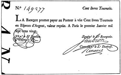
BILL OF THE BANQUE ROYALE OF LAW (1720).
Reduced from a cut in La Croix’s Dix-huitième siècle.
The price of the stock was still further inflated on the market by requiring as a condition precedent for subscriptions to the new issues, that persons desiring to subscribe should be holders of a certain number of shares of the old stock for each share of the new. Subscriptions were in turn stimulated by spreading the payments over a protracted period, on the instalment plan, thus enabling persons of small capital who wished to profit by the upward movement of the stock to operate on margins. To the competition fostered by these ingenious and at that time novel devices was now added the pressure for new shares on the part of those whose investments had been disturbed by the redemption of the rentes. Their demand that some favor be shown them in the matter of subscriptions was recognized, and edicts were issued which removed the stipulation that payments should be made in coin or bank-notes; and in their place billets d’état, notes of the common treasury, and orders on the cashier of the Company given in liquidation of Government[35] obligations, were ordered to be received. Shares rose to ten thousand francs,[50] and even higher; and those who paid for original shares in discredited billets d’état could now realize forty times their purchase-money. The temptation to those of conservative disposition to realize their profits and convert them into coin or property now burst the bubble. For a time the Company, by purchasing its own stock, was able to check the impending disaster; but in spite of all efforts of this sort, and notwithstanding edict after edict ordaining the compulsory circulation of the notes and demonetizing gold and silver, the bank, which had in the mean time been placed under control of the Company, collapsed. The promoter of the scheme, in the same year that he was controller-general of the finances of France, was a fugitive and almost a pauper.
During the progress of these events Louisiana had become the scene of active emigration, ludicrously small when compared with its great domain, but active beyond any preceding movement of population on the part of the French. On the 9th of February, 1718, three vessels despatched by the Company arrived at Dauphin Island, bearing troops and colonists, and also conveying to Bienville[51] the welcome news that he was appointed commandant-général. In September, 1717,[52] Illinois had been detached from New France and incorporated with Louisiana. Boisbriant, who was appointed to the command of that province, did not assume the government until the fall of 1718. The Company set to work honestly to develop the resources of the country. Engineers were sent over to superintend the construction of public works. The pass at the mouth of the river was to be mapped, and two little towers were ordered to be erected “at the entrance to the river, sufficiently high to be seen from afar during the day, and upon which fire can be made at night.” The coast was to be surveyed, and orders were given to effect a landing at St. Joseph’s Bay,—a step which was taken only to be followed by its prompt abandonment. Concessions were made to many distinguished men in France, with conditions attached to each that a certain number of colonists should be imported. Unfortunately for the influence of these grants upon the future of the colony, it was not required that the grantees themselves should live upon their concessions. The grant to Law, twelve miles square, was situated on the Arkansas River. By[36] agreement, he undertook to introduce fifteen hundred settlers. Vessels began now to arrive with frequency, bringing involuntary as well as voluntary emigrants. The power of the courts in France was invoked, apparently with success, to secure numbers for Louisiana, without regard to character. Vagrants and convicts, considered dangerous for French society, were thought suitable for colonists. These steps were soon followed by complaints from the colony of the worthlessness of such settlers and of the little reliance that could be placed upon them in military service.[53] Raynal, in his vigorous way, characterizes them as “the scum of Europe, which France had, as it were, vomited forth into the New World at the time of Law’s system.”
The new commanding general sent a force of mechanics and convicts in February, 1718, to clear the territory now occupied by the city of New Orleans, and to lay the foundations of a new settlement.[54] The channel at Dauphin Island having been blocked by a storm, the headquarters of the colony were removed, first to Old Biloxi, and afterward by order of the Company in 1719, to New Biloxi. During the fall of 1718 MM. Benard de la Harpe and Le Page du Pratz, whose names are associated with the annals of Louisiana, both arrived in the colony. The pages of the chroniclers of colonial events are now sprinkled with the names of ships which arrived with troops and emigrants, including young women from the hospitals and prisons of Paris. On the 6th of June, 1719, two vessels arrived direct from the coast of Guinea with “five hundred head of negroes.” The Company had entered with fervor upon the performance of the stipulation imposed by the charter.
The news of the war between France and Spain reached the colony in the spring of 1719. The inconvenience of the roadsteads occupied by the French had made them anxious to possess Pensacola. Iberville had urged upon the Government the necessity of procuring its cession from Spain if possible. So forcible were his arguments that negotiations to that end had been opened by Pontchartrain.
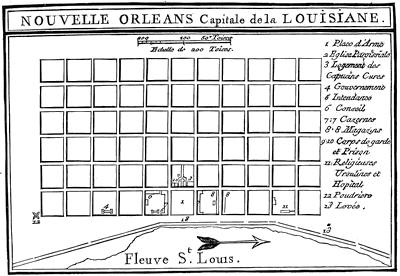
Although the settlement had been neglected by the Spanish Government, yet the proposition to cede it to France was rejected with pompous arguments, in which the title of Spain was asserted as dating back to the famous Bull of Alexander VI., dividing the newly discovered portions of the world between Spain and Portugal.[56] Upon receipt of the news of hostility between the two nations, Bienville promptly availed himself of the opportunity to capture the place.
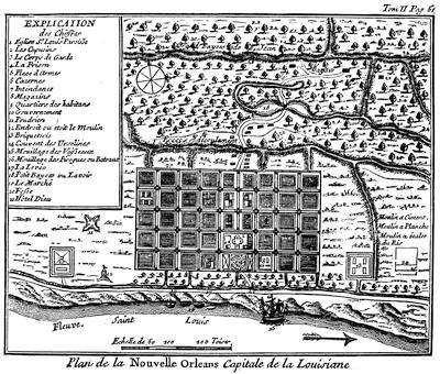
[This is the “Plan de la Nouvelle Orléans” (1718-1720) in Dumont’s Mémoires historiques de la Louisiane, ii. 50, made by Le Blond de la Tour and Pauger. A plan signed by N. B[ellin] in 1744, “Sur les manuscrits du dépôt des chartes de la marine,” was included in Charlevoix’s Nouvelle France, ii. 433, and reproduced in Shea’s translation, vi. 40. In November, 1759, Jefferys published a “Plan of New Orleans, with the disposition of its quarters and canals as they have been traced by M. de la Tour in the year 1720.” He inserted this map (which included also a map of the lower Mississippi) in the History of the French Dominion in America (London, 1760), and in the General Topography of North America and West Indies (London, 1768).—Ed.]
The episodes of the capture of Pensacola by the French, its recapture by the Spaniards, the desertion of a large part of the French garrison, the successful resistance of Sérigny to the siege of Dauphin Island by a Spanish fleet, the opportune arrival of a French fleet, and the capture again of Pensacola, furnished occupation and excitement to the colonists for a few months, but had no[39] other result. The port was returned to Spain when peace was restored.[57] For several years the French at Natchitoches, and the Spaniards a few miles off at the Mission of the Adaes, had lived peacefully side by side. The French lieutenant in command of the post took advantage of the outbreak of hostilities to destroy the Spanish Mission. It was, however, immediately reoccupied by the Spaniards in force, and was permanently retained by them. In Illinois, through the arrival of a band of Missouris who had come to chant the calumet bedecked in chasubles and stoles, and tricked out in the paraphernalia of the altar, Boisbriant learned that a Spanish expedition from Santa Fé, in 1720, had been completely annihilated by these savages.
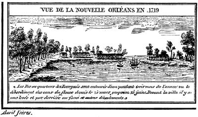
NEW ORLEANS IN 1719.
[This is reproduced from plate ii. of Thomassy’s Géologie pratique de la Louisiane. There is another cut in Gay’s Popular History of the United States, ii. 530. To M. de Vallette Laudun, or Laudreu, sometimes referred to as the Chevalier de Bonrepos, is ascribed the authorship of a Description du Mississipi, écrite de Mississipi en France à Mademoiselle D. ... (Paris, 1720), the writer being the captain of the ship “Toulouse.” It was reprinted as Relation de la Louisiane, écrite à une dame par un officier de marine, in the Relations de la Louisiane et du fleuve Mississipi, published at Amsterdam in 1720, which corresponds to vol. v. of Bernard’s Recueil des voyages au nord. It was reprinted as Journal d’un voyage à la Louisiane fait en 1720 par M. ..., capitaine de vaisseau du roi, both at Paris and La Haye in 1768 (Carter-Brown, vol. iii. nos. 280, 1,641).—Ed.]
Far more important in their effect upon the prosperity of the colony than any question of capture or occupation which arose during these hostilities were the ordinances passed by the Company of the West, on the 25th of April, 1719, in which were announced the fixed prices at which supplies[40] would be furnished to inhabitants at different points, and the arbitrary amounts that would be paid at the same places for peltries, tobacco, flour, and such other articles as the Company would receive. Gayarré summarizes the condition of the colonists under these rules as follows: “Thus the unfortunates who were sent to Louisiana had to brave not only the insalubrity of the climate and the cruelty of the savages, but in addition they were held in a condition of oppressive slavery. They could only buy of the Company at the Company’s price. They could only sell to the Company for such sum as it chose to pay; and they could only leave the colony by permission of the Company.” Whites brought from Europe and blacks brought from Africa “worked equally for one master,—the all-powerful Company.”
Through a title based upon La Salle’s occupation in 1685, strengthened by the explorations of Bienville and Saint-Denys in 1700, the subsequent journeys of Saint-Denys in 1701, 1714, and 1716, and the occupation of Natchitoches, the French laid claim to a large part of what now constitutes Texas. Benard de la Harpe left Dauphin Island toward the end of August, 1718, with fifty men, to establish a post on his concession at Cadodaquais. He settled on land of the Nassonites, eighty leagues in a straight line from Natchitoches. He was instructed to open up trade with the neighboring Spaniards, and through him Bienville forwarded a letter to the Spanish Governor. A correspondence ensued between La Harpe and the Governor at Trinity River, in which each expressed doubts as to the right of the other to be where he was. La Harpe closed it with an assurance that he could be found in command of his fort, and could convince the Governor that he knew how to defend it. No overt act followed this fiery correspondence, and La Harpe shortly after went on an extended tour of exploration to the northward and westward of his concession. We hear no more of this post from French sources; but Spanish authorities assert that after the Mission at Adaes was broken up, the Spaniards returned with an armed force and the French retired to Natchitoches. That post was then put under charge of Saint-Denys. Great stress was laid at Paris upon the necessity for occupying the coast to the west of the mouth of the Mississippi, and positive orders had been issued to that effect by the King on the 16th of November, 1718. Nothing was done, however, until 1720, when six men were landed one hundred and thirty leagues west of the Mississippi and left to perish. In 1721 these orders were reiterated, and La Harpe was appointed “commandant and inspector of commerce of the Bay of St. Bernard.” On August 16 he sailed to take possession of that bay. His equipment and his force were totally inadequate for the purpose. He made a landing at some point on the coast; but finding the Indians hostile, he was obliged to abandon the expedition. With this futile attempt all efforts on the part of the French to occupy any point on the coast of Texas ceased. On the other hand, they remained in uninterrupted possession of Natchitoches;[58][41] and the Spaniards, though they continued to occupy Adaes as long as the French were at Natchitoches, never renewed their attempts on the region of the Osage and the Missouri.
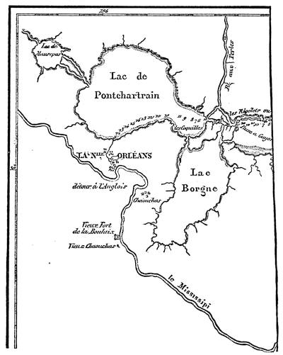
NEW ORLEANS AND THE MISSISSIPPI.
[This is a part of the “Carte de la Côte de la Louisiane, par M. de Sérigny en 1719 et 1720,” as given in Thomassy’s Géologie pratique de la Louisiane, 1860.—Ed.]
During the year 1721 the mortality of the immigrants on the passage over seriously affected the growth of the colony. Among other similar records it is reported that in March two vessels arrived, having on board forty Germans,—all that remained out of two hundred. The same month the “Africaine” landed one hundred and eighty negroes out of two hundred and eighty on board when she sailed, and the “Duc du Maine” three[42] hundred and ninety-four out of four hundred and fifty-three. The pains of the poor creatures did not end with the voyage. Some of them “died of hunger and suffering on the sands of Fort Louis.” Enfeebled by the confinement and trials of a protracted ocean voyage, immigrants and slaves alike were landed on the beach at Biloxi, where neither suitable food nor proper shelter was furnished them.[59] Indeed, so great was the distress for food in 1721, that the very efforts put forth to increase the population were a source of embarrassment and suffering. There were not provisions enough left at Biloxi in September to maintain the garrison; and once again, after more than twenty years’ occupation by the French, the troops at Biloxi were dispersed among the Indians for subsistence.
The engineers who were watching the action of the Mississippi kept a record of their soundings. They attributed the changes which they observed to the scouring action of the water, and suggested methods[60] for keeping up the strength of the current by restraining the river within limits. Their observations confirmed Bienville in the opinion that New Orleans could be reached directly by vessel; thus avoiding the wretched anchorage, fifteen miles from shore,[61] and the expensive and troublesome transfer from ship to barge, and from barge to boat, only to effect a landing by wading, at a spot which was still several days of difficult travel from the natural highway of the country.
The news of the collapse of the Royal Bank and of the flight of Law reached the colony in June, 1721. The expectation that the troubles of the mother country would react upon the fortunes of the colony created great excitement; but the immediate result fell short of the anticipation. Affairs in the territory of Law’s concession were in great confusion. The Alsatians and Germans whom he had placed upon it, finding themselves neglected and the future of the grant doubtful, came down to New Orleans in the expectation of being sent back to Europe. The colony did not willingly relinquish its hold on any of its settlers. These industrious laborers, who had been imported to till the soil, were placated by the grant of concessions along the Mississippi at a point about twenty miles above New Orleans. By their skill in market-gardening they secured the control of that business in the little town which almost in spite of the Company had sprung up on the banks of the river. Bienville, supported by Pauger, one of the engineers, had for some time favored New Orleans as headquarters. The views of the Company on this point had fluctuated. In 1718 the instructions were, to try to open the river to vessels. In 1720 Ship Island, the Alibamons, and the Ouabache (Ohio) were the points they proposed to fortify. In 1721 Pauger prepared a plan for the proposed city of New Orleans. At that time there were only a few cabins there. It was necessary to[43] cut down brush and trees to run the lines. Settlers were attracted by these proceedings, but jealousy stopped the work for a while. Charlevoix, who visited the place in 1722, says that the transfer of the stores of the Company from Biloxi to New Orleans began about the middle of June of that year.
The “Aventurier” arrived in the roadstead in the latter part of May, 1722, bringing orders to make New Orleans the principal establishment of the colony. She was taken up the river by the engineers La Tour and Pauger, and orders were given that all ships should thereafter enter the Mississippi. The “Aventurier” reached New Orleans July 7, and on the 5th of August the departure of Bienville from Biloxi for New Orleans is recorded.
Exchange and currency had proved to be serious drawbacks to the prosperity of Canada. Louisiana was destined to undergo a similar experience. Paper money and card money were issued by the Company. Arbitrary ordinances requiring the presentation of these bills for redemption within a stated time were suddenly promulgated. The price at which the silver dollar should circulate was raised and lowered by edict. Copper money was also forced into circulation. The “Aventurier” had some of this coin on board when she made her famous trip to New Orleans. It was imported, conformably to the edict of June, 1721. The inhabitants were enjoined to receive it without demur, as the Company would take it on the same terms as gold and silver.
To provide for the adjustment of disputes, the colony was divided into nine districts, and judicial powers were conferred upon the commanders of the districts. The jurisdiction of the Superior Council was made exclusively appellate. A similar appellate court, subordinate, however, to the Superior Council, was provided for Illinois.
By ordinance issued May 16, 1722, by the commissioners of the Council, with consent of the Bishop of Quebec, the province of Louisiana was divided into three spiritual jurisdictions. The first comprised the banks of the Mississippi from the Gulf to the mouth of the Ohio, and included the region to the west between these latitudes. The Capuchins were to officiate in the churches and missions of this district, and their Superior was to reside in New Orleans. The second district comprised all the territory north of the Ohio, and was assigned to the charge of the Jesuits, whose headquarters were to be in Illinois. The district south of the Ohio and east of the Mississippi was assigned to the Carmelites. The residence of their Superior was ordinarily to be at Mobile. Each of the three Superiors was to be a grand vicar of the Bishop of Quebec.
By ordinance of the Bishop of Quebec, issued Dec. 19, 1722, the district of the Carmelites was added to that of the Capuchins. The Carmelites then returned to France. In the month of December, 1723, the northern boundary of this district was changed to Natchez, and all the country north of that point, to the east and to the west, was put under charge of the Jesuits.
On the 27th of June, 1725, the Company, to allay the fears of the Capuchins, issued a new ordinance, in which they declared that the Capuchins alone should have the right to perform ecclesiastical functions in their district, and that no priest or monk of other brotherhood should be permitted to do so except with their consent. By request of the Capuchins, this was confirmed by patent from the King, dated the 25th of July, 1725.
The Capuchins had neither the numbers nor the influence essential for so great a work. For this reason the Company assigned the care of the French posts of the district to the Capuchins, and the charge of the Indian missions to the Jesuits; and an agreement was made, Feb. 26, 1726, with the Jesuit fathers, in which the latter undertook to furnish missionaries for the required work. In consequence of this arrangement it became necessary for the Jesuits to have an establishment in New Orleans. Permission to have such establishment was granted by the Company, on condition that they should exercise no ecclesiastical function except by consent of the Capuchins. Beaubois, the Jesuit Superior, disregarded this injunction, and undertook to override the Capuchins, who would have returned to France if he had not been recalled.
On the 13th of September, 1726, the Company entered into a contract with the Ursulines, in which the latter agreed to provide six nuns for the hospital and to educate the girls of New Orleans. The nuns, who were furnished in pursuance of this agreement, sailed from France Feb. 23, 1727. After a perilous voyage, five months in length, they arrived at New Orleans and at once entered on their work.
In 1724 the accumulated complaints of the several officers with whom Bienville had come into collision produced his downfall. La Harpe came to his rescue in a memorial upon the importance of the country and the necessity of maintaining the colony. Louisiana was not to be held responsible for frauds on the Company, nor for lack of system and bad management in its affairs. The Company itself had “begun by sending over convicts, vagrants, and degraded girls. The troops were made up of deserters and men indiscriminately picked up in the streets of Paris. The warehouses were openly robbed by clerks, who screened their knaveries by countless false entries. Disadvantageous bargains were made with companies of Swiss and Germans, of miners, and manufacturers of tobacco,[62] which turned out absolutely without value because the Company did not carry them out. A vast number of burdensome offices were created. The greater part of the directors who were sent out thought only of their own interests and of how they could thwart M. de Bienville, a man more familiar with the country than they were. If he proposed to bring ships[45] up the river, they obstinately opposed him, fearing that they would then no longer be able to maintain traffic with the Spaniards and thus amass fortunes.” La Harpe’s interposition may have subsequently influenced opinions as to Bienville’s merits, but at the time it had no apparent result. In February, 1724, Bienville received positive orders to return to France. The brief interval which elapsed before he sailed gave him an opportunity to associate his name with the issue of the harsh and arbitrary code of fifty-four articles regulating the conduct of the unfortunate slaves in the colony, and imposing penalties for violations of law.
On his return to France, Bienville presented a memorial in vindication of his course. Eight years before this he had urged upon the Marine Council that he was entitled to promotion. The recapitulation of his services, with which he opened his letter, is used again in substance in the memorial: “For thirty-four years Sieur de Bienville has had the honor of serving the King, twenty-seven of them as lieutenant du roy and as commandant of the colony. In 1692 he was appointed midshipman. He served seven years as such, and made seven sea-voyages in actual service on armed vessels of the navy. During these seven years he participated in all the combats waged by his brother, the late Sieur d’Iberville, upon the shores of New England, at Newfoundland, and at Hudson’s Bay; and among others in the action in the North against three English vessels. These three vessels, one of which had fifty-four guns and each of the others forty-two, attacked the said Sieur d’Iberville, then commanding a frigate of forty-two guns. In a combat of five hours he sank the fifty-four-gun ship, and took one of the others; while the third, disabled, slipped away under cover of the night. The said Sieur de Bienville was then seriously wounded in the head.”[63] He then refers to his services in the exploring expedition and in the colony, closing with the statement that his father was killed by the savages in Canada, and that seven of his brothers died in the French naval service.
In support of his memorial, and to refute statements that there would be an Indian outbreak if he should return, several representatives of the Indian tribes of the colony, moved thereto by Bienville’s relatives, were admitted to an audience with the Superior Council, and there pronounced themselves friendly to him. It was thus that the red men, on whom he had relied for food at some time in nearly every year since he landed in Louisiana, rewarded him for his friendly interest in their behalf,—him who had been the advocate of the plan for exiling them to Santo Domingo, there to be exchanged for negroes; who had subdued the eight hundred warriors of the Natchez by treacherously seizing and holding their principal chiefs; who, on the 1st of February, 1723, wrote that an important advantage over the Chickasaws had been gained without the loss of a French life, “through the care that I took to set these barbarians against each other.”

All efforts of Bienville for reinstatement were thrown away. The Council were of opinion that much of the wrangling in the colony was due to the Le Moynes. M. Périer was appointed governor; and in order that his administration might have a fair chance, several of Bienville’s relatives were deprived of office in the colony. Under the new Government, events moved on as before. The quiet of colonial life was undisturbed except for the wrangling of the officials, the publication of company orders, and the announcement of royal edicts. In a memorial forwarded by the commander of Dauphin Island and Biloxi, a highly colored picture is shown of the chaotic condition of affairs. “The army was without discipline. Military stores and munitions of war were not protected. Soldiers deserted at pleasure. Warehouses and store-ships were pillaged. Forgers, thieves, and murderers went unpunished. In short, the country was a disgrace to France, being without religion, without justice, without discipline, without order, and without police.”
Bienville had steered clear of serious Indian complications. He had settled by deceit, without a blow and almost without troops, what in place of more stirring events had been called the “first war of the Natchez.” On the occasion of a second collision, in 1723, he had simply appeared upon the scene with a superior force, and dictated terms to the natives. During Périer’s term of office signs of uneasiness among the natives and of impending trouble began to show themselves. Warnings were given to several of the inhabitants of Natchez that danger was to be apprehended from the neighboring tribe. The commander of the post wilfully neglected these warnings, which were repeatedly brought to his knowledge. On the 29th of November, 1729, the Natchez Indians rose, and slaughtered nearly all the male inhabitants of the little French village.[64] The scene was attended with the usual ingenious horrors of an Indian massacre. A prolonged debauch succeeded. The Yazoos, a neighboring tribe, surprised and slaughtered the little garrison which held the post in their country. Even the fathers in charge of the spiritual affairs of the posts were not spared.[65] Except for this uprising of the Yazoos, the example of the Natchez tribe was not contagious. News was quickly conveyed up and down the river, and but little damage happened to travellers between Illinois and Louisiana.
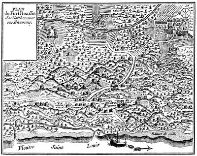
FORT ROSALIE.
[“Plan du Fort Rozalie des Natchez,” in Dumont’s Mémoires historiques de la Louisiane, ii. 94. There is also a plan of Fort Rosalie in Philip Pittman’s Present State of European Settlements on the Mississippi (London, 1770), p. 40.—Ed.]
According to Dumont, the Choctaws and Natchez had conspired to attack the French simultaneously at New Orleans and Natchez, and the attack at Natchez was made in advance of the day agreed upon for the outbreak. At this, he says, the Choctaws were exasperated, and announced that they were willing to move in conjunction with the French upon Natchez. According to their own professions, however, their friendship[48] for the French was uninterrupted, and they denied any previous knowledge of the outbreak at Natchez. Whatever the motive which prompted it, a joint military campaign against the Natchez was now organized with the Choctaws. All the credit in the affair was gained by the Indians. They were first in the field, and they did all the open fighting. When the French tardily arrived on the spot, instead of the surprise, the sudden attack, the rapid flight, and the complete victory or defeat which had hitherto characterized most Indian warfare, they found the Natchez behind rude fortifications, within which they had gathered all their people, together with the women and children captured at the recent attack on the village. The French were compelled to approach these defences with all the formalities of a siege. At the end of what Périer bombastically terms “six days of open trenches and ten days of cannonade,” the Natchez on the 26th of February, 1730, surrendered the captive women, children, and slaves to the Choctaws, withdrew their entire force, and fled to the opposite bank of the Mississippi. The knowledge that the French captives were with the Indians probably hampered the French in their attack.
The services of tribes friendly to the French were secured during the summer to harass the miserable Natchez; and on the 1st of August the Governor could proudly report that by this means he had been able since their migration to kill a hundred and fifty. “Lately,” he says in one of his despatches, “I burned four men and two women here, and the others I sent to Santo Domingo.” Smarting under the disgrace cast upon their reputation by the fruitless results of this campaign, the French felt the necessity for subduing the fugitive Natchez, who still preserved their tribal organization and their independence. An alleged negro insurrection the next summer furnished opportunity for hanging “ten or a dozen of the most culpable” of the negroes, and further demonstrated the necessity for some attempt to recover the prestige of the French name.
In the month of November, 1730, Périer started on a crusade against his foes. The force which he ultimately brought together for this expedition is said to have been a thousand men, of whom seven hundred were French. In January, 1731,[66] he succeeded in running down the Natchez in their fort, situated a short distance from the river on the west side, where he besieged and finally captured—according to his own account—four hundred and fifty women and children and forty-five men. Again the greater part of the warriors of the tribe escaped him. The captives were sent to Santo Domingo, where they were sold as slaves.
The resources of the colony were now better understood. Buffalo-wool, pearls, and mines were no longer relied upon. Prosperity had eluded the grasp of the greater part of the settlers; but if agricultural experiments had not proved remunerative as they had been handled, they had at least[49] demonstrated the fertility of the soil. The hopes of commercial success, with so scant a population and under the restrictions of the monopoly, were shown to be delusive. The climate had proved a severe trial to the health of the settlers.[67] Perhaps the character of the immigrants, their improvident habits, and their reckless exposure had much to do with it, and had made the test an unfair one. At all events the experience of the Company was but a repetition of that of Crozat; and in 1731 the rights granted in the charter were surrendered to the King. During Périer’s administration a change was made in the character of the girls sent over to the colony. In 1728 there arrived a ship bearing a considerable number of young girls who had not been taken from the houses of correction. They were cared for by the Ursulines until they were married.
It is not easy to follow the growth of the colony. When Crozat turned matters over to the Company, there were said to be seven hundred inhabitants; but four years afterward the Company officials, in one of their reports, put this number at four hundred. The official estimate in 1721 was five thousand four hundred and twenty, of whom six hundred were negroes. La Harpe, in his memorial, puts the population in 1724 at five thousand whites and three thousand blacks. At the time of the retrocession to the King the white population was estimated at five thousand, and the negroes at over two thousand.
The treasury notes of the Company at that time constituted the circulating medium of the colony. Fifteen days were allowed, during which their use could be continued. After that their circulation was prohibited, with appropriate penalties.
The Government signalized its renewal of the direct charge of the colony by efforts to build up its commerce. Bienville succeeded in securing his appointment as governor, and in 1733 returned to Louisiana. The finances of the colony having undergone the disturbance of the withdrawal of the paper money of the Company, the Government consulted the colonial officers as to issuing in its place some card money. These gentlemen recommended that the issue should be postponed for two years. The impatience of the Government could, however, be restrained but a year, when the entering wedge of two hundred thousand livres was ordered,—the beginning of more inflation. In 1736 Bienville, owing to the unfriendly attitude of the Chickasaws, felt the necessity of success in some movement against them, if he would retain the respect and friendship of the Choctaws. He therefore made an imposing demonstration against the Chickasaw villages. According to his own account, he had with him over twelve hundred men, who in an attack on one of the villages were repulsed with such severe loss that the whole party were glad to get back to the shelter of their permanent forts, without the satisfaction of knowing that they had either killed or wounded one of the enemy.
The Chickasaws had apparently learned the value of earthworks as defences, from their experience, if not from the English traders. Some of these traders were in the village at the time of the attack, and hoisted the English flag over their cabins. By throwing up the earth around their houses, the Indians had converted each habitation into a fortification. Unfortunately for the objects of the expedition, Bienville learned, on his return to Mobile, that a coöperating column, organized in Illinois, and composed mainly of Northern Indians, which had marched under young Artaguette against the same enemy, had been completely worsted, and their leader was reported killed.
If the movement against the Chickasaws was demanded by the condition of affairs before this demonstration, the repulse made a renewal of it at an early day a positive necessity. A strong force of men was sent over from France under an officer trusted by the Court, and in 1739 an advance was made with twelve hundred white soldiers and twenty-four hundred Indians, by way of the Mississippi instead of the Tombigbee. They were joined at a point near the present site of Memphis by a company under Céloron, and by a detachment from Fort Chartres under Buissonière. Five months were consumed in exploring a road which was supposed to have been already laid out before they started. During this time all the provisions of the expedition were consumed, and the main army was obliged to return without having seen the enemy. The extensive preparations for the expedition had, however, a moral effect. In March a company of Canadians and Northern Indians, which had reported at the appointed rendezvous, penetrated alone to the Chickasaw villages. The chiefs of that tribe, believing that this corps was supported by the expedition, sued for peace, which the French gladly granted them.
Every military effort put forth by Bienville since his return to Louisiana had resulted disastrously. The old story of accusation and counter-accusation between the resident officials of the colony continued during his second term as before. Chagrined at his lack of success, and mortified by evident distrust of his abilities shown by the Court, he tendered his resignation and pathetically wrote: “If success proportionate to my application to the business of the Government and to my zeal in the service of the King had always responded to my efforts, I should gladly have consecrated the rest of my days to this work; but a sort of fatality has pursued me for some time, has thwarted the greater part of my best-laid plans, has often made me lose the fruit of my labors, and perhaps, also, a part of the confidence of Your Highness.” On the 10th of May, 1743, he was relieved by the Marquis de Vaudreuil, and he then returned to France. He was at that time sixty-two years of age, and never revisited the scene of nearly forty-four years of active life in the service of the Government. He was called the “Father of the Colony,” and a certain romantic affection attaches to his memory, based rather upon his professed good-will than upon any success shown in his management of affairs.
During the remainder of the life of the colony, under the administration of M. de Vaudreuil until he was called to Canada, and after that under M. de Kerlerec, his successor, there was no material change in the condition of affairs. All attempts at recapitulation of events resolve themselves into dreary reiterations of what has already been told again and again. Tobacco and rice continued to be the staple products of the colony. Hopes were still maintained that something might be made by cultivating the indigo-plant. The sugar-cane was introduced in 1751.
There was more of tampering with the currency. Incredible as it may seem, there was scarcity of provisions at this late day, and appeals to France for food.[68] The friendly Choctaws were again incited to war against their traditional enemies, the Chickasaws, and strife was also stirred up among themselves. Another warlike expedition boldly marched to the Chickasaw villages and came back again. Criminations and recriminations between governor and commissaire-ordonnateur continued to the end, with few intermissions and with as lively a spirit as characterized the fiercest days of Bienville’s chronic fights. There was another shipment of girls as late as 1751. The character of the troops remained as before, and deserters continued to be a source of annoyance. Even the children of the colonists were affected by their surroundings, if we may believe an anonymous writer,[69] who says, “a child of six years of age knows more of raking and swearing than a young man of twenty-five in France.”
Illinois, separated from the cabals of the little courts at Quebec and New Orleans, showed some signs of prosperity.[70] In 1711 Father Marest wrote: “There was no village, no bridge, no ferry, no boat, no house, no beaten path; we travelled over prairies intersected by rivulets and rivers, through forests and thickets filled with briers and thorns, through marshes where we plunged up to the girdle.” The character of the returns expected by the French from this country had been shown by the expeditions of Le Sueur and La Mothe Cadillac. A few boat-loads of green earth had been sent to France by Le Sueur for assay, but no mines were opened. La Mothe brought down a few specimens of silver ore which had been found in Mexico, and some samples of lead from the mines which were shown him fourteen miles west of the river; but he discovered no silver mines. Nevertheless, the Company had great faith in this region. Their estimate of the dangers to which it was exposed may be gathered from the instructions to Ordonnateur Duvergier in the fall of 1720. He was told where the principal fortifications were to be maintained. Illinois, the directors said, being so far inland, would require a much smaller fort. Communication was to be opened up with that post by land. Positive commands were given to hold a post on the Ohio River, in order to occupy the territory in advance of[52] the English, and prevent them from getting a foothold there. “Illinois is full of silver, copper, and lead mines, which ought to produce considerable returns if worked. The Company has sent to the colony a number of miners to open the mines and to begin work there as an example to the owners of concessions and to the inhabitants. The troop of Sieur Renault, composed of people accustomed to work of this sort, went to the colony at the same time; but the two troops, according to last reports, are not yet at Illinois.”
About the same time it was ordered that “the establishment made by Boisbriant,” originally a few leagues below the village of the Kaskaskias, but apparently afterward transferred to a point about the same distance above the village, should be “called Fort de Chartres.”[71]
In 1721 Charlevoix traversed this region. Speaking of the so-called fort at St. Joseph, near the foot of Lake Michigan, he says: “The commandant’s house, which is but a sorry one, is called a fort from its being surrounded with an indifferent palisade,—which is pretty near the case with all the rest.” The route of Charlevoix was up the St. Joseph across a portage to the Kankakee, and down that river, the Illinois, and the Mississippi, to Fort Chartres, the next French station which he mentions.[72] He describes it as standing about a musket-shot from the river. He heard of mines both copper and lead. Renault, or Renaud, as he is generally called, who was working the lead mines, still hoped for silver. Even after this we hear occasionally of alleged mineral discoveries and revived hopes of mines; but neither the Company nor the Government were destined to reap any great revenue from this source.
The duties of Boisbriant and of his successors were almost exclusively limited to adjudicating quarrels, administering estates, watching Indians, and granting provisional titles to lands or setting off rights in the common fields of the villages. The history of these years is preserved in fragments of church-registers, in mouldy grants of real estate, or in occasional certificates of marriage which have by chance been saved. No break occurred in this monotony till the joint movement against the Chickasaws, of young[53] Artaguette from Fort Chartres and of Vinsennes from his post on the Wabash in 1736. The troops from these posts, who were to move from the North at the same time that Bienville should approach from the South, following their orders, met and advanced at the appointed time. Their prompt obedience brought them to the spot in advance of the dilatory Bienville, and enabled the Chickasaws, as has been previously stated, to meet the columns separately and defeat them in detail. A column from this fort was also in the body of troops from the North which co-operated in the second attack on these Indians.
During this uneventful time the little colony grew, and the settlers enjoyed a moderate degree of prosperity. A contented population of about two thousand whites,[73] to whom grants of land had been freely made for purposes of settlement or cultivation, was mainly engaged in agricultural pursuits. Side by side with them the natives were gathered in villages in which were established Jesuit missions. The fertile soil readily yielded to their efforts at cultivation more than they could consume, and each year the surplus products were floated down to New Orleans. Bossu asserted that all the flour for the lower country came from Illinois. Vaudreuil, before leaving the colony for Canada, reported[74] that boats came down the river annually with provisions; but as late as 1744 he still harped on the discovery of new copper and lead mines. Of the real agricultural value of the country there could not at that time have been any just appreciation. As a mining region it had proved to be a failure.
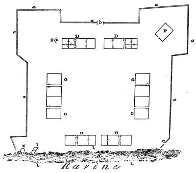
PLAN OF FORT CHARTRES.
[Taken from Lewis C. Beck’s Gazetteer of the States of Illinois and Missouri, (Albany, 1823). The plan was draughted from the ground in 1823. Key: a,a,a, etc., exterior wall (1447 feet); B, gate; C, small gate; D,D, houses of commandant and commissary, 96×30 feet each. E, well; F, magazine; G,G, etc., barracks, 135×36 feet; H,H, storehouse and guard-house, 90×24 feet. I, small magazine; K, furnace; L,L, etc., ravine. Area of fort, 4 acres.—Ed.]
The little fort needed repairs;[75] and La Galissonière, with his usual sagacity, wrote, “The little colony of Illinois ought not to be left to perish. The King must sacrifice for its support. The principal advantage of the country is its extreme productiveness; and its connection with Canada and Louisiana must be maintained.” Apparently the urgency of La Galissonière produced some results. Macarty, the officer who had command of the post at the time of the collision between the French and the English at the headwaters of the Ohio, arrived at Fort Chartres in the winter of 1751-1752. Bossu, who accompanied him, writes from the fort: “The Sieur Saussier, an engineer, has made a plan for constructing a new fort here, according to the intention of the Court. It will bear the same name with the old one, which is called Fort de Chartres.” In January, 1755, Bossu arrived a second time at the post, having in the mean time made a trip to New Orleans. He says: “I came once more to the old Fort Chartres, where I lay in a hut till I could[55] get a lodging in the new fort, which is almost finished. It is built of freestone, flanked with four bastions, and capable of containing a garrison of three hundred[76] men.” The construction of this fort was the final effort of France in the Valley of the Mississippi. It proved to be of even less value than the fortress at Louisbourg, upon which so much money was wasted, for it fell into the hands of the enemy without the formality of a siege. On the other side of the river, Bournion, who in 1721 bore the title of “Commandant du Missouri,” founded Fort Orleans on an island in the Missouri, and left a garrison[77] there, which was afterward massacred. Misère, now known as St. Genevieve, was founded about 1740.
As events drifted on toward the end of the French occupation, the difficulties of the French Government elsewhere compelled the absolute neglect of Louisiana. Kerlerec writes in 1757 that he has not heard from the Court for two years; and in 1761 the French ambassador, in a memorial to the Court at Madrid, states that for four years no assistance had been furnished to the colony. An estimate of the population made in 1745 places the number of inhabitants at six thousand and twenty, of whom four thousand were white. Compared with the number at the time of the retrocession by the Company, it shows a falling off of a thousand whites. It is probable that the white population was even less at a later day. It is not strange that the feeble results of this long occupation should have led the Most Christian King to the determination to present the colony to his very dear and much-loved cousin, the King of Spain,—an act which was consummated in 1762, but not made public at the time. Its influence was not felt until later.
The outline of events in Canada which we have previously traced carried us to a point where the first collision in the Valley of the Ohio between the troops of the two great nations who were contending for the mastery of the northern portion of the continent had already taken place. News of this contest reached New Orleans, and reports of what was occurring at the North served to fill out the Louisiana despatches. From this source we[56] learn that the Chevalier de Villiers,[78] a captain stationed at Fort Chartres, solicited the privilege of leading an expedition to avenge the death of his brother Jumonville, who had been killed by the Virginian force under Washington. The request was granted; and thus the troops from the East and from the West participated in these preliminary contests in the Valley of the Ohio.[79]
It is not within the proposed limits of this sketch to follow in detail the military events with which each of the few remaining years of French domination in America were marked. The death-struggle was protracted much longer than could have been anticipated. The white population of the English colonies is said to have been over ten times greater than that of Canada in 1755; and yet these odds did not fairly express the difference between the contending Powers.[80] The disproportion of the aid which might be expected from the mother countries was far greater. The situation was the reverse of what it had been in the past. England began to show some interest in her colonies. She was prosperous, and the ocean was open to her cruisers. The French experiments at colonization in America had proved a source of expense so great as to check the sympathy and crush the hopes of the Court. The vessels of France could only communicate with her colonies by eluding the search of the English ships widely scattered over the sea. Although no formal declaration of war was made until 1756, England did not hesitate to seize French merchant-vessels and to attack French men-of-war, and she backed the pretensions of her colonists with solid arguments clad in red coats and bearing glittering bayonets. France shipped a few soldiers and some stores to Canada. Some of her vessels succeeded in running the gauntlet of the English cruisers, but more were driven ashore or captured. The native Canadians, more French than Frenchmen themselves, rallied to the support of the Government which had strangled every sign of independent life in their country. Old men and children joined the ranks to repel the invader; and again we have the story repeated of scant crops improperly harvested because of lack of field hands, and thereafter actual suffering for food in this old and well-established colony. The experiences of Braddock and of Dieskau were needed to teach Europeans the value of the opinions of provincial officers in matters of border warfare. Temporary successes during several years inspired hopes in the minds of the French and thwarted the progress of the English. Nevertheless, the strength of the English began to tell, especially along the seaboard, where their supremacy was more conspicuous. The line of French forts across the neck of the Acadian peninsula fell without serious opposition, and it was determined to remove from the country a population which would neither take the oath of allegiance to His Britannic[57] Majesty, nor preserve neutrality in time of war. Their forcible deportation followed; and in their wanderings some of these “neutral French” even penetrated to the distant colony of Louisiana, where they settled on the banks of the Mississippi.[81] Such was the demoralization of the official class of peculators in Canada that those refugees who escaped to the protection of its Government were fed with unwholesome food, for which the King had been charged exorbitant prices by his commissaries. The destruction of the fort at Oswego postponed for that year the efforts of the English to interrupt the communication between the valleys of the Ohio and the St. Lawrence. The destruction of Fort William Henry temporarily protected Montreal; the check sustained by Abercromby was of equal military value. But in 1758 Louisbourg, with its garrison and stores was lost, the little settlements in Gaspé were ravaged, and France was deprived of the last foot of territory on the North Atlantic seaboard. Quebec thus became accessible to the enemy by way of the sea without hindrance.

Distrust and jealousy pervaded the Government councils in Canada. Pierre François, Marquis of Vaudreuil, the successor of Duquesne in 1755, and Montcalm, whose cordial co-operation was essential, were at swords’ points. With each succeeding year the corrupt practices of Intendant Bigot were more openly carried on. With famine stalking through the streets of Montreal and Quebec, with the whole population living on short rations, and bread-stuffs at incredible prices, the opportunity for this wide-awake Intendant to make money was never better. If accounts are to be trusted, he availed himself of his chance; and out of the sufferings and dire necessities of this sorely pressed people he amassed a fortune.[82] All this was to the advantage[58] of England. Every point that she gained in the struggle she kept. From each reverse that she sustained she staggered up, surprised that the little band of half-starved Canadian troops should have prevailed again, but with renewed determination to conquer. The only value of success to Canada was to postpone the invasion, and for the time being to keep the several columns which threatened Montreal from co-operation. With so feeble a force the French could not hope to maintain the widely scattered forts which they held at the beginning of hostilities. In 1759 they were threatened by hostile columns counting more than the entire number of Canadians capable of bearing arms. All hope of aid from France was crushed by the Minister, who wrote: “In addition to the fact that reinforcements would add to the suffering for food which you already experience, it is very much to be feared that they would be intercepted by the English on passage.” Such was the mournful condition of affairs when Wolfe sailed up the St. Lawrence, expecting to find Quebec ready to fall into his hands. To his surprise, the place was held by a force thoroughly capable of defending it against the combined strength of his soldiers and sailors. Fortune favored him, and Quebec was gained.
The resistance of the French during one more campaign was probably justifiable, but was a mere matter of form. Without hope of assistance from France, without means of open communication with any other French possession, without supplies of ammunition or of food, there was really nothing left to fight for. Even the surrounding parishes of Canada had yielded to the pressure of events, after the failure to recapture Quebec. When, therefore, the English columns converged upon Montreal in 1760, the place capitulated, and the French flag disappeared from Canada.
At the mouth of the Mississippi French occupation was not disturbed until the boundaries were adjusted in accordance with the terms of the Treaty of Peace signed at Paris in February, 1763. No reference was made in the treaty nor in the preliminary convention to the fact that France had already granted to Spain her title to the whole of Louisiana. Knowledge of this remarkable act was kept secret for a few years longer. England, by the terms of the treaty of Paris, became the acknowledged mistress of all that portion of the American continent which lies east of the middle of the Mississippi River, with the exception of the island on which was built the city of New Orleans. Ample provision was made to protect the rights of French citizens who might wish to remove from the country. The privilege of religious worship according to the forms of the Roman Catholic[59] Church was guaranteed to those who should remain, as far as the laws of England would permit.
The era of colonial history which this chapter covers is coincident with a period of decline in France. The transmission of the throne in the line of descent was not, however, interfered with, nor were the traditions of colonial policy changed. The causes of the rise and fall of the colonies of European Powers at that time are to be found in the history of European politics; and European politics in turn were largely influenced by the desire to control territory in the New World. The life of French colonies was in close contact with European events. If the pulse of the English settlements did not throb in such sympathy with the mother country, it was because there was a fundamental difference in the methods by which English colonies had been formed and in the conditions of their growth. A colony was not looked upon at that time as forming a part of the parent State. It was a business venture, entered into directly by the State itself, or vicariously by means of a grant to some individual or company. If the colony did not earn money, it was a failure. Spain had derived wealth from ventures of this sort. Other nations were tempted into the pursuit of the same policy in the hope of the same result.
To preserve the proper relations to the parent State, the colony should have within itself elements of wealth which should enrich its projectors; it should absorb the productions of the State which founded it; and in no event ought it to come into competition with its progenitor. The form of the French government was so logical that its colonies could be but mimic representations of France. Priests and nuns, soldiers and peasants, nobles and seigniors, responded to the royal order, and moved at the royal dictation in the miniature Court at Quebec much the same as at Paris. There was so little elasticity in French life that the French peasant, when relieved from the cramp of his surroundings, still retained the marks of pressure. Without ambition and without hope, he did not voluntarily break away from his native village. If transported across the water, he was still the French peasant, cheerful in spirit, easily satisfied, content with but little, and not disposed to wrestle for his rights. The priest wore his shovel-hat through the dense thickets of the Canadian forests, and clung to his flowing black robe even though torn to a fringe by the brambles through which it was trailed. Governor and council, soldier, priest, and peasant, all bore upon their persons the marks that they were Frenchmen whose utmost effort was to reproduce in the wilds of America the artificial condition of society which had found its perfect expression in Versailles. Autocratic as was Frontenac, unlikely as he was to do anything which should foster popular notions of liberty, or in any way endanger monarchical institutions,—even he drew down upon himself a rebuke from the Court for giving too much heed to the people in his scheme of reorganization.
From his palace in France the Grand Monarque dictated the size and shape of a Canadian farm. He prescribed the localities which new-comers ought to select. They must not stray too far from villages; they must clear lands in spots contiguous to settlements. He could find men who would go to Canada, but there was no emigration of families. Soldiers in the colony were offered their discharge and a year’s pay if they would marry and settle. Premiums were offered the colonists for marrying, and premiums for children. “The new settler,” says Parkman, “was found by the King, sent over by the King, and supplied by the King with a wife, a farm, and sometimes with a house.” Popular meetings were in such disfavor that not until 1717 were the merchants permitted to establish an exchange at Quebec. His Majesty, while pulling the wires which moved the puppets of European politics, still found time to express his regrets that the “King’s officers had been obliged to come down from Frontenac to Quebec to obtain absolution,” and to convey his instructions to the Bishop of Quebec to suppress several fête-days which interfered with agricultural labors. Cared for thus tenderly, it would seem that Canada should have thriven. Had the measures put forth been wisely directed toward the prosperity of the colony, it might have done so; but Louis XIV. was not working for the benefit of Canada; his efforts were exclusively in behalf of France. In 1706 his Minister wrote: “It is not for the interest of the parent State that manufactures should be carried on in America, as it would diminish the consumption of those in France; but in the mean time the poor are not prohibited from manufacturing stuffs in their own houses for the relief of themselves and their families.” Generous monarch! The use of the spinning-wheel and the loom was not forbidden in the log-cabins in Canada, even if this did clash somewhat with French trade. “From this permission,” says Heriot, “the inhabitants have ever since continued to fabricate coarse linen and druggets, which has enabled them to subsist at a very small expense.” Coin was almost unknown much of the time; and the paper money and bills of exchange, upon which the colony depended for a circulating medium, were often seriously depreciated.
The spirit of organization and inquisition which infested the Government pervaded all things temporal and spiritual. Trade in peltries could only be carried on by those having permits from the Government or from the firm or company which for the time being had the monopoly. All trade at outlying posts was farmed out by the governors. Young men could not stray off into the woods without violating a royal edict. Such solicitude could only produce two results,—those who endured it became automatons; those who followed their inclinations and broke away from it were proscribed as bushrangers. From the day when Champlain founded the city of Quebec down to the time when the heroic Montcalm received his death-wound on the Plains of Abraham, the motives which had influenced the French in their schemes of colonization had been uniform and[61] their methods identical. Time enough had elapsed to measure the success of their efforts.
French colonization in America had reached three degrees of prosperity. In Acadia, under English rule, freed from military service in the ranks of the country to which they naturally owed allegiance, and with their rights as neutrals recognized by the English, the French colonists had prospered and multiplied. Originally a band of hunters and fishers, they had gradually become an agricultural population, and had conquered prosperity out of a soil which did not respond except to the hand of patience and industry. Exempt from the careful coddling of His Most Christian Majesty, they had evoked for themselves a government patriarchal in its simplicity and complete for their needs. In Louisiana, under the hothouse system of commercial companies and forced immigration, the failure had been so complete that even those who participated in it could see the cause. In Canada there was neither the peaceful prosperity of Acadia nor the melancholy failure of Louisiana. Measured by its own records, the colony shows steady growth. Compared with its rivals, its laggard steps excite surprise and demand explanation. The Acadians were French and Catholics. Neither their nationality nor their religion interfered with their prosperity. They had, however, been lucky enough to escape from the friendly care of the French Government. It is but a fair inference that the Canadians also would have thriven if they could have had a trial by themselves.
The history of England during the corresponding period showed no such uniform motive, no such continuous purpose as to her colonies. From the time of their foundation the English colonies became practically independent States, with which the Home Government, during the long period of political disturbances which intervened, seldom interfered. The transmission of the crown by descent was interrupted. A parliament displaced and executed a king. A protector temporarily absorbed his power. The regular order of the descent of the crown in the restored royal family was again interrupted. The crowned ruler of England was a fugitive on the Continent, and Parliament by act prescribed who should govern England, and afterward how the crown should be transmitted. The causes that produced English emigration, whether political or religious, varied with these events, and emigration was correspondingly affected; but whatever the extent and whatever the character of this influence, the emigration from England was, as a rule, a voluntary emigration of families. Young men might be tempted by the fascinating freedom of a wild life in the woods; but the typical emigrant was the father of a family. He abandoned a home in the old country. He took with him his wife, his family, and his household goods. Much of the furniture brought over by the sturdy emigrants of that time is still treasured by their descendants. The strong mental individuality which thus led men with families to cut adrift from[62] the struggles and trials in England, only to encounter the dangers and difficulties of pioneer life in a new country, found expression in various ways in the affairs of the colonies, oftentimes to the vexation of the authorities.
The New France was a reproduction of the Old France, with all, and more than all, the restrictions which hampered the growth and hindered the prosperity of the parent State. The New England had inherited all the elements of prosperity with which the Old England was blessed, and had even more of that individuality and freedom of action on the part of its citizens which seems to form so important an element of success. Out of the heterogeneous mixture of proprietary grants, colonial charters, and commissions, some of which were granted to bodies which sought exclusive privileges, while others were based upon broad, comprehensive, and liberal views; out of the conflicting interests and divergent opinions of fugitive Congregationalists, Quakers, and Catholics; out of a scattered, unorganized emigration of men entertaining widely different views upon politics and religion,—these aggressive, self-asserting colonists evolved the principle of the right of the inhabitants to a voice in the affairs of their government; and whether provision was made for it in the charter or not, houses of burgesses, general courts, and assemblies were summoned to make laws for the various colonies. Charters were afterward annulled; laws which contained offensive assertions of rights were refused the royal assent: but the great fundamental truth remained,—that the colonies were self-supporting. They had proved their capacity, and they constantly showed their determination, to govern themselves. Each movement of the emigrant away from the coast became a permanent settlement which required organization and control. Out of the unforeseen and unexpected conditions which were constantly occurring came the necessity for local government, to be administered by officers chosen by the little settlements.
Emerson, in speaking of the first tax assessed upon themselves by the people of Concord in Massachusetts, accounts for the peculiar developments of colonial life in New England in the following words: “The greater speed and success that distinguishes the planting of the human race in this country over all other plantations in history owe themselves mainly to the new subdivisions of the State into small corporations of land and power. It is vain to look for the inventor; no man made them. Each of the parts of that perfect structure grew out of the necessities of an instant occasion; the germ was formed in England.”
The pioneer penetrated the forest; he took with him the school-house and the church. Out of the necessities of instant occasions grew, in New England at least, the town-meeting,—the complete expression of a government whose foundations are laid in the people.
Before leaving the colony, in 1754, the Marquis Duquesne summoned the Iroquois to a council. In the course of an address which he then delivered he said: “Are you ignorant of the difference between the King[63] of England and the King of France? Go, see the forts that our King has established, and you will see that you can still hunt under their very walls. They have been placed for your advantage in places which you frequent. The English, on the contrary, are no sooner in possession of a place than the game is driven away. The forest falls before them as they advance, and the soil is laid bare so that you can scarce find the wherewithal to erect a shelter for the night.” No more powerful contrast of the results in North America of the two methods of colonization could be drawn than is presented in the words of the French Governor.
CRITICAL ESSAY ON THE SOURCES OF LOUISIANA HISTORY.
CHARLEVOIX’ Nouvelle France[83] and the account of his personal adventures in the Journal d’un voyage, etc., have been much quoted by early writers. The extent and value of Dr. Shea’s work in annotating his translation of this history can only be appreciated by careful study. Through this means the translation is more valuable for many purposes of research than the original work.[84]
In 1831 the Journal historique de l’établissement des Français à la Louisiane was published at New Orleans and at Paris. It consists of an anonymous historical narrative, to which is appended a memorial signed by Benard de La Harpe. It is generally quoted as “La Harpe.” The narrative is founded largely upon the journals of Le Sueur and La Harpe, though it is evident that the author had other sources of information. Within its pages may be found a record of all the expeditions despatched by the colony to the Red River region and to the coast of Texas.[85] The work of compilation was done by a clear-headed, methodical man. Margry quotes from the work, and attributes its authorship to “le Chevalier de Beaurain, géographe du roy.”[86] Manuscript copies of this work, under the title Journal historique concernant l’établissement des Français à la Louisiane, tiré des mémoires de Messieurs D’Iberville et De Bienville, commandants pour le roy au dit pays, et sur les[64] découvertes et recherches de M. Benard de la Harpe, nommé aux commandement de la Baye St. Bernard, are to be found in some of our libraries.[87]
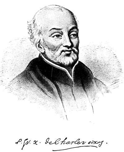
Following the engraving in Shea’s Charlevoix, vol. i. [but now, 1893, thought to be Le Jeune].
The historians of Canada give but brief and inaccurate accounts of the early history of Louisiana. Ferland repeats the errors of Charlevoix even to the “fourth voyage of Iberville.” Garneau leaves the Natchez in possession of their fort at the end of the first campaign.[88]
Judge François-Xavier Martin, in the History of Louisiana from the Earliest Period, 2 vols. (New Orleans, 1827-1829), followed closely the authorities accessible to him when he wrote; his work is a complete, and in the main accurate, compendium of the materials at his command. A new edition was published at New Orleans in 1882, entitled: The History of Louisiana from the Earliest Period. With a Memoir of the Author by W. W. Howe. To which is appended, Annals of Louisiana from 1815 to 1861, by J. F. Condon.
Charles Gayarré is the author of two distinct works which must not be confounded. Louisiana, its Colonial History and Romance,[89] is a history of colonial romance rather than a history of the colony. The Histoire de la Louisiane[90] is an essentially different book. It is mainly composed of transcripts from original documents, woven together with a slender thread of narrative. He states in his Preface that he has sought to remove from sight his identity as a writer, and to let the contemporaries tell the story themselves. References to Gayarré in this chapter are exclusively made to the Histoire, which was brought down to 1770. His final work (reprinted in 1885) was in English, and was continued to 1861.[91] In this edition two volumes are given to the French domination, one to the Spanish, and one to the American.[92]

A little volume entitled Recueil d’arrests et autres pièces pour l’établissement de la compagnie d’occident was published in Amsterdam in 1720. It contains many of the important edicts and decrees which relate to the foundation and growth of this remarkable Company.
The presence of Le Page du Pratz in the colony for sixteen years (1718 to 1734) gives to his Histoire de la Louisiane[93] a value which his manifest egotism and whimsical theories cannot entirely obscure. It was an authority in the boundary discussions.[94]
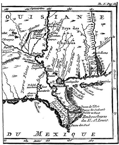
MOUTHS OF THE MISSISSIPPI.
[Part of a map in Le Page du Pratz’ Histoire de la Louisiane (1758), i. 139. Cf. also the Carte des embouchures du Mississipi, by N. Bellin, given (1744) in Charlevoix’ Nouvelle France, iii. 442. In the same volume (p. 469) is the “Partie de la coste de la Louisiane et de la Floride,” giving the coast from the mouths of the Mississippi to Apalache Bay. In 1759 Jefferys gave in the margin of his reproduction of La Tour’s map of New Orleans a map of the Mississippi from Bayagoula to the sea, and of the east mouth of the river, with the fort La Balise.—Ed.]
Dumont, whose Mémoires historiques sur la Louisiane[95] were edited by M. L. Le M. (said to have been L’Abbé Le Mascrier), was in the military service in the colony. In the Journal historique, etc., mention is made of a sub-lieutenant Dumont de Montigny[96][67] at the post at Yazoo. The author was stationed at this post, and accompanied La Harpe up the Arkansas. The statement made in biographical works that Butel Dumont,[97] who was born in 1725, was the author, is manifestly incorrect. Both Dumont and Le Page were contributors to the Journal œconomique, a Paris periodical of the day. We are able positively to identify him as Dumont de Montigny, through an article on the manner in which the Indians of Louisiana dress and tan skins, in that journal, August, 1752. Dumont had a correspondence with Buache the cartographer[98] on the subject of the great controversy of the day,—the sea of the west and the northwest passage. Dumont was fond of a good-sounding story;[99] and his book, like that of Le Page depends for its value largely upon the interest of his personal experiences. Another book of the same class is the Nouveaux voyages aux Indes occidentales,[100] by M. Bossu. The author, an army officer, was first sent up the Tombigbee, and afterward attached to the forces which were posted in Illinois, and was there when Villiers marched on Fort Necessity. He was in the colony twelve years, and bore a good reputation.
The work entitled État présent de la Louisiane, avec toutes les particularités de cette province d’Amérique, par le Colonel Chevalier de Champigny (A la Haye, 1776), has been generally quoted as if Champigny were the author. In an editorial introduction Champigny says the text and the notes were furnished him in manuscript by an English officer. In the body of the work the statement is made by the author that he accompanied the English forces which took possession of the colony after its cession to England. This work is cited by Mr. Adams in the boundary discussion.
The Mémoire historique et politique de la Louisiane, by M. de Vergennes, minister of Louis XVI. (Paris, 1802), contains a brief historical sketch of the colony, intended only for the eye of His Majesty. Its wholesome comments on the French troops and on French treatment of the Indians are refreshing to read.[101] They would not have been so frank, perhaps, if the work had been intended for publication.

In his Early Voyages Up and Down the Mississippi (Albany, 1861) Dr. Shea has collected, translated, and annotated various relations concerning the voyages of Cavelier, De Montigny de Saint-Cosme, Le Sueur, Gravier, and Guignas.[102]
A number of the relations in the Lettres édifiantes et curieuses cover portions of the period and territory of this chapter. These have been collected and translated by Bishop Kip in the Early Jesuit Missions (Albany, 1866). To avoid repetition, he has made certain abridgments. Some of the material thus left out has value to the student of the early history of Illinois.[103]
Major Amos Stoddard, in his Sketches Historical and Descriptive of Louisiana (Philadelphia, 1812), furnished an unostentatious and modest book, which has been freely quoted.
The Relation du voyage des dames religieuses Ursulines de Rouen, etc. (Paris, 1872), with an introduction and notes by Gabriel Gravier, is an exact reprint of a publication at Rouen in 1728 of certain letters of Marie Madeleine Hachard, sœur Saint-Stanislas, to her father. The account of the tedious journey of the nuns from Paris to Orient, and of their perilous voyage to New Orleans, was worth preservation. M. Gravier has performed his part of the work with the evident satisfaction which such a task would afford a bibliophile and an antiquary. His introductory chapter contains a condensed history of Louisiana down to 1727, and is strongly fortified with quotations. He acknowledges himself to be indebted to M. Boimare for a great number of valuable unpublished documents relating to the foundation of New Orleans. Greater familiarity with his subject would have enabled him to escape several errors of date and of statement into which he has been led by authorities whose carelessness he apparently did not suspect. The memorial concerning the Church in Louisiana (note 1, p. 113 et seq.) is a document of great value and interest. M. Gravier (p. lvi) states that the Relation is substantially the same as the Relation du voyage des fondatrices de la Nouvelle Orléans, écrite aux Ursulines de France, par la première supérieure, la mère St. Augustin, which was reprinted by Dr. Shea in an edition of one hundred copies in 1859, under the general title of Relation du voyage des premières Ursulines à la Nouvelle Orléans et de leur établissement en cette ville [1727], par la Rev. Mère St. A. de Tranchepain; avec les lettres circulaires de quelquesunes de ses sœurs, et de la dite mère (62 pp.).
The History of the American Indians, particularly those Nations adjoining to the Mississippi, East and West Florida, Georgia, South and North Carolina, and Virginia, etc., by James Adair, who was forty years in the country, is a work of great value, showing the relations of the English traders to the Indians, and is of much importance to the student of Indian customs.[104]
The Géologie pratique de la Louisiane, by R. Thomassy (New Orleans and Paris, 1860), contains copies of some rare documents which were first made public in this volume.
The Histoire de la Louisiane[105] by M. Barbé Marbois is so brief in its treatment of the period covered by this chapter that very little can be gained from consulting that portion of the book.
A work entitled De la puissance Américaine, by M. Guillaume-Tell Poussin, was published at Paris in 1843. A translation was printed at Philadelphia in 1851. The writer, from his familiarity with this country, was especially fitted to give a French view of our history. His chapter on Louisiana shows that he had access to the treasures of the Paris Archives. Its value, however, is diminished by the fact that he is inexact in his details.
Daniel Coxe, the son of Dr. Coxe, the claimant of the Carolana grant, published in London in 1722 A Description of the English Province of Carolana, by the Spaniards call’d Florida, and by the French La Louisiane.[106] The body of the text is devoted to a description of the attractions of the province to the emigrant. The preface contains an account of the entrance of the Mississippi by the vessel which was turned back by Bienville. The appendix is an argument in favor of the claimant’s title to the grant, and of England’s title to the Mississippi Valley. It contains a curious story of a Massachusetts expedition to New Mexico in 1678, and a claim that La Salle’s guides were Indians who accompanied that expedition.[107]
The official correspondence concerning the Louisiana boundary question may be found in Waite’s American State Papers and Public Documents (Boston, 1815-1819), vol. xii. The temperate statements of Don Pedro Cevallos are in strong contrast with the extravagant assumptions of Luis de Orris, who even cites as authority the mythical Admiral Fonte.[108] Yoakum, in his History of Texas (New York, 1856), goes over this ground, and publishes in his appendix an interesting document from the archives of Bexar.
Illinois in the Eighteenth Century, by Edward G. Mason (Fergus Historical Series, no. 12), Chicago, 1881, has two papers dealing with the topics of this chapter: “Kaskaskia and its parish records” and “Old Fort Chartres.” The recital of the grants, the marriages, and the christenings at Kaskaskia and St. Anne brings us close to Boisbriant, Artaguette, and the other French leaders whose lives are interwoven with the narrative of events in Illinois. The description of Fort Chartres is by far the best extant. The work of rescuing from oblivion this obscure phase of Illinois history has been faithfully performed.
The following works have been freely used by writers upon the early history of Illinois and the Illinois villages and forts:—
The Administration of the Colonies, by Thomas Pownall, 2d ed. (London, 1765). The appendix, section 1, deals with the subject of this chapter.
A Topographical Description of North America, by T. Pownall (London, 1776). Appendix, no. 4, p. 4, Captain Harry Gordon’s Journal, describes the fort and villages.
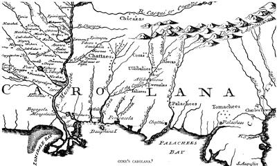
COXE’S CAROLANA.
[Part of the Map of Carolana and of the River Meschacebe, in Daniel Coxe’s Description of the English Province of Carolana, London, 1742—Ed.]
Thomas Hutchins has also published two books,—An Historical Narrative and Topographical Description of Louisiana, etc. (Philadelphia, 1784), and A Topographical Description, etc. (London, 1778).
Captain Philip Pittman prepared a report on The Present State of the European Settlements on the Mississippi. It was published in London, in 1770. It is embellished with charts of the river and plans of several of the forts and villages.[109]
Also Sketches of History, Life and Manners in the West, by James Hall (Philadelphia, 1835), who visited the fort in 1829.
The Early History of Illinois, by Sidney Breese, contains an interesting description of French life in Illinois.[110] See also a chapter on the same subject in Davidson and Stuvé’s Complete History of Illinois (Springfield, 1874). The History of the Discovery and Settlement of the Mississippi Valley, by John W. Monette (New York, 1846), also has an elaborate sketch of the settlement of Louisiana and Illinois.[111]
Mississippi as a Province, Territory, and State, by J. F. H. Claiborne (1880), devotes considerable space to the Province.
Extracts from a memoir by M. Marigny de Mandeville may be found in several of the histories of Louisiana of colonial times. In a note in Bossu[112] it is stated that such a work was published in Paris in 1765.
The story of Saint-Denys’ experiences in Mexico is told in H. H. Bancroft’s North Mexican States, p. 612 et seq., in which the sources of information are mainly Mexican and Spanish. The hero of Penicaut’s romances, viewed from this standpoint, becomes a mere smuggler.
Under the title Historical Collections of Louisiana, etc., Mr. B. F. French, in the years 1846-1875, inclusive, published seven volumes containing reprints and translations of original documents and rare books. Mr. French was a pioneer in a class of work the value of which has come to be fully appreciated. His Collections close a gap on the shelves of many libraries which it would be difficult otherwise to fill. The work was necessarily an education to him, and in some instances new material which came to his hands revealed errors in previous annotations.[113] The value of the work would have been increased if abridgments and omissions had been noted.[114] The translation of the Journal[72] historique, etc., given in the collection was made from the manuscript copy in the library of the American Philosophical Society at Philadelphia.[115] The Penicaut relation differs materially from the copy published by Margry.[116] The labors of Mr. French, as a whole, have been of great service to students of American history.[117]
The fourth and fifth volumes[118] of Pierre Margry’s Découvertes et établissements des Français dans l’ouest et dans le sud de l’Amérique septentrionale contain the material upon which so much of this chapter as relates to Iberville’s expeditions is founded. We have here Iberville’s correspondence with the minister, his memorials, the instructions given to him, and his reports.[119] There are also some of Bienville’s despatches, and the correspondence with the engineer about New Orleans and about the bar at the mouth of the river. The publication of these volumes has enabled us to correct several minor errors which have been transmitted from the earlier chroniclers. Interesting as the volumes are, and close as their scrutiny brings us to the daily life of the celebrated explorer, it is not easy to understand why their contents should have been shrouded with such a profound mystery prior to their publication.[120]
The periodicals and tracts of the eighteenth century contain many historical articles and geographical discussions, from which historical gleaners may yet procure new facts.[121] The manuscripts in the Archives at Paris have by no means been exhausted. Harrisse, in his Notes pour servir à l’histoire, etc., de la Nouvelle France (Paris, 1872), gives an account of the vicissitudes which they have undergone. He traces the history of the formation of the Archives of the Marine and of the Colonies and points out the protecting and organizing care, which Colbert during his ministry devoted through intelligent deputies to the arranging of those documentary sources, among which the modern historian finds all that the Revolution of 1789 has left to him.
The copies which from time to time have been procured from France for the State Archives of Louisiana have so generally disappeared, particularly during the Federal occupation, that but a small portion of them still remains in the State Library.[122]

JOHN LAW.
Copied from the head of a full-length portrait in Het Groote Taferel. Rigaud’s portrait of Law is engraved in Alphonse Courtois’ Histoire des banques en France, 2d ed. (Paris, 1881). Cf. also the print in Mouffle d’Angerville’s Vie privée de Louis XV. (Londres, 1781), vol. 1. p. 53.
I. Law and the Mississippi Bubble.—The literature of the Mississippi Scheme is extensive, and includes the relations of Law’s system to general monetary science. The Mississippi excitement instigated the South Sea Scheme in England. Holland, also, was largely affected, and gave, as well as England and France, considerable additions to the contemporary mass of brochures which grew out of these financial revolutions. Law’s own pleas and expositions, as issued in pamphlets, are the central sources of his own views or pretensions, and are included in the Œuvres de J. Law, published at Paris in 1790. These writings are again found in Daire’s Économistes financiers; where will also be met the Essai politique sur le commerce of Melon, Law’s secretary,—a production which Levasseur styles an allegorical history of the system,—and the Réflexions politiques sur les finances et le commerce of Dutot, another of Law’s partisans, who was one of the cashiers of the Company of the Indies, and undertook to correct what he thought misconceptions in Melon; and he was in turn criticised by an opponent[76] of Law, Paris Duverney, in a little book printed at the Hague in 1740, as Examen du livre intitulé, etc.
Law’s proposal for his Mississippi Company is also included in a Dutch collection of similar propositions, printed at the Hague in 1721 as Verzameling van alle de projecten en conditien van de compagnien van assuratie, etc.
There are various Lettres patentes, Édits, Arrests, Ordonnances, etc., issued separately by the French Government, some of which are included in a volume published at Amsterdam in 1720,—Recueil d’arrests et autres pièces pour l’établissement de la compagnie d’occident. Others will be found, by title at least, in the Recueil général des anciennes lois Françoises (Paris, 1830), vol. xxi., with the preambles given at length of some of the more important. Neither of these collections is complete, nor does that of Duhautchamp take their place; but all three, doubtless, contain the chief of such documents.
A few of the contemporary publications may be noted:—
Some Considerations on the Consequences of the French settling Colonies on the Mississippi, from a Gentleman [Beresford] of America to his Friend in London, London, 1720 (Carter-Brown, vol. iii. no. 275).
Impartial Inquiry into the Right of the French King to the Territory west of the Mississippi (London, n. d.).
The Chimera; or, the French way of paying National Debts laid open (London, 1720).
Full and Impartial Account of the Company of the Mississippi ... projected and settled by Mr. Law. To which is added a Description of the Country of the Mississippi and a Relation of the Discovery of it, in Two Letters from a Gentleman to his Friend (London, 1720). In French and English (cf. Carter-Brown, vol. iii. no. 276). This is an incentive to the speculation.
Historische und geographische Beschreibung des an dem grossen Flusse Mississippi in Nord America gelegenen herrlichen Landes Louisiana, etc. (Leipsic, 1720) 8vo. It has a map of Louisiana. There was a second edition the same year in 12mo, with Ausführliche beginning a title otherwise the same (Carter-Brown, vol. iii. nos. 277, 278). It has an appendix, Remarques über den Mississippischen Actien-Handel, which is a translation of a section on Louisiana in Aanmerkigen over den koophandel en het geldt, published at Amsterdam (Muller, Books on America, 1872, nos. 915, 916; 1877, no. 1817).
Le banquerotteur en desespoir; Das ist, der versweifflende Banquerottirer, etc., with a long explanation in German of the lament of a victim, dated 1720, without place, and purporting to be printed from a Dutch copy (cf. Carter-Brown, ii. 258).
Het Groote Tafereel der Dwaasheid, vertoonende de opkomst, voortgang en ondergang der Actie, Bubbel en Windnegotie in Vrankryk, Engeland en de Nederlanden, gepleegt in dem Jaare DDCCXX. (1720). This is a folio volume of satire, interesting for its plates, most of which are burlesques; but among them are a full-length portrait of Law, another of Mrs. Law in her finery, and a map of Louisiana. There is a copy in Harvard College Library. Cf. Carter-Brown, vol. iii. no. 270; Muller, Books on America (1872), no. 1503.
There is in the Boston Public Library a contemporary manuscript entitled, Mémoire d’après les voyages par Charles Le Gac, directeur de la Comp. des Indes à la Louisiane, sur la Louisiane, sa géographie, la situation de la colonie Française, du 26 aoust 1718 au 6 mars 1721, et des moyens de l’améliorer. Manuscrit redigé en 1722. Le Gac was the agent of Law’s Company during these years.
The earliest personal sketch which we have noted is a Leven en character van J. Law (Amsterdam, 1722).
A Sketch of the Life and Projects of John Law was published in Edinburgh in 1791, afterward included in J. P. Wood’s Ancient and Modern State of the Parish of Cramond (Edinburgh, 1794), and the foundation of the later Life of John Law of Lauriston, published by Wood at Edinburgh in 1824. This may be supplemented in some points by Chambers’s Biographical Dictionary of Eminent Scotsmen.

Professor Smyth found, when he assigned one of his Lectures on Modern History (no. 27) to Law and his exploits, that he got at that time the best exposition for his system in English from Steuart’s Political Economy. The latest summarized statement in English will be found in Lalor’s Cyclopædia of Political Science, vol. ii. (1883), and a good one in Mackay’s Popular Delusions. The general historians of England, more particularly Stanhope, do not tell the story of the great imitatory pageant of the South Sea Scheme without more or less reference to Law. Those of the United States necessarily recount the train of events in Paris, of which Louisiana was the background. A few English monographs, like J. Murray’s French Financiers under Louis XV., and an anonymous book, Law, the Financier, his Scheme and Times (London, 1856), cover specially the great projector’s career; while the best key to his fate at the hands of magazinists will be found in Poole’s Index to Periodical Literature (pp. 728, 854), where a popular exposition by Irving is noted, which having appeared in the Knickerbocker Magazine (vol. xv. pp. 305, 450), has since been included in the[77] volume of his works called Wolfert’s Roost, and other Papers.
In France the treatment of the great delusion has been frequent. The chief source of later writers has been perhaps Duhautchamp’s Histoire du systéme des finances (à la Haye, 1739), which, with his account of the Visa, makes a full exposition of the rise and fall of the excitement by one who was in the midst of it. His fifth and sixth volumes contain the most complete body of the legislation attending the movement. Forbonnais’ Recherches et considérations sur les finances de France à l’année 1721 (Basle, 1758) is a work of great research, and free from prejudice. The Encyclopédie méthodique (1783) in its essays on commerce and banking contributes valuable aid, and there is a critical review in Ch. Ganilh’s Essai sur le revenu public (Paris, 1806). To these may be added Bailly’s Histoire financière de la France (Paris, 1830); Eugène Daire’s “Notice historique sur Jean Law, ses écrits et les opérations du système,” in his Économistes financiers du dix-huitième siècle (1843); Théodore Vial’s Law, et le système du papier-monnaie de 1716 (1849); A. Cochut’s Law, son système et son époque (1853); J. B. H. R. Capefigue’s Histoire des grandes opérations financières (Paris, 1855), vol. i. p. 116; J. P. Clément’s Portraits historiques (1856); and le Baron Nervo’s Les finances Françaises (Paris, 1863). L. A. Thiers’ encyclopedic article on Law was translated and annotated by Frank S. Fiske as Memoir of the Mississippi Bubble, and published in New York in 1859. This is perhaps the best single book for an English reader, who may find in an appendix to it the account of the Darien Expedition from the Encyclopædia Britannica, and one of the South Sea Scheme from Mackay’s Popular Delusions. Thiers’ French text was at the same time revised and published separately in Paris in 1858. Among other French monographs P. E. Levasseur’s Recherches historiques sur le système de Law (Paris, 1854, and again, 1857) is perhaps the most complete treatment which the subject has yet received. We may further add Jules Michelet’s “Paris et la France sous Law” in the Revue de deux mondes, 1863, vol. xliv.; and the general histories of France, notably Martin’s and Guizot’s, of which there are English versions; the special works on the reign of Louis XV., like De Tocqueville’s; P. E. Lémontey’s Histoire de la Régence (Paris, 1832); J. F. Marmontel’s Régence du duc de Orléans (1805), vol. i. p. 168; and the conglomerate monograph of La Croix, Dix-huitième siècle (Paris, 1875), chap. viii. Law finds his most vigorous defender in Louis Blanc, in a chapter of the introduction to his Révolution Française.
The Germans have not made their treatment of the subject very prominent, but reference may be made to J. Heymann’s Law und sein System (1853).
The strong dramatic contrasts of Law’s career have served the English novelist Ainsworth in a story which is known by the projector’s name; but the reader will better get all the contrasts and extraordinary vicissitudes of the social concomitants of the time in the Mémoires of St. Simon, Richelieu, Pollnitz, Barbier, Dangeau, Duclos, and others.
The familiarity of Mr. Davis with the subject has been of great assistance to the Editor in making this survey.
II. The Story of Moncacht-Apé.—The writer of this chapter has, in the Proceedings of the American Antiquarian Society, April 25, 1883, printed a paper on the story of Moncacht-Apé,—an Indian of the Yazoo tribe, who claimed to have made a journey from the Mississippi to the Pacific about the year 1700, which paper has also been printed separately as The Journey of Moncacht-Apé. The story, which first appeared in Le Page du Pratz’ contributions to the Journal œconomique, and first took permanent form in Dumont’s Mémoires in 1753, was made in part to depend for its ethnological interest on the Yazoo marrying a captive Indian, who tells him a story of bearded white men being seen on the Pacific coast. That the Yazoo himself encountered on the Pacific coast a bearded people who came there annually in ships for dye-wood, is derived from the fuller narrative which Le Page du Pratz himself gives in his Histoire de la Louisiane published five years later, in 1758.
Mr. Davis does not find any consideration of the verity of the story till Samuel Engel discussed it in his Mémoires et observations géographiques, published at Lausanne in 1765, which had a chart showing what he conceived to be the route of the Indian, as Le Page du Pratz had traced it, in tracking him from the Missouri to the streams which feed the Columbia River. The story was later examined by Mr. Andrew Stewart in The Transactions of the Literary and Historical Society of Quebec, i. 198 (1829), who accepted the tale as truthful; and Greenhow, in his History of Oregon (Boston, 1844, p. 145), rejects as improbable only the ending as Dumont gives it. In 1881, when M. de Quatrefage rehearsed the story in the Revue d’anthropologie, vol. iv., he argued that the bearded men must have been Japanese. It was this paper of the distinguished French anthropologist which incited Mr. Davis to the study of the narrative; and it is by his discrimination that we are reminded how the story grew to have the suspicious termination, after Le Page had communicated it to Dumont; so that in Mr. Davis’s judgment one is “forced[78] to the unwilling conclusion that the original story of the savage suffered changes at Le Page’s hands.” The story has since been examined by H. H. Bancroft in his Northwest Coast, i. 599 et seq., who sees no reason to doubt the truth of the narrative.
There is an account of the early maps of the country west of Lake Superior and of the headwaters of the Mississippi in Winchell’s Geological Survey of Minnesota, Final Report, vol. i., with a fac-simile of one of 1737. Between 1730 and 1740 Verendrye and his companions explored the country west and northwest of Lake Superior, and reached the Rocky Mountains. Mills, Boundaries of Ontario, p. 75, says he failed to find in the Moniteur, September and November, 1857, the account of Verendrye’s discoveries by Margry, to which Garneau refers.
OF
LOUISIANA AND THE MISSISSIPPI BASIN UNDER THE FRENCH DOMINATION.
BY THE EDITOR.
THE original spelling of the name Mississippi, the nearest approach to the Algonquin word, is Mêché Sébè,[123] a form still commonly used by the Louisiana creoles. Tonty suggested Miche Sepe; Father Laval, Michisepe, which by Father Labatt was softened into Misisipi. Marquette added the first s in Missisipi, and some other explorer a second in Mississipi, as it is spelled in France to-day. No one knows who added a second p in Mississippi, for it was generally spelled with one p when the United States bought Louisiana.[124]
In Vol. IV. of the present History the earliest maps of the Mississippi Basin are enumerated, and fac-similes or sketches of the following may be seen in that volume:—
1672-73 (p. 221). An anonymous map of the course of the Mississippi, which is also to be found in Breese’s Early Hist. of Illinois. Other early maps, without date, are noted in Vol. IV. at pp. 206, 215.
1673-74 (pp. 208, 212, 214, 218). Joliet’s maps; and (p. 220) Marquette’s map, which has since been reproduced in Andreas’s Chicago, i. p. 47.
1682-84-88 (pp. 227, 228, 230, 231). Franquelin’s maps,—the last of which has since been reproduced in Winchell’s Geological Survey of Minnesota, Final Report, i. pl. 2.
1683-97 (pp. 249, 251, 252, 253). Hennepin’s maps, also to be found in Winchell and Breese.
1685 (p. 237). Minet’s map; and without date (p. 235) the map of Raudin. The map which accompanied Joutel’s Journal in 1713 also gave the topography of the time of Lasalle. (See p. 240.)
1688 (p. 232). The map of Coronelli and Tillemon; and (p. 233) that of Raffeix.
1702 (p. 394). The map in Campanius.
1703-1709 (pp. 258, 259, 260, 261). Maps in Lahontan.
It is in continuation of this series, which includes others not here mentioned, that the following enumeration is offered of the cartographical results which controlled and developed the maps of the eighteenth century.
The plates of the maps of Nicolas Sanson, who had died in 1667,[125] were towards the end of that century in the hands of Hubert Jaillot, who was later a royal geographer of France.[126] He published in Paris, in 1692, what passes for Sanson’s Amérique Septentrionale, with adaptations to contemporary knowledge of American geography. It naturally augments the claims of the French to the disputed areas of the continent. It was reissued at Amsterdam not long after as “Dressée sur les observations de Mrs de l’Academie Royale des Sciences.” The plate was long in use in Amsterdam, and I have noticed reissues as late as 1755 by Ottens.
The English claims to the westward at this time will be seen in “The Plantations of England in America,” contained in Edward Wells’ New Sett of Maps, London, 1698-99.[127]
The most distinguished French cartographers[80] of the early part of the eighteenth century were the father and son, Claude and Guillaume Delisle. The father, Claude, died in 1720 at 76; the son, six years later, in 1726, at 51.[128] Their maps of Amérique Septentrionale were published at Paris of various dates in the first quarter of the century, and were reissued at Amsterdam.[129] Their Carte de la Louisiane et du Cours du Mississipi appeared first at Paris in 1703, and amended copies appeared at various later dates.[130] Thomassy[131] refers to an original draft by Guillaume Delisle, Carte de la rivière du Mississipi, dressée sur les mémoires de M. Le Sueur, 1702, which is preserved in the Archives Scientifiques de la Marine, at Paris. Thomassy (p. 211) also refers to an edition of Delisle’s Carte de la Louisiane, published in June, 1718, by the Compagnie d’Occident. Gov. Burnet wrote of this map to the Lords of Trade[132], that Delisle had taken from the borders of New York and Pennsylvania fifty leagues of territory, which he had allowed to the English in his map of 1703.
There is an Amsterdam edition (1722) of Delisle’s Carte du Mexique et de La Floride, des Terres Angloises et des Isles Antilles, du Cours et des Environs de la Rivière de Mississipi, measuring 24 × 19 inches, which includes nearly the whole of North America.
Nicholas de Fer was at this time the royal geographer of Belgium, 1701-1716.[133] We note several of his maps:—
Les Costes aux Environs de la Rivière de Misissipi, par N. de Fer, 1701. This extends from Cape Roman (Carolina) to the Texas coast, and shows the Mississippi up to the “Nihata” village. There is a copy in the Sparks MSS., vol. xxviii.
Le Vieux Mexique avec les Costes de la Floride, par N. de Fer, 1705. This extends south to the Isthmus of Panama. There is a copy in the Sparks MSS., vol. xxviii.
Le Canada ou Nouvelle France, Paris, 1705. There is a copy in the Sparks MSS., vol. xxviii. It shows North America from Labrador to Florida, and includes the Mississippi valley. The region west of the Alleghanies is given to France, as well as the water-shed of the lower St. Lawrence.
De Fer also published, in 1717, Le Golfe de Mexique et les provinces et isles qui l’environne [sic].
In 1718 his Le Cours du Mississipi ou de Saint Louis was published by the Compagnie d’Occident.
Making a part of Herman Moll’s New and exact Map of the Dominions of the King of Great Britain on the Continent of North America, measuring 24 × 40 inches, issued in 1715, was a lesser draft called Louisiana, with the indian settlements and number of fighting men according to the account of Capt. T. Nearn.[134]
When Moll, in 1720, published his New Map of the North Parts of America claimed by France under the name of Louisiana, Mississippi, Canada, and New France, with the adjoining territories of England and Spain (measuring 24 × 40 inches), he said that a great part of it was taken from “the original draughts of Mr. Blackmore, the ingenious Mr. Berisford, now residing in Carolina, Capt. Nairn, and others never before published.” He adds that the southwest part followed a map by Delisle, published in Paris in June, 1718.[135]
In 1719 the Sieur Diron made observations for a map preserved in the Bibliothèque Nationale at Paris, Fleuve Saint Louis, ci-devant Mississipi, showing the course of the river from New Orleans to Cahokia, which was not drawn, however, till 1732.[136] About the same time (1719-20) the surveys of M. De Sérigny were used in another map, preserved in the Archives Scientifiques de la Marine, Carte des[81] Côtes de la Louisiane depuis les bouches du Mississipi jusqu’à la baie de Saint-Joseph. Part of the gulf shore of this map is reproduced in Thomassy (plate ii.).
The year 1719 is also assigned to John Senex’s Map of Louisiana and the river Mississipi, most humbly inscribed to Law of Lawreston, measuring 22 X 19 inches.[137]
Gerard van Keulen published at Amsterdam, in 1720, a large map, in two sheets, Carte de la Nouvelle France ou se voit le cours des grandes Rivières Mississipi et S. Laurens, with annotations on the French fortified posts.
At Paris, in November, 1720, De Beauvilliers took the observations of La Harpe and drafted a Carte nouvelle de la parte de l’ouest de la province de la Louisiane.[138]
The map of Coxe’s Carolana, 1722, is given in fac-simile on an earlier page (ante, p. 70).
The Memoirs of John Ker of Kersland (London, 1726) contain a “new map of Louisiana, and the river Mississipi.”[139]
The map in La Potherie’s Histoire de l’Amérique Septentrionale (Paris, 1722, vol. ii.), called “Carte généralle de la Nouvelle France,” retains the misplacement of the mouths of the Mississippi, as La Salle had conceived them to be on the western shore of the gulf, giving the name “Baye de Spiritu Sancto” to an inlet more nearly in the true position of its mouths.
Thomassy[140] points out that William Darby, in his Geographical Description of Louisiana (2d ed. 1817), in reproducing Jean Baptiste Homann’s map of Louisiana, published at Nuremberg as the earliest of the country which he could find, was unfortunate in accepting for such purpose a mere perversion of the earlier and original French maps. Homann, moreover, was one of those geographers of easy conscience, who never or seldom date a map, and the German cartographer seems in this instance to have done little more than reëngrave the map which accompanied the Paris publication of Joutel’s Journal historique, in 1713. Homann’s map, called Amplisimæ regionis Mississipi seu Provinciæ Ludovicianæ a Hennepin detectæ anno 1687, was published not far from 1730, and extending so as to include Acadia, Lake Superior, and Texas, defines the respective bounds of the English, French, and Spanish possessions.[141]
When Moll published his New Survey of the Globe, in 1729, he included in it (no. 27) a map of New France and Louisiana, showing how they hemmed in the English colonies.
Henry Popple’s Map of the British Empire in America, with the French and Spanish Settlements adjacent thereto, was issued in London in twenty sheets, under the patronage of the Lords of Trade, in 1732; and reissued in 1733 and 1740.[142] A reproduction was published at Amsterdam, about 1737, by Covens and Mortier. Popple’s map was for the Mississippi valley, in large part based on Delisle’s map of 1718.
Jean Baptiste D’Anville was in the early prime of his activity when the Delisles passed off the stage, having been born in 1697, and a long life was before him, for he did not die till 1782, having gained the name of being the first to raise geography to the dignity of an exact science.[143] He had an instinct for physical geography, and gained credit for his critical discrimination between conflicting reports, which final surveys verified. His principal Carte de la Louisiane was issued as “Dressée en 1732; publiée en 1752.”[144] His map of Amérique Septentrionale usually bears date 1746-48; and a new draft of it, with improvements, was published at Nuremberg in 1756.
A map made by Dumont de Montigny about 1740, Carte de la province de la Louisiane, autrefois le Mississipi, preserved in the Dépôt de la Marine at Paris, is said by Thomassy (p. 217) to be more valuable for its historical legends than for its geography.
In 1744 the maps of Nicolas Bellin were attached to the Nouvelle France of Charlevoix, and they include, beside the map of North America, a Carte de la Louisiane, Cours du Mississipi, et pais voisins.[145] Bellin’s Carte des embouchures[82] du fleuve Saint-Louis (1744) is based on a draft by Buache (1732), following an original manuscript (1731) preserved in the Archives Scientifiques de la Marine, in Paris.
Bellin also dates in 1750 a Carte de la Louisiane et des pays voisins, and in an atlas of his, Amérique Septentrionale, Atlas maritime, published in 1764 by order of the Duc de Choiseul, Bellin includes various other and even earlier maps of Louisiana.[146]
Thomassy[147] also refers to a MS. map in the Bibliothèque Nationale, Carte de la Coste et Province de la Louisiane, dated at New Orleans, October 5, 1746, which is not, however, of much value.
There is a “Carte de la Louisiane” in Dumont de Montigny’s Mémoires historiques de la Louisiane, vol. i. (1753), a fac-simile of which is given herewith. It perhaps follows the one referred to above.
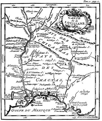
LOUISIANA. (Dumont.)
There is on a later page a fac-simile of the map, showing the carrying-place between the St. Lawrence and Mississippi valleys, which appeared in the London (1747 and 1755) editions of Cadwallader Colden’s History of the Five Indian Nations of Canada.
The controversy over the bounds of the French and English possessions, which was so unproductive of results in 1755, caused a large number of maps to be issued, representing the interests of either side. The French claimed in the main the water-shed of the St. Lawrence and the lakes, and that of the Mississippi and its tributaries. The English conceded to them a southern limit following the St. Lawrence and the Ottawa, thence across Huron and Michigan, to the Illinois, descending that river to the Mississippi; and consequently denied them the southern water-shed of the St. Lawrence and most of the eastern water-shed of the Mississippi.
On the French side the following maps may be named:—
The great D’Anville map, Canada, Louisiane, et les terres anglaises, which was followed in the next year (1756) by D’Anville’s Mémoire on the same map; Robert de Vaugondy’s Partie de l’Amérique Septentrionale qui comprend le Cours de l’Ohio, la Nlle Angleterre, la Nlle York, New Jersey, Pensylvanie, Maryland, Virginie, Caroline; Carte Nouvelle de l’Amérique Angloise contenant le Canada, la Nouvelle Ecosse ou Acadie, les treize Provinces unies, avec la Floride, par Matthieu Albert Lotter, published at Augsburg, without date; Carte des possessions Angloises et Françoises du Continent de l’Amérique Septentrionale, published by Ottens at Amsterdam, 1755; Carte de l’Amérique Septentrionale, par M. Bellin, 1755; in the same year the Partie Orientale, et partie Occidentale de la Nouvelle France ou du Canada, likewise by Bellin;[148] and the Carte de la Louisiane par le Sieur Bellin, 1750, sur de nouvelles Observations on a corrigé les lacs, et leurs environs, 1755; Canada et Louisiane, par le Sieur le Rouge, ingénieur géographe du Roi, Paris, 1755, with a marginal map of the Mississippi River.
In the English interests there were several leading maps: A new and accurate map of North America (wherein the errors of all preceding British, French, and Dutch maps respecting the rights of Great Britain, France, and Spain, and the limits of each of His Majesty’s Provinces are corrected), by Huske. This was engraved by Thomas Kitchin, and published by Dodsley at London, 1755. It gives the names of the French trading posts and stations. John Huske also printed The Present State of North America, Part I., London, 1755, which appeared in a 2d edition the same year with emendations, giving Huske’s map, colored, leaving the encroachments of the French uncolored. It was also reprinted in Boston, in the same year.[149]
Another is A map of the British Colonies in North America, with the roads, distances, limits, and extent of the settlements. This is John Mitchell’s map, in six sheets, engraved by Kitchin, published in London by Jefferys and Faden, 1755. John Pownall, under date of February 13, 1755, certifies to the approval of the Lords of Trade.[150] It was reëngraved, with improvements, a year or two later, at Amsterdam, by Covens and Mortier, under the title Map of the British and French Dominions in North America, on four sheets, with marginal plans of Quebec, Halifax, Louisbourg, etc.[151]
Lewis Evans issued his General Map of the Middle British Colonies in America in 1755,[152][84] and it was forwarded to Braddock after he had taken the field, for his assistance in entering upon the disputed territory of the Ohio Valley,—indeed, its publication was hastened by that event, the preface of the accompanying pamphlet being dated Aug. 9, 1755.
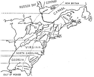
HUSKE’S MAP, 1755.
This is sketched from the colored folding map in John Huske’s Present State of North America, &c., second edition, London, 1755. The easterly of the two pricked (dots) lines marks the limits within which the French claimed to confine the English seaboard colonies. Canada, or the region north of the St. Lawrence, east of the Ottawa, and south of the Hudson Bay Company and New Britain, together with the islands in the Gulf of St. Lawrence, and the northerly coasts of Newfoundland (to dry fish upon), constitute all that the British allowed to France. The stars represent the forts which they had established in the disputed territory; while the circle and dot show the frontier fortified posts of the English, as Huske gives them. The English claimed for the province of New York all the territory north of the Virginia line, west of Pennsylvania, and west of the Ottawa, and south of the Hudson Bay Company’s line. Virginia, the two Carolinas, and Georgia extended indefinitely westward. The northern line of Virginia was established by the charter of 1606; the southern bounds mark where the Carolina charter of 1665 begins, and the bounds of Spanish Florida denote that charter’s southern limit, the territory being divided by the subsequent grant of Georgia. The space between the pricked line, already mentioned, and the other pricked line, which follows the Mississippi River to the north, is the land which is called in a legend on the map the hereditary and conquered country of the Iroquois, which had been ceded by them to the British crown by treaties and a deed of sale (1701), and confirmed by the treaties of Utrecht and Aix-la-Chapelle. Cf. Description of the English and French territories in North America, being an explanation of a new map, shewing the encroachments of the French, with their Forts and Usurpations on the English settlements; and the fortifications of the latter. Dublin, 1755 (Carter-Brown, iii. 1056).
Jefferys pirated Evans’ map, and published it in 1758, “with improvements by I. Gibson,” and in this form it is included in Jefferys’ General Topography of North America and the West Indies, London, 1768. Pownall, who was accused of procuring the dedication of the original[85] issue by “a valuable consideration” (Mass. Hist. Coll., vii. 136), called Jefferys’ reproduction badly done, and reissued Evans’ work in 1776, under the following title: A map of the Middle British Colonies in North America, first published by Mr. Lewis Evans of Philadelphia in 1755, and since corrected and improved, as also extended ... from actual surveys now lying at the Board of Trade, by T. Pownall, M. P., Printed and published for J. Almon, London, March 25, 1776. In this form the original plate was used as “Engraved by James Turner in Philadelphia,” embodying some corrections, while the extensions consisted of an additional engraved sheet, carrying the New England coasts from Buzzard’s to Passamaquoddy Bay.
A French copy, with amendments, was published in 1777.[153]
The map was also reëngraved in London, “carefully copied from the original published at Philadelphia by Mr. Lewis Evans.” It omits the dedication to Pownall, and is inscribed “Printed for Carrington Bowles, London; published, Jan. 1, 1771.” It has various legends not on Evans’ map, and omits some details, notwithstanding its professed correspondence. Evans had used the Greek character [Greek: ch] to express the gh of the Indian names, which is rendered in the Bowles map ch.
Another plate of Evans’ map was engraved in London, and published there by Sayer and Bennett, Oct. 15, 1776, to show the “seat of war.” It covers the same field as the map of 1755, and uses the same main title; but it is claimed to have been “improved from several surveys made after the late war, and corrected from Governor Pownall’s late map, 1776.” The side map is extended so as to include Lake Superior, and is called “A sketch of the upper parts of Canada.” Smith (1756) says: “Evans’ map and first pamphlet were published in the summer, 1755, and that part in favor of the French claim to Frontenac was attacked by two papers in the N. Y. Mercury, Jan. 5, 1756. This occasioned the publication of a second pamphlet the next spring, in which he endeavors to support his map.”[154]
Evans’ pamphlet is called Geographical, historical, political, philosophical, and mechanical essays. The first, containing an analysis of a general map of the middle British colonies in America; and of the country of the confederate Indians [etc.]. Philadelphia, 1755. iv. 32 pp. 4º. A second edition, with the title unchanged, appeared the same year, while “Part ii.” was published in the following year.[155]
By Gen. Shirley’s order N. Alexander made a map of the frontier posts from New York to Virginia, which is noted in the Catal. of the King’s maps (British Museum), ii. 24. This may be a duplicate of a MS. map said by Parkman (i. p. 422) to be in the Public Record office, America and West Indies, lxxxii., showing the position of thirty-five posts from the James River to Esopus on the Hudson.
Le Page du Pratz gave a “Carte de la Louisiane, par l’Auteur, 1757,” in his Histoire de la Louisiane (vol. i. p. 138), a part of which map is reproduced herewith. See also ante, p. 66.
In the Gentleman’s Magazine, 1757, p. 74, is “A map of that part of America which was the principal seat of war in 1756,” defining the Ottawa River as the bounds under the treaty of Utrecht.
Janvier’s L’Amérique, in 1760, carried the bounds of Louisiana to the Pacific.
Pouchot, in a letter dated at Montreal, April 14, 1758, describes a map, which he gives in his Mémoires, vol. iii., where it is called “Carte des frontières Françoises et Angloises dans le Canada depuis Montreal jusques au Fort Du Quesne.” It is reproduced in Dr. Hough’s translation of Pouchot, in the Pennsylvania Archives, second series, vi. p. 409, and in N. Y. Col. Hist., vol. x.
In 1760 Thomas Jefferys included a map of Canada and the north part of Louisiana in The Natural and Civil History of the French Dominion in North and South America, purporting to be “from the French of Mr. D’Anville, improved with the back settlements of Virginia and course of the Ohio, illustrated with geographical and historical remarks,” with marginal tables of “French Incroachments,” and “English titles to their settlements on the Continent.” This map ran the northern bounds of the English possessions along the St. Lawrence, up the Ottawa, across the lakes, and down the Illinois and the Mississippi. The northern bounds of Canada follow the height of land defining the southern limits of the Hudson Bay Company.
After the peace of 1763, Jefferys inserted copies of this map (dated 1762) in the Topography of North America and the West Indies (London, 1768), adding to it, “the boundaries of the Provinces since the Conquest laid down as settled by the King in Council.” The map of[86] 1762 is reproduced in Mills’ Boundaries of Ontario.[156]
Jefferys also gave in the same book (1768) a map of the mouths of the Mississippi and the neighboring coasts, which, he says, was taken from several Spanish and French drafts, compared with D’Anville’s of 1752 and with P. Laval’s Voyage à Louisiane.
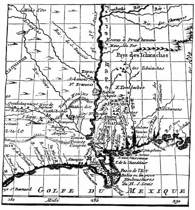
LOUISIANA. (Le Page du Pratz.)
CHAPTER II.
NEW ENGLAND, 1689-1763.
BY JUSTIN WINSOR,
The Editor.
ANDROS, with Joseph Dudley and other satellites, made safe in Castle William, the revolution in New England was accomplished, and the veteran Simon Bradstreet was at the head of the old government on its sudden restoration (1689) to power.
The traditions of the charter-days were still strong among the country people, and their deputies in the resuscitated assembly brought into Boston the old spirit of independence to enliven the stifled atmosphere which the royal governor had spread upon the town. The new government was proposedly a provisional one to await the result of the revolution which seemed impending in England. If the policy of unwavering adherence to the old charter had been pursued with the constancy which characterized the advocacy of Elisha Cooke, the popular tribune of the day, the current of the New England history for the next few years might possibly have been changed. The sturdy assumption of political power did not follow the bold revolution which had prepared the way for it, and, professing dependence upon the royal will, all thoughts were now addressed to placate the new monarch, and regain by law what they had failed to achieve by a dogged assertion of right. King William, of whose accession they soon were notified, unhesitatingly, but for temporary service, confirmed the existing rulers.[157]
A command came for Andros to be sent to England, with a presentation of charges against him, and it was obeyed.[158] Increase Mather had already gone there to join Ashurst, the resident agent of the colony, and the people were not without hope that through the urgency of these representatives the restitution of the old charter might be confirmed. Subsequently Elisha Cooke and Thomas Oakes were despatched to reinforce the others. Mather, either because he felt the project a vain one, or because he hoped, under a new deal, to be better able to direct affairs,[88] was favoring a new charter.
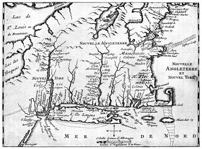
This follows the map in the Amsterdam ed. (1688) of Richard Blome’s L’Amérique, traduit de l’Anglois. This is a different map (on a larger scale) from the one in the original English edition of Blome. See reference to the map given in Mather’s Magnalia (1702) in Vol. III. p. 345. This map is reproduced in Cassell’s United States, i. pp. 492, 516.
Douglass, with some excess, again speaks of Mather’s map (Summary, etc., i. 362) “as composed from some old rough drafts of the first discoverers, with obsolete names not known at this time, and has scarce any resemblance of the country,” and he calls Cyprian Southack’s maps and charts even worse. For Southack see Mem. Hist. of Boston.
Plymouth, which had never had a royal charter, was endeavoring, through the agency of Ichabod Wiswall,[159] the minister of Duxbury, who had been sent over to protect their interests, to make the most of the present opportunity and get a favorable recognition from the king. Between a project of annexation to New York and Mather’s urging of an alternative annexation to the Bay, the weaker colony fared hard, and its ultimate fate was fashioned against its will. In the counsels of the four agents Cooke was strenuous for the old charter at all hazards, and Oakes sustained him. Mather’s course was professedly a politic one. He argued finally that a chance for the old charter was gone, and that it would be wiser to succumb in season to the inevitable, in order better to direct progress. When it came to a petition for a new charter, Oakes so far smothered his sentiments as to sign it with Mather; but Cooke held out to the last.
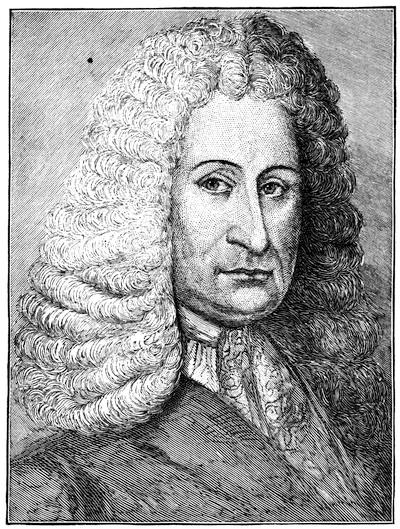
ELISHA COOKE, THE ELDER.
This follows a red-chalk drawing in the gallery of the American Antiquarian Society, which had belonged to the Rev. William Bentley, of Salem, who was born in Boston in 1759, and died in Salem in 1819.
Meanwhile, Massachusetts was governing itself, and had enough to do[90] in looking after its frontiers, particularly at the eastward, where the withdrawal of the troops which Andros had placed there became the signal for Indian outbreaks. New Hampshire, weak in her isolation, petitioned to be taken under the jurisdiction of Massachusetts, and was (March 19, 1690) for the time being annexed.[160] Connecticut, destined to save her charter by delays and a less fiery spirit, entered upon a career characterized in the main by dignified quiet. Though she participated in some of the tumult of the recurrent Indian wars, and let her bitterness against episcopacy sometimes lead to violent acts, she had an existence of much more content than fell to the lot of the other New England colonies.[161]
The first momentous event which the restored governments had to encounter was the disastrous expedition which Phips led against Quebec, in 1690. With confident hope, the fleet on the 8th of August sailed from Boston harbor, and the whole community for three months waited for news with great solicitude. Scarce three weeks had passed when Sewall records (August 28) that they got from Albany intelligence of the Mohawks’ defection, which, as he writes, “puts a great damp here to think that our fleet should be disappointed of their expected aid.”[162] Apprehension of some more imminent danger grew throughout the colony. In September they placed watches at night throughout Boston, and gave as watchwords “Schenectady” and “Salmon Falls,”—fearful reminders.[163] One night at Charlestown there was an alarm because Indians were seen in their back fields,—they proved to be runaway servants. Again, the home guard, eight companies, trained another day. At last tidings came from Plymouth of certain losses which the contingent of that colony, among the forces acting at the eastward, had suffered, news whereof had reached them. This and other matters were made the grounds of an attempt to found a regular channel of communicating the current reports, which in a little sheet called Publick Occurrences was issued at Boston, Thursday, September 25, the precursor of the American newspaper. It told the people of various incidents of their every-day life, and warned them of its purpose to prevent false reports, and to correct the spirit of lying, “which prevails among us.” It represented that “the chief discourse of this month” was the ill-success of the expedition, which, under the command of Gen. Winthrop, of Connecticut, had attempted to advance on Montreal by way of Lake Champlain, to distract the enemy’s attention in that direction while Phips ascended the St. Lawrence.[164]
About six weeks later, on Friday, November 7, word came to the governor from Salem of the disastrous events in the St. Lawrence and the discomfiture of Phips.[165]
The unfortunate expedition had cost Massachusetts £50,000, and while the colony was devising an illusory scheme of paper money as a quick way of gathering taxes, Phips slipped off to England, with the hope that his personal explanations would assist in inducing the home government to lend a helping hand in some future attempt.
When Phips reached England he found that Mather had done good work in preventing the reinstalling of Andros, as at one time was threatened.[166]
Memorials and counter-memorials, printed and manuscript, were pressed upon Parliament, by which that body was now urged to restore, and now implored to deny, the vacated charter. It was at this juncture that Mather, with two other agents, petitioned the king for a new charter; and the law officers reporting favorably, the plan had already been committed to the Lords of Trade at the time when Phips appeared in London. With the assent of the king, the framing of a new charter was entrusted to Sir George Treby, the Attorney General, who was instructed to fortify the royal prerogative, and to make the jurisdiction include not only Massachusetts, but the territory of New Plymouth and all that region, or the better part of it, lying east of the present State of New Hampshire, and stretching from the St. Lawrence to the Atlantic.
It was the dawn of a new existence, in which the province, as it now came to be called, was to be governed by a royal governor, sent to enforce the royal prerogative, to administer the navigation laws in the interests of British merchants, to gratify the sectaries of the Established Church, and to embarrass the old-fashioned theocracy. The chief power reserved to the people was that of the purse,—an important one in any event, and one that the legislative assembly knew how to wield, as the years which followed proved.
Mather professed to think the new charter—and it perhaps was—the best result, under the circumstances, to be attained. He talked about the colony still having a chance of assuming the old charter at some[92] more opportune moment. Cooke, the champion of the old conditions, was by no means backed in his opposition by a unanimity of feeling in the colony itself; for many of the later comers, generally rich, were become advocates of prerogative, and lived in the hope of obtaining more consequence under a changed order of society. Connecticut and Rhode Island were content, meanwhile, with the preservation of their own chartered autonomy, such as it was.
Thus affairs were taking a turn which made Phips forget the object of his visit. Mather seems to have been prepared for the decision, and was propitiated also by the promise of being allowed to nominate the new governor and his subordinates. Phips had been Mather’s parishioner in Boston, and was ambitious enough to become his creature, if by doing so he could secure preferment. So Sir William Phips was commissioned Governor; and as a sort of concession to the clerical party, of which Mather himself was the leader in Boston, William Stoughton was made Lieutenant-Governor. Isaac Addington became Secretary. Bradstreet was appointed first assistant. Danforth, Oakes, and Cooke, the advocates of the old charter, were forgotten in the distribution of offices.
On Tuesday, January 26, 1692, Robin Orchard came to Boston from Cape Cod, bringing tidings that Capt. Dolberry’s London packet was at anchor in the harbor now known as Provincetown, and that she had brought the news of the appointment of Phips under a new charter.[167]
Boston was at this time the most considerable place in the New World, and she probably had not far from 7,000 inhabitants; while Massachusetts, as now constituted, included 75 towns, of which 17 belonged to Plymouth. Within this enlarged jurisdiction the population ranged somewhere between 60,000 and 100,000,—for estimates widely vary. Out of this number twenty-eight persons had been chosen to make the governor’s council, but their places were to be made good at subsequent elections by the assembly, though the governor could negative any objectionable candidate; and the joint approval of the governor and council was necessary to establish the members of the judiciary. The acts of the legislature could for cause be rejected by the Privy Council any time within three years, and to it they must be regularly submitted for approval; and this proved to be no merely formal action. It meant much.
These conditions created a new political atmosphere for Massachusetts. Religion and politics had in the old days gone hand in hand, and the little book which Joshua Scottow, one of the old patriarchs, now printed, Old Men’s Tears, forcibly reminded them of the change. The community was more and more engrossed with trade; and those that concerned[93] themselves with politics were not near so closely of one mind as formerly; and there was lacking that invigorating motive of saving their charter which had so unified the thoughts and banded the energies of the community in former years.
On the 14th of May, 1692, the “Nonesuch” frigate cast anchor in Boston harbor. When Phips and Mather disembarked, eight companies of soldiers received and escorted them to their respective houses. “Made no volleys, because ‘twas Satterday night,” says Sewall, recording the event.[168] The ceremony of inauguration was no sooner over than all parties began to take their bearings; and Mather, not long after,[169] in an election sermon, took occasion to defend the policy of his recent mission. It remained to be seen how much the province was to gain from its closer connection with the home government. Was it to claim and secure larger assistance in repressing Indian outbreaks and repelling French encroachments?—for these things were brought home to them by the arrival of every messenger from the frontiers, by the surveillance under which they had put all Frenchmen who chanced to be in their seaports, and by the loads of wine-casks which paraded the streets of Boston when the “Swan” (September 20, 1692) brought in a French prize. It was not till October 23d that Cooke and Oakes reached home, and the old-charter party had once more its natural leaders; Cooke, at least, bringing to it the influence of wealth.[170]

THE PROVINCE SEAL.
This is the form of the Great Seal of Massachusetts, used in the time of George I. It was recut, and the name of the monarch changed under George II. This last design will be found in the Massachusetts House Doc., no. 345 (1885), being a report on the Arms and Great Seal of Massachusetts. Here, as in the Heraldic Journal, vols. i. and ii., the private seals of the royal governors are given, which were used in sealing military commissions.
In the sermon to which reference has just been made, Mather showed that, however he had carried many of his own points, he had failed in some that much troubled him. The change in the qualification of electors from church membership to the condition of freeholders was alarming to those of the old theocratic sentiments. It meant a diminution of their influence, and that the 120 churches in New England (of which 80 were in Massachusetts) were to direct much less than formerly the legislation of the people. The possible three years which a law might[94] live before the home-veto came must be made the most of. Using his influence with Phips, Mather dictated the choice of the first corporation of Harvard College, freshly chartered under the new rule, and without waiting for the confirmation of the Privy Council, who might well be thought to be opposed to a charter for the college which did not provide some check in a board of visitors, he caused himself, very likely in a passive way, to be made its first Doctor of Divinity, but his admirers and creatures knew the reward he expected. We think, however, to-day less of the legislation which gave such a title to their great man than we do of the smaller ambitions by which the assembly of the province about the same time were originating our public-school system.
The governor, in his communication to the General Court, reminded them of the royal recommendation that they should fix by law a fitting salary for the chief executive. It raised a point that Elisha Cooke was in wait for. Under his instigation, the plan was devised of substituting an annual grant, which might be raised or lowered, as circumstances warranted, and as was necessary to vindicate one of the few rights left to them by the charter. It was the beginning of a conflict that recurred with each successive governor as he attempted to force or cajole the representatives into some recognition of the royal wish.
The baleful influence of the Mathers—for the son Cotton was now conspicuous—conduced to commit the unwary Phips to instituting a court, which disgraced itself by the judicial murders attending the witchcraft frenzy; and in the midst of all, Sir Francis Wheeler’s crippled fleet arrived from the West Indies (June 11, 1693), having lost more than half its men by disease. The fear of infection almost caused a panic among the inhabitants of Boston when, two days later, Wheeler anchored his frigates off Noddle’s Island. Ten days afterwards their commander was entertained at Cambridge by the governor, and by Mather as president of the college.
Connecticut was in the mean while serving both Massachusetts on the east and New York on the west. She sent troops to help defend the eastern dependencies of the Bay. On the retreat of Winthrop’s expedition, New York appealed to Connecticut for help, and she afforded it; but when Governor Fletcher, of New York, came to Hartford and claimed command of her militia, she resisted his pretensions, and, as the story goes, drowned the reading of his proclamation by a vigorous beating of drums.[171] Fitz-John Winthrop was sent to England to compose matters, and it ended in Connecticut placing 120 men at the disposal of the New York governor, while she retained command of her home forces, and Winthrop became in turn her governor.
Phips too went to England, but on a mission not so successful. His testy character had early imperilled his administration. He got into a quarrel[95] with Fletcher, of New York, and he yielded to passions which brought undignified encounters even in the public streets. Representations of such conduct did not fail to reach the king, and Phips was commanded to appear in his own defence. His friends had endeavored to force an address through the House of Representatives, praying the king not to remove him; but it was defeated by the united action of members from Boston, many of whom represented country towns. The governor’s friends resorted to a specious device which appealed to the local pride of the country; and, by the urgency of Mather and others, a bill requiring the representatives to be residents of the town they sat for was forced through the House.[172] With an assembly constituted under the new rule, a bare majority was secured for the address, and Phips took it with him.
Before much progress could be made in the investigation, after his arrival in London, he died on February 18, 1694-5.[173] The news did not reach Boston till early in May. “People are generally sad,” says Sewall. “Cousin Hall says the talk is Mr. Dudley will be governor,” and the next day mourning guns were fired at the Castle.[174]
Joseph Dudley’s hour of pride was not yet come, though he had intrigued for appointment even before Phips’s death. The protests of Ashurst and Constantine Phipps, the colony’s agents in London, were effectual; and the king was by no means prepared as yet to alienate the feelings of his New England subjects in order to gratify the avenging spirit of Dudley. That recusant New Englander was put off with the lieutenant-governorship of the Isle of Wight, a position which he held for nine years.
The government in Boston upon Phips’s leaving had legally fallen into the hands of that old puritan, the lieutenant-governor, William Stoughton, and in his charge it was to remain for four years and more (November, 1694, to May 26, 1699). It was a period which betokened a future not significant of content. It was not long before Thomas Maule could call the ministers and magistrates hard names, and with his quick wit induce a jury to acquit him.[175] But the spirit of Parliament could not be so easily thwarted. As colonists, they had long known what restrictive acts the mother country could impose on their trade in the interests of the stay-at-home merchants, who were willing to see others break the soil of a new country, whose harvests they had no objection to reap. The Parliament of the Commonwealth had first (1651) taken compulsory steps,[96] and the government of the Restoration was not more sparing of the colonists. King William’s Parliament increased the burden, and the better to enforce observance of its laws they established a more efficient agency of espionage than the Plantation Committee of the Privy Council had been, by instituting a new commission in the Lords of Trade (1696), and had followed it up by erecting a Court of Admiralty (1697) to adjudicate upon its restrictive measures.[176] About the same time (1696) they set up Nova Scotia, which had been originally included in the Massachusetts charter of 1691, as a royal province. The war which was waging with France served somewhat to divert attention from these proceedings. French privateers were hovering round the coast, and Boston was repairing her defences.[177] Not a packet came into the Bay from England, but there was alarm, and alertness continued till the vessel’s peaceful character was established. News was coming at one time of Frontenac’s invasion of New York, and at another of Castin’s successes at the eastward. In August, 1696, when Captain Paxton brought word to Boston of Chub’s surrender of Pemaquid, five hundred men were mustered, but they reached Penobscot only to see the French sailing away, and so returned to Boston unrewarded. The enemy also fell on the Huguenot settlement at Oxford, Mass., and the inhabitants abandoned it.[178] When the aged Bradstreet was buried,[179] they had to forego the honor they would pay his memory in mourning guns, because of the scarcity of powder; and good people rejoiced and shivered as word came in June of the scalping exploit of Hannah Dustin at Haverhill, in the preceding March. In the autumn (November 4) there was nothing in all this to prevent the substantial loyalty of the people showing itself in a celebration of the king’s birthday. The Boston town house was illuminated, and the governor and council went with trumpets to Cotton Hill[180] to see the fireworks “let fly,” as they said. No word had yet come of the end of the war, which had been settled by the peace of Ryswick in September. A month later (December 9, 1697) Captain Gillam arrived at Marblehead from London, and the next day, amid the beat of drum and the blare of trumpet, between three and four in the afternoon, the proclamation of the peace was made in Boston. The terms of that treaty were not reassuring for New England. A restitution of captured lands and ports on either side was made by it; but the bounds of Acadia were not defined, and the Sagadahock country became at once disputed ground. The French claimed that it had been confirmed to them by the treaties of St. Germain (1632) and Breda (1668); but the Lords of Trade urged the province to rebuild the forts at Pemaquid, and maintain an ascendency on the spot.
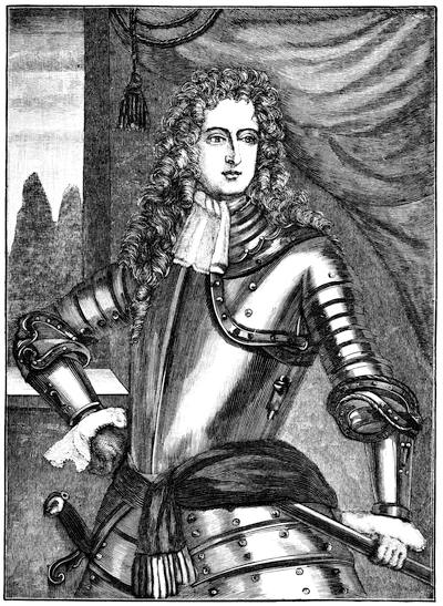
BELLOMONT.
This follows a contemporary engraving preserved in Harvard College library, which is inscribed: “His Excellencie Richard Coote. Earle of Bellomont, Governour of New England, New York and New Hampshire, and Vice Admirall of those seas.” Cf. the picture of doubtful authenticity in the Memorial History of Boston, ii. p. 175.
As early as August, 1695, word had come that Richard Coote, the Earl of Bellomont, was to be the new governor of Massachusetts. Later it was said that he would not arrive till spring; and when spring came the choice had not even been determined upon. It was not till November, 1697, that he was commissioned governor of New York, New Jersey, Massachusetts, and New Hampshire. He landed in New York on the 2d of[98] April, 1698, and on the 12th a sloop reached Boston, bringing tidings of his arrival, and three days later the council received a communication from him. For a year and more he stayed in New York, sending his instructions to Stoughton, who as lieutenant-governor directed the council’s action. On the 26th of May, 1699, the governor reached Boston;[181] and it was not long before he manifested his sympathy with the party of which Elisha Cooke was the leader. This gentleman, who was so obnoxious to the Mather party, had been negatived by Phips, when chosen to the council; but on Phips’s withdrawal, his election had escaped a veto, and he now sat at the council board. Mather had succeeded, in 1697, in forcing upon the legislature a charter, in the main of his own drafting, which gave to Harvard College the constitution that he liked, but he manœuvred in vain to secure his own appointment from the General Court to proceed to England to solicit the sanction of the Privy Council; and it was not long before he found that the new governor had vetoed his charter, and in 1701 the assembly legislated him out of office, as the president of the college.
This first blow to the dominance of the Mathers was reassuring, and Bellomont was a leader for the new life to rally about.[182] He was a man of complacent air. He liked, if we may believe him, to hear sermons well enough to go to King’s Chapel on Sundays, and to the meeting-house for the Thursday lectures. He could patronize the common people with a sufficient suavity; and when the General Court, after their set purpose,[99] voted him a present instead of a salary, if he was not much pleased, he took his £1,000 as the best substitute he could get for the £1,200 which he preferred.
Boston, with its 7,000 inhabitants, was not so bad a seat of a viceroyalty, after all, for a poor earl, who had a living to make, and was debarred the more lucrative methods of trade. He reported back to the Lords of Trade abundant figures of what he found to be the town’s resources and those of his government; but the favor which he was receiving from the good people might have been less had they known that these same reports of his set forth his purpose to find Englishmen, rather than New Englanders, for the offices in his gift.
We have also at this time the report which the scurrilous Ned Ward made of the puritan town and its people;[183] but it is not well to believe all of his talk about the innocence of doves and the subtile wiles of serpents, though life in Boston was not without its contrasts, as we look back upon it now. Samuel Sewall, her first abolitionist, was even then pointing the finger of doom to the insidious evil in his Selling of Joseph. Not altogether foreign to the thoughts of many were the political possibilities of the coming century, when on New Year’s Day, 1701, the bellman’s clangor was heard, as he toned Sewall’s memorial verses through the streets. There was a certain fitness in the century being ushered in, for New England at least, by the man who was to make posterity best acquainted with its life, and who as a circuit judge, coursing statedly the country ways, saw more to portray than any one else. Sewall was an honest man, if in many respects a petty one. He had figured in one of the noblest spectacles ever seen in the self-willed puritan capital, when on a fast day, January 14, 1697, he had stood up in the meeting-house, and had listened with bowed head to the reading of his penitential confession for the sin of his complicity in the witchcraft trials. Stoughton, the lieutenant-governor, and chief justice of those trials, was quite another type of the puritan fatalist, from whom it was futile to expect a like contrition; and when, at a later day (December 25, 1698), Stoughton invited to dinner the council and omitted Sewall, who was one of them, one might fancy the cause was in no pleasant associations with the remembrance of that scene in Parson Willard’s meeting-house. It is characteristic of Sewall that this social slight oppressed him for fear that Bellomont, who had not yet come, might hear of it, and count him less! But poor Sewall was a man whom many things disturbed, whether it was that to mock him some one scattered a pack of playing-cards in his fore-yard, or that some of the godly chose to wear a wig![184]
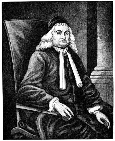
SAMUEL SEWALL.
This follows the steel engraving in Sewall Papers, vol. i. There is another likeness in N. E. H. & Gen. Reg., i. 105. Cf. also Higginson’s Larger Hist. United States, p. 208.
The smiting of the Mathers, to which reference has been made, was a business of serious moment to those theocrats. Whoever was not in sympathy with their protests fared badly in their mouths. “Mr. Cotton Mather,” records Sewall (October 20, 1701), “came to Mr. Wilke’s shop, and there talked very sharply against me, as if I had used his father worse than a neger; spoke so loud that people in the street might hear him.” There is about as near an approach to conscious pleasantry as we ever find in Sewall when, writing, some days later, that he had sent Mr. Increase Mather a haunch of very good venison, he adds, “I hope in that I did not treat him as a negro.”
The Mathers were praised highly and blamed sharply in their lifetime, and have been since. There can be little dispute about what they did and what they said; they were outspoken enough to make their motives and feelings palpable. It is as one makes or refuses allowances for their times that the estimate of their value to their generation is scaled. None ever needed allowances more. They had no conception of those influences which place men in relation to other times than their own. There was in their minds no plane higher than the existence around them,—no plane to which the man of all times leads his contemporaries. Matherism, which was to them their life, was to others a domination, the long-suffering of which, by their coevals, to us of to-day is a study. It would be unjust to say that this mighty influence had not been often of great good; but the gentle observer of an historic character does not contentedly witness outbursts of selfish arrogance, canting humiliation, boastful complacency, to say nothing of social impertinences and public indelicacies, and the bandying of opprobrious epithets in controversy. With this there was indeed mingled much for which New England had reason to be grateful. Increase Mather had a convenient astuteness, which was exerted not infrequently to her no small gain. He had learning, which usually left his natural ability and his education free from entanglements. It was too often quite otherwise with his son Cotton, whose reading smothered his faculties, though he had a native power that occasionally got the upper hand. Between them they gathered a library, which, as John Dunton said, was the glory of New England. The awe which Increase inspired knew little of that lurking rebellion which the too pitiful arrogance of Cotton incited; for the father was essentially a strong and politic man, and though his domination was waning outwardly in 1700, he had the ability to compel the Boston press into a refusal to print the Gospel Order Revised, which his opponents had written in answer to his Order of the Gospel, and to force his adversaries to flee to New York to find a printer.[185]
The old Mather theocracy was attacked on two sides. There was, in the first place, the defection within the old New England orthodoxy, by which an independent spirit had established a church. From the published manifesto of its principles this came to be known as the “Manifesto Church,” and it had invited Benjamin Colman home from England to become its pastor,[186] who, to avoid difficulties, had been ordained in England. He first preached in November, 1699. In the second place, the organization of the Church of England, which had begun in Andros’s time, was gathering strength, though Sewall got what comfort he could from the fact that Mr. Maccarty’s shop and others were not closed on Christmas Day. Attempts had been made to divert the funds of the Society for the Propagation of the Gospel in New England from their application to the needs of the Indians, to strengthen the new Episcopal movement; and the failure to do this, as well as a spirit to emulate the missionary[102] enterprise of the French, had instigated the formation of a new Society in England for Propagating the Gospel in Foreign Parts; but it was not long before its resources were turned into channels which nurtured the Episcopal movement and the royal authority. Strong contrasts to the simplicity of the old order were increasing; and it was not without misgivings that the old people had seen Benjamin Wadsworth, the new associate pastor of the First Church, inducted (1696) into office with an unusual formal parade. Thus the humble manners of the past were becoming in large degree a memory; and when, a little later (June 1, 1702), the new queen was proclaimed, and the representatives were allowed to precede the ministers in the procession, the wail in Sewall’s diary, as well as when he notices the raising of colors at the Castle on the Lord’s Day, betokens in another way the order of things which the new charter was making possible.
While in Massachusetts the defection grew, in Connecticut the old order was entrenching itself in the founding of Yale College, first at Saybrook, and later at New Haven, which was destined, as Harvard declined in the estimation of the orthodox, to become the rallying-point of the old school.[187]
In Rhode Island matters went on much as the heterogeneous composition of that colony necessarily determined. Bellomont could find little good to report of her people, and the burden of his complaint to the Lords of Trade touched their propensity to piracy, their evasion of the laws of trade, and the ignorance of the officials.
Bellomont had returned to his government in New York when, on the 5th of March, 1701, he died. It took ten days for the news to reach Boston (March 15), and four days later (March 19) word came by the roundabout channel of Virginia of the declaration of war between England and France. In the midst of the attendant apprehension, on April 7th, mourning guns were fired for the dead governor at the Sconce and at the Castle, and the artillery company gave three volleys in the middle of the town, Col. Townshend, as Sewall in his antipathy does not fail to record, wearing a wig!
When Bellomont had left for New York in May, 1700, the immediate charge of the government had again fallen upon Stoughton. He did not long survive his chief, and died July 7, 1701, in his seventieth year,[188] and from this time to the coming of Dudley the council acted as executive.
It was on Joseph Dudley, to a large party the most odious of all New Englanders, the ally of Andros, that the thoughts of all were now turned. It was known that he had used every opportunity to impress upon the king his fitness to maintain the royal prerogative and protect the revenue in New England. The people of Boston had not seen him for about ten years. In 1691 he had landed there on his way to New York, where he was to serve as a councillor; and during that and the following year he had made some unobtrusive visits to his home in Roxbury, till, in 1693, he was recalled to England to be made lieutenant-governor of the Isle of Wight. With the death of Bellomont his hopes again rose. Ashurst, as the senior of the Massachusetts agents, still opposed him, though his associate, Constantine Phipps,[189] was led to believe that the king might do worse than appoint the aspirant. Dudley was not deficient in tact, and he got some New Englanders who chanced to be in England to recommend him; and a letter, which he used to some purpose, came not surprisingly, considering his lineage, from Cotton Mather, saying quite enough in Dudley’s praise. Elisha Cooke and his friends were not ignorant of such events, and secured the appointment of Wait Winthrop as agent to organize a fresh opposition to Dudley’s purposes. It was too late. The letters which Dudley offered in testimony were powerful enough to remove the king’s hesitancy, and Dudley secured his appointment, which, on the death of the king a few days later, was promptly confirmed by Anne.[190]
The news of the king’s death and the accession of the queen reached Boston, by way of Newfoundland, on the 28th of May, 1702.[191] The new monarch was at once proclaimed from the town house, and volleys of guns and the merriment of carouse marked a new reign. How New England was to find the change was soon sharply intimated. Amid it all tidings came of the capture of three Salem ketches by the Cape Sable Indians. Later in the same day the eyes of Madam Bellingham, the relict of an early governor, were closed in death, severing one of the last links of[104] other days. Her death was to most a suggestive accompaniment of the mischance which now placed in the governor’s chair the recusant son of Thomas Dudley, that other early governor.
A fortnight later (June 10, 1702), the ship “Centurion,” having Joseph Dudley on board, put in at Marblehead, and the news quickly travelled to Boston. The next day a committee of the council went in Captain Croft’s pinnace to meet him, and they boarded the “Centurion” just outside Point Alderton. Dudley received them on deck, arrayed in a very large wig, as Sewall sorrowfully noted while making him a speech. They saw another man whom they had not heard of, one Thomas Povey, who was to be their lieutenant governor, and to have charge of their Castle. They saw, too, among the passengers, George Keith, the whilom quaker, who was come over on £200 salary, very likely paid by the Society for the Propagation of the Gospel in Foreign Parts, to convert as many as he could to prelacy.[192] Sewall was not happy during that day of compliments. The party landed at Scarlet’s Wharf amid salvos of artillery, and under escort of the council and the town regiment they proceeded to the town house, where the commissions were published and all “had a large treat,” as Sewall says. Major Hobby’s coach, with six horses, was at the door, a guard of horsemen wheeled into ranks, and so Dudley went to that Roxbury home, whence, as many remembered, he had been taken to be imprisoned.
Dudley was not deficient in confidence and forwardness; but he had no easy task before him. He naturally inclined to the faction of which Byfield and Leverett were leaders; but the insidious and envious Cotton Mather, taking him into his confidence, warned him of these very people. Dudley told them of the warning, and it was not long before the sanctimonious Mather was calling his excellency a “wretch.”
When Dudley made his opening address to the General Court,[193] he could not refrain from saying some things that were not very conciliatory. There were two points on which he raised issues, which he never succeeded in compassing. One of these was a demand for a stated salary. The assembly answered it with a present of £500 against the £1,000 which they had given to Bellomont. No urgency, no threats, no picturing the displeasure of the Crown, could effect his purpose.[194] The war which he waged with the representatives never, as long as the province existed, ended in a peace, though there was an occasional truce under pressure of external dangers.
Another of Dudley’s pleas was for the rebuilding of the fort at Pemaquid,[105] to secure possession of the disputable territory between the Kennebec and Acadia.[195] The deputies were immovable. If the Crown wished to secure that region, it must do it by other sacrifices than those of New England.
Thus thwarted, Dudley could make them feel that the royal governor had some prerogatives; and so he rejected the councillors which the deputies accredited. All of this thrust and parry was of course duly reported by Dudley to the home government. The situation was perplexing in the extreme, quite as much so to the governor as to the people, who reluctantly received him. It was for the interests of both that the war against the French should not flag, and money was necessary, but the governor claimed the direction of expenditures, while the representatives stood aloof and firm on the “privilege and right of English subjects to raise and dispose of money, according to the present exigency of affairs.” With the clergy and the ministers, Dudley was not less unhappily placed. His interests turned him to the church people, but they could not find that his profession had any constancy. His lineage placed him with the Congregationalists, and he once had the ministry in view, but his sympathies went altogether with the new school, of which Stoddard, of Northampton, was leader in the west, while Colman, the Leveretts, and the Brattles were the spokesmen in Boston. In the election of a president for Harvard, Dudley favored Leverett, the successful candidate, and made a Latin speech at his installation,[196] and Cotton Mather writhed at the disappointment of his own hopes. The governor encountered (1708), for his decisive opposition to the Mathers, a terrible but overwrought letter from the father, and a livelier epistle from the son. He showed in his reply a better temper, if nothing more.[197] In the opinion of all honest patriots, of whatever party, Dudley was later found in company which raised suspicions. The conflict with France begat, as wars do, a band of miscreants ever ready to satisfy their avarice by trading with the enemy and furnishing them with arms. Dudley did not escape suspicion, and he experienced some of the bitterest abuse in talk and pamphlet,[198] though the council and the House, the latter after some hesitancy, pronounced the charges against him a “scandalous accusation.” It can hardly be determined that he was implicated, and Palfrey gives him the benefit of the doubt.[199]
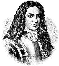
JEAN BAPTISTE HERTEL, SEIGNEUR DE ROUVILLE.
This likeness of the leader of the assault on Deerfield follows one given in Daniel’s Nos Gloires Nationales, i. p. 278, where is an account of the Hertel family. He was thirty-four at the time of his attack.
The war was a fearful one. In 1703, month by month fresh tidings of its horrors among the frontier towns reached Boston. In January it was of Berwick, in Maine. In February came sad tidings from Haverhill. In March there was the story of Deerfield, and how Hertel de Rouville had[106] dashed upon the village. With the early summer Dudley went to Canso to confer with the Indians (June 20); and not long after (July 8), Bombazeen, a noted Indian, appeared in Boston with rumors of the French landing near Pemaquid. In August there were sad messages from Wells, and Capt. Southack was sent off by sea with chaplain and surgeon. With all this need of her troops at home, the colony also despatched two companies of foot to help the British forces at Jamaica. Samuel Sewall mourned as ever, when on Sunday (April 23, 1704) great guns at the Castle signalized the Coronation-Day. “Down Sabbath! Up St. George!” he says. The very next day the first number of the Boston News-Letter (April 24)[200] brought to the minister’s study and to his neighbor’s keeping-room the gossip and news of the town which was witnessing this startling proof of progress. Ten days later Dudley signed Benjamin Church’s instructions (May 4), and the old soldier, whose exploits in Philip’s war were not forgotten, set off by land to Piscataqua, where he was met by Cyprian Southack in his brigantine, who carried him to the eastern garrisons. In the News-Letter, people read of the tribulations at Lancaster; of the affairs at Port Royal; of the new cannon which Dudley got from England for the Castle; of the French captives, whose presence in Boston so disturbed the selectmen that they petitioned the governor to restrain the strangers, and whose imagined spiritual needs prompted Cotton Mather to print in his tentative French his Le vrai patron des saines paroles.
News of this sort was varied by a rumor (December 18, 1705), which a sloop from the English Plymouth had brought, that Sir Charles Hobby was to be made governor,—which meant that the agents of the colony in London were trying to oust Dudley with a new man; but in this they failed.
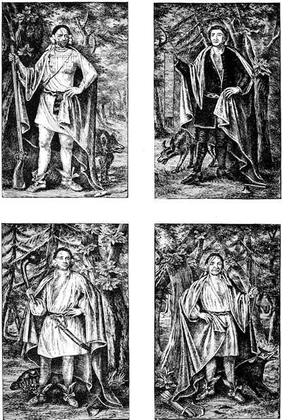
The war made little progress. The expedition against Port Royal in 1707 was a failure, and the frontier towns were still harassed. The news of Marlborough’s victories was inspiriting, and Boston could name a part of its main thoroughfare after the great soldier; but while she planted guns on her out-wharves and hoisted a tar-barrel to her beacon’s top, and while Colonel Vetch marshalled her troops,[201] she waited in vain for the English army to arrive, in concert with which the New England forces were to make a renewed attack on Port Royal in 1709. Rhode Island sent her war-vessels and two hundred men, and they too lay listlessly in Nantasket roads. Schuyler, of Albany, meanwhile started to conduct four Mohawks or Maqua chiefs to England, where he hoped to play upon the imagination of the queen; and in August, while the weary New Englanders were waiting for the signal to embark, Schuyler brought the savages to Boston, and Colonel Hobby’s regiment was mustered for their diversion.[202] Very likely they were taken to see the “celebrated Cotton Mather,” as the man who had not long before “brought in another tongue to confess the great Saviour of the world,” as he himself said of a tract in the language of the Iroquois, which he had printed in Boston (1707) and supplied to the Dutch and English traders among that people. Distractions and waiting wore away the time; but the English forces never came, and another Port Royal attempt proved wretchedly futile.
That autumn (October, 1709) the New England governors met at Rehoboth, and prepared an address to the queen urging another attempt. In the face of these events the Massachusetts colony had to change its London agent. Sir Henry Ashurst died, and the House would have chosen Sir William Ashurst against Dudley’s protest, if Sir William would have accepted. They now selected their own Jeremiah Dummer, but against his desires.
The year 1710 opened with rumors from Albany about preparations in Canada for an onset along the frontier, and it was not till July (15) that flags and guns at the Castle and Sconce, with drum-beats throughout the streets, told the expectant Bostonians that General Nicholson, who was to head a new expedition, had arrived. It was candle-light before he landed, and the letters and despatches at once busied the government. A little later the council (July 24) entertained that commander, with Vetch and Hobby, at the Green Dragon Tavern; and four days afterwards Governor Saltonstall, from Connecticut, reached Boston, and the contingent of that colony, three hundred men, was on the spot in four weeks from the warning. In September the armament sailed,—twelve ships-of-war and twenty-four transports, of which fourteen carried Massachusetts[108] troops, two New Hampshire, three Rhode Island, and five those of Connecticut. On the 26th of October (1710), Nicholson and his force were back in Boston, flushed with the triumph which the capitulation of Port Royal had given them.[203] The town had need of some such divertissement. There had been a scarcity of grain, and when Captain Belcher attempted to despatch a ship laden with it the mob cut her rudder, and the excitement had not passed without more or less inflaming of the passions. The circle of Matherites had also disturbed the equanimity of the liberals in theology by an anonymous document, Question and Proposals, which aimed at ecclesiasticising everybody and everything,—a stroke of a dying cause. There was an antagonist equal to the occasion in John Wise, of Ipswich, and the Mather dynasty had less chance of revival after Wise’s book The Churches’ Quarrel Espoused was launched upon the town.[204]
Nicholson, again in England, had urged the new tory government under Bolingbroke to make a more determined assault on Canada, and Dummer had united with him in a petition to the queen[205] for a royal armament to be sent for the work. Their plea was recognized and what seemed a great force was despatched. Nicholson, with the van of the fleet, arrived on the 6th of June, 1711,[206] and a convention of the New England governors was straightway called at New London to arrange for the campaign. The plan was for Nicholson to lead four thousand men by way of Albany, and the Connecticut contingent of three hundred and sixty men was to make part of this force. The royal ships came straggling into Boston harbor. On the 24th General Hill, who brought under his command seven of Marlborough’s veteran regiments, arrived, and the next day Sewall and others of the council boarded the “Devonshire” and exchanged courtesies with Hill and the admiral of the fleet, Sir Hovenden Walker. The Boston regiments mustered and escorted them to the town house, and the veterans were thrown into a camp on Noddle’s Island. The next six weeks were busy ones, with preparations and entertainments. Mr. Borland, a wealthy merchant, took Hill into his house. The governor offered official courtesies. The transports as they came up into the inner harbor presented a “goodly, charming prospect,” as Sewall thought.[207]
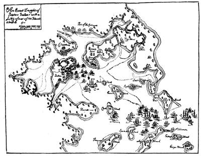
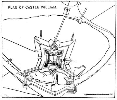
Commencement at Cambridge came on July 4, and all the dignitaries were there. One day some Connecticut Indians exhibited themselves before the admiral, and on another some Mohawks danced on board the flag-ship. By the end of the month, everything was as nearly ready as could be,[208] and the fleet sailed (July 30). They went proudly away, hastened somewhat by large desertions, which the patrolling of the roads leading from Boston had not prevented.
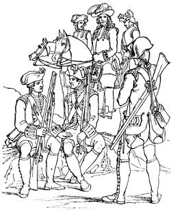
BRITISH SOLDIERS, 1701-1714.
Fac-simile of a cut (pl. xxviii.) in Luard’s Hist. of the Dress of the British Soldier, London, 1852, p. 94. It represents the soldiers of Marlborough’s wars.
Nicholson dallied in Boston for a week or two, eating good dinners, and then started for New York, to take the conduct of the land expedition, Saltonstall accompanying the Connecticut troops as far as Albany. Much farther no one of the land forces went, for word reached them of the sad disaster on the St. Lawrence and of the withdrawal of Walker’s fleet. The New England part of it came straggling back to Boston in October to find the town suffering under the loss of a great fire, which had happened on the night of October 2-3; most unmistakably the result, as Increase Mather told them in a sermon,—and perhaps believed,—of the way in which, during the fitting of the fleet, they had carried bundles on the Lord’s Day, and done other servile work! The cause of the expedition’s failure can be more reasonably indicated: delay in starting, an ill-organized method of supplies, bad pilotage, and incompetent leaders. Walker and Hill sailed direct for England, and in October, while the deputies of the province were bolstering their courage in asking the monarch for another attempt, the English mind was being filled with charges of want of proper coöperation on the part of the New Englanders as the all-sufficient cause of the disaster. Dummer, in London, vindicated his people as well as he could in a Letter to a Noble Lord concerning the late expedition to Canada.[209]
In August of the following year (1712) Bolingbroke made a truce with France, the news of which reached Boston from Newfoundland in October (24th). It resulted in the following spring (March 31, 1713) in the Treaty of Utrecht, by which England acquired Acadia with its “ancient limits,” whatever they might be, for we shall see it was a question. The news arrived amid another corn panic. Two hundred angry and perhaps hungry men broke open Arthur Mason’s storehouse and seized the stock of grain. Capt. Belcher sent off another shipload, despite the remonstrance of the selectmen; but the mob stopped short of pulling down Belcher’s house about his ears. “Hardest fend off,” was his word.
Peace secured, Dudley despatched from Boston, November 6, 1713, John Stoddard and John Williams to proceed to Albany, thence by Lake Champlain to Quebec, to negotiate with Vaudreuil for the restoration of prisoners.[210]
The Mason claim[211] to the province of New Hampshire had been bought by Samuel Allen, a London merchant, and he had become its governor; but the active ruler was his son-in-law, John Usher, who had been the treasurer of Andros’s government, and also, as lieutenant-governor, lived in the province. Memories of old political affiliations had not conduced to make his relations with Sir William Phips, of the neighboring jurisdiction, very agreeable. When Bellomont came he was commissioned to take New Hampshire within his government; and it had fallen in the same way to Dudley’s care. This Boston governor found himself popular in New Hampshire, whose people had opposed the reinstatement of Usher, though this had been accomplished in their spite. Dudley and Usher recriminated, and told their respective grievances, and both made their counter-charges to the home government.[212] Affairs went uncomfortably enough till George Vaughan became the successor of Usher, who now withdrew to Medford, in Massachusetts, where he died at the age of eighty, in 1726.
Upon Rhode Island, Dudley had looked longingly. She would have been brought under his commission but for the exertion of William Penn, then her agent in London. Still, under pretence of consolidating the military strength of the colonies as occasion might require, there was a clause in the commission of Dudley which he construed as giving him command of the Rhode Island militia. Dudley early (September, 1702) went to Newport, and ordered a parade of the militia. Gov. Cranston cited their charter as being against any such assumption of power; and the troops were not paraded.[213] Dudley told the Board of Trade that the colony was[111] “a receptacle of rogues and pirates;” and the people of Rhode Island renewed their fortifications, and sent out their solitary privateer to cruise against French and Spanish. At Dudley’s instigation the Board of Trade (1705) prepared charges of evading the revenue against the colony. Dudley gathered evidence to sustain them, and struggled hard to push the wiry colony to the wall, hoping to crush her charter, and pave the way for a general government for New England, to be the head of which he had not a little ambition. In this Dudley had a confederate in Lord Cornbury, now governor of New York. To him had been similarly given by his commission the control of the Connecticut militia, but a timely prudence saved that colony. Fitz-John Winthrop was now governor,—a second dilution of his race, as Palfrey rather hazardously calls him,—and blameless in purpose always. Dudley’s concert with Cornbury, aimed to crush the charters of both Rhode Island and Connecticut, that each conspirator might get something from the wreck to add to his jurisdiction, utterly failed. In England Sir Henry Ashurst labored to thwart the machinations of Dudley’s friends. In Connecticut Dudley found malcontents who furnished him with allegations respecting the colony’s appropriating unfairly the lands of the Mohegans,[214] and getting a commission appointed to investigate he was made its president. He then proceeded in his own fashion. He omitted to warn Connecticut of the meeting of the court, judged the case peremptorily, and ordered the restitution of the lands. The colony exercised its right of appeal, and prolonging the investigation to 1743 got Dudley’s decision reversed.[215] Gov. Fitz-John Winthrop, of Connecticut, died in Boston while on a visit, November 27, 1707, and was commemorated by Cotton Mather in a funeral sermon, called in his pedantic manner Winthropi justa. The vacant chair was now taken by Gurdon Saltonstall, who did his generation great service and little harm. The policy of Connecticut soon felt his active nature.[216] Her frontier towns towards New York were guarded, and Massachusetts found she had an efficient ally in her warfare at the eastward.
Connecticut, which was steadily rising above 20,000 in population in Saltonstall’s time,—though estimates vary,—was growing more rigorous in observance and creed in contrast to the strengthening of liberalism in Massachusetts. Saltonstall favored the Saybrook platform, which put the management of church affairs in a “consociation of ministers,”—a sort of presbytery. Though a general accord in religious views linked her people[112] together, she harbored some strange sectaries, like the Rogerenes of New London, who were allied in some respects with the Seventh Day Baptists of Westerly, just over the Rhode Island line.

GURDON SALTONSTALL.
This follows the original picture at Yale College by an unknown artist. There is a photograph of it in Kingsley’s Yale College, i. 33. There is another engraving in Hollister’s Connecticut, ii. 584. There is an engraving by Doolittle noted in the Catal. Cab. Mass. Hist. Soc., p. 30.

The annexed autograph is from a MS. in Harvard College library [5325.23], entitled: A Memorial offered to the General Assembly of his Majesties Colony of Connecticut hold in Hartford, May ye 10th, 1716, By Gurdon Saltonstall, Esq., one of the Trustees in Trust of the Mohegan Fields in the Township of New London, for the use of Cesar, Sachem of Mohegan & his Indians, upon the occasion of ye sd Cesar’s Complaint to ye sd Assembly of wrong done him and his Indians in and upon the sd Fields.
It was during Dudley’s time that the emission of paper money had begun to have a portentous aspect. These financial hazards and disputes,[113] as turning people’s thoughts from old issues, had the effect to soften some of the asperities of Dudley’s closing years of service.[217] He ceased to wrangle for a salary, and omitted to reject Elisha Cooke when again returned by the House in 1715 as a member of the council.[218] Massachusetts had grown much more slowly than her neighbors, and five or six thousand of her youth had fallen in the wars. This all meant a great burden upon the survivors, and in this struggle for existence there was no comforting feeling for Dudley that he had helped them in their trials. The puritan class was hardly more content. Sewall’s diary shows the constant tribulation of his representative spirit: sorrowed at one time by the rumor of a play in the council chamber; provoked again on the queen’s birthday at the mocking of his efforts to check the drinking of healths with which it was celebrated on Saturday night; and thankful, as he confessed again, that he heard not the salutes on the Lord’s Day, which were paid to Nicholson when he finally set sail for England.
It was the 15th of September (1714) when news came of the death of Queen Anne. A sloop sent from England with orders was wrecked on Cohasset rocks, and the government was left in ignorance for the time being of the course which had been marked out for it. Dudley’s commission legally expired six months after the sovereign’s demise, if nothing should be done to prolong it. As the time came near, a committee of the council approached him to provide for the entrance of the “Devolution government,” as Sewall termed the executive functions, which then under the charter devolved on the council. Dudley met the issue with characteristic unbending; and some of his appointees knew their places well enough to reject the council’s renewal of their commission, being still satisfied with Dudley’s, as they professed. His son Paul besought the ministers to pray for his father as still the chief executive, and intrigued to prevent the proclamation of the council for a fast being read in the pulpits. In March what purported to be a copy of an order for his reinstatement reached Dudley by way of New York. It was quite sufficient; and with an escort of four troops of horse clattering over Boston neck, he hurried (March 21, 1715) to the town house, where he displayed and proclaimed his new commission. His further lease of power, however, was not a long one.
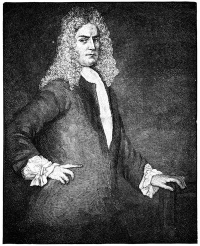
WILLIAM DUMMER.
After a likeness owned by the Misses Loring, of Boston.
There were new times at the English court when the German George I. ruled England; when he gave his ugly Killmansegge and Schulenberg places among the English peeresses, and the new Countess of Darlington and Duchess of Kendall simpered in their uncouth English. The Whig lords must now bend their gouty knees, and set forth in poor German or convenient—perhaps inconvenient—Latin what the interests of distant New England required. We may well suspect that this German dullard knew little and cared less when it was explained to him that the opposing factions of the private and public bank in his American province of Massachusetts Bay were each manœuvring for a governor of their stripe. We may well wonder if he was foolish enough to read the address of the ministers of Massachusetts and New Hampshire, or the address even of the General Court, which came to him a little later. His advisers might have rejoiced that Increase Mather, pleading his age, had been excused from becoming the bearer of these messages, or of that of the ministers, at least.[219]
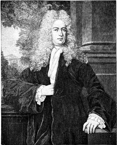
JEREMIAH DUMMER.
After a likeness owned by the Misses Loring, of Boston. It was at one time in the Mass. Hist. Soc. gallery. (Cf. Proceedings, ii. 289, 296, 300, 302.) It has been ascribed to Sir Godfrey Kneller.
The friends of a private bank carried their point far enough to secure to Col. Elisha Burgess the coveted commission, who, however, was better satisfied with the thousand pounds which the friends of a public bank were willing to pay him, and so he declined the appointment. The same power that paid the money now got the commission issued to Col. Samuel Shute, and the news which reached Boston (April 21, 1715) of Burgess’ appointment was swiftly followed by the tidings of Shute’s ascendency,[116] which meant, it was well known, that Jonathan Belcher, of Cambridge, and Jeremiah Dummer had been successful in their diplomacy in this, as well as in the displacing of Tailer as lieutenant-governor by William Dummer. The latter was Dudley’s son-in-law, and the appointment gilded the pill which the late governor was prepared to swallow.
The good people of Massachusetts had not long got over their thanksgiving for the suppression of the Scottish rebellion when, just about sunset, October 3, 1716, a gun in the harbor told of Shute’s arrival. Two days later, at the town house, he laid his hand on the Bible, “kissing it very industriously,” as Sewall records, and swore to do his duty. On the following Sunday he attended King’s Chapel, and on Thursday he was present at the usual lecture of the Congregationalists, when he heard Cotton Mather preach.[220] He seemed very docile, and doubtless smiled when Mather’s fulsome address to him was paraded in a broadside; very docile, too, when he yielded to Sewall’s entreaty one evening that he would not go to a dancing-master’s ball and scandalize his name. But on November 7 (1716), in his set speech to the legislature, there were signs of trouble. New England had peace on her frontiers, and that was not conducive to quiet in her domestic politics. The conflict came, and Shute was hardly equal to it. The legislature could look to a support nearly unanimous of almost a hundred thousand people in the province, being not much short of a quarter of the entire population of the English colonies; and a people like the New Englanders, who could annually export £300,000 worth of products, were not deficient at least in business courage.
Shute’s instructions as to the demands he should make were not novel. It was the old story of a fixed salary, a house to live in, the command of the Rhode Island militia, the rebuilding of Pemaquid, and the censorship of the press. The governor brought their financial plight to the attention of the House, and they voted more bills of credit. He told them of other things which he and the king expected of them, and they did nothing. So he prorogued them.
It was incumbent on the Crown governor to encourage the production of naval stores, as a means of diverting attention from manufactures, which might injure the market in the colonies for English products. One Bridger had already made himself obnoxious, and been suspected of malfeasance as “surveyor-general of woods,” in Dudley’s time, and it was far from conciliatory to a people who found the Crown’s right to mast-timber burdensome[221] that Bridger appeared in the train of Shute with a new commission. The surveyor was arraigned by the younger Elisha Cooke, who was now succeeding to his father’s leadership, and Shute defending him, a rather lively contention followed, which was not quieted till Dummer, in England, finally got Bridger removed.[222] To one of Shute’s speeches the House made a reply, and Shute threatened he would prevent their printing it.
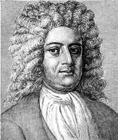
ELISHA COOKE, THE YOUNGER.
This follows a red-chalk drawing once owned by the Rev. Wm. Bentley, of Salem, and now in the gallery of the American Antiquarian Society. Cooke was born in Boston in 1678, and died in 1737. His only publication appears to be the following: Mr. Cook’s just and seasonable vindication, respecting some affairs transacted in the late general assembly at Boston. [Boston, 1720.] The second impression, corrected. [Boston, 1720.] Sabin, iv. 16,305; Brinley, no. 1,474.
Its appearance, nevertheless, in the News-Letter established the freedom of the press in Massachusetts.[223] The governor informed the Board of Trade that the province was bound to wrest from him as much of his representative prerogative as it could, and its action certainly seemed sometimes to have no other purpose than to establish precedents which might in some turn of fortune become useful. The House chose the younger Cooke speaker in palpable defiance, and when he was disapproved the members refused to go into another ballot, and the governor prorogued them. When the new House assembled they contented themselves with publishing a protest, and chose another speaker; and then they diminished the “present” which they voted to the governor. It seems clear that the House, in a rather undignified way, revelled in their power, and often went beyond the limits of propriety. The charter required that all acts should be reviewed by the Crown for approval. The House dodged the necessity by passing resolves. Dummer in England[118] knew that such conduct only helped the Board of Trade to push the plan of confederating all the provinces under a governor-general, and intimated as much. The House was in no temper to be criticised by its own agent, and voted to dismiss Dummer. The council in non-concurring saved him; but the House retaliated by dropping his allowance.
The council was not without its troubles. Shute refused to attend its meetings on Christmas. Sewall, ever alert at any chance of spurning the day, “because,” as he chose to think, “the dissenters had come a great way for their liberties,” broadly intimated that the council still could pass its bills on that day, and the governor might take whatever day he chose to sign them. It was certainly not a happy era in Massachusetts. The legislature was not altogether wise or benign, and Shute did nothing to make them so.[224]
The frontiers, for a space, had but a hazardous peace. In August, 1717, Shute had gone to Arrowsick (Georgetown, Me.) to hold a conference with the Indians, and had learned from a letter received there from Sebastian Rasle, the Jesuit missionary at Norridgewock, that any attempt to occupy the lands beyond the Kennebec would lead to war, and as we shall see the war came.[225] Meanwhile, life in Boston was full of change and shadow. Pirates beset the people’s shipping, and when the notorious “Whidaw” was cast away on Cape Cod (1717) they heard with some satisfaction of the hundred dead bodies which were washed ashore from the wreck. There was consequently one less terror for their coasters and for the paltry sloops which were now beginning to venture out for whales from Cape Cod and Nantucket.[226] There was occasion, indeed, to foster and protect that and all industries, for the purchasing power of their paper money was sinking lower and lower, to the disturbance of all trade. When the province sought to make the English manufacturers afford some slight contribution to restoration of prosperity by imposing a duty of one per cent. on their manufactures sent over, the bill was negatived by the king, with threats of loss of their charter if any such device were repeated. In the same spirit Parliament tried to suppress all iron-working in the province;[227] but after much insistence the people were allowed the boon of making their own nails![228] Some Scotch Irish had come over in 1718, and though[119] most of them went to New Hampshire and introduced the potato,[229] enough remained in Boston to teach the art of linen-making. Spinning under this prompting became a popular employment, and Boston appointed a committee to consider the establishment of spinning schools.[230] Perhaps they could spin, if they could not forge; and Boston, with her 12,000 to 15,000 inhabitants to be clothed and fed, needed to do something, if Parliament would permit. Her spirit was not always subdued. In 1721 she instructed her representatives not to be deterred by frown or threat from maintaining their charter privileges. “When you come to grant allowances,” she said, “do not forget the growing difficulties that we at this day labor under, and that poverty is coming upon us as an armed man.”[231] The General Court emphasized its call for frugality by forbidding the extravagant outlay for funerals, which was becoming the fashion.[232] There might have been some scandal at the haberdashery trade which the profuse habits of bestowing upon their parsons gloves and rings made a possible circumstance, to say the least, in more than one minister’s house. But a little innocent truck in the study was not the ministers’ most pressing diversion. Cotton, or rather Doctor Cotton Mather, as he had been called since Glasgow, in 1712, had given him a Doctorate of Divinity, bid for an ally against the liberals.[233] When he and his father assisted in the ordination of the new Baptist minister, Elisha Callender, in 1718; and when Dudley, two years before his death,[234] joined Sewall in open attacks on Leverett and the government of Harvard College, there is little doubt where the sympathy of the Mathers lay.[235] They had hopes, too, that the new Connecticut college would register their edicts, since they could no longer enforce them at Cambridge. Sewall found the Lord’s Supper unsuggestive[120] of charity, when the deacon offered the cup to Madam Winthrop before it was served to him; and we, to-day, had much rather see him riding about the country on his circuit, distributing tracts and sermons to squires and hostlers, and astonishing the children, as he rode into the shire-towns under the escort of the sheriff and his men.
But Yale College, of which so much was hoped by the lingering puritanism, soon surprised them, when Timothy Cutler, its rector, with one of its tutors, and other Connecticut ministers, embraced Episcopacy in 1722. Governor Saltonstall was powerless to prevent it, when at Commencement the story of that defection was told. Cutler went to England, received Episcopal ordination, and came to Boston in 1724 to take charge of one of its English churches.[236]
But before this the care of the body as well as of souls had proved a source of dispute with the ministers. Cotton Mather had read in the Transactions of the Royal Society, to which he was sometimes a contributor himself, of the method which was employed in Turkey of disarming the small-pox of some of its terrors by the process of inoculation.[237] That disease was now raging. While the town was moving the governor to send the “Seahorse,” man-of-war, down to Spectacle Island, because she had the pest among her crew, Mather urged Dr. Zabdiel Boylston to make trial of the Turkish method. The selectmen of Boston and the town meeting opposed it. The House forbade it by bill; but the council hesitated. One of the most active of the physicians of Boston strenuously objected. This was William Douglass, who had been a student of medicine at Leyden and Paris, and who had come to Boston three years before. Other physicians were likewise in opposition. The passions were excited by the controversy; the press was divided; and Mather, who about this time was finding the people “bloody and barbarous,” the town “spiteful,” and the country “poisoned,”[238] had a grenado thrown through his window.[239]
What with the political, financial, theological, and sanitary disturbances of Shute’s time, and the freedom of the press, which the governor had been foolish enough to give them the opportunity of making the most of, the intellectual activity of the people had never before occasioned so great a fecundity of print. The Boston man of the early part of the eighteenth century resorted to the type-setter as readily as he gossiped, and that was easily enough. In 1719 there were five printing-presses running in[121] Boston,[240] and the Exchange was surrounded with booksellers’ shops. The practice of sales of books at auctions had begun in 1717 with the disposing of the library of the Rev. Ebenezer Pemberton, or at least its catalogue is thought to be the first of such a sale. Thomas Fleet was selling his doggerel ballads, and the boys and girls of New England first knew who Mother Goose was when her nursery tales were published by Fleet in 1719. The News-Letter had been published for fifteen years, but not three hundred were yet sold at an impression. Wm. Brooker, succeeding Campbell as postmaster, felt it necessary to divide the town and give the News-Letter a chance for an altercation, when in 1719 (Dec. 21) he began the Boston Gazette. James Franklin had printed this paper for Brooker, but the printing being taken from him he startled the town with the New England Courant, which first appeared on Aug. 17, 1721. The new sheet was bold and saucy,—a sort of free lance, to which people were not accustomed; and while it gave little news and had few advertisements, its columns swarmed with what the staid citizens called impertinences. It wildly attacked the new inoculation theory, and elicited a public rebuke for its scandalous conduct from Increase Mather, who was in turn attacked by it.[241]
The Mathers, Elisha Cooke, Sewall, and above all Jeremiah Dummer in his Defence of the New England Charters,[242] published not a little of a terse and combative strain, which the student to-day finds needful to read, if he would understand the tides and eddies of the life of the time. Boston was also nourishing some reputable chroniclers of her own story. Thomas Prince, who after his graduation had gone to England, had returned in 1717, yet to live forty years ministering to his people of the Old South, gathering the most considerable of the early collections of books and papers, illustrating in good part the history of New England,[243] and contributing less than we could wish to such stores from his own writing. Dr. William Douglass, as we have seen, had dipped into the controversies of the day, practised his pen in the public journals, not always temperately or with good taste, and thirty years later was to vent so much prejudice in his Summary of the British Settlements that, though the book is suggestive, it is an unsafe guide to the student. Thomas[122] Hutchinson, much the best of our colonial historians, was now a boy of six or seven in the forms of Master Bernard’s grammar school.
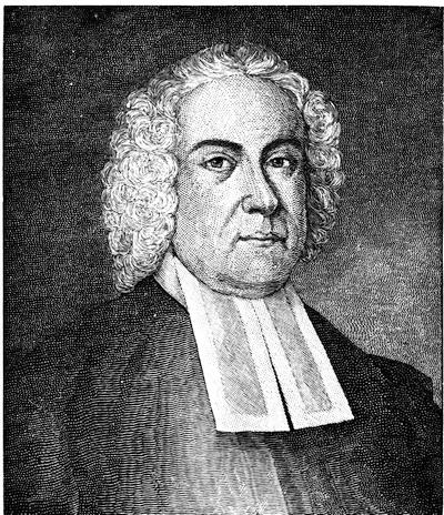
THOMAS PRINCE.
This follows an oil painting in the cabinet of the American Antiquarian Society at Worcester. There is also of Prince a mezzotint engraving of a painting, of which there is a heliotype in the Mem. Hist. Boston, ii. 221. A portrait after a painting by John Greenwood is noted in the Catal. Cabinet, Mass. Hist. Soc., no. 26. Cf. Proceedings, i. 448.
But war was again imminent. As early as 1709 it had been considered advisable to build a line of defences across Boston neck, and up to 1718 much money had been spent upon it. The peaceful aspect of the affairs at that moment had been an inducement to disband the watch which they had kept there; but in 1721 it had been again set. Gov. Phillips, of Nova Scotia, had been in Boston to talk over the situation at the eastward, for the warnings of Rasle rendered a continuance of quiet doubtful. The younger Castin had been seized and taken to Boston,[244] and bloodshed could hardly be averted; for though peace existed between England and France, there was little question but the encroachments and ravages of the Indians were instigated from Quebec. Sewall tried to arrest the progress of events, and published his Memorial relating to the Kennebec Indians,—an argument for persuasion rather than for force. On July 25, 1722, Gov. Shute and his council declared war against[123] the eastern Indians, and a harrowing struggle began.[245] On the 1st of January, 1723, guns at the Castle before sunrise told the town that Shute had sailed for England, and when the people were astir Boston Light was sinking behind him. He went to arraign the colony in person before the Privy Council, and never returned to his government. The conduct of affairs, meanwhile, fell to Dummer, the lieutenant-governor, who made Cotton Mather inexpressibly happy by what the divine called his wise and good administration.
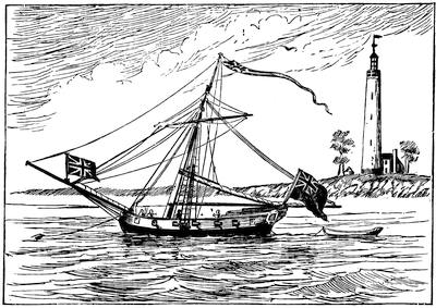
BOSTON LIGHT AND THE PROVINCE SLOOP.
Sketched from an old mezzotint, “W. Burgis del. and fecit,” and inscribed: “To the merchants of Boston this view of the Light House is most humbly presented By their Humble Servt, Wm. Burgis.” Its date is probably not far from 1712. See Boston Record Commissioners’ Reports, vii. 97.
New Hampshire had been included in Shute’s commission, but Vaughan, the lieutenant-governor, claimed that during Shute’s stay in Boston his direct authority lapsed, and his lieutenant was the resident executive. The strife and bickering which followed this assumption had been among Shute’s tribulations, which were somewhat mitigated when influence at London secured the displacement of Vaughan by John Wentworth.[246]
The charters of Rhode Island and Connecticut did not order their enactments[124] to be submitted to the royal supervision, a requirement which at one time there was danger would be made,[247] but which was in good part prevented by the ready reasoning of Dummer in his Defence of the New England Charters. One act of Rhode Island, published at this time, seemingly invalidates that colony’s claim for unfailing toleration. In the edition of her laws printed in 1715 there is one which disfranchises Romanists. No one is able to find beyond dispute when, in the chaotic mass of her enactments, it became a law. To relieve the pride of her people from any imputation so contrary to the professed purport of all her history, Arnold, the historian of Rhode Island, has labored to show that the wording of the statute was simply the interpretation of a committee; but it was an interpretation that successive editors kept up till after the close of the Revolutionary War.[248]
In Massachusetts matters were not much improved under the rule of Dummer. An issue soon arose. The House insisted that Walton and Moody, commanders at the eastward, should be suspended, and refused supplies till it was done. Dummer claimed that as commander-in-chief he had the responsibility of such a change. He was forced, however, to yield, and appointed Thomas Westbrooke in the place of Walton, who, having obeyed the governor rather than the House, found he must retire without the pay which he had earned.
In England Shute was presenting to the king his memorial against the province.[249] When the House heard of it they appropriated £100 to hire counsel for the defence; but the upper branch gave the resolve a negative. So the House sent an address to the king,[250] in which the council would not join. The House would then despatch a new agent; the council was content with Dummer; a compromise was reached, by which Elisha Cooke was sent to join Dummer. Shute and his opponents were in due time heard before the Privy Council. The aspect of affairs grew threatening. A Boston man, John Colman, wrote home that the charter was in danger.[251] It ended in the sealing of a new explanatory and supplemental charter,[252] in which Shute’s demands were fairly met, in that there was in it an undeniable expression of the right of the governor to reject a speaker, while the House itself was denied the right to adjourn beyond two days. With this new order Col. Samuel Vetch had hopes of[125] succeeding Shute; but the old governor was not displaced. The General Court prudently accepted the new charter, January 15, 1725.
INCREASE MATHER.
This follows a corresponding likeness in Cotton Mather’s Parentator, Boston, 1724 (Harv. Col. lib., 10397.17). Cf. Edmund Calamy’s ed. of Memoirs of the life of the late Rev. Increase Mather, London, 1725 (Ibid., 10397.16). Engravings are noted in the Catal. Cab. MS. Hist. Soc., p. 35; and of the painted portraits in the same catalogue, no. 23 is of Mather. There is an original painting in the American Antiquarian Society at Worcester, which is engraved in the Mem. Hist. of Boston, i. 587.
While the provincial charter had been thus in jeopardy, the father of it died. The most conspicuous of New Englanders in his day, though his fame is somewhat overshadowed by his son’s, breathed his last, when Increase Mather died, on August 23, 1723, at the advanced age of eighty-four. When he was buried, a hundred and threescore scholars of Harvard College walked in such a procession as never before attended the burial of a New England divine. In most respects he was the greatest of a race which was born with traits of prowess. His learning was large, far better assimilated than that of the son, and his power over men far happier and more consistent. His industry was enormous; he sometimes worked in[126] his study sixteen hours out of the twenty-four. What Cotton Mather called the “tonitruous cogency” of his pulpit discourse was often alarming to the timid, but not always effective for the mass. The people grew to be disenthralled in large numbers. There was a growing belief that there could be graces even in dogma,—a gospel that never a Mather preached. The rude Bay Psalm Book, and the nasal cadence of the meeting-house, were beginning to pass when the Franklins, in that obnoxious sheet the Courant, were printing the hymns of Isaac Watts.
A year after the father died, there was a new election of president of Harvard College. Cotton Mather was as anxious as before. The governing board picked out in succession three Boston ministers, and never seem to have considered Cotton Mather. Their first choice was Joseph Sewall, of the Old South, a son of the Judge; “chosen for his piety,” as the disappointed man sneeringly wrote in his diary. The “miserable” college, when Sewall declined, chose the minister of the Manifesto Church, a direct thrust at Matherism; but no choice was accepted till Benjamin Wadsworth was elected. The college had another conflict when Timothy Cutler, after receiving Episcopal ordination in England, came to Boston, and by virtue of his new position as a Church of England ministrant set up his claim to a seat in the Board of Overseers. He sought in vain. Mather meantime was contriving to fortify himself, and determined to have a synod to organize some resistance to this increasing antagonism. Dummer entertained a petition to that end, but John Checkley, one of Cutler’s friends, ferreted out the scheme, and there followed a sharp rebuke from the lords justices, who pronounced the calling of such a body the prerogative of the crown, and the movement came to naught. This same John Checkley, a polemical churchman, in Boston, who kept a toy shop, united with it the publishing of tracts, in which the prevailing theology was attacked. In 1719 he had reprinted Charles Leslie’s Short and Easy Method with the Deists, and later accompanied Cutler and his friends to England. While there he caused another edition of Leslie to be printed (1723), but added to it his own Boston imprint, and what was more important, he appended a Discourse concerning Episcopacy, which seems to have been a refashioning of another of Leslie’s treatises, by which Checkley had pointedly demonstrated the schism of all ordination except an Episcopal one. With a stock of this book he came back to Boston, and at the “Sign of the Crown and Blue gate, over against the west end of the town house,” he began to sell them. The magistrates found in some expressions “a false and scandalous libel” on themselves. A trial followed with an appeal, which dragged its slow length along; and in the midst of it Checkley delivered a memorable speech in his own defence. It ended in his being fined fifty pounds.
Checkley left Boston not long after for England; and came back again to settle in Providence, and administer the rites of the church as he believed they should be administered.
During all this wearisome contention in Boston, there is a glimpse of the humaner, and perhaps more godly, spirit in the gathering of men together under the lead of Joseph Marion to effect the insuring of neighbors’ worldly possessions from the chances of fire and the sea. It is not unlikely that this first trial of a system which to-day contributes so much to the sum of our happiness began then to indicate that mutual helpfulness might conduce as much to Christian comfort as keeping eyes alert for “scandalous libels.”
But there was no way yet, except by keeping other eyes alert along a musket barrel, to meet the dangers of the frontier. When the authorities erected (1724) Fort Dummer[253] near a spot where Brattleboro’ now stands, they made the first English settlement in what is to-day Vermont. On the 22d of August (1724), as Sewall records, “the ‘Sheerness’ comes up and Captain Harmon with his Neridgwack scalps, at which there is great shouting and triumph. The Lord help us to rejoice with trembling!” Another diary of the day makes these scalps twenty-eight, one of them Bombazeen’s, and another that of “fryer Railes,”—and this is the shape in which the tidings came to Boston of that quick onset at Norridgewock, when the Jesuit Sebastian Rasle fell among his Indian neophytes, ten days before this.[254]
In May of the next year, Lovewell the borderer made his last fight at Fryeburg in Maine, and the news reached Boston on the 13th of the same month. The ballad of Pigwacket, commemorating that bloody work, passed into the popular memory, and abided there for many a year.[255] In the following November four eastern sagamores came to Boston, and what is known as Dummer’s treaty was signed there on December 16, and the next summer (August 6) it was ratified at Falmouth (Portland). There was to be little disturbance of the peace thus consummated for a score of years to come. The war had borne heavily on Massachusetts. In such money as they had, it had during its four years’ continuance cost £240,000, and when the assembly voted an issue of another £50,000 of bills, Dummer, under royal instructions, withheld his approval. His fidelity cost him his salary for a while, which the House refused to vote until some compromise was reached.
While this quieting of the eastern frontier was in progress, the western settlements of Massachusetts were being pushed across the mountains beyond the Connecticut, and the peopling of Berkshire began at Sheffield in 1725. The leading agents in this movement were Col. Jacob[128] Wendell, of Boston, and Col. Jonathan Stoddard, of Northampton. The occupation proved a barrier against the Dutch of New York, though it was sixteen years before the next settlement was made in the Housatonic valley at Pittsfield.[256]
MATHER BYLES.
This follows a red-chalk drawing in the cabinet of the Antiquarian Society at Worcester, which came to it with other portraits by the bequest of the Rev. William Bentley, of Salem (b. Boston, June 22, 1759; d. Salem, December 29, 1819). There is another likeness in the Mem. Hist. Boston, ii. 227. Cf. Catal. Cab. Mass. Hist. Soc., p. 37.
During the night of the 29th of October, 1727, New England experienced one of the severest earthquakes which she had known. The next morning Cotton Mather made a speech in Boston, and this, with an account of the earthquake’s effects, was published at once as The Terror of the Lord, followed shortly by his Boanerges, intended to strengthen the impressions of the awful hour in the minds of the people. Haven’s bibliography shows the affluence of the ministerial mind in the face of[129] this event.[257] Sermon after sermon was published, and the press had not ceased issuing the renewed editions of some of them when Cotton Mather died on the 13th of February, 1728, and gave the preachers another fruitful theme. Here was a man whose views of a fitting mundane life were as repulsive as those of Sebastian Rasle, and whose scalp would have aroused Quebec as Rasle’s did Boston. We have grown to judge each by a higher standard than the prejudices and doctrines of their time.[258]
After the departure of Shute, Wentworth continued as lieutenant-governor in the executive chair of New Hampshire. The assembly tried to insist upon a speaker whom he disapproved, but the explanatory charter of Massachusetts came to Wentworth’s support, and he prevailed; and under his lead the province experienced its share of the Indian warfare. Rhode Island remained all the time under Gov. Cranston, who had held the office by election thirty successive years when he died in 1727. Her chief point of contact with her neighbors was her bills of credit, which had sunk so low that they had become little better than a pest to herself and to the neighboring colonies. Connecticut kept her activity and quiet ways within herself. She took no part in the war beyond putting her border towns in a state of defence.
Shute was pursuing his aim in England. He had succeeded in getting from the king an explicit threat, under whose pressure it was thought the Massachusetts assembly would see the advisability of establishing a fixed salary for the royal governor, when George I. died (June 11, 1727), and Shute’s commission was vacated. He slipped into a pension of £600 a year, and died an old man. The news of the king’s death reached Boston in August, and on the 14th George II. was proclaimed with military parade. The ministers beguiled themselves, as usual, preaching many sermons on the death of a good king, and Mather Byles published a poem.
Since 1720 William Burnet, a son of Bishop Burnet, had been governor of New York and New Jersey, whither he had gone to retrieve a fortune lost in stock speculations; and with a numerous family to support, he felt the necessity of it. The new king relieved him of some embarrassment, occasioned by a growing unpopularity in his government, by directing his transfer to the vacant chair of Massachusetts, signing his commission in March. He reached Boston July 13, and as he was escorted to the Bunch of Grapes tavern[259] the people marked his noticeable presence and his suave manners, and might have predicted a calmer sway from him than proved to be in store. He was flattered by his reception, and even ordered the publication of some eulogistic verses, which Mather Byles, the clerical wit of the time, addressed to him.[260]
GEORGE II.
From a print in Entick’s Gen. Hist. of the late War (2d ed. 1765) vol. ii., frontispiece.
His instructions were of the sort that the province had got used to, though perhaps they hinted more pointedly of the danger which awaited the charter, if the salary question was not agreeably settled. Burnet’s speech opened the legislative war. The assembly answered it by voting him a larger allowance than was usual,—but still an allowance. The town of Boston had the speech read to it in town meeting, and voted nemine contradicente, as we read in the records,[261] in the assembly’s spirit. The House now asked to be prorogued. The governor refused, thinking the £1,000 a month which the sitting cost might bring them to terms. This failing, he resorted to manœuvres which even Chalmers censures. He removed the General Court to Salem, when, in a sort of grim irony, it recorded a resolve to legalize proceedings passed in an unaccustomed place, and consequently unconstitutional, as they claimed. The House now addressed a memorial to the king and refused the governor a copy of it, and, helped by Boston merchants to pay the cost, the[131] representatives despatched Jonathan Belcher to coöperate with Francis Wilks, now the resident agent in London, in obtaining the king’s favorable attention to their plea. This appeal gave the governor a pretext for releasing the legislature for three months,—and perhaps the device of the House had that purpose.
The Board of Trade heard both sides, sustained the governor, and advised the king to lay the facts before Parliament. The House in turn ordered a historical summary of all the proceedings relating to the salary question from the time of Phips to be edited and printed.[262] The governor dissolved the assembly, and took his revenge in withholding his signature to the bill for their own pay. A new election sent to Boston an assembly which was of the same temper. Burnet told them of the danger from the Board of Trade’s advice to the Crown; their own agents wrote to them there was no danger; and so the House continued as bold as ever. The governor directed their reassembling at Cambridge. Here they voted afresh the allowance, which was scorned as before. Meanwhile the governor got some literary recreation, for which his acquirements well fitted him, by printing moral and entertaining papers in the New England Journal; and if this did not bring him an income, he managed to eke one out by increasing the rate of clearance fees at the custom house, which all went into his own pockets.
Returning one day from Cambridge to Boston, in August, 1729, he was thrown into the water by the overturning of his carriage. A fever ensued, and he died September 7. The legislature gave him an impressive funeral, and voted £2,000 to his children; and his “character,” by Parson Colman, was circulated in a folio half-sheet.[263]
Dummer, as lieutenant-governor, again took the executive’s chair, and fought over the salary question once more; and the council, as before, steadily refused to join in the payment of the agents of the House.
Jonathan Belcher, lately the agent of the province, was now commissioned governor. He came of a New England stock, and his father had gained a fortune in trade, and had secured some political consideration as a member of the council. His mother was a daughter of Thomas Danforth, one of the ablest of the leading politicians under the old charter. The new governor had graduated at Harvard College; and foreign travel had added ease and attraction, with some of the wiles of the world, to a presentable person. He had been accustomed to dispense his fortune in[132] ways to draw attention and give him consequence. He had thrown out intimations in high quarters in England that the view he once held on the prerogative had undergone a change, and that he knew the turbulent spirits of his native province well enough to manage them. Wilks and Shute had seconded his professions, and his appointment followed. With instructions pitched to a higher demand than ever before, he was sent off to try his skill with an intractable people. Meanwhile Dummer had been superseded by Tailer, a former incumbent of the lieutenant-governorship, chiefly because the naval office he was occupying was wanted for another. Tailer was at the time in New England, and received his commission before Belcher arrived, which was not till August 10, 1730. So amid the terror, from a new invasion of small-pox which had withdrawn the town from the observance of its centenary,[264] and with signs of a new life, as well as a new era, in the relief which the law was giving to the baptists and the quakers from the burden of the parish taxes, and with the stranger element of their population developing a new Irish Presbyterian church under John Moorhead,[265] the people of Boston received their recusant townsman as governor. He made his speech in due time to the General Court. Cato, he told them, went beyond reason in letting his obstinacy lure him to destruction. This reference to the salary contention did not intimidate them; for the House had information from its own agents that the jealousies of the party leaders in England were not likely to let any issue affecting the continuance of the charter be forced upon Parliament. In any event there was a disposition rather to accept parliamentary domination, whatever it might be, than surrender one jot of their principles. With such a disposition the House became stubborn,—politely so. It even voted the governor liberal grants for the services which he had rendered as agent, and he took the gratuities though he had abandoned the grantors. The allowances for his services as governor he could not well accept under such instructions as bound him; and as he needed the pay, his son solicited permission from the home government for the father to receive the usual grants. The request was allowed, and the salary contention came virtually to an end. When Belcher approved a grant of £500 to be placed in the Bank of England to the credit of the province’s agent, he little suspected he was furnishing the means to bring about his own overthrow. His conduct of his office rendered such an overthrow likely. The times, with all failings, had[133] not seen before such flagrant attempts to serve party friends with the spoils of office. The public was so sensitive that even the younger Cooke, accepting a judgeship with some traits of sycophancy, fell in their good opinion.
The House set up a claim to audit all bills for which they granted money, and attaching such a proviso to their grants, such votes successively received the governor’s veto. This denied the public officers their salaries, and occasioned distress that the home government was besought to alleviate. The governor’s position was confirmed, and when the news of it came the House somewhat ludicrously asked him to appoint a day of fasting and prayer, since they were under such a “divine displeasure.” The governor thought the matter more mundane than divine, and refused. So in the autumn of 1733 the House saved its pride one forenoon by passing a bill with the proviso, and in the afternoon satisfied its sense of expediency by reversing the vote. Thus the delegates in their ungraceful way succumbed, as the governor did two years later, respecting the salary question. Each side was humbled, and affairs went smoothly for a while, though the depreciation of the paper in which the governor was paid did not quite fill the measure of his content.[266]
Commercial distress always conduces to emotional disturbance in a community, and the history of the “Great Awakening,” as it was called, is no exception to the rule. This religious revival began to make itself felt in 1734, under an impulse from Jonathan Edwards,[267] and later, under the ministrations of George Whitefield, the wild passion—for it became scarce else—spread through the churches and communities of New England.[268]
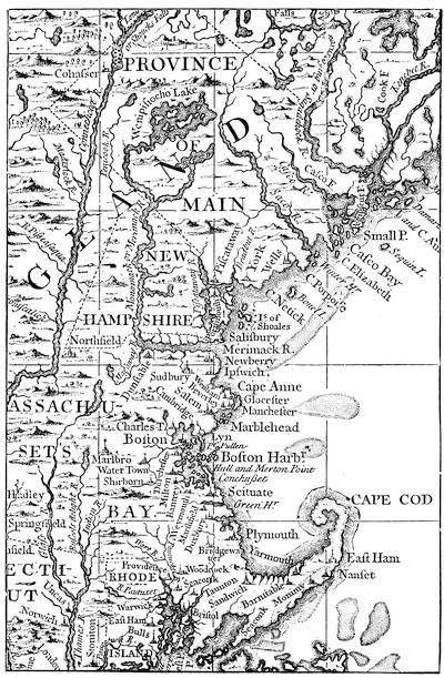
Mather Byles, Judge Danforth, and Thomas Prince supported the movement in the New England Weekly Journal. Thomas Foxcroft and others, reinforced by a large part of the country ministers, fought the battle in sermon and pamphlet. Benjamin Colman gave the movement a qualified commendation. It found various classes of opponents. Charles Chauncy condemned it for its hot-bed sustenance, its “commotion in the passions,” and its precarious growth.[269] Thomas Fleet, the publisher of children’s books, turned the wit which enlivened his evening vendu at the Heart and Crown, in Cornhill, into the columns of the Boston Evening Post, which he had just started. Here he held up Whitefield to ridicule, just as Joseph Green and other wits held up in the same place the pomp of Belcher to public derision. Dr. Douglass[270] reckoned up the thousand pounds sterling that were lost to the families of working people by what he called a misuse of time in attending the midday mass-meetings, to which Whitefield ministered. The passion and fervor swelled, lapsed, returned, dwindled, and died; some counted the wrecks it left, some wondered at its transient impressiveness, and a few occasionally struggled to revive it.[271] Amid all the consternation attending what William Cooper in the election sermon of 1740 called “an empty treasury, a defenceless country and embarrassed trade,” New England managed to raise 1,000 men to send off to join the fleet of Admiral Vernon in the West India waters. Scarce a hundred of them ever returned.[272]
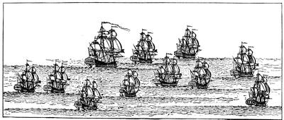
AN ENGLISH FLEET OF THIS PERIOD.
From Popple’s great map, The British Empire in North America, 1732. Admiral Preble says in his “Vessels of war built at Portsmouth” (N. E. Hist. and Gen. Reg., 1868, p. 393) that the “Falkland” was built in 1690, and carried 54 guns; but in some MS. emendations in the copy of his paper in the library of the Mass. Hist. Soc., he says she was probably built between 1694 and 1696. She is considered to be the earliest man-of-war built in the colonies. Within a short time after 1743, three vessels were built in New England for the royal navy,—the “America,” “Boston,” and “Essex.” The same writer, in The United Service, January, 1884, p. 98, etc., describing the changes in armament of vessels during the 18th century, defines ships-of-the-line as carrying 50 guns or more on three decks; frigates, 20 to 50 guns on two decks. Sloops-of-war with guns on one deck, and corvettes with guns on the poop and forecastle only, came in later.
The social life of the chief town of New England passed on, meanwhile, in the shadow of these ominous uncertainties. Jeremy Gridley had as early as 1731 started The Weekly Rehearsal, and had given the more scholarly classes this to ponder upon, and that to be entertained with, in columns more purely literary than they had ever known before. If such people welcomed the poems of Isaac Watts,—and one which Watts addressed to Belcher was just now printed in Boston,—they caused Richard Fry, an English printer, freshly come to Boston, to hold a high opinion of their literary taste, because they relieved his shelves of twelve hundred copies of the poems of Stephen Duck, the Wiltshire bard. In 1731 they listened at a Thursday lecture to Colman’s eulogy of Thomas Hollis as a patron of learning; and the neighboring college mourned in him the principal benefactor of this time. Lemercier, the minister of the Huguenots in Boston, published a Church History of Geneva (1732), which was a passing talk. Cox, a bookseller near the town house, got out (1734) a Bibliotheca Curiosa, describing his stock,—enormous for the times. Thomas Prince, the minister of the Old South, let his antiquarian zeal bring back the early struggles of the first settlers, when he printed (1731) the homely Memoirs of Roger Clap, of Dorchester, while the century sermons of Foxcroft in Boston (1730), and of Callender in Rhode Island (1739), made the pews slumbrous then, and command big prices to-day. Thomas Prince, moreover, was in travail with his Chronological History of New England. He published it in 1736, and the General Court paused to take note of it, and forgot for a moment money schemes and revivals to learn how in the “year 1, first month, 6th day” Adam appeared, to lead the long chronology which Prince felt bound to run down before he got to his proper theme. He had already wearied everybody so much, when he had gone far enough to embrace two or three years only of the New England story, that no one longer encouraged him, and “the leading work of history published in America up to that time” remains a fragment for the antiquaries to regret.[273]
It was in the year 1741 that the Boston Cadets came into existence as the governor’s body-guard. It was earlier, that Thomas Hancock, who had married the daughter of Henchman, the bookseller, by whom he was indoctrinated with the principles of successful trade, built the stone mansion on Beacon Hill which John Hancock, his nephew, later made more famous.[274] It was in this time of commercial distress that, according to Bennett, an observer, the reputation of the ladies of Boston suffered if they went to a dancing-assembly lately set up; but they could drive about with their negro footmen, and “neglect the affairs of their families with as good a grace as the finest ladies in London.” And when the finest lady in Boston, his Excellency’s wife, was buried in 1736, we read of the horses of the hearse covered with broadcloth and escutcheons, and of other parade and adornment, which gave tradespeople something to do and money to earn. Artisans needed then more than now such adventitious help.

BENJAMIN POLLARD.
This likeness of one of the first captains of the Boston Cadets follows an original by Blackburn in the gallery of the Mass. Hist Society. It was Pollard who received Shirley on his return from Louisbourg. Mem. Hist. Boston, ii. 119. He died in 1756. Cf. Mass. Hist. Soc. Proc., i. 498, xvi. 390; Catal. of the Cabinet, no. 76.
Not a hatter might make as many hats as he would, because he injured by so much the trade of the English hatter, and Parliament interdicted (1732) any such rivalry. The poor man paid dear for his molasses, because Parliament compelled the merchant to buy it of the English sugar islands, instead of the French colonies in the West Indies.[275] He paid more for his rum, because Parliament protected the English distillers. The merchant smuggled and had no pangs of conscience;[139] and what smuggling could do was very likely shown in the stately mansion that Thomas Hancock built.[276] Can we wonder that the new country did not attract as many settlers as it might; that town rates in Boston increased from £8,600 in 1738 to £11,000 in 1741, and the polls fell off from 3,395 to 2,972; and that Sam. Adams, graduating at Harvard in 1740, took for his Commencement part the inquiry, “Whether it be lawful to resist the superior magistrates, if the Commonwealth cannot be otherwise preserved?”
Belcher played the potentate with the Indians, and made his treaties with them as his predecessors had done. He met them at Falmouth (Portland) in 1732, and at Deerfield in 1735. Perhaps he was fairer in his dealings with them than he was with his fellows of the whiter skin, for he has passed into history as the least entitled to esteem of all the line of royal governors in Massachusetts,—a depreciation perhaps helped by his being born on the soil. His political paths were too devious. Hutchinson tells us that when Tailer, the lieutenant-governor, died in 1732, it was Adam Winthrop that Belcher openly favored in New England as the successor, while he intrigued with the Board of Trade to secure the appointment of Paul Mascarene; yet to no avail, for Spencer Phips, the adopted son of Sir William, succeeded to the place.
New Hampshire had been reunited with Massachusetts under Burnet, and she had proved much more tractable than the larger colony in yielding the point of the fixed salary to the governor. She had hopes of being in some way rewarded for it. Under Belcher matters grew worse. He quarrelled with the lieutenant-governor, and David Dunbar, the surveyor-general of the king’s lands, came into the place, but without healing dissensions. Dunbar had the support of influential persons like Benning Wentworth and Theodore Atkinson; and Belcher made what he could out of the friendship of Richard Waldron, the secretary.[277] Massachusetts, as well as her governor, had grievances against her neighbor; and she prohibited by legislation the circulation within her bounds of the promissory notes of New Hampshire whose redemption was not well secured. New Hampshire and Massachusetts[140] were never again under a single executive. Wentworth chanced to be in London when Belcher’s downfall came, and he readily slipped into the executive seat of his province.[278]
After the picture (in the Mass. Hist. Society’s gallery) painted on the voyage over by Smybert, who accompanied him. Cf. Catal. Cabinet Mass. Hist. Soc., no. 41. A photograph of the picture of Berkeley and his family by Smybert, now at Yale College, is given in Noah Porter’s Two Hundredth Birthday of Bishop George Berkeley, N. Y. 1885; and in Kingsley’s Yale College, i. 59. Smybert later painted many portraits in Boston. Cf. Mem. Hist. Boston, iv. 384, with references. His pictures, together with those of Blackburn, Pelham, and Copley, richly preserve to us the look and costume of the better classes of New England during the provincial time. Cf. Wm. H. Whitmore’s Notes on Peter Pelham, Boston, 1867; Arthur Dexter’s paper on the “Fine Arts in Boston” in Mem. Hist. Boston, vol. iv., with references in the notes; A. T. Perkins on the portraits of Smybert and Blackburn in Mass. Hist. Soc. Proc., Dec. 1878, p. 385, and May, 1879, p. 93. For historic costume see Dr. Edward Eggleston’s “Colonists at Home” in The Century, xxix. 882. It was when Copley was most in vogue that the habits of the upper classes reached in their dress that profusion of silk and satin, brocaded damask and ruffles, ermine and laces, velvet and gilt braid, which makes up the descriptions in Mr. Perkins’ enumeration of Copley’s portraits. (A. T. Perkins’ Life and Works of J. S. Copley, Boston, 1873. Cf. also Martha B. Amory’s “John Singleton Copley” in Scribner’s Monthly, March, 1881, and her Domestic and Artistic life of Copley, Boston, 1882.)
The Rhode Islanders ejected (1732) Jenckes, their governor, because he tried to stay their wild course in the emission of paper money. The lieutenant-governor, John Wanton, led the opponents of Jenckes, and secured the election of his brother, William Wanton, and two years later succeeded to the chair himself.
George Berkeley, in England, had been pronouncing the age barren of every glorious theme. Perhaps to transcend this level he conceived a project of establishing a college in Bermuda for Indians and missionaries.[279] So he came over to Newport (1729) to buy American lands, and await or perhaps force a rise on them. The death of George I. had crossed his pious scheme by drying up his fountains. Newport was now a thriving town of 5,000 souls, the chief town in a colony of perhaps 18,000 inhabitants. It had an Episcopal church in which Berkeley sometimes preached, and to which he gave an organ. He had brought over with him a Scotch artist, John Smybert, and so the patron and his family, happy on the whole, though his glorious project had not fructified, came out of the canvas under Smybert’s pencil; and the picture went to Yale College, where we may see it now,[280] and afterwards so did his books, and the deed conveying his Newport farm,[281] when after two or three years he had gone back to England, a disappointed man.[282]
Not long afterwards another man with a mission ventured on a different project in the little colony. James Franklin, who had found it prudent to leave Massachusetts, when he told the august assembly that they did not do all they might to catch pirates, came to this nest of free-booters, and started a newspaper, the Rhode Island Gazette, the first in the colony, and saw it fail within a year.
When the Spanish war was coming on, in 1739, the plucky little colony [142]put herself on a war footing. She built the “Tartar,” a war-sloop of 115 tons;[283] her merchants, the Wantons, the Malbones, and others, ran five privateers out to sea; and even her quakers found ways to help. Seven watch-towers were built along the coast, Fort George was garrisoned, and a battery frowned on Block Island.[284]
WILLIAM SHIRLEY.
This follows an engraving, “T. Hudson, pinxt.; J. McArdell, fecit,” reproduced in J. C. Smith’s Brit. Mezzotint Portraits, p. 896. Cf. Catal. Cab. Mass. Hist. Soc., p. 26; Mem. Hist. Boston, ii., frontispiece.
In Connecticut, on Saltonstall’s death in 1724, Joseph Talcott succeeded and held office during the rest of Belcher’s time.
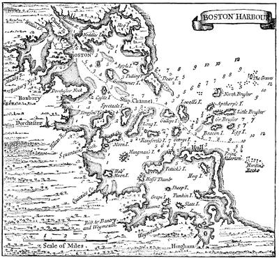
BOSTON HARBOR, 1732.
From Popple’s British Empire in America (1732).
The rule by which good ends sanctified base means came to its limit. Belcher, who had not been without high support,[285] was removed on the 6th of May, 1741; when he had sufficiently indoctrinated his opponents in his own wily ways, and they had not hesitated to use them.
William Shirley, the governor who succeeded on the same day, was an English barrister, who had come to Boston some time before (about 1733-35) to seek his fortune. He looked about for offices in the gift of the home government, and began soliciting them one after another. When the Spanish war came on, he busied himself in prompting enlistment, and took care that the authorities in England should know it; and[144] Mrs. Shirley, then in that country, had, to her husband’s advantage as it turned out, the ear of the Duke of Newcastle. Shirley was in Rhode Island acting upon the boundary question, which was then raised between Massachusetts and her neighbor, when his commission arrived, and he hastened to Boston to take the oath.
Shirley had some excellent qualities for political station. He was courtly and tactful, and when at a later day he entertained Washington he captivated the young Virginian. He was diligent in his duties, and knew how to retreat when he had advanced unadvisedly. He governed his temper, and was commonly wise, though he did not possess surpassing talents.[286] In his speech to the legislature he urged the strengthening of the defences of Boston, for the Spanish war still raged; and he touched without greatly clarifying the financial problem. He tried in a more civil way than his predecessor had followed to get his salary fixed; but he could not force a vote, and a tacit understanding arising that he should be sure annually of £1,000, he desisted from any further attempts to solve that vexed question. A month later, he went to Commencement at Cambridge, and delivered a Latin speech at the proper moment, which was doubtless talked over round the punch in the chambers, as it added one scholarly feature to a festival then somewhat riotously kept. There was more dignity at the Boston lecture, when Benjamin Colman preached, and when his sermon was printed it had in an appendix the address of the Boston ministers to the new governor, and his Excellency’s reply. Spencer Phips was retained in the chair of the lieutenant-governor, but a new collector of Boston came in with Sir Henry Frankland, the story of whose passion for the maid of a Marblehead inn is one of the romances of the provincial history of New England.[287]
Boston was now a vigorous town, and held probably for the next forty years a larger space in the view which Europe took of the New World than has belonged to her since. Forty topsail vessels were at this time building in her ship-yards. She was despatching to sea twice as many sail as New York, and Newport was far behind her. Fortunes were relatively large, and that of John Erving, the father of Shirley’s son-in-law, was perhaps the largest of its day. He earned a few dollars in ferrying passengers across to Cambridge on a Commencement Day; put them into fish for Lisbon, there into fruit for London, and the receipts into other commodities for the return voyages, until the round of barter, abundantly repeated, made him the rich man that he became, and one who could give tea to his guests. The privateers of the merchants brought royal interest on their outlay, as they captured goods from the French[145] and Spanish traders. Yankee wit turned sometimes unpromising plunder to a gain. One vessel brought in “a bale of papal indulgencies,” taken from a Spanish prize. Fleet, the printer, bought them, and printed his ballads on their backs. Another Boston merchant, of Huguenot stock, had given the town a public hall. This benevolent but keen gentleman, of a limping gait, did not live long to add to the fortune which he inherited. The first use that Faneuil Hall was put to was when James Lovell, the schoolmaster and a writer in the local magazines, delivered a eulogy there on this same Peter Faneuil,[288] while the loyal Bostonians glanced from the speaker to the likeness of George II., which had already been hung on its walls.
Shirley with the rest saw that war with France could not be far off. There was preparation for it in the treaty with the Six Nations, which was made at Philadelphia in July, 1742. In August Shirley himself had treated with the eastern Indians at Fort St. George’s. The next year (1743) the line of western settlements in Massachusetts was strengthened by the occupation, under William Williams, of Poontoosuck, now Pittsfield, and Williams was later instructed to establish Fort Shirley (at Heath), Fort Pelham (at Rowe), and Fort Massachusetts (in Adams, near the Williamstown line).
In 1744 the war came.[289] The French, getting advices from Europe earlier, attacked Canseau before the English were aware of the hostile decision. Though France had published her declaration in March, the news did not reach Boston till the 2d of June. Men’s thoughts passed from the “Great Awakening” to the stern duties of a war. “The heavenly shower was over,” said Thomas Prince, who saw with regret what he thought a warfare with the devil pass by; and Fleet, the wit of the newspapers, pointed to an opportune comet, and called it “the most profitable itinerant preacher and friendly New Light that has yet appeared among us,” while all the pulpit orators viewed it after other and their own fashions. Perhaps the lingering puritanism saw an omen or a warning in the chimes just then set in the tower of Christ Church. A lottery in full success was not heinous enough in those days, it would seem, to be credited with all the divine rebukes that it might be now.[290]
There was danger on the coasts. The armed sloops of Rhode Island and Connecticut were cruising between Martha’s Vineyard and New Jersey, and the brigantines of Massachusetts watched the coast north of Cape Cod.[291] But the retaliatory stroke was soon to come in the expedition against Louisbourg.
Dr. Douglass, who had grown into prominence in Boston, prophesied the failure of a scheme which had the barest majority in the assembly, and the chances were certainly on his side: but a desire to show what could be done without the military aid of England aroused the country, and not a little unworthy hatred of Romanism helped on the cause. One parson at least was ready to take along with him a hatchet to hew down the altars of the papist churches. A company from Plymouth, under Sylvanus Cobb, was the earliest to reach Boston. Massachusetts mustered 3,250 men, and the transports which sailed out of Boston harbor with this force made a fleet of a hundred sail, under convoy of nine or ten armed vessels, the whole carrying not far from 200 cannon.
The reader must turn to another chapter for the progress of the siege.[292] Good fortune favored this time the bold as well as the brave. Word coming back to Boston for reinforcements, an express was sent to Captain Williams, at Fort Shirley, and in six days he reported in Boston with 74 men, and sailed on the 23d of June. Louisbourg, however, had already surrendered (June 16), two days after the Rhode Island sloop “Tartar”[293] and two other war-sloops had dispersed the flotilla which was speeding from Annapolis to its assistance. This was the only active force of Rhode Islanders in the campaign; her contingent of foot, which was intended to join the Connecticut regiment, did not reach the ground till after the surrender; but her privateers did good service elsewhere, meanwhile, having sent into Newport during the year a full score of prizes.
It was on a fast day, July 2d, that the news of the success reached Boston, and spread throughout the colonies, occasioning[294] exuberant rejoicing, which the ministers tempered as best they could with ascribing the conquest to the finger of God, shown “more clearly, perhaps,” as Charles Chauncy said, “than since the days of Joshua and the Judges.” Modern historians think that Douglass was right, and that extraordinary good luck was a chief reason of the success.
The colonies beyond the Hudson were now anxious to be partakers in the cost and in the burden of the future defence of the captured fortress,[147] if they had not shared the danger and exhaustion of the victory.[295] Pennsylvania offered £4,000, New Jersey £2,000, and New York £3,000.
The victorious Pepperrell returned to Boston in June, 1746. Cannon from the batteries saluted the frigate which brought him. The governor welcomed him at the Castle and escorted him to the landing of the town, where the Cadets received him and led the way to the council chamber. Here addresses and congratulations were exchanged, and the successful general started for his home in Maine, meeting demonstrations of honor at every town on his way.
Shirley now resolved on further conquest, and plans were being arranged for an armament sufficient for the conquest of all New France, with the help this time of veterans from England, when news came of the speedy arrival of a large French fleet on the coast, with a mission of reprisals and devastation.[296] In August a thanksgiving for the victory at Culloden was held, and Thomas Prince spoke in the Old South in Boston. In September there was little giving of thanks, and there was much fear of the French admiral, D’Anville. Troops were pouring into Boston from the country. Douglass says he saw six or seven thousand of them on Boston Common. The defences of the harbor were being rapidly strengthened. All the coast lookouts were reëstablished, and shore batteries were manned. Rhode Island pushed work on her forts. Connecticut sent promises of large reinforcements, if the attack should fall on Boston. Every Frenchman was put under surveillance, and the times inciting to strong language, the General Court issued orders for greater publicity to be given to the act against profaneness. There was a fast to supplicate for mercy. Thomas Prince in his pulpit heard the windows of the meeting-house rattle with a rising storm. He prayed that it might destroy the French fleet. It did. Divided counsels, disappointments in plans, the sudden death of D’Anville, its commander, the suicide of his lieutenant, disorganized the purpose of the enemy; the waves and the rocks did the rest, and only a fragment of the great armament went staggering back to France. Boston breathed easily, and the hasty soldiers marched home to their harvests; and when news came of the compact which George Clinton had made with the Six Nations at Albany, in August and September, hope and courage prevailed, though the tidings[148] from Fort Massachusetts were distressing. Then came other massacres, and Indians were reported prowling through northern Hampshire. It had been intended to make a demonstration against Crown Point in the autumn. Provisions and munitions were hurried from Boston; Massachusetts men gathered at Albany. Winter came, disconcerting plans, and discouragement ensued.[297]
The next year Boston had a taste of the old-world despotism to which it had not been accustomed. Commodore Knowles, commanding a part of the fleet which had assisted in the capture of Louisbourg, came to Boston. Some of Knowles’ men deserted, and as enlistments did not bring what recruits the fleet needed, the commodore sent a press-gang to town (November 17, 1747), which seized whomever they found about the wharves. Boston was enraged. A mob gathered, and demanded that some of the officers of the fleet, who were in town, should be detained as hostages. The air grew murkier, and Shirley became frightened and fled to the Castle. The legislature tried to settle the difficulty, and Knowles threatened to bombard the town, unless his officers were released. The General Court denounced the riot, but signified to the commodore the necessity of redress. Under its order, the officers returned to the fleet, and Knowles, finding the business had become dangerous, let most if not all of his recruits go, and set sail, but not till the governor, gathering courage from the control over the mob which a town meeting had seemed to acquire, had come back to town, when he was escorted to his house by the same militia that had refused his summons before.
It was a violent reaction for Shirley from the enthusiasm of the Louisbourg victory, thus to experience the fickleness of what he called the “mobbishness” of the people; and his trust in the town meeting and the assembly was not strengthened when the representatives reduced his allowance, on pretence of the burdens which the war had brought. Shirley intimated that the 200,000 population of the province and a capital with 20,000 inhabitants did not mark a people incompetent to pay their rulers equably; but his intimations went for little. The colony was not in very good humor. England, in making the treaty of Aix la Chapelle (October 7, 1748), had agreed to restore Louisbourg to the French, and leave the bounds as before the war. There were discordant opinions among the advisers of the government touching the real value of Louisbourg as a military post; but it was unfortunate that to redress the balance in Europe England had to relinquish the conquests of her colonists. It may not have been wholly without regard to the quelling of the New England pride, which might become dangerous,—since Sam. Adams was pluming his political rhetoric in the Independent Advertiser at this time,—that it was thought best by that treaty to give to the province an intimation of[149] the superior authority of the Crown.[298] The province was not without its own power of warning, for Hugh Orr, a young Scotchman, manufactured about this time at Bridgewater 500 stands of arms for the province of Massachusetts Bay; which are said to have been carried off by the British from Castle William when they evacuated Boston in March, 1776. They are supposed to have been the first made in America.[299]
Meanwhile, Horatio Walpole, the auditor-general, with an eye to his own personal advantage, had brought forward a project of the Board of Trade for overruling the charters of the colonies; but the strenuous opposition of William Bollan and Eliakim Palmer for Massachusetts and Connecticut made the advocates of the measure waver, and the movement failed. Shirley was devising a plan of his own, which looked to such an extension of the parliamentary prerogative as had not yet been attempted. His scheme was to build and maintain a line of posts at the eastward, the expense of which all the colonies should share under a tax laid by Parliament.[300] In the pursuit of this plan, Shirley obtained leave of absence, and went to England (1749), while the conduct of affairs was left in the hands of Spencer Phips, the lieutenant-governor, a man of experience and good intentions, but not of signal ability. Thomas Hutchinson, James Otis, and two others meanwhile went to Falmouth to engage the eastern Indians, who were far from quiet, in a treaty, which was finally brought to a conclusion on October 16, 1749. In the following winter (1749-50), Sylvanus Cobb was in Boston fitting out his sloop for a hostile raid through the Bay of Fundy; but Cornwallis at Halifax thought the preparations for it had become known to the French, and the raid was not accomplished.
The next year (1750), Parliament touched the provinces roughly. The English tanners wished for bark, and they could get it cheap if the English land-owners could sell their wood to the furnaces, and the furnaces would buy it if they could find a sufficient market for their iron and steel, as they could do if they had no rivals in America. It was a chain of possibilities that Parliament undertook to make realities, and so passed an act forbidding the running of slitting and rolling mills in the colonies, and[150] Charles Townshend, who introduced the bill, found no opposer in Shirley. The bold utterances that Jonathan Mayhew was making in indignant Boston carried a meaning that did not warn, as it might, the Board of Trade in England.
Shirley, after four years’ absence, during which he had been employed in an unsuccessful mission to Paris about the Acadian boundaries, came back to Boston in 1753, to be kindly received, but to feel in bringing with him a young Catholic wife, whom he had married in Paris, the daughter of his landlord, that he gave her the position of the first lady in the province not without environing himself and her with great embarrassment, in a community which, though it had departed widely from the puritanism of the fathers, was still intolerant of much that makes man urbane and merry. While Shirley had been gone, the good town had been much exercised over an attempt to introduce the drama, and the performance of Otway’s Orphan at a coffee-house in King Street had stirred the legislature to pass a law against stage plays. The journals of Goelet[301] and others give us some glimpses of life, however, far from prudish, and show that human nature was not altogether suppressed, nor all of the good people quite as stiff as Blackburn was now painting them.
Notwithstanding his hymeneal entanglement, Shirley was unquestionably the most powerful Englishman at this time in America. The fortuitous success of his Louisbourg expedition had given him a factitious military reputation.[302] A test of it seemed imminent. For the sixth time in eighty years the frontiers were now ravaged by the savages. Pepperrell was sent to pacify the eastern Indians. The French were stretching a cordon of posts from the Atlantic to the gulf which alarmed Shirley, and he doubted if anything was safe to the eastward beyond the Merrimac, unless the French could be pushed back from Nova Scotia. He feared New Hampshire would be lost, and with it the supply of masts for the royal navy. A road had been cut along the Westfield River through Poontoosuck (Pittsfield) to Albany, and Shirley planned defences among the Berkshire Hills.
At this juncture a conference of the colonies was called at Albany in 1754, which had been commanded through the governor of New York by the Board of Trade. The reader will find its history traced on a later page. Hutchinson in July brought back to Boston a draft of the plan of action. In the autumn the legislature was considering the question, while Franklin was in Boston (October-December) conferring with Shirley and discussing plans. Boston held a town meeting and denounced the Albany plan, and in December (14th) the legislature definitely rejected it, as all the other colonies in due time did. Rhode Island,[151] particularly, was very vigilant, lest an attempt might be made to abridge her charter-privileges. Connecticut established its first press in this very year, which with the press of the other colonies, was lukewarm or hostile to the plan.[303]
Shirley had not attended the congress. He had left Boston in June (1754) on the province frigate “Massachusetts,” with the forces under John Winslow to build a fort on the Kennebec, which was completed on the 3d of September and called Fort Halifax. On his way he stopped at Falmouth, and on the 28th of June he had a conference with the Norridgewock Indians, and on July 5th another with the Penobscots. Accompanied by some young Indians who were entrusted to the English for education, the governor was once more in Boston on the 9th of September, where he was received with due honor.
This expedition and the congress were but the prelude to eventful years. When Henry Pelham died, on the 6th of March of this year, his king, in remembrance of the wise and peaceful policy of his minister, exclaimed, “Now I shall have no more peace!” For the struggle which was impending, New England had grown in strength and preparation, and had had much inuring to the trials of predatory warfare. She had increased about sixfold in population, while New York and Virginia had increased fivefold. The newer colonies of Pennsylvania, Delaware, New Jersey, and Maryland had fairly outstripped these older ones, and numbered now nine times as large a population as they had sixty-five years earlier. The Carolinas and Georgia had increased in a ratio far more rapid. Massachusetts at this time probably had 45,000 on its alarm list, and in train-bands over 30,000 stood ready for the call.[304] John Adams, when teaching a school in Worcester the next year, ventured to write to a friend, “If we can remove the turbulent Gallicks, our people will in another century become more numerous than England itself.”
In the spring of 1755 Shirley went to Alexandria, in Virginia, being on the way from March 30 till April 12, to meet the other governors, and to confer with General Braddock upon the organization of that general’s disastrous campaign. When the news of its fatal ending reached New England it gave new fervor to the attempts, in which she was participating, of attacking the French on the Canada side,[305] and the war[152] seemed brought nearer home to her people when, by the death of Braddock, the supreme command devolved on the Massachusetts governor.[306] On the 6th of November, at Thomas Hutchinson’s instigation and in expression of their good-will at Shirley’s promotion, the General Court passed a vote of congratulation.
The autumn had been one of excitement in Boston.[307] The forces of nature were conspiring to add to the wonderment of the hour. A part of the same series of convulsions which overturned Lisbon on November 1st and buried Sir Henry Frankland in the ruins, to be extricated by that Agnes Surriage whose romantic story has already been referred to, had been experienced in New England at four o’clock in the morning of the 18th of the same month, with a foreboding of a greater danger; but the commotion failed in the end to do great damage to its principal town, then esteemed, if we may believe the Gentleman’s Magazine, finer than any town in England excepting London. People looked to the leading man of science in New England of that time for some exposition of this mighty power, and Prof. John Winthrop gave at Cambridge his famous lecture on earthquakes, which was shortly printed.[308] The electrical forces of nature had not long before revealed themselves to Franklin with his kite, and it was in November or December that the news was exciting comment in Boston, turning men’s thoughts from the weariness of the war.
That war had not prospered under Shirley, and with a suspicion that he had been pushed beyond his military capacity he was recalled to England, ostensibly to give advice on its further conduct. He had found that Massachusetts could not be led to tax herself directly for the money which he needed, and only pledged herself to reimburse, if required, the king’s military chest for £35,000, which Shirley drew from it. A scale of bounties had failed to induce much activity in enlistments, and the forces necessary for the coming campaign were gathering but slowly.[309][153] This was the condition of affairs when Shirley left for England, carrying with him the consoling commendations of the General Court.
Spencer Phips, the lieutenant-governor, succeeded to the executive chair in Massachusetts at a time when even Boston was not felt to be secure, so fortunate or skilful were the weaker French in a purpose that was not imperilled by the jealousies which misguided the stronger English. It was now problematical if Loudon, the new commander-in-chief, was to bring better auguries. In January of the next year (1757), he came to Boston to confer with the New England governors. The New England colonies now agreed to raise 4,000 new troops. Meanwhile Phips had died in April (4th) in the midst of the war preparations, and Pepperrell, as president of the council, next directed affairs till Thomas Pownall,[310] who had been commissioned governor, and who had reached Halifax on the fleet which brought Lord Howe’s troops, arrived in Boston, August 3d, on the very day when Montcalm on Lake George was laying siege to Fort William Henry, which in a few days surrendered. The news did not reach Pownall till he had pushed forward troops to Springfield on their way to relieve the fort. He put Pepperrell at once in command of the militia,[311] and a large body of armed men gathered under him on the line of the Connecticut;[312] for there was ignorance at the time of Montcalm’s inability to advance because of desertions, and of the weakening of his force by reason of the details he had made to guard and transport the captured stores. Messengers were hurried to the other colonies to arouse them. John Adams, then a young man teaching in Worcester, kept from the pulpit by reason of his disbelief in Calvinism, stirred by the times, with the hope some day of commanding a troop of horse or a company of foot, was one of these messengers sent to Rhode Island, and he tells us how struck he was with the gayety and social aspect of Sunday in that colony, compared with the staid routine which characterized the day in Massachusetts.[313]
Massachusetts had enrolled 7,000 men for the campaign. Connecticut had put 5,000 in the field, and Rhode Island and New Hampshire a regiment each. Massachusetts had further maintained a guard of 600 men along her frontiers. The cost of all these preparations necessitated a tax of half the income of personal and landed property.
In a commercial sense almost crushed,[314] in a political sense the people[154] were as buoyant as ever. When Loudon sent orders to quarter a regiment of the British troops on the people, the legislature forbade it, and grew defiant, and nothing could pacify them but the withdrawal of the order. The commander-in-chief, however he stormed in New York, found it expedient to yield when he learned of the fury his order was exciting in a colony upon whose vigor the home government was largely depending for the successful prosecution of the war. This had now fallen into the hands of Pitt, and he at once recalled Loudon, who chanced to be in Boston, parleying with the legislature about raising troops, when an express brought him his recall. Abercrombie, who succeeded, was even a worse failure; but there was a burst of light at the eastward. Amherst had captured Louisbourg in July (1758),[315] and bringing his troops by water to Boston had landed them on September 13. Never was there so brilliant array of war seen in the harbor as the war-ships presented, or on Boston Common where the troops were encamped. Amherst delayed but three days for rest, when on the 16th of September he began his march westward to join the humbled Abercrombie. At Worcester the troops halted, and John Adams tells us of the “excellent order and discipline” which they presented, and of the picturesqueness of the Scotch in their plaids, as this army of four thousand men filled his ardent gaze.
During the winter recruiting was going on in Boston with success for the fleet wintering at Louisbourg.[316] In the campaign of the next year (1759), Massachusetts and Connecticut put at least a sixth of all their males able to bear arms into the field. They were in part in the army which Amherst led by way of Lake Champlain to the St. Lawrence, and among them were some of the veterans which Pepperrell had command in 1745 at Louisbourg,—Pepperrell who was to die during the progress of the campaign, on the 6th of July, at Kittery in his sixty-fourth year. Another portion went with Pownall to the Penobscot region, or followed him there, and assisted in the building of Fort Pownall, which was completed in July (1759).[317] The reader must turn to another chapter[318] for the brilliant success of Wolfe at Quebec, which virtually ended the war.
George the Second hardly heard of the victories which crowned his minister’s policy. He died October 25, 1760, but the news of his death did not reach Boston till December 27th. He had already effected a change in the government of Massachusetts. Pownall, who had made interest[155] with the Board of Trade to be transferred to the executive chair of South Carolina, left Boston in June, taking with him the good wishes of a people whom he had governed more liberally and considerately than any other of the royal governors.[319] Two months later (August 2, 1760), Francis Bernard, who had been governor of New Jersey,[320] reached Boston as his successor. He showed some want of tact in his first speech, in emphasizing the advantages of subjection to the home government, and gave the House opportunity to rejoin that but for the sacrifice in blood and expense which these grateful colonies had experienced, Great Britain might now have had no colonies to defend. Notwithstanding so untoward a beginning, Bernard seems to have thought well of the people, and reported fair phrases of encomium to the Lords of Trade.[321]
A few weeks after Bernard’s arrival Stephen Sewall, the chief justice, died (September 11, 1760). Thomas Hutchinson was now the most conspicuous man in New England, and he had put all New England under obligations by his strenuous and successful efforts to better their monetary condition. A train of events followed, which might possibly have been averted, if, instead of appointing Hutchinson to the chief-justiceship, as he did, Bernard had raised one of the other justices, and filled the vacancy with Col. James Otis, then Speaker of the House, father of the better known patriot of that name, and whose appointment had been contemplated, it is said, by Shirley. Hutchinson was already lieutenant-governor, succeeding Spencer Phips, and was soon to be judge of probate also for Suffolk,—a commingling of official power that could but incite remark.
The younger Otis was soon to become conspicuous, in a way that might impress even Bernard. There were certain moneys forfeited to the king for the colony’s use, arising from convictions for smuggling under the Sugar Act; the province had never applied for them, and had neglected its opportunities in that respect. The House instructed Otis to sue the custom-house officers. The superior bench under the lead of Hutchinson decided against the province, and it did not pass without suspicion that Bernard had placed Hutchinson on that bench to secure this verdict.
An event still more powerful in inciting discontent was approaching. Charles Paxton, who had been surveyor of Boston since 1752, had, in his seeking for smuggled goods, used general search warrants,—unreturnable, known as “writs of assistance,” and of course liable to great abuse. It seems probable that this process had been so far sparingly used, and there had been no manifest discontent. Upon the king’s death, the existing writs had only a six months’ later continuance, when new applications[156] must be made under the new reign. These new applications came at a time when the public mind was much exercised, and there was a determination to question the legality of such unrestrained power as the writs implied. The hearing was to be before the court of which Hutchinson was now the chief. Jeremy Gridley appeared for the king, and the younger Otis with Oxenbridge Thacher for the petitioners. The court deferred its decision, but in November, 1761, the case was again discussed. The court meanwhile had had advices from England, and the writs were sustained. In the discontent growing out of this proceeding, we may find the immediate beginning of the controversy between the provinces and the Crown, which resulted in the American Revolution. The subsidence of the war left men time to think deeply of these intestine griefs, and when the Peace of Paris in February, 1763, finally dissipated the danger of arms, events had gone far to shape themselves for bringing another renewal of battle, not with the French, but with the mother country.
CRITICAL ESSAY ON THE SOURCES OF INFORMATION.
NEW England in general.—Of Cotton Mather’s Magnalia Christi Americana, or the Ecclesiastical History of New England from 1620 to 1698, mention has been made in another volume,[322] and, as the title shows, it touches only the few earlier years of the period now under consideration. The book was published in London in 1702, and a solitary forerunner of the edition reached Boston, as we know, October 29 of the same year. It was the most considerable work which had been produced in the British colonies, and was in large part an unshapely conglomerate of previous tracts and treatises. Neal, Mather’s successor in the field, while praising his diligence in amassing the material of history, expressed the opinion of all who would divest scholarship of meretriciousness when he criticised its “puns and jingles,”[323] and said, “Had the doctor put his materials a little closer together, and disposed them in another method, his work would have been more acceptable.”[324] But Mather without Matherism would lose in his peculiar literary flavor; we laugh and despise, while his books nevertheless find a chief place on the shelves of our New England library. Mather was still young when the Magnalia was printed, but he stood by his methods and manner a quarter of a century later, and in publishing (1726) his Manuductio ad Ministerium[325] he defended his labored and bedizened[157] style against, as he says, the blades of the clubs and coffee-houses, who set up for critics. He also belabored Oldmixon in a similar fashion, when that compiler both borrowed the doctor’s labors and berated his reputation, and Mather called him, in his inveterate manner, Old Nick’s son.[326] Sibley not unfairly remarks that these peculiarities of Mather’s style were probably almost as absurd to his contemporaries as to ourselves;[327] and very likely it helped to create something of that curiosity respecting him, which Prince tells us he found in Europe at a later day.
In any estimate of Cotton Mather we may pass by the eulogy of his colleague Joshua Gee,[328] and the Life of Cotton Mather[329] by his son Samuel, as the efforts of a predisposing and uncritical friendliness. We are not quite sure how far removed from the fulsome flattery, if not insincerity, of funeral sermons in those days was the good word upon his contemporary which came from Benjamin Colman.
With the coming of the present century we might suppose the last personal resentment of those who knew Cotton Mather had gone, and as an historical character it might well be claimed that a dispassionate judgment was due to him. When James Savage edited Winthrop’s journal, the public were told how Cotton Mather should be contemned; and the tale was not untruthful, but it was one-sided. Quincy in his History of Harvard University could give no very laudatory estimate of the chronic and envious grumbler against the college.[330] When Dr. Chandler Robbins wrote the History of the Second Church of Boston, he said all he could, and in a kindly spirit, to qualify the derogatory estimate then prevalent respecting his predecessor; and W. B. O. Peabody in his Life of Cotton Mather[331] tempered his judgment by saying, “There is danger lest in our disgust at his fanaticism and occasional folly we should deny him the credit which he actually deserves.” His professed defenders, too, lighten their approval with pointing out his defects. Thus does Samuel G. Drake in a rather feeble memoir in the N. E. Hist. and Geneal. Reg. (vol. vi.), and in the 1855 edition of the Magnalia. Dr. A. H. Quint in the Congregational Quarterly, 1859, and Dr. Henry M. Dexter in the Memorial Hist. of Boston, vol. ii., incline to the eulogistic side, but with some reservations. Mr. Samuel F. Haven in the Report of the Amer. Antiq. Soc., April, 1874, turned away the current of defamation which every revival of the Salem witchcraft question seems to guide against the young minister of that day. The estimates of Moses Coit Tyler in his Hist. of Amer. Literature (vol. ii.), and John Langdon Sibley in his Harvard Graduates (vol. iii.), show that the disgust, so sweeping fifty years ago, is still recognized amid all efforts to judge Mather lightly.[332] Mankind is tender in its judgment of the average man, when a difference of times exists. The historical sense, however, is rigid in its scrutiny of those who posture as index-fingers to their contemporaries; and it holds such men accountable to the judgments of all time. Great men separate the perennial and sweet in the traits of their epoch from the temporary and base,—a function Cotton Mather had no conception of.
The next general account of the New England colonies after the Magnalia, and covering the first thirty years of the present period, was Daniel Neal’s History of New-England containing an account of the civil and ecclesiastical affairs of the country to 1700.[158] With a map, and an appendix containing their present charter, their ecclesiastical discipline, and their municipal-laws. In 2 vols. (London. 1720.)[333]
Dr. Watts, writing to Cotton Mather, Feb., 1719-20, of Neal’s history, said that he had hoped to find it “an abstract of the lives and spiritual experiences of those great and good souls that planted and promoted the gospel among you, and those most remarkable providences, deliverances, and answers to prayers that are recorded in your Magnalia Christi, but I am disappointed of my expectations; for he has written with a different view, and has taken merely the task of an historian upon him.” Watts took Neal to task personally for his freedom about the early persecution; but Neal only answered that the fidelity of an historian required it of him.[334] Neal himself in his preface (p. iv.) acknowledges his freedom in treating of the mistakes into which the government fell.
Prince in the preface to his Chronological History of New England says: “In 1720 came out Mr. Neal’s History of New England.... He has fallen into many mistakes of facts which are commonly known among us, some of which he seems to derive from Mr. Oldmixon’s account of New England in his British Empire in America, and which mistakes[335] are no doubt the reason why Mr. Neal’s history is not more generally read among us; yet, considering the materials this worthy writer was confined to, and that he was never here, it seems to me scarce possible that any under his disadvantages should form a better. In comparing him with the authors from whence he draws, I am surprised to see the pains he has taken to put the materials into such a regular order; and to me it seems as if many parts of his work cannot be mended.”
Rogers and Fowle, printers in Boston, who were publishing a new magazine, begun in 1743, called The American Magazine, announced that they would print in it by instalment a new history of the English colonies. They changed the plan subsequently so as to issue the book in larger type, in quarterly numbers, and in this form there appeared in January, 1747, the first number, with a temporary title, which read: A summary, historical and political, of the first planting, progressive improvements and present state of the British settlements in North America; with some transient accounts of the bordering French and Spanish settlements. By W. D., M. D., No. 1. To be continued. Boston, 1747.[336] The author soon became known as Dr. William Douglass, the Scotch physician living in Boston,—“honest and downright Dr. Douglass,” as Adam Smith later chose to call him. He had drawn (pp. 235-38), in contrast to Admiral Warren, a severe character of Admiral Knowles, whose conduct, which occasioned the impressment riot then recent, was fresh in memory. Knowles seems to have instituted a suit for libel, which led to a rather strained amend by Douglass in the preface to the first volume, when the numbers were collected in 1749, and were issued with a title much the same as before, A Summary, historical and political, of the first planting, etc., containing—here follow five heads.[337] The character which he had given of Knowles, he says, was written out of passionate warmth and indiscretion, merely “in affection to Boston and the country of New England, his altera patria,” and then adds that he has suppressed it in the completed volume.[338] The second volume is dated 1751, and Douglass died in 1752.[339]
To his second volume (1751) he adds what he calls “a supplement to the first volume and introduction to the second volume,” in which he hints at the offence he had given Shirley and Knowles—the latter’s suit for libel forcing him to recant, as we have seen—by saying, “If facts related in truth offend any governor, commodore, or other great officer,” the author “will not renounce impartiality and become sycophant.” He further charges upon “the great man of the province for the time being,” as he calls Shirley, the “impeding, or rather defeating, this public-spirited, laborious undertaking,” as he characterizes his own book.
A large part of the work is given to New England, which he knew best; but his knowledge was at all times subservient to his prejudices, which were rarely weak. He is often amusing in his self-sufficiency, and not unentertaining; but he who consults the book is puzzled with his digressions and with his disorderly arrangement, and there is no index to relieve him.[340] Hutchinson struck the estimate which has not since been disputed: it was his “foible to speak well or ill of men very much as he had a personal friendship for them, or had a personal difference with them.”[341] Prof. Tyler in his Hist. of American Literature[342] has drawn his character more elaborately than others.[343] His book, while containing much that is useful to the student, remains a source of uncertainty in respect to all statements not elsewhere confirmed, and yet of his predecessors on New England history Douglass has the boldness to say that they are “beyond all excuse intolerably erroneous.”[344]
A wider interest than that of ecclesiastical record attaches to a book which all students of New England history have united in thinking valuable. This is the work of Isaac Backus, a Baptist minister in Middleborough, Mass., who published at Boston in 1777 a first volume, which was called A History of New England, with particular reference to the denomination of Christians called Baptists.[345] This volume brought the story down to 1690 only, but an appendix summarized subsequent history down to the date of the book. In the second volume, which appeared at Providence in 1784, the title was changed to A Church History of New England, vol. ii., extending from 1690 to 1784. The same title was preserved in the third volume, which was published in Boston in 1796, bringing the narrative down to that date. In the preface to this volume the author complained of the many typographical errors in the first volume, and professed that though there had been private dislikes of the work by some “because their own schemes of power and gain were exposed thereby,” he knew not of any public dispute about “its truth of facts.” The whole work has been reprinted under the title of the original first volume, with notes by David Weston, and published in two volumes by the Backus Historical Society at Newton, Mass., in 1871.[346]
Miss Hannah Adams published at Dedham, Mass., in 1799, a single volume, Summary History of New England. She does not profess to have done more than abridge the[160] usual printed sources, as they were then understood, and to have made some use of MS. material, particularly respecting the history of Rhode Island.

HANNAH ADAMS.
This follows an oil portrait by Alexander in the cabinet of the American Antiquarian Society at Worcester. Hannah Adams was born at Medfield, in 1755, and died at Brookline, Mass., Nov. 15, 1831; and she was the first person interred at Mount Auburn.
It is the fourth and last published volume of Dr. Palfrey’s History of New England (Boston, 1875) which comes within the period of the present chapter, bringing the story, however, down only to 1741, but a continuation is promised from a MS. left by the author, and edited by General F. W. Palfrey, his son, which will complete the historian’s plan by continuing the narrative to the opening of the war of independence. This fourth volume is amply fortified with references and notes, in excess of the limitations which[161] governed the earlier ones. The author says in his preface that he may be thought in this respect “to have gone excessively into details, and I cannot dispute [he adds] the justness of the criticism; such at present is the uncontrollable tendency of my mind.”
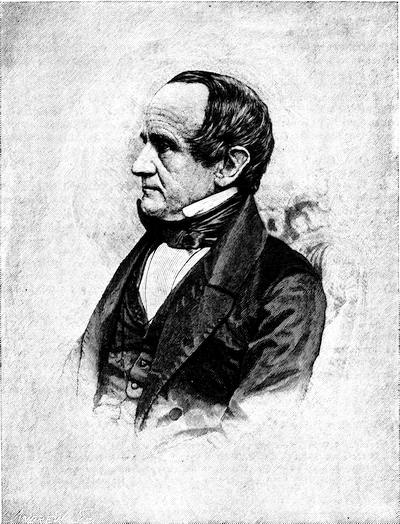
JOHN GORHAM PALFREY.
The editor is indebted to Gen. F. W. Palfrey for the excellent photograph after which this engraving is made.
In 1866 Dr. Palfrey published a popular abridgment of his first three volumes in two smaller ones. These were reissued in August, 1872, with a third, and in 1873 with a[162] fourth, which completed the abridgment of his larger work, and carried the story from the accession of Shirley to power down to the opening of the military history of the American Revolution. In this admirably concise form, reissued in 1884, with a thorough index, the work of the chief historian of New England is known as A compendious History of New England from the Discovery by Europeans to the first general Congress of the Anglo-American Colonies,—the last summarized chapter in the work not being recognized in the title.[347]
Massachusetts.—For this as well as for the period embraced in the third volume of the present history,[348] Thomas Hutchinson’s History of Massachusetts Bay is of the highest importance. Hutchinson says that he was impelled to write the history of the colony from observing the repeated destruction of ancient records in Boston by fire, and he complains that the descendants of some of the first settlers will neither use themselves nor let others use the papers which have descended to them. He seems, however, to have had the use of the papers of the elder Elisha Cooke. He acknowledges the service which the Mather library, begun by Increase Mather, and in Hutchinson’s time owned by Samuel Mather, who had married Hutchinson’s sister, was to him.
While Hutchinson’s continuation of the story beyond 1749 was as yet unknown, George Richards Minot planned to take up the narrative and carry it on. Minot’s Continuation of the History of the Province of Massachusetts Bay from 1748 shows that he made use of the files in the state house as well as their condition then permitted, but he was conscious of the assistance which he might have had, and did not possess, from the papers in the English archives. His first volume was printed in 1798; and he died before his second volume was published, in 1803, which had brought the record down to 1765, but stopped abruptly.[349] Grahame (iii. 446) calls the work “creditable to the sense and talent of its author,” but considers “his style frequently careless, and even slovenly and ungrammatical.” His contemporaries viewed his literary manner much more favorably, and were inclined to give him a considerable share in placing our native historical literature upon a scholarly basis. More painstaking research, with a careful recording of authorities, characterizes the only other History of Massachusetts of importance, that by John S. Barry, whose second volume is given to the period now under consideration,—a work, however, destitute of commensurate literary skill, or its abundant learning would give it greater reputation. Haliburton, in chapters 2 and 3 of book iii. of The Rule and Misrule of the English in America, traces in a summary way the turbulent politics of the province of Massachusetts during its long struggle against the royal prerogative. Emory Washburn’s Sketches of the judicial history of Massachusetts from 1630 to the revolution in 1775, Boston, 1840, contains biographical notices of the judges of Massachusetts, and traces the relations of the study of the law to the progress of political events. William Henry Whitmore’s Massachusetts civil list for the colonial and provincial[163] records, 1630-1774, Albany, 1870, is a list of the names and dates of appointment of all the civil officers constituted by authority of the charters or the local government. The general histories of Maine (during this period a part of Massachusetts) have been sufficiently characterized in another place.[350]
Connecticut.—The History of Connecticut, by Benjamin Trumbull, becomes not of less value as it approaches his own time. Grahame (ii. 165) says of him that he is “always distinguished by the accuracy of his statements, but not less distinguished by his partiality for his own people,” and Palfrey (iv. 226) avers that with all “his gravity Trumbull had a tendency for sensational traditions,” and both are right. He had not brought the story down later than 1713, in the volume published at Hartford in 1797. He says that he availed himself of the material which the ancient ministers and other principal gentlemen of Connecticut had communicated to Thomas Prince, when that writer was engaged upon his Chronological Hist. of New England; and in this collection, he adds, “important information was found, which could have been obtained from no other source.” Trumbull’s first volume was reprinted at New Haven in 1818, with a portrait of the author, together with a second volume, bringing the story down to 1764.
Rhode Island.—Of Rhode Island in the present period, Arnold’s History is the foremost modern authority.[351] Mr. William E. Foster has recently prepared, as no. 9 of the Rhode Island Historical Tracts (1884), a careful and well-annotated study of the political history of the eighteenth century, in a Memoir of Stephen Hopkins.
New Hampshire.—Dr. Belknap, as the principal historian of New Hampshire, has been characterized in another place.[352] The bibliography of his history may find record here. The first volume, The History of New Hampshire, vol. i., comprehending ... one complete century from the discovery of the Pascataqua, was read through the press in Philadelphia (1784) by Ebenezer Hazard.[353] This volume was reprinted at Boston in 1792, where meanwhile vol. ii. (1715-1790) had appeared in 1781, and vol. iii., embracing a geographical description, was issued in 1792. The imprints of these volumes vary somewhat.[354] There was printed at Dover, N. H., in 1812 (some copies have “Boston, 1813”) a second edition in three volumes, “with large additions and improvements published from the author’s last manuscript;” but this assertion is not borne out by the book itself.[355] A copy of his original edition having such amendments by Belknap had been used in 1810, at Dover, in printing an edition which was never completed, as the copy and what had been done in type were burned. Before parting with this corrected copy, the representatives of Dr. Belknap had transferred his memoranda to another copy, and this last copy is the one referred to in the edition which was printed by John Farmer at Dover in 1831, called The History of New Hampshire by Jeremy Belknap, from a copy of the original edition having the author’s last corrections, to which are added notes containing various corrections and illustrations. By John Farmer.[356] This is called vol. i., and contains the historical narrative, but does not include the geographical portion (vol. iii. of the[164] original ed.), which Farmer never added to the publication.[357] Belknap says that he had been educated under the influence of Thomas Prince, and that he had used Prince’s library before it had been despoiled during the Revolution. Of Hutchinson—and Belknap was in early manhood before Hutchinson left New England—he says that while that historian writes many things regarding New Hampshire which Neal and Douglass have omitted, he himself omits others, which he did not think it proper to relate. He refers to Mr. Fitch, of Portsmouth, as having begun to collect notes on New Hampshire history as early as 1728, and says that he had found in Fitch’s papers some things not elsewhere obtainable. He also animadverts on errors into which Chalmers had fallen in his Political Annals of the American Colonies.

A. The Documentary History of New England.—After the lapsing of the New England Confederacy consequent upon the charter of William and Mary, the governments which made up that group of colonies had no collective archives. It is only as we search the archives of the English Public Record Office, and those of Paris and Canada, including Nova Scotia, that we find those governments treated collectively. The Reports of the English Historical Manuscripts Commission have of late years not only thrown additional light on our colonial history, as papers touching it preserved in the muniment rooms of leading families have been calendared, but the commission’s labors have also been the incentive by which the public depositary of records has been enriched by the transfer of many papers, which the commission has examined. Nine of their voluminous reports (up to 1885) have been printed, and by their indexes clues have been provided to the documents about New England history. The Shelburne Papers, belonging to the Marquis of Lansdowne, which make a large part of the Fifth Report, while of most interest in connection with the American Revolution, reveal not a little concerning the colonial history of the earlier part of the seventeenth century. The volumes enumerated in this Report, which are marked xlv. (1705-1724) and xlvi. (1686-1766), are of particular interest, referring entirely to the American colonies. We find here various papers of the Board of Trade and Plantations (or copies of them), embracing the replies from the provincial governors to their inquiries. In the volume numbered lxi., there are sundry reports of the attorney and solicitor-general, to whom had been referred the appeals of Massachusetts in 1699, and of Connecticut in 1701; his report of 1705 respecting Jesuits and papists in the plantations; that of 1707 on the acts of Massachusetts fining those trading with the French; that of 1710 on the reservation of trees in Massachusetts for masts of the royal navy; that of 1716 on the claim of the governor of Massachusetts to command the militia of Rhode Island; that of 1720 on the negative of the governor reserved in the charter of Massachusetts; that of 1722 on the question of the time when the three years that a province law is open to disapproval properly begins; that of 1725 on the encroachments of the House of Representatives on the prerogative of the Crown; that of 1732 relating to the validity of acts in Rhode Island, notwithstanding the governor’s dissent,—not to name many others.
Another source of documentary help is the manuscripts of the British Museum, of which there are printed catalogues; and the enumeration of the documents in the possession of the Canadian government,—of which the quality can be judged, as they existed in 1858,—in the Catalogue of the Library of Parliament, Toronto, 1858, pp. 1541-1655.
The archives of Massachusetts are probably not surpassed in richness by those of any other of the English colonies. The solicitude which the colonial and provincial government always felt for their preservation is set forth by Dr. George H. Moore in appendix v. of his Final notes on Witchcraft (New York, 1885). In 1821, Alden Bradford, then secretary of the commonwealth,[165] made a printed statement of “the public records and documents belonging to the commonwealth” (pp. 19), but the fullest enumeration of them was included in a Report to the Legislature of Massachusetts, made by the Commissioners ... upon the condition of the records, files, papers, and documents in the Secretary’s department, Jan., 1885 (pp. 42), drawn up by the present writer. An indication of such of them as concern the period of the present volume may be desirable.[358] The series of bound volumes, arranged in 1836-46, by the Rev. Joseph B. Felt, according to a classification which was neither judicious nor uniform, but, as Dr. Palfrey says, betrays “ingenious disorder,”[359] includes not all, but the chief part of the papers illustrative of legislation in the secretary’s office which concern us in the present chapter and make part of one hundred and thirty-one volumes. These come in sequence through vol. 136,—the omitted volumes being no. 107 (the revolution of 1689) and nos. 126 to 129 (the usurpation of the Andros period). The other volumes as a rule begin in the colonial period and come down to about the beginning of the Revolutionary War. They are enumerated with their topical characteristics in the Report already referred to (pp. 8, 9). Four volumes of ancient plans, grants, etc. (1643-1783), accompany the series.
Of the so-called French Archives—documents copied in France—mention has been elsewhere made, and a considerable portion of them cover the period now under examination.[360]
The destruction of the town and court house in 1747 carried with it the loss of many of the original records of the colony and province. The government had already undertaken a transcript of the records of the General Court, which had been completed down to 1737; and this copy, being at the house of Secretary Josiah Willard, was saved. A third copy was made from this, and it is this duplicate character which attaches to the records as we now have them. Transcripts of these records under the charter of William and Mary had by its provisions been sent to the Lords of Trade, session by session, and orders were at once given to secure these from 1737 to 1746, or a copy of them, for the province archives. For some reason this was not accomplished till 1845, when a commissioner was sent to England for that purpose; and these years (1737-1746) are thus preserved. None of these records for the provincial period have been printed.[361] The records of the upper branch or the council were also burned,[362] and were in a similar way restored from England. Of the House of Representatives, or lower branch, we have no legislative records before 1714, nor of the legislative action of either branch have we any complete record before 1714, since neither the journals of the House nor the legislative part of the records of the council were sent over to England, but only the executive part of the latter, which was apparently made up in view of such transmission, as Moore represents. The preservation of the journals of the House is due to the jealousy which that body felt of Dudley when he prorogued them in 1715. Because of their inaction on the paper-money question, the House, in a moment of indignation, and to show that they had done something, if not what the governor liked, voted to have their daily records printed. The set of these printed journals in the possession of the State is defective.[363] There is not known to be a perfect set of them in any collection, perhaps not in all the collections in the state, says Judge Chamberlain,[364] who adds: “Of their value for historical purposes I have formed a very high opinion. In many respects they are of more value than the journals of the General Court, which show results; while the journals of the House disclose the temper of the popular branch, and give the history of many abortive projects which never reached the journals of the General Court.”[365] Of a series of copies called charters, commissions, and proclamations, the second volume (1677-1774) concerns the present inquiry. There is a file of bound letters beginning in 1701, and it would seem they are copies in some, perhaps many, cases of originals in the archives as arranged by Mr. Felt.
Respecting the French and Indian wars, nine volumes of the so-called Massachusetts Archives cover muster-rolls from 1710 to 1774, including the regiments of Sir Chas. Hobby and others (1710), the frontier garrisons, those of Annapolis Royal (1710-11), the expedition to the West Indies (1740), the campaigns of Crown Point, Fort William Henry, and Louisbourg (1758), beside various eastern expeditions and the service by sea. Of the first Louisbourg (1745) expedition, there are no rolls, except as made up in copies from the Pepperrell and Belknap papers in the library of the Mass. Historical Society. In addition to these bound papers there are[166] many others in packages, laid aside by Mr. Felt in his labor, in some cases for reasons, and in other cases by oversight or a varying sense of choice.[366]
The Colonial Records of Connecticut for the present period have come under the supervision of Mr. C. J. Hoadly, and are carefully edited. In 1849 about 50,000 documents in the state archives had been bound in 138 volumes, when an index was made to them.[367] The correspondence of the Connecticut authorities with the home government (1755-58) has been printed in the Connecticut Historical Collections (vol. i. p. 257).
For Rhode Island, the continuation of the Colonial Records, beginning with vol. iii., covers the period now under consideration. The sessional papers of 1691-95, however, are wanting, and were probably sent to England by Bellomont, whence copies of those for May and June, 1691, were procured for the Carter-Brown library. Newport at this time was a leading community in maritime affairs, and the papers of these years touch many matters respecting pirates and privateers. The fifth volume (1741-56) indicates how Rhode Island at that time kept at sea more ships than any other colony, how she took part in the Spanish war, and how reckless her assembly was in the authorizing of paper money. The sixth volume (1757-69) closes the provincial period.
The series of publications of New Hampshire ordinarily referred to as Provincial Papers, from the leading series of documents in what is more properly called Documents and records relating to New Hampshire, is more helpful in the present period than in the earlier one.[368] They may be supplemented by the Shute and Wentworth correspondence (1742-53), and Wentworth’s correspondence with the ministry (1750-60); and letters of Joseph Dudley and others, contained in the Belknap MSS. in the cabinet of the Mass. Historical Society.[369] The Granite Monthly (vol. v. 391) has published a list of the issues of the press in New Hampshire from 1756 to 1773; and B. H. Hall’s History of Eastern Vermont, from its earliest settlement to the close of the eighteenth century, with a biographical chapter and appendixes (2 vols., Albany, N. Y., 1858, and on large paper in 1865), supplements the story as regards the claim of New Hampshire to the so-called New Hampshire grants.
The legislative and judicial methods of the several governments are of the first importance to the understanding of New England history, for it was a slow process by which it came to pass that professional lawyers held any shaping hand in the making or the administering of laws. The first Superior Court of Massachusetts under the provincial charter had not a single trained lawyer on the bench, and its assembly was equipped more with persistency and shrewdness in working out its struggle with the crown officer who tried to rule them than with legal acquirements. E. G. Scott, in his Development of Constitutional Liberty in the English Colonies (N. Y., 1882, pp. 31-58), examines the forms of the colonial governments and the political relations of the colonies. No one has better traced their relations to European politics than Bancroft.
The legislation of the several governments has had special treatment in Emory Washburn’s Sketches of the Judicial History of Massachusetts, 1630-1775 (Boston, 1840); in T. Day’s Historical Account of the Judiciary of Connecticut (Hartford, 1817); in John M. Shirley’s “Early Jurisprudence of New Hampshire,” in the New Hampshire Historical Society’s Proceedings, June 13, 1883. Cf. also H. C. Lodge, Short Hist. of the English Colonies, pp. 412-419.
Of the legislation of Massachusetts, Dr. Moore says[370] that it is “a record which, notwithstanding all its defects, has no parallel in any other American State.” The first edition of the Province Laws, under the new charter, was printed in 1699, and it was annually supplemented by those of the succeeding sessions till 1714, when a second edition was printed, to which an index was added in 1722, and various later editions[167] were issued.[371] In 1869 the first volume of a new edition, of historical importance, was published by the State, with the title Acts and Resolves, public and private, of the Province of the Massachusetts Bay, with historical and explanatory notes, edited by Ellis Ames and Abner C. Goodell. Mr. Ames has since died (1884), and the editing is still going on under Mr. Goodell; five volumes, coming down to 1780, having been so far published.[372]
B. Men and Manners.—Dr. George E. Ellis, in an address[373] which he delivered in October, 1884, on the occasion of erecting a tablet to Samuel Sewall’s memory in the new edifice of the Old South church, in Boston, of which that last of the puritans had been a member, said:—
“Judge Sewall is better known to us in both his outer and inner being than any other individual in our local history of two hundred and fifty years; and this is true not only of himself, but through his pen, curiously active, faithful, candid, kind, impartial, and ever just, his own times stand revealed and described to us. His surroundings and companions, his home and public life, the habits, usages, customs, and events, and even the food which we can almost smell and taste, the clothes, and furnishings, the modes of hospitality, of travel, the style of things,—all in infinite detail; the military service, the formal ceremonials and courtesies, the excitements, panics, disasters,—all these have come down to us through Sewall’s pen, with a fullness and old-time flavor and charm, which we might in vain seek to gather from many hundred volumes. And all this comes from Sewall having kept a daily journal from 1674 to 1729, fifty-five years,”—and forty of these years come within the scope of the present chapter.
These journals had long been known to exist in a branch of Sewall’s family, but as, Dr. Ellis says, they “had been kept with much reserve, sparingly yielding to earnest inquirers the information they were known to contain.” President Quincy had drawn from them in his History of Harvard University, and had called them “curious and graphic,” as his extracts show. They had also been used by Holmes in his American Annals, by Washburn in his Judicial History of Mass., and by others. In 1868, some friends of the Mass. Historical Society purchased the diaries and other Sewall papers of the holders, and gave them to the society.[374] The diaries have since been published, and make part of the Collections of that society.[375] Despite a good deal of a somewhat ridiculous conservatism, linked with a surprising pettiness in some ways, the character of Sewall is impressed upon the present generation in a way to do him honor. His was a struggle to uphold declining puritanism, and the contrasts presented by the viceroyalty of New England at that time to one who was bred under the first charter must have been trying to Christian virtues, even were they such as Sewall possessed.[376] Dr. Ellis has[168] pointed out[377] how universally kindly Sewall was in what he recorded of those with whom he came in contact. “There are no grudges, no animosities, no malice, no bitter musings, no aggravating reproaches of those—some very near him—who caused him loss and grief, but ever efforts to reconcile, by forbearance, remonstrance, and forgiveness.” All this may be truly said, and afford a contrast to what the private diaries of his contemporaries, the two Mathers, would prompt us to say of their daily records. Those who are more considerate of the good names of those divines than they were themselves have thus far prevented the publication of these diaries. Dr. Ellis[378] says of them:—
“The diaries of Increase and Cotton Mather are extant, but only extracts of them have been printed. Much in them is wisely suppressed. Increase, though a most faithful, devoted, and eminently serviceable man, was morbid, censorious sometimes, and suffered as if unappreciated. The younger Mather was often jealous, spiteful, rancorous, and revengeful in his daily records, and thus the estimate of his general worth is so far reduced through materials furnished by himself.”[379]
There is among the Sparks manuscripts in Harvard College library a bound quarto volume which is superscribed as follows: “To Mr. Samuel Savile, of Currier’s Hall, London, attorney-at-law: Dear friend,—I here present you with an abstracted Historical Account of that part of America called New England; to which I have added the History of our voiage thereto, Anno Domini, 1740.” This account presents one of the best pictures of New England life, particularly of that in Boston, from a contemporary pen.[380] There are various other diaries of lookers-on, which are helpful in this study of New England provincial life, like the journals of Whitefield, the diary of Francis Goelet,[381] the journal of Madam Knight’s journey, 1704,[382]—not to name others. Among published personal records, there are George Keith’s Journal of Travels from New Hampshire to Caratuck (London, 1706); Capt. Nathaniel Uring’s Voyages and Travels, published at London in 1727;[383] and Andrew Burnaby’s Travels through the middle settlements in North America in the years 1759 and 1760, London, 1775.[384] Burnaby passed on his way, from Bristol through Providence to Boston. The early part of the autobiography of Benjamin Franklin is of exceptional value as a reflex of the life of New England as it impressed a young man.[385]
Among the modern treatises on the social condition of New England, a chief place must be given to Henry Cabot Lodge’s Short History of the English Colonies, the chapters in which on the characteristics of the colonies and their life are the essential feature of a book whose title is made good by a somewhat unnecessary abridgment of the colonies’ anterior history. Lodge groups his facts by colonies. Dr. Edward Eggleston in some valuable papers, which are still appearing in the Century Magazine, groups similar, but often much minuter, facts by their topical rather than by their colonial[169] relations. Mr. Horace E. Scudder prepared an eclectic presentation of the subject in a little volume, Men and Manners a hundred years ago (N. Y., 1876), which surveys all the colonies. The Rev. Jos. B. Felt’s Customs of New England (1853) has a topical arrangement.[386]
For Massachusetts in particular, most of the local histories[387] contribute something to the subject; and in the Memorial History of Boston there are various chapters which are useful,[388] and a survey is also given in Barry’s Massachusetts (vol. ii. ch. I).
“He that will understand,” says Bancroft,[389] “the political character of New England in the eighteenth century must study the constitution of its towns, its congregations, its schools, and its militia.”[390]
C. Finance and Revenue.—Dr. J. Hammond Trumbull in a pamphlet, First Essays at Banking and the first paper money in New England (Worcester, 1884,—from the Council Report of the American Antiquarian Society, Oct., 1884), traces more fully than has been done by Jos. B. Felt, in his Historical account of Massachusetts Currency (Boston, 1839), and by Paine in the Council Report of the same society, April, 1866,[391] the efforts at private banking previous to the province issue of bills in 1690, and with particular reference to a tract, which he ascribes to the Rev. John Woodbridge, of Newbury, called Severals relating to the fund, printed for divers reasons as may appear (Boston, probably 1681-82).[392] Dr. Trumbull attributes to Cotton Mather a paper sustaining the policy of issuing paper bills in 1690, which was published as Some considerations on the Bills of Credit now passing in New England (Boston, 1691),[393] to which was appended Some additional considerations, which the same writer thinks may have been the work of John Blackwell, who had been the projector of a private bank authorized in 1689. Similar views as there expressed are adopted by Mather in his Life of Phips, as printed separately in 1697, and as later included in the Magnalia.
In Dec., 1690, the bills of the £7,000 which were first authorized began to be put forth. Felt (p. 50) gives the style of them, and though an engraved form was adopted some of the earliest of the issues were written with a pen, as shown by the fac-simile of one in the Proceedings of the Massachusetts Hist. Soc. (1863, p. 428). Up to 1702 there had been emissions and repetitions of emissions of about £110,000, when another £10,000 was put out. A fac-simile of one of these notes is given in Smith’s Hist. and Literary Curiosities, p. xlv. The issues for the next few years were as follows: 1706, £10,000; 1707, £22,000; 1708, £10,000; 1709, £60,000; 1710, £40,000; 1711, £65,000,—a total of £207,000.
In the following year (1712), the province bills of Massachusetts were made legal tender,[394] but the break had come. The public confidence was shaken, and their decline in value rapidly increased under the apprehension, which the repeated putting off of the term of redemption engendered.
In Connecticut the management was more prudent. She issued in the end £33,500, but all her bills were redeemed with scarce any depreciation. A fac-simile of one of her three-shilling bills (1709) is given in the Connecticut Colony Records, 1706-1716, p. 111.[395]
Rhode Island managed her issues wildly. The history of her financial recklessness, by E. R. Potter, was published in 1837, and reprinted by Henry Phillips, Jr., in his Historical Sketches, etc. This paper as enlarged by S. S. Rider in 1880, constitutes no. viii. of the Rhode Island Historical Tracts, under the title of Bills of Credit and Paper Money of Rhode Island, 1710-1786, with twenty fac-similes of early bills. In 1741 Gov. Ward made an official report to the Lords Commissioners of Trade, rehearsing the history of the Rhode Island issues from 1710 to 1740, and this report, with other documents relating to the paper money of that colony, is in the Rhode Island Col. Records, vol. v. (1741-56).
Towards the end of Dudley’s time in Massachusetts, the party lines became sharply drawn on questions of financial policy. The downfall of credit alarmed the rich and conservative. The active business men, not many in numbers, but strong in influence, found a flow of paper money helpful in making the capital of the rich and the labor of the poor subserve their interests, as Hildreth says. There were those who supposed some amelioration would come from banks, private and public, and the press teemed with pamphlets.[396] The aggressive policy was formulated in A Projection for erecting a Bank of Credit in Boston, New England, founded on Land Security, in 1714.[397] Its abettors endeavored to promote subscriptions by appealing to the friends of education, in a promise to devote £200 per annum to the advantage of Harvard College.[398]
The small minority of hard-money men cast in their lot with the advocates of a public bank as the lesser evil of the two.
Gov. Dudley was no favorer of the Land-bank scheme[399] and his son, Paul Dudley, attacked it in a pamphlet, Objections to the Bank of Credit lately projected at Boston[400] (Oct., 1714), to which an answer came in Dec., from Samuel Lynde and other upholders, called A Vindication of the Bank of Credit.[401] “Of nearly thirty pamphlets and tracts, printed from 1714 to 1721,[402] for or against a private bank or a public bank,” says Dr. Trumbull,[403] “that of Dudley was the first, and is in some respects the ablest;” but he places foremost among the advocates of the scheme the author of A Word of Comfort to a Melancholy Country (Boston, 1721), purporting to be by “Amicus Patriæ,” or, as Trumbull thinks (p. 40) there is little doubt, by the famous Rev. John Wise, of Chebacco. (Cf. Brinley Catal., i. nos. 1,442-45.)
To forestall the action of the private bank, the province, by a law, issued £50,000 to be let out on mortgages of real estate, and these bills were in circulation for over thirty years, and the assembly took other action to prevent the Land-bank scheme being operative. The subsequent emissions of paper money can be traced in Felt, who also cites the contemporary tracts, ranged upon opposite sides, and supporting on the one hand the conservative views of the Council, and on the other the heedless precipitancy of the House. One of these, The Distressed state of the town of Boston considered ... in a letter from a gentleman to his friend in the country (1720), excited the attention of the council as embodying reflections on the acts of the government.[404]
In 1722 bills of as small a denomination as one, two, and three pennies[405] were ordered, to provide small change, which had become scarce.
The financial situation was rapidly growing worse. In 1710 an ounce of silver was worth eight shillings in paper, and in 1727 it had risen to seventeen shillings; and at this time, or near it (1728), there was afloat about £314,000 of this paper of Massachusetts indebtedness, to say nothing of a similar circulation issued by the other colonies, that of Rhode Island showing a much greater depreciation.[406] The fall in value was still increasing when in 1731 there were plans of bringing gold and silver into the country for a medium of trade;[407] but naturally the needy mercantile class opposed it. Thomas Hutchinson early (1737-38) distinguished himself in the assembly as a consistent opposer of paper money, and in 1740 he tried to push a scheme to hire in England 220,000 ounces of gold to meet the province bills, but he had little success. Another[408] scheme, however, flourished for a while; and this was one reviving the old name of the Land-bank, though sometimes called “Manufactory bank,” a bill for which was set afoot by Mr. John Colman, a needy Boston merchant, as Hutchinson calls him. Its principal feature consisted in securing the issues of the bank by a mortgage on the real estate of each associate to the extent of his subscription. It found its support in the small traders and the people of the rural districts, and was sustained in general by the House of Representatives. The leading and well-to-do merchants opposed it, and set up what was called a “Silver Scheme,”—an issue of notes to be redeemed in silver after the lapse of ten years.[409] “Mr. Hutchinson,” as this gentleman himself records, “favored[172] neither, but considered the silver plan as without fraudulent purpose, which he did not think could be the case with the Land-bank.”[410]
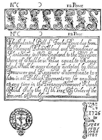
RHODE ISLAND PAPER,—TWELVE PENCE.
From an original bill in an illustrated copy of Historical Sketches of the Paper Currency of the American Colonies, by Henry Phillips, Jr., Roxbury, 1865,—in Harvard College library.
In 1733, Boston instructed its treasurer to refuse the bills of the new emission of Rhode Island. (Records, 1729-42, p. 53.)
The favoring and the opposing of the popular measure of the Land-bank drew lines sharply in the current political contests. The governor was suspected of double dealing, and while he was believed to be personally interested in it, he carried out openly the opposition which the Board of Trade instructed him to pursue: rejected the speaker and committees of the House, who were urging its progress, and displaced[173] justices and militia officers of that way of thinking. All the while rumors of riot began to prevail, but they were not sufficient to coerce the government in a relaxation of their opposition; and the governor on his side carried espionage to a degree which was novel. It is said that something over £50,000 of the bank’s bills actually got out; but some one discovered that an old act of Parliament, which came of the explosion of the South Sea company, held each partner responsible, and nothing else was needed to push the adventure out of existence.[411]
Felt gives the main points in the development of this financial scheme, but here as elsewhere his book is a mere conglomerate of ill-digested items, referring largely to the five volumes (c.-civ.) of the Mass. Archives, marked “Pecuniary,” which cover the monetary movements in Massachusetts between 1629 and 1775. Among the Shelburne Papers, vol. 61,[412] there appears a report of the attorney general to the Lords of Trade on this scheme of erecting a Land-bank in Boston, dated Nov. 10, 1735.
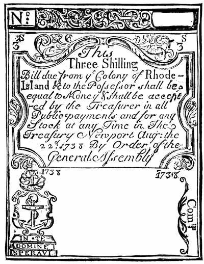
RHODE ISLAND THREE-SHILLINGS BILL, 1738.
From an original bill in the Harvard College copy of Phillips’ Hist. Sketches.
A leading combatant in the wordy conflict which followed was the Scotch physician, William Douglass, then living in Boston. His first publication was Some observations on the scheme projected for emitting £60,000 in bills of a new[174] tenor to be redeemed with silver and gold, Boston, 1738.[413] In the same year he published without date, An Essay concerning silver and paper currencies, more especially with regard to the British colonies in New England, Boston.[414] He next printed in London in 1739 a Discourse concerning the currencies of the British plantations in America, especially with regard to their paper money, more particularly in relation to Massachusetts.[415]
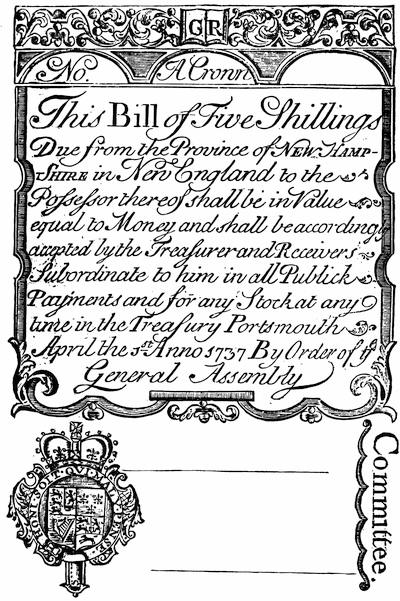
NEW HAMPSHIRE FIVE-SHILLINGS BILL, 1737.
From an original bill in the Harvard College copy of Phillips’ Hist. Sketches of Paper Currency. Fac-similes of bills of 1727 and 1742 are given in Smith’s Lit. and Hist. Curiosities, p. liii. Cf. also Potter’s Manchester.
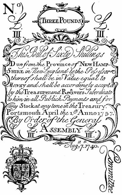
NEW HAMPSHIRE THREE-POUNDS BILL, 1740.
From an original bill in the Harvard College copy of Phillips’ Hist. Sketches. There is a fac-simile of a N. H. bill of forty shillings in Gay’s Pop. Hist. U. S., iii. p. 133; and one of a bill of 1742-43 in Cassell’s Hist. United States, i. p. 486.
A fortunate plan for withdrawing the debased paper currency of Massachusetts Bay was finally matured.[416] Though the taking of Louisbourg had severely taxed the colony with a financial burden, the loss of it by treaty now made the way clear to throw off the same burden. William Bollan, the son-in-law of Shirley, had gone over after the Peace of Aix-la-Chapelle to represent how the sacrifices of New England deserved more recognition than was seemingly paid them in the surrender of her conquest. This and other reasons prevailed, and the government agreed to reimburse the province for the cost of the siege. This was reckoned on the new basis of paper money. Shirley in 1743 had been allowed to give his assent to an issue called “new tenor,” in which the value to silver was about ten times as great as the enormous flood of issues then in circulation bore, and these last were now known as “old tenor.” On this new basis Louisbourg had cost £261,700, which was held to be equivalent to £183,600 in London, the pound sterling equalling now about 30 shillings of the new tenor, and £11 of the old.[417] This agreement had been reached in 1749,[418] and the specie was shipped to Boston. Two hundred and seventeen chests of Spanish dollars and a hundred casks of copper coin were carted up King Street, in September, the harbinger of new prosperity. It was due most to Thomas Hutchinson’s skilful urgency that the assembly, of which he was now speaker, was induced to devote this specie to the redeeming of the paper bills of the “old tenor,” of which £2,000,000 were in circulation.[419] It was agreed to pay about one pound in specie for ten in paper, and the commissioners closed their labors in 1751, the silver and copper already mentioned paying nine tenths of it, while a tax was laid to pay the remaining tenth. About £1,800,000 in current bills were presented; the rest had been destroyed or hid away and forgotten.[420] Rhode Island had received £6,322 as her share of the whole; but as she was not wise enough to apply it to the bettering of her currency, she suffered the evils of a depreciated paper longer than her neighbors.[421] The same lack of wisdom governed New Hampshire. Connecticut had always been conservative in her monetary practices.
When the Massachusetts Assembly, in 1754, sought to raise money for the expenses of the war then impending, its debate upon an inquisitorial[177] excise bill levying a tax on wines and liquors incited violent opposition. Samuel Cooper launched at the plan a pamphlet called The Crisis.[422] Another brief attack appeared with nothing on the title but The Eclipse, MDCCLIV.[423] Daniel Fowle, however, was accused of printing another satirical account of the Representatives’ proceedings, which was published in 1754 as The Monster of Monsters, and the “Thomas Thumb, Esq.,” of the title is supposed to have shielded Samuel Waterhouse. Fowle was arrested, and the common hangman was directed to burn the pamphlet in King Street.[424] Sabin says that not more than three or four copies of the tract escaped, but the Brinley Catalogue shows two.[425] After his release Fowle printed in Boston the next year (1755) A total Eclipse of Liberty. Being a true and faithful account of the arraignment and examination of Daniel Fowle before the House of Representatives of Massachusetts Bay, Oct. 24, 1754, barely on suspicion of being concerned in printing and publishing a pamphlet, entitled The Monster of Monsters. Written by himself. An Appendix to the late Total Eclipse, etc., appeared in 1756.[426]
In May, 1755, a stamp act went into operation in the province, by which the Representatives had established duties upon vellum, parchment, and paper for two years. It yielded towards defraying the charges of the government about £1,350 for the years in question.[427] Shirley issued a proclamation of its conditions, one of which is in the Boston Public Library, and has been reprinted in its Bulletin, 1884, p. 163.
D. The Bounds of the New England Colonies.—During the provincial period, the external limits and internal divisions of New England were the subject of disagreement. The question as to what constituted the frontier line towards Acadia was constantly in dispute, as is explained elsewhere.[428]
On the western side New York had begun by claiming jurisdiction as far as the Connecticut River. She relinquished this claim in the main, as to her bounds on Connecticut, when that colony pressed her pretensions to a line which ran a score of miles from the Hudson, and when she occupied the territory with her settlers, the final adjustment being reached in 1731.[429]
On the line of Massachusetts the controversy with New York lasted longer. The claim of that province was set forth in a Report made in 1753, which is printed in Smith’s New York (1814 ed., p. 283), and Smith adds that the government of Massachusetts never exhibited the reasons of its claim in answer to this report, but in the spring of 1755 sold lands within the disputed territory.[430] In 1764 the matter was again in controversy. Thomas Hutchinson is thought to have been the author of the Massachusetts argument called The Case of the Provinces of Massachusetts Bay and New York, respecting boundary line between the two provinces (Boston, 1764).[431] Three years later (1767) a meeting of the agents of the two provinces was held at New Haven, by which the disagreement was brought to a conclusion.[432]
For the region north of Massachusetts New[178] York contended more vigorously, and the dispute over the New Hampshire grants in the territory of the present Vermont, which began in 1749, was continued into the Revolutionary period. When, in 1740, the king in council had established the northern line of Massachusetts, the commission of Gov. Benning Wentworth, of New Hampshire, the next year (1741), extended his jurisdiction westward until it met other grants, which he interpreted to mean till it reached a line stretched northerly in prolongation of the westerly boundary of Massachusetts, twenty miles east of the Hudson, and reaching to the southern extremity of Lake Champlain. On the 3d of Jan., 1749, Wentworth made a grant of the town of Bennington, adjacent to such western frontier line. These and other grants of townships which Wentworth made became known as the New Hampshire Grants.[433] The wars prevented much progress in the settlement of these grants, but some of the settlers who were there when the French war closed assembled, it is said, with the Rev. Samuel Peters in 1763 on Mount Pisgah, and broke a bottle of spirits with him, and named the country Verd Mont.
Gov. Colden, of New York, on Dec. 28, 1763, issued a proclamation claiming the land thus held under the grants of Wentworth, basing his rights on the grants in 1664 and 1674 to the Duke of York of “all lands from the west side of the Connecticut River to the east side of the Delaware Bay.” On the 20th July, 1764, the king in council confirmed Colden’s view, and made the Connecticut River the boundary as far as 45° north latitude. When this decision reached Wentworth he had already granted 128 townships. New York began to make counter-grants of the same land, and though the king ordered the authorities of New York to desist, when word reached London of the rising conflict, it was the angry people of the grants rather than the royal will which induced the agents of New York to leave the territory. Gov. John Wentworth continued to make grants till the Revolution, on the New Hampshire side; but though Gov. Moore, of New York, had been restrained (1767), his successors had not the same fear of the royal displeasure. As the war approached, the dispute between New York and the grants grew warmer.[434] In 1773 James Duane, it is thought, was the champion of the New York cause in two pamphlets: A State of the rights of the Colony of New York with respect to its eastern boundary on Connecticut River so far as concerns the late encroachments under the Government of New Hampshire, published by the assembly (New York, 1773); and A Narrative of the proceedings subsequent to the Royal Adjudication concerning the lands to the westward of Connecticut river, lately usurped by New Hampshire (New York, 1773).[435] The next year (1774) Ethan Allen answered the first of these tracts in his Brief narrative of the proceedings of the government of New York. Allen dated at Bennington, Sept. 23, 1774, and his book was published at Hartford.[436]
The war of independence soon gave opportunity for the British authorities on the Canada side to seek to detach the Vermonters from their relations to the revolting colonies.[437] The last of the royal governors of New Hampshire had fled in Sept., 1775, and a congress at Exeter had assumed executive control in Jan., 1776. The next year (1777) a convention framed a constitution, and by a stretch of power, as is told in Ira Allen’s Hist. of Vermont, it was adopted without recurrence to the people’s vote. In March, 1778, the state government was fully organized. The dispute with New York went on. Gov. Clinton issued a proclamation. Ethan Allen answered in an Animadversary Address (Hartford, 1778),[438] and in Dec., 1778, a convention of the people of the grants was held, and their resolution was appended to a document prepared by a committee of the assembly, called A public defence of the right of the New Hampshire grants (so called) on both sides Connecticut river, to associate together, and form themselves into an independent state. Containing remarks on sundry paragraphs of letters from the president of the Council of New Hampshire to his Excellency Governor Chittenden, and the New Hampshire delegates at Congress.[439]
The same year the legislature of New York directed the preparation of a Collection of evidence in vindication of the territorial rights and jurisdiction of the state of New York, against the claims of the commonwealth of Massachusetts and New Hampshire, and the people of the grants who are commonly called Vermonters. It was prepared by James Duane, James Morrin Scott, and Egbert Benson, and is printed in the Fund Publications of the New York Historical Society, 1870 (pp. 277-528). On the other side, Ethan Allen published A vindication of the opposition of the inhabitants of Vermont to the government of New York, and of their right to form an independent state;[440] and in 1780, in connection with Jonas Fay, and by order of the governor and council, he published A concise refutation of the claims of New Hampshire and Massachusetts Bay, to the territory of Vermont; with occasional remarks on the long disputed claim of New York to the same.[441]
In 1782, Ethan Allen again brought out at Hartford his The present state of the controversy between the states of New York and New Hampshire on the one part, and the state of Vermont on the other.[442]
The arguments and proofs were rehearsed in 1784, when the question was to be presented to court, in a brief by James Duane, called State of the evidence and argument in support of the territorial rights of jurisdiction of New York against the government of New Hampshire and the claimants under it, and against the Commonwealth of Massachusetts. An amicable adjustment prevented the publication of this document, and it was first printed in the N. Y. Hist. Soc. Coll. for 1871.[443]
Connecticut claimed certain lands in Northern Pennsylvania, which came within her jurisdiction by the extension of her lines, as expressed in her charter of 1662, westward to the South Sea. New York, being then in the possession of a Christian power, was excepted, but the claim was preserved farther west. In 1753 a company was formed to colonize these Connecticut lands in the Susquehanna valley, and lands were bought of the Indians at Wyoming. The government of Pennsylvania objected, and claimed the lands to be within the bounds of William Penn’s charter. (Cf. Penna. Archives, ii. 120, etc.) The defeat of Braddock checked the dispute, but in 1761 it was renewed. In 1763 the home government required the Connecticut people to desist, on the ground that they had not satisfied the Indian owners. New bargains were then made, and in 1769 settlements again took place. General Gage, as commander-in-chief of the British troops on the continent, refused to interfere. In 1774, William Smith prepared an Examination of the Connecticut claim to lands in Pennsylvania, with an appendix and map (Philadelphia, 1774); and Benjamin Trumbull issued A Plea in vindication of the Connecticut title to the contested lands west of the Province of New York (New Haven, 1774). See entries in the Brinley Catalogue, Nos. 2121, etc. The dispute was later referred to the Continental Congress, which in 1781 decided in favor of Pennsylvania, and Aug. 8, 1782, commissioners were appointed. (Journals of Congress, iv. 59, 64.) Connecticut still claimed west of Pennsylvania, and though she retained for a while the “Western Reserve,” she finally ceded (1796-1800) to the United States all her claims as far as the Mississippi.[444] The claims of Massachusetts, on similar grounds, to land in Michigan and Wisconsin were surrendered to the general government in 1785.
The original patent for the Massachusetts Company made its northern line three miles north of the Merrimac River. New Hampshire claimed that it should be run westerly from a point on the coast three miles north of the mouth of that river. When the Board of Trade, in 1737, selected a commission to adjudicate upon this claim, Massachusetts was not in favor, and New Hampshire got more than she asked, the line being run north of the river three miles, and parallel to it, till it reached the most southerly point of the river’s course, when it was continued due west.[445]
Respecting the boundaries on the side of Maine, there is a journal of Walter Bryent, who in 1741 ran the line between New Hampshire and York County in Maine.[446]
Massachusetts also lost territory in the south. The country of King Philip on the easterly side of Narragansett Bay had been claimed by Plymouth, and Massachusetts, by the union under the province charter, succeeded to the older colony’s claim. An arbitration in 1741 did not give all she claimed to Rhode Island, but it added the eastern towns along the bay.[447] On the frontiers of Connecticut, the towns of Enfield, Suffield, Somers, and Woodstock had been settled by Massachusetts, and by an agreement in 1713 she had included them in her jurisdiction.[448] In 1747, finding the taxes in Massachusetts burdensome[181] from the expenses of the war, these towns applied to be received by Connecticut, and their wish was acceded to, while Massachusetts did not dare risk an appeal to the king in council.[449]
The disputes of Connecticut and Rhode Island respecting the Narragansett country resulted on that side in a loss to Connecticut.[450]
In an interesting paper on the “Origin of the names of towns in Massachusetts,” by William H. Whitmore, in the Proceedings (xii. 393-419) of the Mass. Hist. Society, we can trace the loss of towns to Massachusetts, which she had incorporated, and find some reflection of political changes. Up to 1732 the names of towns were supplied by the petitioners, but after that date the incorporation was made in blank, the governor filling in the name, which may account for the large number of names of English peers and statesmen which were attached to Massachusetts towns during the provincial period. The largest class of the early names seems due to the names of the places in England whence their early settlers came. Prof. F. B. Dexter presented to the American Antiquarian Society, in April, 1885, a paper of similar character respecting the towns of Connecticut.
E. Forts and Frontier Towns of New England.—The large increase during recent years in the study of local history has greatly broadened the field of detail. As scarcely one of the older settlements to the west, north, and east escaped the horrors of the French and Indian wars, the student following out the minor phases must look into the histories of the towns of New England. Convenient finding-lists for these towns are the Check-list of Amer. local history, by F. B. Perkins; Colburn’s Bibliog. of Massachusetts; Bartlett’s Bibliog. of Rhode Island; and A. P. C. Griffin’s “Articles on American local history in Historical Collections, etc.,” now publishing in the Boston Public Library Bulletin.
For the Maine towns particular reference may be made to Cyrus Eaton’s Thomaston, Rockland, and South Thomaston (1863), vol. i.; E. E. Bourne’s Wells and Kennebunk; Cushman’s Ancient Sheepscot and Newcastle; Willis’s Portland (2d ed.); Folsom’s Saco and Biddeford; Eaton’s Warren (2d ed.), which gives a map, marking the sites of the forts about the Georges River; Johnston’s Bristol, Bremen, and Pemaquid, which gives a map of the Damariscotta River and the Pemaquid region, with the settlements of 1751; R. K. Sewall’s Ancient Dominions of Maine; James W. North’s Augusta; G. A. and H. W. Wheeler’s Brunswick, Topsham, and Harpswell, including the ancient territory known as Pejepscot, Boston, 1878 (ch. iv. and xxiii.).
See the present History (Vol. III. p. 365) for notes on the local history of Maine, and (Ibid., p. 364) for references to the general historians,—Sullivan, whose want of perspicuousness Grahame (i. 253) complains of, and Williamson.
At the present Brunswick (Maine), Fort Andros had been built in 1688, and had been demolished in 1694. Capt. John Gyles erected there in August, 1715, a post which was called Fort George. Ruins of it were noticeable at the beginning of this century. There is a sketch of it in Wheeler’s Brunswick, Topsham, and Harpswell, pp. 624, 629.
The fort at St. Georges (Thomaston, Me.) had been built originally in 1719-20, to protect the Waldo patent; it was improved in 1740, and again in 1752 was considerably strengthened. (Williamson, i. 287.)
At Pemaquid, on the spot where Andros had established a post, Phips had built Fort William Henry in 1692, which had been surrendered by Chubb in 1696. It is described in Dummer’s Defence of the New England Charters, p. 31; Mather’s Magnalia, book viii. p. 81. In 1729 Col. David Dunbar erected a stone fort, perhaps on the same foundations, which was called Fort Frederick. There is a plan of the latter post in Johnston’s Bristol, Bremen, and Pemaquid, pp. 216, 264. Cf. Eaton’s Warren, 2d ed.
Further down the Kennebec River and opposite the upper end of Swan Island stood Fort Richmond, which had been built by the Massachusetts people about 1723. Near the present Augusta the Plymouth Company founded Forts Shirley and Western in 1754. There are plans and views of them in J. W. North’s Augusta, pp. 47-49. Cf. Nathan Weston’s Oration at the Centennial Celebration of the Erection of Fort Western, July 4, 1854, Augusta, 1854.
Col. John Winslow planned, in 1754, on a point half a mile below Teconick Falls, the structure known as Fort Halifax, according to[182] the extent shown by the dotted line in the annexed cut.[451] Winslow’s letter to Shirley, with the plan, is in the Mass. Archives, and both are given in North’s Augusta, pp. 59, 60. The fort was completed the next year by William Lithgow, as shown by the black part of the cut, the rear flanker, forming the centre of the original plan, having been built, however, by Winslow. This block-house measured 20 × 20 feet below, and on the overhang 27 × 27 feet. The narrower of the large structures was the barracks, also raised by Winslow, but removed by Lithgow, who built the other portions.

FORT HALIFAX.
The cut follows a reconstruction-draft, made by Mr. T. O. Paine, which is given by North (p. 62). The flanker nearest the river is still standing, and the upright planks on the side, as shown in the annexed cut, mark the efforts which have been made of late to secure the timbers. In the Maine Historical Society’s Collections, vol. viii. p. 198, is a history of the fort by William Goold, as well as the annexed cut of a restoration of the entire fort, drawn by that gentleman from descriptions, from the tracings of the foundations, and from the remaining flanker. The preceding volume (vii.) of the same Collections had contained “materials for a history” of the fort, edited by Joseph Williamson,—mainly documents from the Mass. Archives. A journal of the march of Capt. Eleazer Melvin’s company in Gov. Shirley’s expedition to the Norridgewock country, when Fort Halifax was erected in 1754, kept by John Barber (May 30, 1754-Aug. 17, 1754), is in N. E. Hist. and Gen. Reg., 1873, pp. 281-85. Cf. further in Williamson’s Maine, i. 300; Hutchinson’s Massachusetts, iii. 26. A plan (1754) of the Kennebec River forts, by John Indicott (measuring 38/12 × 15/12), is noted in the Catalogue of the King’s Maps (i. 580), in the British Museum. The forts on the Kennebec, and the chief localities of that river, are described by Col. William Lithgow in 1767, in a deposition printed in the N. E. Hist. and Geneal. Reg., 1870, p. 21. Lithgow was then fifty-two years old, and had known the river from childhood.

In 1752, when there was some prospect of quieting the country, and truck houses were built at Fort Richmond and St. Georges, William Lithgow[183] and Jabez Bradbury were put in charge of them.
A paper by Richard Pike, on the building and occupancy of Fort Pownall, on the Penobscot, is in the N. E. Hist. and Gen. Reg., 1860, p. 4. In Williamson’s Belfast, p. 56, is a conjectural view of the fort, drawn from the descriptions and from a survey of the site in 1828. A Survey of the river and bay of Penobscot, by order of Gov. Pownall, 1759, is among the king’s maps (Catal., ii. 167) in the British Museum. A journal of Pownall’s expedition to begin this fort was printed, with notes, by Joseph Williamson in the Maine Hist. Coll., v. 363. Cf. Williamson’s Maine, i. 337. This fort was completed in July, 1759, at a cost of £5,000, and stood till 1775. Cf. N. E. Hist. and Geneal. Reg., 1859, p. 167, with an extract from the Boston News-Letter, May 31, 1759.
This enumeration covers the principal fortified posts in the disputed territory at the eastward; but numerous other garrison posts, block-houses, and stockades were scattered over the country.[452] A view of one of these, known as Larrabee’s garrison stockade, is given in Bourne’s Wells and Kennebunk, ch. xxi. The view of a block-house built in 1714, near the junction of the Kennebec and Sebasticook rivers, as sketched in 1852, is annexed.
West of Maine the frontier stretched from the Piscataqua to the valley of the Housatonic.
For the New Hampshire part of this line, Belknap’s Hist. of New Hampshire must be supplemented for a general survey by B. H. Hall’s Eastern Vermont. So far as the muster-rolls of frontier service show the activity in New Hampshire, it can be gathered from the second volume of the Report of the Adjutant-General of New Hampshire, 1866, supplemented by others given in the N. H. Revolutionary Rolls, vol. i. (1886). The volumes of the series of Provincial Papers published by that State (vols. ix., xi., xii., xiii.), and called “Town Papers, 1638-1784,” give the local records. The principal town histories detailing the events of the wars are Potter’s Manchester; Bouton’s Concord; Runnel’s Sanbornton; Little’s Warren; C. C. Coffin’s Boscawen; H. H. Saunderson’s Charlestown; B. Chase’s Old Chester; C. J. Fox’s Dunstable; Aldrich’s Walpole; and Morrison’s Windham.
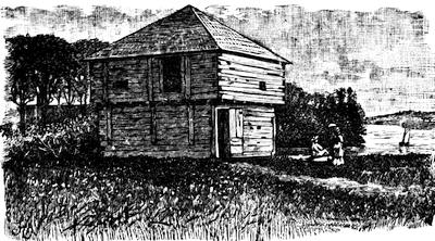
FLANKER, FORT HALIFAX.
In 1704 the assembly of New Hampshire ordered that every householder should provide himself with snow-shoes, for the use of winter scouting parties. (N. H. Prov. Papers, iii. 290.) In 1724 Fort Dummer was built near the modern Brattleboro, in territory then claimed by Massachusetts. (Hist. Mag., x. 109, 141, 178; N. H. Hist. Soc. Coll., i. 143; N. H. Adj.-Gen. Rept., 1866, ii. p. 122.) In 1746, after the alarm over the D’Anville fleet had subsided, Atkinson’s New Hampshire regiment was sent north to meet any invasion from Canada. (N. H. Adj.-Gen. Rept., 1866, ii. 83.) The next year (1747), Walter Bryent advanced with his regiment as far as Lake Winnepesaukee. (N. E. Hist. and Geneal. Reg., July, 1878, p. 297; N. H. Prov. Papers, v. 431, 471; Belknap, ii. 228.)
In 1747 the fort at “no. 4,” or Charlestown, the outpost towards Canada, was attacked. (Saunderson’s Charlestown; Stone’s Sir William Johnson, i. 260.)
In 1752-54 there is record of the hostilities on the New Hampshire borders in the N. H. Prov. Papers, vi. 301, 310-319.
The St. Francis Indians confronted the settlements of the upper Connecticut, and in 1752 Shirley sent Capt. Phineas Stevens to treat with them in the presence of the governor of Canada.[184] (N. Y. Col. Docs., x. 252.) For the massacre at Hinsdale in 1755, and attacks in the Connecticut valley, see N. H. Prov. Papers, vi. 412, and Adj.-Gen. Report, 1866, vol. ii. 153.
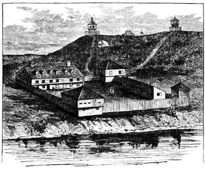
FORT HALIFAX, 1755.
(Restoration.)
In 1694-95, the frontier line of Massachusetts was established by law as including the towns of Amesbury, Haverhill, Dunstable, Chelmsford, Groton, Lancaster, Marlborough, and Deerfield. Five years later this list was increased by Brookfield, Mendon, and Woodstock, with a kind of inner line, running through Salisbury, Andover, Billerica, Hatfield, Hadley, Westfield, and Northampton.
For the border troubles of Massachusetts, beside Penhallow and Niles, Neal and Douglass, and the Magnalia, we turn to Hutchinson with confidence in the facilities which he enjoyed; but John Adams says (Works, x. 361), “When Mr. Hutchinson’s History of Massachusetts Bay first appeared, one of the most common criticisms upon it was the slight, cold, and unfeeling manner in which he passed over the Indian wars.”
The most exposed towns fronting the New Hampshire line were Haverhill, Andover, and Dunstable. The History of Haverhill, by G. W. Chase (1861), gives the story of the Indian troubles with much detail.[453] For Andover they may be found in S. L. Bailey’s Historical Sketches of Andover (Boston, 1880); and for Dunstable in Elias Nason’s History of Dunstable (1877). Just below Dunstable lay Groton, and Dr. Samuel A. Green’s Groton during the Indian Wars supplies the want here,—a good supplement to Butler’s Groton. The frontiers for a while were marked nearly along the same meridian by Lancaster, Marlborough, Brookfield, and Oxford. The Early records of Lancaster, 1643-1725, edited by H. S. Nourse (Lancaster, 1884), furnishes us with a full reflection of border experiences during King William’s, Queen Anne’s, and Lovewell’s wars, and it may be supplemented by A. P. Marvin’s History of Lancaster. The sixth chapter of Charles Hudson’s Marlborough (Boston, 1862), and Nathan Fiske’s Historical Discourse on Brookfield and its distresses during the Indian Wars (Boston, 1776), illustrate the period. The struggle of the Huguenots to maintain themselves at Oxford against the Indians is told in Geo. F. Daniels’ Huguenots in the Nipmuck Country (1880), and in C. W. Baird’s Hist. of the Huguenot Emigration to America (1885).
There is in the cabinet of the Mass. Hist. Soc. (Misc. Papers, 41.41) an early plan of the Connecticut and Housatonic valleys, showing the former from the sea as far north as Fort Massachusetts, and the latter up to Fort Dummer, and bearing annotations by Thomas Prince.
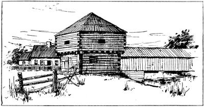
BLOCK HOUSE, BUILT 1714.
In the valley of the Connecticut, Northfield held the northernmost post within the Massachusetts bounds as finally settled. One of the best of our local histories for the details of this barbaric warfare is Temple and Sheldon’s History of Northfield. Deerfield was just south, and it is a centre of interest. The attack which makes it famous came Feb. 29, 1704-5, and the narrative of the Rev. John Williams, who was taken captive to Canada, is the chief contemporary account. Gov. Dudley sent William Dudley to Quebec to effect the release of the prisoners, and among those who returned to Boston (Oct. 25, 1706) was Williams, who soon put to press his Redeemed Captive,[454] which was published in 1707,[455] and has been ever since a leading specimen[186] of a class of books which is known among collectors as “Captivities.”
Further down the Connecticut than Deerfield lies Hadley, which has been more fortunate than[187] most towns in its historian. Sylvester Judd’s History of Hadley, including the early history of Hatfield, South Hadley, Amherst, and Granby, Mass., With family genealogies, by L. M. Boltwood, Northampton, 1863, follows down the successive wars with much detail.[456] A systematic treatment of the whole subject was made by Epaphras Hoyt in his Antiquarian Researches, comprising a history of the Indian Wars in the Country bordering on the Connecticut River, etc., to 1760, published at Greenfield in 1824. There had been published seventy-five years before, A short narrative of mischief done by the French and Indian enemy on the western frontiers of the Province of Massachusetts Bay, Mar. 15, 1743-44, to Aug. 2, 1748, drawn up by the Rev. Mr. Doolittle of Northfield, and found among his manuscripts after his death. Boston, 1750.[457]
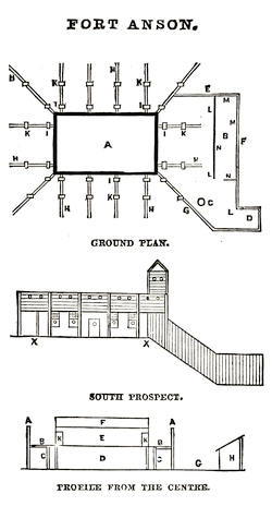
By the time of Shirley’s war (1744-48), the frontier line had been pushed westerly to the line of the Housatonic,[458] and at Poontoosuck we find the exposed garrison life repeated, and its gloom and perils narrated in J. E. A. Smith’s History of Pittsfield, 1734-1800 (Boston, 1869). William Williams, long a distinguished resident of this latter town, had been detailed from the Hampshire[459] militia in 1743 to connect the Connecticut and the Hudson with a line of posts, and he constructed forts at the present Heath, Rowe, and Williamstown, known respectively as forts Shirley,[460] Pelham, and Massachusetts. In August, 1746, the latter post, whose garrison was depleted to render assistance during the eastward war, was attacked by the French and Indians, and destroyed.[461]
Fort Massachusetts was rebuilt, and its charge, in June, 1747, committed to Major Ephraim Williams.[462] It became the headquarters of the forts and block-houses scattered throughout the region now the county of Berkshire, maintaining garrisons drawn from the neighboring settlers,[188] and at times from the province forces in part. The plans of one of these fortified posts are preserved in the state archives, and from the drawings given in Smith’s Pittsfield (p. 106) the annexed cuts are made.[463]
In 1754 the charge of the western frontier was given to Col. Israel Williams.[464]
These Berkshire garrisons were in some measure assisted by recruits from Connecticut, as that colony could best protect in this way its own frontiers to the northward. Beside the general histories of Connecticut, this part of her history is treated in local monographs like Bronson’s Waterbury, H. R. Stiles’ Ancient Windsor, Cothren’s Ancient Woodbury, Larned’s Windham County, and Orcutt and Beardsley’s Derby.[465]
CHAPTER III.
THE MIDDLE COLONIES.
BY BERTHOLD FERNOW,
Keeper of the Historical MSS., N. Y. State.
THE thirteenth volume of the New York Colonial Manuscripts contains a document called “Rolle van t’Volck sullende met het Schip den Otter na Niēu Nederlandt overvaren,” April 24, 1660, being a list of the soldiers who were to sail in the ship “Otter” for New Netherland. Among these soldiers was one Jacob Leisler, from Frankfort, who upon arriving at New Amsterdam found himself indebted to the West India Company for passage and other advances to the amount of nearly one hundred florins.
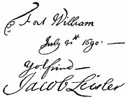
Twenty-nine years later this same quondam soldier administered the affairs of the colony of New York as lieutenant-governor, not appointed and commissioned by the king of England, but called to the position by the people of the colony. When the first rumors of the “happy revolution” in England reached New York, Sir Edmond Andros, the governor-general of New York and New England, was absent in Boston, where the citizens forcibly detained him. Nicholson, the lieutenant-governor, and one or two other high officials belonged to the Church of Rome, and were therefore disliked and suspected by the predominant Protestant population. Rumors had found their way, meanwhile, through the northern wilderness, that the French in Canada were making preparations to invade New York, hoping, with the assistance of the Catholics in the province, to wrest it from the English. The major part of the inhabitants were still Dutch or of Dutch origin, and these were nearly all Protestants. They were easily led to believe that the papists within and without the government had concerted[190] to seize Fort James, in New York, and to surrender that post and the province to a French fleet, which was already on the way from Europe. The prompting of the Protestant party to anticipate any such hostile movement was strengthened when they heard the result of the revolution in England. Leisler, placing himself at the head of this anticipatory movement, seized the fort, and was shortly afterwards proclaimed lieutenant-governor, in order to hold the province for William and Mary until their pleasure should be known. There was little ground for distrusting the Catholics within the province; but the danger from the French was more real, and took a shape that was not expected, in the murderous assault which was made on Schenectady.[466] Leisler’s adherents, as well as his opponents, felt that this coup de main of the French might be only the precursor of greater disasters, if no precautionary steps were taken. Leisler himself believed that the English colonies would never be safe unless the French were driven from Canada. He called a congress of the colonies. Their deliberations led to the naval expedition of Phips against Quebec, and the march of Winthrop and Livingston against Montreal. Their disastrous failure has been described in an earlier volume.[467] Governor Sloughter arrived in New York a few months later, and soon put an end to the hasty revolt. Leisler and his son-in-law, Milbourne, were hanged for what seemed an untimely patriotism and still more uncalled-for religious zeal.
The cry was practically a “No Popery” cry upon which Leisler had risen to such prominence in the affairs of New York. It had appeared scarcely to attract the notice of the king, and he was prone to believe that Leisler was more influenced by a hatred of the Established Church than by zeal for the crown. It was not, however, without some effect. A few words added to the instruction of the new governor had materially changed the condition of religious toleration in the province. Earlier governors had been directed “to permit all persons, of what religion soever, quietly to inhabit within the government.” Under Governor Sloughter’s instructions papists were excepted from this toleration. Was such intolerance really needed for the safety of the English colonies? They had been so far in the main a refuge for those who in Europe had suffered because of their liberal and anti-Roman religious opinions, and had never been much sought by Catholics.[468] The conditions of life in the colonies were hardly favorable to a church which brands private reasoning as heresy; and even in Maryland—which was established, if not as a Catholic colony, yet by a nobleman of that [191] faith—there were, after fifty years of existence, only about one hundred Romanists. Public opinion and the political situation in England had now raised this bugbear of popery. It was but the faint echo of the cry which prompted those restrictions in the instructions to King William’s governor which sought to enforce in New York the policy long in vogue in the mother country. The home government seemed ignorant of the fact that the natural enemies of the Church of Rome, the Reformed and Lutheran clergymen of New York, had not only not shared Leisler’s fears, but, supported by the better educated and wealthier classes, they had opposed him by every means in their power. When, however, with Leisler’s death the motive for their dislike of his cause had been removed, the general assembly, composed to a great extent of his former opponents, willingly enacted a law, the so-called Bill of Rights, denying “liberty to any person of the Romish religion to exercise their manner of worship, contrary to the laws of England.”[469] After the attempt on the life of King William in 1697, further laws, expelling Roman Catholic priests and Jesuits from the province, and depriving papists and popish recusants of their right to vote, were passed in 1700 and 1701. It was reserved for the Revolution of 1776 to change the legal status of the Roman Catholics of New York, and place them on an equal footing with the believers in other doctrines.
In establishing the colony of Pennsylvania on the basis of religious freedom, Penn declared that every Christian, without distinction of sect, should be eligible to public employments. But on the accession of William and Mary it became necessary to adopt and endorse the so-called “penal laws,” in prosecuting followers of the elder church. Penn himself was unable to prevent it, although his liberal spirit revolted at such intolerance, and it seems that the authorities in Pennsylvania were quite as willing as their chief to treat Romanists with liberality, notwithstanding the “penal laws,” since in 1708 Penn was unfavorably criticised in England for the leniency with which this sect was treated by him. “It has become a reproach,” he writes to his friend Logan, “to me here with the officers of the crown, that you have suffered the scandal of the mass to be publicly celebrated.”
Despite all laws, Pennsylvania became of all the colonies the most favorable and the safest field for the priests and missionaries of the Church of Rome. It is true, they had to travel about the country in disguise, but it was known everywhere that Romanists from other provinces came to Philadelphia or Lancaster at regular intervals to receive the sacraments according to the rites of their faith. Before the Revolution, Pennsylvania harbored five Catholic churches, with about double the number of priests and several thousand communicants, mostly Irish and Germans.
The attempt upon the life of the king in 1697 had much the same effect in East New Jersey as in New York. The law of 1698, “declaring what[192] are the rights and privileges of his majesty’s subjects in East New Jersey,” directed “that no person or persons that profess faith in God by Jesus Christ, his only Son, shall at any time be molested, punished, disturbed, or be called in question for difference in religious opinion, &c., &c., provided this shall not extend to any of the Romish religion the right to exercise their manner of worship contrary to the laws and statutes of England.”[470]
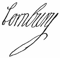
When Lord Cornbury assumed the government of New Jersey in 1701, his instructions directed him to permit liberty of conscience to all persons except papists. Matters remained thus with the Romish Church in New Jersey until the end of British rule.
Another incident of Leisler’s brief administration was of greater importance and farther-reaching consequences than his proscription of persons differing from his religious opinions. It will be remembered[471] that a general assembly of the province had been elected in 1683, holding two sessions that year and another in 1684; also that it had been dissolved in 1687, pursuant to the instructions of King James II. to Sir Edmond Andros, directing him “to observe in the passing of lawes that the Stile of enacting the same by the Governor and Council be henceforth used and no other.” The laws enacted by the first assembly, and not repealed by the king, remained in force, and the government was carried on with the revenues derived from the excise on beer, wine, and liquors, from the customs duties on exported and imported goods, and from tax levies; but the people had no voice in the ordering of this revenue, as they had had none during the Dutch period and before 1683. Leisler and his party, however, firmly believed in the Aryan principle of “no taxation without representation,” and when a necessity for money arose out of the French invasion and the subsequent plan to reduce Canada, Leisler issued writs of election for a general assembly, which in the first session, in April, 1690, enacted a law for raising money by a general tax. Adjourned to the following autumn, it again ordered another tax levy, and passed an act obliging persons to serve in civil or military office.
In calling together this general assembly, notwithstanding the repeal by James II. of the Charter of Liberties of 1683, Leisler assumed for the colony of New York a right which the laws and customs of Great Britain did not concede to her as a “conquered or crown” province. The terms on which New York had been surrendered to the English, both in 1664 and in 1674, ignored a participation by the people in the administration of the government, and the king in council could therefore, without infringing upon any law of England or breaking any treaty stipulation, deal with the conquered province as he pleased; while all the other colonies in America[193] were “settled or discovered” countries, which, because taken possession of as unoccupied lands or under special charters and settled by English subjects, had thereby inherited the common law of England and all the rights and liberties of Englishmen, subject only to certain conditions imposed by their respective charters, as against the prerogatives of the crown. The action of Leisler showed to the English ministry the injustice with which New York had been treated so long, and the instructions given to Governor Sloughter in November, 1690, directed him “to summon and call general Assemblies of the Inhabitants, being Freeholders within your Government, according to the usage of our other Plantations in America.” This general assembly was to be the popular branch of the government, while the council, appointed by the king upon the governor’s recommendation, took the place of the English House of Lords. The governor had a negative voice in the making of all laws, the final veto remaining with the king, to whom every act had to be sent for confirmation. Three coördinate factors of the government—the assembly, the council, and the governor—were now established in theory; in reality there were only two, for the governor always presided at the sessions of the council, voting as a member, and in case of a tie gave also a casting vote. This state of affairs, by which the executive branch possessed two votes on every legislative measure, as well as the final approval, continued until 1733, when, Governor Cosby having quarrelled with the chief justice and other members of the council, the question was submitted to the home government. The law officers now declared that it was inconsistent with the nature of the English government, the governor’s commission, and his majesty’s instructions for the governor in any case whatsoever to sit and vote as a member of the council. Governor Cosby was therefore informed by the Lords of Trade and Plantations that he could sit and advise with the council on executive business, but not when the council met as a legislative body.
The first assembly called by Governor Sloughter enacted, in 1691, the Bill of Rights, which was the Charter of Liberties of 1683, with some modifications relative to churches. It met with the same fate as before, as the Lords of Trade could not recommend it to the king for approval, because it gave “great and unreasonable privileges” to the members of the general assembly, and “contained also several large and doubtful expressions.” The king accordingly vetoed it in 1697, after the ministry had required six years to discover the objections against it. They could not very well give the real reason, which was that this Bill of Rights vested supreme power and authority, under the king, in the governor, council, and the people by their representatives, while it was as yet undecided whether in New York, a “conquered” province, the people had any right to demand representation in the legislative bodies.

GOVERNOR FLETCHER.
From a plate in Valentine’s N. Y. City Manual, 1851.
Governor Sloughter died within a few months after his arrival in New York (June, 1691), and was succeeded by Colonel Benjamin Fletcher, “a soldier, a man of strong passions and inconsiderable talent, very active and[194] equally avaricious,” who, as his successor Bellomont said, allowed the introduction into the province of a debased coinage (the so-called dog dollars); protected pirates, and took a share of their booty as a reward for his protection; misapplied and embezzled the king’s revenue and other moneys appropriated for special and public uses; gave away and took for himself, for nominal quit-rents, extensive tracts of land; and used improper influence in securing the election of his friends to the general assembly.
A man of such a character could hardly be a satisfactory governor of a province, the inhabitants of which were still divided between the bitterly antagonistic factions of Leislerians and anti-Leislerians, without in a short time gaining the ill-will and enmity of one of them. The men whose official position, as members of the council, gave them the first opportunity of influencing the new governor were anti-Leislerians. Fletcher therefore joined this party, without perhaps fully understanding the cause of the dissensions. His lack of administrative abilities, coupled with his affiliation with one party, gave sufficient cause to the other to make grave charges against him, which resulted in his recall in 1697.
In the mean time the assembly had begun the struggle for legislative supremacy which characterizes the inner political life of New York during the whole period of British dominion.
It enacted two laws which were the principal source of all the party disputes during the following decades. One of these laws established a revenue, and thereby created a precedent which succeeding assemblies did not always consider necessary to acknowledge, while the executive would insist upon its being followed. The other erected courts of justice as a temporary measure, and when they expired by limitation, and a later governor attempted to erect a court without the assent of the assembly, this law, too, was quoted as precedent, but was likewise ignored.
In 1694 the assembly discovered that, during the last three years, a revenue of £40,000 had been provided for, which had generally been misapplied. Governor Fletcher refused to account for it, as, according to his ideas of government, the assembly’s business was only to raise money for the governor and council to spend. This resulted in a dissolution of the assembly, as in the council’s judgment “there was no good to be expected from this assembly,” and very little was done by its successor, elected in 1695. But not satisfied with vetoing the Bill of Rights, the home authorities tried further to repress the growing liberal movement in New York by giving to Fletcher’s successor, the Earl of Bellomont, an absolute negative on the acts of the provincial legislature, so that no infringement[195] upon the prerogatives of the crown might become a law. He was further empowered to prorogue the assembly, to institute courts, appoint judges, and disburse the revenues. The Bishop of London was made the head of all ecclesiastical and educational matters in the province, and no printing-press was allowed to be put up without the governor’s license.
Bellomont, in addressing the first assembly under his administration, made a bid for popular favor by finding fault with the doings of his predecessor, who had left him as a legacy “difficulties to struggle with, a divided people, an empty treasury, a few miserable, naked, half-starved soldiers, being not half the number the king allowed pay for, the fortifications, and even the governor’s house, very much out of repairs, and, in a word, gentlemen (he said), the whole government out of frame.” The assembly was to find remedies, that is, money wherewith to repair all these evils. How they did it is shown by a speech made to them by Bellomont a month later: “You have now sat a whole month ... and have done nothing, either for the service of his Majestie or the good of ye country.... Your proceedings have been so unwarrantable, wholy tending to strife and division, and indeed disloyal to his Majestie and his laws, and destructive to the rights and libertys of the people, that I do think fit to dissolve this present assembly, and it is dissolved accordingly.”
Having come with the best intentions of curing the evils of Fletcher’s rule, and being instructed to break up piracy, of which New York had been represented in England as the very hot-bed, Bellomont soon became popular, and no doubt grew in favor with the people, both by persuading the assembly to enact a law of indemnity for Leisler, whose body, with that of Milbourne, was now granted the honors of a public reinterment, and by bringing Kidd, the celebrated sea-rover, to justice. To-day that which was meted out to Kidd might hardly be called justice; for it seems questionable if he had ever been guilty of piracy.
Bellomont was not allowed to carry out his plans for the internal improvement of the province, for death put an end to his work at the end of the third year of his administration, in 1701. His successor, Lord Cornbury, who entered upon his duties early in 1702 (Lieutenant-Governor Nanfan having had meanwhile a successful contest with the leaders of the still vigorous anti-Leisler party), was sent out as governor by his cousin, Queen Anne, in order to retrieve his shattered fortune. The necessitous condition in which he arrived in New York and his profligate mode of life soon led him to several misappropriations of public funds, which resulted in a law, passed by the disgusted assembly of 1705, taking into their own hands the appointment of a provincial treasurer for the receipt and disbursement of all public moneys. The whole of Cornbury’s administration was occupied with a contest between the assembly and the crown: the former claiming all the privileges of Englishmen under Magna Charta; the latter, through its governor, maintaining its prerogatives, and saying that the assembly had no other rights and privileges “but such as the[196] queen is pleased to allow.” Lord Cornbury’s recall did not mend matters.[472] The assembly of 1708, the last under Cornbury’s administration, had been dissolved, because in its tenacity of the people’s right it had declared that to levy money in the colony without consent of the general assembly was a grievance and a violation of the people’s property; that the erecting of a court of equity without consent of the general assembly was contrary to law, both without precedent and of dangerous consequences to the liberty and properties of the subjects.

The term of Cornbury’s successor, Lord Lovelace, was very short, death calling him off within six months, while the lieutenant-governor, Ingoldsby, was a man too much like his friends, Sloughter, Fletcher, and Cornbury, to improve the state of affairs. With Governor Robert Hunter’s commission there came, in 1710, the answer to the declaration of the assembly of 1708. He received thereby “full power and authority to erect, constitute, and establish courts of judicature, with the advice and consent of the council.” The assembly’s remonstrance had been met by ignoring its author, and this treatment naturally incensed the representatives of the people so much that all the efforts of Governor Hunter, a man of excellent qualities, the friend of Addison and Swift, availed nothing in the way of settling the existing differences.
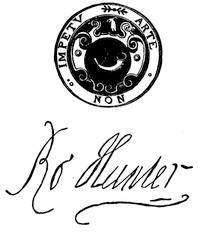
GOVERNOR HUNTER.
Follows an engraving in Valentine’s N. Y. City Manual, 1851, p. 420. Cf. on the seals of the colonial governors, Hist. Mag., ix. p. 176.
After two years’ administration, Governor Hunter had to confess to the Lords of Trade that he could not expect any support of the government from the assembly, “unless her Majesty will be pleased to put it entirely into their own hands;” and in 1715 he appointed Lewis Morris, a wealthy man, as successor to the deceased Chief Justice Mompesson, “because he is able to live without salary, which they [the assembly] will most certainly never grant to any in that station.” He found that he could not carry on the government without yielding, and thereby acting contrary to his instructions, and during the summer of 1715 came to an understanding with the assembly. “I asked,” he says, in a letter to the Lords of Trade, “what they would do for the Government if I should pass it (the Naturalization Bill) in their way, since they did not like mine; I asked nothing for myself, tho’ they well knew that I[197] had offers of several thousands of pounds for my assent; they at last agreed that they would settle a sufficient Revenue for the space of five years on that condition; many rubs I met with, but at last with difficulty carry’d through both parts of the Legislature and assented to both at the same time. If I have done amiss, I am sorry for’t, but what was there left for me to do? I have been struggling hard for bread itself for five years to no effect and for four of them unpitty’d, I hope I have now laid a foundation for a lasting settlement on this hitherto unsettled and ungovernable Province.”
In asserting their rights as representatives of the people and compelling the executive finally to acknowledge them, the assembly had followed the course which has been shown to be effective in the English Parliament since the days of William III. But the legislative supremacy over the executive established by this victory was greater than that obtained by Parliament. In New York the executive could only collect taxes when first authorized by the legislature, while the people, through their representatives, kept the control of the sums collected in their own hands by appointing the receiving and disbursing officers.
Hunter’s wise course in yielding on several points had a better effect on the province than at first he was willing to confess. Fletcher had found the people of New York “generally very poor and the government much in debt, occasioned by the mismanagement of those who have exercised the King’s power.” The revenues of the province were in such deplorable condition that several sums of money had to be borrowed on the personal credit of members of the council to pay the most pressing debts of government; the burden of war, unjustly placed on the shoulders of New York, had impoverished the inhabitants and almost destroyed their usefulness as taxpayers; while the neighboring colonies, either refusing to assist in the defence of the frontiers against the French or being dilatory in sending their quota of money and men, reaped the advantage of New York’s patriotism by receiving within their boundaries the bulk of the foreign trade, and by adding to their population the majority of emigrants. When Hunter left the province, after ten years’ service as its governor, he could congratulate the assembly on increased prosperity and on a better state of public affairs.
His successor was the comptroller of customs at London, William Burnet, the son of the celebrated bishop, who exchanged places with Hunter. Smith, the historian, describes him as “a man of sense and polite breeding, a well-read scholar, sprightly and of social disposition.... He used to say of himself, ‘I act first and think afterwards.’” The good reports which preceded Burnet made a favorable impression on the colonial assembly, and the whole period of his administration was undisturbed by constitutional disputes, even though people opposed to him tried to create trouble by asserting that the appointment of a new governor of the province required, like the accession of a new king, the election of a new assembly,[198] and by representing the continuance of an assembly under two governors as unconstitutional.
Burnet’s distrust of the neighboring French caused some stir in mercantile circles. He had an act passed forbidding all trade in Indian goods with Canada,—an act which would have benefited the province in general by securing all the Indian trade, a large part of which now found its way to Canada; but the merchants of New York and Albany, who disposed of their surplus to Canada traders, would have made less profits. They consequently opposed Burnet’s plans until the end of his administration (1728).
During the three years of John Montgomerie’s rule, which was ended by his death, in 1731, New York enjoyed some rest, to be violently disturbed, however, by the claims of his successor. It had been usual in the royal instructions of the governor to fix the salary of the president of the council at half the amount allowed to the executive, and it was customary to provide that in the absence, resignation, or death of the governor or lieutenant-governor he should assume the reins of the government. Upon Montgomerie’s death, Rip van Dam, as eldest member of the council, became president, and then claimed the full salary of the governor, which the council, after five months’ deliberation, finally allowed. It was upon this decision that the famous Zenger libel suit of a few years later hinged. Soon after the arrival of the new governor, William Cosby, Rip van Dam was called upon (November, 1732) to restore to the treasury a moiety of the full salary, which, under the decision of the council, he had been receiving in contravention, as was claimed, of the royal instructions. On the refusal of the president to comply, the attorney-general of the province was directed to begin an action in the king’s name “to the enforcing a Due Complyance with the said Order [to refund] according to the true Intent thereof and of his Majestie’s Additional Instruction.”
At the trial, the chief justice, Lewis Morris, surprised the governor, the attorney-general, and the whole aristocratic party (Van Dam and his friends representing the popular party) by informing the king’s counsel, in the first place, that the question to be discussed was one of jurisdiction, involving the right of the court to decide cases of equity; and in the second place, that he denied such jurisdiction, and in general the right of the king to establish courts of equity.[473] Jealous to maintain the royal prerogatives, Cosby removed Morris from the chief-justiceship, and put De Lancey, the second justice, in his place. Finding his efforts to be reinstated without result, and having no other means to avenge himself, Morris had recourse to the press, and in Zenger’s New York Weekly Journal he attacked the governor with extreme rancor, and attempted to influence the general assembly, to which he had been elected, against the king’s authority to erect courts. Even Cosby’s death, in 1736, could not conciliate him. The attacks[199] upon his administration continued, and Morris’s vindictiveness finally even disturbed the council and the assembly. President Clarke, who had temporarily succeeded Cosby, was deterred from arresting Van Dam, the younger Morris, Smith the historian, and Zenger the printer, to be sent to England to be tried for treason, only because the forty-fifth paragraph of the instructions required positive proof of the crime in such cases.
The trial of Zenger had, however, already shown that it was not safe to accuse a man of a crime when a jury had already acquitted him. The first number of the Weekly Journal appeared on the 5th of November, 1733; and its editor had from the beginning made war upon the administration with so much vigor that in January following the chief justice, De Lancey, “was pleased to animadvert upon the doctrine of libel in a long charge given in that term to the grand jury,”[474] hoping to obtain an indictment against Zenger. The jury did not share the opinions of the chief justice, and failed to indict Zenger. Nor was the general assembly willing to concur in a subsequent resolution of the council that certain numbers of the Journal should be publicly burnt by the hangman, “as containing in them many things derogatory of the dignity of his majesty’s government, reflecting upon the legislature and tending to raise seditions and tumults in the province,” and that the printer should be prosecuted. The burning of the papers (November 2, 1734), carried out by special order of the council alone, was in appearance far from the solemn judicial act which it was meant to be. The sheriff and the recorder of New York, with a few friends, stood around the pile, while the sheriff’s negro, not the official hangman, set fire to it. The municipal authorities, who usually have to attend such ceremonies ex officio, and were ordered to do so in this case, had refused to come, and would not even allow the order to be entered in the proper records, because they considered it to be neither a royal mandatory writ nor an order authorized by law. Zenger’s trial began on the 4th of August, and resulted in a verdict of “Not guilty.”
The publishing of the alleged libel had been admitted, but it was claimed to be neither false, nor scandalous, nor malicious. When the New York lawyers who had been engaged in the defence were disbarred, Andrew Hamilton, a prominent pleader from Philadelphia, took the case. He managed it so adroitly, met the browbeating of De Lancey so courageously, and pleaded the cause of his client so eloquently that he at once achieved a more conspicuous fame than belonged to any other practitioner at the bar of that day. The corporation of New York fell in with the popular applause in conferring upon him the freedom of their city, enclosing their seal in a box of gold, while they added the “assurances of the great esteem that the corporation had for his person and merits.”[475]
The result of Zenger’s trial established the freedom of the press in the colonies,[476] for it settled here the right of juries to find a general verdict in[200] libel cases, as was done in England by a law of Parliament passed many years later, and it took out of the hands of judges appointed to serve during the king’s pleasure, and not during good behavior, as in England, the power to do mischief.[477] It also gave a finishing blow to the Court of Exchequer, which, after the case of Cosby versus Van Dam, never again exercised an equity jurisdiction, and it suppressed the royal prerogative in an assumed right to establish courts without consulting the legislature. The jurisdiction hitherto exercised by the Supreme Court as a Court of Exchequer—that is, in all matters relating to his majesty’s lands, rights, rents, profits, and revenues—had always been called in question by colonial lawyers, because no act of the general assembly countenanced it. It was, therefore, a relief to everybody in the province when the legislature, in 1742, passed an “Act for regulating the payment of the Quit-Rents,” which in effect, though not in name, established on a firm basis a branch of the Supreme Court as a Court of Exchequer. As then instituted, it passed into the courts of the state, and was only abolished in December, 1828.
The excitement over the Zenger trial had hardly had time to subside when Rip van Dam again disturbed the public mind by claiming, after Cosby’s death, that he as eldest councillor was entitled to be president of the council, and as such to be acting governor, although he had been removed from the council by Cosby. Before the quarrel could attain too threatening dimensions, Clarke’s commission as lieutenant-governor happily arrived, and Van Dam’s claim was set at rest. Clarke’s administration of the province was in the main a satisfactory one. He had lived nearly half a century in New York,[478] and was thoroughly conversant with its resources and its needs, and, assisted by a good education as a lawyer, he found little difficulty in managing the refractory assembly and in gaining most of his important legislative points. His greatest victory was that by certain concessions he induced the assembly of 1739 to grant again a revenue to the king equivalent to the civil list in England, which had been refused since 1736, but was continued during the whole of Clarke’s administration. Although perhaps never unmindful of his own interests, he had also the good of the province at heart, and it must be regretted that a plan, drawn up while he was yet secretary, for colonizing the Indian country was not fully carried out and bore no fruits. He proposed to buy from the Iroquois about 100,000 acres of land, the purchase money to be raised either by subscription or by the issue of bills of credit. Every Protestant family made acquainted with the conditions and wishing to settle was to have 200 acres at nominal quit-rents. All the officials who were entitled to fees from the issue of land patents agreed to surrender the same, so that it would have imposed upon the settlers only the cost of improvements.[201] The neighboring colonies had industriously spread the report that there were few or no lands ungranted in the province of New York, and that the expense of purchasing the remainder from the Indians or obtaining a grant from the crown was greater than the price of land in Pennsylvania and other colonies. Advertisements were therefore to be scattered over Europe, giving intending emigrants a clear view of the advantages of settling in the backwoods of New York. The plan reads very much like a modern land-scheme. If it could, however, have been carried out in those days, with all the governmental machinery to help it, the country from the upper Mohawk to the Genesee would have been settled before the Revolution, and Sullivan’s expedition might have become unnecessary and a Cherry Valley massacre impossible.
The only great event of Clarke’s administration was the negro plot of 1741, which for a while cast the city of New York into a state of fear and attendant precautions, and these conditions were felt even throughout the colonies. A close examination of the testimony given at the trial of the alleged negro conspirators fails to convince the modern investigator that the slaves, who had been misled by the counsels of Roman Catholics, had really arranged a plan to murder all the whites and burn the city. Fires had occurred rather frequently, suspiciously so, during the spring of 1741, the negro riot of the earlier years of the century was remembered, reports of negro insurrections in the West Indies made slave-owners look askance at their ebony chattels, an invasion of the British colonies in America by France and Spain seemed imminent, and a rancorous hatred of the Church of Rome and its adherents prevailed among the English and Dutch inhabitants of New York, while tradition and the journal of the proceedings against the conspirators assure us that some sort of a plot existed; but we must still wonder at the panic occasioned among the ten or twelve thousand white inhabitants by what, after all, may have been only the revengeful acts of a few of the 20 whites and 154 negroes who were indicted on the most insufficient evidence. It is doubtful whether all who were indicted had anything to do with the fires or the intended murder, but the judicial proceedings were of a nature to implicate every one of the two thousand colored people in the county of New York, and two thirds of the accused were found guilty, and were either hanged, burnt at the stake, or transported.
Political astuteness, or perhaps a desire to enjoy in quiet his advancing years, had led Clarke to yield to the popular party on all important points. He had confined himself to wordy remonstrances in surrendering several of his prerogatives. His successor, Admiral George Clinton,—the second son of the Earl of Lincoln, and, as he acknowledged himself, a friend and cousin of Charles Clinton, father of Governor George Clinton of a later date,—found that the position of governor had ceased to be financially desirable. New Jersey had been again placed under a separate governor, thus reducing the income of the governor of New York by £1,000.[202] “Former governors,” it is reported, “had the advantage of one of the four companies, besides the paying of all the four companies, which made at least £2,000 per annum;” but now the assembly had placed this in other hands.
GOVERNOR CLINTON.
From a plate in Valentine’s N. Y. City Manual, 1851.
They had also interfered with a former custom, according to which the governors drew one half of their salary from the date of their commissions; but under the new arrangement for raising and paying the salary he could only draw it from the date of his arrival. Clinton brought with him a prejudice against his lieutenant-governor which was perhaps justified, for he knew him to have led Cosby into all the errors which characterized the latter’s administration. But instead of maintaining an independent position apart from the two political parties, he threw himself into the arms of the cunning Chief Justice De Lancey, the leader of the popular faction. Acting under his advice, Clinton at first was as ready to yield every point to the assembly as Clarke had done, until he discovered that all the powers of a governor were gradually slipping into De Lancey’s hand, who hoped to tire out Clinton’s patience and induce him to resign, thus leaving the field free to him with a commission of lieutenant-governor.
Clinton, upon his arrival at New York, had found, as Clarke predicted, the province “in great tranquillity and in a flourishing condition, able to support the government in an ample and honorable manner.” He perhaps would have had no difficulty with the general assembly about money grants, if he had been less distrustful of Clarke and more willing to acknowledge the rights of the people in such matters. His first measures of dissolving the old assembly, calling a new one, and, perhaps for the first time in America, introducing a kind of civil service reform by continuing in place all officers who had been appointed by his predecessors, were received with great satisfaction throughout the province, but they failed to loosen the strings of the public purse, while the new assembly sought other measures to declare their independence. Clarke’s advice, given before Clinton’s arrival, that henceforth the assembly should allow the government a revenue for a term of years, was not acted upon; but instead they voted the usual appropriations for one year only. In voting salaries for officers, they did[203] not recognize the incumbents by name, and the council pronounced this a device of the assembly to usurp the appointing power, and to change the stipends of the officers at any time.
Walpole had meanwhile turned over the government in England to his friend Pelham, a family connection of Governor Clinton. Macaulay describes Pelham as a man with an understanding like that of Walpole, “on a somewhat smaller scale.” During Pelham’s administration, a bill was considered in the House of Commons in 1744, news of which, upon reaching the colonies, did not fail to arouse their indignation. It forbade the American colonies to issue bills of credit or paper money. As these colonies had but little trade, and had to draw upon Europe for the tools and necessaries of life in the newly opened wilderness, the small amount of coin which they received from the West Indies and the Spanish main in exchange for bread-stuffs and lumber, their only articles of exportation, went across the ocean in part payment of their debts, leaving no “instrument of association,” no circulating medium, in their hands. To replace the coin, they had to have recourse to the issue of paper money, without which all intercolonial and internal trade would have been impossible. The parliamentary intention of depriving the colonies of these means of exchange led the New York assembly to declare that the bill was contrary to the constitution of Great Britain, inconsistent with the liberties and privileges of Englishmen, and subjected the British colonies in America to the absolute will of the crown and its officers.
The efforts of Governor Clinton to reconcile the assembly by giving his assent to all the bills passed by them in their first session did not prevent their assuming greater powers than the House of Commons. He could not obtain from them either money or men for the Cape Breton expedition, set on foot by Governor Shirley of Massachusetts. Trying to regain control of colonial politics, he stirred up a bitter feeling among the popular party men; and after years of struggle, during which the home government afforded him little comfort and support, Clinton was willing to throw up his commission as governor of New York in 1751, and return to England and resume his station as admiral.
The French of Canada had used many artifices and had been indefatigable in their endeavors to gain over the Six Nations. They had cajoled many of them to desert their own tribes and remove to Canada, and had instigated others, whom they could induce to desert, to go to war with the Catawba Indians, friends of South Carolina, thereby endangering and weakening the allegiance of the Southern Indians to the British interest. Commissioners had arrived, or were to come, from all the other colonies, to meet the Six Nations at Albany and renew the covenant chain. If Quidor (the Indian name for the governor of New York) were to be absent on such an occasion, especially a Quidor who already had made an excellent impression on the king’s red allies, the council conceived that the meeting would not only be without result, but that the Indians, considering themselves[204] slighted, would turn a more willing ear to the French, and thus endanger the existence of the colonies. Clinton was luckily a man who considered duty higher than any personal comfort, and on the 1st of July, 1751, opened the conference with the Indians which may be said to have been one of the most important in the history of the English colonies. Colonel William Johnson was induced to withdraw his resignation as Indian agent, which had made the Six Nations very uneasy, and a peace was made between the Iroquois, of New York, and the Catawbas, which also included their friends among the Southern Indians. There is not space to say much of the Indian policy pursued by Governor Clinton and other royal governors of New York. To use the Indian explanation, “they took example from the sun, which has its regular course; and as the sun is certain in its motion, New York was certain to the Indians in the course of their mutual affairs, and deviated not in the least.” New York alone had to bear the expenses (£1,150) of this conference, since Massachusetts, Connecticut, and South Carolina refused to contribute, while New Jersey, Pennsylvania, and Virginia were not represented. The other colonies also refused to help New York in keeping the Iroquois in good humor by supplying smiths to live in the Indian territory and repair the savages’ guns and hatchets. New York has the benefit of the Indian trade, they said; let her bear the burden. Pennsylvania, most interested of all the middle colonies in keeping the Indians friendly, had soon learned the evils of neglecting them. Armed parties of French and savages came down into the valley of the Ohio in 1753, creating great confusion among the Indians of Pennsylvania, and inducing nearly all, the Delawares alone excepted, to join the French, as their best recourse in the indifference of the English. At the same time the New York Indians became dissatisfied at their treatment by the general assembly, which would not allow the forts in the Indian country, at Oswego and at Albany, to be maintained, preferring to trust to the activity of the Indians for keeping the French and their savage allies from devastating the northern frontier. Disgusted with the constant struggle which the jealousy of the assembly and their encroachments upon the royal prerogatives always kept alive, Clinton finally resigned in October of 1753; astonishing the council, and especially his political enemy De Lancey, the chief justice, before he surrendered the office to his newly arrived successor, Sir Danvers Osborn, by the production of a letter from the Duke of Newcastle, secretary of state, dated October 27, 1747, which gave Clinton a leave of absence to come to England, and covered De Lancey’s commission as lieutenant-governor. This stroke of Clinton’s did not succeed very well. It is true, Sir Danvers’ presence deprived the new lieutenant-governor of the pleasure of showing himself as chief magistrate of the province, but it was to be only for a few days. Sir Danvers, perceiving that the assembly of New York was not a body easily led by royal commands, exclaimed, “What have I come here for?” and hanged himself two days after taking the necessary oath; and thus the lieutenant-governor, De Lancey, came into power.
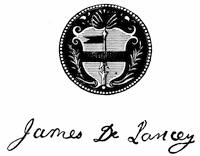
GOV. JAMES DE LANCEY.
From a plate in Valentine’s N. Y. City Manual, 1851. Cf. Lamb’s New York, i. 543.
De Lancey soon discovered himself in a dilemma. The oaths which he had taken when entering upon his new office, and which he must have had self-respect enough to consider binding, compelled him to maintain the royal prerogatives and several obnoxious laws made for the colonies by Parliament. On the other side, his political career and his bearing of past years forced him to work for the continuation of the popularity which his opposition to the very things he had sworn to do had gained him. De Lancey was skilful enough to avoid both horns of this dilemma. The assembly, rejoicing to see a man of their own thinking at the head of affairs, passed money and other laws in accordance with the lieutenant-governor’s suggestions, and quietly pocketed his rebukes, when he saw fit to administer any. The two most important events during his term were of such a nature that he could do nothing, or only very little, to prevent or further action.
On the 11th of January, 1754, a great number of people assembled in the city of New York, on account of a late agreement of the merchants and others not to receive or pass copper half-pence in payment at any other rate than fourteen to the shilling. The crowd kept increasing until two o’clock in the afternoon, when the arrest of the man beating the drum and of two others throwing half-pence into the mass quieted them.
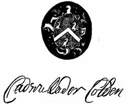
GOV. CADWALLADER COLDEN.
From a plate in Valentine’s N. Y. City Manual, 1851, p. 420.
Later there was the conference of commissioners of all the colonies at Albany in July, 1754, convened to treat anew with the Iroquois, and also to consider, in obedience to orders from England, a plan of confederation for all the colonies. The deliberations and conclusions of the congress in this last respect are made the subject of inquiry in a later chapter of the present volume.[479] De Lancey was accused of opposing this plan of union by his machinations. We may say that such accusation was unjust. The general assembly of the province, to whom the “representation of the state and plan for union” was referred, that they might make observations thereupon, said in their report or address to the lieutenant-governor, on the 22d of August, 1754: “We are of opinion with your Honor, that nothing is more natural and salutary than a union of the colonies for their own defence.” While he transmitted the minutes of the congress at Albany to the Lords of Trade without a word of comment, he may have used his private influence to defeat the union; but there is no reason to believe that he acted even in that wise from other than upright motives, and he had already[206] shown, in the New Jersey boundary question, how personal associations had restrained him from interfering or giving an opinion. His sense of duty in office was perhaps exaggerated, and he could not brook censure by the home authorities. The receiver-general and other officers entrusted with the collection of the king’s revenue desired the passage of an act “for the more easy collecting his majesty’s quit-rents, and for protection of land in order thereto.” The assembly and council having passed such a bill, it came before the governor for his assent, which he readily gave, supposing that an act favored by the king’s officers could not meet with the disapproval of the government in England. The Lords of Trade, however, rebuked him, and he sent in his resignation.
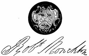
GOV. MONCKTON.
From a plate in Valentine’s N. Y. City Manual, 1851.
In the mean time, the appointment of Admiral Sir Charles Hardy as governor had relieved De Lancey for a time (1755-57) from the cares of the administration. Sir Charles allowed himself to be led by his lieutenant-governor, and therefore the affairs of government went on as smoothly as of late, excepting that the assembly made occasional issues upon money bills, though that body was little inclined to press their levelling principles too strongly against their old friend, the lieutenant-governor, now that he was the adviser of the executive. Sir Charles proved less fond of the cares of office than of the sea, and after two years’ service resigned, to hoist his blue admiral’s flag under Rear Admiral Holbourn at Halifax. De Lancey had therefore to assume once more the government on the 3d of June, 1757, which he administered, with little to disturb the relations between the crown and the assembly, down to the time of his[207] death, on July 30, 1760. This event placed his lifelong adversary, Cadwallader Colden, in the executive chair, first as president of the council, and a year later as lieutenant-governor.
The policy of the royal representative was now very quickly changed. The acquiescent bearing of De Lancey in his methods with the assembly gave place to the more peremptory manner which had been used by Clinton, whose friend Colden had always been. The records of the next few years, during which Monckton, who was connected with the Acadian deportation, was governor, show but the beginning of that struggle between prerogative and the people which resulted in the American Revolution, and a consideration of the immediate causes of that contest belongs to another volume.
The history of Pennsylvania, down to the appointment of Governor Blackwell in 1688, has been told in a previous chapter.[480] The selection of John Blackwell for the governorship was an unfortunate one. A son-in-law of the Cromwellian General Lambert and a resident of puritanical New England, he must have shared more or less in the hatred of the Friends’ religion, so that his appointment to govern a colony settled principally by this sect most likely arose from Penn’s respect and friendship for the man and from his inability to find a suitable Quaker willing to accept the office. Within two months after his arrival, he had quarrelled with his predecessor, Thomas Lloyd, then keeper of the broad seal, and the rest of the council. Shortly after this he succeeded in breaking up the assembly, and before he had been in the province one year he became convinced that his ideas of governing did not meet with the approbation of the people, and returned to England, leaving the administration in the hands of his opponent, Lloyd.
After having acquired from the Duke of York the Delaware territory, Penn endeavored to bring his province and the older settlements under one form of government; but he could not prevent the jealousies, caused often by difference of religious opinion and by desire for offices, from raising a conflict which soon after Blackwell’s departure threatened a dissolution of the nominal union. Lloyd remained president of Pennsylvania, while Penn’s cousin, Markham, was made lieutenant-governor of Delaware, under certain restrictions, as detailed in a letter from Penn, which still left the supremacy to Lloyd in matters of governing for the proprietary.
In the mean time James II. of England had been forced to give up his crown to his son-in-law, and this event brought unexpected results to the proprietary of Pennsylvania. Penn’s intimacy with the dethroned Stuart, unmarred by their different religious views, made him at once a suspicious person in the eyes of the new rulers of England. He had been arrested three times on the charges of disaffection to the existing government, of[208] corresponding with the late king, and of adhering to the enemies of the kingdom, but had up to 1690 always succeeded in clearing himself before the Lords of the Council or the Court of King’s Bench. At last he was allowed to make preparations for another visit to his province “with a great company of adventurers,” when another order for his arrest necessitated his retirement into the country, where he lived quietly for two or three years. This blow came at a most critical time for his province, distracted as it was by political and religious disturbances, which his presence might have done much to prevent. The necessity of keeping remote from observation did not give him opportunity to answer the complaints which became current in England, that a schism among the Quakers had inaugurated a system of religious intolerance in a province founded on the principles of liberty of conscience. The result of this inopportune but enforced inactivity on Penn’s part was to deprive him of his province and its dependency (Delaware), and a commission was issued to Benjamin Fletcher, then governor of New York, to take them under his government, October 21, 1692. Fletcher made a visit to his new territory, hoping, perhaps, that his appearance might bring the opposing sections into something like harmony. Quickly disabused of his fond fancy, and disappointed in luring money from the Quakers, he returned to New York, leaving a deputy in charge. About the same time, 1694, Penn had obtained a hearing before competent authority in England, and having cleared himself successfully of all charges, he was reinvested with his proprietary rights. Not able to return to Pennsylvania immediately, he transferred his authority to Markham, who continued to act as ruler of the colony until 1699, when Penn visited his domain once more.
One of Penn’s first acts was to impress the assembly with the necessity of discouraging illicit trade and suppressing piracy. He did it with so much success that the assembly not only passed two laws to this effect, but also took a further step to clear the government of Pennsylvania from all imputations by expelling one of its members, James Brown, a son-in-law of Governor Markham, who was more or less justly accused of piracy. He was equally successful with his recommendations to the assembly concerning a new charter, the slave-trade, and the treatment and education of the negroes already in the province. But when, in 1701, he asked in the king’s name for a contribution of £350 towards the fortifications on the frontiers of New York, the assembly decided to refer the consideration of this matter to another meeting, or “until more emergent occasions shall require our further proceedings therein.”
The evident intention of the ministry in England to reduce the proprietary governments in the English colonies to royal ones, “under pretence of advancing the prerogatives of the crown,” compelled Penn to return to England in the latter part of 1701. But before he could leave a quarrel broke out in the assembly between the deputies from the Lower Counties, now Delaware, and those of the province. The former were accused[209] of having obtained some exclusive powers or rights for themselves which the others would not allow them, and in consequence the men of the Lower Counties withdrew from the assembly in high dudgeon. After long discussions, and by giving promises to agree to a separation of that district from the province under certain conditions, Penn at last managed to patch up a peace between the two factions. He then went to England.
The new charter for the province and territories, signed by Penn, October 25, 1701, was more republican in character than those of the neighboring colonies. It not only provided for an assembly of the people with great powers, including those of creating courts, but to a certain extent it submitted to the choice of the people the nomination of some of the county officers. The section concerning liberty of conscience did not discriminate against the members of the Church of Rome. The closing section fulfilled the promise already made by Penn, that in case the representatives of the two territorial districts could not agree within three years to join in legislative business, the Lower Counties should be separated from Pennsylvania. On the same day Penn established by letters-patent a council of state for the province, “to consult and assist the proprietary himself or his deputy with the best of their advice and council in public affairs and matters relating to the government and the peace and well-being of the people; and in the absence of the proprietary, or upon the deputy’s absence out of the province, his death, or other incapacity, to exercise all and singular the powers of government.” The original town and borough of Philadelphia, having by this time “become near equal to the city of New York in trade and riches,”[481] was raised, by patent of the 25th of October, 1701, to the rank of a city, and, like the province, could boast of having a more liberal charter than her neighbors; for the municipal officers were to be elected by the representatives of the people of the city, and not appointed by the governor, as in New York.
The government of the province had been entrusted by Penn to Andrew Hamilton, also governor for the proprietors in New Jersey, with James Logan as provincial secretary, to whom was likewise confided the management of the proprietary estates, thus making him in reality the representative of Penn and the leader of his party. Hamilton died in December, 1702; but before his death he had endeavored in vain to bring the representatives of the two sections of his government together again. The Delaware members remained obstinate, and finally, while Edward Shippen, a member of the council and first mayor of Philadelphia, was acting as president, it was settled that they should have separate assemblies, entirely independent of each other.
The first separate assembly for Pennsylvania proper met at Philadelphia, in October, 1703, and by its first resolution showed that the Quakers, so dominant in the province, were beginning to acquire a taste for authority, and meant to color their religion with the hue of political power. According[210] to the new charter, the assembly, elected annually, was to consist of four members for each county, and was to meet at Philadelphia on the 14th of October of each year, sitting upon their own adjournments. Upon the separation of the legislative bodies of the two sections, Pennsylvania claimed to be entitled to eight members for each county, which, being duly elected and met, reasserted the powers granted by the charter; but when the governor and council desired to confer with them they would adjourn without conference. Upon the objection from the governor that they could not sit wholly upon their own adjournment, they immediately decided not to sit again until the following March, and thus deprive the governor and council of every chance to come to an understanding on the matter.
Before President Shippen could take any step toward settling this question, John Evans, a young Welshman, lately appointed deputy-governor by Penn, arrived in Philadelphia (December, 1703). The new-comer at once called both assemblies together, directing them to sit in Philadelphia in April, 1704, in utter disregard of the agreement of separation. He renewed Hamilton’s efforts to effect again a legislative union, and also failed, not because the Delaware members were opposed to it, but because now the Pennsylvania representatives, probably disgusted with the obstinacy of the former, absolutely refused to have anything to do with them. Governor Evans took this refusal very ill and resented it in various ways, by which the state of affairs was brought to such a pass that neither this nor the next assembly, under the speakership of David Lloyd, accomplished anything of importance, but complained bitterly to Penn of his deputy. In the latter part of the same year the first assembly for the Lower Counties met in the old town of New Castle, and was called upon by Governor Evans to raise a militia out of that class of the population who were not prevented by religious scruples from bearing arms,—soldiers being then needed for the war against France and Spain. About a year later, having become reconciled with the Pennsylvania assembly of 1706, Evans persuaded the Delaware representatives to pass a law “for erecting and maintaining a fort for her Majesty’s service at the Town of New Castle upon Delaware.” This law exacted a toll in gunpowder from every vessel coming from the sea up the river.[482]
These quarrels between the governor and the assemblies were repeated every year. At one time they had for ground the refusal of the Quakers to support the war which was waging against the French and Indians on the frontiers. At another they disagreed upon the establishment of a judiciary. These disturbances produced financial disruptions, and Penn himself suffered therefrom to such an extent that he was thrown into a London prison, and had finally to mortgage his province for £6,600. The recall of[211] Evans, in 1709, and the appointment of Charles Gookin in his stead, did not mend matters. Logan, Penn’s intimate friend and representative, was finally compelled to leave the country; and, going to England (1710), he induced Penn to write a letter to the Pennsylvania assembly, in which he threatened to sell the province to the crown, a surrender by which he was to receive £12,000. The transfer was in fact prevented by an attack of apoplexy from which Penn suffered in 1712. The epistle, however, brought the refractory assembly to terms. After exacting a concession of their right to sit on their own adjournment, they consented to the establishment of a judiciary, without, however, a court of appeal, and finally yielded to passing votes to defray the expenses of government. They even gave £2,000 to the crown in aid of the war. Affairs went smoothly under Gookin’s administration until, in 1714, the governor, whose mind is supposed to have been impaired, began the quarrel again by complaining about his scanty salary and the irregularity of payments. He also insisted foolishly upon the illegality of affirmation; foolishly, because the Quakers, who would not allow any other kind of oath, were the dominant party in the province.[483] Not satisfied with the commotion he had stirred up, he suddenly turned upon his friend Logan, and had now not only the anti-Penn faction, but also Penn’s adherents, to contend with. The last ill-advised step resulted in his recall (1717) and the appointment of Sir William Keith, the last governor commissioned by Penn himself; for the great founder of Pennsylvania died in 1718.
While after Penn’s death his heirs went to law among themselves about the government and proprietary rights in Pennsylvania, Governor Keith, who as surveyor of customs in the southern provinces had become sufficiently familiar with Penn’s affairs, entered on the performance of his duties under the most favorable conditions. The assembly had become weary to disgust with the continuous disputes and altercations forced upon them by the last two governors, and it was therefore easily influenced by Sir William’s good address and evident effort to please. Without hesitation it voted a salary of £500 for the governor, and acted upon his suggestion to examine the state of the laws, some of which were obsolete or had expired by their own limitations. The province was somewhat disturbed by the lawsuit of the family for the succession, finally settled in favor of Penn’s children by his second wife, and by a war of the southern Indians with the Susquehanna and New York tribes; but nothing[212] marred the relations between governor and legislature. Under the speakership of James Trent, later chief justice of New Jersey (where the city of Trenton was named after him),[484] an act for the advancement of justice and more certain administration thereof, a measure of great importance to the province, passed the previous year (1718), became a law by receiving the royal assent. Governor Keith’s proposal in 1720 to establish a Court of Chancery met with unqualified approval by the assembly. Under the next governor this court “came to be considered as so great a nuisance” that after a while it fell into disuse.
In 1721 the first great council which the Five Nations ever held with the white people outside of the province of New York and at any other place than Albany, N. Y., took place at Conestoga, and the disputes which had threatened the outlying settlements with the horrors of Indian war were amicably settled. The treaty of friendship made here was confirmed the next year at a council held at Albany, as in the mean time the wanton murder of an Iroquois by some Pennsylvania traders had somewhat strained the mutual relations.
The commercial and agricultural interests of the province began to suffer about this time for want of a sufficient quantity of a circulating medium. Divers means of relief were proposed, among them the issue of bills of credit. Governor Keith and the majority of the traders, merchants, and farmers were enchanted with the notion of fiat money, and overlooked or were unwilling to profit by the experiences of other provinces which had already suffered from the mischievous consequences of such a measure. The result was that, after considerable discussion, turning not so much upon the bills of credit themselves as upon the mode of issuing them and the method of guarding against their depreciation, the emission of £15,000 was authorized, despite the order of the king in council of May 19, 1720, which forbade all the governors of the colonies in America to pass any laws sanctioning the issue of bills of credit. It would lead us too far beyond the limits of this chapter to inquire whether, as Dr. Douglass, of Boston, suggested in 1749, the assembly ordering this emission of £15,000 bills of credit, and another of £30,000 in the same year, was “a legislature of debtors, the representatives of people who, from incogitancy, idleness, and profuseness, have been under a necessity of mortgaging their lands.” All the safeguards thrown around such a currency to prevent its depreciation proved in the end futile. The acts creating this debt of £45,000[485] provided for its redemption a pledge of real estate in fee simple of double the value, recorded in an office created for that purpose. The money so lent out was to be repaid into the office annually, in such instalments as would make it possible to sink the whole original issue within a certain number of years.[213] In the first three years the sinking and destruction of the redeemed bills went on as directed by law; but under its operation the community found itself suffering from the contraction, although only about one seventh of the debt had been paid. The legislature, therefore, passed a law (1726) directing that the bills should not be destroyed, as the former acts required, but that, during the following eight years, they should be reissued. The population of the province, growing by natural increase and by immigration, seeming to require a larger volume of currency, a new emission of £30,000 was ordered in 1729 under the provisions of the laws of 1723. In 1731 the law of 1726 was reënacted, to prevent disasters which threatened the farmer as well as the merchant, and to avoid making new acts for emitting more bills. In 1739 the amount of bills in circulation, £68,890, was increased to £80,000, equal to £50,000 sterling, because the legislature had discovered that the former sum fell “short of a proper medium for negotiating the commerce and for the support of the government.” They justified this step, and tried to explain why a pound of Pennsylvania currency was of so much less value than a pound sterling by asserting that the difference arose only from the balance of Pennsylvania’s trade with Great Britain, which was in favor of the former, since more English goods found their way here now that bills of credit had become the fashion. The act of 1739 had made the bills then in circulation irredeemable for a short term of years, which in 1745 was extended to sixteen years more under the following modifications: the first ten years, up to 1755, no bill was to be redeemed, or, if redeemed, was to be reissued; after 1755 one sixth of the whole amount was to be paid in yearly and the bills were to be destroyed. In 1746 a further issue of £5,000 for the king’s use was ordered, to be sunk in ten yearly instalments of £500 each, and in 1749 Pennsylvania currency, valued in 1723 at thirteen shillings sterling per pound, had, like all other colonial money, so far depreciated that a pound was equal to eleven shillings and one and one third pence.[486]
When the limit of the year 1755 was reached many of the bills of credit had become so torn and defaced that the assembly ordered £10,000 in new bills to be exchanged for the old ones. In the mean time the French war had begun, and to support the troops sent over from England £60,000 were issued in bills to be given to the king’s use.
By this time Pennsylvania had become so largely in debt as to make her taxes burdensome. Notwithstanding a hesitation to increase the volume of indebtedness, her assembly felt called upon by reason of the war to contribute her share of the cost of it, and in September, 1756, a further issue of £30,000 was authorized under a law which provided for the redemption of the bills in ten years by an excise on wine, liquor, etc. If this excise should bring in more than was necessary, the “overplus” was to go into the hands of the king.[487]
Governor Keith took care to increase his popularity with the assembly, and thereby to advance his own personal interest in a greater degree than was compatible with his allegiance to the proprietary’s family. Having managed to free himself from the control of the council, who were men respecting their oaths and friends of the Penn family, he incurred the displeasure of the widow of the great Quaker, and in 1726 was superseded by Patrick Gordon. Keith and his friend David Lloyd had vainly endeavored to persuade Hannah Penn that her views concerning the council’s participation in legislative matters were erroneous, and that the council was in fact created for ornamental purposes and to be spectators of the governor’s actions. This opinion of Keith was of course in opposition to the instructions which he had received. Fully to understand the condition of affairs, we must remember that the government of this colony was as much the private property of the proprietary as the soil; and that in giving instructions to his deputy and establishing a council to assist the deputy by their advice, the proprietary did no more than a careful business man would do when compelled to absent himself from his place of business,—or at least such were the views of the Penns.
The even tenor of political life in Pennsylvania, the greater part of whose inhabitants were either Quakers, religiously opposed to any kind of strife, or Germans, totally ignorant of the modes of constitutional government, was somewhat disturbed during the first two or three years of Gordon’s administration by Keith’s intrigue as a member of the assembly, to which he was soon chosen. We are told that he endeavored by “all means in his power to divide the inhabitants, embarrass the administration, and distress the proprietary family.” He grew, however, as unpopular as he had been popular; and when he finally returned to England, where he died about 1749, the colony again enjoyed quiet for several years.
Governor Gordon had in his earlier life been bred to arms, and he had served in the army with considerable repute until the end of Queen Anne’s reign. As a soldier he had learned the value of moderation; and not forgetting it in civil life, his administration was distinguished by prudence and a regard for the interests of the province, while his peaceful Indian policy secured for the colony a period of almost unprecedented prosperity. Planted in 1682, nearly fifty years later than her neighbors, Pennsylvania could boast in 1735 that her chief city, Philadelphia, was the second in size in the colonies, and her white population larger than that of Virginia, Maryland, and the Carolinas.
The death of Hannah Penn, the widow of the first proprietor, in 1733, threatened to put a sudden stop to Gordon’s rule, since the assembly,[215] deeming his authority to be derived from Hannah Penn, and to end with her death, refused him obedience. The arrival of a new commission, executed by John, Thomas, and Richard Penn, quickly settled this question, as well as another point. The king’s approval of it reserved specially to the crown the government of the Lower Counties, if it chose to claim it. Of the progress in Gordon’s time towards the settlement of the disputed boundary with Maryland, the recital is given in another chapter.[488]
Upon Gordon’s death, in 1736, James Logan, the lifelong friend of Penn, succeeded as president of the council, but gave place, after two uneventful years, to the new governor, George Thomas, who had been formerly a planter in the island of Antigua.
A promise of continued quiet was harshly disturbed when the governor authorized the enrolment of bought or indented servants in the militia. Opposed to the use of military arms under all conditions, the Quakers who owned these enrolled servants, of whom 276 had been taken, were still more aggrieved by having their own property appropriated to such uses. The assembly finally voted the sum of £2,588 to compensate the owners for the loss of their chattels, but the feeling engendered by the governor’s action was not soothed. The relations between governor and assembly became strained; the governor refusing to give his assent to acts passed by the assembly, and the latter neglecting to vote a salary for the governor. This condition of affairs may have led to the serious election riots which disturbed Philadelphia in 1742. The governor, who had only received £500 of his salary, began to be embarrassed, and was in the end induced by his straits to assent to bills beyond the pale of his instructions, while the assembly soothed him by no longer withholding his salary. In this way good feeling and quiet were restored, and when, in 1747, he decided to resign, the regret of the assembly was unfeigned.
After a short interregnum, during which Anthony Palmer, as president of the council, ruled the province, James Hamilton was appointed deputy-governor by the proprietors, Richard and Thomas Penn. He entered upon his duties with good omens. He was born in the country, and his father had somewhat earlier enjoyed an eminence from the result of the Zenger trial such as no lawyer in America had enjoyed before. For a while the assembly and Hamilton were mutually pleased; but as, in time, he withheld his assent to bills that infringed the proprietary’s right to the interest of loans, the assembly was arrayed against him, and rendered his position so unpleasant that in 1753 he sent to England his resignation, to take effect in a year. His place was taken by Robert Hunter Morris, son of the chief justice of New Jersey, who was, like Hamilton, a man thoroughly conscientious and conversant with the political life in the colonies. Very early in his term he came in conflict with the assembly on a money bill, which his instructions would not allow him to sign. Hampered by these orders, he was unable to rely upon his judgment or feelings and to[216] act independently; hence very soon, in 1756, he resigned, and retired to New Jersey, where he died in 1764.
The state of affairs under the next governor, William Denny, is shown by a passage in one of his early messages. “Though moderation is most agreeable to me,” he says to the assembly, “there might have been a governor who would have told you, the whole tenor of your message was indecent, frivolous, and evasive.” Again the instructions were the cause of all trouble. The governor was in duty bound to withhold his assent from every act for the emission of bills of credit that did not subject the money to the joint disposal of the governor and assembly, and from every act increasing the amount of bills of credit or confirming existing issues, unless a provision directed that the rents of proprietary lands were to be paid in sterling money, while the taxes on these lands could not become a lien on the same. The treasury of the province was on the verge of complete bankruptcy, when the governor rejected a bill levying £100,000 on all real and personal property, including the proprietary lands. Seeing no other way out of the dilemma, the assembly amended their bill by exempting the proprietary interests from taxation, but they sought their revenge by sending an agent, Benjamin Franklin, to England to represent their grievances to the crown. Franklin reached London in July, 1757, and entered immediately upon a quarrel with the proprietors respecting their rights, from which he issued as victor. Denny, tired of the struggle, and in need of money, finally disobeyed his instructions, gave his assent to obnoxious bills, and was recalled, to give way to Hamilton, who in 1759 was again installed.
Hamilton went through his second term without strife. There were too many external dangers to engage the assembly’s attention. Parliament, in anticipation of a Spanish war, had appropriated £200,000 for fortifying the colony posts; the assembly took the province’s share of it, £26,000, and made ready to receive the Spanish privateers, to whose attacks by the Delaware the country lay invitingly open. The danger was not so great as it seemed. In 1763 Hamilton was superseded by John Penn, the son of Richard and grandson of William Penn.
During these later years, Pennsylvania could justly be called the most flourishing of the English colonies. A fleet of four hundred sail left Philadelphia yearly with the season’s produce. The colony’s free population numbered 220,000 souls, and of these possibly half were German folk, who had known not a little of Old World oppression; one sixth were Quakers, more than a sixth were Presbyterians, another sixth were Episcopalians, and there were a few Baptists. The spirit and tenets of the first framers of its government, as the Quakers had been, were calculated to attract the attention of oppressed sectaries everywhere, and bodies of many diversified beliefs, from different parts of Europe, flocked to the land, took up their abodes, and are recognized in their descendants to-day. Conspicuous among these immigrants were those of the sect called Unitas Fratrum, United Brethren,[217] or Moravians, who settled principally in the present county of Northampton. Though they labored successfully among the Indians in making converts, it was rare that they succeeded in uniting to their communion any of their Christian neighbors. The Moravians had been preceded by a sect of similar tenets, the adherents of Schwenckfeld. They had come to Pennsylvania in 1732 and mostly settled in the present county of Montgomery. Still earlier a sort of German Baptists, called Dunkers, Tunkers, or Dumplers, coming to America between 1719 and 1729, had found homes in Lancaster County. Another sect of Baptists, the followers of Menno Simon, or Mennonists,—like the Friends, opposed to taking oaths and bearing arms,—had begun to make their way across the ocean as early as 1698, induced thereto by information derived from Penn himself. Like the Dunkers, they chose Lancaster County for their American homes.
But there were other motives than religious ones. There came many Welsh, Irish, and Scotch farmers. The Welsh were a valuable stock; the same cannot be said of the Irish, who began to come in 1719, and continued to arrive in such large numbers that special legislation in regard to them was required in 1729. An act laying a duty on foreigners and Irish servants imported into the province was passed May 10, 1729. This act was repealed, but many features of it were embodied in an act of the following year, imposing a duty on persons convicted of heinous crimes, and preventing poor and impotent persons being imported into the province. It must be acknowledged that the Catholic religion, professed by these immigrants, had not a little to do with the temper of the legislation which restrained them, in a colony which had been modelled on the principles of religious freedom. It was not assuring, on the other hand, for the legislators to discover that the sympathy which the Roman priests showed for the French enemies of the province foreboded mischief.
It has been told in a previous chapter how New Jersey passed from the state of a conquered province to that of a proprietary or settled colony, and how little the change of dynasty in England affected the public affairs of this section of the middle colonies. The proprietors of East New Jersey had grown weary of governing the province, and in April, 1688, had drawn up an act surrendering their share. The revolutionary disturbances in England which soon followed prevented action upon this surrender; but when, at the beginning of the next century, the proprietors of West New Jersey also showed themselves willing to surrender the burden and cares of government to the crown, the Lords of Trade gave it as their opinion that no sufficient form of government had ever been formed in New Jersey, that many inconveniences and disorders had been the result of the proprietors’ pretence of right to govern, and advised the Law Lords to accept the surrender. The proprietors reserved to themselves all their rights in the soil of the province, while they abandoned the privilege of governing. East and West New Jersey, now become again one province, was to be[218] ruled by a governor, a council of twelve members appointed by the crown, and twenty-four assembly-men elected by the freeholders. The governor was given the right of adjourning and dissolving the assembly at pleasure, and of vetoing any act passed by council and assembly, his assent being subject to the approval or dissent of the king.
When surrendering in 1701 their rights of government, the proprietors recommended, for the office of royal governor, Andrew Hamilton, their representative in the colony, in whose ability and integrity they had the fullest confidence, and who during his previous terms as governor had also won the admiration and reverence of the governed. Intrigues against Hamilton, instituted by two influential proprietors, Dockwra and Sonmans, and by Colonel Quary, of Pennsylvania, resulted in Hamilton’s defeat and the appointment of Edward Hyde, Lord Cornbury, who was already governor of New York. Cornbury published his commission in New Jersey on the 11th of August, 1703, and inaugurated, by his way of dealing with the affairs of the colony, the same series of violent contests between the governor and the people, represented by the assembly, that had served under him to keep New York unsettled. Complaints made by the proprietors against him in England had no effect, although he had clearly violated his instructions, by unseating three members of the assembly; by making money the proper qualification for election to the same, instead of land; and by allowing an act taxing unprofitable and waste land to become a law. His successor, John, Lord Lovelace, appointed early in 1708, arrived in New York early in December of the same year. He had various schemes for the improvement of both colonies, but it is doubtful whether his previous position of cornet in the royal horse-guards had fitted him for administrative and executive work. A disease was, moreover, already fastened upon him, which in a few months carried him off. His successor, Major Richard Ingoldsby, is best described by Bellomont, under whom he had previously served in New York. “Major Ingoldesby has been absent from his post four years,” says Bellomont in a letter to the Lords of Trade, October 17, 1700, “and is so brutish as to leave his wife and children here to starve. Ingoldesby is of a worthy family, but is a rash, hot-headed man, and had a great hand in the execution of Leisler and Milburn, for which reason, if there were no other, he is not fit to serve in this country, having made himself hatefull to the Leisler party.” Cornbury understood the man so fully that he would not allow him to act as lieutenant-governor of either New York or New Jersey, to which office he had been appointed in 1704. Ingoldsby’s commission as lieutenant-governor was revoked in 1706, but he was admitted as a member of the council for New Jersey. It seems that the order revoking the commission was not sent out to New York in 1706, for upon Lord Lovelace’s death he assumed the government, and acted so brutally that, when news of it reached England, a new order of revocation was issued. In the short interval before the arrival of his successor, Governor Robert Hunter, who published his commission in New[219] Jersey in the summer of 1710, Ingoldsby had managed to get into conflict with the assembly, largely formed of members from the Society of Friends, and brought about the state of affairs which we may call usual in all the British colonies ruled by a governor appointed by the king, and by an assembly elected by the people. Hunter must be termed the first satisfactory governor of New Jersey. Early in his administration he met with opposition from those who so far had slavishly followed the royal governor. These opponents were the council of the province, who objected to every measure which Governor Hunter, advised by Lewis Morris and other influential members of the Quaker or country party, deemed necessary for the public good. The council was entirely under the thumb of Secretary Jeremiah Basse, who, having been an Anabaptist minister, agent in England for the West Jersey Society, governor of East and West Jersey, had shared in the obloquy attached to Lord Cornbury’s administration. Public business threatened to come to a standstill, as the home authorities were slow in acting on recommendations to remove the obnoxious members of the council. Hunter constantly prorogued the assembly of New Jersey; “it being absolutely needless to meet the assembly so long as the council is so constituted,” he writes to the Lords of Trade, June 23, 1712, “for they have avowedly opposed the government in most things, and by their influence obstructed the payment of a great part of the taxes.” But it was not until August, 1713, that the queen approved of the removal of William Pinhorn, Daniel Coxe, Peter Sonmans, and William Hall from the council, in whose places John Anderson, a wealthy trader and farmer of Perth Amboy, John Hamilton, postmaster-general of North America, and John Reading, of West Jersey, were appointed. William Morris, recommended in place of Sonmans, had died meanwhile. Sonmans stole and took out of the province all public records, and, having gone to England with his booty, he used the papers to injure Governor Hunter in the estimation of the people of New Jersey, while “our men of noise” agitated against him in the province and in its assembly. No effort was spared to prevent a renewal of Hunter’s commission in 1714, and when he was reappointed notwithstanding, Coxe, Sonmans, and their friends had so inflamed the “lower rank of people that only time and patience, or stronger measures, could allay the heat.” At last it became an absolute necessity to summon the assembly again, and an act “for fixing the sessions of assembly in the Jersies at Burlington” was passed in 1715, which became the cause of incessant attacks upon the governor by Coxe and his party. Hunter, seeing the wheels of government stopped by the factious absence of Coxe and his friends from the legislative sessions, said to the assembly, May 19, 1716: “Whereas, it is apparent and evident that there is at present a combination amongst some of your members to disappoint and defeat your meetings as a house of representatives by their wilful absenting themselves from the service of their country ... I have judged it absolutely necessary ... to require you forthwith to meet as a house of representatives, and to take the usual methods to oblige your[220] fellow members to pay their attendance.” The assembly, like a sensible body, aware that Governor Hunter had always acted with justice and moderation, answered his appeal to them by expelling on the 23d of May their speaker, Coxe, as a man whose study it had been to disturb the quiet and tranquillity of the province, and such other members as did not attend and could not be found by the sergeant-at-arms of the house.
Coxe did not consider himself vanquished. An appeal to the king followed. Coxe charged Hunter with illegal acts of every kind, and his petition was numerously signed; but the council certified that his subscribers were “for the most part the lowest and meanest of the people,” and the king sustained and commended the governor. When, a few years later, Hunter resolved to return to Europe to recover his health at the baths of Aix-la-Chapelle, he could with pride assert that the provinces governed by him “were in perfect peace, to which both had long been strangers.”
William Burnet, who succeeded his friend Hunter, was not so amiable a man, and showed the airs of personal importance too much to suit the Quaker spirit which prevailed among the New Jersey people. He needed money to live upon, however, and there was something of the Jacobite opposition in the province for him to suppress. He had difficulty at first in getting the assembly to pass other than temporary bills; but in 1722 the governor and assembly had reached an understanding, and Burnet passed through the rest of his term without much conflict with the legislature, and when transferred to the chair of Massachusetts, in 1728, he turned over the government in a quiet condition, and with few or no wounds unhealed.
The most notable event during the three years’ term of his successor, Montgomerie, was the renewal of an effort, already attempted in Burnet’s time, but defeated by him, to have New Jersey made again a government separate from New York. “By order of the house 4th 5mo, 1730,” John Kinsey, Junr., speaker, signed a petition to the king for a separate governor. Montgomerie died July 1, 1731, and Lewis Morris, as president of the council, governed till September, 1732, when Cosby, the new governor, arrived. The grand jury of Middlesex tried to further the attempt for a separate government in 1736, but nothing was done till Cosby died, when Morris, whom Cosby had shamefully maligned, received the appointment from a grateful king, and New Jersey was again possessed of a separate governor.
Governor Morris published his commission at Amboy on the 29th of August, 1738; at Burlington a few days later. The council, with the assembly, expressed the thanks and joy of the people in unmeasured terms, prophetically seeing trade and commerce flourish and justice more duly and speedily administered under the new rule. The pleasant relations between the governor and the representatives of the people which these expressions of satisfaction seemed to foreshadow were not to be of long duration. “There is so much insincerity and ignorance among the people,[221] ... and so strong an inclination in the meanest of the people to have the sole direction of all the affairs of the government,” writes Morris to his friend Sir Charles Wager, one of the treasury lords, May 10, 1739, “that it requires much more temper, skill, and constancy to overcome these difficulties than fall to every man’s share.” Under these influences, Morris, the former leader of the popular party, betrayed them, and tried to obey his instructions to the very letter. Following the example set by Cosby, of New York, in regard to the salary of an absent governor and a present lieutenant-governor or president of the council, he began to quarrel with John Hamilton, who as president had temporarily acted as governor. Fortunately for Morris’s reputation, this case did not grow into such a public scandal as the Cosby-Van Dam case, mentioned above, and was quietly settled in the proper way. The assembly, having early discovered that Morris was not an easy man to deal with, tried to discipline him by interfering with the disposal of the revenue granted for the support of the government, and finally refused to pass supply bills unless the governor disobeyed his instructions and assented to bills enacted by them. The wheels of the governmental machinery threatened to come to a standstill for want of money, when Morris, after an illness of some weeks, died at Trenton on the 21st of May, 1746, leaving the government of the province to his whilom adversary. John Hamilton, as president of the council, who was then already suffering from ill health, prorogued the assembly, then sitting at Trenton, and reconvened them at Perth Amboy, his own home. Relieved of their political enemy, Morris, the assembly became more amenable to reason, and during Hamilton’s brief administration “chearfully made provision for raising 500 men” for the Canada expedition, and lent the government £10,000 to arm and equip the New Jersey contingent. Hamilton soon succumbed to his disease, and died June 17, 1747. When John Reading, another member of the council, succeeded to power, his administration of a few months was mainly signalized by riots at Perth Amboy,—in which Reading was roughly handled. These disturbances were caused by an act to vacate and annul grants of land and to divest owners of property which had been bought some years before from the Indians.
Jonathan Belcher, after being removed in 1741[489] from the executive office of Massachusetts, had gone to England, where, with the assistance of his brother-in-law, Richard Partridge, the agent at court for New Jersey, he obtained the appointment of governor of this province. When he first met the council and assembly of New Jersey, on the 20th of August, 1747, he said to them, “I shall strictly conform myself to the king’s commands and to the powers granted me therein, as also to the additional authorities contained in the king’s royal orders to me, and from these things I think you will not desire me to deviate.” Belcher had not yet had occasion to arouse the anger of the assembly, when the latter, at their first session,[222] of unusual long duration (fourteen weeks), already showed their distrust of him by voting his salary for one year only, and not “a penny more” than to the late governor, who had “harast and plagued them sufficiently.” Belcher was too well inured to colonial politics openly to manifest his anger at such treatment, or to tell the assembly that he considered them “very stingy,” as he called them in a letter to Partridge. His administration gave evidence of his ability to yield gracefully up to the limits of his instructions; but when a conflict with his assembly could not be avoided, he faced it stubbornly. On the whole, his rule resulted in a much-needed quiet for the province, which was only briefly disturbed by the riots already mentioned, which had begun before Belcher’s arrival. The members of the assembly, who depended largely for their election on the votes of these rioters, sympathized with the lawless element in Essex and other counties; but in the end wiser counsels prevailed, and the disturbances ceased.
In another part of the province the dispute over the boundary line with New York, as it affected titles of land, was also a source of agitation, which in Belcher’s time was the cause of constant remonstrance and appeal and of legislative intervention, but he left the question unsettled, a legacy of disturbance for later composition.
Age and a paralytic disorder, which even the electrical apparatus that Franklin sent to Belcher could not remove, ended Belcher’s life on the 31st of August, 1757, leaving the government in the hands of Thomas Pownall, who, on account of Belcher’s age and infirmity, had been appointed lieutenant-governor in 1755. Pownall was at the time of Belcher’s death also governor of Massachusetts. After a short visit to New Jersey he found “that the necessity of his majesty’s service in the government of the Massachusetts Bay” required his return to Boston, and his absence brought the active duties of the executive once more upon Reading, as senior counsellor, who, through age and illness, was little disposed towards the burden.
The arrival, on the 15th of June, 1758, of Francis Bernard, bearing a commission as governor, relieved Reading of his irksome duties. Bernard had, during his short term, the satisfaction of pacifying the Indians by a treaty made at Easton in October, 1758. The otherwise uneventful term of his administration was soon ended by his transfer to Massachusetts. His successor, Thomas Boone, after an equally short and uneventful term, was replaced by Josiah Hardy, and the latter by William Franklin, the son of the great philosopher. The latter had secured his appointment through Lord Bute, but nothing can be said in this chapter of his administration, which, beginning in 1762, belongs to another volume.[490]
The possible injury which a development of the manufacturing interests in the colonies might inflict on like interests in Great Britain agitated the mind of the English manufacturer at an early date. Already in Dutch[223] times this question of manufactures in the province of New Netherland had been settled rather peremptorily by an order of the Assembly of the Nineteen, which made it a felony to engage in the making of any woollen, linen, or cotton cloth. The English Parliament, perhaps influenced by the manufacturers among their constituents, or not willing to appear as legislating in the interest of money, declared, in 1719, “that the erecting of manufactories in the colonies tends to lessen their dependence on Great Britain,” and a prohibition similar to that of the Dutch authorities was enacted. During the whole colonial period this feeling of jealousy interfered with the development of industries and delayed their growth. Whatever England could not produce was expected to be made here, such as naval stores, pearlash and potash, and silks; but the English manufacturer strenuously set himself in opposition to any colonial enterprise which affected his own profits.
Shipbuilding and the saw-mill had early sprung from the domestic necessities of the people. The Dutch had made the windmill a striking feature in the landscape of New York. The people of Pennsylvania had been the earliest in the middle colonies to establish a press, and it had brought the paper-mill in its train, though after a long interval; for it was not till 1697 that the manufacture of paper began near Philadelphia, and not till thirty years later (1728) was the second mill established at Elizabethtown in New Jersey. The Dutch had begun the making of glass in New York city, near what is now Hanover Square, and in Philadelphia it was becoming an industry as early as 1683; though if one may judge from the use of oiled paper in the first houses of Germantown, the manufacture of window-glass began later. Wistar, a palatine, erected a glass-house near Salem, in West New Jersey, in 1740, and Governor Moore, of New York, in 1767, says of a bankrupt glass-maker in New York that his ill success had come of his imported workmen deserting him after he had brought them over from Europe at great cost.
The presence of iron ore in the hills along the Hudson had been known to the Dutch, but they had made no attempt to work the mines, relying probably to some extent upon Massachusetts, where “a good store of iron” was manufactured from an early date. Towards the end of the seventeenth century, when the ore was tried, the founders discovered the iron to be too brittle to encourage its use. Lieutenant-Governor Clarke tried to arouse interest for the iron industry in 1737, and induced the general assembly to consider the advisability of encouraging proprietors of iron-works; but the movement came to nothing, and Parliament did what it could to thwart all such purposes by enacting a law “to encourage the importation of pig and bar iron from his Majesty’s Colonies in America, and to prevent the erection of any Mill or other Engine for Slitting or Rolling of Iron; or any plating Forge to work with a Tilt Hammer; or any Furnace for making Steel in any of the said Colonies.” When this act was passed in 1750 only a single plating-forge existed in the province of New York, at Wawayanda,[224] Orange County, which had been built about 1745, and was not in use at the time. Two furnaces and several blomaries had been established about the same time in the manor of Cortland, Westchester County, but a few years had sufficed to bring their business to a disastrous end.
In 1757 the province could show only one iron-work at Ancram, which produced nothing but pig and bar iron. At this same establishment, owned by the Livingstons, in the present Columbia County, many a cannon was cast some years later to help in the defence of American liberties. In 1766 we find a little foundry established in New York for making small iron pots, but its operations had not yet become very extensive.
The first iron-works in New Jersey seem to have been opened by an Englishman, James Grover, who had become dissatisfied with the rule of the Dutch and the West India Company, and had removed from Long Island to Shrewsbury, New Jersey, where he and some iron-workers from Massachusetts set up one of the first forges in the province.
In 1676 the Morris family, which later became so prominent in colonial politics, was granted a large tract of land near the Raritan River, with the right “to dig, delve, and carry away all such mines for iron as they shall find” in that tract. The smelting-furnace and forge mentioned in an account of the province by the proprietors of East New Jersey, in 1682, employing both whites and blacks, was probably on the Morris estate. The mineral treasures of the province, however, remained on the whole undiscovered at the end of the century; but in the following century several blomary forges and one charcoal-furnace were erected in Warren County, the latter of which was still running twenty-five years ago. Penn had early learned of the richness of his province in iron and copper, though no attempt was made to mine them till 1698. At this early period Gabriel Thomas mentions the discovery of mineral ores, which were probably found in the Chester County of that day, and the first iron-works in the province were built in that region. Governor Keith owned iron-works in New Castle County (Delaware) between 1720 and 1730, and had such good opinion of the iron industry in the colonies that he considered them capable of supplying, if sufficiently encouraged, the mother country with all the pig and bar iron needed.
In 1718 we read of iron-works forty miles up the Schuylkill River, probably the Coventry forge, on French Creek, in Chester County; also of a forge in Berks or Montgomery County, which in 1728 became the scene of an Indian attack. The mineral wealth of Lancaster County soon attracted the attention of the thrifty Germans who had settled there. In 1728 this county had two or more furnaces in blast, and the number of them in the province increased rapidly up to the time of the Revolution.
Upon the Delaware, the Dutch and Swedes seem to have neglected the ores of silver, copper, iron, and other minerals, which they did not fail to discover existed in that region; but an Englishman, Charles Pickering, who lived in Charlestown, Chester County, Pennsylvania, appears to have[225] been the earliest to mine copper, and was on trial in 1683 on the charge of uttering base coin. A letter written by Governor Morris, of New Jersey, to Thomas Penn in 1755, speaks of a copper-mine at the Gap in Lancaster County, which had been discovered twenty years previous by a German miner.
It was New Jersey, however, which led in the working of copper ore. Arent Schuyler, belonging to a Dutch family of Albany, New York, prominent in politics and in other matters, had removed in 1710 to a farm purchased at New Barbadoes Neck, on the Passaic River, near Newark. There one of his negroes re-discovered a copper-mine, known to the Dutch and probably worked before by them, asking as a reward for it all the tobacco he could smoke, and the permission “to live with massa till I die.” The ore taken from this mine proved to be so very rich in metal, copper and silver, that Parliament placed it on the list of enumerated articles, in order to secure it for the British market. Arent Schuyler’s son John introduced into the middle colonies the first steam-engine, requiring it to keep his copper-mine free from water. The copper-mining industry found another adherent about 1750 in Elias Boudinot, who opened a pit near New Brunswick, and erected there a stamping-mill, the products of which were sent to England and highly valued there. When Governor Hunter, in a letter to the Lords of Trade, November 12, 1715, speaks of “a copper mine here brought to perfection,” he undoubtedly refers to a New Jersey or Pennsylvania undertaking, for five years later he answers the question, “What mines are in the province of New York?” with, “Iron enough, copper but rare, lead at a great distance in the Indian settlement, coal mines on Long Island, but not yet wrought.” The coal mines, which have added so much to the wealth of Pennsylvania during the present century, had not been discovered during the period preceding the Revolution.
It has been said above that the colonies were expected to engage in the production of potash and pearlash. This was an industry already recommended as profitable by the secretary of New Netherland in 1650. The dearness of labor, however, interfered with its development, for “the woods were infinite,” and supplied all the necessary material. The attempt, about 1700, to employ Indians at this work failed, for “the Indians are so proud and lazy.” About 1710 a potash factory was established in the province of New York at the expense of an English capitalist, who found it, however, a losing investment. Not discouraged by previous failures, John Keble, of New Jersey, proposed to set up a manufacture of potash. He petitioned for authority to do so, and from his statements we learn that in 1704 Pennsylvania alone of the middle colonies exported potash, and only to the amount of 630 pounds a year. There is no information as to Keble’s success, but a memorial of London merchants to the Lords of Trade in 1729, asking that the manufacture of this important staple in the colonies might be encouraged, drew forth the opinion that not enough was thought of this industry to “draw the people from employing that part of their time (winter) in working up both Wooling and Linen Cloth.”
Tradition points to many a house, in the region originally settled by the Dutch, as having been built with bricks imported from Holland. That such was not the rule, but only an exception, in the days of the West India Company’s rule, is proved by the frequent allusion to brick-kilns on the Hudson, near Albany and Esopus, and on the Lower Delaware. For the convenience of transportation, the trade has centred in these localities to this day.
The making of salt, either by the solar process or by other means, was a necessity which appealed to the colonists at an early period. The Onondaga salt-springs had been discovered by a Jesuit about 1654, but, being then in the heart of the Indian country, they could not be worked by the French or Dutch. Coney Island had been selected in 1661 as a proper place for salt-works, but the political dissensions of the day did not allow operations to go on there. The Navigation Act of 1663, prohibiting the importation into the colonies of any manufactures of Europe except through British ports, made an exception in favor of salt. The result was that this industry was carried on in the middle colonies during the colonial period only in a few small establishments, furnishing not enough for local consumption.
When the palatines began to emigrate, and there was fear that they would carry with them the art of making woollens, Parliament in 1709 forbade such manufactures in the colonies. In 1715 the towns-people of New York and Albany, probably also of Perth Amboy, Burlington, and Philadelphia, are reported as wearing English cloth, while the poor planters are satisfied with a coarse textile of their own make. Nearly two thirds of such fabrics used in the colonies were made there, and the Lords of Trade were afraid that, if such manufacture was not stopped, “it will be of great prejudice to the trade of this kingdom.” Governor Hunter very sensibly opposed any legislation which would force the people to wear English cloth, as it would be equivalent to compelling them to go naked. A report of the Board of Trade, made in 1732, tells us that “they had no manufactures in the province of New York that deserve mentioning;... no manufactures in New Jersey that deserve mentioning.” “The deputy-governor of Pennsylvania does not know of any trade in that province that can be considered injurious to this kingdom. They do not export any woollen or linen manufactures; all that they make, which are of a coarse sort, being for their own use.”
The statements embodied in reports of this kind were made upon information acquired with difficulty, for the crown officers in the colonies interrogated an unwilling people, who saw no virtue in affording the grounds of their own business repression, and concealed or disguised the truth without much compunction of conscience; and in Massachusetts the legislative assembly had gone so far as to call to account a crown officer who had divulged to the House of Commons the facts respecting the exportation of beaver hats.
An address of the British House of Commons to the king, presented on the 27th of March, 1766, called forth a description of the textile manufactures in the province of New York at the close of the period of which this chapter treats. The Society of Arts and Agriculture of New York City had about this date established a small manufactory of linen, with fourteen looms, to give employment to several poor families, hitherto a charge upon the community. No broadcloth was then made in the province, and some poor weavers from Yorkshire, who had come over in the expectation of finding remunerative work, had been sadly disappointed. But coarse woollen goods were extensively made. One of these native textile fabrics, called linsey-woolsey, and made of linen warp and woollen woof, became a political sign during the Stamp Act excitement. People “desirous of distinguishing themselves as American patriots” would wear nothing else. The manufacture of these coarse woollens became an ordinary household occupation, and what was made in excess of family needs found its way to market. Governor Moore says, “This I had an opportunity of seeing during my late tour;... every house swarms with children, who are set to work as soon as they are able to spin and card; and as every family is furnished with a loom, the itinerant weavers, who travel about the country, put the finishing hand to the work.”
The making of beaver hats was an industry in which the colonial competition with the English hatters led to most oppressive legislation in Parliament. The middle colonies, particularly from their connection with the beaver-hunting Indians, had carried the art to a degree which produced a cheaper if not a better covering for the head than was made in England, and they found it easy to market them in the West Indies, where they excluded the English-made article. Accordingly the export of hats from England fell off so perceptibly that in 1731 the “Master Wardens and Assistants of the Company of Feltmakers of London” petitioned the Lords of Trade to order that the inhabitants of the colonies should wear no hats but such as were made in Great Britain. The prayer was denied, but Parliament was induced, in 1732, to forbid the exportation of hats from American ports.
But most trades in the colonies failed of the natural protection which arises from cheap labor, while the opportunities of acquiring lands and establishing homes with ample acres about them served further to increase the difficulties of competition with the Old World, in that artisans were attracted by lures of this kind to the new settlements, and away from the shops of the towns.
The commerce of the colonies easily fell into four different channels: one took produce to England, or to such foreign lands as the navigation laws permitted; the second bound the colonies one with the other in the bonds of reciprocal trade; a third was opened with the Indians; and the fourth embraced all that surreptitious venture which was known as smuggling.
The ports of New York and Philadelphia absorbed the foreign and transatlantic trade of the middle colonies, notwithstanding the efforts which New Jersey made to draw a share of it to Perth Amboy. Before Governor Dongan’s time, ships coming to Amboy had to make entry at New York, as it was feared that goods brought to the New Jersey port and not paying New York duties might be smuggled to New York by way of Staten Island. “Two or three ships came in there [at Amboy] last year,” writes Governor Dongan in 1687, “with goods, and I am sure that country cannot, even with West Jersey, consume £1,000 in goods in 2 years, so that the rest must have been run into this colony.” Some years later the Lords of Trade decided that the charter did not give to either West or East Jersey the right to a port of entry, but she, nevertheless, in due time obtained the right to open such ports at Amboy and Burlington. The displeasure of the New York authorities was manifest in the refusal of their governor to make proclamation of such decree, and the larger province was strong enough occasionally to seize a vessel bound for Amboy. New Jersey could protest; but her indignation was in vain, and she never succeeded in establishing a lucrative commerce. How steadily the commerce of her neighbor increased is shown in the record that in 1737 New York had 53 ships with an aggregate of 3,215 tons; in 1747, there were 99 ships of 4,313 tons; and in 1749, 157 with a capacity of 6,406 tons. The records of the New York custom-house show that the articles imported from abroad or from the other British colonies on this continent and from the West Indies were principally rum, madeira wine, cocoa, European goods, and occasionally a negro slave,[491] while the exports of the colonies were fish and provisions.
New Jersey had little Atlantic trade, since New York and Philadelphia could import for her all the European and West India goods which she needed. In intercolonial trade, however, she had a large share, and she supplied her neighbors with cereals, beef, and horses. New York, on the contrary, was sometimes pressed to prevent certain exportations, when she needed all her productions herself, as was sometimes the case with cereals. This intercolonial trade naturally grew in the main out of the products of the several colonies; while for their Indian trade, they were compelled to use what the avidity of the natives called for,—blankets, weapons, rum, and the trinkets with which the Indian was fond of adorning his person, and for all which he paid almost entirely in furs. The nature of this traffic was such, particularly in respect to the sale of arms and spirits, that legislation was often interposed to regulate it in the interest of peace and justice.
As respects the illegal or last class of commercial channels, we find that[229] before Bellomont’s time there had grown up, as he found, “a lycencious trade with pyrats, Scotland and Curaçao,” out of which no customs revenue was obtained. As a consequence, the city and province of New York “grew rich, but the customes, they decreased.” Certain Long Island harbors became “a great Receptacle for Pirates.” The enforcement of the law gave Bellomont a chance to say, in 1700, that an examination of the entries in New York and Boston had shown him that the trade of the former port was almost half as much as that of the other, while New Hampshire ports had not the tenth part of New York, except in lumber and fish. The Philadelphia Quakers objected to fight the West Indian enemies of the crown; but they had little objection to trade with them, and to grow rich on such more peaceful intercourse.
Towards the end of the period spoken of in this chapter, a “pernicious trade with Holland” had sprung up, which the colonial governors found hard to suppress, but which was successfully checked in 1764 by the English cruisers; but shortly before the War of Independence it began again to flourish.
A diversity of trade brought in its train a great variety in the coin, which was its medium, and a generation now living can remember when the great influx of Spanish coin poured into the colonies in the last century was still in great measure a circulating medium. The indebtedness to the mother country which colonists always start with continued for a long while to drain the colonies of its specie in payment of interest and principal. As soon as their productions were allowed to find openly or clandestinely a market in the Spanish main and the West Indies, the return came in the pieces of eight, the Rix dollars, and all the other varieties of Spanish or Mexican coinage which passed current in the tropics. So far as these went to pay debts in Europe, the colonies were forced to preserve primitive habits of barter in wampum, beaver, and tobacco. By the time of Andros, foreign trade and the increasing disuse of these articles of barter had begun to familiarize the people with coin of French and Spanish mintage, and at that time pieces of eight went for six shillings, double reals for eighteen pence, pistoles for twenty-four shillings. Soon after this the metal currency began to be very much diminished in intrinsic value by the practice of clipping. Both heavy and light pieces were indiscriminately subjected to this treatment, and the price of the heavier pieces of eight advanced in consequence, so that in 1693 a standard of weight had to be established, and it was determined by a proclamation that “whole pieces of eight of the coins of Sevill, Mexico, and Pillar pieces of 15 pennyweight not plugg’d” should pass at the rate of 6 shillings; pieces of more weight to increase or lose in value 4-1/2 pence for each pennyweight more or less. Pieces of eight of Peru were made current at fourpence for each pennyweight, and Dog dollars at five shillings sixpence. English coin was of course current in the colonies, and the emigrants of that day brought their little hoard in the mintage of their European homes, instead of buying, as to-day, letters of exchange[230] or drafts payable in a currency unknown to them. In 1753 it became necessary to enact, in New York, a law to prevent the passing of counterfeit English half-pence and farthings, and in the second half of the last century the coins mostly current, besides English ones, were the gold Johannis of eighteen pennyweight, six grains; Moidores of six pennyweight, eighteen grains; Carolines of six pennyweight, eight grains; Double Loons (Doubloons) or four Pistoles of seventeen pennyweight, eight grains; double and single Pistoles; French Guineas (louis d’ors) of five pennyweight, four grains; and Arabian Chequins of two pennyweight, four grains.
Of the middle colonies, New Jersey was the first to follow Massachusetts in issuing paper money, which she did by authorizing the issue of £3,000 in bills for the expedition against Canada in 1709.
The people of the Netherlands and the Belgic provinces had profited as little under religious persecution as the puritans and separatists of New England, to become tolerant of other faiths when in the New World they had the power of control. The laws of New Netherland were favorable only to the Protestant Reformed Dutch Church, although Swedes and Finns, who had come to New Sweden on the Delaware, were allowed to worship according to the Lutheran ritual. The directors of the West India Company, the supreme authority, did not approve of any religious intolerance, and expressed themselves forcibly to that effect when Stuyvesant tried to prosecute members of the Society of Friends. When New York and New Jersey became English provinces, complete freedom of religion was granted to them. This drew to them members of all established churches and of nearly every religious sect of Europe, the latter class largely increased by such as fled to New York from Massachusetts to enjoy religious toleration. In 1686, in New York at least, “the most prevailing opinion was that of the Dutch Calvinists.” How the Roman Catholics were treated has been shown above. The same reasons which had led to their proscription tried to impose upon the colonies the Church of England, by directing the governors not to prefer any minister to an ecclesiastical benefice unless he was of this order. This royal command to the governors of New York and New Jersey produced results which its originators probably did not contemplate. It led to the incorporation of Trinity Church in New York, with the celebrated and ever-reviving Anneke Jans trials growing out of it as a fungus, and to the creating a demand for ministers of the Anglican or Episcopal church which necessitated a school to educate them. This was the King’s College, known to us of the present day as Columbia College, chartered in 1754. The non-Episcopalians saw in this movement the fulfillment of their fears, first aroused by the Ministry Act under Governor Fletcher in 1693, tending towards the establishment of a state church. Out of this dread and out of the difficulty in obtaining ministers for the Dutch Reformed Church grew another educational institution, the Queen’s College, now known as Rutgers College, in New Brunswick,[231] N. J. Another institution preceded it, the College of New Jersey at Princeton. This was first founded by charter from President Hamilton in 1746, and enlarged by Governor Belcher in 1747, who left, by will, to its library a considerable number of books. The proprietors of Pennsylvania, always thoughtful of the weal of their subjects, gave, in 1753, $15,000 to a charitable school and academy, founded four years before in Philadelphia by public subscription. Two years later, in 1755, it grew into the “College, Academy, and Charitable School of Philadelphia,” by an act of incorporation, and to-day it is the “University of Pennsylvania.”
Urged thereto by the founder of the independence of the Netherlands, William the Silent, Prince of Orange, the states-general had adopted in the sixteenth century the system of universal education, which, in our days, the New England States claim as their creation. Hence we find schools mentioned and schoolmasters at work from the beginning of the New Netherland; and though at first no classics were taught, even at so early a date as 1663 we read of a government schoolmaster who taught Greek and Latin. The assembly of New York passed, in 1702, an act for the encouragement of a free grammar school, and favored generally the primary education of the children of their constituents. New Jersey did not lag in the good work. In 1765 she had 192 churches of all denominations except the Roman Catholic, and we may safely suppose that a school was connected with nearly every church. The Moravians of Pennsylvania imitated the example set to them at home, and established boarding-schools at Nazareth, Bethlehem, and Litiz. The small number of schools among the “Dissenters,” as the Rev. Samuel Johnson calls all non-Episcopalians, induced him, however, to say, in 1759, that “ministers and schools are much wanted in Pennsylvania.”
CRITICAL ESSAY ON THE SOURCES OF INFORMATION.
I. The Manuscript Sources of New York History. (By Mr. Fernow.)—New York has taken the lead among the American States in the extent of the printed records of her history.[492] In the archives at Albany there are certain manuscript documents illustrating the period now under consideration deserving mention.
“When first his Royall Highnesse, the Duke of York, took possession of this Province [New York], he ... gave him [Govr Nicolls] certain Laws, by which the Province was to be governed.” Several copies of these, Duke’s Laws (1674), were made, and they were sent to the different districts, Long Island, Delaware, the Esopus, and Albany, into which the province was then divided.[493]
The so-called Dongan’s Laws (1683 and 1684) make a manuscript volume, containing the laws enacted by the first general assembly of the province during the years 1683 and 1684. It has upon its original parchment cover a second title, evidently written at a later date: “The Duke of York’s Charter of Liberty & Priviledges to the Inhabitants of New York, anno 1683, with Acts of Assembly of that year & the year 1684.” The laws are mainly a reënactment of the Duke’s Laws, and are now deposited in the State library. They have never been printed.
The Original Colonial Laws (1684-1775) make nineteen volumes of manuscripts, now in the office of the secretary of state at Albany, of which such as had not in the mean time expired by their own limitation were printed in 1694,[494] 1710, and 1726, by William Bradford; in 1719 by Baskett; in 1762 by Livingston and Smith; in 1768 by Parker, and in 1773 by Van Schaack. The Bradford edition of 1710 contains also the journal of the general assembly, etc.
Those Bills which failed to become Laws (1685-1732) make three volumes of manuscript, and though the measures proposed never became operative they show the drift of public opinion during the period covered by them. Several of these bills have been bound into the volumes of laws.
The student of colonial commerce and finances will find much to interest him in other manuscript volumes, now in the State library at Albany, to wit: Accounts of the Treasurer of the Province, under various titles, and covering the period from 1702 to 1776, eight volumes, and Manifest Books and Entry Books of the New York Custom House, 1728 to 1774, forty-three volumes. Much information coveted by the genealogist is hidden in the Indentures of Palatine Children, 1710 and 1711, two volumes; in forty volumes of Marriage Bonds, 1752 to 1783, of which an index was published in 1860 under the title New York Marriages; and in the records kept in the office of the clerk of the Court of Appeals,—Files of Wills, from 1694 to 1800, and of Inventories, 1727 to 1798.
Out of the 28 volumes of Council Minutes, 1668 to 1783, everything relating to the legislative business before the council has been published by the State of New York in the Journal of the Provincial Council. The unpublished parts of these records—the seven volumes of “Warrants of Survey, Licenses to Purchase Indian Lands,” 1721 to 1766, the fourteen “Books of Patents,” 1664 to 1770, the nineteen “Books of Deeds,” 1659 to 1774, and the thirty-four volumes of “Land Papers,” from 1643 to 1775—give as complete a history of the way in which the colony of New York gained its population as at this day it is possible to obtain without following the many private histories of real estate. The above-mentioned “Books of Deeds” contain papers of miscellaneous character, widely differing from deeds, such as commissions, letters of denization, licenses of schoolmasters, etc. Of the “Land Papers” a Calendar was published by the State in 1864.[495]
A public-spirited citizen of Albany, General John Tayler Cooper, enriched in 1850 the State library with twenty-two volumes of manuscripts, containing the correspondence of Sir William Johnson, the Indian commissioner. This correspondence covers the period from 1738 to 1774, and is important for the political, Indian, social, and religious history[233] of New York. Extracts from it appeared in Dr. O’Callaghan’s Documentary History of New York (vol. ii.).[496]
Less important for the period treated of in this chapter are the Clinton Papers, especially the later series; but of the first importance in the study of the French wars are the Letters of Colonel John Bradstreet, deputy quartermaster-general, and The Letters of General Sir Jeffrey Amherst, commander-in-chief in America, dated New York, Albany, etc., from 1755 to 1771, a manuscript volume presented to the State library by the Rev. Wm. B. Sprague, D. D.[497]
An Abridgment of the Records of Indian Affairs, transacted in the Colony of New York from 1678 to 1751, with a preface by the compiler, is the work of Peter Wraxall, secretary for Indian affairs. It is a manuscript of 224 pages, dated at New York, May 10, 1754.[498] It is to be regretted that Wraxall’s complete record of these transactions has not been preserved, as the few extracts of them handed down to us in the Council Minutes and in the Documents relating to the Colonial History of New York give us a great deal of curious and interesting information.[499]
The religious life in the colony of New York during the early part of the eighteenth century, as seen from the Episcopal point of view, is well depicted in a manuscript volume (107 pp. folio), Extracts from Correspondence of the Venerable Society for the Propagation of the Gospel in Foreign Parts with the Missionaries T. Payer, S. Seabury, and others, from 1704 to 1709.[500] The history of trade and business is likewise illustrated in the Commercial Letters of the firm P. & R. Livingston, New York and Albany, from 1733 to 1738, and of Boston and Philadelphia merchants during the same period, giving us a picture of mercantile transactions at that time which a number of account-books of N. De Peyster, treasurer of the colony and merchant in the city of New York, and of the firm of Beverley Robinson & Morrison Malcom, in Fredericksburg, now Patterson, Putnam County, N. Y., help to fill out.[501]
II. Cartography and Boundaries of the Middle Colonies. (By Mr. Fernow and the Editor.)—The following enumeration of maps includes, among others, those of a general character, as covering the several middle colonies jointly, and they run parallel in good part with the sequence named in an earlier section[502] on the “Cartography of Louisiana and the Mississippi Basin under the French Domination,” so that many of the maps mentioned there may be passed over or merely referred to here.[503]
There was little definite knowledge of American geography manifested by the popular [234] gazetteers of the early part of the last century,[504] to say nothing of the strange misconceptions of some of the map-makers of the same period.[505]
A German geographer, well known in the early years of the eighteenth century, was Johann Baptist Homann, who, having been a monk, turned Protestant and cartographer, and at nearly forty years of age set up, in 1702, as a draftsman and publisher of maps at Nuremberg,[506] giving his name till his death, in 1724, to about two hundred maps.[507] Homann’s career was a successful one; he became, in 1715, a member of the Academy of Science at Berlin, and was made the official geographer of the Emperor Charles of Germany and of Peter the Great of Russia. A son succeeded to the business in 1724, and, on his death in 1730, the imprint of the family was continued by “the heirs of Homann,” at the hands of some university friends of the son. Under this authority we find a map, Die Gross Britannischen Colonial Laender in Nord-America in Special Mappen (Homannsche Erben, Nuremberg), in which nearly the whole of New York is called “Gens Iroquois,” or “Irokensium.”
Contemporary with the elder Homann, the English geographer Herman Moll was publishing his maps in London;[508] and of his drafting were the maps which accompanied Thomas Salmon’s Modern History or the State of all Nations, first issued between 1725 and 1739.[509] His map of New England and the middle colonies is not carried farther west than the Susquehanna.[510]
Mention has already been made of the great map of Henry Popple in 1732,[511] and of the maps of the contemporary French geographer D’Anville;[512] but their phenomenal labors were long in getting possession through the popular compends of the public mind. We find little of their influence, for instance, in the Gazetteer’s or Newsman’s Interpreter, being a geographical Index of all the Empires, Kingdoms, Islands, etc., in Africa, Asia, and America. By Laurence Echard, A. M., of Christ’s College, Cambridge (London, 1741).[513] In this New York is made to adjoin Maryland, and is traversed by the Hudson, Raritan, and Delaware rivers; New Jersey lies between 39 and 40° N. L., and is bounded on the east by Hudson’s Bay; and Pennsylvania lies between 40 and 43° N. L., but no bounds are given.
The French geographer’s drafts, however, were made the basis in 1752 of a map in Postlethwayt’s Dictionary of Commerce, which was entitled North America, performed under the patronage of Louis, Duke of Orleans, First Prince of the Blood, by the Sieur d’Anville, greatly improved by M. Bolton.
The maps which, three years later (1755), grew out of the controversies in America on the boundary claims of France and England have been definitely classified in another place,[514] and perhaps the limit of the English pretensions was reached in A New and Accurate Map of the English Empire in North America, representing their Rightful Claim, as confirmed by Charters and the formal Surrender of their Indian Friends, likewise the Encroachments of the French, etc. By a Society of Anti-Gallicans. Published according to Act of Parliament, Decbr., 1755, and sold by Wm. Herbert on London Bridge and Robert Sayer over against Fetter Lane in Fleet Street. This map is of some importance in defining the location of the Indian tribes and towns.
The English influence is also apparent in a reissue of D’Anville, made at Nuremberg by the Homann publishing house the next year: America Septentrionalis a Domino D’Anville in Gallia edita, nunc in Anglia Coloniis in Inferiorem Virginiam deductis nec non Fluvii Ohio cursu aucta, etc., Sumptibus Homanniorum Heredum, Noribergiæ, 1756.[515] It makes the province of New York stretch westerly to Lake Michigan.
Respecting the special maps of New York province, a particular interest attaches to The Map of the Country of the Five Nations, printed by Bradford in 1724, which was the first map engraved in New York. The Brinley Catal. (ii. no. 3,384, 3,446) shows the map in two states, apparently of the same year (1724). It originally accompanied Cadwallader Colden’s Papers relating to an Act of the Province of New York for the encouragement of the Indian trade. It was reëngraved from the first state for the London ed. of Colden’s Five Nations, in 1747, and from this plate it has been reproduced on another page (chapter viii.).[516]
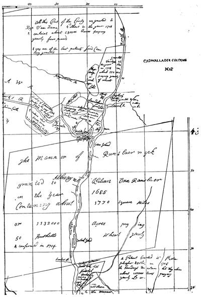
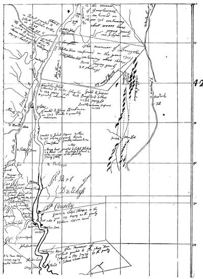
CADWALLADER COLDEN’S MAP OF THE MANORIAL GRANTS ALONG THE HUDSON.
Another of Colden’s maps, made by him as surveyor-general of the province, exists in a mutilated state in the State library at Albany, showing the regions bordering on the Hudson and Mohawk rivers. It was drafted by him probably at the end of the first quarter of the eighteenth century,[517] and fac-similes of parts of it are annexed (pp. 236, 237).
A map of the northern parts of the province, called Carte du Lac Champlain depuis le Fort Chambly jusqu’au Fort St. Frédéric, levée par le Sieur Anger, arpenteur du Roy en 1732, faite à Québec, le 10 Octobre, 1748, signé de Lery, indicates the attempted introduction of a feudal system of land tenure by the French. The map is reproduced in O’Callaghan’s Doc. Hist. of New York.
The province of New York to its western bounds is shown in A Map of New England and ye Country adjacent, by a gentleman, who resided in those parts. Sold by W. Owen (London, 1755).
The New York State library has also a manuscript Map of part of the province of New York on Hudson’s River, the West End of Nassau Island, and part of New Jersey. Compiled pursuant to order of the Earl of Loudoun, Septbr. 17, 1757. Drawn by Captain [Samuel J.] Holland. This is a map called by the Lords of Trade in 1766 “a very accurate and useful survey, ... in which the most material patents are marked and their boundaries described.”
Something of the extension of settlements in the Mohawk Valley at this period can be learned from a manuscript Map of the Country between Mohawk River and Wood Creek, with the Fortifications and buildings thereon in 1758, likewise preserved in the State library.[518]
A drawn map of New York province and adjacent parts (1759), from Maj. Christie’s surveys, is noted in the King’s Maps (Brit. Mus.), ii. 527.
The boundary controversy between New York and New Jersey has produced a long discussion over the successive developments of the historical geography of that part of the middle colonies. An important map on the subject is a long manuscript roll (5 × 2-6/12 feet), preserved in Harvard College library, which has been photographed by the regents of the University of the State of New York, and entitled A copy of the general map, the most part compiled from actual survey by order of the commissioners appointed to settle the partition line between the provinces of New York and New Jersey. 1769. By Berd. Ratzer. [New York, 1884.] 7-5/8 × 12-3/4 in.[519]
Respecting the controversy over the New Hampshire grants, see the present volume (ante, p. 177), and Isaac Jennings’s Memorials of a Century (Boston, 1869), chapters x. and xi.
Of the special maps of Pennsylvania, the Holme map a little antedates the period of our survey.[520] The Gabriel Thomas map of Pennsylvania and New Jersey appeared near the end of the century (1698), and has already been reproduced.[521] In 1728 we find a map of the Delaware and Chesapeake bays in the Atlas Maritimus et Commercialis, published at London. In 1730 we note the map of Pennsylvania which appeared in Humphrey’s Historical Account of the Society for the Propagation of the Gospel in Foreign Parts.[522]
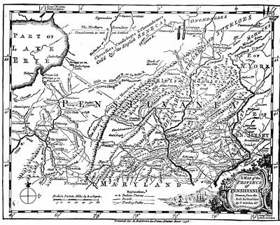
About 1740, in a tract printed at London, In Chancery. Breviate. John Penn, Thomas Penn, and Richard Penn, plaintiffs; Charles Calvert, defendant,[523] appeared A map of parts of the provinces of Pennsylvania and Maryland, with the counties of Newcastle, Kent, and Sussex in Delaware, according to the most exact surveys yet made, drawn[240] in the year 1740. The controversy over this boundary is followed in chapter iv. of the present volume.
A map of Philadelphia and parts adjacent, by N. Scull and G. Heap, was published in 1750, of which there is a fac-simile (folding) in Scharf and Westcott’s Philadelphia, vol. i.
The annexed fac-simile (p. 239) is from a plate in the London Mag., Dec., 1756.
A map to illustrate the Indian purchases, made by the proprietary, is given in An Enquiry into the Causes of the Alienation of the Delaware and Shawanese Indians (London, 1759).[524]
Surpassing all previous drafts was a Map of the Improved Part of Pennsylvania, by Nicholas Scull, published in 1759, and sold by the author in Second Street, Philadelphia. Engraved by Jas. Turner. It was reproduced in Jefferys’ General Topography of North America (Nos. 40-42), and was reissued in London in 1770, and again as A Map of Pennsylvania, exhibiting not only the improved parts of the Province, but also its extensive frontiers, laid down from actual surveys, and chiefly from the late Map of N. Scull, published in 1770. Robert Sayer & Bennett (London, 1775). The edition of 1770 was reëngraved in Paris by Le Rouge.
Upon the boundary controversy between Pennsylvania and Virginia respecting the “Pan handle,” see N. B. Craig’s Olden Time (1843), and the St. Clair Papers, vol. i. (passim).
The Leisler Papers constitute the first volume of the Fund Publications of the N. Y. Hist. Society’s Collections, and embrace the journal of the council from April 27 to June 6, 1689 (procured from the English State Paper Office), with letters, etc., and a reprint of a tract in defence of Leisler, issued at Boston in 1698, and called Loyalty Vindicated, being an answer to a late false, seditious, and scandalous pamphlet, entitled “A letter from a Gent,” etc.[525] The Sparks Catal. (p. 217) shows a MS. copy made of a rare tract in the British Museum, printed in New York and reprinted in London, 1690, called A modest and impartial narrative of the great oppressions that the inhabitants of their majestie’s Province of New York lye under by the extravagant and arbitrary proceedings of Jacob Leisler and his accomplices. Sparks endorsed his copy as “written by a violent enemy to Leisler; neither just, candid, nor impartial.”[526] Various papers relating to the administration of Leisler make a large part of the second volume of the Documentary History of New York, showing the letters written by Leisler to Boston, the papers connected with his official proceedings in New York, and his communications with the adjacent colonies; the council minutes in Dec., 1689; proceedings against the French and Indians; the papers relating to the transfer of the fort and arrest of Leisler; the dying speeches of Leisler and Milbourne; with a reprint of A letter from a gentleman of the city of New York to another (New York, 1698). There are a few original[241] letters of Leisler in the Prince Letters (MSS.), 1686-1700, in Mass. Hist. Soc. cabinet.
The career of Leisler is traced in the memoir by C. F. Hoffman in Sparks’s Amer. Biog., xiii. (1844), and in G. W. Schuyler’s Colonial New York (i. 337). Peleg W. Chandler examines the records of the prosecution in his American Criminal Trials (i. 255). Cf. also Historical Magazine, xxi. 18, and the general histories, of which Dunlap’s gives the best account among the earlier ones.[527]
The student must, of necessity, have recourse to the general histories of New York for the successive administrations of the royal governors, and H. B. Dawson, in his Sons of Liberty (printed as manuscript, 1859), has followed the tracks of the constant struggle on their part to preserve their prerogatives.[528] Schuyler (Colonial New York, i. 394-460) follows pretty closely the administration of Fletcher. The chapter on New England (ante, no. ii.) will need to be parallelized with this for the career of Bellomont.
Under Nanfan, who succeeded Bellomont temporarily, Col. Bayard, who had brought Leisler to his doom, was in turn put on trial, and the narrative of the proceedings throws light on the factious political life of the time.[529]
One of the most significant acts of Cornbury’s rule (1702-1708) was the prosecution in 1707 of Francis Mackemie, a Presbyterian minister, for preaching without a license.[530]
J. R. Brodhead, who gives references in the case (Hist. Mag., Nov., 1863), charges Cornbury with forging the clause of his instructions under which it was attempted to convict Mackemie, and he says that the copy of the royal instructions in the State Paper Office contains no such paragraph. “History,” he adds, “has already exhibited Lord Cornbury as a mean liar, a vulgar profligate, a frivolous spendthrift, an impudent cheat, a fraudulent bankrupt, and a detestable bigot. He is convicted of having perpetrated one of the most outrageous forgeries ever attempted by a British nobleman.”[531]
The few months of Lovelace’s rule (1708-9) were followed by a funeral Sermon when he died, in May, 1709, preached by William Vesey (New York, 1709), which is of enough historical interest to have been reprinted in the N. Y. Hist. Coll. (1880).
During 1720-1722, the Shelburne Papers (Hist. MSS. Commission Report, v. 215) reveal letters of Peter Schuyler and Gov. Burnet, with various other documentary sources.
There is a portrait of Rip van Dam, with a memoir, in Valentine’s Manual (1864, p. 713).
In 1732 and 1738 we have important statistical and descriptive papers on the province from Cadwallader Colden.[532]
The narrative of the trial of Zenger was widely scattered, editions being printed at New York, Boston, and London; while the principles which it established were sedulously controverted by the Tory faction.[533]

The main printed source respecting the Negro Plot of 1741 is the very scarce book by the recorder of the city of New York, Daniel Horsmanden, A Journal of the proceedings in the Detection of the Conspiracy formed by some white people in conjunction with negro and other slaves for burning the City of New York, and murdering the inhabitants, etc., containing, I., a narrative of the trials, executions, etc.; II., evidence come to light since their execution; III., lives of the several persons committed, etc. (New York, 1744).[534]
The history of Pennsylvania during this period is a tale of the trials of Penn,[535] the misgovernment of the province by representatives of the proprietors, the struggles of the proprietary party against the people, the apathy of the Quakers in the face of impending war, and the determination of the assembly to make the proprietors bear their share of the burdens of defence. The published Pennsylvania Archives give much of the documentary evidence, and the general histories tell the story.
The Pennsylvania Hist. Soc., in vols. ix. and x. of their Memoirs, published the correspondence of Penn with Logan, his secretary in the colony, beginning in 1700. This collection also embraced the letters of various other writers, all appertaining to the province, and was first arranged by the wife of a grandson of James Logan in 1814; but a project soon afterwards entertained by the American Philosophical Society of printing the papers from Mrs. Logan’s copies was not carried out, and finally this material was placed by that society at the disposal of the Penna. Hist. Society. The correspondence was used by Janney in his Life of Penn, and liberal extracts were printed in The Friend (Philadelphia, July, 1842-Apr., 1846) by Mr. Alfred Cope. Mr. Edward Armstrong, the editor of the Historical Society’s volumes, gathered additional materials from other and different sources. A portrait of Logan is given in the second volume, which brings the correspondence down to 1711. The material exists for continuing the record to 1750, though Logan ceased to hold official connection with the province in 1738.
Sparks (Franklin’s Works, vii. 25) says that “a history of James Logan’s public life would be that of Pennsylvania during the first forty years of the last century.” See the account of Logan in the Penn and Logan Correspondence, vol. i.
The correspondence of Thomas and Richard Penn with a later agent in Philadelphia, Richard Peters, is also preserved. In 1861 this correspondence was in the possession of Mr. John W. Field, of Philadelphia, when Mr. Charles Eliot[243] Norton gave transcripts of a portion of it (letters between 1750 and 1758) to the Mass. Hist. Society.[536]
Of an earlier period, when Evans was deputy-governor, there are some characteristic letters (1704, etc.) in a memoir of Evans communicated by E. D. Neill to the N. E. Hist. and Geneal. Reg., Oct., 1872 (p. 421).
There is a biographical sketch of Sir William Keith in the Penna. Historical Society’s Memoirs (vol. i.).
There is a pencil-drawn portrait of Sir William Keith, with a painting made from it, in the gallery of the Penna. Hist. Society. Cf. Catal. of Paintings, etc. (nos. 77, 162), and Scharf and Westcott’s Philadelphia (i. 177). Some of the rare tracts in the controversy of Governor Keith and Logan are noted in the Brinley Catal., ii. pp. 197-8. Cf. Hildeburn’s Century of Printing.
As to the position of the Quakers upon the question of defensive war, there is an expressive letter, dated in 1741, of James Logan, who was not in this respect a strict constructionist of the principles of his sect, which is printed in the Penna. Mag. of History (vi. 402). Much of this controversy over military preparation is illustrated in the autobiography and lives of Benjamin Franklin; and the issues of Franklin’s Plain Truth (1747) and Samuel Smith’s Necessary Truth, the most significant pamphlets in the controversy, are noted in the bibliographies.[537] Sparks, in a preliminary note to a reprint of Plain Truth, in Franklin’s Works (vol. iii.), states the circumstances which were the occasion and the sequel of its publication. In Ibid. (vii. 20) there is a letter of Richard Peters describing the condition of affairs.
A mass of papers, usually referred to as the Shippen Papers, and relating to a period in the main antedating the Revolution, have been edited privately by Thomas Balch as Letters and Papers relating chiefly to the Provincial History of Pennsylvania, with some notices of the writers. (Philad., 1855, one hundred copies.)
First of importance among the published travels of this period is the narrative of an English Quaker, Thomas Story, who came over in 1697. From that time to 1708 he visited every part of the colonies from New Hampshire to Carolina, dwelling for much of the time, however, in Pennsylvania, where he became, under Penn’s persuasion, a public official. The Journal of the life of Thomas Story, containing an account of his remarkable convincement of and embracing the principles of truth, as held by the people called Quakers, and also of his travels and labours in the service of the Gospel, with many other occurrences and observations, was published at Newcastle-upon-Tyne in 1747.[538]
George Clarke, born in 1676, was made secretary of the province of New York in 1703, and came to America, landing in Virginia. We have an account of his voyage, but unfortunately the book does not follow his experiences after his arrival;[539] but we have the Letters of his private secretary, Isaac Bobin, which, under the editing of Dr. O’Callaghan, were printed in a small edition (100 copies) at Albany in 1872.
George Keith’s Journal of Travels from New Hampshire to Caratuck, on the Continent of North America, London, 1706, is reprinted in the first volume (1851) of the Collections of the Prot. Episc. Hist. Society, together with various letters of Keith[540] and John Talbot.[541]
Benjamin Holme, another Quaker, came to the colonies in 1715, and extended his missionary wandering to New England, and southward beyond the middle colonies,[542] as did, some years later, 1736-1737, still another Quaker, John Griffeth,[244] whose Journal of his life, labours, and travels in the work of the ministry passed through many editions, both in America and Great Britain.[543]
The records of missionary efforts at this time are not wholly confined to the Quakers. The narrative of the Rev. Thomas Thompson reveals the perplexities of the adherents of the Established Church in the communities through which he travelled in the Jerseys.[544] Similar records are preserved in the journals of Whitefield[545] and his associates, like the Journal of a Voyage from Savannah to Philadelphia and from Philadelphia to England, MDCCXL., by William Seward, Gent., Companion in Travel with the Reverend Mr. George Whitefield (London, 1740).
We have a few German experiences, among them Gottlieb Mittelberger’s Reise nach Pennsylvanien im Jahr 1750 und Rŭkreise nach Teutschland im Jahr 1754 (Stuttgart, 1756)[546]—which is the record of a German teacher and organist, who was in the province for three years. He had no very flattering notion of the country as an asylum for such Germans as, having indentured themselves for their passage, found on their arrival that they could be passed on from master to master, not always with much regard to their happiness.
Michael Schlatter, a Dutch preacher, published his observations of the country and population, and particularly as to the condition of the Dutch Reformed churches. He was in the country from 1746 to 1751, and made his report to the Synod of Holland. Though the book pertains mostly to Pennsylvania, his experiences extended to New York and New England.[547]
We have the reports of a native observer in the Observations on the inhabitants, climate, soil, rivers, productions, animals, and other matters worthy of notice, made by Mr. John Bartram in his travels from Pensilvania to Onondago, Oswego, and the lake Ontario in Canada. To which is annexed a curious account of the Cataracts at Niagara, by Mr. Peter Kalm (London, 1751).[548] Bartram was born in Pennsylvania, and made this journey in company with Conrad Weiser, the agent sent by Pennsylvania to hold friendly conference with the Iroquois, as explained in another chapter.[549] Bartram’s principal object was the study of the flora of the country, in which pursuit he acquired such a reputation as to attract the notice of Linnæus, but his record throws light upon the people which came in his way, and enable us in some respects to understand better their manners and thoughts. Evans’ map, already mentioned,[550] was in part the outgrowth of this journey.
We also owe to the friendly interest of the great Swedish botanist the observations of Peter Kalm, a countryman of Linnæus, whom the Swedish government sent to America on a botanical tour in 1748-1751. He extended his journeys to Pennsylvania, New York, and Canada, and we have in his three volumes, beside his special studies, not a little of his comment on men and events. He published his En risa til Norra America at Stockholm, 1753-1761. (Sabin, ix. 36,986.)[551]
The Rev. Andrew Burnaby’s Travels through the middle settlements in North America in 1759-1760, with observations upon the state of the Colonies, was published in London, 1775.[552] Burnaby was an active observer and used his note-book, so that little escaped him, whether of the people’s character or their manners, or the aspect of the towns they dwelt in, or of the political and social movements which engaged them.
The relations of the middle colonies to the Indians will be particularly illustrated in a later chapter on the military aspects of the French wars,[553] but there are a few special works which may be mentioned here: Colden’s Five Indian Nations (only to 1697); Morgan’s League of the Iroquois; Wm. L. Stone’s Life of Sir William Johnson; and Geo. W. Schuyler’s Colonial New York—Peter Schuyler and his family (Albany, 1885). The successive generations of the Schuylers had for a long period been practical intermediaries between the colonists and the Indians. Something of the Indian relations in Bellomont’s time is indicated elsewhere.[554] For the agreement between William Penn and the Susquehanna Indians in 1701, see the Penna. Archives (i. 145). Of similar records in Cornbury’s time, Schuyler (ii. 17) says the remains are meagre, but he gives more for Hunter’s time (ii. pp. 42-79) and Burnet’s (ii. p. 83). The Shelburne Papers (Hist. MSS. Commission Report, v.) reveal various documents from 1722 to 1724, and there is a MS. of a treaty between the governors of New York, Virginia, and Pennsylvania (Albany, Sept., 1722) in the library of Harvard College.
For the treaty of 1735, see the Penna. Mag. of Hist. (vii. 215).
For 1742 there was a treaty with the Six Nations at Philadelphia, and its text was printed at London.[555]
In 1747 there were treaties in July at Lancaster, Penna., with the Six Nations, and on Nov. 13 with the Ohio Indians at Philadelphia. (Haven in Thomas, ii. 497.) Again, in July, 1753, Johnson had a conference with the Mohawks (2 Penna. Archives, vi. 150); and in Oct. a treaty with the Ohio Indians was made at Carlisle (Hildeburn, i. 1328; Haven, p. 517). There exist also minutes of conferences held at Easton, Oct., 1758, with the Mohawks;[556] at Easton, Aug., 1761, with the Five Nations; and in Aug., 1762, at Lancaster, with the northern and western Indians. (Hildeburn, i. 1593, 1634, 1748, 1908.)
The Moravians, settling first in Georgia, had founded Bethlehem in Pennsylvania in 1741, and soon extended the field of their labors into New York;[557] and in no way did the characteristics of this people impress the life of the colonies so much as in the intermediary nature of their missions among the Indians. David Zeisberger was a leading spirit in this work, and left a manuscript account (written in 1778 in German) of the missions, which was discovered by Schweinitz in the archives of the Moravian church at Bethlehem. (Schweinitz’s Zeisberger, p. 29.) It proved to be the source upon which Loskiel had depended for the first part of his History of the Mission of the United Brethren among the Indians in North America, in three parts, by Geo. H. Loskiel, translated from the German by Christian Ignatius Latrobe (London, 1794);[558] and Schweinitz found it of invaluable use to him in the studies for his Life of David Zeisberger (Philad., 1870). The other principal authority on the work of the Moravians among the Indians is Rev. John Heckewelder, whose Narrative of the Mission of the United Brethren (Philad., 1820) has been elsewhere referred to,[559] and who also published An account of the History, Manners, and Customs of the Indian Nations who once inhabited Pennsylvania and the neighboring States (Philad., 1818).[560] Schweinitz[246] also refers to another manuscript upon the Indians, preserved in the library of the American Philosophical Society, by Christopher Pyrlaeus, likewise a Moravian missionary.[561] We have again from Spangenberg an Account of the manner in which the Protestant Church of the Unitas Fratrum preach the Gospel and carry on their missions among the heathen (English transl., London, 1788); and his notes of travel to Onondaga, in 1745, which are referred to in the original MS. by Schweinitz (Zeisberger, p. 132), have since been printed in the Penna. Mag. of History (vol. iii.).[562]
Perhaps the most distinguished of the English missionaries was David Brainerd, a native of Connecticut, of whose methods and their results, as he went among the Indians of Pennsylvania and New Jersey, we have the record in his life and diaries.[563]
The question of the population of the middle colonies during the eighteenth century is complicated somewhat by the heterogeneous compounding of nationalities, particularly in Pennsylvania. In New Jersey the people were more purely English than in New York. We find brought together the statistics of the population of New York, 1647-1774, in the Doc. Hist. of N. Y. (i. 687), and Lodge (English Colonies, p. 312) collates some of the evidence. The German element in New York is exemplified in F. Kapp’s Die Deutschen im Staate New York während des achtzehnten Jahrhunderts. (New York, 1884.)
In Pennsylvania the Swedes were beginning to lose in number when the century opened, and the Dutch were also succumbing to the English preponderance; but there were new-comers in the Welsh and Germans in sufficient numbers to keep the characteristics of the people very various.[564] Religion had brought the earliest Germans,—Dunkers[565] and Mennonists,[566] all industrious,[247] but ignorant. By 1719 the Irish began to come, in part a desirable stock, the Scotch-Irish Presbyterians; but in large numbers they were as unpromising as the dregs of a race could make them. The rise of Presbyterianism in Pennsylvania is traced in C. A. Briggs’s Amer. Presbyterianism (New York, 1885).[567]
The influx of other than English into Pennsylvania in the eighteenth century had an extent best measured by A collection of upwards of 30,000 names of German, Swiss, Dutch, French, and other immigrants in Pennsylvania, 1727-1776, with notes and an appendix containing lists of more than one thousand German and French in New York prior to 1712, by Professor I. Daniel Rupp (2d enlarged ed., Philad., 1876).
Respecting the Welsh immigrants, compare the Pennsylvania Mag. of Hist., i. 330; Howard M. Jenkins’s Historical collections relating to Gwynedd, a township of Montgomery County, Penn., settled, 1698, by Welsh immigrants, with some data referring to the adjoining township of Montgomery, also a Welsh settlement (Phila., 1884), and J. Davis’s History of the Welsh Baptists (Pittsburgh, 1835).
The Huguenot emigration to the middle colonies, particularly to New York, is well studied in C. W. Baird’s Huguenot Emigration to America (1885). Cf. references ante, p. 98; and for special monographs, W. W. Waldron’s Huguenots of Westchester and Parish of Fordham, with an introduction by S. H. Tyng (New York, 1864), and G. P. Disosway on the Huguenots of Staten Island, in the Continental Monthly, i. 683, and his app. on “The Huguenots in America” to Samuel Smiles’s Huguenots (N. Y., 1868).
The best summary of the manners and social and intellectual life of the middle colonies will be found in Lodge’s Short History of the English Colonies (New York, New Jersey, and Pennsylvania), and he fortifies his varied statements with convenient references. For New York specially the best known picture of life is Mrs. Anne Grant’s Memoirs of an American Lady,[568] but its recollections, recorded in late life, of experiences of childhood, have nearly taken it out of the region of historical truth. For Pennsylvania there is a rich store of illustration in Watson’s Annals of Philadelphia, and much help will be derived from the Penn and Logan Letters, printed by the Penna. Hist. Soc.;[569] from the journal of William Black, a Virginian, who recorded his observations in 1744, printed in the Penna. Mag. of Hist. (vols. i. and ii.).[570]
The exigencies of the Indian wars, while they colored the life and embroiled the politics of the time, induced the search for relief from pecuniary burdens, here as in New England, in the issue of paper money, which in turn in its depreciation grew to be a factor of itself in determining some social conditions.[571]
The educational aspects of the middle colonies have been summarily touched by Lodge in his English Colonies. Each of them had founded a college. An institution begun at Elizabethtown in 1741, was transferred to Princeton in 1757, and still flourishes.[572] In 1750 the Academy[248] of Philadelphia made the beginning of the present University of Pennsylvania. In 1754 King’s College in New York city began its mission,—the present Columbia College.[573]
The development of the intellectual life of the middle colonies, so far as literary results—such as they were—are concerned, is best seen in Moses C. Tyler’s History of American Literature (vol. ii. ch. 16).[574] The list by Haven in Thomas’s Hist. of Printing (vol. ii.) reveals the extent of the publications of the period; but for Pennsylvania the record is made admirably full in Charles R. Hildeburn’s Century of Printing,—issues of the press in Pennsylvania, 1685-1784.[575]
William Bradford, the father of printing in the middle colonies, removed to New York in 1693, where he died in 1752, having maintained the position of the leading printer in that province, where he started, in 1725, the N. Y. Gazette, the earliest New York newspaper.[576] His son, Andrew Bradford (born 1686, died 1742), was the founder of the newspaper press in Pennsylvania, and began the American Weekly Mercury in 1719, and the American Magazine in 1741.[577]
The records of the publication of Franklin and his press have been more than once carefully made,[578] and Col. William Bradford, grandson of the first William, has been fitly commemorated in the Life of him by Wallace.[579]
The general histories of New York, Pennsylvania, and New Jersey have been sufficiently described elsewhere.[580] The documentary collections of New York State have likewise been explained;[581] but the historical literature respecting the province and State has never been bibliographically arranged. The city of New York[249] has some careful histories of its own.[582] The capital, Albany, by reason of the attention of its devoted antiquarian publishers, has recently had its own bibliography traced.[583] The extent of the other local histories of the State, particularly as far as the Dutch period was represented in it, has been already indicated;[584] but the list as touching the period covered by the present chapter could be much enlarged.[585]
The several official and documentary collections published by Pennsylvania have been described elsewhere.[586] Something of her local history has been also indicated, but the greater part of the interest of this class of historical records falls within the period of the present volume.[587]
Respecting the histories of Philadelphia, since the memoranda were noted in Vol. III. (p. 509), the material gathered by Thompson Westcott has been augmented by the labors of Col. J. Thomas Scharf, and the elaborate History of Philadelphia (Philad., 1884) with this joint authorship has been issued in three large volumes. Two chapters (xiii. and xv.) in the first volume cover in the main the period now dealt with. There is still a good deal to be gleaned from the old Annals of Philadelphia, by John F. Watson, of which there is a new edition, with revisions and additions by Willis P. Hazard.[588] It is a work somewhat desultory in character and unskilful in arrangement, but it contains a great body of facts.[589]
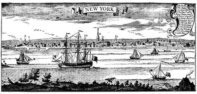
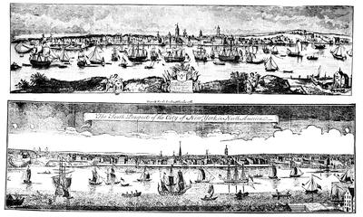
The views of New York here annexed (pp. 250, 251) are the principal ones of the earlier half of the seventeenth century. The larger (New York, on the scroll) is from the great map of Popple, British Empire in America, published in 1732. The upper of the two (p. 251) is reduced from a large panoramic South Prospect of ye Flourishing City of New York (6-6/12 × 2-4/12 ft.), dedicated to Gov. George Clinton by Thomas Blakewell, which was published March 25, 1746. A lithographic reproduction appeared in Valentine’s N. Y. City Manual, 1849, p. 26, and in his Hist. of N. Y. City, p. 290. (Cf. Cassell’s United States, i. 480.) Originals are reported to be in the N. Y. Society library and in the British Museum (King’s Maps, ii. 329, and Map Catal., 1885, col. 2,975).
The reduced fac-simile view, called a “South Prospect,” follows a copperplate engraving in the London Magazine, Aug., 1761.
Key: 1, the fort; 2, the chapel in the fort; 3, the secretary’s office; 4, the great dock, with a bridge over it; 5, the ruins of Whitehall, built by Gov. Duncan [Dongan]; 6, part of Nutten Island; 7, part of Long Island; 8, the lower market; 9, the Crane; 10, the great flesh-market; 11, the Dutch church; 12, the English church; 13, the city hall; 14, the exchange; 15, the French church; 16, upper market; 17, the station ship; 18, the wharf; 19, the wharf for building ships; 20, the ferry house on Long Island side; 21, a pen for cattle designed for the market; 22, Colonel Morris’s “Fancy,” turning to windward, with a sloop of common mould.
This print is clearly based on the one placed above it.
The official documentary collections of New Jersey have already been indicated,[590] as well as some traces of its local history.[591]
A view of New York about 1695 is no. 39 in the gallery of the N. Y. Hist. Society. Cf. Mrs. Lamb’s New York, i. p. 455, for one assigned to 1704.
A view purporting to be taken in 1750 is found in Delisle’s Atlas (1757).
A collection of views of towns, which was published by Jan Roman at Amsterdam in 1752, included one of Nieu Amsterdam, namaels Nieu York. (Muller’s Catal. of American Portraits, etc., no. 310.)[592]
The earliest plan of New York of the period which we are now considering is one which appeared in the Rev. John Miller’s Description of the Province and City of New York, with the plans of the City and several forts, as they existed in the year 1695, now first printed from the original MS. (London, Rodd, 1843), and in a new ed., with introd. and notes by Dr. Shea (N. Y., Gowans, 1862). See Vol. III. p. 420, of the present History, and Mrs. Lamb’s New York (i. 421).
A fac-simile of this plan, marked “New York, 1695,” is annexed. It is reproduced several times in Valentine’s New York City Manual (1843-44, 1844-45, 1845-46, 1847, 1848, 1850, 1851, 1852), and is explained by the following:
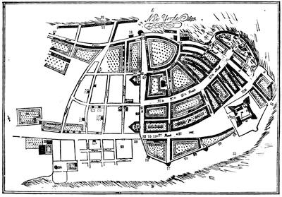
Key: 1, the chapel in the fort of New York; 2, Leysler’s half-moon; 3, Whitehall battery of 15 guns; 4, the old dock; 5, the cage and stocks; 6, stadt-house battery of 5 guns; 7, the stadt or state house; 8, the custom-house; 8, 8, the bridge; 9, Burgher’s or the slip battery of 10 guns; 10, the fly block-house and half-moon; 11, the slaughter-house; 12, the new docks; 13, the French church; 14, the Jews’ synagogue; 15, the fort well and pump; 16, Ellet’s alley; 17, the works on the west side of the city; 18, the northwest block-house; 19, 19, the Lutheran church and minister’s house; 20, 20, the stone points on the north side of the city; 21, the Dutch Calvinists’ church, built 1692; 22, the Dutch Calvinists’ minister’s house; 23, the burying-ground; 24, a windmill; 25, the king’s farm; 26, Col. Dungan’s garden; 27, 27, wells; 28, the plat of ground designed for the E. minister’s house; 29, 29, the stockado, with a bank of earth on the inside; 30, the ground proper for the building an E. church; 31, 31, showing the sea flowing about New York; 32, 32, the city gates; 33, a postern gate.
There is a MS. plan of this date (1695) in the British Museum. A plan of the fort in New York (1695) is also given by Miller, and is reproduced in Gowan’s ed. of Miller, p. 264. (Cf. Appleton’s Journal, viii. p. 353.)
The Brit. Mus. Map Catal. (1885), col. 2,972, notes a map by J. Seller, London; and a Novum Amsterdamum, probably by Vander Aa, at Leyden, in 1720.
A large Plan of the City of New York, from an actual survey, made by Iames Lyne, was published by William Bradford, and dedicated to Gov. Montgomerie, while Col. Robt. Lurting was mayor, in 1728. It has been reproduced wholly or in part at various times.[593]
Popple’s plan of New York (1733) was later re-engraved in Paris. His map of the harbor, from his great map The British Empire in America (inscribed on a scroll, “New York and Perth Amboy harbours”), is annexed (p. 254) in fac-simile.
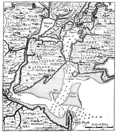
Key: A, the fort; B, Trinity Church; C, old Dutch church; D, French church; E, new Dutch church; F. Presbyterian meeting; G, Quakers’ meeting; H, Baptist meeting; J, Lutheran church; L, St. George’s Chapel; M, Moravian meeting; N, new Lutheran meeting; 1, governor’s house; 2, secretary’s office; 3, custom-house; 4, Peter Livingston & Co., supg. hu.; 5, city hall; 6, Byard’s sugar-house; 7, exchange; 8, fish market; 9, old slip market; 10, meal market; 11, fly market; 12, Burtin’s market; 13, Oswego market; 14, English free school; 15, Dutch free school; 16, Courtland’s sugar-house; 17, Jas. Griswold; 18, stillhouse; 19, Wileys Livingstone; 20, Laffert’s In. Comp.; 21, Thomas Vatar Distilhouse; 22, Robert Griffeth’s Distilhouse; 23, Jno. Burling’s Distilhouse; 24, Jas. Burling’s Distilhouse; 25, Jno. Leake’s Distilhouse; 26, Benj. Blagge’s Distilhouse; 27, Jews’ burial-ground; 28, poor house; 29, powder-house; 30, block-house; 31, gates.
Other drafts of New York harbor during the first half of the last century will be found in Southack’s Coast Pilot, and in Bowen’s Geography (1747). A chart of the Narrows is in a Set of Plans and Forts in America, London, 1763, no. 12.
A large plan of The City and environs of New York, as they were in the years 1742-1744, drawn by David Grim in the 76th year of his age, in Aug., 1813, as it would seem from recollection, is in the N. Y. Hist. Society’s library, and is engraved in Valentine’s N. Y. City Manual, 1854.
The plan of 1755 (also annexed), made after surveys by the city surveyor, and bearing the arms of New York city, follows a lithograph in Valentine’s N. Y. City Manual, 1849, p. 130, after an original plate belonging to Trinity Church, N. Y.
Cf. Valentine’s New York, p. 304, and the Hist. of the Collegiate Reformed Dutch Church in New York (New York, 1886). It was also given in 1763 in a Set of plans and forts in America (no. 1), published in London.
A plan of the northeast environs of New York, made for Lord Loudon, in 1757, is in Valentine’s Manual, 1859, p. 108.
The plan of 1755 (p. 255) needs the following
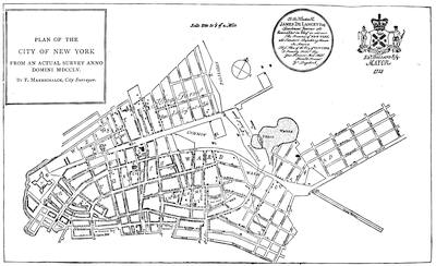
Key: A, the fort; B, Trinity Church; C, old Dutch church; D, French church; E, new Dutch church; F, Presbyterian meeting; G, Quakers’ meeting; H, Baptist meeting; I, Lutheran church; K, Jews’ synagogue; L, St. George’s Chapel; M, Moravian meeting; N, new Lutheran meeting; O, custom-house; P, governor’s house; Q, secretary’s office; R, city house; S, exchange; T, fish market; V, old slip market; X, meal market; Y, fly market; Z, Burtin’s market; 1, Oswego market; 2, English free school; 3, Dutch free school; 4, block-house; 5, gates.
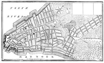
Maerschalck’s plan of 1755 was used as the basis of a new plan, with some changes, which is here reproduced (p. 256) after the copy in Valentine’s Manual (1850), and called a Plan of the City of New York, reduced from an actual survey, by T. Maerschalkm [sic], 1763. The following key is in the upper right-hand corner of the original (where the three blanks are in the fac-simile), of a lettering too small for the present reduction:—
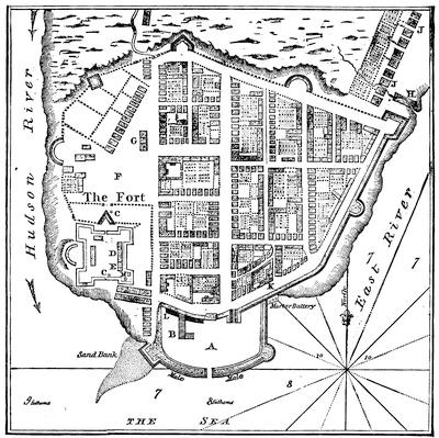
BELLIN’S PLAN, 1764.
Key: A, shipping port; B, bridge for discharging vessels; C, fountain or wells; D, house of the governor; E, the temple or church; F, parade ground; G, meat-market; H, slaughter-house; J, lower town; K, city hall; L, custom-house and stores; M, powder-magazine.[594]
The latest of the plans here reproduced is one which is given in Valentine’s Manual (1861, p. 596), and was made by Bellin by order of the Duke de Choiseul, in 1764:—
The view of Philadelphia (reproduced, p. 258) is the larger part of George Heap’s “East Prospect,” as reduced from the London Mag., Oct., 1761:—
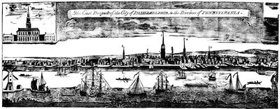
Key: 1, Christ Church; 2, state-house; 3, academy; 4, Presbyterian church; 5, Dutch Calvinist church; 6, the court-house; 7, Quakers’ meeting-house; 8, High Street wharf; 9, Mulberry Street; 10, Sassafras Street; 11, Vine Street; 12, Chestnut Street (the other streets are not to be seen from the point of sight); 13, draw-bridge; 14, corn-mill.
The style of the domestic buildings in Pennsylvania during this period may be seen from specimens delineated in Scharf and Westcott’s Philadelphia (particularly the Christopher Saur house in Germantown, in vol. iii. p. 1964); Egle’s Pennsylvania; Watson’s Annals of Philadelphia; Smith’s Delaware County, Rupp’s Lancaster County; and other local histories, especially Thompson Westcott’s Historic buildings of Philadelphia, with notices of their owners and occupants (Philad., 1877). The Penna. Mag. of Hist., July, 1886, p. 164, gives a view of the first brick house built in New Jersey, that of Christopher White, in 1690.
The original was first published in London in 1754, and was engraved by Jefferys, and reissued in his General Topog. of N. America, etc., 1768, no. 29. It was reproduced on the same scale in Philadelphia, in 1854. In 1857, through the instrumentality of George M. Dallas, then minister to England, a large oil-painting, measuring eight feet long and twenty inches high, was received by the Philadelphia library; and attached to it was an inscription, The southeast prospect of the City of Philadelphia, by Peter Cooper, painter, followed by a key to the public and private buildings. Confidence in its literal fidelity is somewhat shaken by the undue profusion of a sort of cupola given to buildings here and there,—one even surmounting the Quaker meeting-house. Antiquaries are agreed that it must have been painted about 1720. Among the private houses prominent in the picture are that of Edward Shippen, at that time occupied by Sir William Keith, then governor of the province, and that of Jonathan Dickinson. (Cf. Hist. Mag., i. 137.) It has been reëngraved on a small scale in Scharf and Westcott’s Hist. of Philadelphia, vol. i., where will also be found (p. 187) a view of the old court-house, from an ancient drawing (1710). Cf. view of 1744 in Ibid., p. 207.
CHAPTER IV.
MARYLAND AND VIRGINIA.
BY JUSTIN WINSOR,
The Editor.
MARYLAND began its career as a crown province with conditions similar to those which had regulated its growth under the Proprietary. There was nothing within its limits worthy the name of a town, though there were certain places where the courts met. The people were planters, large and small. They, with their servants, were settled, each with land enough about him, along the extensive tide-water front of the Chesapeake and its estuaries. Each plantation had a wharf or landing of its own, and no commercial centre was necessary to ship or receive merchandise. The Indians were friendly, and no sense of mutual protection, such as prevailed farther north, compelled the settlers to form communities. They raised tobacco,—too much of it,—and saw hardly enough of one another to foster a stable, political union. Local disturbances were accordingly not very promptly suppressed. Because one was independent in his living, he came to have too little sympathy with the independence of the mass.
Life was easy. Land and water yielded abundantly of wild game, while swine and cattle strayed about the woods, with ear-marks and brands to designate their owners. The people, however, had mainly to pound their corn and do without schools, for it needs villages to institute the convenient mill-wheel and build the school-house. The condition of the people had hardly changed from what it was during the seventeenth century. When the eighteenth came in, a political change had already been wrought by the revolution which placed William and Mary on the throne,[595] for in 1692 the Marylanders had welcomed Sir Lionel Copley as the first royal governor. In his train came a new spirit, or rather his coming engendered one, or gave activity to one which had been latent. The assembly soon ordained the Protestant Episcopal church to be the established order of a colony which before had had a Catholic master. In time the exclusiveness relaxed a little, enough in some fashion to exempt from restraint those who were Protestant, but dissenters; but the Romanists soon found to their cost that there was no relief for them. The fear of a[260] Jacobite ascendency in the mother country easily kept the assembly alert to discern the evils supposed to harbinger its advent.
Down to 1715 there was a succession of royal governors, but only one among them made any impress upon the time. This was Francis Nicholson, a man of vigor, who was felt during a long career in America in more than one colony. He was by commission the lieutenant-governor under Copley; but when that governor died, Nicholson was in England. On returning he followed his predecessor’s way in studying the Protestants’ interests. In pursuance of this he made the Puritan settlement at Anne Arundel, later to be known as Annapolis, the capital,[596] and left the old Catholic St. Mary’s thereby to become a name and a ruin.
There grew up presently an unseemly quarrel between Nicholson and Coode, a reprobate ecclesiastic, who had earlier been a conspicuous character in Maryland history.[597] The breach scandalized everybody; and charge and counter-charge touching their respective morals contaminated the atmosphere. Indeed, the indictment of Nicholson by his enemies failed of effect by its excess of foulness. In face of all this the governor had the merit, and even the courage, to found schools. He also acquired with some a certain odor of sanctity, when he sent Bibles to the sick during an epidemic, and appointed readers of them to attend upon a sanitarium which had been established at a mineral spring in St. Mary’s county. There was not a little need of piety somewhere, for the church in Maryland as a rule had little of it. When Nicholson was in turn transferred to Virginia, Nathaniel Blakiston (1699) and John Seymour (1703) succeeded in the government. Under them there is little of moment to note, beyond occasional inroads of the French by land and of the pirates along the Chesapeake. Events, however, were shaping themselves to put an end to the proprietary sway.
Charles, the third Lord Baltimore, died February 20, 1714-15, and his title and rights descended to Benedict, his son, who had already in anticipation renounced Catholicism. In becoming Protestant he had secured from the Crown and its supporters an increased income in place of the allowance that his Catholic father now denied him, out of the revenues of the province, which were still preserved to the family. Benedict had scarce been recognized when he also died (April 5, 1715), and his minor son, Charles, the fifth lord, succeeded. The young baron’s guardian, Lord Guilford, took the government, and finding to his liking John Hart, who was then ruling the province for the king, he recommissioned him as the representative of the Proprietary, who was now one in religious profession with the vast majority of his people. The return of the old master was to appearances a confirmation of the old charter; but an inevitable change was impending.
Meanwhile the laws were revised and codified (1715), and a few years[261] later (1722), by solemn resolution, the lower house of the assembly declared that the people of Maryland were entitled to all the rights and immunities of free Englishmen, and were of necessity inheritors of the common law of England, except so far as the laws of the province limited the application of that fundamental right.[598] This manifesto was the signal of a conflict between the ways that were and those that were to be. The Proprietary and the upper house made a show of dissenting to its views; but the old conditions were doomed. The methods of progress, however, for a while were gentle, and on the whole the rule of succeeding governors, Charles Calvert (1720), Benedict Leonard Calvert (1726), and Samuel Ogle (1731), was quiet.
The press meanwhile was beginning to live, and the Maryland Gazette was first published at Annapolis in 1727. A real town was founded, though it seemed at the start to promise no more than St. Mary’s, Annapolis, or Joppa.[599] This was Baltimore, laid out in 1730, which grew so leisurely that in twenty years it had scarce a hundred people in it. From 1732 to 1734 the Proprietary himself was in the province and governed in his own person.
The almost interminable controversy with the Penns over the northern bounds of Maryland still went on, the latter province getting the worst of it. Even blood was shed when the Pennsylvania Germans, crossing the line which Maryland claimed, refused to pay the Maryland taxes. During this border turmoil, Thomas Cresap, a Maryland partisan, made head against the Pennsylvanians, but was finally caught and carried to Philadelphia. A truce came in the end, when, pending a decision in England, a provisional line was run to separate settlers in actual possession.
Maryland had other troubles beside in a depreciated paper currency, and was not singular in it. She sought in 1733 to find a remedy by making tobacco a legal tender.
In 1751 the rights of the Proprietary again passed, this time to an unworthy voluptuary, destined to be the last Baron Baltimore, Frederick, the sixth in succession, who was not known to his people and did nothing to establish a spirit of loyalty among them. They had now grown to be not far from a hundred and thirty thousand in number, including multitudes of redemptioners, as immigrants who had mortgaged their labor for their ocean passage were called, and many thousands of transported convicts. This population paid the Proprietary in quit-rents and dues not far from seventy-five hundred pounds annually.
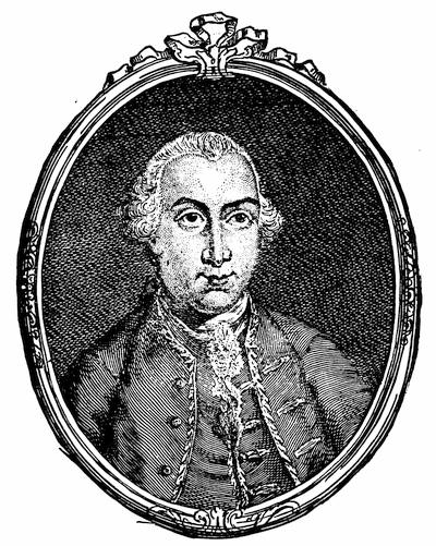
FREDERICK, LORD BALTIMORE.
From an engraving in the London Magazine, June, 1768, after an original painting of the sixth baron. He was born Feb. 6, 1731; succeeded to the title on the death of the fifth baron, April 24, 1751. Some accounts make him erroneously the seventh baron.
The beginning of the French war found Horatio Sharpe[600] fresh in office (1753) as the representative of the man to whom the people paid this money. There was need of resources to push the conflict, in which Maryland had common interests with Virginia and Pennsylvania. The delegates were willing to vote grants, provided the revenue of the Proprietary would share in the burden. This the governor refused to consider; but as the war went on, and the western settlements were abandoned before the Indian forays, Sharpe conceded the point, and £40,000 were raised, partly out of a double tax upon Catholics, who were in the main of the upper classes of the people. The question of supplying the army lasted longer than the £40,000, and each renewal of the controversy broadened the gulf between the governor and the lower house. It soon grew to be observed that the delegates planned their manœuvres with a view to overthrowing, under the stress of the times, the government of the Proprietary. Occasionally a fit of generosity would possess the delegates, as when they voted £50 a scalp to some Cherokee rangers, and £1,500 to the Maryland contingent in Forbes’s expedition against Du Quesne. It was never difficult,[263] meantime, for them to lapse into their policy of obstruction. So Maryland did little to assist in the great conflict which drove the French from North America.
When the war was practically closed, in 1760, the long dispute over the boundary with Pennsylvania was brought to an end, substantially, upon the agreement of 1732, by which the Proprietary of that day had been over-reached. This fixed the limits of the present State of Delaware, and marked the parallel which is now known as Mason and Dixon’s line. The most powerful colony south of that line was Virginia, with whom Maryland was also destined to have a protracted boundary dispute, that has extended to our own time, and has been in part relegated to the consideration of the new State, which the exigencies of the civil war caused to be detached from the Old Dominion. What was and is the most westerly of the head fountains of the Potomac (so the charter described the point from which the meridian of Maryland’s western line should run) depended on seeking that spot at the source of the northern or southern fork of the river. The decision gave or lost to Maryland thirty or forty square miles of rich territory. A temporary concession on Maryland’s part, which entailed such a loss, became a precedent which she has found it difficult to dislodge. Again, as the line followed down the Potomac, whether it gave the bed of that river to Virginia or to Maryland, has produced further dispute, complicated by diversities in the maps and by assumptions of rights, but in 1877 arbitration confirmed the bed to Maryland. Changing names and shifting and disappearing soil along the banks of the Chesapeake have also made an uncertainty of direction in the line, as it crosses the bay to the eastern shore. A decision upon this point has in our day gained new interest from the values which attach to the modern oyster-beds.
The history of Virginia was left in an earlier chapter[601] with the suppression of Bacon’s Rebellion. The royal governors who succeeded Berkeley held office under Lord Culpepper, who himself assumed the government in 1679,[602] bringing with him a general amnesty for the actors in the late rebellion.[603] But pardon did not stop tobacco falling in price, nor was his lordship chary of the state, to maintain which involved grinding taxes. Towns would not grow where the people did not wish them, and even when the assembly endeavored to compel such settlements to thrive at fixed landing places, by what was called a Cohabitation Act (1680), they were not to be evoked, and existed only as ghosts in what were called “paper towns.” Tobacco, however, would grow if only planted, and when producers continued to plant it beyond what the mob thought proper to maintain fit prices, the wayward populace cut off the young plants, going about from plantation to plantation.[604] Culpepper kept up another sort of destruction in[264] hanging the leaders of the mob, and in telling the people that a five-shilling piece, if it went for six, would make money plentier. When the people insisted that his salary should be paid in the same ratio, he revoked his somewhat frantic monetary scheme.
When Culpepper ceased to be the Proprietary, in 1684, Virginia became a royal province, and Charles II. sent out Lord Howard of Effingham to continue the despotic rule. The new governor had instructions not to allow a printing-press.[605] He kept the hangman at his trade, for plant-cutting still continued. The assembly managed to despatch Ludwell to England to show how cruelly matters were going, and he got there just after William and Mary were proclaimed. The representations against Effingham sufficed to prevent the continuance of his personal rule, but not to put an end to his commission, and he continued to draw his salary as governor, despite his adherence to James, and after Francis Nicholson had been sent over as his deputy (1690). The new ruler was not unskilled in governing; but he had a temper that impelled him sometimes in wrong ways, and an ambition that made the people distrust him. He could cajole and domineer equally well, but he did not always choose the fit occasion. He was perhaps wiser now than he was when he nearly precipitated New York into a revolution; and he showed himself to the people as if to win their affections. He encouraged manufactures. He moved the capital from Jamestown, and created a small conspicuousness for Williamsburg[606] as he did for Annapolis, in Maryland. He followed up the pirates if they appeared in the bay. He tried to induce the burgesses to vote money to join the other colonies in the French war; but they did not care so much for maintaining frontier posts in order to protect the northern colonies as one might who had hopes to be one day the general governor of the English colonies. They intrigued in such a way that he lost popularity, when he had none too much of it. He seemed generous, if we do not narrowly inspect his motives, when he said he would pay the Virginia share of the war money, if the assembly did not care to, and when he gave half of a gratuity which the assembly had given him, to help found the college of William and Mary. This last act had a look of magnanimity, for James Blair, who had been chiefly instrumental in getting the college charter, and who also in a measure, as the commissary of the Bishop of London, disputed Nicholson’s executive supremacy, had laughed at his Excellency for his truculent ways. The governor had opposed the “Cohabitation” policy as respects towns, and a certain Burwell affair, in which as a lover he was not very complacent in being worsted, had also made him enemies powerful enough to prefer charges in England against him, and he was recalled,—later to be met in New England and Acadia, and as Sir Francis Nicholson to govern in Carolina.
His service in Virginia was interrupted by his career in Maryland, ending[265] in 1698, during which Sir Edmund Andros ruled in the larger colony. This knight’s New England experience had told on him for the better; but it had not wholly weaned him from some of his pettish ways. He brought with him the charter of the College of William and Mary, and had the infelicity to find in Blair, its first president, the adversary who was to throw him. This Scotchman was combative and stubborn enough for his race, and equally its representative in good sense and uprightness. Blair insisted upon his prerogatives as the representative of the bishop, and taking the grounds of quarrel with the governor to England he carried his point, and Nicholson was recalled from Maryland to supply the place of Andros.
The new college graduated its first class in 1700, and at about the same time Claude Philippe de Richebourg and his Huguenots introduced a new strain into the blood of Virginia.
The accession of Queen Anne led to the conferring of the titular governorship in 1704 upon George Hamilton, the Earl of Orkney, who was to hold the office nominally for forty years. For five years the council ruled under Edward Jenings, their president, and when, December 15, 1704, he made his proclamation of the victory of Blenheim, it was a satisfaction to record that Colonel Parke, of Virginia, had been the officer sent by Marlborough to convey the news to the queen.[607]
In 1710 the ablest of the royal governors came upon the scene, Alexander Spotswood, a man now in his early prime, since he was born in 1676. He bore a wound which he had got at this same Blenheim, for he had a decisive, soldierly spirit. It was a new thing to have a governor for whom the people could have any enthusiasm. He came with a peace-offering in the shape of the writ of habeas corpus, a boon the Virginians had been thus far denied. The burgesses reciprocated in devoting £2,000 to build him a palace, as it was called, as perhaps well they might, considering that their annual tobacco crop was now about 20,000,000 pounds.
The happy relations between the governor and his people did not continue long without a rupture. The executive needed money to fortify the frontiers, and the assembly tightened the purse-strings; but they did pass a bill to appoint rangers to scour the country at the river heads.[608] Spotswood did the best he could with scant funds. He managed to prevent the tributary Indians from joining the Tuscaroras in their forays in Carolina,[609] and he induced the burgesses to take some action on the appeals of Governor Pollock.[610] He also gave his energy scope in developing the manufacture of iron and the growing of vineyards, and in the stately march which he made to find out something about the region beyond the Blue Ridge.[611] He was indeed always ready for any work which was required.
ALEXANDER SPOTSWOOD.
After the engraving in the Spotswood Letters, vol. i., with a note on the portraits on p. viii. His arms are on p. vii. Cf. the Century Magazine, xxvii. 447.
If his burgesses revolted, he dissolved them with a sledge-hammer kind of rhetoric.[612] If Blackbeard, the pirate, appeared between the capes, he sent after him men whom he could trust, and they justified his measure of them when they came home with a bloody head on their bowsprit.[613] He had no sooner concluded a conference with the Five Nations, in August and September, 1722,[614] than the opposition to an assumption which he, like the other[267] governors, could not resist, to be the head of the church as well as of the state, made progress enough to secure his removal from office.[615]
During Spotswood’s time, Virginia attained to as much political prominence as the century saw for her prior to the Revolution. The German element, which gathered away from tide-water,[616] began to serve as a balance to the Anglican aristocracy, which made the river banks so powerful. The tobacco fields, while they in one sense made that aristocracy, in another made them, in luckless seasons, slaves of a variable market. This relation, producing financial servitude, enforced upon them at times almost the abjectness of the African slaves whom they employed. Above it all, however, arose a spirit of political freedom in contrast with their monetary subjection. The burgesses gradually acquired more and more power, and the finances of the province which they controlled gave them opportunities which compensated for their personal cringing to the wilful imperialism of the tobacco market. The people lacked, too, the independence which mechanical ingenuity gives a race. A certain shiftlessness even about the great estates, a laziness between crops, the content to import the commonest articles instead of making them,—all indicate this. The amenities of living which come from towns were wanting, with perhaps some of the vices, for an ordinary or a public house generally stood even yet for all that constituted a settlement of neighbors. In 1728 Byrd, of Westover, speaks of Norfolk as having “most the air of a town of any in Virginia.”
Spotswood remained in Virginia, and was a useful man after his fall from office. He was made the deputy postmaster-general of the colonies (1730-39), and he carried into the management of the mails the same energy which had distinguished his earlier service, and brought Philadelphia and Williamsburg within eight or ten days of each other. On his estates, whether on the Rapidan near his Germans at Germanna, or in his house at Yorktown, he kept the courtly state of his time and rank, and showed in his household his tenderest side. His old martial spirit arose when he was made a major-general to conduct an expedition to the West Indies; but he died (1740) just as he was about to embark, bequeathing his books, maps, and mathematical instruments to the College of William and Mary.
Meanwhile, after a short service in the governor’s office by Hugh Drysdale (1722)[617] and Robert Carter, in 1727 William Gooch took the chair, and held it for twenty-two years. It was a time of only chance excitement, and the province prospered in wealth and population. The governor proved conciliatory and became a favorite of the people. He granted toleration to the Presbyterians, who were now increasing on the frontiers, where Mackemie[268] and the Scotch-Irish were beginning to gain influence, and the sturdy pioneers were thinking of the country beyond the mountains.[618] Some of the tide-water spirit was pushing that way, and in 1745 Lord Fairfax settled in the valley, built his Greenway Court, and passed his life in chasing game and giving it to his guests, with other hospitable cheer.[619] Tall and gaunt of person, sharp in his visage and defective in his eyesight, if he had little of personal attraction for strangers, he had the inheritance of some of the best culture of England, and could hand to his guests a volume of the Spectator, open at his own essays. Disappointed in love at an early day, Fairfax added a desire for seclusion to a disposition naturally eccentric. He had come to America for divertisement, and, enamored of the country and its easy life, he had finally determined on settling on his property. The mansion, which he had intended to erect with all the dignity of its manorial surroundings, was never begun; but he built a long one-story building, with sloping roof and low eaves. Here he lived on through the Revolution, a pronounced Tory, but too respected to be disturbed, until the news of Yorktown almost literally struck him dead at ninety-two.
Along the river bottoms of the lowlands, while Major Mayo[620] was laying out Richmond (1733), and while all tradition was scorned in the establishment of the Virginia Gazette (1736),[621] the ruling classes of the great estates felt that they were more rudely jostled than ever before, when Whitefield passed that way, harrying the church,[622] and even splitting the communions of the Presbyterians as he journeyed in other parts.
When Governor Gooch returned to England, in 1749, he left the council in power, who divided (1751) the province into four military districts, and to the command of one of them they assigned a young man of nineteen, George Washington by name. Late in the same year (November 20, 1751) a notable character presented himself in Robert Dinwiddie, and the College of William and Mary welcomed the new executive with a formal address.[623] Dinwiddie had been unpopular as a surveyor of customs, as such officers almost invariably are; and he came to his new power in Virginia[269] at a trying time, just as a great war was opening, and he and the burgesses could not escape conflict on the question of the money needed to make Virginia bear a creditable part in that war. When it was the northern frontiers towards Canada which were threatened, neither Maryland nor Virginia could be made to feel the mortification that their governors felt, if the northern colonies were left to fight alone the battles in which all the English of the continent were interested.
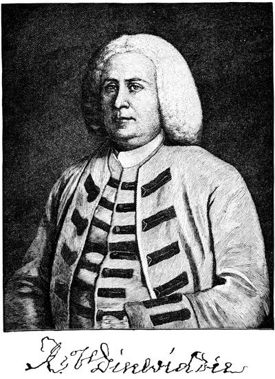
But the struggle was now for the thither slope of the Alleghanies and the great water-shed of the Ohio. In this conflict Virginia presented a frontier to be ravaged, as she soon learned to her cost. The story of that misfortune is told in another chapter,[624] as well as of the outbreak which Dinwiddie forced, when he sent Washington to Le Bœuf. The exigencies of the conflict, however, were not enough to prevent the assembly from watching jealously every move of the governor for asking money from them; and he in turn did little to smooth the way for their peaceable acquiescence, when he exacted[270] unusual fees for his own emolument. The aristocracy were still powerful, and, working upon the fears entertained by the masses that their liberties were in danger, all classes contrived to keep Dinwiddie in a pretty constant turmoil of mind, a strain that, though past sixty, he bore unflinchingly. If, by his presentation of the exigencies, he alarmed them, they would vote, somewhat scantily, the money which he asked for: but they embarrassed him by placing its expenditure in the hands of their own committee. Dinwiddie was often compelled to submit to their exasperating requirements, and was obliged to inform the Lords of Trade that there was no help for it.
It was war indeed, but this chapter is concerned chiefly with civil affairs. Nothing, therefore, can be said here of the disaster of Braddock and its train of events down to the final capture of DuQuesne. Forts were built,[625] and the Indians were pursued[626], and Virginia incurred a debt during it all of £400,000, which she had to bear with the concomitants of heavy taxes and a depreciated paper money. At the end of the war, Norfolk, with its 7,000 inhabitants, was still the only considerable town.
Dinwiddie had ruled as the deputy of Lord Albemarle. When Lord Loudon came over in July, 1756, to assume the military command in the colonies, he became the titular governor of Virginia; but he was never in his province in person, and Dinwiddie ruled for him till January, 1758, when he sailed for England.
CRITICAL ESSAY ON THE SOURCES OF INFORMATION.
SINCE the enumeration of the records of Maryland was made in another volume,[627] the Maryland Historical Society, having now in custody the early archives of the province, has begun the printing of them, under the editorship of Mr. William Hand Browne, three volumes of which having been thus far published.[628] The publication committee of that society have also made to the legislative assembly of the State a printed report,[629] dated November 12, 1883, in which they give an account of the efforts made in the past to care for the documents. To this they append a Calendar of State Archives, many of which come within the period covered by the present chapter.[630]
The general histories of Maryland have been characterized in another place.[631] Of one of them, Chalmers’s, some further mention is made in the present volume.[632] Two works of a general character have been published since that enumeration was made. One of these is the Maryland (Boston, 1884) of William Hand Browne, a well-written summary of the history of the palatinate prior to the Revolutionary period.[633] Mr. Browne’s familiarity with the Maryland archives was greatly helpful in this excellent condensation of Maryland’s history. Mr. John A. Doyle has made special use of the colonial documents in the Public Record Office, in the chapters (x. and xi.) which he gives to the province in his English in America, Virginia, Maryland and the Carolinas, London, 1882.
There have been some valuable papers of late embraced in the Johns Hopkins University Studies in Historical and Political Science, edited by Professor Herbert B. Adams, which touch Maryland, particularly its institutional history. Such are Edward Ingle’s Parish Institutions of Maryland (Studies, 1st series, no. vi.); John Johnson’s Old Maryland Manors (no. vii.);[634] Herbert B. Adams’s Maryland’s influence upon land cessions to the United States, with minor papers on George Washington’s interest in Western lands, the Potomac Company and a National University (3d series, no. 1);[635] Lewis W. Wilhelm’s Maryland Local Institutions, the Land System, Hundred, County, Town (nos. v., vi., and vii.).
The one hundred and fiftieth anniversary of the foundation of Baltimore, occurring in 1880, has produced several records. The city commemorated the event, and printed the next year a Memorial Volume, 1730-1880, edited by Edward Spencer;[636] and the Proceedings of the Historical Society, October 12, 1880, constitutes no. 16 of their Publication Fund series. Mr. J. Thomas Scharf, who had published his Chronicles of Baltimore[272] in 1874, elaborated the matter into the more extensive History of Baltimore City and County, in 1881, published at Philadelphia. There is a plan of the city showing its original and present bounds in this last book (p. 62), as well as in the same writer’s History of Maryland (i. 416). In 1752 there was printed a List of families and other persons residing in Baltimore, and this has been thought to be the earliest directory of an American town. In the same year there was a view of Baltimore by John Moales, engraved by Borgum, which is the earliest we have.[637]
The coarse, hearty, and somewhat unappetizing life of the colony, as it appeared to a London factor, who about the beginning of the eighteenth century sought the country in quest of a cargo of tobacco, is set forth amusingly, as well as in a warning spirit, in a rough Hudibrastic poem, The Sot-weed Factor, by Eben Cook, Gent.[638] (London, 1708.)
There are modern studies of the life of the last century in Lodge’s Short History of the English Colonies, in the seventh chapter of Neill’s Terra Mariæ, and in the last chapter of Doyle’s English Colonies; but the most complete is that in the first chapter of the second volume of Scharf’s History of Maryland, whose foot-notes and those of Lodge will guide the investigator through a wide range of authorities.[639]
Illustrations of the religious communions are given in Perry’s History of the American Protestant Episcopal Church (i. 137), in the Historical Collections of the American Colonial Church (vol. iv.), in Anderson’s American Colonial Church, in Hawks’s Ecclesiastical Contributions (section on “Maryland”), and in Theodore C. Gambrall’s Church Life in Colonial Maryland (Baltimore, 1885).[640] The spread of Presbyterianism is traced in C. A. Briggs’s American Presbyterianism, p. 123.
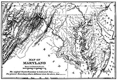
The literature of the controversy over the bounds of Maryland, so far as it relates to the northern lines, has already been indicated in another volume.[641] The dispute was ably followed by McMahon in his History of Maryland (vol. i. pp. 18-59), among the earlier of the general historians, and the whole question has been surveyed by Johnston in his History of Cecil County (ch. xix.). He traces the course of the Cresap war,[642] the progress of the chancery suit of 1735-1750.[643] The diary of one of the commissioners for running the line in accordance with the decision, being the record of John Watson, is preserved in the library of the Pennsylvania Historical Society. Mr. Johnston (p. 307) also describes the line of 1760,[644] and tells the story of the work and methods adopted by Mason and Dixon in 1763, referring to their daily journal, one copy of which is, or was, preserved in the Land Office, the other in the library of the Maryland Historical Society.[645] The scientific aspects of this famous survey are considered in the Philosophical Transactions of the Royal Society (1769); and a running sketch of the history of the line, by William Darlington, is reprinted in the Historical Magazine (ii. p. 37). Another, by T. Edwards, is in Harper’s Monthly (vol. liii. p. 549), and one by A. T. McGill in the Princeton Review (vol. xxxvii. p. 88). Dunlap’s “Memoir” (see Vol. III. p. 514) is also contained in Olden Time (vol. i. p. 529).
The most recent and one of the most careful surveys of the history of the dispute between Baltimore and Penn and of the principles involved is in Walter B. Scaife’s “Boundary Dispute between Maryland and Pennsylvania,” in Pennsylvania Magazine of History (October, 1885, p. 241).
Chief among the maps bearing upon the question of the bounds are the following:—
A map of Virginia, Maryland, Pennsylvania, and East and West New Jersey, by John Thornton, which is without date, but probably from 1695 to 1700.[646]
A new map of Virginia and Maryland and the improved parts of Pennsylvania and New Jersey, revised by I. Senex, 1719.[647]
A short account of the first settlement of the Provinces of Virginia, Maryland, New York, and Pennsylvania by the English, to which is annexed a map of Maryland, according to the bounds mentioned in the charter and also of the adjacent country, anno 1630, London, 1735. This map is a large folding one called “A map of Virginia, according to Capt. John Smith’s map, published anno 1606; also of the adjacent county, called by the Dutch Niew Nederlant, anno 1630, by John Senex, 1735.”[648]
The map accompanying the agreement of July 4, 1760, between Baltimore and Penn, is reproduced, with the text of that document, in the Pennsylvania Archives, iv. (1853), p.3.
Respecting the bounds in dispute between Maryland and Virginia, the fullest summary of claims and evidence is in the Report and Journal of Proceedings of the joint Commissioners to adjust the boundary line of the States of Maryland and Virginia, Annapolis, 1874. This volume gives statements of the Maryland (p. 63) and Virginia (p. 233) claims, with depositions of witnesses. The volume as deposited in public libraries is accompanied by a coast survey chart, in which the determined bounds are marked, with the attestation of the governor of Maryland.[649]
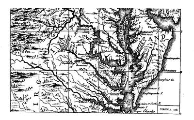
It may be collated with the Report and accompanying documents of the Virginia Commissioners on the boundary line between Maryland and Virginia, Richmond, 1873, which contains the statements of the Maryland Commissioners as well as those of the Virginia Commissioners, the latter having a voluminous appendix of historical documents, including a large number copied from the British Archives, and depositions taken in 1872. The Final Report of the Virginia Commissioners (Richmond, 1874), includes a memorandum of their journal and their correspondence (1870-72), as well as the journal of the joint commissions of Virginia and Maryland (1872).
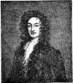
WILLIAM BYRD.
After a cut in Harper’s Magazine, April, 1885, p. 712, from the original painting now at Brandon, on James River. Byrd was b. 1674, and d. 1744.
Respecting the bounds of Virginia and North Carolina, commissioners on the part of both colonies were appointed in 1710,[650] but the line was not run in its easterly portion till 1728, by commissioners and surveyors of both governments. Col. William Byrd, one of the commissioners of Virginia, prepared a sort of diary of the progress of the work, which is known as a History of the Dividing Line between Virginia and North Carolina, as run in 1728-29. This and other of Byrd’s writings which have come down to us are in manuscript, in the hand of a copyist, but interlined and corrected by Byrd himself. The volume containing them was printed at Petersburg in 1841 (copyrighted by Edmund Ruffin) with an anonymous editor’s preface, which states that the last owner of it was George E. Harrison, of Brandon, and that the family had probably been prevented from publishing the papers because of the writer’s “great freedom of expression and of censure, often tinctured by his strong church and state principles and prejudices;” for Colonel Byrd was “a true and worthy inheritor of the opinions and feelings of the old cavaliers of Virginia.” These papers were again privately printed at Richmond, in 1866, under the editing of Thomas H. Wynne, in two volumes, entitled History of the Dividing Line and other tracts, from the papers of William Byrd of Westover. Mr. Wynne supplies an historical introduction, and his text is more faithful than that of 1841, since some of the asperities of the manuscript were softened by the earlier editor. Byrd had been particularly severe on the character of the North Carolinians, as he saw it in his intercourse with them,[651] and not the worst of his characterizations touched their “felicity[276] of having nothing to do.” Byrd at the time of his commission was a man of four and fifty, and he lived for some years longer, not dying till 1744. He was a good specimen of the typical Virginian aristocrat, not blind to the faults of his neighbors, and the best sample of such learning and wit as they had,[652] while he was not forgetful of some of the duties to the community which a large estate imposed upon him. Among other efforts to relieve the Virginians from their thraldom to a single staple were his attempts to encourage the raising and manufacture of hemp.[653] One of Byrd’s companions in the boundary expedition of 1728-29 was the Rev. Peter Fontaine, who acted as chaplain to the party, and a draft of the line as then marked is made in connection with some of his letters in Ann Maury’s Memoirs of a Huguenot Family (New York, 1852, 1872, p. 356).[654] In 1749 the line was continued westerly beyond Peter’s Creek, by Joshua Fry and Peter Jefferson, the father of Thomas Jefferson; and was still further continued to the Tennessee River in 1778.[655]
Another question of bounds in Virginia, which it took some time to settle, was the western limits of the northern neck, as the wedge-like tract of territory was called which lay between the Rappahannock and the Potomac. It had been granted by Charles II. to Lord Hopton and others, but when bought by Lord Thomas Culpepper a new royal grant of it was made to him in 1688.[656] It passed as a dower with Culpepper’s daughter Catharine to Thomas, Lord Fairfax, and from him it passed to the sixth lord, Thomas, who petitioned (1733) the king to have commissioners appointed to run the line between the rivers. Of this commission was William Byrd, and an account of their proceedings is given in the second volume of the Byrd Manuscripts (p. 83) as edited by Wynne. A map of the tract was made at this time, which was called The Courses of the Rivers Rappahannock and Potowmack in Virginia, as surveyed according to order in the years 1736-1737. The bounds established by this commission were not confirmed by the king till 1745, and other commissioners were appointed the next year to run the line in question. The original journal of the expedition for this purpose, kept by Maj. Thomas Lewis, is now in the possession of John F. Lewis, lieutenant-governor of Virginia.[657] The plate of the map already referred to was corrected to conform, and this additional title to it was added: A Survey of the Northern Neck of Virginia, being the lands belonging to the Rt. Honourable Thomas Lord Fairfax, Baron Cameron, bounded by and within the Bay of Chesapoyocke, and between the Rivers Rappahannock and Potowmack. Along the line which is dotted to connect the head-spring of the southern branch of the Rappahannock with the head-spring of the Potomac is a legend, noting that it was determined by the king in council, April 11, 1745, that this line should be the westerly limit of the Fairfax domain. A section of the second state of the plate of this map is annexed in fac-simile from a copy in Harvard College library.[658]
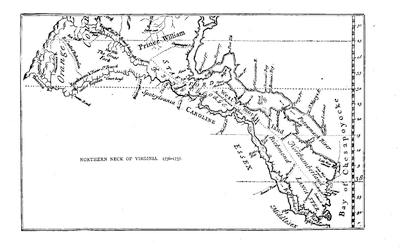
An account has been given elsewhere[659] of what has been lost and preserved of the documentary records of Virginia.
The introduction to W. P. Palmer’s Calendar of Virginia State Papers, 1652-1781, summarizes the documents for the period of our present survey which are contained in the body of that book, and they largely concern the management of the Indians on the borders.[660] Among the Sparks MSS. in Harvard College library are various notes and extracts respecting Maryland and Virginia from the English records (1727-1761) in the hand of George Chalmers, as made for his own use in writing his Revolt of the American Colonies.[661]
There were various editions of the laws during the period now under consideration. What is known as the Purvis collection, dedicated to Effingham, was published in London in 1686; and a survey, giving An abridgement of the Laws in force and use in her majesty’s plantations, including Virginia, was printed in London in 1704. The acts after 1662 were published in London in 1728; while the first Virginia imprint on any edition was that of W. Parks, of Williamsburg, in 1733; and John Mercer’s Abridgment, published in Williamsburg four years later (1737), was reprinted in Glasgow in 1759. The acts since 1631 were again printed at Williamsburg in 1752.[662]
The earliest description of the country coming within the present survey is John Clayton’s Account of the several Observables in Virginia (1688), which Force has included in the third volume of his Tracts. A paper on the condition of Virginia in 1688 is the first chapter in W. H. Foote’s Sketches of Virginia (1850). An “Account of the present state and government of Virginia” is in the fifth volume (p. 124) of the Massachusetts Hist. Soc. Collections. The document was presented to that society by Carter B. Harrison, of Virginia. It seems to have been written in England in 1696-98, in the time of Andros’ governorship, and by one who was hostile to him and who had been in the colony.
Professor M. C. Tyler[663] speaks of the commissary, James Blair, as “the creator of the healthiest and most extensive intellectual influence that was felt in the Southern colonies before the Revolution.” This influence was chiefly felt in the fruition of his efforts to found the College of William and Mary.[664] The Present State of Virginia and the College, by Messieurs Hartwell, Blair and Chilton (London, 1727), contains an account, in which Blair, in Tyler’s opinion, had the chief hand. Blair’s relations to the college have had special treatment in Foote’s Sketches of Virginia (ch. ix.); in[279] Bishop Meade’s Old Churches and Families of Virginia (vol. i. art. xii.); and in the Hist. of the American Episcopal Church (vol. i. ch. 7), by Bishop Perry, who gives two long letters from Blair to the governor of Virginia, after the originals preserved at Fulham Palace.
Additional material is garnered by Perry in his Historical Collections of the Amer. Colonial Church, which includes a large mass of Blair’s correspondence.[665]
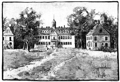
WILLIAM AND MARY COLLEGE.
After the picture given in Meade’s Old Churches, etc., i. 157. Cf. Perry’s Amer. Episc. Church, i. 123; Gay’s Pop. Hist. U. S., iii. 60.
The original building was burned in 1705. The next building, which by scarcity of funds was long in erecting, was not completed till 1723. The above cut is of this second building. In Scribner’s Monthly, Nov., 1875, are views of the building before and after rebuilding in 1859.
While Francis Makemie was entering the lists in the interest of “cohabitation,” gaining thereby not much respect from the tide-water great-estate owners, and printing in London (1705) his Plain and friendly perswasive to the inhabitants of Virginia and Maryland for promoting towns and cohabitation, setting forth the loss to virtue by the dispersal of sympathizers in religion, Robert Beverley was publishing anonymously in London (1705) his History and Present State of Virginia, in four parts. 1. The History of the First Settlement of Virginia, and the Government thereof, to the present time. 2. The Natural Productions and Conveniences of the Country, suited to Trade and Improvement. 3. The Native Indians, their Religion, Laws, and Customs, in War and Peace. 4. The Present State of the Country, as to the Polity of the Government, and the Improvements of the Land,[666] which, as will be seen in the last section of the title, particularly[280] sets forth the condition of the colony at that time, offering some foundation for Mackemie’s arguments.[667]
About twenty years later we have another exposition of the condition of the colony in Hugh Jones’s Present State of Virginia, giving a particular and strict account of the Indian, English, and negro inhabitants of that colony, published in London in 1724.[668] Jones was rector of Jamestown and a professor in the college at Williamsburg, and his book was a missionary enterprise to incite attention among the benevolent in the mother country to the necessities of the colony. “His book,” says Tyler,[669] is one “of solid facts and solid suggestions, written in a plain, positive style, just sufficiently tinctured with the gentlemanly egotism of a Virginian and a churchman.”
The single staple of Virginia was the cause of constant concern, whether of good or bad fortune, and the case was summed up in 1733, in a tract published at London, Case of the planters of tobacco in Virginia, as represented by themselves, with a vindication.[670] Bringing the history of the colony down to about the date of the period when Jones made his survey, Sir William Keith in 1738 published his History of the British Plantations in America, containing the History of Virginia: with Remarks on the Trade and Commerce of that Colony.[671] Nine years later (1747) Stith published his history, but it pertained only to the early period, and in his preface, dated at Varina, December 10, 1746, he acknowledged his indebtedness to William Byrd.[672]
When Burk published his History of Virginia in 1804,[673] the days of the Revolution had separated him from those that were in reality the formative period of the Virginian character, which had grown out of conditions, then largely a mere record. One would have expected to find the eighteenth century developed in Burk better than it is. The more recent authorities have studied that period more specifically, though Bancroft does not much enlarge upon it.[674] Lodge[675] is chiefly valuable for the conspectus he affords of the manners of the time. Doyle in his English in America (London, 1882) depends on the “Colonial Entry Books” and “Colonial Papers” of the State Paper Office in London. Since Howison’s,[676] the latest history is that by a Virginian novelist, John Esten Cooke, and styled Virginia, a history of the people (Boston, 1883),[677] in which he aims to show, through succeeding generations of Virginians, how the original characteristics of their race have been woven into the texture of the population from the Chesapeake to the Mississippi, as those of New England have controlled the north from the Atlantic to the Lakes. He laments that there has never been a study of the Southern people to the same extent as of the Northern, and says that some of the greatest events in the annals of the whole country need, to understand them, a contemplation of the Virginian traits, losing sight, as he expresses it, of “the fancied dignity of history.” Guided somewhat by this canon, the author has modelled his narrative, dividing the periods into what he calls the Plantation, the Colony, and the Commonwealth,—the second more than covering the years now under consideration. He places first among his authorities for this period The Statutes at Large, being a Collection of all the Laws of Virginia, by William Walter Hening, in thirteen volumes, as the most important authority on social affairs in Virginia. He speaks of its unattractive title failing to suggest the character of the work, and says, with perhaps an excess of zeal, that “as a picture of colonial time, it has no rival in American books.”
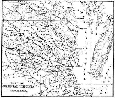
The institutional history of Virginia has of late received some particular attention at the hands of Mr. Edward Ingle, who printed in the Mag. of Amer. History (Dec., 1884, p. 532) a paper on “County Government in Virginia,” which he has reprinted with other papers on the Land Tenure, the Hundreds, the English Parish in America, and the Town, in a contribution called Local Institutions of Virginia, which makes parts ii. and iii. of the third series (1885) of the Johns Hopkins University Studies in History and Political Science.[678]
We are fortunate in possessing the official correspondence of the two most notable royal governors of the eighteenth century. The letters of Alexander Spotswood were used by Bancroft, and were then lost sight of till they were recovered in England in 1873.[679] They are now published in two volumes (Richmond, 1882, 1885) as The official letters of Alexander Spotswood, lieutenant-governor of Virginia, 1710-1722; now first printed from the manuscript in the collections of the Virginia Historical Society, with an introduction and notes by R. A. Brock, constituting the initial volumes of a new series of the Collections of the Virginia Historical Society. Spotswood’s official account of his conflict with the burgesses is printed in the Virginia Hist. Register; and we best see him as a man in William Byrd’s “Progress to the Mines,” included in Wynne’s edition of the Byrd Manuscripts. Palmer draws Spotswood’s character in the introduction to his Calendar of Virginia State Papers, p. xxxix.[680]
Of the other collection of letters, The official records of Robert Dinwiddie, lieutenant-governor of Virginia, 1751-1758; now first printed from the manuscript in the collections of the Virginia Historical Society, with an introduction and notes by R. A. Brock, Richmond, Va., 1883-84, being vols iii. and iv. of the new series of the same Collections, a more special account is given in another place.[681]
The valley of Virginia has been more written about locally than the eastern parts. Beside the old history of Kercheval,[682] W. H. Foote has embraced it in the second series of his Sketches of Virginia (Philad., 1855), and it has recently been treated in J. Lewis Peyton’s History of Augusta County, Va. (Staunton, Va., 1882), a region once embracing the territory from the Blue Ridge to the Mississippi.
Norfolk has been made the subject of historical study, as in W. S. Forrest’s Norfolk and Vicinity (1853), but with scant attention to the period back of its rise to commercial importance.
The ecclesiastical element forms a large part of Virginia history in the earlier times. Some general references have been given in another place.[683] At the opening of our present period, there were of the established church in Virginia fifty parishes, with one hundred churches and chapels and thirty ministers,—according to Bray’s Apostolic Charity (London, 1700).[684] The church history has been well studied by Dr. Hawks,[685] Bishop Perry,[686] and Dr. De Costa,[687] in this country, and by Anderson in his History of the Colonial Church (1856),—a book which Doyle calls “laborious and trustworthy on every page.” Bishop Meade has treated the subject locally in his Old Churches and Families of Virginia,[688] as has Dr. Philip Slaughter in his Saint George’s Parish, Saint Mark’s Parish and Bristol Parish,[689] and he has given a summary of the leading churches of colonial Virginia in a section of Bishop Perry’s Amer. Episc. Church (vol. i. p. 614).
The dissenting element was chiefly among the Presbyterians, whose later strongholds were away from the tide-water among the mountains. The Reverend Francis Mackemie[690] had been principal leader among them, and he was the first dissenter who had leave to preach in Virginia. Their story is best told in C. A. Briggs’ American Presbyterianism (p. 109), and in both series of W. H. Foote’s Sketches of Virginia (Phil., 1850, 1855).
The Baptists in Virginia did not attain numerical importance till within the decade preceding the American Revolution, and they had effected scarcely any influence among the opponents of establishment during the period now under consideration.[691] The Huguenots brought good blood, and affected religious life rather individually than as a body.[692]
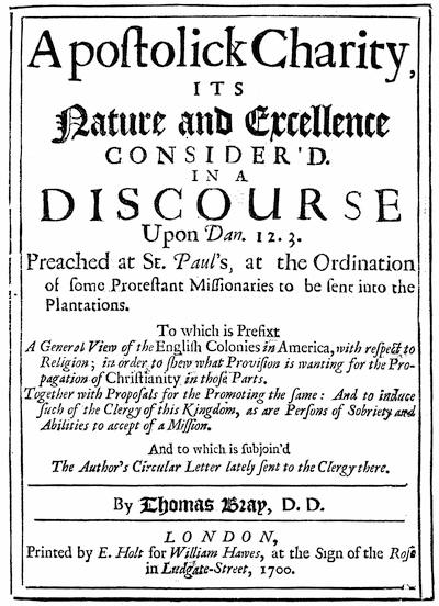
In depicting the society of Virginia during this period, we must get what glimpses we can from not very promising sources. The spirit which despised literature and schools was in the end dispelled, in part at least, but it was at this time dominant enough to prevent the writing of books; and consequently the light thrown upon social life by literature is wanting almost entirely. The Virginians were apparently not letter-writers and diarists, as the New Englanders were, and while we have a wealth of correspondence in Massachusetts to help us comprehend the habits of living, we find little or nothing in Virginia. We meet, indeed, with some letters of the Byrds[693] and the Fontaines,[694] and the official correspondence of Spotswood and Dinwiddie; but the latter touch only in a casual way upon the habits of living. A few descriptive and political tracts, like Hugh Jones’ Present State,[695] give us small glimpses. Later Virginia writers like Bishop Meade[696] and Dr. Philip Slaughter,[697] have gathered up whatever of tradition has floated down in family gossip; and Foote[698] and Esten Cooke[699] have drawn the picture from what sources they could command, as Irving has in his Life of Washington.[700] The most elaborate survey of the subject, with philosophic impulses, has been made by Eben Greenough Scott in his Development of Constitutional Liberty in the English Colonies of America (New York, 1882),[701] in which he contrasts the manners of the lowland aristocracy with those of the farmers of the valley and with the wilder life of the frontiers.[702] The most elaborate composite of data derived from every source is the chapter on “Virginia in 1765,” in Henry Cabot Lodge’s Short History of the English Colonies, in which he depends very largely on the survival of manners in the days when Burnaby, Anburey, Robin, Smyth, Brissot de Warville, Rochefoucauld-Liancourt, and Weld travelled in the country,—material which has the great disadvantage of being derived from chance observation, with more or less of generalization based on insufficient instances, as Dr. Dwight has pointed out in the case of Weld at least.[703]
CHAPTER V.
THE CAROLINAS.
BY PROFESSOR WILLIAM J. RIVERS.
NORTH CAROLINA: Proprietary Government.—It was certainly manifest to England that her claim to vast regions of valuable territory would be substantiated, and her commerce and political power augmented, by the settling of her subjects in North America. Yet the history of her colonies bears, on many pages, evidence of the indifference and inexcusable neglect of the mother country. Instead of a liberal contribution of arms and munitions of war, the means of sustenance, and the protection of her ever-present sovereignty to all who were willing to leave the comforts of home and risk their lives in her service, far away across the Atlantic, enough appeared to have been done if lavish gifts of land were bestowed upon companies, individuals, or proprietors, for their especial emolument, and through them some paltry acres offered to emigrants, with promises of a little more religious freedom and a little larger share of political privileges than they were permitted to enjoy at home. The genesis of a new and potent nationality may be said to have been involved in the acceptance, by the colonists, of these conditions, as inducements to emigration, with all else dependent on their own manly courage.
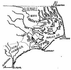
NORTH CAROLINA.
[This is a sketch of the map in Hawks’ North Carolina, ii. 570, showing the grants and divisions from 1663 to 1729.
Quaritch in his Catal. for 1885, no. 29,516, prices at £25 a MS. map of the south part of Virginia (North Carolina), showing the coast line from Cape Henry to Cape Fear, and signed “Nicholas Comberford, fecit anno 1657.” It measures 18¾ × 14 inches.—Ed.]
One of the colonies that struggled, through neglect and almost insurmountable hardships, into permanent existence was Carolina. Before its[286] settlement, other colonies had successfully established themselves in New England, and in Maryland and Virginia. In 1663, Charles II., in the second year after his restoration, granted the region south of Virginia and extending from 31° to 36° north latitude, and westward within these parallels across the continent, to some of his adherents, to whom he was indebted for distinguished services. It is stated in the grant that this extensive region is called “Carolina,” a name used before, and now, no doubt, retained in honor of the king.[704] The favored noblemen are thus introduced to us: “our right trusty and right well-beloved cousins and counsellors, Edward, Earl of Clarendon, our High Chancellor of England, and George, Duke of Albemarle, Master of our Horse and Captain-General of all our Forces, our right trusty and well-beloved William Lord Craven, John Lord Berkeley, our right trusty and well-beloved counsellor, Anthony Lord Ashley, Chancellor of our Exchequer, Sir George Carteret, Knight and Baronet, Vice-Chamberlain of our Household, and our trusty and well-beloved Sir William Berkeley, Knight, and Sir John Colleton, Knight and Baronet;” who, we are deliberately informed, “being excited with a laudable and pious zeal for the propagation of the Christian faith, and the enlargement of” the British dominions, humbly besought leave of the king, “by their industry and charge, to transport and make an ample colony” of his subjects, “in the parts of America not yet cultivated or planted, and only inhabited by some barbarous people who have no knowledge of Almighty God.”[705] Had these high functionaries of the realm acted in accordance with this solemn announcement of their pious zeal for the propagation of Christianity, the blessing of Heaven would, no doubt, have rested more largely upon their noble enterprise.
An adverse claim was soon made to the same territory under a grant obtained in 1629,[706] by Sir Robert Heath, attorney-general of Charles I. But he had failed to form a colony, and the claims of those to whom he had conveyed his rights were on that account set aside. The Proprietors under the new charter began to make immediate exertions to form a settlement, that the king might see they did not “sleep with his grant, but were promoting his service and his subjects’ profit.”[707]
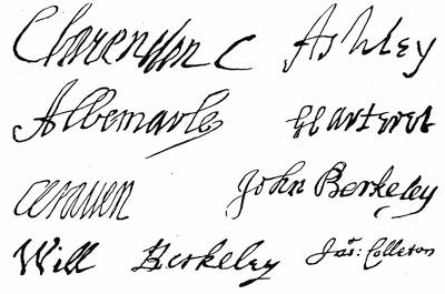
AUTOGRAPHS OF THE LORDS PROPRIETORS.
These follow fac-similes given in the Charleston Year Book, 1883.
Before this, settlers from Virginia had moved at various times southward and taken up their residence on some good lands on and near the river Chowan, in what is now the northeastern part of North Carolina. Among these was a considerable number of Quakers, at that time subject to religious persecution. It happened that Sir William Berkeley, one of the new Proprietors, was governor of Virginia. He was empowered by the other Proprietors to form a government forthwith in this settlement, and appoint its officers; the appointment of surveyor and secretary alone being reserved to the Proprietors in England. “We do likewise send you proposals to all that will plant, which we prepared upon receipt of a paper from persons that desired to settle near Cape Fear, in which our considerations are as low as it is possible for us to descend. This was[288] not intended for your meridian, where we hope to find more facile people, who, by your interest, may settle upon better terms for us, which we leave to your management, with our opinion that you grant as much as is possible rather than deter any from planting there.” Sir William, it is inferred, followed these instructions. William Drummond was appointed governor;[708] the tract of land, at first forty miles square, was named Albemarle in honor of the duke, and a council of six was constituted to make laws with the consent of the delegates of the freemen. These laws were to be transmitted to England for approval by the Proprietors. Lands were granted to all free of rent for three years; and such lands as had been taken by previous settlers were confirmed to them.
Almost simultaneously another colony (Clarendon) was settled in what is now North Carolina. As early as 1660 some adventurers from Massachusetts had gone to the Cape Fear, sometimes called the Charles, River, and purchased lands from the Indians; but in a few years abandoned the situation, leaving their cattle and swine in care of the natives. To the same locality the attention of the inhabitants of Barbadoes[709] was directed on the grant of the territory to the powerful noblemen whose names are given in the charter. The passage already quoted from the letter to Sir William Berkeley had reference to them and their proposal. Explorers, employed by “several gentlemen and merchants” of Barbadoes, were sent out (1663) under command of Hilton, who ascended the Cape Fear far inland, and formed a more favorable opinion of the country than the New Englanders had been enabled to form near the mouth of the river. They purchased from the Indians “the river and land of Cape Fair,” as they express it, and returned to Barbadoes on January 6, 1664. An account of their exploration was published the same year, to which were appended proposals from the Proprietors, through their commissioners, Thomas Mudyford and Peter Colleton, to all who should settle, at their own hazard and expense, south and west of Cape Romano, sometimes called Cape Carteret. This was a bid for volunteer settlers south of the Cape Fear settlement. Nothing whatever, it appears, was accomplished under this offer of the commissioners. In a Description of the Province, with liberal privileges offered to settlers, issued also in London (1666), it is stated that a new plantation had been begun by the English at Cape Fear on the 29th of May, 1664. In the following November, Robert Sandford was appointed secretary and John Vassall surveyor of “Clarendon County.”[710] It was time the Proprietors should agree upon some definite and satisfactory terms for settlement in their territory. While they did not sanction the purchase of lands from Indians, as they had also disallowed the claims of the New England adventurers, they made to all colonists, from Barbadoes and elsewhere, liberal offers for settlement; and under “concessions[289] and agreement” a method of government was framed, and John Yeamans of Barbadoes was knighted by the king (through means of Sir John Colleton), and commissioned, in January, 1665, governor of the newly formed Clarendon County[711] and of the territory southward as far as Florida; for in this direction the Proprietors designed to place a third colony or county.
The two counties, Albemarle and Clarendon, were formed under the charter of 1663. Another charter was granted by the good-natured king in June, 1665, enlarging the limits of the province to 36° 30´ on the north, and on the south to 29°. This extension may be ascribed to the desire of the Proprietors to secure beyond doubt the section on which the Chowan colony happened to be formed near Virginia, and to embrace, southwardly, the limits claimed with respect to Spanish Florida.
We have very little knowledge concerning the administrations of Drummond and of Yeamans. It is said that the latter, being near the sea, began at once to export lumber and opened a trade with Barbadoes; and reports so favorable were carried thither, and so many were induced to follow the first emigrants, that the authorities of the island interposed, and forbade, under severe penalties, “the spiriting off” of their people. In Albemarle, Drummond was succeeded by Samuel Stephens as governor in 1667. In Clarendon, the colony soon ceased to prosper, and most, if not all, of the colonists had abandoned it in 1667. We shall understand better why they did so if we bear in mind that the territory of the Lords Proprietors was very extensive. There were other places, not yet explored, more convenient for commerce, more defensible, more fruitful, more desirable in all respects; the advantages of which would naturally draw off settlers from the less favorable localities selected before a thorough knowledge of the country was obtained. The Proprietors, as we have said, thought of forming, with larger preparations, a colony still further south. The famous harbor of Port Royal, in what is now South Carolina, was the locality they desired to[290] occupy and (with unusual display of wisdom) to fortify. For reasons, however, which will appear hereafter, when we treat of South Carolina, the colonists, after visiting Port Royal, and after a temporary settlement at Albemarle Point on the western bank of the Ashley River, finally settled down on the opposite side, at the confluence of the Ashley and Cooper rivers, and founded the present city of Charleston. There was, indeed, enough to discourage the settlers at Cape Fear independently of the more extensive preparation by the Proprietors to place a colony in a better situation. Secretary Sandford (in his Relation of his voyage in 1666) incidentally mentions: “Wee were in actuall warre with the natives att Clarendon, and had killed and sent away many of them, for they [the more southern Indians] frequently discoursed with us concerning the warre, told us the natives were noughts, their land sandy and barren, their country sickly.” Surveyor-General Vassall, in a letter from Virginia (Oct. 6, 1667), speaks of the loss of the plantation on Charles River and his furnishing shipping to carry away “such weak persons as were not able to go by land.” And a letter from Boston (Dec. 16, 1667) states that Cape Fear was deserted, and the settlers “come hither, some to Virginia.”[712]
Here let us notice the policy and plans of the Proprietors with respect to their distant colonies. The two charters differ only in a few particulars. The second increases the extent of territory, its main object, gives power to subdivide the province into distinct governments, and is a little more explicit with regard to religious toleration. No person was to be molested for difference of religious opinion or practice who did not actually disturb the peace of the community. With regard to political privileges, there is an important clause in both charters conferring upon the Proprietors power to ordain any laws and constitutions whatsoever (if consonant to reason and, as far as possible, to the laws and customs of England), but only “by and with the advice, assent, and approbation of the freemen,” or the majority of them, or of their delegates or deputies, who, for enacting such ordinances, were to be duly assembled from time to time. These privileges, we shall see in the history of the colony, were maintained by the people with a pertinacity commensurate with their importance, whenever their lordships attempted to control the colonists without due regard to their approbation and consent. The charter reserved to the king only allegiance and sovereignty; in all other respects the Proprietors were absolute lords, with no other service or duty to their monarch than the annual payment of a trifling sum of money, and in case gold or silver should be found a fourth part thereof.
On August 6, 1663, a letter to the Proprietors, from members of a Cape Fear company of New England adventurers, claimed full liberty to choose their governors, make and confirm laws, and to be free from taxes, except such as they might impose on themselves, and deprecated “discouragement[291] in reference to their government” as to the accustomed privileges of English colonists. While their claims were not conceded, this letter was answered generally by their lordships, on August 25th, announcing their concessions to all wishing to settle in Carolina.[713] The New England claim of privileges is worthy of notice for what we now call “advanced ideas.” And if we compare the charters of Connecticut (1662) and Rhode Island (1663) with that of Carolina (1663), it will appear that the self-interest of Clarendon[714] and his associates stood in the way of their securing to their colony some civil privileges which it would not have seemed strange at that time to concede. And it may as well be stated here, at once, that besides considerations of self-interest it was also the express policy of their lordships to “avoid erecting a numerous democracy” in their province. To carry out this policy, a grand scheme of government, called the Fundamental Constitutions, was framed by Shaftesbury and the philosopher Locke, and solemnly confirmed as a compact among themselves,—the Proprietors,—and which was to be unalterable forever. A scheme more utopian, more unsuited to the actual condition of the colonists, could hardly have been devised. Yet its adoption by the people was recommended, ordered, stubbornly insisted on by their lordships at the risk of balking—as, for a while, it did balk—the prosperity of their colony. The first set of the unalterable Constitutions is dated 21st July, 1669; the second was issued in March, 1670,—and so on till a fifth set had been constructed. Under the right conferred by the charter, respecting the consent of the freemen, or their delegates, in establishing laws and constitutions, such consent was never formally given; and the code was, at least in South Carolina, again and again rejected. It was a gage of political contention foolishly thrown down; but in taking it up, the colonists were made ardent students of political rights.
By these Constitutions, the eldest Proprietor was made Palatine,—a sort of king of the province. The other seven Proprietors were to be high functionaries: admiral, chamberlain, constable, chief justice, chancellor, high steward, and treasurer.[715] There was to be a Parliament: eight superior[292] courts, one to each Proprietor according to his high office; county and precinct courts; and a grand Executive Council, among whose duties was the preparation and first enactment of all matters to be submitted to Parliament. Among the carefully composed articles in these Constitutions should be noticed such as enjoin that no person above seventeen years of age could have the benefit and protection of the law who was not a member of some church; and no one could hold an estate or become a freeman of the province, or have any habitation in it, who did not acknowledge a God and that He is publicly and solemnly to be worshipped. Moreover, in the set of the Constitutions printed and sent over for adoption, the Church of England[716] was made the established church, and “it alone shall be allowed to receive a public maintenance by grant of Parliament.” It was also enjoined that no one seventeen years old should have any estate or possession or the protection of the law in the province, unless he subscribed the Fundamental Constitutions and promised in writing to defend and maintain them to the utmost of his power.
Their lordships in England, and most, if not all, of their appointed officers in the colonies, as in duty bound, contended strenuously for the adoption of this preposterous form of government till the year 1698; and hardly then did the incontrovertible logic of events convince them of their folly. A late historian of North Carolina remarks, “Their lordships theorized, the colonists felt; the Proprietors drew pictures, but the hardy woodsmen of Carolina were grappling with stern realities. Titles of nobility, orders of precedence, the shows of an empty pageantry, were to them but toys which might amuse children; but there was no romance in watching the savage, or felling the forest, or planting the corn, or gathering the crop, with the ever-present weapon in reach of the laboring hand.”
There was another cause of irritation on the part of the colonists, both in North and South Carolina. The terms of the tenure of land were of paramount interest to them and their children. The quantity offered in 1663 was augmented in 1666, and two years later, by the “Great Deed of Grant,” the fear of forfeiture was removed for not clearing and planting a specified portion of the land; in other words, settlers were permitted to hold lands as they were held in the adjoining royal province of Virginia. At first each freeman received one hundred acres, the same for his wife, each child and manservant, and fifty for each woman-servant; paying a half-penny per acre. After the expiration of servitude, each servant received a liberal quantity of land with implements for tillage.[717] In 1669, in the settling of the colony at Ashley River, one hundred and fifty acres were offered to all free persons above sixteen years of age, and the same for able-bodied men-servants; and a proportionate increase for others,[293] if they arrived before the 25th of March, 1670; then a less number of acres for subsequent arrivals. The annual rent was a penny or the value of a penny per acre (as also announced in the unalterable Constitutions); payments to begin September, 1689.[718] When Governor Sayle died (a year after settling on Ashley River), Sir John Yeamans came from Barbadoes to the new settlement; and having been made a landgrave claimed the government as vice-palatine under the Fundamental Constitutions. Such claim was denied by the colonists;[719] but he soon received a commission, and his first measure, on assuming control, was to have an accurate survey made and a record of lands held by settlers in South Carolina, with a view to the collection of quit-rents for the Proprietors. When ten years of outlay for their province had brought them no pecuniary return, they began to think “the country was not worth having at that rate.” They removed their former favorite Yeamans, because further outlays were incurred, and placed West in authority, who had attended more successfully to their interests. In November, 1682, all prior terms for granting land were annulled, and if a penny an acre (the words “or the value of a penny” being omitted) was not paid, a right of reëntry was claimed: “to enter and distraine, and the distress or distresses then and there found to take, lead, and carry and drive away and impound, and to detain and keep until they shall be fully satisfied and paid all arrears of the said rent.” This produced inequality of tenure, or operated to the injury of many who had previously taken up, on more liberal terms, only part of the lands they were entitled to.[720] Their lordships were too just to interfere with the stability of titles, but the alteration of the tenure for new grants or of the mode of conveyance, from time to time, was at least unwise. Besides, there was scarcely any coin in the province, and the people found it hard that they could no longer pay in merchantable produce. To their reasonable request for relief and a better encouragement to new settlers came the reply, “We insist to sell our lands our own way.” With this reply a peremptory order was sent that the third set of the unalterable Constitutions should be put in force.
A part of this manifest diminution of the generosity of the Proprietors and their unwillingness to bestow further concessions may be accounted for by the opposition their favorite scheme of government had encountered in both colonies, and especially by a rebellious outbreak which had just occurred in Albemarle County. Clarendon County at Cape Fear had broken up and disappeared, as we have related; and henceforth our attention must be directed to Albemarle at the northern end of the province and the Ashley River colony at the south, remote from each other, with a[294] vast forest intervening, the dwelling place of numerous tribes of Indians. Before the province was authoritatively divided (1729), it had divided itself, as it were, into North and South Carolina; and it is best that, in this narrative, we should begin to call them so.
In North Carolina, the Quakers, who were in close association and unison, and so far influential in action,[721] opposed the Fundamental Constitutions and the Church of England establishment; and all the settlers looked upon the enforcement of the recent orders of the Proprietors—the displacement of an easy and liberal method of government without asking their assent—as a violation of the terms of settlement, and of the inducements at first held out to them.[722] Governor Stephens endeavored to enforce the orders of the Proprietors, but he died soon after receiving them, and was succeeded by Carteret, president of the council, till an appointment should be made. Carteret appears not to have been of a nature to contend against the disaffection and turbulence which had arisen, and, in 1675, went to England to make known personally, it is said, the distracted condition of the colony. But two of the colonists, Eastchurch and Miller, had also gone over to represent, personally, the grievances of the people. They seemed, to the Proprietors, the ablest men to carry out their instructions; and the former was made governor and the latter deputy of Earl Shaftesbury and secretary of the province; he was also made, by the commissioners of the king’s revenue, collector of such revenue in Albemarle. They sailed for Carolina in 1677, but the new governor remained a long while in the West Indies (winning “a lady and her fortune”), and died soon after reaching Albemarle. Miller as representing Eastchurch, but really without legal authority to act as governor, ruled with a high hand. He had gone to represent the grievances of his fellow colonists; he returned to harass them still more. The new “model” of government, the denial of “a free election of an assembly” (as the Pasquotank people complained), the attempt to enforce strictly the navigation laws, the collection of the tax on tobacco at their very doors,[723] his drunkenness and “putting the people in general by his threats and actions in great dread of their lives and estates,” as the Proprietors themselves express it, became intolerable to the colonists.
The New Englanders, with their characteristic enterprise, had long been sailing through the shallow waters of the Sound in coasting vessels, adapted to such navigation, and had largely monopolized the trade of North Carolina; buying or trafficking for lumber and cattle, which they sold in the West Indies, and bringing back rum, molasses, salt, and sugar, they exchanged these for tobacco, which they carried to Massachusetts, and shipped thence to Europe without much regard to the navigation laws. Miller, according to instructions sent to Governor Eastchurch, sought to break up this thriving and lucrative business, and to introduce a more direct trade with England. The populace generally, including the Quakers, had their own grievances, and fraternized with the New England skippers. Gillam, one of these bold captains, arrived with his vessel laden with the commodities the people needed, and armed, this time, with cannon. A wealthy Quaker, Durant, was on board with him. On land, John Culpepper, who had lately left South Carolina, where he had created commotions, became a leader of the malcontents. Influenced, no doubt, by the recent rebellion of Bacon in Virginia, some participators in which had taken refuge among them, and led on by men of courage whose hard-earned emoluments were threatened with ruin, the insurgents seized and imprisoned Miller and seven of the proprietary deputies, and took from the former a large amount of money which he had collected for the king. They had won over to their side the remaining deputy, the president of the council; and together they now governed the colony as seemed best to them. But they were aware that violence and usurpation could not be passed over with impunity by higher authority; and as Miller and some of his adherents had escaped and gone to England, Culpepper and Holden were also sent to the Proprietors on a mission of explanation. The explanation of neither party was entirely satisfactory. Miller lost his offices, and Culpepper, though he was unpunished by the Proprietors, was seized by the Commissioners of the Customs to answer for the revenue money which had been used in the time of the disorders. He was put on trial, in 1680, for “treason committed without the realm.” It is said by Chalmers that the judges ruled that taking up arms against the proprietary government was treason against the king. Notwithstanding this view of the case, Culpepper was acquitted of treason, because Shaftesbury asserted that the county of Albemarle had not a regular government, and the offence of the prisoner amounted to no more than a riot.[724]
At this time the Earl of Clarendon sold his proprietary share to Seth[296] Sothel, who was appointed governor. Mr. John Harvey, as president of the council at Albemarle, was to exercise the functions of governor till Sothel’s arrival. The latter, on his voyage, was captured by an Algerine corsair; Harvey died; Jenkins was made governor, and was deposed by the people without reprimand from the Proprietors; and in February, 1681, Wilkinson was appointed. These sudden changes in executive authority were unfortunate for the prestige of proprietary power in the colony; for all this while and until Sothel came in 1683, the old adherents of the Culpepper party, or the popular party, held control in Albemarle. But still more unfortunate for the Proprietors was the coming of Sothel. He seems to have purchased his place as Proprietor and to have come as governor in order to have a clear field for the exercise of his rapacity. If he was “a sober, moderate man,” as his colleagues thought when they intrusted their interests and the welfare of the county to his hands, his association with the Algerines must have materially changed his character. In 1688, the outraged colonists seized him, intending to send him to England for trial. On his appeal this was not done, but the case referred to the colonial assembly, who condemned him. His sentence, however, amounted only to banishment for twelve months and perpetual deposition from authority, Proprietor though he was. He went to South Carolina, and his further career will be noticed when we review the history of that colony.
The next year Philip Ludwell, of Virginia, was made governor, and after four years was transferred to South Carolina and appointed governor of both colonies. For more than twenty years North Carolina was governed by a deputy of the governor at Charleston, or (when there was no deputy appointed) by the president of her own council. The Albemarle colony had become to the Proprietors only a source of vexation. At any rate, they acted wisely in leaving its management, in some measure, under the control of those more conversant with its affairs than their lordships in England could possibly be. Their own mismanagement, in truth, was the principal cause of the turbulent spirit of the people.[725]
After Sothel’s banishment the executive authority belonged, as a rule, to the president of the council till Ludwell received it in 1689. On the latter’s removal to Charleston, S. C., Lillington acted as deputy in Albemarle. In 1695, Thomas Harvey became deputy governor by appointment from Archdale, the Quaker Proprietor (who was sent over to heal grievances in both colonies), and was followed in 1699 by Henderson Walker, president of the council. In 1704, Robert Daniel was appointed deputy by Governor Johnson, of South Carolina. John Porter, a Quaker, or sympathizer with the Quakers (sent to England to complain of Daniel and legislation in favor of the Church of England in the colony by “The Vestry Act”), with[297] the assistance of Archdale, prevailed on the Proprietors to order Daniel’s removal, and Governor Johnson appointed (1705) Thomas Carey in his place. He was as little acceptable to the Quakers in North Carolina as his predecessor had been, and through their influence in England at this conjuncture the appointment of a deputy by the executive in South Carolina was suspended, Carey was removed, and a new Proprietary Council formed, including Porter and several Quakers. Porter returned to North Carolina in 1707, and called together the new council, who chose William Glover, a Churchman, president, and, as such, acting governor. He, however, as Carey had done, required conformity to the English laws respecting official oaths, which were displeasing to the Quakers; and Porter in opposition declared Glover’s election as president illegal, formed a coalition with Carey, whom he had before caused to be displaced, and secured his election to the presidency of the council. There were now two claimants for executive authority, and no power at hand to decide between them. Carey and Glover sat in opposite rooms with their respective councils. Daniel, being a landgrave, and having thereby a right to a seat in the Upper House,—as the council with the governor was styled,—sat alternately with one and the other, and no doubt enjoyed their altercations.
A new rebellion, so-called, now broke out, based apparently on local party strife. At first Carey and his Quaker supporters opposing Glover and his party sought and obtained control of the assembly; and when Edward Hyde came from England with letters on authority of which he claimed executive power,[726] the Carey party, at first favorable to him, finally, on losing control of the next assembly, directed itself against him. Hyde’s life was endangered by Carey’s armed opposition; and Spotswood, the energetic governor of Virginia, sent him military aid and put down his opponents.[727] Carey, on his way through Virginia, was arrested by Spotswood and sent to England for trial. This was the occasion of Lord Dartmouth’s circular letter to all the colonies “to send over no more prisoners for crimes or misdemeanors without proof of their guilt.”
According to the latest history,—that of Rev. Dr. Hawks,—another[298] result of this acrimonious contest was the deplorable massacre of hundreds of defenceless white settlers, men, women, and children, by the Tuscarora Indians. This is doubtless merely post hoc ergo propter hoc. We must ascribe hostilities solely to encroachments on the lands of the natives; to ill treatment by traders and others; and to the killing of one of their number, which called for revenge. The Tuscaroras, it was thought, could muster 1,200 warriors. They suddenly made their onslaught at daybreak, September 22, 1711. Their special task in the diabolical conspiracy was to murder all the whites along the Roanoke, while other tribes conducted a simultaneous attack upon other sections. The wielding of the blood-dripping knife and tomahawk, the conflagration of dwellings and barns, the murderous rush upon the victims who, here and there, had hidden themselves and who ran out from the blazing fires to a fate scarcely less dreadful, with other horrors we are unwilling to relate, continued for three days. One hundred and fifty were slain on the Roanoke, more than sixty at Newbern, an unknown number near Bath; and the carnage was stopped only by the exhaustion and besotted drunkenness of the bloodstained savages. Governor Hyde was powerless to confront the foe. He could not raise half the number of men the enemy had. The Quakers were non-combatants; and with them were affiliated many others who opposed the government. Governor Hyde was compelled to resort to arbitrary measures in impressing vessels and in procuring provisions for such troops as he could muster; and these were so inadequate, and so wide-spread was the Indian combination, that he called for assistance from Virginia and South Carolina. Both responded with alacrity. While Spotswood could not supply troops, he checked the further combination of tribes in his direction. South Carolina sent troops onward through the forests, under Colonel Barnwell, who defeated the Tuscaroras and put an end to the war for the time being. But after he retired to South Carolina, suffering with wounds, the Indians treacherously renewed hostilities; and it was believed they would soon be joined by more powerful northward tribes. To add to the calamities of the people, an epidemic (said to be yellow fever) broke out. The mortality was fearful, and among the victims was the governor of the colony. The council elected Colonel Pollock as their president and to act as commander-in-chief. The following mournful picture is given us from manuscripts left by Colonel Pollock: “The government was bankrupt, the people impoverished, faction abundant, the settlements on Neuse and Pamlico destroyed, houses and property burned, plantations abandoned, trade in ruins, no cargoes for the few small vessels that came, the Indian war renewed, not men enough for soldiers, no means to pay them, the whole available force under arms but one hundred and thirty or forty men, and food for the whole province to be supplied from the northern counties of Albemarle only.” South Carolina, being again called on for help, sent Colonel James Moore, eldest son to Colonel James Moore, late governor of the colony. On the[299] 20th of March, 1713, he conquered the last stronghold of the savages, who soon after, broken and disheartened, left the province in large numbers, and joined themselves with the Iroquois in what is now the State of New York. Such of them as remained in North Carolina entered into a treaty of peace with the whites. During these exhausting calamities the Proprietors were appealed to; and it was a poor response to refer the matter to General Nicholson “to enquire into the disorders of North Carolina.”
The next year (May, 1714) Charles Eden, an excellent officer, was appointed governor. The adherents of Carey, or the popular party, however, seemed to be actuated against all who were sent to rule the colony. What grievances they had to palliate or justify their conduct, on this occasion, we know not; but soon their active opposition had to be dealt with by the constituted authorities. We shall see, when we treat of South Carolina, that a few years later the colonists, in that section, threw off, effectually, the inefficient rule of the Proprietors, and placed themselves under the immediate control of the Crown; deposing the last proprietary governor, and electing Colonel Moore governor in the king’s name. It is probable that the same spirit actuated the people in North Carolina. Yet her historians have not made it evident that the continued disaffection and turbulence and rebellion of the people are indications of their readiness to act as their more southern brethren acted. Perhaps they had not, at that conjuncture, the same amount of provocation. When we read the letter of the Lords Proprietors to the council and assembly (June 3, 1723),[728] “We received an address from you, transmitted some time since by our late governor, Mr. Eden, wherein you signified to us your great dislike to the rebellious and tumultuous proceedings of several of the inhabitants of South Carolina, and your constant and steady adherence to our government and the present constitution,” we are to bear in mind that this governor and council were the appointed officers of their lordships. We are to ask, Where are the records of the assembly,[729]—records of the thoughts and actions of the representatives of the people? These, no doubt, will show, if they can be found, that a spirit of local self-government actuated the people, and is the thread of development to be followed by the future historian of the State. We need the testimony of Porter, of Carey, of the able and virtuous Edward Moseley (chief justice from 1707 to 1711), and of other leaders of the people against the repressive policy of their lordships in England and their governors and councils.
Some interesting subjects, indicative of the condition of the colony in these early times, must be briefly noticed: the emission of paper money consequent upon the expenses of the Indian war; the occasional rating of commodities for exchange; the indigenous products of the soil and staples of export; the forwarding of tobacco abroad through Virginia, and troubles about boundary lines; the customs and modes of life among the gentry or planters and the humbler classes, and among their close neighbors, the Indian tribes; the visits of pirates to the coast, both in North and South Carolina, notably Teach or Blackbeard, and the romantic defeat of him in Pamlico Sound; the settling, at first, along the streams, which became the principal highways for travel and commerce; the ill effects necessarily resulting from the habitations being far apart, and from the fact that there was very little social intercourse; the transmission of letters only by special messengers; the disadvantageous nature of the coast section, retarding the prosperity of the colony.
During the proprietary period, or the first sixty-six years of the colony, the people clung to the seaboard and that part of it which had no good port of entry. This was as great a misfortune as it was to cling to the border line of Virginia. The accession of population, including foreigners, came chiefly through that border. In 1690 and again in 1707, bodies of French Protestants arrived, and settled in Pamlico and on the Neuse and Trent; and three years after some Swiss and Germans settled at Newbern. The whites in the province numbered at this time about 5,000. Large tracts of unoccupied land lay between the selected points of settlement. A few towns had been begun: the first, forty-two years after the first settling in the province. If a good harbor had been selected and a town properly fortified built there for exports, the progress of North Carolina might have been more rapid and substantial. The metropolis was Edenton (founded 1715) on the Chowan. The legislature met there. It contained forty or fifty houses. There was no church there. The Rev. Dr. Hawks says: “For long, long years there were no places of worship. They never amounted to more than some half dozen of all sorts, while the Proprietors owned Carolina; and when their unblessed dominion ended, there was not a minister of Christ living in the province.” There had been, however, missionaries sent out by the Society for the Propagation of the Gospel; and there were some pious gentlemen in the colony who gave them welcome and all the assistance in their power. But while a few of the missionaries were exemplary and accomplished much good, others were a positive hindrance to “the propagation of the gospel.”
Among the misfortunes of the colonists we must not fail to notice the incompetent governors sent from England. Favoritism, and not fitness for office, dictated the selection. Archdale, Hyde, and Eden are considered the only governors sent to the province who did it much service. The last two whom their lordships favored with the dignity of executive authority were Burrington, pronounced “a profligate blackguard,” and Sir Richard[301] Everard, whom his superseded rival railed against as “a noodle and an ape,” and “no more fit to be a governor than Sancho Panza.” It was in the administration of Sir Richard that the colony passed by purchase under the immediate control of the king. Two thousand five hundred pounds sterling were paid for each of seven shares; Lord Carteret declining to dispose of his, as it had come to him by inheritance.[730] The claims for arrears of quit-rent due from settlers were also purchased. Before the surrender of the charter many changes had occurred in the ownership of shares in the province; and not one of the original Proprietors remained alive to witness the failure of their successors in the noble enterprise committed to their management by the munificence of Charles II.
Royal Government.—The method of the royal government will be noticed when we come to write of South Carolina. The more thoughtful in North Carolina no doubt felt relieved in escaping from the negligent rule of the Proprietors; but the transition from the old to the new form of administration appears to have been a matter of indifference to the people at large. All they saw in 1731 was that George Burrington, who had been displaced for Everard in 1725, came back with a commission as the first royal governor, to displace in turn his former rival. Burrington, favored for his father’s services to the king, was unsuited for his position, and soon became involved in disputes with his council, the assembly, and the judges. He appeared to think the foremost duty of the assembly was to provide for him a salary suitable to his new dignity, to raise money for other royal officers and an adequate and permanent revenue for the king. The assembly was prorogued for declining to do so. His violence and tyranny caused complaints against him to be sent, through Chief Justice Smith, to the authorities in the mother country. One service, however, he rendered, in conciliating the Indians on the western border. To this end he sent Dr. John Brickell with a party of ten men and two Indian hunters to assist them.[731] The account of the expedition adds to our knowledge of the condition of that remote section of the province, as the interesting work of Lawson does with respect to other sections. In 1734, on the return of the chief justice, the governor retired to Charleston and sailed thence to England. Soon afterwards he was found murdered in St. James’ Park, in London.[732] Nathaniel Rice, secretary of the province, and the first named of the councillors, administered the government from April till November, when Gabriel Johnston, a Scotchman and man of letters, received, through the influence of his patron, Lord Wilmington, the royal appointment. For nearly twenty years he prudently administered the affairs of the colony. At first he[302] found a formidable obstacle to a successful management of the people in their disregard of laws and of gubernatorial dignitaries, imposed upon them by foreign authority. Many hard things have been said of the people by those who, perhaps, did not consider the neglect, mismanagement, and tyrannical provocation under which they lived for two generations, and the increasing intercolonial influences in behalf of popular sovereignty. One of the Virginia commissioners, for laying off (in 1727) the northern boundary, states that the borderers preferred to belong to the Carolina side, “where they pay no tribute to God or to Cæsar.” Governor Johnston, at this time, was in need of the latter kind of tribute. The salaries of the crown officers were to be paid from quit-rents due to the Crown, the collection of which depended on enactments of the assembly. The governor, finding great difficulty in having a satisfactory enactment passed, prorogued the assembly and attempted to collect the rents on his own authority. Not only was this resisted by the people, but the assembly, being again convened, denied the legality of the acts of the governor, and imprisoned his officers who had distrained for the rents.[733] The assembly was consequently dissolved (March, 1736). At the next session, in the following September, the governor addressed the representatives of the people on the general condition of the province, the lack of moral and educational advancement, and of proper regard for law and good order, and assured them “that while he was obliged by his instructions to maintain the rights of the Crown, he would show a regard to the privileges, liberties, and happiness of the people.” In the spirit of compromise a law was passed with the concurrence of the governor, but which the authorities in England rejected as yielding too much to the demands of the popular assembly.
At this time (1738) commissioners were empowered to run the boundary between North and South Carolina, and completed the work from the Atlantic as far westward as the Pee Dee. The original division of the coast section into three counties—Albemarle with six precincts, Bath with four precincts, and Clarendon with one (New Hanover)—was altered, and the precincts were denominated counties. The very names of the original counties disappeared. Soon other counties westward or inland were formed as the population increased, chiefly by overland immigration. To each county the governor appointed a sheriff, selected from three persons recommended by the county court. The judiciary system was modified to suit the new administration and augmentation of population. The governor had before (1736) deplored the fact that no provision had been made “or care taken to inspire the youth with generous sentiments, worthy principles, or the least tincture of literature;” but not until 1754 was an act passed to establish a public seminary. It did not receive the royal assent. That there were not many schools is doubtless due to the[303] sparseness of settlements, and not to any general indifference to education.[734] During the period of the royal government there were two schools that we read of,—those at Newbern and Edenton. In the building of the former, a wooden structure, the lower house of assembly occasionally held its sessions. In 1749, printing was introduced at Newbern, from Virginia; and a weekly paper styled the North Carolina Gazette, issued “on a sheet of post-sized folio,”—“with freshest advices, foreign and domestic.” In 1752 appeared the first edition of the Provincial Laws.
At the town of Wilmington, so named in honor of the Governor’s patron, and sometimes at Newbern, the assembly now met instead of at Edenton, near the Virginia boundary. A new assembly was convened at Wilmington, and an attempt was made to establish an equalization of representation, with a consequent diminution of the number of representatives from the old and more northern counties,—from five members each to two members.[735] Dissatisfaction was the result; and the six northern counties would neither recognize the assembly at Wilmington nor pay taxes, nor would the jurors attend the courts. The colony, however, was more thriving than it had been at any previous period. It was favored by the mother country with bounties on its exports; and the general prosperity was augmented by the coming in of the banished Highlanders and of emigrants from Ireland, and especially by the beginning of the great flow of overland immigration into the central and more western section of the province. Under the prudent management of Johnston, harmony at last prevailed, and such laws were enacted as were necessary. On the declaration of war between England and France, the defences of the coast received legislative attention, and a fort mounting twenty-four cannon was erected on the south bank of the Cape Fear, and called Fort Johnston, in honor of the governor.[736]
Governor Johnston died in August, 1752. What he had written to the Duke of Newcastle, in 1739, was now even more applicable, that after years of effort he had brought the colony “to system, where disorder had before reigned, and placed it on a firmer foundation.” The administration again devolved on Nathaniel Rice; and on his decease in January, Matthew Rowan, the next councillor, acted as governor till the arrival of Arthur Dobbs, in 1754. Rowan’s short term of service was distinguished by liberal contributions for building churches and purchasing glebe lands[304] for the support of ministers of the gospel; and by the convening of the assembly to provide for aiding Governor Dinwiddie, of Virginia, by whose order George Washington had gone to examine the alarming movements of the French on the Ohio. The militia of North Carolina amounted at that time, as stated by Rowan, to 15,400 men.
Besides the early coast-line settlements, and those along the bottom lands of the northeastern streams, there came, mainly after Braddock’s defeat, a remarkable tide of immigration from the western frontiers of Virginia and Pennsylvania into central and western North Carolina. Between 1750 and 1790 the accession to the population is computed[737] to be as much as 300,000. Many seeking fertile lands moved over into the “Up Country” of South Carolina, and westward into Tennessee. These hardy and liberty-loving German and Scotch-Irish settlers formed a section of North Carolina which for a long time was “distinct in population, religion, and material interests.” Their final fraternization and blending in political union with the people of the eastern section is a subject for the later history of the province and State.
Governor Dobbs, a native of Ireland, and who had been a member of its Parliament, brought to the colony cannon and firelocks, as a present from the king; and, as a present from himself, “a number of his relations, who had hopes of offices and preferments.”[738] While, on the one hand, he sought to conciliate the Indian tribes, on the other he continuously embroiled himself in contests with the assembly and on trivial matters. It was, however, the irrepressible conflict of that day,—the conflict we have been expecting all along in this history,—the outgrowth of antagonism between the royal prerogatives and the rights and privileges of the representatives of the people. Contributions of men and money were called for by the governor for the general defence of the provinces, and for fortifications within the limits of North Carolina. The assembly were ever ready to defend their frontiers and render aid to the neighboring colonies. But in the acts for founding new counties, they disallowed “the royal prerogative of granting letters of incorporation, ordering and regulating elections, and establishing fairs and markets.” In enactments for a new court system, the further emission of paper money, and the appointment of an agent in England to solicit the affairs of the province, disputes ensued between the assembly and the executive. A new assembly being convened was equally jealous of its rights and privileges, and ably maintained them in lengthy communications to the governor, but without moving him from his convictions of duty under the royal instructions. The assembly was prorogued after appointing, by resolution,[305] the agent to England, whom the governor had rejected. Upon reassembling, and again in a new assembly, on various bills the struggle for legislative rights was continued with the Upper House or council.
Two very different events here arrest our attention: the grant of the king, through Parliament, of £50,000 to indemnify Virginia, North and South Carolina, for their war expenses, and the proposal to the colonies to form a union for common defence against general attacks of the French and Indians; the one fostering attachment to the Crown, the other teaching the method of effectual resistance.
Governor Dobbs was now infirm and over eighty years of age, and, having obtained leave of absence, there was sent over, as Lieutenant-Governor, the able and energetic William Tryon, a colonel in the Queen’s Guards, who became, on the decease of Dobbs, in 1765, governor of North Carolina. He was succeeded by Martin, the last royal governor. We close this brief narrative, pondering upon the province’s progress in wealth, population, and political stability; on the intercolonial influences developing union and constitutional self-government; and on the portentous shadow of the approaching Revolution.[739]
SOUTH CAROLINA.
Proprietary Government.—In 1665 the Lords Proprietors placed in charge of Sir John Yeamans—whom they had, in January, commissioned governor of Clarendon county at Cape Fear—the further discovery of the Carolina coast southward of the portion embraced in the report of Hilton, Long, and Fabian in 1663. Yeamans and his party left Barbadoes in three vessels in October. After separation by a storm, they all reached the Cape Fear or Charles River. But there a violent gale wrecked the vessel containing the greater part of their provisions, arms, and ammunition. Being in distress for supplies, their sloop was despatched to Virginia for aid, and Yeamans himself returned to Barbadoes, leaving Robert Sandford in commission to obtain a vessel and complete the exploration of the southern coast. Sandford appears to have first entered the North Edisto River, where he met the Cassique of Kiawah, who had traded with the settlers in Clarendon county, and who now invited Sandford to his country. But the explorers sailed on to Port Royal, arriving there[306] early in July. Their reception was apparently very friendly, and Dr. Henry Woodward remained among the Indians to learn their language, while a nephew of the chief accompanied Sandford. They designed, on their return, to visit Kiawah; but by a mistake of the Indian who acted as guide, they passed beyond the entrance (now Charleston harbor) which led to that country, and the wind not being favorable for putting back, the voyagers proceeded northward and returned to Cape Fear.[740]
In 1667, the Proprietors took measures to found, in the region reported on by Sandford, a colony worthy of themselves and of the munificence of the king in granting them almost royal authority in the extensive territory lavishly bestowed by the charter. The elaborate plan of government which Locke assisted in maturing was devised for this new enterprise, and was solemnly agreed upon as a contract among the Proprietors. Twelve thousand pounds sterling, a large sum at that day, were expended in preparation for founding, in what is now South Carolina, a colonial government calculated to bring both glory and emolument to their lordships. In August, 1669, three vessels were ready to sail from England: the “Carolina” frigate, the “Port Royall,” and the sloop “Albemarle.” On board the first-named were ninety-three passengers. How many were in the other vessels is not at present known; but the intention appears to have been to begin the settlement with at least two hundred. They stopped at Kinsale in Ireland to take in other emigrants, receiving, however, only seven; and according to instructions sailed thence to Barbadoes, which they reached in October. They were to obtain there such plants as the vine, olive, ginger, cotton, and indigo, and some swine for the new colony; and, no doubt, as many emigrants as could be induced to join the expedition. The fleet was consigned to Thomas Colleton, brother of the Proprietor, Sir Peter Colleton. It seems that the Proprietors were not pleased with the management of Sir John Yeamans in the previous expedition and his leaving the perils of exploration to Secretary Sandford; yet his experience and ability rendered his coöperation desirable, and power was given him to fill a blank commission sent to him for the governorship of the new colony. Living in Barbadoes, and familiar with projects of colonization, he acted on this occasion on behalf of their lordships, with authority as their lieutenant-general, and assisted and encouraged the adventurers. But many disasters occurred: at Barbadoes the “Albemarle” was driven ashore in a gale and lost, in November; and in[307] January the “Port Royall” suffered the same fate at the Bahama Islands. A sloop obtained at Barbadoes in place of the “Albemarle” became separated in a storm, and the “Carolina,” in a damaged condition, put in at Bermuda for repairs. A part of the equipments was lost by the wrecks; and Yeamans, to the discontent and indignation of the colonists, withdrew from further participation in their fortunes, saying he was obliged to return to Barbadoes as one of the commissioners appointed to negotiate “with French commissioners the affair at St. Christopher’s.” He persuaded the colonists to take Colonel William Sayle, and inserted his name as governor in the blank commission sent to him by the Proprietors. He describes Sayle as “a man of no great sufficiency, yet the ablest I could then meet with.”[741]
The expedition sailed again on the 26th of February, 1670, in the “Carolina” and a sloop bought at Bermuda (where Sayle had, twenty years before, founded a colony of Presbyterians).[742] The Barbadoes sloop, with about thirty persons on board, had gone to Nansemond, Virginia, and joined the rest of the expedition at Kiawah in the month of May. The other two vessels, about a fortnight after leaving Bermuda, had reached the coast at a place called Sewee,[743] in March, and proceeded thence to Port Royal harbor, their point of destination, and where the instructions of the Proprietors directed them to go. They remained there a few days. Governor Sayle summoned the freemen, according to instructions annexed to his commission, and they elected Paul Smith, Robert Donne, Ralph Marshall, Samuel West, and Joseph Dalton their representatives in the council, which consisted of ten, the other five being deputies named by the Proprietors. The governor and council, by the same instructions, were to select the place for building a fort and a town. Upon examination the land at Kiawah was judged better, and a more defensible position could there be found than at Port Royal. A discussion was held, and, the governor favoring Kiawah, it was determined to remove and settle there permanently. Weighing anchor, they sailed northward as to their home at last, and in the month of April selected for their residence a bluff which they named Albemarle Point, on the western bank of Kiawah River, now called the Ashley, and began to build a town which they named Charles Town, and to erect fortifications. Safely settled after a perilous voyage, when now, borne down with daily toil, they sank to rest, soothing dreams of prosperity and happiness, no doubt, renewed their courage for the labors and dangers of the morrow.[744]
The administration of the colony devolved on the governor, representing the Palatine (the Duke of Albemarle),[745] and the council, representing partly the other Lords Proprietors and partly the people. On the 4th July, 1670, the governor and council—because the freeholders were “nott neere sufficient to elect a Parliament,” as the instructions required—promulgated certain orders for the better observance of the Sabbath; and a certain William Owens, arguing that a parliament was necessary for such legislation, persuaded the people to elect one among themselves, “which they did and returned to said governor.” But this 4th July spirit of independence was not persisted in, the members elect receding from their own “election into dignity.”[746] The council continued to exercise all necessary legislative and judicial as well as executive power, till a parliament was formed.
Sayle was about eighty years of age and in feeble health, and died on 4th March, 1671, transferring his authority, as he was empowered to do, on the man of his choice. He selected Joseph West, his able assistant, who had brought the colonists from England under commission as “Governor and Commander in Chief of the Fleet.”
Scarcely had the English entrenched themselves when the jealous Spaniards sent a party to attack them; but finding them stronger than they expected, they returned to St. Augustine. The chief reason for not settling at Port Royal, as they were directed to do, was evidently the exposure of that situation to attacks, both from hostile Indians and the Spaniards who instigated them, and who, from their early exploration and settlement, claimed the noble harbor, of which Ribault had said, a century before, the largest ships of France, “yea, the argosies of Venice,” might enter therein.[747]
Sayle’s nomination of West, to act with all the authority conferred upon himself, was of force only till the pleasure of the Proprietors could be known. When they were informed of Sayle’s decease, they gave the position of governor to Sir John Yeamans (commission dated August, 1671); continuing West, however, as superintendent of important interests in the[309] colony. He was made governor when Yeamans was displaced (1674); and in December, 1679, their lordships wrote to him, “We are informed that the Oyster Point is not only a more convenient place to build a town on than that formerly pitched on by the first settlers, but that people’s inclinations tend thither; we let you know the Oyster Point is the place we do appoint for the port town, of which you are to take notice and call it Charles Town.” The public offices were removed thither and the council summoned to meet there, and, in 1680, thirty houses were erected. Even before this, some settlers had left old Charles Town and taken up their residence at Oyster Point. Great interest was aroused in all that pertained to the colony by the active exertions and liberal offers of the Proprietors. Every vessel that sailed to Charles Town brought new-comers. The Proprietors’ trading-ship “Blessing” followed the first expedition, its “main end” and chief employment being to transport emigrants from Barbadoes, where Yeamans and Thomas Colleton were to advise and help Captain Halsted in this work of emigration. The “Carolina,” in a return voyage from the same island, had brought sixty-four settlers, and the “John and Thomas” forty-two. In the “Phœnix” from New York a number of German families arrived, who began to build James Town on the Stono River. When Sir John Yeamans came to reside at Charles Town (April, 1672) he brought the first negro slaves into the colony. In 1680, the date of the removal to Oyster Point, the settlers numbered about 1,200; in 1686, they were estimated at 2,500, English, Irish, Scotch, French, and Germans. It is of significance, with respect to the first political acts of these settlers, to bear in mind that they were mostly dissenters. Boone, agent in London for a large portion of the people, stated in his petition to the House of Lords (in 1706) that after the reëstablishment of the Church of England by the Act of Uniformity, many subjects of the Crown, “who were so unhappy as to have some scruples about conforming to the rites of said Church, did transplant themselves and families into said Colony, by means whereof the greatest part of the inhabitants there were Protestant Dissenters from the Church of England.” We must remember, too, that religious freedom was promised as an inducement to emigrate. As Governor Archdale said, the charter “had an overplus power to grant liberty of conscience, although at home was a hot persecuting time.” And this overplus power was at first very fairly used. All denominations lived harmoniously together, till Lord Granville became Palatine, whose tyrannical disruption of the religious privileges of the colonists (by excluding dissenters from the colonial legislature) nearly cost the Proprietors their charter. The felling of forests, clearing of plantations, experimenting in agricultural products, establishing stock farms, building habitations, opening a peltry trade with the Indians, forming military companies for mutual defence against hostile tribes, and against the French at times, and at times against the Spaniards, exploring the adjacent country, caring for and nursing the sick who succumbed to the malarial influences of the sultry low country along the coast, where the[310] settlers were for many years compelled to reside,[748]—amidst such circumstances there was no disposition for religious dissension and none for political differences among themselves. And when political opposition did arise, it was for civil rights, and between the colonists as one party and the Lords Proprietors and their official representatives as the other party. The rights for which they contended against irritating obstacles engendered a persistent spirit of political advancement which led to the overthrow of the proprietary government in 1719, and in further development through the royal administration culminated in constitutional self-government. In this respect, the history of no other colony presents a more interesting and instructive record. The awakening of the people to a determined maintenance of what they deemed right and just began with the stubborn efforts of the Proprietors to force the colonists to adopt their scheme of government, the Fundamental Constitutions. The people declared the charter of Charles II. to be fundamental enough for them. The facts involved in this contention are now to be related.
Locke and Shaftesbury’s elaborate and cumbrous system, solemnly adopted by the Proprietors, suited only (if it could be made to suit) a large population. A copy was sent out for the first governor, but not to be immediately put in force. He was to govern by “instructions” annexed to his commission, and prefaced with the words “In regard the number of the people which will at first be set down at Port Royal will be so small, together with want of Landgraves and Cassiques, that it will not be possible to put our Grand Model of government in practice at first;” the instructions, coming as nigh as practicable to the Grand Model, must be used instead. The same “paucity of nobility” and people is given as the reason for two sets of Temporary Laws (1671, 1672) and the Agrarian Laws (1672). The governor and council are told to follow always the latest instructions; a prudent order, for they came in so quick succession, and with so many alterations, that they may have confused the wisest of governors. In these official papers two principles are prominent: one that nothing should be debated or voted in the parliament (the majority representing the people) “but what is proposed to them by the council” (the majority representing their lordships); the other “that the whole foundation of the government is settled upon a right and equal distribution of land,”—for the Proprietors and provincial aristocracy, first; then the common people could have their subordinate little share.[749]
Contrast with these official regulations framed in London the actions of Governor West and his council as recorded in the “Council Journals” for 1671-72, still preserved in the office of the secretary of state. They were exercising, on account of the “paucity of nobility,” all executive, judicial, and legislative powers with promptness and energy, and were fully supported by the people. They proclaimed war against the Kussoe Indians, had all fire-arms repaired, began to construct a fort, raised military companies, commissioned their officers, and reduced the enemy to submission. They heard and decided complaints and legal issues, and punished criminals, distributed lands, and provided for the health and security of the community. They denied to Sir John Yeamans, Landgrave though he was, any claim to gubernatorial authority, under the Fundamental Constitutions, and had him before their tribunal for cutting timber not his own. It is said he retired again to Barbadoes. But he was commissioned governor and reappeared in the colony, and was “disgusted that the people did not incline to salute him as governor.” In obedience to instructions, he immediately summoned, by proclamation, the freemen to assemble and elect a parliament of twenty members, and to select five of their number to be members of the grand council. This legislative body (April, 1672), the first we have knowledge of in the colony, had at this time very little power, compared with the council; but it was destined to become, as the representative of the people, the most potent factor in the political development of subsequent years. Sir John Yeamans, two years later, gave place again (as before stated) to his rival, Colonel West, whom the Proprietors declared the “fittest man” to be governor.[750] He had, more than any other in the province, promoted the best interests both of the people and of their lordships. There was some scarcity of provisions at the close of Yeamans’ administration, and he was charged with exporting, for his own advantage, too great a quantity of the agricultural products of the colony. Commotions ensued, and John Culpepper, surveyor, was engaged in them or instigated them; and having left Charles Town, he found in North Carolina popular discontents more ready for rebellious activity. The cause of the commotions at Charles Town does not clearly appear. The settlement was so prolific in all that sustains life—in forest, in fields, in a harbor abounding in fish, in herds of swine and cattle—that it is strange to hear of a scarcity of food; even in 1673, when want is said to have threatened the people, provisions were exported to Barbadoes.
Governor Sayle, for reasons already stated, was not to put in force altogether the Fundamental Constitutions; there was, however, a copy “sent under our hands and seales,” as is mentioned in his commission.[312] The project of founding the new colony was based on this special scheme of government. It is positively stated by the colonists, in their letter to Sothel (1691), that this set originally sent bore date July 21, 1669; was “fairly engrossed in parchment, and signed and sealed” by six of the Proprietors; and as all persons were required to swear submission to them before they could take up land, “several hundred of the people arriving here did swear accordingly.” A MS. copy[751] of this set, but without signatures, is in the Charleston library. It does not contain the article establishing the Church of England. In other respects it is as favorable to settlers as the revised set bearing date March 1, 1669-70, and containing that article. That many colonists (the majority being dissenters) preferred the first set sent with Sayle’s commission may thus be reasonably accounted for. It was afterwards repudiated by the Proprietors (those who were then Proprietors) as “but a copy of an imperfect original,” to use the words ascribed to them in the letter to Sothel; and they say themselves in their letter to the Grand Council, May 13, 1691, “The Constitution, so-called, and dated 21 July, 1669, we do not nor cannot own as ours.” The second set was printed, and, it is said, was not known at Ashley River till February, 1673.[752]
In 1687, under Governor Colleton, the endeavor to force the adoption of the Constitutions occasioned such contention between their lordships’ officers and the representatives of the people that no laws were passed for two years; and as all laws were limited to twenty-three months, there was in 1690 not one statute law in force in the colony. A new position was taken and with boldness. “The people having not, according to the royal charters, assented or approved of any fundamental constitutions in parliament, have unanimously declared that the government now is to be directed and managed wholly and solely according to said charters.” Their revolutionary spirit went still further. The representatives in Parliament[313] denied “that any bill must necessarily pass the grand council before it be read in parliament.” They maintained this position, and in consequence were dissolved. The Proprietors instructed their favorite, Landgrave Colleton, brother of one of themselves, to call no more parliaments “unless some very extraordinary occasion should require it.” Colleton proclaimed martial law. The Proprietors thought he did right. In his arrogance, he imprisoned a clergyman and fined him £100 for preaching what he considered a seditious sermon. The Proprietors thought it best to remit the fine. The people, however, raised a cry against his “illegal, tyrannical, and oppressive way of government.” Fortunately for him, Seth Sothel, a Proprietor by purchase of Clarendon’s share, arrived,—having been turned out of North Carolina by its assembly,—and assumed control of affairs in the more southern colony, and acted pretty much as he pleased, till he was turned out of his new position by his colleagues in London. The Proprietors, by their aristocratic folly, had kept the people continually studying and maintaining their rights. A new policy began, about this time, in England,—to revoke proprietary charters. The spirit, too, of the colonists, demanded from the Proprietors some conciliatory concession. Yet it cannot but appear a triumph for the people, and not a good-will concession, when “the true and absolute” lords wrote to the Grand Council (1691), almost in the words which they had written to Andrew Percival and to the provincial authorities,—as if they wished to make an emphatic apology,—that there had been “no alteration made in any of the Constitutions, but for the greater security of the people of Carolina from oppression, either by ourselves or our officers, as any one that will please to peruse the several alterations may plainly perceive; the last in date still bounding our own power most, and putting more into the hands of the people.” But they were forced soon—and it must have been with some little feeling of vexation—to acknowledge the failure of their Grand Model, and to write to their next governor, Ludwell (who could not conciliate the “factious” assembly), that they now thought it best for themselves and the colonists to govern by all the powers of the charter; but that they would part with no power till the people were disposed to be more orderly. This was written to Ludwell; but to the public it was at last definitely announced “that as the people have declared they would rather be governed by the powers granted by the charter without regard to the Fundamental Constitutions, it will be for their quiet and the protection of the well-disposed to grant their request.” The Proprietors, however, still held to the Constitutions as a compact among themselves and as a regulation of their mutual interests; and even endeavored once more to tempt the people to adopt some part of them in the fifth set, reduced to 41 Articles. They were then laid aside entirely.
The assembly (we shall no longer call them parliament), not yet aware of the action of the Proprietors, prepared a summary of grievances: that[314] the latest form of conveying land was not satisfactory; that courts ought to be regulated by laws made by the assent of the people; that the representatives of the people are too few in the assembly and not appointed according to the charter; that the power of enacting necessary laws should not be obstructed; that the application of the laws of England to the province ought not to be by authority of a Palatine Court (established by their lordships), but such laws are applicable of their own force, or are to be so by act of the assembly; that the powers of the assembly and the validity of their enactments are not to be judged by inferior courts, but by the next succeeding General Assembly; that martial law should not be resorted to except in case of rebellion, tumult, sedition, or invasion; that there should be more commoners in the council; that the deputies of the Proprietors were forbidden to confirm a certain set of laws (necessary at times for the immediate welfare of the people) until their lordships’ assent should be given, which could not be known in the province “in less time than one year, sometimes two,” and they do not conceive the Patent of Carolina gives any such powers to their lordships.
There was a further principle announced by the people: that the Proprietors could send what “instructions” they pleased, but they certainly could never have intended that they should have the force of statute laws without the assent and approbation of the people, except in such matters as wholly belonged to their direction according to the charter. With so intelligent and progressive a people to control, the almost impotent “absolute lords” on the other side of the Atlantic might well have written to Ludwell as they did to Morton, “Are you to govern the people, or the people you?” Yet a further signal triumph for the people was at hand. The Proprietors had already seen fit to modify their rule that the assembly of the people should neither debate nor vote on any matter except what the Grand Council should propose to them; but their modification at that time amounted to very little, namely, that if a necessary law was delayed by the council, and “the majority of the grand juries of the counties” presented the matter for legislation, then only might “any of the chambers” take cognizance of it. It was now the good fortune of Governor Smith,[753] successor to Ludwell, to announce that “the Proprietors have consented that the proposing power for the making of laws, which was heretofore lodged in the governor and council only, is now given to you as well as the present council.”[754] Henceforth the assembly claimed the privileges and usages of the House of Commons in England.
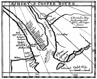
COOPER AND ASHLEY RIVERS.
[This is a side-map in a large folding one called A new map of Carolina, by Philip Lea, at the Atlas and Hercules, in Cheapside, London. Courtenay considers it to be of a date before 1700. There is a fac-simile of the whole in Charleston Year Book, 1883. For the associations and landmarks of these rivers see C. F. Woolson’s “Up the Ashley and Cooper,” in Harper’s Monthly, Dec., 1875; and P. D. Hay’s “Relics of Old South Carolina,” in Appleton’s Journal, xix. 498. In the Charleston Year Book (1883) there is a large map, showing the town and the early farms on the west bank of the Ashley; the present site of the city up to near the Clements’ Ferry road, with all lines of fortifications and historic points. Cf. W. G. Simms’ “Description of Charleston,” in Harper’s Monthly, June, 1857.
Moll’s map of South Carolina (1730) is given in fac-simile in Cassell’s United States, i. 439.—Ed.]
When there was no longer any reasonable expectation for the adoption of the Grand Model of government, a carefully prepared set of Instructions, in 43 Articles, became the rules for the colony, all former Instructions and Temporary Laws being abrogated, except such as related to lands. These rules continued as long as the Proprietors owned the province. It is not necessary to explain them. They were for the interest of their lordships; simple enough, but establishing a proprietary oligarchy. The Palatine and three other Proprietors, and, in the colony, the governor and three other deputies, constituted the governing power, with, apparently, a complete check upon the representatives of the people. The people could not complain if their lordships carried out what they wrote to Ludwell, that “they would part with no power” conferred on them by the charter “till the people were disposed to be more orderly;” for the people had demanded to be governed solely by the charter. The prominent[316] question now would be: Do their lordships properly interpret and apply the powers granted them in the charter?
But fresh political subjects engaged attention: the tenure of lands, naturalization of the French Huguenots, payment of quit-rents, now for some years due, the jury laws, and that relating to elections. Governor Smith lost courage; he could be no champion for their lordships against his friends and neighbors. The only way out of the difficulties occasioned by the maladministration of the Proprietors was that some Proprietor should be sent over “with full power” to heal all grievances. This plan was adopted. The grandson of Earl Shaftesbury was appointed, but declined to come. A pious, benevolent Quaker came, John Archdale, whose policy was a smiling patience, but a strict requisition of every penny that was due to the “true and absolute lords” of the province,—himself among them. He thought his patience would, as he expressed it, allay their heats. But this could only be done by concessions. He yielded to their request to have thirty representatives in the assembly. He also remitted, after a struggle, arrears of quit-rents to Michaelmas, 1695, on condition that the remaining debts were secured, rents for the future strictly provided for, and the town fortified by taxation. Some political advancement was gained by the assembly;[755] the repeal of any law not infringing on the rights of the Crown or of the Proprietors, or relating to land, was not to be made without the consent of the General Assembly. The council, too, was so constituted by the pious Quaker as to be more in harmony with the dissenters. But he seemed to fear that he might be prevailed upon to grant too much, and appointing his friend, Joseph Blake, in his place, hastened away (1696). He lived to see the peace and tranquillity vanish which he hoped he had firmly established. Two years later the “House of Commons” petitioned (among other things) for the privilege of coining; and for the removal of duties on the chief exports from the colony. They also prayed that no more than 1,000 acres be in future granted in one piece; that an authenticated copy of the charter be sent them; and that the colonial authorities have power to repeal laws (if expedient to do so) which had been confirmed by the Proprietors: and though some of these things (they said) were beyond their lordships’ power to grant, their interest with the king was great enough to secure them for their colonists. Their lordships, as might have, been expected, were astonished that Blake, himself a Proprietor,[756] should allow such an address to be issued,—a precedent for so much future evil.
The century now closed. Governor Blake died in 1700. As required under the 43 Articles, the deputies elected a Landgrave to succeed Blake, till the Proprietors could be heard from. At first they chose Morton. He was set aside afterwards by the council, as were all the Landgraves in the colony, and Colonel James Moore, a deputy, appointed. This competition[317] gave origin, for the first time in the history of the colony, to what may be denominated party strife. Besides Moore, several able leaders now appeared,—among them, Major Daniel, Colonel William Rhett, and Sir Nathaniel Johnson; while to Nicholas Trott the foremost place must be assigned for distinguished learning and ability. On his arrival he espoused the popular cause; but with numerous offices and honors bestowed upon him by the Proprietors, he and his brother-in-law, Colonel Rhett, became their zealous champions. These able men so largely influenced their lordships that at a word from them governors and councils were sometimes set at naught.
At the opening of the new century, we must cease to look upon South Carolina as the home of indigent emigrants, struggling for subsistence. While numerous slaves cultivated the extensive plantations, their owners, educated gentlemen, and here and there of noble families in England, had abundant leisure for social intercourse, living as they did in proximity to each other, and in easy access to Charles Town, where the governor resided, the courts and legislature convened, and the public offices were kept. The road that led up from the fortified town between the two broad rivers so enchanted Governor Archdale that he believed no prince in Europe, with all his art, could make a walk for the whole year round so pleasant and beautiful. From the road, to the right and to the left, avenues of water-oaks in mossy festoons, and in spring-time redolent with jasmines, gave the passer-by glimpses of handsome residences, from whose spacious verandas could be seen on the east the beautiful waters of the Bay, on the west the Ashley River. Hospitality, refinement, and literary culture distinguished the higher class of gentlemen.[757]
Governor Moore and his party gained control of the council by filling vacancies with those of whose good-will they were assured. But they ineffectually sought, by every means in their power, to elect a majority of assembly-men in their interest. Even violence was resorted to, and some estimable gentlemen, opponents of the party in power, were set upon and maltreated in the streets. The assembly resolved to investigate the abuses at the election, and were, therefore, prorogued from time to time; and it was reported that martial law would be proclaimed. When at last the assembly convened, they began with recriminations. If the public welfare had required their counsels, why had the governor, through pique, prorogued them? And was it true that he designed to menace them with coercion? “Oh! how is that sacred word Law profaned when joined with Martial! Have you forgotten your Honor’s own noble endeavor to vindicate our liberties when Colleton set up this arbitrary rule?”[758] But further disputation was averted. The governor had planned a secret and sudden attack on St. Augustine. The assembly joined in the scheme. They requested him to go as commander instead of Colonel Daniel, whom he nominated. They voted £2,000; and thought ten vessels and 350 men, with Indian allies, would be a sufficient force. The doors are closed. Men, and even women, who had been to St. Augustine, are interrogated concerning its defences. An embargo is laid on the shipping in the harbor. Moore with about 400 men sets sail, and Daniel with 100 Carolina troops and about 500 Yemassee Indians march by land. But the inhabitants of St. Augustine had heard of their coming, and had sent to Havana for reinforcements. Retreating to their castle, they abandoned the town to Colonel Daniel, who pillaged it before Moore’s fleet arrived. Governor Moore and Colonel Daniel united their forces and laid siege to the castle; but they lacked the necessary artillery for its reduction, and were compelled to send to Jamaica for it. Unfortunately the agent sent put back to Charles Town, and the governor sent Colonel Daniel himself to Jamaica. Before he returned, two Spanish ships appeared off St. Augustine. Moore instantly burned the town and all his own ships, and hastened back by land. Colonel Daniel, coming from Jamaica with the artillery, narrowly escaped the Spanish ships, and was convoyed to Charles Town by an English man-of-war which he met at sea. The expense entailed on the colony was £6,000.
When this attack on St. Augustine was planned, it must have been anticipated in the colony that war would be declared against Spain and France. The impending danger to South Carolina, a frontier to Spanish Florida, induced the Proprietors to appoint as governor the soldierly Sir Nathaniel Johnson (June, 1702). James Moore was made receiver-general; Nicholas Trott, attorney-general; Job Howes, surveyor-general; and Rhett, Broughton, and other men of ability, adhering to the government in its hour of peril, increased thereby the power of the dominant[319] party. Colonel Moore, being sent out by Johnson (December, 1703) with fifty Carolinians and one thousand Indians, ravaged the country of the Apalatchees, allies of the Spaniards, and utterly defeated them and a body of Spanish troops that came to their assistance. Three years later, in August, when yellow fever was prevalent and five or six deaths a day, in the small population of Charles Town, was not a rare occurrence, a French fleet of five vessels under Le Feboure, aided by the Spanish governor at Havana, suddenly appeared off the harbor. Troops were disembarked at several points. A council of war was held, and the Carolinians determined to go out and meet the enemy. Colonel Rhett, Captains Fenwicke, Cantey, Watson, and others, with many gentlemen as volunteers, defeated the invaders, and brought 230 French and Spanish prisoners into town. Thus perished the first attempt to take Charles Town by a naval force, a feat which never yet has been accomplished. The governor, handsomely rewarded by the Proprietors, thanked the troops for their valor and their unanimity at a time when violent estrangements existed between political parties in the colony.
We must now revert to 1704, and relate the occasion of these estrangements. The governor and dominant faction favored Episcopacy. Lord Granville, the new Palatine, was an uncompromising zealot for the Church of England. It was determined to establish that Church in South Carolina. This was not contrary to the charter; but most of the colonists were dissenters, and it would be useless at that juncture to endeavor to win over a majority of the assembly to the support of such a project. The assembly stood prorogued to the 10th of May. They were summoned earlier; and on the 4th a bill was proposed and read, requiring “all persons that shall hereafter be chosen members of the Commons House of Assembly, and sit in the same, to take the oaths and subscribe the declaration appointed by this bill, and to conform to the religious worship of this Province, according to the Church of England, and to receive the Sacrament of the Lord’s Supper according to the rites of said Church.”[759] Some of the members called for the reading of the charter: but the opposition was soon overcome; the bill passed and was ordered to the governor and council, who passed it and returned it to the House; Landgrave Morton, of the council, being denied leave to enter his protest against it. It was pushed through the requisite proceedings and ratified under date of the 6th. It was passed by one majority,—twelve for it and eleven against it; seven members being absent. Some who voted in the negative are said to have been Episcopalians. The assembly was then prorogued[320] till October. It was required by this law that in case a representative elected refused to qualify as directed, the next on the sheriff’s return should be entitled to the seat, or the next, and so on till the list was exhausted; then only should a new writ be issued. The effect was not only to exclude dissenters, but ten men could elect a member against the votes of a thousand. Another tyrannical abuse of party power was exhibited in an Act establishing Religious Worship (passed on the reassembling of the Commons), which authorized a lay commission for the trial of ecclesiastical causes. Dalcho says in his Church History, that they “were authorized to sit in the judgment-seat of spiritual officers, and thus to wrest the ecclesiastical authority out of the hands of the Bishop of London.” This gave offence to Churchmen. The Society for the Propagation of the Gospel, by whose liberality the colony had been greatly benefited, resolved not to send or support any missionaries in South Carolina, till the law, or at least that clause of it, should be repealed. The dissenters, already elected members of assembly, were not allowed (on reassembling in October) to enter their protests against the conduct of the Church party. The Rev. Mr. Marston was called to account by the commission and deprived of his benefice, for opposing the action of the oligarchy. But the case was carried to a higher tribunal, the House of Lords in England. Upon an able representation of the matter, redress having been refused by the Proprietors (under lead of Granville), a report was made to the queen, which caused the annulment of these two provincial laws. Nor was this all; the Board of Trade recommended the annulment of the proprietary charter (April, 1706). Since the accession of James II. there had been a disposition in the English authorities to revoke the charters to companies or individuals, and bring all the American colonies into a closer dependence on the Crown. Though the surrender of the Carolina charter was not on this occasion effected, yet it was manifest to the colony that an authority more potent than that of their lordships was interested in their welfare.
Lord Granville was succeeded in the Palatinate by Lord William Craven, and Colonel Edward Tynte was made governor. The once dominant faction, which had been transmuted, said Archdale, by Johnson’s “chemical wit, zeal, and art” into a High Church party, now fell asunder. Much attention had been awakened in England to the fortunes of the colony by the publications of Archdale and of Oldmixon and the “Case of the Protestant Dissenters;” and Governor Tynte entered upon his duties with kindly assurances and the wish to “render Carolina the most flourishing colony in all America.” He did not live long, and Colonel Charles Craven, brother of the Palatine, and previously an officer in the colony, was appointed in his place (December, 1710). Since the days of Joseph West, “moderate, just, pious, valiant” (says Archdale), no man more capable and beloved than Charles Craven had governed[321] South Carolina. A sentence from an address of his to the Commons (April, 1712) shows the spirit of his administration. However great the honor of this office might be, “yet I shall look on it as a greater glory if, with your assistance, I could bring to pass so noble designs as the safety of this province, the advancement of its riches, and, what is more desirable” than riches, the unanimity and quiet of its people. “To what a prodigious height hath the united provinces risen in less than a century of years, to be able to create fear in some, envy in others, and admiration in the whole world!” The people, aroused by the expectation or apparent reality of their increasing importance, voted £1,500 for the erection of a State House and £1,000 for a residence for the governor. Unparliamentary altercations gave place to a generous emulation for the public welfare. The governor expressed the “greatest tenderness” towards all dissenters and assured them that nothing should ever be done by him injurious to their liberties. Though the law excluding them from the assembly was repealed, yet the Episcopal party retained ascendency and the public support of the Church (by a new Church Act) was continued. The parish system was inaugurated, and the representatives were increased to thirty-six. The turbulence of elections at Charles Town gave place to unmolested elections in the respective parishes. Libraries and a free school were open to all, and religious and educational advancement was promoted. Under Craven’s prosperous administration, it even seemed likely that the public debt would be liquidated, which had begun with the unlucky expedition against St. Augustine. But fresh expenditures were demanded in assisting North Carolina in her conflicts with the Tuscaroras; and scarcely had Barnwell and Moore rested from that campaign, when the most disastrous Indian war that South Carolina ever had to encounter broke suddenly upon her unsuspecting inhabitants. The Yemassees had been employed against the Apalatchees, and, at a later date, against the Tuscaroras. Being enticed by the Spaniards, whom their chiefs often visited, and being largely in debt to the English traders and irritated by their oppressive misconduct, they turned their experience in war against those who had taught them to fight, and, hoping for help from St. Augustine, began an indiscriminate slaughter on the line of settlements westward from Charles Town. Knowing the colonists to be formidable opponents, they had allured into conspiracy with them other Indian nations, notably the Creeks. So wide-spread was the combination formed that the governor asked assistance from other colonies. North Carolina in response sent aid under Colonel Maurice Moore (brother of James Moore), a friendly service which was gratefully appreciated and acknowledged by the assembly. But “expedition is the life of action,” said Craven; and not awaiting assistance, he fought the foe at once, and Colonel Mackay, in another direction, surprised their town, in which they had vast quantities of provisions and plunder, and attacking a fort to which they had betaken themselves carried it by assault and completely routed them.[322] This effectually checked the Yemassees, and dispirited the tribes engaged to assist them. The assembly met, and, despatching such business as was necessary, adjourned to take up their muskets. All available forces were raised and placed under command of Lieutenant-General James Moore and Colonels John Barnwell and Alexander Mackay. The Yemassees, though joined by the Apalatchees, were forced beyond the Savannah, and took up their residence in Florida. We have not space to narrate the heart-rending or romantic incidents of this contest. The Yemassees had acted prematurely; otherwise the disasters to the colony would have been far greater. Many lives were lost (estimated at 400), an immense amount of cattle, produce, and other valuable property destroyed, and it was said that the traders alone lost £10,000 in debts due them. But the invincibility of the colonists was so forcibly impressed upon the minds of the Indians that they entered into no more combinations, and never again, except in straggling parties, penetrated to the vicinity of the fortified English settlements.
On account of the death of Sir Anthony Craven, the governor returned to England, leaving Colonel Robert Daniel to be deputy (1716) till the arrival of Robert Johnson (son of Sir Nathaniel), who was appointed to succeed him. At this time the French were extending their cordon of forts from Canada down to Louisiana and the Gulf of Mexico, and courting the alliance of the Indians who dwelt on the outskirts of the whole line of English colonies. In view of these new dangers and of the deserted condition of the westward parishes of the colony, the Carolinians were compelled to keep up garrisons and troops of rangers from the Santee to the Savannah. The expense of defending themselves and their great losses in the recent Indian war caused an application to the Proprietors for relief. Lord Carteret, Palatine in place of the Duke of Beaufort (who, before, had offered on his part to give up the colony rather than have it in need of adequate relief and protection), wrote to the Board of Trade, “We, the Proprietors, having met on this melancholy occasion, to our great grief find that we are utterly unable of ourselves to afford our colony suitable assistance in this conjuncture; and unless his majesty will graciously please to interpose, we can foresee nothing but the utter destruction of his majesty’s faithful subjects in those parts.” The board asked if such of the Proprietors as were not minors were “willing to surrender the government to the king.” There was no king upon the throne now gratefully sensible of the distinguished services of a Clarendon, Monk, Berkeley, Carteret, or Craven. It was not, on the other hand, the influences of a Danson, Amy, Blake, or even the descendants of the original Proprietors, that formed a barrier to the manifest interests of the whole British nation; but it was the admirable love of justice in the rulers of England that saved to the Proprietors the lavish gift of Charles II., even after their confession of utter inability to help their colonists. It was evident, however, that the termination of the proprietary authority must come. The colonists made it come. We shall now relate how this was done.
The assembly had been forced to issue bills of credit; at first to meet the debts incurred by Moore’s expedition against St. Augustine. This easy method of making money was continued, and of course the bills depreciated. The London merchants complained, and the bills were ordered to be called in and cancelled. To do this required £80,000. This large sum the assembly undertook to pay in three years by a tax on the lands and negroes of the colonists. Before this could be effected the colonial income, applicable to other expenses, was reduced by a royal order to cease the tax of ten per cent on importations of British manufactures; and at the same time an expensive expedition became necessary to suppress the pirates who infested the coasts, and at times seized every ship leaving the harbor of Charles Town. If the Proprietors were unwilling “to expend their English estates to support much more precarious ones in America,”[760] whom were the colonists to ask for aid, except the king? When Governor Johnson met his first assembly, he inveighed against addresses sent to England without consulting the Proprietors as “disrespectful,” “unjustifiable and impolitic.” He then offered the distressed colonists a “donative” from their lordships of a small remission of quit-rents. The assembly declined the donative. They instructed their committee “to touch slightly (but not by way of argument or submission) on what the last two assemblies have done heretofore in addressing his majesty to take this province under his protection.” The governor was anxious they should accept the donative; and equally anxious they should, in return, order a rent-roll for the benefit of the Proprietors. He said, “As the assembly is to pass wholesome laws even to private persons, much more to the Lords Proprietors, who are our masters.” The assembly replied, “We cannot but approve of your honor’s care of their lordships’ interest, who are, as you say, your masters.” “If you look over their charters,” was the answer, “you will find them to be your masters likewise.” (December, 1717.)
The assembly elected Colonel Brewton powder-receiver. The governor, as military chief, required the assembly to order forthwith the keys to be delivered to Major Blakeway, whom he had commissioned. The House refused. The governor offered a compromise: “My officer shall keep the magazines and give receipts to your officer for all powder delivered into his keeping.” “What is the use,” replied the House, “of a powder-receiver who does not keep the powder?” “But I insist upon keeping it,” said the governor, “for I am his majesty the king’s lieutenant.” He soon saw an advertisement by the House, signed by their Speaker, declaring their right to appoint “all officers who receive a settled salary out of the public treasury of this province,” and to “put out, call to account, and put in place,” at discretion, all such officers; and commanding, under penalty, the powder-tax to be paid by all ships to the officer elected by the assembly.
The people, however, were fond of Governor Johnson. They did not[324] always harmonize with strangers sent over to govern them. But Johnson was almost one of themselves, and they admired him for his conspicuous bravery. He had gone personally in pursuit of the pirate Worley, and after a desperate encounter brought in alive only the chief and one of his crew, they having been smitten down with dangerous wounds; and he had immediately caused them to be tried and executed. At this time, too, Colonel Rhett had captured Bonnet, pursuing him into Cape Fear River, and brought him and about thirty of his crew to Charles Town, for speedy execution. The people knew that the governor was in duty bound to promote the cause of the Proprietors. But some of his adherents they justly regarded with ill-will. There had been, as before mentioned, a change, very acceptable to the people, in the mode of electing their representatives. Trott and Rhett had had great control in elections while the ballot was in Charles Town; and the former had been writing to their lordships against the new method of election by parishes. To the surprise of the governor and of all but Trott, orders came from London to disallow that method, to dissolve the assembly, and to summon another to be chosen by the old method; to repeal also the act for electing the powder-receiver, and other laws, such as that for the rehabitation of the Yemassee lands by bringing over Irish settlers to live there, which the people deemed of great importance to the welfare of the colony.[761] The argument was, with their lordships, What right have the assembly to alter anything determined by us? It is true our deputies sanctioned these laws; but we are not bound by what our deputies do, being ourselves the head and source of legislative power in our colony. The people thought, on the other hand, that an enactment by the assembly ratified by the governor and council, the appointed agents of the Proprietors, should not be set aside by the mere whim of a few persons on the other side of the Atlantic, or by the dictation of a man like Nicholas Trott. This gentleman had now to confront the long-delayed denunciation of Whittaker, Allein, and other prominent lawyers, who had for years endured his arrogance and tyranny in court. Thirty-one articles of complaint against him were presented to the assembly, and by them communicated to the governor and council. They knew the allegations to be well founded, and united with the assembly in requesting the Proprietors to restrict their favorite’s power. It had even been ordered from London that no quorum of the council should sanction a law unless Trott was one of the quorum. For a time, too, the whole judicial power was in his hands. Francis Yonge, a member of the council, deputy of Lord Carteret, and surveyor-general, was deputed, with suitable instructions, to proceed to London and confer with the Proprietors (May, 1719).[325] Lord Carteret was absent on an embassy. The others kept Mr. Yonge waiting, without conference, for three months; then sent him back with sealed orders. In fact, some of the Proprietors were minors; others lived away from London; the few who exercised authority left many matters to their secretary: and thus, says Yonge, “a whole province was to be governed by the caprice of one man.” If the secretary managed the Proprietors, Trott and Rhett managed him. When the sealed orders were opened, it was found that Chief Justice Trott was thanked, the governor reprimanded, his brother-in-law, Colonel Broughton, turned out of the council, together with Alexander Skene and James Kinloch; Mr. Yonge alone being permitted to remain, in courtesy to the absent Palatine (Carteret) whose deputy he was. A new council was appointed, and the governor again ordered to dissolve the assembly and call a new one under the old method of election.
The deputies excluded from the council and other prominent gentlemen now became active among the people. The arguments they used must have been: Have not the Proprietors, spurning all appeals, protected a tyrannical judge, and continued him in power over the lives and property of the people? Have they not refused to part with an acre of their immense uncultivated domains for public use in supporting the garrisons? Have they not obstructed our efforts to bring an increase of settlers here for the strengthening of our frontiers, and divided out the land, by thousands of acres, for their own emolument? To foster the power of a few favorites, have they not annulled our laws for the equitable representation of the people by fair and peaceful elections? Have they helped the colony in its distress, beat back the Spaniards, resisted the invasion of the French, suppressed the pirates, or quelled at any time an Indian horde? Can they now, masters as they claim to be, protect us in any emergency? And if, after all these provocations, we choose to rebel and throw off their vaunted absolutism, where are their forces to check our revolt? Will King George, our sovereign, to whom we appeal for protection, furnish them with an army to reduce us to submission? Influenced by such sentiments, the people came again to the polls at Charles Town, to elect their last assembly under the proprietary government. Mr. Yonge, who was there, tells us, “Mr. Rhett and Mr. Trott found themselves mistaken, in fancying they could influence the elections when in town, so as to have such members chosen as they liked, for it proved quite the contrary; they could not get so much as a man chosen that they desired. The whole people in general were prejudiced against the Lords Proprietors to such a degree that it was grown almost dangerous to say anything in their favor.”
It happened at this conjuncture that war was again declared by England against Spain, and an attack from Havana was in preparation either on Charles Town or the island of Providence. Advices being sent to the colony, the governor called together the council and such members elect of the assembly as he could collect, to provide for repairing the[326] fortifications; and as the recent repeals had left him without adequate funds, he proposed an immediate voluntary subscription. The members of the assembly whom he consulted told him the duties provided by law would suffice. “But the Act raising these duties is repealed by the Proprietors.” They replied, “They did not and would not look on their repeal as anything,” and dispersed to their homes. The governor then ordered a muster of all the provincial troops. This afforded an admirable opportunity for a complete combination. An association of leading citizens was secretly formed; the people assembled at the muster; they almost unanimously signed the resolutions submitted to them by the association, and agreed to support whatever measures they should adopt. The first notice the governor had of these proceedings was a letter signed by Mr. Skene, Colonel Logan, and Major Blakeway (28th November), telling him the whole province had entered into an agreement “to stand by their rights and privileges, and to get rid of the oppression and arbitrary dealings of the Lords Proprietors,” and inviting him to hold his office in behalf of the king. The members elect of the assembly, in the mean while, held private conferences and matured their plans.
On meeting at the time required by their writs (December 17), they waited upon the governor, as was customary; and Mr. Middleton, in their name, informed him that they did not look upon his present council as a legal one (the Proprietors having appointed twelve members, instead of seven, the usual number of deputies), and would not act with them as a legal council. Anticipating, it appears, a dissolution, they had resolved themselves into a convention, delegated by the people, and passed resolutions so revolutionary in character as to alarm the governor and his few adherents, who resorted to every menace and means of persuasion without moving the assembly or convention from their fixed purposes. The governor, therefore, issued a proclamation dissolving them. The proclamation was torn from the marshal’s hands; and the convention issued a proclamation, in their own names, ordering all officers, civil and military, to hold their offices till further orders from them. Having failed to win Johnson to their interest, they elected their own governor, Colonel James Moore.
Johnson, who had gone up to his plantation, hearing that the people intended to proclaim Moore governor in the king’s name, hastened back and used every effort to prevent it. But he found the militia drawn up, colors flying at the forts and on all the ships in the harbor, drums beating, and every preparation made for proclaiming the new governor. An eye-witness says it would be tedious to tell all the frantic ex-governor did. But the leaders of the revolution had sent Mr. Lloyd to keep with him under pretence of friendship and adherence, and prevent any rash action on his part. The troops began their march, inspirited by patriotic harangues, and escorted the members of the convention to the fort:[327] where, by the united acclamations of the people, James Moore was proclaimed governor of South Carolina in the name of the king of England (December 21, 1719).
A council of twelve was chosen, as in other colonies under the royal government; and the convention then resumed its functions as a legislative assembly, and proceeded to enact such laws as the state of the province required. They addressed a letter to the Board of Trade explanatory of their action, and their agent in England (Mr. Boone, with whom also Colonel Barnwell was sent to act) laid before the king an account of the misrule of the Proprietors and implored his protection. Johnson and the Proprietors were equally active, and the decision of the English government was anxiously awaited by both parties. During nearly a year such anxiety continued; and as the clergy in the province were unwilling to perform the marriage ceremony without, as previously, a license from Johnson as governor, and a large number of people followed his advice and example in not paying taxes until executions were issued against them, he supposed he had a party ready to reinstate him. But it was not till he received aid from the crews of several English men-of-war that he formed a plan of seizing the government. The Spanish fleet (to resist which the people had been mustered) had not come to Charlestown, but had gone to the island of Providence, and had been there repulsed by Governor Rogers. The “Flamborough,” Captain Hildesley, and “Phœnix,” Captain Pearce, arrived in Charlestown harbor in May, 1721; and chiefly, it appears, by the advice of Hildesley, Johnson appeared in arms with about 120 men, mostly sailors from the “Flamborough,” and marched against the forts, whose garrisons were obeying the orders of Governor Moore. The forts opened fire upon them. Whereupon, Captain Pearce was deputed by Johnson, together with some of his council, to negotiate with the revolutionists. They refused to negotiate; for they knew from their agents that the regency in England had determined to protect the colony, and that General Francis Nicholson had been appointed provisional royal governor. Johnson requested to see the orders of the regency and the despatches from the agents. As soon as he read them, he disbanded his men and gave up all opposition to the existing government. Nicholson’s commission is dated 26th September, 1720. He arrived in the colony 23d May, 1721, and was gladly received by Governor Moore, the assembly, and the people. The revolution was now complete; although the surrender of the proprietary charter, for such a sum of money as was finally agreed upon, was not effected till 1729.
Royal Government.—We have before us the ninety-six articles of instruction to Nicholson (30th August, 1720) and the additional ones to Governor Johnson (1730), detailing the method of the royal government, and which continued in force, with some modifications, till the separation of the colony from the mother country. It is not necessary to give a[328] full synopsis of this method. The enacting clause is “by the governor, council, and assembly;” and the assembly had the same powers and privileges as were allowed to the House of Commons in England. The Episcopal was the established Church, under jurisdiction of the Bishop of London. School-masters were licensed by the bishop or by the governor. If the governor died or left the province, and there was no commissioned lieutenant-governor, the eldest councillor, as president, acted in his stead. Special care was enjoined for the encouragement of the Royal African Company for the importation of negro slaves. If any part of the instructions was distasteful to the people, it was that which conferred equal legislative authority with the assembly upon the council; a council of twelve, nominated (or suspended) by the governor, and three of whom, with the governor, could form a quorum, in emergencies. On this point contests soon arose, the assembly thinking that the governor and three or more of their own neighbors or relatives, who happened to be councillors, ought not to have the power to counteract the deliberate will of the entire body of the representatives of the people; that is, of the freeholders who alone voted for members of the assembly.
But, for the time being, all were happy at their release from “the confused, negligent, and helpless government of the Lords Proprietors.” Governor Nicholson, on his arrival, found in all parties a cheerful allegiance to the king and zeal for the advancement of the colony.[762] Ex-Governor Moore was made Speaker of the assembly, with Nicholson’s cordial approbation, and all laws demanded by the condition of the province were promptly enacted. Peace having been declared between England and Spain, the new governor applied himself to the regulation of Indian affairs, and succeeded in bringing the tribes on the frontier into alliance with British interests. With peace and security everywhere, he addressed himself to forming new parishes, building churches and obtaining clergymen by the help of the London Society for the Propagation of the Gospel. Additional free schools were established by bequests from three benevolent citizens, and the people generally emulated the public spirit of their good governor. In 1725 he returned to England, and the administration of his office devolved upon Arthur Middleton as president of the council. He had it not in his power to be the generous benefactor Nicholson had been, and his views of duty to the royal authority placed him in opposition to the progressive spirit of those with whom he had been associated in the recent revolution. His stubborn contest with the assembly prevented the enactment of any laws for three years. They thought it necessary for the good of the people to pass a bill for[329] promoting the currency of gold and silver in the province. The council rejected it as contravening an act of Parliament in the reign of Queen Anne; and insisted on the passage of a supply bill by the assembly, to meet the expenses of the government. This the assembly refused unless their bill was first agreed to. Middleton resorted to prorogations and dissolutions. This availed nothing; for the people supported their representatives by reëlecting them. From 1727 to 1731 the same bill was eight times sent up to the president and his council, and always rejected. He prorogued them six times, and six times ordered new elections. Among other things in this contest, the assembly claimed the right to elect their clerk without consulting the council;[763] ordered an officer of the council to their bar, and put him under arrest for delay in making his appearance; and maintained that—as in Nicholson’s time—members elect should qualify by holding up the hand in taking the oath before the council, if they thought that best, instead of swearing on the Holy Evangelists, as the governor required them to do. The contest was not terminated until the arrival of Governor Johnson (December, 1730) as successor to Nicholson.
Sir Alexander Cumming had been sent to form a treaty with the Cherokees who lived near the head of the Savannah River and far westward,—a powerful nation with 6,000 warriors. They sent a deputation of their chiefs to England with Cumming to visit King George. It was important to secure the friendship of these Indians before the French should allure them to their interest. The chiefs returned from England in company with Governor Johnson. Middleton had before sent agents among the Creeks and Cherokees, to avert, if possible, the influence of the French, whose enterprise and energy were likely to become more formidable to the English settlements than the hostility of the Spaniards had been. While guarding against danger in this direction, they had to contend against molestations from their inveterate enemy in Florida. Runaway slaves were always welcomed there, were made free, and formed into military companies. Roving bands of the defeated Yemassees from the same refuge-place plundered the plantations on the frontier. No compensation could be obtained for such ruthless spoliation. At length Colonel Palmer was sent to make reprisals; and with about 300 men, militia and friendly Indians, he completely laid waste the enemy’s country up to the gates of St. Augustine, and taught them their weakness and the superior power of the English colonists. Unfortunately, no definite boundaries were settled upon between the claims of Spain and England.
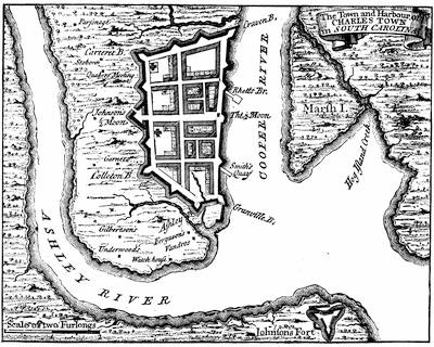
PLAN OF CHARLESTOWN, S. C., 1732.
(From Popple’s British Empire in America.)
[This was reëngraved in Paris in 1733, “avec privilège du Roi.” There is a fac-simile of a plan of Charleston (1739) in the Charleston Year Book, 1884, p. 163-4.—Ed.]
The colonial government, however, had erected in Governor Nicholson’s time Fort King George on the Altamaha, and were determined to keep the Spaniards to the westward of that river. A Spanish embassy came to Charlestown to confer with President Middleton about the erection of this fort. But the only definite understanding reached was in the avowal by the ambassadors that his Catholic majesty would never consent to deliver up runaway[331] slaves, because he desired to save their souls by converting them to the Christian faith. Cunning emissaries from St. Augustine continued to tamper with the slaves, and rendered many of them dangerous malcontents. Not long after (1738) an armed insurrection was attempted in the heart of the English settlement; the negroes on Stono River marching about plundering, burning farm-houses, and murdering the defenceless. The planters at that time went to church armed. It was Sunday. Lieutenant-Governor Bull, riding alone on the road, met the insurgents, and escaping them by turning off on another road gave the alarm. The male part of the Presbyterian congregation at Wiltown—notified of the insurrection by a Mr. Golightly—left the women in church, and hastening after the murderous horde found them drinking and dancing in a field, within sight of the last dwelling they had pillaged and set on fire. Their leader was shot, some were taken prisoners and the rest dispersed. More than twenty persons had been murdered. It might have been an extensive massacre, if so many armed planters had not attended divine service that day.[764]

CHARLESTOWN IN 1742.
[This follows a steel plate, “The city of Charleston one hundred years ago, after an engraving done by Canot from an original picture by T. Mellish, Esq.” A long panoramic view of Charlestown in 1762 is given in the Charleston Year Book, 1882; and in Cassell’s United States, i. 355. The name “Charleston” was substituted for “Charlestown” in the act of incorporation of 1783.—Ed.]
There were in the colony above 40,000 negro slaves. The necessity for increasing the number of white inhabitants had long been apparent to the English authorities. Some of the German Palatines in England (1729) and more of them in 1764 were sent over to the colony. Mr. Purry, of Neufchatel, and his Swiss were granted (1732) an extensive tract of land near the Savannah River. Some Irish colonists settled at Williamsburgh (1733). Colonel Johnson, before he came over as royal governor, proposed[332] to the Board of Trade a plan for forming a number of townships at convenient points, with great inducements to both foreigners and Englishmen to remove to the province. Above all, the proposal by Lord Percival (1730) to establish the colony of Georgia (between the Savannah and Altamaha), and the carrying of the project into effect under General Oglethorpe (1733), gave promise of adding materially to the security and strength of South Carolina. With a new fort at Beaufort (Port Royal), and abundant artillery and ammunition furnished by his majesty, and ships of war protecting the harbor, we have but to look forward a few years to the settlement and improvement of the healthy and fertile “up country” by overland immigration from Virginia and Pennsylvania, and the moving up of population from the coast, to reach the period of permanent prosperity and the greater development of the material resources of the province. Many families moved to the upper part of South Carolina when Governor Glen established peace with the Cherokees; many came when Braddock’s defeat exposed the frontiers of the more northern colonies to the French and Indians; while by way of Charlestown Germans came up to Saxegotha and the forks of the Broad and Saluda—as the Scotch-Irish had come to Williamsburg.
From 200 to 300 ships now annually left Charlestown. In addition to rice, indigo, pitch, turpentine, tar, rosin, timber of various kinds, deer-skins, salted provisions, and agricultural products grown along the coast, the interior plantations raised wheat, hemp, flax, and tobacco; fruits, berries, nuts, and many kinds of vegetables were abundant; and fish from the rivers, and turkeys and deer and other game from the forest, furnished luxuries for the table, without counting the ever-present supplies from swine, sheep, and cattle. But we must now go back a few years.
Governor Johnson died 3d May, 1735, and Lieutenant-Governor Thomas Broughton on 22d November, 1737. William Bull, president of the council, succeeded to the administration till the arrival of Governor James Glen (December, 1743).[765] The lieutenant-governor was a prudent ruler. He assisted in the settlement of Savannah and in the war of Georgia upon St. Augustine (sending the Carolina regiment under Colonel Vanderdussen), and managed wisely in every emergency. Governor Glen with greater energy and activity extended the fortification of the province,—visiting every portion of his government, going among the Cherokees, obtaining a surrender of their lands for the erection of forts, and erecting them; as Prince George on the upper part of the Savannah, 170 miles above Fort Moore, and Fort Loudon on the Tennessee among the Upper Cherokees, 500 miles from Charlestown. These forts and those at Frederica[333] and Augusta in Georgia were garrisoned by his majesty’s troops for the protection of both provinces. When Glen, in 1756, was superseded by Governor William Henry Lyttleton, war was declared between England and France. On the termination of hostilities, the Cherokees, who had aided the British troops in the more northern colonies, were returning home through Western Virginia, and committed depredations, appropriating to their use such horses as came in their way, and were set upon and some of them murdered. In retaliation they killed the whites wherever they could, indiscriminately. Among their victims in Carolina were a few of the garrison of Fort Loudon. This was done by roving bands of headstrong young Indians. The troops at Prince George despatched the news to Governor Lyttleton, who instantly began preparations for war. The Cherokees sent thirty-two of their chiefs to settle the difficulty, as the nation at large desired peace and the continuation of their old friendship with the English. Lyttleton kept the chiefs under arrest, and took them with him along with his troops. His ill-usage of them and his folly involved the province in a disastrous war with the whole Cherokee nation. Then, being appointed Governor of Jamaica, he left the calamities he had caused to the management of Lieutenant-Governor Bull. Not till 1761 were hostilities ended by the help of Colonel Grant, of the British army. Dr. Hewatt, who had the advantage of the acquaintance of the last Lieutenant-Governor Bull, and probably his assistance in the compilation of his history, gives a detailed and graphic narrative of this deplorable conflict, carried on in pathless forests, hundreds of miles from Charlestown. So wasted were Colonel Grant’s men “by heat, thirst, watching, danger, and fatigue” that when peace was made “they were utterly unable to march farther.” In the provincial regiment assisting Grant were Middleton, Laurens, Moultrie, Marion, Huger, Pickens, and others who became distinguished in the war of the Revolution.
The Peace of Paris (1763) happily put an end forever to hostilities arising from French possessions in America. The succeeding royal governors of South Carolina were Thomas Boone (1762), Lord Charles Greville Montague (December, 1765), and Lord William Campbell (1773).
The most interesting and continuous thread of events running through all the colonial history of South Carolina is the development of the power of the assembly or representatives of the people. Taking up this subject where we left it at the close of Middleton’s contest with the assembly, we observe that the choice of their clerk was conceded to them by the succeeding governor. In the policy both of the proprietary and royal government, the elective franchise was granted to the people or freeholders only in choosing members of the assembly. We do not find that they balloted for any executive or other officer. The success of the assembly in electing a few administrative officers and holding them accountable to themselves was an important acquisition, and was followed by a further gain of power in the same direction. Governor Glen, addressing the[334] authorities in England (October 10, 1748), said in substance “that a new modelling[766] of their constitution,” in South Carolina, “would add to the happiness of the province and preserve their dependence upon the Crown, any weakening [of the] power of which and deviation from the constitution of the mother country is in his opinion dangerous. Almost all the places of profit or of trust are disposed of by the general assembly.” “Besides the treasurer they appoint also the commissary, the Indian commissioner, the comptroller of the duties upon imports and exports, the powder-receiver, etc. The executive part of the government is lodged in different sets of commissioners,” “of the market, the workhouse, of the pilots, of the fortifications, etc. Not only civil posts, but ecclesiastical preferment, are in the disposal or election of the people, although by the king’s instructions to the governor” this should belong to the king or his representative. The governor is not prayed for, while the assembly is, during its sittings, the only instance in America where it is not done. “The above officers and most of the commissioners are named by the general assembly, and are responsible to them alone; and whatever be their ignorance, neglect, or misconduct, the governor has no power to reprove or displace them. Thus the people have the whole of the administration in their hands, and the governor, and thereby the Crown, is stripped of its power.” In the next place, the assembly claimed, and with success, the sole power of originating tax bills, notwithstanding instructions to the contrary. They refused to the council even the power to amend such bills. In the words of the Journals of the House (no. 21, 1745), they asserted their “sole right of introducing, framing, and amending subsidy bills,”—which they based on the English Constitution as paramount to the royal instructions. It was furthermore intimated that the council had no right to legislative functions at all,—a view soon after ably advocated by Mr. Drayton. It was contended that the council was not a counterpart of the House of Lords, but simply a body advisory to the governor. It was even argued that, similarly with the mother country, colonial usages and precedents were to be regarded as constitutional in South Carolina.
The last development of the power of the assembly tended to check the governor’s prerogative of dissolution and prorogation. In a contest with Governor Boone, beginning in 1762 and continued to May, 1763, dissolution and prorogation failed entirely as a means of controlling the actions or sentiments of the representatives of the people, where the people were of one mind with the assembly. The subject of dispute involved the assembly’s sole right to judge of the validity of the election of its own members, and the argument on the part of the House was conducted chiefly by Rutledge and Gadsden. But about this time came proposals that committees from all the colonial assemblies should meet to consider the British Stamp Act. We conclude this brief narrative with the remark[335] that in the Continental Congress that ensued the leading statesmen of the South Carolina popular assembly stepped as veterans to new battlefields with the dust of recent victories still upon them.[767]

CRITICAL ESSAY ON THE SOURCES OF INFORMATION.
By the Editor.
IT is claimed that Sir Robert Heath conveyed his rights under the grant of 1630 to the Earl of Arundel, and that these eventually became invested in Dr. Coxe, as presented in a memorial to William III., and assumed in the Carolana of his son, Daniel Coxe.[768] The Heath grant,[769] however, was formally annulled August 12, 1663.[770] De[336] Laet’s map, showing the coast of what was subsequently North Carolina at the period of Heath’s grant, 1630, is given in fac-simile elsewhere.[771]
Dr. Hawks, in his North Carolina, prints from Thurloe’s State Papers (ii. p. 273) a letter dated at Linnehaven, in Virginia, May 8, 1654, from Francis Yardley to John Farrar, giving an account of explorations during the previous year along the seaboard. In 1662 (March) the king granted the first charter, and this was printed the same year, but without date, as The first Charter granted by the King to the Proprietors of Carolina, 24 March.[772] In 1665 (June 30) the second charter extended the limits of the grant. Both charters are found in a volume printed in London, but without date, and called The two Charters granted by King Charles to the Proprietors of Carolina, with the first and last Fundamental Constitutions of that Colony. Issues of this book seem to have been made in 1698, 1705, 1706, 1708, etc.[773]

Mr. Fox Bourne, who in his Life of John Locke (London, 1876, vol. i. pp. 235, etc.) gives the most satisfactory account of Locke’s connection with the new colony, writes of the Fundamental Constitutions that Locke had a large share in it, though there can be hardly any doubt that it was initiated by Lord Ashley, modified by his fellow-proprietors. He adds: “The original draft, a small vellum-covered volume of seventy-five pages, neatly written, but with numerous erasures and corrections, is preserved among the Shaftesbury Papers (series viii. no. 3), and this interesting document has been printed, verbatim et literatim, by Mr. Sainsbury, in the Appendix to the Thirty-third report of the Deputy Keeper of the Public Records (1872), pp. 258-269.”
The same author refers to a draft extant in Locke’s handwriting, dated 21 June, 1669, which varies in some respects from that later issued by the Proprietors, in print.
There is, or was, in 1845, in the Charleston Library, presented to it by Robert Gilmor, of Baltimore, in 1833, a MS. copy in Locke’s own handwriting, dated July 14, 1669; but the earliest printed copy is one entitled thus: The Fundamental Constitutions of Carolina, in number a Hundred and Twenty, agreed upon by the Palatine and Lords Proprietors, to remain the sacred and unalterable form and rule of government of Carolina forever. March 1, 1669.[774] Printed first in 1670, the document was reissued, with some modifications, in 1682, and again, with more important modifications, in 1698.[775] It is also contained in A Collection of several pieces of Mr. John Locke, never before printed, and not extant in his works. London, 1720.[776]
It would seem from a map which is given in fac-simile in the Proceedings of the Massachusetts Historical Society, December, 1883 (p. 402), that it describes the “Discovery made by William Hilton of Charles Towne in New England, Marriner, from Cape Hatteraske, Lat: 35° 30′, to the west of Cape Roman in Lat. 32° 30′, In ye yeare 1662, And laid down in the forme as you see by Nicholas Shapley of the town aforesaid, November, 1662.” A small sketch of the map, which is annexed, shows that he passed along the islands which form a barrier to Pamlico Sound, without noticing, or at least indicating, that interior water, and then entering Cape Fear River tracked its shores up to a point where he designated three branches, which he called East, North, and West. The fac-simile given in the Proceedings by Mr. Hassam, from a photograph of the original in the British Museum,[777] is too obscure to make out all the names which occur along the river, while only “Hatterask” and “C. Romana” are noted on the coast. The intervening points, Cape Lookout and Cape Fear, are not named.
Hilton had come to Plymouth (Mass.) while a child, in 1623, whence he followed his father to Piscataqua, but later settled in Newbury and Charlestown, and in the latter place he died in 1675. Shapley is supposed to have been the same who was clerk of the writs in Charlestown in 1662, dying in that town in May, 1663. Although the New England antiquary, James Savage, and others have not supposed this Massachusetts Hilton to have been the same who led the Barbadoes party to Cape Fear the next year, this map and its record would seem to indicate that when the merchants of that island determined to accept the proposals of the Proprietors of Carolina to furnish them with colonists, they placed the expedition which they sent out in August, 1663, under the charge of one who had already explored parts of this coast,—no other than this William Hilton of New England. This exploring party landed at St. Helena and Edisto, and returned to Barbadoes after an absence of five months. Hilton’s True Relation was published in London in 1664.[778]
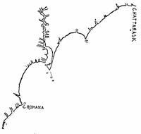
SHAPLEY’S DRAFT.
The year before (1663), according to Hawks,[779] the Proprietors had issued proposals for the encouragement of settlers within their grant, and we have, as Mr. Rivers has stated, the outcome of the Sandford expedition (1665) preserved in a manuscript among the Shaftesbury Papers, and the results of this seem to have been embodied in what is considered a second and expanded edition of their original proposals, which was now published in London, in 1666,—a mere tract of twelve pages, called A brief description of the Province of Carolina, on the coasts of Floreda; and more perticularly of a New[338] Plantation begun by the English at Cape Feare on that river now by them called Charles-River, the 29th of May, 1664. Together with a most accurate map of the whole province.[780]
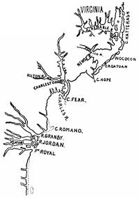
A SKETCH OF THE 1666 MAP.
As indicative of the changes in the North Carolina coast since it was first explored, Mr. Wm. L. Welsh (Bulletin Essex Institute, xvii. nos. 1, 2, and 3, and separately Salem, 1885), in a paper called An Account of the cutting through of Hatteras Inlet, Sept. 7, 1846, says that the present inlet of that name was made by the storm of that date, and that the explorers of 1584 entered through Caffey inlet, since disappeared, and that all the inlets of that day are closed, except the little-used Ocracoke inlet.
It was under the incentive of Sandford’s explorations and this districting of the country that the Proprietors entered upon the expedition which reached the Ashley River in 1670, for whose guidance Locke had prepared his plan of government. The more common knowledge of the geography of the Carolina coast at this time is seen in the map of North Carolina in Ogilby’s America (1671), which is reproduced in Hawks’ North Carolina (ii. p. 53).
In 1671 Sir Peter Colleton wrote to Locke that Ogilby was printing a “Relation of the West Indies,” and desired a map of Carolina, and asked Locke to get the drafts of Cape Fear and Albemarle from “my lord,” and suggest to him also “to draw up a discourse to be added to this map, in the nature of a description such as might invite people without seeming to come from us, as would very much conduce to the speedy settlement.” There remains, in Locke’s handwriting, a list of books to be consulted for this task, but otherwise he does not seem to have done anything to produce such a description.
Meanwhile another explorer had approached this region from the north, entering a country which no European had visited since the incursions of Lane’s company in the preceding century. We have record of this expedition in a tract of the following title: The discoveries of John Lederer in three several marches from Virginia to the west of Carolina, March, 1669-Sept., 1670. Collected out of the latine from his discourse and writings by Sir William Talbot. London, 1672.[781]
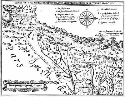
LEDERER’S MAP (1669-1670).
Fac-simile of the original in the Harvard College library copy. There is a sketch of it in Hawks’ North Carolina, ii. 52.
Lederer was a German, and was sent out by Governor Berkeley, of Virginia. He seems to have penetrated westward “to the top of the Apalatœan mountains.” He announced his disbelief in the views of such as held the distance from the Atlantic to the Pacific to be but eight or ten days’ journey, as shown in the “Mapp of Virginia discovered to the Hills,”[782] but was nevertheless inclined to believe that the Indian ocean may indeed stretch an arm into the continent as far as the Appalachian range.
It was on the second of Lederer’s expeditions, going west and southwest from the falls of the James, that he extended his course into North Carolina, and Hawks has endeavored to trace his track. Following him by his names of places, as Ogilby adopted them in his map of 1671, Lederer would appear to have traversed the breadth of South Carolina. “We cannot believe this,” says Dr. Hawks. “The time occupied would not have been sufficient for it. Lederer’s itinerary presents difficulties which we confess we cannot satisfactorily solve.” It seems at least certain that Lederer did not penetrate far enough to encounter the new-comers who were about founding the commonwealth of Locke.
The earliest account which we have of the English settlers at Port Royal, before their removal to the west bank of the Ashley River, is in Thomas Ash’s Carolina, or a description of the present state of that country. London, 1682. The author was clerk on board his majesty’s ship “Richmond,” which was on the coast 1680-82, “with instructions to enquire into the state of the country.”[783]
During the next few years several brief accounts of the new settlements were printed which deserve to be named: Samuel Wilson’s anonymous Account of the Province of Carolina in America; together with an abstract of the Patent and several other necessary and useful particulars, to such as have thoughts of transporting themselves thither. London, 1682 (text, 26 pp.).[784] John Crafford’s anonymous New and most exact Account of the fertile and famous Colony of Carolina.... The whole being a compendious account of a voyage made by an ingenious person, begun Oct., 1682, and finished 1683. Dublin, 1683.[785] Crafford is called supercargo of the ship “James of Erwin.”
Carolina described more fully than heretofore ... from the several relations, ... from divers letters from the Irish settled there and relations of those who have been there several years. Dublin, 1684.[786]
The first edition of Blome’s Present state of his majesty’s isles and territories in America, London, 1687,[787] gave “A new map of Carolina by Robert Morden” (p. 150), and through translations it became a popular book throughout Europe, and did something to bring the new colony to their attention.
Courtenay, in the Charleston Year Book, 1883, p. 377, gives a fac-simile of a map (with a corner map of Charlestown and vicinity) which marks the lots of settlers, and is thought by him to be earlier than 1700.
For the next fifteen years there is little in print about the history of Carolina; but not long after 1700, the attempt of the High-Church party, led by Nicholas Trott, the chief justice, and James Moore, to enforce conformity produced a controversy not without results.
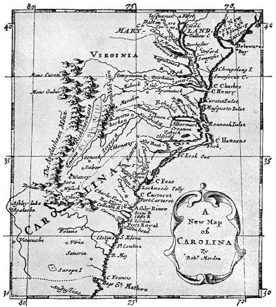
MORDEN’S CAROLINA (1687.)
Cf. “A Generall Mapp of Carolina describeing its Sea Coast and Rivers. London, printed for Ric. Blome,” which appeared in Blome’s Description of the Island of Jamaica, with the other Isles and Territories in America, to which the English are related. London, 1678.
The establishment of the “Society for the Propagation of the Gospel in Foreign Parts,” which had been chartered June 16, 1701, had given a certain impulse to the movement; and the society had its historiographer in David Humphreys, who in 1730 published at London his Historical Account[788] of it. This and the abstracts of the early reports of[342] the society, published with their anniversary sermons, afford data of its work in the colonies.
The first Episcopal church had been built in Charlestown about 1681-2, and its history and that of those later founded in the province, as well as of the movement at this time in progress, can be followed in Frederick D. Dalcho’s Historical Account of the Protestant Episcopal Church in South Carolina, from the First Settlement of the Province to the War of the Revolution; with Notices of the Present State of the Church in each Parish, and some Account of the Early Civil History of Carolina never before published. (Charleston, 1820.)[789]
The early years of the century were distinguished by the sharp retaliatory attacks of the Carolinians and the neighboring Spanish. The letter which Colonel Moore sent to the governor respecting his plundering incursion into Florida is fortunately printed in the Boston News-Letter, May 1, 1704, whence Carroll copied it for his Hist. Collections (ii. 573). Of this and of later attacks, we can add something from the Report of the committee of the South Carolina Assembly, in 1740, on Oglethorpe’s subsequent failure, and from the narratives of Archdale and Oldmixon, later to be mentioned. Of the French and Spanish naval attack on Charlestown in 1706,[790] Mr. Doyle, in his English in America, says that the MS. reports preserved in the Colonial Papers confirm the contemporary account (Sept. 13, 1706) printed in the Boston News-Letter, and the statements in the Report of 1740 on Oglethorpe’s later defeat at St. Augustine. The News-Letter account was reprinted in the Carolina Gazette, at a later day.
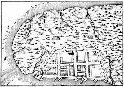
PLAN OF CHARLESTOWN, 1704. (Survey of Edward Crisp.)
The Key: A, Granville bastion. B, Craven bastion. C, Carteret bastion. D, Colleton bastion. E, Ashley bastion. F, Blake’s bastion. G, Half-moon. H, Draw-bridge. I, Johnson’s covered half-moon. K, Draw-bridge. L, Palisades. M, Lieut.-Col. Rhett’s bridge. N. Smith’s bridge. O, Minister’s house. P, English Church. Q, French Church. R, Independent Church. S, Anabaptist Church. T, Quaker meeting-house. V, Court of guard. W, First rice patch in Carolina.—Owners of houses as follows: 1, Pasquero and Garret. 2, Landsack. 3, Jno. Crosskeys. 4, Chevelier. 5, Geo. Logan. 6, Poinsett. 7, Elicott. 8, Starling. 9, M. Boone. 10, Tradds. 11, Nat. Law. 12, Landgrave Smith. 13, Col. Rhett. 14, Ben. Skenking. 15, Sindery.
This same map is one of the three side maps given in H. Moll’s Map of the Dominions of the King of Great Britain in America, 1715. It is repeated in Ramsay’s South Carolina, vol. ii., and in Cassell’s United States, i. 432.]
Rivers points out that Ramsay (i. 135) adds a few details, perhaps from tradition. Professor Rivers had earlier contributed to Russell’s Mag. (Charleston, Aug., 1859, p. 458) a paper from the London State Paper Office, entitled “An impartial narrative of ye late invasion of So. Carolina by ye French and Spanish in the month of August, 1706.” Governor John Archdale printed at London, in 1707, A new Description of that fertile and pleasant province of Carolina, with a brief account of its discovery, settling, and the government thereof (pp. 32).[791]


The next year (1708) we have an account of the condition of the colony in a letter signed by Sir Nathaniel Johnson, and dated September 17. It is quoted in large part by Rivers in his Sketches.[792] The name of John Oldmixon (died in England in 1742) is signed to the dedication of the British Empire in America, London, 1708, and it passes under his name. A second corrected and amended edition appeared in 1741.[793] Herman Moll made the maps which it contains, including one of Carolina, and some have supposed that he wrote the text. Dr. Hawks says of the book that it contains almost as many errors as pages, and unsupported is not to be trusted (ii. p. 481).
In 1708 John Stevens began in London to issue in numbers a work, which when completed in 1710 and 1711 (copies have both dates) was called A new Collection of Voyages and Travels into several parts of the world, none of which ever before printed in English. The second of this series, “printed in the year 1709,” was A new Voyage to Carolina, containing the exact description and natural history of that country, together with the present state thereof and a Journal of a thousand miles travel’d thro’ several nations of Indians, giving a particular account of their customs, manners, etc., by John Lawson, Gent., Surveyor-General of North Carolina. Other issues of the same sheets, with new title-pages, are dated 1714 and 1718.[794]
Lawson was a young Englishman, who arrived in Charleston in September, 1700. After a few months’ tarry in that settlement, he started with five white men and four Indians, and went by canoe to the Santee, where he turned inland afoot, and as he journeyed put down what he saw and experienced. In North Carolina he was made Surveyor-General, and this appointment kept him roaming over the country, during which he came much in contact with the Indians, and made, as Field says,[795] acute and trustworthy observations of them. With this life he practised a literary craft, and wrote out his experiences in a book which was taken to London to be printed,—an “uncommonly strong and sprightly book,” as Professor Tyler calls it.[796] His vocation of land-surveyor was not one calculated to endear him to the natives, who saw that the compass and the chain always harbingered new claims upon their lands. Three years after his book had been printed he was on a journey (1712) through the wilds with the Baron de Graffenreid, when the two were seized by the Tuscaroras, who suffered the German to agree for his release. The Englishman, however, was burned with pine splinters stuck in his flesh, as is generally believed, though Colonel Byrd, in his History of the dividing line between Virginia and Carolina, says he was waylaid and his throat cut.[797]
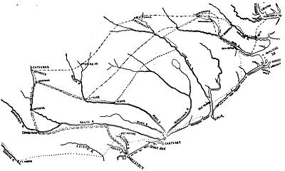
WAR MAP, 1711-1715.
Of about this time we also find a number of tracts, incentives to and records of German and Swiss emigration.[798] For the Carey rebellion and the Indian war of 1711,[799] Hawks used a transcript from an early copy of Governor Spotswood’s letter-book, which had been in his family and was placed by him in the State Department of North Carolina, where it had apparently originally belonged. In 1882, the Virginia Historical Society published the first volume of the Spotswood letters, and the student finds this material easily accessible now.[800]
In 1715 the General Assembly of North Carolina revised and reënacted the body of statute law then in force,[801] and twelve MS. copies were made, one for each precinct court. About a quarter of a century ago, says Mr. Swain, the State Historical Agent, in his Report of 1857, two of these copies, moth-eaten and mutilated, were discovered, and about 1854 a third copy, likewise imperfect, was found. From these three copies the body of laws was reconstructed for the State Library.
The authorities for the Yamassee war of 1715-16, so far as printed, are the account in the Boston News-Letter (June 13, 1715), reprinted in Carroll (ii. 569), where (ii. 141) as well as in Force’s Tracts (vol. ii.) is one of the chief authorities for this and for that other struggle which shook off the rule of the Proprietors, published in London in 1726, under the title of A narrative of the Proceedings of the People of South Carolina in the year 1719, and of the true causes and motives that induced them to renounce their obedience to the Lords Proprietors, as their governors, and to put themselves under the immediate government of the Crown.[802] Yonge, who professes to write in this tract from original papers, is thus made of importance as an authority, since in 1719 the records of South Carolina seem to have been embezzled, as Rivers infers from an act of February, 1719-20, whose purpose was to recover them “from such as now have the custody thereof,” and they are not known to exist. We get the passions of the period in The liberty and property of British subjects asserted: in a letter from an assembly-man in Carolina to his friend in London. London, 1726.[803] It is signed N., and is dated at Charleston, January 15, 1725, and sustains the discontents, in their criticism of the Proprietary government. The preface, written in London, gives a history of the colony.
In 1729 all of the Proprietors, except Lord Granville, surrendered their title in the soil to the Crown;[804] and in 1744 his eighth part was set off to him,[805] being a region sixty-six miles from north to south, adjoining the southern line of Virginia and running from sea to sea. Lord Granville retained this title down to the Revolution, and after that event he endeavored to reëstablish his claim in the Circuit and Supreme Courts, till his death, during the continuance of the war of 1812, closed proceedings.
Meanwhile some sustained efforts were making to induce a Swiss immigration to South Carolina. Jean Pierre Purry, a leader among them, printed in London in 1724 a tract, which is very rare: Mémoire presenté à sa Gr. Mylord Duc de Newcastle sur l’état présent de la Caroline et sur les moyens de l’ameliorer. Londres, 1724.[806] In 1880 Colonel C. C. Jones, Jr., privately printed an English version of it at Augusta, Georgia, as a Memorial ... upon the present condition of Carolina and the means of its amelioration by Jean Pierre Purry of Neufchâtel, Switzerland.
The Gentleman’s Magazine of August, September, and October, 1732, contained an English rendering of a description of Carolina, drawn up by Purry and others, at Charlestown in September, 1731. This last paper has been included by Carroll in his Historical Collections (vol. ii.), and by Force in his Tracts (vol. ii.).[807] Purry’s tracts were in the interest of immigration, and his and their influence seem to have induced a considerable number of Swiss to proceed to Carolina, where they formed a settlement called Purrysburg on the east side of the Savannah River. Hardships, malaria, and unwonted conditions of life discouraged them, and their settlement was not long continued.[808]
Bernheim, German Settlements in Carolina (p. 99), points out how the busy distribution of the rose-colored reports of Purry doubtless also led to the German and Swiss settlement at Orangeburg, S. C., in 1735, the history of which he derives from the journals of the council of the province in the state archives, and from those church record-books, which are preserved. It is to Bernheim we must look for the best accounts of the other German settlements in different parts of the province.
In 1851 the Lutheran synod of South Carolina put the Rev. G. D. Bernheim in charge of its records, and in 1858 he began to collect the minutes of the synod of North Carolina, and to interest himself generally in the history of the German settlements of both States. From 1861 to 1864 he printed much of the material which he had gathered in the Southern Lutheran. He found that the writers in English of the histories of the Carolinas had largely neglected this part of the story, perhaps from unacquaintance with the tongue in which the records of the early German settlers are written. The settlements of these people at Newbern and Salem had not indeed been overlooked; but their plantations in the central and western parts of the State, comprising more than three fourths of the German population, had been neglected. In the histories of South Carolina the settlements of Purrysburg and Hard Labor Creek had alone been traced with attention. In 1872 Mr. Bernheim recast his material into a History of the German settlements and of the Lutheran church in North and South Carolina, from the earliest period [to 1850], and published it at Philadelphia. It may be supplemented by a little volume, The Moravians in North Carolina, by Rev. Levin T. Reichell, Salem, N. C. 1857.[809]
We find some assistance in fixing for this period the extent of the domination of the English Church in a map which accompanies David Humphreys’ Historical Account of the Society for the Propagation of the Gospel in Foreign Parts, London, 1730, which is called “Map of the Province of Carolina, divided into its parishes, according to the latest accounts, 1730, by H. Moll, geographer.” It has a corner “map of the most improved parts of [South] Carolina,” which shows the parish churches and the English and Indian settlements. A fac-simile of this lesser map is annexed. George Howe’s History of the Presbyterian Church in South Carolina, from 1685 to 1800, Columbia, S. C., 1870, is another local monograph of interest in the religious development of the province.[810]
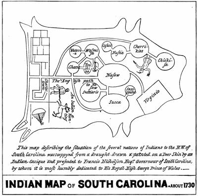
INDIAN MAP, 1730.
In the Kohl collection (no. 220). The original is in the British Museum, describing the situation of the Indian tribes in the northwest parts of South Carolina, and drawn by an Indian chief on a deer-skin, and presented to Gov. Nicholson.
The Huguenot element in Carolina became an important one, and as early as 1737 these French founded in Charleston the “South Carolina Society,” a benevolent organization, which in 1837 celebrated its centennial, the memory of which is preserved in a descriptive pamphlet published at Charleston in that year, containing an oration by J. W. Toomer, and an appendix of historical documents. There is no considerable account yet published of these Carolina Huguenots, and the student must content himself with the scant narrative by Charles Weiss, as given in the translation of his book by H. W. Herbert, History of the French Protestant Refugees (New York, 1854), which has, in addition to the narrative in Book iv. on refugees in America, an appendix on American Huguenots, not, however, very skilfully arranged. There is a similar appendix by G. P. Disosway[811] at the close of Samuel Smiles’ Huguenots (New York, 1868); and briefer accounts in Mrs. H. F. S. Lee’s Huguenots in France and America (Cambridge, 1843, vol. ii. ch. 29), and in Reginald Lane Poole’s History of the Huguenots of the Dispersion (London, 1880).[812]
Professor Rivers contributed to Russell’s Magazine (Charleston, Sept., 1859) a paper on “The Carolina regiment in the expedition against St. Augustine in 1740.”
The natural aspects of the country, as they became better known, we get from Mark Catesby’s Natural History of Carolina, Florida, and the Bahama Islands, etc., which was published in London, from 1732 to 1748, and again in 1754;[813] and a German translation appeared at Nuremberg in 1755. The English text was revised in the second edition by Edwards, and again printed at London in 1771.
The files of the early newspapers of the Carolinas afford needful, if scant, material. Thomas, in his History of Printing, records all there was. The South Carolina Gazette, beginning in January, 1731-2, was published for little more than a year as a weekly; but this title was resuscitated in new hands in February, 1734, when the new journal of this name continued its weekly issues up to the Revolutionary period. No other paper was begun in that province till 1758, when a new weekly, the South Carolina and American General Gazette, was started. Three years before this, the first paper had been established at Newbern, The North Carolina Gazette, which lived for about six years.
To Governor Glen is attributed A description of South Carolina, which was printed in London in 1761,[814] and is reprinted in Carroll’s Historical Collections, vol. ii. It gives the civil, natural, and commercial history of the colony. It is the completest survey which had up to this time been printed.
In the war with the Cherokees some imputations were put upon the South Carolina rangers, under Henry Middleton, by Grant, the commander of the expeditions against those Indians; and this charge did not pass unchallenged, as would seem from a tract published in 1762 at Charleston, entitled Some Observations on the two Campaigns against the Cherokee Indians in 1760 and 1761.[815]
For the geography of this period we have two maps in the New and complete History of the British Empire in America, an anonymous publication which was issued in parts in London, beginning in 1757. One is a map of Virginia and North Carolina, the other of South Carolina and Georgia, both stretching their western limits beyond the Mississippi.
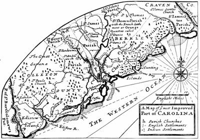
THE SOUTH CAROLINA COAST.
Cf. the Carolina of Moll in his New Survey, no. 26 (1729), and a reproduction of Moll in Cassell’s United States, i. 439. A map of Carolina and Charlestown harbor (1742) is in the English Pilot, no. 19.
At the very end of the period of which we are now writing the MS. description of South Carolina by the engineer William De Brahm, which is preserved in the library of Harvard University, becomes of importance for its topographical account, and its plans and maps, executed with much care. It is included in a volume, containing also similar descriptions of Georgia and Florida, which portions are noticed in the following chapter. There are transcripts of this document which have an early date,[816] and some at least have a title different from the Harvard one, and are called A Philosophico-historico-Hydrography of South Carolina, Georgia, and East Florida. From such a one, which is without the drawings, that portion relating to South Carolina was printed in London in 1856, by Mr. Plowden Charles Jennett Weston, in a volume of Documents connected with the History of South Carolina. An engraved map by De Brahm, Map of South Carolina and a part of Georgia, composed from surveys taken by Hon. Wm. Bull, Capt. Gascoigne, Hugh Bryan, and William De Brahm, published in four sheets by Jefferys, also appeared in the General Topography of North America and the West Indies, London, 1768. The map itself is dated Oct. 20, 1757, and gives tables of names of proprietors of land in Georgia and Carolina.[817]
The earliest account of the history of South Carolina cast in a sustained retrospective spirit is the anonymous Historical Account of the rise and progress of the Colonies of South Carolina and Georgia (London, 1779), which is known to have been prepared by Dr. Alexander Hewatt,—as his signature seems to fix the spelling of his name, though in the bibliographical records it appears under various forms.[818] Carroll, in reprinting the book in the first volume of his Historical Collections, added many emendatory notes.[819] The next year (1780) produced a far more important book, in respect to authority, in George Chalmers’ Political Annals of the Present United Colonies, from their Settlement to the Peace of 1763 (London), the first volume of which, however, was the only one published.[820] Chalmers, who was born in 1742, had practised law in Maryland, but he could not sympathize with the revolution, and at the outbreak returned to England, where in time (August, 1786) he became the clerk of the Board of Trade and died in office, May 31, 1825, at the age of eighty-two.
When Williamson was engaged on his History of North Carolina (i. p. 9), he applied for assistance to Chalmers, whose Political Annals shows that he had access to papers not otherwise known at that time, but was refused. Grahame, in his Colonial History of the United States (i. p. xii.), says he got ready access to Chalmers’ papers, but as he disclosed in his text little new, it was conjectured that before Grahame’s opportunity much had passed out of Chalmers’ hands. Sparks, in a letter (1856) to Mr. Swain, the historical agent of North Carolina, says of Chalmers that “he undoubtedly procured nearly the whole of his materials from the archives of the Board of Trade. His papers, after having been bound in volumes, were sold by his nephew a few years ago (1843) in London. I purchased six volumes of them, relating mostly to New England. They are not important, being memoranda, references, and extracts, used in writing his Annals.”[821] Two large volumes of Chalmers’ notes and transcripts also came into the hands of George Bancroft, and were entrusted by him to the care of Dr. Hawks and Mr. Rivers, when they were at work upon their histories of North and South Carolina. Bancroft, from his own use of them, and of Chalmers’ printed Annals, and speaking particularly of the Culpepper revolution (1678), in the original edition (ii. p. 162) of his United States, says: “Chalmers’ account in all cases of the kind must be received with great hesitancy. The coloring is always wrong; the facts usually perverted. He writes like a lawyer and disappointed politician, not like a calm inquirer. His statements are copied by Grahame,[822] obscured by Martin, and, strange to say, exaggerated by Williamson.[353]” Dr. William Smyth, in his Lectures on Modern History, calls the work of Chalmers an “immense, heavy, tedious book, to explain the legal history of the different colonies; it should be consulted in all such points, but it is impossible to read it.”[823]
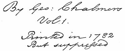
Near the close of the Revolutionary War Chalmers began the printing of another work, a succinct sketch of the history of the colonies. A very few copies exist of the first volume, which is without title or preliminary matter, and in the copy before us a blank leaf contains a manuscript title in Chalmers’ own handwriting as follows: An Introduction to the History of the Colonies, giving from the State Papers a comprehensive view of the origin of their Revolt. By George Chalmers, Vol. I. Printed in 1782, But suppressed. This volume, beginning with the reign of James I. and ending with that of George I., was the only one printed. The present copy[824] is marked as being the one from which Mr. Sparks printed an edition published in Boston in 1845,[825] in which the preface says that the original issue was suppressed, “owing to the separation of the colonies, which happened just at the season for publication, December, 1782, or the prior cause in April precedent, the dismission of a tory administration.”[826]
When Chalmers’ papers were sold, a manuscript continuation of this Introduction in the handwriting of the author was found, completely revised and prepared for the press. When Sparks reprinted the single volume already referred to, he added this second part to complete the work, and it was carefully carried through the press by John Langdon Sibley. Sparks in his introductory statements speaks of the book as “deduced for the most part from the State Papers in the British offices, or to speak with more precision, from the confidential correspondence of the governors and other officers of the Crown in the colonies.” In regard to its suppression he adds that “no political ends could now be answered by its publication, and it is probable that he thought it more politic to sacrifice the pride and fame of authorship than to run the hazard of offending the ministers.”[827]
Of the later histories it is most convenient to treat each province separately, as will be done in the annexed note.
The Later Histories of the Carolinas.
I. North Carolina.—The first published of the general accounts of this State was the History of North Carolina, by Hugh Williamson,[828] at Philadelphia, in 1812, in two volumes. Dr. Hawks, the later historian, says (ii. p. 540) that North Carolinians do not recognize Williamson’s work as a history of their State. It is inaccurate in a great many particulars, and sometimes when there is proof that the original record was lying before him. Sparks calls it “meagre and unsatisfactory,” and adds that it contains but few facts, and these apparently the most unimportant of such as had fallen in his way.[829] More care and discrimination, though but little literary interest, characterized another writer. François Xavier Martin had a singular career. He was born in Marseilles, became a bankrupt in Martinique, went friendless to Newbern, in North Carolina, and rose to distinction as a jurist, after beginning his career in the State as a translator and vendor of French stories. He had removed to Louisiana, when he published at New Orleans his History of North Carolina, in 1829 (two volumes), and in that State he rose to be chief justice, and published a history of it, as we have seen. Martin’s accumulation of facts carries no advantage by any sort of correlation except that of dates. A painstaking search, as far as his opportunities permitted, and a perspicuous way of writing stand for the work’s chief merits. He stops at the Declaration of Independence. Up to Martin’s time Bancroft[830][355] might well speak of the carelessness with which the history of North Carolina had been written.
Next came John H. Wheeler’s Historical Sketches of North Carolina from 1584 to 1851, compiled from original records, official documents, and traditional statements, with biographical sketches of her distinguished Statesmen, Jurists, Lawyers, Soldiers, etc., Philadelphia, 1851. It is not unfairly characterized by Mr. C. K. Adams, in his Manual of Historical Reference (p. 559), as “a jumble of ill-digested material, rather a collection of tables, lists, and facts than a history.”
David L. Swain,[831] who had been governor of the State, had done much to collect transcripts of documents from the archives of the other States and from England, and in 1857, as historical agent of the State, he made a report, which was printed at Raleigh, in which, speaking of the statutes at large, which Virginia and South Carolina had published, he referred to “both of these collections, especially the former, the earlier and better work, as deeply interesting in connection with North Carolina history.”
Of the History of North Carolina, by Francis Lister Hawks, D. D., LL. D., the second volume, published at Fayetteville in 1858, covers the period of the Proprietary government from 1663 to 1729, the first volume being given to the Raleigh period, etc. He availed himself of the fullest permission by state and local authorities to profit by the records within his own State; and he had earlier himself procured in London many copies of documents there. The author claims that more than three fourths of this volume has been prepared from original authorities, existing in manuscript. He tells at greater length than others the story of the law and its administration, of the industrial and agricultural arts, navigation and trade, religion and learning.
The latest local treatment is that of Mr. John W. Moore’s History of North Carolina from the earliest discoveries to the present time, Raleigh, 1880, in two volumes. There is not much attempt at original research, and he does not reprint documentary material, as Hawks did, in too great profusion to make a popular book. Mr. Moore aims to give a better literary form to the story; but his style somewhat overlays his facts.
II. South Carolina.—To turn to the more southern province,—Dr. David Ramsay, who was a respectable physician from Pennsylvania, domiciled and married in Charleston, gained some reputation in his day as a practised writer, and as an historical scholar of zeal and judgment. He published first, in 1796, a Sketch of the Soil, Climate, etc., of South Carolina; and later, in 1809, at Charleston, a History of South Carolina, 1670-1808, in which he made good use of Hewatt, as far as he was available.
In 1836 Carroll republished many of the early printed tracts upon South Carolina history in his two volumes of Historical Collections. Referring to this publication, a writer in the Southern Quarterly Review, Jan., 1852, p. 185, says: “But for a timely appropriation by the legislature of two thousand dollars for his relief, Carroll would have been seriously the sufferer by his experiment on public taste and sectional patriotism.”
Grahame in 1836 had published the first edition of his Colonial History of the United States, including the early history of the Carolinas, and Bancroft, in 1837, published the second volume of his History of the Colonization of the United States, and in chapter xiii. he discussed how Shaftesbury and Locke legislated for South Carolina,—a chapter considerably changed in his last edition (1883).
The South Carolina novelist, William G. Simms, first published a small history of the State in 1840, which served for school use. This he revised in 1860 as a History of South Carolina, which was published in New York. It was spirited, but too scant of detail for scholarly service.[832]
The South Carolina Historical Society was formed in 1855, Mr. Rivers, the writer of the preceding chapter, being one of the originators. The first volume of their Collections, published in 1857, contained, beside an opening address by Professor F. A. Porcher, the beginning of a list and abstracts of papers in the State Paper Office, London, relating to South Carolina. This enumeration was continued in the second and third volumes.[833] There are also in the second volume, beside Petigru’s oration, a paper on the French Protestants of the Abbeville district, an oration [356]by J. B. Cohen, and O. M. Lieber’s vocabulary of the Catawba language. In vol. iii. we find an oration by W. H. Trescott. No further volumes have been printed.
Mr. Rivers’ Sketch of the History of South Carolina to the Close of the Proprietary Government by the Revolution of 1719, published in Charleston in 1856, was continued by him in A Chapter in the Early History of South Carolina, published at Charleston in 1874, which largely consists of explanatory original documents. This section of a second volume of his careful history was all that the author had accomplished towards completing the work, when the civil war of 1861 “rendered him unable to continue its preparation.” Mr. Rivers says, in a note in this supplementary chapter, that an examination of the records at Columbia has shown him that, to perfect this additional task, it would be necessary to make examination among the records of the State-Paper Office in London.
Of these latter records Mr. Fox Bourne, in his Life of John Locke (London, 1876), says: “Locke’s connection with the affairs of the colony lasted only through its earliest infancy. Down to the autumn of 1672 he continued his informal office of secretary to the Proprietors. Nearly every letter received from the colony is docketed by him; and of a great number that have disappeared there exist careful epitomes in his handwriting. We have also drafts, entered by him, of numerous letters sent out from England, and his hand is plainly shown in other letters. Out of this material it would be easy to construct almost the entire history of the colony during the first years of its existence.”
It was some time before the period of Mr. Fox Bourne’s writing that the Earl of Shaftesbury deposited with the deputy keeper of the Public Records the collection of documents known as the Shaftesbury Papers, the accumulation which had been formed in the hands of his ancestor, and which yield so much material for the early history of the Carolina government.[834]
The latest use made of these and other papers of the State-Paper Office is found in The English in America, Virginia, Maryland, and the Carolinas (London, 1882), written by Mr. John A. Doyle, librarian of All Souls, Oxford. In a note to his chapter on the “Two Carolinas,” Doyle says (p. 427), respecting the material for Carolinian history in the English archives: “To make up for the deficiency of printed authorities, the English archives are unusually rich in papers referring to Carolina. There are letters and instructions from the Proprietors, individually and collectively, and reports sent to them by successive governors and other colonial officials. It is remarkable, however, that while we have such abundant material of this kind, there is a great lack of records of the actual proceedings of the local legislatures in North and South Carolina. In North Carolina we have no formal record of legislative proceedings during the seventeenth century. In South Carolina they are but few and scanty till after the overthrow of the Proprietary government.[835] Moreover, the early archives of Carolina, though abundant, are necessarily somewhat confused. The northern and southern colonies, while practically distinct, were under the government of a single corporation, and thus the documents relating to each are most inextricably mixed up. Again, while the Proprietors were the governing body, the colonies in some measure came under the supervision of the Lords of Trade and Plantations, and at a later day of the Board of Trade. Thus much which concerns the colony is to be found in the entry books of the latter body, while the Proprietary documents themselves are to be found partly among the colonial papers,[836] partly in a special department containing the Shaftesbury Papers.”
In the Fifth Report of the Historical Manuscripts Commission there is a calendar of the Shelburne Papers, belonging to the Marquis of Lansdowne, which shows a considerable number of documents of interest in the history of Carolina: as, for instance (p. 215), Governor Barrington’s account of the State of North Carolina, January 1, 1732-33; Governor Glen’s answers with respect to inquiries about South Carolina; an offer (p. 218) of a treaty for the sale of Lord Granville’s district in North Carolina to the Crown, signed by the second Lord Granville; and (p. 228, etc.) various reports of law officers of the Crown on questions arising in the government of the colonies.
CHAPTER VI.
THE ENGLISH COLONIZATION OF GEORGIA.
1733-1752.
BY CHARLES C. JONES, JR., LL. D.
ACTING under the orders of Admiral Coligny, Captain Ribault, before selecting a location for his fort and planting his Huguenot colony near the mouth of Port Royal, traversed what is now known as the Georgia coast, observed its harbors, and named several of the principal rivers emptying into the Atlantic Ocean.[837] “It was a fayre coast, stretchyng of a great length, couered with an infinite number of high and fayre trees.” The waters “were boyling and roaring, through the multitude of all kind of fish.” The inhabitants were “all naked and of a goodly stature, mightie, and as well shapen and proportioned of body as any people in ye world; very gentle, courteous, and of a good nature.” Lovingly entertained were these strangers by the natives, and they were, in the delightful spring-time, charmed with all they beheld. As they viewed the country they pronounced it the “fairest, fruitfullest, and pleasantest of all the world, abounding in hony, venison, wilde foule, forests, woods of all sorts, Palm-trees, Cypresse, and Cedars, Bayes ye highest and greatest; with also the fayrest vines in all the world, with grapes according, which, without natural art and without man’s helpe or trimming, will grow to toppes of Okes and other trees that be of a wonderfull greatness and height. And the sight of the faire medowes is a pleasure not able to be expressed with tongue: full of Hernes, Curlues, Bitters, Mallards, Egrepths, Wood-cocks, and all other kinds of small birds; with Harts, Hindes, Buckes, wilde Swine, and all other kindes of wilde beastes, as we perceiued well, both by their footing there, and also afterwardes in other places by their crie and roaring in the night.... Also there be Conies and Hares, Silk Wormes in merueilous number, a great deale fairer and better than be our silk wormes. To be short, it is a thing vnspeakable to consider the thinges that bee scene there and shal be founde more and more in this incomperable lande, which, neuer yet broken with plough yrons, bringeth forth al things according to his first nature wherewith the eternall God indued it.”
Enraptured with the delights of climate, forests, and waters, and transferring to this new domain names consecrated by pleasant associations at home, Captain Ribault called the River St. Mary the Seine, the Satilla the Somme, the Alatamaha the Loire, the Newport the Charante, the Great Ogeechee the Garonne, and the Savannah the Gironde. Two years afterward, when René de Laudonnière visited Ribault’s fort, he found it deserted. The stone pillar inscribed with the arms of France, which he had erected to mark the farthest confines of Charles IX.’s dominion in the Land of Flowers, was garlanded with wreaths. Offerings of maize and fruits lay at its base; and the natives, regarding the structure with awe and veneration, had elevated it into the dignity of a god.
As yet no permanent lodgment had been effected in the territory subsequently known as Georgia. The first Europeans who are known to have traversed it were Hernando de Soto and his companions, whose story has been told elsewhere.[838] The earliest grant of the lower part of the territory claimed by England under the discovery of Cabot, was made by His Majesty King Charles I., in the fifth year of his reign, to Sir Robert Heath, his attorney-general. In that patent it is called Carolina Florida, and the designated limits extended from the river Matheo in the thirtieth degree, to the river Passa Magna in the thirty-sixth degree of north latitude. There is good reason for the belief that actual possession was taken under this concession, and that, in the effort to colonize, considerable sums were expended by the proprietor and by those claiming under him. Whether this grant was subsequently surrendered, or whether it was vacated and declared null for non user or other cause, we are not definitely informed. Certain it is that King Charles II., in the exercise of his royal pleasure, issued to the Lords Proprietors of Carolina two grants of the same territory with some slight modifications of boundaries. The latter of these grants, bearing date the 30th of June in the seventeenth year of his reign, conveys to the Lords Proprietors that portion of the New World lying between the thirty-sixth and the twenty-ninth degrees of north latitude. While the English were engaged in peopling a part of the coast embraced within these specified limits, the Spaniards contented themselves with confirming their settlements at St. Augustine and a few adjacent points.
Although in 1670 England and Spain entered into stipulations for composing their differences in America,—stipulations which have since been known as the American Treaty,—the precise line of separation between Carolina and Florida was not defined. Between these powers disputes touching this boundary were not infrequent. In view of this unsettled condition of affairs, and in order to assert a positive claim to, and retain possession of, the debatable ground which neither party was willing either to relinquish or clearly to point out, the English established and maintained a small military post on the south end of Cumberland Island, where the river St. Mary empties its waters into the Atlantic.
Apprehending that either the French or Spanish forces would take possession of the Alatamaha River, King George I. ordered General Nicholson, then governor of Carolina, with a company of one hundred men, to secure that river, as being within the bounds of South Carolina; and, at some suitable point, to erect a fort with an eye to the protection of His Majesty’s possessions in that quarter and the control of the navigation of that stream. That fort was placed near the confluence of the Oconee and Ocmulgee rivers, and was named Fort George.
Although by the treaty of Seville commissioners were appointed to determine the northern boundary line of Florida, which should form the southern limit of South Carolina, no definite conclusion was reached, and the question remained open and a cause of quarrel until the peace of 1763, when Spain ceded Florida to Great Britain.
In recalling the instances of temporary occupancy, by Europeans, of limited portions of the territory at a later period conveyed to the trustees for establishing the Colony of Georgia, we should not omit an allusion to the mining operations conducted by the Spaniards at an early epoch among the auriferous mountains of upper Georgia. Influenced by the representations made by the returned soldiers of De Soto’s expedition of the quantity of gold, silver, and pearls in the province of Cosa, Luis de Velasco dispatched his general, Tristan de Luna, to open communication with Cosa by the way of Pensacola Bay. Three hundred Spanish soldiers, equipped with mining tools, penetrated beyond the valley of the Coosa and passed the summer of 1560 in northern Georgia and the adjacent region. Juan Pardo was subsequently sent by Aviles, the first governor of Florida, to establish a fort at the foot of the mountains northwest of St. Augustine and in the province of the chief Coabá. It would seem, therefore, that the Spaniards at this early period were acquainted with, and endeavored to avail themselves of, the gold deposits in Cherokee Georgia.
By the German traveller Johannes Lederer[839] are we advised that these peoples in 1669 and 1670 were still working gold and silver mines in the Appalachian mountains; and Mr. James Moore assures us that twenty years afterward these mining operations were not wholly discontinued.
Thus, long before the advent of the English colonists, had the Spaniards sojourned, in earnest quest for precious metals, among the valleys and mountains of the Cherokees. Thus are we enabled to account for those traces of ancient mining observed and wondered at by the early settlers of upper Georgia,—operations of no mean significance, conducted by skilled hands and with metallic tools,—which can properly be referred neither to the Red Race nor to the followers of De Soto.
In June, 1717, Sir Robert Mountgomery secured from the Palatine and Lords Proprietors of the Province of Carolina a grant and release of all lands lying between the rivers Alatamaha and Savannah, with permission to form settlements south of the former stream. This territory was to[360] be erected into a distinct province, “with proper jurisdictions, privileges, prerogatives, and franchises, independent of and in no manner subject to the laws of South Carolina.” It was to be holden of the Lords Proprietors by Sir Robert, his heirs and assigns forever, under the name and title of the Margravate of Azilia. A yearly quit rent of a penny per acre for all lands “occupied, taken up, or run out,” was to be paid. Such payment, however, was not to begin until three years after the arrival of the first ships transporting colonists. In addition, Sir Robert covenanted to render to the Lords Proprietors one fourth part of all the gold, silver, and royal minerals which might be found within the limits of the ceded lands. Courts of justice were to be organized, and such laws enacted by the freemen of the Margravate as might conduce to the general good and in no wise conflict with the statutes and customs of England. The navigation of the rivers was to be free to all the inhabitants of the colonies of North and South Carolina. A duty similar to that sanctioned in South Carolina was to be laid on skins, and this revenue was to be appropriated to the maintenance of clergy. In consideration of this cession, Sir Robert engaged to transport at his own cost a considerable number of families, and all necessaries requisite for the support and comfort of settlers within the specified limits. It was understood that if settlements were not formed within three years from the date of the grant, it should become void.
In glowing terms did Sir Robert unfold the attractions of his future Eden “in the most delightful country of the Universe,” and boldly proclaim “that Paradise with all her virgin beauties may be modestly supposed at most but equal to its native excellencies.” After commending in the highest terms the woods and meadows, mines and odoriferous plants, soil and climate, fruits and game, streams and hills, flowers and agricultural capabilities, he exhibited an elaborate plan of the Margravate, in which he did not propose to satisfy himself “with building here and there a fort,—the fatal practice of America,—but so to dispose the habitations and divisions of the land that not alone our houses, but whatever we possess, will be inclosed by military lines impregnable against the savages, and which will make our whole plantation one continued fortress.”
Despite all efforts to induce immigration into this favored region, at the expiration of the three years allowed by the concession Sir Robert found himself without colonists. His grant expired and became void by the terms of its own limitations. His Azilia remained unpeopled save by the red men of the forest. His scheme proved utterly Utopian. It was reserved for Oglethorpe and his companions to wrest from primeval solitude and to vitalize with the energies of civilization the lands lying between the Savannah and the Alatamaha.
Persuaded of their inability to afford suitable protection to the colony of South Carolina, and moved by the wide-spread dissatisfaction existing in that province, the Lords Proprietors, with the exception of Lord Carteret, taking advantage of the provisions of an act of Parliament, on the[361] 25th of July in the third year of the reign of His Majesty King George II., and in consideration of the sum of £22,500, surrendered to the Crown not only their rights and interest in the government of Carolina, but also their ownership of the soil. The outstanding eighth interest owned by Lord Carteret, Baron of Hawnes, was by him, on the 28th of February, 1732, conveyed to the “Trustees for establishing the Colony of Georgia in America.”
The scheme which culminated in planting a colony on the right bank of the Savannah River at Yamacraw Bluff originated with James Edward Oglethorpe, a member of the English House of Commons, and “a gentleman of unblemished character, brave, generous, and humane.” He was the third son of Sir Theophilus, and the family of Oglethorpe was ancient and of high repute.[840] Although at an early age a matriculate of Corpus Christi College, Oxford, he soon quitted the benches of that venerable institution of learning for an active military life. With him a love of arms was an inheritance, for his father attained the rank of major-general in the British service, and held the office of first equerry to James II., who intrusted him with an important command in the army assembled to oppose the Prince of Orange. Entering the English army as an ensign in 1710, young Oglethorpe continued in service until peace was proclaimed in 1713. The following year he became captain-lieutenant of the first troop of the Queen’s Life-Guards. Preferring active employment abroad to an idle life at home, he soon repaired to the continent that he might perfect himself in the art of war under the famous Prince Eugene of Savoy, who, upon the recommendation of John, Duke of Argyle, gave him an appointment upon his staff, at first as secretary and afterward as aid-de-camp. It was a brave school, and his alertness, fidelity, and fearlessness secured for him the good-will, the confidence, and the commendation of his illustrious commander. Upon the conclusion of the peace of 1718 Oglethorpe returned to England, versed in the principles of military science, accustomed to command, inured to the shock of arms, instructed in the orders of battle, the management of sieges and the conduct of campaigns, and possessing a reputation for manhood, executive ability, and warlike knowledge not often acquired by one of his years. His brother Theophilus dying, he succeeded to the family estate at Westbrook, and in October, 1732, was elected a member for Haslemere in the county of Surrey. This venerable borough and market-town he continued to represent, through various changes of administration, for two-and-thirty years.
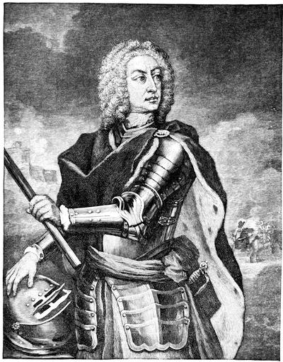
OGLETHORPE.
(See a Note on the Portraits of Oglethorpe on a later page.)
While he was chairman of the committee raised by the House of Commons to visit the prisons, examine into the condition of the inmates, and suggest measures of reform, the idea had occurred to Oglethorpe,—whose “strong benevolence of soul” has been eulogized by Pope,—that not a few of these unfortunate individuals confined for debt, of respectable connections, guilty of no crime, and the victims of a legal thraldom most vile and afflictive, might be greatly benefited by compromising the claims for the non-payment of which they were suffering the penalty of hopeless incarceration, upon the condition that when liberated they would become colonists in America. Thus would opportunity be afforded them of retrieving their fortunes; thus would England be relieved of the shame and the expense[363] of their imprisonment, and thus would her dominion in the New World be enlarged and confirmed. Not the depraved, not felons who awaited the approach of darker days when graver sentences were to be endured, not the dishonest who hoped by submitting to temporary imprisonment to exhaust the patience of creditors and emerge with fraudulently acquired gains still concealed, but the honestly unfortunate were to be the beneficiaries of this benevolent and patriotic scheme. Those also in the United Kingdom who through want of occupation and lack of means were most exposed to the penalties of poverty, were to be influenced in behalf of the contemplated colonization. It was believed that others, energetic, ambitious of preferment, and possessing some means, could be enlisted in aid of the enterprise. The anxiety of the Carolinians for the establishment of a plantation to the South which would serve as a shield against the incursions of the Spaniards, the attacks of the Indians, and the depredations of fugitive slaves was great. This scheme of colonization soon embraced within its benevolent designs not only the unfortunate of Great Britain, but also the oppressed and persecuted Protestants of Europe. Charity for, and the relief of, human distress were to be inscribed upon the foundations of the dwellings which Oglethorpe proposed to erect amid the Southern forests. Their walls were to be advanced bulwarks for the protection of the Carolina plantations, and their aspiring roofs were to proclaim the honor and the dominion of the British nation. In the whole affair there lingered no hope of personal gain, no ambition of a sordid character, no secret reservation of private benefit. The entire project was open, disinterested, charitable, loyal, and patriotic. Such was its distinguishing peculiarity. Thus was it recognized by all; and Robert Southey did but echo the general sentiment when he affirmed that no colony was ever projected or established upon principles more honorable to its founders.
As the accomplishment of his purpose demanded a larger expenditure than his means justified, and as the administration of the affairs of the plantation would involve “a broader basis of managing power” than a single individual could well maintain, Oglethorpe sought and secured the co-operation of wealthy and influential personages in the development of his beneficent enterprise.
That proper authority, ample cession, and royal sanction might be obtained, in association with Lord Percival and other noblemen and gentlemen of repute he addressed a memorial to the Privy Council, in which, among other things, it was stated that the cities of London and Westminster, and the adjacent region, abounded with indigent persons so reduced in circumstances as to become burdensome to the public, who would willingly seek a livelihood in any of His Majesty’s plantations in America if they were provided with transportation and the means of settling there. In behalf of themselves and their associates the petitioners engaged, without pecuniary recompense, to take charge of the colonization, and to erect the plantation into a proprietary government, if the Crown would be[364] pleased to grant them lands lying south of the Savannah River, empower them to receive and administer all contributions and benefactions which they might influence in encouragement of so good a design, and clothe them with authority suitable for the enforcement of law and order within the limits of the province. After the customary reference, this petition met with a favorable report, and by His Majesty’s direction a charter was prepared which received the royal sanction on the 9th of June, 1732.
By this charter, Lord John, Viscount Percival, Edward Digby, George Carpenter, James Oglethorpe, George Heathcote, Thomas Tower, Robert Moor, Robert Hucks, Roger Holland, William Sloper, Francis Eyles, John Laroche, James Vernon, William Beletha, John Burton, Richard Bundy, Arthur Beaford, Samuel Smith, Adam Anderson, and Thomas Coram and their successors were constituted a body politic and corporate by the name of “The Trustees for establishing the Colony of Georgia in America.” Ample were the powers with which this corporation was vested. Seven eighths “of all those lands lying and being in that part of South Carolina in America which lies from the most northern part of a stream or river there commonly called the Savannah, all along the sea-coast to the southward unto the most southern stream of a certain other great water or river called the Alatamaha, and westerly from the heads of the said rivers respectively in direct lines to the South Seas,” were conveyed to the trustees for the purposes of the plantation. The province was named Georgia, and was declared separate and distinct from South Carolina. To all, save Papists, was accorded a free exercise of religious thought and worship. For a period of twenty-one years were these corporators and their successors authorized to administer the affairs of the province. At the expiration of that time it was provided that such form of government would then be adopted, and such laws promulgated for the regulation of the colony and the observance of its inhabitants, as the Crown should ordain. Thereafter the governor of the province and all its officers, civil and military, were to be nominated and commissioned by the home government.
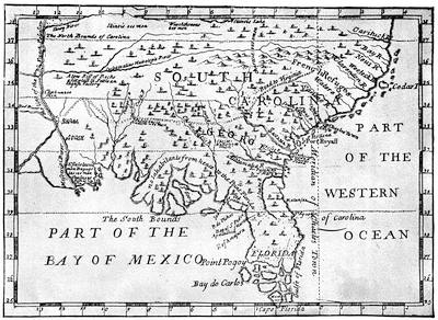
MAP OF SOUTH CAROLINA AND GEORGIA, 1773.
[Fac-simile of a map in Some Account of the Design of the Trustees for establishing the Colony of Georgia in America, 1733, in Harvard College Library [Tract vol. 536]. This tract is appended to Smith’s Sermon (1733). This map also appeared the same year in Reasonsf for Establishing the Colony of Georgia, etc. Cf. also the “New Map of Georgia” in the French version of Martyn’s tracts published in the Recueil de Voyages au Nord, Amsterdam, 1737; Harvard College Library, shelf-no. 3621. 9, vol. ix.—Ed.]
In July, 1732, the corporators convened, accepted the charter, and perfected an organization in accordance with its provisions.[841] Commissions were issued to leading citizens and charitable corporations empowering them to solicit contributions in aid of the trust. Generously did the Trustees subscribe. To prevent any misappropriation of funds, an account was opened with the Bank of England. There a register was kept of the names of all benefactors and of the amounts of their several donations. Liberal responses were received in furtherance of the charitable scheme both from individuals and from corporations; and, as an honorable indorsement of the[366] project and its managers, Parliament gave the sum of £10,000. Tracts commending the colonization to the favorable notice of the public were prepared,—notably by Oglethorpe, and by Benjamin Martyn, secretary to the Trustees,—and widely circulated.
In framing regulations for the observance of the colonists, and in maturing plans most conducive to the prosperity and permanence of the contemplated settlement, the trustees regarded each male inhabitant both as a planter and as a soldier. Hence, provision was made for supplying him with arms and with agricultural tools. Towns, in their inception, were reckoned as garrisons. Consequently the lands allotted for tillage were to be in their immediate neighborhood, so that in seasons of alarm the inhabitants might speedily betake themselves thither for safety and mutual protection. Fifty acres were adjudged sufficient for the support of a planter and his family. Grants in tail-male were declared preferable to any other tenure. The introduction and use of spirituous liquors were forbidden. Unless sanctioned by special license, traffic with the natives was prohibited. The trustees saw fit also to forbid the importation, ownership, and use of negro slaves within the limits of the province of Georgia. Provision was made for the cultivation of the mulberry tree and the breeding of silk-worms.
Keeping in view the benevolent objects of the association and the character of the settlement to be formed, it was manifest that only fit persons should be selected for colonization, and that due care should be exercised in the choice of emigrants. Preference was accordingly given to applicants who came well recommended by the ministers, church-wardens, and overseers of their respective parishes. That the Trustees might not be deceived in the characters and antecedents of those who signified a desire to avail themselves of the benefits of the charity, a committee was appointed to visit the prisons and examine the applicants there confined. If they were found to be worthy, compromises were effected with their creditors and consents procured for their discharge. Another committee sat at the office of the corporation to inquire into the circumstances and qualifications of such as there presented themselves. It has been idly charged that in the beginning Georgia colonists were impecunious, lawless, depraved, and abandoned; that the settlement at Savannah was a sort of Botany Bay, and that Yamacraw Bluff was peopled by runagates from justice. The suggestion is without foundation. The truth is that no applicant was admitted to the privilege of enrolment as an emigrant until he had been subjected to a preliminary examination, and had furnished satisfactory evidence that he was fairly entitled to the benefits of the charity. Other American colonies were founded and augmented by individuals coming at will, without question for personal gain, and furnishing no certificate of[367] either past or present good conduct. Georgia, on the contrary, exhibits the spectacle, at once unique and admirable, of permitting no one to enter her borders who was not, by competent authority, adjudged worthy the rights of citizenship. Even those colonists who proposed to come at their own charge, and who brought servants with them, were required, as a condition precedent to their embarkation, to prove that they had obtained permission from the committee selected by the Trustees to pass upon the qualification of applicants. Upon receiving the approbation of the committee, and until the time fixed for sailing, adult male emigrants passing under the bounty of the Trust were drilled each day by the sergeants of the Royal Guards.
By the 3d of October, 1732, one hundred and fourteen individuals—comprising men, women, and children—had been enrolled for the first embarkation. The “Anne,” a galley of some two hundred tons burden, commanded by Captain Thomas, was chartered to convey them to Georgia. She was furnished not only with necessaries for the voyage, but also with arms, agricultural implements, tools, munitions, and stores for the use and support of the colonists after their arrival in America. At his own request, Oglethorpe was selected to conduct the colonists and establish them in Georgia. He volunteered to bear his own expenses, and to devote his entire time and attention to the consummation of the important enterprise. Himself the originator and the most zealous advocate of the scheme,—this offer on his part placed the seal of consecration upon his self-denial, patriotism, and enlarged philanthropy. Most fortunate were the Trustees in securing the services of such a representative. To no one could the power to exercise the functions of a colonial governor have been more appropriately confided.
On the 17th of November, 1732, the “Anne” departed from England, having on board about one hundred and thirty persons. Thirty-five families were represented. Among them were carpenters, brick-layers, farmers, and mechanics, all able-bodied and of good repute. Shaping her course for the island of Madeira, the vessel there touched and took on board five tuns of wine. After a protracted voyage the “Anne” dropped anchor off Charlestown bar on the 13th of January, 1733. Two delicate children had died at sea. With this exception, no sorrow darkened the passage, and the colonists were well and happy.
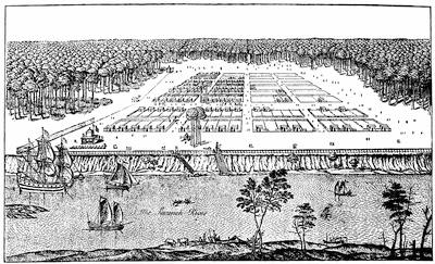
EARLY SAVANNAH.
This print, published in London, 1741, is called “A View of the Town of Savannah in the Colony of Georgia, in South Carolina, humbly inscribed to his Excellency General Oglethorpe.” References: A. Part of an island called Hutchinson’s Island. B. The stairs and landing-place from the river to the town. C. A crane and bell to draw up any goods from boats and to land them. D. A tent pitched near the landing for General Oglethorpe. E. A guard-house with a battery of cannon lying before it. F. The parsonage house. G. A plot of ground to build a church. H. A fort or lookout to the woodside. I. The House for all stores. K. The court house and chapel. L. The mill-house for the public. M. A house for all strangers to reside in. N. The common bake-house. O. A draw-well for water. P. The wood covering the back and sides of the town with several vistas cut into it.
It is reproduced in Jones’s History of Georgia, i. 121; and a small cut of it is given in Gay’s Popular History of the United States, iii. 140, and in Cassell’s United States, i. 487. There is also a print (15-3/4 × 21-3/4 inches) dedicated to the Trustees by Peter Gordon, which is inscribed “A view of Savanah [sic] as it stood the 29th of March, 1734. P. Gordon, inv., P. Fourdrinier, sculp,” of which there is a copy in the Boston Public Library [B. H. 6270, 52, no. 38]. Impressions may also be found in the British Museum, in the Mayor’s office in Savannah, and in the library of Dr. C. C. Jones, Jr., in Augusta, Ga.
Oglethorpe was warmly welcomed and hospitably entreated by the governor and council of South Carolina. The King’s pilot was detailed to conduct the “Anne” into Port Royal harbor. Thence the colonists were conveyed in small craft to Beaufort-town, where they landed and refreshed themselves; while their leader, accompanied by Colonel William Bull, proceeded to the Savannah River and made choice of a spot for the settlement. Ascending that stream as far as Yamacraw Bluff, and deeming it an eligible situation, he went on shore and marked out the site of a town which, from the river flowing by, he named Savannah. This bluff, rising some forty feet above the level of the river, and presenting a bold frontage on the water of nearly a mile,—quite ample for the riparian uses of a settlement[369] of considerable magnitude,—was the first high ground abutting upon the stream encountered by him in its ascent. To the south a high and dry plain, overshadowed by pines interspersed with live-oaks and magnolias, stretched away for a mile or more. On the east and west were small creeks and swamps affording convenient drainage for the intermediate territory. The river in front was capable of floating ships of ordinary tonnage, and they could lie so near the shore that their cargoes might with facility be discharged. Northwardly, in the direction of Carolina, lay the rich delta of the river, with its islands and lowlands crowned with a dense growth of cypress, sweet-gum, tupelo, and other trees, many of them vine-covered and draped in long gray moss swaying gracefully in the ambient air. The yellow jessamine was already mingling its delicious perfume with the breath of the pine, and the forest was vocal with the voices of singing birds. Everything in this semi-tropical region was quickening into life and beauty under the influences of returning spring. In its primeval repose it seemed a goodly land. The temperate rays of the sun gave no token of the heat of summer. There was no promise of the tornado and the thunder-storm in the gentle winds. In the balmy air lurked no suspicion of malarial fevers. Its proximity to the mouth of the river rendered this spot suitable alike for commercial purposes and for maintaining easy communication with the Carolina settlements.
Near by was an Indian village peopled by the Yamacraws, whose chief, or mico, was the venerable Tomo-chi-chi. Having, through the intervention of Mary Musgrove,—a half-breed, and the wife of a Carolina trader who had there established a post,—persuaded the natives of the friendly intentions of the English and secured from them an informal cession of the desired lands, Oglethorpe returned to Beaufort. Thence, on the 30th of January, 1733, the colonists, conveyed in a sloop of seventy tons and in five periaguas, set sail for Yamacraw Bluff, where, on the afternoon of the second day afterward, they arrived in safety and passed their first night upon the soil of Georgia. The ocean had been crossed, and the germ of a new colony was planted in America. Sharing the privations and the labors of his companions, Oglethorpe was present planning, supervising, and encouraging. In marking out the squares, lots, and streets of[370] Savannah, he was materially assisted by Colonel William Bull. Early and acceptable aid was extended by the authorities of Carolina, and this was generously supplemented by private benefactions. Well knowing that the planting of this colony would essentially promote the security of Carolina, shielding that province from the direct assaults and machinations of the Spaniards in Florida, preventing the ready escape of fugitive slaves, guarding her southern borders from the incursions of Indians, increasing commercial relations, and enhancing the value of lands, the South Carolinians were eager to further the prosperity of Georgia. Sensible of the courtesies and assistance extended, Oglethorpe repaired at an early day to Charlestown to return thanks in behalf of the colony and to interest the public still more in the development of the plantation. In this mission he was eminently successful. He was cheered also by congratulations and proffers of aid from other American colonies.
In nothing were the prudence, wisdom, skill, and ability of the founder of the colony of Georgia more conspicuous than in his conduct toward and treatment of the Indians. The ascendency he acquired over them, the respect they entertained for him, and the manly, generous, and just policy he ever maintained in his intercourse with the native tribes of the region are remarkable. Their favor at the outset was essential to the repose of the settlement; their friendship, necessary to its existence. As claimants of the soil by virtue of prior occupancy, it was important that the title they asserted to these their hunting grounds should at an early moment be peaceably and formally extinguished. Ascertaining from Tomo-chi-chi the names and abodes of the most influential chiefs dwelling within the territory ceded by the charter, Oglethorpe enlisted the good offices of this mico in calling a convention of them at Savannah. In May, 1733, the Indians assembled, and on the 21st of that month a treaty was solemnized, by which the Creeks ceded to the Trustees all lands lying between the Savannah and the Alatamaha rivers, from the ocean to the head of tide-water. In this cession were also embraced the islands on the coast from Tybee to St. Simon inclusive, with the exception of Ossabau, Sapelo, and St. Catharine, which were reserved for the purposes of hunting, fishing, and bathing. A tract of land between Pipe-maker’s Bluffs and Pally-Chuckola Creek was also retained as a place of encampment whenever it should please the natives to visit their white friends at Savannah. Stipulations were entered into regulating the price of goods, the value of peltry, and the privileges of traders. It was further agreed that criminal offences should be tried and punished in accordance with the laws of England. In due course the provisions of this treaty were formally ratified by the Trustees.
Thus happily, in the very infancy of the colony, was the title of the Aborigines to the lands south of the Savannah amicably extinguished. This treaty compassed the pacification of the Lower Creeks, the Uchees, the Yamacraws, and of other tribes constituting the Muskhogee confederacy.
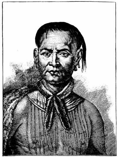
TOMO-CHI-CHI MICO.
[This head is taken from a German print, engraved at Augsburg, purporting to follow an original issued in London. The full print also represents Tooanahowi, his brother’s son, a lad, holding an eagle as he stands beside his uncle. The entire print on a smaller scale is reproduced in Jones’s History of Georgia; in Gay’s Popular History of the United States, iii. 147; and in Dr. Eggleston’s papers on “Life in the English Colonies” in the Century Magazine.—Ed.]
Nor did the influences of this convocation rest with them only. They were recognized by the Upper Creeks; and at a later date similar stipulations were sanctioned by the Cherokees. For years were they preserved inviolate; and the colony of Georgia, thus protected, extended its settlements up the Savannah River and along the coast, experiencing neither opposition nor molestation, but receiving on every hand valuable assurance of the good-will of the children of the forest. Probably the early history of no plantation in America affords so few instances of hostility on the part of the natives, or so many acts of kindness extended by the red men. Potent was the influence of Tomo-chi-chi in consummating this primal treaty of amity and commerce. Had this chief, turning a deaf ear to the advances of Oglethorpe, refused his friendship, denied his request, and, inclining his authority to hostile account, instigated a combined and determined opposition on the part of the Yamacraws, the Uchees, and the Lower Creeks, the perpetuation of this English settlement[372] would have been either most seriously imperilled or abruptly terminated amid smoke and carnage. When therefore we recur to the memories of this period, and as often as the leading events in the early history of the colony of Georgia are narrated, so often should the favors experienced at the hands of this mico be gratefully acknowledged. If Oglethorpe’s proudest claim to the honor and respect of succeeding generations rests upon the fact that he was the founder of the colony of Georgia, let it not be forgotten that in the hour of supreme doubt and danger the right arm of this son of the forest, his active intervention, and his unswerving friendship were among the surest guarantees of the safety and the very existence of that province. Tomo-chi-chi will be remembered as the firm ally of the white man, the guide and protector of the colonist, the constant companion and faithful confederate of Oglethorpe.
Accessions occurred as rapidly as the means of the Trust would allow. Among some of the early comers were Italians from Piedmont, who were engaged to develop the silk industry, from the pursuit of which considerable gain was anticipated. As the immigrants multiplied, and the defences at Savannah were strengthened, Fort Argyle was built on the Great Ogeechee River, the villages of Highgate and Hampstead were laid out, Thunderbolt and Skidoway Island were occupied, Joseph’s Town and Abercorn were peopled, and plantations formed on Augustine Creek, on the Little Ogeechee, and as far south as the Great Ogeechee River. On the 7th of July, 1733, occurred a general allotment of town lots, garden lots, and farms among the inhabitants of Savannah; and this was confirmed by deed executed on the 21st of the following December. The town lot contained sixty feet in front and ninety feet in depth; the garden lot embraced five acres. Forty-four acres and one hundred and forty-one poles constituted the farm; so that the grant aggregated fifty acres,—thus conforming to the instructions of the Trustees, and furnishing land sufficient for the support of the colonist who came at the charge of the Trust and brought no servants. The conveyance was in tail-male. Of the moneys realized from the sale of lands in the island of St. Christopher, the sum of £10,000 was, in pursuance of a resolution of the House of Commons, paid over to the “Trustees for establishing the Colony of Georgia in America,” to be by them applied “towards defraying the charges of carrying over and settling foreign and other Protestants in said colony.” This timely relief enabled the Trustees to accomplish a purpose from the execution of which they had been prevented by a want of funds. In the administration of the Trust preference had been accorded to English Protestants seeking homes in the New World. Now, however, they were justified in enlarging the scope of their charity, because the resolution in obedience to which this liberal benefaction was made, contemplated in terms the colonization of foreign Protestants.
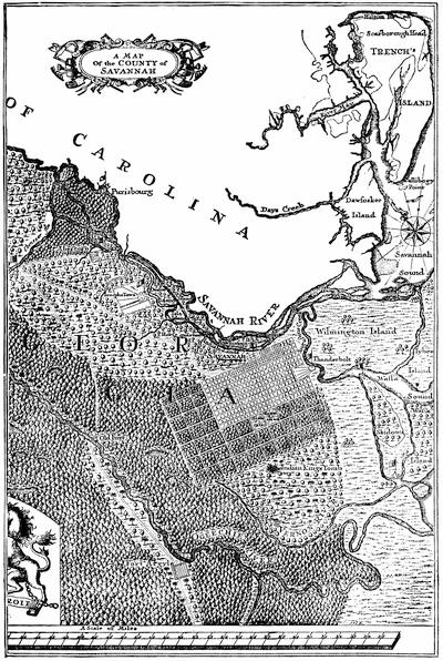
COUNTY OF SAVANNAH.
This is a portion of a map in the Urlsperger Tracts, the whole of which is reproduced in Jones’s History of Georgia, i. 148.
As the first fruits of this expanded charity, on Reminiscere Sunday, according to the Lutheran Calendar, in March, 1734, the ship “Purisburg” entered the Savannah River having on board seventy-eight Salzburgers under the conduct of Baron von Reck, and accompanied by their spiritual advisers the Rev. John Martin Bolzius and the Rev. Israel Christian Gronau. They came from the town of Berchtolsgaden and its vicinity, had taken the oath of loyalty to the British Crown, and were conveyed at the charge of the Trust. “Lying in fine and calm weather under the Shore of our beloved Georgia, where we heard the Birds sing melodiously, every Body in the Ship was joyful,”—so wrote the Rev. Mr. Bolzius, the faithful attendant and religious teacher of this Protestant band. He tells us that when the ship arrived at the wharf, “almost all the inhabitants of the Town of Savannah were gather’d together; they fired off some Cannons and cried Huzzah!... Some of us were immediately fetch’d on shore in a Boat, and carried about the City, into the woods, and the new Garden belonging to the Trustees. In the mean time a very good Dinner was prepared for us.” The inhabitants “shewing them a great deal of kindness, and the Country pleasing them,” the new-comers “were full of Joy and praised God for it.”
By the 7th of April all these Salzburgers had been conducted to the spot designated as their future home. Although sterile and unattractive, and situated in the midst of a pine barren, to these peoples, tired of the sea and weary of persecutions, the locality appeared blessed, redolent of sweet hope, teeming with bright promise, and offering charming repose. The little town which they built in what is now Effingham County, they called Ebenezer. Early in the following year this settlement was reinforced by fifty-seven Salzburgers sent over by the Trustees in the ship “Prince of Wales.” Accessions occurred from time to time; and thus was introduced into the colony a population inured to labor, sober, of strong religious convictions, conservative in thought and conduct, obedient to rulers, and characterized by intelligent industry. Disappointed in their anticipations with regard to the fertility of the soil and the convenience of their location, these peoples, with the consent of Oglethorpe, in a few years abandoned their abodes and formed a new settlement on the Savannah River near the confluence of Ebenezer Creek with that stream.
And now the Moravians, accompanied by the Rev. Gottlieb Spangenberg, sought freedom of religious thought and worship in the province of Georgia. To them were assigned lands along the line of the Savannah River between the Salzburgers and the town of Savannah. With the Salzburgers they associated on terms of the closest friendship. In subduing the forests, in erecting comfortable dwellings, and in cultivating the soil, they exhibited a most commendable zeal.
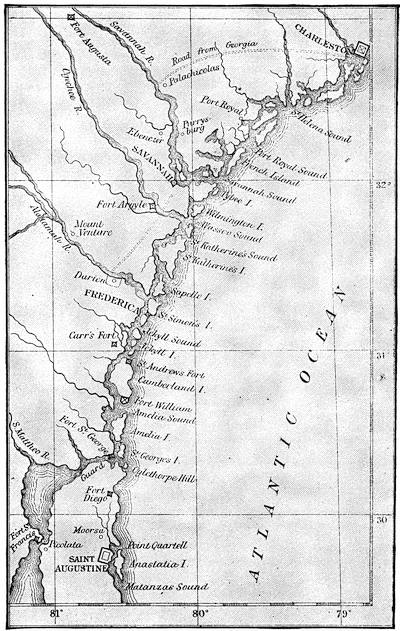
COAST SETTLEMENTS BEFORE 1743.
[This is the map given by Robert Wright in his Memoir of General James Oglethorpe, London, 1867. There is a similar map in Harris’s Oglethorpe. Cf. Gay’s Popular History of the United States, iii. 156.—Ed.]
Encouraged by the development of the plantation, desiring a personal conference with the Trustees, and rightly judging that the advantage and security of the province would be materially promoted by taking with him to England some of the most intelligent of his Indian neighbors, that they might by personal observation acquire a definite conception of the greatness and the resources of the British empire, and, moved by the kindnesses and attentions which he was quite sure would be extended to them on every hand, imbibe memories that would tend to cement the alliances and perpetuate the amicable relations which had been so auspiciously inaugurated,—Oglethorpe, in March, 1734, persuaded Tomo-chi-chi with a selected retinue to accompany him to London. The reception accorded to these Indians in the English capital and its environs was cordial and appropriate. This visit of Tomo-chi-chi and his companions, and the interest awakened by their presence in London, materially assisted Oglethorpe and the Trustees in enlisting the renewed and earnest sympathies of the public, not only in behalf of the colonists, but also in aid of the education and religious instruction of the natives. Widely disseminated among the Indian nations was the knowledge of this sojourn of the mico of the Yamacraws and his companions in the home of the white man. The novel and beautiful presents which the Indians brought back with them afforded ocular proof of the liberality of the English, and produced a profound impression upon the natives, who, grateful for the kindness shown to members of their race, were encouraged in the perpetuation of the amicable relations existing between themselves and the colonists.
Through the influence of Oglethorpe the regulations of the Trustees prohibiting the importation and sale of rum, brandy, and other distilled liquors within the limits of Georgia, and forbidding the introduction and use of negro slaves in the province, received the sanction of Parliament. Commenting upon this legislation, Edmund Burke remarked that while these restrictions were designed to bring about wholesome results, they were promulgated without a sufficient appreciation of the nature of the country and the disposition of the people to be affected by them. Long and earnestly did many of the colonists petition for the removal of these prohibitions, which placed the province at a disadvantage when its privileges were contrasted with those of sister plantations, and beyond doubt, so far at least as the employment of slave-labor was concerned, retarded its material development.
The peopling and fortification of the southern confines of Georgia engaged the earnest thought of the Trustees. The Spaniards regarded with a jealous eye the confirmation of this new English colony upon the borders of Florida. Moved by urgent memorials on the subject, Parliament granted £26,000 for “the settling, fortifying, and defending” Georgia. Their treasury being thus replenished, and anxious to enlist colonists of acknowledged strength and valor, the Trustees, through Lieutenant Hugh Mackay, recruited among the Highlands of Scotland one hundred and thirty men, with fifty women and children. They were all of excellent character, and were carefully selected for their military qualities. Accompanied by a clergyman of their own choice,—the Rev. John McLeod, of the Isle of Skye,—this hardy company was conveyed to Georgia and assigned to the left bank of the Alatamaha, about sixteen miles above the island[377] of St. Simon. Here these Highlanders landed, erected a fort, mounted four pieces of cannon, built a guard-house, a store, and a chapel, and constructed huts for temporary accommodation preparatory to putting up more substantial structures. To their little town they gave the name of New Inverness, and the district which they were to hold and cultivate they called Darien. These Scots were brave and hardy; just the men to occupy this advanced post. In their plaids, and with their broadswords, targets, and fire-arms, they presented a most manly appearance. Previous to their departure from Savannah in periaguas, some Carolinians endeavored to dissuade them from going to the south by telling them that the Spaniards from the houses in their fort would shoot them upon the spot selected by the Trustees for their abode. Nothing daunted, these doughty countrymen of Bruce and Wallace responded, “Why, then, we will beat them out of their fort, and shall have houses ready built to live in.” This valiant spirit found subsequent expression in the efficient military service rendered by these Highlanders during the wars between the colonists and the Spaniards, and by their descendants in the American Revolution. Augmented at intervals by fresh arrivals from Scotland, this settlement, although placed in a malarial region, steadily increased in wealth and influence.
At an early date a road was constructed to connect New Inverness with Savannah.
On the morning of Feb. 5, 1736, the “Symond” and the “London Merchant,” with the first of the flood, passed over the bar and came to anchor within Tybee Roads. On board were two hundred and two persons conveyed on the Trust’s account. Among them were English people, German Lutherans under the conduct of Baron von Reck and Captain Hermsdorf, and twenty-five Moravians with their bishop the Rev. David Nitschman. Oglethorpe was present, accompanied by the brothers John and Charles Wesley, the Rev. Mr. Ingham, and by Charles Delamotte, the son of a London merchant and a friend of the Wesleys. Coming at their own charge were Sir Francis Bathurst, with family and servants, and some relatives of planters already settled in the province. Ample stores of provisions, small arms, cannon, ammunition, and tools were transported in these vessels. The declared object of this large accession of colonists was the population of the southern confines of the province and the building of a military town on the island of St. Simon, to be called Frederica.
It was not until the 2d of March that the fleet of periaguas and boats, with the newly arrived on board, set out from Tybee Roads for the mouth of the Alatamaha. The voyage to the southward was accomplished in five days. So diligently did the colonists labor, and so materially were they assisted by workmen drawn from other parts of the province and from Carolina, that by the 23d of the month Frederica had been laid out, a battery of cannon commanding the river had been mounted, and a fort almost completed. Its ditches had been dug, although not to the required depth or width, and a rampart raised and covered with sod. A storehouse, having a front[378] of sixty feet, and designed to be three stories in height, was finished as to its cellar and first story. The main street which “went from the Front into the Country was 25 yards wide. Each Freeholder had 60 Feet in Front by 90 Feet in depth upon the high Street for their House and Garden; but those which fronted the River had but 30 Feet in Front by 60 Feet in Depth. Each Family had a Bower of Palmetto Leaves finished upon the back Street in their own Lands. The Side towards the front Street was set out for their Houses. These Palmetto Bowers were very convenient shelters, being tight in the hardest Rains; they were about 20 Feet long and 14 Feet wide, and in regular Rows looked very pretty, the Palmetto Leaves lying smooth and handsome, and of a good Colour. The whole appeared something like a Camp; for the Bowers looked like Tents, only being larger and covered with Palmetto Leaves instead of Canvas. There were 3 large Tents, two belonging to Mr. Oglethorpe and one to Mr. Horton, pitched upon the Parade near the River.” Such is the description of Frederica in its infancy as furnished by Mr. Moore, whose Voyage to Georgia is perhaps the most interesting and valuable tract we possess descriptive of the colonization of the southern portion of Georgia. That there might be no confusion in their labors, Oglethorpe divided the colonists into working parties. To some was assigned the duty of cutting forks, poles, and laths for building the bowers; others set them up; others still gathered palmetto leaves; while “a fourth gang,” under the superintendence of a Jew workman, bred in Brazil and skilled in the matter, thatched the roofs “nimbly and in a neat manner.”
Men accustomed to agriculture instructed the colonists in hoeing and preparing the soil. Potatoes, Indian corn, flax, hemp-seed, barley, turnips, lucern-grass, pumpkins, and water-melons were planted. Labor was common, and inured to the general benefit of the community. As it was rather too late in the season to till the ground fully and sow a crop to yield sufficient to subsist the settlement for the current year, many of the men were put upon pay and set to work upon the fortifications and the public buildings.
Frederica, situated on the west side of St. Simon’s Island, on a bold bluff confronting a bay formed by one of the mouths of the Alatamaha River, was planned as a military town, and constructed with a view to breasting the shock of hostile assaults. Its houses were to be substantially built, not of wood as in Savannah, but of tabby. At an early period its streets by their names proclaimed the presence of men-at-arms, while its esplanade and parade-ground characterized it as a permanent camp.[842] Including the camp on the north, the parade on the east, and a small wood on the south which was to serve as a blind in the event of an attack from ships coming up the river, the settlement was about a mile and a half in circumference.
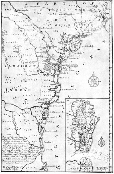
Note.—The map opposite, showing the coast from St. Augustine to Charlestown (S. C.), is copied from one in vol. v. of the Urlsperger Tracts. There is another plan of St. Simon’s Island in W. B. Stevens’s Georgia. i. 186.
The town proper was to be protected by embankment and ditch, and places for two gates, called respectively the Town and Water posts, were indicated. The citadel was to be made of tabby, and formidably armed. In front, a water battery, mounting several eighteen-pounder guns, was designed to command the river. It was contemplated to guard the town on the land side by a formidable intrenchment, the exterior ditch of which could be filled with water. As Savannah was intended as the commercial metropolis of the province, so was Frederica to constitute its southern outpost and strong defence. It soon became the Thermopylæ of the southern Anglo-American Colonies, the headquarters of Oglethorpe’s regiment, the depot of military supplies for the dependent forts built at the south, and the strong rallying point for British colonization in the direction of Florida. In the history of the colony there is no brighter chapter, and in the eventful life of Oglethorpe no more illustrious epoch, than that which commemorates the protracted and successful struggle with the Spaniards for the retention of the charming island of St. Simon. In 1737 Oglethorpe kissed His Majesty’s hand on receiving his commission as colonel. He was also appointed general and commander-in-chief of all His Majesty’s forces in South Carolina and Georgia, that he might the more readily wield the military power of the two provinces in their common defence.
The finances of the Trust were now in a depressed condition, and the General was compelled to draw largely upon his private fortune and to pledge his individual credit in conducting the operations necessary for the security of the southern frontier, and in provisioning the settlers. Matters were further complicated by the defalcation of Thomas Causton, the first Magistrate of Savannah and Keeper of the public stores. Silk culture, from which so much was anticipated, proved a positive expense. There was no profit in the vine. Enfeebled by the hot suns of summer, and afflicted with fevers and fluxes engendered by malarial exhalations from the marish grounds, many of the inhabitants lost heart and cried aloud for the introduction of African slavery. Disappointed in their plans for the religious instruction of the colonists and the conversion of the natives, the brothers John and Charles Wesley had quitted the province. In the consummation of his benevolent and educational scheme, the Rev. George Whitefield was compelled to rely upon foreign aid. With the exception of the Highlanders at Darien, the Salzburgers at Ebenezer, and the Indian traders at Augusta, Georgia could not boast that her inhabitants were either contented or prosperous. There was general clamor for fee-simple title to lands, and permission to buy slaves was constantly urged. The disaffected hesitated not to malign the authorities, to disquiet the settlers, and to exaggerate the unpleasantness of the situation. Fortunately the Indian nations remained peaceful; and in general convention held at[381] Coweta-town in August, 1739, in the presence of Oglethorpe, they renewed their fealty to the King of Great Britain, and in terms most explicit confirmed their previous grants of territory.
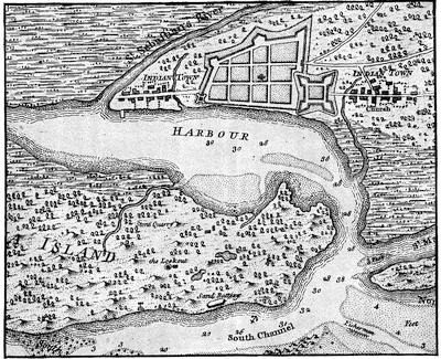
[Fac-simile of a plan of St. Augustine in Roberts’s Account of Florida, London, 1763.—Ed.]
And now the Spanish war-cloud which had so long threatened the southern confines of the province, seemed about to descend in wrath and power. Acting under the discretionary powers confided to him, General Oglethorpe resolved to anticipate the event by an invasion of Florida and the reduction of St. Augustine,—the stronghold of Spanish dominion in that province.
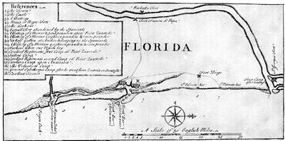
COAST OF FLORIDA.
Fac-simile of the plan in An Impartial Account of the late Expedition against St. Augustine under General Oglethorpe. London, 1742.
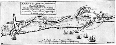
HARBOR AND TOWN OF ST. AUGUSTINE.
[Fac-simile of part of the map in An Impartial Account of the late Expedition against St. Augustine under General Oglethorpe, occasioned by the suppression of the Report of the General Assembly of South Carolina, with an exact plan of St. Augustine and the adjacent coast of Florida, showing the disposition of our Forces. London, 1742.—Ed.]
Collecting his regiment, summoning to his assistance forces from South Carolina, and calling in his Indian allies, in May, 1740, with a mixed army of rather more than two thousand men, he moved upon the capital of Florida. In this expedition Sir Yelverton Peyton, with the British vessels of war,—the “Flamborough,” the “Phœnix,” the “Squirrel,” the “Tartar,” the “Spence,” and the “Wolf,”—was to participate. The castle of St. Augustine consisted of a fort built of soft stone. Its curtain was sixty yards in length, its parapet nine feet thick, and its rampart twenty feet high, “casemated underneath for lodgings, and arched over and newly made bombproof.” Its armament consisted of fifty cannon, sixteen of brass, and among them some twenty-four pounders. For some time had the garrison been working upon a covered way, but this was still in an unfinished condition. The town was protected by a line of intrenchments, with ten salient angles, in each of which field-pieces were mounted. In January, 1740, the Spanish forces in Florida, exclusive of Indians and one company of militia, were estimated at nine hundred and sixty-five men of all arms. As foreshadowed in his dispatch of the 27th of March, 1740, it was the intention of General Oglethorpe to advance directly upon St. Augustine, and attack by sea and land the town and the island in its front. Both, he believed, could be taken “sword in hand.” Conceiving that the castle would be too small to afford convenient shelter for the two thousand one hundred men, women, and children of the town, he regarded the capitulation of the fortress as not improbable. Should it refuse to surrender, he proposed to shower upon it “Granado-shells from the Coehorns and Mortars,” and other projectiles. If it should not yield under the bombardment, he was resolved to open trenches and reduce it by a regular siege. The result was a disastrous failure. This miscarriage may be fairly attributed,—first, to the delay in inaugurating the movement, caused mainly, if not entirely, by the tardiness on the part of the South Carolina authorities in contributing the troops, munitions, and provisions for which requisition had been made; in the second place, to the reinforcement of men and supplies from Havana introduced into St. Augustine just before the English expedition set out, thereby repairing the inequality previously existing between the opposing forces; again, to the injudicious movements against Forts Francis de Papa and Diego, which put the Spaniards upon the alert, encouraged concentration on their part, and foreshadowed an immediate demonstration in force against their stronghold; and to the inability on the part of the fleet to participate in the assault previously planned, and which was to have been vigorously undertaken so soon as General Oglethorpe with his land forces came into position before the walls of St. Augustine. Finally, the subsequent surprise and destruction of Colonel Palmer’s command, thereby enabling the enemy to communicate with and draw supplies from the interior; the lack of heavy ordnance with which to reduce the castle from the batteries planted on Anastasia island; the impossibility of bringing up the larger war vessels that they might participate in the bombardment; the inefficiency of Colonel Vanderdussen’s command; the impatience and disappointment of the Indian allies, who anticipated[385] early capture and liberal spoils; as well as hot suns, heavy dews, a debilitating climate, sickness among the troops, and the arrival of men, munitions of war, and provisions from Havana through the Matanzas River,—all conspired to render futile whatever hopes at the outset had been entertained for a successful prosecution of the siege.
Although this attempt—so formidable in its character when we consider the limited resources at command, and so full of daring when we contemplate the circumstances under which it was prosecuted—resulted in disappointment, its effects were not without decided advantage to Georgia and her sister colonies. For two years the Spaniards remained on the defensive. During that time General Oglethorpe enjoyed an opportunity for strengthening his fortifications and increasing his army; so that when the counter blow was delivered by his adversary, he was the better prepared not only to parry it, but also to punish the uplifted arm.
During the preceding seven years, which constituted the entire life of the colony, Oglethorpe had enjoyed no respite from his labors. Personally directing all movements; supervising the location and providing for the comfort, safety, and good order of the colonists as they arrived from time to time; reconciling their differences, encouraging and directing their labors; propitiating the aborigines, influencing necessary supplies, inaugurating suitable defences, and enforcing the regulations of the Trustees,—he had passed constantly from point to point, finding no rest. Upon his shoulders, as the Trustees’ representative and as a de facto colonial governor, did the administration of the affairs of the province rest. Now in tent at Savannah; now in open boat reconnoitring the coast, now upon the southern islands, his only shelter the wide-spreading live-oak, designating sites for forts and lookouts, and with his own hands planning military works and laying out villages; again journeying frequently along the Savannah, the Great Ogeechee, the Alatamaha, the St. John, and far off into the heart of the Indian country; often inspecting his advanced posts; undertaking voyages to Charlestown and to England in behalf of the Trust, and engaged in severe contests with the Spaniards,—his life had been one of incessant activity and solicitude. But for his energy, intelligence, watchfulness, valor, and self-sacrifice, the important enterprise must have languished. As we look back upon this period of trial, uncertainty, and poverty, our admiration for his achievements increases the more closely we scan his limited resources and opportunities, the more thoroughly we appreciate the difficulties he was called upon to surmount.
There was a lull in the storm; but the skies were still overcast. In the distance were heard ominous mutterings portending the advent of another and a darker tempest. Anxious but calm, Oglethorpe scanned the adverse skies and prepared to breast their fury. In alluding to the expected invasion from St. Augustine, he thus writes to the Duke of Newcastle: “If our men-of-war will not keep them from coming in by sea, and we have no succor, but decrease daily by different accidents, all we can do will be[386] to die bravely in His Majesty’s service.... I have often desired assistance of the men-of-war, and continue to do so. I go on in fortifying this town [Frederica], making magazines, and doing everything I can to defend the province vigorously; and I hope my endeavors will be approved of by His Majesty, since the whole end of my life is to do the duty of a faithful subject and grateful servant.”
Late in June, 1742, a Spanish fleet of fifty-one sail, with nearly five thousand troops on board, under the command of Don Manuel de Monteano, governor of St. Augustine, bore down upon the Georgia coast with a view to the capture of the island of St. Simon and the destruction of the English plantation south of the Savannah. To resist this formidable descent, General Oglethorpe could oppose only a few small forts, about six hundred and fifty men, a guard schooner, and some armed sloops. With a bravery and dash almost beyond comprehension, by strategy most admirable, Oglethorpe by a masterly disposition of the troops at command, coupled with the timidity of the invaders and the dissensions which arose in their ranks, before the middle of July put the entire Spanish army and navy to flight. This “deliverance of Georgia,” said Whitefield, “is such as cannot be paralleled but by some instances out of the Old Testament.” The defeat of so formidable an expedition by such a handful of men was a matter of astonishment to all. The memory of this defence of St. Simon’s Island and the southern frontier is one of the proudest in the annals of Georgia. Never again did the Spaniards attempt to put in execution their oft-repeated threat to extirpate all the English plantations south of Port-Royal Sound. Sullenly and with jealous eye did they watch the development of Georgia, until twenty-one years afterwards all disputes were ended by the cession of Florida to the Crown of Great Britain. Upon the confirmation of the Peace of Aix-la-Chapelle most of the English troops were withdrawn from the island of St. Simon, and its fortifications soon began to fall into decay.
Georgia at this time consisted of only two counties, Savannah and Frederica. In April, 1741, Colonel William Stephens, who for several years had been acting in the colony as secretary to the Trustees, was by them appointed president of the county of Savannah. In the administration of public affairs he was aided by four assistants. As General Oglethorpe, who was charged with the direction and management of the entire province, spent most of his time at Frederica, the designation of a presiding officer for that division of Georgia was regarded as superfluous. Bailiffs were constituted, whose duty it was, under the immediate supervision of the General, to attend to the concerns of that county. At Augusta, Captain Richard Kent acted as “conservator to keep the peace in that town and in the precincts thereof.” Upon the return of General Oglethorpe to England, in order to provide for the government of the entire colony the Trustees decided that the president and assistants who had been appointed for the county of Savannah should be proclaimed president and assistants for the[387] whole province, and that the bailiffs at Frederica should be considered simply as local magistrates. They further advised that the salary of the recorder at Frederica be raised, and that he correspond regularly with the president and assistants in Savannah, transmitting to them from time to time the proceedings of the town court, and rendering an account of such transactions and occurrences in the southern part of the province as it might be necessary for them to know. Thus, upon the departure of General Oglethorpe, the honest-minded and venerable Colonel William Stephens succeeded to the office of colonial governor. It was during his administration that the Trustees, influenced by repeated petitions and anxious to promote the prosperity of the province, removed the restrictions hitherto existing with regard to the introduction, use, and ownership of negro slaves, and the importation of rum and other distilled liquors. They also permitted existing tenures of land “to be enlarged and extended to an absolute inheritance.”
In bringing about the abrogation of the regulation which forbade the ownership or employment of negro slaves in Georgia, no two gentlemen were more influential than the Rev. George Whitefield and the Hon. James Habersham. The former boldly asserted that the transportation of the African from his home of barbarism to a Christian land, where he would be humanely treated and required to perform his share of toil common to the lot of humanity, was advantageous; while the latter affirmed that the colony could not prosper without the intervention of slave-labor. Georgia now enjoyed like privileges with those accorded to the sister American provinces. Lands could now be held in fee-simple, and the power of alienation was unrestricted. The ownership and employment of negro slaves were free to all, and the New England manufacturer could here find an open market for his rum.
The Trustees had up to this point seriously misinterpreted the capabilities of the climate and soil of Georgia. Although substantial encouragement had been afforded to Mr. Amatis, to Jacques Camuse, to the Salzburgers at Ebenezer, and to others; although copper basins and reeling-machines had been supplied and a filature erected; although silk-worm eggs were procured and mulberry trees multiplied,—silk-culture in Georgia yielded only a harvest of disappointment. The vine also languished. Olive trees from Venice, barilla seeds from Spain, the kali from Egypt, and other exotics obtained at much expense, after a short season withered and died in the public garden. Hemp and flax, from the cultivation of which such rich yields were anticipated, never warranted the charter of a single vessel for their transportation, and indigo did not then commend itself to public favor. Exportations of lumber were infrequent. Cotton was then little more than a garden plant, and white laborers could not compete successfully with Carolina negroes in the production of rice. Up to this point the battle had been with Nature for life and subsistence. Upon the stores of the Trust did many long rely for food and clothing. Of trade[388] there was little, and that was confined to the procurement of necessaries. With the exception of occasional shipments of copper money for circulation among the inhabitants, sola bills constituted the chief currency of the province. Now, however, all restrictions removed, Georgia entered upon a career of comparative prosperity.
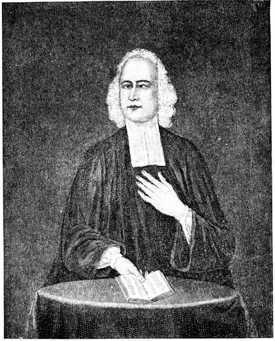
WHITEFIELD.
This cut (see also the Memorial History of Boston, ii. 238) follows a painting in Memorial Hall, Cambridge, Mass. The portraits of Whitefield are numerous. J. C. Smith (British Mezzotint Portraits, i. 442, 443; iii. 601, 692, 939; iv. 1545) enumerates various ones in that style, giving a photo-reproduction of one. The Lives of him usually give likenesses.
On the 8th of April, 1751, Mr. Henry Parker was appointed president of the colony in the room of Colonel Stephens, who retired upon a pension of £80. During his administration the first Provincial Assembly of Georgia[389] convened at Savannah. It was composed of sixteen delegates, and was presided over by Francis Harris. As the privilege of enacting laws was by the terms of the charter vested exclusively in the Trustees, this assembly could not legislate. Its powers were limited to discussing and suggesting such measures as its members might deem conducive to the welfare of particular communities and important for the general good of the province.
The “Trustees for establishing the Colony of Georgia in America” resolved to surrender their charter and relieve themselves from the further execution of a trust which had grown quite beyond their management. For twenty years they had supported its provisions with an earnest solicitude, a philanthropic zeal, a disinterested purpose, and a loyal devotion worthy of every commendation. They had seen a feeble plantation upon Yamacraw Bluff expand year by year, until it now assumed the proportions of a permanent colony and disclosed the potentialities of a future nation. The English drum-beat on the banks of the Savannah is answered by the Highland bagpipe on the Alatamaha, and the protecting guns of Frederica are supplemented by the sentinel field-pieces at Augusta. At every stage of progress and in every act, whether trivial or important, these Trustees, capable and worthy, evinced a clear conception of duty, a patience of labor, a singleness of purpose, an unselfish dedication of time and energy, and a rigid adherence to all that was pure, elevated, and humanizing, which become quite conspicuous when their proceedings are minutely and intelligently scanned. That they erred in their judgment in regard to the best method of utilizing many of these marish lands, smitten by sun and storms and pregnant with fevers and fluxes, may not now be doubted; that the theory upon which they administered the trust was in some respects narrow and retarding in its influences, is equally certain; that they were unfortunate in the selection of some of their agents excites no surprise,—but that they were upright, conscientious, observant, and most anxious to promote the best interests of the colony, as they comprehended them, will be freely admitted.
The surrender of the charter was formally concluded on the 23d of June, 1752; and Georgia, no longer the ward of the Trustees, passed into the hands of the Crown. Until clothed with the attributes of State sovereignty by the successful issue of the American Revolution, she was recognized as one of the daughters of England under the special charge of the Lords Commissioners for Trade and Plantations. By the terms of the surrender, her integrity as an independent province, separate from South Carolina, was fully assured, and all grants of land, hitherto made to the inhabitants, were recognized and respected.
Upon the death of Mr. Parker, Patrick Graham succeeded to the presidency of Georgia. Until a plan for establishing a civil government could be perfected, all officers, both civil and military, holding appointments from the Trustees, were continued in their respective places of trust, with such emoluments, salaries, and fees as were incident thereto. The population[390] of the colony now consisted of two thousand three hundred and eighty-one whites, and one thousand and sixty-six negro slaves. This estimate did not include His Majesty’s troops and boatmen, or a congregation of two hundred and eighty whites, with negro slaves aggregating five hundred and thirty-six, coming from South Carolina and partially settled in the Midway District, or Butler’s Colony with sixty slaves.
The plan suggested by the Lords Commissioners for Trade and Plantations for the establishment of a civil government in Georgia contemplated the appointment of a governor, by commission under the Great Seal, with the title of Captain-General and Governor-in-chief of His Majesty’s Province of Georgia, and Vice-Admiral of the same. He was to be addressed as Your Excellency, and was, within the colony, to be respected as the immediate and highest representative of His Majesty. His functions, as well as those of the two Houses of the Assembly, were well defined.[843]
The plan thus submitted for the government of the Province of Georgia received royal sanction; and His Majesty, upon the nomination of the Lords Commissioners for Trade and Plantations, was pleased, on the 6th of August, 1754, to appoint Captain John Reynolds governor of the Province of Georgia; William Clifton, Esq., attorney-general; James Habersham,[391] Esq., secretary and register; Alexander Kellet, Esq., provost-marshal; William Russel, Esq., naval officer; Henry Yonge and William De Brahm joint surveyors; Sir Patrick Houstoun, Bart., register of grants and receiver of quit rents; and Patrick Graham, Sir Patrick Houstoun, James Habersham, Alexander Kellet, William Clifton, Noble Jones, Pickering Robinson, Francis Harris, Jonathan Bryan, William Russell, and Clement Martin members of Council.
When during the same year (1754) the other English colonies sent delegates to represent them at the Congress of Albany, in order to draft a plan of union against the French, Georgia filled so narrow a space in the regard of the other colonies that her failure to join in the proposed league was hardly remarked.
Only three Royal Governors did Georgia have. The terms of service of Captain Reynolds and of Henry Ellis were short. Assuming the reins of government in 1760, the third and last Royal Governor, Sir James Wright, encountered the storms of the Revolution, and in a brave adherence to the cause of his royal master suffered arrest, mortification, and loss. It was his lot to preside at an epoch full of doubt and trouble. During his administration the political ties which united Georgia to the mother country were violently sundered, and a union of American colonies was formed, which in[392] after years developed into the great Republic. The rapid development of Georgia under the conduct of these royal governors will be admitted when it is remembered that in 1754 her exports did not amount to £30,000 a year; while, at the opening of the Revolutionary War, they did not fall short of £200,000 sterling.
CRITICAL ESSAY ON THE SOURCES OF INFORMATION.
GEORGIA was named in honor of the reigning king of England, George II., who graciously sanctioned a charter, liberal in its provisions, and who granted to the Trustees a territory, extensive and valuable, for the plantation.
In a report submitted to Congress by the Hon. Charles Lee, attorney-general of the United States (Philadelphia, 1796), will be found a valuable collection of charters, treaties, and documents explanatory of the original cession to the “Trustees for establishing the Colony of Georgia in America,” and of the modifications and enlargements to which the same was later subjected. The territory which, in 1733, became the Province of Georgia at an earlier day formed a part of ancient Florida, which stretched in the Spanish conception from the Gulf of Mexico to the far north and westward to the Mississippi and indefinitely beyond.
It has fallen to the lot of another writer in the present work to mention the authorities on the primitive peoples of this region; and by still another an enumeration is made of the archæological traces of their life.[844]
The project of Sir Robert Mountgomery for planting a colony in the territory subsequently ceded to the Georgia Trustees is fully unfolded in his Discourse concerning the design’d Establishment of a New Colony to the South of Carolina in the most delightful Country of the Universe, London, 1717.[845] Accompanying this Discourse is an engraved “plan representing the Form of Settling the Districts or County Divisions in the Margravate of Azilia.”[846] Although extensively advertised, this scheme failed to attract the favor of the public, and ended in disappointment.
The true story of the mission of Sir Alexander Cuming, of Aberdeenshire, Scotland, to establish a trade with the Cherokees, and confirm them in their friendship with and allegiance to the British crown, has been well told by Samuel G. Drake in his Early History of Georgia, embracing the Embassy of Sir Alexander Cuming to the Country of the Cherokees in the year 1730, Boston, 1872. A reproduction of the rare print giving the portraits of the Indians who accompanied Sir Alexander on his return to[393] London might have been advantageously employed in lending additional attraction to this publication.[847]
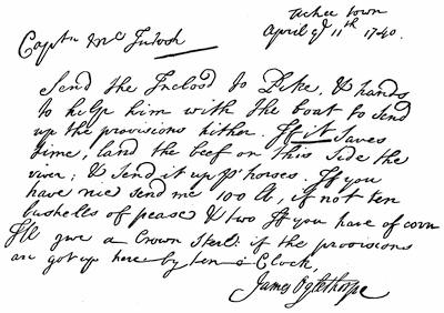
HANDWRITING OF OGLETHORPE.
Of the memoirs of Oglethorpe,—whose life Dr. Johnson desired to write, and whom Edmund Burke regarded as the most extraordinary person of whom he had read, because he founded a province and lived to see it severed from the empire which created it and erected into an independent State,—those best known are A Sketch of the Life of General James Oglethorpe, presented to the Georgia Historical Society by Thomas Spalding, Esq., resident member of the same, printed in 1840; Biographical Memorials of James Oglethorpe, Founder of the Colony of Georgia in North America, by Thaddeus Mason Harris, D. D., Boston, 1841;[848] Life of James Oglethorpe, the Founder of Georgia, by William B. O. Peabody, constituting a part of volume ii. of the second series of The Library of American Biography, conducted by Jared Sparks, Boston, 1847, and based mainly upon Dr. Harris’ work; and A Memoir of General James Oglethorpe, one of the earliest Reformers of Prison Discipline in England and the Founder of Georgia in America, by Robert Wright, London, 1867. The advantages enjoyed by Mr. Wright were exceptionally good, and until the appearance of his memoir that by Dr. Harris was justly regarded as the best.[849]
That the public might be advised of the benevolent character and scope of the undertaking, and might be made acquainted with the designs of the Trustees with regard to the proposed colonization of Georgia, two tracts were published with their sanction: one of them, prepared by Oglethorpe, entitled A New and Accurate Account of the Provinces of South Carolina and Georgia, with many curious and useful Observations on the Trade, Navigation, and Plantations of Great Britain compared with her most powerful Maritime Neighbors in ancient and modern Times, printed in London in 1732;[850] and the other, written by Benjamin Martyn, Secretary of the Board, entitled Reasons for establishing the Colony of Georgia with regard to the Trade of Great Britain, the Increase of our People, and the Employment and Support it will afford to great numbers of our own Poor as well as Foreign persecuted Protestants, with some account of the Country and the Designs of the Trustees, London, 1733.[851] Well considered and widely circulated, these tracts were productive of results most beneficial to the Trust.[852]
The development of the province down to 1741 is described and the regulations promulgated by the Trustees for the conduct of the plantation and for the observance of its inhabitants are preserved in An Account shewing the Progress of the Colony of Georgia in America from its First Establishment, London, 1741. This publication was by authority, and must be accepted as of the highest importance.[853]
Of like interest and value are An Impartial Enquiry into the State and Utility of the Province of Georgia, London, 1741,—appearing anonymously,[854] but with the sanction of the Trustees, and intended to correct certain mischievous reports circulated with regard to the health of the plantation, the fertility of the soil, the value of the products, and the disabilities under which Georgia labored because of restricted land tenures, and by reason of the regulations prohibiting the introduction and use of spirituous liquors and negro slaves; and A State of the Province of Georgia attested upon Oath in the Court of Savannah, November 10, 1740, London, 1742,—in which the superior advantages of Georgia, her resources and capabilities, are favorably considered and proclaimed.
The history of the Salzburgers in Georgia may be learned from An Extract of the Journals of Mr. Commissary Von Reck, who conducted the First Transport of Salzburgers to Georgia; and of the Reverend Mr. Bolzius, one of their Ministers, giving an Account of their Voyage to and happy Settlement in the Province, published by the Directors of the Society for promoting Christian Knowledge, London, 1734;[855] from Neuste und richtigste Nachricht von der Landschaft Georgia in dem Engelländischen America, etc., von J. M. R., Göttingen, 1746;[856] from De Præstantia Coloniæ Georgico-Anglicanæ præ Coloniis aliis,[857] et seq., by Joannes Augustus Urlspergerus; from the Urlsperger Tracts, which present with wonderful fidelity and minuteness of details all events connected with the Salzburger settlements in America;[858] and from [396]the Salzburgers and their Descendants, being the history of a Colony of German Lutheran Protestants who emigrated to Georgia in 1734, and settled at Ebenezer, twenty-five miles above the City of Savannah, by P. A. Strobel, Baltimore, 1855.[859]
To the Gentleman’s Magazine and to the London Magazine must recourse be had for valuable letters and contemporaneous documents descriptive of the colonization of Georgia and the development of the plantation.
There is in Section xxi. of Chapter iii. of the second volume of Navigantium atque Itinerantium Bibliotheca, or a Complete Collection of Voyages and Travels, etc., by John Harris (London, 1748), a “History of the Rise, Progress, and Present State of the Colony of Georgia.” It is prefaced by an excellent map of the province, and is fortified by illustrative documents. In its twenty-five quarto pages are embraced all the noted incidents connected with the early life of the colony and the successful efforts of General Oglethorpe in defending the southern frontier of Georgia against the assaults of the Spaniards. The value of this contribution cannot well be overestimated.
Another work of genuine merit, acquainting us specially with the condition of Savannah and the adjacent region, with the settlement of Frederica, and with those preliminary negotiations which resulted in a postponement of impending hostilities between Georgia and Florida, is A Voyage to Georgia begun in the year 1735, etc., by Francis Moore, London, 1744.[860]
A most detailed statement of the affairs and events of the province will be found in the three octavo volumes constituting the diary of Colonel William Stephens, for some time resident Secretary in Georgia of the Trustees, and, upon the departure of General Oglethorpe, advanced to the responsible position of President of the colony,—entitled A Journal of the Proceedings in Georgia beginning October 20th, 1737, which was printed in London in 1742.[861] Of this work but a limited edition was published by the Trustees, and a complete copy is very difficult to find. While its pages are cumbered with many trivial matters, this rare Journal is remarkable for accuracy of statement and minuteness of details. Its author was at the time far advanced in years, and his narrative is not infrequently colored by his peculiar religious and political notions. He was a firm friend of the colony, an honest servant of the Trust, and in all things most obedient and loyal to his king. Retired upon a pension of £80, he spent his last years on his plantation, near the mouth of Vernon River, which he called Bewlie [Beaulieu] because of a fancied resemblance to the manor of the Duke of Montague in the New Forest. There, about the middle of August, 1753, he died.
In the Executive Department of the State of Georgia may be seen the original MS. folio volume containing A general account of all monies and effects received and expended by the Trustees for establishing the Colony of Georgia in America (June 9, 1732-June 9, 1752), the names of the benefactors, and the sums contributed and the articles given by them in aid of the Trust. This carefully written and unique volume, the entries, charges, and discharges of which are certified by Harman Verelst,—accountant to the Trustees,—exhibits a complete statement of the finances of the Trust from its inception to the time of the surrender of the charter.[862]
The fullest reports of the demonstration of General Oglethorpe against St. Augustine are contained in An Impartial Account of the Expedition against St. Augustine under General Oglethorpe, occasioned by the suppression of the Report made by a Committee of the General Assembly in South Carolina, transmitted under the great seal of that Province to their Agent in England in order to be printed: with an exact Plan of the Town, Castle, and Harbour of St. Augustine and the adjacent Coast of Florida; shewing the Disposition of our Forces on that Enterprize, London, 1741;[863] in The Report of the Committee of both Houses of Assembly of the Province of South Carolina appointed to enquire into the causes of the Disappointment of success in the late Expedition against St. Augustine under command of General Oglethorpe, published by the order of both Houses, Charlestown, S. C., and London, 1743;[864] and in The Spanish Hireling detected, being a Refutation of the Several Calumnies and Falsehoods in a late Pamphlet entitul’d An Impartial Account of the Late Expedition against St. Augustine under General Oglethorpe, by George Cadogan, Lieutenant in General Oglethorpe’s Regiment, etc., London, 1743.[865] Grievous was the disappointment [398] at the failure of the expedition; unjust and harsh were the criticisms upon its leader. “One man there is, my Lords,” said the Duke of Argyle in the British House of Peers, “whose natural generosity, contempt of danger, and regard for the public prompted him to obviate the designs of the Spaniards and to attack them in their own territories: a man whom by long acquaintance I can confidently affirm to have been equal to his undertaking, and to have learned the art of war by a regular education, who yet miscarried in the design only for want of supplies necessary to success.”[866]
Of his successful repulse of the Spanish attack upon the island of St. Simon, the most spirited narratives are furnished in General Oglethorpe’s official report of the 30th of July, 1742, printed in the 3d volume of the Collections of the Georgia Historical Society; in the letter of John Smith (who, on board the war vessel “Success,” participated in the naval engagement), written from Charlestown, South Carolina, on the 14th of July, 1742, and printed in the Daily Advertiser; and in a communication on file in the Public Record Office in London among the Shaftesbury Papers.[867]
That harmony did not always obtain among the Georgia colonists, and that disagreements between the governing and the governed were sometimes most pronounced, must be admitted. While the Trustees endeavored to promote the development of the plantation and to assure the public of the progress of the province, malcontents there were, who thwarted their plans, questioned the expediency of their regulations, and openly declared that their misrule and the partiality of the Trust’s servants were the prolific causes of disquietude and disaster. That General Oglethorpe may, at times, have been dictatorial in his administration of affairs is quite probable; and yet it must be admitted that, amid the dangers which environed and the disturbing influences which beset the development of the province, an iron will and a strong arm were indispensable for its guidance and protection.
The publication, in the interest of the Trust, of the two pamphlets to which we have alluded, one entitled An Impartial Inquiry into the State and Utility of the Province of Georgia, London, 1741,[868] and the other, A State of the Province of Georgia attested upon Oath in the Court of Savannah, November 10, 1740, London, 1742,[869]—both exhibiting favorable views of the condition of the colony and circulated in furtherance of the scheme of colonization,—so irritated these malcontents that they indulged in several rejoinders, among which will be remembered A Brief Account of the Causes that have retarded the Progress of the Colony of Georgia in America, attested upon oath: being a proper Contrast to A State of the Province of Georgia attested upon oath and some other misrepresentations on the same subject, London, 1743.[870] The magistrates, both at Savannah and Frederica, were therein declared to be oppressors of the inhabitants. General Oglethorpe was accused of tyranny and partiality. It will be observed that most of the supporting affidavits were verified outside the limits of Georgia. A[399] desire to sell forbidden articles, and to ply trades for which special licenses had been issued to others; opposition to the regulation which prohibited the owners of cattle and hogs from allowing them to run at large on the common and in the streets of Frederica; alleged misfeasance in the conduct of bailiffs and magistrates in the discharge of their duties; the unprofitableness of labor, overbearing acts committed by those in authority, and similar matters, formed the burthen of these sworn complaints. While they tended to distract the public mind and to annoy those upon whose shoulders rested the provincial government, they fortunately failed in producing any serious impression either within the colony or in the mother country.
Another Jacobinical tract was that prepared and published at the instigation of Dr. Patrick Tailfer,—a thorn in the side of General Oglethorpe, to whom, under the signature of “The Plain Dealer,” he addressed a communication upon colonial affairs full of complaint, condemnation, and sarcasm. He was the chief of a club of malcontents in Savannah, whose conduct became so notorious that they were forced, in September, 1740, to quit the province and seek refuge in South Carolina. When thus beyond the jurisdiction of Georgia, in association with Hugh Anderson, David Douglass, and others, he caused to be printed a scurrilous tract entitled A True and Historical Narrative of the Colony of Georgia in America from the first Settlement thereof until the present period, etc., Charles-Town, South Carolina, 1741.[871] The epistle dedicatory is addressed to General Oglethorpe, and is full of venom. Craving rum, negro slaves, and fee-simple titles to land, such disaffected colonists hesitated not to malign the authorities, disquiet the settlers, and belie the true condition of affairs. Georgia was then in an embarrassed and impoverished situation. Her population was increasing but slowly. Labor was scarcely remunerative. Onerous were some of the regulations of the Trustees, and the Spanish war cloud was darkening the southern confines of the province. The impression, however, which Dr. Tailfer and his associates sought to convey of the status of the colony was exaggerated, spiteful, and without warrant.[872]
The visit of Tomo-chi-chi and his retinue to England is described in contemporaneous numbers of the Gentleman’s Magazine and of the London Magazine. It was also commemorated in what is now rarely seen, Georgia a Poem; Tomo-cha-chi, an Ode; A copy of verses on Mr. Oglethorpe’s second voyage to Georgia, “Facies non omnibus una, nec diversa tamen,” London, 1736. Twenty-two years afterwards appeared Tombo-chi-qui or The American Savage, a Dramatic Entertainment in Three Acts, London, 1758. Although printed anonymously, it is generally attributed to Cleland. The poet Freneau, at a later date, composed an ode to The Dying Indian Tomo-chequi. In the Gentleman’s Magazine, vol. x. p. 129, is an interesting letter describing the last moments and sepulture of this noted Mico. In his Historical Sketch of Tomo-chi-chi, Mico of the Yamacraws, Albany, 1868, the author of these notes endeavored to present all that is known of this distinguished chief, to whose friendship and aid the Colony of Georgia was indebted in a remarkable degree.
It was the custom of the Trustees to assemble annually and listen to a sermon delivered in commendation of the benevolent scheme in which they were engaged. Some of these discourses possess historical value, although most of them are simply moral essays.[873]
In December, 1837, the General Assembly of Georgia empowered the governor of the State to select a competent person to procure from the government offices in London copies of all records and documents respecting the settlement and illustrating the colonial life of Georgia. The Rev. Charles Wallace Howard was entrusted with the execution of this mission. He returned with copies of documents filling twenty-two folio volumes. Fifteen of these were made from the originals on file in the office of the Board of Trade, six from those in the State Paper Office, and the remaining volume consisted of copies of important documents included in the king’s library.[874] These MS. volumes are preserved in the state library at Atlanta. While they embrace many of the communications, regulations, reports, treaties, and documents illustrative of the colonial life of Georgia, they do not exhaust the treasures of the Public Record Office and the British Museum.
In private hands in England are several original MS. volumes, connected with the colonization of Georgia and detailing the acts and resolutions of the Trustees. Prominent among them are two quarto volumes, closely written in the neat, small, round hand of John Percival, the first Earl of Egmont and the first president of the Board of Trustees, containing the original manuscript records of the meetings of the Trustees for establishing the Colony of Georgia in America from June 14th, 1738, to the 24th of May, 1744.[875] They contain also an index of proceedings, June, 1737, to June, 1738, together with some memoranda relating to the proceedings of 1745-46. It is probable that there were antecedent volumes, but they are not now known.
In the Department of State, and in the Executive Department of Georgia, are some documents of great historical interest connected with the English colonization of Georgia. The Historical Collections of the Georgia Historical Society,[876] in four[401] volumes, contain reprints of many of the early tracts already referred to, and other papers illustrative of Georgia history.[877]
In the library of Harvard University, Cambridge, Massachusetts, there is a folio MS. in excellent preservation, entitled History of the three Provinces, South Carolina, Georgia, and East Florida, by John Gerard William de Brahm, surveyor-general of the southern provinces of North America, then under the dominion of Great Britain, and illustrated by over twenty maps and plans. The portion relating to Georgia was, in 1849, edited and printed with extreme accuracy and typographical elegance by Mr. George Wymberley-Jones, of Savannah. The edition was limited to forty-nine copies. Six of the eight maps appertaining to Georgia were engraved.[878] This publication constitutes the second of Mr. Jones’ “Wormsloe quartos,”[879] and is[402] justly esteemed not only for its typography and rarity, but also for its historical value. To the engineering skill of Captain de Brahm was Georgia indebted for many important surveys and military defenses. Through his instrumentality were large accessions made to the German population between Savannah and New Ebenezer.
Of the legislative acts passed by the general assemblies of Georgia during the continuance of the royal government, many are retained in the digests of Robert and George Watkins (Philadelphia, 1800), and of Marbury and Crawford. Aware of the fact that numerous omissions existed, Mr. George Wymberley-Jones De Renne caused diligent search to be made in the Public Record Office in London for all acts originating in Georgia which, having received royal sanction, were there filed. Exact copies of them were then obtained; but Mr. De Renne’s death occurred before he had compassed his purpose of printing the transcripts. His widow, Mrs. Mary De Renne, carried out his design and committed the editing of them to Charles C. Jones, Jr., LL. D. The result was a superb quarto, entitled Acts passed by the General Assembly of the Colony of Georgia, 1755 to 1774, now first printed. Wormsloe. 1881. The edition was limited to forty-nine copies. In this volume appears no act which had hitherto found its way into type. During the period covered by this legislation, James Johnston was the public printer in Savannah. By him were many of the acts, passed by the various assemblies, first printed,—sometimes simply as broadsides, and again in thin quarto pamphlets. William Ewen, who, at a later date, was president of the Council of Safety, carefully preserved these printed acts, and caused them to be bound in a volume which lies before us. The MS. index is in his handwriting. It is the only complete copy of these colonial laws, printed contemporaneously with their passage, of which we have any knowledge. James Johnston was also the editor and printer of the Georgia Gazette, the only newspaper published in Georgia prior to and during the Revolution. In the office of the Secretary of State in Atlanta are preserved the engrossed original acts passed by the colonial General Assemblies of Georgia. The sanction of the home government was requisite to impart vitality to such acts. As soon, therefore, as they had received the approval of the Governor in Council, the seal of the colony was attached to duplicate originals. One was lodged with the proper officer in Savannah, and the other was forwarded for the consideration of the Lords Commissioners for Trade and Plantations. When by them approved, this duplicate original, properly indorsed, was filed in London. Detaching the colonial seal seems to have been the final attestation of royal sanction. Of the action of the home government the colonial authorities were notified in due course.
With regard to the sojourn of Rev. John Wesley in Georgia, of his designs and anticipations in visiting the colony, and of the disappointments there experienced, we have perhaps the fullest memoranda in a little undated volume entitled An extract of the Rev. Mr. John Wesley’s Journal from his embarking for Georgia to his return to London, Bristol; printed by S. and F. Farley. It gives his own interpretation of the events, trials, and disappointments which induced him so speedily to[403] abandon a field of labor in which he had anticipated much pleasure and success.[880] In a tract published in London in 1741, called An Account of money received and disbursed[404] for the Orphan House in Georgia, the Rev. George Whitefield submits a full exhibit of all expenditures made up to that time in the erection and support of that institution. To it is prefixed a plan of the building.[881] His efforts to convert it into a college are unfolded in A Letter to his Excellency Governor Wright, printed in London, 1768. Appended to this is the correspondence which passed between him and the Archbishop of Canterbury. This tract is illustrated by plans and elevations of the present and intended structures, and by a plat of the Orphan House lands. There are sermons of this eloquent divine in aid of this charity, and journals of journeys and voyages undertaken while employed in soliciting subscriptions. His friend and companion, the Hon. James Habersham, has left valuable letters explanatory of the scope and administration of this eleemosynary project. William Bartram, who visited Bethesda in 1765, wrote a pleasant description of it.[882]
Among the histories of Georgia we may mention:—
An Historical Account of the Rise and Progress of the Colonies of South Carolina and Georgia, London, 1779,[883] in two volumes, octavo. Although published anonymously, these volumes are known to have been written by the Rev. Alexander Hewitt,[884] a Presbyterian clergyman and a resident of Charlestown, South Carolina, who returned to England when he perceived that an open rupture between the Crown and the thirteen American Colonies was imminent. While in this work the colonial history of Georgia is given at some length, the attention of the author was mainly occupied with the establishment and growth of the Province of Carolina. His labors ended with the dawn of the Revolution.
To A View of the Constitution of the British Colonies in North America and the West Indies at the time the Civil War broke out on the Continent of America, by Anthony Stokes, his Majesty’s Chief Justice in Georgia, London, 1783, we must refer for the most intelligent history of the civil and judicial conduct of affairs in Georgia during the continuance of the royal government.
Soon after the formation of the general government Mr. Edward Langworthy—at first a pupil and then a teacher at Whitefield’s Orphan House, afterwards an enthusiastic “Liberty Boy,” Secretary of the Provincial Congress of Georgia, and one of the early representatives from that State in the Confederated Congress—conceived the design of writing a history of Georgia. Of fair attainments, and personally acquainted with the leading men and transactions of the period, he was well qualified for the task, and addressed himself with energy to the collection of materials requisite for the undertaking. From a published prospectus of the work, printed in the Georgia Gazette, we are led to believe that this history was actually written. Suitable encouragement not having been extended, the contemplated publication was never made. Mr. Langworthy died at Elkton, in Maryland, early in the present century, and all efforts to recover both his manuscripts and the supporting documents which he had amassed have thus far failed.
From the press of Seymour and Williams, of Savannah, was issued, in 1811, the first volume of Major Hugh McCall’s History of Georgia,[885] and this was followed, in 1816, by the second volume published by William Thorne Williams. Oppressed by physical infirmities, and a martyr to the effects of exposures and dangers experienced while an officer in the army of the Revolution; now confined to his couch, again a helpless cripple moving only in an easy-chair upon wheels; dependent for a livelihood upon the slender salary paid to him as city jailer of Savannah; often interrupted in his labors, and then, during intervals of pain, writing with his portfolio resting upon his knees; without the preliminary education requisite for the scholarly accomplishment of such a serious undertaking, and yet fired with patriotic zeal, and anxious to wrest from impending oblivion the fading traditions of the State he loved so well, and whose independence he had imperilled everything to secure,—Major McCall, in the end, compassed a narrative which is highly prized, and which, in its recital of events connected with the Revolutionary period and the part borne by Georgians in that memorable struggle, is invaluable. He borrowed largely from Mr. Hewitt in depicting the colonial life of Georgia.[886]
As early as March, 1841, the Georgia Historical Society invited Dr. William Bacon Stevens to undertake, under its auspices, the preparation of a new and complete History of Georgia. Liberal aid was extended to him in his labor, and of its two octavo volumes, one was published in 1847 and the other in 1859.[887] This author brings his history down to the adoption of the constitution of 1798.
In 1849 the Rev. George White published in Savannah his Statistics of the State of Georgia, and this was followed, six years afterwards, by his more comprehensive and valuable work entitled the Historical Collections of Georgia, illustrated with nearly one hundred engravings, and published by Pudney and Russell, of New York. In this volume a vast mass of statistical, documentary, and traditional information is presented; and for his industry the author is entitled to much commendation.
The History of Georgia, by T. S. Arthur and W. H. Carpenter, published in Philadelphia in 1854, and constituting one of Lippincott’s cabinet histories, is a meagre compendium of some of the leading events in the life of the Colony and State, and does not claim special attention.
In his History of Alabama, and incidentally of Georgia and Mississippi (Charleston, S. C., 1851) Colonel Albert James Pickett furnishes abundant and interesting material illustrative of the aboriginal epoch; and, in a manner both intelligent and attractive, traces the colonization of the territory indicated down to the year 1820.[888]
The present writer has already printed [1883] the first two volumes of History of Georgia; and his preface unfolds his purpose to tell the story from the earliest times down to a period within the memory of the living. The two volumes thus far issued embrace the aboriginal epoch, a narrative of discovery and early exploration, schemes of colonization, the settlement under Oglethorpe, and the life of the province under the guidance of the Trustees, under the control of the President and Assistants, under the supervision of royal governors, and during the Revolutionary War. They conclude with the erection of Georgia into an independent State. All available sources of information have been utilized. The two concluding volumes, which will deal with Georgia as a Commonwealth, are in course of preparation.
We refrain from an enumeration of gazetteers, historical essays, and publications, partial in their character, which relate to events subsequent to what may be properly termed the period of colonization.

CHAPTER VII.
THE WARS ON THE SEABOARD: THE STRUGGLE IN ACADIA AND CAPE BRETON.
BY CHARLES C. SMITH,
Treasurer of the Massachusetts Historical Society.
ALL through its early history Acadia, or Nova Scotia, suffered from the insecurity to life and property which arose from its repeated changes of masters. Neither France nor England cared much for a region of so little apparent value; and both alike regarded it merely as debatable ground, or as a convenient make-weight in adjusting the balance of conquests and losses elsewhere. Nothing was done to render it a safe or attractive home for immigrants; and at each outbreak of war in the Old World its soil became the scene of skirmishes and massacres in which Indian allies were conspicuous agents. Whatever the turn of victory here, little regard was paid to it in settling the terms of peace. There was hardly an attempt at any time to establish a permanent control over the conquered territory. In spite of the capture of Port Royal by Phips in 1690, and the annexation of Acadia to the government of Massachusetts in 1692, it was only a nominal authority which England had. In 1691, the French again took formal possession of Port Royal and the neighboring country. In the next year an ineffectual attempt was made to recover it; and this was followed by various conflicts, of no historical importance, in different parts of this much-harassed territory. In August, 1696, the famous Indian fighter, Captain Benjamin Church, left Boston on his fourth eastern expedition. After skirting the coast of Maine, where he met with but few Indians and no enemies, he determined to proceed up the Bay of Fundy. There he captured and burned Beaubassin, or Chignecto, and then returned to St. John. Subsequently he was superseded by Colonel John Hathorne, a member of the Massachusetts council, and an attack was made on the French fort at Nachouac, or Naxoat, farther up the river; but for some unexplained reason the attack was not pressed, and the English retreated shortly after they landed. “No notice,” says Hutchinson in his History of Massachusetts Bay, “was taken of any loss on either side, except the burning of a few of the enemy’s houses; nor is any sufficient reason given for relinquishing the design so suddenly.”[889] By the treaty of Ryswick in the following year (1697) Acadia was surrendered to France.
The French were not long permitted to enjoy the restored territory. In May, 1704, Church was again placed in command of an expedition fitted out at Boston against the French and Indians in the eastern country. He had been expressly forbidden to attack Port Royal, and after burning the little town of Mines nothing was accomplished by him. Three years later, in May, 1707, another expedition, of one thousand men, sailed from Boston under command of Colonel March. Port Royal was regularly invested, and an attempt was made to take the place by assault; but through the inefficiency of the commander it was a total failure. Reëmbarking his little army, March sailed away to Casco Bay, where he was superseded by Captain Wainwright, the second in command. The expedition then returned to Port Royal; but in the mean time the fortifications had been diligently strengthened, and after a brief view of them Wainwright drew off his forces. In 1710 a more successful attempt for the expulsion of the French was made. In July of that year a fleet arrived at Boston from England to take part in a combined attack on Port Royal. In pursuance of orders from the home government, four regiments were raised in the New England colonies, and sailed from Boston on the 18th of September. The fleet numbered thirty-six vessels, exclusive of hospital and store ships, and on board were the four New England regiments, respectively commanded by Sir Charles Hobby, Colonel Tailer, of Massachusetts, Colonel Whiting, of Connecticut, and Colonel Walton, of New Hampshire, and a detachment of marines from England. Francis Nicholson, who had been successively governor of New York, Virginia, and Maryland, had the chief command. The fleet, with the exception of one vessel which ran ashore and was lost, arrived off Port Royal on the 24th of September. The garrison was in no condition to resist an enemy, and the forces were landed without opposition. On the 1st of October three batteries were opened within one hundred yards of the fort; and twenty-four hours afterward the French capitulated. By the terms of the surrender the garrison was to be transported to France, and the inhabitants living within cannon-shot of Port Royal were to be protected in person and property for two years, on taking an oath of allegiance to the queen of England, or were to be allowed to remove to Canada or Newfoundland.[890] The name of Port Royal was changed to Annapolis Royal in compliment to the queen, and the fort was at once garrisoned by marines and volunteers under the command of Colonel Samuel Vetch, who had been selected as governor in case the expedition should prove successful. Its whole cost to New England was upward of twenty-three thousand pounds, which sum was afterward repaid by the mother country. Acadia never again came under French control, and by the treaty of Utrecht (1713) the province was formally ceded to Great Britain[409] “according to its ancient limits.” As a matter of fact, those limits were never determined; but the question ceased to have any practical importance after the conquest of Canada by the English, though it was reopened long afterward in the boundary dispute between Great Britain and the United States.
By the treaty of Utrecht, France was left in undisputed possession of Cape Breton; and in order to establish a check on the English in Nova Scotia, the French immediately began to erect strong fortifications at Louisbourg, in Cape Breton, and invited to its protection the French inhabitants of Acadia and of Newfoundland, which latter had also been ceded to Great Britain. Placentia, the chief settlement in Newfoundland, was accordingly evacuated, and its inhabitants were transferred to Cape Breton; but such great obstacles were thrown in the way of a voluntary removal of the Acadians that very few of them joined their fellow countrymen. They remained in their old homes, to be only a source of anxiety and danger to their English masters. At the surrender of Acadia to Great Britain, it was estimated by Colonel Vetch, in a letter to the Board of Trade, that there were about twenty-five hundred French inhabitants in the country; and even at that early date he pointed out that their removal to Cape Breton would leave the country entirely destitute of inhabitants, and make the new French settlement a very populous colony, “and of the greatest danger and damage to all the British colonies, as well as the universal trade of Great Britain.”[891] Fully persuaded of the correctness of this view, the successive British governors refused to permit the French to remove to Canada or Cape Breton, and persistently endeavored to obtain from them a full recognition of the British sovereignty. In a single instance—in 1729—Governor Phillips secured from the French inhabitants on the Annapolis River an unconditional submission; but with this exception the French would never take the oath of allegiance without an express exemption from all liability to bear arms. It is certain, however, that this concession was never made by any one in authority; and in the two instances in which it was apparently granted by subordinate officers, their action was repudiated by their superiors. The designation “Neutral French,” sometimes given to the Acadians, has no warrant in the recognized facts of history.
Meanwhile the colony remained almost stationary, and attracted very little notice from the home government. In August, 1717, General Richard Phillips was appointed governor, which office he retained until 1749, though he resided in England during the greater part of the time. During his absence the small colonial affairs were successively administered by the lieutenant-governor of Annapolis, John Doucette, who held office from 1717 to 1726,[892] and afterward by the lieutenant-governors of the province, Lawrence Armstrong (1725-1739) and Paul Mascarene (1740-1749). Phillips was[410] succeeded by Edward Cornwallis; but Cornwallis held the office only about three years, when he resigned, and General Peregrine Thomas Hopson was appointed his successor. On Hopson’s retirement, within a few months, the government was administered by one of the members of the council, Charles Lawrence, who was appointed lieutenant-governor in 1754, and governor in 1756.
In 1744 war again broke out between England and France, and the next year it was signalized in America by the capture of Louisbourg. Immediately on learning that war had been declared, the French commander despatched a strong force to Canso, which captured the English garrison at that place and carried them prisoners of war to Louisbourg. A second expedition was sent to Annapolis for a similar purpose, but through the prompt action of Governor Shirley, of Massachusetts, it failed of success. Aroused, no doubt, by these occurrences, Shirley formed the plan of capturing Louisbourg; and early in January, 1745, he communicated his design to the General Court of Massachusetts, and about the same time wrote to Commodore Warren, commanding the British fleet in the West Indies, for coöperation. His plans were favorably received, not only by Massachusetts, but also by the other New England colonies. Massachusetts voted to raise 3,250 men; Connecticut 500; and New Hampshire and Rhode Island each 300. The chief command was given to Sir William Pepperrell, a wealthy merchant of Kittery in Maine, of unblemished reputation and great personal popularity; and the second in command was Samuel Waldo, a native of Boston, but at that time also a resident of Maine.[893] The chief of artillery was Richard Gridley, a skilful engineer, who, in June, 1775, marked out the redoubt on Bunker Hill. The undertaking proved to be so popular that the full complement of men was raised within two months. The expedition consisted of thirteen armed vessels, under the command of Captain Edward Tyng, with upward of two hundred guns, and of about ninety transports. They were directed to proceed to Canso, where a block house was to be built, the stores landed, and a guard left to defend them. The Massachusetts troops sailed from Nantasket on the 24th of March, and reached Canso on the 4th of April. The New Hampshire forces had arrived four days before; the Connecticut troops reached the same place on the 25th. Hutchinson adds, with grim humor, “Rhode Island waited until a better judgment could be made of the event, their three hundred not arriving until after the place had surrendered.”[894]
The works at Louisbourg had been twenty-five years in construction, and though still incomplete had cost between five and six millions of dollars. They were thought to be the most formidable defences in America,[411] and covered an area two and a half miles in circumference. A space of about two hundred yards toward the sea was left without a rampart; but at all other accessible points the walls were from thirty to thirty-six feet in height, with a ditch eighty feet in width. Scattered along their line were six bastions and three batteries with embrasures for one hundred and forty-eight cannon, of which only sixty-five were mounted, and sixteen mortars. On an island at the entrance of the harbor was a battery mounted with thirty guns; and directly opposite the entrance of the harbor was the grand battery, mounting twenty-eight heavy guns and two eighteen-pounders. The entrance to the town on the land-side was over a draw-bridge defended by a circular battery mounting sixteen cannon. It was these strong and well-planned works which a handful of New England farmers and fishermen undertook to capture with the assistance of a small English fleet.
Pepperrell was detained by the ice at Canso for nearly three weeks, at the end of which time he was joined by Commodore Warren with four ships, carrying one hundred and eighty guns. The combined forces reached Gabarus Bay, the place selected for a landing, on the morning of the 30th of April; and it was not until that time that the French had any knowledge of the impending attack. Two days later the grand battery fell into Pepperrell’s hands through a fortunate panic which seized the French. Thus encouraged, the siege was pressed with vigor under very great difficulties. The first battery was erected immediately on landing, and opened fire at once; but it required the labor of fourteen nights to draw all the cannon and other materials across the morass between the landing-place and Louisbourg, and it was not until the middle of May that the fourth battery was ready. On the 18th of May, Tyng in the “Massachusetts” frigate captured a French ship of sixty-four guns and five hundred men, heavily laden with military stores for Louisbourg. This success greatly raised the spirits of the besiegers, who, slowly but steadily, pushed forward to the accomplishment of their object. Warren’s fleet was reinforced by the arrival of three large ships from England and three from Newfoundland; the land-gate was demolished; serious breaches were made in the walls; and by the middle of June it was determined to attempt a general assault. The French commander, Duchambon, saw that further resistance would be useless, and on the 16th he capitulated with the honors of war, and the next day Pepperrell took possession of Louisbourg.
By the capitulation six hundred and fifty veteran troops, more than thirteen hundred militia, and other persons, to the number in all of upward of four thousand, agreed not to bear arms against Great Britain during the war, and were transported to France in fourteen ships. Seventy-six cannon and mortars fell into the hands of the conquerors, with a great quantity of military stores and provisions. The number killed on the side of the French was three hundred, and on the side of the English one hundred and thirty; but subsequently the latter suffered heavily by disease,[412] and at one time so many as fifteen hundred were sick from exposure and bad weather. Tidings of the victory created great joy in New England, and the news was received with no small satisfaction in the mother country. Pepperrell was made a baronet, Warren an admiral, and both Shirley and Pepperrell were commissioned as colonels. Subsequently, after a delay of four years, Great Britain reimbursed the colonies for the expenses of the expedition to the amount of £200,000.
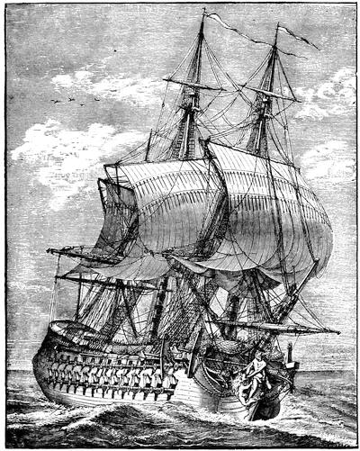
A FRENCH FRIGATE.
[After a cut in Paul Lacroix’s XVIIIme Siècle, p. 129.—Ed.]
The capture of Louisbourg was by far the most important event in the history of Nova Scotia during the war, and the loss of so important a place[413] was a keen mortification to France. As soon as news of the fall of Louisbourg reached the French government, steps were taken with a view to its recapture and to the punishment of the English colonists by destroying Boston and ravaging the New England coast. In June, 1746, a fleet of eleven ships of the line, twenty frigates, thirty transports, and two fire-ships was despatched for this purpose under command of Admiral D’Anville; but the enterprise ended in a disastrous failure. Contrary winds prevailed during the voyage, and on nearing the American coast a violent storm scattered the fleet, driving some of the ships back to France and others to the West Indies, and wrecking some on Sable Island. On the 10th of September D’Anville cast anchor with the remaining vessels—two ships and a few transports—in Chebucto; and six days later he died, of apoplexy, it is said. At a council of war held shortly afterward it was determined to attack Annapolis, against the judgment of Vice-Admiral D’Estournelle, who had assumed the command. Exasperated, apparently, at this decision, he committed suicide in a fit of temporary insanity. This second misfortune was followed by the breaking out of the small-pox among the crews; and finally after scuttling some of the vessels the officer next in command returned to France without striking a single blow. In the spring of the following year another expedition, of smaller size, was despatched under command of Admiral De la Jonquiere; but the fleet was intercepted and dispersed off Cape Finisterre by the English, who captured nine ships of war and numerous other vessels.
Meanwhile, and before the capture of Louisbourg, the French had made an unsuccessful attempt on Annapolis, from which the besieging force was withdrawn to aid in the defence of Louisbourg, but they did not arrive until a month after its surrender. In the following year another army of Canadians appeared before Annapolis; but the place seemed to be so strong and well defended that it was not thought prudent to press the attack. The French accordingly withdrew to Chignecto to await the arrival of reinforcements expected from France. While stationed there they learned that a small body of New England troops, under Colonel Noble, were quartered at Grand Pré, and measures were speedily adopted to cut them off. The attack was made under cover of a snow-storm at an early hour on the morning of the 4th of February, 1747. It was a complete surprise to the English. Noble, who was in bed at the time, was killed fighting in his shirt. A desperate conflict, however, ensued from house to house, and at ten o’clock in the forenoon the English capitulated with the honors of war.[895] This terminated active hostilities in Nova Scotia, from which the French troops shortly afterward withdrew. By the disgraceful peace of Aix la Chapelle (1748) England surrendered Louisbourg and Cape Breton to the French, and all the fruits of the war in America were lost.
After the conclusion of peace it was determined by the home government[414] to strengthen their hold on Nova Scotia, so as to render it as far as possible a bulwark to the other English colonies, instead of a source of danger to them. With this view an advertisement was inserted in the London Gazette, in March, 1749, setting forth “that proper encouragement will be given to such of the officers and private men, lately dismissed his Majesty’s land and sea service, as are willing to accept of grants of land, and to settle with or without families in Nova Scotia.” Fifty acres were to be allotted to every soldier or sailor, free from the payment of rents or taxes for the term of ten years, after which they were not to be required to pay more than one shilling per annum for every fifty acres; and an additional grant of ten acres for each person in a family was promised. Larger grants, with similar conditions, were to be made to the officers; and still further to encourage the settlement of the province the same inducements were offered to “carpenters, shipwrights, smiths, masons, joiners, brickmakers, brick-layers, and all other artificers necessary in building or husbandry, not being private soldiers or seamen,” and also to surgeons on producing certificates that they were properly qualified. These offers were promptly accepted by a large number of persons, but apparently by not so many as was anticipated.
In the following May Edward Cornwallis, then a member of Parliament, and uncle of the first Marquis of Cornwallis, was appointed captain-general and governor in chief, and at once embarked for Nova Scotia with the new settlers. On the 21st of June he arrived in Chebucto harbor, which all the officers agreed was the finest harbor they had ever seen; and early in July he was joined by the transports, thirteen in number, having on board upward of twenty-five hundred immigrants. The shores of the harbor were wooded to the water’s edge, “no clear spot to be seen or heard of.”[896] But by the 23d of the month more than twelve acres were cleared, and preparations were made for building. A month later the plan of the town was fully laid out, and subsequently a line of palisades was erected around the town, a square fort was built on the hill, and a space thirty feet wide cleared outside of the defensive line. By the end of October three hundred houses had been completed, a second fort had been built, and an order had been sent to Boston for lamps to light the streets in the winter nights. Halifax, as the new town was called, had already begun to wear the appearance of a settled community; and in little more than a year its first church was opened for religious services. From the first, the growth of Halifax was strong and healthy; and it soon became a place of considerable importance. So early as 1752 the number of inhabitants amounted to more than four thousand. Stringent rules were adopted to insure public order and morality; and very soon the governor and council proceeded to exercise legislative authority.[897] But their right to do this[415] was expressly denied by the law officers at home.[898] Accordingly, in the early part of 1757 a plan was adopted for dividing the province into electoral districts, for the choice of a legislative body, and was sent to England for approval. Some exceptions, however, were taken to the plan; and it was not until October, 1758, that the first provincial assembly met at Halifax, nineteen members being present.
In the mean time, in 1755, occurred the most memorable and tragic event in the whole history of Nova Scotia. Though England and France were nominally at peace, frequent collisions took place between their adherents in Nova Scotia and elsewhere in America. Early in 1755 it was determined to dispossess the French of the posts which they had established on the Bay of Fundy, and a force of eighteen hundred men was raised in New England, for that purpose, under Lieutenant-Colonels Scott and John Winslow. The chief command of the expedition was given to Colonel Robert Monckton, an officer in the English army. The first and most honorable fruits of the expedition were the capture of the French forts at Beauséjour and at Gaspereau, both of which surrendered in June. A few weeks later Winslow became a chief instrument in the forcible removal of the French Acadians, which has given his name an unenviable notoriety. It was a task apparently at which his whole nature relucted; and over and over again he wrote in his letters at the time that it was the most disagreeable duty he had had to perform in his whole life. But he did not hesitate for a moment, and carried out with unfaltering energy the commands of his superior officers.
For more than a generation the French inhabitants had refused to take the oath of allegiance to the king of England, except in a qualified form. Upon their renewed refusal, in July, 1755, it was determined to take immediate steps for their removal, in accordance with a previous decision, “to send all the French inhabitants out of the province, if they refused to take the oath;” and at a meeting of the provincial council of Nova Scotia, held July 28th, “after mature consideration, it was unanimously agreed that, to prevent as much as possible their attempting to return and molest the settlers that may be set down on their lands, it would be most proper to send them to be distributed amongst the several colonies on the continent, and that a sufficient number of vessels should be hired with all possible expedition for that purpose.”[899] Accordingly orders were sent to Boston to charter the required number of transports;[416] and on the 11th of August Governor Lawrence forwarded detailed instructions to Lieutenant-Colonel Winslow, commanding at Mines, and to Major John Handfield, a Nova Scotia officer, commanding at Annapolis, to ship off the French inhabitants in their respective neighborhoods. As the crops were not yet harvested, and there was delay in the arrival of the transports, the orders could not be executed until the autumn. At that time they were carried out with a sternness and a disregard of the rights of humanity for which there can be no justification or excuse. On the same day on which the instructions were issued to Winslow and Handfield, Governor Lawrence wrote a circular letter to the other English governors in America, expressing the opinion that there was not the least reason to doubt of their concurrence, and his hope that they would receive the inhabitants now sent “and dispose of them in such manner as may best answer our design in preventing their reunion.” According to the official instructions five hundred persons were to be transported to North Carolina, one thousand to Virginia, five hundred to Maryland, three hundred to Philadelphia, two hundred to New York, three hundred to Connecticut, and two hundred to Boston.
On the 4th of September Winslow issued a citation to the inhabitants in his immediate neighborhood to appear and receive a communication from him. The next day, he recorded in his journal, “at three in the afternoon, the French inhabitants appeared, agreeably to their citation, at the church in Grand Pré, amounting to four hundred and eighteen of their best men; upon which I ordered a table to be set in the centre of the church, and, having attended with those of my officers who were off guard, delivered them by interpreters the king’s orders.” After a brief preamble he proceeded to say, “The part of duty I am now upon is what, though necessary, is very disagreeable to my natural make and temper, as I know it must be grievous to you who are of the same species. But it is not my business to animadvert, but to obey such orders as I receive, and therefore without hesitation shall deliver you his Majesty’s orders and instructions.” He then informed them that all their lands, cattle, and other property, except money and household goods, were forfeited to the Crown, and that all the French inhabitants were to be removed from the province. They were, however, to have liberty to carry their money and as many of their household goods as could be conveniently shipped in the vessels; and he added, “I shall do everything in my power that all those goods be secured to you, and that you are not molested in carrying them off, and also that whole families go in the same vessel, and make this remove, which I am sensible must give you a great deal of trouble, as easy as his Majesty’s service will admit, and hope that in whatever part of the world you may fall you may be faithful subjects, a peaceable and happy people.”[900] Meanwhile they were to remain under the inspection of the troops. Toward night these unhappy victims, “not having any provisions with them, and[417] pleading hunger, begged for bread,” which was given them, and orders were then issued that for the future they must be supplied from their respective families. “Thus ended the memorable 5th of September,” Winslow wrote in his journal, “a day of great fatigue and trouble.”[901]
Shortly afterward the first prisoners were embarked; but great delay occurred in shipping them off, mainly on account of the failure of the contractor to arrive with the provisions at the expected time, and it was not until November or December that the last were shipped. The whole number sent away at this time was about four thousand. There was also a great destruction of property; and in the district under command of Winslow very nearly seven hundred buildings were burned. The presence of the French was nowhere welcome in the colonies to which they were sent; and they doubtless experienced many hardships. The governors of South Carolina and Georgia gave them permission to return, much to the surprise and indignation of Governor Lawrence;[902] and seven boats, with ninety unhappy men who had coasted along shore from one of the Southern colonies, were stopped in Massachusetts. In the summer of 1762 five transports with a further shipment of these unfortunate people were sent to Boston, but the General Court would not permit them to land, and they were ordered to return to Halifax.[903]
The removal of the French Acadians from their homes was one of the saddest episodes in modern history, and no one now will attempt to justify it; but it should be added that the genius of our great poet has thrown a somewhat false and distorted light over the character of the victims. They were not the peaceful and simple-hearted people they are commonly supposed to have been; and their houses, as we learn from contemporary evidence, were by no means the picturesque, vine-clad, and strongly built cottages described by the poet. The people were notably quarrelsome among themselves, and to the last degree superstitious. They were wholly under the influence of priests appointed by the French bishops, and directly responsible to the representatives of the Roman Catholic Church at Quebec. Many of these priests were quite as much political agents as religious teachers, and some of them fell under the censure of their superiors for going too much outside of their religious functions. Even in periods when France and England were at peace, the French Acadians were a source of perpetual danger to the English colonists. Their claim to a qualified allegiance was one which no nation then or now could sanction. But all this does not justify their expulsion in the manner in which it was executed, and it will always remain a foul blot on the history of Nova Scotia. The knowledge of these facts, however, enables us to understand better the constant feeling of insecurity under which the English settlers lived, and which finally resulted in the removal and dispersion of the French under circumstances of such heartless cruelty.
In May of the following year, war was again declared between France and England; and two years later Louisbourg again fell into the hands of the English. In May, 1758, a powerful fleet under command of Admiral Boscawen arrived at Halifax for the purpose of recapturing a place which ought never to have been given up. The fleet consisted of twenty-three ships of the line and eighteen frigates, beside transports, and when it left Halifax it numbered one hundred and fifty-seven vessels. With it was a land force, under Jeffery Amherst, of upward of twelve thousand men. The French forces at Louisbourg were much inferior, and consisted of only eight ships of the line and three frigates, and of about four thousand soldiers. The English fleet set sail from Halifax on the 28th of May, and on the 8th of June a landing was effected in Gabarus Bay. The next day the attack began, and after a sharp conflict the French abandoned and destroyed two important batteries. The siege was then pushed by regular approaches; but it was not until the 26th of July that the garrison capitulated. By the terms of surrender the whole garrison were to become prisoners of war and to be sent to England, and the English acquired two hundred and eighteen cannon and eighteen mortars, beside great quantities of ammunition and military stores. All the vessels of war had been captured or destroyed; but their crews, to the number of upward of twenty-six hundred men, were included in the capitulation. Two years later, at the beginning of 1760, orders were sent from England to demolish the fortress, render the harbor impracticable, and transport the garrison and stores to Halifax. These orders were carried out so effectually that few traces of its fortifications remain, and the place is inhabited only by fishermen.
A year after the surrender of Louisbourg a fatal blow was struck at the French power in America by the capture of Quebec; and by the peace of Paris, in February, 1763, the whole of Canada was ceded to Great Britain. The effects of this cession, in preparing the way for the independence of the principal English colonies, cannot easily be overestimated; but to Nova Scotia it only gave immunity from the fear of French incursions, without in the slightest degree weakening the attachment of the inhabitants to England.
CRITICAL ESSAY ON THE SOURCES OF INFORMATION.
IN recent years much attention has been given to the study of Acadian history by local investigators, and important documents for its elucidation have been obtained from England and France, and the provincial archives have been put in excellent order by the commissioner of public records. To his intelligent interest in the subject we are indebted for one of the most important contributions to our knowledge of it, his Selections from the Public Documents of the Province of Nova Scotia.[904] This volume comprises a great[419] mass of valuable papers illustrative of the history of Nova Scotia in the eighteenth century, systematically arranged. The first part consists of papers relating to the French Acadians, 1714-1755; the second part, of papers relating to their forcible removal from the province, 1755-1768; the third, of papers relating to the French encroachments, 1749-1754, and the war in North America, 1754-1761; the fourth, of papers relating to the first settlement of Halifax, 1749-1756; and the last part, of papers relating to the first establishment of a representative assembly in Nova Scotia. Mr. Akins has added a sufficient number of biographical and other notes, and has inserted a conveniently arranged Index.
Next in importance to this volume are the publications of the Nova Scotia Historical Society, which was formed in 1878, and incorporated in 1879. Since that time it has printed four small volumes of Collections, comprising many valuable papers. Of these the most important is the journal of Colonel Winslow at the time of the expulsion of the Acadians, printed (vol. iii. p. 114) from the original manuscript in the possession of the Massachusetts Historical Society. There are also (vol. i. p. 119) the diary of the surgeon, John Thomas, at the same time,[905] beside a journal of the capture of Annapolis in 1710, a history of St. Paul’s Church, Halifax, and other papers of historical interest and value. The fourth volume contains a Memoir of Samuel Vetch, the first English governor of Nova Scotia, with illustrative documents, and the journal of Colonel John Winslow, during the Siege of Beauséjour, in 1755.[906]
Another work of great authority, as well for the later as for the early history of Nova Scotia, is Murdoch’s History of Nova Scotia.[907] Written in the form of annals, it is somewhat confused in arrangement, and a reader or student is under the necessity of picking out important facts from a great mass of chaff; but it is a work of wide and thorough research, and should be carefully studied by every one who wishes to learn the minute facts of Nova Scotia history.
The early history of Nova Scotia, from its first settlement down to the peace of Paris in 1763, is treated with much fulness by James Hannay in a well-written narrative, which is not, however, entirely free from prejudice, especially against the New England colonies.[908] But, for thoroughness of investigation and general accuracy of statement, Mr. Hannay must hold a high place among local historians. Fortunately his labors are well supplemented by Duncan Campbell’s History of Nova Scotia,[909] which was, indeed, published at an earlier date, but which is, however, very meagre for the period when Acadia was a French colony.
Beside these, there are several county and town histories, of which the best is Dr. Patterson’s History of Pictou.[910] It is a work of diligent and faithful research, gathering up much traditional knowledge, and especially full in details respecting the origin and later fortunes of Pictou Academy. There are also a considerable number of local histories in manuscript in the archives of the Nova Scotia Historical Society.

ON THE FRENCH AND INDIAN WARS OF NEW ENGLAND AND ACADIA, 1688-1763.
By the Editor.
A. King William’s War.—This was begun Aug. 13, 1688. A truce was concluded by Captain John Alden at Sagadahock, Nov. 19, 1690. (Hutchinson’s Massachusetts, i. 404; Mass. Hist. Collections, xxi. p. 112, from the Hutchinson papers.)
Pike and Hutchinson’s instructions for making a truce, Nov. 9, 1690, are given in James S. Pike’s New Puritan (p. 128), and (p. 131) the agreement at Wells, May 1, 1691.
Sewall (Letter Book, p. 119) writes Aug. 1, 1691, “The truce is over and our Indian war renewed. The enemy attempted to surprise Wells, but were disappointed by a party of ours [who] got into the town but about half an hour before.”
Submission and agreement of eastern Indians at Fort William Henry, in Pemaquid, Aug. 11, 1693. (Mass. Archives, xxx. 338; Mather’s Magnalia; New Hampshire Provincial Papers, ii. 110; Johnston’s Bristol, Bremen, and Pemaquid, p. 193.)
Accounts of the French capturing vessels in Massachusetts Bay (1694-95), correspondence between Stoughton and Frontenac (1695), and various plans for French expeditions to attack Boston (1696-97, 1700-1704), are in Collection de manuscrits relatifs à l’histoire de la Nouvelle France (Quebec, 1884), vol. ii.
A bill to encourage the war against the enemy is in the Mass. Archives, xxx. 358. Details of Church’s expedition in 1696 to Nova Scotia are given in Murdoch’s Nova Scotia, i. 233. Cf. also J. S. Pike’s Life of Robert Pike, the New Puritan.
Nicholas Noyes, New England’s Duty and Interest to be a Habitation of Justice and a Mountain of Holiness, an election sermon, Boston, 1698 (Sabin’s Dictionary, xiii. no. 56,229; Haven’s list in Thomas’s History of Printing, ii. p. 343; Carter-Brown, ii. 1,546), has in an appendix (pp. 89-99) an account of a visit of Grindall Rawson and Samuel Danforth to the Indians within the province, in 1698.
Submission of the eastern Indians at Pejebscot (Brunswick), Jan. 7, 1699. (New Hampshire Hist. Soc. Coll., ii. 265; N. H. Provincial Papers, ii. 299; E. E. Bourne’s Wells and Kennebunk, ch. xv.; Mass. Archives, xxx. 439.)
Submission of the eastern Indians, Sept. 8, 1699. (Mass. Archives, xxx. 447.)
Various documents concerning the making of a treaty with the eastern Indians, 1700-1701, are also in Mass. Archives, vol. xxx.
The events of this war are covered in Cotton Mather’s Decennium Luctuosum, an history of remarkable occurrences in the long war ... from 1688 to 1698, Boston, 1699. (Sibley’s Harvard Graduates, iii. p. 67.) It was reprinted in the Magnalia.
A detail of the sources on the different attacks and fights of this war is given in Vol. IV. of the present work, pp. 159-161.
B. Queen Anne’s or Governor Dudley’s War.—One of the first acts of the ministry of Queen Anne was to issue a declaration of war against France, May 15, 1702, opening what is known in Europe as the “War of the Spanish Succession.” Governor Dudley in June, 1703, went to Casco, to avert by a conference the Indian participancy in the war, if possible. Campbell, the Boston postmaster, in one of his Public Occurrences says that Dudley found the Indians at the eastward “two thirds for peace, and one third for war.” (Mass. Hist. Soc. Proc., ix. 495.) These latter were the more easterly tribes, who came under French influence, and in Aug., 1703, Dudley issued at Boston a broadside declaration against the Penicooke and eastern Indians. (Haven’s list, p. 351.) Plunder and massacre along the frontier settlements at the eastward soon convinced the people of New England that they must prepare for another murderous war. (Cf. “Indian Troubles on the Coast of Maine,” documents in Maine Hist. Coll., iii. 341.)
The first organized retaliatory assault was the maritime expedition to the Bay of Fundy, led in 1704 by Col. Benjamin Church.
Church’s own part in this expedition is set forth in the Entertaining Passages,[911] where will be found Governor Dudley’s instructions to Church (p. 104). John Gyles, who in his youth[421] had been a captive among the French and Indians, when he learned to speak French, served as interpreter and lieutenant.[912] Church’s conduct of the expedition, which had promised much and had been of heavy cost to the province, had not answered public expectation, and crossed the judgment of such as disapproved the making of retaliatory cruelties the object of war. This view qualifies the opinions which have been expressed upon Church’s exploits by Hutchinson (Hist. Mass., ii. 132); Williamson (Hist. Maine, ii. 47); and Palfrey (Hist. N. Eng., iv. 259). Hannay (Acadia, 264) calls Church “barbarous.” It is his own story and that of Penhallow which have given rise to these opinions.

Church’s instructions had not contemplated the risks of an attack on Port Royal, and in ignorance of this Charlevoix accuses the assailants of want of courage, and Dr. Shea, in editing that writer,[913] stigmatizes the devastations as “inhuman and savage,” and refers to a French account in Canada Documents[914] (III. ii. pp. 648-652) called “Expeditions faites par les Anglois de la Nouvelle Angleterre au Port Royal, aux Mines et à Beaubassin de l’Acadie.”
The French early the next year, under Subercase, inflicted similar devastation upon the Newfoundland coast, though the forts at St. John resisted an attack. There is an original account by Pastour de Costebelle, dated at Plaisance, Oct. 22, 1705, in the possession of Dr. Geo. H. Moore, which has been printed in the Mag. of Amer. Hist., Feb., 1877. Charlevoix (Shea’s translation, iv. 172) naturally relishes the misery of these savages better than he does the equally brutal business of Church.
Palfrey (iv. 269) found in the British Colonial Office a paper dated Quebec, Oct. 20, 1705, containing proposals for a peace between New England and Canada, in which Vaudreuil[915] suggested that both sides should “hinder all acts of hostility” on the part of the Indians.
Cf. for this attempted truce and for correspondence at this time between Dudley and Vaudreuil, Collection de manuscrits relatifs à l’histoire de la Nouvelle France (Quebec, 1884), vol. ii. pp. 425-28, 435-40, 452.
The Abenakis continuing to disturb the borders,[916] Dudley planned an attack on Port Royal, which should be carried out, and be no longer a threat;[917] and Subercase, then in command there, was in effect surprised in June, 1707, at the formidable fleet which entered the basin. Inefficiency in the English commander, Colonel March, and little self-confidence and want of discipline in his force, led to the abandonment of the attack and the retirement of the force to Casco Bay, where, reinforced and reinspirited by a commission of three persons[918] sent from angry Boston, it returned to the basin, but accomplished no more than before.[919]
These successive disappointments fell at a time when the two Mathers were defeated (through[422] Dudley’s contrivances, as was alleged) in the contest for the presidency of Harvard College. This outcome made for Dudley two bitter and unscrupulous enemies, and any abuse they might shower upon him gained a ready hearing in a belief, prevalent even with fair people, that Dudley was using his own position for personal gain in illicit trade with Acadia. There have been reprinted in the second volume of the Sewall Papers three testy tracts which grew out of this conjunction of affairs. In them Dudley is charged with the responsibility of these military miscarriages, and events are given a turn which the careful historian finds it necessary to scrutinize closely.[920]

Palfrey (iv. 273) pictures the universal chagrin and details the efforts to shift the blame for the failure of this expedition. Charlevoix gives a pretty full account, but his editor claims that the English chroniclers resort to vagueness in their stories. In some copies of Diéreville’s Relation du voyage du Port Royal de l’Acadie (Amsterdam, 1710) there is an appendix on the 1707 expedition, taken from the Gazette of Feb. 25, 1708.[921]
Events were tending towards a more strenuous effort at the reduction of Acadia. Jeremiah Dummer, in London, had in 1709 presented a memorial to the ministry arguing that the banks of the St. Lawrence belonged of right to New England.[922] It is printed in The Importance and Advantage of Cape Breton, London, 1746.[923] In April, 1709, the home government despatched orders to the colonies[924] for an extended movement on Montreal by way of Lake Champlain, and another on Quebec by water,—the latter part of the plan falling to the lot of Massachusetts and Rhode Island, who were promised the coöperation of a royal fleet and a force of veterans.[925] Colonel Vetch, who was a prime mover in the proceeding, brought the messages of the[423] royal pleasure, and was made the adjutant-general of the commander, Francis Nicholson; but the promised fleet did not come, and the few king’s ships which were in Boston were held aloof by their commanders, and a project to turn the troops, already massed in Boston, against Port Royal, since there was no chance of success against Quebec unaided, was abandoned for want of the convoy these royal ships might have afforded.[926] Nicholson, the companion of Vetch, returned to England,[927] and the next year (1710) came back with a small fleet, which, with an expeditionary force of New Englanders, captured Port Royal,[928] and Vetch was left governor of the country.[929]
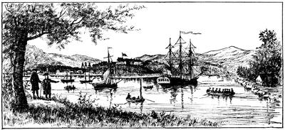
ANNAPOLIS ROYAL.
One of Des Barres’ coast views (in Harvard College library).
The key of the fort at Annapolis, taken at this time, is in the cabinet of the Mass. Hist. Society. (Cf. Catal. Cab. M. H. Soc., p. 112; Proceedings, i. 101.)
Col. William Dudley under date of Nov. 15, 1710, sent to the Board of Trade a communication covering the journal of Col. Nicholson during the siege, with correspondence appertaining, and these papers from the Record Office, London, are printed in the Nova Scotia Hist. Soc. Collections, i. p. 59, as (p. 64) is also a journal from the Boston News-Letter of Nov. 6, 1710. Sabin (ix. no. 36,703) notes a very rare tract: Journal of an Expedition performed by the forces of our Soveraign Lady Anne, Queen, etc., under the command of the Honourable Francis Nicholson in the year 1710, for the reduction of Port Royal in Nova Scotia, London, 1711. A journal kept by the Rev. Mr. Buckingham is printed from the original MS., edited by Theodore Dwight, in the Journals of Madam Knight and Rev. Mr. Buckingham (New York, 1825).[930]
The war was ended by a treaty at Portsmouth,[424] July 11, 1713. (Mass. Archives, xxix. p. 1; N. H. Hist. Soc. Coll., i. p. 83; N. H. Prov. Papers, iii. 543; Maine Hist. Soc. Coll., vi. 250; Penhallow, 78; Williamson’s Maine, ii. 67.)
There was a conference with five of the leading eastern Indians at Boston, Jan. 16, 1713-14, and this treaty is in the Mass. Archives, xxix. 22. A fac-simile of its English signatures is annexed. Another conference was held at Portsmouth, July 23-28, 1714; and this document is also preserved. (Mass. Archives, xxix. 36; Maine Hist. Soc. Coll., vi. 257.)
Dr. Shea (Charlevoix, v. 267) says that no intelligent man will believe that the Indians understood the law-terms of these treaties, adding that Hutchinson (ii. 246) admits as much.
The papers by Frederick Kidder in the Maine Hist. Soc. Collections (vols. iii. and vi.) were republished as Abnaki Indians, their treaties of 1713 and 1717, and a vocabulary with an historical introduction, Portland, 1859. (Field, Indian Bibliog., no. 829; Hist. Mag., ii. p. 84.) It gives fac-similes of the autographs of the English signers and witnesses; and of the marks or signs of the Indians.
A later conference to ratify the treaty of 1713 was published under the title of Georgetown on Arrowsick island, Aug. 9, 1717.... A conference of Gov. Shute with the sachems and chief men of the eastern Indians, Boston, 1717. (Harvard Col. library, no. 5325.24; Brinley, i. no. 431.) This tract is reprinted in the Maine Hist. Soc. Coll., iii. 361, and in the N. H. Prov. Papers, iii. 693. See further in Penhallow, p. 83; Niles, in Mass. Hist. Coll., xxxv. 338; Hutchinson, ii. 199; Williamson’s Maine, ii. 93; Belknap’s New Hampshire, ii. 47; Shea’s Charlevoix, v. 268; Palfrey’s New England, iv. 420.
Shute was accompanied to Arrowsick by the Rev. Joseph Baxter, and his journal of this period, annotated by Elias Nason, is printed in the N. E. Hist. and Geneal. Reg., Jan., 1867, p. 45.
Of chief importance respecting this as well as other of the wars, enumerated in this section, are the documents preserved in the State House at Boston. The Mass. Archives, vol. xxix., covers Indian conferences, etc., from 1713 to 1776; vol. xxxiv. treaties with the Indians from 1645 to 1726; and vols. xxx. to xxxiii. elucidate by original documents relations of all sorts with the Indians of the east and west, as well as those among the more central settlements between 1639 and 1775.
The chief English authority for Queen Anne’s and Lovewell’s wars is The History of the wars of New England with the eastern Indians, or a narrative of their continued perfidy from the 10th of August, 1703, to the peace renewed 13th of July, 1713; and from the 25th of July, 1722, to their submission, 15th December, 1725, which was ratified August 5th, 1726. By Samuel Penhallow. Boston, 1726. The author was an Englishman, who in 1686, at twenty-one, had come to America to perfect his learning in the college at Cambridge, designing to acquire the Indian tongue, and to serve the Society for the Propagation of the Gospel among the Indians. Trade and public office, however, diverted his attention, and he became a rich tradesman at Portsmouth and a man of consideration in the public affairs of New Hampshire. His book is of the first value to the historian and the object of much quest to the collector, for it has become very rare. Penhallow died Dec., 1726, shortly after its publication. It has been reprinted in the first volume of the[425] N. H. Hist. Society’s Collections, and again in 1859 at Cincinnati, with a memoir and notes by W. Dodge.[931]
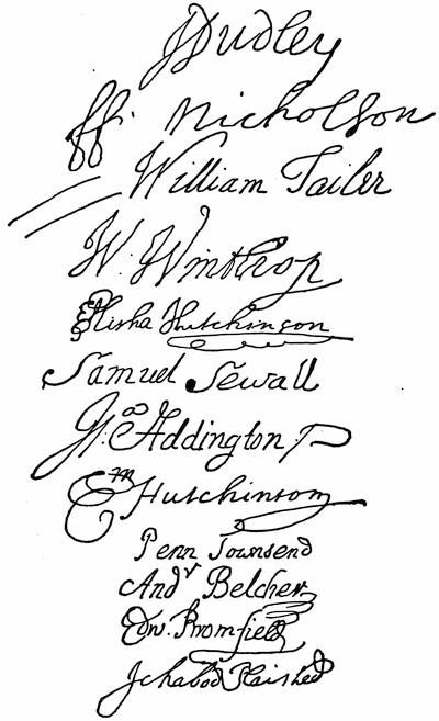
SIGNERS OF THE CONFERENCE.
(January 16, 1713-14.)
A more comprehensive writer is Samuel Niles, in his French and Indian Wars, 1634-1760. Niles was a Rhode Islander, who came to Harvard College the first from that colony to seek a liberal education, and, having graduated in 1699, he settled in Braintree, Mass., in 1711, where he continued till his death in 1762. Palfrey (vol. iv. 256) has pointed out that Niles did little more than add a sentence, embody a reflection, and condense or omit in the use which he made of the Memorial of Nathaniel Morton, the Entertaining Passages of Church, the Indian Wars of Hubbard, the Magnalia of Mather, and the History of Penhallow; so that for a period down to about 1745, Niles is of scarcely any original value.
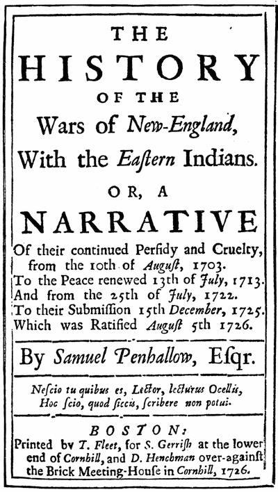
Fac-simile from a copy in Harvard College library.
John Adams (Works, x. 361), who knew the author, lamented in 1818 that no printer would undertake the publication of his history. The manuscript of the work was neglected till some time after 1830 it was found in a box of papers belonging to the Mass. Hist.[427] Society, and was subsequently printed in their Collections, vols. xxvi. and xxxv.[932]

Fac-simile slightly reduced from the copy in Harvard College library.
There are two other important contemporary printed accounts of this war.
Col. Benjamin Church furnished the memoranda from which his son Thomas constructed a book, very popular in its day, and which was published in Boston in 1716, as Entertaining Passages,[933] etc.
Cotton Mather, on the restoration of peace, reviewed the ten years’ sorrows of the war in a sermon before the governor and legislature, which was published as Duodecennium Luctuosum—the History of a long war with Indian savages and their directors and abettors, 1702-1714.[934]
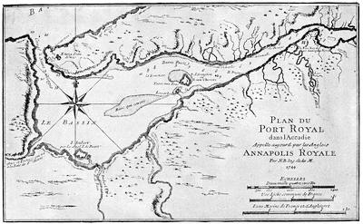
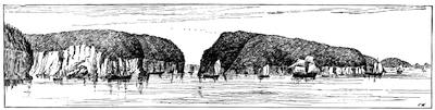
GUT OF ANNAPOLIS.
Note.—The above cut represents the entrance to the Annapolis basin, as it would appear to a spectator at the position corresponding to the letter B in the words “Baye Françoise” in the northwest corner of the map on the opposite page. It follows on a reduced scale one of the coast scenes made by the British engineers to accompany the hydrographic surveys, published by Des Barres, just before the American Revolutionary War, and which frequently make part of the Atlantic Neptune. A modern drawing of the view looking outward through the gut is given in E. B. Chase’s Over the Border (Boston, 1884), where will be found a view of the old block house in Annapolis (p. 64), which stood till 1882.
The map (on the opposite page) is by the royal (French) engineer Nicolas Bellin, and was published by Charlevoix in his Histoire de la Nouvelle France, and is reproduced in Dr. Shea’s translation of Charlevoix, v. p. 170; and on a reduced scale in Gay, Pop. Hist. U. S., iii. p. 125. A MS. plan (1725) is noted in the Catalogue of the King’s Maps in the British Museum, i. p. 38; as also are other plans of 1751, 1752, 1755. One of date 1729 by Nathaniel Blackmore is plate no. 27 in Moll’s New Survey of the Globe. One of 1733 is in the North collection of maps in Harvard College library, vol. ii. pl. 11. One of 1779, after a manuscript in the Dépôt des Cartes in Paris, is no. 11 in the Neptune Americo-Septentrional. This Bellin map may be compared with the draughts of the basin made in the early part of the preceding century by Lescarbot, published in his Histoire de la Nouvelle France (1609), and by Champlain as given in his Voyages du Sieur de Champlain Xaintongeois (1613),—both of which maps are produced in the present History, Vol. IV. pp. 140, 141.
There is on a previous page a view of the town and fort of Annapolis at the upper end of the basin. Various papers respecting Annapolis Royal, as it was called after coming into English possession, can be found in the Belknap Papers (MSS.) in the library of the Massachusetts Historical Society, including letters from Governor Richard Phillips, Lieutenant-Governor John Doucett, and Paul Mascarene. The history of Nova Scotia so much centres in Annapolis, previous to the founding of Halifax, that all the histories of Acadia and Nova Scotia tell the story of the picturesque and interesting region in which the town is situated. (Cf. Vol. IV. p. 156.)
Jacques Nicolas Bellin, the maker of the opposite map, as he was of all the maps given by Charlevoix, was born in Paris in 1703, and died in 1772. He was one of the principal hydrographers of his time in France, and was the earliest to hold a governmental position in the engineer department of the Marine. He has left a large mass of cartographical work, chiefly given on a large scale in his Neptune Français (1753 in folio) and his Hydrographie Française (1756 in folio). The same, with other maps reproduced on a smaller scale, constitute his Petit Atlas Maritime (1764, five volumes in quarto). All of these publications contain maps of American interest, and in 1755 he printed a special contribution to the study of American cartography, Mémoires sur les cartes des côtes de l’Amérique septentrionale.
The uneasy disposition of the times upon the conclusion of the peace may be followed in Gov. Shute’s letter to the Jesuit Father Rasle, Feb. 21, 1718 (Mass. Hist. Coll., v. 112); in the conference with the Penobscots[935] and Norridgewocks, at Georgetown, Oct. 12, 1720 (Mass. Archives, xxix. 68); and in the letter of the eastern Indians (in French) to the governor, July 27, 1721 (Mass. Hist. Coll., xviii. 259).
C. Lovewell’s or Gov. Dummer’s War.—There are documents from the Penhallow Papers relative to the Indian depredations at the eastward in the N. E. Hist. and Gen. Register, 1878, p. 21. Some of them antedate the outbreak of the war. Charlevoix (Shea’s ed., vol. v. 268) tells the story of the counter-missions of the French and English; and the Indians, incited by the French, made demands on the English, who held some of their chiefs as hostages in Boston. (Mass. Hist. Coll., 2d ser., viii. 259; N. Y. Col. Docs., x. 903; Kip, Jesuit Missions, 13.) The seeming truce with the Abenakis was further jeopardized by the act of seizing (Dec., 1721) the younger Baron de St. Castin, when he was taken to Boston for examination. After a detention of five months he was set at liberty.[936] A more serious source of complaints with the Indians before the war was the attempt to seize Father Rasle in Jan., 1722, by an expedition sent to Norridgewock under Col. Westbrook, but in the immediate charge of Capt. Harmon. (N. Y. Col. Docs., ix. 910; Rasle in Kip, 15.) Rasle was warned and escaped, but the party found letters from Vaudreuil in his cabin, implicating the Quebec governor as having incited the increasing depredations of the Indians.[937]
The war began in the summer of 1722. Gov. Shute made his declaration, July 25, 1722 (Mass. Archives, xxxi. 106), and the Rev. Benjamin Wadsworth, at the Thursday lecture, Aug. 16, made it the subject of his discourse. (Brinley, i. no. 429.)
In March, 1723, Col. Thos. Westbrook made a raid along the Penobscot. (Mass. Hist. Coll., xxii. 264; N. Y. Col. Docs., ix. 933.)
Capt. Jeremiah Moulton, under orders of Col. Westbrook, made a scouting expedition in the early summer of 1723, and dated at York, July, 4, his report to Lieut.-Gov. William Dummer, which is printed in the Maine Hist. and Genealog. Recorder, i. p. 204. (Cf. Penhallow, 96; Niles in Mass. Hist. Coll., xxxv. 345; Williamson, ii. 120.) In 1723 there was an Indian raid on Rutland, in which the Rev. Joseph Willard and two children were killed, and two others were carried off. (Cf. Israel Loring’s Two Sermons, Boston, 1724, cited in Brinley, i. no. 1,928.)
A conference was held at Boston, August 22, 1723, of which there is a printed account among the Belknap Papers (MSS.), in the Mass. Hist. Soc. library.
On the 21st July, 1724, there was another conference with the Indians held at St. Georges fort. (Mass. Archives, xxix. 154.)
In Aug., 1724, Moulton and Harmon were sent to make an end of Rasle’s influence. They surprised the Norridgewock settlement, and Rasle was killed in the general slaughter. The opposing chroniclers do not agree as to the manner of his death. Charlevoix (Shea’s ed., v. 279) says he was shot and mutilated at the foot of the village cross. The English say they had intended to spare him, but he refused quarter, and had even killed a captive English boy in[431] the confusion. His scalp and those of other slain were taken to Boston.[938]

In Nov., 1724, Capt. John Lovewell and two others had petitioned to be equipped to scour the woods to the eastward after Indians, and, the legislature acceding (Nov. 17) to their request, Lovewell enrolled his men and made three campaigns in quick succession. The journal of his second expedition (Jan.-Feb., 1724-5) is in the Mass. Archives, vol. lxxxvi., and is printed by Kidder in the N. E. Hist. and Geneal. Reg., Jan., 1853, and in his Expeditions of Capt. John Lovewell. It was on the third of these expeditions, May 9, 1725, that Lovewell encountered the Indians near a pond in Fryeburg, Maine, now known as Lovewell’s pond, upon whose wood-girt surface the summer tourist to-day looks down from the summit of the Jockey-Cap. Their leader was killed early in the action, which lasted all day, and only nine of the English who remained alive were unwounded when the savages drew off.
The news reached Boston on the 13th of May. Kidder gives the despatches received by the governor, with the action of the council upon them. On the 17th an account was printed in the Boston Gazette, which is also in Kidder. The day before (May 16) the Rev. Thomas Symmes, of Bradford, who had gathered his information from some of those who had escaped, delivered a sermon in that town, which, when printed with an “historical preface or memoirs of the battle at Piggwacket,” became popular, and two editions were printed at Boston during the same year. Both editions are of the greatest rarity. The first is called: Lovewell lamented, or a Sermon occasion’d by the fall of the brave Capt. John Lovewell and several of his valiant company in the late heroic action at Piggwacket. Boston, 1725.[939] The other edition was entitled: Historical memoirs of the late fight at Piggwacket; with a sermon occasion’d by the fall of the brave Capt. John Lovewell and several of his valiant company.... The second edition, corrected. Boston, 1725.[940] A third edition was printed at Fryeburg, with some additions, in 1799. The narrative, but not the sermon, was later printed in Farmer and Moore’s Historical Collections, i. 25. At Concord (N. H.), in 1861, it was again issued by Nathaniel Bouton, as The original account of Capt. John Lovewell’s Great Fight with the Indians at Pequawket, May 8, 1725.[941] Mr. Frederic Kidder, in N. E. Hist. and Geneal. Reg.,[942] Jan., 1853 (p. 61), printed an account of Lovewell’s various expeditions, with sundry documents from the Massachusetts Archives, which, together with the second edition of Symmes, were later, in 1865, embodied in his Expeditions of Capt. John Lovewell and his encounters with the Indians, including a particular[432] account of the Pequauket battle.[943] This is a faithful reprint of the Symmes tract, while those of Farmer and Moore, and of Bouton, introduce matters from other sources. The bibliography of Symmes’s sermon is traced in Dr. S. A. Green’s Groton during the Indian Wars, p. 134.
The relations of the French to the Abenaki war during 1724-25 are shown in various documents printed in the N. Y. Coll. Docs., vol. ix., as when the French ministry prompts the governor of Canada to sustain the savages in their struggle with the English (p. 935); a memoir is registered upon their condition (p. 939); Intendant Begon reports on the war (p. 941); other letters are written (p. 945); and the ministry again counsel the governor to instigate further hostilities (p. 956).
A journal of a scout by Westbrook, beginning June 23, 1725, is among the Belknap Papers (MSS.).
Four eastern sagamores came to Boston, Nov. 10, 1725 (Mass. Archives, xxix. 191; Murdoch’s Nova Scotia, i. 429), and a treaty with them was signed Dec. 15, 1725, known as “Dummer’s treaty” (Mass. Archives, xxxiv.), which was ratified at Falmouth, Aug. 6, 1726. (Mass. Archives, xxix. 230; xxxiv. See also Penhallow, 117; N. H. Hist. Coll., i. 123; N. H. Prov. Papers, iv. 188; Niles in Mass. Hist. Coll., xxxv. 360; Williamson, ii. 145, 147; Palfrey, iv. 443.)
This treaty was separately printed under the title of Conference with the Indians at the ratification of peace held at Falmouth, Casco Bay, by Governour Dummer, in July and August, 1726. Boston, 1726, pp. 24. It was reprinted in 1754. (Cf. Brinley, i. 432, 434; Harvard College library, 5325.32.)
There was another Indian treaty at Casco Bay, July 25, 1727. (Mass. Archives, xxix. 256.) In Akins’s Pub. Doc. of Nova Scotia is a fac-simile of a copy of this treaty, attested by Dummer, evidently made to be used by Cornwallis in 1749, in negotiating another treaty. (Cf. N. H. Hist. Coll., ii. 260, where the treaty is printed; and the explanation of the Indians in N. Y. Col. Docs., ix. 966.)
This treaty of 1727 was separately printed as Conference with the Eastern Indians at the further ratification of the peace, held at Falmouth, in Casco Bay, in July, 1727. Boston, 1727, pp. 31. It was reprinted in 1754. (Cf. Brinley, i. 433, 434.)
Cf. also Conferences of Lieut.-Gov. Dummer with the Eastern Indians in 1726 and 1727. Boston, 1754. For the treaties of 1726-27, see also Maine Hist. Coll., iii. 377, 407; N. H. Prov. Papers, iv. 255-258; Palfrey, iv. 444.
There is in the Mass. Archives (xxix. 283) the document which resulted from a conference with the Eastern Indians in the council chamber in Boston, Dec. 9-Jan. 15, 1727-28.
Dr. Colman’s memoir of the troubles at the eastward in 1726-27 is in the Mass. Hist. Coll., vi. 108. (Cf. Mass. Hist. Soc. Proc., x. 324.)
The French were disconcerted by the treaty of 1727, as sundry papers in the N. Y. Col. Docs., vol. ix., show. They reiterate their complaints of the English encroachments on the Indians’ lands (p. 981); observe great changes in the Abenakis since they made peace with the English (p. 990); and the king of France tells the Canadians he does not see how the Indians could avoid making the treaty with the English (p. 995).[944]
The letters of caution, which Belcher was constantly writing (1731-1740) to Capt. Larrabee, in command at Fort George, Brunswick, indicate how unstable the peace was. (N. E. Hist. & Gen. Reg., Apr., 1865, p. 129.) The continued danger from French intrigue is also shown in Colman’s memoir, etc., in Mass. Hist. Coll., vi. 109, and in the repeated conferences of the next few years: Conference of his Excellency Governor Belcher with the chiefs of the Penobscot, Norridgewock, and Ameriscoggin tribes at Falmouth, July, 1732. Boston, reprinted at London. (Haven in Thomas, ii. p. 428; Carter-Brown,[433] iii. 482; Harv. Coll. lib., 5325.33; Brinley, i. no. 435.)
A Conference held at Deerfield, the 27th of August [to Sept. 1], 1735, by his Excellency, Jonathan Belcher, and Ountaussoogoe and others, etc. [Boston, 1735]. (Brinley, i. no. 437.) This tract is reprinted in the Maine Hist. Coll., iv. 123.
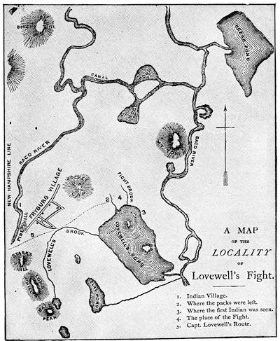
LOVEWELL’S FIGHT.
From the map in Bouton and Kidder.
Conference with the Penobscots at the council chamber in Boston, June, 1736. (Mass. Archives, xxix. 317.)
The nine Penobscot chiefs who held this conference were lodged with one John Sale in Boston, who renders an account of his charges for twenty-four days’ entertainment of them, which is suggestive. He charges for three half-pints of wine, per day, each; for twelve pence worth of rum per day, each; for 120 gallons of cider; for damage done in breaking of sash doors, frames of glass, China bowl, double decanter, and sundry glasses and mugs; for two gross of pipes and tobacco; for candles all night; for showing them the rope-dancers; for washing 49 of their “greasy shirts;” and “for cleaning and whitewashing two rooms after them.” The following “memorandum” is attached: “They eat for the most part between 50 and 60 pounds of meat per day, beside milk, cheese, etc. The cider which they drank I sold for twelve shillings[434] per quart. Besides, they had beer when they pleased. And as for meat, they had the best, as I was ordered.”
Conference with the Penobscots and Norridgewocks, June 28-July 6, 1738. (Mass. Archives, xxix. 336.)
Conference with the Penobscots at the council chamber in Boston, Aug. 25-Sept. 2, 1740. (Mass. Archives, xxix. 364.)
Conference with the Penobscots, Dec. 3, 1741. (Mass. Archives, xxix. 376.)
“Projets sur la prise de l’Acadie, 1741.” (Parkman MSS. in Mass. Hist. Soc., New France, i. p. 1.)
Conference held at the Fort at St. George in the County of York, the 4th of August, 1742, between William Shirley, Governor, and the Chief Sachems and Captains of the Penobscott, Norridgewock, Pigwaket or Amiscogging or Saco, St. John’s, Bescommonconty or Amerescogging and St. Francis tribes of Indians, August, 1742. (Carter-Brown, iii. no. 703; Brinley, i. no. 440. Cf. Williamson, ii. 209.)
D. King George’s, Shirley’s, or Five Years’ War.—France had declared war against England, Mar. 15, 1744 (Coll. de Manuscrits, Quebec, iii. p. 196), and the capitulation of Canso had taken place, May 24. (Ibid., iii. p. 201.) In July, 1744, Pepperrell and others, including some chiefs of the Five Nations, met the Penobscots at St. Georges and agreed to join in a treaty against the Cape Sable Indians. The Penobscots did not keep the appointment. War was declared against the Cape Sable and St. John’s Indians, Oct. 19, 1744. The General Court of Massachusetts offered a reward for scalps; and a proclamation was made for the enlistment of volunteers, Nov. 2, 1744. (Mass. Archives, xxxi. 506, 514; printed in W. W. Wheildon’s Curiosities of History, Boston, 1880, pp. 107, 109.)
The most brilliant event of the war was impending.
The French had begun the construction of elaborate defences at Louisbourg in 1720. A medal struck in commemoration of this beginning is described in the Transactions (1872-73, p. 75) of the Literary and Historical Society of Quebec.

It has always been open to question from whom came the first suggestion of the expedition of 1745. The immediate incentive seems to have been a belief, prompted by the reports of prisoners released from Canso, that Louisbourg could be captured, if attacked before relief could reach it from France. Judge Robert Auchmuty, of Roxbury, developed a plan for the capture in the Gentleman’s Magazine for July, 1745,—the same number in which was also printed the news of the attack and capture. When the paper was reprinted in a thin folio tract shortly afterwards, he or some one for him emphasized his claim to the suggestion in the title itself as follows: The importance of Cape Breton to the British Nation, humbly represented by Robert Auckmuty [sic], Judge, &c., in New England. N. B. Upon the plan laid down in this representation the island was taken by Commodore Warren and General Pepperill the 14th of June, 1745. London, 1745.[945]
It is claimed on behalf of William Vaughan that he suggested the expedition to Governor Wentworth, of New Hampshire, who in turn referred him to Governor Shirley. An anonymous tract, published in London in 1746, The Importance and Advantage of Cape Breton truly stated and impartially considered,[946] often assigned to William Bollan, and believed by some to have been inspired by Vaughan, says that Vaughan had “the honor of reviving, at least, if not of having been the original mover or projector,” of the expedition, since it is claimed that Lieutenant-Governor Clarke, of New York,[947] had suggested the attack to the Duke of Newcastle as early as 1743. Douglass (Summary, etc., i. 348) says that Shirley was taken with the “hint or conceit” of Vaughan, “a whimsical, wild projector.” Hutchinson says that Vaughan “was called the projector of the expedition,” and Belknap accords him the priority in common report.[948] When Thomas Prince came to dedicate[435] his sermon, preached on the Thanksgiving day following the triumph, he inscribed it to Shirley as the “principal former and promoter of the expedition;” but the language hardly claims the origination, though Shirley was generally recognized as the moving spirit in its final determination.[949]
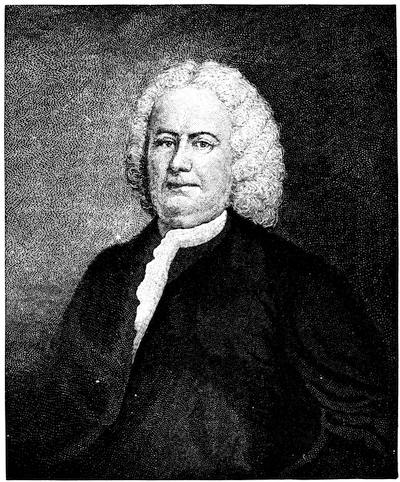
PEPPERRELL.
After a painting, now owned by Mrs. Anna H. C. Howard, of Brooklyn, N. Y., and which has descended from Pepperrell. (Cf. Penna. Mag. of Hist., iii. p. 358.) This likeness, painted in London in 1751 by Smibert, is also engraved in Parsons’ Life of Pepperrell, in Drake’s Boston, and in the N. E. Hist. and Geneal. Reg., Jan., 1866, where Dr. Parsons gives a genealogy of the Pepperrell family. There is in the Memorial Hist. of Boston (ii. 114) an engraving after an original full-length picture in the hall of the Essex Institute at Salem,—artist unknown. See also Higginson’s Larger History, p. 188.

A sword of Pepperrell is shown in the group of weapons engraved in Vol. III. p. 274. (Cf. Catal. Cab. Mass. Hist. Soc., p. 123; Proc. Mass. Hist. Soc., v. 373; and Parsons’ Life of Pepperrell.) Views of the Pepperrell mansion at Kittery, where considerable state was kept, are given in Parsons (p. 329), and in a paper on Pepperrell by J. A. Stevens in the Mag. of Amer. History, vol. ii. 673. Cf. also Lamb’s Homes of America (1879), and Appleton’s Journal, xi. 65.
The earliest account of this mettlesome enterprise, which showed special research and opportunities, was that of Dr. Belknap in his History of New Hampshire, which was written in 1784, less than forty years after the event, and when he might have known some of the participants. The most important of the Pepperrell Papers had fallen into his hands, and he made good use of them, after which he deposited them in the cabinet of the Massachusetts Historical Society, where they now are, bound in two volumes, covering the years 1699-1779, but chiefly concerning the Louisbourg expedition.
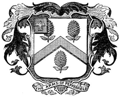
PEPPERRELL ARMS.
This cut of the Pepperrell arms is copied from one in the Mag. of Amer. Hist., Nov., 1878, p. 684.
With them in the same depository are the Belknap Papers, three volumes,[950] as well as a composite volume, Louisbourg Papers, devoted entirely to the expedition.[951] Others of the scattered papers of Pepperrell have since been found elsewhere. Dr. Usher Parsons, in his Life of Pepperrell,[952] beside using what Belknap possessed, sifted a mass of papers found in an old shed on the Pepperrell estate. This lot covered the years 1696-1759, and some of them were scarcely legible. The mercantile letters and accounts among them yielded little, but there was a smaller body of Pepperrell’s own letters and those of his correspondents, which proved of more or less historical value.
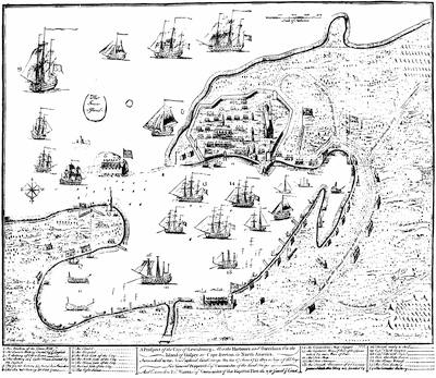
Unremitting search yielded gain to Dr. Parsons in other directions. Some manuscripts coming from a Kittery house into the hands of Capt. Luther Dame, of Newburyport, were reported upon by Col. A. H. Hoyt in the New England Hist. and Geneal. Reg. (Oct., 1874, p. 451), in a paper afterwards reprinted by him, separately, with revision; but they throw no considerable light upon the Louisbourg siege. They would add little to what Parsons presents in chronologically arranged excerpts from letters and other records which make up his account of the expedition.[953]
Of all other contemporary accounts and aids, most, so far as known, have been put into print, though George Bancroft quotes a journal of Seth Pomeroy,[954] not yet in type; and there are papers which might still be gleaned in the Mass. Archives. There are in print the instructions of Shirley, and a correspondence between Pepperrell and Warren (Mass. Hist. Collections, i. 13-60); letters of Wentworth and Shirley on the plan of attack, and other letters of Shirley (Provincial Papers of New Hampshire, vol. v. pp. 931, 949, etc.); and many others of Pepperrell, Warren, Shirley, etc. (Rhode Island Colonial Records, vol. v.). The Colonial Records of Connecticut (vol. ix.) for this period give full details of the legislative enactment regarding the part that colony bore in the expedition; but the absence of most of the illustrative documents from her archives during that interval deprives us, doubtless, of a correspondence similar to that which is included in the Rhode Island printed Records.
Shirley’s letters to Governor Thomas, of Penna., respecting the preparations for the Louisbourg expedition, are in Penna. Archives, i. 667, etc.
Stray letters and documents of some interest, but throwing no essential light upon historical events, are found in the N. E. Hist. and Geneal. Reg., v. 88; xii. 263; xix. 225, etc.
Various accounts of the siege, of no great extent were published soon after its close. Chief among them was an Accurate journal and account of the proceedings of the New England land forces, during the late expedition against the French settlements on Cape Breton to the time of the surrender of Louisbourg, Exon, 1746 (40 pp.). The manuscript of this journal was sent to England by Pepperrell to his friend Capt. Henry Stafford; and as printed it was attested by Pepperrell, Brig.-General Waldo, Col. Moore, Lieut.-Col. Lothrop, and Lieut.-Col. Gridley.[955] This journal was printed, with some curious verbal differences, as an appendix to a Letter from William Shirley, Esq., to the Duke of Newcastle, with a Journal of the Siege of Louisbourg, London, 1746. It was by vote of the legislature, Dec. 30, 1746, reprinted in Boston, once by Rogers and Fowle, and again by J. Draper.[956] An account by Col. James Gibson, published in London in 1745, as a Journal of the late siege by the troops of North America against the French at Cape Breton,[957] contained a large engraved plan of the siege, of which a reduced fac-simile is annexed.[958] The narrative was edited in Boston in 1847 by Lorenzo[438] D. Johnson, under the misleading title A Boston merchant of 1745. Other diaries of the siege, of greater or less extent, have been printed, like Wolcott’s,[959] in the Collections (vol. i.) of the Connecticut Historical Society; Curwen’s in his letters (Hist. Collections Essex Institute, vol. iii. 186), and in his Journal, edited by Ward (p. 8); Craft’s journal (Hist. Coll. Essex Inst., iv. p. 181); that of Adonijah Bidwell, the chaplain of the fleet (N. E. Hist. and Geneal. Reg., April, 1873); and the folio tract entitled A particular Account of the taking of Cape Breton by Admiral Warren and Sir William Pepperell, with a description of the place ... and the articles of capitulation, By Philip Durell, Esq., Capt. of his majesty’s ship “Superbe.” To which is added a letter from an officer of marines, etc., etc., London, 1745. Durell’s account is dated June 20, 1745, in Louisbourg harbor. Douglass gives the force by sea and land before Louisbourg. Summary, etc., i. 350.
A list of the commissioned officers of the expedition, drawn from the Belknap Papers, is edited by Charles Hudson in the N. E. Hist. and Geneal. Reg., Oct., 1870.[960] In Ibid., April, 1868, a list of 221 names of the common soldiers had been printed; but in July, 1871, a much longer enumeration is made out by Mr. Hudson from the Pepperrell papers, the Council Records, and other sources. Potter in the N. H. Adj.-General’s Report, ii. (1866, pp. 61-76), afterwards published as Mil. Hist. of N. H., gives the New Hampshire rolls of Louisbourg soldiers.
On the occasion of a Thanksgiving (July 18, 1745) in Boston, two sermons preserve to us some additional if slight details. That of Thomas Prince, Extraordinary events the doings of God and marvellous in pious eyes, Boston and London, 1745 (Harv. Coll. lib., 4375.42 and 43), is mainly reprinted in S. G. Drake’s Five Years’ French and Indian Wars, p. 187; and that of the Rev. Charles Chauncy, the brother-in-law of Pepperrell, Marvellous Things done by the right hand and holy arm of God in getting him the victory, was printed both in Boston and London.[961]
The capture of Louisbourg and the question of the disposition of the island at the peace led to several expositions of its imagined value to the British Crown, among which may be named:—
The importance and advantage of Cape Breton considered, in a letter to a member of Parliament from an inhabitant of New England, London, 1746. (Brinley, no. 69.) This is signed “Massachusettensis.”[962]
Two letters concerning some farther advantages and improvements that may seem necessary to be made on the taking and keeping of Cape Breton, London, 1746. (Carter-Brown, iii. no. 822.)
The importance and advantage of Cape Breton, truly stated and impartially considered. With proper maps, London, 1746. (Carter-Brown, iii.[439] no. 823.) The maps follow those of Bellin in Charlevoix. Its authorship is usually ascribed to William Bollan. (Sabin, ii. 6,215.)
The great importance of Cape Breton demonstrated and exemplified by extracts from the best writers, French and English, London, 1746. This is a plea against the surrender of it to the French. It is dedicated to Governor Shirley, and contains Charlevoix’s map and plan. (Carter-Brown, iii. no. 821.)
An accurate description of Cape Breton, Situation, Soil, Ports, etc., its Importance to France, but of how much greater it might have been to England; with an account of the taking of the city by the New England forces under General Pepperell in 1745, London, 1755.
Memoir of the principal transactions of the last war between the English and French in North America, from 1744 to the conclusion of the treaty at Aix-la-Chapelle, containing in particular an account of the importance of Nova Scotia and Cape Breton to both nations (3d ed., London, reprinted, Boston, 1758.)
Douglass (Summary, etc.), the general historian nearest the time, was an eager opponent of Shirley, and in his account of the expedition he ascribes to good luck the chief element in its success. He calls it “this infinitely rash New England Corporation adventure, though beyond all military or human probability successful.” (Summary, etc., 1751, ii. p. 11.) “Fortified towns are hard nuts to crack, and your teeth have not been accustomed to it,” wrote Benjamin Franklin from Philadelphia to his brother in Boston. (Franklin’s Works, vii. 16.)[963]
Accounts of the expedition enter necessarily into the more general narratives, like those of Hutchinson (Mass. Bay); Chalmers (Revolt, etc.); Minot (Massachusetts); Gordon (Amer. Rev.); Marshall (Washington); Bancroft (United States); Grahame (United States); Williamson (Hist. of Maine); Murdoch (Nova Scotia, ii. ch. 5); Haliburton (Nova Scotia); Stone (Sir Wm. Johnson, vol. i.); Palfrey (Compendious Hist. of New England, iv. ch. 9); Bury (Exodus of the Western Nations, ii. ch. 6); Gay (Pop. Hist. United States); Drake (Boston). The Memorial Hist. Boston (ii. 117) and Barry’s Massachusetts (ii. 140, etc.) give numerous references. Joel T. Headley has a popular narrative in Harper’s Monthly, xxviii. p. 354. Garneau (Hist. du Canada, 4th ed., ii. 190) offers the established French account. Cf. Lettre d’un habitant de Louisbourg contenant une relation exacte de la prise de l’Ile Royale par les Anglais, Quebec, 1745. (Sabin, x. no. 40,671.)[964]
The present condition of the site of Louisbourg is described by Parsons (Life of Pepperrell, 332); by Parkman (Montcalm and Wolfe); by J. G. Bourinot in his “The old forts of Acadia” in Canadian Monthly, v. 369; and in the Canadian Antiquarian, iv. 57.
Maps, both French and English, showing the fortifications and harbor of Louisbourg are numerous.
Both editions of Charlevoix’s Histoire de la Nouvelle France, the duodecimo in six volumes, and the quarto in three volumes issued in 1744, the year before the siege, have plans of Louisbourg and its fortifications, and the same are reproduced in Dr. Shea’s translation of Charlevoix. They are the work of Nicholas Bellin, and to the same draughtsman belongs Le Petit Atlas Maritime, 1764, in the volume of which devoted to North America, there are other (nos. 23, 24) plans of the harbor and fortifications.
Following French sources is a Plan des fortifications de Louisbourg, published at Amsterdam by H. de Leth about 1750. A “Plan special de Louisbourg” is also to be found on the map published by N. Visscher at Amsterdam, called “Carte Nouvelle contenant la partie de l’Amérique la plus septentrionale.”
Among the French maps is one “levé en 1756,” after a plan of Louisbourg, preserved in[440] the Dépôt des Cartes de la Marine in Paris. This appeared in 1779 in the Neptune Americo-Septentrional, “publiée par ordre du Roi;” and another, dated 1758, “levé par le chev. de la Rigaudiere,” was accompanied by a view, of which there is a copy in the Mass. Archives; Docs. collected in France, Atlas, ii. 5. In this last (composite) Atlas (ii. nos. 44, 45) are maps of the town and harbor, and a large plan of the fortifications, marked “Tome i. no. 23,” which can probably be identified.

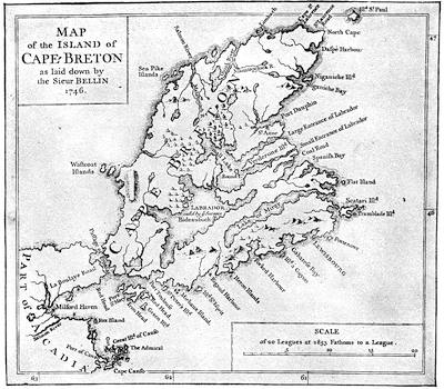
CAPE BRETON, 1746.
Reduced fac-simile of the “Map of the Island of Cape Breton as laid down by the Sieur Bellin, 1746,” annexed to The Importance and Advantage of Cape Breton, truly stated and impartially considered, London, 1746. A general map of the island of Cape Breton, with Bellin’s name attached, is found in the several editions of Charlevoix and in the Petit Atlas maritime, par le S. Bellin, 1764. The earliest more elaborate survey of this part of the coast was the one published by J. F. W. Des Barres, in 1781, in four sheets, The South East Coast of Cape Breton Island, surveyed by Samuel Holland. A map by Kitchen was published in the London Mag., 1747.
Richard Gridley,[965] of Massachusetts Bay, who was present as an officer of the artillery, made a plan of the fortifications after the surrender, and this, called a Plan of the City and Fortifications of Louisbourg from surveys made by Richard Gridley in 1745, was engraved and published by Jefferys, in 1758, and was used by him in his History of the French Dominions in America, London, 1760 (p. 124), and in his General Topography of North America and the West Indies, London, 1768 (no. 25).[966]
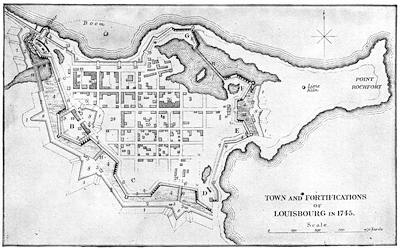
GRIDLEY’S PLAN AS REDUCED IN BROWN’S CAPE BRETON.
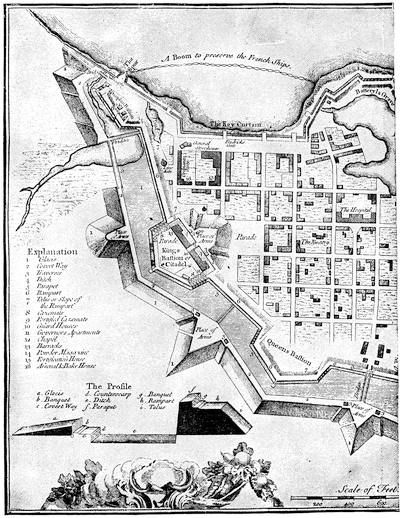
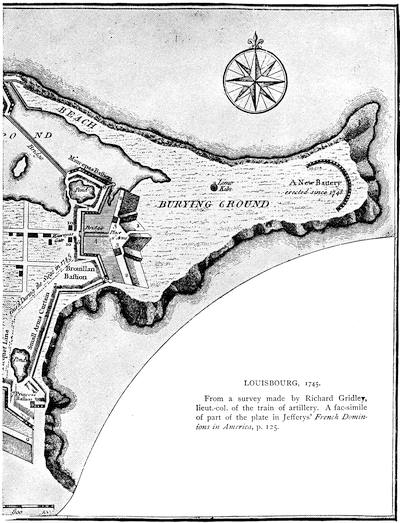
LOUISBOURG, 1745.
From a survey made by Richard Gridley, lieut.-col. of the train of artillery. A fac-simile of part of the plate in Jeffery’s French Dominions in America, p. 125.
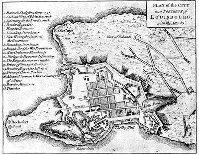
LOUISBOURG (Set of Plans, etc.)
Gridley’s surveys have been the basis of many of the subsequent English plans. The draught reduced from Gridley in Richard Brown’s History of the Island of Cape Breton (London, 1869) is herewith given in fac-simile, and is understood by the following key:—
A. Dauphin bastion and circular battery.
B. King’s bastion and citadel.
C. Queen’s bastion.
D. Princess’ bastion.
E. Bourillon bastion.
F. Maurepas bastion.
G. Batterie de la Gréve.
1, 1, etc. Glacis.
2, 2, etc. Covered way.
3, 3, etc. Traverses.
4, 4, etc. Ditch.
5, 5, etc. Parapet.
6, 6, etc. Ramparts.
7, 7, etc. Slopes of same.
8, 8, etc. Places of arms.
9, 9, etc. Casemates.
10, 10, etc. Guard houses.
11, 11, etc. Wooden bridges.
12. Governor’s apartments.
13. Church.
14. Barracks.
15. Powder magazine.
16. Fortification house.
17. Arsenal and bake-house.
18. Ordnance.
19. General storehouse.
20. West gate.
22. East gate.
23. Gates in quay curtain (b. b. b.).
24. Parade.
25. Nunnery.
26. Hospital and church.
a. a. Palisade, with ramparts for small arms.
c. c. Picquet (raised during the siege).
Another plan of an early date is one, likewise annexed, which appeared in A set of plans and forts in America, reduced from actual surveys, 1763, and published in London.[967] The plan which George Bancroft added to his History of the United States, in one of the early editions, was used again by Parsons in his Life of Pepperrell.
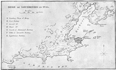
FROM BROWN’S CAPE BRETON.
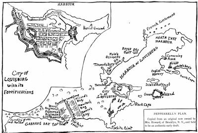
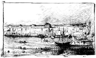
VIEW OF LOUISBOURG.
A reduced sketch from a painting owned by Mrs. Anna H. C. Howard of Brooklyn, N. Y., which came to her by descent from Sir William Pepperrell. The canvas is very dark and obscure, and the artist may have missed some of the details, particularly of the walls along the shore. The point of view seems to be from the northwest side of the interior harbor, near the bridge (seen in the foreground), which spans one of the little inlets, as shown in some of the maps. This position is near what are called “Hale’s Barracks” in the draft of the town and harbor on the preceding page. The dismantled ships along the opposite shore are apparently the French fleet, while an English ship is near the bridge.
The following letter describes the present condition of the ground:—
Boston, June 4, 1886.
My dear Mr. Winsor,—It gives me great pleasure to comply with your request, and to give my recollections of Louisburg as seen in September last.
The historical town of that name, or rather the ruin of the old fortress, lies perhaps three miles from the modern town, which is a small village, situated on the northeasterly side of the bay or harbor. The inhabitants of the neighborhood live, for the most part, by fishing and other business connected with that branch of industry, eking out their livelihood by the cultivation of a rocky and barren soil. The road from the village to the old fortress runs along the western shore of the bay, passing at intervals the small houses of the fishermen and leaving on the left the site of the Royal Battery, which is still discernible. This was the first outpost of the French taken at the siege, and its gallant capture proved subsequently to be of the greatest service to the English. From this point the ruins of the fortress begin to loom up and show their real character. Soon the walls are reached, and the remains of the former bastions on the land side are easily recognized. This land front is more than half a mile in length, and stretches from the sea on the left to the bay on the right, forming a line of works that would seem to be impregnable to any and all assaults. From its crown a good idea can be gained of the size of the fortifications, which extend in its entire circuit more than a mile and a half in length, and inclose an area of a hundred and twenty acres, more or less. The public buildings within the fortress were of stone, and, with the help of a guide, their sites can easily be made out. The burying-ground, on the point of land to the eastward, where hundreds of bodies were buried, is still shown; and the sheep and cattle graze all unconscious of the great deeds that have been done in the neighborhood. Taken all in all, the place is full of the most interesting associations, and speaks of the period when the sceptre of power in America was balancing between France and England; and Louisburg forms to-day the grandest ruin in this part of the continent.
Very truly yours,
Samuel A. Green.
It follows an English plan procured by Mr. Bancroft in London, and closely resembles the sketch owned by a descendant of Pepperrell, and herewith given. Haliburton in his History of Nova Scotia gives a similar plan, as well as a draught of the harbor. The plan of the town and the vicinity which is given by Brown in his Cape Breton is also reproduced herewith. The earliest of the more elaborate charts of the harbor is that published by Des Barres in Oct., 1781. We find a rude sketch of the Island battery in Curwen’s Journal as edited by Ward (Boston, 4th ed. 1864), which was sent by that observer from Louisbourg, July 25, 1745. A reproduction of this sketch, herewith given, needs the following key:—
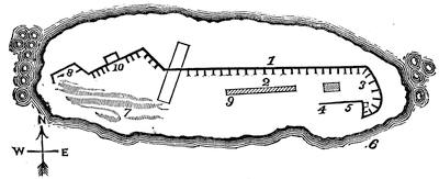
PLAN OF ISLAND BATTERY.
“The embrasures in the front are not more than three feet above the ground.
1. Fronting mouth of harbor: 22 embrasures; 21 guns, 36 and 48 pounders.
2. Barracks.
3. Sally-ports.
4. Wall framed of timber, and covered with plank, and filled with stone and lime, in which is an embrasure with a 48 pounder.
5. Wall, defended with two small swivels.
6. The place at which whale-boats might easily land 500 men.
7. One entire rock, perpendicular on the face, and absolutely impossible to be climbed.
8. Piquet of large timber, fastened by iron clamps, drilled into the solid rock.
9. Commandant’s apartment, five feet high.
10. The gate under the wall, about four feet wide, formed like a common sally-port; not straight, but made an angle of 160 degrees. Ten men can prevent ten hundred making their way; this wall has but four guns and two swivels.
“I paced the island, and judged it to be about 56 yards wide and 150 long at the widest part, nearly.”
There is in the Collections of the Maine Hist. Soc. (viii. p. 120) a life of Lieut.-Col. Arthur Noble, who, by order of Brigadier Waldo, led on May 23 the unsuccessful attack on this battery.
The Catalogue of the king’s maps in the British Museum (vol. i. 718, etc.) shows plans of the town and fortifications (1745) in MS. by Durell and Bastide; others of the town and harbor (1755) by William Green; with views by Bastide (1749), Admiral Knowles (1756), Ince (1758, engraved by Canot, 1762), and Thomas Wright (1766).
Jefferys also published in copperplate A view of the landing of the New England forces in the expedition against Cape Breton, 1745. (Carter-Brown, iii. p. 335.) A copy of this print belongs to Dr. John C. Warren of Boston.
Three months after the fall of Louisbourg there was another treaty with the eastern Indians, Sept. 28-Oct. 22, 1745. (Mass. Archives, xxix. 386.) The renewed activity of the French is shown in the N. Y. Col. Docs., x. p. 3.
A little later, Dec. 12, 1745, Shirley made his first speech to the Massachusetts Assembly after his return to Boston, and communicated the King’s thanks for “setting on foot and executing the late difficult and expensive enterprise against Cape Breton.”[968]
The next event of importance in the Acadian peninsula was the attack of the French upon an English post, which is known as the “battle of Minas.”
The English accounts (Boston Weekly Post Boy, March 2 and 9, 1747), which give the date Jan. 31, old style, and the French (official report), Feb. 11, new style, are edited by Dr. O’Callaghan with the articles of capitulation, in the New Eng. Hist. and Geneal. Reg., April, 1855, p. 107. For general references see Haliburton’s Nova Scotia, ii. 132; Williamson’s Maine, ii. 250; Hannay[449] (p. 349) and the other histories of Nova Scotia.
ENTRANCE OF MINES BASIN.
One of Des Barres’ coast views 1779. (In Harvard College library.)
Douglass (Summary, etc., i. 316) says: “Three companies from Rhode Island were shipwrecked near Martha’s Vineyard; two companies of New Hampshire went to sea, but for some trifling reason put back and never proceeded. The want of these five companies was the occasion of our forces being overpowered by the Canadians at Minas with a considerable slaughter.”
CAPE BAPTIST.
One of Des Barres’ coast views, marked A view of Cate Baptist in the entrance into the basin of Mines, bearing W. by N., two miles distant. (In Harvard College library.)
The French account of these transactions of the command of Ramezay is in a “Journal de la compagne du détachement de Canada à l’Acadie et aux Mines en 1746 et 1747” (June, 1746, to March, 1747). It is in the Parkman MSS. in the Mass. Hist. Society, New France, i. pp. 59-153. For the attack at Minas in particular see the “Relation d’une expédition faite sur les Anglois dans les pays de l’Acadie, le 11 Fév., 1747, par un détachement de Canadiens,” dated at Montreal, 28 Sept., 1747, and signed Le Chev. de la Corne. (Ibid., pp. 155-163.) Cf. also N. Y. Col. Docs., x. 78, 91.
The treaty of Aix-la-Chapelle, Oct., 1748, was proclaimed in Boston, May 10, 1749, and a reprint of it issued there.
Shirley (June 3, 1749) writes to Gov. Wentworth that he had agreed with nine Indian chiefs, then in Boston, to hold a conference at Casco bay, Sept. 27. (N. H. Prov. Papers, v. 127.)
Meanwhile the English government, in pursuance[450] of an effort to anglicize the peninsula,[969] had planned the transportation to Nova Scotia of an equipped colony under Edward Cornwallis, which arrived at Chebucto harbor in the summer of 1749, and founded Halifax. A treaty with the Indians was held there Aug. 15, 1749. (Mass. Hist. Coll., ix. 220.) There is a full-size fac-simile of the document in Akins’s Public Doc. of Nova Scotia. It was in confirmation of the Boston treaty of Dec. 15, 1725, which is embodied in the new treaty.
Another treaty with the eastern Indians was made at Falmouth, Oct. 16, 1749. (Mass. Archives, xxix. 427; xxxiv.; Mass. Hist. Coll., ix. 220; N. H. Hist. Soc. Coll., ii. 264; Williamson’s Maine, i. 259, taken from Mass. Council Records, 1734-57, p. 108; Hutchinson, iii. 4.)
This treaty was proclaimed in Boston, Oct. 27. Cf. Journal of the proceedings of the commissioners appointed for managing a treaty of peace at Falmouth, Sept. 27, 1749, between Thomas Hutchinson, John Choate [and others], commissioned by Gov. Phips, and the eastern Indians, Boston [1749]. (Brinley, i. no. 441; Harv. Col. lib. 5325.39.) This tract is reprinted in Maine Hist. Coll., iv. 145.
There was another conference with the Penobscots and Norridgewocks, Aug. 3-8, 1750. (Mass. Archives, xxix. 429.)
A tract to encourage emigration to the new colony at Halifax was printed in London in 1750, and reprinted in Dublin: A genuine account of Nova Scotia, to which is added his majesty’s proposals as an encouragement to those who are willing to settle there. Cf. the German tract: Historische und Geographische Beschreibung von Neu-Schottland, Franckfurt, 1750. (Carter-Brown, iii. no. 935.) Counter-statements not conducive to the colony’s help, appeared in John Wilson’s Genuine narrative of the transactions in Nova Scotia since the settlement, June, 1749, till Aug. 5, 1751 ... with the particular attempts of the Indians to disturb the colony, London, 1751. (Carter-Brown, iii. no. 966.)
There are papers relating to the first settlement of Halifax in Akins’s Documents, 495; and a paper on the first council meeting at Halifax, by T. B. Akins, in the Nova Scotia Hist. Soc. Coll., vol. ii. See also Murdoch’s Nova Scotia, ii. ch. 11. Various maps of Halifax and the harbor were made during the subsequent years. The Catalogue of the king’s maps (i. 483) in the British Museum shows several manuscript draughts. A small engraved plan was published in the Gentleman’s Magazine, 1750, p. 295. A large map, dedicated to the Earl of Halifax, is called: Carte du havre de Chibucto avec le plan de la ville de Halifax sur la coste de l’Accadie ou Nova Scotia, publiée par Jean Rocque, Charing Cross, 1750.[970]
A smaller Plan des havens von Chebucto und der stadt Halifax was published at Hamburg, 1751. Jefferys issued a large Chart of the Harbor of Halifax, 1759, which was repeated in his General Topography of North America and West Indies, London, 1768. A “Plan de la Baye de Chibouctou nommée par les Anglois Halifax,” bears date 1763. Another is in the Set of plans and forts (No. 7) published in London in 1763. In the Des Barres series of coast charts of a later period (1781) there is a large draft of the harbor, with colored marginal views of the coast.
In 1752-54 there were other conferences with the eastern Indians.
Instructions for treating with the eastern Indians given to the commissioners appointed for that service by the Hon. Spencer Phips ... in 1752, Boston, 1865. Fifty copies printed from the original manuscript, for Samuel G. Drake. (Sabin, xv. 62,579; Brinley, i. no. 443.)
Journal of the proceedings of Jacob Wendell, Samuel Watts, Thomas Hubbard, and Chamber Russel, commissioners to treat with the eastern Indians, held at St. Georges, Oct. 13, 1752, in order to renew and confirm a general peace, Boston, 1752. (Sabin, ix. 36,736; Brinley, i. no. 442.) The original treaty is in the Mass. Archives, xxxiv.
A conference held at St. George’ s on the 20th day of September, 1753, between commissioners appointed by [Gov.] Shirley and the Indians of the Penobscot [and Norridgewock] tribes, Boston, 1753. (Brinley, i. no. 444; Sabin, no. 15,436; Harv. Coll. lib., 5325.42.) Cf. the treaty in Maine Hist. Coll., iv. 168. The original treaties with the Penobscots at St. Georges (Sept. 21) and the Norridgewocks at Richmond (Sept. 29) are in the Mass. Archives, xxxiv.

A journal of the proceedings at two conferences begun to be held at Falmouth, 28th June, 1754, between William Shirley, Governor, etc., and the Chiefs of the Norridegwock Indians, and on the 5th of July with the Chiefs of the Penobscot Indians, Boston, 1754. (Brinley, i. no. 444; Sabin, ix. 36,730; N. H. Prov. Papers, vi. 292.) The original treaties with the Norridgewocks, July 2, and Penobscots, July 6, 1754, are in the Mass. Archives, xxxiv.
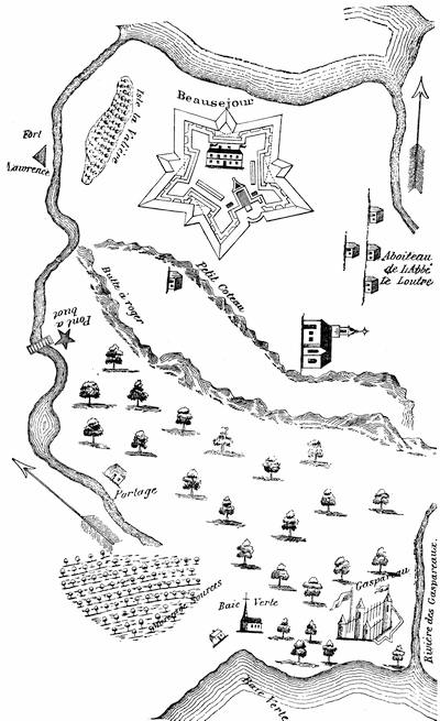
THE NECK OF THE ACADIAN PENINSULA.
E. Old French War.—This was begun in April, 1755. There was a declaration of war against the Penobscots, Nov. 3, 1755. (Mass. Archives, xxxii. 690.)

Meanwhile, towards the end of April, 1755, Cornwallis at Halifax had sent Lawrence[971] to the neck of the peninsula[972] of Nova Scotia to fortify himself on English ground, opposite the French post at Beauséjour. Instigated by the French priest, Le Loutre, the Micmacs[973] were so threatening and the French were so alarmingly near that the English, far outnumbered, withdrew; but they returned in the autumn, better equipped, and began the erection of Fort Lawrence. The French attempted an “indirect” resistance through the Indians and some indianized Acadians, and were, in the end, driven off; but not until the houses and barns of neighboring settlers had been burned, with the aim of compelling the Acadians to fly to the French for shelter and sustenance.[974] The French now began a fort on the Beauséjour hill. A petty warfare and reprisals, not unmixed with treachery, became chronic, and were well set off with a background of more portentous rumors.[975] It happened that letters crossed each other, or nearly so, passing between Lawrence (now governor) and Shirley, suggesting an attack on Beauséjour. So the conquest was easily planned. Shirley commissioned Col. John Winslow to raise 2,000 men, and but for delay in the arrival of muskets from England this force would have cast anchor near Fort Lawrence on the first of May instead of the first of June. Monckton, a regular officer, who had been Lawrence’s agent on the Boston mission, held the general command over Winslow, a provincial officer. The fort surrendered before the siege trains got fairly to work. Parkman, who gives a vivid picture of the confusion of the French, refers for his authorities to the Mémoires sur le Canada, 1749-1760; Pichon’s Cape Breton, and the journal of Pichon, as cited by Murdoch in his Hist. of Nova Scotia.[976] The captured fort became Fort Cumberland; Fort Gaspereau, on the other side of the isthmus, surrendered without a blow. Rouse, the Boston privateersman, who had commanded the convoy from Boston, was sent to capture the fort at the mouth of the St. John, and the Indians, whom the French had deserted on Rouse’s approach, joyfully welcomed him.
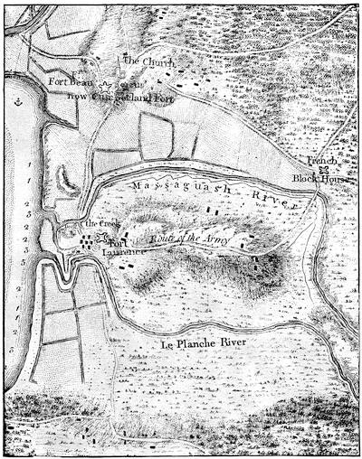
FORT BEAUSÉJOUR AND ADJACENT COUNTRY.
Part of a folding map, “Fort Beauséjour and adjacent country, taken possession of by Colonel Monckton, in June, 1755;” in Mante’s Hist. of the Late War (London, 1772), p. 17. Cf. Des Barres’ Environs of Fort Cumberland, 1781, and various drawn maps in Catal. King’s Library (Brit. Mus.), i. 281.
Three hundred of the young Acadians, the so-called “neutral French,” were found among the defenders of Beauséjour.[977] The council at Halifax had no easy question to solve in determining the next step to be taken.
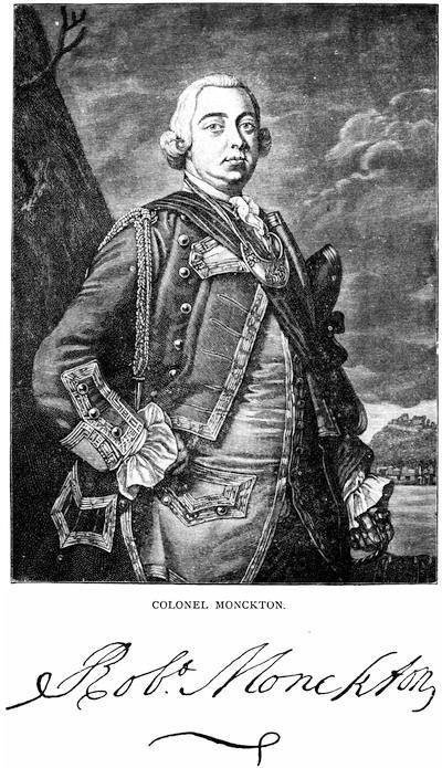
COLONEL MONCKTON.
After a mezzotint preserved in the Amer. Antiq. Soc. library, in which he is called “Major-General, and Colonel of the Seventeenth Foot, and Governor of New York,” as he later was. Cf. other mezzotints noted in J. C. Smith’s Brit. Mezzotint Portraits, ii. 883; iv. 1,525, 1739. There is a portrait in Entick’s Hist. of the Late War, v. 355. See account of Monckton in Akins’s Nova Scotia Docs., 391.
With the documentary evidence now in hand, chiefly the records of the French themselves, we can clearly see the condition which the English rather suspected than knew in detail.[978] They indeed were aware that the neutrals of Chignecto in 1750 had been in effect coerced to crossing the lines at the neck, while the burning of their houses and barns had been accomplished to prevent their return. They further knew that this gave an increased force of desperate and misguided men to be led by priests like Le Loutre, and encouraged by the French commanders, acting under orders of the central government at Quebec. They had good reason to suspect, what was indeed the fact, that the emissaries of the Catholic church and the civil powers in Canada were confident in the use they could in one way and another make of the mass of Acadians, though still nominally subjects of the British king.[979] Their loyalty had always been a qualified one. A reservation of not being obliged to serve in war against the French had been in the past allowed in their oath; but such reservation had not been approved by the Crown, though it had not been practically disallowed. It was a reservation which in the present conjunction of affairs Governor Lawrence thought it inexpedient to allow, and he required an unqualified submission by oath. He had already deprived them of their arms. The oath was persistently refused and the return of their arms demanded. This act was in itself ominous. The British plans had by this time miscarried in New York and Pennsylvania, and under Braddock the forces had suffered signal defeat. The terms of the New England troops in Acadia were fast expiring. With these troops withdrawn, and others of the Acadian garrisons sent to succor the defeated armies farther west, and with the Canadian government prompted to make the most of the disaffection toward the English and of the loyalty to the French flag which existed within the peninsula, there could hardly have been a hope of the retention of the country under the British flag, unless something could be done to neutralize the evil of harboring an enemy.[980] “In fact,” says Parkman, “the Acadians, while calling themselves neutrals, were an enemy encamped in the heart of the province.”[981] Colonel Higginson (Larger History, etc.) presents the antithesis in a milder form, when he says, “They were as inconvenient as neighbors as they are now picturesque in history.” It has been claimed that the cruelty of deportation might have been avoided by exacting hostages of the Acadians. That involves confidence in the ability of an abjectly priest-ridden people to resist the threats of excommunication, should at any time the emissaries of Quebec find it convenient to sacrifice the hostages to secure success to the French arms. Under such a plan the English might too late learn that military execution upon the hostages was a likely accompaniment of a military disaster which it would not avert. The alternative of deportation was much surer, and self-preservation naturally sought the securest means. Simply to drive the Acadians from the country would have added to the reckless hordes allured by the French in 1750, which had fraternized with the Micmacs, and harassed the English settlements. To deport them, and scatter them among the other provinces, so that they could not combine, was a safer and, as they thought, the only certain way to destroy the Acadians as a military danger. It was a terrible conclusion, and must not be confounded with possible errors in carrying out the plan. The council, taking aid from the naval commanders, decided upon it.[982]
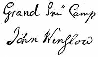
The decision and its execution have elicited opinions as diverse as the characters of those who have the tender and the more rigid passions mixed in them in different degrees. The question, however, is simply one of necessity in war to be judged by laws which exclude a gentle[456] forbearance in regard to smaller for the military advantages of larger communities.
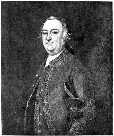
GEN. JOHN WINSLOW.
After an original formerly in the gallery of the Mass. Hist. Soc., but now in Pilgrim Hall, Plymouth. Cf. Mass. Hist. Soc. Proc., xx. 192, and Mem. Hist. Boston, ii. 123. The sword of General Winslow, shown in the cut (Vol. III. p. 274), has also been transferred to Plymouth, as well as the portraits of Governor Edward and Governor Josiah Winslow. (Ibid., pp. 277, 282.) Other engravings of General Winslow are given in Raikes’ Hon. Artillery Co. of London (1878), i. p. 348, and in Gay’s Pop. Hist. U. S., iii. 276.
Writers of the compassionate school have naturally sought to heighten the enormity of the measure by pictures of the guilelessness of the people, who were the sufferers. It was not long after the event when the Abbé Raynal played upon such sympathetic responses in his description[983] of the Acadians, setting forth an ideal simplicity and content to which Longfellow in[457] his Evangeline has added the unbounded charms of his verse. That the Acadians were a prolific people might argue content, but Hannay (Acadia, ch. xvi.), who best traces their mutations and growth, shows evidences that this fruitfulness had not been without some admixture, at least, with the Micmacs.[984] Though it is the usual assertion that bastardy was almost unknown among them, Hannay adduces testimony to their licentiousness which he deems sufficient.[985] We may pick out the most opposite views regarding the comforts of their daily life. A French authority describes their houses as “wretched wooden boxes, without ornament or convenience;”[986] but George Bancroft[987] and many others tell us, after the Raynal ideal, that these same houses were “neatly constructed and comfortably furnished.”
A simple people usually find it easy to vary the monotony of their existence by bickerings and litigations; and if we may believe the French authorities whom Hannay quotes, the Acadians were no exception to the rule, which makes up for the absence of excitements in a diversified life by a counterbalance of such evils as mix and obscure the affections of society.
Their religious training prompted them to place their priests in the same scale of infallibility with their Maker, while the machinations of Le Loutre[988] ensnared them and became, quite as much as that “scrupulous sense of the indissoluble nature of their ancient obligation to their king,”[989] a great cause of their misfortunes. To glimpses of the character of the Acadians which we get in the published documents, French and English, of their own day, we can add but few estimates of observers who were certainly writing for the eye of the public. There is a rather whimsical, but, as Parkman thinks, a faithful description of them, earlier in the century, to be found in the Relation of Diéreville.
Let us now observe some of the mutations of opinion to which allusion has been made. Gov. Lawrence, in his circular letter to the other colonies, naturally set forth the necessity of the case in justification. Edmund Burke, not long after, judged the act a most inhumane one, and “we did,” he says, “upon pretences not worth a farthing, root out this poor, innocent, deserving people, whom our utter inability to govern or to reconcile gave us no sort of right to extirpate.” But this was in the guise of a running commentary from a party point of view, and in ignorance of much now known. The French, English, and American historians nearest the event take divergent positions. Raynal started the poetic ideal, to which reference has been made. It must not be forgotten, however, that the Abbé had a purpose in his picture, aiming as he did to set off by a foil the condition of the French peasantry at a period preceding the French Revolution.[990] Entick[991] commends the measure, but not the method of its execution. A pamphlet published in London in 1765, setting forth the sacrifices of the province during the French and Indian wars, referring to the deportation, says: “This was a most wise step,” but the exiles “have been and still remain a heavy bill of charge to this province.”[992] Hutchinson[993] simply allows that the authors of the movement supposed[458] that self-preservation was its sufficient excuse. When Minot[994] surveyed the subject, he was quite as chary of an opinion. He probably felt, as indeed was the case, that no one at that time had access to the documents on which a safe judgment could be based. The first distinct defence of the English came when Raynal’s views were printed, in translation, in Nova Scotia in 1791. Secretary Bulkely and Judge Deschamps now published a vindication of the English government, but it was necessarily inadequate in the absence of proof. It served not much purpose, however, in diverting the general opinion from the channels of compassion. In 1787, the Rev. Andrew Brown, a Scotchman, was called to settle over a church in Halifax. He remained till 1795, when he returned to Scotland, where he lived till 1834, a part of the time occupying the chair of rhetoric in the University of Edinburgh, which had been previously filled by Dr. Blair. During his sojourn in Nova Scotia, and down to so late a period as 1815, he collected materials for a history of the province. His papers, including original documents, were discovered serving ignoble purposes in a grocer’s shop in Scotland, and bought for the collections of the British Museum. Transcripts from the most interesting of them relating to the expulsion of the Acadians have been made at the instance of the Nova Scotia Record Commission, and have been printed in the second volume of the Collections of the Nova Scotia Historical Society. They consist of letters and statements from people whom Brown had known, and who had taken part in the expulsion, with other contemporary papers regarding the condition of the Acadians just previous to their removal. Brown’s own opinion of the act classed it, for atrocity, with the massacre of St. Bartholomew.
Robert Walsh, in his Appeal from the Judgment of Great Britain (2d ed. 1819, p. 86), says: “It has always appeared to me that the reason of state was never more cheaply urged or more odiously triumphant than on this occasion.” He follows Minot in his account.
Judge Thomas C. Haliburton approached the subject when he might have known, among the very old people of the province, some whose earliest recollections went back to the event, or to its train of succeeding incidents. Haliburton’s sympathy is unmistakably aroused, and failing to find in the records of the secretary’s office at Halifax any traces of the deportation, his deduction is that the particulars were carefully concealed. For such an act he finds no reason, save that the parties were, “as in truth they well might be,” ashamed of the transaction. “I have therefore,” he adds, “had much difficulty in ascertaining the facts.” He seems to have depended almost wholly upon Hutchinson, Raynal, and Minot, and through the latter he got track of the journal of Winslow. Haliburton’s Nova Scotia was published in 1829,[995] and Hutchinson’s third volume had only the year before (1828) been printed in England from his manuscript. Of Winslow’s journal he seems to have made but restricted use.[996] Haliburton’s allegations in respect to the archives of Halifax were founded on a misconception. The papers which he sought in vain in fact existed, but were stored away in boxes, and the archive-keepers of Haliburton’s day apparently had little idea of their importance. A recent writer (Smith’s Acadia, p. 164) hastily infers that this careless disposition of them was intentional. Parkman says that copies of the council records were sent at the time to England and are now in the Public Record Office; but it does not appear that Haliburton sought them; and had he done so, if we may judge from the printed copy which we now have of them, he would have discovered no essential help between July, 1755, and January, 1756. It was not till 1857 that the legislative assembly of Nova Scotia initiated a movement for completing and arranging the archives at Halifax, and for securing in addition copies of documents at London and Quebec,—the latter being in fact other copies from papers in the archives at Paris.
Between 1857 and 1864, Thomas B. Akins, Esq., acting as record commissioner of the province, bound and arranged, as appears by his Report of Feb. 24, 1864, and deposited in the legislative library of the province, over 200 volumes of historical papers. The most important of these volumes for other than the local historian,[459] and covering the period of the present volume appear to be the following:—
Despatches from the Lords of Trade to the governor at Annapolis, 1714-48; and to the governor at Halifax, 1749-99.
Despatches from the governors of Nova Scotia to the Lords of Trade, 1718-1781; and to the Secretaries of State, 1720-1764 (all from the State Paper Office).
Despatches from the governor at Louisbourg to the Sec. of State, 1745-48 (from State Paper Office).
Despatches from the governor of Mass. to the Sec. of State, 1748-51 (State Paper Office).
Documents from the files of the legislative council, 1760-1829; and of the assembly, 1758-1831, with
Miscellaneous papers, 1748-1841.
Acadia under French rule, 1632-1748 (copied from the transcripts in Canada from the Paris archives[997]).
Tyrell’s (Pichon’s) paper relating to Monckton’s capture of Fort Cumberland, 1753-1755.
Council minutes at Annapolis, 1720-49.
Crown prosecutions for treason, 1749-88.
Royal instructions to the governors, 1720-1841.
Royal proclamations, 1748-1807.
Orders of the Privy Council, 1753-1827.
Indians, 1751-1848.
But before this arranging of the Halifax Archives was undertaken, Bancroft in his United States[998] had used language which he has allowed to stand during successive revisions: “I know not if the annals of the human race keep the records of sorrows so wantonly inflicted, so bitter and so perennial, as fell upon the French inhabitants of Acadia.” About the same time the Canadian historian, Garneau,[999] simply quotes the effusions of Raynal. The publication of the Neutral French, by Catharine R. Williams, in 1841, a story in which the writer’s interest in the sad tale had grown with her study of the subject on the spot,[1000] followed by the Evangeline of Longfellow in 1847, which readily compelled attention, drew many eyes upon the records which had been the basis of these works of fiction. The most significant judgment, in consequence, made in America was that of the late President Felton, of Harvard University, in the North American Review (Jan., 1848, p. 231), wherein he called the deportation “a most tyrannical exercise of superior force, resting for its justification not upon sufficient proofs, but upon an alleged inevitable state necessity.” This gave direction to current belief.[1001] Barry (Massachusetts, ii. 200) wrote as if Raynal had compassed the truth. Chambers’ Journal (xxii. 342, or Living Age, xliv. 51) called an article on the subject “The American Glencoe.” In 1862, Mr. Robert Grant Haliburton, a son of Judge Haliburton, gave token of a new conception in the outline of a defence for the British government, which he drew in an address, The Past and the Future of Nova Scotia (Halifax, 1862). A more thorough exposition was at hand. Mr. Akins had been empowered to prepare for publication a selection of the more important papers among those which he had been arranging. In 1869 a volume of Selections, etc., appeared. In his preface Mr. Akins says: “Although much has been written on the subject, yet until lately it has undergone little actual investigation, and in consequence the necessity for their removal has not been clearly perceived, and the motives which led to its enforcement have been often misunderstood.” The views which he enforces are in accord with this remark. Mr. W. J. Anderson followed up this judgment in the Transactions[1002] of the Literary and Historical Society of Quebec, and termed the act “a dreadful necessity.” The old view still lingered. It was enforced by Célestin Moreau in his Histoire de l’Acadie Françoise de 1598 à 1755 (Paris, 1873), and Palfrey, in the Compendious Hist. of New England (1873), which carried on the story of his larger volumes, leaves his adhesion to a view adverse to the English to be inferred. As to the character of the Acadians, while he allows for “a dash of poetry” in the language of Raynal, he mainly adopts it.[1003]
In 1879 Mr. James Hannay, perceiving the necessity of a well-ordered history, to embody in more readable shape the vast amount of material which Beamish Murdoch in his History of Nova Scotia[1004] had thrown into the form of annals, published his History of Acadia from its first discovery to its surrender to England by the Treaty of Paris (St. John, N. B., 1879). Hannay embodied in this book the most elaborate account which had yet been written of the deportation, and referring to it in his preface he says: “Very few people who follow the story to the end will be prepared to say that it was not a necessary measure of self-preservation on the part of the English authorities in Nova Scotia.”
Still the old sympathies were powerful. Henry Cabot Lodge in his Short History of the English Colonies[1005] (1881) finds the Acadians “harmless.” Hannay’s investigations were not lost, however, on Dr. George E. Ellis, who in his Red Man and White Man in North America (Boston, 1882) prefigured the results which two years later were to be adduced by Parkman.
Meanwhile, Mr. Philip H. Smith published at Pawling, N. Y., a book, doubly his own, for he inserted in it rude wood-cuts of his own graving. The book, which was coarsely printed on an old Liberty job press, was called Acadia, a lost chapter in American history,—why lost is not apparent, in view of the extensive literature of the subject. He refers vaguely to fifty authorities, but without giving us the means to track him among them, as he in an uncompromising way condemns the course of the British government. He is found, however, to draw largely from Judge Haliburton, and to adopt that writer’s assertion of the loss or abstraction of records. A few months later Mr. Parkman published the first volume of his Montcalm and Wolfe, using some material, particularly from the French Archives, which his predecessors had not possessed.[1006] In referring to the deportation, he says that its causes have not been understood[1007] by those who follow or abet the popular belief. Though he does not suggest any alternative action, he sets forth abundantly the reasons which palliate and explain a measure “too harsh and indiscriminate to be wholly justified.”[1008]
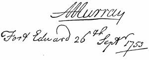
Widely different statements as to the number of those deported have been made. Lawrence in his circular letter,[1009] addressed (Aug. 11, 1755) to the governors of the English colonies, says that about 7,000 is the number to be distributed, and it is probably upon his figures that the Lords of Trade in addressing the king, Dec. 20, 1756, place the number at near 7,000. “Not less than 6,000 at least” is the language of a contemporary letter.[1010] That these figures were approximately correct would appear from the English records, which[461] foot up together for the several centres of the movement—Beaubassin, Fort Edward, Minas, and Annapolis—a little over 6,000, as Parkman shows. The Canadian government in making a retrospective census in 1876, figured the number of Acadians within the peninsula in 1755 at 8,200. In giving 18,000 as the number of Acadians in 1755, Haliburton must have meant to include all of that birth in the maritime provinces, for he accepts Lawrence’s statement that 7,000 were deported. P. H. Smith[1011] uses these figures (18,000) so loosely that he seems to believe that all but a few hundred of them were removed. Rameau, a recent French authority, makes the number 6,000.[1012] Hannay, a late New Brunswick writer, allows only 3,000, but this number seems to have been reached by ignoring some part of the four distinct movements, as conducted by Monckton, Winslow, Murray, and Handfield. Minot accepts this same 3,000, and he is followed by Gay in the Popular Hist. of the United States, and by Ellis in his Red Man and White Man in North America.
Gov. Lawrence agreed with some Boston merchants, Apthorp and Hancock, to furnish the transports for conveying the exiles away.[1013] These contractors furnished the necessary flour, bread, pork, and beef for the service. The delay of the vessels to arrive seems to have arisen from Lawrence’s not giving timely notice to the contractors, for fear that the Acadians might learn of the intention.[1014] Winslow had told those who came under his supervision, that he would do everything in his power to transport “whole families in the same vessel.” Parkman thinks (i. 279) that the failures in this respect were not numerous. Smith, with little regard for the confusion which the tardy arrival of the transports occasioned, thinks they indicate that Winslow violated his word as a soldier. One of the actors in the movement, as reported in the Brown Papers (Nova Scotia Hist. Soc. Coll., ii. 131), says that “he fears some families were divided, notwithstanding all possible care was taken to prevent it.”
Hutchinson (iii. 40) says: “Five or six families were brought to Boston, the wife and children only, without the husbands and fathers, who by advertisements in the newspapers came from Philadelphia to Boston, being till then utterly uncertain what had become of their families.”
Miss Caulkins (New London, p. 469) says more were landed at New London than at any other New England port. The Connecticut Colony Records (vol. x. pp. 452, 461, 615) show how the Acadians were distributed throughout the towns, and that some were brought there from Maryland.
The journals of the House of Representatives in Massachusetts (1755-56) note the official action which was taken in that province respecting them. There are two volumes in the Mass. Archives (vols. xxiii., xxiv.) marked “French Neutrals,” which explain that for fifteen years (1755-1769) the charge of their support entered more or less into the burdens of the towns among which they were then scattered.[1015] A committee was in charge of benefactions which were bestowed upon them, and papers relating to their doings make part of the collection of old documents in the Charity Building in Boston.
Hutchinson (iii. 40), who had personal knowledge of the facts, says of their sojourn in Massachusetts: “Many of them went through great hardships; but in general they were treated with humanity.” He also tells us (iii. 41) that he interested himself in drafting for them a petition to the English king to be allowed to return to their lands or to be paid for them; but they refused to sign it, on the ground that they would thereby be cut off from the sympathy of the French king.
When in the spring of 1756 Major Jedediah Preble returned with some of the New England troops to Boston, he was directed by Lawrence to stop at Cape Sable and seize such Acadians as he could find.[1016] Though Smith (p. 252) says[462] he did not see fit to obey the order, a letter from him, dated April 24, 1756, printed in the N. E. Hist. and Geneal. Reg., 1876, p. 19, shows that he carried out the order and burnt the houses. When these newer exiles arrived at Boston, the provincial authorities declined to receive them. A vessel was hired to convey them to North Carolina, but the captives refused (May 8, 1756) to reëmbark. (Ibid., p. 18.) In 1762 the work of deportation was still going on, and five more transports arrived in Boston, but these seem largely to have been gathered outside the peninsula. They were returned by the Massachusetts authorities to Halifax, with the approval of the Lords of Trade and General Amherst, who thought there was no longer occasion to continue the deportation.[1017]
The Pennsylvania Gazette of Sept. 4, 1755, the day before the action of Winslow at Minas, informed that province of the intended action in Nova Scotia. The exiles were hardly welcome when they came. Governor Morris wrote to Shirley (Penna. Archives, ii. 506; Col. Rec., vi. 712) that he had no money to devote to their support, and that he should be obliged to retain, for guarding them, some recruits which he had raised for the field.[1018] There were kind people, however, in Philadelphia, of kindred blood, among the descendants of Huguenot emigrants, and their attention to the distresses of the exiles renders it possible for Akins to say: “They appear to have received better treatment at the hands of the government of Philadelphia than was accorded to them in some of the other provinces.” (Select. from Pub. Docs. of Nova Scotia, p. 278.) Haliburton (i. 183), averred that the proposition was made in Pennsylvania to sell the neutrals into slavery. Mr. William B. Reed, in a paper on “The Acadian exiles, or French neutrals in Pennsylvania (1755-57),” published in Memoirs (vol. vi. p. 283) of the Penna. Hist. Soc.,[1019] refutes the assertion. The poor people seem to have had less fear of provoking the ill-will of France than their brethren in Massachusetts had shown, and a petition to the king of Great Britain is preserved, apparently indited for them, as Robert Walsh, Jr., in his Appeal from the Judgment of Great Britain respecting the United States (Philadelphia, 1829, p. 437), printed it “from a draft in the handwriting of Benezet,” one of the Philadelphia Huguenots. It is reprinted in the appendix of Smith’s Acadia (p. 369). Another document is preserved to us in A Relation of the Misfortunes of the French Neutrals as laid before the Assembly of the Province of Pennsylvania by John Baptist Galerm, one of the said People. It constitutes a broadside extra of the Pennsylvania Gazette of about February, 1756,—the document being dated Feb. 11. It sets forth the history of their troubles, but did not specifically ask for assistance, which was, however, granted when the neutrals were apportioned among the counties. It is reprinted in the Memoirs (vi. 314) of the Penna. Hist. Soc., in Smith’s Acadia (p. 378), and in Penna. Archives; iii. 565. Walsh (p. 90) says that, notwithstanding charitable attentions, more than half of those in Pennsylvania died in a short time.
Daniel Dulany, writing of the Acadians arriving in Maryland in 1755, says that they insist on being treated as prisoners of war,—thereby claiming to be no subjects. “They have almost eat us up,” he adds; “as there is no provision for them, they have been supported by private subscription. Political considerations may make this [the deportation] a prudent step, for anything I know, and perhaps their behavior may have deservedly brought their sufferings upon them; but ‘t is impossible not to compassionate their distress.”[1020]
In Virginia Governor Dinwiddie received them with alarm, at a time when their countrymen were scalping the settlers on the western frontiers. He seemed to suppose from Lawrence’s letter that 5,000 were coming, but only 1,140 actually arrived. He writes that they proved lazy and contentious, and caballed with[463] the slaves, and tried to run away with a sloop at Hampton. He managed to maintain them till the assembly met, when he recommended that provision should be made for their support; but the clamor against them throughout the colony was so great that the legislature directed their reshipment to England at a cost of £5,000. When Governor Glen, of Carolina, sent fifty more of them to Virginia, Dinwiddie sent them north.[1021]
In the Carolinas and Georgia they were not more welcome. Jones[1022] says that the 400 received in Georgia went scattering away. Dinwiddie reports[1023] that in these southern colonies vessels were given them, and that at one time several hundreds of them were coasting north in vessels and canoes, so that the shores of the Dominion were opened to their descents for provision as they voyaged northward. When Dinwiddie sent a sloop after some who had been heard of near the capes, they eluded the search. When Lawrence learned of this northern coursing, he sent another circular letter to the continental governors, begging them to intercept the exiles and destroy their craft.[1024] Some such destruction did take place on the Massachusetts coast,[1025] and others were intercepted on the shores of Long Island.[1026]
In Louisiana many of them ultimately found a permanent home, and 50,000 “Cajeans,” as they are vulgarly called, constitute to-day a separate community along the “Acadian coast” of the Mississippi, in the western parts of the State.[1027] After the peace and during the next few years they wandered thither through different channels: some came direct from the English colonies,[1028] others from Santo Domingo, and still others passed down the Mississippi from Canada, where their reception had been even worse than in the English colonies.[1029]
Until recent years have given better details, the opinions regarding the ultimate fate of most of the Acadians have remained erroneous. So little did Hutchinson know of it that he speaks (iii. 42) of their being in a manner extinct, the few which remained being mixed with other subjects in different parts of the French dominions. Later New England writers have not been better informed. Hildreth (United States, ii. 459) says that “the greater part, spiritless, careless, helpless, died in exile.” Barry (ii. 204) says, “They became extinct, though a few of their descendants, indeed, still live at the South!” The later Nova Scotia authorities have come nearer the truth. Murdoch says very many of them returned within a few years. Rameau, in his Une Colonie féodale, speaks of 150 families from New England wandering back by land. Some of them, pushing on past their old farms, reached the bay of St. Mary’s, and founded the villages which their descendants now occupy. Those which returned, joined to such as had escaped the hunt of the English, counted 2,500, and in 1871 their numbers had increased to 87,740 souls. Rameau, in an earlier work, La France aux Colonies: Études sur le développement de la race française hors de l’Europe: Les Français en Amérique, Acadiens et Canadiens (Paris, 1859), had reached the same conclusion (p. 93) about the entire number of Acadians within the peninsula (16,000) as already mentioned, and held that while 6,000 were deported (p. 144), about 9,000 escaped the proscription (p. 62). He traces their wanderings and enumerates the dispersed settlements.
A more recent writer, Hannay (pp. 406, 408), says: “The great bulk of the Acadians, however, finally succeeded in returning to the land of their birth.... At least two thirds of the 3,000 (?) removed eventually returned.”
The guide-books and a chapter in Smith’s Acadia tell of the numerous settlements now existing along the Madawaska River, partly in New Brunswick and partly in Maine, which are the villages of the progeny of such as fled to the St. John, and removed to these upper waters of that river when, after the close of the American Revolution, they retired before the influx of the loyalists which settled in the neighborhood of the present city of St. John.[1030]
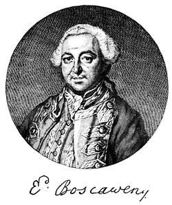
After an engraving by Ravenet. Cf. David Ramsay’s Mil. Memoirs of Great Britain, or a History of the War, 1755-1763 (Edinburgh, 1779), p. 192; and John Entick’s Hist. of the Late War, iii. p. 443.
Lord Loudon’s abortive attempt on Louisbourg has been mentioned in another place.[1031] Parkman gives the authorities. (Montcalm and Wolfe, i. 473; cf. Barry’s Massachusetts, ii. 223.)
An agreement (Sept. 12) for the supply of arms, etc., between sundry merchants and others of Maine and certain men, “for an intended scout or cruise for the killing and captivating the Indian enemy to the eastward,” to be under the command of Joseph Bayley, Jr., for sixty days from Sept. 20, 1757, is in the Maine Hist. and Geneal. Recorder, i. p. 11.
The journal (1758) of Captain Gorham’s rangers and other forces under Major Morris, in a marauding expedition to the Bay of Fundy, is given in the Aspinwall Papers, in Mass. Hist. Coll., xxxix. 222.
Franquet, who a year or two before the war began was sent by the French to strengthen Louisbourg and inspect the defences of Canada, kept a journal, which Parkman uses in his Montcalm and Wolfe.
Admiral Knowles, in the memorial for back pay which he presented in 1774 to the British government, claimed the credit of having planned the movements for this second capture of Louisbourg.
The most authoritative contemporary account of the siege of 1758, on the English side, is contained in the despatches of Amherst and Boscawen sent to Pitt, extracts from which were published as A journal of the landing of his majesty’s forces on the island of Cape Breton, and of the siege and surrender of Louisbourg (22 pp.). What is called a third edition of this tract was printed in Boston in 1758.[1032] The so-called journal of Amherst was printed in the London Magazine, and is included in Thomas Mante’s Hist. of the Late War in North America (London, 1772).
Of the contemporary French accounts, Parkman says he had before him four long and minute diaries of the siege. The first is that of Drucour, the French commander, containing his correspondence with Amherst, Boscawen, and Desgouttes, the naval chief of the French. Tourville, who commanded the “Capricieux,” one of the French fleet, kept a second of these diaries. A third and fourth are without the names of their writers. They agree in nearly all essential particulars.[1033] The Parkman MSS., in the Mass. Hist. Society’s library, contain many letters from participants in the siege, which were copied from the Paris Archives de la Marine. The manuscript of Chevalier Johnstone, a Scotch Jacobite serving with the French, gives an account of the siege, which is described elsewhere (post, in chapter viii.) and has been used by Parkman. The Documents Collected in France—Massachussetts Archives (vol. ix. p. i.) contains one of the narratives.
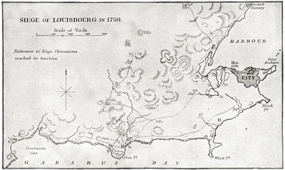
FROM BROWN’S CAPE BRETON.
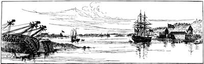
VIEW OF LOUISBOURG.
From the northeast. One of Des Barres’ coast views. (In Harvard College library.) Dr. A. H. Nichols, of Boston, possesses a plan of Louisbourg made by Geo. Follings, of Boston, a gunner in the service. He has also a contemporary sketch of the fort at Canso.
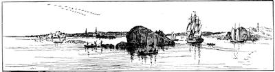
ENTRANCE TO LOUISBOURG HARBOR.
One of Des Barres’ coast views, 1779. (In Harvard College library.) A contemporary view showing the town from a point near the light-house is given in Cassell’s United States, i. 528.
The printed materials on the French side are not nearly so numerous as on the English. Of importance is Thomas Pichon’s[1034] Lettres et Mémoires pour servir à l’histoire du Cap Breton (a la Haye, 1760), of which there is an English translation, of the same year, purporting to be copied from the author’s original manuscript.[1035]
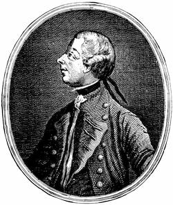
After the print in Entick’s Gen. Hist. of the Late War, 3d ed., vol. iv. p. 90. See the engraving from Knox’s journal, on another page, in ch. viii.
Of individual experiences and accounts there are, on the English side, John Montresor’s journal, in the Coll. of the N. Y. Hist. Soc., 1881 (p. 151);[1036] An Authentic Account of the Reduction of Louisbourg in June and July, 1758, by a Spectator (London, 1758),[1037] which Parkman calls excellent, and says that Entick, in his General History of the Late War (London, 1764),[1038] used it without acknowledgment. The same authority characterizes as admirable the account in John Knox’s Historical Journal of the Campaigns in North America, 1757-1760[1039] (vol. i. p. 144), with its numerous letters and orders relating to the siege. Wright, in his Life of Wolfe, gives various letters of that active officer. Parkman also uses a diary of a captain or subaltern in Amherst’s army, found in the garret of an old house at Windsor, Nova Scotia. Some contemporary letters will be found in the Grenville Correspondence (vol. i. pp. 240-265);[1040] and other views of that day respecting the event can be gleaned from Walpole’s Memoirs of George the Second (2d ed., vol. iii. 134).[1041] Of the modern accounts, the most considerable are those in Warburton’s Conquest of Canada (N. Y., 1850, vol. ii. p. 74), Brown’s History of Cape Breton, and the story as recently told with unusual spirit and acquaintance with the sources in Parkman’s Montcalm and Wolfe (vol. ii. chap. xix).
Amherst had wished to push up to Quebec immediately upon the fall of Louisbourg, but the news from Abercrombie and some hesitancy of Boscawen put an end to the hope. Chatham Correspondence, i. 331-333.
The reports of the capture reached London August 18. (Grenville Correspondence, i. p. 258.)
Jenkinson writes (Sept. 7, 1758), “Yesterday the colours that were taken at Louisbourg were carried in procession to Saint Paul’s; the mob was immense.” (Grenville Corresp., i. 265.)
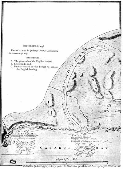
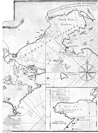
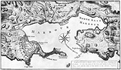
Speaking of Amherst’s success at Louisbourg, Burrows, in his Life of Lord Hawke (London, 1883, p. 340), says: “So entirely has the importance of this place receded into the background that it requires an effort to understand why the success of Boscawen and Amherst should have been thought worthy of the solemn thanks of Parliament, and why the captured colors of the enemy should have been paraded through the streets of London.”
Mr. William S. Appleton, in the Proc. Mass. Hist. Soc., vol. xi. pp. 297, 298, describes three medals struck to commemorate the siege of 1758. Cf. also Trans. Quebec Lit. and Hist. Soc., 1872-73, p. 79.
A view of Louisburg in North America, taken from near the light-house, when that city was besieged in 1758, is the title of a contemporary copperplate engraving published by Jefferys. (Carter-Brown, iii. p. 335.) Cf. the view in Cassell’s United States, i. 528.
The plan of the siege, here presented, is reproduced from Brown’s Hist. of Cape Breton (p. 297):—
Key: The French batteries to oppose the landing were as follows:—
C. One swivel.
D. Two swivels.
E. Two six-pounders.
F. One twenty-pounder and two six-pounders.
G. One seven-inch and one eight-inch mortar.
H. Two swivels.
I. Two six-pounders.
K. Two six-pounders.
N. Two twelve-pounders.
O. Two six-pounders.
P. Two twenty-four pounders.
Q. Two six-pounders.
R. Two twelve-pounders.
The points of attack were as follows:—
A. Landing of the first column.
B. Landing of the second column.
These troops carried the adjacent batteries and pursued their defenders towards the city. The headquarters of the English were now established at H Q, while the position of the various regiments is marked by the figures corresponding to their numbers. Three redoubts (R 1, 2, 3) were thrown up in advance, and two block-houses (B H 1, 2) were built on their left flank; and later, to assist communication with Wolfe, who had been sent to the east side of the harbor, a third block-house (B H 3) was constructed. Then a fourth redoubt was raised at Green Hill (G H R 4) to cover work in the trenches. Meanwhile the English batteries at the light-house had destroyed the island battery, and the French had sunk ships in the channel to impede the entrance of the English fleet. The first parallel was opened at T, T1, T2, and a rampart was raised, E P, to protect the men passing to the trenches. Wolfe now erected a new redoubt at R 5, to drive off a French frigate near the Barachois, which annoyed the trenches; and another at R 6, which soon successfully sustained a strong attack. The second (T 3, 4) and third (T 5, 6) parallels were next established. A boat attack from the English fleet outside led to the destruction and capture of the two remaining French ships in the harbor, opening the way for the entrance of the English fleet. At this juncture the town surrendered.
Cf. also the plans in Jefferys’ Natural and Civil Hist. of the French Dominions in North America (1760), and in Mante’s Hist. of the War (annexed). Parkman, in his Montcalm and Wolfe, ii. 52, gives an eclectic map. Father Abraham’s Almanac, published at Philadelphia and Boston in 1759, has a map of the siege.
Treaty at Halifax of Governor Lawrence with the St. John and Passamaquoddy Indians, Feb. 23, 1760. (Mass. Archives, xxxiv.; Williamson, i. 344.)
Conference with the Eastern Indians at Fort Pownall, Mar. 2, 1760. (Mass. Archives, xxix. 478.)
Pownall’s treaty of April 29, 1760. Brigadier Preble’s letter, April 30, 1760, respecting the terms on which he had received the Penobscots under the protection of the government. (Mass. Archives, xxxiii.) Conference with the Penobscots at the council chamber in Boston, Aug. 22, 1763. (Mass. Archives, xxix. 482.) Cf. on the Indian treaties, Maine Hist. Soc. Collections, iii. 341, 359. The treaty of Paris had been signed Feb. 10, 1763.
THE MAPS AND BOUNDS OF ACADIA.
By the Editor.
The cartography of Acadia begins with that coast, “discovered by the English,” which is made a part of Asia in the map of La Cosa in 1500.[1042] The land is buried beneath the waves, west of the land of the king of Portugal, in the Cantino map of 1502.[1043] It lies north of the “Plisacus Sinus,” as a part of Asia, in the Ruysch map of 1508.[1044] It is a vague coast in the map of the Sylvanus Ptolemy of 1511.[1045] For a long time the eastern coast of Newfoundland and neighboring shores stood for about all that the early map-makers ventured to portray; called at one time Baccalaos, now Corterealis, again Terra Nova; sometimes completed to an insular form, occasionally made to face a bit of coast that might pass for Acadia, often doubtless embracing in its insularity an indefinite extent that might well include island and main together, vaguely expressed, until in the end the region became angularly crooked as a part of a continental coast line. The maps which will show all this variety have been given in previous volumes. The Homem map of 1558[1046] is the earliest to give the Bay of Fundy with any definiteness. There was not so much improvement as might be expected for some years to come, when the map-makers followed in the main the types of Ruscelli and Ortelius, as will be seen by sketches and fac-similes in earlier volumes.
In 1592 the Molineaux globe of the Middle Temple[1047] became a little more definite, but the old type was still mainly followed. In 1609 Lescarbot gave special treatment to the Acadian region[1048] for the first time, and his drafts were not so helpful as they ought to have been to the more general maps of Hondius, Michael Mercator, and Oliva, all of 1613, but Champlain in 1612[1049] and 1613[1050] did better. The Dutch and English maps which followed began to develop the coasts of Acadia, like those of Jacobsz (1621),[1051] Sir William Alexander (1624),[1052] Captain Briggs in Purchas (1625),[1053] Jannson’s of 1626, and the one in Speed’s Prospect, of the same year.[1054] The Dutch De Laet began to establish features that lingered long[1055] with the Dutch, as shown in the maps of Jannson and Visscher; while Champlain, in his great map of 1632,[1056] fashioned a type that the French made as much of as they had opportunity, as, for instance, Du Val in 1677. Dudley in 1646[1057] gave an eclectic survey of the coast. After this the maps which pass under the names of Covens and Mortier,[1058] and that of Visscher with the Dutch, and the Sanson epochal map of 1656[1059] among the French, marked some, but not much, progress. The map of Heylin’s Cosmographie in 1663, the missionary map of the same year,[1060] and the new drafts of Sanson in 1669 show some variations, while that of Sanson is followed in Blome (1670). The map in Ogilby,[1061] though reëngraved to take the place of the maps in Montanus and Dapper,[1062] does not differ much.
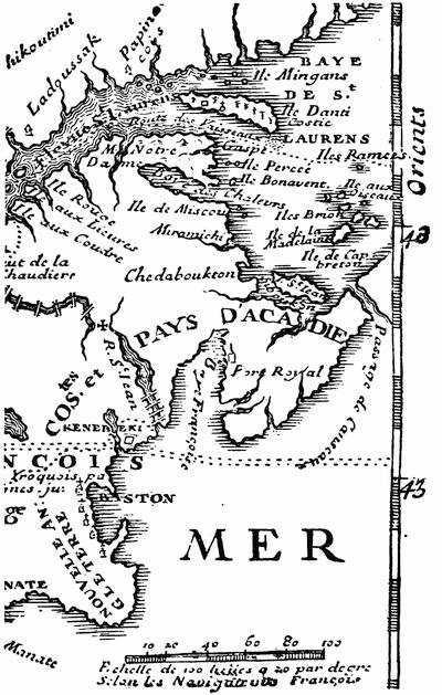
ACADIA.
To complete the two centuries from La Cosa, we may indicate among the French maps a missionary map of 1680,[1063] that of Hennepin,[1064] the great map of Franquelin (1684),[1065] the “partie orientale” of Coronelli’s map of 1688-89,[1066] and the one given by Leclercq in the Établissement de la Foy (1691). The latest Dutch development was seen in the great Atlas of Blaeu in 1685.[1067]
With the opening of the eighteenth century, we have by Herman Moll, a leading English[474] geographer of his day, a New Map of Newfoundland, New Scotland, the isles of Breton, Anticoste, St. Johns, together with the fishing bancks, which appeared in Oldmixon’s British Empire in America, in 1708,[1068] and by Lahontan’s cartographer the Carte générale de Canada, which appeared in the La Haye edition (1709) of his travels, repeated in his Mémoires (1741, vol. iii.). A section showing the southern bounds as understood by the French to run on the parallel of 43° 30′, is annexed.
From 1714 to 1722 we have the maps of Guillaume Delisle, which embody the French view of the bounds of Acadia.
In 1718 the Lords of Trade in England recognized the rights of the original settlers of the debatable region under the Duke of York,—which during the last twenty years had more than once changed hands,—and these claimants then petitioned to be set up as a province, to be called “Georgia.”[1069]
In 1720, Père Anbury wrote a Mémoire, which confines Acadia to the Nova Scotia peninsula, and makes the region from Casco Bay to Beaubassin a part of Canada.[1070]
In March, 1723, M. Bohé reviewed the historical evidences from 1504 down, but only allowed the southern coast of the peninsula to pass under the name of Acadia.[1071]
In 1731 the crown took the opinion of the law-officers as to the right of the English king to the lands of Pemaquid, between the Kennebec and the St. Croix, because of the conquest of the territory by the French, and reconquest causing the vacating of chartered rights; and this document, which is long and reviews the history of the region, is in Chalmers’ Opinions of Eminent Lawyers, i. p. 78, etc.
In 1732 appeared the great map of Henry Popple, Map of the British Empire in America and the French and Spanish settlements adjacent thereto. It was reproduced at Amsterdam about 1737. Popple’s large MS. draft, which is preserved in the British Museum,[1072] is dated 1727. When in 1755 some points of Popple told against their claim, the English commissioners were very ready to call the map inaccurate. We have the Acadian region on a small scale in Keith’s Virginia, in 1738. The Delisle map of North America in 1740 is reproduced in Mills’ Boundaries of Ontario (1873). The English Pilot of 1742, published at London, gives various charts of the coast, particularly no. 5, “Newfoundland to Maryland,” and no. 13, “Cape Breton to New York.”
Much better drafts were made when Nicolas Bellin was employed to draw the maps for Charlevoix’s Nouvelle France,[1073] which was published in 1744. These were the Carte de la partie orientale de la Nouvelle France ou du Canada (vol. i. 438), a Carte de l’Accadie dressée sur les manuscrits du dépost des cartes et plans de la marine (vol. i. 12),[1074] and a Carte de l’Isle Royale (vol. ii. p. 385), beside lesser maps of La Heve, Milford harbor, and Port Dauphin. These are reproduced in Dr. Shea’s English version of Charlevoix. Bellin’s drafts were again used as the basis of the map of Acadia and Port Royal (nos. 26, 27) in Le petit atlas maritime, vol. i., Amérique Septentrionale, par le S. Bellin (1764).
The leading English and French general maps showing Acadia at this time are that of America in Bowen’s Complete System of Geography (1747)[1075] and D’Anville’s Amérique Septentrionale (Paris), which was reëngraved, with changes, at Nuremberg in 1756, and at Boston (reprinted, London) 1755, in Douglass’s Summary of the British Settlements in North America. It is[475] here called “improved with the back settlements of Virginia.”[1076]
The varying territorial claims of the French and English were illustrated in a Geographical History of Nova Scotia, published at London in 1749; a French version of which, as Histoire géographique de la Nouvelle Écosse, made by Étienne de Lafargue, and issued anonymously, was published at Paris in 1755, but its authorship was acknowledged when it was later included in Lafargue’s Œuvres.[1077] The Mémoire which Galissonière wrote in December, 1750, claimed for France westward to the Kennebec, and thence he bounded New France on the water-shed of the St. Lawrence and Mississippi.[1078] In 1750-51 Joseph Bernard Chabert was sent by the French king to rectify the charts of the coasts of Acadia, and his Voyage fait par ordre du Roi en 1750 et 1751 dans l’Amérique Septentrionale pour rectifier les cartes des côtes de l’Acadie, de l’îsle Royale, et de l’îsle de Terre Neuve, Paris, 1753, has maps of Acadia and of the coast of Cape Breton.[1079]
In 1753 the futile sessions of the commissioners of England and France began at Paris. Their aim was to define by agreement the bounds of Acadia as ceded to England by the treaty of Utrecht (1713),[1080] under the indefinite designation of its “ancient limits.” What were these ancient limits? On this question the French had constantly shifted their grounds. The commission of De Monts in 1603 made Acadia stretch from Central New Brunswick to Southern Pennsylvania, or between the 40th and 46th degrees of latitude; but, as Parkman says, neither side cared to produce the document. When the French held without dispute the adjacent continent, they never hesitated to confine Acadia to the peninsula.[1081] Equally, as interest prompted, they could extend it to the Kennebec, or limit it to the southern half of the peninsula. Cf. the Mémoire sur les limites de l’Acadie (joint à la lettre de Begon, Nov. 9, 1713), in the Parkman MSS. in Mass. Hist. Soc., New France, i. p. 9.
In July, 1749, La Galissonière, in writing to his own ministry, had declared that Acadia embraced the entire peninsula; but, as the English knew nothing of this admission, he could later maintain that it was confined to the southern shore only. Cf. again Fixation des limites de l’Acadie, etc., 1753, among the Parkman MSS. in Mass. Hist. Soc., New France, i. pp. 203-269.
On this question of the “ancient limits,” the English commissioners had of course their way of answering, and the New England claims were well sustained in the arguing of the case by Governor Shirley, of Massachusetts,[1082] who with William Mildmay was an accredited agent of the English monarch. The views of the opposing representatives were irreconcilable,[1083] and in 1755 the French court appealed to the world by presenting the two sides of the case, as shown in the counter memoirs of the commissioners, in a printed work, which was sent to all the foreign courts. It appeared in two editions, quarto (1755) and duodecimo (1756), in three and six volumes respectively, and was entitled Mémoires des Commissaires du Roi et de ceux de sa Majesté Britannique. Both editions have a preliminary note saying that the final reply of the English commissioners was not ready for the press, and so was not included.[1084] This omission gave occasion[476] to the English, when, the same year (1755), they published at London their Memorials of the English and French commissaries concerning the limits of Nova Scotia or Acadia, to claim that, by including this final response of the English commissioners, their record of the conference was more complete. This London quarto volume[1085] contained various documents.[1086]
In 1757 a fourth volume was added to the quarto Paris edition, containing the final reply of the English commissioners, and completing the record of the two years’ conference. The four volumes are a very valuable repository of historical material; and, from printing at length the documents offered in evidence, it is a much more useful gathering than the single English volume, which we have already described. The points of difference between the two works are these:—
The memorial of Shirley and Mildmay (Jan. 11, 1751), given in French only in the Paris edition, and accompanied by observations of the French commissioners in foot-notes, is here given in French and English, but without the foot-notes. The English memorial of Jan. 23, 1753, lacks the observations of the French commissioners which accompany it in their vol. iv.[1087]
Among the “pièces justificatives” in the London edition, various papers are omitted which are given in the Paris edition. The reason of the omission is that they already existed in print. Such are the texts of various treaties, and extracts from printed books.
The London edition prints, however, the MS. sources among these proofs, but does not give the observations of the French commissioners which accompany them in the Paris edition. Among the papers thus omitted in the London edition are the provincial charter of Massachusetts Bay and Gen. John Hill’s manifesto, printed at Boston from Charlevoix.
Vol. iv. of the Paris edition has various additional “pièces produites par les commissaires du Roi,” including extracts from Hakluyt, Peter Martyr, Ramusio, Gomara, Fabian, Wytfliet, as well as the English charters of Carolina (1662-63, 1665) and of Georgia (1732).
The Paris edition was also reprinted at Copenhagen, with a somewhat different arrangement, under the title Mémoires des commissaires de sa Majesté très chrétienne et de ceux de sa Majesté Britannique. À Coppenhague, 1755.
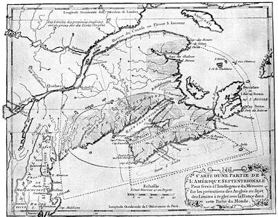
THE FRENCH CLAIM, 1755.
Key of the French Map: Limits proposed by English commissaries, Sept. 21, 1750, and Jan. 11, 1751 (exclusive of Cape Breton),------
By the treaty of Utrecht, ++++++
Port Royal district, by the same treaty,——————
Grant to Sir William Alexander, Sept. 10, 1621, ...........
Cromwell’s grant to La Tour, Crown, and Temple, Aug. 9, 1656, ══════
What was restored to France by the treaty of Breda includes Cromwell’s grant and the country from Mirlegash to Canseau.
Denys’ government (1654), shaded horizontally.
Charnesay’s government (1638), shaded obliquely.
La Tour’s government (1638), shaded perpendicularly.
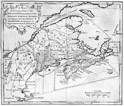
THE ENGLISH CLAIM, 1755.
Key of the English Map: Claim of the English under the treaty of Utrecht (1713), marked ——————
Grant to Sir William Alexander (1621), and divided by him into Alexandria and Caledonia, being all east of line marked ·─·─·─·─
According to Champlain (1603-1629), all, excepting Cape Breton, east of this line, ......
Grants of Louis XIII. and XIV. (1632-1710), the same as the claim of the English for Nova Scotia or Acadia.
Nova Scotia, enlarged westward to the Kennebec, as granted to the Earl of Sterling (Alexander).
Acadia proper, as defined by Charlevoix in accordance with the tripartite division, shaded perpendicularly.
Charnesay’s government (1638), ══════
La Tour’s government (1638), +++++++
Cromwell’s grant to La Tour, Crown, and Temple, being the same ceded to France by the treaty of Breda (1667), ———
Norembega, according to Montanus, Dapper, and Ogilby, is the country between the Kennebec and Penobscot.
The Etechemin region, as defined by Champlain and Denys, shaded obliquely.
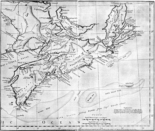
JEFFERYS’ NOVA SCOTIA.
All three of the editions in French have a map, marking off the limits of Acadia under different grants, and defining the claims of France. It is engraved on different scales, however, in the two Paris editions, and shows a larger extent of the continent westerly in the Copenhagen edition. The fourth volume of the quarto Paris edition has also a map, in which the bounds respectively of the charters of 1620, 1662, 1665, and 1732 (Virginia, Carolina, and Georgia), claimed by the English to run through to the Pacific, are drawn.[1088]
Thomas Jefferys, the English cartographer, published at London in 1754 his Conduct of the French with regard to Nova Scotia from its first settlement to the present time. In which are exposed the falsehood and absurdity of their arguments made use of to elude the force of the treaty of Utrecht, and support their unjust proceedings. In a letter to a member of Parliament.[1089]
The map of the French claims and another of the English claims are copied herewith from Jefferys’ reproduction of the former and from his engraving of the latter, both made to accompany his later Remarks on the French Memorials concerning the limits of Acadia, printed at the Royal Printing-House at Paris, and distributed by the French ministers at all the foreign courts of Europe, with two maps exhibiting the limits: one according to the system of the French, the other conformable to the English rights. To which is added An Answer to the Summary Discussion,[1090] etc. London, T. Jefferys, 1756.[1091]
Both of these Jefferys maps were included by that geographer in his General Topography of North America and the West Indies, London, 1768, and one of them will also be found in the Atlas Amériquain, 1778, entitled “Nouvelle Écosse ou partie orientale du Canada, traduitte de l’Anglais de la Carte de Jefferys publiée à Londres en May, 1755. A Paris par Le Rouge.” Jefferys also included in the London edition of the Memorials (1755) a New map of Nova Scotia and Cape Britain, with the adjacent parts of New England and Canada,[1092] which is also found in his History of the French Dominion in North and South America, London, 1760, and also in his General Topography, etc. A section of this map, showing Acadia, is reproduced herewith.[1093]
The great map of D’Anville in 1755[1094] enforced the extreme French claim, carrying the boundary line along the height of land from the Connecticut to Norridgewock, thence down the Kennebec to the sea. The secret instructions to Vaudreuil this same year (1755) allow that the French claim may be moved easterly from the Sagadahock to the St. Georges, and even to the Penobscot, if the English show a conciliatory disposition, but direct him not to waver if the water-shed is called in question at the north.[1095]
A German examination of the question appeared at Leipzig in 1756, in Das Brittische Reich in Amerika ... nebst nachricht von den Gränzstreitigkeiten und Kriege mit den Franzossen. It is elucidated with maps by John Georg Schrübers.[1096]
CHAPTER VIII.
THE STRUGGLE FOR THE GREAT VALLEYS OF NORTH AMERICA.
BY JUSTIN WINSOR,
The Editor.
THE death of Frontenac[1097] and the peace of Ryswick (September, 1697) found France in possession of the two great valleys of North America,—that of the St. Lawrence, with the lakes, and that of the Mississippi, with its affluents.[1098] In 1697 the Iroquois were steadfast in their adherence to Corlear, as they termed the English governor, while they refused to receive French missionaries. In negotiations which Bellomont was conducting (1698) with the Canadian governor, he tried ineffectually to induce a recognition of the Five Nations as subjects of the English king.[1099] Meanwhile, the French were omitting no opportunity to force conferences with these Indians, and Longueil was trying to brighten the chain of amity with them as far west as Detroit, where in July, 1701, La Motte Cadillac began a French post. Within a month the French ratified at Montreal (August 4, 1701) a treaty with the Iroquois just in time to secure their neutrality in the war which England declared against France and Spain the next year (1702). So when the outbreak came it was the New England frontiers which suffered (1703-4),[1100] for the Canadians were careful not to stir the blood of the Iroquois. The French jealously regarded the English glances at Niagara, and proposed (1706) to anticipate their rivals by occupying it. When, in 1709, it was determined to retaliate for the ravages of the New England borders, the Iroquois, at a conference in Albany[1101] (1709), were found ready to aid in the expedition which Francis Nicholson tried to organize, but which proved abortive. Already Spotswood, of Virginia, was urging the home government to push settlers across the Alleghanies into the valley of the Ohio.[1102] But attention was rather drawn to the petty successes in Acadia,[1103] and the spirit of conquest seethed again, when Sir Hovenden Walker appeared at Boston,[1104] and a naval expedition in the summer[484] of 1711 was well under way to capture the great valley of the St. Lawrence. Stupidity and the elements sent the fleet of the English admiral reeling back to Boston, leaving Quebec and Canada once more safe. The next year (1712) the distant Foxes tried to wrest Detroit from the French; but its garrison was too enduring. France had maintained herself all along her Canadian lines, and she was in fair hopes of gaining the active sympathy of the Iroquois, when the treaty of Utrecht (1713) brought the war to a close.
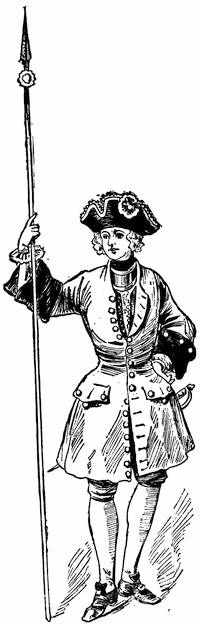
FRENCH SOLDIER (1700).
After a water-color sketch in the Mass. Archives: Documents collected in France, v. p. 271. The coat is red, faced with brown.
The language of this treaty declared that the “Five Nations[1105] were subject to the dominion of England.” The interpretation of this clause was the occasion of diplomatic fence at once. The French claimed a distinction between the subjectivity of the Indians and domination over their lands. The English insisted that the allegiance of the Five Nations carried not only their own hereditary territory, but also the regions of Iroquois conquests, namely, all west of the Ottawa River and the Alleghany Mountains to the Mississippi River.[1106] The peace of Utrecht was but the prelude to a struggle for occupying the Ohio Valley, on the part of both French and English. Spotswood had opened a road over the Blue Ridge from Virginia in 1716, and he continued to urge the Board of Trade to establish a post on Lake Erie. Governor Keith, of Pennsylvania, reported to the board (1718) upon the advances of the French across the Ohio Valley, and the English moved effectually when, in 1721, they began to plant[485] colonists on the Oswego River. By 1726 they had completed their fort on the lake, and Montreal found its Indian trade with the west intercepted. Meanwhile, New York, Pennsylvania, and Virginia strengthened their alliance with the Iroquois by a conference at Albany in September, 1722, and in 1726 the Indians confirmed the cession of their lands west and north of Lake Erie.
When Vaudreuil, in 1725, not long before his death (April 10) suggested to the ministry in Paris that Niagara should be fortified, since, with the Iroquois backing the English, he did not find himself in a position openly to attack them, the minister replied that the governor could at least craze the Indians by dosing them with brandy. Shortly afterwards the commission of his successor, Beauharnois, impressed on that governor the necessity of always having in view the forcible expulsion of the Oswego garrison. In 1727 the French governor tried the effect of a summons of the English post, with an expressed intention “to proceed against it, as may seem good to him,” in case of refusal; but it was mere gasconade, and the minister at home cautioned the governor to let things remain as they were.
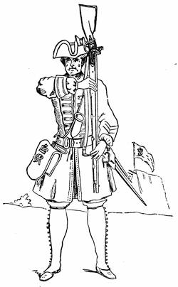
BRITISH INFANTRY SOLDIER (1725).
Fac-simile of a cut in Grant’s British Battles, i. p. 564.
Note To Annexed Map.—In the N. Y. Col. Docs., ix. 1021, is a fac-simile of a map in the Archives of the Marine and Colonies, called Carte du lac Champlain avec les rivières depuis le fort de Chambly jusques à Orangeville [Albany] de la Nouvelle Angleterre, dressé sur divers mémoires. It is held to have been made about 1731. There is in the Doc. Hist. N. Y., vol. i. p. 557, a Carte du lac Champlain depuis le fort Chambly jusqu’au fort St. Frederic, levée par le Sr. Anger, arpenteur du Roy en 1732, fait à Quebec le 10 Oct., 1748,—Signé de Lery.
Nicolas Bellin made his Carte de la rivière de Richelieu et du lac Champlain in 1744, and it appeared in Charlevoix’s Nouvelle France, i. 144, reproduced in Shea’s ed., ii. 15. There is also a map of Lake Champlain in Bellin’s Petit Atlas Maritime, 1764.
There were surveys made of Lake Champlain, in 1762, by William Brassier, and of Lake George by Captain Jackson, in 1756. These were published by order of Amherst in 1762, and reproduced in 1776. (Cf. American Atlas, 1776.) The original drawings are noted in the Catal. of the King’s Maps (Brit. Mus.), i. 223. The Brassier map is also given in Dr. Hough’s edition of Rogers’s Journals. The same British Museum Catalogue (i. 489) gives a drawn Map of New Hampshire (1756), which shows the route from Albany by lakes George and Champlain to Quebec. Cf. the Map of New Hampshire, by Col. Joseph Blanchard and Rev. Samuel Langdon, engraved by Jefferys, and dated 21 Oct., 1761, which shows the road to Ticonderoga in 1759.
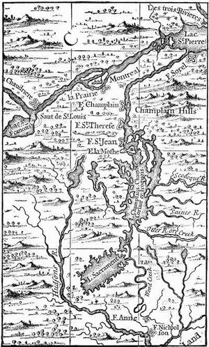
FROM POPPLE’S BRITISH EMPIRE IN AMERICA, 1732.
A few years later a sort of flank movement was made on Oswego, as well as on New England, by the French pushing up Lake Champlain, and establishing themselves in the neighborhood of Crown Point (1731), where they shortly after built Fort St. Frederick. The movement alarmed New England more than it did New York.
The French persisted in seeking conferences with the Six Nations,—as they had been called since the Tuscaroras joined them about 1713,—and in 1734 succeeded in obtaining a meeting with the Onondagas. They ventured in 1737 to ask the Senecas to let them establish a post at Irondequot, farther west on Lake Ontario than Oswego. The Iroquois would not permit, however, either side to possess that harbor. For some years Oswego was the burden of the French despatches, and the English seemed to take every possible occasion for new conferences with the fickle Indians.
The most important of these treaties was made at Lancaster, Pennsylvania, in 1744, when an indefinite extent of territory beyond the mountains was ceded to the English in the form of a confirmation of earlier implied grants. A fresh war followed. The New Englanders took Louisbourg,[1107] but New York seemed supine, and let French marauding parties from Crown Point fall upon and destroy the fort at Saratoga without being aroused.[1108] Oswego was in danger, but still the New York assembly preferred to quarrel with the governor; and tardily at best it undertook to restore the post at Saratoga, while the Albanians were suspected of trading clandestinely through the Caughnawagas with the French in Canada. Both sides continued in their efforts to propitiate the Iroquois, while a parade of arming was made for an intended advance on Crown Point and Montreal. Governor Shirley, from Boston, had urged it, since a demonstration which had been intended by way of the St. Lawrence had to be given up, because the promised fleet did not arrive from England. To keep the land levies in spirits, Shirley had written to Albany that he would send them to join in an expedition by the Lakes, and had even despatched a 13-inch mortar by water to New York.[1109] Before the time came, however, the rumors of D’Anville’s fleet frightened the New Englanders, and they thought they had need of their troops at home.[1110] It was some time before Governor Clinton knew of this at Albany, and preparations went on. Efforts to enlist the Iroquois in the enterprise halted, for the inaction of the past year had had its effect upon them, and it needed all the influence of William Johnson, who now first appears as Indian commissioner, to induce them to send a sufficient delegation to a conference at Albany.
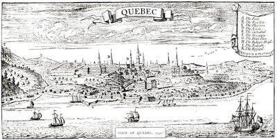
VIEW OF QUEBEC, 1732.
From Popple’s British Empire in America. It is repeated in fac-simile in Cassell’s United States, p. 372; and in Gay’s Pop. Hist. U. S., iii. 307. Cf. The view from La Potherie in Vol. IV. p. 320; also reproduced in Shea’s Charlevoix, vol. v. Kalm described the town in 1749 (Travels, London, 1771, ii. p. 258). See views under date of 1760 and 1761, noted in the Cat. of the King’s Maps (Brit. Mus.), ii. 220. Cf. De Lery’s report on the fortifications of Quebec in 1716, in N. Y. Col. Docs., ix. 872.
The business still further dragged; the withdrawal of New England became in the end known, and by September 16 Clinton had determined to abandon the project, and the French governor had good occasion to twit old Hendrick, the Mohawk chief, when he ventured with more purpose than prudence to Montreal in November.[1111]
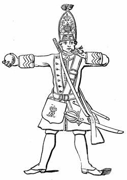
BRITISH FOOTGUARD, 1745.
This sketch of a footguard, with grenade and match, is taken from Grant’s British Battles, ii. 60. Cf. Mag. of Amer. Hist., i. 462; and the uniform of the forty-third regiment of foot (raised in America), represented from a drawing in the British Museum, in The Century, xxix. 891.
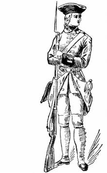
FRENCH SOLDIER, 1745.
After a water-color sketch in the Mass. Archives: Documents collected in France, viii. p. 129. The coat is red, faced with blue; the breeches are blue.
Early the next summer (June, 1747) the French had some experience of a foray upon their own borders, when a party of English and Indians raided upon the island of Montreal,—a little burst of activity conspicuous amid the paralysis that the quarrels of Clinton and De Lancey had engendered. Shirley had formed the plan of a winter attack upon Crown Point, intending to send forces up the Connecticut, and from Oswego towards Frontenac, by way of distracting the enemy’s councils; but the New York assembly refused to respond.
The next year (1748) the French, acting through Father Picquet, made renewed efforts to enlist Iroquois converts, while Galissonière was urging the home government to send over colonists to occupy the Ohio Valley. A number of Virginians, on the other hand, formed themselves into the[490] Ohio Company, and began to send explorers into the disputed valley. In order to anticipate the English, the French governor had already despatched Céloron de Bienville to take formal possession by burying lead plates, with inscriptions, at the mouths of the streams.[1112]
For the present, there was truce. The treaty of Aix-la-Chapelle, entered upon in May, and signed in October (1748), had given each side time to manœuvre for an advantage. Picquet established a new barrier against the English at La Presentation, where Ogdensburg now is;[1113] and in 1749 Fort Rouillé was built at the present Toronto.[1114]
The Virginians, meanwhile, began to push their traders farther and farther beyond the mountains. The Pennsylvanians also sent thither a shrewd barterer and wily agent in George Croghan, and the French emissaries whom he encountered found themselves outwitted.[1115] The Ohio Company kept out Christopher Gist on his explorations. Thus it was that the poor Ohio Indians were distracted. The ominous plates of Céloron meant to them the loss of their territory; and they appealed to the Iroquois, who in turn looked to the government of New York. That province, however, was apathetic, while Picquet and Jean Cœur, another Romish priest, who believed in rousing the Indian blood, urged the tribes to maraud across the disputed territory and to attack the Catawbas. William Johnson, on the one side, and Joncaire, on the other, were busy with their conferences, each trying to checkmate the other (1750); while the English legislative assemblies haggled about the money it cost and the expense of the forts. The Iroquois did not fail to observe this; nor did it escape them that the French were building vessels on Ontario and strengthening the Niagara fort (1751).
While Charles Townshend was urging the English home government (1752) to seize the Ohio region forcibly, the French were attacking the English traders and overcoming the allied Indians, on the Miamis. Virginia, by a treaty with the Indians at Logstown, June 13, 1752, got permission to erect a fort at the forks of the Ohio; but the undertaking was delayed.
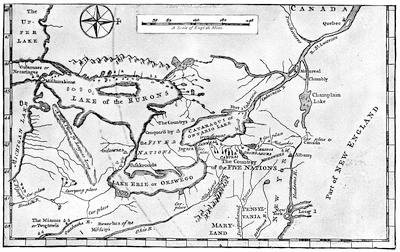

In the spring of 1753 Duquesne, the governor of Canada, sent an expedition[1116] to possess by occupation the Ohio Valley, and the party approached it by a new route.[1117] They landed at Presquisle, built a log fort,[1118] carried their munitions across to the present French Creek, and built there another defence called Fort Le Bœuf.[1119] This put them during high water in easy communication by boat with the Alleghany River. French tact conciliated the Indians, and where that failed arrogance was sufficient, and the expedition would have pushed on to found new forts, but sickness weakened the men, and Marin, the commander now dying, saw it was all he could do to hold the two forts, while he sent the rest of his force back to Montreal to recuperate. Late in the autumn Legardeur de Saint-Pierre arrived at Le Bœuf, as the successor of Marin. He had not been long there, when on the 11th of December a messenger from Governor Dinwiddie, of Virginia, with a small escort, presented himself at the fort. The guide of the party was Christopher Gist; the messenger was George Washington, then adjutant-general of the Virginia militia.[1120] Their business was to inform the French commander that he was building forts on English territory, and that he would do well to depart peaceably. Washington had been made conscious of the aggressive character of the French occupation, as he passed through the Indian town of Venango, at the confluence of French Creek and the Alleghany River, for he there had seen the French flag floating over the house of an English trader, Fraser, which the French had seized for an outpost of Le Bœuf, and there he had found Joncaire in command.[1121] Washington had been received by Joncaire hospitably, and over his wine the Frenchman had disclosed the unmistakable purpose of his government. At Le Bœuf Washington tarried three days, during which Saint-Pierre framed his reply, which was in effect that he must hold his post, while Dinwiddie’s letter was sent to the French commander at Quebec. It was the middle of January, 1754, when Washington reached Williamsburg on his return, and made his report to Dinwiddie.
The result was that Dinwiddie drafted two hundred men from the Virginia militia, and despatched them under Washington to build a fort at the forks of the Ohio. The Virginia assembly, forgetting for the moment its quarrel with the governor, voted £10,000 to be expended, but only under the direction of a committee of its own. Dinwiddie found difficulty in getting the other colonies to assist, and the Quaker element in Pennsylvania prevented that colony from being the immediate helper, which it might from its position have become.
Meanwhile, some backwoodsmen had been pushed over the mountains and had set to work on a fort at the forks. A much larger French force under Contrecœur soon summoned them,[1122] and the English retired. The French immediately began the erection of Fort Duquesne.
While this was doing, Dinwiddie was toiling with tardy assemblies and their agents to organize a regiment to support the backwoodsmen. Joshua Fry was to be its colonel, with Washington as second in command. The latter, with a portion of the men, had already pushed forward to Will’s Creek, the present Cumberland. Later he advanced with 150 men to Great Meadows, where he learned that the French, who had been reinforced, had sent out a party from their new fort, marching towards him. Again he got word from an Indian—who, from his tributary character towards the Iroquois, was called Half-King, and who had been Washington’s companion on his trip to Le Bœuf—that this chieftain with some followers had tracked two men to a dark glen, where he believed the French party were lurking. Washington started with forty men to join Half-King, and under his guidance they approached the glen and found the French. Shots were exchanged. The French leader, Jumonville, was killed, and all but one of his followers were taken or slain.

The mission of Jumonville was to scour for English, by order of Contrecœur, now in command of Duquesne, and to bear a summons to any he could find, warning them to retire from French territory. The precipitancy of Washington’s attack gave the French the chance to impute to Washington the crime of assassination; but it seems to have been a pretence on the part of the French to cover a purpose which Jumonville had of summoning aid from Duquesne, while his concealment was intended to shield him till its arrival. Rash or otherwise, this onset of the youthful Washington began the war.
The English returned to Great Meadows, and while waiting for reinforcements from Fry, Washington threw up some entrenchments, which he called Fort Necessity. The men from Fry came without their leader,[494] who had sickened and died, and Washington, succeeding to the command of the regiment, found himself at the head of three hundred men, increased soon by an independent company from South Carolina.
Washington again advanced toward Gist’s settlement, when, fearing an attack, he sent back for Mackay, whom he had left with a company of regulars at Fort Necessity. Rumors thickening of an advance of the French, the English leader again fell back to Great Meadows, resolved to fight there. It was now the first of July, 1754. Coulon de Villiers, a brother of Jumonville, was now advancing from Duquesne. The attack was made on a rainy day, and for much of the time a thick mist hung between the combatants. After dark a parley resulted in Washington’s accepting terms offered by the French, and the English marched out with the honors of war.[1123]

The young Virginian now led his weary followers back to Will’s Creek. It was a dismal march. The Indian allies of the French, who were only with difficulty prevented from massacring the wounded English, had been allowed to kill the cattle and horses of the little army; and Washington’s men had to struggle along under the burdens of their own disabled companions. Thus they turned their backs upon the great valley, in which not an English flag now waved.
Appearances were not grateful to Dinwiddie. His house of burgesses preferred to fight him on some domestic differences rather than to listen to his appeals to resist the French. He got little sympathy from the other colonies. The Quakers and Germans of Pennsylvania cared little for boundaries. New York and Maryland seemed slothful.[1124] Only Shirley, far away in Massachusetts, was alive, but he was busy at home.[1125] The Lords of Trade in London looked to William Johnson to appease and attach the Indians; but lest he could not accomplish everything, they directed a congress of the colonial representatives to be assembled at Albany, which talked, but to the liking neither of their constituents nor of the government in England.[1126]
Dinwiddie, despairing of any organized onset, appealed to the home government. The French king was diligently watching for the English ministry’s response. So when Major-General Braddock and his two regiments sailed from England for Virginia, and the Baron Dieskau and an army,[495] with the Marquis of Vaudreuil[1127] to succeed Duquesne as governor, sailed for Quebec, the diplomates of the two crowns bowed across the Channel, and protested to each other it all meant nothing.
The English thought that with their superiority on the sea they could intercept the French armament, and Admiral Boscawen was sent to hover about the Gulf of St. Lawrence. He got only three ships of them,—the rest eluding him.
The two armies were to enter the great valleys, one of the St. Lawrence, the other of the Ohio, but not in direct opposition. Dieskau was hurled back at Lake George; Braddock on the Monongahela. We must follow their fortunes.
In February, 1755, Braddock landed at Hampton, Virginia, and presently he and Dinwiddie were living “in great harmony.” A son of Shirley of Massachusetts was serving Braddock as secretary, and he was telling a correspondent how “disqualified his general was for the service he was employed in, in almost every respect.” This was after the young man had seen his father, for Braddock had gone up to Alexandria[1128] in April, and had there summoned for a conference all the governors of the colonies, Shirley among the rest, the most active of them all, ambitious of military renown, and full of plans to drive the French from the continent. The council readily agreed to the main points of an aggressive campaign. Braddock was to reduce Fort Duquesne; Shirley was to capture Niagara. An army of provincials under William Johnson was to seize Crown Point. These three movements we are now to consider; a fourth, an attack by New Englanders upon the Acadian peninsula, and the only one which succeeded, is chronicled in another chapter.[1129]
Braddock’s first mistake was in moving by the Potomac, instead of across Pennsylvania, where a settled country would have helped him; but this error is said to have been due to the Quaker merchant John Hanbury. He cajoled the Duke of Newcastle into ordering this way, because Hanbury, as a proprietor in the Ohio Company, would profit by the trade which the Virginia route would bring to that corporation. Dinwiddie’s desire to develop the Virginia route to the Ohio had doubtless quite as much to do with the choice. While plagued with impeded supplies and the want of conveyance as he proceeded, Braddock chafed at the Pennsylvanian indifference which looked on, and helped him not. He wished New England was nearer. The way Pennsylvania finally aided the doomed general was through Benjamin Franklin, whom she had borrowed of New England. He urged the Pennsylvania farmers to supply wagons, and they did, and Braddock began his march. On the 10th of May he was at Will’s Creek,[1130] with[496] 2,200 men, and as his aids he had about him Captains Robert Orme and Roger Morris, and Colonel George Washington. Braddock invested the camp with an atmosphere little seductive to Indian allies. There were fifty of them present at one time, but they dwindled to eight in the end.[1131] Braddock’s disregard had also driven off a notorious ranger, Captain Jack, who would have been serviceable if he had been wanted.
On the 10th of June the march was resumed,—a long, thin line, struggling with every kind of difficulty in the way, and making perhaps three or four miles a day. By Washington’s advice, Braddock took his lighter troops and pushed ahead, leaving Colonel Dunbar to follow more deliberately.[497] On the 7th of July this advance body was at Turtle Creek, about eight miles from Fort Duquesne.
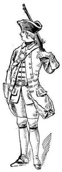
FRENCH SOLDIER, 1755.
After a water-color sketch in the Mass. Archives: Documents collected in France, vol. ix. p. 425. The coat is blue, faced with red.
Parkman (vol. i. 368), speaking of the troops which came with Dieskau and Montcalm, says that their uniform was white, faced with blue, red, yellow, or violet, and refers to the plates of the regimental uniforms accompanying Susane’s Ancienne Infanterie Française. Parkman (i. p. 370) also says that the troupes de la marine, the permanent military establishment of Canada, wore a white uniform faced with black. He gives (p. 370, note) various references.
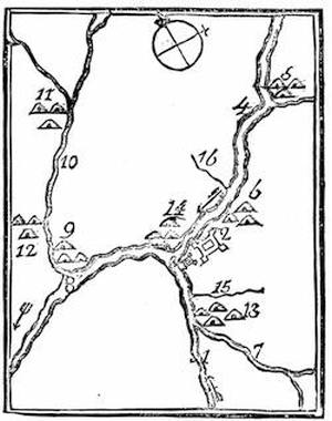
FORT DUQUESNE AND VICINITY.
From Father Abraham’s Almanac, 1761. Key: 1, Monongahela River; 2, Fort Du Quesne, or Pittsburgh; 3, the small fort; 4, Alleghany River; 5, Alleghany Indian town; 6, Shanapins; 7, Yauyaugany River; 8, Ohio, or Alleghany, River; 9, Logs Town; 10, Beaver Creek; 11, Kuskaskies, the chief town of the Six Nations; 12, Shingoes Town; 13, Alleguippes; 14, Sennakaas; 15, Tuttle Creek; 16, Pine Creek. The arrows show the course of the river.
A “Plan of Fort le Quesne, built by the French at the fork of the Ohio and Monongahela in 1754,” was published by Jefferys, and is included in his General Topography of North America and the West Indies, London, 1768. I suppose this to be based upon the MS. plan noted in the Catal. of the King’s Maps (Brit. Mus.), ii. 184. Cf. the plan (1754) in the Memoirs of Robert Stobo, Pittsburgh, 1854, which is repeated in Sargent’s Braddock’s Exped., p. 182, who refers to a plan published in London in 1755, mentioned in the Gentleman’s Mag., xxv. P. 383. Stobo’s plan is also engraved in Penna. Archives, ii. 147, and the letters of Stobo and Croghan respecting it are in Penna. Col. Rec., vi. 141, 161. Parkman refers (i. 208) to a plan in the Public Record Office, London, and (p. 207) describes the fort as does Sargent (p. 182). See the plan in Bancroft, orig. ed., iv. 189, and Gay’s Pop. Hist. U. S., iii. 260.
Duquesne was finished in May, 1755. Cf. Duquesne’s Memoir on the Ohio and its dependencies, addressed to Vaudreuil, dated Quebec, July 6, 1755, and given in English in Penna. Archives, 2d ser., vi. 253. M’Kinney’s Description of Fort Duquesne (1756) is in Hazard’s Penna. Reg., viii. 318; and letters of Robert Stobo, who was a hostage there after the surrender of Fort Necessity, are in Col. Rec. of Penna., vi. 141, 161. Cf. notice of Stobo by L. C. Draper in Olden Time, i. 369. Parkman also refers to a letter of Captain Hazlet in Olden Time, i. 184.
Sargent says (p. 184) that in 1854 the magazine was unearthed, which at that time was all remaining visible of the old fort. (Hazard’s Penna. Register, v. 191; viii. 192.) There is a view of the magazine in John Frost’s Book of the Colonies, N. Y., 1846.
The enemy occupying the fort consisted of a few companies of French regulars, a force of Canadians, and about 800 Indians,—all under Contrecœur, with Beaujeu, Dumas, and Ligneres as lieutenants. They knew from scouts that Braddock was approaching, and Beaujeu was sent out with over 600 Indians and 300 French, to ambush the adventurous Briton.
As Braddock reached the ford, which was to put him on the land-side of[498] the fort, Colonel Thomas Gage, some years later known in the opening scenes of the American Revolution,[1132] crossed in advance, without the opposition that was anticipated. Beaujeu had intended to contest the passage, but his Indians, being refractory, delayed him in his march.
Gage, with the advance, was pushing on, when his engineer, laying out the road ahead, saw a man, apparently an officer, wave his cap to his followers, who were unseen in the woods. From every vantage ground of knoll and bole, and on three sides of the column, the concealed muskets were levelled upon the English, who returned the fire. Beaujeu soon fell.[1133] Dumas, who succeeded in command, thought the steady front of the redcoats was going to carry the day, when he saw his Canadians fly, followed by the Indians, after Gage had wheeled his cannon upon the woods. A little time, however, changed all. The Indians rallied and poured their bullets into the massed, and very soon confused, British troops.
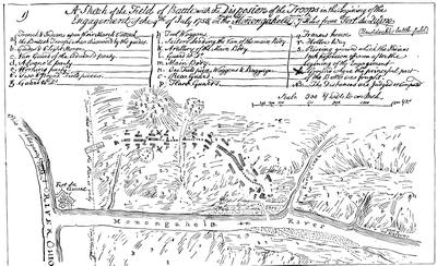
Braddock, when he spurred up, found everybody demoralized except the Virginians, who were firing from the tree-trunks, as the enemy did. The British general was shocked at such an unmilitary habit, and ordered them back into line. No one under such orders could find cover, and every puff from a concealed Indian was followed by a soldier’s fall. No exertion of Braddock, or of Washington, or of anybody, prevailed.[1134] [500] The general had four horses shot under him; Washington had two. Still the hillsides and the depths of the wood were spotted with puffs of smoke, and the slaughter-pen was in a turmoil. Young Shirley fell, with a bullet in his brain.[1135] Horatio Gates and Thomas Gage were both wounded. Scarce one Englishman in three escaped the bullets. The general had given the sign to retreat, and was wildly endeavoring to restore order, when a ball struck him from his horse. The flight of the survivors became precipitous, and when the last who succeeded in fording the river stopped to breathe on the other side, there were thirty Indians and twenty Frenchmen almost upon them. The French, however, pursued no farther. They had enough to do to gather their plunder, while the Indians unchecked their murderous instincts as they searched for the wounded and dying Britons. The next morning a large number of the Indians left Contrecœur for their distant homes, laden with their booty. The French general feared for a while that Braddock, reinforced by Dunbar, would return to the attack. He little knew the condition of his enemy. The British army had become bewildered fugitives. Scarce a guard could be kept for the wounded general, as he was borne along on a horse or in a litter. When they met Dunbar the fright increased. Wagons and munitions were destroyed, for no good reason, and the mass surged eastward. The sinking Braddock at last died, and they buried him in the road, that the tramp of the men might obliterate his[501] grave.[1136] Nobody stopped till they reached Fort Cumberland, which was speedily turned into a disordered hospital. The campaign ended with gloomy forebodings. Dunbar, the surviving regular colonel, instead of staying at Cumberland and guarding the frontier, retreated to Philadelphia, leaving the Virginians to hold Cumberland and its hospitals as best they could.
By the death of Braddock Shirley became the ranking officer on the continent, and we must turn to see how the tidings of his new responsibilities found him.
The Massachusetts governor was at Albany when the bad news reached him, and Johnson being taken into the secret, the two leaders tried to keep it from the army. Shirley immediately pushed on the force destined for Fort Niagara, at the other end of Lake Ontario; while Johnson as speedily turned the faces of his men towards Lake George. Shirley’s army found the path to Oswego, much of the way through swamp and forest; and the young provincials sorrowfully begrimed their regulation bedizenments, assumed under the king’s orders, as with the Jersey Blues they struggled along the trail and tugged through the watercourses. It was easier to get the men to their destination than to transport the supplies, and many stores that were on the way were abandoned at the portages when the wagoners heard the fearful details from the Monongahela. Short rations and discouragements harried the men sorely. The axe and spade were put in requisition, and additional forts were planned and constructed as the army pursued its way. Across the lake at Fort Frontenac the enemy held a force ready to be sent against Oswego if Shirley went on, for the capture of Braddock’s papers had revealed all the English plans. Shirley put on a brave face, with all his bereavement, for the death of his son, with Braddock, was a heavy blow. A council of war, on the 18th of September, determined him to take to the lake with his bateaux as soon as provisions arrived. He had now got word of Dieskau’s defeat,[1137] and he tried to use it to inspirit the braves at his camp. It seemed to another council, on the 27th, that the attempt to trust their[502] river bateaux on the lake was foolhardy, and so the purpose of the campaign was abandoned. At the end of October he left the garrison to strengthen the forts, and returned to Albany. He did not get much comfort there. Johnson showed no signs of following up the victory of Lake George, and as late as November Shirley was still at Albany, where he had received his new commission, advising a movement on Crown Point for the winter;[1138] and in December he was exciting the indignant jealousy of Johnson[1139] by daring to instruct him about his Indian management, for Johnson had now been made Indian superintendent.[1140] Shirley had despatched these orders from New York, where he was laying before a congress of governors his schemes for a new campaign.
We need now to see how Dieskau’s defeat had been the result of the third of the expeditions of the campaign just brought to a close.

Before the arrival of Braddock, Shirley had begun (January, 1755) arrangements for an attack on Crown Point,—a project confirmed, as we have seen, by the council at Alexandria, where William Johnson, whom Shirley had already named, was approved as the commander. Johnson, as a young Irishman of no military experience, had been sent over twenty years before by his uncle, Sir Peter Warren, the admiral, to look after some lands of his in the Mohawk Valley. Settling here and building a house, about ten years earlier than this, he had called it first Mount Johnson, though when it was fortified, at a later day, it was usually called Fort Johnson.[1141] It was the seat of numerous conferences with the Indians, over whom Johnson gained an ascendency, which he constantly turned to the advantage of the English.
The provincials who assembled, first at Albany and then at the carrying place between the Hudson and Lake George, were mostly New Englanders, and a Connecticut man, General Phineas Lyman, was placed second in command. The French were not without intelligence of their enemy’s purpose, derived, as already said, from the captured papers of Braddock. So Dieskau, who had come over, as we have seen, with reinforcements, was ordered to Lake Champlain instead of Oswego, as had been the original intention.
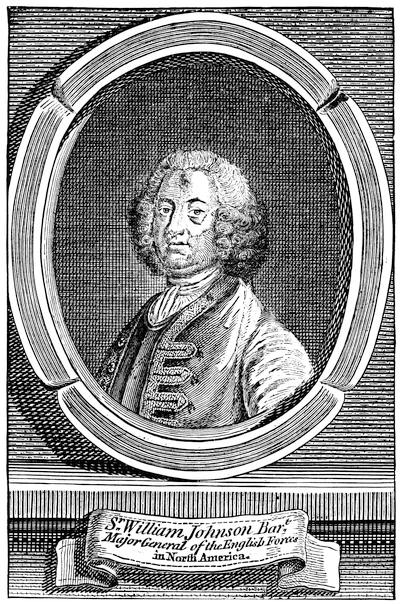
SIR WILLIAM JOHNSON.
From a plate in the London Mag., Sept., 1756; which is also the original of prints in the Doc. Hist. N. Y., ii. 545, and in Hough’s Pouchot, i. 181. Cf. also Stone’s Life of Johnson; Simms’s Trappers of N. Y.; Perry’s Amer. Episc. Church, i. 331; Entick’s General Hist. of the Late War (London, 1765); J. C. Smith’s Brit. Mezzotint Portraits, iii. 1342 (by Adams, engraved by Spooner).
Johnson found among those who joined his camp some who knew much better what war was than he did: such were Colonel Moses Titcomb and Lieutenant-Colonel Seth Pomeroy, of Massachusetts; and Colonel Ephraim Williams, who had just made his will, by which the school was founded which became Williams College. He also was a Massachusetts man, as was Israel Putnam by birth, though now a Connecticut private. The later famous John Stark was a lieutenant of the New Hampshire forces. There[504] were also others in command who knew scarce more of war than Johnson himself, and such was Colonel Timothy Ruggles, of a Massachusetts regiment, who was a college-bred lawyer and an innkeeper, destined to be president of the Stamp Act congress.
At the carrying place Lyman began a fort, which was named after him, but all preparations for the campaign proceeded very leisurely, the fault rather of the loosely banded union and hesitating purpose that existed among the colonies which had undertaken the movement; and matters were not mended by a certain incompatibility of temper existing between Johnson and Shirley, now commander-in-chief.
Leaving a garrison at Fort Lyman, the main body marched to the lake, to which Johnson had, out of compliment to the king, given the name of George. Meanwhile Dieskau had pushed up in his canoes to the very head of Lake Champlain, and had started through the wilderness to attack Fort Lyman. An Indian brought the news to Johnson, and Ephraim Williams and Hendrick, the Mohawk chief, were sent out to intercept the enemy. Dieskau, gaining information by capturing a messenger bound to Fort Lyman, and finding his Indians indisposed to assail a fort armed with cannon, turned towards the lake. Scouts informed him of the approach of the party under Williams, and an ambush was quickly planned. The English scout was badly managed, and fell into the trap. The commander and Hendrick were both killed. Nathan Whiting, of Connecticut, extricated the force skilfully, and a reinforcement from Johnson rendered it possible to hold the French somewhat in check. Could Dieskau have controlled his savages, however, he might have followed close enough to enter the English camp with the fugitives. As he did not, Johnson was given time to form a defence of his wagons and bateaux, mixed with tree-trunks, and when the French came on the English fought vigorously behind their barricade. Johnson was wounded and was borne to his tent. Lyman brought the day to a successful issue, and at its end his men leaped over the breastworks and converted the defeat of the French into a rout.
Meanwhile, a part of Dieskau’s Canadians and Indians had broken away from him, and had returned to the field where Williams had been killed, in order to strip the slain. There, near a pond, known still as Bloody Pond,[1142] a scouting party from Fort Lyman attacked them and put them to flight.[1143]
The French, routed by Lyman, were not followed far, and in gathering the wounded on the field Dieskau was discovered. He was borne to Johnson’s tent, and the English commander found it no easy task to protect him from the vengeance of the Mohawks. He was, however, in the end taken to New York, whence he sailed for England, and eventually reached[505] France, but so shattered from his wounds that he died, though not till several years afterwards.
The defeat of the French had taken place on the 8th of September, and an active general would have despatched a force to intercept the fugitives before they reached their canoes, at the head of Lake Champlain; but timidity, the fear of a fresh onset, or a dread of a further tension of the weakening power of the army induced Johnson to tarry where he was, and to erect a fort, which in compliment to the royal family he named Fort William Henry, while in a similar spirit he changed the name of the post at the carrying place from Fort Lyman to Fort Edward. Of Lyman he seems to have been jealous, and in writing his report on the fight he makes no mention of the man to whose leadership the success was largely due. In this way Lyman’s name failed to obtain recognition in England, while the commander received a gift of £5,000 from Parliament and became Sir William Johnson, Baronet.
If Lyman’s advice had been followed, Ticonderoga might have been seized; but the French who reached it had so strongly entrenched themselves in a fortnight that attack was out of the question, and though Shirley, writing from Oswego, urged an advance, nothing was done. A council of war finally declared it inexpedient to proceed, and on the 27th of November Johnson marched the main part of his army southerly to their winter quarters.
British and French diplomates finally ceased bowing to each other, while their ships and armies fought together, and in May and June (1756), respectively, the two governments declared a war which was now nearly two years old.[1144] The French at once sent the Marquis de Montcalm, now about forty-four years of age, to succeed Dieskau. With him went the Chevalier de Lévis and the Chevalier de Bourlamaque as the second and third in command, and Bougainville as his principal aide-de-camp. By the middle of May the French general was in Quebec, and soon proceeded to Montreal to meet Vaudreuil, who was not at all pleased to share the responsibility of the coming campaign with another. The French troops were now divided, being mainly placed at Carillon (Ticonderoga), Fort Frontenac, and Niagara, and these posts had been during the winter severally strengthened,—Lotbinière[1145] superintending at Ticonderoga, Pouchot at Niagara, and two French engineers at Frontenac.
Already in February the French, by sending a scouting party, had captured and destroyed Fort Bull, a station of supplies at the carrying place on the way from Albany to Oswego; but the intervening time till June was spent in preparation. Word now coming of an English advance on Ticonderoga, Montcalm proceeded thither, and found the fort of Carillon, as the French termed it, which was now completed, much as he would wish it.
LOUDON.
This follows a painting by Ramsay, engraved by Spooner, which is reproduced in J. C. Smith’s Brit. Mezzotint Portraits, p. 1343.
Shirley, on his part, was preparing to carry out such of the lordly plans which he had suggested at New York as proved practicable. He would repeat the Niagara movement himself, with a hope of better success. For the command in the campaign on Lake Champlain he named Gen. John Winslow, and the New England colonies eagerly furnished the troops.
LORD LOUDON.
From a print in the London Magazine, Oct., 1757. Cf. the full-length portrait in Shannon’s N.Y. City Manual, 1869, p. 767, given as a fac-simile of an old print.
The eastern colonies and the Massachusetts governor were not fully aware how the cabal of Johnson and De Lancey, the lieutenant-governor of New York, against Shirley was making head with the home government, and so were not well prepared for the tidings which came in June, while[508] Shirley was in New York, that Colonel Webb, Major-General Abercrombie, and the Earl of Loudon were to be sent over successively to relieve Shirley of the chief command.[1146]
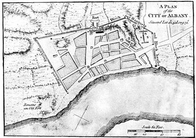
ALBANY.
From A set of plans and forts in America, reduced from actual surveys, 1763, published in London. (Copy in Harvard College library,—5325.67.) A map of the region about Albany and Schenectady, from Sauthier’s map (1779), is given in Pearson’s Schenectady Patent (1883), p. 290. Cf. Mag. of Amer. Hist. Feb., 1886.
While Winslow was employed in pushing forward from Albany his men and supplies, French scouting parties constantly harassed him. Col. Jonathan Bagley was making ready sloops and whale-boats at Lake George; and the English were soon as active as the French in their scouting forays, Capt. Robert Rogers particularly distinguishing himself.
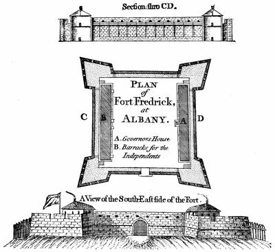
FORT FREDERICK AT ALBANY.
From A set of plans and forts in America, reduced from actual surveys, 1763, published in London. An old view of the fort is given in Holden’s Queensbury, p. 313. There is an early plan of Albany and its fort (1695) in Miller’s Description of the Province and City of New York, of which a fac-simile is given in Weise’s Albany, pp. 257-8. The Catal. of the King’s Maps, i. 13 (Brit. Mus.), shows a MS. plan of Albany of the 18th century. There is a plan dated 1765 in the Annals of Albany, vol. iv. 2d ed.
Mrs. Grant’s Memoirs of an American Lady gives a picture of Albany and its life at this time, which may be compared with the description in Kalm’s Travels. (London, 1771, vol. ii. p. 98; also in Annals of Albany, vol. i. 2d ed., 1869.) Parkman (i. p. 319), who sketches the community from these sources, speaks of Mrs. Grant’s book as “a charming book, though far from being historically trustworthy;” while it affords a “genuine picture of colonial life.” Grahame (United States, ii. 256) considers the picture of manners “entirely fanciful and erroneous.”
Mrs. Grant herself says “I certainly have no intention to relate anything that is not true;” yet it must be remembered that she wrote in 1808, forty years after she, a girl of thirteen, had left the country. The book was published at Edinburgh in 1808; again in 1809, also in New York and in Boston the same year; in London in 1817, and again in New York in 1836 and 1846. The last edition is one printed at Albany in 1876, with notes by Joel Munsell and a memoir by Gen. J. G. Wilson. Cf. Munsell’s Bibliog. of Albany; Lossing’s Schuyler (1872), i. 34; Tuckerman’s America and her Commentators, p. 171.
The most extensive repository of historical data respecting Albany is in Joel Munsell’s Annals of Albany (1850-59), 10 vols. Vol. i. to iv. were issued in a second edition, 1869-71. (See Vol. IV. p. 435.)
Johnson, who had now got his commission as sole Indian superintendent, was busily engaged in conferences with the Six Nations, whom he secured somewhat against their will to the side of the English. He extended his persuasions even to the Delawares and Shawanoes. Some of these tribes were coquetting,[510] however, with Vaudreuil at Montreal, and it was too apparent that nothing but an English success would confirm any Indian alliance.
Shirley also carried out a plan of his own in organizing a body of New England whalemen and boatmen for the transportation service, who, being armed, could dispense with an escort. These were placed under the command of Lieut.-Col. John Bradstreet. In May, before Montcalm’s arrival, a party had been sent by Vaudreuil to cut off the communications of Oswego, and Bradstreet encountered and beat them.
This was the state of affairs in June, 1756, when Abercrombie and Webb arrived with reinforcements, and Pitt was writing in England, “I dread to hear from America.”[1147] Shirley went to New York and received them as well as Loudon, who followed the others on the 23d of July. The new governor proceeded to Albany, and countermanded the orders for the Niagara expedition, and stirred up the New Englanders by promulgating a royal direction which in effect made a provincial major-general subordinate to a regular major.[1148]

Affairs were stagnating in the confusion consequent upon the change of command, and Albany was telling other towns what it was to have foreign officers billeted upon its people. Not till August did some fresh troops set off for Oswego, when apprehension began to be felt for the safety of that post. It was too late. The reinforcement had only reached the carrying place when they heard of the capture of the forts.
Montcalm had suddenly returned from Ticonderoga to Montreal, and had hastened to Niaouré Bay (Sackett’s Harbor), where Villiers was with the force which had escaped Bradstreet’s attack. Here Montcalm gathered about three thousand men, and then appeared without warning before the entrenchments at Oswego. Fort Ontario was soon abandoned by its defenders, and gave Montcalm a place to plant his cannon against the other fort, while he sent a strong force by a ford for an attack on the other bank. Colonel Mercer, the commander, was soon killed by a cannon-shot from Ontario. The enemy’s approach in the rear discouraged the garrison, and they surrendered. Montcalm did what he could to prevent a slaughter of the prisoners, which was threatened when his Indian allies became infuriated by the rum among the plunder.[1149]
While the French were destroying what they could not remove, and were later retiring to Montreal, Webb, who commanded the relief which never came, fell back to German Flats, and orders were sent to Fort William Henry to suspend preparations for a movement down the lake.[1150]
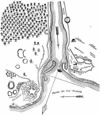
THE FORTS AT OSWEGO.
After a plan in the contemporary Mémoires sur le Canada, 1749-1763, as published in 1838 by the Lit. and Hist. Soc. of Quebec, and (réimpression) 1873, p. 77. It is also reproduced in Dr. Hough’s transl. of Pouchot, i. 65, and in Doc. Hist. of N. York, i. 482.
There was a contemporary English draft of the forts “Ontario and Oswego,” published in the Gentleman’s Mag., 1757, which is reproduced in Dr. Hough’s Pouchot, i. 64, and in the Doc. Hist. N. York, i. 447, 483, where will be found various papers relating to the first settlement and capture of Oswego, 1727-1756.
The Catal. of the King’s Maps (Brit. Mus.), ii. 118, shows a plan made in 1756 for Gov. Pownall, and others of dates 1759, 1760, 1762, 1763, with a view in 1761.
In the New York Col. Docs., ix. p. 996, is what is called a plan of the mouth of the Chouaguen, showing the English redoubt,—an outline sketch found by Brodhead in the Archives de la Marine at Paris. Martin, De Montcalm en Canada, p. 35, gives a plan, “D’après un MS. du dépôt des Colonies” in Paris.
Parkman speaks (Montcalm and Wolfe, i. 416) of the published plans and drawings of Oswego at this time as very inexact. There is a French description of the country between Oswego and Albany, 1757, in Doc. Hist. N. Y., vol. i.; cf. also N. Y. Col. Docs., x. 674. Another map showing the communication between Albany and Oswego is given in Mante’s Hist. of the Late War, London, 1772, p. 60.
A view of Oswego, looking towards the lake between the high banks, appeared in the London Magazine (1760), p. 232. It has been reproduced on different scales in Smith’s Hist. of N. York, 4o, Lond. 1767; Doc. Hist. New York, i. 495; Hough’s transl. of Pouchot, i. 68, Gay’s Pop. Hist. U. S., iii. 49; Clark’s Onondaga, P. 353; The Century, xxviii. 240.
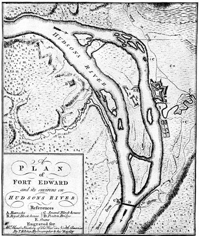
FORT EDWARD.
From Mante’s Hist. of the Late War, London, 1772. The Catalogue of the King’s Maps (Brit. Museum), i. 336, shows various drawn plans of the fort, dated 1755; and another of the same date, marked no. 15,535, is among the Brit. Mus. MSS. John Montresor’s Journal at Fort Edward, in 1757, is in N. Y. Hist. Soc. Coll., 1881, p. 148. He gives a profile of the work (Ibid., p. 36).
Montcalm was soon back at Carillon, watching Winslow’s force at Fort William Henry, while the rest of Loudon’s army was divided between Fort Edward and Albany. Neither opponent moved, and, leaving garrisons at their respective advanced posts, they retired to winter quarters. The[513] regulars were withdrawn to Boston, Philadelphia, and New York; and not a little bad blood was produced by Loudon’s demand for free quarters for the officers.[1151]
The French had the advantage in Indian allies; and during the autumn and winter the forays of the prowling savage and the adventurous scout over the territory neighboring to Lake George and Lake Champlain were checked by the English as best they could. Foremost among their partisans was the New Hampshire ranger, Robert Rogers, whose exploits and those of the Connecticut captain, Israel Putnam, fill a large space in the records of this savage warfare.
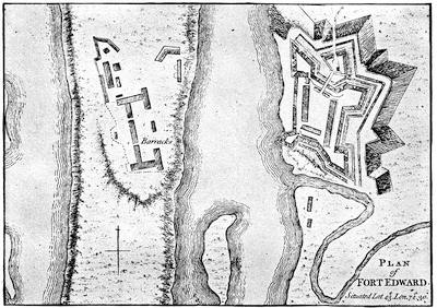
FORT EDWARD.
From A set of plans and forts in America, reduced from actual surveys, 1763, published in London. Cf. the plan in Lossing’s Field-Book of the Revolution, i. p. 95.
The campaign of the next year (1757) opened in March with an attempt to surprise Fort William Henry. The French under Rigaud came up on the ice, 1,600 strong, by night. The surprise failed. They burned, however, two sloops and some bateaux. The next day they summoned Major Eyre, the English commander, but he felt that his four hundred men were enough to hold the fort, and declined to surrender. Rigaud now made a feint of storming the work, but it was only to approach the storehouses, saw-mill, and other buildings outside the entrenchments, which he succeeded in firing, and then withdrew.
Montcalm, when he heard the details, was not over-pleased; and if he had had his way, De Lévis or Bougainville would have led the attack. As it was, Rigaud was a brother of the governor, and Vaudreuil was tenacious of his superiority. The news broke in upon a round of festivities at Montreal, stayed only by Lent. At this season Montcalm prayed, as he had before feasted, with no full recognition of the feelings which Vaudreuil entertained for him. But the minister in France knew it, and he was not, perhaps, so ready to doubt the numbers of the English, exaggerated in Vaudreuil’s report, as he was the prowess of the Canadians in comparison with the timidity of Montcalm and his regulars, which was also reported to him. In Montreal, however, the mutual distrust and dislike of the governor and the general were cloaked with a politeness that was not always successful, when they were apart, in keeping their feelings from their neighbors.
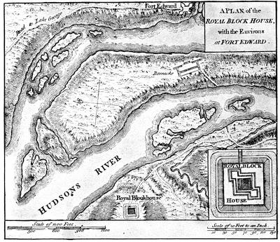
ENVIRONS OF FORT EDWARD.
From A set of plans and forts in America, reduced from actual surveys, 1763, published in London.
Loudon had resolved on attacking Louisbourg, with the aid of a fleet from England.[1152] Withdrawing a large part of the force on the northern frontier, he departed for Halifax, where everything miscarried. But before he returned to New York, crestfallen, the French had profited by his absence.
The English general had left the line of the approach by the lakes from Canada to be watched by Webb, who was at Fort Edward, while Col. Munro, with a small force, held Fort William Henry, at the head of Lake George. This was the most advanced post of the English, and the opportunity for Montcalm had come.
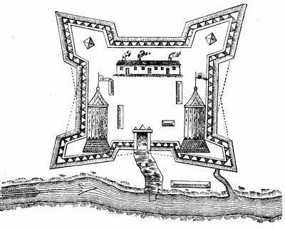
FORT ST. JEAN.
After a plan in the contemporary Mémoires sur le Canada, 1749-1760, as published by the Lit. and Hist. Soc. of Quebec (réimpression), 1873, p. 95. Kalm describes the fort in 1749. Travels, London, 1771, ii. 216.
At Montreal the French general was gathering his Indian allies from points as distant as Acadia and Lake Superior. He pushed forward his[516] commingled forces, and they rallied at Fort St. John on the Sorel. On again they swept in a fleet of bateaux and canoes to Ticonderoga. They were prepared for quick work, and Montcalm set an example by discarding the luxuries of personal equipments.
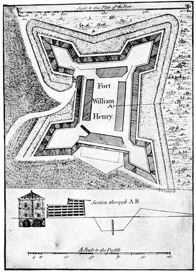
FORT WILLIAM HENRY.
From A set of plans and forts in America, reduced from actual surveys, 1763, published in London. A plan of this fort is in the Brit. Mus. MSS., no. 15,355, and various plans of 1756 and 1757 are noted in the King’s Maps (Brit. Mus.), ii. 475. Plans are also given in Martin’s Montcalm et les dernières années de la colonie Française au Canada, and in Hough’s ed. of Pouchot, p. 48.
A sketch of the fort preserved on a powderhorn is engraved in Stone’s Life of Johnson, i. p. 553, and in Holden’s Queensbury, 306.
At the portage, and before launching his flotilla on Lake George, Montcalm held a grand council, and bound his Indian allies by a mighty belt of wampum. Up the smaller lake the main body now went by boat, but some Iroquois allies led De Lévis, with 2,500 men, along its westerly bank. The[517] force on the lake disembarked under cover of a point of land, which hid them from the English.
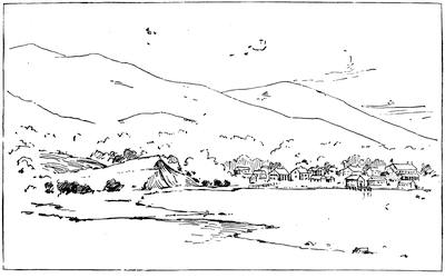
THE SITE OF FORT WILLIAM HENRY, 1851.
From a sketch made in 1851. The fort was on the bluff at the left, now the position of the Fort William Henry hotel. Montcalm’s trenches were where the modern village of Caldwell is built, seen beyond the water. The way to the entrenched camp started along the gravelly beach in the foreground, towards the spectator.
The extent of the demonstration was first made known to Munro when the savages spread out across the lake in their bark canoes. Montcalm soon pushed forward La Corne and De Lévis till they cut the communications of the English with Fort Edward, and then the French general began his approaches from his own encampment. When he advanced his lines to within gun-shot of the ramparts, he summoned the fort. Munro declined to surrender, hoping for relief from Webb; but the timid commander at Fort Edward only despatched a note of advice to make terms. This letter was intercepted by Montcalm, who sent it into the fort, and it induced Munro to agree to a capitulation.
On the 9th of August the English retired to the entrenched camp, and the French entered the fort. Munro’s men were to be escorted to Fort Edward, being allowed their private effects, and were not to serve against the French for eighteen months. Montcalm took the precaution to explain the terms to his Indian allies, and received their seeming assent; but the savages got at the English rum, and, with passions roused, they fell the next day upon the prisoners. Despite all exertions of Montcalm and the more honorable of his officers, many were massacred or carried[518] off, so that the line of march became a disorderly rout, beyond all control of the escort, and lost itself in the woods. Not more than six hundred in a body reached Fort Edward, but many others later straggled in. Another portion, which Montcalm rescued from the clutch of the Indians, was subsequently sent in under a strong escort.
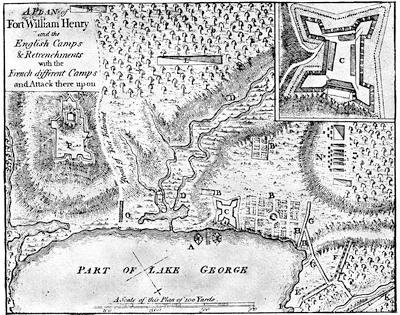
ATTACK ON FORT WILLIAM HENRY.
From A set of plans and forts in America, reduced from actual surveys, 1763, published in London.
Key.—A, dock. B, garden. C, Fort William Henry. D, morass. E, French first battery of nine guns and two mortars. F, French second battery of ten guns and three mortars. G, French approaches. H, two intended batteries. I, landing-place of French artillery. K, Montcalm’s camp, with main body. L, De Lévis’ camp, with regulars and Canadians. M, De la Corne, with Canadians and Indians. N, where the English first encamped. O, bridge over morass. P, English entrenchments, where Fort George later stood.
Cf. the plans in Parkman’s Montcalm and Wolfe, i. 494, and in Palmer’s Lake Champlain, p. 73, based on this, and the reproduction of it in Bancroft’s United States, orig. ed., iv. p. 263. There is a rough contemporary sketch given in J. A. Stoughton’s Windsor Farms, 1884, showing the lines of the attacking force, and endorsed, “Taken Oct. 22, 1757, by John Stoughton.” There is another large plan of the attack preserved in the New York State Library, and this is given in the N. Y. Col. Docs., x. 602. Martin, De Montcalm en Canada, p. 81, gives a “Plan du siège de Fort George [William Henry was often so called by the French] dressé par Fernesic de Vesour le 12 Septembre, 1757,” preserved in the Dépôt des Fortifications des Colonies, no. 516, at Paris.
The French destroyed the fort, throwing the bodies of the slain on the fire which was made of its timber, and, lading their boats with the munitions[519] and plunder, they followed the savages, who had already started on their way to Montreal.
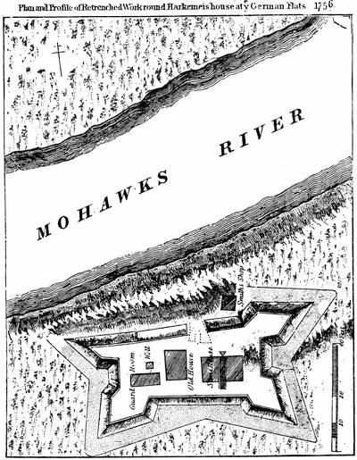
FORT AT GERMAN FLATS.
After a plan in the Doc. Hist. New York, ii. 732. In Benton’s Herkimer County, p. 53, is also a “plan and profile of the entrenched works round Harkemer’s house at ye German Flats, 1756.” Cf. Set of Plans, etc., no. 13.
Loudon reached New York on the last of August,[1153] but he had already heard of the Lake George disaster from a despatch-boat which met him on the way. On landing he learned from Albany that Montcalm had retired. Webb, who was much perplexed with the hordes of militia which all too late began to pour in upon him, was now bold enough to think there was no use of retreating to the passes of the Hudson. The necessity of allowing the Canadians to gather their crops, as well as Montcalm’s inability to transport his cannon, had influenced that general to retreat. At Montreal he learned the stories of the fiendish cruelty practised upon their prisoners by the Indians who had preceded him, and who had not been restrained by Vaudreuil,—so Bougainville said; for the governor’s policy of buying some of the captives with brandy led to the infuriation which wreaked itself on the rest.
The campaign closed in November with an attack on the post at German Flats, a settlement of Palatine Germans, by a scouting body of French and Indians under one of Vaudreuil’s Canadians, Belêtre. Everything disappeared in the havoc, which a detachment sent by Colonel Townshend from Fort Herkimer, not far off, was powerless to check. Before Lord Howe, with a larger force from Schenectady,[1154] could reach the scene, the French had departed.
The winter of 1757-58 at Montreal and Quebec passed with the usual official gayety and bureaucratic peculation. The passions of war were only aroused as occasional stories of rapine and scalps came in from the borders. Good hearty rejoicing took place, however, in March, over the report that a scouting party from Ticonderoga had encountered Rogers, and that the dreaded partisan had been killed and his followers annihilated. The last part of the story was too true, but Rogers had escaped, leaving behind his coat, which he had thrown off in the fray, and in its pocket was his commission, the capture of which had given rise to the belief in his death. Meanwhile, on the English side a new spirit of control was preparing to give unaccustomed vigor to the coming campaign. In England’s darkest hour William Pitt had come to power, thrown up by circumstances. He was trusted in the country’s desperation, and proved himself capable of imparting a momentum that all British movements had lacked since the war began. He developed his plans for America, and made his soldiers and[521] sailors spring to their work. Loudon was recalled. The provincial officer was made the equal of the regular, by conferring upon him the same right of seniority by commission. The whole colonial service felt that they were thereby made equal sharers of the honors as well as of the burdens of the times. Pitt put his finger upon the three vulnerable gaps in the French panoply. He would reach Quebec by taking Louisbourg; and singling out a stubborn colonel who had shown his mettle in Germany, he made him Major-General Amherst, and sent him with a fleet to take Louisbourg, as we may see in another chapter.[1155] Circumstances, or a mischance in judgment, made him retain Abercrombie for the Crown Point campaign, but a better decision named Brigadier John Forbes to attack Fort Duquesne. It belongs to this place to tell the story of these last two campaigns.
In June, Abercrombie had assembled at the head of Lake George a force of 15,000 men, of whom 6,000 were regulars. Montcalm was at Ticonderoga with scarce a quarter as many; but Vaudreuil was tardily sending forward some scant reinforcements under De Lévis. The French general got tidings early in July of the embarkation in England, but had done nothing up to that time to protect his army, which was lying on the peninsula of Ticonderoga, mainly outside the fort. In fact, he was at a loss what to do; no help had reached him, and the approaching army was too numerous to hope for success. He thought of retreating to Crown Point, but some of his principal officers opposed it. He now began a breastwork of logs on the high ground before the fort, and, felling the trees within musket range, he covered the ground with a dense barrier.

All the while, the English were in a heydey of assurance. Pitt was waiting anxiously in London for the first tidings. Abercrombie, now a man of fifty-two years, did not altogether inspire confidence. His heavy build and lethargic temperament made lookers-on call him “aged.” There was, however, a proud expectation of success from the vigorous, companionable Earl Howe, the brigadier next in command, whom Pitt hoped to prove the real commander, because of the trust which Abercrombie put in him. On the 5th of July the immense flotilla, which bore the English army and its train, started down Lake George. To a spectator it completely deadened the glare of the water for miles away. The next morning at daybreak the army was passing Rogers’ Slide, whence a French party under Langy watched them. By noon it had disembarked at the extreme north end of Lake George, and near the river conducting to Ticonderoga they built an entrenchment, to protect their bateaux. Rogers, with his rangers, was sent into the woods to lead the way, while the army followed; but the denseness of the forest soon brought the column into confusion. Meanwhile,[522] the French party under Langy, finding the English had got between them and their main body, endeavored to pass around the head of the English column, and, in doing so, got equally confused in the thickness of the wood, and suddenly encountered that part of the English force where Lord Howe and Major Putnam were. A skirmish ensued, Howe fell,[1156] and the army was practically without a head. Rogers, who was in advance, turned back upon Langy, and few of the Frenchmen escaped.
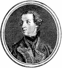
LORD HOWE.
From an engraving in Entick’s Hist. of the Late War, 3d ed., 1765, vol. iii. p. 209. For the impression made by Howe’s character on the colonists, see Mrs. Grant’s American Lady, Wilson’s ed., p. 222.
In the morning Abercrombie withdrew the army to the landing. Bradstreet, with his watermen, having rebuilt the bridges destroyed by the French, the original intention of skirting the river on the west was abandoned, and the army now started to follow the ordinary portage across the loop of the river, which held the rapids. The French had already deserted their positions at either end of this portage. At the northerly end, near a saw-mill, the English general halted his army. He was at one base-corner of the triangular peninsula of which Ticonderoga was the apex. He had now to encounter, not far from the fort, the entrenchment which Montcalm was busily constructing out of the forest-trees which had been laid along its front as by a hurricane. Scorning all measures which might have spared his army great losses, and thoughtless of movements which could have intercepted Montcalm’s reinforcements,[1157] the English general undertook, from the distant[523] mill, to direct repeated assaults in front. His soldiers made a deadly push through the entanglements of the levelled trees and against the barricade, behind which the defenders were almost wholly protected. He could have done nothing to help Montcalm so much. The stores of the French were sufficient for eight days only, and the chief dread of the French general was that Abercrombie would cut his communications with Crown Point.
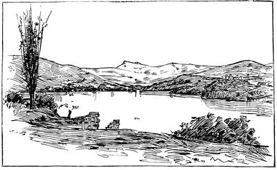
TICONDEROGA, 1851.
After a sketch made in 1851. The ruins of Ticonderoga and the landing-wharf are seen on the right. The high hill on the left is Mount Defiance, on whose side Johnson and his Indians were posted during Abercrombie’s attack. At its base is the outlet leading to Lake George. The ruins in the foreground are a part of Fort Independence.
As it was, De Lévis, with a considerable force, arrived in the night. Sir William Johnson and some Indians opened fire in the morning across the river from the sides of Mount Defiance; but accomplished nothing, and took no further part in the day’s work. About noon the attack began in front, and all day long—now here, now there—the French repelled assaults which showed prodigies of valor and brought no reward. Some rafts, with cannon sent by Abercrombie to enfilade the French line, were driven back by the guns of the fort. At twilight the cruel work ceased. Abercrombie had lost nearly 2,000 men, and Montcalm short of 400.
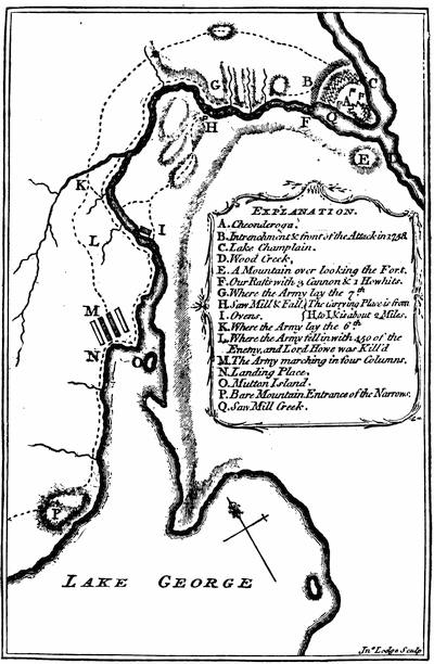
ABERCROMBIE’S ATTACK ON TICONDEROGA, 1758.
From Almon’s Remembrancer, London, 1778, where it is called “Sketch of Cheonderoga or Ticonderoga, taken on the spot by an English officer, in 1759.”
A plan of the approaches and attack by Lieut. Meyer, of the 60th regt., is given in Parkman, ii. p. 94. Cf. other plans in Bancroft, orig. ed. iv.; Palmer’s Lake Champlain, p. 79, etc.
Montcalm was still anxious. He knew that Abercrombie had cannon, and had not used them. The most natural thing in the world for the English general would be to occupy the night in bringing the cannon up. In the morning Montcalm sent out to reconnoitre, and it was found that the[525] English, still 13,000 strong, had reëmbarked, and all the signs showed the great precipitancy of their flight.
The French general could well rejoice, but he exaggerated his enemy’s strength to 25,000 and their losses to 5,000, which last was considerably more than the victor’s whole force.
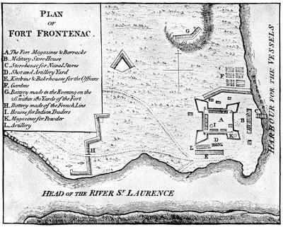
FORT FRONTENAC.
From A set of plans and forts in America, reduced from actual surveys, 1763, published in London. The fort was at the modern Kingston, Canada. There is a view or plan of it in Mémoires sur les affaires du Canada, 1749-60, p. 115.
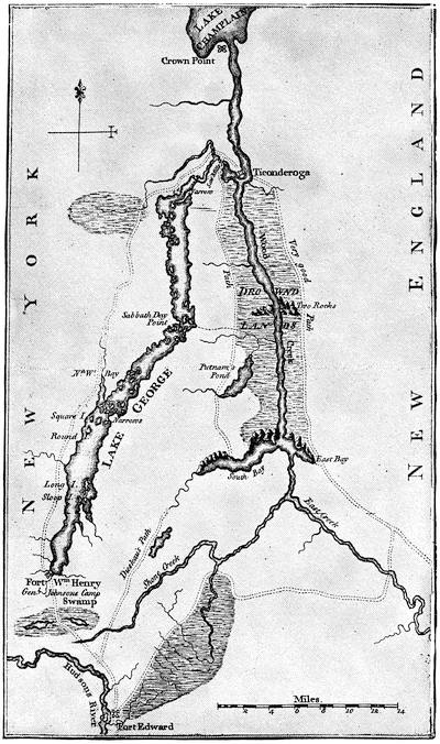
Note.—The annexed map is from Mante’s Hist. of the Late War, Lond., 1772. A map of the lake, from surveys made in 1762, is given in Parkman, i. 285. It is also reproduced in De Peyster’s Wilson’s Orderly Book.
Holden (Hist. Queensbury, 302, 303) mentions several MS. maps of Lake George of this period, preserved in the State Library at Albany. A map of the military roads (1759) from the Hudson to Lake George is given in Ibid., p. 341.
There is in the N. Y. Col. Docs., x. 721, a sketch map copied from an original in the Archives de la Guerre at Paris, called Frontiers du lac St. Sacrement, 1758, 8 Juillet. It shows Lake Champlain from below Crown Point, together with Lake George and the country towards Albany, marking the routes, forts, etc.
Cf. the section giving Lake George in Jefferys’ Map of the most inhabited part of New England, published November 29, 1755, and contained in his General Topography of North America and the West Indies, Lond., 1768, no. 37; and the separate map of Lake George, 1756, in Sayer and Bennet’s American Military Pocket Atlas, 1776. This I suppose to be the survey made in 1756 by Captain Jackson, of which a tracing is given in F. B. Hough’s ed. of Rogers’s journals, Albany, 1883. The map in Gay’s Pop. Hist. U. S., iii. 284, is a modern one.
Views of historic interest on Lake George, by T. A. Richards, are given in Harper’s Mag., vii. 161.
Abercrombie apparently magnified beyond belief an enemy whom he had not seen, and went up the lake in trepidation, lest he should be pursued. Safe on his old camping-ground at the head of the lake, he made haste to entrench himself, while Montcalm, lucky to escape as he did, prepared for a new campaign by rebuilding his lines. So the two armies still watched each other at a safe distance.[1158]
Montcalm for a while tried to harass the English communications with Fort Edward, by sending out his leading partisan, Marin; but Rogers was more than his match, and gave the English general some grains of comfort by his successes. Putnam, however, was captured and carried to Canada. Meanwhile, much greater relief came to the army’s spirits in September when the news of Bradstreet’s success at Fort Frontenac reached them.

A council of war had forced Abercrombie to give Bradstreet 3,000 men, and with these he made his way to Oswego, whence, towards the end of August, his whale-boats and bateaux pushed out upon the lake, and in three days he was before Frontenac. The fort quickly surrendered. Bradstreet levelled it, ruined seven armed vessels, put as much of the plunder as he could carry on two others, and returned to Oswego unmolested. Here he landed his booty, destroyed the vessels, and the French naval power on Ontario was at an end. He began his march for Albany, and, passing the great carrying place where Brigadier Stanwix was building a fort for the protection of the valley, left there a thousand men for its garrison. In October Amherst came overland from Boston, with some of his victorious regiments from Louisbourg. It was too late for further campaigning; and each side left garrisons at their camps, and retired to winter quarters.
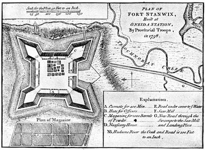
FORT STANWIX.
From A set of plans and forts in America, reduced from actual surveys, 1763, published in London. The Catal. of the King’s Maps (Brit. Mus.), ii. 354-55, shows drawn plans (1758, 1759, 1764) of Fort Stanwix, built by I. Williams, engineer.
A large map of the neighborhood of Fort Stanwix is in the Doc. Hist. New York (iv. p. 324), with a plan of the fort itself (p. 327), accompanied by a paper on the history of the fort. A map of the siege of the fort, presented to Col. Gansevoort by L. Flury, is given with a plan of the modern city of Rome superposed, in Dr. Hough’s ed. of Pouchot, i. 207. Cf. the chapter on Fort Schuyler (Stanwix) in Bogg’s Pioneers of Utica, 1877. The fort was originally called Fort Williams. It was begun on July 23, 1758, by Brig.-Gen. John Stanwix. Cf. note on Stanwix in N. Y. Col. Docs., vii. 280.
There is in Harvard College library a copy of a MS. journal of Ensign Moses Dorr, from May 25 to Oct. 28, 1758, including an account of the building of Fort Stanwix. The original MS. was in 1848 in the possession of Lyman Watkins, of Walpole, N. H.]
The destruction of Frontenac and the French fleet on Ontario had cut off Fort Duquesne from its sources of supply, and to the substantial, if not brilliant, success of Brigadier John Forbes[1159] we must now turn. It is a story of a stubborn Scotch purpose. Forbes had no dash, and purposely dallied with the forming and marching of his army to weary the Indian allies of the French, and to secure time to gain over all of the savages that he could. The English general got upon his route by June, but soon fell sick, and was carried through the marches in a litter; but he breasted every discomfort and harassing complexity of the details, which he had to manage almost in every particular, with a courage that might have done credit to a man in vigor. He had made up his mind to open a new road[529] over the mountains more direct than Braddock’s. Lieutenant-Colonel Henry Bouquet, a Swiss officer of the Royal Americans, sustained him in this purpose; but Washington argued for the older route,—not without inciting some distrust, for Forbes was not blind to the rival interests of Pennsylvania and Virginia, and suspected that Washington was influenced by a greater loyalty for his colony than for the common cause.
Forbes did not fail, however, to recognize the young Virginian’s merit in the kind of warfare which was before them; and there exists in Washington’s hand a plan of a line of march for forces in a forest, with diagrams for throwing the line into order of battle, which Forbes had requested him to make.[1160] Braddock’s defeat was not lost on Forbes, and in his marches and preparations he availed himself of all the arts of woodcraft and partisanship which Washington could teach him. He did not, nevertheless, have a very high opinion of the provincials in his train, and, with the exception of some of their higher officers, they were, no doubt, a sorry set. As he pushed on he established fortified posts for supplies; but all the help he ought to have got from his quartermaster-general, Sir John Sinclair, stood him in poor stead, for that officer was “a very odd man,” and only added to his general’s perplexities. The advice of Washington about taking the other route had so far unsettled Forbes’s faith in him, that, though he told his subordinates among the advance to consult with the Virginia colonel, it might not be best, he suggested, to follow his advice. While the march went on he had little success in attaching some Cherokees and Catawbas, for they stayed no longer than the gifts held out. An occasional scout brought him intelligence of the enemy, and he felt that their numbers were not great, and that the weariness of delays would drive the Indian allies of the French into desertion,—as it did.
At Raystown he built Fort Bedford, to protect his supplies, and pushed on to Loyalhannon[1161] Creek, and there founded his last depot, fifty miles away from Duquesne.
In August Forbes was planning for a general convention with the Indians at Easton. The treaty of the previous year had secured the Delawares and Shawanoes, and a further conference had been held with them in April.[1162] Sir William Johnson was bullied, as Forbes says, into bringing into the compact the eastern tribes of the Six Nations, while other influences induced the Senecas and the western tribes also to join, despite the labors of Joncaire to retain them in the French interests. The chief difficulty was to inspire the Ohio Indians with a distrust of the French; while the failure of French presents, thanks to British cruisers on the ocean, was beginning to dispose them for a change. A Moravian brother,[530] Christian Frederick Post, was sent to the tribes on a hazardous mission, and his confidence and fearlessness carried him through it alive; for he had to confront French officers at the conferences, one of which was held close by Fort Duquesne. As a result of his mission, the convention of the allied tribes which met the English at Easton in October decided confidently to send a wampum belt, in the name of both the whites and the red men, to the Ohio Indians, and Post, with an escort, was commissioned to bear it, the party setting out from Loyalhannon. It became a struggle for persuasion between the English messenger and a French officer, who again confronted Post and offered the Indians a belt of wampum of his own. The French won the young warriors; but Post impressed the sages of the Indian councils, and the old men carried the day. The overtures of peace from the English were accepted, and this happened notwithstanding that the garrison of Duquesne had but just badly used a reconnoitring party of the English under Major Grant, of the Scotch Highlanders.
It was a success of forest diplomacy that encouraged and rendered despondent the respective sides. The French scouting parties were hanging about Loyalhannon, while the little army at Duquesne kept dwindling under the prospect of famine, now that Bradstreet’s raid on Frontenac had checked their supplies. A rough and weltering October made the bringing up of provisions very difficult for the English, and their weakening general found his time, on his litter, disagreeably spent, as he says, “between business and medicine;” but in early November he himself reached Loyalhannon. He would have stopped here for winter quarters, but scouts brought in word that the French were defenceless; so a force was hurriedly pushed forward in light order, which, when it reached Turkey Creek, heard a heavy boom to the west. It was the explosion of the French mines, as the garrison of Duquesne blew up the fort and fled.
Forbes hutted a portion of his troops within a stockade, which he called Pittsburg, and early in December began his march eastward. The debilitated general reached Philadelphia, but died in March. Few campaigns were ever conducted so successfully from a litter of pain.

The winter of 1758-59 was an unquiet one in Canada. Vaudreuil and Montcalm disputed over the results of the last campaign, and the governor was doing all he could to make the home government believe that Montcalm neither deserved, nor could profit by, success. All his intrigue to induce the general’s recall only resulted in the ministry sending him orders to defer to Montcalm in all matters affecting the war.
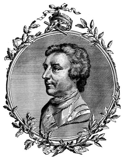
GENERAL AMHERST.
From an engraving in John Knox’s Historical Journal of the Campaigns in North America (1757-60). London, 1769. There is also an engraving in Entick’s Hist. of the Late War, iv. 129.
Reynolds painted three likenesses of Amherst, and sketched a fourth one, begun May, 1765, and finished February, 1768, which gave his army in the background, passing the rapids of the St. Lawrence. This was engraved in mezzotint by James Watson. (Hamilton’s Engraved Works of Reynolds, pp. 1, 163; J. C. Smith’s Brit. Mezzotint Portraits, London, 1878-83, iii. 1008, and iv. 1488; Mass. Hist. Soc. Proc., vii. 101; Catal. Cab. M. H. Soc., p. 45.) Amherst was born in 1717, and died in 1797.
There was never more need of strong counsel in Canada. The gasconade of Vaudreuil had reached the limit of its purpose. The plunder by officials, both of the people and of the king, was an enormity that could not last much longer. It seemed to the wisest that food and reinforcements, and those in no small amounts, could alone save Canada, unless, indeed, some kind of a peace could be settled upon in Europe. To claim help and to learn, Bougainville and Doreil were sent to France. Nothing they said could gain much but what was easily given,—promotion in rank to Montcalm and the rest. They represented that the single purpose which now animated the English colonies was quite a different thing from the old dissensions among them, the existence of which had favored the French in the past. The demand in Europe was, however, inexorable; and all that France could promise was a few hundred men and a campaign’s supplies of munitions.
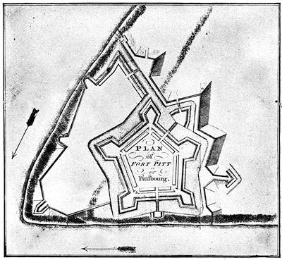
FORT PITT OR PITTSBOURG.
From Mante’s Hist. of the Late War, London, 1772, p. 158. Cf. also the plan in Egle’s Pennsylvania, p. 98; and the corner sketch of the plate in Bancroft, United States (orig. ed.), iv. 189.
In the spring of 1759 Bougainville came back with the little which was precious to those who had nothing, as Montcalm said. But the returning soldier brought word of the great fleet which England was fitting out to attack Quebec, and that fifty thousand men would constitute the army with which Canada was to be invaded. Vaudreuil could hardly count twenty thousand men to meet it, and to do this he had to reckon the militia, coureurs de bois, and Indians. If the worst came, Montcalm[533] thought he could concentrate what force he had, and retreat by way of the Ohio to the Mississippi, and hold out in Louisiana.[1163]
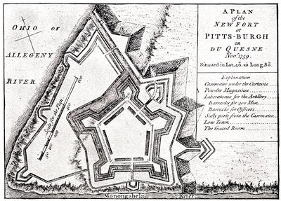
NEW FORT AT PITTSBURGH.
From A set of plans and forts in America, reduced from actual surveys, 1763, published in London.
On the English side matters looked encouraging. Amherst, a sure and safe soldier, without any dash, was made commander-in-chief, and was to direct in person the advance over the old route from Lake George,[1164] while at the same time he took measures to reëstablish Oswego and reinforce Duquesne. To the latter point General Stanwix was sent, where in the course of the summer he laid out and strengthened a new fort, called after the prime minister. Fort Pitt was not, however, wholly secure till success had followed Brigadier Prideaux’s expedition to Niagara, the reduction of[534] which was also a part of Amherst’s plans. Prideaux seated Haldimand at Oswego, and made good its communications with the Mohawk Valley. It was an open challenge to the French, and after Prideaux had proceeded to Niagara, Saint-Lac de la Corne came down with a force from the head of the St. Lawrence rapids to attack Haldimand, but the English cannon sent the French scampering to their boats, and the danger was over.
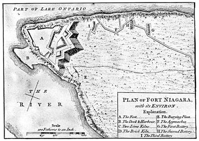
FORT NIAGARA.
From A set of plans and forts in America, reduced from actual surveys, 1763, published in London. This same plan is given in Doc. Hist. N. Y., ii, p. 868, and in Hough’s edition of Pouchot’s History of the Late War, ii. p. 153. There is another plan on a large scale, showing less of the neighboring ground, in the latter book, i. p. 161, and in N. Y. Col. Docs., x. p. 976.
A plan of Fort Niagara, 1759, is noted among the Brit. Mus. MSS., no. 15,535; and in the King’s Maps, ii. 92, are plans of the fort dated 1766, 1768, 1769, 1773, and a view of the falls in 1765.
O’Callaghan, in the Doc. Hist. of New York, ii. 793, gives a map of the Niagara River, 1759, showing the landing place of Prideaux and the path around the cataract. For the track of the Niagara portage, see O. H. Marshall’s “Niagara Frontier,” in Buffalo Hist. Soc. Publ., ii. 412-13.
At Niagara, in the angle formed by the lake and the Niagara River, stood the strong fort which Pouchot had rebuilt. It had a dependency[1165] some distance above the cataract, commanded by Joncaire; but that officer withdrew from this outwork on the approach of Prideaux, and reinforced the main work. It was the same Joncaire who had formerly resisted successfully, but of late less so, the efforts of Johnson to secure the alliance to the English of the Senecas and the more westerly tribes of the Six[535] Nations; and now Johnson with a body of braves was in Prideaux’s camp. The English general advanced his siege lines, and had begun to make breaches in the walls of the fort, when new succor for the French approached. Their partisan leaders at the west had gathered such bushrangers and Indians as they could from Detroit and the Illinois country, and were assembling at Presquisle and along the route to the Monongahela for a raid on the English there, in the hopes of recapturing the post. They got word from Pouchot of his danger, and immediately marched to his assistance, under Aubry and Ligneris.
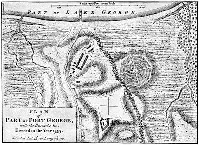
FORT GEORGE.
From A set of plans and forts in America, reduced from actual surveys, 1763, published in London. This plan is reproduced in De Costa’s Hist. of Fort George. For the ruins of the fort and the view from them, see the cuts in Lossing’s Field-Book of the Rev., i. 112; and Scribnner’s Monthly, Mar., 1879, p. 620.
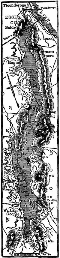
LAKE GEORGE.
Early in the siege, Prideaux had been killed by the bursting of one of his own shells, and the command fell on Johnson, who now went with a part of his force to meet the new-comers, already showing themselves up the river. He beat them, and captured some of their principal officers, while those who survived led the panic-stricken remainder to their boats above the cataract. Thence they fled to Presquisle, which they burned. Here the garrisons of LeBœuf and Venango joined them, and the fugitives continued on to Detroit, leaving the Upper Ohio without a fighting Frenchman to confront the English.
On the same day of the defeat, negotiations for a surrender of Fort Niagara began, and Pouchot, being convinced of the reverses which his intending succorers had experienced, finally capitulated. Johnson succeeded in preventing any revengeful onset of his Indians, who had not forgotten the massacre of William Henry.
The extreme west of Canada was now cut off from the central region, which was threatened, as we shall see, by Amherst and Wolfe, and Vaudreuil could have little hope of preserving it. To press this centre on another side, Amherst now sent General Thomas Gage to succeed Johnson in the command of the Ontario region, and, gathering such troops as could be spared from the garrisons, to descend the St. Lawrence and capture the French post at the head of the rapids. Gage had little enterprise, and was not inclined to undertake a movement in which dash must make up for the lack of men, and he reported back to Amherst that the movement was impossible.
When this disappointment came to the commander-in-chief he was at Crown Point,—but we must track his progress from the beginning.
At the end of June, Amherst had at Lake George about 11,000 men, one half regulars. He set about the campaign cautiously. He had fortified new posts in his rear, and began the erection of Fort George at the head of the lake, of which only one bastion was ever finished. On the 21st of July he embarked his army on the lake, and, landing at the outlet, he followed the route of Abercrombie’s approach to Ticonderoga during the previous year. The disparity of the opposing armies was much like that when Montcalm so successfully defended that post; but Bourlamaque, who now commanded, had orders to retire, and was making his arrangements. Amherst brought up his cannon, and protected his men behind the outer line of entrenchments, which Bourlamaque had abandoned. On the night of the 23d, Bourlamaque escaped down the lake, but a small force under Hebecourt still held the fort, which kept up a show of resistance till the evening of the 26th, when the remaining French, leaving a match in the magazine, also fled. In the night one bastion was hurled to the sky, and the barracks were set on fire.
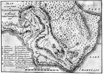
TICONDEROGA.
From A set of plans and forts in America, reduced from actual surveys, 1763, published in London. Various plans and views are noted in the Catal. of the King’s Maps (Brit. Mus.), ii. 395. Cf. plans in Palmer’s Lake Champlain, 85; Lossing’s Field-Book of the Rev., i. 118, and views and descriptions of the ruins in Lossing, i. 127, 131; Watson’s County of Essex, 112. Lieut. Brehm’s description of the fort after its capture is in the N. E. Hist. and Geneal. Reg., 1883, p. 21.
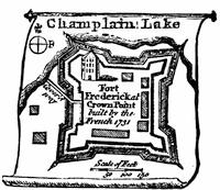
CROWN POINT.
From a small vignette on a map by Kitchin of the Province of New York, in the London Magazine, Sept., 1756. There is a similar map in the Gentleman’s Mag., vol. xxv. p. 525.
Various MS. plans and views of Crown Point are noted in the Catal. of the King’s Maps (Brit. Mus.), i. 277, under date of 1759. The Brinley Catal., ii. 2,939, shows a MS. “Plan of Crown Point Fort, March, 1763,” on a scale of 90 feet to the inch.
There was published in Boston in 1762 a Plan of a part of Lake Champlain and the large new fort at Crown Point, mounting 108 cannon, built by Gen. Amherst. (Haven’s Bibliog., in Thomas, ii. p. 560.) Cf. the plans, nos. 24, 25, in Set of plans, etc. (London, 1763).
For the ruins of Crown Point, see Lossing, Field-Book of the Revolution, i. 150-152; Watson’s County of Essex, pp. 104, 112. These are a part, however, of the fort built by Amherst. Kalm describes the previous fort (Travels, London, 1771, ii. 207), and it is delineated in Mémoires sur les affaires du Canada, p. 53.
Amherst began to repair the works, with his army now succumbing[537] somewhat to the weather,[1166] and was about advancing down the lake, when scouts brought in word that Bourlamaque had also abandoned Crown Point. So Amherst again advanced. He knew nothing of the progress Wolfe was making in his attack on Quebec by water, but he did know that it was a part of Pitt’s plan that success on Lake Champlain should inure to Wolfe’s advantage, and this could only be brought about by an active pursuit of the enemy down the lake. Amherst was, however, not a general of the impetuous kind, and believed beyond all else in securing his rear. So he began to build at Crown Point the new fort, whose massive ruins are still to be seen, and sent out parties to open communication with the Upper Hudson on the west and with the Connecticut River on the east.
The French, as he knew, were strongly posted at Isle-aux-Noix, in the river below the lake, and they had four armed vessels, which would render dangerous any advance on his part by boat. So Captain Loring, the English naval commander, was ordered to put an equal armament afloat for an escort to his flotilla.
Bourlamaque, meanwhile, was confident in his position, for he knew that, in addition to his own strength, Lévis had been sent up to Montreal with 800 men to succor him, if necessary, and all the militia about Montreal was alert.
Amherst, on his part, was anxious to know how the campaign was going with Wolfe. In August he sent a messenger with a letter by the circuitous route of the Kennebec, which Wolfe received in about a month, but it helped that general little to know of the building going on at Crown Point. Amherst then tried to pass messengers through the Abenaki region, but they were seized. Upon this, Major Rogers was sent with his rangers to destroy the Indian village of St. Francis, which he did, and then, to elude parties endeavoring to cut him off, he retreated by Lake Memphremagog to Charlestown, on the Connecticut, enduring as he went the excruciating horrors of famine and exhaustion.
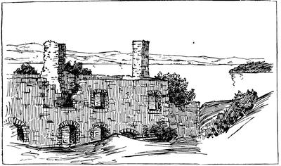
CROWN POINT, 1851.
From a sketch made in 1851, showing in the foreground a slope of the embankment, with part of the ruins of the barracks, the lake beyond, looking to the north.
ISLE-AUX-NOIX.
After a plan in the contemporary Mémoires sur le Canada, 1749-1760, as published by the Lit. and Hist. Soc. of Quebec (réimpression), 1873, p. 154. See the view in Lossing’s Field-Book of the Rev., i. 167.
It was near the middle of October when Loring pronounced the armed vessels ready, and Amherst embarked; but the autumn gales soon convinced him that the risks of the elements were too great to be added to those of the enemy, and after his demonstration had caused the destruction of three of the enemy’s vessels, and one had reached their post on the Richelieu River, the English general, still ignorant of Wolfe’s luck, withdrew to Crown Point, and gave himself to the completion of its fortress.
We must now turn to the most brilliant part of the year’s work. This was the task assigned to General Wolfe, who had already shown his quality in the attack on Louisbourg the previous year.[1167] Late in May he was at Louisbourg, with his army under three brigadiers, Monckton, Townshend, and Murray, and the fleet of Saunders, who had come direct from England, combined with that of Holmes, who had been first at New York to take troops on board. A third fleet under Durell was cruising in the gulf to intercept supplies for Quebec, but that officer largely failed in his mission, for all but three of the French supply ships eluded him, and by the 6th of June, when the last of Wolfe’s fleet sailed out of Louisbourg, Quebec had received all the succor that was expected.
The French had done their best to be prepared for the blow. Their entire force at Quebec was congregated in the town defences and in a fortified camp, which had been constructed along the St. Lawrence, beginning at the St. Charles, opposite Quebec, and extending to the Montmorenci, and on this line about 14,000 men, beside Indians, manned the entrenchments. A bridge connected the camp with Quebec, and a boom across the St. Charles at its mouth was intended to stop any approaches to the bridge by boats; while earthworks along the St. Charles formed a camp to fall back upon in case the more advanced one was forced. Beside the 106 cannon mounted on the defences of the city, there were gun-boats and fire-ships prepared for the moment of need. In the town the Chevalier de Ramezay commanded a garrison of one or two thousand men. Montcalm had his headquarters[1168] in the rear of the centre of the entrenched line along the St. Lawrence, and Vaudreuil’s flag was flying nearer the St. Charles.
On the 21st of June the masts of the advanced ships of the English were first seen, and one of the fire-ships was ineffectually sent against them. There was a difficult passage between the north shore of the river and the lower end of the Island of Orleans; but the English fleet managed[541] to pass it without loss, much to the disappointment of the French, who had failed to plant a battery on the side of Cape Tourmente, whence they could have plunged shot into the passing vessels. Past the dangers of the stream, the English landed their army on the island,[1169] less than 9,000 in all, for Wolfe could count little on the sailors who were needed for the management of the fleet.[1170]
GENERAL JAMES WOLFE.
From an engraving in John Knox’s Hist. Journal of the Campaigns in North America (1757-1760), London, 1769. An engraving from Entick is given in the preceding chapter. There is a head of Wolfe in London Mag. (1759), p. 584.
J. C. Smith, in his Brit. Mezzotint Portraits, notes four different prints (vol. ii. 783; iii. 1027, 1345, the last by H. Smith, engraved by Spooner; and iv. 1750), but he does not reproduce either.
Parkman (Montcalm and Wolfe, ii.) gives a picture of Wolfe in early youth—weak enough in aspect—which follows a photograph from an original portrait owned by Admiral Warde.
Wright, in his Life of Wolfe, gives a photograph of the same. See Ibid., p. 604, for an account of various portraits and memorials.
The common picture representing him standing and in profile is engraved in Parkman’s Historical Handbook of the Northern Tour; in the Eng. ed. of Warburton’s Conquest of Canada, etc.
SIEGE OF QUEBEC, 1759.
Reproduced from the map in Miles’s Canada, called “Plan of the St. Lawrence River from Sillery to the Fall of Montmorency, with the operations of the siege of Quebec, 1759,” which has a corner “View of the action gained by the English, Sept. 13, 1759, near Quebec.” This map is a reduction of one engraved by Jefferys, and dedicated to Pitt, entitled “Authentic plan of the River St. Lawrence from Sillery to the Fall of Montmorenci, with the operations of the siege of Quebec, under the command of Vice-Admiral Saunders and Major-General Wolfe, down to the fifth of September, 1759, drawn by a captain in his Majesty’s navy.” The sideplan is called “View of the action gained by the English Sept. 13, 1759, near Quebec, brought from thence by an officer of distinction.” This was also inserted by Jefferys in his History of the French Dominion in America, London, 1760, p. 131. The same map is given in Entick’s General Hist. of the Late War, London, 1770 (3d ed.), iv. 107; and a similar one is in the American Atlas. Jefferys repeats this map in his General Topography of North America and the West Indies, London, 1768 (no. 18), and adds another (no. 21), called “A correct plan of the environs of Quebec and the battle fought 13 Sept., 1759,” which is accompanied by a superposed “second plate,” showing the disposition of the forces on the Plains of Abraham. This plan had already appeared separately in Journal of the siege of Quebec, to which is annexed a correct plan of the environs of Quebec, and of the battle fought on the 13th September, 1759, together with a particular detail of the French lines and batteries, and also of the encampments, batteries, and attacks of the British army, etc. Engraved from original survey by Thomas Jefferys [London, 1760], 16 pp. (Carter-Brown, iii. no. 1,276.)
The maps given in James Grant’s British Battles, ii. 91, and in Cassell’s United States, are seemingly based on Jefferys’.
The London Magazine for 1759 has a plan of Quebec (Apr.) and of the siege (Nov.), with a map of the river (Sept.); and for 1760, a view of the taking of Quebec (p. 280), and a view of the town from the basin (p. 392).
There is a large folding plan, showing the fleet and the landing of the boats, in Mante’s Hist. of the Late War, 1772, p. 233. Alfred Hawkins published at London, in 1842, A Plan of the Naval and Military Operations before Quebec, accompanied by an engraving of West’s “Death of Wolfe.” (H. J. Morgan, Bibliotheca Canadensis, no. 179.)
In the Atlantic Neptune (Additional Plates, no. 1) is a plan of three sheets, called “A plan of Quebec and environs, with its defences and the occasional entrenched camps of the French, commanded by the Marquis of Montcalm, showing likewise the principal works and operations of the British forces under the command of Maj.-Gen. Wolfe, during the siege of that place, 1759.” It is accompanied by a key. In the same, Part ii. no. 16, there is a map of the St. Lawrence from Quebec to the gulf, which shows the region of Quebec on a large scale.
Among existing MS. plans of Wolfe’s attack may be noted one in the Faden Collection of maps in the library of Congress (E. E. Hale’s Catal. of the Faden Maps); others in the Catal. of the King’s Maps (Brit. Mus.), ii. 220, under date of 1755, 1759, 1760; also Brit. Mus. MSS., no. 15,535; and Additional MSS., no. 31,357; this last is a large plan in four sheets. Parkman (ii. 440) refers to a large MS. plan, 800 feet to an inch, belonging to the Royal Engineers, which was made by three engineers of Wolfe’s army, and of which he says that he possesses a fac-simile. In his Montcalm and Wolfe (ii. 200) he gives an eclectic plan; and other plans are in Lemoine’s Picturesque Quebec, p. 301 (being Jefferys’ on a small scale); Bancroft’s United States, orig. ed., iv. 315, etc., repeated in vol. i. of his Hist. of the Amer. Revolution (English edition).
A plan was published at Amsterdam in 1766.
Dussieux, in Le Canada sous la domination Française, gives a map of the siege, “D’après un manuscrit Anglais du Dépôt de la Guerre.”
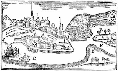
PLAN OF THE CITY OF QUEBEC.
From Father Abraham’s Almanac (by Abraham Weatherwise, Gent.), 1761. Key: A, the west part of the Island of Orleans, on which General Wolfe landed. B, Point Leveé, on which one grand battery was erected. C, Wolfe’s camp to the east of Montmorency Falls. D, the river St. Charles. E E E, the river St. Lawrence, with some of the English ships going up. F, the lower town, to the right of which is a cross (in the middle of the passage to the upper town), and a man kneeling before it, saying his Ave Maria. G, the upper town and passage to the castle. H, Montcalm’s camp and entrenchments, to the west of Montmorency Falls, from whence he marched when Wolfe recrossed the river to Point Leveé, in order to get above the city, where they luckily met, and fought it out bravely. I, Montmorency Falls and Saunders’ ships playing upon the town.
This cut has interest as a contemporary sketch for popular instruction.
He knew also that he must place little reliance[544] on the cannon of the ships, for the high rocks and bluffs of the defences were above the elevation which could be given to the guns, and a broad stretch of mud-flats kept the vessels from a near approach to that portion of the French camp which was low and lay nearest the St. Charles. Cape Diamond, the promontory of Quebec, so jutted out that Wolfe could not inspect at present the banks of the river above the town.
Montcalm had determined on a policy of wearing out his assailants,—and he came very near doing it,—and when a gale sprang up he hoped that its power of devastation would be his best ally. When he saw that fail, he tried his fire-ships; but the British sailors grappled them and towed them aground, where they were harmless.
Wolfe’s next movement was to occupy Point Levi, opposite the city,[1171] whence he showered shot and shell into the town, and drove the non-combatants out. The French tried to dislodge him, but failed. The English army was now divided by the river, and ran some risk of attack in detail. Montcalm, however, was not tempted; nor was he later, when Wolfe next landed a force below him, beyond the Montmorenci, and began to entrench himself, though the English general was interrupted in the beginning of this movement by an attack of Canadians, who had crossed the Montmorenci by an upper ford. The attack was not persisted in, however, and Wolfe was soon well entrenched. The cannonading was incessant. Night after night the sky was streaked with the shells from the vessels, and from each of Wolfe’s three camps.
The dilatory policy of Montcalm soon began to tell on his force, and then weariness and ominous news from Bourlamaque and Pouchot hastened the desertion of his Canadians. Wolfe tried to affect the neighboring peasantry by proclamations more and more threatening, and felt himself obliged at last to enforce his authority by the destruction of crops and villages.
On the 18th of July, in the night, the “Sutherland” and some smaller vessels pushed up the river beyond the town, while a fleet of boats was dragged overland back of Point Levi and launched above, out of gun-shot from the town. A force was sent by a détour to operate with them. Thus Wolfe, in defiance of the French general, had made a fourth division of his troops, each liable to separate attack. The English vessels above the town made descents along the north shore, and took some prisoners, but did little else. The French made their final attempt with a huge fire-raft, but it was as unsuccessful as the earlier ones.
Wolfe now determined to provoke Montcalm to fight, and under cover of a cannonade from Point Levi and from some of his ships[1172] he landed a force from boats beneath the precipice at the lower end of the French camp. An additional body at the same time crossed by a ford, in front of the falls of Montmorenci, which was traversable at low tide. The impetuosity of the grenadiers, who were in advance, not waiting for support, and a tempest which at the moment broke over them, convinced the quick eye of Wolfe that the attempt was to fail, and he recalled his men. The French let them retire in good order, and began to think their Fabian policy was to be crowned with success. Wolfe was correspondingly shaken and rebuked the grenadiers. He began to think, even, that the season might wear away with no better results, and that he should have to abandon the campaign.
There was one plan yet, which might succeed, and he sought to push more ships and march more troops above the town. Murray, who now took command at that point, began to raid upon the shore, but with poor success. Montcalm sent Bougainville with 1,500 men to patrol the shore, and incessant marching they had, as the English by water flitted up and down the river with the tides, threatening to land. The English restlessness was too oppressive, however, for the French camp at Beaufort, which felt that its supplies from Three Rivers and Montreal might be cut off at any moment by an English descent. Desertions increased, and rapidly increased when in August the French got decisive and unfavorable news from Lake Champlain and Ontario. The French fearing an approach of Amherst down the St. Lawrence, Quebec was further weakened by the despatch of Lévis to confront the English in that direction. By the end of August there were no signs of immediate danger at Montreal, and the French took heart.
Wolfe was now ill,—not so prostrate, however, but he could propose various new plans to a council of his brigadiers, but his suggestions were all rejected as too hazardous. They recommended, in the end, an attempt to gain the heights somewhere above the town, and force Montcalm to fight for his communications. Wolfe was ready to try it; but it was the first of September before he was able to undertake it.[1173] He saw no other hope, slight as this one was. The letter which Amherst had sent to him by the Kennebec route had just reached him, and he felt there was to be no assistance from that quarter. On the 3d of September he evacuated the camp at Montmorenci, Montcalm being prevented from molesting him by a feint which was made by boats in front of his Beaufort lines. Other troops were now marched above Quebec, and when Wolfe himself joined[546] Admiral Holmes, who commanded that portion of the fleet which was above the town, he found he had almost 3,600 men, beside what he might draw from Point Levi, for his adventurous exploit. The French were deceived, and thought that the English were to go down the river, as indeed, if the scheme to scale the banks failed on the first attempt, they were. Bougainville’s corps of observation was increased, and it was its duty to patrol a long stretch of the river shore.
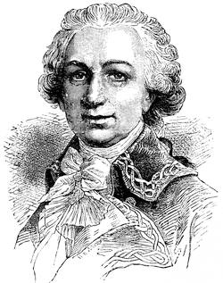
BOUGAINVILLE.
After a cut in Bonnechose’s Montcalm, 5th ed., 1882, p. 138.
Wolfe with a glass had discovered a ravine,[1174] up which it seemed possible for a forlorn hope to mount, and the number of tents at its top did not indicate that there was a numerous guard there to be overcome. Robert Stobo, who had been a prisoner in Quebec after the fall of Fort Necessity, had recently joined the camp, and his biographer says that his testimony confirmed Wolfe in the choice, or rather directed him to it.[1175] While the preparations were going on, the English ships perplexed Bougainville by threatening to land troops some distance up the river, near his headquarters; and by floating up and down with the tide, the English admiral kept the French on the constant march to be abreast of them.
The plan was now ripe. Wolfe was to drop down the river in boats with the turn of the tide, having with him his 3,600 men, and 1,200 were to join him by boat from Point Levi. As night came on, Admiral Saunders, who commanded the fleet in the basin below Quebec, made every disposition as if to attack the Beauport lines, and Montcalm thought the main force of the British was still before him.
As the ships opposite Bougainville began to swing downward with the tide, the French general took pity on his weary men, and failed to follow the moving vessels. This kept the main part of his troops well up the river. This French general had, as it happened, informed the shore guards and batteries towards the town that he should send down by water a convoy with provisions, that night, which was to creep along to Montcalm’s camp under the shadow of the precipice. Wolfe heard of this through some deserters, and he seized the opportunity to cast off his boats and get ahead of the convoy, in order that he might answer for it if hailed. He was hailed, and answered in the necessary deceitful French. This quieted the suspicion of the sentries as he rowed gently along in the gloom.
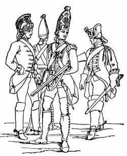
BRITISH SOLDIERS.
Reduced fac-simile of a cut in J. Luard’s Hist. of the Dress of the British Soldier, London, 1852, p. 95. This shows a heavy and light dragoon and two guardsmen of about the time of Wolfe’s attack, 1759. The cap of the guardsmen is of German origin, and was in general use by the English grenadiers of this period. The heavy dragoon is on the right. The one on the left is a light dragoon of the 15th regiment. The breeches are of leather; the coat is of scarlet.
As it happened, the Canadian officer, Colonel de Vergor, who commanded the guard at the top of the ravine, where Wolfe’s advanced party clambered up, was asleep in his tent, and many of his men had gone home, by his permission, to hoe their gardens. The English forlorn hope made, therefore, quick work, when they reached the top, as they rushed on the tents. Their shots and huzzas told Wolfe, waiting below, that a foothold was gained, and he led his army up the steeps with as much haste as possible. While the line of battle was forming, detachments were sent to attack the batteries up the river, which, alarmed by the noise, were beginning to fire on the last of the procession of boats. The celerity of the movement accomplished its end, and the French were driven off and the batteries taken.
Sheer good luck, quite as much as skill and courage, had at last placed Wolfe in an open field, where Montcalm must fight him, if he would save his communications and prevent the guns of Quebec, in the event of its capture,[1176] being turned upon his camp.
Not a mile from Quebec, and fronting its walls, Wolfe had[548] formed his final line, but he had turned its direction on the left, and there the line faced the St. Charles. In the early morning he saw the French form on a ridge in front of him, when some skirmishing ensued, as also in his rear, where a detachment sent by Bougainville began to harass him. With a foe before and behind, quick and decisive work was necessary.
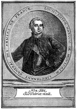
MONTCALM.
After a portrait, “une gravure du temps,” in Charles de Bonnechose’s Montcalm et le Canada Français, 5th ed., Paris, 1882. Cf. the likeness in Daniel, Nos Gloires, ii. 273, and in Martin, De Montcalm en Canada.
The portrait given in Parkman (Montcalm and Wolfe, vol. i.) is after a photograph from an original picture, representing him at 29, now in the possession of the present Marquis de Montcalm. Cf. the likeness in Higginson’s Larger Hist. of the United States, p. 190.
Montcalm, whom Admiral Saunders had been deceiving all night, hurried over to Vaudreuil’s headquarters in the morning to learn what the firing above the town meant. From this position he saw the seriousness of the situation at once. The red coats of the British line were in full view beyond the St. Charles. He hastened across the bridge, and was soon on the ground, bringing the regiments into line as they came up. But all the help he had a right to expect did not come. Ramezay made excuses for not sending cannon. Vaudreuil kept back the left wing at Beaufort, for fear that Saunders meant something, after all.
Montcalm’s impetuosity, now that it was unshackled, could not brook delay. It would take time to concert with Bougainville an attack on the front and rear of the British simultaneously, and that time would give Wolfe the chance to entrench and bring up reinforcements, if he had any. So the decision in Montcalm’s council was for an instant onset.
It was ten o’clock when Wolfe saw it coming. He advanced his line to meet it, and when the French were close[549] upon them the fire burst from the English ranks. Another volley followed; and as the smoke passed away, Wolfe saw the opportunity and gave the word to charge. As he led the Louisbourg grenadiers he was hit twice before a shot in the breast bore him to the ground. He was carried to the rear, and as he was sinking he heard those around him cry that the enemy was flying. He turned, praised God, and died.[1177]
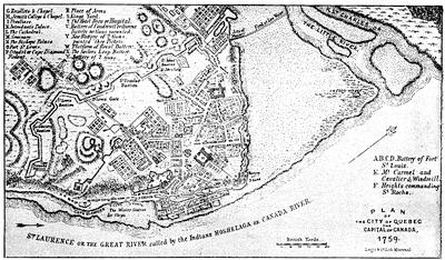
QUEBEC AS IT SURRENDERED, 1759.
After a plan in Miles’s Hist. of Canada, p. 363, which is mainly the same as the large folding map by Jefferys, published Jan. 15, 1760, which also makes part of the Hist. of the French Dominion in America, London, 1760, and of his General Topog. of North America and the West Indies, London, 1768, no. 19. There is another plan in the Nouvelle Carte de la Province de Québec selon l’edit du Roi d’Angleterre du 8 Sepbre, 1763, par le Capitaine Carver et autres, traduites de l’Anglois, à Paris, 1777. One is annexed to Joseph Hazard’s Conquest of Quebec, a poem, London, 1769; and another to Lemoine’s Picturesque Quebec, 1882. Cf. Mag. of Amer. Hist., Apr., 1884, p. 280.
Richard Short made some drawings of the condition of Quebec after the bombardment, which were engraved and published in 1761.
The French plans of Quebec of this period, to be noted, are those of Bellin in Charlevoix, viz.: Plan du bassin de Québec et de les environs, 1744 (vol. iii. p. 70); Plan de la ville de Québec, 1744 (Ibid., p. 72); and Carte de l’isle d’Orléans, et du passage de la traverse dans le Fleuve St. Laurent, 1744 (Ibid., p. 65); beside the plan of Quebec in Bellin’s Petit Atlas Maritime, vol. i., 1764.
In vol. lxiv. of the Shelburne MSS. there are various plans of the fortifications and citadel, made after the surrender. Edw. Fitzmaurice reported on these in the Hist. MSS. Commission’s Fifth Report, p. 231.
Such books as Hawkins’s Picturesque Quebec and Lossing’s paper in Harper’s Magazine, xviii. 176, give pictures of most of the points of historical interest in and about the town. Cf. J. M. Lemoine’s “Rues de Québec,” in the Revue Canadienne, xii. 269.
Various views connected with the siege of Quebec are given in Picturesque Canada, Toronto, 1884, showing the present condition of Wolfe’s Cove and the ascent from it (pp. 25, 47), the martello towers (p. 27), as well as the monuments to commemorate Wolfe and Montcalm (pp. 27, 46).
Montcalm, mounted, borne on by the panic, was shot through the breast just before he entered the town, and was taken within to die.
Part of the fugitives got into Quebec with their wounded general; part fled down the declivity towards the St. Charles, and, under cover of a stand which some Canadian bushrangers made in a thicket, succeeded in getting across the river to the camp, where everything was in the confusion which so easily befalls an army without a head. It was necessary for the English to cease from the pursuit, for Townshend,[1178] who had come to the command (Monckton being wounded), feared Bougainville was upon his rear, as indeed he was. When that general, however, found that the English commander had recalled his troops, and was forming to receive him, he withdrew, for he had only 2,000 men,—probably all he could collect from their scattered posts,—and seeing the English were twice as many, he did not dare attack. So Townshend turned to entrenching, and working briskly he soon formed a line of protection, and had a battery in position confronting the horn-work beyond the St. Charles, which commanded the bridge.
Vaudreuil was trying to get some decision, meanwhile, out of a council of war at Beaufort. They sent to Quebec for Montcalm’s advice, and the dying man told them to fight, retreat, or surrender. The counsel was broad enough, and the choice was promptly made. It was retreat. That night it began. Guns, ammunition, provisions,—everything was left. The troops by a circuitous route flocked along like a rabble, and on the 15th they went into camp on the hill of Jacques Cartier, thirty miles up the St. Lawrence.
The morning after the fight, the tents still standing along the Beaufort lines were a mockery; for Ramezay knew that Vaudreuil had gone, since he had received word from him to surrender the town when his provisions failed.
Bougainville was still at Cap Rouge, and undertook to send provisions into Quebec. Lévis had joined Vaudreuil at Jacques Cartier,[1179] and inspired the governor with hope enough to order a return to his old camp. On the evening of the 18th the returning army had reached St. Augustine, when they learned that Ramezay had surrendered and the British flag waved over Quebec.
Preparations for the departure of the fleet were soon made, and munitions and provisions for the winter were landed for the garrison, which under Murray was to hold the town during the winter. The middle of October had passed, when Admiral Saunders, one of his ships bearing the embalmed body of Wolfe, sailed down the river. Montcalm lay in a grave, which, before the altar of the Ursulines, had been completed out of a cavity made by an English shell.[1180]
The winter passed with as much comfort as the severe climate and a shattered town would permit. There were sick and wounded to comfort, and the sisters of the hospitals devoted themselves to French and English alike. A certain rugged honesty in Murray won the citizens who remained, and the hours were beguiled in part by the spirits of the French ladies. There was an excitement in November, when a fleet of French ships from up the river tried to run the batteries, and seven or eight of them which did so carried the first despatches to France which Vaudreuil had succeeded in transmitting. There was rough work in December, in getting their winter’s wood from the forest of Sainte-Foy, for they had no horses, and the merriment of companionship, checkered with the danger of the skulking enemy, was the only lightening of the severities of the task. Deserters[552] occasionally brought in word that Lévis was gathering and exercising his forces for an attack, so vigilance was incessant. Both sides preserved the wariness of war in onsets and repulses at the outposts, and the English usually got the better of their enemies. Captain Hazen and some New England rangers merited the applause which the regular officers gave them when they buffeted and outwitted the enemy in a series of skirmishes.
By April it became apparent that Lévis was only waiting for the ice in the river to break up, when he could get water carriage for his advance. Murray knew that the enemy could bring much greater numbers against him, for his 7,000 men of the autumn, by sickness and death, had been reduced to about 3,000 effectives, and the spies of Lévis kept the French general well informed of the constant weakening of the English forces.
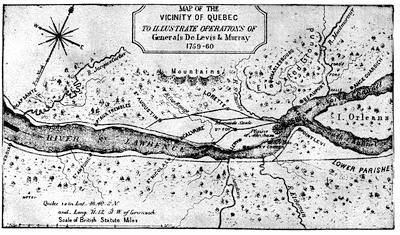
CAMPAIGN OF LÉVIS AND MURRAY.
This follows a map in Miles’s Hist. of Canada, p. 427; also in Lemoine’s Picturesque Quebec, p. 419.
The French placed their cannon and stores on the frigates and smaller vessels which had escaped up the river in the autumn, and with their army in bateaux they started on the 21st April for the descent from Montreal. With the accessions gained on the way, by picking up the scattered garrisons, Lévis landed between eight and nine thousand men at Cap Rouge, and advanced on Sainte-Foy. The English at the outposts fell back, and the delay on the part of the French was sufficient for Murray to learn of their approach. He resolved to meet them outside the walls. It must be an open-field fight for Murray, since the frozen soil still rendered entrenching impossible in the time which he had. He led out about three thousand men, and at first posted himself on the ridge, where Montcalm had drawn up his lines the year before. He pushed forward till he occupied Wolfe’s[553] ground of the same morning, when, with his great superiority of cannon, he found a position that gave him additional advantage, which he ought to have kept. The fire of the English guns, however, induced Lévis to withdraw his men to the cover of a wood, a movement which Murray took for a retreat, and, emulous of Wolfe’s success in seizing an opportune moment, he ordered a general advance. His cannon were soon stuck in some low ground, and no longer helped him. The fight was fierce and stubborn; but after a two hours’ struggle, the greater length of the enemy’s line began to envelop the English, and Murray ordered a retreat. It was rapid, but not so disordered that Lévis dared long to follow.
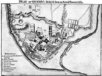
QUEBEC, 1763.
From A set of plans and forts in America, reduced from actual surveys, 1763, published in London.
The English had lost a third of their force; the French loss was probably less. Murray got safely again within the walls, and could muster about 2,400 men for their defence.[1181] There was sharp work, and little time left further to strengthen the walls and gates. Officer and man worked like cattle. A hundred and fifty cannon were soon belching upon the increasing trenches of Lévis, who finally dragged some artillery up the defile where Wolfe had mounted, and was thus enabled to return the fire.
Both sides were anxiously waiting expected reinforcements from the mother country. On the 9th of May a frigate beat up the basin, and to the red flag which was run up at Cape Diamond she responded with similar colors. It was ominous to Lévis, for he felt she was the advanced ship of a British squadron, as she proved to be. It was a week before others arrived, when some of the heavier vessels passed up the river and destroyed the French fleet. As soon as the naval result was certain, Lévis deserted his trenches, left his guns and much else, with his wounded, and hastily fled. This was in the night; in the morning the French were beyond Murray’s reach.
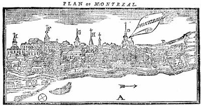
VIEW OF MONTREAL.
A sample of the popular graphic aids of the day, which is taken from Father Abraham’s Almanac, 1761 (Philadelphia). “Key: A, river St. Lawrence; B, the governor’s house and parade; C, arsenal and yard for canoes and battoes; D, Jesuits’ Church and Convent; E, the fort, a cavalier, without a parapet; F, the Parish Church; G, the nunnery hospital and gardens; H, Sisters of the Congregation, and gardens; I, Recollects’ convents and gardens; K, the Seminary; L, the wharf.”
Cf. view and plan published in London Mag., Oct., 1760. Parkman (ii. 371) refers, as among the king’s maps in the Brit. Mus., to an east view of Montreal, drawn on the spot by Thomas Patten. Cf. Lossing’s Field-Book of the Revolution, i. 179.
Their loss of cannon and munitions was a serious one, and the stores from France which might have replaced them were already intercepted by the English cruisers. Vaudreuil and Lévis made their dispositions to defend Montreal, their last hope; yet it was not a place in itself capable of successful defence, for its lines were too weak. It soon became evident that it was to be attacked on three sides; and the French had hopes that so dangerous a combination of armies, converging without intercommunication, would enable them to crush the enemy in detail.
Amherst was directing the general advance on the English side. He kept the largest force with him, and passed from Oswego, across Ontario, and down the St. Lawrence. If Lévis sought to escape westward and hold out at Detroit, Amherst intended to be sure to intercept him. He had about 11,000 men, including a body of Indians under Johnson. Near the head of the rapids he stopped long enough to capture Fort Lévis, now under Pouchot, and because they could not kill the prisoners, three fourths of Johnson’s Indians mutinied and went home. Amherst now shot the rapids with his flotilla, not without some loss, and on September 6th he reached Lachine, nine miles above Montreal.
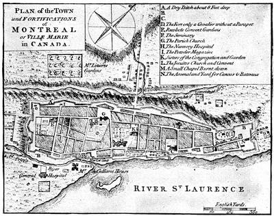
MONTREAL.
From A set of plans and forts in America, reduced from actual surveys, 1763, published in London. There is a plan of Montreal, and of Isle Montreal in a Carte de la Province de Quebec ... par le Capitaine Carver, etc., traduites de l’Anglois, à Paris, 1777. The isle of Montreal as surveyed by the French engineers is mapped in the London Mag., Jan., 1761.
Meanwhile, the other commanders had already approached the city so near as to open communication with each other. Murray had sailed up the river with about 2,500 men, but was soon reinforced by Lord Rollo with 1,300 others from Louisbourg. The English had some skirmishes along the banks, but Bourlamaque, who was opposing them, fell back with a constantly diminishing force, as the Canadians, despite all threats and blandishments, deserted him. Murray was ahead of the others, when he stopped[556] just before reaching Montreal, and encamped on an island in the river. He was not without apprehension that he might have to bear the brunt of an attack alone.
Bougainville, meanwhile, was trying to resist Haviland’s advance at the Isle-aux-Noix, for this English general now commanded on the Champlain route. The two sides were not ill-matched as to numbers; but the English advance was skilfully conducted, and the French found themselves obliged to retreat down the river and unite with Bourlamaque. It was now that Haviland, pushing on, opened communication by his right with Murray, and both stood on the defensive, waiting to hear of Amherst’s approach above the town.
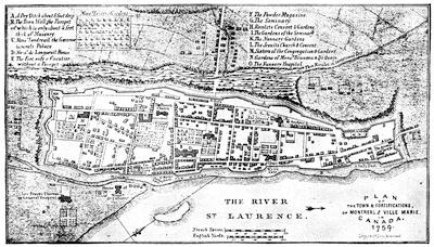
MONTREAL, 1758.
Follows a plan in Miles’s Hist. of Canada, p. 297. It is mainly the same as the large folding map by Thomas Jefferys, published Jan. 30, 1758, and making part of the Hist. of the French Dominion in America, London, 1760, p. 12. This last is in the F. North Collection in Harvard College Library, vol. iii. no. 22; and was again used by Jefferys in his General Topog. of No. America and the West Indies, London, 1768, no. 22.
These other plans belonging to the 18th century may be noted:—
MS. plans of 1717 and 1721 recorded in the Catalogue of the Library of Parliament, Toronto, 1858, p. 1618, nos. 58 and 59.
Map of 1729, made by Chaussegros de Léry, in the Paris Archives.
Carte de l’isle de Montreal et de ses environs, par N. Bellin, 1744, in Charlevoix, i. p. 227, and reproduced in Dr. Shea’s edition of Charlevoix; as well as the plan of the town, in Charlevoix, ii. 170.
A MS. plan of 1752, giving details not elsewhere found, is noted in the Library of Parliament Catal., p. 1620, no. 81.
A plan of 1756, and one of 1762 by Patten, engraved by Canot, are marked in the Catal. of the King’s Maps (Brit. Mus.), ii. 54.
A plan of Montreal and its neighborhood by Bellin, in his Petit Atlas Maritime, 1764.
The delay was brief. Amherst, advancing from Lachine, encamped before Montreal, above it, while Murray ferried his men from the island and encamped below. What there was left of the force which opposed[557] Haviland withdrew across the river into the town, and Haviland’s tents dotted the shore which the French had left. The combined French army now numbered scarce 2,500; Amherst held them easily with a force of 17,000.
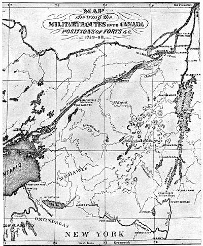
ROUTES TO CANADA, 1755-1763.
Follows map in Miles’s Hist. of Canada, p. 293.
Other contemporary maps showing the country, brought within the campaigns about Lakes Champlain and Ontario, are the following:—
A chorographical map of the country between Albany, Oswego, Fort Frontenac, and Les Trois Rivières, exhibiting all the grants by the French on Lake Champlain, which was included by Jefferys in his General Topog. of North America and the West Indies, London, 1768. It is, in fact, the northerly sheet of Jefferys’ Provinces of New York and New Jersey, with part of Pensilvania, drawn by Capt. Holland. The same General Topography, no. 32, etc., contains also in Blanchard and Langdon’s Map of New Hampshire (Oct. 21, 1761) a corner map, showing “The River St. Lawrence above Montreal to Lake Ontario, with the adjacent country on the west from Albany and Lake Champlain.”
Vaudreuil saw there was no time for delays, and at once submitted a plan of capitulation. A few notes were exchanged to induce less onerous conditions; but Amherst was not to be moved. On September 8th the paper was signed, and all Canada passed to the English king; the whole garrison to be sent as prisoners to France in British ships.

ROBERT ROGERS.
From the Geschichte der Kriege in und ausser Europa, Elfter Theil, Nürnberg, 1777. This follows a print published in London, Oct. 1, 1776, described in Smith’s Brit. Mezzotint Portraits, and in Parkman’s Pontiac, i. p. 164.
This stipulation was adhered to, and during the autumn the principal French officers were on their way to France. The season for good weather on the ocean was passed, and the transportation was not accomplished without some wrecks, accompanied by suffering and death. Vaudreuil, Bigot, Cadet, and others found a dubious welcome in France after they had weathered the November storms. The government was not disposed that the loss of Canada should be laid wholly to its account, and the ministry had heard stories enough of the peculations of its agents in the colony to give a chance of shifting a large part of the responsibility upon those whose bureaucratic thefts had sapped the vitals of the colony. Trials ensued, the records of which yield much to enable us to depict the rotten life of the time; and though Vaudreuil escaped, the hand of the law fell crushingly on Bigot and Cadet, and banishment, restitution, and confiscation showed them the shades of a stern retribution. They were not alone to suffer, but they were the chief ones.
The war was over, and a new life began in Canada. The surrender of the western posts was necessary to perfect the English occupancy, and to receive these Major Rogers was despatched by Amherst on the 13th of September. On the way, somewhere on the southern shore of Lake Erie,[1182] he met (November 7) Pontiac, and, informing him of the capitulation at Montreal, the politic chief was ready to smoke the calumet with him. Rogers pushed on towards Detroit.[1183] There was some apprehension that Belêtre, who commanded there, would rouse his Indians to resist, but the French leader only blustered, and when (November 29) the white flag came down and the red went up, his 700 Indians hailed the change of masters with a yell; and it was with open-eyed wonder that the savages saw so many succumb to so few, and submit to be taken down the lake as prisoners. An officer was sent along the route from Lake Erie to the Ohio to take possession of the forts at Miami and Ouatanon; but it was not till the next season that a detachment of the Royal Americans pushed still farther on to Michillimachinac and the extreme posts.[1184]
English power was now confirmed throughout all the region embraced in the surrender of Vaudreuil.
CRITICAL ESSAY ON THE SOURCES OF INFORMATION.
THE ninth volume of the N. Y. Col. Docs. richly illustrates the French movements near the beginning of the century to secure Indian alliances.[1185]
A number of papers from the archives of the Marine, respecting the founding of Detroit (1701), is given by Margry (Découvertes, etc.) in his fifth volume (pp. 135-250), as well as records of the conferences held by La Motte Cadillac with the neighboring Indians (p. 253, etc.). These papers come down to 1706.[1186]
The contracts made at Quebec in 1701 and later, respecting the right to trade at the straits, are given in Mrs. Sheldon’s Early Hist. of Michigan (N. Y., 1856, pp. 93, 138).[561] In Shea’s Relation des affaires du Canada, 1696-1702 (N. Y., 1865), there is a “Relation du Destroit,” and other papers touching these Western parts.[1187]
Mrs. Sheldon’s Early History of Michigan contains various documents on the condition of the colony at Detroit and Michilimackinac.[1188]
On the attack on Detroit in 1712, made by the Foxes, in which, as confederates of the Iroquois, they acted in the English interest, we find documents in the N. Y. Col. Docs., ix. pp. 857, 866; and the Report of Du Buisson, the French commander, is in W. R. Smith’s Hist. of Wisconsin, iii. 316.[1189]
The report of Tonti, on affairs at Detroit in 1717, is given by Mrs. Sheldon (p. 316).
In Margry’s Découvertes et Établissements des Français dans l’Amérique Septentrionale (vol. v. p. 73) is a “Relation du Sieur de Lamothe Cadillac, capitaine en pied, ci-devant commandant de Missilimakinak et autres postes dans les pays élorgnés, où il a été pendant trois années” (dated July 31, 1718).
In the third volume of the Wisconsin Historical Collections there are other documents among the Cass papers.[1190]
There is in another chapter some account of preparations at Boston for the fatal expedition of 1711, under Admiral Sir Hovenden Walker, with its contingent of Marlborough’s veterans.[1191] An enumeration of the forces employed was printed in the Boston Newsletter, no. 379 (July 16-23, 1711), and is reprinted in what is the authoritative narrative, the Journal or full account of the late expedition to Canada, which Walker printed in London in 1720,[1192] partly in vindication of himself against charges of peculation and incompetency. The failure of the expedition was charged by constant reports in England to the dilatoriness of Massachusetts in preparing the outfit. Walker does not wholly share this conviction, it is just to him to say; but Jeremiah Dummer, then the agent of the province in London, thought it worth while to defend the provincial government by printing in London, 1712 (reprinted, Boston, 1746), a Letter to a noble lord concerning the late expedition to Canada,[1193] in which he contended that this expedition was wisely planned, and that its failure was not the fault of New England. There is another tract of Dummer’s to a similar purpose: A letter to a friend in the country, on the late expedition to Canada, London, 1712.[1194] Palfrey[1195] says that he found various letters and documents among the British Colonial Papers, including a “Journal of the expedition, by Col. Richard King.”[1196]
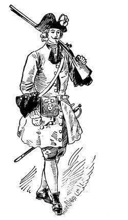
FRENCH SOLDIER, 1710.
After a water-color sketch in the Mass. Archives: Documents collected in France, vi. p. 1. The coat is red, faced with blue.
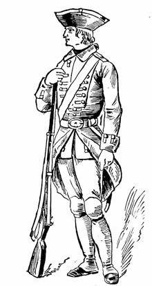
FRENCH SOLDIER, 1710.
After a water-color sketch in the Mass. Archives: Documents collected in France, viii. p. 1. The coat is blue, faced with red. Cf. sketches in Gay’s Pop. Hist. United States, ii. 545.
——————————————————
We have the French side in Charlevoix (Shea’s),[1197] with annotations and references by that editor. Walker, in his Journal, gives a rough draft in English of a manifesto intended to be distributed in Canada. Charlevoix gives the French into which it was translated for that use.[1198]
The recurrent interest taken, during Alexander Spotswood’s term of office (1710-1722) as governor of Virginia, in schemes for occupying the region beyond the mountains is traceable through his Official Letters, published by the Virginia Historical Society in 1882-5.[1199]
The journey of Spotswood over the mountains in 1716 is sometimes called the “Tramontane Expedition;” it was accomplished between Aug. 20 and Sept. 17.[1200]
At the time when Spotswood was urging, in 1718, that steps should be taken to seize upon the Ohio Valley,[1201] James Logan was furnishing to Gov. Keith, to be used as material for a memorial to the Board of Trade, a report on the French settlements in the valley (dated Dec., 1718).[1202]
Previous to 1700 the Iroquois had scoured bare of their enemies a portion, at least, of the Ohio country; but during the first half of the last century, the old hunting grounds were reoccupied in part by the Wyandots, while the Delawares centred upon the Muskingum River, and the Shawanoes, or Shawnees, coming from the south, scattered along the Scioto and Miami valleys,[1203] and allied themselves with the French. The Ottawas were grouped about the Sandusky and Maumee rivers in the north.[1204]
Respecting the Indians of the Ohio Valley we have records of the eighteenth century, in a Mémoire on those between Lake Erie and the Mississippi, made in 1718.[1205]
Among the Cass MSS. is a paper on the life and customs of the Indians of Canada[1206] in 1723, which has been translated by Col. Whittlesey.[1207]
A report (1736) supposed to be by Joncaire, dated at Missilimakinac, is called, as translated, “Enumeration of the Indian tribes connected with the government of Canada.”[1208]
Conrad Weiser’s notes on the Iroquois and the Delawares (Dec., 1746) have been also translated.[1209]
An account of the Miami confederacy makes part of a book published at Cincinnati in 1871, Journal of Capt. William Trent from Logstown to Pickawillany in 1752, edited by Alfred T. Goodman, secretary of the Western Reserve Hist. Soc. It includes papers from the English archives, secured by John Lothrop Motley.[1210] In 1759 Capt. George[564] Croghan made “a list of the Indian nations, their places of abode and chief hunting.”[1211]
The subject of the dispersion and migrations of the Indians of the Ohio Valley has engaged the attention of several of the Western antiquaries.[1212] The most exhaustive collation of the older statements regarding these tribal movements is in Manning F. Force’s lecture before the Historical and Philosophical Soc. of Ohio, which was printed at Cincinnati in 1879 as Some Early Notices of the Indians of Ohio. “In the latter half of the seventeenth century, after the destruction of the Eries in 1656 by the Five Nations,” he says, “the great basin, bounded north by Lake Erie, the Miamis, and the Illinois, west by the Mississippi, east by the Alleghanies, and south by the headwaters of the streams that flow into the Gulf of Mexico, seems to have been uninhabited except by bands of Shawnees, and scarcely visited except by war parties of the Five Nations.” He then confines himself to tracing the history of the Eries and Shawnees. He tells the story of the destruction of the Eries, or “Nation du Chat,” in 1656; and examines various theories about remnants of the tribe surviving under other names. The Chaouanons of the French, or Shawanoes of the English (Shawnees), did not appear in Ohio till after 1750. Parkman[1213] says: “Their eccentric wanderings, their sudden appearances and disappearances, perplex the antiquary and defy research.” Mr. Force adds to the investigations of their history, but still leaves, as he says, the problem unsolved. The earliest certain knowledge places them in the second half of the seventeenth century on the upper waters of the Cumberland, whence they migrated northwest and northeast, as he points out in tracking different bands.
The claim of the English to the Ohio Valley and the “Illinois country,” as for a long series of years the region east of the upper Mississippi and north of the Ohio was called,[1214] was based on a supposed conquest of the tribes of that territory by the Iroquois in 1672 or thereabouts. No treaty exists by which the Iroquois transferred this conquered country to the English, but the transaction was claimed to have some sort of a registry,[1215] as expressed, for instance, in a legend on Evans’ map[1216] (1755), which reads: “The Confederates[565] [Five Nations], July 19, 1701, at Albany surrendered their beaver-hunting country to the English, to be defended by them for the said Confederates, their heirs and successors forever, and the same was confirmed, Sept. 14, 1728 [1726], when the Senecas, Cayugaes, and Onondagoes surrendered their habitations from Cayahoga to Oswego and six miles inland to the same for the same use.” The same claim is made on Mitchell’s map[1217] of the same year (1755), referring to the treaty with the Iroquois at Albany, Sept., 1726, by which the region west of Lake Erie and north of Erie and Ontario, as well as the belt of land from Oswego westward, was confirmed to the English.[1218]
Not much is known of the Indian occupation of the Ohio Valley before 1750,[1219] and any right by conquest which the Iroquois might have obtained, though supported at the time of the struggle by Colden,[1220] Pownall,[1221] and others,[1222] was first seriously questioned, when Gen. W. H. Harrison delivered his address on the Aborigines of the Ohio Valley.[1223] He does not allow that the Iroquois pushed their conquests beyond the Scioto.
The uncertainty of the English pretensions is shown by their efforts for further confirmation, which was brought about as regards westerly and northwesterly indefinite[566] extensions of Virginia and Pennsylvania by the treaty of Lancaster in 1744 (June 22-July 4).[1224]
In 1748 Bollan in a petition to the Duke of Bedford on the French encroachments, complains that recent English maps had prejudiced the claims of Great Britain.[1225] Since Popple’s map in 1732, of which there had been a later edition, maps defining the frontiers had appeared in Keith’s Virginia (1738), in Oldmixon’s British Empire (1741) by Moll, and in Bowen’s Geography (1747).
There is in the Penna. Archives (2d series, vi. 93) a paper dated Dec., 1750, on the English pretensions from the French point of view. On the English side the claims of the French are examined in the State of the British and French Colonies in North America, London, 1755.[1226]
J. H. Perkins, in the North American Review, July, 1839, gave an excellent sketch of the English effort at occupation in the Ohio Valley from 1744 to 1774, which later appeared in his Memoir and Writings (Boston, 1852, vol. ii.) as “English discoveries in the Ohio Valley.” His sketch is of course deficient in points, where the publication of original material since made would have helped him.
The rivalry in the possession of Oswego and Niagara, beginning in 1725, is traced in the N. Y. Col. Docs. (ix. 949, 954, 958, 974), and in a convenient form an abstract of[567] the French despatches for 1725-27 is found in Ibid., ix. 976, with a French view (p. 982) of the respective rights of the rivals.[1227]
There had been a stockade at Niagara under De Nonville’s rule, and the fort bore his name; but it was soon abandoned.[1228] The place was reoccupied in 1725-26, and the fort rebuilt of stone.[1229]
In 1731 the French first occupied permanently the valley of Lake Champlain,[1230] but not till 1737 did they begin to control its water with an armed sloop, and to build Fort St. Frederick.[1231]
Beauharnois’ activity in seeking the Indian favor is shown in his conference with the Onondagas in 1734 and in his communications with the Western tribes in 1741.[1232] The condition of the French power at this time is set forth in a Mémoire sur le Canada, ascribed to the Intendant Gilles Hocquart (1736).[1233]
In 1737 Conrad Weiser was sent to the Six Nations to get them to agree to a truce with the Cherokees and Catawbas, and to arrange for a conference between them and these tribes.[1234]
The expedition to the northwest, which resulted in Vérendrye’s discovery of the Rocky Mountains in Jan., 1743, is followed with more or less detail in several papers by recent writers.[1235]
The first settlement in Wisconsin took place in 1744-46 under Charles de Langlade.[1236]
The Five Years’ War (1744-48) so far as it affected the respective positions of the combatants in the two great valleys was without result. The declaration of war was in March, 1744, on both sides.[1237]
In 1744 the Governor of Canada sent an embassy to the Six Nations, assuring them that the French would soon beat the English.[1238]
In 1744 Clinton proposed the erection of a fort near Crown Point, and of another near Irondequot “to secure the fidelity of the Senecas, the strongest and most wavering of all the six confederated tribes.”[1239]
The scalping parties of the French are tracked in the N. Y. Col. Docs., x. 32, etc., with the expedition against Fort Clinton in 1747 (p. 78) and a retaliating incursion upon Montreal Island by the English (p. 81).
In 1745 both sides tried by conferences to secure the Six Nations. In July, August, and September. Beauharnois met them.[1240] Delegates from Massachusetts, Connecticut, and Pennsylvania convened under the New York jurisdiction at Albany, in October, 1745, and did what they could by treaty to disabuse the Indian mind of an apprehension which the French are charged with having raised, that the English had proposed to them to dispossess the Iroquois of their lands.[1241]
Upon the abortive Crown Point expedition of 1746,[1242] as well as the other military events of the war, we have Memoirs of the Principal Transactions of the last War between the English and French in North America, London, 1757 (102 pp.).[1243] It is attributed sometimes to Shirley, who had a chief hand in instigating the preparations of the expedition. This will be seen in the letters of Shirley and Warren, in the R. I. Col. Rec., v. 183, etc.; and in Penna. Archives, i. 689, 711, as in an Account of the French settlements in North America ... and the two last unsuccessful expeditions against Canada and the present on foot. By a gentleman. Boston, 1746.[1244]
A letter of Col. John Stoddard, May 13, 1747, to Governor Shirley, showing how the Six Nations had been enlisted in the proposed expedition to Canada, and deprecating its abandonment, is in Penna. Archives, i. 740; as well as a letter of Shirley, June 1, 1747 (p. 746).
A letter of Governor Shirley (June 29, 1747) respecting a congress of the colonies to be held in New York in September is in Penna. Archives, i. 754; and a letter of Conrad Weiser, doubting any success in enlisting the Six Nations in the English favor, is in Ibid., p. 161.
Clinton (November 6, 1747) complains to the Duke of Bedford of De Lancey’s efforts to thwart the government’s aims to secure the assistance of the Six Nations for the invasion of Canada.[1245]
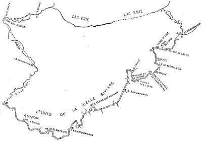
BONNECAMP’S MAP, AFTER THE KOHL COPY.
In February, 1749-50, a long report was made to the Lords Commissioners of the Treasury on the expenses incurred by the colonies during the war for the attempts to invade Canada. It is printed in the New Jersey Archives, 1st ser., vii. 383-400. The annual summaries on the French side, 1745-48, are in N. Y. Col. Docs., x. 38, 89, 137.
A stubborn fight in 1748 with some marauding Indians near Schenectady is chronicled in Pearson’s Schenectady Patent, p. 298.
In 1749 came Céloron’s expedition to forestall the English by burying his plates at the mouths of the streams flowing into the Ohio. A fac-simile of the inscription on one of these plates has been given already (ante, p. 9).[1246]
While Céloron was burying his plates, and La Galissonière was urging the home government to settle 10,000 French peasants on the Ohio, the kinsmen of Washington and others were forming in 1748 the Ohio Company, which received a royal grant of half a million acres between the Monongahela and the Kenawha rivers, on condition of settling the territory;[1247] “which lands,” wrote Dinwiddie,[1248] “are his Majesty’s undoubted right by the treaty of Lancaster and subsequent treaties at Logstown[1249] on the Ohio.” Colonel Thomas Cresap was employed to survey the road over the mountains,—the same later followed by Braddock.
Of the subsequent exploration by Christopher Gist, in behalf of the Ohio Company, and of George Croghan and Montour for the governor of Pennsylvania, note has been taken on an earlier page.[1250] A paper on Croghan’s transactions with the Indians previous to the outbreak of hostilities has been printed.[1251] Referring to the Ohio region in 1749,[571] Croghan wrote: “No people carry on the Indian trade in so regular a manner as the French.”[1252]
Reference has already been made (ante, pp. 3, 4) to the movement in 1749 of Father Piquet to influence the Iroquois through a missionary station near the head of the rapids of the St. Lawrence, on the New York side, at the site of the present Ogdensburg. The author of the Mémoires sur le Canada, whence the plan of La Présentation (ante, p. 3)[1253] is taken, gives an unfavorable account of Piquet.[1254]
The new French governor, Jonquière, had arrived in Quebec in August, 1749. Kalm[1255] describes his reception, and it was not long before he was having a conference with the Cayugas,[1256] followed the next year (1751) by another meeting with the whole body of the Iroquois.[1257] His predecessor, La Galissonière,[1258] was busying himself on a memoir, dated December, 1750,[1259] in which he shows the great importance of endeavoring to sustain the posts connecting Canada with Louisiana, and the danger of English interference in case of a war.
William Johnson, meanwhile, was counteracting the French negotiation with the Indians as best he could;[1260] and both French and English were filing their remonstrances about reciprocal encroachments on the Ohio.[1261] Cadwallader Colden was telling Governor Clinton how to secure (1751) the Indian trade and fidelity,[1262] the Privy Council was reporting (April 2, 1751) on the condition of affairs in New York province,[1263] and the French government was registering ministerial minutes on the English encroachments on the Ohio.[1264]
What instructions Duquesne had for his treatment of the Indians on the Ohio and for driving out the English may be seen in the N. Y. Col. Docs., x. 242.
Edward Livingston, in 1754, writing of the French intrigues with the Indians, says, “They persuade these people that the Virgin Mary was born in Paris, and that our Saviour was crucified at London by the English.”[1265]
The English trading-post of Picktown, or Pickawillany, at the junction of the Great Miami River and Loramie’s Creek, was destroyed by the French in 1752.[1266] This English post and the condition of the country are described in the “Journal of Christopher Gist’s journey ... down the Ohio, 1750, ... thence to the Roanoke, 1751, undertaken on account of the Ohio Company,” which was published in Pownall’s Topographical Description of North America, app. (London, 1776). Gist explored the Great Miami River.[1267]
Parkman[1268] tells graphically the story of the incidents, in which Washington was a central figure, down to the retreat from Fort Necessity.[1269] The journal of Gist, who accompanied Washington to Le Bœuf,[1270] is printed in the Mass. Hist. Coll., xxv. 101.[1271]
The Dinwiddie Papers (vol. i. pp. 40-250) throw full light on the political purposes and other views during this interval. Parkman had copies of them, and partial use had been made of them by Chalmers. Sparks copied some of them in 1829, when they were in the possession of J. Hamilton, Cumberland Place, London, and these extracts appear among the Sparks MSS. in Harvard College library as “Operations in Virginia, 1754-57,” accompanied by other copies from the office of the Board of Trade, “Operations on the Frontier of Virginia, 1754-55.”[1272]
The Dinwiddie papers later passed into the hands of Henry Stevens, and are described at length in his Hist. Collections, i. no. 1,055; and when they were sold, in 1881, they were bought by Mr. W. W. Corcoran, of Washington, and were given by him to the Virginia Historical Society, under whose auspices they were printed in 1883-4, in two volumes, edited, with an introduction and notes, by R. A. Brock.[1273]
Very soon after Washington’s return to Williamsburgh from Le Bœuf, his journal of that mission was put to press under the following title: The Journal of Major George Washington, sent by the Hon. Robert Dinwiddie, Esq., his Majesty’s Lieutenant-Governor and Commander-in-Chief of Virginia, to the Commandant of the French forces in Ohio; to which are added the Governor’s letter and a translation of the French Officer’s answer, Williamsburgh, 1754. This original edition is so rare that I have noted but two copies.[1274] It has been used by all the historians,—Sparks, Irving, Parkman, and the rest.
Sparks[1275] says he found the original sworn statement of Ensign Ward, who surrendered to Contrecœur, in the Plantation Office in London, which had been sent to the government by Dinwiddie. The French officer’s summons is in De Hass’s West. Virginia, p. 60, etc.
There is another journal of Washington, of use in this study of what a contemporary synopsis of events, 1752-54, calls the “weak and small efforts” of the English.[1276] It no longer exists as Washington wrote it. It fell into the hands of the French at Braddock’s defeat the next year (1755), and, translated into French, it was included in a Mémoire contenant le précis des faits, avec leurs pièces justificatives pour servir de réponse aux Observations envoyées par les ministres d’Angleterre dans les cours de l’Europe.[1277] There were quarto and duodecimo editions of this book published at Paris in 1756;[1278] and the next year (1757) appeared a re-impression of the duodecimo edition[1279] and an English translation, which was called The Conduct of the late ministry, or memorial containing a summary of facts, with their vouchers, in answer to the observations sent by the English ministry to the Courts of Europe, London, 1757.[1280] Sparks says that the edition appearing with two different New York imprints (Gaine; Parker & Weyman), as Memorial, containing a summary of the facts, with their authorities, in answer to the observations sent by the English ministry to the Courts of Europe, was translated from a copy of the original French brought by a prize ship into New York. He calls the version “worthy of little credit, being equally uncouth in its style and faulty in its attempts to convey the sense of the original.”[1281] Two years later (1759) the English version again appeared in London, under the title of The Mystery revealed, or Truth brought to Light, being a discovery of some facts, in relation to the conduct of the late ministry.... By a patriot.[1282]
This missing journal of Washington, and other of these papers, are given in their re-Englished form in the second Dublin edition (1757) of a tract ascribed to William Livingston: Review of the military operations in North America from the commencement of the French hostilities on the frontiers of Virginia in 1753 to the surrender of Oswego, 1756 ... to which are added Col. Washington’s journal of his expedition to the Ohio in 1754, and several letters and other papers of consequence found in the cabinet of General Braddock after his defeat.[1283]
There is also in this same volume, Précis des Faits, a “Journal de compagne de M. de[574] Villiers (en 1754),” which Parkman[1284] says is not complete, and that historian used a perfected copy taken from the original MS. in the Archives of the Marine.[1285] The summons which Jumonville was to use, together with his instructions, are in this same Précis des Faits. The French view of the skirmish, of the responsibility for it, and of the sequel, was industriously circulated.[1286] On the English side, the London Magazine (1754) has the current reports, and the contemporary chronicles of the war, like Dobson’s Chronological Annals of the War (1763) and Mante’s Hist. of the Late War (1772), give the common impressions then prevailing. Sparks, in his Washington (i. p. 46; ii. pp. 25-48, 447), was the first to work up the authorities. Irving, Life of Washington, follows the most available sources.[1287]
The Indian side of the story was given at a council held at Philadelphia in December, 1754.[1288] The transaction, in its international bearings, is considered as Case xxiv. by J. F. Maurice, in his Hostilities without Declaration of War, 1700-1870, London, 1883.
For the battle of Great Meadows and surrender at Fort Necessity,[1289] the same authorities suffice us in part, particularly Sparks;[1290] and Parkman points out the dependence he puts upon a letter of Colonel Innes in the Colonial Records of Pennsylvania, vi. 50, and a letter of Adam Stephen in the Pennsylvania Gazette (no. 1,339), 1754, part of which he prints in his Appendix C.[1291] The provincial interpreter,[1292] Conrad Weiser, kept a journal, which is printed in the Col. Rec. of Penna., vi. 150; and Parkman found in the Public Record Office in London a Journal of Thomas Forbes, lately a private[575] soldier in the French service, who was with Villiers.[1293] That the French acted like cowards and the English like fools is given as the Half-King’s opinion, by Charles Thomson, then an usher in a Quaker grammar-school in Philadelphia, and later the secretary of Congress, in his Enquiry into the Causes of the Alienation of the Delaware and Shawanese Indians, London, 1759,—a volume of greater rarity than of value, in Sargent’s opinion.[1294]
A map of the most inhabited part of Virginia, drawn by Joshua Fry and Peter Jefferson in 1751, as published later by Jefferys, and included by him in his General Topography of North America and the West Indies, 1768 (no. 53), shows the route of Washington in this campaign of 1754.
In Pittsburgh, 1854, was published Memoirs of Major Robert Stobo of the Virginia Regiment,[1295] with an introduction by Neville B. Craig, following a copy of a MS., procured by James McHenry from the British Museum. The publication also included, from the Pennsylvania Archives, copies of letters (July 28, 1754), with a plan of Duquesne which Stobo sent to Washington while himself confined in that fort as a hostage, after the capitulation at Fort Necessity, as well as a copy of the articles of surrender.[1296] These letters of Stobo were published by the French government in their Précis des Faits, where his plan of the fort is called “exact.”
The most extensive account of the battle of Monongahela and of the events which led to it is contained in a volume published in 1855, by the Pennsylvania Historical Society, as no. 5 of their Memoirs, though some copies appeared independently. It is ordinarily quoted as Winthrop Sargent’s Braddock’s Expedition.[1297] The introductory memoir goes over the ground of the rival territorial claims of France and England, and the whole narrative, including that of the battle itself (p. 112, etc.), is given with care and judgment. Then follow some papers procured in England for the Penna. Historical Society by Mr. J. R. Ingersoll. The first of these is a journal of Robert Orme, one of Braddock’s aids, which is no. 212 of the King’s MSS., in the British Museum.[1298] It begins at Hampton on Braddock’s arrival, and ends with his death, July 13. It was not unknown before, for Bancroft quotes it. Parkman later uses it, and calls it “copious and excellent.” It is accompanied by plans, mentioned elsewhere. There is also a letter of Orme, which[576] Parkman quotes from the Public Record Office, London, in a volume marked America and West Indies, lxxiv.[1299]
It will be remembered that Admiral Keppel,[1300] who commanded the fleet which brought Braddock over, had furnished four cannon and a party of sailors to drag them. An officer of this party seems to have been left at Fort Cumberland during the advance, and to have kept a journal, which begins April 10, 1755, when he was first under marching orders. What he says of the fight is given as “related by some of the principal officers that day in the field.” The diary ends August 18, when the writer reëmbarked at Hampton. It is this journal which is the second of the papers given by Sargent. The third is Braddock’s instructions.[1301]
The Duke of Cumberland, as commander-in-chief, directed through Colonel Napier a letter (November 25, 1754) to Braddock, of which we have fragments in the Gent. Mag., xxvi. 269, but the whole of it is to be found only in the French version, as published by the French government in the Précis des Faits. Sargent also gives a translation of this, collated with the fragments referred to.
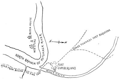
FORT CUMBERLAND AND VICINITY.
Reduced—but not in fac-simile—from a sketch among the Sparks maps in the library of Cornell University, kindly submitted to the editor by the librarian. The original is on a sheet 14 × 12 inches, and is endorsed on the back in Washington’s handwriting, apparently at a later date, “Sketch of the situation of Fort Cumberland.”
Parkman had already told the story of the Braddock campaign in his Conspiracy of Pontiac,[1302] but, with the aid of some material not accessible to Sargent, he retold it with greater fulness in his Montcalm and Wolfe (vol. i. ch. 7), and his story must now stand as the ripest result of investigations in which Bancroft[1303] and Sparks[1304] had been, as well as Sargent, his most fortunate predecessors, for Irving[1305] has done scarcely more than to avail himself gracefully of previous labors. The story as it first reached England[1306] will be found in the Gentleman’s Mag., and, after it began to take historic proportions, is given in Mante’s Hist. of the Late War in North America, London, 1772, and in Entick’s General History of the Late War, London, 1772-79.[1307] Braddock himself was not a man of mark to be drawn by his contemporaries, yet we get glimpses of his rather unenviable town reputation through the gossipy pen of Horace Walpole[1308] and the confessions of the actress, George Anne Bellamy,[1309] which Parkman and Sargent have used to heighten the color of his portraiture. He did not, moreover, escape in his London notoriety the theatrical satire of Fielding.[1310] His rise in military rank can be traced in Daniel MacKinnon’s Origin and Hist. of the Coldstream Guards, London, 1833. His[578] correspondence in America is preserved in the Public Record Office; and some of it is printed in the Colonial Records of Penna., vi., and in Olden Time, vol. ii.[1311] His plan of the campaign is illustrated in N. Y. Col. Docs., vi. 942, 954.[1312] Of the council which he held at Alexandria with Shirley and others, the minutes are given in the Doc. Hist. New York, ii. 648.[1313]
From Braddock’s officers we have letters and memoranda of use in the history of the movement. The Braddock orderly books in the library of Congress (Feb. 26-June 17, 1755) are printed in the App. of Lowdermilk’s Cumberland, p. 495. The originals are a part of the Peter Force Collection, and bear memoranda in Washington’s handwriting. His quartermaster-general, Sir John St. Clair, had arrived as early as January 10, 1755, to make preliminary arrangements for the march, and to inspect Fort Cumberland,[1314] which the provincials had been building as the base of operations.[1315]
From Braddock’s secretary, Shirley the younger, we have a letter dated May 23, 1755, which, with others, is in the Col. Rec. of Penna., vi. 404, etc. Of Washington, there is a letter used by Parkman in the Public Record Office.[1316] Of Gage, there is a letter to Albemarle in Keppel’s Life of Keppel, i. 213, and in the Mass. Hist. Soc. Coll., xxxiv., p. 367, is a statement which Gage prepared for the use of Chalmers. A letter of William Johnston, commissary, dated Philadelphia, Sept. 23, 1755, is in the Eng. Hist. Review (Jan., 1886), vol. i. p. 150. A letter of Leslie (July 30, 1755), a lieutenant in the 44th regiment, is printed in Hazard’s Penna. Reg., v. 191; and Ibid., vi. 104, is Dr. Walker’s account of Braddock’s advance in the field. Livingston, in his Rev. of Military Operations, 1753-56, gives a contemporary estimate.[1317] Other letters and traditions are noted in Ibid., iv. pp. 389, 390, 416.[1318] The depositions of some of the wagoners, who led in the flight from the field, are given in Col. Rec. of Penna., vi. 482.[1319]
The progress of events during the preparation for the march and the final retreat can be gleaned from the Dinwiddie Papers. Sargent found of use the Shippen MSS., in the cabinet of the Penna. Hist. Society. A somewhat famous sermon, preached by Samuel Davies, Aug. 17, 1755, before an independent troop in Hanover County, Va., prophesying the future career of “that heroic youth Col. Washington,”[1320] shows what an impression[579] the stories of Washington’s intrepidity on the field were making upon observers. The list of the officers present, killed, and wounded, upon which Parkman depends, is in the Public Record Office.[1321]
The news of the defeat, with such particulars as were first transmitted north, will be found in the New Hampshire Provincial Papers, vi. 413, and in Akins’ Pub. Doc. of Nova Scotia, 409, etc. The shock was unexpected. Seth Pomeroy, at Albany, July 15, 1755, had written that the latest news from Braddock had come in twenty-five days, by an Indian a few days before, and it was such that, in the judgment of Shirley and Johnson, Braddock was at that time in the possession of Duquesne. (Israel Williams MSS., i. p. 154.) Governor Belcher announced Braddock’s defeat July 19, 1755. New Jersey Archives, viii., Part 2d, 117. In a letter to his assembly, Aug. 1 (Ibid., p. 119), he says: “The accounts of this matter have been very various, but the most authentic is a letter from Mr. Orme wrote to Gov. Morris, of Pennsylvania.”
Governor Sharp’s letters to Lord Baltimore and Charles Calvert are in Scharf’s Maryland (i. pp. 465, 466).
The Rev. Charles Chauncy, of Boston, embodied the reports as they reached him (and he might have had excellent opportunity of learning from the executive office of Governor Shirley) in a pamphlet printed at Boston shortly after (1755), Letter to a friend, giving a concise but just account, according to the advices hitherto received, of the Ohio defeat.[1322]
Two other printed brochures are of less value. One is The life, adventures, and surprising deliverances of Duncan Cameron, private soldier in the regiment of foot, late Sir Peter Halket’s. 3d ed., Phila., 1756 (16 pp.).[1323] The other is what Sargent calls “a mere catch-penny production, made up perhaps of the reports of some ignorant camp follower.” The Monthly Review at the time exposed its untrustworthiness. It is called The expedition of Maj.-Gen’l Braddock to Virginia, ... being extracts of letters from an officer, ... describing the march and engagement in the woods. London, 1755.[1324]
Walpole[1325] chronicles the current English view of the time.
There was a young Pennsylvanian, who was a captive in the fort, and became a witness of the preparation for Beaujeu’s going out and of the jubilation over the return of the victors. What he saw and heard is told in An Account of the Remarkable Occurrences in the life and travels of Col. James Smith during his captivity with the Indians, 1755-59.[1326]
Let us turn now to the French accounts. The reports which Sparks used, and which are among his MSS. in Harvard College library, were first printed by Sargent in his fourth appendix.[1327] These and other French documents relating to the campaign have been edited by Dr. Shea in a collection[1328] called Relations diverses sur la bataille du Malangueulé [Monangahela] gagné le 9 juillet 1755, par les François sous M. de Beaujeu, sur les Anglois sous M. Braddock. Recueillies par Jean Marie Shea. Nouvelle York, 1860 (xv. 51 pp.).[1329]
Pouchot[1330] makes it clear that the French had no expectation of doing more than check the advance of Braddock.
The peculiar difficulties which beset the politics of Pennsylvania and Virginia at this time are concisely set forth by Sargent in the introduction of his Braddock’s Expedition (p. 61), and by Parkman in his Montcalm and Wolfe (vol. i. p. 329). Dulany’s letter gives a contemporary view of these dissensions.[1331]
The apathy of New Jersey drew forth rebuke from the Lords of Trade.[1332] Scharf[1333] describes the futile attempts of the governor of Maryland to induce his assembly to furnish supplies to the army.
The belief was not altogether unpopular in Pennsylvania, as well as in Virginia, that the story of French encroachments was simply circulated to make the government support the Ohio Company in their settlement of the country, and Washington complains that his report of the 1753 expedition failed to eradicate this notion in some quarters.[1334] In Pennsylvania[581] there were among the Quaker population unreconcilable views of Indian management and French trespassing, and similar beliefs obtained among the German and Scotch-Irish settlers on the frontiers of the province, while the English churchmen and the Catholic Irish added not a little to the incongruousness of sentiment. The rum of the traders among the Indians further complicated matters.[1335] This contrariety of views, as well as a dispute with the proprietary governor over questions of taxation, paralyzed the power of Pennsylvania to protect its own frontiers, when, following upon the defeat of Braddock, the French commander thrust upon the settlements all along the exposed western limits party after party of French and Indian depredators.[1336] Dumas, now in command, issued orders enough to restrain the barbarities of his packs, but the injunctions availed nothing.[1337] Washington, who was put in command of a regiment of borderers at Winchester, found it impossible to exercise much control in directing them to the defence of the frontiers thereabouts.[1338] Fears of slave insurrection and a hesitating house of burgesses were quite as paralyzing in Virginia as other conditions were in Pennsylvania, and the Dinwiddie Papers explain the gloom of the hour.
For the Pennsylvania confusion, the views of the anti-proprietary party found expression in the Historical Review of the Constitution and Government of Pennsylvania, a “hotly partisan and sometimes sophistical and unfair”[1339] statement, inspired and partly written by Franklin, the leader in the assembly against the Penns.[1340] While the quarrel went on, and the assembly was neglecting the petitions of the borderers for the organization of a militia to protect them, the two parties indulged in crimination and recrimination, and launched various party pamphlets at each other.[1341] The Col. Records of Penna. (vol. vi.) chronicle the progress of this conflict. We get the current comment in Franklin’s letters,[1342] in the histories of Pennsylvania, and in such monographs as Edmund de Schweinitz’s Life and Times of David Zeisberger (Philad., 1870),—for the massacre at Gnadenhütten brought the Moravians within the vortex, while the histories[1343] of the missions of that sect reiterate the stories of rapine and murder.
Patience ceased to be a virtue, and a “Representation”[1344] to the House was finally couched in the language of a demand for protection. The assembly mocked and shirked; but the end came. A compromise was reached by the proprietaries furnishing as a free gift the money which they denied as a tax on their estates, and Franklin undertook to manage the defence of the frontiers, with such force and munitions as were now under command.[1345]
Any history of the acquisition of lands by the English, particularly by Pennsylvania, shows why the Indians of the Ohio were induced at this time to side with the French.[1346]
Pownall, in his treatise[1347] on the colonies, classified the Indian tribes by their allegiance respectively to the English and French interests.[1348] It is claimed that the Iroquois were first allured by the Dutch, through the latter’s policy of strict compensation for lands, and that the retention of the Iroquois to the English interests arose from the inheritance of that policy by their successors at Albany and New York.[1349]
Braddock’s instructions to Shirley for the conduct of the Niagara expedition are printed in A. H. Hoyt’s Pepperrell Papers (1874), p. 20. This abortive campaign does not occupy much space in the general histories, and Parkman offers the best account. The Massachusetts Archives and the legislative Journal of that province, as well as Shirley’s letters, give the best traces of the governor’s efforts to organize the campaign.[1350] Some descriptive letters of the general’s son, John Shirley, will be found in the Penna. Archives, vol. ii.[1351] The best contemporary narratives in print are found in The Conduct of Shirley briefly stated, and in Livingston’s Review of Military Operations.[1352]
The main dependence in the giving of the story of the Lake George campaign of 1755 is, on the English side, upon the papers of Johnson himself, and they are the basis of[584] the Life and Times of Sir William Johnson,[1353] which, being begun by William L. Stone, was completed by a son of the same name, and published in Albany in 1865, in two volumes.[1354] The preface states that Sir William’s papers, as consulted by the elder Stone, consist of more than 7,000 letters and documents, which were collected from various sources, but are in good part made up of documents procured from the Johnson family in England, and of the Johnson MSS. presented to the N. Y. State library by Gen. John T. Cooper.[1355] An account of Johnson’s preparatory conferences with the Indians (June to Aug., 1755) is printed in N. Y. Col. Docs., vi. 964, etc., and in Penna. Archives, 2d ser., vi. 267-99.[1356] On the 22d of August Johnson held a council of war at the great carrying place,[1357] whence on the 24th he wrote a letter,[1358] while Col. Blanchard, of the New Hampshire regiment, a few days later (Aug. 28-30) chronicled the progress of events.[1359]
The account of the fight (Sept. 8), which Johnson addressed to the governors of the assisting colonies, was printed in the Lond. Mag., 1755, p. 544.[1360]
The sixth volume of the New York Col. Docs. (London documents, 1734-1755) contains the great mass of papers preserved in the archives of the State;[1361] but reference may also be made to vols. ii. 402, and x. 355. The Mass. Archives supplement them, and show many letters of Shirley and Johnson about the campaign.[1362] In the Provincial Papers of New Hampshire, vol. vi., there are various papers indicating the progress of the campaign, particularly (p. 439) a descriptive letter by Secretary Atkinson, dated Portsmouth, December 9, 1755, and addressed to the colony’s agent in London. It embodies the current reports, and is copied from a draft in the Belknap papers.[1363]
The jealousy between Massachusetts and New York is explained in part by Hutchinson.[1364] The Massachusetts assembly complained that Johnson’s chief communication was with New York, and, as was most convenient, he sent his chief prisoners to the seaport of that province, while they should have been sent, as the assembly said, to Boston, since Massachusetts bore the chief burden of the expedition.[1365] It was also complained that the £5,000 given by Parliament to Johnson was simply deducted from the appropriation for the colonies.[1366]
The jealousy of the two provinces was largely intensified in their chief men. Shirley did not hide his official eminence, and had a feeling that by naming Johnson to the command of the Crown Point expedition he had been the making of him. Johnson was not very grateful, and gained over the sympathy of De Lancey, the lieutenant-governor of New York.[1367]
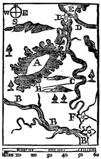
DIESKAU’S CAMPAIGN.
Fac-simile of the map in the Gentleman’s Mag., xxv. 525 (Nov., 1755), which is thus explained: “The French imagined the English army would have crossed the carrying place from Fort Nicholson at G [B in southeast corner?] to Fort Anne at F, and accordingly had staked Wood Creek at C to prevent their navigation; but Gen. Johnson, being informed of it, continued his route on Hudson’s River to H. The French marched from C to attack his advanced detachments near the lake. The dotted lines show their march. A, Lake George, or Sacrament. B, Hudson’s River. C, Wood Creek. D, Otter Creek. E, Lake Champlain. F, Fort Anne. G, Fort Nicholson. H, the place where Gen. Johnson beat the French. H C, the route of the French.”
A copy of the map used by Dieskau on his advance, and found among his baggage, as well as plans of the fort at Crown Point, are among the Peter Force maps in the Library of Congress. A MS. “Draught of Lake George and part of Hudson’s river taken Sept. 1756 by Joshua Loring” is also among the Faden maps (no. 19); as is also Samuel Langdon’s MS. Map of New Hampshire and the Adjacent Country (MS.), with a corner map of the St. Lawrence above Montreal, including observations of Lieut. John Stark.
Parkman received copies of the journal of Seth Pomeroy from a descendant, and Bancroft had also made use of it. A letter of Pomeroy, written to headquarters in Boston, is preserved in the Massachusetts Archives, “Letters,” iv. 109. He supposed himself at that time the only field-officer of his regiment left alive. The papers of Col. Israel Williams are in the Mass. Hist. Soc. library,[1368] and[586] give considerable help. The campaign letters of Surgeon Thomas Williams, of Deerfield, addressed chiefly to his wife (1755 and 1756), are in the possession of William L. Stone, and are printed in the Historical Magazine, xvii. 209, etc. (Apr., 1870).[1369] The French found in the pocket of a captured English officer a diary of the campaign, of which Parkman discovered a French version in the Archives of the Marine.
The Rev. Samuel Chandler, who joined the camp at Lake George in October as chaplain of a Massachusetts regiment, kept a diary, in which he records some details of the previous fights, as he picked them up in camp, giving a little diagram of the ambush into which Williams was led.[1370] In it are enumerated (p. 354) the various reasons, as he understood them, on account of which the further pursuit of the campaign was abandoned. Johnson’s chief of ordnance, William Eyre, advised him that his cannon were not sufficient to attack Ticonderoga.[1371] Parkman speaks of the text accompanying Blodget’s print[1372] and the Second Letter to a Friend as “excellent for information as to the condition of the ground and the position of the combatants.” Some months later, and making use of Blodget, Timothy Clement also published in Boston another print, which likewise shows the positions of the regiments after the battle and during the building of Fort William Henry.[1373]
There are three contemporary printed comments on the campaign. The first is a sequel to the letter written by Charles Chauncy on Braddock’s defeat, which was printed at Boston, signed T. W., dated Sept. 29, 1755, and called A second Letter to a Friend; giving a more particular narrative of the defeat of the French army at Lake George by the New England troops, than has yet been published, ... to which is added an account of what the New England governments have done to carry into effect the design against Crown Point, as will show the necessity of their being helped by Great Britain, in point of money.[1374] This and the previous letter were also published together under the title Two letters to a friend on the present critical conjuncture of affairs in North America; with an account of the action at Lake George, Boston, 1755.[1375]
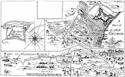
NOTE.
The sketch on the other side of this leaf follows an engraving, unique so far as the editor knows, which is preserved in the library of the American Antiquarian Society. It is too defective to give good photographic results. The print was “engraved and printed by Thomas Johnston, Boston, New England, April, 1756.”
The key at the top reads thus: “(1.) The place where the brave Coll. Williams was ambush’d & killed, his men fighting in a retreat to the main body of our army. Also where Capt. McGennes of York, and Capt. Fulsom of New Hampshire bravely attack’d ye enemy, killing many. The rest fled, leaving their packs and prisoners, and also (2.) shews the place where the valiant Col. Titcomb was killed, it being the westerly corner of the land defended in ye general engagement, which is circumscribed with a double line, westerly and southerly; (3.) with the sd double line, in ye form of our army’s entrenchments, which shows the Gen. and each Col. apartment. (4.) A Hill from which the enemy did us much harm and during the engagement the enemy had great advantage, they laying behind trees we had fell within gun-shot of our front. (W.) The place where the waggoners were killed.”
On the lower map is: “The prick’d line from South bay shews where Gen. Dieskau landed & ye way he march’d to attack our forces.”
The two forts are described: “Fort Edward was built, 1755, of timber and earth, 16 feet high and 22 feet thick & has six cannon on its rampart.”
“This fort [William Henry] is built of timber and earth, 22 feet high and 25 feet thick and part of it 32. Mounts 14 cannon, 33 & 18 pounders.”
The dedication in the upper left-hand corner reads: “To his Excellency William Shirley, esq., Captain general and Govr-in-chief in and over his Majesty’s Province of the Massachusetts Bay in New England, Major General and Commander-in-chief of all his Majesty’s land forces in North America; and to the legislators of the several provinces concerned in the expeditions to Crown Point,—this plan of Hudson River from Albany to Fort Edward (and the road from thence to Lake George as surveyed), Lake George, the Narrows, Crown Point, part of Lake Champlain, with its South bay and Wood Creek, according to the best accounts from the French general’s plan and other observations (by scale No. 1) & an exact plan of Fort Edward & William Henry (by scale No. 2) and the west end of Lake George and of the land defended on the 8th of Sept. last, and of the Army’s Intrenchments afterward (by scale 3) and sundry particulars respecting ye late Engagement with the distance and bearing of Crown Point and Wood Creek from No. 4, by your most devoted, humble servant, Timo. Clement, Survr. Havel. Feb. 10, 1756.”
The second is William Livingston’s Review of the military operations in North America from ... 1753 to ... 1756, interspersed with various observations, characters, and anecdotes, necessary to give light into the conduct of American transactions in general, and more especially into the political management of affairs in New York. In a letter to a nobleman, London, 1757.[1376]
The third is, like the tract last named, a defence of the commanding general of all the British forces in America, and is said to have been written by Shirley himself, and is called The Conduct of Major-General Shirley, late General and Commander-in-Chief of his Majesty’s forces in North America, briefly stated, London, 1758.[1377]
Dwight, in his Travels in New England and New York (vol. iii. 361), and Hoyt, in his Antiquarian Researches on the Indian Wars (p. 279), wrote when some of the combatants were still living. Dwight was the earliest to do General Lyman justice. Stone claims that the official accounts discredit the story told by Dwight, that Dieskau was finally shot, after his army’s flight, by a soldier, who thought the wounded general was feeling for a pistol, when he was searching for his watch.[1378]
Daniel Dulany, in a MS. Newsletter after the fashion of the day, gives the current accounts of the fight.[1379]
The story of the fight had been early told (1851) by Parkman in his Pontiac, revised in his second edition;[1380] and was again recast by him in the Atlantic Monthly (Oct., 1884), before the narrative finally appeared in ch. ix. of the first volume of his Montcalm and Wolfe.[1381]

FORT GEORGE AND TICONDEROGA.
After an inaccurate plan in the contemporary Mémoires sur le Canada, 1749-1760, as published by the Lit. and Hist. Soc. of Quebec (réimpression), 1873, p. 98. The French accounts often call Fort William Henry Fort George. Cf. the map in Moore’s Diary of the Amer. Revolution, i. p. 79.
The Catal. of the King’s Maps (Brit. Mus.), i. 424, shows a drawn map of the fort at the head of Lake George, under date of 1759, and (p. 425) another of the lake itself.
On the French side, the official report of Dieskau[1382] was used by Parkman in a copy belonging to Sparks, obtained from the French war archives, and this with other letters of Dieskau—one to D’Argenson, Sept. 14; another to Vaudreuil, Sept. 15—can be found in the N. Y. Col. Docs., vol. x. pp. 316, 318 (Paris Documents, 1745-78),[1383] as can the reports of Dieskau’s adjutant, Montreuil (p. 335), particularly those of Aug. 31 and Oct. 1, which, with other papers, are also preserved in the Mass. Archives, documents collected in France (MSS.), ix. 241, 265.[1384] The report made by Vaudreuil,[1385] as well as his strictures on Dieskau, is preserved in the Archives de la Marine, as is a long account by Bigot (Oct. 4, 1755),—both of which are used by Parkman. Cf. also the French narratives in the Penna. Archives, 2d ser., vi. 320, 324, 330. There is also in this same collection (p. 316) a Journal of occurrences, July 23 to Sept. 30, 1755, which is also in the N. Y. Col. Docs., x. p. 337, where are other contemporary[589] accounts, like the letter of Doreil to D’Argenson (p. 360) and those of Lotbinière (pp. 365, 369). The Mémoires of Pouchot is the main early printed French source; though there was a contemporary Gazette, printed in Paris, which will be found in the N. Y. Col. Docs., x. p. 383.
A paper in the Archives de la Guerre is thought by Parkman to have been inspired by Dieskau himself, and, in spite of its fanciful form, to be a sober statement of the events of the campaign. It is called Dialogue entre le Maréchal de Saxe et le Baron de Dieskau aux Champs Elysées.[1386] Some of the events subsequently related by Dieskau to Diderot are noticed in the latter’s Mémoires (1830 ed.), i. 402.
Henry Stevens, of London, offered for sale in 1872, in his Bibliotheca Geographica, no. 553, a manuscript record of events between 1755 and 1760, which came from the family of the Chevalier de Lévis. It purports to be the annual record of the French commanders in the field, beginning with Dieskau, for six successive campaigns. Stevens, comparing this record of Dieskau with such of the papers as are printed in the N. Y. Col. Docs., where they were copied from the documents as they reached the government in France, says that the latter are shown by the collection to have been “cooked up for the home eye in France,” and that “we lose all sympathy for the unfortunate Dieskau.” Stevens refers particularly to two long letters of Dieskau, Sept. 1 and 4, sent to Vaudreuil.[1387]
The feeling was rapidly growing that the next campaign should be a vigorous one. Gov. Belcher (Sept. 3, 1755) enforces his opinion to Sir John St. Clair, that “Canada must be rooted out.”[1388] The Gentleman’s Magazine printed papers of similar import.
In November, 1755, Belcher had written to Shirley, “Things look to me as if the coming year will be the criterion whereby we shall be able to conclude whether the French shall drive us into the sea, or whether King George shall be emperour of North America.”[1389] In December, Shirley assembled a congress of governors at New York, and laid his plans before them.[1390] When Shirley returned to Boston in Jan., 1756, the Journal of the Mass. House of Representatives discloses how active he was in preparing for his projects.[1391] Stone[1392] portrays the arrangements.
To Stone,[1393] too, we must turn to learn the efforts of Johnson to propitiate the Indians,[1394] in which he was perplexed by the movements in Pennsylvania and Virginia against the tribes in that region.[1395] The printed contemporary source, showing Johnson’s endeavors[590] with the Indians, is the Account of Conferences, London, 1756, which may be complemented by much in the Doc. Hist. N. Y., vols. i. and iv. Thomas Pownall published in New York, in 1756, Proposals for securing the friendship of the Five Nations. As the campaign went on, Johnson held conferences at Fort Johnson, July 21 (of which, under date of Aug. 12, he prepared a journal), and attended later meetings at German Flats, Aug. 24-Sept. 3, and again at Fort Johnson. These will be found in the Penna. Archives, 2d ser., vi. 461-496;[1396] and in the same volume, pp. 365-376, will be found the conference of deputies of the Five Nations, July 28, 1756, with Vaudreuil, at Montreal.[1397]
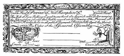
CROWN POINT CURRENCY OF NEW HAMPSHIRE.
From an original bill in an illustrated copy of Historical Sketches of the Paper Currency of the American Colonies, by Henry Phillips, Jr., Roxbury, 1865,—in Harvard College library.
The early events of the year, like the capture of Fort Bull,[1398] find illustrations in various papers in the Doc. Hist. N. Y., vol. i. 509, and N. Y. Col. Docs. x. 403, with some local associations in Benton’s Herkimer County.
The centre of preparation for the campaign during the winter was in Boston, and Parkman[1399] shows the methods of military organization which the New England colonies, with some detriment to efficiency employed. He finds his material for the sketch in the manuscripts of the Mass. Archives (“Military”), vols. lxxv. and lxxvi., and in equivalent printed papers in R. I. Colonial Records, v., and N. H. Provincial Papers, vi. The latter colony issued bills this year, as they had the previous season, called Crown Point currency, in aid of the expedition, a fac-simile of one of which is annexed.[1400]
Another main source for these preliminaries, as well as for the routine of the campaign later in Albany and at Lake George is the Journal of General John Winslow, who, after some coquetting with Pepperrell on Shirley’s part, was finally selected for the command of the expedition against Crown Point.[1401] The second volume of this journal, which is in the library of the Mass. Hist. Society, covers Feb.-Aug., and the third, Aug.-Dec., 1756. They consist of transcripts of letters, orders, etc., chronologically arranged.
The volumes labelled “Letters” in the Massachusetts Archives (MSS.) contain various letters, which depict the condition of the camps and the progress of the campaign. Parkman[1402] refers to them, as well as to a report of Lieut.-Col. Burton to Loudon on the condition of the camps,[1403] and to the journal of John Graham, a chaplain in Lyman’s Connecticut regiment.[1404]
Shirley rightfully understood the value of Oswego to the colonies. As Parkman[1405] says, “No English settlement on the continent was of such ill omen to the French. It not only robbed them of the fur-trade, but threatened them with military and political, no less than commercial ruin.” The previous French governor, Jonquière, had been particularly instructed to compass its destruction, above all by inciting the Iroquois to do it, if possible, for the post was a menace in the eyes of the Indians. Shirley hoped to redeem the failure of last year, and he had the satisfaction of hearing of Bradstreet’s success in the midst of the personal detraction which assailed him.[1406] The military interest of the year, however, centres in the siege and fall of Oswego (Aug. 14), introducing Montcalm on the scene.[1407] Capt. John Vicars, a British officer who was with Bradstreet, gives an account of the fortifications, which Parkman[1408] uses. The correspondence of Loudon and Shirley in the English archives marks the progress of events.[1409] Respecting the siege itself there is a letter, from an officer present, in the Boston Evening Post, May 16, 1757. Stone[1410] uses MS. depositions of two of the English prisoners who escaped from the French.[1411] A declaration by soldiers of Shirley’s regiment is printed in the N. Y. Col. Docs., vii. 126.
Of the contemporary printed sources, note must be made of the “State of facts” in the Lond. Mag., 1757, p. 14; of the Conduct of General Shirley, etc., p. 110; of Livingston’s Review; of The military history of Great Britain for 1756-57. Containing a letter from an English officer at Canada, taken prisoner at Oswego, exhibiting the cruelty of the French. Also a journal of the Siege of Oswego, London, 1757.[1412]
Of somewhat less authority is a popular book, French and Indian cruelty exemplified in the life of Peter Wilkinson, with “accurate detail of the operations of the French and English forces at the siege of Oswego.”[1413] Of a more general character are the accounts in Mante,[1414] Smith,[1415] and Hutchinson.[1416]
Parkman, who sketches the early career of Montcalm,[1417] surveys the chief French authorities on the siege, as gathered mainly from the Archives of the Marine and those of War, at Paris;[1418] the Livre des Ordres; Vaudreuil’s instructions to Montcalm, July 21; the journal of Bougainville; the letters of Vaudreuil, Bigot, and Montcalm. The N. Y. Col. Docs. (vol. x.) contain various translations of these,[1419] including (p. 440) a journal of the siege transmitted by Montcalm; other versions are in the Doc. Hist. N. Y., vol. i.
There was printed at Grenoble, in 1756, a Relation de la prise des forts de Choueguen, ou Oswego, & de ce qui s’est passée cette année en Canada. A small edition was privately reprinted in 1882, from a copy belonging to Mr. S. L. M. Barlow, of New York.[1420] Martin, in his De Montcalm en Canada, ch. iii., presents the modern French view, as also does Garneau, Hist. du Canada, 4th ed., vol. ii. 251. Maurault, in his Hist. des Abénakis (1866), tells the part of the Indians in the siege.
Of the partisan warfare conducted by Rogers and Putnam, we have the best accounts in the reports which the former made to his commanding officer.[1421] These various reports constitute the volume which was published in London in 1765 “for the author,” called Journals of Major Robert Rogers, containing an account of the several excursions he made under the generals who commanded, during the late war.[1422] Rogers’ Journals are written in a direct way, apparently without exaggeration, but sometimes veil the[593] atrocities which he had not screened in the original reports.[1423] Parkman points out that the account of his scout of Jan. 19, 1756, is much abridged in the composite Journals.
The exploits of Rogers are frequently chronicled in Winslow’s Journal, and there are other notes in the Mass. Archives, vol. lxxvi. Parkman cites Bougainville’s Journal as giving the French record.[1424] There is a contemporary account of one of Rogers’ principal actions, in what Trumbull[1425] calls “perhaps the rarest of all narratives of Indian captivities.” The edition which is mentioned is a second one, published at Boston in 1760, and Sabin[1426] does not record the first. It is called A plain narrative of the uncommon sufferings and remarkable deliverance of Thomas Brown, of Charlestown in New England, who returned to his father’s house the beginning of Jan., 1760, after having been absent three years and about eight months; containing an account of the engagement, Jan., 1757, in which Captain Spikeman was killed and the author left for dead.
Of Putnam’s exploits there is a report (Oct. 9, 1755) in the Doc. Hist. N. Y., iv. p. 172. The Life of Putnam by Humphreys chronicles his partisan career, while that by Tarbox passes it over hurriedly. Hollister’s and other histories of Connecticut give it in outline.
The circulars of Pitt to the colonies, asking that assistance be rendered to Loudon, and (Feb. 4, 1757) urging the raising of additional troops, is in New Jersey Archives, viii. Pt. ii. pp. 209, 241. There are in the Israel Williams MSS. (Mass. Hist. Soc.) letters of Loudon, dated Boston, Jan. 29 and Feb., 1757, respecting the organization of the next campaign.
For the attack on Fort William Henry (1757) conducted by Rigaud, Parkman[1427] cites, as usual, his MS. French documents,[1428] but gives for the English side a letter from the fort (Mar. 26, 1757), in the Boston Gazette, no. 106, and in the Boston Evening Post, no. 1,128; with notes of other letters in the Boston News-Letter, no. 2,860.
The best account yet published of Montcalm’s later campaign against Fort William Henry (the Fort George of the French) is contained in the last chapter of the first volume of Parkman’s Montcalm and Wolfe.[1429]
On the French side there is the work of Pouchot, and Dr. Hough’s translation of it (i. 101). The Rough List of Mr. Barlow’s library (no. 941) shows, as the only copy known, a Relation de la prise du Fort Georges, ou Guillaume Henry, situé sur le lac Saint-Sacrement, et de ce qui s’est passé cette année en Canada (12 pp.), Paris, 1757.
Of the documentary evidence of the time Parkman makes full use. He secured from the Public Record Office in London the correspondence of Webb and a letter and journal of Colonel Frye, who commanded the Massachusetts troops, and from these he gives extracts in his Appendix F.[1430]
In the Paris documents as gathered (copies) in the archives at Albany,[1431] and in the copies of other documents from France, supplementing these, and contained in the series of MSS. given by Mr. Parkman to the Mass. Historical Society, there are the Journal of Bougainville, “a document,” says Parkman, “hardly to be commended too much,” the diary of Malartic, the correspondence of Montcalm, Lévis, Vaudreuil, and Bigot. In adding to the graphic details of the theme, there is a long letter of the Jesuit Roubaud, which is printed in the Lettres Edifiantes et Curieuses.[1432]
Jonathan Carver, who was a looker-on, has given an account in his Travels, which Parkman thinks is trustworthy so far as events came under Carver’s eye.[1433]
The journals of the Montresors, father and son, Colonels James and John, during their stay in 1757-59 in the neighborhood of Forts William Henry and Edward, throw light upon the spirit of the time.[1434] They are preserved in the family in England, and, edited by G. D. Scull, have been printed in the N. Y. Hist. Coll., 1881, accompanied by heliotypes of portraits of the two engineers.[1435]
Living at the time, and enjoying good advantages for acquiring knowledge, Hutchinson, in his Massachusetts (vol. iii. p. 60), might have given us more than he does, but his purpose was mainly to show the effect of the campaign upon that colony. It is noticeable, however, that he says the victims of the massacre were not many in number. Most later writers on the English side add little or nothing not elsewhere obtainable.[1436]
Bancroft[1437] made use of a considerable part of the material available to Parkman; but his latest revision does not add to his earlier account.
Dwight, in his Travels in New England and New York,[1438] who remembered the event as a child, expresses the view which long prevailed in New England, that Montcalm made no reasonable effort to check the Indians, and emphasizes the timidity and imbecility of Webb, who lay at Fort Edward with 6,000 men, doing nothing. Dwight narrates as from Captain Noble, who was present, that when Sir William Johnson would gather volunteers from Webb’s garrison to proceed to Munro’s assistance Webb forbade it.[1439]
Respecting the attack in the autumn (Nov. 28, 1757) on German Flats, there are the despatches of Vaudreuil, the Journal of Bougainville, and papers in Doc. Hist. N. Y., i. 520, and N. Y. Col. Docs., x. 672, the latter being a French summary of M. de Belêtre’s campaign. Loudon’s despatch to Pitt, Feb. 14, 1758, is the main English source.[1440]
While Webb held the chief command at Albany, Stanwix was organizing, with the help of Washington, the defence along the Pennsylvania and Virginia borders, and Bouquet further south.[1441] The lives of Washington and the histories of those provinces trace out the events of the summer in that direction. The main thread of this history is the precarious relation of the provinces with the Indians, and much illustrative of this connection is found in the Penna. Col. Rec., vol. vii. Dr. Schweinitz’s Life of Zeisberger and the various Moravian chronicles show how that people strove to act as intermediaries.
The Delawares had not forgotten the deceit practised upon them at Albany in 1754, in inveigling them into giving a deed of lands, and Sir William Johnson was known to be in favor of revoking that fraudulent purchase. Conferences with the Indians were numerous,[596] even after the spring opened.[1442] Johnson received the deputies of the Shawanese and Delawares at Fort Johnson in April, and concluded a treaty with them.[1443]
It boded no good that the Six Nations also, in April, had sent deputies to Vaudreuil, and all through the spring the region north of the Mohawk was the scene of rapine.[1444] The truth was, the successes of the French had driven the westerly tribes of the Six Nations into a neutrality, which might turn easily into enmity, and to confirm them in their passiveness, and to incite the Mohawks and the easterly tribes into active alliance, Johnson, who knew his life to be in danger, summoned the deputies of the confederacy to meet him at Johnson Hall on the 10th of June. His journal for some time previous to the meeting is printed by Stone.[1445] Johnson accomplished all he could hope for. His answer to the Senecas of June 16 is in the Penna. Archives, vi. 511. Under his counsel, the final conclusion with the Indians farther south was reached in a conference at Easton, in Pennsylvania, in July and August.[1446]
Of the defeat of Rogers in March, which opened the campaign of 1758, his own report after he got into Fort Edward, printed at the time in the newspapers, is mainly given in his Journals, together with a long letter of two British regular officers who accompanied him, and who in the fight escaped capture, but wandered off in the woods, till hunger compelled them to seek the French fort, whence by a flag of truce they despatched (Mar. 28) their narrative. The French accounts are derived from the usual documentary sources as indicated by Parkman (ii. p. 16).
The English historians of the war in Europe all describe the change in political feeling which brought Pitt once more into power, with popular sympathy to sustain him.[1447] The public had aroused to the incompetency of the English military rule in America, and upon the importance of making head there against the French, as a vantage for any satisfactory peace in Europe.[1448] This revulsion is best described in Parkman[1449] and in Bancroft.[1450] The letter of Pitt recalling Loudon (who was not without his defenders[1451]), as addressed to the governor of Connecticut, is in the Trumbull MSS., vol. i. p. 127.
The condition of the camp at Lake George in the spring and early summer is to be studied in the official papers, as well as in letters printed in the Boston News-Letter and in[597] the Boston Evening Post.[1452] Parkman describes from the best sources the fort and the outer entrenchments.[1453]
The official reports on the English side of the fight on July 8th are in the Public Record Office. The letter which Abercrombie addressed to Pitt from Lake George, July 12, as it appeared in the London Gazette Extraordinary, Aug. 22, is printed in the N.Y. Col. Docs., x. 728. Dwight represents the opinions of Abercrombie’s generalship as current in the colonies,[1454] and we read in Smith’s New York, vol. ii. p. 264, that the difficulty “appeared to be more in the head than the body.” The diary of William Parkman, a youth of seventeen, who was in a Massachusetts regiment, reflects the charitable criticism of his troops, when the diarist calls their commander “an aged gentleman, infirm in body and mind.”[1455] We have various other descriptions and diaries from officers engaged.[1456]
Parkman[1457] collates the different authorities as respects the losses on the two sides,[1458] and[598] his details are the best of all the later historians.[1459] Of the French contemporary accounts, which are numerous, there are several from the Paris Archives in the Parkman MSS., which have been used for the first time in his Montcalm and Wolfe. Some of the more important ones are printed in the N. Y. Col. Docs. x.[1460]
There is an account in Pouchot, and Chevalier Johnstone’s “Dialogue in Hades” is in the Transactions of the Lit. and Hist. Soc. of Quebec, and summarized accounts in Martin’s De Montcalm en Canada, ch. vii., and in Garneau’s Canada, p. 279.[1461] For the life of the camp later established at the head of Lake George, there are items to be drawn, not only from the official reports, but from the Israel Williams MSS. Parkman (ii. 117) uses a diary of Chaplain Cleaveland. An orderly book of Col. Jonathan Bagley, of a Connecticut regiment, covering Aug. 20-Sept. 11, 1758, is in the library of the American Antiq. Society.[1462] It indicates that the celebration at Lake George of the victory at Louisbourg took place Aug. 28, as does an orderly book of Rogers’ Rangers, covering Aug.-Nov., 1758, at Lake George and Fort Edward.[1463]
Of the autumn scouting, there are letters in the Boston Weekly Advertiser, the centre of interest being the fight between Rogers and Morin.[1464]
Of the Frontenac expedition, Bradstreet’s own report to Abercrombie is in the Public Record Office. Parkman uses it, as well as letters in the Boston Gazette, no. 182; Boston Evening Post, no. 1,203; Boston News-Letter, no. 2,932; N. H. Gazette, no. 104. The articles of capitulation are in the N. Y. Col. Docs., x. 826. Smith (New York, ii. 266), speaking of Bradstreet’s expedition, says he “rather flew than marched.”[1465]
On the French side, there are the official documents, the Mémoire sur la Canada, 1749-60 (published by the Lit. and Hist. Soc. of Quebec), and Pouchot, i. 162.
The loss of Frontenac gave rise to a disagreement between Vaudreuil and Montcalm as to the dispositions to be made upon Lake Ontario, and the papers which passed between them are in the N. Y. Col. Docs., x. 866, etc., as well as others on the conflict of their opinions respecting the defence of Ticonderoga (Ibid., p. 873, etc.).
The main sources for the Duquesne expedition of 1758 are in the Public Record Office, America and West Indies, including the correspondence of Forbes.[1466] There are also papers in the Col. Records of Penna. and Pennsylvania Archives. The letters of Washington in Sparks’ Washington (vol. ii.) may be supplemented by the fuller text of the same, and by others, in Bouquet and Haldimand Papers, in the British Museum. Washington’s letters to Bouquet are in Additional MSS., vol. 21, 641, of the British Museum, and there is a copy of them among the Parkman MSS.[1467] There is a letter of a British officer in the Gent. Mag., xxix. 171. For the new route made by Forbes, see Lowdermilk’s Cumberland, p. 238. The routes of Braddock and Forbes are marked on the map given in Sparks’ Washington, ii. 38, and Washington’s opinion of their respective advantages is in Ibid., ii. 302.
Of Grant’s defeat, the principal fight of the campaign, there are contemporary accounts in the Penna. Gazette,[1468] Boston Evening Post, Boston Weekly Advertiser, Boston News-Letter, etc.; in Hazard’s Penna. Reg., viii. 141; in Olden Time, i. p. 179. Grant’s imprudence met with little consideration in England. (Grenville Correspondence, i. 274.)
The account of Post’s embassy, July 15 to Sept., 1758, appeared in London in 1759, as the Second Journal of Christian Frederick Post.[1469]
Parkman,[1470] Bancroft,[1471] and Irving,[1472] of course, tell the story of Forbes’s campaign,—the first with the best help to sources.[1473]
The concomitants of the winter of 1758-59 in Canada must be studied in order to comprehend the inequality of the two sides in the signal campaign which was to follow. Parkman finds the material of this study in the documents of the Archives de la Marine et de la Guerre in Paris; in the correspondence of Montcalm, of which he procured copies from the present representative of his family, including the letters of Bougainville[1474] and[600] Doreil[1475] on their Paris mission; and in the letters of Vaudreuil, in the Archives Nationales.[1476] Much throwing light on the strained relations between the general and the governor will be found in the N. Y. Col. Docs., vol. x.[1477] French representations of the situation in Canada are given in the Considérations sur l’État présent du Canada, published by the Literary and Historical Society of Quebec in 1840, sometimes cited as Faribault’s Collection de Mémoires, no. 3. Further use may be made of Mémoire sur le Canada, 1749-1760, en trois parties, Quebec, 1838.[1478]
The comparative inequality of the two combatants was a fruitful subject of inquiry then, especially upon the French side. There is in the Penna. Archives, 2d series, vi. 554, a French Mémoire, setting forth their respective positions, needs, and resources, dated January, 1759, and similar documents are given in the N. Y. Col. Docs., x. 897, 925, 930.
Later writers, with the advantage of remoteness, have found much for comment in the several characteristics, experiences, aims, and abilities of the two warring forces. These are contrasted in Warburton’s Conquest of Canada.[1479] Judge Haliburton[1480] points out the great military advantages of the paternal and despotic government of Canada. Viscount Bury, in his Exodus of the Western Nations,[1481] compares the outcome of their opposing systems. Parkman gives the last chapter of his Old Régime in Canada to a vigorous exposition of the subject. The institutional character of the English colonists, developed from the circumstances of their life, is compared with the purpose of the French colonists to reproduce France, in E. G. Scott’s Development of Constitutional Liberty in the English Colonies of America.[1482]
Among the later French authors, Rameau, in his France aux Colonies (Paris, 1859), writes in full consciousness of the limitations and errors of policy which deprived France of her American colonies.[1483] The efforts which were made to propitiate the Indians before the campaign opened are explained in Stone’s Life of Johnson, ii. ch. v., and in the N. Y. Col. Docs., vii. 378.
Upon the movement to render secure the new fort at Pittsburgh, Parkman found in the Public Record Office, in London, letters of Col. Hugh Mercer (who commanded), January-June, 1759; letters of Brigadier Stanwix, May-July;[1484] and a narrative of John Ormsby, beside a letter in the Boston News-Letter, no. 3,023. In the Wilkes Papers, in the Historical MSS. Commission Report, No. IV., p. 400, are long and interesting accounts of affairs at this time in Pennsylvania, written from Philadelphia to Wilkes by Thomas Barrow (May 1, 1759).
The Niagara expedition was a mistake, in the judgment of some military critics, since the troops diverted to accomplish it had been used more effectually in Amherst’s direct march to Montreal. More expedition on that general’s part in completing his direct march[601] would have rendered the fall of Niagara a necessity without attack. Perhaps the risk of leaving French forces still west of Niagara, ready for a siege of Fort Pitt, is not sufficiently considered in this view.[1485]
The Public Record Office yields Amherst’s instructions and letters to Prideaux, and the letters of Johnson to Amherst. Stone[1486] prints Johnson’s diary of the expedition, and the Haldimand Papers in the British Museum throw much light.[1487] Letters of Amherst are in the N. Y. State Library at Albany.
On the French side, the account in Pouchot’s Mémoires sur la dernière guerre[1488] is that of the builder and defender of the fort.[1489] His narrative is given in English in N. Y. Col. Docs., x. 977, etc., as well as in Hough’s ed. of Pouchot. The letters of Vaudreuil from the French Archives are in the Parkman MSS. The English found in the fort a French journal (July 6-July 24, 1759), of which an English version was printed in the N. Y. Mercury, Aug. 20, 1759. It is also given in English in the Hist. Mag. (March, 1869), xv. p. 199.
For the Oswego episode, beside Pouchot,[1490] see Mémoire sur le Canada, 1749-60, and a letter in the Boston Evening Post, no. 1,248.
The best recent accounts are in Parkman’s Montcalm and Wolfe, ii. ch. 26; Warburton’s Conquest of Canada, ii. ch. 9, and Stone’s Life of Johnson, vol. ii.
Johnson’s diary, as given by Stone,[1491] shows how undecided, under Amherst’s instructions, Gage was about attacking the French at La Galette, on the St. Lawrence.
Gage, who, in August and September, 1759, was at Oswego, was much perplexed with the commissary and transportation service, but got relief when Bradstreet undertook to regulate matters at Albany.[1492]
While the expeditions of Stanwix and Prideaux constituted the left wing of the grand forward movement, that conducted by Amherst himself was the centre.
The letters of Amherst to Pitt and Wolfe are in the Public Record Office in London,[1493][602] as well as a journal of Colonel Amherst, a brother of the general. Mante and Knox afford good contemporary narratives.[1494]
The best general historians are Parkman (ii. 235, etc.), Bancroft (orig. ed., iv. 322; final revision, ii. 498); Warburton’s Conquest of Canada, ii. ch. 8. For local associations, see Holden’s Hist. of Queensbury, p. 343.[1495]
Bourlamaque’s account of his retreat is in N. Y. Col. Docs., x. 1,054. Pitt’s letter, when he learned that Amherst had abandoned the pursuit, is in Ibid., vii. 417.
Rogers sent to Amherst a letter about his raid upon the St. Francis village, which was written the day after he reached the settlements on the Upper Connecticut, and it makes part of his Journals. The story was the subject of recitals at the time in the provincial newspapers, like the New Hampshire Gazette and the Boston Evening Post. Hoyt, in his Antiquarian Researches (p. 302), adds a few particulars from the recollections of survivors.[1496]
In coming to the great victory which virtually closed the war on the Heights of Abraham, we can but be conscious of the domination which the character of Wolfe holds over all the recitals of its events, and the best source of that influence is in the letters which Wright has introduced into his life of Wolfe.[1497]
To the store of letters in Wright, Parkman sought to add others from the Public Record Office, beside the secret instructions given by the king to Wolfe and Saunders. The despatches of Wolfe, as well as those of Saunders, Monckton, and Townshend, are found, of course, in the contemporary magazines. A few letters of Wolfe, not before known, preserved among the Sackville Papers, have recently been printed in the Ninth Report of the Hist. MSS. Commission, Part iii. pp. 74-78. (Brit. Doc. Reports, 1883, vol. xxxvii.)[1498]
There is a printed volume which is known as Wolfe’s instructions to young officers (2d ed., London, 1780), which contains his orders during the time of his service in Canada. Manuscript copies of it, seemingly of contemporary date, are occasionally met with, and usually begin with orders in Scotland in 1748, and close with his last order on the “Sutherland,” Sept. 12, 1759.[1499] The general orders of the Quebec campaign, given at greater length than in these Instructions, have been printed in the Hist. Docs., 4th ser., published by the Lit. and Hist. Soc. of Quebec. Various orders are given in the Address of Lorenzo Sabine, on the centennial of the battle.[1500]
A large number of contemporary journals and narratives of the siege of Quebec, both on the English and French sides, have been preserved, most of which have now been printed.[1501]
The letters of Montcalm in the Archives de la Marine mostly pertain to events antecedent to the investment of Quebec. The letters of Vaudreuil are in the Archives Nationales,[1502][605] while those of Bigot, Lévis, and Montreuil are in the Archives de la Marine et de la Guerre.[1503]
Parkman has a note[1504] on the contemporary accounts of Montcalm’s death[1505] and burial, and in the Mercure Français is an éloge on the French general, which is attributed to Doreil. Some recollections of Montcalm in his last hours are given in a story credited to Joseph Trahan, as told in the Revue Canadienne, vol. iv. (1867, p. 850) by J. M. Lemoine,[606] in a paper called “Le régiment des montagnards écossais devant Quebec, en 1759,” which in an English form, as “Fraser’s Highlanders before Quebec,” is given in Lemoine’s Maple Leaves, new series, p. 141.
There is a story, told with some contradictions, that Montcalm entrusted some of his letters to the Jesuit Roubaud. Parkman, in referring to the matter, cites[1506] Verreau’s report on the Canadian Archives (1874, p. 183), and the “Deplorable Case of M. Roubaud,” in Hist. Mag., xviii. 283.[1507]
Referring to the principal English contemporary printed sources, Parkman (ii. 194) says that Knox, Mante, and Entick are the best. Knox’s account is reprinted by Sabine in an appendix. Using these and other sources then made public, Smollett has told the story very intelligently in his History of England, giving a commensurate narrative in a general way, and has indicated the military risks which the plan of the campaign implied. The summary of the Annual Register[1508] is well digested.
In the Public Documents of Nova Scotia there are papers useful to the understanding of the fitting out of the expedition.
Jefferys intercalated in 1760, in his French Dominions in North America, sundry pages, to include such a story of the siege as he could make at that time.[1509]
Of the later English writers on the siege, it is enough barely to mention some of them.[1510]
Parkman first told the story in his Pontiac (vol. i. 126), erring in some minor details, which he later corrected when he gave it more elaborate form in the Atlantic Monthly (1884), and engrafted it (1885) in final shape in his Montcalm and Wolfe (vol. ii.).
The recent histories of Canada, like Miles’, etc., and such general works as Beatson’s Naval and Mil. Memoirs (ii. 300-308), necessarily cover the story; and there is an essay on Montcalm by E. S. Creasy, which originally appeared in Bentley’s Magazine (vol. xxxii. 133).[1511] Carlyle repeats the tale briefly, but with characteristic touches, in his Friedrich II. (vol. v. p. 555).
On the French side the later writers of most significance, beside the general historian of Canada, Garneau,[1512] are Felix Martin in his De Montcalm en Canada (1867), ch. 10, which was called, in a second edition, Le Marquis de Montcalm et les dernières années de la colonie Française au Canada, 1756-1760 (3d ed., Paris, 1879); and Charles de Bonnechose in his Montcalm et le Canada Français, which appeared in a fifth edition in 1882.[1513]
As to the forces in the opposing armies, and the numbers which the respective generals brought into opposition on the Heights of Abraham, there are conflicting opinions. Parkman[1514] collates the varying sources. Cf. also Martin’s De Montcalm en Canada, p. 196; Miles’ Hist. of Canada, app., etc.; Collection de Manuscrits (Quebec), iv. 229, 230.
The record of the council of war (Sept. 15) which Ramezay held after he found he had been left to his fate by Vaudreuil is given in Martin’s De Montcalm en Canada (p. 317), and in the N. Y. Col. Docs., x. 1007. Ramezay prepared a defence against charges of too easily succumbing to the enemy, and this was printed in 1861 by the Lit. and Hist. Soc. of Quebec, as Mémoire du Sieur de Ramezay, Commandant à Quebec, au sujet de la reddition de cette ville, le 18 septembre, 1759, d’après un manuscrit aux Archives du Bureau de la Marine à Paris. The paper is accompanied by an appendix of documentary proofs, including the articles of capitulation, which are also to be found in the appendix of Warburton’s Conquest of Canada (vol. ii. p. 362), N. Y. Col. Docs., x. 1011, and in Martin (p. 317).
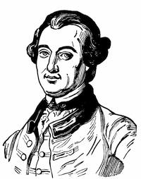
TOWNSHEND.
From Doyle’s Official Baronage, iii. 543.
It has been kept in controversy whether Vaudreuil really directed Ramezay to surrender,[1515] but the note sent by Vaudreuil to Ramezay at nine in the evening, Sept. 13, instructing him to hoist the white flag when his provisions failed, is in N. Y. Col. Docs., x. 1004.
General Townshend returned to England, and when he claimed more than his share of the honors[1516] a Letter to an Honourable Brigadier General (London, 1760) took him sharply to task for it, and rehearsed the story of the fight.[1517] This tract was charged by some upon Charles Lee, but when it was edited by N. W. Simons, in 1841, an attempt by parallelisms of language, etc., was made to prove the authorship of Junius in it. It was answered by A refutation of a letter to an Hon. Brigadier by an officer.[1518] Parkman calls it “angry, but not conclusive.” There were other replies in the Imperial Magazine, 1760. Sabine, in his address, epitomizes the statements of both sides.
On the 17th of January, 1760, Pitt addressed Amherst respecting the campaign of the following season,[1519] and on April 27th Amherst addressed the Indians in a paper dated Fort George, N. Y., April 27.[1520] Letters had passed between Amherst and Johnson in March, about the efforts which were making by a conference at Fort Pitt to quiet the Indians in that direction.[1521] Later there were movements to scour the country lying between Fort Pitt and Presqu’isle, as shown in the Aspinwall Papers,[1522] where[1523] there is a fac-simile of a sketch of the route from Fort Pitt, passing Venango and Le Bœuf, which Bouquet sent to Monckton in August, 1760.
The earliest description of this country after it came into English hands is in a journal (July 7-17, 1760) by Capt. Thomas Hutchins, of the Sixtieth Regiment, describing a march from Fort Pitt to Venango, and from thence to Presqu’isle, which is printed in the Penna. Mag. of Hist. (ii. 849).
Bourlamaque, in a Mémoire sur Canada, which he wrote in 1762, presents Quebec as the key to the military strength of the province.[1524]
The interest of the winter and spring lies in the vigorous efforts of Lévis to recover Quebec. The English commander, Murray, kept a journal from the 18th of September till the 25th of May. The original was in the London War Office, and Miles used a copy from that source. Parkman records it as now being in the Public Record Office,[1525] and says it ends May 17; and the reprint of the Lit. and Hist. Soc. of Quebec credits it to the same source, in their third series (1871).
Parkman[1526] refers to a plan among the King’s Maps (Brit. Mus.) of the battle and situation of the British and French on the Heights of Abraham, 28 April, 1760.
This engagement is sometimes called the battle of Sillery, though the more common designation is the battle of Ste. Foy.
Murray’s despatch to Amherst, April 30, is among the Parkman Papers, and that to Pitt, dated May 25, 1760, is in Hawkins’ Picture of Quebec, and in W. J. Anderson’s Military Operations at Quebec from Sept. 18, 1759, to May 18, 1760, published by the Lit. and Hist. Soc. of Quebec (1869-70), and also separately. It is a critical examination of the sources of information respecting the battle, particularly as to the forces engaged. Parkman (ii., app., p. 442) examines this aspect also.
We have on the English side the recitals of several eye-witnesses. Knox[1527] was such. So were Mante, Fraser, and Johnson; the journals of the last two are those mentioned on a preceding page. Parkman, who gives a list of authorities,[1528] refers to a letter of an officer of the Royal Americans at Quebec, May 24, 1760, printed in the London Magazine, and other contemporary accounts are in the Gentleman’s and English Magazine (1760). There is also a letter in the N. Y. Geneal. and Biog. Record, April, 1872, p. 94.
The principal French contemporary account is that of Lévis, Guerre du Canada, Relation[609] de la seconde Bataille de Québec et du Siége de cette ville,—a manuscript which, according to Parkman, has different titles in different copies, and some variations in text. Vaudreuil’s instructions to Lévis are in the N. Y. Col. Docs., x. 1069. There is a journal of the battle annexed to Vaudreuil’s letter to Berryer, May 3, 1760, in N. Y. Col. Docs., x. 1075, 1077. The Parkman MSS. have also letters of Bourlamaque and Lévis, and there is something to be gleaned from Chevalier Johnston and the Relation of the hospital nun, already referred to.
Of the modern accounts by the Canadian historians, Lemoine[1529] calls that of Garneau[1530] the best, and speaks of it as collated from documents, many of which had never then (1876) seen the light. Smith takes a view quite opposite to Garneau’s, and Lemoine[1531] charges him with glossing over the subject “with striking levity.”[1532]
Col. John Montresor was in the force which Murray led up the river to Montreal, and we have his journal, July 14-Sept. 8, 1760, in the N. Y. Hist. Soc. Coll., 1881, p. 236.
For the progress of the converging armies of Amherst and Haviland, there are the histories of Mante and Knox and the journals of Rogers. Parkman adds a tract printed in Boston (1760), All Canada in the hands of the English. Beside the official documents of the Parkman MSS., he also cites a Diary of a sergeant in the army of Haviland, and a Journal of Colonel Nathaniel Woodhull.[1533] There is a glimpse of the condition of the country to be got from the Travels and Adventures of Alexander Henry in Canada and the Indian territory, 1760-1776 (New York, 1809).
Amherst’s letter to Monckton on the capture of Fort Lévis is in the Aspinwall Papers (Mass. Hist. Soc. Coll., xxxix. 307), and reference may be made to Pouchot (ii. 264), Mante (303), and Knox (ii. 405).[1534]
Parkman uses the Procès verbal of the council of war which Vaudreuil held in Montreal; and the terms of the capitulation (Sept. 8, 1760) can be found in N. Y. Col. Docs., x. 1107; Miles’ Canada, 502; Bonnechose’s Montcalm et le Canada (app.); and Martin’s De Montcalm en Canada (p. 327), and his Marquis de Montcalm (p. 321).
The protest which Lévis uttered against the terms of the capitulation is in the N. Y. Col. Docs., x. 1106, with his reasons for it (p. 1123).
The circular letter about the capitulation which Amherst sent to the governors of the colonies is in the Aspinwall Papers.[1535]
Parkman’s[1536] is the best recent account of this campaign, though it is dwelt upon at some length by Smith and Warburton.
Gage was left in command at Montreal; Murray returned to Quebec with 4,000 men; while Amherst, by the last of September, was in New York.[1537]
Rogers’s own Journals make the best account of his expeditions westward[1538] to receive the surrender of Detroit and the extremer posts. Parkman, who tells the story in his Pontiac (ch. 6), speaks of the journals as showing “the incidents of each day, minuted down in a dry, unambitious style, bearing the clear impress of truth.” Rogers also describes the interview with Pontiac in his Concise Account of North America, Lond., 1765. Cf. Aspinwall Papers (Mass. Hist. Soc. Coll., xxxix. 362) for Croghan’s journal[1539] and (Ibid., pp. 357, 387) for letters on the surrender of Detroit.[1540]
Later Lieutenant Brehm was sent as a scout from Montreal to Lake Huron, thence to Fort Pitt, and his report to Amherst, dated Feb. 23, 1761, is in the N. E. Hist. and Geneal. Reg., 1883, p. 22.
Philippe Aubert de Gaspé, in Les Anciens Canadiens (1863), attempts, as he says, to portray the misfortunes which the conquest brought on the greater portion of the Canadian noblesse.[1541] There is a sad story of the shipwreck on Cape Breton of the “Auguste,” which in 1761 was bearing a company of these expatriated Canadians to France, and one of them, M. de la Corne Saint-Luc, has left a Journal du Naufrage de l’Auguste, which has been printed in Quebec.[1542]
The trials of Bigot and the others in Paris elicited a large amount of details respecting the enormities which had characterized the commissary affairs of Canada during the war. Cf. “Observations on certain peculations in New France,” in N. Y. Col. Docs., x. 1129. There is in Harvard College library a series of the printed reports and judgments in the matter.[1543]
Mr. Parkman has published in The Nation (Apr. 15, 1886) an account of a MS. lately acquired by the national library at Paris, Voyage au Canada dans le Nord de l’Amérique Septentrionale fait depuis l’an 1751 à 1761 par T. C. B., who participated in some of the battles of the war; but the account seems to add little of consequence to existing knowledge, having been written (as he says, from notes) thirty or forty years after his return. It shows, however, how the army store-keepers of the French made large fortunes and lost them in the depreciation of the Canadian paper money.
A. Intercolonial Congresses and Plans of Union.—The confederacy which had been formed among the New England colonies in 1643 had lasted, with more or less effect, during the continuance of the colonial charter of Massachusetts.[1544] As early as 1682 Culpepper, of Virginia, had proposed that no colony should make war without the concurrence of Virginia, and Nicholson, eight or ten years later, had advocated a federation. In 1684 there had been a convention at Albany, at which representatives of Massachusetts, New York, Maryland, and Virginia had met the sachems of the Five Nations.[1545] In 1693 Governor Fletcher, by order of the king, had called at New York a meeting of commissioners of the colonies, which proved abortive. Those who came would not act, because others did not come. In 1694 commissioners met at Albany to frame a treaty with the Five Nations, and Massachusetts, Connecticut, New York, and New Jersey were represented. A journal of Benjamin Wadsworth, who accompanied the Massachusetts delegates, is printed in the Mass. Hist. Collections, xxii. 102. This journal was used by Holmes in his Amer. Annals, 2d ed., i. p. 451.
Such were the practical efforts at consolidating power for the common defence, which the colonies had taken part in up to the end of the seventeenth century. We now begin to encounter various theoretical plans for more permanent unions.[1546] In 1698 William Penn devised a scheme which is printed in the New York Colonial Documents, iv. 296. In the same year Charles Davenant prepared a plan which is found in Davenant’s Political and Commercial Works, vol. ii. p. 11.[1547] In 1701 we find a plan, by a Virginian, set forth in an Essay upon the government of the English plantations;[1548] and one of the same year (May 13, 1701) by Robert Livingston, suggesting three different unions, is noted in the N. Y. Col. Docs., iv. 874.
In 1709 another temporary emergency revived the subject. Colonel Vetch convened the governors of New England at New London (Oct. 14) for a concert of action in a proposed expedition against Canada, but the failure of the fleet to arrive from England cut short all effort.[1549] Again in 1711 (June 21) the governors of New England assembled at the same place, to determine the quotas of their respective colonies for the Canada expedition, planned by Nicholson; and later in the year, the same New England governments invited New York to another conference, but it came to naught.
In 1721 there was a plan to place a captain-general over the colonies. (Cf. a Representation of the Lords of Trade to the King, in N. Y. Col. Docs., v. p. 591.)
On Sept. 10, 1722, Albany was the scene of another congress, at which Pennsylvania and New York joined to renew a league with the Five Nations; and a few days later (Sept. 14), Virginia having joined them, they renewed the conference. (Cf. N. Y. Col. Docs., v. 567.)
The same year, 1722, Daniel Coxe,[1550] in his Carolana, offered another theory of union.
In June, 1744, George Clinton, of New York, submitted to a convocation of deputies from Massachusetts a plan of union something like the[612] early New England confederacy. The Six Nations sent their sachems.
On July 23, 1748, there was another conference for mutual support at Albany, at which the Six Nations met the deputies of New York and Massachusetts.
In 1751, Clinton, of New York, invited representatives of all the colonies from New Hampshire to South Carolina to meet the Six Nations for compacting a league. The journal of the commissioners is in the Mass. Archives, xxxviii. 160.[1551]
In 1751, Archibald Kennedy, in his tract The importance of gaining and preserving the friendship of the Indians to the British interest considered, N. Y., 1751, and London, 1752 (Carter-Brown, iii. 955, 975), developed a plan of his own.[1552]
In 1752 Governor Dinwiddie advocated distinct northern and southern confederacies.
In June, 1754, the most important of all these congresses convened at Albany,[1553] under an order from the home government. The chief instigator of a union was Shirley,[1554] and the most important personage in the congress was Benjamin Franklin, who was chiefly instrumental in framing the plan finally adopted, though it failed in the end of the royal sanction as too subversive of the royal prerogative, while it lost the support of the several assemblies in the colonies because too careful of the same prerogative. Franklin himself later thought it must have hit a happy and practicable mean, from this diversity of view in the crown and in the subject.
This plan, as it originally lay in Franklin’s mind, is embodied in his “Short Hints towards a Scheme for uniting the Northern Colonies,” which is printed in Franklin’s Works.[1555] This draft Franklin submitted to James Alexander and Cadwallader Colden, and their comments are given in Ibid., pp. 28, 30, as well as Franklin’s own incomplete paper (p. 32) in explanation.
It was Franklin’s plan, amended a little, which finally met with the approval of all the commissioners except those from Connecticut.
This final plan is printed, accompanied by “reasons and motives for each article,” in Sparks’s ed. of Franklin’s Works, i. 36.[1556]
An original MS. journal of the congress is noted in the Carter-Brown Catalogue, iii. no. 1,067. The proceedings have been printed in O’Callaghan’s Doc. Hist. N. Y., ii. 545; in the N. Y. Col. Docs., vi. 853; in Pennsylvania Col. Records, vi. 57; and in the Mass. Hist. Soc. Collections, xxv. p. 5, but this last lacks the last day’s proceedings. Cf. rough drafts of plans in Mass. Hist. Coll., vii. 203, and Penna. Archives, ii. 197; also see Penna. Col. Rec., v. 30-97. There are some contemporary extracts from the proceedings of the congress of 1754 in a volume of Letters and Papers, iv. (1721-1760), in Mass. Hist. Soc. Library.
We have four accounts of the congress from those who were members.[1557]
Pownall read (July 11, 1754) at the congress a paper embracing “Considerations towards a general plan of measures for the colonies,” which is printed in N. Y. Col. Docs., vi. 893, and in Penna. Archives, 2d ser., vi. 197.
At the same time William Johnson brought forward a paper suggesting “Measures necessary to be taken with the Six Nations for defeating the designs of the French.” It is printed in N. Y. Col. Docs., vi. 897; Penna. Archives, 2d ser., vi. 203.
Shirley (Oct. 21, 1754) wrote to Morris, of Pennsylvania, urging him to press acquiescence in the plan of union. (Penna. Archives, ii. 181.)
Shirley’s own comments on the Albany plan are found in his letter, dated Boston, Dec. 24, 1754, and directed to Sir Thos. Robinson, which is printed in the Penna. Archives, 2d ser., vi. 213, and in N. Y. Col. Docs., vi. 930. During this December Franklin was in Boston, and Shirley showed to him the plan, which the government had proposed, looking to taxing the colonies for the expense of maintaining the proposed union. Franklin met the scheme with some letters, afterwards brought into prominence when taxation without representation was practically enforced. These Franklin letters were printed in a London periodical in 1766, and again in Almon’s Remembrancer in 1776. They can best be found in Sparks’s ed. of Franklin’s Works, vol. iii. p. 56.[1558]
Livingston’s references to the congress are in his Review of Military Operations (Mass. Hist. Soc. Coll., vii. 76, 77).
A list of the delegates to the congress is given in Franklin’s Works, iii. 28, in Foster’s Stephen Hopkins, ii. 226, and elsewhere.
The report of the commissioners on the part of Rhode Island is printed in the R. I. Col. Records, v. 393. The report of the commissioners of Connecticut, with the reasons for rejecting the plan of the congress, is in Mass. Hist. Soc. Coll., vii. 207, 210.
There is much about the congress in the Doc. Hist. New York, i. 553-54; ii. 545, 564, 570-71, 589-91, 605, 611-15, 672.
Of the later accounts, that given by Richard Frothingham in his Rise of the Republic is the most extensive and most satisfactory.[1559]
After the Albany plan had been rejected by the Massachusetts assembly, another plan, the MS. of which in Hutchinson’s hand exists in the Mass. Archives, vi. 171,[1560] was brought forward in the legislature. It was intended to include all the colonies except Nova Scotia and Georgia. It failed of acceptance. It is printed in the appendix of Frothingham’s Rise of the Republic.
Pownall suggested, in his Administration of the Colonies, a plan for establishing barrier colonies beyond the Alleghanies, settling them with a population inured to danger, so that they could serve as protectors of the older colonies, in averting the enemy’s attacks. Franklin shared his views in this respect. (Cf. Franklin’s Works, iii. 69, and also Pennsylvania Archives, ii. 301, vi. 197.)
Among the Shelburne Papers (Hist. MSS. Commissioners’ Report, no. 5, p. 218) is a paper dated at Whitehall, Oct. 29, 1754, commenting upon the Albany congress, and called “A Representation[1561] to the King of the State of the Colonies,” and “A Plan for the Union of the Colonies,” signed August 9, 1754, by Halifax and others.[1562] This was the plan already referred to, presented by the ministry in lieu of the one proposed at Albany, which had been denied. Bancroft (United States, orig. ed., iv. 166) calls it “despotic, complicated, and impracticable.” It is named in the draft printed in the New Jersey Archives, 1st ser., viii., Part 2d, p. 1, as a “Plan by the Lords of Trade of general concert and mutual defence to be entered into by the colonies in America.”
In the interval before it became a serious question of combining against the mother country, two other plans for union were urged. John Mitchell (Contest in America) in 1757 proposed triple confederacies, and in 1760 a plan[614] was brought forward by Samuel Johnson. (N. Y. Col. Docs., vii. 438.)
B. Cartography of the St. Lawrence and the Lakes in the Eighteenth Century.—Various extensive maps of the St. Lawrence River were made in the eighteenth century. Chief among them may be named the following:—
There is noted in the Catal. of the Lib. of Parliament (Toronto, 1858, p. 1619, no. 65) a MS. map of the St. Lawrence from below Montreal to Lake Erie, which is called “excellent à consulter,” and dated 1728.
Popple’s, in 1730, of which a reduction is given in Cassell’s United States, i. 420.
A “Carte des lacs du Canada, par N. Bellin, 1744,” is in Charlevoix, iii. 276.
A map of Lake Ontario by Labroguerie (1757) is noted in the Catal. of the King’s Maps (Brit. Mus.), ii. 112.
General Amherst caused sectional maps to be made by Captain Holland and others, which are noted in the Catal. of the King’s Maps (Brit. Mus.), i. 608.
Subsequent to the conquest of 1760, General Murray directed Montresor to make a map of the St. Lawrence from Montreal to St. Barnaby Island. This is preserved. (Trans. Lit. and Hist. Soc. of Quebec, 1872-73, p. 99.)
Maps in Bellin’s Petit Atlas Maritime, 1764 (nos. 4 to 8).
Jefferys’ map of the river from Quebec down, added to a section above Quebec, based on D’Anville’s map of 1755, is in Jefferys’ Gen. Topog. of North America, etc., 1768, nos. 16, 17.
The edition of 1775 is called An exact Chart of the River St. Lawrence from Fort Frontenac to Anticosti (and Part of the Western Coast of the Gulf of St. Lawrence), showing the Soundings, Rocks, and Shoals, with all necessary Instructions for navigating the River, with Views of the Land, etc., by T. Jefferys. It measures 24 × 37 inches, and has particular Charts of the Seven Islands; St. Nicholas, or English Harbor; the Road of Tadoussac; Traverse, or Passage from Cape Torment.
A map engraved by T. Kitchen, in Mante’s Hist. of the Late War, London, 1772, p. 30, shows the river from Lake Ontario to its mouth, defining on the lake the positions of Forts Niagara, Oswego, and Frontenac; and (p. 333) is one giving the course of the river below Montreal.
In the Atlantic Neptune of Des Barres, 1781, Part ii. no. 1, is the St. Lawrence in three sheets, from Quebec to the gulf; Part ii., no. 16, has the same extent, on a larger scale, in four sheets; Part ii., Additional Charts, no. 8, gives the river from the Chaudière to Lake St. Francis, in six sheets, as surveyed by Samuel Holland.
Moll made a survey of the Gulf of St. Lawrence in 1729. The most elaborate map is that of Jefferys (1775), which measures 20 × 24 inches, and is called Chart of the Gulf of St. Lawrence, composed from a great number of Actual Surveys and other Materials, regulated and connected by Astronomical Observations.
There is a chart of Chaleur Bay in the North American Pilot (1760), nos. 14, 15; and of the Saguenay River, by N. Bellin, in Charlevoix, iii. 64.
C. The Peace of 1763.—The events in Europe which led to the downfall of Pitt and to the negotiations for peace are best portrayed among American historians in Parkman[1563] and Bancroft.[1564]
The leading English historians (Stanhope, etc.) can be supplemented by the Bedford Correspondence, vol. iii. Various claims and concessions, made respectively by the English and French governments, are printed from the official records in Mills’ Boundaries of Ontario (App., p. 209, etc.). See also the Mémoire historique sur la négociation de la France et de l’Angleterre depuis le 26 Mars, 1761, jusqu’au 20 septembre de la même année, avec les pièces justificatives, Paris, 1761.[1565]
As soon as Quebec had surrendered there grew a party in England who put Canada as a light weight in the scales, in comparison with Guadaloupe, in balancing the territorial claims to be settled in defining the terms of a peace. The controversy which followed produced numerous pamphlets, some of which may be mentioned.[1566]
The surrender of Canada was insisted upon in 1760 in a Letter addressed to two great men on the prospect of peace, and on the terms necessary to be insisted upon in the negotiation (London); and the arguments were largely sustained in William Burke’s Remarks on the Letter addressed to two great men (London, 1760), both of which pamphlets passed to later editions.[1567]
Franklin, then in London, complimented the writers of these tracts on the unusual “decency and politeness” which they exhibited amid the party rancor of the time. This was in a voluminous tract, which he then issued, called Interest of Great Britain considered with regard to her colonies and the acquisition of Canada and Guadaloupe, London, 1760.[1568] In this he repelled the intimation that there was any disposition on the part of the Americans to combine to throw off their allegiance to the crown, though such views were not wholly unrife in England or in the colonies.[1569] He also advocated, in a way that Burke called “the ablest, the most ingenious, the most dexterous on that side,” for the retention of Canada, insisting that peace in North America, if not in Europe, could only be made secure by British occupancy of that region.[1570]
The preliminaries of peace having been agreed upon in November, 1762, and laid before Parliament, the discussion was revived.[1571] The ratification, however, came in due course,[1572] and the royal proclamation was made Oct. 7, 1763.[1573]
D. The General Contemporary Sources Of the War, 1754-1760.—During the war and immediately following it, there were a number of English reviews of its progress and estimates of its effects, which either reflect the current opinions or give contemporary record of its events.
Such are the following:—
John Mitchell’s Contest in America between Great Britain and France, with its consequences and importance, London, 1757.[1574] It was published as by “an impartial hand.”
W. H. Dilworth’s History of the present War to the conclusion of the year 1759, London, 1760.[1575]
Peter Williamson’s Brief account of the War in North America, containing several very remarkable particulars relative to the natural dispositions, tempers, and inclinations of the unpolished savages, not taken notice of in any other history,[616] Edinburgh, 1760,[1576]—a book of no value, except as incidentally illustrating the dangers of partisan warfare.
A review of Mr. Pitt’s Administration, second edition, with alterations and additions, London, 1763. This particularly concerns that minister’s policy in America.
John Dobson’s Chronological Annals of the War (Apr. 2, 1755, to the signing of the preliminaries of peace), Oxford, 1763.[1577]
John Entick’s General History of the late War ... in Europe, Asia, Africa, and America, London, 1764, 5 vols.[1578] The author was a schoolmaster and maker of books. Some contemporary critics speak disparagingly of the book. It includes numerous portraits and maps.
History of the late War from 1749 to 1763. Glasgow, 1765.
J. Wright’s Complete History of the late War, or Annual Register of its rise, progress, and events in Europe, Asia, Africa, and America. Illustrated with heads, plans, maps, and charts. London, 1765.[1579]
Capt. John Knox’s Historical Journal of the campaigns in North America for the years 1757, 1758, 1759, and 1760, containing the most remarkable occurrences, the orders of the admirals and general officers, descriptions of the country, diaries of the weather, manifestos, the French orders and disposition for the defence of the colony, London, 1769, 2 vols.[1580]
The beginning, progress, and conclusion of the late War, London, 1770.[1581]
Thomas Mante’s History of the late War in North America, including the campaign of 1763 and 1764 against his Majesty’s Indian enemies, London, 1772. Mante was an engineer officer in the service, but he did not share in the war till the last year of it.[1582] The book has eighteen large maps and plates. It has been praised by Bancroft and Sparks.
As a supplement to the accounts of the war, we may place Major Robert Rogers’s Concise account of North America, London, 1765;[1583] a description of the country, particularly of use as regards the region beyond the Alleghanies, with accounts of the Indians.
The best contemporary English monthly record before 1758 is to be found in the Gentleman’s Mag., but occasional references should be made to other magazines.[1584] After 1758 the monthly accounts yield in value to the yearly summary of Dodsley’s Annual Register.
Respecting the French territory of North America, the readiest English account is Thomas Jefferys’ Natural and Civil History of the French Dominions in North and South America, London, 1760.[1585] Charlevoix is largely used in the compilation of this work, without acknowledgment.
Foremost among the special histories of the war, which were contemporary on the French side, is the Mémoires sur la dernière guerre de l’Amérique Septentrionale, written by Pouchot, of the regiment of Bearn, who twice surrendered his post, at Niagara and Lévis. The book bears the imprint of Yverdon, 1781,[1586] is in three volumes, and has been published in an English version with the following title:—
Memoir upon the late war in North America, between the French and English, 1755-60, followed by observations upon the theatre of actual war, and by new details concerning the manners and customs of the Indians, with topographical maps, by M. Pouchot, translated by Franklin B. Hough, with additional notes and illustrations. Roxbury, Massachusetts. 1866.[1587] 2 vols.
The Literary and Historical Society of Quebec[1588] published in 1838 contemporary Mémoires sur le Canada, 1749-1760, avec cartes et plans. It was reprinted in 1876. The original MS. has a secondary title, “Mémoires du S—— de C——, contenant l’histoire du Canada durant la guerre et sous le gouvernement anglais.” The introduction to it as printed suggests that its author was M. de Vauclain, an officer of marine in 1759.
Concerning the Histoire de la guerre contre les Anglois, Geneva, 1759-60, two volumes, Rich[1589][617] says it relates almost entirely to the war in America, and cites Barbier as giving the authorship to Poullin de Lumina.[1590]
There is a contemporary account of the campaigns, 1754-58, preserved in the Archives de la Guerre at Paris, which is ascribed to the Chevalier de Montreuil, and is given in English in the N. Y. Col. Docs., x. 912. In the Penna. Archives, 2d ser., vi. 439, it is made a part of an extensive series of documents relating to the period of the French occupation of western Pennsylvania.
Among the Parkman MSS. is a series called New France, 1748-1763, in twelve volumes, mainly transcripts from the French Archives, with copies of some private papers, all supplementing the selection which Dr. O’Callaghan printed in his N. Y. Col. Docs., vol. x.
The papers of this period make a part of the review given by Edmond Lareau in his “Nos Archives,” in the Revue Canadienne, xii. 208, 295, 347. A paper on the “Archives of Canada,” by a former president of the Lit. and Hist. Society of Quebec, Dr. W. J. Anderson, describes the labors of that society, which have been aided by an appropriation from the government to collect and arrange the historical records.[1591] Of a collection made by Papineau from the Paris Archives, in ten volumes, six were burned in the destruction of the Parliament House in 1849. The transcripts of Paris documents in the Mass. Archives, having been copied for the Province of Quebec, have been included in the publication, issued in four quarto volumes, under the auspices of that province, and called Collection de manuscrits contenant lettres, mémoires, et autres documents historiques relatifs à la Novvelle-France, recueillis aux archives de la province de Québec, ou copiés à l’étranger. Mis en ordre et édités sous les auspices de la législature de Québec. [Edited by J. Blanchet.] (Quebec. 1883-85.)[1592]
It was a stipulation of the capitulation at Montreal in 1760 that all papers held by the French which were necessary for the prosecution of the government should be handed over by the French officials to the victors. These are now supposed to be at Ottawa.[1593]
The papers from the Public Record Office (London) from 1748 to 1763, and referring to Canada, occupy five volumes of the Parkman MSS., in the cabinet of the Mass. Historical Society.[1594]
The State of New York, in its Documentary Hist. of New York and its New York Col. Docs.; New Jersey, in its New Jersey Archives; and Pennsylvania in its Colonial Records and Pennsylvania Archives, have done much to help the student by printing their important documents of the eighteenth century.
In New England, Massachusetts has done nothing in printing; but a large part of her important papers are arranged and indexed, and a commission has been appointed, with an appropriation of $5,000 a year,[1595] to complete the arrangement, and render her documents accessible to the student, and carry out the plan recommended by the same commission,[1596] whose report (Jan., 1885) was printed by the legislature. It gives a synopsis of the mass of papers constituting the archives of Massachusetts. Dr. Geo. H. Moore, in Appendix 5 of his Final Notes on Witchcraft, details what legislative action has taken place in the past respecting the care of these archives.
The other New England States have better cared for their records of the provincial period; New Hampshire having printed her Provincial Papers, Rhode Island and Connecticut their Colonial Records.[1597]
Certain historical summaries—contemporary or nearly so—of the English colonies are necessary to the study of their conditions at the outbreak and during the progress of the war.
First, we have an early French view in George Marie Butel-Dumont’s Histoire et Commerce des Colonies Angloises dans l’Amérique Septentrionale, 1755. A portion of it was issued in London in a translation, as The Present State of North America, Part i.[1598]
The Summary of Douglass has been mentioned[618] elsewhere,[1599] and it ends at too early a date to include the later years of the wars now under consideration.
The work of Edmund Burke, An Account of the European Settlements in America, though published in 1757, was not able to chronicle much of the effects of the war. It has passed through many editions.[1600]
M. Wynne’s General History of the British Empire in America, London, 1770,[1601] 2 vols., is in some parts a compilation not always skilfully done.
Smith’s History of the British Dominions in America was issued anonymously, and Grahame (ii. 253) says of it that it “contains more ample and precise information than the composition of Wynne, and, like it, brings down the history and state of the colonies to the middle of the eighteenth century. It is more of a statistical than a historical work.”
A History of the British Dominions in North America (London, 1773, 2 vols. in quarto) was a bookseller’s speculation, of no great authority, as Rich determined.[1602]
William Russell, the author of a History of America from its discovery to the conclusion of the late war [1763], London, 1778, 2 vols. in quarto, was of Gray’s Inn,[1603]—the same who wrote the History of Modern Europe, which, despite grave defects, has had a long lease of life at the hand of continuators. His America has had a trade success, and has passed through later editions.
A New and Complete History of the British Empire in America (London) is the running-title of a work issued in numbers in London about 1756. It was never completed, and has no title-page.[1604]
Jefferys’ General Topography of North America and the West Indies, London, 1768, has a double title, French and English. It is the earliest publication of what came later to be known as Jefferys’ Atlas, in the issues of which the plates are inferior to the impression in this book.[1605]

The special histories of two of the colonies deserve mention, because their authors lived during the war, and they wrote with authority on some of its aspects. These are Thomas Hutchinson’s Hist. of Massachusetts Bay,[1606] and William Smith’s History of the Province of New York.[1607] The latter book, as published by its author, came down only to 1736, though, being written during the war, he anticipated in his narrative some of its events. He, however, prepared a continuation to 1762, and this was for the first time printed as the second volume of an edition of the work published by the New York Hist. Society in 1829-30. In editing this second volume, the son of the author says that his father was “a prominent actor in the scenes described,” which are in large part, however, the endless quarrels of the executive part of the government of the province with its assembly. Parkman characterizes Smith as a partisan in his views. Smith acknowledges his obligations to Colden for “affairs with the French and Indians, antecedent to the Peace of Ryswick;” and while he follows Colden in matters relating to the English, he appeals to Charlevoix for the French transactions.[1608]
Two special eclectic maps of the campaigns of the war may be mentioned:—
Bonnechose, in his Montcalm et le Canada Français, 5th ed., Paris, 1882, gives a “Carte au théâtre des opérations militaires du Mr. de Montcalm, d’après les documents de l’époque.”
In L. Dussieux’s Le Canada sous la domination française (Paris, 1855) is a general map “pour servir a l’histoire de la Nouvelle France, ou du Canada, jusqu’en 1763, dressées principalement d’après des matériaux inédits conservés dans les Archives du ministère de la Marine, par L. Dussieux, 1851.”
As an instance of the curious, perverse error which could be made to do duty for cartographical aids, reference may be made to a publication of Georg Cristoph Kilian, of Augsburg, in 1760,[619] entitled Americanische Urquelle derer innerlichen Kriege des bedrängten Teutschlands ... historisch verfasset durch L. F. v. d. H.
E. The General Historians of the French and English Colonies.—The bibliography of the general histories of Canada has been already attempted,[1609] and to the sources of such bibliography then given may be added M. Edmond Lareau’s Histoire de la Littérature Canadienne (Montreal, 1874), for its chapter (4th) on Canadian historians; and Mr. J. C. Dent’s Last forty years of Canada (1881), for its review of the historians in its chapter on “Literature and Journalism.” New France and her New England historians is the subject of a paper in the Southern Review (new series, xviii. 337).
It is not necessary here to repeat in detail the enumeration of the historians, both French and English, which have been thus referred to.
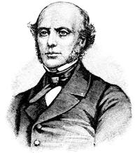
GARNEAU.
After a likeness in Daniel’s Nos Gloires Nationales, ii. p. 107. There is another portrait in his Hist. du Canada, 4th ed., Montreal, 1883, in connection with a memoir of its author.
The leading historian of Canada in the French interests is, without question, François Xavier Garneau, the earlier editions of whose Histoire du Canada depuis sa découverte jusqu’à nos jours have been mentioned elsewhere;[1610] the final revision of which, however, has since appeared at Montreal (1882-83) in a fourth edition in four volumes, accompanied by a “notice biographique” by Chauveau.[1611] English writers question his clearness of vision, when his national sympathies are evoked by his story, and there are some instances in which they accuse him of garbling his authorities. It must be confessed, however, that the disasters of the French do not always elicit Garneau’s sympathy, and his own compatriots have not all approved his reflections upon Montcalm for his last campaign.
Among the later of the French writers on the closing years of the French domination, Mr. J. M. Lemoine, of Quebec, is conspicuous. Such of his writings as are in English have been gathered in part from periodicals, and principal among them are his Quebec Past and Present, and its sequel, Picturesque Quebec, beside his collection of Maple Leaves, in two series (Quebec, 1863, 1873).[1612]
Jean Langevin delivered at the Canadian Institute, in Quebec, a series of lectures on “Canada sous la domination française” (1659-1759), which have appeared in the Journal de Québec.
The latest of the French chronicles are Eugène Réveillaud’s Histoire du Canada et des Canadiens français de la découverte jusqu’à nos jours, Paris, 1884 (pp. 551, with map), and Benjamin Sulte’s Histoire des Canadiens français, 1608-1880 (Montreal, 1882-1884), in eight thin quarto volumes, with illustrations, including portraits of the Canadian historians and antiquaries, Pierre Boucher, Jacques Viger, Garneau, L. J. Papineau, Michel Bibaud, Aubert de Gaspé, Ferland, Abbé Casgrain, and E. Rameau.
The Abbé J. A. Maurault’s Histoire des Abénakis depuis 1605 jusqu’à nos jours, Quebec, 1866, covers portions of the wars of Canada in which those Indians took part.
The American Annals of Dr. Abiel Holmes was published in Cambridge (Mass.) in 1805. It is a book still to inspire confidence, and “the first authoritative work from an American pen which covered the whole field of American history.”[1613] Libraries in America were then scant, but the annalist traced where he could his facts to original sources, and when he issued his second edition, in 1829, its revision and continuation showed how he had availed himself of the stores of the Ebeling and other collections which in the interval had enriched the libraries of Harvard College and Boston. Grahame[1614] gives the[620] book no more than just praise when he calls it perhaps “the most excellent chronological digest that any nation has ever possessed.”
The history of the colonies, which formed an introduction to Marshall’s Life of Washington, was republished in Philadelphia in 1824, as History of the Colonies planted by the English on the Continent of North America to the commencement of that war which terminated in their independence.
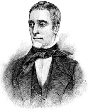
JAMES GRAHAME.
After the engraving in the Boston ed. of his History.
James Grahame was a Scotchman, born in 1790, an advocate at the Scottish bar, and a writer for the reviews. By his religious and political training he had the spirit of the Covenanters and the ideas of a republican. In 1824 he began to think of writing the history of the United States, and soon after entered upon the work, the progress of which a journal kept by him, and now in the library of Harvard College, records. In Feb., 1827, the first two volumes, bringing the story down to the period of the English revolution, were published,[1615] and met with neglect from the chief English reviews. As he went on he had access to the material which George Chalmers had collected. He finished the work in Dec., 1829; but before he published these closing sections a considerate notice of the earlier two volumes appeared in January, 1831, in the North American Review, the first considerable recognition which he had received. It encouraged him in the more careful revision of the later volumes, which he was now engaged upon, and in Jan., 1836, they were published.[1616] His health prevented his continuing his studies into the period of the American Revolution. In 1837 Mr. Bancroft had in his History (ii. 64) animadverted on the term “baseness,” which Grahame in his earliest volumes had applied to John Clarke, who had procured for Rhode Island its charter of 1663, charging Grahame with having invented the allegations which induced him to be so severe on Clarke. Mr. Robert Walsh and Mr. Grahame himself repelled the insinuation in The New York American, and a later edition of Mr. Bancroft’s volume changed the expression from “invention” to “unwarranted misapprehension,” and Mr. Grahame subsequently withdrew the term “baseness,[621]” which had offended the local pride of the Rhode Islanders, and wrote “with a suppleness of adroit servility.” It is not apparent that either historian sacrificed much of his original intention. Josiah Quincy defends Grahame’s view in a note to his memoir of the historian prefixed to the Boston edition of his History, in which Grahame had said he was incapable of such dishonesty as Bancroft had charged upon him. Bancroft wrote in March, 1846, a letter to the Boston Courier, calling the retort of Grahame a “groundless attack,” and charging Quincy, who had edited the new edition of Grahame, with giving publicity to Grahame’s personal criminations. Quincy replied in a pamphlet, The Memory of the late James Grahame, Historian, vindicated from the charges of Detraction and Calumny, preferred against him by Mr. George Bancroft, and the Conduct of Mr. Bancroft towards that Historian stated and exposed, in which use was also made of material furnished by the Grahame family, and thought to implicate Mr. Bancroft in literary jealousy of his rival.[1617] Grahame was not better satisfied with the view which Mr. Quincy had taken of the character of the Mathers in his History of Harvard University. “The Mathers are very dear to me,” Grahame wrote to Quincy, “and you attack them with a severity the more painful to me that I am unable to demur to its justice. I would fain think that you do not make sufficient allowance for the spirit of their times.” This difference, however, did not disturb the literary amenities of their relations; and Grahame, in 1839, demurred against Walsh’s proposition to republish his History in Philadelphia, for fear he might be seeming to seek a rivalry with Mr. Bancroft on his own soil. Three years later, July 3, 1842, Mr. Grahame died, leaving behind him a corrected and enlarged copy of his History. Subsequently this copy was sent by his family for deposit in the library of Harvard College, and from it, under the main supervision of Josiah Quincy, but with the friendly countenance of Judge Story and of Messrs. James Savage, Jared Sparks, and William H. Prescott, an American edition of The History of the United States of North America, from the Plantation of the British Colonies till their Assumption of National Independence, in four volumes, was published in Boston in 1845, accompanied by an engraved portrait after Healy.
Excluding Parkman’s series of histories, upon which it is not necessary to enlarge here after the constant use made of them in the critical parts of the present volume, the most considerable English work to be compared with his is Major George Warburton’s Conquest of Canada, edited by Eliot Warburton, and published in London in two volumes in 1849, and reprinted in New York in 1850. He surveys the whole course of Canadian history, but was content with its printed sources, as they were accessible forty years ago.
Among the other general American historians it is enough to mention in addition Bancroft,[1618] Hildreth,[1619] and Gay;[1620] and among the English, Smollett,[1621] who had little but the published despatches, as they reached England at the time, and Mahon (Stanhope), who availed himself of more deliberate research, but his field did not admit of great enlargement.[1622] The Exodus of the Western Nations, by Viscount Bury, is not wholly satisfactory in its treatment of authorities.[1623]
Henry Cabot Lodge’s Short History of the English Colonies (N. Y., 1881) has for its main purpose a presentation of the social and institutional condition of the English colonies at the period of the Stamp Act Congress in 1765; and the condensed sketches of the earlier history of each colony, which he has introduced, were imposed on the general plan, rather unadvisedly, to fill the requirements of the title. He says of these chapters: “They make no pretence to original research, but are merely my own presentation of facts, which ought to be familiar to every one.”
F. Bibliography of the Northwest.—Concerning the historical literature of the States of the upper lake region and the upper Mississippi, a statement is made in Vol. IV. p. 198, etc. Since that was written some additions of importance have been made. The Northwest Review, a biographical and historical monthly, was begun at Minneapolis in March, 1883; but it ceased after the second number. In Nov., 1884, there appeared the first number of the Magazine of Western History, at Cleveland.
The two most important monographs to be added to the list are:—
S. Breese’s Early history of Illinois, from 1673 to 1763, including the narrative of Marquette’s discovery of the Mississippi. With a biographical memoir by M. W. Fuller. Edited by T. Hoyne. Chicago, 1884; and Silas Farmer’s History of Detroit and Michigan: a chronological cyclopædia of the past and present, including a record of the territorial days in Michigan and the annals of Wayne county. Detroit, 1884,—the latter the most important local history yet produced in the West. The first volume of the Final Report of the Geological Survey of Minnesota, by Winchell, adds something to the early cartography of the region, and gives an historical chart of Minnesota, showing the geographical names and their dates, since 1841. The Historical Society of Minnesota has added a fifth volume (1885) to the Collections, which is largely given to the history of the Ojibways.
The Historical Society of Iowa having ceased to publish the Annals of Iowa in 1874 (1863-1874, in 12 vols.), a new series was begun in 1882 by S. S. Howe, but the society declined to make it an official publication, and began the issue of a quarterly Iowa Historical Record in 1885.
On the Canada side the Historical and Scientific Society of Manitoba have been issuing since 1882, at Winnipeg, its Reports, Publications, and Transactions.
INDEX.
[Reference is commonly made but once to a book, if repeatedly mentioned in the text; but other references are made when additional information about the book is conveyed.]
Abbott, J. S. C., Maine, 163.
Abenakis, 421;
memoir on, 430.
Abercorn (Georgia), 372, 373, 379, 401.
Abercrombie, General, 154;
to succeed Webb, 508;
autog., 521;
to attack Crown Point, 521;
blunders in his attack on Ticonderoga, 522;
does not bring up his cannon, 523;
retreats, 523 (see Ticonderoga);
his letters, 597;
authorities on his defeat, 597.
Abington (Mass.), history of, 461;
Acadians in, 461.
Acadia, power of England nominal, 407;
in French hands, 407;
harassed by Benj. Church, 407;
restored to France, 407;
ceded to England by treaty of Utrecht (1713), 408;
wars in, 407;
the English settlers ask to be set up as the province of Georgia, 474;
Anburey’s view of bounds, 474;
maps of the eighteenth century, 474;
Geographical History of Nova Scotia, 475;
sessions of commissioners in Paris (1755) to define bounds, 475;
earliest grant to De Monts, 475;
the French constantly shifted their ground, 475;
French policy in, under Jonquière, 9;
under Galissonière, 11;
French population, 409;
critical essay on sources of its history, 418;
authorities on its wars, 420;
contemporary French Mémoires on the French claim, 473;
correspondence of Albemarle with Newcastle, 475;
Mémoires des Commissaires du Roi, etc., 475;
two editions of it, 475;
the French view in A Summary View of Facts, 475;
Memorials of the English and French Commissaries, 476;
memorial of Shirley and Mildmay (1750), 476;
Mémoires of the French (1750), 476;
maps and bounds of, 472;
map by Lahontan, 473;
Memorial (1751), 476;
Mémoire (1751), 476;
Memorial (1753) signed by Mildmay and Ruvigny de Cosne, 476;
concession to Thomas Gates (1606), 476;
to Sir Wm. Alexander (1621), 476;
other early papers, 476;
act ceding Acadia to France (1667-68), 476;
reports of the French and English commissioners (1755) compared, 477;
reprints of the French edition at Copenhagen, 477;
papers (1632-1748) from French archives, 459;
papers in library at Ottawa, 459;
manuscripts quoted in the French report, 477;
Répliques des Commissaires anglois, 477;
map of French claim, 478;
of English claim, 479;
early grants mapped out, 478, 479;
Conduct of the French with regard to Nova Scotia, 482;
A fair representative, 482;
French readiness to yield the Kennebec if pressed, 482.
Acadian coast (Mississippi River), 463.
captured at Beauséjour, 452;
were they neutral? 455;
their qualified loyalty, 455;
unqualified submission required by Lawrence, 455;
the French depend on their assistance, 455;
could hostages have been taken? 455;
deportation resolved upon, 455;
their lands coveted, 455;
necessity in war, 455;
guilelessness claimed for them, 456;
Raynal and other sympathizers, 456;
their mixed blood, 457;
migrations of families, 457;
their houses, 457;
their habits, 457;
religious training, 457;
influenced by Le Loutre, 457;
mutations of opinion respecting them, 457, etc.;
“Evangeline and the Archives of Nova Scotia”, 459;
diverse views of the number deported, 460, 461;
method of their transportation, 461;
families separated, 461;
ports where they were landed, 461;
the colonies which received them, 461, etc.;
refused in Boston to sign petition to the king, 461;
signed one in Philadelphia, 462;
not received (1762) in Boston, 462;
Governor Bernard’s estimate of them, 462;
Galerm’s Relation, 462;
became widely scattered, 463;
erroneous views of their fate, 463;
many returned to Nova Scotia, 463;
the Madawaska settlements, 463;
intercepted in endeavoring to return, 463.
See French Neutrals, Nova Scotia.
Acquia Creek, 277.
Acta Upsaliensia, 241.
Adair, Jas., History American Indians, 68.
Adams, Amos, Concise History of New England, 435.
Adams, C. K., 354.
Adams, Hannah, New England, 159;
portrait, 160.
Adams, Herbert B., Germanic Origin of New England Towns, 169;
edits Johns Hopkins University Studies in Historical and Political Science, 271;
Maryland’s Influence upon Land Sessions to the United States, 271;
Maryland’s Influence in founding a National Commonwealth, 271.
Adams, John, Novanglus, 613;
in Rhode Island, 153;
on Shirley, 144.
Adams, Sam., his Commencement part, 139.
Addington, Isaac, 92;
autog., 425.
Addison, Jas., Spectator, 107.
Admiralty, Court of, 96.
Aigrement, Sieur d’, 560.
Ainsworth, John Law, 77.
Aix-la-Chapelle, treaty of, 10, 11, 148, 449, 476, 490;
Bedford correspondence, 476.
Akins, Thomas B., arranges records of Nova Scotia, 458;
edits Public Documents of Nova Scotia, 418, 459;
on the first council at Halifax, 450.
Albach, James R., Annals of the West, 53.
bibliog. of, 249;
history by Weise, 249;
congress at in 1748, 612;
congress of 1754, 150, 205, 495;
its plan rejected, 150;
congress of 1754, authorities on, 612;
instigated by Shirley, 612;
journal, 612;
proceedings printed, 612;
accounts of by members, 612;
Shirley urged acquiescence, 613;
list of delegates, 613;
reports of the commissioners of the colonies, 613;
the minister’s plan proposed in lieu, 613;
the society pictured in Mrs. Grant’s American Lady, 509;
in Kalm’s Travels, 509;
officers billeted on the people, 510;
other maps, 508;
Fort Frederick at, 509;
Schuyler house at, 252;
Van Rensselaer house, 252;
trade with Montreal, 567;
treaty at (1701) surrendering Iroquois country to the English, 564;
treaty (Sept., 1722), 245, 485, 563, 611.
Albee, John, Newcastle (N. H.), 140.
autog., 287.
Alden, Capt. John, 420.
Aldrich, P. E., 169.
Alexander, James, on the congress of 1754, 612.
Alexander, N., map of frontier posts, 85.
Alexander, S. D., 247.
Alexander, W., letters to Shirley on the Niagara campaign, 583.
Alexander, Sir Wm., Earl of Sterling, 587;
claims in Acadia (1621), 476, 479;
his grant in Acadia as defined by English and French, 478, 479.
Alexandria (Acadia), 479.
Alexandria (Virginia), Braddock’s conference at, 495;
his headquarters, 495.
All Canada in the hands of the English, 609.
All the Year Round, 394.
Allard, Minor Atlas, 234.
Alleghany Mountains, spelling of the name, 8.
Allegheny city, 8.
Allen, Ethan (Maryland), 271.
Allen, Ethan (Vermont), Concise Refutation, etc., 179;
Present State of the Controversy, 179;
Proceedings of the Government of New York, 178;
Animadversary Address, 178;
Allen, Ira, History of Vermont, 178, 179.
Allen, J. A., Bibliog. of Cetacea, 345.
Allen, Samuel, 110.
Allen, Wm., Norridgewock, 431.
Allsop, Geo., 603.
Almon, John, Anecdotes, 613.
Amelia Sound, 375.
America, maps of, 234.
American Architect, 169.
American Commonwealths, a series of histories, 271.
American Magazine (Boston), 158.
American Magazine (Philadelphia) (published 1741), 248;
(1757-58), 248.
American Military Pocket Atlas, 527.
American Weekly Mercury, 248.
Ames, Ellis, edits Massachusetts Province Laws, 167;
on the Vernon expedition, 135.
Ames’s Almanac, 455.
Amherst, General Jeffrey, 154;
autog., 527;
portraits, 531;
as a soldier, 533;
siege of Louisbourg, 464;
at Lake George (1759), 536;
builds Fort George, 536;
occupies and repairs Ticonderoga, 536;
his army sick, 537;
occupies and strengthens Crown Point, 537;
communicates with Wolfe by way of the Kennebec, 538;
advances on the lake, but returns to Crown Point for winter quarters, 540;
advances on Montreal, 556;
surrounds it, 558;
captures it, 558;
his campaign of 1759, 601;
his family, 601;
his campaign of 1760, 608;
on the capture of Fort Lévis, 609;
causes maps of the St. Lawrence to be made, 614;
correspondence with Johnson on the campaign of 1760, 608;
made Knight of the Bath, 610;
his instructions to Prideaux, 601;
orders to Rogers (1760), 610;
reasons for taking the St. Lawrence route (1760), 610;
his correspondence with the Nova Scotia authorities, 610.
Amory, M. B., Copley, 141.
Anastase, Father, 17.
Anburey, T., Travels, 284.
Anbury, Père, on bounds of Acadia (1720), 474.
Ancram, 224.
Andastes, 484.
Anderson, Adam, 364.
Anderson, Hugh, 399.
Anderson, John, 219.
Anderson, W. J., on the Acadians, 459;
“Archives of Canada”, 617;
Military Operations at Quebec, 1759-1760, 608.
Anderson, W. T., 574.
Anderson, American Colonial Church, 272, 282.
Andover (Mass.), histories of, 184, 461;
Acadians in, 461.
Andros, Sir Edmund, imprisoned, 87;
sent to England, 87;
papers on his period in Massachusetts, 165.
Andros, Fort, 181.
Anger, Sieur, 238.
Anger, map of Lake Champlain, 485.
Angerville, Mouffle d’, Vie privée de Louis XV., 75.
Annapolis Basin, map by Bellin, 429;
other maps, 429.
Annapolis Royal (see Port Royal),
garrison at, 165;
under Samuel Vetch, 408;
threatened by the French, 410, 413;
journal of capture (1710) 419;
view of, 423;
map of vicinity, 428;
view of Annapolis Gut, 429;
old block house at, 429;
papers concerning, 429;
governor at (1714-1748), 459.
Annapolis (Md.), 260.
Anne Arundel (Annapolis), 260.
Annual Register, 606.
See Dodsley.
Anson, Fort, 187.
Anthony’s Nose (Hudson), 237.
Apalache (Palachees) Bay, 70.
Apalatchees, 319.
Appleton, William S., 186;
medals on Siege of Quebec, 603;
on the medals of Louisbourg, 471.
Apthorp and Hancock (Boston), 461.
Archdale, John, autog., 344;
Carolina, 344;
sent to pacify Carolina, 316.
Arkansas (Arcanças), 82.
Armor, W. C., Governors of Pennsylvania, 249.
Armstrong, Edw., 242.
Armstrong, John, 581.
Armstrong, Lawrence, 409.
Arnold, R. D., 401.
Arnold, S. G., Rhode Island, 163.
Arnold, Theodore, 344.
Arrowsick Island, 118;
Indian conference at (1717), 424.
Arthur, T. S. (with W. H. Carpenter), History of Georgia, 406.
Arthur, W., on Wesley, 403.
Arundel, Earl of, 335.
Ash, Thomas, Carolina, 340.
Ashmead, H. G., Chester, 249.
Ashurst, Sir Henry, dies, 107, 111.
Ashurst, Sir Wm., 107.
Aspinwall Papers, 608.
Atkins’s America’s Messenger, 248.
Atkinson, Sec., letter on Lake George battle (1755), 584.
Atkinson, T. C., on Braddock’s march, 500.
Atlantic Souvenir, 431.
Atlas Amériquain, 83.
Atlas Maritimus, 239.
Atwood, William, case of, 241.
Aubry, 535.
Auchmuty, Robt., autog., 434;
Importance of Cape Breton to the British Nation, 434;
letters, 436.
Azilia, margravate of, 360.
Babson, J. J., Gloucester, 169.
Backus, Isaac, New England, 159;
his life by Hovey, 159.
Bacon’s rebellion in Virginia, authorities on the penal proceedings, 263.
Bagley, Colonel Jonathan, 508, 585;
orderly book, 598.
Bailey, S. L., Andover, 184, 461.
Bailly, Histoire Financière de la France, 77.
Baird, C. W., Huguenots’ Emigration to America, 98, 247.
Baird, R., Religions in America, 246.
Baker, Margaret, 186.
Baker, Captain Thomas, 186.
Balch, Thomas, Les Français en Amérique, 574;
Paper on Provincial History of Pennsylvania, 243.
Baldwin, C. C., Indian Migrations in Ohio, 564.
Baldwin, S. E., 177.
Balise, 66.
Baltimore, Charles, third lord, dies, 260;
fourth lord, Benedict, 260;
fifth lord, Charles, 260;
sixth lord, Frederick, 261;
his portrait, 262;
notes on the family, 271.
Baltimore (city), commemoration of its founding, 261, 271;
Memorial Volume, 271;
plans, 272;
the earliest directory, 272;
earliest view, 272.
Bancroft, Geo., controversy with Grahame, 620;
owns Chalmers’s paper on Carolina, 352, 354;
on the relations of European politics, 166;
on Carolina history, 355;
gives plan of siege of Louisbourg (1745), 444;
used by Parsons, 444.
Bancroft, H. H., on Moncacht Apé, 78.
Bangor Centennial, 430.
Banks, projects to found, in Mass., 170.
Banque Royale of Law, 34.
Banyar, Goldsbrow, his diary, 594.
Baptists in New England, 159;
in Pennsylvania, 246;
In Virginia, 282.
Barbadoes, explorers from, on the Carolina coast, 288;
map in Ogilby, 472;
relations with Carolina, 306.
Barbé Marbois, Louisiane, 68.
Barber, John, 182.
Barlow, S. L. M., 592.
Barnes, Albert, Life and Times of Davies, 578.
Barnwell, Colonel, 322;
his march (1711), 345;
defeats Tuscaroras, 298.
Barré, Isaac, at Quebec, 543.
Barrington, Geo., governor of Carolina, 300, 301;
account of North Carolina, 356.
Barrow, Thomas, 600.
Barry, John S., Massachusetts, 162.
Barry, Wm., 424.
Bartlett, J. R., “Naval History of Rhode Island”, 410.
Barton, Ira M., 98.
Bartram, John, Observations, 244.
Bartram, William, 244;
describes Whitefield’s Orphan House (1765), 404.
Basire, Jas., 337.
Bass, Benj., Journal of Expedition against Fort Frontenac, 599.
Basse, Jeremiah, 219.
Bassett, Wm., Richmond, N. H., 179.
Bastide, J. F., Mémoire Historique, 614;
views and plans of Louisbourg, 448.
Bateman, Edmund, 400.
Bathurst, Sir Francis, 377.
Baton Rouge, 82.
Battles, K. P., History of Raleigh (N. C.), 355.
Baxter, Rev. Jos., journal, 424.
Bay of Fundy, earliest shown in maps, 472.
Bay State Monthly, 432.
Bay Verte. See Baie.
Bayard, Nicholas, Account of his trial, 241.
Bayley, Jos., Jr., 464.
Beaford, Arthur, 364.
Bearcroft, Philip, 400.
Beardsley, E. E., 120;
on Yale College, 102;
on the Mohegan land controversy, 111;
his Wm. Sam. Johnson, 111, 601;
on Dean Berkeley, 142.
Beatson, The Plains of Abraham, 606.
Beatty, Charles, Journal, 246.
Beaubois, 44.
Beaufort (S. C.), fort at, 332.
Beauharnois, Governor, 7;
autog., 7;
confers with the Onondagas, 567;
letter (1726), 561;
meets the Six Nations (1745), 568;
on Oswego, 567.
Beauharnois, Fort, 7.
Beaujeu at Duquesne, 497;
sent against Braddock, 497;
pictures of, 498;
his family, 498;
killed, 498.
Beaumont, J. B. J. E. de, 610.
Beaurain, 36.
Beaurain, Jean de, Journal Historique, 63;
Beauséjour, Fort, map of, 451;
renamed Fort Cumberland, 452;
French neutrals captured at, 452;
plan of, 453;
papers on the capture, 459.
Beauvilliers, De, his map, 81.
Beaver Creek (Ohio), 497.
Beck, L. C., Gazetteer of Illinois, 54.
Beckford, Wm., 601.
Beckwith, Bishop, 404.
Beckwith, H. W., Illinois and Indiana Indians, 564.
Bédard, T. P., 560.
Bedford, Duke of, on the reduction of Canada, 568.
Beekman, Henry, his lands, 237.
Beginning, Progress, and Conclusion of the Late War, 616.
Belcher, Andrew, autog., 425.
Belcher, Governor, 589;
on Braddock’s defeat, 579;
letter-books, 166;
letters to Larrabee, 432.
sent by Massachusetts to England, 131;
made governor of Massachusetts, 131;
governor of New Jersey, 221;
dies, 222;
and the Indians, 139;
his character, 139.
Beletha, Wm., 364.
Belêtre at Detroit, 559;
attacks German Flats, 520.
Belknap, Jeremy, his account of the Louisbourg expedition, 436;
New Hampshire, 163;
portraits, 163;
forms Massachusetts Historical Society, 163;
his life, 163;
Belknap Papers, 163;
correspondence with Hazard, 163.
Bellamy, George Anne, Apology, 577.
Bellin, J. N., and his maps, 429;
his maps in Charlevoix, 81, 474;
favors the French claims, 82, 83;
maps of Cape Breton, 440;
of Lake Champlain, 485;
of Louisbourg, 439;
of Montreal, 556;
of Saguenay River, 614;
of the St. Lawrence, 614;
of Quebec, 549;
Neptune Français, 429;
Hydrographie Française, 429;
Petit Atlas Maritime, 429;
Mémoires, 429;
Remarques, 83.
Bellingham, Governor, his widow dies, 103.
Bellomont, governor of New York, 194;
his negative, 194;
portrait, 97;
governor of Massachusetts, etc., 97;
in Boston, 98;
character, 98;
life by De Peyster, 98;
and the Iroquois, 483;
Propositions by the Five Nations, 483, 560;
correspondence with the French governor, 560.
Belmont, grand vicaire, 6.
Benezet, Huguenot in Philadelphia, 462.
Bennett, D. K., Chronology of North Carolina, 355.
Bennett, James, 404.
Bennett, account of New England (MS.), 168.
Bennington (Vt.), 178.
Benson, Eugene, 179.
Bentley’s Magazine, 603.
Benton, N. S., Herkimer County, 587.
Berkeley, George (Dean), 140, 141;
portrait, 140;
autog., 140;
in Newport, 141;
favors Yale College, 141;
returns to England, 141;
authorities on, 141;
his letters, 141.
Berkeley, John, Lord, 286;
autog., 287.
autog., 287.
Berkshire County (Mass.), histories, 188.
Bermuda, colony of Presbyterians at, 307;
proposed college at, 141.
Bernard, Francis, governor of Massachusetts, 155;
governor of New Jersey, 222;
on the Indian conference, (1758), 245.
Bernetz on Montcalm’s death, 605.
Bernheim, G. D., German Settlements in Carolina, 345, 348.
Berniers, letters, 608.
Berriman, Wm., 400.
Berwick, Me., 105.
Best, Wm., 400.
Beverley, Robt., History of Virginia, 279.
Beverley family, 280;
their mansion, 275.
Bexar archives, 69.
Bibaud, M., portrait, 619.
Bidwell, A., chaplain of the fleet at Louisbourg, 438.
Bienville, midshipman, 17, 18, 20;
meets the English on the Mississippi, 20;
at Biloxi, 21;
on the Red River, 23;
would enslave Indians, 27;
attacks the Natchez, 30;
quarrels with Lamothe, 30;
made commandant, 35;
his titles, 35;
arrives at New Orleans, 43;
his downfall, 44;
defended by La Harpe, 45;
his memorial, 45;
returns to Louisiana, 49;
attacks the Chickasaws, 49;
resigns, 50;
correspondence, 72.
Bigot, J., 561;
account of the Lake George battle (1755), 588;
in France, 559;
intendant, 57;
his corruption, 10;
at siege of Quebec (1759), 605.
Biloxi, deserted, 27;
fortified by Iberville, 19;
position of, 22;
sites of the two, 82.
See New Biloxi.
Biloxi bay, 66.
Binneteau, J., 561.
Bishop, J. L., American Manufactures, 118.
Black, Wm., journal, 247, 268, 566.
Blackbeard. See Teach.
Blackburn, 150.
Blackman, E. C., Susquehanna County, 249.
Blackmoe, Nath., map of Annapolis Basin, 429.
Blackmore, 80.
Blackwell, John, 170;
governor of Pennsylvania, 207.
Blagg, Benj., 257.
Blaikie, Presbyterianism in New England, 98, 132.
Blair, James, character of, 278;
Present State of Virginia, 278;
autog., 279;
correspondence, 279;
gets charter for William and Mary College, 264;
character, 265.
Blake, Jos., in Carolina, 316;
dies, 316.
Blakiston, Nathaniel, governor of Maryland, 260.
Blanc, Louis, Révolution Française, 77.
Blanchard, Jos., Map of New Hampshire, 485;
his New Hampshire regiment at Lake George (1755), 584.
Blodgett, Saml., Prospective plan of the battle near Lake George, 586;
Account of the Engagement, 586;
reëngraved in London, 586.
Blome, Richard, Jamaica and Other Isles, 341;
L’Amérique, 88;
Present State, 340.
Bloody Pond (Lake George), fight at, 504.
Board of Trade and Plantations, papers, 164.
Boardman, G. B., on printing in the middle colonies, 248.
Bobin, Isaac, Letters, 243.
Bogart, W. S., 361.
Bogue, David (with James Bennett), History of Dissenters, 404.
Bohé, on Acadia’s limits, 474.
Boimore, 68.
Boishebert, 610.
Boismare, MSS., 72.
Boismont, 55.
Bollan, Wm., 149;
goes to England, 176;
Importance and Advantage of Cape Breton, 434, 475;
on the value of Cape Breton, 438.
Bolton, improves D’Anville’s maps, 235.
Boltwood, L. M., 187.
Bolzius, J. M., 374;
portrait, 396.
Bombazeen, 106;
killed, 127.
Bond, Rev. S., 308.
Bonnecamps, accompanies Céloron, 8;
map of Céloron’s route, 570.
Bonnechose, C. de, Montcalm et le Canada Français, 607.
Bonnet, the pirate, 323.
Bonrepos, Chevalier de, 39.
See Vallette Laudun.
Book Auctions, early, in Boston, 121.
Boone, Thomas, 333;
governor of New Jersey, 222.
Borgue, lake, 41.
Borland, John, 423.
Boscawen, Admiral Edward, sent to intercept Dieskau, 495;
portrait and autog., 464.
Bossu, Nouveaux Voyages, 67;
English translation, 67.
Boston, in 1692, 92;
described by Bellomont, 99;
by Ned Ward, 99;
its centenary, 132;
conferences with Indians at (1723, 1727), 430, 432;
corn panic at, 110;
fire in (1711), 109;
fortified (1709), 122;
picture of the light-house, 123;
French plans for attacking, 420;
printing in, 120;
social life, (1730), 137;
corps of Cadets, 137;
town rates, 139;
cost of maintaining the town’s affairs (1735), 139;
importance of in Shirley’s time, 144;
fear of D’Anville’s fleet, 147, 413;
drama introduced, 150;
Amherst’s army in, 154;
town house burned (1747), 165;
Memorial History of Boston, 169;
Distressed State of the Town of Boston, 171;
News from Robinson Crusoe’s Castle, 171;
specie for the cost of the Louisbourg siege received, 176;
views of, 108.
Boston Gazette, 121.
Boston Harbor, in Popple’s map, 134;
on a larger scale, 143.
Boston News Letter, 106.
Bostwick, David, 579.
Boucher, Pierre, 619.
Boudinot, Elias, 225.
Bougainville, comes over with Montcalm, 505;
sent to France, 532;
harasses Wolfe’s rear, 548;
retires, 550;
at Cap Rouge, 550;
at Isle-aux-Noix, 556;
unites with Bourlamaque, 556;
letter on attack on Fort William Henry, 594;
on Montcalm’s death, 605.
Boulaix, fort, 41.
Bouquet, Colonel Henry, 595;
with Forbes, 529;
his map, 608.
Bourdonnais, 610.
Bourgmont, 55.
Bourinot, J. G., “Old Forts of Acadia”, 439.
Bourlamaque, comes over, 505;
at Ticonderoga (1759), 536;
evacuates, 536;
abandons Crown Point, 537;
at Isle-aux-Noix, 538;
falls back before Murray, 555;
on the battle of Ste. Foy, 609;
his retreat before Amherst, 602;
Mémoire sur Canada, 608;
his letters, 608;
papers, 605.
Bourmont, 55.
Bourne, E. E., Garrison Houses, 183.
Bournion, 55.
Bouton, Nath., The Original Account of Lovewell’s Great Fight, 431.
Bowen, Clarence W., Boundary Disputes of Connecticut, 177, 181.
Bowen, Daniel, History of Philadelphia, 252.
Bowen, Emanuel, Geography, 234, 352;
Map of Carolina, 352.
Bowles, Carrington, 85.
Bownas, Samuel, 186.
Boylston, Dr. Zabdiel, and inoculation, 120.
Bradbury, Jabez, autog., 183.
Braddock, General, sent to Virginia, 494;
landed, 495;
holds conference at Alexandria, 495, 578;
his mistake in moving by the Potomac, 495;
finds the Pennsylvanians apathetic, 495;
alienates the Indians, 496;
his march, 496;
plans of his march, 500;
ambushed, 498;
MS. plan of the battle, 498, 499;
other plans, 498;
Braddock’s horses shot, 500;
views of the battle-field, 500;
wounded, 500;
dies, 500;
his remains discovered, 501;
his sash, 501;
view of his grave, 501;
his papers captured by the French, 501;
story of his defeat in England, 577;
his early character, 577;
his plan of campaign, 578;
letters of his officers, 578;
his orderly books, 578;
contemporary accounts, 578;
court of inquiry, 578;
list of his officers, 579;
his loss, 579;
news of the defeat as sent north, 579;
The Expedition of Maj.-Gen. Braddock, 579;
French accounts of his defeat (see Monongahela), 580;
list of captured munitions, 580.
Bradford, Alden, 164.
Bradford, Andrew, printer, 248;
authorities on, 248.
Bradford, Wm., father of printing in the middle colonies, 248;
his publications, 248;
his genealogy, 248;
prints New York Laws, 232.
Bradford, Colonel Wm., life by Wallace, 248.
Bradley, S. R., Vermont’s Appeal, 179.
Bradstreet, Colonel John, 436, 591;
his report on his capture of Fort Frontenac, 527, 598;
with Abercrombie, 522;
letters, 233;
commissary at Albany, 601;
head of transportation service, 510;
beats a French party, 510.
Bradstreet, Simon, restored to power, 87;
dies, 96.
Brainerd, David, 246;
life, by Jonathan Edwards, 246.
Brandon house, 275.
Brassier, Wm., survey of Lake Champlain, 485.
Bray, Thomas, Apostolic Charity, 282;
fac-simile of title, 283.
Breard, 610.
Breda, treaty at (1667), 476;
part of Acadia restored to France, 478.
Breese, S., Early History of Illinois, 71, 622.
Brehm, Lieutenant, describes Ticonderoga, 537;
sent to Lake Huron, 610;
report to Amherst, 610.
Brevoort, J. C., 68.
Brewster, Portsmouth, N. H., 169.
Brickell, John, 301;
Natural History of North Carolina, 344.
Bricks, imported, 226;
made in America, 226.
Bridger, 116.
Briggs, C. A., American Presbyterianism, 132, 247.
Brinley, Francis, 176.
Brissot de Warville, Nouveau Voyage, 284.
British footguard (1745), 489.
British Museum, Catalogue of prints, etc., 114;
Catalogue of printed maps, 233;
British soldier, 485;
(1701-14), picture of, 109;
of Wolfe’s time, 547.
Brock, R. A., edits Spotswood’s letters, 281;
edits Dinwiddie’s letters, 281, 572;
on Black’s journal, 566.
Brodhead, J. R., on Cornbury, 241.
Bromfield, Edw., autog., 425.
Bronson, Henry, Connecticut Currency, 170.
Brooker, Wm., 121.
Brookfield (Mass.), 184.
Brooklyn. See Brockland.
Brooks, Noah, 424.
Broughton, Sampson, 237.
Broughton, Thomas, 332.
Brown, Andrew, on the Acadians, 458;
intending a history of Nova Scotia, 458.
Brown, James, 208.
Brown, Richard, Cape Breton, 44;
Brown, Thomas, Plain Narrative, 186;
Sufferings and Deliverances, 593.
Browne, Fox, Life of John Locke, 336.
Browne, Wm. Hand, edits Maryland records, 270;
his Maryland, 271.
Bruce, Lewis, 400.
Brunswick (Me.), 181;
Remarks on the plan (1753), 474.
Bryan, Hugh, 352.
Bryan, Jona., 391.
Bryent, Walter, journal, 180;
his regiment, 183.
Buchanan, Geo., 353.
Buchanan, John, 603;
Glasgow, 603.
Buckingham, Rev. Mr., journal of siege of Port Royal (1710), 423.
Buffalo Historical Society, 249.
Buffaloes, to be propagated, 21.
Buissonière, 50.
Bulkely, Secretary, 458.
Bull, Wm., 332, 352, 367, 370.
Bullard, H. A., 72.
Bundy, Richard, 364.
Burd, Colonel James, journal, 270.
Burgess, Colonel Elisha, 115.
Burgis, W., 123.
Burgiss, Wm., engraver, 252.
Burk, John, 593;
Virginia, 280.
Burke, Edmund, on the Acadians, 457;
European Settlements in America, 618;
Works, 618;
Comparative Importance of the Commercial Principles, 615.
Burke, Wm., Remarks on the Letter addressed to Two Great Men, 615.
Burling, Jas., 257.
Burling, Jno., 257.
Burlington (N. J.), 228.
Burnaby, Andrew, Travels, 168, 245, 284;
various editions, 245.
Burnet, Governor Wm., Answer to a Romish Priest, 186;
governor of New Jersey, 220;
transferred to Massachusetts, 129, 220;
governor of New York, 197;
quarrels with the Massachusetts Assembly, 131;
as a literary man, 131;
dies, 131.
Burnwell, John, Settlement on the Golden Islands, 392.
Burrows, Life of Lord Hawke, 438.
Burton, General, 57.
Burton, Lieutenant-Colonel, 591.
Bury, Viscount, on Braddock’s defea, 577;
Exodus of the Western Nations, 138, 439, 621.
Bushrangers, 4.
Busk, H. W., New England Company, 169.
Butel-Dumont, G. M., Histoire et Commerce des Colonies Angloises, 617;
Present State of North America, 617;
notes on Jeffrey’s Conduct of the French, 482.
Butler, Kentucky, 265.
Byfield, Colonel, 113.
Byles, Mather, portrait, 128;
poem on George II., 129;
on Burnet, 130;
and the Great Awakening, 135.
Bynner, E. L., 169.
Byrd, Wm., helps Stith in his Virginia, 280;
on quit-rents of Virginia, 280;
Progress to the Mines, 281;
his character, 276;
his library, 276;
History of Dividing Line, 275;
portrait, 275;
Westover Papers, 275;
letters, 282;
runs line of Northern Neck, 276;
Byrd Manuscripts, 276.
See Burd.
Cadet, Joseph, 57;
in France, 559.
statue, 560;
letters, 561.
Cadodaquais, 40.
Cadogan, George, The Spanish Hireling, 397.
Caffey Inlet, 338.
Cajeans, 463.
See Acadians.
Calamy, Edmund, his Increase Mather, 125.
Caledonia (Acadia), 479.
Callender, Elisha, 119.
Callender, John, Rhode Island Century Sermon, 137.
Callières, 4;
autog., 4.
Calvert, Benedict Leonard, 267.
Calvert, Charles, 261;
on the boundary dispute of Maryland, 239.
Calvert, Sir George, 271.
Cameron, Baron, 276.
Cameron, Duncan, Life and Adventures, 579.
Campbell, Alex., letter from Quebec, 604.
Campbell, C., Spotswood Family, 281.
Campbell, D., Nova Scotia, 419.
Campbell, Major Duncan, 597.
Campbell, G. L., Journal of Expedition by Oglethorpe, 398.
Campbell, Lord Wm., 333.
Campbell, Tryon County, 587.
Camuse, Jacques, 387.
Canada in the eighteenth century, 5;
postal service, 7;
military posts (1752), 11;
dual government, 57;
controlled in France, 60;
errors of historians, 64;
attack on ordered (1709), 422;
expedition (1710), 107;
(1711), 108;
military routes to, 557;
surrendered, 558;
cost of the invasion, 569;
French summaries of events, 569;
resources in 1759 failed, 600;
paternal government, 600;
compared with the English colonies, 600;
her plunderers tried in France, 610;
their trials, 610;
her importance in settling the terms of peace (1763), 614;
tracts cited, 615;
Acadians in, 463;
archives, 617;
papers in public record office, 617;
copies at Quebec, 459;
list of them in Réponse à un Ordre, 459;
Collection de Manuscrits, etc., 617;
Chalmers’s papers, 354;
Mémoire (1682, etc.), 561;
Warburton’s Conquest of Canada, 621;
Picturesque Canada, 549;
Royal Society Transactions, 452.
Canadian Antiquarian, 279.
Canadian Monthly, 439.
Canso, fort at, plan, 467;
surprised by the French, 145, 410, 434.
Canzes, 55.
Cap Rouge (near Quebec), 550, 552.
Cape Baptist, view of, 449.
Cape Breton, Importance and Advantage of Cape Breton truly stated, 422, 438;
The Great Importance of Cape Breton, 439;
Accurate Description of Cape Breton, 439;
Memoir of the Principal Transactions, 439;
map of, 481;
by Bellin, 440;
by Des Barres, 440;
by Kitchin, 440;
map of coast (1753), 475;
tracts for and against retaining it at the peace of Aix-la-Chapelle, 438;
Importance and Advantage of Cape Breton considered, 438;
Two Letters, 438;
wars in, 407.
Cape Carteret, 288.
Cape Cod, in Popple’s map, 134.
Cape Diamond (Quebec), 544.
Cape Fear River, 288;
settlement at, 288;
fort at, 303;
English at, 338;
on early map, 338.
Cape Hatterash (Hatteras), 338.
Cape Hope (N. C.), 338.
Cape Tourmente, 542.
Cape. See names of capes.
Capefigue, J. B. H. R., Opérations Financières, 77.
Captivities (class of books), 186, 590.
Capuchins in Louisiana, 43, 44.
Carew, Bampfylde Moore, 252.
Carey, Thomas, 297.
Carillon. See Ticonderoga.
Carleton, Guy, 603;
at Quebec, 543.
Carlisle, Pa., treaty at (1753), 245.
Carlyle, Frederick the Great, 606;
on Wolfe’s victory, 607.
Carmelites in Louisiana, 43.
Carmichael, Sir James, 608.
Carmichael-Smyth, Sir James, Précis of the Wars in Canada, 608.
Carolinas, history of, 285;
proprietary government, 285;
grants (1663-1729), shown in a map, 285;
Comberford’s map (1657), 285;
this region variously called, 286;
origin of name “Carolina” or “Carolana”, 286;
names of proprietors, 286, 287;
Clarendon County, 288;
it disappears, 293;
Craven County, 289;
Albemarle County, 289;
Chowan Colony, 289;
purposes of the proprietors, 290;
they oppose democratic tendencies, 291;
fundamental constitutions, 291;
their provisions, 291;
titles, 291;
Church of England established, 292;
land tenure in, 292;
surrendered to the crown, 361;
Acadians in, 463.
See North and South Carolina.
Carolines (coin), 230.
Carpenter, Geo., 364.
Carpenter, J. C., “Old Maryland”, 272.
Carpenter, W. H., 405.
Carr, Lucian, on the mounds of the Mississippi and on women among the Iroquois, 23.
Carr’s Fort, 375.
Carroll, B. R., Historical Collections of South Carolina, 355, 404.
Carroll, Chas., Journal to Canada, 594;
his mansion, 272.
Carter, C. W., York County, Pa., 249.
Carter, Robert, 267.
Carteret, Lord, his share of Carolina not sold to the crown, 301.
Carteret, Sir George, 286;
autog., 287.
Carteret, conveys land to the trustees of Georgia, 361.
Carthagena, taken, 69.
Caruthers, W. A., Knights of the Horseshoe, 563.
Carver, Jona., Travels, 594.
Casco Bay, Indian treaty at, 432.
Casgrain, Abbé, portrait, 619.
Cass papers, 561.
Cassell, United States, 239.
Cassiques, in Carolina, 291.
Castin, the younger, 122.
Castle William (Boston), plan of, 108.
language, 356.
Catesby, Mark, Natural History of Carolina, 350.
Cathcart papers, 604.
Catholics excluded from Georgia, 364;
and the treaty of 1763, 615.
Caton family mansion, 272.
Catskill Creek, 237.
Causton, Thomas, 380.
Cayuga Historical Society, 249.
Céloron de Bienville, his expedition, 8, 490, 569;
authorities, 8;
inscription on his plates, 9;
map showing where they were buried, 569, 570.
Cerisier, A. M., Remarques sur les Erreurs de Raynal, 457.
Cevallos, Pedro, 69.
Chabert, Joncaire, 610.
Chabert, J. B., Voyage, 475.
Chaigneau, L., 561.
Chaleur Bay, map, 614.
Chalmers, Geo., Opinions of Eminent Lawyers, 261;
refuses aid to Williamson, 352;
Grahame’s use of his papers, 352, 353, 354, 620;
his papers, 352;
Introduction to the History of the Colonies, 353;
edited by Sparks, 353;
autog., 353;
on Virginia, 278;
Chamberlain, Mellen, on the Massachusetts Records, 165.
Chambers, G., Irish and Scotch in Pennsylvania, 249.
Chambers, Eminent Scotsmen, 76.
Champigny, Chev. de, 73;
Etat Présent de la Louisiane, 67.
Champlain, his notion of bounds of Acadia, 479.
Champlain, Lake, misplaced in the Dutch maps, 88, 234;
French grants on, 238;
first occupied by the French, 567;
maps of, 485;
surveys, 485;
Popple’s map, 486.
Chandler, P. W., American Criminal Trials, 241.
Chandler, Rev. Sam., diary at Lake George, 586.
Channing, Edw., Town and County Government, 169, 281.
Chaouanons, 564.
See Shawnees.
Chaouchas, 41.
Chapais, Thomas, Montcalm et le Canada, 607.
on Connecticut claims in Pennsylvania, 180.
Charlestown (N. H.), 183.
Charlestown (S. C.), later Charleston, plan by Crisp, 343;
“South Carolina Society”, 349;
map of vicinity, 351;
of harbor, 351;
first site, 308;
threatened by the Spaniards, 308;
Albemarle Point, 308;
town removed to Oyster Point, 308, 309;
map of vicinity, 315;
other early maps, 315;
descriptions, 315;
plantations on the rivers, 317;
population, 317;
slaves, 317;
religion in, 317;
attacked by the Spanish, 319;
Popple’s plan of the town (1732), 330;
view of town (1742), 331;
name changed to “Charleston” (1783), 331;
Oglethorpe at, 367;
Spanish attack on, 342.
Charlevoix, on the bounds of Acadia, 473, 479;
used by Jefferys, 616;
his historical journal, 72;
used in Smith’s New York, 618;
Nouv. France, 63;
editions and translations, 63, 474;
at New Orleans, 63;
annotated by Dr. Shea, 63;
his maps (by Bellin), 474.
Charnock, Biographia Navalis, 437.
visited by Charlevoix, 52;
plan, 54;
position, 55;
described, 71.
Chase, E. B., Over the Border, 429.
Chase, G. W., Haverhill, 184.
Chasse, Father de la, 431.
Chasteaumorand, 16.
Chateauguay, 23.
Chatham, Lord, Correspondence, 467.
Chatkas, 66.
Chauncey, Chas., sermon on Louisbourg victory, 435, 438;
and the Great Awakening, 135;
Seasonable Thoughts, 135;
Letter to Whitefield, 135;
Letter to a Friend, 579;
Second Letter to a Friend, 586;
Two Letters to a Friend, 587.
Chauncey, Isaac, 185.
Chaussegros de Léry, 556.
Chautauqua, 570.
Chauveau, on Garneau, 619.
Chebucto harbor. See Halifax.
Checkley, John, 126;
prints Leslie’s Method, 126;
Discourse concerning Episcopacy, 126;
in Providence, 126.
Chequins (coin), 230.
Cherokees, 25, 86, 345, 350, 359, 484, 567;
Sir Alex, Cuming’s visit to, 392;
maps of their country, 393, 484;
depredating (1756), 333;
make war, 333;
forts built among, 332;
Some Observations on Campaigns, 350;
treaty with, 329.
Chesapeake Bay, maps of, 273, 472.
Chiaha River, 70.
Chickasaws, 25;
(Chicazas), 70;
(Chicachas), 82;
Journal de la Guerre contre les Chicachas, 68.
Chignectou, plans, 452.
Child, Josiah, New Discourse of Trade, 119.
Chimera, 76.
(Chactas), 83;
(Chatkas), 86.
Chogage, 559.
Chouaguen, 511.
Chowan, river, 287.
Christ Church (Cambridge) chimes, 145.
Christie’s Surveys of New York, 238.
Christmas Day, 101;
observance in New England, 118.
Chubb, surrenders Pemaquid, 96.
Church, Benj., Entertaining Passages, 420, 427;
fac-simile of title, 427;
his eastward expedition (1704), 420;
divers estimates of his conduct, 421;
at the eastward again, 106, 407, 408;
sources on his career, 420.
Church, Thomas, prepares his father’s narrative, 427;
edited by H. M. Dexter, 427.
Church of England in the colonies, 230.
Claiborne, J. F. H., Mississippi, 48, 71.
Clap, Roger, Memoirs, 137.
Clap, Thomas, Yale College, 102.
autog., 287.
Clarendon Historical Society, Reprints, 135.
Clark, H. A., 278.
Clarke, George, Voyage to America, 243.
Clarke, John, and the Rhode Island charter, 620.
Clarke, R. H., 271.
Clarke, Wm. (Boston), 490.
Clarke, Wm., Observations on the Conduct of the French, 430, 475.
Clarke, lieutenant-governor of New York, 200;
suggests attack on Louisbourg, 434.
Clarke, Wesley family, 404.
Clavarack Creek, 237.
Clayton, John, Observables in Virginia, 278.
Cleaveland, Chaplain, 598.
Cleland, Tombo-chi-qui, 399.
Clement, J. P., Portraits Historiques, 77.
Clement, Thomas, plan of the Lake George battle (1755), reduced fac-simile, 586a, 586b.
Clérac, 44.
Cleveland, 559.
Clinton, Admiral Geo., 201;
governor of New York, 201;
autog. and seal, 202;
and the Six Nations, 147;
his plan of union (1744), 611;
invites (1751) a conference of the colonies, 612.
Clinton, De Witt, 570.
Clos, 610.
Coal mines, 225.
Cobb, Sylvanus, 146;
projects a raid, 149.
Cochrane, J., 238.
Cochut, John, Law, son système, 77.
Cod-fish, emblem of Massachusetts, 177.
Cœur, Jean, 490.
Cohen, J. B., 356.
Cohoes fall, 236.
Coin, in use, 229;
Spanish, 229;
clipped, 229;
counterfeit, 230.
Coke and Moore, John Wesley, 403.
Colburn, Jere., Bibliography of Massachusetts, 181.
Colden, Cadwallader, account of Lancaster treaty (1744), 566;
on the congress of 1754, 612;
on the Indian trade, 571;
letters, 107;
map of the Lakes and the Iroquois country, 83, 235, 238, 491;
on Smith’s New York, 618;
governor of New York, 206;
autog. and seal, 206;
Papers on the Encouragement of the Indian Trade, 235;
his Five Nations, 235;
his surveys of the Hudson river lands, 235-237;
papers on New York, 241;
a botanist, 241;
his likeness, 241;
his papers, 241;
printed, 241;
on the capture of Fort Lévis, 609.
Coleman, Lyman Family, 585.
Colleton, Sir John, 286;
autog., 287.
Colleton, Sir Peter, 288, 306.
Colleton, Thos., 306.
Collins, Kentucky, 565.
and the Great Awakening, 135;
on Governor Burnet, 131;
on the Indian wars, 432;
on C. Mather, 157;
papers, 436;
sermon before Shirley, 144;
life by Turell, 168.
Distressed State of Boston, etc., 171.
Colonies, as understood by France and England, 59, 600;
French method described, 61;
English method, 61.
Columbia College, 248.
Comberford, Nicholas, his map of North Carolina coast (1657), 285.
Commerce, 118;
in the colonies, 227;
MS. sources, 232.
Common law, carried by English emigrants, 261.
Company of the Indies, 33 (see Company of the West);
surrenders its right, 49.
absorbs other companies, 33 (see Law, John; and “Company of the Indies”);
Recueil d’arrests, etc., 65, 76.
Conant, H. C., New England Theocracy, 159.
Condon, F. F., 65.
Conestoga, 484;
council at, 212.
Congress of 1754, Georgia not represented, 391.
See Albany.
Connecticut, Chalmers papers on, 354;
legislative history, 166;
financial history, 170;
New London Society for trade, etc., 171;
conservative in finances, 176;
boundary controversies, 177;
claims in Pennsylvania, 180;
bounds on Massachusetts, 180;
names of her towns, 181;
local histories, 188;
report of her commissioners on the Albany congress, 612, 613;
defends her borders, 129;
quiet career, 90;
the Great Awakening in, 135;
Governor Saltonstall dies, 143;
Joseph Talcott succeeds, 143;
her first press, 151;
condition (1755), 151;
authorities on her history, 163;
her appeal in 1705, 164;
map of, 88;
sends troops to Massachusetts, 94;
refuses Fletcher of New Jersey command of her militia, 94;
her orthodoxy, 102;
on Port Royal expedition, 107;
her militia, 111;
Fitz-John Winthrop, governor, 111;
Mohegan case, 111;
Gurdon Saltonstall, governor, 111;
the Saybrook platform, 111.
Connecticut River, in Popple’s map, 134;
the bounds of New York, 178;
the Versche River of the Dutch, 234.
Connecticut Valley in the Indian wars, 184;
plan, 184.
Continental Monthly, 268.
Contrecœur, autog., 493;
commanding at Duquesne, 493;
his official report on Braddock’s defeat, 580;
letter, 574.
Convicts in Louisiana, 36.
Conyngham, Redmond, Dunkers at Ephrata, 246.
Coode, his quarrel with Nicholson, 260.
Cook, Eben, Sot-weed Factor, 272;
Sot-weed Redivivus, 272.
Cook, Fort, 134.
Cook, the navigator, at Quebec, 543;
Life of Cook, 545.
Cooke, Elisha, the elder, popular tribune, 87;
in England, 87;
his likeness, 89;
champion of old conditions, 92;
returns to Boston, 93;
devises grants to the governors, 94;
and Bellomont, 98;
opposes Jos. Dudley, 103;
who is finally reconciled, 113;
dies, 113;
his papers, 162.
Cooke, Elisha, the younger, 116;
his portrait, 117;
his Just and Reasonable Vindication, 117;
sent to England, 124;
loses favor, 133.
Cooke, J. E., History of Virginia, 280;
Stories of the Old Dominion, 563;
on the Westover mansion, 275.
Cooper, Sir Anthony Ashley, 286;
autog., 287.
Cooper, J. F., Mohicans, 595.
Cooper, General J. T., 232, 584.
Cooper, Peter, his view of Philadelphia, 258.
Cooper, Samuel, 586;
The Crisis, 177.
Cooper, Wm., 135.
Coosa River, 359.
Coote, Richard. See Bellomont.
Cope, Alfred, edits Penn and Logan letters, 242.
Copley, J. S., 169;
life and works by Perkins, 141;
by Martha B. Amory, 141.
Copley, Sir Lionel, 259.
Copper, in New Jersey, 225.
Coram, Thos., 364.
Corcoran, W. W., buys the Dinwiddie Papers, 572.
autog., 192;
in New York, 195;
his grant of land to Rip Van Dam, 236;
in women’s clothes, 241;
portrayed by Brodhead, 241;
a profligate, 195;
in prison, 196;
recalled, 196;
made Earl of Clarendon, 196.
settles Halifax (N. S.), 414.
Coronelli and Tillemon’s map, 79, 473.
Corter’s Kill, 237.
Corvettes, 136.
Cosa, province of, 359.
Cosby, governor of New York, 193, 198;
governor of New Jersey, 220;
dies, 198.
Costebelle, Pastour de, 421.
Costume, preserved in portraits, 141.
Cotton Papers, 166.
Counties, origin of, 281.
County histories, 249.
Courtenay, W. A., 306;
Charleston Year Books, 340.
Courtois, Alphonse, Banques en France, 75.
Coventry forge (Pennsylvania), 224.
Cox, W. W., 253.
Cox, Bibliotheca Curiosa, 137.
Coxe, Daniel, 335;
Carolana, 13, 69, 72, 81, 611;
his portrait, 611;
plan of union for the colonies, 611;
Collection of Voyages, 69;
his ship on the Mississippi, 20.
Cozas, 70.
Crafford, John, Carolina, 340.
Craft, journal of siege of Louisbourg, 438.
Craig, N. B., edits Stobo’s Memoirs, 575;
Olden Time, 576;
on Braddock’s defeat, 576;
Pittsburg, 249;
plan of Braddock’s march, 500.
Craven, Sir Anthony, dies, 322.
Craven, Colonel Chas., 320.
Craven, William, Lord, 286;
autog., 287;
palatine, 320.
Creasy, E. S., Essay on Montcalm, 607.
Creek Indians, 321;
cede lands to Oglethorpe, 370;
their country, 401.
Creigh, Alfred, Washington County, Pennsylvania, 249.
surveys a road over the mountains, 570;
lives of, 272.
Cresap war, 272.
Crèvecœur, French at, 566.
Crisp, Edw., plan of Charlestown (S. C.), 343.
Croatoan, 338.
Croghan, Geo., explorer, 10, 490, 570;
list of Indian nations, 564;
his statement, 575;
transactions with the Indians, 570;
his letter on Duquesne, 498.
Cromwell, his grant in Acadia according to English and French view, 478, 479.
Crown Point expeditions, 165;
Massachusetts troops in, 585;
French fort at, 7;
occupied by the French (1731), 487;
strengthened by Amherst, 537;
fort built in 1731, plan of, 537;
view of ruins at, 538;
other plans and views, 538.
Crowne, Memoirs, 476.
Cross, An Answer, 582.
Crozat, Antony, permitted to trade, 28;
his character, 28;
his plans fail, 31.
Cullum, Geo. W., Defences of Narragansett Bay, 142.
Culpepper, John, 295;
his rebellion, 311;
tried, 295.
Culpepper, Lord Thomas, in Virginia, 263;
portrait, 263;
his financial schemes, 263;
receives the northern neck, 276;
his daughter marries Fairfax, 276;
his letters, 282;
proposes federation, 611.
Cumberland (Maryland), 493.
Cumberland, Fort (Acadia), 452;
Des Barres’s map, 453.
Cumberland Island, 358.
Cuming, Sir Alexander, 329;
aimed to establish trade with the Cherokees (1730), 392.
Cummings, C. A., 169.
Curren, Benj., 418.
Curteis, Bampton Lectures, 403.
Curwen, diary of siege of Louisbourg, 438.
Cusick, David, 233.
Custis family, 276.
Cutler, Timothy, 102;
becomes Episcopalian, 120;
in Boston, 120;
and Harvard College, 126.
Cutter, A. R., 436.
Dabney, W. P., 282.
Daine, on Abercrombie’s defeat, 598.
Daire, Eugène, Économistes Financiers, 75, 77.
Dalcho, F. D., Episcopal Church in South Carolina, 341.
Dale, James W., Presbyterians on the Delaware, 247.
Dalhousie, Earl, 616;
governor of Canada, 551.
Dallas, Geo. M., 258.
Dalton, Jos., 307.
Damariscotta River, 181.
Dame, Luther, 437.
Danforth, Samuel, 420.
Daniel, Geo. F., Huguenots in the Nipmuck Country, 98, 184.
Daniel, Colonel Robt., 296, 322.
Daniels, R. L., 463.
D’Anville, Admiral, sent to attack Boston, 147, 413, 487.
D’Anville, J. B., as geographer, 81;
his map of Louisiana, 81;
his Œuvres Géog., 81;
Amérique Septentrionale, 81, 474;
improved on Douglass, 475;
map of 1746, 11;
map of the St. Lawrence, 614;
his map showing the claims of France, 83, 482;
his Mémoire, 83;
map of North America, improved by Bolton, 235;
published by Homann, 235.
Dapper, Olfert, Die unbekante Neue Welt, 472;
its maps, 472.
Darby, Wm., Louisiana, 81.
Darien Expedition, 77.
Darlington, Wm., 273.
Darlington, W. M., edits Smith’s Remarkable Occurrences, 579.
Darlington, Countess of, 113.
D’Aulnay, his territory in Acadia, 478, 479;
his Lettres-patentes, 476.
Dauphin Island, 27, 28, 66, 70 (see Massacre Island);
siege of, 37.
Davenant, Charles, Works, 611;
plan of uniting the colonies, 611.
Davidson and Struvé, Illinois, 71.
Davies, Samuel, Sermon, 578;
account of, 578;
Works, 579;
on death of George II., 579.
Davis, Andrew McF., “Canada and Louisiana”, 1;
Journey of Moncacht-Apé, 77.
Davis, Geo. T., on the St. Regis bell, 186.
Davis, J., Welsh Baptists, 247.
Davis, S., on the Moravians, 246.
Dawes, E. C., edits Journal of Rufus Putnam, 594.
Dawson, H. B., on the New Hampshire grants, 179;
Papers on the Boundary of New York and New Jersey, 238;
Sons of Liberty, 241.
Day, Mrs. C. M., Eastern Townships, 602.
Day, T., Judiciary of Connecticut, 166.
De Bow, J. D. W., 72;
Political Annals of South Carolina, 355.
(MS.) History of the Three Provinces, 401;
account of South Carolina, 350;
Philosophico-Historico Hydrography, 350;
Map of South Carolina, 352;
Province of Georgia, 401.
De Chambon, account of siege of Louisbourg (1745), 439.
De Costa, B. F., History of Fort George, 535;
introduction to White’s Episcopal Church, 244;
early Episcopacy in Virginia, 282;
on the Shapley map, 337;
on St. Regis, 186.
D’Estournelle, Vice-Admiral, 413.
De Fer, Nicholas, his maps, 80.
De Foe, Daniel, Party Tyranny, 342;
Case of Protestant Dissenters, 342;
Captain Jack, 284.
De Forest, Indians of Connecticut, 111.
De Haas, Wells, Western Virginia, 581.
D’Hébécourt, letters, 608.
De la Coone, 449.
De la Jonquière, Admiral, 413.
De Laet’s map of Carolina, 336.
De Lancey, E. F., on James De Lancey, 241.
De Lancey, James, memoir of, by E. F. De Lancey, 241;
made chief justice of New York, 198;
leader of popular faction, 202;
becomes governor, 204;
autog. and seal, 205;
on the Congress of 1754, 205;
resigns, 206;
dies, 207;
thwarts the New York government (1767), 569.
De Mille, on the Evangeline Country, 459.
De Peyster, J. W., on the French war, 621.
De Peyster, N., 233.
De Renne (see Wymberley-Jones), 401.
De Voe, T. F., Public Markets of New York, 249.
Deane, Chas., on the bibliography of Hutchinson, 162;
edits Trumbull Papers, 181;
on Mather’s Magnalia, 156;
on the Montcalm forgeries, 606;
owns Vaughan’s Journal, 500.
Decanver’s bibliography of Methodism, 403.
Deerfield, 105; attacked, 185, 186;
conference (1735) with Indians at, 433.
Delamotte, Charles, 377.
Delaville, Abbé, État Présent, 582.
Delaware, bounds of, fixed, 263;
acquired by Penn, 207;
“lower counties”, 209.
Delaware River, its source, 234.
Delawares on the Muskingum, 563;
treaty (1757), 596.
his maps, 80.
Delisle, Guillaume, 80;
his maps, 80;
map of Louisiana, 72;
his map shows the French claims in Acadia, 474.
Denny, Wm., governor of Pennsylvania, 216.
Dent, J. C., Last Forty Years of Canada, 619.
Denys, his government in Acadia (1654), 478.
Derby, E. H., on the landbank, etc., 376.
Des Barres, Atlantic Neptune, 429;
map of the St. Lawrence, 614.
Deschamps, Chas., 610.
Deschamps, Judge, 458.
Desgouttes, 464.
Detroit (1706), 561;
attacked (1712), 561;
attacked by the Foxes, 484;
conferences at, 560;
founded, 483;
the French flee to (1759), 535;
accounts of, 560;
French families, 560;
papers on its founding, 560;
Dexter, Arthur, 141.
Dexter, F. B., Founding of Yale College, 102;
Biographical Sketches of Graduates, 102;
on names of Connecticut towns, 181.
Dexter, H. M., on Cotton Mather, 157;
edits Church’s Entertaining Passages, 427;
on John Wise, 108.
Dickinson, Jonathan, his house in Philadelphia, 258.
Didier, E. L., on the Baltimores, 271.
Diéreville, on the Acadians, 457;
Relation, 422.
Dieskau, sent to Canada, 494;
ordered to Lake George, 502;
his line of march, 526;
defeated by Johnson and Lyman, 504;
his map of his campaign (1755), 585;
official report, 588;
commission and instructions, 588;
thought to have inspired the Dialogue entre le Maréchal Saxe et le Baron Dieskau, 589;
his statements in Diderot’s Mémoires, 589;
his despatches said to be falsified, 589.
Digby, Edw., 364.
Dilworth, W. H., History of the Present War, 615.
Dinwiddie, Robt., governor of Virginia, 268;
portrait and autog., 269;
goes to England, 270;
advocated (1752) northern and southern unions of the colonies, 612;
his papers, 572;
use of them by historians, 572;
Sparks’s copies, 572;
described by Henry Stevens, 572;
bought by W. W. Corcoran, 572;
given to Virginia Historical Society, 572;
edited by R. A. Brock, 572;
precipitates conflict on the Ohio, 12;
sends Washington’s expedition to Le Bœuf, 492;
the disaster at Fort Necessity, 494.
Diron d’Artaguette, 27.
Diron, his map, 80.
Disosway, G. P., on the Huguenots, 247, 349.
Ditchley House, 275.
Dobbs, Arthur, 303;
portrait, 304;
governor of North Carolina, 304.
Dobson, John, Chron. Annals of the War, 574, 616.
Dockwa, 218.
Doddridge, Jos., Notes of Virginia and Pennsylvania, 581.
Dodge, W., edits Penhallow, 425.
Dodsley’s Annual Register, 616.
Dolberry, Capt., 92.
Dongan, Governor, a Catholic, 190.
Dongan’s laws, 232.
Donne, Robt., 307.
Doolittle, Rev. Mr., Short Narrative, 189.
Dorchester (S. C.), 379.
Doreil on Abercrombie’s defeat, 578;
Éloge sur Montcalm, 605;
sent to France, 532;
Lake George battle (1755), 588;
letters on his Paris mission, 600.
Dorr, Moses, 528.
Doubloons, 230.
Doucette, John, 409.
Douglass, David, 399.
Douglass, Captain James, 438.
Douglass, John, supposed author of Letter Addressed to Two Great Men, 615.
Douglass, Dr. William, on Dean Berkeley, 142;
on the Great Awakening, 135;
on the maps of New England, 133;
on finances, 173;
Some Observations, etc., 173;
Essay concerning Silver and Paper Currencies, 174;
Discourse concerning the Currencies, 174;
rejoinders, 174;
quarrel with Knowles, 158;
with Shirley, 159;
his character, 159;
his style, 159;
opposes inoculation, 120;
on the siege of Louisbourg (1745), 146, 438, 439.
Doyle, John A., on Maryland history, 271;
his English in America, 271, 356.
Drake, Samuel A., Old Landmarks of Boston, 169;
Old Landmarks of Middlesex, 169;
Nooks and Corners of New England Coast, 169.
Drake, Samuel G.. on Cotton Mather, 156, 157;
Early History of Georgia, 392;
edits Norton’s Redeemed Captive, 187;
Five Years’ French and Indian Wars, 438;
prints Phips’s instruction to commissioners, 450;
Tragedies of the Wilderness, 421.
Drama, interdicted in Massachusetts, 150.
Draper, Lyman C., 74;
on the expedition against the Shawanoes, 589;
Recollections of Grignon, 580;
on Stobo, 498.
Draper, Richard, 586.
Drucour, account of defences of Louisbourg, 467;
diary of Louisbourg (1758), 464.
Drummond, Wm., governor of Albemarle in Carolina, 288.
Drysdale, Hugh, speeches in Virginia, 267.
Du Buisson, 561.
Du Guay, 16.
Du Poisson, 46.
Duane, Jas., Rights of the Colony of New York, 178;
Royal Adjudication concerning Lands, etc., 178;
Collection of Evidence, etc., 179;
State of the Evidence, 179.
Duck, Stephen, 137.
Dudley, Jos., autog., 425;
correspondence for a peace with Vaudreuil, 421;
charged with trading illicitly with the French, 422;
bitter tracts against, 422;
Memorial of the Present Deplorable State of New England, 422;
A Modest Inquiry, 422;
Deplorable State of New England, 422;
his letters, 166;
made governor of Massachusetts, 103;
his instructions, 103;
comes to Boston, 104;
his character, 104;
quarrels with the Mathers, 104, 422;
with the legislature, 105;
conspires with Cornbury, 111;
reappointed governor, 113;
attacks Leverett, 119;
imprisoned, 87;
in New York, 91;
would be governor, 95;
at Isle of Wight, 95;
opposed landbank, 170;
on Walker’s expedition (1711), 561;
instructions to Colonel Church, 420;
at Casco, 420.
Dudley, Paul, 113;
Banks of Credit, 171;
his diary, 135.
Dudley, Wm., 185.
Dudley, Colonel Wm., 423.
Duhautchamp, 76;
Systéme des Finances, 77.
Duke’s Laws, 231.
Dulany, Daniel, 578;
on the Acadians, 462;
on the Lake George battle (1755), 587.
Dumas, commands the French in Pennsylvania, 581;
at Duquesne, 497;
letter on Braddock’s defeat, 580.
Dummer, Jeremy, Letter to a Friend, 109, 562;
Defence of the New England Charters, 121;
made London agent, 107;
Letter to a Noble Lord, etc., 109, 562;
his portrait, 115;
in England, 116;
on the salary question in Massachusetts, 131;
urged that the St. Lawrence was the proper boundary of New England, 422.
Dummer, Wm., lieutenant-governor of Massachusetts, 116;
portrait, 114;
in power, 131;
Dummer, Fort, 183.
Dummer’s war, 430.
Dumont, Butel, 67.
Dumont de Montigny, 73;
his identity, 66;
Mémoires Historiques sur la Louisiane, 65;
his MS. map of Louisiana, 81;
fac-simile of his engraved map, 82.
Dumplers. See Dunkers.
Dunbar, Colonel, 496.
Dunbar, Colonel David, 139, 181.
authorities on, 246;
their press, 246.
Duquesne de Menneville, Marquis, governor of Canada, 11, 566;
his instructions, 571;
Mémoire on the Ohio, 498;
sent expedition into the Ohio region (1753), 490;
autog., 492.
Duquesne, Fort, Registre du Fort, 580;
Registres des Baptesmes, etc., 589;
expedition against (1758), 599.
Durell, Philip, Particular Account of the taking of Cape Breton, 438;
cruising on the St. Lawrence Gulf, 540.
Dussieux, L., map of the old French war, 618.
Dustin, Hannah, 96.
Dutisné, 55.
Dutot, Réflexions Politiques, 75.
Duverger de Saint Blin, 610.
Duvergier, 51.
Duverney, P., Examen, 76.
Dwight, Sereno E., edits life of Brainerd, 246.
Dwight, Theodore, edits Madam Knight’s Journal, 423.
Dwight, Theo. F., 30.
Dwight, Timothy, Travels, 587, 594.
Earle, J. C., English Premiers, 596.
Earthquake (1755), 152;
in New England (1727), 128;
literature of, 128.
Eastburn, Robt., Faithful Narrative, 591.
Eastchurch, governor of Carolina, 294.
Eastern Chronicle (New Glasgow, N. S.), 423.
Easton (Pa.), conference (1767), 596;
(1758), 530;
MS. records, 596;
Eaton, S. J. M., Venango County, 249, 492.
Ebeling, C. D., translates Burnaby’s Travels, 245.
Ebenezer (Georgia), founded, 374, 375;
Echard, Lawrence, Gazetteer, 235.
Echols, John, journal, 270.
Eclectic Magazine, 603.
Eden, Charles, governor of Carolina, 299.
Edenton (N. C.), 300.
Education, common school, 237;
in the middle colonies, 247.
Edwards, Jonathan, 133;
his Faithful Narrative, 133;
Some Thought, etc., 133;
Life of David Brainerd, 246;
edited by Sereno E. Dwight, 246.
Edwards, Morgan, Baptists in Philadelphia, 247.
Edwards, T., 273.
Effingham. See Howard.
Eggleston, Edward, on colonial life, 118, 168, 371;
Colonists at Home, 141.
Egle’s Notes and Queries, 249;
Historical Register, 249.
Egleston, N. H., Williamstown, 187.
Egmont MSS., 141.
Eliot tracts, 169.
Elliott, Benj., Report of Historical Commission of Charleston Library Association, 312.
Ellis, Geo. E., on the Massachusetts royal governors, 147;
on Judge Sewall, 167;
on the Mather diaries, 168;
Red Man and White Man, 460.
Ellis, Henry, 391.
Elizabeth, N. J., 254.
Encyclopédie Méthodique, 77.
Endress, Christian, History of the Dunkers, 246.
Enfield, Conn., 180.
Engel, Samuel, Mémoires Géographiques, 77.
English claims in North America, 235;
maps of, 235.
English Colonies, the plan of union, 611;
proposed by the ministry, 613 (see Albany, Congress of);
a triple confederacy proposed, 613;
compared with the French, 56;
copies of their charters, 394;
Essay upon the Government of the English Plantations, 611;
general historians of, 619;
populations (1755), 151;
books on their condition, 617.
See Colonies.
English Historical Review, 578.
English traders in the Mississippi Valley, 25.
Entick, John, General History of the Late War, 616;
on the Acadians, 457;
on the siege of Louisbourg (1758), 467.
Ephrata, Dunkers at, 246.
Episcopacy in the colonies, Chalmers’s paper on, 354.
Episcopal church in Carolina, 341, 342;
in the middle colonies, 244.
Erie (Pennsylvania), 492.
Erie Indians destroyed, 564;
history of, 564.
Errett, Russel, 564.
Erving, John, 144.
Esopus, 237.
Etechemin territory, 479.
Ethier, La Prise de Deerfield, 186.
Evans, John, deputy governor of Pennsylvania, 210;
memoirs by Neill, 243.
Evans, Captain John, his lands, 237.
Evans, Lewis, Essays, 85;
Map of Middle Colonies, 83, 244;
pirated by Jefferys, 84;
as issued by Jefferys, denounced by Pownall, 565;
used by Braddock, 578;
the best of the Ohio region, 565.
Everard, Sir Richard, 301.
Everett, Edward, on the army of the French war, 154;
on Harrison’s address, 565;
on the Seven Years’ War as a school of the Revolution, 437;
Orations, 437.
Ewen, Wm., 402.
Examen sobre los Límites de la Acadie, 235.
Eyles, Francis, 364.
Eyma, Xavier, La Légende du Meschacébè, 79.
Eyre, Major, defends Fort William Henry, 513.
Eyre, Wm., 586.
Faillon, notice by Lemoine, 619.
Fairfax, Lord Thomas, at Greenway court, 268;
his character, 268;
marries Culpepper’s daughter and inherits the Northern Neck, 276.
Falmouth (Portland, Me.), 105;
treaty at (1726, 1727, 1732), with Indians, 432;
(1749), 450.
his portraits, 145.
Farmer, John, edits Belknap’s New Hampshire, 163.
Farmer, Silas, Detroit, 560, 622.
Farrar, John, 336.
Father Abraham’s Almanac, 471, 497, 543, 554.
Fay, Jonas, 179.
Felt, Jos. B., arranges Massachusetts archives, 165;
Customs of New England, 169;
Eccles. Hist. of New Eng., 169;
Felton, C. C., on the Acadians, 459.
Ferland, Abbé, portrait, 619;
notice of, by Lemoine, 619.
Fernow, B., on “MS. sources of New York history”, 331;
on the Boundary Controversies of New York, 238;
“The Middle Colonies”, 189.
Field, John W., 242.
Fielding, H., Covent Garden Tragedy, 577.
Fisher, G. H., 595.
Fisher, American Political Ideas, 169.
Fishkill, 237.
Fiske, Frank S., Mississippi Bubble, 77.
Fiske, John, American Political Ideas, 169, 533;
on North Carolina history, 355;
on the town-meeting, 169.
Fiske, Nathan, Brookfield, 184.
Fitch, Asa, 593.
Fitzhugh, George, 276.
Fitzhugh, Wm., his letters, 282.
Five Nations, claimed as subjects by the English king, 483;
conference (1722), 266;
country of, on Colden’s map, 235, 491;
their various designations, 484.
See Iroquois.
Five years’ war, 434;
declared, 568.
Flatbush, 254.
Fleet, Thomas, 145;
his ballads, 121;
on the comet, 145;
ridicules the Great Awakening, 135.
Fleming, Wm., and Eliz., Narrative of Sufferings, 590.
Fletcher, Benj., governor of New York, 193;
autog. and seal, 194;
recalled, 194;
governor of Pennsylvania, 208;
called meeting of the colonies (1693), 611.
Fletcher’s manor, 237.
Florida, bounds undefined, 358, 359;
documents on, 73;
map of, 615;
(1753), 365;
name applied by the French to Carolina, 286.
Flying Post, 118.
Foligny, M. de, at siege of Quebec (1759), 605.
Follings, Geo., 467.
Fontaine, John, his diary, 563.
Fontaine, Peter, his map of the Virginia and North Carolina line, 276;
on Sir Wm. Johnson, 584.
Fonte, Admiral, 69.
Foote, H. W., King’s Chapel, 169.
Foote, W. H., Sketches of Virginia, 278;
on the valley of Virginia, 281.
Forbes, General John, letters on his expedition (1758), 599;
his route, 599;
advances on Fort Duquesne, 528;
suspicious of Washington, 529;
treats with the Indians, 529;
occupies Duquesne, 530;
dies, 530;
autog., 530.
Forbes, Thomas, journal, 574.
Forbonnais, Finances de France, 77.
Force, M. F., Indians of Ohio, 564.
Ford, Paul L., 248.
Forrest, W. S., Norfolk, 281.
Forstall, Edmund, 74.
Forster, J. R., translates Bossu’s Travels, 67;
translates Kalm’s Travels, 245.
Fort Anne (New York), 486, 585.
Fort Argyle (Georgia), 372, 375, 379.
Fort Augusta, 214, 270, 333, 375, 379;
(Shamokin), plan, 581.
Fort Barrington, plan and view of, 401.
(Raystown) plan, 581.
Fort Bull, its situation, 595;
Fort Byrd, 564.
Fort Chartres, old and new, 564.
Fort Clinton, 568;
(1746), 487.
Fort Cumberland (Maine), 578;
plans, 578;
view, 578.
Fort Cumberland (Maryland), 464, 495;
plan of, 495;
Washington’s plan of the vicinity, 577.
Fort Diego, 375.
Fort Dummer, 127.
Fort Duquesne, begun by the French, 493;
French force at, 497;
rude contemporary map of the vicinity, 497;
ruins, 498;
threatened by Forbes, 529;
supplies cut off, 530;
blown up, 530;
name changed by Forbes to Pittsburg, 530.
Fort Edward, plans of, 512, 513;
John Montressor’s journal at, 512;
plan of environs, 514;
situation, 526.
See Fort Lyman.
Fort François, 86.
Fort Frederick (Albany), 509.
Fort Frederick (Maryland), built, 590;
ruins, 590.
Fort Frontenac, 614;
authorities on Bradstreet’s capture of, 527, 598;
Impartial Account, 598;
articles of capitulation, 598;
plans of, 525.
Fort George (Coxpur Island, Georgia), plan of, 401.
Fort George (Lake George), plan, 535;
begun by Amherst, 536;
described (1775), 594.
See Fort William Henry.
Fort George (South Carolina), 359.
Fort Halifax (Maine), 151.
Fort Herkimer, 520.
Fort James (New York), 190.
Fort King George, 379.
Fort Le Bœuf, 492.
Fort Lévis captured, 555, 609;
plan of the attack, 609.
Fort Ligonier, 464;
(Loyalhannon) plan, 581.
Fort Littleton, 564.
Fort Louis, 86.
renamed Fort Edward, 505.
Fort Massachusetts, 145.
Fort Necessity, authorities on the surrender, 494, 574;
view of the fort, 574;
plans, 574;
remains, 574;
Washington at, 493.
Fort Niagara, 614.
Fort Nicholson (New York), 486, 585.
Fort No. 4, 183.
Fort Ontario (Oswego), 510, 511.
Fort Pelham, 145.
Fort Pepperell (Oswego), 511.
Fort Pitt, 564;
plan, 581.
See Fort Duquesne.
Fort Ponchartrain (Detroit), 560.
Fort Pownall built, 154;
conference at, 471.
Fort Prince George, 332.
Fort Rouillé (Toronto), 490.
Fort Schlosser, 534.
Fort Shirley, 145;
(Virginia), 564.
Fort Sorel, 486.
Fort St. Francis (Florida), 375.
Fort St. Frederick (Crown Point), 487, 567.
Fort St. George, 375.
Fort St. Jean, or St. John (Sorel), 486, 575.
Fort St. Louis (Illinois River), 566.
Fort St. Louis (Quebec), 553.
Fort St. Thérèse, 486.
Fort William (Cumberland Island), 375.
Fort William Henry, situation, 526;
attacked by Montcalm (1757), 165, 515;
plans of, 516;
view of site, 517;
plan of attack, 518;
other plans, 518;
surrenders, 517;
often called Fort George by the French, 518;
attempted surprise by Rigaud, 513;
built, 505;
described (1775), 594;
Montcalm charged the fury of the Indians upon the English rum, 595;
Rigaud’s attack, authorities, 593;
Montcalm’s attack, authorities, 593;
Relation de la Prise de Fort George, 593;
articles of capitulation, 594;
forces engaged, 594.
See Montcalm.
Fort Williams, its situation, 595.
Fort. See names of forts and places having forts.
Foster, Nath., 584.
Foster, W. E., “Statesmanship of the Albany Congress”, 613;
Stephen Hopkins, 139, 163, 612;
Reference Lists, 169.
Fowle, Daniel, Monster of Monsters, 177;
Total Eclipse, 177.
Fowler, Durham, Conn., 585.
Fox River, 566.
Foxcroft, Thomas, 132;
and the Great Awakening, 135.
Foxes (Indians), 564;
Foyer, Canadien, le, 581.
France, collections of ancient laws, 76;
debt of, 31;
John Law’s scheme, 32;
decline of, 59;
her claims in the New World, 83;
forts established, 84.
Francis, Convers, Life of Rasle, 431.
Frankland, Sir Henry, 144;
his marriage, 144;
at Lisbon, 152.
Franklin, Benjamin, Autobiography, 168;
in the Congress of 1754, 612;
Short Hints, 612;
drew the plan adopted, 612;
in his Works, 612;
other plans considered, 612;
his account of the Congress, 612;
in Boston conferring with Shirley, 613;
his letters on taxing the colonies to support the union, 613;
writes (with Wm. Smith) A Brief State of the Province of Pennsylvania, 582;
Historical Review, 582;
question of his authorship, 582;
Interest of Great Britain Considered, 615;
argues for the retention of Canada, 615;
prints paper money, 247;
records of his press, 248;
buys Pennsylvania Gazette, 248;
Poor Richard’s Almanac, 248;
upon Shaftesbury, 119;
prints matter on the Penn-Baltimore dispute, 272;
sent to England by Pennsylvania, 216;
True and Impartial State, 582;
in command of the frontiers of Pennsylvania, 583;
on inoculation, 120;
his kite, 152;
Plain Truth, 243.
Franklin, James, 121;
New England Courant, 121;
in Rhode Island, 141.
Franklin, Thos., 400.
Franklin, Wm., governor of New Jersey, 222.
Franklin (Pa.), 570.
Franquelin, his maps, 79.
Franquet, 464.
Fraser, A. C., Works of Berkeley, 141;
lives of Berkeley, 141.
Fraser, Colonel Malcolm, Siege of Quebec, 604.
authorities on Oglethorpe’s repulse of the Spaniards, 398;
founded, 377;
appearance of the town, 377.
See St. Simon’s Island.
Frederick, Fort (Me.), 181.
See Fort.
Freeman, Milo, Word in Season, 176.
Freeman, Cape Cod, 169.
French, B. F., Historical Collection Louisiana, 71;
described, 71;
contents given, 72;
title changed to Historical Memoirs, 72;
second series, 73.
French captures in Massachusetts Bay (1694), 420.
French colonies, general historians of, 619.
French Creek, 11, 492.
French encroachments in Acadia, 419.
French frigate, cut of, 412.
French neutrals and the British government, 409;
expelled from Nova Scotia, 415;
the numbers assigned to the several colonies, 416;
Longfellow’s picture of them a false one, 417;
their character, 417;
jealousies between them and the English, 450;
papers on, 419.
See Acadians.
French soldier, costume of, 497;
(1700), 484;
(1710), 562;
(1745), 489;
French and Spanish in the Gulf of Mexico, 24.
Freneau, The Dying Indian Tomo-chi-chi, 399.
Fresenius, 396.
Frigates, 136.
Frontenac, dies, 2;
on the English colonies, 91.
Frontenac, Fort, 85.
See Fort.
Frost, H. W., 169.
Frost, John, Book of the Colonies, 498.
Frothingham, Richard, Rise of the Republic, 613;
on the Albany congress, 613.
Fry, Joshua, made Colonel, 493.
Fry, Joshua, and Peter Jefferson, Map of Virginia, 272.
Fry, Richard, 137.
Frye, Colonel, journal of attack on Fort William Henry, 594.
Fryeburg, fight at, 431.
Fryeburg Webster Memorial, 432.
Fundamental constitutions of Carolina, 336.
Funeral sermons, 105.
Funerals, costly, 119.
Fur trade. See Peltries.
Gabarus (Chapeau Rouge) Bay, 411, 469.
Gage, Thomas, letter on Braddock’s campaign, 578;
his statement, 578;
papers, 233;
in command at Lake Ontario (1759), 536;
(1760), 610;
leads Braddock’s advance, 498.
Gagnon, D., Drapeau de Carillon, 598.
Galerm, J. B., French Neutrals, 462.
Galissonière, Comte de la, 8;
autog., 8;
occupies the Ohio Valley, 8;
on the importance of posts connecting Canada and Louisiana, 571;
map of Vérendrye, 568;
his Mémoire on the limits of New France, 475;
urges occupation of Ohio Valley, 489.
Galley, a kind of vessel, 438.
Galloway, G., 604.
Galt, Life of Benjamin West, 500.
Gambrall, Theo. C., Church Life in Colonial Maryland, 272.
Gandastogues, 484.
Ganilh, Ch., Le Revenue Publique, 77.
Gansevoort, Colonel, 528.
Garden, Alex., opposes Whitefield, 404.
Gardenier, Andrew, 236.
Gardiner, Captain Richard, Memoirs of the Siege of Quebec, 603.
Garneau, F. X., his portrait, 619;
Histoire du Canada, 619;
memoir, 619;
on Montcalm, 619;
on the Acadians, 459;
on the battle of Sainte-Foy, 609;
on the Jumonville affair, 574;
on the siege of Louisbourg (1745), 439.
Gaspé, P. Aubert de, portrait, 619;
Gaspereau, 451;
Gates, Horatio, with Braddock, 498.
Gates, Thomas, claims in Acadia (1606), 476.
Gayangos, Pascual de, 74.
Gayarré, Chas., books on Louisiana, 65;
and the Louisiana archives, 74.
Gee, Joshua, on C. Mather, 157;
Trade and Navigation, 119.
Gemisick, fort at, 476.
Gentleman’s Magazine, 616.
George I., 113;
dies, 129.
George II., his likeness in Boston, 145;
proclaimed in Boston, 129;
likeness, 130;
dies, 154.
George, Lake, Popple’s map of, 486;
prisoners taken at, 186.
George’s River, 181.
Georgia, Heath’s patent, 358;
early occupations, 359;
mining in, 359;
Montgomery’s grant, 358;
“Azilia”, 360;
land granted to trustees of Georgia, 361;
names of proprietors, 352;
principles of the founding of the colony, 363 (see Oglethorpe);
charter, 364;
Catholics excluded, 364;
seal, 364;
Some Account of the Design of the Trustees, 365;
Reasons for Establishing the Colony of Georgia, 365, 401;
slaves forbidden, 366;
provisions for settlers, 366;
New Map of Georgia (1737), 366;
character of settlers, 366;
first arrivals, 367 (see Savannah and Oglethorpe);
Salzburgers’ arrival, 374;
foundation of Ebenezer, 374;
Moravians arrive, 374;
absence of slaves impedes the colony’s growth, 376;
Scotch immigration, 376;
the Wesleys arrive, 377;
depressed condition, 380;
Whitefield in, 380;
slavery introduced, 387;
silk culture fails, 387;
agricultural failures, 387;
the Trustees surrender their charter, 389;
population, 390;
Butler’s colony, 390;
organization as a royal province, 390;
its seal, 391;
origin of name, 392;
critical essay on the sources of her history, 392;
Cuming and the Cherokees, 392;
tracts and magazine articles to induce settlements, 394, 396;
charter printed, 394;
Account showing the Progress of Georgia (1741), 395, 401;
State and Utility of Georgia, 395;
State of the Province of Georgia, 395;
Germans in (see Salzburgers);
Description of Famous New Colony, 396;
Description by a Gentleman, 396;
Stephens’s Journal, 397;
Account of Moneys, etc. (MS.), 397;
printed financial statements, 397;
discontent in the colony, 398;
Impartial Inquiry into the State and Utility of the Province, 398, 401;
Resolution Relating to Grants of Lands, 398;
State of the Province, 398, 401;
Brief Account of the Causes which have Retarded the Progress of the Colony, 398, 401;
Hard Case of the Distressed People, 398;
Tailfer’s tracts against, 399;
Georgia, a Poem, etc., 399;
sermons before the Trustees, 400;
copies of records from the English archives secured (1837), 400;
MSS. in private hands in England, 400;
records by Percival, 400;
given by J. S. Morgan to the State, 400;
Stephens’s records, 400;
attorney-general’s report of the surrender of the Trustees, 400;
opinions of the king’s attorney, 400;
historical society founded, 400;
its hall, 400;
its Collections, 400;
Itinerant Observations on America (1745), 401;
De Brahm’s MS. (see De Brahm);
Observation on the Effects of Certain Late Political Suggestions, 401;
Acadians in, 463;
Acts of the Assembly (1755-74), 402;
engrossed acts, 402;
John Wesley in Georgia, 402;
Whitefield’s Orphan House, 404;
civil and judicial history, 405;
history of, projected by Langworthy, 405;
history by McCall, 405;
Chalmers’s papers, 354;
charters of, 477;
English colonization of, 357;
maps of, 350, 352 (1733), 365;
(1737), 366;
(1743), 375;
(Harris’s Voyages), 396;
the same name proposed for an English province in Acadia, 474.
Georgia Gazette, 402.
Gerard, J. W., Peace of Utrecht, 475.
German Flats, attack on, authorities, 595;
its situation, 595;
plan of fort at, 519;
attacked, 520.
Germans in Carolina, 309, 331, 332, 345;
in Virginia, 607.
Gibson, Hugh, Captivity, 590.
Gibson, James, Journal of Siege of Louisbourg, 437;
A Boston Merchant, 438;
on the siege of Quebec, 604.
Gibson, improves Evans’s map, 84.
Gillam, Captain, 96.
Gillett, E. H., Presbyterian Church, 132.
Gilman, D. C., on Berkeley, 141.
Gilman, M. D., on bibliography of Vermont, 179.
Gilman, Colonel Peter, 585.
Gilmer, G. R., 405.
Gilmor, Geo., letters, 282.
conducts Washington to Le Bœuf, 492;
his expedition, 10;
his journal, 10;
journal (1750), 571;
explores Great Miami River, 571;
journal with Washington (1753), 572.
Glass-making, 223.
Gleig, G. R., Eminent British Military Commanders, 602.
Glen, James, answer about South Carolina, 356;
South Carolina, 350;
governor of South Carolina, 332.
Glossbrener, A. J., York County, Pa., 249.
Glover, Wm., 297.
Gnadenhütten, massacre, 582.
Godefroy, on Braddock’s defeat, 580.
Godfroy, Claude, 592.
Goelet, Francis, diary, 168.
Gold mining in Georgia, 359.
Golden Islands (Georgia) described, 392.
See St. Simon, St. Catharine, etc.
Goldsmith, O., “Fanny Braddock”, 575.
Gooch, governor of Virginia, 267;
Researches, 280.
Goodell, A. C., edits Massachusetts Province Laws, 167;
on Mark and Phillis, 152;
on Thomas Maule, 95.
Goodloe, D. P., 355.
Goodman, Alf. T., 563.
Gookin, Charles, 211.
Goold, William, on Colonel Wm. Vaughan, 434;
on Fort Halifax, 182.
Gordon, Harry, journal, 69.
Gordon, Patrick, Geography, 234;
governor of Pennsylvania, 214.
Gordon, Peter, 369.
Gordon-Cumming, C. F., 597.
Gorham, Captain, his rangers, 464.
Gorham, John, 436.
Gorrie, Eminent Methodist Ministers, 404.
Gospel, distinct societies for propagating the, 169.
Grace, Henry, Life and Sufferings, 452.
Graffenreid, baron de, 345.
Graham, John, chaplain, 591.
Graham, Patrick, 389, 391, 395.
Grahame, Jas., on Cotton Mather, 157, 621;
his portrait, 620;
controversy with Bancroft, 620;
defended by Josiah Quincy, 621;
on Carolina history, 355;
his use of Chalmers, 352.
Grand Pré, French neutrals at, 417;
view of, 459.
Granite Monthly, 166.
Grant, Anne, American Lady, 247, 509;
editions, 509.
Grant, Major, defeated near Duquesne, 530, 599.
Grant, Sir Wm., 597.
Grant, British Battles, 589.
Granville, Lord, retains his share of Carolina, 347;
his sale of it, 356.
Graveline, 30.
Gravesend, 254.
Gravier, Gabriel, edits Ursuline letters, 36, 68.
Gravier, Jacques, 73.
Gravier, Père, on the missions, 561.
Gray Sisters, 24.
Great Awakening, 123;
literature of, 135.
Great Meadows, Washington at, 493.
Great Miami River, 570.
Green, Bartholomew, 121.
Green, Joseph, 135;
Death of Old Tenor, 176.
Green, S. A., Groton during the Indian Wars, 184, 432;
on the site of Louisbourg, 447.
Green, Wm., 448;
“Genesis of Counties”, 281;
memoir of, 281.
Green Bay (Michigan), 566.
Green Briar Company, 570.
Green Island, 127.
Greene, G. W., Historical View American Revolution, 613.
Greenhow, History of Oregon, 77.
Greenway Court, 268.
Greenwood, Isaac J., “First American built vessels in the British navy”, 438.
Greenwood, John, 122.
Grenville, Lord, Correspondence, 467.
Gridley, Jeremy, 156;
Weekly Rehearsal, 137.
Gridley, Richard, at Louisbourg, 410, 440;
autog., 440;
plan of Louisbourg (1745), 440, 441, 442, 443.
Griffeth, John, Journal, 244.
Griffeth, Robert, 254.
Griffin, A. P. C., American Local History, 181.
Griffin, H. A., 560.
Grim, David, plan of New York, 254.
Gronan, I. C., 374.
Groton (Mass.), 184.
Grove, Jos., Glorious Success at Quebec, 604.
Grover, James, 224.
Guild, E. P., Heath, Mass., 187.
Guilford, Lord, 260.
Guinea Company, 28.
Gunston Hall, 275.
Gyles, Captain John, 181.
Gyles, John, 420;
autog., 421;
notes on, 421;
Memoirs, 421;
reprints, 421.
Habersham, James, 387, 390, 391, 404.
Hachard, Madeline, letters, 68.
See Ursulines.
Hack, Wm., his map, 340.
Hackensack, 254.
Hacks, Robt., 364.
Hagany, J. B., 404.
Haldimand at Oswego, 534;
attacked, 534.
Hale, E. E., Catalogue of the Faden Maps, 500.
Hale, Geo. S., on Boston charities, 169.
Hales, Stephen, 400.
Half-King, 493;
his opinion of the affair of Fort Necessity, 575.
Half-way Brook, 186.
Haliburton, R. G., on the Acadians, 459;
Past and Future of Nova Scotia, 459.
Haliburton, Judge T. C., charged the British authorities with concealing the records of the Acadian deportation, 458;
Nova Scotia, 458;
Rule and Misrule, 162.
Halifax, Fort, description, plans, and
views, 182-184;
account of, by Wm. Goold, 182;
and by Joseph Williams, 182.
See Fort.
Halifax (N. S.), founded, 414, 450;
treaty with Indians at, 450;
governor at (1749, etc.), 459;
papers respecting its founding, 419, 450;
views of, 450.
Hall, B. H., Bibliography of Vermont, 179;
Eastern Vermont, 166.
Hall, C. H., Dutch and the Iroquois, 583.
Hall, Hiland, 178;
replies to Dawson, 179;
Early History of Vermont, 179.
Hall, James, The West, 71.
Hall, Jos., Bishop of Exeter, 308.
Hall, Wm., 219.
Halsted, Captain, 309.
Hamersley, Philadelphia Illustrated, 252.
Hamilton, Andrew, 218;
conducts the Zenger trial, 199;
his standing, 242;
his portrait, 242.
Hamilton, Geo., Earl of Orkney, 265.
Hamilton, governor of Pennsylvania, 209.
governor of New Jersey, 221;
dies, 221.
Hamlin, M. C. W., Legends of Detroit, 560.
Hammond, on Wesley, 403.
Hampstead (Georgia), 372.
Hampton, on Wesley, 403.
Hanbury, John, 495.
Hancock, John, his house, 137.
Hancock, Thomas, builds his mansion, 137, 139;
denounced, 149;
letter book, 149.
Handfield, Major John, 416.
Hannay, James, on the Acadians, 457, 460;
confronted by Catholics, 457;
Hanson, Eliz., Captivity, 186.
Hanson, J. H., The Lost Prince, 186.
Hanway, Jos., Account of Society for the Encouragement of the British Troops, 606.
Hardlabor Creek (S. C.), 348.
Hardwick (Georgia), 401.
Hardwick Papers, 475.
Hardy, Josiah, governor of New Jersey, 222.
Hardy, Sir Chas., governor of New York, 206.
Harmon, Captain, 127;
Colonel, 430.
Harper’s Cyclopædia of United States History, 252.
Harris, Alex., Lancaster County, 249.
Harris, Benj., 92.
Harris, Francis, 391.
Harris, John, Voyages, 234, 396;
account and map of Georgia, 396.
Harris, T. M., edits Rasle’s letters, 431;
Memorials of Oglethorpe, 394.
Harrison, Carter B., 278.
Harrison, Geo. E., 275.
Harrison, W. H., Aborigines of the Ohio Valley, 568.
Hart, John, governor of Maryland, 260.
Harvard College to gain by the landbank, 170;
under the provincial charter of Massachusetts, 94;
new charter of, 98;
attacked by Dudley, 119;
Joseph Sewall and Benj. Colman decline the presidency, 126;
Benj. Wadsworth accepts, 126;
Timothy Cutler would be an overseer, 126;
and Thomas Hollis, 137;
Pietas et Gratulatio, 155.
Harvey, John, 296.
Harvey, Thomas, 296.
Hassam, John T., 337.
Hathorne, John, attacks Nachouac, 407.
Hats of beaver, 227;
making of, prohibited, 138.
Hatteras, Cape, 337.
See Cape.
Haven, S. F., on Cotton Mather, 157.
Haverhill, 105.
Haviland, General, advances on Montreal, 556, 609;
opens communication with Murray, 556.
Hawkes, Colonel John, 186.
Hawkes, Sergeant, 187.
Hawkins, Alfred, Operations before Quebec, 543.
Hawkins, Benj., Creek Country, 401.
Hawkins, his map, 83.
Hawkins, Missions of the Church of England, 342,
Hawks, F. L., North Carolina, 355.
Hawley, Gideon, journey among the Mohawks, 246.
Hawnes, Baron of, 361.
Hay, P. D., 315.
Hayward, G., 253.
Hazard, Eben, 163.
Hazard, Jos., Conquest of Quebec, 549.
Hazard, Willis P., 249.
Hazen, Captain, 552.
Hazlet, Captain, 498.
Hazzen, Richard, Journal, 180.
Headley, Joel T., 439;
on Philadelphia, 252.
Heap, George, view of Philadelphia, 257, 258.
his claim in Carolina, 287;
his patent, 358.
Heath (Mass.), fort at, 187.
Heathcote, Caleb, 124;
grants to, 237.
Heathcote, Geo., 364.
Hebecourt at Ticonderoga, 536.
Heckewelder, John, Mission of the United Brethren, 245, 582;
History of the Indians of Pennsylvania, 245, 583;
on Indian names, 246.
Hell Gate, 254.
Hemenway, Abby M., Vermont Historical Gazetteer, 179.
Hemp manufacture, 276.
Henchman, Daniel, 137.
Hendrick, the Mohawk chief, 489, 504, 587.
Hening, W. W., Statutes at Large of Virginia, 281.
Hennepin, his maps, 79;
suspected by Iberville, 18, 19.
Henry, Alex., Travels, 609.
Henry, John, map of Virginia, 565.
Herbert, H. W., translates Weiss’s French Protestant Refugees, 349.
Herkimer’s house at German Flats, 519.
Hermsdorf, Captain, 377.
Hertel de Rouville, 105;
portrait, 106.
Hewitt (Hewatt, Hewat, Hewit), Alex., South Carolina and Georgia, 333, 352, 404.
Heymann, J., Law und sein System, 77.
Hickcox, J. H., Bills of Credit in New York, 247.
Higginson, John, 422.
Higginson, T. W., Larger History of the United States, 435.
Highgate (Georgia), 372.
Hildeburn, Charles R., Century of Printing, 248;
Philadelphia titles, 249;
on Sir John St. Clair, 578.
Hildreth, S. P., Pioneer History of Ohio Valley, 570.
Hill, Gen., in Boston, 108.
Hill, G. M., Church in Burlington, 243.
Hilton, Wm., discoveries on Carolina coast, 337;
map, 337;
his career, 337;
True Relation, 337;
at Cape Fear River, 288.
Hinckley Papers (Plymouth colony), 166.
Hinsdale (N. H.), massacre, 184.
Historical MSS. Commission, its Reports, 164.
History of the British Dominions in North America, 618.
History of the Late War, 616.
Hoadly, C. J., edits Connecticut Colonial Records, 166.
Hobart, Aaron, Abington, 461.
Hobby, Sir Chas., 104, 106, 408;
his regiment, 165.
Hocquart, Gilles, 58;
Mémoire, 567.
Hodge, Chas., Presbyterian Church, 132.
Hodgson, W. B., 401.
Hoffman, C. F., Life of Leisler, 241.
Holbourn, Admiral, 206.
Holbrook, Mrs. H. P., 402.
Holden, Queensbury, N. Y., 179, 509, 602.
Holderness authorizes force to be used against the French, 573.
Holland, Edw., 255.
Holland, Roger, 364.
Holland, Sam., disowned a map of New York and New Jersey, published as his, by Jefferys, 565;
surveys of Cape Breton, 440;
surveys of the St. Lawrence, 614;
map of New York, 238.
Holland, trade with, 229.
Holland, Western Massachusetts, 587.
Hollis, Thomas, 137.
Hollister, H., Lackawanna Valley, 249.
Hollister, Connecticut, 169.
Holme, Benj., Epistles and Works, 243.
Holmes, Abiel, American Annals, 619;
on the Huguenots, 98.
Holmes, Alex., writes tract against Jos. Dudley, 422.
Holmes, O. W., Agnes, 144.
Homann, J. B., his maps, 234;
map of Louisiana, 81;
Atlas Novus, 234;
Atlas Methodicus, 234;
Hopkins, Stephen, 176;
True Representation of the Plan formed at Albany, 612.
Hopson, General, 603.
Hopson, P. T., 410.
Hopton, Lord, 276.
Horsey, Samuel, 332.
Horsmanden, Daniel, autog., 242;
Journal, etc., 242;
various editions, 242.
Horwood, A. J., on the Shaftsbury Papers, 356.
Hough, F. B., edits Pouchot, 616;
edits Rogers’s Journals, 527, 592;
St. Lawrence and Franklin Counties, 608.
Housatonic River in the Indian wars, 187.
Housatonic Valley plan, 184.
Houstoun, Sir Patrick, 391.
Hovey, Alvah, Isaac Backus, 159.
How, Nehemiah, Captivity, 186.
Howard, Mrs. A. H. C., 435, 447.
Howard, C. W., historical agent of Georgia, 400.
Howard, G. W., Monumental City, 271.
Howard, John, on Kentucky, 565.
Howard of Effingham, in Virginia, 264.
Howe, Geo., Presbyterian Church in South Carolina, 348.
Howe, Lord, at Schenectady, 520;
with Abercrombie, 521;
portrait, 522;
killed, 522;
burial and remains, 522;
his character, 522;
place of his death, 524.
Howe, S. S., 622.
Howe, Sir William, at Quebec, 543.
Howe, W. W., 65.
Howell, R. B. C., “Early Baptists in Virginia”, 282.
Howell’s State Trials, 241.
Howes, Job, 318.
Hoyt, A. H., Pepperrell Papers, 147, 437.
Hoyt, Epaphras, Antiq. Researches, 187.
Hoyt, W. C., on Wesley, 403.
Hubbard, F. M., 345.
Hubbard, Thomas, 450;
autog., 427.
Hudson, Chas., Marlborough (Mass.), 184;
on the siege of Louisbourg, 438.
Hudson, F., American Journalism, 90, 248.
Hudson Bay Co., bounds, 85.
Hudson River, called “Groote Esopus”, 234;
military roads from, to Lake George, 527.
Huguenots, intending for Carolina, stop in Virginia, 335;
in Massachusetts, 96, 98, 184;
in the middle colonies, 247;
settlements in America before 1787, 350;
C. W. Baird on them, 98;
writers on, 98;
in Rhode Island, 98;
Humphreys, David, Works, 609;
Historical Account, 169, 239, 341;
map of New England, 133.
Hunnewell, J. F., Bibliography of Charlestown, 177.
Hunter, Robert, governor of New York, 196;
autog. and seal, 196;
retires, 197;
governor of New Jersey, 218.
Huntoon, D. T. V., 167.
Huske, John, his map of North America, 83;
sketched, 84;
Present State of North America, 83, 84.
Hutchins, Captain Thomas, describes the country from Fort Pitt to Presque Isle, 608;
books on Louisiana, 71;
Environs du Fort Pitt et la Nouvelle Province Indiana, 564;
plan of Illinois villages, 564;
Topographical Description of Virginia, 564.
Hutchinson, Eliakim, autog., 425.
Hutchinson, Elisha, autog., 425.
Hutchinson, Thos., 450;
account of the congress of 1754, 612;
Case of Massachusetts Bay and New York, 177;
Dissertation on the Currencies, 172;
Massachusetts Bay, 162, 184, 618;
bibliography of, 162;
on the massacre at Fort William Henry, 594;
the most conspicuous man in New England, 155;
made chief justice, 155;
holds other offices, 155;
plan of union, 613;
treats with Indians, 149;
his youth, 122;
on the Acadians, 457.
Hyde, Edw., governor of Carolina, 297, 298.
Hyde, Edw. See Clarendon.
Hyde, Edw. See Cornbury.
Iberville, Pierre le Moyne d’, his career, 14;
portrait, 15;
the Louisiana coast, 16;
enters the Mississippi, 18;
at Biloxi, 19;
sails to France, 20;
returns to Biloxi, 20;
third voyage, 21;
at Mobile, 21;
rewarded, 23;
dies, 23;
his wife, 26;
his narrative, 73;
voyage of 1698, 73;
sources in Margry, 73.
Ichicachas, 86.
Illinois, country of, 83;
annexed to Louisiana, 35;
bounds of, 564;
plan of villages, by Thomas Hutchins, 564;
histories of, 71;
by Breese, 621;
Indians of, 564;
visited by Lamothe, 30;
mines, 52;
sources of history, 69.
Illinois River, fort on, 82.
Imperial Magazine, 607.
Importance of the British Plantations, 276.
Indian charity school, 246.
Indian geographical names, 564.
Indian tribes near Lake Erie, 565;
tribes and their numbers in the southern colonies (1733), 365.
Indiana, Indians of, 564;
old province of, 564.
Indians in the battle on the Monongahela, 580;
of Canada, 563;
Chalmers’s papers on, 354;
classified by their English or French leanings, 583;
conferences with, records in Massachusetts archives, 424;
hold conferences only in their own tongue, 574;
conferences with (1757), 596;
councils (1707), 561;
French movement to secure alliance with, 560;
of Maine, conference at Boston (1713-14), 424;
fac-simile of signatures, 425;
conference at Portsmouth, 424;
at Georgetown, 424;
conferences (1752-54), 450;
sign Dummer’s treaty in Boston, 432;
treaties with, 420;
(1745), 448;
make massacre at Fort William Henry, 594;
in the middle colonies, 245;
relations with the Schuyler family, 245;
treaties, 245;
names given by them to streams, etc., 246;
in Nova Scotia, papers concerning, 459;
in Ohio, 564;
relations with Moravians, 245;
repelled by Braddock, 496;
Indicott, John, 182.
Ingersoll, Jared, on Pitt, 601.
Ingersoll, J. R., 575.
Ingle, Captain Richard, 271.
Ingle, Edw., Captain Richard Ingle, 271;
“County Government in Virginia”, 281;
Local Institutions of Virginia, 281;
Parish Institutions of Maryland, 271.
Ingoldsby, Lieutenant-governor of New York, 196.
Ingoldsby, Major Richard, governor of New Jersey, 218.
Innes, Colonel, 574.
Insurance, method of, established, 127.
International Review, 272.
Iowa Historical Record, 622.
Iowa, Historical Society, its Annals, 622.
Irish in Carolina, 331;
Iron forging in Virginia, 265;
mining, 223;
working, 223;
works suppressed, 118.
Irondequot, 568;
coveted by French and English, 487.
Iroquois, called “Confederate Indians”, 83;
conquer the Ohio Valley, 564;
noted in Evans’s map, 564;
conquests of, 484;
extent of their conquests in the Ohio Valley, 565;
their friendships, 2;
peace with, in 1700, 4;
their hereditary and conquered territories, 84;
ceded to the English, 84, 565;
allured by the Dutch, 583;
incited by the English and French equally, 584;
Morgan’s map of their distribution, 583;
missions, 561;
mythology of, 233;
treaties with, 245;
women among, 23.
See Five Nations, Six Nations.
Irving, W., on John Law, 76.
Isle-aux-Noix, plan of, 539;
Bourlamaque at, 539.
Italians in Georgia, 372.
Jackson, R., 169.
Jackson, Rich., 615.
Jacob, Life of Cresap, 272.
Jacques Cartier, hill of, Vaudreuil at, 550.
Jaillot, Hubert, royal geographer, 79.
Jalot, 72.
Jamaica, map in Ogilby, 472.
James, Captain Thomas, voyage, 69.
James, G. P. R., Great Commanders, 603.
James River, 274.
Jamestown (Stono River) founded, 309.
Janes, Wesley his own Historian, 403.
Jans, Anneke, 230.
Janvier, L’Amérique, 85.
Jay, John, 349.
Jefferson, Peter. See Fry, Joshua.
Jefferson, Thomas, Notes on Virginia, 273;
its map, 273.
Jefferys, T., General Topography of North America, 38, 85, 444, 618;
Atlas, 618;
History of the French Dominion, etc., 38, 85, 444, 616;
his map in it, 85;
maps of Louisbourg (1745 and 1758), 442, 443, 444, 468, 469;
his issue of Evans’s map, 565;
his maps of the Acadian bounds, 482;
maps of Montreal, 556;
of Lake Champlain, 557;
of New York and New Jersey, 557;
map of Quebec, 549;
map of the St. Lawrence River, 614;
gulf, 614;
maps of Virginia and New York, 565;
plan of Ticonderoga, 525;
plans of the siege of Quebec (1759), 542;
publishes Fry and Jefferson’s Virginia, 575;
publishes plans of Braddock’s defeat, 500;
reëngraves Blodgett’s plan of the battle at Lake George, 586;
republishes Evans’s map, 84;
on the siege of Quebec (1759), 606;
Conduct of the French, 482;
Conduite des François, 482;
Remarks on the French Memorials, 482.
Jenckes of Rhode Island, 141.
Jenings, Edw., 265.
Jenkins, Howard M., Gwynedd, 247.
Jenning, Isaac, Memorials of a Century, 238.
Jennings, David, Dr. Cotton Mather, 157.
Jésuites Martyrs du Canada, 431.
Jesuits in the English colonies, 164;
Joannes, Major de, La Campagne de 1759, 605.
Jogues, Jesuit, in New York, 190.
Johannis, a coin, 230.
Johns Hopkins University Studies in History and Political Science, 271.
Johnson, B. T., Foundation of Maryland, 271.
Johnson, John, Old Maryland Manors, 271.
Johnson, Mrs., Captivity, 186.
Johnson, Lorenzo D., 438.
Johnson, Robt., 322.
Johnson, Samuel, plan of union, 614.
Johnson, Sir Nath., 317;
governor of Carolina, 318;
on the condition (1708) of Carolina, 344.
Johnson, Sir Wm., with Abercrombie, 523;
Treaty with the Shawanese (1757), 581;
with Amherst (1760), 555;
campaign of 1760, 608;
his circular letter on the Lake George battle, 584;
Letter dated at Lake George, 584;
letters in the Massachusetts Archives, 584;
his commission and instructions for Shirley, 584;
jealous of Shirley, 585;
received £5,000 from parliament, 585;
favored revoking the purchase of lands from the Delawares (1754), 595;
Niagara expedition (1759), 535, 601;
his life, by Stone, 584;
minor characteristics of him, 584;
in fiction, 584;
attached to Clinton in his feuds with De Lancey, 584;
partly printed, 584;
his council of war (Aug.), 584;
his views on measures necessary to defeat the designs of the French, 571, 584, 613;
sought to relieve Monro at Fort William Henry, 595;
at the Albany congress (1754), 613;
autog., 502;
portrait, 503;
his house, 503;
views of it, 503;
leads campaign to capture Crown Point (1755), 503;
fights Dieskau, 504;
wounded, 504;
fails to follow up the victory, 505;
builds Fort William Henry, 505;
rewarded and made a baronet, 505;
goes into winter-quarters, 505;
Indian conferences (1753), 245;
(1755-56), 581, 584, 589, 590;
(1757), 596;
propitiates the Indians, 581, 589;
resigned as Indian agent, 204;
sole Indian superintendent, 508;
relations with the Indians, 487.
Johnson, governor of South Carolina, dies, 332.
Johnston, Gabriel, governor of Carolina, 301;
dies, 303.
Johnston, James, 402.
Johnston, Thomas, 586.
Johnston, Wm., 578.
Johnston, Cecil County, 272.
Johnstone, Chevalier, on the siege of Louisbourg (1758), 464;
Memoirs of a French Officer, 604.
Joliet, his maps, 79.
on the Canada Indians, 490, 563;
near Niagara, 534;
at Venango, 492.
Jones, C. C., on Count Pulaski, 401;
Dead Towns of Georgia, 401;
on the Georgia Historical Society, 400;
History of Georgia, 406;
edits Acts of the Assembly of Georgia (1755-1774), 402;
edits Purry’s tract, 347;
“English Colonization of Georgia”, 357;
Tomo-chi-chi, 399.
Jones, Hugh, Present State, 250;
autog., 278.
Jones, H. G., Andrew Bradford, 248;
on the Dublin (Pa.) Baptist church, 247.
Jones, M. M., 592.
Jones, Nobel, 391.
Jones, U. J., Juniata Valley, 249.
Jonquière, Adm. de la, 8;
autog., 8;
captured, 8;
assumes the government of Canada, 9;
dies, 10;
in Quebec, 571;
confers with the Cayugas, 571.
Joppa (Md.), 261.
Jordan, river, 338.
Joseph’s Town (Georgia), 372, 373, 379.
Journal de Québec, 619.
Journal Historique (Louisiana), 55, 63.
See Beaurain.
Journal Œconomique, 67.
Joutel, Journal Historique, 81.
Juchereau, Hôtel Dieu, 562.
Judd, Sylvester, Hadley, 187.
Jumonville, 574;
autog., 493;
killed, 493.
Juniata, Indian depredations, 590.
Kalbfleisch, C. H., 93.
Kalm, Peter, on Niagara, 244;
En Risa tel Norra America, 244;
translation, 244.
Kankakee River, 52.
Kaokia, 53.
Kapp, F., Deutschen in New York, 246.
Kaskaskias, 52.
Katholische Kirche in den Vereinigten Staaten, 431.
Kearsarge, name of, 180.
Keble, John, 225.
Keith, Chas. P., Councillors of Pennsylvania, 249.
Keith, Geo., in Boston, 103;
portraits, 243.
Keith, Sir Wm., British Plantations, 280;
Present State of the Colonies, 280;
his house in Philadelphia, 258;
notice of, 243;
portrait, 243;
tracts on his controversy, 243;
governor of Pennsylvania, 211-214;
dies, 214;
treaty with Five Nations, 563;
map in his Virginia, 272.
Kellet, Alex., 391.
Kendall, Duchess of, 113.
Kennebec, forts on, 151, 181, 182;
marked as western bounds of Acadia, 475, 482;
Plymouth claims upon, 474;
A Patent for Plymouth, 474;
survey of, 474;
westerly limit of grant to Alexander, 479.
Kennedy, Archibald, Importance of Gaining the Indians, 612;
his plan of union, 612;
Serious Considerations, 612.
Kennedy, John P., Swallow Barn, 284.
Kent, Captain Richard, 356.
Kentucky, early explorers, 565;
histories, 565.
Keppel, Admiral, 576;
journal of one of his officers, 576;
letter, 576;
Life of Keppel, 578.
Ker, John, of Kersland, his Memoirs, 81;
map, 81.
Kercheval, Valley of Virginia, 581.
Kerlerec, governor of Louisiana, 51.
Keulen, Gerard van, his map of New France, 81.
Kiawah, cassique of, 305;
settled, 307.
Kickapoos, 564.
Kidd, pirate, 195.
Kidder, Fred., Abnaki Indians, 424;
Expeditions of Lovewell, 431.
Kilby, Christopher, 147;
his letters, 149.
Kilian, G. C., Americanische Urquelle derer innerlichen Kriege, 618, 619.
Kinderhook township, map, 236.
King, Colonel Richard, 562.
King George’s war, 434.
King, James, 400.
King William’s war (1688, etc.), 420.
Kingsley on Yale College, 102.
Kingston (Canada), 525.
Kingston (N. Y.), 237.
Kinlock, James, 325.
Kinsey, John, 220.
Kip, Early Jesuit Missions, 68.
Kirk, Louis, occurrences in Acadia, 476.
Kitchin, Thos., his maps, 83;
map of Acadia, 474;
map of the Cherokee country, 484;
map of the St. Lawrence, 614;
map of province of Quebec, 615;
map of French settlement, 566;
map of Nova Scotia, 482;
of New England, 482.
Kleinknecht, C. D., Nachrichten von den Colonisten zu Eben-Ezer, 396.
Knight, Madam, her Journey, 168.
Knowles, Com., in Boston, 148;
causes riot, 148;
quarrel with Douglass, 158.
Knox, Captain John, Historical Journal (1757-1760), 467, 616;
account of siege of Louisbourg (1758), 467.
Knox, J. J., United States Notes, 176.
Kohl, J. G., his maps described in Harvard University Bulletin, 473.
Kussoe Indians, 311.
L’Assumption, Fort de, 82.
La Corne, in attack on Fort William Henry, 517.
La Croix, Paul, Dix-huitième Siècle, 34, 77, 412.
La Grange de Chessieux, La Conduite des François justifiée, 482.
autog., 63;
defends Bienville, 44;
at Cadadoquais, 40;
at St. Bernard Bay, 40;
translated, 72.
La Lande, de, account of Piquet, 571.
La Loire, MM., 29.
La Mothe Cadillac, 483;
governor of Louisiana, 29;
autog., 29.
See Cadillac.
La Prairie, 486.
La Presentation, 490.
La Salle, Nic. de, 27.
La Salle’s explorations, 13.
La Tour, his Lettres Patentes, 476;
his territory in Acadia, 478, 479.
Labat, M., 421.
Labroguerie, map of Lake Ontario, 614.
Lachine, 555.
Lafargue, E. de, on Nova Scotia, 475;
Œuvres, 475.
Lahontan, map of Acadia, 473;
of Canada, 474.
Lahoulière’s account of siege of Louisbourg (1758), 467.
Lake. See names of lakes.
Lake George, battle (1755), A Ballad Concerning the Fight, 557;
three contemporary printed comments, 586;
French accounts, 588;
view, 586;
authorities, 583;
Johnson’s letters, 584;
various contemporary letters, etc., 584, 585;
expense largely borne by Massachusetts, 585;
men sent by Massachusetts, 585;
rude map from Gentleman’s Magazine, 585;
Dieskau’s map, 585;
list of killed and wounded, 586;
reasons for abandoning the campaign, 586;
plan of the ambuscade, 586;
contemporary French map, 388;
(1759), 589;
modern map, 536;
“Rogers’s Slide”, 593.
Lake St. Sacrement. See Lake George.
Lalor, Cyclopædia of Political Science, 76.
Lamb, Martha J., Homes of America, 252.
Lamberville, Jac. de, 561.
Lambing, A. A., 580.
Lancaster (Mass.), 184;
Acadians in, 461.
Lancaster (Pa.), treaty (1744), 487, 566;
Colden’s account, 566;
(1747), 245;
(1748), 569;
(1762), 245.
Model for Erecting a Bank of Credit, 170.
Landgraves in Carolina, 291.
Lane, Daniel, 604.
Lane, John, 438.
Langdon, Sam., Map of New Hampshire (MSS.), 485, 585.
Langevin, Jean, “Canada sous la Domination française”, 619.
Langlade, Chas. de, 568;
at Monongahela, 580;
papers on, 568.
Langworthy, Edw., projected a history of Georgia, 405.
Langy watches Abercrombie, 521, 522.
Lansdowne MSS., 475.
Lareau, Edmond, Littérature Canadienne, 619;
“Nos Archives”, 617.
Laroche, John, 364.
Larrabee, Captain, 432;
his garrison house, 183.
Larrabee, Wesley and his Coadjutors, 404.
Lastekas, 30.
Latimer, E. W., on Maryland colonial life, 272.
Latrobe, C. I., translates Loskiel’s Moravian Missions, 245, 582.
Laudonnière, Histoire Notable, 73.
Laval, P., Voyage à Louisiane, 86.
Law, John, and his schemes, 32;
his bank, 33;
fac-simile of note, 34;
a fugitive, 35;
grant on Arkansas River, 35;
literature of, 75;
Œuvres, 75;
his proposal in Verzameling, etc., 76;
contemporary publications, 76;
laments of victims, 76;
Het Groote Tafereel, etc., 76;
satires, 76;
lives of, 76;
autog., 76;
Law, the Financier, 76;
account by Irving, 76;
by many others, 77;
in fiction, 77;
in Mémoires, 77.
Law, Wm., on Georgia history, 401.
Lawrence, Governor Charles, 410;
autog., 452;
and the French neutrals, 416.
Lawrence, Wm. B., 68.
Lawrence, fort, map, 451, 452, 453.
See Fort.
Lawson, John, New Voyage to Carolina, 344;
translations, 345;
murdered, 345;
his map, 345.
Lawyers, late in New England legislatures, 166.
Le Beau, Christine, 186.
Le Ber, Mdlle., 6.
Le Bœuf, 566.
L’Epinay, governor of Louisiana, 31;
autog., 31.
Le Gac, Mémoire, 76.
Le Loutre, Abbé de, 146;
his station 451, 452;
letter to Lawrence, 453;
character of, 457.
Lemoyne, Catholic missionary, 190.
See Lemoine.
Le Page du Pratz, 36;
autog., 65;
Histoire de la Louisiane, 65;
translations, 65.
Le Petit, 46;
narrative, 72.
Le Sueur, 80;
account of, 67;
on the upper Mississippi, 25;
his explorations, 22.
Lea, Philip, map of Carolina, 315.
Leake, John, 257.
Lecky, England in the Eighteenth Century, 615.
Leddel, Henry, 458.
Lederer, John, 359;
his Discoveries, 338;
his map, 339;
his travels, 340.
Lediard, Naval History, 562.
Lee, Chas., 607;
at Abercrombie’s defeat, 597;
letters on the siege of Niagara, 601;
goes to Duquesne, 601.
Lee, Hon. Charles, Attorney-General U. S. A., 392.
Lee, Hannah F., on the Huguenots in France and America, 98, 349.
Lee, J. S., Colonel Hawkes, 186.
Lee family, their mansion, 275.
Leisler, Jacob, arrives in New Netherland, 189;
autog., 189;
proclaimed lieutenant-governor, 190;
hanged, 190;
his legislation, 192;
authorities on, 241;
his body reinterred, 195;
Letter from a Gentleman of New York, 240;
his attainder reversed, 240;
papers, 240;
Loyalty Vindicated, 240;
Modest and Impartial Narrative, 240.
Lelièvre on John Wesley and the English translation, 403.
Lemercier, Church History of Geneva, 137.
Lemoine, J. M., on Garneau, 619;
“Nos quatre historiens modernes”, 619;
Quebec Past and Present, 619;
Picturesque Quebec, 619;
Glimpses of Quebec, 600;
“Fraser’s Highlanders before Quebec”, 604, 605, 606;
Maple Leaves, 604;
on the death of Montcalm, 605;
Le régiments des Montagnards écossais, 606;
La Mémoire de Montcalm vergée, 594;
“Les Archives du Canada”, 617;
Rues de Québec, 549;
“Sur les dernières années de la domination française en Canada”, 610.
See Le Moyne.
Lemoine brothers, 71.
Lémontey, P. E., Histoire de la Régence, 77.
Lery, Macdonald, A. C., de, 495.
Léry, his map, 238;
plan of Detroit, 559;
plan of Oswego, 567.
Lesdignierres, 63.
Leslie, Chas., Short and Easy Method, 126.
Leslie, letter on Braddock’s campaign, 578.
Lettres édifiantes, 68.
Levasseur, P. E., Le Système de Law, 77.
Leverett, Captain John, 421;
orders from Cromwell (1656), 476.
Leverett, C. E., John Leverett, 421.
Lévis, Chevalier de, comes over with Montcalm, 505;
in attack on Fort William Henry (1757), 516;
attacks Murray, 552;
plan of the campaign, 552;
battle of Sainte-Foy, 552;
attacks Quebec, 553;
retreats, 554;
his efforts to recover Quebec, 608;
Guerre du Canada, 608;
his instructions, 609;
at Jacques Cartier, 550;
letters, 608;
his MS. record (1755-60), 589;
sent from Quebec to confront Amherst, 545;
in the siege of Quebec (1759), 605;
at Ticonderoga (1758), 521, 523.
Lewis, John F., 276.
Lewis, Major Thomas, 276.
Libraries in Virginia, 276.
Lieber, O. M., 356.
Ligneres at Duquesne, 497;
at Niagara, 535.
Lignery, De, treaty by (1726), 561.
Lindsey’s Unsettled Boundaries of Ontario, 80.
Linn, J. B., Buffalo Valley, 249.
Linsey-woolsey, 227.
Lithgow, Wm., autog., 182.
Livingston, Edw., on the Albany congress, 613;
on French intrigues with the Indians, 571.
Livingstone, Major, sent to Canada, 424;
his journal, 424.
Livingston, Peter, & Co., 254.
Livingston, P. & R., 233.
Livingston, Robt., plan of a triple confederacy, 611.
Livingston, Wm., on Braddock’s campaign, 578;
defends Shirley, 508;
edits Mackemie’s trial, 241;
Review of the Military Operations, 587.
See Smith, Wm.
Livingston family, 252.
Livingston manor, map, 237;
other maps, 238.
Livre d’Ordres, 589.
Lloyd, Thomas, 207;
governor of Pennsylvania, 207.
Löber, M. C., tract on Georgia, 396.
Locke, John, 336;
autog., 336;
Several Pieces, 336;
works, 337;
his connection with Carolina, 356;
the fundamental constitutions, 291;
intended description of Carolina, 338;
portrait, 337;
Familiar Letters, 337.
Lodge, H. C., Short History of the English Colonies, 168, 247, 280, 621;
on Virginia life, 284.
Lodge, Portraits, 337.
Logan, James, 209;
goes to England, 211;
president of the council, 215;
his correspondence with Penn, 242;
his portrait, 242;
on defensive war, 243;
on the French settlement in the Ohio Valley, 563.
Logan, J. H., Upper Country of South Carolina, 350.
Logan Historical Society, 576.
position of, 570.
London, treaty at (1686-87), 476;
bishop of, made head of the American church, 195.
London Spy, 99.
Londonderry (N. H.), 119.
Longfellow, H. W., verses on Lovewell’s fight, 432;
Longueil, at Detroit, 483;
letter (1726), 561;
governor of Montreal, 7;
governor of Canada, 10.
Loomis, A. W., 599.
Lord, Rev. Joseph, 342.
Lords of Trade, 96.
Loring, Captain, on Lake Champlain, 538, 540.
Loring, Israel, 430.
Loring, Joshua, draught of Lake George, 585.
Loskiel, G. H., Geschichte der Mission, etc., 582;
Lossing, B. J., Cyclopædia of United States History, 252;
edits Washington’s diary (1789-91), 573;
Military Journals of two Private Soldiers, 597;
on Princeton College, 248.
Lotbinière, letter on Braddock’s defeat, 580;
letter on Lake George battle (1755), 589;
at Oswego, 592;
at Ticonderoga, 505.
Lotteries, 145.
Loudon, Earl of, 153;
autog., 510;
sent over to assume command, 508, 591;
correspondence with Shirley, 591;
his dilatoriness, 575;
his intended attack on Louisbourg (1757), 515;
returns, 520;
his military orders as to rank, 510;
his demand for officers’ quarters, 513;
Pitt asks assistance for him, 593;
Conduct of a Noble Commander, 596.
Louis XIV., baffled, 5.
Louis XV., De Tocqueville on, 77.
Louisbourg, fortified, 409, 434;
cost of, 410;
medal commemorating, 434;
suggestions for the attack (1745), 434, 435;
expedition to and siege of (1745), 146, 410;
rolls of, 165;
share of the different New England colonies, 437;
offers of other colonies, 147;
expenses ultimately borne by Great Britain, 412;
which repays the colonies, 176;
surrenders, 411;
the news reaches Boston, 146;
papers on the siege, 436;
sermons on, 438;
councils of war, 436;
diaries, 438;
(Pomeroy), 437;
(Pepperrell), 437;
letters, 437;
other contemporary accounts, 437;
Accurate and Authentic Account, 437;
list of officers, 438;
New Hampshire troops, 438;
great risk of the attempt, 439;
credit given to Warren, 439;
accounts in the general histories, 439;
French accounts, 439;
Lettre d’un Habitant, 439;
the town restored to France (1748), 148, 413;
governors of (1745-1748), 459;
attempted attack by Loudon (1757), 464, 515;
the town strengthened, 464;
siege by Amherst (1758), 165, 418, 464, 471, 604;
English accounts, 464;
diaries, 464;
Journal of the Siege, 464;
Authentic Account, 467;
letters of Wolfe, 467;
Wolfe at, 540;
papers in Parkman MSS., 464;
account of defences, by Drucour, 467;
colors taken to London, 467;
present condition of the site, 439;
maps of the town and sieges, 83, 439-448;
Set of Plans, 444;
siege of 1745 maps (Pepperrell’s), 446;
(Gibson’s), 437;
siege of 1758 maps, 465, 468, 469, 470, 471;
(Folling’s), 467;
chart of the harbor, 448;
plan of island battery, 448;
medals (1758), 471;
views of the town, 466, 467, 471;
of harbor, 466;
(Jefferys), 448.
French claims to, 13;
Spanish claims to, 13;
English claims to, 13;
La Salle in, 13;
Tonty in, 14;
immigrants from Canada, 24;
English traders, 25;
Indian wars, 25;
its name, 25;
its government under Sauvolle, 25;
Iberville held it to be distinct from Canada, 25;
government of, 27;
grants to Crozat, 28;
English traders in, 29;
under L’Epinay, 31;
Company of the West, 31;
absorbs Illinois, 35;
convicts sent to, 36;
effect of Law’s collapse, 42;
currency of the company, 43;
ecclesiastical government, 43;
Company of the Indies ceases, 49;
sold to Spain, 58;
descriptions occasioned by Law’s scheme, 76;
geographical names in, 79;
frontier posts of the French and the English, 84;
the encroachments of the French, 84;
papers in Spanish archives, 74;
papers from the Paris archives, 74;
sources of history, 63;
histories, 64;
separate papers, 65;
boundary question, 69;
historical society, 72;
help from Paris archives, 73;
archives of the state despoiled, 74;
maps of, 79;
(1720), 76;
(1763), 615;
(Dumont’s), 82;
(of the rival claims), 83;
(Delisle’s), 72;
(German), 345;
Acadians in, 463.
Louvigny, 14.
Lovelace, John, governor of New York, autog., 195;
governor of New Jersey, 218;
dies, 196;
sermon on his death, 241.
Lovell, James, 145.
Lovewell, John, 127;
his fight and death, 431;
autog., 431;
sources, 431;
map of his fight, 433.
Lowdermilk, Cumberland, 574, 577.
Lowry, Jean, Captivity, 590.
Loyalhannon Creek, 529;
variously spelled, 529.
Luard, Dress of British Soldiers, 109, 547.
Lucas, Jonathan, 308.
Ludwell, Philip, 296.
Luna, Tristan de, 359.
Lurting, Colonel, Robt., 253.
Lyman, General Phineas, at Lake George, 502;
builds Fort Lyman, 504;
defeats Dieskau, 504;
letter to his wife, 585;
overlooked by Johnson, 585;
defended by President Dwight, 587.
Lynde, Samuel, Bank of Credit, 171.
Lyne, James, plan of New York, 253.
Lyon, Lemuel, journal, 597.
Lyttleton, Wm. H., governor of Carolina, 333;
letters, 350.
Lyttleton papers, 350.
M’Cluny, J. A., Western Adventure, 579, 581.
M’Kinney describes Fort Duquesne, 498.
MacMasters, J. B., on a free press in the middle colonies, 248.
MacMurray, J. W., edits Pearson’s Schenectady Patent, 249.
Macaulay, Chatham, 596.
Mackay, Alex., 322.
Mackay, Hugh, 376.
Mackay, Popular Delusions, 76.
Mackellar, Patrick, 498.
Mackemie, Francis, authorities on, 282;
Narrative of his Imprisonment, 282;
in Virginia, 268;
favors towns in Virginia, 279;
Plain and Friendly Persuasive, 279;
prosecuted by Cornbury, 241;
his Trial edited by Wm. Livingston, 241.
Mackenzie, Alex., 169.
Mackenzie, G., 459.
Mackinnon, D., Coldstream Guards, 577.
Macleod, Daniel, Memoirs, 549.
Macy, Nantucket, 118.
Madawaska River, Acadians upon, 463.
Maerschaick, F., surveyor of New York, 255;
his plan of New York, 257.
Magazine of Western History, 621.
Magne, 74.
on Wolfe, 603.
Maine, Province of, bounds, 134;
garrison houses in, 183;
Indian wars in, 420;
plan of the coast, by Jos. Heath (1719), 474;
by Phineas Jones (1751), 474;
by John North (1752), 474;
towns in, 181.
Malartic, diary, 594; letters, 608.
Malbranchia (Mississippi), 17.
Manhattan Magazine, 247.
Manifesto Church in Boston, 101.
Manitoba, 86;
historical and scientific society of, 622.
Mante, Thomas, History of the Late War, 616.
Manufactures in the colonies, 222;
opposed by England, 223.
Maps, Catalogue of Printed Maps in British Museum, 233;
incorrectness of early, a useful element for the historian, 338.
Maquas in Boston, 107;
pictures of, 107.
See Five Nations.
March, Colonel, before Port Royal, 408, 421.
Marcou, Mrs. Jules, Belknap, 163.
Marest, Gabriel, 561.
Margry, Pierre, Découvertes et Établissements, 73;
titles of separate volumes, 73;
on Vérendrye’s discovery, 567.
Maricheets, 452.
Maricourt, 14.
Marietta (Ohio), 570.
Marigny de Mandeville, memoirs, 71.
journal of, 16.
Marion, Joseph, 127.
Markham, governor of Delaware, 207;
rules for Penn in Pennsylvania, 208.
Marlborough, Duke of, his victories, 106.
Marmontel, J. F., Régence du Duc de Orleans, 77.
Marquette and Joliet’s account of discovery, 72.
Marquette’s maps, 79.
Marsh, Perez, 586.
Marshall, John, diary (1707), 421.
Marshall, John (Va.), History of the Colonies, 620.
Marshall, O. H., on Céloron, 570;
on the Niagara frontier, 534.
Marshall, Ralph, 307.
Marshe, Wm., journal of conference at Lancaster, 566.
Martel, T. B., 610.
Martin, Clement, 391.
Martin, E. K., Mennonites, 246.
Martin, Felix, De Montcalm en Canada, 607;
Le Marquis de Montcalm au Canada, 607.
Martin, F. X., account of, 72, 354;
Louisiana, 65;
North Carolina, 354.
Martin, J. H., Bethlehem, 249.
Martin, governor of North Carolina, 305.
Martyn, Benj., Reasons for Establishing Georgia, 394;
Progress of Georgia, 395;
secretary of trustees of Georgia, 366.
Martyn, Henry, 395.
Marvin, A. P., Lancaster, 184.
Maryland, Acadians in, 461, 462;
archives, 617;
papers in the Maryland Historical Society, 617;
Calendar of State Archives, 270;
Archives of Maryland, 270;
views on the early Toleration Act, 271;
life of the province, 272;
religion, 272; Chalmers’s papers on, 354;
Copley the first royal governor, 259;
Episcopal Church established, 259;
Francis Nicholson, governor, 260;
John Hart ruled for the proprietary, 260;
the assembly claim the common law, 261;
currency troubles, 261;
as a crown province, 259;
tobacco crop, 259;
life in, 259;
absence of towns, 259;
boundary disputes with Pennsylvania, 239, 261, 263, 272, 273;
map used, 272;
disputes with Virginia, 263, 273;
map showing present and charter boundaries, 273;
Report of Commissioners on the Maryland and Virginia Bounds, 273;
population, 261;
institutional life, 261;
Horatio Sharpe, governor, 262;
money voted for the French war, 262;
Catholics, 262;
war on the proprietary, 262;
her records, 270;
history of their preservation, 270;
refuses to assist Braddock, 580.
Maryland Gazette, 261.
autog., 450;
description of Nova Scotia, 409;
his “Events at Annapolis” (1710-1711), 423.
Mason, Arthur, 110.
Mason, Edw. G., 69;
Illinois in the Eighteenth Century, 52.
Mason, Newport, 141.
Mason and Dixon’s line, 263, 273;
their journals, 273;
authorities on, 273.
Massachusetts, expedition from, to New Mexico (1678), 69;
printed, 92;
original of, 92;
population, 92;
seal of, 93;
seals of governors, 93;
document on the arms of, 93;
quarrels with the governors over their salaries, 94, 104, 116, 130, 131, 132, 133;
witchcraft court, 94;
bill making representatives necessarily residents of towns represented by them, 95;
paper money, 113;
loss in Indian wars, 113;
Burgess commissioned governor, 115;
Shute, governor, 115;
Wm. Dummer, lieutenant-governor, 116;
freedom of press, 117;
tracts on her depressed condition (1717, etc.), 119;
picture of the province sloop, 123;
under Dummer, 124;
explanatory charter, 124;
cost of the war (1723), 127;
Burnet removes General Court to Salem, 130;
sends Jona. Belcher to England, 131;
made governor, 132;
Spencer Phips, governor, 139;
Shirley, governor, 143;
exhausted by the Louisbourg expedition, 146;
Brief State of the Services, etc., 147;
relations with its agents, 147;
Spencer Phips governor in Shirley’s absence, 149, 153;
capital offences in, 152;
Pownall, governor, 153;
cost of the war, 153;
refuse to have troops quartered on the people, 154;
her troops (1759), 154;
Bernard, governor, 155;
authorities on her history, 162;
documentary history, 164;
her appeal in 1699, 164;
fines traders with the French, 164;
trees reserved for royal navy, 164;
negative of the governor, 164;
encroachments on the royal prerogative, 164;
her archives cared for, 164;
report on them, 165;
papers on the revolution of 1689, 165;
on the Andros period, 165;
copies from England, 165;
council records, 165;
records of House of Representatives, 165;
their printed journals, 165;
muster rolls of French and Indian wars, 165;
legislative history, 166;
Acts and Resolves, edited by Ames and Goodell, 167;
cost of printing Massachusetts Colony Records, Plymouth Colony Records, and provincial laws, 167;
histories of manners, 169;
financial history, 170;
banks, 170;
penny bills, 171;
manufactory bank, 171;
silver scheme, 171;
volumes marked “Pecuniary” in her archives, 173;
pamphlets on the subject, 174, 175;
old tenor v. new tenor, 176;
depreciation table, 176;
emblems of Massachusetts, 177;
towns in, 92;
names of her towns, 181;
border wars, 184;
massacres, 187;
Brief State of the Services, etc., 457;
despatches of the governor to the secretary of state (1745-51), 459;
troops in Crown Point expedition, 585;
Acadians in, 461;
papers on them in the archives, 461;
town histories referring to them, 461;
declined to receive others, 462;
intercepted, 463;
expense of supporting Acadians, 462;
Bernard refuses to receive them, 462;
bounds on Popple’s map, 134;
boundary disputes, 177;
claims land at the west, 180;
bounds on New Hampshire, 180;
on Connecticut, 180;
map of, 88.
Massachusetts, fort, 187.
See Fort.
“Massachusetts”, frigate, 437.
Mather, Cotton, Bills of Credit, 170;
Life of Phips, 170;
favors Jos. Dudley’s appointment, 103;
quarrels with him, 104;
disappointed in not being president of Harvard College, 105;
his Le Vrai Patron, 106;
his Iroquois tract, 107;
Question and Proposal, 108;
answered by John Wise, 108;
his Winthropi Justa, 212;
and Governor Shute, 116;
Decennium Luctuosum, 420;
diary, 168;
Duodecennium Luctuosum, 430;
incites or writes Memorial against Jos. Dudley, 422;
Magnalia, 156;
Manuductio ad Ministerium, 156;
his style, 157;
lives of, 157;
map in his Magnalia, 88;
his Parentator, 125;
tries to have a synod, 126;
on Sebastian Rasle, 127;
Waters of Marah, 127;
praises Shute, 118;
receives a doctorate, 119;
Testimony against Evil Customs, 119;
favors inoculation, 120;
attacked, 120;
despised by Douglass, 120;
and Wm. Dummer, 123;
his reputation in successive generations, 157;
his literary fecundity, 157;
authorities, 157;
The Terror of the Lord, 128;
Boanerges, 128;
dies, 129;
judged by James Savage, 129.
Mather, Increase, diary, 168;
goes to England, 87;
and the new charter of Massachusetts Bay, 91;
returns to Boston, 93;
laments the decline of theocratic views, 93;
made D. D. by Harvard, 94;
relations to the college, 98;
relations with Sam. Sewall, 100;
Order of the Gospel, 101;
attacked by the Manifesto Church party, 101;
declines to go to England, 114;
and the New England Courant, 121;
dies, 125;
portrait, 125;
memoirs, 125.
Mather, Samuel, Life of Cotton Mather, 157.
Mathers, the, Quincy and Grahame upon, 621.
Mather Papers, 166.
Mathews, Alfred, 565.
Matler’s Rock, 237.
Matthews, A., 577.
Mauduit, Jasper, 462.
Maule, Thomas, 95;
Truth Held Forth, 95;
New England Persecutors, 95;
genealogy of, 95;
Tribute to Cæsar, 562.
Maurault, Abbé, J. A., Histoire des Abénakis, 421, 619.
Maurepas, lake, 41.
Maurice, J. F., Hostilities without Declaration of War, 574.
Maury, Ann, Huguenot Family, 276.
Maury, Jas., on Evans’s map, 564.
Maxwell, Virginia Register, 284.
Mayer, Brantz, edits Sot-Weed Factor, 272;
Logan and Cresap, 272.
Mayer, F. B., 271;
Old Maryland Manners, 272.
Mayer, Lewis, Ground Rents in Maryland,271;
on Maryland Papers, 617.
Mayhew, Jona., his bold utterances, 150.
Mayo, John, lays out Richmond, 268.
Mayo, Colonel William, 268.
McCall, Hugh, History of Georgia, 405.
McGill, A. T., 273.
McHenry, James, 575.
McLeod, Rev. John, 376.
Meade, Old Churches, etc., of Virginia, 279, 282, 284.
Mease, James, Picture of Philadelphia, 252.
Mecklenburg declaration of independence, 304.
Meginness, J. F., Valley of the Susquehanna, 249.
Melchers, Julius, 560.
Melish, John, Description of United States, 53.
Mellish, T., 331.
Melon, Essai politique, 75.
Melvin, Eleazer, 182.
Mémoires sur le Canada, 57;
MS. of, 57.
Memoirs of the Principal Transactions of the Last War, 568.
authorities on, 246.
Menwe. See Five Nations.
Mercer, Colonel, killed at Oswego, 510.
Mercer, Colonel Hugh, at Pittsburgh, 600.
Mercer, John, 278.
Merrimac River, 88;
in Popple’s map, 134.
Merriman, Sergeant, diary, 602.
Methodist Quarterly, 403.
Meursius, Jacob, map, 472.
Mexico, St. Denys in, 71.
Miami Confederacy, 563.
Miami, fort at, 559.
Miamis, 564.
Miamis, French on the, 490, 566.
Michelet, Jules, La France sous Law, 77.
Michilimackinac, French at, 566;
map, 559.
Micmacs, country of, 480;
threatening, 452;
accounts of, 452;
Customs and Manners of the Micmakis, 452.
Middle Colonies in the eighteenth century, 189;
life in, 247;
literature of, 248;
publications in, 248;
population of, 246.
Middleton, Arthur, governor of Carolina, 328;
conflicts with the Assembly, 329.
Middleton, Henry, 350.
Middleton, map of Braddock’s march, 500.
Mildmay, Wm., 475.
Military History of Great Britain, 1756-57, 592.
Miller, John, Province and City of New York, 253.
Miller, secretary of Carolina, 294.
Mills, Boundaries of Ontario, 86.
Mills, rolling, prohibited, 149.
Minas, basin of, view of entrance, 449;
battle of, 448;
English and French accounts, 448, 449.
Minet, his maps, 79.
Mingoes, 484.
See Five Nations.
Minnesota, historical chart of, 622;
historical society of, 622.
Minot, G. R., on the Acadians, 458;
Massachusetts Bay, 162;
portrait, 162.
Minquas, 484.
Misère, 55.
Mississippi Bubble, 75.
See Law, John.
Mississippi River, mouths of, map (1700), 22;
called St. Louis, 86;
entered by Iberville, 18;
maps of, by De Fer, 23;
by Le Blond de la Tour, 23;
by De Pauger, 23;
by Sérigny (1719), 41;
its scouring action, 42;
map of lower parts, by Le Page, 66;
by Bellin, 66;
other maps, 66;
explored by the English, 69;
name of, 70;
spelling of name, 79.
Mississippi Valley, maps of, 79;
maps supporting the English and French claims, 83.
Missouri Indians, 39.
Missouri River, French on the, 566.
Mistasin, lake, 84.
Mitchell, John, Contest in America, 83, 615;
his Map of the British Colonies, 83.
Mittelberger, Gottlieb, Reise, 244.
Moales, John, 271.
plan, 71;
visited by Iberville, 21.
Mobilians, 86.
Mohawk River, 236;
map, 595.
Mohawk Valley, map, 238.
Mohawks, 484;
conference with (1753), 245;
(1758), 245;
missions among, 246.
authorities on, 111;
Cæsar, a Mohegan sachem, 112.
Moidores (coin), 230.
Moll, Herman, his maps, 80, 234;
map of South Carolina, 315;
map of Virginia and Maryland, 273;
survey of St. Lawrence Gulf, 614;
World Displayed, 474;
Carolina, divided into Parishes, 348;
Map of Dominions of the King of Great Britain in America, 344;
made maps for Oldmixon, 344, 474;
view of Niagara Falls (1715), 567.
Mombert, J. I., Lancaster County, 249, 566.
Mompesson, chief justice, 196.
Moncacht-Apé, story of, 77.
Monckton, Robert, governor of New York, autog. and seal, 206;
commands in expedition against Beauséjour, 452;
in Nova Scotia, 415;
portrait and autog., 454;
account of, 454;
wounded at Quebec, 550;
at Fort Pitt (1760), 610.
Moncrief, Major, Expedition against Quebec, 604.
Monette, J. W., Mississippi Valley, 71.
Monk, George. See Albemarle.
Monongahela, battle of, authorities on, 575;
French reports, 575;
ballads, 575.
See Braddock.
Montague, Captain Wm., 437.
Montague, Lord Chas. Greville, 333.
Montanus, Nieuwe en Onbekende Weereld, 472;
its maps, 472.
Montbeillard, Potot de, Mémoires, 605.
Montcalm, Marquis de, autog., 505;
succeeds Dieskau, 505;
at Ticonderoga, 505;
suddenly attacks Oswego, 510;
captures it, 510;
again at Ticonderoga, 511;
goes into winter-quarters, 512;
jealousies of Vaudreuil, 514;
advances (1757) on Fort William Henry, 516;
retreats to Canada, 520;
again at Ticonderoga awaiting Abercrombie’s attack, 521;
repels it, 523 (see Ticonderoga);
strengthens Ticonderoga, 527;
disputes with Vaudreuil, 530;
promoted, 532;
apprehensive, 533;
at Quebec, 540;
his headquarters, 540;
his policy of delay, 544;
on the Plains of Abraham, 548;
portraits, 548;
advances on Wolfe, 548;
killed, 550;
buried, 550;
his remains disturbed, 550;
monuments to his memory, 551;
his early career, 592;
his despatches to the department of war, 592;
his instructions as to Oswego, 592;
on Rigaud’s attack on Fort William Henry, 593;
his letter on his own attack on Fort William Henry, 594;
his instructions, 594;
letter to Webb, 594;
contemporary English view of his conduct during the massacre, 595;
Cooper’s view in the Last of the Mohicans, 595;
his conduct respecting the massacre at Fort William Henry, variously considered, 595;
letters on Abercrombie’s defeat, 598;
dispute with Vaudreuil respecting the loss of Fort Frontenac, 599, 600;
disheartened (1759), 600;
at siege of Quebec (1759), 604;
letters, 604;
contemporary accounts of death and burial, 605;
letters owned by the present Marquis de Montcalm, 605;
correspondence with Bourlamaque, 605;
letters entrusted to Roubaud, 606;
Lettres de Montcalm à Messieurs de Berryer et de la Molé, 606;
known to be forgeries, 606;
have deceived many, 606;
essay on M. by Creasy, 607;
books by Martin, 607;
by Bonnechose, 607;
his commission (1756), 591;
map of his campaigns, 618;
his papers, 599.
Monteano, Manuel de, 386.
Montgomerie, John, governor of New York, 198;
governor of New Jersey, 220.
Montgomery, Richd., on Wolfe’s attack on Quebec, 547.
Montigni, 561.
Montour, Andrew, interpreter, 10, 490, 570;
his family, 490.
Montreal, 486;
defended by Vaudreuil, 534;
threatened by Amherst, 555;
surrounded, 556;
trade with Albany, 567;
Gage at, 610;
treaty at (1701), 560;
views of, 554;
Montresor, James, his journal, 594;
portrait, 594.
Montresor, Colonel John, plan for the campaign (1759), 533, 601;
at siege of Quebec, 604;
traverses the Kennebec route (1760) with despatches, 609;
his map, 609;
accompanied Murray up the St. Lawrence, 609;
journal of Louisbourg (1758), 467;
portrait, 594;
map of the St. Lawrence, 614.
Montreuil, Chevalier de, 617.
Montreuil, Dieskau’s adjutant, 588;
Moor, Robt., 364.
Moore, Colonel James, his march (1712), 345;
defeats the Apalatchees, 319;
defeats the Tuscaroras, 299;
governor of South Carolina (1700), 316.
Moore, Colonel Maurice, his march (1713 and 1715), 345;
sent against the Yemassees, 321.
Moore, Francis, Voyage to Georgia, 396, 401.
Moore, Geo. H., 117;
Final Notes on Witchcraft, 164, 617;
on Massachusetts legislation, 166.
his account of his incursion into Florida, 342;
fights the Yemassees, 322;
made governor of South Carolina by the people, 327.
Moore, James (jr.), dies, 332.
Moore, J. W., North Carolina, 355.
Moore, on Wesley, 403.
Moorhead, John, 132.
Moravians, their historical society, 246;
its publications, 246;
monuments erected by it, 246;
in Connecticut, 246;
at Shekomeko in New York, 246;
at Wechquodnach, 246;
in Philadelphia, 246;
their Manual, 246;
intermediate in the war with the Indians, 595;
in Georgia, 374;
in New York, 257;
in North Carolina, 348;
in Pennsylvania, 217;
their schools, 231;
founded Bethlehem, 245;
relations with Indians, 245;
sources of their history, 245.
Morden, Robert, New Map of Carolina, 340, 341.
Moreau, C., 610;
L’Acadie française, 424.
Morgan, Daniel, with Braddock, 498.
Morgan, Geo., 564.
Morgan, Geo. H., Harrisburg, 249.
Morgan, L. H., League of the Iroquois, 235.
Morilon du Bourg, 476.
Morris, Colonel, his sloop “Fancy”, 252.
Morris, F. O., 575.
chief justice of New York, 198;
governor of New Jersey, 220;
dies, 221.
Morris, Major, marauding expedition to Bay of Fundy (1758), 464.
Morris, Robt. Hunter, governor of Pennsylvania, 215.
Morris, Roger, 496;
his house, 252.
Morris, Wm., 219.
Moseley, Edw., 299.
Moss, L., Baptists and the National Centenary, 282.
Mother Goose, 121.
Motley, John L., 563.
Moulton, Captain Jere., scouting expedition, 430.
Mount Defiance (Ticonderoga), 523.
Mountgomery, Sir Robt., Discourse, 392;
plan of Azilia, 392;
Golden Islands, 392;
his grant in Georgia, 359.
Mt. Pleasant (Va.), 570.
Mudyford, Thomas, 288.
Munro, Colonel, at Fort William Henry (1757), 515;
surrenders, 517.
Munsell, Frank, Bibliography of Albany, 249.
Munsell, Joel, notes on Mrs. Grant’s American Lady, 509;
Annals of Albany, 509.
Murdoch, B., Nova Scotia, 419, 460.
Murphy, A. D., projected history of North Carolina, 354.
Murray, Colonel A., autog., 460.
Murray, F., French Financiers, 76.
Murray, General James, his campaign against Lévis, 552;
plan of the campaign, 552;
his retreat, 553;
commands above Quebec, 545;
holds Quebec, 550;
approaches Montreal, 555;
journal at Quebec, 608;
his despatches, 608;
letters, 608.
Musgrove, Mary, 369.
Muskets, first made in America, 149.
Muskhogee Confederacy, 370.
Muskingum, river, 563.
Muys, M. de, 27.
Nanfan, lieutenant-governor of New York, 195.
Nansemond, Va., 307.
Nantucket, her whalers, 118.
Napier, letter to Braddock, 575, 576.
Narragansetts, 342.
Narragansett Bay, fortifications of, 142.
Narragansett country claimed by Rhode Island and Connecticut, 181.
Nason, Elias, annotates Baxter’s journal, 424;
Dunstable, 184;
Frankland, 144.
Nassau, isle of, 70.
Nassonites, 40.
trading post, 29.
See Rosalie.
attack the French, 30;
wars, 46;
defeated by Choctaws, 48;
authorities, 68.
Natchitoches, 40;
island, occupied, 30.
Navigation laws, 138.
Neal, Daniel, New England, 157;
judged by Watts, 158;
by Prince, 158.
Nearn, T., 80.
Negro plot in New York city, 201.
See New York.
Neill, E. D., on the Calverts, 271;
on Governor Evans, 243;
Vérendrye and his Sons, 568;
Virginia Carolorum, 335;
Virginia Colonial Clergy, 279.
Nelson, John, 476.
Neptune Americo-Septentrional, 429.
Nervo, Les Finances françaises, 77.
Neu-gefundenes Eden, 348.
New American Magazine, 597.
New and Complete History of the British Empire in America, 350, 618.
New Biloxi, 36.
New England (1689-1763), chapter on, 87;
restrictive acts in, 95;
her politics little cared for in England, 114;
her exports (1716), 116;
the king’s rights to the woods, 116;
oppressed by acts of parliament, 118;
industries, 118;
war declared (1722), 122;
earthquake (1727), 128;
the Great Awakening, 133;
Catholic view of modifications of faith in, 133;
sends troops to the West Indies, 135;
smuggling, 138;
war of 1744, 145;
population (1745), 145;
expedition against Canada (1746), 148;
frontier forts, 149;
population (1755), 151;
earthquake (1755), 152;
their lead in military matters, 152;
sources of her history, 156;
legislative history, 166;
manners of, 167;
Chalmers’s notes on, 352, 354;
coast life, 169;
town system, 169;
religious history, 169;
organizations for propagating the gospel, of similar names, 169;
financial history, 170;
reimbursed for the cost of siege of Louisbourg, 176;
disputed bounds, 177;
forts and frontiers, 181;
local histories, 181;
earliest discussion of the Catholic question in, 186;
her people on the Carolina coast, 295;
her territory ravaged by Indians (1703-4), 5, 7, 420, 483;
her military system, 591;
confederacy (1643), 611;
maps, 133;
(1688), 88;
(Moll’s), 133;
(1732, Popple’s), 134;
(1755), 238;
Douglass on maps, 133;
(Salmon’s), 234;
(Pownall’s), 565;
(Kitchin’s), 482.
See names of New England States.
New England Courant, 121.
New England Journal, 131.
New England Weekly Journal, 135.
New France, Collection de Manuscrits relatifs à l’Histoire de la Nouvelle France, 473;
general historians, 619;
English writers on, 619.
New Hampshire, annexed to Massachusetts, 90;
without political government, 90;
the Mason claim, 110;
John Usher, governor, 110;
George Vaughan, governor, 110;
Vaughan, ruling, 123;
John Wentworth, governor, 123, 129;
united with Massachusetts under Burnet, 139;
Waldron, secretary, 139;
his correspondence with Belcher, 139;
authorities on her history, 163;
Chalmers’s papers on, 354;
issues of the press, 166;
judicial history, 166;
fac-similes of her five-shillings bill, 174;
three-pounds bill, 175;
Crown Point currency, 590, 591;
failed to use the Louisbourg money to help her bills, 176;
Stevens’s Books on New Hampshire, 180;
frontier posts of, 183;
Acadians in, 46;
Indian wars, 183;
regiments at Lake George, 585;
troops in the field, 591;
men killed at Fort William Henry, 595;
towns of, 183;
bounds and boundary disputes, 134, 180;
maps (1756), 485;
(1761), 485.
New Hampshire Grants, and the controversy over them, 166, 178, 179, 238.
New Inverness (Georgia), 377.
New Jersey, Alexander’s drafts used by Pownall, 565;
apathy of, at the time of Braddock’s expedition, 580;
boundary disputes with New York, 222, 238;
Catholics in, 191;
Celebration of the Proprietors, 238;
population, 246;
Baptists in, 247;
laws, 252;
first brick house in, 258;
Chalmers’s papers on, 354;
copper ore in, 225;
divided into East and West, 217;
surrendered by the proprietors, 217;
united, 217;
history of, 217, etc.;
education in, 231;
Governor Belcher’s papers on, 166;
Rutgers College, 230;
Princeton College, 230;
trade of, 228;
treaty with Indians (1756), 590.
New London, Acadians at, 461;
governors at, 108.
New Orleans founded, 36;
map by Le Page du Pratz, 37;
in Dumont, 38;
by N. Bellin, 38;
by Jefferys, 38;
view of (1719), 39;
by Pauger, 42;
New York City, negro plot in, 201, 242;
smuggling in, 229;
Trinity Church, 230;
King’s College, 230;
Columbia College, 230;
monographs on phases of New York, 248;
its police, 249;
old coffee houses, 249;
its markets, 249;
its ferries, 248;
Catholic churches, 248;
views of, engraved, 250-252;
from London Magazine, 251, 252;
keys to landmarks, 252-254;
other views, 252;
City Hall, 252;
Fort George, 252;
Broadway and its history, 252;
Wall Street and its history, 252;
tombs of Trinity, 252;
domestic architecture, 252;
Dutch houses, 252;
Rutgers mansion, 252;
Cortelyou house, 252;
Van Cortland house, 252;
Roger Morris house, 252;
Beekman house, 252;
Livingston house, 252;
Verplanck house, 252;
plans of the city, 253;
Miller’s, 253;
key to, 253;
other plans, 253;
Lyne’s plan, 253;
Popple’s, 253;
fac-simile, 254;
Grim’s plan, 254;
Collegiate Reformed Dutch Church, 254;
plan of environs made for Lord Loudon, 254;
city arms, 255;
Maerschalk’s plan (1755), 255;
Bellin’s, 257.
New York Gazette, 248.
New York Province, threatened by the Catholics, 189;
Papists not tolerated, 190, 191;
early Catholics in, 190;
Bill of Rights (1691), 191, 193;
money raised by a general tax, 192;
charter of liberties, 192;
a crown province, 192;
form of government, 193;
legislative struggle for supremacy, 194;
courts established, 194;
seals of governors, 196;
oppressed by war, 197;
trade with Canada, 198;
courts of equity, 198;
court of exchequer, 200;
MS. sources of her history, 231;
Duke’s laws, 231;
Dongan’s laws, 232;
other laws, 232;
Bradford’s editions of, 232;
council minutes, 232;
land records, 232;
Calendar of them, 232;
records of Indian affairs, 233;
sources on religious life, 233;
papers on trade and manufactures, 233;
sources of the rules of the different governors, 241;
Bayard trial, 241;
Episcopal Church in, 244;
population of, 246;
German element in, 246;
French and German names in, 247;
life in, 247;
paper money in, 247;
no bibliography of its historical literature, 248;
local histories, 249;
local historical societies, 249;
education in, 241;
manufactures in, 226;
Huguenots in, 247;
Chalmers’s papers on, 354;
and the New Hampshire Grants, 178;
Report of the Regents of the University on the Bounds, 238;
(French grants), 238;
(New York harbor), 235.
Newbern (N. C.), 303.
Newcastle, Del., fort at, 210.
Newfoundland, map of, 482;
naval engagement at, 452.
Newport, R. I. (1729), 141;
privateers, 166.
Newspapers, 90.
Newton, J. H., History of the Panhandle, 570.
Niagara (cataract), view by Moll, 567;
described by Kalm, 244;
(Jagara on Colden’s map), 491.
Niagara (fort), plans, 534, 567;
strengthened, 490;
French at, 483;
project to seize (1706), 560;
attacked by Prideaux, 533, 600;
taken, 536;
articles of capitulation, 601;
letters, 601;
French accounts, 601;
rivalry for, 566.
Niagara (river), map (1759), 534.
Niaouré Bay (Sackett’s Harbor), 510.
Nicholas, a Huron, 568.
Nichols, Timothy, 604.
Nichols, Literary Anecdotes, 367.
Nicholson, Gen. Francis, in Boston, 107, 108;
goes to New York, 109;
governor of Maryland, 260;
sent to Virginia, 264;
his ambition, 264;
helps to found William and Mary College, 264;
in the “Burwell affair”, 264;
recalled, 264;
made royal governor of Carolina, 327;
attacks Port Royal (1710), 107, 408;
his journal of the siege of Port Royal, with other papers, 423;
plan by which the fleet sailed, 424;
advocates a union of the colonies, 611.
Nihata, 80.
Niles, Samuel, French and Indian Wars, 425;
poem on Louisbourg, 438.
Nimégue, treaty at (1678), 476.
Nitschman, David, 377.
Noble, Arthur, 436;
account of, 448;
attacked at Grand Pré, 413.
Norfolk, Va., 267.
Norridgewock, 118;
conference at, 430.
North, John, survey of the coast of Maine (1752), 474.
North Carolina, history of, 294;
at first known as Albemarle County, 294;
Quakers in, 294;
New Englanders monopolizing the trade, 295;
Culpepper rebellion, 295;
Seth Sothel, governor, 296;
sent to England, 296;
Philip Ludwell, governor, 296;
Carey’s rebellion, 297;
aims of the popular party, 297;
murders by Tuscaroras, 298;
Virginia and South Carolina send help, 298;
journals of the lower house missing, 299;
causes operating to check the prosperity of the colony, 300;
bad governors, 300;
the crown buys out seven of the proprietors, 301;
under royal government, 301;
bounds upon South Carolina, 302;
Bath County, 302;
educational failure, 303;
printing introduced, 303;
laws, 303;
immigration from Pennsylvania and Virginia, 304;
indemnified for war expenses, 305;
sources of her history, 335;
charters, 336;
printed with the fundamental constitutions, 336;
seal of the proprietors, 336;
Revised Statutes, 336;
Hilton’s discoveries, 337;
Brief Description of the Province of Carolina, 337;
changes in the coast line, 338;
boundary with Virginia, first shown, 340;
Carolina described more fully than heretofore, 340;
laws, 345;
surrender of title, 347;
German settlements, 348;
Moravians in, 348;
Swiss in, 348;
Chalmers’s notes on, 352;
Culpepper revolution, 352;
Chalmers’s papers on, 354;
later histories of, 354;
Williamson’s, 354;
Martin’s, 354;
Wheeler’s, 354;
Hawks’s, 355;
Moore’s, 355;
maps, 336, 337, 338, 340, 350;
bounds on Virginia, absence of legislative records, 356;
Barrington’s account, 356;
Byrd’s estimate of the people, 275.
North Carolina Gazette, 303, 350.
North (Hudson) River, map, 236, 237.
See Hudson.
Northern Neck of Virginia, its bounds, 276;
Survey of the Northern Neck, 276;
fac-simile of it, 277.
Northumberland Papers, 603.
Northwest Review, 621.
Norton, Charles Eliot, 242.
Norton, John, Redeemed Captive, 187.
Norumbega defined by Montanus, Dapper, and Ogilby, 479.
Nourse, H. S., on the Acadians, 461;
Lancaster, 184.
Nouvelles des Missions, 68.
Nouvelles Soirées canadiennes, 607.
Nova Belgica, map of, 234.
Nova Scotia, separated from Massachusetts, 96;
governors of, 409;
emigrants invited to settle, 414;
Halifax founded, 414;
first assembly, 415;
expulsion of Acadians, 415 (see French Neutrals);
Public Documents, 418;
histories of, 419;
tracts to encourage settlers, 450;
Genuine Account, 450;
Beschreibung von Neu-Schottland, 450;
counter statements in Wilson’s Genuine Narrative, 450;
Account of the Present State of Nova Scotia, 452;
French Policy defeated, 452;
papers of Andrew Brown upon, 458;
council records sent to England, 458;
records arranged, 458;
T. B. Akins as record commissioner, 458;
synopsis of records, 459;
royal instructions, 459;
proclamations, 459;
Historical Society Collections, 419;
Letter from a Gentleman, 460;
Chalmers’s papers on, 354;
maps of, 482;
(Jefferys) 480, 481;
maps made by order of Lawrence, 482;
Montresor’s surveys, 482;
map, by Kitchin, 482;
of the coasts, by Des Barres, 482.
See Acadia.
Noyes, Nic., New England’s Duty, 420.
O’Callaghan, E. B., on the battle of Minas, 449;
edits Clarke’s Voyage, 243;
edits Voyage of Sloop Mary, 422;
annotates Wilson’s Orderly Book, 602;
edits Bobin’s Letters, 243.
O’Reilley, governor of Louisiana, 73.
O’Sullivan, D. A., 615.
Oakes, Thomas, 87.
Occasional Reflections on the Importance of the War, 596.
Ochagach, 568.
Ocmulgee River, 359.
Oconee River, 359.
Ogden, John C., Excursion to Bethlehem, 245.
Ogeechee River, 373, 375, 379.
Ogilby, his map of Carolina, 338;
assistance sought from Locke, 338;
America, 472;
its map, 472.
Ogle, Samuel, 261.
Oglethorpe, General James Edward, his attack on the Spanish, 342;
Report on its failure, 342;
his origin, 361;
his early life, 361;
named in charter of Georgia, 364;
reached Georgia with the first settlers, 367;
in Charlestown (S. C.), 370;
meets the Indians, 370;
goes to England with Tomo-chi-chi, 376;
made colonel, 380;
commander-in-chief of forces in Georgia and Carolina, 380;
attacks St. Augustine, 381, 385;
opposes Spanish attack on St. Simon, 386;
departs, 387;
fac-simile of his handwriting, 393;
lives of, 394;
notices in general histories and periodicals, 394;
his New and Accurate Account, 394, 401;
letter of, 394;
Curious Account of the Indians, 396;
Poem to, on his arrival, 396 (see St. Augustine and St. Simon Island);
tracts against him, 398;
attacked by Tailfer, 399;
Spalding’s Oglethorpe, 401;
letters of, 401.
charged with circulating stories of French encroachments, 580;
founded (1748), 570;
sends out Gist, 570;
grants to, 570.
Ohio, Indians in, 564;
desert the French, 529;
distracted, 490;
migrations, 564;
side with the French after Braddock’s defeat, 583;
Ohio River, held to be the main stream with the Mississippi, 483;
Indian names along the, 564;
divides Canada from Louisiana, 563;
English claim on, based on the Iroquois conquest, 564;
forks of the, 273;
fort at, 493;
Ward surrenders the post, 573;
the French officer’s summons, 573;
the French building a fort (1732) on, 563;
the Indians in the country, 563.
Ohio Valley, prehistoric axe-cuts in, 565;
English in, 566;
their knowledge of it derived from the French, 566;
grants made by them, 10;
their traders seized, 10;
French in, 9, 484, 566, 571, 572;
Céloron’s plates, 9;
French and English conflict in, precipitated by Dinwiddie, 12;
Wisdom and Policy of the French, 566;
French Encroachments Exposed, 564;
Present State of North America, 566;
statement of English claim (Franklin), 565;
as viewed by the French, 566;
English view in State of the British and French Colonies, 566;
maps of (Evans), 565;
(Pownall’s), 566;
(showing English claims), 566.
Ohio Valley Historical Series, 579.
Ojibways, history of, 622.
Old French war, 453;
general contemporary accounts of, 615;
maps of, 618.
Old lights, 135.
Oldmixon, John, autog., 344;
British Empire in America, 273, 344, 474;
German edition, 344.
Oldschool, Oliver (Dennie), Portfolio, 594.
Oliphant, Mrs., on Wesley, 403;
Historical Sketches of the Reign of George II., 403.
Oneida Historical Society, 249.
Onondaga, salt springs, 226.
Onondagas, conference (1734), 567;
French treaty with, 487.
Ontario, French vessels on, 490;
map (1757), 614.
Orangeburg (S. C.), 348.
Orchard, Robin, 92.
Orleans, Fort, founded, 55.
Orleans, Island of, map of, 549;
Wolfe at, 543;
history of, 543.
Orme, Robt., 496;
plan of Braddock’s field, 500;
journal, 575.
Ormsby, John, 600.
Orr, Hugh, 149.
Orris, Luis de, 69.
Osages, 55.
Osborn, Sir Danvers, governor of New York, 204.
Ossoli, Methodism at its Fountain, 404;
Art, Literature, and Drama, 404.
a bone of contention, 487, 566;
garrisoned, 7;
summoned by the French (1727), 485;
Gage’s failure, 601;
letters, 601;
Indians at, 592;
French sources, 592;
despatches, 567;
Beauharnois on, 567;
La Prise des Forts, 592;
English sources, 511;
Walpole’s paper, 567;
plan of (1727), 567;
situation, 567;
description, 512;
view, 512;
importance of, 591.
Otis, Christine, 186.
Otis, James, sues the custom-house officers for the province, 155;
treats with Indians, 149;
writs of assistance, 156.
Otis, Colonel James, 155.
Ottawa River, bounds of Canada under treaty of Utrecht, 85.
Ottawas on the Sandusky and Maumee rivers, 563.
Ottens, Atlas, 235;
his maps, 79.
Otter Creek, 585.
Ouatanon, 559.
Oumas, 18.
Outagamis, 6.
Owens, Wm., 308.
Oxford, Mass., abandoned, 96.
Oyster beds, and the Virginia boundary line, 263.
Paddock, Ichabod, 118.
Padoucahs, 55.
Page du Pratz, map of Louisiana, 85;
fac-simile, 86.
Paine, Nath., Early Paper Currency, 170.
Paine, T. O., 182.
Palfrey, F. W., 160.
Palfrey, J. G., New England, 160;
his details, 161;
portrait, 161;
abridged edition of his New England, 161;
on the Acadians, 459.
Palissado (Mississippi), 18.
Palmer, Anthony, 215.
Palmer, Eliakim, 149.
Palmer, W. P., 278.
Palmer, Lake Champlain, 587.
Pan Handle, boundary of, 240.
Panet, Jean Claude, journal at Quebec (1759), 605.
Panionassas, 55.
Paper manufacture, 223.
Paper money, 112;
in Carolina, 323;
forbidden in the colonies by Parliament, 203;
in Maryland, 261;
in Massachusetts, 170;
in the middle colonies, 247;
in New Jersey, 230;
in Pennsylvania, 212.
Papineau, L. J., portrait, 619;
and the archives of Canada, 617.
Papists not tolerated in New York, 190.
See Catholics.
Pardo, Juan, 359.
treaty of (1763), see Peace of 1763.
Parke, Colonel, of Virginia, 265.
Parker, Henry, 388.
Parker, J., on New Jersey boundaries, 238.
Parker, Londonderry, 119.
Parkman, Francis, Historical Handbook of the Northern Tour, 541;
Montcalm and Wolfe, 460;
on the Acadians, 460;
controversy with P. H. Smith, 460;
on Washington’s expedition to Le Bœuf, 572;
on the battle of Lake George (1755), 584, 587;
on Braddock’s defeat, 576;
on the campaign of 1760, 609;
on the comparative resources of the French and English colonies, 600;
on the siege of Louisbourg (1758), 467;
his MSS., 617;
on the Montcalm forgeries, 606;
on the Quaker and anti-Quaker quarrels in Pennsylvania, 582;
on the siege of Quebec (1759), 607.
Parkman, G. F., 604.
Parkman, Wm., 597.
Parks, W., 278.
Parsons, Usher, Life of Pepperrell, 437.
Partridge, Oliver, on Abercrombie’s defeat, 597;
on Robt. Rogers, 598.
Partridge, Richard, 221.
Partridge, Saml., 187.
Pasquotank (North Carolina), 295.
Passamaquoddy Indians, treaty with (1760), 471.
Pastorius, Continuatio, etc., 239.
Patten, Thos., 554;
map of Montreal, 556.
Patterson, Dr. Geo., History of Pictou, 419;
on Samuel Vetch, 423.
Pattin, John, 490.
Paulding, J. K., Sketches, 284.
Paxton, Captain, 96.
Paxton, Chas., 155.
Payer, T., 233.
Peabody, W. B. O., Cotton Mather, 157;
on Cotton Mather’s diary, 168;
Life of Oglethorpe, 394.
Peace of 1763, 58, 156, 471;
authorities, 614;
boundary claims, 614;
Mémoire Historique, 614;
Appeal to Knowledge, 615;
royal proclamation, 615;
map of the acquired territory, 615.
See Paris.
Pean, M. T. H., 610.
Pearce, S., Luzerne County, 249.
Pearlash, 225.
Pearson, Jonathan, Schenectady Patent, 190, 249.
Pejebscot (Brunswick, Me.), 181;
Indian conference (1699), 420.
Pelham, Henry, his administration in England, 203.
Pelham, Peter, 141.
Pelham, Fort (Mass.), 187.
Pemaquid, 181;
Indian conference at (1693), 420;
rights of the English to, 474;
surrendered by Chubb, 96.
Pemberton, Ebenezer, 121.
Penhallow, Samuel, Wars of New England, 424;
fac-simile of title, 424;
edited by W. Dodge, 425;
his papers, 430;
his mission to the Penobscots, 425;
his family, 425;
letters, 425.
relation, 72.
Penicooke Indians, 420.
Penn, Hannah, 214.
Penn, John (son of Richard), 216.
Penn, John (son of Wm.), 215.
Penn, Richard, 215.
Penn, Thomas, 215;
his correspondence with Richard Peters, 242.
Penn, Wm., agent of Rhode Island, 110;
arrested in England, 207;
regains his province, 208;
in prison, 210;
dies, 211;
correspondence with Logan, 242, 247;
used and printed, 242;
Essay upon Government, 611;
the Catholics, 191;
his view of his rights, 214;
and the Susquehannas, 245.
Pennoyer, Jesse, 602.
Pennsylvania in the eighteenth century, 207;
put under Governor Fletcher of New York, 208;
charter of 1701 from Penn, 209;
Quaker influence in politics, 209;
mortgaged by Penn, 210;
votes money for the war, 211, 213;
court of chancery, 212;
sends Franklin to England, 216;
dreads Spanish attacks, 216;
most flourishing of the colonies, 216;
its mines, 224;
smuggling in, 228;
penal laws in, 191;
Penn’s leniency to Catholics, 191;
overrun by Indians (1753), 204;
French occupation of the western part, 617;
sources of her history, 242;
correspondence of Penn and Logan, 242;
travels in, 243;
Swedes in, 246;
Welsh in, 246;
Germans in, 246;
foreign names in, 247;
life in, 247;
Presbyterians in, 247;
publications in, 248;
local history, 249;
governors and councillors, 249;
domestic architecture in, 258;
tracts to induce German immigration, 348;
Indian forays within, after Braddock’s defeat, 581, 582, 583;
authorities, 581;
records of her troops, 581;
defences erected, 581;
list of forts, 581;
plans of some, 581;
Etat présent, 582;
frontiers defended by Franklin, 583;
Franklin drafts militia act, 583;
politics at the time of Braddock’s expedition, 580, 582;
held back in the war by the Quakers, 493;
movement against the Indians (1755-56), 589;
conferences at Easton, 589;
Several Conferences of the Quakers, etc., 589;
A True Relation, etc., 590;
narratives of captivities, 590;
Acadians in, 462;
Chalmers’s papers on, 354;
Kitchin’s map (1761), 239;
map of Indian purchases, 240;
land claimed by Connecticut, 180;
“Walking Purchase”, 240;
boundary disputes, 278.
Pennsylvania Gazette, 248.
Pennsylvania Magazine of History, 249.
Pennypacker, S. W., Phœnixville, 249;
translates Scheffer’s Mennonite Emigration, 246;
his Sketches, 246.
Penobscots, conferences with, 430, 433, 434, 450;
their conduct in Boston, 433;
received under protection (1760-63), 471;
war with, 452.
Penobscot River forts, 183.
captured, 36;
founded, 17;
Spanish at, 17;
plans of, 39.
Pentagoet, wines seized at (1687), 476.
Pepin, Lake, 7.
Pepperrell, Sir Wm., attacks Louisbourg, 410, 436;
portrait, 435;
autog., 435;
genealogy, 435;
his sword, 435;
his house, 435;
his papers, 436;
correspondence with Shirley, 436;
with Commodore Warren, 436;
his arms, 436;
his life by Parsons, 436;
other accounts, 437;
his plan of siege of Louisbourg, 446;
returns to Boston from Louisbourg, 147;
dies, 154;
in command (1757) of Massachusetts militia, 153.
Pequods, 342.
Percival, Andrew, 313.
Percival, John, Earl of Egmont, 363, 364, 395;
MS. records of Georgia, 400.
Perier, governor of Louisiana, 46;
autog., 46;
fights the Natchez, 48.
Periwigs, 99.
Perkins, A. T., Copley, 141, 169;
on portraits of Smybert, etc., 141.
Perkins, F. B., Check-list Local History, 181.
Perkins, John, 74.
Perkins, J. H., “English Discoveries in the Ohio Valley”, 566;
Memoir and Writings, 565.
Perles, Rivière aux (Louisiana), 41.
Perry, A. L., on Fort Shirley, 187;
proposed History of Williamstown, 188.
Perry, W. S., American Episcopal Church, 169, 272;
on Wesley and Whitefield, 404;
Historical Collection of the American Colonial Church, 272.
Perth Amboy, 228;
Peters, Richard, 597;
correspondence with Thomas Penn, 242;
his letter, 243.
Peters, Samuel, gives name to Vermont, 178.
Petersburg (Georgia), 401.
Peyster, F. de, Life of Bellomont, 98.
Peyster, J. W. de, 602;
edits Wilson’s Orderly Book, 527.
Peyton, J. L., Augusta County, Va., 281.
Peyton, Sir Yelverton, 384.
Philadelphia, 214;
election riots (1742), 215;
commerce of, 216;
Sylvan City, 252;
early organized government in, 252;
views of, 257;
Heap’s, 258;
view of state-house, 258;
Bellin’s plan, 257;
Chalmers’ papers on, 354;
conferences at (1747), 569;
Westcott and Scharf’s, 249;
made a city, 209;
population, 216;
college of Philadelphia, 231;
map, by Scull and Heap, 240;
Indian treaty at (1742), 245;
(1747), 245;
Moravians in, 246;
Watson’s Annals, 247.
Philadelphia American, 462.
Philips manor house, 252.
Philipse, Adolph, his lands, 237.
Phillips, Henry, Jr., Historical Sketches, 170;
Paper Money in Pennsylvania, 247;
Paper Currency of the American Colonies, 247.
Phillips, Richard, governor of Acadia, 122, 409.
lieutenant-governor of Massachusetts, 139, 144;
dies, 153.
Phips, Sir Wm., expedition to Quebec, 90;
cost of, 91;
goes to England, 91;
made governor of Massachusetts, 92;
returns to Boston, 93;
goes to England, 94;
dies, 95;
lives, 95;
his will, 95.
Pichon, Cape Breton, 452;
his journal, 452;
Lettres, 467;
papers, 467.
See Tyrrell.
Pickawillany. See Picktown.
Pickering, Charles, mines copper, 224.
Pickett, A. J., History of Alabama, 406.
Picquet. See Piquet.
Picturesque Canada, 459.
Pidansat de Mairobert, M. F., Discussion Sommaire, 482.
Pieces of eight, 229.
Pierrepont, H. E., Fulton Ferry, 249.
Pike, Jas. S., New Puritan, 420.
Pike, Richard, 183.
Pike, Robert, Life of, by J. S. Pike, 420.
Pinckney, Mrs. E. L., Journal and Letters (1739-1762), 402.
Pine-tree, emblem of Massachusetts, 177.
Pinhorn, Wm., 219.
intrigues with the Iroquois, 489;
at La Présentation, 571;
plan of his mission, 571;
account of it, 571;
accounts of him, 571.
Piracy, action on, in Pennsylvania, 208;
in Rhode Island, 102.
Pirates on Cape Cod, 118;
on the Carolina coast, 323;
in the Chesapeake, 260.
Pistoles (coin), 230.
Pitkin, Civil and Political History of the United States, 613.
Pitt, Wm., A Review of Mr. Pitt’s Administration, 616;
his influence on the French war, 520;
rehabilitates provincial officers in rank, 521;
sends Amherst to take Louisbourg, 521;
on Amherst’s delays, 602;
his plan of campaign (1759) criticised, 601;
his letter to the governors, 601;
to Amherst, 601;
on the campaign of 1760, 608;
his rise to power, 596;
recalls Loudon, 596.
Pittman, Philip, European Settlements on the Mississippi, 47, 71.
Pittsburg, named by Forbes, 530;
plan of fort, 532;
threatened (1759), 535.
See Fort Duquesne.
Placentia (Newfoundland), 409.
Plains of Abraham. See Quebec.
Plaisted, Ichabod, autog., 425.
Plymouth Colony, 88; annexed to Massachusetts, 89;
records, printed, cost of, 167.
Point Leveé (Quebec), 543.
Point-aux-Trembles, 552.
Poirier, Pascal, 457.
Politique danois, Le, 574.
Pollard, Benj., his portrait, 137.
Pollock, Colonel, 298.
Pomeroy, Seth, 579;
his journal of the Lake George campaign (1755), 502, 585;
letter, 585;
his account of the fight of July 8, 585;
journal of the siege of Louisbourg, 437;
his letter, 437.
Pont le Roy, 525.
Pontbriand, Bishop, Jugement sur le Campagne de 1759, 605;
Lettres, 605.
Pontchartrain, 18.
Pontchartrain, Fort (Detroit), 566.
Pontiac meets Rogers, 559.
Poole, R. Lane, Huguenots of the Dispersion, 349.
Poontoosuck (Pittsfield, Mass.), 145, 187.
Pope, F. L., 177.
Popple, Henry, Map of British Empire in America, 81, 235, 474;
the French edition, 235;
map of New England, 134;
map of Lake Champlain and vicinity, 486;
map of the St. Lawrence River, 614;
his view of Quebec, 488.
Porcher, F. A., 355.
Port Royal (Carolina), 289, 307, 375.
See Beaufort.
Port Royal (Nova Scotia, later called Annapolis) surrendered (1670), 476;
attacked (1707) by March, 106, 408, 421;
expedition to (1709), 107;
taken by Nicholson (1710), 108, 408, 423;
articles of capitulation, 408;
English authorities, 424;
Journal of an Expedition, 423;
documents, 408;
French authorities, 423;
defined by the treaty of Utrecht, 478;
becomes Annapolis Royal, 408, maps (Bellin), 428.
Portages between the lakes and the Mississippi Valley, 7, 71, 570;
shown on Colden’s map, 491;
accounts of, 492.
Porter, John, 296.
Porter, Noah, Bishop Berkeley, 140.
Post, C. F., sent to the Ohio Indians, 530;
Post office in the colonies, 267.
Postlethwayt, Dictionary of Commerce, 235.
Potash, 225.
Potato introduced, 119.
Potherie, La, Histoire de l’Amérique, 81.
Potomac Company, 271.
Potomac River, maps of, 274, 276, 277.
Pottawatomies, 564.
Potter, C. E., Military History of New Hampshire, 438, 584.
Potter, E. R., on Rhode Island paper money, 170;
French Settlements in Rhode Island, 98.
Pouchot, on Braddock’s defeat, 580;
his map, 85;
Mémoires sur la dernière Guerre, 85, 616;
English translation edited by Hough, 616;
at Niagara, 505;
on the siege of Niagara, 601;
rebuilds Niagara, 534;
surrenders it, 536;
plan of attack on Fort Lévis, 609;
surrenders Fort Lévis, 555.
Poughkeepsie, 237.
Poullin de Lumina, Histoire de la Guerre, 616, 617.
Poussin, G. T., De la puissance Américaine, 51, 69.
Povey, Thomas, 103.
Powhatan seat (mansion), 275.
Pownall, John, 83.
Pownall, Thomas, Administration of the Colonies, 69, 565;
Topographical Description of North America, 69, 565;
at the Albany Congress, 1754, 613;
governor of Massachusetts, 153;
portraits, 153;
letter books, 153;
governor of New Jersey, 222;
plan for barrier colonies, 613;
Proposals for securing the Friendship of the Five Nations, 590;
reissues Evans’s map, 85, 565;
view of Boston, 108;
treaty with Indians, 471.
Pownall, Fort, 183.
Prairie du Rôcher, 53.
Preble, G. H., notes on early ship-building, 437.
Preble, Major Jed, brings off Acadians, 461.
Presbyterianism, histories of, 132;
in Pennsylvania, 247;
Prescott, Wm. H., 621.
Present State of Louisiana, 73.
Présentation, La, plan of, 3.
Presque Isle (Lake Erie), 492, 535.
Press, freedom of, established by the Zenger trial, 199.
Prideaux, his instructions for the Niagara campaign, 601;
sent against Niagara (1759), 533;
killed, 535.
Christian History, 135;
Chronological History of New England, 137, 163;
his other publications, 137;
and the D’Anville fleet, 147;
and the Great Awakening, 135;
portraits, 122;
prints Memoirs of Roger Clap, 137;
sermon on the Louisbourg victory, 438.
Prince Papers (Plymouth Colony), 166.
Account of, 247;
Princeton Book, 247.
Printing in the middle colonies, 223;
forbidden in Virginia, 264;
presses to be licensed, 195.
Prisoners, exchanges of (1713), 110.
Pritt, J., Mirror of Olden Time Border-Life, 579.
Privateers of Boston, 144.
Proposals for Uniting the English Colonies, 596.
Publick Occurrences, 90.
Puellin de Lumina, Guerre contre les Anglois, 574.
Pulteney, Wm. (Earl of Bath), perhaps author of Letter Addressed to two Great Men, 615;
Thoughts on the Present State of Affairs, 613.
Punshon, W. M., Lectures, 404.
Purry, I. P., Mémoire, 347;
description of Carolina, 348;
Proposals, 348.
Purrysbourg, 348, 373, 375, 379.
Putnam, Israel, captured (1758), 527;
at Lake George, 503;
his partisan exploits, 593;
his scouts (1756), 513.
Putnam, Rufus, his Journal, 594.
Pyrlæus, Christopher, his MS. on the Indians, 246.
Quakers, make affirmations, 211;
smugglers, 229;
bibliography of, 243;
on defensive war, 243;
Several Conferences between the Quakers and the Six Nations (1756), 575;
A True and Impartial State, 582;
Parkman’s view of the authorities on this quarrel, 582;
made obnoxious in the Brief State, 582;
An Answer, 582;
A Brief View, 582;
État Présent, 582;
defended in An Humble Apology, 582.
Quarry, Colonel Robt., 104, 210, 218.
Quatrefage, M. de, on Moncacht-Apé, 77.
Quebec, attacked by Phips, 90;
De Lery’s report on the fortifications, 488;
Montcalm at, 540;
the French camp, 540;
the English fleet approaches (1759), 540;
plans of the siege, 83, 542, 543, 549, 604;
views of the town, 488, 542, 549;
rude plan of the town, 543;
length of the conflict on the Plains of Abraham, 549;
captured by Wolfe, 58;
French ships run the batteries, 551;
threatened by Lévis, 552; map of the vicinity, 552;
plan of the town (1763), 553;
attacked by Lévis, 553 (see Ste. Foy);
authorities on the siege of 1759: Memoirs of a French Officer, 604;
Dialogue in Hades, 604;
English printed authorities, 606;
French, 607;
forces engaged, 607;
council of war held by Ramezay, 607;
articles of capitulation, 607;
the key to the defence of Canada, 608;
journals of the siege, French and English, 603, 604, 605;
letters on, 604;
monument to Wolfe and Montcalm, 605;
Literary and Historical Society of, 616;
Mémoires sur le Canada, 616.
Queen Anne’s war (1702, etc.), 420.
Querdisien-Trémais, 58.
Quidor, 203.
Quincy, Josiah, the elder, 149.
Quincy, Josiah (d. 1864), History of Harvard University, 157;
Grahame Vindicated, 621;
his view of the Mathers, 157, 621;
republishes Grahame’s History, 621.
Quinipissas, 18.
Quint, A. H., on Cotton Mather, 157.
Raffeix, his map, 79.
Raikes’s Honorable Artillery Company of London, 456.
Raleigh, Sir Walter, story of his being in Georgia, 395.
Ramage, B. J., Local Government, etc., in South Carolina, 355.
Rameau, E., Une Colonie Féodale, 424;
portrait, 619;
La France aux Colonies, 463;
on Cadillac, 560;
Notes sur Détroit, 560;
La Race française en Canada, 600.
Ramezay at the battle of Minas, 449;
in Quebec, 540;
his council of war, 607;
Mémoire, 607.
Ramsay, David, South Carolina, 355;
Soil, Climate, etc., of South Carolina, 355.
Randall, O. E., Chesterfield, N. H., 179.
Randolph, E., on William and Mary College, 278.
Rapidan River, 274;
map, 277.
Rappahannock River, 274;
Raritan River, 254.
Rasle, Sebastian, letter to Shute, 118;
his warnings, 122;
attempts to seize, 430;
alleged letters, 430;
killed, 430;
his scalp in Boston, 127;
diverse French and English accounts, 430;
letters edited by T. M. Harris, 431;
lives of, 431;
his character, 431.
Ratzer, Bernard, map of New York and New Jersey boundary (1769), 238.
Raudin, his map, 79.
Rawson, Grindall, 420.
Ray, F. M., 597.
Raynal, G. T., Histoire Philosophique, 456;
Raystown, 529.
Rea, Caleb, Journal, 597.
Reck, P. G. F. von, 374;
Nachricht, 395.
Red River, explored by Bienville, 22;
(Riv. Rouge), 66.
Redemptioners, 261.
Reed, W. B., on the Acadians in Pennsylvania, 462;
Contributions to American History, 462.
Reichel, W. C., on the Moravians, 246;
on Indian names, 246;
edits Heckewelder’s Indian Nations, 583;
Memorials of the Moravian Church, 583.
Reichell, L. T., Moravians in North Carolina, 348.
Religion, intolerance in, 230.
Rémonville, Sieur de, 14;
memoir, 73.
Renault (Renaud), 52.
Reveillaud, E., Histoire du Canada, 619.
Revue d’Anthropologie, 77.
Revue Canadienne, 549.
Revue Contemporaine, 79.
Reynolds, John, 390.
Reynolds, Sir Joshua, his portraits of Amherst, 531.
Rhett, Wm. (the elder), dies, 332.
Rhett, Colonel Wm., 317.
Rhode Island, her heterogeneous population, 102;
and the Port Royal expedition, 107;
her militia, 110;
Dudley’s enmity, 111;
act against Romanists, 124;
in Popple’s map, 134;
Callender’s Century Sermon, 17;
ejects Governor Jenckes, 141;
Wm. Wanton, governor, 141;
John Wanton, governor, 141;
Dean Berkeley in, 141;
James Franklin in, 141;
in the war with Spain, 142;
at the siege of Louisbourg, 146, 410;
fear of D’Anville, 147;
rejects the Albany plan (1754), 151, 613;
Sunday in, 153;
Hannah Adams on her history, 160;
authorities on, 163;
claim of the governor of Massachusetts to command her militia, 164;
validity of acts, 164;
pirates and privateers, 111, 166;
reckless in issuing paper money, 129, 166, 171, 172;
financial history, 170;
Money the sinews of trade, 171;
fac-simile of her twelve-pence bill, 172;
her three-shillings bill, 173;
failed to use the Louisbourg payment to help her bills, 176;
boundary disputes with Massachusetts, 180, 232;
Chalmers’s papers on, 354.
Rhode Island Gazette, 141.
Ribault in Georgia, 357.
Rice, J. H., 578.
Rice, John L., 178.
Richards, T. A., 527.
Richardson, C. F., and H. A. Clark, College Book, 102, 278.
Richebourg, Claude Philippe de, 265;
on the Natchez war, 68.
Richmond, Fort, 181.
Richmond, portraits of some people of, 268.
Rickson, Colonel, 602.
Rider, S. S., 612;
Bills of Credit, 170.
Ridgley, David, 271.
Ridley, Gloucester, 400.
Rigaud’s attack on Fort William Henry, 513.
Rigaudière, plan of siege of Louisbourg (1745), 439.
Rigg, James H., Relations of Wesley and of Wesleyan Methodism, 403;
Living Wesley, 403.
Ritter, Abraham, Moravian Church in Philadelphia, 246.
Rivers, W. J., “The Carolinas”, 285;
on the expedition against St. Augustine (1740), 350;
Sketch of the History of South Carolina, 356;
Chapter in the Early History, 356.
Rivière-aux-Bœufs. See French Creek.
Rix dollar, 229.
Robbins, Chandler, Second Church in Boston, 157.
Roberts, History of Florida, 39.
Robin, C. C., Nouveau Voyage, 284.
Robinson, Beverley, and Morrison, Malcom, 233.
Robinson, Pickering, 391.
Robinson, Sir Thomas, urges resistance to French encroachments, 573.
Robjohns, Sydney, 606.
Rochefoucauld-Liancourt, Voyage, 284.
Rocky Mountains discovered, 567.
Rocque, Jean, 450.
Rocque, Mary Ann, Set of Plans, 444.
Rogerenes, 112.
Rogers, Robt., 186;
report of his capture, 520;
with Abercrombie, 521;
attacks Langy, 522;
opposes Marin, 527;
his expedition against the St. Francis Indians, 540, 602;
portrait, 558;
sent to receive surrender of Detroit, 559, 610;
at Fort William Henry, 585;
his reports, 592;
editions of, 592;
edited by Hough, 527;
proposed memoir, 592;
his atrocities, 593;
other accounts of his scouts, 593;
his defeat (1758), 596;
orderly book, 598;
authorities on his fight with Marin, 598;
Concise Account of North America, 610, 616.
Rollo, Lord, 555.
Rolof Johnston’s kill, 237.
Romana, Cape, 337.
Romer, Wolfgang, 108.
Roubaud (Jesuit), his letter on Montcalm’s attack on Fort William Henry, 594;
his “Deplorable Case”, 594.
Rouge, Sieur le, his map, 83.
at Louisbourg, 437;
autog., 437;
his career, 438;
at St. John, 452.
Rouse, Wm., 423.
Rouville, Hertel de, 105.
Rowan, Matthew, 303.
Rowlandson, Mrs., Narrative, 185.
Royal African Company, 328.
Royal Americans (soldiers), 559.
Royce, C. C., 563.
Ruffin, Edmund, 275.
Ruggles, Timothy, at Lake George, 504.
Rundle, Thos., 400.
Rupp, I. D., Names of Germans, etc., 247;
his local histories, 249;
Early History of Western Pennsylvania, 572, 573.
Russel, Wm., 391.
Russell’s Magazine, 344.
Russell, Chamber, 450.
Russell, Wm., History of America, 618;
History of Modern Europe, 618.
Rutgers College, 230.
Rutland, attacked by Indians, 430.
Ryswick, peace of, 96, 407, 476, 483.
Sabbath-day Point (Lake George), 526.
Sabine, Lorenzo, on Robert Rogers, 593;
address on Wolfe’s victory, 603.
Sacks, 564.
Sackville Papers, 603.
Sagadahock country, disputed bounds of, 96;
truce at, 420.
Saguenay River, map, 614.
Sainsbury, W. N., 335;
Report of the Department Keeper of the Public Records, 336.
See Natchez.
St. Andrews, Fort (Cumberland Island), 375.
St. Augustin (near Quebec), 552.
St. Augustine, 375, 379;
Spaniards at, 358;
plans and maps, 381, 382, 383;
described, 384;
Impartial Account of the Expedition under Oglethorpe, 397;
Report of the Committee of Assembly of South Carolina, 397;
The Spanish Hireling, 397;
A Full Reply, 397;
Both Sides of the Question, 397;
The Hireling Artifice, 398;
Campbell’s Journal, 398.
St. Bernard Bay, 40.
St. Castin, Baron de, 424.
St. Castin family, 430.
St. Castin (the younger), seized in Boston, 430.
St. Catharine’s Island (Georgia), 370, 375, 379.
St. Christopher Island (Georgia), 372.
St. Clair’s expedition (1791), 402.
St. Clair, Sir John, account of, 578;
portrait, 578.
St. Denys, Juchereau, 25;
his identity, 25;
his goods seized, 30;
on the Red River, 22;
memoirs, 65.
St. Francis Indians, 183;
their village destroyed, 540.
St. Genevieve, 55.
St. George’s, Fort (Georgia), 382.
St. George’s (Me.), conference with Indians at (1724), 430.
St. Germain-en-Laye, treaty at (1632), 476.
St. Jerome River, 28.
See Ouabache.
St. John’s Indians, 434;
treaty with (1760), 471.
St. Joseph’s (Lake Michigan), 566.
St. Joseph’s Bay, 35.
St. Lawrence River, maps of, 542, 543, 557, 614.
St. Louis, river, 28.
See Mississippi.
St. Luc, De la Corne, 534;
Naufrage de l’Auguste, 610.
St. Lucia Island, 476.
St. Mary River, 358.
St. Mary, Straits of, map, 559.
St. Mary’s (Nova Scotia), returned Acadians at, 463.
St. Mary’s River (Md.), 277.
St. Philip River, 28.
See Missouri.
St. Philippe, village, 53.
St. Pierre, island, 462.
St. Pierre, Legardeur de, at Le Bœuf, 492;
letter to Dinwiddie, 573.
St. Regis Chapel bell, 186.
map of, 379;
attacked by the Spanish, 386.
St. Vincent, Earl, at Quebec, 543.
Sainte-Foye, battle of, 552;
plan of, 608;
accounts of, 608;
eye-witnesses of, 608;
monument, 609.
Sale, John, 433.
Salisbury, E. E., Family Memorials, 168.
Salmon, Thomas, History of all Nations, 234;
Modern Gazetteer, 234;
Geographical and Historical Grammar, 159;
Modern History, 394.
Salt-making, 226.
Saltonstall, Gurdon, 111, 424;
his house, 102;
in Boston, 107;
portrait, 112;
autog., 112;
dies, 143.
Salzburgers in Georgia, 374;
authorities, 395;
Journals of Von Reck and Bolzius, 395;
Urlsperger Tracts, 395.
Sandford, Robt., 288;
explores South Carolina coast, 305;
Relation of his Voyage, 306.
Sandusky, French at, 566.
Sandy Hook, 254.
Sanson, Nic., his maps, 79.
Santa Rosa Island, 39.
Sapelo Island, 370.
Saratoga, fort at, destroyed by the French, 487;
called Fort St. Frederick, 487;
site of, 487;
lake, 236.
Sargent, Hon. Daniel, 436.
Sargent, Henry, 163.
Sargent, L. M., on the Huguenots, 98;
Dealings with the Dead, 98.
Sargent, W., Diary, 402.
Sargent, Winthrop, Braddock’s Expedition, 575.
Saunders, Admiral, at Quebec, 546;
sails, 550.
Saunders, Romulus, 74.
Saunders, W. L., 294;
North Carolina, 304.
Saunderson, Charlestown, N. H., 179.
Saussier, 54.
Sauvolle, 17;
Journal, 72.
Savage, Jas., on C. Mather, 157;
bird’s-eye view of, 368;
lots granted, 372;
map of the county of Savannah from the Urlsperger Tracts, 373;
view of, 394;
De Brahm’s plan of, 401;
chart of Savannah Sound, 401.
Savile, Samuel, 168.
Saw-mills, 223.
Sayle, Sir Wm., governor of Carolina, 293, 307;
dies, 308.
Scaife, W. B., on the bounds of Maryland and Pennsylvania, 273.
Schaeffer Eugene, translates Zinzendorf’s diaries, 246.
Scharf, J. Thomas, History of Philadelphia (with Westcott), 249;
Chronicles of Baltimore, 271;
History of Baltimore City, 272;
History of Maryland, 272.
Scheffer, J. G., De Hoop, on the Mennonites in Pennsylvania, 246.
Schele de Vere, on a Protestant Convent, 246.
Schenectady attacked (1690), 190;
fort at, plans of, 520;
fight near (1748), 569.
Schlatter, Michael, his travels in Pennsylvania, 244.
Schoolcraft, Notes on the Iroquois, 587.
Schooner, origin of, 177.
Schrübers, J. G., map on Acadia, 482.
Schuyler, Arent, 225;
his estate shown on map, 254.
Schuyler, G. W., Colonial New York, 560.
Schuyler, John, 186.
Schuyler, John (son of Arent), 225.
Schuyler, Peter, 7;
map of his patent, 236;
holds Magdalen Island, 237;
letters, 241.
Schuyler, Philip, 560;
and the Moquas, 107.
Schweinitz, David Zeisberger, 245, 582.
Schwenckfeld, 217.
Scot in British North America, 423.
Scotch-Irish, 118.
Scotch in Georgia, 376;
to settle near Lake George, 241;
in Pennsylvania, 217.
Scott, E. G., Development of Constitutional Liberty, 119, 166, 247, 284.
Scott, J. M., 179.
Scottow, Joshua, Old Men’s Tears, 92.
Scudder, H. E., Men and Manners, 169;
edits American Commonwealths, 271.
Scull, G. D., on the corporation for propagating the gospel, 169;
account of Daniel Coxe, 335;
edits the Montresor Journals, 594.
Scull, N. (with Heap, G.), map of Philadelphia, 240;
map of Pennsylvania, 240;
assists Evans in his map, 565.
Scutter, M., his maps, 234.
Sea of the West, 8.
Seabury, S., 233.
Searing, Dr. James, 597.
Sedgwick, Theo., Edw. Livingston, 241.
Seguenot, Francis, 186.
Semple, Baptists, 282.
Senecas, 568;
Senex, John, map of Louisiana, 81;
Map of Virginia, 273;
based on Smith’s, 273.
Seventh-day Baptists, 112.
Seville, treaty of, 359.
Sewall, Jos., 126.
Sewall, Samuel, Selling of Joseph, 99;
portrait, 100;
his relations with the Mathers, 100;
his political tribulations, 113;
and Shute, 116;
riding the circuit, 120;
on the Kennebec Indians, 122;
his character, 99;
drawn by Dr. Ellis, 167;
bought for Massachusetts Historical Society, 167;
printed, 167;
his letter-books, 167;
his autog., 425;
his family, 168.
Sewall, Stephen, dies, 155.
Seward, Wm., Journal, 244.
Seymour, John, governor of Maryland, 260.
Shaftsbury, Earl of, 291.
account of them by Horwood, 356.
Shaler, N. S., Kentucky, 565.
Shamokin, 270.
Shanapins, 497.
Shapley, Nicholas, his map of Carolina coast, 337.
Sharpe, Horatio, on Braddock’s council, 578;
his letter on Braddock’s defeat, 579;
governor of Maryland, 261;
portrait, 262.
Shawanoes, expedition against, 270, 589;
treaty with (1757), 596.
See Shawnees.
in the Scioto and Miami Valleys, 563;
history of, 564.
Shea, John G., Early Voyages up and down the Mississippi, 67;
reprints Relation du Voyage, 68;
Discovery and Exploration of the Mississippi Valley, 72;
on Puritanism in New England, 162;
Catholic Question in New England, 186;
edits Miller’s New York, 253;
Early Southern Tracts, 272;
on Wesley, 403;
edits Relation sur la bataille du Malangueulé, 498, 580;
on Beaujeu, 498;
Relation du Canada (1696), 561;
notes on Washington’s diary, 573;
Registres des Baptesmes au Fort Duquesne, 580.
Sheffield (Mass.), settled, 127.
Sheffield, Privateersmen of Newport, 142.
Shelburne Papers, 164, 241, 245, 356, 549, 612, 613, 615.
Sheldon, Mrs., Early History of Michigan, 560.
Shenandoah River, 274.
Sherburn, Jos., 436.
Ship Island, 42
(Isles-aux-Vaisseaus), 66.
Shipbuilding, 223.
Shippen, Edw., mayor of Philadelphia, 209;
his house in Philadelphia, 258.
Ships, English, of the seventeenth century, 136;
earliest man-of-war built in America, 136;
built for the royal navy in America, 136;
style of (1732), 488.
Ships-of-the-line, 136.
Shingoes, town, 497.
Shirley, John, letters, 583.
Shirley, J. M., Jurisprudence in New Hampshire, 186.
Shirley, Wm., governor of Massachusetts, 143;
portrait, 142;
his character, 144;
defamed by Douglass, 159, 439;
treaties with Indians, 145;
plans eastern defences, 149;
returns to Boston (1753), 150;
his marriage, 150;
plans defences to the westward, 150;
confers with Franklin, 150;
commissioned to raise a regiment, 150;
on the Kennebec, 151;
goes to confer with Braddock 151, 495;
goes to England, 152;
correspondence with Governor Wentworth, 436;
with Pepperrell, 436;
organizes the Louisbourg expedition (1745), 146, 435;
letters, 437;
Letter to Duke of Newcastle, 437;
his speech on his return from the siege, 448;
his portrait given to Boston, 448;
commissioner to consider the bounds of Acadia, 475;
a winter attack upon Crown Point, 487, 489;
his son with Braddock, is killed, 495, 500;
his son’s letters, 578;
succeeds Braddock in general command, 152, 501;
hears news of Braddock’s defeat, 501;
pushes for Oswego, 501;
abandons the campaign, 502;
quarrels with Johnson, 502, 585;
plans a new campaign, 502;
still aiming at Niagara (1756), 506;
cabal against him, 507;
superseded, 508;
his campaign of 1755 defended, 508;
Franklin’s opinion, 508;
Loudon countermands his Niagara plans, 510;
Memoirs of the Principal Transactions, 568;
letters, 568;
Account of the French Settlements, 568;
correspondence with Stoddard (1746), 569;
his instructions for the Niagara campaign, 583;
his letters on it, 583;
The Conduct of Shirley briefly stated, 583;
council of war decides to abandon the Niagara campaign, 583;
defends Livingston, 586;
Conduct of Major-General Shirley, 587;
assemblesa congress of governors (Dec., 1755), 589;
proposes a winter attack on Ticonderoga, 589;
explains his views, 589;
correspondence with Loudon, 591;
understands the value of Oswego, 591;
selects John Winslow for the Crown Point expedition, 591;
on a plan of union, 612;
instigates the congress of 1754, 612;
urges acceptance of the plan of the Albany congress, 613;
his own comments, 613;
confers with Franklin, 613.
Shirley, Fort (Mass.), 187;
(Me.), 181.
“Shirley galley”, 437.
Shirley’s war, 434.
Short, Richard, 549.
Shrewsbury (N. J.), iron works, 224.
Shute, Chaplain, 597.
Shute, Colonel Samuel, 115;
governor of Massachusetts, 115;
goes to England, 123, 124, 129;
meets the Indians (1717), 424;
letter to Rasle, 430;
correspondence with Wentworth, 166;
his Memorial, 124;
correspondence with Vaudreuil, 430;
declares war against the Indians (1722), 430.
Sibley, J. L., on Cotton Mather, 157;
carries Chalmers’s Introduction through the press, 353.
Sicily Island (Arkansas), 48.
Silk industry in Georgia, 372, 387.
Sillery, battle of. See Sainte-Foye.
Silver scheme in banking, 171, 173.
Simms, J. R., Trappers of New York, 584;
Scoharie County, 584;
Frontiersmen of New York, 249, 584.
Simms, W. G., on Charleston (S. C.), 315;
South Carolina, 355.
Simon, J., 107.
Simons, N. W., 607.
Sinclair, Sir John, 529.
See St. Clair.
Six Nations and the Catawbas, 203;
conference with them (1751), 204;
(after 1713), 487;
truce with the Cherokees, 567;
conference at Albany (1745), 568.
See Five Nations.
Skidoway Island, 372.
Slade, Wm., Vermont State Papers, 179.
Slaughter, Philip, Memorial of William Green, 281;
Saint George’s Parish, 282;
Bristol Parish, 282.
Slavery in the middle colonies, 228;
in Carolina, 309;
permitted in Louisiana, 28, 36, 45.
Sloops-of-war, 136.
Sloper, Wm., 364.
Sloughter, governor, arrives in New York, 190;
calls a general assembly, 193;
dies, 193.
Small-pox, inoculation for, 120;
literature of, 120.
See Smybert.
Smiles, Samuel, Huguenots, 247.
Smith, C. C., on the Huguenots, 98;
“Wars on the Seaboard”, 407.
Smith, Geo., on English Methodism and Wesley, 403.
Smith, Colonel James, Remarkable Occurrences, 579;
Treatise of Indian War, 579;
sketch of, 579.
Smith, Jos., Bibliotheca Quakeristica, 243.
Smith, J. E. A., Pittsfield, 187.
Smith, Paul, 307.
Smith, Philip H., Green Mountain Boys, 179;
Acadia, 460;
controversy with Parkman, 460.
Smith, Samuel, Necessary Truth, 243.
Smith, Samuel (of Georgia), 364, 400; Sermon, 394;
Design of the Trustees of Georgia, 394.
Smith, Wm., Connecticut Claims in Pennsylvania, 180;
the historian, 199;
on the French enterprise, 571;
said to have had a share in Livingston’s Military Operations, 587;
account of the congress of 1754, 612;
New York, 618;
Histoire de la Nouvelle York, 618;
autog., 618.
See Franklin, B.
Smith, British Dominions in America, 618.
on Wolfe’s victory, 606.
Smucker, Isaac, 565.
in New England, 138.
See Smibert.
Smyth, J. F. D., Travels, 284;
praised by John Randolph, 284.
Smyth, Wm., on John Law, 76; Lectures on Modern History, 353.
Snelling, Captain, 438.
Snow, Captain, 578.
Snow, a kind of vessel, 438.
Snow-shoes, 183.
Society for the propagation of the Gospel in foreign parts, 341;
its history, 341;
its MS. correspondence, 233.
Society for the propagation of the Gospel in New England, 101.
Sola bills, 388.
Some Considerations on the Consequences of the French Settling on the Mississippi, 80.
Somers (Conn.), 180.
Soto, papers on, 72.
South Carolina, proprietary government, 305;
Kiawah settled, 307;
named Charlestown, 307;
the Palatine, 308;
first slaves, 309;
religious harmony, 309;
Granville Palatine, 309
struggle of the popular party against the fundamental constitutions, 310, 312;
laws, 310;
landgraves and cassiques, 310, 311;
different sets of the fundamental constitutions, 311, 312;
popular demands, 314;
rules of the proprietors, 315;
map of Cooper and Ashley rivers, showing settlers’ names, 315;
map of Carolina by Philip Lea, 315;
Archdale, governor, 316;
conditions of living (1700), 317;
expedition against St. Augustine, 318;
Episcopacy to be established, 319;
act establishing religious worship, 320;
dissenters, 320;
the laws for Episcopacy annulled, 320;
the proprietary charter threatened, 320;
High-Church party fails, 320;
peaceful times under Craven, 321;
parish system, 321;
war with the Yemassees, 321;
the frontiers garrisoned, 322;
end of proprietary rule, 323-327;
issue of paper money, 323;
cupidity of the proprietors, 324;
struggles of the popular party, 325;
war with Spain, 325;
the people elect Moore governor, 326;
the king commissions Francis Nicholson, 327;
under royal government, 327;
scheme of government, 328;
Middleton’s rule, 329;
intrigues to prevent French alliances with the Indians, 329;
campaign against the Spaniards, 329;
dispute about Fort King George, 330;
slaves tampered with by the Spaniards, 331;
negro insurrection, 331;
immigration of Germans and Swiss, 331;
war with Cherokees, 333;
development of the people’s power, 333;
essay on the sources of South Carolina history, 335;
Statutes at Large, 336;
descriptions of the country, 340;
Wilson’s map, 340;
Episcopacy in, 342;
contemporary tracts, 342;
French and Spanish invasion (1706), 344;
tracts to induce German and Swiss immigration, 345;
map of the campaigns of 1711-1715, 345, 346;
Yamassee war (authorities), 347;
laws, 347;
records disappear, 347;
tracts on the struggle with the proprietors, 347;
Liberty and Property Asserted, 347;
surrender of title, 347;
German settlements, 348;
tracts to induce Swiss immigration, 348;
Presbyterians in, 348;
Episcopacy in, 348;
map showing parishes, 348, 351;
Huguenots in, 349;
Indian map of, 349;
expedition against St. Augustine (1740), 350;
South Carolina Gazette, 350;
South Carolina and American General Gazette, 350;
De Brahm’s MS. account, 350;
names of proprietors, 352;
Chalmers’s papers on, 352;
Statutes at Large, 355;
modern histories, 355; Ramsay’s, 355;
Carroll’s Historical Collection, 355;
Simms’s, 355;
De Bow’s, 355;
Historical Society, 355;
their Collections, 355;
abstracts of papers in State Paper Office, 355, 356;
Review of Documents and Records in the Archives of South Carolina, 356;
Topics in the History of South Carolina, 356;
absence of legislative records, 356;
map of (1733), 365;
shows Huguenot settlement, 365;
westerly extension of, 365;
north bounds of, 365;
map from Urlsperger Tracts, 379.
See Charlestown.
Southack, Cyprian, his maps, 88, 106;
Coast Pilot, 254.
Southern Lutheran, 348.
Southern Quarterly Review, 355.
Southey, Robert, Wesley, 403;
proposed life of Wolfe, 602.
Souvolle, 19;
left in Biloxi, 20;
dies, 21.
Spangenberg, Gottlieb, 374;
Account of Missions among the Indians, 246;
travels through Onondaga, 246.
Sparhawk, N., 436.
Sparks, Jared, 621;
on Braddock’s march, 500, 576;
as an editor, 572.
Spaulding, Thos., Life of Oglethorpe, 394.
Spencer, Edw., 271.
Spikeman, Capt., 593.
Spinning-schools, 119.
Spiritu Sancto Bay, 81.
Spotsilvania, 277.
Spotswood, Alex., governor of Virginia, 265;
conciliates the Indians, 265;
his speeches, 266;
portrait, 266;
his arms, 266;
removed, 267;
made department postmaster-general, 267;
dies, 267;
his Official Letters, 281, 563;
his journey over the mountains, 563;
known as “Tramontane Expedition”, 563;
Knights of the Golden Horseshoe, 563;
map of their route, 563;
his family, 281;
his letter-book, 345;
urging the settlement of the Ohio Valley, 483;
his marks in the Valley, 570.
Sprague, W. B., 233;
American Pulpit, 246.
Stafford, Captain Henry, 437.
Stamp Act (of 1755), 177;
(of 1765), 227.
Stanhope, Earl, on Methodism, 403.
See Mahon.
Stanley, A. P., 597.
Stanwix, General, builds a fort, 527, 528;
at Duquesne, 533;
on the Pennsylvania border, 595;
at Pittsburgh, 600.
Stanwix, Fort, plan of, 528;
map of its vicinity, 528;
its history, 528.
Staple, Providence, 169.
Staples, H. B., Province Laws, 167, 176.
Stark, Caleb, French War, 592;
John Stark, 592;
his officers, 593.
Stark, John, with Abercrombie, 522;
at Lake George, 503;
observations on Langdon’s map, 585.
Staten Island, Huguenots of, 247;
map of, 254.
Steam-engine, first one in the colonies, 225.
Stephen, Adam, 574.
Stephens, Thomas, Brief Account, 398;
Hard Case, 398.
Stephens, Colonel Wm., 386;
governor of Georgia, 387;
State of the Province of Georgia, 395;
dies, 397;
records of Georgia (MS.), 400.
Sternhold and Hopkins’s psalms, 126.
Stevens, Abel, on Methodism, 403.
Stevens, Henry (G. M. B.), Books on New Hampshire, 180;
on Georgia records, 400;
on the Dinwiddie Papers, 572;
on Dieskau’s despatches, 589;
on the Montcalm forgeries, 606.
Stevens, Hugh, Sr., 179.
Stevens, John, Voyages and Travels, 344.
Stevens, J. A., on Pepperrell, 435;
on New York coffee-houses, 249.
Stevens, Captain Phineas, 183.
Stevens, Simon, 597.
Stevens, Wm. B., Discourse, 401;
History of Georgia, 405;
Observations on Stevens’s History, 405.
Stewart, Andrew, on Moncacht-Apé, 77.
Stewart, Political Economy, 76.
Stickney, M. A., 594.
Stillé, C. J., “Religious Tests in Provincial Pennsylvania”, 243.
Stith, Virginia, 280.
Stobo, Robert, plan of Duquesne, 498, 575;
letters, 498;
with Wolfe at Quebec, 546;
Memoirs, 575.
Stoddard, Amos, Sketches of Louisiana, 68.
Stoddard, Captain, 185.
Stoddard, Colonel John, 110, 188, 569.
Stoddard, Jonathan, 128.
Stokes, Anthony, Constitution of the British Colonies, 405.
Stone, W. L., Life and Times of Sir Wm. Johnson, 584;
on the Lake George campaign (1755), 584.
Stoner, Nicholas, 584.
Stony Point, 237.
Story, Joseph, 621.
Story, Thomas, his Journal, 243.
Stoughton, Governor, correspondence with Frontenac, 420.
Stoughton, John, plan of siege of Fort William Henry, 518.
Stoughton, J. A., Windsor Farms, 518.
Stoughton, Wm., lieutenant-governor of Massachusetts, 92;
rules Massachusetts, 95;
his character, 99;
dies, 103.
Streatfield, Thomas, 602.
Strobel, P. A., Salzburgers and their Descendants, 396.
Strong, M. M., Territory of Wisconsin, 568.
Subercase, 476;
attacks Newfoundland, 421;
character of, 423.
Suffield, Conn., 180.
Sufflet de Berville, 610.
Sugar Act, 155.
Sugar cane in Louisiana, 51.
Sunbury (Georgia), 401.
Sullivan, James, on the Penobscots, 430.
Sulte, Benj., Histoire des Canadiens, 619;
La Vérendrye, 567;
Champlain et le Vérendrye, 567;
Le Nom de Vérendrye, 568.
Sumner, W. G., American Currency, 176.
Surgères, Chevalier de, 16, 18, 21.
Surriage, Agnes, 152.
Susane, Ancienne Infanterie française, 497.
Susquehanna River, fort on, 80.
Susquehanna Title Stated, 240.
Susquehanna Valley lands, claimed by Connecticut, 180.
Susquehannas, 484.
Suze, treaty at (1629), 476.
Swain, D. L., historical agent of North Carolina, 355.
Swedes in Pennsylvania, 246.
Sweet, J. D., 264.
Swiss in Carolina, 331, 345, 347.
Symmes, Thomas, Lovewell Lamented, 431, 432;
Historical Memoirs, 431;
Original Account, 431.
Tache, E. P., 609.
Tailer, Wm., 408;
lieutenant-governor of Massachusetts, 132;
dies, 139;
autog., 425.
Tailfer, Patrick, True and Historical Narrative of the Colony of Georgia, 399, 401.
Tait’s Magazine, 603.
Talbot, John, 243.
Talbot, Sir Wm., 338.
Talcott, Jos., 143.
Tamoroa, 53.
Tanguay, Abbé, Dictionnaire Généalogique, 14, 186.
Tassé, Jos., Langlade, 568, 580;
Canadiens de l’Ouest, 568;
on Piquet, 571;
Sur un Point d’Histoire, 598.
Taylor, A. W., Indiana County, Pennsylvania, 249.
Taylor, H. O., Constitutional Government, 281.
Taylor, John, 185.
Taylor, Wesley and Methodism, 403.
Teach, the pirate, captured, 266.
Teedyuskung, king, 596.
Temple and Sheldon, Northfield, 185.
Temple Bar, 394.
Temple, letters on Acadia, 476;
order from Charles II., 476;
to Captain Walker, 476;
surrender of Acadia, 476.
Texas occupied by the Spanish, 29;
claimed by the French, 40;
history of, by Yoakum, 69.
Thacher, Oxenbridge, 156.
Thackeray, W. M., The Virginians, 284.
The Eclipse, 177.
Thiers, on John Law, 77.
Thomas, Gabriel, map of Pennsylvania, 239.
Thomas, George, governor of Pennsylvania, 215, 437.
Thomas, John, diary, 419.
Thomas, Jumonville, 574;
Œuvres, 574.
Thomassy, R., Géol. prat. de la Louisiane, 22, 68.
Thomaston, Me., 181.
Thomlinson, John, correspondence, 180.
Thompson, Jas., Expedition against Quebec, 604.
Thompson, Thos., Missionary Voyages, 244.
Thomson, Chas., Alienation of the Delaware and Shawanese Indians, 245, 575;
its map, 577;
annotated by Governor Hamilton, 575;
at Easton conference (1757), 596.
Thornton, John, Map of Virginia, 273.
Thorpe, Thos., Catalogue of MSS., 354.
Three Rivers, 486.
Thurloe, State Papers, 336.
Ticonderoga, road to (1759), 485;
attacked by Abercrombie (1758), 523;
his defeat, 523;
view of its ruins, 523;
map of the attack, 524;
called “Cheonderoga”, 524;
accounts of the fort (1758), 525;
its situation, 526;
attacked by Amherst (1759), 536;
abandoned, 536;
plan of the fort, 537;
described after its capture, 537;
contemporary French map, 588;
descriptions of defences, 597;
authorities on Abercrombie’s attack, 597, 598;
losses, 597;
Journal de l’Affaire du Canada, 598.
Tiddeman, Mark, map of New York harbor, 235.
Tilden, Poems, 587.
Timberlake, Henry, Draught of the Cherokee Country, 393;
Memoirs, 393.
Timlow, H. R., 248.
Titcomb, Moses, 502.
Tobacco in Maryland, 259;
a legal tender, 261;
in Virginia, 263, 265, 267, 280;
the plants cut by mobs, 263;
method of cultivating, 280;
Present State of Plantations (1709), 280;
in North Carolina, 303.
Tomachees, 70.
Tomo-chi-chi, chief of the Yamacraws, 369;
portrait, 371;
portrait in Urlsperger Tracts, 395;
Tombo-chi-qui, or the American Savage, 399.
Tonti, Henri de, 14, 18, 19, 21;
on affairs at Detroit, 561;
his remonstrance, 561;
search for La Salle, 19;
dies, 24.
Toomer, J. W., 349.
Toronto, 490.
Torrey, H. W., 167.
Toulouse, Fort, 29.
Tourville, diary of Louisbourg (1758), 464.
Tower, Thos., 364.
Town system of New England, 169.
Townsend, Chas., urges the seizure of the Ohio, 490;
said to have arranged the English Memorials, 476.
Townshend, General, succeeds Wolfe at Quebec, 550;
his portrait, 607;
criticised in a Letter to an Hon. Brigadier-General, 607;
A Refutation, 607.
Townshend, Penn, 102;
autog., 425.
Tracy, Great Awakening, 135.
Trahan, Jos., recollections of Montcalm, 605.
Travelling, 244.
Treby, Sir Geo., 91.
Trent, James, 212.
Trent, Wm., 564.
Trent, Journal, 563.
Trenton, New Jersey, 212.
Trescott, W. H., 356.
Trinity River (La.), 40.
Trott, Nicholas, 317, 318, 324, 341;
charges against, 324;
chief justice of South Carolina, 347;
edits laws, 347;
Laws relating to Church and Clergy, 347;
dies, 332.
Truck-houses in Maine, 182.
Trumbull, Benj., Connecticut, 163;
Connecticut Title to Lands, etc., 180.
Trumbull, Jonathan, his papers, edited by C. Deane, 181.
Trumbull, J. H., First Essays at Banking, 170.
Tryon, Wm., governor of North Carolina, 305.
Tuckerman, H. T., America and her Commentators, 141, 244.
Tunkers. See Dunkers.
Turcotte, L’île d’Orléans, 543.
Turell, Benj. Colman, 168.
Turner, Dawson, his sale, 602.
Turner, James, 85.
Turtle Creek, 497.
Tuscaroras commit murder (1711), 298;
defeated by Barnwell, 298;
by Moore, 299;
join the Five Nations, 299, 583.
Tuttle, C. W., 90.
Tyerman, his Whitefield, 135, 404;
Life and Times of Wesley, 403;
Oxford Methodists, 404.
Tyler, M. C., on Dean Berkeley, 141;
on Cotton Mather, 157;
on Sam. Sewall, 168.
Tyng, Edw., at Louisbourg (1745), 410, 437;
autog., 437;
at Annapolis, 146.
Tyng, S. H., on the Huguenots, 247.
Tynte, Colonel Edw., governor of Carolina, 320.
Tyrrell, T. S. (Pichon), 467.
Tyson, Job R., Social and Intellectual State of Pennsylvania, 248.
Uhden, H. F., Geschichte der Congregationalisten, 159.
Ulster County Historical Society, 249.
Universalists, beginning of, 135.
Uring, Nath., Travels, 168.
Urlin, Wesley’s Place in Church History, 403.
Urlsperger, J. A., his Tracts, 395;
edited by Samuel Urlsperger, 395;
details of the publication, 395, 396;
supplement called Americanisches Ackerwerk Gottes, 396.
Urlsperger, Samuel, edits Urlsperger Tracts, 396;
correspondence with Fresenius, 396.
Urmstone, Rev. John, 297.
Ursuline Nuns in New Orleans, 44;
Relation du Voyage, 68.
See Hachard.
Usher, John, 110.
Utrecht, treaty of (1713), 6, 110, 409, 476, 484;
its intended limits of Acadia a question, 475, 478, 479;
Actes, Mémoires, etc., 475;
considered by J. W. Gerard, 475.
Valentine’s Manual of the City of New York, 252;
his History of New York, 252.
Relation de la Louisiane, 39;
reprinted as Journal d’un Voyage, etc., 39.
Van Braam, 494.
Van Cortlandt, Stephen, his manor, 237;
family, 252.
Van Dam, Rip, autog., 198;
Zenger libel suit, 198;
claims to act as governor of New York, 200;
his grants of land, 236;
likeness, 241.
Van Keulen, Paskart van Carolina, 336.
Van Rensselaer, Cortlandt, Sermons, 587, 602.
Van Rensselaer, Kilian, map of his manor, 236;
its addition, 237;
other maps, 238.
Van Rensselaer family, 252.
Vander Aa, map of Virginia and Florida, 336.
Vanderdussen, Colonel, 332.
Vandyke, Elizabeth, her patent, 237.
Vassal, John, 288.
Vatar, Thomas, 254.
Vauclain, 616.
Vaudreuil, Philippe de, 5, 421;
Vaudreuil, Pierre François, Marquis de, governor of Louisiana, 50;
correspondence, 53;
marquis (1755), 57;
letters, 73;
letters captured, 430;
succeeds Duquesne, 495;
disputes with Montcalm, 530;
holds council of war, 550;
retreats, 550;
tries to return, 550;
in France, 559;
report on the Lake George battle (1755), 588;
conferences (1756), 590;
instructions for his conduct towards the English, 590;
letters about siege of Oswego, 592;
letters on Montcalm’s attack on Fort William Henry, 594;
palliates the Fort William Henry massacre, 595;
reproaches Montcalm after Abercrombie’s defeat, 598;
on the siege of Niagara, 601;
plan of the campaign (1759), 601;
and the surrender by Ramezay, 607;
letters, 608;
on the battle of Sainte-Foy, 609;
council of war in Montreal (1760), 609;
defence in Paris, 610.
Vaughan, George, 110.
Vaughan, Sam., on Braddock’s march, 500;
sketch of plan of Fort Pitt, 599.
Vaughan, Wm., autog., 434;
suggests the Louisbourg expedition, 434;
account of, 434; letters, 436.
Vaugondy, Robt. de, his map of North America, 83.
Velasco, Luis de, 359.
fort at, 492;
ruins of, 492;
plan of, 492.
Venning, W. M., 169.
Vérendrye’s explorations, 78.
Vérendrye, discovers Rocky Mountains, 8, 567;
his maps, 568.
Verelst, Harman, 397.
Vergennes, Mémoire Historique et Politique de la Louisiane, 67;
autog., 67.
Vergor, Colonel de, 547.
Vermont first settled, 127;
constitution formed, 178;
bibliography of, 179.
Vernon, Admiral, 135.
Vernon, James, 364.
Vernon to Lord Lexington (1700), 476.
Vernon River, 373.
Verplanck family, 252.
Canadian Archives, 594.
Vertue, George, 80.
Vesey, Wm., on Lovelace, 241.
Vesour, Fernesic de, 518.
Vetch, Colonel Samuel, 107, 124;
and a union of the New England governors, 611;
memoir, 419;
autog., 422;
Voyage of the Sloop Mary, 422;
arrested, 423;
accounts of, 423;
governor of Port Royal, 423.
Veulst, J., 107.
Vial, Theo., Law et le Système du Papier Monnaie, 77.
Vicars, Captain John, 591.
“Vigilant”, French frigate, captured, 438.
Viger, D. B., 605.
Viger, Jacques, portrait, 619.
Villebon, letter to Stoughton (1698), 476.
Villiers, Chevalier de, 56.
Villiers, Coulon de, 494.
Villiers, journal, 574.
Vincennes (town), 566;
founded, 53;
(Vinsennes), 53.
Vinton, J. A., Gyles Family, 421.
Virginia, history of, 259, 263;
boundary disputes with Maryland, 263;
Lord Culpepper, 263;
Cohabitation Act, 263;
“paper towns”, 263;
becomes a royal province, 264;
printing forbidden, 264;
Williamsburg made the capital, 264;
Spotswood, governor, 265;
Habeas Corpus introduced, 265;
character of the people, 267;
Presbyterians in, 267;
morals of the people, 268;
part in the French war, 269;
Dinwiddie as governor, 269;
debt, 270;
Loudon, governor, 270;
maps of, 272;
map (1738), 274;
limits under the charters, 84, 275;
Report of Commissioners on the Bounds of Virginia and Maryland, 275;
Final Report, 275;
bounds upon North Carolina, 275;
early mansion houses, 275;
eastern peninsula of, 276;
libraries in, 276;
grant of the Northern Neck, 276;
boundary disputes with Pennsylvania, 278;
documentary records, 278;
Calendar of Virginia State Papers, 278;
Indians of, 278;
successive seals, 278;
Purvis collection of laws, 278;
descriptions of the country, 278;
map of colonial Virginia, 280;
her single staple, 280;
Case of the Planters, 280;
histories of Virginia, 280;
Doyle’s account, depends on documents in England, 280;
spread of her population, 280;
historical society, its new series of collections, 281;
institutional history, 281;
Valley of, and its illustrative literature, 281;
contrasted with Massachusetts, 281;
ecclesiasticism in, 282;
parish registers, 282;
Huguenots in, 282;
society in, 282;
dearth of letter-writers, 282;
Presbyterians in, 282;
Baptists in, 282;
map of, 350;
Chalmers’s papers on, 354;
Fry and Jefferson’s map used by Evans, 565;
John Henry’s map, 565;
politics at the time of Braddock’s expedition, 580, 581;
forts in the backwoods described, 581;
Indian forays within after Braddock’s defeat, authorities upon, 581, 583;
movements against the Indians (1755-56), 589.
Virginia Gazette, 268.
Virginians remove to Carolina, 287.
Vivier, Father, 53.
Volney, C. F., États-Unis, 53.
Voyage au Canada, 1751-1761, par T. C. B., 611.
Wabash, French on the, 566.
See Ouabache.
Wade, Captain Robert, 270.
Wadsworth, Benj., 102;
King William Lamented, 103;
chosen president of Harvard College, 126;
on the Indian war (1722), 430;
his journal, 611.
Wainwright, Captain, 408.
Waite, American State Papers, 69.
Waldo, Samuel, at Louisbourg, 410;
letters, 436.
Waldo patent (Me.), 181.
Waldron, Richd., 139.
Waldron, W. W., Huguenots of Westchester, 247.
Walker, C. I., Detroit, 560.
Walker, Dr., on Braddock’s advance, 578.
Walker, Henderson, 296.
Walker, Sir Hoveden, 108, 483;
his fleet shattered, 6, 109, 561;
Letter from an Old Whig, 562;
Dudley’s proclamation, 562.
Walker, J. B., 593.
Walker, N. McF., 79.
Walker, Timothy, 579.
Walking Purchase, 240.
Walpole, Horace, George the Second, 467.
Wallace, Life of William Bradford, 248.
Waller, Henry, 581.
Walsh, Robt., Appeal from the Judgment of Great Britain, 458, 462;
on the Acadians, 458;
defends Grahame, 620.
Walton, Captain, 124.
Walton, Colonel, 408.
Wanton, John, 141.
Wanton, Wm., 141.
War of the Spanish Succession, 420.
Warburton, Geo., Conquest of Canada, 467, 621.
Ward, Ensign, 573.
Ward, Ned, in Boston, 99;
Trip to New England, 99.
Warde, Admiral Geo., 602.
Warde, General, 602.
Warner, C. D., Baddeck, 459.
Warner, Seth, journal, 602.
Warren, Commodore Peter, correspondence with Pepperrell, 436;
admiral, 176;
at Louisbourg, 439;
autog., 439;
accounts of, 439;
owns lands on the Mohawk, 502.
Warren (Pa.), 570.
Washburn, Emory, Judicial History of Massachusetts, 162.
Washington, George, on the Ohio (1753-54), 12;
given command of a district (1751) in Virginia, 268;
his interest in Western lands, 271;
attacks Jumonville, 493;
at Fort Necessity, 493;
sent to build fort at the forks of the Ohio, 493;
charged with assassinating Jumonville, 494;
accompanies Braddock, 496;
on Forbes’ expedition (1758), 529;
his plan for a line of battle in a forest, 529;
Monuments of Washington’s Patriotism, 529;
Gist’s journal, 572;
his French war letters revised by him, 572;
his Journal to the Commandant of the French on the Ohio, 572;
the London edition has a map, 572;
reprints, 572;
original MS., 573;
diary (1789-91), 573;
his journal of events (1752-54), captured by the French, 573;
known only in a French version, 573;
included in Mémoire Contenant le Précis des Faits, 573;
translated as The Conduct of the Late Ministry, 573;
two editions in New York, 573;
appeared in London as The Mystery Revealed, 573;
given in re-Englished form in Livingston’s Review of Military Operations, 573;
route in 1754, 575;
mentioned in Davies’s sermon, 578;
letter on Braddock’s campaign, 578;
commands borderers at Winchester, 581;
map of this region, 581;
on the Virginia border (1757), 595;
his letters to Bouquet on the Duquesne expedition (1758), 599;
his opinion of the Forbes and Braddock routes, 599.
Waterford (Pennsylvania), 492.
Waterhouse, Samuel, Monster of Monsters, 177.
Waters, H. F., 337.
Watson, James, 531.
Watson, John, 273.
Watson, John F., Annals of Philadelphia, 247, 249;
Annals of New York, 252.
Watson on Wesley, 403.
Watson, County of Essex, New York, 522.
Watts, Geo., 400.
Watts, Isaac, 137;
his hymns, 126;
and Cotton Mather, 157;
on Neal’s New England, 158.
Watts, Samuel, 450.
Wawayanda, 223.
Webb, Colonel, succeeds Shirley, 508;
at German Flats, 510;
at Fort Edward, 515;
fails to relieve Fort William Henry, 517;
his correspondence, 594;
his reports, 594.
Webster, Richard, Presbyterian Church, 132, 282.
Wedgwood, Julia, John Wesley, 403.
Wedgwood, W. B., edits Horsmanden’s Journal, etc., 242.
Weekly Rehearsal, 137.
Weise, A. J., History of Albany, 249.
Weiser, Conrad, 244;
on the Indians, 563;
on Indian characteristics, 566;
sent to the Six Nations, 567.
Weiss, Charles, on the Huguenots, 349.
Weld, Travels, 284.
Wells, Edw., New Sett of Maps, 79.
Wells (Me.), Indian conference at, 420.
Welsh, W. L., Cutting through Hatteras Inlet, 338.
Welsh in Pennsylvania, 217, 246;
authorities, 247.
Wendell, Jacob, 128.
autog., 139;
governor of New Hampshire, 140;
his house, 140;
Wentworth, John, governor of New Hampshire, 123;
his genealogy, 123.
Werner, E. A., Civil List of New York, 248.
Wesley, Charles, in Georgia, 377.
Wesley, John, in Georgia, 402;
Extract of his Journal, 402;
lives of, 403;
his literary executors, 403;
his journals, 403;
Narrative of a Remarkable Transaction, 404;
troubles with Oglethorpe, 404;
portraits, 404.
West, Joseph, governor of Carolina, 308.
West, Samuel, 307.
West Indies, expedition to, 165.
West Point, 237.
Westbrook, Colonel Thomas, 124, 430;
raids on the Penobscots, 430;
autog., 430;
journal of his scout, 432.
Westcott, Thompson, Historic Buildings of Philadelphia, 258;
on Philadelphia history, 249.
Western, Fort (Me.), 181.
Western Reserve, 180.
Western Review, 580.
Westminster, treaty at (1655), 476.
Weston, David, 159.
Weston, Nathan, Fort Western, 181.
Weston, P. C. T., Documents, 350.
Westover papers, 275;
mansion, 275;
library, 276.
Whale-fishery, 118.
Wharton, Samuel, 564.
Whately, Richard, on the Fairfaxes of Virginia, 268.
Wheeler, J. H., North Carolina, 354;
Reminiscences and Memoirs, 355.
Wheeler, Sir Francis, 94.
Wheildon, W. W., Curiosities of History, 434.
White, Jos., 587.
White, Christopher, his brick house in New Jersey, 258.
White, Geo., Statistics of Georgia, 405;
Historical Collections, 405.
White, R. G., on old New York, 252.
White, Bishop, Memoir of the Protestant Episcopal Church, 341.
White men barbarized, 4.
Whitefield, George, 133;
his Journals, 135, 168, 244, 404;
literature respecting, 135;
in Virginia, 268;
favors slavery in Georgia, 387;
his portrait, 288;
lives of, 404;
opposed by Alex. Garden, 404;
Orphan House in Georgia, 404;
plan of the building, 404;
Letter to Governor Wright, 404.
Whitehead, W. A., on New Jersey boundaries, 238;
Eastern Boundary of New Jersey, 238.
Whitehead, on Wesley, 403.
Whiting, Colonel, 408.
Whiting, Nathan, at Lake George, 504, 594.
Whitmore, W. H., 586;
Peter Pelham, 141;
Massachusetts Civil List, 162;
assistant editor of Sewall papers, 167;
on the Virginia Cavaliers, 268.
Whittemore’s Universalism, 135.
Whittier, J. G., on Border War (1708), 184;
edits Woolman’s Journal, 244.
Whittlesey, Colonel Chas., Early History of Cleveland, 559;
on the customs of the Indians, 563.
Wier, Robt., 549.
Wilberforce, Protestant Episcopal Church in America, 342.
Wilbraham Centennial, 602.
Wilhelm, L. W., Local Institutions of Maryland, 261, 271;
Sir George Calvert, 271.
Wilkes papers, 600.
Wilkinson, Peter, French and Indian Cruelty Exemplified, 592.
Wilks, Francis, 131.
Willard, Jos., on the Huguenots, 98.
Willard, Rev. Joseph, 430.
Willard, Josiah, 165.
Willard, Samuel, on Stoughton, 103.
William, King, his death, 103;
sermons on, 103;
his influence in America, 103.
William and Mary, accession of, 87.
William and Mary College founded, 264, 265;
a bequest to it from Spotswood, 267;
authorities on, 278;
Present State of the College (1727), 278;
History of the College (1874), 278;
oration by E. Randolph, 278;
view of the college, 279;
its successive buildings, 279.
William Henry, Fort (Me.), 181.
William Henry, Fort (N. Y.), 186.
Williams, Alfred, 581.
Williams, Catharine R., Neutral French, 459;
account of, 459.
Williams, Eleazer, 185;
“the Lost Dauphin”, 185.
Williams, Colonel Eph., 187;
killed, 504;
grave and monument, 587.
Williams, Israel, 188;
his papers. 188;
his correspondence with Hutchinson, 188;
efforts to found a college in Hampshire, 188;
papers, 585;
on Abercrombie’s campaign, 597.
Williams, I., engraver, 528.
Williams, John, 110;
Redeemed Captive, various editions, 185;
his house, 185;
at Quebec, 604.
Williams, Joseph, on Fort Halifax, 182.
Williams, J. S., The American Pioneer, 526.
Williams, Stephen W., 185.
Williams, Surgeon Thomas, his letters (1755-56), 586.
Williams, Colonel Wm., 145, 187;
his papers, 188;
on Abercrombie’s defeat, 597.
Williams, Wm. Thorne, 405.
Williams College, 188.
Williamsburg, Va., account of, 264.
Williamson, Hugh, North Carolina, 354.
Williamson, Joseph, 183.
Williamson, Peter, Occasional Reflections, 596;
Some Considerations, 596;
Brief Account of the War, 615.
Williamson, W. D., Orono, 154;
Maine, 163.
Wills Creek (Cumberland), 493, 495.
Wilmington, Lord, 301.
Wilmington (N. C.), 303.
Wilson, D., on Wolfe, 603.
Wilson, Jas. Grant, edits Mrs. Grant’s American Lady, 247;
on Samuel Vetch, 423.
Wilson, John, Genuine Narrative, 450.
Wilson, Samuel, Carolina, 340;
its map, 340.
Wilson, commissary, orderly-book, 602.
Wimer, Jas., Events in Indian History, 580.
Winchell, Final Report of Geological Survey of Minnesota, 78, 622.
Wind-mills, 223.
Winnebagoes, 564.
Winnepeesaukee, Lake (Wenipisiocho), 134.
Winslow, Edward, governor of Plymouth, portrait carried to Plymouth, 456.
Winslow, John, on the Kennebec, 151;
plans Fort Halifax, 181;
sent to Nova Scotia, 415;
his speech to the Acadians, 417;
journal of siege of Beauséjour, 419;
sent against Beauséjour, 452, his journal, 452;
autog., 455;
portrait, 455;
his sword, 456;
his journal in Acadia, 458;
other papers, 458;
to lead the expedition on Lake Champlain (1756), 506;
his journal of the expedition against Crown Point, 591;
his letter, 591;
in England, 601.
Winslow, Josiah (killed, 1724), 127.
Winslow, Josiah (Governor), portrait carried to Plymouth, 456.
Winsor, Justin, maps of Louisiana and the Mississippi, 79;
“New England”, 87;
writes Report on Massachusetts Archives, 165;
sketch of block-house, 185;
“Cartography and Bounds of the Middle Colonies”, 233;
notes on the middle colonies, 240;
on “Maryland and Virginia”, 259;
“Sources of Carolina History”, 335;
“Authorities on the French and Indian Wars of New England and Acadia”, 420;
on maps and bounds of Acadia, 472;
“Struggle for the Great Valleys of North America”, 483;
“Intercolonial Congress and Plans of Union”, 611;
“Cartography of the St. Lawrence and the Lakes”, 614;
“General Contemporary Sources of the War, 1754-1760”, 615;
“General Historians of the French and English Colonies”, 619;
“Bibliography of the Northwest”, 621.
Winthrop, Adam, 139.
Winthrop, Fitz-John, 111;
his advance on Montreal, 90;
in England, 94.
Winthrop, Prof. John, on earthquakes, 152.
Winthrop, Wait, 103;
autog., 425.
Wisconsin, settled, 568.
Wise, John, 422;
Church’s Quarrel Espoused, 108;
address on, by Dexter, 108;
Word of Comfort, 171.
Wishart, George, 135.
Wistar, 223.
Wiswall, Ichabod, 89.
Witchcraft in Massachusetts, 94.
Wittmeyer, A. V., on the Huguenots, 350.
Wococon, 338.
Wolcott, Governor, on the siege of Louisbourg, 438.
Wolfe, General James, portrait, 541;
other likenesses, 541;
leaves Louisbourg for Quebec, 540;
at Island of Orleans, 543;
at Point Levi, 544;
entrenches at Montmorenci, 544;
his proclamations and devastations, 544;
goes above the town, 544, 545;
attacks at Montmorenci, 545;
ill, 545;
his phrase, “Choice of difficulties”, 545;
evacuates Montmorenci, 545;
lands at Wolfe’s Cove, 546, 547;
on the Plains of Abraham, 547;
his good-luck, 547;
attacks and is killed, 549;
accounts of his death, 549;
his body sent to England, 550;
monuments to his memory, 551;
lives of, 602;
correspondence with Amherst, 603;
his secret instructions, 603;
despatches, 603;
his Instructions to Young Officers, 603;
his orders before Quebec, 603;
imaginary conversation in Hades with Montcalm, 604.
Wolfe’s Cove, 546;
Wood, J. P., Parish of Cramond, 76;
his Life of Law, 76.
map of, 595.
Woodbridge, John, Severals, etc., 170.
Woodbridge, Tim., 597.
Woodhull, Colonel Nath., his Journal, 609.
Woodstock, Conn., 180.
Woodward, Dr. Henry, 306.
Woodward and Safery’s line, 180.
Woolen manufactures forbidden, 226.
Woolman, John, Journal, 244.
Woolsey, Theo., on Yale College, 102.
Woolsey, Colonel, 597.
Woolson, C. F., 315.
Worcester Magazine, 432.
Worley, the pirate, 323.
Wormley, Miss, Cousin Veronica, 284.
Wormsloe quartos, 401.
Wraxall, Peter, secretary for Indian affairs, 233, 590.
Wright, Sir Jas., governor of Georgia, report and letters (1773-1782), 391, 401.
Wright, J., Complete History of the Late War, 616.
Wright, Robert, Memoir of Oglethorpe, 394;
Life of Wolfe, 602.
Wright, Thomas, 448.
Writs of assistance, 155.
Wyandots on the Ohio, 563.
Wymberley-Jones, Geo., prints De Brahm, 401.
Wynne, M., British Empire in America, 618.
Wynne, Thos. H., edits Byrd’s Dividing Line, 275.
Yale, Elihu, portrait, 102.
Yale College founded, 102;
authorities on, 102;
and Episcopacy, 120;
and Dean Berkeley, 141.
Yamacraws, 369;
Yardley, Francis, 336.
Yazoo (Yasoue), 70.
Yazoos, 46.
Yeamans, Sir John, 289;
governor, 308;
goes to Barbadoes, 311;
explores South Carolina coast, 305.
Yeates, Judge, visits Braddock’s field, 500.
Yemassee Indians, 318;
make war, 321.
Yoakum, History of Texas, 69.
Yonge, Francis, 324;
Proceedings of the People of South Carolina (1719), 347;
Trade of South Carolina, 347.
Yonge, Henry, 391.
Yonkers, Philipse, manor house, 252.
Zeisberger, David, 245;
life by Schweinitz, 245.
reports of, 242;
collection of material by Zenger, 242.
Zinzendorf, Diary of his Journeys, 246.
FOOTNOTES:
[1] [See Vol. IV. p. 351.—Ed.]
[2] [There were two stations established to draw off by missionary efforts individual Iroquois from within the influences of the English. One of them was at Caughnawaga, near Montreal, and the other was later established by Picquet at La Présentation, about half-way thence to Lake Ontario, on the southern bank of the St. Lawrence river. Cf. Parkman, Montcalm and Wolfe, i. 65.—Ed.]
[3] [“Hundreds of white men have been barbarized on this continent for each single red man that has been civilized.” Ellis, Red Man and White Man in North America, p. 364.—Ed.]
[4] [See Vol. IV. p. 195.—Ed.]
[5] [See post, chap. ii.—Ed.]
[6] [See chapters vii. and viii.—Ed.]
[7] [See post, chap. viii.—Ed.]
[8] [The treaty of Utrecht, made in 1713, had declared the Five Nations to be “subject to the dominion of Great Britain,” and under this clause Niagara was held to be within the Province of New York; and Clinton protested against the French occupation of that vantage-ground.—Ed.]
[9] While waiting until the Court should name a successor to M. de Vaudreuil, M. de Longueuil, then governor of Montreal, assumed the reins of government.
[10] [See Vol. IV. p. 307.—Ed.]
[11] [See the map in Vol. IV. p. 200.—Ed.]
[12] [See Vol. II. p. 468.—Ed.]
[13] [Parkman (Montcalm and Wolfe, vol. i. chap. ii.) tells the story of this expedition under Céloron de Bienville, sent by La Galissonière in 1749 into the Ohio Valley to propitiate the Indians and expel the English traders, and of its ill success. He refers, as chief sources, to the Journal of Céloron, preserved in the Archives de la Marine, and to the Journal of Bonnecamp, his chaplain, found in the Dépôt de la Marine at Paris, and to the contemporary documents printed in the Colonial Documents of New York, in the Colonial Records, and in the Archives (second series, vol. vi.) of Pennsylvania.—Ed.]
[14] [There is some confusion in the spelling of this name. A hundred years ago and more, the usual spelling was Allegany. The mountains are now called Alleghany; the city of the same name in Pennsylvania is spelled Allegheny. Cf. note in Dinwiddie Papers, i. 255.—Ed.]
[15] [Mémoire sur les colonies de la France dans l’Amérique septentrionale.—Ed.]
[16] [Céloron’s expedition was followed, in 1750, by the visit of Christopher Gist, who was sent, under the direction of this newly formed Ohio Company, to prepare the way for planting English colonists in the disputed territory. The instructions to Gist are in the appendix of Pownall’s Topographical Description of North America. He fell in with George Croghan, one of the Pennsylvania Scotch-Irish, then exploring the country for the Governor of Pennsylvania; and Croghan was accompanied by Andrew Montour, a half-breed interpreter. The original authorities for their journey are in the New York Colonial Documents, vol. vii., and in the Colonial Records of Pennsylvania, vol. v.; while the Journals of Gist and Croghan may be found respectively in Pownall (ut supra) and in the periodical Olden Time, vol. i. Cf. also Dinwiddie Papers, index. In the Pennsylvania Archives, second series, vol. vi., are various French and English documents touching the French occupation of this region.—Ed.]
[17] Prior to this time there had been such an occupation of some of these posts as to find recognition in the maps of the day. See map entitled “Amérique septentrionale, etc., par le Sr. D’Anville, 1746,” which gives a post at or near Erie, and one on the “Rivière aux Beuf” (French Creek).
[18] [See, post, the section on the “Maps and Bounds of Acadia,” for the literature of this controversy.—Ed.]
[19] [See post, chap. viii.—Ed.]
[20] Minister of Marine to M. Ducasse (Margry, iv. 294); Same to same (Margry, iv. 297). See also despatches to Iberville July 29 (Margry, iv. 324) and August 5 (Margry, iv. 327).
[21] [See the section on La Salle in Vol. IV. p. 201.—Ed.]
[22] Margry, iv. 3.
[23] In 1697 the Sieur de Louvigny wrote, asking to complete La Salle’s discoveries and invade Mexico from Texas (Lettre de M. de Louvigny, 14 Oct. 1697). In an unpublished memoir of the year 1700, the seizure of the Mexican mines is given as one of the motives of the colonization of Louisiana. Parkman’s La Salle and the Discovery of the Great West, p. 327, note. The memorial of Louvigny is given in Margry, iv. 9; that of Argoud in Margry, iv. 19.
[24] Daniel’s Nos gloires, p. 39; he was baptized at Montreal, July 20, 1661. (Tanguay’s Dictionnaire généalogique.)
[25] [See Vol. IV. pp. 161, 226, 239, 243, 316.—Ed.]
[26] The Minister in a letter alludes to the reports of Argoud from London, August 21, about a delay in starting (Margry, iv. 82).
[27] Charlevoix says the expedition was composed of the “François” and “Renommée,” and sailed October 17. According to Penicaut the vessels were the “Marin” and “Renommée.” The Journal historique states that they sailed from Rochefort September 24. This work is generally accurate. Perhaps there was some authority for that date. The vessels had come down from Rochefort to the anchorage at Rochelle some time before this, and the date may represent the time of sailing from Rochelle. Margry (iv. 213) in a syllabus of the contents of the Journal of Marin, which he evidently regarded as a part of the original document, gives the date of that event as September 5. In the same volume (p. 84) there is a despatch from the Minister to Du Guay, dated October (?) 16, in which he says that “he awaits with impatience the news of Iberville’s sailing, and fears that he may be detained at Rochelle by the equinoctial storms.”
[28] The French accounts all say that Pensacola had been occupied by the Spaniards but a few months, and simply to anticipate Iberville. Barcia in his Ensayo cronológico (p. 316) says it was founded in 1696.
[29] Report in Margry, iv. 118, and Journal in Ibid., iv. 157. A third account of the Journal of the “Marin” says there were twenty-two in one biscayenne, twenty-three in the other; fifty-one men in all (Journal in Margry, iv. 242). The six men in excess in the total are probably to be accounted for as the force in the canoes. These discrepancies illustrate the confusion in the accounts.
[30] Despatch of the Minister, July 23, 1698, in Margry, iv. 72; Iberville’s Report, in Margry, iv. 120
[31] [See Hennepin’s maps in Vol IV. pp. 251, 253.—Ed.]
[32] Margry, iv. 190.
[33] The date of this letter is given in the Journal “1686” (Margry, iv. 274). This is probably correct. [See Vol. IV. p. 238.—Ed.].
[34] Ten guns, says the Journal, in Margry, iv. 395. One of twenty-four, one of twelve guns; the latter alone entered the river, says Iberville to the Minister, February 26, 1700, in Margry, vol. iv. p. 361. See also Coxe’s Carolana, preface.
[35] [See post, chap. v.—Ed.]
[36] Journal, in Margry, iv. 397.
[37] Instructions, in Margry, iv. 350.
[38] Minister to Iberville, June 15, 1699, in Margry, iv. 305; Same to same, July 29, 1699, in Ibid., iv. 324; Same to same, Aug. 5, 1699, in Ibid., iv. 327.
[39] [See Vol. IV. p. 239.—Ed.]
[40] Journal historique, etc., pp. 30, 34.
[41] The language used in the text is fully justified by the accounts referred to. Students of Indian habits dispute the despotism of the Suns, and allege that the hereditary aristocracy does not differ materially from what may be found in other tribes. See Lucien Carr’s paper on “The Mounds of the Mississippi Valley historically considered,” extracted from Memoirs of the Kentucky Geological Survey, ii. 36, note. See also his “The Social and Political Position of Woman among the Huron Iroquois Tribes,” in the Report of Peabody Museum, iii. 207, et seq.
[42] Pontchartrain to Callières and Champigny, June 4, 1701, in Margry, v. 351. Charlevoix speaks of Saint-Denys, who made the trip to Mexico, as Juchereau de Saint-Denys. Dr. Shea, in the note, p. 12, vol. vi. of his Charlevoix, identifies Saint-Denys as Louis Juchereau de Saint-Denys. The founder of the settlement on the “Ouabache” signed the same name to the Memorial in Margry, v. 350. The author of Nos gloires nationales asserts (vol. i. p. 207 of his work) that it was Barbe Juchereau who was sent to Mexico. Spanish accounts speak of the one in Mexico as Louis. Charlevoix says he was the uncle of Iberville’s wife. Iberville married Marie-Thérèse Pollet, granddaughter of Nicolas Juchereau, Seigneur of Beauport and St. Denis (see Tanguay). This Nicolas Juchereau had a son Louis, who was born Sept. 18, 1676. Martin says the two Juchereaus were relatives.
[43] The establishment was apparently made on the Ouabache (Ohio), Journal historique, etc., pp. 75-89. Iberville, writing at Rochelle, Feb. 15, 1703, says “he will go to the ‘Ouabache,’” in letter of Iberville to Minister (Margry, iv. 631). Penicaut speaks of it as on the Ouabache (Margry, v. 426-438).
[44] Journal historique, etc., p. 106. Charlevoix (vol. ii. liv. xxi. p. 415) says: “It could not be said that there was a colony in Louisiana—or at any rate it did not begin to shape itself—until after the arrival of M. Diron d’Artaguette with an appointment as commissaire-ordonnateur.”
[45] Journal historique, etc., p. 129, and Le Page du Pratz, i. 15, 16. Saint-Denys was evidently duped by the Spaniards. Crozat was anxious for trade. Saint-Denys arranged matters with the authorities at Mexico, and joined in the expedition which established Spanish missions in the “province of Lastekas.” In these missions he saw only hopes of trade; but the title to the province was saved to Spain by them, and no trade was ever permitted.
[46] The following itinerary of this expedition is copied, through the favor of Mr. Theodore F. Dwight, from a rough memorandum in the handwriting of Thomas Jefferson,—which memorandum is now in the Department of State at Washington.
“Oct. 25. Graveline and the other arrived at Rio Bravos at Ayeches, composed of 10 cabbins, they found a Span. Mission of 2 Peres Recollets, 3 souldiers and a woman; at Nacodoches they found 4 Recollets, with a Frere, 2 souldiers and a Span. woman; at Assinays or Cenis 2 Peres Recollets, 1 souldier, 1 Span. woman. The presidio which had been 17 leagues further off now came and established itself at 7 leagues from the Assinayes; it was composed of a Captn, ensign and 25 souldiers. They reached the presidio 2 leagues W. of the Rio Bravo where there was a Capt. Lieut. and 30 souldiers Span. and 2 missions of St. Jean Baptiste and St. Bernard. All the goods of St. Denys were seized and in the end lost. On the return of Graveline and the others they found a Span. Mission at Adayes, founded Jan. 29, 1717.”
[47] The livre is substantially the same as the franc, and by some writers the words are used interchangeably.
[48] There were outstanding, when the bank collapsed, notes of the nominal value of 1,169,072,540 livres. Statements of the amounts in hand, of those which had been burned, etc., showed that there had been emitted more than 3,000,000,000 livres (Forbonnais, ii. 633).
[49] This is exclusive of an issue of 24,000 shares by the Regent. The par value of the 600,000 shares was 300,000,000 livres; but the value represented by them on the basis of the premiums at which they were respectively issued, amounted to 1,677,500,000 livres.
[50] Forbonnais, Recherches et considérations sur les finances de France, ii. 604, says shares rose as high as eighteen to twenty thousand francs.
[51] The commanders of the post in the early days of the colony have been generally spoken of as governors. Gayarré (i. 162) says, “The government of Louisiana was for the second time definitely awarded to Bienville.” He was, as we have seen, lieutenant du roy. As such he was at the head of the colony for many years, and he still held this title when he was by letter ordered to assume command after La Mothe left and until L’Epinay should arrive (Margry, v. 591). In 1716 he was “commandant of the Mississippi River and its tributaries” (Journal historique, etc., pp. 123, 141). His power as commandant-général was apparently for a time shared with his brother Sérigny. In a despatch dated Oct. 20, 1719, quoted by Gayarré, he says, “Mon frère Sérigny, chargé comme moi du commandement de cette colonie.” M. de Vallette Laudun, in the Journal d’un voyage (Paris, 1768), on the 1st of July, 1720, says, M. de Bienville “commands in chief all the country since the departure of his brother, Monsieur de Sérigny.” In 1722 Bienville applied for the “general government” (Margry, v. 634).
[52] Margry, v. 589; Shea’s Charlevoix, vi. 37.
[53] Vergennes, p. 161. “The inhabitants trembled at the sight of this licentious soldiery.”
[54] The Penicaut narrative apparently assigns the year 1717 as the date of the original foundation of New Orleans. Margry (v. 549) calls attention in a note to the fact that the Journal historique, which he attributes to Beaurain, gives 1718 as the date. Gravier, in his Introduction to the Relation du voyage des dames religieuses Ursulines, says that New Orleans was founded in 1717. He cites in a note certain letters of Bienville which are in the Archives at Paris; but as he does not quote from them, we cannot tell to what point of the narrative they are cited as authority.
[55] [From Le Page du Pratz, Histoire de la Louisiane, ii. 262.—Ed.]
[56] [Cf. Vol. II. index.—Ed.]
[57] [There is a “Plan de la Baye de Pansacola,” by N. B., in Charlevoix, iii. 480. Jefferys’s “Plan of the Harbor and Settlement of Pensacola,” and the view of Pensacola as drawn by Dom Serres, are contained in Roberts’s Account of the First Discovery and Natural History of Florida (London, 1763), and in the General Topography of North America and the West Indies (London, 1768), no. 67. The map shows Pensacola as destroyed in 1719, and the new town on Santa Rosa Island.—Ed.]
[58] For the points involved in the discussion of the Louisiana boundary question, see Waite’s American State Papers (Boston, 1819), vol. xii.
[59] Vergennes, p. 153; Champigny, p. 16.
[60] Thomassy, p. 31.
[61] Champigny, p. 127, note 5. “They were obliged to change boats from smaller to smaller three times, in order to bring merchandise to Biloxi, where they ran carts a hundred feet into the ocean and loaded them, because the smallest boats could not land.”
[62] “Clérac” is thus translated by authority of Margry, v. 573, note. He says it means a workman engaged in the manufacture of tobacco, and is derived from the territory of Clérac (Charcute-Inférieure). With this interpretation we can understand why one of the grants was “Celle des Cléracs aux Natchez” (Dumont, ii. 45).
[63] [See Vol. IV. p. 161.—Ed.]
[64] Natchez is never mentioned by the French writers except with expressions of admiration for its soil, climate, and situation. Dumont (vol. ii. p. 63) says “the land at Natchez is the best in the province. This establishment had begun to prosper.” The number of killed at the massacre is stated at “more than two hundred” by Father Le Petit (Lettres édifiantes, xx. 151). Writers like Dumont and Le Page du Pratz state the number at more than seven hundred. Even the smaller number is probably an exaggeration. The value of the tobacco produced at Natchez is alluded to in Champigny; but the place does not seem to have rallied from this blow. Bossu, in 1751, speaks of the fertility of its soil, “if it were cultivated.”
[65] The Capuchin in charge of the post at Natchez was away. The Jesuit Du Poisson, from the Akensas, happened to be there, and was killed.
[66] Clairborne in his Mississippi as a Province, Territory, and State, places the fort of the Natchez in Arkansas, at a place known as “Sicily Island,” forty miles northwest from Natchez.
[67] “I am the only one of the French who has escaped sickness since we have been in this country.” Du Poussin from the Akensas, in Kip, p. 263.
[68] Poussin (De la puissance Américaine, Paris, 1843, i. 262) says: “Nevertheless, about this time (1751) the inhabitants began to understand the necessity of seriously occupying themselves with agricultural pursuits.”
[69] The Present State of the Country and Inhabitants, European and Indians, of Louisiana (London, 1744).
[70] [Cf. Breese, Early History of Illinois, and Vol. IV., p. 198.—Ed.]
[71] “The minute of the surrender of Fort Chartres to M. Sterling, appointed by M. de Gage, governor of New York, commander of His Britannic Majesty’s troops in North America, is preserved in the French Archives at Paris. The fort is carefully described in it as having an arched gateway fifteen feet high; a cut stone platform above the gate, and a stair of nineteen stone steps, with a stone balustrade, leading to it; its walls of stone eighteen feet in height, and its four bastions, each with forty-eight loop-holes, eight embrasures, and a sentry-box; the whole in cut stone. And within was the great storehouse, ninety feet long by thirty wide, two stories high, and gable-roofed; the guard-house, having two rooms above for the chapel and missionary quarters; the government house, eighty-four by thirty-two feet, with iron gates and a stone porch, a coach-house and pigeon-house adjoining, and a large stone well inside; the intendant’s house, of stone and iron, with a portico; the two rows of barracks, each one hundred and twenty-eight feet long; the magazine thirty-five feet wide and thirty-eight feet long, and thirteen feet high above the ground, with a door-way of cut stone, and two doors, one of wood and one of iron; the bake-house, with two ovens and a stone well in front; the prison, with four cells of cut stone, and iron doors; and one large relief gate to the north; the whole enclosing an area of more than four acres.”—Illinois in the Eighteenth Century, by Edward G. Mason, being No. 12 of the Fergus Historical Series, p. 39.
[72] [See map, Vol. IV. p. 200.—Ed.]
[73] Lettres édifiantes et curieuses (Paris, 1758), xxviii. 59. Father Vivier says that five French villages situated in a long prairie, bounded at the east by a chain of mountains and by the River Tamaroa, and west by the Mississippi, comprised together one hundred and forty families. These villages were (Bossu, seconde édition, Paris, 1768, i. 145, note) Kaskaskia, Fort Chartres, St. Philippe, Kaokia, and Prairie du Rocher. There were other posts on the lines of travel, but the bulk of the agricultural population was here. The picture of their life given by Breese is interesting.
Vincennes is said by some authorities to have been founded as early as 1702. See Bancroft (New York, 1883), ii. 186; also A Geographical Description of the United States by John Melish. C. F. Volney, the author of Tableau du climat et du sol des États-Unis d’Amérique (Paris, 1803), was himself at Poste Vincennes in 1796. He says (p. 401): “I wished to know the date of the foundation and early history of Poste Vincennes; but spite of the authority and credit that some attribute to tradition, I could scarcely get any exact notes about the war of 1757, notwithstanding there were old men who dated back prior to that time. It is only by estimate that I place its origin about 1735.” In Annals of the West, compiled by James R. Albach, the authorities for the various dates are given. The post figures in some of the maps about the middle of the century.
[74] “We receive from the Illinois,” he says, “flour, corn, bacon, hams both of bear and hog, corned pork and wild beef, myrtle and bees-wax, cotton, tallow, leather, tobacco, lead, copper, buffalo-wool, venison, poultry, bear’s grease, oil, skins, fowls, and hides” (Martin’s History of Louisiana, i. 316).
[75] Pownall in his Administration of the Colonies (2d ed., London, 1765, appendix, section 1, p. 24) gives a sketch of the condition of the colonies, derived mainly from Vaudreuil’s correspondence. He says that Vaudreuil (May 15, 1751) thought that Kaskaskia was the principal post, but that Macarty, who was on the spot (Jan. 20, 1752), thought the environs of Chartres a far better situation to place this post in, provided there were more inhabitants. “He visited Fort Chartres, found it very good,—only wanting a few repairs,—and thinks it ought to be kept up.”
[76] Fort Chartres is stated by Mr. Edward G. Mason, in Illinois in the Eighteenth Century (Fergus Historical Series, no. 12, p. 25), to be sixteen miles above Kaskaskia. In the Journal historique, etc. (Paris and New Orleans, 1831), p. 221, the original establishment of Boisbriant is stated to have been “eight leagues below Kaskaskia,” and (p. 243) it is stated that it was transferred “nine leagues below” the village. French, in his Louisiana Historical Collections, published a translation of a manuscript copy of the Journal historique which is deposited in Philadelphia. His translation reads that the transfer was made to a point “nine leagues above Kaskaskia.” Martin, who worked from still another copy of the Journal historique, states that the establishment was transferred to a point twenty-five miles above Kaskaskia. The “au dessous” (p. 243 of Journal historique, or, as ordinarily cited, “La Harpe”) was probably a typographical error.
[77] This ground was partly prospected by Dutisné, who, Nov. 22, 1719, wrote to Bienville an account of an expedition to the Missouris by river and to the Osages and Paniouassas by land. Bournion, whose appointment was made, according to Dumont, in 1720, went up the river to the Canzes, and thence to the Padoucahs in 1724. Le Page du Pratz gives an account of the expedition. The name of this officer is variously given as Bournion in the Journal historique, Bourgmont by Le Page du Pratz, Bourmont by Bossu, and Boismont by Martin.
[78] Neyon de Villiers.
[79] [See post, chap. viii.—Ed.]
[80] [“The English colonies ... at the middle of the century numbered in all, from Georgia to Maine, about 1,160,000 white inhabitants. By the census of 1754 Canada had but 55,000. Add those of Louisiana and Acadia, and the whole white population under the French flag might be something more than 80,000.” Parkman, Montcalm and Wolfe, i. 20.—Ed.]
[81] [See post, chap. vii.—Ed.]
[82] [“In the dual government of Canada the governor represented the king, and commanded the troops; while the intendant was charged with trade, finance, justice, and all other departments of civil administration. In former times the two functionaries usually quarrelled; but between Vaudreuil and Bigot there was perfect harmony” (Parkman, Montcalm and Wolfe, ii. 18). Foremost among the creatures of Bigot, serving his purposes of plunder, were Joseph Cadet, a butcher’s son whom Bigot had made commissary-general, and Marin, the Intendant’s deputy at Montreal, who repaid his principal by aspiring for his place. It was not till February, 1759, when Montcalm was given a hand in civil affairs, that the beginning of the end of this abandoned coterie appeared (see Ibid., ii. 37, for sources). Upon the interior history of Canada, from 1749 to 1760, there is a remarkable source in the Mémoires sur le Canada, which was printed and reprinted (1873) by the Literary and Historical Society of Quebec. It reached the committee from a kinsman of General Burton, of the army of General Amherst, who presumably received it from its anonymous author, and took it to England for printing. Smith, in his History of Canada (1815), had used a manuscript closely resembling it. Parkman refers to a manuscript in the hands of the Abbé Verreau of Montreal, the original of which he thinks may have been the first draught of these Mémoires. This manuscript was in the Bastille at the time of its destruction, and being thrown into the street, fell into the hands of a Russian and was carried to St. Petersburg. Lord Dufferin, while ambassador to Russia, procured the Verreau copy, which differs, says Parkman, little in substance from the printed Mémoires, though changed in language and arrangement in some parts (Parkman, Montcalm and Wolfe, ii. 37). The second volume of the first series of the Mémoires of the Literary and Historical Society of Quebec also contains a paper, evidently written in 1736, and seemingly a report of the Intendant Hocquart to Cardinal Fleury, the minister of Louis XV. In the same collection is a report, Considérations sur l’état présent du Canada, dated October, 1758, which could hardly have been written by the Intendant Bigot, but is thought to have been the writing of a Querdisien-Trémais, who had been sent as commissioner to investigate the finances, and who deals out equal rebuke upon all the functionaries then in office.—Ed.]
[83] [Histoire et description générale de la Nouvelle France, avec le journal historique d’un voyage fait par ordre du roi dans l’Amérique septentrionale (Paris, 1744). It is in three volumes, the third containing the Journal (cf. Vol. IV. p. 358), of which there are two distinct English translations,—one, Journal of a Voyage to North America, in two volumes (London, 1761; reprinted in Dublin, 1766); the other, Letters to the Duchess of Lesdiguierres (London, 1763), in one volume. A portion of the Journal is also given in French’s Historical Collections of Louisiana part iii. (Cf. Sabin, no. 12,140, etc.; Carter-Brown, vol. iii. nos. 1,285, 1,347, 1,497.) The Dublin edition of the Journal has plates not in the other editions (Brinley Catalogue, vol. i. no. 80). There is a paper on “Charlevoix at New Orleans in 1721” in the Magazine of American History, August, 1883.—Ed.]
[84] [History and General Description of New France, translated, with Notes, by John Gilmary Shea (New York, 1866), etc., 6 vols. (See Vol. IV. of the present work, p. 358.) Charlevoix’s Relation de la Louisiane is also contained in Bernard’s Recueil de voyages au nord (Amsterdam, 1731-1738).—Ed.]
[85] Upon these expeditions the United States partly based their claims, in the discussions with Spain in 1805 and 1818, on the Louisiana boundary question.
[86] Jean de Beaurain, a geographical engineer, was born in 1696, and died in 1772. He was appointed geographer to the King in 1721. His son was a conspicuous cartographer (Nouvelle biographie générale).
[87] The libraries of the American Philosophical Society (Philadelphia) and of the Department of State (Washington) each have a copy of this manuscript. A copy belonging to the Louisiana Historical Society is deposited in the State Library at New Orleans. [From the Philadelphia copy the English translation in French’s Historical Collections of Louisiana, part iii., was made. A. R. Smith, in his London Catalogue, 1874, no. 1,391, held a manuscript copy, dated 1766, at £7 17s. 6d., and another is priced by Leclerc (Bibl. Amer., no. 2,811) at 500 francs. This manuscript has five plans and a map, while the printed edition of 1831 has but a single map. The manuscripts are usually marked as “Dédié et présenté au roi par le Chevalier Beaurain,” who is considered by Leclerc as the author of the drawings only.—Ed.]
[88] Ferland, ii. 343; Garneau, ii. 94. For characterizations of these and other authorities on Canada, see Vol. IV. of this History, pp. 157, 360.
[89] [It consists of two series of lectures, the first entitled The Poetry, or the Romance of the History of Louisiana, and the second, Louisiana, its History as a French Colony. He says in a preface to a third series, printed separately in 1852 at New York,—Louisiana, its History as a French Colony, Third Series of Lectures (Sabin, vol. vii. nos. 26,793, 26,796),—that the first series was given to “freaks of the imagination,” the second was “more serious and useful” in getting upon a basis more historic; while there was a still further “change of tone and manner” in the third, which brings the story down to 1769. This was published at New York in 1851. Mr. Gayarré had already published, in 1830, an Essai historique sur Louisiane in two volumes (Sabin vol. vii. nos. 26,791, 26,795), and Romance of the History of Louisiana, a Series of Lectures, New York, 1848 (Sabin, vol. vii. nos. 26,795, 26,797, 26,799).—Ed.]
[90] This was published at New Orleans in 1846-1847 in two volumes (Sabin, vol. vii. no. 26,792).
[91] Published as History of Louisiana: the Spanish Domination, the French Domination, and the American Domination,—the three parts respectively in 1854, 1855, and 1866.
[92] [There are many papers on Louisiana history in De Bow’s Review, and for these, including several reviews of Gayarré, see Poole’s Index to Periodical Literature, p. 772, where other references will be found to the Southern Literary Messenger, etc.—Ed.]
[93] [The original edition was published at Paris in 1758. An English version, The History of Louisiana, or the Western Parts of Virginia and Carolina; containing a Description of the Countries that lie on both sides of the River Mississippi, appeared in London in 1763 (two vols.) and 1774 (one vol.), in an abridged and distorted form (Carter-Brown, vol. iii. no. 1,352; Sabin, x. 223; Field, Indian Bibliography, nos. 910-912). H. H. Bancroft (Northwest Coast, i. 598) mentions a different translation published in 1764; but I have not seen it. Field says of the original: “It is difficult to procure the work complete in all the plates and maps, which should number forty-two.”—Ed.]
[94] The authorities upon which are based the statements of most writers upon the history of Louisiana have been exhumed from the archives in Paris, but there are French sources for narratives of the adventures of Saint-Denys which are still missing. Le Page du Pratz (i. 178) says: “What I shall leave out will be found some day, when memoirs like these of M. de Saint-Denis and some others concerning the discovery of Louisiana, which I have used, shall be published.”
[95] [It was issued in two volumes at Paris in 1753 (Carter-Brown, vol. iii. no. 996; Leclerc, no. 2,750, thirty francs; Field, Indian Bibliography, no. 463).—Ed.]
[96] Journal historique, etc., p. 310.
[97] Nouvelle biographie générale, sub “Butel Dumont.”
[98] Considérations géographiques, etc., par Philippe Buache (Paris, 1753), p. 36. See Vol. II. p. 461.
[99] He tells of a rattlesnake twenty-two feet long, in vol. i. p. 109; and of frogs weighing thirty-two pounds, in vol. ii. p. 268.
[100] [It was published at Paris in 1768, and an English translation, Travels through that part of North America formerly called Louisiana (by J. R. Forster), was printed in London, in 2 vols., in 1771, and a Dutch version at Amsterdam in 1769. The original French was reprinted at Amsterdam in 1769 and 1777.—Ed.]
[101] Vergennes, p. 157. “In considering the savages who were drawn into an alliance with us by our presents, and who received us into their houses, would it have been difficult to attach them to us if we had acted toward them with the candor and rectitude to which they were entitled? We gave them the example of perfidy, and we are doubly culpable for the crimes they committed and the virtues they did not acquire.”
[102] [See Vol. IV. pp. 199, 316. The book forms no. 8 of Munsell’s Historical Series. See accounts of Le Sueur and other explorers of the Upper Mississippi in Neill’s Explorers and Pioneers of Minnesota. There are extracts from Le Sueur’s Journal in La Harpe’s Journal historique and in French’s Historical Collections of Louisiana, part iii.; and in the new series (p. 35 of vol. vi.) of the same Collections is a translation of Penicaut’s Annals of Louisiana from 1698 to 1722. The translation was made from a manuscript in the National Library at Paris. Kaskaskia in Illinois is looked upon as the earliest European settlement in the Mississippi Valley; it was founded by Jacques Gravier in 1700. Cf. Magazine of American History, March, 1881. There had been an Indian town on the spot previously, and Father Marquette made it his farthest point in 1675.—Ed.]
[103] [On these books see Vol. IV. pp. 294, 316, where Dr. Shea gives reasons for supposing the earliest publication of the Lettres to have been in 1702. Cf. Sabin’s American Bibliopolist (1871), p. 3; H. H. Bancroft’s Mexico, ii. 191; and the Nouvelles des missions, extraites des lettres édifiantes et curieuses: Missions de l’Amérique, 1702-1743 (Paris, 1827).—Ed.]
[104] [It was first printed in London in 1775, and afterward appeared in 1782 at Breslau, in a German translation. Cf. Field, Indian Bibliography, no. 11. The Mémoire de M. de Richebourg sur la première guerre des Natchez is given in French’s Collections, vol. iii. A paper on the massacre of St. André is in the Magazine of American History (April, 1884), p. 355. Dr. Shea printed in 1859, from a manuscript in the possession of Mr. J. Carson Brevoort (as no. 9 of his series, one hundred copies), a Journal de la guerre du Micissippi contre les Chicachas, en 1739 et finie en 1740, le 1er d’avril. Par un officier de l’armée de M. de Nouaille. Cf. Field, Indian Bibliography, no. 807.—Ed.]
[105] [The original was published at Paris in 1829; in 1830 it was printed in English at Philadelphia as The History of Louisiana, particularly of the Cession of that Colony to the United States of America. It is said to be translated by the publicist, William Beach Lawrence.—Ed.]
[106] [It was reprinted in 1726, again in 1727, and with a lengthened title in 1741 (Carter-Brown, vol. iii. nos. 315, 372, 376, 679; Sabin, vol. v. nos. 17, 276, etc.). The edition of 1741 made part of A Collection of Voyages and Travels, edited by Coxe, which contained: “1. The dangerous voyage of Capt. Thomas James in his intended discovery of a northwest passage into the South sea (in 1631-1632). 2. An authentick and particular account of the taking of Carthagena by the French in 1697 by Sieur Pointis. 3. A description of the English province of Carolana; by the Spaniards call’d Florida, and by the French La Louisiane. By Daniel Coxe.” Coxe’s narrative of explorations is also included in French’s Historical Collections of Louisiana, vol. ii. Coxe’s map, which is repeated in the various editions, is called: “Map of Carolana and the River Meschacebe.” A section of it is given on the next page.—Ed.]
[107] Coxe’s Carolana, p. 118. The writer of an article in the North American Review, January, 1839, entitled “Early French Travellers,” says: “An examination of contemporary writers and the town records has failed to lend a single fact in support of the Doctor’s tale.” Cf. H. H. Bancroft, Northwest Coast, i. 122, 123. [The French as traders and missionaries easily gained a familiarity with the Valley of the Mississippi, before agricultural settlers like the English had passed the Alleghanies. There had, however, been some individual enterprises on the part of the English. Coxe claims that under the grant to Sir Robert Heath, in 1630, of the region across the continent between 31° and 36°, Colonel Wood and a Mr. Needham explored the Mississippi Valley between 1654 and 1664, and that during the later years of that century other explorers had thridded the country.—Ed.].
[108] [See Vol. II. p. 462.—Ed.]
[109] His account of Fort Chartres is quoted in the appendix of Mills’s Boundaries of Ontario, p. 198. His plan of Mobile Bay (p. 55), may be compared with one in Roberts’s Account of the First Discovery and Natural History of Florida (London, 1763), p. 95.
[110] [The Early History of Illinois, from its Discovery by the French, in 1673, until its Cession to Great Britain in 1763, including the Narrative of Marquette’s Discovery of the Mississippi. With a Biographical Memoir by Melville W. Fuller. Edited by Thomas Hoyne (Chicago, 1884). It has three folded maps.—Ed.]
[111] [Cf., for these and other titles, Vol. IV. pp. 198, 199. The routes of Marquette by Green Bay, and of La Salle by the St. Joseph River, had been the established method of communication of the French in Canada with Louisiana in the seventeenth century; but as they felt securer in the Ohio Valley, in 1716, they opened a route by the Miami and Wabash, and later from Presqu’ Isle on Lake Erie to French Creek, thence by the Alleghany and Ohio.—Ed.]
[112] Bossu, ii. 151.
[113] French (part iii. p. 12, note) says: “The two brothers met in deep mourning, and after mutual embraces the brave D’Iberville sought the tomb of his brother Sauvolle, where he knelt for hours in silent grief.” All this is purely imaginary; and in French’s second series (vol. ii. p. 111, note) he concludes that Sauvolle would appear from the text not to have been Iberville’s brother. This doubt whether Sauvolle was a brother of Iberville penetrates even such a work as Nos gloires nationales. The author not finding such a seigniory, says of François Le Moyne, “We do not know if he followed his brother to Louisiana, and is the same to whom the name Sieur de Sauvole was given,”—all this in face of the record in the previous paragraph of his burial in 1687 (Nos gloires, i. 53). To the account of the massacre at Natchez, in his translation of Dumont, French appends a note (vol. v. p. 76), in which he identifies a ship-carpenter, whose life was spared by the Indians, as “Perricault, who, after his escape, wrote a journal of all that passed in Louisiana from 1700 to 1729.” Penicaut, the spelling of whose name puzzled writers and printers, left the colony in 1721. There was no foundation whatever for the note.
[114] The reader might easily be misled by the title given to the translation of a portion of the second volume of Dumont into the belief that the whole work was before him. There is no mention in French of the preface, or of the appendix to Coxe’s Carolana. Both preface and appendix are full of interesting material.
[115] In this translation French (iii. 83) says: “But notwithstanding these reports, they now create him [Bienville] brigadier-general of the troops, and knight of the military order of St. Louis,” etc. Compare this with the faithful rendering of Martin (i. 229),—“The Regent ... so far from keeping the promise he had made of promoting him to the rank of brigadier-general, and sending him the broad ribbon of the order of St. Louis, would have proceeded against him with severity if he had not been informed that the Company’s agents in the colony had thwarted his views.”
[116] It has all the substantial portions of the copy given in Margry, but there are occasional abridgments and occasional additions. The story of the Margry relation is continuous and uninterrupted; but in the copy given by French items of colonial news are interspersed, and sometimes repeated with variations. It would seem as if the copyist had been unable properly to separate the manuscript from that of some other Relation of colonial affairs, and in the exercise of his discretion had made these mistakes. A comparison of the two accounts will readily disclose their differences. A single example will explain what is meant by repetitions which may have been occasioned by confusion of manuscripts. On p. 145 of vol. vi., or second series vol. i. of French’s Historical Collections of Louisiana occurs the following: On the 17th of March, 1719, “the ship of war ‘Le Comte de Toulouse’ arrived at Dauphin Island.” On p. 146 we find, “On the 19th of April the ships ‘Maréchal de Villars,’ ‘Count de Toulouse,’ and the ‘Phillip,’ under the command of M. de Sérigny, the brother of M. de Bienville, arrived at Dauphin Island.” These two paragraphs, with their contradictory statements about the “Comte de Toulouse,” do not occur in Margry. They are evidently interpolated from some outside source. Thomassy (1860) quotes Annales véritables des 22 premières années de la colonisation de la Louisiane par Pénicaut, as from the “MSS. Boismare, dans la Bibliothèque de l’État à Bâton-Rouge.”
The camp-fire yarn of Jalot, with its marvellous details about Saint-Denys’ romantic love-affair, the gorgeous establishment of the Mexican viceroy, and the foolhardy trip of Saint-Denys to see his wife, are omitted in French’s translation. They are worthless as history, but they reveal the simplicity of Penicaut, who yielded faith to his fellow-voyagers, in the belief that it was his good fortune to be chosen to tell the story to the world.
[117] [Historical Collections of Louisiana, ... compiled with Historical and Biographical Notes and an Introduction by B. F. French. Part I. Historical Documents from 1678 to 1691 (New York, 1846). This volume contains a discourse before the Historical Society of Louisiana by Henry A. Bullard, its president (originally issued at New Orleans, 1836; cf. Sabin, vol. iii. no. 9,116), and sundry papers relating to La Salle, Tonty, and Hennepin, specially referred to in Vol. IV. of the present History.
Same. Part II. (Philadelphia, 1850). This volume contains a fac-simile of Delisle’s “Carte de la Louisiane et du Cours du Mississipi;” an account of the Louisiana Historical Society, by James Dunwoody Brownson De Bow; a discourse on the character of François-Xavier Martin; an analytical index of the documents in the Paris Archives relating to Louisiana; papers relating to De Soto (which are referred to in Vol. II. chap. iv. of the present History); a reprint of Coxe’s Carolana (omitting, however, the preface and appendix); and Marquette and Joliet’s account of their journey in 1673 (referred to in Vol. IV. of the present History).
Same. Part III. (New York, 1851). This volume includes a memoir of H. A. Bullard; translations of La Harpe, of Bienville’s correspondence, of Charlevoix’s Historical Journal; accounts of the aborigines, including Le Petit’s narratives regarding them; De Sauvolle’s Journal historique, 1699-1701; with other documents relating to the period treated of in the present volume of this History, as well as papers relating to the Huguenots and Ribault (referred to in Vol. II. of this History).
Same. Part IV. (New York, 1852). This volume has a second title-page,—Discovery and Exploration of the Mississippi Valley, with the Original Narratives of Marquette, Allouez, Membré, Hennepin, and Anastase Douay, by John Gilmary Shea, with a fac-simile of the newly discovered map of Marquette (New York, 1852). The contents of this volume are referred to in Vol. IV. of the present History.
Same. Part V. The title in this part is changed to Historical Memoirs of Louisiana, from the First Settlement of the Colony to the Departure of Governor O’Reilly in 1770, with Historical and Biographical Notes (New York, 1853). It includes translations of Dumont’s memoir, another of Champigny, with an appendix of historical documents and elucidations; and all parts of the volume mainly cover the period of the present chapter. It also contains the usual portrait of Bienville, purporting to be engraved from a copy belonging to J. D. B. DeBow, of an original painting in the family of Baron Grant, of Longueil in Canada.
A second series of Mr. French’s publications has the title, Historical Collections of Louisiana and Florida, including Translations of Original Manuscripts relating to their Discovery and Settlement, with Numerous Historical and Biographical Notes. New Series, vol. i. (New York, 1869). This volume contains translations of De Remonville’s memoir (Dec. 10, 1697), of D’Iberville’s narrative of his voyage (1698), of Penicaut’s Annals of Louisiana (1698 to 1722),—all of which pertain to the period of the present volume. It contains also translations of Laudonnière’s Histoire notable de Floride, being that made by Hakluyt (referred to in Vol. II. of the present History).
Same, vol. ii. (New York, 1875). This volume contains, in regard to Louisiana, translations relating to La Salle, Joliet, Frontenac, and New France, which are referred to in Vol. IV. of the present History, as well as the Journal of D’Iberville’s voyage (1698, etc.), and the letter of Jacques Gravier, who descended the Mississippi to meet D’Iberville,—all referred to in the present chapter. In regard to Florida, there are documents of Columbus, Narvaez, Las Casas, Ribault, Grajales, Solis de las Meras, Fontenade, Villafane, Gourgues, etc.,—(all of which are referred to in Vol. II. of the present History).
It is to be regretted that French sometimes abridges the documents which he copies, without indicating such method,—as in the case of Charlevoix and Dumont.—Ed.]
[118] Vol. IV. has the specific title: Découverte par mer des bouches du Mississipi et établissements de Lemoyne d’Iberville sur le golfe du Mexique, 1694-1703, Paris, 1880. Vol. V. is called: Première formation d’une chaîne de postes entre le fleuve Saint-Laurent et le golfe du Mexique, 1683-1724, Paris, 1883.
[119] [Particularly in Vol. IV. pp. 213-289, the Journal du voyage fait à l’embouchure de la rivière du Mississipi (etc.). Cf. the Journal du voyage fait par deux frégattes du roi, La Badine, commandée par M. d’Iberville, et Le Marin, par M. E. Chevalier de Surgères, qui partirent de Brest le 24 octobre, 1698, où elles avaient relâché, étant parties de Larochelle, le 5 septembre précédent, in Historical Documents, third series, of the Literary and Historical Society of Quebec (48 pp.), published at Quebec in 1871. See also the Catalogue of the Library of Parliament (1858), p. 1613.—Ed.]
[120] [See Vol. IV. p. 242.—Ed.]
[121] [For example, The Present State of the Country ... of Louisiana. By an Officer at New Orleans to his Friend at Paris. To which are added Letters from the Governor [Vaudreuil] on the Trade of the French and English with the Natives, London, 1744 (Carter-Brown, vol. iii. no. 773; Field, Indian Bibliography, no. 955; Sabin, no. 42,283).—Ed.
[122] Gayarré, in his preface, says: “Mr. Magne (one of the editors of the New Orleans Bee) inspected with minute care, and with a discretion which did him honor, the portfolios of the Minister of the Marine in France, and extracted from them all the documents relating to Louisiana, of which he made a judicious choice and an exact copy. Governor Mouton, having learned of this collection, hastened, in his position as a clear-headed magistrate whose duty it was to gather together what might cast light upon the history of the country, to acquire it for account of the State.” It is understood that this Magne Collection was purchased for a thousand dollars at the instance of Mr. Gayarré. It was then deposited in the State Library; but is no longer to be found. A similar disappearance has happened in the case of some other copies which were made for Mr. Edmund Forstall, and were likewise in the State Library; and the same fate has befallen two bound volumes of copies which were made for the Hon. John Perkins while in Europe, and which were by him likewise given to the State Library. Many of these documents were included by Gayarré in his Histoire.
It was also by the influence of Gayarré that the Louisiana Legislature appropriated $2,000 to secure copies of papers from the Spanish Archives. It was committed to the Hon. Romulus Saunders of North Carolina, then the American minister in Madrid, to propitiate the Spanish Government in an application for permission to make copies. He failed, though zealous to accomplish it. Through the medium of Prescott recourse was then had to Don Pascual de Gayangos, who, after difficulties had been overcome, succeeded in getting copies of a mass of papers, which greatly aided Gayarré in his Spanish Domination. These papers, like the rest, found their way to the State Library at Baton Rouge, but disappeared in turn during the Civil War. A small part of them was discovered by Mr. Lyman Draper, of Wisconsin, in the keeping of the widow of a Federal officer, and through Mr. Draper’s instrumentality was restored to the Library. The correspondence of Messrs. Saunders, Gayangos, and Gayarré makes one of the State documents of Louisiana.
A few years since, another movement was made by Mr. Gayarré to get other papers from Spain, impelled to it by information of large diaries (said to be four hundred and fifty-two large bundles) still unexamined in the Spanish Archives, pertaining to Louisiana. The State of Louisiana was not in a condition to incur any outlay; and by motion of General Gibson a Bill was introduced into the National House of Representatives, appropriating $5,000 to procure from England, France, and Spain copies of documents relating to Florida and Louisiana. Nothing seems to have come of the effort beyond the printing of a letter of Mr. Gayarré, with his correspondence with Saunders and Gayangos, which was done by order of a committee to whom the subject was referred. The facts of this note are derived from a statement kindly furnished by Mr. Gayarré.
[There is among the Sparks manuscripts in Harvard College Library a volume marked Papers relating to the Early Settlement of Louisiana, copied from the Originals in the Public Offices of Paris (1697-1753).—Ed.]
[123] Xavier Eyma adopts another form in “La légende du Meschacébé,”—a paper in the Revue Contemporaine (vol. xxxi. pp. 277, 486, 746), in which he traces the history of the explorations from Marquette to the death of Bienville.
[124] Norman McF. Walker on the “Geographical Nomenclature of Louisiana,” in the Mag. of Amer. History, Sept., 1883, p. 211.
[125] See Vol. IV. p. 375.
[126] There is an account of him in the Allg. Geog. Ephemeriden, vol. x. p. 385. See Vol. IV. p. 375.
[127] There are issues of later dates, 1722, etc.
[128] There are portraits and notices of the two in the Allg. Geog. Ephemeriden, published at Weimar, 1802 (vol. x.).
[129] An Atlas Nouveau of forty-eight maps was issued at Amsterdam, with the name of Guillaume Delisle, in 1720, and with later dates. The maps measure 25 × 21 inches.
[130] There are modern reproductions of it in French’s Hist. Coll. of Louisiana, vol. ii., as dated 1707; in Cassell’s United States, i. 475; and for the upper portion in Winchell’s Geol. Survey of Minnesota, Final Report, vol. i. p. 20. The lower part of it is given in the present work, Vol. II. p. 294.
[131] Géol. practique de la Louisiane, p. 209.
[132] N. Y. Col. Docs., v. 577.
[133] Cf. Bulletin de la Soc. de Géog. d’Anvers, vii. 462. De Fer was born in 1646; died in 1720. His likeness is in Allg. Geog. Ephemeriden, Sept., 1803, p. 265.
[134] This map is worth about $10.00. Moll also published in 1715 a Map of North America, with vignettes by Geo. Vertue,—size 38 × 23 inches. Moll’s maps at this time were made up into collections of various dates and titles.
[135] This map of North America is reproduced in Lindsey’s Unsettled Boundaries of Ontario, Toronto, 1873. It shows a view of the Indian fort on the “Sasquesahanoch.” Moll’s Minor Atlas, a new and curious set of sixty-two maps, eighteen of which relate to America, was issued in London, without date, ten or fifteen years later. Cf. also “A new map of Louisiana and the river Mississipi,” in Some Considerations on the consequences of the French settling Colonies on the Mississippi, from a gentleman of America to his friend in London. London, 1720.
[136] Thomassy, p. 212.
[137] Senex issued a revision of a map of North America this same year, size 22 X 19 inches. Between 1710 and 1725 Senex’s maps were often gathered into atlases, containing usually about 36 maps.
[138] Thomassy, p. 214.
[139] Sabin, ix. 37,600. Ker was a secret agent of the British government, and Curl, the publisher, was pilloried for issuing the book.
[140] Géologie practique de la Louisiane, p. 2.
[141] Homann, b. 1663; d. at Nuremberg, 1724. There is an account of him in the Allg. Geog. Ephemeriden, Nov., 1801. There are extracts from the despatches of the Governors of Canada, 1716-1726, respecting the controversy over the bounds between the French and English in N. Y. Col. Docs., ix. 960.
[142] Sabin, xv. 64,140.
[143] His Œuvres Géographiques were published collectively at Paris in five volumes in 1744-45. The atlases which pass under his name bear dates usually from 1743 to 1767, the separate maps being distinctively dated, as those of North America in 1746; those of South America in 1748; those of Canada and Louisiana, 1732, 1755, etc.
[144] The upper part of it is reproduced in Andreas’s Chicago, i. 59.
[145] These maps are reproduced in Dr. Shea’s translation of Charlevoix. The map showing the respective possessions of the French, English, and Spanish is reproduced in Bonnechose’s Montcalm et le Canada français, 5th ed., Paris, 1882. By this the English are confined from the Gulf of St. Lawrence to Florida between the Appalachian range and the sea.
[146] Thomassy, p. 219. It is said that the maps first published by Bellin were not thought by the French government sufficiently favorable to their territorial claims, and accordingly he published a new set, better favoring the French. When Shirley, speaking with Bellin, referred to this, Bellin is said to have answered, “We in France must obey the King’s command.”
[147] Page 218.
[148] Cf. his Remarques sur la Carte de l’Amérique, Paris, 1755.
[149] Sabin, xv. 34,027; and xv. p. 448.
[150] Referring to the maps (1756), Smith, the New York historian (Hist. N. York, Albany, 1814, p. 218), says: “Dr. Mitchell’s is the only authentic one extant. None of the rest concerning America have passed under the examination or received the sanction of any public board, and they generally copy the French.” Cf. C. C. Baldwin’s Early Maps of Ohio, p. 15.
[151] It is also contained in the Atlas Amériquain, 1778, no. 335, where it is described as “traduit de l’Anglais par le Rouge,” and is dated 1777, “Corigée en 1776 par M. Hawkins.” A section of this map is also included in the blue book, North American Boundary, Part I., 1840.
Parkman (Montcalm and Wolfe, i. 126) says: “Mitchell pushed the English claim to its utmost extreme, and denied that the French were rightful owners of anything in North America, except the town of Quebec and the trading post of Tadoussac.” This claim was made in his Contest in America between Great Britain and France, with its consequences and importance, London, 1757.
[152] Thomson’s Bibliog. of Ohio, no. 384; Sabin, vi. p. 272; Baldwin’s Early Maps of Ohio, 15; Haven in Thomas’ Printing, ii. p. 525. The main words of the title are: A General Map of the Middle British Colonies in America ... of Aquanishuonîgy, the country of the Confederate indians, Comprehending Aquanishuonîgy proper, their place of residence; Ohio and Tïiughsoxrúntie, their deer-hunting countries; Coughsaghráge and Skaniadaráde, their beaver-hunting Countries ... wherein is also shewn the antient and present seats of the Indian Nations. By Lewis Evans, 1755.
The map extends from the falls of the Ohio to Narragansett Bay, and includes Virginia in the south, with Montreal and the southern end of Lake Huron in the north. It is dedicated to Pownall, and has a side map of “The remaining part of Ohio R., etc.,” which shows the Illinois country. In the lower right-hand corner it is announced as “Published by Lewis Evans, June 23, 1755, and sold by Dodsley, in London, and the author in Philadelphia.” The map measures 20-1/2 X 27-1/2 inches.
[153] Harv. Coll. Atlases, no. 354, pp. 3-6.
[154] Hist. New York (1814), p. 222. Evans says: “The French being in possession of Fort Frontenac at the peace of Ryswick, which they attained during their war with the Confederates, gives them an undoubted title to the acquisition of the northwest side of St. Lawrence river, from thence to their settlement at Montreal.” (p. 14.)
[155] Harv. Col. lib’y, 6371.8; Boston Pub. lib’y [K. 11.7], and Carter-Brown, iii. 1059, 1113.
[156] The occasion of Mills’ Report on the boundaries of Ontario (1873) was an order requiring him to act as a special commissioner to inquire into the location of the western and northern bounds of Ontario,—the Imperial Parliament having set up (1871), as it was claimed, the new Province of Manitoba within the legal limits of Ontario, which held by transmission the claims westward of the Province of Quebec and later those of Upper Canada.
[157] They might well have gone on under this confirmation till the king supplanted them, but they suffered themselves to be continued in office by the popular vote in three successive annual elections.
[158] This Order of King William, with fac-simile of the signature, is in the Mass. Hist. Coll., xxxviii. 711, the original being in the cabinet of that society.
[159] John Marshall’s diary notes under July 20, 1700, the death of Ichabod Wiswall at Duxbury, “a man of eminent accomplishment for the service of the Sanctuary.” Mass. Hist. Soc. Proc., April, 1884, p. 154. Cf. Winsor’s Duxbury, p. 180.
[160] Mr. Chas. W. Tuttle’s paper, “New Hampshire without provincial government, 1689-90,” in the Mass. Hist. Soc. Proc., October, 1879, was also printed (50 copies) separately.
[161] Palfrey, iv. 375.
[162] Diary, i. 329.
[163] Vol. IV. p. 364.
[164] Hudson’s Amer. Journalism, p. 45; Mem. Hist. Boston, ii. 387; Haven’s Pre-Revolutionary Bibliog., 333 (in Amer. Antiq. Soc. Collections). This innocent attempt to correct the floating rumors gave offence to the magistrates, as a license that should be resisted, or much worse might happen. Sewall refers to it as giving “much distaste, because not licensed, and because of passage referring to the French king and Maquas.” On the 1st of October the governor and council “disallowed” it. Mather attacked its impudence in a sharp letter the next day; and the little over-ambitious chronicle never came to a second issue. (Sewall’s Diary, i. 332.)
[165] See Vol. IV. p. 357; and for sources, p. 361. Sewall, under date of December 29, 1690 (Letter book, p. 115), writes, “I have discoursed with all sorts, and find that neither activity nor courage were wanting in him [Phips], and the form of the attack was agreed on by the Council of War.” A significant utterance of Frontenac is instanced in the same letter: “When the French injuries were objected to Count Frontenack by ours at Canada, his answer was that we were all one people; so if Albany or Hartford provoke them, they hold it just to fall on Massachusetts, Plimouth, Rode Island, or any other English plantation. In time of distress the Massachusetts are chiefly depended on for help;” and Sewall urges Mather to procure the sending of three frigates,—one to be stationed in the Vineyard Sound, another at Nantasket, and a third at Portsmouth.
[166] The charges against Andros were by this time practically abandoned, and he was commissioned governor of Virginia (see post, ch. iv.), while Joseph Dudley was made a councillor of New York.
[167] The charter was at once printed in Boston by Benj. Harris, 1692. It was reprinted by Neal in his New England, 2d ed. ii. App., and is included in various editions of the Charter and Laws, published since. The original parchment is at the State House, and a heliotype of its appearance, as it hangs in a glass case on the walls of the Secretary’s office, is given in the Memorial Hist. of Boston, vol. ii. The explanatory charter of a later year is similarly cared for. The boxes in which they originally came over are also preserved.
[168] Diary, i. 360. Printed copies of a proclamation by the General Court have come down to us, expressing joy at their arrival. F. S. Drake sale, no. 1126, bought by C. H. Kalbfleisch, of New York.
[169] May 31, 1693. The Great Blessing of primitive Counsellors; an appendix “To the inhabitants of the Province, &c.,” containing the vindication. It is reprinted in the Andros Tracts, ii. 301. Cf. Sibley, Harvard Graduates, i. p. 452.
[170] Sibley’s Grad. of H. Univ., i.
[171] This story is doubted. Cf. Conn. Col. Rec. 1689-1706. Their majesties’ letter touching the command of the militia (1694) is in the Trumbull Papers, p. 176.
[172] Sewall Papers, i. p. 386.
[173] His will is given in the N. E. H. & G. Reg., 1884, p. 205. Cotton Mather published in 1697 his life of Phips, as Pietas in Patriam; it was subsequently included in his Magnalia, after it had passed a second edition separately in 1699. Sibley’s Harvard Graduates, iii. p. 64.
[174] Diary, i. 404.
[175] The occasion was his tract Truth held forth, published in New York in 1695, for which he was tried at Salem in 1696. His success did not soften him, and he again assailed them in New England Persecutors mauled with their own Weapons (1697). Cf. A. C. Goodell in Essex Institute Collections, iii.; Sewall Papers, i. 414-16; Dexter’s Bibliog., nos. 2458, 2472; Maule Genealogy, Philad. 1868.
[176] Bancroft, final revision, ii. 238.
[177] Report Rec. Com., vii. pp. 224, 228, 230.
[178] The fort had been built there in 1690. After this attack the farms were again occupied, but finally abandoned in 1704. C. W. Baird’s Huguenot Emigration to America, ii. 264, 278.
[179] April 2, 1697; he had died March 27.
[180] Pemberton Square, then elevated considerably higher than now.
[181] John Marshall’s diary, printed in the Mass. Hist. Soc. Proc., April, 1884, p. 153, describes the parade on Bellomont’s reception, May, 1699.
[182] Haliburton (Rule and Misrule of the English in America, 232) praises him, and calls him “a true specimen of a great liberal governor.”
Cf. Frederic de Peyster’s Life and Administration of Richard, Earl of Bellomont, governor of the provinces of N. Y., Mass., and N. H., from 1697 to 1701. N. Y.: 1879,—an address delivered before the N. Y. Hist. Society.
Bellomont, in his speech to the General Court, advised them to succor the Huguenot clergyman of Boston, his congregation being reduced in numbers. It was five years before that (1695) the Huguenot Oxford settlement had been broken up by the Indian depredations, and nine years earlier (1686) they had first come to Massachusetts with their minister. We have lately had an adequate account of their story in Charles W. Baird’s Huguenot Emigration to America (N. Y., 1885, two vols.), and the “Huguenot Society of America” was established in 1884, when the first part of their Proceedings was published. The earliest treatment of the subject is Dr. Abiel Holmes’s Memoir of the French Protestants, published in the Mass. Hist. Soc. Collections (vol. xxii. p. 1). This was largely about the Oxford settlement, which has since been further illustrated by Geo. T. Daniels in his Huguenots in the Nipmuck Country. Next after Holmes came Hannah F. Lee’s Huguenots in France and America (Cambridge, 1843), but it is scant in matter. Somewhat later (1858, etc.), Mr. Joseph Willard considered them in his paper, “Naturalization in the American Colonies,” printed in the Mass. Hist. Soc. Proc. (iv. 337), showing they were not naturalized till 1731; and Lucius Manlius Sargent recalled many associations with their names in his Dealings with the Dead (vol. ii. pp. 495-549). Cf. further, Ira M. Barton, in Am. Antiq. Soc. Proc., Ap., 1862, Ap., 1864; Mem. Hist. of Boston (chap. by C. C. Smith), ii. p. 249; Blaikie’s Presbyterianism in New England (Boston, 1881), where their church is considered the forerunner of the Presbyterian method of government; Palfrey’s New England, iv. p. 185. The Huguenot society recognizes by their vice-presidents two other settlements of the Huguenots before 1787, in New England, beside those of Oxford and Boston, namely, one in Maine and another in Rhode Island,—the latter being commemorated by Elisha R. Potter’s French Settlements in Rhode Island, being no. 5 of the Rhode Island Historical Tracts, published by S. S. Rider in Providence, R. I.
[183] Trip to New England, with a character of the country and people, both English and Indian, Anonymous, London, 1699; second edition in Writings of the Author of the London Spy, London, 1704; third edition in The London Spy, London, 1706. (The present History, Vol. III. p. 373; Carter-Brown, ii. no. 2,580; Brinley, i. no. 371; Stevens, Bibl. Hist., 1870, no. 2,278; Shurtleff’s Desc. of Boston, p. 53.)
[184] As a corrective of periwigs he advised the good people to read Calvin’s Institutions, book iii. ch. 10.
[185] Cf. Sabin, Dictionary, xv. 65,689.
[186] Mem. Hist. Boston, ii. 211, and references.
[187] As to the part Massachusetts discontents, like Sewall and Addington, took in the founding of Yale College, compare the views of Quincy, Harvard University, i. 198, etc.; and of Prest. Woolsey in his Hist. Discourse of Aug. 14, 1850; and Prof. Kingsley in the Biblical Repository, July and Oct., 1841.
The principal sources of the history of Yale College are the following: Thomas Clap’s Annals or History of Yale College, New Haven, 1766. F. B. Dexter on “The founding of Yale College,” in the New Haven Hist. Soc. Papers, vol. ii., and his Biographical sketches of the graduates of Yale College, with annals of the college history. October, 1701-May, 1745. N. Y. 1885. E. E. Beardsley on “Yale College and the Church,” in Perry’s Amer. Episc. Church, vol. i., monograph 6. The most extensive work is: Yale College; a sketch of its history, with notices of its several departments, instructors, and benefactors; together with some account of student life and amusements. By various authors. 2 vols. New York. 1879. Edited by W. L. Kingsley. In this will be found a photograph of the original portrait of Gov. Elihu Yale (i. p. 37); the house of Saltonstall in 1708 (p. 48), a likeness of Timothy Cutler (p. 49) and his house (p. 49), with a plan of New Haven in 1749, and the college buildings (p. 76). A less extended account is in The College Book, edited by C. F. Richardson and H. A. Clark.
[188] John Marshall, in his diary, July 15, 1701, records the funeral of William Stoughton at Dorchester, “with great honor and solemnity, and with him much of New England’s glory.” Mass. Hist. Soc. Proc., April, 1884, p. 155. On July 17, Samuel Willard preached a sermon on his death, which was published. (Haven in Thomas, ii. 349.)
[189] For a portrait of Phipps, see Brit. Mez. Portraits, iii. 1109.
[190] Dudley’s commission is in Harvard Coll. library (Sibley’s Graduates, ii. 176). His instructions (1702) are in the Mass. Hist. Soc., and printed in their Collections, xxix. 101. Haliburton (Rule and Misrule, etc., 235), while he praises Dudley, questions the wisdom of the ministry which selected him to govern such a province. Cf. Sibley, Harvard Graduates, ii. 166.
[191] On the 4th of June, Benj. Wadsworth preached a sermon, King William lamented in America (Harv. Col. lib., 10396.74). There is a portrait in the Mass. Hist. Soc. gallery (Proceedings, vi. 33). Cf. Mag. of Amer. Hist., May, 1884, for a paper on his influence in America.
[192] Keith journeyed from New England to Carolina in 1702-4, indulging in theological controversies which produced a crop of tracts, and in 1706 he published at London Journal of travels from New Hampshire to Caratuck.
[193] This was printed in 1702, together with the House’s answer, and the address of the ministers to Dudley. (Haven in Thomas, ii. p. 349.)
[194] Col. Quarry, who was reporting on the colonies to the home government, said of New England: “A governor depending on the people’s humors cannot serve the Crown.” Mass. Hist. Coll., iii. p. 229.
[195] Falmouth (Portland) was the most easterly seaboard port of the English at this time.
[196] Mass. Hist. Soc. Proc., ix. 502.
[197] These letters are in the Mass. Hist. Coll., iii. 126, etc. Cotton Mather took his accustomed satisfaction in calling the governor “the venom of Roxbury.” Mass. Hist. Coll., xxxviii. 418.
[198] See post, ch. vii.
[199] Referring to one source of information, common enough in New England, Palfrey (iv. 342), says: “Funeral sermons are a grievous snare to the historian.”
[200] Mem. Hist. Boston, ii. 389; Palfrey, iv. 304.
[201] 1709, May. “About the tenth of this month a general impress for soldiers ran through the Colony. Some say every tenth man was taken to serve in this expedition.” John Marshall’s diary in Mass. Hist. Soc. Proc., April, 1884, p. 160.
[202] Phototypes of contemporary prints of the Four Maquas are annexed. They are reduced from originals (engraved by J. Simon after J. Veulst) in the Amer. Antiq. Society’s Gallery. Cf. Catal. Cab. Ms. Hist. Soc., p. 59; Smith’s Brit. Mezzotint Portraits, iii. 1,095, 1692; Gay, Pop. Hist. U. S., iii. 44, etc. Cf. also Carter-Brown, iii. 136; Brinley, no. 5,395; Field, Indian Bibliog., no. 553; Mag. of Amer. Hist., ii. 151, 313, 372; Sabin’s Dictionary, vi. p. 543; Colden’s letters in N. Y. Hist. Soc. Coll., 1868; Addison’s Spectator, April 27, 1711. There was published in London at the time The Four Indian Kings’ Speech to her Majesty on the 20th April, translated into verse, with their effigies, taken from the life. In Mass. Archives, xxxi., are various papers concerning these Indians,—an order for £30 for their use, the charges of a dinner given to them August 6, 1709, and other accounts (nos. 62, 76, 80-83, 87).
[203] November 16, 1710. “A day of Thanksgiving on account of success at Port Royall.” John Marshall’s diary, Mass. Hist. Soc. Proc., April, 1884, p. 161.
[204] First ed. 1710; second, in 1715. Cf. Stevens’ Bibl. Geog., no. 3,039; Mem. Hist. Boston, ii. p. 216; H. M. Dexter’s address on Wise in the Two hundred and fiftieth anniversary of the Church in Essex, Salem, 1884, p. 113; and Sibley’s Harvard Graduates, ii. 429.
[205] Various petitions to the queen during 1710-11 are in the Mass. Archives, xx. pp. 133, 145, 152, 164, 170.
[206] Dudley on the 9th issued a proclamation for an embargo on outward-bound vessels. Mass. Hist. Soc. Proc., xi. 206.
[207] Annexed are engravings of a contemporary print, “Exact draft of Boston harbor,” and of a ground plan of Castle William from originals in the British Museum. See notes on the construction and history of this fortress in Mem. Hist. Boston, ii. 101, 127. The Catal. of the King’s Maps in the Brit. Mus. (i. p. 216) shows a drawn plan of the Castle, by Colonel Romer, 1705, four sheets, with a profile. Pownall’s view of Boston (1757) shows the Castle in the foreground. (Mem. Hist. Boston, ii. 127; Columbian Mag., Dec., 1787; Drake’s Boston, folio ed.). The plan of the island as given in Pelham’s map is sketched in Mem. Hist. Boston, ii. 127.
[208] The fleet had not been provisioned in England, in order to conceal its destination. Walker’s Journal shows that in Boston Jonathan Belcher was the principal contractor for provisions, and Peter Faneuil for military stores.
[209] Published in London, 1712. (Cf. Carter-Brown, iii. no. 166.) Dummer, referring to Walker’s charges, says, “They can’t do us much, if any, harm.” Mass. Hist. Coll., xxi. 144. Cf. also Dummer’s Letter to a friend in the country on the late expedition to Canada, with an account of former enterprises, a defence of that design and the share the late M——rs had in it. Lond. 1712. (Sabin, v. 21,199; Carter-Brown, iii. no. 167.)
[210] A journal of this negotiation is printed in the New Eng. Hist. & Gen. Reg., January, 1854, p. 26.
[211] See Vol. III., chapter on New England.
[212] Cf. papers on the Usher difficulty in N. E. H. & G. Reg., 1877, p. 162.
[213] This recusant act occasioned a report from the attorney-general to the queen, cited in Shelburne Papers, vol. 61. Cf. Reports Hist. MSS. Commission, v. 228.
[214] Cf. Memoir of the Mohegans in Mass. Hist. Coll., viii. 73, etc.
[215] But this was not the end. It was finally settled in favor of the colony in 1771. Cf. Trumbull’s Connecticut, i. 410, 421; De Forest’s Indians of Conn., 309; The Governor and Company of Connecticut and Mohegan Indians by their guardians: Certified Copy of Book of Proceedings before the Commissioners of Review, 1743 (usually called The Mohegan Case, published in 1769,—copies in Harvard College library; Brinley, no. 2,085; Menzies, no. 1,338; Murphy, no. 660). Cf. Palfrey, iv. 336, 364; Trumbull Papers (Mass. Hist. Coll., vol. xlix., index), and E. E. Beardsley on the “Mohegan land controversy,” in New Haven Hist. Soc. Papers, iii. 205, and his Life and Times of Wm. Samuel Johnson.
[216] Palfrey, New Eng., iv. 489, 495; Sibley’s Harvard Graduates, iii. 277.
[217] Jeremiah Dummer, however, writes, January, 1714, of Col. Byfield, then in England, that he is “so excessively hot against Col. Dudley that he cannot use anybody civilly who is for him.” Mass. Hist. Coll., v. 198.
[218] This tribune of the people, however, did not long survive his victory, but died October 31, 1715, aged seventy-eight.
[219] Dr. Palfrey amply illustrates the reciprocal influence of the old and new politics. Cf. Dr. Ellis in Sewall Papers, iii. 46. There is no more pointed evidence, however, of the scant interest taken by the wits of London in the current politics and customs of the American colonies than the fact that among the multitudinous pictorial satires of the period, preserved in the British Museum and noted in its Catal. of prints, Satires (ii., iii., and iv., 1689-1763), there is scarce a single purely American subject. One or two about the confronting of the English and French in the Ohio valley, and incidentally touching English successes in American waters, are the only ones noted in a somewhat careful examination. Catal. of prints in the Brit. Mus. Satires, iii. pp. 927, 972, 1100.
[220] Mather was very complacent over this event, and called Shute of a “very easy, candid, gentlemanly temper.” Mass. Hist. Coll., xxxviii. 420.
[221] Discussions of the king’s rights to the woods of Maine and New England are in the documents (1718-1726, etc.) collected in Chalmers’s Opinions of Eminent Lawyers, i. 110, 115, 118, 136, 138.
[222] Cf. Barry, Mass., ii. 109.
[223] But compare a paper by Geo. H. Moore in Boston Daily Advertiser, May 12, 1882.
[224] Cotton Mather would have it that the governor was not at fault, when he called him “a person born to make every one easy and happy, that his benign rays can reach unto,” as he said in a letter of Nov. 4, 1758, printed in the Flying Post of May 14-16, 1719. (Harv. Coll. lib., 10396.92.)
[225] See post, ch. vii., Shute’s letter to “Ralleé,” Feb. 21, 1718, in which he says that if war occurs it will be because of the urging of the popish missionaries. (Mass. Hist. Col., v.)
[226] Cf. Edw. Eggleston on “Commerce in the Colonies” in The Century, xxviii. 236; also Macy’s Nantucket. The practice of taking whales in boats from the shore is said to have been introduced into Nantucket by Ichabod Paddock from Cape Cod. “Nantucket men are the only New England whalers at present,” says Douglass (Summary, etc., 1747, vol. i. p. 59; also p. 296).
[227] J. L. Bishop’s Hist. of Amer. Manuf. (1861), i. p. 491.
[228] Cf. on parliamentary restrictions of their trade, Edw. Eggleston in The Century, vol. xxviii. p. 252, etc. See on industries of the province, Palfrey, iv. 429; Lodge’s Eng. Colonies, 410, 411; also the tracts: Brief account of the state of the Province of Mass. Bay, civil and ecclesiastical, by a lover of his country (1717), and Melancholy circumstances of the Province (1719). Cf. Haven in Thomas, ii. p. 382. Sir Josiah Child in 1677 had expounded for the first time the restrictive system in his New Discourse of Trade, which was not, however, published in London till 1694, but was various times reprinted later. He called New England “the most prejudicial plantation to the kingdom of England,” inhabited as it was “by a sort of people called puritans.” Cf. John Adams’ Works, x. 328, 330, 332; Scott, Development of Constitutional Liberty, 208. Otis in his speech on the Writs of Assistance cites Child, as well as Joshua Gee’s Trade and Navigation of Great Britain Considered (London, 1729), which was the first to make evident the policy of making the colonies subserve the public revenue, as they already under the navigation acts bettered the private trade of the mother country. This book was reprinted at London in 1730, 1738, and at Glasgow in 1735, 1760, and in “a new edition, with many interesting notes and additions by a merchant,” in 1767. Cf. John Adams’ Works, x. 335, 350; Scott, Development of Constitutional Liberty (1882), 216.
[229] They settled on the left bank of the Merrimac, and gave the name of Londonderry (whence in Ireland they came) to the new town. Cf. Parker’s Hist. of Londonderry, N. H.; and Maine Hist. Soc. Coll., vi. p. 1.
[230] Cf. Bishop’s Hist. of Amer. Manufactures, i. 331.
[231] Record Com. Rept., viii. 157.
[232] The Boston ministers, Mather, Wadsworth, and Colman, issued a flying sheet in 1719, A Testimony against Evil Customs, in which they regretted that ordinations, weddings, trainings, and huskings were made the occasion of unseemly merriment, and that lectures were not more generally attended. (Harv. Coll. lib., 10396.92.) Lodge (Short Hist. Eng. Colonies, 463) indicates the change which converted the simple burial of the early colonists to an ostentatious display in the provincial period.
[233] When young men like Franklin were pondering on Collins and Shaftesbury, liberalism was alarming.
[234] April 2, 1720.
[235] Josiah Quincy’s History of Harvard University, i. ch. xi.
[236] Cf. Perry’s Amer. Episc. Church, i. ch. xiv.; and monograph vi. by E. E. Beardsley in the same. Sprague’s Amer. Annals, v. 50.
[237] Douglass claims that it was he who drew the attention of that “credulous vain creature, Mather, jr.,” to the account of inoculations in the Philosophical Transactions, xxxii. 169.
[238] Mass. Hist. Coll., xxxviii. 448, 449.
[239] The inoculation controversy produced a crowd of tracts. Cf. Haven’s bibliog. in Thomas, ii. pp. 388-393, 395, 420-422, 444, 456, 515,—extending over thirty years; Brinley Catal., no. 1,645, etc.; Hutchinson, ii. 248; Barry, ii. 115; Mem. Hist. Boston, iv. 535. Franklin wrote Some account of the success of inoculation for the small-pox in England and America, which was printed in London in 1758 (8 pp.), and is reprinted in the Mass. Hist. Coll., xvii. 7.
[240] The most distinguished of the Boston printers was Bartholomew Green, who died in 1733. Cf. Thomas’ Hist. of Printing, and ch. vii. and viii. of Bishop’s Hist. of Amer. Manufactures (1861).
[241] Franklin’s paper, however, did much to arouse the ministers to the conception of the fact that there was a force in the public press to direct the public sense, superior to the power of the pulpit, which must perforce be content with a diminishing power.
[242] This was published in London and Boston, 1721 (again Boston, 1721, 1768, and London, 1765). Sabin, v. no. 21,197; Carter-Brown, iii. 300. Tyler (Am. Lit., ii. 119) is in error in placing its publication in 1728. The tract has been greatly praised. James Otis referred to it with commendation in his great Writs-of-Assistance speech. John Adams (Works, x. 343) calls it “one of our most classical American productions.” Tudor (Life of Otis, ch. vi.) thinks that in point of style it vies with any writing before the Revolution. Grahame (iii. 72) says it has a great deal of interesting information and ingenious argument. Bancroft (revised ed., ii. 247) gives it credit for influence, and makes a synopsis.
[243] Sabin, xv. 65,582.
[244] See post, ch. vii.
[245] See post, ch. vii.
[246] Of John Wentworth (b. 1672), lieut.-gov. of N. H. from 1717 to his death, in 1730, there is a portrait in the gallery of the Mass. Hist. Soc. Cf. Catal. Cabinet, Mass. Hist. Soc., no. 16; Proceedings, i. 124. Blackburn’s portrait of him is engraved in the Wentworth Genealogy, which gives a full account of the family, embracing the genealogical material earlier published in the N. E. H. & G. Reg., 1850, p. 321; 1863, p. 65; 1868, p. 120; also, 1878, p. 434.
[247] Cf. Caleb Heathcote’s charges (1719) on this point in R. I. Col. Rec., iv. 258; R. I. Hist. Mag., April, 1885, p. 270a.
[248] See Vol. III. p. 379.
[249] Papers relating to the governor’s memorial are noted in Brit. Mus. MSS., no. 15,486. The Report of the Lords of the Committee upon Governor Shute’s Memorial with his Majesty’s Order in Council thereupon, was printed in Boston in 1725. (Harv. Col. lib., 10352.4; Haven in Thomas, ii. p. 402.)
[250] It is spread on the Boston Records. Cf. Rec. Com. Rept., viii. 178.
[251] See Mass. Hist. Coll., i. 32.
[252] This document is in the Mass. State Archives. It was printed in Boston in 1725 (pp. 8), and has been since included in the several collections of Charters and Laws. The original parchment hangs in the office of the secretary of the commonwealth. Cf. Report to the Legislature of Massachusetts upon the Condition of the Records, Files, Papers and Documents in the Secretary’s Department, January, 1885, pp. 15, 16.
[253] Fort Dummer was repaired in 1740. On determining the bounds between Massachusetts and New Hampshire, it was brought within the latter province. (B. H. Hall, Eastern Vermont, i. 15, 27; Temple and Sheldon, Northfield, 199; Shirley, letter, Nov. 30, 1748, in Mass. Hist. Coll., iii. 106; N. H. Prov. Papers, vol. v.)
[254] It seems to have been a satisfaction to Cotton Mather, that “the hairy scalp of Father Rallee paid for what hand he had in the rebellion into which he infuriated his proselytes.” Cf. Cotton Mather’s Waters of Marah Sweetened (Boston, 1725), an essay on the death of Capt. Josiah Winslow in a fight with the Indians at Green Island, May 1, 1724.
[255] See post, ch. vii.
[256] It was not till 1773 that a compromise fixed the western line of Massachusetts, and not till 1787 was it finally run.
[257] Cf. Dr. Douglass, Mass. Hist. Soc. Coll., xxxii. 172.
[258] “The great misery of Cotton Mather was his vanity; and this gangrene, first applying to his literary, then to his social, may ultimately have tainted his moral, reputation, in the judgment of his fellow citizens.” Jas. Savage in Mass. Hist. Coll., xxxii. 129.
[259] Corner of Kilby and State streets, according to present names.
[260] A Poem, presented to his excellency William Burnet [t], Esq.; on his arrival at Boston [Boston, 1728?] 5 pp., is not to be confounded with this poem by Mather Byles.
[261] Rec. Com. Report, viii. 226. (Sept. 30, 1728.)
[262] A Collection of the Proceedings of the Great and General Court or Assembly of His Majesty’s Province of the Massachusetts Bay in New England, containing several instructions from the Crown, to the Council and Assembly of that province, for fixing a salary on the governour, and their determinations thereon, as also the methods taken by the Court for supporting the several Governours, since the arrival of the present charter. Boston, 1729. (Harv. Col. lib., 10352.6; Carter-Brown, iii. no. 434). Cf. Jeremiah Dummer’s Letter dated Aug. 10, 1729, on the Assembly fixing the governor’s salary. (Sabin, v. 21,200; Haven in Thomas, ii. p. 418.) Year after year the effusive arguments on the House’s side are spread upon the town records, in the instructions given to the members from Boston.
[263] Haven in Thomas, ii. 418.
[264] Thomas Foxcroft, however, delivered (Aug. 23, 1730) a century sermon, to commemorate the founding of Boston, which is printed. (Haven’s list in Thomas, ii. p. 421.)
[265] Alexander Blaikie’s Hist. of Presbyterianism in New England, Boston, 1881,—a book unskilful in literary form and unwise in spirit. A far better book is Chas. A. Briggs’s Amer. Presbyterianism, its Origin and Early History, New York, 1885,—a book showing more research than any of its predecessors. Cf. also Chas. Hodge’s Constitutional Hist. of the Presbyterian Church in the U. S. (Phil. 1851); Richard Webster’s Hist. of the Presbyterian Church in America to 1760 (Phil. 1857); E. H. Gillett, Hist. of the Presbyterian Church in the U. S. revised ed. (Phil. 1864), etc.
[266] “Belcher was not a paper money governor,” says Douglass (Summary, etc., i. 377); “he was well acquainted in the commercial world.”
[267] Cf. his Faithful narrative of the surprising work of God in the conversion of many hundred souls, etc. Written on November 6, 1736, with a preface by Dr. Watts, etc., London, 1737 (two editions); and “with a shorter preface added by some of the ministers of Boston,” third ed., Boston, 1738. (Cf. Prince Catal., p. 22; and Carter-Brown, iii. nos. 563, 577, 578.) After the coming of Whitefield, he published Some thoughts concerning the present revival of Religion (Boston, 1742; Edinburgh, 1743; Worcester, 1808),—perhaps the strongest presentation of the revivalists’ side. Cf. Dexter’s Bibliography, no. 3092; Quincy’s Harvard University, ii.; Poole’s Index, p. 393. A Catholic view of the successive New England modifications of faith since Jonathan Edwards is in the Amer. Cath. Quart. Rev., x. 95 (1885).
[268] Cf. annexed extract from Popple’s British Empire in America. The maps of Herman Moll are the chief ones, immediately antecedent to Popple’s. One of Moll’s, called “New England, New York, New Jersey, and Pennsylvania,” is in Oldmixon’s Brit. Empire in America, 1708. In 1729 he included what he called a “Map of New England, New York, New Jersey, and Pennsylvania” in his New Survey of the Globe. It singularly enough omits the Kennebec and Penobscot rivers. A somewhat amusing transformation of names is found in a map published by Homann, at Nuremberg, Nova Anglia Anglorum Coloniis florentissima. David Humphrey’s Hist. Acc. of the Society for the propagation of the Gospel in Foreign Parts has also a “Map of New England, New York, New Jersey, and Pennsylvania, by H. Moll, geographer,” in which the towns are marked to which missionaries had been sent. It is dated 1730.
Douglass in 1729, referring to maps of New England, wrote, “There is not one extant but what is intolerably and grossly erroneous.” In the same letter Douglass gives some notion of the uncertain cartography of that day. Mass. Hist. Soc. Coll., xxxii. 186.
[269] Chauncy is claimed by the modern Universalists as prefiguring their faith. Cf. Whittemore’s Modern Hist. of Universalism; and Mem. Hist. Boston, iii. 488. See the characterization of Chauncy in Tyler’s Amer. Literature, ii. 200; and his portrait in Mem. Hist. Boston, ii. 226.
[270] Summary, etc., i. p. 250.
[271] The expostulatory and polemical literature of the “Great Awakening in New England” is abundantly set forth in Haven’s list appended to the Antiq. Soc. ed. of Thomas’s History of Printing, vol. ii., and in the Collections towards a bibliog. of Congregationalism, appended by Dr. H. M. Dexter to his Congregationalism as seen in its Literature, to be found in chronological order in both places between 1736 and 1750; and in the Prince Catalogue, p. 65. Thomas Prince supported, and his son published, during the excitement, a periodical called The Christian History, containing accounts of the revival and propagation of religion in Great Britain, America, etc. (March 5, 1743, to February 23, 1744-5, in 104 numbers). Cf. Thomas, Hist. Printing, Am. Antiq. Soc. ed., ii. 66. A letter of Chas. Chauncy to Mr. George Wishart, concerning the state of religion in New England (1742), is printed in the Clarendon Hist. Soc. Reprints, no. 7 (1883). Chauncy’s Seasonable Thoughts on the State of Religion in New England, Boston, 1743, is the main expression of his position in the controversy, followed up by a Letter to the Rev. Mr. George Whitefield, (Boston, 1743), in vindication of passages in the Seasonable Thoughts which Whitefield had controverted. (Carter-Brown, iii. no. 813, for this and other tracts of that year.) Whitefield’s journals were frequently issued (Carter-Brown, iii. nos. 631-34, 669-70), and the most comprehensive of the modern Lives of Whitefield is that by Tyerman (London, 1876). Poole’s Index (p. 1406) gives the clues to the mass of periodical literature on Whitefield. Cf. Tracy’s Great Awakening (1842). In Connecticut the controversy between the New Lights (revivalists) and the Old Lights took on a more virulent form than in Massachusetts. (Cf. Trumbull, Hollister, etc.) About the best of the condensed narratives of the “Great Awakening” is that of Dr. Palfrey in his Compendious Hist. of New England, iv. ch. 7 and 8, the latter chapter outlining the course of the commotion in Connecticut.
[272] Cf. Ellis Ames’ paper on the part taken by Massachusetts in this expedition, with extracts from the Council Records. Mass. Hist. Soc. Proc., 1881, vol. xviii. p. 364.
“1740, Apr. 17. Orders arrived [in Boston] to declare the warr in form against Spain, and accordingly it was proclaimed with the usual solemnity at Boston the twenty-first.” “Oct. 1740. Five companies, the quota of Massachusetts for the West Indian expedition, sailed.” Paul Dudley’s diary in N. E. H. & G. Reg., 1881, pp. 29, 30.
[273] Sabin, xv. 65,585, with a long list of Prince’s other publications.
[274] See. Mem. Hist. Boston, iii. p. 202; Amer. Mag. (1834), i. p. 81.
[275] Cf. sketch of the history of the Navigation Laws in Viscount Bury’s Exodus of the Western Nations, ii. ch. 2.
[276] Cf. ch. viii. of W. E. Foster’s Stephen Hopkins (Rhode Island Tracts, no. 19), tracing these restrictions of trade as a proximate cause of the Amer. Revolution, and his references. A petition of the town of Boston in 1735, to the General Court, asking for relief from taxation, sets forth the condition of trade at this time, and gives the following schedule of the cost of maintaining the town’s affairs: For the poor, £2,069; the watch, £1,200; ministry, £8,000; other purposes, £4,630; county tax, £1,682; imposts, £1,400. Boston Town Records (1729-1742), p. 120.
[277] The correspondence between Belcher and Waldron is in the keeping of the N. H. Hist. Soc., and some of it is printed in the N. H. Prov. Papers, iv. 866, etc.
[278] There is a view of the Wentworth house at Newcastle in Gay’s Pop. Hist. U. S., iii. 199; and in John Albee’s Newcastle historic and picturesque, Boston, 1884, p. 70. For the old “Province House,” see Ibid. p. 36.
[279] A proposal for the better supplying of churches in our foreign plantations, and for converting the savage Americans to Christianity, by a college to be erected in the Summer islands, otherwise called the isles of Bermuda. London. 1725. Berkeley published this tract anonymously.
[280] Mass. Hist. Soc. Proc., xvii. 94.
[281] Cf. D. C. Gilman on Berkeley’s gifts to Yale College in New Haven Col. Hist. Soc. Papers, vol. i. See the house in Mason’s Newport, p. 73, and in Kingsley’s Yale College, i. p. 60. Cf. also Perry’s Hist. of the American Episcopal Church, i. pp. 532, 545
[282] Cf. Moses Coit Tyler’s “Dean Berkeley’s sojourn in America” in Perry’s Hist. of the Amer. Episcopal Church, i. p. 519; A. C. Fraser’s Works of Berkeley, with Life and Letters of Berkeley, Oxford, 1871, and his subsequent Berkeley, 1881. Some letters of Berkeley from Newport, among the Egmont MSS., are printed in Hist. MSS. Com. Report, vii. 242. Cf. also D. C. Gilman in Hours at Home, i. 115; Tuckerman’s America and her Commentators, p. 162; E. E. Beardsley in Amer. Church Rev., Oct. 1881; Bancroft’s United States, final revision, ii. 266; Noah Porter’s Two Hundredth Birthday of Bishop Berkeley (New York, 1885); Sprague’s Amer. Pulpit, v. 63, and references in Poole’s Index, p. 114. Douglass poked fun at Berkeley in his own scattering way. Summary, i. p. 149.
[283] Cf. Sheffield’s address on The Privateersmen. of Newport.
[284] Cf. Hist. Sketch of the fortification Defences of Narragansett Bay, by Gen. Geo. W. Cullum (Washington, 1884).
[285] The ministers of Boston in a memorial, Dec. 5, 1737, did what they could to counteract the machinations of Belcher’s enemies. Mass. Hist. Coll., xxii. 272.
[286] John Adams, with something of the warring politician’s onset, says of Shirley that he was a “crafty, busy, ambitious, intriguing, enterprising man; and having mounted to the chair of this province, he saw in a young, growing country vast prospects of ambition opening before his eyes, and conceived great designs of aggrandizing himself, his family, and his friends.” Novanglus, in Works, iv. 18, 19.
[287] Cf. Elias Nason’s Life of Sir Henry Frankland; Dr. O. W. Holmes’ Poem of “Agnes;” Mem. Hist. Boston, ii. p. 526; and the Appendix to the Boston Evacuation Memorial.
[288] His portrait in the Mass. Hist. Soc. Gallery is engraved in the Mem. Hist. Boston, ii. 260. There is a steel engraving in the Mag. of Am. Hist., Aug., 1882. Cf. Catal. Cab. Mass. Hist. Soc., no. 77.
[289] New England had under 400,000 population at this time, of whom 200,000 were in Mass., 100,000 in Conn., and Rhode Island and New Hampshire had about 30,000 each.
[290] Lotteries were becoming in Massachusetts a favorite method of raising money in the latter half of the eighteenth century. Cf. H. B. Staples on the Province Laws (1884), p. 9; Mem. Hist. Boston, iv. 503.
[291] A Boston fisherman, who had seen the burning fort at Canseau, gave the colonies notice of the outbreak of the war. Shirley at once sent a message to Gov. Mascarene at Annapolis to hold out till he could be reinforced. The messenger being captured, the French vessels had time to escape before Capt. Edward Tyng, who left Boston July 2d with a force, could arrive. He reached Annapolis July 4, to find Le Loutre and his Indians besieging the town. The enemy withdrew; Tyng threw men into the fort, and by the 13th was back in Boston. Capt. John Rouse, the Boston privateersman, had also been sent off during the summer, and had made havoc among the French fishing stations on the Newfoundland shore.
[292] See post, ch. vii.
[293] R. I. Col. Record, v. 100, 102.
[294] Shirley despatched expresses the next day. His letter to Wanton, of Rhode Island, urged him to store up powder. A few weeks later, Phips, the lieutenant-governor, writes to the governor of Rhode Island, Aug. 14, 1745: “This province is exhausted of men, provisions, clothing, ammunition, and other things necessary for the support of the garrison at Louisbourg. If his Majesty’s other provinces and colonies will not do something more than they have done for the maintaining of this conquest, we apprehend great danger that the place will fall into the enemy’s hands again.” R. I. Col. Records, v. p. 142.
[295] Cf. A brief state of the services and expences of the Province of Massachusetts Bay in the common cause. London, 1765. (Carter-Brown, iii. 1467.)
[296] Christopher Kilby, the agent of the province, had, July 1, 1746, memorialized the home government to send succor to the colonies, in case a French fleet was sent against them. Pepperrell Papers, ed. by A. H. Hoyt (Boston, 1874), p. 5. Cf. Mem. Hist. Boston, ii. 119. Kilby was the province’s agent from Feb. 20, 1744, to Nov. 1748. Cf. Mass. Archives, xx. 356, 409, 469. The relations of the province with its agents are set forth in vols. xx.-xxii. of the Archives. Cf. the chapter on the Royal Governors, by Geo. E. Ellis, in the Mem. Hist. Boston, ii. The apprehension was strong in England that D’Anville would succeed in recovering Acadia and establish himself at Chebuctou, “which it is evident they design by their preparations.” Bedford Corresp., i. 156.
[297] The Duke of Bedford, who was the chief English patron of the expedition of 1746, recognized how great the exhaustion of the colonies had been in doing their part to bring the movement about. Bedford Corresp., i. 182.
[298] War was burdensome; but it had some relief. A Boston ship belonging to Josiah Quincy had, by exposing hats and coats on handspikes above her rail, allured a heavier Spanish ship into a surrender; and when the lucky deceiver brought her prize into Boston, the boxes of gold and silver which were carted through the streets required an armed guard for their protection. Other profits were less creditable. Governor Cornwallis writes from Halifax (November 27, 1750) to the Lords of Trade: “Some gentlemen of Boston who have long served the government, [and] because they have not the supplying of everything, have done all the mischief they could. Their substance, which they have got from the public, enables them to distress and domineer. Without them they say we can’t do, and so must comply with what terms they think proper to impose. These are Messrs. Apthorp and Hancock, the two richest merchants in Boston,—made so by the public money, and now wanton in their insolent demands.” Akins’ Pub. Doc. of Nova Scotia, 630. Thomas Hancock’s letter book (April, 1745-June, 1750), embracing many letters to Kilby, in London, is now in the Mass. Hist. Society’s Cabinet. It is a sufficient exposure of the mercenary spirit affecting the operations of these contractors of supplies.
[299] Mass. Hist. Coll., ix. 264; Bishop, Amer. Manuf., i. 486-7.
[300] Douglass (Summary, i. 552-3) enumerates the frontier forts and cantonments maintained against the French and the Indians, to the west and to the east.
[301] N. E. Hist. and Geneal. Reg., 1870.
[302] Shirley was commissioned in 1754, as was Pepperrell also, to raise a regiment in America for the regular service. His instructions are in the Penna. Archives, ii. 178. Cf. Sir Thomas Robinson’s letter about enlistments in Shirley’s regiment, in New Jersey Archives, viii. Part 2d, p. 17.
[303] Cf. various pamphlets on the state of Conn. at this time, noted by Haven (in Thomas), ii. p. 524-5.
[304] What seem to be the best figures to be reached regarding the population of the English colonies at the opening of the war would place the total at something over a million. This sum is reached thus: In 1749 Maryland had 100,000. In 1752, Georgia had 3,000, and South Carolina 25,000. In 1754, Nova Scotia had 4,000. In 1755, North Carolina had 50,000; Virginia, 125,000; New Jersey, 75,000; New Hampshire, 75,000. Estimates must be made for the others: Pennsylvania, 220,000 (including 100,000 German and other foreign immigrants); Connecticut, 100,000; Rhode Island, 30,000; New York, 55,000, and Massachusetts, 200,000. This foots up 1,062,000.
[305] Quite in keeping with the fervor of the hour was a pamphlet which the last London ship had brought, A scheme to drive the French out of all the Continent of America [by T. C.], which Fowle, the Boston printer, immediately reissued. (Harv. Coll. lib., 4376.31.)
[306] For his military conduct during the following campaign, the reader must turn to chapters vii. and viii.
[307] While they were watching at Boston every tidings of the war from the east and from the west, the gossips were weaving about the trial of Phillis and Mark for the poisoning of their master all the suspicions which unsettle the sense of social security; and when in September the common law of England asserted its dominance, the man was hanged, while the woman was burned, the last instance in our criminal history of this dread penalty for petit treason was recorded. Cf. A. C. Goodell, Jr., in Proceedings Mass. Hist. Soc. (March, 1883), and in a separate enlarged issue of the same paper. It is well not to forget that while in old England at this time there were 160 capital offences, there were less than one tenth as many in Massachusetts. These are enumerated by H. B. Staples in his paper on the Province Laws (1884), p. 10.
[308] A lecture on earthquakes; read in Cambridge, November 26th, 1755, on occasion of the earthquake which shook New-England the week before. Boston, 1755. 38 pp. 8o. Haven’s Ante-Revolutionary bibliography in Thomas’s Hist. of Printing (Amer. Antiq. Soc. ed.), ii. pp. 524-532, 549, shows numerous publications occasioned by this earthquake. Cf. Drake’s Boston, p. 640.
[309] It is not unlikely that enlistments were impeded by a breach of faith with the New England troops, for they had been detained at the eastward beyond their term of enlistment. Shirley remonstrated about it to Gov. Lawrence, of Nova Scotia. Cf. Akins’ Pub. Doc. of Nov. Scotia, 421, 428. Gov. Livingston in 1756 wrote: “The New England colonies take the lead in all military matters.... In these governments lies the main strength of the British interests upon this continent.”
[310] For a portrait of Pownall see Mem. Hist. of Boston, ii. 63. Cf. Catal. Cabinet Mass. Hist. Soc., no. 6. Pownall’s private letter book, covering his correspondence during the war, was in a sale at Bangs’s in New York, February, 1854 (no. 1342).
[311] He took the oath June 16. His commission is printed in the N. E. Hist. and Gen. Reg., July, 1867, p. 208.
[312] Parsons’ Sir William Pepperrell, p. 307.
[313] H. C. Lodge, Short Hist. of the Eng. Colonies, p. 429; Mem. Hist. Boston, ii. p. 467; J. G. Shea in Am. Cath. Quart. Rev., viii. 144.
[314] “I am here,” writes Pownall, September 6, 1757, “at the head of what is called a rich, flourishing, powerful, enterprising colony,—’t is all puff, ’t is all false; they are ruined and undone in their circumstances.” (Pownall’s Letter Book.) A brief State of the Services and Expences of the Province of the Massachusett’s Bay in the Common Cause, London, 1765, sets forth the charges upon the province during the wars since 1690. Cf. Parkman, Montcalm and Wolfe, ii. 84; Mass. Hist. Soc. Proc., xx. 53; Collections, vi. 44, 47. Walsh in his Appeal (p. 131) says that it was asserted in the House of Commons in 1778 that 10,000 of the seamen in the British navy in 1756 were of American birth. “From the year 1754 to 1762, there were raised by Massachusetts, 35,000 men; and for three years successively 7,000 men each year.... An army of seven thousand, compared with the population of Massachusetts in the middle of the last century, is considerably greater than an army of one million for France in the time of Napoleon.” Edw. Everett on “The Seven Years’ War the School of the Revolution,” in his Orations, i. p. 392.
[315] See post, ch. vii.
[316] Grenville Corresp., i. 305.
[317] The establishment of Fort Pownall effectually overawed the neighboring Indians. Cf. W. D. Williamson’s Notice of Orono in Mass. Hist. Coll., xxix. 87.
[318] Cf. post, ch. viii.
[319] “Pownall thought there ought to be a good understanding between the capital and country, and a harmony between both and the government.... Pownall was the most constitutional and national governor, in my opinion, who ever represented the Crown in this province.” John Adams’ Works, x. 242, 243.
[320] Whitehead’s Perth Amboy.
[321] It was through his suggestion that Harvard College published in 1761 a collection of Greek, Latin, and English verses, commemorating George II. and congratulating George III., called Pietas et Gratulatio. Cf. Mem. Hist. Boston, ii. 431, and references.
[322] Vol. III. p. 345. Sibley’s Harvard Graduates, iii. 79. Typographical errors in the book are very numerous, as Mather did not have a chance to correct the type. A page of “errata” was printed, but is found in few copies. Some copies have been completed by a fac-simile of the page, which Mr. Charles Deane has caused to be made. Some copies of the book exist on large paper. (Hist. Mag., ii. 123; Mass. Hist. Soc. Proc., ii. 37.) The Hartford ed. of 1820 was printed from a copy without this list of errata, and so preserves the original crop of errors. So did the edition of 1853; but the sheets of this, with a memoir by S. G. Drake added, were furnished with a new title in 1855, in which it is professed that the errors have been corrected; but the profession is said not to be true. (Hist. Mag., i. 29.) An exceptionally fine copy of the original edition, well bound, will bring $40 to $50. Holmes (Amer. Annals, 2d ed., i. 544) says of the Magnalia that its “author believed more and discriminated less than becomes a writer of history.”
[323] Mass. Hist. Coll., v. 200.
[324] Preface to Neal’s History, p. vii.
[325] Cf. Sibley, Harvard Graduates, for editions (iii. 151).
[326] See Vol. III. p. 345.
[327] Harvard Graduates, iii. 32.
[328] Sermon on Mather’s Death.
[329] Out of this book was published in London, in 1744, An abridgment of the life of the late Reverend and learned Dr. Cotton Mather, taken from the account of him published by his son, by David Jennings. Recommended by I. Watts, D. D.
[330] Grahame (i. 425), taking his cue from Quincy, says of Cotton Mather that “a strong and acute understanding, though united with real piety, was sometimes corrupted by a deep vein of passionate vanity and absurdity.”
[331] In Sparks’s Amer. Biog., vol. vi.
[332] Sibley, Harvard Graduates, iii. 158, gives a list of authorities on Mather, which may be supplemented by the references in Poole’s Index to Periodical Literature. Sibley’s count of his printed and manuscript productions (456 in all) is the completest yet made. Samuel Mather gives 382 titles as the true number of his distinct printed books and tracts.
[333] It is usually priced at figures ranging from $7.00 to $10.00.
[334] Mass. Hist. Coll., v. 201.
[335] Douglass, with his usual swagger, points out (Summary, etc., i. 362-3) various errors of Neal.
[336] Harvard Col. lib., no. 6372.12.
[337] Carter-Brown, iii. 899; Sabin, v. 20,726. Cf. present History, Vol. III. p. 346.
[338] The suppression, however, was incomplete. The numbers already out could not be recalled, and it is these bound up which constitute volume i. in many copies of the book, and the preface in which the suppression is promised is often bound with them. Rich (Catal., 1832, p. 94) had seen none of the proper independent issues of vol. i., in which the suppression was made, and in these copies, sig. Ff. (pp. 233-40) is reset, as well as other parts of the volume, though not all of it. A note in vol. i. (pp. 254-5), not bearing gently on Knowles, was suffered to stand.
[339] Sabin (vol. v. 20,726) says that some copies of vol. ii., which have an appendix from Salmon’s Geog. and Hist. Grammar, are dated 1753. The Sparks (no. 780) and Murphy (no. 814) catalogues note Boston editions in 1755. In the last year (1755) and in 1760 the book was reprinted in London, with a map; but Rich and the Carter-Brown catalogue seem to err in saying that the 1760 edition was one with a new title merely. Sabin (vol. v. 20,727-28) says the edition of 1760 has a few alterations and corrections.
[340] Douglass loftily says (i. p. 310), in defence of his digressions: “This Pindarick or loose way of writing ought not to be confined to lyric poetry; it seems to be more agreeable by its variety and turns than a rigid, dry, connected account of things.”
[341] Mass. Bay, ii. 78. Cf. Grahame, ii. 167. Douglass himself says with amusing confidence (Summary, etc., i. 356): “I have no personal disregard or malice, and do write of the present times, as if these things had been transacted 100 years since.”
[342] Vol. ii. pp. 151-157.
[343] Cf. Tuckerman’s America and her Commentators, p. 184.
[344] Summary, etc., i. 362.
[345] See Vol. III. p. 377.
[346] Cf. Alvah Hovey’s Life and Times of Isaac Backus, 1858, p. 281; and Sprague’s Annals of the Amer. Pulpit. It was while mainly depending on the Magnalia and Backus that H. F. Uhden wrote his Geschichte der Congregationalisten in Neu England bis 1740, of which there is an English version by H. C. Conant, New England Theocracy, Boston, 1858.
[347] An eminent Catholic authority, John G. Shea, in the Amer. Cath. Q. Rev., ix. (1884) p. 70, on “Puritanism in New England,” has said: “New England has framed not only her own history, but to a great extent the whole history of this country as it is generally read and popularly understood.... Schools made New Englanders a reading and writing people, and no subject was more palatable than themselves.... The consequence is that the works on New England history exceed those of all other parts of the country.... The general histories of the United States, like those of Bancroft and Hildreth, are written from the New England point of view, and Palfrey embodies in an especial manner the whole genius and development of their distinctive autonomy, with all the extenuating circumstances, the deprecating apologies, the clever and artistic arrangement in the background, of all that might offend the present taste.”
[348] See Vol. III. p. 344. Cf. also Chas. Deane’s Bibliog. Essay on Gov. Hutchinson’s historical publications (privately printed, 1857, as well as in the Hist. Mag., Apr., 1857, and Mass. Hist. Soc. Proc.) and Sabin’s Dictionary, xi. p. 22. Cf. Bancroft, United States, orig. ed., v. 228.
[349] Vol. III. p. 344. There is a rather striking portrait of Judge Minot (b. 1758; d. 1802), which is reproduced in heliotype in the Mass. Hist. Soc. Proc., i. p. 42.
[350] Vol. III. p. 364. The MS. of Williamson’s History is in Harvard College library. Mr. John S. C. Abbott published a popular History of Maine at Boston in 1875.
[351] Cf. Vol. III. p. 376.
[352] Vol. III. p. 368. There are two portraits of Belknap by Henry Sargent in the gallery of the Mass. Hist. Soc. (cf. Catal. Cab. M. H. Soc., nos. 34, 35, with engravings, p. 37), and the introduction to the first volume of the Proceedings of that society gives his portrait and tells the story of his chief influence in forming that society. Cf. also the index to Belknap Papers, 2 vols., published by that society in 1877, and reissued with an app. in 1882; and the Life of Jeremy Belknap, with selections from his correspondence and other writings, collected and arranged by his granddaughter [Mrs. Marcou], N. Y., 1847.
[353] Cf. the Belknap-Hazard correspondence in the Belknap Papers, published by the Mass. Hist. Soc., in Collections, vol. xlii.; and N. H. Hist. Coll., vol. i.
[354] Sabin, ii. 4,434.
[355] Sabin, ii. 4,435-36.
[356] Sabin, ii. 4,437.
[357] Cf. John Le Bosquet’s Memorial of John Farmer, Boston, 1884.
[358] See Vol. III. p. 343.
[359] Hist. New Eng., iv. p. xi.
[360] Vol. IV. p. 366.
[361] Report, etc., p. 17; Moore, Final notes, etc., p. 114; Ellis Ames in Mass. Hist. Soc. Proc., xviii. 366.
[362] Hutchinson, ii. 213.
[363] Report of Commissioners on the records, files, etc., 1885, p. 21.
[364] Mass. Hist. Soc. Proc., xx. p. 34.
[365] Report, etc., ut supra, on “General Court Records,” p. 17.
[366] Report, etc., p. 24. Beside the “Mather Papers,” which refer to the colonial period, the Prince Catalogue shows the “Cotton and Prince Papers” (p. 153) and the “Hinckley Papers” (p. 154), which extend beyond the colonial into the provincial period. Gov. Belcher’s letter-books are preserved in the cabinet of the Mass. Hist. Soc. Vol. i. begins with Sept., 1731, and his connection with Boston ceases in vol. v., where also his letters from New Jersey begin and are continued to Dec., 1755. (Cf. Mem. Hist. Boston, ii. 60.) Dr. Belknap (Papers, ii. 169) speaks of them as having been sold “at Russell’s vendue for waste paper; some of them were torn up.” Various letters of Belcher are printed in the N. H. Provincial Papers, iv. 866-880. The list of MSS. in the cabinet of the Mass. Historical Society (Proc., x., April, 1868) gives various ones of interest in the study of the last century in New England history.
[367] N. E. Hist. and Gen. Reg., 1849, p. 167. Cf. references in Poole’s Index, p. 292.
[368] Vol. III. p. 367. Of this series, vols. ii. (1686-1691), iii. (1692-1722), iv. (1722-1737), v. (1738-1749), vi. (1749-1763), concern the provincial period. Vols. ix., x., xi., xii., xiii., give the local documents pertaining to the towns.
[369] Proc., x. 160, 324.
[370] Final notes, etc., p. 120.
[371] The first and second editions are extremely rare. (Brinley, i. 818, 1392.) A third edition was printed in London, coming down to 1719, for the Lords of Trade, the charter being dated 1721 and the laws 1724. Other editions were printed in Boston in Jan., 1726-27 (Brinley, i. 1,394); 1742 (Ibid. i. 1,398); 1755 (Temporary Laws); 1759-61 (Perpetual Laws); 1763 (Temporary Laws). These had supplements in needful cases as the years went on. Such of the Province Laws as remained in force after the province became a State were printed as an appendix to the State Laws in 1801, 1807, 1814. (Ames and Goodell’s edition, preface.)
[372] A summary of the work done by the Commissioner on the Province Laws is set forth in D. T. V. Huntoon’s Province Laws, their value and the progress of the new edition, Boston, 1885 (pp. 24), which also contains a history of the various editions. From this tract it appears that Massachusetts, for what printing of her early records she has so far done, for historical uses solely, has expended as follows:—
| Mass. Colony Records, five vols. | $41,834.44 |
| Plymouth Colony Records, twelve vols. | 47,117.66 |
| Provincial Laws, five vols. (to date) | 77,505.75 |
| ————— | |
| $166,457.85 | |
A synopsis of the contents of these volumes of the Province Laws is contained in H. B. Staples’ Province Laws of Massachusetts, in Proc. Amer. Antiq. Soc., Apr., 1884, and separately.
[373] An address on the life and character of Chief-Justice Samuel Sewall, Oct. 26, 1884. Boston, printed for the author, 1885. It also appeared in the volume which the occasion prompted, when its early ministers, with Samuel Adams and other worthies of its membership, were commemorated.
[374] Proceedings, x. 316, 411; xi. 5, 33, 43.
[375] Vols. xlv., xlvi., and xlvii. (1878, 1879, 1882). They are richly annotated with notes under the supervision of Dr. Ellis, as chairman of the committee of publication, who was assisted by Professor H. W. Torrey and Mr. Wm. H. Whitmore, the latter being responsible for the topographical and genealogical notes, of which there is great store. Dr. Ellis communicated to the society in 1873 (Proc., xii. 358) various extracts from the letter-book, which accompanied the diary when it was transferred to the society; but these with other letters and papers will be included in a fourth and fifth volume of the Sewall Papers, now in press.
[376] Probably no personal record of the provincial period of New England history has excited so much interest as the publication of Sewall’s diary. The judgments on it have been kindly, with few exceptions. Cf. D. A. Goddard, Mem. Hist. Boston, ii. 417; Sibley’s Harvard Graduates, ii. 345, 364; H. C. Lodge, Short Hist. of the Eng. Colonies, 426; Mag. of Amer. Hist., ii. 641; Poole, Index to Period. lit., p. 1181. Tyler (Hist. Amer. lit., ii. 99) gives a generous estimate of Sewall’s character, written before the publication of his diary. Palfrey in his vol. iv. made use of the diary after it came into the society’s library. (Proc., xviii. 378.)
There are genealogical records of the Sewalls in Family Memorials, a series of genealogical and biographical monographs on the families of Salisbury, Aldworth-Elbridge, Sewall, etc. ... by Edward Elbridge Salisbury, privately printed, 1885, two folio volumes. Cf. also volume i. of Sewall Papers.
[377] Address, etc., p. 5.
[378] Address, etc., p. 5.
[379] Cf. W. B. O. Peabody on Cotton Mather’s diary in the Knickerbocker Mag., viii. 196. With the exception of a year’s record preserved in the Congregational library in Boston, what remains of the diary of Cotton Mather is now in the libraries of the American Antiquarian Society at Worcester, and of the Mass. Hist. Soc.,—as follows (A. meaning the Am. Antiq. Soc.; M., the Mass. Hist. Soc.; C., the Cong. lib.):—
1681, 83, 85, 86, M.; 1692, A.; 1693, M.; 1696, A.; 1697, 98, M.; 1699, A.; 1700, 1, 2, M.; 1703, A.; 1705, 6, M.; 1709, 11, 13, A.; 1715, 16, C.; 1717, A.; 1718, 21, 24, M. Cf. Sibley, Harvard Graduates, iii. 42; Mem. Hist. Boston, i. p. xviii.; ii. p. 301.
[380] Parts of it are printed in the Mass. Hist. Soc. Proc., Jan., 1861.
[381] N. E. Hist. and Gen. Reg., 1870.
[382] Tuckerman’s America and her Commentators, p. 386; Historical Magazine, iii. 342.
[383] Reprinted in N. H. Hist. Coll., iii. He was in Boston in 1709, 1717, and 1720. Drake’s Boston, p. 537. The date of Uring’s book is sometimes 1726.
[384] There was a later edition in 1798 (much enlarged). Tuckerman’s America and her Commentators, p. 175.
[385] Quincy (Harv. Univ.) calls Turell’s Life of Benj. Colman “the best biography of any native of Massachusetts written during its provincial state.” Letters to and from Rev. Benj. Colman are preserved among the MSS. of the Mass. Hist. Society. Proc., x. 160-162.
[386] A cursory glance is given in H. W. Frost’s “How they lived before the Revolution” in The Galaxy, xviii. 200.
[387] Judd’s Hadley; Ward’s Shrewsbury, etc.
[388] Particularly vol. ii. ch. 16, “Life in Boston in the Provincial Period.” In the same work other aspects of social and intellectual life are studied in Dr. Mackenzie’s chapter on the religious life (in vol. ii,), in Mr. D. A. Goddard’s on the literary life (in vol. ii.), and in Mr. Geo. S. Hale’s on the philanthrophic tendency (in vol. iv.). Incidental glimpses of the ways of living are presented in several of Mr. Samuel A. Drake’s books, like The Old Landmarks of Boston, Old Landmarks of Middlesex, and Nooks and Corners of the New England Coast. The coast life is depicted in such local histories as Babson’s Gloucester, and Freeman’s Cape Cod. The colonial house and household, beside being largely illustrated in the papers of Dr. Eggleston already mentioned, are discussed in Mr. C. A. Cummings’ chapter on “Architecture,” and Mr. E. L. Bynner’s chapter on “Landmarks” in the Mem. Hist. Boston. Cf. also Lodge, pp. 446, 458; and “Old Colonial houses versus old English houses,” by R. Jackson, in Amer. Architect, xvii. 3. Copley’s pictures and the description of them in A. T. Perkins’s Life and Works of John Singleton Copley (privately printed, 1873), with such surveys as are given in the Eggleston papers in The Century, present to us the outer appearance of the governing classes of that day.
For the other New England colonies, the local histories are still the main dependence, and principal among them are Hollister’s Hist. of Connecticut, Brewster’s Rambles about Portsmouth, and Staple’s Town of Providence.
[389] United States, ii. 401.
[390] For the town system of New England and its working, compare references in Lodge (p. 414), Mem. Hist. Boston, i. 454, and W. E. Foster’s Reference lists, July, 1882: to which may be added Herbert B. Adams’s Germanic Origin of the New England Towns (1882), and Edward Channing’s Town and County government in the English colonies of North America (1884),—both published in the “Johns Hopkins University studies;” Judge P. E. Aldrich in Amer. Antiq. Soc. Proc., April, 1884; “Town Meeting,” by John Fiske, in Harper’s Magazine, Jan., 1885 (also in his American Political Ideas, N. Y., 1885); Scott’s Development of Constitutional Liberty, p. 174; Fisher’s American Political Ideas, ch. i. (1885).
For the characteristics of its religious congregations the reader may consult Felt’s Ecclesiastical History of New England; the “Ecclesiastical Hist. of Mass. and Plymouth Colonies,” in Mass. Hist. Coll., vols. vii., viii., ix., etc.; Lodge’s English Colonies (pp. 423-434); the chapters by Dr. Mackenzie in vol. ii., and those on the various denominations in vol. iii., of the Mem. Hist. of Boston, with their references; William Stevens Perry’s Hist. of the American Episcopal Church (2 vols. 1885); H. W. Foote’s King’s Chapel (Boston); M. C. Tyler’s Hist. of American Literature; H. M. Dexter’s Congregationalism as seen in its literature (particularly helpful is its appended bibliography); Dr. W. B. Sprague’s Annals of the American Pulpit; with the notices of such as were ministers in Sibley’s Harvard Graduates; the lives of preachers like Jonathan Edwards; and among the general histories of New England, particularly that of Backus.
One encounters in studying the ecclesiastical history of New England frequent references to organizations for propagating the gospel, and their similarity of names confuses the reader’s mind. They can, however, be kept distinct, as follows:—
I. “Corporation for promoting and propagating the gospel among the Indians of New England.” Incorporated July 27, 1649. Dissolved 1661. There is a history of it by Scull in the New Eng. Hist. and Geneal. Reg., xxxvi. 157. What are known as the “Eliot tracts” were its publications. (Cf. Vol. III. p. 355.)
II. “Corporation for the propagation of the gospel in New England and parts adjacent in America.” Incorporated April 7, 1662. It still exists. The history of it is given by W. M. Venning in the Roy. Hist. Soc. Trans., 2d ser., ii. 293. Its work in New England was broken up by the American Revolution, but it later (1786) began anew its labors in New Brunswick. Cf. also Henry William Busk’s Sketch of the Origin and the Recent History of the New England Company, London, 1884.
III. “Society for the propagation of the gospel in foreign parts.” Chartered June 16, 1701. Historical Account by Humphreys, London, 1730. The printed annual reports present a reflex of the religious and even secular society of the colonies in the eighteenth century. The Murphy Catalogue, no. 2,334, shows an unusual set from 1701 to 1800. The set in the Carter-Brown library is complete for these years.
IV. “Society for propagating the gospel among the Indians and others in North America.” Incorporated by Massachusetts in 1787.
[391] Separately as Remarks on the early paper Currency of Mass., with photographs of Mass. bills. Cambridge, 1866.
[392] Brinley, i. no. 857.
[393] Haven in Thomas, ii. p. 333; Brinley, i. no. 726.
[394] Amer. Antiq. Soc. Proc., Apr., 1866, p. 88; Palfrey, iv. 333, with references; Province Laws (Ames and Goodell), i. 700; Sewall Papers, ii. 366.
[395] Cf. Henry Bronson’s “Hist. Acc. of Connecticut Currency” in the N. Haven Hist. Soc. Papers, i. p. 171.
[396] What has been called “the first gun fired in the Land-bank war of 1714-1721” was a reprint in Boston, in 1714, of a tract which was originally published in London in 1688, called A Model for erecting a Bank of Credit. Adapted especially for his majesties Plantations in America. (Prince Catal., p. 45.) The Boston preface, dated Feb. 26, 1713-14, says that “a scheme of a bank of credit, founded upon a land security, ... will be humbly offered to the consideration of the General Assembly at their next session.” (Sabin, no. 49,795; Brinley, i. no. 1,430.)
[397] Sabin, ii. no. 6,710; Prince Catal., p. 51. But see Ibid., under “Bank of Credit,” p. 4, for other titles.
[398] Mass. Hist. Soc. Proc., 1884, p. 226.
[399] Hutchinson’s Massachusetts, ii. 207, 208.
[400] Brinley, i. no. 1,431.
[401] Sabin, ii. no. 6,711.
[402] Cf. Haven in Thomas, ii. pp. 370-392; Brinley, i. pp. 188-191; Carter-Brown, iii. nos. 184, 185, 302.
[403] First Essays at Banking in New England.
[404] This tract (Brinley, i. no. 1,434; Sabin, iv. 14,536) was the work of John Colman, who followed it later in the same year with The distressed state of the town of Boston once more considered, etc. (Brinley, no. 1,439; Sabin, iv. no. 14,537), which was induced by an answer to his first tract, called A letter from one in the Country to his friend in Boston, 1720 (Brinley, i. no. 1,435, and nos. 1,436-37 for the sequel; also Sabin, iv. 14,538). There were further attacks on the council in News from Robinson Crusoe’s island, with attendant criminations (Brinley, i. nos. 1,440-42).
[405] Fac-similes in The Century, xxviii. 248; Gay’s Pop. Hist. U. S., iii. p. 132.
[406] In a tract, Money the Sinews of Trade, Boston, 1731 (Brinley, i. no. 1,447), there is a wail over the disastrous effect of Rhode Island bills in Massachusetts. Rhode Island, in 1733, issued a large amount of paper money for circulation, chiefly in Massachusetts; and the elder colony suffered from the infliction in spite of all she could do. There is in the Connecticut Col. Records, 1726-35, p. 421, a fac-simile of a three-shilling bill of the “New London Society united for trade and commerce in New England.”
[407] Trade and Commerce inculcated ... with some proposals for the bringing gold and silver into the country. Boston, 1731. (Brinley, i. no. 1,448.)
[408] Bennett, an English traveller, who was in New England at this time, gives an account of the currency in vogue, and he says that the merchants informed him that “the balance of trade with England is so much against them that they cannot keep any money [coin] amongst them.” Mass. Hist. Soc. Proc., 1860-62, pp. 123-24.
[409] Cf. description of the notes of the “Silver Scheme” in N. E. Hist. and Geneal. Reg., 1860, pp. 263-64.
[410] P. O. Hutchinson’s Thomas Hutchinson, p. 51. A Dissertation on the Currencies of the British plantations in North America, and Observations on a paper currency (Boston, 1740), is ascribed to Hutchinson.
[411] An Account of the Rise, Progress, and Consequences of the two late Schemes commonly call’d the Land-bank or Manufactory Scheme and the Silver Scheme in the Province of the Massachusetts Bay, wherein the Conduct of the late and present G——r during their Ad——ns is occasionally consider’d and compar’d. In a letter [Apr. 9, 1744] from a gentleman in Boston to his friend in London. 1744. The reader of the life of Sam. Adams remembers how the closing days of his father’s life and the early years of his own were harassed by prosecutions on account of the father’s personal responsibility as a director of the Land-bank Company. (Cf. Wells’ Life of Sam. Adams, vol. i. pp. 9, 26; N. E. Hist. and Geneal. Reg., 1860, p. 262.) The names of the “undertakers” of the Land-bank are given in Drake’s Boston, p. 613.
[412] Historical MSS. Commission’s Report, v. 229.
[413] Sabin, v. no. 20,725; Carter-Brown, iii. no. 589; Boston Pub. Lib. Bull., 1884, p. 138.
[414] Sabin, v. 20,723.
[415] It was reprinted in Boston in 1740; again in London, 1751, with a postscript; and once more, London, 1757. Sabin, v. no. 20,721; Carter-Brown, iii. 608, 660; Brinley, i. no. 1,450; Harvard Col. lib’y, 10352.3. Douglass reiterated his views with not a little feeling in various notes, sometimes uncalled for, through his Summary, etc., in 1747. Two rejoinders to Douglass’s views appeared, entitled as follows: An inquiry into the nature and uses of money, more especially of the bills of public credit, old tenor.... To which is added a Reply to a former Essay on Silver and Paper Currencies. As also a Postscript containing remarks on a late Discourse concerning the Currencies, Boston, 1740. (Carter-Brown, iii. no. 659; Boston Pub. Liby. H. 94.53; Brinley, i. 1,451.) Observations occasioned by reading a pamphlet intituled, A discourse concerning the currencies, etc., London, 1741. (Brinley, i. no. 1,453.)
Other tracts in the controversy were these: A letter to —— ——, a merchant in London concerning a late combination in the Province of Massachusetts Bay to impose or force a private currency called Land-bank money. [Boston] 1741. (Brinley, i. no. 1,454.) A letter to a merchant in London to whom is directed the printed letter [as above] dated Feb. 21, 1740. [Boston] 1741. (Boston Pub. Liby. Bull., 1884, p. 138.) These and other titles can be found in Haven’s Bibliography in Thomas, ii. pp. 444-508; in Carter-Catal., Brown, vol. iii.; in the Prince Catalogue, under “Land-bank” and “Letter,” pp. 34, 35; in the Brinley i. pp. 191-192. The general histories like Bancroft (last revision, ii. 263), Hildreth (ii. 380), Palfrey (iv. 547), Williamson (ii. 203), Barry (ii. 132), take but a broad view of the subject. Hutchinson (ii. 352) is an authoritative guide, and W. G. Sumner in his Hist. of Amer. Currency, and J. J. Knox in U. S. Notes (1884), have summarized the matter. Cf. a paper on the Land-bank and Silver Scheme read before the Amer. Statistical Association in 1874 by E. H. Derby; and one by Francis Brinley in the Boston Daily Advertiser, Sept. 4, 1856. There is a fac-simile of a Mass. three-shillings bill of 1741 and a sixpence of 1744 in Gay’s Pop. Hist. U. S., iii. pp. 131, 134.
[416] In 1749 Douglass said (Summary, i. 535), “The parties in Massachusetts Bay at present are not the Loyal and Jacobite, the Governor and Country, Whig and Tory, but the debtors and creditors. The debtor side has had the ascendant ever since 1741, to the almost utter ruin of the country.”
[417] P. O. Hutchinson (Diary and Letters of Thomas Hutchinson, p. 53) gives a table of depreciation which the governor made:—
Rates of Silver in
| 1714 | 8 | ½ |
| 1715 | 9 | ⅙ |
| 1716-17 | 12 | |
| 1721 | 13 | |
| 1722 | 14 | |
| 1724-25 | 16 | |
| 1725-26 | 15 | ½ |
| 1730 | 18 | |
| 1731 | 19 | |
| 1733 | 21 | |
| 1734 | 25 | |
| 1737 | 26 | ½ |
| 1738 | 27 | |
| 1739 | 28 | ½ |
| 1744 | 30 | |
| 1745 | 36 | |
| 1746 | 36, 38, 40, 41 | |
| 1747 | 50, 55, 60 |
Felt (p. 83) begins his table in 1710-1711, at 8; for 1712-13 he gives 8½; and (p. 135) he puts the value in 1746-48 at 37, 38, 40; and in 1749-52 at 60. Cf. table in Judd’s Hadley, ch. xxvii.
[418] Admiral Warren was authorized to receive the money. Mass. Archives, xx. 500, 508.
[419] See a humorous contemporary ballad on the Death of Old Tenor, in 1750, reprinted in Mass. Hist. Soc. Proc., xx. p. 30. It is ascribed to Joseph Green in the Brinley Catal., no. 1,459. Cf. Some observations relating to the present circumstances of the Province of the Mass. Bay; humbly offered to the consideration of the General Assembly, Boston, 1750. (Carter-Brown, iii. no. 934; Brinley, i. no. 1,457.) Hutchinson’s plan was opposed in A Word in Season to all true lovers of their liberty and their country, by Mylo Freeman, Boston, 1748. (Brinley, i. no. 1,456.) Cf. Minot’s Massachusetts, i. ch. v.
[420] Judge H. B. Staples in his Province Laws of Mass., Worcester, 1884 (p. 13, etc.), gives a synopsis of Massachusetts legislation on the subject of paper money during the whole period; but Ames and Goodell’s ed. of the Laws is the prime source.
[421] Stephen Hopkins was the chairman of the committee reporting to the assembly on the paper-money question, Feb. 27, 1749 (R. I. Col. Rec., v. 283, and R. I. Hist. tracts, viii. 182; and June 17, 1751, R. I. Col. Rec., v. 130).
[422] Brinley, i. 1,493; ii. 2,655.
[423] Harv. Col. Lib., no. 16352.7; Brinley, ii. 2,656.
[424] Thomas, Hist. of Printing, i. 129; Minot, i. 208; Drake’s Boston, p. 635; Mem. Hist. Boston, ii. 404.
[425] Nos. 1,494-95.
[426] Brinley, nos. 1,497-98; Hunnewell’s Bibliog. of Charlestown, p. 9. Various other pamphlets on the Excise Bill are noted by Haven (in Thomas), ii. pp. 520-21.
[427] The act is printed and a description of the stamps is given in the N. E. Hist. and Gen. Reg., July, 1860, p. 267. One of the stamps shows a schooner, another a cod-fish, and a third a pine-tree,—all proper emblems of Massachusetts. The vessel with a schooner rig was a Massachusetts invention, being devised at Gloucester in 1714, and the story goes that her name came from some one exclaiming, “How she schoons!” as she was launched from the ways. Cf. Babson’s Gloucester, p. 251; Mag. of Amer. Hist., Nov., 1884, p. 474, and (by Admiral Preble), Feb., 1885, p. 207; and United Service (also by Preble), Jan., 1884, p. 101. The earliest mention of the fish as an emblem I find in Parkman’s statement (Frontenac, p. 199, referring to Colden’s Five Nations) that one was sent to the Iroquois in 1690 as a token of alliance. A figure of a cod now hangs in the chamber of the Mass. House of Representatives, and the legislative records first note it in 1784, but lead one to infer that it had been used earlier. Cf. Essex Inst. Hist. Coll., Sept., 1866; Hist. Mag., x. 197. The pine-tree appeared on the coined shilling piece in 1652, which is known by its name. Cf. Hist. Mag., i. 225, iii. 197, 317; Mass. Hist. Soc. Proc., xi. 293; Mem. Hist. Boston, i. 354, with references; Amer. Jour. of Numismatics; Coin Collector’s Journal, etc.
[428] Cf. post, ch. vii.
[429] Clarence W. Bowen’s Boundary Disputes of Connecticut, part iv.; S. E. Baldwin on the “Boundary line between Connecticut and New York,” in the New Haven Hist. Soc. Collections, iii.; Smith’s New York (1814), p. 275.
[430] Cf. further in Smith’s posthumous second volume, p. 250; and in papers by F. L. Pope in the Berkshire Courier, May 13, 20, 27, 1885. Cf. G. W. Schuyler’s Colonial New York, i. 281.
[431] Cf. Brinley Catal., no. 1,464; Deane’s Bibliog. Essay on Gov. Hutchinson’s hist. publications (1857), p. 37.
[432] Journal of the Proceedings of the Commissaries of New York at a Congress with the Commissaries of the Massachusetts Bay, relating to the establishment of a partition line of jurisdiction between the two provinces, New York, 1767. Conference between the Commissaries of Massachusetts Bay and the Commissaries of New York, Boston, 1768. Statement of the case respecting the controversy between New York and Massachusetts respecting their boundaries, London, Boston, Philadelphia, 1767.
[433] The form of these charters is given in the N. E. Hist. and Gen. Reg.. 1869, p. 70.
[434] H. Hall in Hist. Mag., xiii. pp. 22, 74.
[435] Brinley, ii. no. 2,799; Sabin, x. p. 413.
[436] Brinley Catal., nos. 2,510, 2,622; Sparks’ Catal., nos. 47, 50. Allen’s argument in this tract was reprinted in 1779 in his Vindication of the opposition of the inhabitants of Vermont to the government of New York (Dresden, 1779).
[437] John L. Rice, in Mag. of Amer. Hist., viii. p. 1. Cf. Journals of Prov. Cong. etc. (Albany, 1842).
[438] Brinley, i. no. 2,511. Cf. for the proclamation, Sabin, xiii. 53, 873.
[439] Printed at Dresden, Vt., 1779, and reprinted in the Records of the Governor and Council of Vermont (Montpelier, 1877), vol. v. pp. 525-540. Brinley, i. no. 2,512; Boston Pub. Library, 2338.10.
[440] Printed at Dresden, 1779, and reprinted in the Records of the Council of Safety of Vermont (Montpelier, 1873), vol. i. p. 444. Cf. Brinley, i. no. 2,513.
[441] Printed at Hartford, 1780, and reprinted in the Records of the Gov. and Council of Vermont (Montpelier 1874), vol. ii. p. 223. Cf. Brinley, i. no. 2,514. Stephen R. Bradley published the same year Vermont’s appeal to the candid and impartial world (Hartford, 1780). Brinley, i. no. 2,515. The Journals of Congress (iii. 462) show how, June 2, 1780, that body denounced the claims of the people of the New Hampshire grants. The same journals (iv. pp. 4, 5) give the Vermont statement of their case, dated Oct. 16, 1781; and New York’s rejoinder, Nov. 15, 1781.
[442] It is reprinted in the Records of the Gov. and Council of Vermont (Montpelier, 1874), vol. ii. p. 355. Brinley, i. no. 2,516. It was published anonymously. Cf. under date of March 1, 1782, the Report on the history of the N. H. grants in the Journals of Congress, iii. 729-32. The pardon by New York of those who had been engaged in founding Vermont is in Ibid. iv. 31 (April 14, 1782); and a report to Congress acknowledging her autonomy is in Ibid. iv. p. ii. (April 17, 1782).
[443] Documentary sources respecting this prolonged controversy will be found in William Slade, Jr.’s Vermont State Papers, being a collection of records and documents connected with the assumption and establishment of government by the people of Vermont (Middlebury, 1823); in Documents and Records relating to New Hampshire, vol. x.; in O’Callaghan’s Doc. Hist. New York, vol. iv. pp. 329-625, with a map; in the Fund Publications of the N. Y. Hist. Society, vol. iii., and in the Historical Magazine (1873-74), vol. xxi. Henry Stevens, in the preface (p. vii.) of his Bibliotheca Historica (1870), refers to a collection of papers formed by his father, Henry Stevens, senior, of Barnet, Vermont. The first volume of the Collections of the Vermont Hist. Soc. had other papers, the editing of which was sharply criticised by H. B. Dawson in the Historical Magazine, Jan., 1871; with a reply by Hiland Hall in the July number (p. 49). The controversy was continued in the volume for 1872, Mr. Hall issuing fly leaves of argument and remonstrance to the editor’s statements.
The earliest general survey of the subject, after the difficulties were over, is in Ira Allen’s Natural and political History of the State of Vermont (London, 1798, with a map), which is reprinted in the first volume of the Collections of the Vermont Hist. Soc. (Montpelier, 1870). It is claimed to be “the aim of the writer to lay open the source of contention between Vermont and New York, and the reasons which induced the former to repudiate both the jurisdiction and claims of the latter, before and during the American Revolution, and also to point out the embarrassments the people met with in founding and establishing the independence of the State against the intrigues and claims of New York, New Hampshire, and Massachusetts.” The most extensive of the later accounts is in Hiland Hall’s Early Hist. of Vermont (1868), ch. v. and vi., with a part of Mitchell’s map of 1755. Smith’s History of New York (ii. 149) gives the New York side of the controversy. Cf. also Bancroft’s United States, final revision, ii. 361; and Philip H. Smith’s Green-Mountain Boys, or Vermont and the New York land jobbers (Pawling, N. Y., 1885).
The controversy enters more or less into local histories, like Holden’s Queensbury, N. Y. (p. 393); William Bassett’s Richmond, N. H. (ch. iii.); O. E. Randall’s Chesterfield, N. H.; Saunderson’s Charlestown, N. H. All the towns constituting these early grants are included in Abby Maria Hemenway’s Vermont Historical Gazetteer, a local history of all the towns in the State (Burlington and Montpelier, 1867-1882), in four volumes.
The bibliography of Vermont to 1860, showing 250 titles, was printed by B. H. Hall in Norton’s Lit. Register, vol. vi.; a more extended list of 6,000 titles by Marcus D. Gilman was printed in the Argus and Patriot, of Montpelier, Jan., 1879, to Sept. 15, 1880. (Boston Public Library. 6170.14.)
[444] “Early Connecticut Claims in Pennsylvania,” by T. J. Chapman in Mag. of Amer. Hist., Aug., 1884.
[445] Cf. documents mentioned in Henry Stevens’s Catal. of books and pamphlets relating to New Hampshire (1885, p. 15), which documents were sold by him to the State of New Hampshire. Stevens says regarding these papers: “Dear fussy old Richard Hakluyt, the most learned geographer of his age, but with certain crude and warped notions of the South Sea ‘down the back side of Florida,’ which became worked into many of King James’s and King Charles’s charters, and the many grants that grew out of them, was the unconscious parent of many geographical puzzles.... All these are fully illustrated in the numerous papers cited in these cases.” The Thomlinson correspondence (1733-37) in the Belknap papers (Mass. Hist. Soc.), which is printed in the N. H. Prov. Papers, iv. 833, etc., relates to the bounds with Massachusetts, and chiefly consists of letters which passed between Theodore Atkinson, of Portsmouth, and Capt. John Thomlinson, the province agent in London. Cf. Hiland Hall’s Vermont, ch. iv.; Palfrey’s New England, iv. 554; Belknap, Farmer’s ed., p. 219; and the Report of the Committee on the name Kearsarge, in the N. H. Hist. Soc. Proc., 1876-84, p. 136. The journal of Richard Hazzen (1741), in running the bounds of Mass. and New Hampshire, is given in the N. E. Hist. and Gen. Reg., xxxiii. 323.
[446] Historical Mag., 2d ser. vol. ix. 17; N. H. Prov. Papers, vi. 349. Cf. Belknap’s New Hampshire, iii. 349; and Farmer’s ed. of same, p. 245. Douglass (Summary, i. 261) points out how inexact knowledge about the variation of the needle complicated the matter of running lines afresh upon old records. Cf. also Ibid., p. 263.
[447] The original MS. award of the commissioners is in the State-paper office in London. The Carter-Brown Catal., iii. no. 692, shows a copy of it. The Egerton MSS. in the British Museum have, under no. 993, various papers on the bounds of Massachusetts, 1735-54. Cf. also Douglass, Summary, i. 399.
[448] Mr. Waters reports in the British Museum an office copy of the “Bounds between Massachusetts Bay and Connecticut,” attested by Roger Wolcott, 1713; and also a plan of the south bounds of Massachusetts Bay as it is said to have been run by Woodward and Safery in 1642. Douglass (Summary, i. 415) has some notes on the bounds of Massachusetts Bay; and on those with Connecticut there are the original acts of that province in the Conn. Col. Records, iv. (1707-1740).
[449] Bowen’s Boundary Disputes of Connecticut, part iii.; Palfrey’s New England, iv. 364. The report of the joint committee on the northern boundary of Conn. and Rhode Island, April 4, 1752, is printed in R. I. Col. Rec., v. 346. Cf. Foster’s Stephen Hopkins, i. 145.
[450] Bowen, parts ii. and iii., with maps of Connecticut (1720) and Rhode Island (1728); Rhode Island Col. Records, iv. 370; Palfrey, iv. 232; R. I. Hist. Mag., July, 1884, p. 51; and the map in Arnold’s Rhode Island, ii. 132, showing the claims of Connecticut. Cf. Foster’s Stephen Hopkins, i. 144. Since Vol. III. was printed some light has been thrown on the earlier disputes over the Rhode Island and Connecticut bounds through the publication by the Mass. Hist. Soc. of the Trumbull Papers, vol. i. (pp. 40, 76), edited by Chas. Deane, who gives references. Rhode Island’s answer to Connecticut about their bounds in 1698, and other papers pertaining, are also printed with references in the Trumbull Papers, i. p. 196, etc.
[451] The cuts of this fort have been kindly furnished by the Maine Historical Society.
[452] Cf. “Frontier Garrisons reviewed by order of the Governor, 1711,” in Maine Hist. and Geneal. Recorder, i. p. 113; and “Garrison Houses in Maine,” by E. E. Bourne, in Maine Hist. Coll., vii. 109.
[453] Chapters xii. (1688-95), xiv. (1700-1710), xvi. (1713-1725), xxi. (1756-1763). Whittier tells the story of the “Border War of 1708” in his Prose Works, ii. p. 100. Cf. Sibley’s Harvard Graduates, iii. 313.
[454] Sewall Papers, ii. 182; Hist. Mag., viii. 71.
[455] The original edition is called The Redeemed Captive, returning to Zion. A faithful history of remarkable occurrences in the captivity and deliverance of Mr. John Williams, minister of the gospel in Deerfield, who, in the desolation which befel that plantation, by an incursion of the French and Indians, was by them carried away with his family into Canada, [with] a sermon preached by him on his return at Boston, Dec. 5, 1706. Boston, 1707. (Harv. Col. lib., 4375.12; Brinley, i. no. 494; Carter-Brown, iii. no. 103.) A second edition was issued at Boston in 1720; a third in 1738, with an appendix of details by Stephen Williams and Thomas Prince; a fourth without date [1773]; a fifth in 1774; another at New London without date [1780?]; one at Greenfield in 1793, with an additional appendix by John Taylor,—the same who delivered a Century Sermon in Deerfield, Feb. 29, 1804, printed at Greenfield the same year; what was called a fifth edition at Boston in 1795; sixth at Greenfield, with additions, in 1800; again at New Haven in 1802, following apparently the fifth edition, and containing Taylor’s appendix. United with the narrative of Mrs. Rowlandson’s captivity, it made part of a volume issued at Brookfield in 1811, as Captivity and Deliverance of Mr. John Williams and of Mrs. Rowlandson, written by themselves. The latest edition is one published at Northampton in 1853, to which is added a biographical memoir [of John Williams] with appendix and notes by Stephen W. Williams. (Brinley, i. nos. 495-505; Cooke, 2,735-37; Field, Indian Bibliog., 1672-75.) The memoir thus mentioned appeared originally as A Biographical Memoir of the Rev. John Williams, first minister of Deerfield, with papers relating to the early Indian wars in Deerfield, Greenfield, 1837. The author, Stephen W. Williams, was a son of the captive, and he gives more details of the attack and massacre than his father did. Jeremiah Colburn (Bibliog. of Mass.) notes an edition dated 1845. This book has an appendix presenting the names of the slain and captured, and Captain Stoddard’s journal of a scout from Deerfield to Onion or French River in 1707. (Field, no. 1,674.) John Williams died in 1729, and a notice of him from the N. E. Weekly Journal is copied in the N. E. Hist. and Geneal. Reg., April, 1854, p. 174; and Isaac Chauncey’s Sermon at his funeral was printed in Boston in 1729. (Brinley, no. 508.) The house in Deerfield in which Williams lived, showing the marks of the tomahawk which beat in the door, stood till near the middle of this century. An unsuccessful effort was made in 1847 to prevent its destruction. (N. E. Hist. and Gen. Reg., ii. 110.) There are views of it in Hoyt’s Antiquarian Researches, and in Gay’s Pop. Hist. United States, iii. 122. Eleazer Williams, the missionary to the Indians at the west, was supposed to be a great grandson of the captive, through Eunice Williams, one of the captive’s daughters, who adopted the Indian life during her detention in Canada, and married, refusing afterwards to return to her kindred. A claim was set up late in Eleazer Williams’ life that the was the lost dauphin, Louis XVII., and he is said to have told stories to confirm it, some of which gave him a name for questionable veracity. In 1853, a paper in Putnam’s Magazine (vol. i. 194), called “Have we a Bourbon among us?” followed by a longer presentation of the claim by the same writer, the Rev. J. H. Hanson, in a book, The Lost Prince, attracted much attention to Williams, who died a few years later in 1858, aged about 73. There is a memoir of Mr. Williams in vol. iii. of the Memorial Biographies of the N. E. Hist. and Geneal. Society. The question of his descent produced a number of magazine articles (cf. Poole’s Index, p. 1411, and appendix to the Longmeadow Centennial Celebration), the outcome of which was not favorable to Williams’ pretension, whose truthfulness in other matters has been seriously questioned. Hoyt, the author of the Antiquarian Researches, represented on the authority of Williams that there were documents in the convents of Canada showing that the French, in their attack on Deerfield, had secured and had taken to Canada a bell which hung in the belfry of the Deerfield meeting-house, and that this identical bell was placed upon the chapel of St. Regis. Benjamin F. De Costa (Galaxy, Jan., 1870, vol. ix. 124) and others have showed that the St. Regis settlement did not exist till long after. This turned the allegation into an attempt to prove that the place of the bell was St. Louis instead, the present Caughnawaga. Geo. T. Davis, who examines this story, and gives some additional details about the attack on the town, has reached the conclusion, in his “Bell of St. Regis,” that Williams deceived Hoyt by a fabrication. (Mass. Hist. Soc. Proc. (1870), xi. 311; Hough’s St. Lawrence and Franklin Counties, ch. 2.)
There is in the Mass. Hist. Soc. Proc., ix. 478 (March, 1867), a contemporary account of the destruction of Deerfield, with a table of losses in persons and property; and a letter by John Schuyler in the Mass. Archives, lxxii. 13. Cf. also Penhallow’s Indian Wars; Hutchinson’s Massachusetts, ii. 127, 141; Belknap’s New Hampshire, ch. 12; Holmes, Amer. Annals, with notes; Hoyt, Antiq. Researches on Indian Wars, 184; Drake’s Book of the Indians, iii. ch. 2; Holland’s Western Mass., i. ch. 9; Barry’s Mass., ii. 92; Palfrey’s New England, iv. 262; Sibley’s Harvard Graduates, iii. 251, 261; and on the French side, Charlevoix, ii. 290, and a paper by M. Ethier, “Sur la prise de Deerfield, en 1704,” in Revue Canadienne, xi. 458, 542. John Stebbins Lee’s Sketch of Col. John Hawkes of Deerfield, 1707-1784, has details of the Indian wars of this region.
[456] King William’s war, 1688-98, in ch. xxiii.; Queen Anne’s, ch. xxiv.; the wars of 1722-26, 1744-49, 1754-63, in ch. xxx. A competent authority calls Mr. Judd’s history “one of the best local histories ever written in New England.” H. B. Adams, Germanic Origin of New England Towns, p. 30.
[457] Harv. Col. lib., 5325.40; H. C. Murphy Catal., no. 811. Drake’s Particular Hist. of the Five Years’ French and Indian War (Albany, 1870), pp. 10, 12. There is a genealogical memoir of the Doolittles in the N. E. Hist. and Gen. Reg., vi. 294. Dr. S. W. Williams printed in the New Eng. Hist. and Gen. Reg., April, 1848, p. 207, some contemporary Deerfield papers of this war of 1745-46. The Hampshire County recorder’s book contains in the handwriting of Samuel Partridge an account of the border Indian massacres from 1703 to 1746. It is printed in the N. E. Hist. and Gen. Reg., April, 1855, p. 161.
[458] See French documents for this period in N. Y. Col. Docs., x. 32.
[459] Then embracing, to 1761, the four western counties of Massachusetts as now marked.
[460] A. L. Perry on the history and romance of Fort Shirley, in the Bay State Monthly, Oct., 1885; and in the Centennial Anniversary of Heath, Mass., Aug. 19, 1885, edited by Edward P. Guild, p. 94.
[461] The contemporary narrative of this disaster is that of John Norton, the chaplain of the fort, who was carried into captivity, and whose Redeemed Captive, as he called the little tract of forty pages which gave his experiences, was printed in Boston in 1748, after his return from Canada. (Haven’s bibliog. in Thomas, ii. p. 498.) In 1870 it was reprinted, with notes (edition, 100 copies), by Samuel G. Drake, and published at Albany under the title of Narrative of the capture and burning of Fort Massachusetts. (Field, Indian Bibliog., no. 1,139; Brinley, i. 483; Drake’s Five Years’ French and Indian Wars, p. 251; Sabin, xiii. 55,891-92.) Cf. Nathaniel Hillyer Egleston’s Williamstown and Williams College, Williamstown, 1884; Stone (Life of Sir William Johnson, i. 225), in his account of the attack, uses a MS. journal of Serjeant Hawkes. The French documents are in N. Y. Col. Docs., x. 65, 67, 77.
[462] Life and character of Col. Ephraim Williams, in Mass. Hist. Soc. Coll., viii. 47.
[463] The fort will be seen to consist of a house (A in ground plan, 40 × 24), nine-feet walls of four-inch white ash plank, surmounted by a gambrel roof, the pitches of which are seen (E, F) in the profile, while the limits of the house are marked (X X) in the prospect. Sills (H) on the ground gave support to pillars (I, K, in ground plan, A, C, in profile), which held a platform (B in profile) which was reached by doors (K in profile), and protected towards the enemy by a bulwark of plank pierced with loop-holes, as the doors and window-shields of the house were. One corner of this surrounding breastwork had a tower for lookout, as seen in the prospect. At one end a wall (E, F, G, in ground plan) with a bastion (D) enclosed a yard (L in ground plan, G in profile), which was planked over. In this was a well (C in ground plan) and a storehouse (B, size 35 × 10, in ground plan), with a roof inclining inward (H, in profile).
[464] Hall’s Eastern Vermont, i. 67. The papers of Col. Williams are preserved in two volumes in the cabinet of the Mass. Hist. Soc., having come into their possession in 1837. (Proceedings, ii. 95, 121.) The papers are few before 1744, and the first volume comes down to 1757, and concerns the warfare with the French and Indians in the western part of the province. The second volume ends in the main with 1774, though there are a few later papers, and continues the subject of the first, as well as grouping the papers relating to Williams College and Williams’ correspondence with Gov. Hutchinson. It was this same Col. Israel Williams who took offence in 1762 that his son’s name was put too low in the social scale, as marked on the class-lists of Harvard, and tried to induce the governor to charter a new college in Hampshire County. (Proc. Mass. Hist. Soc., xx. 46.)
The MS. index to the Mass. Archives will reveal much in those papers illustrative of this treacherous warfare, and the Report of the Commissioners on the Records, etc. (1885), shows (p. 24) that there is a considerable mass of uncalendared papers of the same character. Various letters from Gov. Shirley and others addressed to Col. John Stoddard during 1745-47, respecting service on the western frontiers of Massachusetts, are preserved in the cabinet of the Mass. Hist. Society. These, as well as the Israel Williams papers, the Col. William Williams’ papers (in the Pittsfield Athenæum), and much else, will be availed of thoroughly by Prof. A. L. Perry in the History of Williamstown, which he has in progress. A coöperative Memorial History of Berkshire County, edited by the historian of Pittsfield, is also announced, but a History of Berkshire County, issued under the auspices of the Berkshire Historical Society, seems likely to anticipate it.
[465] There is an account of Mason’s expedition from New London to Woodstock in Mass. Hist. Soc. Proc., ix. 473.
[466] [This is described in Vol. IV. p. 364, with authorities, to which add Pearson’s Schenectady Patent, 1883, p. 244; Mag. of Amer. Hist., July, 1883; Palfrey’s New England, iv. 45; Mass. Archives, xxxvi. 111.—Ed.]
[467] See Vol. IV. pp. 353, 361, 364. Cf. Connecticut Col. Records, iv. 38; and the present volume, ante, p. 90.
[468] During the Dutch occupation of New York there were only two Catholics in New Amsterdam, and according to Father Jogues, the Jesuit missionary, they had no complaint to make that they suffered on account of their faith. Father Le Moyne, another missionary, was allowed to come to New Netherland a few years later, and administer the rites of the church to the few Romanists then in the province, and in 1686 Governor Dongan, himself of the Church of Rome, reports that there were still only “a few” of his co-religionists in the government.
[469] Vetoed by the king in 1697.
[470] Leamer and Spicer.
[471] See Vol. III. ch. x.
[472] He remained in the debtors’ prison in New York until his accession to the earldom of Clarendon furnished the means for his release.
[473] A court of equity had been erected in the Supreme Court of New York by an ordinance of Gov. Cosby, in 1733.
[474] From Zenger’s narrative of his trial.
[475] Hist. Mag., xiv. 49.
[476] Cf. Bancroft, final revision, ii. 254.
[477] The chief justice’s commission was made for “during good behavior” in Sept., 1744, so as to conform with the practice in New Jersey.
[478] He came to New York in 1703 as secretary of the province, and was connected by marriage with the royal house of Stuart. He returned to England in 1745, and died in 1759.
[479] See ch. viii.
[480] [Cf. Vol. III. p. 495.—Ed.]
[481] Col. Doc., iv. 159.
[482] The state of affairs in Pennsylvania and Delaware resulting from it is best described in a letter written in June, 1707, by Col. Robert Quary, the judge of the admiralty in New York and Pennsylvania, to the Lords of Trade.
[483] Being the first settlers of the province, the Quakers had very naturally made affirmation instead of an oath a matter of great importance. Upon a revision of the laws following the resumption of the government by Penn, a law concerning the manner of giving evidence, passed in 1701, was repealed by the queen in 1705, not because the English government intended to deprive the Quakers of Pennsylvania of their cherished privilege, but because it punished false affirming with more severity than the law of England required for false swearing. Hence Gookin’s objections. The whole question was not satisfactorily settled until the passage of a law, and its approval by the king, prescribing the forms of declaration of fidelity, abjuration, and affirmation.
[484] He was a considerable trader there when the place was first laid out for a town. Proud’s Pennsylvania.
[485] These £45,000 Pennsylvania currency represented only £29,090 sterling, gold being sold then at £6 6s. 6d. p. oz., and silver at 8s. 3d. p. oz.
[486] East New Jersey the same; New York and West New Jersey ten shillings and sixpence.
[487] During the following year, and as long as the war lasted, the same £100,000 were yearly voted, and bills to that amount emitted, secured by a tax on property. Again, in 1764, the Indian troubles about Fort Augusta caused another emission of £55,000. The war with Spain threatened Philadelphia, and £23,500 more were voted. Again, in 1769, bills to the amount of £14,000 were granted towards the relief of the poor in Philadelphia, and £60,000 for the king’s use.
[488] Chapter iv.
[489] See ante, p. 143.
[490] Vol. VI.
[491] How rarely slaves were imported is shown by the fact that of 1,062 entries for duty (a negro imported for sale was taxed £4) during the period from the 11th of March, 1746, to the 31st of March, 1749, only 29 entries were of 49 slaves, and 5 of these were brought on speculation, the others being servants or seamen, and thus exempted from duty. Slavery and the slave traffic were never countenanced in New York, and much less in New Jersey and Pennsylvania, where the Quakers early declared themselves opposed to this institution.
[492] See Vol. IV. p. 410. [Mr. Fernow assisted Geo. W. Schuyler in the account of the records given in his Colonial New York (1885).—Ed.]
[493] Only two of these copies are now known: one is in the manuscript department of the State library at Albany, the other is in the library of the Long Island Historical Society. These laws were printed in the Collection of the New York Historical Society, vol. i. [Cf. Sabin, xiii. p. 178, for editions of early New York laws; and the present History, Vol. III. pp. 391, 414, 510.—Ed.]
[494] The Bradford copy of 1694, in the State library (Albany), not being considered complete, the legislature of 1879 appropriated $1,600 to purchase a better copy at the Brinley sale in 1880. [This was the first book printed in New York. Sabin (xiii. 53,726, etc.; cf. x. p. 371, and Menzies Catal., no. 1,250) gives the successive editions. For the proceedings of the assembly in various forms, see Ibid., xiii. 53,722, 54,003, etc.—Ed.]
[495] It may be here noted that there are also in the State library at Albany the “Minutes of the Proceedings of the Commissioners for settling the Boundaries of the Colony of Rhode Island eastwards towards the Massachusetts Bay,” 1741, one volume; and the “Minutes of the Commissioners appointed to examine, etc., the Controversy between Connecticut and the Mohegan Indians,” 1743, one volume.
[496] [The Johnson papers are further described in chapter viii. of the present volume.—Ed.]
[497] [Dr. Sprague gave also to Harvard College library the papers of Gen. Thomas Gage during his command in New York; but they relate mainly to a later period.—Ed.]
[498] [This is probably the manuscript sold at an auction sale in New York (Bangs, Feb. 27, 1854, Catal., no. 1,330). In an introduction, Wraxall gives an account of his office and its difficulties. He says the originals were somewhat irregularly arranged in four folio volumes, and in part in Dutch, “of which I was my own translator.”—Ed.]
[499] The State library also possesses a small MS., The Mythology of the Iroquois or Six Nations of Indians, by the Hon’ble James Deane, Senior, of Westmoreland, Oneida County, who represented his county in the assembly of New York, in 1803 and 1809, and probably obtained his material from the Oneida Indians in his neighborhood. His account differs very little from that given by the Indian David Cusick. [See Vol. IV. p. 298.—Ed.]
[500] [See ante, p. 169.—Ed.]
[501] Papers relative to the trade and manufactures of New York, 1705-1757, are in Doc. Hist. N. Y., i.
[502] [Page 79, ante. Since that other description of maps in this volume was finally made, there has been issued (1885), in two large volumes, a Catal. of the printed maps, plans, and charts in the British Museum, in which, under the heads of America, New York, etc., will be found extensive enumerations of maps of the eighteenth century.—Ed.]
[503] The drafts of Delisle particularly were the bases of many maps a long way into the eighteenth century. See Catal. Maps, Brit. Mus., 1885.
[504] For example, the Geography anatomiz’d or the Geographical Grammar, by Pat. Gordon (London, 1708), makes the St. Lawrence divide “Terra Canadensis” into north and south parts, of which last section New York (discovered by Hudson in 1608) is a subdivision, as are New Jersey (discovered by the English, “under the conduct of the Cabots,” in 1497) and Pennsylvania, of which it is blindly said that it was discovered “at the same time with the rest of the adjacent continent.” The western limit of these provinces bounds on “Terra Arctica.”
[505] For example, the map without date or imprint, called Pennsylvania, Nova Jersey et Nova York cum Regionibus ad Fluvium Delaware in America sitis. Nova Delineatione ob oculos posita per Matth. Scutterum, Sanctae Caes. Maj. Geographum, Aug. Vind. It places “Dynastia Albany,” “St. Antoni Wildniss,” or “Desertum orientale,” near the junction of the two branches of the Susquehanna River. New York city is on the mainland, from which Long Island is separated by a narrow watercourse.
Another, equally wild in its license, is a Carte Nouvelle de l’Amérique Angloise, etc., Dressée sur les Relations les plus Nouvelles. Par le Sieur S. à Amsterdam chez Pierre Mortier, Libraire, avec Privilége de nos Seigneurs. Lake Erie (Lac Fells) is misshapen, and the Ohio River is ignored.
A common error in the maps of this period, based on Dutch notions, is to place Lakes Champlain and George east of the Connecticut, as is shown in the Nova Belgica et Anglia Nova of Allard’s Minor Atlas, usually undated, but of about 1700. The same atlas also contains (no. 32) a map showing the country from the Penobscot to the Chesapeake, called Totius Neobelgii nova tabula.
[506] [He was born in 1664, and had since 1687 been occupied in his art. During 1701-06 he was at Leipzig, at work on the maps in Cellarius; then he contributed to the geography of Scherer, which appeared in 1710. Homann published what he called an Atlas Novas in 1711, and an Atlas Methodicus in 1719.—Ed.]
[507] Including one without date: Nova Anglia Septentrionali Americae implantata Anglorumque Coloniis florentissima, Geographiae exhibita a Joh. Baptista Homann, Sac. Caes. Maj. Geographo, Norimbergae, cum Privilegio Sac. Caes. Maj. “Novum Belgium, Nieuw Nederland nunc New Jork,” occupies the territory bounded by a north and south line from Lac St. Pierre (St. Lawrence River) through Lakes Champlain and George to about Point Judith on the Sound. In the northwest corner of New York we find “Le Grand Sault St. Louis;” in the southwest, “Sennecaas Lacus,” from which the Delaware River and a tributary of the Hudson, “Groote Esopus River,” emerge. The “Versche River,” the Dutch name for the Connecticut, runs west of Lake George.
[508] See ante, pp. 80, 133. Sabin gives editions of his Atlas in 1701, 1709, 1711, 1717, 1719, 1723, 1732. Moll’s map of the New England and middle colonies in 1741 is in Oldmixon’s British Empire. His drafts were the bases of the general American maps of Bowen’s Geography (1747) and Harris’s Voyages (1764). Cf. Catal. Maps, Brit. Mus. (1885), under Moll, and pp. 2969-70.
[509] Second ed. 1739; third, 1744.
[510] He makes the Mohawk, or western branch of the Delaware River, empty into the eastern branch below Burlington. The same writer’s Modern Gazetteer (London, 1746) is only an abbreviation of his history.
The charts of The English Pilot of about this time give the prevailing notions of the coast. The dates vary from 1730 through the rest of the century,—the plates being in some parts changed. In the edition of 1742 (Mount and Page, London) the maps of special interest are: No. 14, New York harbor and vicinity, by Mark Tiddeman; and No. 15, Chesapeake and Delaware bays. The Dutch Atlas van Zeevaert of Ottens may be compared.
[511] Ante, p. 81. The French reproduction is called Nouvelle Carte Particulière de l’Amérique, où sont exactement marquées ... la Nouvelle Bretagne, le Canada, la Nouvelle Écosse, la Nouvelle Angleterre, la Nouvelle York, Pennsylvanie, etc. This is sometimes dated 1756.
[512] Ante, p. 81.
[513] This is the title of the second part of the volume; the first title calls it an Index of all the considerable Provinces, etc., in Europe.
[514] Ante, p. 83. Stevens also notes a little Spanish Exámen sucincto sobre los antiguos Limites de la Acadia, as having a map of about this time. Bibl. Hist. (1870) no. 679.
[515] Cf. ante, p. 81; and the Carte des Possessions Françoises et Angloises dans le Canada et Partie de la Louisiane. À Paris chez le Sieur Longchamps, Geographe (1756).
[516] Morgan’s League of the Iroquois has an eclectic map of their country in 1720.
[517] Governor Burnet, in his letter of December 16, 1723, perhaps alludes to it when he says: “I have likewise enclosed a map of this province, drawn by the surveyor Genll, Dr. Colden, with great exactness from all surveys that have been made formerly and of late in this province;” ... but more probably Colden refers to it, in his letter of December 4, 1726, to Secretary Popple, as “a Map of this Province, which I am preparing by the Governor’s Order.” As this last letter (N. Y. Col. Docs., v. 806) treats mainly of quit-rents, and as this map illustrates the same as fixed in the various patents, it is most likely that the latter is the map now under consideration. There is a map of the Livingston manor (1714) in the Doc. Hist. N. Y., iii. 414, and papers concerning it (1680-1795) are in the same. A map of the Van Rensselaer manor (1767) is in Idem., iii. 552. Cf. Mag. of Amer. Hist., Jan., 1884, with views and portraits.
[518] [This map is further mentioned in chapter viii.—Ed.]
[519] Cf. Report of the Regents of the University on the Boundaries of the State of New York (Albany, 1883-84), two large vols., with historical documents; and the Bicentennial Celebration of the Board of American Proprietors of East New Jersey (1884). [The history of the controversy as given in the Report of the Regents is by Mr. Fernow, whose references are mainly to the N. Y. Col. Doc., iii., iv., vi., vii., xiii., and the New Jersey Archives, ii., iii., vi., viii. H. B. Dawson published at Yonkers, N. Y., 1866, Papers concerning the boundary between the States of New York and New Jersey, written by several hands. On the New Jersey side, see W. A. Whitehead and J. Parker in New Jersey Hist. Soc. Proc., vols. viii. and x., and second series, vol. i.; and also Whitehead’s Eastern boundary of New Jersey: a review of a paper by Hon. J. Cochrane and rejoinder to reply of [H. B. Dawson] (1866). The Brinley Catal., ii. 2,745-2,750, shows various printed documents between 1752 and 1769. Cf. note on the sources of the boundary controversies, in Vol. III. p. 414.—Ed.]
[520] Cf. Vol. III. p. 116.
[521] [Vol. III. p. 501. It is also in Cassell’s United States, i. 282. Respecting Thomas’s Historical Description, see Vol. III. pp. 451, 501-2. Cf. also Menzies ($120); Murphy, no. 2,470; Brinley, no. 3,102; Barlow, no. 739; F. S. Ellis (1884), no. 284, £35. The text was translated and the map reproduced in the Continuatio der Beschreibung der Landschaffts Pennsylvaniæ, with foot-notes, probably by Pastorius, Frankfort and Leipzig, 1702 (Boston Pub. Lib. Bulletin, July, 1883, p. 60).—Ed.]
[522] It has been reproduced in Egle’s Pennsylvania (p. 92) and in Cassell’s United States (i. 450).
[523] Stevens, Hist. Coll., ii. no. 399.
[524] [In Hazard’s Register of Penna., Oct. 2, 1830, there is an account of the “long walk” and the so-called “Walking Purchase” acquired in Pennsylvania in 1736, by terms which embraced a distance to be walked in a day and a half, which, by reason of plans devised to increase the distance, was the cause later of much indignation among the Indians. This paper is reprinted in W. W. Beach’s Indian Miscellany (Albany, 1877), p. 86. See further, on troublesome purchases of lands from the Indians, the papers in Doc. Hist. N. Y., on the Susquehanna River, where reference is made to the Susquehanna Title Stated and Examined (Catskill, 1796).—Ed.]
[525] Haven in Thomas, ii. p. 343.
[526] Sparks has bound with it a copy of the act of Parliament, 1696, for reversing the attainder of Leisler and others, and refers to Smith’s New York, p. 59, etc., and Hutchinson’s Massachusetts Bay, i. 392.
[527] For a view of Leisler’s house, see Vol. III. 417.
[528] Cf. Edw. F. De Lancey, ed. of Jones’s N. Y. during the Rev., and his memoir of James De Lancey in Doc. Hist. N. Y., iv., and also Sedgwick’s Wm. Livingston.
[529] An account of the commitment, arraignment, tryal, and condemnation of Nicholas Bayard, Esq., for high treason in endeavoring to subvert the government of the province of New York ... collected from several memorials taken by divers persons privately, the commissioners having strictly prohibited the taking of the tryal in open Court. New York, and reprinted in London, 1703. (Cf. Brinley, ii. no. 2,743.)
Case of William Atwood, Esq., Chief Justice of New York ... with a true account of the government and people of that province, particularly of Bayard’s faction, and the treason for which he and Hutchins stand attainted, but reprieved before the Lord Cornbury’s arrival. (London, 1703.) It is reprinted in the N. Y. Hist. Soc. Coll., 1880.
These original reports are both rare, and cost about $5.00 each.
P. W. Chandler examines the evidence on the Bayard trial (Amer. Criminal Trials, i. 269), and the proceedings are given at length in Howell’s State Trials, vol. xiv.
[530] The report of his trial was printed at the time, and reprinted with an introduction by William Livingston in 1755, and again in Force’s Tracts. See Critical Essay of chap. iv., post.
[531] Cornbury is said to have paraded in woman’s clothes. Cf. Hist. Mag., xiii. 71; Shannon’s N. Y. City Manual, 1869, p. 762.
[532] Doc. Hist. N. Y., i. 377; iv. 109. Colden was a Scotchman (born in 1688), who, after completing his studies at the University of Edinburgh, came to Pennsylvania in 1708, where he practised as a physician, and gathered the material for describing in the Acta Upsaliensia several hundred American plants. For a few years after 1715 he was in England; but when Hunter came to New York as governor in 1720, he made Colden surveyor-general and councillor, and ever after he was actively identified with New York. There is a likeness of Colden in Ibid., iii. 495. The Colden Papers are in the library of the N. Y. Historical Society. A portion of them are the correspondence of Colden with Smith, the historian of New York, and with his father, respecting alleged misstatements in Smith’s History, particularly as regards a scheme of Gov. Clarke to settle Scotch Highlanders near Lake George. These letters were printed in the Collections of that society, second series, vol. ii. (1849) p. 193, etc., and another group of similar letters makes part of vol. i. (p. 181) of the Publication Fund Series of the same Collections. (See Vol. III. p. 412.) The main body, however, of the Colden Papers occupy vols. ix. and x. of this last series (1876 and 1877). The earlier of these volumes contains his official letter-books, 1760-1775, which “throw a flood of light upon the measures which were steadily forcing New York into necessary resistance to arbitrary government.” The succeeding volume takes the next ten years down to 1775.
[533] Haven in Thomas, ii., sub anno 1735, 1738; Carter-Brown, iii. 593, 594. Chandler cites editions in New York, 1735, 1756, 1770, and London, 1764. Franklin printed Remarks on Zenger’s Trial in 1737. Remarks on the Trial of John Peter Zenger (London, 1738) is signed by Indus Britannicus, who calls Hamilton’s speech a “wild and idle harangue,” and aims to counteract “the approval of the paper called Common Sense.” Cf. for Hamilton the chapter on the Bench and Bar in Scharf and Westcott’s Philadelphia (ii. 1501). “Andrew Hamilton was the first American lawyer who gained more than a local reputation, and the only one who did so in colonial times.” Lodge, Short History, 233, gives references on the courts and bar of Pennsylvania and New York (pp. 232, 233, 316, 317). There is a portrait of Andrew Hamilton in the Penn. Hist. Soc., and a photograph of it in Etting’s Independence Hall. The trial is canvassed in Chandler’s Amer. Criminal Trials, i. 151; and the narrative of the trial and the Remarks, etc., are reprinted in Howell’s State Trials, vol. xvii. Cf. also Hudson’s Journalism, p. 81, and Lossing in Harper’s Monthly, lvii. p. 293. The New York State library possesses a collection made by Zenger himself of all the printed matter on the case appearing in his day.
[534] See the full title in Sabin’s Dictionary, viii. no. 33,058. Copies were sold in the Rice sale ($140); Menzies, no. 971 ($240); Strong ($300); Brinley, no. 2,865 ($330); Murphy, no. 1,260; Quaritch (£45). There are copies in Harvard College library, Philadelphia library, Carter-Brown (iii. no. 779), and Barlow (Rough List, no. 878). It was reprinted in London in 1747 (Sabin, viii. no. 33,059), and in New York in 1810 as The New York Conspiracy, or a history of the negro plot, with the journal, etc. (Harvard College library, Boston Public library, Brinley, Cooke, etc.), and was again reprinted in New York in 1851, edited by W. B. Wedgwood, as The Negro Conspiracy in the City of New York in 1741.
All the histories touch the story, but for original or distinctive treatment compare Smith’s New York, ii. 58; Stone’s Sir William Johnson, i. 52; Williams’ Negro Race in America, i. p. 144; and the legal examination of the case in Peleg W. Chandler’s American Criminal Trials (i. 211).
[535] See Lives of Penn noted in Vol. III.
[536] Proceedings, v. 312. They are now in the library of the Pennsylvania Hist. Society.
[537] Hildeburn, Century of Printing; Catal. of Works rel. to B. Franklin in Boston Pub. Library, pp. 26, 32, 38.
[538] Stevens, Bibl. Hist. (1870), no. 1,995.
[539] G. Clarke’s Voyage to America, with introduction and notes by E. B. O’Callaghan (Albany, 1867), being no. 2 of a series of N. Y. Colonial Tracts. Clarke remained in the province till 1745. The original MS. of his Voyage is in the State library at Albany.
[540] Portraits of Keith are in G. M. Hill’s Hist. of the Church in Burlington, New Jersey, and in Perry’s Amer. Episcopal Church, i. p. 209.
[541] The bibliography of the Quakers has been given in Vol. III. p. 503. Since that notice was made, Joseph Smith has added to his series of books on Quaker literature Bibliotheca quakeristica: a bibliography of miscellaneous literature relating to the friends (quakers), and biographical notices (London, 1883). Quaker publications in Pennsylvania can best be followed in Hildeburn’s Century of Printing in Penna., while entries more or less numerous will be found in Haven’s list (Thomas’s Hist. of Printing, ii.), and particularly respecting the tracts of George Keith, in Sabin, ix. p. 403; Carter-Brown, ii. and iii.; Brinley, ii. 3,406, etc.; Cooke, iii. 1,342, etc.
Mr. C. J. Stillé has printed a paper on “Religious Tests in Provincial Pennsylvania” in the Penna. Mag. of Hist., Jan., 1885.
[542] Collection of the Epistles and Works of Benjamin Holme, to which is prefixed an account of his life and travels in the work of the ministry, through several parts of Europe and America, written by himself (London, 1753). Carter-Brown, iii. no. 1,000.
[543] London, 1779. There were editions in Philad., 1780; York, 1830; and the book makes vol. v. of the Friends’ Library, Philad., 1841. Sabin (vii. 28,825) gives it as earlier printed with Some brief remarks on sundry important subjects, London, 1764, 1765; Dublin, 1765; London, 1768; Philad., 1781; London, 1805.
These books do not add much to our knowledge of other than the emotional experiences prevalent among this sect at this period. The Journals of John Woolman reveal the beginnings of the anti-slavery agitation among his people. The journals have passed through numerous editions, and John G. Whittier added an introduction to an edition in 1871 (Boston). Cf. Allibone, iii. 2,834.
[544] An Account of Two Missionary Voyages by the Appointment of the Society for the Propagation of the Gospel in Foreign Parts, etc., by Thomas Thompson, A. M., Vicar of Reculver in Kent (London, 1758).
For the history of the Episcopal Church in the middle colonies during the eighteenth century, see Perry’s Amer. Episc. Church, i. chapters 9, 11, 12, 13; and for the non-juring bishops, p. 541. Cf. De Costa’s introduction to Bishop White’s Memoirs of the Prot. Episc. Church, p. xxxii. A statement of the condition of the church in New York in 1704-5 is in the Doc. Hist. N. Y., iii. 74.
[545] Sec Crit. Essay of chap. vi.
[546] Brinley, ii. 3,073; Stevens, Hist. Coll., ii. no. 336.
[547] Muller, Books on America, 1872, no. 1,211; 1877, no. 2,903: Brinley, Catal., ii. no. 3,093. His book is called Getrouw Verhaal van den waren toestant der meest Herderloze Gemeentens in Pensylvanien, etc. (Amsterdam, 1751.)
[548] Stevens, Bibl. Geog., no. 268; Tuckerman’s America and her Commentators, p. 274; Sabin, i. no. 3,868. This traveller must not be confounded with William Bartram, the son, whose travels belong to a period forty years later.
[549] Chap. viii.
[550] Ante, p. 83. There is a chapter on the modes of travel of this time in Scharf and Westcott’s Philadelphia (vol. iii.).
[551] A German version, Reise nach dem nördlichen America, was published at Göttingen in 1754-64,—some copies having the imprint Leipzig and Stockholm. (Sabin, ix. 36,987.) A Dutch translation, Reis door Noord Amerika, has for imprint Utrecht, 1772. (Sabin, ix. 36,988.) An English version by J. R. Forster, Travels into North America, appeared in three volumes at Warrington and at London, in 1770-71, with a second edition at London in 1772. (Sabin, ix. 36,989; Rich, Bib. Am. Nova, p. 178.) Cf. the present History, IV. p. 494, and Tuckerman’s America and her Commentators, p. 295.
[552] Two editions, 1775; Dublin, 1775; third edition, London, 1798, revised, corrected, and greatly enlarged by the author. It is reprinted in Pinkerton’s Voyages, vol. xiii. A French version was published at Lausanne and at the Hague in 1778, and a German one, made by C. D. Ebeling, at Hamburg, in 1776. (Sabin, iii. pp. 142-3.)
[553] Chapter viii. Particularly may reference be made to Charles Thomson’s Enquiry into the Causes of the Alienation of the Delaware and Shawanese Indians from the British Interests.
[554] Chap. viii.—critical part.
[555] Cf. Brinley, iii. 5,486.
[556] Gov. Bernard’s letter in this conference is in N. Jersey Archives, ix. p. 139.
[557] There are in the Doc. Hist. N. Y. (vol. iii. p. 613, etc.) various papers indicative of the opposition the Moravians encountered within the province of New York.
[558] Cf. the Critical Essay of chap. viii. One of the earlier historical treatments is John C. Ogden’s Excursion to Bethlehem and Nazareth, in 1799, with a succinct history of the Society of United Brethren. (Philad., 1800.)
[559] Crit. Essay of chap. viii.
[560] See Vol. III. p. 515.
[561] Life of Zeisberger, pp. 37, 98, 120.
[562] The Moravian Historical Society (Nazareth, Penna.) has taken active measures to preserve the records of their missionary work. In 1860 it published at Philadelphia A memorial of the dedication of monuments erected by the Moravian Historical Society, to mark the sites of ancient missionary stations in New York and Connecticut [by W. C. Reichel], which contains an account of the Moravians in New York and Connecticut; [Mission of] Shekomeko [N. Y.], by S. Davis; Visit of the committee [to Shekomeko and Wechquadnach], and the proceedings of the society and dedication of the monuments.
The society also began a series of transactions in 1876, whose first volume included Extracts from Zinzendorf’s Diary of his second, and in part of his third journey among the Indians, the former to Shekomeko, and the other among the Shawanese, on the Susquehanna. Transl. from a German MS. in the Bethlehem archives. By Eugene Schaeffer (1742), and Names which the Lenni Lenape or Delaware Indians gave to rivers, streams, and localities, within the States of Pennsylvania, New Jersey, Maryland, and Virginia, with their significations. Prepared from a MS. by J. Heckewelder, by William C. Reichel.
For the Moravians in Philadelphia, see Scharf and Westcott’s Hist. of Philad. (vol. ii. p. 1320, etc.), and Abraham Ritter’s Hist. of the Moravian Church in Philad. from its foundation in 1742 (Phil., 1857). Poole’s Index, p. 870, will enable the reader to trace the literature of which the Moravians have been the subject. The sect publish at Bethlehem a Manual, which is convenient for authoritative information.
[563] Jonathan Edwards wrote Brainerd’s life, using his diaries in part. In 1822 a new edition, by Sereno Edwards Dwight, included journals (June, 1745, to June, 1746) that had been published separately, which had been overlooked by Edwards. (Sabin, ii. nos. 7,339-7,346.) The Journal of a two months’ tour with a view of promoting religion among the frontier inhabitants of Pennsylvania, and introducing Christianity among the Indians west of the Alegh-geny Mountains, by Charles Beatty (London, 1768), is the result of a mission planned in England, and is addressed to the Earl of Dartmouth and other trustees of the Indian Charity School. In Perry’s Amer. Episcopal Church, chapter 19, is given an account of missionary labors among the Mohawks and other Indian tribes. Gideon Hawley’s account of his journey among the Mohawks in 1753 is in Mass. Hist. Soc. Coll., iv., and Doc. Hist. N. Y., iii.
[564] Lodge (p. 227) has epitomized this immigration. See references in Vol. III. p. 515.
[565] Cf. Redmond Conyngham, An account of the settlement of the Dunkers at Ephrata, in Lancaster County, Pennsylvania. Added a short history of that religious society, by the late Rev. Christian Endress, of Lancaster, which makes part of the Historical Society of Penn. Memoirs. (1828, vol. ii. 133-153.) Cf. further Penna. Mag. of Hist., v. 276; Century, Dec., 1881; Schele de Vere on a “Protestant Convent” in Hours at Home, iv. 458. For their press see Thomas’s Hist. of Printing, i. 287; Catal. of Paintings in the Penna. Hist. Soc., 1872, p. 6; and Muller’s Books on America, 1877, no. 3,623.
[566] The Dutch of J. G. De Hoop Scheffer’s historical account of the friendly relations between the Dutch and Pennsylvania Baptists was printed at Amsterdam in 1869 (Muller, Books on America, 1872, no. 1,296), and, translated with notes by S. W. Pennypacker, it appeared as the “Mennonite Emigration to Pennsylvania” in the Penna. Mag. of Hist., ii. 117; also see S. W. Pennypacker’s Historical and Biog. Sketches (Philad., 1883); cf. further in R. Baird’s Religions in America (1856), E. K. Martin’s Mennonites (Philad., 1883), and M’Clintock and Strong’s Cyclopædia, vi. 98.
On the Baptists in general in Pennsylvania, see Sprague’s Amer. Pulpit, vol. vi.; Hist. Mag. (xiv. 76), for an account by H. G. Jones of the lower Dublin Baptist Church (1687), the mother church of the sect in Pennsylvania, and Morgan Edwards’s Materials towards a history of the Baptists in Pennsylvania, both British and German, distinguished into First-day Baptists, Keithian Baptists, Seventh-day Baptists, Tunker Baptists, Mennonist Baptists (Philad., 1770-1792), in two volumes; but the second volume applies to New Jersey. (Sabin, vi. 21,981.)
[567] Cf. James W. Dale’s Earliest settlement by Presbyterians on the Delaware River in Delaware County. (Philad., 1871; 28 pp.)
[568] Annotated ed. of 1876 (Albany), by Jas. Grant Wilson.
[569] Memoirs, vols. ix. and x. They cover the years 1700-1711. “Much of the correspondence is taken up with business and politics; but it is also a great storehouse of information respecting men and manners.” Tyler, Amer. Lit., ii. 233.
[570] Cf. E. G. Scott, Development of Constitutional Liberty in the English Colonies (New York, 1882), ch. vi.; Scharf and Westcott’s Philadelphia (ii. chapters 18, 29, 30, etc.). Scott says, “Pennsylvania had a greater diversity of nationalities than any other colony, and offered consequently a greater variety of character” (p. 162).
[571] The history of the paper-money movement in Pennsylvania is traced in Henry Phillips, Jr.’s Hist. sketch of the paper money issued by Pennsylvania, with a complete list of the dates, issues, amounts, denominations, and signers (Philad., 1862), and his Hist. sketches of the paper currency of the American colonies (Roxbury, 1865). A list of the Pennsylvania and New Jersey currency, printed by Franklin, is given in the Catal. of works relating to Franklin in the Boston Pub. Library (p. 42).
For New York paper money see J. H. Hickcox’s Hist. of the bills of credit or paper money issued by New York from 1709 to 1780 (Albany, 1866—250 copies).
For the New Jersey currency Phillips will suffice. These monographs must be supplemented by the general histories and comprehensive treatises on financial history.
[572] Cf. An account of the College of New Jersey, with a prospect of the College neatly engraved. Published by order of the Trustees, Woodbridge, N. J., 1764 (Brinley Catal., ii. 3,599); Princeton Book, a history of the College of New Jersey; “Princeton College,” an illustrated paper in the Manhattan Mag., ii. p. 1; S. D. Alexander in Scribner’s Monthly, xiii. 625; H. R. Timlow in Old and New, iv. 507; B. J. Lossing in Potter’s Amer. Monthly, v. 482.
[573] For these last two colleges, see chapter 23 of Perry’s Amer. Episcopal Church, vol. i.
[574] Cf. Job R. Tyson’s Social and intellectual state of Pennsylvania prior to 1743; and Scharf and Westcott’s Philadelphia (ii. ch. 35). An enumeration of American books advertised in the Pennsylvania Gazette, 1728-1765, is given in Hist. Mag., iv. 73, 235, 328.
[575] Vol. i. was issued in 1885, bringing the record down to 1763. Trial specimens of the list were earlier issued in the Bulletin of the Philadelphia Library, and separately. The first book printed was by Bradford, in 1685, being Atkins’s America’s Messenger (an almanac). An interesting list of books, printed in Philadelphia and New York previous to 1750, is given in the Brinley Catal., ii. nos. 3,367, etc.
[576] See list of his publications in Hist. Mag., iii. 174; his genealogy in N. Y. General and Biog. Record, Oct., 1873; a recent account of him in Scharf and Westcott’s Philadelphia (iii. 1965). Cf. G. D. Boardman on “Early printing in the middle colonies” in Penna. Mag. of Hist., Apr., 1886, p. 15; Lodge’s English Colonies, 255. See further references in Vol. III. p. 513.
[577] His career is commemorated by Horatio Gates Jones in an address, Andrew Bradford, the founder of the newspaper press in the Middle States (Philad., 1869). Cf. Scharf and Westcott’s Philadelphia (vol. iii. ch. 48), on the press of Philadelphia; Thomas’s Hist. of Printing (Worcester, 1874), ii. p. 132; and Frederic Hudson’s Journalism in the United States (N. Y., 1873), p. 60. The best known of the early Philadelphia papers was, however, The Universal Instructor in all Arts and Sciences and Pennsylvania Gazette, which, begun Dec. 24, 1728, passed with the fortieth number into the control of Benj. Franklin, who retained only the secondary title for the paper. Cf. “History of a newspaper—the Pennsylvania Gazette,” in Mag. of Amer. Hist., May, 1886, by Paul L. Ford; a long note by Hildeburn in Catal. of works relating to Franklin in Boston Pub. Library, p. 37.
Of the American Magazine, published at Philadelphia in 1741, and the earliest magazine printed in the British colonies, probably only three numbers were issued (Hildeburn, no. 688). It must not be confounded with a later American Magazine, printed by W. Bradford, which lived through thirteen monthly numbers, Oct., 1757, to Oct., 1758. It purported to be edited “by a society of gentlemen,” and Tyler (Amer. Literature, ii. 306) calls it “the most admirable example of our literary periodicals in the colonial time.” Cf. Wallace’s Col. Wm. Bradford, pp. 64, 73.
[578] Hildeburn’s Century of Printing; the Catal. of books relating to Franklin in the Boston Public Library; Brinley Catal., nos. 3,197, etc., 4,312, etc. Cf. Parton’s Franklin; Thomas’s Hist. of Printing. The series of Poor Richard’s Almanacks was begun in 1733 (fac-simile of title in Smith’s Hist. and lit. curios., pl. ix., and Scharf and Westcott’s Philadelphia, i. 237). Cf. Catal. of works relating to Franklin in Boston Pub. Library, p. 14. In 1850-52 a publication at New York, called Poor Richard’s Almanac, reprinted the Franklin portion of the original issues for 1733-1741.
[579] He gives in an appendix the publications of the younger Bradford’s press, 1742-1766. Cf. J. B. MacMasters on “A free Press in the Middle Colonies,” in the Princeton Review, 1885.
[580] New York, in Vol. III. p. 412, IV. p. 430, and particularly on Smith’s History, see Tyler’s Amer. Lit., ii. 224; Pennsylvania, in Vol. III. p. 507; New Jersey, in Vol. III. pp. 453, 455. The general histories of the English colonies are characterized in the notes at the end of chapter viii. of the present volume.
[581] Vol. IV. p. 410, etc. Cf. E. A. Werner’s Civil list and constitutional history of the Colony and State of New York. (Albany, 1884.)
[582] See Vol. III. pp. 411, 414; IV. 440. Some special aspects are treated in Our Police Protectors; Hist. of the N. Y. Police (New York, 1885, ch. 2, “British occupancy, 1664-1783”); J. A. Stevens on old coffee houses, in Harper’s Mag. (Mar., 1882), also illustrated in Wallace’s Col. Wm. Bradford; T. F. De Voe’s Hist. of the Public Markets of N. Y. from the first settlement (N. Y., 1862); H. E. Pierrepont’s Historical Sketch of the Fulton Ferry and its Associated Ferries (Brooklyn, 1879); the Catholic Church on N. Y. Island, in Hist. Mag., xvi. 229, 271.
[583] Frank Munsell’s Bibliog. of Albany (1883). See Vol. IV. p. 435. Its own story has been freshly told in A. J. Weise’s Hist. of the City of Albany (1884).
[584] See Vol. IV. p. 441.
[585] A method, prevailing widely at present, of forcing local pride and business enterprise into partnership has produced in New York, as it has in other States, a series of county histories which may find in future antiquaries more respect than historical students at present feel for them. The work of some of the local historical societies, like those of Ulster, Oneida, Cayuga, and Buffalo, is conducted in general in a better spirit, and its genuine antiquarian zeal is exemplified in such books as J. R. Simms’s Frontiersmen of New York (1882-83), and in the conglomerate History of the Schenectady patent in the Dutch and English times; being contributions toward a history of the lower Mohawk Valley, by Jonathan Pearson and others; edited by J. W. MacMurray. (Albany, 1883.)
[586] Vol. III. p. 510. For record of the governors from 1682 to 1863, see Hist. Mag., viii. 266; and the summarized Governors of Pennsylvania, 1609-1873, by Wm. C. Armor. (Norwich, Conn., 1874.) Another official enumeration is Charles P. Keith’s Provincial Councillors of Pennsylvania who held office between 1733 and 1776, and those earlier Councillors who were some time chief magistrates of the province, and their descendants. (Philadelphia, 1883.)
[587] In addition to those named in Vol. III. p. 510, and as coming more particularly within the period under consideration, a few may be named:—
From 1844 to 1846 Mr. I. Daniel Rupp issued various books of local interest: Hist. of Lancaster Co. (Lancaster, 1844); History of Northampton, Lehigh, Monroe, Carbon, and Schuylkill Counties (Harrisburg, 1845); History of Dauphin, Cumberland, Franklin, Bedford, Adams, and Perry Counties (Lancaster, 1846); and Early Hist. of Western Pennsylvania (Pittsburgh, 1846).
The others may be arranged in order of publication: C. W. Carter and A. J. Glossbrener’s York County (1834); Neville B. Craig’s Pittsburg (1851); George Chambers’s Tribute to Irish and Scotch early settlers of Pennsylvania (Chambersburg, 1856); U. J. Jones’s Juniata Valley (1856); H. Hollister’s Lackawanna Valley (1857); J. F. Meginness’s West Branch Valley of the Susquehanna (1857); Geo. H. Morgan’s Annals of Harrisburg (Harrisburg, 1858); Stewart Pearce’s Annals of Luzerne County, from the first settlement of Wyoming to 1860 (Philad., 1860); J. I. Mombert’s Lancaster County (1869); Alfred Creigh’s Washington County (1870); Alexander Harris’s Biog. Hist. of Lancaster County (1872); S. W. Pennypacker’s Annals of Phœnixville to 1871 (Philad., 1872); Emily C. Blackman’s Susquehanna County (Philad., 1873); John Hill Martin’s Bethlehem, with an account of the Moravian Church (Philad., 1873); A. W. Taylor’s Indiana County (1876); S. J. M. Eaton’s Venango County (1876); John Blair Linn’s Annals of Buffalo Valley, Pa., 1755-1855 (Harrisburg, 1877); H. G. Ashmead’s Hist. sketch of Chester (1883).
The histories of Wyoming, deriving most of their interest from later events, will be mentioned in Vol. VI. The local references can be picked out of F. B. Perkins’s Check List of Amer. Local History. The Pennsylvania Mag. of History and Egle’s Notes and Queries (1881, etc.), with its continuation, the Historical Register, make current records of local research.
[588] Vol. III. p. 509.
[589] Cf. the long list of titles under Philadelphia, prepared by C. R. Hildeburn, in Sabin’s Dict. of books relating to America (vol. xiv. p. 524), and lesser monographs, like James Mease’s Picture of Philadelphia (1811); Daniel Bowen’s Hist. of Philadelphia (1839); Harper’s Monthly (Apr., 1876); J. T. Headley in Scribner’s Monthly (vol. ii.); A Sylvan City, or quaint corners in Philadelphia (Philad., 1883); Hamersley’s Philad. Illustrated (1871).
The evidence of an organized government in Philadelphia prior to the charter of incorporation given by Penn in 1701 is presented in the Penna. Mag. of History (Apr., 1886, p. 61). There is a graphic description of Philadelphia about 1750 in the Life of Bampfylde Moore Carew.
[590] Vol. III. pp. 454-55. Some of the earlier collections of New Jersey laws are noted in the Brinley Catal., ii. no. 3,583, etc. Cf. titles in Sabin, vol. xiii.
[591] Vol. III. p. 455.
[592] Chief among the architectural landmarks of old New York was the City Hall, on Wall Street, built in 1700, and taken down in 1812. (Cf. views in Valentine’s Manual, 1847 and 1866; Mag. of Amer. Hist., ix. 322; and Watson’s Annals of New York, p. 176.) Valentine’s Manual and his Hist. of N. York contain various views of buildings and localities belonging to the early part of the eighteenth century. Particularly in the Manual, see the views of early New York in the volume for 1858, with a view of Fort George and the city from the southwest (1740). (Cf. Appleton’s Journal, viii. p. 353.) The Manual for 1862 contains a view of the battery (p. 503); others of the foot of Wall Street (p. 506), of the great dock (p. 512), and of the East River shore (p. 531),—all of 1746; and of the North River shore in 1740 (p. 549). The volume for 1865 contains a history of Broadway, with historical views; that for 1866 a history of Wall Street, to be compared with the treatment of the same subject by Mrs. Lamb in the Mag. of Amer. Hist.
An engraving from Wm. Burgiss’s view of the Dutch church in New York, built 1727-37, is given in Valentine’s Hist. of N. Y. City, p. 279.
A paper on the old tombs of Trinity is in Harper’s Mag., Nov., 1876.
The Manual also preserves samples of the domestic architecture of the period. Old houses, especially Dutch ones, are shown in the volumes for 1847, 1850, 1853, 1855. In that for 1858 we have in contrast the Dutch Cortelyou house (1699) and the Rutgers mansion. Of famous colonial houses in New York city and province, cuts may be noted of the following among others:—
Van Cortland House, in Mrs. Lamb’s Homes of America (1879), p. 696; Harper’s Mag., lii. 645; Appleton’s Journal, ix. 801; Mag. of Amer. Hist., xv. (Mar., 1883). Philipse Manor House at Yonkers, in Lamb; Appleton’s, xi. 385; Harper’s Mag., lii. 642. Roger Morris House, in Lamb. See further on this house when Washington’s headquarters, in Vol. VI. Beekman House, in Lamb; Valentine’s Manual, 1854, p. 554; Appleton’s, viii. 310. Livingston House, in Lamb; Mag. of Amer. Hist., 1885, p. 239. Verplanck House, in Lamb; Potter’s Amer. Monthly, iv. 242. Van Rensselaer House at Albany, in Lamb. Schuyler Mansion in Albany, in Lamb.
Many of these houses are also conveniently depicted in Harper’s Cyclopædia of U.S. Hist. (ed. by Lossing).
Cf. “Old New York and its Houses,” by R. G. White, in The Century, Oct., 1883. Geo. W. Schuyler’s Colonial New York epitomizes the histories of several of the old families,—Van Cortlandt, Van Rensselaer, Livingston, Verplanck, etc. (vol. i. 187, 206, 243, 292).
[593] Cf. Valentine’s Hist. of New York City, p. 263; his N. Y. City Manual, 1841-42, 1844-45, 1850, and 1851; Dunlap’s New York, i. 290; Mrs. Lamb’s New York, i. 524; Lossing’s New York, i. 14; Weise’s Discoveries of America, p. 358. It was also republished in fac-simile by W. W. Cox, of Washington; and in lithograph by G. Hayward. Cf. Map Catal. Brit. Mus. (1885), sub “New York City.”
[594] Cf. the “Ville de Manathe ou Nouvelle York,” in Bellin’s Petit Atlas Maritime, vol. i. (1764). The same atlas has a plan of Philadelphia of that date.
[595] Cf. Vol. III. p. 551.
[596] There is a print of the old capitol at Annapolis. Cf. Gay, Pop. Hist. U. S., iii. 51.
[597] Vol. III. p. 551.
[598] See the arguments on the question of the king’s subjects carrying with them, when they emigrate, the common and statute law, in Chalmers’ Opinions of Eminent Lawyers, i. 194. Cf. also note in E. G. Scott’s Constitutional Liberty, p. 40.
[599] “A few neglected grave-stones, several heaps of brick and rubbish, and a solitary mansion, belonging to one of the oldest families in the State, are about all that remain of the once famous seaport town [Joppa] of provincial Maryland.” Lewis W. Wilhelm’s Local Institutions of Maryland (1885), p. 128. This paper is parts v., vi., and vii. of the third series of the Johns Hopkins University Studies, and covers a history of the land system, the hundreds, the county and towns of the province. The institutional life of the town began in 1683-85.
[600] See a portrait of Sharpe after an old print in Scharf’s Maryland, i. 443.
[601] Vol. III. p. 153.
[602] There is a cut of Culpepper, after an old print, in Gay, Pop. Hist. U. S., iii. 54.
[603] Grahame, United States, i. p. 126, has a note on the authorities concerning the penal proceedings following the rebellion.
[604] See Brock’s Hist. of Tobacco, cited in Vol. III. p. 166.
[605] Cf. N. E. Hist. and Geneal. Reg., 1872, p. 30.
[606] Cf. James Drew Sweet on Williamsburg, as the “ancient vice-regal capital of Virginia,” in Mag. of Western Hist., Oct., 1885, p. 117.
[607] Palmer’s Calendar, p. 86.
[608] Palmer’s Calendar, p. 152.
[609] Official Letters, i. 116, 134; Byrd MSS., Wynne’s ed., ii. 192.
[610] Palmer’s Calendar, p. 162.
[611] See post, ch. viii. Iron was first forged in 1714.
[612] Spotswood’s speeches to the assembly in 1714 and 1718 are in Maxwell’s Virginia Register, vol. iv.
[613] February, 1718-19. Official Letters, ii. 273. “Capt. Teach, alias Blackbeard, the famous Pyrate, came within the Capes of this Colony in a Sloop of six Guns and twenty Men; whereof our Governor having Notice, ordered two Sloops to be fitted out, which fortunately met with him. When Teach saw they were resolv’d to fight him, he leap’d upon the Round-House of his Sloop, and took a Glass of Liquor, and drank to the Masters of the two Sloops, and bid Damnation seize him that should give Quarter; but notwithstanding his Insolence the two Sloops soon boarded him, and kill’d all except Teach and one more, who have been since executed. The head of Teach is fix’d on a Pole erected for that Purpose.” (1719.) Mag. of Amer. Hist., Sept., 1878.
[614] Account in Byrd MSS., Wynne’s ed., ii. 249-63.
[615] West, the crown counsel in 1719, interpreted the law as leaving in the hands of the king the right to present to vacant benefices in Virginia. Chalmers’ Opinions of Eminent Lawyers concerning the Colonies, etc. London, 1814, i. p. 17. Blair was still the champion of the ecclesiastical supremacy. Cf. Spotswood’s Official Letters, ii. 292; Perry’s Church Papers of Va., pp. 199, 247.
[616] Meade, Old Churches, etc., ii. 75.
[617] Speeches of Gov. Drysdale to the assembly in 1723 and 1726 are printed in Maxwell’s Virginia Reg., vol. iv.
[618] We have the journal of William Black, who was sent by the province in 1744 to treat with the Iroquois, with reference to these shadowy lands. Penna. Mag. of Hist., vols. i. and ii.
[619] See the view of this mansion in Appleton’s Journal, July 19, 1873; in Mrs. Lamb’s Homes of America, N. Y., 1879; and in the paper on the Fairfaxes in the Mag. of Amer. Hist. (Mar., 1885), vol. xiii. p. 217, by Richard Whateley. Fairfax’s stone office, which was near the mansion, is still standing.
[620] There is no portrait of Maj. William Mayo known to be in existence. Mayo came to Virginia in 1723, and in 1728 was one of those who ran the dividing line between Virginia and North Carolina. In 1737 he planned Richmond, and died in 1744. See the paper, “Some Richmond Portraits,” in Harper’s Magazine, 1885.
[621] The speeches and papers respecting the opening of the assembly under Gooch in 1736 are reprinted from the Virginia Gazette in Maxwell’s Virginia Reg., iv. p. 121.
[622] Byrd, of Westover, in comparing the New Englanders with the Southrons of Virginia, says that the latter “thought their being members of the established church sufficient to sanctifie very loose and profligate morals.” Wynne’s ed. Westover MSS., i. p. 7. Cf. the collation of the laws and traits of Virginia and New England in “Old Times in Virginia,” in Putnam’s Mag., Aug., 1869. A paper by W. H. Whitmore on “The Cavalier Theory refuted,” in the Continental Monthly (1863), vol. iv. p. 60, was written in the height of feeling engendered by the civil war.
[623] Given in the Dinwiddie Papers, i. p. 3.
[624] Post, ch. viii.
[625] The journal of Col. James Burd, while building Fort Augusta, at Shamokin, 1756-57, is in the Penna. Archives, 2d ser., ii. p. 743. Loudon caused Fort Loudon to be built on the Tennessee in 1756. There is a MS. plan of it in the De Brahm MS. in Harvard College library.
[626] John Echols’s journal about “a march that Capt. Robert Wade took to the New River” in search of Indians, Aug.-Oct., 1758, is in Palmer’s Calendar, p. 254; and papers on the expedition against the Shawnee Indians in 1756 are in Maxwell’s Virginia Register, vol. v. pp. 20, 61.
[627] Vol. III. p. 555.
[628] Archives of Maryland. Proceedings and acts of the general assembly, January, 1617-38-September, 1664. Published by authority of the State, under the direction of the Maryland Historical Society. William Hand Browne, editor. Baltimore: Maryland Historical Society. 1883. Two other volumes have since been published.
[629] Archives of Maryland: Calendar and Report by the Publication Committee of the Maryland Hist. Society, 1883.
[630] This Calendar shows that the Proprietary records, with few gaps, exist from 1637 to 1658; the council proceedings from 1636 to 1671, with some breaks; the assembly proceedings from 1637 to 1658 (included in the published volume, with continuation from the Public Record Office in London to 1664); the Upper House Journals from 1659 to 1774; the Senate Journals, 1780-83; the Lower House Journals, 1666 to 1774; the Revolutionary journals, 1775-1780; the Laws from 1638 to 1710 (those to 1664 are continued in the published volume, and the commissioners say that the full text probably exists of these from 1692 to 1774; and while Bacon in his edition of the Laws had given only six of the 300 laws, and none before 1664 in full, the commissioners in the printed volume have supplied the full text of the others from the Public Record Office); the Court Records, 1658-1752; Letters, 1753-1771; Council of Safety Correspondence, 1775-77; Council Correspondence, 1777-93; Commission books, 1726-1798; Commission on the Public Records, 1724-1729; Minutes of the Board of Revenue, 1768-1775; the David Ridgely copies of important papers (1682-1785), made in 1838; and Ethan Allen’s Calendar of Maryland State Papers, 1636-1776, made in 1858. (See Vol. III. p. 556.)
The laws of Maryland, 1692-1718, were printed in Philadelphia by Bradford. (Hildeburn’s Penna. Publications, no. 150.) The charter of Maryland, with the debates of the assembly in 1722-24, was printed in Philadelphia in 1725. (Ibid. no. 255.)
[631] Vol. III. p. 559.
[632] Ch. v. Bancroft (History of the United States, orig. ed., ii. 244) says: “The chapters of Chalmers on Maryland are the most accurate of them all.”
[633] One of the American Commonwealths, edited by Mr. Horace E. Scudder.
[634] Also in Lewis Mayer’s Ground Rents in Maryland, Baltimore, 1883.
[635] Cf. Mr. Adams’s Maryland’s influence in founding a national commonwealth, published as no. 11 of the Fund Publications of the Maryland Historical Society.
Since Volume III. of the present History was printed, there have been added to these Fund Publications, as no. 18, B. T. Johnson’s Foundation of Maryland and the origin of the act concerning religion, of April 21, 1649; no. 19, E. Ingle’s Capt. Richard Ingle, the Maryland pirate and rebel, 1642-1653; no. 20, L. W. Wilhelm’s Sir George Calvert, Baron of Baltimore.
Beside Mr. Johnson’s monograph on the Toleration Act, Mr. R. H. Clarke in the Catholic World, October, 1883, has replied to the views held by Bancroft.
Beside Mr. Wilhelm’s paper on Calvert, see E. L. Didier on the family of the Baltimores in Lippincott’s Magazine, vi. 531. Scharf gives portraits of the fifth and sixth lords (vol. i. pp. 381, 441). Neill traces the line’s descent in the eighth chapter of his Terra Mariæ.
[636] Memorial Volume, 1730-1880. An account of the municipal celebration of the 150th anniversary of the settlement of Baltimore, October 11-19, 1880. With a sketch of the history, and summary of the resources of the city. Illus. by Frank B. Mayer. (Baltimore, 1881.) 328 pp. 4o. Cf. also G. W. Howard, Monumental City, its past history and present resources. Baltimore, 1873-[83].
[637] There is a copy in the library of the Pennsylvania Historical Society. It is reproduced in Scharf’s Maryland (i. 421), and in his City and County of Baltimore (p. 58).
[638] Neill’s Terra Mariæ, p. 200; Sabin, Dictionary, iv. 16,234. M. C. Tyler, Hist. Amer. Literature, ii. 255, epitomizes it. In 1730 there appeared at Annapolis, Sot-weed Redivivus, or the Planter’s Looking-glass, in burlesque verse, calculated for the meridian of Maryland, by E. C., Gent. Mr. Tyler throws some doubt upon the profession of the same authorship conveyed in the title, because it is destitute of the wit shown in the other. The next year (1731) the earlier poem is said to have been reprinted at Annapolis with another on Bacon’s Rebellion. (Hist. Mag., iv. 153.) The Sot-weed Factor was again reprinted with a glossary in Shea’s Early Southern Tracts, 1866, edited by Brantz Mayer. There is a copy of the original edition in Harvard College library [12365.14].
[639] Cf. E. W. Latimer’s “Colonial Life in Maryland, 1725-1775” in the International Review, June, 1880; Frank B. Meyer’s “Old Maryland Manners” in Scribner’s Monthly, xvii. 315; and J. C. Carpenter’s “Old Maryland, its Homes and its People,” in Appleton’s Journal, Mar. 4, 1876, with a view of the Caton mansion. The Carroll house is pictured in the Mag. of Amer. Hist., ii. 105.
[640] A view of All-Hallows Church, built 1692, is given in Perry, ii. 613.
[641] Vol. III. p. 513. In the Ellis sale, London, Nov., 1885, no. 232, was a map, Novi Belgii, Novæque Angliæ necnon partis Virginiæ tabulæ, multis in locis emendata a Nicolas Visschero (Amsterdam, about 1651), which had belonged to William Penn, and was indorsed by him, “The map by which the Privy Council, 1685, settled the bounds between Lord Baltimore and I, and Maryland, Pennsylvania and Territorys or annexed Countys.—W. P.” Franklin printed (1733) the articles of agreement between Maryland and Pennsylvania, and again (1736) with additional matter. In 1737 and 1742 he printed the proclamations against the armed invaders from Maryland. Cf. Catal. of Works relating to B. Franklin, in Boston Public Library (1883), pp. 29, 36.
[642] Cf. also Jacob’s Life of Cresap, p. 25; B. Mayer’s Logan and Cresap, p. 25; Gordon’s Pennsylvania, p. 221; Egle’s Pennsylvania, p. 824; Rapp’s York County, Pa., p. 547; Hazard’s Reg. of Penna., i. 200, ii. 209. The statement of the government of Maryland, respecting the border outrages, which was addressed to the king in council, is printed in Scharf’s Hist. of Maryland, i. p. 395.
[643] A map showing the temporary bounds as fixed by the king in council, 1738, is in Penna. Archives, i. 594.
[644] The report on this line is given in Scharf’s Maryland, p. 407. Cf. map in Penna. Arch., iv.
[645] Cf. Vol. III. p. 489. Extracts from Mason’s field-book are given in the Hist. Mag., v. 199. A view of one of the stones erected by them, five miles apart, and bearing the arms of Penn and Baltimore, is given in the Penna. Mag. of Hist., vi. 414, in connection with accounts respectively of Baltimore and Markham in 1681-82. See Vol. III. p. 514. The line was continued farther west in 1779, giving to Pennsylvania the forks of the Ohio, which Dinwiddie had claimed for Virginia. Olden Time, i. 433-524.
[646] Report of the Boundary Commission (1874), pp. 21, 129. Cf. Moll’s map of Virginia and Maryland in Oldmixon’s Brit. Empire in America, 1708, which shows Chesapeake and Delaware bays and their affluents.
[647] “A new map of Virginia, humbly dedicated to ye Right Honble Thomas Lord Fairfax, 1738,” in Keith’s Virginia. The Map of the most inhabited part of Virginia by Joshua Fry and Peter Jefferson, 1751, published in London by Jeffreys, is the best known map of this period. The map which was engraved for Jefferson’s Notes on Virginia, 1787, which showed the country from Albemarle Sound to Lake Erie, was for the region east of the Alleghanies, based on Fry and Jefferson, and on Scull’s Map of Pennsylvania, “which was constructed chiefly on actual survey,” while that portion west of the mountains is taken from Hutchins. A fac-simile of this map is in the Notes which accompany the second volume of the Dinwiddie Papers.
There is a map of the Chesapeake and Delaware bays in Bowen’s Geography, 1747.
[648] There are two copies of this in Harvard College library. Cf. map of Maryland in London Mag., 1757.
[649] See further in Vol. III. p. 159. There is in Maxwell’s Virginia Register, vol. i. p. 12, a paper on the limits of Virginia under the charters of James I.
[650] Spotswood Letters, ii. 26.
[651] The Westover Papers also contain a journey to a tract that Byrd owned near the river Dan, which he called a “Journey to the land of Eden.” See the view of the Westover mansion in Harper’s Magazine, May, 1871 (p. 801); in Appleton’s Journal, Nov. 4, 1871, with notes by J. E. Cooke; and in Mrs. Lamb’s Homes of America, 1879, where are views of other colonial houses like Powhatan Seat, Gunston Hall, etc. Cf. references on country houses in Lodge, Short History, p. 79. There are views of Ditchley House, the home of the Lees of the Northern Neck, and of Brandon House, the seat of the Beverleys in Middlesex, in Harper’s Mag., July, 1878 (pp. 163, 166). For some traces of family estates in the eastern peninsula, see Harper’s Mag., May, 1879. It was the cradle of the Custises. There is a paper on the ancient families of Virginia and Maryland by George Fitzhugh in De Bow’s Review (1859), vol. xxvi. p. 487, etc.
[652] Cf. M. C. Tyler, Hist. Amer. Literature, ii. 270; J. Esten Cooke’s Virginia, 362. Stith speaks of Byrd’s library (3,625 vols.) as “the best and most copious collection of books in our part of America.” Byrd possessed the MS. of the Virginia Company Records, already referred to (Vol. III. p. 158). See some account of the Westover library in Maxwell’s Virginia Hist. Reg., iv. 87, and Spotswood Letters, i. p. x., where something is said of other Virginia libraries of this time. Grahame (United States, i. 148) evidently mistakes these manuscripts of Byrd’s for something which he supposed was published in the early part of that century on the history of Virginia, and which he says Oldmixon refers to.
[653] The importance of the British plantations in America to this kingdom, London, 1731, p. 75.
[654] This sketch is reproduced in Hawks’ No. Carolina, ii. 102. The journal of the commissioners is given in Martin’s No. Carolina, vol. i. App.
[655] Williamson’s North Carolina, App., for documents reprinted in Maxwell’s Virginia Reg., iv. p. 80.
[656] Grant of the Northern Neck in Virginia to Lord Culpepper by James II., in Harvard College library.
[657] Spotswood Letters, i. 152.
[658] This grant, from conflicting interests, has been the subject of much later litigation. Cf. Kercheval’s History of the Valley, 2d ed., 1850, pp. 138-152. Cf. on the boundary disputes between Pennsylvania and Virginia, Mag. of Amer. Hist., Feb., 1885, p. 154.
[659] Vol. III. 160, 161.
[660] In his introduction, p. xxxv., he discusses the successive seals of Virginia.
[661] Sparks’ Catal., p. 214.
[662] Spotswood Letters, ii. 16.
[663] Hist. Amer. Lit., ii. 260. Cf. Sprague’s Annals of the Amer. Pulpit, v. p. 7.
[664] One of the earliest accounts of the college is in the paper of 1696-98 (Mass. Hist. Coll., vol. v. section xii.). Palmer (Calendar, p. 61) gives a bill for facilitating the payment of donations to the college (1698). Its charter is given in The Present State, etc., by Blair and others, was printed at Williamsburg in 1758, and is found in the History of the College of William and Mary (1660-1874), printed with the general catalogue at Richmond in 1874. An oration by E. Randolph on the founders of William and Mary College was printed at Williamsburg in 1771. Jones in 1724 gave a rather melancholy picture of the institution, then a quarter of a century old. It is, he says, “a college without a chapel, without a scholarship, and without a statute; a library without books, comparatively speaking, and a president without a fixed salary, till of late.” (Hugh Jones’s Present State, 83.) Other sketches are Historical Sketch of the College of William and Mary, Richmond, 1866 (20 pp.); History of William and Mary College from the foundation, Baltimore, 1870; and Mr. C. F. Richardson’s “Old Colonial College” in the Mag. of Amer. History, Nov., 1884. Richardson, together with Henry Alden Clark, also edited The College Book, which includes an account of the college, as of others in the United States. Doyle (English in America, 363) says, “We may well doubt if the college did much for the colony.... It is evident it was nothing better than a boarding-school, in which Blair had no small difficulty in contending against the extravagance engendered by the home training of his pupils.”
[665] The Canadian Antiquarian (iv. 76) describes an old MS. concerning the government of the English plantations in America, which is preserved in the library at Ottawa, and is supposed to have been written “by a Virginian in 1699, Mr. Blaire or B. Hamson [? Harrison], Jr.” Cf. on Blair, E. D. Neill’s Virginia Colonial Clergy. Can this be the account elsewhere referred to, and printed in the Mass. Hist. Collections, vol. v.? See Scribner’s Monthly, Nov., 1875, p. 4.
[666] See Vol. III. 164. Lodge, Short Hist. Eng. Colonies, speaks of this book as “inaccurate but not uninteresting.” Cf. Cooke’s Virginia, p. 361. Beverley’s family is traced in the Dinwiddie Papers, ii. 351.
[667] In Maxwell’s Virginia Register, iii. p. 181, etc., there is a paper, “Some observations relating to the revenue of Virginia, and particularly to the place of auditor,” written early in the 18th century; and extracts from “A general accompt of the quit-rents of Virginia, 1688-1703, by William Byrd, Rec’r Gen’ll,” etc.
[668] There is a copy in Harvard College library. Sabin (ix. 36,511) says it is not so rare as Rich represents. It was reprinted in 1865 as no. 5 of Sabin’s Reprints (New York).
[669] Hist. Amer. Lit., ii. 268. Cf. Perry’s Amer. Episc. Church, i. 307; Sprague’s Annals, v. p. 9.
[670] Lodge (Short History, etc., p. 65) refers, on the modes of cultivating tobacco, to sundry travellers’ accounts of the last century: Anburey, ii. 344; Brissot de Warville, 375; Weld, 116; Rochefoucauld, 80; Smyth, i. 59.
Cf. The present state of the tobacco plantations in America (about 1709), folio leaf (Sabin, xv. 65,332).
[671] See Vol. III. p. 165. A paper by Sir William Keith on “The Present State of the Colonies in America with respect of Great Britain” is in Wynne’s ed. of the Byrd MSS., ii. 214, with (p. 228) Gov. Gooch’s “Researches” on the same. Walsh in his Appeal (part i. sect. 5) shows the benefits reaped by Great Britain from the American trade, making use of an essay on the subject by Sir William Keith (1728) which will be found in Burk’s Virginia (vol. ii. ch. 2).
[672] See Vol. III. p. 165; Cooke’s Virginia, 361.
[673] The four volumes, 1804-16, which make up a complete set of Burk are now rather costly. Stevens, Bibl. Amer., 1885, no. 59, prices them at £18 18s. See Vol. III. p. 165.
[674] United States, orig. ed., ii. 248; iii. 25; and later eds.
[675] Short Hist., 23, etc.
[676] Vol. III. p. 166.
[677] It forms one of the American Commonwealths, edited by H. E. Scudder.
[678] Cf. Wm. Green’s “Genesis of Counties” in Philip Slaughter’s Memoir of Hon. Wm. Green; and Edward Channing’s Town and County Government in the English Colonies of North America, being no. x. of the 2d series of the same Johns Hopkins University Studies. Cf. also Henry O. Taylor’s “Development of Constitutional Government in the American Colonies,” in the Mag. of Amer. History, Dec., 1878,—a summary contrasting Massachusetts and Virginia.
[679] Cf. article from Richmond Enquirer, Dec. 9, 1873, copied in N. E. Hist. and Geneal. Reg., 1874, p. 257.
[680] Cf. C. Campbell’s Genealogy of the Spotswood Family, published in 1868.
[681] Post, ch. viii.
[682] See ch. viii.
[683] Vol. III. p. 166.
[684] There is a copy of this rare discourse in Harvard College library. Perry in his Amer. Episc. Church, i. 139, gives a rude drawing of the title, as if it were a fac-simile of it. Cf. Dexter’s Bibliog. of Congregationalism, no. 2,530, and the notice of Thomas Bray, in Sprague’s Annals, v. 17. See the views of old churches in Meade, Perry, and Appleton’s Monthly, vol. vi. 701; xii. 193, etc.
[685] Ecclesiastical Contributions, vol. i.
[686] W. S. Perry’s Hist. Coll. of the American Colonial Church, and his Hist. of the Amer. Episc. Church (1885).
[687] “Early Episcopacy in Virginia,” in his introduction to White’s Memoirs of the Episc. Church, p. xxiv., etc.
[688] It is said that the collection of parish registers and vestry books which Meade gathered was finally bestowed by him upon the theological seminary near Alexandria. Spotswood Letters, i. p. 166.
[689] See Vol. III. p. 160.
[690] An episode of Mackemie’s history is recorded in a Narrative of a new and unusual American imprisonment of two Presbyterian ministers, and prosecution of Mr. Francis Mackemie, one of them, for preaching a sermon at New York, 1707, in Force’s Tracts, vol. iv. Cf. Sprague’s Annals, iii. p. 1; Richard Webster’s Hist. of the Presbyterian Church.
[691] Semple’s Hist. of the Baptists; R. B. C. Howell’s “Early Baptists of Virginia” in L. Moss’s Baptists and the National Centenary, Philadelphia, 1874 (pp. 27-48).
[692] Meade’s Old Churches, etc., i. 463; Mag. of Amer. Hist., viii. 31 (Jan., 1882), by Wm. P. Dabney.
[693] A private letter-book of Captain William Byrd, Jan. 7, 1683, to Aug. 3, 1691, is preserved by the Virginia Hist. Soc.; Maxwell’s Va. Reg., i. and ii., where some of the letters are printed. Some letters of a certain William Fitzhugh (1679-1699) are preserved in Ibid., i. 165. Two letters of Culpepper’s on Virginia matters, dated at Boston, on his way to England in 1680, are in Ibid., iii. p. 189.
[694] Virginia Hist. Soc. Coll.; The Huguenot Family, 260, 333. See Vol. III. p. 161. MS. letters of the second William Byrd and of Dr. George Gilmor are also preserved.
[695] Tyler, Hist. Amer. Lit., ii. 269.
[696] Old Churches and Families of Virginia. Philad., 1857. It takes up the older parishes in succession.
[697] A history of St. Mark’s parish, Culpepper County, Virginia; with notes of old churches and old families, and illustrations of the manners and customs of the olden time. [Baltimore, Md.?] 1877.
[698] Sketches of Virginia.
[699] His chapter on “The golden age of Virginia” in his Virginia.
[700] Vol. I. ch. 26.
[701] Chap. v., “Manners in the southern provinces.”
[702] On Virginia social classes, see Lodge, p. 67, and references.
[703] A. Burnaby, Travels through the middle settlements in North America, 1759-60, London, 1775. Extracts from Burnaby relating to Virginia are given in Maxwell’s Virginia Register, vol. v.
T. Anburey, Travels through the interior parts of America, two vols., London, 1789. He was an officer of Burgoyne’s army.
C. C. Robin, Nouveau Voyage dans l’Amérique Septentrionale en 1781. Philad., 1782. He was one of Rochambeau’s officers.
J. F. D. Smyth, Travels in the United States, London, 1784. Extracts from Smyth on Virginia are in Maxwell’s Virginia Reg., vi. p. 11, etc. John Randolph said of this book in 1822: “Though replete with falsehood and calumny, it contains the truest picture of the state of society and manners in Virginia (such as it was about half a century ago) that is extant. Traces of the same manners could be found some years subsequent to the adoption of the federal constitution, say to the end of the century. At this moment not a vestige remains.”
Brissot de Warville, Nouveau Voyage dans les États Unis, Paris, 1791.
Rochefoucauld-Liancourt, Voyage dans les États-Unis, 1795-97.
Weld, Travels through the States of North America, 1795-97, London, 1799.
In fiction reference may be made to De Foe’s Captain Jack; Paulding’s Sketches; Kennedy’s Swallow Barn; Miss Wormley’s Cousin Veronica; and Thackeray’s Virginians.
[704] All the country of which North and South Carolina form a part was known for a long time by the name of Florida, a name given by early Spanish explorers. The English, after the settlement of Virginia, called the region in that direction South Virginia. From 1629, in the reign of Charles I., the name Carolana (as in Heath’s claim), and at times Carolina, began to be used (see S. C. Hist. Soc. Coll., i. p. 200). At length, when the new charter was obtained, the name as it now stands was definitely applied to the region granted to the Proprietors. If they had wished, they could have adopted some other name. It happened that the fort built by the French in Florida was called in Latin “arx Carolina”; a Charles fort was also built by them in what is now South Carolina,—both so named in honor of Charles IX. of France; yet they did not apply the name to the territory, which they continued to call Florida. Gov. Glen in his Description of South Carolina (1761) says: “The name Carolina, still retained by the English, is generally thought to have been derived from Charles the Ninth of France, in whose reign Admiral Coligny made some settlements on the Florida coast.”
[705] Clarendon was the companion of Charles II. in his exile, and rendered great service in his restoration. We all know the services of General Monk (preëminently the restorer of the king), afterwards created Duke of Albemarle. Sir George Carteret, governor of the Isle of Jersey, opposed Cromwell, and gave refuge to Charles, the Duke of York, the Earl of Clarendon, and others. Sir Anthony Ashley Cooper (Earl of Shaftesbury) was particularly commended to the king by General Monk as one of the council, and his abilities raised him to the chancellor-ship. Sir John Colleton had impoverished himself in the royal cause; and after Cromwell’s success retired to Barbadoes, till the Restoration. Lord Berkeley had faithfully followed Charles in his exile; and his brother, Sir William, as governor of Virginia, caused that colony to adhere to the king, as their rightful sovereign. The Earl of Craven was of the Privy Council, and held a military command under the king. For authorities, see Sketch of the Hist. of S. C., p. 64.
[706] N. Carolina, Abstracts of Records, etc., p. 2. In the letter of the Proprietors, 8th September, it is said the patent was “granted in the 5th year of King Charles I.” A subsequent copy, under the Great Seal, bears date August 4, 1631.
[707] Letter of the Lords Proprietors to Sir William Berkeley, September 8, 1663.
[708] He was commissioned by the Proprietors in 1664.
[709] For the prosperous state of Barbadoes, see Martin’s Brit. Colonies, ii. pp. 324-328.
[710] Abstracts, etc., North Carolina, p. 4.
[711] January 7, 1664-5. “Minute: although the county of Clarendon, etc., be, for the present, under the government of Sir J. Yeamans, yet it is purposed that a part of it, south and west of Cape Romania, shall be a distinct government and be called Craven County.” Abstracts, Coll. S. C. Hist. Soc., i. p. 97.
Chalmers (“Annals,” in Carroll’s Hist. Coll., ii. p. 289) says Yeamans and his colonists arrived at Cape Fear “during the autumn of 1665.” Dr. Hawks gives May, 1664, on p. 83 (vol. ii.), and 1665 on pp. 181 and 453. From the Charleston Year Book, 1883, p. 359, it appears Yeamans had ample powers in 1665 to explore the coast south and west of Cape Roman. He did sail from Barbadoes for that purpose, in October, and did go at that time to Cape Fear, of which he was governor by appointment nine months before. He may have been at Barbadoes merely for the purpose of making ready for that exploration. We have no reason to doubt the settling at Cape Fear in May, 1664, whether Yeamans was or was not, at that time, the leader of the colonists. In Sandford’s Relation (1666) the expression “the great and growing necessityes of the English colony in Charles river,” when Yeamans arrived (November, 1665), seems to refer to colonists already there. It was for the interests of the Proprietors to secure—as they did in 1665—the services of such a man not only for Clarendon, but as their “lieutenant-general” for further services southward in their policy above indicated. The difficulty appears to be that Sir John had a policy of his own,—to grow rich; and that his real home was all the while in Barbadoes. He did not sacrifice himself for the emolument of their lordships either at Cape Fear or at Ashley River, as will be apparent in our subsequent narrative.
[712] Sandford’s Relation, and information from papers in London now being received by the authorities in North Carolina.
[713] See Abstracts, etc., relating to Colonial Hist. of N. C., p. 3; also for this letter, Hawks, ii. p. 23; and for a copy of the declaration, etc., of 25th August, Rivers’ Sketch of the Hist. of So. Carolina, p. 335.
[714] See Chalmers’ “Annals” in Carroll’s Collections, ii. p. 288, with respect to charges against Clarendon.
[715] Under their charter they could grant titles of honor, provided they were not like those of England. A provincial nobility was accordingly created under the titles of Landgraves and Cassiques. The province was divided into counties; each county into eight signories, eight baronies, and four precincts, and each precinct into six colonies for the common people. Each of the other divisions (that is, excluding the precincts) was to contain 12,000 acres; the signories for the Proprietors, the baronies for the provincial nobility, to be perpetually annexed to the hereditary title. These nobles were, in the first instance, to be appointed by their lordships. In their subsequent endeavors to establish this scheme of government quite a large number of provincial nobles were created: the philosopher Locke, James Carteret, Sir John Yeamans to begin with, and many others, from time to time, till the title of Landgrave—and there were Cassiques also—must have appeared to the recipient as ridiculous as it was to Albemarle to be first Palatine, Craven first High Constable, Berkeley first Chancellor, Ashley Chief Justice, Carteret Admiral, and Colleton High Steward, of Carolina.
[716] This, it is true, was not contrary to the charter, but there is no doubt that the majority of the early settlers were dissenters, and the establishment of this Church, to be supported by taxation, occasioned much dissatisfaction and active opposition.
[717] A Brief Description, etc.; also Hawks, ii. p. 149.
[718] Instructions for Gov. Sayle, July 27, 1669.
[719] They said, “Sir John intended to make this a Cape Feare Settlement.” Charleston Year Book, p. 376.
[720] Letter of the people in South Carolina to Sothel, 1691; Sketch of Hist. of S. C., p. 429. See also memorial from members of the assembly in Clarendon County, probably in 1666, asking for better terms of land than in the agreement with Yeamans; otherwise the county may be abandoned. See Abstracts, etc., p. 6 (N. Carolina).
[721] Towards 1700, “about half of the Albemarle settlement was composed of Quakers.” (Hawks, ii. p. 89.) They had been, at an earlier day, driven from Massachusetts and Virginia. (Ib. p. 362.) They did not, however, at any time amount to 2,000, and constituted a small minority of the whole population in the colony (p. 369).
[722] It is said by historians that a sort of constitution had been given the colony at Albemarle, in 1667, when Stephens became governor. It is explained by Chalmers (“Political Annals,” p. 524, as cited by Dr. Hawks, ii. p. 147), and said not to be now extant, and that the provisions were simple and satisfactory to the colony. The Hon. W. L. Saunders, the present Secretary of State of North Carolina, has discussed this subject, and shows from the Shaftesbury Papers, which were unknown to Chalmers, that what has been considered a constitution was merely the “Concessions of January 7th, 1665,” a transcript of which had been sent to Governor Stephens. See pamphlet, 1885, p. 31, et seq.
[723] The revenue, collected by Miller in six months after he arrived, was about 5,000 dollars and 33 hogsheads of tobacco. Hawks’ North Carolina, ii. p. 471
[724] Bancroft, ii. pp. 161, 162, ed. 1856, views the Culpepper rebellion as an outgrowth of the spirit of freedom, not mere lawlessness. See documents in Hawks’ North Carolina, ii. pp. 374-377; also the “Answer of the Lords Proprietors,” p. 38 of North Carolina under the Proprietary Government, pamphlet, 1884. Compare this self-excusatory answer with the manly “remonstrance of the inhabitants of Pasquotank,” who wanted, first of all, “a free Parliament.” This manifesto has been ridiculed by Chalmers and Hawks; Wheeler appears to have the right conception of it.
[725] The histories of North Carolina—through lack of records—are deficient in explaining the political aims of the people. The lack of records of the popular assembly will be noticed hereafter.
[726] His commission as deputy governor was to come from the Executive in South Carolina. The governor there—Tynte—was dead, and Hyde’s formal commission delayed. In December, 1710, it was proposed among the Proprietors to appoint a separate governor for North Carolina. Hyde received the appointment, and was sworn in—the first “Governor of North Carolina”—in 1712. Abstracts, etc., N. C., p. 23. The population of the colony was at this time about 7,000, white and black.
[727] We can, to some extent, understand the aim, at this time, of the popular party, from letters of Gov. Spotswood (July 28th and 30th). The people demanded the repeal of certain laws. One of these was probably that which excluded Quakers from all offices for which oaths were a prerequisite, as no reservation was made for conscientious scruples; and another, that which imposed a fine of £5 on any one promoting his own election or not qualifying as prescribed. Perhaps the disaffection was more deeply seated. In 1717 the Rev. John Urmstone said the people acknowledged no power not derived from themselves. This opinion, at any rate, appears to be consistent with the tenor of events. See Hawks, ii. pp. 423, 426, 509, and 512; and N. Carolina under the Proprietary Government, p. 36 (pamphlet), 1884.
[728] Coll. of S. C. Hist. Soc., i. p. 176. This letter may be sarcastic, if the “great dislike” of rebellion applies to the people, but we are sure it is untrue in saying that the almost unanimous action of South Carolina was the action of “several of the inhabitants.” It is likely, also, to be untrue in intimating that the assembly joined in such an address. Hawks, ii. p. 561. See Yonge’s account of the way in which the affairs of the Proprietors were often transacted by their secretary. Some Proprietors lived away from London; others were minors and represented by proxy.
[729] Legislative document no. 21, 1883, informs us that among the historical material especially needed are “the Journals of the Lower House of the legislature prior to 1754.”
[730] About 1743, John Lord Carteret (Earl of Granville) was allotted his eighth part of the land, all other rights being conveyed to the Crown. This strip of land was just below the Virginia line, and extended from the Atlantic to the Pacific. From notices in Hewat’s “South Carolina” in Carroll’s Collections, p. 360, and S. C. Hist. Soc. Coll., ii. p. 284.
[731] Martin’s North Carolina, ii. p. 10.
[732] Wheeler’s Sketches, North Carolina, i. pp. 42, 43.
[733] Hildreth, ii. p. 340. Wheeler, i. p. 43.
[734] It is probable there were in North and South Carolina many “private tutors” for families or neighborhoods, though few “public schools” supported by taxation.
[735] Martin, ii. p. 48.
[736] At the close of the proprietary government the population numbered 10,000; it numbered in 1750 about 50,000. Its exports were 61,528 barrels of tar, 12,055 barrels of pitch, 10,429 barrels of turpentine, 762,000 staves, 61,580 bushels of corn, 100,000 hogsheads of tobacco, 10,000 bushels of peas, 3,300 barrels of pork and beef, 30,000 pounds of deer-skins, besides wheat, rice, bread, potatoes, bees-wax, tallow, bacon, lard, lumber, indigo, and tanned leather. Cf. Martin and Wheeler. The former says 100 hogsheads of tobacco; but he had given 800 hogsheads as the crop about 1677, when the whole population amounted to only 1,400; the latter is authority for changing this item to 100,000 hogsheads.
[737] North Carolina; its Settlement and Growth, by Hon. W. L. Saunders (1884). See also Foote’s Sketches of North Carolina. From these settlers came the celebrated Mecklenburg Declaration of Independence.
[738] Wheeler, i. p. 46. There is a good mezzotint portrait of Dobbs, of which an excellent reproduction is given in Smith’s British Mezzotint Portraits.
[739] The following estimates of population in North Carolina are from the Secretary of State, 1885: 1663, 300 families, Oldmixon. 1675, 4,000 population, Chalmers. 1677, 1,400 tithables, Chalmers. 1688, 4,000 population, Hildreth. 1694, 787 tithables, General Court Records (Albemarle). 1700, not 5,000 population, Martin. 1711, not 7,000 population, Hawks; not 2,000 “Fensibles,” Williamson. 1714, 7,500 population, Hawks. 1715, 11,200 population, Chalmers. 1716, not 2,000 taxables, Martin. 1717, 2,000 taxables, Pollock. 1720, 1,600 taxables, Memorial of S. C. Assembly. 1729, 10,000 population, Martin, Wiley; 13,000 population, Martin. 1735, about 50,000 population, McCulloch. 1752, over 45,000 population, Martin. 1760, about 105,000 population, Gov. Dobbs. 1764, about 135,000 population, Gov. Dobbs. 1776, 150,000 population, Martin; not less than 210,000 population, Gov. Swain. 1790, 393,751 population, U. S. Census.
[740] The city council of Charleston (S. C.) have obtained copies of some of the Shaftesbury Papers recently given by the family to the State Paper Office in London. Among them is a MS. of 36 pp., being “A Relation of a Voyage on the Coast of the Province of Carolina, formerly called Florida, in the Continent of Northern America, from Charles River, neare Cape Feare, in the County of Clarendon, and the lat. of 34 deg: to Port Royall in North Lat. of 32 deg: begun 14th June, 1666—performed by Robert Sandford, Esq., Secretary & Chief Register for the Right Hon’ble the Lords Proprietors of their County of Clarendon, in the Province aforesaid.” For a copy of this narrative we are indebted to the Hon. W. A. Courtenay, mayor of Charleston. From the new facts brought to light in these Shaftesbury Papers we must alter, in some particulars, the extant history of the first English settlement in South Carolina.
[741] In the Sketch of the History of South Carolina published in 1856 is a copy of Sayle’s commission, obtained from London, and it bears date 26th July, 1669. At the same time West’s commission, dated 27th July, confers such power upon him as “Governor and Commander-in-Chief,” till the arrival of the fleet at Barbadoes, that we cannot suppose Sayle was on board at that time. The difficulty is removed in the Shaftesbury MSS., and by the filling up of the commission with the name of Sayle at Bermuda.
[742] See Winthrop’s Hist. of New England, ii. p. 335.
[743] I make the date of their arrival 17th March. See Sketch of the Hist. of So. Carolina, p. 94.
[744] Of the first site of Charlestown on the west side of the Ashley River there is said to be no trace left, or was not fifty years ago, except a depression, which may have been a ditch, then traceable across the plantation of Jonathan Lucas, as Carroll says (i. p. 49).
[745] The duke was dead when the colony was founded, and the new duke, Christopher, was represented by proxy at the meeting of the Proprietors, January 20, 1670. Lord Berkeley was then Palatine by seniority.
[746] From the Shaftesbury Papers. We should not fail to notice here that the aged governor had written, on 25th June, to Earl Shaftesbury for the procurement of Rev. S. Bond, of Bermuda (who had been ordained by Joseph Hall, Bishop of Exeter), to settle in the colony; and that their lordships authorized an offer to Mr. Bond of five hundred acres of land and £40 per annum. It is not known that he came.
[747] [See Vol. II. ch. 4.—Ed.] The writer of this narrative has examined Albemarle Point, the spot selected by the English for their settlement: a high bluff, facing the east and the entrance of the bay, and running out between a creek and an impassable marsh, and easily defended by cutting a deep trench across the tongue of land. Precisely the same defensible advantages, with the additional one of a far better harbor, lay opposite at a tongue of land called Oyster Point, between the Ashley and Cooper rivers.
[748] The earliest notice we have of the population is from the Shaftesbury Papers, under date 20 January, 1672 [N. S.]: “By our records it appears that 337 men and women, 62 children or persons under 16 years of age, is the full number of persons who have arrived in this country in and since the first fleet out of England to this day.” Deducting for deaths and absences at the above date, there remained of the men 263 able to bear arms. Though the colony increased in wealth and importance, there was for many years but a slow increase in the number of white inhabitants.
[749] How pompous is article 7: “Any Landgrave or Cassique, when it is his right to choose, shall take any of the Barronies appropriated to the Nobility, which is not already planted on by some other Nobleman.” These provincial nobles, made so, in the first instance, by appointment of the Proprietors, were to be legislators by right. Yet in this same year (1672), their lordships issued an offer to settlers from Ireland and promised that whoever carried or caused to go to Carolina 600 men should be a Landgrave with four baronies; and if 900 he should be Landgrave and also nominate a Cassique; and if 1,200, should also nominate two Cassiques. This was scattering at random the hereditary right of legislating over the freemen of the colony.
[750] See letter of the Proprietors, May 8, 1674, in Sketch, etc., p. 332.
[751] In the Reports of the Historical Committee of the Charleston Library Society, prepared by Benj. Elliott, Esq., and published 1835, this MS. is spoken of as a present from Robert Gilmor, Esq., of Baltimore, but is not accurately described in the report of the committee. My copy of it is dated 21st July, and is not divided into numbered sections.
[752] A third set was sent out (dated January 12, 1682), and to please the Scots who were willing to emigrate, further alterations were made, and a fourth set (dated August 17, 1682, and containing 126 articles) was despatched to Governor Morton. Last of all, a fifth set (dated April 11, 1698, and containing only 41 articles), was sent out by the hands of Major Daniel, and with it, as an inducement for a favorable reception, six blank patents for landgraves and eight for cassiques. When the third set was sent, the sentiments of the people with regard to the whole subject may be fairly represented as in the letter to Sothel in 1691,—that, inasmuch as their lordships, under their hands and seals, had ordered that no person should be a member of the council nor of parliament, nor choose lands due to him, unless he subscribed his submission to this last set of the Constitutions; “the people remembering their oaths to the first, and deeming these not to be agreeable to the royal charters, which direct the assent and approbation of the people to all laws and constitutions, did deny to receive the said Fundamental Constitutions.” Governor Morton, in 1685, actually turned out of parliament the majority of the representatives for refusing to sign the third set, though they had sworn to the first set. In consequence, the laws that year enacted were enacted by only seven representatives and by eight of the deputies of the Proprietors.
[753] A fac-simile of Smith’s commission is given in Harper’s Monthly, Dec., 1875.
[754] MS. Journal of the Commons, May 15, 1694.
[755] As inferred from the Statutes (ii. p. 101, sec. 16).
[756] Archdale in Carroll’s Hist. Collections, ii. p. 109.
[757] At this time, one passed, in riding up the road, the plantations of Matthews, Green, Starkey, Gray, Grimball, Dickeson, and Izard, on the Cooper River; and further up, those of Sir John Yeamans, Landgrave Bellinger, Colonel Gibbes, Mr. Schenking, Colonel Moore, Colonel Quarry, and Sir Nathaniel Johnson. On the left, Landgrave West, Colonel Godfrey, Dr. Trevillian, and Mr. Colleton, had plantations. Westward from Charlestown lived Col. Paul Grimball, Landgrave Morton, Blake (a Proprietor), and Landgrave Axtel; while many residences in the town, as those of Landgrave Smith and Colonel Rhett, were said to be “very handsome buildings,” with fifteen or more “which deserve to be taken notice of.” From these residences could be seen entering the harbor vessels from Jamaica, Barbadoes, and the Leeward Isles, from Virginia and other colonies, and the always welcome ships from England. An active and lucrative commerce employed many ships to various ports in North America, and also twenty-two ships between Charles Town and England; about twelve were owned by the colonists; half of these had been built by themselves. The inhabitants (1708) numbered nearly 10,000; the whites and negroes being about equal, with 1,400 Indian slaves. (Letter of Governor and Council, Sept. 17, 1708, in S. C. Hist. Soc. Coll., ii. p. 217.) For a few years the whites had decreased in number on account of epidemics and disaffection with regard to the tenure of lands (the nature of this disaffection may be noticed in what is recorded in the preceding narrative sketch of North Carolina); while negroes were regularly imported by the English traders and by Northern ships, as the plantation work extended, particularly the culture of rice, which had become the most valuable export. A little later (1710) the whites were computed at .12 of the whole inhabitants, negro slaves .22, and Indian subjects .66. Of the whites, the planters were .70, merchants about .13, and artisans .17. With respect to religion, the Episcopalians were then computed to be .42, the Presbyterians, with the French Huguenots, .45, Anabaptists .10, and the Quakers .03. (Inserted in Governor Glen’s Description of South Carolina.)
[758] MS. Journals of the House.
[759] Rev. Mr. Marston says, “Many of the members of the Commons House that passed this disqualifying law are constant absentees from the Church, and eleven of them were never known to receive the Sacrament of the Lord’s Supper,” though for five years past he had administered it in his church at least six times a year. (“Case of Dissenters;” and Archdale.) The same assembly had passed an act against blasphemy and profaneness, “which they always made a great noise about,” wrote Landgrave Smith, “although they are some of the most profanest in the country themselves.” See Sketch of the Hist. of S. C., p. 220.
[760] Yonge’s Narrative.
[761] The folly, or grasping cupidity, of the Proprietors plainly appears in their action respecting these lands (S. C. Hist. Soc. Coll., i. p. 192), 21 Nov., 1718: “Lots drawn this day for the 119,000 acres of land in South Carolina; that 48,000 acres should be taken up in South Carolina by each Proprietor for the use of himself and heirs, 24,000 of which may be of the Yemassee land if thought fit, ... at a pepper corn rent, etc.”
[762] We should add along with this avowal of loyalty, which was no doubt sincere, the prophetic language of Colonel Rhett, in December, 1719, as mentioned in Chalmers, ii. p. 93: If this “revolt is not cropt in the bud, they will set up for themselves against his majesty.” And in the same strain we understand the extract of a letter (Nov. 14, 1719, in S. C. Hist. Soc. Coll., ii. p. 237), concluding, “I must tell you, sir, if the much greater part of the most substantial people had their choice, they would not choose King George’s government.”
[763] In S. C. Hist. Soc. Coll., ii. p. 119, is an abstract (from state papers, London) of a “draft” for new instructions, that the governor should approve or disapprove of the speaker and clerk, and refuse assent to any law appointing civil officers; and that money bills should be framed by a committee of the council joined with a committee of the “Lower House of Assembly,” as they should in future be called. We are not aware that such instructions were ever sent. Johnson allowed them to appoint their clerk (1731), they pleading custom, and giving instances of the same in other colonies.
[764] Details are given by Hewatt in Carroll’s Hist. Coll., ii. pp. 331 et seq.
[765] Samuel Horsey was made governor in July, 1738, but died before he left England. Glen was appointed in his place in October, 1738. We may state here that the elder William Rhett died 1723, the second James Moore 1724, President Middleton 1737, Nicholas Trott 1740, Alexander Skene 1741. Lieutenant-Governor Bull was father of the later lieutenant-governor of the same name (Ramsay, preface).
[766] We quote from the abstract of his communication in the record office in London. S. C. Hist. Soc. Coll., ii. p. 303.
[767] Estimates of Population in South Carolina. 1672. Joseph Dalton, secretary to Lord Ashley. Whites, 391: men 263, women 69, children under 16 years 59. 1680. T. A. in Carroll’s Coll., 2d, p. 82, about 1,200. 1682. Same, about 2,500. 1699. E. Randolph to Lords of Trade (Sketch of Hist. S. C., p. 443) gives white militia not above 1,500 and four negroes to one white; and 1,100 families, English and French. 1700. Hewatt, Carroll’s Coll., 1st, p. 132, computes whites from 5,000 to 6,000. 1701. Humphreys’ Hist. Account, etc., p. 25, computes whites above 7,000. 1703. By estimate for five years, allowable from statements of the governor and council (Sketch, Hist. S. C., p. 232), we may put the population in 1703 at 8,160. 1708. Governor Johnson and council compute 9,580: freemen 1,360, freewomen 900, white servant men 60, white servant women 60, white free children 1,700, in all 4,080; negro men slaves 1,800, negro women slaves, 1,100, negro children slaves 1,200, in all 4,100; Indian men slaves 500, Indian women slaves 600, Indian children slaves 300, in all 1,400. 1708. Oldmixon, Carroll’s Coll., ii. p. 460, computes total 12,000. 1720. Governor Johnson, whites 6,400; at same date the Revolutionary governor and council report whites 9,000; militiamen not over 2,000. From a sworn statement the taxpayers of the eleven parishes were 1,305, and their slaves 11,828 (see A Chapter in Hist.S. C., p. 56). Chalmers multiplies 1,305 by four, and makes total white and black 17,048; but 9,000 whites and 11,828 blacks give 20,828. 1724. Hewatt, p. 266, computes whites 14,000. In Glen’s Description, etc., in Carroll’s Coll., ii. p. 261, the same number is given; also slaves, mostly negroes, 32,000; total 46,000. 1743. Chalmers’ papers in possession of Mr. George Bancroft, letter of McCulloch, comptroller, computes negroes at 40,000. 1751. Same authority; letter from Glen; also Carroll’s Coll., ii. p. 218; whites 25,000, negro taxables 39,000; say total 64,000. 1756. Same authority; Governor Lyttleton says the militia amounted to 5,500 men. Computing negro increase at 1,000 per annum, we estimate a total of 72,500. 1763. In a Short Description, etc., Carroll’s Coll., ii. p. 478. Whites between 30,000 and 40,000, negroes about 70,000; say total 105,000. 1765. Hewatt, p. 503. Militia between 7,000 and 8,000, from which he computes the whites near 40,000, negroes “not less than” 80,000 or 90,000; say total 123,000. 1770. Chalmers’ MSS.; Lieutenant-Governor Bull gives negroes returned in last tax 75,178; militiamen 10,000; say 125,178. 1770. Wells’ Register says negroes 81,728, and free blacks 159. 1773. Wells’ Register and Almanac for 1774. Whites 65,000, negroes 110,000 (militiamen 13,000); total 175,000. Chalmers’ MSS.; Dr. George Milligan gives for 1775, whites 70,000, negroes 104,000, militiamen 14,000, which makes 174,000. 1790. U. S. Census. Whites 140,178, free blacks 1,801, slaves 107,094; total 249,073.
[768] There is an account of Coxe, by G. D. Scull, in the Penna. Mag. of Hist., vii. 317.
[769] Cf. E. D. Neill’s “Virginia Carolorum” in Penna. Mag. of Hist., Oct., 1885, p. 316.
[770] W. Noel Sainsbury (Antiquary, London, March, 1881, p. 100) refers to documents in the colonial series of State Papers in the Public Record office, showing that a company of French Protestants had been inveigled into a voyage to undertake a settlement under the Heath patent, and reached Virginia; but as transportation was not provided they never went further.
[771] Vol. III. p. 125. The map of Florida in the 1618 edition of Lescarbot, in which the Rivière de May is made to flow from a “Grand Lac” in the interior, is said to have afforded in part the groundwork of De Laet’s map. Cf. also the map of Virginia and Florida (1635) in Mercator’s Atlas; the map “Partie meridionale de la Virginie et de la Floride,” published by Vander Aa. Johannis van Keulen’s Paskart van de Kust van Carolina, in his Atlas, is very rude.
[772] Sabin, iii. no. 10,969. The seal of the Proprietors is shown in Lawson’s map, and is reproduced in Dr. Eggleston’s papers in the Century Magazine, vol. xxviii. p. 848, and in The Charleston Year Book, 1883.
[773] Sabin, iii. no. 10,980; Carter-Brown, ii. no. 1,526, iii. no. 75; Murphy, no. 481; Harvard College library, nos. 6374.26 and 12352.2. Carroll, in printing the second charter granted by Charles II. (Hist. Coll., ii. 37), speaks of the original as being in the possession of Harvard University; but he must refer to the early printed copy, not the parchment. Both charters may be found in the Revised Statutes of North Carolina, 1837, and in the Statutes at Large of South Carolina, 1836. Hawks (vol. ii. p. 107) gives a synopsis of the two in parallel columns; and they are given in French and English in Mémoires des Commissaires du Roi, etc., vol. iv. (Paris, 1757) p. 554; and on p. 586, the second charter of June 13 (24), 1665. The second is also given in Dr. Wynne’s edition of the Byrd MSS., i. p. 197.
[774] Sabin, iii. no. 10,970; Carter-Brown, ii. no. 1,016.
[775] The original Fundamental Constitutions (81 articles) were signed July 21, 1669; a second form (120 articles), Mar. 1, 1669-70; a third (120 articles), Jan. 12, 1681-2; a fourth (121 articles), Aug. 17, 1682; a fifth and last (41 articles), Apr. 11, 1698.
[776] Carter-Brown, iii. no. 271; Sabin, x. no. 41,726. There was a second edition in 1739. The Fundamental Constitutions will also be found in Carroll’s Hist. Coll., ii. 361; in Martin’s North Carolina, App. i.; in Hewatt’s South Carolina and Georgia, i. 321, etc.
The most familiar portrait of Locke is Kneller’s, which has been often engraved. It was painted in 1697, and the several engravings by Vertue (1713, etc.) appeared in the Works of Locke, published in folio in London, in 1722 and 1727, and elsewhere, sometimes with different framework, and of reduced size, in the Familiar Letters of 1742 (fourth edition). The same likeness is the one given in editions of Lodge’s Portraits. There is also a folio mezzotint by John Smith (J. C. Smith, Brit. Mezzotint Portraits, iii. 1190). A different head is that engraved by James Basire in the London editions of the Works, 1801 and 1812.
[777] Mr. Henry F. Waters sent the photograph from London, but the map had already been noticed inquiringly by Dr. De Costa in the Mag. of Amer. Hist., Jan., 1877 (vol. i. p. 55).
[778] Brinley Catalogue, ii. no. 3,869; Harvard College library, no. 12355.7. It is reprinted in Force’s Tracts, vol. iv., and in the Charleston Year Book for 1884.
[779] North Carolina, ii. p. 78.
[780] Carter-Brown, ii. no. 972; Griswold, no. 982; Barlow’s Rough List, no. 593; Brinley, ii. no. 3,842; Sabin, iii. no. 10,961; Rich (1832), no. 338, £1 16s.; Menzies, no. 334. Quaritch priced it in 1885 (no. 29,505) at £12 12s., and it has since been placed at £18 18s. The map referred to is reproduced by Dr. Hawks in his North Carolina (i. p. 37) with a reprint of the tract itself; but a better reproduction is in Gay’s Popular Hist. of the United States (ii. 285). Carroll also reprints the text in his Historical Collections (ii. p. 9), but he omits the map as “very incorrect,” not appreciating the fact that the incorrectness of early maps is an index of contemporary ideas, with which the historian finds it indispensable to deal.
[781] Lederer’s tract is very rare. There is a copy in Harvard College library. It was priced $200 in Bouton’s catalogue in 1876, and brought $305 at the Griswold sale the same year. The Sparks copy (at Cornell) lacks the map; but the Murphy (no. 1,456) copy had it. Cf. Rich (1832), no. 358; Brinley, ii. no. 3,875; Barlow’s Rough List, no. 625. A copy was sold in London in Dec., 1884.
[782] See fac-simile of this map in Vol. III. p. 465.
[783] Carter-Brown, ii. no. 1,633; Barlow’s Rough List, nos. 668-70; Brinley, ii. no. 3,840; Harvard Coll. Library Catalogue, nos. 12352.4 and 6; Menzies, no. 83. It is reprinted in Carroll’s Hist. Coll., ii. 59.
[784] Carter-Brown, ii. no. 1,261; Barlow’s Rough List, no. 675-76; Harvard Col. Lib. Catalogue, no. 12352.4. It is reprinted in Carroll’s Hist. Coll., ii. 19. The book should be accompanied by a map called “A new description of Carolina by order of the Lords Proprietors,” which shows the coast from the Chesapeake to St. Augustine. The book throws no light on the sources of the map; but Kohl, who has a sketch of the map in his Washington collection (no. 211), thinks White’s map served for the North Carolina coast, and Wm. Sayle’s surveys for the more southerly parts. Kohl says that the boundary line here given between Virginia and Carolina is laid down for the first time on a map. The river May flows from a large “Ashley lake.”
A printed map, very nearly resembling this of Wilson, is signed, “Made by William Hack at the signe of Great Britaine and Ireland, near New Stairs in Wapping. Anno Domini, 1684.” There is a sketch of it in Kohl’s Washington collection (no. 213).
[785] Sabin, v. no. 17,334.
[786] Sabin, iii. no. 10,963.
[787] Carter-Brown, ii. no. 1,333; and for editions of 1678 and 1697, nos. 1,177 and 1,508.
[788] Extracts touching Carolina are given in Carroll’s Collections, ii. 537, etc. The details are scant in the sketch of the history of the colonial church, which B. F. De Costa added to the edition of Bishop White’s Memoirs of the Protestant Episcopal Church, New York, 1880; but more considerable in “The State of the Church in America, at the beginning of the eighteenth century and the foundation of the Society for the Propagation of the Gospel in Foreign Parts,”—being ch. xi. of Perry’s Amer. Episcopal Church.
[789] Sabin, no. 18,298. “Dalcho is very useful for the early history of South Carolina, and is more scrupulous than Ramsay.” (Bancroft, orig. ed., ii. 167.) The movement in South Carolina is necessarily treated more scantily in Hawkins’ Missions of the Church of England; Wilberforce’s Hist. of the Prot. Episc. Church in America; Bishop White’s Memoirs of the Prot. Episc. Church in the United States; and Dr. W. B. Sprague’s American Pulpit, vol. v. The publications directly bearing at the time on this controversy are:—
An act for the more effectual preservation of the government of the Province of Carolina, by requiring all persons that shall be hereafter chosen members of the Commons House of Assembly to take oaths ... and to conform to the Religious Worship according to the Church of England. Ratified 6th of May, 1704. (Sabin, iii. no. 10,956.)
Another act for the establishment of religious worship in the Province of Carolina according to the Church of England. Ratified Nov. 4, 1704. (Sabin, iii. no. 10,958.)
The case of the Church of England in Carolina ... with resolves of the House of Lords. (Sabin, iii. no. 10,967.)
The copy of an act pass’d in Carolina and sent over to be confirmed by the Lord Granville, Palatine, etc. (Sabin, iii. no. 10,968.)
The representation and address of several members of this present assemble, returned for Colleton County ... to the Right honourable John Grenville, Esq., etc. 26 June, 1705. (Sabin, iii. no. 10,978.)
The humble address of ... Parliament presented to her majesty, 13 March, 1705, relating to Carolina, and the petition therein mentioned, with her majesty’s most gracious answer thereunto. London, 1705. (Sabin, iii. no. 10,972.)
Party-Tyranny, or an occasional bill in miniature as now practised in Carolina. Humbly offered to the consideration of Parliament. London, 1705 (30 pp.). (Carter-Brown, iii. no. 64; Sabin, v. no. 19,288; Harvard College Lib. Catalogue, no. 12352.17; Brinley, ii. no. 3,882. It is ascribed to Daniel De Foe, and the exclusive act of 1704 is severely denounced in it. Stevens, Bibl. Amer., 1885, no. 72, prices it at £6 6s., and gives a second title-edition of the same year, no. 74, £5 5s.)
The case of the protestant dissenters in Carolina, shewing how a law to prevent occasional conformity there, has ended in the total subversion of the Constitution in Church and State. London, 1706. (Carter-Brown, iii. no. 76; Sabin, iii. no. 10,966. The copy of this tract in Harvard College Library has an appendix of documents paged separately. It is also sometimes attributed to De Foe.)
Rivers (Sketches, etc., p. 220) thinks it is an error to represent the body of the Dissenters as favoring the Fundamental Constitutions. Dalcho’s Protestant Episcopal Church in South Carolina (p. 58, etc.) examines the legislation on this movement to an enforced religion.
[790] In the spring before this attack a New England man, Rev. Joseph Lord, then ministering not far from Charlestown, was congratulating himself by letter to Samuel Sewall, of Boston (writing from Dorchester, in South Carolina, March 25, 1706), on “freedom from annoyance by ye Spaniards, especially considering all, so soon after the proclamation of war, began with them.” He then goes on to inform his correspondent that he believed some of the neighboring tribes to be wandering remnants of the Narragansetts and Pequods. N. E. Hist. and Geneal. Reg., xiii. p. 299.
[791] It was reprinted at Charleston in 1822, and is included in Carroll’s Hist. Collections (ii. 85). Cf. Brinley, ii. no. 3,839; Harvard Coll. Lib’y Cat., no. 13352.6; Barlow’s Rough List, no. 779; Stevens, Bib. Am., 1885, no. 18, £5 5s. Doyle (The English in America, p. 437) fitly calls it “confused and rambling.” The same judgment was earlier expressed by Rivers; but Grahame (ii. p. 140), touching it more generously on its human side, calls it replete with good sense, benevolence, and piety.
[792] Pages 207, 231.
[793] A German version of the first edition was printed at Hamburg in 1715 as Das Gros-Britannische Scepter in der Neuen Welt; and Theodor Arnold published in 1744 a translation of the second edition, called Das Britische Reich in America, reproducing Moll’s map, but giving the names in German. Carroll’s Hist. Collections (ii. 391) gives the essential extracts from Oldmixon.
[794] It was reprinted at Raleigh in 1860. A work called The Natural History of North Carolina by John Brickell, M. D., Dublin, 1737, is Lawson’s book, with some transpositions, changes, and omissions. (Carter-Brown, iii. no. 560; Brinley, ii. no. 3,843.) This last book is sufficiently changed not to be considered a mere careless reprint of Lawson, as J. A. Allen points out in his Bibliog. of Cetacea and Sirenia, no. 208. Brickell was a physician settled in North Carolina. A German translation of Lawson by M. Vischer, Allerneuste Beschreibung der Provinz Carolina in West Indien, was printed at Hamburg in 1712; and again in 1722. (Sabin, iii. no. 10,957; v. no. 39,451, etc.; Carter-Brown, iii. nos. 119, 125, 158, 169, 233; Cooke, no. 1,409; Murphy, nos. 1,448-49; Barlow’s Rough List, no. 787; O’Callaghan, no. 1,349; J. A. Allen’s Bibliography of Cetacea, etc., nos. 165, 167, 170, 174; Field, Indian Bibliog., nos. 896-899; Brinley, ii. no. 3,873.) Quaritch (1885) priced the original 1709 edition at £5, and I find it also quoted at £6 6s. The German version repeats Lawson’s map, and also has one called “Louisiana am Fluss Mississippi.”
[795] Indian Bibliog., p. 228.
[796] Hist. of Amer. Literature, ii. p. 282.
[797] Lawson’s book was accompanied by a map, and a part of it, giving the North Carolina coast, is reproduced by Dr. Hawks (ii. 103). Mr. Deane’s copy has the map. Prof. F. M. Hubbard, writing in 1860 in the North American Review, said, “We know after much inquiry of the existence of only four copies in this country. About 1820, a copy then thought to be unique was offered for sale at auction in North Carolina and brought nearly sixty dollars.” The book now is less rare than this writer supposed.
[798] Auszfuhrlich und umstandlicher Bericht von der berühmten Landschaft Carolina, in dem Engelländischen America gelegen. An Tag gegeben von Kocherthalern. Dritter Druck, mit einem Anhang, ... nebst einer Land-Charte. Frankfort a. M. 1709. (Sabin, iii. no. 10,959; Stevens, Bib. Amer., 1885, no. 75, £5 5s.) Das verlangte, nicht erlangte Canaan, oder ausführliche Beschreibung der unglücklichen Reise derer jüngsthin aus Teutschland nach Carolina und Pensylvania wallenden Pilgrim, absonderlich dem Kochenthalerischen Bericht entgegen gesetzt. Frankfort, 1711. This is a rare tract about the emigration from the Pfälz. (Sabin, iii. no. 10,960; Harrassowitz, Americana (81), no. 114 at 50 marks; Harvard Coll. Lib’y Catalogue, no. 12352.10; Stevens, Bib. Amer., 1885, no. 77, £4 14s. 6d.) A Letter from South Carolina giving an account of the soil, etc.... Written by a Swiss gentleman to his friend at Bern. London, 1710. There were other editions in 1718, 1732. (Carter-Brown, iii. nos. 143, 239, 493; Harvard College Lib’y Catalogue, nos. 12354.4 and 5.)
Bernheim’s German Settlements, later to be mentioned, is the best modern summary of these Swiss and German immigrations.
[799] The map on the next page is sketched from a draft in the Kohl collection (219) of a map preserved in the British State Paper Office, bearing no date, but having the following legends in explanation of the lines of march:—
“1. — — — — The way Coll. Barnwell marched from Charlestown, 1711, with the forces sent from S. Carol. to the relief of N. Carolina.
“2. — · — · The way Coll. J. Moore marched in the 1712 with the forces sent for the relief of North Carolina.
“3. — ·· — ·· The way Corol. Maurice Moore marched in the year 1713 with recruits from South Carolina.
“4. ···· The way Corol. Maurice Moore went in the year 1715, with the forces sent from North Carolina to the assistance of S. Carolina. His march was further continued from Fort Moore up Savano river, near a N. W. course, 150 miles to the Charokee indians, who live among the mountains.”
[800] Cf. vol. i. 44-46, 100, 102, 105-7, 115, 118, 121, 160. See post ch. viii. and ante ch. iv. of the present volume.
[801] Cf. An abridgment of the laws in force and use in her majesty’s plantations, London, 1702. (Harvard College lib’y, 6374.20.) Chief Justice Trott—“a great man in his day,” says De Bow,—published a folio edition of South Carolina laws in 1736; and the Laws of South Carolina, published by Cooper (Columbia, S. C.), give by title only those enacted before 1685. Trott also published in London (1721) Laws of the British Plantations in America relating to the Church and the Clergy. (Harvard College lib’y, 6371.1.)
[802] H. C. Murphy, Catalogue, no. 2,344; Brinley, ii. no. 3,893. It is attributed to F. Yonge, whose View of the Trade of South Carolina, addressed to Lord Carteret, was printed about 1722 and 1723. Carter-Brown, iii. nos. 321, 337.
[803] Carter-Brown, iii. no. 371.
[804] An Act for establishing an Agreement with seven of the lords proprietors of Carolina for the surrender of their title and interest in that province to his Majesty. London, 1729. Brinley, no. 3,831.
[805] Grant and Release of one eighth part of Carolina from his Majesty to Lord Cartaret [1744] with a map. Sabin, iii. no. 10,971.
[806] Brinley, ii. no. 3,883.
[807] This description is usually accompanied by what is called Proposals of Mr. Peter Purry of Neufchatel for the encouragement of Swiss Protestants settling in Carolina, 1731, and this document is also included in Carroll’s Hist. Collections (ii. 121), and will be found in Bernheim’s German Settlements, p. 90, in Col. Jones’ publication, already mentioned, and in other places. Bernheim gives a summarized history of the colony.
[808] Among the publications instigating or recording this immigration, the following are known: Der nunmehro in dem neuen Welt vergnügt und ohne Heimwehe Schweitzer, oder Beschreibung des gegenwärtigen Zustands der Königlichen Englischen Provinz Carolina. Bern, 1734. (Sabin, iii. no. 10,975; Stevens, Bib. Am., 1885, no. 76, £4 14s. 6d.) Neue Nachricht alter und neuer Merkwürdigkeiten, enthaltend ein vertrautes Gespräch und sichere Briefe von dem Landschafft Carolina und übrigen Englishchen Pflantz-Städten in Amerika. Zurich, 1734. (Sabin, iii. no. 10,974.) The Carter-Brown Catalogue (iii. no. 566) mentions a tract, evidently intended to influence immigration to Pennsylvania and the colonies farther south, which was printed in 1737 as Neu-gefundenes Eden.
[809] Martin, in his North Carolina, vol. i., has an appendix on the Moravians.
[810] Cf. Chapter on Presbyterianism in South Carolina in C. A. Briggs’ Amer. Presbyterianism, p. 127.
[811] This gentleman has contributed to the periodical press various papers on Huguenots in America. Cf. Poole’s Index, p. 612.
[812] In April, 1883, there was formed in New York a Huguenot Society of America, under the presidency of John Jay, with vice-presidents to represent each of the distinct settlements of French Protestants prior to 1787,—Staten Island, Long Island, New Rochelle, New Paltz, New Oxford, Boston, Narragansett, Maine, Delaware, Pennsylvania, Virginia, and South Carolina. Their first report has been printed. Monograph iv. of Bishop Perry’s American Episcopal Church is “The Huguenots in America, and their connection with the Church,” by the Rev. A. V. Wittmeyer.
[813] Carter-Brown, iii. nos. 1,046, 1,778.
[814] Carter-Brown, iii. no. 1,306. There is a copy in Harvard College library [12353.2]. The Dinwiddie Papers throw some light on Glen’s career. The Second Report of the Historical Manuscripts Commission, p. 38, notes a collection of letters sent from South Carolina during Gov. Lyttleton’s term, 1756-1765, as being in Lord Lyttleton’s archives at Hagley, in Worcestershire.
[815] Brinley, ii. no. 3,989; Haven, “Ante-Revolutionary Bibliog.” (Thomas’ Hist. of Printing, ii. 559). Cf. Bancroft’s United States, original ed. iv. ch. 15. Cf. also John H. Logan’s History of the Upper Country of South Carolina, from the earliest periods to the close of the War of Independence, Charleston, 1859, vol. i. It largely concerns the Cherokee country.
[816] A MS. copy of De Brahm appears (no. 1,313) in a sale catalogue of Bangs, Brother & Co., New York, 1854.
[817] Cf. Emanuel Bowen, in his Complete System of Geography, ii. 1747 (London), who gives a New and accurate map of the Provinces of North and South Carolina, Georgia, etc., showing the coast from the Chesapeake to St. Augustine.
[818] See post, ch. vi.
[819] The latest writer on the theme, Doyle, in his English in America, thinks Hewatt “may probably be trusted in matters of notoriety.” Grahame (iii. 78) says: “Hewit is a most perplexing writer. A phrase of continual recurrence with him is ‘about this time,’—the meaning of which he leaves to the conjecture of readers and the laborious investigation of scholars, as he scarcely ever particularizes a date.” Again he adds (ii. p. 110): “While he abstains from the difficult task of relating the history of North Carolina, he selects the most interesting features of its annals, and transfers them to the history of the southern province. His errors, though hardly honest, were probably not the fruit of deliberate misrepresentation.” Cf. Sprague’s Annals of the Amer. Pulpit, iii. p. 251.
[820] That portion about South Carolina, ending with the revolution of 1719, is printed in Carroll, ii. 273.
[821] These volumes are described in the Sparks Catalogue, pp. 214-215, and are now in Harvard College library.
[822] Grahame (ii. 167) says of Chalmers that “he seems to relax his usual attention to accuracy, when he considers his topics insignificant; and from this defect, as well as from the peculiarities of his style, it is sometimes difficult to discover his meaning or reconcile his apparent inconsistency in different passages.”
[823] Cf. Belknap Papers (Mass. Hist. Soc. Coll.), ii. 218, 219.
[824] Harvard College library.
[825] An introduction to the history of the revolt of the American colonies, derived from the state papers in the public offices of Great Britain. Boston, 1845. 2 v.
[826] The copy referred to is also marked in Mr. Chalmers’ autograph as “from the author to Mr. Strange as an evidence of his respect and kindness.” It is also noted in it that it is the identical copy described by Rich in his Bibliotheca Americana Nova (under 1782), no. 2, where it is spoken of as “apparently entirely unknown,” and having the bookplate of George Buchanan with a manuscript note, “Not published, corrected for the press by me, G. B.” No such evidences of Buchanan’s ownership are now in the volume, and the title as given by Rich is more extended than that written by Chalmers. A slightly different title too is given in the only other copy of which trace has been found, that given in the Murphy Catalogue, no. 534.
[827] A large number of the Chalmers manuscripts relating to America are enumerated in Thomas Thorpe’s Supplement to a Catalogue of Manuscripts, 1843. Such as relate to periods not of the Revolution are somewhat minutely described under the following numbers:—
No. 616. Copies of papers, 1493-1805, two volumes, £12 12s.
No. 617. Papers relating to New England, 1625-1642, one volume, £2 2s.
No. 618. Papers relating to Maryland, 1627-1765, one volume, £3 3s.
No. 619. Papers relating to New York and Pennsylvania, 1629-1642, £1 11s. 6d.
No. 620. Short account of the English plantations in America, about 1690, MS., £2 2s.
No. 666. Papers on Canada, 1692-1792, one volume, £4 4s.
No. 669. Letters and State Papers relating to Carolina, 1662-1781, two volumes, £12 12s. [I suppose these to be the volumes now in Mr. Bancroft’s hands.]
No. 673. The manuscript of vol. ii. of the Annals, £7 7s.
No. 707. Papers on Connecticut, 15s.
No. 726. Papers on the ecclesiastical jurisdiction over the colonies, 1662-1787, one volume, £2 2s.
No. 745. Papers on Georgia, 1730-1798, one volume, £5 5s.
No. 782. Papers on the Indians, 1750-1775, one volume, £10 10s.
No. 823. Papers on Maryland, 1619-1812, two volumes, £15 15s.
No. 838. Papers on New England, 1635-1780, four volumes, £21.
No. 842. Papers on New Hampshire, 1651-1774, two volumes, £10 10s.
No. 843. Papers on New Jersey, 1683-1775, one volume, £6 6s.
No. 845. Papers on New York, 1608-1792, four volumes, £52 10s.
No. 857. Papers on Nova Scotia, 1745-1817, one volume, £7 7s.
No. 867. Papers on Pennsylvania, 1620-1779, two volumes, £10 10s.
No. 869. Letters from and Papers on Philadelphia, 1760-1789, two volumes, £15 15s.
No. 891. Papers on Rhode Island, 1637-1785, one volume, £5 5s.
No. 949. Papers on Virginia, 1606-1775, four volumes, £31 10s.
[828] He was born in 1735, and was a Pennsylvanian, whom commercial aims brought to Edmonton, in North Carolina, where he practised medicine, and as a representative of the district sat in Congress. He had removed, however, to New York when he published his history. He died in 1819. Cf. Scharf and Westcott’s Hist. of Philadelphia, ii. 1146.
[829] North Amer. Rev., xii. 37. In 1829 Judge A. D. Murphy sought, unsuccessfully, to induce the legislature to aid him in publishing a history of North Carolina in six or eight volumes. North Amer. Review, xxiv. p. 468.
[830] Orig. ed., i. p. 135.
[831] Cf. N. Eng. Hist. and Geneal. Reg., Oct., 1870.
[832] J. D. B. DeBow’s Political Annals of South Carolina, prepared for the Southern Quarterly Review, was printed separately as a pamphlet, at Charleston, in 1845. A writer in this same Review (Jan., 1852) deplores the apathy of the Southern people and the indifference of Southern writers to the study of their local history. In the series of the Johns Hopkins University Studies in Historical and Political Science, Mr. B. J. Ramage has published an essay on “Local government and free schools in South Carolina.”
[833] There is also a list of papers prior to 1700 in the appendix of Rivers’ Sketch, etc., p. 313.
[834] The Third Report (1872) of the Commission on Historical Manuscripts (p. xi.) says: “In April, 1871, the Earl of Shaftesbury signified his wish to present his valuable collection of manuscripts to the Public Record Office. These papers have been arranged and catalogued by Mr. Sainsbury.” The same Report (p. 216) contains Mr. Alfred J. Horwood’s account of these papers, the ninth section of which is described as comprising letters and papers about Carolina, and many letters and abstracts of letters in Locke’s handwriting. Cf. Charleston Year Book, 1884, p. 167.
[835] A review of documents and records in the archives of the State of South Carolina, hitherto inedited (Columbia, 1852), points out the gaps in its public records. Of the Grand Council’s Journal, only two years (1671, etc.) are preserved, as described by Dalcho and in Topics in the History of South Carolina, a pamphlet. Cf. also Rivers’ Sketch, etc., p. 370.
[836] Abstracts of many of them are necessarily included in Sainsbury’s Calendars.
[837] [This story is told in Vol. II. chap. iv.—Ed.]
[838] [Vol. II. p. 244.—Ed.]
[839] [See Vol. III. p. 157, and chap. v., ante.—Ed.]
[840] [He was born in 1698; but see W. S. Bogart on “the mystery of Oglethorpe’s birthday,” in Magazine of American History, February, 1883, p. 108. There is a statement as to his family in Nichols’s Literary Anecdotes, ii. 17; copied by Harris, in his Life of Oglethorpe.—Ed.]
[841] The corporate seal adopted had two faces. That for the authentication of legislative acts, deeds, and commissions contained this device: two figures resting upon urns, from which flowed streams typifying the rivers forming the northern and southern boundaries of the province. In their hands were spades, suggesting agriculture as the chief employment of the settlers. Above and in the centre was seated the genius of the Colony, a spear in her right hand, the left placed upon a cornucopia, and a liberty cap upon her head. Behind, upon a gentle eminence, stood a tree, and above was engraven this legend, Colonia Georgia Aug. On the other face,—which formed the common seal to be affixed to grants, orders, and certificates,—were seen silk-worms in the various stages of their labor, and the appropriate motto, Non sibi sed aliis. This inscription not only proclaimed the disinterested motives and intentions of the trustees, but it suggested that the production of silk was to be reckoned among the most profitable employments of the colonists,—a hope not destined to be fulfilled.
[842] There is in Lossing’s Field Book of the Revolution, ii. 722, a sketch of the remains of the barracks as they appeared in 1851.
[843] As Captain-General he was entitled to command all the land and naval forces of the province, and by him were all officers of the militia to be appointed. As Governor-in-chief he was a constituent part of the General Assembly, and possessed the sole power of adjourning, proroguing, convening, and dissolving that body. It rested with him to approve or to veto any bill passed by the Council and the Assembly. All officers who did not receive their warrants directly from the Crown were appointed by him: and if vacancies occurred, by death or removal, in offices usually filled by the immediate nomination of the King, the appointees of the governor acted until the pleasure of the home government was signified. He was the custodian of the Great Seal, and as Chancellor exercised within the province powers of judicature similar to those reposed in the High Chancellor of England. He was to preside in the Court of Errors, composed of himself and the members of Council as judges, hearing and determining all appeals from the superior courts. As Ordinary, he collated to all vacant benefices, granted probate of wills, and allowed administration upon the estates of those dying intestate. By him were writs issued for the election of representatives to sit in the Commons House of Assembly. As Vice-Admiral, while he did not sit in the court of vice-admiralty,—a judge for that court being appointed by the Crown,—in time of war he could issue warrants to that court empowering it to grant commissions to privateers. With him resided the ability to pardon all crimes except treason and murder. It was optional with him to select as his residence such locality within the limits of the province as he deemed most convenient for the transaction of the public business, and he might direct the General Assembly to meet at that point. He was invested with authority, for just cause, to suspend any member of Council, and, in a word, might “do all other necessary and proper things in such manner and under such regulations as should, upon due consideration, appear to be best adapted to the circumstances of the colony.” The King’s Council was to consist of twelve members in ordinary and of two extraordinary members. They were to be appointed by the Crown, and were to hold office during His Majesty’s pleasure. In the absence of the governor and lieutenant-governor, the senior member of the Council in Ordinary administered the government. When sitting as one of the three branches of the legislature the Council was styled the Upper House of Assembly. It also acted as Privy Council to the governor, assisting him in the conduct of public affairs. In this capacity the members were to convene whenever the governor saw fit to summon them. When sitting as an Upper House, the Council met at the same time with the Commons House of Assembly, and was presided over by the lieutenant-governor, or, in his absence, by the senior member present. The forms of procedure resembled those observed in the House of Lords in Great Britain.
The qualification of an elector was the ownership of fifty acres of land in the parish or district in which he resided and voted; that of a representative, was the proprietorship of five hundred acres of land in any part of the province. Writs of election were issued by order of the Governor in Council under the Great Seal of the province, were tested by him, and were returnable in forty days. When convened, the Representatives were denominated the Commons House of Assembly. Choosing its own speaker, who was presented to the governor for approbation, this body,—composed of the immediate representatives of the people, and conforming in its legislative and deliberative conduct to the precedents established for the governance of the English House of Commons,—when convened, continued its session until dissolved by the governor. It claimed and enjoyed the exclusive right of originating bills for the appropriation of public moneys. Thus constituted, the Upper and Lower Houses formed the General Assembly of the province and legislated in its behalf. Bills which passed both Houses were submitted to the governor for his consideration. If approved by him, the Seal of the Colony was attached, and they were duly filed. Authenticated copies were then prepared and transmitted for the information and sanction of the Home Government.
Provision was also made for the establishment of a “General Court,” of a “Court of Session of Oyer and Terminer and General Gaol Delivery,” and of courts of inferior jurisdiction. There was also a “Court of Admiralty.”
The presiding judge was styled Chief-Justice of Georgia. He was a “barrister at law” who had attended at Westminster, was appointed by warrant under His Majesty’s sign-manual and signet, and enjoyed a salary of £500, raised by annual grant of Parliament. The assistant justices were three in number. They received no salaries except on the death or in the absence of the chief-justice, and held their appointments from the governor.
Arrangements were also made for appointment of Collectors of Customs, of a Register of Deeds, of a Receiver of Quit Rents, of a Surveyor-General, of a Secretary of the Province, of a Clerk of Council, of a Provost Marshal, of an Attorney-General, and of other necessary officers.
The device approved for a public seal was as follows: On one face was a figure representing the Genius of the Colony offering a skein of silk to His Majesty, with the motto, “Hinc laudem sperate Coloni,” and this inscription around the circumference: “Sigillum Provinciæ nostræ Georgiæ in America.” On the other side appeared His Majesty’s arms, crown, garter, supporters, and motto, with the inscription: “Georgius II. Dei Gratia Britanniæ, Franciæ, et Hiberniæ Rex, Fidei Defensor, Brunsvici et Luneburgi Dux, Sacri Romani Imperii Archi Thesaurarius et Princeps Elector.”
[844] Cf. Chapter IV., on “Ancient Florida,” by Dr. John G. Shea, in Vol. II.; and a chapter in Vol. I.
[845] [Sabin, xii. no. 51194; Barlow, no. 809; Carter-Brown, iii. no. 224; Brinley, no. 3911; Murphy, no. 1743; Rich (1835), p. 25. This tract is reprinted with the plan in Force’s Tracts, vol. i. There is a copy in Harvard College library [12354.7]. Coming within the grant to Mountgomery and lying “within a day’s rowing of the English habitations in South Carolina” are certain islands called by Sir Robert, St. Symon, Sapella, Santa Catarina, and Ogeche, which were described in a tract printed in London in 1720, called A description of the Golden Islands with an account of the undertaking now on foot for making a settlement there. (Cf. Carter-Brown, iii. no. 266.)
There is in Harvard College library a tract attributed to John Burnwell, published also in 1720 in London: An account of the foundation and establishment of a design now on foot for a settlement on the Golden Islands to the south of Port Royal, in Carolina. (Sabin, iii. no. 10955.)—Ed.].
[846] [This plan is reproduced in Jones’ History of Georgia, vol. i. p. 72; and in Gay’s Pop. Hist. of the U. S., iii. 142.—Ed.]
[847] [In this separate shape this tract was a reprint with additions from the N. E. Hist. and Geneal. Reg., 1872. It has a “new map of the Cherokee nation” which it is claimed was drawn by the Indians about 1750, with the names put in by the English. A later map of the region about the Tennessee River above and below Fort Loudon appeared as “A draught of the Cherokee country on the west side of the 24 mountains, commonly called Over the hills, taken by Henry Timberlake, when he was in that country in March, 1762: likewise the names of the principal herdsmen of each town and what number of fighting men they send to war” [809 in all], which appeared in Timberlake’s Memoirs, 1765; and again in Jefferys’ General Topography of North America and West Indies, London, 1768. A copy of Timberlake with the map is in Harvard College library. The above fac-simile is from Harris’s Oglethorpe.—Ed.
][848] [This was reviewed by Sparks in No. Amer. Rev., liii. p. 448.—Ed.]
[849] [The story of the founding of Georgia is necessarily told in general histories of the United States (Bancroft, Hildreth, Gay, etc.), and in articles on Oglethorpe like those in the Southern Quart. Rev., iii. 40, Temple Bar, 1878 (copied into Living Age, no. 1797), and All the Year Round, xviii. 439.—Ed.]
[850] [It was reprinted in London in 1733. Both editions are in Harvard College library. It was again reprinted in the Georgia Hist. Soc. Collections, i. p. 42. Cf. Carter-Brown, iii. no. 494. Grahame (iii. 182) calls it “most ingenious and interesting, though somewhat fancifully colored.” Sabin (Dictionary, xiii. nos. 56, 846) says it is mostly taken from Salmon’s Modern History, 4th ed., iii. p. 700.—Ed.]
[851] [It was issued in two editions in 1733; to the second was added, beginning p. 43, among other matters a letter of Oglethorpe dated “camp near Savannah, Feb. 10, 1732-3,” with another from Gov. Johnson, of South Carolina. It has a plate giving a distant view of the projected town, with emblematic accompaniments in the foreground, and the map referred to on a previous page. There is a copy of the second issue in Charles Deane’s collection. Cf. also Carter-Brown, iii. 511-12. A French translation was issued at Amsterdam in 1737 in the Recueil de Voyages au Nord, vol. ix., with the new map of Georgia, copied from the English edition. The original English was reprinted in the Georgia Hist. Soc. Coll., i. 203.—Ed.]
[852] [When the sermon of Samuel Smith, Feb. 23, 1730-31, was printed in 1733, he added to it Some account of the design of the Trustees for establishing the Colony of Georgia in America, which was accompanied by the map referred to in the preceding note (Carter-Brown, iii. no. 516). The charter of Georgia, as well as those of Maryland, Connecticut, Rhode Island, Pennsylvania, and Massachusetts Bay, is given in A list of Copies of Charters from the Commissioners for Trade and Plantations, presented to the House of Commons, 1740 (London, 1741). It is given in English in Mémoires des Commissaires du Roi, vol. iv. p. 617 (London, 1757). Cf. Mag. of Amer. Hist., Feb., 1883, in “The Sesqui-Centennial of the founding of Georgia.” There is an appendix of documents in a Report of the Committee appointed to examine into the proceedings of the people of Georgia with respect to South Carolina and the disputes subsisting between the two Colonies. Charlestown, 1737. (Carter-Brown, iii. no. 570; Brinley, ii. no. 3886 with date, 1736; the Harvard College copy is also dated, 1736.)—Ed.]
[853] [It is also ascribed to Benj. Martyn. It was reprinted at Annapolis in 1742, and is included in Force’s Tracts, vol. i., and in the Georgia Hist. Soc. Collections, ii. p. 265. Cf. Carter-Brown, iii. no. 685. The original is in Harvard College library. One passage in this tract (Force’s ed., p. 37) reads: “Mr. Oglethorpe has with him Sir Walter Rawlegh’s written journal, and by the latitude of the place, the marks and traditions of the Indians, it is the very first place where he went on shore, and talked with the Indians, and was the first Indian they ever saw; and about half a mile from Savannah is a high mount of earth, under which lies their chief king. And the Indians informed Mr. Oglethorpe that their king desired, before he died, that he might be buried on the spot where he talked with that great good man.” The fact that Ralegh was never in North America somewhat unsettles this fancy.—Ed.]
[854] [It has an appendix of documents, and is reprinted in the Georgia Hist. Soc. Collections, i. 153. Cf. Carter-Brown, iii. no. 686; Barlow, no. 857. A MS. note by Dr. Harris in one of the copies in Harvard College library says that, though usually ascribed to Henry Martyn, he has good authority for assigning its authorship to John Percival, Earl of Egmont.—Ed.]
[855] [This little volume is in Harvard College library; as is also Kurzgefasste Nachricht von dem Etablissement derer Salzburgischen Emigranten zu Ebenezer, von P. G. F. von Reck. Hamburg, 1777.—Ed.]
[856] [Sabin, xiii. no. 56848.—Ed.]
[857] [This tract is assigned to 1747 in the Carter-Brown Catalogue, iii. no. 849, and in the Harvard College library catalogue.—Ed.]
[858] [This important series of tracts, edited at Halle, in Germany, by Samuel Urlsperger, was begun in 1734, with the general title, Ausführliche Nachricht von den Saltzburgischen Emigranten. It was reissued in 1735. Judging from the copies in Harvard College library, both editions had the engraved portrait of Tomo-cachi, with his nephew, and the map of Savannah County. The 1735 edition had a special title (following the general one), Der Ausführlichen Nachrichten von der Königlich-Gross-Britannischen Colonie Saltzburgischer Emigranten in America, Erster Theil. In the “vierte continuation” of this part there is at p. 2073 the large folding map of the county of Savannah. With the sixth continuation a “Zweyter Theil” begins, with a general title (1736), and a “Dritter Theil” includes continuations no. 13 to 18. This thirteenth continuation has a large folding plan of Ebenezer, showing the Savannah River at the bottom, with a ship in it, and it was published by Seutter in Augsburg, with a large map of the coast. The set is rare, and the Carter-Brown Catalogue (iii. no. 541) gives a collation, and adds that “only after many years’ seeking and the purchase of several imperfect copies” was its set completed. Harvard College library has a set which belonged to Ebeling. (Turell’s Life of Colman, 152.) Urlsperger was a correspondent of Benjamin Colman, of Boston. Calvary, of Berlin, had for sale in 1885 the correspondence of Samuel Urlsperger with Fresenius, 1738-56 (29 letters), held at 100 marks.
There is a supplemental work in four volumes, printed at Augsburg in 1754-60, bringing the journal down to 1760, Americanisches Ackerwerk Gottes. It is also in Harvard College library, and contains the mezzotint portrait of Bolzius, the senior minister of Ebenezer, which is engraved on wood in Gay’s Pop. Hist. of the U. S., iii. 155. Harvard College library has also a part of the journal, with the same title (Augsburg, 1760), which seems to belong chronologically after the third part. (Cf. Brinley Catalogue, no. 3926.)
Other illustrative publications may be mentioned: Kurtze Relation aus denen aus Engelland erhaltenen Briefen von denen nach Georgien gehenden zweyten Transport Saltzburgischer Emigranten (cf. Leclerc, Bibl. Americana, 1867, no. 1512; Harrassowitz, ‘81, no. 119). Auszug der sichern und nützlichen Nachrichten von dem Englischen America besonders von Carolina und der fruchtbaren Landschaft Georgia, etc. ... von D. Manuel Christian Löber, Jena, without year.
Fred. Muller (Books on America, 1877, no. 1679) notes C. D. Kleinknecht’s Zuverlässige Nachricht von der schwarzen Schaaf- und Lämmer-Heerde, Augsburg, 1749, as containing in an appendix Nachrichten von den Colonisten Georgiens zu Eben-Ezer in America.—Ed.]
[859] [This has a lithograph of the Bolzius likeness in the Urlsperger Tracts. Dr. Sprague (American Pulpit, vol. ix. p. vi.) calls the Salzburger settlement the fourth in order of the Lutheran immigrations into the English colonies. The same volume contains a notice of Bolzius by Strobel.—Ed.]
[860] [Cf. Field, Ind. Bibliog., no. 1085; Sabin, xii. p. 336; Carter-Brown, iii. no. 776. It is reprinted in the Georgia Hist. Soc. Collections, vol. i. A London dealer, F. S. Ellis (1884, no. 204), priced a copy at £7 10s. Three other contemporaneous tracts of no special historical value may here be mentioned: A New Voyage to Georgia, by a Young Gentleman, etc., to which are added, A Curious Account of the Indians, by an Honourable Person [Oglethorpe], and A Poem to James Oglethorpe, Esq., on his arrival from Georgia, London, 1735, with a second edition in 1737; A Description of the famous new Colony of Georgia in South Carolina, etc., Dublin, 1734; and A Description of Georgia by a Gentleman who has resided there upwards of seven years, and was one of the first settlers, London, 1741. This last (8 pp. only) is included in Force’s Tracts, vol. ii. Cf. Carter-Brown, iii. nos. 536, 562. It is in Harvard College library.—Ed.]
[861] [The work is in three volumes, the second containing “A state of that Province [Georgia] as attested upon oath in the Court of Savannah, Nov. 10, 1740.” (Cf. Carter-Brown, iii. 720.) There is a copy in Harvard College library.—Ed.]
[862] [For some years at least yearly statements of the finances were printed, as noted in a later note in connection with Burton’s sermon. A single broadside giving such a statement is preserved in Harvard College library [12343.4]; and in the same library is a folio tract called The General Account of all Monies and Effects, etc., London, 1736. This is in good part reprinted in Bishop Perry’s Hist. of the American Episcopal Church, i. 360.—Ed.]
[863] Carter-Brown, iii. no. 714.
[864] [Haven’s Ante-Revolutionary Publications in Thomas’s Hist. of Printing, ii. p. 478. The main portion of this report is given in Carroll’s Hist. Coll. of So. Carolina, ii. p. 348.—Ed.]
[865] [The author of this tract was George Cadogan, a lieutenant in Oglethorpe’s regiment. It induced the author of the Impartial Account to print A Full Reply to Lieut. Cadogan’s Spanish Hireling, and Lieut. Mackay’s Letter concerning the Action at Moosa, London, 1743. Cf. Carter-Brown, iii. nos. 731-32; Sabin, xiii. no. 56845. Both tracts are in Harvard College library. Two other tracts pertain to this controversy: Both sides of the question: an inquiry] into a certain doubtful character [Oglethorpe] lately whitened by a C——t M——l, which passed to a second edition; and The Hireling Artifice detected, London, 1742.—Ed.
[866] [There are various references to this expedition in Jones’ Georgia, i. p. 335, and in his Dead Towns, p. 91. Watt mentions a Journal of an Expedition to the gates of St. Augustine conducted by General Oglethorpe, by G. L. Campbell, London, 1744.—Ed.]
[867] [Cf. references in the Dead Towns of Georgia, p. 114, and more at length in Jones’ Georgia, i. 335, 353. There is a plan of Frederica in the Dead Towns, p. 45.—Ed.]
[868] [Carter-Brown, iii. no. 686. No. 707 of the same catalogue is a Journal received Feb. 4, 1741, by the Trustees, from William Stevens, Secretary; and in Harvard College library is the Resolution of the Trustees, March 8, 1741, relating to the grants and tenure of lands.—Ed.]
[869] [Carter-Brown, iii. no. 706. Harvard College library catalogue ascribes this to Patrick Graham.—Ed.]
[870] [Reprinted in the Georgia Hist. Soc. Coll., ii. p. 87; cf. Barlow’s Rough List, nos. 873-74. This book, which has an appendix of documents, is assigned to Thomas Stephens in the Harvard College library catalogue. A two-leaved folio tract in Harvard College library, called The Hard Case of the distressed people of Georgia, dated at London, Apr. 26, 1742, is signed by Stephens.—Ed.]
[871] [It was reprinted in London, 1741, and is included in Force’s Tracts, vol. i., and in Georgia Hist. Coll., vol. ii. p. 163. Cf. Carter-Brown, iii. no. 696; Brinley, no. 3922; Barlow, no. 859. There is a copy in Harvard College library. F. S. Ellis, of London (1884, no. 106), prices it at £3 5s.—Ed.]
[872] [Tyler (Amer. Lit., ii. 292), on the contrary, says of this book: “Within a volume of only one hundred and twelve pages is compressed a masterly statement of the author’s alleged grievances at the hands of Oglethorpe. The book gives a detailed and even documentary account of the rise of the colony, and its quick immersion in suffering and disaster, through Oglethorpe’s selfishness, greed, despotism, and fanatic pursuit of social chimeras.... Whatever may be the truth or the justice of this book, it is abundantly interesting, and if any one has chanced to find the prevailing rumor of Oglethorpe somewhat nauseating in its sweetness, he may here easily allay their unpleasant effect. Certainly as a polemic it is one of the most expert pieces of writing to be met with in our early literature. It never blusters or scolds. It is always cool, poised, polite, and merciless.”—Ed.]
[873] Among those which have been preserved are sermons, by Samuel Smith, LL. B., 1731; by John Burton, B. D., 1732; by Thomas Rundle, LL. D., 1733; by Stephen Hales, D. D., 1734; by George Watts, 1735; by Philip Bearcroft, D. D., 1737; by William Berriman, D. D., 1738; by Edmund Bateman, D. D., 1740; by William Best, D. D., 1741; by James King, D. D., 1742; by Lewis Bruce, A. M., 1743; by Philip Bearcroft, D. D., 1744; by Glocester Ridley, LL. B., 1745; and by Thomas Francklin, M. A., 1749. [Cf. Carter-Brown, iii. nos. 515, 528, 530, 572, 598. Burton’s sermon (London, 1733) has appended to it, beginning p. 33, “The general account of all the monies and effects received and expended by the trustees for establishing the Colony of Georgia ... for one whole year, 1732-33.” A list of these sermons is given in Perry’s American Episcopal Church, vol. i.—Ed.]
[874] [They are described in a report of the Georgia Historical Society.—Ed.]
[875] They were sold in London in July, 1881, by Mr. Henry Stevens; and, although the State of Georgia was importuned to become the purchaser of them, the General Assembly declined to act, and the volumes passed into other hands, but have recently been given to the State by Mr. J. S. Morgan, the London banker. [Cf. Stevens, Hist. Collections, i. p. 34. Mr. Stevens also gives in his Bibliotheca Geographica, no. 2618, some curious information about other MSS. in England, being records kept by William Stephens, the Secretary of the Colony, which are now at Thirlstane House, Cheltenham. A Report of the Attorney and Solicitor General to the Lords of Trade, on the proposal of the Trustees of Georgia to surrender their trust to the Crown, dated Feb. 6, 1752, is noted in vol. 61 of the Shelburne MSS., as recorded in the Fifth Report of the Hist. MSS. Commission, p. 230; and also, a Report of the same officer on the properest method of administering the government after the surrender. The opinion of the attorney and solicitor-general on the king’s prerogative to receive the charter of Georgia (1751) is given in Chalmers’ Opinions of Eminent Lawyers, i. p. 34.—Ed.]
[876] [This Society was organized in Dec., 1839. Cf. Amer. Quart. Reg., xii. 344; Southern Quart. Rev., iii. 40; The Georgia Hist. Soc., its founders, patrons, and friends, an address by C. C. Jones, Jr., Savannah, 1881; Proceedings at the dedication of Hodgson Hall, 1876.—Ed.]
[877] Volume I. (1840) contains the anniversary address of the Hon. William Law, February 12, 1840, reviewing the early history of the province; reprints of Oglethorpe’s New and Accurate Account of the Provinces of South Carolina and Georgia; of Francis Moore’s Voyage to Georgia begun in the year 1735; of An Impartial Inquiry into the State and Utility of the Province of Georgia, and of Reasons for Establishing the Colony of Georgia with regard to the Trade of Great Britain; together with the Hon. Thomas Spalding’s Sketch of the life of General James Oglethorpe.
Volume II. (1842) contains the Historical Discourse of William Bacon Stevens, M. D., and reprints of A New Voyage to Georgia, &c.; of A State of the Province of Georgia attested upon Oath in the Court of Savannah, November 10, 1740; of A Brief Account of the causes that have retarded the progress of the Colony of Georgia, &c.; of A true and historical Narrative of the Colony of Georgia in America, &c., by Patrick Tailfer, M. D., Hugh Anderson, M. A., David Douglass, and others; and of An Account showing the Progress of the Colony of Georgia in America from its first establishment, &c.
Volume III., part i., consists of A Sketch of the Creek Country in the years 1798 and 1799, by Colonel Benjamin Hawkins, with a valuable introduction by the late William B. Hodgson.
Volume III. (1873) contains letters from General Oglethorpe to the Trustees and others, covering a period from October, 1735, to August, 1744,—a report of Governor Sir James Wright to Lord Dartmouth, dated September 20th, 1773, exhibiting the condition of the Colony of Georgia,—letters from Governor Wright to the Earl of Dartmouth and Lord George Germain, from August 24th, 1774, to February 16th, 1782:—an Anniversary Address of Colonel Charles C. Jones, Jr., on the life, services, and death of Count Casimir Pulaski,—and an Address by Dr. Richard D. Arnold commemorative of the organization of the Georgia Historical Society and of the Savannah Library Association.
Volume IV. (1878) contains The Dead Towns of Georgia, by Charles C. Jones, Jr. (also published separately), and Itinerant Observations in America, reprinted from the London Magazine of 1745-6. In the Dead Towns of Georgia the author perpetuates the almost forgotten memories of Old and New Ebenezer, of Frederica, of Abercorn, of Sunbury, of Hardwick, of Petersburg, and of lesser towns and plantations, once vital and influential, but now covered with the mantle of decay. This contribution embraces a large portion of the early history of the province, and recounts the vicissitudes and the mistakes encountered during the epoch of colonization. It is illustrated with engraved plans of New Ebenezer, Frederica, Sunbury, Fort Morris, and Hardwick, and revives traditions and recollections of persons and places which had become quite forgotten.
To the Itinerant Observations in America the student will turn with pleasure for early impressions of the province, and especially of its southern confines.
1. Plan of Ebenezer and its fort.
2. Plan of Savannah and fortifications.
3. Chart of Savannah Sound.
4. Plan and profile of Fort George on Coxpur Island.
5. Environs of Fort Barrington.
6. Plan and view of Fort Barrington.
[The plan of Ebenezer is also reproduced by Col. Jones in his Dead Towns and in his Hist. of Georgia.—Ed.]
[879] [This series is thus entered in the Harvard College library catalogue:—
Wormsloe quartos. Edited by G. Wymberley-Jones De Renne. 5 vol. Wormsloe, Ga. 1847-81. 4o; and sm. fo, large paper. Namely:—
i. [Walton, G., and others.] Observations upon the effects of certain late political suggestions. By the delegates of Georgia [G. Walton, W. Few, R. Howly]. 1847. 4o. First printed at Philadelphia in 1781. 21 copies reprinted: with a reproduction of the original title-page.
ii. De Brahm, J. G. W. History of the province of Georgia. 1849. 4o. 6 maps. 49 copies privately printed from a part of a manuscript in Harvard College library, entitled: “History of the three provinces, South Carolina, Georgia, and east Florida.”
iii. Pinckney, Mrs. E. (L.). Journal and letters [July 1, 1739-Feb. 27, 1762. Edited by Mrs. H. P. Holbrook.] Now first printed. 1850. 4o. “Privately printed. Limited to 19 copies.”
iv. Sargent, W. Diary [relating to St. Clair’s expedition. 1791]. Now first printed. 1851. “Privately printed. Limited to 46 copies.”
v. Georgia (Colony of)—General Assembly. Acts passed by the assembly. 1755-74. Now first printed. [Prepared for publication by C. C. Jones, Jr.] 1881. fo. “Privately printed. Limited to 49 copies.” “The materials for this work were obtained from the public record office in London, by the late G. Wymberley-Jones De Renne, who intended himself to prepare them for the press.”
Cf. Sabin, ii. no. 7325.—Ed.]
[880] [The lives of Wesley as touching this early experience of his life, as well as illustrating a moral revolution, which took within its range all the English colonies during the period of the present volume, may properly be characterized here:—
The introduction to Rigg’s Living Wesley is devoted to a criticism of the different accounts of John Wesley, and the student will find further bibliographical help in a paper on “Wesley and his biographers,” by W. C. Hoyt in the Methodist Quarterly, vol. viii.; in the article in Allibone’s Dict. of Authors; in Decanver’s [Cavender pseud.] list of books, written in refutation of Methodism; and in the list of authorities given by Southey in his Life of Wesley.
Wesley left three literary executors,—Coke, Moore, and Whitehead, his physician; and his journals and papers were put into the hands of the last named. Coke and Moore, however, acting independently, were the first to publish a hasty memoir, and Whitehead followed in 1793-96; but his proved to be the work of a theological partisan. A memoir by Hampton was ready when Wesley died, but it turned out to be very meagre.
Next came the life by Southey in 1820. He had no sources of information beyond the printed material open to all; but he had literary skill to make the most of it, and appreciation enough of his subject to elevate Wesley’s standing in the opinion of such as were outside of his communion. He accordingly made an account of a great moral revolution, which has been by no means superseded in popular usefulness.
Now followed a number of lives intended to correct the representations of previous biographers, and in some cases to offer views more satisfactory to the Methodists themselves. Moore, in 1824, found something to correct in the accounts of both Whitehead and Southey. Watson, in 1831, aimed to displace what Southey had said unsatisfactory to the sect, and to correct Southey’s chronological order; but he made his narrative slight and incomplete. Southey was, however, chiefly relied upon by Mrs. Oliphant in her sketch, first in Blackwood’s Mag., Oct., 1868, and later in her Hist. Sketches of the Reign of George II.; but while Dr. Rigg acknowledges it to be clever, he calls it full of misconceptions. Mrs. Julia Wedgwood, in her John Wesley and the Evangelical Reaction of the Eighteenth Century (London, 1870), relied so much on Southey, as the Methodists say, that she neglected later information; but she so far accorded with the general estimation of Wesley in the denomination as to reject Southey’s theory of his ambition.
In the general histories of English Methodism, Wesley necessarily plays a conspicuous part, and their authors are among the most important of his biographers. The first volume of George Smith’s history was in effect a life of Wesley, though somewhat incomplete as such; but in Abel Stevens’s opening volumes the story is told more completely and with graphic skill. There is an excellent account of these days in chapter 19 of Earl Stanhope’s History of England, and a careful summary is given in the fourth volume of the Pictorial History of England.
The relations which Wesley sustained throughout to the Established Church have been discussed in the London Quarterly Review by the Rev. W. Arthur, and by Dr. James H. Rigg, the contribution by the latter being subsequently enlarged in a separate book, The relations of John Wesley and of Wesleyan Methodism to the Church of England, investigated and determined. 2d edition, revised and enlarged. London, 1871. See also British Quarterly Review, Oct., 1871, and the Contemp. Review, vol. xxviii. Curteis, in his Bampton lectures, goes over the ground also. Urlin, John Wesley’s place in Church History (1871), prominently claimed that Wesley was a revivalist in the church, and not a dissenter, and aimed to add to our previous knowledge. A Catholic view of him is given by Dr. J. G. Shea in the Amer. Cath. Quart. Rev., vii. p. 1.
The most extensive narrative, considering Wesley in all his relations, private as well as public, the result of seventeen years’ labor, with the advantage of much new material, is the Life and Times of Wesley, by Tyerman. It is, however, far too voluminous for the general reader. He is not blind to Wesley’s faults, and some Methodists say he is not in sufficient sympathy with the reformer to do him justice.
Those who wish compacter estimates of the man, with only narrative enough to illustrate them, will find such in Taylor’s Wesley and Methodism, where the philosophy of the movement is discussed; in Rigg’s Living Wesley, which is a condensed generalization of his life, not without some new matter; and in Dr. Hamilton’s article in the North British Review, which was kindly in tone, but not wholly satisfactory to the Methodists.
There is a well-proportioned epitome of his life by Lelièvre in French, of which there is an English translation, John Wesley, his Life and Work, London, 1871. Janes has made Wesley his own historian, by a collocation of his journals, letters, etc., and his journals have been separately printed. There is a separate narrative of Wesley’s early love, Narrative of a remarkable Transaction, etc. A paper on his character and opinions in earlier life is in the London Quart. Rev., vol. xxxvii. On his mission to Georgia, see David Bogue and James Bennett’s History of Dissenters from 1688 to 1808, London, 1808-12, in 4 volumes, vol. iii.; and the note on his trouble with Oglethorpe in Grahame’s United States (Boston ed., iii. p. 201).
Lesser accounts and miscellaneous material will be found in Clarke’s Memoirs of the Wesley Family; in Gorrie’s Eminent Methodist Ministers; in Larrabee’s Wesley and his Coadjutors; in Sprague’s Annals of the American Pulpit, v. 94; in J. B. Hagany’s paper in Harper’s Magazine, vol. xix.; in the Galaxy, Feb., 1874; in the Contemporary Review, 1875 and 1876; in Madame Ossoli’s Methodism at the Fountain, in her Art, Literature, and Drama; and in W. M. Punshon’s Lectures.
See also Nichols’s Literary Anecdotes, vol. v.; Malcolm’s Index, and numerous references in Poole’s Index to Periodical Literature, p. 1398.
Tyerman’s Oxford Methodists uses the material he was forced to leave out of his Life of Wesley.
The portraits of Wesley are numerous. Tyerman gives the earliest known; and it was taken (1743) nearer the time of his Georgia visit than any other which we have. J. C. Smith in his British Mezzotint Portraits enumerates a series (vol. i. pp. 64, 442; ii. 600, 692, 773; iii. 1365; iv. 1545, 1748).—Ed.]
[881] [Cf. the view of the building given in Stevens’ Georgia, p. 352.—Ed.]
[882] [Whitefield’s labors in Georgia are summarized in Tyerman’s Life of Whitefield, London, 1876, with references; and other references are in Poole’s Index to Periodical Lit., p. 1406. Bishop Perry, in his Hist. of the American Episcopal Church, gives the bibliography of Whitefield’s Journals, and a chapter on “The Wesleys and George Whitefield in Georgia.” An account by Bishop Beckwith of the Orphan House is contained in the same work. Foremost among the opponents of Whitefield was Alexander Garden, an Episcopal clergyman in Charleston, who lived in the colony from 1720 to his death in 1756. As the Commissary of the Bishop of London, the constructive ecclesiastical head of the colonies, he brought much power to aid his pronounced opinions, and he prosecuted Whitefield with vigor both in the ecclesiastical court and in the desk. In 1743 Garden reviewed his course in a letter [N. E. Hist. and Geneal. Reg., xxiv. 117] in which he says: “Bad also is the present state of the poor Orphan House in Georgia,—that land of lies, and from which we have no truth but what they can neither disguise nor conceal. The whole Colony is accounted here one great lie, from the beginning to this day; and the Orphan House, you know, is a part of the whole,—a scandalous bubble.”—Ed.]
[883] [Reprinted with editorial annotations and corrections of errors in B. R. Carroll’s Hist. Collections of South Carolina, New York, 1836, vol. i.—Ed.]
[884] [This name is variously spelled Hewatt, Hewat, Hewitt, and Hewit. Cf. Drayton’s View of So. Carolina, p. 175.—Ed.]
[885] [Cf. Sabin, x. no. 42973; Field, Indian Bibliog., no. 972.—Ed.]
[886] [Mr. Geo. R. Gilmer, in an address in 1851 on the Literary Progress of Georgia, said of McCall’s history, “A few actors in the scenes described read it on its first appearance; it was then laid upon the shelf, seldom to be taken from it. Ten years afterwards Bevan collected materials for the purpose of improving what McCall had executed indifferently. He received so little sympathy or aid in his undertaking that he never completed it.”—Ed.]
[887] [A severe criticism appeared in Observations on Dr. Stevens’s History of Georgia, Savannah, 1849. C. K. Adams’ Manual of Historical Reference, p. 559, takes a favorable view. Hildreth (ii. 371) speaks of Stevens as a “judicious historian, who has written from very full materials.”—Ed.]
[888] [In two volumes. It passed to a second and third edition. Pickett is spoken of as a private gentleman and planter of Alabama, in the enjoyment of wealth and leisure when he wrote his history, bringing to his task a manly industry and generous enthusiasm. He was fortunate in being able to procure much material which had been hitherto inedited; manuscripts of early adventurers in the territory, who were traders among the red men, and in some cases the testimony of the red men themselves. Southern Quarterly Review, Jan., 1852.—Ed.]
Portraits of Oglethorpe. The likeness given on a preceding page follows a print by Burford, after a painting by Ravenet, of which a reduction is given in John C. Smith’s British Mezzotint Portraits, p. 128. There is a note on the portrait of Oglethorpe in the Magazine of American History, 1883, p. 138. See the cut in Bishop Perry’s American Episcopal Church, i. 336.
The head and shoulders of this Burford print are given in the histories of Georgia by Stevens and Jones; and in Gay’s Popular History of the United States, iii. 143; Cassell’s United States, i. 481. The expression of the face seems to be a hard one to catch, for the engravings have little likeness to one another.
The medal-likeness is given in Harris’s Oglethorpe, together with the arms of Oglethorpe.
There is beside the very familiar full-length profile view, representing Oglethorpe as a very old man, sitting at the sale of Dr. Johnson’s library, which is given in some editions of Boswell’s Johnson; in White’s Historical Collections of Georgia, 117; in Harris’s Oglethorpe; in Gay’s Popular History of the United States, iii. 165; in the Magazine of American History, February, 1883, p. 111; in Dr. Edward Eggleston’s papers on the English Colonies in the Century Magazine, and in various other places.—Ed.
[889] Hutchinson, History of Massachusetts Bay, ii. 95.
[890] The articles of capitulation are in Hutchinson’s History of Massachusetts Bay, ii. 182-184; and the first volume of the Collections of the Nova Scotia Historical Society contains an ample collection of documents connected with the capture of Port Royal, obtained from the State-Paper Office in London, and covering forty-six printed pages.
[891] Selections from the Public Documents of the Province of Nova Scotia, pp. 5, 6.
[892] [A description of Nova Scotia in 1720 was transmitted to the Lords of Trade by Paul Mascarene, engineer. It is given in the Selections from the Pub. Docs. of Nova Scotia, p. 39.—Ed.]
[893] [There is a portrait of Waldo in Jos. Williamson’s Hist. of Belfast, Me., p. 44.—Ed.]
[894] History of Massachusetts Bay, ii. 371.
[Views of this sort regarding the prudence or apathy of Rhode Island were current at the time, and Gov. Wanton, in a letter to the agent of that colony in London, Dec. 20, 1745 (R. I. Col. Records, v. 145), sets forth a justification. Mr. John Russell Bartlett, in a chapter of his naval history of Rhode Island (Historical Mag., xviii. 24, 94), claims that the position of the colony has been misrepresented.—Ed.]
[895] [For authorities, see post, p. 448.—Ed.]
[896] Letter to the Duke of Bedford in Selections from the Public Documents of the Province of Nova Scotia, p. 560.
[897] July 17, 1750, a proclamation was ordered to be published “against the retailing of spirituous liquors without a license.” August 28th, a second proclamation was ordered to be published, and “a penalty be added of 20 shillings sterling for each offence, to be paid to the informers, and that all retailers of liquors be forbid on the same penalty to entertain any company after nine at night.” In the following February, it was “Resolved, that over and above the penalties declared by former Acts of council, any person convicted of selling spirituous liquors without the governor’s license, shall for the first offence sit in the pillory or stocks for one hour, and for the second offence shall receive twenty lashes.”—Selections from the Public Documents, pp. 570, 579, 603.
[898] Ibid., p. 710.
[899] Selections from the Public Documents of Nova Scotia, p. 266.
[900] Winslow’s Journal in Collections of Nova Scotia Historical Society, iii. 94, 95.
[901] Winslow’s Journal in Collections of Nova Scotia Historical Society, iii. 98.
[902] Selections from the Public Documents of Nova Scotia, pp. 302, 303.
[903] Ibid., pp. 329-334.
[904] Selections from the Public Documents of the Province of Nova Scotia. Published under a Resolution of the House of Assembly, passed March 15, 1865. Edited by Thomas B. Akins, D. C. L., Commissioner of Public Records. The Translations from the French by Benj. Curren, D. C. L. Halifax, N. S., 1869. 8vo, pp. 755. [See further in Editorial Notes following the present chapter.—Ed.]
[905] [This journal had already been printed in the N. E. Hist. and Geneal. Reg., Oct., 1879, p. 383.]
[906] Report and Collections of the Nova Scotia Historical Society. Vols. i.-iv. Halifax: Printed at the Morning Herald Office. 1879-1885. 8vo, pp. 140, 160, 208, 258.
[907] A History of Nova Scotia, or Acadie. By Beamish Murdoch, Esq., Q. C. Halifax, N. S. 1865-1867. 3 vols. 8vo, pp. xv. and 543, xiv. and 624, xxiii. and 613.
[908] The History of Acadia, from its first Discovery to its Surrender to England by the Treaty of Paris. By James Hannay. St. John, N. B., 1879. 8vo, pp. vii. and 440.
[909] Nova Scotia, in its Historical, Mercantile, and Industrial Relations. By Duncan Campbell. Halifax, N. S. Montreal, 1873. 8vo, pp. 548.
[910] A History of the County of Pictou, Nova Scotia. By the Rev. George Patterson, D. D. Montreal, 1877. 8vo, pp. 471.
[911] See post for fac-simile of title-page.
[912] We encounter Gyles frequently as commander of posts in the eastern country. He lived latterly at Roxbury, Mass., and published at Boston, in 1736, Memoirs of the odd adventures, strange deliverances, etc., in the captivity of John Gyles, Esq., Commander of the garrison on St. George’s River. This book is of great rarity. There is a copy in Harvard College library [5315.14] and a defective one in the Mass. Hist. Soc. library (Catalogue, p. 553). One is noted in S. G. Drake’s Sale Catalogue, 1845, which seems also to have been imperfect. Drake in reprinting the book in his Tragedies of the Wilderness, Boston, 1846 (p. 73), altered the text throughout. It was perhaps Drake’s copy which is noted in the Brinley Catalogue, i. no. 476, selling for $37. It was again reprinted in Cincinnati, by William Dodge, in 1869, but he followed Drake’s disordered text. (Cf. Carter-Brown, iii. no. 547; Mem. Hist. Boston, ii. 336; Church, Entertaining Passages, Dexter’s ed., ii. 163, 203; Johnston, Bristol, Bremen, and Pemaquid, 183; J. A. Vinton’s Gyles Family, 122; N. E. Hist. Geneal. Reg., Jan., 1867, p. 49; Oct., 1867, p. 361.)
[913] Shea’s Charlevoix, iv. 171.
[914] See Vol. IV. p. 62.
[915] There were two governors of Canada of this name, who must not be confounded. This was the earlier.
[916] L’Abbé J. A. Maurault, Histoire des Abénakis, 1866; chapters 9-15 cover “Les Abénakis en Canada et en Acadie, 1701-1755.”
[917] John Marshall’s diary under March, 1707, notes the disinclination of the people to agree with the determination of the General Court to make a descent on Port Royal. (Mass. Hist. Soc. Proc., April, 1884, p. 159.) There are in the Collection de Manuscrits, etc. (Quebec, 1884), two papers on this matter: one dated Port Royal, June 26, 1707, “Entreprise des Anglois contre l’Acadie” (vol. ii. p. 464); the other dated July 6, “Entreprise des Bastonnais sur l’Acadie par M. Labat” (p. 477).
[918] Colonels Hutchinson and Townsend, and John Leverett. Letters from the latter respecting the expedition are in C. E. Leverett’s Memoir of John Leverett, and in Quincy’s Hist. of Harvard Univ. Cf. Sibley’s Harvard Graduates, iii. 185, 197; Marshall’s diary in Mass. Hist. Soc. Proc., April, 1884, p. 159.
[919] Hannay (Acadia, 269) judges Charlevoix’s stories of hand-to-hand fighting as largely fabulous. Hutchinson (ii. 134) prints a letter from Wainwright, who had succeeded March in command, in which the sorry condition of the men is set forth.
[920] These tracts are: A Memorial of the Present Deplorable State of New England, with the many disadvantages it lyes under by the mall-administration of their present Governor, Joseph Dudley, Esq., and his son Paul ... to which is added a faithful but melancholy account of several barbarities by the French and Indians in the east and west parts of New England, Printed in the year 1707, and sold ... in Boston. Two things seem clear: that Cotton Mather incited, perhaps wrote, this tract, and that the printing was done in London. It is not known that there is a copy in this country, and the reprint was made from one in the British Museum.
Dudley or some friend rejoined in the second tract, not without violent recriminations upon Mather: A modest enquiry into the grounds and occasions of a late pamphlet intituled a Memorial, etc. By a disinterested hand. London, 1707. (Carter-Brown, iii. no. 99; Murphy, i. 327.)
The third tract touches particularly the present expedition: The Deplorable State of New England, by reason of a covetous and treacherous Governor and pusillanimous Counsellors, ... to which is added an account of the shameful miscarriage of the late expedition against Port Royal. London, 1708. (Harv. Coll. library, 10396.80; and Carter-Brown, iii. no. 115.) This tract was reprinted in Boston in 1720. The North Amer. Rev. (iii. 305) says that this pamphlet was thought to have been written by the Rev. John Higginson, of Salem, at the age of ninety-two; but the “A. H.” of the preface is probably Alexander Holmes. (Sabin, v. 19,639.) Palfrey (iv. 304, etc.) thinks that its smartness and pedantry indicate rather Cotton Mather or John Wise (Brinley, i., no. 285) as the author.
[921] Stevens, Bibliotheca Geog., no. 887; Field, Indian Bibliog., no. 428; Brinley, i. no. 83; Sabin, v. 20,128. The Boston Public Library has a Rouen edition of 1708. The Carter-Brown (iii. 109, 137) has both editions, as has Mr. Barlow (Rough List, nos. 784, 789, 790). The full title of the Rouen edition is: Relation du voyage du Port Royal de l’Acadie ou de la Nouvelle France, dans laquelle on voit un détail des divers mouvements de la mer dans une traversée de long cours; la description du Païs, les occupations des François qui y sont établis, les manières des différentes nations sauvages, leurs superstitions et leurs chasses, avec une dissertation exacte sur le Castor. Ensuite de la relation, on y a ajouté le détail d’un combat donné entre les François et les Acadiens contre les Anglois.
[922] Jeremiah Dummer’s memorial, Sept. 10, 1709, setting forth that the French possessions on the river of Canada do of right belong to the Crown of Great Britain. (Mass. Hist. Coll., xxi. 231.)
[923] Carter-Brown, iii. no. 823.
[924] Cf. Doc. Col. Hist. N. Y., v. 72; N. E. H. and Gen. Reg., 1870, p. 129, etc.
[925] Palfrey, iv. 275, quotes Sunderland’s instructions to Dudley from the British Colonial Papers. The proclamation which the British agents issued on their arrival, with Dudley’s approval, is in the Mass. Archives. Vetch had as early as 1701 been engaged in traffic up the St. Lawrence. Cf. Journal of the voyage of the sloop Mary from Quebec, 1701, with introduction and notes by E. B. O’Callaghan, Albany, 1866. Through this and other adventures he had acquired a knowledge of the river; and in pursuance of such traffic he had gained some enmity, and had at one time been fined £200 for trading with the French. It was in 1706 that William Rouse, Samuel Vetch, John Borland, and others were arrested on this charge. (Mass. Hist. Coll., xviii. 240.)
[926] Hutchinson, ii. 161; Barry, Mass., ii. 98, and references; Charlevoix (Shea’s), v. 222.
[927] Bearing an address to the queen, asking for assistance in another attempt the next year. (Mass. Archives, xx. 119, 124.)
[928] Some documents relative to the equipment are given in the N. E. Hist. and Gen. Reg., 1876, p. 196. Dudley (July 31, 1710) notified the New Hampshire assembly of the provisions to be made for the expedition. N. H. Prov. Papers, iii. p. 435.
[929] The Rev. George Patterson, D. D., of New Glasgow, N. S., contributed in 1885 to the Eastern Chronicle, published in that town, a series of papers on “Samuel Vetch, first English governor of Nova Scotia.” Cf. also J. G. Wilson on “Samuel Vetch, governor of Acadia” in International Review, xi. 462; and The Scot in British North America (Toronto, 1880), i. p. 288. There is also in the Nova Scotia Historical Collections, vol. iv., a memoir of Samuel Vetch by Dr. Patterson, including papers of his administration in Nova Scotia, 1710-13, with Paul Mascarene’s narrative of events at Annapolis, Oct., 1710 to Sept., 1711, dated at Boston, Nov. 6, 1713; as also a “journal of a voyage designed to Quebeck from Boston, July, 1711,” in Sir Hovenden Walker’s expedition. (See the following chapter.)
[930] Sabin, ix. p. 525; Harv. Col. lib., 6374.12. The general authorities on the French side are Charlevoix (Shea’s), v. 224, 227, etc., with references, including some strictures on Charlevoix’s account, by De Gannes. An estimate of Subercase by Vaudreuil is in N. Y. Col. Doc., ix. 853. Cf. Garneau’s Canada (1882), ii. 42; E. Rameau, Une Colonie féodale en Amerique—L’Acadie, 1604-1710 (Paris, 1877); Célestin Moreau, L’Acadie Française, 1598-1755, ch. 10 (Paris, 1873). The English side is in Penhallow, p. 59; Hutchinson, ii. 165; Haliburton, i. 85; Williamson, ii. 59; Palfrey, iv. 277; Barry, ii. 100, with references; Hannay, 272; Mem. Hist. Boston, ii. 105. Nicholson’s demand for surrender (Oct. 3), Subercase’s reply (Oct. 12), the latter’s report to the French minister, and a paper, “Moyens de reprendre l’Acadie” (St. Malo, Jan. 10, 1711), are in Collection de Manuscrits (Quebec, 1884), ii. pp. 523, 525, 528, 532. There is in the cabinet of the Mass. Hist. Soc. (Misc. Papers, 41.41) a diagram showing the plan of sailing for the armed vessels and the transports on this expedition, with a list of the signals to be used, and instructions to the commanders of the transports.

Major Livingstone, accompanied by the younger Castine, was soon sent by way of the Penobscot to Quebec to acquaint Vaudreuil, the French governor, on behalf of both Nicholson and Subercase, with the capture of Port Royal, and to demand the discontinuance of the Indian ravages. Livingstone’s journal is, or was, in the possession of the Chicago Historical Society, when William Barry (Mass. Hist. Soc. Proc., Oct., 1861, p. 230) communicated an account of it, showing how the manuscript had probably been entrusted to Governor Gurdon Saltonstall, and had descended in his family. (N. Y. Col. Docs., v. 257.) Cf. Palfrey, iv. 278; Williamson, ii. 60; a paper on the Baron de St. Castin, by Noah Brooks, in the Mag. of Amer. Hist., May, 1883; Charlevoix (Shea’s), v. 233. Penhallow seems to have had Livingstone’s journal; Hutchinson (ii. 168) certainly had it. Cf. account in N. Y. Col. Docs., ix. 854. Castine’s instructions are in Collection de Manuscrits, ii. p. 534.
[931] Field, Indian Bibliog., nos. 1,202-3; Brinley, i. nos. 414, 415; Palfrey, New England, iv. 256; Haven in Thomas, ii. p. 407; Tyler, Amer. Literature, ii. 141; Hunnewell’s Bibliog. of Charlestown, p. 7. Mr. Henry C. Murphy (Catalogue, no. 1,924) refers to the original MS. of this book as being in the Force collection, and as showing some occasional variations from the printed copy. (Cf. Catalogue of the Prince Collection, p. 49; Carter-Brown, iii. no. 384.) Penhallow had been engaged, during the April preceding the August in which he began his history, on a mission to the Penobscots, the reports of which are in the N. E. Hist. and Geneal. Reg., 1880, p. 90. There is a sketch of him and his family in Ibid., 1878, p. 28. There are many letters of Samuel Penhallow among the Belknap Papers in the Mass. Hist. Society (61. A).
[932] Tyler, Amer. Lit., ii. 143.
[933] Cf. Vol. III. p. 361; also Tyler’s Amer. Lit., ii. 140; Brinley, i. nos. 383-4. Quaritch priced it in 1885 at £50. The best working edition is that edited by Dr. H. M. Dexter.
[934] Carter-Brown, iii. no. 186; Haven in Thomas, ii. p. 371; Sibley, Harvard Graduates, iii. p. 117.
[935] Cf. James Sullivan’s Hist. of the Penobscots in Mass. Hist. Coll., ix. 207; and a memoir respecting the Abenakis of Acadia (1718) in N. Y. Col. Docs., ix. 879.
[936] Hutchinson, ii. 246; Palfrey, iv. 423. For the Castin family, see Bangor Centennial, 25; Shea’s Charlevoix, v. 274, and references in Vol. IV. p. 147. Williamson (ii. 71, 144) seems to confound the two sons of the first Baron de Castin, judging from the letter of Joseph Dabadis de St. Castin, dated at Pentagouet, July 23, 1725, where he complains of the treachery of the commander of an English vessel. (N. E. Hist. and Gen. Reg., Ap., 1860, p. 140, for a letter from Mass. Archives, lii. p. 226.) See also Maine Hist. Coll., vii., and Wheeler’s Hist. of Castine, 24.
[937] Penhallow, 90; Vaudreuil and Begon in N. Y. Col. Docs., ix. 933. Dr. Shea (Charlevoix, v. 278) thinks some rude translations of letters of Rasle (Mass. Hist. Coll., xviii. 245, 266), alleged to have been found at Norridgewock, are suspicious. Cf. Palfrey, iv. 422, 423; Farmer and Moore’s Hist. Coll., ii. 108. A distinct asseveration of the incitement of the French authorities and their priests is in the Observations on the late and present conduct of the French, published by Dr. Clarke in Boston in 1755, quoted by Franklin in his Canada pamphlet (1760), in Works, iv. p. 7. Cf. on the French side a “Mémoire sur l’entreprise que les Anglois de Baston font sur les terres des Abenakis sauvages alliés des François” in Collection de manuscrits (Quebec, 1882), ii. p. 68, where are various letters which passed between Vaudreuil and Shute.
[938] On the French side we have Charlevoix (Shea’s ed., v. 280), and the Lettres Edifiantes, sub anno 1722-1724 (cf. Vol. IV. p. 316), with the Nouvelles des Missions; Missions de l’Amérique, 1702-43, Paris, 1827, both giving Father de la Chasse’s letter, dated Quebec, Oct. 29, 1724, which is also given in English by Kip, p. 69. Cf. Les Jésuites Martyrs du Canada, Montreal, 1877, p. 243. There is a letter of Vaudreuil in N. Y. Col. Doc., ix. 936. These and on the English side the letters of Rasle, edited by Thaddeus Mason Harris, in the Mass. Hist. Coll., vol. xviii., are the chief authorities; but Harmon’s journal and a statement by Moulton were used by Hutchinson (ii. 281). Upon this material the Life of Rasle, by Convers Francis in Sparks’s Amer. Biog., vol. 17, and that in Die Katholisches Kirche in dem Vereinigten Staten (Regensburg, 1864) are based.
The estimates of Rasle’s character are as diverse as the Romish and Protestant faiths can make them. The times permitted and engendered inhumanity and perfidy. There is no sentimentality to be lost over Rasle or his adversaries. Cf. Shea’s Charlevoix, v. 280; Palfrey’s New England, iv. 438; Hannay, Acadia, 320. Hutchinson (ii. 238) says the English classed him “among the most infamous villains,” while the French ranked him with “saints and heroes.”
Cf. further Dr. Shea, in Vol. IV. p. 273, with note; Williamson’s Maine, ii. 130; Bancroft, United States, final revision, ii. 218, etc.; Drake, Book of the Indians, iii. 127; Atlantic Souvenir, 1829; Murdoch’s Nova Scotia, i. 412; Mem. Hist. Boston, ii. 109; William Allen, Hist. of Norridgewock (1849); Hist. Magazine, vi. 63; Hanson’s Norridgewock and Canaan, with a view of the Rasle monument.
[939] An uncut copy was in the Brinley sale, no. 422. Cf. Haven in Thomas, p. 404; Hunnewell’s Bibliog. of Charlestown, p. 7.
[940] Brinley, i. no. 423; Harv. Coll. lib., 5325.27; Haven’s Bibliog. in Thomas, p. 404. Field (Indian Bibliog., no. 1,527) says the copy sold in the Menzies sale (no. 1,940) is the only perfect copy sold at public auction in many years, and this one had passed under the hammer four times, bringing once $175, and again $132.50 when it was last sold.
[941] Field, no. 1,527. This edition has a map of the scene of action which is repeated in Kidder and reproduced herewith. N. E. Hist. & Geneal. Reg., Oct., 1861, p. 354. Only extracts of the sermon are given.
[942] A small number of copies was printed separately.
[943] There were copies on large and small paper, and a few on drawing paper. Brinley, nos. 406, 407; N. E. Hist. and Geneal. Reg., Jan., 1866, p. 93; also see Ibid., 1880, p. 382.
[944] Other accounts are in Penhallow, 107, and the edition of Dodge, app.; Niles in Mass. Hist. Coll., xxxv. 255, etc.; N. Hampshire Prov. Papers, iv. 168; Worcester Mag., i. 20; New Hampshire Book (1844); Williamson’s Maine, ii. 135; Davies’ Centennial Address (1825); Drake’s Book of the Indians, book iii. ch. 9; Belknap, New Hampshire, 209; Palfrey, iv. 440; Maine Hist. Coll., iv. 275, 290; Mason’s Dunstable; Fox’s Dunstable, p. 111; C. E. Potter, Manchester, N. H., p. 145; S. A. Green, Groton in the Indian Wars; Bay State Monthly, Feb., 1884, p. 80. Dr. Belknap describes a visit to Lovewell’s Pond in 1784 in Belknap Papers, i. 397-98; ii. 159. A list of the men making up Lovewell’s company is in the N. H. Adj. Genl. Rept., 1866, p. 46.
Various popular ballads commemorating the fight were printed in Farmer and Moore’s Hist. Coll., ii. 64, 94, and they are repeated in whole or in part in the Cincinnati (1859) edition of Penhallow, and in Kidder, Palfrey, etc.
Longfellow wrote a poem in the measure of Burns’ Bruce, for the centennial celebration of the fight, May 19, 1825, and this was his first printed poem. It has been reprinted in connection with Daniel Webster’s youthful Fourth of July oration, delivered at Fryeburg, July 4, 1802, in the Fryeburg Webster Memorial.
[945] A tract of seven pages,—in Harvard College library. A paper of this title, as printed in the Mass. Hist. Coll., v. 202, is dated “From my lodgings in Cecil Street, 9 April, 1744.” An early MS. copy is in a volume of Louisbourg Papers in the Mass. Hist. Soc. library.
[946] Carter-Brown, iii. no. 823; Brinley, i. no. 70.
[947] See on the contribution of New York to the expedition, N. Y. Col. Docs., vi. 284.
[948] Cf. William Goold on “Col. William Vaughan of Matinicus and Damariscotta,” in the Collections (viii. p. 291) of the Maine Historical Society. S. G. Drake’s Five Years’ French and Indian War (Albany, 1870). Palfrey (Compendious History of New England, iv. 257) gives Vaughan the credit. Cf. Johnston’s Bristol, Bremen, and Pemaquid, p. 290.
[949] Cf. Chauncy’s Sermon on the victory, p. 9; Mass. Hist. Coll., vii. 69. The Rev. Amos Adams, or Roxbury, in his Concise History of New England, etc. (Boston, reprinted in London, 1770), written at a time when “many of us remember the readiness with which thousands engaged themselves in that hazardous enterprise,” credits Shirley with the planning of it.
[950] A memorandum of Dr. Belknap, printed in the Proceedings of the Mass. Hist. Soc. (x. p. 313) shows as being in the cabinet of that society in 1792 the following sets of papers: Correspondence between Shirley and Wentworth, 1742-1753; between Shirley and Pepperrell, 1745-1746; between Pepperrell and Warren, 1745; between these last and the British ministry, 1745-1747; and between Pepperrell and persons of distinction throughout America, 1745-1747. These papers as now arranged cover the preparations for the siege, as well as its progress, and the events immediately succeeding. Pepperrell’s letters are mostly drafts, in his own hand. The instructions from Shirley are dated Mar. 19 (p. 13). We find here “A register of all the Commissions” (p. 26); the notification of the capitulation, June 20 (p. 63). There are letters of Benning Wentworth, Com. Warren, Gen. Waldo, John Gorham, John Bradstreet, Arthur Noble, William Vaughan, John Rous, Robert Auchmuty, Ammi R. Cutter, N. Sparhawk, etc. There are also various letters of Benj. Colman, who from his relations to Pepperrell took great interest in the movement. (Cf. the Colman papers, 1697-1747, presented to the same society in 1793.) The editor of N. H. Prov. Papers, vol. v., prints various papers as from the “Belknap Papers” in the N. H. Hist. Society library. Cf. Belknap Papers (Mass. Hist. Soc. Coll.), i. 120.
[951] It contains manuscript books, bound together, which were in part the gift of the Hon. Daniel Sargent, and in part came from the heirs of Dr. Belknap. These books contain copies of the leading official papers of the expedition and capitulation, the records of the councils of war from Apr. 5, 1745, at Canso, to May 16, 1746, at Louisbourg, the letters of Pepperrell, Shirley, Warren, and others between Mar. 27, 1745, and May 30, 1746; records of consultation on board the “Superbe,” Warren’s flag-ship; with various other letters of Warren; several narratives and journals of the siege and later transactions at Louisbourg, some of them bearing interlineations and erasures as if original drafts; and papers respecting pilots and deserters. The writer of the diaries and narrative is given in one case only, that of an artillerist who records events between May 17 and June 16, 1745, and signs the name of Sergeant Joseph Sherburn. There are also some notes made at the battery near the Light-house beginning June 11.
[952] Boston and London, 1855-56, three editions. Sabin, xiv. no. 58,921.
[953] Other special accounts of Pepperrell are by Ward in the appendix of Curwen’s Journal and in Hunt’s Merchants’ Mag., July, 1858; Mag. of Amer. Hist., Nov., 1878; Potter’s Amer. Monthly, Sept., 1881.
[954] Seth Pomeroy’s letter to his wife from Louisbourg, May 8, 1745, was first printed by Edward Everett in connection with his oration on “The Seven Years’ War a School of the Revolution.” Cf. his Orations, i. p. 402.
[955] Harv. Coll. library, 4375.46; Boston Pub. Library, 4417.27; Carter-Brown, iii. no. 824.
[956] Harv. Coll. lib., 4375.41, 5316.38; Haven in Thomas, ii. p. 489; Carter-Brown, iii. no. 585; Stevens, Hist. Coll., i. nos. 815, 816. It again appeared as An accurate and authentic account of the taking of Cape Breton in the year 1745, London, 1758 (cf. Carter-Brown, iii. no. 1,175; Stevens, Bibl. Amer., 1885, £3 13s. 6d.), and in the American Magazine, 1746.
[957] Carter-Brown, iii. 801, 805. Gibson accompanied the prisoners as cartel-agent when they sailed for France, July 4, 1745.
[958] Of the vessels shown in this view the “Massachusetts” frigate (no. 20) was under the command of Edward Tyng, the senior of the provincial naval officers, who, acting under Shirley’s commission, had found a merchantman on the stocks, which under Tyng’s direction was converted into this cruiser of 24 guns. (Mass. Hist. Coll., x. 181; Williamson’s Maine, ii. 223; Preble’s “Notes on Early Ship-Building,” in N. E. Hist. and Geneal. Reg., Oct., 1871, p. 363; Alden’s Epitaphs, ii. 328; Drake’s Five Years’ War, 246.) Tyng had been a successful officer. The previous year he had captured a French privateer which, sailing from Louisbourg, had infested the bay, and on May 24, 1744, the town of Boston had thanked him.
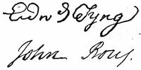
The next ranking provincial naval officer was Capt. John Rous, or Rouse, who commanded the “Shirley Galley,” a snow, or two-masted vessel, of 24 guns. Rouse had the previous year, in a Boston privateer, spread some consternation among the French fishing-fleet on the Grand Banks. It was this provincial craft and the royal ship the “Mermaid,” of 40 guns, Capt. James Douglas, which captured the French man-of-war the “Vigilant,” 64 guns (no. 15), as she was approaching the coast. (Drake’s Five Years’ War, App. C.) Douglas was transferred to the captured ship, and a requisition was made upon the colonies to furnish a crew to man her. (Corresp., etc., in R. I. Col. Rec., v.) Capt. William Montague was put in command of the “Mermaid,” and after the surrender she sailed, June 22, for England with despatches, arriving July 20. Duplicate despatches were sent by Rouse in the “Shirley Galley,” which sailed July 4. The British government took the “Shirley Galley” into their service and commissioned Rouse as a royal post-captain. This vessel disappears from sight after 1749, when Rouse is found in command of a vessel in the fleet which brought Cornwallis to Chebucto (Halifax). At the time of Rouse’s death at Portsmouth, Apr. 3, 1760, he was in command of the “Sutherland,” 50 guns. (Charnock, Biographia Navalis; Isaac J. Greenwood’s “First American built vessels in the British navy,” in the N. E. Hist. and Geneal. Reg., Oct., 1866, p. 323. There are notes on Rouse, with references, in Hist. Mag., i. 156, and N. Y. Col. Docs., x. 59; cf. also Drake’s Five Years’ French and Indian War, p. 240, and Nova Scotia Docs., ed. by Akins, p. 225.) Preble (N. E. H. and Gen. Reg., 1868, p. 396) collates contemporary authorities for a precise description of a “galley.” Such a ship was usually a “snow,” as the largest two-masted vessels were often called, and would seem to have carried all her guns on a continuous deck, without the higher tiers at the ends, which was customary with frigates built low only at the waist.
The “Cæsar,” of 20 guns, was commanded by Capt. Snelling, the third ranking provincial officer.
[959] Gov. Wolcott, of Connecticut, wrote to Gov. Hamilton, of Pennsylvania, that the secret of the success of the Louisbourg expedition lay in the fact that the besiegers were freeholders and the besieged mercenaries. (Pa. Archives, ii. p. 127.)
[960] Petitions of one Capt. John Lane, who calls himself the first man wounded in the siege, are in the Mass. Archives, and are printed in the Hist. Mag., xxi. 118.
[961] Carter-Brown, iii. nos. 796, 805. Cf. Samuel Niles, A brief and plain essay on God’s wonder-working Providence for New England in the reduction of Louisbourg. N. London (T. Green), 1747. This is in verse. (Sabin, xiii. 55,330.)
[962] Burrows (Life of Lord Hawke, p. 341) says of this tract: “Few papers convey a more accurate description of contemporary opinion on the colonial questions disputed between Great Britain and France in the last century.”
[963] “A train of favorable, unforeseen, and even astonishing events facilitated the conquest,” says Amos Adams in his Concise Hist. of New England, etc. Palfrey in his review of Mahon speaks of it as “one of the wildest undertakings ever projected by sane people.” Whatever the fortuitous character of the conquest, there was an attempt made in England to give the chief credit of it to Warren, who never landed a marine during its progress.

This assumption was violently maintained in the debates in Parliament at the outbreak of the Revolutionary War. The question is examined by Stone in his Life of Johnson, i. 152, who also, p. 58, gives an account of Warren and his residence in New York. English statesmen were not so instructed later, but that Lord John Russell, in his introduction to the Bedford Correspondence, i. p. xliv., could say: “Commodore Warren, having been despatched by the Duke of Bedford for that purpose, took Louisbourg.”
[964] The French record of some of the principal official documents is in the Collection de Manuscrits (Quebec), vol. iii., such as the summons of May 7, the declination of May 18 (pp. 220, 221), the papers of the final surrender and exchange of prisoners (pp. 221-236, 265, 314, 377), and Du Chambon’s account of the siege, written from Rochefort, Sept. 2, 1745 (p. 237).
[965] Inquiry has not disclosed that any portrait of Gridley exists.
[966] Both of these works contain another map, Plan of the City and Harbour of Louisbourg, showing the landing place of the British in 1745 and 1758, and their encampment in 1758.
[967] The Carter-Brown Catalogue (iii. no. 1,469) gives the date of publication 1765, and assigns its publication to “Mary Ann Rocque, topographer to his Royal Highness, the Duke of Gloucester.”
[968] Amer. Magazine (Boston), Dec., 1745. Some of Shirley’s admirers caused his portrait to be painted, and some years later they gave it to the town of Boston, and it was hung in Faneuil Hall. Town Records, 1742-57, p. 26.
[969] Mascarene in a letter to Shirley, April 6, 1748, undertakes to show the difficulties of composing the jealousies of the English towards the Acadians. Mass. Hist. Coll., vi. 120.
[970] In Harv. Coll. library “Collection of Nova Scotia maps.”
[971] Cf. Lawrence to Monckton, 28 March, 1755, in Aspinwall Papers (Mass. Hist. Coll., xxxix. 214).
[972] The annexed plan is from the Mémoires sur le Canada, 1749-1760, as published by the Lit. and Hist. Soc. of Quebec (re-impression), 1873, p. 45. The same Mémoires has a plan (p. 40) of Fort Lawrence. Various plans and views of Chignectou are noted in the Catalogue of the King’s Maps (British Museum), i. 239. A “Large and particular plan of Shegnekto Bay and the circumjacent country, with forts and settlements of the French till dispossessed by the English, June, 1755, drawn on the spot by an officer,” was published Aug. 16, 1755, by Jefferys, and is given in his General Topography of North America and West Indies, London, 1766. Cf. J. G. Bourinot’s “Some old forts by the sea,” in Trans. Royal Soc. of Canada, i. sect. 2, p. 71.
[973] A contemporary account of these Indians, by a French missionary among them, was printed in London in 1758, as An account of the customs and manners of the Micmakis and Maricheets savage nations now dependent on the government of Cape Breton. (Field, Ind. Bibliog., no. 1,062; Quaritch, 1885, no. 29,984, £4 4s.)
[974] The Life and Sufferings of Henry Grace, Reading, 1764 [Harv. Coll. lib. 5315.5], gives the experience of one of Lawrence’s men, captured by the Indians at this time.
[975] The French ministry were advising Vaudreuil, “Nothing better can be done than to foment this war of the Indians on the English, which at least delays their settlements.” (N. Y. Col. Docs., x. 949.)
[976] Cf. references in Barry’s Mass., ii. 199. The journal of Winslow during the siege in the summer and autumn of 1755 is printed from the original MS. in the Mass. Hist. Soc. library, in the Nova Scotia Hist. Soc. Coll., vol. iv. Tracts of the time indicate the disparagement which the provincial men received during these events from the regular officers. Cf. Account of the present state of Nova Scotia in two letters to a noble lord,—one from a gentleman in the navy lately arrived from thence; the other from a gentleman who long resided there, London, 1756. Cf. also French policy defeated, being an account of all the hostile proceedings of the French against the British colonies in North America for the last seven years, ... with an account of the naval engagement of Newfoundland and the taking of the forts in the Bay of Fundy, London, 1755. (Carter-Brown, iii. no. 1,060.)
[977] On the 10th of Aug., 1754, Lawrence had sent a message to the Acadians, who had gone over to the French, that he should still hold them to their oaths, and this, as well as a letter of Le Loutre to Lawrence, Aug. 26, 1754, will be found in the Parkman MSS. in the Mass. Hist. Society, New France, i. pp. 271, 281.
[978] Minot, without knowledge of these documents, says: “They [the Acadians] maintained, with some exceptions, the character of neutrals.”
[979] Cf. Bury’s Exodus of the Western Nations, vol. ii. ch. 7.
[980] “They call themselves neutrals, but are rebels and traitors, assisting the French and Indians at all opportunities to murder and cut our throats.” Ames’s Almanac, 1756,—a household authority.
[981] This condition was thoroughly understood by the French authorities. Cf. Vaudreuil’s despatch when he heard of the deportation, Oct. 18, 1755. Doc. Col. Hist. N. Y., x. 358. On Nov. 2, 1756, Lotbinière, addressing the French ministry on a contemplated movement against Nova Scotia, says: “The English have deprived us of a great advantage by removing the French families.”
[982] Winslow’s instructions, dated Halifax, Aug. 11, 1755, are printed in Akins’s Selections, etc., 271. It has sometimes been alleged that a greed to have the Acadian lands to assign to English settlers was a chief motive in this decision. Letters between Lawrence and the Board of Trade (Oct. 18, 1755, etc.) indicate that the hope of such succession to lands was entertained after the event; but it was several years before the hope had fruition.
[983] Guillaume Thomas Raynal’s Histoire philosophique et politique des Etablissemens et du Commerce des Européens dans les deux Indes, Paris, 1770; Geneva, 1780 (in 5 vols. 4to, and 10 vols. 8vo.); revised, Paris, 1820. (Rich, after 1700, p. 290; H. H. Bancroft, Mexico, iii. 648.)
[984] M. Pascal Poirier in the Revue Canadienne (xi. pp. 850, 927; xii. pp. 71, 216, 310, 462, 524) discusses the question of mixed blood, and gives reasons for the mutual attachments of the Acadians and Abenakis, confronting the views of Rameau. He follows the Acadian story down, and traces the migrations of families.
[985] A writer in the Amer. Cath. Q. Rev. (1884), ix. 592, defends the “Acadian confessors of the faith,” and charges Hannay with “monstrous and barefaced perversions of history.” Cf. among the Parkman MSS. (Mass. Hist. Society, New France, i. p. 165) a paper called “Etat présent des missions de l’Acadie. Efforts impuissants des gouverneurs anglois pour détruir la religion catholique dans l’Acadie.”
[986] Doc. Col. Hist. N. Y., x. p. 5.
[987] United States, final revision, ii. 426.
[988] These are set forth in Hannay’s Acadia, ch. xx.; Doc. Col. Hist. N. Y., x. p. 11, etc.; Parkman’s Montcalm and Wolfe, i. 114, 266, etc.; Akins’s Selections from the Pub. Docs. of Nova Scotia (with authorities there cited); Mémoires sur le Canada, 1749-1760 (Quebec, 1838). Le Loutre was a creature of whom it is difficult to say how much of his conduct was due to fanaticism, and how much to a heartless villainy. The French were quite as much inclined as any one to consider him a villain. The Acadians themselves had often found that he could use his Micmacs against them like bloodhounds.
[989] Minot, i. 220.
[990] Rameau (La France aux Colonies, p. 97) allows Raynal’s description to be a forced fantasy to point a moral; but he contends for a basis of fact in it. Cf. Antoine Marie Cerisier’s Remarques sur les erreurs de l’histoire philosphique et politique de Mr. Guillaume Thomas Raynal, par rapport aux affaires de l’Amérique septentrionale, Amsterdam, 1783.
[991] The General History of the Late War, London, 1763, etc.
[992] A Brief State of the Services and Expenses of the Massachusetts Bay, London, 1765, p. 17.
[993] Hist. of Mass. Bay, iii. 39.
[994] Massachusetts, ch. i. x.
[995] Vol. IV. p. 156. Cf. Morgan, Bibliotheca Canadensis, p. 168.
[996] Cf. Mem. Hist. Boston, ii. 123. This journal is in three volumes, the first opening with a letter of proposals by Winslow, addressed to Shirley, followed by a copy of Winslow’s commission as lieutenant-colonel, Feb. 10, 1755. Transcripts then follow of instructions, letters, accounts, orders, rosters, log-books, reports, down to Jan., 1756. This volume is mostly, if not wholly, in Winslow’s own hand. It has been printed in vol. iii. of the Nova Scotia Hist. Soc. Collections, beginning with a letter from Grand Pré, Aug. 22, 1755. The second volume (Feb.-Aug., 1756) has a certificate that it is, “to the best of my skill and judgment, a true record of original papers committed to my care for that purpose.” This is signed “Henry Leddel, Secretary to General Winslow.” The third volume (Aug.-Dec., 1756) is similarly certified. There is in the Mass. Hist. Soc. another collection of Winslow’s papers (cf. Proc., iii. 92) covering 1737-1766, being mostly of a routine military character.
[997] Compare the enumeration of MSS. on Acadia, as indexed in the Catalogue of the Library of Parliament, Toronto, 1858, p. 1451. There are preserved in the office of the registrar of the Province of Quebec ten volumes of MS. copies of documents relating to the history of Canada, covering many pertaining to Acadia. A list of their contents was printed in 1883, entitled Réponse à un ordre de la chambre, demandant copie de la liste des documents se rapportant à l’histoire du Canada, copiés et conservés au département du régistraire de la Province de Québec. J. Blanchet, Secrétaire. Cf. “Evangeline and the Archives of Nova Scotia,” in Trans. Lit. and Hist. Soc. of Quebec, 1869-70.
[998] Orig. ed. (1852), iv. 206. In writing his first draft of the transaction in 1852, Bancroft, referring seemingly to Haliburton’s statement, says: “It has been supposed that these records of the council are no longer in existence; but I have authentic copies of them.” (Orig. ed., iv. 200).
[999] Ed. 1882, vol. ii. 225.
[1000] “The publications of C. R. Williams, with notes concerning them,” in R. I. Hist. Tracts. no. xi. For other accounts concerning the condition of the “Evangeline Country,” see E. B. Chase’s Over the Border, Acadia, the home of Evangeline (Boston, 1884), with various views; J. De Mille in Putnam’s Magazine, ii. 140; G. Mackenzie in Canadian Monthly, xvi. 337; C. D. Warner’s Baddeck (Boston, 1882); and the view of Grandpré in Picturesque Canada, ii. 789.
[1001] There is a sample of this purely sympathetic comment in Whittier’s Prose Works, ii. 64.
[1002] New series, vol. vii. (1870).
[1003] Palfrey (Compend. Hist. New England, iv. 209) says: “There appears to be no doubt that they were a virtuous, simple-minded, industrious, unambitious, religious people. They were rich enough for all their wants. They lived in equality, contentment, and brotherhood; the priest or some trusted neighbor settled whatever differences arose among them.”
[1004] Halifax, 1865-67, vol. ii. ch. 20. Cf. Vol. IV. p. 156.
[1005] Page 369.
[1006] Ch. iv. and viii.
[1007] Montcalm and Wolfe, i. 90.
[1008] He does intimate, in some later published letters, that a taking of hostages might perhaps have sufficed. The controversy of which these letters are a part began with the anticipatory publication by Mr. Parkman of his chapter on the Acadians in Harper’s Monthly, Nov., 1884. This drew out from Mr. Philip H. Smith a paper in the Nation, Oct. 30, 1884, in which incautiously, and depending on Haliburton, he charged the English with rifling their archives to rid them of the proofs of the atrocity of the deportation. Parkman exposed his error, in the same journal, Nov. 6, 1884, and also in the N. Y. Evening Post, Jan. 20, 1885, and Boston Evening Transcript, Jan. 22. Smith transferred his challenge to the Boston Evening Transcript of Feb. 11, 1885, making a good point in quoting the Philadelphia Memorial of the Acadians, which affirmed that papers which could show their innocence had been taken from them; but he unwisely claimed for the exiles the literary skill of that memorial, which seems to have been prepared by some of their Huguenot friends in Philadelphia. A few more letters appeared in the same journal from Parkman, Akins, and Smith, but added nothing but iteration to the question. (Cf. Transcript, Feb. 25, by Parkman; March 19 by Akins; March 23, April 3, by Smith.)
[1009] Akins’ Select. from Pub. Doc., 277; Smith’s Acadia, 219.
[1010] A letter from a gentleman in Nova Scotia to a person of distinction in the continent, describing the present state of government in that colony, 1736, p. 7.
[1011] Boston Transcript, Feb. 11, 1885. In his Acadia, p. 256, he says 15,000 were “forcibly extirpated” [sic], but he probably includes later deportations, mainly from the northern side of the Bay of Fundy.
[1012] Une Colonie féodale en Amérique (Paris, 1877). To this 6,000 Rameau adds 4,000 as the number previously removed to the islands of the gulf, 4,000 as having crossed the neck to come under French protection, and 2,000 as having escaped the English,—thus making a total of 16,000, which he believes to have been the original population of the peninsula. Cf. on Rameau, Daniel’s Nos Gloires, ii. 345
[1013] See Lawrence’s letter to Monckton in the “Aspinwall Papers,” Mass. Hist. Soc. Coll., xxxix. 214
[1014] Lawrence’s letter to Hancock, Sept. 10, 1755, in N. E. Hist. and Gen. Reg., 1876, p. 17.
[1015] There are large extracts from these Archives in the Winslow Papers (Mass. Hist. Soc.). North Amer. Rev., 1848, p. 231. There is usually scant, if any, mention of them in the published town histories of Massachusetts. In Bailey’s Andover (p. 297) there is some account of those sent to that town, and a copy of a petition (Mass. Archives, xxiii. 49) from those in Andover and adjacent towns to the General Court, urging that their children should not be bound out to service. Cf. also Aaron Hobart’s Abington, App. F., and “Lancaster in Acadie and Acadiens in Lancaster,” by H. S. Nourse, in Bay State Monthly, i. 239; Granite Monthly, vii. 239. More came to Boston in the first shipment than were expected, and New Hampshire was asked to receive the excess. N. H. Prov. Records, vi. 445, 446.
[1016] N. E. Hist. and Gen. Reg., 1862, p. 142.
[1017] Jasper Mauduit’s letter to the House of Representatives, relating to a reimbursement of the expense of supporting the French neutrals, 1763. Mass. Hist. Coll., vi. 189. Among the Bernard Papers (Sparks MSS.), ii. 279, is a letter from Bernard to Capt. Brookes, dated Castle William, Sept. 26, 1762, forbidding the landing of Acadians from his “transports.” There is also in Ibid., ii. 83, a letter of Gov. Bernard, July 20, 1763, in which he speaks of a proposition which had been made to the French neutrals then in the province, to go to France on invitation of the French government. “Many of these people,” he adds, “are industrious, and would, I believe, prefer this country and become subjects of Great Britain in earnest, if they were assured of liberty of conscience.” The governor accordingly asks instructions from the Lords of Trade. The number of such people intending to go was, as he says, 1,019 in all, which he considers very near if not quite the whole number in the province. Bernard expressed a hope that he could induce them to settle rather at Miramichi, as he had formed a high opinion of their industry and frugality (p. 86). When some of them wished to migrate to Saint Pierre, the small island near the St. Lawrence Gulf, then lately confirmed to France, the governor and council tried to persuade them to remain.
[1018] See further in Penna. Archives, ii. 513, 581; Penna. Col. Recs., vii. 45, 55, 239-241, 408-410.
[1019] Cf. also his Contributions to Amer. History (1858), and Philad. American and Gazette, Mar. 29, 1856.
[1020] Penna. Mag. of Hist., iii. 147. Cf. also Scharf’s Maryland, i. 475-79; Johnston’s Cecil County (1881), p. 263.
[1021] Dinwiddie Papers, ii. 268, 280, 293, 306, 347, 360, 363, 379, 380, 396, 408, 444, 538.
[1022] Hist. Georgia, i. 505.
[1023] Dinwiddie Papers, ii. 410, 412, 417, 463, 479, 544.
[1024] Akins’ Selections, etc., 303; R. I. Col. Rec., v. 529.
[1025] In July, 1756, Governor Spencer Phips gave orders to detain seven boats, containing ninety persons.
[1026] Doc. Col. Hist. N. Y., vii. 125.
[1027] R. L. Daniels in Scribner’s Monthly, xix. 383.
[1028] From January to May, 1765, 650 arrived from the English colonies. Gayarré, Louisiana, its history as a French colony (N. Y., 1852), pp. 122, 132.
[1029] Parkman, i. 282-3. There are various papers of uncertain value in the Parkman MSS. in the Mass. Hist. Society, New France, vol. i., respecting the fate and numbers of the exiles. One paper dated at London in 1763 says there were 866 in England, 2,000 in France, and 10,000 in the English colonies. Another French document of the same year places the number in France at from three thousand to thirty-five hundred. There are among these papers plans for establishing some at Guiana, with letters from others at Miquelon and at Cherbourg.
[1030] Cf. Mass. Hist. Soc. Proc., xiii. 77.
[1031] See chapter viii.
[1032] Sabin, ix. 36,727; Boston Public Library, 4426.17; Harvard Coll. lib., 4375.39; Haven, Ante Rev. Bibliog., p. 540. Parkman (Montcalm and Wolfe, ii. 81) refers to five letters from Amherst to Pitt, written during the siege, which he got from the English Public Record Office, copies of which are in the Parkman MSS. in the Mass. Hist. Soc. Library. Cf. Proc., 2d ser., i. p. 360.
[1033] There is an abstract in English of the journal of a French officer during the siege, in N. Y. Hist. Soc. Coll., 1881, p. 179.
[1034] He sometimes called himself Thomas Signis Tyrrell, after his mother’s family. Cf. Akins’ Select. from Pub. Doc. of N. Scotia, p. 229, where some of Pichon’s papers, preserved at Halifax, are printed.
[1035] Sabin, xv. 62,610-11; Brinley, i. no. 71; Carter-Brown, iii. nos. 1,274-75. There are in the Collection de Manuscrits (Quebec, 1883, etc.) Drucour’s account of the defences of Louisbourg (iv. 145); Lahoulière’s account of the siege, dated Aug. 6, 1758 (iv. 176), and other narratives (iii. 465-486).
[1036] Also, Ibid., p. 188, is a journal of a subsequent scout of Montresor’s through the island.
[1037] Carter-Brown, iii. no. 1,184.
[1038] Carter-Brown, iii. no. 1,389.
[1039] Carter-Brown, iii. no. 1,680.
[1040] Particularly letters of Nathaniel Cotton, a chaplain on one of the ships.
[1041] Cf. references in Barry’s Massachusetts, ii. p. 230. There are some letters in the Penna. Archives, ii., 442, etc.
[1042] Vol. III. p. 8.
[1043] Vol. II. p. 108.
[1044] Vol. III. p. 9.
[1045] Vol. II. p. 122.
[1046] Vol. IV. p. 92.
[1047] Vol. III. p. 213.
[1048] Vol. IV. pp. 107, 152. This is the earliest map given in the blue book, North American boundary, Part i. London, 1840.
[1049] Vol. IV. p. 380.
[1050] Vol. IV. p. 382.
[1051] Vol. IV. p. 383.
[1052] Vol. III. p. 306.
[1053] Vol. IV. p. 383.
[1054] Vol. IV. p. 384.
[1055] Vol. IV. p. 384.
[1056] Vol. IV. p. 386.
[1057] Vol. IV. p. 388.
[1058] Vol. IV. p. 390.
[1059] Vol. IV. p. 391.
[1060] Vol. IV. p. 148.
[1061] Vol. IV. p. 393.
[1062] The cartography of these three books deserves discrimination. In De Nieuwe en onbekende Weereld of Montanus (Amsterdam, 1670-71) the map of America, “per Gerardum a Schagen,” represents the great lakes beyond Ontario merged into one. The German version, Die unbekante Neue Welt, of Olfert Dapper has the same map, newly engraved, and marked “per Jacobum Meursium.” Ogilby’s English version, America, being an accurate description of the New World (London, 1670), though using for the most part the plates of Montanus, has a wholly different map of America, “per Johannem Ogiluium.” This volume has an extra map of the Chesapeake, in addition to the Montanus one, beside English maps of Jamaica and Barbadoes, not in Montanus. These maps are repeated in the second edition, which is made up of the same sheets, to which an appendix is added, and a new title, reading, America, being the latest and most accurate description of the new world. It will be remembered that Pope, in the Dunciad (i. 141), mocked at Ogilby for his ponderous folio,—
“Here swells the shelf with Ogilby the Great.”
[1063] Vol. III. p. 383.
[1064] Vol. IV. p. 249.
[1065] Vol. IV. p. 228.
[1066] See Vol. IV. p. 229. This map was also reproduced in the North American boundary, Part i. London, 1840.
[1067] For further references, see sections v. and vi. of “The Kohl Collection of Maps,” published in Harvard Univ. Bulletin, 1884-85. Cf. also the Mémoire pour les limites de in Nouvelle France et de la Nouvelle Angleterre (1689) in Collection de Manuscrits relatifs à l’histoire de la Nouvelle France, Quebec, 1883, vol. i. p. 531. In later volumes of this Collection will be found (vol. iii. p. 49) “Mémoire sur les limites de l’Acadie envoyé à Monseigneur le Duc d’Orléans par le Père Charlevoix,” dated at Quebec, Oct. 29, 1720 (iii. p. 522); “Mémoire sur les limites de l’Acadie,” dated 1755. here is an historical summary of the French claim (1504-1706) in the N. Y. Col. Docs., ix. 781.
[1068] Moll’s maps were used again in the 1741 edition of Oldmixon. Moll combined his maps of this period in an atlas called The world displayed, or a new and correct set of maps of the several empires, etc., the maps themselves bearing dates usually from 1708 to 1720.
[1069] This memorial was printed by Bradford in Philadelphia about 1721. Hildeburn’s Century of Printing, no. 170. There was a claim upon the Kennebec, arising from certain early grants to Plymouth Colony, and in elucidation of such claims A patent for Plymouth in New England, to which is annexed extracts from the Records of the Colony, etc., was printed in Boston in 1751. There is a copy among the Belknap Papers, in the Mass. Hist. Soc. (61, c. 105, etc.), where will be found a printed sheet of extracts from deeds, to which is annexed an engraved plan of the coast of Maine between Cape Elizabeth and Pemaquid, and of the Kennebec valley up to Norridgewock, which is called A true copy of an ancient plan of E. Hutchinson’s, Esqr., from Jos. Heath, in 1719, and Phins. Jones’ Survey in 1751, and from John North’s late survey in 1752. Attest, Thomas Johnston. The Belknap copy has annotations in the handwriting of Thomas Prince, and with it is a tract called Remarks on the plan and extracts of deeds lately published by the proprietors of the township of Brunswick, dated at Boston, Jan. 26, 1753. This also has Prince’s notes upon it.
[1070] N. Y. Col. Docs., ix. 894. Cf. Penna. Archives, 2d ser., vi. 93.
[1071] N. Y. Col. Docs., ix. 915.
[1072] Brit. Mus. MSS., no. 23,615 (fol. 72).
[1073] Charlevoix was brought to the attention of New England in 1746, by copious extracts in a tract printed at Boston, An account of the French settlements in North America ... claimed and improved by the French king. By a gentleman.
[1074] Jefferys reproduced this map in the Gentleman’s Mag. in 1746.
[1075] Among the more popular maps is that of Thomas Kitchin, in the London Mag., 1749, p. 181.
[1076] Sabin, xii. no. 47,552.
[1077] See Vol. IV. p. 154.
[1078] N. Y. Col. Docs., x. 220.
[1079] Rich, Bibl. Amer. (after 1700), p. 103; Leclerc, no. 691.
[1080] The articles of the treaty of Utrecht touching the American possessions of England are cited and commented upon in William Bollan’s Importance and Advantage of Cape Breton, etc. (London, 1746.) The diplomacy of the treaty of Utrecht can be followed in the Miscellaneous State Papers, 1501-1726, in two volumes, usually cited by the name of the editor, as the Hardwicke Papers. Cf. also Actes, mémoires et autres pièces authentiques concernant la paix d’Utrecht, depuis l’année 1706 jusqu’à présent. Utrecht, 1712-15, 6 vols. J. W. Gerard’s Peace of Utrecht, a historical review of the great treaty of 1713-14, and of the principal events of the war of the Spanish succession (New York, etc., 1885) has very little (p. 286) about the American aspects of the treaty.
[1081] N. Y. Col. Docs., ix. 878, 894, 913, 932, 981.
[1082] To Shirley was dedicated a tract by William Clarke, of Boston, Observations on the late and present conduct of the French, with regard to their encroachments upon the British colonies in North America; together with remarks on the importance of these colonies to Great Britain, Boston, 1755, which was reprinted in London the same year. Cf. Thomson’s Bibliog. of Ohio, nos. 234, 235; Hildeburn’s Century of Printing, no. 1,407; Catal. of works rel. to Franklin in Boston Pub. Lib., p. 13. The commissioners seem also to have used an account of Nova Scotia, written in 1743, which is printed in the Nova Scotia Hist. Coll., i. 105.
[1083] The correspondence of the Earl of Albemarle, the British minister at Paris, with the Newcastle administration, to heal the differences of the conflicting claims, is noted as among the Lansdowne MSS. in the Hist. MSS. Com. Report, iii. 141.
[1084] The three quarto volumes were found on board a French prize which was taken into New York, and from them the French claim was set forth in A memorial containing a summary view of facts with their authorities in answer to the Observations sent by the English ministry to the courts of Europe. Translated from the French. New York, 1757. The 2d volume of the original 4to ed. and the 3d volume of the 12mo edition contain the following treaties which are not in the London edition, later to be mentioned:—
1629, Apr. 24, between Louis XIII. and Charles I., at Suze.
1632, Mar. 29, between Louis XIII. and Charles I., at Saint Germain-en-Laye.
1655, Nov. 3, between France and England, at Westminster.
1667, July 21-31, between France and England, at Breda; and one of alliance between Charles II. and the Netherlands.
1678, Aug. 10, between Louis XIV. and the Netherlands, at Nimégue.
1686, Nov. 16. Neutrality for America, between France and England, at London.
1687, Dec. 1-11. Provisional, between France and England, concerning America, at Whitehall.
1697, Sept. 20, between France and England, at Ryswick.
[This treaty is also in the Collection de Manuscrits relatifs à l’histoire de la Nouvelle France (Quebec, 1884), vol. ii.]
1712, Aug. 19. Suspension of arms between France and England, at Paris.
1713, Mar. 31-11 Apr. Peace between France and England, and treaty of navigation and commerce, at Utrecht.
1748, Oct. 18, between France, England, and the Netherlands, at Aix-la-Chapelle.
The Bedford Correspondence (3 vols., 1842) is of the first importance in elucidating the negotiations which led to the treaty of Aix-la-Chapelle. The Mémoires of Paris and the Memorials of London also track the dispute over the St. Lucia (island) question, but in the present review that part need not be referred to.
[1085] It is said to have been arranged by Charles Townshend. Cf. Vol. IV. index.
1. Memorial describing the limits, etc. (in French and English), signed Sept. 21, 1750, by W. Shirley and
W. Mildmay.
2. “Mémoires sur l’Acadie” of the French commissioners, Sept. 21 and Nov. 16, 1750.
3. Memorial of the English commissioners (in French and English), Jan. 11, 1751.
4. Memoir of the French commissioners (en réponse), Oct. 4, 1751. The “preuves” are cited at the foot of each page.
5. Memorial of the English commissioners (in French and English) in reply to no. 4. The “authorities” are given at the foot of the page. It is signed at Paris, Jan. 23, 1753, by William Mildmay and Ruvigny de Cosne.
6. “Pièces justificatives,” supporting the memoir of the English commissioners, Jan. 11, 1751, viz.:—
Concession of James I. to Thomas Gates, Apr., 1606 (in French and English).
Concession of James I. to Sir Wm. Alexander, Sept., 1621 (in Latin), being the same as that of Charles I., July 12, 1625.
Occurrences in Acadia and Canada in 1627-28, by Louis Kirk, as found in the papers of the Board of Trade (in French and English).
Lettres patentes au Sieur d’Aulnay Charnisay, Feb., 1647.
Lettres patentes au Sieur de la Tour, 1651. [There are various papers on the La Tour-D’Aulnay controversy in Collection de Manuscrits, Quebec, 1884, ii. 351, etc.]
Extract from Memoirs of Crowne, 1654 (in French and English).
Orders of Cromwell to Capt. Leverett, Sept. 18, 1656 (in French and English).
Acte de cession de l’Acadie au Roi de France, 17 Feb., 1667-8 (in French and English).
Letters of Temple, 1668 (in French and English).
Lettre du Sieur Morillon du Bourg, dated “à Boston, le 9 Nov., 1668.”
Order of Charles II. to Temple to surrender Acadia, Aug. 6, 1669 (in French and English).
Temple’s order to Capt. Walker to surrender Acadia, July 7, 1670 (in French and English).
Act of surrender of Pentagoet by Walker, Aug. 5, 1670 (in French and English).
Procès verbal de prise de possession du fort de Gemisick, Aug. 27, 1670.
Certificate de la redition de Port Royal, Sept. 2, 1670.
Ambassadeur de France au Roi d’Angleterre, Jan. 16, 1685.
Vins saisis à Pentagoet, 1687.
John Nelson to the lord justices of England, 1697 (in French and English).
Gouverneur Villebon à Gouverneur Stoughton, Sept. 5, 1698.
Vernon to Lord Lexington, Ap. 29, 1700 (in French and English).
Board of Trade to Queen Anne, June 2, 1709 (in French and English).
Promesse du Sieur de Subercase, Oct. 23, 1710.
Premières Propositions de la France, Ap. 22, 1711.
Réponses de la France, Oct. 8, 1711, aux demands de la Grand Bretagne (in French and English).
Instruction to British plenipotentiaries for making a treaty with France, Dec. 23, 1711 (in French and English).
Mémoire de M. St. Jean, May 24, 1712 (in French and English).
Réponses du Roi au mémoire envoyé de Londres, June 5-10, 1712.
Offers of France, Demands for England, the King’s Answers, Sept. 10, 1712 (in French and English).
Treaty of Utrecht, art. xii. (in Latin and French).
Acte de cession de l’Acadie par Louis XIV., May, 1713.
7. Table des Citations, etc., dans le mémoire des Com. Français, Oct. 4, 1751, viz.—
Ouvrages imprimés: Traités, 1629-1749; Mémoires, etc., par les Com. de sa Majesté Britannique; Titres
et pièces communiquées aux Com. de sa Majesté Britannique.
Pièces manuscrites;—
1632, May 19. Concession à Rasilly.
1635, Jan. 15. Concession à Charles de St. Étienne.
1638, Feb. 10. Lettre du Roy au Sieur d’Aunay Charnisay.
1641, Feb. 13. Ordre du Roi au Sieur d’Aunay Charnisay.
1643, Mar. 6. Arrêt.
1645, June 6. Commission du Roi an Sieur de Montmagny.
1651, Jan. 17. Provisions en faveur du Sieur Lauson.
1654, Jan. 30. Provision pour le Sieur Denis.
1654, Aug. 16. Capitulation de Port Royal.
1656, Aug. 9. Concession faite par Cromwell.
1657, Jan. 26. Lettres patentes en faveur du Vicomte d’Argenson.
1658, Mar. 12. Arrêt (against departing without leave).
1663, Jan. 19. Concession des isles de le Madelaine, etc., au Sieur Doublet.
1663, May 1. Lettres patentes an Gov. de Mezy.
1664, Feb. 1. Concession an Sieur Doublet (discovery in St. Jean Island).
1668, Nov. 29. Lettre du Temple an Sieur du Bourg.
1669, Mar. 8. Ordre du Roi d’Angleterre au Temple pour restituer l’Acadie.
1676, Oct. 16. Concession de la terre de Soulanges par Frontenac et Duchesneau.
1676, Oct. 16. Concession an Sieur Joibert de Soulanges du fort de Gemisik par Frontenac et Duchesneau.
1676, Oct. 24. Concession de Chigneto au Sieur le Neuf de la Vallière par Frontenac et Duchesneau.
1684. M. de Meules au Roi.
1684. Requête des habitans de la Coste du sud du fleuve St. Laurent.
1684, Sept. 20. Concessions des Sieurs de la Barre et de Meules au Sieur d’Amour Ecuyer, de la rivière de
Richibouctou, et an Sieur Clignancourt, de terres à la rivière St. Jean.
1686. Mémoire de M. de Meules sur la Baye de Chedabouctou.
1689, Jan. 7. Concession à la rivière St. Jean au Sieur du Breuil.
1710, Oct. 3. Lettre de Nicholson à Subercase.
[1087] This document was also published at the Hague in 1756, as Répliques des Commissaires Anglois: ou Mémoire présenté, le 23 Janvier, 1753, with a large folding map.
[1088] The maps of Huske and Mitchell (1755), showing the claims of the French and English throughout the continent, are noted on a previous page (ante, p. 84), and that of Huske is there sketched. In a New and Complete Hist. of the Brit. Empire in America, London, 1756, etc., are maps of “Newfoundland and Nova Scotia,” and of “New England and parts adjacent,” showing the French claim as extending to the line of the Kennebec, and following the water-shed between the St. Lawrence and the Atlantic.
[1089] Carter-Brown, iii. no. 1,028. A French translation appeared the next year: Conduite des François par rapport à la Nouvelle Ecosse, depuis le premier établissement de cette colonie jusqu’à nos jours. Traduit de l’Anglois avec des notes d’un François [George Marie Butel-Dumont]. Londres, 1755. The next year (1756) a reply, said to be by M. de la Grange de Chessieux, was printed at Utrecht, La Conduite des François justifiée. (Carter-Brown, iii. no. 1,129.)
[1090] Discussion sommaire sur les anciennes limites de l’Acadie [par Matthieu François Pidansat de Mairobert]. Basle, 1755. (Stevens, Nuggets, no. 2,972.) Cf. also A fair representation of his Majesty’s right to Nova Scotia or Acadie, briefly stated from the Memorials of the English Commissaries, with an answer to the French Memorials and to the treatise Discussion sommaire par les anciennes limites de l’Acadie, London, 1756. (Carter-Brown, iii. no. 1,130).
[1091] Stevens, Nuggets, no. 2,973.
[1092] It includes, for the most distant points, Boston, Montreal, and Labrador.
[1093] Various maps of Nova Scotia, drawn by order of Gov. Lawrence (1755), are noted in the British Museum, King’s Maps (ii. 105), as well as others of date 1768. Of this last date is an engraved Map of Nova Scotia or Acadia, with the islands of Cape Breton and St. John, from actual surveys by Capt. Montresor, Eng’r. There is a map of Nova Scotia and Newfoundland in A New and Complete Hist. of the Brit. Empire in America, Lond., 1756; and one of New England and Nova Scotia by Kitchin, in the London Magazine, Mar., 1758. In the Des Barres series of British Coast Charts of 1775-1776, will be found a chart of Nova Scotia, and others on a larger scale of the southeast and southwest coasts of Nova Scotia.
[1094] On three sheets, each 22½ x 18½ inches, and called Louisiane et Terres Angloises.
[1095] N. Y. Col. Docs., x. 293.
[1096] Stevens, Bibl. Geog., no. 451.
[1097] See Vol. IV. p. 356.
[1098] The Indians held the Ohio to be the main stream, the Upper Mississippi an affluent. Hale, Book of Rites, 14.
[1099] Cf. also Propositions made by the Five Nations of Indians to the Earl of Bellomont, 20 July, 1698, New York, 1698 (22 pp.). Sabin, xv. 66,061. Brinley’s copy brought $410.
[1100] See chapters ii. and vii.
[1101] There is a contemporary MS. record of this conference in the Prince Collection, Boston Public Library. (Catal., p. 158.)
[1102] For the movement instituted by Spotswood, and his inspection of the country beyond the Blue Ridge, see chapter iv., and the authorities there cited.
[1103] See chapter vii.
[1104] See chapter ii.
[1105] This Indian confederacy of New York called themselves Hodenosaunee (variously spelled); the French styled them Iroquois; the Dutch, Maquas; the English, the Five Nations; the Delawares, the Menwe, which last the Pennsylvanians converted into Mingoes, later applied in turn to the Senecas in Ohio. Dr. Shea, in his notes to Lossing’s ed. of Washington’s diaries, says: “The Mengwe, Minquas, or Mingoes were properly the Andastes or Gandastogues, the Indians of Conestoga, on the Susquehanna, known by the former name to the Algonquins and their allies, the Dutch and Swedes; the Marylanders knew them as the Susquehannas. Upon their reduction by the Five Nations, in 1672, the Andastes were to a great extent mingled with their conquerors, and a party removing to the Ohio, commonly called Mingoes, was thus made up of Iroquois and Mingoes. Many treat Mingo as synonymous with Mohawk or Iroquois, but erroneously.”
[1106] The inscription on Moll’s Map of the north parts of America claimed by France (1720) makes the Iroquois and “Charakeys” the bulwark and security of all the English plantations. This map has a view of the fort of “Sasquesahanock.” A map of the region of the Cherokees, from an Indian draught, by T. Kitchen, is in the London Mag., Feb., 1760.
[1107] Chapter vii.
[1108] This fort had been built in 1739, and called Fort St. Frederick. G. W. Schuyler (Colonial N. Y., ii. pp. 113, 114) uses the account of the adjutant of the French force, probably found in Canada at the conquest. The fort stood on the west side of the Hudson, south of Schuylerville, while Fort Clinton, built in 1746, was on the east side. (Ibid., ii. pp. 126, 254.) A plan of this later fort (1757) is noted in the King’s Maps (Brit. Museum), ii. 300. See no. 17 of Set of Plans, etc., London, 1763.
[1109] American Mag. (Boston), Nov., 1746.
[1110] Chapter ii. p. 147.
[1111] N. E. Hist. Geneal. Reg., 1866, p. 237.
[1112] See ante, p. 9.
[1113] See ante, p. 3.
[1114] Canadian Antiquarian, vii. 97.
[1115] He was accompanied by Andrew Montour, a conspicuous frontiersman of this time. Cf. Parkman’s Montcalm and Wolfe, i. 54; Schweinitz’s Zeisberger, 112; Thomas Cresap’s letter in Palmer’s Calendar, Va. State Papers, 245; and on his family the Penna. Mag. of Hist., iii. 79, iv. 218.
In 1750 John Pattin, a Philadelphia trader, was taken captive among the Indians of the Ohio Valley, and his own narrative of his captivity, with a table of distances in that country, is preserved in the cabinet of the Mass. Historical Society, together with a letter respecting Pattin from William Clarke, of Boston, dated March, 1754, addressed to Benjamin Franklin, in which Clarke refers to a recent mission of Pattin, prompted by Gov. Harrison, of Pennsylvania, into that region, “to gain as thorough a knowledge as may be of the late and present transactions of the French upon the back of the English settlements.”
[1116] The English got word of this movement in May. N. Y. Col. Docs., vi. 779.
[1117] See papers on the early routes between the Ohio and Lake Erie in Mag. of Amer. Hist., i. 683, ii. 52 (Nov., 1877, and Jan., 1878); and also in Bancroft’s United States, orig. ed., iii. 346. For the portage by the Sandusky, Sciota, and Ohio rivers, see Darlington’s ed. of Col. James Smith’s Remarkable Occurrences, p. 174. The portages from Lake Erie were later discovered than those from Lake Michigan. For these latter earlier ones, see Vol. IV. pp. 200, 224. Cf. the map from Colden given herewith.
[1118] The ruins of this fort are still to be seen (1855) within the town of Erie. Sargent’s Braddock’s Expedition, p. 41. Cf. Egle’s Pennsylvania.
[1119] Now Waterford, Erie Co., Penna.
[1120] The road over the mountains followed by Washington is identified in Lowdermilk’s Cumberland, p. 51.
[1121] Sargent says the ruins of the fort which the French completed in 1755 at Venango were still (1855) to be seen at Franklin, Penna.; it was 400 feet square, with embankments then eight feet high. Sargent’s Braddock’s Exped., p. 41; Day, Hist. Coll. Penna., 312, 642. There is a notice of the original engineer’s draft of the fort in Mass. Hist. Soc. Proc., ix. 248-249. Cf. S. J. M. Eaton’s Centennial Discourse in Venango County, 1876; and Egle’s Pennsylvania, pp. 694, 1122, where there is (p. 1123) a plan of the fort.
[1122] This summons is in Mass. Hist. Coll., vi. 141. Cf. N. Y. Col. Docs., vi. 840.
[1123] The terms of the capitulation, as rendered by Villiers, had a reference to the “assassinat” of Jumonville, which a Dutchman, Van Braam, who acted as interpreter, concealed from Washington by translating the words “death of Jumonville.” This unintended acknowledgment of crime was subsequently used by the French in aspersing the character of Washington. See Critical Essay, post.
[1124] In December, 1754, Croghan reported to Gov. Morris that the Ohio Indians were all ready to aid the English if they would only make a movement. Penna. Archives, ii. 209.
[1125] See chapter ii.
[1126] See post.
[1127] Cf. Le Château de Vaudreuil, by A. C. de Lery Macdonald in Rev. Canadienne, new ser., iv. pp. 1, 69, 165; Daniel’s Nos Gloires, 73.
[1128] A view of the house in Alexandria used as headquarters by Braddock is in Appleton’s Journal, x. p. 785.
[1129] See chapter vii.
[1130] This was now Fort Cumberland. There is a drawn plan of it noted in the Catal. of the King’s Maps (Brit. Mus.), i. 282. Parkman (i. 200) describes it. The Sparks Catal., p. 207, notes a sketch of the “Situation of Fort Cumberland,” drawn by Washington, July, 1755.
[1131] Sargent summarizes the points that are known relative to the unfortunate management of the Indians which deprived Braddock of their services. Sargent, pp. 168, 310; Penna. Archives, ii. 259, 308, 316, 318, 321; vi. 130, 134, 140, 146, 189, 218, 257, 353, 398, 443; Penna. Col. Rec., vi. 375, 397, 460; Olden Time, ii. 238; Sparks’ Franklin, i. 189; Penna. Mag. of History, Oct., 1885, p. 334. Braddock had promised to receive the Indians kindly. Penna. Archives, ii. 290.
[1132] Two other officers, as well as Washington, were destined to later fame,—Daniel Morgan, who was a wagoner, and Horatio Gates, who led an independent company from New York.
[1133] There is an engraving of Beaujeu in Shea’s Charlevoix, iv. 63; and in Shea’s ed. of the Relation diverses sur la bataille du Malangueulé, N. Y., 1860, in which that editor aims to establish for Beaujeu the important share in the French attack which is not always recognized, as he thinks. Cf. Hist. Mag., vii. 265; and the account of Beaujeu by Shea, in the Penna. Mag. of Hist., 1884, p. 121. Cf. also “La famille de Beaujeu,” in Daniel’s Nos gloires nationales, i. 131.
[1134] The annexed plan of the field is from a contemporary MS. in Harvard College library. See Mass. Hist. Soc. Proc., xvii. p. 118 (1879).
Parkman (Montcalm and Wolfe, i. 214) reproduces two plans of the fight: one representing the disposition of the line of march at the moment of attack; the other, the situation when the British were thrown into confusion and abandoned their guns. The originals of these plans accompany a letter of Shirley to Robinson, Nov. 5, 1755, and are preserved in the Public Record Office, in the volume America and West Indies, lxxxii. They were drawn at Shirley’s request by Patrick Mackellar, chief engineer, who was with Gage in the advance column. Parkman says: “They were examined and fully approved by the chief surviving officers, and they closely correspond with another plan made by the aide-de-camp Orme,—which, however, shows only the beginning of the affair.” This plan of Orme is the last in a series of six plans, engraved in 1758 by Jefferys (Thomson, Bibliog. of Ohio, no. 107; Sabin, ii. no. 7,212), and used by him in his General Topography of North America and the West Indies, London, 1768. There is a set of them, also, in the Sparks MSS., in Harvard Coll. library, vol. xxviii.
These six plans are all reproduced in connection with Orme’s Journal, in Sargent’s Braddock’s Expedition. They are:—
I. Map of the country between Will’s Creek and Monongahela River, showing the route and encampments of the English army.
II. Distribution of the advanced party (400 men).
III. Line of march of the detachment from Little Meadows.
IV. Encampment of the detachment from Little Meadows.
V. Line of march with the whole baggage.
VI. Plan of the field of battle, 9 July, 1755.
See also the plans of the battle given in Bancroft’s United States (orig. ed.), iv. 189; Sparks’ Washington, ii. 90, the same plate being used by Sargent, p. 354, and in Guizot’s Washington. In the Faden Collection, in the Library of Congress, there are several MS. plans. (Cf. E. E. Hale’s Catalogue of the Faden Maps.)
Beside the map of Braddock’s advance across the country, given in the series, already mentioned, there is another in Neville B. Craig’s Olden Time (ii. 539), with explanations by T. C. Atkinson, who surveyed it in 1847, which is copied by Sargent (p. 198), who also describes the route. Cf. Egle’s Pennsylvania, p. 84; and the American Hist. Record, Nov., 1874. A map made by Middleton and corrected by Lowdermilk is given in the latter’s History of Cumberland, p. 141. A letter of Sparks on the subject is in De Hass’s West. Virginia, p. 125. The condition of Braddock’s route in 1787 is described by Samuel Vaughan, of London, in a MS. journal owned by Mr. Charles Deane.
The Catal. of Paintings in the Penna. Hist. Soc., no. 65, shows a view of Braddock’s Field, and an engraving is in Gay’s Pop. Hist. U. S., iii. 254, and another in Sargent, as a frontispiece. Judge Yeates describes a visit to the field in 1776, in Hazard’s Register, vi. 104, and in Penna. Archives, 2d ser., ii. 740; and Sargent (p. 275) tells the story of the discovery of the skeletons of the Halkets in 1758. Cf. Parkman, ii. 160; Galt’s Life of Benj. West (1820), i. 64. Some views illustrating the campaign are in Harper’s Magazine, xiv. 592, etc.
[1135] “Poor Shirley was shot through the head,” wrote Major Orme. Cf. Akins’ Pub. Doc. of Nova Scotia, pp. 415, 417, where is a list of officers. Various of young Shirley’s letters are in the Penna. Archives, ii.
[1136] Braddock’s remains are said to have been discovered about 1823 by workmen engaged in constructing the National Road, at a spot pointed out by an old man named Fossit, Fausett, or Faucit, who had been in the provincial ranks in 1755. He claimed to have seen Braddock buried, and to have fired the bullet which killed him. The story is not credited by Sargent, who gives (p. 244) a long examination of the testimony. (Cf. also Hist. Mag., xi. p. 141.) Lowdermilk (p. 187) says that it was locally believed; so does De Hass in his West. Virginia, p. 128. Remains of a body with bits of military trappings were found, however, on digging. A story of Braddock’s sash is told by De Hass, in his W. Virginia, p. 129. In July, 1841, a large quantity of shot and shell, buried by the retreating army, was unearthed near by. Mass. Hist. Soc. Proc., iii. 231, etc. A picture of his grave was painted in 1854 by Weber, and is now in the gallery of the Penna. Hist. Soc. (Cf. its Catal. of Paintings, no. 66.) It is engraved in Sargent, p. 280. Cf. Day, Hist. Coll. Penna., p. 334. Lowdermilk (pp. 188, 200) gives views of the grave in 1850 and 1877, with some account of its mutations. Cf. Scharf and Westcott’s Philadelphia, ii. p. 1002. A story obtained some currency that Braddock’s remains were finally removed to England. De Hass, p. 112.
[1137] See a subsequent page.
[1138] Inquiry into the Conduct of Maj.-Gen. Shirley.
[1139] Stone’s Life of Johnson, i. 538.
[1140] Penna. Archives, vi. 333, 335.
[1141] There are views of it in 1840 and 1844 in J. R. Simms’s Trappers of New York (1871), and Frontiersmen of New York (Albany, 1882), pp. 209, 249; in W. L. Stone’s Life of Johnson, ii. 497; and in Lossing’s Field-Book of the Revolution, i. p. 286.
[1142] See views of it in Gay, iii. p. 286; in Lossing’s Field-Book of the Rev., i. p. 107, and Scribner’s Monthly, March, 1879, p. 622.
[1143] “The loss of the enemy,” says Smith (New York, ii. 220), “though much magnified at the time, was afterwards found to be less than two hundred men.”
[1144] See the English declaration in Penna. Archives, ii. 735.
[1145] On his family see Daniel, Nos Gloires, p. 177.
[1146] For the rejoicing of Shirley’s enemies, cf. Barry’s Mass., ii. 212. Shirley had got an intimation of the purpose to supersede him as early as Apr. 16, 1756. (Penna. Archives, ii. 630.) He had some strong friends all the while.
Gov. Livingston undertook to show that the ill-success of the campaign of 1755 was due more to jealousies and intrigues than to Shirley’s incapacity. (Mass. Hist. Coll., vii. 159.) “Except New York,” he adds, “or rather a prevailing faction here, all the colonies hold Shirley in very high esteem.” Franklin says: “Shirley, if continued in place, would have made a much better campaign than that of Loudoun in 1756, which was frivolous, expensive, and disgraceful to our nation beyond comparison; for though Shirley was not bred a soldier, he was sensible and sagacious in himself and attentive to good advice from others, capable of forming judicious plans, and quick and active in carrying them into execution.... Shirley was, I believe, sincerely glad of being relieved.” Franklin’s Writings (Sparks’ ed.), i. p. 220-21.
[1147] Grenville Correspondence, i. 165, June 5, 1756.
[1148] Marshall’s Washington, i. 327.
[1149] There seems to be some question if any massacre really took place. (Cf. Stone’s Johnson, ii. p. 23.)
[1150] Referring to the fall of Oswego, Smith (New York, ii. 236) says: “The panic was universal, and from this moment it was manifest that nothing could be expected from all the mighty preparations for the campaign.”
[1151] Parkman (i. p. 440) notes the sources of this commotion.
[1152] Loudon had to this end held meetings with the northern governors at Boston in January, and with the southern governors at Philadelphia in March, 1757. Loudon’s correspondence at this time is in the Public Record Office (America and West Indies, vol. lxxxv.), and is copied in the Parkman MSS. When Loudon left with his 91 transports and five men-of-war, he sent off a despatch-boat to England; and Jenkinson, on the receipt of the message, wrote to Grenville, reflecting probably Loudon’s reports, that “the public seem to be extremely pleased with the secrecy and spirit of this enterprise.” Grenville Corresp., i. 201.
[1153] Bancroft and those who follow him, taking their cue from Smith (Hist. of New York), say that Loudon “proposed to encamp on Long Island for the defence of the continent.” Parkman (ii. p. 2) points out that this is Smith’s perversion of a statement of Loudon that he should disembark on that island if head winds prevented his entering New York bay, when he returned from Halifax. There seems to have been a current apprehension of a certain ridiculousness in all of Loudon’s movements. It induced John Adams to believe even then that the colonies could get on better without England than with her. Cf. the John Adams and Mercy Warren Letters (Mass. Hist. Soc. Collections), p. 339.
[1154] Plans of the fort and settlement at Schenectady during the war are in Jonathan Pearson’s Schenectady Patent (1883), pp. 311, 316, 328: namely, one of the fort, by the Rev. John Miller (1695), from an original in the British Museum; another of the town (about 1750-60); and still another (1768).
[1155] Chapter vii.
[1156] Hutchinson (iii. 71) represents that Howe, in the confusion, may have been killed by his own men. On Howe’s burial at Albany, and the identification of his remains many years after, see Lossing’s Schuyler, i. p. 155; Watson’s County of Essex, 88. He was buried under St. Peter’s Church. Cf. Lossing, in Harper’s Mag., xiv. 453.
[1157] Abercrombie’s engineer surveyed the French works from an opposite hill, and pronounced it practicable to carry them by assault. Stark, with a better knowledge of such works, demurred; but his opinions had no weight. A view of the field of Abercrombie’s defeat is given in Gay, Pop. Hist. U. S., iii. 299. M. D’Hagues sent to the Marshal de Belle Isle on account of the situation of Fort Carillon [Ticonderoga] and its approaches, dated at the fort, May 1, 1758, which is printed (in translation) in N. Y. Col. Docs., x. 707; and in the same, p. 720, is another description by M. de Pont le Roy, French engineer-in-chief.
The condition of the fort at the time of Abercrombie’s attack in 1758 is well represented by maps and plans. Cf. the plan of this date in the N. Y. Col. Docs., x. 721; and the French plan noted in the Catal. of the Library of Parliament (Toronto, 1858), p. 1621, no. 86. Bonnechose (Montcalm et le Canada, p. 91) gives a French plan, “Bataille de Carillon, d’après un Plan inédit de l’époque.” Jefferys engraved a Plan of town and fort of Carillon at Tyconderoga, with the attack made by the British army commanded by General Abercrombie, 8 July, 1758, which Jefferys later included in his General Topog. of North America and the West Indies, London, 1768, no. 38. Martin, De Montcalm en Canada, p. 128, follows Jefferys’ draft. Hough in his edition of Pouchot, p. 108, gives the plan of the attack as it appeared in Mante’s Hist. of the Late War, London, 1772, p. 144; and from this it is reproduced in the N. Y. Col. Docs., x. 726.
[1158] When Pitt heard of Abercrombie’s defeat he wrote to Grenville: “I own this news has sunk my spirits, and left very painful impressions on my mind, without, however, depriving me of great hopes for the remaining campaign.” Grenville Correspondence, i. 262.
[1159] Most of the writers, following Bancroft, call him Joseph Forbes; and Bancroft lets that name stand in his final revision.
[1160] This paper in fac-simile is in a volume called Monuments of Washington’s Patriotism (1841). A portion of it is reproduced, but not in fac-simile, in Sparks’ Washington, ii. 314.
[1161] Loyalhannon, Parkman; Loyal Hanna, Bancroft; Loyal Hannan, Irving; Loyal Hanning, Warburton.
[1162] The original MS. report of this conference appears in a sale catalogue of Bangs & Co., N. Y., 1854, no. 1309.
[1163] Speaking of Canada, John Fiske (Amer. Polit. Ideas, p. 55) says of the effect of the bureaucracy which governed it that it “was absolute paralysis, political and social,” and that in the war-struggle of the eighteenth century “the result for the French power in America was instant and irretrievable annihilation. The town meeting pitted against bureaucracy was like a Titan overthrowing a cripple;” but he forgets the history of that overthrow, its long-drawn-out warfare, the part that the vastly superior population and the interior lines and seaboard bases of supplies for the English played in the contest to intensify their power, and the jealousies and independence of the colonies themselves, which so long enabled the French to survive. Even as regards the results of the campaign of 1759, the suddenness had little of the inevitable in it, when we consider the leisurely campaign of Amherst, and the mere chance of Wolfe surmounting the path at the cove. It took the successes of these last campaigns to produce the fruits of conquest, even at the end of a long conflict.
[1164] A plan of Montresor’s for the campaign, dated N. Y., 29 Dec., 1758, is in Penna. Archives, vi. 433.
[1165] Fort Schlosser had been erected in 1750. Cf. O. H. Marshall on the “Niagara Frontier,” in Buffalo Hist. Soc. Publ., ii. 409.
[1166] In August, Amherst was reporting sickness in his army from the water at Ticonderoga, and demanding spruce-beer of his commissary. (Mass. Hist. Soc. Proc., v. 101.)
[1167] See chapter vii.
[1168] In a massive old building, the manor-house of the first Seigneur of Beaufort (1634), which was destroyed in 1879. Cf. Lossing’s sketch in Harper’s Magazine (Jan., 1859), xviii. p. 180.
[1169] Turcotte’s Hist. de l’île d’Orléans (Quebec. 1867), ch. iii.
[1170] Among the officers of the army and navy here acting together were some who were later very famous,—Jervis (Earl St. Vincent), Cook, the navigator, Isaac Barré, the parliamentary friend of America, Guy Carleton, and William Howe, afterwards Sir William.
[1171] This point is prominent in most views of Quebec from below the town. Cf. Lossing, Field-Book of the Revolution, i. 185, etc. Montcalm was overruled by Vaudreuil, and was not allowed to entrench a force at Point Levi, as he wished. Beatson’s Naval and Mil. Memoirs.
[1172] The Life of Cook gives some particulars of an exploit of Cook in taking soundings in the river, preparatory to the attack from Montmorenci.
[1173] On the 2d, in a despatch to Pitt, he used a phrase, since present to the mind of many a baffled projector, for when referring to the plans yet to be tried, he spoke of his option as a “choice of difficulties.”
[1174] Wolfe’s Cove, as it has since been called. Views of it are numerous. Cf. Picturesque Canada; Lossing’s Field-Book; and the drawing by Princess Louise in Dent’s Last forty years, ii. 345.
[1175] Memoirs of Robert Stobo. Cf. Boston Post Boy, no. 97; Boston Evening Post, no. 1,258. Stobo had made his escape from Quebec early in May, 1759. Cf. Montcalm’s letter in N. Y. Col. Docs., x.970.
[1176] Montgomery, nearly twenty years later, with a similar task before him, said, “Wolfe’s success was a lucky hit, or rather a series of such hits; all sober and scientific calculations of war were against him until Montcalm gave up the advantage of his fortress.” (Force’s Am. Archives, iii. 1,638.)
[1177] Sabine collates the various accounts of Wolfe’s death, believing that Knox’s is the most trustworthy. The Memoirs of Donald Macleod (London), an old sergeant of the Highlanders, says that Wolfe was carried from the field in Macleod’s plaid. There is an account of his pistols and sash in the Canadian Antiquarian, iv. 31.
Capt. Robert Wier, who commanded a transport, timed the firing from the first to the last gun, and made the conflict last ten minutes. (Mass. Hist. Soc. Proc., iii. 307.)
[1178] Doyle’s Official Baronage, iii. 543.
[1179] A view or plan of this post is given in Mémoires sur les affaires du Canada, 1749-60, p. 40.
[1180] Dr. O’Callaghan (N. Y. Col. Docs., x. 400) threw some doubt on this statement, but it seems to be well established by contemporary record (Parkman, ii. 441). The remains of Montcalm were disturbed in digging another grave in 1833, but little was found except the skull, which is still shown in the convent. (Miles’s Canada, p. 415.) See the view in Harper’s Magazine, xviii. 192.

HEIGHTS OF ABRAHAM, WITH WOLFE’S MONUMENT.
Dalhousie, when governor, caused a monument, inscribed with the names of both Wolfe and Montcalm, to be erected in the town. (Harper’s Mag., xviii. 188; Canadian Antiquarian, vi. 176.) A monument near the spot where Wolfe was struck down, and inscribed, “Here Wolfe died victorious,” fell into a decay, which relic-seekers had helped to increase (see a view of it in its dilapidated condition in Lossing’s Field-Book of the Revolution, i. p. 189), and was in 1849 replaced by a monument surmounted with a helmet and sword, which is now seen by visitors, and, beside repeating the inscription on the old one, bears this legend: “This pillar was erected by the British army in Canada, A. D. 1849, ... to replace that erected ... in 1832, which was broken and defaced, and is deposited beneath.” (See views in Harper’s Mag., xviii. p. 183.) A view of it from a sketch made in 1851 is annexed. An account of these memorials, with their inscriptions, is given in Martin’s De Montcalm en Canada, p. 211, with the correspondence which passed between Pitt and the secretary of the French Academy respecting an inscription which the army of Montcalm desired to place over his grave in Quebec. (Cf. Martin, p. 216; Bonnechose, Montcalm et Canada, App.; Warburton’s Conquest of Canada, ii., App.; and Watson’s County of Essex, p. 490.)
Cf. also Lossing in Harper’s Mag., xviii. 176, 192, etc.
[1181] The news which reached England from Murray did not encourage the government to hope that Quebec could be saved. Grenville Correspondence, i. 343.
[1182] There is doubt where Rogers encamped,—the river “Chogage.” Parkman in the original edition of his Pontiac (1851, p. 147) called it the site of Cleveland; but he avoids the question in his revised edition (i. p. 165). Bancroft (orig. ed., iv. 361) and Stone, Johnson (ii. 132), have notes on the subject. Cf. also Chas. Whittlesey’s Early Hist. of Cleveland, p. 90; and C. C. Baldwin’s Early Maps of Ohio, p. 17.
[1183] Parkman has a plan of Detroit, made about 1750 by the engineer Léry.
[1184] The London Mag. for Feb., 1761, had a map of the “Straits of St. Mary, and Michilimakinac.”
[1185] Here we find Bellomont’s correspondence (1698) with the French governor as to the relations of the Five Nations to the English, pp. 682, 690. Cf. also N. Y. Col. Docs., iv. 367, 420; Shea’s Charlevoix, v. 82; a tract, Propositions made by the Five Nations of Indians ... to Bellomont in Albany, 20th of July, 1698 (N. Y., 1698), containing the doings of Bellomont and his council on Indian affairs up to Aug. 20, 1698. (Brinley, ii. 3,400.) The same vol. of N. Y. Col. Docs. (ix.) gives beside a memoir (p. 701; also in Penna. Archives, 2d ser., vi. 45) on the encroachments of the English; conferences with the Indians at Detroit (p. 704) and elsewhere in 1700; the ratification of the treaty of peace at Montreal, Aug. 4, 1701 (p. 722); conferences of Vaudreuil with the Five Nations in 1703 and 1705 (pp. 746, 767); the scheme of seizing Niagara, 1706 (p. 773); Sieur d’Aigrement’s instructions and report on the Western posts (p. 805); a survey (p. 917) of English invasion of French territory (1680-1723); a memoir (p. 840) on the condition of Canada (1709),—not to name others.
For the period covered by the survey of this present chapter, these N. Y. Col. Docs. give from the London archives papers 1693-1706 (vol. iv.), 1707-1733 (vol. v.), 1734-1755 (vol. vi.), 1756-1767 (vol. vii.); and from the Paris archives, 1631-1744 (vol. ix.), 1745-1778 (vol. x.). The index to the whole is in vol. xi. See Vol. IV. pp. 409, 410.
There has been a recent treatment of the relations of the English with the Indians in Geo. W. Schuyler’s Colonial New York, in which Philip Schuyler is a central figure, during the latter end of the seventeenth and for the first quarter of the eighteenth century. The book touches the conferences in Bellomont’s and Nanfan’s time. Colden, who was inimical to Schuyler, took exception to some statements in Smith’s New York respecting him, and Colden’s letters were printed by the N. Y. Hist. Society in 1868.
[1186] The biography of Cadillac has been best traced in Silas Farmer’s Detroit, p. 326. He extended his inquiries among the records of France, and (p. 17) enumerates the grants to him about the straits. Cf. T. P. Bédard on Cadillac in Revue Canadienne, new ser., ii. 683; and a paper on his marriage in Ibid., iii. 104; and others by Rameau, in Ibid., xiii. 403. The municipality of Castelsarrasin in France presented to the city of Detroit a view of the old Carmelite church—now a prison—where Cadillac is buried. An engraving of it is given by Farmer. Julius Melchers, a Detroit sculptor, has made a statue of the founder, of which there is an engraving in Robert E. Roberts’ City of the Straits, Detroit, 1884, p. 14.
Farmer (p. 221) gives a description of Fort Pontchartrain as built by Cadillac, and (p. 33) a map of 1796, defining its position in respect to the modern city. Cf. also Roberts’ City of the Straits, p. 40. The oldest plan of Detroit is dated 1749, and is reproduced by Farmer (p. 32). Of the oldest house in Detroit, the Moran house, there are views in Farmer (p. 372) and Roberts (p. 50), who respectively assign its building to 1734 and 1750.
Among the later histories, not already mentioned, reference may be made to Charlevoix (Shea’s ed., vol. v. 154); E. Rameau’s Notes historiques sur la colonie canadienne de Détroit. Lecture prononcée à Windsor sur le Détroit, comté d’Essex, C. W., 1er avril, 1861, Montréal, 1861; Rufus Blanchard’s Discovery and Conquests of the Northwest, Chicago, 1880; and Marie Caroline Watson Hamlin’s Legends of le Détroit, Illus. by Isabella Stewart, Detroit, 1884. These legends, covering the years 1679-1815, relate to Detroit and its vicinity. On p. 263, etc., are given genealogical notes about the early French families resident there. A brief sketch of the early history of Detroit by C. I. Walker, as deposited beneath the corner-stone of the new City Hall in 1868, is printed in the Hist. Mag., xv. 132. Cf. Henry A. Griffin on “The City of the Straits” in Mag. of Western History, Oct., 1885, p. 571.
[1187] See Vol. IV. p. 316. Shea’s volume is entitled: Relation des affaires du Canada, en 1696. Avec des lettres des Pères de la Compagnie de Jésus depuis 1696 jusqu’en 1702. (N. Y., 1865.) Contents: La guerre contre les Iroquois; De la mission Iroquoise du Sault Saint François Xavier en 1696, ex literis Jac. de Lamberville; De la mission Illinoise en 1696, par le P. Gravier; Lettre du P. J. Gravier à Monseigneur Laval, 17 sept., 1697; Lettre de M. de Montigni au Rev. P. Bruyas [Chicago, 23 avril, 1699]; Lettre du P. Gabriel Marest, 1700; Lettre du P. L. Chaigneau sur le rétablissement des missions Iroquoises en 1702; Relation du Destroit; Lettre du P. G. Marest [du pays des Illinois, 29 avril, 1699]; Lettre du P. J. Binneteau [du pays des Illinois, 1699]; Lettre du P. J. Bigot [du pays des Abnaquis, 1699].
These papers illustrate affairs in the extreme west just at the opening of the period we are now considering. Cf. also the “Mémoire sur le Canada” (1682-1712) in Collection de Manuscrits ... relatifs à la Nouvelle France, Quebec, 1883, p. 551, etc.
[1188] Letters (1703) from Cadillac to Count Pontchartrain (p. 101), and to La Touche (p. 133); the developments of Cadillac’s defence in 1703 and later years (p. 142); Père Marest’s letter from Michilimackinac in 1706 (p. 206); a letter of Cadillac in the same year (p. 218), reports of Indian councils held at Montreal, Detroit, and Quebec in 1707 (pp. 232, 251, 263); a letter of Cadillac to Pontchartrain (p. 277) and D’Aigrement’s report on an inspection of the posts (p. 280), both in 1708. Speeches of Vaudreuil and an Ottawa chief, from a MS. brought from Paris by Gen. Cass, are printed in the Western Reserve Hist. Soc. Papers, no. 8. These papers, as translated by Whittlesey, pertaining to affairs about Detroit in 1706, are revised by that gentleman and reprinted in Beach’s Indian Miscellany, p. 270.
[1189] Cf. Shea’s Charlevoix, v. 257; Sheldon’s Michigan, 297.
[1190] A memoir on the peace made by De Lignery, the commandant at Mackinac, with the Indians in 1726 (p. 148); letters of Longueil, July 25, 1726 (p. 156), and Beauharnois, Oct. 1, 1726 (p. 156); a petition of the inhabitants of Detroit to the Intendant in 1726, with Tonti’s remonstrance (pp. 169, 175); a memoir of the king on the Indian war, and another by Longueil on the peace (pp. 160, 165).
[1191] Cf. ch. ii. Dudley’s speech in aid of the expedition is given in the Boston Newsletter, no. 377, and his call of June 9, 1711, upon New Hampshire to furnish its contingent appears in the N. H. Prov. Papers, iii. 479.
[1192] Carter-Brown, iii. no. 295; Harv. Coll. Lib., 4375.11; Cooke, no. 2,544; Menzies, no. 2,026; Mass. Hist. Soc. Proc., ii. 63.
[1193] Carter-Brown, iii. nos. 166, 825; Harv. Coll. Lib., 4375.16; 6374.36.
[1194] Carter-Brown, iii. no. 167; Bost. Pub. Lib., H. 98.18. Cf. also Letter from an old whig in town ... upon the late expedition to Canada [signed X. Z.], published at London in 1711. (Carter-Brown, iii. no. 146; Harv. Coll. lib., 4375.14.)
[1195] New England, iv. 281, 282.
[1196] Notwithstanding the failure of the expedition, Dudley issued a Thanksgiving proclamation for other mercies, etc. N. H. Prov. Papers, ii. 629. In general, see Boston Newsletter, nos. 379-81; Penhallow, pp. 62-67; Niles, in Mass. Hist. Coll., xxxv. 328; Hutchinson’s Massachusetts, ii. 175, 180; N. Y. Col. Docs., iv. 277; v. 284; ix., passim; Chalmers’ Revolt, etc., i. 349; Lediard’s Naval History, 851; Williamson’s Maine, ii. 63; Palfrey’s New England, iv. 278, etc., with references; Mem. Hist. Boston, ii. 106. The tax for the expedition was the occasion of Thomas Maule’s Tribute to Cæsar, with some remarks on the late vigorous expedition against Canada, Philadelphia [1712]. Hildeburn’s Century of Printing, no. 120.
[1197] Vol. v. 238, 245, 247, 252.
[1198] Cf. also Garneau, Histoire de Canada (1882), ii. 48; Juchereau, Hist. de l’hôtel Dieu; Grange de Chessieux, La conduite des Français justifiée, and an edition of the same edited by Butel-Dumont.
[1199] The two volumes are edited, with an introduction, by R. A. Brock. Bancroft had used these papers when owned by Mr. J. R. Spotswood, of Orange County, Va. The MS. was carried to England by Mr. G. W. Featherstonehaugh, and of his widow it was bought by the Virginia Hist. Society in 1873.
[1200] Mr. Brock refers to accounts of it in Hugh Jones’s Present State of Virginia; the preface to Beverly’s Virginia; Campbell’s Virginia; Slaughter’s Hist. of Bristol Parish; and in Slaughter’s St. Mark’s Parish is a paper on “The Knights of the Golden Horseshoe,” crediting the diary of John Fontaine, which he reprints (it is also in Maury’s Huguenot Family, N. Y., 1872, p. 281), with giving the most we know of the expedition. Cf. also J. Esten Cooke’s Stories of the Old Dominion, N. Y., 1879; and W. A. Caruthers’ Knights of the Horseshoe. Slaughter also gives a map of Spotswood’s route from Germanna to the Shenandoah.
Palmer, the editor of the Calendar of Virginia State Papers (p. lix.), could find nothing official throwing light on this expedition.
[1201] Spotswood’s Official Letters, ii. 296, 329.
[1202] It is printed in Hist. Mag., vi. 19. The treaty between Keith and the Five Nations at Albany, Sept., 1722, was printed that year in Philadelphia, as were treaties at a later date at Conestogoe (May, 1728) and Philadelphia (June, 1728), made with the Western Indians. Hildeburn’s Century of Printing, nos. 189, 356. There were reports in 1732 of the French being then at work building near the Ohio “a fort with loggs” (Penna. Archives, i. 310), and delivering speeches to the Shawanese (Ibid., p. 325).
[1203] Cf. C. C. Royce on the identity and history of the Shawnees in Mag. of West. History, May, 1885, p. 38.
[1204] Walker’s Athens Co., Ohio, p. 5.
[1205] Printed in the Penna. Archives, 2d ser., vi. 49, and in the N. Y. Col. Docs., ix. 885.
[1206] The Ohio was the division between Canada and Louisiana. Cf. Du Pratz, Paris, 1758, vol. i. 329.
[1207] Wisconsin Hist. Coll., vols. i. and iii. (p. 141).
[1208] Doc. Hist. N. Y., octavo ed., i. p. 15.
[1209] Penna. Mag. of Hist., i. 163, 319; ii. 407. It was printed in English by Franklin in 1757. (Franklin’s Works in the Boston Public Library, p. 40.) A journal of his mission to the Ohio Indians in 1748 is given in the Penna. Hist. Soc. Coll., i. (1853) p. 23. Cf. T. J. Chapman in Mag. of West. Hist., Oct., 1885, p. 631.
[1210] There is an abstract of Trent’s Journal in Knapp’s Maumee Valley, p. 23.
[1211] Penna. Hist. Soc. Coll., i. p. 85. Cf. Proud’s Pennsylvania, ii. 296, and Mr. Russel Errett on the Indian geographical names along the Ohio and the Great Lakes in the Mag. of West. Hist., 1885.
[1212] C. C. Baldwin’s Indian Migrations in Ohio, reprinted from the Amer. Antiquarian, April, 1879; Mag. of West. Hist., Nov., 1884, p. 41; Hiram W. Beckwith’s paper on the Illinois and Indiana Indians, which makes no. 27 of the Fergus Historical Series. It includes the Illinois, Miamis, Kickapoos, Winnebagoes, Foxes and Sacks, and Pottawatomies. Cf. Davidson and Struvé’s Hist. Illinois, 1874, ch. iv., and the reference in Vol. IV. p. 298.
[1213] Pontiac, i. 32.
[1214] W. R. Smith’s Wisconsin, i. p. 60. Cf. also Breese’s Early Hist. of Illinois. The more restricted application of this term is seen in a “plan of the several villages in the Illinois country, with a part of the River Mississippi, by Thomas Hutchins;” showing the position of the old and new Fort Chartres, which is in Hutchins’ Topographical Description of Virginia, etc. (London, 1778, and Boston, 1787), and is reëngraved in the French translation published by Le Rouge in Paris, 1781. This same translation gives a section of Hutchins’ large map, showing the country from the Great Kenawha to Winchester and Lord Fairfax’s, and marking the sites of Forts Shirley, Loudon, Littleton, Cumberland, Bedford, Ligonier, Byrd, and Pitt. Logstown is on the north side of the Ohio. The portages connecting the affluents of the Potomac with those of the Ohio are marked. The map is entitled: Carte des environs du Fort Pitt et la nouvelle Province Indiana, dediée à M. Franklin. The province of Indiana is bounded by the Laurel Mountain range, the Little Kenawha, the Ohio, and a westerly extension of the Northern Maryland line, being the grant in 1768 to Samuel Wharton, William Trent, and George Morgan.
[1215] Sparks, Franklin, iv. 325. Smith (New York, 1814, p. 266) says “there was only an entry in the books of the secretary for Indian affairs,” and the surrender “through negligence was not made by the execution of a formal deed under seal.” Cf. French encroachments exposed, or Britain’s original right to all that part of the American continent claimed by France fully asserted.... In two letters from a merchant retired from business to his friend in London. London, 1756. (Carter-Brown, iii. 1,115.)
[1216] James Maury in 1756, referring to Evans’ map, says, “It is but small, not above half as large as Fry and Jefferson’s, consequently crowded. It gives an attentive peruser a clear idea of the value of the now contested lands and waters to either of the two competitor princes, together with a proof, amounting to more than a probability, that he of the two who shall remain master of Ohio and the Lakes must in the course of a few years become sole and absolute lord of North America.” Maury’s Huguenot Family, 387. T. Pownall’s Topographical description of such parts of North America as are contained in the (annexed) map of the British middle colonies, etc., in North America (London, 1776) contains Evans’ map, pieced out by Pownall, and it reprints Evans’ preface (1755), with an additional preface by Pownall, dated Albemarle Street (London), Nov. 22, 1775, in which it is said that the map of 1755 was used by the officers during the French war, and served every practicable purpose. He says Evans followed for Virginia Fry and Jefferson’s map (1751), and that John Henry’s map of Virginia, published by Jefferys in 1770, enabled him (Pownall) to add little. For Pennsylvania Evans had been assisted by Mr. Nicholas Scull, who in 1759 published his map of Pennsylvania, and for the later edition of 1770 Pownall says he added something. As to New Jersey, Pownall claims he used the drafts of Alexander, surveyor-general, and that he has followed Holland for the boundary line between New Jersey and New York. Pownall affirms that Holland disowned a map of New York and New Jersey which Jefferys published with Holland’s name attached, though some portions of it followed surveys made by Holland. What Pownall added of New England he took from the map in Douglass, correcting it from drafts in the Board of Trade office, and following for the coasts the surveys of Holland or his deputies. Pownall denounces the “late Thomas Jefferys” for his inaccurate and untrustworthy pirated edition of the Evans map, the plate of which fell into the hands of Sayer, the map publisher, and was used by him in more than one atlas.
[1217] Sparks, Franklin, iv. 330.
[1218] This deed is in Pownall’s Administration of the Colonies, London, 1768, p. 269.
[1219] Evans’ map of 1755 is held to embody the best geographical knowledge of this region, picked up mainly between 1740 and 1750. The region about Lake Erie with the positions of the Indian tribes, is given from this map, in Whittlesey’s Early Hist. of Cleveland, p. 83. This author mentions some instances of axe-cuts being discovered in the heart of old trees, which would carry the presence of Europeans in the valley back of all other records.
There are stories of early stragglers, willing and unwilling, into Kentucky from Virginia, after 1730. Collins, Kentucky, i. 15; Shaler, Kentucky, 59. A journey of one John Howard in 1742 is insisted on. Kercheval’s Valley of Virginia, 67; Butler’s Kentucky, i., introd.; Memoir and Writings of J. H. Perkins, ii. 185.
[1220] Five Nations.
[1221] Administration of the Colonies.
[1222] Sparks, Franklin, iv. 326.
[1223] This has been reprinted as no. 26 of the Fergus Hist. Series, “with notes by Edward Everett;” certain extracts from a notice of the address, contributed by Mr. Everett to the No. Amer. Review in 1840, being appended. A recent writer, Alfred Mathews, in the Mag. of Western History (i. 41), thinks the Iroquois conquests may have reached the Miami River. Cf. also C. C. Baldwin in Western Reserve Hist. Tracts, no. 40; and Isaac Smucker in Mag. of Amer. Hist., June, 1882, p. 408.
J. H. Perkins (Mem. and Writings, ii. 186) cites what he considers proofs that the Iroquois had pushed to the Mississippi, but doubts their claim to possess lands later occupied by others.
Franklin’s recapitulation of the argument in favor of the English claim is in Sparks’ Franklin, iv. 324; but Sparks (Ibid., iv. 335) allows it is not substantiated by proofs, and enlarges upon the same view in his Washington, ii. 13.
[1224] Colden’s official account of this conference and treaty was printed in Philadelphia the same year by Benjamin Franklin: A Treaty held at the Town of Lancaster in Pennsylvania by the Honourable the lieutenant governor of the Province, and the Commissioners for the provinces of Virginia and Maryland, with the Indians of the Six Nations in June, 1744. There is a copy in Harvard College library [5325.38]. Quaritch priced a copy in 1885 at £6. 10s. Cf. Barlow’s Rough List, no. 879; Brinley, iii. no. 5,488; Carter-Brown, iii. 785, with also (no. 784) an edition printed at Williamsburg the same year. There was a reprint at London in 1745. It was included in later editions of Colden’s Five Nations. Cf. J. I. Mombert’s Authentic Hist. of Lancaster County, 1869, app. p.51. The journal of William Marshe, in attendance on the commissioners, is printed in the Mass. Hist. Collections, vii. 171. Cf. Wm. Black’s journal in Penna. Mag of Hist., vols. i. and ii. Black was the secretary of the commission, and his editor is R. A. Brock, of Richmond. Stone, in his Life of Sir Wm. Johnson, i. 91, gives a long account of the meeting. See the letter of Conrad Weiser in Proud’s Pennsylvania, ii. 316, wherein he gives his experience (1714-1746) in observing the characteristics of the Indians. Weiser was an interpreter and agent of Pennsylvania, and a large number of his letters to the authorities during his career are in the Penna. Archives, vols. i., ii., and iii. The Brinley Catal., iii. p. 105, shows various printed treaties with the Ohio Indians of about this time. Those that were printed in Pennsylvania are enumerated in Hildeburn’s Century of Printing, nos. 852, 870, 907, etc.; and those printed by Franklin, as most of them were, are noted in the Catal. of Works relating to Benjamin Franklin in the Boston Public Library, p. 39.
[1225] Mass. Hist. Coll., vi. 134.
[1226] Thomson, Bibliog. of Ohio, no. 1,099; Carter-Brown, iii. 1,092. The French posts north of the Ohio in 1755, according to the Present State of North America, published that year in London, were Le Bœuf and Venango (on French Creek), Duquesne, Sandusky, Miamis, St. Joseph’s (near Lake Michigan), Pontchartrain (Detroit), Michilmackinac, Fox River (Green Bay), Crèvecœur and Fort St. Louis (on the Illinois), Vincennes, Cahokia, Kaskaskia, and at the mouths of the Wabash, Ohio, and Missouri. A portion of Gov. Pownall’s map, showing the location of the Indian villages and portages of the Ohio region, is given in fac-simile in Penna. Archives, 2d ser., ii. Cf. map in London Mag., June, 1754; Kitchin’s map of Virginia in Ibid., Nov., 1761; and his map of the French settlements in Ibid., Dec., 1747.
James Maury (1756) contrasts the enterprise of the French in acquiring knowledge of the Ohio Valley with the backwardness of the English. Maury’s Huguenot Family, 394.
Smith (New York, ii. 172), referring to the period of the alarm of French encroachments on the Ohio, speaks of its valley as a region “of which, to our shame, we had no knowledge except by the books and maps of the French missionaries and geographers.”
A tract called The wisdom and policy of the French, ... with observations on disputes between the English and French colonists in America (London, 1755) examines the designs of the French in their alliance with the Indians.
[1227] Beauharnois’ despatches about Oswego begin in 1728 (N. Y. Col. Docs., ix. 1,010). That same year Walpole addressed a paper on the two posts to the French government, and with it is found in the French archives a plan of Oswego, “fait à Montreal 17 Juillet, 1727, signé De Lery.” The correspondence of Gov. Burnet and Beauharnois is in Ibid., ix. p. 999. The plan just named is also in the Doc. Hist. N. Y., vol. i., in connection with papers respecting the founding of the post. Smith (New York, 1814, p. 273) holds that the French purpose to demolish the works at Oswego in 1729 caused a reinforcement of the garrison, which deterred them from the attempt. Smith says of the original fort there that its situation had little regard to anything beside the pleasantness of the prospect. Burnet, the New York governor, exerted himself to destroy the trade between Albany and Montreal, and the report of a committee which he transmitted to the home government is printed in Smith’s New York (Albany, 1814 ed., p. 246); but in 1729 the machinations of those interested in the trade procured the repeal of the restraining act. (Ibid., 274; cf. Smith, vol. ii. (1830) p. 97.) At a late day (1741) there is an abstract of despatches to the French minister respecting Oswego in the Penna. Archives (2d ser., vi. 51), and a paper on the state of the French and English on Ontario in 1743 is in N. Y. Col. Docs., vi. 227.
[1228] N. Y. Col. Docs., ix. 386.
[1229] O. H. Marshall on the Niagara frontier, in the Buffalo Hist. Soc. Publications, vol. ii. Smith (New York, 1814, p. 268) says that “Charlevoix himself acknowledges that Niagara was a part of the territory of the Five Nations; yet the pious Jesuit applauds the French settlement there, which was so manifest an infraction of the treaty of Utrecht.”
A view of the neighboring cataract at this period is given by Moll on one of his maps (1715), and is reproduced in Cassell’s United States, i. 541.
[1230] Of the occupation of Crown Point by the French, Smith (New York, 1814, p. 279) says: “Of all the French infractions of the treaty of Utrecht, none was more palpable than this. The country belonged to the Six Nations, and the very spot upon which the fort stands is included within the patent to Dellius, the Dutch minister of Albany, granted in 1696.” Again he says (p. 280): “The Massachusetts government foresaw the dangerous consequences of the French fort at Crown Point, and Gov. Belcher gave us the first intimation of it.” It was not till 1749 that there were reports that the French were beginning to plant settlers about Crown Point. (Penna. Archives, ii. 20.) Jefferys published a map showing the grants made by the French about Lake Champlain.
The English fort at Crown Point was built farther from the lake than the earlier French inconsiderable work. Chas. Carroll (Journal to Canada in 1776, ed. of 1876, p. 78) describes its ruins at that time,—-the result of an accidental fire.
[1231] W. C. Watson’s Hist. of the County of Essex, Albany, 1869, ch. iii.
[1232] N. Y. Col. Docs. ix. 1,041, etc.
[1233] Hist. Documents of the Lit. and Hist. Soc. of Quebec, in 1840.
[1234] A translation of Weiser’s journal on this mission is in the Penna. Hist. Col., i. 6.
[1235] Pierre Margry has two articles in the Moniteur Universel, and a chapter, “Les Varennes de Vérendrye,” in the Revue Canadienne, ix. 362. The Canadian historian, Benjamin Sulte, has a monograph, La Vérendrye, a paper, “Champlain et la Vérendrye,” in the Revue Canadienne, 2d ser., i. 342, and one on “Le nom de la Vérendrie” in Nouvelles Soirées Canadiennes, ii. p. 5. The Rev. Edw. D. Neill has a pamphlet, Le Sieur de la Vérendrye and his sons, discoverers of the Rocky Mountains by way of Lakes Superior and Winnipeg, Minneapolis, 1875. Cf. also Garneau, Hist. du Canada, 4th ed., ii. 96.
In the Kohl Collection (no. 128) of the Department of State there are copies of three maps in illustration. The first is a MS. map by La Vérendrye, preserved in the Dépôt de la Marine, “donnée par Monsieur de la Galissonière, 1750,” which Kohl places about 1730, showing the country, with portages, forts, and trading posts, between Lake Superior and Hudson’s Bay. The second (no. 129) is an Indian map made by Ochagach, likewise in the Marine. Kohl supposes it to have been carried to Europe by La Vérendrye, who used it in making the map first named. The third map (no. 130), also in the same archives, is inscribed: Carte des nouvelles découvertes dans l’ouest du Canada et des nations qui y habitent; Dressée, dit-on, sur les Mémoires de Monsieur de la Véranderie, mais fort imparfaite à ce gu’il m’a dit. Donnée au Dépôt de la Marine par Monsieur de la Galissonière en 1750.
[1236] Cf. Wisconsin Hist. Coll., iii. 197; Hist. Mag., i. 295; Joseph Tassé on “Charles de Langlade” in Revue Canadienne, v. 881, and in his Les Canadiens de l’ouest, Montreal, 1878 (p. 1, etc.); also M. M. Strong, in his Territory of Wisconsin (Madison, 1885), p. 41.
[1237] It will be found in Beatson’s Naval and Military Memoirs, p. 144, and in the Amer. Magazine, i. pp. 381-84.
[1238] Conrad Weiser’s letter, Sept. 29, 1744, in Penna. Archives, i. 661.
[1239] Smith’s New York, ii. p. 71.
[1240] N. Y. Col. Docs., x. 22, etc.
[1241] Hildeburn, Cent. of Printing, no. 959; N. Y. Col. Docs., vi. 289, etc.; Brinley, iii. no. 5,490. Stone, Life of Johnson, i. ch. iv., gives a long account. There was about the same time (1745-47) a plot laid by Nicholas, a Huron, to exterminate the French in the West. Knapp’s Maumee Valley, p. 14. Smith (New York, ii. 35) gives an account of the conference of Aug., 1746.
[1242] Lord John Russell, in his introduction to the Bedford Correspondence, i. p. xlviii., says: “Had the Duke of Bedford been allowed to order the sailing of the expedition, it is most probable the conquest of Canada would not have been reserved for the Seven Years’ War; but the indecision or timidity of the Duke of Newcastle delayed and finally broke up the expedition.” A representation of the Duke of Bedford and others upon the reduction of Canada, made March 30, 1746, is in Bedford Corresp., i. 65.
[1243] Harv. Coll. lib., 4375.25; Carter-Brown, iii. 1,161; Stevens, Bibl. Geog., no. 1,835.
[1244] Brinley, i. 61. Cf. Stone’s Johnson, i. 190.
[1245] Bedford Correspondence, i. 285. There was a treaty with the Ohio Indians at Philadelphia, Nov. 13, 1747 (Hildeburn, no. 1,110); and another at Lancaster in July, 1748, for admitting the Twightwees into alliance. (Ibid., no. 1,111.)
[1246] In addition to the references there given, note may be taken of a paper on the expedition, by O. H. Marshall, in the Mag. of Amer. Hist., ii. 129 (Mar., 1878), with reference to the original documents in the N. Y. Col. Docs., x. 189, and in the Penna. Archives, 2d ser., vi. 63. Cf. Bancroft, orig. ed., iv. 43. On his plates, see Mass. Hist. Soc. Proc., ix. 248; Mag. of Amer. Hist., Jan., 1878, p. 52; and Mag. of Western History, June, 1885, p. 207. A representation of a broken plate found at the mouth of the Muskingum River, in 1798, is given in S. P. Hildreth’s Pioneer Hist. of the Ohio Valley, Cincinnati, 1848, p. 20, with the inscription on the one found at the mouth of the Kenawha in 1846 (p. 23). An account of the Muskingum plate was given by De Witt Clinton in the Amer. Antiq. Soc. Trans., ii. 430. Its defective inscription is given in the Mémoires sur les Affaires du Canada, p. 209. Cf. Sparks’s Washington, ii. 430. Other fac-similes of these plates can be seen in Olden Time, p. 288; N. Y. Col. Docs., vi. 611; Egle’s Pennsylvania (p. 318; also cf. p. 1121); De Hass’s Western Virginia, p. 50.
The places where the plates were buried are marked on a map preserved in the Marine at Paris, made by Père Bonnecamps, who accompanied Céloron. It shows eight points where observations for latitude were taken, and extends the Alleghany River up to Lake Chautauqua. It is called Carte d’un voyage, fait dans la belle rivière en la Nouvelle France, 1749, par le reverend Père Bonnecamps, Jesuite mathématicien. There is a copy in the Kohl Collection, in the Department of State at Washington.
Kohl identifies the places of burial as follows: Kananouangon (Warren, Pa.); Rivière aux bœufs (Franklin, Pa.); R. Ranonouara (near Wheeling); R. Yenariguékonnan (Marietta); R. Chinodaichta (Pt. Pleasant, W. Va.); R. à la Roche (mouth of Great Miami River).
There are two portages marked on the map: one from Lake Chautauqua to Lake Erie, and the other from La Demoiselle on the R. à la Roche to Fort des Miamis on the R. des Miamis, flowing into Lake Erie.
In the annexed sketch of the map, the rude marks of the fleur-de-lis show “les endroits ou l’on enterré des lames de plomb;” the double daggers “les latitudes observées;” and the houses “les villages.”
The map has been engraved in J. H. Newton’s Hist. of the Pan Handle, West Virginia (Wheeling, 1879), p. 37, with a large representation of a plate found at the mouth of Wheeling Creek (p. 40).
Spotswood in 1716 had taken similar measures to mark the Valley of Virginia for the English king. John Fontaine, who accompanied him, says in his journal: “The governor had graving irons, but could not grave anything, the stones were so hard. The governor buried a bottle with a paper enclosed, on which he writ that he took possession of this place, and in the name of and for King George the First of England.” Maury’s Huguenot Family, p. 288.
[1247] The home government ordered Virginia to make this grant to the Ohio Company. In 1749, 800,000 acres were granted to the Loyal Company. In 1751 the Green Briar Company received 100,000 acres. Up to 1757, Virginia had granted 3,000,000 acres west of the mountains.
[1248] Dinwiddie Papers, i. 272. The American Revolution ended the company’s existence. See ante, p. 10; also Rupp’s Early Hist. Western Penna., p. 3; Lowdermilk’s Cumberland, p. 26; Sparks’s Washington, ii., app.; Sparks’s Franklin, iv. 336.
[1249] This treaty was made June 13, 1752. The position of Logstown is in doubt. Cf. Dinwiddie Papers, i. p. 6. It appears on the map in Bouquet’s Expedition, London, 1766. Cf. De Hass’s West. Virginia, 70.
[1250] Ante, p. 10.
[1251] Penna. Archives, 2d ser., vi. 516, and in N. Y. Col. Docs., vii. 267, etc.
[1252] Penna. Archives, ii. 31. William Smith, in 1756, spoke of the French “seizing all the advantages which we have neglected.” (Hist. of N. York, Albany, 1814, Preface, p. x.)
[1253] This plan is also reproduced in Hough’s ed. of Pouchot, ii. 9; in Hough’s St. Lawrence and Franklin Counties, 70; in the papers on the early settlement of Ogdensburg, in Doc. Hist. N. Y., i. 430.
[1254] Translated in Hough’s St. Lawrence and Franklin Counties, p. 85, where will be found an account of the mission (p. 49), and a view of it (p. 17) after the English took possession. De la Lande’s “Mémoires” of Piquet are in the Lettres Édifiantes, vol. xv., and there is an abridged version in the Doc. Hist. N. Y. The Canadian historian, Joseph Tassé, gives an account of Piquet in the Revue Canadienne, vii. 5, 102.
[1255] Travels, London, 1771, ii. 310.
[1256] N. Y. Col. Docs., x. 205, May 15, 1750.
[1257] Penna Archives, 2d ser., vi. 108.
[1258] A paper in Hist. Mag., viii. 225, dwells on the impolicy of the French government in superseding Galissonière.
[1259] N. Y. Col. Docs., x. 220.
[1260] Stone’s Johnson; Penna. Archives, 2d ser., vi.
[1261] N. Y. Col. Docs., vi. 734; x. 239, etc.
[1262] Ibid., vi. 738.
[1263] Ibid., vi. 614-39.
[1264] Penna. Archives, 2d ser., vi. 123, 125.
[1265] Sedgwick’s William Livingston, p.99; Parkman’s Montcalm and Wolfe, i. p. 54.
[1266] Thomson, Bibliog. of Ohio, no. 1,149; Parkman, Montcalm and Wolfe, i. 85. Cf. Sparks’s Franklin, iv. 71, 330; Contest in North America, p. 36, etc.
[1267] Thomson, nos. 449, 940. Thomas Cresap writes in 1751, “Mr. Muntour tells me the Indians on the Ohio would be very glad if the French traders were taken, for they have as great a dislike to them as we have, and think we are afraid of them, because we patiently suffer our men to be taken by them.” Palmer’s Calendar of Virginia State Papers, p. 247.
[1268] Montcalm and Wolfe, i. ch. v.
[1269] His foot-notes indicate the particular papers on which he depends among the Parkman MS. in the Mass. Hist. Soc. library, as well as papers in the N. Y. Col. Docs., vi. 806, 835, etc., x. 255, and in the Colonial Records of Pennsylvania, v. 659. Cf. papers on the French movements in the Ohio Valley in 1753, in the Mag. of Western Hist., Aug., 1885, p. 369; and T. J. Chapman on “Washington’s first public service,” in Mag. of Amer. Hist., 1885, p. 248, and on “Washington’s first campaign,” in Ibid., Jan., 1886.
[1270] Cf. N. Y. Col. Docs., x. 259, note.
[1271] Cf. Thomson’s Bibliog. of Ohio, 450.
[1272] Sparks’s Catal., p. 224; also Sparks’s Washington, i. 48, ii. p. x. Sparks considered that these papers “filled up the chasm occasioned by the loss of Washington’s papers” in the Braddock campaign. Referring to Washington’s letters during the French war, Sparks (ii., introd.) says that Washington, twenty or thirty years after they were written, caused them to be copied, after he had revised them, and it is in this amended condition they are preserved, though several originals still exist. In his reply to Mahon (Cambridge, 1852, p. 30) Sparks says that this revision by Washington showed “numerous erasures, interlineations, and corrections in almost every letter,” probably meaning in those whose originals are preserved. With the canons governing Sparks as an editor, this revision was followed in his edition of Washington’s Writings; but the historian regrets, as he reads the record in Sparks’s volumes, that the Washington of the French war has partly disappeared in the riper character which he became after he had known the experiences of the American Revolution.
[1273] The Official Records of Robert Dinwiddie, lieutenant-governor of the Colony of Virginia, 1751-58, Richmond, 1883-84, 2 vols.
[1274] Brinley, ii. no. 4,189, a copy which brought $560. Though described as in “the original marble wrapper,” it did not have a map, as the copy noted in the Carter-Brown Catal. (iii. 1,033) does, though this may have been added from the London reprint of the same year, which had “a new map of the country as far as the Mississippi.” This map is largely derived from Charlevoix. Trumbull, in noting this reprint (Brinley, ii. 4,190), implies that the original edition did not have a map, which may be inferred from what Washington says of its being put hurriedly to press, after he had had only a single day to write it up from his rough notes. This London reprint is also in the Carter-Brown library (iii. no. 1,034), and Thomson’s Bibliog. of Ohio (no. 1,187) records sales of it as follows: (1866) Morrell, $46; (1867) Roche, $49; (1869) Morrell, $40; (1870) Rice, $52; (1871) Bangs & Co., $28; (1875) Field, $30; (1876) Menzies, $48. The Brinley copy brought $80. Cf. Rich., Bib. Amer. Nova (after 1700), p. 105; Field, Indian Bibliog., no. 1,623; Stevens, Hist. Coll., i. no. 1,618; F. S. Ellis (1884), no. 310, £7 10s. Sabin reprinted the London edition in 1865 (200 copies, small paper), and other reprints of the text are in Sparks’s Washington, ii. 432-447; in I. Daniel Rupp’s Early History of Western Pennsylvania, and of the West, and of Western Expeditions and Campaigns, from 1754 to 1833. By a gentleman of the bar. With an appendix containing the most important Indian Treaties, Journals, Topographical Descriptions, etc. Pittsburgh, 1846, p. 392; in the appendix to the Diary of Geo. Washington, 1789-91, ed. by B. J. Lossing, pp. 203-248, with notes by J. G. Shea, N. Y., 1860, and Richmond, 1861; and in Blanchard’s Discovery and Conquests of the North West, app., 1-30, Chicago, 1880.
Stevens (Hist. Coll., i. p. 131) says the “original autograph of Washington’s Journal” is in the Public Record Office in London.
St. Pierre’s letter to Dinwiddie was also printed in the London Magazine, June, 1754. This and the allied correspondence are in the Penna. Archives, 2d ser., vi. 164, etc.; and in Lossing’s ed. of Washington’s Diaries.
The letter of Holdernesse to the governors of the English colonies, authorizing force against the French, is in Sparks’s Franklin, iii. 251. Sir Thomas Robinson’s letter (July 5, 1754) urging resistance to French encroachments, with the comments of the Lords of Trade, is in the New Jersey Archives, viii. pp. 292, 294; where will also be found Robinson’s letter (Oct. 26, 1754) urging enlistments (Ibid., Part ii. p. 17.)
[1275] Washington, ii. 7.
[1276] Penna. Archives, ii. 233.
[1277] Sparks’s Washington, ii. 23; Field, Indian Bibliog., no. 1,051, with an erroneous note; Thomson, Bibliog. of Ohio, no. 809; Leclerc, Bib. Amer., no. 761.
[1278] Carter-Brown, iii. nos. 1,122-24.
[1279] Leclerc, Bib. Amer., no. 762.
[1280] Carter-Brown, iii. no. 1,151; Thomson, Bibliog. of Ohio, no. 264.
[1281] Sparks’s Washington, ii. 24; Carter-Brown, iii. no. 1,162; Thomson, Bibliog. of Ohio, nos. 811, 812. It was reprinted in 1757 in Philadelphia. Thomson, no. 810; Hildeburn, Century of Printing, i. 1,537.
[1282] Stevens, Bibliotheca Hist. (1870), no. 1,383; Carter-Brown, iii. 1,229; Sabin, xii. 51,661.
[1283] Carter-Brown, iii. no. 1,167; Cooke, no. 2,904; Sabin, x. p. 412; Murphy, no. 1,510; Field, Indian Bibliog., no. 944. It is also reprinted in Olden Time, vol. ii. 140-277 (Field, no. 1,052), and in Lowdermilk’s Cumberland, p. 55, etc.
[1284] Montcalm and Wolfe, i. 155.
[1285] Parkman also characterizes as “short and very incorrect” the abstract of it which is printed in the N. Y. Col. Docs., vol. x.
[1286] Cf. letter of Contrecœur in the Précis des Faits; in Pouchot’s Mémoire sur la dernière Guerre, i. p. 14 (also Hough’s translation); in Le Politique Danois, ou l’ambition des Anglais demasquée par leurs Pirateries, Copenhagen, 1756 (Stevens, Bibliotheca Geographica, no. 2,212; Sabin, xv. no. 63,831); in Histoire de la Guerre contre les Anglois (Geneva, 1759, two vols.), attributed to Puellin de Lumina, who speaks of “le cruel Washington;” in Thomas Balch’s Les Français en Amérique (p. 45); in Dussieux’s Le Canada sous la domination Française, 118; in Gaspe’s Anciens Canadiens, 396. There are other particular references given by Parkman. Garneau’s account and inferences in his Histoire du Canada are held to be strictly impartial. Jumonville’s loss is noted in the Collection de Manuscrits, etc. (Quebec, 1884), vol. iii. p. 521.
[1287] Poole’s Index refers to the following: “Washington and the death of Jumonville,” by W. T. Anderson, in Canadian Monthly, i. p. 55; “Washington and the Jumonville of M. Thomas,” in Historical Magazine, vi. 201. The “Jumonville” of Thomas was a poem published in 1759, reflecting severely on Washington, and may be found in Œuvres de Thomas, par M. Saint-Surin, v. p. 47. Peter Fontaine represents the current opinion among the English, as to Jumonville’s action, when he says that the French “were in ambush in the woods waiting for” Washington. (Maury’s Huguenot Family, 361.) It is not necessary to particularize the references to Smollett, and Mahon, Marshall’s Washington, Warburton’s Conquest of Canada, and other obvious books; though something of local help will be found in W. H. Lowdermilk’s History of Cumberland, Maryland, from 1728 up to the present day, embracing an account of Washington’s first campaign, and battle of Fort Necessity, with a history of Braddock’s expedition, etc., Washington, 1878. Sargent also goes over the events in the introduction to his Braddock’s Expedition, p. 43, etc., and epitomizes the account by Adam Stephen in the Pennsylvania Gazette, no. 1,343.
[1288] Col. Rec. of Penna., vi. 195.
[1289] A view of the fort is noted in the Catal. of Paintings, Pa. Hist. Soc., 1872, no. 64. A diagram of Fort Necessity and its surroundings, from a survey made in 1816, is given in Lowdermilk’s Cumberland, p. 76. A plan of the attack is in Sparks’s Washington, i. 56. De Hass (Western Virginia, 63, 65) says that in 1851 the embankments of the fort could be traced; and that at one time a proposition had been made to erect a monument on the site.
[1290] Washington, ii. 456-68.
[1291] Parkman, Montcalm and Wolfe. Cf. also Penna. Archives, ii. 146; N. Y. Col. Docs., x. 260; Walpole’s Mem. of the Reign of George II., 2d ed., i. p. 399.
[1292] “It is a constant maxim among the Indians that if even they can speak and understand English, yet when they treat of anything that concerns their nation, they will not treat but in their own language.” Journal of John Fontaine in Maury’s Huguenot Family, p. 273.
[1293] Henry Reed added to Mahon’s account in the Amer. ed. of that historian (1849), ii. 307. There is a detailed account in Lowdermilk’s Cumberland, p. 77.
[1294] Braddock’s Expedition, p. 55; Proud’s Pennsylvania, ii. 331. The Enquiry has a map of the country, and the second journal of Christian Frederic Post. The book was reprinted in Philad. in 1867. (Thomson, Bibliog. of Ohio, nos. 1145, 1146; Barlow’s Rough List, no. 951, 952; H. C. lib., 5325.44.) Parkman (Pontiac, i. 85) refers to Thomson’s tract “as designed to explain the causes of the rupture, which took place at the outbreak of the French war, and the text is supported by copious references to treaties and documents.” Referring to a copy with MS. notes by Gov. Hamilton, Parkman says that the proprietary governor cavils at several unimportant points, but suffers the essential matter to pass unchallenged. Cf. Several Conferences between ... the Quakers and the Six Indian Nations in order to reclaim their brethren the Delaware Indians from their defection, Newcastle-upon-Tyne, 1756. (Brinley, iii. 5,497.)
[1295] J. M. Lemoine epitomizes Stobo’s career in his Maple Leaves, new series, 1873, p. 55.
[1296] These articles are also in Livingston’s Review of Mil. Operations, etc.; Penna. Archives, ii. 146; De Hass’s Western Virginia, p. 67; S. P. Hildreth’s Pioneer Hist. of the Ohio Valley, p. 36; Sparks’s Washington, ii. 459.
[1297] History of an expedition against Fort Du Quesne, in 1755, under Edward Braddock. Ed. from the original MSS., Phila., 1855. Contents:—Preface. Introductory memoir, pp. 15-280; Capt. [Robert] Orme’s journal, pp. 281-358; Journal of the expedition, by an unknown writer, in the possession of F. O. Morris, pp. 359-389; Braddock’s instructions, etc., pp. 393-397; Letter by Col. Napier to Braddock, pp. 398-400; Fanny Braddock [by O. Goldsmith], pp. 401-406; G. Croghan’s statement, pp. 407, 408; French reports of the action of the 9th July, 1755, pp. 409-413; Ballads, etc., pp. 414-416; Braddock’s last night in London, pp. 417, 418; Index, pp. 419-423. Sargent was born in 1828, and died in 1870. N. E. Hist. and Gen. Reg., 1872, p. 88.
[1298] Cf. Catal. of Sparks MSS., under vol. xliii., no. 4, for the same.
[1299] Cf. letter dated Fort Cumberland, July 18, 1755, given in Mass. Hist. Soc. Coll., xviii. 153, with list of officers killed; also in Hist. Mag., viii. 353 (Nov., 1864); and in Lowdermilk’s Cumberland, p. 180. It describes the flight of the army.
[1300] Keppel’s letter to Gov. Lawrence, of Nova Scotia, is in the Penna. Mag. of Hist., Jan., 1886, p. 489.
[1301] Also in the Penna. Archives, ii. 203 (cf. 2d series, vi. 211), and N. Y. Col. Docs., vi. 920. In Olden Time, ii. 217, will be found a re-Englished form of these instructions, taken from a French version of them, which the French government published from the original, captured among Braddock’s baggage.
[1302] Second ed., 1870, i. 101.
[1303] Orig. ed., iv. 184-192; final revision, ii. 420.
[1304] Life and Writings of Washington, vol. i., Memoir, and vol. ii. 16-26, 68-93, 468. Sparks also encountered the subject in dealing with Franklin, for the Autobiography of Franklin (Franklin’s Works, ed. Sparks, i. 183,—some errors pointed out, p. 192; Bigelow’s ed., p. 303) gives some striking pictures of the confidence of Braddock and the assurance of the public, the indignation of Braddock towards what he conceived to be the apathy if not disloyalty of the Pennsylvanians, and the assistance of Franklin himself in procuring wagons for the army (in which he advanced money never wholly repaid,—Franklin’s Works, vii. 95). On this latter point, see Sargent, p. 164; and Penna. Archives, vol. ii. 294.
Neville B. Craig’s Washington’s First Campaign, Death of Jumonville, and taking of Fort Necessity; also Braddock’s Defeat and the March of the unfortunate General explained by a Civil Engineer, Pittsburgh, 1848, is made up of papers from Mr. Craig’s monthly publication, The Olden Time, published in Pittsburgh in 1846-1848, and reprinted in Cincinnati in 1876. It had a folded map of Braddock’s route, repeated in the work first named. Many of these Olden Time papers are reprinted in the Virginia Historical Register, v. 121.
The full title of Craig’s periodical was The Olden Time; a monthly publication devoted to the preservation of documents and other authentic information in relation to the early explorations and the settlement of the country around the head of the Ohio. (Cf. Thomson’s Bibliog. of Ohio, nos. 280, 892, 893; Field, Ind. Bibliog., no. 381.) Thomson refers to a similar publication of a little earlier date: The American Pioneer. A Monthly Periodical, devoted to the objects of the Logan Historical Society; or to Collecting and Publishing Sketches relative to the Early Settlement and Successive Improvement of the Country. Edited and Published by John S. Williams. Vol. i., Chillicothe, 1842; vol. ii., Cincinnati, 1843. After the removal of the place of publication to Cincinnati, vol. i. was reprinted, which accounts for the fact that in many copies vol. i. is dated Cincinnati, 1844, and vol. ii. 1843. The publication was discontinued at the end of no. 10, vol. ii. It contains journals of campaigns against the Indians, narratives of captivity, incidents of border warfare, biographical sketches, etc. The Logan Historical Society was first organized on July 28, 1841, at Westfall, Pickaway County, near the spot where Logan, the Mingo chief, is said to have delivered his celebrated speech. The society flourished for two or three years. Mr. Williams was the secretary of the society. An attempt was again made in 1849 to revive the society, without success.
[1305] Life of Washington, i. ch. xiv.
[1306] For 1755, pp. 378, 426. The first intelligence which Gov. Morris sent to England was from Carlisle, July 16. Penna. Archives, ii. 379.
[1307] The latest local rendering is in W. H. Lowdermilk’s History of Cumberland (Maryland) from 1728, embracing an account of Washington’s first campaign, with a history of Braddock’s expedition, etc. With maps and illustrations. Washington, D. C., 1878. It is only necessary to refer to such other later accounts as Hutchinson’s Mass., iii. 32; Chalmers’ Revolt, ii. 275; Marshall’s Washington; Grahame’s United States; Mahon’s England, vol. iv.; Hildreth’s United States, ii. 459-61; Scharf’s Maryland, i. ch. 15; J. E. Cooke’s Virginia, p. 344; A. Matthews in the Mag. of Western History, i. 509; Viscount Bury’s Exodus of the Western Nations (ii. p. 237), who quotes largely from a despatch which he found in the Archives de la Guerre (Carton marked “1755, Marine”).
[1308] Letters (1755), and Mem. Geo. II., i. 190.
[1309] Apology for her Life.
[1310] Capt. Bilkum in the Covent Garden Tragedy, 1732.
[1311] See a single letter in Mag. of Amer. Hist., July, 1882, p. 502, dated June 11, 1755.
[1312] Braddock, at a later stage, was supplied with Evans’ map, for acquiring a knowledge of the Ohio Valley. Penna. Archives, ii. 309, 317. There is in the Faden collection (Library of Congress), no. 4, “Capt. Snow’s sketch of the country [to be traversed by Braddock] by himself and the best accounts he could receive from the Indian tribes,”—a MS. dated 1754, with also Snow’s original draft (no. 5).
[1313] Cf. Parton’s Franklin, i. 349. Gov. Sharpe’s letter on this council is printed in Scharf’s Maryland, vol. i. 454.
[1314] A plan of Fort Cumberland, 1755, from a drawing in the King’s Maps (Brit. Museum), is given in Lowdermilk’s History of Cumberland, p. 92. (Cf. Scharf’s Maryland, i. p. 448.) A lithographic view (1755), in Lowdermilk’s Hist. of Cumberland, is given in a reduced wood-cut in Scharf’s Maryland, vol. i. p. 458.
[1315] Cf. a memoir and portrait of St. Clair by C. R. Hildeburn, in the Penna. Mag. of Hist., 1885, p. 1.
[1316] America and West Indies, vol. lxxxii.
[1317] Mass. Hist. Coll., vii. 91-94. Cf. Letter to the people of England on the present situation and conduct of national affairs (London, 1755). Sabin, x. no. 40,651.
[1318] See letter from Camp on Laurel Hill, July 12, 1755, on the defeat, in Hist. Mag., vi. 160. In the Penna. Mag. of History, iii. p. 11, is a MS. Newsletter by Daniel Dulany, dated Annapolis, Dec. 9, 1755, giving the current accounts.
[1319] Parkman notes (p. 221) as among his copies a letter of Gov. Shirley to Robinson, Nov. 5, 1755, from the Public Record Office (Amer. and W. Indies, lxxxii.); a report of the court of inquiry into the behavior of the troops at the Monongahela; Burd to Morris, July 25; Sinclair to Robinson, Sept. 3, etc.
[1320] The sermon was printed in Philad., and reprinted in London in 1756. (Sabin, v. 18,763; Hildeburn, i. no. 1,409; Brinley, i. 218.) There are other symptoms of the time in another sermon of the same preacher, Oct. 28, 1756. (Sabin, v. 18,757.) Cf. Tyler, Amer. Literature, ii. p. 242; and W. H. Foote’s Sketches of Virginia (Phil., 1850), pp. 157, 284. See further on Davies (who was later president of Princeton College) and his relations to current events in Sprague’s Annals, iii.; John H. Rice’s memoir of him in the Lit. and Evangelical Mag.; Albert Barnes’ “Life and Times of Davies,” prefixed to Davies’ Works (N. Y., 1851); and David Bostwick’s memoir of him accompanying Davies’ fulsome Sermon on the Death of George II. (Boston, 1761).
[1321] America and West Indies, lxxxii. Cf. the statement of loss in Collection de Manuscrits (Quebec), iii. 544, and in Sargent, p. 238. The list of Braddock’s killed and wounded, as reported in the Gentleman’s Mag., Aug., 1755, is reprinted in Lowdermilk’s Cumberland, p. 164. There is among the Sparks MSS. (no. xlviii.) a paper, apparently contemporary, giving the British loss, in which Washington is marked as “wounded.”
[1322] It is signed T. W., and is dated Boston, Aug. 25, 1755. There were other editions the same year at Bristol and London. Cf. Carter-Brown, iii. nos. 1,039, 1,120; Thomson, Bibliog. of Ohio, no. 182; Sabin, iii. no. 12,320, x. no. 40,382; Brinley, i. no. 213; Harvard Coll. lib., 5325.46. The O’Callaghan Catalogue, no. 1,749, says the T. W. was “probably Timothy Walker, afterwards chief justice of the Common Pleas in Boston.”
[1323] Hildeburn, i. no. 1,479.
[1324] Carter-Brown, iii. 1,038; Thomson, no. 106; Sabin, ii. 7,210.
[1325] Mem. of the Reign of George II., 2d ed., ii. 29.
[1326] The book, which is very rare, was published at Lexington, Ky., in 1799. (Field, Ind. Bibliog., no. 1,438; Thomson, Bibliog. of Ohio, 1,055.) It was reprinted in Cincinnati, in 1870 “with an appendix of illustrative notes by W. M. Darlington,” as no. 5 of the Ohio Valley Historical Series. (Field, no. 1,440.) It was reprinted at Philad. in 1831, since dated 1834. (Brinley, iii. 5,570.) The author published an abstract of it in his Treatise on the mode and manner of Indian war, Paris, Ky., 1812. (Field, no. 1,439.) Parkman calls the earlier book “perhaps the best of all the numerous narratives of captives among the Indians.”
There is a sketch of Col. James Smith in J. A. M’Clung’s Sketches of Western Adventure (Dayton, Ohio, 1852). There have been other reprints of the Remarkable Occurrences in Drake’s Tragedies of the Wilderness (Boston, 1841); in J. Pritt’s Mirror of Olden Time Border Life (Abingdon, Va., 1849); in James Wimer’s Events in Indian History (Lancaster, 1841); and in the Western Review, 1821, vol. iv. (Lexington, Ky.). These titles are noted at length in Thomson’s Bibliog. of Ohio.
[1327] They are: 1. “Relation du combat du 9 juillet, 1755.”
2. “Relation depuis le départ des trouppes de Québec, jusqu’au 30 du mois de septembre, 1755.”
3. Lettre “de Monsieur Lotbinière à Monsieur le Comte d’Argenson, au Camp de Carillon, le 24 oct., 1755.”
[1328] One hundred copies printed.
[1329] Contents.—Notice sur D. H. M. L. de Beaujeu [par J. G. Shea]; Relation de l’action par Mr. de Godefroy; Relation depuis le départ des trouppes de Québec jusqu’au 30 du mois de septembre, 1755; Relation de l’action par M. Pouchot; Relation du combat tirée des archives du Dépôt général de la guerre; Relation officielle, imprimée au Louvre; Relation des diuers mouvements qui se sont passés entre les François et les Anglois, 9 juillet, 1755; État de l’artillerie, munitions de guerre et autres effets appartenant aux Anglais qui se sont trouvés sur le champ de bataille; Lettre de M. Lotbinière, 24 octobre 1755; Extraits du registre du Fort Du Quesne. (Cf. Field, Indian Bibliog., no. 1,394.) Shea also edited in the Cramoisy series (100 copies), as throwing some light on the battle and its hero Beaujeu, Registres des baptesmes et sepultures qui se sont faits au Fort Du Quesne pendant les années 1753, 1754, 1755, & 1756. Nouvelle York, 1859. (iv. 3-51 pp.) An English translation of this by Rev. A. A. Lambing has been published at Pittsburgh.
Cf. the French account printed in the Penna. Archives, 2d ser., vi. 256, and the statement of the captured munitions (p. 262). Cf. N. Y. Col. Docs., x. 303, 311. Parkman (app. to vol. ii. 424) brings forward the official report of Contrecœur to Vaudreuil, July 14, 1755, and (p. 425) a letter of Dumas, July 24, 1756, written to explain his own services, both of which Parkman found in the Archives of the Marine at Paris. It has sometimes been held that Beaujeu, not Contrecœur, commanded the post. (Hist. Mag., Sept., 1859, iii. p. 274.) Parkman (i. p. 221) also notes other papers among his own MSS. (copies) now in the Mass. Hist. Soc. library. There is something to be gleaned from the Mass. Archives, Doc. collected in France (cf. vol. ix. 211), as well as from the documents copied in Paris for the State of New York (vol. xi., etc.).
Maurault, in his Histoire des Abénakis (1866), gives a chapter to “les Abénakis à la bataille de la Mononagahéla.” The part which Charles Langlade, the partisan chief, took is set forth in Tassé’s Notice sur Charles Langlade (in Revue Canadienne originally), in Anburey’s Travels, and in Draper’s “Recollections of Grignon” in the Wisconsin Hist. Coll., iii.
[1330] Vol. i. p. 38.
[1331] Penna. Mag. of Hist., iii. p. 11.
[1332] N. Jersey Archives, 1st ser., viii. 294. The colony was finally alarmed through fear the enemy would reach her borders. Ibid., viii., Part 2d, pp. 158, 174, 179, 182, 201.
[1333] Hist. of Maryland, i. 459.
[1334] Sparks’s Washington, ii. 218.
[1335] Sargent, in picturing the condition of society which thus existed, finds much help in Joseph Doddridge’s Notes of the Settlement and Indian wars of the western parts of Virginia and Pennsylvania, 1763-1783, with a view of the state of society and manners of the first settlers of the western country, Wellsburgh, Va., 1824. (Sargent, Braddock’s Exped., p. 80; Thomson, Bibl. of Ohio, no. 331.) Doddridge was reprinted, with some transpositions, in Kercheval’s Hist. of the Valley of Virginia (Winchester, 1833, and Woodstock, 1850,—Thomson, nos. 668-9); and verbatim at Albany in 1876, edited by Alfred Williams, and accompanied by a memoir of Doddridge by his daughter (Thomson, no. 332).
Another monograph of interest in this study is John A. M’Clung’s Sketches of Western Adventure ... connected with the Settlement of the West from 1755 to 1794, Maysville, Ky., 1832. Some copies have a Philadelphia imprint. There were editions at Cincinnati in 1832, 1836, 1839, 1851, and at Dayton in 1844, 1847, 1852, 1854. An amended edition, with additions by Henry Waller, was printed at Covington, Ky., 1872. (Thomson, Bibliog. of Ohio, nos. 745-749.)
Of some value, also, is Wills De Hass’s History of the Early Settlement and Indian Wars of Western Virginia, previous to 1795, Wheeling, 1851. (Thomson, no. 318.)
[1336] James Maury gives a contemporary comment on this harassing of the frontiers. Maury’s Huguenot Family, p. 403. Samuel Davies pictures them in his Virginia’s Danger and Remedy (Williamsburg, 1756).
[1337] Penna. Archives,, ii. 600; Le Foyer Canadien, iii. 26; Sparks’s Washington, ii. 137.
These murderous forays can be followed in the correspondence of Washington (1756); in the Col. Recs. of Penna., vii.; Penna. Archives, ii.; Hazard’s Penna. Reg.; and in the French documents quoted by Parkman, i. pp. 422-26. There is a letter of John Armstrong to Richard Peters in the Mag. of Amer. Hist., July, 1882, p. 500; and local testimony in Egle’s Pennsylvania, 616, 714, 764, 874, 1,008; Rupp’s Northumberland County, etc., ch. v. and vi.; Newton’s Hist. of the Panhandle, West. Va. (Wheeling, 1879); Kercheval’s Valley of Virginia, ch. vii., etc.; U. J. Jones’s Juniata Valley (Phil., 1876); J. F. Meginness’ Otzinachson, or the West Branch Valley of the Susquehanna (Phil., 1857, p. 62); Scharf’s Maryland, vol. i. 470-492; Hand Browne’s Maryland, 226.
There is record of the provincial troops of Pennsylvania employed in these years in the Penna. Archives, 2d ser., vol. ii. In February, 1756, Governor Morris wrote to Shirley, describing the defences he had been erecting along the borders. (Penna. Archives, ii. 569.) There is in Ibid., xii. p. 323, a list of forts erected in Pennsylvania during this period. The enumeration shows one built in 1747, one in 1749, two in 1753, seven in 1754, eleven in 1755, twenty-one in 1756, three in 1757, three in 1758, and one in 1759. Plans are given of Forts Augusta at Shamokin, Bedford at Raystown, Ligonier at Loyalhannon, and Pitt at Pittsburgh.
In 1756, William Smith (Hist. New York, 1814, p. 243) says that William Johnson, within nine months after the arrival of Braddock, received £10,000 to use in securing the alliance and pacification of the Indians.
There was published in London in 1756 an Account of conferences and treaties between Sir William Johnson and the chief Sachems, etc., on different occasions at Fort Johnson, in 1755 and 1756 (Brinley, iii. no. 5,495), and in New York and Boston in 1757 a Treaty with the Shawanese on the west branch of the Susquehanna River, by Sir Wm. Johnson (Sabin, xv. 65,759).
[1338] Irving’s Washington, i. p. 192, etc. A map of the region under Washington’s supervision, with the position of the forts, is given in Sparks’ Washington, ii. 110. The journal of John Fontaine describes some of the forts in the Virginia backwoods. Maury’s Huguenot Family, 245, etc.
[1339] Parkman, i. 351.
[1340] The book was first published in London in 1759. (Carter-Brown, iii. 1,217.) Sparks, in reprinting it in his edition of Franklin’s Works, ii. p. 107, examines the question of Franklin’s relations to its composition and publication. The book had an appendix of original papers respecting the controversy. The copy which belonged to Thomas Penn is in the Franklin Collection, now in Washington. (U. S. Doc., no. 60.) Cf. Catal. of Franklin Books in Boston Public Library, p. 8.
[1341] Dr. Franklin and the Rev. William Smith are said to have had a hand in A Brief State of the Province of Pennsylvania, in which the conduct of their assemblies for several years past is impartially examined, London, 1755. (Rich, Bibl. Americana Nova (after 1700), p. 111; Thomson, Bibliog. of Ohio, 1,070; Carter-Brown, iii. nos. 1,082, 1,133; Brinley, ii. no. 3,034; Cooke, no. 2,007; a third edition bears date 1756. It was reprinted by Sabin in N. Y. in 1865.) The purpose of this tract was (in the opinion of the Quakers) to make them obnoxious to the British government by showing their factious spirit of opposition to measures calculated to advance the interests of the province; and on the other side, An Answer to an invidious pamphlet entitled A Brief State, etc., said to be by one Cross, was published the same year in London. (Carter-Brown, iii. no. 1,083; Cooke, no. 2,008; Brinley, ii. 3,035; Rich, Bib. Am. Nov. (after 1700), p. 111.) A sequel to the Brief State, etc., appeared in London in 1756 as A Brief View of the Conduct of Pennsylvania for the year 1755, so far as it affected the service of the British Colonies, particularly the Expedition under the late General Braddock (Carter-Brown, iii. no. 1,132; Thomson, Bibl. of Ohio, no. 1,072; Cooke, no. 2,006; Brinley, ii. 3,036; Menzies, 1,580-82; Field, Ind. Bibliog., 1,446; Barlow’s Rough List, no. 937), which included an account of the contemporary incursions of the Indians along the Pennsylvania frontiers. A French version was printed in Paris the same year, under the title of Etat présent de la Pensilvanie (Brinley, i. 225; Murphy, 329; Quaritch, 1885, no. 29,677, £2 10s.). The Barlow Rough List, no. 930, assigns it to the Abbé Delaville. It had “une carte particulière de cette colonie.”
The Quakers found a defender in An humble apology for the Quakers, occasioned by certain gross abuses and imperfect vindications of that people, ... to which are added Observations on A Brief View, and a much fairer method pointed out than that contained in The Brief State, to prevent the encroachments of the French, London, 1756. (Brinley, ii. 3,041.) The latest contribution to this controversy was A True and Impartial State of the Province of Pennsylvania, Philadelphia, 1759. (Carter-Brown, iii. no. 1,232; Brinley, ii. 3,040; Cooke, no. 2,009.) Hildeburn (Century of Printing, i. no. 1,649) says it was thought to be by Franklin. Parkman (i. p. 351) calls this “an able presentation of the case of the assembly, omitting, however, essential facts.” This historian adds: “Articles on the quarrel will also be found in the provincial newspapers, especially the New York Mercury, and in the Gentleman’s Magazine for 1755 and 1756. But it is impossible to get any clear and just view of it without wading through the interminable documents concerning it in the Colonial Records of Pennsylvania and the Pennsylvania Archives.”
Parkman also traces the rise of the disturbance in his Pontiac, i. p. 83; and refers further to Proud’s Pennsylvania, app., and Hazard’s Penna. Reg., viii. 273, 293, 323.
[1342] Works, vii. pp. 78, 84, 94, etc.
[1343] Georg Henry Loskiel, Geschichte der mission der Evangelischen Brüder unter den Indianern in Nordamerica, Leipzig, 1789 (Thomson, Bibl. of Ohio, no. 732), and the English version by Christian Ignatius La Trobe, History of the Missions of the United Brethren, London, 1794. The massacre is described in Part iii. p. 180. (Thomson, no. 733.)
John Heckewelder, Narrative of the Mission of the United Brethren among the Delaware and Mohegan Indians, 1740-1808, Philadelphia, 1820. (Thomson, no. 537; cf. Hist. Mag., 1875, p. 287.) There is also a chapter on “the brethren with the commissioner of Pennsylvania during the Indian war of 1755-57,” in the Memorials of the Moravian Church, ed. by William C. Reichel (Philad., 1870), vol. i. (Field, Indian Bibliog., no. 1,270.)
[1344] Penna. Archives, ii. 485.
[1345] Cf. Parton’s Franklin, i. 357; and Franklin’s Autobiography, Bigelow’s ed., p. 319. Franklin drafted the militia act of Pennsylvania, which was passed Nov. 25, 1755. (Gentleman’s Mag., 1756, vol. xxvi.) In Nov., 1755, Gov. Belcher informs Sir Thomas Robinson of expected forays along the western borders of Virginia and Pennsylvania. (New Jersey Archives, viii., Part 2d, 149.) Even New Jersey was threatened (Ibid., pp. 156, 157, 158, 160, where the Moravians are called “snakes in the grass”), and Belcher addressed the assembly (Ibid., p. 162), and, Nov. 26, ordered the province’s troops to march to the Delaware (Ibid., p. 174). On Dec. 16 he again addressed the assembly on the danger (p. 193).
[1346] Cf. Thomson’s Alienation of the Delawares, etc.; Heckewelder’s Acc. of the Hist. of the Indian Nations, Phil., 1819; in German, Göttingen, 1821; in French, Paris, 1822; revised in English, with notes, by W. C. Reichel, and published by Penna. Hist. Soc., 1876. (Details in Thomson’s Bibliog. of Ohio, nos. 533-36.)
[1347] Administration of the Colonies, ii. 205.
[1348] The statement is copied in Mills’ Boundaries of Ontario, p. 3.
[1349] N. Y. Col. Docs., xiii., introduction; Dr. C. H. Hall’s The Dutch and the Iroquois, N. Y., 1882,—a lecture before the Long Island Hist. Society. In Morgan’s League of the Iroquois there is a map of their country, with the distributions of 1720, based on modern cartography. The Tuscaroras, defeated by the English in Carolina, had come north, and had joined the Iroquois in 1713, or thereabouts, converting their usual designation with the English from Five to Six Nations.
[1350] Cf. N. H. Prov. Papers, vi. 386, etc. Various letters of Shirley are in the Penna. Archives, vol. ii., particularly one to De Lancey, June 1, 1755 (p. 338), on the campaign in general, and one from Oswego, July 20 (p. 381), to Gov. Morris. William Alexander wrote letters to Shirley detailing the progress of the troops from May onward (p. 348, etc.).
[1351] Especially one of Sept. 8, “in a wet tent” (p. 402). A letter from Shirley himself, the next day, Sept. 9, is in the N. H. Prov. Papers, vi. 432. Cf. also N. Y. Col. Docs., vi. 956. The records of the two councils of war, first determining to continue, and later to abandon, the campaign, with Shirley’s announcement of the decision to Gov. Hardy, are in Penna. Archives, ii. 413, 423, 427, 435.
[1352] Cf. also Gent. Mag., 1757, p. 73; London Mag., 1759, p. 594. Cf. Trumbull’s Connecticut, ii. 370, etc.
[1353] See particularly for this fight vol. i. 501. Stone treats the subject apologetically on controverted points. Cf. Field, Indian Bibliog., no. 1,511. Johnson’s letter to Hardy is given in N. Y. Col. Docs., vi. p. 1013.
[1354] Various books may be cited for minor characterizations of Johnson: Mrs. Grant’s Memoirs of an American Lady; J. R. Simms’ Trappers of New York, or a biography of Nicholas Stoner and Nathaniel Foster, and some account of Sir William Johnson and his style of living (Albany, 1871, with the same author’s Schoharie County, ch. iv.), called Frontiersmen of New York in the second edition,—works of little literary skill; Ketchum’s Buffalo (1864). Parkman’s first sketch was in his Pontiac (i. p. 90). Mr. Stone has also a paper in Potter’s Amer. Monthly, Jan., 1875. Cf. Lippincott’s Mag., June, 1879, and Poole’s Index, p. 694. His character in fiction is referred to in Stone’s Johnson, i. p. 57.
Peter Fontaine, in 1757, wrote: “General Johnson’s success was owing to his fidelity to the Indians and his generous conduct to his Indian wife, by whom he has several hopeful sons.” Ann Maury’s Huguenot Family, p. 351.
William Smith (New York, ii. 83), who knew Johnson, speaks of his ambition “being fanned by the party feuds between Clinton and De Lancey,” Johnson attaching himself to Clinton.
[1355] Many of these which cover Johnson’s public career have been printed in the Doc. Hist. N. Y. (vol. ii. p. 543, etc.), and Penna. Archives, 2d ser., vol. vi., not to name places of less extent.
[1356] Cf. An account of conferences held and treaties made between Maj.-Gen. Sir Wm. Johnson, Bart., and the Chief Sachems and Warriours of the Indian nations, Lond., 1756. (Carter-Brown, iii. no. 1,119; Stevens’ Hist. Coll., i. 1,455; Harvard Coll. lib., 5325.48.) Johnson’s views on measures necessary to be taken with the Six Nations to defeat the designs of the French (July, 1754) are in Penna. Archives, 2d ser., vi. 203.
As early as 1750-51, Johnson was telling Clinton that the French incitement of the Iroquois was worse than open war, and that the only justification for the French was that the English were doing the same thing.
[1357] N. H. Prov. Papers, vi. 422.
[1358] Ibid., p. 421.
[1359] Ibid., p. 429.
[1360] Haven (Thomas, Hist. Printing, ii. p. 526) notes it as printed at the time separately in a three-page folio as a Letter dated at Lake George, Sept. 9, 1755, to the governours of the several colonies who raised the troops on the present expedition, giving an account of the action of the preceding day. There is a copy of a two-page folio edition in the cabinet of the Mass. Hist. Soc. Dr. O’Callaghan, in the Doc. Hist. N. Y. (ii. 691), copies it from the Gent. Mag., vol. xxiv., and gives a map (p. 696) from that periodical, which is annexed herewith.
[1361] Wraxall’s letter, Sept. 10, p. 1003; a gunner’s letter, p. 1005; and a list of killed and wounded, p. 1006.
[1362] Shirley’s commission to Johnson, and his instructions are given in the app. of Hough’s ed. of Rogers’ Journal, Albany, 1883.
[1363] There is an account of Blanchard’s New Hampshire regiment by C. E. Potter, in his contribution, “Military Hist. of New Hampshire, 1623-1861” (p. 129), which makes Part i. of the 2d vol. of the Report of the Adj.-Gen. of N. H. for 1866. Cf. also N. H. Revolutionary Rolls, Concord, 1885, vol. i. A second N. H. regiment, under Col. Peter Gilman, was later sent. (Ibid., p. 144.) Col. Bagley, who commanded the garrison left in Fort William Henry the following winter, had among his troops the N. H. company of Capt. Robert Rogers. (Ibid., p. 156.)
[1364] Mass. Bay, iii. 36.
[1365] The Mass. Archives attest this; cf. also Doc. Hist. N. Y., ii. 667, 677. Out of a reimbursement of £115,000 made by Parliament to be shared proportionately, Massachusetts was given £54,000 and New York £15,000, while Connecticut got £26,000,—Rhode Island, New Hampshire, and New Jersey the rest. (Parkman, i. 382.) The rolls which show the numbers of troops which Massachusetts sent on the successive “Crown Point expeditions,” 1755-60, are in the Mass. Archives, vols. xciii.-xcviii.
[1366] The friends of Gen. Lyman were angry at Johnson for his neglect in his report to give him any share of the credit of the victory. Cf. Fowler’s Hist. of Durham, Conn., 108; Coleman’s Lyman Family (Albany, 1872), p. 204. A letter from Gen. Lyman to his wife is given by Fowler, p. 133.
[1367] Parkman (vol. i. p. 327) touches on this unpleasantness, referring to N. Y. Col. Docs., vols. vi. and vii., Smith’s Hist. of New York, and Livingston’s Review of Military Operations; and adds that both Smith and Livingston were personally cognizant of the course of the dispute.
[1368] Cf. vol. i. pp. 174, 182, 184, etc. They include Pomeroy’s account of the fight of Sept. 8, 1755, addressed to his wife; a letter of Perez Marsh, dated at Lake George, Sept. 26, 1755; and a list of the killed, wounded, and missing in Col. Williams’ regiment in the same action, with a summary of the killed in the whole army, 191 in all.
[1369] They are from Albany, June 6, 1755, July 12; from the carrying place, Aug. 14, 17, 23; from Lake George, Sept. 11, 26, Oct. 8, 19, Nov. 2; from Albany, June 19, 1756; from Stillwater, July 16; from Albany, July 31, August 25, 28; Sept. 2.
[1370] Printed in the N. E. Hist. and Geneal. Reg., Oct., 1863, p. 346, etc.
[1371] Stone’s Johnson, i. 523.
[1372] Samuel Blodget’s Prospective plan of the battle near Lake George, on the eighth day of September, 1755, with an explanation thereof; containing a full, tho’ short History of that important affair, was engraved by Thomas Johnston, and published in Boston by Richard Draper, 1755. (Brinley, i. 209.) The size of the plate is 14×18 inches, and the text is called Account of the engagement near Lake George, with a whole sheet plan of the encampment and view of the battle between the English and the French and Indians (4to, pp. 5). It is dedicated to Gov. Shirley. A copy belonging to W. H. Whitmore is at present in the gallery of the Bostonian Society, Old State House, Boston. It was reëngraved (“not very accurately,” says Trumbull) by Jefferys in London, and was published Feb. 2, 1756, accompanied by An Explanation ... by Samuel Blodget, occasionally at the Camp, when the battle was fought. (Sabin, ii. 5,955; Harv. Coll. library, 5325.45.) Jefferys inserted the plate also in his General Topog. of North America and the West Indies, London, 1768. It was from Jefferys’ reproduction that it was repeated in Bancroft’s United States (orig. ed., iv. 210); in Gay’s Pop. Hist. United States, iii. p. 288; in Doc. Hist. New York, iv. 169; and in Dr. Hough’s ed. of Pouchot. The plate shows two engagements, with a side chart of the Hudson from New York upwards: first, the ambuscade in which Williams and Hendrick were killed; and second, the attack of Dieskau on the hastily formed breastwork at the lake. The plate, as engraved by Jefferys, is entitled A prospective View of the Battle fought near Lake George on the 8th of Sepr, 1755, between 2,000 English and 250 Mohawks under the Command of Genl Johnson, and 2,500 French and Indians under the Command of Genl Dieskau, in which the English were victorious, captivating the French General, with a number of his men, killing 700 and putting the rest to flight.
[1373] The annexed fac-simile is after a copy of this print in the library of the American Antiquarian Society.
[1374] Carter-Brown, iii. 1,068; Harvard Coll. lib., 4376.37.
[1375] Haven (in Thomas), ii. 525, who assigns it to Samuel Cooper. It was reprinted in London, 1755. Brinley, i. no. 214.
[1376] Thomson, Bibliog. of Ohio, no. 725. Other editions: Dublin, 1757; New England, 1758; New York, 1770. Cf. Carter-Brown, iii. nos. 1,166, 1,762; Cooke, no. 2,146; Barlow’s Rough List, no. 944. It is reprinted in Mass. Hist. Coll., vii. 67. Cf. estimate of the book in Tyler, Amer. Literature, ii. 222.
Stone, Life of Johnson, i. 202, says that the coincidences between passages in this letter and others in William Smith’s Hist. of New York are so striking as to warrant the conclusion that Smith must have had a share in the Review.
Sedgwick (Wm. Livingston, p. 114) says: “Allowance is to be made for its bitter attacks upon the character of De Lancey, Pownall, and Johnson.” William Smith, alleged to have been a party to its production, says: “No reply was ever made to it; it was universally read and talked of in London, and worked consequences of private and public utility. General Shirley emerged from a load of obloquy.” De Lancey (Jones’ N. Y. during the Rev., i. 436) holds that, while Livingston was doubtless cognizant of its publication, its real author was probably William Smith.
[1377] Carter-Brown, iii. no. 1,196; Harv. Coll. lib., 4375.25. It is sometimes ascribed to William Alexander, Earl of Stirling.
[1378] The histories have usually stated that Dieskau was mortally wounded, and Bancroft (United States, iv. 207), in his original edition speaking of him as “incurably wounded,” has changed it in his final revision (vol. ii. 435) to “mortally wounded,”—hardly true in the usual acceptation of the word, since Dieskau lived for a dozen years, though his wounds were indeed the ultimate cause of his death.
[1379] Penna. Mag. of Hist., iii. p. 11.
[1380] Vol. i. 115.
[1381] Cf. further Entick, i. 153; Hutchinson, iii. 35; Smith’s New York, ii. 214; Minot, i. 251; Trumbull’s Conn., ii. 368; Palfrey, Compend. ed., iv. 217; Gay, iii. 283; Barry, ii. 191, etc.; and among local authorities, Holland’s Western Mass.; Holden’s Queensbury, p. 285; Palmer’s Lake Champlain; Watson’s Essex County (1869), ch. iv.; De Costa’s Hist. of Fort George (New York, 1871; also Sabin’s Bibliopolist, iii. passim, and ix. 39.)
As to Hendrick, see Schoolcraft’s Notes of the Iroquois; Campbell’s Annals of Tryon County; N. S. Benton’s Hist. of Herkimer County, ch. i.
Rev. Cortlandt Van Rensselaer delivered a centennial address at Caldwell in 1855, which is in his Sermons, Essays, and Addresses (Philad., 1861), and Stone (i. 547) makes extracts regarding the grave and monument of Williams. Joseph White delivered a discourse on Williams before the alumni of Williams College in 1855. Cf. the histories of that college.
A Ballad concerning the fight between the English and French at Lake George, a broadside in double column, was published at Boston in 1755. (Haven, in Thomas, ii. 523.) Parkman (i. 317) cites another, “The Christian Hero,” in Tilden’s Poems, 1756.
[1382] What he hoped of the campaign is expressed in his letter to Doreil, Aug. 16 (N. Y. Col. Docs., x. 311). Dieskau’s commission and instructions (Aug. 15, 1755) from the home government, as well as Vaudreuil’s instructions to him, are in Ibid., x. 285, 286, 327, and in the original French in Coll. de Manuscrits (Quebec), iii. p. 548.
[1383] Here also (pp. 381, 397), as well as in the Penna. Archives, 2d ser., vi. 341, will be found the usual annual reports of “occurrences” transmitted to Paris.
[1384] Printed in Coll. de Manuscrits (Quebec), iv. p. 1, as is also a letter of Dieskau from the English Camp (p. 5), and a letter of Montreuil of Sept. 18 (p. 6).
[1385] N. Y. Col. Docs., x. 318.
[1386] It is translated in the N. Y. Col. Docs., x. 340, and is accompanied (p. 342) by a diagram of the cul-de-sac which received the English.
[1387] This seems to be the document which Parkman quotes as Livre d’Ordres, now in the possession of Abbé Verreau. Parkman does not think it materially modifies the despatches as filed in Paris.
[1388] New Jersey Archives, viii., Part 2d, 133; also see pp. 137, 149, 188.
[1389] New Jersey Archives, viii., Pt. 2d, p. 168.
[1390] Smith’s New York, ii. 224; N. H. Prov. Papers, vi. 460, 463; The Conduct of Genl Shirley, pp. 53-56; Livingston’s Rev. of Mil. Operations.
[1391] One of his projects, which he had to abandon, was a winter attack on Ticonderoga. (N. H. Prov. Papers, vi. 461, 467.) He explained in Feb. to Gov. Morris, of Penna., his views of the campaign. (Penna. Archives, ii. 579.) Cf. also N. H. Prov. Papers, vi. 480.
[1392] Johnson, i. 536.
[1393] Vol. ii. ch. i. Cf. also Parkman, i. 392-3.
[1394] Johnson had held a conference with them at Lake George shortly after the fight (Sept. 11). Penna. Archives, ii. 407.
[1395] Cf. L. C. Draper’s “Expedition against the Shawanoes,” in the Virginia Historical Register (vol. v. 61). Later in the season the Pennsylvanians (July and Nov., 1756) sought to quiet the tribes by conferences at Easton. Cf. Penna. Archives, ii. 722, etc., and Sparks’ note in Franklin’s Works, vii. 125, and the histories of Pennsylvania, and Several Conferences of the Quakers and the deputies from the Six Indian Nations, in order to reclaim the Delaware Indians, Newcastle-upon-Tyne, 1756, noted in Carter-Brown, iii. no. 1,118. Hildeburn, i. nos. 1,538, 1,539, 1,540, and the Catal. of works relating to Franklin in the Boston Public Library, p. 35, give these various publications. The opposition of the Quakers to the war was still an occasion of attacks upon them. Cf. A true relation of a bloody battle fought between George and Lewis (Philad., 1756), noted in Hildeburn, i. no. 1,476. In Jan., the New Jersey government had made a treaty at Croswicks, and the proceedings of the conference were printed at Philad. (Cf. Hildeburn, i. no. 1,504; Haven, in Thomas, ii. p. 530.) Governor Sharp erected Fort Frederick for the defence of the Maryland frontier. Its ruins are shown in Scharf’s Maryland, i. 491.
Among the accounts of “captivities” which grew out of the frontier warfare of Pennsylvania, the Narrative of the sufferings and surprising deliverance of William and Elizabeth Fleming was one of the most popular. It was printed in Philadelphia, Lancaster (Pa.), and Boston, in 1756, in English, and at Lancaster in German. (Hildeburn, nos. 1,465-1,468.) The Captivity of Hugh Gibson among the Delawares, 1756-59, is printed in the Mass. Hist. Coll., xxv. 141. A Journal of the Captivity of Jean Lowry and her children, giving an account of her being taken by the Indians, April 1, 1756, in the Rocky Spring settlement in Pennsylvania, was printed in Philadelphia in 1760. (Hildeburn, Century of Printing, i. no. 1,683.) On the Indian depredations at Juniata in 1756, see Egle’s Hist. Register, iii. 54.
[1396] In the N. Y. Col. Docs., vii., these conferences of 1756 can be followed equally well, beginning with a long paper by the secretary of Indian affairs, Peter Wraxall, in which he examines the causes of the declension of British interests with the Six Nations (p. 15), with records of conferences from March through the season (pp. 44, 91, 130, 171, 229, 244).
[1397] Cf. the instructions given to Vaudreuil, Apr. 1, 1755, touching his conduct towards the English, in N. Y. Col. Docs., x. 295, and Penna. Archives, 2d ser., vi. 239.
[1398] Conduct of Shirley, etc., p. 76; Pouchot’s Mémoires, i. 76; Parkman, i. 375.
[1399] Vol. i. p. 357. Cf. Barry’s Mass., i. 211.
[1400] The roll of the regiment which New Hampshire sent into the field is given in the Rept. of the Adj.-Gen. of N. H., 1866, vol. ii. p. 159, etc.
[1401] On Winslow’s appointment, compare Conduct of Shirley, etc., p. 65; Journal of Ho. of Rep. Mass., 1755-56; Winslow’s letter in the Mass. Hist. Soc. Coll., vi. p. 34; Minot’s Mass., i. 265; Parsons’s Pepperrell, 289.
[1402] Vol. i. p. 405.
[1403] Ibid., i. pp. 401-2.
[1404] Since printed in the Mag. of Amer. Hist. (March, 1882), viii. 206. It covers June 11-Aug. 18, 1756.
[1405] Vol. i. p. 72.
[1406] Parkman (vol. i. p. 394) tells the story of that success, and refers to a letter of J. Choate in the Mass. Archives, vol. lv.; letters from Albany, in the Doc. Hist. N. Y., i. 482, 505; Livingston’s Review; Niles, in Mass. Hist. Coll., xxxv. 417; Mante, p. 60; Lossing’s Life of Philip Schuyler (1872, vol. i. p. 130), who was Bradstreet’s commissary.
[1407] Montcalm’s commission is given in the N. Y. Col. Docs., x. 394, and in Coll. de Manuscrits (Quebec), vol. iv. 19. It is dated at Versailles, Mar. 1, 1756.
[1408] Vol. i. p. 398.
[1409] Loudon was now directing affairs. The circular from Fox, secretary of state, to the governors of the colonies, directing them to afford assistance to Lord Loudon, is in New Jersey Archives, viii., Pt. ii., p. 209; with additional instructions, p. 218.
[1410] Life of Johnson, ii. 22.
[1411] Cf. Coll. de Manuscrits (Quebec), iv. 59. Robert Eastburn, who was captured by the Indians near Oswego and carried to Canada, published at Philadelphia and Boston, in 1758, a Faithful narrative of many dangers and sufferings during his late captivity. (Sabin, vi. no. 21,664; Hildeburn, i. no. 1,581.)
[1412] Carter-Brown, iii. no. 1,163; Field, Indian Bibliog., no. 1,064.
[1413] Second ed., York, 1758; fourth ed., London, 1759. (Carter-Brown, iii. 1,200, 1,241.) Also, Dublin, 1766; and Stockbridge, Mass., 1796.
[1414] Page 64.
[1415] New York (to 1762), ii. 239.
[1416] Mass., vol. iii. The latest account and best to consult is Parkman’s (vol. i. p. 413). Bancroft’s is much the same in his final revision (vol. ii. 453) as in his original ed. (iv. 238). Warburton’s Conquest of Canada (ch. ii.) is tolerably full. For local aspects, cf. Clark’s Onondaga, and a paper by M. M. Jones in Potter’s American Monthly, vii. 178.
[1417] Vol. i. p. 356-360.
[1418] The governors of Canada were in the habit of reporting to the Marine; but Montcalm sent his despatches to the department of War. Various ones are given in N. Y. Col. Docs., x., and in Coll. de Manuscrits (Quebec), vol. v.
[1419] Such are an officer’s letter (p. 453), a journal (p. 457), Montcalm to D’Argenson (p. 461), an engineer’s letter (p. 465), an account (p. 467), Vaudreuil to D’Argenson (p. 471), other narratives with enumeration of booty (pp. 484-85, 520, 537), Lotbinière’s account (p. 494), etc. Cf. the French account, Aug. 28, 1756, in the Penna. Archives, 2d ser., vi. 376, beside the letter of Claude Godfroy (p. 391). Pouchot’s Mémoires, i. pp. 70, 81, gives the current French account.
[1420] Boston Pub. Library; Murphy, no. 2,114. It is given in Coll. de Manuscrits (Quebec), iv. 48.
[1421] They will be found in the Doc. Hist. N. Y., iv. pp. 169, 170 (Sept., 1755), 171, 175 (Oct.), 176 (Nov.), 184 (Jan., 1756), 185 (June), 286 (July), etc.
[1422] It was reprinted at Dublin in 1769. (Thomson, Bibliog. of Ohio, nos. 996, 997; Field, Ind. Bibliog., no. 1,315; Carter-Brown, iii. nos. 1,474, 1,702; Barlow’s Rough List, nos. 983-84; Brinley, i. no. 256; Menzies, no. 1,716; H. C. lib., 4376.21.) In a condensed form it makes part of a book edited by Caleb Stark, and published at Concord, N. H., in 1831, called Reminiscences of the French War, and it also appears in an abridged form in Caleb Stark’s Memoir of John Stark, Concord, 1860, p. 390. The best edition is that edited by Dr. F. B. Hough, with an Appendix, Albany, 1883. The Journals cover the interval from Sept. 24, 1755, to February 14, 1761. Haven (Thomas, ii. p. 560) cites from the Boston News-Letter, Apr. 15, 1762, proposals for printing at Charleston, S. C., in 4 vols., a “Memoir of Robert Rogers, containing his journals, 1755-1762,” but the publication was not apparently undertaken.
[1423] Hough’s ed., p. 9; Parkman, i. p. 437.
[1424] The best later accounts are in Parkman (vol. i. 431), Stone’s Johnson (ii. 20), and the papers by J. B. Walker in the Granite Monthly, viii. 19, and Bay State Monthly, Jan., 1885, p. 211. Sabine has a sketch of Rogers in his Amer. Loyalists, and more or less of local interest can be gathered from H. H. Saunderson’s Charlestown, N. H., ch. 5 and 6; N. Bouton’s Concord, N. H., ch. 6; Caleb Stark’s Dunbarton, N. H., p. 178; and Worcester’s Hollis, N. H., p. 98. Caleb Stark prints a sketch of Rogers in his Memoir of Gen. Stark. Cf. references in N. E. Hist. and Geneal. Reg., Apr., 1885, p. 196.
The officers of Rogers’ Rangers are given in the Report of the Adj.-Gen. of N. H., vol. ii. p. 158, etc., but it is there stated that but few fragments remain of their rolls.
There is an account by Asa Fitch of the affair of Jan., 1757, in the N. Y. State Agric. Soc. Trans., 1848, p. 917. The legend of “Rogers’ slide,” near the lower end of Lake George, has no stable foundation. Hough’s ed. of Journals, p. 101.
[1425] Brinley Catal., i. no. 469.
[1426] Vol. xv. no. 63,223.
[1427] Vol. i. p. 451.
[1428] Some of these are printed in the N. Y. Col. Docs., x., like Vaudreuil’s letter (p. 542), enclosing an extended narrative (p. 544), Montcalm to D’Argenson (p. 548), to M. de Paulmy (p. 554), beside other statements (p. 570, etc.).
[1429] The general accounts which had been earlier printed, and which were based on contemporary reports, were, on the English side, in John Knox’s Historical Journal of the Campaigns, 1757-60 (London, 1769), Mante’s History of the Late War (London, 1772, pp. 82-85), and Smith’s New York, ii. 246. To these may be added the reports which were printed in the newspapers and magazines of the time, like the Boston Gazette and the London Magazine. An important letter of John Burk from the camp at Fort Edward, July 28, 1757, is in the Israel Williams MSS. (Mass. Hist. Soc.).
[1430] Col. Frye’s “Journal of an attack on Fort William Henry, Aug. 3-9” is printed in Oliver Oldschool’s (Dennie’s) Portfolio, xxi. 355 (May, 1819).
[1431] Printed in the N. Y. Col. Docs., x.: Montcalm’s letter (p. 596); Journal, July 12 to Aug. 16 (p. 598); Bougainville’s letter to the ministry (p. 605); articles of capitulation (p. 617); other accounts (p. 640); number of the French forces (pp. 620, 625), of the English garrison (p. 621); account of the booty (p. 626), etc. The same volume contains (p. 645) a reprint of a current French pamphlet, dated Oct. 18, 1757. These and other documents are in the Coll. de Manuscrits (Quebec), vol. iv.: Montcalm’s letters from Montreal; his instructions, July 9 (p. 100); his letters from Carillon (p. 110); his letter to Webb, Aug. 14 (p. 114); an account of the capture, dated at Albany, Aug., 1757 (p. 117); Munro’s capitulation (p. 122).
[1432] Vol. iv. Cf. Felix Martin’s De Montcalm en Canada, p. 65. The letter is translated in Kip’s Jesuit Missions, and is reprinted by J. M. Lemoine in his La Mémoire de Montcalm vengée, ou le massacre au Fort George, Quebec, 1864, 91 pp. (Field, Ind. Bibliog., no. 906; Sabin, x. p. 205.) Cf., on Roubaud, “The deplorable case of Mr. Roubaud,” in Hist. Mag., 2d ser., viii. 282; and Verreau, Report on Canadian Archives (1874). A late writer, Maurault, in his Histoire des Abénakis (1866), has a chapter on these Indians in the wars. They are charged with beginning the massacre. The modern French view is in Garneau’s Canada, 4th ed., vol. ii. 251.
[1433] There is a letter on the capture, by N. Whiting, among the Israel Williams MSS. (ii. 42) in the Mass. Hist. Soc. library. Cf. a paper by M. A. Stickney in the Essex Inst. Historical Collections, iii. 79.
[1434] Cf. Scull’s Evelyns in America, p. 260.
[1435] The Journals give a sketch of the intrenchment near Fort William Henry, laid out by James Montresor (p. 23), and describe how the firing was heard at Fort Edward (p. 26), and how the survivors of the massacre came in (p. 28). Webb’s reports to the governor during this period are noted in Goldsbrow Banyar’s diary (Aug. 5-20), in the Mag. of Amer. Hist., January, 1877. The Journal of General Rufus Putnam, kept in Northern New York during four campaigns, 1757-1760, with notes and biog. sketch by E. C. Dawes (Albany, 1886), shows (pp. 38-41) how the news came in from the lake,—the diarist, whose father was a cousin of Israel Putnam, being stationed at Fort Edward.
[1436] Niles’ French and Indian Wars; Minot’s Massachusetts (ii. 21); Belknap’s New Hampshire (ii. 298); Hoyt’s Antiq. Researches, Indian Wars, (p. 288); Williams’ Vermont, (i. 376). Chas. Carroll (Journal to Canada, 1876, p. 62) tells what he found to be the condition of Forts George and William Henry twenty years later.
[1437] Orig. ed., iv. 258; final revision, ii. 463.
[1438] Vol. iii. 376.
[1439] Stone’s Johnson, ii. 47. The admirer of Cooper will remember the interest with which he read the story of Fort William Henry as engrafted upon The Last of the Mohicans, but the novelist’s rendering of the massacre is sharply criticised by Martin in his De Montcalm en Canada, chaps. 4 and 5. Cf. also Rameau, La France aux Colonies, ii. p. 306. Cooper, in fact, embodied the views which at once became current, that the French did nothing to prevent the massacre. The news of the fall of the fort reached the eastern colonies by way of Albany, where the fright was excessive, and it was coupled with the assurance that the massacre had been connived at by the French. (N. H. Prov. Papers, vi. 604, 605.) Montcalm had apprehensions that he would be reproached, and that the massacre might afford ground to the English for breaking the terms of the surrender. He wrote at once to Webb and to Loudon, and charged the furor of the Indians upon the English rum (N. Y. Col. Docs., x. 618, 619), and Vaudreuil wrote a letter (p. 631) of palliation. Some later writers, like Grahame (United States, iv. 7), do not acquit Montcalm; but the more considerate hardly go further than to question his prudence in not providing a larger escort. (Warburton, Conquest of Canada, ii. 67.) Potter (Adj.-Gen. Rep. of N. H., 1866, ii. 190) says that of 200 men of that province, bringing up the rear of the line of retreating English, 80 were killed; and he reminds the apologists of Montcalm that, when the English were advised to defend themselves, the French general knew that they had not surrendered till their ammunition was expended. Stone (Johnson, ii. 49) says that thirty were killed. Parkman (i. p. 512) says it is impossible to tell with exactness how many were killed—about fifty, according to French accounts, not including those murdered in the hospitals. Of the six or seven hundred carried off by the Indians, a large part were redeemed by the French. The evidence, which is rather confusing, is examined also in Watson’s County of Essex, N. Y., p. 74. Cf. Les Ursulines de Québec, 1863, vol. ii. p. 295.
[1440] Of the later writers, see Parkman, ii. 6; Stone’s Johnson, ii. 54; Simms’s Frontiersmen of N. Y., 231; and Nath. S. Benton’s Herkimer County, which rehearses the history of the Palatine community, 1709-1783. Parkman, referring to Loudon’s despatches as he found them in the Public Record Office, says they were often tediously long. They were, it seems, in keeping with the provoking dilatoriness in coming to a point which characterized all his lordship’s movements. Franklin gives some amusing instances. (Cf. Parton’s Franklin, i. p. 383; Sparks’ Franklin, i. 217-21.) “The miscarriages in all our enterprises,” wrote Peter Fontaine in 1757, “have rendered us a reproach, and to the last degree contemptible in the eyes of our savage Indian and much more inhuman French enemies.” (Maury’s Huguenot Family, 366.)
Attached to a collection of papers in the Doc. Hist. N. Y., vol. i., relating to the Oneida country and the Mohawk Valley, 1756-57, is a sketch-plan of the Mohawk River and Wood Creek, showing the relative positions of Fort Bull, Fort Williams, and the German Flats.
[1441] G. H. Fisher on Bouquet in Penna. Mag. of Hist., iii. 121.
[1442] Minutes of Conferences with the Indians at Harris’s ferry and at Lancaster, Mar., Apr., May, 1757, fol., Philad. (Haven, in Thomas, ii. p. 535.)
[1443] A treaty with the Shawanese and Delaware Indians at Fort Johnson, by Sir Wm. Johnson, with a preface, N. Y., 1757. (Harv. Coll. lib., 5321.30.) It was also printed at Boston. (Haven, p. 535.) Cf. Penna. Archives, 2d ser., vi. 499, 511.
[1444] Stone’s Johnson, ii. 26.
[1445] Johnson, ii. 28.
[1446] Minutes of Conference held with the Indians at Easton, July and Aug., 1757, Philad. (Haven, p. 535.) A journal of Capt. George Croghan during its continuance and Croghan’s report to Johnson are in Penna. Archives, 2d ser., vi. 527-538, and in N. Y. Col. Docs., vii. 280. In a sale of Americana at Bangs’s in New York, Feb. 27, 1854, no. 1,307 of the Catalogue shows MS. minutes of this conference, which is endorsed by Benj. Franklin, “This is Mr. [Chas.] Thomson’s copy, who was secretary to King Teedyuskung,” who was the Delaware chief. No. 1,308 of the same Catalogue is the MS. Report of the council.
An account of Johnson’s proceedings with the Indians from July to Sept., 1757, is in the N. Y. Col. Docs., vii. 324; and in the same volume are various letters of Johnson to the Lords of Trade.
[1447] It is told graphically in Macaulay’s Essay on Chatham. Cf. also J. C. Earle’s English Premiers, Lond., 1871, vol. i.
[1448] Cf. Occasional reflections on the importance of the war in America, in a letter to a member of Parliament, Lond., 1758. (H. C. lib., 4375.34.) The Carter-Brown Catal. (iii. 1,201) assigns this to Peter Williamson, who published at York, in 1758, Some considerations on the present state of affairs wherein the defenceless condition of Great Britain is pointed out. (H. C. lib., 6374.19.) Cf. also Proposals for uniting the English Colonies ... so as to enable them to act with force and vigour against their enemies, London, 1757. (Carter-Brown, iii. 1,165; Harv. Coll. library, 6374.14.)
[1449] Vol. ii. ch. xviii.
[1450] Orig. ed., iv. 144; final revision, ii. 457.
[1451] Conduct of a noble commander in America impartially reviewed, Lond., 1758, pp. 45. (Carter-Brown, iii. 1,176; Sabin, iv. 15,197.)
[1452] In June, 1758, Simon Stevens, who commanded a reconnoitring party from Fort William Henry, was captured by the enemy, and an account of his experiences, till he escaped from Quebec, was printed in Boston in 1760.
[1453] Cf. letter in Penna. Archives, iii. 472. Later historians have followed Dwight (Travels, iii. 383) in supposing the earthworks still remaining to represent the work of Montcalm in preparation for the fight. Hough (ed. of Rogers’ Journal, p. 118) so accounts them. Parkman says, however, that these mounds are relics of the strengthened works that Montcalm threw up later, his protection at the fight being of logs mainly.
[1454] Travels, iii. 384.
[1455] Items from this diary are quoted in Mass. Hist. Soc. Proc., vol. xvii. (1879), p. 243. The original is in the cabinet of that society.
[1456] Parkman refers (ii. 432) to letters of Colonel Woolsey and others in the Bouquet and Haldimand Papers in the British Museum. A letter of Sir William Grant is given in Maclachlan’s Highlands (1875), ii. 340. Knox (i. 148) gives a letter from an officer. Dwight refers to a letter in the New Amer. Magazine. There are among the letters of Chas. Lee to his sister (N. Y. Hist. Coll., 1871) one from Schenectady, June 18, and one from Albany, Sept. 16, 1758. He describes his being wounded at Ticonderoga, and is very severe on the “Booby-in-chief.” Other letters are in the Boston Gazette, 1758. The Boston Evening Post, July 24, 1758, has “the latest advices from Lake George, published by authority,” in which, speaking of Montcalm’s lines, it is said that “the ease with which they might be forced proved a mistake; for it was not possible with the utmost exaction of bravery to carry them.” It gives a table of losses as then reported; and adds extracts from a letter dated Saratoga, July 12, “which are not authenticated.” There is in the Israel Williams MSS., in the Mass. Hist. Soc. library, a letter from Col William Williams, dated July 11, 1758, at Lake George, as at “a sorrowful situation.” The same papers contain also a letter from Oliver Partridge, Lake George, July 12, 1758; a detailed account of the campaign, by Col. Israel Williams; a letter of his nephew, Col. William Williams, Aug. 21, 1758; a rough draft of a narrative of the campaign by Colonel Israel Williams, dated at Hatfield, Aug. 7, 1758; a letter from Timothy Woodbridge, Lake George, July 24, 1758; and others from the camp, Lake George, Sept. 26 and 28, by William Williams.
Several diaries have been printed: Chaplain Shute’s is in the Essex Inst. Hist. Coll., xii. 132. In the same, vol. xviii. pp. 81, 177 (April, July, 1881), is another by Caleb Rea, published separately as Journal, written during the expedition against Ticonderoga in 1758. Edited by F. M. Ray, Salem, Mass., 1881.
In the Historical Mag., Aug., 1871 (p. 113), is the journal of a provincial officer, beginning at Falmouth (Me.), May 21, 1758, and ending on his return to the same place, Nov. 15.
The journal of Lemuel Lyon, during this expedition, makes part (pp. 11-45) of The military journals of two private soldiers, with illustrative notes by B. J. Lossing, published at Poughkeepsie in 1855. (Field, no. 963; Sabin, x. no. 42,860.) An account by Dr. James Searing is given in the N. Y. Hist. Soc. Proc., 1847, p. 112, and Rufus Putnam’s journal, 1757-1760, edited by E. C. Dawes (Albany, 1885), covers the campaign. A Scottish story of second sight,—a legend of Inverawe,—in reference to the death of Major Duncan Campbell in the fight, is given in Fraser’s Mag., vol. cii. p. 501, by A. P. Stanley; in the Atlantic Monthly, Apr., 1884, by C. F. Gordon-Cumming; and by Parkman (vol. ii., app., P. 433).
[1457] Vol. ii. p. 432.
[1458] A list of the killed and wounded of the English, from the London Mag., xxvii. p. 427, is in the N. Y. Col. Docs., x. 728. In a volume of miscel. MSS., 1632-1795, in the Mass. Hist. Society, there is a list of officers and soldiers killed and wounded in the attack on Ticonderoga, July 8, 1758, “from papers of Richard Peters, secretary of the governor of Pennsylvania.”
[1459] Other general sources: Entick; Hutchinson, iii. 70; Smith’s New York (1830), ii. 265; Trumbull’s Connecticut; Bancroft, orig. ed., iv. 298, final revision, ii. 486; Williams’ Vermont; Warburton’s Conquest of Canada, ii. ch. 5, who accuses Grahame (United States, ii. 279) of undue predilection for the provincial troops; Watson’s County of Essex, ch. 6; Stone, ii. 173, who neglects to say what part Johnson’s braves took in the fight; beside the general English historians, Smollett, Belsham, Mahon, etc.
[1460] Such are Montcalm’s letter to the Marshal de Belle Isle, July 12 (p. 732), his report to the same (p. 737), and his letter to Vaudreuil (p. 748). The governor made the victory the occasion of casting reproaches upon the general (p. 757), and Vaudreuil’s spirit of crimination is shown in his letter to De Massiac, Aug. 4 (p. 779), and in his observations on Montcalm’s account of the fight (p. 788, etc.), as well as in Vaudreuil’s letter to Montcalm, and the latter’s observations upon it (p. 800). The Coll. de Manuscrits (Quebec), vol. iv., has several documents, like Montcalm’s letters to Vaudreuil of July 9 and Oct. 21 (pp. 168, 201).
A letter of Doreil, dated at Quebec, July 28, is also in the N. Y. Col. Docs. (pp. 744, 753), as well as a reprint of an account printed at Rouen, Dec. 23, 1758 (p. 741). A Journal de l’affaire du Canada, passée le 8 Juillet, 1758, imprimé à Paris, 1758, is in the Coll. de Manuscrits (Quebec), iv. 219. There is a French letter (July 14) in the Penna. Archives, iii. 472, of which a translation is given in the N. Y. Col. Docs., x. p. 734. (Cf. also pp. 747 and 892.) The journal of military operations before Ticonderoga from June 30 to July 10 is in Ibid., p. 721, as well as a journal of occurrences, Oct. 20, 1757, to Oct. 20, 1758, which also rehearses the details of the fight (p. 844).
M. Daine, in a letter to Marshal de Belle Isle, dated Quebec, 31 July, 1758, gives him the details of the victory at Carillon, as he had collected them from the letters of different officers who were in the action. (N. Y. Col. Docs., x. 813.) It resembles Montcalm’s own letter to Vaudreuil.
[1461] On the part of the Indians in the battle, see Joseph Tassé, “Sur un point d’histoire,” in Revue Canadienne, v. 664. Ernest Gagnon has a paper, “Sur le drapeau de Carillon,” in Ibid., new series, ii. 129.
[1462] Proceedings, 2d ser., i. p. 134.
[1463] N. E. Hist. and Geneal. Reg., 1862, p. 217.
[1464] Called “Molong” by the early chroniclers on the English side, and even by Tarbox, in his Life of Putnam. Parkman says Humphreys’ account of the battle is erroneous at several points. There are details in Rogers’ Journals; in a record by Thomson Maxwell in the Hist. Coll. of the Essex Institute, vii. 97; in Gentleman’s Mag., 1758, p. 498; in Boston Gazette, no. 117; in N. H. Gazette, no. 104; beside, on the French side, in the Paris documents of the Parkman MSS. Cf. account of the ground in Lossing’s Field-Book of the Rev., i. 140, and Holden’s Queensbury, p. 325. A letter of Oliver Partridge, Sept., 1758 (Israel Williams MSS.), describes the movements of Rogers.
[1465] Bradstreet himself is thought to have had a hand in An Impartial Account of Lieut.-Col. Bradstreet’s Expedition to Fort Frontenac, by a Volunteer on the Expedition, London, 1759. (Carter-Brown, iii. 1,203; Field, Indian Bibliog., no. 171; Bost. Pub. Library, H. 95.74; Brinley, i. 210.) There is in Harvard College library a copy of a MS. which belonged in 1848 to Lyman Watkins, of Walpole, N. H., and is called A Journal of the Expedition against Fort Frontenac in 1758, by Lieut. Benjamin Bass, with lists of officers, etc. (H. C., 5325.51.) Fort Frontenac, after its capture, is described in a Letter to the Right Hon. William Pitt, Esq., from an officer at Fort Frontenac, London, 1759. (Carter-Brown, iii. 1,223; Sabin, x. 40,533.)
[1466] His letter announcing the occupation is in Penna. Archives, viii. 232, and N. Y. Col. Docs., x. 905.
[1467] Parkman’s notes on these indicate that in Sparks, ii. p. 293, the letter is abbreviated and altered; p. 295 is altered; p. 297 is varied; p. 299 has great variations; p. 302 has variations; p. 307 is shortened and changed; p. 310 has variations.
[1468] This is reprinted in N. Y. Col. Docs., x. 902. Cf. Penna Archives, 2d ser., vi. 429.
[1469] Bibliog. of Ohio, no. 939; Sabin, xv. 64,453; Field, no. 1,233. It is reprinted in Proud’s Hist. of Penna., ii., app.; Rupp’s Early Hist. of Western Penna., p. 99; Olden Time, i. 98; Penna. Archives, iii. 520 (cf. also pp. 412, 560). Stone, Life of Johnson, ii. ch. 4, magnifies Johnson’s influence in this pacification of the Indians. Cf. Parkman’s Pontiac, i. 143.
[1470] Vol. ii. ch. 22.
[1471] Orig. ed., iv. 308; final revision, ii. 490.
[1472] Vol. i. ch. 24.
[1473] Cf. Sargent’s Braddock’s Exped., introd.; Darlington’s ed. of Smith’s Remarkable Occurrences, p. 102; A. W. Loomis’ Centennial Address (1858), published at Pittsburgh, 1859; Gordon’s Hist. of Pennsylvania; The American Pioneer (periodical). A sketch of Fort Pitt, as Mr. Samuel Vaughan found it in 1787, is given in his MS. journal, owned by Mr. Chas. Deane.
[1474] The Parkman MSS. contain letters of Bougainville dated July 25, 1758; Paris, Dec. 22, Versailles, Dec. 29; Paris, Jan. 16, 1759; Versailles, Jan. 28, Feb. 1, 16; Bordeaux, March 5; Paris, Dec. 10.
[1475] Some letters of Doreil on his Paris mission (1760) are among the Parkman MSS.
[1476] The disheartening began early, as shown by Doreil’s letter of Aug. 31, 1758 (N. Y. Col. Docs., 828), and Montcalm, addressing Belle Isle in the spring (Apr. 12, 1759), had to depict but a sorry outlook. (Ibid., x. 960.)
[1477] Particularly (p. 857) in the abstracts of the despatches in the war office, complaining of Vaudreuil.
[1478] Sabin, xii. 47,556. Cf. the address of J. M. Lemoine, Glimpses of Quebec, 1749-1759, made in Dec., 1879, and printed in the Transactions of the Lit. and Hist. Soc., 1879-80; Martin’s De Montcalm en Canada, ch. 9; and Viscount Bury’s Exodus of the Western Nations (vol. ii. ch. 9), who seems to have used French documentary sources.
[1479] N. Y. ed., ii. ch. 6 and 7.
[1480] Rule and Misrule of the English in America, N. Y., 1851, p. 209.
[1481] Vol. ii. ch. 1.
[1482] New York, 1882, p. 51.
[1483] See his introduction; also Part ii. p. 59. Various characteristics of French colonization in Canada are developed by Rameau in the Revue Canadienne: e. g., “La race française en Canada” (x. 296); “L’administration de la justice sous la domination française” (xvi. 105); “La langue française en Canada” (new ser., i. 259); “Immigration et colonisation sous la domination française” (iv. 593).
[1484] Stanwix worked hard to put Pittsburgh into a defensible condition. Maury’s Huguenot Family, 416.
[1485] Indeed, military critics have questioned the general multiform plan of Pitt’s campaign as a serious error. Cf. Smollett’s England, and Viscount Bury’s Exodus, ii. 288. Pitt’s letter of Dec. 9, 1758, to the colonial governors on the coming campaign is in the New Hampshire Prov. Papers, vi. 703; and his letter of Dec. 29, 1758, to Amherst on the conduct of it is in the N. Y. Col. Docs., vii. 355. Cf. also Chatham Correspondence. Jared Ingersoll’s account of the character and appearance of Pitt in 1759 is given in E. E. Beardsley’s Life and Times of William Samuel Johnson, Boston, 2d ed., 1886, p. 21.
Col. Montresor submitted a plan for amendments which, in its main features, was like Pitt’s. Cf. Penna. Archives, 2d ser., vi. 433, and N. Y. Col. Docs., x. 907. (Cf. Collection de Manuscrits, Quebec, iv. 208.) The plan of Vaudreuil, Apr. 1, 1759, on the French side, is in Ibid., x. 952. In Dec., 1758, Gen. Winslow was in England, and William Beckford was urging Pitt to have recourse to him for information. Chatham Correspondence, i. 378.
[1486] Life of Johnson, ii. 394, etc.
[1487] There is a contemporary letter in the Boston Evening Post, no. 1,250, a composite account in the Annual Register, 1759, and another in Knox’s Hist. Journal, vol. ii. Papers from the London Archives are in the New York Col. Docs., vii. 395. There are among Charles Lee’s letters two (July 30 and Aug. 9, 1759) describing the siege of Niagara, and his subsequent route towards Duquesne is defined in another (March 1, 1760). N. Y. Hist. Soc. Coll., 1871, p. 9.
[1488] Vol. ii. 42; vol. iii. 165.
[1489] Cf. on Pouchot, N. Y. Col. Docs., x. 668, note. In the same (p. 990) are the articles of capitulation.
[1490] Vol. ii. p. 130.
[1491] Vol. ii. p. 104, etc.
[1492] Gage’s Letters, 1759-1773 (MS.), in Harvard College library. In one of them he says to Bradstreet: “You must not conclude that all the oxen that leave Schenectady reach this; and in your calculation of provisions make allowance for what may be lost, taken by and left at the Indian castles, beside what are used at the several posts.”
[1493] Amherst’s letters chronicling progress are in N. Y. Col. Docs., vii. 400, etc. Early in Nov., 1758, it had been rumored in Albany that Amherst was to supersede Abercrombie. (C. V. R. Bonney’s Legacy of Hist. Gleanings, Albany, 1875, p. 26.) A large number of letters addressed to Amherst are in the Bernard Papers (Sparks MSS.), 1759. On Amherst’s family connections, cf. James E. Doyle’s Official Baronage of England (London, 1886), i. p. 38.
[1494] An Orderly Book of Commissary Wilson, in the possession of Gen. J. Watts De Peyster, was printed as no. 1 of Munsell’s Historical Series, at Albany, in 1857, with notes by Dr. O’Callaghan, which in the main concern persons mentioned in the record.
A journal of Samuel Warner, a Massachusetts soldier, is printed in the Wilbraham Centennial, and is quoted in De Costa’s Lake George. Parkman was favored by Mr. Wm. L. Stone with the use of a diary of Sergeant Merriman, of Ruggles’ regiment, and with a MS. book of general and regimental orders of the campaign. The Journal of Rufus Putnam covers this forward movement. A MS. “Project for the attack on Ticonderoga, May 29, 1759, W. B. delt.,” is among the Faden maps, no. 24, Library of Congress.
[1495] A centennial address of the capture of Ticonderoga, delivered in 1859, is in Cortlandt Van Rensselaer’s Sermons, Essays, and Addresses, Phil., 1861.
[1496] Parkman refers to an account by Thompson Maxwell as of doubtful authenticity, as it is not sure that the writer was one of Rogers’s party. A hearsay story of equal uncertainty, respecting an ambush laid by Rogers for the Indians, as told by one Jesse Pennoyer, is given by Mrs. C. M. Day, in her Hist. of the Eastern Townships. Stone (Life of Johnson, ii. 107) says he could not find any tradition of the raid among the present descendants of the St. Francis tribe. Maurault, in his Histoire des Abénakis, gives an account. Vaudreuil refers to it in his letters in the Parkman MSS. Cf. Watson’s County of Essex, p. 106.
[1497] The first attempt to recount the exploits of Wolfe in the shape of a regular biography was made by a weak and florid writer, who, in 1760, “according to the rules of eloquence,” as he professed, got out a brief Life of General James Wolfe, which was in the same year reprinted in Boston. (Carter-Brown, iii. 1,280; Haven in Thomas, p. 557.) Nothing adequate was done, however, for a long time after, and the reader had to gather what he could from the Annual Register, Smollett’s England, Walpole’s George II., or from the contemporary histories of Entick and Mante. (Cf. various expressions in Walpole’s Letters.)
The letters of Wolfe to his parents were not used till Thomas Streatfeild made an abstract of a part of them for a proposed history of Kent; but his project falling through, the papers passed by Mahon’s influence (Hist. of England, 3d ed., iv. 151) to the Rev. G. R. Gleig, who used them in his Lives of the Most Eminent British Military Commanders (1832). About 1827, such of the Wolfe papers as had descended from General Warde, the executor of Wolfe’s mother, to his nephew, Admiral George Warde, were placed in Robert Southey’s hands, but a life of Wolfe which he had designed was not prepared, and the papers were lost sight of until they appeared as lots 531, 532 of the Catalogue of the Dawson Turner Sale in 1858, which also contained an independent collection of “Wolfiana.” Upon due presentation of the facts, the lots above named were restored to the Warde family, together with the “Wolfiana,” as it was not deemed desirable to separate the two collections. This enlarged accumulation was submitted to Mr. Robert Wright, who produced the Life of Major-General James Wolfe, which was published in London in 1864. To the domestic correspondence of Wolfe above referred to, which ceases to be full when the period of his greatest fame is reached, Mr. Wright added other more purely military papers, which opportunely came in his way. Some of these had belonged to Col. Rickson, a friend of Wolfe, and being filed in an old chest, in whose rusty lock the key had been broken, they had remained undisturbed till about forty years ago, when the chest was broken open, and the papers were used by Mr. John Buchanan in a sketch of Wolfe, which he printed in Tait’s Magazine in 1849, and reprinted in his Glasgow Past and Present in 1856. Wright found the originals in the Museum of the Antiquarian Society of Scotland, at Edinburgh, and he says they, better than the letters addressed to his mother, exhibit the tone and bent of Wolfe’s mind. The letters which passed between Wolfe and Amherst during the siege of Louisbourg (1758) were submitted to Wright by Earl Amherst, and from these, from the “Wolfiana” of Dawson Turner, from the Chatham and Bedford Correspondence, he gathered much unused material to illustrate the campaigns which closed the struggle for Canada. See particularly a letter of Wolfe, from Halifax, May 1, 1759, detailing the progress of preparations, which is in the Chatham Correspondence, i. 403, as is one of Sept. 9, dated on board the “Sutherland,” off Cape Rouge (p. 425). Walpole speaks of the last letter received from Wolfe before news came of his success, and of that letter’s desponding character. “In the most artful terms that could be framed, he left the nation uncertain whether he meant to prepare an excuse for desisting, or to claim the melancholy merit of having sacrificed himself without a prospect of success.” (Mem. of the Reign of George II., 2d ed., iii. p. 218.) Mr. Wright, from a residence in Canada, became familiar with the scenes of Wolfe’s later life, and was incited thereby to the task which he has very creditably performed.
[1498] Cf. also, on Wolfe, James’ Memoirs of Great Commanders, new ed., 1858; Bentley’s Mag., xxxi. 353; Eclectic Mag., lxii. 376; Canadian Monthly, vii. 105, by D. Wilson. Mahon (England, iv. ch. 35) tells some striking stories of the way in which Wolfe’s shyness sometimes took refuge in an almost crazy dash.
[1499] The Abbé Verreau is said to have one. I note another in a sale catalogue (Bangs, N. Y., 1854, no. 1,319), and a third is cited in the Third Report of the Hist. MSS. Commission, p. 124, as being among the Northumberland Papers at Alnwick Castle.
[1500] This address was delivered before the N. E. Hist. Geneal. Soc. in Boston. It was not so much a narrative of events as a critical examination of various phases of the history of the siege.
Mr. W. S. Appleton describes the medal struck to commemorate the capture of Quebec and Montreal, in the Mass. Hist. Soc. Proc., xi. 298, and in the Amer. Journal of Numismatics, July, 1874. A cut of it is given on the title of the present volume. Cf. Quebec Lit. and Hist. Soc. Transactions, 1872-73, p. 80.
[1501] Those on the English side are as follows:—
1. Journal of the expedition up the river St. Lawrence from the embarkation at Louisbourg ‘til after the surrender of Quebeck, by the sergeant-major of Gen. Hopson’s Grenadiers, Boston, 1759. (Sabin, ix. 36,723.). This appeared originally in the N. Y. Mercury, Dec. 31, 1759, and is reprinted in the second series of the Hist. Docs. of the Lit. and Hist. Soc. of Quebec.
2. Journal of the expedition up the river St. Lawrence, beginning at Perth Amboy, May 8, 1759. The original was found among the papers of George Allsop, secretary to Sir Guy Carleton, Wolfe’s quartermaster-general. It has been printed in the Hist. Docs., 4th ser., of the Lit. and Hist. Soc. of Quebec.
3. Capt. Richard Gardiner’s Memoirs of the siege of Quebec, and of the retreat of M. de Bourlamaque from Carillon to the Isle aux Noix on Lake Champlain, from the Journal of a French officer on board the Chezine frigate ... compared with the accounts transmitted home by Maj.-Gen. Wolfe, London, 1761.
4. An accurate and authentic Journal of the siege of Quebec, 1759, by a gentleman in an eminent station on the spot, London, 1759. (Brinley, i. 207; H. C. library, 4376.29; Carter-Brown, iii. 1,233.)
5. Genuine letters from a volunteer in the British service at Quebec, London [1760]. (Carter-Brown, iii. 1,257.)
6. “Journal of the particular transactions during the siege of Quebec,” by an officer of light infantry, printed in Notes and Queries, xx. 370. It is reprinted in the Hist. Mag. (Nov., 1860), iv. 321. It extends from June 26 to Aug. 8, 1759, purports to be penned “at anchor opposite the island of Orleans.” The original is said to have been in the possession of G. Galloway, of Inverness, and is supposed to have been written by an officer of Fraser’s regiment.
7. A short, authentic account of the expedition against Quebec, by a volunteer upon that expedition, Quebec, 1872. It is ascribed to one James Thompson.
8. Memoirs of the siege of Quebec and total reduction of Canada, by John Johnson, clerk and quartermaster-sergeant to the Fifty-Eighth Regiment. A MS. of 176 pages, cited by Parkman (ii. 440) as by a pensioner at Chelsea (England) Hospital. It belongs to Geo. Francis Parkman, Esq.
9. A short account of the expedition against Quebec ... by an engineer upon that expedition (Maj. Moncrief), with a plan of the town and basin of Quebec, and part of the adjacent country, showing the principal encampments and works of the British army, and those of the French army during the attack of 1759. Catal. of Lib. of Parliament (Toronto, 1858), p. 1277. There is, or was, a MS. copy in the Royal Engineers’ office at Quebec. The original is without signature, but is marked with the initials “P. M.” (Miles, Canada, p. 493.)
10. Col. Malcolm Fraser’s Journal of the siege of Quebec. This officer was of the Seventy-Eighth Highlanders. It is printed in the Hist. Docs. of the Lit. and Hist. Soc. of Quebec, 2d series. Cf. “Fraser’s Highlanders before Quebec, 1759,” in Lemoine’s Maple Leaves, new series, p. 141.
11. In the N. Y. Hist. Coll. (1881), p. 196, is a journal of the siege of Quebec, beginning June 4, 1759, and extending to Sept. 13, accompanied (p. 217) by letters of its author, Col. John Montresor, to his father (with enclosed diaries of events), dated Montmorency, Aug. 10; Quebec, Oct. 5 and Oct. 18.
12. In Akins’ Pub. Doc. of Nova Scotia, p. 452, is a long letter (July-Aug.) from James Gibson respecting the progress of the siege.
13. In the N. E. Hist. and Geneal. Register (1872), p. 237, is a brief journal of the siege, beginning July 8th, kept by Daniel Lane.
14. A letter dated at Quebec, Oct. 22, 1759, written by Alexander Campbell, in the Hist. Mag., iv. 149.
15. Joseph Grove’s Letter on the glorious success at Quebec ... and particularly an account of the manner of General Wolfe’s death, London, 1759.
16. Timothy Nichols was a private in the company of John Williams, of Marblehead, and reached Wolfe’s army, by transport, July 19. He notes the daily occurrences of cannonading, fires in the town, skirmishes, fire-rafts, the attack near Montmorency, ceasing his entries Aug. 22, and dying Sept. 9. The MS., which is defective, belongs to Dr. Arthur H. Nichols, of Boston, to whom the editor is indebted for extracts.
On the French side we have:—
1. The Second Report of the Hist. MSS. Commission (p. 30) notes, as among the Earl of Cathcart papers, a folio MS., “Journal de la expédition contre Québec, 1759.” It has 34½ pages, and extends from May 1 to May 10, according to the report.
2. Martin, in his De Montcalm en Canada, p. 239, describes an English MS. in the Bibliothèque du Ministère de la Guerre (Paris), called for a general title Memoirs of a French Officer, and divided into two parts:—
(1.) Begins with a narrative of the Scottish rebellion in 1745, and then gives “An account of the war in Canada to the capitulation of Montreal in 1760, with an account of the siege of Louisbourg in 1758, and an exact and impartial account of the hostilities committed in Acadia and Cape Breton before the declaration of war.”
(2.) a. Dialogue in Hades between Montcalm and Wolfe, reviewing, in the spirit of a military critic, the mistakes of both generals in the conduct of the campaign, not only of Quebec, but of the other converging forces of the English. This portion is given in English in the Hist. Docs. of the Lit. and Hist. Soc. of Quebec. Martin has a French translation of it.
b. “A critical, impartial, and military history of the war in Canada until the capitulation signed in 1760.” Published by the Lit. and Hist. Soc. of Quebec in 1867.
The whole MS. is attributed to a Scotch Jacobite, Chevalier Johnston, who after the suppression of the Scotch revolt went to France, and served in the campaign of this year in Canada as aid to Lévis, and afterwards as aid to Montcalm.
3. In the first series (1840) of the Hist. Docs. of the Lit. and Hist. Soc. of Quebec there is a “Relation de ce qui s’est passé au siége de Québec, et de la prise du Canada, par une Religieuse de l’Hôpital Général de Québec: addressée à une communauté de son ordre en France.” It is thought to have been written in 1765; and the original belongs to the Séminaire de Québec. It was again printed at Quebec in 1855.
There was also published at Quebec, about 1827, an English version, The siege of Quebec, and conquest of Canada: in 1759. By a nun of the general hospital of Quebec. Appended an account of the laying of the first stone of the monument to Wolfe and Montcalm.
4. Parkman (ii. 438) considers one of the most important unpublished documents to be the narrative of M. de Foligny, a naval officer commanding one of the batteries in the town, namely a Journal mémoratif de ce qui s’est passé de plus remarquable pendant qu’a duré le siége de la ville de Québec. It is preserved in the Archives de la Marine at Paris.
5. In the Hist. Docs. of the Lit. and Hist. Soc. of Quebec, 4th series, there is a paper, “Siége de Québec en 1759—journal tenu par M. Jean Claude Panet, ancien notaire de Québec.” It is the work of an eye-witness, and begins May 10.
6. “Journal tenu à l’armée que commandait feu M. le Marquis de Montcalm” is also printed in the Hist. Docs. of the Lit. and Hist. Soc. of Quebec. Parkman calls it minute and valuable.
7. Parkman cites, as from the Archives de la Marine, Mémoires sur la Campagne de 1759, par M. de Joannès, major de Québec.
8. Siégede Québec, en 1759. Copie d’après un manuscrit apporté de Londres, par l’honorable D. B. Viger, lors de son retour en Canada, en septembre 1834-mai 1835. Copie d’un manuscrit déposé à la bibliothèque de Hartwell en Angleterre. This was printed in a small edition at Quebec in 1836, and Parkman (ii. 438) calls it a very valuable diary of a citizen of Quebec.
9. In the first series of the Hist. Docs. of the Lit. and Hist. Soc. of Quebec is a “Jugement impartial sur les opérations militaires de la campagne en 1759, par Mgr de Pontbriand, Évêque de Québec.” It aims only to touch controverted points. It is translated in N. Y. Col. Docs., x. 1059. Cf. “Lettres de Mgr Pontbriand,” in Revue Canadienne, viii. 438.
10. Leclerc, in his Bibliotheca Americana (Maisonneuve, Paris), 1878, no. 770, describes a manuscript, Mémoires sur les affaires du Canada, 1756-1760, par Potot de Montbeillard, Commandant d’Artillerie, as a daily journal, written on the spot, never printed, and one of three copies known. Priced at 400 francs. This has been secured by Mr. Parkman since the publication of his book.
11. The Lit. and Hist. Soc. of Quebec has also printed a document, the original of which was found in the Archives du département de la Guerre at Paris, entitled: Événements de la Guerre en Canada durant les années 1759 et 1760: Relation du Siége de Québec du 27 Mai au 8 Aôut, 1759: Campagne du Canada depuis le 1er Juin jusqu’au 15 Septembre, 1759. These are followed by other documents, including no. 6 (ante).
[1502] The Parkman MSS. contain transcripts from these archives, 1666-1759.
[1503] These are translated in N. Y. Col. Docs., x., with others: such as a published narrative of the French, ending Aug. 8 (p. 993); an account, June 1 to Sept. 15 (p. 1001); Montreuil’s letter (p. 1013); a journal of operations with Montcalm’s army (p. 1016); and Bigot’s letter to Belle Isle on the closing movements of the siege (p. 1051).
The collection of Montcalm letters in the Parkman MSS., copied from the originals in the possession of the present Marquis of Montcalm, begins in America, May 19 (Quebec), 1756, when he says that he had arrived on the 12th. The others are from Montreal, June 16, 19, July 20, Aug. 30; from Carillon, Sept. 18; from Montreal, Nov. 3, 9, Apr. 1 (1757), 16, 24, June 6, July 1, 4, 8, Aug. 19; from Quebec, Sept. 13, Feb. 19 (1758); from Montreal, Apr. 10, 18, 20, June 2; from Carillon, July 14, 21, Aug. 20, 24, Sept. 25, Oct. 16, 27; from Montreal, Nov. 21, 29, Apr. 12 (1759), May 16, 19.
The Parkman MSS. also contain letters of Montcalm to Bourlamaque, copied from the Bourlamaque papers, beginning with one from Montreal, June 25, 1756, and they are continued to his death; to which are added letters of Bougainville and Bernetz, written after the death of Montcalm.
[1504] Vol. ii. 441.
[1505] Cf. “Où est mort Montcalm?” by J. M. Lemoine, in Revue Canadienne, 1867, p. 630; and the document given in the Coll. de Manuscrits (Quebec), iv. 231.
[1506] Vol. ii. 325.
[1507] In this last there seems to be an allusion to a book which appeared in London in 1777, in French and English, published by Almon, called Lettres de Monsieur le Marquis de Montcalm à Messieurs de Berryer et de la Molé, écrites dans les années 1757, 1758, et 1759. (Sabin, xii. p. 305; Barlow’s Rough List, no. 1,095.) The letters were early suspected to be forgeries, intended to help the argument of the American cause in 1777 by prognosticating the resistance and independency of the English colonists, to follow upon the conquest of Canada and the enforced taxation of the colonies by the crown. These views came out in what purported to be a letter from Boston, signed “S. J.,” to Montcalm, and by him cited and accepted. The alleged letters were apparently passed round in manuscript in London as early as Dec., 1775, when Hutchinson (Diary and Letters, p. 575) records that Lord Hardwicke sent them to him, “which I doubt not,” adds the diarist, “are fictitious, as they agree in no circumstance with the true state of the colonies at the time.” Despite the doubt attaching to them, they have been quoted by many writers as indicating the prescience of Montcalm; and the essential letter to Molé is printed, for instance, without qualification by Warburton in his Conquest of Canada (vol. ii.), and is used by Bury in his Exodus of the Western Nations, by Barry in his Hist. of Mass., by Miles in his Canada (p. 425), and by various others. Lord Mahon gave credence to it in his Hist. of England (orig. ed., vi. 143; but see 5th ed., vi. 95). Carlyle came across this letter in a pamphlet by Lieut.-Col. Beatson, The Plains of Abraham, published at Gibraltar in 1858, and citing it thence embodied it in his Frederick the Great. Ten years later Parkman found a copy of the letter among the papers of the present Marquis de Montcalm, but inquiry established the fact that it was not in the autograph of the alleged writer. This, with certain internal evidences, constitutes the present grounds for rejecting the letters as spurious, and Parkman further points out (vol. ii. 326) that Verreau identifies the handwriting of the suspected copy of the letter as that of Roubaud.
Mr. Parkman first made a communication respecting the matter to the Mass. Hist. Soc. Proc., June, 1869 (vol. xi. pp. 112-128), where the editor, Dr. Charles Deane, appended notes on the vicissitudes of the opinions upon the genuineness of the letters; and these data were added to by Henry Stevens in a long note in his Bibliotheca Historica, no. 1,336. Carlyle finally accepted the arguments against them. (M. H. Soc. Proc., Jan., 1870, vol. xi. 199.)
[1508] This periodical was begun in 1758, and Mahon speaks of its narratives as “written with great spirit and compiled with great care.”
[1509] The victory of Quebec, as well as British successes in Germany, induced the formation in England of a “Society for the Encouragement of the British Troops,” of which Jonas Hanway printed at London, in 1760, an Account, detailing the assistance which had been rendered to soldiers’ widows, etc. (Sabin, viii. no. 30,276. There is a copy in Harv. Coll. Library.)
[1510] Smith’s Hist. of New York (1830, vol. ii.); the younger Smith’s Hist. of Canada (vol. i. ch. 2); Chalmers’ Revolt, etc. (vol. ii.); Grahame’s United States (vol. ii.); Mortimer’s England (vol. iii.); Mahon’s England, 5th ed. (vol. iv. ch. 35), erroneous in some details; Warburton’s Conquest of Canada (vol. ii. ch. 10-12); Bancroft, United States, orig. ed., iv.; final revision, vol. ii.; Gay’s Pop. Hist. U. S. (vol. iii. 305); a paper by Sydney Robjohns, in the Roy. Hist. Soc. Trans., v.
[1511] It is reprinted in the Eclectic Mag., xxvii. 121, and in Littell’s Living Age, xxxiv. 551.
[1512] Fourth ed., vol. ii. p. 313.
[1513] Cf. also his papers on Montcalm in the Revue Canadienne, xiii. 822, 906; xiv. 31, 93, 173. Thomas Chapais’ “Montcalm et le Canada,” in Nouvelles Soirées Canadiennes, i. 418, 543, is a review of Bonnechose’s fifth edition.
[1514] Vol. ii. 298, 305, 436.
[1515] Miles’ Canada, 418.
[1516] Parkman, ii. 317. Walpole (Mem. of the Reign of George II., 2d ed., iii. p. 218) says that “Townshend and other officers had crossed Wolfe in his plans, but he had not yielded.”
[1517] Carter-Brown, iii. no. 1,267.
[1518] Carter-Brown, iii. no. 1,268.
[1519] N. Y. Col. Docs., vii. 422.
[1520] Aspinwall Papers, in Mass. Hist. Coll., xxxix. 241.
[1521] Stone’s Life of Johnson, ii. 122, etc.
[1522] Mass. Hist. Soc. Coll., xxxix. 249, etc.
[1523] Ibid., p. 302.
[1524] N. Y. Col. Docs., x. 1139. There are letters received by Bourlamaque between June 28, 1756, and the end of the contest in Canada (1760), preserved in the collection of Sir Thomas Phillipps. They are from Vaudreuil, De Lévis (after 1759), Berniers, Bougainville, Murray, Malartic, D’Hébécourt, etc. Copies of them are in the Parkman MSS. (Mass. Hist. Soc.).
There is a summary of the strategical movements of the war in a Précis of the Wars in Canada, 1755-1814, prepared, by order of the Duke of Wellington in 1826, by Maj.-Gen. Sir James Carmichael-Smyth, “for the use and convenience of official people only.” During the American civil war (1862) a public edition was issued, edited by the younger Sir James Carmichael, with the thought that some entanglement of Great Britain in the American civil war (1861-1865) might render the teachings of the book convenient. The editor, in an introduction, undertakes to say “that the State of Maine has exhibited an unmistakable desire for annexation to the British Crown,” which, if carried out, would enable Great Britain better to maintain military connection between Canada and New Brunswick.
[1525] America and West Indies, vol. xcix.
[1526] Vol. ii. 359.
[1527] Vol. ii. 292-322.
[1528] Vol. ii. 359.
[1529] Quebec Past and Present, p. 177.
[1530] Canada, 4th ed., vol. ii. 351.
[1531] Picturesque Quebec, 305.
[1532] Cf. Martin, De Montcalm en Canada, ch. 14; Philippe Aubert de Gaspé’s Anciens Canadiens (Quebec, 1863), p. 277. In 1854 E. P. Tache delivered a discourse at a ceremonial held by the Société Saint-Jean-Baptiste de Québec, on the occasion of “l’inhumation solennelle des ossements trouvés sur le champ de bataille de Sainte-Foye.” There is an account of the monument on the ground in Lemoine’s Quebec Past and Present, p. 295.
For the winter in Quebec, see Les Ursulines de Québec, vol. iii.
On the 26th of January Col. John Montresor was sent by way of the Chaudière and Kennebec to carry despatches to Amherst in New York. His journal till his return to Quebec, May 20, is in the N. E. Hist. and Geneal. Reg., 1882, p. 29, and in the library of the N. E. Hist. Geneal. Soc. is the map which he made of his route. (Mag. of Amer. Hist., Oct., 1882, p. 709.) Cf. also Maine Hist. Coll., vol. i.; N. Y. Hist. Coll., 1881, pp. 117, 524.
[1533] Woodhull was the colonel of the Third Regiment of N. Y. Provincials, and was with Amherst. The journal begins at Albany, June 11, and ends Sept. 27, 1760. It is in the Hist. Mag., v. 257.
[1534] Mante’s account is copied in Hough’s St. Lawrence and Franklin Counties, p. 89, where the passage down the St. Lawrence is treated at length. Dr. Hough judges the account of the taking of Fort Lévis, as given by David Humphrey in his Works (New York, 1804, p. 280), to be mostly fabulous. Hough (p. 704) also prints Governor Colden’s proclamation on the capture. Pouchot gives a plan of the attack. There are various documents, French and English, in Collection de documents (Quebec), iv. 245, 283, 297.
[1535] Vol. xxxix. p. 316.
[1536] Vol. ii. p. 360.
[1537] The success of the campaign made Amherst a Knight of the Bath, and his investiture with the insignia took place at Staten Island in Oct., 1761, and is described in the Mag. of Amer. Hist., ii. 502.
Charles Carroll (Journal to Canada, ed. 1876, p. 86) seems to give it as a belief current in his time (1776) that Amherst took the route by Oswego and the St. Lawrence because he feared being foiled by obstructions at Isle-aux-Noix. The correspondence of Amherst and the Nova Scotia authorities is noted in T. B. Akins’s List of MS. Docs. in the government offices at Halifax (1886), p. 12.
[1538] Amherst’s order to Rogers is in Lanman’s Michigan, p. 85. Rogers made a detour from Presqu’isle to Fort Pitt to deliver orders to Monckton.
[1539] Cf. Rupp’s Early Penna., p. 50.
[1540] Cf. also Blanchard’s Discovery and Conquests of the Northwest, ch. vi.
[1541] Cf. Lemoine, Maple Leaves, new ser., 79.
[1542] Lemoine, p. 115. See also Les Anciens Canadiens, ii. p. 5.
[1543] Moreau’s Principales requêtes du Procureur-Général en la commission établie dans l’affaire du Canada [1763].
Mémoire pour le Marquis de Vaudreuil, ci-devant Gouverneur et Lieutenant-Général de la Nouvelle France, Paris, 1763.
Mémoire pour Messire François Bigot ... accusé, contre Monsieur le Procureur-Général ... contenant l’histoire de l’administration du Sieur Bigot, Paris, 1763, 2 vols. This is signed by Dupont and others, with a “Suite de la seconde Partie,” “contenant la discussion et le détail des chefs d’accusation.”
Mémoire pour Michel-Jean-Hugues Péan contre M. le Procureur-Général accusateur, Paris, 1763.
Réponse du Sieur Breard, ci-devant contrôleur de la marine à Québec, aux mémoires de M. Bigot et du Sieur Péan [par Clos], Paris, 1763.
Mémoire pour D. de Joncaire Chabert, ci-devant commandant au petit Fort de Niagara, contre M. le Procureur-Général [par Clos], in three parts.
Mémoire pour le Sieur de la Bourdonnais and supplément.
Mémoire pour le Sieur Duverger de Saint Blin, lieutenant d’enfantrie dans les troupes étant ci-devant en Canada, contre M. le Procureur-Général, Paris, 1763.
Mémoire pour [Charles Deschamps] le Sieur de Boishebert ci-devant commandant à l’Acadie [par Clos].
Mémoire du Sieur [Jean-Baptiste] Martel [de Saint-Antoine] dans l’affaire du Canada, 1763.
Jean-Baptiste-Jacques-Elie de Beaumont’s Observations sur les profits prétendus indûment faits par la Société Lemoine des Pins, 1763.
Sufflet de Berville’s Jugement rendu souverainement et en dernier ressort dans l’affaire du Canada du 10 Decembre, 1763, [contre Bigot, etc.], Paris, 1763.
Some of these are mentioned in Stevens’ Bibl. Geographica, nos. 546-551.
On Bigot, cf. Lemoine, “Sur les dernières années de la domination française en Canada,” in Revue Canadienne, 1866, p. 165.
[1544] See Vol. III., Index.
[1545] Frothingham, Rise of the Republic, p. 86. Bancroft makes a brief summary of movements towards union in the opening chapter of vol. viii. of his final revision.
[1546] Cf. also Rise of the Republic, p. 111.
[1547] Cf. Rise of the Republic, p. 111.
[1548] Rise of the Republic, p. 112.
[1549] Hist. Mag., iii. 123.
[1550] Cf., on Coxe, G. M. Hills’ Hist. of the Church in Burlington, N. J. (2d ed.), where there is a portrait of Coxe.
[1551] No attempt is made to enumerate all the conferences with the Indians in which several colonies joined. They often resulted in records or treaties, of which many are given in the Brinley Catalogue (vol. iii. no. 5,486, etc.). Records of many such will also be found in the N. Y. Col. Docs. and in Penna. Archives. Cf. Stone’s Sir William Johnson. See chapters ii. and viii. of the present volume.
[1552] Rise of the Republic, 116. Cf. also Kennedy’s Serious Considerations on the Present State of the Affairs of the Northern Colonies, New York, 1754. James Maury was writing about this time: “It is our common misfortune that there is no mutual dependence, no close connection between these several colonies: they are quite disunited by separate views and distinct interests, and like a bold and rapid river, which, though resistless when included in one channel, is yet easily resistible when subdivided into several inferior streams.” (Maury’s Huguenot Family, 382.) In March, 1754, Shirley urged a union upon the governor of New Hampshire. (N. H. Prov. Papers, vi. 279.)
[1553] The commissions of the deputies are printed in Penna. Archives, ii. 137, etc.
[1554] Cf. Shirley to Gov. Wentworth, in N. H. Prov. Papers, vi. 279.
[1555] Sparks’s ed., iii. 26. The “Short Hints,” with Alexander’s and Colden’s notes, are preserved in a MS. in the N. Y. Hist. Soc. Library; and from this paper they were first printed in Sedgwick’s Life of William Livingston, Appendix. A MS. in Colden’s handwriting is among the Sparks MSS. (no. xxxix.).
[1556] It can also be found in Penna. Col. Rec., vi. 105; N. Y. Col. Docs., vi. 889; Minot’s Massachusetts, i. 191; Pownall’s Administration of the Colonies, 1768, app. iv.; Trumbull’s Connecticut, app. i.; Haliburton’s Rule and Misrule of the English in America, p. 253,—not to name other places.
There is a MS. copy among the Shelburne Papers, as shown in the Hist. MSS. Commission’s Report, no. 5, p. 55.
[1557] The first of these is by Franklin, in his Autobiography. It will be found in Sparks’s ed., p. 176, and in Bigelow’s edition, p. 295. Cf. also Bigelow’s Life of Franklin, written by himself, i. 308, and Parton’s Life of Franklin, i. 337.
The second is that by Thomas Hutchinson, contained in his Hist. of Mass. Bay (iii. p. 20).
The third is William Smith’s, in his History of New York (ed. of 1830), ii. p. 180, etc.
The fourth is in Stephen Hopkins’s A true representation of the plan formed at Albany [in 1754], for uniting all the British northern colonies, in order to their common safety and defence. It is dated at Providence, Mar. 29, 1755. (Carter-Brown, iii. 1,065.) It was included in 1880 as no. 9, with introduction and notes by S. S. Rider, in the Rhode Island Historical Tracts. Cf. William E. Foster’s “Statesmanship of the Albany Congress” in his Stephen Hopkins (R. I. Hist. Tracts), i. p. 155, and his examination of current errors regarding the congress (ii. p. 249). This account by Hopkins is the amplest of the contemporary narratives which we have.
[1558] Cf. John Adams’ Novanglus in his Works, iv. 19; Parton’s Franklin, i. 340; John Almon’s Biog., Lit., and Polit. Anecdotes (London, 1797), vol. ii.
[1559] This subject, however, is examined with greater or less fulness—not mentioning works already referred to—in William Pulteney’s Thoughts on the present state of affairs with America (4th ed., London, 1778); Chalmers’ Revolt of the American Colonies, ii. 271; Trumbull’s Connecticut, ii. 355-57, 541-44; Belknap’s New Hampshire, ii. 284; Minot’s Massachusetts, i. 188-198; Sparks’s edition of Franklin, iii. p. 22; Pitkin’s Civil and Political Hist. of the U. States, i. 143; Bancroft’s United States (final revision), ii. 385, 389; Barry’s Massachusetts, ii. 176 (with references); Palfrey’s Compendious Hist. New England, iv. 200; Weise’s Hist. of Albany, p. 313; Stone’s Sir William Johnson, i. ch. 14; Munsell’s Annals of Albany, vol. iii., 2d ed. (1871); Greene’s Hist. View Amer. Revolution (lecture iii.).
[1560] Another MS. is in the Trumbull MSS., i. 97.
[1561] It is printed in N. Y. Col. Docs., vi. 917; Penna. Archives, 2d ser., vi. 206.
[1562] It is printed in N. Y. Col. Docs., vi. 903; Penna. Archives, 2d ser., vi. 206.
[1563] Montcalm and Wolfe, ii. 383, etc.
[1564] Orig. ed., iv. ch. 17; and final revision, ii.
[1565] There was an English version issued in London the same year. Carter-Brown, iii. nos. 1, 294-95. The tract is known to be the production of Jean François Bastide. Both editions are in Harvard College library [4376.34 and 35].
[1566] Considerations on the importance of Canada ... addressed to Pitt, London, 1759. (Harv. Coll. lib., 4376.39).
The superior gain to Great Britain from the retention, not of Canada, but of the sugar and other West India islands, is expressed in a Letter to a Great M——r on the prospect of peace, wherein the demolition of the fortifications of Louisbourg is shewn to be absurd, the importance of Canada fully refuted, the proper barrier pointed out in North America, etc., London, 1761. (Carter-Brown, iii. 1,299.)
Examination of the Commercial Principles of the late Negotiation, etc., London, 1762. (Two editions. Carter-Brown, iii. no. 1,321.) Comparative importance of our acquisitions from France in America, with remarks on a pamphlet, intitled An Examination of the Commercial Principles of the late Negotiation in 1761, London, 1762. There was a second edition the same year. (Carter-Brown, iii. nos. 1,317-18.)
Burke was held to be the author of a tract, Comparative importance of the commercial principles of the late negotiation between Great Britain and France in 1761, in which the system of that negotiation with regard to our colonies and commerce is considered, London, 1762. (Carter-Brown, iii. no. 1,319.)
[1567] Carter-Brown, iii. 1,263-1,266. The two great men were Pitt and Newcastle. The Letter was reprinted in Boston, 1760. As to its authorship, Halkett and Laing say that it “was generally attributed to William Pulteney, Earl of Bath, and is so attributed in Lord Stanhope’s History of England; but according to Chalmers’ Biographical Dictionary it was really written by John Douglas, D. D., Bishop of Salisbury.” Sabin says that it has been attributed to Junius. Cf. Bancroft, orig. ed., iv. p. 364.
[1568] There were editions in Dublin, Boston, and Philadelphia the same year. (Carter-Brown, iii. nos. 1,251-55. Cf. Franklin’s Works, Sparks’s ed., iv. p. 1.)
[1569] Cf. Bancroft, orig. ed. iv. pp. 369, 460. “After the surrender of Montreal in 1759, rumors were everywhere spread that the English would now new-model the colonies, demolish the charters, and reduce all to royal governments.” John Adams, preface to Novanglus, ed. 1819, in Works, iv. 6.
[1570] Sparks’s Franklin, i. p. 255; Parton’s Franklin, i. 422. It is also held that Franklin’s connection with this pamphlet was that of a helper of Richard Jackson. Catal. of Works relating to Franklin in the Boston Pub. Library, p. 8. Lecky (England in the XVIIIth Century, iii. ch. 12) traces the controversy over the retention of Canada. Various papers on the peace are noted in the Fifth Report of the Hist. MSS. Commission as being among the Shelburne Papers.
[1571] Among other tracts see Appeal to Knowledge, or candid discussions of the preliminaries of peace signed at Fontainebleau, Nov. 3, 1762, and laid before both houses of Parliament, London, 1763. (Carter-Brown, iii. 1,340.) There is a paper on the treaty in Dublin University Mag., vol. 1. 641. Cf. “The Treaty of Paris, 1763, and the Catholics in American Colonies,” by D. A. O’Sullivan, in Amer. Cath. Quart. Rev., x. 240 (1885).
[1572] The treaty is printed in the Gent. Mag., xxxiii. 121-126.
[1573] It is given in the Annual Register (1763); in the Gentleman’s Magazine (Oct., 1763, p. 479), with a map (p. 476) defining the boundaries of the acquired provinces; in Sparks’s Franklin, iv. 374; in Mills’ Boundaries of Ontario, pp. 192-98, and elsewhere. For other maps of the new American acquisitions, see the London Magazine (Feb., 1763); Kitchen’s map of the Province of Quebec, in Ibid. (1764, p. 496); maps of the Floridas, in Gent. Mag. (1763, p. 552); of Louisiana, Ibid. (1763, p. 284), and London Mag. (1765, June).
[1574] Thomson, Bibliog. of Ohio, no. 838; Sabin, xii. 49,693; Harv. Coll. lib., 4375.29; Rich, Bib. Am. Nova (after 1700), p. 121.
[1575] Brinley, i. 221.
[1576] Rich, Bib. Am. Nov. (after 1700), p. 134.
[1577] Carter-Brown, iii. no. 1,351; Stevens, Bibl. Geog., no. 891.
[1578] Carter-Brown, iii. no. 1,389; Rich, Bib. Am. Nova (after 1700), p. 144.
[1579] Carter-Brown, iii. no. 1,483. Cf. similar titles in Sabin, iv. 15,056-58, but given anonymously.
[1580] Carter-Brown, iii. no. 1,680; Sabin, ix. p. 529; Rich, Bib. Am. Nova (after 1700), p. 168.
[1581] Rich, Bib. Am. Nov. (after 1770), p. 180.
[1582] Field, Ind. Bibliog., no. 1,003; Brinley, i. no. 241; Rich, Bib. Am. Nova (after 1770), p. 188; Sabin, xi. 44,396. It is worth about $75 or more.
[1583] Rich, Bib. Am. Nov. (after 1700), p. 146; Barlow’s Rough List, nos. 985, 986.
[1584] In the vol. for 1757 (xxvii. p. 74) there is a map of the seat of war.
[1585] Rich, Bib. Am. Nova (since 1700), p. 135.
[1586] Sabin, xv. 64,707.
[1587] Sabin, xv. 64,708. Part (57) of the edition (200) is in large quarto. Field, Indian Bibliog., no. 1,236.
[1588] On the publications and MS. collections of the Lit. and Hist. Soc. of Quebec, covering the period in question, see Revue Canadienne, vi. 402. The society was founded in 1834 by the Earl of Dalhousie.
[1589] Bib. Am. Nova (after 1700), p. 131.
[1590] Leclerc, Bibl. Americana, no. 771; Stevens, Bibl. Geog., no. 1,122; Carter-Brown, iii. no. 1,221.
[1591] Transactions Lit. and Hist. Soc. Quebec, 1871-72, p. 117.
[1592] A letter from Mr. Parkman, cited in vol. ii. p. xv., explains the gaps which provokingly occur in the Poore collection. See ante, p. 165, and Vol. IV, p. 366.
[1593] Mr. J. M. Lemoine has a paper, “Les Archives du Canada,” in the Transactions of the Royal Soc. of Canada, vol. i. p. 107.
[1594] Various documents relating to the war, particularly letters received by the governor of Maryland, are in the cabinet of the Maryland Hist. Soc., an account of which is given in Lewis Meyer’s Description of the MSS. in that society’s possession (1884), pp. 8, 13, etc. The printed index to the MSS. in the British Museum yields a key to the progress of the war under such heads as Abercrombie, Amherst, Bouquet, etc.
[1595] Laws and Resolves, 1885, ch. 337.
[1596] Resolves, 1884, ch. 60. See ante, p. 165.
[1597] See ante, p. 166.
[1598] Rich, Bib. Amer. Nova (after 1700), pp. 108, 114.
[1599] See ante, p. 158.
[1600] London (1757, 1758, 1760, 1765, 1766, 1770, 1777, 1808, two), Dublin (1762, 1777), Boston (1835, 1851); beside making part of editions of Burke’s Works. Its authorship was for some time in doubt. (Sabin, iii. 9,282, 9,283, who also enumerates various translations, 9,284, etc.)
[1601] Carter-Brown, iii. no. 1,767; Rich, Bib. Am. Nova, after 1700, p. 178.
[1602] Rich, Bib. Am. Nov., after 1770, p. 192.
[1603] Rich, Bib. Am. Nov., after 1700, p. 262.
[1604] Rich (Bib. Am. Nov., after 1700, p. 118) describes it. There is a copy in Harvard College library.
[1605] Sabin, ix. 35,962-63.
[1606] See ante, p. 162.
[1607] London, 1757. Harv. Coll. library; Barlow’s Rough List, 939, etc. The Beckford copy on large paper, with the original view of Oswego, was priced by Quaritch in 1885 at £63. An octavo ed. was printed in 1776. A French version, Histoire de la Nouvelle-York, was published at London in 1767.
[1608] New York (1814), pp. xii., 135. Cf. Cadwallader Colden on Smith’s New York (N. Y. Hist. Soc. Coll., ii. 203, etc.).
[1609] Vol. IV. p. 367.
[1610] Vol. IV. pp. 157, 367.
[1611] Cf. a “Discours” at Garneau’s tomb by Chauveau, in the Revue Canadienne, 1867, p. 694; and an account of Garneau’s life in Ibid., new series, iv. 199. Cf. J. M. Lemoine (Maple Leaves, 2d ser., p. 175) on the “Grave of Garneau.” Cf. Lareau’s Littérature Canadienne, p. 157, and J. M. Lemoine’s “Nos quatre historiens modernes,—Bibaud, Garneau, Ferland, Faillon,” in Trans. Roy. Soc. Canada, i. p. 1.
[1612] Lareau’s Littérature Canadienne, p. 230.
[1613] G. W. Greene, in Putnam’s Mag., 1870, p. 171.
[1614] United States, i. 263.
[1615] History of the Rise and Progress of the United States. Lond., 1827; N. Y., 1830; Boston, 1833. Sabin, vii. no. 28,244.
[1616] History of the United States to the Declaration of Independence. Lond., 1836; 2d ed., enlarged, Philad., 1845; but some copies have Boston, 1845; Philad., again in 1846 and 1852. Sabin, vii. 28,245.
[1617] Edmund Quincy’s Life of Josiah Quincy, p. 479. In the present History, Vol. III. p. 378.
[1618] Hist. of the United States of America.
[1619] Hist. of the United States of America.
[1620] Popular Hist. of the United States.
[1621] History of England.
[1622] History of England from the Peace of Utrecht to the Peace of Versailles, 1713-1783, by Lord Mahon, 5th ed., London, 1858.
[1623] In review of this book, Gen. J. Watts de Peyster gives a military critique on the campaigns of the war in the Hist. Mag., May, 1869 (vol. xv. p. 297).