Large-size versions of illustrations are available by clicking on them.
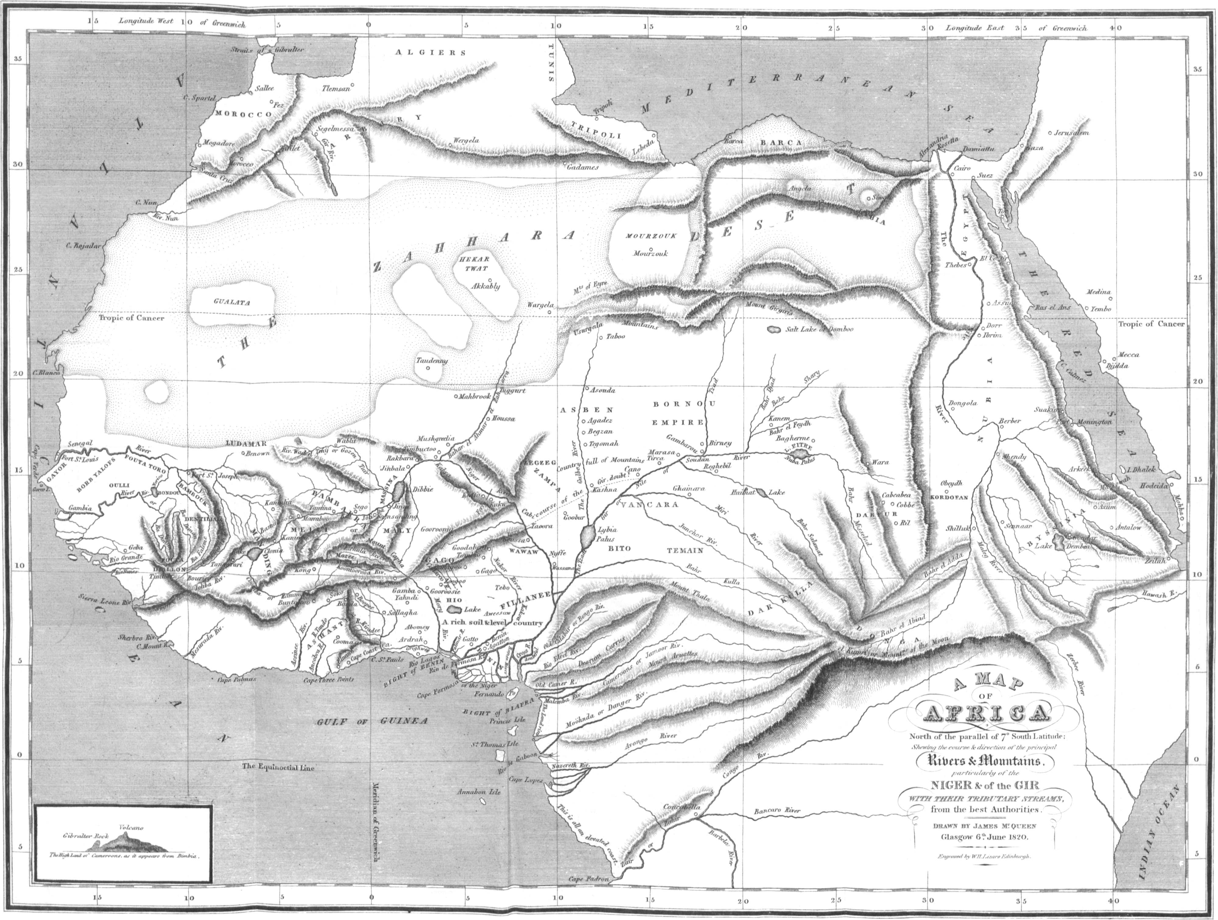
A MAP
OF
AFRICA
North of the parallel of 7° South Latitude;
Shewing the course & direction of the principal
Rivers & Mountains,
particularly of the
NIGER & of the GIR
WITH THEIR TRIBUTARY STREAMS,
from the best Authorities.
Drawn by James McQueen
Glasgow 6th. June 1820.
Engraved by W. H. Lizars Edinburgh.
Engraved by W. H. Lizars
Edinburgh, Published by Willm. Blackwood 1821.
A
GEOGRAPHICAL AND COMMERCIAL
VIEW
OF
NORTHERN CENTRAL AFRICA:
CONTAINING A PARTICULAR ACCOUNT
OF THE
Course and Termination
OF THE
GREAT RIVER NIGER IN THE ATLANTIC
OCEAN.
BY JAMES M‘QUEEN.
EDINBURGH:
PRINTED FOR WILLIAM BLACKWOOD,
EDINBURGH;
T. CADELL, IN THE STRAND, LONDON; AND
W. TURNBULL, GLASGOW.
1821.
Printed by Balfour and Clarke,
Edinburgh, 1821.
TO
HIS GRACE
THE DUKE OF MONTROSE,
THIS WORK
IS RESPECTFULLY DEDICATED,
BY
HIS OBLIGED, MOST OBEDIENT, AND
HUMBLE SERVANT,
JAMES M‘QUEEN.
[v]PREFACE.
The subsequent sheets regarding the Geography and Commerce of Northern Central Africa, are with much deference submitted to the public. They are the results of much labour, long research, and numerous inquiries, carried on with a view to elucidate these important subjects.
When Mr. Park returned from his first journey, I was resident in the Island of Grenada (West Indies). There I had Mandingo Negroes under my charge, who were well acquainted with the Joliba. They knew the name perfectly from hearing me pronounce it in reading Mr. Park’s book. I also knew a Houssa Negro, who said he rowed Mr. Park across the Niger. These things naturally attracted my attention; and being[vi] fond of geographical subjects, I endeavoured to collect all the accounts which I could concerning the features of the country on the Upper Niger, as well from Negroes as from gentlemen of my acquaintance, who had obtained their information from similar sources. Though it was scarcely possible to reduce these, standing by themselves, into regular order, yet, connected with other accounts, they became satisfactory, and formed the commencement of my labours and collections on this subject. The narratives of every one were filled with the accounts of high mountains, great rivers, populous countries, and large towns. By these means, my particular attention was fixed upon this interesting subject, and my researches have been pursued day succeeding day, ever since the period above mentioned. Numerous authorities regarding this interesting portion of Africa have been examined with much care, and the most striking facts elicited from their pages. This investigation in the geographical department, has led to the conclusion which is now submitted to the world. It is for the public to judge how far the work has been judiciously and accurately performed.
[vii]It is nearly five years, since, in a small treatise, I pointed out that, in the Bights of Benin and Biafra, the Niger certainly entered the ocean. Various travellers, and researches made since that period, have enabled me to delineate with greater accuracy the course of this important river, and its numerous tributary streams through the interior of the country. Perfect accuracy on these subjects is at present unattainable, nor is it here pretended to. The delineation of the general features of the country was all I had in view, and this I flatter myself has been done with sufficient accuracy to establish all the leading points which were contemplated.
The Public will no doubt feel surprised when, considering the number and magnitude of the rivers in the Bights of Benin and Biafra, that no attempt has ever been made to penetrate by means of the chief and most powerful of these streams into the interior of the country. Yet such is the fact. The rivers of interior Africa were believed to be like no other rivers. By one they were stated to run, first increasing, and then diminishing, till the current disappeared altogether. By another,[viii] that, flowing in opposite directions, they at last met and stood still; and by a third, that one of the greatest rivers in the world, with all its tributary streams, was swallowed up in a lake, or absorbed by sands. Such were the theories formed; and no farther inquiry was considered necessary. Thus Central Africa has for ages been buried from the eyes of the civilized world, and in a similar manner, unworthy and erroneous theories are at work to mislead the public, and shut up the vast continent of New Holland. The mighty rivers lately discovered in that Continent are also represented as terminating in a lake or swamps, chiefly because it has been said that the Niger does so terminate. Near 600 miles of the coast of New Holland, on the south-west side, remain to be explored. In the north-east corner of the Great Bay, which circumscribes the south-west part of that continent, no doubt is the outlet of all the waters of that vast country, which, flowing from every point of the compass, converge towards that quarter, and after forming a lake or lakes, in all probability issue therefrom, and pour a mighty tribute into the ocean. Whoever casts his eye upon the map of[ix] the world, must be struck with the faithful resemblance which the Great Bay, and the south-west coast of New Holland, bear to the Gulph of Guinea and the south-west coast of Africa. To the same point in both Continents all the rivers converge. Another Niger and another Gir will perhaps ere long be found out, traversing the interior of New Holland, and therefore it is of the utmost consequence that Great Britain should get possession of the country round the mouths of these streams, which would thus give her the complete command of all that immense country.
In the way to open up and establish a commercial intercourse with Africa, there will no doubt be a diversity of opinions. On such an important subject, involving so many interests, and such mighty consequences, I would wish to be understood as offering my opinion with great deference. Nevertheless, from what I have learned of Africa, and from what I know of the Negro character, I am convinced that the plan proposed and recommended in this work, or one formed upon a similar basis, is that which will soonest render the trade with Africa the most beneficial, either to Africa or to Great Britain.
[x]In recommending the destruction of the system of slavery in Africa, I am not so sanguine or inconsiderate as to imagine, or to expect, that this can or ought to be accomplished in a moment. It can only be effected in a gradual manner; and abolition can only be beneficial by being accomplished in this way. It must be the work of much time. There is also too much reason to fear, that Africa can only rise to freedom and civilization through the medium of slavery in the first instance. The great error committed by her Princes, and all Europeans who have hitherto held communication with Africa, is, that they withdraw the labours of Africa to cultivate other quarters of the world, in place of fixing its exertions to the soil which gives it birth. It is this system which has hitherto retarded the civilization of Central Africa. Let those then, who are slaves in Africa, or who may in future become so by the regulations of the native powers, be employed to cultivate Africa, and the population of that Continent will, with its improvement, gradually rise to freedom, knowledge and civilization. There is no other safe way to accomplish the object.
There is one article of commerce which is particularly abundant in the parts of Africa which[xi] have been considered, namely, rice, the particular value of which I have omitted to mention. This article may be purchased in the countries adjoining the Niger, at the low value of a halfpenny to three farthings per lb. or about 90s. per cwt. Here it costs four times the sum, and in the West Indies a still greater price. It is needless to point out the advantages which would result from prosecuting this branch of commerce.
I cannot help thinking, that the accounts which we have heard of nations in the interior of Africa devouring their prisoners is incorrect, and arises from a want of knowledge of their customs and language. It is well known that the Negroes believe in the power of witchcraft to such a degree as to sink under the idea, pine away, and die. I omit numerous instances in the West Indies where the individual inflicting, and the individual suffering, were each equally so convinced of the fatal power, as neither reasoning, threats, nor punishment, could remove the impression. Thus situated, the infatuated sufferer stated that his enemy was devouring him. From Beaver’s African Memoranda, we learn that this practice is quite common on[xii] the western coast of Africa, and is known by the common appellation, that such and such a person “eats another,” or is “eaten by another.” From this may arise the reports of there being nations in the interior, and elsewhere, who eat each other and their prisoners.
After these sheets were nearly all printed off, the kindness and attention of Professor Jameson of the University of Edinburgh, put into my hands the new work from the pen of Mr. Bowditch, regarding the interior of Africa. From this, the important fact is obtained, that the river which flows from the east is navigable, and navigated, at any rate, to Lake Caudee, or Fittre, if not further; for instead of days journeys, as related in his former work, we find that it is sixty-five days navigation from the island of Gangi, near Yaoora, to the borders of Fittre Lake. Park navigated the Niger to Boussa, in the immediate neighbourhood of Gangi; and we have it confirmed by the previous authority, that the eastern river is navigable also. This confirms what both Edrisi and Leo Africanus related concerning it. Leo Africanus also clearly points out that there were several rivers besides[xiii] the Niger, and that all the others emptied themselves into it. The Negro kingdoms which he enumerated and visited, were, as he distinctly states, situated either upon “the Niger, or other rivers which flow into it.” That it did not run to the Egyptian Nile, but from it, and that it was not lost in a lake, but terminated in the ocean, Gregory of Abyssinia states most pointedly. Flowing west from the Egyptian Nile, he says, “Descendit enim versus regionem Elwah, et sic illabitur in Mare Magnum, i.e. Oceanum Occidentalem.”
Also, from the work just quoted, it would appear that the river from the east joins the Niger about and below Yaoora. In the itinerary of Brahima, the route from Yahndi and Gamba, to the Niger, is given. The last place on that route is Schal. “Here,” says Brahima, “is the river which is named Coudha, on the extremity of which is the great kingdom of Your,” (Yaoora.) If this relation is correct, then it would appear that the Great Eastern River is that which is called Coudha, Kaoda, or Quolla, and that it flows into the Niger to the south of Yaoora, forming the boundary of[xiv] this state on that quarter. It is by no means improbable that this is really the case. With one remark I shall conclude my observations on these subjects. It appears, from all geographical authorities in early times, that nearly all the great rivers in the different continents were uniformly laid down as flowing from the same source, or as being joined together in some part of their course. This is the case with the great rivers in the Eastern World, in Africa, and lastly in America, where the Rio de La Plata and the Great Maranon are represented as uniting, and then separating from each other, and then flowing in nearly opposite directions. Perpetuating such erroneous ideas, has led into the confusion which has long reigned in the geography of Africa.
In speaking of the magnitude of African cities and states, it must always be borne in mind that these are considered chiefly according to the accounts derived from the authority of Arab, Moor, and Negro travellers, whose comparisons, again, are drawn from what they saw or heard of in Africa. These accounts must not be taken as applied to, or compared with, European Kingdoms and States.[xv] Several cities in Africa, however, are certainly populous, and the number of this description is undoubtedly also very considerable.
In the numerous authorities to which I have referred, and which I have quoted, I have uniformly given their exact words, that my readers may be enabled to judge for themselves concerning the truth of what I advance. In the style and composition of the work, I have to claim the indulgence of the public. Avocations of a different kind necessarily engage my time; and my distance from Edinburgh, where the work was printed, has, in a few instances, led into errors, which, however, are either very obvious, or not very material.
The interest which is now excited about every thing connected with Africa, must soon lead to measures by some European power, such as will clearly and accurately develope every part of the interior of that long-neglected and very remarkable country. I hope that this honour, and the immense advantages to be derived therefrom, both political and commercial, are reserved for Great Britain.
[xvi]It is only necessary further to add, that the substance of the following work, in what regards both the geography and the trade, were embodied into separate memorials, and with a map of Northern Africa, (which has been reduced and engraved for this work) upon a large scale, submitted to his Majesty’s Government in the latter end of June last year. Especially these were laid before the noble Lords at the Head of the Admiralty and the Colonial Department, the Right Honourable the President and Vice-President of the Board of Trade, and other distinguished members of the Executive Government. To his Grace the Duke of Montrose I feel particularly indebted for the interest he took in the furtherance of a plan which, if prosecuted, would be attended with incalculable advantages to the West of Scotland, and to Glasgow in particular.
Glasgow, March 22, 1821.
[xvii]CONTENTS.
| GEOGRAPHY OF NORTHERN AFRICA. | |
| CHAP. I. | |
| Page | |
| Ancient Geography of Central Africa — General Observations — Accounts of the Interior by Ptolemy, Edrisi, Ibn-al-Vardi, Scheabeddin, Mackrisi, Batouta, Abulfeda, Ebn Haukal, Leo Africanus — Termination of the Niger, &c. | 1 |
| CHAP. II. | |
| Joliba, two branches, source western, ditto eastern — River Zamma; course till junction — Snowy mountains — Balia — Lake Clonia — River Guinola — Kaniaba — Bammakoo — Magnitude of Niger — Rapids — Marraboo — Yamina — Sego — Jennë — Ba Nimma — Ba Maniana — Lake Dibbie — River Gozen Zair — High Mountains — Walet — Course of Niger, north-east — Ba Moriaca — Jinbala — Rakbara — Kabra — Timbuctoo — Bahar-el-Ahmar — Course of ditto — Houssa — Magnitude of Niger at Timbuctoo — Sidi Hamed — Course of river south-east — Mountains — Kaffo — Rocks — River bursts through a chain of mountains — Exceeding high ridge to south-west — Cabi, a Ferry — Yaoora — Great River from east may join here — Boussa — Park’s death — Cause of it — Wauwa — Gange — Nyffe — Wassanah — Magnitude of Wassanah — Magnitude of Niger or Zadi — Course to “Great Water” — Junction with the Sea, and where — General Observations | 59 |
| CHAP. III. | |
| Eastern rivers — Misselad or Gir, source and course — Dar Saley — Wara — Other rivers — Gir turns west — Lake Fittre — Magnitude of River; junction with the Shary — Bahr-el-Feydh — Bahr Djad — Course of Gir west — Gambarou — Birney — Bornou — River Tzad — Face of the country — Cano or Ghana — Kashna — Gulbe, supposed course of ditto — Position of Kashna — Junction of eastern and western rivers — Vancara or Owencara; what it is — Bito — Temian — Cannibals — Junction of Gir and Bahr Kulla, source and course of ditto — Mount Thala — Miri — Junchor and Bahr Salamat Rivers — Lake Haimat — Island at the junction of Gir and Niger — Lybia Palus — Lake of Jackson, or sea of[xviii] Sudan; what that is — Robertson — River Loro — Fillanee — Water communication between the sea-coast and north-east parts of Africa — Course of the Niger to the sea in the Bights of Benin and Biafra — Boundary of Benin — Bahr Kulha; what it is | 93 |
| CHAP. IV. | |
| Bights of Benin and Biafra — Rio de Formosa — Delta of Benin — Innumerable Rivers — Rio Forcados — Gatto Creek — Cape Formosa — Rivers East — New Calabar and Bonny River; their great magnitude — Old Calabar and Cross Rivers — Rio Elrei — Salt Ground — Great Trade in Salt — Face of the Country in the Delta — Trade to these Places — Inundation of the Rivers — Time of ditto — Shews they are different from either the Congo or the Egyptian Nile — Currents in the Sea near the Coast — Number and Magnitude of the Rivers in the Delta — Breadth — Depth — Trade — Natives into the Interior — A Race of People almost White — Leucæ Ethiopians of Ptolemy — General Observations on the N.E. and North parts of Central Africa — Accounts of Travellers — Kong — What it means — Great Magnitude of the Niger, and his Tributary Streams — Length of Course — Compared to Magnitude of Bahr-el-Abiad at Shilluk — Cannot be the same Stream — No Connection with that River | 128 |
| CHAP. V. | |
| Country south of the Elrei — High land of Cameroons — An extinct Volcano — Chariot of the Gods — Old Cameroons — Jamoor and Malemba Rivers — Moöhnda, or Danger River — Gaboon River — Nazareth, Liverpool, Bristol, and Tawney Rivers — Congo River — Rivers West of the Rio de Formosa — Rio Lagos — Mory River — Country around it — Rio Volta — Boosempra, Ancobra, and Assinee Rivers — Mesurada River — Sierra Leone — Way to explore Africa — Distances of Places, how ascertained — How to command Africa — Fernando Po, a sure stronghold — Sierra Leone, a secondary place — A settlement inland of the greatest importance — Extent of country it would command — French settlement in Africa — Wish to extend their power in that quarter — Rivers, their great use in the Torrid Zone — East coast of Africa, important for Commerce — Rivers Zambezi and Zebee — Island of Socotora — Situation of Africa — Slavery — The Slave Trade — Extent thereof — Slavery and Superstition — Scourges of Africa — How to benefit Africa — Colonization — Advantage of Colonies — The chief strength of Britain — Eagerly coveted by France — Our efforts in Central Africa would civilize all Northern Africa — Must expect to meet difficulties — Perseverance will ensure success | 156 |
| [xix]TRADE AND COMMERCE OF NORTHERN CENTRAL AFRICA. | |
| Colonies necessary to Great Britain — France anxious to colonize Africa — New markets can alone relieve our trade — Old overstocked — Africa the best field — Superior productions — Country near the Niger — Powerful, populous, cultivated, and commercial states — Large cities — Numerous valuable productions — Africa long neglected — Formerly enriched other countries — Articles of export and import — Particular enumeration and value of those most in demand — Salt — Ostrich feathers — Spices — Precious stones — Gums — Drugs — Dye-stuffs — Gold dust — Ivory — Gunpowder, Fire-arms, &c. — Value of articles — Great profits on trade — Immense advantages of a water conveyance — Hardships attending the trade at present — Value of articles at the Gold coast and the interior — Extent and value of the trade at present — Would supply our West India Colonies with provisions — Obtain plenty of fine cotton — Would open up a trade to the Cape of Good Hope and India — Abolition of the slave trade would relieve and cultivate Africa — If not checked, our West India colonies must be ruined — Infringe the rights of no civilized nation in colonizing Africa — Three modes of establishing the trade — A chartered company the best — Regulations under which to be formed — Government must countenance and support such an undertaking — Plans to be adopted and pursued — General reflections on the climate of Africa, and the importance of the contemplated undertaking | 211 |
ERRATA.
| Page | 8. | 3d | line from bottom, | for | Girgires, | read | Girgiris. |
| 27. | 10th | do. | — | itineries, | — | itineraries | |
| 28. | 3d | line from top, | — | Canal | — | Canoe | |
| 33. | 2d | line from bottom, | — | Cetenum | — | Ceterum | |
| 57. | 3d | line from top, | — | comes | — | come | |
| 85. | 3d | line from bottom, | — | Kabee | — | Kabeer | |
| 105. | 3d | do. | — | bar | — | bark | |
| 123. | 15th | line from top, | — | West | — | East | |
| — | 3d | line from bottom, | — | occurrence of which, | — | occurrence which | |
| 138. | do. | — | turnings | — | burnings | ||
| 177. | 2d | line from top, | — | outlet | — | outlets |
[1]GEOGRAPHY
OF
NORTHERN AFRICA.
CHAP. I.
Ancient Geography of Central Africa — General Observations — Accounts of the Interior by Ptolemy, Edrisi, Ebn-al-Fardi, Sheabiddin, Mackrisi, Batouta, Abulfeda, Ebn Haukal, Leo Africanus — Termination of the Niger, &c.
The central parts of Africa, and, in a very particular manner, the interior parts of the northern division of that great continent, together with the course and termination of the great river Niger, are still in a great measure unknown. Become the eager object of European research, these cannot much longer remain hid. It is surprising they have remained undiscovered so long. To explore and determine accurately these important points, is the most interesting geographical problem that now remains to be solved.
[2]Unworthy and erroneous theories, and to which all information hitherto received has been forced to bend, have long led astray the public mind, and general exertions of Europe, from the true path by which the interior of Northern Africa can be explored, and the only way by which the course and termination of the Niger can be ascertained. The road, however, is easy, and quite accessible. Nature has formed it. The Niger, and his tributary streams, pursue their course through Central Africa. From the west, and from the east, they converge to one point. After uniting in one channel, the mighty current divides itself into several streams, which enter the Atlantic ocean by navigable estuaries in the Bights of Benin and Biafra.
Allowing we had no positive information of the course and magnitude of the Niger lower down than Bammakoo, Sego, and Lake Dibbie, still the fact of there being such a river continuing its course eastward from the latter place, is sufficient to induce us to look for its exit on the sea coast. We are quite certain that it does not enter the sea to the north; and we may say we are equally sure that it does not finish its course in any sea to the east. To the south, therefore, we must turn our inquiries. In no part of Western or Southern Africa is there stronger grounds to look for this estuary, than in the coast below Benin. There the soil is all alluvial.[3] For a great distance into the interior, stones larger than a man’s fist are unknown. The country is flat, and inundated during the swell of the rivers from the tropical rains. The land is daily gaining on the sea from the quantity of alluvial matter brought down from the interior. The whole country and coast, for a great extent, is intersected with arms and outlets of rivers, communicating with each other inland. The bottom of the sea, along a great extent of coast, is all soft mud. From the Rio Lagos to the Rio Elrei river, no fewer than twenty streams enter the ocean, several of them of surprising magnitude, and navigable for ships. Large floating islands are borne down by their waves, and carried into the ocean. The great magnitude of these rivers will by and bye come more particularly under our review.
As the easterly course of the Upper Niger is now no longer a matter of dispute, it would be perfectly superfluous to bring forward, in detail, the authority of writers and geographers, from the days of Herodotus downwards to this day, to prove this important fact. Its termination is now the subject which engages the attention of all. The theories at present most in vogue, are, first, that it flows eastward, reaching beyond the parallel of 18° North Lat. and then, in about 20° East Long. flows south-east, and is the parent stream of the Bahr-el-Abiad,[4] or Nile of Egypt; second, that it terminates in a large lake in the interior, which also receives the waters of the Gir, or Nile of Soudan, coming from the eastward; third, that the waters of both rivers are lost in, and absorbed by swamps and sandy deserts, in a country called Wangara; and fourth, that the Niger from his middle course flows south, and joins the great River Congo, or Zaire.
Every one of these theories is grossly erroneous, contrary to every authority on which reliance can be placed, and in opposition to every feature of geography exhibited any where else on this globe. The expedition to the Congo, so lately undertaken, and so unfortunate, has nevertheless settled the question, that the Congo and Niger are different streams. The lake said to receive and retain the waters of the Gir and the Niger, can no where be heard of, either as a sea of salt or fresh water, in the interior of Africa. Wangara, said to absorb these rivers in swamps and sands, or rather those parts of Africa where Wangara is said to lie, is, as the name signifies, a country of a different description—a country intersected by many powerful rivers, mountainous, fertile and cultivated, and inundated during the rains. That the Niger flows to form the Bahr-el-Abiad, is contrary to all probability, contrary to the good authority of Ptolemy,[5] contrary to the authority of the best Arabian geographers, and contrary to excellent modern authority. Yet it is most surprising that an opinion, so improbable in itself, and so directly opposite to all the authorities mentioned, should even to this day continue to be believed and maintained.
In following out this subject, and establishing by conclusive evidence, the fact which I have advanced, it may not be unnecessary to consider the general outline of the Roman and Arabian geography of this portion of Africa, to which our attention is directed, before we consider authorities of more recent dates. The coincidence will thus be more apparent, and the fact more obvious. In the geography of Ptolemy we are not to look for the accuracy of modern details. Nevertheless, his general features of Northern Africa are worthy of attention. In his days, it is obvious, from his enumeration of mountains, rivers, and nations, that it must have been much better known than it now is; and, therefore, we must the more regret that he did not then possess the means which we now possess of fixing the positions of the places he mentions with geographical accuracy. On this part of the subject, however, it is not my intention to enter at great length, but merely to select the undisputed and clearer parts which tend so strongly to confirm the accounts of modern travellers concerning the[6] course and termination of the great and important streams already mentioned.
The most ancient Greek and Roman authors seem to have been very imperfectly acquainted with the great Zahaara, or the countries beyond it. Ptolemy himself seems altogether to overlook the desert, though he minutely enumerates the countries beyond it. Strabo and Pliny conceived that the streams which descended from the south-east side of Mount Atlas formed the Niger, and which river was in these days believed to be one with the Egyptian Nile. They stated that the streams descending from Mount Atlas hid themselves, or rather run under the desert for a space occupying 24 days journey, when, emerging, they continued their course to the eastward, united in the Niger. This desert they describe as being composed of black dust. Modern travellers all describe it as scorching sands. Whether any alteration has taken place on it during the lapse of so many ages, cannot be determined; but it is by no means improbable that its extent is considerably increased, from the sands gaining on the cultivated ground, as is well known to be the case on the side towards Egypt. It is a curious fact, that, approaching the middle thereof, reckoning from the Atlantic Ocean, abundance of water is found upon digging some feet below the surface, and which the Arabs term, “the sea under ground.”[7] This remarkable circumstance might suggest to Strabo and Pliny the idea already mentioned of the rivers from Mount Atlas running under ground.
Ptolemy wrote on Egypt in the second century of the Christian era. Then Africa was better known. The interior of the northern division thereof he describes apparently from good authority, and with considerable accuracy, only he seems altogether to leave out the Great Desert. Mount Mandrus, the middle of which was in 23° East Long. from Ferro, and 22° North Lat., and Rhisadirus Mountain more to the south, he places as the barrier which divides the waters which flow westward into the Atlantic Ocean, by the rivers Stachirus, &c. (the Senegal, Gambia, &c.) from those which flow eastward in the Niger. Turning eastward from Rhisadirus Mountain, we find Mount Caphas in about 10° North Lat. which divides the waters which flow south into the great gulf, or Gulf of Guinea, and those which flow north to join the Niger. In Caphas, we readily recognize the Kong range. Eastward, in the same parallel, there is a blank or opening, and then comes Mount Thala, situated in 10° North Lat. and 38° East Long. from Ferro.
Before proceeding further, it is necessary to correct an obvious error in the longitude, as reckoned by Ptolemy. He places Alexandria in 60° 30′ East[8] Long. from Ferro, or 42° 29′ from Greenwich. This we know is 12° too much, Alexandria being in 30° East Long. from Greenwich, or 48° from Ferro. It is evident, therefore, that we must deduct one-fifth (decreasing this deduction in proportion as we go west) from the longitude, as laid down by Ptolemy, in order to correct his reckoning. By doing this, we shall see how accurately the positions of some places agree with modern accounts.
South of Mount Thala, in 3° North Lat. and 33° East Long. we have Mount Arualtes, and eastward of that in North Lat. 1° 30′, and East Long. 47°, we have Mount Arangas. Turning north in 10° North Lat., and 50° East Long. we have the chain of hills called the Garamantican rampart, which divides the waters which flow west in the Gir, from those deserts which stretch eastward to the Nile. Turning westward, in the parallel of 21° North Lat. and extending along by the sources of the river Cinips, from 40° to 45° East Long. we have Mount Girgiris, and from 8° to 10° farther west, in the same parallel of Lat. are the Usargala mountains. Next, in North Lat. 32°[1], and East Long. 20° 30′,[9] we have Mount Sagapola, placed most erroneously in the map accompanying the work, in 20° North Lat. and 15° East Long., in the south side, in place of the north side of the desert.
The formidable barriers here enumerated, according to the delineation of Ptolemy, encircle or enclose those extensive valleys, if I may use the expression, through which the Niger, the Gir, and their tributary streams, take their course, leaving only the opening between Mount Thala and Mount Caphas, for the collected flood to escape to the southward. How much these general outlines agree with modern accounts, our future investigations, and the map accompanying this work, will shew.
It is in this portion of Africa that the greatest rivers flow, greater, as Ptolemy must mean, than any other which flowed in the northern division of that continent. In the middle of the country, says he, the greatest rivers display themselves, viz. the Gir, joining together the Usargala mountain and the Garamantican barrier or rampart. One branch of this river makes the Lake Chelonides, in 20° North Lat. and 49° East Long. (21° East Long. from Greenwich,) and another the Lake Nuba in[10] North Lat. 15° and East Long. 50°, or 22° from Greenwich, answering very accurately with the Lake Fittre of modern authors. The course of the Gir westward, Ptolemy distinctly marks, by enumerating the cities on its northern bank, from Lynxana, in 20° 30′ North Lat. and 48° 30′ East Long., unto Thycimath, situate in 19° 45′ North Lat. and 38° East Long. Still more westward, he places his Gira metropolis in North Lat. 18° and 36° East Long. or 12° East from Greenwich.
Next is the Niger river, running east, and joining both Mount Mandrus and Mount Thala, that is all the waters which are collected in the vale between these mountains flow to form the Niger. The course east he distinctly marks, by marking first the Lake Nigrites, and then the cities on both the northern and southern banks, viz. on the north from Pessidy, situate in 18° North Lat. and 19° East Long. to Panagra, in 16° 45′ North Lat. and 31° East Long. On the south bank from Thuspu, situated in 17° 45′ North Lat. and 26° 30′ East Long. unto Dudum in 15° North Lat. and 31° East Long. or about 6° east of Greenwich. At this point the river is evidently declining south considerably, and a space of 5° of longitude, by Ptolemy’s reckoning, intervenes between this part of the Niger and the Gira metropolis, the last point mentioned on the Gir river.
[11]The Niger, we are informed, makes the Lake Nigrites in 15° East Long.[2] and 18° North Lat. This is evidently the Lake Dibbie. The Nigira metropolis is placed on the map at the junction of a river coming from the north-east, and in 17° 45′ North Lat. and 25° 20′ East Long. which is about 3° east of Greenwich, answering in longitude very nearly indeed with the position of Timbuctoo. On the north side the Niger receives two branches, viz. one from the Sagapola mountain, and another from the Usargala mountain, which latter is probably that branch which joins at the Nigira metropolis. That from the Sagapola mountain is evidently a mistake, providing that mountain is correctly laid down; but a branch springing south of the desert, and coming from that direction, does perhaps join the Niger. Ptolemy, in his account of the Sagapola mountain, seems to take no notice of the Great Desert, that mountain being placed to the north of it. The Upper Niger he clearly brings from the north-west.
On the south the Niger receives one branch nigh to two places, viz. 17° North Lat. and 21° East Long. and also 13° 30′ North Lat. and 21° East Long. The accuracy of this we shall by and by[12] have occasion to notice more particularly. Towards the Rising Sun it also receives one branch above the Lybian Lake, which lake is placed in 16° 30′ North Lat., and 35° East Long., or about 12° east of Greenwich. This branch, no doubt, comes from the eastern part of, or from the country eastward of Mount Thala. Ptolemy seems to indicate, when he says, above the Lybian Lake, that this branch joined the Niger after the latter had issued from the lake. Yet his exact meaning is not easily ascertained. The point, however, is of considerable importance; for, if to the westward of the lake, no stream coming from the east could join the Niger but the Gir. Be this as it may, it is obvious that he means that this branch from the eastward and this lake communicated with the Niger. Whoever considers for a moment, must see that it could not fail also to have a communication with, or rather that it must receive the waters of the Gir. The latter stream, in its westerly course, is distinctly traced to 18° North Lat. and 36° East Long., while the Lybian Lake is placed in 16° 30′ North Lat. and 35° East Long., only about 100 miles S.W. from the Gira metropolis. This is curious and important.
The Niger from this point continues a southerly course, otherwise it could not join Mount Thala, the middle of which is in 10° North Lat. and 38°[13] East Long., or 13° 40′ east of Greenwich. Further, we have in Ptolemy no accurate accounts of the course of this river. But that it flows south and joins the ocean, he certainly meant, when he says, that Lybia, wherein he had described the courses of the rivers mentioned, was bounded on the south by that part of Ethiopia Interior called Agisymba; and concerning these African rivers, he says, “Illorum vero qui per interiorem Æthiopam fluant, quique fontes et ostia in continente habent maximi sunt Gir et Niger.” (Lib. ii. E. 1. de maximis fluminibus.) In this the southern course is very plainly marked, and also their termination in the ocean.
With one observation I shall conclude this part of the subject. In Mount Girgiris, situate, as has been already mentioned, Ptolemy states that the river Cinips has its source in two places, viz. in the parallel of 21° North Lat. and in 40° and 45° East Long. This river flows north, and enters the Mediterranean between the greater and the lesser Syrtes, in 42° 15′ East Long., or to the eastward of modern Tripoli. No such river we certainly know flows through this part of Africa. It is therefore probable that the springs in Mount Girgiris flowed, joined, and formed a river running in a different direction. The river Cinyphus, which enters the Mediterranean, is certainly one of those streams[14] which rise north of the desert, and have very short courses indeed, compared to what the Cinips would have, if it flowed from Lat. 21° North, a course of nearly 800 miles. The river springing in Mount Girgiris certainly takes a different direction, and doing this, it will correspond with the accounts of the direction of the rivers in that part of Africa, as these are described by modern travellers.
After Ptolemy, the early Arabian authors and geographers demand our attention. From their careless and obscure manner of writing on these subjects, it is impossible to reconcile all their statements. Sufficient, however, remains to shew us our way. According to Leo, the ancient Arabian chroniclers, viz. Bukri and Mishuudi, knew nothing in the land of the Negroes till the year of the Hegira 380 (A.D. 1002,) except Alguechet and Cano. These discoveries were evidently made from Egypt, as Alguechet is an Oasis in the desert 120 Arabian miles distant from Egypt, and seems to have been the first stage in the road to western discovery. At the period last-mentioned, however, the Arabs from Barbary passed the great desert, and all the countries to the south thereof were quickly explored and conquered. Those formidable deserts, which formed a rampart against the advance of the most powerful nations of antiquity, were, to the roving Arab, strengthened by enthusiasm, and fortified by[15] predestination, no barriers whatever. Innumerable swarms soon found their way to the southward, and planted, amidst powerful colonies, the standard and religion of their prophet on the banks of the Niger. They penetrated through the centre of the country, from sea to sea, from the Mediterranean to the Gulf of Guinea. When the Portuguese first discovered the latter part of the coast of Africa, they found the population every where mixed with Arabs. The western parts of the continent, however, namely, the countries along the north and south of the Senegal, were less known to them to much later periods. These seem to have been the refuge of the ancient inhabitants of Morocco, &c. who, driven from their ancient abodes by the disciples of Mahommed, sought refuge across the desert, and, being a more intelligent and hardy race than the Negroes, were thus for a longer period enabled to repel the attacks of their restless enemies.
The central and southern parts of Northern Africa became thus well known to the Arabian writers, either from observation or report. In some parts, however, they contracted, and in others extended, the continent beyond its proper limits. “The ambient sea,” (Bahar Addolum, Sea of darkness, or Atlantic Ocean,) says Abulfeda, “extends itself from Mauritania until it has passed the desert of Lemptuna, (Great Desert,) a vast wilderness of[16] barbarians, to the country of the Nigritæ. Thence it stretches yet farther southwards, till it has passed beyond the Equator, after which it extends to the east, behind the mountains of El Komri, from whence the Nile of Egypt has its source. Again, it proceeds southward,” &c. Leo Africanus states, that the “south part of Africa abutteth upon the Ocean Sea, which compasseth it almost as far as the deserts of Gaoga.” These deserts of Gaoga, according to the same authority, lie to the south and the south-west of the kingdom of Gaoga, which kingdom extended on the west bank of the Nile from the confines of Egypt, southward 500 Arabian miles, to the great bend of the Nile, about Dongola. This, with the account from Abulfeda, shews how much the early Arabian writers were deceived regarding the true position of the Gulf of Guinea, and how far eastward they conceived that it pierced into the African continent.
Belad-el-Soudan, was the general term applied to those parts of Africa inhabited by Negroes, south of the Great Zahaara, and west of the deserts of Nubia. “Belad-el-Soudan,” says Bakui, who flourished about the year 1400, “or the Country of the Blacks, extendeth on the north to that of the Berbers, on the south to deserts, on the east to Ethiopia, and on the west to the ocean sea. It is burned by a perpendicular sun. The inhabitants[17] are naked, part Mussulmen, and part Infidels.” Speaking of that portion of Africa which abounds with mines of the “most pure gold,” Ebn Haukal says, “this land of the Blacks is a very extensive region. Their skin is of a finer and deeper black than any other blacks, whether Habeshis, (Abyssinians,) or Zingians, (Ethiopians;) and their country is more extensive than that of any other nation of blacks. It is situated on the coasts of the ocean to the south.” This distinctly points out the northern shore of the Gulf of Guinea. Ebn Haukal was the most accurate of all the Arabian geographers, and is with great reason supposed to have visited every country which he describes. Regarding the boundary south, Bakui seems not to have been so well-informed, when he says, it is “by deserts” on that quarter. But he evidently carries his Belad-el-Sudan no farther south than the mighty chain of Kong and the chain in the same parallel of latitude, stretching eastward to El Komri. By the word deserts, we are to understand not only sandy deserts, like the great Zahaara, but likewise mountainous, rugged, and woody countries less civilized, cultivated, and inhabited than others. Leo Africanus enables us to clear up this point. He states, that the kingdom of Melli is bounded south by “certain deserts and dry mountains,” which are without doubt the bleak mountains in the Kong chain. But still more expressly,[18] and to the point, he states, that “the land of the negroes lies between the Lybian Desert (Zahaara) and a desert to the south, which stretcheth to the main ocean.” But that it is not barren sands is evident, for he adds, “in the desert are infinite nations (except by report) unknown to us.” The country south of Guangara, the same authority informs us, is of a similar description. Hence the authority of Leo and Bakui is reconciled, and the meaning of their respective descriptions, and others of a similar nature, given by other Arabian writers, are, by this elucidation rendered clear and plain.
Belad-el-Sudan, or the country of the blacks, is, by Arabian authors, divided into several large portions, each of which contains a number of kingdoms and states. The larger divisions which are more immediately connected with our present investigation, are the land of Gaoga, the land of Kanem, Ghana, Maly, Meczarat-al-Sudan, Lamlem, and Belad-el-Tibri. The four first occupied the whole country south of the Great Desert, and the deserts of Lybia, extending through central Africa, from the Egyptian Nile to the sources of the Senegal. The three latter divisions, or portions, lie to the south of the former.
Gaoga does not properly belong to the land of the negroes, which, in fact, commences from the western borders of the former. Gaoga, 300 years[19] ago, comprehended all that country from the confines of Egypt to the desert south of Dongola, and from the Nile to the limits of the great empire of Bornou. In the latter direction, according to Leo, it is about 500 miles in breadth. The country is in general barren, and full of burning deserts.
The land of Kanem. This was formerly a mighty and important country, though now merged in the great empire of Bornou, and parcelled out into smaller states, such as Bagherme, &c. “On the borders of the Nile,” says the Egyptian historian Macrisi, “lies also the land of Kanem; the king of which is a Mahommedan. It is at a great distance from the land of Maly. The capital is Heymy. The first town on the side towards Egypt (that is on the caravan route) is Zeilah, and the last, reckoning lengthways, is called Kaka, about three months journey from the other. The people go veiled. Their king remains behind a curtain when he speaks to any one. Except on two mornings each year, at the time of Asseer, no one sees him. Their main food is rice. It grows without culture. They have wheat, Indian corn, (dhoura,) figs, lemons, and other fruits. Their currency is cotton-stuffs, called Dandy, and cowries. Gourds grow to a great size. They make ships (perhaps rafts) of them, upon which they cross the Nile. To the south of them are forests and deserts inhabited by[20] wild creatures, like demons, approaching to the figure of a man, whom a horseman cannot overtake, and which hurt people. In the night there appears something like fire; it shines, and when any one goes towards it, it retires to a distance from him, so that if he should even run, he never can come up with it, but it always keeps before him, and if he throws a stone at it, and hits it, sparks fly from it. These countries lie between Barca and Mogreb (a general name for Southern Africa) and extend to the south as far as the middle Gharb. Their religion is of the sect of Imam Malek Ibn Anes.”— (Burkhardt.)
The manners, customs, and produce of the country, are much the same as are now found in Bornou, at that time a province of Kanem. The wild creatures like demons are no doubt the African ourang-outang and ape, which abound in the forests of Southern Africa, particularly towards Dar Kulla and countries south of Bornou, which places, from the great extent of the land of Kanem, it evidently reached. That they hurt, and even attack people, particularly women, we learn from various authorities. Mollien, page 286, says, “it is dangerous to meet the African ourang-outang, particularly if a person be unarmed;” and in pages 290 and 291, he relates an account of an assault made upon a woman by a number of apes, who beat her most severely,[21] and afterwards fought a desperate battle with the principal inhabitants of a village near Galam, who went on horseback to attack these animals. The fire that appeared at night was most probably the fire fly, so numerous near rivers and forests in the torrid zone, and which perhaps formed those “fiery rivers” which astonished Hanno, the Carthaginian navigator and his followers.
From the description here given by Macrisi, it is plain that the Nile (the Gir,) or some, if not all its large branches, passed through this land of Kanem. Ibn-al-Vardi confirms the account of Macrisi. The former states that “Konem, or Kanem, is a large country, situated along the Nile,” and, what is still more to the point, he says, “the inhabitants were all Mussulmen of the sect of Imam Malek.” Cities fall and empires disappear, but the sects, tribes, and religion of the Arabs survive the roll of ages, and form our sure guides. Edrisi also states Kanem as a large district, and adds, that some negroes stated that Kaugha was subject to it. Kanem, though humbled, is still known. According to Burkhardt, “it is a large district, inhabited by the tribes of Tendjear, and Beni Wayl,” (p. 479.) It is situated east of Bornou, and near the river Sharee, and Bahr el Gazalle. Sheeref Imhammed places Kanem north of Bornou in the road to Mourzook, but Burkhardt is perhaps the best authority.
[22]Ghana, and the countries once subject to it, was, during the days of its vigour, the richest and most important kingdom which the Arabs ruled in interior Africa. It lay to the west of Kanem, and was situated upon the Nile. It was perhaps what is now known under the name of Cano. Vancara, Cassina, and many other surrounding kingdoms, obeyed the authority of Ghana, whose sovereign was exceedingly rich and powerful. The inhabitants had long boats on the Nile, with which they fished and carried on communication with other cities. In its largest sense, the land of Ghana must have been of great extent. Ghana, according to Edrisi, was bounded on the north by the broadest desert, lying out between the countries of the blacks and Barbary. According to Ibn-al-Vardi, it was bounded on the south by Meghrara, or Meczara. It was through the negroes country of Meczara that the Nile of the negroes, according to Edrisi, ran in its progress to the sea near the Isle of Ulil. Meczara El-Sudan, in all probability, was a general term applied by the Arabs to all the countries lying to the south of their first established kingdoms in Africa. They seem, in their progress of colonization, to have proceeded first westward down the Gir, and then to have been met by fresh colonies; which colonies descending from Barbary, urged their progress eastward and along the Niger, till they met their countrymen on the Gir.
[23]The Pagan country of Lamlem lay to the southward and westward of the kingdom of Ghana. “The countries and dominions of Lamlem,” says Edrisi, “lay near a certain river flowing into the Nile. It is not known whether there is any inhabited place to the southward, (rather S.W.) of Lamlem, it being bounded on that side by a “Desert.” Thus indicating that it is bounded on the southward and westward by a mountainous and woody country. According to Ibn-al-Vardi, Lamlem is an inland city, “where gold is found.” This would lead us to look for it between the Niger and the Kong Mountains. Edrisi, however, has left us a more particular mark by which we can ascertain the true position of this country, which was invaded by all its Mahommedan neighbours, and its population carried off to be made slaves. “When any of all the inhabitants of Lamlem,” says Edrisi, “come to have the use of their reason, he is burnt in the face and temples; this they do to distinguish each other.” Now, according to Bowditch, this is the practice of the people of Dagwumba, (famous for the abundance of gold,) Yahndi and Moosee, countries S.W. of the Niger, and in the immediate vicinity of the Kong Mountains, “where gold is found.” “The people of Dagwumba,” says he, “have three slight cuts on each cheek bone, and three below, with one horizontal under the eye.[24] Those of Yahndi, three deep indented cuts. The people of Moosee, three very deep and long, and one under the eye.” (Bowditch, p. 183.) These are unchangeable features, and cannot mislead us. In all other parts of Africa, the people are marked on their bodies. Lamlem, therefore, lay S. and S.W. of the Niger, towards Kong, and was near a river which flowed into the Niger, or the Nile of these Arabian geographers.
Belad-el-Tibri, or the country of pure gold, seems a general name applied to all that part of Africa, south of the Upper Niger, towards the mountainous country of Kong, where gold is so abundant. “Belad-el-Tibri, or the country of pure gold,” says Bakui, “is part of the Sudans or the Blacks in the south of Africa. From Segelmessa (south of Mount Atlas,) to this country, they reckon three months journey. Here you see gold come out of the sand, as elsewhere plants out of the earth.” This is sufficient to enable us to ascertain what is meant by “Belad-el-Tibri,” and also where that country is. The Empire of Ghana, Bakui also informs us, was situate near this rich and evidently extensive district.
The land of Maly, which, according to Macrisi, is at “a very great distance” from the land of Kanem, next demands our attention. The celebrated Arabian traveller, Batouta, enables us to fix[25] the position of this important country. This man was perhaps the greatest land traveller that ever lived. He had visited every country from China to Spain, and traversed nearly all northern Africa. An abridgment of his important travels was found by Burckhardt in Egypt. The work is become very scarce. Batouta was a native of Tangier. From Segelmessa, he set out with the slave caravan for Sudan, in the year of the Hegira 753, (A.D. 1375.) In 45 days they crossed the Desert, and reached the first town in Sudan, called Abou Laten, or Eiswalaten, perhaps Walet. From Abou Laten, he travelled to Maly, through a country abounding with large trees, in the hollow of one of which he saw a weaver at work on his loom. Ten days brought them to Zaghary, an extensive place inhabited by negro traders, and some white people of the heretic creed of Byadha, supposed to be Christians or Jews. Leaving Zaghary, but without mentioning the distance, or the bearing travelled, he came to the Nile (Niger,) at a village named Karsendjour or Kosegarten.
“From Karsendjour,” says Batouta, “the Nile flows down to Kabera, and from thence to Zagha, the inhabitants of which are Moslems of old, and strong in the faith.” In this we readily recognize Sego, whose people are to this day very rigid Mahommedans. “From Zagha,” continues Batouta,[26] “the Nile flows down to Timbuctoo, then to Kuku, to Mouly, the last place in the country of Maly, to Bowy, (Query, can this be the same as Boussa?) which is one of the largest cities in Sudan, and the Sultan one of the most powerful in that country. No white man enters it, for he would be killed before his arrival.” From Karsendjour, the traveller “proceeded to the river called Sansera, about ten miles from Maly, and then entered Maly, where he remained two months, and received presents from Sultan Mousey Solyman, an avaricious but very just king. The women in this country never cover their nakedness till after marriage.”
From the mutability of names in Africa, it is impossible for us to fix precisely the spot where Batouta first reached the Niger. The time he took to travel from Segelmessa across the Desert, agrees very well with the distance to Walet, and from 15 to 20 days would bring him to the Niger about Yamina. His general route to this point was in all probability south. From the Niger, his course was probably to the eastward of south, which would soon bring him to the Ba Nimma, which seems to have been his river Sansera. The Maly here mentioned, there seems no reason to doubt, is the Melli of Leo, and the early Portuguese Voyagers. According to Cadamosto, it was 30 days journey S.W. from Timbuctoo, and from Leo,[27] we learn that it was an extensive country, “extending 300 Arabian miles along a river which falleth into the Niger. It is bounded by Jinnéé on the north, Gago on the east, south by certain deserts and dry mountains, and west by huge woods and forests, stretching to the Ocean (Atlantic) Sea. The capital, Melli, contains 6000 families or more. They excel all negroes in wit, civility, and industry. They are rich, and have plenty of wares. The country yieldeth great abundance of corn, flesh, and cotton. Here are many artificers and merchants in all places. The people of Melli were the first that embraced Mahommedanism.” The identity therefore of the Maly of Batouta, and the Melli of Leo, is very apparent. This country must either be situated along the Ba Nimma, or on the Niger itself, as will be noticed more fully as we proceed in tracing the latter. According to the itineraries which Bowditch obtained from several Moors, there is at this day a place called Mali, to the west of Sego. (Bowditch, pages 484, 487, 489, and 192.)
“In 764, (A.D. 1376,) Batouta left Maly, and came to a canal or branch of the Nile, where he saw a great number of Hippopotami; and from thence, after many days, he reached Timbuctoo. It is a town of the kingdom of Maly, and a black governor, named by the Sultan of Maly, resides[28] there. Most of its inhabitants are traders.” From thence he passed down the Nile in a canoe, till he came to Kuku, paying daily visits to the towns on the banks of the river.” Kuku is a large city, one of the finest in Sudan. Here, as well as in Maly, they use shells for currency. From thence he reached the town of Berdamma, whose inhabitants are the guardians of the caravans. Their women are beautiful. From this he went to Nekda or Tedka, built of red stones. The water with which it was supplied, runs over copper mines, and assumes a red colour, whence it is called Bahar-el-Ahmar, or Red River. The people have no employment except trade, and the copper outside of Nekda, where slaves work. The copper is melted into long pieces, which are carried to the Pagan negroes for sale, and to other places. The Sultan was of the Berber nation. From hence the traveller returned to Barbary in 1376, passing through Twat, Hekar of the Berbers, and Segelmessa, from whence he went to Faz, where his travels ended.”
From Kuku, Batouta turned homewards. The road he took from thence clearly establishes this fact. The people of Berdamma being the guardians of the caravans, and the Sultan of Nekda being of the Berber nation, fixes these places on the south side of the Great Desert, and N.E. of Timbuctoo. How far Kuku is below Timbuctoo, we are left to[29] conjecture. From the former place he was 70 days in reaching Twat. This Oasis in the Desert is 45 days journey from Timbuctoo, nearly north. Allowing that Batouta rested no part of the 70 days mentioned, but which it is probable that he did, and taking into consideration the declination of the Niger southward below Timbuctoo, Batouta could scarcely have been more than 25 days journey below the latter place. About that distance from Timbuctoo, according to Sidi Hamed, there are two very large towns on the south bank of the Niger. Batouta’s account of the river called “Bahar-el-Ahmar,” is a curious circumstance, and seems to confirm the account given by Adams of the river which, coming from the N.E. joins the Niger at Timbuctoo, and called the Red River of the Desert.
The two great points, however, here established by this narrative of Batouta, is the account of the great kingdom of Maly, to which in these days Timbuctoo was tributary, and the information that the great city of Kuku, “famous amongst the negroes for magnitude,” was in this land of Maly, the first place of note below Timbuctoo, and upon the banks of the Niger. Modern geographers have placed Kuku N.E. of Bagharme, near 1200 miles from the Niger. Had such an important city been in these parts, it would not have escaped[30] the knowledge of Mr. Browne’s informants, nor the researches and inquiries of the accurate and intelligent Burckhardt, who gives the routes of travellers from Dar Saley to Mourzook, over the very spot where Kuku has been erroneously placed, without once hinting that such a city existed. This grievous error concerning the situation of Kuku, has tended to confuse all the Arabian geography of Africa. The authority for placing it in the part referred to is Edrisi. But that author is very undecided and uncertain on that point. “Kuku,” says he, “is famous amongst the negroes for magnitude. It is situated on the banks of a river which, flowing from the north part, washes it, and although many negroes relate that the city of Kuku is situated on the banks of the Nile, others place it near a river flowing into the Nile. The king of Kuku is absolute, dependent upon no one, he has much attendance, and the greatest empire. The people are of a martial disposition. The governors and nobility are dressed in satin,” &c.
The accounts given by Edrisi of the magnitude and importance of Kuku, are fully confirmed, and correspond exactly with the description given by Batouta nearly two hundred years later. The position of the city, however, as mentioned by Batouta, must be relied on in preference, because he saw what he describes, and Edrisi only wrote from hearsay,[31] and reports from travellers. Some of these reported that Kuku was not upon the Nile, that is the Gir, but “near a river flowing into the Nile,” which is the fact, by Kuku standing upon the banks of the Niger. Edrisi had evidently very imperfect accounts of the river we call the Niger, and not sufficient to enable him to distinguish it from the Nile or Gir, which ran westward till it met the former. Scheabeddin informs us, that the country between Abyssinia and Syene, through which the Nile of Egypt passed, was called Coucou; and modern authorities tell us, that near Lake Fittre is a country called Dar Cooka, but neither of these were, or could be, the Kuku of Batouta. The city as it is at present placed, is situated in the land of Kanem, whereas Batouta distinctly states it to be in the land of Maly, which Macrisi informs us is at “a very great distance” from the former.
There are some particulars regarding the kingdom of Melli, which require further consideration. According to Leo, it was bounded south by a desert and bare mountains. In this we readily recognize the high and bleak hills of Kong. But he states that, on the west it is bounded by huge woods and forests, which stretch to the ocean, that is to the Atlantic. In this he seems evidently to have had in view the vast woody and hilly country west[32] of the Niger, and its course above Bammakoo. Perhaps these vast countries were in those days but little known to the followers of Mahomet, and therefore supposed to be little else but continued woods and forests. Indeed Abulfeda calls these coasts “uncultivated, uninhabited, and unfrequented countries.” Melli, however, seems to have been a name which extended over a great part of the most western portion of Africa. The name was quite familiar to the early European navigators. Cada Mosto in 1455 was informed, when in the Gambia, that the chiefs up that river, ten days journey distant, “were subservient to the king of Melli, the great emperor of the negroes,” (Clarke’s Mar. Dis. p. 279.) According to Barbot, some navigators make the limits of Sierra Leone extend “north to Cape Verga, making it border on the kingdom of Melli that way.” (Clarke, Mar. Dis. p. 314.) The early Dutch navigators in 1600 state, that the coast from Cape Verde to Cape Palmas, was called Melligette, where the kingdom of Melli was situated. This kingdom of Melli hath another under it called Bitonni, which lyeth not far from the Rio Cestos. (Purchas, vol. ii. p. 928.) This shews how far the fame and authority of Melli extended in those days, and that, though the centre of its power was on the upper Niger, it nevertheless overawed or claimed[33] respect from the most distant parts in the south-most portion of Africa[3].
Cada Mosto particularly mentions, that Melli was the great channel of the gold trade with Timbuctoo, Barbary, Tunis, and Cairo. Salt was a great article of barter for gold dust, and was brought from Tegazza in the Great Desert. The people of Melli were the carriers of these articles, and Cada Mosto and several other authorities mention a strange circumstance, that this barter was effected with negroes whom the Melli merchants never saw. The latter carried their salt to the banks of a great water, and placing it there in parcels, left it. Other negroes then came in boats from islands adjacent, and finding the salt, laid a quantity of gold beside it equal to what they conceived the value of the salt to be, and then retired. The Melli merchants returned, and if they were satisfied with the quantity of gold, took it, left the salt, and departed, without having seen or spoken to the other merchants. (Clarke, Mar. Dis. p. 245.) According to Wadstrom, the negroes who carry on this singular traffic, inhabit the interior countries to the north of the Grain and the[34] Gold coast. The Great Water to which Cada Mosto was informed the salt was carried for this singular trade, was therefore, in all probability, the Niger in its upper course, and eastern branch on the lake, which is probably formed at the confluence of its branches.
Having thus briefly considered Batouta’s important narrative, the land of Maly and Kuku, the most important city in Sudan, situated in the land of Maly, we shall now proceed to give the account of the course and termination of the Nile or Gir, according to the authority of different Arabian geographers. It is the Gir of Ptolemy with which they were acquainted, and to which all their descriptions apply. Scheabeddin, who flourished about the year 1400, follows the ideas of Ptolemy about the Mountains of the Moon being situated beyond the equator, from which mountains the Egyptian Nile takes its rise. “It cuts,” says he, “horizontally the equator in its course north. Many sources come from this mountain, and unite in a great lake. From this lake comes the Nile, the greatest and most beautiful of the rivers of all the earth. Many rivers derived from this great river water Nubia, and the country of Djenawa.” His account of the sources of the Nile south of the equator are grossly erroneous, but the account related, in the Arabic mode of expression, that a river or rivers[35] flowing from it “waters the country of Djenawa,” is most important, because Djenawa is the Arabic name for the country we call Guinea, and by them used in a much more extended sense and meaning. It in fact comprehends Africa from the Gold Coast to the borders of the Great Zahaara[4].
Edrisi, however, who was born in Nubia, and wrote in Egypt, gives us a more accurate account of the sources of what was then known as the Nile of Sudan. “In part 4th of climate 1st, (climate 1st extends from the equator to the tropic of Cancer,) viz. in that part of Ethiopia, south and south-west of Nubia, says he, “is seen the separating of the two Niles. The one flows from south to north into Egypt, and the other part of the Nile flows from the east to the utmost bounds of the west, and upon this branch of the Nile lie all, or at least the most celebrated kingdoms of the negroes. The blacks mostly inhabit the banks of the Nile, or streams that flow into it. It waters the country from east to west.” Here the westerly course is most distinctly marked out by both authors. By the term “separating,” we are not to understand the separation of the two rivers, as if the one really flowed from the other, but[36] their separation as rising and taking different courses in a region, not at a particular spot. Scheabeddin’s term “derived from,” is tantamount to the same thing, and both are a mode of expression quite common and familiar in all eastern countries, and particularly with Arabian writers. Abulfeda also confirms this account of the westerly course of the Nile. Leo also states the same thing, though he is extremely confused between the accounts which he had heard, and that which he must have seen, namely, that the Niger, a different river, ran from west to east.
“In climate 1st, part 1st,” says Edrisi, “are the cities of Ulil, Salla, Tocrur, Dau, Berissa, and Musa, all situated in the Negroes’ country of Mecrara. In the island of Ulil, which stands not far from the continent, are those famous salt-pits, the only ones we know in all the countries of the negroes, whence they are every where supplied with salt. Men coming to this island load their vessels with salt, and direct their course to the mouth of the Nile, which is at the distance of one day’s sail. Along the Nile they afterwards pass by Salla, Tocrur, Berissa, and other provinces of Ghana, Vancara, and Caugha. These countries are subject to intense heat. Therefore the inhabitants of the first, second, and some parts of the third climate are black.” Meghrara, or Meczara, says Ibn-al-Vardi,[37] “is in the territory of the Sudans, or the Blacks. The principal city is named Oulili. It is situated on the shore of the sea. There is salt pits, and a great trade in salt.” Scheabeddin, already quoted, indeed says, that the branch of the Nile which passes westward through “the country of Djenawa, does not flow to the sea, but only to the end of the inhabited part of the land of Ghana.” The end of the land of Ghana, there is little doubt, is the termination of this river, because it thereabouts joins the Niger; but that it does not terminate in this place, Edrisi assures us, when he states that the river runs through the Negroes country of Meczara, which Ibn-al-Vardi says is south of the land of Ghana. He also agrees with Edrisi in the farther course of the river, when he mentions that Tocrur, which is in Meczara, is situated on the south-west bank. Scheabeddin’s meaning, therefore, can only be, that, at the point mentioned, it joined another river, or that its further progress was unknown to him. Had it here terminated in a lake, he would scarcely have omitted to state it.
The salt pits, and a great trade in salt into the interior clearly fixes the mouth of the river on the sea-shore. We shall search the west coast of Africa in vain, for any thing resembling the account given by Edrisi, except in the Delta of Benin. There the island of Fernando Po is exactly one[38] day’s sail from the mouth of a great river. Opposite this island, and on the mainland, are numerous salt pits. To this day, to this hour, a great trade in salt is carried on from these parts up the rivers far into the interior. It is the chief employment of the natives, and has hitherto been the principal trade which they followed, the slave-trade excepted.
In all these accounts, from different authorities, the Nile of Egypt and the Nile of Sudan are clearly and most distinctly stated to be different rivers. But we have yet an earlier authority than any of these authors mentioned, to shew that they are so. In Macrisi’s History of Egypt, we have related the travels of Ibn Selym Assouany, a native of Egypt, who travelled through Nubia, and upwards to the Bahr-el-Abiad, as early as about the year 200 of the Hegira (A.D. 822.) “When on the banks of the Bahr-el-Abiad,” says Selym, “I inquired at the Moggrebbin (negro) travellers whom I met there, and who had travelled in Sudan, about the Nile of their country, they stated that it rose in mountains of sand, (confines of the Desert perhaps they meant) and that it collects in Sudan into large seas, (or lakes;) that it is unknown where it afterwards flowed to, and that its colour was not white.” Here is the most convincing proof that the rivers were different. Standing[39] on the banks of the Bahr-el-Abiad, they must have known if it was the same river which passed through their country (Sudan.) When they state that they were ignorant of the termination of the Nile of Sudan, and that its colour was not white, like the colour of the Bahr-el-Abiad, they in fact distinctly state, that the latter was a different river from the former.
The interior of Northern Africa was visited by Leo Africanus, an intelligent Mahommedan, about 300 years ago. His accounts, as these relate to the general features of the country, the kingdoms, productions, and trade, are in several instances of great importance. There is a confusion, or rather want of accuracy in some particulars, which is to be regretted. This arises perhaps from errors in translating his work, and also from the transmutation of proper names from the Arabic into the Italian, and afterwards into other languages. As several parts of his narrative will be referred to more properly in another place, the notice taken of it in this part of our subject shall necessarily be brief.
His account of Melli we have already considered. The next kingdom of importance is Genni or Jinnee, which is bounded north by Gualata, south by Melle, and east by Timbuctoo. The length, he says, is 500 Arabic miles, and its extent 250 miles[40] along the Niger, bordering upon the Ocean Sea, in the same place where the Niger falleth into the said sea. This region, during July, August, and September, is yearly environed with the overflowings of the Niger in manner of an island, all which time the merchants of Timbuctoo convey their merchandise hither in certain canoes or narrow boats, made of one tree, which they row all day long, but at night they bind to the shore and lodge themselves upon the land. This country was once subject to the Lybians, (Gualata) afterwards it was tributary to King Soni Heli, (Morocco,) and next to Izchia, King of Timbuctoo.” (Purchas, vol. ii. p. 827.) Either Leo or his translator here confounds two things which are radically distinct[5]. The kingdom of Jinnee or Genni is totally different from the country named, (at least in its extended and general meaning,) Gheneoa, Ghenehoa, Genowa, Genawa, or Djenawa, which signifies Guinea, in its most extended meaning. The kingdom of Genni does extend along the Niger, and perhaps from it the whole country southward might derive the general name of Genowa or Djenawa. The kingdom of[41] Jinnee, however, in its restricted and proper sense, does not border upon the Ocean Sea, (Atlantic) but upon Lake Dibbie, whereas Gheneoa or Genawa, (Guinea) does border upon the Ocean Sea, and “in the same place where the Niger entereth that sea.” De Bry, in his Hist. Ind. Orient. states upon the authority of the early European navigators, that “Benni, or Benin, is esteemed to be part of the Gold Coast and Guinea,” (Purchas, vol. ii. p. 965.) The words “Ocean Sea,” invariably mean the Atlantic Ocean, and are never applied by the Arabs to designate a lake, though the word “sea” frequently is. El Hagi Shabeeny establishes the fact that Genawa and Guinea, are the same, when he relates “that fish oil, a great article of trade, is brought from the neighbourhood of the sea, by Genawa to Houssa and Timbuctoo; dearer at Timbuctoo than at Houssa, and dearer at Houssa than at Genawa.” (Jackson’s Shabeeny, p. 28.): thus clearly pointing out the quarter and the course of this trade. The length also of Gheneoa, as recorded by Leo, viz. 500 Arabic miles (625 British) from north to south, would point out, that this country and the kingdom of Jinnee were different, for that distance would extend from Lake Dibbie almost to the mouth of the Rio Lagos.
Timbuctoo, according to Leo, was situated on a branch of the Niger, and was founded in the year[42] of the Hegira 610 (A.D. 1232.) In his days Timbuctoo had subjected to its authority all the neighbouring states, viz. Jinnee, Melli, Cassina, Gago, Guber, &c. Kabra, a large town on the Niger, and the port of that city, was distant from it about 12 Arabic (14½ British) miles. Here the negroes resorted in great numbers from all quarters, and embarking with their merchandise, sailed westward to Jinnee and Melli. Timbuctoo was then, and has ever since, been the great emporium of the trade of Central Africa. The inhabitants were represented as wealthy and industrious, particularly while they were subject to Morocco.
The great city and powerful kingdom of Gago was situated (the capital) about 400 Arabic miles distant from Timbuctoo, a little to the southward of east. The merchants were exceeding rich, and every thing was abundant. The country abounded with corn and cattle, but fruits and wine were scarce. The position of Gago by this reckoning would be in about 10° or 10° 30′ N. Lat. and from 4° to 5° E. Long.[6] South of Gago also, according to other authorities, lay the once powerful kingdom of Eyeo, or Haiho or Hio, which once[43] commanded Dahomy. Dalzel supposes that Eyeo and Gago were the same. According to Bowditch, Hio lies in about 8½° N. Lat. and 4½° E. Long. The people of Acca, or Akim, on the coast of Guinea, carried on a great trade to Tonowah, Gago, and Meczara, and the frontiers of Acca extended north to those of Tonowah. (Leyden’s Africa.) From the Report of Sir George Collier, printed by order of the House of Commons in June 1820, we learn that Dahomy at this day carries on a great trade with Gago. The territories of this kingdom in early times, no doubt, were of considerable extent, and comprehended several adjoining kingdoms and states, which are now become independent or subject to other powerful neighbours, such as Dahomy. Gago, in the days of Leo, who visited it, was bounded on the west by Melli and on the east by Guber.
Eastward of Gago lay the kingdom of Guber, 300 Arabic (370 British) miles distant from the former capital. “Between the two kingdoms lay a vast desert, much destitute of water, for it is distant from the Niger 40 miles. Guber is environed with high mountains, and containeth many villages, peopled with shepherds. There is abundance of cattle, great and small. The capital contained 6000 families, amongst whom were all kinds of merchants. At the inundation of the Niger all the[44] fields in this region are overflowed, and then the inhabitants cast their seed into the water only.” (Purchas, vol. ii. p. 829.) The position of Guber, we are enabled to fix with considerable precision. According to Bowditch, p. 211, Guber, or Goobur, is 10 days journey from the Niger through the territories of Yaoora, and, skirting the eastern limits of the kingdom of Zamfra or Zamfara, and in the direct road from Yaoora to Cashna. From Goobur to the latter place is a journey of eight days, and “across a great river.” From the accounts which Mr. Ritchie obtained at Mourzook, Guber was the first place in the road from Cashna to Timbuctoo, and Zamfra the next. (Quarterly Review, May, 1820.) These accounts correspond very exactly with Leo, and shew that Guber, a country environed with hills, is situated near the eastern river or the Gir, for on a river it is situated, being inundated completely during the floods. Leo has, in this instance, mistaken the one river for the other; but which, the authority of Bowditch and Ritchie enables us to correct. By looking at the map, and attending to the future narrative, we will perceive, that a desert, or bare mountainous district, does, according to Leo, lie westward of the Niger, and in the direction of Gago.
The great province of Cano, certainly the once famous empire of Ghana, is, according to Leo, “500[45] miles eastward of the river Niger. Here is abundance of corn, rice, and cotton; the inhabitants are partly herdsmen, and partly husbandmen. Here are also many deserts and wild woody mountains, containing many springs of water. In the woods are plenty of wild citrons and lemons. In the midst of the province is the capital of the same name. The walls and houses are built of chalk. The inhabitants are a civil people, and rich merchants. The king was formerly of great puissance, and had mighty troops of horsemen at his command.” In the days of Leo, it paid tribute to Izchia (Timbuctoo. Purchas, vol. ii. p. 829.) Speaking of Ghana, Edrisi, says, “that the palace was founded in 510 (A.D. 1132.) No other king has so many captains, who, every morning, come to his house on horseback. He has abundance of rich ornaments and horses. He has many troops, who march each with their colours under his royal banner, &c. In Ghana are two cities, situated on the two opposite shores of what they called a fresh water sea; and it is the largest, most populous, and wealthiest, in all the negro countries.” There is no difficulty in recognizing, in the Cano of Leo, the Ghana of Edrisi. Four hundred years, however, had greatly changed its fortunes and splendour. The distance of Cano from the Niger, as placed by Leo, is, perhaps, too much; yet, if he calculates the distance actually travelled,[46] his error cannot be great. According to Bowditch, p. 212, Kano is in the direct road from Yaoora to Bornou, and 28 days journey from the former. Bornou, he says, is 52 days journey from Yaoora. From the accounts which Mr. Ritchie received, Cano is 12 days journey west from Bornou, (the capital,) and situated upon the great river, which passes half a day’s journey south of the latter. This river is called Tshadi. (Quarterly Review, May, 1820.) From this account, Cano would be 40 journeys (Bowditch makes it only 28) from the Niger, which, at 14 miles per day, is 560 geographical miles, corresponding very accurately with the distance as given by Leo in Arabic miles.
The great point established by these authorities, is the existence of Cano or Ghanah upon a great river, but not upon the Niger, and the wild woody mountains, with many springs of water, with the abundance of corn, rice, and cotton, herdsmen, and husbandmen, all shew a country very different from what has been supposed, and one where rivers must increase, not decrease.
Cassena, or Kashna, according to Leo, is full of mountains and dry fields, which, notwithstanding, yield great store of barley and mill-seed (supposed Indian and Guinea corn.) The inhabitants, when he visited it, were rude, and dwelt in forlorn cottages. By a mistake, Cassena is placed east of[47] Cano. This, however, is not the fact. Bowditch, Ritchie, and various other authorities, shew it is west of Cano. Lucas places it about five days journey north from the great river, and in this Bowditch nearly agrees; but from the accounts obtained by Ritchie, Kashna was upon a river, there named Gulbe, and as broad as from the gate of Tripoli to the Bazaar in the sands, or one-third of a mile. (Quarterly Review, May, 1820.) Perhaps this may be a tributary stream, descending from the northward, and the mountains about to be mentioned.
Agadez is enumerated as a kingdom by Leo, but it is so well known, that we shall pass it over in this place. The southern parts were inhabited by shepherds and herdsmen. Agadez was said to be distant from Cano about 160 leagues. The kingdom of Zegzeg, mentioned by Leo, is about 150 miles from Cassena, and its south-east parts border upon Cano. The inhabitants are rich, and have great traffic into other nations. Their houses are built like the houses of Cassena. The fields abound with water, and are exceedingly fruitful. Some parts of the country are plain and some mountainous. The mountains are exceedingly cold, but the plains are intolerably hot. Because they can hardly endure the sharpness of the winter, they kindle great fires in the midst of their houses, laying the coals thereof under their high bed-steads, and so[48] betake themselves to sleep.” (Purchas, vol. ii. p. 830.) This country appears to be situated in about 19° or 20° of north latitude, and corresponds very nearly with the position of the Usurgala mountains of Ptolemy. The excessive degree of cold shews the great height of the mountains, and lays before us these interior parts of Africa, under very different features indeed to those we have been called upon to behold. From these mountains numerous and powerful streams certainly flow, and must take their course southward. Accordingly, in the maps by Ortelius in 1570, and others of a latter date, various rivers are represented as descending in this direction, and forming a junction with the Niger. From the accounts obtained by Ritchie, Zegzeg lay in the road from Kashna to Timbuctoo, and west of Nyffe. (Quarterly Review, May, 1820.) If so, then it is several degrees farther to the southward, and, from the degree of cold mentioned, the height of the mountains must be still greater. Though the boundaries mentioned by Leo are not sufficiently clear, yet, being in this instance supported by other authorities, the position given is, perhaps, the safest to rely on. Yet, if Leo is correct, that Zegzeg touches southward upon Zamfra, it must be more southerly than the Usurgala mountains of Ptolemy. According to Ledyard, Zamfra lay to the east of Kashna. From[49] Bowditch, page 211, it would appear to lie S.W. of Kassena; and Leo says Zamfra borders eastward upon Zezgeg; in which case, the position as given to Ritchie, would appear to be the most correct. Amongst such conflicting testimony it is difficult to be perfectly accurate. Zamfra was, in the days of Leo, inhabited by a rustical people, subject to Timbuctoo. Their fields abounded with rice, millet, and cotton.
The kingdom of Guangara, according to Leo, adjoineth south-westerly upon Zamfra, and eastward it had the kingdom of Bornou. From Bowditch, p. 212, we find that this is the case; for there seems no reason to doubt that Oongooroo is the Guangara of Leo. South of this country lay a region greatly abounding in gold. From the accounts given by Leo of their mode of travelling thither, and mules being the chief beasts of burthen, it is evident that the country was exceedingly mountainous and rugged. Guangara, there is the best reason to believe, is the Vancara of the early Arabian geographers. This country, according to Edrisi, was “famous for the excellency and abundance of its gold,” and, according to Ibn-al-Vardi, it was “the country of gold and aromatics.” The Nile surrounded it on three sides, and, after the inundation subsided, the gold was found in[50] abundance. They called it an island, and said it was 300 miles in length, and 150 miles in breadth.
The large province of Bornou, according to Leo, extended eastward from Guangara 500 miles, till it reached the limits of Gaogo. It (that is Bornou) is distant, says he, from the fountain (lake) of Niger almost 150 miles. This distance agrees very nearly with the Lake Caudee, or Fittre. The south part adjoineth the Desert of Seu, and the north part stretcheth to that Desert which extends toward Barca. The monarch was very powerful, and had frequent wars with a powerful people south of the Desert of Seu. The position of Bornou, as here given, is we know sufficiently accurate. Leo clearly brings the river, which passes through it from the eastward, and from the Lake Fittre. Beyond that he had no accurate idea of the Misselad to the S.E. though he states it was reported that the Niger really rose in the Desert of Seu, (that is S.E. of Lake Fittre,) while others said that it was derived from Nilus, which, after disappearing for a space, at last burst up in the Lake mentioned. From the accounts received by Ritchie, we learn that the capital of Bornou is half a day’s journey north of the great river. The port of the city is called Gambarou, where there are the remains of castles and houses formerly inhabited by Christians,[51] (Quart. Rev. May, 1820,) the refugees, no doubt, who sought shelter in the interior of Africa from the fury of the early Mahommedan conquerors.
Gaogo and Nubia are the next kingdoms enumerated by Leo. But, regarding these, nothing remarkable is stated, and it is sufficient here to state, that in those parallels of latitude, they extended from the confines of Bornou to the Nile. All these kingdoms Leo visited, and, in the features of the country, manners and customs of the inhabitants, and in the trade and productions of each of them, he could not be mistaken. Therefore his information is valuable; and we shall see, as we proceed, that modern authority bears him out in most of his leading facts.
One thing is plain, from the consideration of all these ancient authorities, that the interior of Northern Africa is traversed by many mighty rivers, and is also filled with stupendous mountains. Every one of these authorities also agree in the westerly course of the rivers which rise westward of Darfur, and that the great stream which absorbs the whole of them is a distinct river from the Egyptian Nile.
Their confusion regarding the Gir and the Niger being the same, or one stream, we can clear up and account for. For these reasons I have dwelt upon this part of my subject longer than was at first intended. In his account of the great natural features[52] of a country, such as rivers, mountains, lakes, inundated roads, or dry deserts, an Arab cannot be mistaken, and his authority is a guide sufficiently safe. In his names of places, in his bearings and distances, it is very different, and it is there that in following him great caution is necessary. These distances and bearings are, and become so different,—as their journeys are undertaken by the slow, unwieldy caravan, the saint begging his way on foot, the single unencumbered traveller, the messenger urging his way on horseback, or the Moor or Arab mounted on his camel or fleet dromedary—these are so different, that unless each mode is specifically mentioned, there is no possibility of approximating the truth but by a careful attention to, and comparing a variety of them with each other. The distance also from place to place is frequently calculated from capital to capital, sometimes from the capital of one state to the confines of another; sometimes the name of the capital is placed for the name of the kingdom, and the name of the kingdom for the name of the capital; and sometimes both or either are named after some particular thing for which they may have become famous. The name of a river is also frequently substituted for a country, and the name of a country for a river in it. Without being able to determine the distances[53] accurately, it is consequently impossible to fix the bearings correctly, even where these are faithfully taken, which, however, are very seldom found to be the case, particularly when not upon any one of the four chief points of the compass.
These things, together with the ignorance of the Arabic and Negro languages amongst those who have hitherto attempted to explore, or endeavoured to obtain information concerning Northern Africa, have been the sole cause why the geography of the interior has remained so long a mystery. As those are understood, however, the other is elucidated, and as those are rendered clear, the geography of Africa, like the geography of every other quarter of the globe, appears simple and natural. Thus, for instance, Belad-el-Sudan signifies all Africa south of the Great Desert inhabited by negroes, and, therefore, the Sea of Sudan can be no other than that sea on its southern shores, or the great Gulph of Guinea. Bahr-el-Gazalle is not a river, but a fine valley adapted to pasturage. Houssa, according to Horneman, is not a name applied to a particular district, but a great portion of Africa north of the Niger, comprehending many kingdoms and states. Wangara, there is good reason to believe, besides being the name of a province, is also a term applied to all Africa south of the Niger, if[54] not also the countries between it and the great Desert; in short, of all the country through which rivers flow, in contra-distinction to the Zahaara or Great Desert. Such was the explanation given to Mr. Hutchison, (see Bowditch, p. 206,) and such the accounts given to Mr. Ritchie, (Quart. Rev. May, 1820,) as well as other authorities. Dar Kulla, or rather Deaar Kulla, signifies a country full of houses, (Jackson’s Shabeeny, p. 479.) and the same authority, pages 444 and 487, informs us, that Bahar Kulla, or Bahar Kulha, signifies the sea altogether, or an alluvial country.
In like manner, all the names applied to the river we call the Niger, are used to distinguish it from the Nile of Egypt. The latter is invariably called the “Neel Shem,” or the “Neel Masser,” while the Niger is termed “Neel-el-Abeed,” (Nile of Slaves,) “Neel Assudan,” (Nile of Sudan,) and “Neel-el-Kabeer,” or great Nile. (Jackson’s Shabeeny, p. 443, and Transactions of African Association, p. 222.) Regarding the different seas which surround Africa, the Western Ocean is called Bahar Kabeer, or Bahar Addolum, the Great Sea, or the Sea of Darkness. The term Bahar el Mâleh, is applied generally to a salt sea; but the term, says Mr. Jackson, and only term applied by the Moors to the Mediterranean Sea, is the “Bahar Segrer,”[55] literally the Small Sea, (Jackson’s Shabeeny, p. 489.)
Bearing these things in mind, we shall, without much difficulty, clear up many points apparently very confused in African geography. That the Niger enters the Atlantic Ocean we have many direct testimonies. Although Ptolemy was unacquainted with the outlets of the river, he evidently believed that it had one in that direction. Edrisi and Ibn-al-Vardi distinctly state that such is the case; and unless the transcriber, or translators of Leo, have supplied a word which he never wrote, namely, the “Ocean Sea,” that celebrated traveller, who made very diligent inquiries of the merchants who came to Timbuctoo from those coasts, states the same thing. Mr. Horneman was very pointedly informed that the Niger ran southward of Nyffe till it joined the Bahar Kulla, or Bahar Kulha, and Park was told the same thing. Windhus was informed at Morocco, in 1721, that “the Niger, or Black’s River, had a passage into the Southern Sea.” According to the Report of the Committee of Council, Mr. Barnes states, that “the Niger discharges itself into a large lake; that he has heard from the black traders that there are white inhabitants on the borders of that lake—that they dress in the style of the Barbary Moors, and wear turbans, but do not speak Arabic.” There is scarcely any room[56] to doubt that this alludes to the Portuguese, and other European settlements on the coast of Guinea towards Benin.
Besides these authorities, El Hage Shabeeny says most pointedly, that he “always understood the Niger run into the sea, the Salt Sea, or Great Ocean,” on the coast of Genawa, or Guinea. (Jackson’s Shabeeny, p. 40.) Mr. Beaufoy was informed by an intelligent Moor, that “below Ghinea, (that is Genawa, Djenawa, or Guinea,) is the sea into which the river of Timbuctoo disembogues itself, and that boats went with the stream to Ghinea.” Mr. Grey Jackson, who had received much information concerning the interior of Africa, states, that it is “the general African opinion, that the Neel-el-Abeed (Niger) discharges itself into the Salt Sea,” (Bahar el Mâleh,) which he clearly and unequivocally shews is a different sea from the Mediterranean. (Jackson’s Shabeeny, p. 518 and 489.) The Moors told Bowditch and Hutchison at Coomassie, that the Niger ran into the Bahar le Malee, or Baramela, (page 205, Bowditch,) which Mr. Jackson, page 489, clearly shews is a corruption of the Arabic words Bahar el Mâleh, or the Salt Sea. By reports collected for the African Association, from 1790 to 1798, they were told that “the Niger was lost in the sands to the south of Timbuctoo,” which[57] could only mean the sea-shore on the Bight of Benin. The natives on the coasts of Benin and Biafra, assert that all the rivers in the Delta come from one great river which descends from the north. (Robertson’s Notes, and other authorities.) As these sheets were preparing for the press, a further confirmation of this important point was received in the account given by a sailor named Scot, belonging to Liverpool, who was wrecked about Cape Nun, and carried into slavery by the Arabs of the Desert. While in this state, he was carried, along with a tribe, across the Desert into Sudan, and with them he crossed Lake Dibbie, or what he calls “Bahar Tee-eb,” the sea of fresh water, or the sea where boats can go. There he was told by some negro boatmen who rowed them over the Lake, that, very far to the south there “lay a great salt water sea; that the one they were on run into it; that there was no end to it; that there were plenty of Saffina el kabeer (large ships,) upon it, and that they called it Bahar el Kabeer,” that is, the great sea. (Edin. Philosoph. Journ. No. 7.) As we proceed, other authorities will be adduced.
With these general observations, I shall proceed without further remark to the chief object in view, namely, to trace the course, and to point out the termination of the Niger and its tributary streams. In[58] following out this subject I shall endeavour to be as concise as possible. The best authorities also are taken as my guide. “The Niger,” said Park in the last dispatch that he wrote which has reached Britain, “can terminate no where else but in the sea.” In this he was correct. In the sea it must and does terminate.
[59]CHAP. II.
Joliba, two branches, source western, ditto eastern — River Zamma; course till junction — Snowy mountains — Balia — Lake Clonia — River Guinola — Kaniaba — Bammakoo, Magnitude of Niger — Rapids — Marraboo — Yamina — Sego — Jinnë — Ba Nimma — Ba Maniana — Lake Dibbie — River Gozen Zair — High Mountains — Walet — Course of Niger north-east — Ba Moriaca — Jinbala — Rakbara — Kabra — Timbuctoo — Bahar-el-Ahmar — Course of ditto — Houssa — Magnitude of Niger at Timbuctoo — Sidi Hamed — Course of river south-east — Mountains — Kaffo — Rocks — River bursts through a chain of mountains — Exceeding high ridge to south-west — Cabi, a Ferry — Yaoora — Great River from east may join here — Boussa — Park’s death — Cause of it — Wauwa — Gange — Nyffe — Wassanah — Magnitude of Wassanah — Magnitude of Niger or Zadi — Course to “Great Water” — Junction with the Sea, and where — General observations.
The Niger, or Joliba, seems to be formed, in its early course, by an eastern and a western branch. The latter rises about 80 miles south-east of Timbo, in the woods between Kouranko and Soliman. This spot is in about 9° north latitude, and 10° west longitude. The distance from the source of the Senegal is about 110 miles, and from Sierra Leone not above 150 miles. The mountains hereabouts are said to be very high, and are also said to[60] be perpetually covered with snow. From its source the stream flows north-east. In Balia, above Bourré, a frontier town of Kankan, and celebrated for the abundance and superior fineness of its gold, the river first becomes navigable. Here the merchants from Foota Diallon embark in their journey to Sego and Timbuctoo, which occupies them four months. At Tankarari, below Bourré, the river is already “two gun-shots broad.” Kankan is 15 days’ journey west from Maniana, the capital of which is called Tokoro. (Mollien, p. 301-303, and others.)
Continuing its course north-east, this branch, in about 11° north latitude and 6° 45′ west longitude, joins a mightier stream flowing from the east. This branch, there is good grounds to believe, rises in the snowy mountains eastward of Kong. Taking a circular course, it flows southward beyond the parallel of 9° north latitude, from whence it runs first west and then north-west and north, till its junction with the western branch. Nineteen days’ journey (190 miles,) north north-west of Coomassie, where it is crossed by travellers from Ashantee, in the route by Kong to Jinnë, it is said to be half-a mile broad, and running westward. It is called by the natives “Coomba,” and by the Moors “Zamma.” (Bowditch, p. 182.) The French maps, constructed in 1756, by Robert de Vagondy for[61] the King of France, lay down this branch tolerably accurate. In the parallels and parts mentioned are the sources of the Niger eastward of Kong, viz. in 10° north latitude, and from 1½° to 2¼° west longitude. The mountains must be of a stupendous height, for the natives state that the cold is very severe in Oalla to the north-west of Inta, and the hills in those parts covered with snow. (Robertson’s Notes, p. 182.) After this junction, the Joliba continues to flow north-east, either through or along by the frontiers of Mandingo, and must be a powerful stream. A native of Mandingo told Tuckey, that his country “lay on a river as broad as the Zaire, (half a British mile,) but full of rocks.” (Tuckey, p. 141.) Travellers from Kong to the Rio Pongos state, that in their journey west they pass one very large river, which can be no other but the Niger in this part of his course. (Bowditch, p. 210.) At Tembo, Messrs. Watt and Winterbotham were informed that thirty days’ journey from thence, in the route to Sego, the “road lay along a great water, across which the eye could not reach, and which was sweet and good to the taste.” It is by no means improbable that this great water is a lake formed by the Niger at the confluence of the two branches. The features of the country render such a thing very probable. The mountains on either hand are of a stupendous height.[62] To the westward Mollien found the east wind, from having swept over them, excessively cold and piercing, (page 292.) These are features altogether new and unexpected in the geography of tropical Africa. Amidst such mountains the rivers must soon become very large, such as we find amidst the Andes of South America, where the Beni, after a course of only 300 miles, is found to be two miles broad.
While preparing these sheets for the press, chance threw in my way a copy of the third part of the Geography of Joannis Bleau, printed at Amsterdam in 1662. In the general map of Africa, he lays down a large lake in north latitude 10°, and east longitude 10° from Ferro, which corresponds very nearly with the place we have been considering. From this lake (situated north-east from Sierra Leone) issues the river Guinola, (perhaps Guinbala, another name for the Joliba,) which flows first in a north-west, and afterwards in a northerly direction, and then north-easterly, till it approaches near the Niger, from which river a branch descending joins the latter, and from the united streams are formed the rivers Senegal, Gambia, and Rio Grande. The latter features we know to be incorrect, though it was believed to be the true delineation in those days; but the lake and circular course of the Guinola to[63] the north are curious features. These were no doubt founded upon positive information, but made to bend to the theory then in vogue. Mandingo, he states, lay between 9° and 11° north latitude, which agrees very well with modern information. The capital city, Sango, was 100 leagues from Cape Palmas; and, he adds, “Multorum in Mandingæ regione fluminum ortus existet, quæ varias ingressa vias, tandem Gambeæ amni miscentur.” (P. 122.)
The Stachirus of Ptolemy is generally supposed to be the Gambia, or more probably the Rio Grande. According to this authority, the Stachirus in 11° north latitude, and 17° west longitude from Ferro, makes the lake Clonia. The reader, by turning to the map, will perceive this position given; for the lake Clonia corresponds with the junction of the two rivers, and the lake which, in all probability, is there to be found at this day. Ptolemy has mistaken this branch of the Niger, which he certainly had heard of, for the Stachirus, the sources of which he accordingly carried too far to the eastward; nor was his error to be wondered at, when we find geographers so near our own day continuing the same error. The extended course of the Stachirus of Ptolemy has only to be bent northward in these parallels and meridians to direct its waters to the Niger; and we then have from Ptolemy the upper[64] course and eastern branch of this important stream. These are very curious and important circumstances. The west coast of Africa is laid down by that early geographer several degrees too much east of Ferro, which occasions the great contraction of all the western parts and rivers, and the consequent errors in his longitudes in all the upper course of the Niger, and about the sources of the Senegal, Gambia, &c. The great southern branch of the Niger he has, in error, evidently joined to these latter streams. The Arabian geographers also had no idea of the extent of Africa to the south-west; but conceived that the continent stretched due south, or rather to the eastward of south from the Straits of Gibraltar. Hence the confusion into which they were led regarding the remote parts of western Africa.
Continuing its course north-east along the eastern base of those hills which separate its waters from those of the Ba Fing, and having passed Kankary (perhaps the Kankan of Mollien) and Kaniaba, the Niger reaches Bammakoo, situate in 12° 48′ north latitude, and 3° 40′ west longitude. Here Park first fell in with it in his second journey; and he says, that at this place it was larger than either the Senegal or the Gambia, near the sea. The breadth of the stream is one mile. It was then in flood, but did not overflow its banks. Thus, though[65] the depth was no doubt greatly increased, the breadth could not be increased in proportion. A short distance below Bammakoo, the river passes over several rapids, which fill its bed during 30 miles of its course. Here the stream is two miles broad. These rapids are occasioned by a chain of hills extending south-eastwards of Kong. Three of these rapids are more formidable than the remainder. The velocity of the water, said Park, when descending the stream at this place, was such “as to make me sigh.” Notwithstanding this, the river can still be navigated past these ledges of rocks; for Park informs us, that the King of Bambarra’s, and other canoes, pass this place in their voyage up the river, with slaves to the great slave markets of Kaniaba and Kankary. The magnitude of the Niger at Bammakoo shews, not only that its sources must be more remote than they have hitherto been supposed, but that it must collect its tributes from a much more extended range of country than the mere extension of one branch to the south-west. The Ba Nimma and Ba Maniana, united, and after a course of perhaps 300 miles, are only half as large as the Niger. The Senegal, at its mouth, and after a course of 1000 miles, is not so large as the Niger at Bammakoo. These rivers afford us a scale to determine, that the sources of the Niger must be far removed from Bammakoo,[66] (much further than 2° of latitude, the distance hitherto allowed,) and that its waters must be collected from a wide range of country, extending to the south-west, south, and eastward.
From Bammakoo the Niger bends his course in an east-north-east direction, flowing in a clear navigable stream. High land extends to the north below Bammakoo. In the above direction the Niger passes Yamina, Sego, Sansanding, and Silla, all situate in the kingdom of Bambarra. Bending its course more to the north-east, the Niger approaches Jinnë, and soon after lake Dibbie, or the dark lake, called also Bahar Dehebbie, the sea of water abounding in gold; Bahar Tibber, the sea of gold dust; and Bahar Tee-eb, the fresh water sea; without doubt, the Negrites Palus of Ptolemy. This lake extends from south-west to north-east, and is described to be of great magnitude. Canoes, in passing it, lose sight of land for a whole day. From Scot’s account its breadth may be about 60 miles, and depth 20 fathoms. (Edin. Phil. Journ. No. 7.) Either near the lake, or running directly into the lake, the Niger receives from the south the Ba Nimma and Ba Maniana, in an united stream about half as large as the Niger. The Ba Nimma rises south of Marraboo, and comes from the neighbourhood of what is properly called Kong. Its course[67] will be about 300 miles. The Ba Maniana rises more to the eastward, and has a shorter course.
About the entrance into lake Dehebbie, the Niger, we may almost certainly state, receives a very considerable branch from the north-west. According to Sidi Hamed, at Wablet, (Walet,) a town situate a little to the south of the desert, and about 240 miles west of Timbuctoo, there passes a river which flows eastward. Its breadth at that town was about 250 yards. It was called by the Negroes “Gozen Zair,” but by the Moors “el Wad Tenij.” The mountains, to the south-west of Wablet, were represented by Sidi Hamed to be “at a great distance,” and as high as Mount Atlas, near Suse, or 12,000 feet above the level of the sea, but not caped with snow. Amongst these the river no doubt has its rise. In the course of this river,—and that there is such a river Sidi Hamed could not be mistaken, because he travelled, in his route to Timbuctoo, during the space of four days along its banks, and through a country so hilly and woody that his party were forced to turn off directly north to the confines of the desert, in order to travel with greater freedom. In his route from Benown and Jarras to Sego, Mr. Park passed no river running west; but, as he proceeded south-east, he passed numerous small streams, all bending their course north-east. These, to the eastward, must join the[68] river mentioned by Sidi Hamed in its course to the east; and the united streams, forming a large river, must join the Niger. And, if the accounts given by Scot are correct, as there seems no just grounds to doubt, that in his course across the desert to lake Dehebbie he crossed no river, then the “Gozen Zair” of Sidi Hamed must join the Niger south-west of Scot’s route to the lake, and consequently about the confluence of the Niger with the lake. The stream from Wablet to this point would have a course exceeding 240 geographic miles in length. It is very remarkable, that Ptolemy brings the chief stream of the Niger in this very direction, and in this manner, to the Palus Negrites. From this lake Mount Mandrus lay north-west. It appears also extremely probable, that the river in question was the Nile of Batouta, and that the Joliba was his river Sansera. From the direction in which he travelled, the Gozen Zair must have been the first he met with after leaving the desert. In this point of view also, the Joliba would be the river, along which, according to Leo, the kingdom of Melli extended 300 miles. On these important subjects, however, I would not wish to give a decided opinion. One way or the other, it makes no material error in the grand geographical features of interior Africa, which it is my object to delineate. It is a curious circumstance, and deserves to be noticed,[69] that D’Anville, in his early maps, lays down a river issuing from lake Maberia, or Dibbie, and flowing in the above direction to join the Senegal. The course he has evidently mistaken from the usual misapprehension of Arabian information. Few people had better information than he had; and he, no doubt, had received positive information that there was a river in those parts.
Issuing from the lake Dehebbie, (the position of which will afterwards be more particularly noticed,) the Niger keeps a northerly course, and soon after receives from the south the Ba Moriaca, which is certainly a considerable river. The junction, in all probability, takes place at no great distance from the north-east corner of the lake, on the south-east side of which is a chain of hills. The junction of the Ba Moriaca is a very remarkable feature in the delineation of Ptolemy; and his description corresponds in a surprising manner with modern accounts. “On the south,” says he, “the Niger receives one branch above (supra) Daradum, nigh to the two positions, 21° east longitude, 17° north latitude, and 21° west longitude, 13° 30′ north latitude (Tab. Quart. Af. cap. 6.) Here not only the junction of the Ba Moriaca, but also the junction of the Ba Nimma, Maniana, and Joliba (if it is true that all these are united before entering the lake) on the south, and also the great northern bearing of the[70] course of the river at this place is very plainly marked. The junction of both being laid down in the same meridian, but nigh to two places, distant 3° 30′ latitude from each other, shews this in a very striking manner. His longitude of 21° east also corresponds, when corrected, nearly with the meridian of Greenwich. All the parts we have here considered are represented as being very widely and deeply flooded by the Niger during the rains. From the junction of so many rivers, it is obvious that such must be the case. Still keeping his north-east course, the Niger passes Rakbara, and soon after it turns suddenly east, and, in this direction, approaches Kabra, the port of the celebrated city of Timbuctoo. The great curve which the Niger makes in its course from Jinnë to Kabra is well known. It is called “el Kosie Neel,” the arch or curve of the Nile. (Jackson’s Shabeeny, p. 439.) That such is the case, is also very obvious from the time occupied in travelling betwixt these places, according as the journey is performed on land or by water. By the latter, it is a voyage of 20 days, but by the former only a journey of 12 days. (Bowditch, p. 193.)
In the present maps, the position of both Lake Dehebbie and the city of Timbuctoo seem evidently to be placed too far west. Bammakoo, we have seen, stands in 3° 40′ west longitude. From thence,[71] or Marraboo, which is a little lower down, Park was altogether 62 hours in passing down the stream from the latter place to Sansanding. During this period the river was in flood, and the force of the current carried the canoe downwards at the rate of fully five miles per hour. This would give a distance of 320 miles. Throwing off 120 for the windings of the stream, leaves 200 made good in horizontal distance to Sansanding. From this place to Lake Dehebbie is a voyage of six days by water, when the river is low, which, taking at only 100 miles made good for horizontal distance, would place the Lake in the meridian of 1° 20′ east longitude. Jinnë is two days sail above the lake: from the former, through the Lake to Timbuctoo, is 20 days passage, which, at the most moderate computation, taking into consideration the difference of latitude, would place Timbuctoo in 3° east longitude, and 16° 30′ north latitude, if not still farther east.
Below Lake Dehebbie, or Dibbie, is the kingdom of Jinbala, said to be an island by some authorities; but this is probably wrong. The Arabs use the words isle and peninsula as synonymous terms, and call the land between the junction of streams, or the separation of their branches, islands. Of this numerous instances might be given. Besides, Bowditch (p. 193,) states pointedly, and upon good authority, that Jinbala was not an island, but a town[72] on the northern bank of the river. All this country is greatly flooded during the inundation. This may probably be heightened by the junction of the Ba Moriaca with the Niger, and which stream joining, as it probably does do, the Joliba soon after the latter leaves the Lake, might, in the Arabic idiom, occasion the appellation of island to be applied to the country between the two rivers and above their junction.
Timbuctoo, the great emporium of the trade of Central Africa, is 12 Arabic (14½ British) miles from the Niger. Descending from the north-east, a great river passes very near the city, and joins the Niger at Kabra. This is a remarkable feature in the geography of Ptolemy, which seems borne out by modern accounts. We have already shewn that the “Negira metropolis” of that geographer stood where Timbuctoo now stands. Though the existence of this river is doubted by some, still the authorities which mention it are so explicit, that there seems no sufficient reason for disbelieving them. Leo Africanus states, that Timbuctoo was situated near “a branch of the Niger.” Batouta, as we have seen, in his journey homeward, crossed a river near the confines of the Desert, and north-east of Timbuctoo, called “Bahar-el-Ahmar,” the very name by which the river in question is known at Timbuctoo. D’Anville lays down a river passing Timbuctoo,[73] and descending from the north-east. Adams says it was called La Mar Zarah, which Burkhardt and others rightly conjecture is a corruption of the Arabic words “Bahar-el-Ahmar el Zahaara,” or the Red River of the Desert. The river, according to Adams, approaches within a short distance of the city on its south-east side, and is about three quarters of a mile wide. When low, the water is brackish. Sidi Hamed says, that one hour’s ride on a camel south of the city, brought the traveller to the great river, and after two hours’ ride, that they came to the great river Zolibib, or Niger. Two miles south of Timbuctoo, the Bahar-el-Ahmar passes between two mountains, and is contracted to half a mile in breadth. (Adams.) The water is said to be of a very red colour—hence the name. Bowditch, p. 194, says, he was informed that during the rainy season this stream overflowed its banks so as to force the inhabitants to retire from the suburbs to the centre of the city. Leo also says, that during the inundation the waters of the rivers were conveyed in canals to water the country.
On this river travellers embark to go to Houssa, a distance of about 20 days’ passage according to Bowditch, (p. 196.) On the third day after leaving Timbuctoo, you come, says Shabeeny, to Mushgreelia, where there is a ferry, and where the traveller embarks if he goes by water, or crosses the stream if[74] he goes by land. “If you go this way,” says Shabeeny, “you must cross the river before you reach Houssa. (p. 38, Jackson’s Shabeeny.”) This would indicate that Timbuctoo lay on the west side of the river. Bowditch (p. 196,) gives the same account of the distance to the town where the traveller embarks on the river, and he supposes Houssa to be east north-east of Timbuctoo. It is obvious that both him and Shabeeny speak of a different river from the Niger, which cannot be crossed in going from Timbuctoo to Houssa, which latter, all accounts agree, is on the north side of the Niger, and distant from it. Between Timbuctoo and Houssa, according to Shabeeny, there is a great trade carried on by means of this river. “There are more boats on it between Mushgreelia and Houssa,” says he, “than between Rosetta and Cairo. The boats are like those of Tetuan and Tangier, but larger. Its waters are very red and (hellue) sweet, or pure. Ferry-boats are numerous on it. The water in the wells near it are best after the river has overflowed. Houssa is a journey of a day and a half from the south bank of the river.” (P. 38, 39.) The wells in the neighbourhood being sweetest after the commencement of the inundation, is a proof that the stream flows near the confines of the Desert. Adams travelled during ten days, at the rate of 18 miles per day, upwards by the side of this river in a north-east[75] direction before his party struck off north-west to reach Taudeny. Sidi Hamed says, that for 20 days’ journey north north-east from Timbuctoo, the country is mountainous, populous, and well cultivated, and that he passed numerous small streams in that space flowing south and west to the great river. Ritchie was informed by a schoolmaster at Tripoli, who had been at Timbuctoo, that the country, during the space of 15 days’ journey north of that city, abounded with provisions and water, and that the Oases of Tuat, 45 days’ journey north north-east of Timbuctoo, was very fruitful, and abounding in grain and water. (Quarterly Rev. May, 1820.)
In such a country, it is evident that rivers may and must be formed. It would be a very remarkable circumstance if all the authorities quoted should have been mistaken in this particular. The gentleman who found out and examined Adams in London, assured the writer of this, that Adams was very particular about his bearings, and his reasons for being so were, that, expecting to effect his escape, and anxious to return home, he was very careful to observe the direction in which he travelled. Adams, in his account of Timbuctoo, mentioned that cocoa-nuts were found there. This made his narrative to be doubted. Leo Africanus, however, mentions that cocoa-nuts grew in the neighbourhood.[76] The brackish sandy soil, near the Desert, is a country where we may expect such fruit to be produced. Whether the river in question is the same as that which passes Agadez or not, it is difficult to determine. It is evident that it comes from the point of the compass where the mountains Usurgala of Ptolemy lay. Bowditch was told that this river ran north-east from Timbuctoo—separating soon after, one branch ran eastward and one northward, the latter, first to Yahoudee, a place of great trade, and from thence to another river called Hotaiba, and which river ran towards Tunis. (Bowditch, p. 187.) It is curious, that in the map by Ortellius, in 1570, he has a city named Yghidi, laid down upon the edge of a lake, in 20° 30′ north latitude, and 32° east longitude, from Ferro. It is evidently the Yahoudee of Bowditch, who, in the route from Timbuctoo to Fezzan, also mentions, as the seventh station on the road, a place called Hotailee, named perhaps from the river, or rather the river named from the town. In this account, the geographical line of the bed of the river is evidently put for the direction in which it flows, a circumstance quite common in the narratives given by Moorish and Arabian merchants. Separate streams are also here taken as one, a circumstance which frequently occurs in the accounts obtained from similar sources. No river runs towards Tunis; but a stream descends[77] from the mountains of Eyrè southwards towards Agadez.
The river in question, or the Bahar-el-Ahmar, in all probability descends past the neighbourhood of Tuggurt, from the eastern boundaries of the Oases of Tuat, from whence it may receive a supply of water. That country is represented as well watered, and a stream is found at Tuggurt, which may be the Bahar-el-Ahmar, or connected with it. Shabeeny says the river near Houssa is much narrower than the river at Jinnë. It is sometimes broader than the Thames at London, and sometimes narrower; it does not very deeply overflow its banks.
There are various accounts of the course of the Niger eastward from Timbuctoo. That given by Sidi Hamed, an intelligent Arab, is the clearest hitherto received. The whole narrative is extremely plain and simple. There is nothing in it to destroy the credibility of the author. Other authorities confirm his accounts. In the middle course of the river, he is taken as our chief guide. He travelled with a caravan consisting of 3000 men, 3000 asses, and 200 camels, laden with heavy goods. Ten geographic miles is the utmost which can be allowed for the horizontal distance made good each day, during their progress. In such a country, even this is perhaps too much; but this calculation accords very nearly with other authorities regarding particular points. This scale is, therefore, followed[78] in calculating all distances on every route near the Niger, or to the southward of it. To the northward, as the country is less rugged, 13 miles, on an average, may be allowed as a day’s journey. In the countries that are cultivated, this scale will be found sufficiently accurate. In the open desert, the length of a day’s journey is much greater, and may extend 20 miles.
We have no accurate accounts of the magnitude of the Niger near Timbuctoo. Ritchie was informed that it was so broad that a gun could not take effect across it. The stream is, in all probability, a good deal contracted in these parts. From Kabra, the river called here Issa, and also Zolibib, flows in an easterly course for 60 miles. A very high mountain to the east here bends the course of the stream more to the S.E. In this direction, it flows in an open majestic stream, through a hilly and woody country, for 150 miles. About the middle of the latter bearing, the course of the stream declines to the S.W. like the arch of a bow. At this distance from Timbuctoo, two “very large towns,” both walled, were seen on its southern bank. Many canoes plied on its bosom. On the N.E. side rose mountains. For 30 miles farther, the river pursued a winding course S.E. About this place is the part where travellers from Ashantee and Dagwumba cross the Niger in their route to Houssa. According to Bowditch, p. 206. the[79] ferry must be about 24 days’ journey below Timbuctoo, and the stream here about two miles broad. At this place the inhabitants begin to be friendly to the king of Wassanah, and enemies to the sovereign of Timbuctoo. In this part of its course the Niger comes to a very high ridge of mountains, thickly covered with trees, and so abrupt and steep, that there is no path between the stream and the hill. “It ran against the steep side of the mountain,” said Sidi Hamed. From the summit of this ridge, “a large chain of high mountains was seen to the westward.” In passing through the ridge mentioned, the course of the Niger forms an arch, or curve, declining S.W. Six days are necessary to cross this chain, which there is no avoiding. Having crossed the ridge, the traveller in his S.E. progress, comes to the river again, at a place where it is narrow and full of rocks, “which dashed the water most dreadfully.” This is no doubt the place below Kaffo, mentioned by Amadou Fatouma, (Park’s guide,) where rocks in the river had formed it into three channels, through one of which, smoother than the others, their canoe passed safely. Allowing 6 miles for each day’s journey, this ridge would be 36 miles in breadth.
From this ridge, the stream continues to flow in a S.E. direction for 120 miles. Its windings in this part are numerous, which indicates a more level country. To the westward, “high mountains[80] are very plainly discernible.” From the eastward, in this part of its course, flow many small streams, which empty themselves into the Niger. This would indicate elevated land at no great distance in that quarter. The stream “looked deep,” but “was not very wide.” At this distance, 395 miles below Timbuctoo, is a ferry, and in all probability it is the celebrated ferry called Yaoora, so well known, and so much frequented by all travellers from the countries S.W. to the countries N.E. of the Niger. Considering the distance and direction that Sidi Hamed had travelled, and considering the bearing and distance from Yahndi to this place, as given to Mr. Bowditch by various authorities, namely, 42 journeys N.E. the point will be found to accord with sufficient accuracy. Here the stream is said to be about three miles broad. (Bowditch, p. 202.) Near Yaoora, D’Anville and De Lisle, lay down a river as joining the Niger on its southern side. For this they, no doubt, had good authority. The features of the country also render this extremely probable. On this river, and not on the Niger, they erroneously lay down Cabi, Yaoora, and Boussa, the first nearest the Niger, and the last at the greatest distance from it, but at the distances from each other as given by later accounts. At this point there seems a want in Sidi Hamed’s narrative. When he says he came to a ferry at this point, where he rested seven days, it[81] is not said whether the ferry was across the Niger, or across a river which there joined the Niger on its eastern side. Perhaps Riley never thought of asking him the question. It is to be regretted that he did not, as it is very probable that a great river from the eastward does join the Niger about this place. The reasons for thinking that this is the case, will be considered more at large hereafter. Sidi Hamed says he saw many canoes crossing the river, and though there no doubt was a ferry across the Niger at this place, still the ferry he mentioned, might have been one across another river which he had to cross in his further progress S.E.
Before proceeding farther down the river, a few observations become necessary at this part of the subject. Yaoora, we learn, is in the country of Houssa, and the first state of that country on the Niger. To the country of Houssa, Amadou Fatouma was engaged to conduct Park. Below Kaffo, says he, was Carmassie, below Carmassie, was Gormou, and below the latter, was Houssa. At Yaoora they reached that country, and at Yaoora, accordingly, this guide left the unfortunate traveller. It is very remarkable that Leo Africanus, and other Arabian authors, make no mention of Houssa, either as a city or a great country. Yet there must be a city of that name. All the negroes from the interior make mention of it, and speak of it as of[82] great magnitude. They also talk familiarly about snow in their country, which shews the mountainous nature of it, and also the great height of these mountains. Bowditch was told by numerous authorities that the city of Houssa was situate 17 days’ journey (say 220 miles) N.N.E. from the Niger, at the point where we have already noticed the travellers from Ashantee, Inta, &c. cross the river in their route to it. Hornemann was indeed informed that Houssa was the name of an extensive portion of interior Africa, eastward of the Niger, and comprehending the kingdoms or provinces of Kashna, Daura, Cano, Nora, Nyffe, Cabi, Zamfra, and Guber. Of these, Cabi and Nyffe alone touched upon the Niger. These states bounded Kashna on the S.W. and South, according to Hornemann. Cabi is stated by various authors as being the port of Houssa on the Niger. L’Hage Mahommed says that Butoo on the Niger, is the port of both Kashna and Houssa. By the port of Houssa, they may mean the first city of that country which is reached in the voyage on the river upwards from the Sea. The distance of Butoo from Kabra is about 46 days’ journey, which would bring it below or beyond Yaoora. Eastward of Butoo, L’Hage Mahommed says that the navigation of the river is interrupted by falls and cataracts. Butoo, there is some reason to suppose, may be the Bito of Leo[83] Africanus, which, according to the authority of Joannes Blaev (taken perhaps from Leo) p. 107, is bounded east by Guber, which latter place Bowditch informs us, is 10 days’ journey N.E. from Yaoora. Should Bito and Butoo be the same place, then it would appear to be on the Gir; and therefore may, on that side, be accounted as the port both of Kashna and Houssa. On the other hand, the rocks said to be in the river east of this place, corresponds in some measure with the account of rocks or rapids at Boussa. By the authority of Bowditch, we learn that Nyffe is one day’s journey below Yaoora, while another account, which appears more distinct, says that it is below Boussa and Wauwa. This shews the great extent of the country of Houssa; and as the name is often used to designate the country, not the city, so the accounts of travellers are confused, or rendered confused, by not adverting to this circumstance.
Below Yaoora, 4 days’ journey, or about 40 miles, is situated Boussa, where Park unfortunately perished, four months after he left Sansanding, and when he was so near accomplishing the object of his important journey. From the time he took to descend the river to this place, it is evident he must have stopped a considerable time at different places in his way, and the probability is, that he found the country interesting. One account says his death[84] was occasioned by an hostile attack on the part of the natives, from a high rock which overhangs the river where the stream was very confined and rapid; and another, that the natives pressed after him to warn him of his danger, but which he mistook for a meditated attack, and, in endeavouring to escape, rushed into the cataracts or rapids where he perished. The former account is, however, deemed the most correct, as the canoe and a negro remaining in it being saved, shewed that the current was not irresistible and overwhelming. Park and one of his companions jumped into the river to escape by swimming, but, unfortunately, they did not succeed. One of the bodies floated down the river, and was taken out of the stream at Gangi, an island in it, and buried there by direction of the king of Wauwa, a kingdom situated below Boussa. The Cape, or headland against which the canoe struck, would indicate the termination of a ridge or chain of mountains at this place. Amadou Fatouma’s description of this rock and passage like a door, was not mentioned by those eye-witnesses which related to Mr. Bowditch this fatal catastrophe.
In this manner perished our unfortunate country-man, after all his honourable toils and labours, and when he was so near being crowned with complete success. The account which his guide gives of the events which led to his destruction are by no means satisfactory.[85] Treachery occasioned the fatal event; and there is too much reason to believe that this guide was the traitor and betrayer of his former master. He, I suspect, it was that kept back the presents which Park had sent to the chief of Yaoora, and who communicated, at the same time, a message that Park never intended to return; a message, the very reverse of what Park was sure to have sent. These things irritated the chief; and in the deception under which he laboured, he took those rash measures which deprived society of an excellent man, and his country of an useful subject. The falsehoods of Amadou Fatouma, put forth to screen himself, we are, in one instance, enabled completely to expose. Passing Kabra, he says, they were followed by several canoes filled with men with hostile intentions. On these Mr. Park and his party fired, and killed a great many of them. This account was so contrary to Park’s disposition, and so improbable in itself, that it bore the strongest marks of falsehood. In a letter received at Mogadore, in the month of March 1806, by Seedi L’Abbes Buhellal Fasee, from his liberated slave at Timbuctoo, the writer says, “a boat arrived a few days since from the west at Kabra, having two or three Christians in it. One of them was (rajeel Kabeer) a tall man, who stood erect in the boat which displayed (shinjuk bied) a white flag. The inhabitants of Kabra did[86] not, however, understand the signal to be emblematic of peace, and no one went to the boat, although it remained at anchor the whole day, till night. In the morning it was gone.” (Jackson’s Shabeeny, p. 319.) Here there is no account of hostile attacks or slaughter of the natives, all of which, had they been true, the writer must have known, and would most certainly have related. Mr. Jackson translated this letter himself, therefore there can be no imposition. Mr. Park left Sansanding on the 17th November, 1805, and the letter quoted must have been written early in December that year. The falsehoods advanced by Amadou were evidently contrived to justify the attack made by the people of Boussa upon Park, while his great anxiety to prevent Isaaco from proceeding to Yaoora was no doubt occasioned by his fears, lest, by going there, the latter should come to the knowledge of his treachery.
From the plain and simple narrative of Sidi Hamed, it is quite clear that the country below Timbuctoo, on the south and south-west side of the Niger, is extremely mountainous. On that side they seem to have attracted his particular attention. The very high “chain” which he saw to the westward, from the summit of that ridge which he passed over, and near which place the Niger bursts through the chain, is a remarkable feature, and[87] leaves us scarcely any room to doubt that it is the continuation of the Kong range, or a main branch thereof, extending in a northerly direction towards the high lands, north and west of Kashna, and those north of Bornou, upon the confines of the northern deserts, and which must be the same as the Usurgala and Girgiris mountains of Ptolemy. The ridge here mentioned by Sidi Hamed is within a short distance of the high land of Zegzeg, to which it is no doubt joined. A branch of the Kong range, more to the southward, may extend eastward, and cross the course of the Niger about Boussa, or even lower down, until it is merged in the chains of hills to the eastward. The mountainous nature of the country we have been considering is mentioned by various authorities, particularly by Ledyard and Lucas, who were informed, that, south of the Niger, the mountains were of a most stupendous height all the way to Ashantee and the Gold Coast. It is probable that the very high mountains last mentioned by Sidi Hamed are the dry barren range, 40 miles distant from the Niger, and in the route from Gago to Guber, mentioned by Leo, and the Desert placed by Bowditch in these parts. In that journey this chain must be crossed, and its great height may render it barren and destitute of water. On the north-east side of the Niger, with the exception of the chain he crossed, it would appear from the narrative of Sidi Hamed, that the[88] country, near the river, was less mountainous. This agrees with other authorities, and will be considered more particularly hereafter.
But, to return to the river:—Continuing its course south-eastward, for 150 miles below the place mentioned, or Yaoora, the Niger reaches Wassanah, a city twice as large as Timbuctoo, and situated on its eastern bank. Here the river turns nearly south, and is so broad that it is scarcely possible to discern a man on the opposite bank. From 300 to 400 canoes, each capable of containing from ten to twenty persons, plied constantly on the river. Crocodiles and alligators were numerous in the stream. The land on its banks was well cultivated, low, flooded during the inundation, and, consequently, produced excellent rice in abundance. On the western side were many towns and small settlements. Oxen, cows, asses, and elephants, were numerous, but there were no camels, mules, sheep, or goats. The King’s guards were armed with musquets; the sovereign and principal inhabitants wore shirts and trowsers of European manufacture. The inhabitants were all Pagans, a circumstance which Sidi Hamed pathetically laments, and which is perhaps the chief cause why this celebrated city has not been mentioned by other Arabs; it being well known that in their trading journeys they generally take those routes where they meet inhabitants professing[89] their own faith. Sidi Hamed was 51 days constant travelling, exclusive of the 6 days taken to cross the chain of mountains, in his journey from Timbuctoo to Wassanah. This would place Wassanah in 10° 40′ north latitude, and 9° 40′ east longitude. Ten miles per day, however, is certainly more than such a caravan could make good. That was the utmost which Bowditch and a small travelling party could make good in their journey from Cape Coast to Coomassie. We cannot err far, however, in placing Wassannah in 11° north latitude, and 9° 30′ east longitude.
Though the accounts given of the progress of this river below Wassanah are less positive, still these are plain and satisfactory as to the great point at issue. From this city, according to Sidi Hamed, the Niger, called here by the natives Zadi, (which seems a very general name for a large river in Southern Africa,) flows first south and then west, till it reaches the great water, where were found “pale people, who come thither in great boats, and brought muskets, powder, tobacco, blue cloth, and knives, which they exchanged for slaves, ivory,” &c. These pale people had in their great boats “guns as big as men’s bodies, and with which they could kill all the people in a hundred negro boats.” With these people the inhabitants of Wassanah traded. Many people had been down at “the great water” with slaves[90] and teeth, and come back again. The brother of the King of Wassanah told Sidi Hamed that he was soon to set out on such a voyage with 60 boats and 500 negro slaves, and wished the latter to accompany him. It would, he said, take three moons to reach the “great water,” and to return by land he would be absent twenty moons—a striking proof of the slowness of, and difficulties attending African communications.
The description here given of the European trade, and European vessels (for it could be no others,) engaged in it, and all the articles of that trade, are extremely accurate. Sidi Hamed, a native of the northern parts of the Great Desert, wholly unacquainted with such a traffic, never could invent such a story as this, nor had his informants any reason to deceive him with fictitious accounts; therefore, the authenticity of his narrative is clearly established, and the course of the Niger, and certainty of its being navigable, satisfactorily ascertained. That it is a different river from the Congo, is established by this fact, for the latter river cannot be navigated by any vessel in its lower course, by reason of rocks, rapids, and cataracts. Sidi Hamed arrived at Wassanah early in May, and stopped there two moons. Consequently, it must have been after the inundation, and when the heaviest rains were over, that the son of the King intended to set[91] out on his journey. The current would then be less rapid. The progress of such a fleet, creeping along the banks of the river, and stopping at almost every place in its way for the purposes of trade, or to procure provisions, would necessarily be extremely slow. The voyage also only continues during the day. As the level country was approached, the windings of the river would be more frequent and extensive, and, consequently, greatly protract the voyage. More than a third of the time would be occupied in stoppages; from 20 to 22 miles per day is the utmost extent passed over during such voyages; and the horizontal distance made good on general bearings does not perhaps exceed 14 miles. Lagos, the great slave trading station, was evidently the place where these traders reached the “great water.” On the general bearings, the distance from Wassanah to Lagos cannot be less than 700 miles. Park took four months in one canoe to travel an equal distance from Sansanding to Boussa. The time therefore mentioned to Sidi Hamed as necessary to descend from Wassanah to the great water was no more than was absolutely necessary, considering the slowness of African travelling. Time, to an African, however, is an object of no consideration.
In his journey from Yaoora to Wassanah, Sidi Hamed makes no mention of any mountains or[92] rocks in the river, though “he travelled most of the time in sight of it.” From this account, it would appear, that the course of the stream was here more direct, and the country more open. Yet it is possible that there may have been obstructions which he had not seen, or neglected to mention, from no questions being put to him on that head. The canoes which Sidi Hamed describes, as plying on the Niger at Wassanah, and descending the river to the sea, are exactly the same as Bowditch and other authorities were informed did go down from the interior, and which Robertson and others saw come down from the interior to these parts of the sea coasts. These canoes are all large, and have apartments for the trader and his wives separate from the slaves and servants. Wassanah, from the previous accounts, will stand on the Niger about 100 miles below the place where Park perished, and evidently out of the track of the great trading routes chiefly frequented by the Arabs.
[93]CHAP. III.
Eastern rivers — Misselad or Gir, source and course — Dar Saley — Wara — Other rivers — Gir turns west — Lake Fittre — Magnitude of River; Junction with the Shary — Bahr-el-Feydh — Bahr Djad — Course of Gir west — Gambarou — Birney — Bornou — River Tzad — Face of the country — Cano or Ghana — Kashna — Gulbe, supposed course of ditto — Position of Kashna — Junction of eastern and western rivers — Vancara or Owencara; what it is — Bito — Temian — Cannibals — Junction of Gir and Bahr Kulla, source and course of ditto — Mount Thala — Miri — Junchor and Bahr Salamat Rivers — Lake Haimat — Island at the Junction of Gir and Niger — Lybia Palus — Lake of Jackson, or Sea of Sudan; what that is — Robertson — River Loro — Fillanee — Water communication between the sea coast and north-east parts of Africa — Course of the Niger to the sea in the Bights of Benin and Biafra — Boundary of Benin — Bahr Kulha; what it is.
Before examining more particularly the accounts of the country from Wassanah to the sea, and the outlets of the Niger from other authorities, it is necessary to turn our attention to the immense supply of waters which it receives from the eastern and the north-eastern parts of Africa. With our present information, it is not easy to fix with accuracy[94] the points where these waters form a junction with the Niger. Nevertheless, it is hoped that this may be done with sufficient accuracy, to shew the great geographical outlines of the rivers of northern Africa, which are the object of the present research. Let us take the chief or parent stream first.
On the north side of the chain, which gives birth to the Bahr-el-Abiad, or chief branch of the Egyptian Nile, springs the Misselad of Browne, the Abou Teymam, or Om Teymam of Burkhardt, and the Gir of Ptolemy. It is satisfactory to learn, from the authority of Burkhardt, the discovery of this long lost name. It is called by the natives of these parts Djyr, which, in the Egyptian pronunciation, sounds Gir. Mr. Beaufoy was informed, that the river of Bornou rose “from the same source,” or, in other words, in the vicinity of the Egyptian Nile. Leo also heard the same thing reported. Edrisi states the matter distinctly; and Ptolemy evidently brings it from the southernmost point of his Garamantican rampart, in 10° north latitude. The Gir flows first in a north-north-west direction towards the kingdom of Dar Saley or Borgo. Inclining more to the north-west, it passes the parallel of Wara, the capital of Dar Saley, three days’ journey to the west of that city; and, according to the accounts obtained by Dr. Seibzen, it is in this part of its course as large as the Nile[95] in Egypt, or near half a mile broad. From the eastward, according to Burkhardt, it must have previously received the Oul Rashid, Abou Redjeyle, and Om Ettyman, besides other streams, which flow from the kingdom of Darfur. The country between Wara and Darfur is mountainous and rocky. Deep lakes are formed by the rains which remain throughout the year, and afford retreats for the crocodiles and Hippopotami. The natives of Dar Saley use canoes in passing their rivers, a proof of the magnitude of the same. The country about the sources of the Misselad, is represented as extremely mountainous, and giving birth to numerous streams. Westward of Wara is several very high mountains.
Running northerly from the parallel of Wara, the river soon after turns west, and, flowing in that direction a distance of 11 days’ journey, (Browne,) it falls into lake Fittre, certainly the Nuba Palus of Ptolemy. The coincidence is very remarkable. Lake Fittre is two days journey south-east of the Bahr-el-Gazalle. The size of this lake varies in the relations given by different travellers. Some make it four days’ journey in circumference, others 15. The difference may proceed from the one account relating to the magnitude in the dry, and the other in the rainy season, and estimating by different scales. This lake is also called by the[96] Arabs Caudee and Bahr-el-Noëh. According to a tradition, the waters of the deluge were absorbed in it. A very high mountain is situate near it. (Bowditch, p. 203.) It is evidently the same lake as that mentioned by Leo, as lying 150 miles east of Bornou. From Dar Saley to lake Fittre, the country, it would appear, is rather flat than mountainous, and much flooded during the rains. (Burk. p. 484.) Towards the Bahr-el-Gazalle the land is woody, and the soil clayey. (Browne.)
Issuing from lake Fittre, the river takes a western course. According to the accounts obtained by Ritchie, it is hereabouts one mile broad, and very deep. (Quart. Rev. May, 1820.) At the distance of 12 days’ journey from the lake, (Bowditch, p. 203,) the river is joined by a large stream descending from the north-east, and called the Sharee or Shary. Burkhardt also was informed that it flowed from north-east to south-west, and was as large as the Nile in Egypt, (2000 feet broad,) full of fish, and abounding in crocodiles. This stream, there is reason to believe, is also called the river of Baghermee. From its magnitude at its junction with the Gir, the sources must be remote, and towards the eastern parts of the mountains of Tibbou of Bilmah. In these parts, according to Burkhardt, (p. 488,) the country is flat, flooded during the rains, and fine water[97] is abundant found even during the dry season, upon slightly digging the sands. Therefore it is called Bahr. The sweetness of the water shews that it is entirely free from the saline particles of the desert, and, therefore, on the confines of those countries where rivers spring forth. Perhaps this is the stream which forms the Chelonidæ Paludes of Ptolemy. A considerable river, called the Bahr Djad, runs into the Shary on its western side, before the junction of the latter with the great river. Also, on the eastern side, the Shary, in like manner, receives a still more considerable stream, called Bahr-el-Feydh, or inundating river. (Burk. p. 478 and 479.) On this river, or near it, according to the same authority, is situated Kanem in the Bahr-el-Gazalle. Edrisi mentions a river called the Nile, three days’ journey from the town of Angimi, in the province of Kanem. According to Bowditch, (p. 213,) six days’ journey east of the confines of Bornou, and close to Aweeac, travellers pass a very large river, called by the negro merchants Zerookoo Kerooboobie. It is evidently the Shary, which is said to be 15 days’ slow march eastward of the confines of Bornou. (Burkhardt.)
From the junction of the Shary the great river continues a westerly course, and, it is probable, under different names. The exact course is not readily delineated. Nevertheless we cannot err far[98] in the chief features. At no great distance from the junction of the Shary, the mighty stream approaches within half a day’s journey of the capital of Bornou, and passes the port of this city named Gambarou. Here it is joined by another river from the northward; but whether this river is called Kamadkoo, (the same as the Kammadoo mentioned to Mr. Hutchison, Bowd. p. 213,) and the great river, Tshadi or Tzad; or, that the great river bears the former name, and the river from the north the latter, it is difficult in the present state of our information to determine. Hornemann was informed that the river of Bornou was called Zad, and that it was a mile broad. Burkhardt was also informed, that the river was called Tzad, and he was told that it flowed at a short distance from the capital; therefore, the Tzad may be taken as the proper name of the great river, particularly as we find it bears that name in its lower course. The river, coming from the northward, as conjectured by Burkhardt, probably springs from Mount Dirka, in the great range of hills south of the desert of Bilmah. These mountains lie nearly under the tropic of Cancer, and in about 21° east longitude, corresponding with the chain Girgiris of Ptolemy. The river that he mentions springing from Mount Girgiris in two places, 5° of longitude separate, may be the river we have mentioned, or the Shary. The resemblance is very striking.[99] Across a desert 200 miles broad, and south-east from Fezzan, lies the country of Tibesti, full of fertile vales and mountains, affording excellent pasturage. Though it never rains in this country, still springs are abundant. In this country, therefore, and to the southward and eastward of it, in all probability, rise all the rivers which flow south from the river, which passes the capital of Bornou to the Shary. From the extent of country through which these flow, it is evident that they must be powerful streams.
A native of Bornou informed Dr. Seitzen, that the river, within a mile of the city, was as large as the Nile in Egypt, abounding with hippopotami and fish. It was navigated by vessels having sails and oars. It overflowed its banks, and, during the inundation, a virgin female slave, richly dressed, is thrown into the river by order of the king. Bowditch, (p. 218,) was informed, that a small river, called Gaboöa, ran southwards near Bornou; and Burkhardt was told, that the river formed a lake of a considerable size, on the west side of which stood Birney, the capital of Bornou, a city of such magnitude, that travellers, in describing it, state, “Cairo was a trifle to it.” Other authorities, however, deny the existence of any lake; and, whether the river Gaboöa mentioned to Bowditch, is the same as that alluded to by Burkhardt, it is[100] difficult to determine. They may be the same; and the smallness of the Gaboöa may be estimated in comparison with the great river.
All the countries through which the rivers we have mentioned flow are very mountainous and woody, and greatly inundated by the tropical rains. They are also populous, powerful, and well cultivated. The inhabitants are great traders. Bornou is a mighty empire. Its authority is acknowledged to the banks of the Niger. The sovereign is represented as more powerful than the emperor of Morocco. Wangara and Kashna are subject to him. This country is situated a great deal farther to the southward and the westward than has hitherto been allowed. Burkhardt is of opinion that it lies not much to the eastward of south from Fezzan. According to Browne, (p. 448,) from Cubcabea in Darfur, by Wara to Bornou, is 60 days’ journey. This places it much to the westward. Two things prove its southern position: First, its territories are said to extend to within 20 days’ journey of the Bahr-el-Abiad. Second, elephants are found there, which animals, it is well known, cannot live in the dry countries to the northward. The country of Bornou is, in general, level, and very rich and fertile. It produces maize, rice, beans, cotton, hemp, indigo in abundance, grapes, apricots, pomegranates, lemons, limes, melons, &c.[101] and plenty of sheep, goats, camels, horses, buffaloes, and horned cattle. There are also lions, leopards, wolves, foxes, elephants, and the rivers abound with fish, crocodiles, and hippopotami. This country is what was known to the early Arabian geographers as the land of Kanem, a very extensive region and powerful state, ruled by the Beni Wayl, one of the most ancient and powerful of all the Arabian tribes.
From the port of Bornou, the Gir (for we shall retain the ancient name) continues its course west, declining southward; and, from the accounts received by Ritchie, at a distance of 12 days’ journey, reaches Cano, no doubt the ancient Ghana. Bowditch calls it Kano, or Kanoo, and makes the distance 24 days’ journey. Ritchie’s informant, however, might mean the frontier of the kingdom, while the distance given to Bowditch, extends from capital to capital. The river here, according to Ritchie, is called Tshadi. Bowditch, (p. 211,) says he was informed that the river skirted Kano and Oongooroo, or Vancara. In the Geography of Joannes Bleav, (p. 105,) it is particularly mentioned that the kingdom of Cano extends, for a part only, along the channel of the Nile on the right hand. This would serve to shew, if correct, that the course of the stream turned more to the southward, leaving the territories of Cano. This is by no means improbable.[102] A difficulty, however, here occurs, as we shall see presently. Ritchie’s informant appears to make the river continue westward to Kassena, which he stated was only 5 days’ journey from Cano; here again he seems to mean the frontier of the former kingdom, for Bowditch was informed that the distance was 10 days’ journey. Ritchie’s informant, Hadji Hamet, states that Kassena, (Cassena, or Cashna) was upon the river here called Gulbe; and as broad as from the gate of Tripoli to the Bazaar on the sands, or one-third of a mile. It would appear, however, that when speaking of the Gulbe, he is speaking of a different river to the great river. The name of the latter above Kashna, is Tshadi. The name far from and below it is Tshadi also. It is not at all probable that he would mention the river in Kashna under a different name to that which the same stream bore, both above and below that city. Besides, the magnitude of the Gulbe, only one-third of a mile, would shew it to be a different river from the Tshadi, which, and much nearer its source, is represented by various authorities as three times the breadth of the Gulbe. Hornemann also heard that in the country of Houssa and Kashna, there was a river called Gulbe.
Mr. Lucas was informed that Kashna was 5 days’ journey, about 65 miles north of the great river. Bowditch, (pages 207 and 211,) gives it the same[103] distance; for he states that, three days’ journey from Goobur, and 13 from the Niger, travellers, in their route to Kashna, pass “a large river.” The point to be determined here is, what river is it that is here mentioned? It is not the Niger. If it was the Gir continuing to flow westward, then that stream would join the Niger at the place where the ferry mentioned by Sidi Hamed is placed: but, on the other hand, it may be a stream descending from the north, and which, passing Kashna under the name of Gulbe, flows south to join the Gir, the latter river having previously bent its course in that direction. Sheeref Imhammed says that the Nile, or the great river, flows west through the kingdom of Kashna with a rapidity no vessel can stem; and that its breadth at the island called Gongoo, where the ferry men reside, is so great, that the sound of the loudest voice from the northern shore can scarcely be heard. Its depth is 24 feet. Still, however, this river may be said to run westward through the kingdom of Kashna, and not reach the Niger at the point supposed. It may also there join the Niger, and yet, previous to its doing so, receive the waters of the Gulbe from the northward. Whoever casts his eye upon the map, and considers the nature and extent of the country to the northward of Kashna, must perceive that it is not at all probable such a great space can be destitute of rivers. The cultivated country commences from the Tropic, 450 miles to the northward. A[104] river descends from the Tropic of Cancer, and passes Agadez. D’Anville calls it Wad-el-Mezzeran, and makes it rise in about 26° north latitude. He says the caravans from Tripoli to Nigritia (perhaps kingdom of Kashna,) perform seven days’ journey along its banks. The authors of the Encyclopedia Britannica affirm, that this river joins the Niger. In the French maps of 1757, drawn by Robert de Vagondy for the king of France, this river is laid down as joining the Niger about 250 miles below Timbuctoo. It is also curious, that in all the old maps of Africa, (particularly that by Ortelius, in 1570, and that by Joannis Bleav, 1662.) various rivers are laid down as flowing from the northward and joining the Niger. Cassena, in particular, is laid down by Ortelius on a river; and the river of Agadez is laid down as running into lake Guber. For these things, these authors certainly had positive, though not perfectly accurate information. Upon the whole, however, comparing their accounts with those of the most recent date, there seems the best reason to believe that Kashna does stand upon a river descending from the north, but whether it is the same with that which passes Agadez or not, I cannot take upon me to determine. The probability is, that it is the same.
Kashna, it would appear, stands in 15° north latitude, and 11° 30′ east longitude. At this rate Cano, 130 miles, or 2° farther east, will stand very nearly[105] where Ptolemy has placed his Gira metropolis. This city stood in 18° north latitude, and 36° east longitude, which, corrected as before mentioned, is about 13° east of Greenwich. This correction agrees very well with what Ptolemy says in another place, namely, that this city was in time 1⅛ hour, (or 17° nearly) west of Alexandria, which is exactly 13° east of Greenwich.
Though, from the reasons mentioned, there is a very great probability that a river, or the great river from the east, does join the Niger above or near Yaoora, still the silence of Sidi Hamed and Bowditch, with others, upon that important point, leaves a doubt on the subject. That junction, perhaps, takes place lower down, and if so, must be below Wassanah. That such a junction does take place, must be self-evident, and is, moreover, positively stated. Bowditch was informed that the Moors call the Niger Quolla at Jinnë, and Sansanding, &c. and describes the Joliba as falling into the Quolla, east of Timbuctoo (p. 191.) Here the names are evidently misplaced, no uncommon thing with Arab travellers. (Burkhardt, p. 489,) states that the Tzad of Bornou, and the Joliba were connected together. Leo Africanus also states the same thing, when he says that, during the inundation, “a man in a bark may pass over all the land of the Negroes.” (Purchas, lib. 6. c. 1. p. 765.) In the present state of our information, the greatest difficulty[106] is to determine the exact point where that junction takes place. The accounts concerning this portion of Africa are, as regards these more minute points, very confused and unsatisfactory. The grand features, however, we are still enabled to trace with considerable precision.
It is quite common for the Moors, the Arabs, and the Negroes, in their descriptions of countries through which they pass, to reverse the course of rivers, by placing the geographical line, or bearing, of the bed of each as the course of the stream. It is also very common for them to describe, as one, different rivers which may in their course approach near each other, and to state as a continuation of a river, any stream that joins another coming from an opposite direction. Of these, numerous instances might be given from the narratives of all their authors and travellers. A few may here suffice. Abulfeda says “the Egyptian Nile goes on to the land of the Zingians (Ethiopians;”) and Scheabeddin states, that “many rivers derived from this great river, water Nubia, &c.” Now the Nile does not go to these countries, but is formed by various streams flowing from them. Three Moors described to Bowditch the course of the Niger to Egypt thus: One began it, or made it rise at the mouth of the Senegal,—one in Bambouk, and continuing it along the Senegal, came to the Niger above Sego,—where the third made it rise, and then all three[107] carried the course of the stream down to Yaoora, thence to Noofee, thence to Rakah, thence to Bornou, thence to Dar Saley, thence to Darfur, thence to Sennaar, and thence to Egypt; thus embracing and marking as one, four distinct rivers, all running in different directions. In short, they identify the course of the rivers with the direction of their journey: But having one or more sure points to direct us, such as the course of the Niger east, and the course of the Gir west, it will enable us to decypher with ease, many apparent inconsistencies in accounts given by the Moors, Arabs, or Negroes; and explain their meaning about the Joliba and the river of Bornou being one stream, as well as other things of a similar description.
The eastern parts of Sudan, or Central Africa, which we have been considering, exhibit features very different to what has hitherto been believed. The mountains are numerous, and, as in Zegzeg, of a stupendous height. Around Agadez, the country is delightful, fruitful, and populous. Kashna is beautifully diversified with hill and dale, delightfully wooded, and well cultivated. Here and there to the northward, strips of desert countries, and a bare ridge intervenes, but the fruitful land prevails. The rivers, which are found in almost every part, are of great magnitude. Ritchie was informed that, in that part of its course due south of Fezzan,[108] the great river is so broad, that people can scarcely see an object on the opposite bank. Cities of very considerable magnitude rear their heads on every side, and at short distances from each other. Commerce is active; cultivated fields, flocks and herds, every where meet the eye. None of these things could be found in a country wild or full of sandy deserts, or inhabited by mere savages.
In this part of Africa, all accounts agree, the streams bend their course to the southward. Amadou Fatouma, “who was the greatest traveller in this part of Africa, told Park that he was certain that the Niger did not terminate either in Kashna or Bornou, as he had been in both these places; but that, after passing Kashna, the river turned, and ran to the right hand (south.”) Its further course was to him unknown. Hornemann was informed that the Niger flowed southward from Houssa. Park was informed (so was Hornemann) that the Niger declined south, till it joined the Bahr Kulla. Scheabeddin evidently points out the southerly course of the Niger, when he says, that, except the Nile of Egypt, which runs north, all the other “rivers of Africa have their direction to the east, to the west, and to the south.” There could be no other great river known to the Arabs in his days that flowed south but the Niger.
[109]Taking it as certain that the Gir, or Tshadi, joins the Niger below Wassanah, we will return to that part of its course where it must turn to the south-west. This will be between Cano and Kashna. This necessarily leads us to consider the kingdom or province of Guangara, mentioned by Leo, and, no doubt, the same as the Vancara of Edrisi, and the Owencara of Ibn-al-Vardi. This country is certainly not only situated upon a river, but at the junction of one or more rivers. Bowditch, (page 212,) informs us that it is called Oongooroo, being a negro corruption of the Arabic name. It lay between Kano and Bornou, and was skirted by a river on the north: at present, it seems much reduced in its opulence and extent. According to Leo, it extended westward as far as Zamfra or Zamfara, which, we learn from Bowditch, adjoins Guber on the north-west. On the east it is bounded by Bornou, to which power it is subject. Edrisi calls it an “empire,” which shews its former extent; formerly it was subject to Ghana. It was then a very rich country, and carried on a great traffic with the neighbouring and distant countries in gold dust, found in the country itself, and also brought from mountainous districts to the southward. This district is much flooded in August, when the inundation is highest. According to Edrisi, it is “most famous for its excellency and abundance of gold;”[110] and, according to Ibn-al-Vardi, it is “the country of gold and aromatics.” The gold, they inform us, is collected after the flood retires; then the inhabitants “slightly dig the earth, and not one of them is disappointed in his labour.”
These Arabian authors call this district an island, and say it was 300 (Arabic) miles long, and 150 miles broad, surrounded by the Nile all the year, says Edrisi—but only on three sides, says Ibn-al-Vardi. The former calls it an “island,” the latter an “isle or peninsula.” It has been already noticed that these writers use the words isle, or peninsula, or lands lying about and between the junction of rivers, as synonymous terms. Two examples may suffice. Ibn Selym, the old Arabian traveller already quoted, says, regarding the Egyptian Nile, that “an island is enclosed between the Bahr-el-Abiad and Bahr-el-Azreek, the upper end of which is unknown, as is likewise the extremity of these rivers;” and again, concerning the branches of the Bahr-el-Azreek, “they have fewer side-channels and islands” than the other rivers. (Burk. p. 499.) This affords us a complete elucidation of what the Arabian geographers meant by the Island of Vancara. With this explanation also we unriddle much of the Arabian geography. Edrisi says the frontier of Vancara lay south-west of Ghanah about 8 days’ journey. Ibn-al-Vardi says this[111] country was situate “on the shore of the great Bahr,” (river or lake,) which would seem to point out the lake into which the Gir, or Tshadi, enters. Vancara therefore seems to comprehend the country in the middle course of the Gir to the lake, and may also be intended to include the country betwixt the Gulbe and the Gir, the Gir and the Niger, and might extend to another large river about to be mentioned. The land betwixt them is, in the oriental style, denominated an island.
East of Bito, and south of Guangara, is the large district of Temian, inhabited, according to Leo and others, by a wild savage people, who are represented as cannibals. I notice this here for two reasons; first, because it is said that this country is bounded south by the Niger, which shews how much both it and the Gir decline south even according to ancient authorities. It is uncertain which river is meant; but as Bito is represented as being east of Guber, and Temian east of Bito, the river which bounds Temian on the south is more probably the Bahr Kulla than the Niger. Second, I notice this kingdom because various other authorities mention a nation of cannibals in this part of Africa, and also that they are near the Quolla or Niger. Mr. Bowditch, (page 202,) was informed that their country was called Canna, Dall and Yum-Yum, and subject to Quollaliffa, or[112] Quollaraba, a powerful kingdom on the Niger, below Noofee or Nyffe. Hornemann was informed they were called Yem-Yems, and that their country lay to the south of Cano. Yam-yam was also heard of by Burkhardt, as a Pagan country very far distant from Dar Saley. Browne also was told of this Pagan country very remote from Darfur, and called by the Arabs Gnum-Gnum, whose inhabitants eat their prisoners taken in war. (Browne, p. 310.) This is no doubt the country called Temian by Leo and others, and which is said to be bounded south by the Niger.
Descending south-west, the Gir approaches its confluence with the Niger, and near which it is probably joined by a very large river called Bahr Kulla. The proper name of it however is perhaps different. This must be a very large river. It may take its name from the country from whence it flows, and in which it takes its rise, namely, Dar Kulla. All accounts agree in placing this country nearly south-west of Darfur. The branches which form the river in question rise on the west side of the mountains of El Komri, which give birth to the Bahr-el-Abiad, or Egyptian Nile. The country hereabouts is extremely mountainous and woody; large rivers must consequently soon be formed. Browne informs us that in this part of Africa the rivers were numerous and large, and that they were[113] crossed in ferry-boats hollowed out of a single tree, and managed partly by poles and partly by double oars. Burkhardt also informs us, from good authority, that Dar Kulla, and the countries around, “were throughout mountainous, and that several very large rivers flowed through them, which were never dry,” a strong Arabic expression, denoting rivers of the first magnitude. The rivers, according to Browne and others, take courses first north-westerly; in this point corroborating the earliest authors, and corresponding very accurately with the features of the country as delineated by Ptolemy. The sources are east of his Thala mountain, north of his Aranga mountain, and west of that chain which intervenes between these springs and the Misselad. The Bahr Kulla is perhaps the branch which Ptolemy mentions joins the Niger from the east above the Lybian Lake.
Bounding the range of Mount Thala, in a westerly course, the Bahr Kulla declines southerly till its junction with the Gir, where the united stream soon after joins the Niger, if the two streams do not join it at the same place. Many Moors and Arabs who travel in the interior of Africa, state, that the Niger joins the Bahr Kulla, and flows to form the Bahr-el-Abiad. Bowditch, Park, and Hornemann, were each told this; and an Arab pilgrim, in the suite of the Morocco Princes, told Captain Dundas[114] of the Tagus frigate, that the Niger communicated with the Nile of Egypt, through the sea of Sudan. All these accounts only tend to prove the course of a river in the direction already mentioned, and its subsequent junction with the Niger. Better authority enables us to shew the junction of the Bahr Kulla and Bahr-el-Abiad to be a misapprehension, arising from the manner in which the Arabs frequently express themselves on these matters. Of the junction of the river which comes from Dar Kulla with the Niger, there is no doubt; but it is probable that the words Bahr Kulla, or Kûlha, have a very different signification than this particular river.
Betwixt the river of Kulla and the Misselad there is a great extent of country where rivers rise, and flow to join the Gir in its middle course. Of these, however, we are imperfectly informed. The chief seems to be that called Bahr Salamat, which runs north-west, and passes through Lake Haimat. Numerous other streams, however, spring in those parts, and pursue their course in a westerly direction, but which no traveller has yet completely explored. The chief of these streams are the Miri, the Junchor, and the Terruge, the latter between the Miri and the Salamat. The two first are certainly large streams; in their upper parts their courses are north-westerly, and there is little doubt[115] but, as Major Rennel supposes, they join the great river in Vancara. Hence it is easy to see that this country must be greatly flooded during the height of the floods in August. It is curious that, carrying their lower courses on the bearings mentioned, that the positions and bearings, and distances of Reghebil and Ghanara, (both situated on fresh water streams or seas,) as given by Edrisi from Ghana, and from each other, should correspond so very exactly.
Browne mentions a singular circumstance, that merchants from Darfur, who go to Dar Kulla across the Misselad to trade, do not return till the end of two years, and that they occupy from 80 to 90 days in going there, and as much on returning. This would indicate that the country was at a much greater distance than in the immediate vicinity of the Mountains of the Moon. In fact, at ten miles per day, it would reach almost to the flat country near Benin. There may, however, be some error even in the reckoning, or some particular obstructions to travelling, which indeed must necessarily be very slow through such a woody, hilly, and well watered country as intervenes. He mentions also that the inhabitants are partly copper-coloured, which would indicate a mixture of Arabs; and that this country was towards the west and centre of Africa. On the other hand, the kingdom being invaded[116] by the arms of Dar Saley, would shew that the distance from the latter is not very great.
The junction of the Gir with the Niger, I suppose, takes place in about 10° east longitude, and 9° north latitude. Jackson, in his favourite theory, that a water communication exists between the Nile of Sudan and the Nile of Egypt by means of the Bahr Kulla and the Bahr-el-Abiad, states the belief to be, that such a union of waters takes place in Bahr Kulla, Wangara, or the Sea of Sudan. That this union, by the junction of the streams about these parts of Africa, does take place, there is little room to doubt. But Mr. Jackson seems at length to have renounced the idea that the Bahr-el-Abiad is a continuation of the Niger. (Jackson’s Shabeeny, p. 443.) Almost all accounts, ancient and modern, speak of a large lake in the central parts of Africa, but its exact position it is very difficult to fix; indeed, it would seem that there are more than one lake in these southern parts of Africa. Some authorities, however, by identifying the ocean with the lake, or lakes with the ocean, may thus create the apparent uncertainty. In the map by Ortellius, in 1570, this lake is called the Lake of Guber, which would lead us to look for it about the place where that kingdom is placed. There can be no doubt that the lake in question is the Lybian Lake laid down by Ptolemy in 16° 30′[117] north latitude, and 35° east longitude, or, when corrected, from 11° to 12° east of Greenwich. This is east of the course of the Niger at Yaoora, above 3° 30′, which would bring the position of this lake directly in the course of the Gir to the southward. Ptolemy has placed it in 16° 30′ north latitude; but we have seen that he was 3° wrong in the position of the Nigrites Palus, and a similar allowance may fairly be made for the position of his Lybia Palus. This would place it in about 13° north latitude. It is remarkable that Hadji Hamet informed Mr. Ritchie that “at Nyffe there was a large sea, not salt but sweet, and that the river Tshadi (river of Bornou or Gir,) came out of that sea and flowed to the Egyptian Nile. He could not tell whether the river of Timbuctoo flowed into that sea or not.” (Quart. Rev. May, 1820.) The misapprehension concerning the true course of the Tshadi is here so obvious, that it scarcely requires pointing out; the fact, however, of the Gir flowing into this lake, and the coincidence with the Lybia Palus of Ptolemy, is very remarkable and important. The lake being formed by the Gir, and not by the Niger, sufficiently accounts for no notice being taken of it by Sidi Hamed in his journey to Wassanah.
Jackson states that this lake, which he takes for the Sea of Sudan, is 450 miles eastward of Timbuctoo, and that “the Neel-el-Abeed (Niger) passes[118] through it.” (Jack. Shab. p. 486.) This, supposing that city to be in 3° east longitude, would bring the position of the lake to be in 10° 30′ east longitude, 1° or more to the west of the point mentioned. It must however be observed, that, in tracing the course of the Niger below Timbuctoo, I have followed the bearings given by Sidi Hamed. It is possible that it may be carried 1° too far east, and the course of the Gir not carried sufficiently to the westward. Perfect accuracy in these things at present is impossible, nor does the want materially alter the grand features it is my chief object to delineate. Jackson says that “a lake is formed by the waters of the Neel-el-Abeed, of which the opposite shore is not visible. It is navigated by large vessels, which sometimes come to Timbuctoo, manned by a particular kind of people. On its eastern bank begins the territory of white people, denominated by the Arabs N’sareth,” (Christians.) From this description it is quite evident that the “lake” here mentioned is a different lake to that represented as being situated 450 miles east of Timbuctoo. It is clearly the sea on the Gold coast, and Bights of Benin and Biafra—“a lake whose opposite shore is not visible,” and on the eastern or north-eastern bank of which “is the territory of Christians.” The fact of large vessels coming up from this lake to Timbuctoo, “manned by a particular kind of people,”[119] is an additional proof that the navigation of the Niger is unobstructed from the ocean to Timbuctoo.
The Sea of Sudan, however, or this interior lake, if it really bears that name, is certainly a different expanse of water from the Bahar Sefeena of Park, which Jackson labours to prove is the same. His Bahar Sudan, he asserts, is east of Timbuctoo 450 miles. From Sego to Bœdoo, according to Park, is 30 days journey, in a southerly direction. “One month’s travel,” says he, “south of Bœdoo, through the kingdom of Gotto, (Moosee) will bring the traveller to the country of the Christians, who have their houses on the banks of the Ba-Se-Feena. This water is incomparably larger than the Lake Dibbie, and the water sometimes ran one way and sometimes another.” (Park, vol. ii. p. 229, 8vo. ed.) The words Ba-se-Feena are very properly shewn, by Jackson, to be a corruption of the Arabic words Bahar Sefeena, signifying literally “the sea of ships,” or the sea where ships are seen. The direction, the distance, and every other particular mentioned, however, clearly point out the European settlements on the Gold coast. The water running sometimes one way and sometimes another, obviously relates to the flux and reflux of the sea, a phenomenon which could not fail to arrest the attention of a negro from the interior. The water[120] here mentioned never can be taken as a lake in the interior to the eastward of Timbuctoo; and it is strange that a person of Mr. Jackson’s discrimination in African affairs should attempt to confound two things so clearly distinct. The Bahar Sefeena and Bahar Sudan may be the same; but, if they are so, it is certainly the Gulph of Guinea which is represented under the appellation.
But to return to the junction of the Niger with the rivers from the eastward. From Robertson’s Notes in Africa, lately published, we learn, by information which he received on the coast at Greghwee, from people belonging to the interior, that, forty days’ journey from Greghwee, and in a north-east direction, lay the country of Fillanee, on the river Kakoa, which flowed into a lake called Issebee, near the sea. Still farther, in the same direction, and betwixt the Fillanee and another people called Boolamas, lay the great river Loro, which, descending from the north-west, was at this point joined by several other great rivers, coming from the north-east. At this position there is a large island called Wadamsera, the capital of which is called Oendera, or Wandera. The inhabitants were great traders, and carried on a brisk trade with the opposite banks of the river: what is more remarkable, they were partly Negroes and partly Arabs, but all Mahommedans. It is impossible not to recognize in[121] this account the junction of the Gir and the Niger. The Fillanee country lay 400 miles north-east of Greghwee; between it and the Boolamas lay the river Loro. This term Boolamas does not apply to any particular nation, but it is evidently of the same signification as Boolas, which, according to Bowditch, is a term of reproach which the inhabitants of the sea-coasts, who account themselves more civilized, apply to the slaves brought from these interior parts, as well as to the population thereof in general. One hundred miles farther to the north-east of Fillanee would bring us to the river in question, beyond which are these Boolamas, or savage people, which will correspond with that country already mentioned where it is said they devour their prisoners. The direction and distance from Greghwee, as given to Robertson, would thus agree very accurately with the point where the junction is supposed to take place, and where, it is extremely probable, that an island may be formed. The fact also mentioned, that the population of this island are all Mahommedans, a circumstance unknown in the middle course of the Niger, proves the existence of an easy communication between this place and the north-east parts of Africa, which could only be by water. Park’s guide distinctly informed him, that, on going down the Niger, as far as he knew it, they would touch on the Moors[122] no where else but at Timbuctoo. Shabeeny also distinctly states that “no Arabs are found on the banks of the Nile.” (Jack. Shabeeny.) Sidi Hamed shews this to be correct, when he laments so pathetically, that the population of Wassanah were ignorant of the true faith. The fact of a water communication with the distant N.E. parts of Africa, is otherwise clearly established. Robertson met on the coast, two intelligent Arabs, who came from a country which lay five moons journey distant, in a N.E. direction from Lagos. These men stated that “they came a great part of the way by water, in canoes hired from the chiefs of the country through which they passed.” From the description which they gave of their country, where “all the gentlemen could read and write, and where camels, horses, and cattle of all descriptions were plenty,” (Robertson, p. 288, 289.) it is evident their country must be Bornou. Other authorities, from accounts similarly obtained, give us the like information.
Descending southward from its junction with the Gir and other rivers, the Niger, pursuing his course first south, and then south-west, approaches the low lands in the country of Benin. Here the stream separates, as is the case with other large rivers, into several large branches, which take their course to the sea in different directions. Those[123] again divide into numerous small branches, which intersect the coast in every direction. The inhabitants of Bonny or Bannee river, who traded into the interior by means of that river, state, that the Bonny “came out of a large river in the interior, which made all the rivers in that country.” (Robertson, p. 298.) This is positive testimony to an important circumstance, which the natural features of the country rendered probable. From other accounts which Robertson obtained, it would appear that the Niger, before it approaches the sea, forms a lake called Issebee, from whence the river issues in three streams, which bend their course south-easterly to the sea, and a fourth which flows westerly to Lagos. This lake may be 200 miles east from the latter place, considering the time the travellers took to descend from it to the sea in August when “the water ran fast.” Of its magnitude we are wholly ignorant. It is well known that the same term in Arabic denotes both a lake and a large river, and the Arabs use the same often without discrimination. From a circumstance regarding this lake, namely, that, during the night, the canoes near the shore were carried backwards almost as far as these had advanced down the middle of the stream during the day, (an occurrence which was believed to be the work of some evil spirit,) it would appear that it is merely the reach[124] of a great river. Such a phenomenon Tuckey found at every reach in the Congo. The lake Issebee, therefore, may only be the undivided trunk of the mighty Niger. If the accounts is correct, this lake, or separation of the stream, will be in about 7° 20′ north latitude, and 6° 40′ east longitude.
The country through which the Niger here flows is very level. The mountains, however, are at no very great distance northward from Benin. These mountains are represented by the natives as stretching eastward from the Kong range, and forming a kind of amphitheatre to the northward. Encircling Benin, they descend south-easterly, till they are merged in the high land, stretching north from Cameroons. This is particularly mentioned by Joannes Bleav[7], and also by Robertson. The general features of the country render this very probable. A small stream joins the Niger at Wauwa. Near Goodeberry, we are informed by Bowditch, there runs a river called Leeäsa, but what course it takes we are uncertain. It is possible it may be the Kakoa, on which is situated the Fillanee, as mentioned by Robertson. There is, however, no certainty on this point, and the Kakoa may be a branch of the Niger, or even the Niger itself,[125] though different circumstances lead me to suppose that it is a distinct river, which joins the Niger in or near the territories of Benin.
Before turning our attention to the coast, it is of consequence to consider the explanation which Mr. Jackson gives of the Arabic words Bahr Kulla. The term, he says, in proper Arabic, is Bahar Kûlha, which term signifies the Ocean; and also, an alluvial country. If this explanation is correct, and which there seems little reason to doubt, we have the clearest account of the termination of the Niger. Numerous authorities state, that, in its middle course, it turns to the southward, and flows till it joins the Bahr Kulha, the sea, or the alluvial country. This it certainly does do at the points we have mentioned, and which we are about to consider. It may be necessary further to observe, on what Mr. Bowditch was informed, namely, that, close to the northward of Houssa, were two large lakes; “one called Balahar Sudan, and the other Girrigee Marragassee.” (Bowditch, p. 198.) The first, as Mr. Jackson distinctly states, is clearly a negro corruption of the words Bahar Sudan, and the other, he supposes, is a negro name for the same sea. Bowditch, there is the greatest reason to believe, has completely mistaken the information concerning the position of this lake, or lakes, which must be to the southward of the country of[126] Houssa, and not to the northward of the city of that name. He has been led into the error by taking the city for the country of Houssa, and from not adverting to the misapprehension which both negroes and Arabs are so apt to entertain on these subjects. The greatest care is necessary in order to make them state bearings and positions of places conformably to our mode of expressing these things. They very frequently, in their figures of speech, reverse them. Thus, the shores of the Atlantic Ocean which bound Africa, are called by them the western shores of that sea. “The western border of the ambient sea,” says Abulfeda, “namely, that which washes Africa and Spain, is the Ocean,” &c. We call it the eastern. Here they seem to look to the land, and we to the sea. By applying this rule to Bowditch’s account of the lake north of Houssa, we will see more satisfactorily that he has just reversed its position. Situate to the south of the country of Houssa, it may be either the Lybia Palus of Ptolemy, or else the gulf of Guinea, which, after all, there is reason to believe, will turn out to be the true sea of Sudan.
Before proceeding further, it may be observed, that the Niger, about Yaoora and Boussa, is called Kood, Kaoda, and Coudha, a term of similar import as Quolla. It is not easy to determine, whether the Arabs apply the term Coudha to the Niger,[127] or to the eastern river, or to both streams indiscriminately. It is evident, from the manuscript which gives the account of Park’s death, that the term is applied to the Niger, because he was on the Niger. But to whichever of the rivers it is applied, or, if applied to both, it is clear they communicate with each other. Shereef Brahima, an intelligent Arab, informed Mr. Bowditch, that the water of the Coudha goes to lake Caudee, or Fittre; but he enables us to understand distinctly what he means by that expression, when he says that lake Caudee is “the mother of Coudha,” or, in other words, that the Coudha flows westward from the lake, instead of eastward into it. From the same authority, we learn, that between Gamba and the extremity of Coudha at Yaoora, the traveller passes four rivers, namely, Kadarkoo, Doodirba, Shawanka, and Wada rivers, at the distances as marked on the map. Of their course and magnitude we have no information; but it is probable that the former is to the south or south-east, and that one of them, namely, the Wada, is the same as the Leeäsa river. The distance from Yahndi to each corresponds very accurately. By this information we are enabled to fill up another blank in the geography of Africa, and to fix, with considerable accuracy, the features of the country, and the course which the various rivers take in those parts of that continent.
The Coast
FROM
CRADOO LAKE
to the
HIGHLAND OF CAMEROONS
from the
African Pilot
W. H. Lizars Sculpt.
Page 128.
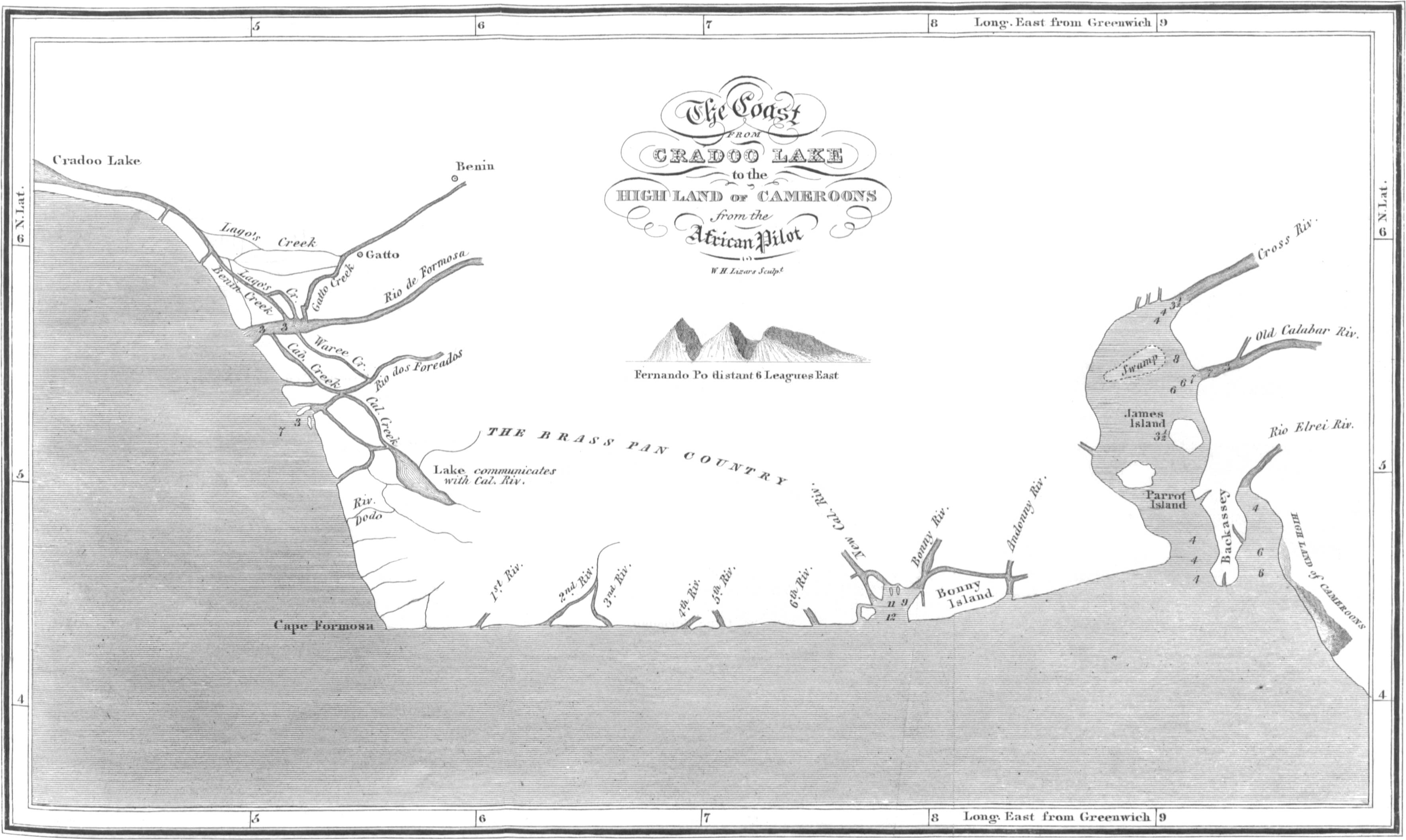
[128]CHAP IV.
Bights of Benin and Biafra — Rio de Formosa — Delta of Benin — Innumerable Rivers — Rio Forcados — Gatto Creek — Cape Formosa — Rivers East — New Calabar and Bonny River; their great magnitude — Old Calabar and Cross Rivers — Rio Elrei — Salt Ground — Great Trade in Salt — Face of the Country in the Delta — Trade to these Places — Inundation of the Rivers — Time of ditto — Shews they are different from either the Congo or the Egyptian Nile — Currents in the Sea near the Coast — Number and Magnitude of the Rivers in the Delta — Breadth — Depth — Trade — Natives into the Interior — a Race of People almost White — Leucæ Ethiopians of Ptolemy — General Observations on the N.E. and North parts of Central Africa — Accounts of Travellers — Kong — What it means — Great Magnitude of the Niger, and his Tributary Streams — Length of course — Compared to Magnitude of Bahr-el-Abiad at Shilluk — Cannot be the same Stream — No Connection with that River.
Let us now turn our attention to the rivers which enter the Ocean in the Bights of Benin and Biafra. Of the larger branches the Rio de Formosa, though not the largest, may be considered the parent stream from which all the others are deflections. At its mouth it is three and a half British miles broad, with two bars of mud, on which there is 13 feet[129] water. Besides numerous creeks which issue from it, a very large, deep, and navigable branch flows into the lake Cradoo, which communicates with the Lagos river near its junction with the Sea. The space betwixt them, according to the French maps, drawn for the French Marine service, under the late Emperor, is filled with low islands; and several rivers from the northward fall into the lake, or sound mentioned, betwixt the Rio de Formosa, and the Rio Lagos. The account which Bosman gives of the Rio de Formosa, is the most particular and satisfactory which I have met with. “Upwards,” say she, “it is sometimes broader, and sometimes narrower. It sprouts into innumerable branches, some of which may very well deserve the name of rivers.” About five miles from its mouth, it throws off two branches within two miles of each other. Agatton, the chief place of trade, is situated sixty Dutch miles (220 British,) up the river, and on a Peninsula formed by it. “So far, and yet farther, ships may conveniently come, sailing by hundreds of branches of the river, besides creeks, some of which are very wide. Its branches extend into all the circumjacent countries. The country all about is divided into islands, by the multiplicity of its branches.” The Portuguese, who had settlements inland, and were well acquainted with those parts, affirm that “it was easy, with a canoe, to get from the[130] Rio de Formosa into the circumjacent rivers, viz. the Rio Lagos, Rio Volta, Elrei, New Calabar, Bonny, and other rivers. The Rio de Formosa meanders through a fine fertile country, and brings down innumerable floating islands of considerable extent on its waves. On the north side, the river is joined by the Gatto creek, which may be the termination of a river descending from the north, perhaps the Kakoa heard of by Robertson. The Rio dos Forcados, apparently a mighty stream, no doubt branches off from the Rio de Formosa, after the streams running south-east have separated. South of the Rio dos Forcados, is a lake of considerable magnitude, which communicates with the sea, west of Cape Formosa, and also with the New Calabar river. The number of rivers which enter the sea from the Rio de Formosa to Cape Formosa, is six.
Passing Cape Formosa eastward, besides creeks, we have six rivers, which, at their mouth are all navigable. Beyond these, we come to the great estuary of New Calabar, and Bonny, or Bannee rivers. These streams form a junction near the sea, the one forming an island on the east side of the estuary, and the other an island on the west side thereof. The New Calabar river comes from the N.N.W. and the Bannee from the N.E. apparently at no great distance from each other; but still between[131] them some streams from the north enter the sound formed by their junction. This grand estuary is eleven miles broad, very deep, and navigable for ships of heavy tonnage. On the west side is a bank of sand, thrown up by the action of the river and the sea. In some places it has thirty feet water on it. The New Calabar river, opposite to the town, and 40 miles from the sea, is six fathoms deep. In it, however, are many flats with only 16 feet water. The Bonny river is perhaps the most powerful branch: it divides, and forms an island about twenty five miles long, and twelve broad; the eastern branch, a very considerable stream, entering the sea under the name of Andonny, or St. Anthony’s river. The town of Bonny is situated on this island, which is almost level with the water, and a great part of it is flooded during the inundation. Inland, however, the inhabitants assert that the land becomes more dry, and the country free from those pestilential vapours which are generated amidst the swamps immediately adjoining the sea. The current out of the mouth of the united streams of the Bonny and New Calabar rivers is strong and rapid; and it is asserted that they discharge as much water as the great river Congo.
Thirty-two miles eastward from Andonny river, we come to the estuary of Cross river, and Old Calabar, or Bongo river. This estuary is twelve miles[132] broad; but it may be considered as an arm of the sea rather than the mouth of a river, though the above rivers fall into it. This inlet penetrates into the country nearly 100 miles. At a considerable distance up this inlet, Old Calabar river is found to enter from the east. Its width and magnitude are considerable; but, tracing it eastward and upward on its course, it is, according to some authorities, found to pass over a large cataract which stops the navigation, and which indicates a course not of great length. Cross river is a branch of the Niger: our best charts represent it as coming from the N.E. This evidently is wrong, and should, I apprehend, be from the N.W. This Robertson asserts, and the name seems to bear him out; for it is by this stream that merchandize is transported from Old Calabar river to Bonny river, and the parent stream, the Niger, in order to be carried into the interior. Therefore, perhaps, it is named “Cross river.” In the French maps already mentioned, both these rivers are laid down as coming, the Old Calabar directly from the north, and the Cross river joining it from the N.W. In the latter, they are certainly correct. How far they are so regarding the former, future researches can only determine.
A small peninsula divides the mouth of the latter rivers from the outlet of the Rio Elrei. The[133] estuary, or arm of the sea into which it falls, is ten miles broad. Both estuaries are very deep, and the navigation of either is safe. According to the accounts transmitted to the African Association by Nicholls, the traveller who fell a victim to the climate in endeavouring to explore this river, the Elrei comes from the eastward, and joins the sound, or arm of the sea, north of the high land of Rumby. Advancing up the river to the eastward, the land rises rapidly, and the Elrei becomes full of cataracts and rocks, obstructing the navigation. This shews that the sources both of it and the Bongo, or Old Calabar river, comes from the bosom of that mighty chain of hills which we shall presently see terminate on the coast a little to the southward. These rivers will thus be found to come from the south side of the mount Thala of Ptolemy. For the reasons mentioned, namely, cataracts and rapids, it is obvious that neither of these rivers can be branches of the Niger.
The country round the Rio de Formosa is uncommonly beautiful. Hence the name. It is also very populous; but, from being so low and swampy, it is very unhealthy for Europeans. The same may be said of the whole extent of coast intersected by the above mentioned rivers. The country to the northward, between the Rio de Formosa and Ardrah, is without hills, but, rising in a gentle swell,[134] affords the finest prospect in the world. Inland, the country becomes more healthy, and the climate good. The land is extremely fertile. The trees are uncommonly large and beautiful. Cotton of the finest quality is amazingly plentiful; and indigo and other dye stuffs are to be had in abundance. The feathered tribes are innumerable. Horses, cows, and sheep are seen in great numbers. Weaving, and dressing of leather, are understood and practised. The Jaboos, an industrious people, carry on a great trade in grain, between Benin and Lagos. Benin is about ten miles from the river. Agatton is the port of the city. Benin is still a considerable place, though much decayed. The streets are long and broad; and it has regular markets every morning and evening. The houses, though built of clay, are handsome. Benin, when the Portuguese first discovered this part of Africa, was a powerful empire, extending westward to Elmina, and so far into the interior, as to be known to an empire distant twenty moons journey, in a N.E. direction, whose sovereign, being a Christian, it is supposed could only be Abyssinia. The extent of Benin is still considerable, their dominions extending twenty days’ journey from south to north. It claims sovereignty over New Calabar and Bonny.
The trade to these parts of the coast of Africa is very considerable, and annually increasing. The[135] number of slaves annually exported from Bonny, and Old Calabar rivers, were formerly, and still continue to be, very great. They are chiefly brought from the interior by a water conveyance. The people are every where fond of trade, generally civil and obliging to Europeans who deal honestly; and they are anxious to cultivate commercial connections with them. All around the Delta, the population on the sea coast are busily employed in making salt for the interior market. In the kingdom of Qua, situated between the Andonny and Old Calabar river, this is particularly the case. The land on the coast is called the salt ground, and is, perhaps, the place where Ibn-al-Vardi mentions the numerous salt-pits on the shore of the sea. This salt is carried into the interior, along with other merchandize, in canoes or vessels, built around Bonny river, so large as to contain 200 people, and having a cannon placed on each end. They are covered with hides to keep them dry. (Robertson, p. 308.) Boussa, on the Niger, is a great emporium for this trade, and the place where the people from the sea-coast meet the caravans from Barbary, to exchange their merchandize. (Robertson, p. 301 and 209.) The natives on these coasts also talk familiarly of their trade, intercourse, and communication with Houssa and Timbuctoo. West of the New Calabar river also, is a country famous for the manufacture of salt, and[136] called the brass-pan country, from the great demand for articles of this description from Europeans.
The rivers on the Bights of Benin and Biafra are in flood from May till December, but the height of the inundation is during the months of July and August. Then the Rio de Formosa covers all the land as far as Gatto, forty miles from its mouth, and fifteen from its bed. The inhabitants amongst the islands formed by its numerous branches, erect temporary villages, in which they live during the dry season, but which are all swept away during the rains. Such also is the situation of the country round the mouths of the New Calabar and Bonny Rivers, and, in fact, throughout all these coasts. Inland, the overflow of the river is very great; but we have no accurate account of the height. Shabeeny says, that it is so great that all the sheep, camels, goats, and horses, which feed on the banks of the river when low, are removed to the uplands during the flood. The land is constantly gaining on the sea, from the quantity of alluvial matter brought down by the different streams. Places near the mouth of Bonny River, which, within the recollection of traders of the present day, were stagnant pools, are now become dry and cultivated ground. In this manner, and during a succession of ages, has all the land in the Delta of Benin been formed. Every one of the natives[137] on these coasts agree in stating, that, in the interior, near Benin, a great river from the northward throws off three branches, which pursue a southerly course to the sea, and one branch which runs westward to Lagos.
The time of the inundation of these rivers shew in the clearest manner that they can have no communication with the Congo. Their rise begins in May, and is at the height in July and August. The Congo does not begin to rise at the distance of 200 miles from its mouth, till the beginning of September. The distance from the Bight of Biafra, or the point eastward and inland, over which the Niger, if it flowed south to the Congo, would have to pass to the point where Tuckey first perceived the rise of the latter, is only about 560 miles. The current in flood from six to seven miles per hour, as Park found it in the Niger, (without reckoning any accelerated rapidity from rocks and cataracts) would reach the spot mentioned by Tuckey, in the Congo, in four days, and in six days, allowing one-third more for the turnings and windings of the river. For similar reasons, the Niger cannot be the Nile, because that river reaches its greatest height in Egypt, by the time the flood in the Niger is at its height about Yaoora, which is 4000 miles distant from Egypt, by the supposed course of the river, and one third more, making a moderate allowance for[138] turnings and windings. The height of the flood also in the Bights of Benin and Biafra, being in August, is a most convincing proof that the waters which occasion it, come from places far to the northward and westward of nine or ten degrees of latitude, and in the same meridians, because the rains in the same parallels of latitude as the mouths of these rivers, are greatest in May and June. Their violence is past before August, whereas in the parallels between 10° and 20° north latitude, their violence is greatest in July and August. This being the case, shews that the height of the flood from those waters which pass Timbuctoo, and which come from Dar Saley, cannot be before August in the Bights of Benin and Biafra.
From the immense volumes of fresh water poured into the sea on these coasts, the currents are rendered exceedingly strong, and the swell and agitation of the waves very great and dangerous. The current in the sea sets to the northward, from the Congo along the coast of Africa, till it approaches the Bight of Biafra. Thence it is bent westward, through the Bight of Benin, and along the coast of Guinea. From the mouth of the Rio de Formosa it runs particularly strong to the westward. Bosman describes the excessive roll and turnings of the sea in this part in the strongest language: “The tide, from the eastward,” he says,[139] “is so strong, that no shallop can stem it by rowing.” Having gained the shore through these terribly agitated waters, is, he says, to have “passed from hell to heaven.” Similar tides, swells, and currents, are invariably found off the mouths of large rivers, particularly all such as are flooded by the tropical rains. The mouths of the Maranon, the Orinoco, and the Ganges, have all similar phenomena near them.
CALABAR
And
Bonny Rivers.
Surveyed by
Captn. Newton
W. H. Lizars Sculpt.
Page 139.
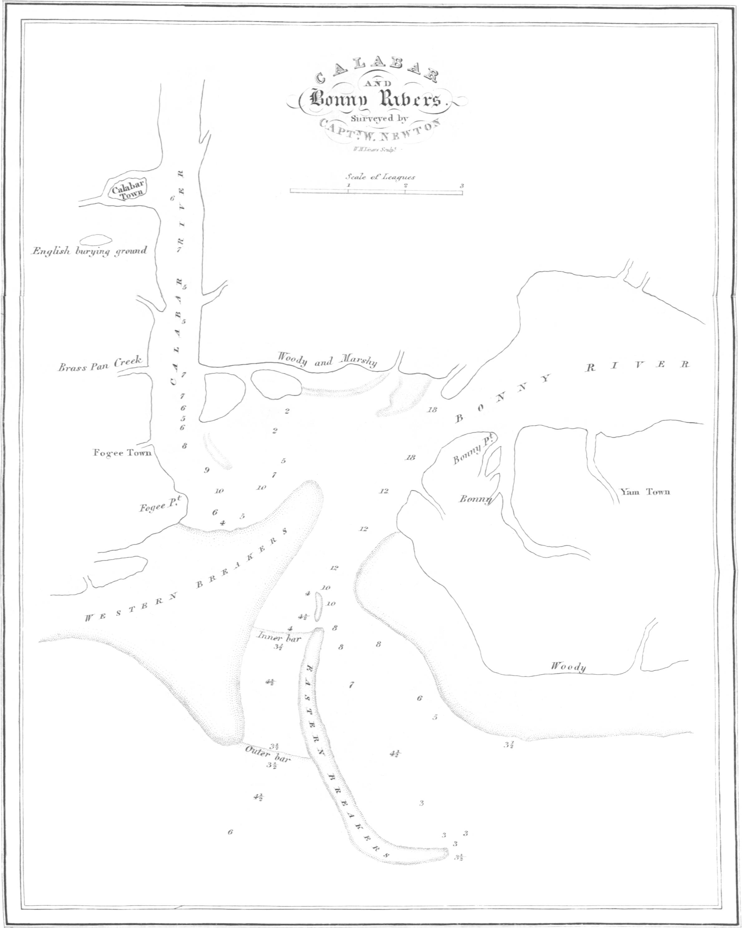
When we reflect, for a moment, on the number and magnitude of the rivers which join the sea in the Delta of Benin, we are filled with wonder and amazement. From the Rio Lagos to the mouth of the Cross river inclusive, the number exceeds 20. The breadth of their surfaces connected together, would exhibit an expanse of fresh water perhaps 50 miles broad. Three of these only, viz. the Rio de Formosa, the chief outlet of the Bonny, and the estuary of the Old Calabar and Cross rivers, would make 27 miles. The depth of these rivers greatly exceeds that of other rivers of the first magnitude at their mouths. Thus, the Rio de Formosa has 13 feet water on the bars at its outlet, and deepens to several fathoms as it leaves the coast. The mouth of the New Calabar and Bonny has 7, 8, 10, 12, and, considerably upwards in the Bonny river, 18 fathoms; while the New Calabar, 40 miles from the sea, is six and seven fathoms deep. The chief mouth of the Orinoco has only[140] 17 feet water on the bar, and the navigable part is no more than three miles broad. The Mississippi enters the sea by six channels, the two principal of which have only 12 feet water on the bar in each. Thus the outlets of the Niger greatly exceed either of these mighty rivers in the depth of their mouths. The distance from the source of the Missouri to the mouths of the Mississippi exceeds 4000 miles. The Delta formed by the Niger, exceeds in extent that formed by the Ganges, the Mississippi, the Orinoco, or the Wolga. In difference of longitude the Delta of Benin is nearly 260 miles. That of the Ganges, much larger than any of the others, is 200 miles. The navigation also of the outlets of every one of these mighty rivers is much more obstructed than the navigation in the mouths of the Niger. They have less water, and are more intricate and dangerous than either the Rio Lagos, the Rio de Formosa, the Bonny, and Old Calabar rivers. Of the depth of the Niger in the interior we are wholly ignorant; but, judging by the depth and magnitude of its branches at their mouths, we may form some idea of the depth of the united stream: It must be great. Inland, the Niger, before it is joined by any of the eastern rivers, is represented as two and three miles broad, and in its lower course five miles. (Bowditch, p. 201.) The united stream of the Orinoco at St. Thomas’ is four[141] miles broad, and 65 fathoms deep, when the stream is lowest. The Ganges, inland, is three miles broad, and ten fathoms deep, when in flood. The united stream of the Mississippi, at New Orleans, is nearly one mile broad, and 20 fathoms deep. Higher up its breadth is rather more than a mile in some places, and from 200 feet to 35 feet deep. If we calculate from its breadth, the Niger will yield to none of these rivers in depth. The extent of country from whence it collects its waters, is, in breadth from east to west, greater than that part of South America which forms the immense Maranon; but, except in the meridian of Benin, little more than one-half the extent from north to south. The features, however, throughout the greater part, are of the same stupendous and magnificent description which are met with in those parts of South America. From the sources of the Misselad to the junction of the great eastern river with the Niger, the length of the Gir will, on general bearings, exceed 1600 miles. The Niger itself has a still longer course; and the stream that descends from Dar Kulla will have a course of 1000 miles to the place where it unites its waters with the former streams. Although the clearest information which we can obtain, leads us to fix the junction of these mighty rivers at the point mentioned, yet it is by no means[142] improbable that this junction may take place lower down, or in the alluvial country nearer the sea.
It has been, and at various periods, stated, that vessels of considerable burden, navigated with sails and oars, and some of them manned by white people, came up the Niger from the eastward to Timbuctoo. Mandingo merchants informed de la Brue at Galam, that, some leagues from Timbuctoo, the Niger was navigated by “masted vessels.” Dr. Laidley, who resided long at Pisania, was informed, that vessels of 100 tons burden frequented Houssa, by which might be meant the country as well as the city of Houssa. A priest, who had visited Timbuctoo, informed Mr. Park, that “the canoes on the Niger were large and not made of a single tree, but of various planks united, and navigated by white people.” Major Houghton was informed by a Shereef whom he met with at Medina, and who had formerly known the Major when he was British Consul at Morocco, and who had been at Timbuctoo, that “they had decked vessels with masts, with which they carry on trade from Timbuctoo, eastward to the centre of Africa.” The crews of these vessels have been stated sometimes to exceed 150. These things were considered as fables. Late accounts, however, explain these relations in a satisfactory manner, and also confirm[143] the accuracy of the earliest accounts which we have of Africa. Robertson has informed us of the great magnitude of the canoes or vessels built about Bonny river. We hear of no such vessels employed on either the Rio Grande, the Gambia, or the Senegal. With these vessels they trade up the river into the interior. He also states, that the natives from Tebo to the north of Benin “are whiter than Arabs, but are silky haired; and that the people on the coast give them the same appellation as white men, namely, Evoo.” These people are great traders, and go far into the interior; and there is no doubt but that it has been some of these people, with the large vessels mentioned, which have, at different times, made their appearance at Timbuctoo. It is far from being improbable also, but that they are “the particular kind of people” mentioned by Jackson, and the “white people” who dress in the style of Barbary Moors, and wear turbans, but do not speak Arabic, and who dwell on the borders of that lake into which the Niger discharges itself,” which Barnes heard of. It is very remarkable, that, in these parts of Africa, (for, if we examine his work accurately, we will find that it is hereabouts,) Ptolemy mentions and places a nation of white Ethiopeans, (Leucæ Ethiopeans.) The circumstances which we have mentioned prove the navigation of the Niger to be free and open; and[144] Edrisi distinctly states that the Gir is so also, when he mentions that the vessels with salt from Ulil go up the Nile through the provinces of Ghana, Vancara, and Kaugha. All accounts concur in stating that the canoes which come down the rivers from the interior to the coast, are large and much finer vessels than those generally used on the south or the west coasts of Africa.
Some articles of European manufacture found in the interior also establish the fact of this channel of communication. Thus the schoolmaster at Tripoli informed Mr. Ritchie, that the uniforms of the King’s guards at Timbuctoo were red; and “that they were armed with musquets brought from the great Sea.” This must be the Bight of Benin, to which Europeans carry a great quantity of fire-arms. These articles do not come from the northward, for L’Hage Shabeeny expressly states that the traders from Morocco to Timbuctoo “carry neither swords, musquets, nor knives, except such as are wanted in the caravan.” (Jackson’s Shabeeny, p. 21.) The reason for this is obvious, for, if they carried these articles, they would arm and enable the Negroes to defend themselves, which is not the policy of either Moors or Arabs. Consequently, these articles must come through countries where neither of these nations possess any influence. All these things prove, in the clearest manner, the open, easy, and extensive[145] communication by water, from the coast adjoining Benin, with the interior; a communication only found on this part of the coast.
In the northern, and north-eastern parts of central Africa, from Mourzook, to Darfur, and from the mountains of Eyrè to Timbuctoo, instead of burning deserts, and sterile wastes, and boundless swamps, we now, from good authority, find that there are numerous, powerful, fertile, cultivated, well wooded, watered, populous, and industrious states. Every where mighty rivers, from the east, from the north, and from the west, are found pursuing their course to the ocean, and verging to one grand point. Benin, Bornou, Asben, Bagherme, Dar Saley, Darfur, Kashna, Houssa, Timbuctoo, Sego, and Wassanah, and many others, are populous kingdoms, abounding in metals, minerals, fruits, grain, cattle, animals wild and tame. Kashna comprehends 1000 towns and villages. The population of Timbuctoo is estimated on the lowest scale at 50,000. Houssa is still larger. Wassanah nearly double, and Bornou still more extensive. The sovereign of Houssa, according to Shabeeny, can raise 70,000 horsemen, and 100,000 infantry. I am aware much must be allowed for Negro amplification, but still sufficient remains to shew us the importance of these places. Beyond Kashna, the camel, “that ship of the desert,” is no longer found; thus[146] ceasing to be produced where his labours could no longer be generally useful or necessary, and in countries where he is not calculated to live. After passing Kashna to the southward and south-westward, the face of the country changes greatly. It becomes less open, and more intersected with great rivers, inundated roads, prodigious forests, and stupendous mountains, all the way to the gold coast. All these countries, all Central Africa, abounds with the elements of commerce; and her noble rivers afford the easiest, the safest, the cheapest, and most expeditious roads for the collecting and the conveyance of these. In all things, it is superior to what any portion of America, in the same parallels, or indeed in any parallel, afforded when Europeans first visited that quarter of the globe.
In the course of the Gir, or Nile of Sudan, as delineated on the map accompanying this work, it may be observed, that it is extremely probable the course of the stream in the middle part is still too much (perhaps a degree and a half) to the north. This would bring the lake Fittre into the latitude assigned by Ptolemy to the Nuba Palus. The bend, or angle formed by the river northward of Wara, is also, in all probability, much less acute than is represented on the map; and Wara is perhaps more to the west, and not so much to the north of Darfur. This would give the river, in appearance, a[147] more natural course in those parts, and which the bearings given by the Arabian and native merchants would admit of without unnecessarily wresting their meaning. The rivers that descend from the north would thus have a greater space to traverse before these joined the Gir. On the other hand, the mountains which give these birth, may be more to the southward than I have placed them; and, in this particular, corresponding with the accounts given by Ptolemy more accurately than their position as supported by the testimony of Arab merchants. From 21° to 22° north latitude, there is reason to believe, is the true position of the highest chain of those natural barriers which divide the desert from the fruitful land. Northward, there is no doubt, lesser chains gradually decreasing in height, till these reach the desert. Northward of Ashantee, we have no difficulty in ascertaining the highest land. The magnitude of the rivers which flow S.E. point that out very distinctly. Thus we learn from Bowditch, (p. 171.) that at, and near Boopee, the Adirri and Addifoosoo, the two chief sources of the Rio Volta, are about 120 yards broad. Lower down, and in the route from Coomassie to Sallagha, the rivers Kirradee, and Oboosoom, running S.E. are each about 60 yards broad. These things are sure guides in determining the most elevated parts of the country. Independent of the positive testimony of Sidi[148] Hamed, regarding the very high ridges of mountains in the central parts of Africa, with other concurrent circumstances, we have the positive testimony of various other intelligent Arabian travellers and merchants, that stupendous mountains cover these parts of Africa. Leo informs us that Guber is environed with mountains; and from Cashna, southward to Ashantee, all authorities agree in stating that prodigious high hills raise their lofty heads throughout all the space mentioned. The country northward from Ashantee to Sego and Jinnë is full of exceeding high mountains, which renders commercial communications almost impracticable. On the other hand, merchants and travellers who come from the country of Houssa, to the sea coast at Lagos and Bonny, make no mention of any particular chain of mountains, or inconvenience therefrom to travellers; but speak of heights, and complain chiefly of interruption and difficulties arising from large rivers, lakes, and morasses. This shews the parts of the country where the mountains become less elevated, and the land more open, thus affording an easy passage for the mighty rivers in their course to the ocean.
The word Kong is Mandingo, and signifies a mountainous country, and not one particular ridge. Did an impenetrable ridge, as is imagined, extend from Kong in 10° north latitude to Komri in 7° degrees north latitude,[149] then the distance from its summit to Benin would not exceed 240 geographic miles. In such a distance, it is utterly impossible that so many, or indeed any one of the great rivers which enter the sea through the Delta of Benin, could be formed. From the westward none of them does or can come; and from the east it is equally obvious that they cannot flow. All this portion of Africa is mountainous; but it is evident these mountains admit a passage for the united waters of the Niger and the Gir from the northward, which, emerging from the mountainous districts, flow through a level country, and, in the lapse of ages, have formed the alluvial Delta of Benin.
In the Bights of Biafra and Benin, therefore, is the great outlet of the Niger, bearing along, in his majestic stream, all the waters of Central Africa, from 10° west longitude to 28° east longitude, and from the Tropic of Cancer to the shores of Benin. It is certain it is navigable from Balia, for Park informs us canoes can pass the rapids at Marraboo. This celebrated traveller descended the stream in safety to Boussa, where an accident terminated his life. The traders from the coast go up the river above this place. The course of the Niger will greatly resemble, on the map, that of the Orinoco of South America, and the length from the extreme sources (and those nearest its mouth) will be, on general[150] bearings, 2250 geographic, or about 2600 British miles. The cannon, therefore, which thundered at Aboukir, and made the Nile tremble—those cannon which burst asunder, for ever, the chains of Christian slavery at Algiers, and which bore the fame of Britain[8] into the deepest recesses of Africa, may in safety awaken with their echoes, to obedience and respect, the uncivilized, or half civilized, nations of all Central Africa.
We have noticed, and from sure authority, the magnitude of the Niger at Bammakoo—in flood, one mile broad. At the ferry in the route to Houssa, it is described as two miles broad; at Yaoora, three miles. In other places it is stated by the Moors as five miles broad. We have noticed the magnitude of the Gir, the Shary, and the Tzad, in the early part of their courses—we have noticed the probable magnitude of the Bahr Kulla and the supposed Gulbe, all uniting in the Gir, which, where it passes through part of Kashna, with a rapid current, is twenty-three to twenty-four feet deep, and very wide; and having considered these things minutely,[151] it is obvious that the united flood (making large allowances for African amplification,) must form a river equalled by few, very few, on this globe. The Maranon alone can exceed it. Neither sands can absorb, nor lakes contain, such streams. When Bowditch mentioned to the Arabs whom he met with at Ashantee, the European theory, that the Niger was lost in lakes or sands, they expressed the utmost astonishment. “God,” they said, “made all the great rivers to flow into the sea, and did Europeans think that he made the Quolla (Niger,) the greatest of them all, to be lost in the sands of the desert.”
It has been argued that the diminished size of the Bahr-el-Abiad at Shilluk, compared with that of the Niger at Bammakoo, and more eastward in its course, was easily accounted for by evaporation. This argument might have been allowed some weight, had it been shewn that the supposed course of the Niger from Timbuctoo to Shilluk lay through countries as dry and sandy as those countries are through which the Nile flows from Shilluk to the shores of Egypt. The reverse, however, is, from every information we can receive, the case. The country along the supposed course of the Niger, from Timbuctoo to Shilluk, is all remarkably hilly, woody, mountainous, in many places well cultivated, and abounding with large rivers, which must[152] increase, not diminish, any great river which flowed through it. Again, it is argued that the Bahr-el-Abiad being full all the year, is a proof that it is the Niger. This account, however, proves the very reverse, because the Niger is not full, or in flood, (for so those who reason thus would take the expression used by Bruce,) all the year, but only during a part thereof. The expression, “full all the year,” however, does not mean that the Bahr-el-Abiad is in perpetual flood, but that it does not diminish in size during the dry season so much as the Bahr-el-Azreek, and other streams that flow from the south-eastward. That this is the true meaning of the expression is obvious, for Bruce also expressly states that “all the rivers in these parts fail when the sun goes South of the line.”
This continued fullness, or rather greater copiousness of the stream, during the dry season, in comparison with the eastern branches of the Nile, proves to a demonstration that the chief branches of the Bahr-el-Abiad either spring greatly to the southward, (some of them most probably do,) near the equator, or else considerably to the south-westward of Shilluk, amidst stupendous mountains covered with impenetrable forests, where the sun’s rays, during the dry season, have no influence in lessening the damps and moisture which give vigour to the springs, and where also the height of[153] the mountains may be such, as melting snows may at all times add resources to the stream. From Donga, where the Bahr-el-Abiad is said to rise, to Shilluk, is above 300 miles. In an equal space, and through similar countries and Alpine scenery, the Niger becomes a much larger river than the Bahr-el-Abiad is represented to be at Shilluk. At its junction with the Bahr-el-Azreek it is said to be three times as large as that stream when it is low. At this junction, which is in 16° north latitude, the Bahr-el-Azreek can be crossed on foot, and is only mid-leg deep. The magnitude, therefore, of the Bahr-el-Abiad, calculated by the scale given, it is evident, cannot be very large. Besides, the Bahr-el-Adda intervenes between the Bahr-el-Abiad and the conjectured course of the Niger southward and eastward; and whichever of the former streams may be chosen as the continuation of the latter, still the theory in question exhibits the Niger in its lower course as running, not down from, but up against, the hills and high lands; for such are, and must be, situate about the sources of either the Bahr-el-Adda or the Bahr-el-Abiad. The latter also is represented, not as a still river, but of a current so rapid that a considerable distance is passed over before its waters are mixed with those of the Bahr-el-Azreek.
Considering all these things attentively, it is not[154] possible that the Niger, and its collected waters, can flow to form the Bahr-el-Abiad, or the Nile of Egypt. They may have a communication. That is possible, but not probable. They are certainly distinct rivers. Can a river which is a British mile broad, as the Niger is at Bammakoo, in longitude 4° west, and latitude 13° north, flow through all Central Africa, passing in its progress east the parallel of 16° north latitude, and then returning south to 7° north latitude, through a country filled with stupendous mountains covered with snow, extensive forests, and drenched with tropical rains— Can such a river, receiving, as it does, and must do, mighty streams on either hand, flow again northward to north latitude 14°, and to the eastward as far as east longitude 33°; a distance, upon the general bearings of its course, equal to 2700 geographic (3127 British) miles; and then and there dwindle down to a stream such as the Bahr-el-Abiad is at Shilluk; the breadth of which, according to Browne, is only such that the human features could not be distinguished, but the human voice could be heard, by a person on the opposite bank? This breadth cannot exceed a quarter of a mile. The identity, therefore, of the Niger and the Bahr-el-Abiad, is, for this as well as for many other reasons too tedious to mention, altogether impossible. Swelled by the tropical rains, which make the dry-bedded[155] torrents of the deserts of Africa become mighty streams, the Niger, with his accumulating, accumulated flood, would become a river of such force and magnitude, as would sweep all the cultivated land of Nubia bare as the rocks which there compose the bed of the Nile—bear Egypt and her cities headlong into the Mediterranean Sea, and cover perpetually, with its waters, all her land, fertile and sterile, from Rosetta “to the tower of Seyne.”
[156]CHAP. V.
Country south of the Elrei — High land of Cameroons — An extinct Volcano — Chariot of the Gods — Old Cameroons — Jamoor and Malemba rivers — Moöhnda or Danger river — Gaboon river — Nazareth, Liverpool, Bristol, and Tawney rivers — Congo river — Rivers west of the Rio de Formosa — Rio Lagos — Mory river — Country around it — Rio Volta — Boosempra, Ancobra, and Assinee rivers — Mesurada river — Sierra Leone — Way to explore Africa — Distances of places, how ascertained — How to command Africa — Fernando Po, a sure stronghold — Sierra Leone, a secondary place — A settlement inland of the greatest importance — Extent of country it would command — French settlement in Africa — Wish to extend their power in that quarter — Rivers, their great use in the Torrid Zone — East coast of Africa, important for Commerce — Rivers Zambezi and Zebee — Island of Socotora — Situation of Africa — Slavery — The slave trade — Extent thereof — Slavery and superstition scourges of Africa — How to benefit Africa — Colonization — Advantage of colonies — The chief strength of Britain — Eagerly coveted by France — Our efforts in Central Africa would civilize all Northern Africa — Must expect to meet difficulties — Perseverance will ensure success.
It is now time to turn our attention to the rivers south of the Elrei. But first the high land of Cameroons demands our attention. This part of the coast extends from the mouth of the Elrei to Cameroons[157] river, about 45 miles in a north north-west bearing. The ridge comes close to the sea. The nearest peak is a volcano, and is higher than the Peak of Teneriffe. A third of its height is above the limits of vegetation, and its top every morning covered with snow. Considering the latitude so near the equator, the height, before snow and ice could appear, must exceed 16,000 feet. Still farther inland, three other peaks are discernible, each rising in height; for, seen from the sea, the most distant appears of the same height as the nearest. In the clear atmosphere of these latitudes, such mountains may be seen at a distance of 200 miles. The face of these hills does not front the Bight of Biafra, but fronts south south-east; as the view from old Cameroons river clearly establishes. It is therefore almost certain, that this is the termination of a mighty chain of mountains, which branch off from the mountains of the Moon. It would be contrary to all the knowledge we have of other parts of the globe, to suppose the mountains inland were less high than those on the sea-coast. Such a chain must completely bar the passage of any river from the northwards. This chain is distinctly indicated in the maps constructed from the accounts of Arabian geographers. The chain, no doubt, follows the course of the Bahr[158] Kulla; and thus shows how the Elrei and the Old Calabar rivers may have their course in elevated lands, and their springs amidst their hills. It also points out the deflection of the Niger to the west, as it descends from the north, and approaches the western extremity of these mountains. What we have noticed is a most extraordinary feature in African geography, not paralleled, I believe, in any other part of this globe.
There is the strongest reason to believe, that the high land which we have been considering is the “Chariot of the Gods” of the ancients. According to Hanno it was situated in a bay or gulf. The flame that issued from it at night, he says, extended to the stars, and by day the same tremendous appearance was maintained. Hence that navigator called it the Chariot of the Gods. It is clear, that it was beyond, and greatly beyond “Hesperus his Horn,” which Ptolemy places in 8° north latitude, and 13° east longitude from Ferro. Whoever considers the latter author with attention, will readily see, that, in the place we are considering, he has placed his “Deorum Currus.” There is no part on the coast of Africa which answers so accurately to the description given by Hanno. The mountain is an extinct volcano, but which, in the days of Hanno, might have been in full activity. Nothing is more probable.[159] The Bights of Benin and Biafra must have undergone great changes since that early period. The Delta must be greatly increased, if not, in a great measure, formed, during the space of 2390 years. The island of Fernando Po also is evidently of volcanic origin. But it is foreign to my purpose to enter at length into these subjects.
Immediately south of this ridge, in 3° 40′, is Old Cameroons river, about two miles broad. It is navigable upwards, for vessels drawing 18 feet water. About 3° 20′ north latitude we have the great estuary of Old Cameroons, or Jamoor, and Malemba rivers. The extreme breadth is 12 miles. It communicates with Old Cameroons by Bimbia and other creeks. At a short distance from the sea, is an island between the Jamoor and Malemba rivers, on which the town of Cameroons is situated. The natives say, that all these three rivers come from one parent stream in the interior; but of whose source they are ignorant, as it was far distant. Southward, the coast rises into a table land, extremely beautiful, and very healthy. Passing Cape Claro, in 1° 10′ north latitude, we have Moöhnda, or Danger River, a deep and powerful stream, navigable for vessels of any burden. Its entrance is narrow and dangerous; but once entered, it is quite safe. The island of Corisco (Thunder)[160] is in its mouth. Its banks abound with the finest timber for ship-building and other purposes. Forty miles south, passing along a low swampy coast, (almost a morass,) in latitude 0° 30′ north, is the entrance of the Rio de Gaboon, 30 miles broad, but inwards contracted to 12 miles. 45 miles from the sea, the river divides into two branches; the one streaching north-east in a deep stream, till, according to the natives, it comes from the Moöhnda. The other runs south-east, and about 60 miles upwards is formed by several streams from the mountains. The sources of the Moöhnda are said to be far into the interior, northward of east. Southward of the Gaboon, the land is low, and the navigation of the coast dangerous, by reason of currents in the sea. Northward of Cape Lopez, we have Nazareth River, which has a bar, with only 12 feet water at its mouth. It is a large and deep river, and navigable in the interior. Such are the accounts given by the natives. Southward, and round Cape Lopez, is Liverpool, Bristol, Tawney, and Cape Lopez rivers, said to be considerable streams, and, with the Nazareth River, to come from one river in the interior called Avongo, which, at a considerable distance from the coast, is said to fall over an immense precipice. The course, however, and sources of these rivers, are unknown, except[161] that they come from the eastward. Towards the mountains of the Moon they, no doubt, have their rise, where the land is greatly elevated. South-west of that ridge, the maps constructed from the authorities of the Arabs, represent several rivers. It is a fact, and one worth attending to, that from Old Cameroons river inclusive, the natives on the coast are wholly unacquainted with Moors and Arabs, which shews they have no communication with the northern interior countries; a circumstance which could not have happened, had either the Niger or the Gir flowed to the southward.
From Cape Lopez to the mouth of the Congo, the land is hilly, and the shore in many places bold. Few rivers of any magnitude enter the sea on this part of the coast. The mountains seem to run parallel with the coast. The mouth of the Congo is in nearly 6° south latitude. The voyage of Tuckey has made us accurately acquainted with this stream in its lower course. Its magnitude has been greatly exaggerated. At Fathomless Point, the true mouth of the river, it is only three miles broad. The depth, however, is about forty fathoms. Higher up, and approaching the cataracts and rapids, it contracts to two miles, and even to one mile. These cataracts are numerous. The rapids continue for a considerable space, during which the river is frequently contracted to a very narrow channel. The[162] ridges, on either side, rise steep, bare, and barren. Navigation is impracticable. The course is from N.E. Above the rapids and rocks it expands to the breadth of three and four miles. This is about 280 miles from its mouth. At this point Tuckey was forced to turn back. The navigation upwards was said to be open. Ten days’ journey above this, a large branch comes from the N.W. The great stream comes from the N.E.; and, in all probability, rises on the S.E. side of the Mountains of the Moon, in about 5° north latitude, and 31° or 33° east longitude. According to the Portuguese, near Concabella is the junction of several great rivers. A branch comes from the east, and one as large as the Po comes from the south. The Congo begins to rise in September. The flood is greatest in December. It begins to rise at the cataracts on the first of September. This rise begins a month before the rains commence in these parts. This is a convincing proof that its source is north of the equator, and south of those hills which give birth to the Nile, where the rains are greatest in August. From November to January the rains are heaviest in the lower parts of the Congo. Comparatively speaking, it may be said to be in perpetual flood. The reason is obvious. Its chief sources lie in different hemispheres, with one branch in the middle, between those extending eastward into the interior.[163] The consequence is, that the Congo receives supplies from the rains of both Zones. The one beginning to swell it, before the flood from the other ceases. These things are a complete proof that it is no part of the Niger. Tuckey and his companions were surprised at the vast volume of water in the Congo, both above and below the cataracts, compared to that which rolled over them. They conceived the stream found subterraneous passages, from the number of tremendous whirlpools in it. Proyart, in his account of Loango, mentions some curious circumstances, which would favour Tuckey’s supposition. All the rivers in Loango, he says, flow in an equal stream in the dry and the rainy seasons. They suffer no diminution. However deep the natives dig, neither tuffe nor stone is found. A stratum of compact argile confines the waters to the interior of the earth. In some places it is interrupted, where the water undermines the surface, and often excavates large and deep abysses, which open spontaneously during the rains. The inhabitants fly as far as possible from these moving grounds. (Proyart, Pinkerton’s Coll. vol. xvi. p. 550.) Loango is west of the cataracts of the Congo, and situate beyond the chain of hills which run along its N.W. bank. Can the phenomena mentioned by Proyart, be occasioned by the subterraneous[164] passages in the Congo, as supposed by Tuckey?
If the Congo were the Niger, then the latter must pass south, in the latitude of Benin, at the utmost not more than 300 miles east of the high land of Cameroons: now a mighty chain of mountains is from the coast seen to stretch two-thirds of this distance in that direction; and all the country in the interior, we are informed, is exceedingly mountainous. The vale, if I may use the expression, through which a river of such magnitude as the Niger is, can flow, must be very broad. Large streams would also join it from the west, as well as from the east. Bearing this in mind, it is plain that if the Niger passed to the Congo, no space of sufficient extent could remain between those mountains and the sea, to yield those immense rivers which enter the sea from Rio Lagos to Cape Lopez. The utmost extent of the course of any of them could not exceed 200 miles. If the Niger continued to flow to the Congo, after throwing off branches which form all the rivers in the Delta of Benin, and southward to Cape Lopez, then, considering the elevation which, in that case, the bed of the Niger behoved to have, their streams would have the rapidity of torrents; whereas, in all but the Old Calabar and Elrei river, it is the reverse.
[165]Westward of the Rio de Formosa, we have the Rio Lagos river, which a branch from the Rio de Formosa joins at its mouth. The current is very rapid during the flood; bearing down floating islands, and forcing vessels from their anchorage, when in the roads. The chief stream comes from the northward, and above its junction with the branch of the Niger is said to be ten fathoms deep, and so broad, that when in the middle, the banks on either hand, though covered with lofty trees, can scarcely be discerned. This stream has different names, in different parts of its course. Seven days’ journey N.E. of Ardrah, it passes under the name of Azewoa. Six days’ journey N.E. of Yahndi, it passes S.E. under the name of Mory. Four days’ journey northward of Yngwa, the Kontoorooa, one of its branches, is found flowing S.E. half a mile broad, and near its junction with the Kirhala, which is a larger stream. This latter river is readily identified, as being that which travellers cross at twelve days’ or eleven days’ journey distant from Kong, in their route to Jinnë. The united stream of the Kontoorooa and Kirhala flows S.E., and is undoubtedly the Lagos river, which flows through populous and powerful countries and states.
The Mory, or Lagos river, has been mistaken by Robertson for the Niger; and, accordingly, he confounds the kingdoms and states on each, as if these[166] were around or upon the same river. Soko, in Ashantee, he has thus put down as Sego, which place is 400 miles from Soko. The Mory river must be of great magnitude. Descending from such stupendous mountains, it must soon increase and become a very large stream. Six or seven days’ journey north of Ardrah, travellers represent it as being six miles broad. In length it must exceed 500 miles. Various accounts state that, north of Dahomey, is a very large lake from which several rivers issue. Robertson says it is 10 days’ journey N.E. of Agombe, the capital of Dahomey. Bowditch says it is situated in Hio, 10 days’ journey north of Dahomey; and Snelgrave and Barbot state that this lake lay between Gago and Dauma (Dahomey) 370 miles N.N.E. of Ardrah, a distance much greater than either of the two former authorities allow. There is little doubt, however, but it is the same lake that each authority has in view. Snelgrave and Barbot call it Guarde, and estimate its length at 100, and its breadth at 50 leagues. In this, however, they may be deceived, from estimating the days’ journey, the usual mode of calculation, at much more than it really is. There is little doubt, however, but that it is of considerable size, and its true position seems to be about 100 miles to the northward of east from Dahomey.
The countries to the west and north-west of Dahomey[167] are represented as very populous, abounding in provisions, and the people great traders. Dagwumba, in particular, is a powerful state, and its capital, Yahndi, of considerable magnitude, and a great emporium for trade. Still more to the north-west, and amongst the Kong hills, are other powerful states. To the northward of the chief range, according to Bowditch, is the kingdom of Moozee; but, from other authorities, particularly Park, we learn that Moozee is the capital of the great kingdom of Gotto. It is a very common practice among negroes to place the capital for the kingdom and the kingdom for the capital. Moosee lies in about 10° 20′ north latitude, and 0° 45′ west longitude.
The soil in the kingdom of Dahomey is composed of a deep, rich, reddish clay, intermixed with sand, and scarcely containing a stone the size of an egg throughout the whole country. This affords a clear proof of its being low and level: it is very fertile. The surrounding countries exhibit the same features.
Westward of the Rio Lagos is the Rio Volta, a large, deep, and rapid stream, which is increased by the junction of the Laka at no great distance from the sea. The sources of both rivers we readily recognise in the Adirri and Addifoosoo, which take their rise in the eastern parts of the mountains of Kong, which are here so elevated as to be covered[168] with snow, and amongst which springs the chief branch of the Niger. The Kirhala, and the Ba Nimma, also here take their rise. The mouth of the Rio Volta, between the breakers, is a mile broad, and has three fathoms water; sixty miles upward it is four fathoms deep. The stream flows through fertile and populous districts; the natives hold it in great veneration. Teak trees abound on its banks. The climate is fine, and the country healthy. A branch from the Rio Lagos communicates with the Rio Volta, in many places only divided by a sand-bank from the sea. All the natives on this part of the coast are industrious, and great traders. Many Arabic words are found mixed with their languages; several Arabian customs remain. About Fidah the country is fertile and delightful. The land rises gently from the sea, covered with lofty trees growing in regular order, as if planted by human hands.
Beyond Cape Three Points is the Boosempra, the Ancobra, and Assinee rivers, the latter the largest, but all comparatively small streams. Westward, as far as to the Mesurada, the rivers that enter the sea are mere torrents, a proof of the shortness of their course, and also that the river called “Zamma,” already mentioned, must be a branch of the Niger. The coast here is all bold and high. Inland, the country is exceedingly mountainous, rising in height[169] and grandeur. Sierra Leone (hitherto supposed to be the chariot of the gods of the ancients,) seems to be the termination of the mighty chain which stretches north-east by east, through those parts of Africa; and it is very curious, that this chain appears to run exactly parallel to the grand chain of Mount Atlas. Perhaps it stretches across the Continent to Egypt.
Whether the Congo is the Niger or not—whether the latter flows to the Egyptian Nile, and whether or not it terminates in a lake, swamps, or sands in the interior, still the Bights of Biafra and Benin are the points from whence to set out to ascertain and determine this important point. A considerable portion of the journey, we know from the best authority, can be travelled by a water conveyance. The whole distance cannot much exceed 300 miles, till the point would be determined. The nations and people on the route are comparatively peaceable, civilized, and friendly to Europeans. At old Calabar, different European languages are understood. The English language is spoken, and taught, and read, and written. They keep regular mercantile accounts in our language; hence good guides could be procured. In any other route from the west, from the north, or from the east, into the interior, the path is through dreadful barren deserts, countries wild and rugged, and men fierce and rude,[170] and by religion the most inveterate enemies to the Christian name. The distance also, by any one of these routes, to be travelled before the points alluded to could be decidedly determined, is about 2500 miles. It is not difficult, therefore, to determine the route which should be chosen.
Coomassie in the south, Mourzook in the north, and Cobbè in the east of Africa, are points accurately ascertained. Timbuctoo, in the centre, is tolerably well known. It is satisfactory that, taking the bearings, and calculating the distances on these by the most accurate scale, as all these are given by authorities wholly unknown to, and unconnected with each other, the positions of places and rivers agree with a remarkable degree of accuracy. In this manner the map which accompanies this work was constructed.
Agadez, according to Leo and Joannes Bleav, is about 160 leagues distant from Cano. This corresponds very nearly indeed with the position where it is placed according to the accounts obtained by Ritchie and Bowditch. From Cashna to Zegzeg, according to Leo, is 150 miles, which will fix the position of the latter place about 100 miles north-east by north of the Niger at the point where Sidi Hamed crossed the great ridge. The mountainous nature of Zegzeg, mentioned by Leo, is thus supported by the testimony of Sidi Hamed. From[171] Cashna, westward to Gonjah, (Kong, or districts near it,) according to Shereef Imhammed, is 97 days’ journey, which, from the nature of the country passed through, and the route taken, will agree with sufficient accuracy with the position of Kong, as placed by the information given to Bowditch. From Gonjah, or Kong, to the sea coast, through Tonouah, is 46 days’ journey according to Shereef Imhammed. This will be found to agree very nearly with the accounts obtained by Bowditch. Kashna is stated to be east of Timbuctoo 690 miles, and west of Bornou 650 miles. (Rees’ Encyc.) Both these distances will be found to agree well with the position of Kashna, as obtained from Bowditch and others. Park’s guide, Amadou Fatouma, told him that from Sansanding to Kashna was a journey of 60 days or two months. Much of this journey was by water, and consequently more expeditious than by land.
From Cubcabea in Darfur, by Wara in Dar Saley, to Bornou, according to Browne, was a journey of 60 days. According to Ledyard, the distance from Mourzook to Bornou is 660 geographical miles. According to Burkhardt it is 50 days’ journey, (by others 52,) which, at an average of 13 miles per day, is 650 miles. From Mourzook to Agadez, according to Ledyard, is 479 geographical miles: from other authorities it is 47 days’ journey,[172] and 17 days’ journey additional to Kashna, which is nearly south of Mourzook. From Tripoli to Timbuctoo, according to Ritchie, is a journey of 80 days. The two places are 1260 geographical miles distant from each other. This would give an average of 15½ miles for each day’s journey, which, being through an open country, exceeds considerably what can be made good in one day in the woody and mountainous districts.
South of the Niger we will find the reckonings equally exact. From Coomassie to Yahndi is 24 days’ journey. This will place Yahndi in north latitude 8° 38′, and 0° 55′ east longitude. From Yahndi to Yaoora is 42 days’ journey, and the same distance to the point where the Niger is crossed in the route to the city of Houssa. From Inta to Timbuctoo is 41 days’ journey; from Coomassie to Kong is 24 days’ journey, and thence to Jinnë is 42 days’ journey, according to the accounts which Bowditch obtained from different authorities. From Elmina, on the Gold Coast, to Oenessy, on the river Ingaee, (evidently the Niger at Jinnë or Lake Dibbie,) by a route through Buntakoo, Inta, Oalla, &c. is, according to Robertson, (p. 180,) 60 days’ journey. Calculating the day’s journey at 10 geographical miles made good south of the Niger, and 13 miles, (12 to 13 is the number allowed by Browne, p. 448,) upon an average, in the cultivated[173] countries north of the Niger, the reader will perceive how nearly different authorities, wholly unconnected with each other, are made to agree; a proof of the general accuracy, and also that the proper scale for estimating these days journey has been followed.
To explore Central Africa to its deepest recesses—to acquire the command and control over the whole of its trade, we require only two great stations: first, an insular one near the grand estuary of the Niger; second, as the river has several navigable estuaries, another station in the interior is necessary, either where the stream divides or unites, as may be found most eligible or most healthy. With these we command the whole trade of Northern Africa, from the source of the Senegal to Darfur, and from Bornou to Benin. A third station, at the Rio Lagos, would give us the command of the trade into the deepest recesses of the Kong mountains. If ships cannot navigate to all these more distant parts, we know that boats, and vessels of a magnitude sufficient to render the conveyance of goods cheap, expeditious, and easy, can and do. Steam-boats could navigate to the most distant parts—to Balia, to Bornou, and Dar Saley. Ten, twelve, fifteen, or twenty days, would serve to reach Timbuctoo, and the most distant parts from our interior settlement. Steam would impel[174] them upwards; the current would bring them down without any expense of fuel. Coals could be carried out cheap; wood can be had in abundance. Who can calculate the advantages that would result from such an intercourse?
The Island of Fernando Po is the insular station which nature points out, I may say that she has planted, for that important end. This island is about forty miles distant from the mouth of Bannee River—the same distance from the estuary of Cross and Elrei rivers—scarcely farther removed from Cameroons and Malemba rivers, and about 200 and 220 miles from the Moöhnda and Rio de Gaboon, thus commanding the entrance of all these rivers, if they proceed from the Niger, or whether they proceed from the Niger or not. Even if the Niger flowed to the Congo, after throwing off all the rivers mentioned—even though the Gir were a separate stream, and besides throwing off the rivers south of the high land of Cameroons, it continued its course to the Congo, then the value of Fernando Po would by this be greatly enhanced; because, besides an entrance into Northern Africa, we should command an entrance into Southern Africa also, as the Congo is not navigable near its mouth by reason of cataracts. The Island of Fernando Po has been successively abandoned by the Dutch, Portuguese, and Spaniards, and the title to it could thus[175] readily be acquired. The land is very high, and therefore healthy. It is 36 miles long, and 15 broad, and could be made very productive. On each side it has fine and safe anchorage; the inhabitants are warlike, but their subjugation would be an easy task. Prince’s Island, 110 miles south-west, is a fine soil and climate, and might also be taken possession of, to prevent any other European nation from annoying us. St. Thomas’s, under the equator, is very unhealthy, and both it and Annabon is too distant from the coast to render them of such importance as the former two.
The reason why an insular situation is necessary is obvious: it would be healthier than the low lands on the coast of the continent. It could be kept and protected by a naval power, at much less expense than a settlement on the coast of the mainland. It would prove a station which would equally command every approach, while it would prove an impregnable bulwark in the hands of the Mistress of the Ocean, from whence our internal establishment could always be supplied, and to which it could look for succour and effectual assistance in case of any emergency.
Fernando Po is, of all places, the best, and, it may be added, the only proper station on the African coast, for our cruizers to watch and cut up the slave trade, which is, and while it continues, will[176] always be, greatest on the coast opposite. Our naval officers know, and are well convinced of this. Sierra Leone is near 1600 miles from this island, and from the prevailing winds, vessels from the Bights of Benin and Biafra, where the greatest number of captures are made, are forced to beat all the way to Sierra Leone, which renders the passage exceedingly tedious. As the vessels now employed in the slave trade are small, and built to sail fast, that they may elude our cruizers, and being thus exceedingly crowded, the length of the passage to Sierra Leone proves fatal to many of the slaves. Sierra Leone is also the most unhealthy spot on the whole western coast of Africa, and, from its situation, must remain so. It is a grave for Europeans; and whoever turns his eye to the map, will readily perceive that it is the worst chosen station on all the coast of Africa for an extensive political or commercial establishment. From the nature of the country behind this settlement, it is obvious it can have no communication with the interior but by land carriage, and this, from the mountainous nature of the country, is almost impracticable. It has nothing in it or about it that ever can give it an ascendancy in Africa, and an establishment on the Niger and Fernando Po would soon shew its insignificance.
But, while possession of Fernando Po would, in[177] time of war, completely command all the grand outlets of Central Africa, and place whatever European settlements were therein planted, completely at the mercy of Great Britain, still the possession of that island alone, would neither give us the monopoly of the trade to those parts, nor prevent other European nations from sharing in that trade with us in time of peace. A commanding station, however, inland on any spot which could controul the united stream, would give to this nation the complete monopoly and every advantage. Without this, Fernando Po would only become valuable to Great Britain when war occurred betwixt her and any European power which had settlements in the interior. Without such a controuling settlement also, in the interior, the trade from Great Britain to those Central parts of Africa, laid open by these rivers, had much better, as more convenient and less expensive, be carried on direct from any port in Great Britain, to Timbuctoo, &c. (should the Niger prove navigable for ships) than to have the goods landed, and afterwards reshipped at Fernando Po. This island may be of great use as a depot, till the point for forming a settlement in the interior is finally pitched upon, and rendered secure against any attack. In choosing the position for this settlement, care must be taken not only to take into consideration the security and advantage for[178] the present moment, but those great advantages and important results which may be fairly anticipated for the future.
Granting that the navigation of the Niger was interrupted at Boussa, by reason of rapids or rocks rising amidst the stream; still, we know that the river can be navigated in safety from Boussa upwards, and from Boussa downwards. Therefore, on this commanding spot, let the British standard be firmly planted, and no power on Africa could tear it up. A trifling land carriage would then give this nation nearly all the advantages of an open navigation, and by such a natural barrier, place the Niger completely under her controul. Firmly planted in Central Africa, the British flag would become the rallying point for all that is honourable, useful, beneficial, just, and good. Under the mighty shade thereof, the nations would seek security, comfort, and repose. Allies Great Britain would find in abundance. They would flock to her settlement, if it had the power and the means to protect them. The resources of Africa, and the energies of Africa, under a wise and vigorous policy, may be made to subdue and controul Africa. Let Britain only form such a settlement, and give it that countenance, support, and protection, which the wisdom and energy of British Councils can give, and which the power and resources of the British[179] empire can so well maintain, and Central Africa to future ages will remain a grateful and obedient dependency of this empire. The latter will become the centre of all the wealth, and the focus of all the industry of the former. Then the Niger, like the Ganges, would acknowledge Great Britain as its protector—our King as its Lord.
The extent of country and population whose improvements, labours, and wants would be dependent upon, and stimulated to exertions by, a settlement on the Niger, is prodigious, and all together unequalled. The extent compromises a country of nearly 40° of longitude, from W. to E., and through the greater part of this extent of 20° latitude, from N. to S., a space almost equal to Europe. Where the confluence of the Gir, or the Bahr Kulla with the Niger takes place, is the spot to erect the Capital of our great African establishments. A city built there, under the protecting wings of Great Britain, and extended, enriched, and embellished by the industry, skill, and spirit of her sons, would ere long become the capital of Africa. Fifty millions of people, yea, even a greater number, would be dependent on it.
Whoever turns his eyes to the map, must at one glance perceive that this is a kingdom—a colony—a trade in which no foreign power whatever could come into competition with us, or endanger its stability[180] and prosperity. Insurmountable barriers oppose on every side. On the north and on the east deserts intervene, across which all attempts at mercantile competition must be fruitless, and where no hostile armies in any force can find their way. From the west, south-west, and south-east, impenetrable mountains (for I may say these are so for any purposes of trade or attempt at invasion) arise, insuperable barriers. By the majestic stream of the Niger an entrance can only be obtained. The Mistress of the Ocean may place a barrier there, which she, and she only, can shut and open at her pleasure. The rival which can approach nearest, must do so by means of the Senegal. But this stream ceases to be navigable above Galam. Thence to the Niger is nearly 200 miles, across such mountains, and through such forests, as may be considered impassable for any army of strength, or for any mercantile speculation which could alarm or shake the prosperity of the settlements eastward on the Niger.
The French nation have long looked towards Africa with an anxious and a longing eye, in order to repair the losses which revolution and war have occasioned in their colonial establishments. France is making every effort to explore and collect information concerning the interior parts of the northern division of that Continent. She is already established[181] on the Senegal, and commands that river; and if the supineness and carelessness of Great Britain allow that powerful, enterprising, and ambitious rival to step before us and fix herself securely on the lower Niger, then it is evident, that with such a settlement in addition to her command of the Senegal, France will command all Northern Africa. The consequences cannot fail to be fatal to the best interests of this country, and by means surer than even by war or conquest, tend ultimately to bring ruin on our best Tropical Colonial establishments. She will then meet this country with a decided superiority in every market, not only with all colonial productions at present known, but also with others peculiar to Africa, and as yet, little known in Europe.
The rivers are the roads in the Torrid Zone. Nature seems to have intended these as the great help in introducing agriculture and commerce. Wherever the continents are most extensive, there we find the most magnificent rivers flowing through them, opening up a communication from side to side. What is still more remarkable, and becomes of great utility, is, that these mighty currents flow against the prevailing winds, thus rendering the navigation easy, which would otherwise be extremely tedious and difficult. This is the case with the great Maranon and Oronoco in South America.[182] The prevailing trade winds blow right up their streams. This is the case with the Niger, and in a more particular manner during the time it is in flood. For ten months in the year, but more particularly from May till November, the prevailing wind in the Bights of Benin and Biafra is from south-west, thus blowing right up all the outlets of the Niger. January and February are the months during which the Harmattan wind blows, a dry wind coming from the north-east, and from the great deserts south of the Mediterranean. In the Congo, Tuckey found the breeze generally blowing up the stream. It is needless to point out, at length, the advantages which may be derived from this wise regulation in the natural world. The meanest capacity may comprehend these.
But it is not the west coasts and interior of Northern Africa only that afford eligible situations for settlements, and a wide field for profitable commerce. The east coasts afford ample range for both. From the Cape of Good Hope, but more particularly from Caffraria to Cosseir on the Red Sea, there are rich and ample fields. These were the mines of wealth for the ancient world, and from whence the Phenicians, Tyre and Zidon drew their golden stores. By political events, cut off for ages from the civilized portions of the earth, these countries have become sunk in ignorance and barbarity,[183] and their capabilities remain neglected and unknown. But the materials remain. And could Tyre and Zidon—cities on the Mediterranean in the earliest periods of history, while knowledge was limited to what it is now—do what Great Britain cannot? Certainly not. We have more than they ever had within our power. Immense rivers flow on the east coast of Africa. The Zambezi, or, as it is called at its mouth, Quilimanca, enters the sea in about 18° south latitude, and by five different mouths, forming so many Deltas. Far into the interior, and before it divides into branches, it is a league broad. It inundates the country in April, a proof that its sources are towards the Southern Tropic. The country up this river, and its tributary streams, is very rich in metals and minerals, as it is also towards the south about Sofala, so famous for its gold mines. Northwards are other important rivers, particularly the Zebee. But the grand station in these parts is the Island of Socotora, to the east of Cape Guardafui. In the hands of a naval power, such as Great Britain, this shuts up the Red Sea most completely, and gives us the command of Western Arabia, and all the inlets into Abyssinia and Nubia. The coasts of Africa opposite, are the lands so famed in ancient times for myrrh and incense. It brings us into immediate contact with, and in fact enables us to command,[184] the fertile kingdom of Aden on the Arabian coast, so famous for its spices. Possession of this island would enable us to shut and open the Red Sea at our pleasure, in all the trade from the East Indies, or indeed from any part. A small exertion might get from the Turks Massouah, and Suakim, and Cosseir, ports on the west coast of the Red Sea. These places are of no use to them, but would be most valuable to us.
Unfold the map of the world. We command the Ganges—fortified at Bombay, the Indus is our own. Possessed of the islands in the mouth of the Persian Gulf, we command the outlets of Persia, and the mouths of the Euphrates, and consequently of countries the cradle of the human race. We command at the Cape of Good Hope; Gibraltar and Malta belonging to us, we controul the Mediterranean. Let us plant the British standard on the Island of Socotora—upon the Island of Fernando Po—and inland upon the banks of the Niger, and then we may say Asia and Africa—for all their productions and all their wants—are under our controul. It is in our power. Nothing can prevent us. A tenth part of the sum which our merchants and manufacturers have lost in overstocking old markets, would have been sufficient to fix us securely in Africa, and to have developed completely all the mercantile[185] stores which she possesses, and the improvements of which she is susceptible.
To benefit Africa, and make Africa a benefit to Europe, we must know and consider the evils she suffers, and the wrongs she inflicts on herself. In every part of Africa her population, whether Moors, Arabs, Negroes, or the mixed race descended from these, is divided into innumerable petty states, who are engaged in constant quarrels and warfare with each other. Wherever we find more powerful states in Africa, there the ignorant sovereign rules over his trembling subjects by the terrors of superstition and the sword. Life, liberty, and property, are consequently every where insecure. Slavery exists universally, and the slave trade is prevalent every where. The elements of human society are dreadfully disjointed. Nevertheless, the nations in central Africa, I mean its northern part, are not savages. They are barbarians, and some less rude than others. Every where we find them collected into cities, cultivating the land, and carrying on commerce, which, though rude when compared to civilized nations, yet clearly distinguishes their condition from that of the savage state. Here, the fiery zeal and hard yoke of the Arab has done some good. Wherever their influence extended, cannibalism and human sacrifices, so prevalent on the coasts of Guinea, and countries bordering on it,[186] were abolished. The days, however, of Arabian grandeur and greatness are fled. Their power in Africa is decaying fast. The governments on the southern boundaries of the Zahaara, and in the north-east parts of Sudan, exhibit the strangest compound of arrogance and weakness, pride and imbecility, despotism and ignorance, barbarity and folly, that are to be met with on the face of the earth.
Yet the materials for a better order of things exist both amongst them and the Negro population. The power that could curb the lawlessness of the one, and enlighten the ignorance of the other, would soon make them useful. Were it not that the power of the Arabs is so much decayed in better countries, the population of Africa to the Gold Coast had at this day acknowledged Mecca as their temple, and Mahomet as the prophet of God. Decayed as their power is, still they are more than a match for the timid and indolent Negro, whose lands are invaded and plundered by these marauding bands. The Mahommedan religion teaches its votaries that it is a deed meriting paradise to convert, by any means, an infidel to the true faith. To accomplish this, the Negro is loaded with chains. Enthusiasm and interest goad on the Arab and Moor. Large caravans seek Sudan from every quarter, and barter the commonest merchandize[187] for men. Into Morocco, the Barbary States along the Mediterranean, Egypt, Nubia, Abyssinia, across the Red Sea into Arabia and other countries, from 60,000 to 70,000 slaves are carried annually. Since the abolition of Christian slavery in the Barbary States, this traffic in Negro slaves is greatly increased. The miseries the slaves endure marching across the deserts, sinks the middle passage of the European slave trade into insignificance.
There is no efficient way to arrest the progress of this deep-rooted evil, but to teach the Negroes useful knowledge, and the arts of civilized life. Left to themselves, the Negroes will never effectually accomplish this. It must be done by a mighty power, who will take them under its protection— a power sufficiently bold, enlightened and just, to burst asunder the chains of that grovelling superstition, which enthrals and debases their minds, and that, with the voice of authority, can unite the present jarring elements which exist in Africa, and direct them to honourable and useful pursuits. A small portion of European knowledge and spirit would be sufficient to rouse the Negro to assert his independence, and drive back, with shame and disgrace, any force which either the Moors or the Arabs could send against him. Till this is done— till the native princes are taught that they may be rich without selling men—and till Africa is shown,[188] that it is in the labour and industry of her population, and in the cultivation of her soil, that true wealth consists—and till that population see a power which can protect them from such degrading bondage, there can be no security for liberty or property in Africa; and, consequently, no wish or hope for improvement amongst her population. Slavery, and a slave trade, existed in all their virulence many centuries before Europeans had any knowledge of Western and of Southern Africa. Were the European abolition rendered ever so effectual— were all the traffic with the other places previously enumerated completely abolished, still this would scarcely dry up one tear that flows to swell the tide of African misery. Millions are still slaves—slaves to slaves in Africa. It is in Africa, therefore, that this evil must be rooted out—by African hands and African exertions chiefly that it can be destroyed. It is a waste of time and a waste of means, an aggravation of the disorder, to keep lopping off the smaller branches of a malignant, a vigorous and reproductive plant, while the root and stem remain uninjured, carefully supplied with nourishment, and beyond our reach. Half the sums we have expended in this manner, would have planted us firmly in Interior Africa, and rooted up slavery for ever. Only teach them and shew them that we will give them more for their produce than for the hand that[189] rears it, and the work is done. All other methods and means will prove ineffectual.
It is the policy of the Moors and Arabs to keep Christians, in any numbers, from penetrating into the interior of Africa. Fanaticism and interest make them oppose all such attempts. This jealousy is heightened by superstitious fears; for there runs a tradition amongst all the Mahommedans in Africa, that the Christians are one day to wrest the country from them. The Negro States on the south of Africa act with similar policy, and for similar reasons. They do every thing they can to hinder Europeans from having communication with the nations in the interior. They want a monopoly of every trade carried on with the interior; and all these people are convinced, that if ever Europeans can find their way into the interior, their monopoly, and all their power and influence, are gone. It is evident, therefore, that till all these barriers which stand in the way of African improvement are broken down and destroyed, no great progress will ever be made in civilizing Africa, or of rendering that continent serviceable to her inhabitants, or to the rest of the world. Protection and conquest, permanent and commanding, can only accomplish the object. Not that conquest, which, springing from unprincipled ambition, overruns to destroy, but that conquest which subdues and controls to restrain evil,[190] and establishes what is good. This once civilized a part of Africa—this only can accomplish such a work again.
While the first and determined effort must be made to put down every foreign slave trade with, or in the interior of Africa, it may be a question, how far it would be politic and safe to intermeddle with the internal slavery there existing, except to ameliorate it. This, as in Russia, exists to an enormous extent. The number of slaves in Africa is about three-fourths of her population. But we must not grasp at too much at first. We must get their chiefs to go along with us at the outset. This, it is possible, we might not effect with that cordiality which is necessary, should we require all their slaves to be made free at once. In Africa there is no such a thing as a freeman hiring himself to labour; it is all done by slaves; consequently, without them no labour could be carried on. Also, we must create the labour in which freemen could be employed. With the present internal establishments, therefore, it might be prudent not to interfere further than to see strict justice maintained to all in their relative situations, till time prepared their minds for the change, and till a general system of industry, and influx of wealth from labour, enabled the freemen and their chiefs to emancipate their slaves, without reducing themselves to beggary[191] and want: In short, till the one could procure labour to earn his subsistence, and the other free labourers to keep up his former rank and independence. But while we did not interfere too rashly in these internal regulations, so as to bring unnecessary difficulties on our hands, and which might blast our future prospects, still it must never be forgotten, that no time and no opportunity ought to be lost in making freedom universal in Africa; and every exertion must be made, in every way and at all times, by precept and by example, to prepare the minds of the one part of the population in Africa to give, and the other to receive it. We must instruct this to be done; and, above all, we must counsel and direct all external traffic in slaves to cease. With that there can and must be no compromise, if we wish to benefit Africa. But let these instructions and commands be issued and carried into effect in the spirit of moderation, conciliation, and peace—by that spirit which, placing ourselves in the situation of our neighbour, would do as it wishes to be done by; and with this, our object cannot fail, in time, of complete success. We must be the sole arbiter and director in this part of Africa; and therefore our intentions must be honest, our actions just, and our sentence irrevocable.
In establishing such a colony in Africa, we must not, as in the case of America and New Holland,[192] go with a few unarmed settlers, as amidst a few straggling savages. We must go with a force that will command respect and obedience, and be able to resent and punish every aggression made, or insult offered. A force less than the garrison of Gibraltar would command all the interior of Northern Africa; and a few Congreve rockets would serve to disperse and reduce the most numerous armies that the most powerful sovereigns in these parts could arm against us. Europeans, indeed, could not undergo in these climates the same fatigues as the natives; but the superiority of the former in knowledge and skill would compensate for the mere physical superiority of the latter. The opinion universally entertained of European superiority, would, of itself, judiciously applied, half conquer Africa. Besides, we could levy and organize a force, to any extent judged prudent, amongst these natives, to aid in the control and command of the country. We have done this in India, and why cannot we do it in Africa? Nay, we might make India subdue Northern Africa;—the Ganges the mighty engine which would give us the command of the Niger. From the banks of the former we could obtain a voluntary force, which would enable us to dictate to the latter. By these means we should make India the means of preparing for us an empire of equal importance to replace her strength, when that, in[193] course of political changes, is withdrawn from our allegiance. Once established on the Niger, the work is done. The resources and energies of Africa would complete the object. There are many of the people, both Moors, Arabs, and Negroes, who, though they could not be made agriculturists, followers of commerce and manufactures, would yet make good soldiers; and, commanded by European officers, would, with a small proportion of European troops, be equal to every purpose. The preservation of the health of European troops in warm climates, is now better understood than formerly, and in the interior of Africa there are numerous healthy situations.
There is but one opinion amongst all those who are, or who have had an opportunity of being acquainted with Africa, her population, and present institutions, namely, that colonization, fixed and stable, can only render her any permanent benefit. The mere abolition of the external slave trade, they all agree, will do little or nothing for the welfare of Africa. Governor Ludlam, than whom no person better understood the African character, or interests of Africa, goes even a step farther. “To abolish the slave trade,” says he, “is not to abolish the violent passions which now find vent in that particular direction. Were it to cease, the misery of Africa would arise from other causes; but it does[194] not follow that Africa would be less miserable: she might even be less miserable, and yet be savage and uncivilized. The abolition of the external slave trade does not actually set us forward one step in our course to civilize or benefit Africa. Nay,” says he, “where they have been in some measure improved, I rather think they will sink back into their former state, which is still the state of the natives two or three hundred miles inland (from Sierra Leone.) In the next place, the administration of every African government must become extremely severe, if not extremely bloody. When so effectual a punishment as slavery is done away, which yet, as it sheds no blood, is readily executed on petty criminals, and in doubtful cases, severe punishments, and more terrible examples, must be introduced. Every ancient institution, the power of every hereditary chief, must now be sustained by blood instead of slavery. While the punishment of many small crimes has, by means of the external slave trade, been raised into slavery, it is not less true, that the punishment of some great ones has been sunk into it. The abolition, therefore, will be of little benefit to Africa, unless plans for its improvement and civilization be vigorously acted upon. That civilization will follow conquest, I readily allow;” and, adds he, “there will be no question that the French will diligently endeavour to extend their[195] influence in Africa by all possible means, and as diligently endeavour to drive us out of it.” (Letter to Zach. Macauly, Esq. Sierra Leone, April 14, 1807.)
This was the opinion of one intimately acquainted with the west coast. Every passing day has served to confirm his opinions, formed from actual observation. Let us attend to the observations and opinions of another intelligent observer, made in Eastern Africa, namely Burkhardt. Page 344, he says, “Were all the outlets to Sudan closed to the slave trade, and the caravans which carry on the traffic with Barbary, Egypt, and Arabia, prevented from procuring farther supplies, still slavery would universally prevail in Sudan itself; for as long as these countries are possessed by Mussulmans, whose religion induces them to make war upon the idolatrous Negroes, whose domestic wants require a constant supply of servants and shepherds, and who, considering slaves as a medium of exchange in lieu of money, are as eager to obtain them as other nations would be to explore the African mines, slavery must continue to exist in the heart of Africa; nor can it cease, until the Negroes shall become possessed of the means of repelling the attacks, and resisting the oppression of their Mussulmen neighbours. It is not from foreign nations that the Blacks can obtain deliverance; this great work[196] must be effected by themselves, and can be the result only of successful resistance. The European governments who have settlements on the coasts of Africa, may contribute to it by commerce, and by the introduction among the Negroes of arts and industry, which must ultimately lead them to a superiority over the Mussulmans in war. Europe, therefore, will have done but little for the Blacks, if the abolition of the Atlantic slave trade, which is trifling when compared with the slavery of the interior, is not followed up by some wise and grand plan, tending to the civilization of the continent.”
Colonization, permanent and powerful, is this “wise and grand plan.” Established in the heart of Africa, Great Britain would be the arbiter of Africa. Her precept, and example, and assistance, would serve to teach and enable every Negro potentate to repel all foreign aggression, and the beneficial tendency of employing their present slave population in cultivating their own kingdoms. This would procure them wealth. Wealth would induce them to seek security, and enable them to obtain the means of protecting themselves from external injury; or, where they could not of themselves accomplish this object, bring them to place themselves under the wings of the power which could do so. On this grand and wise principle, colonization and cultivation were the first settlements[197] of the Portuguese established in Africa. The beneficial results soon became most extensive and apparent, even after the attention of that power was unfortunately withdrawn to another quarter of the world. The number, and extent, and prosperity, of their settlements in Africa are well known. Unfortunately, however, for Portugal, and still more unfortunately for Africa, the spirit, strength, and influence of Portugal received a check in Europe, and the discovery of, and desire for cultivating America attracted her attention, withdrew her affections and care from these settlements in Africa; and not only so, but by a most erroneous policy, and barbarous system, induced her to withdraw the strength of Africa to cultivate the fields of America. In this manner her extensive colonies in the former were lost, or became only points for carrying on the slave trade; and all the good she had done, and might have done to Africa and to herself, was lost and disregarded. What she might have done, and what every European power has so long neglected, it is now in our power, under more favourable circumstances, to set about and accomplish.
There is, and can be but one opinion about the policy of extending our connections political and commercial with Africa. In the manner pointed out, these can only be permanently and beneficially extended. It must cost some expense, but the result[198] will repay it. It is to her colonial system that Great Britain is indebted for her greatness and her glory. It is these possessions which enabled her to resist and beat down beneath her feet, the world united against her. It is her colonial trade that gives her sailors, acquainted with every coast, and inured to every climate. The whole trade of Northern Africa would augment more than others the number of these most useful subjects. Nor is it merely the number employed in that trade which such an intercourse would give her. The command of African produce would give her the trade to other quarters of the world, and by so much more, add to the numbers of her seamen. These would man her fleets with determined hands on every emergency. On these things depend the preponderance of Britain in the councils and affairs of Europe. If neglected, that preponderance is gone, and our existence, as a nation, is endangered. Our formidable rival France, understands this well. She has learned it by experience. Had the counsels of Talleyrand been followed by her Government, the fatal disasters which befel France had never happened, nor the glory and power of Britain been so raised and extended. To procure and rear up colonies, was at all times the earnest recommendation to his countrymen, of this crafty but wise politician. He placed Britain before their eyes as a[199] most striking example of what such possessions did do, and could enable her to perform.
In his valuable pamphlet, written during the French Consulate, for the purpose mentioned, he says of Britain. “Her navy and her commerce are at present all her trust. France may add Italy and Germany to her dominions with less detriment to Britain than will follow the acquisition of a navy, and the extension of her trade. Whatever gives colonies to France, supplies her with ships, sailors, manufactures, and husbandmen. Victories by land can only give her mutinous subjects; who, instead of augmenting the national force by their riches or numbers, contribute only to disperse and enfeeble that force; but the growth of colonies supplies her with zealous citizens, and the increase of real wealth, and increase of effective numbers, is the certain consequence.”
“What would Germany, Italy, Spain, and France, combining their strength, do against England? They might assemble in millions on the shores of the Channel, but there would be the limits of their enmity. Without ships to carry them over, without experienced mariners to navigate these ships, Britain would only deride the pompous preparation. The moment we leave the shore, her fleets are ready to pounce upon us, to disperse and destroy our ineffectual armaments. There lies her[200] security; in her insular situation and her navy consist her impregnable defence. Her navy is, in every respect, the offspring of her trade. To rob her of that, therefore, is to beat down her last wall, and to fill up her last moat. To gain it to ourselves, is to enable us to take advantage of her deserted and defenceless borders, and to complete the humiliation of our only remaining competitor.” These are great and serious truths, which every British statesman, and indeed every Briton should engrave on their memories. France will always consider us as her competitor; and she will, accordingly, pursue the plans which can only render her successful against our independence and prosperity. This, Britain ought carefully to remember.
The change contemplated in Africa could not be wrought in a day. But were we once firmly established, in a commanding attitude, on the Niger, and an end put to the two great scourges of Africa, superstition and an external slave trade, the progress of improvement would be rapid, and the advantages great. Commanding the Niger, none could interfere with us. The Arab and the Moor would no longer be tempted, by gain from traffic, to brave the dangers of the great Zahaara; and, if from ambition or love of plunder they did so, then meeting a foe which could effectually oppose them, they would not venture to repeat their incursions and attacks.[201] Thus cut off from the means of obtaining slaves from the interior of Africa to labour for them, as they are now debarred from enslaving Christians, they would be compelled to labour—compelled to follow the example of civilized nations—compelled, in a word, to become civilized also. Nor would the consequences stop here. Those fierce hordes, rendered savage by the hardships they endure, and who frequent the great Zahaara to plunder the traveller and the merchant, and who are tempted with the hopes of wealth to lead such unsettled lives, finding this trade no longer carried on by these routes, would be compelled to emerge from their burning wastes, seek more habitable spots, and thus come more within the power of civilized man. The accomplishment and carrying into effect the object and measures I have endeavoured to point out, would not only civilize Southern and Central Africa, but all the northern and eastern parts thereof; and is, perhaps, the only way by which it can be done, except by the conquest of all those countries by some formidable European power, which, even if one capable of doing that could be found, the jealousies of the other powers would oppose and prevent. But the same reason does not apply to controlling the Southern and Central parts of Africa, because that does not immediately threaten the independence, repose, or interests of any European power.
[202]But it will, and may very justly be asked, what right have we, or any other European nation, to go and fix ourselves in Africa, conquer and controul the native powers, levy taxes, and make them our subjects? The answer is plain; we have no such right, nor is any such right here claimed or advocated. In every thing that has been stated, or that may yet be stated, in the prosecution of this subject, I have viewed matters prospectively, and considered our connection with Africa and our empire there, as extensively and permanently formed. But there is not the smallest idea of wishing to recommend that we should, or hope expressed that we would, enter Africa with the sword drawn to accomplish these objects. Quite the contrary. Fernando Po we may take possession of with the permission of the Portuguese, (should that be deemed necessary to ask,) without invading or violating, in the slightest degree, any right of the natives, or those of any native power in Africa. For the settlement inland, let us purchase the right and title to the space of country we may judge necessary for that purpose, from any of the native Princes or powers to whom it may belong. This was done at Sierra Leone, and may be done in any other part of Africa very readily, and at a trifling expence.
This done, there fixed and fortified, we have an unquestionable right to extend our connections in[203] Africa by trade, and by treaties. We can form alliances, take nations under our protection who may solicit the same, (many certainly would,) and thus situated, we should have the clearest right to resist, repel, and conquer every power which might dare to attack ourselves, or any of our allies. In this manner, as in India, but at much less trouble and expence, our influence, power, and empire, would be felt, would be consolidated, extended, and securely fixed in Africa; and, ere long, it would comprehend all the countries which have been pointed out, either as friends, or immediately under our sway. It is in this manner I would recommend, and wish to see, and hope to see, our power and commerce extended in Africa; and, in this manner, it can and would extend, not only without infringing upon any legitimate rights, but extending inestimable blessings and benefits to all.
We have attempted to do much for Africa, but hitherto without effect. We have expended millions in endeavouring to arrest the career of the slave trade, and upon Sierra Leone; but, in regard to the former, it may be stated altogether without effect. Let it not be supposed that I mean any reflections upon any one on account of the measures which have been pursued, but the expence has hitherto been such as to be a serious item in our national expenditure, and all without any good resulting to[204] either to ourselves or Africa, at least such as offers any prospect of permanent advantage. It was only the other day that, for one year, L.150,000 was voted to pay Portugal for illegal captures of her slave ships, and L.18,000 more as the expences for commissions to watch over and investigate these matters. Large as these sums are, still they are comparatively trifling to what has at different times previously been paid to Spain and Portugal, and in rewards to our naval officers for seizing those very vessels which this nation is thus obliged to repay. A portion, however, of the sums mentioned, and not a very large portion, would be sufficient to commence an establishment such as that recommended, and which, from the trade it would draw to it and protect, would not only be soon able to support itself, but to repay whatever advances government may, in the first instance, have made. On this principle also ought colonies only to be formed in Africa, to draw wealth to Britain, not to take it from her. We have done much for Africa. We are the best entitled of any European nation to secure to ourselves whatever advantages she may possess. To extend and to increase these advantages, a liberal policy in all things is absolutely necessary, and it may be equally advantageous to Africa and to Great Britain that foreign ships[205] should be admitted into such a colony or colonies with the produce of their respective countries which Africa may require, and be permitted in return to take away cargoes of African produce to their own countries, but to these countries alone. This, so far from injuring our commerce in that quarter, would tend rather to increase it, or, where it might militate against our interests, a trifling duty imposed upon foreigners, might, without materially injuring them, make up the difference.
In an undertaking of this kind, we are not to be led away by too sanguine hopes of immediate success; because, if we are so, we shall be completely and unnecessarily discouraged at any untoward circumstance which may, in the course of events, come in our way. Neither are we to imagine that the population of Africa, or indeed any other population within the Torrid Zone, can be brought to exert themselves in the same manner as the hardier natives of temperate climates. But were the exertions of the former only brought to equal one half the labours of the latter, the gain would be immense to Africa and to the world. It would give a new turn, and a different tone, to the feelings and pursuits of the population of that unhappy country. But nothing can be done—nothing ever will be done, to alter their present indolent and inactive[206] mode of life, till justice and general security are spread throughout these extensive regions. It would be vain to expect industry or exertion on their parts, in order to procure the comforts and the luxuries of life, when no one can call any thing he may possess his own, or where the superior wealth which he does possess serves only to mark him out as the prey of the unfeeling robber or sovereign despot. Formidable as these two scourges are in Africa, still they are only so to the feeble and imbecile population, whom superstition and ignorance have, from time immemorial, taught to bend under the yoke. Before the power, energy, and intelligence—before the firmness, prudence, and justice of Great Britain, these would vanish. Those fearful butcheries, under the name of “customs,” at the death of any person of note, so prevalent in Southern Africa, would disappear. Industry and commerce would rear their heads. Christianity would enter, with Liberty in her train; and the unprincipled despot, and the sanguinary freebooter, would shrink back into the deserts, and be heard of no more.
The exertion on the part of Great Britain to accomplish all this would be small. The power of the Arab is declining; it is easy to contend with a power in that condition. The climate opposes[207] some obstacles, the population of Africa none. The smallest gun-brig in our navy would lay the nations dwelling on both banks of the Niger, from Bammakoo to its mouth, from Bornou to Benin, prostrate before us, with awe, obedience, and respect. Coming as their friend—overthrowing what is evil— rearing up, encouraging and protecting what is just, we should teach the nations in these extensive regions to assume their rank amongst the sons of men. To accomplish this, we have, by means of the Niger, a safe and an easy road. Let no other nation pre-occupy it.
[209]TRADE AND COMMERCE
OF
NORTHERN CENTRAL AFRICA.
[211]TRADE AND COMMERCE
OF
NORTHERN CENTRAL AFRICA.
CHAP. I.
Colonies necessary to Great Britain — France anxious to colonize Africa — New markets can alone relieve our trade — Old overstocked — Africa, the best field — Superior productions — Country near the Niger — Powerful, populous, cultivated and commercial states — Large cities — Numerous valuable productions — Africa long neglected — Formerly enriched other countries — Articles of export and import — Particular enumeration and value of those most in demand — Salt — Ostrich feathers — Spices — Precious stones — Gums — Drugs — Dye stuffs — Gold dust — Ivory — Gunpowder, Fire arms, &c. — Value of articles — Great profits on trade — Immense advantages of a water conveyance — Hardships attending the trade at present — Value of articles at the Gold coast and the interior — Extent and value of the trade at present — Would supply our West India Colonies with provisions — Obtain plenty of fine cotton — Would open up a trade to the Cape of Good Hope and India — Abolition of the slave trade would relieve and cultivate Africa — If not checked our West India colonies must be ruined — Infringe the rights of no[212] civilized nation in colonizing Africa — Three modes of establishing the trade — A chartered company the best — Regulations under which to be formed — Government must countenance and support such an undertaking — Plans to be adopted and pursued — General reflections on the climate of Africa, and the importance of the contemplated undertaking.
The high rank and preponderance of Great Britain in the scale of nations, can only be maintained by extensive commerce. This alone can give us naval superiority, and that can be secured to us only by colonial establishments. In the present depressed state of our manufactures and commerce, no permanent relief can be hoped for, if new markets for our trade be not discovered and established. The old, of which we had the monopoly, have, from the industry, the skill, and exertions of the population of other countries, become less beneficial to us than formerly; and for the reasons stated, as well as from the poverty of other countries, the demand from us is greatly reduced. Besides this, we must look forward to new colonies to replace such as in the course of time we must lose. Amongst this number are our North American possessions, and the East Indies, all of which will, sooner or later, throw off our yoke. Our West India colonies are also on the decline. The system that made them[213] is destroyed; and it is quite certain, that a revolution in their internal establishments, violent or gradual, is not far distant, either of which will work such a change as will render these possessions of little value as commercial colonies. They are also daily getting more and more into contact with dangerous and ambitious neighbours, which must render the tenure of these possessions more insecure, and perhaps force us into future contests, the expences attending which, the parent state may, from their altered economy, grudge to bear. All these considerations render it imperious upon us to turn our thoughts to commence establishments in some other parts of the world, that by gradual improvement these may render the decay and ultimate loss of some of our present colonial establishments as light and little felt as possible. In establishing such colonies, care should be taken to keep them free from the inconveniences, dangers, and changes to which several of our present colonial establishments are so much exposed. There is, perhaps, no part of the globe where new commercial establishments could be set down more easily, or where these could be more effectually protected than in Africa. It is at present a noble, and at present an undisputed, but not long to remain an undisputed field.
[214]The French nation is most anxious and most earnest to extend their settlements and influence in Africa. Deprived by the Revolution and by wars, of, I may say, all their valuable colonial possessions, France looks to Africa with a longing eye. To cultivate colonial produce in Africa by means of her population was the idea of Talleyrand, and the plan of her late Imperial Despot; and nothing but the constant wars in which his restless and unprincipled ambition involved him, and his ultimate downfall, prevented him from putting this plan into execution, with an energy and means which would have altered the whole face of European colonial policy in tropical regions. The same advice which suggested this plan has yet the ear of the French government, and every proceeding on the part of France shews clearly, that she has the object in view as soon as circumstances will permit. America has also turned her attention to Africa; and an expedition for a settlement, and another for discovery, was lately sent out to the west coast of Africa for similar purposes and similar views. The spot that we ought to choose for our exertions, may—nay, must soon be pitched upon by one or other of these powers.
The object which this country ought at present to attend to, is, as has been shortly noticed, to look[215] out for and obtain new markets for the productions of her industry. Laying open the trade to India and to China, taking off all the restrictions with which our commerce is at present unavoidably fettered, will merely afford a temporary relief to the mercantile interest of the country. Other nations may adhere to restrictive systems, and, at all events, we will be met on equal terms on that point. In and with the countries particularly mentioned, and many others not enumerated, we have and will continue more and more to have the unencumbered efforts of the mental skill and physical exertions of their whole population to contend with. To no civilized country can we at present send manufactures in which we do not find native manufactures springing up to oppose, and to be encouraged, in preference to ours. This is what we had reason to expect, and of which we have no just reason to complain. In France, Germany, the kingdom of the Netherlands, Russia, and Prussia, this is remarkably the case. The renovated governments of several nations of Europe, the moment they are got clear of political storms, will turn their attention to similar objects. In India our manufactures are met by cheapness and superiority. The British manufacturer and merchant may there gain the superiority; but, in effecting their object, both may be forced into sacrifices which no future compensation[216] will be able to repay; while any partiality shewn in that trade may very readily raise a tempest, which will tear up to its foundations the fabric of our power in India. In China we may say they exchange no manufactures with us. South America is convulsed with civil war, and, end as that contest may, still the greater part of the real property of the country, namely, the slaves, by whom alone the land was cultivated and produce raised, is, by their emancipation, destroyed; and it is evident that a long time must elapse before the loss is replaced or injury repaired under another system. The United States are stripped of all their neutral carrying trade, and all that valuable trade to our West India colonies so long their great gain and support; and thus situated, these States cannot, if they were inclined, take from us any thing like the quantity of manufactures which they formerly did. Besides, they are endeavouring to rear up manufactures amongst themselves, while the independence of South America will lay open to all the world a trade of which Great Britain, from particular circumstances, has long enjoyed almost the complete monopoly. It is a fact that they prefer the linens of Silesia and other manufactures of Germany to many articles of our manufacture.
New markets, therefore, can only afford this country a great and a permanent relief;—new markets[217] in countries where no competition from manufactures produced by native skill and industry can for ages lessen the value of, the demand for, or come in competition with ours;—new markets which can supply us, in return for the productions of our skill, with the precious metals, and with the raw materials for many branches of our trade, and other articles which we at present must take from rival commercial states. Africa is that country, and the natives in the interior of the northern central parts thereof the people we have to look to as consumers of our manufactures, and from whom we can fear no competition at all. The introduction of gold dust alone would tend to lessen the value of money raised by the resumption of cash payments, and consequently tend greatly to lighten the load of our national debt.
On the United States of America, we may say, we chiefly depend for the superior cottons for our finer manufactures. War betwixt those States and this country is by no means an improbable event. Their interests would no doubt, notwithstanding, lead them to get their cotton to a British market; but, during war, it is evident that it could only find its way at an enhanced rate. This additional price might be such as would raise the value of our manufactures to a price beyond what Continental nations could afford, or are inclined to give, and therefore[218] lead them more and more to encourage manufactures of their own growth, and to manufacture for themselves. It must therefore be of the first importance to our cotton manufacturers to be independent of America for a supply of fine cottons. Africa, as we shall presently see more at large, can furnish that supply. The tea trade to China is a continued drain upon this country for specie. From good authority, it seems that this valuable plant may be cultivated to advantage on the rich plains which extend between the Rio Volta and the Niger. Also the old Arabian traveller, Batouta, who had visited China, states, that in the interior parts of Africa, along the Niger, which he visited, the tea plant grew abundantly. Here is another and a mighty inducement to secure as ours the produce of these regions. In comparison with China, these parts are at the door; and the difference in freight and insurance alone, would give the tea there produced a decided superiority in the European market, and in the markets of every part of the western world. It could also be obtained from Africa in exchange for our manufactures, and not as from China, in exchange for specie only.
It is to the Niger and his tributary streams that our attention ought to be turned. The magnitude and importance of these, have elsewhere been sufficiently dwelt on. The wide extent of Africa through[219] which these rivers run, is susceptible of great improvement, and is every way adapted for trade. Here is not a barren wilderness inhabited by a few savage individuals, who possess not one idea of useful knowledge or civilized life. We should not, in Africa, wander as the first European settlers did on the banks of the Maranon and the La Plata, for hundreds of miles, without seeing a habitation where a half civilized human being would be content to shelter his head. No! numerous, powerful, and populous cities, rise around us on every side. The inhabitants of these are indeed unlettered barbarians, compared to Europeans, but the materials for a better state of society are most abundant, and want only a power to direct, to excite, and to controul them.
Bornou is a very extensive and powerful monarchy. The capital thereof is so large, that travellers, in describing its magnitude, state, that Cairo, which contains half a million of people, “is a trifle to it.” Kashna, which is subject to Bornou, is said to contain 1000 towns and villages. The country is represented as being very pleasant, beautifully diversified with hill and dale, very fertile, well cultivated, abounding in docks and herds, and very populous. In this kingdom, they dye goat skins red and yellow in a very superior manner. These form a very considerable branch of trade with the Barbary[220] States, particularly with Morocco, from whence they are carried into most of the countries in Europe. The kingdom of Asben, of which Agadez is the capital, is a beautiful and a very rich country, populous and well cultivated. From Assouda to Agadez, and also southward to Tegomah, it is particularly so. Silver is said to be so plentiful in this country, that the natives construct their defensive armour and the corslets of their horses with that metal. Houssa is also a very populous country, and throughout all the territories included under this name, the population are represented as being a very superior race of people to any other in the interior of Africa. The environs of Timbuctoo, and for many days journey north-east of it, is all a cultivated and populous country. On the Niger, above it for several hundred miles, we know from undoubted authority, that the population is very considerable, and that both agriculture and commerce are successfully and extensively carried on. About the beginning of last century, the sovereigns of Morocco carried on a great and lucrative trade with Timbuctoo, by means of regular caravans, properly guarded, and assisted by regular establishments in the Great Desert. This trade, once the chief source of the wealth of Morocco, has been for many years nearly lost, owing to political revolutions in that country. It is now, however, about being re-organised[221] by the Emperor of Morocco, under the direction of an Englishman, and upon a better and a securer footing than before.
Descending the Niger, we find at Wassanah every mark of cultivation and commerce. Betwixt this place and Timbuctoo, there are, no doubt, many fine districts, particularly where Kuku is situated, so “famous for magnitude” in the early ages of Arabian power. From Wassanah to the sea, and westward to Ashantee, we hear of considerable attention to agriculture and unremitting attention to commerce. All ranks are traders in Africa. No one thinks mercantile matters and pursuits beneath his notice, or that he is degraded by following trade. On the contrary, the merchants amongst them are accounted the chief ones of the earth; and it is remarkable, that in many places traders pass free and unmolested between nations at war with each other. In every part of the Delta of Benin commerce is eagerly followed. Westward from the Rio Volta the population is numerous, most of them very industrious, and all actively engaged in business of some description or other. The country from the Rio Volta to the Rio de Formosa, is represented as being uncommonly beautiful; and the agriculture in many places such as would not disgrace many parts of Europe. Inland, the country known under the name of[222] Wangara, or those parts of Africa supposed to go under this name, is in all probability a country considerably advanced in civilization. “It is the country of gold and aromatics,” says Bakui. Gold dust is amazingly plentiful all along the Niger, from the sources downwards. The quality is particularly fine about Bourrè above Tangarari. It is found also in Houssa, and about the sources of the Bahr Kulla. Silver, copper, and iron, abound in various parts of Africa, particularly in those countries situated upon the Niger, in the early part of his course, and towards the sources of the Senegal and the Gambia. The latter is of a very fine quality. Many other rich stores would undoubtedly be added to our knowledge were these countries explored, as doubtless they would be, if subjected to Great Britain.
The cities in these places are numerous and large. Sego, we know from good authority, contains 30,000 inhabitants; yet it is but a trifling place to Walet, Timbuctoo, Houssa, Wassanah, and Kashna, on the north-east side of the Niger. Coomassie, Yahndi, Abomey, Benin, Ardrah, Lagos, and many other places, are all great towns. Moors and Negroes no doubt amplify in their descriptions of places, but still, allowing largely for that, sufficient remains to shew the importance of all these places. The country throughout is covered[223] with smaller towns, villages, hamlets; and to most of these places navigable branches of the Niger extend. There cannot be a doubt, but, that these places would prove prodigious outlets for all the manufactures of this country. Even at the commencement the demand would be considerable, and every succeeding voyage would increase it.
Every kind of colonial produce can be cultivated in Africa. The rich soil from the Volta eastward, in all the Delta of Benin, and along the Niger northward, are particularly adapted for coffee, sugar, &c. Cotton of a quality remarkably fine may be had in abundance. Rice is found every where, and in great quantities. Indian corn of the very finest quality is in all places most abundant, and which of itself would form a great source of wealth and a most valuable and important branch of commerce. Various kinds of dyes and dyewoods are very plentiful. The qualities are very superior. Some of them are said to resist both acids and light. To this country the importation of such articles would be invaluable. The fine navigable rivers render the conveyance and shipment of all these heavy articles of produce easy and cheap, an advantage which no territory distant from a water conveyance can possess. Such means of conveyance are advantageous every where, but within the Tropics these are incalculably so. The Jaboos, a[224] superior race of people, situated between Lagos and Benin, use the dye stuffs of the country with great ingenuity; and the manufactures carried on by the population about the junction of the Gir with the Niger are numerous and well executed. Immense herds of deer traverse the fertile plains situated north of Iffla or Popo. Teak trees and other very fine kinds of timber for ship-building are every where to be had in any quantity. Various descriptions of timber also fit for furniture, and some fine kinds peculiar to Africa, can be readily obtained. Palm oil, which finds ready market in this country, is to be had in abundance. But it is impossible to enumerate, within the bounds of a publication like this, every article of commerce which may even now be found in Africa. What must it become when science is introduced, and property and life made secure?
The legitimate commerce of this portion of Africa has long been neglected. In early ages it was certainly of much more importance than it is now. There is good reason to believe that the Roman empire obtained the greater part of the gold which enriched it from the centre of Africa. After the Arabs extended their arms into those parts of Africa, commerce was very active, and the quantity of gold brought from Sudan was very great. Morocco was the great emporium of this traffic, and[225] from thence this precious metal was circulated into most of the nations of Europe. The Sovereigns of the former country were so sensible of the immense advantages which this trade conferred, that they carried large armies across the desert, subdued, and for a long time held in subjection the finest parts of Sudan. Timbuctoo was the chief seat of their power. With that city and Fez there was a regular and open communication. Segelmessa, and all the towns south of Mount Atlas, were enriched by the traffic carried on with the land of the Negroes. In the days of Leo Africanus, who visited all these parts, this trade was carried on with much industry. Segelmessa, in particular, was greatly enriched by it. So also was the province of Dara, in its immediate neighbourhood. “Their castles in this province,” says Leo, “are inhabited by goldsmiths and other artificers, and so are all the regions lying in the way from Timbuctoo to Fez.”
Jinnë was famous in the days of Leo for cotton, and grain, and gold; all of which they exchanged with the caravans from the northward. The inhabitants of Timbuctoo were particularly wealthy. There were many shops of artificers and merchants, especially such as wove cotton and linen cloth. The king had many plates and sceptres of gold of great weight and value. Their coin had no stamp.[226] Perhaps it was what is now called Wangara gold bars. There are Negroes in our West India islands, from the interior of Africa, who distinctly state that there are in their countries shops and places of business not inferior to many in some of the best towns in these islands. Gago was also an important commercial station: “It is wonderful,” said Leo, “to see what plenty of merchandize is daily brought hither, and how costly and sumptuous all things be.” The arms of Morocco also reached this distant place, and it is said that Muley Hamed, son of the famous Muley Moluck, sovereign of Morocco, some time about the year 1590, brought from Gago 75 quintals, and from Timbuctoo 60 quintals of gold dust, making together 135 quintals or 16,065 lbs. avoirdupois weight of gold, the whole worth about L.962,100 Sterling. (Jackson’s Shabeeny, p. 520.) The yearly tribute of Timbuctoo was 60 quintals. Succeeding sovereigns continued to draw immense supplies from the same quarter of this precious metal. In the days of Leo, the central parts of Africa received all their foreign supplies from the northern side of the great desert. The length of the journey, and the difficulties and dangers attendant thereon, rendered the price of every article of foreign manufacture very high. Thus horses bought in Europe at 10 ducats each, sold at Gago for 40 and 50 ducats.[227] The coarsest European cloths brought four, and the finest 15 ducats per ell. One ell of Venice or Turkey scarlet cloth, sold as high as 30 ducats per ell. A sword brought four crowns; spears, bridles, &c. were proportionally dear. Salt, however, exceeded every other commodity in value. The duty in Gago was L.5 for a camel load of 600 lbs. The prime cost at Tegazza was only four shillings per load. At Timbuctoo also this article bore a very high value. Though some of the articles mentioned now reach these interior parts from the Gulph of Guinea, still their value in the interior is, from various circumstances, not greatly reduced.
The articles chiefly imported into the different places connected with the trade of interior Africa are as follows, viz. into the eastern parts from the Red Sea, into Abyssinia, Nubia, and westward to Kordefan and Darfur, they import, cambrics, baft (used as currency,) India goods, such as Bengal silks, China silks, nankeens, cotton cloth, cotton stuffs, refined sugar, in small loaves of about four pounds each, linen, paper, sheep-skins, tar, looking-glasses, silver trinkets for female ornaments, soap, files, scissars, thimbles, needles, razors, sword blades, coral, spices, such as cloves, mace, nutmegs, cinnamon, ginger, black-pepper, India and Mokha beads, and a great variety of other articles. From the north and from the sea-coasts on the[228] west, there is sold and carried into interior Africa, viz. manufactured silks, damasks, brocade, velvet, raw silk, combs of box and ivory, gold, thread, paper, cochineal, (from France, Italy, &c.) red woollen caps, baize, check linens, light coarse woollen cloths, blue linens, long cloths, superfine and plain brilliant cloths, and mixtures, and cassimeres, Turkey carpets, glazed cottons, printed cottons, calicoes, cotton netting, veils, printed and calico handkerchiefs, muslin dresses and scarfs, cotton stockings, dimities, creas, rowans, Britannias and Irish linens, plattillas, tissues, muslins, (mulls) gum-benzoin, gum, tartar, cassia, vitriol, brimstone, alum, copper, brass, iron nails, copper nails, brass nails, dagger blades, knives, fire-arms, powder, and shot, all kinds of hardware for common use, trinkets, beads, glass-ware, salt, iron, tobacco, lead, cocoa, coffee, sandals, cushions, Silesias, all India cotton and linen goods, brandy, rum, and various other articles previously enumerated.
From eastern Sudan the exports are, viz. slaves, gold dust, gum-arabic, gum-liban, (a kind of incense much esteemed,) leather, whips, rhinoceros horns, very valuable, ostrich feathers, very fine, ebony, ivory, musk, &c. To Morocco and other Barbary states are exported, viz. slaves, gold dust, gold bars, gold trinkets, B’kore, a kind of frankincense, greatly esteemed by Mahommedans, guza[229] serawie, (grains of paradise,) ivory, amber, ostrich feathers, gum-Arabic or gum-Sudan, gum-Copal, assafoetida, dyed skins, tiger skins, leopard skins, senna, manna, indigo, equal to that of Guatimala, hemp, &c. From the south and from the west coasts are exported, viz. elephants’ teeth, gold dust, wax, honey, palm oil, rice, Indian corn, cotton, indigo, amber, barwood, camwood, ebony, sandalwood, hides, a great variety of medicinal herbs and drugs, dye-woods and dye-stuffs of very superior qualities, and a great variety of timber fit for ship-building and other articles.
In the interior, a great trade is carried on from place to place in exchanging various commodities of native productions and produce. Shea butter, produced from the shea tree; Garoo nuts, a fruit eagerly sought after by all the nations south of the Niger; and some native trinkets and manufactures, form considerable branches of commerce in Africa. The latter, however, would soon yield to the superiority of European skill. Provisions also form a considerable branch of trade, in carrying these from one state to another, as may be found requisite. There no doubt exists other branches with which we are unacquainted; and many more would be produced were industry and security extended and put in activity over these extensive districts of Africa.
[230]Several of these articles of commerce are so important, as to demand our particular attention and observation. From these we may obtain data to enable us to judge of the value and importance of other articles already enumerated. To begin with salt: This is an article of the greatest importance in commerce, and one which the population of these parts cannot possibly do without. The profits thereon, says Jackson, “are extravagant.” According to El Hagi Shabeeny, “it is more profitable than linen.” (Jackson’s Shabeeny.) In almost every part of Africa, it bears the same high price. In Dar Kulla, Browne informs us, that twelve pounds of salt will buy a male, and fifteen pounds a female slave. At Timbuctoo, it has been known so high in price that six pounds thereof was equal to the value of a prime slave. In Melli, a camel’s load brings from 200 to 300 mitgalli, or minkalli, each worth about a ducat. These loads are generally small; for, being composed of rock salt, they do not carry much, lest a heavy load should chafe the backs and sides of the camels. These loads are sometimes more, sometimes less, and from 200 lbs. as high as 600 lbs. About 300 lbs. may be reckoned a medium load. This would make the value in Melli from 4s. to 5s. Sterling per lb. Leo Africanus says, he has seen 80 ducats given for a load at Timbuctoo. Each load costs at Tegazze, in[231] the Desert, 4s. Sterling. From the heart of the Great Desert, the Moors and Arabs carry on an immense trade in this article, to all the neighbouring parts of Sudan. Since the days of Edrisi also, to this day, it has been an extensive article of commerce from the sea-coasts on the Bights of Biafra and Benin, to the interior parts of the continent. It is carried to the most distant parts by means of the rivers. But having so many petty states to pass through, where the trader cannot protect himself, so many duties, presents, expenses and exactions, are laid upon it, and so many barterings and sales take place, that it becomes extremely dear by the time it reaches the interior countries, without yielding a great return to each hand engaged in conveying it. To the slaves brought from Houssa, and other countries in its neighbourhood, to the sea-coast, a piece of salt is the greatest rarity which can be presented to them. This shews the scarcity of it in the interior, and the absurdity of placing the Isle of Ulil and the salt-pits of the early Arabian geographers in those very parts of Africa where salt is unknown. Rock-salt is what is chiefly carried from the great desert. Such can be purchased in Britain, for exportation, at the rate of 12s. to 15s. per ton. It is needless to point out the ease with which European merchants and navigators could carry it into the interior of Africa by a water conveyance,[232] and the advantages to be derived from such a trade.
Ostrich Feathers.
This is also an important and lucrative branch of African commerce. Those brought from Timbuctoo, Houssa, &c. are much superior to any that are found in Eastern Sudan, and from thence carried to the Egyptian market. Yet the latter sell at Cairo for 280 piastres (L.70 Sterling) per lb. They are generally sorted in parcels of 10 lbs. containing a proportion of each kind from the best to the worst. The price at Cairo is ten times greater than at Shendy in Nubia. (Burk. p. 282.) Hence we can form some idea of the advantages which the merchant would derive by getting into the interior of Africa, and procuring and transporting these with the facilities which a water communication affords. Sorted for the Cairo market, the parcels contain 1 lb. of the finest and the whitest sort, 1 lb. of the second quality, and 8 lbs. of the coarser kinds, in equal proportions, making the parcel 10 lbs. which sells for 2800 piastres, or L.700 Sterling. The price at Shendy may be taken as a just criterion to judge of the value at Timbuctoo and Houssa, say 28 piastres, or L.7 Sterling per lb. In Britain,[233] the finer kinds cost very high. The advantages of this branch of commerce is very evident.
Spices, Precious Stones, &c.
According to the accounts of various travellers, pimento is abundant in Dar Kulla. The tree which bears it is called kumba. A rotal, or pound of salt, will purchase four or five mid, each mid about a peck, or nearly 35 lbs. for 5s. which is about the value of a pound of salt in that country, (Browne, p. 309.) Edrisi and Ibn-al-Vardi, expressly describe Vancara as “the country of gold and aromatics.” We have seen in what part of Africa this country lies. Ptolemy, in his “Mundi Descriptio, cap. 15, states the remarkable fact, that in these parts of Africa, “Hyacinthus et chrysoprasus ibi reperiunter. Cinnamomum ibi colligitur.” Hyacinths and chrysoprasus are there found. There cinnamon is collected. Jackson informs us, that one of the chief articles of export from Sudan to Morocco is “B’Kore Sudan,” (fumigation of Sudan,) a kind of frankincense much esteemed. Burkhardt mentions gum-Liban as an article of value in the exports from the eastern parts, and which is also a kind of incense, and used as a medicine. As early as the days of Hanno, Africa seems to have been remarkable for spices. That navigator expressly mentions, that in his[234] voyage between “Hesperus his Horn,” and the “Chariot of the Gods,” he sailed along a coast from which the gales were perfumed with incense. This was no doubt the Mellegette, or Pepper coast, where the Portuguese found such great quantities of pimento, and which, to this day, abounds there. When the trees are in blossom, the fragrance which perfumes the air is delightful, and reaches to a distance. Many other valuable articles would, without a doubt, be brought to light by the energy and activity which European intelligence would create and call forth in Africa. Once shew the population that the fruits of their industry is secure, and a market open for the same to exchange, in order to supply their wants, and the work is done.
Gums, Drugs, &c.
Senna is most abundant in the interior parts of Africa, particularly in the territories of Kashna. It is brought into Europe by way of Tripoli and Alexandria. That brought from Tripoli is the best, owing perhaps to the journey being shorter, and the article receiving more care in the packing, and less damage in the carriage across the desert. The King of Fezzan exacted from the tribes of Tibesti an yearly tribute of 20 camel loads of this article. Manna is also abundant in the central parts[235] of Africa, near the confines of the desert. About Agadez the inhabitants collect it in small vessels, and, mingled with water, they esteem it a very precious drink. It is of a very cooling nature, and therefore extremely useful in such a climate. Gum Arabic is particularly abundant in Africa. The name it there goes by is Gum Sudan. Burkhardt informs us, that what of this article is brought from the countries to the westward of Kordofan is of the very finest quality. That produced in the central parts cannot be less so. The value thereof we shall immediately and particularly consider. In proportion to its value, must be the value of all other commodities of a similar description in interior Africa. The prices, therefore, of the following articles in Britain, are worth attending to. The whole quoted are African productions.
- Gum Copal, 2s. 3d. to 6s. per lb.; duty, 1s. 8d. per lb.
- Assafœtida, £5 to £10 per cwt.; duty, 10d. per lb.
- Musk, 12s. to 15s. per oz.; duty, 5s. per oz.
- Senna (Tripoli,) 3s. to 3s. 3d. per lb.; duty, 1s. 3d. per lb.
- Gum Ammoniac, drop, £22 to £25 per cwt.; duty, 1s. 3d. do.
- Do. do. lump, £10 to 10 guineas, do.; do. do.
- Gum Galbanum, drop, £28 to 28 do. do.; do. 1s. 4d. do.
- Grains, Guinea, £9 to £10 per cwt. do. 2s.
- Indigo, (Guatimala,) 8s. 6d. to 9s. per lb.; duty, 5d. per lb.
The latter article, Jackson informs us, which is produced abundantly in Africa, is of a quality equal[236] to that brought from Guatimala, which is the finest that is to be got. Various other dye stuffs, and also dye woods, are abundant in Africa. The quality of some of these are so superior as to resist both acids and light. Such would be most invaluable to a manufacturing country like this. The Senna of Agadez is worth, at Tripoli, from L.4, 4s. to L.4, 10s. per 100 lbs. That of Tibesti is only worth from L.2, 14s. to L.3 per the same quantity. (Transact. Afric. Assoc. p. 169.)
Gold Dust.
This article is very abundant in all the mountainous districts of Africa. The following places are more remarkable for it than others, viz. Mandingo, the countries around the sources of the Niger, Senegal, &c. and the country to the south of Vancara, or amidst that range called Mount Thala by Ptolemy. Also about the sources of the Bahr-el-Abiad, and south-west of the Bahr-el-Azreek, about Dumute and countries to the south-west. Gold is said to be more plentiful in those parts than in Peru. There can be no doubt but if a civilized and strong power were established on the Niger in Central Africa, that this article would circulate to it from regions the most remote, and hitherto unknown, and be collected by people who are at present careless, as not knowing what to[237] make of it. The value of this article is different at different places in Africa, and is not always easily and correctly ascertained. Being easier transported than other merchandize, it in general approaches nearer its European value than articles and produce of greater bulk and more expensive carriage. At Fezzan and Cashna, the ounce of 640 grains, or 9 Mitkals, is worth, in Cashna, L.4, 10s. but in Fezzan only L.4. At this rate, an English ounce of 480 grains, is worth, in Cashna, L.3, 17s. 6d., and in Fezzan only L.3. (Transac. Afric. Assoc. p. 169.) El Hagi Shabeeny states, that the value of gold at Timbuctoo and Fezz was as 90 at the former to 150 at the latter, a difference of nearly 70 per cent., which would almost induce us to believe that there is some mistake.
Ivory, &c.
Ivory is a most important and lucrative branch of African commerce. It is to be had in considerable quantities in the interior. The medium value in Britain at first hand is L.21 per cwt. exclusive of a duty of L.3. It is bought at Houssa at about 1½d. per lb. and sells in Morocco at the rate of 60 ducats for 200 lbs. In Ashantee the price is about 20s. per cwt. All these articles mentioned, and many more of the most interesting and valuable kinds, medicinal herbs, drugs, dye-stuffs, dye-woods, colonial[238] produce of every kind, timber of the most valuable kinds for ship-building, and other purposes, would soon be found in abundance in Africa. The water communication which the Niger and his tributary streams afford lays the whole immediately and readily open.
Gunpowder, shot, flints, and fire-arms, are every where in great demand, and bring an enormous profit. The exportation of these articles, however, from Great Britain is prohibited. The reason given is, that these things would tend to encourage wars amongst the natives, and extend the slave trade. This is an erroneous policy on our part, and has an effect diametrically opposite to what we suppose. Foreign nations carry these things into Africa to exchange for slaves, and for slaves alone. The consequences are, that the natives and powers on the sea-coasts arm themselves with these formidable weapons, and carefully and strictly prohibit the introduction of any into the interior countries. In this manner the former are rendered superior to the latter, who become an easy prey to their profligate neighbours whenever or wherever they find that it suits their interest and convenience. In this manner the slave trade is extended and aggravated, and we, at the same time, lose all the benefit which the sale and exchange of these commodities afford, without rendering Africa[239] the service we intend. If the nations inland could procure European fire-arms, there is not the smallest doubt but they would be able to repel all the hostile attacks of their lawless neighbours, made for the sole purpose of procuring slaves, whether these inroads are made by the Negro Powers from the sea-coasts, or the Moors and the Arabs from the Great Desert. The policy of both are the same on this point, and each do all they can to keep the population of the interior from obtaining such supplies, that this population may, at all times, remain at their mercy. All accounts, European or African, agree in their statements on this head.
If Great Britain carried her arms into Africa to colonize and to rule over it, then her policy, and her just and wise policy, would be to keep, as far as she was able, fire-arms from the hands of every nation in the interior, but such as she can depend upon as being friendly and faithful to her. While this is not the case, however, our obvious policy is to exchange and sell such productions of our skill and industry as the population of Africa may have the greatest desire to obtain. In this manner we shall wrest a valuable branch of commerce from the hands of foreign nations, who use it for the worst of purposes, obtain the friendship and protection of the greater powers, and thus get our manufactures and our policy—our name and our greatness extended[240] over Africa. It is a mistake that the possession of fire-arms render wars more bloody, and nations more eager to engage in them. The reverse is the case, as, if it were here necessary to establish more fully, a reference to history both ancient and modern would readily prove. The extension of a trade in these articles to Africa, and such may be extended to an inconceivable degree, would be of the utmost advantage to Great Britain, and, in a particular manner, it would tend to relieve the stagnation of the trade in Birmingham, so greatly depressed from the cessation of hostilities in Europe, the duration of which occasioned continued and extensive demands for these articles from that city.
The cotton and linen manufactures of this country are particularly coveted and sought after in Africa. Showy prints are particularly sought after by the negro women; and there cannot be a doubt, but when they perceive that the finer dresses are within their power, that these will also be eagerly coveted. The finer cloths would also soon find a market in the interior, and even the coarser would be in demand in the cold mountainous countries. The three following instances of the value of European articles in the interior, upon the authority of Mr. Jackson and others, may serve to give us an idea of the value of other articles, which, in all such as are most in request, we may rest assured, is[241] upon an equal scale. An 100 lbs. of refined sugar brings at Timbuctoo 100 Mexican dollars, worth 4s. 6d. each, or L.22, 10s. Sterling. A piece of Irish linen, 25 yards, of ordinary quality, brings 75 dollars, or L.16, 17s. 6d. A piece Flemish platillas brings 20 mezeens of gold, or 50 dollars, L.11, 5s. In order, however, to understand the subject better, and see it in a clearer light, we shall state the value of these articles, as these are rated in the trade at present carried on from Morocco and other places across the Great Desert, and the value which these would bear if carried direct from Great Britain by a water conveyance, and African productions brought back by the same means.
IMPORTS AT TIMBUCTOO.
| 100 lbs. refined sugar cost in Britain | £3 | 10 | 0 | |||
| Duty in Morocco 10 per cent. | 0 | 9 | 0 | |||
| Freight to Mogadore | 0 | 3 | 6 | |||
| Carriage and duties across the Desert | 2 | 0 | 0 | |||
| Costs at Timbuctoo | £6 | 0 | 6 | |||
| Sells there for 100 Mexican dollars, at 4s. 6d. each | 22 | 10 | 0 | |||
| Profit by this conveyance | £16 | 9 | 6 | |||
| If carried by water, charges would be 30s. less | 1 | 10 | 0 | |||
| Profit if carried from Britain direct, or 300 p. cent. | £17 | 19 | 6 | |||
| [242]LINEN. | ||||||
| A piece Irish linen worth at Timbuctoo | £16 | 17 | 6 | |||
| Prime cost in, and charges from, Britain, | 3 | 10 | 6 | |||
| Profit, or near 400 per cent. | £13 | 7 | 0 | |||
| PLATILLAS. | ||||||
| A piece is worth at Timbuctoo | £11 | 5 | 0 | |||
| Cost in, and charges from, Britain, about | 2 | 0 | 0 | |||
| Profit, or nearly 450 per cent | £9 | 5 | 0 | |||
EXPORTS FROM TIMBUCTOO.
| GUM SUDAN, OR GUM ARABIC. | ||||||
| 200 camel loads, at 250 lbs. neat, cost 4 Mexican dollars each load | 800 | dollars | ||||
| Camel hire to Akka in Barbary, at 18 dollars each | 3600 | |||||
| Statta, or convoy duty to chiefs | 300 | |||||
| Camel hire from Akka to Santa Cruz, at 3 dollars | 600 | |||||
| Suppose freight and charges to Britain | 600 | |||||
| Total | 5900 | dollars | ||||
| Value brought across the Desert | £1327 | 10 | 0 | |||
| Gum Sudan, or Gum Arabic, costs in Britain, (the finest quality,) L.10 per cwt. including a duty of 12s. | ||||||
| 200 camel loads is 22⅓ tons, at L.200, is | £4466 | 13 | 4 | |||
| Deduct | ||||||
| Duty | £268 | 0 | 0 | |||
| First cost, &c. landed in Britain | 1327 | 10 | 0 | |||
| 1595 | 10 | 0 | ||||
| Profit, or about 210 per cent | £2871 | 3 | 4 | |||
| [243]If Gum Senegal, it would stand thus: | ||||||
| 221 tons, at L.100 per ton, (neat) | £2233 | 6 | 8 | |||
| Deduct first cost | 1327 | 10 | 0 | |||
| Profit, or nearly 70 per cent. | £905 | 16 | 8 | |||
In the preceding statement, no account is taken of the profit of the merchant at Santa Cruz or Mogadore, but the whole is stated as if the article were brought to Great Britain by the route of the Desert. If shipped to Great Britain by the Niger, it would stand thus, viz.
| Neat proceeds 200 camel loads, or 22⅓ tons, at the price of Gum Arabic | £4198 | 13 | 4 | |||
| Deduct | ||||||
| First cost at Timbuctoo, 800 dollars | £180 | 0 | 0 | |||
| Freight 22⅓ tons, at L.10 | 223 | 6 | 8 | |||
| Insurance, at 5 per cent. | 20 | 0 | 0 | |||
| Allow for commissions | 20 | 0 | 0 | |||
| 443 | 6 | 8 | ||||
| Leaving the enormous profit of | £3755 | 6 | 8 | |||
| If Gum Senegal, neat proceeds | £2233 | 6 | 8 | |||
| Deduct cost and charges | 443 | 6 | 8 | |||
| Leaving profit 400 per cent. | £1790 | 0 | 0 | |||
| Clear profit, at a medium between both | £2772 | 13 | 4 | |||
[244]TRADE BY BARTER AT TIMBUCTOO.
| 800 pieces Flemish platillas cost in Britain | £1200 | 0 | 0 | |||
| 400 pieces Irish linen, ordinary quality | 1200 | 0 | 0 | |||
| Say freight and charges to Timbuctoo by Niger | 600 | 0 | 0 | |||
| Cost landed at Timbuctoo | £3000 | 0 | 0 | |||
| In the trade across the Desert, these articles, in quantity and quality as above, have been exchanged for, viz. | ||||||
| 500 skins Wangara gold dust, each containing | ||||||
| 4 ounces, is 2000 ounces, at 75s. | £7500 | 0 | 0 | |||
| 100 Wangara gold bars, each 20 ounces, at 75s. | 7500 | 0 | 0 | |||
| 50 Camel loads Gum Sudan, medium value | 700 | 0 | 0 | |||
| £15,700 | 0 | 0 | ||||
| Deduct | ||||||
| Cost articles exchanged | £3000 | 0 | 0 | |||
| Freight and charges gold to Britain | 1500 | 0 | 0 | |||
| 4500 | 0 | 0 | ||||
| Profit, or 370 per cent. | £11,200 | 0 | 0 | |||
But if the above articles were sold for gold or specie, and then native produce purchased, the profits on a voyage would be much greater, because there would be a profit both on the export and the import in an equal ratio. The only difficulty to calculate this, is to ascertain what is the value of gold at Timbuctoo. This is uncertain; but suppose it is the same as at Fezzan, namely, L.3 per English[245] ounce, we cannot err far. Then 400 pieces Irish linen, and 800 pieces platillas, would bring at Timbuctoo L.12,050, or 53,550 dollars. This sum would purchase 13,387 camel loads, or 1494 tons Gum Sudan, which would produce in Britain,
| Less duties | £280,972 | 0 | 0 | |
| Deduct freight and charges | 29,686 | 0 | 0 | |
| Profit Gum Arabic, 200 per cent. | £251,286 | 0 | 0 | |
| If Gum Senegal, would bring | £149,400 | 0 | 0 | |
| Deduct freight and charges | 29,686 | 0 | 0 | |
| Profit Gum Senegal, or 100 per cent. | £119,714 | 0 | 0 | |
| Exclusive of 400 per cent. profit on the outward bound cargo. | ||||
| IVORY | ||||
| Costs at Houssa 1½ per lb. or per cwt. | £0 | 14 | 0 | |
| Freight and charges to Britain | 0 | 13 | 0 | |
| Cost by water conveyance | £1 | 7 | 0 | |
| Sells in Britain for | 21 | 0 | 0 | |
| Profit by this mode | £19 | 13 | 0 | |
I state these things merely as a criterion to judge of the advantages which may be derived from such a trade and such communications being laid open. I am perfectly well aware that the quantity of the articles mentioned could not be procured at any one place, or, under the present[246] circumstances, at any one time in Africa. But various articles, all bearing a proportional value, could be procured. No doubt, to do so, would take some time, as there is no such a thing as depots of merchandize to any extent in Africa. Consequently great deductions would fall to be made on account of the expences which the greater delay attending such a voyage would occasion. But, as security was established in Africa, the articles to be exchanged would be brought to favourable spots ready for the market, and thus much delay and expence, which, under the present circumstances, must be incurred, would afterwards be avoided. It is almost unnecessary to observe, that as the interior is gained, the nations become more civilized, the country more populous, the value of all European goods greater, and that of all native productions less, and the quantity more abundant. Therefore, it is evident, that the trade to those parts must be most beneficial, and that the water conveyance will render the most bulky the most profitable, as being by this means more readily brought to a market. By the use of steam-boats, every article of commerce may safely, and expeditiously, and cheaply, be carried into the remotest parts of Africa. Already the French have got these kinds of vessels on the Senegal. A short time will, I hope, see such vessels placed on a nobler[247] stream. Nor is it possible to conceive a sight more surprising and grand than that which will be disclosed when the first steam-boat bears an European throughout all central Africa. The consequences will prove beyond all calculation beneficial.
It would be a waste of time, and a waste of words, to point out further the advantages which such a trade would confer on this country, and on any and all who engage in it. No doubt the value of European articles would decrease as these became more abundant in the interior of Africa. But it must also be borne in mind, that the diffusion of knowledge, and industry, and the establishment of security for life, liberty, and property, would create such a degree of wealth and of wants, as would increase the demand to an astonishing degree, and thus keep up the value. The price also of the productions of interior Africa would no doubt rise in those countries, and fall in Europe, but the immense supplies which could so readily be procured and speedily produced, if once her numerous population had felt the sweets of industry, and property would tend to counterbalance any exorbitant rise in value from the increased demand. But, taking every casualty and every difficulty into account, still the field that remains is so extensive and so fruitful, that a rich and abundant harvest must be the certain result.
[248]As the principal part of the trade into Sudan is at present conducted, it is subjected to the most serious inconveniences. Besides a duty of 10 per cent. in Morocco, and the excessive expences of land carriage, amounting, according to the nature of the goods, to three times or five times the original value, the merchandize in its passage into the interior passes through five different hands, each of whom receives from 20 to 30 per cent. of profit and duty, &c. Yet the merchants engaged in it make rich. The African produce brought back is subjected to the same burdens, and, in Gum-Sudan, we have an instance of the enormous expence of land carriage, being more than five times the amount of its original cost. A water conveyance will remove entirely this excessive expence.
From considering the previous statements, derived from real and authentic mercantile transactions between Morocco and Timbuctoo, &c. it is evident that gold and gold dust are not the most profitable, though these may, in some instances, be the most marketable articles of Exchange. Being easier transported, gold commands at Timbuctoo a price much nearer to its European value than any other article, but particularly bulky articles of African produce. Though the freight of gold would be lower than any other article, still, its value being[249] greater, larger sums for commissions and other expences are necessarily paid upon it. From a trade in the articles we have mentioned into the interior of Africa, it is evident that a duty to government could very well be afforded. Suppose the imports into Africa amounted to one million, and the exports from it to as much, as there is sure data to shew would be the case, then the duty to government at five per cent. would produce L.100,000. If the land and properties in Africa paid at the same rate, wherever we colonized or protected, (at present they pay ten times the sum, not for protection but for oppression,) it would be very easy, in this manner, to raise a sufficient revenue to defray every expence attending any settlement to colonize and to civilize Africa.
The whole population of Africa, high and low, are traders, and in some way or other engaged in trade. Already they are acquainted with its advantages, and some of its rules. They only want security and a greater degree of knowledge to make them thoroughly acquainted with the principles of honourable commerce. The Moorish and Arabian merchants, who everywhere, in perfect safety, frequent the markets of interior Africa, may be made the ready instruments of diffusing commerce from the great towns on the rivers to which European merchants, with their goods, can[250] have easy access into the more remote and inaccesible parts of the continent. They are very honourable in their dealings, and there cannot be a doubt, but that they would most cheerfully engage in conveying European goods, from places on the rivers to towns at a distance from their banks, rather than run the risk they now run, in transporting goods through the fearful deserts and dangers that intervene between Morocco, Fezzan, Tripoli, Egypt, and Sudan. All these merchants are well acquainted with the country, inured to the climate, and conversant with the different languages, even if Arabic were not generally understood in Africa. They may thus be made most useful and active commercial agents.
To give a farther illustration of the advantages to be derived from a trade to Africa, I shall here adduce, from the authority of Mr. Bowditch, the profits on that carried on between Cape Coast and Coomassie, (capital of Ashantee,) and other places more into the interior. The expence attending it must be considerable, when we reflect that it is carried on by means of land carriage, through the immense forests, and over the hills of Southern Africa.
| [251]India silk costs, at Cape Coast, L.4 per piece of 11 yards, brings 5s. per span[9] at Coomassie, and 20s. per fathom at Yahndi—profit | 175 | per cent. |
| Sarstracunda (highly glazed British cotton, of bright red stripes, with a bar of white) at Cape Coast 30s. per piece, at Coomassie 2s. 6d. per span | 400 | |
| Glasgow Dane, 30s. Cape Coast, at Coomassie 5s. per handkerchief | 75 | |
| Rum, Cape Coast 10s. per gallon, Coomassie 7½d. per dram | 400 | |
| Flints, Cape Coast 5s. per 100, Coomassie 3d. each | 600 | |
| Tobacco, (Portuguese,) Cape Coast L.6 per roll, (42 fathoms) at Coomassie L.10 | 75 | |
| Ditto, at Inta | 150 | |
| Gunpowder, Cape Coast L.4 per ¼ barrel 25 lbs., at Coomassie 7½d. per charge of ¾ ounce | 400 | |
| Iron, Cape Coast L.1 per bar, Coomassie 35s. | 75 | |
| Ditto, Sallagha and Yahndi 60s. | 200 | |
| Lead, the same | ||
| Spanish dollars, 5s. Cape Coast, at both places 10s. (two ackies) | 100 | |
| Ditto, ditto, Sansanding, 25s. to 50s. | 600 |
Sal Amoniac is abundant in Dagwumba, and at Ashantee, 2s. will buy a lump as big as a hen’s egg. Small Turkey and Mesurata carpets bring at Coomassie 2 ounces gold, worth 75s. per ounce, or even L.4. The Ashantees frequently give the governor of the Dutch forts 2 ounces of gold for one roll of Portuguese tobacco.
[252]The nature and extent of the trade at the outset, under the settlement and the regulations proposed, would be, first, the value of all the trade at present carried on across the Desert. Second, the whole trade at present carried on between Cape Lopez and Cape Palmas. Third, the inland trade of Africa between place and place in commodities and wants purely African, and particularly salt from the coast to the interior. These three branches are at once placed in the power and under the controul of those who can navigate and command the Niger and his tributary streams.
The value of the present trade into the interior of Africa cannot be calculated with perfect accuracy. The trade from Morocco is about 1,000,000 dollars in exports annually. From all the other Barbary States, from Mourzook, Egypt, Nubia, Darfur, &c. it is about three times as much, in all one million Sterling from the North (chiefly) and from the East. In the trade from Morocco the returns are said to be in some instances ten to one, and, in general, that a capital of 5000 dollars will be raised in two years to 20,000 dollars. The trade from Mourzook must be in a similar proportion, and that from Egypt, according to Burkhardt, yields from 150 to 500 per cent. each journey, according to the nature of the articles carried to market. Slaves, however, are chiefly the returns, at least[253] those on which the profit is greatest; but in the trade contemplated this would form no part, and consequently the profits would not be in the same proportion. But, on the other hand, the profits would be greatly increased, from the quickness of the returns, and the reduced expences at which the trade would be conducted. The British exports to Africa, (Cape of Good Hope included,) were, on an average of three years, ending 1810, to the amount of L.830,000 annually, and the imports, exclusive of gold dust, L.430,000. The quantity of gold brought from the gold coast annually, is estimated to amount to L.400,000. Since that period both the exports and the imports are greatly increased. At least L.300,000 in imports, and as much in exports, centre in those places where the projected establishments would be placed. At present also the British trade to these places is greatly reduced, because other nations, continuing the slave trade, which we have abandoned, supply those places with a great quantity of goods which would otherwise have come through our hands. The extent of this annually it is difficult to estimate; but it is, perhaps, equal to our share of the imports, and, exclusive of slaves, fully one-third of the exports of African produce.
To give a stronger and more correct idea of what might be the extent of the trade in question, it is[254] only necessary to point out, and to mention the following fact. During the continuation of the slave trade, Great Britain exported manufactures to Africa to the extent of L.1,000,000 annually, entirely for the purpose of barter in that trade. It is not too much to say that all the other European nations sent an equal amount for the same purpose. One-half of all this certainly went to those places situate between Cape Coast and the Rio de Gaboon, but principally confined to that part of the coast from the Rio Lagos to the Rio Elrei. From Bonny River alone, it is calculated 20,000 slaves were annually exported by European nations. These would cost, at the lowest, L.10 each. Thus, at least, L.1,000,000 of European goods were annually imported into those parts of Africa where the Niger enters the Sea, the greater part of which were intended for the consumpt of the nations inland. The contemplated settlements would secure to Great Britain, and that immediately, the whole of the trade mentioned, and the advantages to be derived from African produce taken in exchange.
This is the present trade with those parts of Africa. It would soon increase greatly, and include the supply of all our West India colonies with the finest descriptions of dry provisions, such as Indian corn, rice, &c. and also with live-stock of every description, which are indispensably necessary for the[255] supply and health of our naval force and garrisons in that quarter of the world. For all these we are at present chiefly dependent upon a foreign and a rival power. Indian corn is the finest of all food for Negroes. They prefer it to superfine flour. It is found to be better for their health. In the West Indies we have 800,000 slaves. These must require large supplies. From the United States we formerly imported into these colonies annually 647,853 bushels of corn; 431,504 bushels meal and flour; and 9,393 bushels rice; altogether, valued at L.440,000. The live-stock imported also cost a large sum, and, altogether, the imports from America to the West Indies exceeded half a million Sterling. Canada cannot supply these articles, because it does not produce them. Africa could supply these, and at a cheaper rate; and in return, take back rum, as the United States formerly did.
Secondly, there would be an immense importation into this country of cotton of the finest qualities, coffee, indigo, superior dye-stuffs, and excellent timber, either for the purposes of ship-building or ornamental furniture. Africa yields all these in abundance. The value and advantages of all these it is impossible to calculate. To the United States, and to the Brazils, we give annually six millions for cotton, which Africa produces of a much finer quality. By obtaining it from Africa we should[256] thus be independent of either of these powers in case of war, and not only so, but we should, by this means, if not deeply injure their present establishments, at least completely check the further extension of the cultivation of cotton in these countries, which is one of the greatest sources of their wealth and their power. This, in a political point of view, is of itself a matter of great consequence, and a way of weakening a rival power of which no nation has any just right to complain. The introduction of cotton from Africa to any extent, would lower the value of the article from every other quarter, thereby affording our manufacturers the raw material at a cheaper rate, which must tend to the extension of their business, and, by cheapening, create increased demands for their goods. The same may be said with regard to coffee, sugar, and dye-stuffs. The advantages of a supply of ship-timber, independent of any rival power, are too obvious to require pointing out.
Thirdly, under this head would be a trade to the Cape of Good Hope. The northern settlement would take flour and wine from the southern, and, through the Cape, a supply of East India goods, articles which are in great request in Africa. The southern settlement would take back from the northern, sugar, coffee, and various other articles, such as timber for ship-building and other purposes,[257] thereby mutually benefiting each other, while the wealth of each must ultimately flow to the mother country in increased demands upon her for various articles, which their labour, capital, and soil, cannot produce. Fourthly, we should acquire nearly all the trade to the Mediterranean with the Barbary powers, by carrying to their doors, at a much cheaper rate, all the articles which they are accustomed to procure from the interior of Africa. This increased intercourse with Britain would tend greatly to soften the asperity and fanaticism of their character, two things which so deeply injure the moral and the natural features of this fine portion of Africa. The severest laws of Mahomet would bend to interest, and honest commerce has, in every age, proved a powerful instrument to civilize mankind.
From the previous enumeration, it would appear that the direct foreign trade of this portion of Africa which would fall into our hands immediately, is fully equal to three millions in imports and exports. From the extent and populousness of the country itself, from the fertility of the soil, the abundance of the precious metals, the cheapness of provisions, and, above all, from the manners and pursuits of a great multitude of the population being favourable to, and engaged in, commercial concerns, there is no reason to doubt but that, under prudent management and adequate protection,[258] the trade, in a short time, would be augmented to five times, nay, to ten times the sum. There cannot be a doubt but that, in exploring, cultivating, and civilizing the tropical regions of Africa, immense, and as yet hidden stores for the benefit and advancement of manufactures, and commerce, and agriculture, would develope themselves[10]. They know nothing of the Torrid Zone who can think otherwise. Security will give the Africans industry. Both will teach them wants, and when they find that these can be gratified with safety, there can be no doubt respecting the result.
Attention to every article of agriculture, and the demands occasioned for these in the regular course of trade, would be found the most easy, powerful, and effective engine which could be used to turn the attention of the population of Africa to understand their true interests, and consequently prove the most peaceable and expeditious mode of extending knowledge and civilization amongst them. Without roads and regular means of conveyance of goods and produce, such as we possess, the ignorant despot of the interior will never think of making[259] his slaves, or his people, cultivate or transport produce of great bulk, and of laborious and expensive carriage, in order to procure in exchange articles which he requires, either for ornament or for use; produce too, which is liable to be injured by the way, while, with a trifling labour, and at a still more trifling expence, the slave can be compelled to walk to the most distant market in order to be there sold and exchanged for mercantile commodities, to gratify the passions of a barbarous master. Nor have we any reason to expect any change while cut off from all ready communication with any enlightened nation, and not only so, but, on the contrary, everywhere surrounded by fanatic powers, whose interest and whose policy it is to teach, and encourage these sovereigns to follow an opposite course. It can tend to little advantage to cut off a foreign slave-trade, (granting that could be made effectual,) unless we teach the Africans how to employ their slaves in a more useful and profitable manner. Unless we do this, the abolition of the foreign slave-trade will only tend to secure a greater number of wretched victims for those bloody “Customs,” and wholesale butcheries under the name of sacrifices, which are so frequent in many parts of Africa.
This detestable traffic must be gradually, that it may be wholly and entirely abolished, not only between[260] Africa and foreign countries, but in Africa between state and state. To accomplish this end effectually, it is necessary also to destroy that grovelling superstition which disgraces human nature in Africa, and which binds the minds of prince and people in the worst and most ruinous of all bondage. In fact, it is this which leads to personal slavery, and every evil which afflicts Africa. Till the chains of superstition are broken asunder, neither the fetters of slavery, nor the yoke of the slave-trade ever will. The introduction of Christianity will dispel the terrors of the one, and its benign influence root out and remove the horrors of the other. Nothing else can accomplish the object. It is in our power to do this. The blessings and the benefits which, by the exertions of men from other countries, were first conferred upon us, we are bound to diffuse amongst other nations who remain deprived of them. It is on this sure basis, the introduction of true religion, and the education of young and old in its principles and its duties, that we must build the fabric of our dominion and our fame in Africa. Every other means will prove a foundation of “sand,” which each flood of human passions will sweep away. But, erected on the rock of Christianity, the foundation of our power in Africa will be impregnable, and our dominions spread invulnerable against every[261] assailing foe. Christianity is the great enlightener and softener of human nature. Power directed by its principles can never fail of stability.
Let us proceed: we have nothing to fear. The whole civilized world is on our side. Our immediate interference is necessary to rescue Africa from severer afflictions and deeper woes than any she has previously endured. The accounts from every quarter are most deplorable, calamitous, and distressing. The slave-trade is stalking abroad with more appalling steps than ever. Since the abolition of Christian slavery by the Barbary States, their fury and their cupidity is directed, as might have been foreseen, to the unhappy population of the interior. The latest accounts from these places are most distressing. Havoc and ruin, pillage and desolation, are marching in awful array over all northern Sudan, and whole tribes are driven away into slavery by the ruthless Moor and unprincipled Arab. Powerful assistance and protection can only terminate this dreadful state of anarchy, distraction, and misery, into which Africa is so deeply plunged. These alone can check those frightful evils, and bring peace, security, and happiness, to Africa. Let us plant our standard, the standard of liberty, peace, and order, in her bosom, wherever our power can be most commanding, and by good deeds, acts of kindness, and protection,[262] let us draw them to be our willing subjects, and then we shall see what power in Africa or elsewhere will dare to make slaves of them—to steal—to buy—or to sell their children any more.
Not only our duty, but our interests, require of us prompt and decisive measures on this subject, and on this occasion. It is the continued extension of the slave-trade which is proving the deepest injury to our West India colonies, and unless it is checked, the further continuance of it will cover all these colonies with ruin. The vast quantities of sugar, coffee, and cotton, which the United States, the Spanish and the Portuguese possessions are now raising, and the cheap rates at which these are produced from the continued importation of slaves, has driven our West India merchants out of every market on the Continent. It is in vain to speak about stopping a trade where individual and national interest are so much concerned, while all Africa is ready also to welcome any who embark in it, and while we pay such enormous sums annually to purchase that very produce, (cotton in particular,) which is raised by the labour of the slaves thus introduced. The united navies of Europe, and all the laws which the nations in it can pass, will fail in effecting the desirable object. British capital and industry thus strongly, though indirectly, carries on the slave-trade; for it is the[263] interests of the governments, deriving so much benefit from its continuation, to wink at the conduct of their subjects who engage in it. There seems, therefore, no way to stop this trade effectually, and by so doing secure the prosperity of our West India possessions, but by colonizing interior Africa, and teaching and commanding the population there to abandon this disgraceful and abominable traffic.
Every object here pointed out can be carried into effect without trenching, in the smallest degree, upon the immediate rights and interests of any civilized nation upon earth. The advantages which Africa would derive from such measures cannot escape the notice of the most thoughtless. There cannot be a doubt of the rapid growth and extension of such a connexion and such a commerce. Whatever benefits Africa derived from it, would be returned upon us with double interest. Those who are acquainted with the character of Negroes, know how eagerly they seek after our cotton manufactures, particularly showey prints, &c. both for the purposes of ordinary use, and ornament upon festive occasions. They are all, particularly the females, fond of shew, and the outlet which would thus be created for the manufactures of Sheffield and Birmingham, Manchester, Glasgow, and Paisley, would be prodigious. The profits of such a[264] trade also are not to be calculated by the scale of that trade carried on from Sierra Leone and the countries on the Gold Coast. The former place is inhabited chiefly by captured Negroes, the refuse of Africa, savage, poor, idle, and indolent, and from it there is no conveyance by water into the mountainous interior, while the latter are occupied by a population, harassed, oppressed, and plundered, by some petty or higher despot. At the same time, they have no extensive communication with the wealthier countries in the interior. The trade proposed and contemplated will, and it is obvious must, have a wider range, greater facilities, and a securer foundation.
It is a point of the utmost importance, and a subject which requires the deepest consideration, to determine the best mode of establishing a commercial intercourse with Africa, that shall prove advantageous and permanent. The following views of the subject present themselves to our consideration. The first is a direct trade with the natives of the different countries in the interior, conducted in a similar manner as other branches of commerce are carried on betwixt this country and other independent nations. Taking the formation of the trade in this point of view, we should merely have commercial without any political establishments. Thus situated, we must depend upon the native[265] powers in whatever country our mercantile establishments are formed for justice and protection; and to the power and interference of our own country for redress, if, in course of our transactions, justice is denied or protection withdrawn. Amidst a barbarous people, such occurrences may be expected; while, before punishment is inflicted, the wrong is committed which will undermine the security of all commercial intercourse. Under such circumstances also, we ought not to interfere, and have no right to interfere, in any shape, with any of the present institutions established in the interior, whether these be civil or religious. Thus situated, the trade must continue on the same footing, and consequently on the same insecure and limited scale which it has hitherto done during the lapse of so many centuries, and continue to be subject to all the vexatious delays and extortions with which the capricious tyranny of the rude and ignorant despots of Africa may choose to load it. A trade so insecure and liable to so many unfavourable contingencies, cannot possibly be profitable to any one, and consequently could not be durable. Under such a system, there could be no rational hope of any speedy improvement amongst the population of Africa, which improvement can only give extension and permanency to the trade. No doubt, a legitimate commerce, carried on with Africa[266] would, in time, tend to open the eyes of both the princes and the people to their true interests; but the progress thereof, under the most favourable circumstances, must necessarily be very slow; while so many obstructions lie in the way, so many difficulties under this mode of proceeding would remain to be overcome, and so many untoward circumstances may take place, as might very readily deter European merchants from prosecuting a trade under so many difficulties, and at last induce them to discontinue it altogether. Besides, foreign nations would participate in this trade. Conflicting European interests would be transplanted into the heart of Africa, and add to all those jealousies, the rivalry, and those distractions which already so grievously afflict and torment her.
The second view of the subject, which occurs for our consideration in the establishment of this trade is, by colonization and conquest; for in Africa the latter would necessarily, and speedily, and extensively, follow the former. Under these circumstances, the trade contemplated might safely be left free to the capital and industry of any British merchant or subject who might choose to engage in it. All that would be necessary in this case, in order to secure the most beneficial results to this country and to Africa, would be to prevent foreign nations from participating in this trade upon[267] equal terms. At the outset, individuals might lose in this trade. The markets might, and in all probability would, be overstocked with supplies, both such as are proper and such as are improper; such as are calculated for the present wants of the natives, and such as are not calculated for that purpose. The loss, however, thus occasioned, would not be a national loss. Foreigners would derive no benefit therefrom. What one British subject lost another would gain, and in time every thing would be reduced to order. The supply would be suited to the demand, and the competition would be confined to those articles which are best adapted to the market. The capital and industry of all would have a fair, open, and honourable field for exertion. Under such circumstances, it might be most advisable to lay open, establish, and carry on the trade contemplated. This mode would certainly be most consonant to the present feelings of the population of the British Empire: but I am not sure, and indeed have strong doubts, if it would prove soonest and most extensively beneficial, either to this country or to Africa. The situation and interests of the latter must never be lost sight of, because it is only by bettering or improving her condition that we can greatly benefit ourselves.
The next mode of establishing this trade is under a chartered company. This may be done after[268] the manner of the East India Company. In duration, however, it may and ought to be greatly limited, so as to render it expedient for those to whom it is granted to carry on the trade with energy, in order to reap every possible advantage from it, and that it may not be left to languish, as might be the case, if the period was greatly extended. On the other hand, the duration of it ought not to be narrowed too much, otherwise that circumstance would tend to discourage the merchant, and prevent him from laying out money at the first outset, to any considerable extent, or from embarking in the trade with that energy and vigour which could only render it productive and successful, or reimburse him for his labour expended and capital advanced. Perhaps 15 years might be a very fair period for the duration of such a charter. With diligence and activity, the time mentioned would render it an object well worth the attention of mercantile men, and nothing more than the encouragement which the nation ought to give for the labour in forming, or I may say creating, a commerce which is altogether new to this country, from which, through the individuals engaged in it, the nation derives immediate benefit, and lays, in the only way in which it can be securely laid, the foundation of a trade, from which the whole nation[269] may fairly anticipate, and are certain to derive, at a future period, still greater advantages.
A charter, for the purpose contemplated, may either be extended or reduced, in regard to the numbers and capital engaged in it, as may be found most eligible or necessary. As the nature of the commerce in view, both as regards exports and imports, will naturally confine itself to the three chief commercial ports of this kingdom, namely, London, Liverpool, and Glasgow, and that in nearly equal proportions, so the charter may be granted to an extent proportionate to the magnitude of each of these places, and in a manner such as those merchants who are inclined to embark in it may regulate and determine. Their interest would lead them to choose the port which would prove the most conducive thereto, from whence they could send supplies, and to which they would direct the returns to be made. A power might be vested in the Board of Trade to examine into the general management of the chartered company, and to regulate these upon the strict principles of national justice and national advantage.
A charter for the purposes mentioned, and under such circumstances, can scarcely be called a monopoly. It is indeed an exclusive privilege in trade, but then this exclusive privilege is for a trade yet to be formed—a trade which neither this country,[270] nor any other civilized nation, are, or have previously, been in possession of—a trade, which it is a very doubtful case if this country ever could possess, (certainly not so soon, if at all,) to the extent to which she would command it, if gone into under the regulations and privileges recommended. No legislative interference with, or burthens imposed upon, any other settlement in Africa, is required or expected. It is not solicited or contemplated, that the produce of any other country or colony should be prohibited from entering, or be taxed upon its entering, any of the ports of Great Britain, (the great and most objectionable features in other charters,) in order to enhance the value of, or insure a preference in, the consumption of any articles which may be brought from Africa under the privilege here recommended. No prohibitive or protecting laws in any branch of commerce are thought of. On the contrary, it is proper, and it is expected, that all branches thereof should be left free and open to the competition of capital, skill, and industry.
The judicious application of charters is one thing, and the injudicious grant of them another. To a trade carried on with any civilized country, every exclusive privilege is injurious. The reason is obvious. There law, justice, and order prevail. Every individual is equally protected, and no evil consequences can result from competing interests. To[271] an uncultivated and uninhabited country, similar regulations are equally, if not more injurious, because the prosperity and advancement of the same, in every branch of improvement, depends upon the ability, caprice, liberality, capital, credit, and judgment—the good or bad fortune of those who obtain such an exclusive privilege. With a populous, but a barbarous country, incapable of organizing any thing that is stable or advantageous for itself or its neighbours, a very different line of conduct is rendered necessary. Without a chartered company, Great Britain never could have achieved what she has done in India, nor reared such a noble fabric of commerce and civil government as she has there done. Yet when Britain entered that part of the world, India was peopled by civilized nations. Compared to what the inhabitants of India were, the people of Africa are rude barbarians. Compared to what the population of India are now become, the inhabitants of central Africa are mere savages. It may be for the greater advantage of Great Britain and of India, that the trade to the latter should now be thrown open, but it never could have been for the interest of either that this should have taken place at an earlier period. The situation of Africa, however, is totally different. There every thing is to do. Regular commerce is to be created. Society is almost altogether to be formed. Security and civilization,[272] law, order, and religion, are each and all yet to be introduced into and planted in Africa. Unity of action and design, therefore, becomes absolutely necessary to accomplish all these desirable objects. Conflicting interests, amidst such a disjointed population, must, and will, indefinitely retard it. A charter is clearly and indispensably necessary, in order to conduct mercantile affairs to a prosperous issue—in order to regulate the supply, to explore the country, and find out the proper markets—to negotiate, as an irresistible and stable power, with the native princes—to purchase lands, to protect trade, to punish aggression—to rear up, gradually an empire in Africa, such as has been done in India, against which no native power shall be able to raise its head. Then, but not till then, the trade may be thrown open, but the territorial power of the charter may, as in India, remain.
Without such regulations for a time, there is too good reason to dread that our connection with Africa will never be more than the transient visitations of insulated merchants acting without concert—often contrary to one another—glutting the markets, pouring in ill-timed and improper supplies—raising the price of native produce above its value, and depressing each other’s commodities; in short, strengthening the hands of the native tyrants, and enabling them more easily to dictate hard terms to commerce,[273] to shut up the interior altogether, and to enable barbarous hands, or savage life, still to hold the balance in that ill-fated country. The whole of our establishments on the coasts of Tropical Africa, afford, at this moment, a sad confirmation, and striking illustration of these important truths. If this erroneous policy in their intercourse with Africa is still to be continued by European powers, then, to the latest period of time, the central and southern parts of that vast continent are doomed to remain in the same deplorable state of ignorance, degradation, and misery, which has been their lot during the lapse of 3000 years.
No doubt the capital, skill, and industry of British merchants, can do much, and overcome difficulties which perhaps the merchants of no other nation can. If government established powerful settlements in Africa, and rendered Great Britain respected, feared, and obeyed, then there could be no danger with regard to the ultimate success of the trade, though laid open to all. But, in this case, a very considerable expence must be incurred by the nation, without any adequate or immediate return; whereas, in the other case, that return, and the expense incurred for protection, would go hand in hand. The question for the consideration and decision of government in this case, is, which method[274] will prove the most secure and permanent, and soonest become the most beneficial to individuals and to the national interests, and at the least possible outlay or expense? The plan that can accomplish these things, is that which should be chosen, and acted upon without hesitation or reserve. For the reasons already mentioned, as well as for various others too tedious to enumerate, a chartered company for a limited time seems the most advisable way to enter upon and establish the contemplated trade. On such an important point, however, I would wish it to be understood, that the opinion here given is adduced with great deference.
The trade to Central Africa ought to belong exclusively to the subjects and the people of Great Britain. Every article which the people on the Niger can require for convenience, ornament, or use— all implements of agriculture—all articles for domestic purposes—for dress, for navigation, commerce, manufactures, science—in short, every thing that a population advancing from the rudest state of society, through all the intervening stages to the most enlightened, can want, are almost exclusively the productions of the British soil, or of British industry. Our finer manufactures would be chiefly sought after for the light dresses adapted for the climate; but the coarser and the warmer would in some instances also be sought after, by those people[275] who live amidst the African Andes. Where the fine and costly manufactures of other nations were in request, then, coming through our hands, we should make it more their interest to be on friendly terms with us. If the trade to Interior Africa, carried on by barbarians, with our goods sold to them in the first instance at a fair price, and then carried thither by them, subject to all the danger, delay, expense, exactions, and robberies, which unprincipled despots, and lawless freebooters heap upon them—if this trade yield them such extensive profits as it really does, what must the British merchant gain who can carry these goods from the first hand, at the first cost, and land these at Timbuctoo almost as cheap as they can at present be landed at Mogadore, Algiers, Tunis, or Tripoli? How much could he under-sell both the Moor and the Arab, either in the imports to the interior, or the exports from it, while his goods would at all times arrive at their destined market in a state superior to what it is possible theirs at present can now do? Besides, the conveyance by water would enable us to carry many articles to those markets which, from the nature of the articles, cannot possibly now be got transported into the interior by land carriage.
A trade such as that contemplated, may employ a capital of any extent; but at the outset, under a company, there is no necessity for its being great.[276] On the contrary, it is evident, that from the situation in which Africa is, the trade, to do good to any party, must feel its way—must make itself. The articles which would be chiefly exported in its early stages, would be of the coarser and cheaper kinds, and the returns of a description that will command a ready market. Small vessels, both for expedition in the voyages, and also for navigating the rivers, would be the best in the commencement of the undertaking. Indeed, till the latter are completely explored, small vessels are indispensable. Some time must elapse before all these points can be fully known. Till then, it is evident the trade cannot be forced, while, at the outset, it may very readily be overdone.
In an undertaking of this kind the countenance and support of government is absolutely necessary, in order to induce merchants of capital, credit, and character, to embark in it. To be done correctly and advantageously, every thing must emanate from one source in Africa, whether it regards civil government or commerce. Unity in design, and obedience to the dictates of one authority, can alone render the present plan completely successful. The reasons urged against the exclusive privilege of trade to a civilized state do not apply in this instance. The trade, open to all, would create conflicting interests, which would retard and endanger,[277] if not altogether prevent the accomplishment of the grand, the ultimate object in view. Besides, it is one thing to embark in a trade to a country where civilization, law, and justice prevail, and another to engage in one to a country where all those things are yet to be formed. The latter requires an exclusive privilege to induce and protect the adventurers, while the trade, in the same or similar articles with other parts of the world, remaining upon its present footing, or without any preference to either, will always prevent the apparent monopoly from injuring the general interests of the parent state by exorbitant prices, while the competition they have to meet with from other markets, would compel the merchants engaged in the trade with Africa, to be diligent, prudent, and industrious. Unless such a privilege were granted, there is too much reason to dread, that every object at present contemplated will fail, and that the nation, as well as individuals, will thereby sustain a great and irreparable loss. Conflicting interests also would lower us in the eyes of the natives, and prevent us from acquiring and maintaining that superiority in Africa indispensably necessary for our protection, and for her civilization and improvement. In Africa, as in India, opinion gives power. Without power in Africa we could not effect any thing.
The persons to be employed under government[278] in these parts should be men who are willing to serve their country for their country’s good. They ought to be amply remunerated for their services, and their public duty ought not to be forgotten or sacrificed for private emolument. Their business and their duty is to see justice impartially administered to all, and to raise the honour and fame of their country on a sure and a permanent basis. The settlement must, for as short a time as possible, be rendered burthensome to Great Britain. Africa is to receive the benefit, and ought to and must defray the expence. All expences attending civil and military establishments must be borne by Africa. A trifling tax imposed upon the property of the country under our controul, would be adequate for this purpose, as, at the outset, these need not be large. As these increased, Africa, from the benefits received, would be more able to defray the additional expence. A tenth—a twentieth part of what the population of Africa now pay to those from whom she receives no benefit whatever, would now, and, at any future period, be more than sufficient for this purpose. The blessings of good government, true religion, peace, and security, would by this tribute be cheaply purchased.
All expences, merely commercial, or in any way relating thereto, such as travelling expences for agents, salaries for servants in the employ of the[279] company, or for the furtherance of any object connected with their immediate and exclusive interest, ought to be borne by the mercantile body engaged in the undertaking. A public fund should be set apart to defray the expences of exploring the country, in order to form connections and establishments in more distant parts thereof. But as this tends to the benefit of this nation—of Great Britain and Africa, an allowance (till the revenue of the latter can defray the expence) should be made out of the public purse to the mercantile body for this purpose, government having the power to require satisfactory information how the money has been expended. The interest of the merchant would induce him to pay liberally, and, at the same time, to proceed economically. In all undertakings of this kind, mercantile men can prevent or rectify abuses easier than any government can do, and, therefore, it becomes more proper to bestow upon them such an authority, and such an exclusive privilege, as is here pointed out.
The expence of embassies to the courts of the native powers, which ought to be frequent, should be borne by Britain at the outset, and afterwards by the colonial government. The former ought to lend her name and authority to individuals resident in large cities as consuls or persons exploring the country, thereby conferring upon all[280] these persons a degree of importance highly necessary in Africa, and which would not fail to claim respect from the sovereigns and the people. In all the chief towns men of this description should, as soon as possible, be placed, in order to gain the most correct knowledge of the country, its productions and wants, and to buy, sell, receive, or send off these productions and supplies, to the general depot where these articles are directed to be collected in their voyage to, or from Europe, and other places. This mode of proceeding would sooner teach the natives the value and utility of their productions and their labour.
The concern being for the general benefit of the nation, should, from the outset, receive the cordial and unremitting attention and support of the nation. In all matters, either civil or political, every establishment must be under the controul of the British government. In political matters and civil government, none must lift a hand or a foot in Africa without permission from it. In every thing relating to commercial affairs, the direction and management must remain entirely in the hands of the company and its servants, while, at the same time, the servants of government must be instructed to render the merchants every protection and assistance requisite to prosecute and extend the trade. This company, by their charter, ought to[281] have the power to extend their capital as they may see necessary. This capital may consist of transferable shares. These shares may be smaller or larger, as may be judged most convenient. The smaller, however, the better, as it will give a greater number of persons an opportunity to engage in the undertaking, and thus create a greater interest in the mother country for the welfare and prosperity of these African Colonies. Government, in the first instance, must be at the expence of every outlay for permanent military establishments, such as proper fortifications and adequate garrisons; but both the principal and the interest of the outlay ought, as soon as possible, to be paid from the proceeds of internal taxation, laid on such things as may be found most eligible. All regulations, laws, and measures for the government of these colonies, must be formed by the British Government and Legislature, or subject to their approval and revisal, always, however, restricted, (could that be supposed necessary,) in so far as these shall not militate against the interests of the company or main object of the undertaking.
Provision should be made in every place for the teachers of religion, and the instructors of youth. A fixed revenue should be raised and appropriated for this purpose; and it is the people of Africa, and others who may derive benefit from it, who should[282] defray the expence. The superstition which degrades and debases Africa must be vanquished by the spirit and the precepts of the Gospel; and the other, namely, human sacrifices, wherever we may find these, be prevented by the arm of power, if necessary. No expence ought to be spared to accomplish these objects. In this the authority of the company and of the government should go hand in hand. The blessings of the British constitution should be gradually extended to the colonists, as their intelligence, power, and resources increase. At the outset this could not be done with safety. Justice, however, must be most carefully administered; and in every thing, Europeans must set a good example, that the liberty bestowed upon the African population may not be construed by them as a path to licentiousness. All kinds of African produce and commodities should be admitted into Great Britain and her other colonies, upon the same terms as those articles are admitted from other places, with the exception of sugar, the great staple of our West India Islands, where so much British capital is vested, and whose cultivation is so expensive. A considerable time, however, must elapse before any establishment could be formed in Africa to cultivate sugar to an extent which could affect the market. There are other points for regulation, which a due consideration of this important[283] subject, in all its bearings, and the wisdom and liberality of the British government, will, either now, or in due time, supply. Having thought much and long on the subject, I only hint at this with due deference to the opinion of the government and of the public.
Minor criminals, who are sentenced to be transported from Great Britain, may be sent to Africa to aid in colonizing it. The punishment also of many offences against our laws, such as theft, house-breaking, forgery, &c. when these are not attended with the most aggravating circumstances, and which are at present capital, may be commuted into banishment to an African colony. Many, very many of those unhappy individuals who forfeit their character and lives to the violated laws of their country, and many who are expatriated from it, are not destitute of talents, and, if spared, might become useful members of society. In Africa, from necessity, they must become sober and industrious, or they would soon end their days. But if they behaved well, they might become greatly serviceable to their country, to themselves, and to mankind. In Europe, the remembrance of errors stamps an inferiority upon them in the eyes of every one, and which too often overcomes every resolution of amendment, and, considering themselves proscribed outcasts, they are hurried headlong[284] into the commission of greater crimes. Removed, however, into the midst of a population such as are in Africa, they would assume an importance in their own eyes, which would act as a stimulus to keep them in the paths of virtue. They would see human nature degraded below them, and men more ignorant and rude than themselves. They would feel their superiority. They would strive to maintain it. By doing good to others, which they would then have in their power, the better disposed would endeavour to make amends for the injuries which they had previously inflicted upon society. The worst amongst them could still teach multitudes in Africa much useful knowledge. Removed from the scenes of their folly and their crimes, and the inducements which led to these, there would be few, indeed, who would not strive to retrieve their characters and their fortunes.
For a first offence, expatriation from friends, country, and civilized society, is, and must be, the severest punishment: removed to Africa must prove particularly severe. Let the condition of their restoration to society be their merits, activity, and character in Africa. It is our duty to reclaim, more than to punish—to restore, rather than to cut off a member from society. In this we follow, and, ought to follow, the footsteps of him who came to seek and to save—to preserve, not to destroy those[285] who had erred. Perhaps 1000 convicts annually might be sent from Great Britain to Africa—1000, every one of whom might, under judicious authority, in some degree be made instrumental, in places of the greatest danger, to teach useful knowledge to the ignorant African. Under the controlling authority established there, the convict, from the hopes of forgiveness and restoration to a better rank in the scale of society, would be led to amend his own life, and reclaim the most degraded and benighted of his fellow creatures. All, perhaps, would not act such a part. But many would. If, however, this plan succeeded in reclaiming five out of ten, and in making these outcasts from British society the instruments of instructing Africa in any of the arts and labours of civilized life, how great is the good that will thereby be effected!
In this voyage (if I may use the expression) for the improvement of Africa, there are two fatal rocks which we must carefully avoid, if we wish to escape shipwreck. The first is, that, although the precious metals (gold in particular) abound in Africa, still we must take care to direct the exertions of her people to those labours of greater importance, the profits of which can, at all times, command the precious metals, and which productions ought, in this case, as well as in every other, to be only a secondary object. The next is, we ought not to go[286] to Africa with the rooted idea, that it was Europeans who occasioned slavery, and created a slave trade in, and with, Africa. If we adopt this erroneous opinion, in order to act upon it, we shall never take the right path or proper means to root out the one, or to destroy the other. It is Africa herself, as has already been remarked, that is the great root of the evil, though her guilt does not constitute European innocence, wherever the latter has participated in, or yet continues the traffic.
The climate of Africa is not worse than in other tropical regions of the earth, particularly the coast of America from the Rio Bravo to Rio de Janeiro. On the contrary, about the mouths of the Orinoco, and all along the coast to the mouth of the Maranon, it is more unhealthy than any part of the coast of Africa in the neighbourhood of Benin and Biafra. With proper attention in forming settlements, healthy spots may be found. It is quite evident, that, in the interior of Africa, such places must be numerous, and that, freed from the noxious vapours so prevalent about the mouths of rivers on the coasts, the greatest danger to the health of Europeans would be the sudden transitions from heat to cold, which must occur among the prodigious mountains of Africa. The heat, on these coasts, is by no means oppressive or so great as in other places. The sky is much obscured with clouds, which mitigate[287] the heat greatly. With care, these regions of Africa offer no greater objections to forming settlements in them than many other places so eagerly coveted by Europeans, and so widely colonized.
I have thus, though feebly I confess, in comparison to the magnitude of the subject brought forward, completed the object which I had in view, namely, to call the attention of the British government, and the power and energies of our people, to an honour of the first rank, and, at the same time, endeavoured to rouse the resources and enterprize of our merchants to engage in a trade of the first magnitude. By means of the Niger and his tributary streams, it is quite evident, that the whole trade of Central Africa may be rendered exclusively and permanently our own. The object, at all times of the highest importance, is, at the present moment, become more particularly so. The feelings and the efforts of this great nation would most cheerfully embark in the enterprize. To support and carry into execution the measures necessary to accomplish this undertaking is worthy of the ministry of Great Britain, and worthy of the first country of the world. It will confer immortal honour on our native land—lasting glory on the name and reign of George the Fourth—bring immense and permanent advantages to Britain, and bestow incalculable blessings[288] and benefits on Africa. Agriculture, and manufactures, and commerce, and learning, and religion, will spread rapidly and widely over a country abounding in the richest productions, whether on the surface of the earth or below it, but, at present, a country overspread with the most abject servitude, and sunk in the deepest ignorance, superstition, and barbarity. Every obstacle will vanish before judicious and patient exertions. The glory of our Creator—the good of mankind—the prosperity of our own country—the interest of the present, and the welfare of future generations—glory, honour, interest, call us, and, united, point out the sure path to gain the important end. Let but the noble Union Ensign wave over and be planted by the stream of the mighty Niger, and the deepest wounds of Africa are healed. Round it, and to it, the nations from Balia to Darfur, from Asben to Benin, would gather for safety and protection—the slave would burst his fetters, and the slave trade be heard of no more. The road to effect this is open— It is safe—It will soon be occupied by others; and, if we hesitate, the glory and the advantages will be wrested from our hands.
FINIS.
Printed by Balfour & Clarke,
Edinburgh, 1821.
FOOTNOTES:
[1]There is some reason to believe that the Latitude as here given, may have been transposed in transcribing, and thus the Latitude placed for the Longitude. But, having no access to any copy but one, I have not the means of ascertaining this point. If this transposition has taken place, then the Sagapola Mountains would be a continuation of the Usargala Mountains, and a chain extending on the south side of the desert, till it joined Mount Mandrus. On the other hand, as the river Subos, which enters the sea in 29° North Lat. is said by Ptolemy to flow from those mountains, it would fix them as being part of the grand chain of Mount Atlas.
[2]I strongly suspect that the longitude here has also been transposed for the latitude.
[3]Verum recentiores Melli regnum claudunt à meridie Melligetico littore, quo ab regno Melli regnam nomen accepisse contendunt. Ceterum Melligetam terminant ab oriente promontorio Palmarium à meridie autem oceano. (Geog. Joannis Blaev. pars tertia, p. 121. Amsterdam, 1662.)
[4]The country of the negroes is called by the Arabs Belad el Abeed, (Country of Slaves,) and Belad el Genewa, the same as Djenawa. (Geog. Joannis Blaev. pars tertia, p. 101. Amsterdam, 1662.)
[5]P. 21. Regnum hoc multis Guineæ insignitum vocabulo, diversumque a vasta illa Guineæ regione quæ meridium versus ultra Gago Guberque est regna, mercatoribus Afris, Leone teste, Genehoa; Arabibus, Marmolio auctore, Genewa; incolis autem Genni seu Genee appellatur. (Geog. Joannis Blaev, pars tertia, p. 104. Amsterdam, 1662.)
[6]In the Encyc. Brit. 5th edition, Gago is said to be situated south of Timbuctoo and Houssa, and near a range of hills that run from east to west, from whence issue many rivers that flow north to the Niger. South of Gago is Dahomy.
[7]“Ab Orientes montes, qui in Deserta quædam procurrint; a Septentrionibus autema lios quodam montes permeandos ad Guineæ Mellegeticumque littus ituris,” p. 122.
[8]It is a curious fact, that at Coomassie, the capital of Ashantee, Bowditch met with a very intelligent Arab, who had witnessed the battle of Aboukir. He particularly mentioned the blowing up of the L’Orient, and at the very hour (10 P.M.) that it took place. He was at Cairo at that time when the French army, he says, came, ill-treated every one, “took all, and paid for nothing;” and he was there when the British army, with the Turkish force, drove them away. The British treated every person well, and paid for every thing. Such were his accounts, which, as we know well, are perfectly accurate.
[9]A span is 9 inches; 8 spans to a fathom. In Inta only 6 to the fathom.
[10]With the parts to which the trade is at present contemplated, the Romans and Egyptians, in the days of Ptolemy, seem to have been well acquainted. Of Africa he says, “Est autem illa pars mundi quæ Aphrica dicitur minor spacie quam Asiæ vel Europa: sed pro sua quantitate ditior est et mirabilior in quantitate. Nam in auro et gemmis ditissima, est similitur in frugibus, fructibus et olinis. Mirabilissima etiam producit bestiarum et hominem species et figuras,” &c.
Transcriber's note:
- The changes in the ERRATA regarding the text have been made.
- pg 1, Changed: "by Ptolemy, Ednisi" to: "Edrisi"
- pg 1, Changed: "Sheabiddin, Macknisi, Batouta" to: "Mackrisi"
- pg 13, Added ” after "sunt Gir et Niger."
- pg 14, Changed: "Arabian chroniclers, viz. Bukri and Mishundi" to: "Mishuudi"
- pg 32, Changed: "the kingom of Melli was situated" to: "kingdom"
- pg 36, Changed: "Abulfeda also confirms is account" to: "this"
- pg 40, footnote 5, Changed: "Amsterdam, 1669." to: "1662"
- pg 42, Changed: "once powerful kingom of Eyeo" to: "kingdom"
- pg 89, Changed: "9° 30′ east longitnde" to: "longitude"
- pg 102, Changed: "river coutinue westward to Kassena" to: "continue"
- pg 103, Changed: "where the ferrry men reside" to: "ferry"
- pg 109, Changed: "will be beween Cano and Kashna" to: "between"
- pg 123, Changed: "when the “the water ran" to: "when “the water ran"
- pg 167, Changed: "and 0′ 45′ west longitude" to: "0° 45′"
- pg 168, Changed: "mouth of of the Rio Volta" to: "mouth of the"
- pg 172, Changed: "Yahndi in north latitude 8° 38°" to: "8° 38′"
- pg 174, Changed: "calculate the advaatages that would" to: "advantages"
- pg 177, Changed: "us the monoply of the trade" to: "monopoly"
- pg 179, Changed: "empire can so well mantain" to: "maintain"
- pg 234, Changed: "from the tribes of Tihesti" to: "Tibesti"
- pg 246, Changed: "value of all Euro-ropean goods greater" to: "European"
- pg 272, Changed: "connection with Af-frica will never" to: "Africa"
- pg 277, Changed: "prevent the apparent monoply" to: "monopoly"
- Additionally, some changes in punctuation have been done silently.