Transcriber's Note:
Inconsistent spelling and hyphenation in the original
document have been preserved. Obvious typographical errors have been
corrected.
This book is the third of three volumes. Page numbering continues
from Volume 2. The other volumes are available at:
Volume 1:
http://www.gutenberg.org/etext/43774.
Volume 2:
http://www.gutenberg.org/etext/43775.
The index to this book contains links to the first two volumes.
The links are designed to work when the book is read on line.
If you want to download the volumes and use the index, you will need
to change the links to point to the correct file names on your own device.
Pike's Expeditions
VOLUME III.
THE EXPEDITIONS
OF
Zebulon Montgomery Pike,
To Headwaters of the Mississippi River,
Through Louisiana Territory, and in New Spain,
During the Years 1805-6-7.
A NEW EDITION,
Now First Reprinted in Full from the Original of 1810,
With Copious Critical Commentary,
Memoir of Pike, New Map and other Illustrations,
and Complete Index,
BY
ELLIOTT COUES,
Late Captain and Assistant Surgeon, United States Army,
Late Secretary and Naturalist, United States Geological Survey,
Member of the National Academy of Sciences,
Editor of Lewis and Clark,
etc., etc., etc.
IN THREE VOLUMES.
Vol. III.
Index—Maps.
NEW YORK:
FRANCIS P. HARPER.
1895.
Copyright, 1895,
BY
FRANCIS P. HARPER,
New York.
All rights reserved.
LIST OF MAPS AND OTHER PLATES.
INDEX.
N. B.—This index covers all the matter of the two preceding volumes, both
of main text and notes thereto. It is mainly an index of names, proper and
common, without analysis of what comes under them. All proper names are
intended to be indexed in every place where they occur, except a few of incessant
recurrence, in the cases of which some selection is made. Of common
names the list is quite full, though it is exclusive, as a rule, of mere mention or
allusion. Proper are distinguished from common nouns by capitalization, the
same as they would be if occurring in ordinary sentences. The arrangement
of the entries is intended to be strictly alphabetical, without regard to the logical
order in which phrase-names and phrases would follow one another; thus,
Mountjoy's name comes between Mt. Hosmer and Mt. Keyes; various Sandy
things interrupt the canon of Spanish saints whose names begin with San; and
so on. Contractions and abbreviations are alphabetized as if they were spelled
out. Place-names which are phrases are entered as usually spoken or written,
but a great many of them are also re-entered in another form or in other forms;
as, Rio Conejos and Conejos r. Alternative and variant names of the same
thing are all entered, but cross-references are made only in special cases.
Roman numerals all refer to pages of the introductory matter in Vol. I.; the
unbroken pagination of the rest of the work obviates reference by vol. for the
Arabic figures. Besides serving the usual purpose, this index has been made
the depository of various belated items, which do not appear elsewhere in the
work, and really contains no little additional information, with here and there a
correction.
Usual abbreviations or contractions for names of States and Territories, civic
and military titles, etc.; also, the following:
Ark. r., Arkansaw river; br., branch (of a stream); chf., (Indian) chief;
co., county; cr., creek; fk., fork (of a stream); Ind., Inds., Indian, Indians;
isl., island; l., lake; ldg., landing; Miss. r., Mississippi river; Mo. r., Missouri
river; Mt., mt., Mount, mountain; pk., peak; pra., prairie; pt., point;
r., river; rap., rapid or rapids; res., (Indian) reservation; R. R., Ry., railroad,
railway; sl., slough; spr., spring, springs; st., street; St., Saint; sta.,
(railroad) station; tp., township.
- A
- Aaiaoua, 22
- Abadie, d', 213, 214
- Abajo, Hacienda de, 682
- Abboinug, 31
- Abert, J. J., 334
- Abert, J. W., 429, 446, 607, 615, 617, 630, 633, 645, 737
- Abicu, N. M., 604
- Abies balsamea, 132, 318, 320
- Abilene, Kas., 403, 404
- Abricu, N. M., 605
- Abrupt Discharges, see Kapuka
- Abstract of Indians, etc., 590, 591
- Abstract of Nations, etc., 346, 347
- Acanza, 559
- Acapulco, Mex., 721, 722, 791
- Accault, M., 3, 5, 13, 35, 64, 65, 68, 70, 71, 91, 95
- accountants, 286
- acequias, 621, 652, 740, 741
- Acer saccharinum, 157
- Achipoe is a form of the word Ojibway or Chippewa
858
- Aco, Acoma, N. M., 630, 745
- Acomita, N. M., 745
- Act of Congress, see Congress
- Acts of Minnesota Legislature, 74, 164
- Adaes, Adahi, Adai, Adaise, Adaizan, Adaize, Adaizi, 713, 714
- Ada, Kas., 405
- Adams co., Ill., 6, 9, 11
- Adams, Gov. A., xlix, lv, 457, 471, 490
- Adams isl., 26
- Adams, Lieut., 686
- Adams, Mrs. Ann, 84
- Adams, Prest. J., lxx
- Adana sta., Col., 442
- Adayes, Adees, 713, 714
- Adobe, Col., 462
- Adobe cr., 446
- Adyes, 713, 714
- Africa, 525
- Agate cr., 468
- agave, 681
- agricultural establishment, 15, 16, 211
- agriculture of Osages, 532
- Agua Caliente, N. M., 597,
see Ojo Caliente
- Agua de Leon, 675
- Agua Fria, N. M., 614
- Agua Fria r., Ariz., 734
- Agua Nueva, Mex., 653
- Aguas Calientes, State of, 719, 723
- Agua Verde l., 776
- Aguazul Inds., 731, 736,
see Havasupai
- Ahacus, 742
- Ahmokave, Hamookhabi, are same word as Mojave, and said by some to mean "three mountains"
- Aiatans, 412
- Aiavvi, 22
- Aile pra., 206
- Aile Rouge, 69, 202, 205, 257, 347
- Aiowais, 346, 347
- Aird, George, 24
- Aird, James, 24, 32, 225, 293
- Aishkabugakosh, Aishkebugekoshe, Aishkibugikozsh, 169
- Aitkin, Alfred, see Aitkin, Wm.
- Aitkin co., Minn., 134, 135, 137, 143, 175, 314
- Aitkin l., 137
- Aitkin, Minn., 134, 135, 136, 137, 157
- Aitkin, Robert, see Aitkin, Wm.
- Aitkin's ferry, 122
- Aitkin's post is that referred to, 138
- Aitkinsville, see Aitkin, Wm.
- Aitkin, Wm., or Wm. A., or Wm. R., or Robert, 330, believed to be the same "Mr." Aitkin.
Among licensed traders in Minnesota in 1833 were W. A. Aitkin, at Fond du Lac, and Alfred Aitkin, at Sandy l.
Wm. Aitkin, of Little Rock, signed a memorial in 1848.
In Minn. Hist. Coll., I. 86, J. F. Williams speaks of W. A. Aitkin as at Sandy l. in 1832;
see op. cit., V. 483;
on p. 382 it says W. A. Aitken was given the trade of the Amer. Fur Co. in Fond du Lac dept., 1826;
died 1851, "and lies buried at Aitkinsville (Swan river)."
The Hist. Up. Miss. Vall., 1881, says Wm. Aitkin located at Swan r., 1848.
His half-breed son Alfred, doubtless the one above mentioned, was murdered at Leech Lake post, 1836.
Name varies also to Aitken, Aikin, Aiken
- Ajuntos isl., 692
- Akansa, 559
- Akaque, 347
- Ako l., 166, named for M. Accault by Hon. I. V. D. Heard
- Alabama, cx, cxi, 748
- alacrans, 763
- Alameda Arriba, Mex., 688
- Alameda, N. M., 619
- alamedas, 681, 682
- Alamito, Mex., 677
- Alamo de los Pinos, N. M., 621
- Alamo de Parras, Mex., 677, 681
- Alamo de Peña, 652
- Alamo, Mex., 688, 689
- Alamo r., br. of Rio Grande, 691
- Alamos, 761
- Alamosa, Col., 494
- Alamosa cr., 494, 497
- Alamosa de Parras, 680
- Alamosa r., in N. M., 637
- Alamos r., 774
- Alamos, Sonora, 773
- Alarcon, Alarchon, Hernando de, discovered Colorado r. of the West, Aug. 26th, 1540;
said he navigated it 85 leagues;
returned same year without joining Coronado
- Albach's Annals, 438
- Albany Argus, xxiii
- Albany, Ill., 26
- Albany, N. Y., liii, lxx, lxxiii
- Albion, Minn., 128
859
- Alboquerque, A. d', 619
- Albuquerque, Alburquerque, N. M., 619, 621, 625, 626, 739,
old town founded about 1701.
See H. H. Bancroft's Arizona and New Mexico, notes to pp. 168, 228, 231 seq.
- Albykirk, Albykirky, 619
- Alchedoma, see Jalchedum
- Alcontre r., 691
- Alder r., 137
- Aldrich, Hon. Chas., preface and xlix
- Alencaster, Alencastre, see Allencaster
- Aleutian isls., 53
- Alexander, Gen., 82
- Alexandria, Mo., 14
- Algodones, N. M., 616, 617, 619
- Algona l., 310
- Algonquian, Algonquin Inds., 289, 337, 341, 346, 351, 353
- Alice l., 162
- Aliche, 711
- alicrans, 763
- Alim8pigoiak, Alinoupigouak, see Assiniboine
- Allamakee co., Ia., 38, 41, 42, 305
- Allan, see Allen
- Alleghany, Allegheny mts., 444, 454, 523
- Allen, Allan, Maj. W., ciii
- Allen, Andrew H., preface
- Allencaster, Don Joachin or Joaquin del Real, xlvii, 504, 508, 509, 608, 609, 610, 611, 612, 613, 622, 758, 807, 808, 809, 823, 828, 850, was governor 1805-08
- Allencaster's brother, 648
- Allen co., Kas., 395, 397
- Allende r., 670
- Allen, J. A., see Coues and Allen
- Allen, Judge C. H., 390
- Allen l., 128, 332,
named by Brower for Lieut. James Allen
- Allen, Lieut. Jas., 97, 101, 102, 103, 104, 122, 124, 127, 143, 147, 156, 161, 163, 167, 309, 328, 329, 330, 331, 332, 335
- Allenoga r., 162,
name compounded by Schoolcraft of Allen + oga
- Allen's bay, 157, 158, 160, 332
- Allouez, 288
- Alma bluffs, 58
- Almagra, Almagre r., 452
- Almansa, see D'Almansa
- Alma, Wis., 55, 56, 57, 59, 60, 62
- Almighty, the, 352, 353
- Alomas, 761,
see Alamos
- Alona, 742
- Alnwick, Col., 465
- Alston, Mr., 841
- Altac, Altar, in Sonora, 773
- Altar r., 771
- Alton, Ill., 2, 5
- Alvarado, Hernando de, August, 1540, was sent by Coronado from Cibola (Zuñi) to Cicuye (Pecos) via Acuco (Acoma) and Tiguex (near Bernalillo, N. M.), and returned to Tiguex
- Amaqua, Amaquaqua, 735,
also Amacava, Amajava
- Amaranth isl., 6
- Amazon bend, 2
- Amazonian woman, 694
- Amelia l., 90
- American Antiquarian Society, xxxiv
- American Fur Company, 156, 204, 298
- American Philosophical Society, 77
- American State Papers, 10, 840
- Americus sta., Col., 470
- amusements, Spanish, 789
- Anakigi, 66
- Analectic Magazine, lxxix
- Anamas r., 445, 730, see Animas r.
- Andabazo cr. or r., 672, 673
- Andaig r., in Schoolcraft, 1855, for Karishon or Crow r.
- Andalusia, Ill., 23, 24
- Anderson, Col. A. L., 634
- Anderson, Geo., 154, 155, 172, 180, 202, 272, 280, 283
- Anderson, Geo., his brother, 202
- Anderson, Mrs. M. B., preface
- Andes, 461
- Andreas' Historical Atlas, 17
- André, Maj., lxvi
- Androctonus biaculeatus, 763
- Andromeda, 67
- Andrus cr., 163,
named by Brower for the treasurer of the Minnesota Game and Fish Commission
- Andrusia l., 160,
named by Schoolcraft for Andrew Jackson, president 1829-37
- Andrusian lakes of Eastman, 1855, are Elliott Coues and Pamitascodiac or Tascodiac
- Angelina, Angeline r., 709, 710, 782
- Angle isl., 7
- Anglo-American, xlvi, xlvii, 809
- Anglojibway, 31
- Animas r., br. of Rio Grande, 637
- Anitons, 313
- Annals of Iowa, xlix
860
- Annals of New Mexico, 738
- Ann l., 90
- Anoka co., Minn., 96
- Anoka, Minn., 94,
orig. Sioux name of settlement at mouth of Rum r., meaning "on both sides"
- Anser albifrons, 692
- Antaya, Pierre, 37, 303, also found as Antagna
- antelope, 399, 653,
see cabrie
- Antelope cr., br. of Ark. r., 547
- Antelope cr., br. of Grape cr., 491
- Antelope hills, Okla., 559
- Anthony, St., 91
- Anthony sta., N. M., 640
- Antigua r., 722
- Antilocapra americana, 399, 653
- antiquities of Arizona, 741, 742
- Antlers Hotel, Colorado Springs, 456
- Antoine r., 213
- Apache arrows, 747, 749
- Apache assassin, 752
- Apache weapons, 749
- Apaches, xlvii, xcviii, 413, 598, 599, 631, 632, 633, 636, 639, 648, 651, 679, 697, 731, 735, 744, 746, 747, 748, 749, 750, 751, 752, 768, 778, 785
- Apaches, anecdotes of, 750, 751, 752
- Apaches, character of, 748
- Apaches, classification of, 748
- Apaches of the Gila, 748
- Apachquay l., 301
- Apex sta., Mo., 5
- apikan, 136,
Ojibway name of the portage-strap in Barraga's Dict.
- Apina, 742
- Apishapa bluffs, 448
- Apishapa, Apishipa, Apishpa r., 447, 448
- Apostles' r., 734,
translating Rio de los Apostoles, name given to the Gila by Father Kino, 1699, when he called four of its branches Los Evangelistas
- apostles, twelve, 764
- Appaches, see Apaches
- Appannose, Appanooce, Ill., 17, 18
- Appanoose cr., in Kas., 520
- Apple r., 27, 28
- Appleton, 300
- Apuckaway, Apukwa l., 301
- Aqas nueva, 653
- Aqua, see Agua
- Aqua Caliente, N. M., 597, 600, 601, 623,
see Agua Caliente and Ojo Caliente
- aqueduct of Chihuahua, 765, 766
- Aquico, 742
- Aquinsa, 742
- Arago, Dominique François, 334,
b. Estagel, Feb. 26th, 1786,
d. Paris, Oct. 2d, 1853
- Araignee Jaune, 347
- Arapahoes, 435
- archbishoprics, archbishops, 800, 801
- Archevêque, Jean l', 780,
b. Bayonne, France, 1671, son of Claude Archevêque and Marie d'Armagnac;
was at Santa Fé, 1696, with Pierre Meunier and Jacques Grollet, two other of La Salle's men;
married Antonia Gutierez, 1697;
married again Aug. 16th, 1719;
had sons Miguel and Augustin Archibeque (as the name became in New Mexico);
was killed by Pawnees and French somewhere on South Platte r. or Ark. r., Aug. 16th, 1720:
see biog. in Bandelier's Gilded Man, pp. 289 to 302
- Archibeque, see Archevêque
- Archipelago in Miss. r., 100, 192
- architecture of Pawnees, 533, 534
- archives, see Ontario and War Dept.
- Arcs, River of, 815
- Aretiqui r., 738
- Arispea, 771, 773
- arit, 772
- Arivaca, 771
- Arivaipa Apaches, 748
- Arizona, xcviii, 646, 727, 730, 731, 734, 735, 736, 741, 742, 743, 744, 746, 747, 748, 770, 771, 772, 773
- Arizpa, Arizpe, 719, 771, 772, 773
- Arkansas, Arkansaw, cx, 559
- Arkansas City, Tex., 697
- Arkansas Post, Ark., 215, 432, 560, 561, 714
- Arkansaw City, Kas., 549
- Arkansaw Divide, in Col., 443, 451
- Arkansaw dry route, in Kas., 433, 434
- Arkansaw hills, in Rocky mts., 471
- Arkansaw journey, Pike's, 357 to end of Pt. 2,
also 845 to 854
- Arkansaw journey, Wilkinson's Report on, 539 to 561
- Arkansaw map, 426
- Arkansaw Osages, 526, 529, 530, 532, 556, 557, 561, 566, 582, 590, 591, 827
- Arkansaw Post, see Arkansas Post
- Arkansaw r., xlv, xlvii, li, lxiv, 3, 381, 424, 425 and continuously to 482, 514, 515, 516, 517, 518, 522, 523, 524, 535, 541, 544 and continuously to 561, 563, 564, 580, 581, 583, 585, 587, 589, 590, 591, 592, 606, 612, 642, 692, 704, 705, 815, 822, 827, 834, 835, 837, 838, 840, 841, 844, 846, 847, 852, 854, 855
861
- Arkansaw r., crossings of the, 439
- Arkansaw route, 446, 447
- Arkansaw schism, 530
- Arkansaw villages, Kwapa, 559, 560
- Arkansaw villages, see Arkansaw Osages
- Arkensa Inds., 560
- Arkensaw, see Arkansaw
- Armendaris Grant, 633
- Armes du Roy, etc., 64
- Armijo, Don M., 607
- armorer killed, lxxxv, lxxxvi
- Arms of God r., 706
- Armstrong, Gen. J., lxxiii, lxxix, lxxxiii, xc, ci, cii
- Army of the West, 333, 446, 607, 639, 727, 737
- Arnold, one, 27
- Arnold's cr., 469
- Arny, N. M., 634
- Arrowsmith, Mr., xlii
- arrows poisoned, 747
- Arroyo del Espinazo, 616
- Arroyo Hondo, 614, see Cua-kaa
- Arroyo Seco, 654
- Artaceoasa cr., 696
- Arthur, Mo., 390
- Arundinaria macrosperma, 561
- Asbury, 5
- Ascencion r., 771
- Ashburn sta., Mo., 7
- Ash cr., br. of Ark. r., 426, 433
- Ash cr., br. of Mo. r., 366
- Asherville, Kas., 408
- Ash House, 278
- Ashkibogi-sibi, 81
- Ash r. of Pike, 363, 364, 366
- Ashton cr., 6
- Ashui, Zuñians' name of themselves
- Asia, 641
- Ask a Buggy Cuss, 169
- Asp, a ship, lxxxiii
- Aspidonectes ferox, 539
- Assawa l., 162, 167, 335
- Assawa Lake fk., 162
- Assawe l., 162
- Asseni-sipi is an old name of Rock r. in Ill.
- Assiniboine Inds., 171, 255, 272, 347, 348, 354
- Assiniboine r., 168, 254, 256, 322
- Assinipoualak, see Assiniboine
- Assumption of the B. V. M., 734
- Assyrian, the, 631
- Astecostota, Tex., 696
- Astoria, 168
- Astor, J. J., 76
- astronomy, 604
- Asturias, 674
- Asuncion, Fray Juan de, or de Olmeda, see Nadal
- Asuncion r., see Rio de la
- Atascosa co., Tex., 696
- Atascosa cr., 696
- Atayos, 713
- Atchafalaga bluff, 43
- Atchipoue is a form of the word Ojibway or Chippewa
- Atchison, Topeka, and Santa Fé R. R., 399, 404, 432, 434, 440, 441, 447, 448, 521, 550, 553, 619, 621, 626, 638, 731
- Athapasca, 141
- Athapasca l., 278
- Athapascan stock, 697, 731, 735, 744, 746
- Athapuscow, 141
- Atkinson, Gen., 45
- Atlantic and Pacific R. R., 621, 626, 731, 776
- Atlantic ocean, xlv, 444, 522, 718, 720, 722, 724, 732, 746
- Atlas, Ill., 7
- Atlas isl., 7
- Atlas l., 6
- Atoyac r., in Mex., 721
- Atoyac r., in Tex., 709, 710, 782
- Atrisco, N. M., 619, 621, 625, 626,
is most probably the place where Pike met Dr. Robinson: see Pajarito, Tousac, and St. Fernandez, N. M.
- Attila the Hun, 632
- Aubray, Aubrey, preferably Aubry, François Xavier, 442, and delete the query there.
This is the famous Canadian French plainsman, b. Maskinongé, Dec. 4th, 1824, murdered at Santa Fé, N. M., by Maj. R. H. Weightman, U. S. A., Aug. 20th, 1854: see Tassé, II., 1878, pp. 179-227, best biography, with portrait.
Aubrey City and Aubrey valley, Ariz., 730, and Fort Aubray, Col., named for him
- Aubry, French officer, 667
- Auchinleck, lxxix
862
- Audebee, C., 451
- Audevies cr., 96
- Au Canoe r. in Schoolcraft, 1820, for Cannon r. near L. Pepin, compare Ocano r. and cr.
- Au Fevre r. in Schoolcraft, 1820, for Fever or Galena r.
- Auguelle, Antoine, 3, 13, 35, 64, 65, 70, 91
- Augusta bend, 363
- Augusta, Mo., 363
- Auhaha r., 7
- Aura, 688
- Aurora, a newspaper, lxix, lxxxiv, xcix
- Austin, Tex., 698, 704
- Autobee, C., 451
- Au Vasse, Auxvasse cr., 369
- Au Vasse, Auxvasse r., 369
- avena fatua, 38
- Aveyron, France, 411
- Avicu, 742
- Awishinaubay, 31
- Ayavois, Aye8ias, 22
- Ayer, Rev. Mr. F., 125, 336
- Ayoes, Ayoois, Ayooues, Ay8ay, Ayo8ois, Ayouez, 22
- Azevedo, see Zuñiga y
- B
- Baal, priests of, 41
- Babaseekeendase, 134
- Babbtown, Mo., 372
- Babesigaundibay, Babikesundeba, 134
- Babruly cr., 372
- Baca co., Col., 442, 443
- Baca Grant, N. M., 640
- Bachimba, Mex., 667, 668
- Back cr., 34
- Backwater l., 147
- Bacon, Judge Thos. W., preface, 8, 10
- Bacorelli, 731, is traceable to Bucareli of Garcez, 1775-76, and Puerto del Bacorelli corresponds to a part of the Grand Cañon of the Colorado r. through Kaibab plateau, below the mouth of the Colorado Chiquito
- Bacuachi, 773
- Bad Axe, battle of, 46, 338
- Bad Axe bend, 49
- Bad Axe r., 45, 48, 49, 338
- Bad Axe, Wis., 49
- badger, 96, 315, 432
- Badger cr., 475
- Badger sta., Col., 475
- Bad Heart, a chf., 347
- Bagatwa l., 150
- Bagnell, Mo., 374, 375
- Baie de Noc, 297
- Baie Verte, 298, 299
- Bailey's cr., 368
- Bain, Jas., jr., preface
- Bairdstown, Ky., 756
- Bajada, 614
- Bajan, Mex., 685
- Baker cr., 401
- Baker, Gen. J. H., 166, 167, 336
- Baker's ferry, 97, over the Miss. r., between Dimick's isl. and Spring rap.
- Baker's trading house, 126, was near Camp Coldwater above Fort Snelling
- Bakinoa, 762
- Bald isl., 73
- Bald mt., Col., 493
- Baldwin City, Kas., 519
- Baldy mt., Col., 493
- Baldy mt. or pk., N. M., 606, 736
- Baldy pk., Col., 492
- Ball Club l., 150, 322, 325
- Ballenger, Sgt. J., 359, 360, 362, 375, 432, 547, 565, 568, 580, 587, 818, 845, 855
- ball game, 207
- Ball Game r., 51
- balsam-fir, 132, 318, 320, 321
- Balsam-fir l., 320
- Baltimore co., Md., cxi
- Baltimore, Md., cvii, 333, 656
- Banfill, John, see Fridley
- Bank of the Dead, 341
- Bangs, Wm., 336
- Banner, Kas., 403
- Baraga, Rev., 102
- Barego or Borages, Don, 687
- Barelo, Capt., 670, 671, 673, 675, 676, 682, 694, 695, 712, 839
- Barilla, 636
- Barn bluff, Minn., 70, height as given there is by city survey of 1859; railroad levels make it 335 ft. above depot grounds
- Barnesville, Kas., 395
- Barney canal is between Miss. r. and Lake Peosta, at Dubuque, Ia.
- Barn Hill, Mo., 12
- Barn mt., Minn., 70, see Barn bluff
- Barn, The, 205, 308, 356
- Baroney, see Vasquez
- Baroteran, Mex., 688
- Barra de Santander, 724
- Barral r., 670
- Barr, a person, 709
863
- Barre, Gov. de la, 72
- Barrionuevo, Francisco de, on Coronado's expedition, discovered Taos in 1541
- Bar r. of Pike, 6, 7, 290, is identified with South Two Rivers by Beck, Gaz., 1823, p. 316
- Barrois, Céleste, 388
- Barroney, see Vasquez
- Bartholomew, Mr., 609, 613, 614, 615, 807
- Bartlett, J. R., 645
- Barton, Capt. J. L., cviii
- Barton co., Kas., 423, 424, 425, 433, 522
- Barton co., Mo., 385
- Baie Verte, see Baye, La. In 1785, it had about 55 pop. in 7 families, in 1812 about 250 pop.
- Bashier, Major, 692
- Bas Lac aux Cèdres Rouges or du Cèdre Rouge, 135, 356
- Bass brook, 147
- Bassett's cr., 94
- Bass l., near Minneapolis, Minn., 90
- basswood, 315
- Bastonnais, Bastonnaise, 188
- Bastrop, Baron, 704
- Bastrop, Tex., 704, 705
- Batacoso, 773
- Bates co., Mo., 370, 385, 390
- Bates, Frederick, 10, 388
- Bates' isl., 366
- Bates, Moses D., 9
- bathytaphy, 73
- Baton Rouge, La., liv, 564
- Batopilas, Batopilis, 762
- battle, see names of battles
- Battle cr. and isl., 45
- Battleground, in Kas., 439
- Battle rap., 98
- Batton Rouge, 564
- baugahudoway, 150
- Bavbien, C., 607
- Bavispe, Bavista, 771, 773
- Bayard sta., Kas., 397
- Bay City, Wis., 63
- Bay cr., Ill., 6
- Baye des Puans or Puants, 298
- Baye, La, 298, 299
- Baye Verde, 356
- Bay of Puante, 68
- Bay of the Holy Spirit, 444
- Bayogoula, Bayoucogoula, i. e., people of the bayou, bayouc, or bayouque; see N. Y. Nation, Nov. 15th, 1894
- Bayou au Roi, 5
- Bayou Bartholomew, 704
- Bayou chute, 11
- Bayou Lennan, 712
- Bayou Pierre, 713
- Bayou Roi, 5
- Bayou St. Charles, 8, 10
- Bayou San Miguel, 712
- Bayou San Patricio, 712
- Bay r. of Pike, 364, 365
- Bay St. Charles, 9, 10
- Bay Settlement, 129
- Baxter sta., 129
- Bazar, Kas., 401
- Bean cr. is given in Beck's Gaz., 1823, p. 89, as a name of Rivière au Fèvre, i. e., Galena r.
- Bean, Ellis, liii
- Beans cr., N. M., 604
- Bear r., br. of Fountain r., in Col., 452
- Bear cr., br. of May cr., in Col., 492
- Bear cr., br. of Miss. r., in Minn., 163
- Bear cr., br. of Miss. r., in Mo., 8
- Bear cr., br. of Osage r., in Mo., 373, 382, 383
- Bear Creek cañon, 456
- Bear Creek isl., 370
- Bear cr. is Loose cr., 370
- Bear cr. is Noir cr., 7, 290
- Bear cr. is translation of Makoqueta cr., which see
- Beard, Jack, 384
- Beard, Mr., 437
- Bear isl., 153, in Leech l.
- Bear isl., 99, in Miss. r., Sect. 2, tp. 33, range 29, 4th M.
- Bear pt., at Lake Itasca, 167, was named by Peter Turnbull in 1883
- Bear r. is Loose cr., 370
- Bear r., Utah, 738
- Bear spr., N. M., 746
- Beau or Beaux, a chf., 172, 173, 175, 189
- Beautiful Bird, a chf., 384, 552, 591
- Beaver, Col., 462
- Beaver cr., br. of Ark. r., in Col., 462
- Beaver cr., br. of Ark. r., Kaw Agency, 550
- Beaver cr., br. of Osage r., 377, 378
- Beaver depot, Col., 462
- Beaver isl., Ia., 26
- Beaver isl. is the largest (middle) one of the Coon isls., near Coon cr., Anoka co., Minn.
- Beaver isls. of Pike, 99, 192, 193
- Beaver or Chabadeba r., 51
864
- beavers, 99, 100
- Beaver Tail, a person, 76
- Bécasse, Beccasse, 84, 88
- Becker co., Minn., 128, 164, 318
- Beck's ferry, 638
- Beck's Gazetteer, 3, 637, 532, 657
- Beck's place, in Mo., 4
- Beckwith, Lieut. E. G., 424, 433, 437, 439, 457, 491, 518, 520, 733, 734
- Bedouins of Texas, 706
- Beech's, Ill., 4
- Beef l., 301
- Beef r., 56, 58
- Beef sl., 58, 60
- Bed cr., 460
- Beemis, Private, 332
- Bega de Maraujo, 677
- beggars, beggary, 790, 701
- Behar, Bejar, see Bexar
- Bekozino-sibi, 102
- Belen, N. M., 629
- Belle Fontaine cemetery, 357
- Belle Fontaine cr., 357, 358
- Belle Fontaine, Mo., lxii, 213, 214, 264, 271, 357, 358, 360, 365, 393, 420, 511, 539, 562, 565, 572, 573, 597, 845, 851
- Belle Oiseau, see Bel Oiseau
- Belle Prairie, Minn., 125
- Bellerive, L. St. A. de, 214
- Belle Roche, 375
- Bellevue, Ia., 28
- Bellevue sta., Col., 474
- Bellevue tp., Minn., 102
- Bellows, J., 734
- Belleville, Tex., 691
- Bel Oiseau, Belle Oiseau, a chf., and his son of same name, 383, 384, 409, 423, 551, 552, 591
- Beloit, Kas., 421
- Beloit, Wis., 24
- Beltramian source of Miss. r., 157
- Beltrami co., Minn., 159, 164, 329
- Beltrami, J. C., 5, 14, 16, 18, 22, 26, 27, 28, 35, 36, 41, 43, 44, 49, 52, 54, 60, 66, 69, 70, 81, 84, 85, 86, 96, 97, 99, 100, 102, 103, 118, 122, 123, 124, 126, 127, 128, 132, 137, 138, 143, 144, 145, 150, 151, 159, 160, 192, 199, 204, 328, 329, 330, 332
- Belvidere, Wis., 57
- Bemejigemug, Bemidji, Bermiji l., 160, 161, 163, 331,
the spelling with B instead of P first made about 1866 by A. J. Hill at E. F. Ely's suggestion
- Bemidj-sibi, 289
- Bench st., St. Paul, 75
- Bend cr. of Nicollet, 99
- Bender, Russia, 571
- Benêt, Mr., 370
- Benham's isl., 25
- Bénite, Bennet, Bennight, Benoit, Mr., 370
- Bent co., Col., 443, 445, 447
- Bent, Chas., 607
- Bent, Mr., 446
- Benton co., Ark., 558
- Benton co., Minn., 101
- Benton co., Mo., 371, 377, 380
- Benton, Thos. H., 649
- Bent's Fort, Col., 447
- Bent's fort, old, 444, 446, 447
- Bergamo, Italy, 328
- Bergen, Wis., 49
- Berger cr. or r., 365, 366
- Berger's bottom, 365, 366
- Berks co., Pa., cxi
- Berlin, Ill., 26
- Berlin, Wis., 301
- Bermiji l., 161
- Bermijo r., 558
- Bernalillo co., N. M., 619, 629
- Bernalillo, N. M., 616, 619,
dates from 1701
- Bernard, Col., 475
- Bernicla canadensis, 89
- Berosus, 182
- Berthier, Minn., 326
- Berti, Mr., 170
- Beshaw cr., 385
- Beson, Tex., 703
- Bessel l., 151
- Bessemer, Col., 452
- Bête Puante r., 18
- Betsy sl., 57
- Bexar co., Tex., 697
- Bexar, Bexer, Bejar, Behar, San Antonio de, Tex., 697
- Bible, 406
- bibliography of Pike's books, xxxiii to l
- Bicentenary, see Hennepin
- Biedma, de, 288
- Bienville, M. de, 77
- Big Bay or Three Brothers, 8
- Big Blue camp, 518, 519
- Big Blue cr. or r., 518, 519
- Big Buffalo cr., 377
- Big Bull cr., 519
- Big Burning, 335,
is a tract denuded of wood by fire, E. of Lake Itasca
- Big Caney cr., 555
865
- Big Coon cr., 518, 522
- Big cr., br. of Cuivre r., 4
- Big cr., br. of Grand r., Mo., 379
- Big cr., see Big Stew cr.
- Big cr., see North and South do.
- Big Devil cr., 16
- Big Duckett cr., 362
- Big Eagle, a chf., 85
- Big Eddy, in Miss. r., 131
- Big falls or Sauk rap., 356
- Big Foot, a chf., 556, 557
- Big Foot, nickname of St. Denis, 714
- Big Gravois cr., 374, 375
- bighorn, 476
- Big isl., 18, 210
- Big John cr. and spr., 518, 521
- Big Knives, 148
- Big Manitou r., 391
- Big Monegan or Monegaw cr., 385
- Big Muddy r. of L. and C., 369
- Big Nemaha r., 418
- Big Osage Inds., see Grand do.
- Big Pipe, a chf., 347
- Big pt., in Leech l., 153
- Big rap. or Sauk rap., 100
- Big Rice l., on Boy r. connection, 155
- Big Rice l
., on Willow r. route, 320
- Big River sl., 16
- Big Rock cr., br. of Neosho r., 518, 521
- Big Rock cr., br. of Osage r., 376
- Big Rogue, a chf., 591
- Big Rush cr., 27
- Big Sand cr. of Gregg, 444
- Big Sandy cr., br. of Ark. r., 442, 443
- Big Sandy r., br. of Bill Williams' r., 730
- Big Soldier, a chf., 370, 371, 527
- Big Stew cr., 6
- Big Stone l., 343, 344, 349
- Big Suck-off, 41
- Big Summer isl., 297
- Big Tabeau cr., 379
- Big Tavern cr., 369, 372
- Big Timbers, 444
- Big Track, a chf., 556
- Big Turkey cr., 522
- Big Walnut cr., 425, 426
- Big Winnipeg or Winnibigoshish l., 322
- Bijou cr., 451
- Billon, F. L., 194, 204, 213
- Billon's Annals, 39, 357, 388
- Bill Williams' fk. of Colorado r., 730
- Bill Williams' mt., 730, 731
- Biogen Series, xxxii
- Birch bay, 279
- Birch l., 317
- Bird cr., 555
- Birth l., 128
- Biscay, see New Biscay
- Bishop of Rome, 80
- Bissell, Capt. or Gen. D., 570, 603
- Bissell, D., of Vt., 570
- Bissell, H. W., 570
- Bissell, L., 570
- Bissell, R., 570
- Bitch l., 124, 329
- Bitch r., 124
- Black Bear cr., 556
- Blackbird isl., 7
- Blackburn, E., liii
- Blackburn sta., 483
- Black Dog, a chf., 348
- Black Eagle, a chf., 347
- Black Hawk, a chf., 11, 45
- Black Hawk co., Ia., 22
- Black Hawk, Ia., 23
- Black Hawk Purchase, 45
- Black Hawk sl., 21
- Black Hawk War, second, 45
- Black Jack cr., 518, 519, 520
- Black Jack, Kas., 519
- Black Jack pt., 518, 519
- black larch, 319
- Blackman's Mills, 375
- Black Mesa, 601
- Black mts. or range, in N. M., 631, 747
- Black r., 51, 52, 56, 58, 296, 305
- Black River bay, civ
- Black Rocks, Mex., 691
- Blacksmith sl., 55
- Black Soldier, a chf., 76
- Black Squirrel cr., 451
- blaireau, 432
- Blair, F. P., 607
- Blanchard, R., 554
- Blanchard's isl., 22
- Blanchard's rap., 104
- Blanchette, the hunter, 214, 361
- Blakely, Mr., 207
- Bleak House, lxiii
- Bledsoe co., Tenn., cxi
- Blessed Virgin Mary, 289, 734
- blockhouse on Ark. r., 481
- blockhouse on Conejos r., 495, 496, 497
- Blockhouse or post on Miss. r., 105, 106, 107
- Blondeau, Mr., 32, 34, 211
- Blood of Christ mts., 490
- Bloody run, 37, 41
- Bloomfield, Gov. J., lix
866
- Blouin, Louis, 194
- Blow Snake r. is translation of Ojibway name of Naiwa r.
- Blueberry cr., 143
- Blue cr., br. of Ark. r., 443, 444
- Blue cr., br. of Gila r., 735
- Blue Earth r., 65, 68, 77, 78, 79, 349
- Blue, Maj. U., xxvi, xxviii
- Blue Mound, Mo., 385,
is in S. E. ¼ of Sect. 3, tp. 37, range 30
- Blue Mounds, Cherokee country, 555
- Blue Mound tp., Mo., 385
- Blue mts. of Pike, 483
- Blue or Blue Earth r., 78, 79
- Blue r., in Ariz., 735
- Blue r., in Col., 471
- Blue Spirit, a chf., 343, 347, 349
- Bluff cr., 518, 521
- Bluff in the Water, 54
- Bluff isl., 54
- Bluffton, Mo., 368, 369
- Blumenau, 487
- Blummer, Chas., 607
- Board of Honor, cviii
- Bob, Bobb, Bobbs, Bobs cr., 4
- Body of Christ cr., 707
- Brèche-dent, a chf., 351
- Bodark r., 815
- Bœger cr., 365
- Bœuf isl., 365
- Bœuf l., 801
- Bœuf qui Joue, a chf., 347
- Bœuf qui Marche, a chf., 84, 88
- Bœuf r., br. of Miss. r., 56, 58
- Bœuf r., br. of Mo. r., 364, 365
- Bofecillos mts., 642
- Bog cr., 324
- Bogottowa l., 150
- Bogtown, Ill., 4
- Bogus cr., 63
- Boiling Spring r., 452
- Boilvin, N., xxxiv, 292
- bois blanc, 315
- Boivin, N., xxxiv, 292
- Boisbriant, P. D. de, 531
- Bois Brûlé cr., 372
- Bois Brûlé r., 71, 309
- Bois Brulle, a chf., 347
- Boley, Pvt. John, 1, 117, 142, 143, 144, 145, 174, 175, 359, 360, 432, 547, 845, 854, 855
- Bolinger, Bollinger cr., 376
- Bolson de Mapimi, 672, 673, 675, 676, 677, 678, 686, 762
- Bolter's isl., 4
- Bolvar, Mr., 292,
may be Boivin or Boilvin, N.
- Bonaparte, J., 576
- Bonaparte, N., 381, 702, 805, 831
- Bonasa umbellus, 97
- Bon Fils sta., Mo., 361
- Bon Homme, Mo., 57
- Bon Homme r., 362
- Bonito pueblo, 630
- Bonnet du Bœuf, a chf., 591
- Bonnet, Mr., 370
- Bonpland, Aimé, xli, xlii, 718, 792
- Bon Secours l., 65
- Bookoosaingegon in Schoolcraft, 1820, is Bras Cassé or Broken Arm, chf. of Sandy l.
- Boom isl., 98,
in Miss. r. at Monticello, Wright co., Minn., just below the ferry
- Boone, Daniel, 364, 367
- Boone's Lick, 367, 570
- Booneville, Col., 448, 451
- Boon's Lick, see Boone's
- Borages, Don, 687,
see Barego
- Borden, B. C., see Palmburg
- Borgne, Le, a chf., 88
- Bosquecito, Bosquecitos, N. M., 633
- Bosquecito, N. M., lower, 640
- Bosque del Apache, 633
- Bosque de los Pinos, 621
- Bosque, N. M., 629
- Bosse, D., preface
- Bostonian, 188
- botany, 603
- Bottom of the Lake, 356
- Boucher, P. du, 65
- Bouchette, lxxvi
- Boulanger sl., 74
- Boulder's isl., 4
- Bourbon co., Kas., 394, 395, 396, 397
- Bourbeuse cr., 364
- Bourgne, see Borgne
- Bousky, Bousquai, Bousquet, Mr. Chas., 139,
was in Fond du Lac Dept., N. W. Co., in 1799
- Boussant, 155
- Boutwell cr., 167,
named by Brower for next
- Boutwell, Rev. W. T., 328, 331, 332, 334
- Bouvet, Mathurin, 10
- Bouvin, Mr., 139,
compare Boivin or Boilvin
- Bowdark r., 815
- Bowditch l., 161, 162
- Bowen, F., lxvi
- Bowers, see Joe Bowers
- Bowl, see Greater and Lesser Reservoir
867
- Bowwood r., 815
- Boy l., 155
- Boynton's isl., 99
- Boy or Boy's r., 153, 155, 156, 320, 334
- Braba was a name of Taos in 1541
- Braces r., 706, 707
- Brackenridge's Travels, 361
- Brackettville, Tex., 690
- Braddock's defeat, 438, 531
- Bradford, Col., 490, 491, 492
- Bradley, Corp. or Sergt. Samuel, 1, 20, 54, 56, 108, 114, 115, 117, 124, 127, 128, 131, 136, 137, 138, 139, 172, 173, 177, 193, 359, 360, 372, 373, 401, 428, 432, 547, 845, 854, 855
- Braggers, 345, 349
- Brainerd, Minn., 129, 130, 131, 135, 177, 179, 318
- Branches of the Vine, 777
- Branden, Pvt. Peter, 1, 854
- Brandy r., 96
- Brannan, lxxix, lxxxiii, ci
- Bras Cassé, Bras Casse, Brasse Casse, a chf., 88, 338, 347
- Brasses, Brassos r., Mex., 673, 678
- Brasses, Brassos, Brassus r., Tex., lii, 678, 706, 707
- Bravo r., 641, 642, 643, 644,
see Rio Grande and Rio del Norte
- Brazeau, Marie, 388
- Brazito, battle and tract, 640
- Brazos, Col., 596
- Brazos pk., 597
- Brazos r., Brazos de Dios r., lii, 560, 705, 706, 707, 779, 780, 781
- Breche, Brèche-dent, a chf., 176, 189, 190
- Breck l., 166
- brelau, brelaw, 96, 432
- Brent's, N. M., 637
- Brevoort, Capt. H. B., xxvi, xxviii,
see also Michigan Pioneer Collections, I. p. 373, VIII. p. 449
- Bridge cr., 518
- Bridgeport, Kas., 403, 404
- Bridgeport, Mo., 366
- Bridgeport, Wis., 38
- Brigade order, Pike's, lxxx
- Brisbois, Mr., 36
- Briscoe, Pvt., 332
- British generalities not indexed
- British medals, 551
- British sergeant killed, xc
- Britt's ldg., 49
- Brock, Gen., c
- Brockman, Mo., 373
- Brock's, Ill., 4
- Brockway, Minn., 102
- Broken Arm, a chf., 88, 338, 347
- Broken Arrow sl., 50
- Broken Gun channel, 52
- Broken Teeth or Tooth, a chf., 134, 176, 347
- Brook Luta, 402, 403
- Brooks, officer of artillery, lxxx
- Broolay, Stephen, 30
- Brother Jonathan, 711
- Brotherton, Mo., 361
- Brouisseau, J. Le F. d'I. de, 214
- Broulé r., in Schoolcraft, 1855,
see Bois Brûlé r.
- Brower, Hon. J. V., preface, 101, 105, 158, 159, 160, 163, 164, 165, 166, 167, 288, 326, 328, 331, 332, 336
- Brower isl., in Hernando de Soto l., named by a committee consisting of Capt. R. Blakely, Mr. Chas. D. Elfelt, and Hon. I. V. D. Heard, for Hon. J. V. Brower
- Brower ridge, 165, 166
- Brower r. is the name I have given to that stream which flows into Lake Winnibigoshish and is commonly reckoned as III. or Third r., which see:
see also Annals of Iowa for Apr., 1895, p. 22
- Brown cañon, 472
- Brown Cañon sta., Col., 472
- Brown, Clara or Clarissa, xxx, xxxiii
- Brown co., Ind., cxi
- Brown co., Wis., 298, 299
- Brown, Browne, Dr. Jos., 388, 579
- Brown, Gen. John, xxx, xxxiii, lix
- Browning, Hon. D. M., preface
- Brown, John, 394
- Brown, Pvt. John, 1, 115, 359, 360, 373, 432, 454, 457, 476, 482, 488, 489, 490, 510, 845, 854, 855
- Brown's cr., br. of Ark. r., 472
- Brown's cr., br. of Miss. r., 90
- Brown's fall, 90, 92
- Brown's isl., 98
- Brownsville, Minn., 49, 206
- Brownsville, N. Y., lxxxii
- Brûlé I., 153, 155
- Brunet, F., 334, 335
- Bruno cr., 401
- Brusha for Brèche-dent, 176
- Brush cr., 519
- Brush Hollow cr., 462
- Brushy cr., 559
- Brushy Mound, see Timbered Hill
- Bruske, Bruské, Brusky, Chas., 139
- Bruslé, Étienne, 30
868
- Bryan, F. T., 645
- Bryan, Guy, 602
- Bryant, Hon. C. S., 88
- Bryant's cr., 5
- Buade, L. de Frontenac de, 294
- Buade l., 91, 95, 313
- Buade r., 289
- Bucanieus, La Touche de la Cote, 423
- Bucareli, see Bacorelli. Gen. Antonio Maria Bucareli y Urzua,
b. Seville, Jan. 24th, 1717,
d. at Mexico Apr. 9th, 1779,
was 1760-71 Governor of Cuba,
and 1771 to death Viceroy of New Spain
- Bucasse, a chf., 88
- Buck, a chf., 156, 157, 172, 173, 175, 189;
Schoolcraft, 1855, p. 444, calls him Iaba Waddik
- Buck cr., Ia., 34
- Buck cr., or Suicide cr., 556
- Buck cr., Wis., 41
- Buck cr., Wis., another, 42
- Buckeye cr., 381
- Bucklin, Kas., 437
- Buckman, Geo. R., preface
- Buckman Hotel, Little Falls, Minn., 123
- Buckner's cr., 429
- Bucks, a chf., see Buck
- Bucks co., Pa., xx, 602, 656
- Budd and Bartram, 656
- Buenacus r., 703
- Buenaventura, Mex., 653
- Buenaventura r., 733
- Buena Vista, battle of, xix, 760
- Buena Vista, Col., 469, 470, 471
- Buenavista, Sonora, 773
- Buenos Aires, 739
- buffalo, passim, for example, 58, 426, 427, 428, 429, 433, 434, 438, 439, 440, 441, 472, 473, etc.
- Buffalo buttes, N. M., 597
- Buffalo City, Wis., 57
- Buffalo co., Wis., 55
- Buffalo cr., br. of Little Platte r., 468
- Buffalo cr., br. of Miss. r., in Minn., of Pike, 103, 110
- Buffalo cr., br. of Miss. r., in Minn., being first one below Brainerd, on the E., mouth in Sect. 3, tp. 44, range 31, 4th M.
- Buffalo cr., br. of Miss. r., in Mo., or Pike's Bar r., 7, 290
- Buffalo cr., br. of Republican r., 404, 405, 408, 420
- Buffalo crs., see Big and Little
- Buffalo, Ia., 23, 24
- Buffalo isl. in Miss. r., 7
- Buffalo isl. in Mo. r., 365
- Buffalo l., 301, 302
- Buffalo, Buffaloe r., br. of Miss. r., in Mo., 4, 355
- Buffalo, Buffaloe r., br. of Miss. r., in Wis., 55, 56, 58, 59, 65, 290, 305
- Buffalo r., br. of Mo. r., 365
- Builder of Towns, a chf., 557
- Bukesagidowag r., 152
- Bullard's cr., 64, 69.
Bullard was the trader who settled at Red Wing in 1850 and laid out the town
- Bull cr., 518, 519
- Bungo, Wm., 336
- Bunting, Rev. O. S., preface, civ, cv
- Burch, Capt. D. E., cix
- Bureau of Ethnology, 238
- Bureau of Indian Affairs, 238
- Burger, Caspar, 365
- Burger's cr. and bottom, 365
- Burgwin, Capt. J. H. K., 606
- burial, burying-ground, 73
- Burke, Pvt., 332
- Burlingame, Kas., 520
- Burling, Mr., 662
- Burlington bluffs, 18, 19
- Burlington, Ia., 18, 19
- Burlington isl., 18
- Burlington, Kas., 399
- Burlington, Vt., cviii
- Burnet's Notes N. W. Terr., 438
- Burnett co., Wis., 72
- Burnt, a chf., 156, 347
- Burnt isl., 356
- Burnt, Burntwood r., 308, 309, 310
- Burr, Aaron, lv, lvi, 500, 501, 504, 652, 692, 826, 836
- Burris cr. and valley, 55
- Burr's Pass, 638
- Busard Blanc, 89
- Businause, 134
- Bustamente, Mex., 670
- bustard, 89
- But, see Butte
- Butler, Capt. E., xxviii
- Butler co., Kas., 549
- Butler, J. D., 40
- Butte de Mort, des Morts, 300, 301, 341, 356
- Butte des Morts l., 300, 301, 340
- Butte d'Hyvernement, 51, 52, 53, 54
- C
- Caballo Cone, 637
- Caballos mts., 635
869
- Cabaso, Father J. A., 703, 708
- Cabeça de Vaca, 713
- Caberairi, Caberarie, Cabrera, Don A., 660, 661, 662
- Caberairi, Señora M. C., 659
- Caberet's isl., 1
- Cabezua, see Jabezua r.
- cabrie, 399, 653, 738, 772
- Cache cr., in Ark., 559
- Cache cr., in Col., 471
- caches, 437, 439, 535
- Caddo, see Caddoan Inds.
- Caddoa, Col., 443
- Caddoa cr., 443, 444
- Caddoan bluffs, 443
- Caddoan Inds., Caddoes, 412, 526, 557, 591, 706, 708, 711, 713
- Caddodaquis, 714
- Caddy cr., 371
- Cadena, Mex., 674
- Cadena pass, 674, 675
- Cadillac, A. de la M., 714
- Cadiwabida, 176
- Cadiz, 660, 702
- Cæsar, a negro, 666
- Cahagatonga, 527, 591,
council name of Osage chf., Cheveux Blancs or White Hair, said to mean Big Ice
- Cahokia, Ill., 206, 602
- Cahokias, 339
- Caigua is same word as Kiowa
- Cajuenche was a tribe of Yuman Inds.,
called Cojuenchis on Pike's map
- Calhoun co., Ill., 3, 4, 5
- Calhoun, J. C., 83
- Calhoun l., 90
- Calhoun pt., 3
- Caliente cr., 597, 598, 600
- California, cxi, cxii, 446, 641, 645, 719, 725, 727, 728, 729, 733, 734, 735, 736, 742, 746, 770, 773
- Callaway, Capt. Jas., 367
- Callaway co., Mo., 368, 369
- Callejito spr., 653
- Calumet co., Wis., 300, 301
- Calumet cr., 6
- Calvinistic Creator, 332
- Camanche, Ia., 27
- Camanche Inds., 536, 563, 565, 566, 590, 706,
and see Comanches
- Camargo, Mex., 692
- Camden, lvi
- Camden co., Mo., 371, 374, 375, 376
- Camden, Ill., 3
- Cameron Cone, 456
- Cameron, Mr. M., 66, 67, 70, 82, 86, 202, 208, 238
- Camino a Senora, 651, 653
- Camino de Monasterio, Camion de Monaseo, 670
- Campagnoni, Comtesse de, 328, 330
- Camp Allegheny, xxiv, xxvi
- Camp Apache, 748
- Campbell, Archibald, 25
- Camp Belle Fontaine, lxii
- Campbell, Mr., of Nicollet, 200
- Campbell, Mr., of Pike, was John Campbell, 206, 207, 211, 269
- Campbell, R. B., 645
- Campbell's isl. and chain, 25
- Camp Coldwater, 83.
An undated military map in MS., in the Minn. Hist. Soc., marks it in a sort of cove opp. the head of the first island above Fort St. Anthony.
Lieut. Douglas' Historical Rep., dated Dec. 4th, 1879, says this camp was at a spring near the old trading house
- Camp cr., br. of Miss. r., 18
- Camp cr., br. of Vermilion r., 400
- Campeche, 718
- Camp Hualapais, 736
- Camp Independence, 386, 388, 390, 392, 393, 396, 577
- Camp Osage, 518, 522
- Camp Price, 736
- Camp St. Peter's, 83
- Camp Terre au Bœuf, lxiv
- Canabe, Canabi, 742
- Canada, xxvi, lxxvi, 229, 558, and passim
- Cañada Alamosa, 637
- Cañada cr., N. M., 605
- Canada grouse, 175
- Cañada, N. M., 598
- Cañada r., 558, 606
- Canadian Institute, 168, 278
- Canadian oats or rice, 38
- Canadian or Cañadiano r., xlvii, 437, 552, 558, 559, 606, 705
- Canal, Eureka Irrigating, 434
- canals, see acequias
- Canary isls., 461, 701
- Cances, 706, see Kanzes
- Candelaria, Mex., 650
- Candelaria, N. M., 619
- cane, a plant, 561
- Cane or Caney cr., 556
- Caney r., 555
- Cannon r., 50, 62, 67, 68, 69, 70, 73, 205, 308, 309, 348, 349, 356
- Cano, Canoe, Canot r., near Lake Itasca, 163,
see Chemaun r.
- Cano, Canoe, Canon, Canot r., see Cannon r.
870
- canoe-men, 286
- canoe voyage to Lake Itasca, 160, 161, 162, 163, 164, 165, 166, 167
- Cañon City, Col., 359, 360, 462, 463, 464, 465, 466, 469, 472, 475, 476, 479, 480, 481, 482, 483, 642, 847
- Cañon de Chaca, Chasco, 632
- Cañon de Chelly, 731
- Cañon of Colorado r., 730, 731, see Grand Cañon
- Cañon or Canadian r., 558
- Canon or Canot r., see Cannon r.
- Canton chute, 12
- Canton, Kas., 403, 521
- Cantonment Washington, lxv
- Cantonment Belle Fontaine, 213, 357, 358, 360,
and see Belle Fontaine
- Cantonment Davis, 14
- Cantonment Missouri, 573,
see Belle Fontaine
- Cantonment St. Peter's, see New Hope
- Canton, Mo., 11, 12
- Cap à l'Ail, à l'Ail Sauvage, 42, 43
- Cap au Grais, Gre, Grès, Gris, 4, 5
- Cape Galena, 375
- Cape Garlic, 42, 43
- Cape Garlic r., 42
- Cape Girardeau, 710
- Cape Gray, 5
- Cape Jerardeau, 710
- Cape Puant, 43
- Cape Tepoca, 771
- Cape Winnebago, 42, 43
- Cape Winnebago cr. or r., 42, 43
- Capilla pk., 629
- Capitan mt., 631
- Capitol Hill, lxiii
- capitulation of York, ciii
- Capoli, 42
- Capoli bluff and cr., 43
- capot, capote, 835
- Cap Puant, 43
- Captain cr., 519
- Caquina, 742,
name appears as Caquima in 1680, Vetancurt, Teatro Mexicano;
see Cequimas
- caravan road, route, or trail, 401, 424, 425, 429, 433, 517, 518, 519, 520, 521, 522
- Carbunker's pt., 360
- Cardenas, Garcia Lopez de, was sent by Coronado from Cibola to the Colorado r., summer of 1540
- Cardinal r., 377, 378
- Carey, H. C., and Hart, 553
- Carle's isl., 6
- Carlisle, Pa., 748
- Carlisle spr., Col., 460
- Carlos IV., 794
- Carlton, Col., 442, 443
- Carlton, Kas., 403, 404
- Carmen r., 651, 652
- Carmen sta., Mex., 652
- Carnage r., 163
- Car of Commerce bend, 360
- Carondelet, Baron de, 657
- Carondelet, Mo., 215
- Carracal, Carrizal, Mex., 650, 651, 652, 767, 770
- Carracal r., 650
- Carrizal, Mex., 767, 770
- Carrizalillo, 646
- Carrizo mts., 631
- Carrizo spr., 695
- Carrizo, Tex., 691
- Carroll co., Ill., 27, 28
- Carroll or Corral cr., 475
- Carroll's isl., 6
- Carron, Thomas, 180, 184, 347
- Carson, Christopher, 446
- Carte du Canada, 71
- Carter, Pvt. Jacob, 1, 359, 360, 432, 482, 490, 509, 510, 845, 850, 854, 855
- Carver, Capt. Jonathan, 35, 59, 60, 61, 65, 77, 80, 81, 92, 94, 95, 96, 97, 198, 199, 200, 201, 205, 236, 295, 306, 309, 313, 314, 315, 338
- Carver's cave, 75, 198, 199, 200, 201
- Carver's Terrace, 60, 61
- Casa Calva, Marques de, 661
- Casa Colorada, N. M., 629
- Casa Grande, Ariz., 734, 741, 742
- Cascade cañon and road, 456
- Cascade, Col., 456
- Cascade cr., 90
- Casey, Gen. T. L., preface
- Casey's isls., 94
- Cashesagra, 556, 557, 558
- Cash's isl., reference lost
- Caso, Cassa Calva, Casso Calvo, Marquis of, 612, 661, 816
- Cassa Yrujo, Marquis de, 815
- Cass co., Minn., 128, 130
- Casse-Fusils channel, 52
- Cass, Gov. Lewis, 36, 83, 134, 137, 157, 158, 159, 199, 327, 330, 333, 358
- Cassina l., 157, 158, 327
- Cassina r., 289
- Cass l., xlviii, cx, 135, 152, 153, 157, 158, 159, 160, 167, 168, 173, 263, 322, 323, 324, 327, 328, 329, 330, 335
871
- Cass r., 159, 289
- Cassville sl., 34
- Cassville, Wis., 32, 34
- Castañeda, Piedro, chronicler of Coronado's expedition, 1540-42, his work first pub. in French in 1838
- Castañuela, Mex., 683
- Casti's courtiers, 330
- Castle of San Juan, 722
- Castroville, Tex., 690, 697
- casualties at York, xci
- Catalonian, 654
- Cataract cañon, 731, 736
- Catarractes, see Saltus Astiaius
- Catawabata, Catawabeta, 176, 347, 351
- Catfish cr., 32, 209, 294
- Catfish isl., 362
- Catholic Block, St. Paul, 75
- Catholic religion, 663
- Catlin, Col., 448
- Catlin, Geo., 14
- Catskill, N. Y., 405
- Cattail cr., 27
- cattle barons or kings, 704
- cavalry, Spanish, 795
- Cave cr., 379
- Cavelier, J., 779
- Cavelier, R., 779, 780,
see La Salle
- caves, 198, 199, 200, 201, 363
- Cave Treaty, 201
- Cawree, Cawrees, 343
- Cayman l., 673, 762
- Cayome, liii
- Cayone, 770
- Cazaguaguagine-sibi, 151
- Cebola, 742
- Cebolleta, N. M., 619, 630
- Cebolletita, N. M., 630
- cedar, 157
- Cedar co., Mo., 384, 385
- Cedar cr., Ill., 27
- Cedar cr., Kas., 519
- Cedar cr., Minn., 53
- Cedar cr., see Lower Red Cedar r.
- Cedar Falls, Ia., 22
- Cedar Grove, Kas., 401
- Cedar isl., 98
- Cedar l., see Upper and Lower Red
- Cedar Lake sta., Minn., 135
- Cedar Point, Kas., 401
- Cedar rap., Fox r., 300
- Cedar rap., Miss. r., 98
- Cedar Rapids, Ia., 22
- Cedar r., 175,
see Lower Red
- Center sl., 41
- Century Cyclopedia, 737, 745, 756
- Century Dictionary, 39, 101, 204
- Cequimas, 630. Mr. F. W. Hodge of U. S. Bureau of Ethnology identifies the place so marked on Pike's map as the Cibolan pueblo of Kiakima or Kyakima, not Acoma, as my text says.
What text gives of Acoma is not thereby affected in other respects.
See also Caquina
- Cerro Blanco, 492, 493
- Cerro Chifle, 598
- Cerro Cristobal, 598
- Cerro Cuchillo Negro, 639
- Cerro Gordo, battle of, 673
- Cerro Gordo cr. or r., 672, 673
- Cerro Gordo, Mex., 673
- Cerro Magdalen, 638, 639
- Cerro Manzano, 631
- Cerro Montoso, 598
- Cerro Montoso, another, 629, 631
- Cerro Olla, 598
- Cerro Orejas, 598
- Cerro Robledo, 638, 639
- Cerro San Antonio, 597
- Cerro San Pascual, 639
- Cerro Taoses, 598
- certificate, Allencaster to Pike, 809
- certificate, Bloomfield's, lix
- certificate of papers seized, 817, 818, 819, 820
- Cevilleta Grant, 628
- Cevola is Cibola
- Chaas, 35
- Chabadeba, Chabaoudeba, Chabedeba r., 51
- Chacat, 630, 743
- Chacito r., 614
- Chacktaws, 526
- Chaco cañon, people, and r., 630, 731
- Chactaws, 557, 560, 591
- Chaffee co., Col., 469, 471
- Chagouamikon bay, 296
- Chahpahsintay, 76
- Chalcedony buttes, 462
- Chaldeans, 182
- Chalk cr., 469, 472
- Chama, N. M., 601
- Chama r., 597, 600, 601, 604, 629
- Chamberino, N. M., 640
- Chambers' bay, named by Brower for Julius Chambers
- Chambers, Col. T., 358
- Chambers' cr., 166, 167
- Chambers isl., 298
- Chambers, Julius, 166, 167, 336,
see New York Herald, June and July, 1872, especially July 6
872
- Chambers, Mr., 437
- chameleon, 431
- Chamita, N. M., at confluence of Rio Chama with Rio Grande, on site of old pueblo Yunque or Yuque Yunque
- Chamois, Mo., 368, 369
- Champanage, 347
- Champlain frontier, district, xxiii, lxxii, lxxxv,
and see Lake
- Champlain's Hundred Associates, 31
- Chancery, lxiii
- Chandler cr., 462
- Chandler, John, lxxi
- Chanpoksamde, 58
- Chantaoeteka, 347
- Chantapeta, 349
- Chapala l., 720
- chaparral, 671
- Chapetones, 738, 739
- Chaporanga, 591
- Chaquamegon bay, 80, 296
- Characterish, 409, 414, 542, 543, 544, 551, 591
- Charbonnier isl. and pt., 361
- Charcoal, Col., 469
- Charette bend, 365
- Charette, La Charette, Mo., 361, 363, 364, 512, 568, 572
- Charette's cr. and village, 361
- Charez cr., 424, 518
- Charger, a chf., 349
- Charles IV., 214, 711, 804
- Charles bayou, 8
- Charles r., 451
- Charles Scribner's Sons, xlviii
- Charlestown, Ia., 27
- Charlevoix, P. F. X. de, 77, 79
- Chartres, Duc de, 531
- Chartron, Mr., 364
- charqui, 798
- Chasco cañon and r., 630, 731
- Chase co., Kas., 395, 400, 401
- Chase, Kas., 424
- Chaska, Minn., 342
- Chassebœuf, C. F., 154
- chasseurs du bois, 513
- Chatamutah, 342
- Chatanwakoowamani, Chatewaconamani, 85, 342, 347,
and see Chet-
- Chauncey, Comm. I., lxxiii, lxxix, lxxx, lxxxiii, xcviii, ci, ciii
- Chavez, A. J., 424, 621
- Chavez cr., 424, 518
- Chavez, Don M., 621
- Chavez map, 288
- Chavez, N. M., 626
- Chea, 745
- Chef de la Terre, 172, 260, 346
- Chein Blanche, 187
- Chekakou, 68
- Chelly cañon, 731
- Chemaun r., 163. This Chippewa name was used by Schoolcraft in 1855, and is adopted by Brower and myself for this river
- Chemehuevis, 735, 744
- Chemequaba, 731, 735
- Chenal à Loutre, 366
- Chenal Écarté, 6,
and see snicarty
- chenegay is said to be a corruption of Sp. cienega.
The word exists, but the alleged derivation is dubious
- Cheney cr., 15
- Chen hyperboreus, 89
- Chenire, Ia., 28
- Cheniers, M. and A., 139
- Chenowagesic l., 162, named for a Leech Lake Chippewa in 1881
- Chenoway's son, 347
- Cherokee country, 397, 555, 558, 559
- Cherokee co., Kas., 397
- Cherokee fort, old, 657
- Cherokee Inds., 526, 557, 591, 594
- Cherokee trail, old, 448, 451
- Cherry cr., 448
- Cherry l. is among the names of Lake Erie
- Chesapeake, frigate, cv, cvii
- Chesnaye, A. de la, 313
- Chester co., Pa., cx
- Chesterfield, Lord, xxxi
- Chetanwakoamene, 74, 85, 348,
and see Chat-
- Chetho Kette, 630
- Cheveu Blanc, Cheveux Blanc, Cheveux Blanche, Cheveux Blancs, 375, 382, 387, 389, 390, 391, 392, 527, 558, 577, 578, 581, 582, 591
- Chevréuil r. in Schoolcraft, 1820, is a name of Deer r., Itasco co., Minn.
- Chewawa, 683,
see Chihuahua
- Chewitt, Lt. Col. W., ciii
- Chewokmen, Chewokomen, 148
- Cheyenne bottoms, Kas., 424, 425, 517
- Cheyenne co., Col., 443
- Cheyenne co., Kas., 410
- Cheyenne cr., Col., 442,
and see North and South
- Cheyenne Inds., 435
- Cheyenne mt. or pk., 454, 455, 456
873
- Cheyenne r., 343
- Chia, 745
- Chiapa, Chiapas, 718, 721, 722, 726
- Chicago and Alton R. R., 7
- Chicago and Northwestern R. R., 27
- Chicago, Burlington, and Northern R. R., 54
- Chicago, Burlington, and Quincy R. R., 7, 9, 19, 36
- Chicago, Dubuque, and Minneapolis R. R., 41
- Chicago, Ill., 3
- Chicago, Kansas, and Nebraska R. R., 402, 437, 521
- Chicago, Milwaukee, and St. Paul R. R., 27, 37, 74, 302
- Chicago, Rock Island, and Pacific R. R., 24, 44
- Chickasaw bluffs, 657
- Chickasaw Inds., 526, 591
- Chico cr., 451
- Chico, Kas., 403
- Chico sta., Col., 451
- Chief Himself, a chf., 591
- Chief of the Land, a chf., 172, 347
- Chien Blanc, Chien Blanche, Chienne Blanche, 121, 187, 189
- Chienne r., 343
- Chifle mt., 598
- Chigomi l., 331
- Chihuahua City, xlvii, lii, liii, liv, 411, 414, 536, 610, 611, 625, 626, 628, 634, 648, 649, 650, 653, 654, 655 and to 667, 669, 671, 690, 695, 713, 759, 760, 761, 764, 765, 766, 767, 769, 770, 771, 787, 808, 809, 810, 812, 813, 820, 822, 823, 828, 829, 831, 837, 838, 851
- Chihuahua State, 640, 641, 648, 669, 673, 674, 675, 677, 678, 681, 719, 726, 742, 759, 762, 770, 774, 775
- Chihuahua r., 765
- chile colorado, 798
- Chili, N. M., 601
- Chillpecker cr., 164
- Chilocco, Chilocky cr., 550
- Chimayo settlements, 605
- Chimborazo, 641
- Chimney butte, 744
- Chimney rock, 57
- Chimoguemon, 148
- China, xxxi, 804
- Chingouabé, 77
- Chinook, 188
- Chino valley, 730
- Chipeway Inds., xcv, 346, 347,
and see Chipp-
- Chipeway r., 60, 350, 355,
and see Chipp-
- Chipeway, Travers, or Pemidji l. appears on Nicollet's orig. map
- Chippewa, battle of, lxxxi
- Chippewa, City of, in Harper's Mag., XIX., 1859, pp. 50, 51, is Ojibway, Minn., which see
- Chippewa Inds., throughout Pt. 1, esp. 30, 31, 83, 310, 350, 352, 353, 354,
and see Chipe- and Ojib-
- Chippewa, Chippewa r., br. of Miss. r., 35, 56, 58, 59, 60, 61, 62, 63, 78, 296, 305, 306, 348
- Chippewa r., br. of Minn. r., 316
- Chippewa-Sioux boundary, 310
- Chiricahua Apaches, 748
- Chiricahua mts., 644
- Chisago co., Minn., 309
- Chivola is Cibola
- Chocktaw country, 559
- Choctaw Inds., 713
- Choteau, see Chouteau
- Chouagen, lxxv
- Chouart, M., 295
- Choumans, 412
- Chouteau, A., senior, 213, 215
- Chouteau, C., 393
- Chouteau, G., 292
- Chouteau, Mrs. A., 213
- Chouteau, P., 222, 241, 242, 333, 381, 384, 514, 529, 530, 550, 551, 557, 558, 568, 559, 576, 579
- Chouteau's fort on Osage r., 384, 385
- Chouteau's isl., Ark. r., 440
- Chouteau's isl., Miss. r., 1
- Christ, 764, 801,
and see Body and Blood of
- Christianity, Christian religion, Christians, 182, 599, 663, 753, 768
- Christy, lxxix
- Chtoka, 531, qu. Chetopa?
- Chucagua, 288
- Chuchacas, Chuchachas, 745
- Chumpa on some maps is Cumpa
- Chupadera mesa, 631
- churches of Chihuahua, 764, 765, 766
- Churchville, Ia., 14
- Chusco is Chasco and Chaco
- Chusco r., 731
- Chute de la Roche Peinte, 123, 316
- Cia, 604, 605, 745, was a large pueblo till after the revolt of 1680
- Cibola, Seven Cities of, 630, 742
- Cibolleta, N. M., 628
- Cibolo r., 697, 703
874
- Cicuique, Cicuye, 737
- Cienega Apache, 637
- Cienega Grande, Hacienda de, 682
- Cienega, N. M., see Vitior
- Cieneguilla, N. M., 614,
see Tziguma and Vitior
- Cilla, 745
- Cimarone r., 552, 554
- cimarron, 438
- Cimarron, Kas., 437, 438, 439
- Cimarron r., 438, 552, 553, 554, 555, 556, 705
- Cimarron r., or Salt fk. of Ark. r., 552, 553, 554
- Cimarron route, 426, 439
- Cimmaron r., see Cimarron r.
- Cinaloa, 774
- Cincinnati, Ill., 7
- Cincinnati ldg., 7, 8
- Cincinnati, O., xxvi, xxxi, 446, 836
- Cincinnati, Wis., 34
- Cincinnatti, O., 836
- Cinyumuh, 744
- Cioux, 313,
see Sioux
- Cistus creticus, 494
- Cities of Cibola, 630, 742
- City of the Pines, 130
- City of Vera Cruz, 722
- Ciudad Juarez, 641
- Ciudad Porfirio Diaz, 691
- Ciudad Victoria, 724
- Civil War, 634
- civilized Indians, 752, 753
- Civola is Cibola
- Civona is Cibola
- Claflin, Kas., 424
- Claiborne, Gen. F. L., xxvi, xxvii
- Claiborne, Gen. W. C. C., 660
- Clark co., Mo., 12, 13, 14
- Clark co., Wis., 52
- Clarke co., Kas., 556
- Clarke cr., at Lake Itasca, named by Brower for Hopewell Clarke
- Clarke, Hopewell, 167, 336
- Clarke l., at Lake Itasca, named by A. J. Hill for Hopewell Clarke
- Clarke pool, at Lake Itasca, named by Brower for Hopewell Clarke
- Clark, Geo. R., xcviii
- Clarksville isl., 6
- Clarksville, Mo., 6
- Clark, W., xxviii, cxiii, 10, 30, 36, 57, 60, 87, 134, 291, 292, 330, 357, 361, 734,
and see Lewis and
- Clark, Wm. H., 36
- Clavigero, F. X., xli
- Clay co., Kas., 410
- Clay cr., 443
- Clayton co., Ia., 34, 38, 304
- Clayton, Ia., 34
- Clear cr., br. of Cottonwood r., 401, 402, 521
- Clear cr., br. of Miss. r., 43
- Clear cr., br. of Osage r., 385
- Clear or Clear Water r., 56, 57
- Clear or Platte r., 101, 102, 103, 111, 112, 116, 192, 193, 315, 316
- Clear Water cr. in Wis., 63
- Clear Water, Minn., 98, 99
- Clear Water or Minneiska r., 57, 355
- Clear-water r. appears in Schoolcraft, 1820, for Minn. r.
- Clear Water r., bet. Wright and Stearns cos., Minn., 99, 193
- Clemson, Capt., lxii, 367
- clerks, 286
- Clermont, a chf., 557, 558
- Clifton, Ill., 2
- Clinch, Gen., lxxxvii
- Clinton co., Ia., 26, 37, 224
- Clinton, Dewitt C., 27
- Clinton, Ia., 27
- Clinton's r. is Chemaun cr.
- Cloquet isl., 96
- Cloud co., Kas., 410
- Clouquet isl., 96
- Cluses, Savoy, 333
- Coahuila, xli, liii, 648, 673, 675, 678, 679, 682, 689, 690, 692, 696, 697, 719, 723, 724, 725, 726, 759, 762, 775, 776, 777, 778
- Coahuila de Zaragoza, 775
- Coal Camp cr., 377, 378
- Coal cr., 462
- Cobero, see Covero
- Cocculus indicus, 283
- Cochetope pass, 596
- Cochiti, N. M., 606, 745
- cochmelies, 613
- Cockalin portage, 347
- Cockien, 299
- Cock isl., 6
- Cocklebur sl., 6
- Cocolo, 299
- Cocomaricopas, 735
- Cocopas, 735, 736
- Cœur du Killeur Rouge, 347
- Cœur Mauvais, 347
- Coffey co., Kas., 395, 399
- Cogquilla, Cogquillo, 668, 678, 686, 697, 701, 724, 725, 727, 729, 747, 752, 759, 762, 775, 777, 778, 779, 780, 781,
and see Coahuila
- Cog Railway, 456
- Cohahuila, 673, 775,
see Coahuila
- Cohasset, 145, 147
875
- Cohonino, see Cosnino
- coinage, 792
- cojinillos, 613
- Cojnino cañon, 731, 736,
and see Cosnino
- Cojuenchis, 735,
and see Cajuenche
- Colbertia, Colbertie, is a former name of the whole Miss. r. region
- Colbert r., 289, 295
- Colcaspi isl., 157, 158
- Cold cr., 696
- Cold r. of Carver, 102
- Cold Water cr., 357, 358
- Cole Camp cr., 377, 378
- Cole co., Mo., 371, 372
- Cole cr., 520
- Coleman, N. M., 638
- Cole's or Coles' cr., 367
- Colerado r., 706,
see Colorado r.
- Colima, Mex., 718, 719
- Collen or Colly ford, 385
- colluvies gentium, 705
- Colly, S., liii, 609, 613
- Colonia, Mex., 677
- Colorado basin, 732
- Colorado Chiquito r., 630, 731, named Rio Colorado by Oñate in 1604
- Colorado City, Col., 452
- Colorado College, xlix
- Colorado Grande r., 630, 744
- Colorado Midland R. R., 467, 468, 469, 470, 471
- Colorado, N. M., 638
- Colorado River Agency, 736
- Colorado r., of Cal., 522, 523, 524, 622, 623, 630, 644, 645, 646, 647, 730, 731, 732, 733, 734, 735, 736, 770, discovered by Alarcon Aug. 26th, 1540, visited in 1540 by Cardenas from Cibola, visited 1541 by Melchior Diaz, who called it Rio del Tizon, visited 1604 by Juan de Oñate, who called it Rio Grande de Buena Esperanza
- Colorado r., of Tex., 696, 698, 704, 705, 780, 781
- Colorado r., of the East, 558, 705, 815, 816
- Colorado r., of the West, xlv, xlviii, 645, 705,
see Col. r. of Cal.
- Colorado river-system, 730, 731, 732
- Colorado Springs, Col., xlix, cxii, 452, 453, 454, 456, 467
- Colorado State, xlviii, cxiii, 441, and continuously to 510, also 595,
596, 597, 732, 746, 822
- Columbia co., Wis., 302
- Columbia r., 168, 642, 727
- Comanche co., Kas., 556
- Comanche Inds., xlvii, 407, 412, 435, 459, 468, 571, 706, 737, 743, 744, 746,
see Camanche Inds. and Tetans
- Comanche, Ia., 27
- Comanche res., 412
- Comanche sl., 26
- Comandes, 412,
see Comanches
- Commerce, Ill., 15
- commerce of New Spain, 739, 766, 791
- commerce of the Miss. r., 274
- communal houses, 741
- Company of the West, 531
- compass stolen, 694
- Compostela, Mex., 720
- Conception r., 289
- Concho, Mex., 669
- Conchos basin and r., 642, 668, 669, 670, 673, 762, 765
- Conchos, Mex., 770
- Condé, 44
- Condé l., 71, 310
- Conde, Mexican Commissioner, 644
- Conejos co., Col., 596
- Conejos, Col., 596, 597
- Conejos, Durango, 674
- Conejos pk., 494
- Conejos r., xlvi, 495, 496, 497, 499, 502, 596, 622, 641, 816, 848, 855
- Conejos r., error for Chama r., 600
- Cone mt., 736
- Confederates, 560
- conferences, 221, 266, 267
- Congress, xxix, xxxiv, lvi, lvii, lxii, lxiv, lxxxi, cvii, 81, 237, 647, 704, 705, 827, 840, 841, 851
- Congress water, 452
- Connecticut, xxvii, liii, 570, 711, 715
- Connecticut Herald, lxix
- Conner, Maj. S. S., ciii
- Conquest, a ship, lxxxiii
- Conradi, read Conrad's shoals, 125, mistake of the engineer's chart
- Conrad, Lucas and Co., lxi
- conspiracy of Indians, 768
- Constancia, N. M., 629
- Constantine, Emperor, 71
- Contadero, N. M., 634, 635, 636
- Continental Divide, xlv, 466, 467, 468, 469, 471, 479, 483, 637
- Conurus carolinensis, 474
- Conway, Thos., lvi
- Cook, Capt., 53
876
- Cooke, P. St. G., 637, 639
- Cooke, Prof., 336
- Cooke's range, 638
- Cooke trail, 639
- Coolidge, Kas., 441
- Cooley, see Colly
- Coon cr., Ia., 43
- Coon cr., Kas., 434, 435,
see Big and Little
- Coon cr., Minn., 94, 101
- Coon cr., Wis., 49
- Coon isl., 6
- Coon's hacienda, 645
- Coon sl., Ill., 6
- Coon sl., Wis., 49
- Cooper, historian, lxxix
- Cooper, J. F., 431
- Copala, 759
- Copes, Dr. J. S., President New Orleans Academy of Science, was among those whom a recent dishonest adventurer deceived, and for whom Lake Copes was named near Lake Itasca
- Copperas cr., 22
- Copper cr., Col., 462
- Copper cr., Ill., 22
- Copper cr., Wis., 42
- copper mines, various, 78, 79, 80, 637, 673, 674, 734, 761
- Copper r., 4, 211, 290
- Copp, Pvt., 332
- Coqquella, see Coahuila
- Coquillas, Mex., 652
- Coquimas on Humboldt's map is source of Pike's Cequimas, which see
- Coquimo is Caquina, see Kyakima
- Coquite is a form of Cicuique or Cicuye, see Pecos
- Corbeau François, 347
- Corbeau isl., 128, 279, 316, 356
- Corbeau r., 128, 294, 316, 317, 319, 320
- Cordawa, Ill., 26
- Cordeliers, 333
- Cordero, Gov., 411, 694, 698, 699, 700, 702, 703, 704, 710, 770, 778, 785, 813, 832, 836, 839
- Cordilleras, 333
- Cordova, Ill., 26
- Coregonus clupeiformis, 297
- Coregonus sp., 169
- Cormorant pt., 313
- Coronado, Francisco Vasquez de, 742, b. Salamanca about 1500;
governor of New Galicia, 1539;
then married to dau. of Alonzo d'Estrada;
left Compostela Feb. 1st, 1540;
at Culiacan Easter Monday;
ascended Rio Sonora;
crossed Rio San Juan June 24th;
reached Cibola middle of July, no doubt at pueblo of Hawikuh, not Kyakima, as usually said;
captured it;
heard of Moki country by name of Tusayan;
sent Pedro de Tobar there, that summer;
sent Hernando de Alvarado to Cicuye or Pecos in August;
sent Garcia Lopez de Cardenas to the Colorado r. and on his return thence to the Rio Grande, to prepare winter quarters at Tiguex, at or near present Bernalillo, N. M.
Coronado left Cibola, reached Rio Grande near present Isleta, N. M.;
ascended to Tiguex;
fought and captured pueblos, massacred some Tiguas, and made himself master of the Rio Grande valley, where he wintered 1540-41;
started from Pecos May 3d, 1541, to discover the fabulous Quivira, guided by a foreign Indian called El Turco, "the Turk," and another Indian named Xabe;
went in general N. E., and crossed Ark. r. somewhere in present Kansas;
found Quivira to be no place, but wherever Quivira Inds. followed the buffalo;
hanged the Turk;
stayed with the Quiviras about a month, and returned to Pecos and Rio Grande in Oct.;
a part of his force had returned to Tiguex in July;
he was there re-enforced by Pedro de Tobar;
wintered 1541-42;
was seriously injured by fall from his horse;
evacuated Tiguex Apr., 1542;
left three priests and some others there and fell back on Cibola;
returned to Culiacan;
left there July 4th, 1542, for City of Mexico;
was received there with disfavor;
withdrew to Cuernavaca, and there died after 1548:
see Bandelier, Gilded Man, pp. 162-257
- corporal punishment, 796
- corps du ballet, 627
- Corpus Christi, 706
- Corpus Christi cr., 707
- Corpus Christi, Tex., 690, 696
- Corral Bluffs, Col., 453
877
- Corral or Carroll cr., 475
- Corrales, N. M., 619
- correspondence, see letter
- correspondence and conferences, 221
- Cortés, H. or F., 288, 501, 719, 722, 755
- Corvidæ, 85
- Cosninas Inds., 730, 731
- Cosninas mts., 731
- Cosnino cañon, 731. This and Cojnino, Cohonino, etc., are Moki words, otherwise Kohnina
- Costa Rica, 718, 726
- Costello co., Col., 492
- Costilla, see Hidalgo y
- Costilla r., 494
- costumes, Spanish, 788
- Coteau de Prairie, 343, 348
- Côte sans Dessein, 369, 370
- Cotopaxi, Col., 475, 476
- Cottel's isl., 8
- Cottlebaum's ldg., 363
- Cottleville ldg., 362
- Cotton, Mr., 139
- cottonwood, 442, 728
- Cottonwood cr., br. of Ark. r. from Sawatch mts., 469, 470
- Cottonwood cr., br. of Currant cr., 477
- Cottonwood cr., br. of Grape cr., 487
- Cottonwood cr., fk. of Neosho r., see Cottonwood r.
- Cottonwood Falls, Kas., 400, 401
- Cottonwood isls., 11
- Cottonwood r., fk. of Neosho r., 395, 397, 400, 401, 402, 403, 518, 521, 523
- Cotulla, Tex., 690
- Coues and Allen, 97
- Coues, E., letter to, xx
- Coues, E., memoir of Pike, xix to cxiii
- Coues, Mrs. E., 107
- Couhatchattes is a name of the Mandans
- Council Grove cr., 401, 518, 521
- Council Grove, Kas., 401, 518, 521
- Council Grove, Smoky Valley, and Western R. R., 404
- Council Hill, Ia., 305
- council with Pawnees, 414, 415, 416
- council with Sioux, 46, 83, 84
- Courcelle, de, 294, 312
- coureurs des bois, 276
- Coursier's hacienda, 667
- Courtchouattes is a name of the Mandans
- Courtois sl., 41
- Court Oreilles l., 306
- courts-martial, Spanish, 799
- cousin, 338
- Couture, a person, 560, 714
- Couverte Blanche, 347
- Cove cr., 559
- Covero, N. M., 616, 630
- Covert cr., 405, 406
- cowboys, 705, 739
- Cow cr., 424, 425, 426, 545, 548
- Cowhorn l., 162
- Cowley co., Kas., 549, 550
- Cowperthwait map, 122
- Cow-wing r., 128,
see Crow Wing r.
- Coxe's Carolana, 50
- Coyotero Apaches, 748
- Crab Island chain and sl., 25
- Cradled Hercules, 165, 328
- Crane totem, 134
- Crawford co., Ark., 559
- Crawford co., Wis., 37, 41, 42
- creasing horses, 436
- Credit isl., 24
- Creek country, 397
- Creek Inds., 397, 400, 513, 557, 591
- creek, see names of creeks
- Creely, Theresa, 222
- Crees, 351, 354
- Creoles, Creolians, 510, 617, 670, 738, 764, 771, 774, 784, 790, 802
- Crescent spr., near Lake Itasca, named by Brower
- Creux, de, 31, 310
- Creuzfeldt, F., 734
- Crêvecœur cr., 362
- Cricetus talpoides, 97
- Criminal isl., 4
- Cripple cr., 456
- Cristivomer namaycush, 297
- Cristobal mt. or pk., 598, 635,
see Fra Cristobal
- Crittenden, Mo., 377
- Crocker cr., 401
- Crocker, N. M., 636
- Crockett, Davy, 38
- Crockett, Tex., 708
- Croix, C. F. de, 678
- Croix, T. de, 677
- Crooked cr., br. of Ark. r., 447
- Crooked cr., br. of Cimarron r., 439
- Crooked marsh, 361
- Crooked rap., 142
- Crooked sl., Ill., 6
- Crooked sl., Ia., 41, 42
- Crooked sl., Minn., 56
- Crook, Gen. Geo., 747, 748, d. Mar. 21st, 1890
- Crooks, Ramsay, 204
- crossings of Ark. r., 439
878
- Cross l., on Pine River route, 174
- Cross or Traverse l., 161
- Cross sta., 550
- Crosswater is Schoolcraft's name, 1855, of Bemidji l.
- Crotalus confluentus, 429
- Crow cr., 25
- Crow Feather r., 128
- Crowing r., 128,
see Crow Wing r.
- Crow r., 96, 97, 128, 315
- Crow r., 128,
see Crow Wing r.
- Crow Wing co., Minn., 127, 128, 130, 132, 135, 175
- Crow Wing isl., 128, 129
- Crow Wing, Minn., 125, 129, 130, 326.
It was a place of importance to the fur trade in the territorial days—a sort of Ultima Thule.
But when the N. P. R. R. founded Brainerd, the people moved themselves and even some of their houses to the new town;
those that were left were burned
- Crow Wing r., 104, 128, 129, 130, 153, 170, 177, 178, 179, 316, 317, 319, 320, 331, 334, 350, 351.
John McDonnell, in Masson's Bourgeois, 1st ser., 1886, p. 269, writing about 1797, speaks of l'aile du corbeau, "after a portage of that name" on the road between Prairie du Chien and Red r. of the N.
- Crozat, 289, 714
- Crying Mound is a name of Blue Mound, Mo.
- Crystal cr., 452
- Crystal l., 135
- Ctenosaura teres, 771
- Cua-Kaa, old Tañoan pueblo on Arroyo Hondo, N. M., abandoned before 1550
- Cuapa, 745
- Cuaphooge, Cuapooge, names of the ancient pueblo on the site of which was built Santa Fé, N. M.
- Cuba, lxvi, 699, 749
- Cub cr., 373
- Cubero, N. M., 616
- Cucapa, 735
- Cuchans, 735, 736
- Cucharas r., 448
- Cuchilla, N. M., 601
- Cuchillo Negro r., 637
- Cueres is a form of Keres Cueva Springs, N. M., 598
- Cuivre isl., 4
- Cuivre r., 4, 290
- Cuivre sl., 4
- Culebra mts., 445
- Culebra r. or cr., 445, 494, 507
- Culiacan, Mex., 774
- Culiacan or Culican r., 774
- Culver, Kas., 405
- Cumanche found for Comanche
- Cumberland Heights, xxix
- Cumming's hollow, 42
- Cummings sta., N. M., 638
- Cumpa, N. M., 630, 743; Pike took it from Humboldt's map
- Cuni, 742
- Curling Hair, Curly Head, Curleyhead, a chf., 133, 134
- Currant cr., 464, 465, 477
- Currant Creek pass, 465
- Cushing, Col. T. H., 575, 826, 827, 836
- Cushing, F. H., 741, 742
- Custer co., Col., 483, 484, 488, 489, 491
- Cutbank r., 494
- Cut Foot Sioux r., 324, 325
- Cut Hand cr., 143
- Cutler sta., N. M., 636
- Cut-off l., 147
- Cut Toe l., 324
- Cuvero, see Covero
- Cuyamanque, Cuyamunge, N. M., 605
- Cuyler's pt., 367
- Cynomys ludovicianus, 429
- Cypewais or Cypoway r., 60
- Cythara or Cytherea isls. of Beltrami A. J. Hill thinks are those at mouth of Rabbit r., though Beltrami says only 6 m. below Pine r.
- D
- D'Abadie, 213, 214
- Dacota, see Dakota
- Daily Democrat, St. Paul, 85
- Daily Transcript, Little Falls, 107, 123
- Dakota co., Minn., 72, 73, 74
- Dakota cr., Minn., 52, 74
- Dakota Inds., 345, 348, 349,
see Sioux
- Dakota, Minn., 52, 53
- Dallas City, Ill., 18
- Dallas co., Mo., 376, 380, 384
- Dallas, Tex., 697
- Dallum, R., 607
- D'Almansa, Capt. A., xlvi, 611, 613, 614, 615, 622, 627, 628, 633
- Dam bay, 324, 325
879
- Dameron, Mo., 5
- Danger l., 166, was named by Peter Turnbull
- Danton, Wm., liii
- Danville, Mo., 367
- Dardenne, Dardonne isl., 4
- Darien, 522
- Darke co., O., cxi, 438
- Dauntless, a chf., 348
- Dauntless Society, 86
- Dauphine, Mo., 370
- Davenport, Ia., 21, 24, 25
- Davenport l., 174
- Davenport, Mr., 709, 710
- Daviess, Joseph Hamilton, b. Bedford co., Va., Mar. 4th, 1774, d. near Tippecanoe, Ind., Nov. 8th, 1811, of wounds rec'd at battle of T. the day before: see Jo Daviess
- Davis, N. H., 358
- Dayton bluff, St. Paul, Minn., 75, 198, 199, 201
- Dayton, Hennepin co., Minn., 96
- Dayton rap., 96, 97
- Dead, Lake of the, Coahuila, 673
- Dead, Lake of the, N. M., 635
- Dead Man's cañon, 455
- Dead Man's spr., 636
- Dead mt., 639
- Dean cr. or brook, 132, 135, 173, 175, 177
- Dearborn co., Ind., xxi
- Dearborn, Gen. H., xxi, li, lvii, lviii, lix, lx, lxi, lxiii, lxx, lxxii, lxxiii, lxxiv, lxxix, lxxx, lxxxiii, xcvii, xcviii, ci, cii, ciii, 15, 239, 418, 567, 575, 582, 583, 584, 585, 705, 841, 842, 845, 853, 854
- Dearing's ldg., 370
- Dease, F. M., 25
- Death mt., 635
- Death's Door bluffs, 297
- Death's Head cr., 28
- death's heads, 28
- De Biedma, 288
- De Breche, 176, 177, 189, 190, 347, 351,
see Brêche-dent
- De Corbeau r., 128, 294,
see Crow Wing r.
- De Courcelle, 294
- De Creux, 31, 310
- De Cross, see La Crosse pra.
- Deep cr., br. of Osage r., 379
- Deep Water cr., br. of Grand r., Mo., 379
- Deer cr., br. of Ark. r., Okla., 550
- Deer cr., br. of Mo. r., or Grindstone cr. of L. and C., 370
- Deer cr., br. of Neosho r., Kas., 397
- Deer cr., br. of Osage r., Mo., 377, 378
- Deer cr. of L. and C., 368
- Deerfield, Kas., 440
- Deer Lodge co., Mont., cxi
- Deer or White Oak l., Minn., 147, 148
- Deer r., Itasca co., Minn., 147, 150, 321
- Deer River (town), Itasca co., Minn., 145, 166, 167
- Deis, see St. Dies and Sandia
- Deity, 353, 806
- De la Harpe, B., 77, 78, 79
- Del Arroyo pueblo, 630
- Delassus, Gov., 367
- De Launay, 560
- Delaware, lxxxvi
- Delaware Inds., 526, 591
- Delaware r., xx
- Delhi, Wis., 301
- De L'Isle, 81, 95, 313
- Delpetrero, 653
- Delta co., Mich., 297
- deluge-myth, 182
- Deluot l., 153, 155
- Demaray cr., 165, named by Brower for Mrs. Georgiana Demaray, dau. of Wm. Morrison
- Demaray, Mrs. Geo., 326
- Demick's isl., 97
- Demidouzaine, Demi Douzen, Demie Douzaine, 84, 88
- Deming, N. M., 638
- Demizimaguamaguen-sibi, 160
- Demon r., 14,
see Des Moines r.
- De Moyen r., 222, 291, 293, 339, 343, 344, 347,
see Des Moines r.
- De Moyen rap., 13, 25, 291, 337, 347
- Dendragapus canadensis, 175
- Dendragapus obscurus, 458
- Denmark isl., 7
- Denver and Rio Grande R. R., 460, 462, 469, 470, 471, 492, 494, 597
- Denver, Col., xliv, xlv, cxii, 456, 457, 466, 467, 490, 495
- Denver ed. of Pike, xliv, xlv
- Denver, Leadville, and Gunnison br. of U. P. R. R., 470
- Denver, South Park, and Pacific R. R., 467, 469
- Department of Archives, Ottawa, xcii
- Department of Taos, 598
- Department, see War do.
- De Pere, Depere, Wis., 298, 299
- Derby, Lieut. G. H., see Fort Ripley
- Derby, Tex., 690
- De Sable l., see Sandy l.
880
- De Sezei, see Lisa
- Desgrozeliers, 295
- Desiré, a person, 334, 335
- Des Moines co., Ia., 18, 21
- Desmoin, Des Moines, Des Moyan r., lxii, 13, 14, 15, 206, 222, 291
- Des Moines, Desmoines rap., 2, 9, 221, 222
- Des Moins, Ia., xlix
- De Soto, H., 288
- De Soto r., 163
- De Soto, Wis., 42
- d'Esprit, Pierre, 295
- Détergette, D., 214
- Détour de Pin, des Pins, Miss. r., 74
- Détour de Pin, du Pin, Wisc. r., 302, 303
- Détour, La., 356
- Détour pt., 297
- Détroit, 297
- Detroit isl., 297
- Detroit, Mich., xxiii, xxx, xciv, xcvii, 229
- De Veau, Jacques, 194
- Devil's cr., Ia., 16, 17
- Devil's isl., Ia., 16
- Devil's l., N. Dak., 314
- Devil's Race-ground, 363
- De Witt Clinton's r., 163
- Dhegiha, 412, 559
- Diamond Bluff, Wis., 73
- Diamond cr., 401, 518, 521
- Diamond isl., in the Miss. r., so called by river-men, gives name to the town on the Wisconsin side nearly opposite it, near the bold bluff
- Diamond l., 90
- Diamond spr., 401, 518, 521
- Diaz, Capt. Melchior, attempted to discover Cibola, Nov. 17th, 1539, to Mar. 20th, 1540;
reached Colorado r. of the West in 1541, and found traces of Alarcon
- D'Iberville, 77, 78, 288, 713, 714
- Dickinson co., Kas., 395, 403, 404
- Dickson, Col. Robert, 40, 99, 117, 118, 119, 120, 154, 155, 176, 180, 181, 186, 189, 191, 193, 194, 195, 196, 198, 202, 223, 225, 242, 261, 267, 294, 295, 298, 299, 300, 302
- Dicotyles torquatus, 697
- Dido, Queen, 704
- Dill, Lt. J., xxvi, xxviii
- Dindon, see Turkey r., 355
- Dimick's isl., 97, 98, 194
- diplomacy, English and Spanish-American, 803
- discipline, Spanish military, 797
- dish game, 535
- dispunishable, 204
- Dissertation on Louisiana, Pike's, 511
- District of Columbia, 229, 721
- District of St. Charles, 360
- District of St. Louis, 388
- Disturnell's map, 644, 645
- Divine r., 3
- Division cr., 164, so named by Brower, is first fk. of Miss. r. below Itasca l., and heads on divide between Mexican and Hudsonian waters
- Dixon, Mr., 267
- Dixon's, Ill., 4
- Dobson's sl., 16, 17
- Dodd's crossing, 12
- Dodd's isl., 369, 370
- Dodge City, Kas., 434, 437, 438
- Dodge, Col. H., 45
- Dodge's br., 32
- Dodsley, R., xxxi
- Doe l., 124, 329
- Doe r., 124
- Dog cr., 373
- Dog Inds., 35, 36, 303, 338
- Dog Plains, 35,
see Prairie du Chien
- Dog's Meadow, 355,
see Prairie du Chien
- Dog's Plain, 35,
see Prairie du Chien
- Dog, The, a chf., 36
- Dogtown, Ill., 5
- Dollie, Mo., 385
- Dolly Varden Expedition, 336
- Dolly Varden l., 166, named in N. Y. Herald, July 6th, 1872, by Julius Chambers, after name of his canoe
- Dolores hacienda, 671, 672
- Dolores, Mex., 765
- Dolores sta., Mex., 671
- Dolores r., in Utah, 730, 732
- Dome Rock, 465
- Dominion of Canada, 558
- Dona Ana Bend Colony, 639
- Dona Ana co., N. M., 638, 640
- Dona Ana hills, 639
- Dona Ana, N. M., 639, 640, 644
- Dona is properly Doña, often now Donna
- Doniphan, Col. A. W., 634, 636, 640, 654, 655, 667, 674, 746
- Doniphan's Expedition, 429, 446, 649, 652, 654, 655, 746, 747
- Don r., in Ontario, lxxvii, c
- Dorante, S., see Estévan
- Door co., Wis., 297
- Door in the Mountain, 751
- Door of the Prison, 674
881
- Dornick sta., 470
- Doty or Doty's isl., 300
- Douay, Friar A., 779, 780
- Double r., 97
- Dougherty, Pvt. T., xlvi, 1, 359, 360, 432, 482, 485, 486, 487, 490, 505, 506, 509, 510, 845, 854, 855
- Douglas co., Kas., 519
- Douglas co., Wis., 310
- Douglas, S. A., 310
- Douglasville, Ill., 8
- Dousman, H. M., 204
- Doylestown, Pa., 602
- Dozier's bend and ldg., 362
- Dragoon cr., 520
- Draper, L. C., 11, 239
- Dresbach, Minn., 53
- Dresbach's isl., 53
- Drury sl., 23
- Dry cr., br. Ark. r., in Col., 443
- Dry cr., br. of Mulberry cr., in Kas., 404
- Dry or Horse cr., in Col., 446
- Dry route on Ark. r., 433, 434, 437
- Dry Walnut cr., 425
- Drywood cr., 386
- Du Bois or Dubois cr., 363, 364
- Du Bois r., 2
- Dubuque, Ia., 20, 27, 28, 32, 293, 294;
lat. 42° 29´ N., long. 90° 44´ W., pop. 30,311 in 1890
- Dubuque interrogation, 226
- Dubuque, Julien, 29, 30, 32, 37, 209, 211, 224, 225, 226, 268, 294, 303;
best biogr. in Tassé, I. pp. 239-62, with view of his grave
- Dubuque, Kas., 423
- Dubuque's bluff, 294
- Dubuque's lead mines, 28, 29, 226
- Duc de Chartres, 531
- Duchouquette, B. (for J. B.), 578, 579
- Duchouquette, F. L., 388
- Duchouquette, J. B., 387, 388
- Duchouquette, Marie, 222
- duck-billed cat, 5
- Duck cr., 25
- Duck Creek chain and sl., 25
- Duckett, see Little and Big
- Duck l., Mex., 651, see Patos l.
- Duck l., Minn., Crow Wing co., 131, 177
- Duck l., Minn., near Minneapolis, 90
- Dug Out cr., 18
- Dudley, Lieut., xcvii
- Duhaut, 560, 779, 780
- Duimas r., 732
- Duke cr., 364
- Duke of York, lxxvi
- Duluth, 130, 135
- Duluth and Winnipeg R. R., 143, 145, 148, 167
- Du Luth, Le Sieur D. G., 70, 71, 72, 309, 312, 313
- Dumoulin, Amaranthe, 222
- Dunbar, Wm., 473, 612, 704, 827, 834
- Duncan, Mr., 81
- Dundas, lxviii
- Dundee sta., Kas., 432
- Dundee sta., Mo., 365
- Dunegan, F. B., 214
- Duponceau l., 153, 323
- Du Quarre, 347
- Durango, archbishop of, 800
- Durango, City of, 761, 762, 763, 764, 770, 773, 775
- Durango, State of, 648, 673, 674, 675, 678, 679, 689, 719, 723, 726, 747, 759, 763, 774, 775
- Durazno l., 650
- Durgan's cr., 11, 291
- Durham, Kas., 401, 402, 403, 521
- Durham's for Durnam's isl., 94
- Durkee's isl., 11
- Durnam's isl., 94
- Duroc, Mo., 377
- Durrett, Dr. R. T., preface and li, lii
- dusky grouse, 458
- Dutch cr., 483
- Dutch ed. of Pike, xxxviii, xliii, xliv
- Dutch Fred, 163
- Dutchman isl., 18
- Dutch or Swift cr., 483
- Dutton, Pvt., 332
- Dwelling of the Great Spirit, 198
- Dwissler's cr., 518, 520
- E
- Eagle, see Killeur, 118
- Eagle bay, 297
- Eagle bluff, on Green bay, Wis., 297
- Eagle bluff, on Miss. r., Wis., 56, 57
- Eagle cr., br. of Miss. r., Wis., 55, 57
- Eagle cr., br. of Neosho r., Kas., 399, 400
- Eagle isl., 6
- Eagle Nest savannah, 150
- Eagle pass, 690, 696
- Eagle r., br. of Grand r., 471
- Eagle's Nest isl., 2
- Eagle sta., N. M., 636
- Eakins, Mr., lxx
- Eamozindata r., 67
882
- Eanbosandata, 348
- East Arm of Lake Itasca was so named by Brower
- East Burlington, Ill., 19
- East Dubuque, Ill., 32
- East fk. of Ark. r., 471
- East fk. of Elk r., 98
- East fk. of Miss. r., on Eastman's map of 1855, is the Naiwa, Laplace, or Schoolcraft r., 331
- East Indies, 791
- East Indies, Spanish, 718
- Eastman, Capt. Seth, U. S. A., 162, 163, d. Aug. 31st, 1875
- East Naiwa r., 162
- East Ojibway, see Ojibway, Minn.
- Easton, Pa., xx
- East r. of Pike, br. of Osage r., 382
- East Turkey cr., 455
- East St. Cloud, Minn., 100
- East Savannah r., 138
- East Swan r. of Nicollet, 143
- East Wing cr., 370
- Eaton, Mrs. B. H., xxxii
- Eau Claire r., 56, 57, 305, 355
- Eau de Vie r., 96
- ecclesiasticism in New Spain, 801
- Eccleston l., 153, 155
- Echararria, Lt. J., 703
- Economy of Human Life, xxxi
- Ectopistes migratorius, 211
- Ecuadorean Andes, 461
- Eddy, Corporal, 211
- Eden, Dickens' City of, 11
- Edgerton, Kas., 519
- Educational Reporter Extra, 327
- Edwards Co., Kas., 434
- Edwards r., see Beck's Gazetteer, 1823, p. 104
- Egg Harbor, 298
- Egypt, 621
- Eight Mile cr., in Col., 462
- Eight Mile cr., in Kas., 520
- El, see some of the Sp. names without the definite article
- élan, eland, 87, 240
- Elan Levie or Leve, 240
- El Andabazo cr., 672, 673
- Elbert co., Col., 443
- El Beson, 703
- Elceario, 649
- Elco, Kas., 400
- El Dorado, liv, 501
- electricity, 759, 760
- Electric pk., 483
- Elephant butte, 637
- Eleven Mile cañon, 466, 467
- Elisaira, Elizario, 770
- Elk co., Kas., 555
- Elk cr., br. of Ark. r., in Ark., 558
- Elk cr., br. of Miss. r., in Ia., 27
- Elk cr., feeder of Elk l., Itasca basin, 166
- elk-hunting, 109, 110, 111, 112
- Elk l., formerly Itasca l., 326, 327
- Elk l., near Itasca l., 165, 166, 334, was surveyed, located, and marked with posts in Oct., 1875, by E. S. Hall
- Elk l. of Pike, now Little Rock l., 102
- Elk pool, near Elk l., Itasca basin, was so named by Brower
- Elk r., br. of Miss. r., in Ia., 27
- Elk r., br. of Miss. r., in Minn., 95, 97, 101, 314
- Elk r., br. of Verdigris r., 555
- Elk r., in British America, 278
- Elk r., 289, is the Miss. r. between Elk or Itasca l. and Bemidji l.
- Elk r. of Allen, by error, 122
- Elk r. of Pike, now Little Elk r., 124, 316
- Elk River (town), Sherburne co., Minn., 97
- Elk spr., at E. side of Elk l., Itasca basin, were so named by Brower
- Ellicott City, Md., 656
- Ellicott, Hon. A., 656, 657
- Ellicott's Mills, Md., 656
- Ellinwood, Kas., 522
- Elliott Coues l., 160
- Elliott, Lt. J. D., ciii
- Ellis co., Kas., 404
- Ellis isl., 2
- Ellison's cr., 18
- Ellsworth co., Kas., 404, 423
- Elm cr., br. of Council Grove cr., 518, 521
- Elm cr., br. of Marais des Cygnes r., 518, 521
- Elm cr., br. of Miss. r., 94
- Elm cr., br. of Neosho r., 397, 398
- Elmdale, Kas., 401
- Elm isl., in Cass l., 158
- Elmo, Kas., 403
- Elohist, 182
- El Paso co., Col., 443, 452, 465
- El Paso co., Tex., 640
- El Paso del Norte, 595, 619, 631, 632, 638, 639, 640, 641, 642, 643, 644, 645, 646, 647, 648, 650, 651, 682, 684, 686, 729, 739, 740, 756, 760, 762
- El Paso de los Tres Rios, 685
- El Paso, Tex., xxxii, 641, 642, 643
883
- El Peñol, 653, 654
- El Pozo, 677, 680, 682
- El Rio, 288
- El Rosario r., 774
- El Saucillo, 669
- Elsberry, Mo., 5
- El Torreon, 677, 679
- El Turco, see Coronado
- Elvira l., 162
- Embarras, Embarrassments r., 56, 305, 355
- Embuda, Embudo, N. M., 598, 606
- Embudo cr., 606
- Emily bend, 365
- Emory, Lt. or Maj. W. H., 429, 554, 607, 617, 631, 642, 643, 644, 645, 646, 647, 691, 692, 697, 712, 737, 788
- Empire gulch, 471
- Emporia, Kas., 397
- Enbudo, 606
- Encina hacienda, 687
- Encinal, Tex., 690
- Encinas, Mex., 687, 688
- Encinillas l., 653
- Encinillas, Mex., 654
- Engineer Bureau, 549, 554
- England, passim, xxxi, 802, 804
- English chain, 15
- English diplomacy, 803
- English ed. of Pike, xxxviii, xxxix
- English generalities not indexed
- Ensign, Kas., 437
- Enterprise isl., 4
- Eokoros, 50
- Eororos, 65
- épinette, 319, 321, 324
- Épinettes, River of, 324
- Epouvette isl., 295
- Epsport, 296
- Erethizon dorsatum, 125
- Erie, battle of, lxxxi,
see Fort Erie
- Erie, Minn., 318
- Esanapes, 68
- Escalante, 730, 738
- Escalon, 674
- Eschkebugecoshe, 169
- Escondido r., 289
- escopate, escopet, escopette, 508
- Eshkabwaka l., 159
- Eshkibogikoj, Eskibugeckoge, 169, 261, 335, 347, 351
- Española, N. M., 601
- Espejo, Antonio de, was on the Rio Grande of N. M. in 1583, but did not found Santa Fé, whose "tercentennial" of 1883 was too previous;
he died 1585
- Espinazo, Arroyo del, 616
- Espiritu Santo bay, 697
- Espiritu Santo r., 288
- Espiritu Santo spr., 675
- Esprit Bleu or Blue, 343, 347
- Esprit, Pierre de, 295
- Esquagamau l., 135
- Esquibugicoge, 169
- Essai Militaire, 503
- Essanapes, 50
- Esterolargo mt., 638
- Estévan, Estévanico, the negro killed by the Cibolans in 1539, see Nizza.
He is sometimes mistakenly called Stefano Dorante
- estufa, 737
- Ethnography of the Mississippi, 337
- Étienne, Veuve, 295
- Etlah sta., Mo., 365
- Eureka, Wis., 301
- Eureka Irrigating Canal, Kas., 434
- Eustace, Capt., xcii
- Eustis, Hon. Wm., lxv, lxvii
- Eustis, Maj., lxxx, lxxxi, lxxxviii, lxxxix
- Evangelists, The, is trans. of Los Evangelistas, collective name given by Kino in 1699 to four branches of the Gila r., now the Salado or Salt, the Verde, Santa Cruz, and San Pedro
- Ewing's cr., 369, 370
- Ewing, Wm., 15, 222, 223, 291, 292
- examination of papers, 610
- exœcias, 741
- explosions, 109,
and see magazines
- Exposition Grounds, Toronto, lxxvi, lxxviii
- Eyeish, Eyish, 711
- F
- Fabas, Fabbas r., 9
- Fabius isl., 10, 11
- Fabius r., 9, 10
- Fabius tp., Mo., 11
- Fair American, a ship, lxxxiii
- Fairbanks, a Mr., 324
- Fairfield, Mo., 380
- Fairport, Ia., 23
- Fall cr., Pike co., Ill., 6
- Fall Inds., 278
- Falling Leaf, a chf., 43
- Falling Rock cr., 2
- Fall r., br. of Verdigris r., 555
- Falls cr., or Bassett's cr., 94
- Falls, see names of falls, besides the following:
884
- Falls of Pakagama, 147
- Falls of St. Anthony, 35, 91, 195, 196, 198, 227, 231, 232, 234, 235, 244, 310, 311, 321, 348, 356, 844, and see the elaborate illustrated article in Final Rep. Geol. Surv., Minn., II., 4to
- Fanning, Capt. A.C.W., lxxxvii
- Faraone Apaches, 632, 748
- Faribault, A., 76
- Faribault, B., 76
- Faribault, J. B., 76, 83, see Tassé, II., pp. 309-331, portrait
- Faribault, Minn., 76
- Farm Island l., reference lost
- Farnese, A., a pope, 599
- Farris Hotel, Pueblo, Col., 453, 454
- Father Gabriel, 64
- Father of Waters, 289
- Father, Son, and Holy Ghost r., 708
- Faucon Noir is F. name of Black Hawk, a chf.
- Fawn cr., 400
- Fay, H. A., lxxix, ci
- Featherstonhaugh, G. W., 11, 14, 18, 26, 51, 54, 61, 63, 66, 79, 80, 81, 85, 200, 289, 295, 298, 299
- Febvre, Jos. d'I. de Brouisseau le, 214
- Federal City, 824, 833
- Federal District of Mexico, 721
- Feebyain, 338
- Fee Fee cr., 362
- Femme Osage r., 362, 363
- Fener, Mr., 243
- Fénelon, F. de S. de la Mothe-, xxiv
- Fennai, F., 243, was a boatman in Amer. Fur Co., Feb. 25th, 1819
- Ferara, Capt. de, 686
- Ferdinand cr., 357
- Fernandez, Don B., 508, 595
- Fern Leaves, 349
- Fero, D., liii, liv, 660, 665, 811, 812
- Ferrebault, see Faribault
- Ferrero, Don J. J. de, 686
- Ferro, D., 660, see Fero
- Ferry sl., 41
- Ferryville, Wis., 42
- Fest's ferry, 637
- Fever r., 28, 29
- Fiddle cr., 363
- Fiddler's bend, 301
- Field, T. W., xlii
- Fievre r., 29
- Fifer's ldg., 361
- Fifth rap. of Nicollet, 125
- figs, fig trees, 675, 676, 681
- Filotrano, 329
- Fils de Killeur Rouge, 118, 180
- Fils de Penechon, Penichon, Pinechon, or Pinchow, 83, 84, 86, 195, 197, 198, 257, 346, 347
- Filson Club, lii
- Finan, P., lxxix, lxxxviii, xcvii
- Finlay, Anthony, 553
- Finlayson, J., 553
- Finney co., Kas., 440
- Fire pra., lxii
- First Dragoon cr., 520
- First fk. of Ark. r., 448, 463
- Fish cr., br. of Marais des Cygnes r., 518, 521
- Fisher, Judge, Capt., or Mr., 6, 35, 37, 42, 87, 206, 209, 211, 224, 225, 269, 372
- Fisher's cr., 41
- Fisher's ldg., 368
- Fisher sta., Col., 470
- Fish l., on Bend cr., 99
- Fishline l., 317
- Fish r. or St. Croix r., 72
- Fitz Gerald, David, preface
- Fiuntenas, 773
- Five Points sl., 6
- flag incident, 89
- Flambeau r., 306
- Flanders, 677, 701
- Flat Mouth, a chf., 134, 156, 169, 170, 171, 172, 260, 335, 347, 351
- Flat r., 102
- Flax r. is a name of the Colorado Chiquito, in frequent use about 40 years ago, trans. Rio de Lino of early Sp. records
- Fletcher cr., 125, 179
- Fleury, Judge, 727
- Flint cr. or r., 19
- Flint hills, 19
- Flite, Miss., lxiii
- Floating Bog cr., 167
- Floating Moss l., 165
- Floodwood, Minn., 143
- Floodwood r., 143
- Florado r., 669, 670
- Florence, Col., 462
- Florence, Italy, 328
- Florence, Kas., 401
- Florence, Minn., 63
- Florida, as a captaincy-general, 718
- Florida boundary, 657
- Florida, Mex., 683, 684
- Florida mts., 638
- Florida or Florido r., 669, 670, 671, 762
- Florida, State of, lxvi, lxxxvii, 734, 779
885
- Florissant, Col., 465, 467
- Florissant, Mo., 214, 511
- Fly pass, 492
- Foley sta., Mo., 5
- foliated talc, 729
- folle avoine, 38
- Folle Avoine Inds., 38, 117, 118, 120, 124, 125, 126, 298, 299, 300, 301, 305, 306, 309, 314, 340, 341, 343, 346, 347, 351
- Fond du Lac co., Wis., 300
- Fond du Lac department, 280, 282, 284, 285
- Fond du Lac, Minn., 139, 141, 168, 170, 181, 295, 321, 356
- Fond du Lac r., 321
- Fond du Lac, Wis., 24
- Fons et Origo spr., 165
- Fontainebleau, 213
- Fontaine qui Bouille r., 452
- Fontaine-qui-bouit r., 453
- Fontaine r., 452
- Ford co., Kas., 435, 436, 437
- Ford, Col., 475
- Ford, Kas., 436, 437
- Forest Hill, Kas., 423
- forestry question, 524
- Forked r., 289
- Forks of Ark. r., 463, and see under East, First, Grand, Lake, North, Pike's, Tennessee, and Third
- Forks of Miss. r., at Crow Wing r., 317
- Forks of Miss. r., at Leech Lake br., 325
- Forsyth, Maj. B., lxxx, lxxxiv, lxxxv, lxxxvi, xcvi, cii
- Forsyth, Maj. Thos., 12, 19, 22, 26, 54, 56, 88, 89, 118, 239
- Fort Adaize, 713, 714
- Fort Adams, 564, 565, 827
- Fort Armstrong, 25, begun May, 1816;
named for the Secretary of War:
see Annals of Iowa, Jan., 1895, pp. 602-614, plate
- Fort Atkinson, 358, 425, 434, 439
- Fort Atkinson, old, below Fort Dodge, abandoned before 1866
- Fort at or below Lake Pepin, built by Perrot, 65
- Fort at Toronto, lxxvii
- Fort Aubray, Aubrey, Aubry, 442
- Fort Beauharnois, 65, 80, 308
- Fort Bliss, 643
- Fort Bourbon, 256
- Fort Brady, 332
- Fort Carondelet, 384, 387, 541
- Fort Cayome, liii
- Fort Charles the Prince, 214
- Fort Chartres, 204, 213, 214, 531, 532
- Fort Clark, see Fort Osage
- Fort Clark, Tex., 690
- Fort Clemson, 367
- Fort Conchos, 668
- Fort Conrad, 633, 634
- Fort Craig, 634
- Fort Crawford, 36, 45
- Fort Crawford, on Des Moines r., 13
- Fort Crèvecœur, 3, 64, 68
- Fort Crittenden, 773
- Fort Cummings, 638
- Fort Dauphin, 256
- Fort de Charters, 531
- Fort Dodge, 437
- Fort Duncan, 690, 691, 696
- Fort Duquesne, 453
- Fort Edwards, 14
- Fort Elisiaira, Elizario, 648, 649
- Fort Erie, lxxxvii, xc
- Fort Ewell, 696
- Fort Falls, 692
- Fort Fayette, xxvi
- Fort Fillmore, 640
- Fort Frontenac, lxxii, 70, 309
- Fort Gage, 532
- Fort Gaines, 127
- Fort Garland, 493, 494, 596
- Fort George, lxxiii, lxxiv, xciv, xcv, xcviii, cvi
- Fort Griffin, 706
- Fort Howard, 299
- fortifications, supposed, 57, 59, 60
- Fort Inge, 696
- Fort Jesup, 712
- Fort La Baie, La Baye, 298
- Fort La Reine, 254, 255, 256
- Fort Larned, 425, 426, 429, 435, 444
- Fort Leavenworth, 333, 405, 446, 519
- Fort L'Huillier, 65, 78, 79
- Fort Lesueur, 71, 73
- Fort Lowell (old), 596
- Fort Lyon, 435, 444, 445
- Fort McDowell, 734, abandoned
- Fort McHenry, lxiv
- Fort McIntosh, 690, 691, 696
- Fort Mackinac, 176
- Fort McRae, 635, 636, 637, named for Capt. Alex. McRae, killed at battle of Valverde, Feb. 21st, 1861;
site selected by A. L. Anderson, in the cañon E. of Rio Grande, about 40 m. S. of Fort Craig.
- Fort Madison (fort and town, Ia.), 17
- Fort Mann, 437
- Fort Marcy, 605, 607, was built precisely on the site of the older one of two Indian villages which were replaced by Santa Fé, N. M.
886
- Fort Marsiac, Massac, xxv, 656, 657
- Fort Mason, 771, 773
- Fort Mellon, lxxxvii
- Fort Mohave, Mojave, 736
- Fort Niagara, lxxvi, cvi
- Fort Osage (or Clark), 520
- Fort Oswego, ciii
- Fort Perrot (various or alleged), 54, 59
- Fort Pike, La., cx
- Fort Pike, N. Y., civ, cx
- Fort Point (Clark or Osage), 520
- Fort Prince Charles, 358
- Fort Recovery, 438
- Fortress Monroe, 45
- Fort Reynolds, 451
- Fort Riley, 404, 405, 408, 425
- Fort Ringgold, 692
- Fort Ripley (old), 127, site selected by Gen. Geo. Mercer Brooke, surveyed Sept. 24th, 1848, by Lieuts. Geo. Hasket Derby and Robert Stockton Williamson, both then of U. S. Top. Engrs., former of Phœnixiana and Squibob fame, latter noted in connection with Pac. R. R. expls. and surveys;
see Harper's Mag., XIX, 1859, p. 54
- Fort Ripley (town), Minn., 127, 179
- Fort Rouillé, lxxv, lxxvi, lxxxiii, xcii, cii
- Fort St. Anthony (Snelling), 30, 58, 82, 83, 328, 329
- Fort St. Antoine, Beef r., 58
- Fort St. Antoine, Lake Pepin, 65
- Fort St. Croix, 309
- Fort St. Louis, Ill., 560, 714
- Fort St. Louis, Ia., 13
- Fort St. Louis, Mo., 269
- Fort St. Louis, Tex., 560, 779, 780
- Fort St. Pierre, 80
- Fort Sarah, 425
- Fort Scott, 394, 395
- Fort Selden, 636, 638, 639, 640
- Fort Smith, 559
- Fort Snelling, 30, 58, 75, 82, 83, 84, 85, 90, 91, 236, 243, 310, 328, 334, 358, 405:
see also Ex. Doc. No. 9, Ho. Reps., 40th Congr., 3d Sess.
- Fort Stanton, 447
- Fort Thorn, 638
- Fort Tompkins, ciii
- Fort Toronto or Rouillé, lxxv, cii
- Fort Toronto or York, lxxvii
- Fort Towson, 519
- Fort Whipple, 735, 747
- Fort William (British), 169
- Fort William, Col., 446
- Fort Wingate, 607, 619, 629, 742
- Forty-niners, cxi
- Fort York, lxix, lxxiii, lxxiv, lxxvi, lxxvii, lxxviii, lxxix, lxxx, lxxxiii, lxxxiv, lxxxv, lxxxvii, xcii, xciii, xciv, xcv, xcvii, c, ci;
and see York
- Fort Yuma, 646, 736
- Fort Zara, Zarah, 425;
gone before 1866
- Foster, Dr. Thos., 85, 86, 87, 88
- Fountain cave, 75, 199, 200, 201
- Fountain City bay, 57
- Fountain City, Wis., 55, 56
- Fountain cr., 452
- Fountain r., 445, 451, 452, 453, 454, 459, 463
- Four Brothers isls., 4
- Fourche de la Côte du Kansas, 423
- Four Mile cr., 399
- Fourth rap., 104
- Fowlshiels, xlv
- Fownda, Chevalier Don, 812, 813
- Fox Inds., 26, 31, 35, 36, 301, 330, 338, 339, 346, 347
- Fox isl., 12, 13
- Fox pra., 12
- Fox r., Ia., 12, 13
- Fox r., Wis., 291, 294, 295, 298, 299, 301, 302, 338, 340, 341, 347
- Fox sl., 13
- Fox-Wisconsin portage, route, traverse, 24, 35, 68, 294, 302
- Fra Cristobal, 634, 635, 639
- Fra Cristobal mt. or pk., 633, 637
- Frame cr., 366
- France, 213, 701, 805
- Francisco, Don, 618
- Francis r., 377, 378
- François r., 95, 313
- Franconia, 309
- Frank, a Pawnee, 402, 408, 416, 569
- Franklin co., Kas., 520
- Franklin co., Mo., 363, 364, 365, 366
- Franklin mts., 631, 640
- Franklin, Tex., 643
- Franquelin, J. B., 3, 13, 24, 35, 48, 49, 51, 71, 72, 73, 81, 91, 95, 309, 313
- Fraser, Lieut., lxxxiv, lxxxvii, xc, xcix
- Fray Cristobal, 635, 636
- Frazer City, Minn., 318
- Frazer, Jas., 37, 40, 42, 44, 48, 49, 50, 51, 52, 54, 55, 58, 59, 61, 70, 82, 91, 201, 202, 205, 206, 207, 238, 242, 243, 244
887
- Frazer, Jos. J., 40
- Frazer, Robert, 40
- Frazier l., in Itasca basin, flows into Little Mantrap l.
- Fredonia, Ia., 23
- Fredonia, Kas., 555
- Freeman, Col. C., 564, 715
- Freeman, Mr. Thos., li, 412, 473, 710, 827, 841
- Frémont co., Col., 460, 462, 483
- Frémont, J. C., 79, 333, 334, 381, 446, 452, 453, 457, 645
- Frémont pass, 471
- Frémont's pk., 462
- French, Capt. S. G., 643, 645
- French ed. of Pike, xxxviii, xl
- French influence on Osage Inds., 531
- Frenchman's bar, 74
- French post, old, near Trempealeau, 54
- French rap., 131
- French Rapids was also name of a paper town on E. side of Miss. r., still-born or extinct about 1857
- French Raven, a chf., 347
- French relations, 288
- Frene cr., 366
- Fresaie, 179
- Fresno, 667
- Freytas, 288
- Friar Christopher, 639
- Friar Christopher mt., 633, 634, 635, 639
- friars, two, 755, are uncertain:
see Nadal, Nizza, and Asuncion, J. de la
- Fridley's bar, 94.
Fridley
was a local magnate in territorial times, whose farm was at the mouth of Rice cr., where he laid out a town he called Manomin, and in 1859 made a new county of this name, though Manomin co. consisted of less than half a township (T. 30, R. 24, 4th M.), being little over 15 sq. miles.
The county was nicknamed "Fridley's farm."
Under the State constitution no county could be less than a certain area without an affirmative vote of its inhabitants.
This one did not work well, and those most interested wanted to get rid of it.
To do so required a special alteration of the constitution.
This was made, and Manomin was annexed to Anoka co. in 1870, with the result of the curious spur or lobe (Fridley township) which hangs to the latter.
It is a wonder that the knowing ones did not see how Minneapolis would have been aggrandized by adding Manomin to Hennepin co.
The original settler on Manomin was John Banfill, about 1848
- Frio r., 696
- Frijoles cr., 604
- Frobisher, Mr., 188
- Frontenac, L. de Buade de, 77, 294, 307, 312
- Frontenac, Minn., 63, 64, 65, 69
- Frontenac r., 289
- Frontera, Fronteras, Tex., 643, 644, 645, 646
- Fronteras, Sonora, 773
- Front range of Rocky mts., 444, 451, 452, 454, 456, 467
- Front st., Toronto, lxxviii
- Fruitland, Ill., 4
- Frye isl., near Hancock's, in S. W. ¼ of Sect. 14, below Elk r.
- Fuentes, Mex., 691
- Fuerte r., 762
- Fulton, Fulton's isl., 25, 27
- Fulton, Ill., 27
- Fulton, Kas., 394
- furs and peltries, return of, 284, 285
- fur trade, 274
- G
- Gachupines, 738, 739
- Gadsden purchase or treaty, 644, 645, 646, 647, 727, 770
- Gagiwitadinag l., 166
- Gaillard, Gaillard's r., 377,
see Giard
- Galena, Ill., 28
- Galena r., 28, 29, 32
- Gales and Seaton, 840
- Galisteo cr., 615
- Gallardo, see Galvez y
- Galland, Ia., 15
- Gallatin, Mr., lxx
- Gallego, Gallejo spr., 652
- Gallegos, N. M., 601
- Gallinipper cr., 383
- Galtier, Rev. L., 75
- Galueston's, Galveston bay, 710, 781
- Galves, Count of, 803, 804
- Galveston, Tex., 707
- Galvez, Don D. C., 803
- Galvez y Gallardo, B., 803, 804
- game of ball, 50, 207
888
- games, Pawnee, 534, 535
- games, Spanish, 789
- Gange, see Grange
- Ganges r., 70
- Gannett, Henry, preface
- Ganville, 310
- Garcia, Don F., 643
- Garde, see Mont La Garde
- Garden City, Kas., 440
- Garden isl., 158
- Garden of the Gods, 452; name arose before 1859
- Gardner, Col., 492
- Garey, Bill or Wm., 446
- Garfield, Kas., 434, 435
- Garland, Col. J., 425
- Garlic bluffs, cape, and r., 42, 43
- Garrison cr., Ark., 559
- Garrison cr., Ont., lxxvii
- Garrison, O. E., 336
- Garrison pt. was named by Brower for O. E. Garrison, who visited Lake Itasca in July, 1880
- Garzas, Mex., 668, 669
- Gasconade City, Mo., 367
- Gasconade co., Mo., 366, 369
- Gasconade r., 11, 366, 367, 368, 369, 512
- Gass, P., 364
- Gastacha, 288
- Gaston, 30
- Gatchi Betobeeg is Schoolcraft's name, 1855, for the great morasses above Pokegama falls
- Gates, Gen., lvi, lvii
- Gates of the Rocky mts., 642
- Gatschet, A. S., 706, 713
- Gatuño, 677
- Gaurreau, Lt. F., ciii
- Gauss l., 153, 155
- Gauthier, Gaultier, see Verendrye
- Gayard r., 37,
see Giard r.
- Gayarré, Charles Étienne Arthur, 714, b. Louisiana, Jan. 9th, 1805, was living 1894, since dead
- Gayashk l., 134
- Gayashk r., 129, 334
- Gaygwedosay cr., 166, 334, so named by Brower,
see Trying to Walk
- Gayoso de Lemas, Don M., lv, 657
- Gear, Rev. Ezekiel Gilbert, of Conn., was chaplain at Fort Snelling 1838-53, and at Fort Ripley 1860-67;
d. Oct. 13th, 1873
- Gear l., 174
- Geary co., Kas., 404, 410
- geese, 89
- General Land Office, 7, 26, 491, 554
- General Pike, a ship, cix, cx.
Further information in Barrie's Army and Navy, p. 38, and Roosevelt's Naval War of 1812, p. x, fig.
Emmons says she was 875 tons, carried 28 long 24's, and was second frigate launched on Lake Ontario;
commanded by A. Sinclair and Wm. M. Crane;
served in Comm. Chauncey's squadron, for some time as flagship, against the English, Aug. 7th-11th, Sept. 11th, and Sept. 28th, 1813:
in the last action burst a gun, and had 27 killed and wounded.
(A. W. Greely, in lit., May 21st, 1895.)
- General Putnam, a steamboat, 9
- general remarks on New Spain, 786 to 806
- Genesis, 182
- Geneva, Ia., 23
- Genoa, Wis., 49
- Gens de Mer, 31
- Gens des Feuilles, 118, 120, 197, 230, 258, 343, 345, 346, 347, 349
- Gens des Feuilles Tirées, 345, 346, 347, 349
- Gens du Lac, 69, 81, 86, 95, 197, 207, 267, 313, 314, 342, 345, 346, 347
- Gens du Large, 81, 345
- Geomys talpoides, 97
- George, see Fort George
- George III., lxxvi
- George l., 161
- George's bay, 771
- Georgia, cx, 715
- Georgian bay, lxxv
- German ed. of Pike, xliv
- Germany, xxviii
- Gerrales, 629
- Geulle Platte, Geuelle Platte, 169, 261, 347
- Ghaymnichan is a form of Remnicha, which see
- Ghisdhubar, 182
- Ghost r., 733
- Giard, Basile, 303
- Giard, Giard's r., 37, 304, 347
- Giaucthinnewug, 171
- Gibraltar pt., lxxvii, xcii
- Gieulle Platte, 351
- Gihagatche, 591
- Gilans, 748
- Gila r., 637, 639, 644, 645, 646, 728, 730, 734, 735, 736, 741, 742, 756, 773;
date of discovery 1538;
crossed by Friar Marcos de Nizza in 1539;
889
name appears on Kino's map, 1701;
river also called Gila by Venegas, 1757, and Font, 1777;
this name for the river dates from 1697, though Gila was name of a province in 1630;
first name of the river was Rio del Nombre de Jesus, Oñate, 1604;
the name Rio de los Apostoles is later, having been first applied by Father Kino in 1699
- Gila river-system, 734, 735
- Gilbert, Gilberttown, Ia., 25
- Gilbert's isl. and ldg., 7
- Gilead, Ill., 5
- Gileño Apaches, 748
- Gilfillan l., 336; named by Brower for Rev. J. A. Gilfillan, who held first religious services known at Lake Itasca, May, 1881
- Gilfillan, Rev. J. A., 166
- Gilmer, J. F., 607
- Gitchigomi l., 330
- Givens, Maj., lxxxv, xcii, xciii
- Gladstone, Mo., 375
- Glaize cr., 375
- Glasco, Kas., 408
- Glasscock's isl., 8
- glaucoma, 81
- Glaucus isl., 8
- Glazier l., 166
- Glen Erie or Eyrie cr., 452
- Glen Haven, Wis., 34
- Glenn, Kas., 519
- Glen's ldg., 370
- Glen, The, 518, 519
- Gloucester, a ship, xciv
- Gnacsitares, 50, 68
- God, 64, 182, 196, 353, 382, 432, 501, 573, 576, 587, 602, 657, 706, 801
- Goddard's r., 306, 309
- Godwin, Lt. A., cviii
- Golden's cr., 15
- gold mines, 759, 760, 761
- Gomez, 604, 615
- Gonzales, Tex., 703
- Goode, Prof. G. Brown, preface
- Good Help l., 65
- Good Help r., 58
- Good Hope r., trans. of Rio Grande de Buena Esperanza, which see
- Goodhue co., Minn., 63, 64, 65, 69, 73
- Goodhue, J. M., 65
- Goodman's r., 362
- Goodnight, Col., 459
- Good or Ninnescah r., 549
- Good Road, a chf., 86
- Good Sight mts. and pk., 638
- Good Sparrow Hunter, a chf., 85
- Goodwin, see Godwin
- Goodwin, Gov. John N., 727
- Goodwin's isl., 96
- Goose bay, 70
- Goose isl., 153
- Goose r., 97
- Gorden, Pvt. Wm., 1, 359, 360, 432, 482, 490, 510, 845, 854, 855
- Gordon, Geo., 602
- Gordon's bay, 41
- Gordon's ferry, 28
- gorget, 586
- Goths, 632
- Gouelle Platte, 169
- Gove co., Kas., 404
- government of New Biscay, 768, 769
- government of New Mexico, 754
- Governor Tompkins, a ship, lxxxiii
- Gove sta., Col., 483
- Graeton, see Greaton
- Grafton, Ill., 2, 5
- Graham, Col. J. D., 644
- Graham, D., 25, 238
- Graham, H. R., 833
- Granada, Col., 442
- Granada cr., 442
- Granada sta., N. M., 636
- Grand Auglaise cr., 375
- Grand cañon, Ark r., 462, 466, 476, 477, 478, 479, 847
- Grand cañon, Colorado r., 730, 731, 732, 735
- Grand chute, Fox r., Wis., 299
- Grand copper mines, 637
- Grand Duchy of Nassau, 452
- Grande Avenue, Miss. r., 175
- Grande de Santiago r., 719
- Grande Île, 194
- Grand Encampment, 59, 60, 205
- Grand Encampment isl., 60
- Grande Prairie Mascotin, 22
- Grande r., see Rio Grande and Rio del Norte
- Grande Rivière au Vase or Vaseuse, 369
- Grand fk. of Osage r., 383, 513
- Grand fk. or Solomon r., 421
- Grand fks. of Ark. r., 445, 451, 463
- Grand isl., Cass l., 157, 158
- Grand isl., La Crosse, 51
- Grand Isle, one of Pike's Beaver isls., 194, 262
- Grand Kakalin, Kaukauna, Konimee, 299, 300
- Grand Lac, 30, 310
- Grand Marais, 75, 310, 342, 348
890
- Grand Osage Inds. or village, 381, 385, 386, 387, 389, 390, 391, 392, 393, 394, 529, 530, 531, 532, 541, 550, 551, 555, 558, 562, 563, 566, 576, 579, 582, 590, 591
- Grand Osage r., see Osage r.
- Grand Pawnees, 412, 413, 449, 450, 451, 532, 542, 544, 583, 590, 591
- Grand pk., 456, 457, 458
- Grand Pest, Peste, a chf., 566, 586, 588
- Grand Portage, 188, 326
- Grand Rapids, Itasca co., Minn., 137, 146
- Grand raps., in Miss. r., Itasca co., Minn., 142, 143, 144, 145, 321
- Grand raps., or Sauk raps., 100, 193, 315, 356
- Grand r., a cr. in Wis., 301
- Grand r., a name of the Miss. r., 288
- Grand r., br. of Colorado r., 471, 479, 524, 596, 732
- Grand r., br. of Osage r., 379, 382, 540
- Grand r. or Cottonwood r., 402
- Grand r. or Neosho r., 397, 398, 399, 400, 401, 515, 541, 552, 556, 557
- Grand Saline r., in Kas., 405, 420, 422, 545, 586
- Grand Saline r. or Cimarron r., 552, 553, 554, 555
- Grand Saline r. or Newsewtonga r., 552
- Grange, La or The, 70, 205, 308, 356
- Granger co., Tenn., liii
- Granite cr., 727, 734
- Granite gulch and sta., Col., 471
- Granite mt., 730
- Grant co., Kas., 439
- Grant co., N. M., 638
- Grant co., Wis., 37
- Grant, Mr., of N. W. Co., 133, 136, 137, 139, 140, 142, 143, 144, 146, 155, 156, 175, 176, 180, 184, 189, 190, 191, 261
- Grant's house, 142, 144, 145, 146, 280
- Grant's pra., 21, 22, 211
- Grape cr., cx, 462, 463, 482, 483, 484, 487, 489, 490, 491, 847
- Grape sta., Col., 483
- grapevines, 681
- Gratiot, Chas., 10
- Gravel or Gravois cr., 374,
see Big, Grand, Little, Upper
- Gravelly isl., 297
- Gravel r. of Pike, 512,
see Big, Little
- Grave r., 71
- Graveyard cr., 443
- Gravis cr., 374
- Gravois Mills, Mo., 375
- Grayback mt., 492, 493
- Gray, Capt. A., xxvi, xxvii
- Gray co., Kas., 437, 438, 440
- Gray Horse cr., 556
- Gray, Prof. A., 39
- Greaser cr., 491
- Greasy cr., 369
- Great American Desert, 733
- Great Bend, Kas., 359, 420, 424, 425, 426, 427, 429, 436, 441, 443, 518, 522, 539, 548
- Great bend of Ark. r., 408, 425, 436, 521, 547
- Great bend of Miss. r., 163
- Great Britain, 213, 803, and passim
- Great Cape Gray, 5
- Great Crow, a chf., 85
- Greater Ultimate Reservoir Bowl, 164, so named by Brower, the area in which the Miss. r. arises to flow into West Arm of Lake Itasca
- Great Gravel cr., 375
- Great Kaukauna, 299
- Great Lakes, 3, 24, 35, 72, 294,
and see their names
- Great Macoketh r., 28, 293
- Great Marsh or March, 75
- Great Morasses, see Gatchi Betobeeg
- Great Northern R. R., 167
- Great North r., 816,
see Rio Grande
- Greaton, Capt. R. H., xxvi, xxvii
- Great Osage r., 385,
see Osage r. and Marais des Cygnes r.
- Great r., 288, 289, is the Miss. r.
- Great r. of the Couhatchatte Nation, Verendrye, 1737, is the Missouri
- Great Saline r., in Kas., 405, 420, 423, 545
- Great Salt l., 732, 733, 738
- Great Spirit, 198, 256, 258, 265
- Great Spirit l., 314
- Great Wabiscihouwa, 44
- Great Western Ry., xc
- Greely, Gen. A. W., preface, xlviii, cx, 470
- Green bay, 3, 24, 31, 297, 298, 299, 338, 340
- Green Bay, Ia., 18
- Green Bay, Wis., 298, 299
- Greenbush, N. Y., lxx
- Green co., Mo., 380
- Greenhorn mts., 452
- Greenhorn r., 451, 488, 490
- Green isl., Green bay, 298
- Green isl., Mo. r., 357
- Green Lake co., Wis., 301
891
- Green l., Minn., 97
- Green l., Wis., 301
- Green Leaf r., 81
- Green, Mrs., cvii
- Green mts., 733
- Green Prairie tp., Minn., 124, 125
- Green r., br. of Colorado r., 479, 732, 733
- Green r., br. of Minnesota r., 77, 79
- Green's bottom and chute, 362
- Greenville, O., xxvii, 438
- Greignon, Greinnor, Greinway, Greinyea, 181, 194,
compare Grignon
- Gregg, Dr. Josiah, 394, 398, 410, 424, 437, 439, 444, 446, 457, 463, 480, 482, 496, 517, 518, 521, 553, 558, 613, 633, 635, 636, 641, 650, 651, 652, 653, 737, 739, 763, 764
- Gregory, Morrison co., Minn., 122
- Gregory's ldg., 12, 13
- Grenadier pt., lxxxiii
- Grey, see Gray, Capt. A.
- Grey Cloud, Grey Cloud isl. and sl., 174
- Greysolon du Luth, Le Sieur D., 70, 312
- Griegos, N. M., 617
- Griffith, a deserter, 687, 688
- Grignon, Augustin, living 1859, then oldest inhabitant of Wis.; see Tassé, I., p. 1, portrait
- Grignon, Louis, 181
- Grignon, Mr., 139
- Grijalva, 718
- Grimes isl., 6
- Grindstone cr., 370
- Griswold, Mo., 365
- Grollet, Jacques, or Grolee, Santiago, was among those who conspired to kill La Salle in 1687;
was at Santa Fé, N. M., 1696;
Bernalillo, N. M., married Elena Galvegos in 1699, and was living in 1705
- Groseilliers, 295, 296; Groseilliers l. in Itasca basin named for him by Brower
- Groshong, Grosjean, Jacob, 367
- Gross Calumet, a chf., 347
- Grosse Isle, 555
- Gros Ventres, 171, 344
- Grotto l., 200
- Ground Apple pra., 27
- Grouse cr., 549
- Growler, a ship, lxxxiii
- Grozayyay, see Groseilliers
- Guachoya, 288
- Guadalajara, Guadalaxara, audience, archbishopric, administration, city, or State, 718, 719, 720, 723, 726, 755, 765, 774, 786, 800
- Guadalajara, Spain, 719
- Guadalquivir r. The Rio Grande was named Rio Guadalquiver at confluence of Rio Conchos by Friar Augustin Rodriguez or Ruiz, on Chamuscado's expedition of 1581
- Guadalupe, Col., 596
- Guadalupe Hidalgo treaty, 644, 645, 646
- Guadalupe mts., 631, 736
- Guadalupe, Guadelupe r., 696, 697, 703, 705, 780, 781, 782
- Guadiana, 764
- Guagarispa is Arizpe
- Guajuquilla, Mex., 670, 671, 672, 673, 770
- Gualamalia, see Guatemala
- Gualpi, 731, 743,
see Walpi
- Guanabal, Guanabel r., 677, 678, 681
- Guanajuato, Guanaxuato, administration, city, or State, 718, 719, 720, 721, 723, 724
- Guatemala, Guatimalia, 718, 722, 726
- Guaxequillo, 670, 672, 762, 770
- Guaymas, 770, 771
- Guelle Plat, 169
- Guerin, a Mr., 51, 295
- Guerin, Jean, 296
- Guerin, Vital, 75,
see Tassé, II., pp. 1-29, portrait
- Guerra, Father A., 619, 621, 622
- Guerrero, Don Rey de, 682
- Guerrero, Guerro, Mex., 691
- Guerrero, State, 718, 721, 722
- Gueule Platte, 156, 169, 335, 351
- Guin's cr., 6
- Guipaulavi is Shupaulovi
- Guipu is a form of the native name of the Tihua pueblo, Santo Domingo, N. M.
- Gulf of California, 523, 637, 641, 644, 705, 718, 726, 731, 734, 735, 747, 756, 762, 770, 771, 772, 774, 791
- Gulf of Mexico, 164, 165, 302, 310, 321, 523, 560, 641, 642, 644, 682, 690, 696, 705, 707, 708, 709, 718, 722, 724, 729, 781, 782, 791
- Gulf of St. Lawrence, 310, 353
- Gull isl., 297
- Gull l., 134
- Gull r., 129, 334
- Gull River sta., Minn., 129
- Guloo, Don H., 671, 683, 686
- Gulph, see Gulf
892
- Gunnison, Capt. J. W., 408, 425, 433, 437, 439, 491, 733, 734
- Gunnison, Col., 469
- Gunnison r., 466, 467, 468, 471, 596, 732
- Guodiana, Lieut., 710, 712
- Gusman family, 719, 729
- gutta serena, 81
- Guttenberg channel, 34
- Guttenberg, Ia., 34
- Guyagas spr., 652
- Guyamas, 771
- Guy Fawkes, cvi
- Guzman l., 650
- Guzman, N. B., 719
- Guzzler's gulch, 429
- Gwin's cr., 6
- Gypsum City, Kas., 403, 404
- Gypsum cr., 403, 404
- H
- Hacienda de Abajo, 682
- Hacienda de Cienega Grande, 682
- Hacienda de Dolores, 671, 672
- Hacienda del Petrero, 653
- Hacienda de Patos, 683, 684
- Hacienda de San José de Pelayo, 673
- Hacienda de San Lorenzo, 681, 777
- Hacienda Encina, 687
- Hacienda Poloss, 683
- hackmetack, 319
- Hackley's chute and isl., 13
- Hacuqua is Zuñian name of Aco or Acoma, according to Cushing
- Haddock sl., 57
- Hadley cr., 6
- Haha Inds., 348
- Halcheduma, see Jalchedum
- Haldemand cr., 400
- Haldimand, U. C., xci
- Hale l., 143
- Half Dozen, a chf., 88
- Half Moon battery, lxxvii, lxxxviii
- Half Moon cr., 471
- Half Moon l., 131, 177
- Halfway house, 456
- Half-way r., 559
- Hall, Edwin S., 167, 336, opened first road in Itasca l. basin for G. L. O. survey in 1875
- Halley, Col. A., 384, settled about 1839 at Halley's Bluff
- Halley's Bluff, 384, on S. side of Osage r., in N. E. ¼ of Sect. 34, T. 38, R. 30, 2 m. S. of West Bellevoir
- Hallico r., 380
- Hall l., near Itasca l., named for E. S. Hall by Brower
- Hallock, Chas., 326
- Hallock, Minn., 326
- Hall's ferry, 361
- Halona, 742
- Ham, a mythical person, 56
- Hamburg bay, 6
- Hamburg, Ill., 5, 6
- Hamburg, Mo., 362, 363
- Hamilton, a ship, lxxxiii
- Hamilton co., Kas., 441
- Hamilton, Gov. H., xcviii
- Hamilton, Ill., 14, 15
- Hamilton, Lt.-Col. Wm. S., 36
- Hamilton, Tex., 711
- Hamish is Jemez
- Hammond, Kas., 394
- Hammond's chute, 52
- Hamookhabi is same word as Mohave
- Hampton, Gen., lxv
- Hampton, Ill., 25
- Hamtramck, Col. J. F., xxvi
- Hamtramck, J. F., xxvi
- Hamtramck, Mich., xxvi
- Hancock co., Ill., 13, 15, 17, 18
- Hancock isl., above Dayton, Minn.
- Hancock's bottom, 363, 364
- Hanging Kettle l., 135
- Hannibal and St. Jo. R. R., 8
- Hannibal, Mo., 8, 9, 10, 211
- Hano, 744
- Hanover, N. H., lxxxi
- Hapita, 744
- Harding, Kas., 396
- Hardscrabble, Col., 453
- Hardscrabble cr., 462, 488
- Harkness cr., 6
- Harland, Kas., 440
- Harlan, Dr. Richard, 771
- Harmon's Journal, 278
- Harmony Mission, Mo., 385
- Harpe, B. de la, 77, 78, 79
- Harper and Brothers, 553, 554
- Harper cr., Kas., 399
- Harper, F. P., preface
- Harper's Ferry, Va., 41
- Harper's Gazetteer, 554
- Harper sl., 41, 42
- Harper's Magazine, 326
- Harriet l., 90
- Harrison, ex-Prest. B., preface, xxxii
- Harrison, Gen. Wm. H., xxx, 11, 222
- Harrison, J. C. S. or Symmes, xxx, xxxii
- Harrison's ldg., 369
- Harrison, W. H., xxxii, xxxiii
- Harris sl., 28
893
- Harrower, H. D., 327, 333, 336
- Hart, see Carey and
- Hart, a person, 60
- Hartsell's, Hartzell's ranch, 468
- Hasatch, 745
- Hasca for Itasca l., in Schoolcraft, 1855
- Hashakedatungar, 526
- Hasisadra, 182
- Hassler l., 153, 155
- Hastain, Mo., 377
- Hastings, Ill., 4
- Hastings, Minn., 65, 72, 73
- Hasty, Minn., 99
- Hatch, E. A. C., 87
- Hatchet chute, 4
- Hatch sta., 638
- Hat isl., 298
- Hauicu, see Havico
- Hause, Major, 76
- Hauteurs des Terres, 164, 165
- Haut Lac de Cèdre Rouge or aux Cèdres Rouges, 157, 356
- Havasupai, 731, is a Walapai word from havesu, "down in," and pai, "people," with ref. to residence in the bottom of the cañon.
Ewing in the Great Divide, Dec., 1892, p. 203, says it is from ahah, "water," visua, "green," and pai, with ref. to verdure of the place where these Indians live.
The etym. which makes the word a corruption of Sp. agua, "water," azul, "blue," and pais, "country," is fictitious:
see Aguazul Inds. and Yavasupai Inds., also Jasquevilla
- Havico, Havicu, Hawiku, Hawikuh, 742, 15 m. S. W. of Zuñi, first discovered of the seven cities of Cibola, and the original "Cibola" of Marcos de Nizza, 1539;
taken by Coronado, 1540;
abandoned, 1679
- Hawilhamook r. is Bill Williams' fk. of the Colorado
- Hawkeye cr., 19
- Hawk that Chases Walking, a chf., 85
- Hay cr., br. of Cannon r., 70
- Hay cr., br. of Miss. r., Crow Wing and Aitkin cos., Minn., 135, 175
- Hay cr., br. of Miss. r., Morrison co., Minn., 103
- Hayden, Dr. F. V., 443, 466, 483, 491, 495
- Hayden's pass, 475
- Hay, Kas., 396
- Head, Mr. L., 495, 496
- Heagler's ldg., 361
- Heart of Fire, a chf., 349
- Heart of the Red Eagle, a chf., 347
- Heart of the Town, a chf., 591
- Heathcote, Lt.-Col., xcii
- Hebe, 620
- Hector, F. L., 657
- Hedgehog harbor, 297
- Height of Land, 164
- Height of Land l., 317, 318
- Heitman, F. B., Heitman's Register, xxii, lxxx, lxxxvi, lxxxviii
- Helena isl., 295
- Helena, Wis., 302
- heliœcias, 741
- Helix l., 150
- Helvetius on Man, 801
- hemlock, 320
- Henderson co., Ill., 18, 19
- Henderson, Martin, 691, 692, 693
- Henderson r., 20, 291
- Hennepin Bicentenary, 91: see report in full, with speeches, etc., in Minn. Hist. Coll., VI., pt. 2, 1891, pp. 29-74
- Hennepin co., Minn., 94, 96, 97
- Hennepin, L., 3, 5, 8, 13, 23, 35, 51, 58, 64, 65, 68, 70, 71, 72, 77, 81, 91, 92, 95, 96, 288, 289, 309, 313, 314, 329
- Hennepin r., 163, see Wakomiti r.
- Henry, A., jun., 168
- Henry, A., sen., 188
- Henry co., Mo., 371, 381
- Henry, Geo., 361, 362, 374, 375, 393, 568
- Henry VIII., 599
- Herald, see Connecticut and New York do.
- Herault, Elizabeth, 296
- Herculean Incunabula, 166
- Hermann isl., 366
- Hermann, Mo., 366
- Hermanos, Mex., 686, 687, 688
- Hermosillo, 770, 771
- Hernando de Soto l., 164, named by Brower with implied ref. to the wooded shores (Hernand of the Grove)
- Herrera, Capt., 709
- Herrera, Gov. Don S., 698, 699, 701, 702, 703, 704, 710, 711, 786, 836, 839
- Herring's cr., 468
- Herron, N. M., 640
- Hersey chute, 23
894
- Heshota Oaquima is the Zuñian pueblo Kyakima
- Heshota-uthla, see Hish-
- Heth's cr., 429
- He Who Drives Villages, a chf., 591
- Heytman's ldg., 42
- Hhemnicha, 70, is same word as Remnicha.
Initial sound is strongly aspirated, like hr or rh, and was marked h with a dot over it, or double h, or ch or letter r was used in stead.
The word is compounded of he, hill, mini, water, and cha, wood
- Hiawatha, 90
- Hickory Apaches, 731
- Hickory chute, 7
- Hickory co., Mo., 380
- Hickory pt., 520
- Hidalgo, City of, 720
- Hidalgo, State of, 718, 721, 722
- Hidalgo y Costilla, Don M., 765
- Hidatsas, 344
- Hidden r., 289
- Hiens, one, 714, 779, 780
- hierœcias, 741
- hieroglyphics, 198, 199, 200
- Hieronimo, 770
- Hietans, 412, 706
- Higgins', Col., 469
- High cr., br. of Little Platte r., 468
- High cr., br. of Oil cr., 465
- Highest pk., 459
- High pra. of Pike, 26
- High Rock r., 67
- Hila is Gila
- Hill, A. J., preface, 29, 70, 107, 166, 167, 199, 201, 256, 328
- Hillock of the Dead, 356
- Hill pt., see Point Hill
- Hillsborough, N. M., 637
- Hilton, Lieut., see Hinson
- Hinckley's bend, 363
- Hinson, Lieut. John, of Mississippi, second lieut. 2d Infantry Feb. 16th, 1801, honorably discharged June 1st, 1802, is probably the Lieut. "Hilton" of xxvii, xxviii
- Hishota-uthla, preferably Heshota-uthla, 742
- Historical Register, xxii,
see Heitman
- History of New Mexico, 755, 756
- Hobbs br. of Gypsum cr., 403, 404
- Hodge, F. W., preface
- Hogan-wanke-kin, 72
- Hog isl., 18
- Hogle's cr., 380
- Hogtown, 5
- hog, wild, 697
- Hohang r., 72
- Hohenzollern, Prince of, lxvi
- Hohtchunhgrah, 39
- Hoka, Hokah r., 49, 50
- Holcombe, R. I., preface, 8, 10, 365, 379, 385, 390
- Hole in the Day I., a chf., 134
- Holland cr., 403
- Holloway isl., 379
- Hollys, Col., 441, 442
- Holmes isl., 361
- Holton, Maj. A., xxiii, xxx
- Holy Cross l. and r., 71
- Holy Ghost, 182, 675
- Holy Ghost bay, 706
- Holy Ghost r., 288
- Holy Ghost r., see Father, Son, and Holy Spirit, Bay of the, 444
- Homan's park, 474
- Homer chute, 55
- Homer, Minn., 55
- Hominy cr., 555
- Homme Riche, 591
- Hondo r., 696, 697
- Honduras, 726
- Honey cr., or Camp cr. of Nicollet, Ill., 18
- Honey cr., Pike co., Ill., 6
- Honoré, L. T., 222
- Hook l., 147
- Hook, Lieut. M., xxvi, xxviii
- Hoosier cr., 399
- Hoover, Mo., 394
- Hopee, see Hopi
- Hop Hollow, 2
- Hopi, Hopituh, 744
- Hoppock, Hopsock, Capt. J. L., lxxxvi
- Horcasitas, Chihuahua, 667
- Horcasitas, Sonora, 773
- Horicon marshes, 24
- horn frog, 431
- Horn l., 159
- Hornos, Mex., 677
- Horse cr., br. of Grape cr., 485, 487
- Horse cr., or Dry cr., 446
- Horse mt. or range, N. M., 635, 637, 638
- Horseshoe bend, 57
- Horseshoe isl., 297
- Horseshoe l., Minn., 145
- Horseshoe l., Mo., 386
- horses of the Pawnees, 533
- horses, wild, 433, 435, 436
- Hosford, E. and E., 328
- Hotcañgara, 39
- Hot Spring, N. M., 816
895
- Hough, lxxix
- Houghton, Dr. D., 170, 328, 331
- Houghton, Mr. J., 607
- Houghton's flats, 98
- Houho Otah, 347
- Houire, L. T., 222, 223
- House, Capt. J., lxii
- houses of the Pawnees, 533
- House, Thos., liv
- Houston co., Minn., 48, 49, 50, 51, 52, 206
- Houston co., Tex., 708
- Howard bend, 362
- Howard co., Mo., 367
- Howard cr., 165, named by Brower for Mrs. Jane S. Howard, dau. of Schoolcraft
- Howard, L. O., preface
- Howard's isl., 6
- Howbert, Col., 465
- Howchungera, 39
- Howell's isl., 362
- Howell sta., Kas., 437
- Howe's Hist. Coll. Ohio, 438
- Hualpee, Hualapais, 736, 744
- Hubbard co., Minn., 128, 162, 164, 318
- Hubbard cr., 433
- Hucaritspa is Arizpe
- Huddleston, Pvt., Solomon, 1, 115, 359, 360, 378, 432, 548, 845, 854, 855
- Hudson Bay Co., 167, 280, 281
- Hudsonian waters, 164, 263, 328
- Hudson's bay, 263, 277, 327
- Huerfano co., Col., 488, 489, 491, 492
- Huerfano mts., 448
- Huerfano park, 448, 491
- Huerfano pass, 448
- Huerfano r., 448, 451, 463, 482, 488, 489, 490, 491, 492, 494
- Huertas, N. M., 633
- Huetbatons, 312, 313
- Hughes, A. E., 429
- Hughes, J. T., 333, 429, 446, 631, 636, 640, 652, 655, 673, 746, 747, 764
- Hughes, Lt. or Maj. D., xxvi, xxviii, 213
- Hughes pt., 296
- Huillier, M. l', 77, 78
- Humber r., lxxv, lxxvii, lxxxiii
- Humboldt, A. von, xxxix, xli, xlii, xliii, 553, 631, 681, 718, 792
- Humphrey's cr., 373
- Hungo Pavi, 630
- Hunt, Brigade Major, ci
- Hunt, Col. T., lxii, 575, 581
- Hunter, Dr., 473, 704
- Hunt, Geo., lxii
- Hunt, Thos., lxii
- Hurd and Houghton, xlvi
- Huron Inds., lxxv, 296
- Huron, Ia., 21
- Huron sl., 20
- Hurricane cr., isl., and ldg., 9
- Hurricane isl. and settlement, 7, 8, 9, 211
- Hutchinson, Kas., 424, 548
- Hu-yá, 118
- Hydrocephalus l., 331
- Hymie, see Guloo
- hypsitaphy, 73
- I
- Iaba Waddik, 157,
see Buck
- Ibarra, Don M. de, 680, 682
- Ibarra, F. de, 759
- Iberville, Pierre le Moyne, Sieur d', 77, 78, 288, 713, 714
- Ichesohungar, 591
- Ida cr., 64, 69
- Ietans, 407, 412, 571, 632, 744,
see Comanche Inds., Tetaus
- Igomi l., 330
- Ihanctoua, see Yancton
- Ihanktonwans, 343
- Île, see Isle
- Île à Loutre, 366
- Ilhuicamina, 737
- Ilinois, Illenois, Illin, Illini, Illinois, etc., Inds., 3, 339, 559
- Illinoets l., 296
- Illinois, cx, 531, 603, 818, 825
- Illinois r., br. of Ark. r., 558
- Illinois r., br. of Miss. r., 2, 3, 4, 13, 35, 64, 68, 77, 93, 255, 289, 560, 714
- Iminijaska, 75
- Immaculate Conception r., 289
- Imnijaska, see Iminijaska
- Incunabula, Herculean, 166
- Independence Hall, cxiii
- Independence, Kas., 555
- Independence, Mo., 379, 424, 517, 518, 519
- India, 738
- Indianapolis, Ind., xxxiii
- Indiana State, cx, cxi
- Indian agencies, 748
- Indiana Terr., xxi, 11
- Indian Bureau, 238, 553, 554
- Indian conspiracy, 768
- Indian cr., br. of Big Blue cr., 519
- Indian cr., br. of Big Gravel cr., 375
896
- Indianola, Tex., 697
- Indian rice, 38
- Indians, see names of tribes and chfs.
- Indian territory, former, 518, 519
- Indian Terr., present, 400, 480, 549, 552, 559, 706, 748
- Infant Mississippi, 165, 167
- Ingalls, J. J., 438
- Ingalls, Kas., 438, 439
- Ingersoll, historian, lxxix
- Inglebert de Brouisseau, J. Le F. d', 214
- Ingleman cañon, 452, 456
- Ingouville, Lieut., xciii
- Ingram, Pvt., 332
- Inies, 709
- insurrection, Spanish, 804
- instructions to Kennerman, 245
- instructions to Pike, 562, 563, 564, 565, 566
- Interior Provinces of New Spain, 718
- Interlaken, Col., 472
- Internal Provinces of New Spain, 719, 726, 727 and continuously to 786
- interpreters, 286
- inventory of papers seized, 817, 818, 819
- Inyan Bosndata r., 67
- Inyantonka l., 343
- Iola, Kas., 397
- Ioua r., 48
- Iowa City, 23
- Iowa district, 45
- Iowa gulch, Col., 471
- Iowa Inds., 23, 292, 339, 346, 347, 361, 526, 551
- Iowa isl., 4
- Iowa r., 21, 22, 23, 211, 292, 293, 337, 339, 347, 348, 355,
and see Upper Iowa r.
- Iowa sl., 20
- Iowa State Hist. Dept., xlix
- Iowa Terr., 45
- Iron Knoll, 465
- Iron mt., 492
- Iron Springs, 447
- Iroquois, lxxiv, lxxvi, 288, 351
- irrigating canal, 434
- irrigation, 740
- Irving l., 161, 331
- Irving's Astoria, 361
- Irving, Washington, 367
- Isabel cr., 63
- Isabel l., 73
- Isan l., 313
- Isantanka, 148
- Ishkode-wabo r., 314
- Ishmaelites, 705
- Iskatappe, 409, 421, 542, 551, 591
- Iskode Wabo, 96
- Island cr., feeder of Itasca l., named by Brower as falling in opp. Schoolcraft's isl.
- Island l., 317
- Island of Ozawindib, 158
- Island of the Sun, 103
- Island of the Turn, 356
- Island rap., 131
- Islati, 313
- Isle au Détour, 297
- Isle Brûlé, 297, 356
- Isle de Corbeau, 128, 279, 316, 356
- Isle de Pou, des Poux, 297, 356
- Isle du Détour, 356
- Isle, G. de L', 71
- Islenois, 3
- Isle Pelée, 65, 71, 73, 77
- Isle Racro, 297
- Isles, Lake of the, 94
- Isleta, N. M., 621, 623, 643, in Pike's time was the largest settlement between Albuquerque and Belen;
pop. 419 Inds. and 378 Spaniards in 1805
- Isletas, bet. Tex. and Coahuila, 692
- Isleta sta., N. M., 621, 626
- Isleta, Tex., 643
- Islets, in Rio Grande, 692
- Isle Vermillion, 298, 356
- Isle Verte, 297
- Islinois, 3
- Israel, 526
- Issanati, Issanti, Issanoti, Issaqui, 313
- Issati, 71, 313
- Issati, Lake of the, 95
- Issati, River of the, 95
- Issayati, 313
- Isthmus of Darien, 522
- Itasca, canoe voyage to Lake, 160, 161, 162, 163, 164, 165, 166, 167
- Itasca co., Minn., 142, 143, 144, 159
- Itasca l., 124, 152, 158, 159, 160, 161, 162, 163, 164, 165, 166, 167, 289, 326, 328, 329, 331, 332, 335
- Itascan basin, 322, 331
- Itascan sources, 151, 159, 329
- Itasca State Park, 164, 329
- Itaska l., 96
- Itoye, 347
- Iturbide, Emperor, 719
- Ives, Lt. J. C., should have been named, 645
- Ivison, Blakeman, Taylor and Co., 326, 327
- Ixtaccihuatl, 723
897
- Izatys, 312, 313
- Izdubar, 182
- J
- Jabezua, see Javesua
- Jackson, Col., 448
- Jackson, Corp. J. R., 1, 359, 360, 432, 482, 490, 502, 505, 510, 845, 850, 853, 854, 855
- Jackson co., Ia., 27, 28
- Jackson co., Mo., 518
- Jackson co., Wis., 52
- Jacquez, Mr., 650
- Jacuihu, 742
- Jah-pinuniddewin, "place of violent deaths," given by Schoolcraft, 1832, as origin of Pinidiwin
- Jahveh, priests of, 41
- Jalchedum, 735, not identified there, were the Yuman tribe otherwise known as Alchedoma
- Jalisco, 719, 723, 759, 774
- Jamaica, 576
- James I., 182
- James, a writer, lxxix
- James, Dr. Edwin, 29, 457
- Jameson isl., 98
- James' pk., 457
- Jamestown, Kas., 408
- Jamestown ldg., 360
- Janos, 770, 819
- Japhet, 56
- Jaquesila r., on Hugh Murray's map, 1829, see Jasquevilla r.
- Jaquesua, see Javesua
- Jara cr., 494, 497
- Jarales, N. M., 629,
see Xaxales
- Jarrot, see Jearreau, and in Tassé, I., p. 147
- Jarvis, Capt., xciv
- Jarvis cr., 424, 522
- Jarvis, Minn., 318
- Jasquevilla r., 731,
see Javesua
- Jauflione, Jauflioni, Jaustioni, Justioni r., 9, 10, 11, 290, 291, 339
- Jaune r., 73, 355
- Javesua, Jabezua, first in Garces, 1775-76, as name of the river in the cañon in which the Havasupai Inds. live, is origin of the names Jaquesua, Jaquesila, Jasquevilla, etc., which are, therefore, not connected with Jicarilla, but with Havasupai, which is also found as Havesua, etc.
- Jaway r., 22
- Jay, Mr., 247
- Jearreau, Mr., 206, 207
- Jefferson barracks, 358
- Jefferson co., Ind., 332
- Jefferson co., Tenn., liv
- Jefferson r., br. of Ark. r., 552, 553
- Jefferson r., br. of Mo. r., xlix
- Jefferson, Thos., xxix, lxiii, lxx, 229, 271, 287, 388, 543, 704, 705, 734, 853
- Jeffreon, Jeffrion r., 10, 11, 290
- Jehovah, Jehovist, 182
- Jemez mts., 615, 616
- Jemez, N. M., 604, 615, 737
- Jemez r., 615, 616, 629, 745
- Jemez trail, 605
- Jena, lxvi
- Jennesse, Mr., 194, 262
- Jeronime, Jeronimo, 770
- Jersey co., Ill., 2, 3
- Jerseyman, lix
- Jesuitism, 501
- Jesuit Relations, 329, 349
- Jesuits, 30, 765
- Jesus, 620
- Jetans, 412
- Jeunesse, Mr. La, 194, 262
- Jewell co., Kas., 409, 410
- Jewell, Kas., 420
- Jewett map, 324
- Jews, 182
- Jicarilla Apaches, 731, 748; the name means "little baskets," referring to what they make
- Jicarilla mts., 631, 731
- Jimenez, Chihuahua, 670
- Jimenez r., Tamaulipas, 724
- Jimenez, Señ., 647
- Jimmy or Jimmy's Camp, 453
- Jimmy's Camp cr., 452
- Jo Daviess co., Ill., 27, 28
- Joe Bowers, cxii
- Jogues, 349
- Johnny cr., 443
- Johnson co., Kas., 519
- Johnson, Maj. E., 425
- Johnson's cr., Stearns co., Minn., with town site St. Augusta about its mouth
- Johnston and Ward, 554
- Johnston, A. R., 637
- Johnston, Francis, 683
- Johnston, Geo., 328, 331
- Johnston, J. E., 645
- Johnston's Atlas, 554
- Johnston's l., 128
- Joint Commission, 644
- Joliet l., 163
- Joliet, Louis, 3, 13, 288, 294, 295, 296, 394, 559; b. Québec, Sept. 21st, 1645, d. May, 1700
898
- Jollyville, Ia., 18
- Jones, A. J., 163
- Jones, Capt. C. G., lxxxii
- Jones' cr., 163
- Jones, Hon. Wm., xcviii
- Jordan, a cr. in Minn., 70
- Jordan, a r. in Utah, 738
- Jornada del Muerto, 634, 635, 636, 639, 739
- Josephine l., 166, named in 1888 by Brower
- Joutel, 713, 779, 780
- Jouy, Comte de, lxxv
- Jowa, Jowah, Joway r., 22
- Joya cañon, 629, 630, 632
- Joya Grant, N. M., 628, 631,
and see La Joya
- Joya, Mex., 685
- Joyita, N. M., 630
- Juarez, Ciudad or City of, in Chihuahua, 641
- Juarez, in Coahuila, 689
- Juchereau de St. Denis, L., 714
- Julia, a ship, lxxxiii
- Julia l., 159, 328
- Julian source, 151, 157, 279, 328, 329
- Julimes, 668
- Jumas for Yumas on Humboldt's map
- jumping-off place, 518, 519
- Junction City, Kas., 404, 405
- Juniper mts., 730, 736
- Juniperus virginiana, 157
- Junot, Chas., 818
- Jupiter, 390, 414, 482, 564, 576
- Justioni r., 10
- K
- Kabekona l. and r., 152
- Kabe-Konang l., 334
- Kabikons falls, 147
- Kabikons rap., 144
- Kabitawi r., 98
- Kabukasagetewa l., 147
- Kachiwasigon, 347
- Kadewabedas, 176
- Kadikomeg l., 174, 334
- Kadowaubeda, 176
- Kaginogumag l., 128
- Kagiwan r., 128
- Kagiwegwon is Schoolcraft's name, 1855, for Crow Wing r.
- Kahra, Kahras, 343, 348, 349
- Kaibab plateau, see Bacorelli
- Kaichibo Sagitowa l., 128
- Kakabika, Schoolcraft, 1855, or Kakabikons rap., 144
- Kakakibons falls, Schoolcraft, 1832 and 1855, are his Little-falls raps., near Lake Itasca
- Kakalin, 299, 340
- Kallmeyer's ldg., 367
- Kamanitiguia, 251, 280
- Kamdiyohi co., Minn., 97
- Kametonga l., Schlc., 1855, is Sandy l., Aitkin co., Minn.
- Kaminaigokag r., 324
- Kankakee r., 3
- Kankana, Kankarma, Kankauma r., 299, 300
- Kanizotygoga-sibi, 103
- Kans, see Kansas
- Kansas Agency, 550
- Kansas and Colorado R. R., 424
- Kansas City and Southern R. R., 383
- Kansas City, Clinton, and Springfield R. R., 383
- Kansas City, Fort Scott, and Gulf R. R., 395, 519
- Kansas City, Mo., 517, 518, 519
- Kansas Diminished Reserve, 521
- Kansas Inds., 381, 391, 401, 402, 407, 410, 412, 413, 414, 417, 418, 525, 526, 536, 544, 559, 562, 563, 576, 578, 583, 584, 585, 586, 590, 591, 706, 757, 846
- Kansas Ind. trail, 401, 402
- Kansas r., li, 402, 404, 405, 408, 412, 420, 423, 424, 473, 515, 516, 517, 518, 519, 523, 532, 541, 542, 543, 544, 545, 546, 560, 584, 591, 834, 837
- Kansas, State, cx, 395 (entered) continuously to 441 (left), 518, 519
- Kansas State Historical Society, xlvii
- Kansas Trust Lands, 521
- Kanses, Kanzes, etc., see Kansas
- Kapitotigaya-sibi, 97
- Kapoja, Kaposia, 40, 74, 85, 86, 182, 199, 342, 348
- Kapoo, see Santa Clara, N. M.
- Kappa, 559
- Kapp, F., lxvi
- Kapuka Sagatawag is rendered by Schlc., 1855, translated Abrupt Discharges
- Kapukasagitowa l. and r., 152, 153
- Karamone, 266, 268, 347
- Karishon r., 97
- Kasagaskwadjimekang l., 153
- Kaskaskia, Kaskaskias, 28, 222, 339, 500, 570, 603
- Kathio, 313
899
- Kaukauna falls, 299
- Kaumains, 412
- Kaw, see Kansas
- Kawaiko, 745
- Kawakomik, Kawakonuk r., 99
- Kawanibio-sibi, 99
- Kawasidjiwong r., 306
- Kawkawnin, 299
- Kaw rap., 385
- Kay, Alex., 338,
see also Tassé, I. pp. 338-340
- Kayaways, 846,
see Kiowa Inds.
- Kearney co., Kas., 440, 441
- Kearny, Gen. S. W., 429, 446, 607, 639, 727
- Keating, Prof., 29, 37, 40, 41, 43, 51, 59, 66, 69, 70, 74, 77, 78, 79, 80, 86, 199, 310, 328, 330
- Kecheahquehono r., 705
- Kechepagano r., 171
- Keeskeesedatpun l., 324
- Kegwedzissag, 166, 334, 335
- Keithsburg, Ill., 21
- Kekebicaugé, 123
- Keleroy, Ia., 34
- Keller's bar, 27
- Keller's isl., 27
- Kelly's isl., 5
- Kemp's ldg., 361
- Kendall, G. W., 739, 763
- Kenistenos, 171
- Kennerman, Sgt. Henry, 1, 98, 105, 119, 176, 178, 193, 221, 245, 359, 360, 362, 365, 393, 420, 570, 845, 854, 855
- Kentucky, xxx, li, liii, lvi, cx, cxi, 691, 756, 758, 833
- Keokuck, Keokuk, Ia., 2, 9, 12, 13, 14, 15, 211, 291
- Keokuk l., 22, so called before 1838, as the site of Keokuk's first village in Iowa, occupied by him about 1826-34.
For his portrait, see Catlin's pl. 280 and pl. 290
- Keoxa, 348
- Kera, Keran, see Keres
- Kerelec, Gov., 213
- Keres, Keresan, Keresans, 598, 604, 606, 615, 616, 617, 629, 630, 742, 743, 744, 745, 752
- Kern, E. H., 734
- Keswhawhay, 745
- Ketchupawe, 742
- Kettle cr., 42
- Kettle hill, 53
- Kettletas, Mr., 6
- Kewaunee co., Wis., 298
- Keweenaw bay, 296
- Keychias, Keyes, 708
- khoya, 118
- Kiakima, see Kyakima
- Kianawe, see Kyanawe
- Kibby, Judge T., lvi
- Kicapous r., 24
- Kichais, 708
- Kichi for Kitchi l., 159
- Kichi Gummi, 310
- Kickapoo, Kickapou Inds., 222, 526, 591
- Kickapoo isl., 5
- Kickapoo r., 24
- Kigigad, 36
- ki-han, 118
- Kikassias, 28
- killed and wounded at Fort York, xci
- Killein, Killien, Killiou, Killieu Noir, Killeur Rouge, 118, 180, 198, 347
- Killpecker cr., 164
- Killroy, Kilroy, Ia., 34
- Killow, 118
- Kimberly is the place where the N. P. R. R. crosses Rice r.
- King, Chas., liii
- Kingdom of New Leon, 724
- Kingdom of New Spain, 718, 719
- King l., 74
- King, Maj. Wm., lxxxvi, ciii
- King of Mexico, 804
- King, Prof. H., preface
- King's isl., 8
- Kingston, U. C., lxxii, lxxiii, xci, xcii, xciv, xcv, c
- Kiniew is a form of the word Killeur: see under Killein, and cf. Masson, II. p. 316
- Kinsley, Kas., 434
- Kiosh, Kioshk r., 128, 129
- Kiowa co., Col., 443
- Kiowa co., Kas., 435
- Kiowa, Comanche, and Wichita res., 748
- Kiowa cr., 451
- Kiowa Inds., 435, 468, 743, 846
- Kiowa res., 412
- Kioxa, 43
- Kipesagi, Kipisagee, Kipy Saging, 36
- Kirk, T. H., 54
- Kiskahoo l. is Schoolcraft's name, 1820, for the first lake on the Miss. r. above Cass l., also called by him Andrusia, i. e., Lake Elliott Coues of Brower
- Kitchemocummon is Harmon's form of the word Kitchimokomen
- Kitchi Gummi, 330
900
- Kitchimokomen, 148
- Kitchi-sibi or Great r. is a name of the Miss. below the confluence of the Leech Lake fk., 289
- Kitihi for Kitchi l., 159
- Kittson co., Minn., 326
- Kiyuska, 43
- Knife Inds., 313
- Knife l., 313
- Knife rap., cx, 104, 122
- Knistenaux, 354
- Knobby cr., 377
- Knowlton, F. H., 39
- Kohnina, see Cosnino cañon
- Komtonggomog l. is a name of Sandy l., in Schoolcraft, 1820
- Konamik, Schoolcraft, 1855, see Konimee
- Konimee, 299
- Konomee, Schoolcraft, 1820, see Konimee
- Krider's bend, 6
- Krider's isl., 6, 7
- Kubba Kunna l., 161, 334
- Kuhnbrook, Kas., 403
- Kunersdorf, lxvi
- Kurtzman, S., 107
- Kuthumi, xxxii
- Kwaiantikwokets, 744
- Kwapas, 559, 560
- Kwiwisens r., 153, 320, 334
- Kyaways, 535, 537, 743, 745, 757
- Kyakima, Kiakima, 742, is Pike's Cequimas, which see.
The pueblo was occupied before 1599, abandoned after 1680
- Kyanawe, 742
- L
- Labadie's bottom and cr. or sl., 363
- La Baie, Wis., 298, 290
- La Bajada, N. M., 614
- Labal, 288
- Labardie, Mr., 579
- La Barre, Gov. de, 72
- La Baye, Wis., 298, 299
- La Beesh r. is Schoolcraft's rendering in 1820 of Miss. r. above Cass l.
- Labeish, La Biche l., 158
- La Biche r. is the Miss., as flowing from L. La Biche (Itasca) to L. Bemidji
- La Brule, 157, 347
- Labusciere, Jos., 214
- La Cadena, Mex., 674
- La Cadena pass, 675
- Lac à la Biche, 158, 289
- Lac à la Crose, 150
- Lac à la Queue de Loutre, 317
- Lac a Puckaway, 301
- Lac au Sable, 137
- Lac aux Cèdres Rouges, see Bas and Haut
- Lac aux Chênes, 147
- Lac aux Sangsues, 153
- Lac Buade, 313
- Lac Butte des Morts, 300, 301, 340
- Lac Chapala, 720
- Lac Court Oreilles, 306
- Lac de Bœuf, 302
- Lac de Bon Secours, 65
- Lac de Buade, 313
- Lac de Condé, 310
- Lac de Grosse Roche, 343, 344, 347
- Lac de la Providence, 309
- Lac de Sable, 120, 133, 137, 138, 139, 140, 141, 144, 191, 263, 280, 320, 321, 350, 351, 356
- Lac des Assenipoils, 64
- Lac des Buttes, 278
- Lac des Claies is a name of Lake Simcoe
- Lac des Issatis, 313
- Lac des Mille Lacs, 312, 313, 314
- Lac des Pleurs, 65
- Lac des Prairies, 256
- Lac des Puants, 300
- Lac des Sioux, 313
- Lac de Susma, 650
- Lac de Timpanagos, 733, 738
- Lac de Tracy, 310
- Lac du Cayman, 673, 762
- Lac du Sable, 173
- Lace, Minn., 318
- La Charbonnière, 361, 511
- La Charette, Charrette, Mo., 361, 363, 364, 512
- La Charette cr. and bottom, 364
- La Chesnaye, A. de, 313
- Lac La Beesh, la Biche, 158, 166, 327, 329
- Lac la Crosse, 150
- Lac la Folle, 163,
see Pinidiwin l.
- Lac la Folle of Morrison, 326, 327
- Lac la Pluie, 347
- Lac la Queue de Loutre, see Otter Tail l.
- Laclede co., Mo., 375, 376
- Laclede, P. L., 193, 213, 214, 215, 560
- Laclede's village, 204, 214
- Lac Macdon, 713
- Lac Mille Lacs, 312
- Lac Puckway, 356
- Lac que Parle, 66
901
- La Crescent, Minn., 51, 52
- La Crosse co., Wis., 49, 52
- La Crosse pra., 51
- La Crosse r., 51, 58, 72, 305
- La Crosse r., discharge of Ball Club l., 322
- La Crosse, Wis., 49, 50, 51, 52, 206
- Lac Rouge, 356
- La Cruz, Chihuahua, 669
- Lac Ste. Croix, 71
- Lac Sang Sue, 152, 153, 240, 319, 350, 356
- Lac Sapin, 320
- Lac's pt., 364
- Lac Supérieur, 310
- Lac Terrehaute, 317
- Lac Travers, Traverse, 161, 331,
and see Bemidji l.
- Lacus Algonquiniorum, 31
- Lacus Fœtentium, 31
- Lacus Superior, 310
- Lacus Superior Nicolleti, 165
- Lac Vaseux, 302, 356
- Ladron mts., 632
- Lady of the Lake, a ship, lxxxiii
- Lady's cr., 385
- Lady, Wm., 385, early settler in Mo., a hatter, still living in Oregon
- Lafayette co., Mo., 379
- La Feuille, Fieulle, a chf., 43, 54, 208, 347, 348
- La Fievre r., 29
- La Folle l., 163
- La Florida, Mex., 683, 684
- La Fon, J., 578, 591
- La Frontera, Tex., 643
- La Fye, a chf., 43
- La Garde, see Mont La Garde
- Lagard l., 317
- Lago de Chapala, 719, 720
- Lago de la Condelaria, 650
- Lago del Munto, 636
- Lago de San Martin, 653
- Lago de Tlahualila, 673
- La Grain of Pike, 675, is perhaps F. la grenade, pomegranate
- La Grange, Minn., 308
- La Grange, Mo., 9, 11, 12, 205, 291
- Laguna de Agua Verde, 776
- Laguna de las Encinillas, 653
- Laguna del Cayman, 673
- Laguna del Muerto, Mex., 673, 677, 678, 681, 762, 776
- Laguna del Muerto, N. M., 635, 636
- Laguna de Parras, 677, 678, 681, 776
- Laguna de Patos, 651
- Laguna de Xacco, 673
- Laguna, N. M., 630, 745, the pueblo established as late as 1700
- La Jara cr., 494, 497
- La Jeunesse, Mr., 194
- La Joya de Cibolleta, N. M., 628
- La Joya, N. M., new, 629, 631
- La Joya, N. M., old, 628, 629
- La Joyita, N. M., 630
- La Junta, Col., 446, 447
- La Harpe, B. de, 65, 71
- La Harpe, Kas., 397
- La Hontan, Baron, 35, 49, 50, 64, 67, 68, 69, 71, 80
- La Hontan r., 50, 67, 68
- Lake, see names of lakes, also Lac, Lago, and Laguna, besides the following
- Lake Champlain, lxxii, lxxiii
- Lake City, on Lake Pepin, 62, 63, 64
- Lake co., Col., 471
- Lake cr., feeder to Twin lakes, Col., 472
- Lake de Sable, see Lac de Sable and Sandy l.
- Lake Erie, 351
- Lake fk. of Ark. r., 471
- Lake Huron, lxxv, 30, 295, 340, 351
- Lake Itaska, 96.
The small settlement there was a competitor of St. Paul for capital honors in territorial times, when there was no Minneapolis to contest the case, as the title to Ind. lands W. of the Miss. r. at the Falls of St. Anthony was not extinguished till 1851
- Lake Maskuding or in the Prairie, 22
- Lake Michigan, 3, 24, 293, 295, 296, 297, 298, 340, 351
- Lake Mille Lacs, 312, 313
- Lake of Live Oaks, 653
- Lake of Tampanagos, 738
- Lake of Tears, 65
- Lake of the Dead, Mex., 673
- Lake of the Dead, N. M., 635
- Lake of the Hills, 278
- Lake of the Illinoets, 296
- Lake of the Island, 129, 317
- Lake of the Isles, 94
- Lake of the Issati, 95
- Lake of the Mountain, 129, 317
- Lake of Thequaio, 738
- Lake of the Two Mountains, 351
- Lake of the Woods, 279, 281, 351
- Lake Ontario, xxxi, lxxii, lxxiii, lxxiv, lxxv, lxxvi, lxxvii, cx, 351
- Lake pk., N. M., 606, 736
- Lake Peosta is part of the sl. in front of Dubuque, Ia., connected by Barney canal
902
- Lake Rebecca, 74
- Lake Relief, 65
- Lake r. of Pike, 102, 315, 316
- Lake Simcoe, lxxv
- Lake Superior, 30, 71, 72, 124, 138, 169, 247, 249, 277, 286, 295, 296, 297, 306, 308, 310, 321, 330, 340, 350
- Lake Tlahualila, 673
- Lake Traverse r., 160
- Lake Willowmarsh, 26
- Lake Winepie, 168
- Lake Winipie, L. Winnipeg, 278, 280, 322, 327, 351, 353
- Lake Winnebago, 24
- Lake Winnipeg, 351, 353
- Lalande, A., 602
- La Lande, B., xlix, 500, 502, 602, 604, 623, 624
- Lamalee chain, 15
- Lamalee's cr., 15
- La Marque, Marie Anne, 255
- La Marque, Mgr. de, 254
- Lamar sta., Col., 442, 443
- Lamberton, N. J., xx
- La Mesa, N. M., 634, 640
- Lamie, Lamme, see Larme
- Lamoille, Minn., 53, 55
- Lamont, Hon. D. S., preface, xx
- Lamson, Mr., 85
- Lamy, see Larme
- Lancaster, Pa., 656
- Lance, a chf., 361
- land-tortoise, 431
- Lane co., Kas., 425
- Lane, J. H., 383
- Lane's isl., 98
- Langham, E. L., 358
- Lanman, Chas., 327, 335
- Lansing, Ia., 42, 43
- Laplace r., 162, 334
- La Plata, 804
- la platte, a game, 535
- La Platte r., 412, 479, 500, 523, 524, 532, 536, 591, 744, 757, 758, 831, 840, 852,
and see Platte r. and North and South
- La Pointe, 80
- La Pomme r., 27, 28
- La Prairie, Minn., 144, 145
- La Puebla de los Angeles, Mex., 722, 723
- La Puebla, Mex., city and State, 721, 722, 723
- La Ramada, Mex., 670, 671
- La Ranchera, a mt. in N. M., 637
- Laredo, Tex., 689, 690, 691, 692, 696
- Larix americana, 319
- Larme, B., 388, 578, 579, 819
- Larned res., 425, 429, 433
- La Rochelle, France, 77
- Larregui, see Salazar y
- Larry's cr., 15
- Las Acequias, N. M., 741
- Lasale, La Salle l., 161, 331, 779, 780
- La Salle r., 163
- La Salle, Le Sieur de, 3, 35, 51, 64, 70, 71, 72, 91, 288, 309, 560, 714
- La Salmera mt., 638
- Las Animas, Col., 445
- Las Animas co., Col., 442, 443, 445, 446
- Las Canopas, 741
- Las Coquillas, Mex., 652
- Las Cruces, N. M., 639, 640
- Las Fronteras, Tex., 643
- Las Garzas, Mex., 668, 669
- Las Huertas, N. M., 633
- Las Isletas, bet. Coahuila and Tex., 692
- Las Lunas, N. M., 621, 628, 629
- Las Minas, Mex., 652
- Las Nutrias, N. M., 629
- Las Pennuclas, 635
- Las Vegas mts., 736
- La Tulipe, Tulip, B., 381, 576
- Launay, De, 560
- Laurentian waters, 143
- Lava butte and sta., N. M., 636
- La Vaca, Tex., 779
- La Vera Cruz, 721
- Lawrenceburg, Ind., 383
- Lawrence, Capt. James, cv, cvii
- Lawrence co., Mo., 384
- laws of N. M., N. Biscay, 754, 768, 769
- laws of the U. S., 238
- Lead isl., 18
- lead mines, 28, 226,
see Dubuque
- Leadville, Col., 467, 471
- Leaf, a chf., 43, 347, 348
- Leaf Beds, 349
- Leaf Inds., 118
- Leaf r., br. of Crow Wing r., 128, 317
- Leaf r., br. of Miss. r., of Pike, or Elk r. near Rum r., 95, 97, 101, 314, 315, 356
- Leaf Shooters, 44, 349
- Leaf's Sioux, 44
- league, Mexican, 669
- Lea, I., 553
- Lean Clare, Claire r., 56, 57, 305
- Leander, 576
903
- Leapers, 346, 347
- L'eau Chaud, N. M., 597
- Leavenworth, Col. H., 83, 239
- Leavenworth, Kas., 383, 405, 426
- Leavenworth-Sioux treaty, 239
- Le Brûlé, a chf., 157
- Le Claire, Ia., 25, 26, 293
- Le Cousin, 338
- Le Cross, Crosse, see Lac La Crosse
- Ledoux P. O., Minn., 122
- Leech l., 122, 128, 129, 133, 134, 137, 139, 142, 144, 145, 146, 151, 152, 153, 155, 157, 158, 159, 169, 170, 172, 173, 189, 241, 247, 259, 260, 261, 280, 282, 284, 285, 312, 317, 319, 320, 322, 323, 326, 331, 334, 335, 346, 347, 350, 356
- Leach Lake br., fk., or r., 137, 149, 150, 151, 152, 153, 289, 322, 323, 324, 325
- Leech Lake r., Willow r., 141
- Leech Lake traverse, 101
- Leech-Otter Tail traverse, 317
- Lee co., Ia., 13, 15, 16, 17, 18, 291
- Lee or Lee's cr., 559
- Lee Panes, Lee Pawnees, 697,
see Lipans
- Lee, S., 106
- Lefei, Lefoi, a chf., 43
- Le Fou, J., 578
- Lefoy, a chf., 43
- Legend of Lake Pepin, 66, 67
- Legends of Pike's pk., 456, 457, 458
- Le Jeune, Father, 349
- Lemas, see Gayoso de
- Le Moine factory, 18
- Le Moine r., 14
- Lenexa, Kas., 519
- Lennan bayou, 712
- Lenox, Minn., 128
- Le Noyeau, 347
- Lentz, Pvt., 332
- Leonard, Mr., 470
- Leona r., 696
- Leona Victoria, 682
- Leon, Don A. de, 780
- Leopold hill, 28
- Le Panis, see Lipans
- Le Picard, 64
- Leroux, Antoine, 639
see his biography in Tassé, II. pp. 229-48
- Le Roy, 186
- Leroy, Kas., 399
- Lertensdorfer, E., 607
- Les Coquillas of Pike, 652
- Lesser Ultimate Reservoir Bowl, the drainage area of the E. arm of Lake Itasca, named by Brower
- Le Sucre, 156,
see Sucre
- Lesueur, Fort, 71
- Le Sueur, Minn., 88
- Lesueur, Pierre, 65, 71, 72, 77, 78, 79, 80, 313
- Lesueur r., 79
- Lesueur's Terrace, 73
- Le Tiembre, Henri, settled 1837 at foot of Timbered hill, Mo.
- Letter, Allencaster to Salcedo, xlvi
- Letter, Chauncey to Jones, xcvii
- Letter, Dearborn to Armstrong, ci, cii
- Letter, Dearborn to Montgomery, 842
- Letter, Dearborn to Pike, lviii
- Letter, Eaton (Mrs.) to Coues, xxxii
- Letter, Harrison to Coues, xxxii
- Letter, Lamont to Coues, xx
- Letter, McGillis to Pike, 251
- Letter, Pike to Allencaster, 807, 809
- Letter, Pike to Campbell and Fisher, 269
- Letter, Pike to Dearborn, lvi, lviii, lix, lx, lxi, lxii, lxiii, 582
- Letter, Pike to Dickson, 261
- Letter, Pike to Eustis, lxiv, lxv
- Letter, Pike to McGillis, 247
- Letter, Pike to Natchez Herald, lii
- Letter, Pike to Philadelphia Aurora, lxix
- Letter, Pike to Salcedo, 812, 820, 837
- Letter, Pike to Wilkinson, 221, 223, 232, 263, 269, 271, 567, 568, 572, 573, 576, 577, 580, 581, 585, 589, 822, 828
- Letter, Pike (Z.) to Dearborn, xxi
- Letter, Salcedo to Pike, 814, 825
- Letter, Salcedo to Wilkinson, 815
- Letter, Sheaffe to Prevost, xci, xcii
- Letter, Wilkinson to Pike, lxiv, 562, 563, 564, 565, 566, 573, 825
- Letter, Williams to Holton, xxiii
- Le Vent, 591
- Lewis and Clark, xxviii, xlix, li, lxiii, 2, 4, 6, 13, 17, 18, 22, 24, 26, 40, 48, 51, 57, 66, 86, 96, 100, 102, 103, 127, 168, 181, 215, 254, 277, 278, 345, 349, 357, 360, 361, 363, 364, 365, 366, 367, 368, 370, 388, 412, 428, 431, 444, 481, 520, 524, 556, 557, 559, 593, 642, 727, 745, 834, 841
- Lewis, Capt. M., xxvi, xxviii, cxiii, 40, 198, 271, 277, 384, 594, 656, 734
904
- Lewis co., Mo., 9, 12, 291
- Lewis, T. H., 54, 107, 201, 256
- Lexington and Southern R. R., 390
- Lexington, Ky., lvi
- Libby, Minn., 138
- Library of Amer. Biogr., xix
- Library of Congress, xxxiv
- Light cr., 383
- Lille, Flanders, 677
- Lima, Peru, 725
- Lime r., 383
- Limestone cr., 443
- Limitar mts., 632
- Limitar, N. M., 633
- Lincoln co., Col., 443
- Lincoln co., Kas., 423
- Lincoln co., Mo., 4, 5
- Lincoln co., Neb., 467
- Lincoln, Kas., 423
- linden, 315
- Lindsburg, Kas., 403
- Lindsey, a Mr. Chas., 168
- Linn co., Ia., 23
- Linn cr., 376
- Linn Creek, Mo., 376
- Linnell, Minn., 318
- Linwood, Ia., 24
- Liotot, 779, 780
- Lipan Apaches, Lipans, 680, 697, 706, 746, 748, 778
- Lippincott, Grambo and Co., 332
- Lisa, M. de, 361, 384, 387, 388, 529, 557, 574, 575, 576, 579
- L'Isle, G. de, 71, 81, 95, 313
- Little Arkansaw r., br. of Ark. r. in Kas., 424, 518, 522, 548, 621
- Little Arkansaw r., or Salt fk. of Ark. r., 552, 553, 554
- Little Berger's, Burger's cr., 365
- Little Boy r., 320
- Little Brassos, Brazos r., 707
- Little Buffalo cr., 377
- Little Bull cr., 519
- Little Calumet cr., 6
- Little Caney cr., 555
- Little Cape Gray, 5
- Little Cedar cr., 400
- Little chute, Fox r., 300
- Little Cimarron r., 558
- Little Colorado r., 730
- Little Coon cr., 435
- Little Corbeau, 243, 257
- Little Cow cr., 424, 518, 522
- Little Crow, a chf., 85, 87, 88
- Little Duckett cr., 362
- Little Elk l., at Lake Itasca, named by Brower
- Little Elk rap., 123, 124
- Little Elk r., 101, 123, 124, 179
- Little Fall cr., 123
- Little falls, Itasca co., Minn., 147,
see Pokegama falls
- Little falls, Morrison co., Minn., 123, 316
- Little Falls, Morrison co., Minn., 104, 106, 107, 123, 125, 128, 129, 179
- Little Falls tp., Morrison co., Minn., 122
- Little Fork cr., 124
- Little Fountain cr., 452, 455, 459
- Little Gravel r. of Pike, 374
- Little Gravois cr., 374, 375
- Little Ioway r., 48
- Little Kakalin, Kaukauna, Konimee, 299, 340
- Little Lake r. of Carver, 99
- Little Lake Winnipeg, 322
- Little Long l., 129, 317
- Little Maquoketa r., 32
- Little Mississippi r., 163
- Little Monegan, Monegau, Monegaw cr., 384
- Little Muddy r. of Lewis and Clark, 369
- Little Niangua r., 376
- Little Osage Inds., 371, 381, 389, 396, 529, 530, 531, 532, 540, 541, 555, 576, 819
- Little Osage, Mo., 394
- Little Osage r., 384, 385, 386, 390, 393, 394, 395, 396, 404, 473, 513, 514, 523, 555, 557, 584
- Little Osage village, 387, 388, 390, 391, 392, 393, 578, 580, 590, 591
- Little Pine l., 318
- Little Platte r., 468
- Little Pomme de Terre r., 380
- Little Prairie r. of Nicollet, 138
- Little rap., Fox r., 299
- Little rap., Minn. r., 347
- Little Raven, a chf., 40, 74, 85, 201, 347, 348
- Little River, Kas., 522
- Little Rock, Ark., 560
- Little-rock falls of Schoolcraft, 1832 (and 1855), see Kakabikons
- Little Rock l., 316
- Little Rock r., 101, 102, 315, 316
- Little Sack r., 102
- Little Saline r., 405, 406, 423, 545
- Little Sand cr., 442
- Little Sandstone bluff, 38
- Little Sauk r., 101
- Little-severed Rock falls, 147
- Little shoot, Fox r., 299
905
- Little Six, a chf., 88
- Little Streight, 356
- Little Sturgeon bay, 298
- Little Tabo, Teabo, Tebeau, Tebo cr. or r., 379
- Little Tavern cr., 369, 372
- Little Tebeau, Tebo cr. or r., 379
- Little Thunder, a chf., 266
- Little Two Rivers r., 103, 104
- Little Turkey cr., 522
- Little Verdigris r., 555
- Little Vermillion l., 128, 317
- Little Walnut cr., 425, 426, 427
- Little White Oak pt., 148, 149
- Little Willow r., 135
- Little Winnepeck l., 322
- Little Winnibigoshish l., 150, 325
- Little York, lxxvi
- Live Oak co., Tex., 696
- Live Oaks l., 653
- Livingston cr., 420
- Livingston, Mont., 642
- Liza, see Lisa
- lizards, 771
- Llanero Apaches, 748
- Llanos Estacados, 707
- Lo, 182
- loadstone, 761
- Lockhart, Tex., 704
- Lockwood, Capt. B., 686
- lodges of Osages, 528
- Logan co., Kas., 404
- Logan cr., 369
- Lone Elm, Kas., 518, 519
- Lone Rock, Wis., 302
- Long br. of Cow cr., 522
- Longfellow, H. W., 90
- Long Gulch cr., 468
- Long, John, 602
- Long Knives, 138
- Long, Major S. H., 5, 14, 17, 25, 26, 29, 35, 36, 37, 40, 41, 43, 44, 48, 50, 51, 53, 54, 57, 58, 59, 60, 61, 66, 67, 69, 70, 72, 73, 74, 77, 78, 79, 80, 81, 83, 84, 85, 86, 92, 95, 137, 138, 145, 158, 199, 201, 302, 310, 314, 316, 328, 329, 330, 345, 366, 457, 553, 558
- Long Prairie r., 128, 316
- Longrice, Long Rice l., 128
- Long r., Nokasippi r., 127
- Long r. of La Hontan, 49, 50, 67, 68, 69, 71
- Longueil, Longueuil, 167
- Long Water l., 317
- Loomis, Capt. G., 405
- Loomis, Eliza, 405
- Loose cr., 370
- Lopez, Juan, a Franciscan at Bernalillo, N. M., in 1580
- Lord, H., 358
- Loredo, 691,
see Laredo
- Loring, Capt., xciv
- Lorrimier's son, 710
- Los Ajuntos isl., 692
- Los Angeles, Cal., 664
- Los Gallegos, N. M., 601
- Los Griegos, N. M., 617
- Los Guanacos, 741
- Lo, shamans of, 41
- Los Hornos, 741
- Los Medanos, Mex., 650
- Los Muertos, 741
- Los Nogales, Ariz. or Sonora, 646, 773
- Los Palomos, N. M., 637
- Los Pinos cr., 597
- Los Pinos, N. M., 621, 626, 628, a very lately named place, appar. after 1854;
name possibly a personal one?
- Lossing, Benson John, b. Feb. 12th, 1813, d. June 3d, 1891, lxxv, lxxviii, lxxix, lxxxviii, lxxxix, xc, civ, cxii, cxiii
- Lost cr., br. of Miss. r., Ia., 18
- Lost cr., br. of Miss. r., Wis., 63
- Lost cr., br. of Mo. r., 366
- Lost or Clear cr., 521
- Lost or Willow cr., 518, 521
- Lost sl., 46
- Lost spr., 401, 518, 521
- Lost Spring sta., Kas., 521
- Lothario spr., 651
- Louis XIV., 13, 30, 64, 560
- Louisa co., Ia., 21, 22, 23
- Louisiana, xlvii, xlix, lvi, 10, 11, 16, 213, 214, 227, 229, 268, 279, 357, 360, 444, 571, 699, 701, 714, 718, 727, 756, 779, 834, 845
- Louisiana, Mo., 6, 7
- Louisiana, Pike's Dissertation on, 511
- Louisiana Purchase, see Louisiana
- Louisiana, State, lxxxi, xc, 696, 699, 711, 726
- Louisiana Territory, see Louisiana
- Louisianaville, Mo., 6
- Louisiane r., 289, 296
- Louis le Grand, 333
- Louis r., 289
- Louisville, Ky., lii
- Loup Blanche, a chf., 591
- Loup r., 300, 301, 356
- Loups, see Pawnee Loups
- Louter r., 366
- Loutre isl., 367
- Loutre r., 366, 367
906
- Lover's Leap, 63
- Lower California, 735, 770
- Lower Canada, lxxvi
- Lower chain of Rock rap., 25
- Lower crossing of Ark. r., 439
- Lower Fox r., 295, 298, 299, 300
- Lower l., Miss. r., near Red Wing, Minn., 70
- Lower Nicollet l., 165
- Lower Pajarito, N. M., 626
- Lower Pimas, 735
- Lower Red Cedar l., 102, 133, 134, 135, 138, 172, 173, 174, 175, 176, 180, 186, 279, 311, 314, 316, 320, 356.
The N. W. Co. House site was examined by T. H. Lewis, at instance of A. J. Hill, Oct. 7th, 1886;
former position of three houses visible, with ruins of one chimney;
stones of two other chimneys said to have been hauled away for foundations;
these stones had been taken from the lake shore;
the remains are on a high steep bank overlooking the lake;
ground covered with small brush and high grass;
land back of the buildings is cultivated and strewn with animal bones
- Lower Red Cedar r., 134, 135, 261
- Lower St. Croix l., 72, 308
- Lowther, Hon. Mrs., xxxi
- Loyalists, lxxvi
- Lozieres, B. de, 713
- L'Rhone, L'Rone, 172, 173, 174
- Lucas, John B. C., 10
- Lucifer spr., 651
- Lukens, Capt. J., xxvi, xxvii
- Lunas, N. M., 621, 628, 629
- Lund sta., Minn., 98
- Lusk's ferry, 570
- Luta brook or cr., 402, 403
- Luter r., 366
- Lutra canadensis, 132
- Lyendecker l., at Lake Itasca, named by Brower for John Lyendecker
- Lyndon, N. M., 640
- Lynxville, Wis., 41, 42
- Lyon co., Kas., 395, 397, 399, 400, 521
- Lyons, Ia., 27
- Lyons, Kas., 424, 522
- Lytle's pra., 52
- M
- M', Mac, and Mc treated as one
- Macalester College, 254
- Maçaque, Macaquia, 742
- Macarty, Chevalier, 531
- McBean, John, 139
- M'Cartie, a Mr., 531
- McClure, James, 334
- McCormick, R. C., 727
- M'Coy, a Mr., 278
- McCoy, John C., 554
- M'Coy, S., liii
- McCoy's isl., 6
- McCrary, Geo. W., 17
- McDaniel, John, 424
- McDonald's house, 278
- Macdon l., 713
- McDougal's eddy and rap., 103, 104
- McFarlane, one, 558
- McGarrahan, Wm., lxiii
- McGee's, Col., 469
- M'Gillis, Mr. Hugh, 154, 155, 171, 172, 173, 174, 180, 241, 247, 250, 254, 274
- McGirk's isl. and ldg., 366, 367
- McGregor, Ia., 37, 224
- McGregor, Minn., 137
- McGuire, Father, 698, 699
- McHugh, Minn., 318
- McIntire, Gov. A. W., 496
- Mackay or M'Kay, a Mr., 278
- McKay l., in Itasca basin, named by Brower for Rev. Stanley A. McKay, who first baptized there, 1891
- Mackenzie, a Mr., 278
- McKenzie cr., 385
- Mackenzie, McKenzie, Sir A., 354
- Mackinac, 170
- Mackinac co., Mich., 295
- McKinney's r., 125
- McLean, D., xciv
- McLean's cr., 4
- Maclura aurantiaca, 816
- Maclure, Col., lxxx, lxxxi, lxxxvii, xcvi
- McMahon, Maj. Wm., 438
- McMullen co., Tex., 696
- McNeal, Capt., xciii
- McNeal's ferry, 102
- Macomb, Gen. A., xxvii, xxix, 332
- McPherson co., Kas., 403, 404
- McPherson, Kas., 521, 522
- Macraragah, 268, 347
- Macuwa isl., 153
- Madison Barracks, civ
- Madison co., Ill., 1
- Madison, flagship, lxxxiii, xci, xcvii, c, cx
- Madison, Ind., 332
- Madison, Ia., 17, 18,
see Fort Madison
907
- Madison, James, lxx, 814
- Madrid, 457, 613, 677, 700, 721
- magazine explosions, lxxviii, lxxix, lxxxviii, lxxxix, xc, xci, xciii, xcv, xcvi, xcviii, xcix
- Magdalena, N. M., 632
- Magdalena r., 771
- Magdalene r., 71
- Magdalen mts., 631, 632, 638
- Magdalen r., 309
- Magdeburg, lxvi
- Magdelaine r., 71, 309
- magic of Osages, 527
- magpies, 460
- Magui, 744
- Maguire, Wm. M., preface, xliv, xlv, cxiii, 453, 466, 490, 491, 492, 495, 496
- Mahas, Mahaws, 343, 526, 544, 583, 591
- Mahgossau, 89
- Mahwawkeeta is same as Makoqueta
- Maiden rock, 63
- Maiden Rock City, Wis., 63, 64
- Maiden's head or rock, 63
- Maison Françoise, 80
- Majave, 735
- Makandwyinniniwag, 170
- Makarty, Chevalier, 531
- Makokety, Makoqueta r., 28, 32, 33
- Malabanchia, Malabouchia, 288
- Malachite, Col., 492
- Malagare, see Malgares
- Malgares, Don F., 413, 414, 420, 457, 499, 537, 611, 624, 625, 626, 627, 628, 630, 633, 634, 635, 648, 649, 652, 654, 655, 656, 658, 659, 660, 661, 662, 664, 665, 666, 667, 670, 671, 698, 712, 750, 754, 809, 810, 829, 839, 851.
Name also appears as Melgares, and as that of last civil and military governor under the Spanish crown, 1818 to 1822
- Malhern qu. Malheur cr., 366
- Maligne, Maline r., 707
- Malpimi, see Mapimi
- Malta, Order of, 657
- Mancy, see Many
- Mandanes, Mandans, 168, 254, 255, 256, 278, 734, 757
- Maney, La., 712
- Maney, see Many
- Manidowish r., 306
- Manila, audience of, 718
- Manistique r., 296
- Manitou and Pike's Peak R. R., 452
- Manitou cr. of Beltrami, 16
- Manitou Springs, Col., 452, 454, 456
- Mankato, Kas., 420
- Mankato r., 68, 79, 80
- manners, etc., 754, 755, 767, 787
- Manny, La., 712
- Manny, see Many
- Manomin co., Minn., see Fridley.
This county is now Fridley tp. of Anoka co.
- Manomin cr., or Rice cr., Anoka co., Minn., 94
- Manomin l., Aitkin co., Minn., discharging by Rice Lake r. or Sand Lake r. into Sandy l., 137
- Manomin l., on Fox r., Wis., 303
- Manomin l., various, see Rice l. and Pinidiwin l.
- Manomin r., or Rice r., Aitkin co., Minn., near Mud r., 136
- Manton, W., preface
- manufactures, etc., 776, 791
- Manville sta., Col., 442
- Manya Wakan r., 316
- Many, Capt. James B., xxvi, xxviii, 210, 211, 213, 514, 694
- Many, La., 712
- Manzano mts. and pk., 629
- Mapimi, Mex., 674, 675, 676, 678, 680, 685, 689, 761,
and see Bolson de
- Mapini, see Mapimi
- Maple brook, 103
- Maple isl., Ill. or Mo., 2, 5
- Maple isl., Minn., 103
- Mapula, Mex., 667
- Maquanquitons, Maquaquity, and Maquoqueti in Schoolcraft, 1820 and 1855, for Makoqueta r.
- Maqui, 744
- Maquoketa, see Makoqueta r.
- Marais Croche, 361
- Marais des Cygnes r., 386, 519, 520, 521
- Marais d'Ogé, d'Osier, 26
- Marais sl., 41
- Maraujo, Bega de, 677
- Marcharavieja, 803
- Marchessau r., 63
- Marchon, Capt. E., 703
- Marcy, Capt. or Gen. R. B., 452, 473, 645
- Mare de Oge, 26
- Margry's Relations, 23, 70, 71
- Mariana, Mariano r., 697, 776, 780. Maricopas, 735, 736, lived further down the Gila, with their Yuman kindred, when the original of Pike's map was made
908
- Marie Croche l., 361
- Marier, Mr., 243
- Maries co., Mo., 371
- Maries r., 371
- Marion City, Mo., 11
- Marion co., Ala., cxi
- Marion co., Kas., 395, 401, 402, 403, 521
- Marion co., Mo., 8, 9
- Marion, Kas., 401, 402, 521
- Maria, Sieur de, 779
- Marmaton, Marmiton r., 386, 389, 390, 393, 394, 396
- Marmot pk., 470
- maroon, 438
- Marquee, 712
- Marquette, 3, 13, 35, 71, 289, 294, 295, 296, 559
- Marquette co., Wis., 301
- Marquette l., 161, 331
- Marsh cr., br. of Buffalo cr., 409
- Martell's l., 41
- Marten r., 143
- Marthasville, 364
- Martin, Abraham, 296
- Martin cr., 401
- Martin, Geo. W., xlvii
- Martin's, Ill., 4
- Martin's or Slate cr., 465
- Mar Vermejo, Red Sea, old name of the Gulf of California
- Mary cr., 166, 167, named by Peter Turnbull for his wife
- Mary l., 166, named by Brower for Mary Turnbull, first white woman at Lake Itasca, 1883, gave birth there to first white child;
her cabin was on the hill on E. side of the E. arm, opp. Turnbull pt.
- Maryland, xxviii, lvii, lxxxvi, ciii, civ, cxi, 229, 539, 656
- Mary, La., 712
- Mary, see Many
- Mary's Home, Mo., 372
- Mary valley, in the Lesser Ultimate Reservoir Bowl, named by Brower for Mrs. Mary Turnbull
- Masciccipi r., 288
- Mascoutens, Mashkudens, 81, 145
- Mashongnavi, 744, is Pike's Mosanis
- Maskoutens r., 13
- Mason, Prof. O. T., preface
- Mason's isl., 3
- Masoretic points, 182
- Massachusetts, xxvii, xxviii, xxix, lxxx, lxxxi, lxxxvii, lxxxviii, ciii, 715, 826
- massacre of Gunnison's party, 733
- massacre of Osages, 531
- Massas cr., 366
- Massey, Ia., 32
- Massey's cr., 366
- Massey, Wm., 358
- Matagorda bay, 779, 781
- Matagorda isl., 697
- Matagorda, Tex., 705, 707
- Matamoras, Mex., 677
- Matape r., 771, 773
- Matcho Maniton, 100
- Matfield Green, Kas., 401
- Mathers, U. S. Commissioner, 518
- Matsaki, 742
- Matthews, Dr. W., 741
- Maturrangos, 739
- Maugraine or Noel, 393, 566, 579, 581, 591
- Maupeme, Maupemie, Mausseme, see Mapimi
- Mauvaise Hache r., 49
- Maverick co., Tex., 695
- Maxwell, Mr., 211
- May cr., 492
- Mayes, 706
- Mayner, Maynor, or Mayron, Don A., 659, 660, 661, 662
- Mayo r., 771
- Mayron, Mex., 677
- Mazatlan, Mex., 774
- Mazatlan r., 774
- Mde, Sioux name of Lake Pepin, two syllables, first short, last accented as if Meday´
- Mde Wakanton l., 94
- Mdewakantonwan Sioux, 74, 95, 201, 313, 342
- Mdote-mini-sotah, 81
- Mdoteminiwakan r., 314
- Meade co., Kas., 556
- Meadow qu. Medano cr., 482
- Meadow r., 145, 321
- Meadows, Col., 459
- Means r., 13, 355
- Meaogeo r., 137
- Meaux, France, 295
- Mecan, Mechan r., 301
- Mechesebe r., 288
- Medano cr., 482, 491
- Medano pass, 499, 491, 493, 650
- Medanos, Mex., 650
- medicine-stone, 73
- Medicine Wood, 74
- Medina co., Tex., 697
- Medina r., 697, 776
909
- Medora, Mo., 370
- Meeker co., Minn., 97
- Meek, Sgt. W. E., xlvi, 1, 114, 115, 118, 178, 359, 360, 432, 482, 490, 506, 509, 510, 595, 830, 832, 845, 850, 853, 854, 855
- Mekabea Sepe, 29
- Melcher or Michon, more probably Melchior, Don, 686, 688
- Meles taxus, 96
- Meline, Col. J. F., xlvi, xlvii, lv, cxii
- Melish, John, 553
- Menard, 51, 71, 295, 296
- Menasha, 300
- Menaugh, Pvt. H., 1, 359, 360, 432, 482, 490, 506, 510, 845, 854, 855
- Menchokatonx, 313
- Mendesuacantons, 313
- Mende Wahkantoan, 345, 348
- Mendota, Minn., 76, 81, 83
- Mendoza, a viceroy, 718
- Meno Cockien, 356
- Men of Achievement Series, xlviii
- Menomene Inds., see Menomonee Inds.
- Menomene r., 340
- Menomeny-sibi, 138
- Menomine, Menominie Inds., see Menomonee Inds.
- Menomonee cr., Ill., 32
- Menomonee Inds., 38, 39, 183, 299, 330, 340, 341, 346, 347
- Menomonee settlement, 300
- Mer a Doge, 26
- Mercer co., Ill., 21
- Mercer co., O., 438
- Mercer cr., 400
- Merchant, a chf., 268
- Mercier, Mr., 243
- Mer Douce, 30
- Merior, Maj., 411
- Merriam, Kas., 519
- Merrimac isl., 74, was the nidus of a spiritualists' camp, 1892-93
- Merrimac, Minn., 74
- Mesa Prieta, 634
- Mescalero Apaches, 631, 632, 748
- Mescalero res., 748
- Meschaouay r., 50
- Meschasipi r., 288
- Meschetz Odeba r., 35
- mesquite, 704
- Mesquite, N. M., 640
- Messchsipi r., 288
- Messila, N. M., 640
- Messipi, Messisipi r., 288
- Meteorological Observations, 216, 217, 218, 219, 220, 716, 717
- Meteros r., 682
- Metifs, 510, 738, 764, 768, 771, 774, 790
- Metoswa raps., 160, were so named by Schoolcraft, 1855, because he supposed they were 10 in number
- Meunier, Pierre, see Archevêque
- Mexican boundary, 641, 642, 644, 645, 646, 647, 691, 692, 735
- Mexican claims, 647
- Mexican mts., in Col., 444, 445, 822
- Mexicano or Mexican r., 702, 711
- Mexican tour, Pike's, begins 595, runs to end of Vol. II.
- Mexican waters, 164
- Mexico, in various applications, passim throughout Pt. 3, and 270, 340, 677, 683, 684, 718, 720, 721, 722, 723, 724, 726, 735, 739, 740, 742, 743, 746, 765, 786, 790, 800
- Meyer, Wm., 238
- Miakechesa, Mia Kechakesa, 345, 349
- Miami co., Kas., 519
- Miami rap., xxvi
- Miawakong r., 316
- Michals, Mr. Myers, 20
- Micheli-, see Michil-
- Michigan, State or Territory, xxx, 45
- Michilimackinac, 20, 68, 70, 181, 183, 229, 247, 250, 261, 276, 280, 281, 294, 295, 298, 303, 304, 306, 327, 345, 346, 352
- Michi Sepe, 288
- Michler, Lt. Nathaniel, 645, 647, 692
- Michoacan, 718, 719, 720, 721, 723
- Michon, see Melcher
- Micissypy r., 288
- Mico, 288
- Middle cr., br. of Cottonwood r., 401
- Middle cr., br. of Mo. r., 369
- Middle Nicollet l., 165
- Middle or Half-way r., 559
- Middle park, Col., xlviii, 479
- Middle r., br. of Mo. r., 369
- Midway, Col., 469
- Midway Reservoir, at Clarke l. and vicinity, named by Brower
- Mier, Mex., 691, 692, 696
- Migadiwin cr., 98
- Migiskun Aiaub l., 317
- migrations of Pawnees, 535
- Mikenna l., in Itasca basin, named by A. J. Hill
- Milakokia r., 295
- Milan, Ill., 4, 24, 293
- Military Academy, see West Point
- military discipline, Spanish, 797
910
- military force, 755, 769, 772, 773, 793
- Mil Lac, 312
- Millada r., 688, 689, 777
- Mill cr., br. of Big Gravel cr., 375
- Mill cr., br. of Kansas r., 519
- Mill cr., br. of Marmiton r., 396
- Mille Lac, 311, 312
- Mille Lac l., 312
- Mille Lacs, 70, 102, 135, 312
- Mille Lacs co., Minn., 312, 314
- Mille Lacs l., 91, 94, 95, 96, 152, 351
- Miller bend, 365
- Miller co., Mo., 371, 372, 373, 374
- Miller cr., 385
- Miller, Pvt. Theo., xlvi, 1, 108, 109, 110, 113, 114, 115, 117, 145, 146, 149, 151, 153, 154, 155, 187, 359, 360, 371, 432, 454, 457, 464, 470, 472, 476, 482, 490, 506, 509, 510, 854, 855
- Miller's ldg., 365
- Milles Lac, Milles Lacs, 312
- Millieu r., 559
- Mill isl., 123
- Mill l., 312
- Mill Pine cr., 63
- Milltop, Col., 469
- Milor, a half-breed, 66
- Milton sta., Kas., 521
- Mimbreño Apaches, 748
- Mimbres mts. or range, Mex., 674
- Mimbres mts. or range, N. M., 637
- Minas, Mex., 652
- Mineola, Mo., 367
- Mineral bluff, 52
- Mine r., 383, 384
- Miners, Miner's, Miners' cr., 34
- mines, 673, 674, 759, 760, 761
- Minetares, 344
- Minirara, 91
- Miniskon r., 57
- Minisotah r., 81
- Minitik isl. of Beltrami is the large round cut-off close above the mouth of that Manomin or Rice r. which falls in 4 air-line miles above Missagony r.
- Miniwakan l., Minn., 314
- Miniwakan l., N. Dak., 314
- Minnay Chonkahah, 54
- Minnay Sotor r., 81, 295
- Minneapolis, Kas., 405
- Minneapolis, Minn., 70, 82, 83, 90, 91, 92, 236.
The 89,483 names in city directory of 1893 supposed to represent a pop. of 223,707
- Minnehaha, 91, 92
- Minnehaha falls, 90
- Minneiska bluffs, 57
- Minneiska, Minn., 57
- Minneiska r., 56, 57, 305
- Minneopa, Minn., 55
- Minnequa l., 453
- Minneshonka, 54
- Minneska r., 57
- Minnesota City, Minn., 56
- Minnesota Historical Society, or Collections of, xxxv, cxiii, 14, 17, 25, 26, 29, 31, 43, 54
- Minnesota isl., Wis., 53
- Minnesota r., cx, 24, 31, 69, 74, 76, 77, 78, 79, 80, 81, 82, 83, 91, 179, 227, 260, 310, 328
- Minnetonka l., 90
- Mino Cockien r., 295
- Minowa Kantong, 69, 74, 342, 343, 344, 345, 346, 347
- Minsi-sagaigon-ing, 312, 313, 314
- mintage, 792
- Mirabeau, 801
- Miranda, 576
- Mire r., 383, 384
- Misacoda r.
, 309
- Misakoda of Schoolcraft, 1855, see Misacoda r.
- Mischipi r., 288
- Misconsin, Misconsing, Miscou r., 35
- Mishongnivi, 744
- Misi River r., 312
- Misisaga, lxxvi, xcv
- Misisipi r., 287
- Miskonsing r., 35
- Miskwakis, 338
- Missagony r., Missayguani-sibi, 96, 135, 136
- Missilimackinac, 67, 68,
see Michili-
- Mission Agency, Cal., 736
- Mission of Adayes, 713
- missions of New Mexico, see under pueblos in general
- Missisagaiegon, Mississacaigan l. and r., 313, 314
- Missisagus, see Misisaga
- Mississawgaigon r. of Schoolcraft, 1820, is Rum r.
- Mississippian place-names, 355
- Mississippi Herald, lvi
- Mississippi r., geography of the, 287
- Mississippi r., noted names of, 288
- Mississippi r., not indexed—throughout Pt. 1, and elsewhere passim
- Mississippi spr., in the center of the Greater Ultimate Reservoir Bowl, named by Brower
- Mississippi State, cx, 700
- Mississippi Terr., lxv, 662, 666
911
- Mississipy r., 288
- Missourians of Doniphan's Exp., 654
- Missouri Geological Report, 372
- Missouri Inds., 338, 346, 525, 526, 536, 591
- Missouri, Kansas, and Texas R. R., 8, 385, 397
- Missouri Pacific R. R., 365, 370, 379, 385, 390, 403, 404, 448
- Missouri r., not indexed—Pt. 2 to 369 and elsewhere passim
- Missouri River Commission, 363, 364, 365, 366, 369
- Missouri, State of, cx, cxi, and in Pt. 1 to 14, in Pt. 2 to 395, also 518, 519
- Missouriton, Mo., 363
- Mitchell co., Kas., 421
- Mitchell, Lt.-Col., 674
- Mitchell, Lt.-Col. G. E., ci, ciii
- Mitchell, S. A., 553, 554
- Mitschaoywa r., 50
- Mobile isl., 2
- Moctezuma r., 771
- Modenas pass, 491
- Moeng8oana r., 13
- Mogollon Apaches, 748
- Mogollon, Mogoyon mts., 730
- Mohace, 744
- Mohave Inds., 736
- Mohave r., 776
- Mohotse, 744
- Moingana, Moingoana r., 13
- Mojave, 735
- Mojou, Joseph, 87
- Moki, 630, 731, 742, 743, 744
- Moki buttes or mesas, 743, 744
- mole, 97
- Moline chain, 25
- Moline, Ill., 25
- Moloch, priests of, 41
- Mommytaw r., 386
- Monastery Road, 670, 706
- Monclova, 776, 777
- Monegaw Springs, Mo., 384
- Monistique r., 296
- Monkey, see Moki
- Monk r., 14
- Monmouth, lxvi
- Monongahela r., 438
- Montagne de Salines, 631, 632
- Montagne qui Trempe à l'Eau, 52, 54, 206, 356
- Montaigne de la Prairie, 348
- Montaigne de Sel, 732
- Montana, xlix, cxi
- Montbrun's tavern, 368, 369
- Montebello, 14
- Monte de los Tres Rios, 685
- Monte Largo, 619
- Montello, 301
- Montelovez, 673, 677, 685, 686, 689, 695, 701, 775, 777, 779, 784
- Mont Elrey, El Rey, 701, 725, 784
- Monterey bay, 725
- Monterey, Count of, 725, 755
- Monterey, Mex., 685, 690, 692, 701, 725, 784
- Monte Rito Alto, 483
- Montezuma I., II., 737
- Montezuma, Kas., 437
- Montgomery co., Kas., 400, 555
- Montgomery co., Mo., 4, 366, 367, 368
- Montgomery, Hon. John, lxiii, 841, 842
- Monticello, Minn., 97, 98, 99
- Mont La Garde is Schoolcraft's name for La Grange, at Red Wing, Minn.
- Montoso mt., 598
- Montoyo, Tex., 640, 643
- Montpelier, Ia., 23, 24
- Montreal, Can., lxxvii, 77, 167, 312
- Montreal, Ill., 18
- Montreal r., Wis., 306
- Montrose, Ia., 16, 291
- Montrose isl., 16
- Montville, Col., 493
- Monument cr., 452
- Moon cr., 400
- Moore, Dr. John, 616
- Moore, Geo. H., 326
- Moorhead, Minn., 318
- Moors, 787
- Moose rap., 137
- Moqui, 730, 731, 744
- Moquino pueblo, 630
- morals, 754, 755, 769, 787
- Moranget, 779, 780
- Morantown, Kas., 397
- Morelos, Mex., 718, 721, 722
- Morelos y Pavon, J. M., 720
- Morgan co., Mo., 371, 374, 377
- Mormon battalion, 333, 639
- Mormon cr., Wis., 50
- Mormons, 15, 734
- Moro r., 559
- Morris co., Kas., 521
- Morrison, Allan, 326, 327, guided Chas. Lanman to Lake Itasca in 1846
- Morrison co., Minn., cx, 102, 103, 107, 122, 123, 125, 127, 128, 179
- Morrison hill, 165, named by Brower for Wm. Morrison
912
- Morrison, James, 360
- Morrison l., 164, named by Brower for Wm. Morrison
- Morrison's, Minn., 130
- Morrison, Wm., 139, 164, 167, 181, 326, 327, 336, b. Canada, 1783, d. there Aug. 7th, 1866
- Morrison, Wm., of Kaskaskia, 500, 507, 602, 603
- Morrison, Wm. R., 603
- Morse's Atlas and Gazetteer, 10, 549, 553
- Morte r., 49, 50, 67, 68
- Morton, S. G., 747
- Mosanis, 730, 743,
see Mashongnavi
- Mosca cr., 492, 493
- Mosca pass, 490, 492, 493, 506
- Mosca pk., 629
- Moscosaguiagon l., 329
- Mosier's isl. and ldg., 6
- Moska, Mosko r., 124
- Mosquito rap., 100, 194
- Moss l., 153
- Moszasnavi is Mashongnavi
- Mothe-Cadillac, A. de la, 714
- mother-ditches, 741
- Mother l., 90
- Moundville, Wis., 302
- Mountain Island r., 54
- Mountain, Lake of the, 129, 317
- Mountain of Salt, 732
- Mountain of the Dead, 637
- Mountain of the Three Rivers, 685
- mountain rams, 476
- Mountains of Magdalen, 631, 632
- Mountain Which Soaks, etc., 54, 55, 356
- Mt. Antero, 469
- Mt. Brinley, 484
- Mt. Cheyenne, 455, 456
- Mt. Chimborazo, 461
- Mt. Elbert, 471
- Mt. Harvard, 470
- Mt. Herring, 483
- Mt. Hosmer, 43
- Mountjoy, Pvt., 1, 359, 360, 432, 470, 472, 482, 490, 510, 845, 854, 855
- Mt. Keyes, 469, 474
- Mt. Lincoln, 524
- Mt. McDowell, 734
- Mt. Magdalen, 632
- Mt. Navajo, 731, 744
- Mt. Pascal, 633
- Mt. Pisgah, 456, 465
- Mt. Princeton, 469
- Mt. Robinson, 484
- Mt. Rosa, 455, 456
- Mt. Royal Cemetery, 167
- Mt. St. Elias, 722
- Mt. San Diego, 639
- Mt. Shavane, 469, 474
- Mt. Soak Your Feet, etc., 53
- Mt. Tremble Oh, Trempealeau, Trombalo, Trombonello, Trump Low, 52, 53.
Strombolo is another form, once frequent
- Mt. Truchas, see Truchas mt.
- Mt. Tyndall, 483
- Mt. Vernon barracks, 748
- Mt. Vernon, Minn., 57
- Mt. Washington, Col., 454
- Mt. Washington, N. H., 454
- Mt. Yale, 470
- Mouse r., 168, 278
- Mozeemleek, 68
- Mozier's isl., 6
- Muckpeanut, Muckpeanutah, 208, 347
- Muckundwas, 169, 170
- Mud cr., br. of Ark. r. in Col., 443, 444
- Muddy cr., br. of Grape cr., 491
- Muddy cr., br. of Huerfano r., 448, 490, 491, 492
- Muddy cr., br. of Mo. r., 369,
see Big and Little
- Muddy cr., br. of Osage r., 382, 386
- Muddy l., on Fox r., 302, 356
- Muddy l., on Leech Lake fork, 151, 323
- Muddy r., see Mud r.
- Muddy York, lxxvi
- Mud l., Aitkin co., Minn., 135
- Mud l., on Leech Lake fork, 151, 153, 324
- Mud or Muddy r., Aitkin co., Minn., 135, 136, 320
- Mud sl., Ill., 6
- Mugua is Moki
- Mukimduawininewug, 171
- Mukundwais, 170
- Mukwa isl., 153
- Mulberry cr., br. of Ark. r. in Kas., 436, 437
- Mulberry cr., br. of Ark. r. in Col., 444
- Mulberry cr., br. of Smoky Hill r., 404
- Mullanphy isl., 361
- Mundy's ldg., 7
- Mungo-Meri-Paike, xlv, xlvi
- Mung's isl., 363
- Murdoch's ldg., 363
- Musaqui, 742
- Musca pass, 492
- Muscatine co., Ia., 22, 23, 24
- Muscatine, Ia., 21, 22, 23, 145
- Muscatine isl. and sl., 22
913
- Muscononges, 351
- Muse of Mitylene, 66
- Mushkoda r. of Schoolcraft, 1855, see Prairie r.
- Mushkotensoi-sibi, 145
- Music pass, 482, 490, 491, 493
- Music pass of Hayden, 491
- Music's ferry, 361
- Muskogees, 513
- musqueet, 704
- mustangs, 707, 783
- Mycycypy r., 288
- Myers, Col., xcv
- mystic rites, 753, 754
- N
- Nabajoa r., 731, Indiens de Nabajoa appears on Humboldt's map, whence Pike took the name: see Navajo
- Nachez r., 782,
see Neches r.
- Nachitoch, Nachitoches, see Natch-
- Nacodolhes, xli
- Nacogdoches co., Tex., 709, 710
- Nacogdoches, Tex., xli, liii, liv, 411, 412, 708, 709, 710, 711, 784, 786, 839
- Nadal, Fray Pedro, and Fray de la Asuncion were two friars who first entered New Mexico, i. e., Arizona, in 1538, before September of that year
- Nadouasioug, Nadouechiouec, Nadouecioux, Nadouesiouack, Nadouesiouek, Nadouesseronons, Nadouesserons, Nadouessi, Nadouessis, 312, 349,
and see Sioux
- Nadouessioux r., 13,
and see Des Moines r.
- Nadoussiou, River of the, 95,
and see Rum r.
- Naduesiu, 349
- Nafiap, 619
- Nagadoches, Naggadoches, see Nacogdoches
- Nagajika cr., 13
- Nahjo, 730,
see Navajo Inds.
- Naisha, 748
- Naiwa l., 161
- Naiwa Lake fk., 162
- Naiwa r., 162, 331, 334
- Namago-sibi, 143
- Namakagon r., 309
- Nambe, 605
- Nambe cr., 605
- Nanahaws, 746,
see Navajo Inds.
- Nanesi r., 448, 481
- Nankele, Nankesele r., 127
- Nanpashene, 86
- Naouadiches, 714
- Napesi, Napeste, Napestle r., 448
- Napoleon I., 381
- Narcotah, 346, 347
- Narrows, The, in Kas., 518, 520
- Nasas, Nassas, Nazas r., 673, 677, 678, 679, 681, 762
- Nashville, Ia., 15
- Nassas, see Nasas
- Nassau, Grand Duchy of, 452
- Nassau, Ia., 14
- Natches r., 708, 709
- Natchez Herald, lii
- Natchez Inds., 713
- Natchez massacre, 714
- Natchez, Miss., liii, liv, 657, 666, 692, 699, 700, 708, 827
- Natchez r., 709
- Natchitoches co., La., 713
- Natchitoches Inds., 714
- Natchitoches, Nachitoches, Nachitoch, La., xxi, xli, l, li, lii, 77, 360, 414, 497, 504, 537, 565, 571, 575, 592, 661, 690, 696, 705, 706, 708, 711, 784, 823, 824, 827, 828, 837, 839, 848, 855
- Nathrop, Col., 469, 472
- National Academy of Sciences, 741
- Nation, The, of N. Y., 6, 40
- Natural Obelisk r., 67
- Nau, Antoine, xli, xliii, xliv, lxi, 833
- Naudowessies, 80
- Nauvoo, Ill., 15, 16, 211
- Navajo cr., 491
- Navajo, Navaho Inds., 619, 630, 633, 634, 730, 731, 744, 746.
Mr. F. W. Hodge informs me he can fix the date of advent of the Navajos in latter part of the 15th century, though they were not strong enough to make mischief till early in the 17th
- Navajo res., 746
- Navajo r., 731
- Navarino, Wis., 299
- Navasota r., 707
- Nazas, see Nasas
- Nazeekah, 88
- Ndakotahs, 79
- Neale, Capt. W., xci
- Neal, W. E., 336
- Necha r., 302
- Nechech, 347
- Neches, Nechez, Nachez r., 696, 708, 709, 710, 782
- Necktame, 347
914
- Needle, a mt. in Col., 465
- Neenah, 300
- Negracka r., 549, 552, 553, 554, 705
- Negracka r., of Wilkinson, 549
- Nehemgar r., 376, 513, 540
- Neill, Rev. E. D., 29, 31, 75, 80, 84, 139, 170, 254, 313, 349
- Nelson, Hon. Mr., cvii
- Nelson's r., 327
- Nemaha r., 418
- Nemitsakouat, 71
- Nemitsakouat r., 309
- Nenescah, Nenesesh, Nenesquaw r., 549
- Neocho, see Neosho r.
- Neosho basin, 395
- Neosho Falls, Kas., 398
- Neosho r., 395, 397, 398, 399, 400, 401, 473, 514, 515, 518, 521, 541, 552, 556, 557
- Neouoasicoton r., 309
- Neozho, see Neosho r.
- Nepeholla r., 408
- Ne Perce, see Nez Percé
- Nepesangs, 351
- Nepesta, Col., 448
- Nescutanga, Nescutango r., 552, 554
- Neskalonska r., 549, 552
- Neska r., 555
- Ness co., Kas., 425
- Nesuhetonga, Nesuketonga, Nesuketong r., 552, 553, 554
- Neuces, see Nueces r.
- Nevada, 732, 735
- Nevomes, 735
- New Albin, Ia. or Minn., 45
- New Amsterdam, Wis., 52
- Newark, lxxvi
- Neway l., 161,
and see Naiwa l.
- New Biscay, liii, 610, 638, 641, 649, 650, 673, 678, 719, 720, 723, 725, 727, 729, 739, 749, 756, 759, 762, 763, 764, 765, 766, 767, 768, 769, 770, 771, 772, 774, 775, 769, 808, 823
- New Boston, Ill., 21, 23
- New Braunfels, Tex., 703
- New cave, 199, 200, 201
- New Englanders, 188
- Newfoundland banks, 77
- New Galicia, 719
- New Hampshire, lxxxi, ciii, 454
- New Haven, Mo., 365
- New Hope, Minn., 83.
An undated military map (MS.) in the Minn. Hist. Soc. marks "Cantonment St. Peter's" opp. W. end of Pike's isl., about ¾ m. from center of Mendota.
This is presumably the place christened New Hope
- New Jersey, xx, xxii, lix, lx, lxii, cviii, cix
- New Leon, 701, 719, 724, 725, 759, 775, 776, 779, 786
- New Madrid, 657
- New Mexico, xlvi, xlvii, lii, 444, 446, 447, 461, 483, 497, 499, 503, 536, 537, 555, 559, 564, 571, 572, 583, 588, 591, 595, 597, continuously to 641, also 696, 697, 719, 726, 727 and continuously to 758, 769, 770, 772, 775, 779, 813, 815, 818, 823, 825, 838, 848, 849
- New Mexico, aborigines of, 743
- New Mexico, agriculture of, 740, 741, 742
- New Mexico, animals of, 738
- New Mexico, government and laws of, 754
- New Mexico, history of, 755, 756
- New Mexico, lakes of, 737
- New Mexico, manners and morals of, 754
- New Mexico, military force of, 755
- New Mexico, population of, 738
- New Mexico, religion of, 755
- New Mexico, trade and commerce of, 739
- New Okat, 347
- New Orleans, La., lxiv, 213, 360, 539, 564, 687, 699, 703, 757, 813, 824, 825, 855
- Newport isl., 74
- Newport, Minn., 72, 73, 74
- Newry, lxxix
- New San Ander, 724, 725, 729, 775, 779
- New San Ander r., 724
- Newsewketonga r., 552, 555, 556
- New Spain, passim, as 499, 560, 563, 571, 598, 641, 656;
Special Observations on, 718 and to end of the chapter;
General Remarks on, 786 to 806; 818
- New York Evening Post, 326
- New York Herald, lxix, lxx
- New York, Ia., 27
- New York State, xxvi, xxvii, xxviii, xxix, liii, lxvi, lxxxii, lxxxiv, lxxxviii, cix, 656
- Nez Corbeau, Nez de Corbeau, 203, 267, 347
- Nez Percé, 346, 347
- Nezuma, 540, 550, 551, 591
915
- Niagara, battle of, falls, r., or town, lxxiii, lxxvi, lxxxi, xc, xcvii.
Thirty-nine ways of spelling the word are found
- Niangua r., 376, 379, 540
- Nicholson, Capt. B., xc, civ
- Nickerson isl. is opp. mouth of Elk r.
- Nicolet, Jean, 31, 349
- Nicollet Heights, 165
- Nicollet, J. N., 4, 5, 7, 8, 12, 13, 14, 16, 18, 22, 23, 24, 26, 28, 34, 35, 36, 42, 43, 49, 50, 52, 53, 54, 57, 58, 61, 63, 64, 65, 67, 68, 69, 70, 79, 80, 81, 82, 90, 94, 95, 96, 97, 99, 100, 101, 102, 103, 104, 122, 123, 124, 126, 127, 128, 129, 131, 135, 136, 137, 138, 142, 143, 144, 145, 147, 148, 150, 151, 153, 155, 156, 159, 161, 162, 163, 164, 165, 166, 167, 200, 201, 213, 214, 215, 309, 312, 314, 316, 323, 324, 328, 331, 333, 334, 335, 336, 363, 364, 365
- Nicolletian source of Miss. r., 159
- Nicollet lakes, 165
- Nicollet's cave, 75
- Nicollet's cr., so called by T. H. Kirk, 1887, is the Infant Mississippi
- Nicollet valley, 165
- Nicollet, Wis., 299
- Niemada l. is near Little Mantrap l., in Itascan basin
- Nika, 780
- Nile of the Bolson, 678
- Niles, H., Niles' Register, lxix, lxxi, lxxix, lxxx, lxxxii, lxxxiv, xc, xcvi, xcvii, xcix, ci, ciii, cv, cvi, cvii, cviii, cix
- Nimissakouat, 71
- Nimissakouat r., 309
- Nine Mile isl., 32
- Nininger, Minn., 74
- Ninnescah r., 549
- Nipissing l., 351
- Niobrara res., 44
- Niota, Ia., 17, 18
- Niota isl., 17
- Nissipikouet, 71
- Nissipikouet r., 309
- Niza, Nizza, Friar Marcos or Marcus, of Nicæa, Nice, or Nizza, Italy, on Nov. 25th, 1538, had received instructions from Don Antonio de Mendoza, first viceroy of New Galicia, and left San Miguel de Culiacan on Friday, Mar. 7th, 1539, with the negro Estévan or Estévanico as guide, to go N. into present Sonora and Arizona to Cibola;
he discovered the Cibolan pueblo of Ahacus, now Hawiku, where Estévan had gone before him and been killed;
returned to Culiacan Sept. 2d, 1539, reported descubrimiento de las siete ciudades, i. e., seven cities of Cibola, and died at City of Mexico Mar. 25th, 1558
- Noachian, Noah, Noah's ark, 56, 182
- Noal, Noel, or Maugraine, 393, 581
- Nogal arroyo, 637
- Nogales, lii, 657
- Nogales, see Los Nogales
- Nogal mts., 631
- Noir cr., 290
- Noire r., 296
- Noissour, Noix r., 695
- Noka, a chf., 127
- Noka r., 127
- Nokasele, Noka Sipi, Nokasippi
- Nokay r., 127, 128, 178, 179, 316
- Nolan, Capt. Philip, li, lii, lv, 609, 657, 660, 666, 767, 811
- Nolan, J. B., 255
- Nolan, Le Sieur, 255
- Nolan, Noland, Nolant, Chas., 255, 256
- No Man's Land, 727
- Noonan, Noonan's pk. or mt., 462, 463, 478, 479
- Normandie, 779
- North Arm of Lake Itasca so named by Brower
- North Bend, O., xxxi, xxxii, xxxiii
- North Big cr., 399
- North Buffalo, Ia., 24
- North Carolina, liii, lxxxiv, cx, cxi
- North Cheyenne cr., 452
- North Dakota, 278, 704
- Northern Pacific R. R., 167, 318
- North Fabius r., 10
- North fk. of Ark. r., 452, 453
- North fk. of Canadian r., 559
- North fk. of Osage r., 394
- North Fritz isl., 7
- North La Crosse, Wis., 51
- North McGregor, Ia., 37, 41, 304
- North Mexico, 524, 535, 641, 650, 654, 738,
and see New Mexico
- North mt., or Pike's pk., 461
- North park, Col., 479, 642
- North Platte r., 467, 479, 524, 642, 729
916
- North Two Rivers, 10, 11, 290, 291
- North Washington, Mo., 364
- North West Company, 133, 134, 135, 136, 137, 138, 139, 140, 141, 145, 154, 155, 167, 168, 174, 241, 247, 248, 250, 251, 253, 262, 263, 270, 276, 278, 279, 280, 281, 282, 283, 284, 285, 286, 306, 321, 346, 347, 835
- North West Company house on Sandy l., 143, 144, 146, 153, 156; it was built 1794
- Norwood, D., 131
- Nova Zembla, 242
- Noyer cr., 290
- Nuage Rouge, 208, 343, 347
- Nueces r., 695, 696, 697, Nuesas on Hugh Murray's map of 1829
- Nuestra Señora de Belem, see Belen, N. M.
- Nuestra Señora de Guadalupe de Pojuaque, mission, see Pojuaque
- Nuestra Señora de Guadalupe de Zuñi, mission, see Zuñi
- Nuestra Señora de la Asumpcion de Zia, mission, see Cia
- Nuestra Señora de los Angeles de Pecos, mission, see Pecos
- Nuestra Señora de los Dolores de Sandia, 619,
see Sandia pueblo
- Nueva España, 718
- Nueva Galicia, 719
- Nueva Viscaya, Vizcaya, 719, 720, 739, 759
- Nuevo Laredo, 691
- Nuevo Leon, 678, 682, 689, 690, 692, 699, 724, 726, 775, 776
- Nuevo Mejico, 727,
see New Mexico
- Nuevo Reino de Leon, 724, 725
- Nuevo San Ander, 724, 725, 726
- Nuevo Santander, 724
- Num Inds., 412
- Nunpakea, 349
- Nutrias, N. M., 629
- Nutt sta., N. M., 638
- Nyburg, Col., 451
- O
- Oahaha, Oahahah r., 7, 290, 355
- Oajaca, City of, 721
- Oajaca, State of, 721, 722
- Oak cr., br. of Ark. r., Col., 462
- Oak Grove cr., br. of Ark. r., 475
- Oak l., 147, 148,
see White Oak l.
- Oakland Reserve, 706
- Oak pt., Minn., 147, 148,
see White Oak pt.
- Oak pt., Wis., 295, 356
- oaks, 776
- Oaks, Mex., 687
- Oaks, N. M., 636
- Oanoska, 348
- Oatishtye, one form of native name of San Felipe, N. M.
- oats, 38
- Oaxaca, see Oajaca
- Obequelle is the form of Obiguitte in Taliaferro's Autobiog., p. 210
- Obeya, Mex., 688
- Obigouitte, 172, 247, 260
- Observations on New Spain, Pike's, 503, 718 and to end of chap. IV.
- Ocano r., 163, of Schoolcraft, 1855, for Au Canot, see Cano r.
- Ocano r. of Schoolcraft, 1820, Narr., p. 257, is Cannon r., which see
- Ocano spr., at head of Ocano r. or Andrus cr., named by Brower
- Ocapa, 559
- Ocaté r., 558
- Ochangras, 346, 347
- Ochente Shakoan, 345
- Ochungraw, 31
- O'Connell's isl., 19
- Odelltown, N. Y., lxxxiv
- Œconomy, see Economy
- Oetbatons, 313
- Oganga l. is Schoolcraft's name, 1820, for the first lake on the Miss. r. below L. Bemidji, appar. that he later called Pamitascodiac or Tascodiac, i. e., Lake Vandermaelen of Nicollet
- Ogawahasa, 591
- Ogden, Maj. E. A., 405
- Ogdensburg, lxxxv
- Ogechie l., 316
- Ogo mall a Ukap, 649, 650
- Oguoppa, 559
- Ohio, cx, cxi, 686, 836
- Ohio r., xxv, xxxi, xxxii, 229, 656, 657
- Oholoaïtha, 66, 69
- Oil cr., 462, 463, 464, 465, 477, 480
- Ojibwa Inds., lxxvi, 30, 31, 170,
see Chippewa Inds.
- Ojibwa res., 314
- Ojibway, Minn., was a paper town which never materialized.
Townsite surveyed 1856 by J. R. Moulton;
it extended E. ⅞ m. from mouth of "Palm" (= Mud) r. and S. ⅝ m. from mouth of Sesabagomag r., thus adjoining present Aitkin.
A furore was raised and shares sold at fabulous prices, but there was never a building on it.
917
This is satirized by Charles Hallock in Harper's Mag., XIX, 1859, pp. 50, 51, by the name of City of Chippewa.
There were named an East Ojibway and a West Ojibway.
Mr. A. J. Hill sends me an original certificate of a share in the latter, No. 77, date 1856
- Ojo Caliente, Col., 495, 496
- Ojo Caliente, N. M., 597, 600, 816
- Ojo Caliente, N. M., near Zuñi, 742
- Ojo Caliente sta., Chihuahua, 652
- Ojo Caliente sta., N. M., 597
- Ojo de Callejon, 652
- Ojo del Muerto, 636, 637
- Ojo de Lotario, 651
- Ojo de Malayuque or Samalayuca, 650
- Ojo Lucero, 651
- Ojo Malalka, 650
- Ojo Oso, 746
- Ojo San Bernardo, 672
- Ojo San Blas, 672
- Ojos Calientes, Chihuahua, 652
- Ojos Calientes, on Jemez r., N. M., 615
- Oklahoma, 412, 550, 552, 554, 555, 556, 559
- Olathe, Kas., 519
- Old Baldy mt., Col., 493
- Old Baldy mt., N. M., 632
- Old Bustard, a chf., 89
- Old Fort Toronto, lxxv
- Old French fort near Trempealeau, 54
- Old French fort, see Fort Rouillé
- Old Man's rap., 376, 539
- Old Pawnee village, 410
- Old Priest, a chf., 87
- Old Sioux village, 348
- Old Zuñi, a group of six small pueblos occupied between 1680 and 1705
- oligarchies, aboriginal, 526
- Olla mt., 598
- Olmeda, see Asuncion, Fray de la
- Olmsted's bar, 126, 179, spelling preferable to Olmstead, as no doubt named for S. Baldwin Olmsted, a lumberman of Belle Prairie.
One David Olmsted came to Minn. in 1848 with Winnebagoes who were then removed to Long Prairie
- Olney, Col., 448
- Olopier, 347
- Olpe, Kas., 399, 400
- Omaha Inds., 344, 525, 526, 559,
and see Mahaw Inds.
- Omoshkos r., 124
- Omoshkos Sogiagon, 158, 166, 289
- Omri, 301
- Omushkozo-sagaiigun is same as Omoshkos Sogiagon. (Gilfillan.)
- Onalaska, Wis., 53
- Oñate, Cristobal de, Governor of New Galicia in 1539, was father of the next
- Oñate, Juan de, 607, 755, 756.
Oñate's first settlement in 1598, date often given as that of founding of Santa Fé, N. M., by him, was not there, but at confluence of Rio Chama with Rio Grande, opp. San Juan, N. M., near present Chamita sta. of the railroad;
he there began to build what he called San Francisco de los Españoles Aug. 23d, 1598, and the settlement was called San Gabriel in 1599;
ruins visible till about 1694;
only establishment of whites in N. M. till 1608, when Oñate repaired to location of present Santa Fé. (Bandelier.)
- One-eye, One-eyed Sioux, 88
- One Hundred and Forty-two Mile cr., 518, 521
- One Hundred and Ten Mile cr., 518, 520
- Oneida, a ship, lxxxiii
- Onion cr., 521
- Onisconsin r., 35
- Onomonikana-sibi, 147
- Ontario, see Lake
- Ontario, a ship, lxxxiii
- Ontario, U. C., lxxv, lxxvi, lxxx, 168, 274, 278
- Ontero's hacienda, 626
- Oole, a chf., 157, 347
- Ootyiti is Cochiti
- Opejas, 773
- Opening of the Virgin, 706
- Opii, 744
- Oppelousas, liii
- opuggiddiwanan, 135
- opuntia, 681
- Oquawka, Ill., 19, 21
- Oraibi, 744
- Orano or Orono, Minn., is a village on the knoll 1½ m. W. of Elk River, laid out 10 years before the latter, and for some years the county-seat
- Oraybe, 730, 743, 744
918
- Orchards, N. M., 633
- Order of Malta, 657
- Oregan, The, 727
- Oregon trail, 519
- O'Reilly, Oreily, Gov. or Gen. A., 214, 714
- Orejas mt., 598
- orenac, 87
- Organ, N. M., 640
- Organ, Organic, Organon mts., 631, 640
- Orick's ldg., 361
- Original Leve, 83, 84, 85, 87, 240
- orignac, 87
- Orignal Levé, 87, 240, 347
- orignal, oriniac, 87
- Orizaba, 722
- Orizaba mt., 722
- Orleans, see New Orleans
- Orleans parish, La., cx
- Orleans territory, 411
- Oronos isls., plural, not Orono's or Oranos, 98,
see Orano
- Oronto bay, 306
- Orphan r., 451
- Orrick's ldg., 361
- Ortelius, 288
- Ortiz, Chihuahua, 668
- Ortiz hills, 597
- Orton's isl., 10, 11
- Oruilla, 674
- Oryzeæ, 39
- Osage Agency, 555
- Osage agriculture, 532
- Osage basin, 395, 396
- Osage Bluff, Mo., 372
- Osage census, 590
- Osage City, Mo., 371
- Osage co., Kas., 520
- Osage co., Mo., 368, 369, 371, 372
- Osage cooks, 528
- Osage divisions, 529
- Osage feasts, 528
- Osage fk. of Gasconade r., 376
- Osage Inds., 229, 338, 347, 358, 359, 360, 367, 372, 381, 382, 387, 388, 389, 390, 391, 392, 393, 394, 402, 409, 410, 414, 417, 418, 422, 432, 513, 514, 525, 526, 527, 531, 532, 533, 534, 535, 536, 537, 540, 541, 542, 543, 546, 549, 555, 556, 557, 558, 559, 562, 565, 566, 567, 573, 574, 576, 583, 584, 585, 586, 588, 589, 590, 591, 692, 694, 697, 752, 845, 846,
and see Grand and Little
- Osage Inds., Ark. band of, 529, 530, 532
- Osage Iron Works, Mo., 376
- Osage lodges, 528, 529
- Osage magic, 527
- Osage massacre, 531
- Osage, Minn., 318
- Osage orange, 816
- Osage r., xxiii, li, 68, 225, 229, 357, 368 and following to 385, 473, 512, 513, 514, 515, 518, 519, 523, 529, 539, 555, 556, 557, 568, 569, 573, 576, 584, 591, 756, 757, 815, 818, 837, 840, 845
- Osage tp., Mo., 390
- Osage towns or villages, 395, 513, 514, 516, 560, 577, 580, 581,
and see Grand and Little
- Osagi, 338
- Osakis l., 316
- Osakis r., 101
- Osaukee, Osauki, Osawki, 101, 338
- Osceola Mills, Wis., 309
- Osceola, Mo., 382, 383
- Osha pk., 629
- Oshkosh, Wis., 300, 301
- Ossowa l., 162,
see Assawa l.
- Ossowa l., on Crow Wing route, 128
- Oswego, N. Y., lxxv
- Otagamis, 338
- Otchagra Inds., 39
- Otchipwe Dictionary, 102
- Otentas r., 13
- Otermin, Gov., 641
- Otero, A. J., 607
- Otero co., Col., 445, 447
- Otoe, a place, 556
- Oto Inds., 340, 367, 525, 526, 536, 544, 583, 591
- Otsego, Minn., 98
- Ottagamie, Ottagaumie, Ottaguamie Inds., 36, 307, 346, 347
- Ottahtongoomlishcah, 201
- Ottawa co., Kas., 405
- Ottawa cr., 519, 520
- Ottawa Inds., 297, 299, 351,
and see Ottoway
- Ottawa, Kas., 519, 520
- Ottawa, Ont., lxxx, xcii
- Ottawa, Ottawaw lakes, 296, 306, 309
- Otter cr., br. of Miss. r., in Ill., 27
- Otter cr., br. of Miss. r., in Minn., 98
- Otter cr., br. of Neosho r., 399
- Otter isl., Miss. r., 19
- Otter isl., Mo. r., 366, 367
- Otter r., br. of Mo. r., 366, 367
- Otter sl., Mo. r., 366
- Otter Tail co., Minn., 128, 317, 318
- Otter Tail l., 128, 317, 326, 349, 351
- Otter Tail pt., 153, 334
919
- Otter Tail r., 318
- Otter Tail traverse, 101
- Ottonwey r., 94
- Ottoway Inds., 347, 351,
and see Ottawa Inds.
- Ouaboucha is a F. form of Wapasha
- Ouadebaetons, 313
- Ouachipouanes, Cree name of the Mandans
- Ouapikoutee, Ouapikouti, 8apik8ti, 349
- Ouate, see Oñate
- Ouchata r., 612
- Ouchipawah, 257, 346, 347
- Ouchipewa Sippi, 355
- Ouchipouwaictz r., 60
- Oude r., 702
- Oufotu, 559
- Ouinipigou, 31
- Ouinipigous, 31
- Ouinipique l., 322
- Ouisconsin, Ouisconsinc, Ouisconsing, Ouisconching r., 35, 38
- Ouiseconsaint, name of Wisconsin r. in Malhiot's Jour. of 1804, Masson, I. 1889, p. 235. Also Ouisseconsaint
- Ouiscousing r., 35, 36, 180, 224, 265, 294, 302, 303, 304, 306, 308, 340, 347, 355, 843
- Ousconsing r., in Schoolcraft, Narr. of, 1820
- Ouscousin r., 35
- Outagamas, 308
- Outagamie co., Wis., 299, 300
- Outaouas, 296
- Outard, Outarde Blanche, 89, 90
- 8tantas, Outontantas, 8t8ntes r., 13
- Oviscousin r., 35
- Ovis montana, 438, 476
- Owah-Menah, given as Sioux name of St. Anthony falls in Schoolcraft, 1820
- Owen, Dr. D. D., 4, 6, 8, 14, 16, 18, 24, 26, 28, 34, 49, 57, 58, 70, 99, 101, 122, 123, 124, 127, 135, 136, 143, 147, 159, 324
- Owings, Pvt. D., 1, 114, 854
- Owisconsin, Owisconsing r., 35
- Owl cr., 425, 518
- Owl l. of Beltrami is Ball Club l.
- Oxaca, 721, 722, 723
- Ox-portage rap., 142
- Ozagig, 101
- Ozark mts., 370
- Ozaukee, 101
- Ozawindib, 158, 328, 331
- Ozawindib isl., 158, 159
- Ozawindib pt., 167, so named by Brower, for Schoolcraft's guide of 1832
- Ozawindib village, 158
- P
- Pacaua l., 301
- Pacific ocean or waters, xlv, xlviii, xlix, 444, 466, 470, 471, 522, 644, 645, 718, 720, 727, 732, 733, 774, 805
- Packegamau, Packegamaw falls or l., 147, 321, 356,
see Pokegama
- Packwaukee, 301
- paddlefish, 5
- Padillas, 626
- Padoucas, Paducahs, 412, 536, 591, 757
- Pagadawin, Pagadowan l., 150
- Pago is Pecos
- Paguate, 630, 745
- Pahuska, 558,
see White Hair
- Paike, see Mungo-Meri-Paike
- Pain Court, Mo., 214
- Paine l., 161, named for Bartlett C. Paine, of Indianapolis, Ind.
- Paine, Thos., 154
- Paint cr., 41
- Painted Rock cr., 41
- Painted rock, in Kas., 433
- Painted Rock, Minn., 41, 206
- Painted Rock raps., or Little falls, Minn., 123, 316
- painted stone, 73
- Pajarito, N. M., 621, 626, pop. 500 in 1853, see Tousac and St. Fernandez, N. M.
- Pakagama falls, 146, 147,
see Pokegama
- Pakegamanguen, Pakegomag l., 147
- Palayo, see Pelayo
- Palisade r., 289
- Pallalein, 764
- Palmburg, Minn., 138, was laid out in Oct., 1856, by B. C. Borden, but never lived.
The plot occupied the N. half of Sect. 25, tp. 50, R. 24, 4th mer., and extended 1/16 of a mile over into the sects. to the N. and E.
- palmetto, 776
- Palm r. is a quondam name of that Mud r. or Ripple cr. on which is Aitkin, Minn.
- Palm r., Tamaulipas, 724
- Palms, River of, 289
- Palo Alto, battle of, 675
920
- Palomas l., 650
- Palomo r., 637
- Palomos, N. M., 637
- Pamajiggermug l., 161
- Pamitascodiac l., 160, of Schoolcraft, 1855, is same as his Tascodiac l., is one of his two Andrusian lakes, and is Nicollet's Vandermaelen l.
- Pamitchi Gumaug, 331
- Pamitchi l., 161
- Panami, etc., r., 731
- Pananas, Pananis, 255, 815,
see Pawnee Inds.
- panhandle, 692
- Panis, 563, 567, 568, 569, 574, 578, 581, 590, 591, 697,
see Pawnee Inds.
- Panisciowa, 86
- Panther cr., 373
- Panther cr., another, 385
- Paola, Kas., 519
- Paotes r., 13
- Pa8itig8ecii or Paouitigouecii, De Creux, 1684, a name of the Saulteurs; compare Pawtucket
- Papagos, 735
- Papa Paulo III., 599
- Pap chute, 57
- papers, examination of Pike's, 610
- Papinsville, Mo., 385
- Papoose isl., 25
- Paquiu, 737
- paradise, a terrestrial, 676, 677
- Paraje, Paraje ferry, 634, 635
- Parallel r., 97
- Paras, see Parras
- Parent, Emily F., 364
- Parent, P., see Parrant
- Parida, N. M., 633
- Paris, France, 77
- Paris, Kas., 422
- Paris, treaty of, 213, 657
- Parkdale, Col., 462, 465, 476, 477
- Parke, J. G., 645
- Parker tp., Minn., 124
- Park, Itasca State, 164
- Parkman, F., 714
- Park, Mungo, xlv
- Park on Osage r., 380, 381, 576
- Park range of R. mts., 467, 468, 469, 470, 471, 847
- Park Rapids, Minn., 167, 318
- parra, 681
- Parrant, Peter, 75, otherwise Pierre Parent and Œil de Cochon, see Pig's Eye
- Parras l., 681, 762
- Parras, Mex., 649, 674, 676, 677, 680, 681, 682, 683, 777
- parroquia, 607, 765
- partridge, 175
- Pashepaho, 361
- Passeri, Mlle., 328
- Pass, in mts., see names of passes
- Pass of Cadena, 674
- Passo, of Pike, see El Paso
- Pass of Three Rivers mt., 685
- Pass spr., 652
- Pass, The, see El Paso
- Pass wine or whisky, 641
- Pastora, Mex., 684
- Patmos, Kas., 399
- Patos, hacienda, 683, 684
- Patos l., 651
- Patos, Mex., 674, 677, 682, 683, 684
- Patos mt., 685
- Patterson pt., 296
- Patton, an old man, 367
- Patton's pt. and ldg., 365
- Pattos, see Patos
- Paul III., 599
- Paulier, Mr., 99, 193, 194, 195,
see Porlier, J.
- Pauns, Paunts, 31
- Pauwaicun l., 300
- Pavon, 720,
see Morelos y
- Pawating, a form of the Ojibwa name of the Sault Ste. Marie; compare Powhatan
- Pawmaygun l., 300
- Pawnane, 590
- Pawnee Agency, 556
- Pawnee confederation, 412
- Pawnee council, 414, 415, 416
- Pawnee co., Kas., 429, 433, 434
- Pawnee fk. of Ark. r., 425, 429, 432, 433
- Pawnee games, horses, houses, 533, 534, 535
- Pawnee Inds., 358, 367, 384, 391, 392, 393, 394, 402, 407, 408, 409, 410, 412, 417, 418, 419, 420, 421, 422, 423, 426, 442, 449, 450, 451, 532, 533, 534, 535, 536, 543, 544, 547, 551, 583, 587, 588, 589, 590, 591, 592, 596, 603, 611, 697, 744, 754, 815, 829, 845, 846,
and see above and below
- Pawnee Loups, 412, 418, 532, 583, 590, 591
- Pawnee Mahas, Mahaws, 412, 413, 544, 583
- Pawnee migrations, policy, 533, 535
- Pawnee Republic, 404, 409, 410, 412, 413, 419, 515, 516, 532, 541, 582, 583, 585, 590, 591, 846,
921
and see Pawnee village
- Pawnee rock, 432, 453
- Pawnee Rock, Kas., 433
- Pawnees, Spanish influence on, 535, 537
- Pawnee village, xlix, 357, 405, 407, 409, 410, 414, 516, 541, 542, 552, 560, 592,
see Scandia
- Pawnee village, old, 410
- Pawnee wars, 535
- Pawnee Wolves, see Pawnee Loups
- Pawns, 31
- Paykie is a Spanish form of Pike's name
- Payogona is Pecos
- Peace Rock, of Schoolcraft, is the stony hill in Stearns co., Minn., ½ m. below mouth of Little Rock r.
- Peacock, A., lxxix
- Peak, see names of peaks
- Peak of Teneriffe, 461
- Peakers, cxii
- Pearce, Col. C., ci
- Pearl l., 90
- Pearsall, Tex., 690
- Pears, Joel, liii
- Pearson's br., 377
- Peau Blanche, 347
- Pecagama, 147,
see Pokegama
- peccary, 697, 777, 782
- Pecit, 347
- Peckagama, 327,
see Pokegama
- Peck's cr., 459
- Pecos cañon, 737
- Pecos, N. M., 737
- Pecos pueblo, old, 737.
In 1885 28 Pecos Inds. were living at Jemez;
the Pecos and Jemez together formed a "tribe" of the Tañoan stock
- Pecos r., 631, 632, 736, 737, 762
- Pecucio, Pecucis, 606
- Peel isl., 18
- Pekitanoui is an old name of the Mo. r., about 1750
- Pekushino r., 102
- Pelagius, Pelayo, a person, 674
- Pelayo, Mex., 673, 674
- Pelée isl., 65, 71, 73, 77
- Pelia, 673
- Pelican bend and isl., 360, 361
- Pelican isl., Leech l., 153
- Pelican l., 133
- Peltier, Isidore, 194
- peltries, return of furs and, 284, 285
- Pembina, N. Dak., 328, 332
- Pemidji l., 161
- Peña Blanca, N. M., 606, 607, 615
- Penáculos, Los, 635
- Peña, Mex., 677
- Peñasca Blanca, N. M., 630
- Penechon, 86
- Penicaut, 71
- Penichon, Penition, 86
- Pennsylvania, xxvii, xxviii, xxix, lxxxix, ci, cx, cxi, 656, 715
- Penrose, C. B., 10
- peonage, 768
- People descended from Ferns, 345
- People of Lake Thousand-lakes, 313
- People of Spirit l., 314, 345
- People of the Ferns, 345
- People of the Lakes, 69, 346, 347
- People of the Leaves, 258, 345, 346, 347
- People of the Leaves detached, 346, 347
- People that Shoot at Leaves, 345
- Peoria, Ill., 3
- Peouareas r., 13
- Peouerias, 48
- Pepin co., Wis., 61, 62, 64
- Pepin l., 34, 44, 58, 59, 60, 61, 62, 63, 64, 65, 72, 78, 80, 198, 202, 203, 205, 243, 264, 307, 308, 342, 348
- Pepin, personal name, 65.
One Jean Pepin married Madeline Loiseau at Boucherville, Nov. 23d, 1685.
A connection of the leader of the expedition of 1727 was the wife of a Pepin, Neill in Minn. Hist. Soc. Coll., X. 1888.
Boucher had an uncle named Pepin, Kirk, Illust. Hist. Minn.
- Pepin, Wis., 63
- Peralta, N. M., 626, 628, 629. The name is modern; see St. Fernandez, N. M.
- Perchas r., 637
- Perch l., 162
- Perham, Minn., 318
- Perillo, N. M., 636
- Perkins, lxxix
- Perlier, Mr., 99, 193,
see Porlier, J.
- Permidji l., 161, for Bemidji on Stieler's Hand Atlas
- Peronal, Mex., 674, 675
- Perreault, 338
- Perrique cr. is Peruque cr.
- Perrot, N., 35, 48, 59, 71, 77, 80, 288, 296, 313
- Perruque isl., 4
- Perry isl., 4
922
- Perseus, 67
- Pert, a ship, lxxxiii, c
- Peru, 677, 678, 725, 739
- Peruque cr. and isl., 4
- Petaca, N. M., 598
- Peterah cr., 94
- Peter, Lt. Geo., 229
- Peterson, M., 222
- Petessung, 343, 347
- Petit Cap au Grès, 38
- Petit Corbeau, Fox chf., 347
- Petit Corbeau, Carbeau, Sioux chf., 40, 74, 82, 83, 84, 85, 89, 182, 200, 201, 231, 238, 243, 257, 310, 347, 348
- Petit D'Etroit, détroit, 297, 356
- Petite chute, Fox r., 299
- Petite Rivière au Vase, Vaseuse, 369
- Petites Coquilles isl., cx
- Petites Côtes, 214, 361
- Petite Shute, 356,
see Pokegama
- Petit Grey or Gris, 38, 224, 304
- Petit Kakalin, Kaukauna, 299
- Petit Mort, 338
- Petit Osage, 590, 591,
see Little Osage
- Phaon, 66
- Pharr's isl., 6
- Philadelphia, Pa., xxxiv, lxi, lxxxiv, cxiii, 602, 687, 747
- Phœnix, Ariz., 728, 734, 741
- Phozuangge is Pojuaque
- Phragmites communis, 325
- Phrynosoma douglasi, 431
- Piadro mt., 638
- Piasa cr. and isl., 2
- Piaxtla r., 774
- Picacho of Orizaba, 722
- Picard du Gay, 64, 91
- Picard du Gay lakes, in Itasca basin, named by Brower for Antoine Auguelle, the Picard
- Picatoire is found as a name of Purgatory r.
- Picea alba, 102
- Pickadee cr., 41
- Pickering bay, 153
- Pickering Valley R. R., cx
- Picket-wire r., 445
- Pico de Teyde, 461
- pictographs, 201
- Picuris, 606
- Picwabic r., 102
- Piedra Amarilla r., 733
- Piedras Negras, Mex., 691
- Pierce, Benj., 646
- Pierce co., Wis., 63, 64, 70, 72, 73, 243
- Pierceville, Kas., 40
- Piernas, Capt. P., 214, 358
- Pierre Jaune r., 479, 729, 733
- Pigeon cr., 637
- Pigeon r., 324
- pigeons, wild, 211
- Pig's Eye, a person, 75
- Pig's Eye marsh or l., 75, 310, 342, 348
- pike, a fish, cxi, 137
- Pikean source of Miss. r., 151, 159
- pike, a weapon, lxix
- Pike bay, see Pike's bay
- Pike, Capt. John, xx, lix
- Pike City, Cal., cx
- Pike, Clarissa Harlowe, xxxii
- Pike counties, various, cx
- Pike co., Ill., cxi, cxii, 6, 7, 8
- Pike co., Ind., cxi
- Pike co., Ky., cxi
- Pike co., Mo., cxi, cxii, 6, 7, 8, 9
- Pike co., O., cxi
- Pike cr., cx, 104, 123, 316
- Pike Creek tp., Mo., cx
- Pike Creek tp., Morrison co., Minn., cx, 104, 122, 123, 124
- Pike, death of, c
- Pike, fatal wound of, xcix
- Pike Five Corners, N. Y., cx
- Pike, Ill., cx
- Pikeland, Pa., cx
- Pike, Maj. Z., xx, xxi, xxiv, lix, 657
- Pike, memoir of, xix to cxiii
- Pike Mills, Pa., cx
- Pike, Mrs. Z., xxi
- Pike, Mrs. Z. M., xxvi, xxxi, xxxiii, 91, 211, 223, 247, 567, 576, 841
- Pike, N. Y., cx
- Pike, Niles' eulogy of, cv
- Pike, N. C., cx
- Pike, O., cx
- Pike, portraits of, cxii
- Pike raps., cx, 100, 104, 122
- Pike r., or Willow r., 137, 320, 356
- Pikes, a class of emigrants, cxi, cxii
- Pikesagidowag r., 152
- Pike's bay, cx, 157, 158, 324
- Pike's Brigade order, lxxx
- Pike's brother, lxvii
- Pike's Dissertation on Louisiana, 511 to 538
- Pike's Ethnography of the Miss. r., 337 to 354
- Pike's fk. of Ark. r., cx, 463, 482
- Pike's Geography of the Miss. r., 287 to 336
- Pike's isl., cx, 76, 197, 239
- Pike's letters, see Letters
- Pike's mt., cx, 37
923
- Pike's Observations on New Spain, 718 to 806
- Pike's pk., cxi, cxii, 444, 451, 452, 454, 455, 456, 457, 458, 461, 462, 464
- Pike's Peak Cog Ry., 456
- Pike's Peak, Ind., cxi
- Pike's Peak, Mich., cxi
- Pike's Peak, Mont., cxi
- Pike's proclamation, lxxi
- Pike's regiment, lxviii, lxix
- Pike's regiment, action by, cviii
- Pike's speeches, see Speech
- Pike's tablet, civ
- Pike sta., O., cxi
- Pike's treaty with Sioux, see Treaty
- Pikesville, Md., cxi
- Pikesville, O., cxi
- Pikesville, Pa., cxi
- Pike's vocabulary, see Vocabulary
- Piketon, Ky., cxi
- Piketon, Mo., cxi
- Piketon, O., cxi
- Pike tp., Berks co., Pa., cxi
- Pike tp., Potter co., Pa., cx
- Pike townships, various, cx
- Pikeville, Ala., cxi
- Pikeville, Ind., cxi
- Pikeville, Ky., cxi
- Pikeville, N. C., cxi
- Pikeville, O., cxi
- Pikeville, Tenn., cxi
- Pikeville tp., N. C., cxi
- Pike, Z. M., see foregoing
- Pilabo, locality of Socorro, N. M.
- Pilate pk., 456
- Pillagers, Pilleurs, 118, 169, 170, 171
- Pilot isl., 297
- Pilot knob, 83
- Pima Agency, 735, 736
- Pima Inds., 735
- Pimas Altas, 735
- Pimas Bajas, 735
- Pima village, 639
- Pimetoui, 3
- Piña Blanca, 607
- Pinawan, 742
- Pinchon, Pinchow, 86
- Pinckney bend and pt., 365, 366
- Pinckney, Capt., lxii
- Pinckney, Pinckneyville, Mo., 365
- Pincourt for Pain Court in John Macdonell's Journ., Masson, I. 1889, p. 273
- Pine Bend, Minn., 74
- Pine bend or turn, 74
- Pine Bend, Wis., 302
- Pine camp, 126, 179
- Pinechon, 86
- Pine cr., br. of Ark. r., 470, 472
- Pine cr., br. of Grape cr., 482, 483
- Pine cr., discharging into Target l., 50
- Pine cr., Ia., 23
- Pine cr. of Pike, or Swan r., 105, 108, 122, 131, 179, 318, 319, 373
- Pine cr., Pierce co., Wis., 63
- Pine Creek rap., 245
- Pine knoll, 175
- Pine l., Aitkin co., Minn., 135
- Pine l., of Otter Tail traverse, 317, 318
- Pine l., on Pine r. route, 174
- pinenet, 319, 321
- Pine rap., 142
- Pine ridge, 177
- Pine r., br. of Miss. r., 130, 131, 134, 137, 153, 173, 174, 175, 177, 318, 319, 334, 351, 356
- Pine r., br. of Wisconsin r., 302
- Pines r., 102
- Pines Tail r., 102
- Pinichon, 86
- Piniddiwin, Pinidiwin, Pinnidiwin l. and r., 163
- Pinnacles, 635
- Pinneshaw, 86
- Pinnidiwin, see Piniddiwin
- Pino, N. M., 606
- pinole, 798
- Pinos cr., 597
- Pintado pueblo, 630
- Piorias, 339
- Piper's ldg., 361
- pirogues, 23
- Pisa tower, civ
- Pitahauerat, 412
- Pitchers r. of Beltrami, Mr. A. J. Hill thinks is the Mud r. at Aitkin, Minn.
- Pitt, lxxvi
- Pittman, historian, 532
- Pittsburg of the West, 453
- Pittsburg, Pa., xxiv, lxii
- Piutes, 733
- place-names, Vocabulary of Mississippian, 355
- Placentia, Newfoundland, 67
- plagiarism, xli, xlii
- Plantagenet l., 161, 331, 334
- Plantagenian fk. or source of Miss. r., 151, 161, 162, 331, 334
- Plata r., see Platte r.
- Platte l., 316
- platter game, 535
- Platte r., br. of Miss. r., 101, 102, 103, 111, 112, 116, 184, 315, 316
924
- Platte r., br. Mo. r., li, 340, 412, 466, 473, 479, 500, 523, 524, 532, 536, 591, 729, 733, 744, 757, 758, 831, 840, 847, 852,
and see Little, North, and South
- Plattsburgh, N. Y., xxix, lxix, cix
- Playing Buffalo, a chf., 347
- Plaza Grande, 634
- Pleasant Valley, Col., 475
- Pleasant Valley cr., 518, 521
- Pleasant Valley, Ia., 25
- Plé l., 128, 317
- Plum cr., in Kas., 421
- Plum cr., in Minn., 99
- Plum isl., 297
- Plummer, S. L., 334
- Plunderers, 170
- plus, 283
- Plympton l., 174
- Poanagoan-sibi, 97
- Pocan cr., 556
- pocket-gopher, 97
- Pockquinike, 88, 338, 347
- Point Ahome, 762
- point, as a measure of distance, 135
- Point au Chene, 356
- Point Clinton, 306
- Point de Sable, 307, 356
- Point Douglas, 72
- Point du Chene, 295
- Pointe au Barque, 297
- Pointe au Chêne, 295
- Pointe au Sable, 65
- Pointe aux Chênes, 148
- Pointe de Sable, 61, 65
- Pointe de Tour, 297
- Pointed Horn, a chf., 591
- Pointed rock, 41
- Pointe Seul Choix, 296
- Point Hill, 167
- Point Hughes, 296
- Point Lobos, 771
- Point No Point, 62, 64, 65
- Point of Rocks, Col., 492
- Point of Rocks, N. M., 636
- Point of Woods, 101
- Point Patterson, 296
- Point Prescott, 87
- Point Rosa, 771
- Point Sable, 299
- Point St. Ignace, 295
- Point Scott, 296
- Point Wiggins, 297
- Poison cañon, 492
- poisoned arrows, 747
- Pojoaque, Pojuaque, Pojuate, 605, 606, 630
- Pokegama falls, 137, 142, 146, 147, 152, 321
- Pokegama l., 143, 145, 147
- Pokegoma, 147
- Pokeway l., 301
- Polander hollow, 42
- Polecat cr., 556
- Polecat r., 18
- policy of Pawnees, 533
- politics, Spanish, 802
- Polk co., Mo., 380
- Polk co., Wis., 309
- Polk isl., 18
- Poloss, hacienda, 683
- Polvadero mts., 632
- Polvaredo, N. M., 605
- Polyodon spatula, 5
- pomegranates, 681,
and see La Grain
- Pomme de Terre pra., 27
- Pomme de Terre r., 378, 380
- Ponca Agency, P. O., and res., 552
- Ponca Inds., 559
- Ponca sta., 550
- Ponce de Leon, 675
- Ponce de Leon, Gen., 640
- Poncho cr., 474
- Poncho pass, 474, 492
- Poñi r., 558
- Pons naturalis, 165
- Pontiac, 339
- Pontoosuc, 18
- Poojoge, see San Ildefonso
- Pope's cr., 21
- Pope's Essays, 406, 801
- Pope's r., 21
- Pope sta., N. M., 636
- Popocatepetl, 457, 722
- Populus, 728
- Populus angustifolia, 494
- Porcupine Quill cr., 63
- Porfirio Diaz, 691
- Porlier, Jacques, 194, 195
- Portage bay, 297
- Portage de Cockalin, 347
- Portage des Perre, or des Peres, 347
- Portage des Sioux, 2, 3, 212
- Portage, Leech l. to Winnibigoshish l., 153, 323
- Portage, Minn., 137
- Portage, St. Croix r., 369
- Portage, Wis., 302
- Port Byron, Ill., 25
- Port de Mort, des Morts, 297, 356
- Porter, Gen. M., xxvi, xxvii
- Portfolio, The, lxxix
- Port Hope, Wis., 302
- Portland isl., 369
- Portland, Mo., 369
925
- Port Louisa, 22
- Port of the Dead, 356
- Porto Rico, 576
- Port Royal, Mo., 363
- Port Scipio, Mo., 9
- Portsmouth, 77
- Portsmouth, N. H., lxvi
- Porus, 652
- Poskoyac r., 256
- Possitonga r., 555
- Poste aux Arkansas, 215, 560, 780
- Post-Nicolletian explorers, 335, 336
- Potatoe pra., 27
- Potatoe r., 378, 380
- Poteau r., br. of Ark. r., 558, 559
- Poteau r., br. of Osage r., 376
- Potier, Pothier, Mr., 99, 193, 194
- Potowatomie Inds., 297, 347, 358, 367, 526, 531, 540, 574, 579, 591
- Potowatomies isl., 356
- Potrero de las Vegas, 745
- Potrero, N. M., 605
- Potrero San Miguel, 745
- Potrero Viejo, 745
- Potrillo, Mex., 688
- Potteau, Pottoe r., br. of Ark. r., 558, 559
- Potter co., Pa., cx
- Potter's isl., 16
- Potter, Wm., 734
- Pottoe r., br. of Osage r., 376, 377, 378
- Pottoe r., see Poteau r.
- Poualak, see Assiniboine
- Pou isl., 297
- Pouñel r., 558
- Poutowatomies, 297
- Poux isl., 297
- Povete, N. M., 639
- Powell, Maj. J. W., 39, 443, 705, 713
- Poygan l., 300, 301, 340
- Pozo, Pozzo, Mex., 677, 680, 682
- Prado, J., 646
- Prague, lxvi
- Prairie à la Crosse, 51
- Prairie à l'Aile, Aux Ailes, 54, 88
- Prairie Chicken cr., 518, 521
- Prairie de la Crosse, 51
- Prairie des François, 342, 343
- prairie dogs, 430, 431
- Prairie du Chien, Wis., cx, 20, 26, 35, 36, 37, 43, 45, 68, 82, 134, 181, 183, 196, 198, 204, 205, 209, 221, 223, 224, 230, 242, 263, 265, 266, 267, 269, 294, 295, 303, 304, 305, 339, 340, 342, 345, 346, 347, 355, 372, 405, 843
- Prairie du Frappeur, 27
- Prairie du Rocher, 532
- Prairie la Crosse, 49
- Prairie la Crosse r., 51, 305
- Prairie la Port, Ia., 34
- Prairie le Aisle, 54, 55
- Prairie l'Eau de Vie, i. e., Rum r., 356
- Prairie le Chien, 35
- Prairie le Cross, 55
- Prairie isl., 73, 77
- prairie mole, 97
- Prairie of Cross r., 355
- Prairie Percée, 127
- prairie problem, 525
- Prairie r., br. of Miss. r., 145, 321
- Prairie r., feeder of Sandy l., 138, 168, 321
- prairie-squirrels, 429
- Pratt, a deserter, 687
- prehistoric village at Lake Itasca, 164
- Preinier, Premier, 347
- Premiro, Don D., 725
- Prentis, N. L., xlvii, xlviii, lvi, cxi, cxii
- Prescott, Ariz., 727, 734, 747, 748
- Prescott plains, 727
- Prescott, William Hickling, 727
- Prescott, Wis., 72, 73, 243
- President of the U. S., lviii, 238, 239, 254,
and see names of presidents
- Presidio de Carracal, 651
- Presidio de las Juntas, Santas, 669
- Presidio del Norte, 642, 669, 736, 762, 770
- Presidio del Rio Grande, see Presidio Grande
- Presidio de San Paubla, 668
- Presidio de Tubson, 735
- Presidio Grande, 648, 679, 689, 690, 692, 696, 729, 776, 778, 779
- Presidio Pelia, 673
- Presidio Rio Grande, see Presidio Grande
- Presidio Salto, see Presidio Grande
- Presidio San Antonio, Sonora, 773
- Presidio San Elizario, 649, 650
- Presidio San Pablo, 668
- Presidio San Vincento, 776
- Prevost, Sir Geo., lxxiii, xci, xcv
- Price, Col., 446
- Price, Col. W. R., 736
- Price, Gen. S., 384
- Price r., 732
- Price's cr., 15
- prices of goods in exchange, 283
- Priestley, Mr., 154
- Priest's rap., 298
926
- priest temples, 741
- Prince of Peace, 84
- Princeton, Ia., 26
- proclamation, Pike's, lxxi
- Proctor cr., 377
- Proctor, Mo., 377
- Procyon lotor, 94, 96
- Proft's cr., 372
- Promontory bluffs, 487
- promotions of Spanish troops, 798
- Prophet r., 127
- Prosopis juliflora, 704
- Prospect pk., 494, 596
- Providence l., 309
- Providence, ways of, 841
- Province of Biscay, 412,
and see New Biscay
- Province of Texas, see Texas
- Province of Tusayan, 744
- Provincias Internas, 719,
and see their names
- Prowers co., Col., 441, 442, 443
- Prowers sta., Col., 442, 443
- Preuss, C., 452
- Psoralea esculenta, 73
- Puans, Puant Inds., 31, 38, 39, 206, 207, 208, 209, 300, 301, 302, 303, 305, 340, 341, 346, 347
- Puante r., 13
- Puant rap., 300, 356
- Puckaway l., 301
- Puckegan cr., 301
- Puckway l., 301, 340
- Puebla, a state of Mexico, 718, 720, 721, 722, 723
- Puebla de los Angeles, Mex., 722, 723
- Pueblita, N. M., 745
- Pueblito, N. M., 629
- Pueblitos de Belen, 629
- pueblo, see names of pueblos, besides the following
- Pueblo, Col., xlix, 432, 434, 445, 451, 452, 453, 454, 455, 459, 462
- Pueblo de Taos, 598
- Pueblo Inds., Pueblonians, 453, 458, 598, 599, 619, 743,
and see names of them.
- Pueblo revolt, 641, 756
- pueblos in general, 598, 599, 742, 743.
Governor Allencaster's official census of missions and curacies of New Mexico, Nov. 20th, 1805, representing pop. of towns and pueblos practically as they were when Pike went through, is as follows—the first figures of the several sets being Indians, the others Spaniards:
San Geronimo de Taos, 508+1337;
San Lorenzo de Picuries, 250+17;
San Juan de los Caballeros, 194+1888;
Santo Thomas de Abiquiu, 134+1218;
Santa Clara, 186+967;
San Ildefonso, 175+176;
San Francis de Nambé, 143+37;
Nuestra Señora de Guadalupe de Pojuaque, 100+177;
San Diego de Tesuque, 131+188;
N. S. de los Angeles de Pecos, 104+402;
San Buenaventura de Cochiti, 656+497;
Santo Domingo, 333+140;
San Felipe, 289+440;
N. S. de los Dolores de Sandia, 314+405;
San Diego de Jemes, 264+337;
N. S. de la Asumpcion de Zia, 254+none;
Santa Ana, 450+68;
San Augustin de Isleta, 419+378;
N. S. de Belem, 107+1588;
Santa Fé, none+2963;
La Cañada, none+2188;
Alburquerque, none+4294;
San Estévan de Acoma, 731+none;
San Josef de la Laguna, 940+138;
N. S. de Guadalupe de Zuñi, 1470+5;
Royal Garrison, none+778;
jurisdiction of El Paso and pueblo, none+6209.
Total Inds. enumerated, 8,172;
total Spaniards, 26,835;
grand total, 35,007.
- Pueblo Viejo, 605
- Puerco r., br. of Rio Grande, 629, 633
- Puerco r. of the West, 730
- Puerco r., see Pecos r.
- Puerta, 652
- Puerta de Cadena, 674
- Puerta de la Virgen, 669
- Puerto del Bacorelli, 731,
see Bacorelli
- Puerto r., see Pecos r.
- Pugonakeshig r., 134
- Pulaski co., Mo., 371, 375
- Pumly Tar r., 380
- Punames, 745
- Puncho cr., 474
- Puncho pass, 492
- punishments of Spanish troops, 796
- punk, 103
- Punta de Agua, 773
- Punto del Bosque, 629
- Punyeestye, 745
- Punyekia, 745
- Purgatory r., 442, 443, 444, 445, 446, 447, 463, 517
- Pursley, James, xlix, 468, 756, 757, 758
- Purvis, Mo., 376
927
- Pusityitcho, 745
- Puyatye, Keresan name of Tañoans
- Q
- Qotyiti is Cochiti
- Quagila, 775
- Quakers, 530, 656
- Quapaw, Quappa, 559, 560
- Quarry Sugar cr., 15
- Quashquame, 361
- Quatroons, 764
- Quebec, c, 714
- Quebec, Province of, lxxvi
- Queen Anne's l., 161
- Queen Charlotte sound, 279
- Queen Dido, 704
- Queen's bluff, 53
- Queenston, Queenstown Heights, xciv, c
- Queen's wharf, Toronto, lxxviii
- Quenemo, Kas., 520
- Quercus nigra, 519
- Quera, Queres, Queris, Quirix, 616, 745,
and see Keres
- Querecho, 748
- Querétaro, 721, 723
- queries proposed to Mr. Dubuque, 226
- Quihi cr., 696
- Quihi r., 696
- Quill r. is one of Schoolcraft's names, 1855, of Crow Wing r.
- Quincy, Ill., 9, 11
- Quinipissas, 560
- Quinn, Mr., 200
- Quires is Keres
- Quiver r., 4
- Quizquiz, 288
- R
- Rabbit l., 131
- Rabbit l., another, 134
- Rabbit r., Col., 494,
and see Conejos r.
- Rabbit r., Minn., 139
- Rabledillo, 639
- Raccoon cr., Minn., 94
- Raccoon cr., Wis., 49
- Raccoon sl., 49
- Race-ground, Devil's, 363
- Racine r., 49, 305, 355
- Racoon cr. and sl., see Raccoon
- Racro isl., 297
- Radisson l., in Itascan basin, named by Brower
- Radisson, Marguerite H., 296
- Radisson, P. E. de, 289, 295, 296
- Raft channel, 49
- Ragozin, Z. A., 182
- Rahbahkanna l., 161
- Rainey cr., 377
- Rainville, Jos., see Reinville, and see biogr. in Tassé, I. pp. 293-304.
Pike's man was b. about 1779
- Rain which Walks, a chf., 540, 550, 591
- Rainy cr., 377
- Rainy l., 80, 172, 350
- Rainy Lake r., 171
- Raisins r., 67
- Ralls co., Mo., 7, 8
- Ralph, Apache assassin, 752
- Ramada, Mex., 670, 671
- Rambo, 685
- Ramsay, Gen. Alex., 326
- Ramsay, Mr., 361
- Ramsey's cr., 6
- Ranche de St. Antonio, 678
- Rancheria sta., Mex., 651
- Ranchero mt., 637
- Ranchitos d'Isleta, 626
- Rancho de Taos, 598
- Rancho Nuevo, 683
- Rancho Sabinal, 629
- Rancho San Antonio, 678, 679
- Ranchos d'Albuquerque, 619
- Ranchos de Belen, 629
- ranchos, various unnamed, 684, 685, 688, 689
- Randall tp., Minn., 124
- Rand, Lt. B., xxvi, xxvii
- Randolph co., Ill., 532
- Randolph, Ill., 2
- Raney cr., 377
- rapid, see names of rapids and following
- Rapides Croches, 299
- Rapides des Peres, 298
- Rapid r. of Long, 73
- Rapids City, Ill., 25
- Rapids of Painted Rock, 316
- rations of Spanish troops, 798
- Raton mts., 447, 558
- rattlesnakes, 229, 431
- Raven, a chf. (Wiahuga), 349
- Raven, a Fox chf., 31
- Raven, a ship, lxxxiii
- Raven isl., 356
- Raven r., 128, 177, 341, 346, 355,
and see Crow Wing r.
- Raven's Nose, a chf., 203, 208, 347
- Raven's Plume r., 128
- Raven's pt., 323, 324
- Raven's Wing r. of Schoolcraft, 1855, is Crow Wing r.
928
- Raymbault, 349
- Raynal, G. T. F., 411
- Read's ldg., 61, 62
- Reale, a Mr., 173, 174.
One Constant Relle was employed by A. F. Co. Aug. 3d, 1818, deserted 1819, killed winter of 1821-22: see Wis. Hist. Soc. Coll., XII. p. 166.
One Antonio Reilh or Reilhe appears in W. H. S. C., XI. p. 164.
These names probably the same, but different persons
- Rebecca l., 74
- reboso, 787, 788
- recapitulation of furs and peltries, 284, 285
- Recollect priest, 64
- Recovery, O., 438
- Red Cedar, 157
- Red Cedar cr., see Lower Red Cedar r.
- Red Cedar isl. in Cass. l., 158
- Red Cedar l., see Lower and Upper do.
- Red Cedar r., Ia., 22, 23, 26, 292, 293
- Red Cedar r., Minn., 159, 289
- Red Cloud, a chf., 208, 343, 347
- Red Cloud, Neb., 410
- Red cr., br. of Ark. r., Col., 460
- Red cr., or Red Rock cr., 556
- Red Earth Inds., 338
- Red fk. or Cimarron r., 552, 553, 554
- Red fk. or Salt fk. of Ark. r., 552, 553, 554
- Red House, N. M., 629
- Red l., xlviii, 152, 156, 171, 172, 260, 280, 284, 285, 326, 332, 346, 347, 350, 351
- Redmond's Ranch, Tex., 691
- Red Oak pt., 147
- Red Quilliou, 118
- Red r., Ark. r., 589
- Red r., Canadian r., xlvii, 558
- Red r., Cimarron r., 705
- Red r. of Arkansas, 705
- Red r. of California, 742,
see Colorado r.
- Red r. of Louisiana or of the Miss. r., li, lv, 519, 563, 564, 565, 571, 585, 591, 592, 593, 596, 690, 694, 696, 697, 705, 710, 712, 713, 714, 727, 738, 746, 754, 805, 807, 809, 815, 822, 823, 834, 838, 847, 848, 849, 850, 852
- Red r. of Natchitoches, 558, 705
- Red r. of Pike, of various identifications, 412, 413, 466, 468, 469, 473, 480, 481, 482, 484, 490, 502, 504, 505, 525, 537, 624, 705
- Red r. of Texas, 696, 704, 705, 781, 782, 785
- Red r. of the East, 705
- Red r. of the Mo. r., 523:
and see Yellow-stone r.
- Red r. of the North, xlviii, 128, 139, 159, 171, 172, 183, 247, 254, 263, 278, 279, 280, 317, 318, 326, 328, 343, 349, 350, 351, 354, 704
- Red r. of the West, 705
- Red r., Salt fk. of Ark. r., 552, 553, 554, 704
- Red River trail, 326
- Red r., Wis., 298, 356
- Red River, Wis., 298
- Redrock, 556
- Red Rock cr., 556
- Red Rock, Minn., 73
- Red's place, 5
- Red Thunder, a chf., 208, 343, 347
- Red Wing, a chf., 68, 69, 202, 203, 308, 347
- Red Wing band or village, 69, 70, 88
- Red Wing, Minn., 62, 69, 70, 308
- Reed, Joseph, liii
- Reed r., 279
- Rees, Dr. Thos., xxxviii, xxxix, xl, xlv
- Reeves, U. S. Commissioner, 518
- Refugio, Mex., 680
- Regent of France, 531
- Register, see Heitman, and Niles
- Reid, J., 702
- Reino de la Nueva Vizcaya, 759
- Reino de Leon, 724
- Reino de Nueva Galicia, 719
- Reinulle, Reinville, Jos., 39, 40, 87, 99, 180, 207, 242,
and see Rainville
- Relief l., 65
- religion, 755, 770, 800
- Remnicha, compounded of three words meaning "hill," "water," "wood," was a comprehensive Sioux name of the stretch of country from foot of Barn bluff (La Grange) to Cannon r., about the center of which was the old Indian village, and is the modern town, of Red Wing, drained by the coulee nicknamed the Jordan
- Remnicha cr. or r., 70
- Remnichah, 70
- Reno, Col., 464
929
- Reno co., Kas., 424, 548
- report of late occurrences, etc., xlvi
- report on the Arkansaw, Wilkinson's, 539
- report to Congress, 840, 841
- Republican fk. of Kansas r., 395
- Republican Pawnees, 412, 541, 542
- Republican r., xlix, 357, 404, 407, 409, 410, 420, 473, 516, 543
- Republic City, Kas., 409
- Republic co., Kas., 408, 409, 410
- Reservoir Bowl, see Greater and Lesser ditto
- Resting l., Rest in the Path l., 161
- return of furs and peltries, 284, 285
- return of men employed, etc., 286
- return of military force in New Spain, 793
- return of persons, etc., 1
- revenue, Spanish, 791, 792
- revolt of the pueblos, 756
- Revolutionary army, xxvi, xxvii, lvi
- Revolutionary War, 183
- Rey, Don P. R., 646
- Reynard Inds., 25, 26, 31, 35, 36, 209, 293, 303, 307, 337, 338, 339, 341, 346, 347, 361, 591,
and see Fox Inds.
- Reynolds, John, 657
- Rhoades, Kas., 403
- Rhodes hill, 167, named for D. C. Rhodes, of Verndale, Minn., photographer, by Brower
- Rhyolite pk., 465
- Rib r., 494
- rice, 38
- Rice co., Kas., 424, 522
- Rice cr. (= Nagajika cr., near Brainerd), 131
- Rice-eaters, 39
- Rice l., a pond near Winnibigoshish dam, 325
- Rice l., discharging by Rice Lake or Sandy Lake r., into Sandy l., 137
- Rice l. = L. Ann, 90
- Rice l. (near Sisibakwet l.), 147
- Rice l., on Fox r., Wis., 302
- Rice l. (= Pinidiwin l.), 163
- Rice l., see Big Rice l.
- Rice Lake r., a feeder of Sandy l., 137
- Rice lakes, near Iowa r., 292
- Rice or Manomin cr., Anoka co., 94
- Rice r. (in Aitkin co., 4½ m. above mouth of Mud r.), 136, 137, 320
- Rice r. (= Nagajika cr., near Brainerd), 131
- Rice, Willard, 747
- Richardson and Co., 139
- Richardson, Dr. John, 97
- Richardson, Judge N., 106, 107, 123
- Richards, Stephen, liv
- Rich Hill, Mo., 390
- Richland co., Wis., 302
- Rich Man, a chf., 542, 591
- Richmond, Minn., 53
- Richmond, Va., 826
- Riddle, Lt. D., lxxxix, ci
- Ridgway library, xxxiv
- Riggs and Pond, 43
- Riggs' Dictionary, 118
- Riggs' ranche, 465
- Riggs, Rev. S. R., 85, b. Steubenville, O., Mar. 23d, 1812, d. Beloit, Wis., Aug. 24th, 1883
- Rigi mt., 454
- Riley, Pvt., 332
- Rinconada, N. M., 606
- Rincon, N. M., 636, 638, 639
- Rinehart, Mo., 394
- Rineland ldg., 367
- Ringgold barracks, 682, 692
- Rio, see names of rivers besides the following
- Rio Abajo, 729
- Rio Alamo, 691
- Rio Alamos, 771, 774
- Rio Alamosa, 637
- Rio Alcontre, 691
- Rio Allende, 670
- Rio Almagra, Almagre, 452
- Rio Altar, 771
- Rio Angelina, 709, 710
- Rio Animas, 637
- Rio Arriba, 729
- Rio Atoyac, 721
- Rio Azul, 735
- Rio Bavispe, 771
- Rio Bravo, 641, 642, 643, 645, 729, 730,
and see Rio del Norte, Rio Grande.
Name Rio Bravo extant before 1600
- Rio Brazos, 781
- Rio Caliente, 597, 600
- Rio Cañada, Cañadiano, 558, 606,
and see Canadian r.
- Rio Carmen, 651, 652
- Rio Chacito, 614
- Rio Chaco, 630, 731
- Rio Chasco, 731
- Rio Chama, 597, 600, 601, 604, 629
- Rio Chelly, 731
- Rio Chusco, 731
- Rio Cibolo, 697, 703
- Rio Colorado, Canadian r., xlvii
- Rio Colorado del Este, 705
930
- Rio Colorado del Occidente, 705
- Rio Colorado of California, 522, 523, 524, 622, 623, 644, 730, 734, 735, 736
- Rio Colorado of Texas, 698, 704, 705, 781
- Rio Colorado, see Red r. of Louisiana
- Rio Conchos, 642, 668, 669, 670, 762, 765
- Rio Conejos, 358, 359, 483, 484, 494, 495, 496, 497, 499, 595, 596, 597, 622, 816, 848, 855
- Rio Costilla, 494
- Rio Cuchillo Negro, 637
- Rio Culebra, 445, 494, 507
- Rio Culiacan, Culican, 774
- Rio de Barral, 670
- Rio de Buena Guia, so called in 1540, is the Rio Colorado
- Rio de Carracal, 651
- Rio de la Antigua, 722
- Rio de la Ascencion, 771
- Rio de la Asuncion, 734, more fully called Rio de Nuestra Señora de la Asuncion or Asumpcion; name appears in Venegas, Hist. Cala., 1757
- Rio de la Culebra, 494
- Rio de las Anamas, Animas, 445, 731
- Rio de las Animas Perdidas was a name of Purgatory r.
- Rio de las Palizadas, 289
- Rio de las Palmas, 289
- Rio de las Palmas, Mex., 724
- Rio de las Vacas, before 1600, is Pecos r.
- Rio del Espiritu Santo, 288
- Rio del Fuerte, 762, 774, named for Fuerte de Montes Claros, built 1610
- Rio de Lino, of Coronado, 1540, is the Colorado Chiquito, hence called Flax r.
- Rio del Nombre de Jesus is the name originally given to the Gila r. by Juan de Oñate, 1604
- Rio del Norte, xlvi, 494, 497, 509, 521, 523, 524, 535, 541, 595, 596, 640, 641, 642, 678, 728, 729, 730, 731, 733, 736, 737, 738, 744, 756, 762, 809, 816, 822, 838, 848, 849, 850, 851;
name probably originated on Don Antonio Espejo's exped. of 1582.
See Rio Grande
- Rio de los Anamas, 730, 732
- Rio de los Apostoles, 734,
see Apostles' r.
- Rio de los Brazos de Dios, 706
- Rio de los Dolores, 730, 732
- Rio de los Duimas, 732, of Pike, identification confirmed; it is simply error of transcribing Rio de las Animas from Humboldt's map
- Rio de los Martires appears on Humboldt's map and above it the legend Tout ce Pays de puis la mission de Zuñi jusqu'aux Indiens Cobaji a été visité par le Père Pedro Font, 1775.
Name originated with Father Kino, 1699, who first applied it to the Col. r.
- Rio de los Palisados, 289
- Rio de los Panami, etc., 731
- Rio del Tizon, see Colorado r.
- Rio de Nanesi, Napesi, Napestle, 448, 481
- Rio de Nasas, 673
- Rio de Ozul, 735
- Rio de Piedro Amaretto del Missouri, 733
- Rio de San Clemente, 733
- Rio de Santa Buenaventura, 733
- Rio de Santa Fé, 606, 607
- Rio de Taos, 598
- Rio El Rosario, 774
- Rio Escondido, 289
- Rio Florida, Florido, 669, 670, 671, 762
- Rio Frio, 696
- Rio Galisteo, 615
- Rio Gila, Hila, Jila, Xila, 637, 644, 645, 730, 734, 735, 736, 741, 742,
and see Gila r.
- Rio Grande, xlix, lv, 288, 444, 445, 463, 474, 482, 483, 490, 492, 493, 494, continuously to 648, 650, 651, 669, 682, 685, 689, 690, 691, 692, 693, 695, 697, 712, 724, 729, 730, 731, 733, 734, 736, 744, 745, 746, 747, 756, 775, 776, 778, 779, 816, 822,
and see Rio del Norte.
Name Rio Grande found in narrative of exped. of Gaspar Castaño de Sosa, 1591
- Rio Grande City, Tex., 692
- Rio Grande de Buena Esperanza is the Colorado of the West, so named by Juan de Oñate in 1604
- Rio Grande de los Apostolos, 734
- Rio Grande de Santiago, 719
- Rio Guadalupe, 780, 781
- Rio Guanabel, 677, 678, 681
- Rio Hondo, 696, 697
- Rio Jasquevilla, 730
- Rio Jemez, 615, 616, 629, 745
931
- Rio Jimenez, 724
- Rio Magdalena, 771
- Rio Mariano, 697
- Rio Matape, 771, 773
- Rio Mayo, 771
- Rio Mazatlan, 774
- Rio Meteros, 682
- Rio Mexicano, 682
- Rio Moctezuma, 771
- Rio Nabajoa, 730
- Rio Napeste, 448
- Rio Nasas, Nassas, Nazas, 673, 677, 678, 679, 681, 762
- Rio Navajo, 731
- Rio Oude, 702
- Rio Palomo, 637
- Rio Pecos, 631, 632, 736
- Rio Perchas, 637
- Rio Piaxtla, 774
- Rio Puerco, 629, 633
- Rio Puerco of the West, 730
- Rio Puerco, or Puerto, for Pecos, 632, 736
- Rio Purgatorio, 445
- Rio Quiburi, before 1700, name of San Pedro r., br. of the Gila
- Rio Quihi, 696
- Rio Rojo, Roxo, 705
- Rio Sabinas, 679, 685, 687, 688, 689, 691, 776
- Rio Salado, Ariz., 734
- Rio Salado, Mex., 691, 776
- Rio Salado, N. M., 632
- Rio Salinas, 682, 685
- Rio Salinas, br. of Gila r., 734
- Rio San Antonio, br. of Rio Conejos, 682, 685
- Rio San Antonio, br. of Rio Grande, 780, 781
- Rio San Buenaventura, 733
- Rio San Francisco, br. of Gila r., 735, 741
- Rio San Francisco del Tigre, 682
- Rio San José, 745
- Rio San Juan, Mex., 682, 685, 692, 776
- Rio San Juan, N. M., 630, 731, 746
- Rio San Lorenzo, Sinaloa, 774
- Rio San Marco, 703, 704, 781
- Rio San Maria, see Santa Maria r. 730
- Rio San Miguel, Mex., 774
- Rio San Miguel, Tex., 696
- Rio San Paubla, 668, 762
- Rio San Pedro, br. of Gila r., 735
- Rio San Pedro, in Chihuahua, 668, 669, 762
- Rio San Rafael, 730
- Rio Santa Fé, 606, 607, 613, 614
- Rio Santa Teresa, 707
- Rio San Xavier, 730
- Rios, Capt., 357, 358
- Rios, Don F., 214
- Rio Seco, 696
- Rio Tigre, 682
- Rio Toyac, 710
- Rio Trinidad, 707, 708
- Rio Verde, Ariz., 727, 730, 734
- Rio Verde, Mex., 721
- Rio Yampancas, 738
- Rio Yaqui, 771, 772
- Rio Zanguananos, 732
- Rio Zuñi, 630
- Ripley, 179,
see Fort Ripley
- Ripley, Col. E. W., lxxxi
- Ripple cr., 135
- Rising Moose, a chf., 87, 347
- Rising Sun, Minn., 52, 53
- Rita Servilleta, 597
- Rita Vallecita, 597
- Rito Alto mt., 483
- Rito San José, 630
- Riveaux cr., 370
- River, see names of rivers, also under Rio and Rivière, and some following
- Rivera, Mex., 685
- River of Arcs, 815
- River of Chihuahua, 765
- River of Embarrassments, 355
- River of Lake Traverse, 160
- River of Means, 355
- River of Palms, 289
- River of Rabbits, 816
- River of the Arms of God, 706
- River of the Boiling Spring, 452
- River of the Fort, 774
- River of the Issati, 95
- River of the Mountain which Soaks, etc., 54, 356
- River of the Prairie of Cross, 355
- River of Wild Bulls, 58
- Rivers, Capt. F., 214
- Riverside, Minn., is a town site in Fridley tp., Anoka co., 1 m. above mouth of Rice cr.
- Riverside sta., Col., 470, 472
- River that Divides Itself in Two, 289
- Riverview, Mo., 377
- Rivière, see names of rivers, also under Rio and River, besides the following
- Riviere a Canon, 356
- Rivière a Cigue, for à Cigne, 356
- Rivière à l'Aile de Corbeau, 128
- Rivière à la Biche, 289
- Rivière à la Crosse, 322
932
- Rivière à la Roche, 24
- Rivière à l'Ours, l'Ourse, 370
- Rivière à Loutre, 366
- Rivière Antoine, 213
- Rivière au Bœuf, br. of Miss. r., in Mo., 4, 355
- Rivière au Bœuf, br. of Miss. r., in Wis., 56, 305
- Rivière au Bœuf, br. of Mo. r., 365
- Rivière au Bois d'Arc, 815
- Rivière au Canon, 67, 308, 342
- Rivière au Dindon, 355
- Rivière au Feve, Fevre, see Fever r.
- Rivière au Milieu, 559
- Rivière au Pin, 356
- Rivière au Sel, 7, 355
- Rivière au Solé (for au Saule) of Schoolcraft, 1820, also Alder r., is Willow r., Aitkin co., Minn.
- Rivière aux Embarras, 57
- Rivière aux Feuilles, 356
- Rivière aux Frênes, 366
- Rivière aux Racines, 49, 355
- Rivière aux Raisins, 67
- Rivière aux Bœufs, 65
- Rivière aux Canots, 67
- Rivière aux Cèdres Rouges, 289
- Rivière aux Riveaux, 370
- Rivière aux Saukes, 101, 356
- Rivière de Ayoua, 355
- Rivière de Bon Secours, 58, 65
- Rivière de Buade, 289
- Rivière de Colbert, 289
- Rivière de Corbeau, 104, 128, 129, 130, 189, 316, 317, 318, 319, 326, 343, 348, 350, 351, 355
- Rivière de la Conception, 289
- Rivière de la Fièvre, 29
- Rivière de la Fontaine qui Bouille, 452
- Rivière de la Madelaine, Magdelaine, 71, 95, 309
- Rivière de la Montagne qui Trempe, etc., 54, 305, 307
- Rivière de la Prairie de Crosse, 355
- Rivière de l'Eau de Vie, 96
- Rivière de Louis, 289
- Rivière de Louisiane, 289
- Rivière d'Embarras, 355
- Rivière de Mendeouacanion, 95
- Rivière de Moyen, 355
- Rivière de Roche, 23, 24, 25, 337, 339, 340
- Rivière de St. François, 95
- Rivière de St. Louis, 289
- Rivière des Arounoues, 49
- Rivières des Bœufs, 58, 65
- Rivière de Seignelay, 3
- Rivière des Épinettes, 324
- Rivière des Feuilles, br. of Crow Wing r., 128, 317
- Rivière des Feuilles, br. of Minnesota r., 326
- Rivière des Feuilles, br. of Miss. r., 97
- Rivière des François, 95, 313
- Rivière des Illinois, br. of Ark. r., 558
- Rivière des Illinois, br. of Miss. r., 3
- Rivière des Kicapous, 24
- Rivière des Loups, 356
- Rivière des Mongana, 13
- Rivière des Noix, 695
- Rivière des Ouisconsins, 35
- Rivière des Rochers, 355
- Rivière des Sioux, 95, 313
- Rivière de Tombeau, 71
- Rivière du Bœuf, 342
- Rivière du Brochet, 137, 356
- Rivière du Portage, 95
- Rivière Embarras, 56
- Rivière Jaune, Vermilion r., 73
- Rivière Jaune, Yellow r., 41, 355
- Rivière la Pomme, 28
- Rivière l'Eau Claire, 57, 355
- Rivière Longue, 49, 50, 67, 68
- Rivière Maligne, 707
- Rivière Morte, 49, 50, 67, 68
- Rivière Noir, 51, 296
- Rivière Puante, 13
- Rivière Purgatoire, 445
- Rivière Rouge, see Red r. of the North
- Rivière Rouge, Wis., 298, 356
- Rivière St. Croix, 71
- Rivière Ste. Thérèse, 707
- Rivière St. Pierre, 356
- Rivière Sanglante, 332
- Rivière Sauteaux, 355
- Rivière Verte, 77, 78
- Roaring r., 63
- Roasters, 31
- Robbers, 170
- Robedoux, Mr., 6
- Robert's isl., 122
- Robertson, qu: Rev. Wm., 238
- Robert st., St. Paul, 74
- Robideau's pass, 492
- Robidou of New Mexican places was Antoine (brother of Joseph, Sen.), b. St. Louis, Aug. 29th, 1794, d. St. Joseph, Mo., Apr. 29th, 1860
- Robidoux fk. of Gasconade r., named for Joseph Robidou, Sen., founder of St. Joseph, Mo., b. Aug. 2d, 1783, d. May 27th, 1868
933
- Robinson, Dr. J. H., xlvi, lxi, 359, 361, 364, 365, 368, 372, 373, 374, 375, 381, 382, 394, 401, 402, 408, 421, 425, 427, 428, 429, 432, 435, 444, 449, 450, 454, 457, 459, 461, 463, 464, 469, 470, 472, 476, 477, 478, 480, 482, 483, 485, 486, 487, 490, 495, 497, 498, 502, 503, 504, 510, 543, 545, 546, 566, 568, 569, 577, 589, 594, 603, 608, 621, 622, 623, 624, 627, 628, 651, 658, 659, 662, 664, 665, 666, 698, 712, 761, 766, 809, 815, 816, 824, 834, 835, 845, 848, 850, 851, 852, 854, 855
- Robinson sta., Col., 447
- Robledo, N. M., 636
- Rob Roy Expedition, 336
- Roche Blanche, 343, 344
- Roche Jaune r., 479, 733
- Roche, Mr., 243
- Rocher Rouge cr., 63
- Rochers Peints, Roches Peintes, 41
- Rockbridge co., Va., 691
- Rock Cañon, Col., 459
- Rock cr., br. of Ark. r., 459
- Rock cr., br. of Bull cr., 519
- Rock cr., br. of Vermilion r., 400
- Rock cr., near Pawnee village, Kas., 419,
and see White Rock cr.
- Rock creeks, two, in Kas., 518, 520
- Rockdale sta., Col., 447, 448
- Rockhill, W. W., preface
- Rock isl., at Little Falls, Minn., 123
- Rock isl., at mouth of Rock r., 210
- Rock Island co., Ill., 23, 24, 293
- Rock Island, Ill., 21, 23, 24, 25
- Rock Island rap., 295
- Rock ldg., 4
- Rockport, Ill., 7, 24
- Rock r., 15, 23, 24, 32, 180, 210, 222, 265, 293, 301, 303, 338, 355
- Rock River raps., 209
- rock-rose, 494
- Rockville, Mo., 385
- Rocky cr. of Pike, 103
- Rocky Ford, Col., 446
- Rocky hills of Pike, 26
- Rocky mts., 256, 278, 332, 354, 360, 444, 452, 454, 456, 733
- Rocky mts., Gates of the, 642
- Rocky Mountain sheep, 438
- Rocky r., 24
- Rocky shoal, 167
- Rocque, A., 36, 41
- Rocque's trading house, 61
- Rocus, Father, 659, 839
- Rodriguez, Augustin, a Franciscan, at Bernalillo, N. M., in 1580
- Rodriques, Rodreriques, Rodriguez, Capt. S., 411, 661
- Roger, lxxix
- Rogers, H. D., 333
- Rojo r., 705
- Rolette, Michel, 204
- Rolett, Rolette, Jos., Sen., 204, full name Jean Joseph Rolette, see Tassé, I. pp. 143-211, portrait
- Rolett, Rollet, Roulet, Mr., 36, 60, 204, 207
- Rollingstone sl., 57
- Rolling Thunder, a chf., 347
- Roman confessional, 748
- Roman Nose, a chf., 203, 205, 208
- Roma, Tex., 692
- Rome, Italy, 342
- Rook's r., 97
- Root r., 49, 50, 305, 355
- Roque, A., see Rocque, Rocque's
- Rosati l., 153, 155
- Rosedale, Kas., 519
- Rosita, Col., 484
- Rosita cr., 485
- Roslin, Wis., 302
- Rossbach, lxvi
- Rosseau, see Rousseau
- roster of the party, 1
- Roubideau's pass, 492
- Rouen, 779
- Rouillé, A. L., lxxv
- Rouillé monument, lxxvi, lxxviii
- Roulet, see Rolett
- Round Grove, Kas., 518, 519
- Round l., 324
- Round Lake r., 324
- Round mt., Col., 483, 484
- Round mt., N. M., 636
- Roussand, Mr., 155, 156
- Rousseau channel, 36, 40
- Rousseau, J. J., 801
- Rousseau, Rosseau, Pierre, 39, 61, 97, 127, 184, 854
- Rowan, Hon. J., lvi
- Roxo r., 705
- Royal Gorge, 462, 463, 466, 476, 477
- Royalton, Minn., 102
- Royce, C. C., 238, 239
- Roy, of N. W. Co., 159, 169
- Roy, Pvt. Alex., 1, 184, 186, 359, 360, 432, 482, 490, 510
- Rubicon, Spanish-American, 711
- Rubi, Father, 617, 618, 619, 628
- rubric of rivers, 705
- Rudsdell, John, 66
- ruins in Arizona, 741, 742
- Rule cr., 443
934
- Rum r., 94, 95, 96, 101, 194, 196, 311, 313, 314, 343, 350, 351, 356
- Running sl., 6
- Running Turkey cr., 522
- Ruque, see Rocque and Rocque's
- Rural Cemetery, 357
- Rush co., Kas., 425
- Rush cr., br. of Ark. r., 460
- Rush cr., Ill., 27
- Rush cr., Minn., 63
- Rush cr. of Lewis and Clark, 369
- Rush cr., Wis., 42
- Rush isl., 19
- Rush l., bay of Leech l., 153
- Rush l., Little Winnibigoshish l., 325
- Rush l., Otter Tail series, 318
- Rush l., Wis., 301
- Rush pt., 325
- Russell co., Kas., 404, 423
- Russia, 571
- Ruter, 780
- Ruxton cr., 452, 456
- Ruxton, G. F., 457, 598
- S
- Sabal palmetto, 776
- Sabinal, Sabinal sta., N. M., 629
- Sabinas r., 679, 685, 687, 688, 689, 691, 777
- Sabine bay or l., 709, 782
- Sabine co., La., 712, 713
- Sabine co., Tex., 710
- Sabine l., 709, 782
- Sabine r., bet. La. and Tex., l, 407, 696, 702, 708, 709, 710, 711, 712, 713, 782
- Sabine r., in Mex., see Sabinas r.
- Sabinetown, Tex., 711, 712
- Sabinez, N. M., 628, 629
- Sabin's Bibl. Amer., xxxiv
- Sable l., 120, 241,
and see Sandy l.
- Sabula, Ia., 27
- Sac and Fox boundary, war, and treaty, 9, 11, 45, 367
- Sac Inds., 5, 15, 16, 19, 20, 24, 31, 101, 210, 211, 293, 330, 337, 338, 339, 361, 384, 526, 551, 570, 591,
and see Fox Inds.
- Sackett's Harbor, lxxiii, lxxx, lxxxii, lxxxiii, xcii, xciv, xcvii, ciii, civ, cx
- Sack r., 101,
see Sauk r.
- Sacque, see Sac Inds.
- Sacramento mts., 631, 736
- Sacramento r., 654, 655
- Sac r., br. of Miss. r., 315,
see Sauk r.
- Sac r., br. of Osage r., 381, 383, 384, 385, 514
- Sacs and Foxes, see Sac Inds. and Fox Inds., also Sac and Fox
- Sac village, see Sac Inds.
- Saddle mt., 464, 465
- Sagatagon r., 103
- Saget, 780
- Saguache co., Col., 491, 492
- Saguache mts., 596
- Saint, Sainte, as follows, abbrev. St., Ste., see also San, Santa, and Santo
- St. a fé, St. Affe, St. Affee, lii, liii, 706,
see Santa Fé
- St. Albans, Mo., 362, 363
- St. Ander, 724,
see Santander and New San Ander
- St. Anthony, 289
- St. Anthony's falls, 70, 75, 82, 83, 90, 91, 92, 93, 94, 195, 196
- St. Antoine, fort on L. Pepin, 71
- St. Antonio r., 780
- St. Antonio, Tex., liii, 666, 692, 697, 783, 784, 785, 786, 813, 814, 836,
see San Antonio de Bexar
- St. Aubert, Mo., 369
- St. Aubert's isl., 370
- St. Aubert sta., Mo., 370
- St. Augusta, Minn., 99, 100, 194
- St. Augustine, Fla., 734
- St. Bernard bay, 779, 781
- St. Charles bayou, 8, 11
- St. Charles co., Mo., 3, 4, 360, 363, 364
- St. Charles district, lvi, 10, 360
- St. Charles, Mo., 214, 229, 360, 361, 511, 512, 567, 568, 569
- St. Charles r., 451, 454, 463, 488, 490
- St. Clair co., Mo., 371, 381, 383, 384, 385
- St. Clair, Gen. A., 438
- St. Cloud, Minn., 99, 100, 101, 120, 193, 315
- St. Croix falls, 309, 310
- St. Croix, fort, 71
- St. Croix l., 72, 308
- St. Croix, Ste. Croix, a trader, 71, 72
- St. Croix, Ste. Croix r., 48, 52, 58, 60, 62, 65, 70, 71, 72, 73, 77, 80, 95, 205, 227, 231, 243, 279, 306, 308, 309, 338, 342, 347, 348, 350
- St. Denis, St. Dennie, L. J. de, 714
- St. Dies mts., 616,
see Sandia mts.
- St. Dies pueblo, 619,
see Sandia
- St. Domingo, Mex., 677, 766
- St. Domingo, N. M., 615, 752
- St. Elias mt., 722
- St. Elizabeth, Mo., 372
- Ste. Thérèse r., 707
935
- St. Ferdinand, Mo., 214
- St. Ferdinand tp., Mo., 357
- St. Fernandez, N. M., 624, 625, 809, 851,
and see San Fernandez, N. M. Pike's elusive "St. Fernandez" must have been Peralta itself, or that immediate vicinity, close to Valencia.
I halted him correctly there, on p. 626.
Peralta or Peralto is a modern name, and I find that there was in 1844 a town called St. Fernandez or San Fernando, in that place;
also, Pike's mileage hence to his next place, St. Thomas (Tomé) is quite right for this determination.
See further, Whipple, P. R. R. Rep., III., Pt. 3, p. 12, where is given San Fernando de Taos ("de Taos" in error), a place between Valencia and Tomé, with a pop. of 800
- St. Fernandez, Tex., 696
- St. Francis d'Assisi, de Paola, de Sales, 95
- St. Francis, monks of, 766
- St. Francis r., br. of Gila r., 741
- St. Francis r., Elk r., 97
- St. Francis, St. François r., Rum r., 35, 95, 96, 313, 314
- St. Genevieve, 213, 215, 691
- St. Helen's isl., 295
- St. Ignace, Ignatius pt., 356
- St. Jacomb mt., 638
- St. Jeronime, Jeronimie, liv, 660
- St. John's cr. and isl., 364
- St. John's, Mo., 364
- St. John's, N. M., 601, 602, 603, 604,
see San Juan
- St. John's parish, Eng., 167
- St. John's r., 364
- St. Joseph l., 351
- St. Joseph mission, Tex., 697
- St. Lawrence, Minn., 318
- St. Lawrence r., lxxii, lxxiii, 277, 302, 326
- St. Louis and Hannibal R. R., 8
- St. Louis bay, 779
- St. Louis chain, 25
- St. Louis co., Mo., 1, 2, 357
- St. Louis de Potosi, see San Luis de Potosí
- St. Louis fort, see Fort St. Louis
- St. Louis, Keokuk, and N. W. R. R., 5, 7, 8
- St. Louis, Mo., xxii, xxix, lxiv, 1, 3, 5, 11, 20, 171, 204, 206, 213, 214, 215, 221, 222, 223, 225, 226, 228, 237, 247, 257, 258, 259, 263, 266, 267, 268, 269, 270, 272, 273, 287, 292, 294, 317, 346, 347, 357, 358, 360, 361, 367, 384, 387, 388, 391, 411, 437, 557, 567, 570, 577, 579, 580, 581, 590, 602, 603, 608, 609, 756, 757, 809, 815, 818, 825, 826, 833, 842, 845, 854
- St. Louis Potosi, see San Luis de Potosí
- St. Louis r., of Lake Superior, 138, 143, 168, 280, 321, 330
- St. Louis r., or Illinois r., 3
- St. Louis r., or Miss. r., 289
- St. Luis Potosi, see San
- St. Malo, 296
- St. Marco, St. Mark r., 704, 781,
see San Marco r.
- St. Martin's isl., 297
- St. Mary's falls, 30, 330,
see Sault Ste. Marie
- St. Michael mission, 65
- St. Michael's church, Trenton, civ
- St. Paul, fort of, 668,
see Presidio San Pablo
- St. Paul ldg., 75
- St. Paul, Minn., cxiii, 72, 74, 75, 82, 83, 92, 130, 182, 201, 348; names in directory of 1893, 84,461, are supposed to represent a pop. of 190,262
- St. Paul sl., Ia., 41
- St. Peter, St. Peter's r., 30, 31, 35, 61, 68, 69, 74, 75, 76, 77, 78, 79, 80, 81, 82, 197, 199, 200, 202, 226, 227, 231, 232, 233, 234, 242, 243, 244, 257, 258, 260, 264, 267, 309, 310, 316, 342, 343, 344, 346, 347, 348, 349, 356,
and see St. Pierre r.
- St. Philip's, N. M., 616, 752,
and see San Felipe
- St. Pierre, Capt., St. Pierre de, Jacques le Gardeur, St. Pierre Repantigni, 80
- St. Pierre or St. Pierre's r., 24, 65, 66, 72, 80, 81, 230, 310, 316, 356, 844,
and see St. Peter's r.
- St. Thereseor r., 707
- St. Thomas, Mo., 372
- St. Thomas, N. M., 628,
see Tomé
- St. Vrain, Marcellus, 446
- Sakawes, Sakawis, 101,
see Sac and Sauk
- Saladoans, 741
- Salado r., br. of Gila r., 735, 741
- Salado r., br. of Rio Grande in Mex., 691, 776
- Salado r., br. of Rio Grande in N. M., 632
936
- Salazar y Larregui, Don J., 644, 646, 647
- Salcedo, Don N., xlvii, liv, 411, 655, 656, 657, 658, 659, 661, 662, 663, 664, 667, 675, 683, 689, 690, 702, 771, 810, 811, 812, 813, 814, 815, 817, 818, 820, 821, 822, 823, 825, 828, 830, 832, 837, 839
- Salida, Col., 472, 474, 476
- Salina, Kas., 403, 404, 405
- Salinal, Tex., 690
- Salinas mts., 631, 632
- Salinas r., or Saline r., Mex., 682, 685
- Saline co., Kas., 395, 404, 405
- Saline cr., br. of Osage r., 373
- Saline cr., or Salt fk. of Ark. r., 552, 553, 554
- Saline mts., 632
- Saline r., Great, of Kas., 403, 404, 405, 420, 423, 426, 515, 545
- Saline r. of Pike, br. of Osage r., 375
- Saline r., or Cimarron r., 552, 553, 554
- Saline r., or Salt fk. of Ark. r., 552, 553, 554
- Saline r., see Salinas r.
- Saline r., unidentified, 556
- Salle, 779, 780,
see La Salle
- Sallison cr., 559
- Salmera mt., 638
- Salmo namaycush, 297
- Salt cr., br. of Osage r., 384
- Salt cr., br. of Solomon r., 405, 408, 422
- Salt cr., or Salt fk. of Ark. r., 552, 553, 554
- Saltelo, Don I., 508, 595, 807
- Saltelo, see Saltillo, Mex.
- Salt fk. of Ark. r., 549, 552, 553, 554, 556, 705
- Saltiaux, Saltiers, 30
- Saltillo, Mex., 649, 677, 682, 683, 684, 692, 775, 776, 778
- Salt mt., 732
- Salt r., br. of Gila r., 734, 741
- Salt r., br. of Miss. r. in Mo., 7, 211, 290, 355
- Salt r., in Kas., 404
- Salt r., see Salt fk. of Ark. r.
- Saltus Astiaius, De Creux, 1684, is the Sault Ste. Marie
- Saltville, Kas., 422
- Salt Works, Col., 469
- Samalayuca, 649, 650
- Samuel, J., 358
- San Ander, see New Santander
- San Andreas mts., 631, 632, 635, 640
- San Antonio camp, Mex., 672
- San Antonio cr., 494, 597
- San Antonio de Bexar, Tex., liii, 666, 677, 678, 689, 690, 692, 694, 695, 696, 697, 698, 699, 700, 701, 704, 713, 776, 780, 781, 783, 784, 785, 786
- San Antonio de Jaral, and cr., 683, 684
- San Antonio mt., 597
- San Antonio, N. M., 604
- San Antonio, N. M., another, 633
- San Antonio, Rancho de, on Rio Nasas, 678, 679
- San Antonio r., in Tex., 696, 697, 703, 780
- San Antonio, Tex., see ditto de Bexar and St. Antonio, Tex.
- San Augustin co., Tex., 710
- San Augustin del Isleta, mission, see Isleta, N. M.
- San Augustin, Fla., settled 1560 or 1565
- San Augustin pass, 640
- San Bartolomé, N. M., 616
- San Bernardo bay, 781
- San Bernilla, N. M., 619
- San Blas spr., 672
- San Buenaventura de Cochiti, mission, see Cochiti
- San Buenaventura, fort of, 770
- San Carlos Agency, 735, 736
- San Carlos mts., 642
- San Carlos res., 748
- San Carlos r., in Ariz., 735
- San Carlos r., in Col., 451, 452
- Sanchez, Tex., 690
- San Clemente r., 733
- San Clemente tract, N. M., 628
- San Cruz, 773,
see Santa Cruz, Ariz.
- Sand Bank cr. of Lewis and Clark, 17
- Sandbank cr. of Pike, 18
- Sand-bank pra., 21
- Sand bay of Pike, 18
- Sand cr., br. of Fountain r., in Col., 452
- Sand cr., in Crow Wing co., Minn., 131
- Sand cr., in San Luis Valley, Col., 490, 491, 493
- Sand cr., near Grand Cañon, in Col., 462
- Sand Dunes, 491, 492, 493
- Sand Hill pass, 484, 490, 491, 492, 506, 650
- Sand Hills, Kas., 439
- Sand Hills, Mex., 650
- Sandia mts., 615, 616, 618, 619, 631
937
- Sandia pueblo, N. M., 618, 619, 752.
The documentary evidence adduced by Meline, pp. 214-220, for "founding" of the place in 1748, does not apply to the orig. founding of Sandia pueblo, but to arrangements for Friar J. M. Menchero's herding there a lot of "converts" (Mokis and others), who he was afraid might get away from him if something remarkable was not done
- San Diaz mts., 616, 631
- San Diaz pueblo, 618, 619
- San Diego, Cal., 639
- San Diego de Jemes, mission, see Jemez
- San Diego de Tesuque, mission, see Tesuque
- San Diego mt., 639
- San Diego, N. M., 639
- San Dies, see Sandia pueblo
- Sandival, Sandival's hacienda, 619
- Sand l., see Sandy l.
- San Domingo, Mex., 677
- San Domingo, N. M., 613, 614, 615, 616, 617, 752, more often called Santo Domingo, which see
- Sand or Medano cr., 490, 491, 493
- Sand Point r., 63, 65
- Sand pra., Ia., 28
- Sandusky, Ia., 15
- Sandy cr., br. of Cimarron r., 439
- Sandy cr., in Wis., 34
- Sandy l., 102, 120, 133, 134, 136, 137, 138, 139, 140, 141, 142, 145, 153, 155, 168, 170, 173, 176, 178, 191, 241, 279, 280, 281, 285, 316, 320, 321, 327, 338, 346, 347, 350, 351, 356
- Sandy l., near St. Paul, is now called L. Como
- Sandy Lake rap., 137
- Sandy Lake r., 137, 140, 320
- Sandy l., unidentified, 173, 174
- Sandy pt., 61, 63, 356
- Sandy Point cr., 63
- Sandy r., see Sandy Lake r.
- Sandy r., tributary to Leech l., 153
- San Elceario, Elizario, Tex., 643
- San Estévan de Acoma, mission, see Acoma
- San Felipe, N. M., 616, 617, 618, 621, 745, 752, on west side of Rio Grande since 1630
- San Felipe, N. M., old, 617
- San Fernandez de Taos, N. M., 598
- San Fernandez, N. M., 625, 627, 628,
and see St_Fernandez, N. M.
- San Fernando de Rosas, Mex., 691
- Sanford's cr., 371
- San Francisco, a church, 765
- San Francisco, Cal., 736
- San Francisco de los Españoles, see Oñate
- San Francisco del Tigre r., 682
- San Francisco de Nambé, mission, see Nambe
- San Francisco mt., Ariz., 730, 731, 741
- San Francisco range or divide, Ariz., 741
- San Francisco r., 741
- San Francisco r., another, in Ariz., is Rio Verde
- San Gabriel, N. M., see Oñate
- San Geronimo de Taos, mission of Taos
- Sanglante r., 332
- Sangonet, Mr., 573
- Sangre de Cristo mts., 359, 444, 445, 448, 463, 474, 475, 479, 482, 483, 484, 485, 486, 487, 488, 490, 491, 492, 493, 706, 848
- Sangre de Cristo pass, 492, 494
- Sang Sue, Sangsue l., 122, 141, 240, 241, 319, 350
- Sangue Sue br. or fk., 151
- Sangue Sue l., 152
- Sanguinet, Chas., jr., 573
- San Ildefonso, N. M., 605, or pueblo of Poojoge, existent since 1598
- San Jeronimo, Mex., liv, 660
- San José, Col., 596
- San José de Pelayo hacienda, 673
- San Josef de la Laguna, mission, see Laguna, N. M.
- San José, mission, Tex., 697, 698
- San José, N. M., various places, 601, 604, 633, 637
- San José r., br. of Rio Puerco, 630, 745
- San José sta., in Chihuahua, 651
- San Juan Bautista, Mex., 770
- San Juan castle, 722
- San Juan [de Ulúa], 722
- San Juan, first capital of N. M., 756
- San Juan, Mex., 677, 680
- San Juan mts., 492, 494, 595, 596, 622
- San Juan, N. M., 600, 601, 602, 603, 604, 605, 606, 743; mission there more fully called San Juan de los Caballeros
- San Juan range, see ditto mts.
938
- San Juan r., in Mex., 682, 685, 692, 776
- San Juan r., N. M. and Utah, 630, 731, 746, may be that indicated on Pike's map by the legend "Land seen by Father ... Escalante in 1777"
- San Juan road, in Col., 469
- San Lorenzo de Picuries, mission at Picuris, N. M.
- San Lorenzo el Real treaty, 656
- San Lorenzo hacienda, 681, 682, 777
- San Lorenzo, in Coahuila, 777
- San Lorenzo, on Rio Nasas, 677
- San Lorenzo r., in Sinaloa, 774
- San Luis cr. or r., 482, 491, 496
- San Luis lakes, hills, park, 492, 493, 494, 497, 596
- San Luis Potosí, liii, liv, 719, 720, 722, 723, 724, 725, 775, 800
- San Luis r., see do. cr.
- San Luis valley, lv, 474, 484, 490, 491, 492, 493, 494, 495, 497, 641
- San Marcia, N. M., 634
- San Marco or Marcos r., 703, 704, 781
- San Marcos or Yaatze, N. M., 18 m. S. S. W. of Santa Fé, pop. 600 in 1680
- San Mateo mts., pk., 637
- San Miguel bayou, 712
- San Miguel, N. M., 640, 737
- San Miguel r., br. of Dolores r., 732
- San Miguel r., br. of Sonora r., 771, 774
- San Miguel r., in Tex., 696
- San Miguel's church, in present Santa Fé, N. M., represents the younger one of two Indian pueblos which occupied that site; this one had a pop. of 700 in 1630
- San Oreille, Oriel, see Sans Oreille
- San Pablo, Mex., 668, 770
- San Pablo r., 668
- San Pascual mt., 633, 634
- San Patricio bayou, 712
- San Paubla, Mex., 770
- San Paubla r., 668, 762
- San Pedro de Jaquesua r. of Garces, 1775-76, is the Colorado Chiquito: see Jasquevilla r.
- San Pedro, N. M., 633
- San Pedro r., br. of Gila r., 639, 735
- San Pedro r., in Chihuahua, 668, 669, 762
- San Pedro r., in Tex., 697
- San Philip de Queres, 616,
and see San Felipe
- San Rafael, Col., 596
- San Rafael r., 730, 732
- San Rosa, see Santa Rosa
- Sansamani, 347
- Sans Bois cr., 559
- San Sebastian, 677, 678
- Sans Nerve, a chf., 591
- Sans Oreille, Orielle, a chf., 370, 371, 377, 382, 392, 393, 394, 396, 528, 591
- Santa Ana, N. M., 745
- Santa Barbara, 638
- Santa Clara cr., 605
- Santa Clara, N. M., 605, on site of Kapoa, a pueblo existent since 1598
- Santa Cruz, Ariz., 773
- Santa Cruz de Rosales, 668
- Santa Cruz, N. M., 605, 606
- Santa Cruz r., 734, 735, 773
- Santa Eulalia, 764
- Santa Fé mts., 606, 736
- Santa Fé, Fe, Fee, N. M., xli, xlvii, lii, lvi, 359, 405, 413, 414, 424, 426, 429, 437, 438, 446, 498, 499, 500, 502, 503, 504, 505, 509, 517, 544, 558, 563, 571, 574, 583, 586, 588, 595, 596, 597, 604, 605, 606, 607, 608, 609, 610, 611, 612, 613, 614, 615, 619, 622, 623, 627, 633, 639, 640, 641, 643, 729, 737, 738, 739, 740, 745, 746, 753, 755, 756, 758, 764, 807, 809, 816, 819, 820, 823, 828, 829, 831, 849, 850, 851,
see Fort Marcy, Oñate, Juan de, and San Miguel's church
- Santa Fé r. or cr., 606, 607, 613, 614
- Santa Fé road, route, trail, old caravan, etc., 401, 424, 425, 429, 433, 446, 517, 518, 519, 520, 521, 522
- Santa Maria, Juan de, Franciscan friar at locality of Bernalillo, N. M., in 1580
- Santa Maria l., 650, 776
- Santa Maria mts., 730
- Santa Maria r., 730, so named by Garces, 1775-76
- Santa Mayara, 677
- Santa Rita, 670
- Santa Rosa, 679, 775, 777, 779
- Santa Rosalia, Mex., 669, 670
- Santa Teresa r., 707
- Santa Teresa, Tex., 643
- Santego, Santiago r., 720
- Santo Domingo, audience of, 718
- Santo Domingo, N. M., 615, 745.
Before Oñate, 1598, Santo Domingo was on Arroyo de Galisteo, more than 1 m. E. of present Wallace; was partly washed out by a freshet; inhabitants moved further W. and built another pueblo, similarly destroyed.
939
Next built on Rio Grande, and likewise wiped out.
Present town has had three such disasters in 200 years, last in 1886, when its churches were demolished.
(F. W. Hodge, in letter, 1895.)
- San Tomas, N. M., 628
- Santo Tomas de Abiquiu, mission, see Abiquiu
- San Xavier del Bac, 735. Bac is a corruption of Piman word bat-ki, "old house"
- San Xavier r., 730, 732
- Sapah Watpa, 52
- sapin, 132, 318, 321
- Sappah r., 52
- Sappho, 67
- sap pine, 132, 318, 320, 321
- Saque, Saques, 303, 346, 347,
see Sac Inds. and Sauk
- Sarah Ann isl., 4
- Saramende, Don P. R., 651
- Saskashawan, Saskatchewan r., 256, 278
- Sassassaouacotton, 101
- Sassicy-Woenne rap., 144
- Satterfield, Mo., 12
- Satterfield's cr., 12
- Sauceda, Mex., 684
- Saucier, François, 3, 214
- Saucier, French engineer, 531
- Saucillo, Mex., 668, 669
- Sauerwein's woodyard, 18
- Sauk raps., 100, 101, 193, 315
- Sauk, Saukee Inds., 101, 338, 339, 341, 346, 347,
see Sac Inds., and Sacs and Foxes
- Sauk, Saukes r., 101, 315, 356
- Sault de St. Antoine, 91
- Sault de Ste. Marie, 30
- Sault du Gaston, 30
- Saulteurs, Saulteux, 30
- Sault Ste. Marie, 330, 349
- Sauteaux Inds., 297, 299, 303, 306
- Sauteaux, r., br. of Minnesota r., 316
- Sauteaux, Sauteur r., br. of Miss. r., 60, 279, 305, 306, 307, 355
- Sauteurs, 30, 31, 346, 347
- Sautiaux r., 60
- Sautiers, 30
- Saut St. Antoine, 91
- Sauz, Mex., 654
- Savanna, Ill., 27
- Savanna isl., 27
- savanna partridge, 175
- Savanna r., br. of Miss. r., 138
- Savanna, Savannah r., feeder of Sandy l., 138, 321, 330,
and see West do.
- Savanna, Savannah r., see East do.
- Savary, a writer, 621
- Saverton, Mo., 8
- Savinal, N. M., 629
- Sawatch range, 469, 471, 479, 483, 492
- Sawk, Sawkee, 101, 346, 347,
see Sauk
- Saw-mill cr., 429
- Sawyer co., Wis., 309
- Sawyer r., 289
- sawyers, 12
- Say and Calhoun, 92
- Sayers, John, 139, 168
- Say, Thos., 41, 330
- Scalops aquaticus, 97
- scalp, scalp incident, scalping, xcvii, xcviii
- Scalp l., 317
- Scammon, E. P., 334
- Scandia, Republic co., Kas., 411, is given by N. L. Prentis as "traditional" site of Pike's Pawnee village, but I doubt it; seems decidedly too far S. E.
- Schell City, Mo., 385
- Schenectady barges, 223
- Schiras, see Shiras
- Schoolcraft co., Mich., 296
- Schoolcraft, H. R., 36, 63, 85, 92, 101, 127, 128, 129, 143, 147, 148, 150, 153, 156, 157, 158, 159, 161, 162, 163, 169, 170, 176, 199, 309, 314, 317, 324, 326, 327, 328, 329, 330, 331, 335, 338
- Schoolcraft isl., 166, 167, 332
- Schoolcraft r., 162, 334
- Schwanders, Col., 469
- Schweidnitz, lxvi
- Scioux, see Sioux
- Scipio r., 9
- Scirpus lacustris, 325
- scorpions, 763
- Scotland, xlv
- Scotland co., Mo., 12
- Scott, Capt. John, lxxxvi
- Scott, Capt. M., 37, 38, 41
- Scott co., Ia., 24, 25, 26, 293
- Scott, Gen. W., lv, 45, 84
- Scott, Lieut. John, lxxxvi
- Scott pt., 296
- Scott purchase, 45
940
- Scott's ldg., 7
- Scourge, a ship, lxxxiii
- Scranton, Kas., 520
- Scribner's Sons, xlviii
- Scrub Oak r., 127
- Seaman's isl., 41
- Sea of the North, 310
- Sea People, 31
- Search, Mo., 377
- Search's isl., 2
- Searles, Mr., 164
- Searles, O. O., 123
- Sea, Sgt., 712
- Seaton, see Gales and
- Sebastian co., Ark., 559
- Second cr. of Pike, 105, 123
- Second Dragoon cr., 520
- Second fk. of Ark. r., 445, 463
- Second raps. of Nicollet, 100
- Second r., 324
- Second Saline r., 545
- Seco r., 696
- Secretary of State, xlii
- Secretary of the Navy, xcviii, ci
- Secretary of War, xx, xxi, xxix, l, li, lvii, lx, lxi, lxiii, lxiv, lxv, lxvi, lxvii, lxxiii, lxxix, xcvii, ci, 564, 567, 575, 585, 841, 842, 845, 851, 853, 855
- Sedalia, Warsaw, and Southern R. R., 379
- Sedgwick, Capt. T., xxvi, xxvii
- Sedgwick co., Kas., 548
- Seemunah, 745
- Seguna, 629,
see Laguna, N. M.
- Seignelay, Marquis de, 3, 70, 312
- Seignelay r., 3
- Selden cañon, 639
- Selkirk, Lord, 118
- Selkirkshire, xlv
- Sellers sta., N. M., 638
- Sel r., 7, 355
- Seltzer spr., 452
- Semerone r., 552, 553, 554
- Senate, U. S., 231, 236, 238
- Senora, see Sonora
- Septuagint, 182
- Sequimas, 630,
see Cequimas
- Servilleta, Col., 596, 598
- Sesabagomag l. and r., 135, 136
- Seseetwawns, 313
- Seven Cities of Cibola, 630, 742
- Seven Lakes, 456
- Seven Mile cr., 470
- Seventh rap. of Nicollet, 131
- Severn r., lxxv
- Sevier l. and r., 732, 733, 734
- Sevilleta, Sibilleta of Pike, was a Piro Indian village, so named by Oñate in 1598 from fancied resemblance to Seville in Spain
- Seymour, S., 41
- Sezei, see Lisa
- Shackleford co., Tex., 706
- Shaff's cr., 429
- Shahkpay, Shahkpaydan, 88
- Shakea, 69, 348
- Shakeska, 349
- Shakopee, Minn., 88, 342
- Shakpa, 88, 348
- Shannon, a ship, cv
- Shannon co., Mo., cx
- Sharpsdale, Col., 492
- Shawanese, 526, 591
- Shawanoe, 180, 186, 187, 189, 193, 347
- Shawanoe hunter, 780
- Shaw cr., 385
- Shaw, G. W., 334
- Shawinukumag cr., 167
- Shaw, Maj. Gen., xcii
- Shawnee, Shawnee Agency, Kas., 519
- Shawonese, 191,
see Shawanese
- Sheaffe, R. H., lxxviii, lxxxviii, xc, xci, xcii, xcv, xcvi, xcvii, c, cii
- Shea, J. G., 5, 23, 65, 71, 91, 95, 312
- sheep, wild, 438
- Shell Lake, Minn., 318
- Shell r., 669
- Shell Rock cañon, 443
- Shell Rock cr., 22
- Shelton's isl., 365
- Shem, a mythical person, 56
- Shenga Wassa, 551, 591
- Shenoma, 744
- Shenouskar, 347
- Shepherd, Ill., 8
- Shepherd r., 365
- Shepherd's cr., 365
- Sherburne co., Minn., 96, 97
- Sherlock, Kas., 440
- Shiba l., 331
- Shichoamavi, 744
- Shienne r., 349
- Shields' br., 2
- Shikagua cr., 18
- Shingle cr., 94
- Shinumo, 744
- Shipauliwisi, 744
- Shipley, Mo., 370
- Shiras, Lieut. P., xxvi, xxvii
- Shiuano is Zuñians' name of their country
- Shiwina, 742
- Shoemaker, Capt. P., xxvi, xxvii, xxix
941
- Shokauk cr. or r., 18
- Shokokon sl., 18, 19
- Shongapavi, 744
- Shooter, a chf., is Wacouta
- Shooters at Leaves, 349
- Shoshonean, 731, 735, 743, 744, 746
- Shoshones, 341
- Shouchoir pt., 296
- Shumepovi, Shumopavi, 744, is Pike's Songoapt
- Shupaulovi, 744
- Shute de la Roche Peinture, 123, 316
- Shute de St. Antoine, 356
- Sia, 604, 745
- Sibilant l., named by Brower from its shape of the sibilant letter S
- Sibilleta, N. M., 628, 632, 739,
see Sevilleta
- Sibley, Dr., 77, 559, 705, 706, 708, 709, 711, 713, 714, 785, 835
- Sibley, Gen. H. H., 40, 76, 86, 204, 239, 333
- Sibley l., 129
- Sibley, Mo., 520
- Sibley, Mr., U. S. Commissioner, 518
- Sibola, 742
- Sichumovi, 744
- Siegfried cr., 166, named by Brower for A. H. Siegfried
- Sienega, Sieneguilla, see under C
- Sierra Blanca, Col., 448, 483, 493
- Sierra Blanca, N. M., 631
- Sierra Christopher, 632, 633, 639
- Sierra co., Cal., cx
- Sierra co., N. M., 637, 638
- Sierra de el Sacramento, 631
- Sierra de Guadalupe, 631
- Sierra de la Cola, 640
- Sierra de las Mimbres, 674
- Sierra de los Caballos, 635, 637, 638
- Sierra de los Cosninas, 731
- Sierra de los Organos, 631
- Sierra de Tampanagos, 738
- Sierra la Sal, 732
- Sierra Madre, 733, 761, 762, 764
- Sierra Magdalena, 632
- Sierra Magillez, 632
- Sierra Obscura, Oscura, 631, 632
- Sierra Verde, 733
- siesta, 660
- Sieur Dacan, d'Acau, d'Accault, d'Ako, 64
- Signal butte, 744
- Silla, 745
- Silver Cliff, Col., 482, 483, 484
- Silver cr., Col., 483
- Silver cr., Kas., 401
- Silver cr., Minn., 98, 99
- Silver Creek Siding, Minn., 99
- silver mines, 759, 760, 761
- Simcoe, Gov. J. G., lxxvi, lxxvii
- Simcoe l., lxxv
- Simpson, Kas., 408
- Simpson, Lieut. J. H., 598, 615, 619, 630, 645
- Sinaloa, city, 774
- Sinaloa r., 774
- Sinaloa, State, 719, 726, 739, 740, 759, 770, 773, 774, 775
- Sinecu pueblo, 643
- Singonki-sibi, 143
- Singuoako r., 132
- Sinipee, Sinipi, Sinope, Ia., 32
- Sinsinawa, Sinsinaway, Sinsinniwa, Sissinaway cr. or r., 28, 32
- Siouan, 345, 412, 559
- Sioux, passim throughout Pt. 1, esp. 30, 31, 43, 44, 45, 46, 47, 50, 82, 91, 341, 342, 343, 344, 345, 346, 347, 348, 349, 352, 353, 354, passim in Pt. 2, 744, 746,
see also following
- Sioux-Chippewa boundary, 72, 101
- Sioux councils, 83, 84, 207
- Sioux l., 313
- Sioux of the Prairie, 81
- Sioux outbreak of 1862, 85
- Sioux, Pike's speech to, 46
- Sioux r., 95, 313
- Sioux r. of Beltrami, 97
- Sioux sl., 41
- Sioux treaty, Pike's, 227, 231, 233, 234, 235, 236, 237, 238, 239
- Sioux village, old, 348
- Sipans, 746,
see Lipans
- Sirens, The, 126
- Sisibakwet l., 147
- Sisitoans, Sisitonwans, Sissetons, Sissitons, 120, 208, 313, 343, 345, 346, 347, 348, 349
- Sister bluffs, 297
- Sitgreaves, Capt. L., 645
- Sivola is Cibola
- Six, a chf., 88, 348
- Six Mile cr., Col., 462
- Six Mile cr., Ill., 6
- Six Mile cr., Kas., 401
- Sixth rap. of Nicollet, 126
- Sketch of Arkansas journey, 845 to 854
- Skidis, 412
- Skin cr., 559
- Skunk r., 18
- slack-rope, 694
- Slate cr., br. of Ark. r., 549
- Slate or Martin's cr., 465
942
- Slater's ferry, 96
- Slave l., 278
- Slave r., 278, 376
- Sleepy-eye, 99
- Slim chute and isl., 6
- Small, C. H., preface, 453, 454
- smallpox, 170, 171
- Smallpox cr., 28, 29
- Small pra. of Pike, 12
- Small rap. of Nicollet, 142
- Small Saline r., 545
- Smith, Geo., 182
- Smith, J. Calvin, 554
- Smith, Lieut. or Gen. Thos. A., 715, 827
- Smith, Luther R., preface
- Smith, Pvt. Pat., 1, 359, 360, 432, 481, 482, 490, 506, 509, 510, 612, 845, 854, 855
- Smith's Canada, lxxix
- Smith's chain, 25
- Smithsonian Institution, xx
- Smith, W. F., 645
- Smoking mt., 723
- Smoky Hill buttes, 404
- Smoky Hill fk. or r., 395, 403, 404, 405, 408, 410, 419, 420, 423, 424, 426, 473, 515, 541, 545, 584
- Smoky Hill route, 425, 426, 429
- Snag r., 289
- Snake cr., 556
- Snake Inds., 341, 743
- Snake r., br. of Rio Grande, 494
- Snake r., br. of St. Croix r., 95
- Snelling, Col. J., 83, 330
- Snelling, W. J., 84, 330
- Snibar, Sniabar, 6
- snicarty, 6, 7, 8, 11, 41, 42, 51
- Snively, Col., 439
- Snow mts. of Pike, 483
- snowshoes, lxix
- Sny carte, Sny levee, 6
- Sny Magill, 34
- Soaking mt., 54
- Soap cr., 375
- Sobaipuri, 735
- Socorro co., N. M., 628, 637
- Socorro grant, 633
- Socorro mts., 632
- Socorro, N. M., 632, 633, old pueblo destroyed 1681, and new town founded 1817
- Socorro, Tex., 643
- Soda Springs, Col., 483
- soft-shelled turtles, 539
- Soldat de Chien, 591
- Soldier of the Oak, a chf., 541
- Soldier's cr., 520
- Soldier's Dog, a chf., 591
- Solferino, Ia., 15
- Solomon r., 403, 404, 405, 408, 420, 421
- Sombrerito, Mex., 674
- Son, and Holy Ghost r., see Father, etc.
- Songaskitons, Songasquitons, 312, 313
- Songoapt, 731, 743, is Shumopavi
- Songukumigor, 134
- Son in Law, a chf., 591
- Son of Waters, 289
- Sonora, city, 772
- Sonora, Ill., 15
- Sonora, military force of, 772, 773
- Sonora r., 771, 773
- Sonora, Senora, State, 649, 651, 653, 678, 719, 726, 727, 735, 739, 740, 756, 759, 761, 766, 769, 770, 771, 772, 773, 774, 775
- Soone, 742
- Sossabegoma-sibi of Beltrami is Sesabagomag r.
- Soters, 30
- Soulard, A. P., 9, 226
- Souris r., 168
- South America, 791, 804
- South Arkansaw r., 472, 474
- South Big cr., 399
- South br. or fk. of Miss. r., or Leech Lake br., 151
- South Cheyenne cr., 452
- South Coon cr., 550
- Southern Caddoan, 714
- Southern California, 776
- Southern California R. R., 731
- Southern Ute res., 748
- South Fabius r., 10
- South fk. of Ark. r., 482
- South fk. of Miss. r., or Plantagenian
- Source, 162, 331
- South Fritz isl., 7
- South Kansas R. R., 519
- South mts. of Pike, or Wet mts., 462
- South Oil cr., 465
- South park, Col., xlviii, 452, 463, 464, 465, 466, 467, 468, 469, 477, 480, 642, 757
- South Park, Kas., 519
- South Park, Minn., 74
- South Platte r., 451, 464, 465, 466, 467, 468, 473, 524, 642, 729, 847
- South Point isl., 363
- South Point, Mo., 363
- South Pueblo, Col., 452, 453
- South Sea, 720, 721, 727
- South Two Rivers, Mo., 10
- Soutors, 30
943
- Spain, 213, 501, 502, passim in Pts. 2 and 3, as 727, 808, 810, 811, 821, 823, 850,
see New Spain, Spaniards, Spanish
- Spalding, D., 358
- Spaniards, 227, 229, 254, passim in Pt. 2, and throughout Pt. 3
- Spanish America, 802
- Spanish-American diplomacy, 803
- Spanish bayonet, 776
- Spanish beggary, 791
- Spanish cavalry, 795
- Spanish chain on Miss. r., 15
- Spanish costumes, 788
- Spanish courts-martial, 799
- Spanish ecclesiasticism, 801
- Spanish games, 789
- Spanish influence over Pawnees, 535, 537, 543, 544
- Spanish Inds., 535, 538,
and see pueblos in general
- Spanish insurrection, 804
- Spanish l., 713
- Spanish manufactures, 791
- Spanish military force, see Spanish troops
- Spanish peaks, 448
- Spanish politics, 802
- Spanish principles of military authority, 800
- Spanish relations to the U. S., 805
- Spanish revenues, 791, 792
- Spanish spies, 503
- Spanish troops, 794, 795, 796, 797
- Sparks, Capt. R., 412, 558, 710
- Sparks, Jared, xix, lxvi
- Sparks, Pvt. John, xlvi, 1, 12, 54, 56, 108, 110, 113, 114, 115, 119, 179, 245, 246, 359, 368, 373, 377, 380, 420, 425, 432, 461, 462, 472, 482, 485, 486, 487, 490, 505, 506, 509, 510, 845, 854, 855
- Spatularia spatula, 5
- Spearville, Kas., 434
- speeches, Chippewa chfs. to Pike, 259
- speeches, Inds. to Pike, 266, 267, 268
- speeches, Pike to Sioux, 46, 226
- speech, Pike to Puants, 265
- speech, Pike to Sauteaux, 254
- Spencer's cr. and isl., 25
- Spikebuck, Col., 476
- Spirit hill, 53
- Spirit l., Devil's l., N. Dak., 314
- Spirit l., Mille Lacs l., Minn., 314
- Spirit l., small one, Minn., 314
- Split Hand r., 143
- Spofford, A. R., preface, xxxiv
- spoon-billed cat, 5
- Spring butte, 744
- Spring cr., br. of Cannon r., 70
- Spring cr., br. of Grape cr., 485
- Spring cr., br. of Miss. r., 18
- Spring cr., br. of Mulberry cr., 404
- Spring Lake sl., 6
- Spring rap., 98
- Spring Ridge, Spring Ridge cr., 165, so named by Brower
- Spring runs, several, 465
- spruce, 101, 102
- Spruce cr., 18
- spruce partridge, 175
- Spunk brook or r., 103, 184
- Squaw cr., 472, 474
- Squaw isl., 4
- Stabber, a chf., 361
- Stag cr., 403, 404
- Stag isl., 5
- Staked plains, 707
- stampede, 783
- Standing Buffalo, a chf., 349
- Standing Cedars, 72, 101
- Standing Elk or Moose, a chf., 87, 240
- Standing Rock r., 67
- Starca, Stasca, in Schoolcraft, 1855, stand for Itasca
- Stars and Stripes up, c
- State Dept., 239
- State papers, 840
- State Park, Itascan, Minn., 164, 329
- States, The, where left, 518, 519
- Statistical Abstract, 589, 590, 591
- Statutes at Large, 11
- Stavely, J. W., 9
- Stearns co., Minn., 99, 100, 102
- Stephens l., 147, 148
- Stephensonville, Ill., 24
- Steuben, Baron F. W. A. H. F. von, lxvi, lxviii
- Steuben, Steubenville, lxvi
- Stevenson, Col. Jas., 742
- Stinkards, Stinkers, 31, 39
- Stinkers' bay, 298
- Stinkers' l., 300
- Stinking cr., 13
- Stinking l., 340
- Stinking rap., 356
- Stirling, Capt., 214
- Stirling isl., 5
- Stirling, Mo., 5
- stockade on Conejos r., 495, 496, 497
- stockade on Swan r., 105, 106, 107
- Stockbridge and Brotherton, 300
- Stockholm, Minn., 62, 63
- Stoddard co., Mo., cxi
- Stoddard cr., 49
944
- Stoddard, Minn., 49
- Stone of Fruit, a chf., 347
- Stone Sioux, 348, 354
- Stoney, see Stony
- Stony brook or cr. enters Miss. r. in Stearns co., Minn., 1 m. S. of town line 126-127
- Stony cr., in La., 713
- Stony or Stoney r., 24, 32, 210, 293, 355
- Stony Point, Sac village, 210
- Stoute, Pvt. F., 1, 359, 432, 476, 482, 490, 510, 845, 854, 855
- Strawberry isl., 298
- Strawberry r., 306
- Strong Ground, a chf., 134
- Strong, Lt.-Col. D., xxvi, xxvii
- Strong, Maj. E., 715
- Stuben, see Steuben
- Stump l., 58
- Sturgeon bay, 297, 298
- Sturgeon l., 73
- Stygian caverns, 201
- Sucre, a chf., 259, 260, 347, 351
- Sues, 346, 347,
see Sioux
- Sugar cr., in Ia., 16, 17
- Sugar cr., in Mo., 372
- Sugar cr., in Wis., 42
- Sugar-loaf hill, 55
- sugar maple, 157
- Sugar pt., 156, 157
- suicide, 66
- Suicide cr., 556
- Suinyi, 630, 742
- Suisinawa cr., 32
- Sully, Duc de, 182
- Sulphur spr., 468
- Sumbraretto, 674
- Sumner, Col. E. V., 425
- Sumner co., Kas., 549
- Sunday Cone, 638
- Sune, 742
- Sun isl., 103
- sun-temples, 741
- Suppai, Supai, forms of Havasupai
- Susma, 650
- Sussitongs, 120, 121, 197, 258, 263, 267, 343, 344, 345, 346, 347
- Suter, Maj. C. R., 295, 299
- Suycartee sl., 6
- Swallows, Col., 460
- Swallow's Nest, 383
- Swamp l., 131, 177
- Swan l., 321
- Swan, Maj. Wm., lxxx, lxxxi
- Swan r., Aitkin co., Minn., 143, 321, 356
- Swan r., Morrison co., Minn., 17, 99, 101, 104, 106, 122, 132, 178, 179, 186, 193, 315, 316, 318
- Swan r. of Allen, by error, 124
- Swan River P. O., Minn., 123
- Swan River tp., Minn., 103, 104, 122
- Swan sl., 6
- Sweden isl., 4
- Sweet, a chf., 156, 157, 168, 172, 260, 347
- Sweetland cr., 23
- Sweetwater cr., 470
- Swift cr., 483
- Swift, Dean, 204
- Swift sl., 6
- Switzerland, 454
- Switzerland of America, 472
- Switzler's cr., 518, 520
- Sycamore chain, 25
- syenite, 73
- Sylvain, L. P., preface, xcii, xcv
- Sylvan isl., 25
- Sylvan Lake sta., Minn., 129
- synœcias, 741
- syphilization, 736
- Syracuse, Kas., 441
- T
- Tabasco, 718, 722
- Tabeau creeks, see Big and Little
- Tachies, Tachus, 709
- Tacokoquipesceni, 86
- Tacubaya, 803
- Tahama, Tahamie, 87, 88, 347
- Tahkookeepayshne, 86
- Tahma cr., 23
- Tahtawkahmahnee, 88
- Tahuglauk, 68
- Takopepeshene, 86, 348
- Talahsee cr., 477
- Talangamene, 69, 347
- talc, 729
- Taliaferro l., 131
- Taliaferro, Maj. L., 83, 84, 89, 330, 333
- Tallahassa, Tallahassee cr., 477
- Tamahaw, 87
- Tamalisieu, 288
- tamarac, 319
- Tamaulipas, 692, 722, 724, 725, 775, 776
- Tamaya, 745
- Tammahhaw, 87
- Tammany, 411
- Tampa, Kas., 402, 403
- Tampanagos l., 738
- Tampico, 724
- Tanakaways, 705
945
- Tancards, 705, 706, 785
- Tandy, D. C., 358
- Tandy, R. E., 358
- Tankahuas, Tanks, 705
- Tanner, H. S., 553, 554
- Tañoan pueblos, 598, 601, 604, 605, 615, 619, 643, 737, 742, 743, 744, 752
- Tanos, 653
- Taoapa, 88, 348
- Taos co., N. M., 598
- Taos cr., 598
- Taoses mt., 598
- Taos, N. M., xlvii, 438, 446, 453, 598, 606, 607, 618, 739, 745, 758, discovered 1541 by Barrionuevo of Coronado's army
- Taos r., 598
- Taos valley, 492
- Taoyatidoota, 85
- Tapage, 412
- Tapatui, 288
- Tapoueri Inds., 48
- Taracone Apaches, see Faraone
- Tarehem, 591
- Target l., 50
- tariff of prices in exchange, 283
- Tascodiac l., 160
- Tassé, 194
- Tatamane, Tatamene, 203, 347
- Tatanga, i. e., Buffalo Sioux, named first in Radisson's Journal, pub. by Prince Society of Boston
- Tatangamani, 69, 342
- Tatangashatah, 347
- Tatankanaje, 349
- Tatanka Yuteshane, 349
- Tate cr., 400
- tattoo, 72
- Tatunkamene, 69
- Taucos is found for Tewa
- Tau-formed peninsula, 153
- Taui is Taos
- Tavern cr., 363, 369
- Tavern, The, 363
- Tawangaha, 591
- Tawanima, 559
- Taxidea americana, 96, 432
- Taxus, 709
- Taylor co., Wis., 52
- Taylor isl., 8
- Taylor, Z., 17, 45, 725
- Tcawi, 412
- Tchahtanwahkoowahmane, Tchaypehamonee, 85
- Tchikun, 748
- Tchishi, 748
- Teabo creeks, see Big and Little
- Teakiki r., 3
- Tears, Lake of, 65
- Tebo creeks, see Big and Little
- Tebo r., br. of Mo. r., 379
- Tecumseh st., Toronto, lxxviii
- Teepeeota pt., 59, 60
- Tegatha was a name of Taos
- Teguan, 744
- Teissier, 779
- Tell, Wm., 289
- Tempe, Ariz., 741
- Teneriffe, Peak of, 461
- Ten Mile cr., br. of Blue r., 471
- Ten Mile cr., br. of Bull cr., 519
- Ten Mile cr., br. of Oil cr., 465
- Tennai, 746
- Tennessee, liii, liv, cxi, 691, 694
- Tennessee fk. of Ark. r., 471
- Tennessee r., 656
- Tepeedotah, Tepeeota pt., 59, 60
- tequesquite, 654
- Terenate, 772
- Terre Beau, 379
- Tesugue, Tesuque, 605, 606, 625
- Tetankatane, 348
- Tetans or Tetaus, 407, 412, 413, 441, 449, 459, 526, 535, 536, 537, 563, 566, 570, 571, 574, 587, 588, 590, 591, 592, 600, 620, 744, 745, 756, 778
- Tête du Mort, des Morts cr., 28
- Tetilla pk., 614
- Tetoans, 349
- Tetobasi, 528, 591
- Tetons, 343, 346, 347
- Tewa, Tewan, 744
- Texan expedition of 1841, 739, 765
- Texas, xxxii, lii, liii, 436, 559, 560, 640, 641, 642, 643, 644, 645, 661, 678, continuously from 690 to 711, 719, 724, 725, 726, 727, 746, 775, 777, 778, 779, and to 786
- Texas cr., in Col., 475, 483
- Texas Creek sta., Col., 475
- Texican, 709
- Texus, lii
- Teyde, Pico de, 461
- Tharp, Sgt., 712
- Theakiki r., 3
- Thequaio l., 738
- Thequao, A. de, 738
- Thermopylæ, 571
- Thermopylæ of Texas, 698
- Thieves' isl., 21
- Thinthonhas, 313
- Third fk. of Ark. r., 451, 463
- Third rap. of Nicollet, 101
- Third r., 324
946
- Third River bay, 324
- Thirty-nine Mile mt., 464, 465
- Thomas, a chf., 180, 181, 184, 187, 189, 196
- Thomason's, Ill., 4
- Thomomys talpoides, 97
- Thompson, a writer, lxxix
- Thompson, David, 138, 139, 159, 167, 168, 278
- Thompson gulch, 471
- Thompson, Ill., 27
- Thompson isl., 18
- Thompson, Prof. A. H., preface
- Thompson, R. F., preface, 11, 553
- Thornberry r., 324
- Thousand isls., 99, 100, 120, 192, 193
- Thousand-lakes l., 312, 313
- Three Brothers, 8
- Three Rivers, Canada, 296
- Three Rivers mt., Mex., 685
- Three Rivers pass, 685
- Three Rocks sta., N. M., 597
- Thundering rap., 144
- Thunder l., 155
- Thunder mt. is the high Zuñi mesa called Toyoalana
- Thurman cr., 400
- Thwaites, R. G., preface
- Tiburon isl., 771
- Ticorilla is Buschmann's form of Jicarilla
- Tierra Amarilla, 597
- Tierra Blanca, 650
- Tierra Caliente, 722
- Tierra Fria, 722
- Tiger, Tigre r., 682, 725
- Tijeras cañon, 619
- Tijera, Tijeras cr., 619, 626
- Tilden's isl., 6
- Tilia americana, 315
- Tillier, Mr., 567
- Timbered Hill, 385, said to be named for one Henri de Tiembre, also called Brushy Mound
- Timpa, Timpas cr., 446, 447
- Timpanagos l., 733, 738
- Tintonbas, Tintonhas, Tintons, 313
- Tioscaté, 77
- Tipiota, 59
- Tipisagi, 36
- Tippet's ldg., 45, 48
- Tippin and Streeper, 649
- Titoan, Titongs, Titonwans, 343, 344, 345, 346, 347
- Tkanawe, see Kyanawe
- Tlahualila l., 673
- Tlascala, 718, 721, 722
- Toas, see Taos
- Todd co., Minn., 128
- Todos Santos, 706
- toise, 540
- Toluca, 721
- Tomahawk cr., 519
- Tomaw, 180, 347,
and see Carron
- Tomb r., 71
- Tomé Grant, 629
- Tomé hill, 628
- Tomé, N. M., 628
- Tomé ranches, 628
- Tomichi r., 471
- Tompkins ldg., 7
- Tongue pt., 324
- Tonkawa, Tonkawan, 705, 706
- Tonnere, Tonnerre Rouge, 208, 267, 270, 343, 344, 347
- Tonnerre qui Sonne, 347
- Tons, see Taos
- Tonti, H. de, 560, 714
- Tonti, L., 560
- Tontine insurance, 560
- Tonto Apaches, 748
- Tonto basin, 748
- Tonty, H. de, 560
- Tonuco sta., N. M., 639
- Toolsboro, Ia., 23
- Topeka Commonwealth, xlvii
- Topeka, Kas., xlvii
- Topeka, Minn., 125, 179
- Topeka, Saline, and Western R. R., 521
- Torch r., 306
- Toronto bay, lxxv, lxxvii
- Toronto l., lxxv
- Toronto, Ont., lxxiv, lxxv, lxxvi, lxxvii, 168, 278
- Torreon, Mex., 677, 679
- Tortugas, N. M., 640
- Totonteac, 744
- Touche de la cote Bucanieus, 423
- touchwood, 103
- Tourmansara, 391
- Tous, see Taos
- Tousac, 621, 625.
Of the alternatives given in the text, 625, it seems most probable we are to take for Pike's Tousac the next village below Atrisco, i. e., Pajarito, and that Atrisco was the place where he met Dr. Robinson
- Towa for Iowa in Hugh Murray, 1829
- Towaiotadootah, 85
- Tower, The, 679
- Toyac r., 710, 782, 784,
see Atoyac and under Rio
947
- Toyoalana, Zuñian name of Thunder mt.
- Trachyte, Trackite Knob, 465
- Tracy l., 310
- trade, etc., 739, 766, 791
- Trainer, alias Henderson, 693
- Tramha, Trampas, Tranpa, 606
- transcontinental route, 523, 731, 732
- Trappist monks and r., 13
- Traverse of Lake Pepin, 61, 65
- Travers, Traverse l., on Miss. r., 161
- Travers, Traverse l., on Red r., 118, 349
- treaty, Mr. Jay's, 247
- Treaty of Fontainebleau, 213, 657
- Treaty of Paris, 213, 657
- Treaty of Prairie du Chien, 36
- Treaty with Sacs and Foxes, 11
- Treaty with Sioux, Pike's, 231, 239
- Trego co., Kas., 404
- Trejos, N. M., 629
- Trempealeau co., Wis., 52, 53
- Trempealeau r., 54, 56, 58, 305, 307
- Trempealeau, Wis., 52, 53, 55
- Trenton, N. J., xx, lix, civ
- Trenton, Wis., 70
- Tres Piedras, N. M., 597
- Tres Rios, Monte de los, 685
- Treviño, Mex., 685
- Trimbelle r., 73
- Trinchera cr., 494, 497, 507
- Trinchera mt., 445
- Trinidad r., 707, 708
- Trinidad, Tex., 708
- Trinity r., 696, 703, 706, 707, 708, 710, 779, 781, 782, 784, 786
- Trinity, Tex., 708
- Trinity, The, 707
- Trionyx ferox, 539
- Triplet lakes, near Morrison l. and Whipple l., named by Brower
- Trompledo, Schlc., 1855, for Trempealeau
- trout, 297
- Trout cr., Col., 469, 471
- Trout cr., Itasca co., Minn., 143
- Trout Creek pass, 469, 847
- Trout Creek Pass hills, 469
- Trout cr., Winona co., Minn., 53
- Trout cr., Wis., 41
- Trout r., 143
- Truchas, Truches mt. or pk., 606, 736
- Trudeau, Gov. Z., 358
- Trujillo, 659
- Trumbull, Jonathan, 711
- Truro, Col., 465
- Truxillo, 659, 839
- Trying to Walk is E. trans. of name of Nicollet's guide Gaygwedosay, 1836, who lately died at supposed age of 115 years; portrait published, 1895, by Brower
- Tsea, 745
- Tshiquite, 737
- Tsia, 745
- Tsuga canadensis, 320
- Tubac, Ariz., 771, 773, was an Indian mission about 1699
- Tubson, 773
- Tucayan, 743, 744
- Tucson, Ariz., 639, 734, 773.
The orig. Piman rancheria, pop. 331 in 1760-67, became site of a Spanish presidio about 1772, and actual settlement by Spaniards was in 1776.
The contention of great antiquity of Tucson as a white settlement is thus a popular myth
- Tuerto cr., 616
- Tulenos, 770
- Tulip, see La Tulip
- Tully, 12
- Tully isl., 12
- Tumbling rock, 56
- Tuque cr., 364
- Turk, see Coronado
- Turkey cr., br. of Ark. r., in Col., 452, 454, 455, 456, 457, 459, 460
- Turkey cr., br. of Ark. r. in Okla., 550
- Turkey cr., br. of Huerfano r., 491
- Turkey cr., br. of Kansas r., 519
- Turkey cr., br. of Little Ark. r., in Kas., 518, 522
- Turkey cr., br. of Neosho r., 399
- Turkey cr., br. of Osage r., 377, 378
- Turkey cr., br. of Smoky Hill r., 403
- Turkey isl., 381
- Turkey r., 32, 34, 293, 294, 339, 355
- Turkey's foot, 22, 292
- Turkish ladies, 790
- Turnbull, Peter, opened a road in Itasca basin, 1882
- Turnbull pt., 167, named by Brower for Peter Turnbull, first white resident at L. Itasca
- Turner, Capt. E. D., xxvii, 725
- Turner's, Turner's isl., 5
- Turning Point, 297
- Turn isl., 356
- Turn, The, 356
- Turtle brook is Turtle r. near Turtle l., Minn., D. Thompson, 1798
- Turtle isl., 8
- Turtle l., 161, 332
948
- Turtle mt., 255, 278
- Turtle Portage r., 324
- Turtle r., 157, 158, 159, 167, 168, 263, 328
- Turtle River lakes, 157, 158
- turtles, 539
- Tusayan, 742
- Tuscumbia, Mo., 373
- Tuttasuggy, 371, 386, 389, 391, 540, 550, 552, 591
- Tuzan, 744
- Twin Creek pass, 465
- Twin isls., 18
- Twin lakes, Col., 471, 472
- Twin lakes, Minn., 166, so named by Brower
- Twin Lakes sta., Col., 471
- Twin r., 103
- Two Branch, Ill., 4
- Two Branch isl., 4
- Two Butte cr., 442, 443
- Two Creek pass, 465
- Two Lakes l., 317
- Two Mountains l., 351
- Two Rivers Baptist Association, 10
- Two Rivers brook, 103
- Two Rivers, Minn., 103, 105, 110,
see Little
- Two Rivers, Mo., 10, 11,
see North and South
- Two Rivers tp., Minn., 103
- Tympanuchus americanus, 98
- Tyrrell, J. B., 168, 278
- Tyson's cr., 17
- Tzia, 745
- Tziguma, old pueblo near Cienega, N. M., pop. under 1000, abandoned after revolt of 1680
- U
- Ugarte, Capt., 698
- Ukaqpa, 559
- Ulloa, A. d', 214
- Ulloa, Count, 357
- Ulloa, Francisco de, was first in Gulf of California in 1539
- Ultimate Reservoir Bowl, see Greater and Lesser do.
- Ultima Thule, 457
- Ulua, see Ulloa
- Ulysses, Kas., 439
- Umas, 736,
see Yuma Inds.
- Unadilla, N. Y., 405
- Una Vida, 630
- Uncle Sam, 711
- Undine region, 68
- Union Avenue, Pueblo, Col., 453, 454
- Union gulch, Col., 471
- Unionists, 560
- Union Jack down, c
- Union Pacific R. R., 404, 471
- United Empire Loyalists, lxxvi
- United States, 231, 232, 236, 237, 238, 240, 241, 247, 248, 249, 250, 262, 263, 265, 266, 270, 279, 280, 727, 808, 810, 811, 812, 813, 814, 816, 817, 818, 821, 822, 823, 825, 837, 838, 840, 842, 843, 844, 846, 850, 851, 853, 854
- United States and Mexican Boundary, 644, 645, 646, 647, 691, 692
- United States and New Spain Boundary, 656
- United States Geological Survey, 369, 370, 491
- United States mt., 606
- United States Northern Boundary, 279
- upékan is Chip. name of the portage-strap in Wilson's Dict., 1874; see p. 136
- Upham sta., N. M., 636
- Upper Canada, xxiii, lxxvi, lxxxviii, cii
- Upper cañon of S. Platte r., 466
- Upper chain, 15
- Upper chain of Rock r., 25
- Upper Cottonwoods, 688
- Upper crossing of Ark. r., 439
- Upper Ford, Tex., 645
- Upper Fox r., 295, 300, 301
- Upper Gravel r., 376, 377
- Upper Iaway r., 48
- Upper Iowa r., 42, 44, 45, 48, 206, 305, 307, 308, 339, 342
- Upper l., near Red Wing, Minn., 70
- Upper Nicollet l., 165
- Upper or Eleven Mile cañon, 466
- Upper Pajarito, N. M., 626
- Upper Pimas, 735
- Upper Red Cedar l., xlviii, 153, 157, 158, 159, 323, 326, 351, 356
- Upper Red r. of Pike, 535
- Upper Rio Grande, 474
- Upper St. Croix l., 72, 309, 310
- Upper St. Croix r., 309
- Upper Zumbro outlet, 61
- Uraba was a name of Taos
- Ures, 773
- Usawa, Usaw-way l., 162, 331
- Usaya, 744
- Utah, 630, 731, 732, 733, 734, 735, 736
- Utah Inds., 508, 535, 537, 591, 618, 744, 746, 849, 850
- Utah l., 738
949
- Ute cr., 494
- Ute cr. = Brush Hollow cr., 462
- Ute Inds., xlvi, 448, 453, 492, 596, 743, 816
- Ute pass, 456, 464
- Utica, N. Y., xlvi
- V
- Vacamora, 771
- Vache Blanche, 347
- Valasco, F., 817, 819, 820
- Valencia co., N. M., 628, 629, 742
- Valencia, N. M., 618, 628
- Valladolid, Mex., 720, 721, 723
- Valladolid, Spain, 720
- Vallance, J., 553
- Valley City, Ia., 25
- Vallois, Don P., 661, 662
- Vallois, Señora M., 659
- Valverde ford is near the ruins of Valverde, and about 5 m. N. of Fort Craig, N. M.
- Valverde, N. M., 633, 634
- Van Bibber, Mr., 367
- Van Buren, Ark., 559
- Van Buren, M., 358
- Vandals, 632
- Van Dalsem, Capt. H. H., cviii
- Vandermaelen l., 160
- Vaqueria, 684
- vaquero, 684
- vara, 669
- Varennes, P. G. de, 254
- Vargas, 737
- Vasquez, A. F. B., or "Baroney," lxiv, 359, 360, 361, 362, 364, 365, 368, 371, 386, 387, 390, 393, 401, 403, 414, 416, 420, 421, 422, 429, 432, 435, 449, 459, 470, 472, 474, 477, 478, 480, 481, 482, 490, 506, 509, 510, 545, 579, 580, 612, 834, 845, 853, 855
- Vaugondy, 559, 695, 734
- Veau, Mr. Jacques, 194, 195
- Vegas, Col., 459
- Velasco, see Valasco, F.
- Velasco, viceroy, 755
- Vellita, N. M., 629
- Venadito, 685
- Venus' spr., 651
- Vequeria cr., 683
- Vequeria, Mex., 683, 684
- Vera Cruz, administration or State of, 673, 718, 720, 721, 722, 723, 724
- Vera Cruz, city of, 721, 722, 791
- Veragua, Veraqua, 726
- Verdegris r., 400
- Verde r., Ariz., 727, 730, 734
- Verde r., Mex., 721
- Verdigris, Kas., 400
- Verdigris, Verdigrise r., 399, 400, 515, 532, 555, 556, 557, 560, 584
- Verendrye, Le Sieur de, 254, 255, 256
- Veritas, Caput, 331
- Vermijo r., 558
- Vermilion cr., br. of Osage r., 377, 378
- Vermilion r., br. of Ark. r., 395, 400, 514, 515, 555, 557
- Vermilion r., br. of Miss. r., Cass co., Minn., 147
- Vermilion r., br. of Miss. r., Dakota co., Minn., 72, 73
- Vermilion r. of Beltrami = Deer r., Minn., 147
- Vermilion sea, old name of the Gulf of California, for Red sea
- Vermilion sl., 73
- Vermillion isl., 298, 356
- Vermillion r. of Pike, br. of Osage r., 379
- Vermont, 570
- Vermonter, 242
- Vernon co., Mo., 370, 385
- Vernon co., Wis., 49
- Verte, Isle, 297
- Verte r., 77, 78
- Verum Caput, 165, 331
- Verumontanum, 165
- Verwyst, 101
- Veta pass, 492, 494
- Viana, Capt. or Don F., 412, 709, 710, 839
- Viceroyalty of New Spain, 719
- Vicksburg, Miss., 708
- Victoria City, Mex., 724
- Victoria, Wis., 49
- Victor, Kas., 422
- Victory, Wis., 45
- Vide-poche, 215
- Vieau, Jacques, 194
- Vieux Desert l., 128
- Vigil, D., 607
- Village Creek, Ia., 43
- Village de Charette, 568, 572
- Villamil, Don B., 659, 661, 662
- Villa Rica de la Vera Cruz, 722
- Villiers, N. de, 214
- Villineuve, a person, 413
- Vimont's Relations, 31
- Vine cr., 559
- vineyards, 681
- Vingt-une isl., 361
- Viola, Wis., 41
- Virginia, a boat, 84
950
- Virginia, a State, xxvii, xxviii, liii, lxxxviii, 656, 691, 715, 826, 833
- Virgin r., 732
- Visscher, Capt. N. J., xxvi, xxvii
- Vitior, 613, 614.
This baffling name is clearly a misprint, Mr. F. W. Hodge believes, for Sienega (Cienega), place on a cr. of same name, br. of Santa Fé r., 2 m. S. E. of Cieneguilla, which appears on most maps of to-day.
Cienega and Cieneguilla were both towns of Santa Fé co. in 1844, but La Bajada may be later.
Cienega had pop. 500, and Cieneguilla, pop. 300, in 1853-54, according to Whipple, P. R. R. Rep. III., Pt. 3, p. 12
- Vocabulary, etc., 355
- volcano, 723
- Volcano sta., N. M., 597
- Volney, Count, 154
- Voltaire, 154, 801
- Vulgate, 182
- W
- Wabasha, 43, 171, 206, 260, 342, 347, 348
- Wabasha I., II., III., 44
- Wabasha co., Minn., 56, 57, 64
- Wabasha, Minn., 57, 59, 60, 61
- Wabasha st., St. Paul, 74
- Wabashaw, 44, 88
- Wabash r., 68, 438
- Wabash Ry., 8, 15
- Wabash, St. Louis, and Pacific R. R., 360
- Wabesapinica, Wabezipinikan, Wabisapencun, Wabisapincun, Wabisipinekan r., 26
- Wabezi r., 122
- Wabiscihouwa, 44
- Wabisipinekan r., 293
- Wabizio-sibi, 122
- Wablo cr., 383
- Waboji, 338
- Wacanto, Wacantoe, 343, 347
- Wachpecoutes, 263
- Waconda, Mo., 12
- Waconda, Wacondaw pra., 12
- Wacoota, Wacouta, 69
- Wacouta, Goodhue co., Minn., 63
- Waddapawmenesotor, 81
- Wadena co., Minn., 128
- Wade, Pvt., 332
- Wadub r., 101
- Wagoner's cr., 15
- Wahkantahpay, 88
- Wahkanto, 349
- Wahkootay is Wacouta, 88
- Wahkpakotoan, 344, 345, 349
- Wahkpatoan, 345, 349
- Wahpatoota, 349
- Wahpaykootans, 88
- Wahpeton Sioux, 85
- Wahpetonwans, 118
- Wajhustachay, 61
- Wakan-tibi, 200
- Wakarusa pt., 520
- Wakarusa r., 408, 520
- Wakoan, 706
- Wakomiti is the Ojibway name of the stream misnamed Hennepin r., and should stand: see Annals of Iowa, Apr., 1895, p. 26
- Wakon-teebe, 198
- Wakouta, 62, 69
- Wakouta, Goodhue co., Minn., 63
- Wakpatanka is Sioux name of the Miss. r., meaning Great river
- Wakpatons, 313
- Wakuta, Wakute, see Wacoota, 69
- Walapais, 736
- Walbach, Gen. J. De B., xxvii, xxviii
- Walker, Capt. Joel P., of Cal., 446
- Walker, Lt. J. P., 656, 658, 660, 664, 665, 666, 761, 767, 817, 819, 820, 821, 830
- Walking Buffalo, a chf., 69, 88
- Wallace co., Kas., 404
- Wallace, Joseph, 531, 532, 560, 714
- Wallace, N. M., see Santo Domingo, N. M.
- Wall, a Mr., xxi
- Walnut cr., br. of Ark. r., 424, 425, 426, 429, 517, 518, 522, 545, 546, 547
- Walnut cr., or White Water r., 549
- Walnut Hills, lii, 657
- Walpi, 744, is Pike's Gualpi
- Walworth, Capt. John, lxxxvii, lxxxviii
- Wamaneopenutah, 347
- Wamdetanka, 85
- Wamendetanka, 348
- Wamendi-hi, 118
- Waminisabah, 347
- Wanomon r., 147
- Wanotan, 349
- Wanyecha cr., 94
- Wapahasha, Wapasha, Wapashaw, 43, 44, 61, 86, 348
- Wapello, Louisa co., Ia., named for a chf. who had his village on Iowa r. near present city
- Wapsipinecon, Wapsipinicon r., 26
951
- Wapuchuseamma, 745
- Waqpatonwan, Waqpetonwan, 313, 343
- Waqpekute, 344
- Waraju r., 66
- War Department, xix, xx, xxii, l, lviii, lix, lx, lxi, lxiii, lxv, lxxii, xcvi, cxiii, 236, 239, 446, 549, 554, 593, 645, 812, 842, 844, 851, 855
- Ward, see Johnston and, 554
- Ward, Prof. L. F., 38
- Ward's isl., 11
- War Eagle, 348
- Warm spr., Mex., 652, 653
- Warm spr., N. M., 597
- Warner's ldg., 49
- Warpekutes, 44
- Warpetonwans, 313
- Warpool l., 129, 317
- Warren co., Mo., 363, 364, 365, 366
- Warren, Gen. G. K., xlv, 56, 57, 58, 62, 91, 295, 310, 333, 457, 558
- Warren, Gen. Jos., cvi, cix
- Warren, Hon. W. W., 31, 127, 134, 150, 157, 170, 171, 176
- Warsaw, Ill., 14
- Warsaw isl., 379
- Warsaw, Mo., 379
- wars of Pawnees, 535
- Warwater r., 128
- Wasaba Tunga, 591
- Wasbasha, 590
- Wascheta r., 827
- Wasetihoge r., 555
- Washburn co., Wis., 309
- Washington co., Ark., 558
- Washington co., Minn., 72, 73, 74
- Washington, D. C., xxxiv, xlii, li, liv, lvi, lviii, lix, lx, lxiii, lxv, 358, 410, 510, 538, 550, 551, 582, 583, 587, 647, 656, 812, 813, 827, 833, 835, 845, 851, 855
- Washington, Geo., lvi, lxvi, lxviii, lxx, 49, 289, 408, 656, 701
- Washington Irving's l., see Irving l.
- Washington isl., 279
- Washington, Mo., 363, 364
- Washington, Tex., 560, 707
- Washione, 347
- Washita r., 612, 704, 827
- Washpecoute, 344, 345, 346, 347
- Washpetong, 343, 344, 345, 346, 347
- Wasonquianni, 343, 347
- watab, 101, 102
- Watab rap., 101, 102
- Watab r., 101
- Watapan Menesota, 81
- Watapan Tancha, a form of the Sioux name of the Miss. r.
- watap, watapeh, 101
- Watchawaha, Watchkesingar, 591
- Wate-paw-mené-Sauta as Sioux name of Minnesota r. in Schlc., 1820
- water-oats, water-rice, 38
- Waters, John, liii
- Watertown, Ill., 25, 210
- Watpà-menisothé, 81
- Watson, Prof. S., 39
- Wattah r., 101
- wattap, 102
- Waubojeeg, 127
- Waucon Junction, 41
- Waucouta, see Wacouta
- Waukan r., 301
- Waukenabo l., 135
- Waukon, Ia., 41
- Waukon Junction, 41
- Wauppaushaw, 43, 54
- Wawana, 143
- Way Aga (or Ago) Enagee, 86, 231, 238
- Wayne co., Mich., xxvi, cxi
- Wayne co., N. C., cxi
- Wayne co., O., cxi
- Wayne, Gen. A., xxvi, 438, 712
- Wazi Oju r., 57
- Weablo cr., 383
- Wea cr., 519
- Weakaote, 349
- Weather Diary, 216, 217, 218, 219, 220, 716, 717
- Weaubleau cr., 383
- Weaver mts., 730
- Webber cr., 559
- Webber's falls, 558, 559
- Webber's Falls, Ind. Terr., 558
- Webb, Tex., 690
- Webster co., Mo., 376, 380
- Webster co., Neb., 404, 410
- Webster park, 462, 478, 479
- Weed Bush is a corruption of Vide Poche
- Weekly Register, see Niles'
- Wejegi, 630
- Weller-Conde line, 644
- Weller, J. B., 644, 645
- Wellman, W. D., 365
- Well of Mineral Water, 680
- Well of Putrid Water, 680
- Wells' br., 377
- Wells cr., 63, 65
- wells in Mexico, 680
- Wellsville sta., 475
- Wenepec l., 322
- Wentaron is a form of the Ind. name of Lake Simcoe
952
- West Arm of Lake Itasca, so named by Brower, see Itasca l.
- West Brainerd, Minn., 130
- Western battery, lxxvii, lxxviii, lxxix, lxxxviii, xc, xcvi, cii
- Western Ocean, 524, 721, 722
- West Fork of Miss. r., on Eastman's map of 1855, is the main stream from Lake Itasca
- West Indies, 718
- West Lake Champlain, lxxii
- Westminster, Engl., 167
- West Monument cr., 452
- West Naiwa r., 162
- West Newton chute, 57
- West Oil cr., 465
- West Ojibway, see Ojibway, Minn.
- Weston gulch, 471
- West Point, N. Y., xxvi, lxvii, lxxxvii, 405, 656, 734
- Westport isl., 5
- Westport, Jackson co., Mo., 408, 517, 518, 519
- Westport, Lincoln co., Mo., 5
- West Quincy, Mo., 9
- West Savannah r., 138
- West Swan r. of Nicollet, 143
- West Turkey cr., Col., 455
- West Turkey cr., Kas., 522
- Wet Glaize cr., 375
- Wetmore's Gazetteer, 3
- Wet mts., 448, 451, 463, 482, 483, 484, 485, 487, 488, 848
- Wet Mountain valley, 482, 483, 434, 485, 848
- Wet Stone, a chf., 531
- Wet Walnut cr., 425, 426
- Whakoon-Thiiby, 200
- Wheeler, Lt. G. M., 483
- Whelply, Pvt. D., 1, 854
- Whipple, A. W., 645, 735
- Whipple, Capt. J., xxvi, xxvii
- Whipple l., named by Rev. J. A. Gilfillan for Bishop H. B. Whipple, 165
- Whistler, Maj. J., 358
- White Bear-skin r., 131, 177
- White Blanket, a chf., 347
- White Buffalo, a chf., 347
- White Bustard or Buzzard, a chf., 89
- White Dog, a chf., 121, 189
- whitefish, 169, 297
- White Fisher, a chf., 127, 176
- Whitefish l., 133, 173, 174, 175, 319, 334
- White Hair, a chf., 387, 388, 390, 551, 558, 563, 565, 576, 578, 579, 591,
and see Cheveux Blancs
- Whitehouse's isl., 366
- Whitely cr. is a name of the Rice or Nagajika cr. 2 m. N. E. of Brainerd
- Whitely isl. is just below Seventh or French raps.
- White Mountain Apaches, 748
- White mts., Ariz., 730
- White mts., N. H., 454
- White mts., N. M., 631, 640, 736
- White mts. of Pike, in Col., 483, 492, 493
- White Nails, a chf., 349
- White Oak l., 147, 148
- White Oak or Stephens l., 147, 148, 150
- White Oak pt., 146, 147, 148, 150
- White r., br. of Miss. or of Ark. r., 514, 515, 757
- White r. or Ark. r., 692, 694
- White r. or Cottonwood r., 402
- White r. or Neosho r., 397, 398, 473, 514, 515, 584
- White r., Wis., 301
- White Rock cr., Kas., 404, 405, 408, 409
- White Rock, Kas., 409
- White Rock, on Minnesota r., 343
- White Rock, St. Paul, Minn., 75
- Whiteside co., Ill., 27
- White Skin, a chf., 347
- White Snow mts. of Pike, 479
- white spruce, 102
- White Water cr., N. M., 637
- White Water r., Kas., 549
- White Water r., Minn., 56, 57, 305
- White Wolf, a chf., 542, 551, 591
- whitewood, a tree, 315
- Whiting, Gen. H., xix, xxx, xxxiv, xlv, lxviii, lxxiv, lxxix, lxxxv, lxxxix, xc, xcix, cvi, 44, 275, 499, 500, 501
- Whitman, Kas., 549
- Whitney, a Mr., 302
- Who-walks-pursuing-a-hawk, a chf., 85
- Whymper, Edw., 461
- Wiahuga, 349
- Wibru, Corporal, 332
- Wichaniwa r., 95, 97
- Wichita, Kas., 548
- Wichita res., 412
- Wiggins, O. P., 457
- Wild Bull r., 58
- Wildcat cr., 49
- wild hogs, 697
- Wild Horse cr., 442
- wild horses, 433, 435, 436, 738, 782, 783
953
- wild oats or rice, 38
- Wild Oats r. of L. and C. map, 1814, and of Beltrami, is that Rice r. which is between Aitkin and Willow r., 138
- wild pigeons, 211
- Wild Rice l., on Willow River route, 320
- Wild Rice Sissetons, 349
- wild rye, 47
- wild sheep, 438
- Wild Swan r., 143
- Wilkinson, Gen. James, xxi, xxii, xxvii, xxix, xlvi, li, lv, lvi, lvii, lviii, lxiii, lxiv, lxxiv, 2, 15, 17, 37, 84, 85, 206, 221, 222, 223, 224, 225, 229, 232, 237, 239, 240, 244, 246, 255, 259, 269, 270, 271, 273, 293, 358, 361, 375, 381, 386, 388, 392, 418, 431, 481, 500, 504, 539, 561, 562, 563, 564, 565, 566, 567, 568, 569, 570, 571, 572, 573, 574, 575, 582, 585, 586, 587, 588, 589, 592, 593, 594, 662, 697, 703, 712, 810, 817, 819, 820, 821, 824, 836, 841, 842, 844, 845, 852
- Wilkinson, Lieut. J. B., xxxvi, xli, li, 223, 225, 263, 359, 360, 361, 364, 365, 372, 373, 381, 382, 385, 386, 387, 389, 390, 392, 393, 403, 406, 407, 409, 414, 421, 425, 426, 427, 431, 432, 514, 515, 518, 532, 539, 540, 541, 542, 543, 544, 545, 546, 547, 565, 568, 572, 577, 578, 580, 585, 587, 589, 592, 708, 818, 819, 824, 826, 827, 833, 834, 835, 845, 846, 852, 855
- Wilkinson's Report on the Arkansaw, 432, 539 to 561
- Wilkinsonville, xxvi
- Williamsburg, Col., 482
- Williams, Gen. J. R., xxiii, xxx
- Williams, Helen M., xli
- Williams isl., in Osage r., 377
- Williams, J. Fletcher, xxxv, 31, 44, 76, 85, 87, 88, 201
- Williams, Lt.-Col. Jonathan, xxvii, xxix
- Williams, Lt. J. R., preface, xxiii, xxx
- Williams, Lt., unidentified, xxvi, xxviii, is no doubt Thomas W. Williams of N. Y., ensign 12th Infantry Jan. 14th, 1799, second lieutenant Mar. 2d, 1799, honorably discharged June 15th, 1800, second lieutenant 1st Infantry Feb. 16th, 1801, resigned July 28th, 1801
- Williams' pass, 491
- Williams, Peter, 18
- Williamson, Lt. R. S., see Fort Ripley
- Willibob l., 143
- Willow cr., br. of Ark. r., Col., 443
- Willow cr., br. of Cottonwood r., Kas., 401
- Willow cr., br. of Osage r., Mo., 385
- Willow cr. or Lost cr., Kas., 518
- Willow Inds., 278
- Willowmarsh l., 26
- Willow portage, 142
- Willow r., 137, 142, 153, 155, 320
- Willows, Mex., 684
- Willow spr., 518, 519, 520
- Willow Springs cr., 459
- Wilmot, Mr., 207, 209, 211
- Wilson co., Kas., 555
- Wilson cr., br. of Oil cr., 464, 465
- Wilson isl., 98
- Wilson, Lt. J., xxvi, xxviii
- Wilson, Mr., on Pike's pk., 457
- Wilson, Pvt. J., 359, 432, 548, 845, 855
- Wilson's cr., br. of Huerfano r., 491
- Winapicane, 819
- Winboshish appears on Stieler's Hand Atlas for Winnibigoshish
- Winchell, Prof. N. H., preface, 95, 106, 333
- Winchester, Va., liii
- Wind, a chf., 371, 387, 389, 392, 393, 540, 550, 578, 580, 581
- windshake or windshock, 109
- Wind that Walks, a chf., 203, 347
- Windy pt., 324
- Winebagos, 346, 347
- Winepie l., 168
- Wing pra., 54
- Winipec or Winnibigoshish l., 322
- Winipeg l., 351, 353
- Winipeque br. of Miss. r., or main r. above Leech Lake br., 325
- Winipeque or Winnibigoshish l., 149, 152, 322, 323
- Winipie or Winnibigoshish l., 149, 152, 351
- Winipie or Winnipeg l., 278, 280, 322, 327, 351, 353
- Winnebago cape, 42, 43
- Winnebago chain, 25
- Winnebago council, 207, 208, 209
- Winnebago co., 300, 301
- Winnebago cr. or r., 42, 43, 46
- Winnebago Inds., 31, 39, 43, 265, 266, 340, 341
- Winnebago l., 24, 295, 300, 301, 340
954
- Winnebago pra., Stearns co., Minn., between Watab raps. and Brockway
- Winnebago rap., 300
- Winnebago village, 300
- Winnebeegogish l. of Schlc., 1855
- Winnepegoosis l., 322
- Winnepeg or Winnibigoshish l., 322
- Winneshiek sl., 42
- Winnibigoshish l., 138, 149, 152, 153, 158, 159, 168, 317, 322, 323, 324, 325
- Winnipec or Winnibigoshish l., 322, 327
- Winnipeg l., 351, 353
- Winnipegoos is Winnibigoshish l., D. Thompson, 1798
- Winnipek is Winnibigoshish l., Schlc., 1855
- Winona, a maiden of myth, 66
- Winona co., Minn., 52, 53, 57
- Winona, Minn., 54, 55, 56, 88, 206
- Winship, W. W., preface
- Winsor, J., 296
- Winterbotham's map, xli, 696, 697, 702, 707
- wintering grounds, 99
- Winter's ldg., 53
- Wisconsan r., 35
- Wisconsin Central R. R., 302
- Wisconsin r., 3, 34, 35, 71, 78, 224, 295, 302, 303, 304, 338
- Wiscoup, 156, 259, 347, 351
- Wise Family, a chf., 591
- Wise, Kas., 397
- wishtonwish, 429, 430, 431
- Wislizenus, Dr., 339, 437, 446, 518, 521, 631, 635, 649, 650, 652, 653, 654, 667, 668, 669, 670, 671, 672, 674, 675, 680, 681, 682, 683, 684, 739, 747, 759
- Wissakude r., 309
- Withlachoochee r., lxxxvii
- Without Ears, a chf., 591
- Without Nerve, a chf., 591
- Wiyakonda, Mo., 12
- Woco-sibi, Wokeosiby, 127
- Wolf cr., br. of Ark. r. in Col., 442
- Wolf cr. of Pike, 103, 184
- Wolfe, Gen., lxxxiii, c
- Wolf Inds., 35, 338
- Wolf r., 300, 301, 356
- Wollstonecraft, Maj. C., 715
- Wolverine cr., 396
- Woman in White mt., 723
- women and children, 286
- Woodbridge, N. J., lix
- Woodcock, 88
- Wood cr., br. of Miss. r., 2
- Wood cr., br. of Mo. r., 363, 364
- Wood, Mr., 201, 202, 205, 206, 207
- Woodruff, J. C., 554
- Woods, Lake of the, 279, 281, 351
- Woods, Mr., 37, 42
- Woodson co., Kas., 395, 398, 399
- Wool, Gen. J. E., 669, 674, 679, 684
- Woolstoncraft, Capt., 715
- Wooster, Maj. Gen. D., cvi
- Worcester, Mass., xxxiv
- Word of God, 182
- wounded, see killed and
- Wright co., Minn., 96, 97, 98
- Wright's cr., 381
- Wright's isl., 379
- Wrightstown, 299
- Wuckan l., 340
- Wuckiew Nutch, 208, 343, 347
- Wukunsna, 347
- Wyaconda, Mo., 12
- Wyaconda r., 9, 291
- Wyaganage, 86, 342, 347
- Wyalusing, Wis., 34
- Wyoming co., N. Y., cx
- Wyoming, Ia., 23
- Wyoming sl., 23
- X
- Xacco l., 673
- Xalisco, 719
- Xaxales, 628, 629, has been thought to have been so called as once a temporary Apache rancheria of huts, jacales, or xacales;
but see Jarales.
The form Xarales is also found
- Xenia, Kas., 396, 397
- Xicarilla for Jicarilla, in Don José Cortez, 1799
- Xila is Gila
- Xisuthros, 182
- Xocoyotzin, 737
- Xougapavi is Shongapavi
- X. Y. Company, 139, 277
- X. Y. Z., one, 336
- Y
- Yaatze, see San Marcos
- Yabijoias, 735, of Pike, simply error in copying Indiens Yabipias à longues barbes from Humboldt's map
- Yahowa r., 22,
see Iowa r.
- Yahowa r., 44,
see Upper Iowa r.
- Yakwal, 706
955
- Yamajab is Mojave
- Yamaya, 735
- Yampancas r., 738
- Yamparicas Inds., 738
- Yanctongs, 120, 121, 197, 207, 208, 258, 264, 267, 343, 344, 345, 346, 347,
see Yanktons
- Yanctons for Hietans, 563
- Yanga r., 540
- Yankee, 188
- Yanktoan, 345, 349
- Yanktoanan, 345, 349
- Yanktonnais, 343
- Yanktons, 120, 343, 346, 347
- Yanos, 653
- Yaos, 598
- Yaqui r., 771, 773
- Yattasses, 713
- Yavapais, 735
- Yavasupai Inds., 731, 736,
see Havasupai
- Yawayes or Yawayhaws are Iowa Inds.
- Yawoha, Yawowa r., 22,
see Iowa r.
- Yawowa r., 44,
see Upper Iowa r.
- Yeager's ldg., 366
- Yellow banks, 19
- Yellow Head, a chf., 158
- Yellow Head r., 334
- Yellow r., br. of Miss. r., 38, 41, 305, 355
- Yellow r., br. of St. Croix r., 309
- Yellow Skin Deer, a chf., 591
- Yellow Spider, a chf., 347
- Yellowstone Park, 473
- Yellowstone r., 168, 479, 642, 729, 733
- Yeo, Sir J., lxxiv
- York harbor, lxxiv
- York, killed and wounded at, xci
- Yorktown, lxvi
- York, U. C., xxiii, lxxvi, lxxvii, lxxviii, lxxix, lxxx, lxxxiii, lxxxiv, xxxv, lxxxvii, xcii, xciii, xciv, xcv, xcvii, c, ci, ciii, civ, cv, cvi,
and see Fort York
- Youngar r., 376
- Young, Brigham, 411
- Young, Col., xcv
- Youngs, Capt. White, lxxxvi, cix
- Yrujo, see Cassa Yrujo
- Yucatan, 718, 726
- Yucca arborescens, 776
- Yucca canaliculata, 776
- yuccas, 776
- Yucca treculeana, 776
- Yuma, Col., 646
- Yuma, Yuman Inds., 735, 736, 744
- Yungar r., 375, 376, 513, 540
- Yunque, Yuque, Yunque, see Chamita
- Yuraba was a name of Taos
- Yutas, 816,
see Utes
- Z
- Zacataca, Zacatecas, administration, city and State, 719, 720, 723, 724, 725, 755, 759, 775
- Zakatagana-sibi, 103
- Zandia mts., 618
- Zandia pueblo, 618
- Zanguananos r., 732
- Zapato cr., 493
- Zaragoza, 674
- Zaragoza, Coahuila de, 775
- Zavalza, 674
- Zenia, Kas., 396
- Zerbin, Dr., 698, 699, 700
- Zesuqua, 605
- Zia, 745
- Ziamma, 745
- Zibola, 742
- Zizania aquatica, 38, 39
- Zond, see Fond
- Zoto for Les Otoes, 346
- Z. R., cv
- Zuloaga, Don M., 659, 660, 662, 665
- Zumbro r., 56, 57, 58, 59, 61, 305
- Zumi, Zuñi, Zuñian, 629, 630
- Zuñi, see Old Zuñi
- Zuñian mts., 730
- Zuñiga y Azevedo, C. de, 725
- Zuñi is a Keresan name of the Zuñis
- Zuñi r., 630
- Zuñis, Zuñians, 737, 742, 743, 744, 745
THE END.
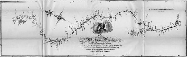
MAP
OF THE
MISSISSIPPI RIVER
FROM ITS
Source TO THE MOUTH OF THE Missouri:
Laid down from the notes of Lieutt Z. M. Pike, by Anthony Nau.
Reduced, and corrected by the Astronomical Observations of Mr. Thompson at its source;
and of Captn. M. Lewis, where it receives the waters of the Missouri.
By. Nichs. King.
Engraved by Francis Shallus. Philadelphia.
View larger image.
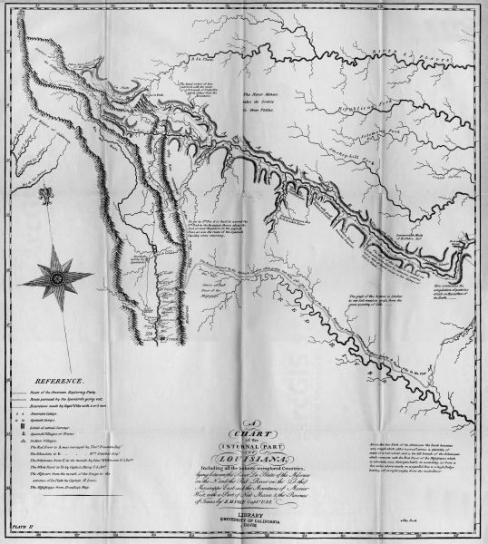
A
CHART
OF THE
INTERNAL PART
OF
LOUISIANA,
Including all the hitherto unexplored Countries,
lying between the River La Platte of the Missouri
on the N: and the Red River on the S: the
Mississippi East and the Mountains of Mexico
West; with a Part of New Mexico & the Province
of Texas by Z. M. PIKE Capt.n U.S.I.
PLATE II
View larger image.
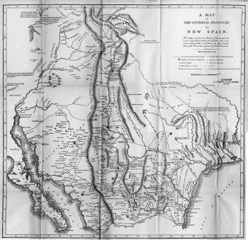
A MAP
OF
THE INTERNAL PROVINCES
OF
NEW SPAIN.
The Outlines are from the Sketches of but corrected and
improved by Captain ZEBULON M. PIKE who was
conducted through that COUNTRY in the Year 1807, by
Order of the Commandant General of those Provinces.
View larger image.
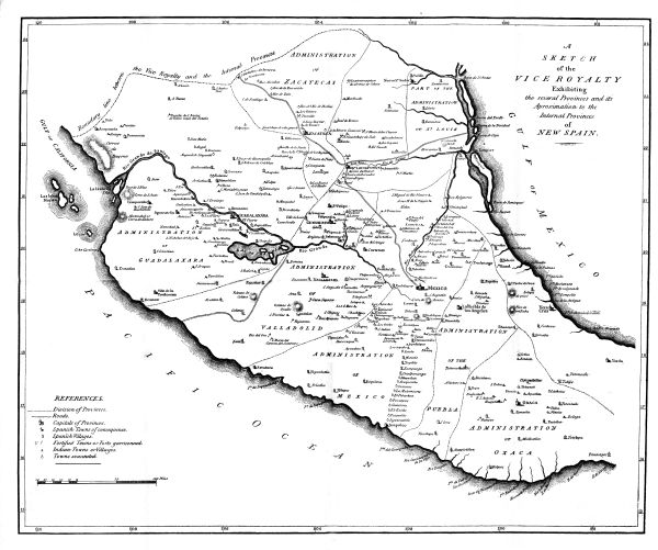
A
SKETCH
OF THE
VICE ROYALTY
EXHIBITING
THE SEVERAL PROVINCES AND ITS
APROXIMATION TO THE
INTERNAL PROVINCES
OF
NEW SPAIN.
Harrison sct
View larger image.
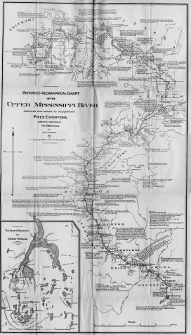
Historico=Geographical Chart
OF THE
Upper Mississippi River
COMPILED AND DRAWN TO ACCOMPANY
Pike's Expeditions,
UNDER THE DIRECTION OF
Dr Elliott Coues,
BY
Dan'l W. Cronin.
1895
Copyright, 1895 by Francis P. Harper, N. Y.
The Infant Mississippi
OR
Cradled Hercules.
(AFTER BROWER)
View larger image.


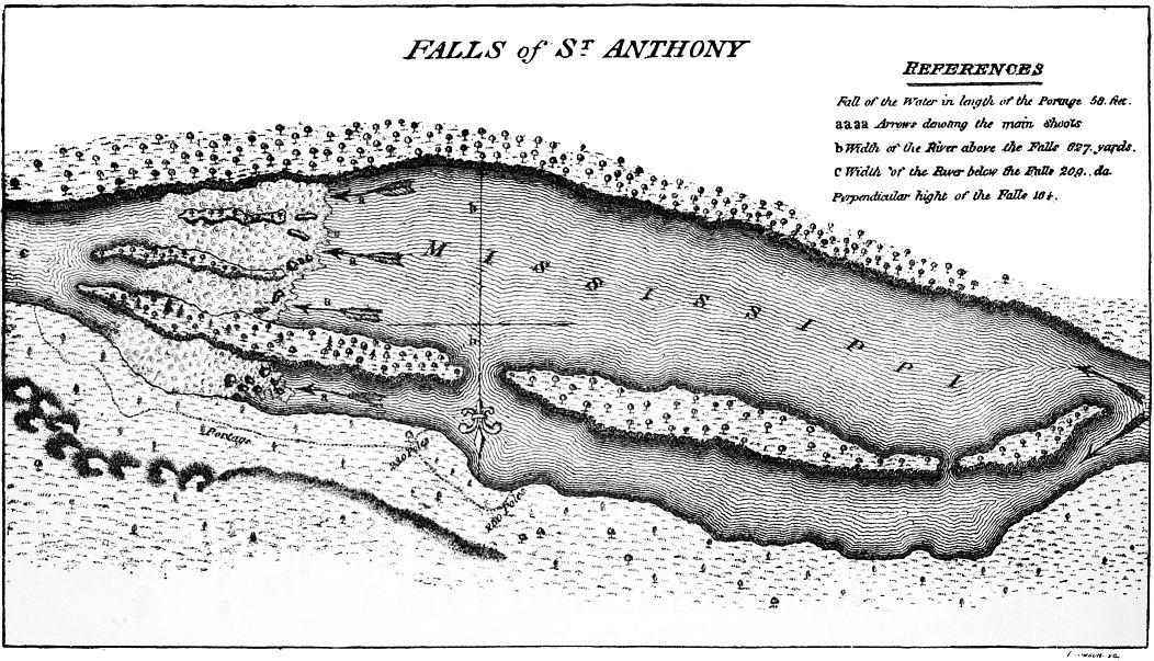
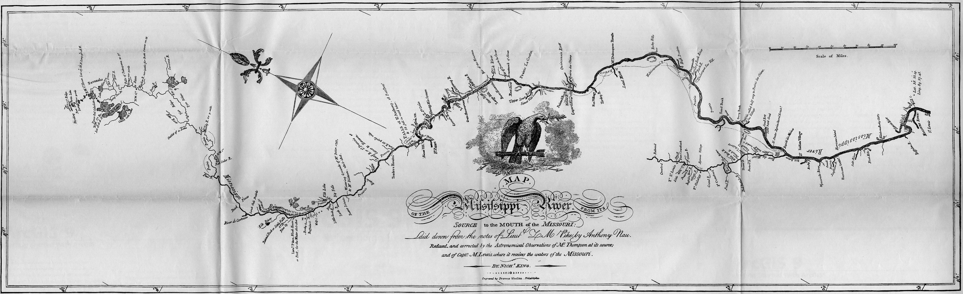
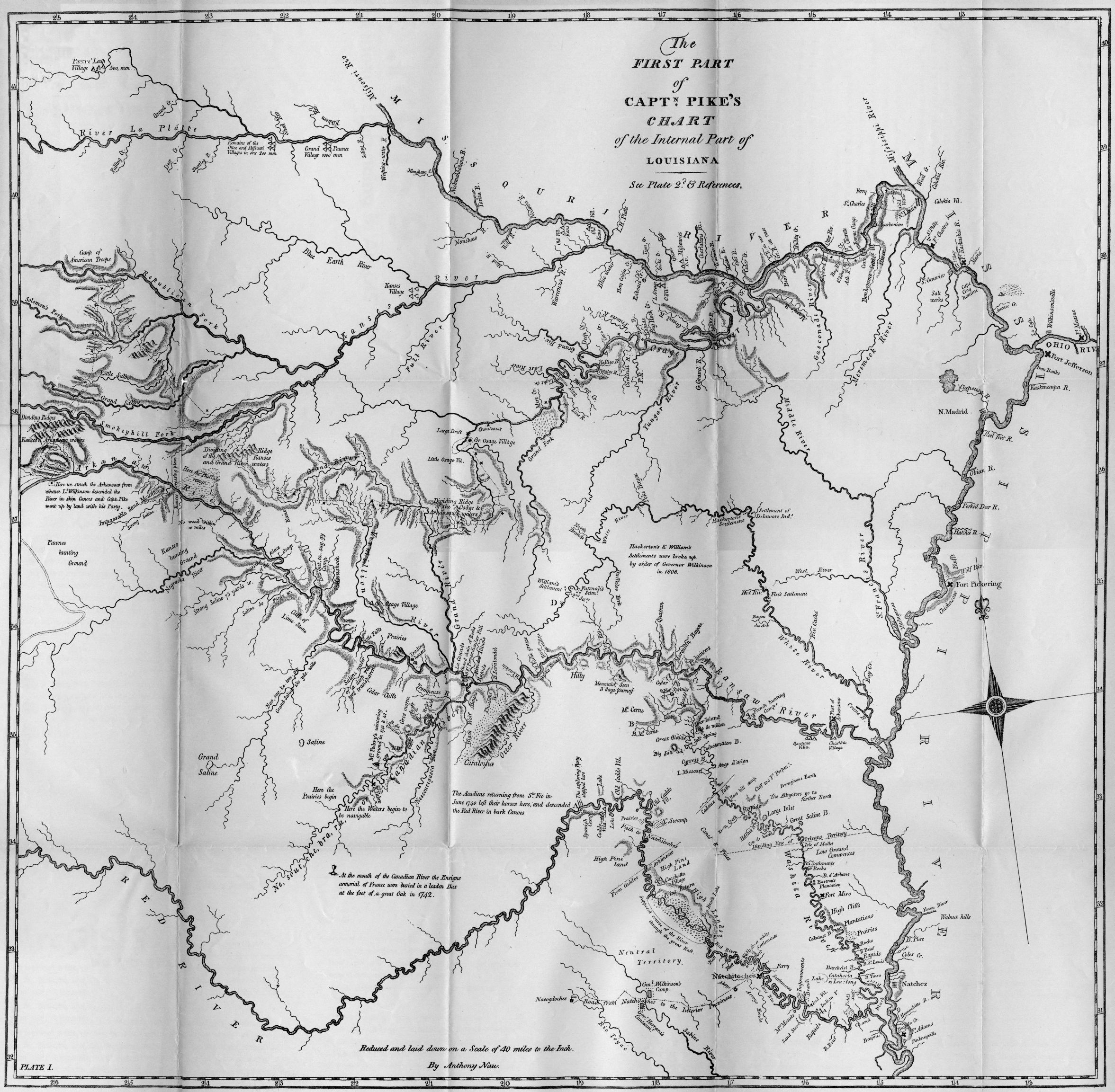
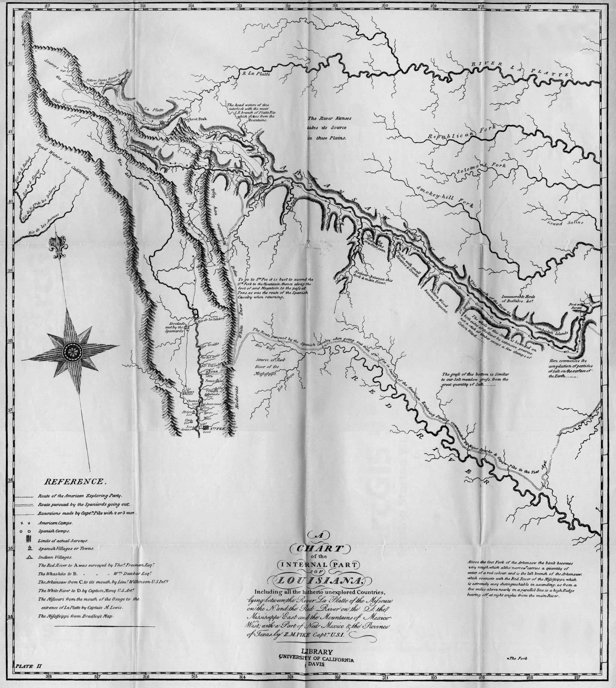
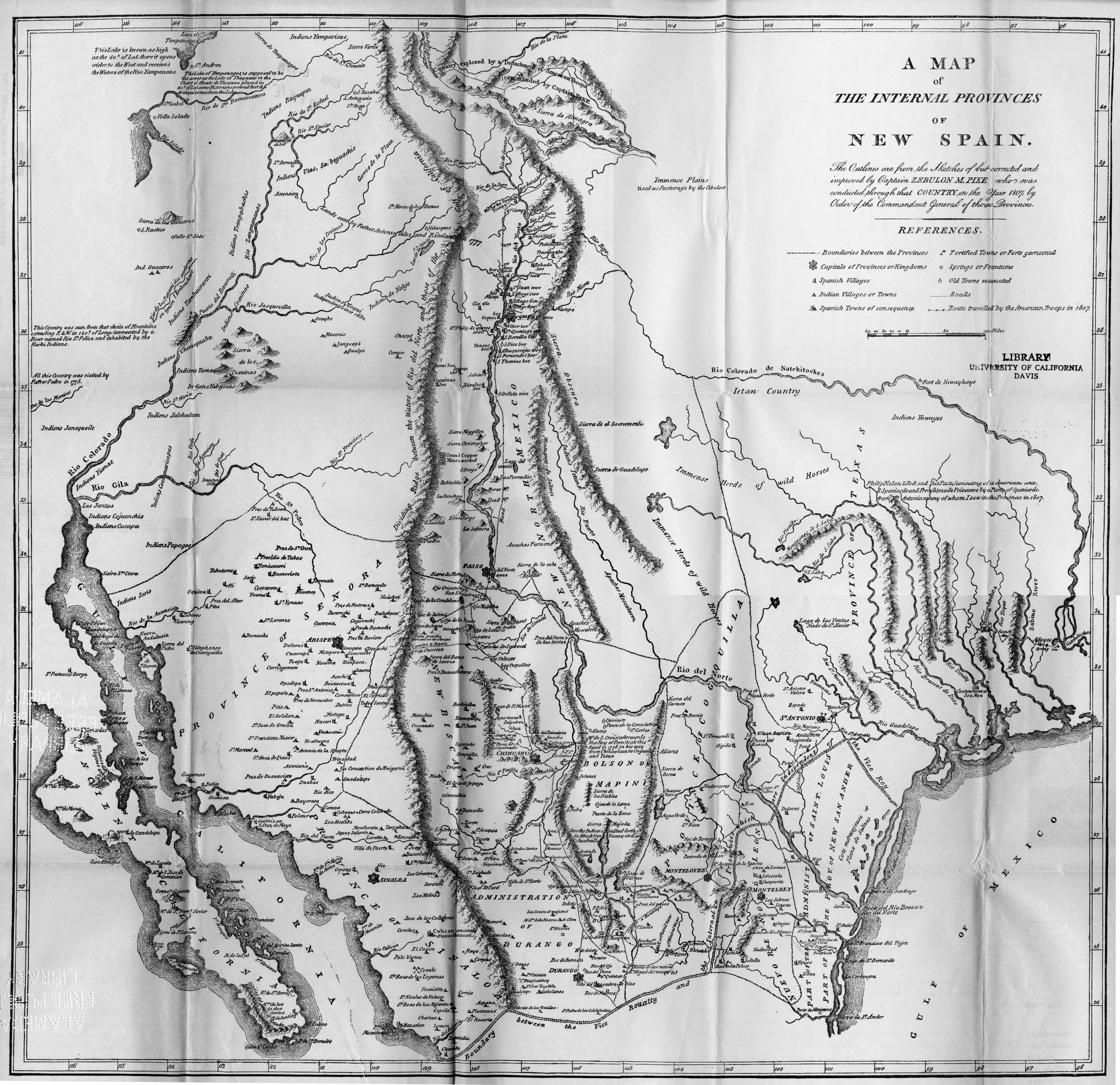
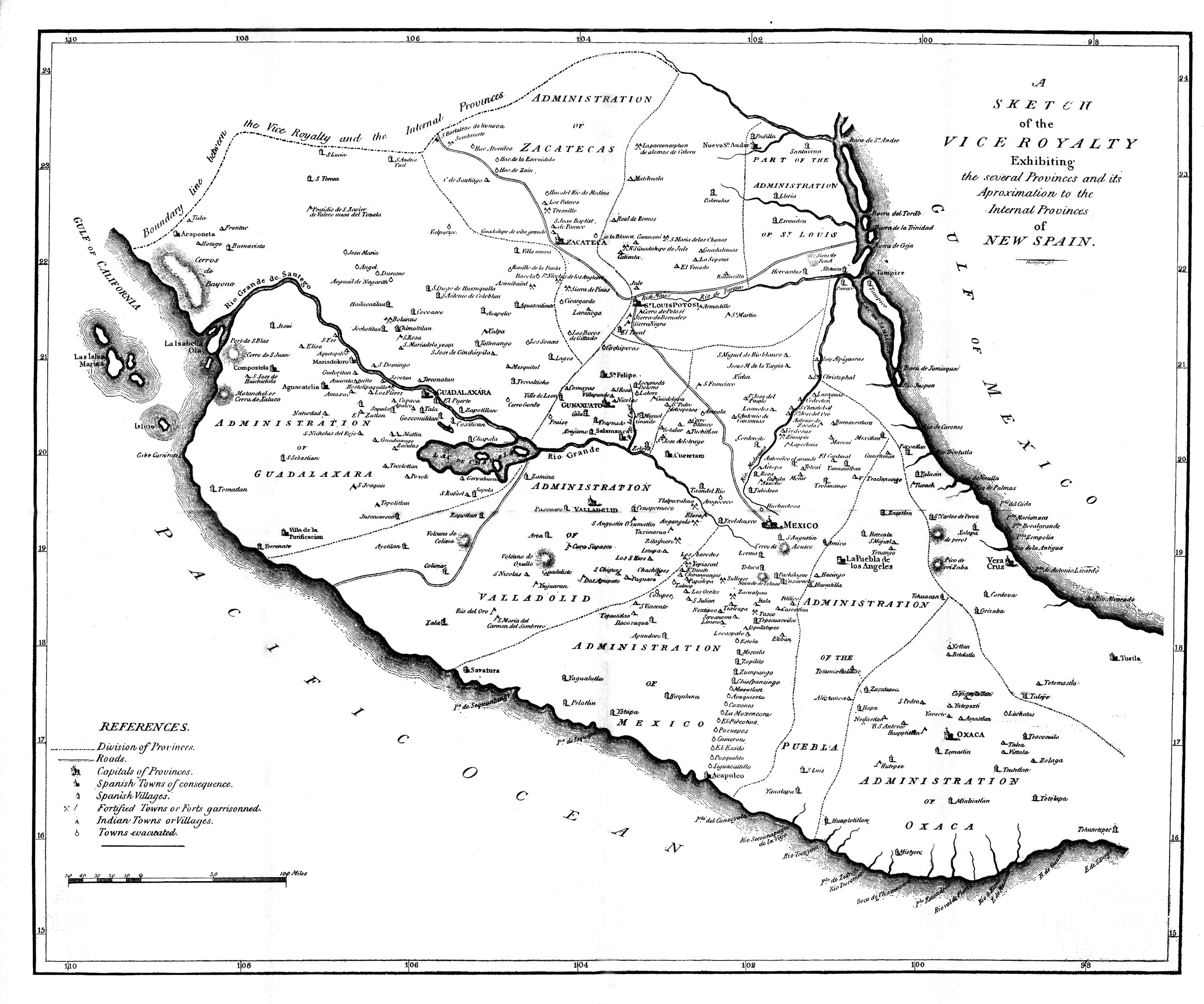
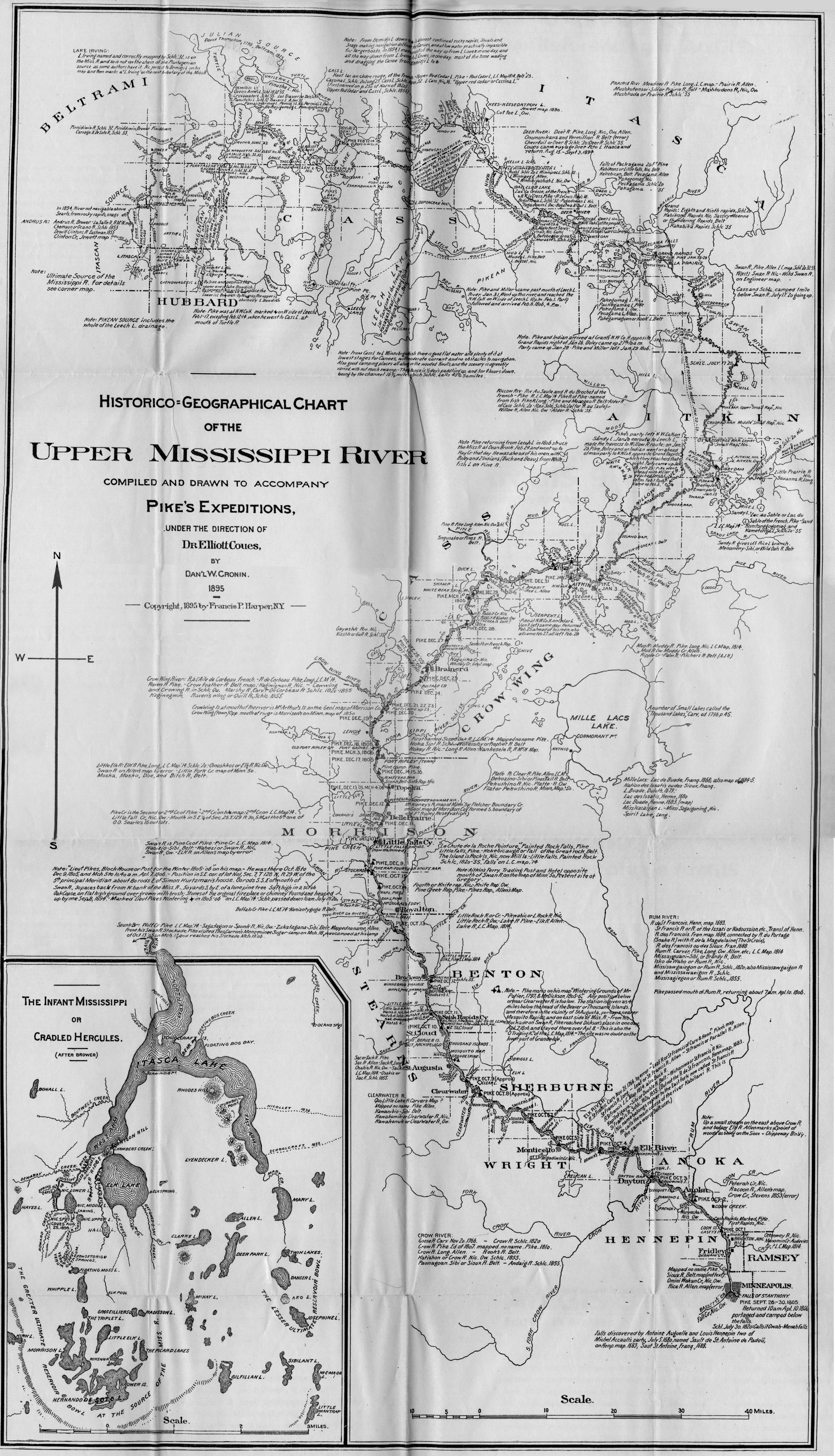