| GARDINER G. HUBBARD | President |
| HERBERT G. OGDEN GEO. L. DYER A. W. GREELY C. HART MERRIAM A. H. THOMPSON |
Vice-Presidents |
| CHARLES J. BELL | Treasurer |
| HENRY GANNETT GEORGE KENNAN |
Secretaries |
| CLEVELAND ABBE MARCUS BAKER ROGERS BIRNIE, JR. G. BROWN GOODE C. A. KENASTON W. B. POWELL O. H. TITTMANN JAMES C. WELLING |
Managers |
Introductory Address by the President
Geographic Methods in Geologic Investigation: Wm. M. Davis
The Classification of Geographic Forms by Genesis: W. J. McGee
The Great Storm of March 11 to 14, 1888: A. W. Greely,
Everett Hayden
The Survey of the Coast: Herbert G. Ogden
The Survey and Map of Massachusetts: Henry Gannett
Proceedings of the National Geographic Society
National Geographic Society
Certificate of incorporation
By-laws
List of Officers, 1888
List of Members
The "NATIONAL GEOGRAPHIC SOCIETY" has been organized "to increase and diffuse geographic knowledge," and the publication of a Magazine has been determined upon as one means of accomplishing these purposes.
It will contain memoirs, essays, notes, correspondence, reviews, etc., relating to Geographic matters. As it is not intended to be simply the organ of the Society, its pages will be open to all persons interested in Geography, in the hope that it may become a channel of intercommunication, stimulate geographic investigation and prove an acceptable medium for the publication of results.
The Magazine is to be edited by the Society. At present it will be issued at irregular intervals, but as the sources of information are increased the numbers will appear periodically.
The National Capital seems to be the natural and appropriate place for an association of this character, and the aim of the founders has been, therefore, to form a National rather than a local society.
As it is hoped to diffuse as well as to increase knowledge, due prominence will be given to the educational aspect of geographic matters, and efforts will be made to stimulate an interest in original sources of information.
In addition to organizing, holding regular fortnightly meetings for presenting scientific and popular communications, and entering upon the publication of a Magazine, considerable progress has been made in the preparation of a Physical Atlas of the United States.
The Society was organized in January, 1888, under the laws of the District of Columbia, and has at present an active membership of about two hundred persons. But there is no limitation to the number of members, and it will welcome both leaders and followers in geographic science, in order to better accomplish the objects of its organization.
October, 1888.
Correspondence with the Society should be addressed to Mr. GEORGE KENNAN, Corresponding Secretary, No. 1318 Massachusetts Avenue, Washington, D. C.
I am not a scientific man, nor can I lay claim to any special knowledge that would entitle me to be called a "Geographer." I owe the honor of my election as President of the National Geographic Society simply to the fact that I am one of those who desire to further the prosecution of geographic research. I possess only the same general interest in the subject of geography that should be felt by every educated man.
By my election you notify the public that the membership of our Society will not be confined to professional geographers, but will include that large number who, like myself, desire to promote special researches by others, and to diffuse the knowledge so gained, among men, so that we may all know more of the world upon which we live.
By the establishment of this Society we hope to bring together (1) the scattered workers of our country, and (2) the persons who desire to promote their researches. In union there is strength, and through the medium of a national organization, we may hope to promote geographic research in a manner that could not be accomplished by scattered individuals, or by local societies; we may also hope—through the same agency—to diffuse the results of geographic research over a wider area than would otherwise be possible.
The position to which I have been called has compelled me to become a student. Since my election I have been trying to learn the meaning of the word "geography," and something of the history of the science to which it relates. The Greek origin of the word ([Greek: gê], the earth, and [Greek: graphê], description) betrays the source from which we derived the science, and shows that it relates to a description of the earth. But the "earth" known to the Greeks was a very different thing from the earth with which we are acquainted.
To the ancient Greek it meant land—not all land, but only a limited territory, in the centre of which he lived. His earth comprised simply the Persian Empire, Italy, Egypt and the borders of the Black and Mediterranean seas, besides his own country. Beyond these limits, the land extended indefinitely to an unknown distance—till it reached the borders of the great ocean which completely surrounded it.
To the members of this society the word "earth" suggests a very different idea. The term arouses in our minds the conception of an enormous globe suspended in empty space, one side in shadow and the other bathed in the rays of the sun. The outer surface of this globe consists of a uniform, unbroken ocean of air, enclosing another more solid surface (composed partly of land and partly of water), which teems with countless forms of animal and vegetable life. This is the earth of which geography gives us a description.
To the ancients the earth was a flat plain, solid and immovable, and surrounded by water, out of which the sun rose in the east and into which it set in the west. To them "Geography" meant simply a description of the lands with which they were acquainted.
Herodotus, who lived about the year 450 B.C., transmitted to posterity an account of the world as it was known in his day. We look upon him as the father of geography as well as of history. He visited the known regions of the earth, and described accurately what he saw, thus laying the foundations of comparative geography.
About 300 years B.C., Alexander the Great penetrated into hitherto unknown regions, conquered India and Russia, and founded the Macedonian Empire. He sent a naval expedition to explore the coasts of India, accompanied by philosophers or learned men, who described the new countries discovered and the character of their inhabitants. This voyage may be considered as originating the science of Political Geography, or the geography of man.
About the year 200 B.C., Eratosthenes of Cyrene, the keeper of the Royal Library at Alexandria, became convinced, from experiments, that the idea of the rotundity of the earth, which had been advanced by some of his predecessors, was correct, and attempted to determine upon correct principles its magnitude. The town of Cyrene, on the river Nile, was situated exactly under the tropic, for he knew that on the day of the summer solstice, the sun's rays illuminated at noon the bottom of a deep well in that city. At Alexandria, however, on the day of the summer solstice, Eratosthenes observed that the vertical finger of a sun-dial cast a shadow at noon, showing that the sun was not there exactly overhead. From the length of the shadow he ascertained the sun's distance from the zenith to be 7° 12', or one-fiftieth part of the circumference of the heavens; from which he calculated that if the world was round the distance between Alexandria and Cyrene should be one-fiftieth part of the circumference of the world. The distance between these cities was 5000 stadia, from which he calculated that the circumference of the world was fifty times this amount, or 250,000 stadia. Unfortunately we are ignorant of the exact length of a stadium, so we have no means of testing the accuracy of his deduction. He was the founder of Mathematical Geography; it became possible through the labors of Eratosthenes to determine the location of places on the surface of the earth by means of lines corresponding to our lines of latitude and longitude.
Claudius Ptolemy, in the second century of the Christian era, made a catalogue of the positions of plans as determined by Eratosthenes and his successors, and with this as his basis, he made a series of twenty-six maps, thus exhibiting, at a glance, in geographical form, the results of the labors of all who preceded him. To him we owe the art of map-making, the origination of Geographic Art.
We thus see that when Rome began to rule the world, the Greeks had made great progress in geography. They already possessed Comparative, Political and Mathematical Geography, and Geographic Art, or the art of making maps.
Then came a pause in the progress of geography.
The Romans were so constantly occupied with the practical affairs of life, that they paid little attention to any other kind of geography than that which facilitated the administration of their empire. They were great road-builders, and laid out highways from Rome to the farthest limits of their possessions. Maps of their military roads were made, but little else. These exhibited with accuracy the less and greater stations on the route from Rome to India, and from Rome to the further end of Britain.
Then came the decline and fall of Rome, and with it the complete collapse of geographical knowledge. In the dark ages, geography practically ceased to exist. In the typical map of the middle ages, Jerusalem lay in the centre with Paradise on the East and Europe on the West. It was not until the close of the dark ages that the spirit of discovery was re-awakened. Then the adventurous Northmen from Norway and Sweden crossed the ocean to Iceland.
From Iceland they proceeded to Greenland and even visited the main-land of North America about the year 1000 A.D., coasting as far south as New England; but these voyages led to no practical results, and were forgotten or looked upon as myths, until within a few years. For hundreds of years geography made but little advance—and the discoveries of five centuries were less than those now made in five years. In the fourteenth or fifteenth century, the mariner's compass was introduced into Europe from China, and it then became possible to venture upon the ocean far out of sight of land. Columbus instead of coasting from shore to shore like the ancient Northmen, boldly set sail across the Atlantic. To many of his contemporaries it must have seemed madness to seek the East by thus sailing towards the West, and we need hardly wonder at the opposition experienced from his crew. The rotundity of the earth had become to him an objective reality, and in sublime faith he pursued his westward way. Expecting to find the East Indies he found America instead. Five centuries had elapsed since the Northmen had made their voyages to these shores—and their labors had proved to be barren of results. The discovery of Columbus, however, immediately bore fruit. It was his genius and perseverance alone that gave the new world to the people of Europe, and he is therefore rightfully entitled to be called the discoverer of America. His discovery was fraught with enormous consequences, and it inaugurated a new era for geographic research. The spirit of discovery was quickened and geographic knowledge advanced with a great leap. America was explored; Africa was circumnavigated. Magellan demonstrated the rotundity of the earth by sailing westward until he reached his starting point. Everywhere—all over the civilized world—the spirit of adventure was aroused. Navigators from England, Holland, France and Spain rapidly extended the boundaries of geographical knowledge, while explorers penetrated into the interior of the new lands discovered. The mighty impetus given by Columbus set the whole world in motion and it has gone on moving ever since with accelerated velocity.
The great progress that has been made can hardly be realized without comparing the famous Borgia map, constructed about one hundred years before the discovery of America, with the modern maps of the same countries; or Hubbard's map of New England made two hundred years ago, with the corresponding map of to-day. The improvements in map-making originated with Mercator, who, in 1556 constructed his cylindrical projection of the sphere. But it has been only during the last hundred years that great progress has been made. Much yet remains to be done before geographic art can fully accomplish its mission.
The present century forms a new era in the progress of geography—the era of organized research. In 1830, the Royal Geographical Society of England was founded, and it already forms a landmark in the history of discovery. The Paris Society preceded it in point of time, and the other countries of Europe soon followed the example. Through these organizations, students and explorers have been encouraged and assisted, and information systematically collected and arranged. The wide diffusion of geographical knowledge through the medium of these societies and the publicity of the discussions and criticism that followed, operated to direct the current of exploration into the most useful channels. Before organized effort, darkness gave way at every step. Each observer added fresh knowledge to the existing store, without unnecessary duplication of research. The reports of discoveries were discussed and criticized by the societies, and the contributions of all were co-ordinated into one great whole.
America refuses to be left in the rear. Already her explorers are in every land and on every sea. Already she has contributed her quota of martyrs in the frozen north, and has led the way into the torrid regions of Africa. The people of Europe, through Columbus, opened up a new world for us; and we, through Stanley, have discovered a new world in the old, for them.
Much has been done on land—little on the other three-quarters of the earth's surface. But here America has laid the foundations of a new science,—the Geography of the Sea.
Our explorers have mapped out the surface of the ocean and discovered the great movements of the waters. They have traced the southward flow of the Arctic waters to temper the climate of the torrid zone. They have followed the northward set of the heated waters of the equator and have shown how they form those wonderful rivers of warm water that flow, without walls, through the colder waters of the sea, till they strike the western shores of Europe and America, and how they render habitable the almost Arctic countries of Great Britain and Alaska. They have even followed these warm currents further and shown how they penetrate the Arctic Ocean to lessen the rigors of the Arctic cold. Bravely, but vainly, have they sought for that ignis fatuus of explorers—the open polar sea—produced by the action of the warm waters from the south.
American explorers have sounded the depths of the ocean and discovered mountains and valleys beneath the waves. They have found the great plateaus on which the cables rest that bring us into instantaneous communication with the rest of the world. They have shown the probable existence of a vast submarine range of mountains, extending nearly the whole length of the Pacific Ocean—mountains so high that their summits rise above the surface to form islands and archipelagoes in the Pacific. And all this vast region of the earth, which, a few years ago, was considered uninhabitable on account of the great pressure, they have discovered to be teeming with life. From the depths of the ocean they have brought living things, whose lives were spent under conditions of such pressure that the elastic force of their own bodies burst them open before they could be brought to the surface; living creatures whose self-luminous spots supplied them with the light denied them in the deep abyss from which they sprang—abysses so deep that the powerful rays of the sun could only feebly penetrate to illuminate or warm.
The exploring vessels of our Fish Commission have discovered in the deep sea, in one single season, more forms of life than were found by the Challenger Expedition in a three years' cruise. Through their agency, we have studied the geographical distribution of marine life; and in our marine laboratories, explorers have studied the life history of the most useful forms.
The knowledge gained has enabled us to breed and multiply at will; to protect the young fish during the period of their infancy—when alone they are liable to wholesale destruction—finally to release them in the ocean, in those waters that are most suitable to their growth. The fecundity of fish is so great, and the protection afforded them during the critical period of their life so ample, that it may now be possible to feed the world from the ocean and set the laws of Matthews at defiance. Our geographers of the sea have shown that an acre of water may be made to produce more food for the support of man than ten acres of arable land. They have thrown open to cultivation a territory of the earth constituting three-quarters of the entire surface of the globe.
And what shall we say of our conquests in that other vast territory of the earth, greater in extent than all the oceans and the lands put together—the atmosphere that surrounds it.
Here again America has led the way, and laid the foundations of a Geography of the Air. But a little while ago and we might have truly said with the ancients "the wind bloweth where it listeth, and we know neither from whence it comes nor whither it goes"; but now our explorers track the wind from point to point and telegraph warnings in advance of the storm.
In this department, the Geography of the Air, we have far outstripped the nations of the world. We have passed the mob-period of research when the observations of multitudes of individuals amounted to little, from lack of concentrated action. Organization has been effected. A Central Bureau has been established in Washington, and an army of trained observers has been dispersed over the surface of the globe, who all observe the condition of the atmosphere according to a pre-concerted plan.
The vessels of our navy and the mercantile marine of our own and other countries have been impressed into the service, and thus our geographers of the air are stationed in every land and traverse the waters of every sea. Every day, at the same moment of absolute time, they observe and note the condition of the atmosphere at the part of the earth where they happen to be, and the latitude and longitude of their position. The collocation of these observations gives us a series of what may be termed instantaneous photographs of the condition of the whole atmosphere. The co-ordination of the observations, and their geographical representation upon a map, is undertaken by a staff of trained experts in the Central Bureau in Washington, and through this organization we obtain a weather-map of the world for every day of the year. We can now study at leisure the past movements of the atmosphere, and from these observations we shall surely discover the grand laws that control aerial phenomena. We shall then not only know, as we do at present, whence comes the wind and whither it goes, but be able to predict its movements for the benefit of humanity.
Already we have attained a useful, though limited, power of prediction.
Our Central Bureau daily collects observations by telegraph from all parts of this continent, and our experts are thus enabled to forecast the probabilities by a few hours. Day by day the results are communicated to the public by telegraph in time to avert disaster to the mariners on our eastern coast, and facilitate agricultural operations in the Eastern and Middle States.
Although many of the predictions are still falsified by events, the percentage of fulfilments has become so large as to show that continued research will in the future give us fresh forms of prediction and increase the usefulness of this branch of science to mankind.
In all departments of geographical knowledge, Americans are at work. They have pushed themselves into the front rank and they demand the best efforts of their countrymen to encourage and support.
When we embark on the great ocean of discovery, the horizon of the unknown advances with us and surrounds us wherever we go. The more we know, the greater we find is our ignorance. Because we know so little we have formed this society for the increase and diffusion of Geographical knowledge. Because our subject is so large we have organized the society into four broad sections: relating to the geography of the land, H. G. Ogden, vice-president; the sea, J. R. Bartlett, vice-president; the air, A. W. Greely, vice-president; the geographic distribution of life, C. H. Merriam, vice-president; to which we have added a fifth, relating to the abstract science of geographic art, including the art of map-making etc., A. H. Thompson, vice-president; our recording and corresponding secretaries are Henry Gannett and George Kennan.
We have been fortunate indeed to secure as Vice-Presidents men learned in each department, and who have been personally identified with the work of research.
Definition of Geography and Geology—Geographic Methods in Geology—Hutton and Lyell—Marine deposits explained by existing processes reveal the history of the earth—American Topographers—First Pennsylvania Survey; geographic form as the result of extinct processes—Western Surveys; geographic form explained by existing processes reveals the history of the earth—Deductive Topography—Comparison with Palæontology—Geographic Individuals—Classification according to structure—Ideal cycle of regular development—Interruptions in the Simple Ideal Cycle—Geography needs ideal types and technical terms—Comparison with the biological sciences—Teaching of Geography—The water-falls of Northeastern Pennsylvania as examples of deductive study—Systematic Geography.
The history of the earth includes among many things an account of its structure and form at successive times, of the processes by which changes in its structure and form have been produced, and of the causes of these processes. Geography is according to ordinary definition allowed of all this only an account of the present form of the earth, while geology takes all the rest, and it is too generally the case that even the present form of the earth is insufficiently examined by geographers. Geographic morphology, or topography, is not yet developed into a science. Some writers seem to think it a division of geology, while geologists are as a rule too much occupied with other matters to give it the attention it deserves. It is not worth while to embarrass one's study by too much definition of its subdivisions, but it is clearly advisable in this case to take such steps as shall hasten a critical and minute examination of the form of the earth's surface by geographers, and to this end it may serve a useful purpose to enlarge the limited definition of geography, as given above, and insist that it shall include not only a descriptive and statistical account of the present surface of the earth, but also a systematic classification of the features of the earth's surface, viewed as the results of certain processes, acting for various periods, at different ages, on divers structures. As Mackinder of Oxford has recently expressed it, geography is the study of the present in the light of the past. When thus conceived it forms a fitting complement to geology, which, as defined by the same author, is the study of the past in the light of the present. The studies are inseparable and up to a certain point, their physical aspects may be well followed together, under such a name as physiography. Specialization may then lead the student more to one subject than to the other.
An illustration from human history, where the study of the past and present has a single name, may serve to make my meaning clear in regard to the relation of the two parts of terrestrial history, which have different names. A descriptive and statistical account of a people as at present existing, such as that which our statistical atlas of the last Census gives in outline, corresponds to geography in its ordinary limitation. A reasonable extension of such an account, introducing a consideration of antecedent conditions and events, for the purpose of throwing light on existing relations, represents an expanded conception of geography. The minute study of the rise and present condition of any single industry would correspond to the monographic account of the development of any simple group of geographic forms. On the other hand, history taken in its more general aspects, including an inquiry into the causes and processes of the rise and fall of ancient nations, answers to geology; and an account of some brief past stage of history is the equivalent of paleography, a subject at present very little studied and seemingly destined always to escape sharp determination. It is manifest that geology and geography thus defined are parts of a single great subject, and must not be considered independently.
History became a science when it outgrew mere narration and searched for the causes of the facts narrated; when it ceased to accept old narratives as absolute records and judged them by criteria derived from our knowledge of human nature as we see it at present, but modified to accord with past conditions.
Geology became a science when it adopted geographic methods. The interpretation of the past by means of a study of the present proves to be the only safe method of geologic investigation. Hutton and Lyell may be named as the prominent leaders of this school and if we admit a reasonable modification of their too pronounced uniformitarianism, all modern geologists are their followers. The discovery of the conservation and correlation of energy gives additional support to their thesis by ruling out the gratuitous assumption of great results from vague causes. Causes must be shown to be not only appropriate in quality, but sufficient in quantity before they can be safely accepted. But the geographic argument as expounded by the English school deals almost entirely with processes and neglects a large class of results that follow from these processes. Much attention is given to the methods of transferring the waste of the land to the sea and depositing it there in stratified masses, from which the history of ancient lands is determined. But the forms assumed by the wasting land have not been sufficiently examined. It was recognized in a general way that land forms were the product of denudation, but the enormous volume of material that had been washed off of the lands was hardly appreciated, and the great significance of the forms developed during the destruction of the land was not perceived.
Hutton says a little about the relation of topography to structure; Lyell says less. The systematic study of topography is largely American. There is opportunity for it in this country that is not easily found in Europe. The advance in this study has been made in two distinct steps: first, in the East about 1840; second, in the West about 1870. The first step was taken in that historic decade when our early State surveys accomplished their great work. The Pennsylvania surveyors then developed topography into a science, as Lesley tells us so eloquently in his rare little book "Coal and its Topography," 1856, which deserves to be brought more to the attention of the younger geographers and geologists of to-day. It presents in brief and picturesque form the topographical results of the first geological survey of Pennsylvania. It shows how Lesley and the other members of that survey "became not mineralogists, not miners, not learned in fossils, not geologists in the full sense of the word, but topographers, and topography became a science and was returned to Europe and presented to geology as an American invention. The passion with which we studied it is inconceivable, the details into which it leads us were infinite. Every township was a new monograph." (p. 125.) Some of the finest groups of canoes and zigzags developed on the folded beds of the Pennsylvania Appalachians are illustrated from studies made by Henderson, Whelpley and McKinley, and they certainly deserve the most attentive examination. I often feel that they have been of the greatest assistance in my own field work, especially in the efforts I have made to discover the structural arrangement of the Triassic lava sheets in the Connecticut valley. But although the intricacies of Appalachian topography were then clearly seen to depend on the complications of Appalachian structure, the process of topographic development was not at that time discovered. "The only question open to discussion is," says Lesley, "whether this planing down of the crust to its present surface was a secular or an instantaneous work" (p. 132), and he decides in favor of the latter alternative. He adds, that to the field worker, "The rush of an ocean over a continent ... leads off the whole procession of his facts, and is indispensable to the exercise of his sagacity at every turn" (p. 166). "The present waters are the powerless modern representatives of those ancient floods which did the work" (p. 151).
It is not the least in any spirit of disparagement that I quote these cataclysmic views, now abandoned even by their author. Great generalizations are not often completed at a single step, and it is enough that every effort at advance should have part of its movement in the right direction. What I wish to show is that topographic form was regarded in the days of our eastern surveys, even by our first master of American topography, as a completed product of extinct processes. Topography revealed structure, but it did not then reveal the long history that the structure has passed through. The anticlinal valleys, hemmed in by the even-topped sandstone mountains of middle Pennsylvania, were found to tell plainly enough that a vast erosion had taken place, and that the resulting forms depended on the structure of the eroded mass, but it was tacitly understood that the land stood at its present altitude during the erosion. The even crest lines of the mountains and the general highland level of the dissected plateau farther west did not then reveal that the land had stood lower than at present during a great part of the erosion, and thus the full lesson of the topography was not learned. The systematic relation of form to structure, base level and time; the change of drainage areas by contest of headwaters at divides; the revival of exhausted rivers by massive elevations of their drainage areas: all these consequences of slow adjustments were then unperceived. In later years there seems to be a general awakening to the great value of these principles, which mark the second stage in the advance of scientific topography, referred to above.
It is not easy to sketch the history of this awakening. Ramsay years ago contributed an element in his explanation of plains of marine denudation; Jukes opened the way to an understanding of cross valleys; Newberry excluded fractures from the production of the most fracture-like of all water ways; and our government surveyors in the western territories have fully developed the all important idea of base level, of which only a brief and imperfect statement had previously been current. I cannot say how far European geographers and geologists would be willing to place the highest value on the last named element; to me it takes the place of Lesley's ocean flood, in leading off the whole procession of outdoor facts. It is indispensable at every turn. Recently, mention should be made of Löwl, of Prague, who has done so much to explain the development of rivers, and of McGee, who has explicitly shown that we must "read geologic history in erosion as well as in deposition."
If it be true that the greater part of this second advance is American like the first, it must be ascribed to the natural opportunities allowed us. The topographers of the Appalachians had a field in which one great lesson was repeated over and over again and forced on their attention. The patchwork structure of Europe gave no such wide opportunity. The surveyors of the western territories again found broad regions telling one story, and all so plainly written that he must run far ahead who reads it. It is to this opportunity of rapid discovery and interpretation that Archibald Geikie alludes in the preface to the recent second edition of his charming volume on the "Scenery of Scotland." He says that since the book first appeared he has seen many parts of Europe, "but above all it has been my good fortune to have been able to extend the research into western America, and to have learned more during my months of sojourn there than during the same number of years in the Old Country." (p. vii.)
Our position now is, therefore, while structure determines form as our earlier topographers taught, and while form-producing processes are slow, as had been demonstrated by the English geologists, that the sequence of forms assumed by a given structure during its long life of waste is determinate, and that the early or young forms are recognizably different from the mature forms and the old forms. A young plain is smooth. The same region at a latter date will be roughened by the channeling of its larger streams and by the increase in number of side branches, until it comes to "maturity," that is to the greatest variety or differentiation of form. At a still later date the widening of the valleys consumes the intervening hills, and the form becomes tamer, until in "old age" it returns to the simple plain surface of "youth." Young mountains possess structural lakes and are drained largely by longitudinal valleys; old mountains have no such lakes and have transverse drainage, formed as the growing headwaters of external streams lead out much water that formerly followed the longitudinal valleys. Young rivers may have falls on tilted beds, but such are short lived. Falls on horizontal beds are common and survive on the headwater branches of even mature rivers. All falls disappear in old rivers, provided they are not resuscitated by some accident in the normal, simple cycle of river life. The phases of growth are as distinct as in organic forms. As this idea has grown in my mind from reading the authors above named, geography has gained a new interest. The different parts of the world are brought into natural relations with one another; the interest that change, growth and life had before given to the biologic sciences only, now extends to the study of inorganic forms. It matters not that geographic growth is destructive; it involves a systematic change of form from the early youth to the distant old age of a given structure, and that is enough. It matters not that the change is too slow for us to see its progress in any single structure. We do not believe that an oak grows from an acorn from seeing the full growth accomplished while waiting for the evidence of the fact, but because partly by analogy with plants of quicker development, partly by the sight of oaks of different ages, we are convinced of a change that we seldom wait to see. It is the same with geographic forms. We find evidence of the wasting of great mountains in the wasting of little mounds of sand; and we may by searching find examples of young, mature and old mountains, that follow as well marked a sequence as that formed by small, full grown and decaying oaks. If the relative positions of the members in the sequence is not manifest at first, we have the mental pleasure of searching for their true arrangement. The face of nature thus becomes alive and full of expression, and the conception of its change becomes so real that one almost expects to see the change in successive visits to one place.
Now consider the deductive application of this principle. Having recognized the sequence of forms developed during the wasting life of a single structure, reverse the conception and we have a powerful geographic method for geologic investigation. On entering a new country, apply there the principles learned from the inductive study of familiar regions, and much past history is revealed; the age of mountains may be deduced from their form as well as from their rocks; the altitudes at which a district has stood may be determined by traces of its old base levels, of which we learn nothing from the ordinary routine of geologic observation, that is, from a study of the structure and age of the rocks themselves. The principle is commonly employed nowadays, but its methods are not formulated, and its full value is hardly yet perceived. Heim has found traces of successive elevations in the Alps, proved by incipient base levels at several consistent altitudes on the valley slopes. Newberry, Powell and Dutton have worked out the history of the plateau and cañon region from its topography; Chamberlin and Salisbury write of the young and old topographic forms of the drift-covered and the driftless areas in Wisconsin; LeConte and Stephenson have interpreted chapters in the history of California and Pennsylvania from the form of the valleys. Recently McGee has added most interesting chapters to the history of our middle Atlantic slope, in an essay that gives admirable practical exposition of the geographic methods. In the light of these original and suggestive studies one may contend that when geographic forms in their vast variety are thus systematically interpreted as the surface features of as many structures, belonging to a moderate number of families and having expression characteristic of their age and accidents, their elevation and opportunity, then geography will be for the wasting lands what palæontology has come to be for the growing ocean floors.
An interesting comparison may be drawn here. Fossils were first gathered and described as individual specimens, with no comprehension of their relationships and their significance. It was later found that the fossils in a certain small part of the world, England—that wonderful epitome of geologic history—were arranged in sequences in the bedded rocks containing them, certain groups of forms together, successive groups in shelves, as it were, one over another. Then it was discovered that the local English scale had a wider application, and finally it has come to be accepted as a standard, with certain modifications, for the whole world. The exploring geologist does not now wait to learn if a formation containing trilobites underlies another containing ammonites, but on finding the fossils in the two, confidently and as far as we know correctly concludes that such is their relative position. Thus the sequence of submarine processes is made out by the sequence of organic forms. In brief, palæontology has passed largely from the inductive to the deductive stage.
The geographer first regarded the features of the land as completed entities, with whose origin he was in no wise concerned. Later it was found that some conception of their origin was important in appreciating their present form, but they were still regarded as the product of past, extinct processes. This view has been in turn displaced by one that considers the features of the land as the present stage of a long cycle of systematically changing forms, sculptured by processes still in operation. Now recognizing the sequence of changing forms, we may determine the place that any given feature occupies in the entire sequence through which it must pass in its whole cycle of development. And then reversing this conception we are just beginning to deduce the past history of a district by the degree of development of its features. Geography is, in other words, entering a deductive stage, like that already reached by palæontology.
The antecedent of deductive topography is the systematic study of land geography. The surface of the land is made up of many more or less distinct geographic individuals, every individual consisting of a single structure, containing many parts or features whose expression varies as the processes of land sculpture carry the whole through its long cycle of life. There is endless variety among the thousands of structures that compose the land, but after recognizing a few large structural families, the remaining differences may be regarded as individual. In a given family, the individuals present great differences of expression with age, as between the vigorous relief of the young Himalaya and the subdued forms of the old Appalachians; or with elevation over base level, as between the gentle plain of the low Atlantic coast and the precocious high plateaus of the Colorado river region; or with opportunity, as between the last named plateaus with exterior drainage and the high plains of the Great Basin, whose waters have no escape save by evaporation or high level overflow; or with complexity of history, as between the immature, undeveloped valleys of the lava block country of southern Oregon, and the once empty, then gravel-filled, and now deeply terraced inner valleys of the Himalaya. When thus studied, the endless variety of the topography will be considered in its proper relations, and it will not seem as hopeless as it does now to gain a rational understanding and appreciation of geographic morphology.
We should first recognize the fact that a geographic individual is an area, large or small, whose surface form depends on a single structure. Boundaries may be vague, different individuals may be blended or even superposed, but in spite of the indefiniteness, the attempt to sub-divide a region into the individuals that compose it will be found very profitable. In a large way the Appalachian plateau is an individual; the Adirondacks, the terminal moraine of the second glacial epoch are others. In a small way, a drumlin, a fan delta, a mesa, are individuals. The linear plateaus of middle Pennsylvania are hybrids between the well-developed linear ridges of the mountains farther east and the irregular plateau masses farther west.
A rough classification of geographic individuals would group them under such headings as plains, plateaus, and rough broken countries of horizontal structure; mountains of broken, tilted or folded structure, generally having a distinct linear extension; volcanoes, including all the parts from the bottom of the stem or neck, up to the lateral subterranean expansions known as laccolites, and to the surface cones and flows; glacial drift; wind drift. The agents which accomplished the work of denudation are also susceptible of classification: rivers according to the arrangement of their branches, and their imperfections in the form of lakes and glaciers. The valleys that rivers determine may be considered as the converse of the lands in which they are cut; and the waste of the land on the way to the sea is susceptible of careful discrimination: local soil, talus, alluvial deposits, fan cones and fan deltas, flood plains and shore deltas. Their variations dependent on climatic conditions are of especial importance. The structures formed along shore lines are also significant. This list is intentionally brief, and the lines between its divisions are not sharply drawn. It undoubtedly requires discussion and criticism before adoption. It differs but slightly from the common geographic stock in trade, but for its proper application it requires that the geographer should be in some degree a geologist.
The changes in any geographic individual from the time when it was offered to the destructive forces to the end of its life, when it is worn down to a featureless base level surface, are worthy of the most attentive study. The immaturity of the broken country of southern Oregon, as compared with the more advanced forms of the Basin ranges, is a case in hand. The Triassic formation of the Connecticut valley is in some ways of similar structure, being broken by long parallel faults into narrow blocks or slabs, every block being tilted from its original position. Russell's description of the blocks in southern Oregon would apply nicely to those in Connecticut, except that the former have diverse displacements, while the latter all dip one way; but the Connecticut individual has, I feel confident, passed through one cycle of life and has entered well on a second; it has once been worn down nearly to base level since it was broken and faulted, and subsequent elevation at a rather remote period has allowed good advance in a repetition of this process. The general uniformity in the height of its trap ridges and their strong relief above the present broad valley bottom, require us to suppose this complexity of history. A given structure may therefore pass through two or more successive cycles of life, and before considering the resulting composite history in its entirety, it would be best to examine cases of simple development in a single cycle. After this is accomplished, it would be possible to recognize the incomplete partial cycles through which a structure has passed, and to refer every detail of form to the cycle in which it was produced.
The most elementary example that may be chosen to illustrate a simple cycle of geographic life is that of a plain, elevated to a moderate height above its base level. The case has already been referred to here and is given in more detail in an article printed in the proceedings of the American Association for the Advancement of Science, for 1884, to which I would now refer. When the succession of forms there described as developed at a given elevation over base level is clearly perceived, the occurrence of forms dependent on two different base levels in a single region can easily be recognized. The most striking example of such a complex case that I know of is that of the high plateaus of Utah, as described by Dutton. Northern New Jersey presents another example less striking but no less valuable: the general upland surface of the Highlands is an old base level, in which valleys have been cut in consequence of a subsequent elevation. The plateau developed on the tilted Triassic beds about Bound Brook is a second base level, cut during a halt in the rise from the previous lower stand of the land to its present elevation. There is a parable that illustrates the principle here presented.
An antiquary enters a studio and finds a sculptor at work on a marble statue. The design is as yet hardly perceptible in the rough cut block, from which the chisel strikes off large chips at every blow; but on looking closer the antiquary discovers that the block itself is an old torso, broken and weather beaten, and at once his imagination runs back through its earlier history. This is not the first time that the marble has lain on a sculptor's table, and suffered the strong blows of the first rough shaping. Long ago it was chipped and cut and polished into shape, and perhaps even set up in its completed form in some garden, but then it was neglected and badly used, thrown over and broken, till its perfect shape was lost, and it was sold for nothing more than a marble block, to be carved over again if the sculptor sees fit. Now it just beginning its second career. We may find many parallels to this story in the land about us, when we study its history through its form. The sequence of events and consequently of forms is so apparent here that no one could have difficulty in interpreting history from form, and it shall come to be the same in geography. The gorge of the Wissahickon through the highland northwest of Philadelphia can have no other interpretation than one that likens it to the first quick work of the sculptor on the old torso.
An essential as well as an advantage in this extension of the study of geography will be the definition of types and terms, both chosen in accordance with a rational and if possible a natural system of classification. Types and terms are both already introduced into geographic study, for its very elements present them to the beginner in a simple and rather vague way: mountains are high and rough; lakes are bodies of standing water, and so on. It is to such types and terms as these that every scholar must continually return as he reads accounts of the world, and it is to be regretted that the types are yet so poorly chosen and so imperfectly illustrated, and that the terms are so few and so insufficient. Physical geography is particularly deficient in these respects, and needs to be greatly modified in the light of the modern advance of topography. General accounts of continental homologies of course have their interest and their value, but they are of the kind that would associate whales with fishes and bats with birds. The kind of reform that is needed here may be perceived from that which has overtaken the biological sciences. The better teaching of these subjects lays representative forms before the student and requires him to examine their parts minutely. The importance of the parts is not judged merely by their size, but by their significance also. From a real knowledge of these few types and their life history it is easy to advance in school days or afterwards to a rational understanding of a great number of forms. Few students ever go so far in school as to study the forests of North America or the fauna of South America. It is sufficient for them to gain a fair acquaintance with a good number of the type forms that make up these totals. It is quite time that geography should as far as possible be studied in the same way. No school boy can gain a comprehensive idea of the structure of a continent until he knows minutely the individual parts of which continents are composed. No explorer can perceive the full meaning of the country he traverses, or record his observations so that they can be read intelligently by others until he is fully conversant with the features of geographic types and with the changes in their expression as they grow old. Both scholar and explorer should be trained in the examination and description of geographic types, not necessarily copies of actual places, before attempting to study the physical features of a country composed of a large number of geographic individuals. When thus prepared, geography will not only serve in geologic investigation, it will prosper in its proper field as well.
Geographic description will become more and more definite as the observer has more and better type forms to which he may liken those that he finds in his explorations, and the reader, taught from the same types, will gather an intelligent appreciation of the observer's meaning. Take the region north of Philadelphia above referred to. Having grown up upon it, I called it a hilly country, in accordance with the geographic lessons of my school days, and continued to do so for twenty years or more, until on opening my eyes its real form was perceived. It is a surface worn down nearly to a former base level but now diversified by ramifying valleys, cut into the old base level in consequence of a subsequent but not very ancient elevation of a moderate amount. Maturity is not yet reached in the present cycle of development, for there is still much of the old base level surface remaining, into which the valleys are gnawing their head ravines and thus increasing the topographic differentiation. Perhaps not more than a sixth of the total mass above present base level is yet consumed. To say that a country is hilly gives so wide a range to the imagination that no correct conception of it can be gained, but I venture to think that one who understands the terms used can derive a very definite and accurate conception from the statement that a certain country is an old, almost completed base level, raised from one to three hundred feet, and well advanced toward maturity in its present cycle of change.
It is from geographic methods thus conceived that geologic investigation will gain assistance. As the subject is properly developed it will form an indispensable part of the education of every explorer, topographer and geologist; and in its simpler chapters it will penetrate the schools. There is no other subject in which there is greater disproportion between the instruction, as commonly carried on, and the opportunity for application in after life. The intelligent part of the world is travelling from place to place to an extent that our fathers could not have believed possible, and yet not one person in ten thousand has any geographic instruction that enables him to see more than that a river is large or small, or that a hill is high or low. The meaning of geography is as much a sealed book to the person of ordinary intelligence and education as the meaning of a great cathedral would be to a backwoodsman, and yet no cathedral can be more suggestive of past history in its many architectural forms than is the land about us, with its innumerable and marvelously significant geographic forms. It makes one grieve to think of the opportunity for mental enjoyment that is lost because of the failure of education in this respect.
It may be asked perhaps how can one be trained in geographic types, seeing that it is impossible for schools to travel where the types occur. This is surely a great and inherent difficulty, but it may be lessened if it cannot be overcome. Good illustrations are becoming more and more common by means of dry plate photography; maps are improving in number and quality; but the most important means of teaching will be found in models. No maps, illustrations or descriptions can give as clear an idea of relief as can be obtained from a well-made model, and with a set of models, fifty or sixty in number, the more important types and their changes with age can be clearly understood. Maps, illustrations and descriptions supplement the models. The maps should be contoured, for in no other way can the quantitative values be perceived that are essential to good study. The illustrations should be of actual scenes; or, if designs, they should be designed by a geographic artist. The descriptions should wherever possible be taken from original sources, in which the narrator tells what he saw himself. It is, to be sure, not always possible to know what kind of a form he describes, owing to lack of technical terms, but many useful examples can be found that may then be referred to their proper place in the system of geographic classification that is adopted.
I shall consider only one example in detail to show how far short, as it seems to me, geography fails of its great opportunity, both as taught in schools and as applied in after life.
In northeastern Pennsylvania there are several water-falls that leap over tilted beds of rock. Such falls are known to be of rare occurrence, and we may therefore inquire into the cause of their rarity and the significance of their occurrence in the region referred to.
We may first look at the general conditions of the occurrence of water-falls. They indicate points of sharply contrasted hardness in the rocks of the stream channel, and they show that the part of the channel above the fall has not yet been cut down to base level. When the channel reaches base level there can be no falls. Now it is known from the general history of rivers that only a short part of their long lives is spent in cutting their channels down to base level, except in the case of headwater streams, which retain youthful characteristics even through the maturity of their main river. Consequently, it is not likely that at any one time, as now, in the long lives of our many rivers, we should see many of them in their short-lived youthful phase. Falls are exceptional and denote immaturity. They endure a little longer on horizontal beds, which must be cut back perhaps many miles up stream before the fall disappears, than on tilted beds, which must be cut down a few thousand feet at most to reduce them to base level. Falls on tilted beds are therefore of briefer duration than on horizontal beds, and are at any time proportionately rarer. On the headwater branches of a river where youthful features such as steep slope and sudden fall remain after the main river has a well-matured channel, we sometimes find many water-falls, as in the still young branches of the old Ohio. These are like young twigs on an old tree. But even here the rocks are horizontal, and not tilted as in the cases under consideration.
The falls of such headwater streams must persist until the plateau is cut away, for the cap rocks over which the streams leap being horizontal cannot be smoothed down till the whole plateau is cut through. They are long-lived features. Moreover every one of the innumerable branch streams must on its way down from the uplands fall over the outcropping edges of all the hard beds. The falls will therefore be common as well as long-lived features. Their frequent occurrence confirms the correctness of this generalization. On the other hand, in regions of tilted rocks, the hard beds are avoided by the streams, which select the softer strata for their valleys. The hard beds soon stand up as ridges or divides, across which only the large streams can maintain their courses, and these are the very ones that soon cut down any fall that may appear in their early stages. Falls on tilted rocks are therefore rare not only because of their brief duration, but also because tilted rocks are crossed by few streams, except the large ones, which soon cut away their falls.
The foregoing considerations show clearly enough that falls like those of northeastern Pennsylvania are rare, and we have now to consider why they should be prevalent in the region in question. The Appalachians contain many water-gaps cut down on tilted beds, every one of which may have been the site of a fall for a relatively brief period of river immaturity, but this brief period is now left far in the past. The streams show many signs of maturity: their slope is gentle and their valleys are wide open from Alabama to Pennsylvania, but in the northeastern corner of the latter State we find a group of streams that leap over high benches into narrow gorges, and the benches are held up by tilted rocks. Manifestly the streams have in some way been lately rejuvenated; they have been, in part of their courses at least, thrown back into a condition of immaturity, at a time not long past, and, as has so well been shown by White, the cause of this is the obstruction of their old channels by irregular deposits of glacial drift. Here first in the whole length of the Allegheny section of the Appalachians we find an exceptional condition of stream life, and here also we come into a region lately glaciated, where heaps of drift have thrown the streams out of their old tracks. The explanation fits perfectly, and if it had not been discovered by inductive observation in the field, the need of it might have been demonstrated deductively. It is a case that has given me much satisfaction from the promise that it holds out of a wide usefulness for geography, when its forms are systematically studied and its principles are broadly applied.
A final word as to terminology. The material common to geography and geology may be included under the name physiography, as used by Huxley. It is, I think, a subject that is destined to receive much attention. Physical geography, as ordinarily defined, does not cover the ground that it might fairly claim. It is too largely descriptive and statistical. Geographic evolution, as defined by Geikie, is the general preparation of existing geography by geologic processes. It does not consider the general scheme of topographic development or the natural classification of geographic forms.
It is not easy to change the accepted meaning of a term, and I would therefore suggest that a new term should be introduced to include the classification of geographic forms, as advocated here, rather than that any old and accepted term should be stretched over a new meaning. As the essential of the study here outlined is the systematic relation of form to structure, base level and time, the new term might be Systematic Geography.
Scientific progress may be measured by advance in the classification of phenomena. The primitive classification is based on external appearances, and is a classification by analogies; a higher classification is based on internal as well as external characters, and is a classification by homologies; but the ultimate classification expresses the relations of the phenomena classified to all other known phenomena, and is commonly a classification by genesis.
The early geologic classification was based chiefly upon simple facts of observation; but with continued research it is found that the processes by which the phenomena were produced may be inferred, and, accordingly, that the phenomena may be grouped as well by the agencies they represent as by their own characteristics. Thus the empiric or formal laws of relation give place to philosophic or physical laws indicating the casual relations of the phenomena, and the final arrangement becomes genetic, or a classification by processes rather than products.
The phenomena of geography and geology are identical, save that the latter science includes the larger series: since the days of Lyell the geologist has seen in the existing conditions and agencies of the earth a reflection and expression of the conditions under which and the agencies by which its development has been effected; the far stretching vista of geologic history is illuminated only by knowledge of the earth of to-day; and the stages in geologic development are best interpreted in terms of geography. So a genetic classification of geologic phenomena (which is rendered possible and intelligible through geographic research) will apply equally to geography, whether observational or of the more philosophic nature which Davis proposes to call Systematic Geography, and which Powell has called Geomorphology. Such a classification is here outlined.
The various processes or movements with which the geologist has to deal fall naturally into two principal and antagonistic categories and five subordinate categories; and each category, great and small, comprises two classes of antagonistic processes or movements.
The initial geologic movements (so far as may be inferred from the present condition of the earth) were distortions or displacements of the solid or solidifying terrestrial crust, occurring in such manner as to produce irregularities of surface. These are the movements involved in mountain growth and in the upheavel of continents. They have been in operation from the earliest known eons to the present time, and their tendency is ever to deform the geoid and produce irregularity of the terrestrial surface. The movements have been called collectively "displacement" and "diastrophism," but in the present connection they may be classed as diastatic, or, in the substantive form, as deformation. Recent researches, mainly in this country, have indicated that certain diastatic movements are the result of transference of sediment—that areas of loading sink, and areas of unloading rise; but it is evident that the transference of sediment is itself due to antecedent diastatic movements by which the loaded areas were depressed and the unloaded areas elevated; and the entire category may accordingly be divided into antecedent and consequent diastatic movements. A partially coincident division may be made into epeirogenic, or continent-making movements (so called by Gilbert), and orogenic, or mountain-making movements. Though there is commonly and perhaps always a horizontal component in diastatic movement, the more easily measured component is vertical, and when referred to a fixed datum (e.g. sea level) it is represented by elevation and depression.
The second great category of geologic processes comprehends the erosion and deposition inaugurated by the initial deformation of the terrestrial surface. By these processes continents and mountains are degraded, and adjacent oceans and lakes lined with their debris. They have been in active operation since the dawn of geologic time, and the processes individually and combined ever tend to restore the geoid by obliterating the relief produced by deformation. The general process, which comprises degradation and deposition, may be called gradation.
The first subordinate category of movements is allied to the first principal category, and comprises, (1) the outflows of lavas, the formation of dykes, the extravasation of mineral substances in solution, etc., (2) the consequent particle and mass movements within the crust of the earth, and (3) the infiltration of minerals in solution, sublimation, etc.,—in short, the modification of the earth's exterior directly and indirectly through particle movements induced by the condition of the interior. These processes have been in operation throughout geologic time, though they perhaps represent a diminishing series; they have added materially to the superficial crust of the earth; and it is fair to suppose that they have modified the geoid not only by additions to the surface but by corresponding displacements in their vicinity. The category may be tentatively (but rather improperly) called vulcanism, and the antagonistic classes of movements constituting it are extravasation and its antithesis. The vibratory movements of seismism probably result from both deformation and vulcanism under certain conditions.
The second subordinate category of processes is closely linked with all of the others. It comprises the various chemic and chemico-mechanical alterations in constitution and structure of the materials of the earth's crust. The processes have affected the rocks ever since the solidification of the planet, though probably in a progressively diminishing degree; and they have materially (but indirectly rather than directly) modified the internal constitution and external configuration of the earth. The processes may be collectively called alteration; and the antagonistic classes into which the category is divisible are lithifaction and decomposition in their various phases, or rock-formation and rock-destruction.
The third subordinate category of processes, viz: glaciation, is related to the second principal category; but since (1) it is probable if not actually demonstrable that under certain circumstances glacial grinding tends to accentuate preëxisting irregularities of surface, and since (2) it is well known that glacial deposition sometimes gives great irregularity of surface, it is evident that glaciation is not a simple process of gradation, but must be clearly distinguished therefrom. A considerable portion of the earth's surface has been modified by glaciation during later geologic times. The general process comprises glacial construction and glacial destruction.
There is a fourth subordinate category of processes, which is also allied to gradation, viz: wind-action, which may be made to include the action of waves and wind-born currents; but since the winds scoop out basins and heap up dunes, while the waves excavate submerged purgatories and build bars, it is evident that this category, too, must be set apart. The processes are only locally important as modifiers of the land surface of the globe. They comprise constructive action and destructive action.
There is a final category which is in part allied to alteration but is in part unique, viz: the chemic, mechanical, and dynamic action of organic life. Ever since the terrestrial crust become so stable as to retain a definite record of the stages of world-growth, life has existed and by its traces has furnished the accepted geologic chronology: at first the organisms were simple and lowly, and affected the rocks chemically through their processes of growth and decay, as do the lower plants and animals of the present; later, certain organisms contributed largely of their own bodily substance to the growing strata; and still later, the highest organisms, with man at their head, have by dynamic action interfered directly with gradation, alteration, and wind-action, and thus, perhaps, indirectly with the more deep-seated processes of world growth. The vital forces are too varied in operation to be conveniently grouped and named.
These categories comprise the various processes contemplated by the geologist, and collectively afford an adequate basis for a genetic classification of geologic science. Their relations are shown in the accompanying table:
| Principal Categories. |
1.—Deformation. | Antecedent<Epeirogenic. Consequent>Orogenic. |
Elevation. Depression. |
| 2.—Gradation | Deposition. Degradation. |
||
| Subordinate Categories. |
1.—Vulcanism. | Extravasation. (Antithesis of Extrav.) |
|
| 2.—Alteration. | Lithifaction. Decomposition. |
||
| 3.—Glaciation. | Glacial construction. Glacial destruction. |
||
| 4.—Wind action. | Wind construction. Wind destruction. |
||
| 5.—Vital action. | Various constructive and destructive processes. |
||
On applying this classification to geographic forms, the various phenomena immediately fall into the same arrangement. The continents, great islands, mountain systems, and non-volcanic ranges and peaks generally, the oceans, seas, and some bays, gulfs and lakes, evidently represent the diastatic category of movements. These greater geographic features have long been named and classified empirically, and can be referred to their proper places in a genetic taxonomy without change in terminology. The volcanoes, craters, calderas, lava fields, tuff fields, tufa crags, mesas, volcanic necks, dykes, etc., however modified by degradation, alteration, glaciation, or wind action, exhibit characteristic forms which have often received names indicative of their origin. The glacial drift with its various types of surface, the moraines, drumlins, kames, roches de moutonnées, rock basins, kettles, lacustral plains, aqueo-glacial terraces, loess hills and plains, etc., have been studied in their morphologic as well as their structural aspects, and the elements of the configuration commonly assumed have been described, portrayed, and appropriately named; and they take a natural place in the classification of products by the processes giving rise to them. The dunes, dust drifts, sand ridges, etc., and the wind-scooped basins with which they are associated, are local and limited, but are fairly well known and fall at once into the genetic classification of forms and structures. But all of these geographic forms are modified, even obliterated, by the ever prevailing process of gradation, which has given origin to nearly all of the minor and many of the major geographic forms of the earth. The forms resulting from this second great category of geologic processes have generally engaged the attention of systematic students, but their prevalence, variety and complexity of relation are such that even yet they stand in greatest need of classification.
Lesley thirty years ago regarded the mountain as the fundamental topographic element; Richthofen recognizes the upland and the plain ("aufragendes Land und Flachböden") as the primary classes of configuration comprehending all minor elements of topography; Dana groups topographic forms as (1) lowlands, (2) plateaus and elevated table lands, and (3) mountains; and these related allocations are satisfactory for the purposes for which they are employed. But the implied classification in all these cases is morphologic rather than genetic, and is based upon superficial and ever varying if not fortuitous characters; and if it were extended to the endless variety of forms exhibited in the topography of different regions it would only lead to the discrimination of a meaningless multitude of unrelated topographic elements.
In an exceedingly simple classification of geographic phenomena, the primary grouping is into forms of construction and forms of destruction; but it is evident on inspection of the table introduced above that such a classification is objectionable unless the greater geographic elements due to diastatic movements (in which the constructive action is veritable but different in kind from those in the other categories) be excluded, and this is impracticable without limiting the classification to subordinate phenomena. Moreover it is illogical and useless to unite the constructive phenomena of the remaining categories, since (1) the processes exemplify widely diverse laws, which must find expression in any detailed classification whether genetic or not, and since (2) the differences between the forms united are much greater than the differences between the forms separated in such a classification—e.g. the differences between a dune, a drumlin and a mesa (all constructive forms) are far greater than the differences between a fresh lava sheet and a deeply cut mesa, between a drumlin and the smallest drift remnant, or between a dune and a Triassic mound of circumdenudation; and this is true whether the distinction be made on analogic, homologic, or genetic grounds. Indeed it seems evident that while discrimination of constructive and destructive forms is necessary and useful in each genetic category, the use of this distinction as a primary basis of classification is inexpedient.
The classification of topographic forms proposed a few years ago by Davis, who regards "special peculiarities of original structure" as a primary, and "degree of development by erosion" a secondary basis, and Richthofen's arrangement of categories of surface forms as (1) tectonic mountains, (2) mountains of abrasion, (3) eruptive mountains, (4) mountains of deposition, (5) plains, and (6) mountains of erosion,1 in addition to depressions of the land (Die Hohlformen des Festlandes), are more acceptable, since they are based in part on conditions of genesis. But it is clearly recognized by modern students of dynamic geology that waterways are the most persistent features of the terrestrial surface; and the most widely applicable systems of classification of the surface configuration of the earth thus far proposed have been based substantially on the agencies of gradation. Thus Powell, Löwl and Richthofen classify valleys by the conditions of their genesis; Gilbert classifies drainage; and Phillipson, unduly magnifies the stability and genetic importance of the water parting, classifies the hydrography through the divides; and, although these geologists have not dwelt upon and perhaps have failed to perceive the relation, the same classification is as applicable to every feature of the local relief as to the streams by which the relief was developed.
1 (1) Tektonische Gebirge, (2) Rumpfgebirge oder Abrasionsgebirge, (3) Ausbruchsgebirge, (4) Aufschüttungsgebirge, (5) Flachböden, und (6) Erosionsgebirge.
In a general classification of the topographic forms developed through gradation, it would be necessary to include the forms resulting from deposition as well as degradation, and also to discuss the relation of base-level plains to antecedent and consequent relief; but in a brief résumé it will suffice to consider only the modifications produced by degradation upon a surface of deposition after its emergence from beneath water level as a regular or irregular terrane; and the influence of base-level upon the topographic forms developed upon such a surface may be neglected in a qualitative discussion, though it is quite essential in quantitative investigation.
The hydrography developed upon terranes affected by displacement both before and after emergence has already been satisfactorily classified. Powell, years ago, denominated valleys established previous to displacement of the terrane by faulting or folding, antecedent valleys; valleys having directions depending on displacement, consequent valleys; and valleys originally established upon superior and subsequently transferred to inferior terranes, superimposed valleys; and these valleys were separated into orders determined by relation to strike and again into varieties determined by relation to subordinate attitude of the terranes traversed. Gilbert adopted the same general classification, and so extended as to include certain special genetic conditions. Tietze, in the course of his investigation of the Sefidrud (or Kizil Uzen) and other rivers in the Alburs mountains of Persia, independently ascertained the characteristics of the class of waterways comprehended by Powell under the term antecedent; Medlicott and Blanford observed that many of the Himalayan rivers are of like genesis; and Rütimeyer, Peschel and others have recognized the same genetic class of waterways; but none of these foreign geologists have discussed their taxonomic relations. Löwl, who upon a priori grounds denies the possibility of antecedent drainage, has recently developed an elaborate taxonomy of valleys which he groups as (a) tectonic valleys, and (b) valleys of erosion (Erosionsthäler). The first of these categories is separated into two classes, viz: valleys of flexure and valleys of fracture, and these in turn into several sub-classes determined by character of the displacement and its relations to structure; and the second, whose genesis is attributed to retrogressive ("rückwärts fortschreitende" or "rückschreitende") erosion, is vaguely separated into several ill-defined classes and sub-classes determined by structure, climate, and various other conditions. The second of Löwl's categories is also recognized by Phillipson. Still more recently, Richthofen, neglecting antecedent drainage, designated the superimposed class of Powell epigenetic, and formulated a classification of the remaining types of continental depressions (Die Hohlformen des Festlandes) as (a) orographic depressions (Landsenken); (b) tectonic valleys, and (c) sculptured valleys; and the last two categories are separated into classes and sub-classes, corresponding fairly with those of Löwl, determined by their relations to structure and by various genetic conditions.
These several classifications have much in common; their differences are largely due to the diversity of the regions in which the investigations of their respective authors have been prosecuted; but combined they probably comprehend all the topographic types which it is necessary to discriminate.
The American classification and nomenclature, particularly, is unobjectionable as applied to montanic hydrography; but it does not apply to the perhaps equally extensive drainage systems and the resulting topographic configuration developed on emergent terranes either (a) without localized displacement or (b) with localized displacement of less value in determining hydrography than the concomitant erosion, terracing and reef building; neither does it apply to the minor hydrography in those regions in which the main hydrography is either antecedent or consequent; nor does it apply even to the original condition of the superimposed or antecedent drainage of montainous regions.
Upon terranes emerging without displacement and upon equal surfaces not yet invaded by valleys, the streams depend for their origin on the convergence of the waters falling upon the uneroded surface and affected by its minor inequalities, and for their direction upon the inclination of that surface. They are developed proximally (or seaward) by simple extension of their courses by continued elevation, and distally by the recession of the old and the birth of new ravines; and since in the simple case it follows from the law of probabilities that the receding ravine will retain approximately the old direction and that the new ravines will depart therefrom at high angles, the drainage systems thus independently developed become intricately but systematically ramified and more or less dendritic in form. Löwl, Phillipson, Richthofen, and other continental, as well as different British and Indian geologists, and Lesley in this country, indeed recognize this type of drainage, but they do not correlate it with the montanic types; and Löwl's designation, derived from the manner in which he conceives it to be generated ("rückschreitende Erosion"), does not apply to either the completed drainage, or the coincident topography.
Although its subordinate phases are not yet discriminated on a genetic basis, this type or order of drainage is sufficiently distinct and important to be regarded as coördinate with the type represented by the entire group of categories recognized by Powell and clearly defined by Gilbert. Such hydrography (which either in its natural condition or superimposed characterizes many plains, some plateaus, and the sides of large valleys of whatever genesis) may be termed autogenous; while the drainage systems imposed by conditions resulting from displacement (which characterize most mountainous regions) may be termed tectonic. Gilbert's classification of drainage may then be so extended as to include topography as well as hydrography, and so amplified as to include the additional type.
Drainage systems and the resulting systems of topography (all of which belong to the degradational class of forms) are accordingly.—
| Type 1, Autogenous. | |||
| Type 2, Tectonic— | |||
| Order A, Consequent, upon | |||
| Class a, | Displacement before emergence, and | ||
| Class b, | Sudden displacement after emergence; | ||
| Order B, Antecedent; and | |||
| Class a, | Sedimentation (when the superimposed drainage may be autogenous), | ||
| Class b, | Alluviation or subaerial deposition, and | ||
| Class c, | Planation (in which two cases the superimposed drainage may simulate the autogenous type). | ||
In brief, the entire domain of geologic science is traversed and defined by a genetic classification of the phenomena with which the geologist has to deal; and the same classification is equally applicable to geographic forms, as the accompanying table illustrates:
| GENETIC PROCESSES. | GEOGRAPHIC FORMS. | |
| Category. | Class. | |
| DEFORMATION | ELEVATION | Continents, great islands, most mountain ranges, etc., not classified in detail. |
| DEPRESSION | Oceans, great seas and bays, some inland valleys and lake-basins, etc., not classified in detail. | |
| GRADATION | DEPOSITION | Newly emerged ocean-bottoms (e.g., portions of the Coastal plain), playas and mountain-bound deserts, many flood-plains, marshes, etc., not classified in detail. |
| DEGRADATION | Drainage-systems and resulting topographic elements which are— 1—Autogenous (not classified in detail); and 2—Tectonic— Consequent, upon Displacement before emergence, and Sudden displacement after emergence; Antecedent; and Superimposed, through Sedimentation, Alluviation, and Planation. |
|
| VULCANISM | EXTRAVASATION | Volcanic peaks, craters, lava-fields, tufa-crags, sinter-cones, volcanic necks, mesas, dykes, some mineral veins, etc., not classified in detail. |
| (ANTITHESIS OF DO.) | Sinks, caverns, some fissures, etc., not classified in detail. | |
| ALTERATION | LITHIFICATION | Minor features of certain topographic forms, e.g., reefs, crags, pinnacles, salients, out-cropping veins, some cataracts, etc., not classified in detail. |
| DELITHIFICATION | Minor features of certain topographical forms, e.g., pools and basins, reëntrants, some fissures and caverns, etc., not classified in detail. | |
| GLACIATION | GLACIAL CONSTRUCTION | Drift-plains, moraines of whatever character, drumlins, kames, aasar, drift-dammed lakes, loess-plains and ridges, etc., not classified in detail. |
| GLACIAL DESTRUCTION | Rock-basins, U-cañons, roches de moutonnées, etc., not here classified in detail. | |
| WIND ACTION | WIND CONSTRUCTION | Dunes, sand-ridges, bars, spits, etc., not here classified in detail. |
| WIND DESTRUCTION | Ponds associated with dunes, "blow-outs," "purgatories," etc., not classified in detail. | |
| VITAL ACTION | (Not discriminated) | |
This storm is by no means as violent as others which have occurred in the eastern part of the United States. It is noted, however, as being one in which an unusual amount of snow fell, which, drifted by the high winds caused by the advance of an anticyclonic area in rear of the storm depression, did an enormous amount of damage to the railways in Massachusetts, southern New York, and New Jersey.
The storm centre was first noticed in the North Pacific on March 6th; whence it passed southeast from the Oregon coast to northern Texas by the 9th. The centre instead of maintaining the usual elliptical form, gradually shaped itself into an extended trough of low pressure, which covered the Mississippi and Ohio valleys during the 10th. On the morning of March 11th the barometer trough extended from Lake Superior southward to the eastern part of the Gulf of Mexico; in the northern section over Lake Superior, and the southern part, over Georgia, distinct centres, with independent wind circulation, had formed.
The northern storm centre moved northeastward and disappeared, while the southern centre moved slowly eastward, passing off the Atlantic coast near Cape Hatteras. The pressure on the afternoon of March 11th was about 29.07 at the centre of both the northern and southern storms, but during the night of the 11–12th the pressure decreased in the southern storm centre, and the area instead of continuing its easterly direction moved almost directly to the north, and on the morning of March 12th was central off the New Jersey coast.
The causes which underlie the decrease of pressure and consequent increase in the violence of storms are, as yet, undetermined. The theory of "surges," that is, atmospheric waves independent of the irregular variations consequent on storms, has been urged by some, and especially by Abercromby, as the cause of the deepening of depressions in some cases or of increasing the pressure in other cases. It is possible that under this theory a "surge," passing over the United States to the eastward, as its trough became coincident with the centre of low pressure increased its intensity or decreased its pressure, and the consequent increase in barometric gradients added to the violence of the winds. It should be pointed out, however, that the very heavy rainfalls from Philadelphia southward to Wilmington during the 11th, and even the heavier ones over the lower valley of the Hudson and in Connecticut during the 12th, may have exercised a potent influence in depressing the barometer at the centre of this storm. However this may be, it is certain that the storm remained nearly stationary, with steadily decreasing pressure until midnight of March 12th, at which time it was central between Block Island and Wood's Holl, with an unusually low barometer of 28.92 at each station. During this day the winds were unusually high along the Atlantic coast from Eastport to Norfolk; the maximum velocities at the various stations ranging from 48 miles at New York City and New Haven to 60 miles at Atlantic City and 70 miles per hour at Block Island. These winds, though high, are not unprecedented, and if they had been accompanied only by precipitation in the form of rain, the damage on land would have been inconsiderable, but, unfortunately for the commercial interests of New York and other neighboring great cities, the passage of the low area to the eastward was followed by a cold wave of considerable severity and of unusual continuance.
The northern storm centre, which had passed eastward on the 11th, had had the usual effect of drawing in a large quantity of cold air from British America; a cold wave following the wake of this storm, as is usual during the winter season. This usual effect was intensified by the advance of a second, and more violent, cyclonic centre northward; the effect of which was to augment the cold wave already in progress by drawing in a still larger amount of cold air to re-enforce it.
As has been already alluded to, the quantity of snowfall was unusually great. The easterly and northeasterly winds had drawn a large amount of aqueous vapor from the Atlantic over New England in advance of the low area. The sudden change of temperature precipitated by far the greater portion of the aqueous vapor in the air, with the result of an almost unprecedented fall of snow over western Massachusetts, Connecticut, and the valley of the Hudson.
Professor Winslow Upton, Secretary of the New England Meteorological Society, has gathered estimates of snow from 420 different observers, which go to show that 40 inches or more of snow fell over the greater part of the districts named.
The deepening of the area of low pressure and the augmentation of the cold high area advancing from British America resulted in barometric gradients of unusual intensity; there being gradients in excess of 6, when gradients of 5 rarely occur either in the United States or Great Britain. The high winds caused by these unusual gradients had the effect of drifting the snow to an unusual extent, so that, as is well known, nearly every railroad in New Jersey, Connecticut, New York, and Massachusetts was snow-bound; the earliest and most prolonged effects being experienced in Connecticut, which doubtless received the full benefit of the heavy snowfall in the Hudson River valley in addition to that in the western part of that State.
It is thought by some that the storm re-curved and passed northwest into Connecticut; an opinion in which I cannot concur. The international map and reports tend to show that this storm passed northeastward and was on the Banks of Newfoundland on the 17th of March. The peculiar shape of the isobars, while the storm could be clearly defined from observations at hand, was such that it is not unreasonable to believe that the change of wind to the south at Block Island was due simply to an off-shoot of the storm from the main centre, in like manner as the storm itself was the outgrowth of a previous depression.
The track of this storm across the sea is left to Professor Hayden. These remarks are necessarily imperfect, as my official duties have been such as to prevent any careful study or examination of the storm apart from that possible on the current weather maps of the Signal Service.
The history of a great ocean storm cannot be written with any completeness until a long interval of time has elapsed, when the meteorological observations taken on board hundreds of vessels of every nationality, scattered over the broad expanse of ocean, and bound, many of them, for far distant ports, can be gathered together, compared, and, where observations seem discordant, rigidly analyzed and the best data selected. It is only when based upon such a foundation that the story can fully deserve the title of history, and not romance, fact and not hypothesis. At best, there must be wide areas where the absence of vessels will forever leave some blank pages in this history, while elsewhere, along the great highways of ocean traffic, the data are absolutely complete. Last August a tropical hurricane of terrific violence swept in toward our coast from between Bermuda and the Bahamas, curved to the northward off Hatteras, and continued its destructive course past the Grand Banks toward northern Europe; hundreds of reports from masters of vessels enabled us accurately to plot its track, a great parabolic curve tangent to St. Thomas, Hatteras, Cape Race, and the northern coast of Norway. Six months later a report forwarded by the British Meteorological Office, from a vessel homeward bound from the Equator, indicated that it originated far to the eastward, off the coast of Africa, and only the other day the log of a ship which arrived at New York, March 30th, from Calcutta, supplied data by means of which the storm track can be traced still more accurately, westward of the Cape Verde islands. Not only that, but this same vessel on the 11th of March was about 500 miles to the eastward of Bermuda, and, while the great storm was raging between Hatteras and Sandy Hook, was traversing a region to the northeastward of Bermuda from which our records are as yet very incomplete. It will thus be clearly understood that while the most earnest efforts have been made, not only to collect and utilize all available information, but to be careful and cautious in generalizing from the data at hand, yet this study must be considered as only preliminary to an exhaustive treatise based on more complete data than it is now possible to obtain.
Four charts have been prepared to illustrate the meteorological conditions within the area from 25° to 50° north latitude, 50° to 85° west longitude, at 7 A.M., 75th meridian time, March 11th, 12th, 13th and 14th respectively. Data for land stations have been taken from the daily weather maps published by the U. S. Signal Service, and the set of tri-daily maps covering the period of the great storm has been invaluable for reference throughout this discussion. Marine data are from reports of marine meteorology made to this office by masters of vessels, and not only from vessels within the area charted, but from many others just beyond its limits. The refined and accurate observations taken with standard instruments at the same moment of absolute time all over the United States by the skilled observers of the Signal Service, together with those contributed to the Hydrographic Office by the voluntary co-operation of masters of vessels of every nationality, and taken with instruments compared with standards at the Branch Hydrographic Offices immediately upon arrival in port, make it safe to say that never have the data been so complete and reliable for such a discussion at such an early date.
It will not be out of place briefly to refer to certain principles of meteorology that are essential to a clear understanding of what follows. The general atmospheric movement in these latitudes is from west to east, and by far the greater proportion of all the areas of low barometer, or centers of more or less perfectly developed wind systems, that traverse the United States, move along paths which cross the Great Lakes, and thence reach out over the Gulf of St. Lawrence across the Atlantic toward Iceland and northern Europe. Another very characteristic storm path may also be referred to in this connection, the curved track along which West Indian hurricanes travel up the coast. The atmospheric movement in the tropics is, generally speaking, westward, but a hurricane starting on a westward track soon curves off to the northwest and north, and then getting into the general eastward trend of the temperate zone, falls into line and moves off to the northeast, circling about the western limits of the area of high barometer which so persistently overhangs the Azores and a great elliptical area to the southwestward. The circulation of the wind about these areas of low barometer, and the corresponding changes of temperature, are indicated graphically on the map: the isobars, or lines of equal barometric pressure, are, as a rule, somewhat circular in form, and the winds blow about and away from an area of "high" in a direction with the hands of a watch (in nautical parlance, "with the sun"), toward and about "low" with an opposite rotary motion, or against the hands of a watch; in front of a "low" there will therefore be, in extra tropical latitudes, warm southeasterly winds, and behind it cold northwesterly winds, the resulting changes of temperature being shown by the isotherms, or lines of equal temperature. Moreover, in a cyclonic system of this kind the westerly winds are generally far stronger than the easterly winds, the motion of the whole system from west to east increasing the apparent force of the former and decreasing that of the latter. Upon reaching the coast, such areas of low barometer, or storm systems, almost invariably develop a great increase of energy, largely due to the moisture in the atmosphere overhanging the ocean, which, when the air is chilled by contact with the cold dry air rushing in from the "high," is precipitated and becomes visible in the form of clouds, with rain or snow. The latent heat liberated by the condensation of this aqueous vapor plays a most important part in the continuance of the storm's energy and, indeed, in its increase of energy: the warm light air flowing in towards the central area of the storm rises rapidly into regions where the pressure is less, that is, where the thickness and consequently the weight of the superincumbent atmosphere is less; it therefore rapidly expands, and such expansion would result in a much more rapid cooling, and a corresponding decrease in its tendency to rise still higher, were it not for the latent heat liberated by the condensation of the moisture which it contains. Thus the forces that are conspiring to increase the energy of the storm are powerfully assisted by the presence and condensation of aqueous vapor, and the increasing updraught and rarefaction are at once marked by the decreasing barometric pressure at the center. For example, a storm was central over the Great Lakes on Jan. 25th, with lowest barometer 29.7; the following day it was central off Nantucket, barometer 29.2; and on the 27th and 28th, over the Gulf of St. Lawrence, with barometer below 28.6. But such instances are so common as to make it the rule, and not the exception. As stated above, the isobars about an area of low barometer are somewhat circular in form; more strictly speaking, they are somewhat oval or elliptical in shape, and the more elongated the north and south axis of this ellipse, the greater the resulting changes of temperature, because, as it moves along its broad path toward the Atlantic, the indraught, or suction, is felt in front far down toward the tropics, and in rear far to the northward, beyond the territorial limits of the United States.
Similarly with regard to the general movement of areas of high barometer, certain laws of motion have been clearly established by means of studies of the daily international charts; instead of a motion toward east-northeast, these areas when north of the 40th parallel, have in general a motion towards east-southeast, and as a rule move more rapidly and with greater momentum than "lows," so that they may be said to have the right of way, when the tracks of two such systems converge or intersect. These laws, or at least that relating to the Great Lake storm track, as it may be called, soon become evident to anyone who watches the weather map from day to day, upon which are charted the systems of low and high barometer as they follow one another across the continent, bringing each its characteristic weather.
The first of the accompanying weather charts indicates graphically the meteorological conditions over the wide area charted, comprising about 3,000,000 square miles, of which one-third is land and two-thirds water. Over the land there is a long line, or trough, of low barometer, extending from the west coast of Florida up past the eastern shore of Lake Huron, and far northward toward the southern limits of Hudson Bay. In front of this advancing line the prevailing winds are southeasterly, and the warm moist air drawn up from southern latitudes spreads a warm wave along the coast, with generally cloudy weather and heavy rains, especially south of Hatteras; the Signal Service observer at Pensacola, for example, reports the heavy rain-fall of 4.05 inches on the 10th. About midway of this trough of low barometer there is a long narrow region of light variable winds; of rapid changes in meteorological conditions; calms, shifts of wind, intervals of clearing weather; then overcast again, with cooler and fresh northwesterly winds, increasing to a gale. The front line of this advancing battalion of cold northwesterly winds is more than a thousand miles in length, and covers the whole breadth of the United States: its right flank is on the Gulf, its left rests on the Great Lakes, or even farther north; the temperature falls rapidly at its approach, with frost far south into Louisiana and Mississippi, and heavy snow in central Kentucky and eastern Tennessee. The long swaying line is advancing toward the coast at the rate of about 600 miles a day, followed by a ridge of high barometer reaching from Texas to Dakota and Manitoba. At points along the trough the barometer ranges from 29.70, a hundred miles north of Toronto, to 29.86 at Pittsburg, 29.88 at Augusta, and 29.94 at Cedar Keys. Along the ridge the barometer is very high; 30.7 to the northward about Lake Winnipeg, 30.6 in Wyoming, 30.7 in Indian Territory, and 30.5 south of the Rio Grande. The difference of pressure from trough to ridge is thus measured by about an inch of mercury in the barometer. Moreover, the chart shows that there is another ridge of high barometer in advance, curving down off the coast from northern Newfoundland, where the pressure is 30.6, toward Santo Domingo, where the pressure is 30.3, and passing midway between Hatteras and Bermuda. Farther to the eastward the concentric isobars show the presence of a storm which originated about Bermuda on the 9th, and is moving off toward Europe where, in a few days, it may cause northwesterly gales with snow to the northward of its track, and southeasterly gales with rain to the southward. Storm reports from various vessels show that this storm was of hurricane violence, with heavy squalls and high seas, but it need not be referred to in this connection further than to say that it sent back a long rolling swell from northeast, felt all along the Atlantic sea-board the morning of the 11th, and quite distinct from that caused by the freshening gale from the southeast.
While this trough of low barometer, with all its attendant phenomena, is advancing rapidly eastward toward the Atlantic, and the cold wave in its train is spreading over towns, counties and states—crossing the Great Lakes, moving up the Ohio valley, and extending far south over the Gulf of Mexico—we may pause for a moment to consider a factor which is to play a most important part in the warfare of the elements so soon to rage with destructive violence between Hatteras and Block Island, and finally to disturb the weather of the entire North Atlantic north of the 20th parallel.
The great warm ocean current called the Gulf Stream has, to most people, a more or less vague, mythical existence. The words sound familiar, but the thing itself is only an abstract idea; it lacks reality, for want of any personal experience or knowledge of its characteristic effects. To the navigator of the North Atlantic it is a reality; it has a concrete, definite existence; it is an element which enters into the calculations of his every-day life—sometimes as a friend, to help him on his course, sometimes as an enemy, to endanger, harass, and delay. Briefly, the warm waters of the tropics are carried slowly and steadily westward by the broad equatorial drift-current, and banked up in the Caribbean Sea and Gulf of Mexico, there to constitute the head or source of the Gulf Stream, by which the greater portion is drained off through the straits of Florida in a comparatively narrow and swiftly moving stream. This great movement goes on unceasingly, subject, however, to certain variations which the changing seasons bring with them. As the sun advances northward in the spring, the southeast trades creep up toward and across the equator, the volume of that portion of the equatorial current which is diverted to the northward of Cape San Roque is gradually increased, and this increase is soon felt far to the westward, in the Yucatan and Florida straits. Figures fail utterly to give even an approximate idea of the amount of heat thus conveyed from the tropics to the north temperate zone by the ceaseless pulsations of this mighty engine of oceanic circulation. To put it in some tangible shape for the mind to grasp, however, suppose we consider the amount of energy, in the form of heat, that would be liberated were this great volume of water reduced in temperature to the freezing point. Suppose, again, that we convert the number of heat-units thus obtained into units of work, so many foot-pounds, and thence ascertain the corresponding horse-power, in order to compare it with something with which we are familiar. Considering only the portion of the Gulf Stream that flows between Cape Florida and the Great Bahama bank, we find from the latest and most reliable data, collected by the U. S. Coast and Geodetic Survey, that the area of cross section is 10.97 square miles (geographic or sea miles, of 6,086 feet each); mean velocity, at this time of the year, 1.305 miles per hour; mean temperature, 71° F. These figures for mean velocity and temperature from surface to bottom are, it will be noticed, far below those for the surface current alone, where the velocity is often as great as five knots an hour, and the temperature as high as 80°. The indicated horse-power of a great ocean steamship—"La Bourgogne," "Werra," "Umbria" and "City of New York," for example—is from 9,000 to 16,000; that of some modern vessels of war is still greater; the "Vulcan," now building for the British Government, is 20,000, and the "Sardegna," for the Italian Government, 22,800. Again, if we convert into its equivalent horse-power the potential energy of the 270,000 cubic feet of water per second that rush down the rapids of Niagara and make their headlong plunge of 160 feet over the American and Horse-shoe falls, we get the enormous sum of 5,847,000. The Gulf Stream, however, is every hour carrying north through the straits of Florida fourteen and three-tenths cubic miles of water (more than three thousand times the volume of Niagara), equivalent, considering the amount of heat it contains from 71° to 32° F., to three trillion and sixty-three billion horse-power, or more than five hundred thousand times as much as all of these combined; indeed, considering only the amount of heat from 71° to 50°, it is still two hundred and seventy-five thousand times as great.
Sweeping northward toward Hatteras with its widening torrent, its volume still further increased by new supplies drawn in from the Bahamas and the northern coast of Cuba, its color a liquid ultramarine like the dark blue of the Mediterranean, or of some deep mountain lake, it then spreads northeastward toward the Grand banks of Newfoundland, and with decreasing velocity and lower temperature gradually merges into the general easterly drift that sets toward the shores of Europe about the 40th parallel.
The cold inshore current must also be considered, because it is to great contrasts of temperature that the violence of storms is very largely due. East of Newfoundland the Labrador current flows southward, and during the spring and summer months carries gigantic icebergs and masses of field-ice into the tracks of transatlantic steamships. Upon meeting the Gulf Stream, a portion of this cold current underruns it, and continues on its course at the bottom of the sea; another portion is deflected to the southwest, and flows, counter to the Gulf Stream, along the coast as far south as Hatteras.
The broad features of these great ocean currents have thus been briefly outlined, and, although they are subject to considerable variation as to temperature, velocity, and limits, in response to the varying forces that act upon them, this general view must suffice for the present purpose.
Now to consider for a moment some of the phenomena resulting from the presence and relative positions of these ocean currents, so far as such phenomena bear upon the great storm now under consideration. With the Pilot Chart of the North Atlantic Ocean for March there was issued a Supplement descriptive of water-spouts off the Atlantic coast of the United States during January and February. Additional interest and importance have been given to the facts, there grouped together and published, by their evident bearing upon the conditions that gave rise to the tremendous increase of violence attendant upon the approach of this trough of low barometer toward the coast. In it were given descriptions, in greater or less detail, of as many as forty water-spouts reported by masters of vessels during these two months, at various positions off the coast, from the northern coast of Cuba to the Grand banks; and since that Supplement was published many other similar reports have been received. Moreover, it was pointed out that the conditions that gave rise to such remarkable and dangerous phenomena are due to the interaction between the warm moist air overhanging the Gulf stream and the cold dry air brought over it by northwesterly winds from the coast, and from over the cold inshore current, and the greater the differences of temperature and moisture, the greater the resulting energy of action. Reports were also quoted showing that the Gulf Stream was beginning to re-assert itself after a period of comparative quiescence during the winter months, and with increasing strength and volume was approaching its northern limits, as the sun moved north in declination.
Such, then, were the meteorological conditions off the coast, awaiting the attack of the advance guard of this long line of cold northwesterly gales,—conditions still further intensified by the freshening gale that sprung up from the southeast at its approach, drawing re-enforcements of warm, moist ocean air from far down within the tropics. The energy developed when storm systems of only ordinary character and severity reach the Atlantic on their eastward march toward northern Europe is well-known, and need not be referred to further: let us now return to the consideration of this storm which is advancing toward the coast at the rate of about 600 miles a day, in the form of a great arched squall whose front is more than a thousand miles in length, and which is followed, far down the line, by northwesterly gales and temperatures below the freezing point.
Sunday afternoon, at 3 o'clock, the line of the storm center, or trough, extended in a curved line, convex to the east, from Lake Ontario down through New York State and Pennsylvania, along about the middle of Chesapeake Bay to Norfolk, across North Carolina to Point Lookout, and thence down through eastern Florida to Key West. Northeasterly, easterly, and southeasterly gales were therefore felt all along the coast from the Gulf of St. Lawrence to the Florida Keys, except in the bight between Lookout and Cañaveral, where the barometer had already reached and passed its lowest point and the wind was northwest, with much cooler weather. Reference to the Barometer Diagram shows pretty clearly that the trough passed Norfolk a short time before it reached Hatteras, where the lowest reading was undoubtedly lower, the evening of the 11th, than it was at Norfolk.
By 10 P.M. the line has advanced as far east as the 74th meridian. Telegraphic reports are soon all in from signal stations along the coast. The barometer is rising at Hatteras and Norfolk and still falling at Atlantic City, New York, and Block Island, but there is little or no indication of the fury of the storm off shore along the 74th meridian, from the 30th to the 40th parallel, where the cold northwesterly gale is sweeping over the great warm ocean current, carrying air at a temperature below the freezing point over water above 75° Fahrenheit, and where the barometer is falling more and more rapidly, the gale becoming a storm, and the storm a hurricane. Nor are there any indications that the area of high barometer about Newfoundland is slowing down, blocking the advance of the rapidly increasing storm, and about to hold the center of the line in check to the westward of Nantucket for days, which seem like weeks, while a terrific northwest gale plays havoc along the coast from Montauk Point to Hatteras, and until the right flank of the line has swung around to the eastward far enough to cut off the supply of warm moist air pouring in from the southeast. Long before midnight the welcome "good night" message has flashed along the wires to all the signal stations from the Atlantic to the Pacific slope, whilst at sea, aboard scores of vessels, from the little fishing-schooner and pilot-boat to the great transatlantic liner, a life-or-death struggle with the elements is being waged, with heroism none the less real because it is in self-defence, and none the less admirable because it cannot always avert disaster.
The accompanying Track Chart gives the tracks of as many vessels as can be shown without confusion, and illustrates very clearly where data for this discussion are most complete, as well as where additional information is specially needed. Thus it is here plainly evident that vessels are always most numerous to the eastward of New York (along the transatlantic route), and to the southward, off the coast. To the southeastward, however, about the Bermudas, there is a large area from which comparatively few reports have been received, although additional data will doubtless be obtained from outward-bound sailing vessels, upon their return. Of all the days in the week, Saturday, in particular, is the day on which the greatest number of vessels sail from New York. The 10th of March, for instance, as many as eight transatlantic liners got under way. Out in mid-ocean there were plowing their way toward our coast, to encounter the storm west of the 50th meridian, one steamship bound for Halifax, five for Boston, nineteen for New York, one for Philadelphia, one for Baltimore, and two for New Orleans. Northward bound, off the coast, were six more, not to mention here the many sailing vessels engaged in the coasting or foreign trade, whose sails whiten the waters of our coasts.
Of all the steamships that sailed from New York on the 10th, those bound south, with hardly a single exception, encountered the storm in all its fury, off the coast. Eastward-bound vessels escaped its greatest violence, although all met with strong head winds and heavy seas, and, had the storm not delayed between Block Island and Nantucket on the 12th and 13th, would have been overtaken by it off the Grand banks. Without quoting in detail the reports received, let us see what they indicate regarding the general character of the storm during the night, preparatory to our consideration of the weather chart for 7 A.M. March 12th. To do so, be it remembered, is a very different task from that which is involved in the study and comparison of observations taken with standard instruments at fixed stations ashore. Here our stations are constantly changing their positions; different observers read the instruments at different hours; the instruments themselves vary greatly in quality, and while some of them may have been compared with standards very recently, there are others whose errors are only approximately known. Moreover, when a vessel is pitching and rolling in a storm at sea, in imminent danger of foundering, it is, of course, impossible to set the vernier of the barometer scale and read off the height of the mercury with very great precision. It will thus be readily understood that the many hundreds of observations carefully taken and recorded for the Hydrographic Office by masters of vessels are necessarily more or less discordant, although the results obtained rest on the averages of so many reports that the probable error is always very small. An exhaustive study of reports from vessels at various positions along the coast, from the Straits of Florida to Sandy Hook, together with the records of the coast stations of the U. S. Signal Service, indicates a continuous eastward movement of the trough of low barometer during the night, accompanied by a rapid deepening of the depression. All along the coast we have the same sequence of phenomena, in greater or less intensity, according to the latitude of the vessel, as we noticed here in Washington that Sunday afternoon, when the warm southeasterly wind, with rain, died out, and after a short pause a cold northwesterly gale swept through the city, piling up the snow in heavy drifts, with trains belated or blockaded, and telegraphic communication cut off almost entirely with the outer world. It was a wild, stormy night ashore, but it was ten-fold more so off the coast, where the lights at Hatteras, Currituck, Assateague, Barnegat, and Sandy Hook mark the outline of one of the most dangerous coasts the navigator has to guard against. To bring the scene vividly before the mind would require far more time than I have at my disposal, and I can only regret that I cannot quote a few reports to give some idea of the violence of the storm.
By means of a careful comparison of many reports, it is evident that although the general trough-like form of the storm remained, yet another secondary storm center, and one of very great energy, formed off shore, north of Hatteras, as soon as the line had passed the coast. It was this center, fully equal to a tropical hurricane in violence, and rendered still more dangerous by freezing weather and blinding snow, which raged with such fury off Sandy Hook and Block Island for two days,—days likely to be long memorable along the coast. Its long continuance was probably due to the retardation of the center of the line, in its eastward motion, by the area of high barometer about Newfoundland; thus this storm center delayed between Block Island and Nantucket while the northern and southern flanks of the line swung around to the eastward, the advance of the lower one gradually cutting off the supply of warm moist air rushing up from lower latitudes into contact with the cold northwesterly gale sweeping down from off the coast between Hatteras and Montauk point. So far as the ocean is concerned, the 12th of March saw the great storm at its maximum, and its wide extent and terrific violence make it one of the most severe ever experienced off our coast.
The deepening of the depression is well illustrated by the fact that the lowest reading of the barometer at 7 A.M. was 29.88, at Augusta, Ga.; at 3 P.M., 29.68, at Wilmington, N. C.; at 11 P.M., on board the "Andes," 29.35; and at 7 A.M., the following morning it was as low as 29.20,—an average rate of decrease of pressure at the center of very nearly .23 in eight hours, and a maximum, from reliable observations, of .33.
The Weather Chart for 7 A.M., March 12th, shows the line, or trough, with isobars closely crowded together southward of Block Island, but still of a general elliptical shape, the lower portion of the line swinging eastward toward Bermuda, and carrying with it violent squalls of rain and hail far below the 35th parallel. The high land of Cuba and Santo Domingo prevented its effects from reaching the Caribbean Sea, although it was distinctly noticed by a vessel south of Cape Maysi, in the Windward channel, where there were three hours of very heavy rain, and a shift of wind to NW by N. The isotherm of 32° F. reaches from Central Georgia to the coast below Norfolk, and thence out over the Atlantic to a point about one hundred miles south of Block Island, and thence due north, inshore of Cape Cod, explaining the fact that so little snow, comparatively, fell in Rhode Island and southeastern Massachusetts; from about Cape Ann it runs eastward to Cape Sable, and farther east it is carried southward again by the northeasterly winds off the Grand banks. These northeasterly winds are part of the cyclonic system shown to the eastward of this and the preceding chart; farther south they become northerly and northwesterly, and it will be noticed that they have now carried the isotherm of 70° below the limits of the chart. Thus this chart shows very clearly the positions of warm and cold waves relative to such cyclonic systems: first there is this cool wave in rear of the eastern cyclonic system, then a warm wave in front of the system advancing from the coast, and finally a cold wave of marked intensity following in its train.
It was probably during the night of the 12th that the lowest barometric pressure and the steepest gradients occurred. Although several vessels report lower readings, yet a careful consideration of all the data at hand indicates that about the lowest reliable readings are those taken at 10 P.M. at Wood's Holl, Mass. (28.92), Nantucket (28.93), Providence, R. I. (28.98), and Block Island (29.00). The steepest barometric gradients, so far as indicated by data at hand, are also those that occurred at this time, and are as follows, taking Block Island as the initial point and distances in nautical miles: at New London, 26 miles, the barometer stood 29.11, giving a difference of pressure in 15 miles of .063 inch; New Haven, 62 miles, 29.36, .087; New York, 116 miles, 29.64, .083; Albany, 126 miles, 29.76, .090. At 7 A.M. the following day, very low readings are also reported: New Bedford, Mass., 28.91, Block Island, 28.92, and Wood's Holl, 28.96.
The chart for 7 A.M., March 13th, shows a marked decrease in the intensity of the storm, although the area over which stormy winds are blowing is still enormous, comprising, as it does, almost the entire region charted. From the Great Lakes and northern Vermont to the northern coast of Cuba the wind is blowing a gale from a direction almost invariably northwest, whilst westerly winds and low temperatures have spread over a wide tract of ocean south of the 40th parallel. North of this parallel, the prevailing winds are easterly, the isobars extending in a general easterly and westerly direction. At the storm center off Block Island the pressure is 28.90, but the gradients are not so steep as on the preceding chart, and the severity of the storm, both ashore and at sea, has begun to diminish. About this center, too, the isobars are noticeably circular in form, showing that, although it first formed as an elliptical area, it gradually assumed the character of a true revolving storm, remaining almost stationary between Block Island and Nantucket until it had actually "blown itself out," while the great storm of which it was a conspicuous but not essential part was continuing its eastward progress. The enormous influx of cold air brought down by the long continued northwesterly gale is graphically shown on this chart by the large extent and deepening intensity of the blue tint, where the temperatures are below the freezing point. From the northwestern to the southeastern portion of the chart we find a difference in temperature of more than 80° F. (from below –10° to above 70°); the steepest barometric gradient is found to the northwest of Block Island, where the pressure varies 1.80 inches in 750 miles (gradient, .036 inch in 15 nautical miles), and .66 inch in 126 miles (Block Island to Albany, N. Y.; gradient, .079).
On the chart for 7 A.M., March 14th, the depression off Block Island has almost filled up, and the stormy winds have died out and become light and variable, with occasional snow squalls. The other storm center has now regained its ascendency, and is situated about two hundred miles southeast from Sable Island, with a pressure about 29.3. The great wave of low barometer has overspread the entire western portion of the North Atlantic, with unsettled squally weather from Labrador to the Windward Islands. The area of high pressure in advance has moved eastward, to be felt over the British Isles from the 17th to the 21st of the month, followed by a rapid fall of the barometer as this great atmospheric disturbance moves along its circuit round the northern hemisphere. The isotherm of 32° is still south of Hatteras, reaching well out off shore, and thence northward, tangent to Cape Cod, as far as central Maine, and thence eastward to St. Johns, Newfoundland. Great contrasts of temperature and pressure are still indicated, but considerably less marked than on the preceding chart, and the normal conditions are being gradually restored.
The great storm that has thus been briefly described, as well as can be done from the data now at hand and in the limited time at our disposal, has furnished a most striking and instructive example of a somewhat unusual class of storms, and this on such a grand scale, and in a part of the world where the data for its study are so complete, that it must long remain a memorable instance. Instead of a more or less circular area of low barometer at the storm center, there is here a great trough of "low" between two ridges of "high," the whole system moving rapidly eastward, and including "within the arc of its majestic sweep," almost the entire width of the temperate zone. The "trough phenomena," as an eminent meteorologist has called the violent squalls, with shifts of wind and change of conditions at about the time of lowest barometer, are here illustrated most impressively. Such changes are, of course, to be expected and guarded against in every storm, and sailors have long ago summed them up, to store away in memory for practical use when occasion demands, in the well-known lines,—
| "First rise after low Indicates a stronger blow." |
One thing to which attention is particularly called is the fact that storms of only ordinary severity are likely, upon reaching the coast, to develop greatly increased energy. As has been already pointed out, there can be no doubt but that this is especially so in a storm of this kind, where the isobars are elongated in a north and south direction. The accompanying Barometer Diagram, if studied in connection with the Track Chart and the Weather Chart for March 11th, illustrates very clearly this deepening of the depression at the storm center. The formation and persistency off Block Island of a secondary storm center of such energy as was developed in this case, however, it would seem wholly impossible to have foretold, and a prediction to that effect made under similar circumstances would probably prove wrong in at least nine cases out of ten. But it may be safely said that the establishment of telegraphic signal stations at outlying points off the coast is a matter of great importance, not only to our extensive shipping interests, but to the people of all our great seaboard cities as well. To the northward, telegraphic reports from such stations would furnish data by which to watch the movement of areas of high barometer, upon which that of the succeeding "low" so largely depends; and to the southward, to give warning of the approach and progress of the terrific hurricanes which, summer after summer, bring devastation and destruction along our Gulf and Atlantic coasts, and of which this great storm is an approximate example and a timely reminder. In this connection, also, there is another important result to be gained: scientific research and practical inventive genius, advancing hand in hand for the benefit of mankind, have discovered not only the laws governing the formation of the dense banks of fog that have made the Grand Banks dreaded by navigators but also the means by which certain facts may be observed, telegraphed, charted, and studied a thousand miles away, and the occurrence of fog predicted with almost unfailing accuracy, even whilst the very elements themselves are only preparing for its formation. By means of such predictions, the safety of navigation along the greatest highway of ocean traffic in the world would be vastly increased,—routes traversed yearly at almost railway speed by vessels intrusted with more than a million human lives, and property of an aggregate value of fully a billion dollars. What is everybody's business is too often nobody's business, and if no single nation is going to undertake this work, an international congress should be formed to do so, with full authority to act and power to enforce its decisions.
Probably nothing will more forcibly attract the attention of the practical navigator than the new and striking illustrations which have been furnished by reports from various masters of vessels, caught in the terrific winds and violent cross seas of this great storm, relative to the use of oil to prevent heavy broken seas from coming on board. Although this property of oil has been known from time immemorial, it has only recently come into general use, and it is good cause for congratulation, considering the great benefits to be so easily and so cheaply gained, that the U. S. Hydrographic Office is acknowledged to have taken the lead in the revival of knowledge regarding it, and in its practical use at sea. It is difficult to select one from among the many reports at hand, but the following brief extract from the report made by boat-keeper Robinson, in behalf of the pilots of New York pilot-boat No. 3 (the "Charles H. Marshall"), cannot fail to be read with interest. The gallant and successful struggle made by the crew of this little vessel for two long days and nights against such terrific odds is one of the most thrilling incidents of the storm, and well illustrates the dangers to which these hardy men are constantly exposed.
The "Charles H. Marshall" was off Barnegat the forenoon of the 11th, and, as the weather looked threatening, two more reefs were put in the sails and she was headed to the northward, intending to run into port for shelter. During the afternoon the breeze increased to a strong gale, and sail was reduced still further. When about 18 miles S.E. from the lightship, a dense fog shut in, and it was decided to remain outside and ride out the storm. The wind hauled to the eastward toward midnight, and at 3 A.M. it looked so threatening in the N.W. that a fourth reef was taken in the mainsail and the foresail was treble-reefed. In half an hour the wind died out completely, and the vessel lay in the trough of a heavy S.E. sea, that was threatening every moment to engulf her. She was then about 12 miles E.S.E. from Sandy Hook lightship, and in twenty minutes the gale struck her with such force from N.W. that she was thrown on her beam ends; she instantly righted again, however, but in two hours was so covered with ice that she looked like a small iceberg. By 8 A.M. the wind had increased to a hurricane, the little vessel pitching and tossing in a terrific cross-sea, and only by the united efforts of the entire crew was it possible to partially lower and lash down the foresail and fore-staysail. No one but those on board can realize the danger she was in from the huge breaking seas that rolled down upon her; the snow and rain came with such force that it was impossible to look to windward, and the vessel was lying broadside to wind and sea. A drag was rigged with a heavy log, anchor, and hawser, to keep her head to sea and break the force of the waves, but it had little effect, and it was evident that something must be done to save the vessel. Three oil bags were made of duck, half filled with oakum saturated with oil, and hung over the side forward, amidships, and on the weather quarter. It is admitted that this is all that saved the boat and the lives of all on board, for the oil prevented the seas from breaking, and they swept past as heavy rolling swells. Another drag was rigged and launched, although not without great exertion and danger, and this helped a little. Heavy iron bolts had to be put in the oil bags to keep them in the water, and there the little vessel lay, fighting for life against the storm, refilling the oil bags every half hour, and fearing every instant that some passing vessel would run her down, as it was impossible to see a hundred feet in any direction. The boat looked like a wreck; she was covered with ice and it seemed impossible for her to remain afloat until daylight. The oil bags were replenished every half hour during the night, all hands taking turn about to go on deck and fill them, crawling along the deck on hands and knees and secured with a rope in case of being washed overboard. Just before midnight a heavy sea struck the boat and sent her over on her side; everything movable was thrown to leeward, and the water rushed down the forward hatch. But again she righted, and the fight went on. The morning of the 13th, it was still blowing with hurricane force, the wind shrieking past in terrific squalls. It cleared up a little towards evening, and she wore around to head to the northward and eastward, but not without having her deck swept by a heavy sea. It moderated and cleared up the next day, and after five hours of hard work the vessel was cleared of ice, and sail set for home. She had been driven 100 miles before the storm, fighting every inch of the way, her crew without a chance to sleep, frost-bitten, clothes drenched and no dry ones to put on, food and fuel giving out, but they brought her into port without the loss of a spar or a sail, and she took her station on the bar as usual.
Do the pages of history contain the record of a more gallant fight! Nothing could show more graphically than this brief report, the violence and long duration of the storm. No wonder that this terrific northwest gale drove the ocean itself before it, so that the very tides did not resume their normal heights for nearly a week at certain ports along the coast, and the Gulf Stream itself was far south of its usual limits. The damage and destruction wrought ashore are too fresh in mind to be referred to here, and losses along the coast can only be mentioned briefly. Below Hatteras there was little damage done to shipping. In Chesapeake Bay, 2 barks, 77 schooners, and 17 sloops were blown ashore, sunk, or damaged; in Delaware Bay, 37 vessels; along the New Jersey coast and in the Horse-shoe at Sandy Hook, 13; in New York harbor and along the Long Island coast, 20; and along the New England coast, 9. The names of six vessels that were abandoned at sea have been reported, and there are at least nine others missing, among them the lamented New York pilot boats "Phantom" and "Enchantress," and the yacht "Cythera." Several of these abandoned vessels have taken their places amongst the derelicts whose positions and erratic tracks are plotted each month on the Pilot Chart, that other vessels may be warned of the danger of collision; the sch. "W. L. White," for instance, started off to the eastward in the Gulf Stream, and will soon become a source of anxiety to the captains of steamships along the transatlantic route, and furnish a brief sensation to the passengers when she is sighted. There is thus an intensely human side to the history of a great ocean storm, and to one who reads these brief records of facts and at the same time gives some little play to his imagination, there is a very pathetic side to the picture. In the words of Longfellow,—
| "I see the patient mother read, With aching heart, of wrecks that float Disabled on those seas remote, Or of some great heroic deed On battle fields, where thousands bleed To lift one hero into fame. Anxious she bends her graceful head Above these chronicles of pain, And trembles with a secret dread Lest there, among the drowned or slain, She find the one beloved name." |
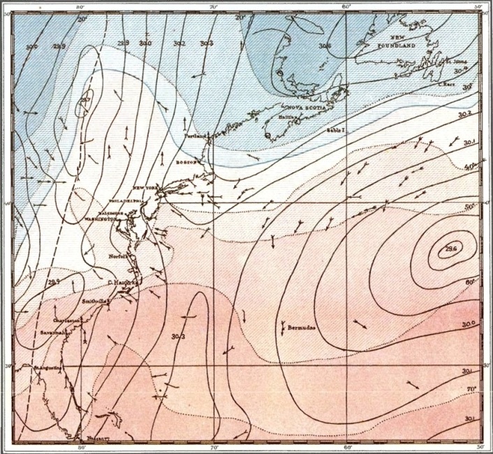
Barometer.—Isobars in full black lines for each tenth of an inch, reduced pressure. The trough of low barometer is shown by a line of dashes.
Temperature.—Isotherms in dotted black lines for each ten degrees Fahr. Temperatures below freezing (32° F.) in shades of blue, and above freezing in red.
Wind.—The small black arrows fly with the wind at the position where each is plotted. The force of wind is indicated in a general way by the number of feathers on the arrows, according to the scale given in the following table:
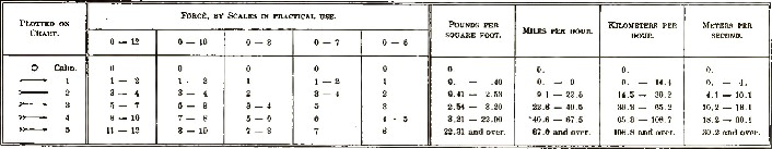
It will be noticed that the Beaufort scale (0–12), in general use at sea, has been converted into the international scale (0–10) for the sake of clearness in plotting data on the chart. The absence of arrows over large areas indicates absence of simultaneous data; at sea, however, this has been partly compensated for in the construction of the chart by information obtained from journals and special storm reports of vessels in the vicinity.
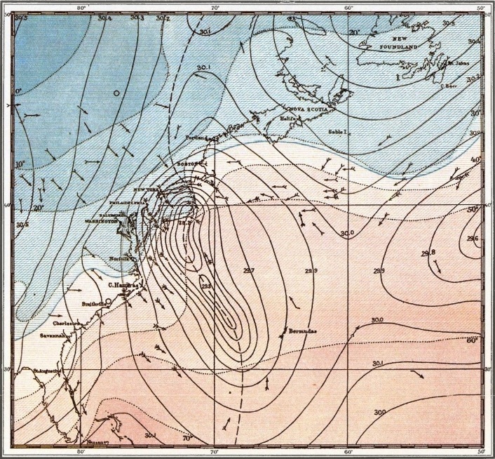
Barometer.—Isobars in full black lines for each tenth of an inch, reduced pressure. The trough of low barometer is shown by a line of dashes.
Temperature.—Isotherms in dotted black lines for each ten degrees Fahr. Temperatures below freezing (32° F.) in shades of blue, and above freezing in red.
Wind.—The small black arrows fly with the wind at the position where each is plotted. The force of wind is indicated in a general way by the number of feathers on the arrows, according to the scale given in the following table:
It will be noticed that the Beaufort scale (0–12), in general use at sea, has been converted into the international scale (0–10) for the sake of clearness in plotting data on the chart. The absence of arrows over large areas indicates absence of simultaneous data; at sea, however, this has been partly compensated for in the construction of the chart by information obtained from journals and special storm reports of vessels in the vicinity.
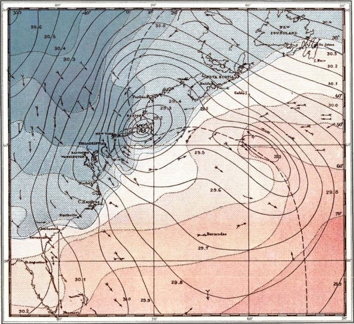
Barometer.—Isobars in full black lines for each tenth of an inch, reduced pressure. The trough of low barometer is shown by a line of dashes.
Temperature.—Isotherms in dotted black lines for each ten degrees Fahr. Temperatures below freezing (32° F.) in shades of blue, and above freezing in red.
Wind.—The small black arrows fly with the wind at the position where each is plotted. The force of wind is indicated in a general way by the number of feathers on the arrows, according to the scale given in the following table:
It will be noticed that the Beaufort scale (0–12), in general use at sea, has been converted into the international scale (0–10) for the sake of clearness in plotting data on the chart. The absence of arrows over large areas indicates absence of simultaneous data; at sea, however, this has been partly compensated for in the construction of the chart by information obtained from journals and special storm reports of vessels in the vicinity.
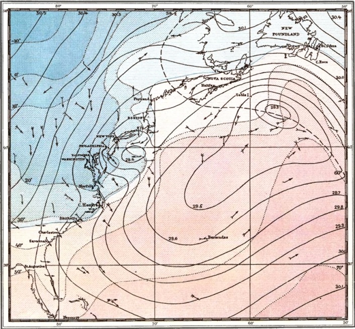
Barometer.—Isobars in full black lines for each tenth of an inch, reduced pressure. The trough of low barometer is shown by a line of dashes.
Temperature.—Isotherms in dotted black lines for each ten degrees Fahr. Temperatures below freezing (32° F.) in shades of blue, and above freezing in red.
Wind.—The small black arrows fly with the wind at the position where each is plotted. The force of wind is indicated in a general way by the number of feathers on the arrows, according to the scale given in the following table:
It will be noticed that the Beaufort scale (0–12), in general use at sea, has been converted into the international scale (0–10) for the sake of clearness in plotting data on the chart. The absence of arrows over large areas indicates absence of simultaneous data; at sea, however, this has been partly compensated for in the construction of the chart by information obtained from journals and special storm reports of vessels in the vicinity.
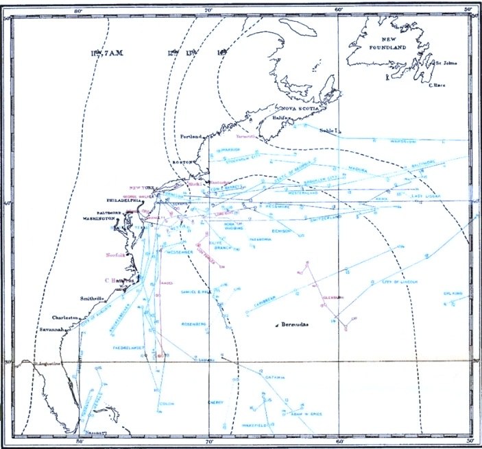
Black.—The line of dashes indicates the position of the trough of low barometer, or the line of sudden change from easterly to westerly winds, with brief intervals of calm, shifts of wind in heavy squalls of rain or snow, colder, and, finally, clearing weather.
Red.—Positions and names of land stations and names and tracks of vessels plotted in red are those whose barometer curves are shown in the accompanying Barometer Diagram.
Blue.—The tracks of certain other vessels from which storm reports have been received are plotted in blue. In addition to these, however, storm reports have been received from the following vessels, omitted from the chart in order to avoid confusion:
Transatlantic steamships, westward bound: Glendevon, Lydian Monarch, St. Ronans, Werra.
Coasting steamships, bound south: El Monte, Morgan City, New Orleans. Bound north: Newport.
Sailing vessels off the coast from Montauk point to cape Cañaveral: Spartan, Charles H. Marshall, Caprice, Coryphene, Phebe, Isaac Orbeton, John H. Krantz, Arcot, Iroquois, Welaka, Serene, Warren B. Potter, Normandy, Lottie Stewart, Melissa Trask, Wilhelm Birkedal, Johanna, James S. Stone, Anita.
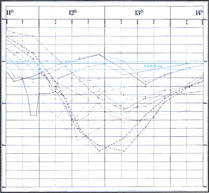
Barometer Curves.—As it is only practicable to illustrate graphically the barometer records of a few vessels and land stations, the following have been selected as being of special interest; the small circles mark the points of observation:
Barometer Normal.—The barometer normal for the 5°-square from latitude 35° to 40° N., longitude 65° to 70° W., assumed for the present purpose as the normal for the entire area, is 29.98, and is indicated by the blue line on the diagram.
The positions of the above-mentioned signal-stations and the tracks of these seven vessels are all indicated in red on the accompanying Track Chart. This diagram should therefore be studied in connection with the chart, in order to form a clear idea of the general eastward movement of the trough of low barometer, and the accompanying rapid deepening of the depression upon reaching the coast.
At the inception of the Coast and Geodetic Survey in the early years of the century, so little was known of the dangers attending navigation along our extensive seaboard, that those who engaged in commercial enterprises were constrained to rely upon local knowledge and the reports of the hardy navigators who might carry their ventures to success. The charts available were by no means a sure reliance, and it has since been shown, contained many serious errors. The great headlands and outlying shoals that present the greatest obstacles to the safety of coastwise navigation, had not been carefully surveyed, and their relative positions to one another were only approximately determined.
The capacities of the harbors had not been ascertained, many were unknown; and even at the great port of New York, the Gedney or Main channel, was not developed until after the permanent establishment of the Survey in 1832, and the thorough exploration of the entrance was undertaken. A list of the sunken dangers and new channels that have been discovered during the progress of the work would fill pages. It is true such developments were to be expected in making a precise survey of the comparatively uncharted coast; but they, nevertheless, clearly point to the necessity of the work. We may also assume that the men who were controlling the destinies of the republic, realized that a knowledge of the coast was essential if they would succeed in building up a commerce, without which it was believed the prosperity of the people could not be assured. The deep draught vessels of the present day could not have traded along our shores on any margin of safety with the little that was known, and it is largely due to the perfect charting of the coast, that commercial enterprise has found it practicable to build the larger vessels of modern type to meet the increasing demands of trade.
The survey proposed was also required in providing for the public defence; as it is a self-evident proposition, that if we would protect a harbor from a hostile fleet, we must know not only the channels by which the fleet might enter, but their relations to each other and the points of vantage that should be utilized in obstructing them; and in modern warfare to know these things only approximately will not suffice, for precision is practiced now in the art of war, as well as in the arts of peace.
The lack of charts of our extensive Coast line, or indeed, of any practical information that could be utilized in a systematic defence against foreign aggression, was only one of the many perplexities that surrounded our forefathers in building the nation. By their valor they had wrested a jewel from the British Crown, and had inaugurated a system of government by the people, which on their sacred honors they had sworn to defend. But not a generation had passed away when they saw new dangers, and were forced to contemplate again taking up arms in defence of their rights. The land was theirs, even far towards the setting sun, pioneers had explored it, and they knew whence might come a hostile foe. But of the waters from far away to the eastward, that flowed on until they washed every shore and filled the great Bays, even to the heart of the Republic, they knew little, save that over that almost immeasurable expanse might come the fleet of destroyers to penetrate they knew not where, and inflict incalculable damage months ere the dreary tales might be told. It must be remembered there were no telegraphs, no railroads, no steamboats, in those days, and time taken by the forelock was time gained. The speed of man could not be overtaken as we see it to-day in the wondrous inventions of the last generations. Each community was dependent upon itself, alone, in time of danger, to ward off the blow or yield to a more powerful foe; assistance could hardly be obtained in months and perhaps not then. It was not possible for any man to study or to learn the points of danger, and prepare a system of defence.
President Jefferson in his far-seeing statesmanship, threatened with war, realized the danger. A survey of the coast he believed essential to the national defence, and to the prosperity of the nation in time of peace. Had his wise counsels prevailed and the survey been prosecuted with vigor, instead of being almost immediately suspended for a quarter of a century, there can be no question but that it would have saved the people millions of dollars in expenditures and put other untold millions into their coffers, through the impetus it would have given to commerce years before commerce actually had a name in many that are now thriving seaport towns.
But it is not to be supposed the commercial importance of a knowledge of the coast and harbors was underrated because the Survey was not prosecuted. The people were poor, the task would be expensive and laborious. The appliances for the work were not in the possession of the Government, and above all, war came sooner than was anticipated and the energies of the people were taxed to the utmost in combat with their powerful foe; and when peace came again, there was the inevitable commercial depression that follows a resort to arms. The men of the day fully realized how illy they were prepared to invite commerce to our shores, or incite our own people to more extensive trade. There was nothing to adequately represent those magnificent harbors that have since become famous the world over; nor of that long line of coast with its treacherous shoals, whereby those seeking new ventures might judge of the dangers to be encountered. The absolute ignorance that existed was aptly described in the Albany Argus in 1832, when the propriety of reviving the act of 1807 was under discussion, as follows:
"It had been discovered by an American statesman that parent countries always keep the commercial knowledge of their colonies as a leading-string in their own hands, and that as practical navigators, American seamen knew less of their own shores than the country and its allies from whose subjection we had recently delivered ourselves by force of arms. In large vessels, three nations, the Dutch, the French, and the English, approached our harbors with less risk than those bearing our own flag; at the same time that in small and more manageable vessels, we had long been known as a match for the strongest. The president, Jefferson, saw the defect and the manner in which it must be remedied. We were at that time on the brink of war, about whose justice some of our politicians differed in opinion and it was, of course, more necessary to pray for a fortunate result than to preach the causes which had occasioned the quarrel. To have procured for the nation (even had it been practicable so to do) the old charts from the Dutch, French, and English governments, would have only been to put our knowledge on a par with theirs, while to execute more recent and accurate surveys, was advancing the new country above the old. With the clear and bold perception, which always distinguishes men of genius when they are entrusted in times of danger with the destinies of a nation, the president recommended a survey of the whole coast with all the aid of the more recent discoveries of science."
The proposed survey was strongly advocated by President Jefferson, and the Secretary of the Treasury, Mr. Gallatin, and in February, 1807, Congress passed the first act providing for the work. Thirteen separate plans, or schemes, were submitted for consideration; among the number was one by Professor F. R. Hassler, which was finally adopted, and Professor Hassler was appointed the first superintendent. It is not necessary to dwell, in detail, upon the varying fortunes of the survey during the three-quarters of a century that have passed since the original act authorizing it. The first thirty years of experiment, before it was finally established as a bureau of the Treasury Department, show only too clearly the ignorance and prejudice against which the supporters—we may say founders—of the survey had to contend. But they had only the experience of all men who attempt the inauguration of new things of which it cannot be shown that they will return a cash profit at the end of six months. To the opponents of the measure cash could not be seen at all, and the profit, whatever it should be, was only an intangible kind of benefit to be realized in the future by additional security to their property and commerce; but, in reality, as has since been appreciated, the direct saving of many millions of dollars annually.
The war of 1812 interrupted Professor Hassler's labors and it was not until 1817 that he actually commenced work; but he was stopped the next year by a limitation of the law requiring the work to be performed by the Military Departments. In 1832 Congress passed a special act reviving the law of 1807 and Professor Hassler was again appointed Superintendent. A further interruption occurred in 1834 by the transfer of the bureau to the Navy Department, but this was of short duration, as it was re-transferred to the Treasury Department in 1836, where it has since remained. Professor Hassler continued as Superintendent until his death in November, 1843. He was succeeded by Professor A. D. Bache, who was fortunate in assuming the charge under much more favorable auspices than had prevailed under his predecessor.
By the appropriation bill passed in March, 1843, the President was directed to appoint a Commission to reorganize the Bureau and prescribe methods for its future conduct. The plan recommended by the Commission was substantially that which had been followed by Professor Hassler. It was approved by the President a few months before Professor Bache assumed the superintendency and has since been the law for the execution of the work. To have a law specifying in detail the methods that should be employed in prosecuting the surveys, that had been drawn by a special commission of experts and approved by the administration, relieved the Superintendent of much of the responsibility that had been borne by Professor Hassler, although it did not put an end to the carpings of the critics, or their advocacy of the less expensive "nautical surveys."
The reorganization provided for the employment of civilians and officers of the Army and Navy to serve directly under instructions from the Superintendent; thus securing for the service the opportunity to procure the best talent from either civil or military life. The civil element, it was assumed, would form a body of experts for the prosecution of those branches of the work not properly falling in the direct line of the military, and experience has demonstrated that while the results anticipated have been fully realized, the organization has not only proved effective but conducive to the advancement of the survey in many ways. The Civil War was a serious interruption, but alone, proved the wisdom of the civil organization of the Bureau. On the outbreak of hostilities the military element was necessarily withdrawn for duty with the Army and Navy; and it was not until ten years after the close of the war that officers of the Navy were again available, while officers of the Army, through the exigencies of the Military service, have not returned at all.
The organization was preserved through these fifteen years by the permanent civil nucleus, and the work suffered no deterioration, but steadily advanced, notwithstanding that the larger number of the civilians were constantly employed during the four years of the war with the Armies and Navy, in different capacities on the staffs of commanding officers; and that the urgent necessities of the government devolved additional labor, and temporarily, a new class of work upon the office force in compiling, draughting and publishing maps of the interior for the use of the Armies in the field. And when finally, our Armies were disbanded and our fleets reduced to a peace basis, and officers of the Navy resumed the execution of the Hydrographic work, it was but to step into the duties of their predecessors; they had, too, the additional advantage of the fifteen years' experience of the purely civil administration of the Survey, during which time the trained surveyors of the land had become equally expert as surveyors of the water, and had added not a little to the improvement of Hydrographic methods. The History of the Survey shows a steady advance in methods of work from its foundation to the present day. But so equally has the march of improvement been due to the zeal and untiring efforts of the civilians and officers of the Army and Navy alike, that any distinction would be invidious.
The plan of reorganization of 1843 provided for a detailed survey of precision. It was to be based on an exact triangulation that would insure positive results, that the location of a danger or the development of a new channel, should be beyond doubt; and that the survey, when completed, should fit together as one continuous line, in which the distance and direction of any object on the map from any other object should be true, whether the objects were in hailing distance of one another, or at the extremes of our boundaries. So well was the scheme conceived, so perfect has it proved in operation, that it is substantially the guide for the closing labors of the great work, notwithstanding the many improvements that experience has wrought in the details.
Those engaged upon the Survey have been quick to profit by experience, and the master mind of Professor Bache, the second Superintendent, was not slow to adopt that which promised increased economy, rapidity or improvement. He drew from all sources, Science contributed her quota and the great inventive genius of the American people played an equal share in producing the final results.
The researches that were necessary to obtain the information required by law "for completing an accurate chart of every part of the coasts," have produced results of great economic and scientific value to the whole people, aside from their bearing on the interests of commerce and navigation; and which will contribute to the welfare of mankind long years after those who labored for them have passed away. A brief reference to a few of the many instances that might be cited to illustrate this perpetual influence to benefit our fellow men, may not be without interest to some of you present.
The application of the method of determining latitude by the measurement of small zenith distances, introduced by Captain Andrew Talcott of the Engineer Corps, U. S. A., while serving as an Assistant on the Survey, developed such radical errors in the star places given in the catalogues, that it led to an almost immediate call for better places, and arrangements were made with the observatories of the country to obtain the necessary observations, the Survey to pay for the labor involved. Stimulated by the knowledge that better work was required to meet the new demand, observatories deficient in instruments procured new ones, and soon furnished more accurate star places. Continued observation has added still further improvement until to-day we have catalogues that furnish the highest degree of precision. Professor Chauvenet defines "Talcott's method" as "one of the most valuable improvements in practical astronomy of recent years, surpassing all previous known methods (not excepting that of Bessel by prime vertical transits) both in simplicity and accuracy." But the advantages of the method have been found to be of a practical nature also; as it is productive of large economy in time and labor and has reduced the cost of the Survey many thousands of dollars.
The introduction of the Electric Telegraph was utilized by the Survey immediately on the practical accomplishment of the first line built, as a ready and improved means for determining longitude. Indeed, before Professor Morse had demonstrated to the world the truthfulness of his theories and experiments, the bare possibility of their success, and availability in the instant transmission of time, had been discussed on the Coast Survey, and the method to be first employed fully considered. But as in the application of all things under new conditions, experience is the teacher, and improvements were frequently made, until finally the invention and perfection of the "chronograph" has brought the method to a degree of precision that little more can be looked for. This method of determining longitude, introduced, fostered and perfected on the Coast Survey, has been more far reaching than geographical boundaries. All civilized nations have adopted it as the "American Method," and by the greater accuracy and reliability of the results the whole world has profited. The saving that has accrued by the more perfect determination of longitudes and the consequent increased safety to commerce, may be counted by millions every year; until one stands aghast in contemplation of the immensity of the sum, and fears to reckon it, even approximately, much less to prophecy what it may reach in the future. The system is but a natural sequence of the development of the telegraph, but emphasizes in a marked degree the spirit of progress that has ever been the active principle and guide in the conduct of the work, and advanced its methods to a state of perfection that has called forth the admiration of the scientific world.
The determination of the magnetic elements has been a subject of investigation from the early days of the survey; the knowledge sought was essential to the navigator, and in recent years, especially, has proved to be of the greatest practical value on shore. Limited by small appropriations the research was at first slow. But a trust fund left by Professor Bache, who always evinced the warmest interest in this particular investigation, added largely to the rapidity with which observations could be obtained, until now we have magnetic maps of the United States of such reasonable precision that they are authoritative, and are in almost daily demand. The results are more far reaching than their mere tabulation for the current year, as laws have been determined by which the declination in a locality can be ascertained for any year in the past.
There are but few places where the needle remains stationary, or points in the same direction, for any great length of time; it even changes daily and during the hours of a day; but the aggregate for a year will rarely exceed three or four minutes of arc. If we reflect then, upon the great use made of the compass in the settlement of the continent, and the proverbial neglect of the country surveyor of those days to record the local variation, or declination, with his work, we may see a little of the utility and practical purposes to which the results are constantly being applied. Property so little thought of a hundred years ago that a few acres more or less, lost or acquired, in its transfer defined by compass surveys, may suddenly assume a value in these days of progress that every square foot is worth dollars. When a dispute arises, deeds are examined, lost or obliterated marks are diligently sought for, perhaps one is found, surveyors are employed to run out the lines but only make the confusion worse. Instead of a few rods that were in doubt according to the best information, the surveyor's line makes it acres, and litigation looms up to eat the profits of the sudden rise, and there seems even then no satisfactory solution of the vexing problem. How valuable then must be the fact, that it is possible to compute the variation for years back, to the time the original survey was made, and furnish the deflection that will re-run the lines so clearly as to render the descriptions in the deed intelligible. This is but a single instance of the practical application of the knowledge gained; and if its general usefulness may be judged by the numerous inquiries made of the Bureau, it is not unreasonable to assume that time will bear increasing testimony of its great economic value from those who traverse the land, as well as those who sail on the waters.
The study of the recurrence of the tides along our extensive Coast lines, and determination of laws that would satisfy the great variance in the different periods, was a problem of no little magnitude but the greatest possible importance to our commerce. Much of the traffic along the coasts literally moves with the tides, and the cost of transportation is enhanced or diminished as the tide retards or advances it. Hundreds of dollars of expense may be incurred on a single cargo that must enter on the high water, but through imperfect knowledge of the master of the ship, is forced after sighting his port, to wait for the next tide, perhaps over night, and is driven to sea by a sudden storm and the voyage made several days longer. Such mishaps are not infrequent, and even at the great port of New York certain classes of vessels must "wait for the tide." The investigation of this complex subject has resulted in the acquirement of a knowledge that enables the prediction of the time of high and low water, and the height of the tidal wave, years in advance; and the mariner may now carry with him the tables published on the subject wherever he goes, and be independent of the doubtful communications he may otherwise receive from the shore. How many lives, how many dollars, have been saved by the knowledge gained?
But the investigation of the Tidal phenomena is of great scientific importance also; and a practical assistance in the great problems involved in the preservation and improvement of our harbors, but in this connection it probably falls more properly under the head of that greater study of the currents and their effects in the erosion, and building of the shores; the movement of the sands and formation of shoals and channels; termed "Physical Hydrography." Our commerce depends largely on this study for its perpetuation, for without harbors commerce must cease; and without harbors that will admit vessels of the largest class it must deteriorate. If commerce finds increased profits in large vessels it demands increased facilities, and the bars to the harbors with but six or eight feet of water on them a few years ago, must have ten, perhaps fifteen feet now, or the people must suffer their trade to pass to some more fortunate or energetic neighbor. This may be a hardship; but the demands of trade are inexorable, the profits must be reasonably assured, and those who would have the trade must comply with the requirements. Thus we see the striving for harbor improvements; the weakest making the greatest outcry that they shall not be left in the race. And the improvements must come in the end, or at least be attempted, for it is as much a law of commerce not to be hampered by small freights, as it is the law of nature that water flows down hill.
The outcry for "improvements" never grows weaker; it is the expression of a sincere conviction that the life of the community and the welfare of the "back country" depend upon its success for prosperity; it will not admit a rebuff and knows no such word as failure. Alleged authorities are consulted, a scheme of improvement is proposed and Congress is asked to vote the money, and finally the improvements are attempted. To be successful, the plan must conform to known general laws and the peculiarities of local conditions, many of which are only ascertainable by comparison of surveys at different periods. Theories advanced on data collected by one survey, may be strengthened or disproved by the facts ascertained in a subsequent survey; and it is only when the plan proposed meets the general laws and the local conditions at the same time, that it holds out promise of success. The study of the questions involved has been greatly aided by the work of the Coast Survey in improvements already attempted, and will be of greater assistance in the future. A positive knowledge of what the local conditions were when a harbor was at its greatest capacity, is of the greatest help in indicating the improvements necessary to restore it, after deterioration, or to maintain it in the full measure of its usefulness. Reliable charts do this, but they tell only half the story. A cause must be found for the effects that have been produced, and the remedy suggested must overcome that cause or control it, that it may work good instead of evil. In Physical Hydrography we learn the forces that nature has given us in the tides, the currents and the winds, and divert them from powers of destruction, as man in his ignorance may have led them, or in their warfare with one another they may have led themselves; and bring their mighty influence to protect, improve or maintain that which we originally had. Many harbors have suffered incalculable injury through the recklessness of these who live upon them, and whose daily bread is dependent upon their preservation; until the evil has become so great that commercial cities have now "Harbor Commissions," whose special function is the preservation and improvement of the harbors. The original surveys made by Coast Survey are the foundations on which they very generally must build, while re-surveys point out to them the obstacles that must be overcome. And thus it will ever be; and future generations endeavoring to meet the demands of commerce for increased facilities, will have still greater cause for thankfulness, that the wise men who inaugurated the work of the Coast Survey, determined that it should be executed with every improvement that science could devise; and that the able men who conducted it, did not yield to the clamor for quick returns and cheap results, of only momentary value. They will realize by the benefits they will derive from it, as do those now living who have watched its progress and development, that the best is the cheapest as it will be useful through all time.
In 1871 Congress authorized the execution of a Geodetic triangulation across the continent to connect the great primary triangulations along the Atlantic and Pacific coasts, and provided that the triangulation should determine positions in those States that made requisite provision for topographical and geological surveys of their own territories. Each year since then, a small sum has been expended on these works with gratifying results to the States that have availed themselves of the assistance. But it was not until 1878 that Congress designated the Bureau as the "Coast and Geodetic Survey," the official title it bears at this time. Many comments have been passed upon the action of Congress in extending the field of the survey to the interior in the establishment of a "Geodetic Survey," which has been looked upon as a purely scientific research for which the people had no immediate use, and could well afford to wait. But if the tree can be judged by its fruit, there will be no lack of testimony to the economic value of the Geodetic Survey in the near future; aside from its scientific and practical usefulness in perfecting the Survey of the Coasts. It will eventually be the basis for a precise survey of the whole country, determining boundaries, settling disputes, and furnishing incontrovertible data by which later generations can reproduce the marks placed by the local surveyors who make use of it, should they become obliterated or lost; thereby causing a direct increase in the security of property boundaries, and diminution in litigation that now costs millions of dollars annually. Some of the practical advantages to be derived from such a work, are now being demonstrated in Massachusetts in the "Town boundary Survey," as it is called, in which the corners, or turning points of the boundaries are being determined trigonometrically in a subsidiary work based upon the Geodetic triangulation of the Coast Survey. Each boundary corner in this scheme becomes a fixed point, and the direction and distance of many other corners are at once accurately ascertained in their true relations to it. The town boundaries will in due time be made the bases of reference for all local surveys and subdivisions of property; so that, eventually, there will be developed a cadastral map of unrivaled excellence, to supplement the Topographical map that has just been completed.
The imperfections of our "land surveys," brilliant as the scheme was conceived to be at the time of its inauguration, demonstrate only too clearly the extravagance of primitive methods in matters intended to be enduring. As time passes and property taken up under the "land survey" becomes more valuable, the difficulty of accurately identifying boundaries becomes more serious, until finally, it is only after long litigation that rights are determined. The inherent defect in the land survey to accomplish the purpose for which it was designed, lies in the fact, that while it parcels out the land, or a section of land, in a given number of lots, it fails to provide the means for identifying the boundaries of the lots at any future time; the marks placed for this purpose become obliterated or perhaps are moved by designing men, until a large area may be involved in great uncertainty. A triangulation covering the same ground and controlled by Geodetic work, determining the true positions of the old marks that may be left, would be the most economical and precise method of relieving these uncertainties and fixing for all time the location and boundaries of the lots originally parcelled out, by observations and marks that cannot be lost or obliterated.
The system of weights and measures in use throughout the country is largely due to the patient labor of the Coast Survey. Required by law to have standards of length, the only bureau in the public service that required such a measure of precision, it was in the natural order of events that the Superintendent of the Survey should also be charged with the maintenance of standards of Weight and Capacity. The duplication of standards for the use of the people was begun under Mr. Hassler, so long ago that the system has really grown with the population. Wise legislation has fostered the sentiment of uniformity until we are indeed blessed, that wherever we may be in all our broad domain, a pound is a pound, a yard is a yard, and a bushel is a bushel. Manufacturers receive their standards from the Bureau, and in special cases have their products tested and certified. And individuals engaged upon work of great refinement, seek the stamp of the Bureau, also, upon the measures on which they must rely. But so careful is the Bureau to preserve the integrity of its certificate, that the stamp is refused except on weights or measures of approved metal and workmanship. Business men realize in every day life the benefits that have been derived from the simple legislation that inaugurated a supervision over the weights and measures of the country early in her history, though they may have no conception of the endless annoyances they would have been subjected to had the preservation and duplication of standards not been provided for.
The limited time assigned to me will not permit a detailed statement of the researches made by the Bureau in all the different branches of science related to the practical conduct of the work, much less a reference, even, to the many improvements instituted in the practice of surveying. As in the case of the observatories called upon to replace their defective instruments with those more refined, to enable them to furnish star places of sufficient precision to meet the improved method of determining latitude, so has the demand ever been upon the experts employed upon the work in all its branches. The Triangulation, Topography, Hydrography, Astronomy and Magnetics have all passed through several stages of development and improvement in methods and instruments, to meet the requirements put forth by those charged with the conduct of the work, that the full measure of harmony desired should be secured and that they might supply the demands made upon them for information. Imperfect results indicate defects to be remedied, and it is to the credit of those who performed the labor, that they overcame one difficulty after another as they were developed, until now the methods and instruments in the hands of experts, will produce far superior results at a much less cost than was possible at the time the Survey was inaugurated.
The charting of the great ocean currents, has long been an interesting investigation to hydrographers the world over. A sketch of the efforts, projects, and devices that have been resorted to by the Coast Survey in the attempt to unravel the mysteries of the Gulf Stream, would exemplify the continuous demand for improvement and new exertions under which those employed upon the work have always labored, although the full measure of knowledge sought has not yet been obtained. But it is not necessary to enter into these details at this time; let it suffice that many experiments and failures pointed out the path to be followed by subsequent observers, and stimulated to new efforts, until at last appliances have been perfected that have already produced wonders, and it is safe to predict, will ere many years show the ocean currents on the charts of the world with the same relative precision that the currents in a river or harbor can now be indicated. Lieutenant Maury gave us current charts that were a marvel in their day, but his information, or data, was defective, and his conclusions, therefore, only approximate; and how to improve on the data he had, has ever since been the subject of research. The depth of the ocean is necessarily an important factor in the study of its features, as erroneous depths lead to false hypotheses. The introduction by the English of a method of sounding with a wire, has therefore proved an important advance. American officers have perfected the apparatus and severely tested the methods, demonstrating the reliability of the results and the total unreliability of the old deep sea soundings taken with a line. These accurate wire soundings have revealed new facts, disproved old theories and formed new ones to guide future researches. So successful is the improved apparatus that specimens of the bottom of the ocean have been brought up from a depth of five miles. The great value of this system, however, is not confined to the mere ascertainment of depths for the hydrographer and cartographer, as may be readily demonstrated by referring to the reports of the Fish Commissioner. A further step towards improving on Maury's results; the crowning glory that is to shed light on much that has been dark, and trace out those ocean currents we have heretofore vainly endeavored to follow, is found in the invention and devices of a naval officer attached to the Survey, whereby he can anchor the ship in mid-ocean and observe the direction and velocity of the current as from a stationary body, and with a "current meter," also his own invention, determine the same factors hundreds of feet below the surface; thus ascertaining not only the movement at the surface, but the depth of the body of water that moves, and the velocity at various depths, so that finally we have the volume—a quantity—to be followed until it meets other currents or is absorbed in the vast expanse. Already current observations have been recorded with the ship anchored at the great depth of eighteen hundred fathoms; and arrangements have been perfected that it is believed will prove successful at the greater depth of three thousand fathoms. It is impossible with our superficial knowledge of the great ocean currents to estimate the benefits that will be derived from their systematic exploration. It is not probable that the absolute determination of their limits would produce such a revolution in navigation, as was caused by Maury's wind charts, but it is reasonably certain they would prove a valuable assistance to the navigator, and in the great channels and bays of the world increase his facilities for the successful navigation of his ship. Not a little of their value, perhaps the larger part, will be of an indirect nature, resulting from their study by investigators in the natural sciences interested in utilizing the bounties of nature for benefit of man.
The Survey was instituted for the determination of facts, and the presentation of them in an intelligible form. It does not promulgate theories, and has no use for them beyond the assistance they may be in indicating the line of research necessary to ascertain the facts; but rather leaves to the student the formulation of the theories that may be deduced from the facts presented. The publications of the Survey are, therefore, calculated to contain only useful, practical information, on the subjects of which they treat. An examination of them will show this to be the case, and further, that error has more likely been committed by over-caution, than a too free use of the material at command. Doubtless much has been suppressed through lack of means, as it has always been the aim of the Superintendents to expend the appropriations in producing the most useful results, whether in surveys to be made or facts to be published. It necessarily requires many years to complete a precise survey over a large area; and in the work of the Coast Survey, with the people in all sections of our extended coast line petitioning for surveys at the same time, the problem was beset with additional difficulties. Fortunately Congress prescribed the method on which the work should be conducted, and that the method permitted making surveys widely separated with the certainty that they could eventually be joined and form a consistent whole. Soon after the plan of reorganization of 1843 had been adopted, surveying parties were on the Atlantic and Gulf coasts at many points; the principal harbors and headlands with outlying shoals were first surveyed and it was but a few years before charts of them were published. The less important shores between these points were left for future work, but Hydrographic examinations or Nautical surveys, were made of them, and preliminary charts of long stretches of coast were issued, to be followed when the surveys had been completed by the finished chart of reliable data. So elastic was the system adopted for the conduct of the work, that its availability was limited only by the annual appropriations. Soon after the annexation of Texas surveying parties were on that coast, and on the acquisition of California a few years subsequently parties were soon at work there also; and after the close of the war and purchase of Alaska, the immense field thus opened was attacked with equal promptness, and a reconnaissance made that resulted in a map of considerable accuracy. As the precise surveys were extended the charts and plans published from the preliminary surveys were withdrawn, the new charts necessarily having later dates.
The original surveys of the Atlantic and Gulf coasts are now practically completed, but very little more remaining to be done in a few comparatively unimportant localities. On the Pacific coast precise surveys supplemented by careful reconnaissance of less important sections, define nearly the whole outline, excepting Alaska, but a great deal of work is still required to obtain the full measure of information necessary to accurately chart it. And in Alaska, Nautical surveys have developed long stretches of the "Inland passage" and the most important anchorages, supplementing the general reconnaissance of the whole coast line. A very large proportion of our shores, however, are subject to such radical changes from natural causes, that the survey of the coast can never be brought to final completion. Examinations and re-surveys are as essential as was the original work, if the material already acquired is to be maintained in the full measure of its usefulness, and commerce is to continue to reap the legitimate benefit of the expenditures already incurred. Fortunately the survey has been conducted on such sound principles it meets the increasing requirements for accuracy demanded by the navigation of to-day, as fully as it did the more simple needs of the navigator of forty years ago, and it is fairly believed, whatever may be the necessities of the future, that it will still supply the information desired.
The Surveys are published in four hundred and fifty charts designed to meet the various needs of the Navigator and Civil Engineer, for either general or local purposes; over thirty thousand copies of these are issued annually and there is a steadily increasing demand.
The assistance rendered to the armies and fleets of the Union, in the late Civil War, is a chapter in the history of the Survey that should not be forgotten. The office in Washington was beset with demands for information from all over the country, for descriptions not of the coast alone, but all sections of the interior representing the seat of war. Fortunately the experts were there who, under the direction of able chiefs, could collect and compile such material as was available. The labor of the office in this cause resulted in the publication of a series of "War Maps" of the interior, for which there is frequent demand even at the present day. This was all additional work to a force already overburdened in the preparation of manuscript maps and special information, compiled from the reports of the Field parties; especially of those localities that had only recently been surveyed. And in all the din and excitement of the call to arms, with hosts of stalwart, honest men assembled around him, that might give in their learning the wisdom of the world, the controlling mind of the Survey, that had labored diligently and sought knowledge patiently, was a chosen counsellor of the Chief of the Nation. Declining military honors, the profession in which he had been educated, he devoted himself with renewed energy to assisting the nation's efforts in those special duties he knew so well how to perform. A patriot himself of the purest type, he inspired those around him by his ennobling spirit and zeal in the cause.
An average of twenty parties were maintained with the Army and Navy during all the years of the war, rendering services of acknowledged value to the military forces. An officer of the Coast Survey piloted the fleet into Port Royal; another led the Iron Clads in the attack on Sumter; a third stationed the fleet in the bombardment of Jackson and St. Philip; and a fourth rendered signal services in the assault on Fort Fisher. They were on the Peninsula, guides in the wilderness on the retreat to Malvern Hill; at Chickamauga, Knoxville, Missionary Ridge; the march to the Sea and pursuit through the Carolinas; on the Red river; before Petersburgh; in the Sounds of North Carolina; the Sea Islands of Georgia and Florida and the swamps of Louisiana; and, wherever they went, few in numbers though they were, they gained honor for their cause and credit for their Chief.
The Survey of the Coast has excited the admiration of the whole civilized world for its thoroughness and accuracy, and has not been excelled by the most advanced nations. It has justly been claimed to be a scientific work, as well as a practical one, for science has guided those who have conducted it and led them through the fields of their labors on the only sure basis to produce knowledge. And the great knowledge that has been acquired by its scientific prosecution, is beyond comparison with the little that would have resulted had it been conducted on the less thorough methods of Nautical Surveying that have been so earnestly advocated. We cannot compute the value of what has been learned in dollars and cents; that it has saved to the Nation many times over, all that it has cost, does not admit of a doubt. Its educational influence has been widespread, extending beyond the seas, and coming back to us with cheering words of encouragement and praise. Practical men utilizing the results of the great work in the business affairs of life, use no stinted phrases in the encomiums they bestow upon it; Military men compelled to rely upon it in the perils of warfare, have not found it wanting, and have given only praise for the great help it was to them; Scientific men, ever watchful of that which is true, have approved it the world over, and cite it as an example of the great profit that may come to a people, free to utilize Science in the conduct of practical work. Our institutions of learning have adopted its publications in text-books. Our merchants venture millions of dollars daily on the veracity of its statements, and our mariners risk their lives on the truthfulness of the Surveys. It has added to the prosperity of the nation in peace—to her glory in war; and when history shall record its awards to our people, there will be no page of the galaxy with more honor than that which bears tribute to the genius of American Science, in the work of the Coast Survey. From ignorance most profound we have been raised to knowledge almost perfect; and well may the commercial communities by their associations and exchanges bear the testimony to its value that they do, and have done in times past; as might the whole people for the wise legislation that established the work, that has defended it, and we may hope will perpetuate it for its inestimable benefits to them all.
The Geological Survey is engaged in making a map of the United States. This work was commenced as an adjunct to the geological work, and was rendered necessary by the fact that, except in limited areas, no maps of the country on any but the smallest scales were in existence. While these maps are thus primarily made to aid in the geologic work and in the delineation of geologic results, they are being made of such a character as to meet all requirements which topographic maps on their scales should subserve.
The work is being carried on in various parts of the country and is being prosecuted on a considerable scale, the annual output being between 50,000 and 60,000 sq. miles of surveyed area. Commenced in 1882, the work has been extended over more than 300,000 sq. miles at the present time. Of this work the survey of Massachusetts forms a part.
In some of its features this survey was an experiment. It was the joint work of the State and the United States, and, so far as I know, was the first example of such joint work. In the summer of 1883 the U. S. Geological Survey commenced topographic work within the State, the scale adopted being very nearly 2 miles to an inch. Only a beginning was made during the season, and in the following winter the Governor of the State recommended to the legislature that if practicable advantage be taken of the opportunity, and an arrangement for coöperation be made between the State and the Geological Survey, by which a map upon a larger scale and with a greater degree of detail might be obtained as a result of this survey. Accordingly, after some correspondence with the Director of the U. S. Geological Survey, the legislature authorized the appointment of a commission, with power to make an arrangement with the Director of the Geological Survey looking toward the result above indicated, and appropriated $40,000, being half the estimated cost of the survey upon the larger scale, $10,000 of which was to be available the first year and $15,000 in each of the two subsequent years. The following is the text of the bill, which is in many respects a model legislative document:
Resolved, That the governor, with the advice and consent of the council, be and is hereby authorized to appoint a Commission to consist of three citizens of the Commonwealth, qualified by education and experience in topographical science, to confer with the director or representative of the United States Geological Survey, and to accept its coöperation with this Commonwealth in the preparation and completion of a contour topographical survey and map of this Commonwealth hereby authorized to be made. Said Commission shall serve without pay, but all their necessary expenses shall be approved by the governor and council, and paid out of the treasury. This Commission shall have power to arrange with the Director or representative of the United States Geological Survey concerning this survey and map, its scale, method, execution, form and all details of the work in behalf of the Commonwealth, and may accept or reject the plans of the work presented by the United States Geological Survey. Said Commission may expend in the prosecution of this work a sum equal to that which shall be expended therein by the United States Geological Survey, but not exceeding ten thousand dollars, during the year ending on the first day of June, eighteen hundred and eighty-five, and not to exceed the sum of fifteen thousand dollars in any one year thereafter, and the total cost to the Commonwealth of the survey shall not exceed forty thousand dollars.
In pursuance of this resolution Gov. Robinson appointed the following gentlemen as commissioners on the part of the State: Gen. Francis A. Walker, President of the Massachusetts Institute of Technology, Mr. Henry L. Whiting, Assistant U. S. Coast and Geodetic Survey and Prof. N. S. Shaler of Harvard College. The Director of the Geological Survey, upon being notified of this action, laid before the commissioners a proposition for a joint survey in the following terms:
1. It is proposed to make a topographic map of the State of Massachusetts, the expense of which shall be borne conjointly by the Geological Survey and the State of Massachusetts.
2. The Borden triangulation and the Coast and Geodetic Survey triangulation will be utilized as far as possible, and additional triangulation will be made to such extent as may be necessary.
3. The topographic work of the Coast and Geodetic Survey will be utilized as far as it extends.
4. The survey will be executed in a manner sufficiently elaborate to construct a topographic map on a scale of 1:62,500.
5. The topographic reliefs will be represented by contour lines with vertical intervals varying from ten to fifty feet, as such intervals are adapted to local topography.
6. As sheets are completed from time to time copies of the same will be transmitted to the commission.
7. When the work is completed and engraved for the Geological Survey, the Commission, or other State authorities, may have, at the expense of the State, transfers from the copper plates, thus saving the State the cost of final engraving.
8. The survey will be prosecuted at the expense of the Geological Survey for the months of July, August and September. During the last half of the month of September the Commission shall examine the work executed up to that time, and if the results, methods and rates of expenditure are satisfactory to the Commission, the expenses of the work for the month of October shall be borne by the State of Massachusetts, for the month of November by the Geological Survey, and the work thereafter shall continue to be paid alternately by months, by the Geological Survey, and the State of Massachusetts severally. But as the larger expense incident to the beginning of the work is imposed on the Geological Survey, at the close of the work the State of Massachusetts shall pay such additional amount as may be necessary to equalize the expenditures; provided that the total expenditure of the State of Massachusetts shall not exceed forty thousand dollars ($40,000); and if the completion of the survey of the State of Massachusetts and the preparation of the necessary maps on the plan adopted by the survey shall exceed in amount eighty thousand dollars ($80,000), then such excess shall be wholly paid by the Geological Survey.
The commissioners suggested some minor amendments to this proposition, which were accepted, and under these provisions work was commenced and carried forward continuously to its completion. The field work of the state was finished with the close of the season last fall, and the drawing of the maps is now substantially done. The work was done in the field with such accuracy and such degree of detail as to warrant the publication of the map upon a scale of one inch to a mile, or, what is practically the same thing, 1:62,500. The relief of the surface is represented by the contour lines, or lines of equal elevation above sea, traced at vertical intervals of 20 feet. These contour lines, which are becoming a common feature of modern maps, add an additional element. They express quantitatively the third dimension of the country, viz: the elevation. An inspection of such a map not only shows the horizontal location of points, but their vertical location as well. It gives the elevations of all parts of the country represented, above the sea.
The map represents all streams of magnitude sufficient to find place on the scale, and all bodies of water, as lakes, swamps, marshes, etc. In the matter of culture, in which definition is included all the works of man, it seemed desirable to represent only such as are of a relatively permanent nature, and to exclude temporary works, for the very apparent reason that if temporary works were included, the map would be not only a constant subject for revision, but even in the interval between the survey and the publication, the culture might change to a large extent, and the published map be correspondingly incorrect from the outset. In searching for a criterion which could be consistently followed in distinguishing between culture which should and should not be represented, it was found that by limiting the representation to that which may be denominated public culture, that is, that which has relation to communities, as distinguished from individuals, a consistent line could be drawn. Adopting this criterion, the map contains all towns, cities, villages, post offices,—in short, all settlements of any magnitude, all railroads and all roads, with the exception of such as are merely private ways, all public canals, tunnels, bridges, ferries and dams. There were excluded under this ruling isolated houses, private roads, fences and the various kinds of crops, etc. Forest areas are shown. Subsequently, however, in response to the urgent wish of the commissioners, the survey consented to locate the houses upon the maps, although in the engraving these have been omitted. The omission of all private culture leaves the maps very simple and easy to interpret. For convenience the field work was done upon a larger scale than that upon which the maps were to be published, viz: a scale of 1:30,000, or a little more than double the publication scale. The map of the state as planned is comprised in 52 atlas sheets, each of which comprises 15 minutes of latitude by 15 minutes of longitude and an area of about 225 square miles. These sheets upon the scale of publication are about 17½ inches by 13 in dimensions. In two or three cases along the coast it seemed to be in the interest of economy to vary from this arrangement slightly, in order to avoid the multiplication of sheets. Many of the sheets upon the borders of the state project over into other states, and, in cases where the area lying without the state was small, the survey was extended beyond the limits of the state, in order to complete the sheets.
Every map is a sketch, which is corrected by the geometric location of a greater or less number of points. Assuming entire accuracy in the location of the points, that is, assuming that the errors of location of the points are not perceptible upon the map, the measure of accuracy of the map consists in the number of these geometric locations per unit of surface, per square inch, if you will, of the map. The greater the number of these locations the greater the accuracy of the map, but however numerous they may be the map itself is a sketch, the points located being simply mathematical points. Whatever method be employed for making these geometric locations, the sketching is substantially the same everywhere. The methods of making these locations must differ with the character of the country, as regards the amount and form of its relief, the prevalence of forests and other circumstances. There are two general methods of making the geometric locations used in surveying; one, by triangulation; the other by the measurement of a single direction and a distance, which is the method employed in traverse surveying. In practice, the two methods are often combined with one another. Both methods have been employed in Massachusetts. The fundamental basis of the work was the triangulation which had been carried over the state by the U. S. Coast and Geodetic Survey. By this survey points were located at wide intervals over the state. Besides this there was executed between 1830 and 1840, at the expense of the state, a triangulation known as the "Borden Survey." This located a much larger number of points, but less precisely. The Coast and Geodetic Survey kindly undertook the adjustment of this triangulation to an agreement with its own work, and, as many of the lines were common to the two pieces of work, the locations made by the Borden Survey were by this adjustment greatly strengthened. Even after this work was done, however, there remained considerable areas which were destitute of located points, and it became necessary to supplement it. This was done in part by the Coast and Geodetic Survey and in part by the Geological Survey. By these several agencies upwards of 500 points were made available for the use of the topographers. These are in the main well distributed, furnishing upon each sheet a sufficiency, while upon many the number is greatly in excess of the requirements.
The work of location has been done in different parts of the state by different methods as seemed most applicable to the differing conditions of relief, forest covering and culture. Throughout most of the western part of the state the work was done entirely with the plane table, using the method of intersections as the means of location. Each plane table sheet comprised one-half of an atlas sheet, cut along a parallel of latitude. The plane tabler, starting with three or more locations upon his sheet, furnished by the triangulation, expanded over the sheet a graphic triangulation, locating thereby a considerable number of points, before commencing detailed work. This was done as rapidly as possible consistent with a high degree of precision. The reason for covering the sheet with the graphic triangulation beforehand lay in the necessity for locating a considerable number of points before the sheet had opportunity to become distorted by alternations of moisture and drying. This done, the plane tabler went on with his usual routine of work, locating minor points and sketching the topography in contours. The map was as far as possible completed upon the stations, with the country in view. Elevations were determined as the work progressed, with the vertical circle of the alidade, and minor differences of elevation between points whose height was known were measured by aneroid barometer.
In this work several different forms of plane table have been employed. It was commenced with the large heavy movement designed I believe by the Coast and Geodetic Survey. This, however, was found unnecessarily heavy and cumbersome, and it was discovered that the requisite degree of stability could be obtained with much less weight. For this plane table movement there was soon substituted another form in use in the Coast and Geodetic Survey, which is very much lighter. This was soon improved by taking off the slow motion in azimuth, which was found to be unnecessary, and the addition of more powerful clamps, for the purposing of rendering it more stable. A still more stable form, however, coupled with even less weight, was designed by Mr. W. D. Johnson, of the U. S. G. S. and was immediately adopted. This is substantially a modification of the ball and socket movement. It consists of two cups of large size fitting closely to one another and working within one another in such a way as to allow of the adjustment in level, and the clamping of the level adjustment independently of the azimuth movement, clamps for both level and azimuth adjustments being underneath the instrument. This form is extremely stable, admits of quick adjustment and leveling, and it has been from the time of its invention in general use in this state and elsewhere in the Survey.
In the undulating, forest-covered, region in the southeastern part of the state it was found impracticable to use economically the method of intersections, and resort was had to the traverse method for making locations. In this method, as is well known, one station is located from another by the measurement of a distance and direction, the line of stations being connected at each end either upon stations in the triangulation or upon other lines, while from the stations in these traverse lines, points off the lines are located by intersections, if practicable, or by distance and direction measurement. For this kind of work the plane table, at least such a plane table as is generally in use is an inconvenient instrument. The plane table with the telescopic alidade is too cumbersome an instrument to be carried about and set up as frequently as is necessary in this work. Therefore for this purpose theodolites, fitted with stadia wires and stadia rods, have been used. Distances are measured by the angles subtended by the stadia wires upon the rod, whose divisions are of known length, while the directions are measured by the compass attached to the theodolite, and differences of elevation by spirit level and vertical angles. With this instrument lines were run along all the roads and along the principal streams in this part of the state and from these lines the country lying between them was located and sketched.
In the northeastern and in much of the middle portion of the state a mixed method of work was employed, the plane table being used for carrying on the intersection work wherever it could be done, while by traversing the roads, their details, which could not be obtained by the plane table in this region, were reached. These traverses were platted in the office and the maps drawn from notes and sketches made in the field.
The degree of accuracy of the map depends upon the accuracy of the locations, their number and the uniformity of their distribution. Of their accuracy it is only necessary to state that their errors are not sufficiently large to be appreciable upon the scale of the map, for instance the scale being one inch to a mile, an error of 50 feet in the location of a point would be upon the map but one hundredth of an inch,—a barely appreciable quantity, and it is of course easy to make the locations within this limit. Of the number of locations per unit of map surface I shall give statistics drawn from the full experience of the Survey in this state. The area surveyed by the method of intersections exclusively comprises 3,500 square miles, or about two-fifths of the state. In this area 3,123 stations were occupied with the plane table, or slightly less than one to a square mile, or, measured upon the map, one to a square inch. Besides these, 17,846 points were located in this area by intersections, making, with the occupied stations, a total of 20,969 locations within the area, or 6.2 horizontal locations per square inch. In the same area the heights of 34,893 points were measured, being 10 per square inch. I am expressing these figures in terms of inches of the final map, because it is the map with which we are concerned.
The area surveyed by the traverse method is 2500 sq. miles. In this area 5615 miles of traverse lines were run, being 2.2 linear inches per square inch of the map. In running these lines 46,524 stations were made with the theodolite, being 8.3 per linear mile of traverse and 18.6 per sq. inch of map. The number of measurements of height was 92,561, being 37 to the square inch.
The area surveyed by the mixed method comprised 3000 sq. miles. In this 900 stations were made with the plane table, and from them 3718 points were located by intersection, making altogether 4618 points located with the plane table. In addition to this, 6767 miles of traverse were run, being 2.2 linear miles per square mile of area. In these traverses 31,708 instrumental stations were made, or 4.7 per linear mile and 10.6 per sq. mile. The sum of the plane table stations, locations, and the traverse stations, which makes up the total of horizontal locations in this area, is 36,326, being a total of 12.1 points per sq. inch of map. The number of measurements of height in this area is 67,119, being 22.4 per sq. inch. It will be seen that the number of horizontal locations and of height measurements in the area traversed is much greater than in that surveyed by the intersection method, and it might be inferred that the former work is better controlled than the latter. I do not judge, however, that this is the case, owing to the fact that traverse stations are not of as much value for purposes of location as those by intersection. The latter are selected points. The former are not selected points, but on the contrary, a large proportion of them are located simply for carrying forward the line and are of no further service, and very few of them are such as would be fitted for the purpose of controlling areas.
Within the area surveyed by traverse nearly every mile of road has been run. With the exception of those in the cities, nearly every house and every church in the commonwealth has been located, either by intersection with the plane table or by traverse.
The organization of the surveying parties has been of the simplest character. Plane table work has been carried on by one man with an assistant, the latter doing little more than attend the plane tabler and assist him in carrying the instruments. Each of these little plane table parties was furnished with a horse and buggy for transportation. The organization for traverse work has been equally simple, consisting of a traverse man and a rodman. As a horse and buggy would be an impediment in this work, this feature of the outfit has been omitted. In the mixed work the traverse men have been under the immediate control of the plane tabler, so that their movements have been directed by him in detail. The average output per working day of the plane tabler has been for the whole survey 3.1 sq. miles, and of the traverse man 2.8 sq. miles, and, as the expenses of the former have been slightly greater than those of the latter, the cost per square mile of the two methods of work has been substantially the same.
The average cost per square mile of the survey of the State has been a trifle less than $13. This includes the salaries of all men engaged upon the work during the field season, their traveling, subsistence and all other expenses, the salaries of the men engaged in drawing the maps in the office, the cost of supervision and of disbursement,—in short all expenses of whatever character, incurred in the production of the map.
First Regular Meeting, Feb. 17, 1888.—Held in the Law Lecture room of Columbian University, the president, Mr. Hubbard, in the chair.
The president delivered an inaugural address.
Major J. W. Powell lectured on the Physiography of the United States.
Second Regular Meeting, March 3, 1888.—Held in the Law Lecture room of the Columbian University, vice-president Bartlett in the chair.
Paper: Patagonia, by Mr. W. E. Curtiss.
Third Regular Meeting, March 17, 1888.—Held in the Assembly Hall of the Cosmos Club, the president, Mr. Hubbard, in the chair.
Paper: Physical Geography of the Sea, by Commander J. R. Bartlett.
Fourth Regular Meeting, March 31, 1888.—Held in the Assembly Hall of the Cosmos Club, the president, Mr. Hubbard, in the chair.
Discussion was had on the proposed Physical Atlas of the United States, participated in by Messrs. Gannett, Gilbert, Ogden, Greely, Marcus Baker, Willis, Bartlett, Merriam, Ward, Henshaw and Abbe.
Fifth Regular Meeting, April 13, 1888.—Held in the Assembly Hall of the Cosmos Club, vice-president Merriam in the chair.
The discussion of the proposed Physical Atlas of the United States was continued, and was participated in by Messrs. Marcus Baker, Greely, Willis, Cosmos Mindeleff, Gilbert Thompson, Kenaston, Gannett and Van Deman.
Paper: The Survey of the Coast, by Mr. Herbert G. Ogden.—(Published in Vol. 1, No. 1, "National Geographic Magazine.")
Sixth Regular Meeting, April 27, 1888.—Held in the Assembly Hall of the Cosmos Club, the president, Mr. Hubbard, in the chair.
Papers: The Great Storm of March 11–14, 1888, by Gen. A. W. Greely and Mr. Everett Hayden.—(Published in Vol. 1, No. 1, "National Geographic Magazine.")
Geographic Methods in Geologic Investigation, by Prof. W. M. Davis.—(Published in Vol. 1, No. 1, "National Geographic Magazine.")
Seventh Regular Meeting, May 11, 1888.—Held in the Assembly Hall of the Cosmos Club, vice-president Merriam in the chair.
Papers: The Survey and Map of Massachusetts, by Mr. Henry Gannett.—(Published in Vol. 1, No. 1, "National Geographic Magazine.")
Graphic Triangulation, by Mr. W. D. Johnson.
Eighth Regular Meeting, May 25, 1888.—Held in the Assembly Hall of the Cosmos Club, vice-president Merriam in the chair.
Papers: The Classification of Geographic Forms by Genesis, by Mr. W. J. McGee.—(Published in Vol. 1, No. 1, "National Geographic Magazine.")
The Classification of Topographic Forms, by Mr. G. K. Gilbert.
The North Winds of California, by Mr. Gilbert Thompson.
This is to Certify that we whose names are hereunto subscribed, citizens of the United States, and a majority of whom are citizens of the District of Columbia, have associated ourselves together pursuant to the provisions of the Revised Statutes of the United States relating to the District of Columbia, and of an act of Congress entitled: "An Act to amend the Revised Statutes of the United States relating to the District of Columbia and for other purposes," approved April 23, 1884, as a Society and body corporate, to be known by the corporate name of the National Geographic Society, and to continue for the term of one hundred years.
The particular objects and business of this Society are: to increase and diffuse geographic knowledge; to publish the transactions of the Society; to publish a periodical magazine, and other works relating to the science of geography; to dispose of such publications by sale or otherwise; and to acquire a library, under the restrictions and regulations to be established in its By-Laws.
The affairs, funds and property of the corporation shall be in the general charge of Managers, whose number for the first year shall be seventeen, consisting of a President, five Vice Presidents, a Recording Secretary, a Corresponding Secretary, a Treasurer and eight other members, styled Managers, all of whom shall be chosen by ballot at the annual meeting. The duties of these officers and of other officers and standing committees, and their terms and the manner of their election or appointment shall be provided for in the By-Laws.
| GARDINER G. HUBBARD | J. W. POWELL. |
| C. E. DUTTON. | HENRY GANNETT. |
| O. H. TITTMANN. | A. H. THOMPSON. |
| J. HOWARD GORE. | A. W. GREELY. |
| C. HART MERRIAM. | HENRY MITCHELL. |
| J. R. BARTLETT. | GEORGE KENNAN. |
| ROGERS BIRNIE, JR. | MARCUS BAKER. |
| GILBERT THOMPSON. | |
The name of this Society is the "NATIONAL GEOGRAPHIC SOCIETY."
The object of this Society is the increase and diffusion of geographic knowledge.
The members of this Society shall be persons who are interested in geographic science. There may be three classes of members, active, corresponding and honorary.
Active members only shall be members of the corporation, shall be entitled to vote and may hold office.
Persons residing at a distance from the District of Columbia may become corresponding members of the Society. They may attend its meetings, take part in its proceedings and contribute to its publications.
Persons who have attained eminence by the promotion of geographic science may become honorary members.
Corresponding members may be transferred to active membership, and, conversely, active members may be transferred to corresponding membership by the Board of Managers.
The election of members shall be entrusted to the Board of Managers. Nominations for membership shall be signed by three active members of the Society; shall state the qualifications of the candidate; and shall be presented to the Recording Secretary. No nomination shall receive action by the Board of Managers until it has been before it at least two weeks, and no candidate shall be elected unless he receives at least nine affirmative votes.
The Officers of the Society shall be a President, five Vice Presidents, a Treasurer, a Recording Secretary and a Corresponding Secretary.
The above mentioned officers, together with eight other members of the Society, known as Managers, shall constitute a Board of Managers. Officers and Managers shall be elected annually, by ballot, a majority of the votes cast being necessary to an election; they shall hold office until their successors are elected; and shall have power to fill vacancies occurring during the year.
The President, or, in his absence, one of the Vice Presidents, shall preside at the meetings of the Society and of the Board of Managers; he shall, together with the Recording Secretary, sign all written contracts and obligations of the Society, and attest its corporate seal; he shall deliver an annual address to the Society.
Each Vice President shall represent in the Society and in the Board of Managers, a department of geographic science, as follows;
| Geography of the Land, Geography of the Sea, Geography of the Air, Geography of Life, Geographic Art. |
The Vice Presidents shall foster their respective departments within the Society; they shall present annually to the Society summaries of the work done throughout the world in their several departments.
They shall be elected to their respective departments by the Society.
The Vice Presidents, together with the two Secretaries, shall constitute a committee of the Board of Managers on Communications and Publications.
The Treasurer shall have charge of the funds of the Society, shall collect the dues, and shall disburse under the direction of the Board of Managers; he shall make an annual report; and his accounts shall be audited annually by a committee of the Society and at such other times as the Board of Managers may direct.
The Secretaries shall record the proceedings of the Society and of the Board of Managers; shall conduct the correspondence of the Society; and shall make an annual report.
The Board of Managers shall transact all the business of the Society, except such as may be presented at the annual meeting. It shall formulate rules for the conduct of its business. Nine members of the Board of Managers shall constitute a quorum.
The annual dues of active members shall be five dollars, payable during the month of January, or, in the case of new members, within thirty days after election.
Annual dues may be commuted and life membership acquired by the payment of fifty dollars.
No member in arrears shall vote at the annual meeting, and the names of members two years in arrears shall be dropped from the roll of membership.
Regular meetings of the Society shall be held on alternate Fridays, from October until May, inclusive, and, excepting the annual meeting, shall be devoted to communications. The three regular meetings next preceding the annual meeting shall be devoted to the President's annual address and the reports of the Vice Presidents.
The annual meeting for the election of officers shall be the last regular meeting in December.
A quorum for the transaction of business shall consist of twenty-five active members.
Special meetings may be called by the President.
These by-laws may be amended by a two-thirds vote of the members present at a regular meeting, provided that notice of the proposed amendment has been given in writing at a regular meeting at least four weeks previously.
| President. | |
| GARDINER G. HUBBARD. | |
| Vice Presidents. | |
| HERBERT G. OGDEN. | |
| J. R. BARTLETT. | |
| A. W. GREELY. | |
| C. HART MERRIAM. | |
| A. H. THOMPSON. | |
| Treasurer. | |
| CHARLES J. BELL. | |
| Secretaries. | |
| HENRY GANNETT. | GEORGE KENNAN. |
| Managers. | |
| CLEVELAND ABBE. | WILLARD D. JOHNSON. |
| MARCUS BAKER. | HENRY MITCHELL. |
| ROGERS BIRNIE, JR. | W. B. POWELL. |
| G. BROWN GOODE. | JAMES C. WELLING. |
a., original members.
l., life members.
In cases where no city is given in the address, Washington, D. C., is to be understood.
| Cleveland Abbe, a. l., | U. S. Signal Office. |
| S. T. Abert, | 725 20th st. |
| Jeremiah Ahern, | U. S. Geological Survey. |
| J. A. Allen, | Am. Museum of Nat. Hist., New York. |
| Clifford Arrick, a., | U. S. Geol. Survey. |
| Miss E. L. Atkinson, | 918 Mass. ave. |
| W. R. Atkinson, a., | U. S. Geol. Survey. |
| Miss S. C. Ayres, a., | U. S. Coast and Geodetic Survey. |
| Frank Baker, a., | 1315 Corcoran st. |
| Marcus Baker, a., | U. S. Geol. Survey. |
| H. L. Baldwin, a., | U. S. Geol. Survey. |
| E. C. Barnard, a., | U. S. Geol. Survey. |
| J. R. Bartlett, a., | Navy Department. |
| C. C. Bassett, a., | U. S. Geol. Survey. |
| Lewis J. Battle, | U. S. Geol. Survey. |
| A. Graham Bell, a., | 1336 19th st. |
| Chas. J. Bell, a., | 1437 Penna. ave. |
| Julius Bien, a., | New York City. |
| Morris Bien, a., | U. S. Geol. Survey. |
| Rogers Birnie, Jr., a., | War Department. |
| H. B. Blair, a., | U. S. Geol. Survey. |
| J. H. Blodget, a., | U. S. Geol. Survey. |
| S. H. Bodfish, a., | U. S. Geol. Survey. |
| C. O. Boutelle, a., | U. S. Coast and Geod. Survey. |
| Andrew Braid, a., | U. S. Coast and Geod. Survey. |
| L. D. Brent, | U. S. Geol. Survey. |
| H. G. Brewer, a., | Hydrographic Office. |
| Wm. Brewster, | Cambridge, Mass. |
| Miss L. V. Brown, | 1312 S st. |
| A. E. Burton, a., | Boston, Mass. |
| Z. T. Carpenter, a., | P. O. Box 387. |
| R. H. Chapman, a., | U. S. Geol. Survey. |
| H. S. Chase, a., | Navy Department. |
| T. M. Chatard, a., | U. S. Geol. Survey. |
| A. H. Clark, | National Museum. |
| E. B. Clark, a., | U. S. Geol. Survey. |
| Verplanck Colvin, a., | Albany, N. Y. |
| E. E. Court, | Hydrographic Office. |
| R. D. Cummin, a., | U. S. Geol. Survey. |
| W. E. Curtis, a., | 513 14th st. |
| Mrs. Caroline H. Dall, a., | 1603 O st. |
| C. C. Darwin, a., | U. S. Geol. Survey. |
| Geo. Davidson, a., | San Francisco, Cal. |
| Arthur P. Davis, a., | U. S. Geol. Survey. |
| Mrs. A. P. Davis, | |
| Wm. M. Davis, | Philadelphia, Pa. |
| W. H. Dennis, a., | U. S. Coast and Geod. Survey. |
| J. S. Diller, a., | U. S. Geol. Survey. |
| E. M. Douglas, a., | U. S. Geol. Survey. |
| B. W. Duke, a., | U. S. Geol. Survey. |
| A. F. Dunnington, a., | U. S. Geol. Survey. |
| A. H. Dutton, a., | Hydrographic Office. |
| C. E. Dutton, a., | U. S. Geol. Survey. |
| G. L. Dyer, | Navy Department. |
| G. W. Dyer, a., | 1003 F st. |
| J. R. Edson, a., | 1003 F st. |
| W. P. Elliott, a., | Navy Department. |
| George A. Fairfield, a., | U. S. Coast and Geod. Survey. |
| Walter Fairfield, a., | U. S. Coast and Geod. Survey. |
| B. Fernow, a., | Dept. of Agriculture. |
| J. P. Finley, a., | U. S. Signal Office. |
| E. G. Fischer, a., | U. S. Coast and Geod. Survey. |
| C. H. Fitch, a., | U. S. Geol. Survey. |
| L. C. Fletcher, a., | U. S. Geol. Survey. |
| Robert Fletcher, a., | Army Medical Museum. |
| W. C. Ford, a., | State Department. |
| Gerard Fowke, a., | Bureau of Ethnology. |
| N. P. Gage, a., | Seaton School. |
| Henry Gannett, a., | U. S. Geol. Survey. |
| S. S. Gannett, a., | U. S. Geol. Survey. |
| G. K. Gilbert, a., | U. S. Geol. Survey. |
| D. C. Gilman, a., | Johns Hopkins Univ., Baltimore, Md. |
| G. Brown Goode, a., | National Museum. |
| R. U. Goode, a., | U. S. Geol. Survey. |
| Edward Goodfellow, a., | U. S. Coast and Geod. Survey. |
| R. O. Gordon, a., | U. S. Geol. Survey. |
| F. D. Granger, | U. S. Coast and Geod. Survey. |
| A. W. Greely, a., | U. S. Signal Office. |
| Morris M. Green, | Dept. of Agriculture. |
| W. T. Griswold, a., | U. S. Geol. Survey. |
| F. P. Gulliver, | U. S. Geol. Survey. |
| Merrill Hackett, a., | U. S. Geol. Survey. |
| Dabney C. Harrison, a., | U. S. Geol. Survey. |
| E. M. Hasbrouck, | U. S. Geol. Survey. |
| E. E. Haskell, a., | U. S. Coast and Geod. Survey. |
| Everett Hayden, a., | Navy Department. |
| A. J. Henry, a., | U. S. Signal Office. |
| H. W. Henshaw, a., | Bureau of Ethnology. |
| Gustave Herrle, a., | Hydrographic Office. |
| W. H. Herron, a., | U. S. Geol. Survey. |
| George A. Hill, a., | U. S. Signal Office. |
| W. F. Hillebrand, a., | U. S. Geol. Survey. |
| H. L. Hodgkins, a., | Columbian University. |
| C. L. Hopkins, | Dept. of Agriculture. |
| D. J. Howell, a., | 1003 F st. |
| E. E. Howell, a., | Rochester, N. Y. |
| W. T. Hornaday, a., | National Museum. |
| Gardiner G. Hubbard, a., | 1328 Connecticut ave. |
| C. T. Iardella, a., | U. S. Coast and Geod. Survey. |
| J. H. Jennings, a., | U. S. Geol. Survey. |
| A. B. Johnson, a., | Light House Board. |
| S. P. Johnson, | Le Droit Park. |
| W. D. Johnson, a., | U. S. Geol. Survey. |
| Anton Karl, a., | U. S. Geol. Survey. |
| S. H. Kaufmann, a., | 1000 M st. |
| C. A. Kenaston, a., | Howard University. |
| George Kennan, a., | 1318 Massachusetts ave. |
| Mark B. Kerr, a., | U. S. Geol. Survey. |
| E. F. Kimball, | Le Droit Park. |
| S. I. Kimball, a., | Le Droit Park. |
| Harry King, a., | U. S. Geol. Survey. |
| F. J. Knight, a., | U. S. Geol. Survey. |
| F. H. Knowlton, a., | U. S. Geol. Survey. |
| Peter Koch, a., | Bozeman, Mont. |
| Wm. Kramer, | U. S. Geol. Survey. |
| W. E. Lackland, a., | U. S. Geol. Survey. |
| Boynton Leach, | Hydrographic Office. |
| R. L. Lerch, a., | Hydrographic Office. |
| A. Lindenkohl, a., | U. S. Coast and Geod. Survey. |
| H. Lindenkohl, a., | U. S. Coast and Geod. Survey. |
| R. L. Longstreet, a., | U. S. Geol. Survey. |
| W. H. Lovell, | U. S. Geol. Survey. |
| James A. Maher, a., | U. S. Geol. Survey. |
| Van H. Manning, Jr., a., | U. S. Geol. Survey. |
| Henry L. Marindin, | U. S. Coast and Geod. Survey. |
| C. C. Marsh, a., | Navy Department. |
| Washington Matthews, a., | Army Med. Museum. |
| W. J. McGee, a., | U. S. Geol. Survey. |
| R. H. McKee, a., | U. S. Geol. Survey. |
| R. C. McKinney, a., | U. S. Geol. Survey. |
| George Melville, a., | Navy Department. |
| A. G. Menocal, a., | Navy Department. |
| C. Hart Merriam, a., | Dept. of Agriculture. |
| Cosmos Mindeleff, | Bureau of Ethnology. |
| Victor Mindeleff, | Bureau of Ethnology. |
| Henry Mitchell, a., | Nantucket, Mass. |
| A. T. Mosman, a., | U. S. Coast and Geod. Survey. |
| Robert Muldrow, a., | U. S. Geol. Survey. |
| A. E. Murlin, | U. S. Geol. Survey. |
| Miss J. C. Myers, | 804 11th st. |
| E. W. F. Natter, | U. S. Geol. Survey. |
| Louis Nell, a., | U. S. Geol. Survey. |
| Charles Nordhoff, a., | U. S. Geol. Survey. |
| Herbert G. Ogden, a., | U. S. Coast and Geod. Survey. |
| T. S. O'Leary, a., | Hydrographic Office. |
| F. H. Parsons, a., | U. S. Coast and Geod. Survey. |
| W. W. Patton, a., | Howard University. |
| A. C. Peale, a., | U. S. Geol. Survey. |
| E. T. Perkins, Jr., a., | U. S. Geol. Survey. |
| G. H. Peters, a., | Navy Department. |
| W. J. Peters, a., | U. S. Geol. Survey. |
| J. W. Powell, a., | U. S. Geol. Survey. |
| W. B. Powell, a., | Franklin School. |
| D. W. Prentiss, a., | 1101 14th st. |
| J. H. Renshawe, a., | U. S. Geol. Survey. |
| Eugene Ricksecker, a., | Portland, Oreg. |
| C. V. Riley, a., | Dept. of Agriculture. |
| Homer P. Ritter, a., | U. S. Coast and Geod. Survey. |
| A. C. Roberts, a., | Hydrographic Office. |
| I. C. Russell, a., | U. S. Geol. Survey. |
| C. S. Sargent, a., | Brookline, Mass. |
| W. S. Schley, a., | Navy Department. |
| S. H. Scudder, a., | Cambridge, Mass. |
| N. S. Shaler, a., | Cambridge, Mass. |
| John S. Siebert, | Hydrographic Office. |
| Edwin Smith, a., | U. S. Coast and Geod. Survey. |
| Middleton Smith, a., | 1616 19th st. |
| E. J. Sommer, a., | U. S. Coast and Geod. Survey. |
| Leonhard Stejneger, a., | National Museum. |
| *James Stevenson, a., | U. S. Geol. Survey. |
| Chas. H. Stockton, a., | Navy Department. |
| Frank Sutton, | U. S. Geol. Survey. |
| Mary C. Thomas, a., | U. S. Coast and Geod. Survey. |
| A. H. Thompson, a., | U. S. Geol. Survey. |
| Gilbert Thompson, a., | U. S. Geol. Survey. |
| Laurence Thompson, a., | Denver, Colorado. |
| R. E. Thompson, | War Department. |
| O. H. Tittmann, a., | U. S. Coast and Geod. Survey. |
| R. M. Towson, a., | U. S. Geol. Survey. |
| W. L. Trenholm, a., | Treasury Dept. |
| Frank Tweedy, a., | U. S. Geol. Survey. |
| Chas. F. Urquhart, a., | U. S. Geol. Survey. |
| H. C. Van Deman, | Dept. of Agriculture. |
| George Vasey, a., | Dept. of Agriculture. |
| W. I. Vinal, a., | U. S. Coast and Geod. Survey. |
| A. Von Haake, | Post Office Dept. |
| C. D. Walcott, a., | U. S. Geol. Survey. |
| H. S. Wallace, a., | U. S. Geol. Survey. |
| Lester F. Ward, a., | U. S. Geol. Survey. |
| W. H. Weed, a., | U. S. Geol. Survey. |
| J. B. Weir, a., | U. S. Coast and Geod. Survey. |
| J. C. Welling, a., | Columbian University. |
| C. A. White, a., | U. S. Geol. Survey. |
| C. H. White, | Navy Department. |
| J. T. Wilder, a. l., | Roan Mt., Tenn. |
| Miss Mary Wilder, | Roan Mt., Tenn. |
| Bailey Willis, a., | U. S. Geol. Survey. |
| Mrs. Bailey Willis, | |
| A. E. Wilson, | U. S. Geol. Survey. |
| H. M. Wilson, a., | U. S. Geol. Survey. |
| Thos. Wilson, | National Museum. |
| Isaac Winston, | U. S. Coast and Geod. Survey. |
| R. S. Woodward, a., | U. S. Geol. Survey. |
| H. C. Yarrow, a., | Army Medical Museum. |
| Chas. M. Yeates, a., | U. S. Geol. Survey. |
| * Deceased. |