Project Gutenberg's Early Western Travels 1748-1846, v. 17, by Various

This eBook is for the use of anyone anywhere in the United States and most
other parts of the world at no cost and with almost no restrictions
whatsoever.  You may copy it, give it away or re-use it under the terms of
the Project Gutenberg License included with this eBook or online at
www.gutenberg.org.  If you are not located in the United States, you'll have
to check the laws of the country where you are located before using this ebook.


Title: Early Western Travels 1748-1846, v. 17

Author: Various

Editor: Reuben Gold Thwaites

Release Date: March 13, 2015 [EBook #48481]

Language: English

Character set encoding: ASCII

*** START OF THIS PROJECT GUTENBERG EBOOK EARLY WESTERN TRAVELS ***


Produced by Richard Tonsing, Greg Bergquist and the Online
Distributed Proofreading Team at http://www.pgdp.net (This
file was produced from images generously made available
by The Internet Archive/American Libraries.)
The cover image was created by the transcriber and is placed in the public domain.
[Pg 1]
Early Western Travels
1748-1846
Volume XVII
[Pg 2]
[Pg 3]
Early Western Travels
1748-1846
A Series of Annotated Reprints of some of the best
and rarest contemporary volumes of travel, descriptive
of the Aborigines and Social and
Economic Conditions in the Middle
and Far West, during the Period
of Early American Settlement
Edited with Notes, Introductions, Index, etc., by
Reuben Gold Thwaites, LL.D.
Editor of "The Jesuit Relations and Allied Documents," "Original
Journals of the Lewis and Clark Expedition," "Hennepin's
New Discovery," etc.
Volume XVII
Part IV of James's Account of S. H. Long's Expedition
1819-1820
Cleveland, Ohio
The Arthur H. Clark Company
1905
[Pg 4]
Copyright 1905, by
THE ARTHUR H. CLARK COMPANY
ALL RIGHTS RESERVED
The Lakeside Press
R. R. DONNELLEY & SONS COMPANY
CHICAGO
[Pg 5]
CONTENTS OF VOLUME XVII
| CHAPTER I [IX of Vol. III, original ed.]—Journey from Belle Point to Cape Girardeau. Cherokee Indians. Osage War. Regulator's Settlements of White River |
11 |
| CHAPTER II [X of Vol. III]—Hot Springs of the Washita. Granite of the Cove. Saline River |
42 |
| CHAPTER III [XI of Vol. III]—Red River. Exploring Expedition of 1806. Return to the Arkansa. Earthquakes |
61 |
| A General Description of the Country traversed by the exploring Expedition. Stephen Harriman Long |
94 |
| Observations on the Mineralogy and Geology of a Part of the United States west of the Mississippi. Augustus Edward Jessup |
183 |
| Calculations of Observations made ... on a tour from the Council Bluffs on the Missouri River, westward along the river Platte to its head waters in the Rocky Mountains,—thence southwardly to the head waters of the Arkansa and Canadian rivers, and down said rivers to Belle Point, performed in 1820. [From Philadelphia edition, 1823]. Stephen Harriman Long, and William Henry Swift |
256 |
| Vocabularies of Indian Languages [from Philadelphia edition, 1823]. Thomas Say |
289 |
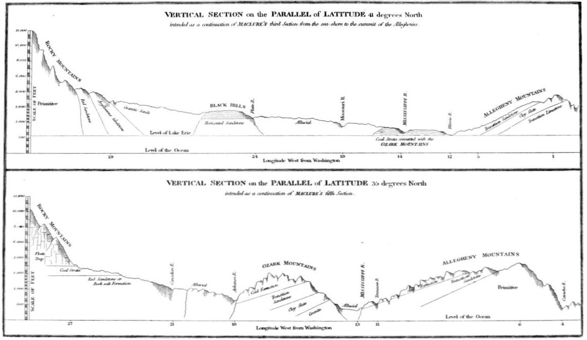
ILLUSTRATION TO VOLUME XVII
| Vertical Section on the Parallel of Latitude 41 degrees North; and on the Parallel of Latitude 35 degrees North |
185 |
Chapters ix, x, and xi, General Description of the Country, and
Observations on the Mineralogy and Geology, reprinted from
Volume III of London edition, 1823
Calculations of Observations by Long and Swift, reprinted from
Part II, Volume II, Philadelphia edition, 1823
Vocabularies of Indian Languages, by Say, reprinted from Volume
II, Philadelphia edition, 1823
[Pg 10]
[Pg 11]
EXPEDITION FROM PITTSBURGH
TO THE ROCKY MOUNTAINS
[PART IV]
{124} CHAPTER I [IX][1]
Journey from Belle Point to Cape Girardeau—Cherokee
Indians—Osage War—Regulator's Settlements of
White River.
The opportunity afforded by a few days residence at
Fort Smith, was seized for the purpose of ascertaining,
by several successive observations, the latitude and
longitude of the place. The results of several observations
of the sun's meridian altitude, and of lunar distances,
had between the 14th and 19th September, give for the
latitude of Belle Point, 34° 50´ 54˝, and for the longitude
94° 21´ west of Greenwich.[2]
On the 19th, Captain Bell left the fort to proceed on
his way to Cape Girardeau,[3] accompanied by Dougherty
[Pg 12]and Oakly, two of the engagees whose services were no
longer required. On the 20th, Doctor James and Lieutenant
Swift departed in company with Captain Kearny,[4]
who had visited the post in the discharge of his duties as
inspector and pay-master. It was the design of this party
to descend the Arkansa to the Cherokee agency, and to
proceed thence to the hot springs of the Washita.
On the 21st, the party, now consisting of Major Long,
Messrs. Say, Seymour and Peale, accompanied by Wilson,
Adams, Duncan, and Sweney, the other soldiers being
left at the fort, commenced their journey towards Cape
Girardeau. We took with us five horses and five mules,
two of the latter being loaded with packs. Captain
Ballard kindly volunteered his services as guide, and,
attended by a servant, accompanied us the first day's
journey on our march.
{125} Our route lay on the south side of the Arkansa, at
considerable distance from the river, and led us across
two small creeks—one called the Mussanne or Massern,
and the other the Vache Grasse.[5] The latter stream
has a course of several miles, but during the dry season,
[Pg 13]discharges very little water. The small path we followed
lay for the most part through open woods of post oak,
black jack, and hickory, occasionally traversing a narrow
prairie. In these open plains, now covered with rank
grass and weeds, we discovered here and there some traces,
such as a skull or a hoof of a bison, indicating that the
undisputed possession of man to these regions had been
of a very recent date.
It was near five o'clock when we arrived at the solitary
cabin of a settler, and though we found no inhabitant about
the place, we halted, and encamped near the spring. Our
horses were scarce unsaddled, when a man, who seemed
to be the occupant of the house, came up, and informed
us, that half a mile further on our way, we should find a
house and good accommodations. Accordingly, we again
mounted our horses, and rode on to "Squire Billingsby's,"
as our destined host was entitled, where we met a very
hospitable reception.[6] As the night approached, we
observed that several young women and men, the sons
and daughters of the family, disappeared, going to the
cottages of the neighbours (the nearest of which seemed
to be the one we had passed) to spend the night, that they
might leave their beds for our use. Our hospitable
landlord had many swarms of bees, some of which had
been taken from the neighbouring forests. Wishing to
make the addition of some honey to the bountiful table
spread for our entertainment, he went with a light, and
[Pg 14]carefully removing the top of one of the hives, took out
as much of the comb as he wished, and then replaced the
top without killing or injuring the bees. In this manner,
he assured us, honey may {126} at any time be taken
without destroying the insects, who will, if the season
admits, speedily make up the deficiency thus produced.
Some feather beds having been given up by their ordinary
occupants expressly for our use, we could not well avoid
accepting the accommodation thus offered, but instead of
proving an indulgence, we found the use of them partook
more of the nature of a punishment. We spent an unquiet
and almost sleepless night, and arose on the following
morning unrefreshed, and with a painful feeling of
soreness in our bones, so great a change had the hunter's
life produced upon our habits. Those of the party who
spread their blankets, and passed the night on the floor
of the cabin, rested much more pleasantly.
On the succeeding morning, Captain Ballard returned
to Belle Point, and we resumed our journey, accompanied
by one of the sons of our landlord, who undertook to
guide us on our way, until we should fall in with a path
which we might continue to follow. We passed through
a hilly country, crossing two creeks, heretofore called the
Middle and Lower Vache Grasse. At the distance of
four or five miles from the Arkansa, on each side, the country
is broken and mountainous, several of the summits
rising to an elevation of near two thousand feet above the
surface of the water. Several trees which stood near our
path had been in part stripped of their bark, and the
naked trunks were marked with rude figures, representing
horses, men, deer, dogs, &c. These imperfect paintings,[Pg 15]
done with charcoal, and sometimes touched with a little
vermilion, appeared to be historic records, designed to
perpetuate, or at least to communicate the account of
some exploit in hunting, a journey, or some similar event.
We have already remarked, that this method of communication
is sufficiently understood by the Indians, to
be made the vehicle of important intelligence.
A little before sunset we arrived at a settlement on the
stream, called Short Mountain Bayou. The little {127}
cabin we found occupied by two soldiers belonging to
the garrison, who were on their return from the settlement
at Cadron, whither they had been sent with letters
on our arrival at Fort Smith, Cadron being the nearest
post-town. We had expected letters from our friends by
the return of the express, but were disappointed.[7]
The soldiers informed us, that the house in which they
had quartered themselves for the night, had been for a
week or two deserted, since its proprietor had died, and
his wife, who was sick, had been removed to the nearest
settlement. The place is called the Short Mountain
Settlement,[8] from a high ridge of sandstone, a little to
[Pg 16]the north-west, rising in the form of a parallelogram to
an elevation of about twelve hundred feet.[9] Its sides
are abrupt, and in many places, particularly towards the
summit, perpendicular. The summit is broad and
nearly tabular, being covered with small trees, among
which the red cedar, or some other ever-green tree, predominates.
The plantation is somewhat elevated on a
rocky eminence, at a little distance from the creek, but
it is surrounded on all sides, save one, by the heavily
wooded low grounds, in which we are to look for the
causes whose operation have made it so soon desolate.
Short Mountain Bayou, if we may judge from the depth
and width of its channel, and the extent of its low grounds,
is a large stream, or rather one which drains an extensive
surface, but at this time it exhibited a succession of green
and stagnant pools, connected by a little brook, almost
without any perceptible current. On the surface of these
pools, we saw the floating leaves of the nymphæa kalmiana,
some utricularias, and other aquatic plants.
{128} September, 23d. After leaving the wide and fertile
bottoms of the Short Mountain Bayou, our path lay across
high and rocky hills, altogether covered with woods.
The upland forests are almost exclusively of oak, with
some little intermixture of hickory, dogwood and black
gum. They are open, and the ground is in part covered
with coarse grasses.
At noon we arrived at the Cherokee settlements on
Rocky Bayou, and were received with some hospitality
at the house of the metif chief, known by the name of[Pg 17]
Tom Graves. Though entirely an Indian in his character
and habits, he has the colour and features of an
European, and it was not without some difficulty we could
be made to believe that he was in reality allied by birth
to the people among whom he holds the rank of a chief.
His house, as well as many we passed before we arrived
at it, is constructed like those of the white settlers, and
like them surrounded with enclosed fields of corn, cotton,
sweet potatoes, &c., with cribs, sheds, droves of swine,
flocks of geese, and all the usual accompaniments of a
thriving settlement.
Graves, our landlord, though unable to speak or understand
our language, held some communications with us
by means of signs, occasionally assisted by a black girl,
one of his slaves, who interpreted the Cherokee language.
He told us, among other things, that the Osages do not
know how to fight; that the Cherokees were now ready
to give up the Osage prisoners, if the Osages would deliver
into their hands the individuals who had formerly killed
some of the Cherokees, &c. He has shown his admiration
of military prowess, by calling one of his children Andrew
Jackson Graves. He treated us with a good degree of
attention, and showed himself well acquainted with the
manner of making amends by extravagant charges. Our
dinner was brought in by black slaves, and consisted of a
large boiled buffaloe fish, a cup of coffee, corn bread,
{129} milk, &c. Our host and his wife, of unmixed aboriginal
race, were at table with us, and several slaves of
African descent were in waiting. The Cherokees are
said to treat their slaves with much lenity. The part of
the nation now residing on the Arkansa, have recently
removed from a part of the state of Tennessee. They[Pg 18]
are almost exclusively agriculturists, raising large crops
of corn and cotton, enough for clothing their families,
which they manufacture in their own houses.
After dinner we proceeded a few miles, taking with us
one of Graves's sons as a guide, who led us to a place
affording good pasture for our horses. Here we encamped.
September 24th. From the settlement of the Cherokees,
at Rocky Bayou, our route lay towards the south-east,
across the succession of rocky hills, sparingly wooded
with oak, intermixed with the cornus porida, attaining an
unusual magnitude.
As we descended towards the Arkansa, we perceived
before us the cabins and plantations of another settlement
of Cherokees. Passing near a wretched and neglected
tenement, we observed a white man, who appeared to be
the occupant, and called upon him to direct us to the
place where, as we had been told, the river could be
forded. It was not until we had repeated our request
several times, that he seemed disposed to give any attention.
He then approached at a snail's pace, and setting
himself down upon the ground, drawled out his direction,
terminating each word with a long and hearty yawn. The
depression and misery which seemed written on his features,
and the sallowness of his complexion, convinced us
that disease, as well as native indolence, had some share
in occasioning the apparent insolence he had shewn, and
cured us of any wish we might have felt to reproach him.
Following a winding pathway, which led through deep-tangled
thickets and heavy cane-brakes, we {130} arrived
at the ford, and crossing without difficulty, halted at the
settlement of Walter Webber,[10] a young chief of the Cherokees.
[Pg 19]
Here we found the gentlemen of our party who
had left the garrison before us.
The chiefs of the Cherokee nation had called a grand
council, to meet at Point Pleasant the day after our arrival
there, to adopt measures to forward the negotiations
for peace with the Osages, with whom they had been at
variance for many years. The origin of the quarrel,
existing between these powerful and warlike nations, is by
some referred to the period of the American revolution,
when the Osages killed a number of refugees, who had
fled to them for protection. Among these were some
Cherokees, some Indians of mixed breed, and it is said
some Englishmen, to whom the success of the American
arms rendered unsafe a longer residence in the country
then occupied by the Cherokee nation. Whether the
outrage thus alleged against the Osages was in fact committed,
it is not at this time easy to determine. It appears,
however, agreeably to the information we have been able
to collect, that of late years the Cherokees have almost
uniformly been the aggressors, while the abuses of the
Osages, so loudly complained of, both by the Cherokees
and the Whites, have been acts of retaliation. A large
number of Cherokees now live on the south side of the
Arkansa, upon lands claimed by the Osages; and all the
Cherokees of the Arkansa are in the habit of hunting and
committing depredations upon the Osage hunting grounds.
In 1817, the Cherokees, with a number of Delawares,
Shawnees,[11] Quapaws, and eleven American volunteers,
the whole amounting to about six hundred men, made
an irruption into the territory of the Osages, having previously
[Pg 20]taken measures to quiet the suspicions of their
enemies, by occasional messages, professing a peaceable
disposition on their part. When they had arrived near
the village, they {131} sent a deputation to the Osages,
concealing at the same time their numbers and their
hostile intention, and inviting Clermont, the chief, to a
council which they proposed to hold at a little distance
from the town. Clermont being absent on a hunt with
the young men of his village, an old Indian, and one in
high standing with his people, was appointed to act in
his stead, and commissioned to conclude a peace with the
Cherokees, according to the wish they had expressed by
their messengers. But what was his surprise, when, on
arriving at the spot designated as that at which the council
was to be held, instead of a few chiefs and old men, as had
been represented, he found himself surrounded by the
whole armed force of the Cherokees. He was seized and
put to death on the spot. The design of this act of perfidy
had been to effect the destruction of Clermont, the bravest
and most powerful of the Osages. The Cherokees then
proceeded to the attack of the town, where, on account of
the absence of the efficient men, they encountered little
resistance. A scene of outrage and bloodshed ensued, in
which the eleven Americans are said to have acted a conspicuous
and a shameful part. They fired the village,
destroyed the corn and other provisions, of which the
Osages had raised a plentiful crop, killed and took prisoners
between fifty and sixty persons, all old men, women,
and children. Four of these prisoners, who had been
since held in captivity by the Cherokees east of the
Mississippi, had been brought to Point Pleasant, by a
metif called Captain Rogers, and a consultation was now[Pg 21]
to be held, concerning the manner of restoring them to the
Osages.
In the winter of 1817-18, some of the leading men of
both nations had been summoned to a council at St.
Louis, by Governor Clark, for the purpose of negotiating
a peace. By the treaty then made, the Cherokees had
agreed to relinquish the prisoners in question, in consideration
of which they were to be {132} allowed the
privilege of hunting in the country north of the Arkansa,
as high as the Grand river or Six Bulls, and on the south
side as high as they pleased.[12] The stipulated surrender
of the prisoners not having been made, a party of Osages,
who were hunting on Red river, some time in the ensuing
winter, fell in with three Cherokee hunters, and whom
they murdered by way of retaliation. This circumstance
tended to widen the breach between them, till at length
both parties were resolved on war, which was for the present
prevented by the interference of Governor Miller,
and by the check imposed by the presence of an armed
force at Belle Point, on the frontiers of the two nations.
At the time of our visit, it was hoped the influence of
Governor Miller would effect the establishment of a
permanent peace. The first of the ensuing month
(October) had been appointed for the surrender of the
prisoners, and Governor Miller was said to be then on
his way to Belle Point, to ensure the fulfilment of the
conditions stipulated between the contending parties.
The Osages were to give up the men concerned in the
[Pg 22]murder on Red river, in exchange for the women and
children then prisoners with the Cherokees.
The Cherokees were taught the culture of cotton many
years since, by Governor Blount[13] of North Carolina,
who offered them a stipulated price per pound, for all they
would deliver at the trading-house. They were for
several years paid regularly for their cotton; but the
factor at length refusing any longer to receive it, they
complained to Governor Blount, who advised them to
manufacture it into clothing for their own use, which
they consented to do, on condition of being furnished
with a person to give the requisite instruction. They now
raise considerable quantities of cotton, and many of them
are comfortably clad in garments of their own manufacture.
The introduction of a considerable degree of civilization
among the Cherokees, has been attended {133} with the
usual consequence of inequality in the distribution of
property, and a larger share of the evils resulting from
that inequality, than are known among untutored savages.
Encroachments upon the newly-established rights of
exclusive possession have been frequent, and have rendered
the numerous class of the poor among the Cherokees
troublesome neighbours, both to the wealthy of their own
nation, and to those of the white settlers in their vicinity
who had any thing to lose. But wealth seldom finds itself
destitute of the means of protection. Three bands
of regulators, or troops of light horse, as they are sometimes
called, are maintained among the Cherokees, consisting
each of ten men well armed and mounted, and[Pg 23]
invested with an almost unlimited authority.[14] A few
days previous to our arrival at Point Pleasant, a young
man had been apprehended by one of these bands of
regulators, on suspicion of horse-theft. On examination,
the supposed delinquent proved stubborn and refractory,
whereupon the captain ordered the infliction of fifty
lashes; and this not seeming to produce the desired effect,
an additional fifty was commenced, when the culprit
confessed himself guilty, and disclosed the whole transaction,
in which he had been concerned. We were
called upon for advice in the case of the Osage prisoners,
a young woman and three children labouring under an
attack of intermitting fever. The young woman we
found sitting upon the floor in a little cabin, near the
trading-house, and crying bitterly, not more, as we were
informed, on account of ill-health, than of her reluctance
to return to the Osages. She had been long among the
Cherokees, whose customs she had adopted, and among
whom she had formed attachments.
Tikatok's village, which we passed on the 25th, is
situated on the Illinois Bayou,[15] about seven miles above
[Pg 24]Point Pleasant. It consists of no more than {134} five or
six cabins, but is the residence of the venerable Tikatok,
who, since the death of Tallantusky in 1817, has been
considered the principal chief of this portion of the Cherokee
nation. He has been a distinguished benefactor to
his people, and is familiarly known by the name of "The
Beloved." The Cherokees who live at and about this
village, and those settled at a distance from the Arkansa,
generally are less subject to fevers than those who reside
on the river bottoms. At a little distance above the village
we left the Illinois, and proceeded across the wilderness
towards Little Red river, on our route to Cape Girardeau.
Two or three scattered plantations, occupied by Cherokees,
occur in the country between Point Pleasant and Little
Red river, where we arrived on the 28th. This river has
a deep rocky channel, sixty or one hundred yards in
width, at the point where we crossed it, which is distant
about eighty miles from its confluence with White river.
It had at this time scarcely a perceptible current, and in
many places might be crossed on foot without wading.
It is, however, like most of the rivers of this region, subject
to great and sudden floods, which, in several instances,
have drowned the cattle, and destroyed and swept away
the crops of those who were settled along the banks.
From the marks left by the last flood upon the banks, we
perceived that the range, from high to low water, could
not be less than sixty feet. From Stanley's settlement
on Little Red river, it is about thirty-six miles north-east
to Harding's ferry on White river. Here are numerous
settlements of Whites; but notwithstanding the country
is hilly and profusely irrigated with numerous rapid
streams, the inhabitants have almost without exception[Pg 25]
a sickly appearance. Harding's ferry is about four hundred
miles distant from the confluence of White river and
the Mississippi.[16] White river is navigable for keel-boats
at high water to this place, and during a considerable
portion of the year, they {135} may ascend one hundred
miles farther. It is here about three hundred yards
wide. Its water is remarkably clear, and flows with a
moderate current over a gravelly or stony-bed.
Near Harding's ferry, on the south side of White river,
is the Chattahoochee mountain,[17] of about two thousand
feet elevation, somewhat surpassing any other point in
its vicinity. The top of this mountain marks the north-eastern
angle of the Cherokee boundary, as established
by General Jackson's treaty. The eastern boundary of
the tract, ceded by that treaty to the Cherokees, runs in
a straight line from the top of the Chattahoochee to the
mouth of Point Remove or Eddy Point creek, which
enters the Arkansa about thirty miles above Cadron.
This line coincides nearly with the eastern limit of the
[Pg 26]mountainous region. Many small portions of valuable
land are included in the territory lately ceded to the
Cherokees, but by far the greater part is mountainous
and barren, and unfit for cultivation. White river has
its source in the Ozark mountains, near the 94th degree
of west longitude, and about the 36th degree north latitude,
in the same district, from which descend, on the south-west
the Illinois river of Arkansa, and on the north the
Yungar Fork of the Osage. The average direction of its
course is nearly due east parallel to the Arkansa, crossing
about four degrees of longitude to its confluence with
Black river, in latitude 350° 15´, then turning abruptly
south, it flows through 1º 15´ of latitude to its bifurcation,
and the confluence of its eastern branch with the Mississippi
in 34 degrees north.[18] Below the point where it
receives the Black river from the north, and even at the
Chattahoochee mountains, near one hundred miles above
that point, White river is little inferior, either in the width
of its channel, or in its volume of water, to the Arkansa
under the same meridian. When we have had occasion
to mention among the people of White river, that we {136}
had crossed the Arkansa at the Rocky Mountains, more
than one thousand miles to the west, the question has been
repeatedly put to us, "Where did you cross White river?"
Those who have known only the lower portions of both
[Pg 27]rivers, consider them as nearly of equal length, and as
heading near each other; whereas the entire extent of
country drained by White river, compared to that of the
Arkansa, is as one to six nearly. Three miles above its
confluence with the Mississippi, White river divides into
two branches, the lesser of which, turning off at right angles,
flows south-west, with a current sometimes equal to three
miles per hour, and falls into the Arkansa at the distance
of four miles and a half. It is said the current flows
through this communication alternately to and from the
Arkansa, according as the water in that river is higher or
lower than in White river. Major Long entered the
Arkansa through this cut-off on the 13th of October 1817,
and it has been passed more recently by Mr. Nuttall,[19]
in 1819. In both these instances the current flowed from
White river towards the Arkansa. The mouth of that
branch of White river which communicates immediately
with the Mississippi is situated fifteen miles above the
mouth of the Arkansa,[20] and is about two hundred yards
wide. The current is very gentle, and the water deep.
Though perfectly transparent, it is of a yellowish colour.
The banks are low, and subject to periodical inundations.
The soil near the mouth of White river is an intermixture
of clay and fine sand, the clay predominating, and the
whole of a reddish tinge.
[Pg 28]
Numerous settlements have heretofore been formed
on the lands contiguous to White river, and several in
the portion above the Chattahoochee mountain on the
south side; but all these lands having by treaty been
surrendered to the Cherokees, many whites {137} have
been compelled to withdraw, and leave their farms to
the Indians. The tract of land ceded to the Indians by
the treaty above alluded to, is for the most part rocky and
barren. Some of the tributaries of White river have
extensive and fertile bottoms, but the greater part of the
country watered by this river, is mountainous and unfit
for cultivation. At MacNeil's ferry, where the road from
Little Rock on the Arkansa to Davidsonville, in Lawrence
county, crosses White river, the bottoms are wide, and as
fertile as any of those on the Arkansa.[21] Here the miegia
and the papaw attain their greatest perfection, and the
soil is found well adapted to the culture of corn, cotton,
and tobacco. At the point formed by the confluence of
White and Black rivers, is a portion of land of a triangular
form, and bounded by sides about fifteen miles in extent,
which, in the excellence of its soil, as we were informed
by the surveyors, is surpassed by none in the western
country. There are considerable portions of the upland
soil of White river, where the profuse supply of streams
and springs of excellent water, the elevation and comparative
[Pg 29]healthfulness of many situations, and the vicinity
of navigable rivers and other local advantages, make
amends for the want of exuberant fertility in the soil.
The same remark is applicable to the country south of
the Arkansa, where are extensive tracts of hilly and rocky
soils, which seem admirably adapted to the culture of the
vine and the olive. In every part of the Ozark mountains,
there are vallies, and small portions of land within
the hills, having a deep and fertile soil, covered with
heavy forests of oak, ash, hickory, and in some places
with the sugar maple, and abounding in excellent water.
The labour of a few years will be sufficient to convert
these tracts into productive farms, but the inconvenience
resulting from the difficulty of communication and access
to the different {138} parts of the country, will for a long
time retard their settlement.
In several parts of the Arkansa territory we were shewn
dollars, which were believed to have been coined in some
of the upper settlements of White river; and it has been
currently reported, that mines of silver exist, and are
wrought there. It appears, however, upon examination,
that much spurious coin is here in circulation; and it is
probable that the White river country owes its present
reputation for mineral wealth to the successful labours of
some manufacturer of imitation dollars. Since the time
of De Soto, it has been confidently asserted by many who
have written concerning Louisiana, that mines of gold
and silver exist in that part of the country of which we are
speaking. In an old map, by Du Pratz, a gold mine is
placed somewhere near the confluence of the Illinois and
the Arkansa; a silver mine on the Merameg, and he says,[Pg 30]
"I myself saw a rivulet whose waters rolled down gold
dust."[22] We are informed by Schoolcraft, that granite
exists about the sources of the St. Francis, which are near
those of White river.[23] Of the extent and character of
this formation of granite, we have not yet been able to
form any very definite ideas; it is, however, by no means
improbable, that to its plates of yellow and white mica,
we are to look for the origin of the fabulous accounts of
the precious metals in those regions. Like the country
of the gilded king, the El Dorado of South America, it
is probable the gold and silver mines of the Arkansa
territory will recede, before the progress of examination,
first into the wildest and most inaccessible parts, and at
length disappear entirely. We by no means intend to
assert, that the region in question will not prove of immense
importance, on account of its mineral treasures;
valuable mines of lead and iron are certainly frequent in
many parts of it. And we can assign no reason why silver
{139} and other metals should not be found in the argillite
with quartzy veins, and in the other rocks of the transition
[Pg 31]period, which we know to exist in these mountains. We
only intend to give it as our opinion, that there has as yet
been no foundation in actual discovery for the belief that
such mines do exist.
The bed of White river, at the place where we crossed
it, is paved with pebbles and fragments of a yellowish
white petrosiliceous stone, intermixed with rounded
masses of transparent quartz, and sometimes with pieces
of calcedony. Its water is uncommonly transparent, and
this, with the whiteness of its bed, and the brisk motion
of the current, gives it an aspect of unusual beauty. The
banks are high, and in many places not exposed to inundation.
Dense and heavy forests of sycamore and
cotton-wood stretch along the river, disclosing here and
there, at distant intervals, the solitary hut and the circumscribed
clearing of the recent settler. Some who have
been no more than two or three years resident upon their
present farms, and who commenced in the unbroken
forests, have now abundant crops of corn and pumpkins,
with large fields of cotton, which is said to equal in quality
that of the uplands of Georgia and Carolina. Few
attempts have hitherto been made to cultivate any grain,
except Indian corn, though the soil is thought to be in
many places well adapted to wheat, barley, oats, &c.
The maize cultivated in the Arkansa territory, and in
the southern and western states, generally is the variety
called the ground seed, having a long and compressed
kernel, shrivelled at the end when fully ripe; and crops
are not uncommon yielding from sixty to ninety bushels
per acre. In all the uplands, the prevailing growth is
oak. At the time of our journey, the acorns were falling
in such quantities, that the ground for an extent of many[Pg 32]
acres was often seen almost covered with them. Many
recent settlers, indulging the disposition to indolence which
seizes upon almost every man who {140} fixes his residence
in these remote forests, place as much dependence upon
the crop of mast as on the products of their own industry.
Vast numbers of swine are suffered to range at large in
the forests, and in the fall of the year, when they have
become fat by feeding on the acorns, they are hunted and
killed like wild animals, affording to the inhabitants a
very important article of subsistence. It is remarked also,
that the venison becomes fat somewhat in proportion as
acorns are abundant. Turkeys, which are still vastly
numerous in the settlements of White river, feed upon
them, but are said to grow poor in consequence.
Sweet potatoes[24] are produced in great perfection in
many parts of the Arkansa territory, and are but too
much cultivated and eaten, their constant use as an article
of food being little beneficial to health. The common
or Irish potatoe, as it is here universally called, succeeds
but indifferently, and few attempts are made to
cultivate it.
A few of the roads which traverse the country from the
Mississippi to the upper settlements of Red river and the
Arkansa, have been sufficiently opened to admit the
passage of waggons. On these are seen many families
migrating from Missouri to Red river, and from Red
river to Missouri. The first settlements in the wilderness
are most commonly made by persons to whom hardihood
and adventure have become confirmed and almost indispensable
habits, and who choose to depend upon the
chase, and the spontaneous products of the unreclaimed[Pg 33]
forest, rather than submit to the confinement and monotony
of an agricultural life. They are therefore, of
necessity, kept somewhat in advance of those settlers
who intend a permanent residence in the situations they
first occupy. Removing from place to place with their
cattle, horses, and swine, they confine themselves {141}
to one spot no longer than the range continues to afford
a sufficient supply of the articles most necessary to life.
When the canes are fed down and destroyed, and the
acorns become scarce, the small corn-field and the rude
cabin are abandoned, and the squatter goes in search of a
place where all the original wealth of the forest is yet
undiminished. Here he again builds his hut, removes
the trees from a few acres of land, which supplies its
annual crop of corn, while the neighbouring woods, for
an extent of several miles, are used both as pasture and
hunting grounds. Though there is in this way of life an
evident tendency to bring men back to a state of barbarism,
we have often met among the rudest of the squatters
with much hospitality and kindness. Near White
river, we called at a house to purchase food for ourselves
and our horses, but having no silver money, our request
was refused, although we offered the notes of the bank
of Missouri, then in good credit. In a few miles we arrived
at another cabin, where we found every member
of the numerous family sick with the ague and fever,
except one young girl. But here they were willing to
furnish every refreshment their house afforded. There
were at this time very few houses, particularly in the
settlements about White river, which did not exhibit
scenes of suffering similar to those in the one of which
we were now the reluctant guests. We have seen some[Pg 34]
instances, where, of a family of eight or ten, not a single
individual was capable of attending to the services of the
household, or of administering to the wants of his suffering
relatives. In these instances we thought it better to
pitch our tents at a little distance, and intrude ourselves
no farther than was necessary to procure corn and other
indispensable supplies.
On the evening of September 30th, we halted at a little
rivulet called Bayou Curæ.[25] The dwelling of our landlord
consisted, as is commonly the case in the new settlements,
of a single room, with beds in {142} two or three
of the corners. We were cordially invited to make use
of the beds, though it would have been at the expence of
rendering it necessary for our host, his wife, and daughters,
to sleep upon the floor of the same room. We accordingly
spread our blankets, and deposited ourselves around the
hearth, while the family occupied their usual stations.
On the first of October we arrived at the ford of Strawberry
river, a tributary entering the Big Black, not far
from the confluence of the latter with White river, and
about fourteen miles beyond, at the ford of Spring river,
a parallel stream. Both of these are rapid and beautiful
rivers, possessing all the peculiarities, as to the abundance,
transparency, and purity of their waters, usually observed
in those rivers which traverse elevated and mountainous
districts. The entire length of Spring river is said to be
but about one hundred and forty miles; yet in the quantity
of water which it discharges, it more than twice exceeds
the Canadian, having a course of more than nine hundred
miles. It is said to have its principal source in a spring
[Pg 35]of uncommon magnitude. Spring river unites with
another, called Eleven Point, near the little town of
Davidsonville, the seat of justice for Lawrence county,
and flows thence nearly due east, two or three miles to its
junction with Big Black. The country around Davidsonville
is hilly, having a deep and fertile primary soil,
and abounding in heavy forests. The sources of Eleven
Point, we have been told, are in eleven large springs,
and are near those of Spring river.[26]
To those who have been long accustomed to the thirsty
regions of the Missouri, the Platte, and the Upper Arkansa,
it is somewhat surprising to meet in tracts, having nearly
the same elevation, and resting to a great extent on rocks
of a similar character, so great a number of large streams
crowded into such narrow compass.
{143} Is it not probable, that a large portion of the water
falling in rains upon the extensive plains at the eastern
side of the Rocky Mountains, may sink through the loose
and porous soil, till at length, meeting with some compact
stratum, it may be collected into rills, and even considerable
streams, which, descending along the surface of this[Pg 36]
stratum in the direction of the general inclination of the
country, at length meet with the nucleus of the Ozark
mountains, traversing the secondary strata like a mineral
dike, and are consequently made to appear in the form
of large springs? Whether any course of this kind
operates to supply the unusual profusion of water with
which this hilly tract is irrigated, must be for others to
decide. The fact is an established one.
Black river originates in an elevated part of the Ozark
mountains, between 37° and 38° north latitude, and
between 90° and 91° west longitude. From the same
tract descend, on the north, the waters of the Merameg;
on the north-east, those of Big river;[27] on the east and
south, those of the St. Francis and Black river; and on
the west, those of the Osage and the Gasconade. By an
examination of the map which accompanies this work,
it will be seen that the direction of the watercourses
clearly indicates the existence of an elevated ridge, running
from the confluence of the Missouri and Mississippi,
on the north-east, to the junction of the Arkansa and the
Canadian on the south-west. On the north-western side
of this ridge, we observed the Osage, the Grand river,
the Verdigrise, and even the Arkansa, inflected from that
due eastern course, which the tributaries of the Mississippi
and Missouri on the west incline to pursue; and coming
near its base, we find the Illinois river of the Arkansa, and
the Yungar Fork of Osage, running in opposite directions,
and nearly at right angles to the general course of the
Canadian, the Arkansa, the Main Osage, and Konzas.
[Pg 37]
The Illinois, and the great eastern tributary of the Osage,
{144} receive numerous streams from the western slope of
the Ozark mountains, but they traverse a region hitherto
very imperfectly known. It appears, however, that these
two rivers drain all the north-western side of the mountainous
range in question. Black river runs nearly
parallel, that is, from north-east to south-west, along the
south-eastern side of the range. Its sources are in the
district of the lead mines, and at no great distance from
those of the Merameg and the St. Francis. Its course is
at first south-east, about sixty or one hundred miles;
then turning to the south-west, it receives in succession
from the south-eastern side of the mountains, the Little
Black, the Currents, Fourche De Thomas, Eleven Point
Spring, and Strawberry rivers, uniting at length with
White river, in latitude 35° 15´. As far as hitherto
known it receives no considerable tributary from the
east.[28] About the sources of Black river reside the
Peola or Peoria Indians, who are said to number about
fifty warriors. Parallel to this river, and from twenty to
sixty miles distant on the east, is the St. Francis, a larger
[Pg 38]river, but one in many respects resembling Black river.
It rises in the high lands, about one hundred miles to the
westward of St. Genevieve in Missouri, and receiving,
before it leaves the hills, Bear Creek, Castor, White water,
and numerous other streams, it descends toward the
south-east, soon entering the extensive swamp which
stretches from New Madrid on the Mississippi, along the
base of the mountains, to the Arkansa.[29] We have been
informed by some of the inhabitants of the counties of
Cape Girardeau and Madison, that in this swamp the
St. Francis is so much obstructed with rafts, and so lost
among islands, that its course can with difficulty be traced.
It is well known that in the lower part of its course it is
so obstructed by a large raft, as not to admit the passage
of the smallest boats. Its confluence with the Mississippi
is about three hundred and five miles below the Ohio,
and eighty above the mouth of White {145} river. Running
parallel both to the Mississippi and White river, and at no
great distance from either, the St. Francis can have no
very large tributaries; indeed we know of none on either
side which deserve the name of rivers. We have no very
definite information respecting the great swamp in which
the St. Francis is said to lose itself soon after leaving the
hills; the accounts of the hunters, and of some settlers
who have seen it, agree in representing it as almost impassable,
[Pg 39]covered with heavy forests of cypress, and
wholly unfit to become the residence of men. This
swamp, and the country about the sources of Black river
and the St. Francis, appear to be near the centre of the
region so powerfully affected by earthquakes in the year
1811. The fertile lands, on the upper branches of the
St. Francis, are not very extensive, and are all more or
less subject to inundation by the sudden overflowing of
the streams. On this account they cannot be considered
as of great value for agriculture; but the wealth which
this region possesses in its mines, renders it one of the
most important parts of ancient Louisiana.
On the 8th October we arrived at Jackson, the seat of
justice for the county of Cape Girardeau, and, after St.
Louis and St. Charles, one of the largest towns in Missouri.[30]
It lies about eleven or twelve miles north-west
of the old town of Cape Girardeau, on the Mississippi,
and is surrounded by a hilly and fertile tract of country,
at this time rapidly increasing in wealth and population.
Jackson is what is called a thriving village, and contains
at present more than fifty houses, which, though built of
logs, seem to aspire to a degree of importance unknown
to the humble dwellings of the scattered and solitary
settlers, assuming an appearance of consequence and
superiority similar to that we immediately distinguished
in the appearance and manners of the people. Our
horses, having never been accustomed to such displays of
magnificence, signified great reluctance to enter the {146}
[Pg 40]village. Whips and heels were exercised with unusual
animation, but in a great measure without effect, until
we dismounted; when by dint of coaxing, pushing, kicking,
and whipping, we at length urged our clownish animals
up to the door of the inn.
Fifteen miles north of Jackson, on a little stream called
Apple creek, reside about four hundred Indians, mostly
Delawares and Shawnees. At the time of our visit the
head of a Shawnee, who had been concerned in the murder
of a white woman, was to be seen elevated on a pole
by the side of the road leading from Jackson to the Indian
settlement of Apple creek. It was related to us that the
crime, for which this punishment had been inflicted, was
committed at the instigation of a white man. The
murderer was demanded of the Shawnees by the people
of Jackson, and being at length discovered by the Indians,
and refusing to surrender himself, he was shot by his own
people, and his head delivered up, agreeable to the demand.
It is painful to witness the degradation and misery of
this people, once powerful and independent; still more so
to see them submitting to the unnecessary cruelties of
their oppressors. We have not been informed by what
authority the punishment above mentioned was inflicted
upon a whole community for the crime of one of its members,
and we are sorry to have occasion to record a circumstance
so little honourable to the people of Missouri.
A miserable remnant of the Shawnee, Delaware, and
Peola tribes, with a few Chickasaws and Cherokees,
were at this time scattered through the country, from the
Mississippi at the mouth of Apple creek westward to
the sources of Black river. They were, however, about
to remove farther west, and many of them were already[Pg 41]
on their way to the country about the upper branches of
White river, where, by becoming intruders upon the
territories of the Cherokees, it may be expected their
speedy and entire extinction will be insured.[31]
{147} The road from White river joins that from the
upper settlements on the St. Francis, at some distance
beyond Jackson. Castor and White water are two beautiful
streams, traversing the country west of Jackson. They
run towards the south, and soon after their confluence
enter the great swamp through which they find their way
to the St. Francis.
The district of the lead mines, situated near the sources
of the Merameg, the Gasconade, and the St. Francis,
has been repeatedly described. The best accounts of it
are in the works of Bradbury, Brackenridge, Stoddart,
and Schoolcraft.[32] To those accounts we have to add
a few observations respecting the rocks and soils of the
region, a considerable part of which we have seen and
examined as attentively as circumstances would admit.
But as discussions of this kind have little interest for the
general reader, we propose to give at the end of the work
such remarks as we have had the opportunity to make
connected with the mineralogy of this interesting territory.
{148} CHAPTER II {X}[33]
Hot Springs of the Washita—Granite of the Cove—Saline
River
We return to give a hasty account of an excursion from
Point Pleasant, in the country of the Cherokees, to the
hot springs of the Washita.
On the morning of the 25th, our little party, consisting
of Captain Kearney, Lieutenant Swift, and myself, having
taken leave of our companions, recrossed the Arkansa
from Webber's, and proceeded on our journey without a
guide.
Having mistaken the route we had been directed to
follow, we were bewildered during a considerable part
of the day, wandering about through a fertile country
without settlements, and so covered with dense forests
as to render the travelling exceedingly harassing. Towards
evening we arrived at a settlement of Cherokees,
where we engaged a guide to conduct us to the trace
leading to the springs. For this service we paid him two
dollars. At night we encamped in an open forest of oak,
where we found a sufficient supply of grass for our horses.
The hills south of the Arkansa range from N.E. to S.W.,
their sides are sometimes nearly naked, but more commonly
covered with small and scattered trees. Several
kinds of oak, and the chinquapin (castanea pumila, Ph.)
attaining the dimensions of a tree, are met with in the
sandstone tracts. We distinguished here, in the uplands,
two separate varieties of soil. That just mentioned,[Pg 43]
based upon a compact hard sandstone, and bearing
forests of oak, and another resting upon a white petrosiliceous
rock, with fragments of which it is much intermixed.
This latter is often covered {149} with pine
forests. The most common species, yellow pine (P.
resinosa,) attains unusual magnitude. The rigida, and
some other species occur, but are not frequent. We also
observed several species of vaucinum, the mitchella, the
kalmia latifolia, hamamelis virginica? cunila mariana,
and many other plants common to this region and the
Alleghany mountains.
There are no settlements between those of the Cherokees
about Derdonai on the Arkansa and the hot springs.
The blind path which we followed traverses a rugged and
mountainous region, having considerable resemblance,
except in the want of parallelism in the ranges, to the
sandstone portions of the Alleghanies. As the weather
was rainy we felt the inconvenience of travelling in the
wilderness and encamping without tents. On the 28th
we arrived at the hot springs. The country near these,
on the north and north-west, is high and rocky. The
sandstone, which extends from the Arkansa to within a
few miles to the springs, becomes, as you go south, something
inclined, and apparently of a more ancient deposition,
until it is succeeded by a highly inclined primitive argillite.
Both these rocks are traversed by large veins of white
quartz. They are inclined towards the south, and the
argillite at a great angle. In some localities it is but
indistinctly slaty in its structure, and its laminæ are
nearly perpendicular.
It contains extensive beds of a yellowish white siliceous
stone, which is often somewhat translucent, and resembles[Pg 44]
some varieties of hornstone. Its fracture is a little splintery,
and sometimes largely conchoidal; it is of a close texture,
but the recent surface is generally destitute of lustre. It
is this rock which affords the stones called Washita oilstones.
It may, with propriety, be denominated petrosilex.
This name is, however, to be understood as having
the application given it by Kirwan,[34] who uses it to designate
the fusible varieties of the hornstone of {150} Werner,
and not the several varieties of compact felspar to which
it has been sometimes applied. In passing from the hot
springs, north-east to the lead-mine country, about the
sources of the Merimeg, this rock is found to be intimately
connected, and to pass by minute and imperceptible
gradations, into the flint rock of that district, which is
decidedly secondary, and of contemporaneous origin with
the compact limestone which it accompanies. About
the hot springs it is not distinctly stratified, but occurs
in very extensive masses, sometimes forming the body
of large hills, and is marked by perpendicular seams and
fissures, often placed very near each other.
The hot springs of the Washita are in north latitude
34° 31´, and west longitude 92° 50´ 45˝,[35] near the base
of the south-eastern slope of the Ozark mountains, and
six miles north of the Washita. They have been erroneously
represented as the principal sources of that river,
which are more than one hundred miles distant.[36]
[Pg 45]
We have been informed that these remarkable springs
were unknown, even to the American hunters, until the
year 1779. At that time, it is said, there was but one
spring discharging heated water. This is described as
a circular orifice, about six inches in diameter, pouring
out a stream of water of the same size, from the side of a
perpendicular cliff, about eight feet from its base. This
cliff was situate then, as it is now, along the eastern side
of a small creek, but was at a greater distance from the
stream than at present. At another place, near the top
of the mountain, which rises abruptly towards the east,
the heated water is said to have made its appearance
near the surface of the ground, in a state of ebullition,
and to have sunk and disappeared again upon the same
spot. It is probable these representations {151} are in a
great measure fabulous; all we are to understand by
them is, that the gradual augmentation of the thermal
rocks, which are constantly forming about the springs,
has changed the position, and perhaps increased the number
of the orifices.[37]
These springs were visited by Hunter and Dunbar in
1804, and the information communicated by them, as
well as much derived from other sources, together with an
analysis of the waters, has been placed before the public[Pg 46]
by Dr. Mitchell.[38] They have been subsequently examined
by Major Long, in January 1818, from whose notes we
derive much of the information we have to communicate
respecting them. They are about seventy in number,
occupying situations at the bottom and along one side of
a narrow ravine, separating two considerable hills of
clay-slate. A small creek enters the ravine from the north
by two branches, one from the north-west, and the other
from the north-east, flowing after their union nearly due
south, and blending with the water of the springs, increasing
rapidly in size, and acquiring so high a temperature,
that at the time of our visit the hand could not
be borne immersed in it. After traversing from north
to south the narrow valley containing the springs, this
creek meanders away to the south-east, and enters the
Washita at the distance of eight or ten miles. All the
springs are within a distance of six hundred yards below
the junction of the two brooks, and all, except one, on the
east side of the creek.
We subjoin a note, containing some particulars observed
by Major Long at the time of his visit in 1818.[39]
[Pg 47]
During the winter the steam which rises from the springs
is condensed to a white vapour, which is often visible at
a great distance.
The water of the springs is limpid and colourless, and
destitute, when cooled, of either taste or smell, {152} and,
according to the analysis of Dr. Mitchell, purer than
ordinary spring water. It however deposits, as it comes
in contact with the air, a copious sediment, which has
gradually accumulated until it has become an independent
[Pg 48]rock formation of considerable extent. This rock appears
to consist of flint, lime, and a little oxide of iron. It is
often of a porous or vascular texture, and the amygdaloidal
cavities are sometimes empty and sometimes contain
very delicate stalactites. Hæmatitic iron ore occurs disseminated
in every part. Also extensive caverns, sometimes
filled with a bright red metallic oxide. Dr. Wilson,
who has been some time resident at the springs, informed
us, that the continued use of the water occasions salivation,
from which it has been commonly inferred that mercury
exists in the water in solution.[40]
The time of our visit to the springs being one of very
unusual drought, the quantity of water was somewhat
less and the temperature higher than ordinary. The
time required to boil eggs, as much as they usually are
for the table, was fifteen minutes. In the same time a
cup of coffee was made by immersing our kettle in one of
the springs.[41]
A number of baths have been made, by hollowing out
excavations in the rock, to which the hot water is constantly
flowing. By cutting off or increasing the supply
the temperature can be regulated at pleasure; over some
of these are built small log cabins, and in the neighbourhood
are twenty or thirty huts, occupied at some seasons
of the year by persons who resort hither for the benefit
of the waters.
[Pg 49]
Three miles north-east from the hot springs is a large
fountain of water, of the ordinary temperature, forming
the source of the small stream already mentioned as
flowing down from that direction. It rises from the
summit of a little knoll, six or eight feet in diameter, and
divides into two streams, one of which flows towards the
east, the other towards the west. Both, however, unite
at the base of the knoll, and {153} the brook flows thence
south-west, between two petrosiliceous hills, to its confluence
with another from the north-west, to form the hot
spring creek. The quantity of water discharged by this
spring can scarcely be less than from eighty to one hundred
gallons per minute. Immediately on the south rises
a large hill, and the elevation of the spring itself, above
the level of the highest of the thermal springs, is thought
to be not less than one hundred and fifty feet. The water
is transparent, but has a perceptible metallic taste, and
deposits upon the stones over which it flows a copious
rust-like sediment. The spring is known in the neighbouring
settlements as the "poison spring," a name which we
were told it had received from the following circumstance,
said to have taken place many years since. A hunter who
had been pursuing a bear, and was much exhausted with
heat and fatigue, arrived at this spring in the middle of
the day, and finding the water cool, and not unpleasant to
the taste, drank freely of it, but immediately afterwards
sickened and died. His death was occasioned, probably,
not by any deleterious quality in the water, but by the
disease commonly induced by drinking too largely of
cold water when the body is heated. The neighbouring
inhabitants, however, imputed the hunter's death to some
supposed poisonous property in the spring. Not long[Pg 50]
afterwards a discontented invalid, residing at the hot
springs, came to a resolution of putting a period to his
own life. This he concluded to bring about by drinking
the water of the poison spring. He accordingly repaired
to it, and after drinking as much as he could, filled his
bottle, and returned home. Instead of dying, as he had
expected, he found himself greatly benefited by his potation.
Notwithstanding this discovery of the sanative
quality of the water the spring still retained its former
name. It is however used without apprehension, and
is much resorted to by people who visit the warm
springs.
{154} About two miles to the north-east of this spring,
a little to the left of the road leading to the settlement
of Derdonai, is the principal quarry from which the
Washita oilstones are procured. It is near the summit
of a high and steep hill of the petrosiliceous rock already
mentioned. The oilstones are found in the perpendicular
seams or fissures of the rock, from which they are detached
with little difficulty, having, as they are dug from
the quarry, nearly the requisite shape and size. They
are then carried by hand, or thrown to the foot of the
precipice, whence there is an easy transportation of ten
or twelve miles to the Washita. By this river they descend
to New Orleans, and some have been carried
thence to New York, where they are known as the
Missouri oilstones. These stones are said not to be inferior
in quality to the oilstones from Turkey.
In the immediate neighbourhood of the hot springs we
observed a number of interesting plants. The American
holly (ilex opaca) is a conspicuous and beautiful tree in
the narrow vallies within the mountains. The leaves of[Pg 51]
another species of ilex (I. cassine), the celebrated cassine
naupon frequent about the springs, are there used as a
substitute for tea. The angelica tree (aralia spinosa, Ph.)
is common along the banks of the creek, rising to the
height of twelve to fifteen feet, and bending beneath its
heavy clusters of purple fruit. The pteris atropurpurea,
asplenium melanoraulon, A. ebeneum, and other filices
are found adhering to the rocks. In the open pine
woods the germandia pectinata, considered as a variety
of G. pedicularia, is one of the most conspicuous
objects.
The sources of the Washita are in a high and broken
part of the Ozark mountains, in north latitude 34° 15´,
and between 93° and 94° west longitude, and sixty or
an hundred miles south-west of the settlement of Cadron
on the Arkansa. From the same mountainous district
descend towards the north-east the Petit Jean and Le Fevre,
tributaries to the Arkansa; on {155} the north-west the
upper branches of the Poteau; on the south-west the
Kiamesha; and on the south-east the Mountain, Cossetot,
Rolling Forks, and other streams, discharging into Little
river of Red river.[42] The principal source of the Washita
is said to be very near that of the Fourche Le Fevre, and
to descend towards the west from the same hill, out of
which flow the upper branches of the Le Fevre towards
the east. These particulars are, however, of little importance,
except as serving to illustrate the character of
[Pg 52]that portion of the country. The whole of that region is
strictly mountainous, and its numerous streams are rapid
and circuitous, winding their way among abrupt and craggy
hills, so thinly covered with pine and post oak, that the
sober gray of the sandstone is often the prevailing colour
of the landscape. The hills, at the sources of the Poteau
and the Kiamesha, abound in clay-slate, and a slaty petrosilex
destitute of organic remains.[43] It is remarked by
hunters, that the most remote and elevated sources of
all the rivers of this region are joined in or near extensive
woodless plains. As far as this is the case, it would seem
to prove that the existing inequalities of the surface have
been produced almost entirely by the currents of water
wearing down and removing extensive portions of the
horizontally stratified rocks. In districts where secondary
rocks only are found, as in the country of the Ohio, there
appears little difficulty in attributing this origin to all the
hills; and even in the mountainous district under consideration,
as the most recent rocks, and those of horizontal
stratification, occupy the highest portions of the hills, we
may perhaps be allowed to suppose they formerly covered a
much greater extent of country than at present, overlaying
those strata of more ancient deposition, which
now appear upon the declivities of the mountains. It
cannot escape {156} the remark of any person who shall
visit the range of country, which we call the Ozark mountains,
that the direction of the ridges, (particularly of
those where sandstone is the prevailing rock,) conforms
to the course of the principal streams.
None of the tributaries to the Washita, above the hot[Pg 53]
springs, have hitherto been explored. The Little Missouri
and the Fourche-au-Cadeau, enter it in succession
from the west, in the course of a considerable bend which
it makes to the south, after receiving the waters of Hot
Spring creek.[44] These two streams run mostly in a
mountainous country, though some fertile lands and some
settlements occur on each. On the Little Missouri,
Hunter and Dunbar found the maclura, a tree confined
to fertile soils. The first considerable stream entering the
Washita from the north is the Saline, rising in three principal
branches, twenty or thirty miles north-west of the
hot springs. The road from Derdonai to the springs
crosses these streams near their sources, in an extremely
rugged and mountainous region. The Saline, like the
Washita itself in this part, and the other tributaries already
enumerated, is liable to great and sudden floods, and also
to great depression in seasons of drought. Originating
in a mountainous tract, and in the continuation of the
range so profusely supplied with springs in the country
about the sources of White river, we might expect
that the Washita would be fed by numerous and unfailing
fountains. It appears, however, to derive the greater
[Pg 54]part of its supplies from the water of rains, and consequently
to rise and fall according to the time of year and
the state of the weather. Where Major Long crossed
the Washita, on the 31st December 1817, six miles south-west
of the hot springs, the river was one hundred and
fifty yards wide, about four feet deep, and extremely
rapid.
In the latter part of October 1820, at the time of our
journey, the Washita at Keisler's settlement, about fifteen
miles below the springs, was something {157} less than one
hundred yards in width, flowing in a deep and unequal
channel over a bed of clay-slate. The water is here ten or
fifteen feet deep in many places, and the currents scarce
perceptible; as we looked down upon the river from the
elevated banks it appeared like a quiet lake, and the
unusual blackness of the waters suggested the idea of
its great depth. Little groups of naked rocky islands
were disclosed here and there in different parts of the
channel. On examination we found the apparent dark
colour of the water to depend upon the complexion of the
rocks which form the bottom and sides of the bed, they
being principally of a dark-coloured argillite; and not
only these, but the small fragments of quartz and other
whitish stones, had acquired, from lying in the water, a
peculiar tinge of dark brown. We expected to find an
incrustation covering the surfaces of these stones, but upon
examination the colouring matter seemed inseparably
blended with the rock itself. The water, seen by transmitted
light, was entirely transparent, and had no perceptible
saltness.
At the distance of five or six miles south-east from the
hot springs, on the road leading towards the town of[Pg 55]
Little Rock, on the Arkansa, commences a tract of land,
having a fertile soil and a beautiful situation, and extending
to the Washita. Some parts of this region afford
exceptions to the remark generally applicable to Arkansa
territory, that the best soils are found in the alluvion of
the rivers. Some extensive districts of primary soil along
the base of the mountains are of a quality rarely surpassed
in fertility, bearing heavy forests of oak, ash, and sugar
maple, which attain here to greater size than we have
seen in other parts of the United States.
We arrived about sunset on the 28th at Keisler's plantation,[45]
where we made application for permission to
spend the night. This was readily granted, though, as is
often the case in such remote and solitary habitations,
the house was not in the most complete {158} readiness
for the accommodation of travellers. A quantity of
Indian corn was immediately gathered in the adjoining
field, a part of it given to our horses, and a part prepared
for our own supper. During the green-corn season,
which is a time of jubilee and rejoicing among the agricultural
Indians, and scarcely less so with many of the
white settlers, those who live remote from corn mills use
no other bread than such as we now saw prepared, within
the space of an hour, from the standing corn. Such ears
are selected as are fit for roasting, and the corn grated
from the cob by means of the side of a tin lanthorn, or
some portion of an old coffee-pot, perforated with several
[Pg 56]holes. In this state it forms a soft paste, which, with
the addition of a little salt, is spread upon a heated stone
or an iron pan, and baked before the fire. Our supper
consisted of bread of this sort, bear's meat, and coffee—a
treat worthy the attention of an epicure.
The Cove is a valley commencing among the mountains
at no great distance to the east of the hot springs, and containing
a small rivulet which enters the Washita six or
eight miles below Keisler's.[46] This valley is bounded
towards the west by loamy hills, disclosing at intervals
cliffs and ledges of clay-slate and petrosilex. In
the lowest part of this valley, at a place called Roark's
settlement, we discovered a bed of granite forming the
basis of a broad hill, which rose by a very gradual ascent
towards the east. We were directed to the examination
which brought us acquainted with the existence of this
rock by the representation of Roark, that in his corn field,
not far from the house, was a bed of plaister of Paris.
Being conducted to the spot, we found a quantity of
loose granitic soil, that had been raised from a shallow
excavation, and was intermixed with numerous large
scales of talc. The examination had been carried a few
feet below the surface, and had terminated upon the
granite in question. Having collected {159} several beautiful
masses of an aggregate of felspar, talc and quartz,
we returned to the house where our breakfast was in
preparation. Being informed by our landlord that blue
vitriol, native copper, and other interesting minerals, had
been formerly discovered near the sources of the little
brook that ran past the house, we delayed our journey
[Pg 57]some time, that we might continue our examination. In
following the brook towards its sources, we were much
gratified in finding an extensive bed of native magnet,
which seemed to be embraced in the granite. Not far
distant the same rock contained large masses of pyrites
and of bluish green mica. In these we readily perceived
the blue vitriol and native copper mentioned by our host.
In some places we found the bed of the brook paved
almost exclusively with detached schorls. We collected
also several other interesting imbedded minerals. More
extensive examinations will hereafter show this spot to be
one among the most interesting in America to a mineralogist.
The great depth of soil resting upon this formation
of granite prevented our examining it at as many points as
we could wish; also from ascertaining to our satisfaction
its extent, and its connexion with the neighbouring rocks.
It appears, however, at several points in an area of fifteen
or twenty acres, and always in place. We saw not a
single detached mass at any distance. This may be
owing in part to the perishable structure of the granite,
and in part to its being surrounded on all sides by more
elevated rocks of slate or sandstone. On the summit of
the hill a grave had recently been dug. In the granitic
soil which lay about it we saw many fragments of pyrites,
also uncommonly large and beautiful laminæ of talc
intermixed with scales of mica. These two minerals are,
we think, rarely found in such intimate connexion, yet
retaining so perfectly their distinctive characters, as in
the instance under consideration. The talc in some instances
forms an integrant part of the granite, and {160}
we have seen it blended with mica in the same specimen.
The road, leading towards the Little Rock on the[Pg 58]
Arkansa, passes from the granite of the Cove over a
coarse hard sandstone, embracing beds of conglomeratic
or puddingstone, and in many respects closely resembling
some of the varieties of the old red sandstone of the
Alleghany mountains. Towards the east the surface of
the country rises gradually, and the sandstone, without
giving place to any other stratum, becomes more micaceous
and slaty, and at length assumes all the characters of a
sandstone accompanying coal.
In the afternoon of the 29th we arrived at Lockhart's
settlement, on the Saline Fork of the Washita. The soil
of some of the bottom lands along this stream is not
inferior to any we have seen west of the Mississippi. It
is well watered, and abounds in excellent timber. Pine
and oak are intermixed with the ash, hickory, and sugar
maple. Here are some well cultivated gardens, and
extensive plantations of corn, cotton, and tobacco. Mr.
Lockhart and his family, who are emigrants from North
Carolina, consider the climate more agreeable than that
of the country they came from, and have continued,
during a residence of several years, to enjoy good health.
We could not fail to attribute this remarkable exemption
from disease, in a great measure, to the regularity, neatness,
and good order of their domestic economy.
October 30th. In crossing some broken ridges of
sandstone, which occupy the high and uninhabited tract
between the vallies of the Arkansa and Washita, we
followed the obscure path communicating between the
settlements on the Saline and the town of Little Rock.
As we were descending from one of these ridges our
attention was called to an unusual noise, proceeding from
a copse of low bushes on our right, at a few rods from[Pg 59]
the path. On arriving at {161} the spot we found two
buck deer, their horns fast interlocked with each other,
and both much spent with fatigue, one, in particular, being
so much exhausted as to be unable to stand. As we perceived
it would be impossible they should extricate themselves,
and must either linger in their present situation
until they died of hunger, or were destroyed by the
wolves, we despatched them with our knives, not without
having first made an unavailing attempt to disentangle
their antlers. Leaving their bodies in the place where
we had killed them, we called at the cabin of a settler,
which we found within a few miles, and requested him
to go back and fetch the venison for the use of his family.
From the occasional occurrence of the skulls of deer
and elk with the horns interlocked with each other, and
from the fact above mentioned, it appears that the contests
of these animals at the rutting season often prove fatal
to both parties. From the form of the horns, and the
manner of fighting, it seems probable they must often be
entangled with each other, and when this is the case both
fall an easy prey to the wolves.
The Saline has an entire length of about one hundred
and fifty miles, running all the way nearly parallel to the
Washita, to its confluence near the latitude 33° north.
After entering the state of Louisiana, the Washita receives
from the east the Barthelemi, the Boeuf, the Macon, and
the Tensa, all of which, having their sources near the
west bank of the Mississippi, may be considered as inosculating
branches of that river, since at times of high
floods they are fed from the Mississippi. The western
tributaries are the Saluder, Derbane, and Ocatahoola,
deriving their sources from a spur of the Ozark moun[Pg 60]tains,
which, in the northern part of Louisiana, divides
the broad alluvial valley of Red river from that of the
Mississippi. About twenty miles south-west from the
confluence of the Tensa, Washita, and Ocatahoola, {162}
the latter expands into a considerable lake, and sends
off a branch to Red river. Indeed the Washita might,
without great impropriety, be considered as entering the
Mississippi at the point where its waters unite with those of
the Ocatahoola and Tensa. The periodical inundations
cover the country westward to this point, and even in
times of low water the channels communicating with the
Mississippi are numerous. From this point there is an
uninterrupted connexion, through a system of lakes and
watercourses, stretching along parallel to the Mississippi,
about thirty miles distant, and communicating, through
the river and lake Atchafalaya, with the gulf of Mexico,
at a point more than one hundred and fifty miles west of
the principal debouchure of the Mississippi.[47]
CHAPTER III {XI}[48]
Red River—Exploring Expedition of 1806—Return to
the Arkansa—Earthquakes
The Red river of Louisiana enters the Mississippi from
the west, in north latitude 31° 5´,[49] and in 16° 35´ west
longitude from Philadelphia. From the Mississippi to the
mouth of Black river (as the Washita is called below the
confluence of the Ocatahoola and Tensa) is twenty-six
miles by water. The aggregate width of Red river, for
this distance, is from three hundred to three hundred and
fifty yards. The depth of the water in summer varies,
according to the actual measurement of Messrs. Freeman
and Humphrey, from eighty-four to forty-two feet, the
range from extreme high to low-water is from twenty-five
to thirty feet, and the banks are elevated from fourteen to
twenty-five feet above the surface of the river at low-water.
At no great distance, on each side, is a second
alluvial bank, rising a few feet higher than the immediate
bank of the river. Back of this the surface is elevated
nearly to high-water mark, but descends gradually towards
the lakes and swamps, which occur along both sides of the
valley of the river. In the wet season the lower part of
Red and Black rivers are lost in an extensive lake, covering
the country from the Mississippi westward near one
hundred miles to the settlement of the Avoyelles.[50]
[Pg 62]
The distinction made by Du Pratz, between the country
on the south and that on the north side of Red river, appears
to be strictly applicable only to {164} the part lying
below the point where Red river enters the immediate
valley of the Mississippi.[51]
Above the confluence of Black river the bed of Red
river immediately contracts to one hundred and twenty
yards, which is its average width from this point to the
rapids seventy-two miles above: the current becomes in a
corresponding degree more rapid, running with a velocity
of from two and a half to three miles per hour, at a moderate
stage of water, in the early part of summer. The
average depth in this section is stated at from eighteen to
twenty feet, at a time when the water is twenty-one feet
below its maximum of elevation. The banks are generally
bold and steep on one side or the other, and often on both.
The bottom lands are level and exceedingly fertile, but
bear the marks of periodical inundation. The forests of
the lower section of Red river differ little from those of the[Pg 63]
Mississippi and the Arkansa. White gum, cotton-wood,
pecan, locusts, white oak, mulberry, sycamore, hackberry,
and cypress occupy the low grounds, while the low and
scattered hills are covered with pine, intermixed with a
small proportion of oak and hickory. The only portion
of the low lands in any sort fit for cultivation is a narrow
strip immediately on each bank, commencing a little
above the mouth of Black river, and enlarging upwards;
but even here the settler is not secure, as uncommon
swellings of the river sometimes lay the whole under water.
Aside from this, the extreme insalubrity of the air, occasioned
by the vicinity of extensive swamps, stagnant ponds,
and lagoons, tends to retard the progress of settlements in
this quarter.
At the rapids the river spreads to three hundred yards
in width. The banks are thirty feet high, and never overflowed.
Here has for many years been a settlement.
The soil of the neighbouring country is extremely fertile.[52]
A bed of soft sandstone, or indurated clay, crosses the
river, causing a fall of ten feet {165} in fifty yards. "This
stone, when exposed to the air, becomes as hard as freestone;
but under water it is found as soft as chalk. A
channel could, with very little labour or expense, be cut
through any part of the bed of the river, and need not be
extended more than two hundred yards. It appears to
me that twenty men, in ten days, with mattocks only,
could at low water open a channel sufficiently wide and
deep for all the barges that trade in this river to pass with
[Pg 64]safety and ease."[53] Three quarters of a mile above this
rapid is another, very similar in extent and magnitude.
Thirty miles above the rapids we find the river divided
into two beds, each having a high bold bank. The right-hand
channel contains about one third of the volume of
water of the whole river. They separate from each other
four or five miles below Natchitoches, and unite again here,
forming an island sixty miles long and five wide.
The right-hand branch is called by the French Rigolet
Bon Dieu, and the other Old river. Another island, commencing
one-fourth of a mile below Natchitoches, extends
parallel to that above mentioned, thirty-four miles and a
half; this is about four miles wide. The current, in all
the branches which lie between these islands and the
main-shore, is rapid, but not equally so. The description
already given of the valley of the river is applicable to this
portion; on each side the surface descends from the river,
terminating in a line of pools and cypress swamps, which
extend along the base of the bluff. Settlements were here
somewhat numerous in 1806. The small cottages are
placed near the bank of the river, and the cultivated lands
extend back but a little distance. "The inhabitants,"
says Freeman "are a mixture of French, Spanish, Indian,
and Negro blood, the latter often predominating."[54]
[Pg 65]
{166} The separation of the water of the river into three
distinct branches, each confined within high and steep
banks, raised twenty and even thirty feet above the medium
elevation of the water, and their reunion, after traversing
severally an extent of sixty and thirty miles, might at first
view appear a matter of curious inquiry; but upon the
slightest investigation it will be discovered that this whole
country adjacent to the river has been made or raised to
its present elevated position by frequent inundation and
depositions from the water. This evidently appears from
the great quantities of timber frequently seen as you ascend
the river, deposited as low as low-water mark, under
steep banks of different heights from twelve to thirty feet.
Red river takes its name from the colour of its water,
which is in time of floods of a bright red, and partakes more
or less of this colour throughout the year. There can be
no doubt the colouring matter on which this tinge depends
is derived from the red sandstone of the salt formation
already described when speaking of the sources of the
Canadian river of Arkansa, although no person qualified
to give a satisfactory account of the country has hitherto
traced Red river to that formation. We propose to add
some brief notices of this important river, derived from the
unpublished materials of the exploring party sent out by
[Pg 66]the government of the United States in 1806; also from
the notes of Major Long, who visited the upper settlements
in 1817; not neglecting such additional information from
the works of Darby, Nuttall, and others who have written
of Louisiana, as may appear deserving of confidence.
Red river was explored at a very early period by the
French, but their examinations appear to have extended
no farther than to the country of the Natchitoches and the
Cadoes;[55] and although subsequent {167} examinations
have a little enlarged our acquaintance with its upper
branches, we are still unfortunately ignorant of the position
of its sources. Three years after the cession of
Louisiana to the United States, a small party, known by
the name of the "Exploring Expedition of Red river,"
and consisting of Captain Sparks, Mr. Freeman, Lieut.
Humphrey, and Dr. Custis, with seventeen private soldiers,
two non-commissioned officers, and a black servant, embarked
from St. Catherine's landing, near Natchez, on
board several barges and small boats, with instructions to
ascend Red river to its sources.[56] On the 3d of May 1806
[Pg 67]they entered Red river, expecting to be able to ascend with
their boats to the country of the Pawnee Piqua Indians.
Here it was their intention to leave their boats, and packing
their provision on horses which they should purchase of
the Pawnees, they were to "proceed to the top of the mountains,"
the distance being, as they believed, about three
hundred miles.
On the 19th of May they arrived at Natchitoches, distant
from the Mississippi 184 miles 266 perches, measured
by log-line and time. At this place they delayed some
days; and having received information that their progress
would be opposed by the Spaniards, they resolved to increase
the strength of their party by retaining a detachment
which had been ordered by the secretary at war to join
them at Natchitoches, "for the purpose of assisting the
exploring party to ascend the river to the upper end of the
Great Raft, and to continue as far afterwards as might
appear necessary to repel by force any opposition they
might meet with." Accordingly, twenty men were selected
from the garrison at Natchitoches, and, under the command
of Lieutenant Duforest,[57] joined the exploring {168}
party. They were now thirty-seven in number aside from
the officers, and were furnished with a supply of flour
sufficient for nine months' provision. On the 2d of June
they left Natchitoches, and proceeded towards their destination.
The journal of their tour by Mr. Freeman,
[Pg 68]which has been obligingly put into our hands by General
D. Parker,[58] is extremely circumstantial, and embraces
much valuable information. We make use of it, without
particular reference, whenever we have occasion to speak
of that part of Red river visited by the expedition. On
the 7th of June the party were overtaken, near a small
village of Natchitoches and Paskagoulas,[59] by an Indian
guide and interpreter, whom they had hired at Natchitoches.
He brought a letter from Dr. Sibley,[60] the Indian
agent, giving information that a detachment of Spanish
troops were already on their march from Nacogdoches,[61]
with a design to intercept the exploring party. At the
distance of one hundred and two miles above Natchitoches
they left the bed of the river, turning out through one of
those numerous communications called Bayous, which
[Pg 69]connect the principal channel with those lateral chains
of lakes, pools, swamps, and marshes, which extend along
the sides of the valley. Their design in leaving the river
was to avoid that singular obstruction to the navigation
called the Great Raft, having been informed by Mr.
Toolan, an old and respectable French inhabitant, that
it would be impossible for them to pass through it. They
had already encountered three similar obstructions,
through which they had made their way with extreme toil,
by loosening and floating out the logs and trunks of trees,
that had been piled upon each other in such numbers as to
fill the bed of the river from the bottom, usually at the
depth of thirty feet, and rising three or four feet above the
surface of the water.
The Bayou Datche, as the part of the river is called
into which they entered, conducted them to a {169} beautiful
lake called Big Broth.[62] It is thus described by Mr.
Freeman. "This beautiful sheet of water extends, from
the place we first entered it, seventy miles in a north-westerly
direction; and, as far as we saw it, is beautifully
variegated with handsome clumps of cypress trees thinly
scattered in it; on the right-hand side it is bounded by
high land, which ascends from the surface of the water,
and at the distance of one hundred yards is elevated about
forty feet, and covered with forests of black oak, hickory,
dogwood, &c.; soil good second-rate. It is bounded on
the left by a low plain covered with cypress trees and
bushes. The depth of water is from two to six feet. High-water
mark ten feet above the present surface. It is called
by the Indians Big Broth, from the vast quantities of
froth seen floating on its surface at high water. The pas[Pg 70]sage
out of this lake is by a very difficult communication,
through bayous, into another very handsome lake of about
one mile wide called Swan lake, and so on, through long
crooked bayous, lakes, and swamps, full of dead standing
timber." Having made their way for many days along
this chain of lakes, they were at length anxious to return
to the river. After searching several days for a passage,
and finding their pilot incapable to direct them, they resolved
to wait while they could send messengers by land
to the Coashatay village,[63] and procure a guide. The
return of this messenger brought them some information
calculated to aid in extricating themselves from the labyrinth
of lakes in which they were bewildered, also the
promise of the Coashatay chief, that he would join the
party himself, and conduct them to the river. This promise,
however, it was not his intention to fulfil. The party
therefore, on the 20th of June, resumed their search for a
passage, returning some distance on their route. {170} On
the 25th they discovered a narrow and obstructed channel,
through which, after removing several rafts, trees, &c.
they found their way into the river. "Thus," says the
journal of the expedition, "after fourteen days of incessant
fatigue, toil and danger, doubt and uncertainty, we at
length gained the river above the Great Raft, contrary
to the decided opinion of every person who had any knowledge
of the difficulties we had to encounter."[64]
[Pg 71]
The distance from Natchitoches to the point where the
party entered Red river, above the Great Raft, is two
hundred and one miles by the meanders of their route.
Above the Raft the river is two hundred and thirty yards
wide, thirty-four feet deep, and has a very gentle current.
The banks are ten or twelve feet high. On the north side
the lands rise considerably at a little distance, and are
covered with heavy forests of oak, poplar, and red cedar.
At the Coashatay village, about twenty miles above the
Great Raft, the commander of the exploring party received
information, by an express, from the chief of the principal
village of the Cadoes, which is thirty miles farther to the
west, "that about three hundred Spanish dragoons, with
four or five hundred horses and mules, were encamped
near that village, with the design to prevent the further
progress of the Americans." The Coashatay and Cadoe
Indians of this part of Red river are an agricultural half-civilized
people, like the Cherokees.[65]
On the 1st of July a messenger arrived at the encampment
of the party, near the Coashatay village, giving information
of the near approach of the Cadoe chief, with
forty young men and warriors of his village. About noon[Pg 72]
they made their appearance on the opposite bank of the
river, and kept up, for a few minutes, an irregular firing
by way of salute. This was returned both from the camp
and the village, in a manner highly gratifying to the Cadoe
party. The {171} customary ceremonies used in meeting
Indians being past, an exchange of complimentary speeches
followed.
The Cadoe chief expressed great uneasiness on account
of the Spaniards who were encamped near his village.
Their commandant, he said, had come to see him, had
taken him by the hand, and asked him, if he loved the
Americans; he answered, he did not know what to say,
but if the Spaniards wished to fight the Americans, they
might go down to Natchitoches, and fight them there;
but they should not shed blood in his territories. He said
he was pleased with what he had heard respecting the
designs of the exploring party; he wished them to go on
and see all his country, and all his neighbours. "You have
far to go, and will meet with many difficulties, but I wish
you to go on. My friends, the Pawnees, will be glad to
see you, and will take you by the hand. If you meet with
any of the Huzaa's (Osages), and kill them, I will dance
for a month. If they kill any of your party, I will go with
my young men and warriors, and we will be avenged for
you." The soldiers belonging to the expedition having
paraded in open order and single file, the forty young
Cadoes commenced on the right of the line, and marching
towards the left, shook each man by the hand in the most
earnest manner. When their leader had reached the
other extremity of the line, they instantly placed themselves
in a corresponding line, about three paces distant, and[Pg 73]
their partizan or principal warrior delivered a short address
to the serjeant.
"Here we are," said he, "all men and warriors shaking
hands together, let us hold fast, and be friends for ever."
It was said by the interpreter he prefaced his observation
by saying, he was glad to see that his new brothers had
the faces of men, and looked like men and warriors.
After a delay of a few days the Cadoe chief, professing
the most friendly disposition towards the exploring {172}
party, withdrew with his young men to his own village.
On the 11th of July the officers of the party, having as
yet no certain knowledge of the designs of the Spaniards,
re-embarked on board their little fleet, and began to
ascend Red river from the Coashatay village, having
engaged the Cadoe chief to watch the motions of the
Spanish troops, and to give timely notice of any thing
interesting to the expedition. The river, above the
Coashatay village, became very crooked and wide, and
the water was so low that the boats were often aground,
though they drew no more than from sixteen to twenty
inches of water.
On the 26th of July, in the afternoon, three Indians
appeared on the sand-beach, who were found to be the
runners sent from the Cadoe chief, agreeable to previous
engagement. They brought information that the Spaniards
had returned to Nacogdoches, for a reinforcement
and new instructions; that six days since they had arrived
at the Cadoe village, about one thousand strong;
that they had cut down the United States' flag in
the Cadoe village, and had said, it was their intention
to destroy the exploring party. They had[Pg 74]
taken from the Cadoe village two young men to conduct
them to a handsome bluff, a few miles above where
they were now encamped, to await the arrival of the party.
The Indian messengers, and the Cadoes who had remained
with the party, appeared much alarmed, and intreated the
commanding officer to return, saying, if they met the
Spaniards, not one would come back alive. The distance
to the Spanish camp was three days' journey. On
the following day the party made a deposit of some of
their most important papers, with a small stock of ammunition,
provisions, and astronomical instruments in a
retired place, that they might not be entirely destitute of
resources after the contemplated rencontre with the
Spaniards should have taken place. At sunset, on the
28th of July, as they were {173} about to encamp, they
heard several guns a-head of them, which left no doubt
that they had arrived near the Spanish camp. On the
ensuing morning Captain Sparks, Mr. Freeman, and a
favourite Indian, walked a-head of the boats, along the
sand-beach, with their guns in their hands. The Indian
soon discovered some tracks, ran hastily up among the
bushes on the bank, and then returning, made signs that
the Spaniards were there. The party was now halted,
the arms examined, and put in readiness for immediate
action; then all went on board the boats, and they continued
their ascent, as if they had known nothing of the
Spanish troops. The advanced guard which the Indian
had discovered consisted of twenty-two men, stationed a
mile and a half below the encampment of the main body.
On seeing the boats they fled instantly, and hid themselves
in the woods, leaving behind their clothes and provisions.
[Pg 75]
On turning the next bend they commanded a beautiful
view of the river, extending about a mile, with steep
banks on both sides, and level sand beaches, occupying
more than half the bed of the river. On one of these, at
the distance of half a mile, they discovered a sentinel, and
soon afterwards saw a detachment of horse gallop from
thence through the small cotton-wood bushes near the
next bend of the river, and shortly after return to their
former station. As it was now the middle of the day,
the exploring party halted according to custom, and
kindled fires to prepare their dinner.
About half an hour after they had halted, a large
detachment from the Spanish camp were seen riding down
the sand-beach, enveloped in such a cloud of dust that
their numbers could not be accurately estimated. The
soldiers belonging to the exploring party were sent to take
possession of a thick cane brake on the immediate bank
of the river, at a short distance above the boats, to be in
readiness, should there be occasion, to attack the advancing
party on {174} their flank. A non-commissioned
officer and six men were sent still farther up the river, and
ordered to be in readiness to assail the Spaniards in the
rear.
The advancing party of horse came on at full speed,
and neglecting the first challenge of the two sentinels stationed
at some distance in advance of the boats. When
the sentinels cried "halt" the second time, they cocked
their pieces, and were in the act of presenting them to
fire, when the Spanish squadron halted, and displayed on
the beach about one hundred and fifty yards distant.
Their officers moved slowly forward, and were met by
Captain Sparks, whom the Spanish commandant politely[Pg 76]
saluted, and a parley ensued, which continued about three-quarters
of an hour. The Spaniards being greatly superior
in numbers, and expressing a determined resolution
to fulfil their orders, which were to prevent, at all hazards,
the farther progress of the exploring expedition, the officers
of that party reluctantly consented to relinquish their
undertaking. The spot where this interruption took
place is two hundred and thirty miles by water above the
Coashatay village, consequently six hundred and thirty-five
miles above the mouth of Red river.[66]
Below this point it appears the river and the country
lose, in a great measure, the peculiar characters which
belong to the region of recent alluvial lands near the mouth
of the river. Swamps, bayous, and lagoons, are less frequent;
the forests are more open, the trees smaller, and
the soil less fertile and open; meadows more frequent
here than below. A portion of Red river above, between
this point and the upper settlements,[67] is but imperfectly
known.
[Pg 77]
The average direction of Red river, as far as it has been
hitherto explored, from the confluence of the Kiamesha,
in latitude 33° 30´, to its junction with the Mississippi in
31° 5´, is from north-west to south-east. Above the
Kiamesha it is supposed to flow more directly from west
to east. The streams tributary {175} to Red river are
comparatively small and few in number. Above the
Washita the principal are the Little river of the south and
the Little river of the north,[68] both entering near the north-western
angle of the state of Louisiana, and both hitherto
little known. The next in order is the Kiamesha, rising
in the Ozark mountains, opposite the Poteau, and entering
Red river about one thousand miles from the Mississippi.
The Kiamesha has been explored from its sources
to its confluence by Major Long, who first visited it in
1817. The country about the sources of this river is
mountainous, being broken into numerous irregular peaks
and ridges, of an old ferruginous sandstone, with its
stratifications highly inclined towards the south. The
timber in the mountainous country is the yellow pine,
intermixed with red, white, and mountain oak, the small
chesnut, the American box or hop hornbeam (ostrya
virginica), the red cedar, &c.
In the low lands, towards Red river, all the forest[Pg 78]
trees common to the valley of the Arkansa are found,
with the addition of the maclura, which is now so rare
about the Arkansa that it can scarcely be said to make
a part of the forests there. Extensive prairies exist on
the lower part of the Kiamesha, some of which command
delightful views of the surrounding country. Before you
lies the great valley of Red river, exhibiting a pleasing
variety of forests and lawns; beyond rises the gentle slope
of the Ozark mountains, imprinting the broad outline of
their azure summits upon the margin of the sky. At the
mouth of the Kiamesha, Red river is about two hundred
yards wide. Its course is meandering, forming points
alternately on the right and left, terminating in sand-bars,
covered with red mud or clay, deposited from the
water of the river. In its lowest stage the river may be
forded at any place, so that a person may pass along the
bed, as in the Canadian, by travelling on the sand-bars,
and occasionally crossing the water {176} between them.
The soil and climate of Red river are said to be peculiarly
adapted to the culture of cotton. The crop sometimes
yields twenty-five hundred pounds of seed-cotton per
acre, and this of a quality inferior to none, except the
Sea island.
Of the Vaseau, or Boggy Bayou, and the Blue river,
two considerable streams tributary to Red river, next
above the Kiamesha, we have little information. They
appear to enter like what are called the north and south
forks of the Canadian, near the foot of the western slope
of the Ozark mountains. Above these the principal
tributary is the Faux Ouachita, or False Washita, from
the north, which has been described to us (by Mr. Findlay,
an enterprising hunter, whose pursuits often led him to[Pg 79]
visit its banks), as bearing a very near resemblance to the
Canadian river of Arkansa.[69]
We are as yet ignorant of the true position of the
sources of Red river; but we are well assured the long
received opinion, that its principal branch rises "about
thirty or forty miles east of Santa Fé," is erroneous.
Several persons have recently arrived at St. Louis in
Missouri, from Santa Fé, and, among others, the brother
of Captain Shreeves, who gives information of a large and
frequented road, which runs nearly due east from that
place, and strikes one of the branches of the Canadian,
[and] that at a considerable distance to the south of this
point in the high plain is the principal source of Red
river. His account confirms an opinion we had previously
formed, namely, that the branch of the Canadian explored
by Major Long's party, in August 1820, has its sources
near those of some stream which descends towards the
west into the Rio Del Norte, and consequently that some
other region must contain the head of Red river. From
a careful comparison of all the information we have been
able to collect, we are satisfied that the stream on which
we encamped on the 31st of August [July] is the Rio
Raijo [Rojo] of Humboldt, {177} long mistaken for the
source of the Red river of Natchitoches, and that our camp
of September [August] 2d was within forty or fifty miles
east from Santa Fé. In a region of red clay and sand,
where all the streams have nearly the colour of arterial[Pg 80]
blood, it is not surprising that several rivers should have
received the same name; nor is it surprising that so
accurate a topographer as the Baron Humboldt, having
learned that a Red river rises forty or fifty miles east of
Santa Fé, and runs to the east, should conjecture it might
be the source of the Red river of Natchitoches. This
conjecture (for it is no more) we believe to have been
adopted by our geographers, who have with much confidence
made their delineations and their accounts correspond
to it.[70]
In relation to the climate of the country on Red river
we have received little definite information. The journal
of the Exploring Expedition contains a record of
thermometric observations for thirty-six days, commencing
with June 1st, 1806, and extending to July 6th.
These were made between Natchitoches and the Coashatay
village; and the temperature, both of the air and the
water of the river, are noted three times per day, at 6 a.m.
and 3 and 9 P.M. They indicate a climate extremely mild
and equable. The range of atmospheric temperature is
from 72° to 93° Fah. that of the water from 79° to 92°.
The daily oscillations are nearly equal, and the aggregate
temperature rises slowly and uniformly towards midsummer.
From Lockhart's settlement on the Saline river of
Washita to Little Rock on the Arkansa, is a distance about[Pg 81]
twenty-five miles. As we approached the Arkansa, we
found the country less broken and rocky than above.
The soil of the uplands is gravelly and comparatively
barren, producing almost exclusively scattered forests
of oak, while along the streams are small tracts of extremely
fertile bottom lands. In some of the vallies,
however, the cypress appears filling extensive swamps,
and imparting a gloomy and {178} unpromising aspect to
the country. This tree is well known in all the southern
section of the United States, to indicate a low and marshy
soil, but not universally one which is irreclaimable. It
is rarely if ever met with north of the latitude of 38°. In
many respects, particularly in the texture, firmness, and
durability of its wood, and in its choice of situation, it
resembles the white cedar[71] of the northern states, but
far surpasses it in size, being one of the largest trees in
North America. "There is," says Du Pratz, "a cypress
tree at Baton Rouge, which measures twelve yards round,
and is of prodigious height." In the cypress swamps,
few other trees, and no bushes are to be seen, and the
innumerable conic excrescences called knees, which
spring up from the roots, resembling the monuments in a
church-yard, give a gloomy and peculiar aspect to the
scenery of those cypress swamps. The old error of Du
Pratz, with regard to the manner of the reproduction of the
cypress, is still maintained by great numbers of people
who never heard of his book. "It renews itself," says
he, "in a most extraordinary manner:—A short time after
it is cut down a shoot is observed to grow from one of
its roots, exactly in the form of a sugarloaf, and this sometimes
rises ten feet high before any leaf appears; the
[Pg 82]branches at length rise from the head of this conical
shoot."[72] We have often been reminded of this account
of Du Pratz, by hearing the assertion among the settlers,
that the cypress never grows from the seed; it would
appear, however, that he could have been little acquainted
with the tree, or he would have been aware that the conic
excrescences in question spring up and grow during the
life-time of the tree, but never after it is cut down.
At Little Rock, a village of six or eight houses, we
found several of the members of a missionary family
{179} destined to the Osages. They had exposed themselves
during the heat of summer to the pestilential
atmosphere of the Lower Mississippi and Arkansa; and
we were not surprised, when we considered their former
habits, to find they had suffered most severely from their
imprudence. They had all been sick, and two or three
of their number had died; the survivors, we understood,
were on the recovery. They had been some time at Little
Rock, the water in the Arkansa having fallen so low as to
render their further ascent impracticable.[73]
The village of Little Rock occupies the summit of a
high bank of clay-slate on the south-west side of the
Arkansa. Its site is elevated, and the country immediately
adjoining, in a great measure, exempt from the
operation of those causes which produce a state of the
[Pg 83]atmosphere unfavourable to health. It is near the commencement
of the hilly country, and for a part of the year
will be at the head of steam-boat navigation on the
Arkansa. The country in the rear of the projected town is
high, and covered for the most part with open oak forests.
October 3d. We left Little Rock at an early hour,
taking the road towards Davidsonville. This led us for
about four miles through the deep and gloomy forests
of the Arkansa bottoms. Here we saw the ricinus palma
christi growing spontaneously by the road side, and rising
to the height of twelve or fourteen feet. We arrived at
Little Red river by about nine o'clock, the distance from
the Arkansa being not more than eight or nine miles. In
the high and rocky country about White river, we fell in
with the route which had been pursued by Major Long
and his party, and following this, we reached Cape
Girardeau a few days after their arrival. The distance
from Belle Point to Little Rock by the way of the hot
springs is two hundred and ten miles, from Little Rock
to Cape Girardeau three hundred; in the whole, five
hundred and ten miles.
{180} Major Long's notes of a tour in the Arkansa territory
contain tables of meteorological observations, showing
the variations of temperature from September 30th,
1817, to January 31st, 1818. The country in which these
observations were made, is that between the Arkansa at
Fort Smith, and the Red river at the mouth of the
Kiamesha, about the hot springs of the Washita, the
settlement of Cadron, &c. Here we find in the month
of January the mercury at zero, and shortly after at 58°,
a degree of cold that would not discredit the climate of
Moscow, and a rapidity of change and violence of vicissi[Pg 84]tude
to compare with the ever-varying temperature of
the Atlantic states. We might expect in the latitude of
34°, and in a region placed along the south-eastern slope
of a moderately elevated range of mountains, a mild and
equable climate. But almost every portion of the territory
of the United States seems alike exposed to the influence
of the western and north-western winds, refrigerated
in their passage over the wide and frozen regions of the
Rocky Mountains, and rushing down unobstructed across
the naked plains of the great desert, penetrating with
almost unmitigated rigour to the Atlantic coast. It is
proper to remark, that the winter of 1817-18 was considered
one of unusual severity in the Arkansa territory.
From the accounts of Hunter and Dunbar, it appears,
that in December 1804 the weather was much milder in
the same portion of country. An alligator was seen in
December many miles above the confluence of the Saline
Fork, and even at the hot springs many plants were in
flower, and the ground in the woods had considerable
appearance of verdure. We have been assured by emigrants
from North Carolina, that the winter temperature
of the country, about the upper branches of the Washita,
is more mild and equable than that of the corresponding
latitudes on the Atlantic coast.
{181} On the 12th October the exploring party were
all assembled at Cape Girardeau. Lieutenant Graham,
with the steam-boat Western Engineer, had arrived a day
or two before from St. Louis; having delayed there some
time subsequent to his return from the Upper Mississippi.
In the discharge of the duties on which he had been
ordered, Lieutenant G. and all his party had suffered
severely from bilious and intermitting fever.
[Pg 85]
A few days subsequent to our arrival at Cape Girardeau,
the greater number of those who had been of the
party by land, experienced severe attacks of intermitting
fever; none escaped, except Captain Bell, Mr. Peale, and
Lieutenant Swift. Major Long and Captain Kearney,
who had continued their journey immediately towards
St. Louis, were taken ill at St. Genevieve, and the latter
confined some weeks. The attack was almost simultaneous
in the cases of those of the party who remained at
Cape Girardeau; and it is highly probable we had all
received the impression which produced the disease nearly
at the same time. The interruption of accustomed habits,
and the discontinuance of the excitement afforded by
travelling, may have somewhat accelerated the attack.
We had observed that we had felt somewhat less than
the usual degree of health, since breathing the impure
and offensive atmosphere of the Arkansa bottoms about
Belle Point, and there we have no doubt the disease
fastened upon us. In every instance, we had the opportunity
of observing, the attack assumed the form of a
daily intermittent. The cold stage commenced with a
sensation of languor and depression, attended with almost
incessant yawning, and a disinclination to motion, soon
followed by shivering, and a distressing sensation of cold.
These symptoms pass off gradually, and the hot stage
succeeds. The degree of fever is usually somewhat proportioned
to the violence of the cold fit, the respiration
becomes full and frequent, the face flushed, the {182} skin
moist, and the patient falls into a heavy slumber; on
awaking, after some time, extreme languor and exhaustion
are felt, though few symptoms of fever remain. This
routine of most uncomfortable feelings, commencing at[Pg 86]
nine or ten in the morning, occupied for some time the
greater part of our days. Late at evening, and during the
night, we suffered less. Intermitting fevers are of such
universal occurrence in every part of the newly-settled
country to the west, that every person is well acquainted
with the symptoms, and has some favourite method of
treatment. A very common practice, and one productive
of much mischief, is that of administering large draughts
of whiskey and black pepper previous to the accession of
the cold stage. Applications of this kind may sometimes
shorten the cold fit, but the consequent fever is comparatively
increased, and the disease rendered more obstinate.
The Peruvian bark is much used, but often so injudiciously
as to occasion great mischief.
Cape Girardeau, formerly the seat of justice for a
county of the same name, is one of the oldest settlements
in Upper Louisiana, having been for a long time the residence
of a Spanish intendant or governor. Occupying
the first considerable elevation on the western bank of
the Mississippi, above the mouth of Ohio, and affording
a convenient landing for boats, it promises to become a
place of some little importance, as it must be the depôt of
a fertile district of country, extending from the commencement
of the great swamps on the south-east
to the upper branches of the St. Francis. The advantages
of its situation must be considered greater than those
of the settlements of Tyawapatia and New Madrid, which
are not sufficiently elevated. It is at the commencement
of the hilly country, extending up the Mississippi to the
confluence of the Missouri, north-west of the Gasconade
and Osage rivers, and south-west to the province of Texas.
Two or three miles below Cape {183} Girardeau the cy[Pg 87]press
swamps commence, extending with little interruption
far to the south.
The town comprises at this time about twenty log-cabins,
several of them in ruins, a log-jail no longer
occupied, a large unfinished brick dwelling, falling rapidly
to decay, and a small one finished and occupied. It
stands on the slope, and part of the summit of a broad
hill, elevated about one hundred and fifty feet above the
Mississippi, and having a deep primary soil resting on
horizontal strata of compact and sparry limestone. Near
the place where boats usually land is a point of white
rocks, jutting into the Mississippi, and at a very low
stage of water producing a perceptible rapid. These
are of a white sparry limestone, abounding in remains of
encrini and other marine animals. If traced some distance,
they will be found to alternate with the common
blue compact limestone, so frequently seen in secondary
districts. Though the stratifications of this sparry limestone
are horizontal, the rock is little divided by seams
and fissures, and would undoubtedly afford a valuable
marble, not unlike the Darling marble quarried on the
Hudson.
The streets of Cape Girardeau are marked out with
formal regularity, intersecting each other at right angles;
but they are now in some parts so gullied and torn by the
rains, as to be impassable; in others, overgrown with
such thickets of gigantic vernonias and urticas, as to
resemble small forests. The country, back of the town,
is hilly, covered with heavy forests of oak, tulip-tree, and
nyssa, intermixed in the vallies with the sugar-tree and
the fagus sylvatica, and on the hills, with an undergrowth
of the American hazel, and the shot-bush or angelica[Pg 88]
tree. Settlements are considerably advanced, and many
well-cultivated farms occur in various directions.
Two or three weeks elapsed previous to Major Long's
return from St. Louis; when, notwithstanding his ill
health, he left Cape Girardeau immediately, as {184} did
Captain Bell, both intending to prosecute, without delay,
their journey to the seat of government.
About the 1st of November, Messrs. Say, Graham, and
Seymour had so far recovered their health, as to venture
on undertaking a voyage to New Orleans on their way
home. They left Cape Girardeau in a small boat, which
they exchanged at the mouth of the Ohio for a steam-boat
about to descend the Mississippi. Mr. Peale, who
had escaped the prevailing sickness, accompanied them,
leaving only Dr. James and Lieut. Swift with the steam-boat
Western Engineer at Cape Girardeau. Lieut. Swift
had received instructions, as soon as the water should
rise sufficiently, to proceed with the boat to the Falls of
Ohio, where it was to remain during the winter.
Early in November, the frosts had been so severe at
Cape Girardeau, that the leaves were fallen, and the
country had assumed the aspect of winter. On the 9th,
at four P.M. the shock of an earthquake was felt. The
agitation was such as to cause considerable motion in
the furniture and other loose articles in the room where
we were sitting. Before we had time to collect our
thoughts and run out of the house, it had ceased entirely;
we had therefore no opportunity to form an opinion of
its direction. Several others occurred in the time of our
stay at the Cape, but they all happened at night, and were
all of short duration. "Shakes," as these concussions
are called by the inhabitants, are in this part of the country[Pg 89]
extremely frequent, and are spoken of as matters of every
day occurrence.[74] Several houses in and about Cape
Girardeau have formerly been shaken down, forests have
been overthrown,[75] and other considerable changes produced
by their {185} agency. Their effect upon the
constantly varying channels and bars in the bed of the
Mississippi must doubtless be very important.
These concussions are felt through a great extent of
country, from the settlements on Red river and the
Washita to the falls of Ohio, and from the mouth of the
Missouri to New Orleans. Their great extent, and the
very considerable degree of violence with which they
affect not only a large portion of the valley of the Mississippi,
but of the adjacent hilly and mountainous country,
appear to us most clearly to indicate that they are produced
by causes far more efficient and deep-seated than
"the decomposition of beds of lignite or wood-coal
situated near the level of the river, and filled with pyrites,"
according to the suggestion of Mr. Nuttall.[76] It has been
repeatedly asserted, that volcanic appearances exist in the
mountainous country between Cape Girardeau and the
[Pg 90]hot springs of the Washita, particularly at the latter
place; but our observation has not tended to confirm
these accounts; and Hunter and Dunbar, who spent
some time at the hot springs, confidently deny the existence
of any such appearances in that quarter. Reports
have been often circulated, principally on the authority
of hunters, of explosions, subterraneous fires, blowings
and bellowings of the mountains, and many other singular
phenomena, said to exist on the Little Missouri of Washita,
and other parts of the region of the hot springs; but it
is easy to see that the combustion of a coal-bed, or some
other affair of equal insignificance, may have afforded
all the foundation on which these reports ever rested.
But though no traces of existing or of extinct volcanoes
should be found in any part of the country affected by these
earthquakes, it is not therefore necessary to go in search
of some cause unlike those which in {186} other parts of
the earth are believed to produce similar effects.
On the morning following the earthquake above mentioned,
a fall of snow commenced, and continued during
the day; towards evening it fell mixed with hail and rain,
and covered the ground to the depth of about six inches.
The rain continued for some days, the mercury ranging
from 40° to 48° and 50°, a temperature and state of weather
as little grateful to an ague-shaken invalid as any weather
can be. The snow which fell on the 10th remained on
the ground until the 15th, when it had nearly disappeared,
and a succession of bright days followed. The air was
now filled with countless flocks of geese, sandhill cranes,
and other migratory birds on their passage to the south.
The migrations of the ardea canadensis afford one of
the most beautiful instances of animal motion we can[Pg 91]
any where meet with. These birds fly at a great height,
and never in a direct line, but wheeling in circles, they
appear to float without effort on the surface of an aerial
current, by whose eddies they are borne about in an endless
series of revolutions. Though larger than a goose,
they rise to so great an elevation as to appear like points,
sometimes luminous, and sometimes opaque, as they
happen to intercept or reflect the rays of the sun; but never
so high but their shrill and incessant clamours may be
heard.
While at Cape Girardeau we were induced, from
motives of curiosity, to attend at the performance of some
ceremonies by the negroes, over the grave of one of their
friends, who had been buried a month since. They were
assembled round the grave, where several hymns were
sung. An exhortation was pronounced by one, who
officiated as minister of the gospel, who also made a
prayer for the welfare of the soul of the deceased. This
ceremony, we are told, is common among the negroes
in many parts of the {187} United States: the dead are
buried privately, and with few marks of attention; a
month afterwards the friends assemble at the grave,
where they indulge their grief, and signify their sorrow
for the deceased, by the performance of numerous religious
rites.
On the 22d of November, having been informed the
Ohio had risen several inches, Lieut. Swift determined
to leave Cape Girardeau with the steam-boat on the
following day. Dr. James had so far recovered as to be
able to travel on horseback; and immediately set forward
on the journey to the Falls of Ohio, intending to proceed
by the nearest route across the interior of Illinois.
[Pg 92]
The immediate valley of the Mississippi, opposite the
little village of Bainbridge, ten miles above Cape Girardeau,
is four miles wide, and exclusive of the river, which
washes the bluffs along the western side. Upwards, it
expands into the broad fertile and anciently populous
valley, called the American bottom; on the east, it is
bounded by abrupt hills of a deep argillaceous loam,
disclosing no rocks, and rather infertile, bearing forests
of oak, sweet gum, tupelo, &c. The road crossing the
hilly country between the Mississippi and the village of
Golconda on the Ohio passes several precocious little
towns, which appear, as is often the case in a recently
settled country, to have outgrown their permanent resources.
The lands, however, are not entirely worthless;
and on some of the upper branches of the Cache, a river
of the Ohio, we passed some fertile bottoms, though they
are not entirely exempt from inundation at the periodical
floods. The compact limestone about Golconda, near
the sources of Grand Pierre creek, and near Covedown
rock, contains beautiful crystals of Derbyshire spar; sulphuret
of lead also occurs in that vicinity, as we have
been informed, in veins accompanying the fluate of
lime.[77]
On arriving at Golconda, Dr. James had become so
much indisposed, by a recurrence of fever and {188} ague,
as to be unable to proceed. This circumstance, with
others, induced Lieut. Swift to leave the steam-boat, for
the winter, at the mouth of Cumberland river. After a[Pg 93]
delay of a few days, he continued his journey towards
Philadelphia on horseback.[78]
Having thus traced the progress of the exploring party
to their final separation, we shall add some discussions
concerning the countries west of the Alleghany mountains,
of a more general description than deemed compatible
with the humble style of a diary, which we thought convenient
to be retained in our narrative.
The following paper, from Major Long, comprises,
moreover, the results of many observations made on
various journeys previous to those detailed in the foregoing
account, and in parts of the country remote from those
traversed by the expedition.
Being the Copy of a Report of Major Long To The
Hon J. C. Calhoun, Secretary of War
Dated Philadelphia, Jan. 20. 1821.
Sir,
In obedience to your order of the 28th of November,
I have the honour to submit the following report, embracing
a concise account of the movements of the exploring
expedition under my command, and a general
description of the country explored by them. Although
there may be no very striking incidents to embellish
the narration, yet the diversity of scenery presented to
the view, the changes in the character and aspect of
the country, and the variety of other interesting matter in
the several departments of natural science, which have been
subjects of particular attention, cannot fail to awaken a
lively interest in the minds of an enlightened community,
inasmuch as a discussion of them must lead to a knowledge
of the condition and natural resources of a large
portion of the United States' territory. But as the principal
object contemplated in this report is a general view
of the topography of the country, the subjects of description
will be such only as are thought to be illustrative of
such a view.
[Pg 95]
{190} MOVEMENTS OF THE EXPEDITION
The expedition embarked on board of the United
States' steam-boat, Western Engineer, at Pittsburgh, on
the 4th of May, 1819. Their outfit consisted of such
books, instruments, stationery, &c. (a return of which is
on file in the engineer department), together with such
provisions, &c. as were deemed requisite at the commencement
of their voyage. They proceeded down the
Ohio river, making such observations and surveys along
its banks as are calculated to augment the stock of intelligence
already acquired in relation to that part of the
country. This part of their route having been previously
traversed by gentlemen of science, who have judiciously
arranged and generously promulgated the intelligence they
have collected, but little matter of a novel or interesting
character could be expected. Yet an investigation of
the numerous organic remains, and mineral productions,
discoverable on the Ohio throughout its whole extent,
together with such an examination of the country as is
requisite to a general description of its aspect, soil, and
vegetable productions, were considered as objects meriting
their attention in the discharge of their several duties.
On arriving at the confluence of the Ohio and Mississippi,
they proceeded up the latter to the Missouri, and
thence up the river last mentioned to the Council Bluffs,
improving every opportunity of extending their researches
in the various branches of natural science. At the time
of their arrival at the Council Bluffs, the season was so
far spent, that it was deemed inexpedient to proceed
further till the ensuing season; and the boat was accordingly
dismantled, and moored in a safe harbour, and quarters[Pg 96]
constructed for the accommodation of the party during
the then approaching winter. Being located in a situation
central to a variety of Indian tribes and nations, inhabiting
the neighbouring country, {191} they were enabled to
acquire a pretty extensive acquaintance with the manners,
customs, and character of the natives in that quarter.
Surveys of the surrounding country were made; observations
for determining the latitude, longitude, magnetic
variation, dip, &c. were taken; the changes of the weather,
and other meteorologic phenomena were recorded; and
such other duties performed, as pertained to the pursuits
of the expedition.
On the voyage up the Missouri, a party was detached
from the steam-boat at Fort Osage, with instructions to
proceed across the country by land, to the Konzas village,
and thence to the villages of the Pawnees, on the river
Platte, and to return on board again at the Council Bluffs.
This excursion was undertaken with a view of prosecuting
the business of the expedition. The party had accomplished
part of the duties assigned them, when they were
met near the Konzas village by a war-party of the Republican
Pawnees, and robbed of their horses, baggage, &c.,
which compelled them to give up the further prosecution
of their enterprize. This misfortune rendered it necessary
for them to change their route, and shape their course for
the Missouri, which they reached at Cow Island, having
obtained much useful information concerning the country
through which they passed, and the natives inhabiting it.
On my return to the wintering post of the expedition,
to which we had given the name of Engineer Cantonment,
I pursued a course north of the Missouri, from near its
mouth to that place, taking sketches of the country, pre[Pg 97]paratory
to a topographical delineation. The observance
of courses, distances, magnetic variations, &c. were
objects of our particular care and attention in all the
movements of the expedition.
On my arrival at the cantonment, which I reached on
the 27th of May last, preparations were made, with all
convenient despatch, for reconnoitring the country {192}
westward to the Rocky Mountains, in conformity to your
order of the 28th of February, 1820. The steam-boat
was ordered on topographical duties under the command
of Lieut. Graham, who proceeded with her down the
Missouri to St. Louis, thence up the Mississippi to the De
Moyen rapids, and thence down the river to Cape Girardeau,
taking such observations and sketches on the voyage
as are requisite in constructing a chart of that part of the
river and the adjacent country.
Having made the necessary arrangements, and rendered
our outfit, for the western tour, as complete as
circumstances would permit, we commenced our march
on the 6th of June, all in good health, except Mr. Say,
the zoologist for the expedition. It may not be improper
here to give a list, exhibiting the names of the persons
composing the party, and the several capacities in which
they served.
- S. H. Long, Major I. Engineers, commanding Expedition.
- J. R. Bell, Capt. Lieut. Artillery, Journalist.
- W. H. Swift, Lieut. Artillery, Assistant Topographer and Commanding Guard.
- T. Say, Zoologist, &c.
- E. James, Botanist, Mineralogist, and Surgeon.
[Pg 98]
- T. R. Peale, Assistant Naturalist.
- S. Seymour, Landscape-painter, &c.
- Joseph Bijeau, Guide and Interpreter.
- Abraam Ledoux, Farrier and Hunter.
- Stephen Julien, Interpreter.
- H. Dougherty, Hunter.
- Zachariah Wilson, Baggage Master.
- J. Duncan, J. Oakley, and D. Adams, Engagees.
- John Sweney, Private of the Corps of Artillery.
- Joseph Verplank, William Parish, Robert Foster, Mordecai Nowland, Peter Barnard, and Charles Myers, Privates of the Rifle Regiment, Pack-horsemen and Hunters.
{193} The number of horses and mules, provided for
the use of the party, was thirty-four, including several
that were the property of individuals; so that we were
able to have all of the party mounted, and also a sufficient
number of horses besides, for the transportation of baggage.
In addition to arms, ammunition, a small quantity of
provisions and other necessaries for the tour, our outfit
embraced a small supply of Indian goods for presents,
not exceeding £150 in value.
The instruments for astronomical and other observations,
comprehended in our outfit, were very limited, both
in number and variety. The mode of transporting them
that we were compelled to adopt was by no means suited
to the conveyance of delicate instruments, or such as
required much space in packing. We, however, took all
belonging to the expedition that were in good repair and
of a portable construction. The principal were the
following: one sextant of five inches radius; one snuff
box sextant; one mercurial horizon with a glass frame;
one patent lever watch of an excellent quality; three[Pg 99]
travelling compasses; one measuring tape; two thermometers;
and some few articles of apparatus for the use
of the naturalists.
Every man being accoutred with a gun, shot-pouch,
and powder-horn, and most of them with pistols, the
exploring party proceeded westwardly to the Pawnee
villages, situated on a branch of the Platte called the
Loup Fork, thence southwardly to the Platte, and thence
westwardly along the valley of the Platte, to the place
where it issues from the Rocky Mountains. Having
examined the mountains at that place, and finding the
country too hilly and broken to penetrate with horses
within their range, we shaped our course southwardly
along their base, taking occasion to ascend the peaks
and spurs of the mountains whenever a favourable
opportunity presented, for the purpose of ascertaining
their geological character, and that of the vegetables
growing upon them.
{194} On arriving at the Arkansa Captain Bell was
detached with a small party to ascend along the river as
far as it was practicable to travel with horses, and was
able to ascend nearly thirty miles, when his further progress
was intercepted by the proximity of the hills to the river.
Having descended the Arkansa about one hundred
miles to the point whence it was judged expedient to
strike upon a southwardly course in quest of the source
of the Red river, the party was formed into two detachments;
the one to proceed down the Arkansa, under the
direction of Captain Bell, and the other to accompany
me, with the view of exploring the country southwardly
to Red river, and thence down its valley to the upper
settlements thereon.
[Pg 100]
Captain Bell's party, with the exception of three soldiers
last mentioned in the foregoing list, who deserted on the
march, arrived in safety at Belle Point, their place of
destination, having performed the duties assigned them.
On separating from Captain Bell, the detachment under
my direction proceeded southwardly in view of the
mountains about one hundred and fifty miles, and arrived
at a creek, having a southwardly course, which we took
to be tributary to Red river. Having travelled down its
valley about two hundred miles, we fell in with a party
of Indians of the nation of Kaskaias, or Bad-hearts, who
gave us to understand that the stream along which we
were travelling was Red river. We accordingly continued
our march down the river several hundred miles further;
when, to our no small disappointment, we discovered that
it was the Canadian of the Arkansa, instead of Red river,
that we had been exploring. Our horses being nearly
worn out with the fatigue of our long journey, which they
had to perform bare-footed, and the season being too
far advanced to admit of retracing our steps and going
again in quest of the source of Red river with the possibility
of exploring it before the commencement {195} of
winter, it was deemed advisable to give over the enterprize
for the present, and make our way to the settlements
on the Arkansa. We were led to the commission of this
mistake in consequence of our not having been able to
procure a guide acquainted with this part of the country.
Our only dependence, in this respect, was upon Pike's
map, which assigns to the head-waters of the Red river
the apparent locality of those of the Canadian. We continued
our march, therefore, and arrived at Belle Point[Pg 101]
on the Arkansa on the 13th September, four days after
the arrival of Captain Bell and his party.
Both parties suffered occasionally for the want of food
and water; but in general the game of the country yielded
us an ample supply of the former, and the watercourses,
along which we for the most part travelled, satisfied our
demands for the latter. In regard to health we were all
highly favoured, except Mr. Say, who was more or less
indisposed throughout the tour. Some of the rest were
occasionally affected with slight indisposition.
It is a source of much regret that we had the misfortune
to lose some of our most valuable manuscripts by the
desertion of three soldiers of Captain Bell's party before
mentioned. They deserted on the head-waters of the
Verdigrise river, within about two hundred miles of the
upper settlements of the Arkansa, taking with them three
horses, the best belonging to the party, four saddle-bags,
containing wearing apparel and other things belonging to
the gentlemen of the party, besides the following manuscripts:
viz. Journal of the Tour, one number; Manners
and Customs of the Indians, one number; Zoological
Description and Remarks, one number; Vocabularies of
Indian Languages, two numbers; all by Mr. Say; and
one number, containing Topographical Notes and
Sketches, by Lieutenant Swift. In addition to the above,
the loss of a few horses that died {196} on the march
was the only accident or misfortune worthy of notice
that befell the expedition.
From Belle Point the exploring party proceeded across
the country in a north-eastwardly direction to Cape
Girardeau, where they arrived on the 10th October,[Pg 102]
having been occupied a little more than four months in
the performance of the tour from the Council Bluff.
Throughout the whole excursion the attention of the
gentlemen of the expedition was constantly occupied
upon the several subjects of investigation which were
deemed essential to a topographical and scientific description
of the country. In the discharge of our duties, however,
we laboured under many disadvantages for want of
a sufficient variety of instruments to furnish all the data
proper and desirable in giving an account of the geology
and meteorology of the country. A barometer would
have been particularly useful; but out of three belonging
to the expedition two were rendered completely unfit for
use, partly by accident and partly by defects in their construction,
and the third was in such a condition that it
was not deemed advisable to take it with us, as it was not
likely to remain fit for service but for a short time only.
In ascertaining the humidity of the atmosphere a hygrometer
would have been particularly useful, but it has
never been in my power to procure one that had any
claim to being accurate. In taking the various observations,
however, that could be effected by means of the
few instruments we had with us, no pains were spared,
and no opportunities lost; those in particular, for the
calculation of latitude and longitude, were taken as often
as it was thought necessary, and with the utmost care and
precision that circumstances would permit.
On our arrival at Cape Girardeau we had contemplated
to embark on board of the Western Engineer, which was
at that port ready for our accommodation, {197} and sail
for Louisville; but, learning that the water of the Ohio was
at that time too low to admit even the passage of a boat[Pg 103]
drawing no more than fifteen or sixteen inches of water,
we were compelled to seek another mode of conveyance.
Those of the expedition who had been on duty during the
two last seasons, being very anxious to visit their homes,
arrangements were accordingly made for their return to
Philadelphia, when they would be enabled to complete
and report the intelligence they had collected. Messrs.
Say, Peale, Seymour, and Lieut. Graham, being desirous
to return by water, waited the opportunity of taking a
passage to New Orleans, and thence to Philadelphia.
Most of the curiosities collected by the expedition were
placed in the charge of Mr. Say, to be shipped for this
place.
Lieut. Swift was left in command of the steam-boat and
crew, with instructions to proceed with them to Louisville
as soon as the water would permit. He was instructed
to leave the boat in the care of the pilot employed on
board of her,—order her crew of United States' soldiers
to Newport, Kentucky, for winter quarters and subsistence,
and report in person at Philadelphia, for topographical
duty.
GENERAL DESCRIPTION OF THE COUNTRY TRAVERSED BY
THE EXPLORING EXPEDITION
Having given the foregoing brief account of the movements
of the expedition, we next proceed to a consideration
of the region explored by them, which embraces a very
considerable portion of the immense valley situated
between the Alleghany and Rocky Mountains. The
portion of this valley to which their attention has been
more particularly directed, and relative to which intelligence
has been collected, is situated between thirty-five[Pg 104]
and forty-two degrees of north latitude, and eighty and
one hundred and six degrees of west longitude, embracing
an extent of {198} about five hundred miles in width from
north to south, and thirteen hundred miles in length from
east to west. As might be expected in a region of this
extent, a great diversity of surface is presented to view,
exhibiting all the varieties, from the most level and unbroken
to the most rugged and mountainous aspect.
The most broken parts of this region are those situated
along the Ohio, from its source to its confluence with the
Mississippi, and on the west of the Mississippi, between
Red river and the Arkansa, and between the
latter and the Missouri, extending westward about four
hundred miles from the Mississippi. The whole
region, in a geological point of view, is constituted of
three varieties of formations, which characterize the surface
throughout; viz. transition, secondary, and alluvial.
A tract, however, of considerable extent, including the
hot springs of the Washita, and extending northwardly
to the lead mines back of St. Genevieve, has, by some,
been considered as possessing a primitive character; but
it is believed that the rocks discoverable therein are not
sufficiently uniform to warrant such a decision. Moreover,
an insulated tract of primitive country, surrounded
by others exhibiting the most unequivocal marks of their
being secondary, and at the same time presenting a
similar conformation in their general aspect, is such an
anomaly in natural science as requires more than ordinary
proof to be admitted. The particular tract under consideration
is probably analogous to other tracts within
the region above specified, exhibiting a surface character[Pg 105]ized
by primitive formation superincumbent upon others
of a secondary character.
In order to give a more distinct conception of the
country or region under consideration, it may be regarded
as divisible into the following sections: viz. 1st, the
country situated between the Ohio river and the Alleghany
mountains; 2d, the country situated between the Ohio,
Mississippi, and the Lakes; {199} 3d, the country situated
between the Mississippi and Missouri rivers; 4th, the
country situated between the Red and Missouri rivers,
west of the Mississippi and east of the meridian of the
Council Bluff; and 5th, the country between the proposed
meridian and the Rocky Mountains.
Of the country situated between the Ohio river
and the Alleghany mountains
The country on the south side of the Ohio, including
the northerly parts of Pennsylvania, Virginia, and Tennessee,
together with the whole of Kentucky, abounds in hills
elevated, in the vicinity of the Ohio, from four to eight
hundred or a thousand feet above the water-table of the
river, and rising many hundred feet higher in the neighbourhood
of the Alleghany mountains. This section is
watered by many streams of considerable magnitude
tributary to the Ohio, the most important of which are
the Monongahela, Kenhawa, Great Sandy, Licking,
Kentucky, Salt, Green, Cumberland, and Tennessee.
These rivers are all navigable for keel-boats, and many
of them for steam-boats, some hundreds of miles,
during the boating season, which generally commences
about the 20th February and terminates early in June.[Pg 106]
Occasional freshets contribute to render them navigable
during short portions of the other months of the year;
but no reliance can be placed in periodical returns of
freshets, excepting those of the spring season. Upon
these rivers are extensive and valuable tracts of bottom
land covered with deep and heavy forests, and possessed
of a soil adapted to the cultivation of all the variety of
vegetable products common to the various climates in
which they are situated. The highlands, back of the
bottoms, although variegated with hills and vallies alternating
with each other in quick succession, are generally
possessed of a surface susceptible of being tilled, and in
many instances of a soil equally rich and prolific with
that of the bottoms. {200} In many parts of the country,
however, the hills are abrupt and stony to such a degree
as renders them unfit for tillage. The average produce
per acre, upon the farming lands of this section, may be
estimated at the following rates: viz. Indian corn or
maize, forty bushels; wheat, twenty-two; rye, twenty-six;
oats, thirty-five; barley, thirty; tobacco, from twelve
to fifteen cwt., and cotton from five to seven cwt. In
regard to the products last mentioned, viz. cotton and
tobacco, it should be observed, that they are cultivated
only in the south-westerly parts of this section, and that
oats and barley are seldom cultivated except in the upper
or north-easterly parts.
Of the population of this section, if we except the towns
and villages and their immediate vicinities, as also a large
portion of country surrounding Lexington, Kentucky,
and another of considerable extent, including Nashville,
Tennessee, it is yet but thinly inhabited, affording room
for a population far more numerous and more widely[Pg 107]
diffused. There are extensive tracts of country between
the Alleghany mountains and the Ohio as yet almost
entirely destitute of inhabitants, the most considerable of
which are situated in the vicinity of the mountains, also
the country generally between Tennessee river and the
Mississippi. As this section of country is pretty generally
well known, the foregoing outline of its topography will
suffice.
Of the country situated between the Ohio,
Mississippi, and the Lakes
The section of country next in the order proposed is
situated north of the Ohio river, and comprehends the
states of Ohio, Indiana, and Illinois. This section may
be subdivided into three orders or varieties of country,
which merit a separate consideration, viz. the hilly, the
plain or rolling, and the valley country.
{201} The hilly country, like that south of the Ohio,
exhibits a very uneven surface, variegated with hills and
dales irregularly distributed, and occupying about one
third part of the section under consideration. This portion
of the country is of an oblong shape, bounded on
the south-east by the Ohio river, and on the north-west
by an imaginary line, commencing on the Mississippi
near the grand tower, and running in a direction nearly
E.N.E., till it approaches the easterly part of Lake Erie.
On the east it mingles with the hilly country, comprehending
the back parts of Pennsylvania and New York.
In short, the whole region situated between the Alleghany
mountains and the imaginary line above specified, or in
other words, the country through which the Ohio and its
tributaries, except the Wabash, have their courses, may[Pg 108]
be arranged under this head. The hills throughout
the whole are very similar in respect to their altitudes,
multiplicity and conformation.
Although the hilly country north of the Ohio is in
many places rugged and broken, yet a large proportion
of it is susceptible of cultivation. No high mountains
are to be seen; the hills usually rise from six to eight
hundred feet above the common level, or about one
thousand feet above the water-tables of the principal
rivers, and invariably present rounded summits. Interspersed
among the hills are numerous fine tracts of
arable land, which may in general be alleged of the valleys
of the numerous rivers and creeks by which the country
is watered. The soil upon the hills is generally productive,
except where the surface is rocky and the declivities abrupt,
which is more particularly the case in the vicinity of rivers,
where the high lands are divided into numerous knobs,
being cut by deep ravines with abrupt and precipitous
banks.
The hilly country, having been generally esteemed
more healthy than either of the other varieties above
mentioned, has acquired a more numerous population
{202} than the latter. As yet, however, no part of this
section has its full complement of inhabitants, if we except,
as before, the numerous towns and villages and their
immediate neighbourhoods. In regard to the products
of agriculture, the same remarks that have been made
concerning the section south of the Ohio are equally
applicable to the country under consideration, with the
exception that cotton is cultivated only in the south-westerly
extreme of this section, and tobacco is raised for
domestic uses only.
[Pg 109]
The most considerable rivers intersecting this section
of country are the Muskingum, Sciota, Big Miami, and
Wabash, all of which, in the spring season, are navigable
two or three hundred miles from their mouths.
The valleys of these rivers give place to many extensive
and fertile bottoms well adapted to cultivation, and producing
the necessaries of life in great abundance and
variety.
The plain, or rolling country, is separated from that
last under consideration by the imaginary line above mentioned.
It is not to be inferred, however, that the junction
of these two regions is distinctly marked by any
characters whatever by which the line can be traced with
precision, but that a gradual change of aspect is observable
in travelling from one variety of country to the other, and
that the general direction of the line indicated by this
change is that specified above. The other boundaries of
this variety are the Mississippi on the west, and the
Lakes Erie and Michigan, and the Fox and Wisconsan
rivers on the north and east. This variety of country,
although not entirely destitute of hills, is almost throughout
its whole extent possessed of an undulating or rolling
surface, rising into broad and gentle swells in some parts,
and subsiding into extensive flats or plains in others. The
valleys of numberless watercourses, bounded by abrupt
bluffs or banks, afford some diversity to its aspect; and
the bluffs in {203} particular of the principal streams,
being cut by numerous ravines, contribute in many places
to give the surface a hilly and broken appearance. Although
no part of this region can with propriety be
denominated hilly, especially when compared with the
portions of country above considered, yet upon the[Pg 110]
Wisconsan, Fox, the head-waters of Rock and Melwakee
rivers, the country is considerably diversified with hills,
or rather swells, and valleys. The only hills worthy of
particular notice, not only in this variety, but in the whole
section under consideration, are the Ocooch and Smokey
mountains, which are broad and elevated ridges rather
than mountains. The former is situated about twelve
miles north of the Wisconsan, one hundred miles above
its mouth, and the latter about forty miles south of the
portage between the river just mentioned and Fox river
of Green Bay. The rivers of most note within this region
are, the Wabash, above the hilly country before described,
the Kaskaskias, Illinois, Rock and Wisconsan, tributary
to the Mississippi; the Fox of Green Bay, the St. Joseph
of Lake Michigan, and the Maumee and Sandusky,
tributary to Lake Erie. These rivers are all navigable
for boats of ten or fifteen tons burden when swollen by
spring freshets; but, during the greater part of the summer
and fall, they have not a sufficient depth of water for
boats of burden, and in winter their navigation is entirely
obstructed by ice. The spring freshets, consequent to
the melting of the snow and ice, usually take place in the
month of March, the southerly streams being open for
navigation much earlier than those in the north.
The prairies, or champaigns, east of the Mississippi,
are mostly situated in this particular region, occupying
at least three fourths of it. These are waving or flat
tracts of country, of greater or less extent, separated from
each other by narrow skirts of woodland situated upon the
margins of rivers and creeks. They are generally possessed
of a rich soil, yielding {204} a spontaneous growth
of grass and herbage of a luxuriant appearance. They[Pg 111]
are well adapted to the cultivation of corn, wheat, rye,
barley, oats, &c. of which they yield plentiful crops.
The prevailing opinion in regard to this portion of the
country, viz. that it is unhealthy, appears too well founded
to admit of refutation. The causes that contribute to
render it so are very obvious: a large proportion of the
prairies are so flat that much of the water deposited upon
them by showers remains stagnant upon the surface till
it is carried off gradually by evaporation, which renders
the atmosphere humid and unhealthy. The vegetable
mould of which the immediate surface is composed, and
the abundance of vegetables that spring and decay upon
the ground, contribute largely to render these exhalations
more deleterious. Although there are but few swamps or
marshes, and very rarely pools of stagnant water, to be
met with in this region, still the general water-table of
the country is so little inclined, that the streams, having
but a moderate descent, are uniformly sluggish, often
exhibiting the appearance of a succession of stagnant
pools. The consequence is, that the vegetable matter
they contain, instead of being carried away by the strength
of the current, is deposited upon the bottoms and sides of
the channels, and, while in its putrescent state, serves to
augment the quantity of noxious effluvia with which the
atmosphere is charged.
The population of this region, compared with its extent,
is very limited; and with the exception of a few villages
the settlements are very scattering. Large portions of it,
embracing the northerly parts of Indiana and Illinois,
are almost entirely destitute of inhabitants. Many parts
of the country must remain uninhabited for many years
to come, on account of the scarcity of timber and other[Pg 112]
deficiencies, such as the want of mill-seats, springs of
water, &c. which are serious blemishes in the character
of a large {205} proportion of the country. There are,
however, numerous and extensive tracts within this
region possessed of a rich soil, and in other respects well
adapted for settlements, and presenting the strongest
inducements for emigrants to occupy them.
The country of the third order, agreeably to the subdivision
above given, viz. the valley country, is situated
upon the rivers, and is included within the hilly and plain
country above described. The tracts belonging to this
order, usually denominated bottoms, are altogether
alluvial, being composed of alternate layers of sand and
soil deposited from the water of the rivers upon which
they are respectively situated. The alluvion thus deposited,
having once constituted a part of the surface of the
countries drained by the watercourses tributary to the
rivers along which the deposit has been made, it will
readily be inferred that the fecundity of the valleys will
in some measure correspond with that of the countries
whence their alluvion was derived. Accordingly we find
the bottoms more or less productive in proportion to the
fertility of the regions in which the rivers take their rise
and through which they flow. In the valley of the Ohio
the quality of the soil appears to improve from its source
downwards. The alluvion, of which it is composed is
supplied by the Alleghany and Monongahela rivers, which
have their origin and courses in a hilly and mountainous
country, possessed in general of a sandy surface. The
alluvion, supplied by other tributaries entering the Ohio
at various points between its source and its mouth, is of
a better quality, being composed principally of argilla[Pg 113]ceous
and calcareous earth, which are prevailing ingredients
in the soil of the country drained by those tributaries.
It should be remarked, however, in relation to all the
varieties of alluvia, that they are partially composed of
the fine particles of decayed vegetable {206} matter with
which the water drained from the surface of the ground
is invariably charged. This property in alluvial deposits
often prevails to such a degree as to render soils, apparently
sandy and sterile, remarkably productive. The
alluvial bottoms throughout the United States afford
innumerable examples of this fact. The fertilizing matter
often exhibits itself in the slimy deposits left upon the surface
of the ground after an inundation.
The most extensive tract of valley country east of the
Mississippi is that situated within the bluffs of this river,
usually denominated the American Bottom, extending
from the mouth of the Ocoa, or Kaskaskias river, northwardly
to that of the Missouri. This spacious bottom,
although at present elevated much above the range of the
highest freshets, is nevertheless alluvial. Its length along
the Mississippi is about eighty, and its average breadth
about four miles. It is generally destitute of a timber
growth, except along the margin of the river, upon which
there is a skirt of woodland extending almost from one
end of the tract to the other. The alluvion of the American
Bottom is composed of the rich mud brought down
by the turbid Missouri, united with an abundance of
vegetable matter yielded by the waters of the upper
Mississippi, which also characterizes the bottoms of
this extensive river from the Missouri downward to its
mouth. Upon this bottom are situated the town of
Kaskaskias, the villages of Prairie de Rocher, Harrison,[Pg 114]
Prairie de Pont, Cahokia and Illinois, together with many
other settlements.
On the same side of the river another large tract of
valley land, called the Mississippi Bottom, commences
a few miles below the mouth of the river Kaskaskias, and
extends downwards along the Mississippi, between fifty
and sixty miles, having an average width of about three
miles. This tract, in regard {207} to soil and aspect, is
of a character similar to that of the American Bottom,
except that the former is more plentifully stocked with
timber.
Besides these, there are numerous other bottoms on
the Mississippi, within the limits prescribed for this
report, all of which are composed of a rich alluvion.
Those in particular situated below the confluence of the
Mississippi and Missouri are possessed of a soil exceedingly
luxuriant, being composed, as before observed, of
the rich and fertilizing mud deposited from the water of
the Missouri. Most of them are covered with deep and
heavy forests of timber, accompanied with a luxuriant
undergrowth of vines, shrubs, grass and other herbage.
The bottoms of the Wabash, Kaskaskias, Illinois, and
Rock rivers, are also made up of a rich alluvion of sand
and loam, containing a large proportion of vegetable
mould. Their surfaces, like those of the Mississippi
bottoms, are generally flat, exhibiting tabular elevations
or benches, formed by the washing of their rivers at
different periods. Large tracts of prairie land are to be
met with upon them; but for the most part the proportion
of woodland is amply sufficient to supply the adjacent
country with timber and fuel.
The valleys of these rivers differ from that of the Ohio,[Pg 115]
not only in having a greater width, but also in being
limited on both sides by bluffs stretching along their
whole length, and maintaining nearly a parallel direction;
whereas the valley of the Ohio is bounded by abrupt hills
irregularly disposed, in some instances protruding far
into the valley like promontories, and in others retiring
from the river, and affording room for bottoms of pretty
large extent. The Ohio bottoms are uniformly clad in
deep forests, except where they have been removed by
settlers; no prairies worthy of notice making their appearance.
{208} The valley country, from the circumstances already
detailed in allusion to the country constituting the second
variety, is almost without exception unhealthy. But at
the same time it appears evident, that this evil gradually
decreases in proportion to the increase of population, and
the consequent advancement of agriculture; for the
products of the soil, which the bottoms yield in the greatest
profusion, instead of being left to wither and decay upon
the surface, are necessarily consumed in the subsistence
of man and beast; in consequence of which, one of the
most fruitful causes of pestilential effluvia, viz. vegetable
putrefaction, is in a very considerable degree removed.
The prevailing timber growth of the region comprehending
the two sections of country already described,
is exhibited in the following list of trees: viz. cotton-wood,
willow, sycamore, black walnut, pecan, coffee-tree, sweet
and sour or black gum, red and water elm, hackberry,
blue and white ash, linden, yellow and white poplar,
catalpa, black and honey locust, buck-eye, bur oak, white
and black oak, mulberry, box, elder, white dogwood,
sugar-tree, white maple, wild cherry, red oak, hickory,[Pg 116]
iron-wood, and hop hornbeam. The foregoing constitute
the principal timber growth of the valley country, and are
to be met with more or less frequently throughout the
whole of it. Red beech is abundant in some parts of the
valley of the Ohio, and in those of many of its tributaries;
it abounds also in the northerly parts of the States of Ohio
and Indiana. Post oak, black jack, and several other
varieties of the oak, also chesnut, white and shell bark,
hickory, persimmon, &c. are sometimes found in the
bottoms, but are more prevalent upon the hills and highlands.
Pitch pine abounds in many parts of Ohio and
Indiana, and generally in the neighbourhood of the
Alleghany mountains. White pine occasionally {209}
makes its appearance in the northerly parts of Ohio.
Red cedar is found in a great variety of places throughout
the country, but no where in great abundance.
The undergrowth of the several tracts of country above
considered includes a great variety of shrubs, vines,
brambles, grass and other herbage, to be enumerated in
a botanical catalogue daily expected from Dr. James.
The most valuable timber trees are the white, post,
and bur oaks, the white and blue ash, the shell bark hickory,
the black walnut, the cherry, the locust, chesnut,
poplar, mulberry, beach, cotton-wood and linden. The
two last mentioned are seldom used where other kinds of
timber are to be had. The cotton-wood is not only the
most abundant timber-growth upon the bottoms, but is
more widely diffused than any other, and in many places
is the only variety of forest trees that make their appearance;
which, however, is more particularly the case westward
of the Mississippi.
[Pg 117]
Of the country situated between the Mississippi
and Missouri rivers
We next proceed to a consideration of the country west
of the Mississippi, and shall begin with that situated
between this river and the Missouri. This section contains
no mountains, or indeed hills, of any considerable magnitude.
The term rolling appears to be peculiarly applicable
in conveying an idea of the surface of this region,
although it is not entirely destitute of abrupt hills and
precipices. The aspect of the whole is variegated with
the broad valleys of rivers and creeks, and intervening
tracts of undulating upland, united to the valleys by gentle
slopes. Its surface is chequered with stripes of woodland
situated upon the margins of the watercourses, and
dividing the whole into extensive parterres. If we
{210} except those parts of the section that are contiguous
to the Mississippi and Missouri, at least nineteen-twentieths
of the country are completely destitute of a timber-growth.
Within the valleys of these two rivers are extensive
tracts of alluvial bottom possessed of a rich soil. The
bottoms of the Missouri in particular are probably inferior
to none within the limits of the United States in point of
fertility. Those of the Mississippi are very rich, but do
not exhibit symptoms of so great fecundity as the former.
The bottoms of both, on ascending the rivers, become
more sandy, and apparently less productive.
The bottoms of the Missouri are for the most part clad
in a deep and heavy growth of timber and under-brush,
to the distance of about three hundred and fifty miles[Pg 118]
above its mouth. There are, however, prairies of considerable
extent occasionally to be met with on this part
of the river. Higher up, the prairies within the river
valley become more numerous and extensive, till at
length no woodlands appear, except tracts of small size,
situated at the points formed by the meanders of the river.
The bottoms on the Upper Mississippi (that part of the
Mississippi situated above its confluence with the Missouri
being distinguished by this appellation) contain less woodland,
in proportion to their extent, than those of the
Missouri. The prairies upon this river also become more
numerous and extensive as we proceed upward.
The interior of the country, situated between the valleys
of these rivers, presents, as before remarked, a rolling
aspect, inclining to hilly, and broken in some parts, but
generally variegated with gentle swells and broad valleys.
Within this section are numerous small rivers and creeks,
with valleys of a character similar to those of the Mississippi
or Missouri, but not so fertile. These valleys expand
to a great width, compared with the magnitude of the
streams upon which they are situated, {211} but are not
bounded by abrupt bluffs, like those of the two rivers just
mentioned. They are generally covered with a luxuriant
growth of grass and other herbage, and occasionally
present copses of woodland of moderate extent. The
timber-growth of the bottoms is similar to that of the
Mississippi bottoms; cotton-wood, blue and white ash,
hackberry, black walnut, cherry, mulberry, hickory, and
several varieties of the oak, being the prevailing timber
trees. The hills or high lands are in some instances
covered with a scrubby growth of timber and furze, con[Pg 119]sisting
of post oak, black jack, hazel, green brier, &c.
The soil of this section is probably equal, if not superior,
to that of any other tract of upland of equal extent within
our territory. But the scarcity of timber, mill-seats, and
springs of water,—defects that are almost uniformly
prevalent,—must for a long time prove serious impediments
in the way of settling the country.
The population of this section of country is located
almost exclusively within the valleys of the Mississippi
and Missouri, and in their immediate neighbourhood,
extending upwards along the former about one hundred
and sixty, and along the latter about three hundred and
twenty miles above their confluence. The most populous
parts of the country are the county of St. Charles, situated
near the junction of these two rivers; Cote Sans Dessein
and its vicinity; that part usually denominated the Boon's
Lick country, extending from the mouth of Osage river
upward along the Miami to the river Chariton; and the
country on the Mississippi, including the Salt river settlements,
which have become numerous and pretty widely
diffused.
Along the valleys, both of the Mississippi and Missouri,
there are still innumerable vacancies for settlement, holding
forth inducements for emigrants to occupy them,
equally as strong as any of the positions already occupied.
The inhabitants of this {212} section have frequently been
visited by the prevailing epidemics of the western country,
which may be attributed, in all probability, to the same
causes that have been herein assigned in relation to the
country east of the Mississippi, which operate with equal
force and effect upon the inhabitants of this section.
[Pg 120]
Of the country situated between the Missouri and Red
rivers, west of the Mississippi and east of the meridian
of the Council Bluff.
Although no precise limits can be assigned as the western
boundary of this section, yet the meridian above proposed
may be regarded as a line of division between two regions
differing in their general character and aspect. It is not
pretended that the immediate course of the line is marked
by any distinct features of the country, but that a gradual
change is observable in the general aspect of the two
regions, which takes place in the vicinity of the proposed
line. The assumed meridian is in longitude ninety-six
degrees west nearly, and crosses the Platte a few miles
above its mouth, the Konzas near the junction of the
principal forks, the Arkansa about one hundred miles
above the Verdigrise, or seven hundred miles from its
mouth, the Canadian about one hundred and fifty miles
from its mouth, and the Red river about one hundred and
fifty miles above the Kiamesha river.
The section of country under consideration exhibits
a great variety of aspect, the surface being diversified by
mountains, hills, valleys, and occasional tracts of rolling
country; within the section, is an extensive tract of bottom
land deserving of a particular consideration. It is situated
on the Mississippi, commencing a few miles below
the Ohio, and extending downward to Red river, uninterrupted
by hills or high lands, and subject in many places
to inundation from the freshets of the Mississippi. The
bottoms contain many large swamps, rendered almost
{213} impenetrable by a dense growth of cypress and
cypress-knees (the latter of which are conical excrescences[Pg 121]
springing from the roots of the cypress, and shooting up
in profusion to the height of from one to eight or ten feet).
The most extensive of these swamps commences near the
head of the bottom, and passes south-westwardly back of
New Madrid, the Little Prairie, St. Francisville, &c.,
and terminates near the village of the Port of Arkansa.
The Great Swamp, the name by which this extensive
morass is designated, is about two hundred miles in length,
and is of a variable width, from five to twenty or thirty
miles. The timber-growth of this and of the other
swamps, which are of a similar character, but inferior in
magnitude, consist principally of cypress of a superior
quality. But the difficulty of removing it renders it of
little value to the country. Within the bottom are also
numerous lakes, lagoons, and marshes, once, no doubt,
parts of the bed of the Mississippi, or of some of its tributaries
that have their courses through the bottom. Notwithstanding
the general depression of this bottom, it
contains many insulated tracts of considerable extent,
elevated above the range of the highest floods. The
bottom, almost throughout its whole extent, supports a
dense and heavy growth of timber, of an excellent quality,
together with a luxuriant undergrowth of cane brake,
vines, &c.
It may not be improper to remark in this place, that
great havoc is annually made amongst the timber of this
tract, by lumber and fuel mongers, who furnish the New
Orleans market with large supplies of these articles, particularly
of the former.
The bottom is bounded on the west by a chain of
heights, corresponding to the river bluffs on other parts
of the Mississippi, but not arranged in so regular a man[Pg 122]ner.
These are the commencement of a part of the hilly
country hereafter to be considered. The most considerable
rivers that flow through the bottoms, and pour their
tribute into the Mississippi, {214} are the St. Francis, the
Big Black and White rivers, which are confluent, the
Washita and Red river.
There are also a few other bottoms on the west side of
the Mississippi of moderate size. The largest of these
are Tywapata and Bois Broulè, situated a little above the
mouth of the Ohio.
The hilly and mountainous country commences immediately
west of the Mississippi bottoms, and extends westwardly
about four hundred miles. Although the terms
hilly and mountainous are expressive of the general character
of the country, yet the following portions of this
section may be enumerated as exceptions, viz. a tract of
country comprehending St. Louis, Belle Fontain, Florissant,
and extending south-westwardly so as to include the
lead mine tract, Belle View, &c. This tract (which embraces
the most populous part of the Missouri territory)
may be denominated rolling, or moderately hilly. Considerable
portions of the country situated between the
Arkansa and Red rivers, particularly in the vicinity of
the latter, are also of this character. On the Arkansa,
above Belle Point, is an extensive tract of a similar description;
as also many tracts of inferior size, on the north
side of the Arkansa, between the villages of the Port and
the Cadron settlements. On the south side of the Missouri
is also an extensive tract of rolling country, commencing
at the river Le Mine, six miles above Franklin, and extending
upward along the Missouri, with occasional interruptions,
to the Council Bluff. Such is the extent of this[Pg 123]
tract, that it comprises almost the whole of the country
situated between the assumed meridian line and the Missouri,
from Fort Osage upward. On the head waters of
the Osage river, and on those of its principal tributaries,
the country is said to be of a similar character also. To
these may be added large portions of country situated on
the Verdigrise river, upon the Arkansa, above Grand
river, and upon the {215} Canadian, from its mouth upwards
to the distance of about two hundred miles. The
tracts here designated, exhibit broad and elevated swells
of land, separated from each other by deep and spacious
valleys.
These portions of country are chequered with woodlands
and prairies, in many instances alternating with
each other in due proportion, for the accommodation of
settlers with farming and woodlands. On the Missouri
above Fort Osage, and on the Osage river, however, the
proportion of woodland is very inconsiderable, and the
timber it affords of a scrubby character. The prairies
here, as on the north of the Missouri, occupy at least
nineteen-twentieths of the whole surface. Some portions
of the Red river country are also deficient in the quantum
of woodlands allotted to them; but in general it may be
observed, that the more southerly regions are better supplied
with timber than those farther north. The growth
of the woodlands interspersed amongst the prairies is
mostly post oak, hickory, black jack, and white oak upon
the high lands; and cotton-wood, sycamore, black and
white walnut, maple, bur oak, and several other trees
common to the western bottoms, in the valleys. The
bow wood, or, as it is sometimes called, the Osage orange,
is found upon the southerly tributaries of the Arkansa,[Pg 124]
and upon the Red river and its tributaries. This tree is
deserving of particular notice, inasmuch as it affords a
timber extremely compact and elastic; its trunk and roots
may prove very useful in dying yellow, and its fruit of
importance in medicine.
The residue of this section, with the exception of the
river bottoms, and tracts of valley land scattered in various
directions throughout the whole, is extremely hilly, broken,
and mountainous, the hills and mountains rising from
five to fifteen hundred feet above the water-table of the
country in which they are situated. They are exceedingly
numerous, and are divided into a multiplicity of knobs
and peaks, {216} having rounded summits, and presenting
perpendicular cliffs and abrupt precipices of sandstone.
Their surfaces generally are covered with rocks of this
description, or flinty fragments strewed in profusion upon
them. The growth upon them is, almost exclusively,
pitch pine, cedar, scrubby oaks, hickory, haw and bramble;
the poverty of the soil in some instances, and the
scarcity of it in others, excluding the more luxuriant
vegetable productions common to the more level country
in their vicinity.
The range of mountains situated between the Arkansa
and Red rivers gives rise to the following streams, all of
which are sufficiently copious for mill-seats, and abound
in cascades and falls, well adapted to such purposes; viz.
the Blue Water, Kiamesha and Little rivers; the Mountain,
Rolling, Cossetot and Saline forks of Little river,
all of which are tributary to Red river; the Little Missouri,
Cadeau, Washita, and the Saline, all confluent; the
Mamelle, Le Fevre, Petit Jean and Poteau, tributary to
the Arkansa, besides numerous creeks of less note.
[Pg 125]
The hills and mountains between the Arkansa and
Missouri are equally prolific in watercourses. The most
considerable of these are the Verdigrise, Neosho or Grand
river, Illinois; together with the Frogs, Mulberry, White
Oak, Spadra, Pine, Illinois, Point Remove and Cadron
creeks, tributary to the Arkansa; the Little Red and
White rivers, confluent streams; the Strawberry, Spring,
Eleven Point, Currant, Little and Big Black, all confluent,
and tributary to White river, which enters the Mississippi
about thirty miles above the mouth of the Arkansa.
The St. Francis and the Merameg have their sources in
this broken region also, and discharge themselves into
the Mississippi. Of the valleys of the rivers last enumerated,
viz. those north of the Arkansa and tributary to the
Mississippi, it is observable that they are uniformly possessed
of a rich soil, but owing to the excessive floods
occasionally brought down through them from {217} the
hills and mountains, their cultivation is very precarious.
The valley of White river, and those of some few others,
are in many places elevated above the reach of the highest
freshets, and are not altogether subject to this inconvenience.
But for the most part they are liable to being
swept by overwhelming freshets, which prostrate fences,
buildings, and every artificial structure that opposes their
march. Even a fall freshet has been known to inundate
plantations situated within the valleys, to the depth of
eight or ten feet. These floods are generally very sudden,
as well as excessive, to such a degree, that on some occasions
the water has risen, in the course of one night, more
than twenty feet. By these sudden rises of the water, the
planter that in the evening thought his family and possessions
secure from harm, has been compelled the next[Pg 126]
morning to embark with his family in a canoe, to save
themselves from impending destruction, while his habitation,
fields, cattle, and all his effects, are abandoned to the
fury of the torrent.
The streams rising in the same hilly country, and tributary
to the Missouri, are the following, viz. the Bon
Homme creek, the Gasconade, the Osage and its tributaries,
the Le Mine, the Blue Water, and several streams
tributary to the Konzas river. Upon some of these, as the
Bon Homme, Gasconade, and some few creeks besides,
mills have been constructed, at which much of the timber
of the St. Louis market is sawed.
This section, as yet, is but very partially populated,
although the inhabitants in some portions of it are considerably
numerous. The most populous part of the
section is the country situated immediately below the
mouth of the Missouri, including the town of St. Louis and
the villages of Florissant and Carondelet, Herculaneum,
St. Genevieve, Bainbridge, Cape Girardeau, Jackson,
St. Michael's, and the country in their vicinity; the lead
mine tract, including Mima {218} Berton, Potosi, and
Belle View, are considerably populous. The settlements
in these places, however, if we except the sites occupied
by the towns and villages just enumerated, are still very
scattering, and but a small proportion of the land susceptible
of agriculture is yet under cultivation. Besides these,
there are numerous other settlements and several small
villages within this part of the Missouri territory, distributed
in various directions, and constituting but a very
scanty population. They are scattered along the Missouri
from its mouth to Fort Osage, a distance of more than[Pg 127]
three hundred miles, on the Gasconade, Merameg, St.
Francis, Big Black, and several of its tributaries.
Within the Arkansa territory, there are but few villages,
and the settlements are as yet very scattering. The principal
villages are the Port of Arkansa, situated about sixty
miles above the mouth of the river; Davidsonville, on Big
Black river; a small village at the commencement of the
high lands on the Arkansa, at a place called the Little
Rock, about two hundred miles from the mouth of the
river, selected as the seat of government for the territory.
Besides these, there are a few other inconsiderable villages
on the Arkansa river, as also several of small size, situated
in the country between the river just mentioned and the
Red river, the most considerable of which are at Pecan
Point, Mount Prairie, Prairie de Inde, &c. These villages
contain but very few houses, and those generally of a rude
structure, a circumstance attributable only to the infancy
of the territory. The settlements of the territory are
scattered along the Arkansa, from the White river cut off
(a channel uniting these two rivers at the distance of thirty
miles above the mouth of the former, and three miles
above that of the latter) to Belle Point, a distance of
about four hundred miles. On Little Red, White, and
Strawberry rivers, are many scattering settlements, as
also on the Washita, Cadeau, Little Missouri, {219} and
the several forks of Little river. The settlements upon
Red river extend upward to the Kiamesha, a distance
of about nine hundred miles from its mouth, following the
meanders of the river.
The settlements of the section under consideration are
most numerous in those parts represented, in the fore[Pg 128]going
description, as being variegated with prairies and
woodlands alternating with each other. In the valley of
the Arkansa, however, which is generally clad in rich
forests and luxuriant cane brakes, prairies are seldom to
be met with, and settlers have had recourse to clearing the
land necessary for their plantations.
In addition to the white settlements above pointed out,
there are numerous villages and settlements of the Cherokee
Indians extending along the Arkansa, from the mouth
of Point Remove creek upward to Mulberry river, a distance
of about one hundred miles. These settlements,
in respect to the comforts and conveniences of life they
afford, appear to vie with, and in many instances even
surpass, those of the Americans in that part of the country.
There are a few villages of the Quapaws or Arkansas,
and Choctaws, situated on the south side of the Arkansa
river, below the high lands. They are not numerous,
subsist principally upon game and Indian corn of their
own raising, and have ever been friendly to the whites.
Upon the river St. Francis are a few settlements of the
Delawares and Shawnees, dispersed remnants of those
unfortunate nations. The several bands of the Osage
nation resident upon the Verdigrise, and upon the head
waters of Osage river, also the Konzas Indians living upon
the river bearing their name, are included within this
section of the country.
In regard to climate, this region, as it expands through
more than eight degrees of latitude, may be expected to
afford a considerable variety; and the position is sufficiently
verified by the commencement {220} and progress
of annual vegetation. The change of climate is also
indicated by certain peculiarities observable in the vege[Pg 129]table
products of different parts of the country. For
example, vegetation begins at least a month earlier in the
southern than in the northern extreme of the region.
The Spanish moss disappears northwardly of the 33d
degree of north latitude; cotton and indigo cannot be
cultivated to advantage in a latitude higher than 36
or 37 degrees; and the cane brake is seldom found north
of 37½ degrees.
In regard to the salubrity of the climate, there is also
a diversity, depending upon local circumstances rather
than upon the temperature of the weather. A luxuriant
soil yielding its products to decay and putrefy upon the
ground, also stagnant waters, flat lands and marshes in
which the river valleys of this region abound, cannot fail
to load the atmosphere with pestilential miasmata, and
render the country unhealthy, wherever these occurrences
are to be met with. But it is presumed that the causes of
disease will gradually be exterminated as the population
of the country increases.
Of the rivers of this region there are many that are
navigable for keel-boats of several tons burden, but all
of them have more or less obstructions from shoals and
frosts at different periods. The Arkansa, which, in point
of magnitude and extent, deservedly ranks second amongst
the tributaries of the Mississippi (the Missouri being the
first), is navigable to the mouth of the Neosho, or Grand
river, a distance of about six hundred miles. In this part
of the river, however, the navigation is liable to obstructions,
for want of a sufficient depth of water, during a
period of two and a half or three months, commencing in
July. Occasional obstructions are also imposed by ice
forming in the river during the winter season, but these[Pg 130]
are seldom of long continuance, the winters being usually
short and mild. As the freshets {221} of the river seldom
prevail more than a few days at a time, and are usually
attended by sudden rises and falls of the water, boats of
moderate draft and burden only are suited to its navigation.
The Arkansa is navigable at all seasons for boats
of this description about two hundred miles, which comprehends
the distance by the meanders of the river from
the Mississippi to the commencement of the high lands.
Above the mouth of the Neosho it spreads to a much
greater width than below, and the water is more extensively
diffused over its bed, which renders the shoals more
numerous and the navigation more precarious. This part
of the Arkansa cannot indeed be considered navigable, even
for pirogues of a large size, except during the short period
of a freshet, which is seldom long enough to complete a
voyage of one hundred miles ascending and descending.
The Red river is navigable, during most of the year,
to the Great Raft, about five hundred miles from its
mouth. At this place its navigation is effectually obstructed,
except in a high stage of water, when keel-boats
of ten or fifteen tons burden may pass around it and
ascend several hundred miles above. That part of the
river situated above the Raft, however, like the upper
part of the Arkansa, is rendered impassable for boats of
burden, by shoals and sand-bars.
The Washita, tributary to Red river, is navigable
many miles. That part of it particularly situated within
the valley of the Mississippi, and denominated Black
river, admits of constant navigation for boats of considerable
burden. The Little river, which is also tributary to
Red river, together with its forks, heretofore enumerated,[Pg 131]
is navigable in high water. White river is navigable in
a moderate stage of water between three and four hundred
miles. Also the Big Black, its principal tributary, and
several branches of the river last mentioned, viz. the
Strawberry, Currant, {222} Eleven Point, and Spring
rivers. The navigation of the St. Francis is blocked up
near its mouth, and rendered impassable for boats of
every description, by rafts of logs and drift-wood, completely
choking the channel of the river, and in many places
occupying the whole of its bed for the distance of several
miles together. The Merameg is also navigable in a
moderate stage of water for many miles.
The Gasconade, Osage, and Konzas rivers are navigable
in the spring season, but their navigation seldom extends
far inland from their mouths, being obstructed by shoals
or rapids.
Of the rivers tributary to the Missouri, it is remarkable
that their mouths are generally blocked up with mud,
consequent to the subsidence of the summer freshet of
that river, which usually takes place in the month of July.
The reason is obvious; the freshets of the more southerly
tributaries are discharged early in the season, and wash
from their mouths the sand and mud previously deposited
therein, leaving them free from obstructions. These
freshets having subsided, the more northerly branches
discharge their floods, formed by the melting of the snow
at a later period. The Missouri being swollen thereby,
backs its waters, charged with mud, considerable distances
up the mouths of the tributaries before alluded to.
The water here becoming stagnant, deposits its mud; and
the tributaries, having no more freshets to expel it, remain
with their mouths thus obstructed till the ensuing spring.
[Pg 132]
The lower part of the Canadian river, although it is
included within the section under consideration, will be
described in the sequel of the report, in connexion with the
rest of that river.
Of the animals found in the several sections of country
above described, there are a great variety in almost every
department of zoology. But as most of them are common
in other parts of the United States, they need not to
be enumerated here.
{223} Of the country situated between the meridian of the
Council Bluff and the Rocky Mountains
We next proceed to a description of the country westward
of the assumed meridian, and extending to the
Rocky Mountains, which are its western boundary. This
section embraces an extent of about four hundred
miles square, lying between 96 and 105 degrees of west
longitude, and between 35 and 42 degrees of north latitude.
Proceeding westwardly across the meridian above
specified, the hilly country gradually subsides, giving place
to a region of vast extent, spreading towards the north
and south, and presenting an undulating surface, with
nothing to limit the view or variegate the prospect, but
here and there a hill, knob, or insulated tract of table-land.
At length the Rocky Mountains break upon the view,
towering abruptly from the plains, and mingling their
snow-capped summits with the clouds.
On approaching the mountains, no other change is
observable in the general aspect of the country, except
that the isolated knobs and table-lands above alluded
to become more frequent and more distinctly marked,[Pg 133]
the bluffs by which the valleys of watercourses are bounded
present a greater abundance of rocks, stones lie in greater
profusion upon the surface, and the soil becomes more
sandy and sterile. If, to the characteristics above intimated,
we add that of an almost complete destitution of
woodland (for not more than one thousandth part of the
section can be said to possess a timber-growth) we shall
have a pretty correct idea of the general aspect of the
whole country.
The insulated tracts herein alluded to as table-lands, are
scattered throughout the section, and give to the country
a very remarkable appearance. They rise from six to
eight hundred feet above the common {224} level, and are
surrounded in many instances by rugged slopes and perpendicular
precipices, rendering their summits almost
inaccessible. Many of them are in this manner completely
insulated, while others are connected with the
plains below by gentle acclivities, leading from their basis
to their summits, upon one side or other of each eminence.
These tracts, as before intimated, are more numerous,
but less extensive in the vicinity of the Rocky Mountains
than they are farther eastward; and in the former situations,
they are more strikingly characterized by the marks
above specified than in the latter.
The geological formations that present themselves
along the declivities of those heights are principally
horizontal strata of secondary sandstones, and breccia
or puddingstone, alternating with each other. Clinkstone
prevails upon the surface of them in many places,
but in general the superior strata are rocks of the description
just before mentioned. These tracts are denominated
tabular, not from any flatness of surface by which[Pg 134]
they are characterized, but from their appearance at a
distant view, and from the horizontal disposition of the
stratifications imbedded in them. Their surfaces are
usually waving, and in some instances rise into knobs
and ridges of several hundred feet high; many of them are
clad in a scanty growth of pitch pine, red cedar, scrubby
oaks, &c., while others exhibit a bald or prairie surface.
By far the greater proportion of this section of country
is characterized by a rolling and plain surface, which may
be alleged not only of the space included within the limits
above assigned, but of extensive portions of country north
and south of it. Although the elevated table-lands, a description
of which has just been given, are situated within
this region, they occupy but a small proportion of it. In
addition to these inequalities in the surface of the country,
there are numerous mounds or knobs of different magnitude,
and occasionally swells of greater {225} or less
extent, which contribute to give a pleasing variety to the
prospect. The country is also divided into extensive
parterres by the valleys of rivers and creeks, which are
usually sunk 150 or 200 feet below the common level, and
bounded in some places by perpendicular precipices, and
in others by bluffs, or banks of gentle slopes.
Immediately at the base of the mountains, and also at
those of some of the insular table-lands, are situated many
remarkable ridges, rising in the form of parapets, to the
height of between fifty and one hundred and fifty feet.
These appear to have been attached to the neighbouring
heights, of which they once constituted a part, but have,
at some remote period, been cleft asunder from them by
some extraordinary convulsion of nature, which has prostrated
them in their present condition.
[Pg 135]
The rocky stratifications, of which these ridges are
principally composed, and which are exactly similar to
those of the insulated table-lands, are variously inclined,
having various dips, from forty-five to eighty degrees.
Throughout this section of country the surface is occasionally
characterized by water-worn pebbles, and gravel
of granite, gneiss, and quartz, but the predominant characteristic
is sand, which in many instances prevails almost
to the entire exclusion of vegetable mould. Large tracts
are often to be met with, exhibiting scarcely a trace of
vegetation. The whole region, as before hinted, is almost
entirely destitute of a timber-growth of any description.
In some few instances, however, sandy knobs and ridges
make their appearance, thickly covered with red cedars of
a dwarfish growth. There are also some few tracts clad
in a growth of pitch pine and scrubby oaks; but, in general,
nothing of vegetation appears upon the uplands but
withered grass of a stinted growth, no more than two or
three inches high, prickly pears profusely covering extensive
{226} tracts, and weeds of a few varieties, which, like
the prickly pear, seem to thrive best in the most arid and
sterile soil.
In the vicinity of the Rocky Mountains, southwardly
of the Arkansa river, the surface of the country, in many
places, is profusely covered with loose fragments of volcanic
rocks. On some occasions, stones of this description
are so numerous as almost to exclude vegetation. A
multiplicity of ridges and knobs of various sizes, containing
rocks of this character, also make their appearance.
All these formations seem to be superincumbent upon
horizontal strata of secondary sandstone. But the volcanoes
whence they originated have left no vestiges by[Pg 136]
which their exact locality can be determined. In all
probability, they were extinguished previously to the
recession of the waters that once inundated the vast
region between the Alleghany and Rocky Mountains.
Of the rivers that have their courses through this section,
those of most note are the Platte, the Konzas and its forks,
the Arkansa, and the Canadian tributary to the Arkansa.
The Platte rises in the Rocky Mountains, and after an
easterly course of about eight hundred miles, falls into the
Missouri, at the distance of about seven hundred miles
from the Mississippi. It derives its name from the circumstance
of its being broad and shoal; its average width
being about twelve hundred yards, exclusive of the islands
it embosoms; and its depth, in a moderate stage of water,
so inconsiderable, that the river is fordable in almost
every place. The main Platte is formed of two confluent
tributaries of nearly equal size, called the North and
South forks, both of which have their sources considerably
within the range of the Rocky Mountains. They unite
about four hundred miles westward from the mouth of
the Platte, having meandered about the same distance
eastwardly from the mountains. Besides these, {227} the
Platte has two considerable tributaries, the one called
the Elk Horn, entering a few miles above its mouth, and
the other the Loup Fork, entering about ninety miles above
the same place. The valleys of the Platte and its several
tributaries are extremely broad, and in many places considerably
fertile. They gradually become less fertile on
ascending from the mouths of the rivers on which they
are situated, till at length they exhibit an arid and sterile
appearance. The alluvion of which the bottoms are composed
contains a large proportion of sand, which, added to[Pg 137]
the nitrous and saline matter blended with it, occasions
frequent appearances of complete barrenness. Magnesia
also appears to be a component part of the soil, a quality
invariably derogatory to the fertility of any soil. The
valley of the Platte, from its mouths to its constituent
forks, spreads to the width of ten or twelve miles, and
forms a most beautiful expanse of level country. It is
bounded on both sides by high lands, elevated twenty-five
or thirty feet above the valley, and connected therewith
by gentle slopes.
The river in several places expands to the width of
many miles, embosoming numerous islands, some of
which are broad and considerably extensive, and all of
them covered with a growth of cotton-wood and willows.
These are the only woodlands that make their appearance
along the river, and in travelling westward these become
less numerous and extensive, till at length they entirely
disappear. Copses and skirts of woodland again present
themselves in the neighbourhood of the mountains, but
they are of small magnitude, and the trees they furnish
are of a dwarfish growth. For a distance of nearly two
hundred miles, commencing at the confluence of the
North and South forks, and extending westwardly towards
the mountains, the country is almost entirely destitute of
woodland, scarcely a tree, bush, or even a shrub, making
its appearance.
{228} The Platte is seldom navigable, except for skin
canoes, requiring but a moderate depth of water, and for
these only when a freshet prevails in the river. No attempts
have ever been made to ascend the river in canoes
for any great distance; the prevalence of shoals, and the
rapidity of the current, discouraging such an undertaking.[Pg 138]
The bed of the Platte is seldom depressed more than six
or eight feet below the surface of the bottoms, and in many
places even less; and spreads to such a width, that the
highest freshets pass off without inundating the bottoms,
except in their lowest parts; the rise of the water, on such
occasions, being no more than five or six feet.
In order to account in some measure for the diversity
of soil observable in the vallies of most of our western
rivers, it may not be improper in this place to assign one
of the principal causes that operate in producing this
effect. The alluvial deposits of which the river bottoms
are formed, consist of particles of mud and sand, more or
less minute. The coarser and more ponderous particles
are of course soonest deposited, while the finer are transported
by the current to a greater distance, and deposited
near the mouths of the rivers. Thus it happens, that the
bottoms situated nearest to the sources of the western
rivers, are sandy, and contain but a small proportion of
vegetable mould, while those nearer their mouths are generally
furnished with a rich and fertile loam.
The Konzas, or Konzays, as it is pronounced by the
Indians, is made up of two considerable streams, heading
in the plains between the Platte and Arkansa rivers,
called the Republican and Smoky-hill forks; tributary
to the former of these, are the Solomon's and Salim forks,
of less magnitude, rising also in the same plains. The
Konzas is navigable only in high freshets for boats of
burden, and on such occasions not more than one hundred
and fifty or two hundred miles, the navigation being
obstructed by shoals. {229} The character of this river
and its several branches is similar to that of the Platte
and its tributaries. Woodlands are seldom to be met with,[Pg 139]
except in narrow skirts and small copses along the watercourses.
Much of the country situated upon its forks is
said to be possessed of a good soil, but is rendered uninhabitable
for want of timber and water. The bottoms are
possessed of a light sandy soil, and the uplands are in
many places characterized by aridity and barrenness.
The surface for the most part is rolling, but in some instances
inclines to hilly.
That portion of the Arkansa included within the section
under consideration has a bed or channel varying in
width from four hundred yards to more than a mile,
exclusively of islands. In the neighbourhood of the
mountains, its width does not exceed fifty or sixty yards,
gradually growing wider in its progress downward. Its
valley, for a distance of more than one hundred miles
from the place where it issues from the mountains, contains
a considerable timber-growth, principally of cotton-wood,
in skirts bordering upon the river, which occasionally
embosoms islands clad in the same kind of growth. Every
appearance of timber, however, is lost on a further progress
eastward, and nothing is presented to variegate or adorn
the prospect inland, but a broad expanse of waving
prairies.
Proceeding eastward along the river, its valley gradually
widens, and the bluffs or banks by which it is
bounded become less elevated and abrupt. The bottoms
rise but a few feet above the water-level of the river, but
the freshets, having a broad bed like that of the Platte to
expand upon, seldom rise so high as to inundate the bottoms.
This part of the Arkansa, as before hinted, cannot
be considered as navigable, except for boats of light burden
during the prevalence of a freshet. In a very low[Pg 140]
stage, the river is said to disappear in many places, the
{230} whole of its water passing off through the immense
body of sand of which its bed is composed.
The Arkansa, having a direction nearly east and west,
has no great variety of climate to traverse in its course
from the mountains to the Mississippi; consequently
there is no succession of thaws taking place upon the
river, calculated to maintain a freshet for any considerable
length of time. The freshets are occasioned by a
simultaneous melting of the snow throughout the whole
extent of the river, and by showers of rain, which, falling
upon a rolling surface, is quickly drained off, and causes
sudden, but seldom excessive rises in the river. I have
witnessed, in the Arkansa, no less than three considerable
rises and falls of the water in the course of two weeks.
The most considerable streams tributary to this part
of the Arkansa are the Negracka or Red Fork, and the
Newsewketongu, or Grand Saline, on the south, and the
Little Arkansa and Stinking Fork on the north side. The
Negracka rises within fifty or sixty miles of the mountains,
and after meandering eastwardly between four and five
hundred miles, unites with the Arkansa at the distance of
about nine hundred miles from the mouth of the latter.
The Newsewketongu has its source in the plains between
the Arkansa and Canadian rivers, and unites with the
former about one hundred and fifty miles below the
Negracka. The head waters of the Little Arkansa
interlock with those of the Smoky-hill Fork of the Konzas,
and are discharged into the Arkansa, about fifteen hundred
miles above its mouth. The Stinking Fork rises
amongst the head-waters of the Neosho, and enters the
Arkansa about eight hundred miles from its mouth.[Pg 141]
Besides these, there are many other streams of smaller
size entering on both sides of the river.
The Canadian rises at the base of the Rocky Mountains,
and after a meandering course of about {231} one
thousand miles, enters the Arkansa at the distance of
about five hundred and fifty miles from the mouth of the
latter. This river has generally been represented, upon
the maps of the country, as having a north-easterly course;
whereas its source is nearly in the same latitude as its
confluence with the Arkansa, consequently its general
course is nearly east. In its course, it forms an extensive
curve to the southward, leaving a broad space between
it and the Arkansa, in which several streams, many hundred
miles in length, tributary to both of these rivers,
have their origin and course.
This river has a broad valley, bounded by bluffs from
two to five hundred feet high, faced with rocky precipices
near its source, and presenting abrupt declivities, intersected
by numerous ravines lower down. It has a spacious
bed, depressed but a few feet below the bottoms, and
exhibiting one continued stratum of sand through the
greater part of its length. It is the channel through which
the water of a vast extent of country is carried off, yet,
during most of the summer season, it is entirely destitute
of running water throughout a large proportion of its
extent, a circumstance in proof of the aridity of region
drained by it. Fifty miles above its mouth, it receives at
least two-thirds of its water from its principal tributary,
denominated the North Fork. This fork rises between
the Arkansa and Canadian, and has a meandering course
of about seven hundred miles. Six miles above the fork
just mentioned, another tributary enters the Canadian[Pg 142]
called the South Fork, about half as large as the other.
Notwithstanding the supplies afforded by these two tributaries,
the Canadian has not a sufficiency of water in
summer to render it navigable even to their mouths. At
the distance of twenty miles above its mouth, a chain of
rocks (slaty sandstone) extends across the bed of the river,
but occasions no considerable fall. A little above the
entrance of the South Fork, is another of the same {232}
description, forming rapids of moderate descent, not
more than four hundred yards in length. With these
exceptions, the bed of the river presents no rocky formations
in place, for more than four hundred miles from its
confluence with the Arkansa. About three hundred and
fifty miles from that point, beds of gypsum, or plaster of
Paris, begin to make their appearance in the bluffs fronting
upon the river, and upon the declivities of the highland
knobs. A great abundance of this article is to be met
with, not only upon the Canadian, but also upon the upper
part of the Arkansa. The hills, in which it is imbedded,
are composed of ferruginous clay and fine sand of a deep
red complexion. Hence the Arkansa derives the colouring
matter that gives to its waters their reddish hue.
The bottoms of the Canadian, in the neighbourhood
of its mouth, are possessed of a soil exceedingly prolific;
but, like those of the other rivers of this region, the more
remote their situation from the mouth of the river, the
more sandy and sterile is their appearance. Its valley
is plentifully supplied with timber of an excellent quality,
for a distance of about two hundred miles on the lower
part of the river; and the high lands, for nearly the same
distance, are agreeably diversified with prairies and woodlands.
This portion of the river is situated eastward of[Pg 143]
the assumed meridian, and the country upon it has already
been partially described in a former part of this report.
The woodland growth, upon the lower part of the
Canadian, consists of cotton-wood, sycamore, white,
blue, and black ash, swamp cedar, red elm, coffee tree,
yellow wood, sugar tree, box elder, white and black walnut,
wild cherry, mulberry, &c. in the river valley; and
hickory, white and post oak, black jack, black oak, &c.
upon the adjacent uplands. On a progress westward,
the most valuable of the timber trees above enumerated
disappear, till at length occasional groves of cotton-wood,
mingled with mulberry, {233} red elm, and stunted shrubbery
of various kinds, constitute the only woodlands of the
country. On this occasion, it may be observed, that the
cane or reed, the pea-vine, pawpaw, spice-wood, hop-vine,
and several other varieties of shrubs and vines common
only to rich soils, are no where to be found within this
section, or westward of the proposed meridian.
The country of the Canadian above that last considered,
or that portion of it west of the assumed meridian,
appears to be possessed of a soil somewhat richer than
the more northerly parts of the section, but exhibits no
indications of extraordinary fecundity in any part of it.
Proceeding westward, a very gradual change is observable
in the apparent fertility of the soil, the surface becoming
more sandy and sterile, and the vegetation less vigorous
and luxuriant. The bottoms appear to be composed, in
many places, almost exclusively of loose sand, exhibiting
but few signs of vegetation. Knobs and drifts of sand,
driven from the bed of the river by the violence of the
wind, are piled in profusion along the margin of the river
throughout the greater part of its length. It is remarkable,[Pg 144]
that these drifts are in many instances covered with grape
vines of a scrubby appearance, bearing fruit in the greatest
abundance and perfection. The vines grow to various
heights, from eighteen inches to four feet, unaccompanied,
in some instances, by any other vegetable, and bear a grape
of a dark purple or black colour, of a delicious flavour,
and of the size of a large pea or common gooseberry.
The waters of this section, almost in every part of it,
appear to hold in solution a greater or less proportion of
common salt and sulphate of magnesia, which, in many
instances, render them too brackish or bitter for use.
Saline and nitrous efflorescences frequently occur upon
the surface, in various parts of the country, and incrustations
of salt, of considerable {234} thickness, are to be
found in some few places south of the Arkansa river.
As to the existence of rock salt in a mineral state some
doubts are to be entertained, if the decision is to rest upon
the character of the specimens exhibited as proofs of the
fact. The several examples of this formation that we
have witnessed, are evidently crystalline salt deposited
by a regular process of evaporation and crystallization,
and formed into concrete masses or crusts upon the surface
of the ground.
Indications of coal are occasionally to be seen, but this
mineral does not probably occur in large quantities. The
geological character of this section is not such as to encourage
the search for valuable minerals. A deep crust
of secondary sandstone, occasionally alternating with
breccia, with here and there a superstratum of rocks of a
primitive type, are the principal formations that present
themselves.
Of the animals of this region, the buffaloe or bison[Pg 145]
ranks first in importance, inasmuch as it supplies multitudes
of savages not only with the principal part of their
necessary food, but also contributes to furnish them with
warm clothing. The flesh of this animal is equal, if not
superior, to beef, and affords not only a savoury but a
wholesome diet. A large proportion of this section, commencing
at the assumed meridian, and extending westward
to within one hundred miles of the Rocky Mountains,
constitutes a part only of their pasture ground, over
which they roam in numbers to an incredible amount.
Their range extends northwardly and southwardly of the
section, as far as we have any particular account of the
country. The animal next in importance is the wild
horse, a descendant, no doubt, of the Spanish breed of
horses, to which its size, form and variety of colours, show
that it is nearly allied. In regard to their contour, symmetry,
&c. they afford all the varieties common to that
breed of horses. They are {235} considerably numerous in
some parts of the country, but not abundant. They are
generally collected in gangs, but are sometimes solitary.
Grizzly or white bears are frequently to be seen in the
vicinity of the mountains. They are much larger than
the common bear, endowed with great strength, and are
said to be exceedingly ferocious. The black or common
bears are numerous in some parts of the country, but none
of these animals are found remote from woodlands, upon
the products of which they in a great measure depend for
their subsistence.
The common deer are to be met with in every part of
this section, but are most numerous in the vicinity of
woodlands. The black-tailed or mule deer is found only
in the neighbourhood of the mountains; hilly and broken[Pg 146]
lands seem to afford them their favourite pasture ground.
The elk is also an inhabitant of this section, but is not to
be found remote from woodlands. The cabric wild goat,
or, as it is more frequently called, the antelope, is common.
They are numerous, and with the buffaloe are the
common occupants of the plains, from which they retire
only in quest of water.
Wolves are exceedingly numerous, particularly within
the immediate range of the buffaloe. Of these there are
many varieties, distinguishable by their shape, size and
colour.
The marmot, commonly called the prairie dog, is more
abundant throughout this section than any other quadruped.
They live in villages scattered in every direction,
and thickly inhabited; a single village in some instances
occupying a tract of ground three or four miles in extent.
Their habitations are burrows three or four inches in
diameter, situated at the distance of fifteen or twenty
paces asunder. Their habits and manners in other
respects are peculiarly interesting. They subsist on
vegetables; their {236} flesh is similar to that of the ground
hog, and their hair equally as coarse.
The beaver, otter, mink, and muskrat, are numerous
upon the rivers, creeks, and rivulets issuing from the
mountains, and generally upon those whose valleys are
supplied with woodland.
Badgers, raccoons, hares, polecats, porcupines, many
varieties of squirrels, panthers, wild cats, lynxes and foxes
of several species, are also inhabitants of this section.
Besides these, the country affords a great variety and
abundance of reptiles and insects, both venomous and
harmless.
[Pg 147]
Of the feathered tribes, no very considerable variety
is observable. The turtle-dove, the jay, the barn swallow,
the quail (partridge of the Middle States), the owl,
whip-poor-will, and lark, which seem more widely distributed
over the territory of the United States than any
other birds, are found here. Several varieties of the hawk,
containing some new species, the bald and gray eagle, the
buzzard, raven, crow, jackdaw, magpie, turkey, two or
three varieties of the grouse, pheasant, pigeon, many
varieties of the sparrow and fly-catcher, the whooping or
sandhill crane, curlew, sandpiper, together with a variety
of other land and water fowls, are more or less numerous
in this region. It is remarkable that birds of various
kinds common to the sea-coast, and seldom found far
in the interior, pervade the valley of the Mississippi to a
great distance from the gulf of Mexico, and frequent the
regions adjacent to the Rocky Mountains.
In regard to this extensive section of country, I do not
hesitate in giving the opinion, that it is almost wholly
unfit for cultivation, and of course uninhabitable by a people
depending upon agriculture for their subsistence.
Although tracts of fertile land considerably extensive are
occasionally to be met with, yet the scarcity of wood and
water, almost {237} uniformly prevalent, will prove an
insuperable obstacle in the way of settling the country.
This objection rests not only against the section immediately
under consideration, but applies with equal propriety
to a much larger portion of the country. Agreeably to
the best intelligence that can be had, concerning the country
both northward and southward of the section, and
especially to the inferences deducible from the account
given by Lewis and Clarke of the country situated be[Pg 148]tween
the Missouri and the Rocky Mountains above the
river Platte, the vast region commencing near the sources
of the Sabine, Trinity, Brases, and Colorado, and extending
northwardly to the forty-ninth degree of north latitude,
by which the United States' territory is limited in
that direction, is throughout of a similar character. The
whole of this region seems peculiarly adapted as a range
for buffaloes, wild goats, and other wild game; incalculable
multitudes of which find ample pasturage and subsistence
upon it.
This region, however, viewed as a frontier, may prove
of infinite importance to the United States, inasmuch as
it is calculated to serve as a barrier to prevent too great an
extension of our population westward, and secure us
against the machinations or incursions of an enemy that
might otherwise be disposed to annoy us in that part of
our frontier.
The Indians of the section last described, whose numbers
are very limited compared with the extent of country
they inhabit, will be considered in the sequel of this report.
Of the Rocky Mountains
This range of mountains has been distinguished by a
variety of appellations, amongst which the following are
the most common, viz. Rocky, Shining, Mexican, Chippewyan,
Andes, &c. The general {238} course of the
range is about N.N.W. or S.S.E. Its breadth varies from
fifty to one hundred miles. They rise abruptly out of the
plains, which lie extended at their base on the east side,
towering into peaks of great height, which renders them
visible at the distance of more than one hundred miles[Pg 149]
eastward from their base. They consist of ranges, knobs,
and peaks, variously disposed, among which are interspersed
many broad and fertile valleys. The more elevated
parts of the mountains are covered with perpetual
snows, which contribute to give them a luminous and at
a great distance even a brilliant appearance, whence they
have derived the name of Shining Mountains.
Between the Arkansa and Platte, on a small creek tributary
to the former, is situated a high part of the mountains,
denominated the "Highest Peak" on many maps
of the country, and said to be more elevated than any other
part within the distance of one hundred and fifty or two
hundred miles. This peak, whose summit has been
accounted inaccessible, was ascended by a detachment
of the expedition conducted by Dr. James, from which
circumstance it has been called James's Peak. Its elevation
above the common level, ascertained by a trigonometrical
measurement, is about eight thousand five
hundred feet. But the correctness of the statement, that
it is higher than any other parts of the mountains within
the distance above mentioned, is questionable. Judging
from the position of the snow near the summits of other
peaks and ridges at no great distance from it, a much
greater elevation is apparent.
The mountains are clad in a scattering growth of
scrubby pines, oak, cedar, and furze, and exhibit a very
rugged and broken aspect. The rocky formations embodied
in them, contrary to the opinion generally received,
are of a primitive character, consisting of granite, gneiss,
quartz rocks, &c. It {239} should be remarked, however,
that a deep crust of secondary rocks, the same as
the stratifications of the plains before mentioned, appears[Pg 150]
to recline against the east side of the mountains, extending
upward from their base many hundred feet.
At the base of James's Peak above designated, are two
remarkable springs of water, considerably copious, and
strongly impregnated with fixed air. At the place also
where the Arkansa issues from the mountains, are several
medicinal springs on the north side of the river, rising in
a small area at the base of the mountain. These springs
were discovered by Captain Bell, and, in consequence, I
have taken the liberty to call them Bell's Springs. They
are six in number, one of which is strongly impregnated
with fixed air, another with sulphurated hydrogen, and
the rest with salt and sulphur; the water of all being
more or less chalybeate.
Of the Indians inhabiting the section of
country last described
This country is exclusively inhabited by savages, no
other beings of the human family having fixed their
abode within it. They consist of the following tribes
and nations, whose numbers, places of residence, and
mode of life, will be subjects of consideration as far as
our knowledge of them extends.
The Otoes, or as they are called in their own language,
the Wahtooh-tah-tah, reside in a permanent village of
dirt or earthen lodges, on the south bank of the river
Platte, about fifty miles from its confluence with the
Missouri, and thirty miles south-westwardly from the
Council Bluff. The principal remnant of the old Missouries,
who have become extinct as a nation, have their
residence with the Otoes. In the course of the last
winter, whilst these Indians were absent from their[Pg 151]
village on their winter-hunt, their town was partly burnt
by the {240} Sauks, which misfortune induced them to
take up a temporary abode upon Salt river, a few miles
from their former residence. But it was generally supposed
that they would return again, and rebuild their
town. The name of their principal chief is Shongotongo,
or Big Horse. Probable number of lodges 100, of persons
1400. The Otoes and Missouries are esteemed a
brave people, and are friendly towards the Americans.
They are at war with the Sauks, Foxes, Sioux, Osages,
Ietans, and other Indians west of the Missouri. A small
band of the Ioways resided for some time with these
Indians, but not being able to harmonize with them,
lately returned to their old village on the river De Moyen
of the Mississippi. Their principal chief, usually called
Hard Heart, being dissatisfied with the conduct of his
tribe, remains with the Otoes.
The Omawhaw, or as it is commonly written the Maha
nation, exultingly boast that they have never killed an
American. On the contrary, they have ever been friendly,
and still hold the Americans in the highest estimation.
Under the influence of their present principal chief,
Ongpatonga, or the Big Elk, they never go to war except
in the pursuit of a predatory war-party, in consequence
of which the traders have given them the reputation of
being cowardly. But the history of this people shows
that they have been as ambitious of martial renown, and
have acquired as large a share of it, as any of their neighbours.
They formerly resided in a village of dirt lodges
upon Omawhaw creek, a small stream entering the
Missouri about two hundred miles above the Council
Bluff; but they have recently abandoned it, and are about[Pg 152]
building a town on Elk Horn river. Their number of
souls is about 1500.
The Puncahs have their residence in a small village
of dirt lodges, about one hundred and eighty miles above
Omawhaw creek. This tribe have a common origin
with the Omawhaws, and speak the same language.
{241} Their principal chief is called Smoke Maker. Their
number is about 200 souls.
The tribes above enumerated evidently sprung from
the same common stock, the language of all being radically
the same. They have a tradition that their fathers came
from beyond the Lakes.
The Pawnees are a race of Indians distinct from the
preceding, their language differing radically from that of
the Indians alluded to. The Pawnees consist of three
distinct bands, that have their residence at present on
a branch of the river Platte called the Loup Fork, about
sixty miles from the mouth of the latter, and between
100 and 115 miles westward from the Council Bluff. The
three bands are distinguished by the appellation of the
Grand, the Republican, and the Loup Pawnees. The
two former acknowledge a common origin, but the latter
deny having any natural affinity with them, though their
habits, language, &c. indicate the same ancestry. They
live in three villages, included within an extent of about
seven miles on the north bank of the Loup Fork, all
compactly built.
The village of the Grand Pawnees is situated immediately
on the bank of the river, and contains about 180
earthen lodges, 900 families, or 3500 souls. The name
of the principal chief of this village is Tarrarecawaho, or
Long Hair.
[Pg 153]
The village of the Republican Pawnees is situated about
three miles above that of the Grand Pawnees, contains
about 50 lodges, 250 families, or 1000 souls. The name
of their principal chief is Fool Robe, who is very much
under the influence of Long Hair. This band separated
many years since from the Grand Pawnees, and established
themselves upon the Republican fork of Konzas
river, where they were visited by Pike on his tour westward.
They seem to be gradually amalgamating with
the present stock, and their village wears a declining
aspect.
The village of the Loup Pawnees, or Skeree, as they
call themselves, is situated four miles above {242} that
last mentioned, immediately on the bank of the river;
it contains about 100 dirt lodges, 500 families, or 2000
souls, making an aggregate of 6500 souls belonging to
the three villages. The name of their principal chief is
the Knife Chief. A few years since the Loup Pawnees
had a custom of annually sacrificing a human victim to
the Great Star, but this was abolished by their present
chief, aided by the noble daring of his gallant son. They
appear unwilling to acknowledge their affinity with the
other Pawnees; but their language being very nearly the
same, proves them to be of the same origin.
Although these bands are independent of each other
in all their domestic concerns, government, &c., yet in
their military operations they generally unite, and warfare
becomes a common cause with them. Their arms are
principally bows and arrows, lances, war-clubs, and
shields, with some few firearms. They are expert horsemen,
but generally fight on foot. They are more numerous,
and accounted more formidable in warfare, than any[Pg 154]
other combination of savages on the Missouri. Their
confidence in their own strength gives them a disposition
to domineer over their weaker neighbours. They are at
war with the Osages, Konzas, Sioux, Ietans, Kaskaias,
Kiaways, Shiennes, Crows, &c.
The several tribes above described cultivate maize or
Indian corn, pumpkins, beans, watermelons, and squashes.
They hunt the bison or buffaloe, elk, deer, beaver, otter;
the skins of which they exchange with the traders for
fusees, powder, and lead, kettles, knives, strouding,
blankets, beads, vermilion, silver ornaments, and other
trinkets. They prefer the Mackinaw guns, blankets,
&c., and will give a higher price for them, knowing that
they are greatly superior to those furnished by American
traders.
The Konzas and Osages, both of which reside in the
vicinity of the meridian assumed as the eastern boundary
of this section, may here be admitted to a more particular
consideration than that already {243} allowed them in
this report. The Konzas Indians reside in a village of
earthen lodges, situated on the north side of the river
bearing their name, about one hundred miles from its
mouth. Their village consists of about 130 lodges, and
contains about 1500 souls. This tribe was formerly very
troublesome to our traders, frequently robbing them of
their goods, but since the establishment of the upper posts
on the Missouri they have become very friendly. They
are at war with most of the other tribes and nations herein
enumerated, except the Osages and Otoes, with the last
of whom they have lately made peace, through the agency
of Major O'Fallon, Indian agent for the Missouri. Several
Indians of the Missouri tribe reside with them.
[Pg 155]
The Osages are divided into three bands or tribes,
called the Grand Osage, the Little Osage, and Clermont's
band; the two former of which reside in permanent villages,
situated on the head-waters of Osage river, and the
last upon the Verdigrise, about sixty miles from its confluence
with the Arkansa. According to Pike, whose
estimate of their numbers is probably near the truth, the
Grand Osage band amounts to 1695, the Little Osage
to 824, and Clermont's to 1500 souls, making an aggregate
of about 4000. These Indians are not accounted
brave by those inhabiting the country to the north and
east of them, but are the dread of those west and south
of them. Although they have occasionally been chargeable
with depredations committed against the whites,
they have been provoked to the perpetration of them by
aggressions or trespasses on the part of the latter, or else
the depredations have been committed by malcontents of
the nation, who will not be governed by the counsel of
their chiefs. These Indians hold the people and government
of the United States in the highest estimation, and
have repeatedly signified their strong desire to be instructed
by them in the arts of civilization. The United
States have purchased from them large and valuable tracts
of country {244} for mere trifles, which the Osages have
been the more willing to relinquish, under the prospect
and encouragement given them, that the Americans
would become their neighbours and instructors. They
are in a state of warfare with all the surrounding tribes
and nations of Indians, except the Konzas. It is said,
that they are about forming an alliance with the Sauks
and Fox Indians of the Mississippi, and that the latter
are preparing to remove to their country. They have[Pg 156]
recently driven the Pawnees of Red river from their place
of residence, and compelled them to seek an abode upon
the head waters either of the Brases or Colorado.
The Konzas and Osages are descendants from the same
common origin with the Otoes, Missouries, Ioways,
Omawhaws, and Puncahs, to which may be added the
Quapaws, and several other tribes, not mentioned in
this report. The languages of all of them are radically
the same, but are now distinguished by a variety of dialects.
Of the Arrapahoes, Kaskaias, Kiaways,
Ietans, and Shiennes
These nations have no permanent residences or villages,
but roam, sometimes in society and sometimes separately,
over the tract of country constituting the section last
described. They hunt the bison principally, and migrate
from place to place in the pursuit of the herds of that
animal, upon the flesh of which they chiefly subsist.
Being thus accustomed to a roving life, they neglect the
cultivation of the soil, and are compelled to subsist almost
exclusively upon animal food. They formerly carried
on a limited trade with the Spaniards of Mexico, with
whom they exchanged dressed bison-skins for blankets,
wheat, flour, maize, &c.; but their supplies of these
articles are now cut off by a war, which they at present
are waging against that people. They also, at distant
periods, held a kind of fair on a tributary of the {245}
Platte, near the mountains (hence called Grand Camp
creek), at which they obtained British merchandize from
the Shiennes of Shienne river, who obtained the same at
the Mandan village from the British traders that frequent
that part of our territory. Last winter they traded a[Pg 157]
great number of horses and mules with a party of white
men, who had ascended Red river, but whence the party
came from could not be ascertained; it however appeared
probable that they were citizens of the United States, or
possibly freebooters from Barataria.
The Shiennes associated with these wandering tribes
are a small band of seceders from the nation of the same
name residing upon Shienne river. They are said to be
daring and ferocious. They are however kept under
restraint by the energy and firmness of their chief. The
Bear Tooth, who is the principal chief of the Arrapahoes,
and the head chief of all these nations, possesses great
influence over the whole. His mandates, which are
uniformly characterized by discretion and propriety, are
regarded by his subjects as inviolable laws.
The Kaskaia and Kiaway languages are very difficult
to acquire a knowledge of. Our interpreter, who had
lived several years with them, could only make himself
understood by the language of signs, with the aid of a
very few words of the Crow language, which many of
them appeared to understand. Indeed many of the
individuals of these different nations seemed to be ignorant
of each other's language; for when they met, they
would communicate by means of signs, with now and
then an oral interjection, and would thus maintain a
conversation, apparently without the least difficulty or
misapprehension.
These nations are at war with all the Missouri Indians,
as far down as the Osages, who are also included amongst
their enemies; and it was rumoured that hostilities had
recently commenced between them and the Shiennes,
upon the river of the same name. {246} Their imple[Pg 158]ments
of war consist of the bow and arrow, the lance,
war-club, and shield. They usually fight on horseback,
and as horsemen display great skill and activity. Their
habitations are leather lodges, which serve them as tents
on the march, and dwellings at the places of their encampment.
Widely diffused as these Indians are, and never embodied,
it is impracticable even to conjecture their numbers
with any degree of probable accuracy. They rove
not only throughout the section above specified, but extensively
within the range of the Rocky Mountains.
The foregoing remarks concerning the Indians of this
part of the country have been made for the most part
agreeably to the suggestions of Mr. Say, whose attention
was particularly directed to researches of this nature.
But having been robbed of his notes upon the customs,
manners, traditions, &c. of the western Indians, by the
men who deserted from Captain Bell's party, he could
give no farther account of them than what his recollection
could supply. Of the Konzas, Otoes, Pawnees, and
other Indians near the Council Bluff, his notes are considerably
extensive; but the vessel on board of which
they, with other articles, were shipped from New Orleans,
having been obstructed in her passage up the Delaware
by ice, we have not yet received them.
Observations embracing several traits of character common
to the Indians of the western country
An accurate and extensive knowledge of the numerous
tribes and nations of Indians living within the United
States' territory can only be attained by a long residence
with them. They are seldom communicative, except up[Pg 159]on
subjects intimately connected with their personal
experience or present interests and welfare. In regard
to matters of an abstract or metaphysical nature their
ideas {247} appear to be very limited; at any rate very
little is known of their sentiments upon subjects of this
kind, owing, in a great measure, to the inability of the
persons usually employed as interpreters to converse
intelligently concerning them. The delicate trains of
thought and reflection attributed to them by writers who
have attempted to enlarge our acquaintance with the
Indian character, usually have their origin in the ingenuity
of the writers themselves. The exploits of their war-parties,
and particularly those of individuals, are often
recounted, but are seldom transmitted to succeeding
generations, unless they are characterized by some signal
advantage to the tribe or nation to which the party or
individual belongs. Hence their history is very defective,
affording but few incidents, and characterized by no
regular series of events. In regard to the number of
persons, and strength of the several tribes and nations,
also the ages of individuals, no precise statements can be
made; all the information given under these heads is
almost without exception conjectural. In relation to
subjects of this kind the Indians are either ignorant or
wilfully silent; and deem it an impertinent curiosity that
prompts a stranger to the investigation of them.
Notwithstanding these obstacles in the way of acquiring
authentic and credible information concerning the savages,
yet there are certain traits in their general character
that are observable on a partial acquaintance with a
variety of tribes and nations, and upon these the following
remarks are grounded.
[Pg 160]
They are, almost without exception, addicted to habits
of extreme indolence; self-preservation, self-defence, and
recreation being their usual incitements to action. The
laborious occupations of the men consist almost exclusively
in hunting, warfare, and tending their horses. Their
amusements are principally horse-racing, gambling, and
sports of various kinds. The cultivation of corn and other
vegetables, {248} the gathering of fuel, cooking, and all
other kinds of domestic drudgery, is the business of the
women, the men deeming it degrading to their dignity to
be occupied in employments of this kind. Their religion
consists in the observance of a variety of rites and ceremonies,
which they practise with much zeal and ardour.
Their devotional exercises consist in singing, dancing,
and the performance of various mystical ceremonies,
which they believe efficacious in healing the sick, frustrating
the designs of their enemies, and in giving success to
any enterprize in which they may be embarked.
Amongst all these tribes and nations secret associations
or councils are common, the proceedings of which are
held sacred, and not to be divulged, except when the
interests of the people are thought to require a disclosure.
To these councils, which they denominate medicine, or
rather magic feasts, none are admitted but the principal
men of the nation, or such as have signalized themselves
by their exploits in battle, hunting, stealing horses, or
in any of the pursuits accounted laudable by the Indians.
In these assemblies the policy of making war or peace,
and the manner in which it is to be effected, also all
matters involving the interests of the nation, are first
discussed. Having thus been the subject of deliberation
in solemn council (for the proceedings at these feasts are[Pg 161]
conducted with the greatest solemnity,) the decision, of
whatever nature it may be, is published to the people at
large by certain members of the council performing the
office of criers. On such occasions, the criers not only
proclaim the measures that have been recommended, but
explain the reasons of them, and urge the people zealously
to support them. It is also the business of the criers, who
are generally men of known valour and approved habits,
and are able to enforce their precepts by the examples
they have set, to harangue the people of their village
daily, and exhort them to such a course {249} of life as is
deemed praiseworthy. On such occasions, which are
usually selected in the stillness of the morning or evening,
the crier marches through the village, uttering his exhortation
in a loud voice, and endeavouring to inculcate correct
principles and sentiments. The young men and children
of the village are directed how to demean themselves, in
order to become useful and enjoy the esteem of good men,
and the favour of the good spirit. In this way they are
incited to wage war or sue for peace; and to practise
according to their ideas of morality and virtue; and may
be swayed to almost any purpose that their elders, for
such are their men of medicine (or as the term imports,
magic wisdom), think proper to execute. They appear
to have no laws, except such as grow out of habitual
usages, or such as are sanctioned by common consent.
The executive of their government seems to be vested in
the chiefs and warriors; while the grand council of the
nation is composed of the medicine council above mentioned,
at which the principal chief presides. In all their
acts of devotion, as also on all occasions where their confidence
is to be won, or their friendship to be plighted,[Pg 162]
the smoking of tobacco seems to be invariably regarded
as an inviolable token of sincerity. They believe in the
existence of a Supreme Being, whom they denominate
"Master of Life" or "Good Spirit," but of his attributes
their ideas are vague and confused. They are generally
in the habit of offering in sacrifice a portion of the game
first taken on a hunting expedition, a part of the first
products of the field, and often a small portion of the food
provided for their refreshment. In smoking, they generally
direct the first puff upward, and the second downward
to the earth, or the first to the rising and the second to the
setting sun; after which they inhale the smoke into their
lungs, and puff it out through the nostrils for their own
refreshment.
{250} They have some indistinct notions of the immortality
of the soul, but appear to know no distinction of
Heaven or Hell, Elysium or Tartarus, as the abode of
departed spirits.
The arts of civilized life, instead of exciting their
emulation, are generally viewed by the Indians as objects
unworthy of their attention. This results, as a natural
consequence, from their habits of indolence. They are
aware that much labour is requisite in the prosecution of
them, and being accustomed from their infancy to look
upon manual labour of every description as a drudgery
that pertains exclusively to the female part of their community,
they think it degrading to the character of men
to be employed in them. Hunting, horsemanship, and
warfare are the only avocations in which their ambition
or sense of honour prompts them to engage.
Their reluctance to forgive an injury is proverbial.
"Injuries are revenged by the injured; and blood for[Pg 163]
blood is always demanded, if the deceased has friends
who dare to retaliate upon the destroyer." Instances have
occurred where their revenge has become hereditary, and
quarrels have been settled long after the parties immediately
concerned have become extinct.
Much has been published in relation to the high antiquity
of Indian tradition, of those particularly which relate to
their origin and their religion. But from the examples
afforded by the several nations of Indians resident upon
the Mississippi and its waters, but little proof is to be had
in favour of the position. It is not doubted that the
immediate objects of their worship have been held in
reverence by their predecessors for a long succession of
ages; but in respect to any miraculous dispensations of
providence, of which they have a traditional knowledge,
their ideas are at best exceedingly vague and confused;
and of occurrences recorded in sacred history they appear
to be entirely ignorant. The knowledge they {251} have
of their ancestry is also very limited; so much so, that
they can seldom trace back their pedigree more than a
few generations; and then know so little of the place
whence their fathers came, that they can only express their
ideas upon the subject, in general terms, stating, that
they came "from beyond the lakes,"—"from the rising
or setting sun"—"from the north or south," &c. In
some instances, where their term of residence in a place
has evidently been of limited duration, they have either
lost or conceal their knowledge of the country whence
their ancestors came, and assert that the Master of Life
created and planted their fathers on the spot where they,
their posterity, now live. They have no division of time,
except by years, seasons, moons, and days. Particular[Pg 164]
periods are distinguished by the growth and changes of
vegetables, the migrations, incubations, &c. of birds and
other animals.
Their language is of two kinds, viz. verbal and signal,
or the language of signs. The former presents a few
varieties, marked by radical differences, and a multiplicity
of dialects peculiar to individual tribes or nations
descended from the same original. The latter is a language
common to most, if not all, of the western Indians, the
motions or signs used to express ideas being, with some
slight variations, the same amongst all of them. Nearly
allied to the language of signs is a species of written
language which they make use of, consisting of a few
symbolical representations, and of course very limited
and defective. The figures they make use of have but
a faint resemblance to the object described, and are
rudely imprinted upon trees, cliffs, &c. by means of
paints, charcoal, and sometimes by carving with a knife
or other edged tool, and are significant of some movement,
achievements, or design of the Indians. A variety of
figures of this description are to be seen upon the cliffs,
rocks, and trees in places held sacred and frequently
resorted to by the Indians, {252} but of their import little
is known. Many of these symbols are made by the
magicians, or men of medicine, and are probably of sacred
or devotional import.
Much intrigue, cunning, and artifice are blended with
the policy of the Indians, and judging from their usual
practice, it is a favourite and well approved maxim with
them, that "the end sanctifies the means." In an interview
with strangers it appears to be their first object to
ascertain their motives and the objects of their visits; and[Pg 165]
after regarding them for some time without a show of
curiosity, a variety of interrogatories are proposed, in
order to satisfy themselves upon these points. This they
appear to do with the view also of scrutinizing into the
character and disposition of their guests. In the course
of the conversation they become more and more familiar
and impertinent, till at length their familiarity is succeeded
by contempt and insult. Thus, from the coldest
reserve, they are in a short time impelled by curiosity
and a propensity to abuse, where they are not in some
measure compelled to respect, to the commission of outrages,
even without the slightest provocation. This kind
of treatment, however, is easily obviated at the commencement
of an interview, by resisting every advance
made by the Indians towards familiarity, and by uniformly
opposing firmness and reserve to the liberties they are
disposed to take.
These attributes of the Indian character manifest themselves
not only in the well-known stratagems they adopt
in warfare, but in the management of their domestic
concerns, in which rivalships of one kind or other are
created; parties are formed and pretenders arise, claiming
privileges that have been withheld from them, and placing
themselves at the head of factions, occasionally withdraw
from the mother tribe. Thus new tribes are formed and
distributed in various directions over the country, with
nothing to {253} mark their genealogy, but the resemblance
of their language to that of the parent stock, or of other
Indians that sprung from the same origin.
The chiefs, or governors of tribes, have their rank and
title by inheritance; yet in order to maintain them, and
secure themselves in their pre-eminence, they are under[Pg 166]
the necessity of winning over to their interests the principal
warriors and most influential men of their tribe, whose
countenance and support are often essential to their continuance
in authority. In conciliating the friendship of
these, the chief is often compelled to admit them to
participate in the authority with which he is invested,
and to bestow upon them any effects of which he may be
possessed. Thus it often happens that the chiefs are
amongst the poorest of the Indians, having parted with
their horses, clothes, trinkets, &c. to ensure the farther
patronage of their adherents, or to purchase the friendship
of those that are disaffected.
The situation of principal chief is very frequently
usurped during the minority of the rightful successor, or
wrested from an imbecile incumbent by some ambitious
chief or warrior. In this case the ascendancy obtained
over the nation by the usurper is gradual, and depends
upon the resources of his own mind, aided by his reputation
for generosity and valour.
The condition of the savages is a state of constant
alarm and apprehension. Their security from their
enemies, and their means of subsistence, are precarious
and uncertain, the former requiring the utmost vigilance
to prevent its infraction, and the latter being attended
with no regular supplies of the necessaries of life. In
times of the most profound peace, whether at their villages
or on a hunting expedition, they are continually on the
alert lest they should be surprised by their enemies. By
day scouts are constantly kept patrolling for a considerable
distance around them, and by night sentinels are posted
to give notice of the approach of strangers.
{254} When they engage in a hunt, they generally[Pg 167]
abandon their villages, old men, women, and children
joining in the enterprize, through fear of being left at
home without the strength of their nation to protect them.
On their march they endeavour to make as great a display
of force as practicable, in order to intimidate any of their
enemies that may be lurking to spy out their condition.
With this view they are careful to pitch their lodges or
tents at the places of their encampment in such a manner,
and in such numbers, as to give the impression, at a
distance, that they are numerous and formidable. We
have witnessed a hunting party on their march, consisting
of not more than one hundred persons, including men,
women, and children, yet at their encampment more than
thirty lodges were pitched, each of which would accommodate
at least twelve adult persons.
It is an opinion generally credited, that the Indians are
possessed of strong natural appetites for ardent spirits, but
there is at least room to doubt of its being well-founded.
That the appetites for them are often strong and ungovernable
is very certain; but they may be considered as
factitious rather than natural, having been created by
occasional indulgencies in the use of intoxicating liquors.
Instances are not rare in which Indians have refused to
accept liquor when offered them. After a long abstinence
from food, any thing calculated to allay the cravings of
the appetite is eagerly swallowed, and on such occasions
nothing perhaps produces such an effect more speedily
than spirituous liquors. Indians, while lounging about
a trading establishment, are often destitute of food for
a considerable time, and can obtain no other kind
of refreshment from the trader but liquor, which is
bestowed partly in exchange for commodities they may[Pg 168]
have to dispose of, and partly by way of encouraging
them to return to him with the products of their next
hunt. A small draught, on such occasions, produces
intoxication, and the sudden {255} transition from a state
of gnawing hunger to that of unconcerned inebriety cannot
fail to make them passionately fond of a beverage
that can thus change their condition so much to their
immediate satisfaction. In their use of ardent spirits,
the Indians appear to be less captivated with their taste
than with their exhilarating effects. The quality of
liquor is not a subject of discrimination with them; provided
it has sufficient strength to inebriate they are satisfied,
let its character in other respects be what it may.
Having contracted the habit of intoxication, they seldom
appear thankful for liquor, unless it has been bestowed
in such quantities as are sufficient to produce that effect.
In the indulgence of their appetites they display but
few or no traits of epicurism, choosing those kinds of
food that are most nutritive, without regarding their
taste or flavour. In the preservation of their food, no
pains are taken to render it savoury or palatable; their
object is solely to reduce it to a state of security against
putrefaction. They make no use of spices or other
aromatics, either in preserving or cooking their food.
Even salt is not considered as an essential, and is seldom
used as an appendage in their cookery. This article is
only prized by them on account of its usefulness for their
horses. In regard to their choice of food, however, and
manner of cooking it, the small variety within their reach,
and the impracticability of obtaining condiments of
different kinds, perhaps renders them less particular in
these respects, than they would be under different cir[Pg 169]cumstances.
It cannot be supposed that they are entirely
insensible to dainties of every description; on the contrary,
they appear remarkably fond of sugar and saccharine
fruits.
They appear to have a natural propensity for the
fumes of tobacco, which they invariably inhale into the
lungs, and eject through the nostrils. They make no
use of this article except in smoking, which is an {256}
indulgence of which they are exceedingly reluctant to be
deprived. When they cannot obtain tobacco, they use
as a substitute the dried leaves of the sumac, the inner
bark of the red willow dried, and the leaves and bark of
a few other shrubs, the fumes of which are less stimulating,
but equally as palatable as those of tobacco.
The Indians under consideration know not the use
or value of the precious metals, except as trinkets or
ornaments for their dress. They use wampum, and in
some few instances shells of a small size and of a particular
character, as a substitute for money. But in general
furs, peltries, horses, and various articles of dress at
standing or fixed rates of barter, are the immediate
objects, both of internal and external trade. They do
not hold their property in common, but each individual
enjoys the fruit of his own toil and industry. They are
accounted more or less wealthy according to the number
of horses they are possessed of, and the style in which
they are able to dress.
Polygamy is common amongst them, every man being
allowed to have as many wives as he can maintain.
Marriages are binding upon the parties only as long as
they think proper to live together, and are often contracted
for a limited term particularly specified. Females,[Pg 170]
during the periods of their catamenia, are excluded from
society, and compelled even to sleep apart from their
families, in small tents or lodges constructed for their
use.
Dancing is common amongst them, both as a devotional
exercise and an amusement. Their gestures on
both occasions are similar, except that on the former they
are accompanied by solemnity, and on the latter by cheerfulness;
and are characterized by extraordinary uncouthness,
rather than by gracefulness. No ribaldry,
however, or tricks of buffoonery are practised on these
occasions; on the contrary, their deportment is uniformly
accordant with their {257} ideas of decorum. This
exercise is invariably accompanied by singing, or a kind
of chanting, in which the women, who are usually excluded
from a participation in the former, perform their part.
Their music consists in a succession of tones of equal
intervals, accompanied by occasional elevations and
depressions of the voice. The modulations with which
it is variegated are by no means melodious; the voices
of all the chanters move in unison, and all appear to utter
the same aspirations. The same series of sounds appears
to be common to the chanting of all the tribes.
The foregoing are among the most common features
in the general character of the western Indians. Although
in a region so extensive as that inhabited by them, and
amongst so great a variety of tribes and nations, a considerable
diversity of character is to be expected and
admitted, yet it is believed that the traits above considered
are common to the whole, as a race of barbarians.
And although the shades of barbarism in which they are
enveloped uniformly exclude the light of civilization, yet[Pg 171]
it is not to be presumed that they are equally dark and
malignant in all cases.
OF THE MISSISSIPPI, MISSOURI, AND OHIO RIVERS
I trust it will not be deemed improper on this occasion,
to offer a few remarks upon the character of these rivers,
embracing more particularly the condition of their navigation.
The causes heretofore alleged as giving occasion to a
diversity of soil within the valleys of the western rivers,
have an effect also in giving character to their channels
or beds. For example: the banks near the mouths of
the rivers, being composed of a fine unctuous and adhesive
alluvion, are less liable to crumble and wash away, and
constitute a more permanent barrier to resist the force of
the current, than those {258} higher up, that are composed
of coarser materials. In consequence, the beds of the
rivers are rendered narrower and deeper towards their
mouths than at greater distances above them. This is
more particularly the case with the Mississippi, Red,
Arkansa, and some others, whose beds or channels gradually
dilate, and become more shoal on ascending from
their mouths. Thus it happens also, that the navigation
of the Mississippi has fewer obstructions between Natches
and its mouth than above this part of the river, having
so great a depth of water, that mags, bars, &c. are sunk
below the reach of any kind of water-craft employed in its
navigation. From Natches upward to its confluence
with the Missouri, the river presents impediments that
become more and more numerous and difficult to pass.
Still, however, the main channel, though intricate in
many places, affords a sufficient depth of water in all[Pg 172]
stages for boats of five or six feet draft to ascend to the
mouth of the Ohio. From this point to the Missouri,
a distance of more than two hundred and twenty miles,
the navigation is partially obstructed, during a very low
stage of the water, by shoals, so that it is navigable only
for boats of moderate burthen, requiring but about three
feet of water. At the distance of about thirty miles above
the mouth of the Ohio there are two rocky bars extending
across the Mississippi, called the Big and Little Chains,
which in the deepest channel across them afford no more
than five or six feet of water in a low stage, and occasion
a great rapidity of current. The Mississippi is usually
at its lowest stage about the middle of August, the summer
freshet of the Missouri having subsided previously
to that time. It usually continues in this stage till it is
swollen by the fall freshet of the Ohio, after which it
subsides again, and remains low during the winter. The
distance from New Orleans to the mouth of the Missouri
is estimated at about twelve hundred miles; its current
in the main channel of {259} the river is supposed to have
an average velocity of three miles and three quarters per
hour, in a moderate stage of the water; but when the river
is high its velocity is considerably accelerated. Its water
is turbid, being charged with a fine argillaceous mud, of
a light colour, derived exclusively from the Missouri.
The Missouri is a very wild and turbulent river, possessing
the ruder features of the Mississippi, but destitute
of the gentleness characteristic of the latter in many
places. The obstructions to the navigation of the Missouri,
although they are of the same character with those
of the Mississippi, are far more numerous and formidable
than those of the latter. The channel is rendered exceed[Pg 173]ingly
intricate by means of sand-bars and islands, and
the navigation in many places is very hazardous, on
account of the multiplicity of rafts, mags, sand-bars, &c.
with which the channel is beset. No part of the river is
exempt from these obstructions for any considerable distance,
particularly when the water is low.
As this river in connexion with some of its principal
tributaries traverses a considerable variety of climates,
embracing more than ten degrees of latitude, a succession
of spring freshets invariably takes place, and maintains
an elevated stage of water from the breaking up of winter
early in March, to the middle, and sometimes the last of
July, when the summer freshet, yielded by the most
northerly of its tributaries, takes place. During this
period there is a sufficient depth to admit boats of almost
any burthen; but during the residue of the year it can
hardly be called navigable, except for boats drawing no
more than twenty-five or thirty inches. The river is
usually blocked up with ice during the winter season.
The average velocity of its current, in a middling stage
of water, may be estimated at four miles and one third.
In time of a high freshet it moves with an {260} accelerated
velocity, equal to five or five and half miles per hour.
The Ohio river, as before hinted, differs from those
just described, in the rapidity of its current, the width of
its bed, the character of its channel, and in several other
respects; but as its general character is well known, a
few remarks in relation to it will here suffice. The
obstructions to its navigation are sand-bars, some few
rafts and mags, and rapids, to which the intricacy of its
channel in several places may be added. During a
middle and high stage of water, the obstructions entirely[Pg 174]
disappear, and an accelerated current is the only difficulty
to be encountered. The average velocity of the current,
in a moderate stage of water, may be estimated at two
miles and a half, and in a high stage, at three miles per
hour. The season in which the navigation of the Ohio
can be relied on, commences between the middle of
February and first of March, and continues to the latter
part of June. A fall freshet usually takes place in October
or November, and the river is again navigable for a few
weeks. During the rest of the year, boats of inconsiderable
burthen meet with numerous obstructions in their progress
from the lowness of the water, and in many places no
channel can be found of sufficient depth to admit their
passage. At the distance of about seventeen miles from
its mouth is the first serious obstruction to its navigation,
consisting of a limestone bar extending across the river,
denominated the Big Chain. Three miles above is
another of a similar description. The range of rocks,
of which these appear to be a portion, seems to extend
across the point of land situated between the Ohio and
Mississippi, presenting itself again on the latter, at the
Big and Little Chains before mentioned. The falls of
the Ohio at Louisville are impassable for boats of burthen,
except in the higher stages of the water. Le Turt's
Falls, and {261} numerous other rapids, denominated
ripples, are also impassable for boats of heavy burthen
when the river is at its lowest stages. In this state the
river is fordable in numberless places.
OF THE GREAT VALLEY OR BASIN OF THE MISSISSIPPI
This vast region, embracing more than twenty degrees
of latitude and about thirty of longitude, although it has[Pg 175]
been explored in various directions by men of intelligence,
is yet but imperfectly known; and probably no country
in the world affords a more ample or interesting field for
philosophic investigation. A thorough acquaintance with
its geological character would in all probability lead to
the most important conclusions in forming a correct
theory of the earth, while a knowledge of its vegetable
and mineral productions may be conducive to the comforts
and enjoyments of a large portion of the human
family. All we shall presume to offer under this copious
head, will be a few general remarks relative to the position
and conformation of the valley, grounded almost exclusively
upon the hydrography of the country, so far as it
has come under our observation.
The valley is bounded on the west by the Rocky Mountains,
on the east and south-east by the Alleghanies, and
on the south by the Gulf of Mexico. To the northward,
no precise limits can be assigned as its boundary. Although
many have supposed that the waters of the Mississippi
are separated from those running north-westwardly
into the Pacific Ocean, and north-eastwardly into the
Atlantic, by a mountainous range of country, yet, from
the best information that can be had on the subject, the
fact is quite otherwise. The old and almost forgotten
statement of savage origin, viz. that "four of the largest
rivers on the continent have their sources in the same
plain," is entitled to far more {262} credit. The rivers
alluded to are the Mississippi, the St. Lawrence, the
Saskashawin, and the Oregon or M'Kenzie's river.
Agreeably to the accounts of Colonel Dixon and others
who have traversed the country situated between the
Missouri and the Assinaboin, a branch of Red river of[Pg 176]
Hudson's Bay, no elevated ridge is to be met with; but,
on the contrary, tributaries to both these streams take
their rise in the same champaign, and wind their way in
various directions to their far distant estuaries. Judging
from the maps that have been given of the country near
the sources of the Mississippi, and of the region generally
situated northwardly of the great lakes, as also from the
accounts of various travellers who have penetrated many
parts of those countries, the same remarks appear equally
applicable to a large portion of the whole. The watercourses
are represented as chains of lakes of various magnitudes,
while lakes and stagnant pools are scattered in
almost every direction, without ridges or perceptible
declivities to show the direction in which they are drained.
But we forbear to enlarge on this subject, and beg leave
that reference may be had to Bouchette's map of the region
of which we have just been treating, as a document containing
ample illustrations of our opinion. Hence it will
be inferred that the valley of the Mississippi is merely a
portion of an immense region of valley or flat country,
extending from the Gulf of Mexico north-eastwardly to the
Atlantic, and north-westwardly to the Pacific Ocean.
Within the valley or region drained by the Mississippi,
are situated no less than three distinct ranges of mountainous
country, the localities of which we will attempt
to point out. The first and most considerable is a range
of mountains commencing within the Spanish province of
Texas, and stretching in a north-eastward direction, till
it is terminated by the high lands on the lower part of the
Missouri river. To this range we have given the name
of the Ozark {263} Mountains, an appellation by which
the Arkansa river was formerly distinguished, as also the[Pg 177]
tribe of Indians, since denominated the Quapaws, inhabiting
near that river. Its direction is nearly parallel to
that of the Alleghanies. Its peaks and ridges are less
elevated than those of the latter, and do not present the
same regularity in their arrangement. The second is
denominated the Black Hills, commencing on the South
or Padouca fork of the river Platte, at the distance of
about one hundred miles eastward of the Rocky Mountains,
and stretching north-eastwardly towards the great
northerly bend of the Missouri. Of this range very little
is yet known; and the fact that there is such a range is
partially substantiated by the concurrent testimony of the
traders and hunters of the Missouri, with whom it is a
noted landmark, but it is more fully corroborated by the
hydrography of the country, as may be shown by the map.
The third is a range of hilly and broken country, commencing
on the Wisconsan near the Portage, and extending
northwardly to Lake Superior. To this range we
have taken the liberty to give the name of the Wisconsan
Hills. The Ocooch and Smokey Mountains before mentioned,
are connected with this range. In its geological
character, and more especially in its metallic productions,
so far as our inquiry will enable us to decide, it appears
nearly allied to the Ozark Mountains, and circumstances
are not wanting to induce the opinion, that they were once
the same continuous range. Dr. James is decidedly of
opinion, that the metalliferous region of the Mississippi,
which extends from Red river to Lake Superior in the
direction of these two ranges, strongly indicates that a
continuous range, as just hinted, once had an existence.
The Mississippi river may be regarded as occupying
the lowest part of the valley, from its great estuary, the[Pg 178]
Gulf of Mexico, to its confluence with the Missouri and
Illinois. Thence to Lake Michigan, {264} the immediate
valley of the Illinois is to be viewed as the lowest part of
the great valley under consideration. This conclusion
necessarily results from an attentive consideration of the
characters of the three rivers just mentioned. If the
inclinations of the plains down which these rivers respectively
flow, be in any degree proportionate to the velocities
of their currents, the plain of the Illinois will be found to
have far the least inclination, inasmuch as the velocity of
its current is not more than one-fourth of that of either of
the others. But in order to have a more distinct view
of the matter, let us assume the parallel of latitude intersecting
the Illinois at its head, or point of confluence of
the Kankakee and Des Plaines rivers, and suppose a
vertical section cut in the direction of the parallel. Such
a section would intersect the Missouri at the distance of
nearly seven hundred miles from its mouth, the Mississippi
at about two hundred and sixty, and the Illinois at two
hundred and fifty from the same point. Hence, allowing
that the plains of each have the same inclination, the point
of intersection on the Missouri would be at a greater
elevation than that on the Mississippi, and that on the
Illinois would be less elevated than either. But the
difference of inclination in these plains is manifest, not
only from the comparative velocities of the several streams
alluded to, but from the circumstance, that the Illinois is
destitute of any considerable rapids throughout its whole
course, whereas the Mississippi, in addition to a current
uniformly more rapid, is hurried down the De Moyen
rapids, eleven miles in length; and the Missouri, without[Pg 179]
a perversion of terms, may be denominated a rapid
throughout the distance above specified. By a similar
course of reasoning it may also be made to appear, that
the assumed point of intersection on the Illinois is less
elevated than any other point in the same parallel of latitude
between that river and Lake Erie, and even that it is
somewhat lower than the surface of {265} the lake itself; for
the aggregate descent, from the surface of Lake Michigan
to the point under consideration, is evidently greater than
from the surface of the same lake to that of Lake Erie;
or, in other words, the descent of the Des Plaines, from
Chicago to its confluence with the Kankakee, is greater
by a few feet than that of the stream uniting Lakes Huron
and Erie.
This view of the subject affords us a clue whereby
to ascertain, with some degree of precision, the aggregate
fall of the water, from the head of the Illinois, to the Gulf
of Mexico. Agreeably to the surveys of the Great Canal
of New York, the elevation of Lake Erie above tide-water
is found to be 564 feet. Hence we may assume, in round
numbers, 450 feet as the altitude of the head of the Illinois
above the ocean.
Of the conformation of the valley in other respects, no
other ideas can be advanced but such as are suggested
by a general view of the topography of the country, and
especially of the courses of the principal rivers, as exhibited
in the map of the country drained by the Mississippi. We
will only add, that the inclined plain constituting the
western side of the valley, or, in other words, the great
slope down which the Red, Canadian, Arkansa, Konzas,
Platte, and other large rivers have their courses, has[Pg 180]
probably a greater general inclination than any other side
of the valley. In forming an estimate of the aggregate
descent of this slope, commencing at tide-water, and
extending to the base of the Rocky Mountains, Pike allows
8000 feet, which probably exceeds the truth by more than
one-half. We would substitute 3000 feet as the aggregate
elevation of the base of the mountains above the ocean,
and are of opinion, that this amount rather exceeds the
truth. This altitude, added to that of James's Peak as
before stated, would give for the height of that Peak
above the ocean, 11,500 feet; comparing this altitude
with that of the "inferior {266} limit of perpetual snow,"
as estimated by M. De Humboldt for the latitude of 40
degrees, viz. 9846 feet above the ocean, we find the summit
of the Peak 1654 feet higher than that elevation; and
judging from appearances, this difference of altitude
seemed sufficiently well marked by the distance to which
the snow extended from the summit downward, upon the
sides of the Peak, to authenticate in a good degree the
calculation above stated.
The foregoing report is intended as a civil rather than
a military description of the country. For a partial
description of its military features, I beg leave to refer to
my report of the 12th May, 1818, to Brigadier General
T. A. Smith, on file in the War Department.
In the performance of topographical duties I have
been aided by Lieutenants Graham and Swift, who have
rendered essential service in these and other operations.
The former of these gentlemen is at present occupied in
completing the calculations upon the various astronomical[Pg 181]
and other observations we took in connexion with our
duties; the latter is engaged in delineating the surveys
made in behalf of the expedition.
The services of Captain Bell are to be recognized as
highly important and useful to the expedition, in keeping
a journal of our proceedings, and conducting detached
parties whenever an occasion required. He is now busily
engaged in revising his journal, a copy of which will soon
be in readiness to be disposed of agreeably to your instructions.
The duties in the various departments of natural science
were discharged with zeal and ability by Mr. Say and
Dr. James, assisted by Mr. Peale, who was active and
industrious in the collection and preservation of such rare
specimens of animals, &c. as came under our observation.
The vessel on board of which most of these specimens
were shipped {267} from New Orleans, has very
lately arrived in this port, and discharged our packages
in good order. I take this opportunity to express my
acknowledgements of the politeness of her owners, Messrs.
Price and Morgan, who have kindly franked the transportation
of the collections. A catalogue, embracing the
zoology of the country explored by us, is shortly expected
from Mr. Say, and shall be forwarded by the earliest
opportunity. Dr. James has been instructed also to furnish
a mineralogical and botanical catalogue, which is
daily expected. Both of these are intended as accompaniments
to this report.
Mr. Seymour has taken numerous landscape views,
exhibiting the characteristic features of various parts of
the country, besides many others of detached scenery.
[Pg 182]
A map of the country situated between the meridian
of Washington City and the Rocky Mountains, shall be
reported as soon as the necessary elements and data can
be compiled and the drawings executed.
I have the honour to be, Sir,
most respectfully,
Your obedient and humble Servant,
S. H. LONG,
Major U. S. Engineers.
Honourable J. C. Calhoun,
Secretary of War.
[Pg 183]
Extracted from a Report to Major Long[79]
The following remarks are designed to give a summary
and connected view of the facts and observations collected
during the progress of the exploring expedition, relative
to the geology and mineralogy of the several regions
traversed by the party, more particularly of the Rocky
Mountains, and the western portions of the great valley
of the Mississippi. In an attempt of this kind, some
difficulty arises from the unsettled and progressive condition
of geognostic science. A nomenclature, constructed
upon principles applicable to the other branches of natural
history, has been extended to this. Attempts have been
made to define classes, orders, genera, and species of
rocks; while it must be acknowledged, that the inventors
of systems have hitherto failed to point out such infallible
foundations for distinction of character as exist in the
animal and vegetable kingdoms. Among minerals, from
one extreme of the series to the other, there is a constant[Pg 184]
transition of approximating aggregates into each other.
The particles of unorganized matter, being exempt from
the influence of those peculiar laws which regulate the
forms and characters of living {272} beings, and moving
in obedience only to the impulses of attraction and affinity,
arrange themselves together not always in an invariable
order, and after a permanent and unalterable type, but
are variously intermixed and confounded, as circumstances
may have variously influenced their aggregation. Definitions,
it must be acknowledged, have been constructed,
strictly applicable to particular portions of matter, which
may occur under similar circumstances in remote quarters
of the globe. Fragments of granite may be found in the
Rocky Mountains of America which could not be distinguished
from the granite of Egypt, such as is seen in our
collections. These definitions, then, may be sufficient
for the purposes of the naturalist who confines his inquiries
to his cabinet; but when examinations are extended, when
we approach the imaginary limits of these artificial divisions,
we not uncommonly find ourselves deserted by our
boasted distinctions and definitions. It must be evident
to any person in the slightest degree familiarized to the
examination of the rocky materials composing the earth's
surface, that between any two of the contiguous artificial
divisions there is often-times no definite and discoverable
boundary. Granite must consist essentially of felspar,
quartz, and mica; so must gneiss and mica-slate; and
between the two former, it is often extremely difficult to
point out the line which shall be considered as marking
the termination of the one and the commencement of the
other. It will, we think, be acknowledged, that not one
of the names applied to rocks, as constituting extensive[Pg 185]
strata, conveys of itself a definite and satisfactory idea.
Hence the necessity which is felt, in attempting to give a
detailed account of the rock formations of any particular
district, to define the names in almost every instance of
their application. If the following remarks should on
this account seem faulty, by a certain monotony and
appearance of {273} repetition, we hope there are a few,
who, for the sake of the facts detailed, will excuse any
want of precision in the language which may have necessarily
resulted from the unsettled condition of the nomenclature.
No part of the earth, it is probable, presents a greater
degree of simplicity and uniformity in the structure and
conformation of its surface than North America. The
mountain ranges are here distinct, forming each its own
particular system, and preserving severally, through their
whole extent, a similarity in external appearance, as well
as in the structure and aggregation of the various rocks of
which they are composed.
The outlines of a physical delineation of the continent of
North America would present, first, the great chain of the
Rocky Mountains, evidently a continuation of the Andes
of the southern hemisphere, stretching parallel to the direction
of the western coast from the isthmus of Panama to
the northern ocean. Their summits penetrating far into
the regions of perpetual winter, look down upon the vast
plains of the Mississippi and its tributaries; in which we
distinguish a comparatively inconsiderable range of rocky
hills, commencing near the confluence of the Missouri and
Mississippi, and running south-west of the Gulf of Mexico,
near the estuary of the Rio del Norte. Beyond these,
the surface subsides to a plain, stretching eastward to the[Pg 188]
commencement of the great chain of the Alleghanies.
The range of the Alleghanies, far less elevated and alpine
than that of the Rocky Mountains, traverses the continent
in a direction nearly parallel to the Atlantic ocean, from
the Gulf of St. Lawrence, on the north-east, to the confluence
of the Alabama and Tombigbee rivers, in the
south-west. Compared to the Rocky Mountains, this
range is without summits, presenting, instead of conic
peaks, long and level ridges, rising in no point to the
inferior limit of perpetual frost, and scarce in any instance
reaching that degree of {274} elevation which is incompatible
with the growth of forests.
In many particulars there is a manifest resemblance
between the Alleghanies, and the comparatively inconsiderable
group known by the name of the Ozark mountains.
They are parallel in direction, making an angle
of about forty degrees with the great range of the Andes.
They agree in having their most elevated portions made
up of rocks of recent formation. It is well known, that,
from the highly primitive gneiss rock at Philadelphia, there
is a gradual ascent, across strata more and more recent,
to the rocks of the coal formation, about the summit of
the Alleghanies. Whether the same thing happens in
every part of the range, our examinations have not yet
been extensive enough to decide. We know that some
of the granitic mountains of New England are far surpassed
in elevation by the neighbouring hills and ridges
of mica slate, talcose rocks, or even more recent aggregates.
In the Ozark mountains, as far as they have been
hitherto explored, the granites and more ancient rocks
are found at the lowest parts, being surmounted by those
of a more recent date, the newest horizontal sandstone,[Pg 189]
and strata of compact limestone, forming the highest
summits. What we wish to remark is, that the reverse
of this being the case with the Rocky Mountains, the
granite there far surpassing, both in extent and elevation,
all the other aggregates forming the central and higher
portions of all the ridges, that range has a character very
distinct from the Ozark or Alleghany mountains.
It has been suggested by Major Long, that the hydrography
of the upper portion of the Missouri seems to
indicate the existence of a mountain range, approaching
that river from the south-west, near the great northern
bend, in the country of the Mandans. From Lewis and
Clarke we have also some accounts tending to the confirmation
of this opinion. Further {275} examination
may perhaps prove this third range, called the Black hills,
to resemble in direction and general character the Alleghany
and Ozark mountains. The Rocky Mountains
have not inaptly been called the backbone of the continent:
these three lateral ranges, going off at an angle of about
forty degrees, may with equal propriety be called the
ribs. In latitude 38° north, the eastern base of the Rocky
Mountains is found to be in about 106° west longitude:
following the same parallel of latitude eastward, you
arrive at the base of the Ozark mountains, nearly in
longitude 94°. The intervening space, occupying the
extent of near twelve degrees of longitude, is a wide and
desolate plain, destitute of timber; scorched in summer
by the reverberation of the rays of the sun, howled over
in winter by the frozen west winds from the Rocky Mountains.
Though we have assumed twelve degrees of longitude
as the medium width of this great plain, it is to be re[Pg 190]marked,
that to many parts of it our examinations have not
been extended. In the latitude of 41°, no mountain, and
scarce an elevation deserving the name of a hill, occurs between
the western range of the Alleghanies and the Rocky
Mountains. But at no great distance north of this parallel,
low ranges of hills begin to appear in the region south-west
of Lake Michigan; and though too inconsiderable in
point of elevation to deserve particular notice, still they
exhibit peculiar characters, which seem to designate an
intimate connection with the Ozark mountains, south of
the Missouri. The same succession of strata, the same
alternation of crystalline beds, with those of mechanical
deposition, and similar depositories of metallic ores, are
observed here, as in the regions about the Merameg and
St. Francis. A marked difference is also, as we think,
to be discovered between the rocks and soils on the different
sides of this range. Of this we shall speak more {276}
particularly in another place. For our present purpose,
it is sufficient to assume as a boundary of the region we
propose first to consider, a line running from the confluence
of the Arkansa and Canadian rivers on the south-west, to
the junction of the Mississippi and Wisconsan, on the
north-east. Assuming this as the direction of the range
of the Ozark mountains, it will be perceived, by examining
the map, that to the north-west of this line spreads an
extensive plain, reaching to the base of the Rocky Mountains.
This plain has been crossed in three different
places by the exploring party, as already detailed in our
narrative; once in ascending by the River Platte, between
latitude 40° and 41° 30´; again, in descending the Arkansa,
in 38°; and, thirdly, by the route of the Canadian, in 34°.
To the information collected in these journeys, we have[Pg 191]
added a little from other sources; but the greater part of
this extensive region yet remains unknown.
Of the Great Desert at the base of the Rocky Mountains
The portion of country which we design to consider
under this division has an average width of five or six
hundred miles, extending along the base of the Rocky
Mountains from north to south: as far as we have any
acquaintance with that range, consisting entirely of granitic
sands, or of secondary aggregates made up of the detritus
of that great chain of primitive mountains, there seems to
be a degree of propriety in designating it by some name
recognising relation to those mountains. It has been
mentioned as the "Mexican desert;" a name sufficiently
applicable, perhaps, to some portions of it, but one by
no means to be extended to every part alike, as there can
be little doubt of its occupying an extensive {277} portion
of the interior of North America. That a similar desert
region exists on the western side of the mountains, we
have sufficient evidence; but whether as uninterrupted
and as extensive, we have not the means of determining.
The Jesuit Venegas, speaking of the early history of
California, says "Father Kino and his companions, after
travelling thirty leagues from San. Marcelo, came to a
small rancheria (Indian village); and leaving on the north
the great mountain of Santa Clara, whose sides, for the
length of a league, are covered with pumice-stone, they
arrived at the Sandy Waste, on the 19th of March." Our
information is, however, too limited to justify an attempt
to fix the boundaries of this desert; we will, therefore,
content ourselves with communicating the observations
our opportunities have enabled us to make.
[Pg 192]
The channel of the Missouri, near the mouth of the
Platte, discloses here and there rocks of horizontal limestone;
which, from their peculiar character, we are disposed
to consider as belonging rather to the Ozarks, than
having any connection with the Rocky Mountains. These
rocks appear at the lowest parts of the valleys, and are
usually surmounted by extensive beds of soil, consisting
principally of flinty sand in the most minute state of division,
but variously intermixed with the remains of organized
beings, and sometimes with calcareous and aluminous
earth. Proceeding westward, the sand becomes deeper
and more unmixed; not a rock or a stone, in place or out
of place, is to be met with for some hundreds of miles.
It is believed that no rocky bluffs appear along the valley
of the Platte, within three hundred miles of its mouth,
though a small part of this distance, on the lower portion
of the river, has not hitherto been explored. The surface
is not an absolute plain, but is varied with gentle undulations,
such {278} as the draining of water, from an
immense table of a light arenaceous earth, for a succession
of centuries, may be supposed to have occasioned. The
gradual intermixture of the exuviæ of animals and vegetables,
with what was formerly a pure siliceous sand, has
at length produced a soil capable of supporting a scanty
growth of grasses; now almost the only covering of these
desolate regions. Scales of mica, little particles of
brownish felspar, and minute fragments of hornblende,
may here be detected in the soil.
About four hundred miles west of the mouth of the
Platte, a low range of sandstone hills crosses the country
from south-west to north-east. The strata composing
these hills have no perceptible inclination, and present ap[Pg 193]pearances
which indicate their deposition to have been
nearly contemporaneous to that of many of our coal formations.
It has already been suggested that this range
may probably be a continuation of the Cotes Noir, or
Black hills, said to contain the sources of the Shienne,
the Little Missouri, and some branches of the Yellow
Stone.[80]
These inconsiderable hills being passed, the surface
again subsides nearly to a plain. The fine and comparatively
fertile sand which prevailed to the east of the ranges,
is exchanged for a gravel made up of rounded granitic
fragments, varying in dimensions from the size of a six-pound
shot to finish sand. This great mass of granitic
fragments, evidently brought down by the agency of water
from the sides and summits of the Andes, slopes gradually
from their base, appearing, as far as examinations have
extended, to correspond in some measure, in magnitude,
to the elevation and extent of that part of the mountains
opposite which it is placed. The minute particles derived
from the quartzy portions of the primitive aggregates, being
least liable to decomposition, have been carried to the
greatest distance, {279} and now form the almost unmixed
soil of the eastern margin of the great sandy desert. The
central portions are of a coarser sand, with which some
particles of felspar and mica are intermixed: nearer the
mountains, pebbles and boulders become frequent, and
at length almost cover the surface of the country.
The opinion above advanced, that the great sandy
desert has resulted from the wearing down of the mountains,
both before and since the retiring of the ocean,
should, perhaps, be received with some caution. We[Pg 194]
have no foundation for the belief, but in the examinations
which enabled us to discover that the materials composing
both regions are similar in kind; that the granitic soils
of the plain are precisely such as would result from the
disintegration of the rocks now existing in the mountains;
and that the numerous deep ravines and water-worn
valleys traversing the mountains in various directions,
indicate the change here supposed to have happened.
It is probable many parts of this extensive desert may
differ from that traversed by the Platte, in having the
surface more or less covered with horizontal strata of
sandstone and conglomerate, instead of loose sand and
pebbles. Indeed, there are many appearances indicating
that a formation of this kind formerly extended down the
Platte much farther than at present. From the minute
account given in the narrative of the expedition, of the
particular features of this region, it will be perceived that
its eastern portions bear a manifest resemblance to the
deserts of Siberia. The soils, and I believe the rocks,
wherever any occur, are saline: plants allied to chenopodium
and salsola are peculiarly abundant, as are the
astragali and other herbaceous leguminæ; while trees and
forests are almost unknown.
The surface of the sandy plain rises perceptibly towards
the base of the mountains; and becoming constantly more
and more undulating, is at length broken, disclosing some
cliffs and ledges of micaceous {280} sandstone. Near the
Platte this sandstone occurs in horizontal strata, sometimes
divided by the beds of the streams, and forming
low ridges parallel to the Rocky Mountains. Whether
they continue in an uninterrupted line along the base of
the mountains, we have not been able to ascertain. They[Pg 195]
are separated from the first range of primitive, by more
elevated cliffs of a similar sandstone, having its strata in
a highly inclined position. Behind these, occur lofty but
uninterrupted ranges of naked rocks, destitute of any
covering of earthy or vegetable matter, and standing
nearly perpendicular. At a distant view, they present to
the eye the forms of walls, towers, pyramids, and columns,
seeming rather the effects of the most laborious efforts
of art, than the productions of nature. When surveyed
from the more elevated summits of the first granitic range,
these immense strata of sandstone standing on edge, and
sometimes inclining at various angles towards the primitive,
resemble the plates of ice often seen thrown into a
vertical position in the eddies and along the banks of
rivers.
Climbing to the summits of such of these elevations as
are accessible, and crossing their stratifications towards
the primitive, we observe appearances similar to those
found in the valleys, when circumstances enable us to push
our inquiries to a corresponding extent below the surface.
Having crossed the upturned margin of the whole secondary
formation which occupies the plain, and arriving
at the primitive, we find these highly inclined strata of
sandstone reposing immediately against the granite. We
search in vain for any traces of those rocks distinguished
by the Wernerians as rocks of the transition period. We
also observe an entire deficiency of all those primitive
strata which the doctrine of universal formations may
have taught us to look for in approaching the granite.
The sandstone along the base of the mountains, {281}
though apparently not very recent, contains the remains
of marine animals and plants, and embraces some exten[Pg 196]sive
beds of puddingstone. It may be remarked that the
sand and gravel composing these aggregates have in general
the same close resemblance to the materials of the
granitic mountains, as we have already observed in the
un-cemented materials of the plain. Indeed, it does not
seem easy to determine whether the sands, gravel-stones,
and pebbles, now loosely strewed over the extensive plains
of the desert, have been brought down immediately
from the granitic mountains whence they were originally
derived, or have resulted from the disintegration of the
stratified sandstone and conglomerates deposited during
a long series of ages, while the waters of the ocean rested
upon the great plain, and washed the bases of the Rocky
Mountains. The very wide and equal distribution of these
sands, in other words, the very gradual slope of the débris
of the mountain, would seem to countenance the latter
supposition.
The position of the strata of sandstone varies in the
distance of a few miles from nearly horizontal to an
inclination of more than sixty degrees, and that without
any very manifest change of character, or the interposition
of any other stratum. The laminæ most distant
from the primitive, occupying the eastern sides of the
first elevations, though lowest in actual elevation, may
with propriety be considered the uppermost, as resting
on those beyond. At the level of the surface of the
great plain, they sink beneath the alluvial; and in the
neighbourhood of the river Platte, they are no more seen.
The uppermost are of a yellowish-gray colour; moderately
fine; compact and hard; constantly varying, however, at
different points, in colour as well as most other characters.
The light-coloured varieties usually contain small round[Pg 197]
masses about the size of a musket-ball, which are more
friable than the rock itself, {282} from which they are
easily detached, leaving cavities corresponding to their
own shape and dimensions. They are commonly of a
dark-brown colour, and of a coarser sand than that which
constitutes the rock itself. Where these are found, I could
never discover any of those remains of shellfish so distinctly
seen in many of the secondary rocks in this neighbourhood.
Passing downwards, or in other words, proceeding
towards the primitive, crossing the edge of the secondary,
the sandstone becomes more coarse and friable, its colour
inclining more to several shades of brown and red. This
variety contains numerous masses of iron ore, and does
not appear to abound in the remains or impressions of
organized beings. It is also less distinctly stratified than
that just mentioned; and it often becomes exceedingly
coarse, with angular fragments intermixed, being in no
respect different from the rock denominated breccia, and
by some geologists considered a distinct stratum.
This tract of sandstone, which skirts the eastern
boundary of the Rocky Mountains, and appears to
belong to that immense secondary formation which occupies
the valley of the Mississippi, abounds in scenery of
a grand and interesting character. The angle of inclination
of the strata often approaches 90°, and is very rarely
less than 45°. That side of the ridges next the primitive
appears to have been broken off from a part of the stratum
beyond; and is usually an abrupt and perpendicular
precipice, sometimes even overhanging and sheltering a
considerable extent of surface. The face of the stratum
is usually smooth and hard, and both sides are alike desti[Pg 198]tute
of soil and verdure. Elevations of this description
are met with, varying from twenty to several thousand
feet in thickness; neither are they by any means uniform
in height. Some of them rise, probably, three hundred
or four hundred feet; and considering their singular
character, would appear {283} high, were they not subjected
to an immediate and disadvantageous comparison
with the stupendous Andes, at whose feet they are placed.
Their summits in some instances are regular and horizontal,
and are crowned with a scanty growth of cedar and
pine. Where the cement and most of the materials of
the sandstone are siliceous, the rock evinces a tendency to
break into fragments of a rhombic form; and in this
case the elevated edge presents an irregularly notched or
serrated surface.
Sandstones consisting of silex, with the least intermixture
of foreign ingredients, are the most durable. But in
the region of which we speak, the variations in the composition,
cement, and characters of the sandstone, are
innumerable. Clay and oxide of iron entering into its
composition in certain proportions, seem to render it unfit
to withstand the attacks of the various agents, whose effect
is to hasten dissolution and decay. Highly elevated rocks
of this description may well be supposed in a state of
rapid and perceptible change. The sharp angles and
asperities of surface which they may have originally presented,
are soon worn away; the matter constantly removed
by the agency of water from their sides and summits
is deposited at their feet; their elevation gradually
diminishes, and even the inclination of their strata becomes
at length obscure or wholly undiscoverable. This
appears to have been a part of the process by which numer[Pg 199]ous
conic hills and mounds have been interspersed among
the highly inclined naked rocks above mentioned. These
hills, often clothed with considerable verdure to their
summits, add greatly to the beauty of the surrounding
scenery. The contrast of colours in this rude but majestic
region, is often seen to produce the most brilliant and
grateful effects. The deep green of the small and almost
procumbent cedars and junipers, with the less intense
colours of various species of deciduous foliage, acquires
new beauty from being {284} placed as a margin to the
glowing red and yellow seen in the surfaces of many of
the rocks.
Of the Sandstones of the Rocky Mountains
Having commenced our account of the Rocky Mountains
with the consideration of that vast accumulation of
rounded fragments constituting the Great Desert, which
may be reckoned the most recent formation connected
with that great range of mountains, we proceed to speak
of the sandstones, the next member in the inverted order
we have adopted; and here we take occasion to remark
the peculiar grandeur and simplicity of features which
distinguish the mineral geography of this part of our continent.
We have here a stupendous chain of granitic
mountains, many hundred miles in extent, and with no
stratified rocks resting about their sides, except a few
sandstones, equally granitic, and almost equally primitive.
We discover here comparatively few traces of that magnificent
profusion of animal and vegetable life, which in
other parts of the globe has reared mountains of limestone,
clay-slate, and those other aggregates, which if not entirely,
are often in a great measure, made up of the exuviæ[Pg 200]
of living beings. We shall not here be understood to contradict
the assertion we have before made, that the sandstones
along the base of the Rocky Mountains contain
organized remains, and bear abundant evidence of having
been at a comparatively recent period deposited gradually
from the waters of the ocean. The particular we wish to
remark as distinguishing these mountains most strikingly
from the Alleghanies, and many other ranges, is the entire
want of the aggregates referred by the Wernerians to the
transition period, as well as nearly all the stratified primitive
rocks, and the limestones of the secondary formations.[81]
This great range, as far as hitherto known to us,
lies nearly from north to south. Considered {285} topographically,
the sandstone formation belongs both to the
mountains and the plains, sloping down from the sides of
the granite, and disappearing under the sands of the
Great Desert.
The western boundary of this formation of sandstone,
as far as our examinations have searched, appears to be
defined, and corresponds to the side of the easternmost
granitic ranges. From the Platte towards the south, the[Pg 201]
sandstone increases in width, and on the Canadian it
extends more than half the distance from the sources of
that river to its confluence with the Arkansa. This sandstone
formation we consider as consisting essentially of
two members.
1st. Red sandstone.—This rock, which is the lowest of
the horizontal or fletz rocks met with in this part of the
country, is very abundant in all the region immediately
subjacent to the Rocky Mountains. We have never met
with a similar rock in the eastern part of the valley of the
Mississippi. It occurs at intervals along the base of the
mountain, reposing against the primitive rocks, in an
erect or highly inclined position. It varies in colour from
bright brick red, to dark brown; and is sometimes found
exhibiting various shades of yellow and gray. It is,
however, almost invariably ferruginous; and the predominance
of red in the colouring certainly entitles it to the
distinctive appellation of red sandstone. The lowest
part of the stratum has frequently least colour, and is also
the most compact and hard. This is not, however,
invariably the case; for in the neighbourhood of the
Platte, that part of it which lies immediately upon the
granite is white, and contains beds of coarse conglomerate
or puddingstone. At the lowest points we have been able
to examine, are found embodied large oval or irregular
masses of hornstone, usually of a yellowish-white, or
bluish colour; and near the surface of these masses are
found the few well-marked organic relics the stratum can
be said to contain. Higher {286} up the rock becomes
much softer, and usually of a browner colour. It is disposed
in immense horizontal laminæ or strata, which,
when broken transversely, exhibit some tendency to[Pg 202]
separate into fragments of a rhombic form. Near the
upper part of the stratum are frequently seen broad belts
of a lighter colour, conspicuously marked with reticulating
yellowish veins. The cross fracture of the stone is even
and earthy, except in the conservatories. When divided
in a direction parallel to that of the strata, small scales of
mica are seen; but this is usual only in those parts of the
stone where natural seams or fissures existed. Small specimens
from many parts of this stratum could not be distinguished
from the red sandstone quarried at Nyae in
New Jersey, and used in great quantities in the cities of
New York, Albany, &c. for building. The character
which most particularly distinguishes this rock from "the
old red sandstone of Werner," pointed out by Maclure
in New York and New Jersey, appears to be the constant
accompaniment of gypsum, and muriate of soda; the
colour of the stratum is also in general of a brighter red,
approaching vermilion, and is more copiously imparted
to such streams of water as traverse it.
2d. Argillaceous or gray sandstone.—Immediately above
the red sandstone, we have invariably found, where any
rock rests upon it, a grayish or yellowish-white sandstone,
which we distinguish as the second variety. It most
frequently contains a large proportion of argillaceous
earth in the cement, and has a more or less slaty structure.
Hence it may with propriety be denominated argillaceous
sandstone, though it may in some respects differ from the
rock known to many by that name. This variety being
uppermost in actual position, is perhaps more frequently
seen than the other, while at the same time it is probably
less abundant. The line of separation betwixt the two is
often manifest and well defined; and in other instances,[Pg 203]
they pass by imperceptible gradations into each other.
{287} The upper, or gray sandstone, is usually more compact
and homogenous than the red; it breaks like the other,
though more rarely, into large cubic or rhombic masses,
which, on account of the more compact texture of the
stone, retain their form longer than those of the other
variety. The precipices formed by both are often lofty
and perpendicular; but the projections and angles of the
red are more worn and rounded than those of the gray.
The narrow defiles and ravines which the streams of
water have excavated, are less tortuous when they are
made entirely in the gray sandstone, than in other instances.
The springs of water flowing from it are more
free of mineral impregnations, than such as are found in
the other variety. It sometimes consists of glittering
crystalline particles, but does not in this case appear to
be a chymical deposit. In fine, it appears under an
endless variety of characters, of which it would be in vain
to attempt the enumeration. Although the gray sandstone
is not invariably distinguished by the presence of
an argillaceous ingredient, yet it is constantly found
accompanying soft clay-slate, or bituminous shale and
coal, wherever these last are met with.
If this formation of sandstone, consisting of the two
varieties just mentioned, ever extended across the valley
of the Mississippi to the Alleghany mountains, as some
might be disposed to believe, we cannot pretend to determine
what was its position relative to the immense masses
of fletz, limestone, and other rocks now found in that
valley. But as the red variety is still extensively disseminated,
and usually accompanied by those valuable substances,
salt and plaister, it may not be amiss to trace, as[Pg 204]
far as our examinations have enabled us to do it, the outline
of the region which it occupies. As we have before mentioned,
it is found in the vicinity of the river Platte, in a
highly inclined position, covering a narrow margin immediately
at the foot of the Rocky Mountains. {288} From
the accounts of Lewis and Clarke, we are induced to
believe that it exists under similar circumstances, near
the falls of the Missouri. On the Canadian it is constantly
met with, from the sources of that river on the borders of
New Mexico, near Santa Fé, 106° west, until you arrive
within a short distance of its confluence with the Arkansa,
in long. 97° west. The waters of the Canadian, from
flowing over the sandstone in question, acquire an intense
red colour, and are so impregnated with muriate of soda
and other soluble salts as to be unfit for use. This, we
are credibly informed, is also the case with the waters of
three small rivers tributary to the Arkansa, above the Canadian,
on the same side; also with the waters of Red river.
Hence the conclusion appears to be justified, that this
rock extends from near the Arkansa on the north, to a
point beyond Red river on the south; and from near the
mouth of the Canadian, an unknown distance to the west.
It is not unlikely it may exist about the sources and upper
branches of the Rio Colorado of California, the Red river
of Santa Fé, and the other Red rivers of New Mexico.
Near the mountains, and for a great distance to the south
and east of the High Peak, it is covered by the gray sandstone
already mentioned. This gray sandstone is the
uppermost of those horizontally stratified rocks which are
seen in this region, possessing convincing evidence of
their being the deposition of an ocean or lake of salt
water.
[Pg 205]
Perhaps the most striking feature of this formation of
sandstone, is the great and abrupt change in the inclination
of the strata in the parts near the granite. We have
already described this in a manner sufficiently explicit, as
we suppose, to convince most of our readers that since the
deposition of the sandstones, a signal change must have
happened in the elevation of the secondary aggregates as
compared with the granite. The appearances are precisely
{289} such as we must suppose would have ensued,
had the sudden emerging of the granite broken off, and
thrown into an inclined or vertical position the margin
of the horizontally stratified rocks of the plains. We are
conscious that inclined strata of sandstone are by no means
infrequent about the declivities of lofty mountains, but we
are not well assured that the same strata being traced to a
little distance, are often found in a horizontal position in
the plains, as is the case in the instance under consideration.
It may perhaps be thought possible that the gradual
wearing away, by the agency of rivers, of some portions
of the sandstone, may have been sufficiently extensive to
have occasioned that change of elevation of which we
speak; and that those rocks now found in an inclined
position, are insulated portions of what was formerly the
upper part of the stratum, which having been undermined
on their eastern side, and supported by the granite
on their western, have fallen into their present situation.
This supposition, however, seems incompatible with
the vast magnitude and extent of these rocks, and entirely
irreconcilable to the fact that they dip to a great and
indefinite extent below the present level of any of the
beds of the river.
The position of this formation in relation to the granite[Pg 206]
is similar to that of the sandstone of Guachaco, in South
America, observed by Humboldt; also to that spoken of
by Mr. Burkhardt, at the entrance of Nubia, superimposed
upon the granite of Syene, and to that mentioned by
Mr. Schoolcraft, as found near Lake Superior, but it does
not appear that those formations have the same peculiarities
in regard to inclination.
FLETZ TRAP ROCKS
Another family of rocks, of recent formation, and connected
with the sandstone last mentioned, remains to be
noticed.
{290} These are rocks of basaltic conformation, belonging
to the class, by some mineralogists denominated
superincumbent rocks, and by many considered of volcanic
origin. They present a striking contrast, by their
dark colour, by the vastness and irregularity of their
masses, to the smooth, light, and fissile sandstone on
which they rest. Sometimes they are observed compact
and apparently homogeneous in their composition, and
in many particulars of structure, form, hardness, &c.
seeming more analogous to the primitive rocks than to
those recent secondary aggregates with which they are
associated. In other instances, black and formless
masses of porous and amygdaloidal substances are seen
scattered about the plains or heaped in conic masses,
but having no immediate connection with the strata on
which they rest. Most of the rocks belonging to this
class were observed in the neighbourhood of the sources
of the Canadian. Among them we distinguish two kinds,
referable to the two divisions called greenstone and
amygdaloid.
[Pg 207]
1. Greenstone, Jameson.—It appears in the limited
district we examined under almost every variety of form
and character noticed by mineralogists. Sometimes it is
nearly or quite free from any intermixture of hornblende,
is of a fine dark green colour, and closely resembles some
varieties of serpentine. Sometimes its colour is a dull
gray, graduating into brown and black of various shades
and intensities. It forms numerous conic hills of considerable
elevation, scattered without order, or grouped in
various directions. These hills are usually of a regular
and beautiful form. The great plain on which they are
based is elevated and destitute of timber or water, but
ornamented with a carpet of thick and verdant grasses.
The hills, though steep and high, are sometimes smooth
and green to the summit, the surface on all sides being
unbroken by trees or rocks, and covered with thick turf.
The whole forms a scene of singular {291} beauty. During
our journey across the district, based upon the rocks now
under consideration, we had constantly occasion to
admire the freshness and abundance of the grasses and
other herbaceous plants. The plains of the Platte and
Arkansa we had seen brown and desolate, as if recently
ravaged by fire; but here we passed elevated tracts,
where, for many miles, we could find no water for our
own necessities, yet the vegetation possessed the freshness
of spring in the most fertile regions. But the conic hills
just mentioned, are not invariably the form under which
the greenstone appears. It sometimes rises in low irregular
ridges, extending a considerable distance, and sloping on
both sides into the level of the plain.
In the narrow channels which the streams of water have
sunk in it, may be seen perpendicular precipices of great[Pg 208]
elevation, but the valley between them is usually almost
filled with large broken masses of the rock, which frequently
exhibit a prismatic form. It falls readily into
large masses, but seems strongly to resist that progress of
disintegration which it must undergo before it can be
removed by the water. The face of the perpendicular
precipices are almost invariably marked by distinct and
large seams running nearly parallel to each other, and
at right angles with the horizon. Following the watercourses,
which are sunk considerable distance below the
surface, the line of separation from the sandstone on which
the greenstone rests, at length becomes visible on account
of the descent of the surface.
2. Amygdaloid, Kirwan, Jameson.—We apply this
name to a porous or vesicular rock, of a very dark gray,
greenish or black colour, usually found near the greenstone,
but sometimes in connection with the sandstone.
In its ultimate composition it resembles greenstone,
but we have never seen in it such large fragments of felspar
and scales of mica, as are observed in that rock. The
amygdaloidal {292} cavities which every where penetrate
this rock, are of various sizes, some of them appearing
like bubbles which have been formed in a semifluid mass,
and afterwards lengthened and variously distorted by the
motions of the contiguous matter. Near the surface they
contain a soft white, or yellowish white substance, very
different from the rock itself, usually a soft chalk-like
carbonate of lime. This gives the recent surface a mottled
appearance. In surfaces which have been for some
time exposed to the air, this soft substance has been
removed, and the pores and vesicles are found empty.
Amygdaloid does not appear to occupy any very great[Pg 209]
extent of the country near the Rocky Mountains. We
have not met with it imbedded in, or surmounted by any
other rock. Like the greenstone, it forms conic hills
which sometimes occur in deep water-worn vallies,
bounded on both sides by perpendicular walls of sandstone.
It is likewise seen in the high plains, sometimes
in the form of narrow and crooked ridges, apparently
following what were anciently the beds of small brooks.
Some very high and sharp conic hills were visible to the
westward, but at a great distance. Two of this kind
which stand near each other, and seem to be detached
from the primitive mountains, are called the Spanish
peaks, and at the end of July, snow was still to be seen
on them.
When either of the two rocks last mentioned occur,
it is not uncommon to find detached masses of a stone
somewhat resembling the pumice-stone of commerce.
It is usually of a faint red, or yellowish white colour, but
sometimes it is brown, or nearly black. It feels less
harsh than the pumice-stone which is used in the arts,
and seems to consist in a great degree of clay. It appears
to be entirely similar to the substance brought down the
Missouri by the annual floods, and by many considered
as a {293} product of pseudo-volcanic fires, said to exist
on that river.
With regard to the soils resting upon the rocks of this
trap formation, it may be worthy of remark, that gravel
and water-worn pebbles rarely occur, except in situations
where it is easy to see they may have been derived from
the substratum of sandstone. We are not disposed to
enter into any discussion concerning the origin of the
trap rocks. The volcanists, and those who believe the[Pg 210]
trap formations to have been thrown up in a state of
fusion from beneath the crust of the earth, will have an
easy method of accounting for a fact mentioned in our
journal, namely, that pieces of charred wood were found
enclosed in the sandstone underlying the formation in
question. Though we sought in vain for some evidence
that the rocks of this formation traversed the strata of
sandstone in the manner of the whin dikes of England,
we are conscious our examinations were far too limited
to justify us in asserting that this is not the case; nor can
we adduce a single fact from which it could be inferred
that these basaltiform rocks have been deposited, like the
accompanying strata of sandstone, from suspension in
water. The country occupied by this formation, exhibits
scenery of a very peculiar and interesting character. It
is remarked by Humboldt,[82] that "in the Canary islands,
in the mountains of Auvergne, in the Mittelgebirge, in
Bohemia, in Mexico, and on the banks of the Ganges,"
and we may add, in the United States, the formation of
trap is indicated by a symmetrical disposition of the
mountains by truncated cones, sometimes insulated,
sometimes grouped, and by elevated plains, both extremities
of which are crowned by a conical rising. In
some of the unpublished drawings by Mr. Seymour, these
peculiar {294} features of the scenery of the fletz trap
formation, have been preserved.
RECAPITULATION
The secondary formations along the eastern base of
the Rocky Mountains, are:
1st. Red Sandstone—Rests immediately upo[Pg 211]n the
granite, is rather indistinctly stratified; strata sometimes
inclined and sometimes horizontal; abounds in gypsum,
salt, and iron, but exhibits no indications of coal.
2d. Argillaceous, or Gray Sandstone—Overlays the
red, conforming to it in the inclination of the strata, occurs
principally near the primitive; contains coal and iron.
3d. Greenstone and Graystone[83]—Of an imperfectly
columnar structure, resting on the argillaceous sandstone.
4th. Amygdaloid—Sometimes containing argil, and
sometimes hornblende, occurs with the greenstone about
the sources of the Canadian river, constituting with the
former the newest fletz trap formation.
5th. Sand and Gravel—Accompanying the sandstones
and extending over the great desert, but rarely
found resting on the trap rocks.
The sandstones being entirely mechanical aggregates,
consisting of rounded fragments of rocks formerly constituting
a part of the primitive mountains, would seem
to have been deposited at a very remote period, when the
waters of the primeval ocean covered the level of the
great plain and the lower regions of the granitic mountains.
Subsequent to the deposition of the horizontally stratified
rocks, the position of these in relation to the primitive,
has been somewhat changed either by the action of some
force beneath the primitive rocks, {295} forcing them up
to a greater elevation than they formerly possessed, or by
the sinking down of the secondary, produced by the
operation of some cause equally unknown. Without
supposing some change of this kind, how can we account
for the great inclination of the margin of the sandstone
rocks which is found resting against the granite almost[Pg 212]
perpendicularly? Nearly contemporaneous to this change,
was the retiring of the sea, and the formation of the trap
rocks. The beds of loose sand and gravel which are still
constantly accumulating, have been formed in part from
the disintegration of the sandstones and puddings, and
partly by the action of those currents of water which are
constantly bringing down small fragments from the primitive
rocks, and depositing them in the plains.
The absence of any formation of limestone is a distinguishing
characteristic of the country under consideration.
A traveller to the upper part of the Missouri mentions
"calcareous and petrosiliceous hills," as existing in
the coal districts on that river. But in ascending the
Platte from its confluence with the Missouri to the mountains,
we saw not a single fragment of limestone. Small
veins of carbonate of lime crystallized in the usual form,
are met with in the argillaceous sandstone of the Arkansa,
also the sulphate in small quantities. Gypsum is very
abundant on the Canadian river, at a distance of three or
four hundred miles from the mountains. It is disseminated
in veins and thick horizontal beds in the red sandstone.
The extent and thickness of these horizontal beds
are, perhaps, such as would justify the appellation of
stratum, but as it is not met with in great quantities,
except in connection with the sandstone, with which it
often alternates, it may with propriety be considered a
subordinate rock.
Rock Salt.—This substance has often been said to exist
in some part of upper Louisiana, in the form of {296}
an extensive stratum: we have met with salt among the
natives in masses of twenty or thirty pounds weight. The
interior of these masses when broken, presented a crys[Pg 213]talline
structure, being made up of incomplete cubic
crystals variously grouped together. On one of the surfaces,
which had probably been the one in contact with the
ground or rock on which the salt had rested, a considerable
mixture of red sand was discoverable. These masses had
apparently been produced by the evaporation, during
the dry season, of the waters of some small lake. The
whole country near the mountains abounds in licks, brine
springs, and saline efflorescences, but it is in the neighbourhood
of the red sand-rock before mentioned, that
salt is met with in the greatest abundance and purity.
The immediate valley of the Canadian river in the upper
part of its course, varies in width from a few rods to three
or four miles, but it is almost invariably bounded by
precipices of red sand-rock, forming "the river bluffs."
In the valley between these, incrustations of nearly pure
salt are often found, covering the surface to a great extent,
in the manner of thin ice, and causing it to appear
when seen from a distance, as if covered with snow.
Most of the remarkable formations of rock-salt hitherto
known, have been found in the stratum denominated
"the lowest red sand rock," which appears to correspond
in character, position, &c. with the sandstone above mentioned.
Rock salt is found in connection with this
sandstone in Cheshire, and at Northwich and Droitwich,
in England, at Cardona in the province of Catalonia
in Spain, and at the base of the Carpathian
mountains in Moldavia and Poland. In Peru it is accompanied
by sandstone and gypsum.
Accident, or further examination, it is probable, may
hereafter bring to light those extensive beds of {297}
this substance, which there is reason to believe exist[Pg 214]
in the neighbourhood of the Rocky Mountains. The
briny character of those great streams, the Arkansa and
Red rivers, flowing over the red sandstone formation, and
receiving from it the peculiar character and colour of
their waters, affords sufficient evidence of the existence
of such beds, and the greatness of the quantity washed
away in any given time, would lead to the conclusion,
that they must be of vast extent. By the analogy of other
rock salt formations apparently similar in character, we
should be instructed to search for these beds in depressed
situations and basin-shaped cavities, whose contents had
not been worn down and removed by the currents of
water.
Other secondary rocks found in different parts of the
great valley of the Mississippi will be noticed hereafter.
Those above enumerated seem to have a peculiar dependence
upon the Rocky Mountains, and for this reason,
we thought proper to consider them in connection with
that range; they also appear to be, in some measure,
independent of the other members of that great secondary
formation on the borders of which they occur. The
peculiar features of the region occupied by these rocks
have been minutely described in the narrative of our journey.
It is a region unfitted by the barrenness of its soil,
the inhospitable character of its climate and other physical
disadvantages, to become the residence of a permanent
and numerous population. The immense grassy plains
of the southern and eastern portions are adapted to the
feeding of cattle and horses; and it is not improbable the
countless herds of bisons and wild horses will soon give
place to domesticated animals. The coal, salt, plaster,
and iron, which constitute the mineral wealth of this por[Pg 215]tion
of the United States' territory, lose much of their
value on account of their remoteness from navigable
streams. Beautiful carnelions and agates occur in the
alluvial regions of {298} the Platte and the Missouri; but
these will never become objects of any importance.
Of the Ozark Mountains
Leaving the newest fletz trap rocks, about the sources
of the Canadian, and returning eastward along the great
woodless plain between the Arkansa and Red rivers, we
find an extensive tract occupied exclusively by the red
sandstone of the salt formation. This rock, as we have
already remarked, is constantly accompanied by gypsum
and muriate of soda. The red and somewhat argillaceous
soil which results from its disintegration is far more fertile
than that of the gravelly plains of the Platte, being
often covered with a luxuriant growth of grasses, and
affording pasturage to great numbers of herbivorous
animals.
About one hundred and fifty miles west from the confluence
of the Arkansa and Canadian, this red sandstone
is discontinued, being succeeded, or perhaps overlaid
by an extensive coal formation. The argillaceous
sandstone of this formation assumes various characters
at different points. The Falls of the Canadian, particularly
described in our narrative, are occasioned by a
small ridge of fine argillaceous sandstone of a deep green
colour, crossing the bed of the river obliquely. The coal
beds in this region are of great thickness, and are apparently
extensive and numerous. This formation appears,
in a great measure, unconnected with the coal strata
along the base of the Rocky Mountains, and the sandstone[Pg 216]
of the two districts are often remarkably dissimilar.
Though the strata in both instances are nearly horizontal,
the formation at the base of the Rocky Mountains must
have an actual elevation greatly surpassing that of the
district now under consideration. For these reasons, we
have been induced to consider {299} this as belonging to
the small group of mountains we have already had frequent
occasion to mention, and which have received from
Major Long, the name of Ozark mountains. These we
shall now proceed to describe, according to the information
in our possession.
From an inspection of the map annexed to this work,
it will be perceived that the course of the Missouri, below
the mouth of the Konzas, is considerably inflected to the
east, in order to pass round the end of a range of hills,
rising in the angle between this river and the Mississippi.
This range increases in elevation for some distance to the
south-west, its highest point being somewhere near the
sources of the White and Osage rivers, the two most considerable
streams originating in these mountains. Farther
to the south-west, losing a part of its elevation, it is traversed
in succession by the Arkansa and Red rivers from
the west, and gives origin to the Washita, the Sabine, and
some other rivers of inconsiderable magnitude. Our
acquaintance with the country between Red river and the
Rio del Norte is too imperfect to enable us to trace particularly
the continuation of the Ozark mountains, which is
believed to extend to that river, and to have some connection
with its great southern bend, below the confluence
of the Rio Conchos. We will, therefore, at present, confine
our attention to that portion north-east of Red river.
Though there is no point of great elevation in any part of[Pg 217]
the range, the whole is truly a mountainous region, and
well entitled to a distinctive appellation. Its parallelism
in general direction to the Atlantic coast, and the great
chain of the Alleghanies, as well as the character and
inclination of its component strata, afford unequivocal
indication that it belongs to a different system from the
great chain of the Rocky Mountains. In several particulars,
there is a striking resemblance between this range
and the Alleghanies, {300} and in some, as we shall notice
hereafter, as manifest a dissimilarity.
Near the western limits of the coal formation, which are
also the limits of the mountainous countries on the Canadian
and Arkansa, compact limestone occurs for the first
time (as far as our acquaintance extends) on this side the
Rocky Mountains. This formation of limestone, and the
accompanying strata of argillaceous sandstone, though
they do not, perhaps, always strictly coincide in position,
may be traced far to the north; and these we consider
as marking the western limits of the Ozark mountains.
It is to be remarked, however, that in these observations,
we do not intend to apply this name with strict geographical
precision to those portions only which are sufficiently
elevated to be called mountains; but so far to extend its
signification as to include not only the high and broken
ridges, but several less elevated tracts possessing the same
peculiar mineralogical features.
The few facts and observations we have it in our power
to contribute towards an account of this interesting range,
were collected during a pedestrian excursion from Bainbridge
on the Mississippi, through the country of the lead-mines,
at the sources of the Merameg and St. Francis, and
a journey from Belle Point, by the way of the hot springs[Pg 218]
of the Washita, and the upper settlements of White river,
to Cape Girardeau. For many important facts we are
indebted to Major Long's unpublished journals of tours
in various parts of the region in question, and to Mr.
Nuttall's "Travels into the Arkansa Territory."
Compact Limestone.—We commence with the consideration
of this stratum, as it is one of frequent occurrence,
and perhaps occupies a greater extent of surface than any
other. It so frequently alternates with the micaceous
sandstones, and with the peculiar flint-rock of this district,
that we have never been able to devise any theory of
arrangement {301} which appeared applicable to more than
an inconsiderable extent of territory.
A few miles west of the Rapids of the Canadian, a thin
stratum of compact limestone, of the common blue
variety, and abounding in organized remains, overlays
the argillaceous sandstone of the coal formation. This
limestone becomes more abundant towards the south, and
is the prevailing rock on that part of Red river, near the
confluence of the Kiamesha.[84] At Cape Girardeau, in
[Pg 219]the country a few miles in the rear of Herculaneum and
St. Genevieve, and in many places throughout the district
of the lead-mines, there is a coarse crystalline limestone,
of a light gray colour, which is usually the lowest rock
exposed in those places. It is very indistinctly stratified,
and has in many respects a considerable resemblance to
the more crystalline varieties of primitive limestone: for
such it appears to have been mistaken by Mr. Schoolcraft,
who, in his work on the lead-mines, asserts that the "mineral
soil at Mine a Burton, and the numerous mines in its
vicinity, reposes on primitive limestone," page 108. Afterwards,
at page 119., speaking of this same primitive limestone,
he says, "On going deeper, the rock again graduated
into a compact limestone, very hard, and of a bluish
gray colour, in which were frequently found small cavities
studded over with minute pyramids of limpid quartz."
And again, at the page first referred to, he informs us,
"The primitive limestone passes into transition, and secondary,
in various places on the banks of the Mississippi,
between Cape Girardeau, and Saint Louis." We adduce
these statements as confirming our own observations of
the alternation of the crystalline or sparry limestone, with
the compact blue variety; but as we have examined with
great care several of the places mentioned by Mr. Schoolcraft,
and many others apparently similar, we are disposed
[Pg 220]to think he has mistaken the character of the rock. We
have never met with any {302} limestone about the lead-mines
which did not contain organized remains; and the
white crystalline variety abounds particularly in casts of
encrinites, though these are not always manifest without
careful examination.
This limestone, though rather indistinctly stratified,
is marked by horizontal seams, distant one or two
feet, and sometimes more, from each other. Its exposed
surface becomes somewhat bleached and rough with
small prominences, in which we may often distinctly trace
the forms of animal remains. The recent fracture is
uneven, distinctly crystalline, and much like that of many
moderately fine-grained granites. Careful examination
shows that in many instances the most minute particles
visible under a lens, have assumed the rhombic form so
common to the carbonate of lime. These crystalline particles
vary greatly in size, and are sometimes half an
inch across. In the interior of the casts of animal
remains, they are sometimes less distinct than in parts of
the rock where no such remains are discovered.
These vast beds of sparry limestone, made up almost
exclusively of deposits from chymical solution, would seem
to have been formed during periods when great tranquillity
prevailed in the waters of the primeval ocean;
and their alternation with limestones of the common
earthy variety, and with sandstones made up of fragments
rounded by attrition, may be considered as proofs that
those periods, whatever may have been their distinguishing
peculiarity, alternated with other periods of a different
character.
[Pg 221]
This variety of limestone is perhaps the lowest rock
hitherto noticed in the country of the lead-mines, and it
may, according to the suggestion of Schoolcraft, be considered
as the basis rock in that district; but as it certainly
passes through every intermediate variety into the
compact blue limestone, there seems to be no propriety
in separating it from that rock, which often overlays the
newest sandstones. If this view of the subject be admitted,
it results that we are to consider {303} the whole
of that part of the Ozark mountains which contains the
lead-mines as belonging to a coal formation. We have
met with nothing north of the Arkansa which appears to
us to have any claim to be considered as belonging to the
class of primitive rocks.
Mr. Schoolcraft informs us, that granite, gneiss, and
mica slate exist in Missouri, but has omitted to point out
the particular localities. See Views of the Lead Mines,
page 92.
At St. Louis, Cote sans Dessein, Isle a Loutre, and at
many points on the Missouri, the limestone partakes of
the character of both the varieties above mentioned, but
is rarely if ever so exclusively crystalline as in the lead-mine
district. Most of the limestones between Franklin
on the Missouri, and the Council bluffs, are distinctly
crystalline, and are usually of a yellowish or reddish white
colour.
The horizontal limestone near the mouth of the Ohio,
is of a bluish gray colour, of a compact or fine granular
structure, and contains some metallic ores often occurring
in veins of beautifully crystallized fluat of lime. Near
some of these localities of fluat of lime, we have observed[Pg 222]
the rock itself to contain small and apparently water-worn
masses of hornstone, and some fragments of a perfectly
white granular limestone.
Petrosilex.—In the vicinity of Bainbridge, ten miles
above Cape Girardeau, is a stratified gray flint rock very
similar in aspect, and having nearly a similar fracture to
the common gun-flint. This rock is here an extensive
stratum, and occurs in connection with compact limestone.
In tracing it towards the south-west, we have not been
able to detect the slightest interruption to its continuity
through an extent of more than two hundred miles along
the central portion of the mountainous district. Towards
the south-west it is found to acquire gradually a more and
more primitive character, and losing, near the Chattahoocke
mountain the accompanying stratum {304} of compact
limestone, it appears near the hot springs of the
Washita, associated with the highly inclined argillite of
that district. This rock, as far as our limited observations
have extended, exhibits no traces of organized remains.
Its colour seems gradually to change according to its
age, or at least with the apparent age of the rocks associated
with it. South of the Arkansa it is of a yellowish or
pearly white colour; about White river, it is a dirty yellow,
and at the St. Francis a grayish brown. A corresponding
change may also be noticed in the inclination of the strata,
and in other particulars. Aside from this apparently
intimate connection there is a particular resemblance
between the petrosilex of the Washita, and the flint rock
of the lead-mine district. The rock in both instances
falls readily into small masses of a few ounces weight.
The hills it forms have usually a rounded outline, and
often bear open forests of pine, while the timber on the[Pg 223]
sandstone hills is usually oak. Open woods of pine and
oak occur in almost all the uplands in the Ozark mountains,
and are considered unfailing indications of a meagre and
flinty soil.
Argillaceous Sandstone.—The sandstones of this small
group of mountains appear under almost every variety of
character, but in most of them, as far as hitherto examined,
we discover traces of coal or of those minerals and organized
remains which usually accompany it. In the
inclined sandstone near the hot springs, there are, it is
true, no indications of coal; and that rock is in every
respect similar to what are called the transition sandstones
of the Alleghany and Coatskill mountains, but
by following it an inconsiderable distance either east or
west, it is found passing imperceptibly into the coal strata
of the Poteau, and of the Little Red river of White river.
In this instance, as in that of the stratum last mentioned,
we find a rock apparently possessing as much unity as can
belong to such a subject, passing from {305} recent secondary
down, through all the intermediate grades, to the
oldest transition, and thus heaping confusion upon our
doctrines of the original continuity and systematic succession
of strata.
A conspicuous character in the sandstones about the
central and western portions of the region under consideration,
is the great proportion of mica, in large scales,
which enters into their composition. Fragments of the
sand-rock, about the mouth of the Poteau, might be
mistaken for mica slate. This mica is rarely if ever of
that dark coloured variety which prevails in the Rocky
Mountains; and in the other materials of these aggregates,
there is a manifest want of resemblance to those[Pg 224]
mountains. A very slight comparison of the secondary
formations at the base of the Rocky Mountains, with the
similar aggregates in the Ozark range, will be sufficient
to convince any one that they have resulted from the wearing
down of primitive mountains, very dissimilar in
character to each other.
We might have remarked, when speaking of the Rocky
Mountains, the absence of any formation of talcose rocks,
and indeed of magnesian fossils of any kind, and a corresponding
deficiency of talcose and chloritic sandstones
among the secondary rocks. We no sooner arrive at the
western margin of the secondary belonging to the Ozark
mountains, than we meet with extensive beds of sandstone,
in which the prevalence of magnesia forms
a conspicuous character. The beautiful argillaceous
chlorite sandstone at the rapids of the Canadian, has
been already described, and similar beds are not uncommon
in many places in the vicinity of extensive depositions
of coal.
Another peculiar variety of sandstone occurs, in connection
with the sulphuret of lead, at the old mines of
St. Michael, and at many places thereabouts. This bears
apparently the same relation to the common sandstones,
as the crystalline limestone above {306} mentioned does
to the earthy varieties, and it alternates with and passes
into the common rock in a similar manner. Its particles
are crystalline, and appear to remain undisturbed in the
position in which they were originally deposited from
solution in water. Nevertheless the aggregate is manifestly
secondary, and embraces the relics of many organized
beings, as is common in the other secondary rocks.
[Pg 225]
There is also about the lead mines a sandstone composed
of small glimmering grains of transparent quartz,
and so loosely cemented as to fall rapidly to pieces, forming
a light gray sand. In this variety we have sometimes
observed the lead ore either disseminated, or forming
horizontal veins between the laminæ of sandstone. An
examination of some spots might lead to the conclusion
that the soil in which most of the lead has hitherto been
found, has resulted from the disintegration of a sandstone
of this kind.
Sandstone, though often covered at the surface by compact
limestone or some other stratum is probably the
rock which occurs in the greatest quantity throughout
every part of this range of mountains. It is the prevailing
stratum in all the country between the Arkansa and Red
rivers, from the confluence of the Mamelle westward;
rising to the height of two or three thousand feet, to form
the summits of the Cavaniol, Sugar Loaf, and Mt. Cerne,
and to a less considerable elevation at the Mamelle, Magasin,
Caslete, and Short mountains.
North of the Arkansa it forms the body of the Chattahoocke
mountain, and of many nameless elevations, which
diversify the surface from the sources of the Little Red
river to the Mississippi. Beds of coarse conglomerate
or puddingstone, are met with in many places; but these
are particularly frequent in connection with the inclined
or transition sandstones about the Washita.
Native Argil.—Nine miles west of Bainbridge, on {307}
the road to Jackson, and on the right bank of the Mississippi,
near the head of Tiawapeti bottom, also in various
other places in this vicinity, there are extensive beds of[Pg 226]
perfectly white native argil, of about the hardness of
common chalk, for which it has often been mistaken.[85]
See Schoolcraft's "Catalogue of Western Minerals,"
art. 1st. Notwithstanding Mr. Schoolcraft's confident
assertion, it must yet be considered doubtful whether any
chalk has ever been found in the region under consideration.
Specimens of the substance called chalk by the inhabitants,
were collected at several places between Cape
Girardeau and St. Louis. Also on the north side of the
Missouri, on the road from St. Louis to Franklin. Some
of these which were brought to New York, have been
examined by my brother, Dr. J. James, and others, and
were found to consist principally of argil, none of them
occasioning the slightest effervescence with acids.
This substance, whatever it is to be considered, is distributed[Pg 227]
extensively throughout the country lying around
the confluence of the Missouri and Mississippi. Some
specimens have been sent from Illinois to the Lyceum of
Natural History at Troy, where they are spoken of as a
"littrographic carbonate of lime;" but whether any
experiments have been made to ascertain their real character
we have not been able to learn. We have not, from
our own observation, found occasion to confirm the
statement, that nodules of flint are found imbedded in
this substance; but we have commonly found it accompanied
by the flint rock already mentioned, which has in
many respects a manifest resemblance to the flints occurring
in chalk formation. We have sought in vain for the
remains of echini and other animals so common in chalk
beds.
Argillite.—Of the older secondary rocks, we have
observed in the Ozark mountains only the inclined {308}
sandstones and conglomerates above mentioned, and a
limited formation of argillite, extending a few miles
around the hot springs of Washita, and re-appearing on
the Arkansa at and above the town of Little Rock, being
usually accompanied by vast beds of petrosilex. This
latter ought, perhaps, to be considered a distinct stratum,
but south of the Arkansa we have not been able to trace it
uninterrupted for any great distance.
Mr. Nuttall, in his valuable Journal of Travels into
the Arkansa Territory, mentions grauwacke slate as occurring
along the Arkansa river near Little Rock, p. 105.
We have observed none here in any considerable degree
similar to the grauwacke slate of the transition mountains
of New York, or even to that of the Alleghanies. We are
aware, however, that some of the aggregates which we[Pg 228]
call sandstones, have all the characters attributed to
grauwacke slates, "grauwacke is a complete sandstone,"[86]
and in a district where both are so intimately blended as
in that we are considering, perhaps it is unnecessary to
attempt any distinction between them; or we may persevere
in the use of the two names at the same time, acknowledging
they are both applied to the same stratum.
The hot springs of the Washita issue from clay-slate,
and if we may judge from the inclination of the strata,
and the distance at the surface from the granite of the
cove, we may conclude a very large mass of clay-slate is
interposed between the surface of the granite and the
point at which the springs rise. This however it is not
possible to ascertain. The hottest springs on the globe
rise from beneath or within the granite,[87] and it is not
improbable this rock may approach near the surface at
many points {309} in the Ozark mountains, where it has
not yet been uncovered.
The slate rock about the hot springs is highly inclined,
often a good deal flinty in its composition, and as far as
we have observed, contains no organised remains. It
is traversed by large upright veins, filled usually with
white quartz, contrasting strongly in colour with the
dark blue of the slate-stone. The elevation of the "Hot
Springs mountain" is estimated by Hunter and Dunbar
at three hundred feet above the surface of the creek at
the springs. This point is probably raised twenty or
thirty feet above the Washita at Keisler. North of the
springs the slate-rocks rise to greater elevation; but it is
not probable that at any point where we have seen them,
[Pg 229]they attain the height of one thousand feet above the
Mississippi.
The high lands between Washita and Red river are
occupied principally by sandstone, the clay-slate appearing
to extend from north-east to south-west, which, as
far as we have observed, is the direction of the strata;
these, when they are not perpendicular, usually dipping
to the north-west.
The country about the sources of the Washita is represented
as affording many interesting minerals; among
them are enumerated "a martial pyrites, large bodies of
crystallised spar, and hexagonal prisms, which are known
to contain no small portion of the precious metals."[88]
If the clay-slate in any part of this mountainous region
should be found accompanied by its usual attendant,
the metalliferous limestone, we should be more ready to
credit the accounts of the precious metals being found, as
at least some of the valuable mines in America exist in
that stratum. But as yet we have no satisfactory accounts
of the occurrence of that limestone, or any of the precious
metals in that part of the United States.
{310} Granite.—About fifteen miles south-east from
the hot springs, near the Washita, granite is found in situ.
It forms the basis, and, as far as we could discover, the
whole mass of a small hill, but little elevated above
the level of the river; we found it emerging from beneath
the soil at several parts of an area for two hundred or three
hundred acres; but had not an opportunity to trace it
to any great distance, nor to observe its connection with
any other rock. The extent of surface which it covers,
we believe, cannot be very great. This granite is very[Pg 230]
soft, and disintegrates rapidly when exposed to the air.
It is compounded of grayish-white quartz, yellowish-white
felspar, and an unusually large proportion of mica, in
variously and brilliantly coloured masses. These large
laminæ of mica are white, pearl colour, yellow, brown,
green, and often black, and in some instances are so
large and numerous as to exceed in proportion the other
ingredients of the aggregate. Talc also enters in large proportion
into the composition of this granite. It is indeed
sometimes so abundant as to occasion a doubt whether
the whole should not be considered a bed of talc, rather
than granite. This talc is in tabular masses, two or three
inches in diameter, and about half an inch in thickness.
Zeolite is also so abundant as sometimes to seem to take
the place of the other materials of the granite. It is of
two varieties, radiated and mealy. Stilbite (blaettriger
zeolith of Werner) occurs in connexion with zeolith.
The bed of one of the small streams which traverses this
formation of granite is paved with small crystals of schorl,
that of another with native magnet. Sulphuret of iron
is disseminated in the granite. Several of the appearances
presented by this interesting mass of granite, would
seem to countenance the opinion that it is of secondary
origin, like that mentioned by Saussure, as existing near
the valley of Valorsine, at Semur en Auxois, and at the
city of Lyons. In speaking of the granite {311} at these
places, he says, "It could not be doubted on seeing these
heaps of large crystals, that they are the produce of the
rain-waters, which, passing through the granite, have
dissolved and carried down these different elements, and
have deposited them in these wide crevices, where they[Pg 231]
have formed new rocks of the same kind. The crystals
of these new granites are larger than those of the ancient,
on account of the repose which the waters enjoyed in the
inside of these reservoirs."
The granite of the Washita, if it is to be considered as
of secondary formation, appears to be much more extensive
than any of the kind hitherto known. Many more
particulars must, however, be ascertained before this
question can be settled. We are ignorant of the manner
of its connection with any other rock. Nor do we know
of any formation of primitive granite from which it could,
by the action of water, have been derived. One can have
no hesitation, however, in considering the Ozark mountains,
as a separate system within themselves, and having
no immediate connection with the Alleghanies or Rocky
Mountains. The sandstones which lie about these
mountains, abound much more in mica than those near
the Rocky Mountains, nearly in the same proportion as
the granite of the latter has less than what is met with in
the little we have seen of the former. The Ozark mountains
exhibit evidence of metallic riches far exceeding any
thing that appears in the Rocky Mountains. May not an
extensive range of granite and other primitive rocks have
existed at some distant period where the Ozark mountains
now are, containing the vast quantities of the ores
of lead, iron, &c. now found in rocks of recent secondary
origin, and even in the alluvial? and may not the operations
of water during many ages, when an ocean rolled over
the summits of these mountains, have worn down those
primitive rocks, their detritus having been deposited horizontally
upon their submarine sides and summits; {312}[Pg 232]
so that the greater part of their surfaces are now covered
by secondary aggregates? Our acquaintance with this
range is however much too limited to admit of indulgence
in such speculations.
Numerous specimens of minerals brought by Lieutenant
Graham and Dr. Somerville from the Upper Mississippi
and the Illinois rivers and others from that region, now
in the possession of Dr. L. C. Beck, of St. Louis, have a
peculiar resemblance to similar minerals met with in the
Ozark mountains, south of the Missouri. From these
resemblances, and the corroborating testimony of all the
accounts we have received concerning that country, rich
in mines, which lies along the eastern side of the Upper
Mississippi, we have been induced to believe that a continuation
of the Ozark mountains, or at least, of a region
similar in Mineralogical features, extends from the confluence
of the Missouri, northward to the sources of the
Wisconsan, and the Ontonagon river of Lake Superior,
north of the Missouri, the country is very little elevated;
but aside from this it appears to possess all the peculiar
features of the region we have been considering. The
sandstones, the limestones, and other rocks, have a
striking resemblance. Both regions abound in the ores
of lead, and both afford copper.[89]
We are aware that the great irregularity in the direction
of the ridges accessory to this range, and of the dip and
inclination of the older secondary rocks belonging to
it, may be considered objections to our idea of the connection
and continuity of the different parts and the general
direction of the group. But we are by no means anxious
to maintain the position we have assumed. Our examinations[Pg 233]
have been limited, and we shall rejoice in any
opportunity of correcting our errors, and enlarging our
acquaintance with this interesting range of country.
{313} We subjoin in a note some account of a few of
the most interesting minerals hitherto observed in connection
with the rocks of this district.[90]
[Pg 234]
Recapitulation
The Ozark mountains extend from the sources of the
Rio Colorado of Texas on the south-west, to the confluence
of the Mississippi and Missouri on the north-east, and
[Pg 235]are continued in a low range from this point towards
Lake Superior. They are widest in the south-west, and
in that quarter they mingle with some low tracts of secondary
sandstone, extending from near the Gulf of Mexico
to the base of the easternmost ridge of the Rocky Mountains.
Whether there is any similar expansion at the
northern extremity, or whether this range is connected
as a spur to the great primitive chain supposed to exist
north of the great lakes, and is separated by a wide
secondary and alluvial valley from the Rocky Mountains,
is yet to be determined. This range consists of low
ridges, irregular in direction, rarely rising to an elevation
of more than 1500 or 2000 feet, and consisting principally
of secondary rocks.
The strata are—
1st. Granite—at the cove of the Washita.
2d. Argillite—ranging north-east and south-west from
Little Rock on the Arkansa to the hot springs, and thence
to the sources of the Kiamesha.
3d. Transition Sandstone—a narrow margin, following
nearly the same direction on the north-west side of the
argillite, and usually inclining like it to the south or
south-east.
4th. Flint (petrosilex)—From the hot springs north-east
to the Mississippi, and usually forming the basis of
the pine-lands.
5th. Limestone—Compact and sparry; distributed {314}
in the same direction as the last, but more extensive.
6th. Argillaceous Sandstone—with extensive beds of
coal, and abounding in mines of lead.
7th. Alluvial—There are many extensive tracts of deep
argillaceous or calcareous loam; in other instances, a more[Pg 236]
meagre soil has resulted from the disintegration of the
sand-rock.
These are the remarks we have been able, from observation,
to make respecting the geology of a part of the United
States' territory, west of the Mississippi. Relating to
that part of the interior of our country which lies north-west
of Lake Superior, and north of the sources of the
Missouri, we have little satisfactory information. From
the accurate and intelligent Mackenzie,[91] we are however
able to collect a few important particulars. This enterprising
voyager, it is well known, travelled from Montreal,
L. C., in latitude 45° 30´, longitude 74°, in a north-west
direction, to the mouth of Mackenzie's river, latitude 69°,
longitude 135°; and again, at a later period, leaving his
former route at the Lake of the Hills, about midway
between Lake Superior and the mouth of Mackenzie's
river, he ascended, in a south-west direction, the Unjegah,
or River of Peace, to the Rocky Mountains, and crossing
them, fell upon the sources of the northern branch of the
Columbia, and from thence arrived at the Pacific, at a
point a little north of the inlet of Queen Charlotte's
sound. From him we learn that the Rocky Mountains
continue in an uninterrupted chain, from the sources of
the Missouri in the south, to a point beyond the sixty-fifth
parallel of north latitude, near the mouth of Mackenzie's
river. The River of Peace which he ascended in his
journey to the western ocean, has its source in these mountains
in about 55° north, nearly opposite to those of the
great northern branch of the Columbia. Farther towards
the south are the sources of the Saskatchawin, a large
[Pg 237]river, discharging itself from the {315} north-west into
Lake Winnipic. The mountains in this part seem to be
less elevated than those more to the south, but in other
respects entirely similar. Their northern termination,
according to this traveller, is in about north latitude 65°,
130° west longitude. Santa Fé in New Mexico is in latitude
36°, longitude 104° 53´ west.[92] From this it will be
perceived, that the general direction of this great mountain
range is nearly from north-north-east to south-south-west.
We have no evidence to confirm the conjecture, which,
nevertheless, is highly probable, that the principal ridges
of this range consist through their whole extent of granite
or other primitive rocks. Considering the stupendous
character, the great elevation and uniformity of the
appearance of that portion of these primitive mountains
with which we are acquainted, we should be led to look
for similarity of character, and similar uniformity throughout.
It is commonly believed, as asserted by Maclure,
that "a large mass of primitive occupies all the northern
part of this continent;" and he considers the great Atlantic
range of primitive, the mountains of New England, New
York, and the Alleghanies, as a spur for this formation.
We are not acquainted with the grounds on which this
opinion is founded, but we see no reason to consider it
an improbable one. Of the northern boundary of that
vast formation of secondary which certainly occupies a
very large portion of the interior of this continent, we are
ignorant. On the south-east, its limit is the irregular
border of the transition of the Alleghanies, commencing
between the Alabama and Tombigbee rivers, and running
north-west to Fort Anne, near Lake Champlain. From
[Pg 238]this point, a narrow and perhaps interrupted strip of
secondary extends through the valley of Lake Champlain
to the upper parts of St. John's river. The island and
mountain of Montreal are of secondary. The country
{316} also between St. John's and La Prairie is most
probably secondary, as is much of that along the St.
Lawrence below Montreal. From the termination of
the transition near the confluence of the Alabama and
Tombigbee, the secondary rocks continue on the south-west,
sometimes concealed by the recent alluvial to the
Black-lake river, near Natchitoches. Beyond this, the
information we have is not satisfactory. From this point,
turning north-west, we may for the present consider the
Red river of Louisiana as the boundary of the secondary,
or rather the limit of our acquaintance with this formation.
Beyond the Ozark mountains, the district between the
Red river and the Canadian is occupied by the red sandstone
of the salt formation, mentioned when speaking of
that region, and is undoubtedly to be considered secondary.
How far it extends to the west beyond the sources of Red
river and the Canadian, we are unable to determine. At
the commencement of the most eastern ridge of the Rocky
Mountains, a few south of the high peak, and at no very
great distance north from Santa Fé, the boundary again
becomes determinate. From this point it runs nearly
north one hundred and fifty miles, where it crosses the
river Platte. From the narrative of Lewis and Clarke,
we are enabled to determine with sufficient accuracy, that
it crosses the Missouri not far from the Falls, in longitude
110° west. Beyond this, the little information we have,
we owe to Sir Alexander Mackenzie. He informs us,[Pg 239]
that great quantities of pit coal are found about the
sources of the Saskatchawin which lie near the Rocky
Mountains, and between 50° and 55° north latitude. The
sources of Saskatchawin are placed by this traveller near
the base of the Rocky Mountains; and the coal formation
which he mentions, lies on the margin of a plain extending
far to the north and east. The Saskatchawin running to
the east, traverses 15° of longitude, and discharges its
waters into Lake Winnipic in {317} latitude 53° north.
Lake Winnipic is connected by the Severn and Port Nelson
rivers to Hudson's-bay. There is a water communication,
interrupted by one portage, from the Saskatchawin, north-west,
to the Mississippi or Churchill's river; and from
thence, by the Lake of the Hills, Slave Lake, and Mackenzie's
river, to the North Sea. Near the Lake of the Hills,
in latitude 59°, Mackenzie found several brine springs.
This, though not decisive evidence, perhaps justifies the
conclusion, that secondary rocks exist in that neighbourhood.
A view of the character and direction of the
several large rivers which traverse the region about Hudson's
Bay, of their numerous inosculations, and the number
and position of the small lakes which abound in every
part of it, afford, at least, presumptive evidence, that it is
an extensive plain little inclined in any direction.
We may, perhaps, venture to conclude, that the secondary
formation extends uninterrupted along the base of
the Rocky Mountains, as far as to the Saskatchawin,
where coal was observed by Mackenzie. What lies
beyond is as yet unknown. From this coal formation,
our boundary must for the present run in a direction a
little south of east to Lake Superior, whence it may, with
a few inconsiderable interruptions, follow the territorial[Pg 240]
boundary of the United States, until it arrives at 45° parallel
of latitude, thence by the St. Lawrence to Montreal.
The slight acquaintance we have with the country north
of this line, is perhaps insufficient to justify the conjecture,
that secondary formations occupy an extensive portion
of that country. It is improbable, that formations of
secondary extend along the base of the Rocky Mountains
through their whole course, and from thence spread themselves
to the east, knowing no limits but Atlantic mountains,
the shores of the Gulf of St. Lawrence, and the
northern ocean. We know that rocks of this formation
exist about the {318} Gulf of St. Lawrence, whence coal,
plaster, and sandstone, are brought to our markets.[93]
This boundary of the great formation of secondary
rocks, which occupies so large a portion of the interior
of our continent, includes a vast area of surface, extending
through 25° of latitude, and 60° of longitude. I intend
to consider that portion of it only of which the state of
facts at present known enables us to speak with some
degree of confidence. This portion may be conceived
as occupying the area of a large triangle, the base of which
is a line running from Montreal in Lower Canada, south-west
to a point, near the outlet of the river Sabine, the
western boundary of the state of Louisiana. The summit
would be at the sources of the Saskatchawin, which
are west of north from the mouth of the Sabine, and north
of west from Montreal. The Rocky Mountains on the[Pg 241]
west, and the Alleghanies on the south-east mark the
limits of the secondary in those directions. Its extent
towards the north and north-east is as yet unknown.
In the wide space included within the lines above mentioned,
we know of but one exception to the remark, that
all the rocks found in place are secondary. This is the
instance of the Ozark hills traversing the horizontal strata
from south-west to north-east, somewhat in the manner
of a whindyke. The most striking peculiarity of this
range, is the prevalence among the secondary strata of
crystalline substances, and what are called rocks of
chymical deposition, and the alternation of these with beds
and strata whose integrant particles bear evident marks of
having been worn and rounded by mechanical attrition.
{319} Appearances of this kind are observed in all formations
of secondary rocks, but it is believed, are, in few
instances, as extensive or as numerous as in this. It is
well known, that the ores of lead, so abundant in many
parts of this range, occur in the uppermost strata of
horizontal sandstone, or in primary soils superimposed
upon those sandstones. It has been suggested, that these
ores of lead may have been brought down in the alluvion
of rivers from some more ancient and elevated region,
but any one who shall examine them in connection with
the substances with which they are now found associated,
will, we think, be convinced of their having been of contemporaneous
origin with the sandstone. That the sparry
limestones, the crystalline sandstones, and perhaps the
ores of lead, (almost invariably found in the form of
crystals,) have been deposited from solution in water, is
highly probable; and that these depositions must have[Pg 242]
taken place in connection with circumstances not unfavourable
to animal life is evident, as all these crystalline
rocks abound in organised remains.
In attempting an explanation of these appearances, can
any assistance be derived from recourse to the ingenious
suggestion of Bakewell, that the matter of these crystalline
beds and strata has been ejected from beneath the crust of
the earth in a state of chymical solution. These submarine
eruptions may have been numerous, and may have
happened at different and remote periods; hence the
alternation of rocks, consisting of particles mechanically
aggregated together with those of chymical deposition.
Hence the existence of metallic ores overlaying recent
marine sandstones and compact limestones; for these
ores, in a state of solution, may have been the matter
thrown out in some of the latest eruptions.
This supposition may derive some confirmation from
the well known fact that this region is still in a remarkable
degree subject to subterranean concussions {320} and
earthquakes. These concussions centring apparently in
this range of mountains, and felt at times throughout all
the western parts of the United States, are certainly too
considerable in force and extent to be attributed to the
operation of a cause so limited and superficial as the decomposition
of beds of lignite lodged among the alluvion of
the Mississippi. We do not insist upon the accounts that
have been so often circulated, of the blowing, smoking,
and burning mountains, said to exist in the country west
of the hot springs of the Washita, because these accounts
want confirmation.
Though this range of mountains has probably a nucleus
of primitive rocks running through its whole extent: yet[Pg 243]
these appear but rarely at the surface. We have seen
such only in the places already mentioned, and have been
informed of others in Washington county, near the sources
of the St. Francis, and about Lake Superior.[94]
From the information we have been able to collect,
we are induced to believe that secondary rocks occupy
the country on both sides of Red river, from its sources
to its confluence with the Mississippi. If this be the case,
the primitive of the Ozark mountains must be considered
a small and insulated mass.
The inequalities of surface in this great secondary
formation are considerable. It has often been called
the "basin of the Mississippi," but with little propriety,
since it might with equal accuracy be called the basin of
the St. Lawrence, the Saskatchawin or Mackenzie's river.
The form of that part of it which contains the Mississippi,
is however similar to that designated by geologists as a
basin-shaped cavity. As far as our acquaintance extends,
it is bounded on all sides, except a narrow space at the
outlet of the Mississippi, by a surface of greater elevation
than itself. But whether this surface is not sometimes of
secondary {321} formation is doubtful. It is dangerous
to infer the existence at a former period of an insulated
inland sea from any formation of secondary rocks, without
being acquainted with its whole extent, with its elevation
at different points, and its connexion with other rocks.
On the south-east, secondary sandstones and depositions
of coal are met with in some of the most elevated parts of
the Alleghany mountains. The positive elevation of the
primitive mountains of New England is, except at a few
points, scarce equal to that of the secondary in the western[Pg 244]
parts of the state of New York. From the primitive
rocks near Philadelphia, to the secondary of the Alleghanies,
is an almost uninterrupted ascent. The clay-slate
and granite of the Washita, occupy nearly the lowest
part of the surface of the Mississippi valley. We are as
yet destitute of barometrical or other observations, by
which we might determine the actual height which the
secondary rocks reach on the sides of the Rocky Mountains.
Pike estimates the elevation of the plain at the
foot of the mountains, at 8000 feet above the level of the
ocean. This is doubtless overrated. We have already
observed, that secondary rocks are found upon the sides
of the Rocky Mountains, considerably above the level of
the plain. It is probable, that this estimate of Pike's far
exceeds the truth, yet any one who considers the great
length and rapidity of the rivers which flow from that
region, the severity of cold in winter, the rapidity with
which evaporation is carried on in summer, the transparency
and peculiar aspect of the sky, will be convinced that
those tracts are highly elevated; and there is unquestionably
good reason to believe, the secondary rocks along
the eastern base of the Rocky Mountains have in many
points an elevation at least equal to the summits of the
Alleghanies.
This vast formation of secondary, extending as it
probably does from the Gulf of Mexico to the Northern
ocean, and from the Bay of St. Lawrence {322} to the
Rocky Mountains, must of necessity occupy in various
parts different and sometimes great elevations: like other
great fields of the same formation, its borders are marked
by high and broken ridges, which become less elevated
and less frequent towards the centre. Sandstone appears[Pg 245]
to be the basis and predominating rock occupying the
borders contiguous to the primitive and transition, and
passing under the more recent secondary. In this sandstone
on the outskirts of the secondary, have been found
most of the extensive coal beds hitherto known, also gypsum
and brine springs.
Horizontally stratified limestone is met with in many
parts of this formation, but is most abundant in the
central portions, about the beds of the great rivers, and
in those parts which have the least positive elevation.
Compact limestone is a name sometimes used to designate
all the varieties of that rock occurring in districts of
secondary, but is certainly inapplicable to the limestone
about Cape Girardeau and in many other places, which is
notwithstanding manifestly secondary. Some of the
limestone north-west of the primitive on Hudson's river,
about the Coatskill and Hellebergh mountains, is of this
crystalline variety, but abounds in marine exuviæ. That
of Lake Champlain, as well as the greater part of that in
the interior and western parts of the state of New York,
is of the compact blue variety. From the falls of the Ohio
at Louisville to Cincinnati, a mixed kind, partaking of the
character of both of the before-mentioned varieties, is
found along the river, and for some distance on each side.
From Dr. Drake we learn, that this limestone is confined
to a small district, and is on all sides bounded by sandstone,
which rises from below it, and on which it is supposed
invariably to rest. Whether the red sand-rock
which is found on the south-west branches of the Arkansa,
in a horizontal position, and in an highly inclined one
skirts the Rocky Mountains, {323} extends to other parts
of this formation of secondary, we are unable to say.
[Pg 246]
Throughout the country adjacent to the Ohio river,
the prevailing and basis rock is a gray horizontal sandstone,
often approaching in character those varieties
which contain coal. It embraces extensive beds of coarse
conglomerate, and supports or alternates with compact
limestone.
Of the Alleghany Mountains
By this name we intend to designate the great range of
mountains extending parallel to the Atlantic coast, from
the sources of the St. John's river in New Brunswick in
the north-east, to the confluence of the Alabama and
Tombigbee in the south-west. An outline of this great
chain has already been traced by Maclure, and particular
accounts of portions of it are to be found in the works of
Eaton and others; we shall, therefore, confine our attention
to those strata, which, forming the north-western
side of the range, are most intimately connected with the
great secondary formations of the west.
1st. Granular Limestone—Appears in every part of the
United States, where it has hitherto been observed to be
the uppermost in the series of primitive rocks. It is true,
it is often found to graduate, by minute and imperceptible
shades of difference, into that which is decidedly secondary.
Instances of this have been observed so frequently that
the fact can be no longer questioned. This fact, and
others of the same kind, ought not, perhaps, to be considered
as invalidating the received opinions with regard to
the classification of rocks according to the doctrines of
Werner. If a division is to be made of the rocky strata
of the earth into primitive, transition, &c. it is, perhaps,
of little importance whether the boundaries thus instituted[Pg 247]
shall traverse beds of the same substance, {324} or separate
contiguous strata composed of different materials.
That series of rocks next in order to the primitive limestone
above mentioned, has been very generally denominated
the Transition Class. It comprehends the following
strata: Metalliferous limestone, Clay-slate, Graywacke,
and Graywacke-slate, and Old Red sandstone. If we confine
our attention to the consideration of these rocks as
they exist in our own country, we shall find them appearing
in their different localities under circumstances of
considerable uniformity.
2d. Metalliferous Limestone.—The prevailing colour of
this rock is blue, of various shades and intensities, varying
into yellow and gray. It has usually a close texture, an
even, large conchoidal, or somewhat splintery fracture.
In many varieties the surface, by long exposure, becomes
coated with an incrustation of a yellowish white powdery
matter, which adheres closely. It is frequently traversed
by small reticulating veins of quartz or calcareous spar,
which, during the gradual decomposition of detached
masses, resist the progress of disintegration, and are left
standing out from the surface, giving it a chequered
appearance. It is the lowest and is considered as the
most ancient of the rocks containing organized remains,
which are those of cryptogamous plants, and animals
without sight.
Geographical distribution.—This rock occurs extensively
along all the north-western side of the primitive of
the great chain of the Alleghanies. In lower Canada and
Vermont, it is accompanied by granular limestone and
granular quartz, which separate it from the mica slate
and talcose rocks on the east. [See Eaton's Index to the[Pg 248]
Geology of the Northern States.] It is there usually inclined
towards the west, at an inconsiderable angle. It
is separated from the compact fletz limestone of the valley
of Lake Champlain by a stratum of old red sandstone,
which forms {325} the upper part of a range of hills, called,
in Vermont, the Snake mountain. In Berkshire county,
in the western part of Massachusetts, and along the
eastern side of the Hudson in New York, a stratum of primitive
clay-slate intervenes between this rock and the
granular limestone. The New Lebanon mountain, which
is of slate, and divides the primitive limestone of Pittsfield,
Richmond, Stockbridge, &c. from the transition which
occurs at New Lebanon springs, and along the western
base of this range, is considered primitive. (Dewey in
Silliman's Journal.) To the north-east of the Hudson
river, the transition limestone nowhere occupies any great
extent of surface from east to west, but is a narrow strip
running along the margin of the primitive, and in a few
miles is succeeded either by red sandstone, or clay-slate
resting upon it. In Vermont, in the same neighbourhood,
it alternates with clay-slate, and supports red sandstone.
Crossing the Hudson above the highlands, and proceeding
south-west, little of this stratum is seen in the lower
part of New York; but it becomes more abundant in the
western parts of New Jersey and Pennsylvania. If we
suppose the whole of the Alleghany mountains of Pennsylvania,
Maryland, and the western parts of Virginia,
removed to a level with the surface at base of their eastern
declivities, it is probable their foundation, which would
be thus exposed, would be found through their whole
extent to be of transition limestone. This rock is almost
the only one which occurs between the primitive limestone.[Pg 249]
About twenty miles west of Philadelphia and Harrisburgh,
Cove Hill, the North and South mountains, and the other
eastern ranges of the Alleghany, are all based upon metalliferous
limestone. It is seen emerging from beneath
the sandstone which forms the body of these mountains
at O'Connel's town, and in most of the vallies between
the Alleghanies. We learn from Maclure, that it extends
itself to the south and west, nearly to the termination of
this range of mountains at the {326} confluence of the
Alabama and Tombigbee rivers in Mississippi.
3d. Transition Argillite.—This name is intended to
comprehend not only the common varieties of the clay-slate
of transition, but also some varieties of graywacke,
and the siliceous slate by some considered a distinct stratum.
It is believed, that throughout the range of country
occupied by the several rocks here mentioned, they will
be found too intimately blended, and too closely entangled
with each other, to allow of their being considered as
separate formations.
Geographical distribution.—The formation including
the above mentioned rocks, may with propriety be denominated
clay-slate of transition. As far as our acquaintance
has extended, it occurs in all its localities associated with
metalliferous limestone, or old red sandstone. It is not
to be confounded with the primitive argillite which occurs
below transition limestone, and is met with in the highly
primitive parts of New England, nor with the aluminous
schist of the great secondary formation to the west. It
is distinct from either; and in most instances its character
is marked with sufficient distinctness. It occurs in the
central portions of that extensive field of transition which
skirts the western margin of the primitive of New York[Pg 250]
and New England, and forms the great body of the Alleghany
and Catskill mountains. It is wider and more
extensive in the north, occupying much of the surface in
Vermont, the northern parts of the state of New York
and Canada. In the Alleghany mountains of Pennsylvania,
Maryland, and Virginia, its beds are of great thickness,
and form, in some instances, the prevailing rocks,
being, however almost invariably overlaid by sandstone.
It has, in several instances, been observed to contain impressions
of organized remains, but these are usually those
of zoophytic animals, and are exceedingly unlike those
found so abundantly in the schist of coal formations. Its
colours are variable, it {327} is, however, most commonly
blueish, black, or dark brown. Between Albany and
Pittsfield, it is met with of a green colour, and a few miles
to the south-east of White-hall, New York, it is bright red.
The graywacke, which in this very general and hasty
view we have considered as in part belonging to the clay-slate
of transition, appears to us to form the connecting
link between that clay-slate and the old red sandstone. In
attempting to give a more detailed account of these formations,
we might perhaps speak of the graywacke as others
have done, as a distinct stratum. We have, however,
usually found it so intimately blended either with the
sandstone or clay-slate, that in this enlarged view we see
no necessity for a separation. We cannot agree in opinion
with some who have considered the graywacke as the
substratum of the great secondary formation of the valley
of the Mississippi. We have found it almost invariably
overlaid by an inclined sandstone, separating it from the
secondary rocks towards the west. This may not be as
often the case at the north, as in Pennsylvania, Maryland,[Pg 251]
and Virginia. Mr. Eaton is of opinion, that "graywacke
underlays all that district of country in the interior of the
state of New York, which would be bounded on the north
by a line drawn from Albany westward to the Onondaga
salt springs; on the west, by a line running from the salt
springs by Bath to the Pennsylvania line; on the south,
by a line running thence to Newbergh on the Hudson,
above the highlands; and from thence to Albany, by a
line running parallel to the river, at a few miles distance."
We are informed by Governor Clinton,[95] that coal strata
exist in the western part of the state of New York, and
we are induced from the analogy of the other parts of the
same great secondary formation, to believe that the brine
springs of Onondaga rise not from graywacke, {328} but
from the sandstone of that coal formation. According
to Maclure,[96] old red sandstone appears from under the
limestone and other strata at Lewestown, ten miles below
the falls of Niagara, and also near the salines of Onondaga
in Genessee county. "This," says he, "would give some
probability to the conjecture that the old red sandstone
is the foundation of all this horizontal formation, and is
perhaps attached to some series of rocks laying on the primitive
north of the Great Lakes."
Sandstone of Transition. Old Red Sandstone of Werner?—Throughout
the whole extent of the transition formation
before mentioned, a sandstone occurs, evidently
belonging to the oldest depositions of that rock. It is
for the most part distinctly stratified, and in all cases its
stratifications are inclined. It consists of grains of quartz,
united by a scanty cement, and usually more or less
[Pg 252]rounded, as if by attrition and the operation of currents of
water. Their fragments vary in magnitude from the finest
sand to boulders of several pounds weight. Among the Alleghany
mountains are many extensive beds of puddingstone
or coarse conglomerate, usually coloured by oxide of
iron. It is also to be observed, that this formation of transition
sandstone sometimes embraces extensive beds, whose
integrant particles have by no means the appearance of
having been rounded by attrition. As in the case of almost
all the rocks of secondary formation, there appear to have
been periods during the time of its deposition when the
waters of the superincumbent ocean ceased to throw down
the mechanical débris of former rocks, and deposited
earthy matter from a state of chymical solution. It is
perhaps one of the most interesting and most difficult
problems which remain unsolved, to account for the alternation
through the whole series of lower secondary and
fletz rocks, of {329} beds of strata of mechanical with those
of chymical deposition.
The Alleghany mountains in New York, Pennsylvania,
Maryland, and Virginia, are made up principally of rocks
belonging to the transition class, and among these sandstone
is perhaps of more frequent occurrence than any
other aggregate. We are aware that Maclure has not
considered the sandstones of the Alleghany mountains
generally, as belonging to the old red sandstone formation
of Werner; and it must be acknowledged there is some
difference, at least in colour, between the ferruginous
sand-rock, which commences on the shore of Tappan bay
near Nyac, and extends south and west by the way of
Newark, Amboy, and Brunswick, in New Jersey, and
that which forms the body of the Cove, Sideling and[Pg 253]
Alleghany ridges farther to the west. But we cannot discover
so marked a difference between the sandstone of
the localities last mentioned, and that which occurs about
the South mountain in Pennsylvania, that at Hagerstown
in Maryland, and near Harper's ferry, in Virginia, which
Maclure considers as the old red sandstone. Indeed, this
last appears to us in almost every respect to resemble the
inclined sandstone which prevails so generally throughout
the middle and eastern ridges of the Alleghany mountains
in Pennsylvania and Maryland. We have already stated
the opinion, in part sanctioned by the observations of
Maclure, that the old red sandstone is the great substratum
of the part of the secondary formation south of Lake
Ontario. If this be the case, what stratum, if not the old
red sandstone, should be seen emerging from beneath
that secondary along its south-eastern margin? We will
not, however, contend for the name. It is sufficient for
our purpose to state, that the sandstone so abundant in
all the principal ridges accessory to the Alleghany on the
east, has the character of a rock belonging to the transition
class of the Wernerians; that is, its {330} strata have a
somewhat regular dip and inclination; it contains no
beds of bituminous coal, though many of anthracite, and
few organised remains. Near the summit of the ridge
called particularly the Alleghany, the change to secondary
begins to appear. Without the interposition of any other
stratum, and without any sudden change of features, the
strata of sandstone become nearly horizontal, assuming
gradually all the characters of secondary rocks. About
one mile west of the summit of the Alleghany, on the road
from Philadelphia to Pittsburgh, the first indications of
coal are observed. Descending into the vallies, the transi[Pg 254]tion
strata again emerge to the light. The same thing
happens in the case of Coatskill and other mountains west
of the Hudson, their basis being of transition, and their
summits crossed with secondary.
The horizontal sandstones connected with the depositions
of coal occurring along the Ohio from Pittsburgh to
the confluence of Green river, assume various characters,[97]
[Pg 255]and often support extensive formations of compact limestone.
[PART II][98]
Containing the Calculations of Observations made by Major Long
and Lieutenant Swift, on a tour from the Council Bluffs on the
Missouri river, westward along the river Platte to its head waters
in the Rocky Mountains,—thence southwardly to the head waters of
the Arkansa and Canadian rivers,—and down said rivers to Belle
Point, performed in 1820, under the command of Major S. H. Long,
of the United States' Topographical Engineers.
Note.—The instruments used in making the following astronomical
observations, were a portable sextant of 5 inches radius, graduated
by the assistance of the vernier to 30˝, made by Cary, London, accompanied
by a mercurial artificial horizon with a glass frame, and
an excellent patent-lever watch, by Robert Roskell.
Camp on the river Platte, at the fording place of the Pawnee Indians,
twenty-seven miles below the confluence of the North and South, or
Padouca Forks.
| June 20, 1820. |
Meridian altitude of sun's lower limb |
72° 23´ |
| Extent of horizon, (a level sheet of water) |
700 yards. |
| Height of observer's eye above horizon |
3½ feet. |
| Index error—4´ 15˝. Latitude deduced |
40° 59´ 15˝ N. |
Equal altitudes of Sun to find error of Watch.
|
Time from Noon, A.M. |
Time from Noon, P.M. |
Error of Watch. |
| June 20, 1820. |
2h 32´ 26˝ |
2h 32´ 34˝ |
1´ 15˝ fast.
Mean time. |
| 2 29 36 |
2 29 46 |
Camp on the Platte, thirty-two miles below the point where it issues
from the Rocky Mountains.
| July 4, 1820. |
Meridian double altitude of star Antares, (ɑ. Scorpii) |
48° 10´ 00˝ |
| Index error—3´ 45˝. Latitude deduced |
39° 57´ 40˝ N. |
{xxxvii} Observations made on the River Platte, seven minutes of latitude
south of the Camp of July 4th.
Equal altitudes of Sun to find error of watch, at noon.
|
Time from Noon, A.M. |
Time from Noon, P.M. |
Error of Watch. |
| July 5, 1820. |
2h 30´ 19˝ |
2h 21´ 17˝ |
8´ 41˝ slow.
Mean time. |
| 2 28 57 |
2 19 55 |
| 2 27 30 |
2 18 22 |
A mean of eight lunar distances from sun and times correspondent, to
find the longitude. Latitude by account 39° 50´ 40˝ N. Assumed
longitude 7h 01´ W.
|
Time per Watch, A.M. |
Distance of nearest limbs. |
Index error. |
| July 5, 1820. |
7h 33´ 07˝ |
56° 09´ 26˝ |
-4´ |
Daily variation of watch 1´ 41˝ losing.
Longitude deduced, 7h 01´ 23˝, or 105° 20´ 45˝ W. of Greenwich.
Camp at the base of the Rocky Mountains.
| July 8, 1820. |
Meridian double altitude of Antares |
49° 17´ 30˝ |
| Index error —3´ 45˝. Latitude deduced |
39 23 52 N. |
| July 9, 1820. |
Meridian double altitude of Antares |
49 18 15 |
| Index error -3´ 45˝. Latitude deduced |
39 23 29 N. |
| Mean latitude of the camp |
39 23 40 N. |
At our camp on Boiling-spring Creek, at the distance of about 25
miles from James's Peak, (the same designated by Pike as the highest
peak,) trigonometrical observations were made for determining the
height of the peak above the level of the adjacent country. A base
of 1048½ feet was accurately measured, and angles taken at its extremities,
to ascertain another side of the triangle, to serve as a base to
determine the height of the mountain. The angles at the extremities
of the primary base, corrected for the index error of sextant, were
104° 32´ 15˝ and 65° 28´ 45˝—and the extent of the secondary
base as found by calculation, 133372.5 feet. The angles taken at
the extremities of the secondary base, included between that line and
the lines of vision, to an object distinctly visible at the summit of the
peak, were 96° 21´ 15˝ and 81° 17´ 45˝, corrected as above. The
angle of elevation of the top of the peak, observed at the extremity[Pg 258]
{xxxviii} of the secondary base, most remote from the peak, was
3° 41´ 15˝, corrected also for index error of sextant. The final
result of these observations, gives for the height of the peak above
the plain in which the observations were made, 8507½ feet.
In order to ascertain with precision, the angle of elevation of the
summit of the peak, an artificial horizon of water was employed, and
the double angle of elevation observed. The angle of elevation as it
stands corrected for refraction, is 3° 39´ 26˝. The estimate as above
gives the height of the peak above the true level of the place of
observation, no correction having been made for the spherical figure
of the earth.
Allowing the perpendicular fall of the river Platte, from the mountains
to its mouth, to be on an average nineteen inches per mile,
(which appears reasonable from the rapidity of its current compared
with that of the Missouri,) the fall of the Missouri from the place
where it receives the Platte to its mouth, to be 16 inches per mile,
which agrees with the result from leveling at Engineer Cantonment—and
that of the Mississippi from the mouth of the Missouri to the Gulf
of Mexico to be 12 inches per mile, it would give for the height of the
Platte at the base of the mountains, say at the place of the above
observations, 3000 feet above the level of the ocean, and consequently
the height of James's Peak would be 11507½ above the same level.
This mountain was clothed in snow for a considerable distance
below its summit, when the exploring party visited it, in the middle of
July, and at the same time they experienced excessive heat at its base.
Observations made on the Arkansa, at our camp, situated about twenty-five
miles below the point where the river issues from the mountains.
Equal altitudes of Sun to find error of watch, at noon.
|
Time from Noon, A.M. |
Time from Noon, P.M. |
Error of Watch. |
| July 17, 1820. |
3h 27´ 17˝ |
3h 08´ 35˝ |
15´ 03˝ slow.
Mean time. |
| 3 25 58 |
3 07 15 |
| 3 24 36 |
3 05 54 |
| July 17, 1820. |
Meridian double altitude of Antares |
51° 28´ |
| Index error 3´ 22˝. Latitude deduced |
38 18 19 N. |
A mean of eight lunar observations. Distance of nearest limbs of sun
and moon for calculating the longitude.
|
Time per Watch, P.M. |
Distance of Sun and Moon. |
Index Error. |
| July 17, 1820. |
3h 26´ 49˝ |
84° 08´ 30˝ |
- 3´ 22˝ |
{xxxix} Assumed longitude 7h 01´ west. Allowance to be made
for error and rate of time-piece, as before.
Longitude of Camp deduced, 7h 02´ 39˝, or 105° 39´ 45˝ W.
Camp on the Arkansa, two miles below the river St. Charles, or third
fork of Pike.
| July 19, 1820. |
Meridian double altitude of Antares |
51° 36´ 00˝ |
| Index error—3´ 22˝. Latitude deduced |
38 14 18 N. |
Camp on the Arkansa, at the place where the Exploring Party was
divided into two detachments.
Equal altitudes of Sun to find error of watch, at midnight.
|
Time before Midnight |
Time after Midnight |
Error of Watch. |
| July 21, 1820. |
8h 39´ 58˝ |
8h 17´ 50˝ |
17´ 19˝ slow.
Mean time. |
| 8 38 38 |
8 16 30 |
| 8 37 18 |
8 15 1 |
A mean of eight lunar distances and times correspondent,—nearest
limb of moon from star Spicæ Virginis.
|
Time per Watch P.M. |
Distance of Moon and Star. |
Index error. |
| July 21, 1820. |
9h 40´ 54˝ |
51° 45´ 47˝ |
- 3´ 30˝ |
Variation of watch 47˝ per 12 hours losing. Error of watch to be
estimated. Longitude by account 6h 58´ W. Lat. determined by
subsequent observations.
Longitude of Camp, 6h 55´ 05˝ or 103° 46´ 15˝ W. of Greenwich.
Equal altitudes of Sun to find error of watch, at noon.
|
Time from Noon, A.M. |
Time from Noon, P.M. |
Error of Watch. |
| July 22, 1820. |
2h 58´ 21˝ |
2h 34´ 09˝ |
18´ 06˝ slow.
Mean time. |
| 2 56 59 |
2 32 47 |
| 2 55 36 |
2 31 23 |
| July 22, 1820. |
Meridian double altitude of Antares |
51° 40´ |
| Index error—3´ 30˝. Latitude deduced |
38 12 22 N. |
{xl} Camp on the Canadian River of August 6th.
| Aug. 6, 1820. |
Meridian of altitude sun's lower limb |
71° 52´ |
| Extent of natural horizon, or sheet of water |
82 yards. |
| Height of observer's eye above horizon |
38 inches. |
| Index error of sextant |
- 3´ |
| Latitude deduced |
35° 16´ 19˝ N. |
Camp on the Canadian River of August 22d.
| Aug. 22, 1820. |
Meridian double altitude of moon's lower limb |
72° 18´ 15˝ |
| Index error—4´ 00˝. Latitude deduced |
35 26 29 N. |
Camp on the Canadian River of August 31st.
Equal altitudes of Sun to find error of watch, at noon.
|
Time from Noon, A.M. |
Time from Noon, P.M. |
Error of Watch. |
| Aug. 31, 1820 |
3h 27´ 43˝ |
2h 23´ 40˝ |
31´ 52½˝ slow.
Mean time. |
| 3 26 21 |
2 22 18 |
| 3 24 55 |
2 20 57 |
Altitudes of Sun and times correspondent, to find the Latitude.
|
Times per Watch, A.M. |
Double altitudes of sun's upper limb. |
Index error. |
| Aug. 31, 1820. |
10h 29´ 20˝ |
121° 18´ 00˝ |
- 4´
Error and variation of watch to be allowed.
Lat. by account
34° 57´ N. |
| 10 30 24 |
121 32 00 |
| 10 32 05 |
121 52 30 |
| 10 33 12 |
122 06 30 |
| 10 34 13 |
122 17 30 |
| Mean 10h 31´ 51˝ |
121° 49´ 18˝ |
|
| Latitude of Camp deduced from the above |
34° 57´ 35˝ |
A mean of seven Lunar distances, and times correspondent—nearest
limbs of Sun and Moon.
|
Time per Watch, A.M. |
Distance of Sun and Moon. |
Index error. |
| Aug. 31, 1820. |
7h 32´ 06˝ |
77° 50´ 15˝ |
- 4´ |
{xli} Allowance to be made for error and variation of watch. Longitude
by account, 6h 26´ W.
Longitude deduced, 6h 26´ 12˝, or 96° 33´ 00˝ W. of Greenwich.
Camp on the Canadian river, fifteen miles above its mouth.
| Sept. 9, 1820. |
Meridian double altitude of sun's lower limb |
120° 13´ 00˝ |
| Index error - 4'. Lat. deduced |
34 50 15 N. |
Observations made on the Arkansa river, at Fort Smith, Belle Point,
situated at the confluence of the Arkansa and Poteau rivers.
| Sept. 14, 1820. |
Meridian double altitude of sun's lower limb |
116° 22´ 00˝ |
| Index error - 4´. Latitude deduced |
34 51 07 N. |
| Sept. 15, 1820. |
Meridian double altitude of sun's lower limb |
115 36 00 |
| Index error - 4´. Latitude deduced |
34 51 00 N. |
| Sept. 16, 1820. |
Meridian double altitude of sun's lower limb |
114 50 30 |
| Index error - 4´. Latitude deduced |
34 50 35 N. |
|
Mean latitude of Belle Point |
34 50 54 N. |
Equal altitudes of Sun to find error of watch, at noon.
|
Time from Noon, A.M. |
Time from Noon, P.M. |
Error of Watch. |
| Sept. 15, 1820. |
3h 41´ 21˝ |
3h 36´ 32˝ |
2´ 47˝ fast.
Mean time. |
| 3 38 35 |
3 33 46 |
A mean of seven lunar distances and times correspondent—nearest
limbs of Sun and Moon.
|
Time per Watch, P.M. |
Distance of Sun and Moon. |
Index error. |
| Sept. 15, 1820. |
3h 55´ 46˝ |
93° 59´ 30˝ |
- 4´ |
Allowance for error of watch as usual. Longitude by account,
6h 18´ west of Greenwich.
Longitude of Belle Point deduced from the foregoing data, 6h 17´
24˝, or 94° 21´ 00˝ west of Greenwich.
[Pg 262]
{xlii} A TABLE OF LATITUDE AND LONGITUDE,
Embracing the deductions recorded in the foregoing account of Astronomical
Observations and Calculations.
| Places of Observation |
Latitude N |
Longitude W. from Greenwich |
Longitude W. from Washington City |
| Shippingsport, Ky |
38° 15´ 23˝ |
|
|
| Camp on Mississippi, June 8 |
38 26 09 |
|
|
| Mouth of Merameg river |
38 23 39 |
|
|
| St. Louis, Missouri |
38 36 18 |
90° 02´ 35˝ |
13° 02´ 35˝ |
| Camp on Missouri river, June 28 |
38 34 33 |
|
|
| Franklin, Missouri |
38 57 09 |
92 57 05 |
15 57 05 |
| Fort Osage, Missouri |
39 09 33 |
|
|
| Cow Island, Missouri river |
39 25 05 |
|
|
| Camp on Missouri river, Aug. 31 |
39 49 01 |
|
|
| Fort Lisa, Missouri Fur Co.'s Establishment |
41 24 13 |
|
|
| Engineer Cantonment |
41 25 04 |
95 43 53 |
18 43 53 |
| Mouth of river Platte |
41 03 13 |
|
|
| Mouth of Elk-horn, tributary to Platte |
41 12 00 |
|
|
| Boyer river at commencement of High Lands |
41 32 15 |
|
|
| Elk-horn river, near Pawnee Trace |
41 26 07 |
|
|
| Village of Republican Pawnees |
41 17 03 |
|
|
| Mouth of Missouri river |
38 51 39 |
90 00 40 |
13 00 40 |
| Mouth of De Moyen river |
40 21 48 |
|
|
| Mouth of Illinois river |
38 58 23 |
90 18 00 |
13 18 00 |
| Cape Girardeau, Mississippi river |
37 18 39 |
89 17 00 |
12 17 00 |
| Spanish Fort at Natchez |
31 33 45 |
|
|
| Camp on the Platte, July 4 |
39 57 40 |
|
|
| Do. do. July 5 |
39 50 40 |
105 20 45 |
28 20 45 |
| Camp at the base of the Rocky Mountains, July 8 |
39 23 40 |
|
|
| 1st Camp on Arkansa, July 17 |
38 18 19 |
105 39 45 |
28 39 45 |
| Camp on Arkansa, July 19 |
38 14 18 |
|
|
| Camp where Exploring Party separated |
38 12 22 |
103 46 15 |
26 46 15 |
| Camp on Canadian river, Aug. 6 |
35 16 19 |
|
|
| Do. do. Aug. 22 |
35 26 29 |
|
|
| Do. do. Aug. 31 |
34 57 35 |
96 33 00 |
19 33 00 |
| Do. do. Sept. 9 |
34 50 15 |
|
|
| Belle Point, Arkansa Territory |
34 50 54 |
94 21 00 |
17 21 00 |
METEOROLOGICAL REGISTER
Preliminary Explanations
The observations on the modifications of the clouds were particularly
detailed in the Journal by Mr. Say, who being often remote from
the party on detached expeditions, the phases observed by him cannot
always be considered as precisely corresponding with those that occurred
where the observations noted in the remaining columns of the
tables were made by Lieut. Graham. As they would occupy too much
space, if introduced into the body of this work agreeably to the manuscript
notes, it was judged proper to modify and condense them into
the smallest possible space. With this view, the nomenclature of
Messrs. Howard and Forster has been adopted, and is now inserted
in the meteorological tables, under the indications of the following
abbreviations, viz.
| S |
- Stratus. |
| C |
- Cirrus. |
| Cs |
- Cirrostratus—the addition of a full point, thus Cs. shows that this cloud was almost or entirely universal; and a comma, thus, Cs, indicates its partial occurrence. The same observations also relate to the signs for the following clouds. |
| Cm |
- Cumulus. |
| Cml |
- Cirrocumulus. |
| Cms |
- Cumulostratus. |
| Cmc |
- Cumulocirrostratus. |
| Ns |
- Nimbus. |
But as the particular varieties of appearance which these respective
clouds exhibited, could not be indicated in the allotted columns of the
tables, they are altogether omitted. The column headed with the
word courses indicates the points of the heavens from which the clouds
proceed; thus | C. | S.W. | shows the occurrence of the Cirrus form
of clouds proceeding from the south-west.
The letter L. sometimes inserted in the column of remarks on the
state of the weather, indicates lightning; T. thunder, and R. rain.
Observations, by means of the Cyanometer, on the colour of the
atmosphere, were also made, three times each day, by Mr. Graham;
but as the instrument became imperfect in consequence of the fading
of its colours, from the necessary exposure to the action of light, they
have been rejected.
No record was made of the humidity of the atmosphere, as the
Hygrometer provided for the use of the Expedition, proved entirely
useless.
Simultaneous meteorological observations were made at Germantown,
near Philadelphia, by Mr. Reuben Haines; from which the
average temperature of that place during several months has been
deduced and inserted for the sake of comparison, in the following
tables.
Observations on the state of the weather were regularly made
during the whole term of the expedition, but being too voluminous to
be inserted in the work, it was thought best to select those of an entire
year and reject the remainder.
[Pg 264][Pg 265]
{xliv} Meteorological Register {xlv} for the Month of JUNE, 1819
| Day of Month |
MORNING |
MID-DAY |
EVENING |
Mean Temp. |
Mean Temp. at Germantown |
REMARKS |
BAROMETER |
MODIFICATIONS AND COURSES OF CLOUDS |
| Morning |
Mid-Day |
Evening |
| Temperature |
Wind |
Temperature |
Wind |
Temperature |
Wind |
Morning |
Noon |
Evening |
Clouds |
Courses |
Clouds |
Courses |
Clouds |
Courses |
| 1 |
68 |
N.W. |
76 |
N.N.W. |
77 |
W. |
73 |
— |
Windy during the day |
29.40 |
29.26 |
29.32 |
Fair |
— |
Cs, Cms, |
— |
— |
|
| 2 |
65 |
Calm |
77 |
W.N.W. |
75 |
N.W. |
72 |
— |
|
29.36 |
29.17 |
29.31 |
|
|
|
|
|
|
| 3 |
65 |
Calm |
82 |
S.E. |
80 |
S.S.E. |
75 |
— |
|
29.41 |
29.26 |
29.20 |
|
|
|
|
|
|
| 4 |
72 |
Calm |
83 |
Sy. |
81 |
S. |
78 |
68 |
|
29.32 |
29.16 |
29.17 |
|
|
|
|
|
|
| 5 |
73 |
S. |
85 |
S.E. |
83 |
Sy. |
80 |
— |
|
29.25 |
29.10 |
29.18 |
|
|
|
|
|
|
| 6 |
73 |
Calm |
85 |
S.E. |
84 |
E.S.E. |
80 |
79 |
|
29.29 |
29.15 |
29.16 |
|
|
|
|
|
|
| 7 |
79 |
S.W. |
85 |
S.W. |
84 |
Sy. |
82 |
79 |
|
29.24 |
29.19 |
29.19 |
|
|
|
|
|
|
| 8 |
78 |
S.S.W. |
83 |
S.S.W. |
83 |
S. |
81 |
— |
|
29.20 |
29.15 |
29.16 |
|
|
|
|
|
|
| 9 |
75 |
S.W. |
85 |
S.W. |
80 |
W.S.W. |
80 |
— |
|
29.18 |
29.20 |
29.15 |
|
|
|
|
|
|
| 10 |
68 |
S.E. |
83 |
E.S.E. |
75 |
S.E. |
75 |
71 |
|
29.28 |
29.21 |
29.20 |
|
|
|
|
|
|
| 11 |
64 |
S.S.E. |
76 |
W.N.W. |
72 |
N.W. |
70 |
69 |
Thunder shower before daylight this morning |
29.15 |
29.16 |
29.18 |
|
|
|
|
|
|
| 12 |
66 |
N.N.E. |
73 |
N.N.W. |
73 |
N.N.W. |
70 |
69 |
|
29.36 |
29.27 |
29.28 |
|
|
|
|
|
|
| 13 |
68 |
Calm |
78 |
S.S.E. |
72 |
S.S.W. |
72 |
— |
|
29.40 |
29.26 |
29.20 |
|
|
|
|
|
|
| 14 |
72 |
S.E. by E. |
81 |
S. by E. |
80 |
S. |
77 |
65 |
|
29.29 |
29.16 |
29.15 |
|
|
|
|
|
|
| 15 |
77 |
S. by E. |
84 |
E. |
75 |
S. |
80 |
— |
Violent thunder gust commenced at 6 P.M. and continued till 7 |
29.21 |
29.22 |
29.23 |
|
|
|
|
|
|
| 16 |
72 |
S.E. |
84 |
Calm |
86 |
Calm |
77 |
71 |
Sultry |
29.26 |
29.21 |
29.18 |
|
|
|
|
|
|
| 17 |
80 |
Calm |
87 |
Calm |
86 |
Calm |
84 |
76 |
Sultry |
29.22 |
29.17 |
29.14 |
|
|
|
|
|
|
| 18 |
80 |
Calm |
86 |
N.W. by N. |
81 |
N.W. |
82 |
79 |
Light breezes. Thermometer at 88½ at 11 o'clock, A.M. |
29.16 |
29.13 |
29.14 |
|
|
|
|
|
|
| 19 |
69 |
N.E. by N. |
74 |
N. by E. |
73 |
N. by E. |
72 |
78 |
Light breezes |
29.29 |
29.27 |
29.14 |
|
|
|
|
|
|
| 20 |
66 |
W.S.W. |
81 |
W. |
80 |
Calm |
75 |
68 |
Light breezes |
29.35 |
29.22 |
29.20 |
|
|
|
|
|
|
| 21 |
70 |
S.W. |
83 |
N.W. |
83 |
N. by W. |
78 |
71 |
Light breezes |
29.21 |
29.16 |
29.11 |
|
|
|
|
|
— |
| 22 |
70 |
E. by S. |
83 |
E.N.E. |
84 |
Calm |
79 |
— |
Light breezes |
29.22 |
29.19 |
29.13 |
Cs, |
— |
Cs. Cm, |
— |
Cs. |
— |
| 23 |
72 |
Calm |
82 |
E.S.E. |
82 |
S. |
78 |
— |
Light breezes |
29.20 |
29.17 |
29.09 |
Fair |
— |
Cms. |
— |
Cms, |
— |
| 24 |
71 |
Calm |
84 |
Calm |
86 |
S.W. |
80 |
70 |
Light showers of rain in the afternoon |
29.24 |
29.18 |
29.14 |
Fair |
— |
Ns, |
— |
Ns, |
— |
| 25 |
75 |
Calm |
85 |
N.E. |
86 |
N. |
82 |
69 |
Thermometer at 88 at 5 P.M. Light breezes. L. in evening |
29.25 |
29.20 |
29.19 |
Fair |
— |
Cms, |
— |
Cm, Cml, |
— |
| 26 |
77 |
N.W. |
84 |
S. |
87 |
W.N.W. |
82 |
68 |
Light and variable breezes |
29.25 |
29.15 |
29.15 |
Fair |
— |
Cms, Cs. |
— |
— |
— |
| 27 |
70 |
N.W. by N. |
84 |
N.N.E. |
86 |
N.N.E. |
80 |
73 |
Light breezes |
29.29 |
29.09 |
29.10 |
— |
— |
— |
— |
— |
— |
| 28 |
75 |
Calm |
83 |
S. by W. |
86 |
E. |
81 |
76 |
Light breezes |
29.15 |
29.08 |
29.06 |
Fair |
— |
Cml, |
— |
Fair |
— |
| 29 |
71 |
Calm |
88 |
N.W. |
89 |
N.W. by W. |
82 |
— |
Strong breezes |
29.04 |
28.90 |
28.87 |
Cs. |
— |
Fair |
— |
Cml, |
W. |
| 30 |
74 |
N.W. |
81 |
W.N.W. |
78 |
S.W. by S. |
77 |
77 |
Strong gales of wind last night and also during this day |
29.00 |
28.99 |
29.00 |
Fair |
— |
Cm. |
— |
Cm, Cm, |
— |
{xlvi} Meteorological Register {xlvii} for the Month of JULY, 1819
| Day of Month |
MORNING |
MID-DAY |
EVENING |
Mean Temp. |
Mean Temp. at Germantown |
REMARKS |
BAROMETER |
MODIFICATIONS AND COURSES OF CLOUDS |
| Morning |
Mid-Day |
Evening |
| Temperature |
Wind |
Temperature |
Wind |
Temperature |
Wind |
Morning |
Noon |
Evening |
Clouds |
Courses |
Clouds |
Courses |
Clouds |
Courses |
| 1 |
69 |
Calm |
83 |
W.S.W. |
83 |
Calm |
78 |
— |
Fresh gales in middle of the day |
29.09 |
29.00 |
29.00 |
Cms, |
— |
Cml, |
— |
Cs. |
— |
| 2 |
71 |
Calm |
74 |
W. by S. |
80 |
N.E. by N. |
75 |
— |
Fresh gales in middle of the day |
29.16 |
29.18 |
29.18 |
Cs. |
— |
Cs. |
— |
Cs. |
— |
| 3 |
67 |
N.N.W. |
80 |
N.W. by N |
78 |
N.E. by E. |
75 |
70 |
Fresh and variable brs.—night fair |
29.33 |
29.20 |
29.20 |
Cs, |
— |
Cs, |
— |
Cs, |
— |
| 4 |
64 |
N.N.W. |
81 |
E.S.E. |
77 |
E.S.E. |
74 |
70 |
Fresh breezes |
29.39 |
29.20 |
29.20 |
Cm, |
S. |
Cm, & C, |
S. |
C, & Cs, |
— |
| 5 |
65 |
S.E. by E. |
80 |
E. by N. |
79 |
E.N.E. |
74 |
69 |
Light breezes |
29.25 |
29.08 |
29.07 |
Cmc. |
— |
Cm, Cms, Cs, |
S.E. |
Ns, |
— |
| 6 |
76 |
Calm |
81 |
W.S.W. |
84 |
E.N.E. |
80 |
69 |
Freq. showers of R. during the day |
29.07 |
29.05 |
29.06 |
Ns. |
— |
Ns, |
— |
Cms, |
— |
| 7 |
72 |
E.N.E. |
86 |
N.W. by W. |
86 |
S.E. by E. |
81 |
65 |
Hard shower this forenoon |
29.12 |
29.00 |
29.02 |
Cms, & Cs, |
— |
Cs, & Cms, |
— |
Cm, & Cs, |
— |
| 8 |
76 |
Calm |
90 |
S.W. |
88 |
E.N.E. |
84 |
67 |
Light brs.—mackerel sky in even. |
29.04 |
28.96 |
28.96 |
Cs, |
E. |
Cm. & Cs. |
— |
Cml, |
— |
| 9 |
78 |
E.N.E. |
83 |
S.W. by S. |
85 |
S.W. |
82 |
77 |
Hard shower this forenoon. L. in the evening |
29.04 |
29.00 |
28.98 |
Cs. |
— |
Cs. Cms, |
— |
Ns, Cms, |
N.W. |
| 10 |
80 |
W.S.W. |
85 |
N.W. |
|
|
|
79 |
Rained greater part of forenoon |
28.99 |
29.05 |
|
Ns. |
— |
Cms. |
— |
Cs. |
— |
| 11 |
71 |
N.E. |
85 |
N.W. by N. |
82 |
S.W. |
79 |
80 |
Fresh breezes this afternoon, N.N.W. horizon red after twilight. Lightning. Storm of wind |
29.18 |
29.10 |
29.04 |
Cs. |
S.W. |
Ns. |
— |
Ns. |
— |
| 12 |
76 |
Calm |
87 |
N.W. |
81 |
N.W. by N. |
81 |
79 |
Lightning in the evening |
29.00 |
28.97 |
29.04 |
Ns, Cs, |
S.W. |
Cs. |
— |
Ns. |
N. |
| 13 |
79 |
S. |
85 |
W. |
86 |
Calm |
83 |
81 |
Thunder shower and heavy wind from from N.W. about 1 o'clock this morning—rain 1½ inches |
29.07 |
29.00 |
29.03 |
Cs, Ns, |
NW., NE. |
Cms, Ns. |
S.W. |
Ns, Cs, |
E. |
| 14 |
77 |
W.S.W. |
81 |
N.E. |
82 |
Calm |
80 |
78 |
Thunder showers and heavy wind this morning about 1 o'clk. rain ½ inch—noon L. ¼ inch rain |
29.03 |
29.13 |
29.13 |
Cs, |
— |
Ns. |
— |
Ns, |
N.N.E. |
| 15 |
75 |
W.S.W. |
84 |
W.N.W. |
82 |
|
80 |
81 |
Very light breezes |
29.22 |
29.21 |
29.23 |
S. |
— |
Cs, Cm, |
— |
Cs, |
— |
| 16 |
69 |
W.N.W. |
77 |
N.W. |
76 |
N.N.W. |
74 |
78 |
Very light breezes |
29.27 |
29.27 |
29.25 |
C, Cs, |
W.N.W. |
Cms, |
— |
Cs, |
— |
| 17 |
54 |
N.N.E. |
73 |
S.S.E. |
72 |
N.W. |
66 |
73 |
Very light breezes. Stratus at night |
29.34 |
29.31 |
29.31 |
Cms, |
— |
Cms. |
— |
Cs, |
— |
| 18 |
54 |
N.W. |
73 |
E. by N. |
74 |
N.N.W. |
67 |
70 |
Pleasant wea. Even. S. in N.E. |
29.34 |
29.34 |
29.31 |
S. |
— |
Cs, |
— |
Cs. |
— |
| 19 |
54 |
N.N.E. |
75 |
E. |
76 |
S.S.E. |
68 |
72 |
Pleasant weather |
29.34 |
29.34 |
29.34 |
Cmc. |
— |
Cs. |
— |
Cs. |
— |
| 20 |
64 |
S.E. |
80 |
W.N.W. |
73 |
E. by S. |
72 |
72 |
Light breezes |
29.34 |
29.30 |
29.24 |
Cs. |
— |
Cm, Cs, |
— |
Cs. |
— |
| 21 |
68 |
E. by S. |
75 |
E. by S. |
70 |
S.S.E. |
71 |
72 |
Light breezes |
29.21 |
29.15 |
29.15 |
Ns. |
— |
Ns, Cm, |
S.W. |
— |
— |
| 22 |
70 |
E. |
80 |
S. by W. |
77 |
S.E. |
75 |
75 |
Fresh breezes. T. storm in even. |
29.06 |
28.97 |
28.97 |
Ns. |
S. |
Cms, Cml, |
— |
Ns |
S.W. |
| 23 |
68 |
Calm |
73 |
S.S.E. |
|
|
|
75 |
Several showers of rain to-day. L. incessant in the evening |
29.00 |
29.00 |
|
Ns. |
— |
Cs, Cml, |
N.W., S. |
Cm, Ns, |
S.S.W. |
| 24 |
72 |
Calm |
83 |
S.E. |
82 |
N.E. |
79 |
75 |
Fr. brs. T. storm with R. in even. |
29.02 |
29.10 |
29.12 |
Cm, Cs, |
— |
Cms, Cs, |
N.N.W. |
Ns, |
— |
| 25 |
72 |
N.W. by N. |
83 |
N.N.E. |
80 |
N. by W. |
78 |
76 |
Fresh breezes. Light rain this morning. L. in the evening |
29.16 |
29.17 |
29.16 |
Cms, |
N.N.W. |
Cm, |
N.N.W. |
C, |
N.W. |
| 26 |
65 |
Calm |
83 |
N. |
72 |
W. |
73 |
76 |
Fresh breezes |
29.20 |
29.20 |
29.13 |
C, Cml, |
— |
Fair |
— |
Fair |
— |
| 27 |
64 |
N.W. |
84 |
S.S.E. |
75 |
E.S.E. |
74 |
76 |
Thick fog over the river this morn. |
29.13 |
29.13 |
29.06 |
S. |
— |
Fair |
— |
Fair |
— |
| 28 |
69 |
E. |
86 |
S. by E. |
84 |
N.E. |
79 |
78 |
Strong breezes in the afternoon. Evening L. and shower at night |
29.10 |
29.10 |
29.06 |
C, |
— |
Cms, |
— |
Cms, |
— |
| 29 |
72 |
E.N.E. |
88 |
S.W. by S. |
80 |
S. |
80 |
77 |
Strong breezes |
29.12 |
29.06 |
29.03 |
C, |
N. |
Cs, C, |
— |
Cs, Cms, |
— |
| 30 |
74 |
W.S.W. |
89 |
E.S.E. |
83 |
S.E. by E. |
82 |
82 |
Moderate brs. Noon T. Even. L. |
29.08 |
29.01 |
29.00 |
Ns. |
— |
Cms, Cml, |
S.W. |
Cms, Cs, |
— |
| 31 |
72 |
N.E. by N. |
86 |
N.N.W. |
82 |
E. by N. |
80 |
86 |
Moderate breezes |
29.00 |
28.90 |
28.88 |
Ns |
— |
Cms. Cs |
N.E., S.W. |
— |
— |
Remarkable Phenomena.—On the 7th, 170 miles from mouth of Missouri river at 9 o'clock,
P.M. discovered a comet bearing nearly N.W. Observed its distance from North Star to
be 49° 38´.—8th, 57 minutes past 8 P.M. observed distance of comet from North Star 48°
46´, bearing at same time N. 43°, W. Altitude 7°.
[Pg 267]
17th—Franklin, Missouri—Magnetic intensity 26 oscillations per minute.
28th—At our Camp—Magnetic intensity 25 oscillations per minute.
[Pg 268]
{xlviii} Meteorological Register {xlix} for the Month of AUGUST, 1819
| Day of Month |
MORNING |
MID-DAY |
EVENING |
Mean Temp. |
Mean Temp. at Germantown |
REMARKS |
BAROMETER |
MODIFICATIONS AND COURSES OF CLOUDS |
| Morning |
Mid-Day |
Evening |
| Temperature |
Wind |
Temperature |
Wind |
Temperature |
Wind |
Morning |
Noon |
Evening |
Clouds |
Courses |
Clouds |
Courses |
Clouds |
Courses |
| 1 |
72 |
N.W. |
85 |
N. |
82 |
S.E. |
79 |
88 |
Frequent showers of rain, ⅛ of an inch rain since yesterday morn. |
28.87 |
28.77 |
28.74 |
Ns. |
N.E. |
Cml. |
N.E. |
Cs. |
|
| 2 |
69 |
Calm |
78 |
E. by S. |
74 |
E. by S. |
73 |
86 |
|
28.72 |
28.68 |
28.68 |
Ns. |
|
Ns. |
|
Ns. |
|
| 3 |
68 |
|
82 |
S.W. |
74 |
W. by S. |
74 |
78 |
|
28.68 |
28.70 |
28.74 |
Ns. |
|
Ns. |
|
Ns. |
|
| 4 |
73 |
S. |
84 |
S. |
78 |
W. |
78 |
76 |
Frequent showers of rain, ½ an inch of rain since yesterday morning |
28.79 |
28.77 |
28.77 |
Ns. |
E. |
Cm, |
|
C, Cs. |
|
| 5 |
68 |
S.S.W. |
86 |
W. |
76 |
S.W. |
76 |
75 |
Light sprinkles of rain |
28.83 |
28.80 |
28.80 |
|
|
|
|
|
|
| 6 |
71 |
W. |
88 |
W. |
80 |
W. |
79 |
75 |
Cloudy all day |
28.86 |
|
28.85 |
Cs. |
|
Cs. |
|
Cs. |
|
| 7 |
71 |
S.W. |
84 |
W.S.W. |
81 |
W.S.W. |
78 |
79 |
Light sprinkles of rain last night and this afternoon |
28.90 |
28.82 |
28.82 |
Ns. |
|
Cs. |
|
Cms. |
|
| 8 |
71 |
Calm |
84 |
N.E. |
80 |
S.W. by S. |
78 |
82 |
Sprinkles of rain this forenoon |
28.82 |
28.74 |
28.74 |
Ns. |
|
Cs. |
|
Cms. |
|
| 9 |
70 |
S.S.W. |
88 |
Calm |
84 |
Calm |
80 |
80 |
Sultry |
28.75 |
28.74 |
28.74 |
Cs, Cms, |
|
Fair |
|
Cm, |
|
| 10 |
70 |
S.S.E. |
88 |
S. |
84 |
E.S.E. |
80 |
82 |
Sultry. Light in S.E. this evening |
28.80 |
28.80 |
28.80 |
Fair |
|
Cm. |
S.S.W. |
Fair |
|
| 11 |
72 |
E.N.E. |
90 |
S.S.E. |
85 |
E.S.E. |
82 |
79 |
Pleasant brs. L. in N. this |
28.86 |
28.86 |
28.78 |
Fair |
|
Cm, |
S.S.W. |
C, Cs, |
|
| 12 |
72 |
Calm |
92 |
W. |
85 |
E.N.E. |
83 |
81 |
Fresh breezes. Lightning in N.W. |
28.84 |
28.80 |
28.74 |
Cs. |
|
Cs, Cms, |
|
Cs, |
|
| 13 |
75 |
Calm |
91 |
S.W. |
86 |
S.S.E. |
84 |
82 |
Fresh breezes. Night meteors shooting to the north |
28.77 |
28.70 |
28.70 |
Cm, Cs, |
|
Cm, |
|
Cm, Cs, |
|
| 14 |
77 |
Calm |
93 |
S. |
87 |
S. |
85 |
82 |
Fresh breezes. No dew |
28.70 |
28.63 |
28.62 |
|
|
|
|
|
|
| 15 |
76 |
S.E. |
92 |
S. |
86 |
S.S.W. |
84 |
79 |
Fresh breezes. No dew |
28.62 |
28.60 |
28.57 |
|
|
|
|
|
|
| 16 |
76 |
Calm |
90 |
Calm |
87 |
N. |
84 |
72 |
Light breezes. Shower of rain in the morn. No dew in the even. |
28.57 |
28.63 |
28.64 |
Ns. |
N.W. |
Ns. |
|
Ns, Cs, |
|
| 17 |
74 |
E.N.E. |
90 |
N.E. |
86 |
N.N.E. |
83 |
79 |
Light breezes |
28.66 |
28.66 |
28.66 |
Cs, |
|
Cs, Cml, |
S.W., N.E. |
|
|
| 18 |
73 |
W.S.W. |
86 |
Calm |
81 |
E.N.E. |
89 |
72 |
Light brs. noon. Rain in the E. |
28.70 |
28.67 |
28.67 |
Cs, |
|
Cs, Cm, |
S.W., N.E. |
Ns. |
E. |
| 19 |
74 |
Calm |
83 |
E.N.E. |
80 |
E.N.E. |
79 |
74 |
|
28.74 |
28.74 |
28.74 |
Ns. |
|
Cms. |
N.E. |
|
|
| 20 |
76 |
S.S.E. |
85 |
E. |
81 |
E. |
80 |
76 |
|
28.80 |
28.75 |
28.68 |
Fair |
|
Cm, Cs, |
|
C. |
|
| 21 |
68 |
Calm |
84 |
W.N.W. |
78 |
N.W. |
76 |
77 |
Hard shower of rain from North—3/16 of an inch of rain |
28.68 |
28.63 |
28.66 |
Ns. |
|
Ns. |
|
|
|
| 22 |
61 |
N.W. |
76 |
N.N.E. |
68 |
N.N.W. |
68 |
78 |
Windy |
28.84 |
28.85 |
28.88 |
|
|
|
|
|
|
| 23 |
50 |
W. |
72 |
Calm |
67 |
N.W. |
63 |
70 |
|
29.18 |
28.85 |
28.85 |
Cs. |
|
|
|
|
|
| 24 |
54 |
S.S.E. |
73 |
S.S.E. |
70 |
S.S.E. |
65 |
66 |
Windy |
28.85 |
28.77 |
28.77 |
Cs. |
|
|
|
|
|
| 25 |
60 |
S.E. |
83 |
S.S.E. |
|
S.S.E. |
|
62 |
Strong gale of wind during the day |
28.83 |
28.65 |
28.65 |
C, |
|
C, |
E. |
C, |
E. |
| 26 |
68 |
S. |
86 |
S.S.E. |
80 |
S.S.E. |
78 |
|
Strong gale of wind. Evening, rain |
28.72 |
28.66 |
28.63 |
Cs, |
|
Cs, Cm, |
S.W. |
Ns. |
|
| 27 |
71 |
E. |
70 |
N. |
69 |
N. |
70 |
64 |
Strong gale of wind. Morn. rain |
28.63 |
28.75 |
28.75 |
Ns. |
N.W. |
Cs, Cm, |
W., N.W. |
|
|
| 28 |
50 |
N.W. |
79 |
N.W. |
66 |
E.N.E. |
65 |
65 |
Strong gale of wind |
28.94 |
28.78 |
28.79 |
Fair |
|
Cs. |
|
|
|
| 29 |
50 |
N.N.E. |
75 |
E.S.E. |
|
|
|
70 |
Fresh breezes |
29.00 |
28.84 |
|
|
|
|
|
|
|
| 30 |
50 |
E.S.E. |
84 |
S.S.W. |
71 |
S.W. |
68 |
69 |
Fresh breezes |
28.97 |
28.67 |
28.54 |
|
|
|
|
|
|
| 31 |
62 |
S. |
93 |
W.S.W. |
84 |
S.W. |
79 |
71 |
Windy |
28.57 |
28.44 |
28.45 |
Cs, |
|
Fair |
|
Fair |
|
Remarkable Phenomena.—On the evening of the 2d, when the moon was about 8°
above the horizon, brilliant rays of light appeared very distinctly to proceed from a point
5° or 6° to the north of the moon. Same phenomenon on the evening of the 3d.
[Pg 269]
Fort Osage, August 4th, magnetic intensity 26½.
Fall of rain on the 26th instant 3-16ths of an inch—27th ½ an inch.
[Pg 270]
{l} Meteorological Register {li} for the Month of SEPTEMBER, 1819
| Day of Month |
MORNING |
MID-DAY |
EVENING |
Mean Temp. |
Mean Temp. at Germantown |
REMARKS |
BAROMETER |
MODIFICATIONS AND COURSES OF CLOUDS |
| Morning |
Mid-Day |
Evening |
| Temperature |
Wind |
Temperature |
Wind |
Temperature |
Wind |
Morning |
Noon |
Evening |
Clouds |
Courses |
Clouds |
Courses |
Clouds |
Courses |
| 1 |
75 |
N.W. |
92 |
S.S.E. |
88 |
S.W. |
85 |
75 |
Windy |
28.45 |
28.40 |
28.40 |
C, |
— |
C, Cm, |
— |
Cs, |
— |
| 2 |
75 |
N.W. |
88 |
E.S.E. |
74 |
Calm |
79 |
78 |
Light breezes. Lightning in S.W. at midnight |
28.41 |
29.20 |
29.20 |
Fair |
— |
Fair |
— |
Fair |
— |
| 3 |
63 |
S.S.E. |
90 |
S.W. |
78 |
S.W. |
77 |
80 |
Hard thunder shower from W.S.W. this afternoon, lightning in N.W. in the evening |
28.70 |
28.47 |
28.47 |
C, Cs, |
S.W., W. |
Cs. |
N.W. |
Ns. |
S.W. |
| 4 |
76 |
S.W. |
90 |
S.S.E. |
82 |
S.S.E. |
82 |
78 |
Some rain last night |
28.47 |
28.47 |
28.47 |
C, |
S.W. |
Fair |
— |
Cs, |
W. |
| 5 |
71 |
N.N.W. |
70 |
N.N.W. |
71 |
N.N.W. |
70 |
79 |
Rain and lightning last night, and a shower at noon |
28.63 |
28.58 |
28.58 |
Cs. Cml, |
W., N.W. |
Ns. |
S.E. |
Ns. |
S. |
| 6 |
66 |
S.E. |
84 |
N.W. |
72 |
N.W. |
74 |
79 |
Thunder storm from S.E. last night, and another from N.W. this afternoon, and during part of the night, with rain, and some hail in the night |
28.58 |
28.50 |
28.50 |
Cs. Cml, |
N.W., S. |
Cs, |
— |
Ns. |
— |
| 7 |
70 |
N.W. |
85 |
E.S.E. |
78 |
N.N.W. |
77 |
80 |
Violent thunder storm from N.N.W. with a little hail this afternoon |
28.50 |
28.44 |
28.44 |
Ns, |
— |
Cm. |
— |
Ns. |
— |
| 8 |
65 |
N.E. |
85 |
E.S.E. |
76 |
E.S.E. |
75 |
80 |
|
28.56 |
29.60 |
29.60 |
Fair |
— |
Fair |
— |
Cs, |
— |
| 9 |
65 |
E.S.E. |
92 |
S.E. |
75 |
S.E. |
74 |
77 |
Thunder in the W. and some appearance of rain this afternoon—evening lightning in the N. |
28.65 |
28.55 |
28.55 |
C, Cm, |
— |
C, Cm, |
— |
Ns, |
— |
| 10 |
70 |
Calm |
87 |
S.S.E. |
80 |
S.E. |
79 |
70 |
|
28.68 |
28.68 |
28.68 |
Fair |
— |
Cm, |
— |
Cm.Cs, |
— |
| 11 |
72 |
Calm |
77 |
S. |
76 |
S.E. |
75 |
65 |
Frequent light sprinkles of rain to-day, rain in the morning |
28.66 |
28.66 |
28.63 |
Ns. |
— |
Ns. |
— |
Ns. |
— |
| 12 |
74 |
S.S.E. |
82 |
S. |
76 |
Calm |
77 |
68 |
|
28.63 |
28.64 |
28.64 |
Ns. |
— |
Ns. |
— |
Fair |
— |
| 13 |
62 |
N. |
74 |
N.N.W. |
67 |
N.N.W. |
67 |
62 |
Very windy and squally all day |
28.76 |
28.84 |
28.84 |
Ns. |
— |
Cs. |
— |
Fair |
— |
| 14 |
50 |
W. |
69 |
E.N.E. |
60 |
E.N.E. |
59 |
59 |
Cool breezes. S. from river at night |
29.10 |
28.92 |
28.86 |
Fair |
— |
Cm, |
— |
Fair |
— |
| 15 |
50 |
S.W. |
74 |
S.S.W. |
68 |
S.S.W. |
64 |
64 |
Remarkably clear sky all this day |
28.92 |
28.70 |
28.68 |
Fair |
— |
Fair |
— |
Fair |
— |
| 16 |
56 |
N.E. |
78 |
S. |
71 |
S. |
68 |
65 |
Remarkably clear sky all this day |
28.75 |
28.64 |
28.65 |
Fair |
— |
Fair |
— |
Fair |
— |
| 17 |
55 |
S. |
85 |
E.N.E. |
78 |
E.N.E. |
72 |
65 |
Remarkably clear sky all this day |
28.75 |
28.60 |
28.60 |
Fair |
— |
Fair |
— |
Fair |
— |
| 18 |
58 |
Calm |
90 |
S.E. |
75 |
S.E. |
74 |
66 |
|
28.60 |
28.50 |
28.50 |
Fair |
— |
Cs, |
N.W. |
Fair |
— |
| 19 |
56 |
N.N.W. |
84 |
S.E. |
72 |
S.E. |
70 |
66 |
|
28.70 |
28.68 |
28.68 |
Fair |
— |
Fair |
— |
Fair |
— |
| 20 |
58 |
S.E. |
70 |
S.E. |
69 |
S.S.W. |
65 |
60 |
Night S. from the river and nimbus in N.W. horizon |
28.80 |
28.70 |
28.70 |
S, Ns, |
— |
S, Cml, |
— |
S. |
— |
| 21 |
56 |
E.S.E. |
80 |
E.S.E. |
74 |
S.E. |
70 |
56 |
Fresh gales of wind |
28.70 |
28.54 |
28.54 |
S, Cs, |
— |
Cs, |
N.W. |
Cs, |
— |
| 22 |
60 |
E.S.E. |
76 |
S.E. |
72 |
Calm |
69 |
62 |
Atmosphere thick and smoky |
28.56 |
28.46 |
28.56 |
C, C, |
— |
Cs, |
— |
Cs, |
N.W. |
| 23 |
54 |
N. |
64 |
N.N.W. |
58 |
N.W. |
58 |
68 |
Windy |
28.66 |
28.66 |
28.66 |
Cs, |
N.W. |
Cs, |
N.W. |
Fair |
— |
| 24 |
41 |
N. |
64 |
N. |
55 |
Calm |
53 |
68 |
Windy |
28.78 |
28.57 |
28.57 |
Fair |
— |
Fair |
— |
S, |
— |
| 25 |
34 |
Calm |
70 |
Calm |
59 |
Calm |
54 |
66 |
Frost last night |
28.80 |
28.54 |
28.54 |
Fair |
— |
Fair |
— |
Fair |
— |
| 26 |
45 |
S.E. |
82 |
S.E. |
71 |
S.E. |
66 |
62 |
Atmosphere very smoky, occasioned by the neighbouring prairies being on fire |
28.50 |
28.37 |
28.37 |
Fair |
— |
Fair |
— |
Fair |
— |
| 27 |
54 |
Calm |
80 |
S.E. |
67 |
S.E. |
67 |
61 |
28.37 |
28.43 |
28.43 |
Fair |
— |
Fair |
— |
Fair |
— |
| 28 |
54 |
E.S.E. |
77 |
S.E. |
70 |
S.E. |
67 |
60 |
28.70 |
28.64 |
28.64 |
Fair |
— |
Fair |
— |
Fair |
— |
| 29 |
54 |
E.S.E. |
85 |
S.E. |
80 |
S.E. |
73 |
60 |
28.65 |
28.50 |
28.50 |
— |
— |
— |
— |
— |
— |
| 30 |
62 |
Calm |
86 |
N.W. |
73 |
N.W. |
73 |
66 |
28.50 |
28.54 |
28.50 |
Cs, |
— |
Fair |
— |
Cs, |
N.W. |
Note. The Expedition arrived at Engineer Cantonment, their wintering post, on the
17th instant.
[Pg 271]
September 3d, fall of rain 7-8 inch—4th, 1-8 inch—5th, 5-8 inch—7th, 3-8 inch—8th,
5-8 inch.
[Pg 272]
{lii} Meteorological Register {liii} for the Month of OCTOBER, 1819
| Day of Month |
MORNING |
MID-DAY |
EVENING |
Mean Temp. |
Mean Temp. at Germantown |
REMARKS |
BAROMETER |
MODIFICATIONS AND COURSES OF CLOUDS |
| Morning |
Mid-Day |
Evening |
| Temperature |
Wind |
Temperature |
Wind |
Temperature |
Wind |
Morning |
Noon |
Evening |
Clouds |
Courses |
Clouds |
Courses |
Clouds |
Courses |
| 1 |
46 |
Calm |
86 |
N.W. |
74 |
N.W. |
68 |
65 |
Atmosphere thick with smoke |
28.73 |
28.54 |
28.56 |
Cml, |
N.W. |
Fair |
— |
Fair |
— |
| 2 |
50 |
Calm |
73 |
E. |
65 |
E. |
62 |
— |
Atmosphere thick with smoke |
28.74 |
28.62 |
28.62 |
Fair |
— |
Fair |
— |
Fair |
— |
| 3 |
54 |
S.E. |
75 |
S.E. |
72 |
Calm |
67 |
— |
Atmosphere thick with smoke |
28.54 |
28.45 |
28.38 |
Fair |
— |
Fair |
— |
Fair |
— |
| 4 |
64 |
E.S.E. |
90 |
S.E. |
86 |
S.E. |
80 |
56 |
Atmosphere thick with smoke |
28.38 |
28.28 |
28.28 |
Fair |
— |
Fair |
— |
C, |
S.W. |
| 5 |
72 |
S.E. |
88 |
S.S.E. |
82 |
S.S.E. |
80 |
60 |
Windy and squally. Atmosphere thick with smoke |
28.38 |
28.35 |
28.35 |
Cml, |
— |
Cm, |
— |
C, |
— |
| 6 |
68 |
S.E. |
71 |
S.E. |
47 |
N.W. |
62 |
66 |
Light rain this morning |
28.40 |
28.33 |
28.40 |
Ns. |
S.W. |
Ns. |
— |
Ns. |
— |
| 7 |
36 |
N.W. |
39 |
N.W. |
38 |
N.W. |
37 |
66 |
Windy |
28.70 |
28.80 |
28.87 |
Ns. |
— |
Ns. |
— |
Ns. |
— |
| 8 |
32 |
N.W. |
38 |
N.W. |
36 |
N.W. |
35 |
67 |
A little ice and snow last night. Windy and light snow this even. |
28.96 |
28.94 |
28.94 |
Ns. |
— |
Ns. |
— |
Ns. |
— |
| 9 |
31 |
N.W. |
48 |
N.W. |
44 |
N.W. |
41 |
70 |
Frost last night—windy to-day |
28.88 |
28.83 |
28.72 |
Fair |
— |
C, |
— |
Fair |
— |
| 10 |
38 |
S.E. |
68 |
N.N.W. |
55 |
N.N.W. |
53 |
58 |
Windy |
28.71 |
28.66 |
28.67 |
C, |
— |
C, Cml, |
— |
Ns. |
— |
| 11 |
35 |
|
56 |
E.S.E. |
52 |
E.S.E. |
47 |
53 |
Light sprinkles of rain to-day |
28.88 |
28.88 |
28.96 |
Fair |
— |
Ns. |
— |
Ns. |
W.N.W. |
| 12 |
43 |
Calm |
53 |
N.E. |
49 |
Calm |
48 |
54 |
Fresh breezes of wind all this day |
29.21 |
29.20 |
29.23 |
Ns. |
— |
Cs, |
N.W. |
Cml, |
— |
| 13 |
28 |
Calm |
57 |
S.E. |
47 |
Calm |
44 |
46 |
Frost last night |
29.45 |
29.28 |
29.25 |
Fair |
— |
Fair |
— |
Fair |
— |
| 14 |
42 |
S.E. |
70 |
S.E. |
62 |
Calm |
58 |
47 |
|
29.16 |
28.90 |
28.83 |
Fair |
— |
Fair |
— |
Fair |
— |
| 15 |
44 |
N.N.E. |
58 |
N.N.E. |
53 |
N.W. |
51 |
52 |
|
28.69 |
28.64 |
28.65 |
C, |
N. |
Cml, |
— |
Cml, |
— |
| 16 |
30 |
N.W. |
53 |
N.W. |
42 |
W. |
41 |
57 |
Frost last night |
28.87 |
28.78 |
28.78 |
Fair |
— |
Fair |
— |
Fair |
— |
| 17 |
26 |
S.E. |
59 |
E.S.E. |
51 |
S.E. |
45 |
49 |
Frost last night—water also froze in a vessel left out |
28.90 |
28.75 |
28.75 |
Fair |
— |
C, |
W. |
C, |
N.W. |
| 18 |
43 |
N.N.W. |
57 |
W.N.W. |
53 |
W.N.W. |
51 |
46 |
Windy |
28.64 |
28.61 |
28.61 |
C, |
N.W. |
Cm, |
N.W. |
Ns, |
N.W. |
| 19 |
40 |
N.W. |
53 |
N.W. |
45 |
N.W. |
46 |
46 |
High wind this day |
28.76 |
28.76 |
28.76 |
Cm, |
N.W. |
Cm, |
N.W. |
Ns. |
— |
| 20 |
29 |
Calm |
53 |
N.W. |
45 |
W.N.W. |
42 |
47 |
Hail last night |
28.95 |
28.95 |
29.00 |
Cm, |
— |
Cm, |
— |
Cm. |
— |
| 21 |
28 |
Calm |
49 |
S.E. |
46 |
S.E. |
41 |
48 |
Heavy frost last night |
29.16 |
29.00 |
28.88 |
Cs, |
N.W. |
Cs, |
N.W. |
Fair |
— |
| 22 |
38 |
Calm |
74 |
Variable |
65 |
N.W. |
59 |
42 |
High wind this afternoon. Fog on the river this morning |
28.66 |
28.35 |
28.45 |
C, |
N.W. |
C, |
— |
Fair |
— |
| 23 |
40 |
N.W. |
|
N.W. |
|
N.W. |
|
46 |
High winds |
28.78 |
|
|
C, |
— |
C, |
— |
C, |
— |
| 24 |
|
N.W. |
|
N.W. |
|
N.W. |
|
48 |
High winds |
|
|
|
Cs. |
— |
C, |
— |
C, |
— |
| 25 |
|
S.S.W. |
|
S.S.W. |
|
S.S.W. |
|
39 |
High winds |
|
|
|
C, |
— |
Fair |
— |
Fair |
— |
| 26 |
29 |
Calm |
56 |
S.E. |
54 |
S.E. |
46 |
42 |
|
28.92 |
28.88 |
28.90 |
C, |
N.W. |
C, |
— |
Fair |
— |
| 27 |
32 |
Calm |
59 |
Calm |
56 |
Calm |
49 |
50 |
|
28.94 |
28.88 |
28.88 |
C, |
N.W. |
C, |
N.W. |
C |
N.W. |
| 28 |
32 |
Calm |
68 |
S.S.W. |
66 |
S.S.W. |
55 |
53 |
|
28.96 |
28.73 |
28.67 |
Fair |
— |
Fair |
— |
Fair |
— |
| 29 |
39 |
Calm |
61 |
N. |
57 |
N. |
51 |
52 |
Frost last night, smoky atmosphere to-day |
28.83 |
28.74 |
28.69 |
— |
— |
— |
— |
— |
— |
| 30 |
31 |
Calm |
52 |
S.E. |
54 |
S.E. |
45 |
52 |
Atmosphere filled with dense smoke |
28.88 |
28.73 |
28.64 |
— |
— |
— |
— |
— |
— |
| 31 |
50 |
N.W. |
77 |
N.W. |
61 |
N.W. |
62 |
43 |
Atmosphere filled with dense smoke |
28.48 |
28.48 |
28.48 |
C, |
N.W. |
C, |
N.W. |
C, |
N.W. |
Remarkable Phenomena.—The Aurora Borealis appeared in N.N.E. at 8 o'clock on
the evening of the 12th, near the horizon, and continued but a short time.
[Pg 273]
The atmosphere has been very thick with smoke during this month generally,
occasioned by the burning of the prairies. This appearance has generally been near
the horizon, but at some times, particularly in the latter part of the month, the whole
of the sky has been obscured by smoke, bearing much resemblance in the morning,
when there was little wind, to a thick fog.
6th—Fall of rain 3-16ths of an inch.
[Pg 274]
{liv} Meteorological Register {lv} for the Month of NOVEMBER, 1819
| Day of Month |
MORNING |
MID-DAY |
EVENING |
Mean Temp. |
Mean Temp. at Germantown |
REMARKS |
BAROMETER |
MODIFICATIONS AND COURSES OF CLOUDS |
| Morning |
Mid-Day |
Evening |
| Temperature |
Wind |
Temperature |
Wind |
Temperature |
Wind |
Morning |
Noon |
Evening |
Clouds |
Courses |
Clouds |
Courses |
Clouds |
Courses |
| 1 |
52 |
N.W. |
63 |
N.W. |
54 |
N.W. |
56 |
— |
Windy and boisterous |
28.70 |
28.63 |
28.73 |
Fair |
— |
Fair |
— |
Fair |
— |
| 2 |
33 |
S.E. |
65 |
Var. |
60 |
N.W. |
52 |
50 |
Strong winds. Gust at 2 P.M. |
28.75 |
28.45 |
28.50 |
C. |
N.W. |
C, |
N.W. |
C, |
— |
| 3 |
44 |
N.W. |
54 |
N.W. |
53 |
N.W. |
50 |
49 |
Windy |
28.65 |
28.67 |
28.66 |
C, |
N.W. |
C, |
N.W. |
C, |
N.W. |
| 4 |
32 |
Calm |
64 |
N.W. |
58 |
N.W. |
51 |
47 |
Windy |
28.53 |
28.49 |
28.49 |
Cms, |
N.W. |
C, |
— |
C, |
— |
| 5 |
44 |
S.E. |
54 |
S.E. |
57 |
S.E. |
51 |
44 |
Windy. Atmos. dense with smoke |
28.50 |
28.18 |
28.09 |
C, |
W. |
— |
— |
— |
— |
| 6 |
46 |
N.W. |
50 |
N.W. |
47 |
N.W. |
47 |
43 |
Very windy and boisterous |
28.65 |
28.71 |
28.82 |
C, |
— |
C, |
— |
C, |
— |
| 7 |
30 |
S.E. |
54 |
S.E. |
56 |
S.E. |
46 |
50 |
Windy |
28.95 |
28.64 |
28.48 |
Cs, |
N.W. |
— |
— |
— |
— |
| 8 |
47 |
S.E. |
68 |
S.E. |
56 |
S.E. |
57 |
— |
Light wind. Atmos. very smoky |
28.35 |
28.22 |
28.30 |
— |
— |
— |
— |
— |
— |
| 9 |
30 |
Calm |
40 |
N.W. |
44 |
N.W. |
38 |
47 |
Light wind. A little rain at evening, with thunder and lightning |
28.68 |
28.60 |
28.60 |
— |
— |
— |
— |
Ns. |
— |
| 10 |
57 |
S. |
58 |
S. |
54 |
S. |
56 |
48 |
Rainy until noon |
28.35 |
28.13 |
28.13 |
Ns. |
— |
Ns. |
S.S.E. |
Cml, |
S.S.E. |
| 11 |
36 |
Var. |
53 |
S. |
52 |
S. |
47 |
49 |
Light brs. Atmosphere very clear |
28.53 |
28.53 |
28.47 |
Fair |
— |
Fair |
— |
Fair |
— |
| 12 |
38 |
N.W. |
40 |
N.W. |
36 |
N.W. |
38 |
56 |
A little rain last night |
28.59 |
28.80 |
28.80 |
Ns, |
N.W. |
Ns. |
— |
Ns. |
— |
| 13 |
38 |
S.E. |
41 |
S.E. |
43 |
S.E. |
40 |
50 |
Fresh breezes |
28.89 |
28.70 |
28.56 |
Ns, |
S.E. |
Cs, |
— |
C, |
— |
| 14 |
38 |
S.E. |
64 |
Calm |
48 |
Calm |
50 |
41 |
Mild weather |
28.41 |
28.33 |
28.35 |
C, |
— |
C, |
N.W. |
Cs, |
— |
| 15 |
45 |
S.E. |
56 |
S.E. |
50 |
N.W. |
50 |
37 |
Mild. At sunset wind N.W. |
28.10 |
27.90 |
28.10 |
Cs, |
W.N.W. |
C, |
— |
Cs, |
W. |
| 16 |
33 |
Calm |
52 |
N.W. |
50 |
N.W. |
45 |
50 |
Frost last night. Light winds |
28.44 |
28.43 |
28.47 |
Fair |
— |
C, |
N.W. |
Cms, |
— |
| 17 |
34 |
S.E. |
46 |
S.E. |
43 |
Calm |
41 |
59 |
Frost last night |
28.60 |
28.46 |
28.51 |
C, |
N.W. |
Cs, |
N.W. |
Cs, |
N.W. |
| 18 |
24 |
Calm |
42 |
Sy. |
43 |
S.E. |
36 |
47 |
Heavy frost last night. |
28.90 |
28.70 |
28.56 |
Cs, |
N.W. |
Ns, |
N.W. |
Ns, |
N.W. |
| 19 |
44 |
S.E. |
61 |
Sy. |
61 |
Sy. |
55 |
43 |
Moderate wind |
28.30 |
28.21 |
28.31 |
Cs, |
W. |
Cs, |
W. |
C, |
W.N.W. |
| 20 |
39 |
N. |
43 |
N. |
41 |
N. |
41 |
— |
Windy |
28.75 |
28.76 |
28.80 |
Cs. |
— |
C, |
W.N.W. |
Cs, |
— |
| 21 |
36 |
S.E. |
38 |
S.E. |
39 |
S.E. |
37 |
47 |
Rain before daylight |
28.94 |
28.83 |
28.76 |
Ns. |
— |
Ns. |
— |
Ns. |
— |
| 22 |
40 |
N.W. |
42 |
N.W. |
40 |
N. |
40 |
38 |
Rain last night |
28.83 |
28.92 |
28.97 |
Ns, |
N.W. |
Ns, |
N.W. |
Ns. |
N.W. |
| 23 |
37 |
E. |
39 |
S.E. |
42 |
S.E. |
39 |
46 |
Rain last night. Ground covered with sleet in the morning |
28.95 |
28.69 |
28.57 |
Ns. |
S.E. |
Ns. |
— |
Ns. |
— |
| 24 |
35 |
W. |
43 |
W. |
44 |
W. |
40 |
— |
Rainy last night |
28.54 |
28.55 |
28.62 |
C, |
S.W. |
Fair |
— |
Fair |
— |
| 25 |
36 |
S.E. |
39 |
S.E. |
43 |
S.E. |
39 |
48 |
Heavy frost last night. Lit. rn. even. |
28.72 |
28.60 |
28.55 |
Ns. |
S.W. |
Ns. |
— |
Ns. |
— |
| 26 |
18 |
N.W. |
22 |
N.W. |
23 |
N.W. |
21 |
48 |
Snow ⅛ in. Little ice in river |
29.13 |
29.08 |
29.13 |
Cml, |
N.W. |
Cml, |
N.W. |
Cml, |
N.W. |
| 27 |
10 |
Calm |
20 |
S.E. |
25 |
S.E. |
18 |
51 |
Much floating ice in river |
29.43 |
29.25 |
29.21 |
Fair |
— |
Fair |
— |
Fair |
— |
| 28 |
20 |
S.E. |
34 |
S.E. |
36 |
S.E. |
30 |
39 |
Frost last night |
29.14 |
29.08 |
28.95 |
Fair |
— |
Fair |
— |
Fair |
— |
| 29 |
29 |
S.E. |
40 |
S.E. |
40 |
S.E. |
36 |
— |
Floating ice increasing in river |
29.02 |
28.91 |
28.87 |
Fair |
— |
Cml, |
N.W. |
Cs, |
— |
| 30 |
30 |
Calm |
55 |
Calm |
42 |
Calm |
42 |
35 |
Floating ice increasing in river Fair |
28.85 |
28.77 |
28.77 |
Fair |
— |
C, |
N.W. |
C, |
N.W. |
Remarkable Phenomena.—The atmosphere continued its smoky appearance until
the 11th, appearing to be produced by southerly and south-easterly winds, and carried
off by north and north-westerly ones.
[Pg 275]
November 10th, fall of rain ½ inch—23d, ¾ inch—24th, ½ inch.
[Pg 276]
{lvi} Meteorological Register {lvii} for the Month of DECEMBER, 1819
| Day of Month |
MORNING |
MID-DAY |
EVENING |
Mean Temp. |
Mean Temp. at Germantown |
REMARKS |
BAROMETER |
MODIFICATIONS AND COURSES OF CLOUDS |
| Morning |
Mid-Day |
Evening |
| Temperature |
Wind |
Temperature |
Wind |
Temperature |
Wind |
Morning |
Noon |
Evening |
Clouds |
Courses |
Clouds |
Courses |
Clouds |
Courses |
| 1 |
34 |
Calm |
51 |
N.W. |
46 |
N.W. |
43 |
37 |
Thawing |
28.94 |
28.80 |
28.88 |
Cs, |
N.W. |
C, |
W. |
Fair |
|
| 2 |
32 |
S.E. |
41 |
S.E. |
43 |
S.E. |
38 |
34 |
No floating ice in river |
28.90 |
28.85 |
28.72 |
Cs, |
|
Cs, |
|
Fair |
|
| 3 |
32 |
S.E. |
53 |
S.E. |
49 |
S.E. |
44 |
30 |
Thawing |
28.56 |
28.55 |
28.63 |
Fair |
|
Fair |
|
Fair |
|
| 4 |
34 |
E. |
39 |
E. |
39 |
E. |
37 |
39 |
Frost last night |
28.88 |
28.78 |
28.80 |
C, |
N.W. |
C, |
|
Cs, |
|
| 5 |
33 |
S. |
40 |
Calm |
43 |
Calm |
38 |
32 |
Rain at mid-day |
28.85 |
28.61 |
28.61 |
Ns, |
S. |
Ns. |
|
Ns. |
|
| 6 |
42 |
S.E. |
45 |
S. |
42 |
S. |
43 |
34 |
Drizzling, A.M. |
28.74 |
28.63 |
28.70 |
Ns. |
|
Ns. |
N. & S. |
Ns, |
|
| 7 |
36 |
S.E. |
44 |
Calm |
43 |
Calm |
41 |
43 |
Frost last night |
28.87 |
28.73 |
28.74 |
C, |
W.N.W. |
Cs, |
W.N.W. |
Cs, |
|
| 8 |
38 |
N.W. |
42 |
N.W. |
39 |
N.W. |
39 |
45 |
Light winds |
28.84 |
28.89 |
29.02 |
Ns. |
W. |
Ns. |
|
Cml, |
N.W. |
| 9 |
23 |
S.E. |
32 |
S.E. |
32 |
S.E. |
29 |
42 |
Heavy frost last night |
29.28 |
29.00 |
28.97 |
C, |
N.W. |
C, |
N.W. |
C, |
N.W. |
| 10 |
32 |
S.E. |
34 |
S.E. |
34 |
S.E. |
33 |
— |
Windy |
28.77 |
28.60 |
28.58 |
Ns. |
S.E. |
Ns. |
|
Ns, |
|
| 11 |
31 |
S.E. |
36 |
S.E. |
34 |
S.E. |
33 |
27 |
Windy |
28.75 |
28.70 |
28.70 |
Ns. |
S.E. |
Ns. |
S.E. |
Ns. |
S.E. |
| 12 |
34 |
Calm |
36 |
Calm |
36 |
Calm |
35 |
29 |
A little snow, hail, and rain last night. Float. ice this morn. |
28.57 |
28.44 |
28.44 |
Ns. |
|
Ns. |
|
Ns. |
|
| 13 |
28 |
N.W. |
32 |
N.W. |
26 |
N.W. |
28 |
30 |
Floating ice/river |
28.47 |
28.36 |
28.46 |
Cml. |
W.N.W. |
Ns. |
N.W. |
Ns. |
N.W. |
| 14 |
20 |
N.W. |
28 |
N.W. |
24 |
N.W. |
24 |
34 |
Floating ice/river |
28.78 |
28.80 |
28.83 |
Ns. |
N.W. |
Ns. |
N.W. |
Ns. |
N.W. |
| 15 |
15 |
N.W. |
20 |
N.W. |
19 |
N.W. |
18 |
33 |
Frost last night. Much floating ice this morn. |
29.25 |
29.14 |
29.08 |
Fair |
|
Cml, |
N.N.W. |
Ns. |
|
| 16 |
14 |
S.E. |
24 |
S.E. |
21 |
S.E. |
19 |
34 |
A little snow in flakes at noon |
29.09 |
29.04 |
28.91 |
Ns, |
|
Ns. |
|
Ns. |
N.W. |
| 17 |
21 |
S.W. |
35 |
S.W. |
37 |
S.W. |
31 |
34 |
Frost last night |
28.72 |
28.62 |
28.50 |
Fair |
|
C, Cml, |
NW., SW. |
C, |
S.W. |
| 18 |
29 |
N.W. |
28 |
N.W. |
27 |
N.W. |
28 |
33 |
Very windy |
28.49 |
28.54 |
28.50 |
Ns. |
|
Ns. |
|
Ns. |
|
| 19 |
11 |
N.W. |
38 |
N.W. |
24 |
N.W. |
24 |
45 |
Snow ¼ inch last night |
28.72 |
28.60 |
28.60 |
Fair |
|
Fair |
|
C, |
|
| 20 |
17 |
S.E. |
55 |
S.E. |
42 |
S.E. |
38 |
39 |
Thawing |
28.56 |
28.50 |
28.40 |
C, |
|
Cs, |
W.N.W. |
Ns, |
|
| 21 |
35 |
S.E. |
19 |
N.W. |
17 |
N.W. |
23 |
35 |
Very high wind |
28.14 |
28.30 |
28.49 |
Cml, |
N.W. |
Ns, |
N.W. |
Cs, |
N.W. |
| 22 |
1 |
N.W. |
3 |
N.W. |
1 |
N.W. |
1 |
35 |
Ice made across river last night |
29.00 |
28.73 |
28.83 |
Ns. |
|
Ns. |
|
Ns. |
|
| 23 |
-10 |
N.W. |
3 |
N.W. |
1 |
N.W. |
-2 |
40 |
A little snow fell yesterday |
29.32 |
29.02 |
29.00 |
Cs, |
S.W. |
Cs, |
S.W. |
C, |
S.W. |
| 24 |
-8 |
S.W. |
15 |
S.W. |
19 |
S.W. |
9 |
43 |
River entirely closed with ice |
28.93 |
28.80 |
28.50 |
Fair |
|
C, |
|
Cs, |
N.W. |
| 25 |
18 |
Calm |
|
|
|
|
|
28 |
Stratus in horizon at midnight |
28.64 |
|
|
C, |
N.W. |
C, |
|
C, |
|
| 26 |
20 |
N.W. |
43 |
N.W. |
35 |
N.W. |
32 |
28 |
Frost last night |
28.58 |
28.31 |
28.51 |
Fair |
|
Fair |
|
Fair |
|
| 27 |
9 |
Calm |
|
|
|
|
|
32 |
Frost last night |
28.68 |
|
|
C, |
|
Cs. |
|
Cs. |
|
| 28 |
12 |
N.W. |
21 |
N.W. |
11 |
N.W. |
14 |
25 |
Windy, slight snow. Icy particles in air |
28.80 |
28.57 |
28.84 |
Ns. |
|
Fair |
|
Fair |
|
| 29 |
4 |
S.E. |
25 |
Calm |
16 |
Calm |
15 |
24 |
Frost last night |
28.84 |
28.80 |
28.66 |
Cs, |
N.W. |
C, |
N.W. |
Cs, |
N. |
| 30 |
-4 |
N.W. |
2 |
N.W. |
-1 |
N.W. |
-1 |
16 |
A little snow last night |
28.98 |
28.95 |
28.95 |
Ns, |
N. |
Ns, |
N. |
|
|
| 31 |
-4 |
S.E. |
15 |
S.E. |
19 |
N.W. |
10 |
14 |
Snow ¼ inch to-day |
28.83 |
28.50 |
28.54 |
Ns. |
|
Ns. |
|
Cml, |
N.W. |
Remarkable Phenomena.—December 30th. This morning at sunrise there appeared
two images of the sun about 22° or 23° N. and S. of, and in a horizontal line
with the sun; the whole sky being obscured by dense cloud: neither the images nor
the sun appeared very distinct, but presented the appearance of luminous spots. The
appearance continued until about 11 o'clock.—This evening at half past five o'clock,
a similar phenomenon accompanied the moon.—Around her there was a halo or
luminous circle of about 45° in diameter. In the circumference of this circle, on each
side the moon and in a horizontal line with her, there appeared an image similar to
those described of the sun, though not quite so distinct. They did not continue long.
[Pg 277]
December 5th, fall of rain 1-16th of an inch.
[Pg 278]
{lviii} Meteorological Register {lix} for the Month of JANUARY, 1820
| Day of Month |
MORNING |
MID-DAY |
EVENING |
Mean Temp. |
Mean Temp. at Germantown |
REMARKS |
BAROMETER |
MODIFICATIONS AND COURSES OF CLOUDS |
| Morning |
Mid-Day |
Evening |
| Temperature |
Wind |
Temperature |
Wind |
Temperature |
Wind |
Morning |
Noon |
Evening |
Clouds |
Courses |
Clouds |
Courses |
Clouds |
Courses |
| 1 |
16 |
N.W. |
22 |
N.W. |
20 |
N.W. |
19 |
12 |
Little snow fell to-day |
28.58 |
28.77 |
28.87 |
Ns. |
— |
Ns. |
— |
Cs. |
— |
| 2 |
13 |
N.W. |
24 |
N.W. |
18 |
N.W. |
18 |
21 |
|
29.00 |
28.91 |
29.00 |
Ns, |
— |
C, |
N.W. |
Cs, |
— |
| 3 |
4 |
S.E. |
35 |
S.E. |
28 |
N.W. |
22 |
— |
Mild and fair |
28.98 |
28.76 |
28.87 |
C, |
N.W. |
C, |
N.W. |
Fair |
— |
| 4 |
13 |
N.E. |
31 |
N.W. |
21 |
N.W. |
21 |
26 |
|
29.04 |
28.97 |
29.03 |
Cs. |
— |
Cs. |
— |
C, |
W. |
| 5 |
0 |
S.E. |
24 |
S.E. |
19 |
S.E. |
14 |
25 |
Fresh winds |
29.19 |
29.02 |
29.04 |
C, |
N.W. |
Fair |
— |
Fair |
— |
| 6 |
20 |
S.E. |
32 |
S.E. |
28 |
S.E. |
26 |
18 |
A little snow at evening |
28.88 |
28.74 |
28.66 |
Cs. |
N. |
Ns. |
— |
Ns. |
— |
| 7 |
16 |
N.W. |
40 |
Calm |
35 |
N.W. |
30 |
23 |
Thawing |
28.60 |
28.44 |
28.57 |
Cs, |
— |
C, |
— |
Cs, |
— |
| 8 |
24 |
N.W. |
32 |
N.N.E. |
27 |
N.W. |
27 |
35 |
Snow in flakes at evening |
28.80 |
28.74 |
28.85 |
Cs. |
— |
Ns. |
N.E. |
Ns. |
— |
| 9 |
7 |
N.N.W. |
14 |
N.W. |
14 |
N.W. |
11 |
35 |
Windy. Snow ½ inch last night |
29.14 |
29.04 |
29.10 |
Ns. |
— |
Ns. |
— |
Ns. |
— |
| 10 |
-8 |
N.W. |
3 |
N.W. |
-3 |
N.W. |
-3 |
27 |
Windy. Slight snow last night |
29.15 |
29.12 |
29.21 |
Fair |
— |
Fair |
— |
Fair |
— |
| 11 |
-16 |
N.W. |
-2 |
N.W. |
-3 |
N.W. |
-7 |
29 |
Moderate wind |
29.48 |
29.27 |
29.21 |
Fair |
— |
Fair |
— |
Fair |
— |
| 12 |
7 |
S.E. |
32 |
S.E. |
36 |
N.W. |
25 |
22 |
Strong wind, A.M. Little rain and snow, P.M. |
28.63 |
28.58 |
28.62 |
Ns. |
W.N.W. |
Ns. |
— |
Ns. |
— |
| 13 |
10 |
N.W. |
17 |
N.W. |
13 |
N.W. |
13 |
17 |
Snow, P.M. |
28.77 |
28.75 |
28.78 |
Ns |
N.W. |
Ns. |
— |
Ns. |
— |
| 14 |
2 |
N.W. |
21 |
N.W. |
-1 |
N.W. |
8 |
26 |
Fresh wd. Snow 6 inches last night |
28.97 |
28.97 |
29.13 |
Ns. |
— |
Ns. |
— |
C, |
— |
| 15 |
-14 |
N.W. |
-5 |
N. |
-5 |
N. |
-8 |
31 |
Fresh wind |
29.40 |
29.40 |
29.40 |
Ns. |
— |
Ns. |
— |
Ns. |
— |
| 16 |
-9 |
N.W. |
4 |
N.W. |
1 |
N.W. |
-1 |
25 |
|
29.22 |
28.98 |
28.96 |
Ns. |
— |
Cml. |
— |
— |
— |
| 17 |
-9 |
S.E. |
11 |
S.E. |
11 |
Sy. |
-4 |
35 |
Snow ¼ inch at night |
28.82 |
28.76 |
28.86 |
Cs, |
— |
Ns. |
— |
Ns. |
— |
| 18 |
-13 |
N.W. |
9 |
N.W. |
1 |
N.W. |
-1 |
25 |
Light wind |
29.06 |
28.93 |
28.90 |
Fair |
— |
Fair |
— |
Hazy |
— |
| 19 |
1 |
N.N.E. |
9½ |
N.E. |
2 |
N.W. |
4 |
27 |
Snow 1 inch last night |
28.83 |
28.83 |
28.86 |
Ns. |
— |
Ns. |
— |
Cs. |
— |
| 20 |
-5 |
S.E. |
9 |
S.E. |
11 |
S.E. |
-5 |
22 |
Windy. Snow storm from 9 A.M. |
28.70 |
28.59 |
28.60 |
Ns. |
— |
Ns. |
— |
Ns. |
— |
| 21 |
10 |
N.W. |
13 |
N.W. |
1 |
N.W. |
8 |
25 |
Snow till 3 P.M. Snow 5 inches on 19th & 20th |
28.85 |
28.99 |
29.15 |
Ns. |
— |
Ns. |
— |
Cml, |
— |
| 22 |
-15 |
N.W. |
11 |
N.W. |
-8 |
N.W. |
-4 |
33 |
Light winds |
29.33 |
29.27 |
29.26 |
Fair |
— |
Fair |
— |
Fair |
— |
| 23 |
-9 |
S.E. |
11 |
S.E. |
12 |
S.E. |
5 |
29 |
Windy. Thermom. at 17°, P.M. |
29.05 |
28.95 |
28.96 |
Cs, |
W.N.W. |
Cml, |
— |
Cs, |
W.N.W. |
| 24 |
19 |
N.W. |
34 |
N.W. |
19 |
N.W. |
20 |
20 |
|
29.19 |
29.15 |
29.19 |
Cs. |
— |
Cs. |
— |
Cs. |
W. |
| 25 |
-5 |
S.E. |
23 |
S.E. |
23 |
S.E. |
13 |
30 |
Windy |
29.08 |
28.95 |
28.84 |
Ns. |
S.W. |
Cml, |
S.S.W. |
Cml, |
S.S.W. |
| 26 |
26 |
N.W. |
33 |
N.W. |
21 |
N.W. |
26 |
23 |
Snow last night 4½ inches |
28.42 |
28.42 |
28.61 |
Ns. |
— |
Cs. |
— |
Cs. |
— |
| 27 |
19 |
N.W. |
23 |
N.W. |
4 |
N.W. |
15 |
32 |
Light breezes. Snow |
28.78 |
28.85 |
28.96 |
Ns. |
— |
Ns. |
— |
Cs, |
— |
| 28 |
-15 |
S.E. |
9 |
S.E. |
5 |
S.E. |
0 |
36 |
Windy |
28.90 |
28.77 |
28.80 |
C, |
S.W. |
C, |
S.W. |
Cs, |
— |
| 29 |
6 |
S.E. |
12 |
N.W. |
-3 |
N.W. |
5 |
21 |
Windy. A lit. snow, A.M. |
28.75 |
28.71 |
28.95 |
Cml, |
S.E. |
Cs, |
N. |
Cs, |
— |
| 30 |
-26 |
S.E. |
-2 |
S.E. |
0 |
N.W. |
-9 |
32 |
|
29.07 |
28.95 |
28.93 |
C, |
— |
C, |
— |
Cs, |
— |
| 31 |
-2 |
N.W. |
-3 |
N.W. |
-11 |
N.W. |
-5 |
30 |
Windy, A.M. |
29.30 |
29.38 |
29.41 |
Cs, |
W.N.W. |
Cs. |
— |
Cs. |
— |
Remarkable Phenomena.—January 18th. This morning a parhelion appeared
around the sun as he rose, consisting of a mock sun, or image of the sun on each side
of him in a horizontal line. From the image northward of the sun there issued a cone
of light, the vertex of which was directed from the sun. There was no halo, and the
mock suns were not well defined by any outline, though the morning was fair, and
the sun shone bright. At eight o'clock the distance of the mock suns from each other,[Pg 279]
measured by a sextant, was found to be 44° 40´. At half past eight they had assumed
the appearance of extended planes perpendicular to the horizon, and about 5° or 6° in
length; breadth a little more than sun's diameter; soon after which they disappeared.
N. B. See Remarkable Phenomena continued, on page lxviii [our page 288], at the conclusion
of the Meteorological Register.
[Pg 280]
{xlviii} Meteorological Register {lxi} for the Month of FEBRUARY, 1820
| Day of Month |
MORNING |
MID-DAY |
EVENING |
Mean Temp. |
Mean Temp. at Germantown |
REMARKS |
BAROMETER |
MODIFICATIONS AND COURSES OF CLOUDS |
| Morning |
Mid-Day |
Evening |
| Temperature |
Wind |
Temperature |
Wind |
Temperature |
Wind |
Morning |
Noon |
Evening |
Clouds |
Courses |
Clouds |
Courses |
Clouds |
Courses |
| 1 |
-12 |
S.E. |
-3 |
S.E. |
-3 |
S.E. |
-6 |
8 |
A little snow, A.M. and windy |
29.06 |
28.87 |
28.81 |
Ns. |
— |
Cs, |
— |
Cs. |
— |
| 2 |
0 |
N.W. |
7 |
N.W. |
-2 |
N.W. |
2 |
21 |
Fresh winds |
28.80 |
28.77 |
28.88 |
Cs. |
— |
Cml, |
— |
Fair |
— |
| 3 |
-5 |
S.E. |
13 |
S.E. |
20 |
S.E. |
9 |
33 |
Windy |
28.85 |
28.69 |
28.67 |
C, |
N.W. |
Cs, |
— |
Cs, |
— |
| 4 |
4 |
S.E. |
30 |
S.E. |
33 |
S.E. |
22 |
28 |
Windy. Thermom. 34°, P.M. Snow melting |
28.84 |
28.65 |
28.60 |
C, |
N.W. |
C, |
W.N.W. |
C, |
W.N.W. |
| 5 |
39 |
S.E. |
45 |
S.E. |
19 |
N.W. |
34 |
24 |
Thawing at noon |
28.32 |
28.22 |
28.72 |
Cs, |
W. |
Cs, |
— |
Cml, |
— |
| 6 |
7 |
S.E. |
35 |
S.E. |
29 |
S.E. |
23 |
40 |
Fresh wind. Thawing |
29.00 |
28.87 |
28.72 |
Cs, |
— |
Cs. |
— |
Cml, |
W.S.W. |
| 7 |
4 |
S.E. |
33 |
S.E. |
34 |
S.E. |
23 |
32 |
Damp & foggy. Light winds. |
28.95 |
28.76 |
28.83 |
C, |
— |
Fair |
— |
C, |
— |
| 8 |
21 |
N.W. |
33 |
N.E. |
31 |
N.W. |
28 |
35 |
Damp and foggy. Icy particles falling all day |
28.75 |
28.60 |
28.69 |
Ns. S. |
— |
Ns. |
— |
Ns. |
— |
| 9 |
23 |
S.E. |
41 |
S.E. |
31 |
S.E. |
31 |
31 |
Snow and ice melting |
28.86 |
28.83 |
28.79 |
Ns. |
— |
Ns. |
— |
Ns. |
— |
| 10 |
12 |
S.E. |
31 |
S.E. |
38 |
S.E. |
27 |
22 |
Snow and ice melting |
28.84 |
28.58 |
28.66 |
C, |
— |
C, |
N.W. |
Fair |
— |
| 11 |
31 |
S.E. |
44 |
W.N.W. |
34 |
N.N.W. |
36 |
31 |
Snow and ice melting |
28.60 |
28.33 |
28.50 |
C, |
— |
C, |
— |
C, |
— |
| 12 |
26 |
N.W. |
35 |
S.E. |
31 |
S.E. |
30 |
33 |
Little rain and snow |
28.80 |
28.50 |
28.60 |
Cs. |
— |
Fair |
— |
C, |
— |
| 13 |
33 |
S.E. |
46 |
S.E. |
|
S.E. |
|
49 |
Rain & hail last night. Windy and warm to-day |
28.33 |
28.16 |
|
Cs, |
— |
C, |
— |
C, |
— |
| 14 |
34 |
N.W. |
35 |
N.W. |
37 |
N.W. |
35 |
42 |
Violent wind all day with a little snow |
28.24 |
28.26 |
28.33 |
Cs, |
— |
Ns. |
— |
Ns. |
— |
| 15 |
33 |
S.E. |
39 |
S.E. |
44 |
S.E. |
38 |
51 |
Snow chiefly melted A little snow fell |
28.24 |
28.00 |
27.80 |
Cs, Cml, |
SSW, SSE |
Ns. |
S.S.E. |
Cm, |
— |
| 16 |
32 |
N.W. |
33 |
N.W. |
29 |
N.W. |
34 |
41 |
Violent wind last night & to-day, with some snow |
27.96 |
28.21 |
28.43 |
Ns. |
N.N.W. |
Ns. |
— |
Cs, |
— |
| 17 |
20 |
N.W. |
34 |
S.E. |
31 |
S.E. |
28 |
49 |
Moderate winds |
28.76 |
28.55 |
28.66 |
Fair |
— |
C, |
— |
C, |
— |
| 18 |
27 |
S.E. |
30 |
S.E. |
30 |
S.E. |
29 |
38 |
Windy |
28.86 |
28.73 |
28.55 |
Cs. |
N.N.W. |
Cs, |
— |
Cs. |
— |
| 19 |
26 |
N.W. |
23 |
N.W. |
25 |
N.W. |
24 |
29 |
Violent wind last nt. |
28.44 |
28.69 |
28.89 |
Ns. |
— |
Cml, |
N.N.W. |
C, |
— |
| 20 |
20 |
N.W. |
34 |
N.W. |
30 |
N.W. |
28 |
37 |
Moderate wind |
28.96 |
28.86 |
28.87 |
Fair |
— |
Fair |
— |
Fair |
— |
| 21 |
33 |
S.E. |
51 |
S.E. |
47 |
S.E. |
43 |
32 |
Thermometer at 55° Ice rapidly melting |
28.74 |
28.50 |
28.42 |
Fair |
— |
Fair |
— |
Fair |
— |
| 22 |
35 |
N.W. |
45 |
S.E. |
37 |
S.E. |
39 |
39 |
Fresh brs. Ice melting |
28.53 |
28.47 |
28.49 |
C, |
— |
C, |
N.W. |
C, |
N.W. |
| 23 |
33 |
N.W. |
47 |
N.W. |
38 |
N.W. |
39 |
44 |
Windy and squally Geese flying north |
28.16 |
28.19 |
28.40 |
Cs, |
— |
Cms, |
— |
Fair |
— |
| 24 |
30 |
S.E. |
54 |
S.E. |
39 |
N.W. |
41 |
53 |
Light breezes. Geese passing northwardly |
28.30 |
28.07 |
28.08 |
Cs. |
W.N.W. |
Cs. |
W.N.W. |
C, Cs, |
— |
| 25 |
33 |
N.W. |
44 |
N.W. |
35 |
N.W. |
37 |
45 |
Light breezes. Ducks passing down river |
28.11 |
27.96 |
28.05 |
Cs, |
— |
Cs, Cml, |
S.W., N.W. |
Ns, |
— |
| 26 |
25 |
N.W. |
39 |
N.W. |
35 |
N.W. |
33 |
48 |
Snow last night ⅛th inch |
28.21 |
28.25 |
28.38 |
Ns, |
N.W. |
Cs, Cml, |
W., NNW. |
Cs, |
— |
| 27 |
21 |
N.W. |
44 |
N.W. |
40 |
N.W. |
35 |
51 |
Frost last night |
28.67 |
28.58 |
28.63 |
C, |
— |
Cs, |
— |
C, |
— |
| 28 |
34 |
Calm |
57 |
S.E. |
49 |
W.N.W. |
46 |
41 |
Frost last night |
28.87 |
28.73 |
28.73 |
Fair |
— |
C, |
— |
Fair |
— |
| 29 |
22 |
N.W. |
60 |
S.E. |
55 |
W.N.W. |
45 |
32 |
Frost abundant. River begins to open |
28.90 |
28.65 |
28.57 |
Fair |
— |
Fair |
— |
Fair |
— |
Remarkable Phenomena.—15th, Lightning in N.E. this evening between 7 and 8
o'clock—clear sky—fresh S.E. wind. During the violent wind to-day the rain
gauge was blown from its station and broken.
[Pg 281]
22d.—Halo around the moon this evening at 40´ past 6—ascertained its diameter
to be 45° 8´. Cirrus cloud all over the sky.
23d.—Halo around the moon this evening also.
[Pg 282]
{lxii} Meteorological Register {lxiii} for the Month of MARCH, 1820
| Day of Month |
MORNING |
MID-DAY |
EVENING |
Mean Temp. |
Mean Temp. at Germantown |
Rise or fall of Missouri in last 24 hours |
REMARKS |
BAROMETER |
MODIFICATIONS AND COURSES OF CLOUDS |
| Morning |
Mid-Day |
Evening |
| Temperature |
Wind |
Temperature |
Wind |
Temperature |
Wind |
Inc. |
Morning |
Noon |
Evening |
Clouds |
Courses |
Clouds |
Courses |
Clouds |
Courses |
| 1 |
20 |
N.W. |
32 |
N.W. |
21 |
N.W. |
24 |
40 |
-12 |
Violent winds |
29.27 |
29.27 |
29.50 |
Fair |
— |
Fair |
— |
Fair |
— |
| 2 |
16 |
N.W. |
26 |
S.E. |
26 |
Calm |
22 |
24 |
+ 1 |
Frost last night. Icy particles falling in the morning |
29.42 |
29.10 |
29.00 |
C, |
N.W. |
Cs, |
— |
C, |
— |
| 3 |
21 |
N.W. |
28 |
N.W. |
24 |
N.W. |
24 |
24 |
+ 5½ |
Strong wind. A little snow |
28.90 |
28.90 |
28.94 |
Ns, |
N.N.E. |
Cml, |
N.N.E. |
Cml, |
— |
| 4 |
32 |
S.W. |
50 |
S.E. |
48 |
N.W. |
43 |
31 |
+ 5 |
Frost last night. Fresh wind |
28.67 |
28.84 |
28.84 |
C, |
— |
C, |
— |
Cs, |
— |
| 5 |
30 |
N.W. |
28 |
N.W. |
25 |
N.W. |
27 |
41 |
- 2 |
Very clear sky all day |
28.88 |
28.75 |
28.86 |
Fair |
— |
C, |
N.W. |
Cs, |
N. |
| 6 |
5 |
N.W. |
13 |
N.W. |
9 |
N.W. |
9 |
44 |
+ 2½ |
Snow ¾ inch last night |
29.14 |
29.04 |
29.12 |
Cs. |
— |
Cml, |
N.E. |
C, |
— |
| 7 |
6 |
N.W. |
15 |
N.W. |
14 |
N.W. |
11 |
26 |
+27½ |
Frost last night |
29.16 |
29.10 |
29.16 |
Fair |
— |
Fair |
— |
Fair |
— |
| 8 |
15 |
N.W. |
16 |
N.N.E. |
12 |
N.W. |
14 |
28 |
+20 |
Frost last night |
29.32 |
29.18 |
29.20 |
Fair |
— |
Fair |
— |
Fair |
— |
| 9 |
24 |
N.W. |
23 |
E.S.E. |
24 |
S.E. |
23 |
31 |
+ 4 |
Frost last night |
29.14 |
28.96 |
28.98 |
Fair |
— |
Fair |
— |
Cs, |
— |
| 10 |
20 |
Calm |
35 |
S.E. |
34 |
S.E. |
29 |
33 |
- 5 |
Fresh wind. No geese, few ducks flying |
29.20 |
29.18 |
29.18 |
Cs, |
S.E. |
Ns. |
— |
Ns. |
— |
| 11 |
28 |
S.E. |
23 |
S.E. |
25 |
S.E. |
25 |
27 |
- 1½ |
Violent winds. Snow ¾ inch |
29.20 |
29.14 |
29.00 |
Ns |
— |
Ns. |
— |
Ns. |
— |
| 12 |
31 |
S.E. |
42 |
S.E. |
37 |
S.E. |
36 |
27 |
+ 7 |
Moderate winds |
28.95 |
28.80 |
28.74 |
Ns. S |
— |
Ns. |
— |
Ns. |
— |
| 13 |
32 |
N.W. |
46 |
N.W. |
40 |
N.W. |
39 |
34 |
+ ½ |
Rain last night |
28.74 |
28.62 |
28.55 |
Ns. S |
— |
Cs, |
— |
Ns, |
— |
| 14 |
19 |
N.W. |
33 |
N.W. |
32 |
Calm |
28 |
46 |
- 6 |
Frost last nt. Riv. break. up |
28.76 |
28.67 |
28.67 |
Cml, |
N.N.W. |
Cml, |
N.N.W. |
Cml, |
N.N.W. |
| 15 |
22 |
N.W. |
39 |
N.W. |
34 |
N.W. |
31 |
36 |
- 5 |
Frost last night |
28.89 |
28.81 |
28.84 |
Cs. |
W.N.W. |
Cs. |
W.N.W. |
Cs, |
W.N.W. |
| 16 |
21 |
S.E. |
51 |
N.W. |
43 |
N.W. |
38 |
40 |
- 3 |
Do. Moderate winds |
28.94 |
28.72 |
28.77 |
Fair |
— |
Cml, |
— |
Cml, |
— |
| 17 |
24 |
N.W. |
45 |
N.W. |
36 |
Calm |
35 |
43 |
- 3¼ |
Do. Light and var. winds |
29.05 |
28.90 |
28.90 |
Cs |
N.N.W. |
Cs, |
N.N.W. |
Cs, |
— |
| 18 |
34 |
S.E. |
61 |
S.E. |
58 |
S.E. |
51 |
40 |
-14¼ |
River open. Geese, swans, ducks, &c. flying up |
28.82 |
28.60 |
28.50 |
Fair |
— |
C, |
— |
Cs, |
— |
| 19 |
39 |
N.W. |
48 |
N.W. |
41 |
N.W. |
42 |
39 |
- 1½ |
A little rain, A.M. |
28.75 |
28.75 |
28.88 |
Ns. |
— |
Ns. |
— |
Cml, |
W. |
| 20 |
25 |
Calm |
48 |
N.W. |
41 |
Calm |
38 |
44 |
- 1½ |
A little rain, P.M. |
29.10 |
28.90 |
28.83 |
Fair |
— |
Cml. |
N. |
Cml, |
N. |
| 21 |
25 |
Calm |
58 |
N.W. |
49 |
N.W. |
44 |
42 |
+ 5 |
Frost. Geese, &c. flying Nly. |
28.88 |
28.74 |
28.48 |
Fair |
— |
C, |
— |
C, |
— |
| 22 |
34 |
Calm |
67 |
N.W. |
58 |
N.W. |
53 |
43 |
+10 |
Moderate wind |
28.38 |
28.25 |
28.49 |
C, |
N.W. |
C, |
W. |
Cml, |
— |
| 23 |
38 |
S.E. |
65 |
S.E. |
68 |
S.E. |
57 |
48 |
+42 |
Violent wind all day |
28.58 |
28.26 |
28.20 |
Cs. |
— |
Cs. |
S.E. |
Cs, |
W. |
| 24 |
55 |
S.E. |
65 |
S. |
53 |
S. |
57 |
54 |
+40 |
High wind, A.M. Showers P.M. Light in N.E. even. |
28.30 |
28.30 |
28.40 |
Cs, |
S.W. |
Ns. |
— |
Cml, |
— |
| 25 |
38 |
N.W. |
51 |
N.W. |
46 |
N.W. |
45 |
56 |
+10 |
Drizzly, A.M. |
28.62 |
28.52 |
28.50 |
Ns. |
— |
Ns. |
— |
Cs, |
S. |
| 26 |
38 |
N.W. |
40 |
N.W. |
42 |
N.W. |
40 |
57 |
-12 |
Heavy rain till 7 A.M. Some rain and snow afterwards |
28.31 |
28.37 |
28.60 |
Ns. |
— |
Ns. |
— |
Cml, |
— |
| 27 |
29 |
Calm |
56 |
S.E. |
45 |
S.E. |
43 |
57 |
+10 |
Frost last nt. A lit. rain P.M. |
28.90 |
28.90 |
28.90 |
Cs, |
— |
Cs. |
— |
Cs. |
— |
| 28 |
39 |
S.E. |
45 |
E. |
38 |
N.E. |
40 |
50 |
- 4½ |
Rain occas. through the day |
28.87 |
28.91 |
29.02 |
Cml, |
— |
Ns, |
E. |
Cs. |
— |
| 29 |
28 |
N.W. |
34 |
N. |
32 |
N.E. |
31 |
51 |
- 6 |
Fresh winds |
29.27 |
29.30 |
29.28 |
Cml, |
N.W. |
Cml, |
— |
Cml, |
— |
| 30 |
28 |
S.E. |
56 |
S.E. |
52 |
S. |
45 |
34 |
- 2 |
Heavy frost last night |
29.03 |
28.89 |
28.72 |
C, |
N.W. |
Fair |
— |
Cml, |
W. |
| 31 |
35 |
Calm |
57 |
N.E. |
40 |
N.E. |
44 |
34 |
+ 6 |
Windy P.M. and all night |
28.53 |
28.60 |
28.34 |
Fair |
— |
C, Cs, |
— |
Cs. |
— |
Remarkable Phenomena.—Halo around the moon on the evening of the 21st.—Continued
several hours. Same on the evening of the 23d, from 7 till 11 o'clock.
[Pg 283]
The ice on the Missouri broke and commenced moving on the 29th February; but
a few days after it blocked up and continued stationary until the 14th of the present
month, when it began to move again; and on the 18th it was entirely open and clear
of ice. In this register an extra column is added, containing the daily rise or fall of
the river. The sign—denotes the fall of the water during the last twenty-four hours,
and the sign + denotes its rise during the same length of time. When the register was
commenced the river was three feet above the low-water mark, or its lowest stage in
the winter. Therefore on the 25th, when it was highest this month, it was thirteen
feet five inches above its lowest stage in the winter.
[Pg 284]
{lxiv} Meteorological Register {lxv} for the Month of APRIL, 1820
| Day of Month |
MORNING |
MID-DAY |
EVENING |
Mean Temp. |
Mean Temp. at Germantown |
Rise or fall of Missouri in last 24 hours |
REMARKS |
BAROMETER |
MODIFICATIONS AND COURSES OF CLOUDS |
| Morning |
Mid-Day |
Evening |
| Temperature |
Wind |
Temperature |
Wind |
Temperature |
Wind |
Inc. |
Morning |
Noon |
Evening |
Clouds |
Courses |
Clouds |
Courses |
Clouds |
Courses |
| 1 |
29 |
N.N.E. |
28 |
N.W. |
20 |
N.W. |
25 |
52 |
+ 5 |
A light snow fell to-day |
29.00 |
29.03 |
29.10 |
Ns. |
— |
Ns. |
— |
Cs. |
— |
| 2 |
15 |
N.N.E. |
38 |
N.W. |
27 |
N.W. |
24 |
32 |
- 7 |
Geese, &c. flying S. to-day |
29.16 |
29.08 |
29.10 |
Fair |
— |
Cs. |
— |
Fair |
— |
| 3 |
14 |
Calm |
41 |
S.E. |
46 |
E. |
33 |
— |
- 3 |
Large frost last night |
29.08 |
28.90 |
28.70 |
Fair |
— |
Fair |
— |
Cs, |
— |
| 4 |
40 |
W.N.W. |
64 |
N.W. |
51 |
N.W. |
51 |
— |
+ 12 |
Strong wind |
28.30 |
28.38 |
28.56 |
Cs, |
— |
Cml, |
N.W. |
Fair |
— |
| 5 |
29 |
N.W. |
59 |
N.W. |
49 |
Calm |
45 |
— |
+ 22 |
Strong wind |
28.56 |
28.70 |
28.80 |
Fair |
— |
Cml, |
— |
C, |
N.W. |
| 6 |
41 |
S.E. |
65 |
N.W. |
55 |
N.W. |
53 |
— |
+ 5 |
Very windy. Large hail fell before sunrise |
28.60 |
28.30 |
28.40 |
Cs. |
— |
Cs. |
— |
Cs. |
— |
| 7 |
41 |
N.W. |
65 |
N.W. |
52 |
N.W. |
52 |
44 |
- 9 |
Windy. Light sprinkle of rain this afternoon |
28.45 |
28.56 |
28.73 |
Fair |
— |
Cm, |
N.W. |
Ns. |
— |
| 8 |
32 |
Calm |
57 |
N.W. |
47 |
N.W. |
45 |
46 |
0 |
Strong wind |
28.94 |
28.75 |
28.84 |
Fair |
— |
C, |
— |
Cs, |
— |
| 9 |
40 |
S.E. |
76 |
S.E. |
70 |
S.E. |
62 |
47 |
0 |
Windy |
28.66 |
28.36 |
28.10 |
C, |
— |
Fair |
— |
Fair |
— |
| 10 |
50 |
S. |
79 |
S. |
69 |
N.W. |
66 |
57 |
+ 28 |
Geese flying N. Strong wind |
28.00 |
27.44 |
27.50 |
C, Cm, |
W.N.W. |
C, |
N.W. |
Cml, |
N.W. |
| 11 |
49 |
N.W. |
69 |
N.W. |
59 |
N.W. |
59 |
— |
+ 12 |
Strong wind |
28.32 |
28.32 |
28.39 |
C, |
— |
Cs, |
— |
Cs, |
N.W. |
| 12 |
35 |
S.E. |
65 |
S.E. |
64 |
Calm |
54 |
56 |
+ 14 |
Very strong wind |
28.48 |
27.94 |
28.35 |
Cml, |
— |
Cml, |
S.W. |
Cml, |
S.W. |
| 13 |
48 |
S.E. |
80 |
S.E. |
72 |
S.E. |
66 |
52 |
- 12 |
Lt. in N. and N.W. Windy |
28.30 |
28.00 |
28.00 |
Cml, |
N.W. |
— |
— |
Cs, Cm, |
S.W. |
| 14 |
50 |
S.E. |
68 |
S.E. |
70 |
Calm |
62 |
54 |
- 16 |
Rain and thunder in aftern. |
28.25 |
28.05 |
27.90 |
Ns, |
S. |
Ns. |
— |
Cs, |
— |
| 15 |
51 |
S.E. |
71 |
S.E. |
72 |
S.E. |
64 |
55 |
- 7½ |
Fresh wind. Lightn. in N. W |
28.20 |
28.10 |
28.10 |
Cml, |
S.W. |
Cml, |
— |
Ns. |
— |
| 16 |
49 |
S.E. |
62 |
S.E. |
64 |
S.E. |
58 |
49 |
- 4 |
Rainy |
28.40 |
28.25 |
28.20 |
Ns. |
N.E. |
Ns. |
N.E. |
Cs. |
— |
| 17 |
50 |
S.E. |
66 |
S.E. |
79 |
S.E. |
65 |
|
- 4½ |
Lightning last night |
28.23 |
28.05 |
27.96 |
Ns. |
— |
Ns. |
— |
Cml, |
— |
| 18 |
53 |
S.E. |
82 |
S.E. |
82 |
S. |
72 |
|
- 5½ |
Fresh wind |
28.03 |
27.60 |
27.72 |
Fair |
— |
Fair |
— |
Cml, |
S.W. |
| 19 |
63 |
S. |
79 |
S.E. |
|
|
|
|
- 3 |
Strong wind |
27.40 |
27.40 |
|
Cs. |
— |
Cs. |
— |
Cml, |
— |
| 20 |
59 |
S. |
65 |
S.E. |
62 |
Calm |
62 |
|
- 2½ |
Strong wind |
28.30 |
28.30 |
28.33 |
Cs, |
— |
Cs, |
— |
Cs, |
— |
| 21 |
54 |
S.E. |
71 |
N.W. |
74 |
N.W. |
66 |
|
- 3 |
Fresh breeze |
28.40 |
28.20 |
28.10 |
Fair |
— |
Cml, |
— |
Cs, |
— |
| 22 |
55 |
N.W. |
76 |
S.E. |
70 |
N.W. |
67 |
|
- 3 |
Wind very strong at mid-day |
28.40 |
27.94 |
28.08 |
Fair |
— |
Cs, |
— |
Cs, |
— |
| 23 |
58 |
S.E. |
84 |
S.E. |
83 |
S.E. |
75 |
|
0 |
Strong wind |
28.25 |
27.60 |
27.15 |
C, |
— |
— |
— |
Cml, |
— |
| 24 |
65 |
S.E. |
79 |
S.E. |
80 |
E.S.E. |
74 |
|
- 2 |
Fresh wind. Violent rain and hail storm after sunset, ⅓ inch rain in one hour |
27.97 |
27.76 |
27.77 |
Cml, Cs, |
— |
Cs, |
— |
Cs. |
— |
| 25 |
50 |
N.W. |
52 |
N.W. |
57 |
N.W. |
53 |
|
- ½ |
Rain to-day |
28.54 |
28.60 |
28.50 |
Cs. |
— |
Cs, |
— |
C, |
— |
| 26 |
42 |
N.W. |
63 |
N.W. |
67 |
N.W. |
57 |
|
- 3 |
Fresh breeze |
28.62 |
28.41 |
28.26 |
Fair |
— |
— |
— |
— |
— |
| 27 |
49 |
N.W. |
67 |
E.N.E. |
69 |
E. |
61 |
|
- 2½ |
|
28.59 |
28.31 |
28.24 |
C, |
— |
— |
— |
— |
— |
| 28 |
53 |
S.E. |
59 |
S.E. |
64 |
S.E. |
58 |
|
- 1½ |
Fresh wind in morning |
28.68 |
28.50 |
28.52 |
Cs. |
— |
Fair |
— |
Fair |
— |
| 29 |
53 |
S.E. |
65 |
E.S.E. |
67 |
E.S.E. |
61 |
|
- ½ |
|
28.76 |
28.54 |
28.50 |
Cs. |
— |
Fair |
— |
Fair |
— |
| 30 |
56 |
S.E. |
68 |
E. |
70 |
E.S.E. |
64 |
|
- 8½ |
|
28.89 |
28.65 |
28.53 |
Cml, |
— |
— |
— |
— |
— |
Remarkable Phenomena.—20th, Halo and Corona around the moon.
In the hail storm of the 24th, hail stones fell of a very large size. One of the largest
seen here was of the following dimensions, viz. length 2 inches, breadth 1½ inches,
depth 1⅛ inches.
[Pg 285]
April 16th, fall of rain 3-10 inch.
[Pg 286]
{lxvi} Meteorological Register {lxvii} for the Month of MAY, 1820
| Day of Month |
MORNING |
MID-DAY |
EVENING |
Mean Temp. |
Rise or fall of Missouri in last 24 hours |
REMARKS |
BAROMETER |
MODIFICATIONS AND COURSES OF CLOUDS |
| Morning |
Mid-Day |
Evening |
| Temperature |
Wind |
Temperature |
Wind |
Temperature |
Wind |
Inc. |
Morning |
Noon |
Evening |
Clouds |
Courses |
Clouds |
Courses |
Clouds |
Courses |
| 1 |
57 |
N.W. |
74 |
N.W. |
71 |
N.W. |
67 |
+1 |
P.M. few drops of rain |
28.80 |
28.46 |
28.44 |
Cs. |
— |
Cms. Cs. |
— |
Cs. |
— |
| 2 |
54 |
S.E. |
76 |
S.E. |
75 |
S.E. |
68 |
0 |
|
28.66 |
28.20 |
28.18 |
Cs. |
— |
Cm, |
— |
Cs, |
— |
| 3 |
59 |
S.E. |
71 |
S.E. |
67 |
S.E. |
65 |
-2½ |
Fresh wind |
28.41 |
28.07 |
28.07 |
Cs. |
— |
Cms. |
— |
Cs. |
— |
| 4 |
64 |
S.E. |
64 |
N.W. |
61 |
N.W. |
63 |
+4½ |
Violent storm last night with thunder and lightning |
27.70 |
27.74 |
28.03 |
Ns. |
— |
Ns, |
— |
Ns. |
— |
| 5 |
50 |
N.W. |
69 |
N.W. |
70 |
S.S.E. |
64 |
0 |
|
28.03 |
28.38 |
28.33 |
Cs, C, |
— |
Cm. |
— |
Cs, |
— |
| 6 |
54 |
S.E. |
68 |
S.E. |
70 |
S.E. |
64 |
+19 |
|
28.59 |
28.31 |
28.03 |
Cs. |
— |
Cs, |
— |
Cs, |
— |
| 7 |
40 |
N.W. |
55 |
N.W. |
51 |
N.W. |
48 |
+26 |
Rain last night, with thunder and lightning. Strong wind |
28.23 |
28.29 |
28.81 |
Cm, |
— |
Cm, |
— |
Fair |
— |
| 8 |
45 |
S.E. |
|
S.E. |
59 |
S.E. |
|
-6 |
|
28.72 |
|
28.53 |
Cs, |
— |
C, |
W.N.W. |
Cs, |
— |
| 9 |
51 |
S.E. |
77 |
N.W. |
65 |
N.W. |
64 |
-9 |
|
28.60 |
28.08 |
28.37 |
Cs, |
— |
Cm, |
— |
Cml, |
— |
| 10 |
53 |
S.E. |
59 |
N.W. |
52 |
N.W. |
54 |
+19 |
|
28.57 |
28.41 |
28.50 |
Ns. |
— |
Ns. |
— |
Ns. |
— |
| 11 |
46 |
N.W. |
61 |
N.W. |
63 |
Calm |
56 |
+15 |
|
28.63 |
28.40 |
28.40 |
Ns |
— |
Cml, |
— |
Cs, |
N.W. |
| 12 |
56 |
N.W. |
70 |
N.W. |
64 |
N.W. |
63 |
+8 |
|
28.25 |
28.40 |
28.58 |
Cs, |
N.W. |
Cs, |
N.W. |
Cml, |
N.W. |
| 13 |
54 |
N.W. |
67 |
N.W. |
62 |
N.W. |
61 |
-5 |
|
28.26 |
28.70 |
28.75 |
Fair |
— |
Fair |
— |
Fair |
— |
| 14 |
50 |
N.W. |
69 |
N.W. |
64 |
N.W. |
61 |
-5 |
|
28.91 |
28.65 |
28.61 |
Fair |
— |
Fair |
— |
C, |
N.W. |
| 15 |
58 |
S.E. |
67 |
S.E. |
66 |
S.E. |
63 |
-7 |
|
28.80 |
28.63 |
38.70 |
Cs. |
— |
Cml. |
— |
Cs, |
N.W. |
| 16 |
59 |
S.E. |
65 |
S.E. |
61 |
S.E. |
61 |
-7 |
Storm last night of wind, rain, and hail |
28.80 |
28.73 |
28.73 |
Ns, |
S.E. |
Ns. |
S.E. |
Ns. |
E.S.E. |
| 17 |
61 |
S.E. |
70 |
S.E. |
68 |
S.E. |
66 |
-6 |
Rain last night, with much wind, thunder and lightning |
28.60 |
28.25 |
28.30 |
Ns. |
— |
Ns, |
S.E. |
Cml. |
S.E. |
| 18 |
59 |
S.E. |
66 |
S.E. |
66 |
S.E. |
63 |
-5 |
|
28.37 |
28.30 |
28.24 |
Ns. |
— |
Cml. |
S.E. |
Cml. |
S.E. |
| 19 |
56 |
S.E. |
72 |
S.E. |
68 |
S.E. |
65 |
-7 |
|
29.47 |
28.18 |
28.26 |
C, |
— |
Ns, |
S.E. |
C, |
— |
| 20 |
54 |
S.E. |
68 |
S.E. |
69 |
S.E. |
63 |
-3 |
Rainy |
28.47 |
28.33 |
28.27 |
Ns. |
S.E. |
Ns. |
— |
Ns. |
— |
| 21 |
56 |
S.E. |
76 |
S.E. |
71 |
S.E. |
67 |
-6 |
|
28.27 |
28.14 |
28.21 |
C, |
— |
C, Cm, |
S. |
C, Cm, |
S. |
| 22 |
60 |
S.E. |
77 |
S.E. |
75 |
S.E. |
70 |
0 |
Light breezes |
28.00 |
28.08 |
28.15 |
Fair |
— |
Cm, |
S.W. |
Cm, |
— |
| 23 |
60 |
S.E. |
83 |
S.E. |
77 |
Calm |
73 |
+5½ |
|
28.22 |
27.70 |
27.82 |
Fair |
— |
Cm. |
— |
Cm, Cs, |
— |
| 24 |
67 |
S.E. |
69 |
S.E. |
|
E. |
|
+14 |
Rain with high wind this evening. Thunder and lightning |
28.02 |
28.07 |
|
C, |
— |
C. Cs. |
— |
Ns, |
— |
| 25 |
53 |
E. |
67 |
N.E. |
|
N.E. |
59 |
-64 |
|
28.57 |
28.57 |
28.65 |
Ns. |
— |
Cml, |
— |
Cs, |
— |
| 26 |
57 |
N.W. |
68 |
N.W. |
62 |
N.W. |
62 |
-12 |
|
28.55 |
28.68 |
28.60 |
Cs, |
— |
Cml, |
N.W. |
Fair |
— |
| 27 |
50 |
N.W. |
76 |
N.W. |
72 |
N.W. |
66 |
+1 |
|
28.66 |
28.13 |
28.22 |
Fair |
— |
Cml, |
N.W. |
Cs, Cm, |
— |
| 28 |
58 |
N.W. |
79 |
N.W. |
68 |
N.W. |
68 |
+40 |
Light winds |
28.48 |
28.00 |
28.29 |
Cml, |
— |
Cm. |
N.W. |
Cm, |
— |
| 29 |
|
|
|
|
|
|
|
+30 |
Light winds |
|
|
|
Fair |
— |
Cs. |
— |
Cm, |
— |
| 30 |
59 |
S.E. |
73 |
S.E. |
71 |
S.E. |
67 |
+15 |
Light winds |
28.49 |
28.21 |
28.31 |
C, |
— |
Cms, |
— |
Cs. |
— |
| 31 |
58 |
S.E. |
66 |
S.E. |
63 |
S.E. |
62 |
-24 |
Light winds |
28.76 |
28.47 |
28.66 |
C, |
— |
Cs. |
— |
Cs, |
— |
May 4th, fall of rain, ½ inch—10th, 1 inch—20th, ⅛ inch—24th, ¾ inch.
[Pg 287]
[Pg 288]
{lxviii} Meteorological Register
[Remarkable Phenomena continued from page lix [our page 279].]
January 29th. Parhelion around the sun this afternoon, consisting of a halo circumscribing
the sun, in the circumference of which appeared the mock suns, and in a
horizontal line with the sun. The diameter of the halo was observed to be 45° 20´.
To the N.E. of the sun there also appeared a luminous arch inverted, or having its
convex part towards the sun, and its extremities directed from it. It was about 60°
of a circle of a smaller periphery than the halo, and well defined. The part nearest the
sun was found to be 48° 17´ distant from that luminary, so that it did not come in
contact with the halo, but the points of their nearest approach were 25° 37´ apart. The
halo was indistinct, except in the vicinity of the mock suns, where it was well defined.
Time of making observations half past three o'clock, P.M. Thermometer at the
same time 5°, Barometer 28.88, atmosphere hazy, thin light clouds about sun, fresh
N.W. wind.
This evening soon after the moon rose, there being a thick haze or mist in the atmosphere
about her, there appeared two luminous cones of a reddish cast, whose bases
coincided with the moon's disc; the one extending with its vertex above the moon
directed towards the zenith, and the other with its vertex below her approaching the
horizon. At six o'clock the paraselene appeared complete, consisting of the halo of
the same diameter as that around the sun this afternoon, the mock moons or images,
and the inverted arch to the S.W. of the moon, and of the same size and distance from
the moon as that which appeared with the parhelion above mentioned. From each
mock moon there projected a cone of light, whose vertices were directed from the moon.
Soon after these appeared two more cones issuing from the moon, one on each side of
her in a horizontal direction. The length of the one projecting downwards was 8° 40´;
that of the other three 2° 30´, they being equal in length. Thermometer when the
observations on the moon were made stood at 5°, Barometer 29.00, fresh N.W. breeze,
atmosphere hazy, no clouds visible about moon.
January 31st. Parhelion around the sun this morning, consisting of the mock suns
only, which appeared soon after sunrise, the distance between them measured 44° 30´.
On the 12th the ice in the river was found to be 28 inches thick. Very little current
where the measurement was made.
VOCABULARIES
OF
INDIAN LANGUAGES
For the accuracy of the words in the following Vocabularies we
have to rely upon the knowledge of the Indians or interpreters from
whom we received them, having carefully noted them down on the
spot, as they appeared to be pronounced. I have much pleasure in
acknowledging the ready and important aid which I received from
Mr. John Dougherty, at present Deputy Indian Agent for the Missouri;
indeed, the Omawhaw, Shoshone and Upsaroka vocabularies
are chiefly set down agreeably to his pronunciation.
The philologist will observe, that in these vocabularies, the guttural
sound is indicated by a †, a nasal sound by an *, and a ‡ accompanying
the letter j, shows that the French sound of that letter must
be given to it.
T. SAY.
[Pg 290][Pg 291][Pg 292][Pg 293][Pg 294][Pg 295][Pg 296][Pg 297][Pg 298]
{lxx} VOCABULARY OF INDIAN LANGUAGES
|
Wah-tok-ta-ta, or Oto Language |
Konza Language |
O-maw-haw Language |
Sioux, (Yancton band,) Lang. |
Min-ne-ta-re, or Gros ventre Language |
Paw-ne Language |
Chel-a-ke, or Cherokee Language |
| Head |
na-so |
ve-ach-re |
pah |
pah |
an-too |
pak-shu |
is-ko |
| Hair |
na-to |
pa-heu |
pa-he |
pa-ha |
ar-ra |
o-shu |
ka-tluh |
| Face |
in-ja |
in-da |
e-ta |
e-ta |
|
|
|
| Fore-head |
pa |
pah |
pa |
e-ta-ho |
e-re |
pak-she re |
a-ga-ta-ga-nuh |
| Eye |
ish-tah |
ish-tah |
ish-tah |
ish-tah |
ish-tah |
ke-re-ko |
a-ka-tuh |
| Nose |
pa-so |
pah |
(same as head) |
pa-so |
a-pah |
tshu-sho |
col-yen-suh |
| Ear |
nan-tois |
nah-tah |
ne-tah |
nong-ko-pa |
la-hoch-e |
at-ka-ro |
kad-la-nuh |
| Lip |
e-ha |
e-hah |
e-hah {same
e-hah { |
e-ha |
|
|
e-a-na-ga-luh |
| Mouth |
e |
yeh or eh |
ee |
e-eep-chap-pah |
tska-o |
a-ho-le |
| Chin |
e-ko |
egh |
ra-ba-he |
e-ko |
|
ka-ka |
kay-en-uh |
| Tooth |
he |
heh |
ee |
he |
ee(teeth) |
ha-ro |
ky-to-ka |
| Tongue |
ra-za |
yaa-sah |
they-se or tha-se |
cha-dzhe |
neigh-‡je |
ha-to |
ka-no-kuh |
| Beard |
e-he |
eh-hah-he |
e-he |
po-te-he |
a-poo-te |
ra-rosh |
a-ha-no-luh |
| Neck |
ta-sha |
tah-heu |
pa-he (same as hair) |
ta-ho |
a-peh |
tshu-she-re |
kit-sane or a-git-a-ga-nuh |
| Skin |
ho-ha |
whugh-hah |
ha |
ha |
laugh-pa |
ska-ret-ke |
kan-a-guh |
| Arm |
a-grat-che |
ah |
ah |
is-to |
arrough |
pe-e-ru |
kan-o-gan |
| Hand |
na-wa |
sha-geh |
nom-ba |
na-pa |
shan-te |
ik-she-re |
o-woy-an-e |
| Fingers |
no name for the fingers |
sha-geh-hah |
sha-ga |
nap-cho-pa |
shan-te-ich-po |
hash-pet |
ta-ka-ya-sut-enn |
| Nail |
sha-ga |
sha-geh-hu-hah |
sha-ga-ha |
sha-ka |
ich-po |
hash-pet |
ka-so-kut-un |
| {lxxi} Leg |
ho |
sha-gah |
naugh-pa-he |
ho |
eh-ta-whir-ta |
kash-o |
kun-uns-ka-nuh |
| Thigh |
ra-ga |
sha-gah-tun-gah |
‡ja-guh |
cha-cha |
e-re-ke |
pe-ka-ta-ko |
ka-guh-lung |
| Foot |
ce |
seh |
se |
ce-ha |
it-se |
ash-o |
la-sa-ta-nuh |
| Toes |
no name for the toes collectively |
se-hah |
se-pa |
ces-has-ta |
it-se-shan-ke |
ash-o-hash-pet |
ta-ka-na-sut-uh |
| Copulation |
wa-to |
|
wat-che |
tow-e-tong |
e-e-pe |
|
|
| Penis |
ra |
shang-a |
‡ja |
cha |
e-re |
car-e-o |
a-tuh |
| Vulva |
o-ya |
|
e-‡ja |
so-so |
sher-rah |
|
|
| Meat |
ta-to-ka |
ta-do-kah |
ta-no-ka |
ta-do |
cu-ruc-tschit-te |
ke-shat-ske |
o-we-duh |
| Blood |
wa-pa-ga |
wah-pe |
wa-me |
oua |
eh-re |
ha-to |
ke-kuh |
| Heart |
nan-tcha |
na-cha |
naun-da |
shan-ta |
nah-tah |
pet-so |
o-noh-hwa |
| Bone |
wa-ho |
wa-heu |
*y-he |
ho, same as leg |
e-rouh |
ke-sho |
ko-luh |
| Horn |
cha-ha |
hah |
ha |
heh or ha |
an-‡je |
are-ko |
hu-lon-uh |
| Magician |
wah-ho-ben-ne |
|
ne-ka-shing-guh-ho-ba |
|
|
|
|
| Chief |
wang-a-ge-he |
|
ne-ka-ga-he |
|
|
|
|
| Man |
wah-she-ga |
ne-kos-shing-goh |
no |
we-cha-sha |
mat-tza |
tsa-e-ksh |
ski-yuh |
| Old man |
wa-sha-in-ga |
|
ish-a-ga |
we-chach-chah |
e-tan-ca |
|
|
| Soldier |
moi-a-ke-ta |
|
wa-na-sha |
|
|
|
|
| Woman |
nah-hak-ka |
wa-kooh |
wa-o |
we-ah |
me-ya |
tsa-pat |
ka-yuh |
| Old woman |
na-ak-shin-ya |
|
wa-o-‡jin-guh |
wa-konk-ka |
ga-no |
|
|
| Boy |
chin-to-ing-ya |
she-do-shing-goh |
no-‡jing-ga |
ho-ke-she-na |
shi-kan-‡ja |
pesh-ke |
at-so-zuh |
| Friend |
in-tar-ro |
|
ca-ga |
|
|
|
|
| Girl |
che-me-ing-ya |
she-me-shing-goh |
me-‡jing-ga |
we-chin-cha-no |
me-ya-kan-‡ja |
tcho-ra-ksh |
a-ga-hew-tzuh |
| Father |
an-tcha |
e-tah-cheh |
da-da or da-da-ha |
at-cu-cu |
tan-ta |
a-te-ash |
a-to-tuh |
| {lxxii} Mother |
e-hong, the mother |
e-nah |
e-hong, the mother |
hu-co |
e-ka |
a-te-rah |
a-tsing |
| Son |
e-ing-ya, the son |
(See Boy) |
e-‡jing-ga, his son |
che-het-co |
mou-ri-sha |
pe-rou-ta-ta |
a-quat-se-at-su-tsuh |
| Daughter |
e-ong-a, the daughter |
(See Girl) |
e-‡jong-ga, the daughter |
we-tach-nong |
ma-cath |
tcho-ra-ge-la-ha |
a-quat-se-a-ga-ho-tsuh |
| Pretty |
o-com-pe |
|
o-com-pe |
o-yuk-co-pe |
e-ta-suk-es |
|
|
| Ugly |
o-com-pish-con-na |
|
o-com-pe-a-‡ja |
o-yuk-she-sha |
e-ta-e-she-es |
|
|
| Child |
che-ching-a |
shing-goh-shing-goh |
shinga-shinga |
ok-che-cho-pa |
man-on-gah, children |
pe-rou |
a-kah |
| Brother |
e-ena, elder brother
e-song-a, younger brother |
wes-son-gah |
we-son-gah, younger brother
‡je-na-ha, elder brother |
ho-cowng-‡je-co-che-a, my elder brother |
be-a-cah, elder
Mat-tso-ga, younger |
e-ra-re |
a-ke-ne-le |
| Sister |
e-tong-a, younger sister
e-onuh, elder do |
wet-ton-geh |
toing-ga |
tow-in-och-te |
mat-to-me-ya elder, mat-tak-ke-e-‡je, younger |
e-ta-†he |
ang-ga-tuh |
| God |
wah-con-dah— they call the thunder the same |
wak-kon-doh |
wah-con-da |
wa-ca-tun-ca, the Great Spirit |
man-ho-pa, Great Spirit |
tlou-wa-hot, Master of Life |
ka-long-la-te-e-geth-te-ra, the Great Spirit above |
| {lxxiii} Devil |
wah-con-dah-pish-co-na, bad god |
wok-kon-doh-pe-she, bad spirit |
ish-ten-e-ke, bad spirit or witch |
wa-con-she-cheh, bad spirit |
no corresponding word |
tsa-he-ksh-ka-ko-hra-wah, bad spirit |
ske-nuh |
| Heaven |
wah-noh-a-tche nuh, town of spirits |
no corresponding word; wah-nahk-he-o-shonge-yah-re—road of the dead |
wa-noch-a-te, town of brave and generous spirits |
wan-ach-a-te-pa, house of spirits |
a-pah-he, good village |
tska-o, same as mouth |
ka-lang-a-te |
| Hell |
no name for this |
no corresponding word in this language
o-shon-geh-pe-she— bad road |
wa-noch-a-tow-woin-pa-‡je, town of poor or useless spirits |
no word for this |
no corresponding word |
ka-ko-hre-a-to-ro, bad road |
tsens-ske-nuh |
| Heat |
tah-an-ah |
mos-cheh |
on-a-bre |
oh-de-de-ta |
ar-rase |
tou-ets-to |
telh-kuh |
| Cold |
sne |
sne-wah-cheh |
sne |
sne |
ce-re-a |
ta-pech-e |
uh-lan-nuh |
| Rain |
ne-yu |
ne-she-hue-ah |
naun-she |
ma-ha-‡jou |
†har-a |
tat-so-ro |
a-ga-skuh |
| Snow |
pah |
pah-hue-ah |
mah |
wah |
mah-pa |
to-sha |
an-tsink |
| Ice |
no-ha† |
nah-heh |
no-ha |
cha-†hah |
me-†roh-†he |
la-she-to |
un-a-ster-lang |
| Hail |
pa-so |
|
ma-se |
was-so |
mah-pe-ich-te-et-snow large har-a-a-pa rain together |
|
the same as ice |
| Summer |
to-ka |
|
no-gah |
min-to-ca-to |
ma-pus-a-gus |
le-at |
ko-ke |
| Winter |
pa-ne |
|
mah-ra-dong |
wah-ne-ah-to |
ma-la |
pitsh-e-kat |
ko-luh |
| Morning |
ha-ro-tach-tche |
|
cas-aht-te |
he-han-na |
ker-aug-co-tah |
ka-ka-rush-ka |
so-nah-leh |
| Evening |
eh-ta-na |
|
paz-za |
eh-ti-a-to |
oh-pah |
wa-tate-kat-tate-ke-a |
son-e-a-leh |
| {lxxiv} Day |
hang-wa |
|
om-bah |
aung-pa |
mah-pah, very like snow |
shak-o-ro e-sharet |
e-kum |
| Night |
hang-ha |
|
hon-da |
haha-pe |
oh-se-us |
e-ra-shu-a-te |
son-o-yeh |
| Sun |
pe |
|
me-na-ca-ja |
oue |
mah-pe-me-ne, sun of day |
sha-ko-ro |
na-toh |
| Moon |
pe-tang-wa, sun that gives light |
|
me-om-bah |
ha-ya-to-we |
oh-se-a-me-ne, sun of night |
pa |
as sun, dist. by adding night |
| Star |
pe-kah-ha |
|
me-ca-a |
weh-chah-pe |
e-kah |
o-pe-ret |
noh-kos-a |
| Earth |
ma-ha |
|
mon-e-ka |
mong-ca |
a-mah |
o-ra-ro |
ka-tun |
| Water |
ne |
|
ne |
me-ne |
me-ne |
ket-so |
a-muh, nearly the same as salt |
| Whiskey |
pa-je-ne |
|
pa-ge-ne |
|
|
|
|
| Medicine |
man-cong |
|
uc-cong |
|
|
|
|
| Mysterious medicine |
wah-ho-ne-ta |
|
†ho-ba |
|
|
|
|
| Fire |
pa-ja |
|
pa-da |
pa-ta |
be-ras |
la-te-to |
at-se-luh |
| Wood |
na |
|
‡jan |
cha* |
be-ra |
la-gish, forest |
at-uh |
| Tree |
na-bo-shra-ja, standing wood |
|
†her-a-ba-me |
cha-on-ge-na, one wood alone |
be-ra-ech-te-et |
|
hu-kuh |
| Bean |
o-ne |
|
him-bar-rin-ga |
|
|
|
|
| Leaf |
nah-wa |
|
a-ba |
wah†-pa |
a-pa-bat-to-se |
lets-ko-shu |
u-guh-lo-kuh |
| Maize |
wa-to-ja |
|
wat-tan-ze |
|
|
|
|
| Pumpkin |
wat-twoing |
|
wat-tang |
|
|
|
|
| {lxxv} Bark |
na-ha |
|
‡joh-noh-hah |
chang-ha |
es-sche |
la-vet-ta-te |
u-tha-lu-kuh |
| Tobacco |
ra-ne |
|
ne-ne |
chan-te |
ow-pa |
|
|
| Hazlenuts |
qua-ing-ya |
|
*a-‡jin-guh |
|
|
|
|
| Hill |
o-ha |
|
pa-ha |
†ha-a-ca |
avo-ca-ve-car-ish-ta |
pa-ho-ke-ve-to |
|
| Valley |
a-bras-ka |
|
o-‡je-nosh-ka |
se-mong-ca |
a-man-she-e-pe, a bushy ravine |
la-kat-tosh, a ravine |
oh-tat-luh |
| River |
nesh-noug-a, running water |
|
wa-tish-ka |
wa-co-pa |
an-ge |
kat-tosh |
ak-wo-ne |
| Spring |
ne-wa-bru, water springing up |
|
ne-hun-ga |
cak-ce-za |
ma-ha |
kets-pa-le, |
a-muk-a-nu-go-guh |
| Gelding |
shong-a? |
|
shong-ga-son-ga-en-ne |
shon-ko-wa-cong |
it-ze-mat-shu-ga |
|
|
| Horse |
shong-to-ka? |
|
shon-ga-tun-ga |
shong-min-to-ca |
an-‡ju-ca-ba-tu |
a-ro-sha |
tsa-wil-e |
| Mare |
shong-ming-ya |
|
shon-ga-min-ga |
shong-we-a-nong |
be-ca |
a-sha-tsa-pat |
|
| Colt |
shong-shing-ya |
|
shon-to-‡jin-guh |
shong-che-na |
it-ze-bu-zu-ga-non-ga |
|
|
| Dog |
shong-o-ka-ne, unmeaninghorse |
|
she-no-ta |
shon-ka |
mat-shu-ga |
a-sha-kish |
ke-leh |
| Wolf |
shong-tung |
|
shong-tun-guh |
shunk-to-ka-cheh |
sa-‡ja |
|
|
| Fox |
mes-ra-ka |
|
ma-nik-o-shier |
cha-to-ka-na |
ih-hoc-ca-‡je |
|
|
| Bird |
wa-ing-ya |
|
wash-ing-guh |
ze-ca-no |
sa-can-ga |
le-kot-ske |
ses-quah |
| Turkey |
wa-ek-kung-ja |
|
ze-ze-kah |
|
|
|
|
| War eagle |
he-ra |
|
†he-ra-ska |
|
|
|
|
| Buck elk |
|
|
om-pa-nu-gah |
heh-ha-ka |
ma-ron-ga-ca-re-pe |
|
|
| Doe |
|
|
om-pa-min-gah |
o-pong |
ma-ron-ga-be-ca |
|
|
| {lxxvi} Egg |
e-tcha |
et-tah |
wa-tuh |
weet-ca ga |
sa-can-ga-non-ko |
le-kot-ske-pe- |
o-a-teh |
| Buck deer |
|
|
toch-ta-nu-gah |
ta-min-do-ca |
se-e-ka-tuc-ke |
|
|
| Doe |
|
|
toch-ta-min-gah |
ta-we-a-nong |
se-e-ka-tuc-ke-be-ca |
|
|
| Fawn |
|
|
toch-ta‡jinguh-hin-gara-‡ja |
ta-che-cha-na |
se-e-ka-tuc-ke-non-ga |
|
|
| Fish |
ho |
ho |
ho-ho |
ho-hung |
bo-a |
kat-tsche-ke |
at-tsa-teh |
| Squirrel |
ah-sin-ya |
|
sin-guh |
|
|
|
|
| Prairie dog |
man-ne-ho-ja |
man-ne-†ho-da |
|
|
|
|
|
| Snake |
wa-cong |
vatz-ah |
wais-uh |
wam-dosh-ka |
ma-buc-sha |
lot-pat-set |
e-nah-tah |
| Bison |
cha |
ta |
|
ke-e-ra-pe |
|
|
|
| Otter |
tosh-nong-ya |
|
nosh-noh |
pet-tong |
me-ra-po-ca |
|
|
| Black tailed deer |
ta-sa-wa |
|
toch-ta-sin-ja-sa-ba |
|
|
|
|
| Bear |
mon-ja |
was-sah-ba |
was-sa-ba |
wa-hunk-ca-ce-cha |
lah-pet-ze |
ko-roksh |
yoh-nuh |
| Raccoon |
me-ka |
|
me-ca |
we-cha |
me-ra-pa |
|
|
| Beaver |
ra-way |
|
‡ja-ba |
cha-pa |
|
|
|
| Louse |
ha |
hah |
ha |
ha-uh |
a-tap-peh |
pets |
ta-nuh |
| Antelope |
ta-to |
|
ta-tshu-guh |
|
|
|
|
| Skunk |
mon-ka |
|
mon-guh |
|
|
|
|
| {lxxvii} Flea |
ta-gres-ka, deer that is going |
no corresponding word |
tat-a-guh, fool deer |
ha-nuh |
sa-cas-ke |
te-ra-guh |
tsu-kuh |
| Muskrat |
o-to-ak-ka |
|
sin-ja-sna-ja-wa-ge-re |
|
|
|
|
| Rabbit |
mish-tsching-ya |
|
mas-tschin-ga |
mash-te-cha-nong |
e-ta-ke |
|
|
| Bow |
man-to |
shah-me-ja |
man-da-san-ra |
e-ta-ze-pah |
be-rah-hah |
te-ra-gish |
kelk-tsut-e |
| Arrow |
ma |
mah |
mah |
wang-hink-a-pa |
e-tah |
lek-sho |
kun-e |
| Knife |
ma-he |
|
ma-he |
me-na mat-ze |
|
|
|
| Pipe |
ra-no-wa |
|
ne-ne-bah |
chan-dow-ho-pa |
eh-ke-pe |
|
|
| Canoe |
pa-ja |
pah-cheh |
mon-de-ha-shin-ga |
wa-tah |
a-man-ta |
lak-o-ho-ro |
tse-u |
| House |
che |
teh |
te |
te-pe |
a-te, Ind. lodge |
ak-ka-ro |
kat-so-da |
| Copper |
ma-za-ze |
mahs-es-se-he |
mon-za-‡je-da |
mas-ah-shah, or red iron |
o-was-sa-she-re |
kots-ter-ra-ha |
tsal-ya-tal-ou-i-ka, red brass |
| Stone |
eng-ro |
eh |
e-eh |
e-yong |
me-e |
ka-ret-ke |
ni-yah |
| Body |
e-ro |
|
|
|
|
|
|
| Iron |
ma-za |
mahs-suh |
mon-za |
ma-ah |
o-was-sa |
pa-bet-de-sho |
u-tal-u-gis-ke |
| Yes |
Hon-ja |
hoo-eh |
oh-hoh* |
hah or toch |
i, or ar-roch-o-bah |
na-wa |
o-wah |
| No |
He-a-ko, by the men |
hank-kash-eh |
auns-kash-a |
he-yah |
na-‡jes |
ka-ke |
an-tleh |
| He-a-ka by the squaws |
| None |
ning-ya |
|
ning-ga |
|
|
|
|
| White |
ska |
skoh |
ska |
scah |
ho-tech-ke |
la-ta-ka |
u-na-kuh |
| Red |
shu-ja |
|
‡je-da |
shah |
ish-she |
|
|
| Black |
sa-wa |
sah-beh |
sah-ba |
sa-pah |
shu-pe-sha |
ka-tet |
un-nuh-ga |
| Blue |
to |
|
to |
toe |
ta-he |
|
|
| Yellow |
ze |
|
ze |
ze |
she-re |
|
|
| Light |
ta-kong |
haum-pah |
o-go-om-ba |
oh-‡ja-‡jo |
mah-pa-suh-kas |
shuk-she-gat |
e-ga-hew |
| Darkness |
o-han-za |
haum-o-pas-se |
o-ga-ha-no-pa-sa |
oh-yok ka-pa-za |
oh-pa-‡je |
same as night |
ul-se-kuh |
| Me |
me-eh |
|
we |
me-ya |
|
|
|
| I (ego) |
|
be-ah |
|
|
me-e |
ta |
i-yeh |
| One |
yon-ka |
me-akh-che |
me-ach-che |
wan-cha |
le-mois-so |
as-ko |
|
| Two |
no-wa |
nom-pah |
nom-ba |
no-pa |
no-o-pah |
pet-ko |
|
| Three |
ta-ne |
yah-be-re |
ra-be-ne |
ya-me-ne |
na-me |
tou-wet |
|
| Four |
to-wa |
toh-pah |
to-ba |
to-pah |
to-pah |
shke-tiksh |
|
| Five |
sa-ta |
sah-tah |
sat-ta |
zap-ta |
che-†hoh |
she-oksh |
|
| Six |
sha-qua |
shahp-peh |
shap-pa |
shak-pa |
a-ca-ma |
shek-sha-bish |
|
| Seven |
shah-a-muh |
pa-om-bah |
pa-num-ba |
shak-o-e |
chap-po |
pet-ko-shek-sha-bish |
|
| Eight |
kra-ra-ba-na |
pa-yah-be-re |
pa-ra-be-ne |
shak-un-do-huh |
no-pup-pe |
tou-wet-sha-bish |
|
| Nine |
shan-ka |
shank-kuh |
shon-ka |
nuh-pet-che-wung-kuh |
no-was-sap-pa |
lok-she-re-wa |
|
| Ten |
kra-ba-nuh |
kera-brah, or ker-a-be-rah |
kra-ba-ra |
wek-chem-in-uh |
pe-ra-gas |
lok-she-re |
|
| Eleven |
a-gen-ne-yon-ka |
ah-re-me-akh-che |
a-gar-e-me |
a-ka-ong-‡jin |
a-pe-le-mois-so |
as-ko-lok-she-re |
|
| Twelve |
a-gen-ne-no-wa |
ah-re-nom-pah |
a-gar-e-num-ba |
a-ka-no-pa |
a-pe-no-o-pah |
pet-ko-sho-she-re |
|
{lxxix} Having but a small number of words of the two following Languages,
it is thought proper to insert them separately from the above comparative
tables, in order that the columns may not be too much
extended.
Shos-ho-ne Language
Good, sant
Bad, kate-sant
Salmon, au-gi
Come, ke-ma
Large, pe-up
Big river, pau-pe-up
To eat, bo-re-can
White people, tab-ba-bo—people
of the sun
Go, nu-me-a-ro
To copulate, yo-co
To see, ma-bo-ne
Did not see it, ka-en-ma-bo-na
To love, kom-muh
A great many, shant
Bison, kot-zo
Antelope, wa-re
Elk, pa-re
Awl, we-u
Beaver, ha-nish
Friend, hants
Woman, wipe
Water, pa
Horse, bunk-o
No, ka-he
Tash-e-pa, pierced nose—a nation
of the Columbia
Paw-kees, black feet Indians
Pun-ash, root eaters—a band of
Shoshones who call a horse toish,
and a squaw mo-co-ne
Up-sa-ro-ka, or Crow Language
White people, mash-te-se-re—yellow
eyes
Pawkees or Black-feet, e-chip-e-ta
Poor, bats-ish-cat
Powerful or strong, bats-atsh
Good, e-tschick
Bad, kab-beak
Bison, be-sha
Bison bull, che-ra-pa
Beaver, be-rap-pa
Tobacco, o-pa
Where, sho
Far, ham-a-ta
Mountain, am-a-†ha-ba
Elk, e-che-re-ca-te—little horse
Finished or completed, kar-a-ko-tuk
Knife, mit-se
What, sa-pa
Near, ash-ka
Friend, she-ka
To eat, ba-boush-mek
Gunpowder, be-rups-spa
Little, e-ro-ka-ta
Name which they give to the
Sioux nation, mar-an-sho-bish-ko—or
the cut throats
Young woman, me-ka-ta
Water, me-ne
Fire, be-da
Wood, mon-a
River, an-sha
Horse, e-che-ra
No, bar-a-ta
[Pg 300]
{lxxx} The following promiscuous words are added for the further information
of the philologist.
Wah-tok-ta-ta, or Oto Language
White people, maz-onk-ka—iron
makers
Americans, ma-he-hun-jeh—big
knife
British, ra-gar-rash-ing, probably
not an Oto word
Ioway nation, pa-ho-ja—gray snow
Missouri nation, ne-o-ta-tcha—those
who build a town at the
mouth of a river
Mississippi river, ne-o-hun-je—the
river that enlarges as it runs, or
ne-ber-a-‡je, water of knowledge
Missouri river, ne-su-ja—smoky
water
Osage river, ne-ska—white water
Grand river, nesh-na-hun-ja—big
water
Konzes river, to-pe-o-ka—good
potatoe river
Nodowa river, ne-a-ton-wa—jump
over river, or ne-wa-ton
Walk, ma-ne
Distant, har-re
Deer, tah-che
Green, toh-tsche
Platte river, ne-bras-ka—or flat
water
Little Platte river, ne-breska-ingya—little
flat water
Tarkio river, tar-ke-u
Nemehaw river, ne-mo-ha-hun-ge
Little Nemehaw river, ne-mo-haing-ya
Nishnabatona river, nish-na-bot-ona—canoe
making river
Weeping water river, ne-ha-ga—weeping
water
Saline creek, nes-co—salt water
Loup fork of the Platte river,
Pawneeomawhaw-ne-etow-wa
Elk-horn creek, wa-ta-tung-ya
Konza river, Konza-ne-etow-wa—or
the river belonging to the
Konzas
Run, nong-a
Leap, ta-wa
Fight, a-ke-ra-ga
Eat, wa-ro-ja
Drink, rat-tong
Steal, mo-no
Talk, e-cha
Strength, bre-hra
Weakness, wa-ha-ha
Poor, wa-was-tong
Near, as-ke
Different, e-tan-tong
Good, pe-ay
Bad, pish-co-na
Mockeson, a-ko-je
Gunpowder, ak-ho-je
Ball, ma-za-muh
Looking-glass, ma-zo-ka-tou-a
Long, thra-ja
Short, su-is-cha
Broad, ar-ru-cha-hun-ja
Thick, sho-ga
Thin, bra-ka
Father, in-ko—used by a person
when addressing his father.
This word is said by Lewis and
Clarke, p. 36, to mean chief, but
this seems to be a mistake.
Twenty, kra-ba-nuh-no-wa
Twenty-one, krabanuhnowa-agen-ne-yon-ka?
Thirty, krabanuh-ta-ne
One hundred, krabanuh-ho-yong
One hundred and one, krabanuhhoyongagenneyonka
One thousand, krabanuhhoyonghon-ja—or
big hundred
[Pg 301]
{lxxxi} O-maw-haw Language
White people, wah-ha—makers
Americans, mah-he-tun-guh—big
knife
British, suk-an-ash—not a proper
Omawhaw word
Hat, wa-ha-pa-ga-rong
Hatchet, maz-za-pa-‡jin-ga
Axe, maz-za-pa-tun-guh
Prairie dog's burrow, man-ne-†ho-da-te
Grizzly bear, mon-tschu
White hare, mas-tschi-ska
Porcupine, pa-he
Bald eagle, he-ra-pa-song
Grey eagle, he-ra-gra ‡je
Black bear, wa-sa-ba
Dragon fly, te-ne-nik-a
Sword, mah-he-tun-guh
Small knife, mah-he-‡jin-guh
Canoe, mun-da
Thunder, †ger-rong
Breech-cloth, ‡ja-a-de-gar-rong
Niece, we-te-‡jeh by the men, we-to-‡jon-ga
by the squaws
Brother-in-law, tahong
Deer skin, ta-ha
Sweet maize, wat-tan-ze-ske-ra
Common maize, wat-tan-ze-sar-ra-ga
An ear of maize, wa-ha-ba
Abdomen, ta-ze
Paunch or stomach, ne-ha
Mammæ, mon-za, same as iron
People, ne-ka-shing-ga, or ne-kuh-shing-guh
Young warrior, wa-se-se-ga
Warm, mash-ta
Nostrils, pah-shu-sha
Human skin, he-ha
Deep blue, toh-che
Dance, wat-che. Sometimes the
word ga-ha, to make, is subjoined
to this word in order to
distinguish from their term for
copulation
His child, e-ne-se
Me (I) make, pa-†ha, very like
the word for hill
My true child, we-se-‡jun-tsche-nu
It is said there is none, ning-ga-um
Bad or ugly, pa-‡juh—a word
used in anger, principally by
the squaws
Poor as a turkey, wah-pa-ne-ze-ze-ka-a-go
I am as poor as a turkey, a-mah-panezezekaago
You are as poor as a turkey, war-ichpanezezekaago
It was red with blood, wa-me-‡je-da-ka
I will not go, a-bra-muj‡-‡je
Come here, ge-ga-ha
Little Platte river, ne-bras-ka-‡jinguh—Little
flat water
Konza river, Konza-ne-eta
Bowyer creek, ne-ha-ba—shallow
water
Little Sioux creek, wa-ta
Run, to-na
Leap, we-sa
Fight, ke-ke-na
Eat, wa-brat-ta
Drink, brat-tong
Steal, mo-no
Talk, e-a, very like stone
Strength, wash-ca-tun-ga
Weakness, wa-ha-ha
Poor, wah-pa-ne
Near, ash-ka
Good, o-dong
Bad, o-dong-buj‡-‡je, or o-dan-‡je,
or pe-a-‡ja
Mockeson, *han-pa
Gunpowder, mah-†ho-da
[Pg 302]
Ball, mah-za-muh
Looking-glass, ne-o-ke-garras-se
Long, sna-da
Short, cha-shkah
Broad, bras-ka
Thick, sho-guh
{lxxxii} Thin, bra-ka
Thirteen, a-gar-e-ra-be-ne
Twenty, kra-ba-ra-nom-ba
Twenty-one, krabaranomba-ke-de-me-ach-che
Thirty, krabara-be-ne
Thirty-one, krabarabene-ke-de-me-ach-che
One hundred, krabara-he-me
One hundred and one, krabarahe-me-ke-de-me-ach-che
One thousand, krabaraheme-ton-ga
One thousand and one, krabara-he-metonga-kedemeachche
Nine thousand, krabarahemeton-ga-shon-ka
O-maw-haw Names of Persons
MEN
Yellow Belly, ta-ze-ze
Little God, wah-conda-‡jin-ga
God, wah-conda
He that carries his feet, se-ge-e
He that has four feet, se-to-ba
Four hands, nom-ba-to-ba
Two legs, ‡ja-ga-nom-ba
Four nails, sha-ga-to-ba
Big hand, nomba-tun-ga
Big eyes, ish-ta-tun-ga
He who deliberates, wa-ru-ger-rong
Buffaloe rib, ta-re-ta
Buffaloe tail, ta-sin-da
Buffaloe head, ta-pa
Buffaloe bull, ta-nu-ga
Buffaloe calf, ta-‡jin-ga
Little white bear, mut-chu-‡jinga
Black white bear, mut-chu-sa-ba
Black bird, wa-‡jinga-sa-ba
He that walks on the edge, o-hon-ga-mon-e
He that makes signs as he walks,
wa-bom-en-e
He that walks behind, a-ga-ha-mo-ne
He that hunts as he walks, o-na-mun-ne
The walking cloud, mah-pe-mun-ne
The strong walker, wash-ka-mun-ne
He who walks when fruit is ripe,
se-da-mun-ne
He who cries as he walks, ha-ga-mun-ne
He who walks beyond others, ko-she-ha-mun-ne
He who arrived in haste, wash-con-he
He who is not afraid of tracks, se-gra-na-pa-ba
The white horse, shon-ga-ska
Seven, pa-num-ba
Ace of spades, o-ka-de-ga-rong
Little cook, o-hon-‡jin-ga
Head wind or North wind, ke-ma-ha
Big skunk, mon-ga-tun-ga
Prairie wolf, mon-e-kus-se
Swan, me-hus-ca-tun-ga
He who walks double, nom-ba-mon-ne
Black breast, mon-ga-sab-ba
No hand, nom-ba-ning-ga
Brave, wa-shu-sha
No knife, ma-he-ning-ga
[Pg 303]
Two tails, sin-da-num-ba
The top of the tent-poles which
are tied together, te-she-mo-ha
Big bullet, ma-ze-mat-tunga
Medicine mouth, e-wa-ho-ba
He who carries real medicines,
mac-ca-n-e
Wet mockeson, hom-pa-no-ca
Big leggings, o-tant-tun-ga
Smoke maker, shu-da-goch-ha
Two faces, in-da-nom-ba
The twins, nom-ba-dant
Yellow knife, ma-he-ze
SQUAWS' NAMES
The first moon, me-ta-e
Na-sa-za
{lxxxiii} Village, towoin
Me-hun-guh
First thunder, ti-en-e
Female sun, me-teh-ha
Female moon, me-um-bun-ne
Female axe, mas-up-pa-me
Female deer that looks, wa-tum-bun-ne
The first thunder that falls, ta-ingga-ra
O-maw-haw Interjections and Exclamations
Zt!—This is used by the men
when contemplating a fine trinket,
looking-glass, &c.; they
sometimes say zt-o-dah!
Sheh-zt-zt-zt! or wah-zt-zt-zt! or
oah-zt-zt-zt! is used by the men
for driving dogs out of mischief.
Eh-zt-zt-zt-zt! by the women on
the same occasion.
Heh! an inspiration—used by
the women when a sudden but
trifling accident occurs—as it
is also used by the white females.
Ke-a!—the first syllable nasal—by
the women for calling their
dogs.
Wo-oh! by the men for calling
their dogs or horses. It is a
sound very similar to that used
by the whites to halt horses.
Wah-man-gar-ing-ga! Be off, or
go away—spoken in anger—this
would be the last word, an
attack would succeed if disregarded.
O-hoh! (drawn out very long)
used to one who has been troubling
them a long time—it
would precede the preceding
exclamation in the gradation of
displeasure.
Ge-ga-ha! wah-ge-ga-ra! o-hoh-ge-gar-a!—the
successive expressions
of impatience in calling
a person to come.
Hi-o! The answer of a squaw to
one who calls.
Ha! The answer of a man to one
who calls.
Da-dansh-ta-a! An exclamation
similar in signification to O,
alas, me!
[Pg 304]
{lxxxiv} Sioux, (Yancton band,) Language
American, me-na-has-hah—Long
knife
British, sa-kin-da-sha. This appears
to be an adopted word.
Physician, wa-pe-a-we-a-cha-sha
Village, o-tong-y-a
Eagle, ho-yah
Green, to-we-toy-ya, or "the blue
to dye with"—they have no
other word for this colour.
Warm, mach-ta
Pawnees, pa-dan-o-ta
Sioux, da-co-ta
Run, e-ong-ka
Leap, e-ep-se-sha
Fight, ke-che-za
Eat, wo-tah
Drink, ya-ta-kong
Talk, e-ah
Good, wash-ta
Gunpowder, cha-hun-da
Thirteen, a-ka-ya-me-ne
Nineteen, a-ka-nuh-pet-che-wung
Twenty, wek-chem-in-eh-nom-pa
Twenty-one, wekcheminehnompah-a-ka-ong-ge
Thirty, wekcheminuh-ya-me-ne
Thirty-one, wekcheminuhyamene-a-ka-ong-‡jin
One hundred, o-pang-ha
One hundred and one, opangha-aka-ong-‡jin
One thousand, kok-o-tong-o-pang-ha
One thousand and one, kokotongopangha-a-ka-ong-‡jin
Ten thousand, kokotongopanghawekcheminuh
The upper bands of the Sioux
in their pronunciation substitute
the letter l for the d.
Min-ne-ta-re, or Gros ventre Language
American, man-ce-ech-te-et—big
knife
British, bo-she-it-to-†chre-shu-pe-sha—the
men who bring black
cloth
French, bo-she
Spaniard, was-she-o-man-ti-qua
Crow Indians, par-is-ca-oh-panga—the
crow people
Crow Indians, another band, ehha-tza—the
people of leaves
Snake Indians, ma-buc-sho-roch-pan-ga
Flat-headed Indians, a-too-ha-pe
Pierced-nose Indians, a-pa-o-pa
Black foot Indians, it-ze-su-pe-sha
Gros ventre of the Fort prairie, a
band of Black feet, a-re-tear-opan-ga
Assinniboin Indians, e-tans-kepa-se-ta-qua
Shienne Indians, a-was-she-tanqua,
or it-anse-po-‡je
Sauteur Indians, ha-hat-tong
Mandan Indians, a-rach-bo-cu
Rickaree Indians, a-rick-a-ra-one
Sioux Indians, it-ans-ke
Pawnee Loups Indians, sa-‡jer-opan-ga
Les Noire Indians, at-te-shu-pesha-loh-pan-ga
The Red Shield Chief, one of the
principal chiefs, e-tam-ina-gehiss-sha
The Borgne or One Eye, grand
chief, a remarkable man, he
was killed by the Red Shield,
a few years since, ka-ko-a-kis
[Pg 305]
{lxxxv} Missouri river, amanti-a-‡je—the
river that carries canoes
Little Missouri river, a-manti-ca-‡ja—the
river that carries little
canoes
Yellow Stone River, mit-ze-re-a-‡je—the
river of yellow rocks
Physician, mat-za-ma-ho-pa
Village, a-ma-teh
Prairie, a-mon-su-ket
Eagle, ich-pro-hich
Arrow point, e-tah-e
Tomahawk, weep-sa-lan-ga
Green, †hau-te-ge
Emasculation, an-ju-ca-da-‡jus
Little wolf, bot-sas
Blanket, wash-a-echre-o-tucke
Mountain, avo-ca-ve
Kill, ta-ha
Die, tas
Scalp, a-ram-pa-tsak-ke
He or she, ne
Bison cow, me-te-ya
A thick forest of small trees, be-ra-she-e-pe
Run, te-re-a
Leap, te-chre
Fight, re-ke
Eat, ma-rou-ta
Drink, be-de-he
Steal, ma-a-shan-re
Talk, de-da
Mockasin, o-pah
Gunpowder, mer-e-ze-ba
Nineteen, a-pe-no-was-sap-pa
Twenty, no-o-pah-pe-ra-gas
Thirty, na-me-a-pe-ra-gas
Forty, to-pah-a-pe-ra-gas
One hundred, pe-ra-gas-ich-te-et
One thousand, pe-re-gas-ich-te-et-a-cah-co-re
Paw-ne Language
Grand Pawnees, tcha-we
Loups or Pawneeomawhaws, ske-re
Pawnee Republicans, ze-ka-ka or
ket-ka-kesh
Tappage band, pe-tou-we-ra
Not, buj‡-‡je
Tool Robe, (the republican grand
chief), sha-re-a-deeksh-taw-we
Thirteen, tou-wet-lok-she-re
Fourteen, lah-ko-ke-ta
Fifteen, she-oksh-ta-ro-ke-ta
Sixteen, shrou-we-o
Seventeen, tou-wet-ka-ke, (twenty
less three)
Eighteen, pet-ko-ka-ke, (twenty
less two)
Nineteen, as-ko-ka-ke, (twenty
less one)
Twenty, pe-tou-o
Twenty-one, petouo-as-ko
Thirty, luk-she-re-we-tou-o
Thirty-one, luksherewetouo-as-ko
Forty, pet-ko-sho-o-ra-ro
Forty-one, petkoshooraro-as-ko
Fifty, petkoshoorarolokshere
Sixty, tou-wet-ra-ro
Seventy, touwetrarolokshere
Seventy-one, touwetrarolokshere
askolokshere
Eighty, shke-tiksh-ta-ro
Eighty-one, shketikshtaroasko
Ninety, shketikshtarolokshere
Ninety-one, shketikshtaroaskolokshere
One hundred, she-koksh-ta-ro
One thousand, petkoshoorarolokshere-tsa-e-ksh
The name of one individual of
the Pawnee Loups is "The
maker of God."
[Pg 306]
{lxxxvi} The two following Vocabularies were taken down by Major Long
during his tour on the upper Mississippi in the year 1817
|
Winnebago, Puant, or Nippegon |
Naudowessies of Carver and Hennepin |
| Arm |
ar-dah |
ish-to |
| Axe |
mahs |
ontz-pa |
| Arrow |
mah |
wah-hen-te-pa |
| American or Long knife |
mah-ek-ha-te |
is-son-tah-kah |
| Brother |
sunk-ha-deh |
me-son-kah |
| Beads |
wy-a-per-ris-sipe |
we-o-ke-a-tah |
| Bread |
wice-kap |
ah-ho-e-a-pe |
| Beaver |
nah-a-pah |
schah-pah |
| Bear |
ontsh |
wah-hank-ce-chah |
| Brass or copper |
mahn-se |
mahnz-a-ze |
| Chief |
ongk-pe |
wich-ash-tah-yah-top-pe—good chief |
| Canoe or boat |
wach |
wah-ta |
| Cards, playing |
pek |
pek |
| Child |
no-go-nek |
oke-che-o-pah |
| Dead |
ah-no |
kthah |
| Deer |
tchah |
tah-ken-shah |
| Dog |
shonk |
shonk-ah |
| Elk |
|
o-pangh |
| Elbow |
eye-shou-uck |
ish-pah |
| Eyes |
shtas-so |
ish-tah |
| Ears |
nahnt-shou-ah |
nokh-ra |
| Feet |
se |
se-hah |
| Fingers |
na-ap |
no-pa-to-ka-hah |
| Fox |
cha-ontz-sin-cer-et |
shonk-gre-dah |
| Fire |
pyche |
pa-tah |
| Father |
cha-che |
ah-ta |
| Face |
|
e-ta |
| Good |
a-pe-no |
wash-ta |
| Garter |
o-a-kish-ke |
wash-kin-chah-ha |
| Gun |
ish-ok |
mahs-ak-khan |
| Ground |
mak-kah |
mah-koh-cha |
| Green |
mah-nech-o |
tah-ko-te |
| Grass |
khah-weh |
pa-zhe |
| Hands |
nah-pur |
no-pa |
| Head |
nahs-so |
Fak-e |
| Heart |
nach-keh |
chan-ta |
| House or lodge |
tche |
te-pe[Pg 307] |
| Horse |
shonk-hat-ta |
shonk-a-wak-kungh |
| Island |
wich |
we-tah |
| Iron |
mahs-ish-ah |
mahnz-ah |
| {lxxxvii} Indian |
wank-shich |
ik-e-cha-wich-ash-ta |
| Knife |
mah-he |
es-sanh |
| Lead |
ish-o-co-mah |
mahnz-as-so |
| Legs |
o-rah |
ho |
| Louse |
ha-dah |
hah-yur |
| Maize |
wa-cho-as |
wah-me-nah-zah |
| Man |
wank-she-grah |
wich-ash-tah |
| Mother |
nah-ne |
e-nah |
| Musket |
shou-uck |
sin-te-pah |
| Meat |
tchack |
tun-do |
| Meal |
wois-top |
ah-ho-e-ap-pe |
| Mockasin |
wa-co-cheh |
ham-pah |
| Moon |
hah-heh-we |
we? |
| Mouth |
e |
e? |
| Mosquetto |
nah-wonk |
chah-pon-gah |
| No, or nothing |
chonch-que-ne-no |
he-yah |
| Nose |
pah |
pagh-ra |
| Oar, or paddle |
nash-uck |
wa-me-nah-he-chah |
| Old |
ah-chin-shun |
wich-a-hin-chah, old man |
| Otter |
to-shen-uk |
ptungh |
| Owl |
wahk-cheh-he |
e-angh-kah-hah |
| Powder |
ok-hun-ne |
chah-hun-de |
| Pond or lake |
tah-hat-ta |
min-da, or tong-gah |
| Porcupine |
wah-hane |
| Pipe |
tah-ne-ho |
chan-do-o-pah |
| Road |
nak-koh |
chang-ko |
| River |
ne-shan-nuk |
wah-te-pah |
| Red |
was-seh |
shah |
| Sister |
nok-ach-ap-pe-tah |
tunk-she |
| Silver |
sho-de-ah |
manz-as-kah |
| Squaw |
he-no-ko-tah |
win-o-khe-jah |
| Sun |
we-dah |
we? |
| Star |
kah-dach-o |
wich-anck-pe |
| Thunder |
wah-kon-jah |
wak-ke-ah |
| Tree |
nah-nah |
chah |
| Town or village |
mah-ket-te-che-nuk |
ah-tong-wa |
| Tobacco |
tah-ne-nah |
chan-de[Pg 308] |
| Teeth |
he |
e? |
| Universe |
han-najh-pe |
ah-was-se |
| Wax |
i-sic-we-ke-ne-chah |
tok-mah-hah-ses-sen-de |
| White |
skah |
skah |
| Water |
ne-nah, or neh |
men-neh |
| You |
ne-eh |
ne-ya |
| {lxxxviii} Yes |
on-chah |
hah |
| One |
jhing-ke-de |
wan-chah |
| Two |
nope |
nom-pah |
| Three |
tah-ne |
yah-men-ne |
| Four |
chope |
toh-o-pah |
| Five |
sach |
sah-pe-tah |
| Six |
kuh-we |
shahk-pe |
| Seven |
sha-ko |
shahk-o-win |
| Eight |
no-wunk |
shah-hun-da-hah |
| Nine |
jhink-ich-os-co-ne |
nop-cheh-wunk-kah |
| Ten |
kher-a-pun |
we-ke-cha-me-nah |
| Eleven |
jhink-he-ra-sho-ne |
ak-ka-wun-ghe |
| Twelve |
nope-ash-o-ne |
ak-ka-nume |
Transcriber's Notes:
Simple spelling, grammar, and typographical errors were silently corrected.
Anachronistic and non-standard spellings retained as printed.
End of Project Gutenberg's Early Western Travels 1748-1846, v. 17, by Various

*** END OF THIS PROJECT GUTENBERG EBOOK EARLY WESTERN TRAVELS ***

***** This file should be named 48481-h.htm or 48481-h.zip *****
This and all associated files of various formats will be found in:
        http://www.gutenberg.org/4/8/4/8/48481/

Produced by Richard Tonsing, Greg Bergquist and the Online
Distributed Proofreading Team at http://www.pgdp.net (This
file was produced from images generously made available
by The Internet Archive/American Libraries.)


Updated editions will replace the previous one--the old editions
will be renamed.

Creating the works from public domain print editions means that no
one owns a United States copyright in these works, so the Foundation
(and you!) can copy and distribute it in the United States without
permission and without paying copyright royalties.  Special rules,
set forth in the General Terms of Use part of this license, apply to
copying and distributing Project Gutenberg-tm electronic works to
protect the PROJECT GUTENBERG-tm concept and trademark.  Project
Gutenberg is a registered trademark, and may not be used if you
charge for the eBooks, unless you receive specific permission.  If you
do not charge anything for copies of this eBook, complying with the
rules is very easy.  You may use this eBook for nearly any purpose
such as creation of derivative works, reports, performances and
research.  They may be modified and printed and given away--you may do
practically ANYTHING with public domain eBooks.  Redistribution is
subject to the trademark license, especially commercial
redistribution.


*** START: FULL LICENSE ***

THE FULL PROJECT GUTENBERG LICENSE
PLEASE READ THIS BEFORE YOU DISTRIBUTE OR USE THIS WORK

To protect the Project Gutenberg-tm mission of promoting the free
distribution of electronic works, by using or distributing this work
(or any other work associated in any way with the phrase "Project
Gutenberg"), you agree to comply with all the terms of the Full Project
Gutenberg-tm License available with this file or online at
  www.gutenberg.org/license.


Section 1.  General Terms of Use and Redistributing Project Gutenberg-tm
electronic works

1.A.  By reading or using any part of this Project Gutenberg-tm
electronic work, you indicate that you have read, understand, agree to
and accept all the terms of this license and intellectual property
(trademark/copyright) agreement.  If you do not agree to abide by all
the terms of this agreement, you must cease using and return or destroy
all copies of Project Gutenberg-tm electronic works in your possession.
If you paid a fee for obtaining a copy of or access to a Project
Gutenberg-tm electronic work and you do not agree to be bound by the
terms of this agreement, you may obtain a refund from the person or
entity to whom you paid the fee as set forth in paragraph 1.E.8.

1.B.  "Project Gutenberg" is a registered trademark.  It may only be
used on or associated in any way with an electronic work by people who
agree to be bound by the terms of this agreement.  There are a few
things that you can do with most Project Gutenberg-tm electronic works
even without complying with the full terms of this agreement.  See
paragraph 1.C below.  There are a lot of things you can do with Project
Gutenberg-tm electronic works if you follow the terms of this agreement
and help preserve free future access to Project Gutenberg-tm electronic
works.  See paragraph 1.E below.

1.C.  The Project Gutenberg Literary Archive Foundation ("the Foundation"
or PGLAF), owns a compilation copyright in the collection of Project
Gutenberg-tm electronic works.  Nearly all the individual works in the
collection are in the public domain in the United States.  If an
individual work is in the public domain in the United States and you are
located in the United States, we do not claim a right to prevent you from
copying, distributing, performing, displaying or creating derivative
works based on the work as long as all references to Project Gutenberg
are removed.  Of course, we hope that you will support the Project
Gutenberg-tm mission of promoting free access to electronic works by
freely sharing Project Gutenberg-tm works in compliance with the terms of
this agreement for keeping the Project Gutenberg-tm name associated with
the work.  You can easily comply with the terms of this agreement by
keeping this work in the same format with its attached full Project
Gutenberg-tm License when you share it without charge with others.

1.D.  The copyright laws of the place where you are located also govern
what you can do with this work.  Copyright laws in most countries are in
a constant state of change.  If you are outside the United States, check
the laws of your country in addition to the terms of this agreement
before downloading, copying, displaying, performing, distributing or
creating derivative works based on this work or any other Project
Gutenberg-tm work.  The Foundation makes no representations concerning
the copyright status of any work in any country outside the United
States.

1.E.  Unless you have removed all references to Project Gutenberg:

1.E.1.  The following sentence, with active links to, or other immediate
access to, the full Project Gutenberg-tm License must appear prominently
whenever any copy of a Project Gutenberg-tm work (any work on which the
phrase "Project Gutenberg" appears, or with which the phrase "Project
Gutenberg" is associated) is accessed, displayed, performed, viewed,
copied or distributed:

This eBook is for the use of anyone anywhere at no cost and with
almost no restrictions whatsoever.  You may copy it, give it away or
re-use it under the terms of the Project Gutenberg License included
with this eBook or online at www.gutenberg.org

1.E.2.  If an individual Project Gutenberg-tm electronic work is derived
from the public domain (does not contain a notice indicating that it is
posted with permission of the copyright holder), the work can be copied
and distributed to anyone in the United States without paying any fees
or charges.  If you are redistributing or providing access to a work
with the phrase "Project Gutenberg" associated with or appearing on the
work, you must comply either with the requirements of paragraphs 1.E.1
through 1.E.7 or obtain permission for the use of the work and the
Project Gutenberg-tm trademark as set forth in paragraphs 1.E.8 or
1.E.9.

1.E.3.  If an individual Project Gutenberg-tm electronic work is posted
with the permission of the copyright holder, your use and distribution
must comply with both paragraphs 1.E.1 through 1.E.7 and any additional
terms imposed by the copyright holder.  Additional terms will be linked
to the Project Gutenberg-tm License for all works posted with the
permission of the copyright holder found at the beginning of this work.

1.E.4.  Do not unlink or detach or remove the full Project Gutenberg-tm
License terms from this work, or any files containing a part of this
work or any other work associated with Project Gutenberg-tm.

1.E.5.  Do not copy, display, perform, distribute or redistribute this
electronic work, or any part of this electronic work, without
prominently displaying the sentence set forth in paragraph 1.E.1 with
active links or immediate access to the full terms of the Project
Gutenberg-tm License.

1.E.6.  You may convert to and distribute this work in any binary,
compressed, marked up, nonproprietary or proprietary form, including any
word processing or hypertext form.  However, if you provide access to or
distribute copies of a Project Gutenberg-tm work in a format other than
"Plain Vanilla ASCII" or other format used in the official version
posted on the official Project Gutenberg-tm web site (www.gutenberg.org),
you must, at no additional cost, fee or expense to the user, provide a
copy, a means of exporting a copy, or a means of obtaining a copy upon
request, of the work in its original "Plain Vanilla ASCII" or other
form.  Any alternate format must include the full Project Gutenberg-tm
License as specified in paragraph 1.E.1.

1.E.7.  Do not charge a fee for access to, viewing, displaying,
performing, copying or distributing any Project Gutenberg-tm works
unless you comply with paragraph 1.E.8 or 1.E.9.

1.E.8.  You may charge a reasonable fee for copies of or providing
access to or distributing Project Gutenberg-tm electronic works provided
that

- You pay a royalty fee of 20% of the gross profits you derive from
     the use of Project Gutenberg-tm works calculated using the method
     you already use to calculate your applicable taxes.  The fee is
     owed to the owner of the Project Gutenberg-tm trademark, but he
     has agreed to donate royalties under this paragraph to the
     Project Gutenberg Literary Archive Foundation.  Royalty payments
     must be paid within 60 days following each date on which you
     prepare (or are legally required to prepare) your periodic tax
     returns.  Royalty payments should be clearly marked as such and
     sent to the Project Gutenberg Literary Archive Foundation at the
     address specified in Section 4, "Information about donations to
     the Project Gutenberg Literary Archive Foundation."

- You provide a full refund of any money paid by a user who notifies
     you in writing (or by e-mail) within 30 days of receipt that s/he
     does not agree to the terms of the full Project Gutenberg-tm
     License.  You must require such a user to return or
     destroy all copies of the works possessed in a physical medium
     and discontinue all use of and all access to other copies of
     Project Gutenberg-tm works.

- You provide, in accordance with paragraph 1.F.3, a full refund of any
     money paid for a work or a replacement copy, if a defect in the
     electronic work is discovered and reported to you within 90 days
     of receipt of the work.

- You comply with all other terms of this agreement for free
     distribution of Project Gutenberg-tm works.

1.E.9.  If you wish to charge a fee or distribute a Project Gutenberg-tm
electronic work or group of works on different terms than are set
forth in this agreement, you must obtain permission in writing from
both the Project Gutenberg Literary Archive Foundation and Michael
Hart, the owner of the Project Gutenberg-tm trademark.  Contact the
Foundation as set forth in Section 3 below.

1.F.

1.F.1.  Project Gutenberg volunteers and employees expend considerable
effort to identify, do copyright research on, transcribe and proofread
public domain works in creating the Project Gutenberg-tm
collection.  Despite these efforts, Project Gutenberg-tm electronic
works, and the medium on which they may be stored, may contain
"Defects," such as, but not limited to, incomplete, inaccurate or
corrupt data, transcription errors, a copyright or other intellectual
property infringement, a defective or damaged disk or other medium, a
computer virus, or computer codes that damage or cannot be read by
your equipment.

1.F.2.  LIMITED WARRANTY, DISCLAIMER OF DAMAGES - Except for the "Right
of Replacement or Refund" described in paragraph 1.F.3, the Project
Gutenberg Literary Archive Foundation, the owner of the Project
Gutenberg-tm trademark, and any other party distributing a Project
Gutenberg-tm electronic work under this agreement, disclaim all
liability to you for damages, costs and expenses, including legal
fees.  YOU AGREE THAT YOU HAVE NO REMEDIES FOR NEGLIGENCE, STRICT
LIABILITY, BREACH OF WARRANTY OR BREACH OF CONTRACT EXCEPT THOSE
PROVIDED IN PARAGRAPH 1.F.3.  YOU AGREE THAT THE FOUNDATION, THE
TRADEMARK OWNER, AND ANY DISTRIBUTOR UNDER THIS AGREEMENT WILL NOT BE
LIABLE TO YOU FOR ACTUAL, DIRECT, INDIRECT, CONSEQUENTIAL, PUNITIVE OR
INCIDENTAL DAMAGES EVEN IF YOU GIVE NOTICE OF THE POSSIBILITY OF SUCH
DAMAGE.

1.F.3.  LIMITED RIGHT OF REPLACEMENT OR REFUND - If you discover a
defect in this electronic work within 90 days of receiving it, you can
receive a refund of the money (if any) you paid for it by sending a
written explanation to the person you received the work from.  If you
received the work on a physical medium, you must return the medium with
your written explanation.  The person or entity that provided you with
the defective work may elect to provide a replacement copy in lieu of a
refund.  If you received the work electronically, the person or entity
providing it to you may choose to give you a second opportunity to
receive the work electronically in lieu of a refund.  If the second copy
is also defective, you may demand a refund in writing without further
opportunities to fix the problem.

1.F.4.  Except for the limited right of replacement or refund set forth
in paragraph 1.F.3, this work is provided to you 'AS-IS', WITH NO OTHER
WARRANTIES OF ANY KIND, EXPRESS OR IMPLIED, INCLUDING BUT NOT LIMITED TO
WARRANTIES OF MERCHANTABILITY OR FITNESS FOR ANY PURPOSE.

1.F.5.  Some states do not allow disclaimers of certain implied
warranties or the exclusion or limitation of certain types of damages.
If any disclaimer or limitation set forth in this agreement violates the
law of the state applicable to this agreement, the agreement shall be
interpreted to make the maximum disclaimer or limitation permitted by
the applicable state law.  The invalidity or unenforceability of any
provision of this agreement shall not void the remaining provisions.

1.F.6.  INDEMNITY - You agree to indemnify and hold the Foundation, the
trademark owner, any agent or employee of the Foundation, anyone
providing copies of Project Gutenberg-tm electronic works in accordance
with this agreement, and any volunteers associated with the production,
promotion and distribution of Project Gutenberg-tm electronic works,
harmless from all liability, costs and expenses, including legal fees,
that arise directly or indirectly from any of the following which you do
or cause to occur: (a) distribution of this or any Project Gutenberg-tm
work, (b) alteration, modification, or additions or deletions to any
Project Gutenberg-tm work, and (c) any Defect you cause.


Section  2.  Information about the Mission of Project Gutenberg-tm

Project Gutenberg-tm is synonymous with the free distribution of
electronic works in formats readable by the widest variety of computers
including obsolete, old, middle-aged and new computers.  It exists
because of the efforts of hundreds of volunteers and donations from
people in all walks of life.

Volunteers and financial support to provide volunteers with the
assistance they need are critical to reaching Project Gutenberg-tm's
goals and ensuring that the Project Gutenberg-tm collection will
remain freely available for generations to come.  In 2001, the Project
Gutenberg Literary Archive Foundation was created to provide a secure
and permanent future for Project Gutenberg-tm and future generations.
To learn more about the Project Gutenberg Literary Archive Foundation
and how your efforts and donations can help, see Sections 3 and 4
and the Foundation information page at www.gutenberg.org


Section 3.  Information about the Project Gutenberg Literary Archive
Foundation

The Project Gutenberg Literary Archive Foundation is a non profit
501(c)(3) educational corporation organized under the laws of the
state of Mississippi and granted tax exempt status by the Internal
Revenue Service.  The Foundation's EIN or federal tax identification
number is 64-6221541.  Contributions to the Project Gutenberg
Literary Archive Foundation are tax deductible to the full extent
permitted by U.S. federal laws and your state's laws.

The Foundation's principal office is located at 4557 Melan Dr. S.
Fairbanks, AK, 99712., but its volunteers and employees are scattered
throughout numerous locations.  Its business office is located at 809
North 1500 West, Salt Lake City, UT 84116, (801) 596-1887.  Email
contact links and up to date contact information can be found at the
Foundation's web site and official page at www.gutenberg.org/contact

For additional contact information:
     Dr. Gregory B. Newby
     Chief Executive and Director
     gbnewby@pglaf.org

Section 4.  Information about Donations to the Project Gutenberg
Literary Archive Foundation

Project Gutenberg-tm depends upon and cannot survive without wide
spread public support and donations to carry out its mission of
increasing the number of public domain and licensed works that can be
freely distributed in machine readable form accessible by the widest
array of equipment including outdated equipment.  Many small donations
($1 to $5,000) are particularly important to maintaining tax exempt
status with the IRS.

The Foundation is committed to complying with the laws regulating
charities and charitable donations in all 50 states of the United
States.  Compliance requirements are not uniform and it takes a
considerable effort, much paperwork and many fees to meet and keep up
with these requirements.  We do not solicit donations in locations
where we have not received written confirmation of compliance.  To
SEND DONATIONS or determine the status of compliance for any
particular state visit www.gutenberg.org/donate

While we cannot and do not solicit contributions from states where we
have not met the solicitation requirements, we know of no prohibition
against accepting unsolicited donations from donors in such states who
approach us with offers to donate.

International donations are gratefully accepted, but we cannot make
any statements concerning tax treatment of donations received from
outside the United States.  U.S. laws alone swamp our small staff.

Please check the Project Gutenberg Web pages for current donation
methods and addresses.  Donations are accepted in a number of other
ways including checks, online payments and credit card donations.
To donate, please visit:  www.gutenberg.org/donate


Section 5.  General Information About Project Gutenberg-tm electronic
works.

Professor Michael S. Hart was the originator of the Project Gutenberg-tm
concept of a library of electronic works that could be freely shared
with anyone.  For forty years, he produced and distributed Project
Gutenberg-tm eBooks with only a loose network of volunteer support.

Project Gutenberg-tm eBooks are often created from several printed
editions, all of which are confirmed as Public Domain in the U.S.
unless a copyright notice is included.  Thus, we do not necessarily
keep eBooks in compliance with any particular paper edition.

Most people start at our Web site which has the main PG search facility:

     www.gutenberg.org

This Web site includes information about Project Gutenberg-tm,
including how to make donations to the Project Gutenberg Literary
Archive Foundation, how to help produce our new eBooks, and how to
subscribe to our email newsletter to hear about new eBooks.