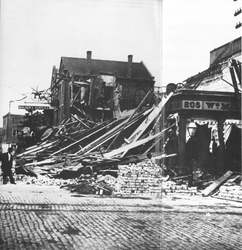
Many buildings in Charleston, South Carolina, were damaged or destroyed by the large earthquake that occurred August 31, 1886.
U.S. Department of the Interior / U.S. Geological Survey
by Kaye M. Shedlock and
Louis C. Pakiser
For sale by the U.S. Government Printing Office
Superintendent of Documents
Mail Stop: SSOP, Washington, DC 20402-9328
One of the most frightening and destructive phenomena of nature is a severe earthquake and its terrible aftereffects. An earthquake is a sudden movement of the Earth, caused by the abrupt release of strain that has accumulated over a long time. For hundreds of millions of years, the forces of plate tectonics have shaped the Earth as the huge plates that form the Earth’s surface slowly move over, under, and past each other. Sometimes the movement is gradual. At other times, the plates are locked together, unable to release the accumulating energy. When the accumulated energy grows strong enough, the plates break free. If the earthquake occurs in a populated area, it may cause many deaths and injuries and extensive property damage.
Today we are challenging the assumption that earthquakes must present an uncontrollable and unpredictable hazard to life and property. Scientists have begun to estimate the locations and likelihoods of future damaging earthquakes. Sites of greatest hazard are being identified, and definite progress is being made in designing structures that will withstand the effects of earthquakes.
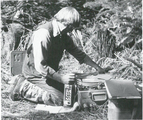
USGS scientist uses portable seismic recording equipment near Mount St. Helens, Washington.
The scientific study of earthquakes is comparatively new. Until the 18th century, few factual descriptions of earthquakes were recorded, and the natural cause of earthquakes was little understood. Those who did look for natural causes often reached conclusions that seem fanciful today; one popular theory was that earthquakes were caused by air rushing out of caverns deep in the Earth’s interior.
The earliest earthquake for which we have descriptive information occurred in China in 1177 B.C. The Chinese earthquake catalog describes several dozen large earthquakes in China during the next few thousand years. Earthquakes in Europe are mentioned as early as 580 B.C., but the earliest for which we have some descriptive information occurred in the mid-16th century. The earliest known earthquakes in the Americas were in Mexico in the late 14th century and in Peru in 1471, but descriptions of the effects were not well documented. By the 17th century, descriptions of the effects of earthquakes were being published around the world—although these accounts were often exaggerated or distorted.
The most widely felt earthquakes in the recorded history of North America were a series that occurred in 1811-12 near New Madrid, Mo. A great earthquake, whose magnitude is estimated to be about 8, occurred on the morning of December 16, 1811. Another great earthquake occurred on January 23, 1812, and a third, the strongest yet, on February 7, 1812. Aftershocks were nearly continuous between these great earthquakes and continued for months afterwards. These earthquakes were felt by people as far away as Boston and Denver. Because the 3 most intense effects were in a sparsely populated region, the destruction of human life and property was slight. If just one of these enormous earthquakes occurred in the same area today, millions of people and buildings and other structures worth billions of dollars would be affected.
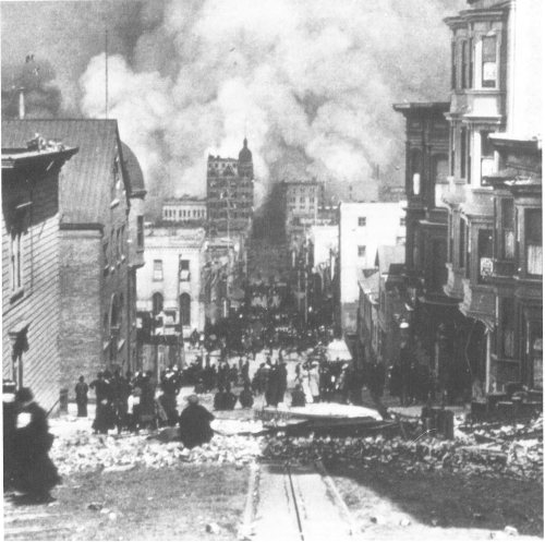
The great 1906 San Francisco earthquake and fire destroyed most of the city and left 250,000 people homeless.
The San Francisco earthquake of 1906 was one of the most destructive in the recorded history of North America—the earthquake and the fire that followed killed nearly 700 people and left the city in ruins. The Alaska earthquake of March 27, 1964, was of greater magnitude than the San Francisco earthquake; it released perhaps twice as much energy and was felt over an area of almost 500,000 square miles. The ground motion near the epicenter was so violent that the tops of some trees were snapped off. One hundred and fourteen people (some as far away as California) died as a result of this earthquake, but loss of life and property would have been far greater had Alaska been more densely populated.
The Earth is formed of several layers that have very different physical and chemical properties. The outer layer, which averages about 70 kilometers in thickness, consists of about a dozen large, irregularly shaped plates that slide over, under, and past each other on top of the partly molten inner layer. Most earthquakes occur at the boundaries where the plates meet. In fact, the locations of earthquakes and the kinds of ruptures they produce help scientists define the plate boundaries.
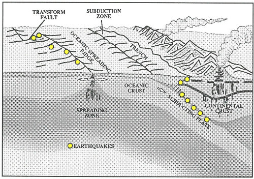
There are three types of plate boundaries: spreading zones, transform faults, and subduction zones. At spreading zones, molten rock rises, pushing two plates apart and adding new material at their edges. Most spreading zones are found in oceans; for example, the North American and Eurasian plates are spreading apart along the mid-Atlantic ridge. Spreading zones usually have earthquakes at shallow depths (within 30 kilometers of the surface).
Transform faults are found where plates slide past one another. An example 5 of a transform-fault plate boundary is the San Andreas fault, along the coast of California and northwestern Mexico. Earthquakes at transform faults tend to occur at shallow depths and form fairly straight linear patterns.
Subduction zones are found where one plate overrides, or subducts, another, pushing it downward into the mantle where it melts. An example of a subduction-zone plate boundary is found along the northwest coast of the United States, western Canada, and southern Alaska and the Aleutian Islands. Subduction zones are characterized by deep-ocean trenches, shallow to deep earthquakes, and mountain ranges containing active volcanoes.
Earthquakes can also occur within plates, although plate-boundary earthquakes are much more common. Less than 10 percent of all earthquakes occur within plate interiors. As plates continue to move and plate boundaries change over geologic time, weakened boundary regions become part of the interiors of the plates. These zones of weakness within the continents can cause earthquakes in response to stresses that originate at the edges of the plate or in the deeper crust. The New Madrid earthquakes of 1811-12 and the 1886 Charleston earthquake occurred within the North American plate.

An earthquake is the vibration, sometimes violent, of the Earth’s surface that follows a release of energy in the Earth’s crust. This energy can be generated by a sudden dislocation of segments of the crust, by a volcanic eruption, or even by manmade explosions. Most destructive quakes, however, are caused by dislocations of the crust. The crust may first bend and then, when the stress exceeds the strength of the rocks, break and “snap” to a new position. In the process of breaking, vibrations called “seismic waves” are generated. These waves travel outward from the source of the earthquake along the surface and through the Earth at varying speeds depending on the material through which they move. Some of the vibrations are of high enough frequency to be audible, while others are of very low frequency. These vibrations cause the entire planet to quiver or ring like a bell or a tuning fork.
A fault is a fracture in the Earth’s crust along which two blocks of the crust have slipped with respect to each other. Faults are divided into three main groups, depending on how they move. Normal faults occur in response to pulling or tension; the overlying block moves down the dip of the fault plane. Thrust (reverse) faults occur in response to squeezing or compression; the overlying block moves up the dip of the fault plane. Strike-slip (lateral) faults occur in response to either type of stress; the blocks move horizontally past one another. Most faulting along spreading zones is normal, along subduction zones is thrust, and along transform faults is strike-slip.
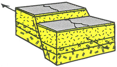
Normal Fault. Blocks are pulled apart
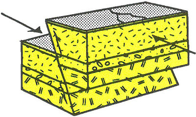
Thrust Fault. Blocks are pushed together
Strike-Slip Fault. Blocks slide past each other
Geologists have found that earthquakes tend to reoccur along faults, which reflect zones of weakness in the Earth’s crust. Even if a fault zone has recently experienced an earthquake, however, there is no guarantee that all the stress has been relieved. Another earthquake could still occur. In New Madrid, a great earthquake was followed by a large aftershock within 6 hours on December 16, 1811. Furthermore, relieving stress along one part of the fault may increase stress in another part; the New Madrid earthquakes in January and February 1812 may have resulted from this phenomenon.
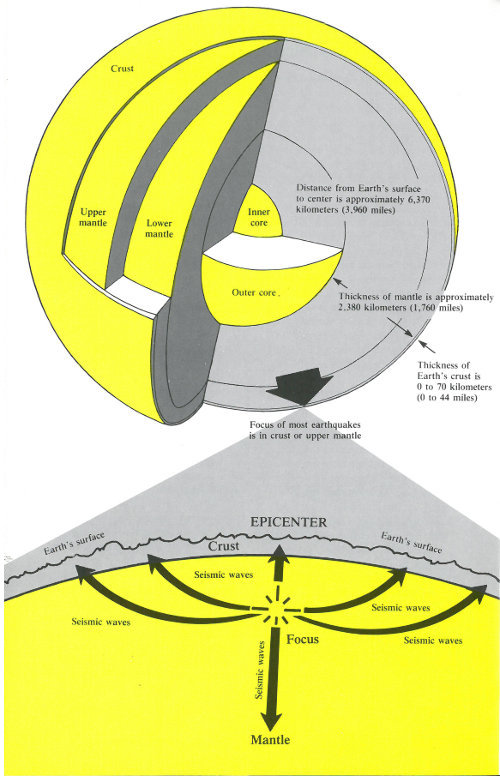
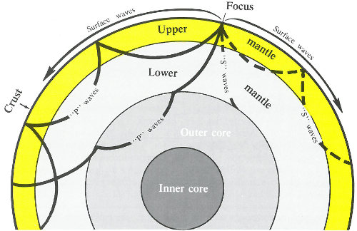
The focal depth of an earthquake is the depth from the Earth’s surface to the region where an earthquake’s energy originates (the focus). Earthquakes with focal depths from the surface to about 70 kilometers (43.5 miles) are classified as shallow. Earthquakes with focal depths from 70 to 300 kilometers (43.5 to 186 miles) are classified as intermediate. The focus of deep earthquakes may reach depths of more than 700 kilometers (435 miles). The focuses of most earthquakes are concentrated in the crust and upper mantle. The depth to the center of the Earth’s core is about 6,370 kilometers (3,960 miles), so even the deepest earthquakes originate in relatively shallow parts of the Earth’s interior.
The epicenter of an earthquake is the point on the Earth’s surface directly above the focus. The location of an earthquake is commonly described by the geographic position of its epicenter and by its focal depth.
Earthquakes beneath the ocean floor sometimes generate immense sea waves or tsunamis (Japan’s dread “huge wave”). These waves travel across the ocean at speeds as great as 960 kilometers per hour (597 miles per hour) and may be 15 meters (49 feet) high or higher by the time they reach the shore. During the 1964 Alaska earthquake, tsunamis engulfing coastal areas caused most of the destruction at Kodiak, Cordova, and Seward and caused severe damage along the west coast of North America, particularly at Crescent City, Calif. Some waves raced across the ocean to the coasts of Japan.

Tsunami destruction on Kamehameha Avenue on Hilo’s waterfront, 1946. (Photograph provided by the U.S. Army Corps of Engineers.)
Liquefaction, which happens when loosely packed, water-logged sediments lose their strength in response to strong shaking, causes major damage during earthquakes. During the 1989 Loma Prieta earthquake, liquefaction of the soils and debris used to fill in a lagoon caused major subsidence, fracturing, and horizontal sliding of the ground surface in the Marina district in San Francisco.
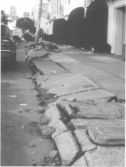
Liquefaction of sands and debris caused major damage throughout the Marina district in San Francisco during the Loma Prieta earthquake.
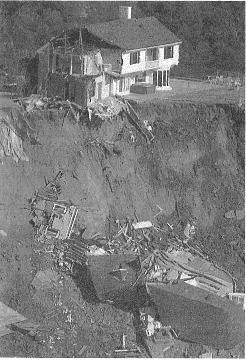
Landslides triggered by earthquakes often cause more destruction than the earthquakes themselves. During the 1964 Alaska quake, shock-induced landslides devastated the Turnagain Heights residential development and many downtown areas in Anchorage. An observer gave a vivid report of the breakup of the unstable earth materials in the Turnagain Heights region: I got out of my car, ran northward toward my driveway, and then saw that the bluff had broken back approximately 300 feet southward from its original edge. Additional slumping of the bluff caused me to return to my car and back southward approximately 180 feet to the corner of McCollie and Turnagain Parkway. The bluff slowly broke until the corner of Turnagain Parkway and McCollie had slumped northward.
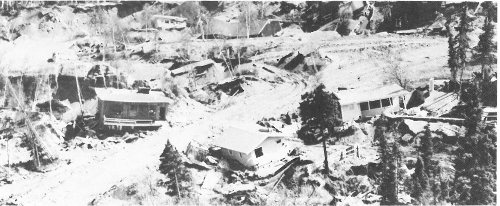
Many homes were damaged by landslides triggered by the 1964 Alaska earthquake (above) and the 1989 Loma Prieta shock (below).
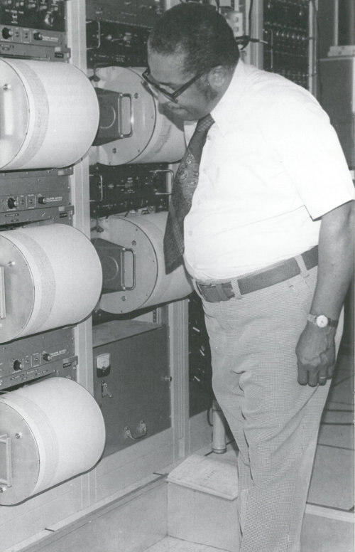
The vibrations produced by earthquakes are detected, recorded, and measured by instruments called seismographs. The zig-zag line made by a seismograph, called a “seismogram,” reflects the changing intensity of the vibrations by responding to the motion of the ground surface beneath the instrument. From the data expressed in seismograms, scientists can determine the time, the epicenter, the focal depth, and the type of faulting of an earthquake and can estimate how much energy was released.
The two general types of vibrations produced by earthquakes are surface waves, which travel along the Earth’s surface, and body waves, which travel through the Earth. Surface waves usually have the strongest vibrations and probably cause most of the damage done by earthquakes.
Body waves are of two types, compressional and shear. Both types pass through the Earth’s interior from the focus of an earthquake to distant points on the surface, but only compressional waves travel through the Earth’s molten core. Because compressional waves travel at great speeds and ordinarily reach the surface first, they are often called “primary waves” or simply “P” waves. P waves push tiny particles of Earth material directly ahead of them or displace the particles directly behind their line of travel.
Shear waves do not travel as rapidly through the Earth’s crust and mantle as do compressional waves, and because they ordinarily reach the surface later they are called “secondary” or “S” waves. Instead of affecting material directly behind or ahead of their line of travel, shear waves displace material at right angles to their path and are therefore sometimes called “transverse” waves.
The first indication of an earthquake is often a sharp thud, signaling the arrival of compressional waves. This is followed by the shear waves and then the “ground roll” caused by the surface waves. A geologist who was at Valdez, Alaska, during the 1964 earthquake described this sequence: The first tremors were hard enough to stop a moving person, and shock waves were immediately noticeable on the surface of the ground. These shock waves continued with a rather long frequency, which gave the observer an impression of a rolling feeling rather than abrupt hard jolts. After about 1 minute the amplitude or strength of the shock waves increased in intensity and failures in buildings as well as the frozen ground surface began to occur.... After about 3½ minutes the severe shock waves ended and people began to react as could be expected.
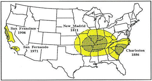
Large earthquakes cause more damage east of the Rocky Mountains; this map shows areas that suffered major architectural damage (striped areas) and minor damage (dotted areas) during the magnitude-8 earthquakes in New Madrid and San Francisco and the smaller but still damaging quakes in Charleston and San Fernando.
The severity of an earthquake can be expressed in several ways. The magnitude of an earthquake, usually expressed by the Richter Scale, is a measure of the amplitude of the seismic waves. The moment magnitude of an earthquake is a measure of the amount of energy released—an amount that can be estimated from seismograph recordings. The intensity, as expressed by the Modified Mercalli Scale, is a subjective measure that describes how strong a shock was felt at a particular location.
The Richter Scale, named after Dr. Charles F. Richter of the California Institute of Technology, is the best known scale for measuring the magnitude of earthquakes. The scale is logarithmic so that a recording of 7, for example, indicates a disturbance with ground motion 10 times as large as a recording of 6. A quake of magnitude 2 is the smallest quake normally felt by people. Earthquakes with a Richter value of 6 or more are commonly considered major; great earthquakes have magnitudes of 8 or more on the Richter scale.
The Modified Mercalli Scale expresses the intensity of an earthquake’s effects in a given locality in values ranging from I to XII. The most commonly used adaptation covers the range of intensity from the condition of “I—Not felt except by a very few under especially favorable conditions,” to “XII—Damage total. Lines of sight and level are distorted. Objects thrown upward into the air.” Evaluation of earthquake intensity can be made only after eyewitness reports and results of field investigations are studied and interpreted. The maximum intensity 15 experienced in the Alaska earthquake of 1964 was X; damage from the San Francisco and New Madrid earthquakes reached a maximum intensity of XI.
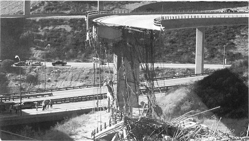
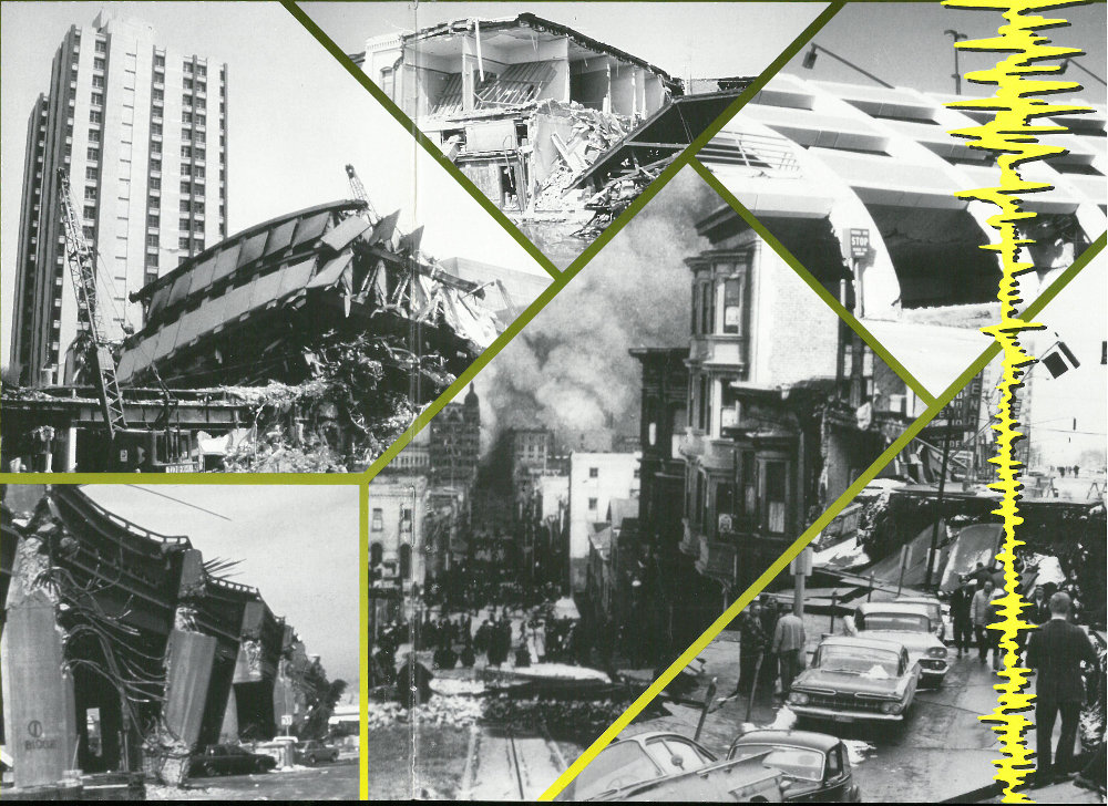
The January 17, 1994, earthquake at Northridge, California, caused this collapse of a major highway interchange. (Photograph by James W. Dewey, USGS.)
Earthquakes of large magnitude do not necessarily cause the most intense surface effects. The effect in a given region depends to a large degree on local surface and subsurface geologic conditions. An area underlain by unstable ground (sand, clay, or other unconsolidated materials), for example, is likely to experience much more noticeable effects than an area equally distant from an earthquake’s epicenter but underlain by firm ground such as granite. In general, earthquakes east of the Rocky Mountains affect a much larger area than earthquakes west of the Rockies.
An earthquake’s destructiveness depends on many factors. In addition to magnitude and the local geologic conditions, these factors include the focal depth, the distance from the epicenter, and the design of buildings and other structures. The extent of damage also depends on the density of population and construction in the area shaken by the quake.
The Loma Prieta earthquake of 1989 demonstrated a wide range of effects. The Santa Cruz mountains suffered little damage from the seismic waves, even though they were close to the epicenter. The central core of the city of Santa Cruz, about 24 kilometers (15 miles) away from the epicenter, was almost completely destroyed. More than 80 kilometers (50 miles) away, the cities of San Francisco and Oakland suffered selective but severe damage, including the loss of more than 40 lives. The greatest destruction occurred in areas where roads and elevated structures were built on unstable ground underlain by loose, unconsolidated soils.
The Northridge, California, earthquake of 1994 also produced a wide variety of effects, even over distances of just a few hundred meters. Some buildings collapsed, while adjacent buildings of similar age and construction remained standing. Similarly, some highway spans collapsed, while others nearby did not.
A sudden increase in earthquake tremors signaled the beginning of a series of eruptions at Redoubt Volcano in 1989-90.
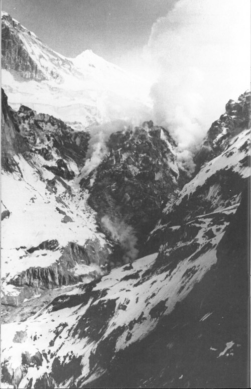
Earthquakes are associated with volcanic eruptions. Abrupt increases in earthquake activity heralded eruptions at Mount St. Helens, Washington; Mount Spurr and Redoubt Volcano, Alaska; and Kilauea and Mauna Loa, Hawaii. The location and movement of swarms of tremors indicate the movement of magma through the volcano. Continuous records of seismic and tiltmeter (a device that measures ground tilting) data are maintained at U.S. Geological Survey volcano observatories in Hawaii, Alaska, California, and the Cascades, where study of these records enables specialists to make short-range predictions of volcanic eruptions. These warnings have been especially effective in Alaska, where the imminent eruption of a volcano requires the rerouting of international air traffic to enable airplanes to avoid volcanic clouds. Since 1982, at least seven jumbo jets, carrying more than 1,500 passengers, have lost power in the air after flying into clouds of volcanic ash. Though all flights were able to restart their engines eventually and no lives were lost, the aircraft suffered damages of tens of millions of dollars. As a result of these close calls, an international team of volcanologists, meteorologists, dispatchers, pilots, and controllers have begun to work together to alert each other to imminent volcanic eruptions and to detect and track volcanic ash clouds.
The goal of earthquake prediction is to give warning of potentially damaging earthquakes early enough to allow appropriate response to the disaster, enabling people to minimize loss of life and property. The U.S. Geological Survey conducts and supports research on the likelihood of future earthquakes. This research includes field, laboratory, and theoretical investigations of earthquake mechanisms and fault zones. A primary goal of earthquake research is to increase the reliability of earthquake probability estimates. Ultimately, scientists would like to be able to specify a high probability for a specific earthquake on a particular fault within a particular year. Scientists estimate earthquake probabilities in two ways: by studying the history of large earthquakes in a specific area and the rate at which strain accumulates in the rock.
Scientists study the past frequency of large earthquakes in order to determine the future likelihood of similar large shocks. For example, if a region has experienced four magnitude 7 or larger earthquakes during 200 years of recorded history, and if these shocks occurred randomly in time, then scientists would assign a 50 percent probability (that is, just as likely to happen as not to happen) to the occurrence of another magnitude 7 or larger quake in the region during the next 50 years.
But in many places, the assumption of random occurrence with time may not be true, because when the strain is released along one part of the fault system, it may actually increase on another part. Four magnitude 6.8 or larger earthquakes and many magnitude 6-6.5 shocks occurred in the San Francisco 18 Bay region during the 75 years between 1836 and 1911. For the next 68 years (until 1979), no earthquakes of magnitude 6 or larger occurred in the region. Beginning with a magnitude 6.0 shock in 1979, the earthquake activity in the region increased dramatically; between 1979 and 1989, there were four magnitude 6 or greater earthquakes, including the magnitude 7.1 Loma Prieta earthquake. This clustering of earthquakes leads scientists to estimate that the probability of a magnitude 6.8 or larger earthquake occurring during the next 30 years in the San Francisco Bay region is about 67 percent (twice as likely as not).
Another way to estimate the likelihood of future earthquakes is to study how fast strain accumulates. When plate movements build the strain in rocks to a critical level, like pulling a rubber band too tight, the rocks will suddenly break and slip to a new position. Scientists measure how much strain accumulates along a fault segment each year, how much time has passed since the last earthquake along the segment, and how much strain was released in the last earthquake. This information is then used to calculate the time required for the accumulating strain to build to the level that results in an earthquake. This simple model is complicated by the fact that such detailed information about faults is rare. In the United States, only the San Andreas fault system has adequate records for using this prediction method.
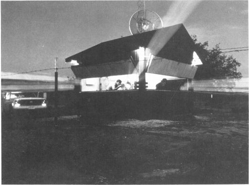
Using a two-color laser to detect movement along a fault near Parkfield, California.
Both of these methods, and a wide array of monitoring techniques, are being tested along part of the San Andreas fault. For the past 150 years, earthquakes of about magnitude 6 have occurred an average of every 22 years on the San 19 Andreas fault near Parkfield, California. The last shock was in 1966. Because of the consistency and similarity of these earthquakes, scientists have started an experiment to “capture” the next Parkfield earthquake. A dense web of monitoring instruments was deployed in the region during the late 1980s. The main goals of the ongoing Parkfield Earthquake Prediction Experiment are to record the geophysical signals before and after the expected earthquake; to issue a short-term prediction; and to develop effective methods of communication between earthquake scientists and community officials responsible for disaster response and mitigation. This project has already made important contributions to both earth science and public policy.
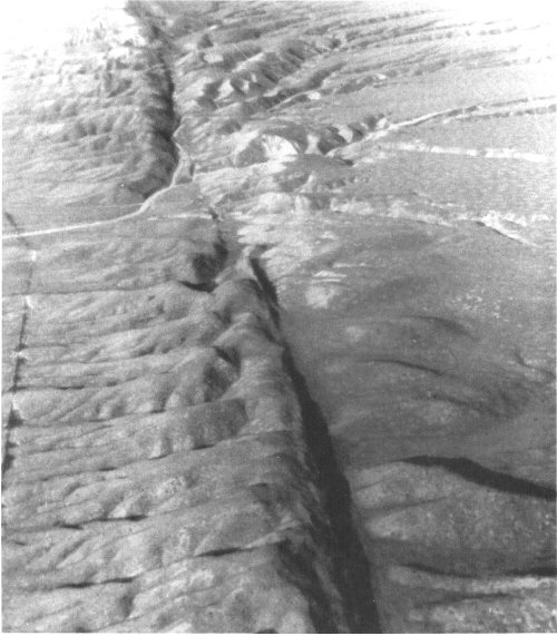
San Andreas fault in the Carrizo Plain, central California.
Scientific understanding of earthquakes is of vital importance to the Nation. As the population increases, expanding urban development and construction works encroach upon areas susceptible to earthquakes. With a greater understanding of the causes and effects of earthquakes, we may be able to reduce damage and loss of life from this destructive phenomenon.
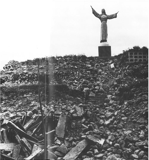
A statue of Christ at Cemetery Hill overlooks the ruined town of Yungay, Peru. It and a few palm trees were all that remained standing after the May 31, 1970, earthquake.
U.S. Geological Survey
Information Services
P.O. Box 25286
Denver, CO 80225
★ U.S. GOVERNMENT PRINTING OFFICE: 1996—421-205

As the Nation’s principal conservation agency, the Department of the Interior has responsibility for most of our nationally owned public lands and natural and cultural resources. This includes fostering sound use of our land and water resources; protecting our fish, wildlife, and biological diversity; preserving the environmental and cultural values of our national parks and historical places; and providing for the enjoyment of life through outdoor recreation. The Department assesses our energy and mineral resources and works to ensure that their development is in the best interests of all our people by encouraging stewardship and citizen participation in their care. The Department also has a major responsibility for American Indian reservation communities and for people who live in island territories under U.S. administration.
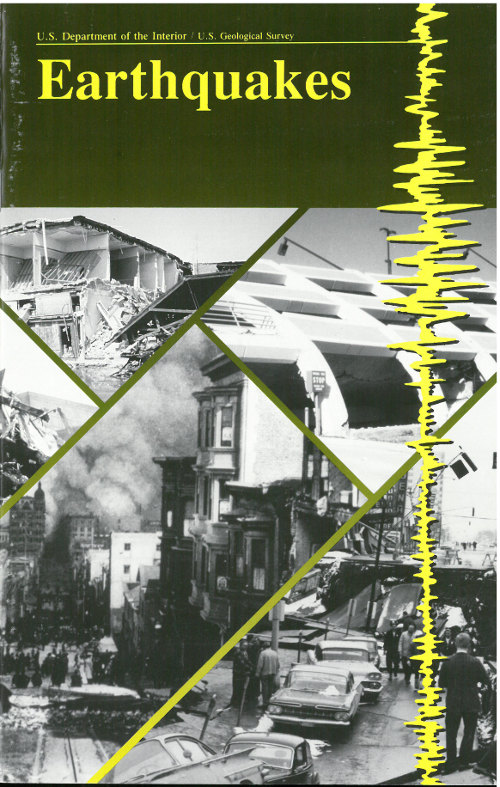
(Cover photographs, clockwise from top left): Mexico City, Mexico, 1985; Coalinga, Calif., 1983; Northridge, Calif., 1994; Anchorage, Alaska, 1964; San Francisco, Calif., 1906; Loma Prieta, Calif., 1989.