
FRAGMENTS
OF
EARTH LORE
FRAGMENTS
OF
EARTH LORE
SKETCHES & ADDRESSES
Geological and Geographical
BY
JAMES GEIKIE, D.C.L., LL.D., F.R.S., &c.
MURCHISON-PROFESSOR OF GEOLOGY AND MINERALOGY IN THE
UNIVERSITY OF EDINBURGH
FORMERLY OF H.M. GEOLOGICAL SURVEY OF SCOTLAND
WITH MAPS AND ILLUSTRATIONS
![]()
JOHN BARTHOLOMEW & CO.
LONDON: SIMPKIN, MARSHALL, HAMILTON, KENT & Co., Ltd.
1893
The articles in this volume deal chiefly with the history of Glacial times and the origin of surface-features. As they were not written with any view to their subsequent appearance in a collected form, each is so far independent and complete in itself. Under these circumstances some repetition was unavoidable, if the articles were not to be recast, and I did not think it advisable to make such radical alteration. With the exception of verbal changes and some excisions, therefore, the papers remain substantially in their original state. Here and there a footnote has been added to indicate where the views expressed in the text have since been modified; but I have not been careful to insert such notes throughout. Geologists, like other folk, live and learn, and the reader will probably discover that the opinions set forth in some of the later articles are occasionally in advance of those maintained in the writer’s earlier days.
I have to thank the Publishers of Good Words for allowing me to republish the articles on the Cheviot Hills and the Outer Hebrides. My acknowledgments are also due to Mr. Bartholomew for the excellent maps with which the volume is so well illustrated.
Edinburgh, April 5th, 1893.
| Plate | I. | PHYSICAL FEATURES OF SCOTLAND | Frontispiece |
| ” | II. | STRUCTURE OF MOUNTAINS | 60 |
| ” | III. | PAST AND PRESENT GLACIATION OF THE WORLD | 193 |
| ” | IV. | ICE AGE IN NORTHERN EUROPE | 324 |
| ” | V. | THE GEOGRAPHICAL EVOLUTION OF CONTINENTS | 348 |
| ” | VI. | BATHYOROGRAPHICAL MAP, ILLUSTRATING DEVELOPMENT OF COAST-LINES | 428 |
| CHAP. | PAGE | |
| I. | GEOGRAPHY AND GEOLOGY | 1 |
| II. | THE PHYSICAL FEATURES OF SCOTLAND | 14 |
| III. | MOUNTAINS: THEIR ORIGIN, GROWTH, AND DECAY | 36 |
| IV. | THE CHEVIOT HILLS | 62 |
| V. | THE LONG ISLAND, OR OUTER HEBRIDES | 125 |
| VI. | THE ICE AGE IN EUROPE AND NORTH AMERICA | 160 |
| VII. | THE INTERCROSSING OF ERRATICS IN GLACIAL DEPOSITS | 194 |
| VIII. | RECENT RESEARCHES IN THE GLACIAL GEOLOGY OF THE CONTINENT | 220 |
| IX. | THE GLACIAL PERIOD AND THE EARTH-MOVEMENT HYPOTHESIS | 248 |
| X. | THE GLACIAL SUCCESSION IN EUROPE | 288 |
| XI. | THE GEOGRAPHICAL EVOLUTION OF EUROPE | 326 |
| XII. | THE EVOLUTION OF CLIMATE | 349 |
| XIII. | THE SCIENTIFIC RESULTS OF DR. NANSSEN’S EXPEDITION | 382 |
| XIV. | THE GEOGRAPHICAL DEVELOPMENT OF COAST-LINES | 393 |
Geography and Geology.[A]
[A] Portion of a lecture given in 1886 to the Class of Geology in the University of Edinburgh.
The teaching of Geography naturally occupies a prominent place in every school curriculum. It is rightly considered essential that we should from an early age begin to know something of our own and other countries. I am not sure, however, that Geography is always taught in the most interesting and effective manner. Indeed, according to some geographers, who are well qualified to express an opinion, the manner in which their subject is presented in many of our schools leaves much to be desired. But a decided advance has been made in recent years, and with the multiplication of excellent text-books, maps, and other appliances, I have no doubt that this improvement will continue. When I attended school the text-books used by my teachers were about as repellent as they could be. Our most important lesson was to commit to memory a multitude of place-names, and the maps which were supposed to illustrate the text-books were, if possible, less interesting and instructive. Nowadays, however, teachers have a number of more or less excellent manuals at their service, and the educational maps issued by our cartographers show in many cases a very great advance on the bald and misleading caricatures which did duty in my young days as pictures of the earth’s surface.
During the progress of some war we often remark that the task of following the military operations compels us to brush up our Geography. I am uncharitable enough to suspect that it would frequently be truer to say that, before these campaigns — 2 — commenced, we had no such knowledge to brush up. The countries involved in the commotion were probably mere names to many of us. We had no immediate interest in them or their inhabitants, and had we been asked, before the outbreak of hostilities, to indicate the precise positions of the places upon a map, some of us perhaps might have been sorely puzzled to do so. Nor is such ignorance always discreditable. One cannot know everything; the land-surface of the globe contains upwards of 50 millions of square miles, and one may surely be excused for not having a detailed knowledge of this vast area. I have referred to the subject simply because I think it gives us a hint as to how the teaching of Political Geography might be made most instructive and interesting. Historical narrative might often be interwoven with the subject in such a way as to fix geographical features indelibly on the memory. Striking and picturesque incidents, eventful wars, the rise and progress of particular trades, the routes followed by commerce, the immigration and emigration of races, the gradual development of the existing political divisions of the Old World, the story of Columbus and the early voyagers, the geographical discoveries of later times—all these, and such as these, might be introduced into our lessons in Political Geography. The wanderings of a Mungo Park, a Bruce, a Livingstone, a Stanley, traced on a good map, could not fail to arrest the attention of the youthful student of African geography. In like manner, the campaigns of the great Napoleon might be made to do good service in illustrating the geographical features of large portions of our own continent. Then, as regards Britain, what a world of poetry and romantic story clings to every portion of its surface—why, the very place-names themselves might suggest to any intelligent teacher themes and incidents, the deft treatment of which would make the acquisition of Geography a delightful task to the dullest boy or girl.
The intimate relation that obtains between Political Geography and History has indeed long been recognised, and is in fact self-evident. And we are all well aware that in our school manuals of Geography it has been usual for very many — 3 — years to note the scenes of remarkable events. Such notes, however, are of necessity extremely brief; and it need hardly be said that to fully incorporate history in a text-book of general Geography would be quite impracticable. It might be done to a certain extent for our own and a few of the more important countries; but similar detail need not be attempted in regard to regions which are of less consequence from the political point of view. Indeed, I should be inclined to leave the proper application of historical knowledge in the teaching of Geography very much to the teacher himself, who would naturally select such themes and incidents as seemed best adapted to attract the attention of his pupils. Be that, however, as it may, it is enough for my present purpose if I insist upon the fact that the proper study of Political Geography involves the acquisition of some historical knowledge. One can hardly conceive the possibility of an intelligent student taking pains to become acquainted with the political geography of a country without at the same time endeavouring to learn something of its history—otherwise, his geographical attainments would hardly surpass those of a commercial traveller, whose geographical studies have been confined to the maps and tables of his Bradshaw.
But if it be impossible to ignore History in the teaching of Political Geography, it is just as impossible to exclude from our attention great physical features and characteristics. Surface-configuration, climate, and natural products all claim our attention. It is obvious, in fact, that the proper study of Political Geography must give us at least a general notion of the configuration, the river-systems, and climatic conditions of many different lands. For has not the political development of races depended most largely on the physical conditions and natural resources of the countries occupied by them? So far, then, as these have sensibly influenced the progress of peoples, they come naturally under the consideration of Political Geography. Thus, if Political Geography be closely connected and interwoven, as it were, with History, not less intimate are its relations to Physical Geography. It does not embrace all Physical Geography, but it introduces us to many facts and — 4 — phenomena, the causes and mutual relations of which we cannot understand without first mastering the teachings of Physical Geography. In the study of this latter science we come more closely into contact with Nature; we cease to think of the surface of the earth as parcelled out into so many lots by its human occupants—we no longer contemplate that surface from the limited point of view of the political geographer—we are now not merely members of one particular community, but have become true citizens of the world. To us north and south, east and west are of equal interest and importance. Our desire now is to understand, if haply we may, the complex system of which we ourselves form a part. The distribution of land and water—the configuration of continental areas and oceanic basins—the circulation of oceanic and terrestrial waters—earth-movements and volcanoes—ice-formations—the atmosphere—climatology—the geographical distribution of plants and animals—in a word, the world as one organic whole now forms the subject of our contemplation. Such being the scope of Physical Geography, it is satisfactory to know that its importance as a subject of study in our schools has been fully recognised. This being admitted, I shall now proceed to show that Physical Geography, although, like Political Geography, it is a separate and distinct subject, yet, just as the study of the latter involves some knowledge of History, so the prosecution of Physical Geography compels us to make a certain acquaintance with Geology. We cannot, in fact, learn much about the atmosphere, about rain and rivers, glaciers and icebergs, earthquakes and volcanoes, and the causes of climate, without at the same time becoming more or less familiar with the groundwork on which geological investigations are based. And just as a knowledge of history enables us better to understand the facts of Political Geography, so some acquaintance with the results of geological inquiry are necessary before we can hope to comprehend many of the phenomena of which Physical Geography treats. Let me try to make this plain. The physical geographer, we shall suppose, is considering the subject of terrestrial waters. He tells us what is meant by the drainage-system of a country, — 5 — points out how the various minor water-courses or brooks and streams unite to form a river, describes for us the shape of the valley through which a typical river makes its way—how the valley-slope diminishes from the mountains onwards to the sea-coast—how, at first, in its upper or mountain-track, the flow of the river is torrential—how, as the slope of the valley decreases, the river begins to wind about more freely, until it reaches the head of its plain-track or delta, when, no longer receiving affluents, it begins to divide, and enters the sea at last by many mouths. He tells us further what proportion of the rainfall of the country passes seawards in our river, and he can measure for us the quantity of water which is actually discharged. All this is purely Physical Geography; but when we come to ask why some rivers flow in deep ca¤ons, like those of the Colorado—why valleys should widen out in one part and contract, as it were, elsewhere—why the courses of some rivers are interrupted by waterfalls and rapids, and many other similar questions, the physical geographer must know something of Geology before he can give an answer. He can describe the actual existing conditions; without the aid of Geology, he can tell us nothing of their origin and cause. So the political geographer can map out for us the present limits of the various countries of Europe, but History must be invoked if we would know how those boundaries came to be determined. The moment, therefore, the physical geographer begins to inquire into the origin of any particular physical feature, he enters upon the domains of the geologist. And as he cannot possibly avoid doing so, it is quite common now to find a good deal of the subject-matter of Geology treated of in text-books of Physical Geography. I state this merely to show how very closely the two sciences are interlocked. Take, for example, the configuration of river valleys just referred to. The physical geographer recognises the fact that a river performs work; by means of the sediment which it carries in suspension and rolls along its course, it erodes its bed in many places, and undermines its banks, and thus its channel is deepened and widened. He can measure the amount of sediment which it carries down to the sea, and — 6 — the quantity of saline matters which its waters hold in solution: and knowing that all these substances have been abstracted from the land, he is able to estimate approximately the amount of material which is annually transferred from the surface of the drainage-area involved. He discovers this to be so relatively enormous that he has no difficulty in believing that the valleys in which rivers flow might have been hollowed out by the rivers themselves. But, without trespassing further into the geologist’s domains, he cannot go beyond this: and you will at once perceive that something more is required to prove that any particular valley owes its origin to the erosive action of running water. Suppose someone were to suggest to him that his river-valley might be a minor wrinkle in the earth’s crust caused by earth-movements, or that it might indicate the line of a fissure or dislocation, due to some comparatively recent convulsion—how could his computation of the amount of material at present carried seawards by the river prove such suggestions to be erroneous? And what light could it throw upon the origin of the varied configuration of the river-valley—how would it explain the presence or absence of cascades and rapids, of narrow gorges and open expanses? None of these phenomena can be interpreted and accounted for without the aid of the geologist: without some knowledge of rocks and rock-structures, the origin of the earth’s surface-features is quite inexplicable. To give an adequate explanation of all the surface-features of a country in detail would of course require a profound study of Geology; but a general acquaintance only with its elementary facts is quite sufficient to enable us to form a reasonable and intelligent view of the cause and origin of the main features of the land as a whole. Thus a few lessons in elementary Geology would make clear to any child how rivers have excavated valleys, why cataracts and gorges occur here, and open valleys with gently-flowing waters elsewhere.
Let me select yet another example to show how dependent Physical Geography is upon Geology. The physical geographer, in describing the features of the land, tells us — 7 — how the great continental areas are traversed in various directions by what he calls mountain-chains. Thus, in speaking of America, he tells us that it may be taken as a type of the continental structure—namely a vast expanse of land, low or basin-like in the interior, and flanked along the maritime regions by elevated mountain borders—the highest border facing the deepest ocean. He points out further that the great continental areas are crossed from west to east by well-marked depressions, to a large extent occupied by water. Thus Europe is separated from Africa by the Mediterranean, a depression which is continued eastward through the Black Sea into the Aralo-Caspian area. South America is all but cut away from North America, while Australia is separated from Asia by the East India Seas. We find, in fact, all over the world that well-marked natural features are constantly being repeated. Not only do the great land-masses of the globe bear certain resemblances to each other, but even in their detailed structure similar parallelisms recur. The physical geographer notes all these remarkable phenomena, but he can give us no clue to their meaning. He may describe with admirable skill the characteristic features of plains and plateaux, of volcanic mountains and mountain-chains, but he cannot tell us why plains should occur here and mountains there; nor can he explain why some mountains, such as those of Scotland or Norway, differ so much in configuration from the Alps and the Pyrenees. The answer to all these questions can only be given by Geology. It is from this science we learn how continental areas and oceanic basins have been evolved. The patient study of the rocks has revealed the origin of the present configuration of the land. There is not a hill or valley, not a plateau or mountain-region, which does not reveal its own history. The geologist can tell you why continents are bordered by coast-ranges, and why their interiors are generally comparatively low and basin-shaped. The oceanic basins and continental areas, we learn, are primeval wrinkles in the earth’s crust, caused by its irregular subsidence upon the gradually cooling and contracting nucleus. The continents are immense plateau-like areas rising more or less abruptly — 8 — above those stupendous depressions of the earth’s crust which are occupied by the ocean. While those depressions are in progress the maritime borders of the land-areas are subjected to enormous squeezing and crushing, and coast-ranges are the result—the elevation of those ranges necessarily holding some relation to the depth of the contiguous ocean. For, the deeper the ocean the greater has been the depression under the sea, and, consequently, the more intense the upheaval along the continental borders. It is for the same reason that destructive earthquakes are most likely to occur in the vicinity of coast-ranges which are of comparatively recent geological age. These, and indeed all, mountains of elevation are lines of weakness along which earth-movements may continue from time to time to take place. But all mountains are not mountains of elevation; many elevated regions owe their mountainous character simply to the erosive action of sub-aërial agents, such as rain, frost, ice, and running water, the forms assumed by the mountains being due to their petrological character and geological structure. There are, for example, no true mountains of elevation in Scotland; hence to write of the chain of the Grampians or the range of the Lowthers is incorrect and actually misleading. Without the aid of Geology the geographer cannot, in fact, discriminate between mountains of elevation and mountains of denudation; hence geographical terms so constantly in use as mountain-range and mountain-chain are very often applied by writers, ignorant of geological structure, to elevated regions which have no claim to be described either as chains or ranges. Some knowledge of Geology, therefore, is essential to us if we would have correct views of many of the grandest features of the globe. But it will be said that, after all, the physical geographer deals with the earth as we now find it; he does not need to trouble himself with the origin of the phenomena he describes. Well, as I have just shown, he cannot, even if he would, escape trenching on Geology; and if he could, his subject would be shorn of much of its interest. He recognises that the world he studies has in it the elements of change—the forces of Nature are everywhere modifying the earth’s surface—considerable changes are sometimes brought about — 9 — even in one’s lifetime, while within the course of historical ages still greater mutations have taken place—he becomes conscious, in short, that the existing state of things is but the latest phase of an interminable series of changes stretching back into the illimitable past, and destined to be prolonged into the indefinite future. Thus he gladly welcomes the labours of the geologist, whose researches into the past have thrown such a flood of light upon the present. In fact, he can no more divorce his attention from the results of geological inquiry than the political geographer can shut his eyes to the facts of History.
Let me, in conclusion, give one further illustration of the close inter-dependence of the two sciences of which I am speaking. One of the subjects treated of by Physical Geography is the present geographical distribution of plants and animals. The land-surface of the globe has been mapped out into so many biological regions, each of which is characterised by its special fauna and flora. The greatest changes in the flora and fauna of a continent are met with as we pass from south to north, or vice versa. Proceeding in the direction of the latitude, the changes encountered are much less striking. Now, these facts are readily explained by the physical geographer, who points out that the distribution is due chiefly to climatic conditions—a conclusion which is obvious enough. But when we go into details we find that mere latitude will not account for all the phenomena. Take, for example, the case of the Scandinavian flora of our own Continent. It is true that this flora is largely confined to northern latitudes; but isolated colonies occur in our own mountains and in the mountains of middle and southern Europe. How are these to be accounted for? The physical geographer says that the plants grow there simply because they obtain at high levels in low latitudes the favourable climatic conditions underneath which they flourish at low levels in high latitudes. He therefore concludes that the distribution of life-forms is due to varying climatic and physical conditions. But if we ask him how those curious colonies of foreigners come to be planted on our mountains, he cannot tell. To get our answer we must come to the — 10 — geologist; and he will explain that they are, as it were, living fossils—monuments of former great physical and climatic changes. He will prove to us that the climate of Europe was at a recent geological period so cold that the Scandinavian flora spread south into middle Europe, where it occupied the low grounds. When the climate became milder, then the northern invaders gradually retired—the main body migrating back to the north—while some stragglers, retreating before the stronger Germanic flora, took shelter in the mountains, whither the latter could not or would not follow, and so there our Scandinavians remain, the silent witnesses of a stupendous climatic revolution. Now, all the world over, plants and animals have similar wonderful tales to tell of former geographical changes. The flora and fauna of our country, for example, prove that the British Islands formed part of the Continent at a very recent geological period; and so, from similar evidence, we know that not long ago Europe was joined on to Africa. On the other hand, the facts connected with the present distribution of life demonstrate that some areas, such as Australia, have been separated from the nearest continental land for vastly prolonged periods of time.
It would be a very easy matter to adduce many further illustrations to show how close is the connection between the studies of the physical geographer and the geologist. I do not indeed exaggerate when I say that no one can hope to become a geologist who is not well versed in Physical Geography; nor, on the other hand, can the physical geographer possibly dispense with the aid of Geology. The two subjects are as closely related and interwoven, the one with the other, as History is with Political Geography. I do not see therefore how educationists who have admitted the great importance of Physical Geography as a branch of general education, can logically exclude Geology as a subject of instruction in schools. Already, indeed, it has been introduced by many teachers, and I am confident that ere long it will be as generally taught as Physical Geography. I would not, however, present the subject to young people as a lesson to be learned from books. A good teacher should be able to dispense with these helps, or — 11 — rather hindrances—for such they really are to a young beginner. His pupils ought to have previously studied the subject of Physical Geography, and if they have been well taught they ought to have already acquired no mean store of geological knowledge. They ought, in fact, to have learned a good deal about the great forces which are continually modifying the surface of the globe, and what they have now to do is to study more particularly the results which have followed from the constant operation of those forces. We shall suppose, for example, that the teacher has described how rivers erode their channels, and waves tend to cut back a coast-line, and how the products of erosion, consisting of gravel, sand, and mud, are distributed along river-valleys and accumulated in lakes and seas. He now exhibits to his class good-sized fragments of conglomerate, sandstone, and shale, and points out how each of these rocks is of essentially the same character, and must therefore have had the same origin, as modern sedimentary accumulations. His pupils should be encouraged to examine the rocks of their own neighbourhood, whether exhibited in natural sections or artificial exposures, and to compare these with the products of modern geological action. One hour’s instruction in the field is, in fact, worth twenty hours of reading or listening to lectures. Knowledge at first hand is what is wanted. There are many excellent popular or elementary treatises dealing with Historical Geology, and these have their uses, and may be read with profit as well as pleasure. But the mere reading of such books, it is needless to say, will never make us geologists. They help no doubt to store the mind with interesting and entertaining knowledge, but they do not cultivate the faculties of observation and reasoning. And unless geology is so taught as to accomplish this result, I do not see why it should enter into any school curriculum. Further, I would remark that, however interesting a geological treatise may be, it cannot possibly stimulate the imagination as the practical study of the science is bound to do. One may put into the hands of a youth a clear and well-written description of some particular fossiliferous limestone, and he may by dint of slavish — 12 — toil be able to repeat verbatim all that he has read. That is how a good deal of book-knowledge of science is acquired. Only think, however, of the drudgery it involves—the absolute waste of time and energy. But let us illustrate our lesson by means of a lump of the limestone itself; let us show him the character of the rock and the nature of its fossil contents, and his difficulties disappear. Better still—let us take him, if we can, into a limestone quarry, and he will be a dull boy indeed if he fails fully to understand what limestone is, or to realise the fact that the rock he is looking at accumulated slowly, like existing oceanic formations, at the bottom of a sea that teemed with animal life. It is unnecessary, however, that I should illustrate this subject further. I would only repeat that the beginner should be taught from the very first to use his own eyes, and to draw logical conclusions from the facts which he observes. Trained after this manner, he would acquire, not only a precise and definite knowledge of what geological data really are, but he would learn also how to interpret those data. He would become familiar, in fact, with the guiding principles of geological inquiry.
How much or how little of Historical Geology should be given in schools will depend upon circumstances. Great care, however, should be taken to avoid wearying the youthful student with strings of mere names. What good is gained by learning to repeat the names of fifty or a hundred fossils, if you cannot recognise any one of these when it is put into your hand? With young beginners I should not attempt anything of that kind. If the neighbourhood chanced to be rich in fossils, I should take my pupils out on Saturday to the sections where they were found, and let them ply their hammers and collect specimens for themselves. I should describe no fossils which they had not seen and handled. Of the more remarkable forms of extinct animals and plants, which are often represented by only fragmentary remains, I should exhibit drawings showing the creatures as they have been restored by the labours of comparative anatomists. Such restorations and ideal views of geological scenes like those given by Heer, Dana, Saporta, and others, convey far more vivid impressions of the — 13 — life of a geological period than the most elaborate description. In fine, the story of our earth should be told much in the same manner as Scott wrote the history of Scotland for his grandson. There is no more reason for requiring the juvenile student to drudge through minute geological data before introducing him to the grand results of geological investigation, than there is for compelling him to study the manuscripts in our Record Offices before allowing him to read the history which has been drawn from these and similar sources of information. It is enough if at the beginning of his studies he has already learned the general nature of geological evidence and the method of its interpretation. Provided with such a stock of geological knowledge as I have indicated, our youth would leave school with some intelligent appreciation of existing physical conditions, and a not inadequate conception of world-history.
The Physical Features of Scotland.[B]
[B] Scottish Geographical Magazine, vol. i., 1885.
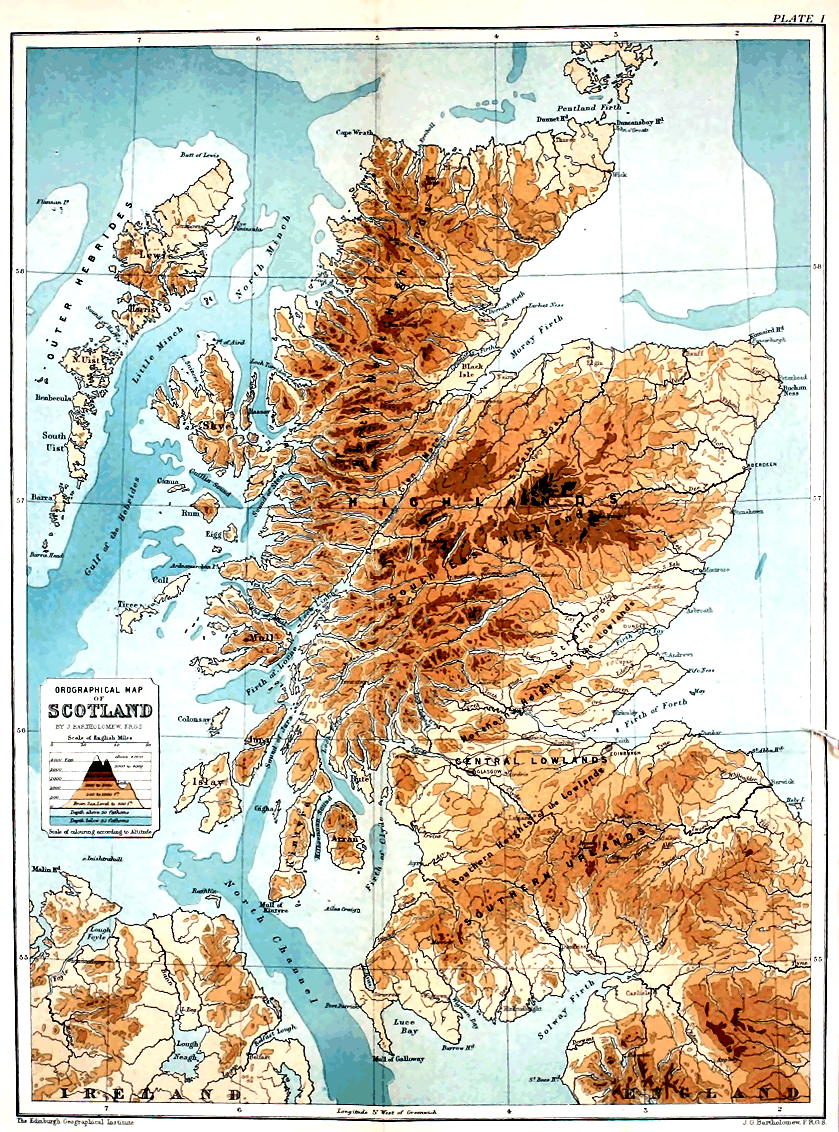
Scotland, like “all Gaul,” is divided into three parts, namely, the Highlands, the Central Lowlands, and the Southern Uplands. These, as a correctly drawn map will show, are natural divisions, for they are in accordance not only with the actual configuration of the surface, but with the geological structure of the country. The boundaries of these principal districts are well defined. Thus, an approximately straight or gently undulating line taken from Stonehaven, in a south-west direction, along the northern outskirts of Strathmore to Glen Artney, and thence through the lower reaches of Loch Lomond to the Firth of Clyde at Kilcreggan, marks out with precision the southern limits of the Highland area and the northern boundary of the Central Lowlands. The line that separates the Central Lowlands from the Southern Uplands is hardly so prominently marked throughout its entire course, but it follows precisely the same north-east and south-west trend, and may be traced from Dunbar along the base of the Lammermoor and Moorfoot Hills, the Lowthers, and the hills of Galloway and Carrick, to Girvan. In each of the two mountain-tracts—the Highlands and the Southern Uplands—areas of low-lying land occur, while in the intermediate Central Lowlands isolated prominences and certain well-defined belts of hilly ground make their appearance. The statement, so frequently repeated in class-books and manuals of geography, that the mountains of Scotland consist of three (some writers say five) “ranges” is erroneous and misleading. The original author of this strange statement — 15 — probably derived his ignorance of the physical features of the country from a study of those antiquated maps upon which the mountains of poor Scotland are represented as sprawling and wriggling about like so many inebriated centipedes and convulsed caterpillars. Properly speaking, there is not a true mountain-range in the country. If we take this term, which has been very loosely used, to signify a linear belt of mountains—that is, an elevated ridge notched by cols or “passes” and traversed by transverse valleys—then in place of “three” or “five” such ranges we might just as well enumerate fifty or sixty, or more, in the Highlands and Southern Uplands. Or, should any number of such dominant ridges be included under the term “mountain-range,” there seems no reason why all the mountains of the country should not be massed under one head and styled the “Scottish Range.” A mountain-range, properly so called, is a belt of high ground which has been ridged up by earth-movements. It is a fold, pucker, or wrinkle in the earth’s crust, and its general external form coincides more or less closely with the structure or arrangement of the rock-masses of which it is composed. A mountain-range of this characteristic type, however, seldom occurs singly, but is usually associated with other parallel ranges of the same kind—the whole forming together what is called a “mountain-chain,” of which the Alps may be taken as an example. That chain consists of a vast succession of various kinds of rocks, which at one time were disposed in horizontal layers or strata. But during subsequent earth-movements those horizontal beds were compressed laterally, squeezed, crumpled, contorted, and thrown, as it were, into gigantic undulations and sharper folds and plications. And, notwithstanding the enormous erosion or denudation to which the long parallel ridges or ranges have been subjected, we can yet see that the general contour of these corresponds in large measure to the plications or foldings of the strata. This is well shown in the Jura, the parallel ranges and intermediate hollows of which are formed by undulations of the folded strata—the tops of the long hills coinciding more or less closely with the arches, and the intervening hollows with the troughs. Now folded, crumpled, and — 16 — contorted rock-masses are common enough in the mountainous parts of Scotland, but the configuration of the surface rarely or never coincides with the inclination of the underlying strata. The mountain-crests, so far from being formed by the tops of great folds of the strata, frequently show precisely the opposite kind of structure. In other words, the rocks, instead of being inclined away from the hill-tops like the roof of a house from its central ridge, often dip into the mountains. When they do so on opposite sides the strata of which the mountains are built up seem arranged like a pile of saucers, one within another.
There is yet another feature which brings out clearly the fact that the slopes of the surface have not been determined by the inclination of the strata. The main water-parting that separates the drainage-system of the west from that of the east of Scotland does not coincide with any axis of elevation. It is not formed by an anticlinal fold or “saddleback.” In point of fact it traverses the strata at all angles to their inclination. But this would not have been the case had the Scottish mountains consisted of a chain of true mountain-ranges. Our mountains, therefore, are merely monuments of denudation, they are the relics of elevated plateaux which have been deeply furrowed and trenched by running water and other agents of erosion. A short sketch of the leading features presented by the three divisions of the country will serve to make this plain.
The Highlands.—The southern boundary of this, the most extensive of the three divisions, has already been defined. The straightness of that boundary is due to the fact that it coincides with a great line of fracture of the earth’s crust—on the north or Highland side of which occur slates, schists, and various other hard and tough rocks, while on the south side the prevailing strata are sandstones, etc., which are not of so durable a character. The latter, in consequence of the comparative ease with which they yield to the attacks of the eroding agents—rain and rivers, frost and ice—have been worn away to a greater extent than the former, and hence the Highlands, along their southern margin, abut more or less — 17 — abruptly upon the Lowlands. Looking across Strathmore from the Sidlaws or the Ochils, the mountains seem to spring suddenly from the low grounds at their base, and to extend north-east and south-west, as a great wall-like rampart. The whole area north and west of this line may be said to be mountainous, its average elevation being probably not less than 1500 feet above the sea.
A glance at the contoured or the shaded sheets of the Ordnance Survey’s map of Scotland will show better than any verbal description the manner in which our Highland mountains are grouped. It will be at once seen that to apply the term “range” to any particular area of those high grounds is simply a misuse of terms. Not only are the mountains not formed by plications and folds, but they do not even trend in linear directions. It is true that a well-trained eye can detect certain differences in the form and often in the colouring of the mountains when these are traversed from south-east to north-west. Such differences correspond to changes in the composition and structure of the rock-masses, which are disposed or arranged in a series of broad belts and narrower bands, running from south-west to north-east across the whole breadth of the Highlands. Each particular kind of rock gives rise to a special configuration, or to certain characteristic features. Thus, the mountains that occur within a belt of slate, often show a sharply cut outline, with more or less pointed peaks and somewhat serrated ridges—the Aberuchill Hills, near Comrie, are an example. In regions of gneiss and granite the mountains are usually rounded and lumpy in form. Amongst the schists, again, the outlines are generally more angular. Quartz-rock often shows peaked and jagged outlines; while each variety of rock has its own particular colour, and this in certain states of the atmosphere is very marked. The mode in which the various rocks yield to the “weather”—the forms of their cliffs and corries—these and many other features strike a geologist at once; and therefore, if we are to subdivide the Highland mountains into “ranges,” a geological classification seems the only natural arrangement that can be followed. Unfortunately, however, our geological — 18 — lines, separating one belt or “range” from another, often run across the very heart of great mountain-masses. Our “ranges” are distinguished from each other simply by superficial differences of feature and structure. No long parallel hollows separate a “range” of schist-mountains from the succeeding “ranges” of quartz-rock, gneiss, or granite. And no degree of careful contouring could succeed in expressing the niceties of configuration just referred to, unless the maps were on a very large scale indeed. A geological classification or grouping of the mountains into linear belts cannot therefore be shown upon any ordinary orographical map. Such a map can present only the relative heights and disposition of the mountain-masses, and these last, in the case of the Highlands, as we have seen, cannot be called “ranges” without straining the use of that term. Any wide tract of the Highlands, when viewed from a commanding position, looks like a tumbled ocean in which the waves appear to be moving in all directions. One is also impressed with the fact that the undulations of the surface, however interrupted they may be, are broad—the mountains, however they may vary in detail according to the character of the rocks, are massive, and generally round-shouldered and often somewhat flat-topped, while there is no great disparity of height amongst the dominant points of any individual group. Let us take, for example, the knot of mountains between Loch Maree and Loch Torridon. There we have a cluster of eight pyramidal mountain-masses, the summits of which do not differ much in elevation. Thus in Liathach two points reach 3358 feet and 3486 feet; in Beinn Alligin there are also two points reaching 3021 feet and 3232 feet respectively; in Beinn Dearg we have a height of 2995 feet; in Beinn Eighe are three dominant points—3188 feet, 3217 feet, and 3309 feet. The four pyramids to the north are somewhat lower—their elevations being 2860 feet, 2801 feet, 2370 feet, and 2892 feet. The mountains of Lochaber and the Monadhliath Mountains exhibit similar relationships; and the same holds good with all the mountain-masses of the Highlands. No geologist can doubt that such relationship is the result of denudation. The mountains are — 19 — monuments of erosion—they are the wreck of an old table-land—the upper surface and original inclination of which are approximately indicated by the summits of the various mountain-masses and the direction of the principal water-flows. If we in imagination fill up the valleys with the rock-material which formerly occupied their place, we shall in some measure restore the general aspect of the Highland area before its mountains began to be shaped out by Nature’s saws and chisels.
It will be observed that while streams descend from the various mountains to every point in the compass, their courses having often been determined by geological structure, etc., their waters yet tend eventually to collect and flow as large rivers in certain definite directions. These large rivers flow in the direction of the average slope of the ancient table-land, while the main water-partings that separate the more extensive drainage-areas of the country mark out, in like manner, the dominant portions of the same old land-surface. The water-parting of the North-west Highlands runs nearly north and south, keeping quite close to the western shore, so that nearly all the drainage of that region flows inland. The general inclination of the North-west Highlands is therefore easterly towards Glenmore and the Moray Firth. In the region lying east of Glenmore the average slopes of the land are indicated by the directions of the rivers Spey, Don, and Tay. These two regions—the North-west and South-east Highlands—are clearly separated by the remarkable depression of Glenmore, which extends through Loch Linnhe, Loch Lochy, and Loch Ness, and the further extension of which towards the north-east is indicated by the straight coast-line of the Moray Firth as far as Tarbat Ness. Now, this long depression marks a line of fracture and displacement of very great geological antiquity. The old plateau of the Highlands was fissured and split in two—that portion which lay to the north-west sinking along the line of fissure to a great but at present unascertained depth. Thus the waters that flowed down the slopes of the north-west portion of the broken plateau were dammed by the long wall of rock on the “up-cast,” or south-east side of the fissure, and — 20 — compelled to flow off to north-east and south-west along the line of breakage. The erosion thus induced sufficed in the course of time to hollow out Glenmore and all the mountain-valleys that open upon it from the west.
The inclination of that portion of the fissured plateau which lay to the south-east is indicated, as already remarked, by the trend of the principal rivers. It was north-east in the Spey district, nearly due east in the area drained by the Don, east and south-east in that traversed by the Tay and its affluents, westerly and south-westerly in the district lying east of Loch Linnhe.[C] Thus, a line drawn from Ben Nevis through the Cairngorm and Ben Muich Dhui Mountains to Kinnaird Point passes through the highest land in the South-east Highlands, and probably indicates approximately the dominant portion of the ancient plateau. North of that line the drainage is towards the Moray Firth; east of it the rivers discharge to the North Sea; while an irregular winding line, drawn from Ben Nevis eastward through the Moor of Rannoch and southward to Ben Lomond, forms the water-parting between the North Sea and the Atlantic, and doubtless marks another dominant area of the old table-land.
[C] The geological reader hardly requires to be reminded that many of the minor streams would have their courses determined, or greatly modified, by the geological structure of the ground. Thus, such streams often flow along the “strike” and other “lines of weakness,” and similar causes, doubtless, influenced the main rivers during the gradual excavation of their valleys.
That the valleys which discharge their water-flow north and east to the Moray Firth and the North Sea have been excavated by rivers and the allied agents of erosion, is sufficiently evident. All the large rivers of that wide region are typical. They show the orthodox three courses—namely, a torrential or mountain-track, a middle or valley-track, and a lower or plain-track. The same is the case with some of the rivers that flow east from the great north-and-south water-parting of the North-west Highlands, as, for example, those that enter the heads of Beauly Firth, Cromarty Firth, and Dornoch Firth. Those, however, which descend to Loch Lochy and Loch Linnhe, and the sea-lochs of Argyllshire, have no lower or — 21 — plain-track. When we cross the north-and-south water-parting of the North-west Highlands, we find that many of the streams are destitute of even a middle or valley-track. The majority are mere mountain-torrents when they reach the sea. Again, on the eastern watershed of the same region, a large number of the valleys contain lakes in their upper and middle reaches, and this is the case also with not a few of the valleys that open upon the Atlantic. More frequently, however, the waters flowing west pass through no lakes, but enter the sea at the heads of long sea-lochs or fiords. This striking contrast between the east and west is not due to any difference in the origin of the valleys. The western valleys are as much the result of erosion as those of the east. The present contrast, in fact, is more apparent than real, and arises from the fact that the land area on the Atlantic side has been greatly reduced in extent by subsidence. The western fiords are merely submerged land-valleys. Formerly the Inner and Outer Hebrides were united to themselves and the mainland, the country of which they formed a part stretching west into the Atlantic, as far probably as the present 100 fathoms line. Were that drowned land to be re-elevated, each of the great sea-lochs would appear as a deep mountain-valley containing one or more lake-basins of precisely the same character as those that occur in so many valleys on the eastern watershed. Thus we must consider all the islands lying off the west coast of the Highlands, including the major portions of Arran and Bute, as forming part and parcel of the Highland division of Scotland. The presence of the sea is a mere accident; the old lands now submerged were above its level during a very recent geological period—a period well within the lifetime of the existing fauna and flora.
The old table-land of which the Highlands and Islands are the denuded and unsubmerged relics, is of vast geological antiquity. It was certainly in existence, and had even undergone very considerable erosion, before the Old Red Sandstone period, as is proved by the fact that large tracts of the Old Red Sandstone formation are found occupying hollows in its surface. Glenmore had already been excavated when the — 22 — conglomerates of the Old Red Sandstone began to be laid down. Some of the low-lying maritime tracts of the Highland area in Caithness, and the borders of the Moray Firth, are covered with the sandstones of that age; and there is evidence to show that these strata formerly extended over wide regions, from which they have since been removed by erosion. The fact that the Old Red Sandstone deposits still occupy such extensive areas in the north-east of the mainland, and in Orkney, shows that the old table-land shelved away gradually to north and east, and the same conclusion may be drawn, as we have seen, from the direction followed by the main lines of the existing drainage-system. We see, in short, in the table-land of the Highlands, one of the oldest elevated regions of Europe—a region which has been again and again submerged either in whole or in part, and covered with the deposits of ancient seas and lakes, only to be re-elevated, time after time, and thus to have those deposits in large measure swept away from its surface by the long-continued action of running water and other agents of denudation.
The Central Lowlands.—The belt of low-lying ground that separates the Highlands from the Southern Uplands is, as we have seen, very well defined. In many places the Uplands rise along its southern margin as abruptly as the Highlands in the north. The southern margin coincides, in fact, for a considerable distance (from Girvan to the base of the Moorfoots) with a great fracture that runs in the same direction as the bounding fracture or fault of the Highlands. The Central Lowlands may be described, in a word, as a broad depression between two table-lands. A glance at the map will show that the principal features of the Lowlands have a north-easterly trend—the same trend, in fact, as the bounding lines of the division. To this arrangement there are some exceptions, the principal being the belt of hilly ground that extends from the neighbourhood of Paisley, south-east through the borders of Renfrewshire and Ayrshire, to the vicinity of Muirkirk. The major part of the Lowlands is under 500 feet in height, but some considerable portions exceed an elevation of 1000 feet, — 23 — while here and there the hills approach a height of 2000 feet—the two highest points (2352 and 2335 feet) being attained in Ben Cleugh, one of the Ochils, and in Tinto. Probably the average elevation of the Lowland division does not exceed 350 or 400 feet. Speaking generally, the belts of hilly ground, and the more or less isolated prominences, are formed of more durable rocks than are met with in the adjacent lower-lying tracts. Thus the Sidlaws, the Ochil Hills, and the heights in Renfrewshire and Ayrshire, are composed chiefly of more or less hard and tough volcanic rocks; and when sandstones enter into the formation of a line of hills, as in the Sidlaws, they generally owe their preservation to the presence of the volcanic rocks with which they are associated. This is well illustrated by the Lomond Hills in Fifeshire, the basal and larger portion of which consists chiefly of somewhat soft sandstones, which have been protected from erosion by an overlying sheet of hard basalt-rock. All the isolated hills in the basin of the Forth are formed of knobs, bosses, and sheets of various kinds of igneous rock, which are more durable than the sandstones, shales, and other sedimentary strata by which they are surrounded. Hence it is very evident that the configuration of the Lowland tracts of Central Scotland is due to denudation. The softer and more readily disintegrated rocks have been worn away to a greater extent than the harder and less yielding masses.
Only in a few cases do the slopes of the hill-belts coincide with folds of the strata. Thus, the northern flanks of the Sidlaws and the Ochils slope towards the north-west, and this also is the general inclination of the old lavas and other rocks of which those hills are composed. The southern flanks of the same hill-belt slope in Fifeshire towards the south-east—this being also the dip or inclination of the rocks. The crest of the Ochils coincides, therefore, more or less closely, with an anticlinal arch or fold of the strata. But when we follow the axis of this arch towards the north-east into the Sidlaws, we find it broken through by the Tay valley—the axial line running down through the Carse of Gowrie to the north of Dundee. From the fact that many similar anticlinal axes — 24 — occur throughout the Lowlands, which yet give rise to no corresponding features at the surface, we may conclude that the partial preservation of the anticline of the Ochils and Sidlaws is simply owing to the greater durability of the materials of which those hills consist. Had the arch been composed of sandstones and shales it would most probably have given rise to no such prominent features as are now visible.
Another hilly belt, which at first sight appears to correspond roughly to an anticlinal axis, is that broad tract of igneous rocks which separates the Kilmarnock coal-field from the coal-fields of the Clyde basin. But although the old lavas of that hilly tract slope north-east and south-west, with the same general inclination as the surface, yet examination shows that the hills do not form a true anticline. They are built up of a great variety of ancient lavas and fragmental tuffs or “ashes,” which are inclined in many different directions. In short, we have in those hills the degraded and sorely denuded fragments of an ancient volcanic bank, formed by eruptions that began upon the bottom of a shallow sea in early Carboniferous times, and subsequently became sub-aërial. And there is evidence to show that after the eruptions ceased the volcanic bank was slowly submerged, and eventually buried beneath the accumulating sediments of later Carboniferous times. The exposure of the ancient volcanic bank at the surface has been accomplished by the denudation of the stratified masses which formerly covered it, and its existence as a dominant elevation at the present day is solely due to the fact that it is built up of more resistant materials than occur in the adjacent low-lying areas. The Ochils and the Sidlaws are of greater antiquity, but have a somewhat similar history. Into this, however, it is not necessary to go.
The principal hills of the Lowlands form two interrupted belts, extending north-east and south-west, one of them, which we may call the Northern Heights, facing the Highlands, and the other, which may in like manner be termed the Southern Heights, flanking the great Uplands of the south. The former of these two belts is represented by the Garvock Hills, lying — 25 — between Stonehaven and the valley of the North Esk; the Sidlaws, extending from the neighbourhood of Montrose to the valley of the Tay at Perth; the Ochil Hills, stretching along the south side of the Firth of Tay to the valley of the Forth at Bridge-of-Allan; the Lennox Hills, ranging from the neighbourhood of Stirling to Dumbarton; the Kilbarchan Hills, lying between Greenock and Ardrossan; the Cumbrae Islands and the southern half of Arran; and the same line of heights reappears in the south end of Kintyre. A well-marked hollow, trough, or undulating plain of variable width, separates these Northern Heights from the Highlands, and may be followed all the way from near Stonehaven, through Strathmore, to Crieff and Auchterarder. Between the valleys of the Earn and Teith this plain attains an abnormal height (the Braes of Doune); but from the Teith, south-west by Flanders Moss and the lower end of Loch Lomond to the Clyde at Helensburgh, it resumes its characteristic features. It will be observed also that a hollow separates the southern portion of Arran from the much loftier northern or Highland area. The tract known as the Braes of Doune, extending from Glen Artney south-east to Strath Allan, although abutting upon the Highlands, is clearly marked off from that great division by geological composition and structure, by elevation and configuration. It is simply a less deeply eroded portion of the long trough or hollow.
Passing now to the Southern Heights of the Lowlands, we find that these form a still more interrupted belt than the Northern Heights, and that they are less clearly separated by an intermediate depression from the great Uplands which they flank. They begin in the north-east with the isolated Garleton Hills, between which and the Lammermoors a narrow low-lying trough or hollow appears. A considerable width of low ground now intervenes before we reach the Pentland Hills, which are in like manner separated from the Southern Uplands by a broad low-lying tract. At their southern extremity, however, the Pentlands merge more or less gradually into a somewhat broken and interrupted group of hills which abut abruptly on the Southern Uplands, in the same — 26 — manner as the Braes of Doune abut upon the slate hills of the Highland borders. In this region the greatest heights reached are in Tinto (2335 feet), and Cairntable (1844 feet), and, at the same time, the hills broaden out towards north-west, where they are continued by the belt of volcanic rocks already described as extending between the coal-fields of the Clyde and Kilmarnock. Although the Southern Heights abut so closely upon the Uplands lying to the south, there is no difficulty in drawing a firm line of demarcation between the two areas—geologically and physically they are readily distinguished. No one with any eye for form, no matter how ignorant he may be of geology, can fail to see how strongly contrasted are such hills as Tinto and Cairntable with those of the Uplands, which they face. The Southern Heights are again interrupted towards the south-east by the valleys of the Ayr and the Doon, but they reappear in the hills that extend from the Heads of Ayr to the valley of the Girvan.
Betwixt the Northern and Southern Heights spread the broad Lowland tracts that drain towards the Forth, together with the lower reaches of the Clyde valley, and the wide moors that form the water-parting between that river and the estuary of the Forth. The hills that occur within this inner region of the Central Lowlands are usually more or less isolated, and are invariably formed by outcrops of igneous rock. Their outline and general aspect vary according to the geological character of the rocks of which they are composed—some forming more or less prominent escarpments like those of the Bathgate Hills and the heights behind Burntisland and Kinghorn, others showing a soft rounded contour like the Saline Hills in the west of Fifeshire. Of the same general character as this inner Lowland region is the similar tract watered by the Irvine, the Ayr, and the Doon. This tract, as we have seen, is separated from the larger inner region lying to the east by the volcanic hills that extend from the Southern Heights north-west into Renfrewshire.
The largest rivers that traverse the Central Lowlands take — 27 — their rise, as might be expected, in the mountainous table-lands to the north and south. Of these the principal are the North and South Esks, the Tay and the Isla, the Earn, and the Forth, all of which, with numerous tributaries, descend from the Highlands. And it will be observed that they have breached the line of the Northern Heights in three places—namely, in the neighbourhood of Montrose, Perth, and Stirling.
The only streams of importance coming north from the Southern Uplands are the Clyde and the Doon, both of which in like manner have broken through the Southern Heights. Now, just as the main water-flows of the Highlands indicate the average slope of the ancient land-surface before it was trenched and furrowed by the innumerable valleys that now intersect it, so the direction followed by the greater rivers that traverse the Lowlands mark out the primeval slopes of that area. One sees at a glance, then, that the present configuration of this latter division has been brought about by the erosive action of the principal rivers and their countless affluents, aided by the sub-aërial agents generally—rain, frost, ice, etc. The hills rise above the average level of the ground, not because they have been ridged up from below, but simply owing to the more durable nature of their component rocks. That the Northern and Southern Heights are breached only shows that the low grounds, now separating those heights from the adjacent Highlands and Southern Uplands, formerly stood at a higher level, and so allowed the rivers to make their way more or less directly to the sea. Thus, for example, the long trough of Strathmore has been excavated out of sandstones, the upper surface of which once reached a much greater height, and sloped outwards from the Highlands across what is now the ridge of the Sidlaw Hills. Here then, in the Central Lowlands, as in the Highlands, true mountain- or hill-ranges are absent. But if we are permitted to term any well-marked line or belt of high ground a “range,” then the Northern and Southern Heights of the Lowlands are better entitled to be so designated than any series of mountains in the Highlands.
The Southern Uplands.—The northern margin of this wide division having already been defined, we may now proceed to examine the distribution of its mountain-masses. Before doing so, however, it may be as well to point out that considerable tracts in Tweeddale, Teviotdale, and Liddesdale, together with the Cheviot Hills, do not properly belong to the Southern Uplands. In fact, the Cheviots bear the same relation to those Uplands as the Northern Heights do to the Highlands. Like them they are separated by a broad hollow from the Uplands, which they face—a hollow that reaches its greatest extent in Tweeddale, and rapidly wedges out to south-west, where the Cheviots abut abruptly on the Uplands. Even where this abrupt contact takes place, however, the different configuration of the two regions would enable any geologist to separate the one set of mountains from the other. But for geographical purposes we may conveniently disregard these geological contrasts, and include within the Southern Uplands all the area lying between the Central Lowlands and the English Border.
If there are no mountains in the Highlands so grouped and arranged as to be properly termed “ranges,” this is not less true of the Southern Uplands. Perhaps it is the appearance which those Uplands present when viewed from the Central Lowlands that first suggested the notion that they were ranges. They seem to rise like a wall out of the low grounds at their base, and extend far as eye can reach in an approximately straight line. It seems more probable, however, that our earlier cartographers merely meant, by their conventional hill-shading, to mark out definitely the water-partings. But to do so in this manner now, when the large contour maps of the Ordnance Survey may be in any one’s hands, is inexcusable. A study of those maps, or, better still, a visit to the tops of a few of the dominant points in the area under review, will effectually dispel the idea that the Southern Uplands consist of a series of ridges zigzagging across the country. Like the Highlands, the area of the Southern Uplands is simply an old table-land, furrowed into ravine and valley by the operation of the various agents of erosion.
Beginning our survey of these Uplands in the east, we encounter first the Lammermoor Hills—a broad undulating plateau—the highest elevations of which do not reach 2000 feet. West of this come the Moorfoot Hills and the high grounds lying between the Gala and the Tweed—a tract which averages a somewhat higher elevation—two points exceeding 2000 feet in height. The next group of mountains we meet is that of the Moffat Hills, in which head a number of important rivers—the Tweed, the Yarrow, the Ettrick, and the Annan. Many points in this region exceed 2000 feet, others approach 2500 feet; and some reach nearly 3000 feet, such as Broad Law (2754 feet), and Dollar Law (2680 feet). In the south-west comes the group of the Lowthers, with dominant elevations of more than 2000 feet. Then follow the mountain-masses in which the Nith, the Ken, the Cree, the Doon, and the Girvan take their rise, many of the heights exceeding 2000 feet, and a number reaching and even passing 2500 feet, the dominant point being reached in the noble mountain-mass of the Merrick (2764 feet). In the extreme south-west the Uplands terminate in a broad undulating plateau, of which the highest point is but little over 1000 feet. All the mountain-groups now referred to are massed along the northern borders of the Southern Uplands. In the south-west the general surface falls more or less gradually away towards the Solway—the 500 feet contour line being reached at fifteen miles, upon an average, from the sea-coast. In the extreme north-east the high grounds descend in like manner into the rich low grounds of the Merse. Between these low grounds and Annandale, however, the Uplands merge, as it were, into the broad elevated moory tract that extends south-east, to unite with the Cheviots—a belt of hills rising along the English Border to heights of 1964 feet (Peel Fell), and 2676 feet (the Cheviot).
The general configuration of the main mass of the Southern Uplands—that is to say, the mountain-groups extending along the northern portion of the area under review, from Loch Ryan to the coast between Dunbar and St. Abb’s Head—is somewhat tame and monotonous. The mountains are — 30 — flat-topped elevations, with broad, rounded shoulders and smooth grassy slopes. Standing on the summits of the Higher hills, one seems to be in the midst of a wide, gently undulating plain, the surface of which is not broken by the appearance of any isolated peaks or eminences. Struggling across the bogs and peat-mosses that cover so many of those flat-topped mountains, the wanderer ever and anon suddenly finds himself on the brink of a deep green dale. He discovers, in short, that he is traversing an elevated undulating table-land, intersected by narrow and broad trench-like valleys that radiate outwards in all directions from the dominant bosses and swellings of the plateau. The mountains, therefore, are merely broad ridges and banks separating contiguous valleys; in a word, they are, like the mountains of the Highlands, monuments of erosion, which do not run in linear directions, but form irregular groups and masses.
The rocks that enter into the formation of this portion of the Southern Uplands have much the same character throughout. Consequently there is less variety of contour and colour than in the Highlands. The hills are not only flatter atop, but are much smoother in outline, there being a general absence of those beetling crags and precipices which are so common in the Highland regions. Now and again, however, the mountains assume a rougher aspect. This is especially the case with those of Carrick and Galloway, amongst which we encounter a wildness and grandeur which are in striking contrast to the gentle pastoral character of the Lowthers and similar tracts extending along the northern and higher parts of the Southern Uplands. Descending to details, the geologist can observe also modifications of contour even among those monotonous rounded hills. Such modifications are due to differences in the character of the component rocks, but they are rarely so striking as the modifications that arise from the same cause in the Highlands. To the trained eye, however, they are sufficiently manifest, and upon a geologically coloured map, which shows the various belts of rock that traverse the Uplands from south-west to north-east, it will be found that the mountains occurring within — 31 — each of those separate belts have certain distinctive features. Such features, however, cannot be depicted upon a small orographical map. The separation of those mountains into distinct ranges, by reference to their physical aspect, is even less possible here than in the Highlands. Now and again, bands of certain rocks, which are of a more durable character than the other strata in their neighbourhood, give rise to pronounced ridges and banks, while hollows and valleys occasionally coincide more or less closely with the outcrops of the more readily eroded strata; but such features are mere minor details in the general configuration of the country. The courses of brooks and streams may have been frequently determined by the nature and arrangement of the rocks, but the general slope of the Uplands and the direction of the main lines of water-flow are at right angles to the trend of the strata, and cannot therefore have been determined in that way. The strata generally are inclined at high angles—they occur, in short, as a series of great anticlinal arches and synclinal curves, but the tops of the grand folds have been planed off, and the axes of the synclinal troughs, so far from coinciding with valleys, very often run along the tops of the highest hills. The foldings and plications do not, in a word, produce any corresponding undulations of the surface.
Mention has been made of the elevated moory tracts that serve to connect the Cheviots with the loftier Uplands lying to north-west. The configuration of these moors is tamer even than that of the regions just described, but the same general form prevails from the neighbourhood of the Moffat Hills to the head-waters of the Teviot. There, however, other varieties of rock appear, and produce corresponding changes in the aspect of the high grounds. Not a few of the hills in this district stand out prominently. They are more or less pyramidal and conical in shape, being built up of sandstones often crowned atop with a capping of some crystalline igneous rock, such as basalt. The Maiden Paps, Leap Hill, Needs Law, and others are examples. The heights draining towards Liddesdale and lower reaches of Eskdale, composed — 32 — chiefly of sandstones, with here and there intercalated sheets of harder igneous rock, frequently show escarpments and terraced outlines, but have a general undulating contour; and similar features are characteristic of the sandstone mountains that form the south-west portion of the Cheviots. Towards the north-east, however, the sandstones give place to various igneous rocks, so that the hills in the north-east section of the Cheviots differ very much in aspect and configuration from those at the other extremity of the belt. They have a more varied and broken outline, closely resembling many parts of the Ochils and other portions of the Northern and Southern Heights of the Central Lowlands.
The low-lying tracts of Roxburghshire and the Merse, in like manner, present features which are common to the inner region of the Central Lowlands. Occasional ridges of hills rise above the general level of the land, as at Smailholm and Stitchell to the north of Kelso, while isolated knolls and prominences—some bald and abrupt, others smooth and rounded—help to diversify the surface. Bonchester Hill, Rubers Law, the Dunian, Penielheugh, Minto Hills, and the Eildons may be mentioned as examples. All of these are of igneous origin, some being mere caps of basalt resting upon a foundation of sandstone, while others are the stumps of isolated volcanoes.
In the maritime tracts of Galloway the low grounds repeat, on a smaller scale, the configuration of the lofty Uplands behind, for they are composed of the same kinds of rock. Their most remarkable feature is the heavy mountain-mass of Criffel, rising near the mouth of the Nith to a height of 1800 feet.
Everywhere, therefore, throughout the region of the Southern Uplands, in hilly and low-lying tracts alike, we see that the land has been modelled and contoured by the agents of erosion. We are dealing, as in the Highlands, with an old table-land, in which valleys have been excavated by running water and its helpmates. Nowhere do we encounter any linear banks, ridges, or ranges as we find described in the class-books, and represented upon many general maps — 33 — of the country. In one of those manuals we read that in the southern district “the principal range of mountains is that known as the Lowther Hills, which springs off from the Cheviots, and, running in a zigzag direction to the south-west, terminates on the west coast near Loch Ryan.” This is quite true, according to many common maps, but unfortunately the “range” exists upon those maps and nowhere else. The zigzag line described is not a range of mountains, but a water-parting, which is quite another matter.
The table-land of the Southern Uplands, like that of the Highlands, is of immense antiquity. Long before the Old Red Sandstone period, it had been furrowed and trenched by running water. Of the original contour of its surface, all we can say is that it formed an undulating plateau, the general slope of which was towards south-east. This is shown by the trend of the more important rivers, such as the Nith and the Annan, the Gala and the Leader; and by the distribution of the various strata pertaining to the Old Red Sandstone and later geological periods. Thus, strata of Old Red Sandstone and Carboniferous age occupy the Merse and the lower reaches of Teviotdale, and extend up the valleys of the Whiteadder and the Leader into the heart of the Silurian Uplands. In like manner Permian sandstones are well developed in the ancient hollows of Annandale and Nithsdale. Along the northern borders of the Southern Uplands we meet with similar evidence to show that even as early as Old Red Sandstone times the old plateau, along what is now its northern margin, was penetrated by valleys that drained towards the north. The main drainage, however, then as now, was directed towards south-east.
Many geological facts conspire to show that the Silurian table-land of these Uplands has been submerged, like the Highlands, in whole or in part. This happened at various periods, and each time the land went down it received a covering of newer accumulations—patches of which still remain to testify to the former extent of the submergences. From the higher portions of the Uplands those accumulations have been almost wholly swept away, but they have not been — 34 — entirely cleared out of the ancient valleys. They still mantle the borders of the Silurian area, particularly in the north-east, where they attain a great thickness in the moors of Liddesdale and the Cheviot Hills. The details of the evolution of the whole area of the Southern Uplands form an interesting study, but this pertains rather to Geology than to Physical Geography. It is enough, from our present point of view, to be assured that the main features of the country were chalked out, as it were, at a very distant geological period, and that all the infinite variety in the relief of our land has been brought about directly, not by titanic convulsions and earth-movements, but by the long-continued working of rain and rivers—of frost and snow and ice, supplemented from time to time by the action of the sea.
The physical features more particularly referred to in this paper are of course only the bolder and more prominent contours—those namely which can be expressed with sufficient accuracy upon sheets of such a size as the accompanying orographical map of Scotland (Plate I.). With larger maps considerably more detail can be added, and many characteristic and distinguishing features will appear according to the care with which such maps are drawn. In the case of the Ordnance Survey map, on the scale of 1 inch to a mile, the varying forms of the surface are so faithfully delineated as frequently to indicate to a trained observer the nature of the rocks and the geological structure of the ground. The artists who sketched the hills must indeed have had good eyes for form. So carefully has their work been done, that it is often not difficult to distinguish upon their maps hills formed of such rocks as sandstone from those that are composed of more durable kinds. The individual characteristics of mountains of schist, of granite, of quartz-rock, of slate, are often well depicted: nay, even the varieties of igneous rock which enter into the formation of the numerous hills and knolls of the Lowlands can frequently be detected by the features which the artists have so intelligently caught. Another set of features which their maps display are those due to glaciation. These are admirably brought out, even down to the — 35 — smallest details. A glance at such maps as those of Teviotdale and the Merse, for example, shows at once the direction taken by the old mer de glace. The long parallel flutings of the hill-slopes, roches moutonnées, projecting knolls and hills with their “tails,” the great series of banks and ridges of stony clay which trend down the valley of the Tweed—these, and many more details of interest to specialists, are shown upon the maps. All over Scotland similar phenomena are common, and have been reproduced with marvellous skill on the shaded sheets issued by the Ordnance Survey. And yet the artists were not geologists. The present writer is glad of this opportunity of recording his obligations to those gentlemen. Their faithful delineations of physical features have given him many valuable suggestions, and have led up to certain observations which might otherwise not have been made.
Mountains: Their Origin, Growth, and Decay.[D]
[D] Scottish Geographical Magazine, vol. ii., 1886.
Mountains have long had a fascination for lovers of nature. Time was, however, when most civilised folk looked upon them with feelings akin to horror; and good people, indeed, have written books to show that they are the cursed places of the earth—the ruin and desolation of their gorges and defiles affording indubitable proof of the evils which befell the world when man lapsed from his primitive state of innocence and purity. All this has changed. It is the fashion now to offer a kind of worship to mountains; and every year their solitudes are invaded by devotees—some, according to worthy Meg Dods, “rinning up hill and down dale, knapping the chuckie-stanes to pieces wi’ hammers, like sae mony roadmakers run daft—to see, as they say, how the warld was made”—others trying to transfer some of the beauty around them to paper or canvas—yet others, and these perhaps not the least wise, content, as old Sir Thomas Browne has it, “to stare about with a gross rusticity,” and humbly thankful that they are beyond the reach of telegrams, and see nothing to remind them of the fumun et opes strepitumque Romæ. But if the sentiment with which mountains are regarded has greatly changed, so likewise have the views of scientific men as to their origin and history. Years ago no one doubted that all mountains were simply the result of titanic convulsions. The crust of the earth had been pushed up from below, tossed into — 37 — great billows, shivered and shattered—the mountains corresponding to the crests of huge earth-waves, the valleys to the intervening depressions, or to gaping fractures and dislocations. This view of the origin of mountains has always appeared reasonable to those who do not know what is meant by geological structure, and in some cases it is pretty near the truth. A true mountain-chain, like that of the Alps, does indeed owe its origin to gigantic disturbances of the earth’s crust, and in such a region the larger features of the surface often correspond more or less closely with the inclination of the underlying rocks. But in many elevated tracts, composed of highly disturbed and convoluted strata, no such coincidence of surface-features and underground structure can be traced. The mountains do not correspond to great swellings of the crust—the valleys neither lie in trough-shaped strata, nor do they coincide with gaping fractures. Again, many considerable mountains are built up of rocks which have not been convoluted at all, but occur in approximately horizontal beds. Evidently, therefore, some force other than subterranean action must be called upon to explain the origin of many of the most striking surface-features of the land.
Every geologist admits—it is one of the truisms of his science—that corrugations and plications are the result of subterranean action. Nor does any one deny that when a true mountain-chain was first upheaved the greater undulations of the folded strata probably gave rise to similar undulations at the surface. Some of the larger fractures and dislocations might also have appeared at the surface and produced mural precipices. So long a time, however, has elapsed since the elevation of even the youngest mountain-chains of the globe that the sub-aërial agents of erosion—rain, frost, rivers, glaciers, etc.—have been enabled greatly to modify their primeval features. For these mountains, therefore, it is only partially true that their present slopes coincide with those of the underlying strata. Such being the case with so young a chain as the Alps, we need not be surprised to meet with modifications on a still grander scale in mountain-regions of much greater antiquity. In — 38 — many such tracts the primeval configuration due to subterranean action has been entirely remodelled, so that hills now stand where deep hollows formerly existed, while valleys frequently have replaced mountains. And this newer configuration is the direct result of erosion, guided by the mineralogical composition and structural peculiarities of the rocks.
It is difficult, or even impossible, for one who is ignorant of geological structure to realise that the apparently insignificant agents of erosion have played so important a rôle in the evolution of notable earth-features. It may be well, therefore, to illustrate the matter by reference to one or two regions where the geological structure is too simple to be misunderstood. The first examples I shall give are from tracts of horizontal strata. Many readers are doubtless aware of the fact that our rock-masses consist for the most part of the more or less indurated and compacted sediments of former rivers, lakes, and seas. Frequently those ancient water-formed rocks have been very much altered, so as even sometimes to acquire a crystalline character. But it is enough for us now to remember that the crust of the globe, so far as that is accessible to observation, is built up mostly of rocks which were originally accumulated as aqueous sediments. Such being the case, it is obvious that our strata of sandstone, conglomerate, shale, limestone, etc., must at first have been spread out in approximately horizontal or gently inclined sheets or layers. We judge so from what we know of sediments which are accumulating at present. The wide flats of our river valleys, the broad plains that occupy the sites of silted-up lakes, the extensive deltas of such rivers as the Nile and the Po, the narrow and wide belts of low-lying land which within a recent period have been gained from the sea, are all made up of various kinds of sediment arranged in approximately horizontal layers. Now, over wide regions of the earth’s surface the sedimentary strata still lie horizontally, and we can often tell at what geological period they became converted into dry land. Thus, for example, we know that the elevated plateau through which the river — 39 — Colorado flows is built up of a great series of nearly horizontal beds of various sedimentary deposits, which reach a thickness of many thousand feet. It is self-evident that the youngest strata must be those which occur at the surface of the plateau, and they, as we know, are of lacustrine origin and belong to the Tertiary period. Now, American geologists have shown that since that period several thousands of feet of rock-materials have been removed from the surface of that plateau—the thickness of rock so carried away amounting in some places to nearly 10,000 feet. Yet all that prodigious erosion has been effected since early Tertiary times. Indeed, it can be proved that the excavation of the Grand Ca¤on of the Colorado, probably the most remarkable river-trench in the world, has been accomplished since the close of the Tertiary period, and is therefore a work of more recent date than the last great upheaval of the Swiss Alps. The origin of the ca¤on is self-evident—it is a magnificent example of river-erosion, and the mere statement of its dimensions gives one a forcible impression of the potency of sub-aërial denudation. The river-cutting is about 300 miles long, 11 or 12 miles broad, and varies from 3000 to 6000 feet in depth.
Take another example of what denuding agents have done within a recent geological period. The Faröe Islands, some twenty in number, extend over an area measuring about 70 miles from south to north, and nearly 50 miles from west to east. These islands are composed of volcanic rocks—beds of basalt with intervening layers of fine fragmental materials, and are obviously the relics of what formerly was one continuous plateau, deeply trenched by valleys running in various directions. Subsequent depression of the land introduced the sea to these valleys, and the plateau was then converted into a group of islands, separated from each other by narrow sounds and fiords. Were the great plateau through which the Colorado flows to be partially submerged, it would reproduce on a larger scale the general phenomena presented by this lonely island-group of the North Atlantic. The flat-topped “buttes” and “mesas,” and the pyramidal mountains — 40 — of the Colorado district would form islands comparable to those of the Faröes. Most of the latter attain a considerable elevation above the sea—heights of 1700, 2000, 2500, and 2850 feet being met with in several of the islands. Indeed, the average elevation of the land in this northern archipelago can hardly be less than 900 feet. The deep trench-like valleys are evidently only the upper reaches of valleys which began to be excavated when the islands formed part and parcel of one and the same plateau—the lower reaches being now occupied by fiords and sounds. It is quite certain that all these valleys are the work of erosion. One can trace the beds of basalt continuously across the bottoms, and be quite sure that the valleys are not gaping cracks or fractures. Now, as the strata are approximately horizontal, it is obvious that the hollows of the surface have nothing whatever to do with undulations produced by earth-movements. The sub-aërial erosion of the islands has resulted in the development of massive flat-topped and pyramidal mountains. These stand up as eminences simply because the rock-material which once surrounded them has been gradually broken up and carried away. Nothing can well be more impressive to the student of physical geology than the aspect presented by these relics of an ancient plateau (Plate II. Fig. 1). Standing on some commanding elevation, such as Nakkin in Suderöe, one sees rising before him great truncated pyramids—built up of horizontal beds of basalt rising tier above tier—the mountains being separated from each other by wide and profound hollows, across which the basalt-beds were once continuous. Owing to the parallel and undisturbed position of the strata, it is not hard to form an estimate of the amount of material which has been removed during the gradual excavation of the valleys. In order to do so we have simply to measure the width, depth, and length of the valleys. Thus in Suderöe, which is 19 miles long and 6 miles broad, the bottoms of the valleys are 1000 feet at least below the tops of the mountains, and some of the hollows in question are a mile in width. Now, the amount of rock worn away from this one little island by sub-aërial — 41 — erosion cannot be less than that of a mass measuring 10 miles in length by 6 miles in breadth, and 800 feet in thickness. And yet the Faröe Islands are composed of rocks which had no existence when the soft clays, etc., of the London Basin were being accumulated. All the erosion referred to has taken place since the great upheaval of the Eocene strata of the Swiss Alps.
But if the evidence of erosion be so conspicuous in regions composed of horizontal strata, it is not less so in countries where the rocks are inclined at various angles to the horizon. Indeed, the very fact that inclined strata crop out at the surface is sufficient evidence of erosion. For it is obvious that these outcrops are merely the truncated ends of beds which must formerly have had a wider extension. But while the effects produced by the erosion of horizontal strata are readily perceived by the least-informed observer, it requires some knowledge of geological structure to appreciate the denudation of curved or undulating strata. And yet there is really no mystery in the matter. All we have to do is by careful observation to ascertain the mode of arrangement of the rocks—this accomplished, we have no difficulty in estimating the minimum erosion which any set of strata may have experienced. An illustration may serve to make this plain. Here, for example, is a section across a region of undulating strata (Fig. 2). Let the line A B represent the surface of the ground, and C D be any datum line—say, the sea-level. An observer at A, who should walk in the direction of B, would cross successively eight outcrops of coal; and, were he incapable of reading the geological structure of the ground, he might imagine that he had come upon eight separate coal-seams. A glance at the section, however, shows that in reality he had met with only two coals, and that the deceptive appearances, which might be misread by an incautious observer, are simply the result of denudation. In this case the tops of a series of curved or arched beds have been removed (as at E), and, by protracting the lines of the truncated beds until they meet, we can estimate the minimum amount of erosion they have sustained. Thus, if the strata — 42 — between o and p be 300 feet thick, it is self-evident that a somewhat greater thickness of rock must have been removed from the top of the anticlinal arch or “saddleback” at E.
Again, let us draw a section across strata which have been fractured and dislocated, and we shall see how such fractures likewise enable us to estimate the minimum amount of erosion which certain regions have experienced. In Fig. 3 we have a series of strata containing a bed of limestone L, and a coal-seam a. The present surface of the ground is represented by the line A B. At F the strata are traversed by a fault or dislocation—the beds being thrown down for say 500 feet on the low side of the fault—so that the coal at a2 occurs now at a depth of 500 feet below its continuation at a1. At the surface of the ground there is no inequality of level—the beds overlying the coal (a2) having been removed by denudation. Were the missing rocks to be replaced, they would occupy the space contained within the dotted lines above the present surface A B. Such dislocations are of common occurrence in our coal-fields, and it is not often that they give rise to any features at the surface. We may thus traverse many level or gently-undulating tracts, and be quite unconscious of the fact that geologically we have frequently leaped up or dropped down for hundreds of feet in a single step. Nay, some Scottish streams and rivers flow across dislocations by which the strata have been shifted up or down for thousands of feet, and in some places one can have the satisfaction of sitting upon rocks which are geologically 3000 yards below or above those on which he rests his feet. In other words, thousands of feet of strata have been removed by denudation from the high sides of faults. These, as I have said, often give rise to no feature at the surface; but, occasionally, when “soft” rocks have been shifted by dislocations, and brought against “hard” rocks, the latter, by better resisting denudation than the former, cause a more or less well-marked feature at the surface, and thus betray the presence of a fault to the geologist. The phenomena presented by faults, therefore, are just as eloquent of denudation as is the truncated appearance — 43 — of our strata; and only after we have carefully examined the present extension and mutual relations of our rock-masses, their varied inclination, and the size of the dislocations by which they are traversed, can we properly appreciate the degree of erosion which they have sustained. Before we are entitled to express any opinion as to the origin of the surface-features of a country, we must first know its geological structure. Until we have attained such knowledge, all our views as to the origin of mountains are of less value than the paper they are written upon.
I have spoken of the evidence of denudation which we find in our truncated and dislocated rock-masses; there is yet another line of evidence which I may very shortly point out. As every one knows, there exist in this and many other countries enormous masses of igneous rocks, which have certainly been extruded from below. Now, some of these rocks, such as granite, belong to what is called the plutonic class of rocks; they are of deep-seated origin—that is to say, they never were erupted at the surface, but cooled and consolidated at great depths in the earth’s crust. I need not go into any detail to show that this is the case—it is a conclusion based upon incontrovertible facts, and accepted by every practical geologist. When, therefore, we encounter at the actual surface of the earth great mountain-masses of granite, we know that in such regions enormous denudation has taken place. The granite appears at the surface simply because the thick rock-masses under which it solidified have been gradually removed by erosion.
The facts which I have now briefly passed in review must convince us that erosion is one of the most potent factors with which the geologist has to deal. We have seen what it has been able to effect in certain tracts composed of strata which date back to a recent geological period, such as the plateau of the Colorado and the pyramidal mountains of the Faröe Islands. If in regions built up of strata so young as the rocks of those tracts the amount of erosion be so great, we may well expect to meet with evidence of much more extensive denudation in regions which have been subjected — 44 — for enormously longer periods to the action of the eroding agents.
The study of geological structure, or the architecture of the earth’s crust, has enabled us to group all mountains under these three principal heads:—
1. Mountains of Accumulation.
2. Mountains of Elevation.
3. Mountains of Circumdenudation.
1. Mountains of Accumulation.—Volcanoes may be taken as the type of this class of mountains. These are, of course, formed by the accumulation of igneous materials around the focus or foci of eruption, and their mode of origin is so generally understood, and, indeed, so obvious, that I need do no more than mention them. Of course, they are all subject to erosion, and many long-extinct volcanoes are highly denuded. Some very ancient ones, as those of our own country, have been so demolished that frequently all that remains are the now plugged-up pipes or flues through which the heated materials found a passage to the surface—all those materials, consisting of lavas and ashes, having in many cases entirely disappeared. In former times volcanic eruptions often took place along the line of an extensive fissure—the lava, instead of being extruded at one or more points, welled-up and overflowed along the whole length of the fissure, so as to flood the surrounding regions. And this happening again and again, vast plateaux of igneous rock came to be built up, such as those of the Rocky Mountains, Iceland, the Faröes, Antrim and Mull, Abyssinia and the Deccan. These are called plateaux of accumulation (see Fig. 1), and all of them are more or less highly denuded, so that in many cases the plateaux have quite a mountainous appearance. Of course, plateaux of accumulation are not always formed of igneous rocks. Any area of approximately horizontal strata of aqueous origin, rising to a height of a thousand feet or more above the sea, would come under this class of plateau—the plateau of the Colorado being a good example. Although that plateau is of recent — 45 — origin, yet its surface, as we have seen, has been profoundly modified by superficial erosion; and this is true to a greater extent of plateaux which have been much longer exposed to denudation. It is obvious that even mountains and plateaux of accumulation often owe many of their present features to the action of the surface-agents of change.
2. Mountains of Elevation.—We have seen that the strata which enter most largely into the composition of the earth’s crust, so far as that is open to observation, consist of rocks which must originally have been disposed in horizontal or approximately horizontal layers. But, as every one knows, the stratified rocks are not always horizontally arranged. In Scotland they rarely are so. On the contrary, they are inclined at all angles from the horizon, and not infrequently they even stand on end. Moreover, they are often traversed by dislocations, large and small. No one doubts that these tilted and disturbed rocks are evidence of wide-spread earth-movements. And it has been long known to geologists that such movements have happened again and again in this and many other countries where similar disturbed strata occur. Some of these movements, resulting in the upheaval of enormous mountain-masses, have taken place within comparatively recent geological times. Others again date back to periods inconceivably remote. The Pyrenees, the Alps, the Caucasus, the Himalaya, which form the back-bone of Eurasia, are among the youngest mountains of the globe. The Highlands of Scotland and Scandinavia are immeasurably more ancient; they are, in point of fact, the oldest high grounds in Europe, nor are there any mountain-masses elsewhere which can be shown to be older. But while the Alps and other recent mountains of elevation still retain much of their original configuration, not a vestige of the primeval configuration of our own Highlands has been preserved; their present surface-features have no direct connection with those which must have distinguished them in late Silurian times. Our existing mountains are not, like those of the Alps, mountains of elevation.
The structure of a true mountain-chain is frequently very complicated, but the general phenomena can be readily expressed in a simple diagram. Let Fig. 5 be a section taken across a mountain-chain, i.e. at right angles to its trend or direction. The dominant point of the chain is shown at B, while A and C represent the low grounds. Now, an observer at A, advancing towards B, would note that the strata, at first horizontal, would gradually become undulating as he proceeded on his way—the undulations getting always more and more pronounced. He would observe, moreover, that the undulations, at first symmetrical, as at a, would become less so as he advanced—one limb of an arch or anticline, as it is termed, being inclined at a greater angle than the other, as at b. Approaching still nearer to B, the arches or anticlines would be seen eventually to bend over upon each other, so as to produce a general dip or inclination of the strata towards the central axis of the chain. Crossing that axis (B), and walking in the direction of the low grounds (C), the observer would again encounter the same structural arrangement, but of course in reverse order. Thus, in its simplest expression, a true mountain-chain consists of strata arranged in a series of parallel undulations—the greater mountain ridges and intervening hollows corresponding more or less closely to the larger undulations and folds of the strata. Now, could these plicated strata be pulled out, could the folds and reduplications be smoothed away, so as to cause the strata to assume their original horizontal position, it is obvious that the rocks would occupy a greater superficial area. We see, then, that such a mountain-chain must owe its origin to a process of tangential or lateral thrusting and crushing. The originally horizontal strata have been squeezed laterally, and have yielded to the force acting upon them by folding and doubling up. It seems most probable that the larger contortions and foldings which are visible in all true mountain-chains, owe their origin to the sinking down of the earth’s crust upon the cooling and contracting nucleus. During such depressions of the crust the strata are necessarily subjected to enormous lateral compression; they — 47 — are forced to occupy less space at the surface, and this they can only do by folding and doubling-back upon themselves. If the strata are equally unyielding throughout a wide area, then general undulation may ensue; but should they yield unequally, then folding and contortion will take place along one or more lines of weakness. In other words, the pressure will be relieved by the formation of true mountain-chains. Thus, paradoxical as it may seem, the loftiest mountains of the globe bear witness to profound depression or subsidence of the crust. The Andes, for example, appear to owe their origin to the sinking down of the earth’s crust under the Pacific; and so in like manner the Alps would seem to have been ridged up by depression of the crust in the area of the Mediterranean. Mountain-chains, therefore, are true wrinkles in the crust of the earth; they are lines of weakness along which the strata have yielded to enormous lateral pressure.
A glance at the geological structure of the Alps and the Jura shows us that these mountains are a typical example of such a chain; they are mountains of elevation. In the Jura the mountains form a series of long parallel ridges separated by intervening hollows; and the form or shape of the ground coincides in a striking manner with the foldings of the strata. In these mountains we see a succession of symmetrical flexures, the beds dipping in opposite directions at the same angle from the axis of each individual anticline. There each mountain-ridge corresponds to an anticline, and each valley to a syncline, or trough-shaped arrangement of strata. But as we approach the Alps the flexures become less and less symmetrical, until in the Alps themselves the most extraordinary convolutions and intricate plications appear, the strata being often reversed or turned completely upside down.
Though it is true that the slopes of this great mountain-chain not infrequently correspond more or less closely to the slope or inclination of the underlying rocks, it must not be supposed that this correspondence is often complete. Sometimes, indeed, we find that the mountains, so far from — 48 — coinciding with anticlines, are in reality built up of synclinal or basin-shaped strata; while in other cases deep and broad valleys run along the lines of anticlinal axes (Fig. 6). All this speaks to enormous erosion. A study of the geological structure of the Alps demonstrates that thousands of feet of rock have been removed from those mountains since the time of their elevation. A section drawn across any part of the chain would show that the strata have been eroded to such an extent, and the whole configuration so profoundly modified, that it is often difficult, or even impossible, to tell what may have been the original form of the surface when the chain was upheaved. And yet the Alps, it must be remembered, are of comparatively recent age, some of their highly-confused and contorted rocks consisting of marine strata which are of no greater antiquity than the incoherent clays and sands of the London Tertiary basin. Now, when we reflect upon the fact that, in the case of so young a mountain-chain, the configuration due to undulations of the strata has been so greatly modified, and even in many places obliterated, it is not hard to believe that after sufficient time has elapsed—after the Alps have existed for as long a period, say, as the mountains of middle Germany—every mountain formed of anticlinal strata shall have disappeared, and those synclines which now coincide with valleys shall have developed into hills. The reader who may have paid little or no attention to geological structure and its influence upon the form of the ground, will probably think this a strange and extravagant statement; yet I hope to show presently that it is supported by all that we know of regions of folded strata which have been for long periods of time subjected to denudation.
3. Mountains of Circumdenudation.—In countries composed of undulating and folded strata which have been for long ages exposed to the action of eroding agents, the ultimate form assumed by the ground is directly dependent on the character of the rocks, and the mode of their arrangement. The various rock-masses which occur in such a neighbourhood — 49 — as Edinburgh, for example, differ considerably in their power of resisting denudation. Hence the less readily eroded rocks have come in time to form hills of less or greater prominence. Such is the case with the Castle Rock, Corstorphine Hill, the Braids, the Pentlands, etc. These hills owe their existence, as such, to the fact that they are composed of more enduring kinds of rock than the softer sandstones and shales by which they are surrounded, and underneath which they were formerly buried to great depths. Some hills, again, which are for the most part built up of rocks having the same character as the strata that occur in the adjacent low grounds, stand up as prominences simply because they have been preserved by overlying caps or coverings of harder rocks—rocks which have offered a stronger resistance to the action of the denuding agents. The Lomond Hills are good examples. Those hills consist chiefly of sandstones which have been preserved from demolition by an overlying sheet of basalt-rock.
But the mode in which rocks are arranged is a not less important factor in determining the shape which the ground assumes under the action of the agents of erosion. Thus, as we have already seen, flat-topped, pyramidal mountains, and more or less steep-sided or trench-like valleys, are characteristic features in regions of horizontal strata. When strata dip or incline in one general direction, then we have a succession of escarpments or dip-slopes, corresponding to the outcrops of harder or less readily eroded beds, and separated from each other by long valleys, hollows, or undulating plains, which have the same trend as the escarpments (Fig. 7). This kind of configuration is well exemplified over a large part of England. The general dip or inclination of the Mesozoic or Secondary strata throughout that country, between the shores of the North Sea and the English Channel, is easterly and south-easterly—so that the outcrops of the more durable strata form well-defined escarpments that face the west and north-west, and can be followed almost continuously from north to south. Passing from the Malvern Hills in a south-easterly direction, we traverse two great escarpments—the first coinciding with the outcrop of the Oolite, and forming the Cotswold Hills; — 50 — and the second corresponding to the outcrop of the Chalk, and forming the Chiltern Hills. The plains and low undulating tracts that separate these escarpments mark the outcrops of more yielding strata—the low grounds that intervene between the Cotswolds and the Malvern Hills being composed of Liassic and Triassic clays and sandstones. In Scotland similar escarpments occur, but owing to sudden changes of the dip, and various interruptions of the strata, the Scottish escarpments are not so continuous as those of the sister-country. Many of the belts of hilly ground in the Scottish Lowlands, however, exemplify the phenomena of escarpment and dip-slope. Thus, the Sidlaws in Forfarshire consist of a series of hard igneous rocks and interbedded sandstones and flags—the outcrops of which form a succession of escarpments with intervening hollows. The same appearances recur again and again all over the Lowlands. Wherever, indeed, any considerable bed of hard rock occurs in a series of less enduring strata—the outcrop of the harder rock invariably forms a well-marked feature or escarpment. As examples, I may refer to Salisbury Crags, Craiglockhart Hill, Dalmahoy Crags, the Bathgate Hills, King Alexander’s Crag, etc. All these are conspicuous examples of the work of denudation—for it can be demonstrated that each of these rock-masses was at one time deeply buried under sandstones and shales, and they now crop out at the surface, and form prominent features simply because the beds which formerly covered and surrounded them have been gradually removed.
From what has now been said it will be readily understood that in regions composed of strata the inclination or dip of which is not constant but continually changing in direction, the surface-features must be more or less irregular. If the strata dip east the outcrops of the harder beds will form escarpments facing the west, and the direction of the escarpments will obviously change with the direction of the dip. Undulating strata of variable composition will, in short, give rise to an undulating surface, but the superficial undulations will not coincide with those of the strata. On the contrary, in regions consisting of undulating strata of diverse consistency — 51 — the hills generally correspond with synclinal troughs—or, in other words, trough-shaped strata tend to form hills; while, on the other hand, arch-shaped or anticlinal strata most usually give rise to hollows (see Fig. 2). This remarkable fact is one of the first to arrest the attention of every student of physical geology, and its explanation is simple enough. An anticlinal arrangement of strata is a weak structure—it readily succumbs to the attacks of the denuding agents; a synclinal arrangement on the contrary, is a strong structure, which is much less readily broken up. Hence it is that in all regions which have been exposed for prolonged periods to sub-aërial denudation synclinal strata naturally come to form hills, and anticlinal strata valleys or low grounds. In the case of a mountain-chain so recently elevated as that of the Alps, the mountain-ridges, as we have seen, often coincide roughly with the greater folds of the strata. Such anticlinal mountains are weakly built, and consequently rock-falls and landslips are of common occurrence among them—far more common, and on a much larger scale, than among the immeasurably older mountains of Scandinavia and Scotland. The valleys of the Pyrenees, the Alps, and the Apennines, are cumbered with enormous chaotic heaps of fallen rock-masses. From time to time peaks and whole mountain-sides give way, and slide into the valleys, burying hamlets and villages, and covering wide tracts of cultivated land. Hundreds of such disastrous rock-falls have occurred in the Alps within historical ages, and must continue to take place until every weakly-formed mountain has been demolished. The hills and mountains of Scotland have long since passed through this phase of unstable equilibrium. After countless ages of erosion our higher grounds have acquired a configuration essentially different from that of a true mountain-chain. Enormous landslips like that of the Rossberg are here impossible, for all such weakly-constructed mountains have disappeared.
A little consideration will serve to show how such modifications and changes have come about. When strata are crumpled up they naturally crack across, for they are not elastic. During the great movements which have originated — 52 — all mountains of elevation, it is evident that the strata forming the actual surface of the ground would often be greatly fissured and shattered along the crests of the sharper anticlinal ridges. In the synclinal troughs, however, although much fissuring would take place, yet the strata would be compelled by the pressure to keep together. Now, when we study the structure of such a region as the Alps, we find that the tops of the anticlines have almost invariably been removed, so as to expose the truncated ends of the strata—the ruptured and shattered rock-masses having in the course of time been carried away by the agents of erosion. Such mountains are pre-eminently weak structures. Let us suppose that the mountains represented in the diagram (Fig. 8) consist of a succession of strata, some of which are more or less permeable by water, while others are practically impermeable. It is obvious that water soaking down from the surface will find its way through the porous strata (p), and come out on the slopes of the mountains along the joints and cracks (c) by which all strata are traversed. Under the influence of such springs and the action of frost, the rock at the surface will eventually be broken up, and ever and anon larger and smaller portions will slide downwards over the surface of the underlying impermeable stratum. The undermining action of rivers will greatly intensify this disintegrating and disrupting process. As the river deepens and widens its valley (v), it is apparent that in doing so it must truncate the strata that are inclined towards it. The beds will then crop out upon the slopes of the valley (as at b, b), and so the conditions most favourable for a landslip will arise. Underground water, percolating through the porous beds (p), and over the surface of the underlying impermeable beds (i, i, i), must eventually bring about a collapse. The rocks forming the surface-slopes of the mountain will from time to time give and slide into the valley, or the whole thickness of the truncated strata may break away and rush downwards; and this process must continue so long as any portion of the anticlinal arch remains above the level of the adjacent synclinal troughs.
Thus it will be seen that an anticlinal arch is a weak — 53 — structure—a mountain so constructed falls a ready prey to the denuding agents; and hence in regions which have been exposed to denudation for as long a period as the Scottish or Scandinavian uplands, a mountain formed of anticlinally arranged strata is of very exceptional occurrence. When it does appear, it is only because the rocks of which it is composed happen to be of a more enduring character than those of the adjacent tracts. The Ochil Hills exemplify this point. These hills consist of a great series of hard igneous rocks, which are arranged in the form of a depressed anticlinal arch—the low grounds lying to the north and south being composed chiefly of sandstones and shales. Here it is owing to the more enduring character of the igneous rocks that the anticlinal arch has not been entirely removed. We know, however, that these igneous rocks were formerly buried under a great thickness of strata, and that their present appearance at the surface is simply the result of denudation.
If an anticlinal arch be a weak structure, a synclinal arrangement of strata is quite the opposite. In the case of the former each bed has a tendency to slip or slide away from the axis, while in a syncline it is just the reverse—the strata being inclined towards and not away from the axis. Underground water, springs, and frost are enabled to play havoc with anticlinal strata, for the structure is entirely in their favour. But in synclinal beds the action of these powerful agents is opposed by the structure of the rocks—and great rock-falls and landslips cannot take place. Synclinal strata therefore endure, while anticlinal strata are worn more readily away. Even in a true mountain-range so young as the Alps, denudation has already demolished many weakly-built anticlinal mountains, and opened up valleys along their axes; while, on the other hand, synclinal troughs have been converted into mountains. And if this be true of the Alps, it is still more so of much older mountain-regions, in which the original contours due to convolutions of the strata have entirely disappeared (see Fig. 9).
The mountains of such regions, having been carved out and modelled by denuding agents, are rightly termed mountains of — 54 — circumdenudation, for they are just as much the work of erosion as the flat-topped and pyramidal mountains which have been carved out of horizontal strata. The Scottish Highlands afford us an admirable example of a mountainous region of undulating and often highly-flexed strata, in which the present surface-features are the result of long-continued erosion. As already remarked, this region is one of the oldest land-surfaces in the world. In comparison with it, the Pyrenees, the Alps, and the Himalayas are creations of yesterday. The original surface or configuration assumed by the rocks composing our Highland area at the time when these were first crushed and folded into anticlines and synclines had already been demolished at a period inconceivably more remote than the latest grand upheaval of the Alps. Even before the commencement of Old Red Sandstone times, our Archæan, Cambrian, and Silurian rocks had been planed down for thousands of feet, so that the bottom beds of the Old Red Sandstone were deposited upon a gently undulating surface, which cuts across anticlines and synclines alike. In late Silurian and early post-Silurian times the North-west Highlands probably existed as a true mountain-chain, consisting of a series of parallel ranges formed by the folding and reduplication of the strata. The recent observations of my friends, Professor Lapworth and Messrs. Peach and Horne, in Sutherland, have brought to light the evidence of gigantic earth-movements, by which enormous masses of strata have been convoluted and pushed for miles out of place. We see in that region part of a dissected mountain-chain. The mountain-masses which are there exposed to view are the basal or lower portions of enormous sheets of disrupted rock, the upper parts of which have been removed by denudation. In a word, the mountains of Sutherland are mountains of circumdenudation—they have been carved out of elevated masses by the long-continued action of erosion. To prove this, one has only to draw an accurate section across the North-west Highlands, when it becomes apparent that the form or shape of the ground does not correspond or coincide with the convolutions of the strata, and that a thickness of — 55 — thousands of feet of rock has been denuded away since those strata were folded and fractured. All over the Highlands we meet with similar evidence of enormous denudation. The great masses of granite which appear at the surface in many places are eloquent of the result produced by erosion continued for immeasurable periods of time. Every geologist knows that granite is a rock which could only have been formed and consolidated at great depths. When, therefore, such a rock occurs at the surface, it is evidence beyond all doubt of prodigious erosion. The granite has been laid bare by the removal of the thick rock-masses underneath which it cooled and consolidated.
A glance at any map of Scotland will show that many river-valleys, and not a few lakes, of the Highlands have a north-east and south-west trend. This trend corresponds to what geologists call the strike of the strata. The rocks of the Highlands have been compressed into a series of folds or anticlines and synclines, which have the direction just stated—namely, north-east and south-west. A careless observer might therefore rashly conclude that these surface-features resembled those of the Jura—in other words, that the long parallel hollows were synclinal troughs, and that the intervening ridges and high grounds were anticlinal arches or saddle-backs. Nothing could be further from the truth. A geological examination of the ground would show that the features in question were everywhere the result of denudation, guided by the petrological character and geological structure of the rocks. Several of the most marked hollows run along the backs of anticlinal axes, while some of the most conspicuous mountains are built up of synclinal or trough-shaped strata. Ben Lawers, and the depression occupied by Loch Tay, are excellent examples; and since that district has recently been mapped in detail by Mr. J. Grant Wilson, of the Geological Survey, I shall give a section (Fig. 10) to show the relation between the form of the ground and the geological structure of the rocks. This section speaks for itself. Here evidently is a case where “valleys have been exalted and mountains made low.” A — 56 — well-marked syncline, it will be observed, passes through Ben Lawers, while Loch Tay occupies a depression scooped out of an equally well-defined anticline—a structure which is just the opposite of that which we should expect to find in a true mountain-chain. It will be also noted that Glen-Lyon coincides neither with a syncline nor a fault; it has been eroded along the outcrops of the strata. Many of the north-east and south-west hollows of the Highlands indeed run along the base of what are really great escarpments—a feature which, as we have seen, is constantly met with in every region where the strata “strike” more or less steadily in one direction. In the Highlands the strata are most frequently inclined at considerable angles, so that the escarpments succeed each other more rapidly than would be the case if the strata were less steeply inclined. In no case does any north-east and south-west hollow coincide with a structural cavity. Loch Awe has been cited as an example of a superficial depression formed by the inward dip of the strata on either side. But, as was shown many years ago by my brother, A. Geikie,[E] this lake winds across the strike of the strata. Moreover, if it owed its existence to a great synclinal fold, why, he asks, does it not run along the same line as far as the same structure continues? It does not do so: it is not continuous with the synclinal fold, while vertical strata appear in the middle of the lake, where, as my brother remarks, they have clearly no business to be if the sides of the lake are formed by the inward dip of the schists.
[E] Trans. Edin. Geol. Soc. vol. ii. p. 267.
The Great Glen, as I mentioned in the preceding article, coincides with a fracture or dislocation—a line of weakness along which the denuding agents had worked for many ages before the beginning of Old Red Sandstone times; and it is possible that smaller dislocations may yet be detected in other valleys. But in each and every case the valleys as we now see them are valleys of erosion; in each and every case the mountains are mountains of circumdenudation; they project as eminences because the rock-masses which formerly surrounded them have been gradually removed. We have — 57 — only to protract the outcrops of the denuded strata—to restore their continuations—to form some faint idea of the enormous masses of rock which have been carried away from the surface of the Highland area since the strata were folded and fractured. All this erosion speaks to the lapse of long ages. The mountains of elevation which doubtless at one time existed within the Highland area had already, as we have seen, suffered extreme erosion before the beginning of Old Red Sandstone times, much of the area having been converted into an undulating plateau or plain, which, becoming submerged in part, was gradually overspread by the sedimentary deposits of the succeeding Old Red Sandstone period. Those sediments were doubtless derived in large measure from the denudation of the older rocks of the Highlands, and since they attain in places a thickness of 20,000 feet, and cover many square miles, they help us to realise in some measure the vast erosion the Highland area had sustained before the commencement of the Carboniferous period. Nor must we forget that the Old Red Sandstone formation which borders the Highlands has itself experienced excessive denudation: it formerly had a much greater extension, and doubtless at one time overspread large tracts of the Highlands. Again, we have to remember that during the Carboniferous and Permian periods, and the later Mesozoic and Cainozoic eras, the Highlands probably remained more or less continuously in the condition of land. Bearing this in mind, we need not be surprised that not a vestige of the primeval configuration brought about by the great earth-movements of late Silurian times has been preserved. Indeed, had the Highland area, after the disappearance of the Old Red Sandstone inland seas, remained undisturbed by any movement of elevation or depression, it must long ago have been reduced by sub-aërial erosion to the condition of a low-lying undulating plain. But elevation en masse from time to time took place, and so running water and its numerous allies have been enabled to carry on the work of denudation.
Thus in the geological history of the Scottish Highlands we may trace the successive phases through which many other — 58 — elevated tracts have passed. The Scandinavian plateau, and many of the mountains of middle Germany—such, for example, as the Harz, the Erzgebirge, the Thüringer-Wald, etc.—show by their structure that they have undergone similar changes. First we have an epoch of mountain-elevation, when the strata are squeezed and crushed laterally, fractured and shattered—the result being the production of a series of more or less parallel anticlines and synclines, or, in other words, a true mountain-chain. Next we have a prolonged period of erosion, during which running water flows through synclinal troughs, works along the backs of broken and shattered anticlines, and makes its way by joints, gaping cracks, and dislocations, to the low grounds. As time goes on, the varying character of the rocks and the mode of their arrangement begin to tell: the weaker structures are broken up; rock-falls and landslips ever and anon take place; anticlinal ridges are gradually demolished, while synclines tend to endure, and thus grow, as it were, into hills, by the gradual removal of the more weakly-constructed rock-masses that surround them. Valleys continue to be deepened and widened, while the intervening mountains, eaten into by the rivers and their countless feeders, and shattered and pulverised by springs and frosts, are gradually narrowed, interrupted, and reduced, until eventually what was formerly a great mountain-chain becomes converted into a low-lying undulating plain. Should the region now experience a movement of depression, and sink under the sea, new sedimentary deposits will gather over its surface to a depth, it may be, of many hundreds or even thousands of feet. Should this sunken area be once more elevated en masse—pushed up bodily until it attains a height of several thousand feet—it will form a plateau, composed of a series of horizontal strata resting on the contorted and convoluted rocks of the ancient denuded mountain-chain. The surface of the plateau will now be traversed by streams and rivers, and in course of time it must become deeply cleft and furrowed, the ground between the various valleys rising into mountain-masses. Should the land remain stationary, its former fate shall again overtake it; it will inevitably be degraded and worn down by — 59 — the sub-aërial agents of erosion, until once more it assumes the character of a low-lying undulating plain.
Through such phases our Highlands have certainly passed. At a very early epoch the Archæan rocks of the north-west were ridged up into great mountain-masses, but before the beginning of the pre-Cambrian period wide areas of those highly-contorted rocks had already been planed across, so that when subsidence ensued the pre-Cambrian sandstones were deposited upon a gently undulating surface of highly convoluted strata. Another great epoch of mountain-making took place after Lower Silurian times, and true mountain-ranges once more appeared in the Highland area. We cannot tell how high those mountains may have been, but they might well have rivalled the Alps. After their elevation a prolonged period of erosion ensued, and the lofty mountain-land was reduced in large measure to the condition of a plain, wide areas of which were subsequently overflowed by the inland seas of Old Red Sandstone times—so that the sediments of those seas or lakes now rest with a violent unconformity on the upturned and denuded edges of the folded and contorted Silurian strata. At a later geological period the whole Highland area was elevated en masse, forming an undulating plateau, traversed by countless streams and rivers, some of which flowed in hollows that had existed before the beginning of Old Red Sandstone times. Since that epoch of elevation the Highland area, although subject to occasional oscillations of level, would appear to have remained more or less continuously in the condition of dry land. The result is, that the ancient plateau of erosion has been deeply incised—the denuding agents have carved it into mountain and glen—the forms and directions of which have been determined partly by the original surface-slopes of the plateau, and partly by the petrological character of the rocks and the geological structure of the ground.
INFLUENCE OF ROCK STRUCTURE ON THE FORM OF THE GROUND.
 |
 |
The Edinberg Geographical Institute J. G. Bartholemew, F.R.G.S.
Click on image to view larger size image.
|
|
Thus, in the evolution of the surface-features of the earth, the working of two great classes of geological agents is conspicuous—the subterranean and the sub-aërial. The sinking down of the crust upon the cooling nucleus would appear to have given rise to the great oceanic depressions and continental ridges, just as the minor depressions within our continental areas have originated many mountain-chains. In the area undergoing depression the strata are subjected to intense lateral pressure, to which they yield along certain lines by folding up. The strata forming the Alps, which are 130 miles broad, originally occupied a width of 200 miles; and similar evidence of enormous compression is conspicuous in the structure of all mountains of elevation. Great elevation, however, may take place with little or no disturbance of stratification: wide continental areas have been slowly upheaved en masse, and sea-bottoms and low-lying plains have in this way been converted into lofty plateaux.[F] Many of the most conspicuous features of the earth’s surface, therefore, are due directly to subterranean action. All those features, however, become modified by denudation, and eventually the primeval configuration may be entirely destroyed, and replaced by contours which bear no direct relation to the form of the original surface. (See Fig. 9.) In the newer mountain-chains of the globe the surface-features are still largely those due directly to upheaval; so in some recently elevated plateaux the ground has not yet been cut up and converted into irregular mountain-masses. Many of the more ancient mountain-chains and ranges, however, have been exposed so long to the abrading action of the denuding agents that all trace of their original contour has vanished. And in like manner plateaux of great age have been so highly denuded, so cut and carved by the tools of erosion, that their plateau character has become obscured. They have been converted into undulating mountainous and hilly regions. Everywhere throughout the world we read the same tale of subsidence and accumulation, of upheaval and denudation. The ancient sedimentary deposits which form the major portion of our land-surfaces, are the — 61 — waste materials derived from the demolition of plains, plateaux, and mountains of elevation. In some mountain-regions we read the evidence of successive epochs of uplift, separated by long intervening periods of erosion, followed by depression and accumulation of newer sediments over the denuded surface. Thus the Alps began to be elevated towards the close of Palæozoic times. Erosion followed, and subsequently the land became depressed, and a vast succession of deposits accumulated over its surface during the long-continued Mesozoic era into early Cainozoic times. Again, a great upheaval ensued, and the Mesozoic and Eocene strata were violently contorted and folded along the flanks of the chain. Then succeeded another period of erosion and depression, which was again interrupted by one or more extensive upheavals. Away from those lines of weakness which we call mountain-chains, we constantly encounter evidence of widespread movements of elevation, during which broad areas of sea-bottom have been upheaved to the light of day, and, after suffering extensive denudation have subsided, to be again overspread with the spoils of adjacent lands, and then upheaved once more. And such oscillations of level have occurred again and again. Looking back through the long vista of the past, we see each continental area in a state of flux—land alternating with sea, and sea with land—mountains and plateaux appearing and disappearing—a constant succession of modifications, brought about by the antagonistic subterranean and sub-aërial agents.
[F] This is the generally accepted view of modern geologists. It is very difficult, however, to understand how a wide continental area can be vertically upheaved. It seems more probable that the upheaval of the land is only apparent. The land seems to rise because the sea retreats as the result of the subsidence of the crust within the great oceanic basins. See Article xiv. (1892.)
The Cheviot Hills.[G]
[G] From Good Words for 1876.
I.
The ridge of high ground that separates England from Scotland is not, like many other hilly districts, the beloved of tourists. No guide-book expatiates upon the attractiveness of the Cheviots; no cunningly-worded hotel-puffs lure the unwary vagrant in search of health, or sport, or the picturesque, to the quiet dells and pastoral uplands of the Borders. Since the biographer of Dandie Dinmont, of joyous memory, joined the shades, no magic sentences, either in verse or prose, have turned any appreciable portion of the annual stream of tourists in the direction of the Cheviots. The scenery is not of a nature to satisfy the desires of those who look for something piquant—something “sensational,” as it were. It is therefore highly improbable that the primeval repose of these Border uplands will ever be disturbed by inroads of the “travelling public,” even should some second Burns arise to render the names of hills and streams as familiar as household words. And yet those who can spare the time to make themselves well acquainted with that region should do so; they will have no reason to regret their visit, but very much the reverse. For the scenery is of a kind which grows upon one. It shows no clamant beauties—you cannot have its charms photographed—the passing stranger may see nothing in it to detain him; but only tarry for a while amongst these green uplands, and you shall find a strange attraction in their soft outlines, in their utter quiet and restfulness. For those who are wearied with the crush and din of life, I cannot think — 63 — of a better retreat. One may wander at will amongst the breezy hills, and inhale the most invigorating air; springs of the coolest and clearest water abound, and there are few of the brooks in their upper reaches which will not furnish natural shower-baths. Did the reader ever indulge in such a mountain-bath? If not, then let him on a summer day seek out some rocky pool, sheltered from the sun, if possible, by birch and mountain-ash, and, creeping in below the stream where it leaps from the ledges above, allow the cool water to break upon his head, and he will confess to having discovered a new aqueous luxury. Then from the slopes and tops of the hills you have some of the finest panoramic views to be seen in this island. Nor are there wanting picturesque nooks, and striking rock scenery amongst the hills themselves: the sides of the Cheviot are seamed with some wild, rugged chasms, which are just as weird in their way as many of the rocky ravines that eat into the heart of our Highland mountains. The beauty of the lower reaches of some of the streams that issue from the Cheviots is well known; and few tourists who enter the vale of the Teviot neglect to make the acquaintance of the sylvan Jed. But other streams, such as the Bowmont, the Kale, the Oxnam, and the Rule will also well repay a visit. In addition to all these natural charms, the Cheviot district abounds in other attractions. Those who are fond of Border lore, who love to seek out the sites of old forays, and battles, and romantic incidents, will find much to engage them; for every stream, and almost every hill, is noted in tale and ballad. Or if the visitor have antiquarian tastes, he may rival old Monkbarns, and do his best to explain the history of the endless camps, ramparts, ditches, and terraces which abound everywhere, especially towards the heads of the valleys. To the geologist the district is not less interesting, as I hope to be able, in the course of these papers, to show. The geological history of the Cheviots might be shortly summed up, and given in a narrative form, but it will perhaps be more interesting, and, at the same time more instructive, if we shall, instead, go a little into detail, and show first what the nature of the evidence is, and, second, how that evidence may be pieced together so as to tell — 64 — its own story. I may just premise that my descriptions refer almost exclusively to the Scottish side of the Cheviots—which is not only the most picturesque, but also the most interesting, both from an antiquarian and geological point of view.
The Cheviots extend from the head of the Tyne in Northumberland, and of the Liddel in Roxburghshire, to Yeavering Bell and the heights in its neighbourhood (near Wooler), a distance of upwards of thirty miles. Some will have it that the range goes westward so as to include the heights about the source of the Teviot, but this is certainly a mistake, for after leaving Peel Fell and crossing to the heights on the other side of the Liddel Water, we enter a region which, both in its physical aspect and its geological structure, differs considerably from the hilly district that lies between Peel Fell and the high-grounds that roll down to the wide plains watered by the Glen and the Till. The highest point in the range is that which gives its name to the hills—namely, the Cheviot—a massive broad-topped hill, which reaches an elevation of 2767 feet above the sea, and from which a wonderful panorama can be scanned on a clear day. The top of the hill is coated with peat, fifteen to twenty feet thick, in some places. A number of deep ravines trench its slopes, the most noted of which are Hen Hole and the Bizzle. Peel Fell, at the other extremity of the range, is only 1964 feet high, while the dominant points between Peel Fell and the Cheviot are still lower—ranging from 1500 feet to 1800 feet. The general character of the hills is that of smooth rounded masses, with long flowing outlines. There are no peaks, nor serrated ridges, such as are occasionally met with in the northern Highlands; and the valleys as a rule show no precipitous crags and rocky precipices, the most conspicuous exceptions being the deep clefts mentioned as occurring in the Cheviot. The hills fall away with a long gentle slope into England, while on the Scottish side the descent is somewhat abrupt; so that upon the whole the northern or Scottish portion of the Cheviots has more of the picturesque to commend it than the corresponding districts in England. Indeed, the opposite slopes of the range show some rather striking contrasts. The long, flat-topped elevations — 65 — on the English side, that sweep south and south-west from Carter Fell and Harden Edge, and which are drained by the Tyne, the Rede Water, and the Coquet, are covered for the most part with peat. Sometimes, however, when the slope is too great to admit of its growth, the peat gives place to rough scanty grass and scrubby heath, which barely suffice to hide the underlying barren sandstone rocks. One coming from the Scottish side is hardly prepared, indeed, for the dreary aspect of this region as viewed from the dominant ridge of the Cheviots. If in their physical aspect the English slopes of these hills are for the most part less attractive than the Scottish, it is true also that they offer less variety of interest to the geologist. Those who have journeyed in stagecoaching times from England into Scotland by Carter Fell, will remember the relief they felt when, having surmounted the hill above Whitelee, and escaped from the dreary barrens of the English border, they suddenly caught a sight of the green slopes of the Scottish hills, and the well-wooded vales of Edgerston Burn and Jed Water. On a clear day the view from this point is very charming. Away to the west stretch in seemingly endless undulations the swelling hills that circle round the upper reaches of Teviotdale. To east and north-east the eye glances along the bright-green Cheviots of the Scottish border, and marks how they plunge, for the most part somewhat suddenly, into the low grounds, save here and there, where they sink in gentler slopes, or throw out a few scattered outposts—abrupt verdant hills that somehow look as if they had broken away from the main mass of the range. From the same standpoint one traces the valleys of the Rule and the Jed—sweetest of border streams—stretching north into the well-clothed vale of the Teviot. Indeed, nearly the whole of that highly-cultivated and often richly-wooded country that extends from the base of the Cheviots to the foot of the Lammermuirs, lies stretched before one. Here and there abrupt isolated hills rise up amid the undulating low grounds, to hide the country behind them. Of these the most picturesque are dark Rubers Law, overlooking the Rule Water; Minto Crags, and Penielheugh with its ugly — 66 — excrescence of a monument, both on the north side of the Teviot; and the Eildon Hills, which, as all the world knows, are near Melrose.
After he has sated himself with the rare beauty of this landscape (and still finer panoramic views are to be had from the top of Blackhall Hill, Hownam Law, the Cheviot, as also from various points on the line of the Roman Road and other paths across the hills into England), the observer will hardly fail to be struck by the great variety of outlines exhibited. Some of the hills, especially those to the west and north-west, are grouped in heavy masses, and present for the most part a soft, rounded contour, the hills being broad atop and flowing into each other with long, smooth slopes. Other elevations, such as those to the east and north-east of Carter Fell, while showing similar long gentle slopes, yet are somewhat more irregular in form and broken in outline, the hills having frequently a lumpy contour. Very noteworthy objects in the landscape also are the little isolated hills of the low grounds, such as Rubers Law, and the Dunian, above Jedburgh. They rise, as I have said, quite suddenly out of that low gently undulating country that sinks softly into the vales of the Teviot and the Tweed. This variety arises from the geological structure of the district. The hills vary in outline partly because they are made up of different kinds of rock, and partly owing to the mode in which these rocks have been arranged. But notwithstanding all this variety of outline, one may notice a certain sameness too. Flowing outlines are more or less conspicuous all over the landscape. Many of the hills, especially as we descend into Teviotdale, seem to have been smoothed or rounded off, as it were, so as to present their steepest faces as a rule towards the south-west. And if we take the compass-bearing of the hill-ridges of the same district, we shall find that these generally trend from south-west to north-east So much, then, at present for the surface configuration of the Cheviot region. When we come to treat of the various rock-masses, and to describe the superficial accumulations underneath which these are often concealed, we shall be in a better position to give — 67 — an intelligible account of the peculiar form of the ground, and the causes to which that configuration must be ascribed.
The solid rocks which enter into the composition of the Cheviots consist mainly of (1) hard grey and blue rocks, called greywacké by geologists, with which are associated blue and grey shale; (2) various old igneous rocks; and (3) sandstones, red and white, interbedded with which occur occasional dark shales. Now, before we can make any endeavour towards reconstructing in outline the physical geography of the Cheviot Hills during past ages, it is necessary that we should discover the order in which the rock-masses just referred to have been amassed. I shall first describe, therefore, some sections where the members of the different series are found in juxtaposition, for the purpose of pointing out which is the lowest-lying, and consequently the oldest, and which occupy the uppermost and intermediate positions.
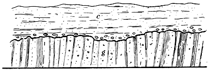 FIG 1.—Conglomerate and Red Sandstone, etc., c, resting on Greywacké and Shale, g.
The first section to which reference may be made is exposed in the course of the River Jed, at Allars Mill, a little above Jedburgh. This section is famous in its way as having been described and figured by Dr. Hutton, who may be said to have founded the present system of physical geology. In the bed of the stream are seen certain confused ridges of a greyish blue rock running right across the river course—that is, in a direction a little north of east and south of west. These ridges are the exposed edges of beds of greywacké and shale, which are here standing on end. The beds are somewhat irregular, being inclined from the vertical, now in one direction and now in another, or, as a geologist would say, the “dip” changes rapidly, sometimes being up the valley — 68 — and sometimes down. The same beds continue up the steep bank of the river for a yard or two, and are there capped by another set of rocks altogether, namely, by soft red sandy beds which at the bottom become conglomeratic—that is to say, they are charged with water-worn stones. The annexed diagram (Fig. 1) will show the general appearances presented: g represents the vertical greywacké and shale, and c the overlying deposits of conglomerate and red sandy beds. Now let us see what this section means. What, in the first place, is greywacké? The term itself has really no meaning, being a name given by the miners in the Harz Mountains to the unproductive rocks associated with the vein-stones which they work. When we break the rock we may observe that it is a granular mixture of small particles of quartz, to which sometimes felspar and other minerals are added. The grains are bound together in a hardened matrix of argillaceous or clayey and silicious matter, blue, or grey, or green, or brown and yellow, as the case may be. At Allars Mill, and generally throughout the Cheviot district, the prevailing colour is a pale greyish blue or bluish grey; but shades of green and brown often occur. The component particles of the rock are usually rounded or water-worn. Again, we notice that the ridges and bands of rock that traverse the course of the Jed at Allars Mill are merely the outcrops of successive strata or beds. It is clear then that greywacké and the grey shales that accompany it are aqueous rocks—that is to say, they consist of hardened sediment, which has undoubtedly been deposited in successive layers of variable thickness by water in motion. But since the sediments of rivers and currents are laid down in approximately horizontal planes, it is evident that if the greywacké and shale be sedimentary deposits they have suffered considerable disturbance since the time of their formation; for, as we have seen, the beds, instead of being horizontal or only gently inclined, actually approach the vertical. The fact is, that the outcrops which we see are only the truncated portions of what were formerly rapid undulations or folds of the strata, the tops of the folds or arches having been cut away by geological agencies, to which I shall — 69 — refer by-and-by. What were at one time horizontal strata have been crumpled up into great folds, the folds being squeezed tightly together, and their upper portions planed away before the overlying red sandy beds were laid down. The accompanying diagram (Fig. 2) may serve to make all this clearer. Let A A represent the present surface of the ground, and B B a depth of say fifty feet or a hundred feet from the surface. The continuous lines between A and B represent the greywacké beds as we now see them in section; the dotted lines above A A indicate the former extension of the strata, and the dotted lines below B B their continuation below that datum line. Hence it is obvious that in a succession of vertical or highly inclined beds, we may have the same strata repeated many times, the same beds coming again and again to the surface. Thus the stratum at S is evidently the same bed as that at W, X, Y, and Z.
 Fig 2.
Such great foldings or redoublings of strata are most probably originated during subsidence of a portion of the earth’s crust. While the ground is slowly sinking down, the strata underneath are perforce compelled to occupy less space laterally, and this they can only do by yielding amongst themselves. All folding or contortion on the large scale—that, namely, which has affected areas of strata extending over whole countries—seems to have taken place under great pressure; in other words, to have been produced at considerable depths from the earth’s surface. We can conceive, therefore, of a wide tract of land sinking down for hundreds — 70 — of feet, and producing at the surface comparatively little change. But a depression of a few hundred feet at the surface implies a considerably greater depression at a depth of several thousand feet from the surface, and it is at great depths, therefore, that the most violent folding must take place. Consequently considerable contortion, and much folding, and lateral crushing and reduplication of strata may occur, and yet no trace of this be observable at the surface, save only a gentle depression. For example, in Greenland, a movement of subsidence has been going on for many years—the land has been slowly sinking down. The rocks at the surface are of course quite undisturbed by this widely-extended movement, but the strata at great depths may be undergoing much compression and contortion. It follows from such considerations, that if we now get highly contorted strata covering wide areas at the surface, we suspect that very considerable denudation has taken place. That is to say, large masses of rock have been removed by the geological agents of change, so as to expose the once deeply-buried tops of the arched or curved and folded strata. We may therefore infer from a study of the phenomena in the Jed at Allars Mill, first, that the red sandy beds are younger than the greywacké and shale, seeing that they rest upon them; and, second, that a very long period of time must have elapsed between the deposition of the older and the accumulation of the younger set of strata; for it is obvious that considerable time was required for the consolidation and folding of the greywacké, and an incalculable lapse of ages was also necessary to allow of the gradual wearing away by rain, frost, and running water of the great thickness of rocks underneath which the greywacké was crumpled. And all this took place before the horizontally-bedded red sandstone and conglomerate gathered over the upturned ends of the underlying strata. The succession of rocks at Allars Mill is seen in many other places in the Cheviot district, but enough has been said to prove that the greywacké beds are the older of the two sets of strata.
There is another class of rocks, the relative position of which we must now ascertain, for no one shall wander much — 71 — or far among the Cheviots without becoming aware of the existence of other kinds of rock than greywacké and sandstone. Many of the hills east of Oxnam and Jed Waters, for example, are composed of igneous masses—of rocks which have had a volcanic origin. As we shall afterwards see, the whole north-eastern section of the Cheviots is built up of such rocks. At present, however, we are only concerned with the relation which these bear to the greywacké and the red sandy beds. Now at various localities—for example, in Edgerston Burn, on the hill-face south of Plenderleith, and again along the steep front of Hindhope and Blackball Hills, which are on the crest of the Cheviots—we find that the igneous rocks rest upon the greywacké and shale (see Fig. 3) precisely in the same way as do the red sandy beds. They therefore belong to a later date than the greywacké. In other places, again, we meet with the conglomerates and red sandstones (c, Fig. 4) resting upon and wrapping round the igneous rocks, i, and thus it becomes quite obvious that the latter occupy an intermediate position between the greywacké and shale on the one hand, and the conglomerate and red sandstone upon the other.
 Fig. 3.—Igneous rocks (i, a) resting on Greywacké and Shale, g.
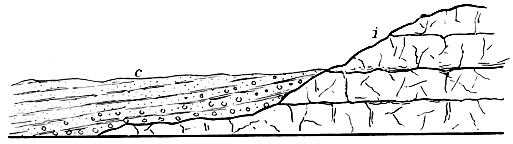 Fig. 4.—c, Conglomerate and Sandstones, resting on Igneous rocks, i.
We have now cleared the way so far, preparatory to an attempt to trace the geological history of the Cheviots. The three sets of rocks, whose mutual relations we have been studying, are those of which the district is chiefly composed; but, as we shall see in the sequel, there are others, not certainly of much extent, but nevertheless having an interesting story to tell us. Nor shall we omit to notice the superficial accumulations of clay, gravel, sand, silt, alluvium, and peat; monuments as they are of certain great changes, climatic and geographical, which have characterised not the Cheviots only, but a much wider area.
II.
If we draw a somewhat straight line from Girvan, on the coast of Ayrshire, in a north-east direction to the shores of the North Sea, near Dunbar, we shall find that south of that line, up to the English border, nearly the whole country is composed of various kinds of greywacké and shale like the basement beds of the Cheviot district. Here and there, however, especially in certain of the valleys and some of the low-lying portions of this southern section of Scotland, one comes upon small isolated patches and occasional wider areas of younger strata, which rest upon and conceal the greywackés and shales. Such is the case in Teviotdale, the Cheviot district, and the country watered by the lower reaches of the Tweed, in which regions the bottom beds are hidden for several hundreds of square miles underneath younger rocks. Indeed, the greywacké and shale form but a very small portion of the surface in the Cheviots, appearing upon a coloured geological map like so many islands or fragments, as it were, which have somehow been detached from the main masses of greywacké of which the Lammermuirs and the uplands of Dumfries and Selkirk shires are composed. Although the bottom rocks of the Cheviot Hills are thus apparently separated from the great greywacké area, there can be no doubt that they are really connected with it, the — 73 — connection being obscured by the overlying younger strata. For if we could only strip off these latter, if we could only lift aside the great masses of igneous rock and sandstone that are piled up in the Cheviot Hills and the adjoining districts, we should find that the bottom upon which these rest is everywhere greywacké and shale. In part proof of this it may be mentioned that at various places in those districts which are entirely occupied by sandstone and igneous rock, the streams have cut right down through the younger rocks so as to expose the bottom beds, as in Jed Water at Allars Mill. Again, when we trace out the boundaries of any detached areas of greywacké we invariably find these bottom beds disappearing on all sides underneath the younger strata by which they are surrounded. One such isolated area occurs in the basin of the Oxnam Water, between Littletonleys and Bloodylaws, a section across which would exhibit the general appearance shown in the accompanying diagram (Fig. 5). Another similarly isolated patch is intersected by Edgerston Burn and the Jed Water between Paton Haugh and Dovesford. But the largest of these detached portions appears, forming the crest of the Cheviots, at the head of the River Coquet. There the basement beds occupy the watershed, extending westward, some three or four miles, as far as the sandstones of Hungry Law, while to the north and east they plunge under the igneous rocks of Brownhart Law and the Hindhope Hills. Now it is evident that all those detached and isolated areas of greywacké and shale are really connected underground, and not only so, but they also piece on in the same way to the great belt of similar strata that stretches from sea to sea across the whole breadth of Scotland. Indeed, we may observe in — 74 — the Cheviot district how long and massive promontories of greywacké jut out from that great belt, and extend often for miles into the areas that are covered with younger strata, as, for example, in the Brockilaw and Wolfelee Hills. A generalised section across the greywacké regions of the Cheviot Hills would therefore present the appearances shown in the annexed diagram (Fig. 6), in which G represents the basement beds, I the igneous rocks, and C the red sandstones, etc.
 Fig. 5.—Section across Greywacké area of Oxnam Water; G, Greywacké and Shale;
C, Sandstone, etc.
Fig. 5.—Section across Greywacké area of Oxnam Water; G, Greywacké and Shale;
C, Sandstone, etc.
 Fig. 6.—Diagram section across Greywacké districts of Cheviot Hills.
Throughout the whole of the district under review the bottom beds are observed to dip at a high angle—the strata in many places being actually vertical—and the edges or crops of the strata run somewhat persistently in one direction, namely, from south by west to north by east; or, as a geologist would express it, the beds have an approximately south-west and north-east “strike.” Now as the dip is sometimes to north-west and sometimes to south-east, it is evident that the rocks have been folded up in a series of rapid convolutions, and that some of the beds must be often repeated.
From the character of the fossils which the bottom beds have yielded we learn that the strata belong to that division of past time which is known as the Silurian age. These fossils appear to be of infrequent occurrence, and the creatures of which they are the relics occupied rather a humble place in the scale of being. They are called graptolites (from their resemblance to pens), an extinct group of hydroid zoophytes, apparently resembling the sertularians of our own seas.
The general appearance of the Silurian strata of the Cheviots is indicative of deposition in comparatively quiet water, but how deep that water was one cannot say. Upon the whole, the beds look not unlike the sediments that gather in calm reaches of the sea, such as estuaries, betokening the presence of some not distant land from which fine mud and — 75 — sand were washed down. Another proof that some of the strata at all events were accumulated not far from a shore-line, is found in certain coarse bands of grit and pebbles, which are not likely to have been formed in deep water. This evidence, however, cannot be considered decisive, and in the present state of our knowledge all that we can assert with anything like confidence is simply this:—That during the deposition of the Silurian strata the whole of the Cheviot area lay under water—existed, in short, as a muddy sea-bottom, in the slime of which flourished here and there, in favourable spots, those minute hydroid animals called graptolites.
Between the deposition of the Silurian and the formation of the rocks that come next in order a long interval elapsed, during which the mud, sand, and grit that gathered on the floor of the ancient sea were hardened into solid masses, and eventually squeezed together into great folds and undulations. It has already been pointed out that these changes could hardly have been effected save under extreme pressure, and this consideration leads us to infer that a great thickness of strata has been removed entirely from the Cheviot district, so as to leave no trace of its former existence. Long before the deposition of the younger strata that now rest upon and conceal the Silurian rocks, the action of the denuding forces—the sea, frosts, rain, and rivers—had succeeded in not only sweeping gradually away the strata underneath which the bottom beds were folded, but in deeply scarping and carving these bottom beds themselves. Can we form any reasonable conjecture as to the geological age of the strata underneath which the bottom beds of the Cheviots were folded, and which, as we have seen, had entirely disappeared before the younger rocks of the district were accumulated? Well, it is obvious that the missing strata must have been of later formation than the bottom beds, and it is equally evident that they must have been of much more ancient date than the igneous rocks of the Cheviot Hills. Now, as we shall afterwards see, these igneous rocks belong to the Old Red Sandstone age, that is to say, to the age that succeeded the Silurian. How is it then, if the bottom beds be really of Silurian and the igneous rocks of — 76 — Old Red Sandstone age, that a gap is said to exist between them? The explanation of this apparent contradiction is not far to seek. When we compare the fossils that occur in the Silurian strata of the Cheviot Hills and the districts to the west, with the organic remains disinterred from similar strata elsewhere, as in Wales for example, we find that the bottom beds of the Cheviots were in all probability accumulated at approximately the same time as certain strata that occur in the middle division of the Upper Silurian. In Wales and in Cumberland the strata that approximate in age to the Silurian of the Cheviots are covered by younger strata belonging to the same formation which reach a thickness of several thousand feet. It may quite well be, therefore, that the succession of Silurian strata in the Cheviots was at one time more complete than it is now. The upper portions of the formation which are so well developed in Wales and Cumberland, and which are likewise represented to a small extent in Scotland, had in all probability their equivalents in what are our border districts. In other words, there are good grounds for believing that the existing Silurian rocks of the Cheviots were in times preceding the Old Red Sandstone age covered with younger strata belonging to the same great system. The missing Silurian strata of the Cheviots may have attained a thickness of several thousand feet, and underneath such a mass of solid rock the lower-lying strata might well have been consolidated and subsequently squeezed into folds.
We now pass on to consider the next chapter in the geological history of the Cheviot Hills. As we proceed in our investigations it will be noticed that the evidence becomes more abundant, and we are thus enabled to build up the story of the past with more confidence, and with fuller details. For it is with geological history as with human records—the further back we go in time the scantier do the facts become. The rocks upon which Nature writes her own history are palimpsests, on which the later writing is ever the most easily deciphered. Nay, she cannot compile her newer records without first destroying some of those compiled in earlier times. The sediments accumulating in modern lake and sea — 77 — are but the materials derived from the degradation of the rocks we see around us, just as these in like manner have originated from the demolition of yet older strata. Thus the further we trace back the history of our earth, the more fragmentary must we expect the evidence to be; and conversely, the nearer we approach to the present condition of things the more abundant and satisfactory must the records become. Accordingly, we find that the igneous rocks of the Cheviot Hills tell us considerably more than the ancient Silurian deposits upon which they rest. The surface of the latter appears to be somewhat irregular underneath the igneous rocks, showing that hills and valleys, or an undulating table-land, existed in the Cheviot district prior to the appearance of the younger formation. But before we attempt to summarise the history of that formation, it is necessary to give some description, however short, of the rocks that compose it.
These consist chiefly of numerous varieties of a rock called porphyrite by geologists, piled in more or less irregular beds, one on top of another, in a somewhat confused manner. The colour of the freshly fractured rocks is very variable, being usually some shade of blue or purple; but pink, red, brown, greenish, and dark grey or almost black varieties also occur. Some of the rocks are finely crystalline; others, again, are much coarser, while many are compact, or nearly so, a lens being required to detect a crystalline texture. The mineral called felspar is usually scattered more or less abundantly through the matrix or base, which itself is composed principally of felspathic materials. Besides distinct scattered crystals of felspar, other minerals often occur in a similar manner; mica and hornblende being the commonest. Occasionally the rocks contain numerous circular, oval, or flattened cavities, which are sometimes so abundant as to give the appearance of a kind of coarse slag to the porphyrite. These little cavities, however, are usually filled up with mineral matter—such as calcspar, calcedony, jasper, quartz, etc. Sometimes also cracks, crannies, and crevices of some size have been sealed up with similar minerals. Now nearly all these appearances are specially characteristic of rocks which have at one time been in a state of igneous — 78 — fusion; nor can there be any doubt that the Cheviot porphyrites are merely solidified lava-beds, which have been poured out from the bowels of the earth. In modern lavas we may notice not only a crystalline texture, but frequently also we observe those in our porphyrites. Such cavities are due to the expansive force of the vapours imprisoned in the molten mass at the time of eruption. They form chiefly towards the upper surface of a lava stream, and are often drawn out or flattened in the direction in which the lava flows. Thus a stream of lava, as it creeps on its way, becomes slaggy and scoriaceous or cindery above and in front, and as the molten mass within continues to flow, the slags and cinders that cover its face tumble down before it, and form the pavement upon which the stream advances. In this way slags and cinders become incorporated with the bottom of the lava, and hence it is that so many volcanic rocks are scoriaceous, as well below as above. The vapours which produce the cavities usually contain minerals in solution, and these, as the lava cools, are frequently deposited, partially filling up the vesicles, so as to form what are called geodes. But many of the cavities have been filled in another way—by the subsequent infiltration of water carrying mineral matter in solution. And since we know that all rocks are so permeated by water, it is clear that the cavities may have received their contents during many successive periods, after the solidification of the rock in which they occur. It is in this manner that the jaspers, calcedony, and beautiful agates of commerce have been formed. Rocks abundantly charged with cavities are said to be vesicular, and when the vesicles are filled with mineral matter, then the mass becomes, in geological language, amygdaloidal, from the almond-like shape assumed by the flattened vesicles.
Now all the appearances described above, and many others hardly less characteristic of true lavas, are to be met with amongst those porphyrites which, as I have said, form the major portion of the Cheviot Hills. From the valley of the Oxnam, east by Cessford, Morebattle, and Hoselaw, and south by Edgerston, Letham, Browndeanlaws, and Hindhope, — 79 — the porphyrites extend over the whole area, sweeping north-east across the border on to the heights above the Rivers Glen and Till. In the hills at Hindhope we notice a good display of the oldest beds of the series. At the base occurs a very peculiar rock resting upon the Silurian, and thus forming the foundation of the porphyrites. It varies in colour, being pink, grey, green, red, brown, or variously mottled. Sometimes it is fine-grained and gritty, like a soft, coarse-grained sandstone; at other times it is not unlike a granular porphyrite; but when most typically developed it consists of a kind of coarse angular gravel embedded in a gritty matrix. The stones sometimes show distinct traces of arrangement into layers; but they are often heaped rudely together with little or no stratification at all. They consist chiefly of fragments of porphyrites; but bits of Silurian rocks also occur amongst them. This peculiar deposit unquestionably answers to the heaps of dust, sand, stones, and bombs which are shot out of modern volcanoes; it is a true tuff—that is, a collection of loose volcanic ejectamenta.
Upon what kind of surface did it fall? Long before the eruptions began, the Silurian rocks had been sculptured into hills and valleys by the action chiefly of the sub-aërial forces, and it was upon these hills and in these valleys that the igneous materials accumulated. It is difficult to say, however, whether at this period the Cheviot district was above or under water. The traces of bedding in the tuff would seem to indicate the assorting power of water; but the evidence is too slight to found upon, because we know that in modern eruptions, loose ejectamenta frequently assume a kind of irregular bedded arrangement. For aught we can say to the contrary, therefore, dry land may have extended across what is now southern Scotland and northern England when the first rumblings of volcanic disturbance shook the Cheviot area. Be that as it may, we know that the volcanic outbursts began in those old times, as they almost invariably commence now, by a discharge of sand, small stones, blocks, and cinders. These, we may infer, covered a wide area round the centre of dispersion—the chief focus of eruption — 80 — being probably in the vicinity of the big Cheviot, where a mass of granite seems to occupy the core or deep-seated portion of the old volcanic centre. The locality where the tuff occurs is some nine miles or so distant from this point, and the intervening ground could hardly have escaped being more or less thickly sprinkled with the same materials. The whole of that intervening ground, however, now lies deeply buried under the massive streams of once-molten rock that followed in succession after the first dispersion of stones and débris. Although, as I have said, it may be doubted whether at the beginning of their activity the Cheviot volcanoes were sub-aqueous, yet there are not a few facts that lead to the inference that the eruption of the porphyrites took place for the most part, if not exclusively, under water. The beds are occasionally separated by layers of sandstone, grit, and conglomerate; but such beds are rare, and true tuffs are rarer still. If the outbursts had been sub-aërial, we ought surely to have met with these latter in greater abundance, while we should hardly have expected to find such evidently water-arranged strata as do occur here and there. The porphyrites themselves present certain appearances which lead to the same conclusion. Thus we may observe how the bottoms of the beds frequently contain baked or hardened sand and mud, showing that the molten rock had been poured out over some muddy or sandy bottom, and had caught up and enclosed the soft, sedimentary materials, which now bear all the marks of having been subjected to the action of intense heat. Sometimes, indeed, the old lava-streams seem to have licked up beds of unconsolidated gravel, the water-worn stones being now scattered through their under portions. As no fossils occur in any of the beds associated with the porphyrites, one cannot say whether the latter flowed into the sea or into great freshwater lakes. Neither can we be certain that towards their close the eruptions were not sub-aërial. They may quite well have been so. The porphyrites attain a thickness of probably not less than fifteen hundred or two thousand feet, and the beds which — 81 — we now see are only the basal, and therefore the older portions of the old volcanoes. The upper parts have long since disappeared, the waste of the igneous masses having been so great that only the very oldest portions now remain, and these, again, are hewn and carved into hill and valley. Any loose accumulation of stones and débris, therefore, which may have been thrown out in the later stages of the eruptions, must long ere this have utterly disappeared. We can point to the beds which mark the beginning of volcanic activity in the Cheviots; we can prove that volcanoes continued in action there for long ages, great streams of lava being poured out—the eruptions of which were preceded and sometimes succeeded by showers of stones and débris; we can show, also, that periods of quiescence, more or less prolonged, occasionally intervened, at which times water assorted the sand and mud, and rounded the stones, spreading them out in layers. But whether this water action took place in the sea or in a lake we cannot tell. Indeed, for aught one can say, some of the masses of rounded stones I refer to may point to the action of mountain torrents, and thus be part evidence that the volcanoes were sub-aërial. If we are thus in doubt as to some of the physical conditions that obtained in the Cheviot district during the accumulation of the porphyrites and their associated beds, we are left entirely to conjecture when we seek to inquire into the conditions that prevailed towards the close of the volcanic period. For just as we have proof that before this period began the Silurian strata had been subjected to the most intense denudation—had, in short, been worn into hill and valley—so do we learn from abundant evidence that the rocks representing the old volcanoes of the Cheviots are merely the wrecks of formerly extensive masses. Not only have the upper portions of these volcanoes been swept away, but their lower portions, likewise, have been deeply incised, and thousands of feet of solid rock have been carried off by the denuding forces. And by much the greater part of all this waste took place before the accumulation of those sandstones which now rest upon the worn outskirts of the old volcanic region.
III.
Some reference has already been made (see p. 64) to the general appearance presented by the valleys of the Cheviots. In their upper reaches they are often rough and craggy; narrow dells, in fact, flanked with steep shingle-covered slopes, and occasionally overlooked by beetling cliffs, or fringed with lofty scaurs of decomposing rocks. As we follow down the valleys they gradually widen out; the hill-slopes becoming less steep, and retiring from the stream so as to leave a narrow strip of meadow-land through which the clear waters canter gaily on to the low grounds of the Teviot. In their middle reaches these upland dales are not infrequently well cultivated to a considerable height, as in the districts between Hownam and Morebattle, and between Belford and Yetholm—the former in the valley of the Kale, and the latter in that of the Bowmont. It is noticeable that all the narrower and steeper reaches lie among Silurian strata and Old Red Sandstone porphyrites. No sooner do we leave the regions occupied by these tough and hard rock-masses than the whole aspect of the scenery changes. The surrounding hills immediately lose in height and fall away into a softly undulating country, through which the streams and rivers have dug for themselves deep romantic channels. Nevertheless, it is a fact, as we shall see by-and-by, that south-west of the region occupied by the igneous rocks of the Cheviot Hills, all the higher portions of the range (Hungry Law, Carter Fell, Peel Fell, etc.) are built up of sandstones. For the present, however, I confine attention to those valleys whose upper reaches lie either wholly or in part among igneous rocks or Silurian strata. A typical and certainly the most beautiful example is furnished us by the vale of the River Jed. This stream rises among the sandstone heights which have just been mentioned as composing the south-west portion of the Cheviot range. The first seven or eight miles of its course lead us through a broad open valley, which has been — 83 — hollowed out almost exclusively in sandstones and shales; by-and-by, however, we are led into a Silurian tract, and thereupon the valley contracts and the hill-slopes descend more steeply to the stream. But we soon leave the grassy glades of this Silurian tract and enter all at once upon what may be termed the lower reaches of the Jed. No longer cooped up in the rocky gully, painfully worn for itself in the hard greywacké and shales, the stream now winds through a much deeper and broader channel which has evidently been excavated with greater ease. Precipitous banks and scaurs here overlook the river at every bend, the banks becoming higher and higher and retiring further and further from each other, as the water glides on its way, until at last they fairly open upon the broad vale of the Teviot. Sometimes the river flows along one side of its valley for a considerable distance, and whenever this is the case, it gives us a line of bold cliffs which are usually flanked on the opposite side by sloping ground. This is the general character of all valleys of erosion, and especially of the lower reaches of the Jed.
A glance at the cliffs and scaurs of the Jed shows that they consist of horizontal or gently undulating strata of soft earthy, friable, shaly sandstone, arranged in thin beds and bands, which alternate rapidly with crumbling, sandy, and earthy shales; the whole forming a loose and unconsolidated mass that readily becomes a prey to the action of the weather, rain, frost, and running water. The prevailing colour is a dull red, but pale yellow, white, green, and purple discolorations are visible when the strata are closely scanned. The finest sections occur between Glen Douglas and Inchbonnie, and at Mossburnford, but the cliffs throughout present the same general appearance, and are picturesque in the highest degree. Everywhere the banks are thickly wooded, and even the steep red scaurs are dashed and flecked with greenery, which droops and springs from every ledge and crevice in which a root can fix itself. How vivid and striking is the contrast between the fresh delicate green of early summer and the rich warm tint of these rocks, which when lit up by — 84 — the setting sun seem almost to glow and burn! Well may the good folk of Jedburgh be proud of the lovely valley in which their lot is cast. In no similar district in Scotland will the artist meet with a greater number of such “delicious bits,” in which all the charms of wood and water, of meadow and rock are so harmoniously combined. It is not with the scenic beauties of the Jed, however, that we have at present to do. I wish the reader to examine with me certain appearances visible at the base of the red beds, where these rest upon those older rocks which have formed the subject of the preceding papers. In the bed of the river at Jedburgh, we see the junction between the red beds and the Silurian strata, and may observe how the bottom portions of the former, which repose immediately upon the greywackés, are abundantly charged with well-rounded and water-worn stones. Many of these stones consist of greywacké, hardened grit, and other kinds of rock, and most of them undoubtedly have been derived from Silurian strata. In other districts where the old igneous rocks of the Cheviots form the pavement upon which the red beds repose, the stones in the lower portions of the latter are made up chiefly of rounded fragments of the underlying porphyrites. All which clearly shows that the red beds have been built out of the ruins of the older strata of the district. This is unquestionably the origin not only of the conglomerates, but of all the red beds through which the River Jed cuts its way from the base of the hills to the Teviot. When we trace out the boundary of these beds, we find that this leads us along the base of the hills, close to the hill-foot; and not only so, but it frequently takes us into the hill-valleys also. And this shows that the Cheviots had already been deeply excavated by streams before any portion of the red beds was deposited.
I have said that the red beds are approximately horizontal; sometimes, however, they have a decided dip or inclination, and when this is continuous, it is invariably in a direction away from the hills. Thus as we traverse the ground from the hill-foot to the Teviot, we pass over the outcrops of the red beds and slowly rise from a lower to a higher geological — 85 — position. The strata, however, are generally so flat that their dip is often not greater than the average slope or inclination of the ground. Hence when we ascend the valley-slopes from the stream, we soon reach the higher beds of the series, as, for example, in the undulating heights that overlook the Jed in the neighbourhood of Jedburgh. In that district a number of quarries have been opened, in which the upper beds of the red series are well exposed, as at Ferniehirst, Tudhope, etc. These consist of thick beds of greyish white, yellowish, and reddish sandstones, which, unlike the crumbling earthy deposits below, are quite suitable for building purposes. Scales of fish and plant remains are often met with in the thick sandstones, but the underlying earthy, friable red beds appear to be quite destitute of any organic remains.
Let us now briefly recapitulate the main facts we have just ascertained. They are these:—1. All the low grounds that abut upon the hills are composed of horizontal or nearly horizontal strata, which consist chiefly of red earthy beds, passing down into conglomerates, and up into whitish and reddish sandstones. 2. The conglomeratic portion forms the boundary of the series, fringing the outskirts of the hills, and resting sometimes upon Silurian strata and sometimes upon Old Red Sandstone igneous rocks. 3. Fossils occur in the white and red sandstones, but seem to be wanting in the underlying red earthy beds.
 Fig. 7.—S, Silurian strata; i, Old Red Sandstone Igneous Rocks; a1, Conglomerate;
a2, Red earthy beds; a3, White and Red Sandstones.
Fig. 7.—S, Silurian strata; i, Old Red Sandstone Igneous Rocks; a1, Conglomerate;
a2, Red earthy beds; a3, White and Red Sandstones.
The accompanying diagram (Fig. 7) gives a generalised view of the relation borne by the red beds to the older rocks of the Cheviots. It will be seen that the former rest unconformably upon the Old Red Sandstone igneous rocks, and also, of course, upon the Silurian strata. The section shows that the red beds lie upon a worn and denuded surface. Now — 86 — this speaks to the lapse of a long period of time. It may be remembered that we had some grounds for believing that the latest eruptions of the Cheviot volcanoes were sub-aërial. The evidence now enables us to advance further, and to state that after the close of the volcanic period, the whole Cheviot district existed as an elevated tract of dry land, from which streams flowed north and south. And for so long a time did these conditions endure, that the rivulets and streams were enabled to scoop out many channels and broad valleys before any of the outlying red beds had come into existence. Before the conglomerate beds were laid down, the ancient volcanic bank of the Cheviots had thus suffered great erosion. This is what “unconformability” means. It points to the prolonged continuance of a land-surface, subject as that must always be to the wearing action of the sub-aërial forces. Rain and frost disintegrate the rocks, and running water rolls the débris from higher to lower levels, and piles it up in the form of gravel, sand, and mud in lakes and the sea. While the old volcanic country of the Cheviots was being thus denuded, it would appear that a wide extent of land existed in the Northern Highlands and Southern Uplands of Scotland, and also in what are now the lake districts of England and the hilly tracts of Wales. And in all these regions valleys were formed, which at a subsequent time were more or less filled up with newer deposits.
The presence of the red beds that sweep round the base of the Cheviot Hills shows unmistakably that a period of submergence followed these land conditions. All the low grounds of Southern Scotland disappeared beneath a wide sheet of water, which stretched from the foot of the Lammermuirs up to the base of the Cheviots, and here and there entered the valleys, and so extended into the hills. This water, however, does not seem to have been that of an open sea; rather was it portion of a great freshwater lake, brackish lagoon, or inland sea. The lowest beds of the red series are merely hardened layers and masses of gravel and rolled shingle, which would seem at first sight to indicate the former action of waves along a sea-beach. There are certain — 87 — appearances, however, which lead one to suspect that these ancient shingle beds may have had quite another origin. In some places the stones exactly resemble those which are found so abundantly in glacial deposits. They are sub-angular and blunted, and, like glaciated stones, occasionally show striæ or scratches. This, however, is very rarely the case. Most of the stones appear subsequently to have been rolled about in water, and in this process they must have lost any ice-markings they may have had, and become smoothed and rounded like ordinary gravel stones. The same appearances may be noted in the glacier valleys of Norway and Switzerland, where at the present day the glaciated stones which are pushed out at the lower ends of the glaciers are rolled about in the streams, and soon lose all trace of ice-work. It is impossible, however, to enter here into all the details of the evidence which lead one to suspect that glaciers may have existed at this early period among the Cheviot and Lammermuir Hills. In the latter district, the conglomerates occur in such masses and so exactly resemble the morainic débris and ice-rubbish of modern glacial regions, that the late Sir A. C. Ramsay long ago suggested their ice-origin.
Let us conceive, then, that when the ancient lake or inland sea of which I have spoken reached the base of the Cheviots, glaciers may have nestled in the valleys. Streams issuing from the lower ends of these would sweep great quantities of gravel down the valleys to the margin of the lake, and it is quite possible that there might be enough wave-action to spread the gravel out along the shores. It is evident, however, that the main heaps of shingle would gather opposite what were at that time the mouths of glacier valleys; and it is just in such positions that we now meet with the thickest masses of conglomerate. Ere long, however, the supposed glaciers would seem to have melted away, and only fine sand and mud, with here and there small rounded stones and grit, accumulated round the shores of the ancient lake. Of course, during all this time fine-grained sediment gathered over the deeper parts of the lake-bottom.
We have no evidence to show what kind of creatures, if any, inhabited the land at this time; nor do any fossils occur in the red earthy beds to throw light upon the conditions of life that may have obtained in the lake. If glaciers really existed and sent down ice-cold water, the conditions would hardly be favourable to life of any kind; for glacial lakes are generally barren. But the absence of fossils may be due to other causes than this. It is a remarkable fact, that red strata are, as a rule, unfossiliferous, and the few fossils which they do sometimes yield are generally indicative rather of lacustrine and brackish-water, than marine conditions. The paucity or absence of organic remains seems to have been often due to the presence in the water of a superabundance of salts. Now this excessive salinity may have arisen in either of two ways. First, we may suppose some wide reach of the sea to have been cut off from communication with the open ocean by an elevation of a portion of its bed; and in this case we should have a lagoon of saltwater, which evaporation would tend to concentrate to such a degree, that by-and-by nothing would be able to live in its waters. Or, again, we may have a lake so poisoned by the influx of springs and streams, carrying various salts in solution, as to render it uninhabitable by life of any kind, either animal or vegetable. Many red sandstone deposits, as Sir A. C. Ramsay has pointed out, are evidently lagoon-formations, which is proved by the presence of associated beds of rock-salt, gypsum, and magnesian limestone. They have slowly accumulated in great inland seas or lakes having no outlet, whose waters were subject to evaporation and concentration, although now and then they seem to have communicated more or less freely with the ocean. The red earthy beds of the Jed, however, though unfossiliferous, yet contain no trace of rock-salt or magnesian limestone. The only character they have in common with the salt-bearing strata of the New Red Sandstone of England is their colour, due to the presence of peroxide of iron, which we can hardly conceive could have been deposited in the mud of a sea communicating freely with the ocean. But a quiet lake, fed — 89 — by rivulets and streams that drained an old volcanic district, is precisely the kind of water-basin in which highly ferruginous mud and sand might be expected to accumulate. Such a lake, tainted with the various salts, etc., carried into it by streams and springs (some of which may have been thermal; for, as we shall see presently, the volcanic forces, although quiescent, were yet not extinct), might well be unfitted for either animal or plant, and probably this is one reason why the red earthy beds of the Jed are so unfossiliferous.
After some time, the physical conditions in the regions under review experienced some further modification. Considerable depression of the land supervened, and the waters of our inland sea or lake rose high on the slopes of the Cheviots. Mark now how the character of the sediment changes. The prevailing red colour has disappeared, and white, yellow, and pale greenish or grey sand begins to be poured over the bed of the lake. Even yet, however, ferruginous matter exists in sufficient quantity to tint the sediment red in some places. With the appearance of these lighter-coloured sandy deposits, the conditions seem to have become better fitted to sustain life. Fish of peculiar forms, which, like the gar-pike of North American lakes, were provided with a strong scaly armour of tough bone, began to abound, weeds grew in the water, and the neighbouring land supported a vegetation now very meagrely represented by the few remains of plants which have been preserved. In some places fish-scales are found in considerable abundance. They belong to several genera and species which are more or less characteristic of the Old Red Sandstone formation. The most remarkable form was the Pterichthys, or wing-finned fish. Its blunt-shaped head and the anterior portion of its body were sheathed in a solid case of bone, formed by the union of numerous bony scales or plates. Two curious curved spine-like arms occupied the place of pectoral fins, and may have been used by the creature in paddling along the bottom of the sea or lake in which it lived. The posterior part of the body was covered with bony scales, but these were not suturally united. Other kinds of fish — 90 — were the Holoptychius and Coccosteus, both of which were, like the Pterichthys, furnished with bony scales. The scales of the former overlapped, and had a curious wrinkled surface. The head of the Coccosteus was protected by a large bony shield or buckler, and a similar bony armour covered the ventral region.
The organic remains of these fish-bearing strata are too scanty, however, to enable us to form any idea of the kind of climate which characterised the district at this long-past period; but if we rely upon the fossils which have been met with in strata of the same or approximately the same age elsewhere, we may be pretty sure the climate was genial, and nourished on the land an abundant vegetation, consisting of ferns, great reeds, and club-mosses, which attained the dimensions of large trees, conifers, and other strange trees which have no living analogues.
It seems most likely that when the land sank down in the Cheviot district, so as to allow the old lake to reach as it were a higher level, some communication with the outlying ocean was effected. Red ferruginous mud would then cease to accumulate, or gather only now and then; the deposits would for the most part be white or yellow, or pale green; and fish would be able to come in from the sea. The communication with the ocean, however, was probably never very free, but liable to frequent interruption.
Here, then, ends the third great period of time represented by the rocks of the Cheviot district. The first period, as we have seen, closed with the deposition of the Silurian strata. Thereafter supervened a vast lapse of time, not recorded in the Cheviots by the presence of any rocks, but represented in other regions by younger members of the Silurian system. During this unrecorded portion of past time, the Silurian strata of the Cheviots were hardened, compressed, folded, upheaved to the light of day, and worn into hills and valleys by the action of the sub-aërial forces. Then began the second period of rock-forming in our district. Volcanoes poured out successive beds of molten matter and showers of stones and ashes, and so built up the rock-masses — 91 — of the highest parts of the Cheviot Hills. These eruptions belong to the Old Red Sandstone age, and form a portion of what we term the Lower Old Red Sandstone. After the extinction of the volcanoes, another prolonged period elapsed, which is not accounted for in the Cheviots by the presence of any rocks. Then it was, as we know, that the great volcanic bank was denuded and worn into a system of hills and valleys. Now, since it is evident that the red beds of the Jed and other places are also of Old Red Sandstone age, it follows that they must belong to a higher place in the Old Red Sandstone formation than the much-denuded igneous rocks upon which they rest unconformably. The reasonable conclusion seems to be that the denudation or wearing away of the Lower Old Red Sandstone igneous rocks of the Cheviots was effected during that period which is represented in other districts of Scotland by what is called the Middle Old Red Sandstone, so that the Jed beds will thus rank as Upper Old Red Sandstone.
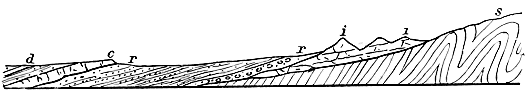 Fig. 8.—s, Silurian strata; i, Cheviot Igneous Rocks (Lower Old Red Sandstone); r, Upper Old
Red Sandstone series; c, Kelso Igneous Rocks (Lower Carboniferous); d, Lower Carboniferous
Sandstones, Shales, etc.
Fig. 8.—s, Silurian strata; i, Cheviot Igneous Rocks (Lower Old Red Sandstone); r, Upper Old
Red Sandstone series; c, Kelso Igneous Rocks (Lower Carboniferous); d, Lower Carboniferous
Sandstones, Shales, etc.
I come now to speak of certain rocks which, although they are developed chiefly beyond the limits of our district, yet require a little consideration before we can complete our account of the geological history of the Cheviots. The rocks referred to consist chiefly of old lava-beds, which very closely resemble those of the Lower Old Red Sandstone. They appear on the south side of the Tweed valley below Kelso, whence they extend south-west and west, crossing the river at Makerstoun, and sweeping north to form the hills about Smailholm, Stichill, and Hume (Fig. 8). All to the east of these rocks, the valley of the Tweed is occupied — 92 — by a great thickness of grey sandstones, and grey and blue shales and clays, with which are associated thin cement-stone bands, and occasional coarse sandy limestones called cornstone. These strata rest upon the outskirts of the Kelso igneous rocks, and are clearly of later date than these, since in their lower beds, which are often conglomeratic, we find numerous rounded fragments of the igneous rocks upon which the sandstones and shales abut. The latter have yielded a number of fossils, both animals and plants, to which I shall refer presently. In the bed of the Teviot near Roxburgh, and elsewhere, the Kelso igneous rocks are found reposing upon whitish and reddish sandstones, which are evidently the upper members of the red beds of the Jed Water and other localities.
Strata closely resembling the grey sandstones and shales of the Tweed valley appear among the Cheviot Hills at the head of the Jed Water, where they are marked by the presence of thick massive sandstones, which form all the tops of the hills between Hungry Law and the heights that overlook the sources of the Liddel Water—the greatest height reached being at Carter Fell, which is 1815 feet above the sea-level. The strata at this place contain some impure limestone and thin seams of coal, while beds of lava and tuff appear intercalated in the series.
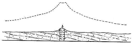 Fig. 9.—Section across old volcanic neck. The dotted line above suggests the original form
of the volcano; b, plug of igneous rock which rose in a molten state and cooled in the
vent.
Fig. 9.—Section across old volcanic neck. The dotted line above suggests the original form
of the volcano; b, plug of igneous rock which rose in a molten state and cooled in the
vent.
Now let us rapidly sum up what seem to be the inferences suggested by these briefly-stated facts. We have seen that the Upper Old Red Sandstone began to be deposited in a lake which, as time wore on, probably communicated with the sea, while the land was undergoing a process of depression, so that the area of deposition was thus widely increased, and sediment gradually accumulated in places and at levels which had existed as land when the ancient lake first appeared in the Cheviot district. The old lava-beds of Kelso show that the volcanic forces, which had long been quiescent, again became active. Great floods of molten matter issued from the bowels of the earth, and poured over the bottom of the inland sea. But all the larger volcanoes of this period were confined to the centre — 93 — of the Tweed valley. Not a few little isolated volcanoes, however, seem to have dotted the sea-bottom beyond the limits of the Kelso area. From these, showers of stones were ejected, and sometimes also they poured out molten matter. Their sites are now represented by rounded hills which stand up, more or less abruptly, above the level of the undulating tracts in which they occur (Fig. 9). Among the most marked are Rubers Law, Black Law, the Dunian, and Lanton Hill. Of course it is only the plugged-up vents or necks that now remain; all the loose ejectamenta by which these must at one time have been surrounded have long since been worn and washed away. At last the Kelso volcanoes became extinct, and the little ones also probably died out at the same time. Another long period now ensued, during which the inland sea disappeared, and its dried-up bed was subjected to the denuding action of the sub-aërial forces. The volcanic rocks of the Kelso district suffered considerable erosion, while the softer sandy strata amongst which they were erupted no doubt experienced still greater waste. Ere long, however, the scene again changes; and what is now the vale of Tweed becomes a wide estuary, the shores of which are formed at first by the Kelso igneous rocks. Into this estuary, rivers and streams carry the spoil of the Southern Uplands, and — 94 — strew its bed with sand and mud. Occasionally ferns and large coniferous trees are floated down, and, getting water-logged, sink to the bottom, where they become entombed in the slowly accumulating sediment. The character of these buried plants shows that the climate must have been genial. They belong to species which are characteristic of the Carboniferous system, and we look upon them with interest as the forerunners of that vast plant-growth which by-and-by was to cover wide areas in Britain, and to give rise to our coal-seams, the source of so much national wealth. In the waters of the estuary, minute crustaceous creatures called cyprides abounded, and with these was associated a number of small molluscs, chiefly univalves. Here and there considerable quantities of calcareous mud and sand gathered on the bed of the estuary, and formed in time beds of cement-stone, and impure limestone or cornstone. How long that condition of things obtained in the Tweed valley we cannot tell; but we know that after a very considerable thickness of sediment had accumulated, estuarine conditions prevailed over the south-west end of what is now the Cheviot range. This points to a considerable depression of the land. In this same region volcanic action appeared, and streams of lava and showers of fragmental materials were ejected—the remains of which are seen in Hungry Law, Catcleugh Shin, and the head-waters of the Jed. Genial climatic conditions continued; and here and there, along what were either low islets or the flat muddy shores of the estuary, plants grew in sufficient quantity to form masses of vegetation which, subsequently buried under mud and sand, were compressed and mineralised, and so became coal. The only place where these are now met with is on the crest of the Cheviots at Carter Fell. The process of depression still continuing, thick sand gradually spread over the site of the submerged forests. To trace the physical history immediately after this, we must go out of the Cheviot district; and it may suffice if I merely state that these estuarine or lacustrine conditions, which prevailed for a long time not only over — 95 — the Tweed and Cheviot areas but in various other parts of Scotland, at last gave place to the sea. In this sea, corals, sea-lilies, and numerous molluscs and fishes abounded—all pointing to the prevalence of genial climatic conditions. The organic remains and the geological position of the estuarine beds of the Tweed and the Cheviots—resting as they do upon the Upper Old Red Sandstone—prove them to belong to the Lower series of the great Carboniferous system.
It was some time during the Carboniferous period that wide sheets of melted matter were forcibly intruded among the Old Red Sandstone and the Lower Carboniferous strata of the Cheviot district; but although these are now visible at the surface, as at Southdean, Bonchester, etc., they never actually reached that surface at the time of their irruption. They cooled in the crust of the earth amongst the strata between which they were intruded, and have only been exposed to view by the action of the denuding forces which have worn away the sedimentary beds by which they were formerly covered.
A very wide blank next occurs in the geological history of the Cheviots. We have no trace of the many great systems, comprising vast series of strata and representing long eras of time, which we know, from the evidence supplied by other regions, followed after the deposition of the Lower Carboniferous strata. The Middle and Upper Carboniferous groups are totally wanting, so likewise is the Permian system; and all the great series of “Secondary” systems, of which the major portion of England is composed, are equally absent. Nay, even Tertiary accumulations are wanting. There is one very remarkable relic, however, of Tertiary times, and that is a long dyke or vertical wall of basalt-rock which traverses the country from east to west, crossing the crest of the Cheviots near Brownhart Law, and striking west by north through Belling Hill, by the Rule Water at Hallrule Mill, on towards Hawick. This is one of a series of such dykes, common enough in some parts of Scotland, which become more numerous as we approach the west — 96 — coast, where they are found associated with certain volcanic rocks of Tertiary age, in such a way as to lead to the belief that they all belong to the same period. The melted rock seems to have risen and cooled in great cracks or fissures, and seldom to have overflowed at the surface. Indeed it is highly probable that many or even most of the dykes never reached the surface at all, but have been exposed by subsequent denudation of the rocks that once overlaid them. Such would appear to have been the case with the great dyke of the Cheviot district.
We can only conjecture what the condition of this part of southern Scotland was in the long ages that elapsed between the termination of the Lower Carboniferous period and the close of the Tertiary ages. It is more than likely that it shared in some of the submergences that ensued during the deposition of the upper group of the Carboniferous system; but after that it may have remained, for aught we can tell, in the condition of dry land all through those prolonged periods which are unrecorded in the rocks of the Cheviot Hills, but have left behind them such noteworthy remains in England and other countries. Of one thing we may be sure, that during a large part of those unrecorded ages the Cheviot district could not have been an area of deposition. Rather must it have existed for untold eras as dry land; and this explains and accounts for the enormous denudation which the whole country has experienced; for there can be little doubt that the Lower Carboniferous strata of Carter Fell were at one time continuous with the similar strata of the lower reaches of the Tweed valley. Yet hardly a trace of the missing beds remains in any part of the country between the ridge of the hills at the head of the Jed Water and the Tweed at Kelso. Only little patches are found capping the high ground opposite Jedburgh, as at Hunthill, etc. Thus more than a thousand feet of Lower Carboniferous strata, and probably not less than five hundred or six hundred feet of Old Red Sandstone rocks, have been slowly carried away, grain by grain, from the face of the Cheviot district since the close of the Lower Carboniferous period.
IV.
In the first of these papers some reference was made to the configuration of the ground in the Cheviot district. We have seen that the outlines assumed by the country have been determined in large measure by the nature of the rocks. Thus where igneous masses abound, the hills present a more or less irregular, and broken or lumpy contour, while the valleys are frequently narrow and deep. In the tracts occupied by Silurian strata, we have, as a rule, broad-topped hill-masses with a smoothly-rounded outline, whose slopes generally fall away with a long gentle sweep into soft green valleys, along the bottoms of which the streams often flow in deep gullies and ravines. Where the country is formed of sandstones, and other associated strata, the hills are generally broad and well-rounded, but the outline is not infrequently interrupted by lines of cliff and escarpment. These strata, however, are confined chiefly to the low-grounds, where they form a gently-undulating country, broken here and there, as in Dunian Hill, Bonchester Hill, Rubers Law, etc., by abrupt cones and knobs of igneous rock.
It is evident, then, that the diversified character of the Cheviot Hills and the adjoining low-grounds depends on the character of the rocks and also, as we shall see presently, upon geological structure. Each kind of rock has its own peculiar mode of weathering. All do not crumble away under the action of rain, frost, and running water in precisely the same manner. Some which yield equally and uniformly give rise to smooth outlines, others of more irregular composition, such as many igneous rocks, break up and crumble unequally in a capricious and eccentric way, and these in the course of time present a hummocky, lumpy, and rough irregular configuration. And as soft and readily-weathered rocks must wear away more rapidly than indurated and durable masses, it follows that the former will now be — 98 — found most abundantly at low levels, while the latter will enter most extensively into the composition of the hills. But the contour of a country depends not only upon the relative durability of the rocks, but also upon the mode of their occurrence in the crust of the earth. Strata, as we have seen, do not all lie in one way; some are horizontal, others are inclined to the horizon, while yet others are vertical. Again, many rocks are amorphous; that is to say, they occur in somewhat thick masses which show no trace of a bedded arrangement. Such differences of structure and arrangement influence in no small degree the weathering and denudation of rocks, and cannot be left out of account when we are seeking to discover the origin of the present configuration of our hills and valleys. Thus, escarpments and the terraced aspect of many hill-slopes are due to inequalities in the strata of which such hills are built up. The softer strata crumble away more rapidly under the touch of the atmospheric forces than the harder beds which rest upon them, and hence the latter are undermined, and their exposed ends or crops, losing support, fall away and roll down the slopes. The igneous rocks of the Cheviots are arranged in beds; but so massive are these, that frequently a hill proves to be composed from base to summit of one and the same sheet of old lava. Hence there is a general absence of that terraced aspect which is so conspicuous in hills that are built up of bedded rock-masses. Here and there, however, the beds are not so massive, several cropping out upon a hill-side; and whenever this is the case (as near Yetholm) we find the hill-slopes presenting the usual terraced appearance—a series of cliffs and escarpments, separated by intervening slopes, rising one above the other. In the Silurian districts no such terraces or escarpments exist, the general high dip of the strata, which often approaches the vertical, precluding any such contour. In a region composed of highly-inclined greywacké and shale, however, we should expect to find that where the strata are of unequal durability, the harder beds will stand up in long narrow ridges, separated by intervening hollows, which — 99 — have been worn out along the outcrops of the softer and more easily-denuded beds. And such appearances do show themselves in some parts of the Silurian area. As a rule, however, the Silurian strata are not thick-bedded, and harder and softer bands alternate so rapidly that they yield on the whole a smooth surface under the action of the atmospheric forces. In the low-lying districts, which, as I have said, are mostly occupied by sandstones and shaly beds, all the abrupt isolated hills are formed of igneous rocks, which are much harder and tougher than the strata that surround them. It is quite evident that these hills owe their present appearance to the durable nature of their constituent rocks, which now project above the general level of the surface, simply because they have been better able to resist the denuding agents than the softer rocks that once covered and concealed them.
We see, then, that each kind of rock has its own particular mode of weathering, and that the configuration of a country depends primarily upon this and upon geological structure. Indeed, so close is the connection between the geology and the surface-outline of a country, that to a practised observer the latter acts as an unfailing index to the general nature of the underlying rocks, and tells him at a glance whether these are igneous like basalt and porphyrite, aqueous like sandstone and shale, or hardened and altered strata like greywacké. But while one cannot help noticing how in the Cheviot district the character of the scenery depends largely upon the nature and structure of the rocks, he shall, nevertheless, hardly fail to observe that flowing outlines are more or less conspicuous over all the region. And as he descends into the main valleys, he shall be struck with the fact that the hill-slopes seem to be smoothed off in a direction that coincides with the trend of these valleys. In short, he cannot help noticing that the varied configuration that results from the weathering of different rock-masses has been subsequently modified by some agent which seems to have acted universally over the whole country. In the upper reaches of the Cheviot valleys, the rocks have evidently — 100 — been rounded off by some force pressing upon them in a direction coinciding with that of the valleys; but soon after entering upon their lower reaches, we notice that the denuding or moulding force must have turned gradually away to the north-east—the northern spurs of the Cheviots, and the low-grounds that abut upon these being smoothed off in a direction that corresponds exactly with the trend of that great strath through which flow the Teviot and the Tweed, from Melrose downwards. Throughout this broad strath, which extends from the base of the Lammermuirs to the foot of the Cheviots, and includes the whole of Teviotdale, the ground presents a remarkable closely-wrinkled surface, the ridges and intervening hollows all coinciding in direction with the general trend of the great strath, which is south-west and north-east; but turning gradually round to east, as we approach the lower reaches of the Tweed.
Passing round the north-eastern extremity of the Cheviot range into Northumberland, we observe that the same series of ridges and hollows continues to follow an easterly direction until we near the sea-board, when the trend gradually swings round to the south-east, as in the neighbourhood of Belford and Bamborough, where the ridges run parallel with the coast-line.
The ridges and hollows are most conspicuous in the low-grounds of Roxburghshire and Berwickshire, especially in the regions between Kelso and Smailholm, and between Duns and Coldstream. The dwellers along the banks of the Tweed are quite familiar with the fact that the roads which run parallel with the river are smooth and level, for they coincide with the trend of the ridges and hollows; whilst those that cross the country at right angles to this direction must of course traverse ridge after ridge, and are therefore exceedingly uneven. In this low-lying district most of the ridges are composed of superficial deposits of stony and gravelly clay and sand, and the same is the case with those that sweep round the north-eastern spurs of the Cheviots by Coldstream and Ancroft. Some ridges, however, consist either of solid rock alone, as near Stichill, or of rock and overlying masses — 101 — of clay and stones. In the hilly regions, again, nearly all the ridges are of rock alone, especially in the districts lying between Melrose and Selkirk and between Selkirk and Hawick. Indeed, the hills drained by the upper reaches of the Teviot and its tributaries are more or less fluted and channelled, as it were—many long parallel narrow hollows having been driven out along their slopes and even frequently across their broad tops. This scolloped and ridged aspect of the hills, however, disappears as we approach the upper reaches of the hill-valleys. From Skelfhill Pen (1745 feet) by Windburgh Hill (1662 feet), on through the ridge of the Cheviot watershed, none of the hills shows any appearance of a uniformly-wrinkled surface.
 Fig. 10.—Rounded Rocks, with superficial deposits, t t t, heaped up against steep faces.
The arrows indicate direction followed by the smoothing agent.
Fig. 10.—Rounded Rocks, with superficial deposits, t t t, heaped up against steep faces.
The arrows indicate direction followed by the smoothing agent.
A close inspection of the rock-ridges satisfies one that they have been smoothed off by some agent pressing upon them in a direction that coincides with their own trend; and not only so, but the smoothing agent, it is clearly seen, must have come from the watersheds and then pressed outwards to the low-grounds which are now watered by the Teviot and the Tweed. This is shown by the manner in which the rocks have been smoothed off, for their smooth faces look towards the dominant watersheds, while their rough and unpolished sides point away in the opposite direction. Sometimes, however, we find that more or less steeply projecting rocks face the dominant watersheds. When such is the case, there is usually a long sloping “tail” behind the crag—a “tail” which is composed chiefly of superficial deposits. The hills between Hume and Stichill afford some good examples. The two kinds of appearances are exhibited — 102 — in the accompanying diagram (Figs. 10, 11.) The appearance shown in Fig. 10 is of most common occurrence in the upland parts of the country, while “crag and tail” (as shown in Fig. 11) is seen to greatest advantage in the open low-grounds. In both cases it will be observed that superficial deposits (t) nestle behind a more or less steep face of rock.
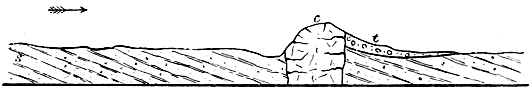 Fig. 11.—“Crag and Tail”; boss of hard rock, c; intersecting sandstones, s; superficial
deposits heaped up in rear of crag, t. The arrow indicates direction followed by smoothing
agent.
Fig. 11.—“Crag and Tail”; boss of hard rock, c; intersecting sandstones, s; superficial
deposits heaped up in rear of crag, t. The arrow indicates direction followed by smoothing
agent.
When the rocks have not been much exposed to the action of the weather, they often show a polished surface covered with long parallel grooves and striæ or scratches. Such polished and scratched surfaces are best seen when the superficial deposits have been only recently removed. Often, too, when we tear away the thick turf that mantles the hill-slopes, we find the same phenomena. Indeed, wherever the rocks have not been much acted upon by the weather, and thus broken up and decomposed, we may expect to meet with more or less well-marked grooves and stride. Now the remarkable circumstance about these scratches is this—they agree in direction with the trend of the rock-ridges and the hollows described above. Nor can we doubt that the superficial markings have all been produced by one and the same agent. In the upper valleys of the Cheviots, the scratches coincide in direction with the valleys, which is, speaking generally, from south to north, but as we approach the low-grounds they begin to turn more to the east (just, as we have seen, is the case with the ridges and hollows), until we enter England to the east of Coldstream, where the striæ point first nearly due east, but eventually swing round to the south-east, as is well seen upon the limestone rocks between Lowick and Belford. In Teviotdale the general trend of the striæ — 103 — is from south-west to north-east, a direction which continues to hold good until the lower reaches of the Tweed are approached, when, as we have just mentioned, they begin to turn more and more to the east. Thus it becomes evident that the denuding agent, whatever it was, that gave rise to these ridges and scratched rock-surfaces must have pressed outwards from all the dominant watersheds, and, sweeping down through the great undulating strath that lies between the Cheviots and the Lammermuirs, must have gradually turned away to the east and south as it rounded the northern spurs of the former range, so as to pass south-east over the contiguous maritime districts of Northumberland.
A few words now as to the character of the superficial deposits which enter so largely into the composition of the long parallel banks and ridges in the low-grounds of Roxburghshire, Berwickshire, and the northern part of Northumberland. The most conspicuous and noteworthy deposit is a hard tough tenacious clay, which is always more or less well-charged with blunted and sub-angular stones and boulders, scattered pell-mell through the mass. This clay is as a rule quite unstratified—it shows no lines of bedding, and although here and there it contains irregular patches and beds of gravel and sand, yet it evidently does not owe its origin to the action of water. Its colour in the upper part of Teviotdale and the Cheviots is generally a drab-brown, or pale grey and sometimes yellow, while here and there, as in the upper reaches of the Jed valley, it is a dark dingy bluish grey. In the lower parts of Teviotdale and in the Tweed district it is generally red or reddish brown. The stones in the clay have all been derived from the rocks of the region in which it occurs. Thus in Teviotdale we find that in the higher reaches of the dale which are Silurian the stones and boulders consist of various kinds of greywacké, etc. In the lower reaches, however, when we pass into the Red Sandstone area, we note that the clay begins to contain fragments of red sandstone, while the clay itself takes on a reddish tinge, until we get down to the vale of the Tweed, where not only is the clay very decidedly red, but its sandstone boulders also — 104 — are very numerous. The same appearances present themselves in passing outwards from the Cheviots. At first the clay contains only stones that have been derived from the upper parts of the hills, but by-and-by, as we near the low-grounds, other kinds begin to make their appearance, so that by the time we reach the Tweed we may obtain from the clay specimens of every kind of rock that occurs within the drainage-area of the Teviot and the lower reaches of the River Tweed.
Look at the stones, and you shall observe that all the harder and finer-grained specimens are well-smoothed and covered with striæ or scratches, the best marked of which run parallel with the longer axis of each stone and boulder. These scratches are evidently very similar to those markings that cover the surface of the underlying solid rock, and we may feel sure, therefore, that the denuding agent which smoothed and scratched the solid rocks had also something to do with the stones and boulders of the clay.
Underneath the stony clay, or Till, as it is called, we find here and there certain old river gravels. We know that these gravels are river-formations, because not only do they lie at the bottom of the river-valleys, but the stones, we can see, have been arranged by water running in one constant direction, and that direction is always down the valley in which the gravels chance to occur. Frequently, however, there is no trace of such underlying gravels, but the till rests directly upon the solid rocks.
Now what do all these appearances mean? It is clear that there is no natural agent in this country engaged in rounding and scratching the rocks, or in accumulating a stony clay like till. In alpine regions, however, we know that glaciers, as they slowly creep down their valleys, grind and polish and scratch the rocks over which they pass, and that underneath the moving ice one may detect smoothed and striated stones precisely resembling those that occur in till. Frost in such alpine regions splits up the rocks of the cliffs and mountain-slopes that overlook a glacier, and immense masses of angular stones and débris, thus loosened, — 105 — roll down and accumulate along the flanks of the ice-streams. Eventually such accumulations are borne slowly down the valley upon the back of the glacier, and are dropped at last over the terminal front of the ice, where they become intermingled with the stones and rubbish, which are pushed or washed out from underneath the ice. These heaps and masses of angular débris and stones are called “moraines,” and one can see that in Switzerland the glaciers must at some time have been much larger, for ancient moraines occur far down in the low-grounds of that country—the glaciers being now confined to the uppermost reaches of the deep mountain-valleys. Moreover, we may note how the mountain-slopes overlooking the present puny glaciers have been rubbed by ice up to a height of sometimes a thousand feet and more above the level of the existing ice-streams. Now since the aspect presented by the glaciated rock-surfaces of Switzerland is exactly paralleled by the rounded and smoothed rocks of Scotland, there can be no doubt that the latter have had a similar origin. Again, we find throughout the low-grounds of Switzerland a deposit of till precisely resembling that which is so well developed in Teviotdale and the valley of the Tweed. And as there can be no doubt that the Swiss till has been produced by the action of glacier ice, we are compelled to believe the same of the till in Scotland.
Let us further note that in the deep mountain-valleys of Switzerland the glacial deposits consist for the most part of coarse morainic débris—of such materials, in short, as the terminal moraines of existing glaciers are mainly composed. Not infrequently this morainic débris has been more or less acted upon by the rivers that escape from the glaciers, and the angular stones have been rounded and arranged in bedded masses. It is only when we get out of the mountain-valleys and approach the low-grounds that the till, or stony clay, begins to appear abundantly. The same phenomena characterise the Cheviot district. In the upper reaches of the mountain-valleys at the heads of the Teviot, the Kale, the Bowmont, etc., either till does not occur or it is thin and often concealed below masses of rude morainic débris and — 106 — gravel. Out in the low-grounds, however, till, as we have already remarked, is the most conspicuous of all the superficial deposits. From these facts it may be inferred that till indicates the former presence of great confluent glaciers, while morainic débris in hill-valleys points to the action of comparatively small local and isolated glaciers.
What, then, are the general conclusions which may be derived from a study of the rock-ridges, flutings, and striæ, and the till of the Cheviot district? Clearly this: that the whole country has at one time been deeply buried under glacier ice. The evidence shows us that the broad strath stretching between the Lammermuirs and the Cheviots must have been filled to overflowing with a great mass of ice that descended from the uplands of Peebles and Selkirk and the broad-topped heights that overlook the sources of the Teviot. The Cheviots appear to have been quite buried underneath this wide sea of ice, and so likewise were the Lammermuirs. At the same time, as we know, all Scotland was similarly enveloped in a vast sheet of snow and ice, which streamed out from the main watersheds of the country, and followed the lines of the chief straths—that is to say, the general slope of the ground. The track of the ice in the Cheviot district is very distinctly marked. In Teviotdale it followed the trend of the valley, and, grinding along the outcrop of the Silurian strata, deepened old hollows and scooped out new ones in the soft shaly beds, while the intervening harder strata, which offered greater resistance to the denuding action of the ice, did not wear so easily, and so were rounded off, and formed a series of ridges running parallel to the eroded hollows. The stones and rubbish, dragged along underneath the ice, necessarily increased as the glacier mass crept on its way. The rocks were scratched and grooved by the stones that were forced over them, and the polishing was completed by the finer sand and clay which resulted from the grinding process. Wherever a rock projected there would be a tendency for the stones and clay and sand to gather behind it. One may notice the same kind of action upon the bed of a stream, where the sediment tends to collect in the rear of prominent — 107 — stones and boulders. And we can hardly fail to have observed further that the sediment of a river often arranges itself under the action of the current in long banks, which run parallel to the course of the water. Underneath the ice-sheet the stones, sand, and clay behaved in the same way. Behind projecting rocks in sheltered nooks and hollows, they accumulated, while in places exposed to the full sweep of the ice-stream they were piled up and drawn out into long parallel banks and ridges, the trend of which coincided with that of the ice-flow. The presence of confused and irregular patches and lenticular beds of sand, clay, and gravel in the till is not difficult to understand when we know that there is always more or less water flowing on underneath a glacier. Such streams must assort the débris, and roll angular fragments into rounded stones and pebbles; but the materials thus assorted in layers will ever and anon be crushed up so as to be either partially or wholly obliterated by the slowly moving glacier.
As the stones and clay were derived from the underlying rocks, it is no wonder that the colour of the till should vary. In the Silurian tracts it is pale yellowish, or bluish grey, and the stones consist chiefly of fragments of Silurian rocks, all blunted and smoothed, and often beautifully polished and striated. When we get into the Red Sandstone region of the low-grounds the colour of the clay begins by-and-by to change, and fragments of red sandstone become commingled with the Silurian stones, until ere long the colour of the deposit is decidedly red, and sandstone fragments abound. Everywhere the stones show that they have been carried persistently in one direction, and that is out from the watershed, and down the main valleys.
The direction of the ice-marks upon the solid rocks, and the trend of the “drums,” as the parallel ridges of till are termed, show that the ice-sheet of Teviotdale and Tweed gradually turned away to the east and south-east as it swept round the north-eastern spurs of the Cheviots. Now we may well ask why the ice did not go right out into the North Sea, which is apparently the course it ought to have followed. — 108 — The same curious deflection affected the great ice-stream that occupied the basin of the Forth. When it got past North Berwick, that stream, instead of flowing directly east into the North Sea, turned away to the south-east and overflowed the northern spurs of the Lammermuirs, bringing with it into the valley of the Tweed stones and boulders which had travelled all the way from the Highlands. It is obvious there must have been some impediment to the flow of the Scottish ice into the basin of the North Sea. What could have blocked its passage in that direction? At the very time that Scotland lay concealed beneath its ice-sheet, Norway and Sweden were likewise smothered in ice which attained a thickness of not less than five or six thousand feet. The whole basin of the Baltic was occupied by a vast glacier which flowed south into Northern Germany, and this sheet was continuous with glacier-ice that crossed over Denmark. When we consider how shallow the North Sea is (it does not average more than forty fathoms between Scotland and the Continent), we cannot doubt that the immense masses of ice descending from Norway could not possibly have floated off, but must actually have crept across the bottom of that sea until they abutted upon and coalesced with the Scottish ice, so as to form one vast mer de glace.
Thus it was that the Scandinavian ice blocked up the path of the Scottish glaciers into the basin of the North Sea, and compelled them to flow south-east into England.[H] Had there been no such obstruction to the passage of the Scottish glaciers, it is impossible to believe that snow and ice could ever have accumulated to such a depth in Scotland. The Scottish ice reached a thickness of some three thousand feet in its deeper parts. It is evident, however, that had there been a free course for the glaciers, they would have moved off before they could have attained this thickness. And we can hardly doubt, therefore, that it was the damming-up of their outlet by the great Scandinavian ice-sheet that enabled them to deepen to such an extent in the valleys and low-grounds of Scotland.
[H] In the extreme north of Scotland we find that the Scottish ice was, in like manner, compelled to turn aside and overflow Caithness from south-east to north-west.
When the ice-sheet was at its thickest, the Cheviots were completely covered, nevertheless they served to divide the ice-flow between Scotland and England, although here and there one finds that the ice passed over some of the lower summits, carrying with it boulders and stones. This is by no means an uncommon circumstance in Scotland and other glaciated countries. Thus we note that Highland boulders have been brought into the vale of the Tweed across the Lammermuirs; and in the same way boulders from the heights overlooking Eskdale have been carried over some of the lower hill-tops into the vale of the Teviot. In like manner the Swedish ice occasionally overflowed the lower mountain-tops of the dividing ridge or watershed into Norway.
What wonder now that the Cheviot area should exhibit so many flowing outlines, that the hills should be so smoothed and rounded and fluted, that the low-grounds should be cumbered with such heaps of clay and striated stones? Long before the great glaciers appeared, the rocks were weathered and worn by the action of the usual atmospheric forces, and each had assumed its own peculiar outline; but how greatly has this been modified by the grinding action of the ice-sheet! To what an extent have projecting rocks been rubbed, and how great is the destruction that has befallen the loose accumulations of river gravel, sand, and clay that gathered in the valleys before the advent of the Ice Age! All that now remains of these are a few patches preserved here and their underneath the till. The Cheviots can tell us nothing of the kinds of plants and animals that clothed and peopled the country in pre-glacial times. All we learn is that streams and rivers flowed as they flow now, and that by-and-by everything was changed, and the land disappeared underneath a vast covering of snow and ice.
In my concluding paper I will show how this ice period passed away, and how the present condition of things succeeded.
V.
I have described the condition of the Cheviot district during the climax of the Ice Age as one of intense arctic cold, the whole ridge of hills being then completely smothered in snow and ice. This excessive climate, however, did not last continuously throughout the so-called glacial period, but was interrupted by more than one mild interglacial epoch. We have evidence in Scotland, as in other countries, to show that the great confluent ice-masses melted away so as to uncover all the low-grounds and permit the reappearance of plants and animals. Rivers again watered the land, and numerous lakes diversified the face of the country. Willows, hazels, and alders grew in the sheltered valleys, oak-trees flourished in the low-grounds, and Scots firs clustered upon the hill-slopes. A strong, grassy vegetation covered wide areas, and sedges and rushes luxuriated in marshy places and encroached upon the margins of the lakes. The mammoth, or woolly-coated elephant, roamed over the land, and among its congeners were the extinct ox, the horse, the Irish elk, and the reindeer. After such a temperate condition of things had continued for some time—perhaps for thousands of years—the land, during the last interglacial epoch, became gradually submerged to a depth of several hundred feet, and a cold, ungenial sea, in which flourished species of northern and arctic shells, covered the low-grounds of Scotland. The cold continuing to increase, our glaciers descended for the last time from the mountains and encroached upon the bed of the sea, until they became confluent, fairly usurping the floor of the German Ocean, and pushing back the western seas as far as, and even beyond, the islands of the Outer Hebrides. There is good reason to believe that such great changes of climate occurred several times during the glacial period, which thus seems to have consisted of an alternation of cold and genial epochs. But as the last phase in this extraordinary series of changes was a cold one, during which great glaciers scoured the face of the country, we now obtain — 111 — only a few scattered traces of the genial conditions that characterised the preceding mild interglacial epochs. Vegetable accumulations, lake and river deposits with mammalian remains, marine beds and their shelly contents, were all ploughed up by the ice, and to a very large extent demolished. Here and there, however, we find in the till or boulder-clay that marks the last cold epoch, wasted fragments of trees, tusks of mammoths, and broken sea-shells; while underneath the till we occasionally come upon old lake deposits with vegetable and mammalian remains, or, as the case may be, beds of marine origin well stocked with sea-shells of arctic species. And these freshwater and marine beds repose, in many cases, upon an older accumulation of till, which belongs to an earlier cold epoch of the glacial period. In the Cheviot district proper, the traces of mild, interglacial conditions are very slight, but in the immediate neighbourhood we find them more strongly marked. Thus, in the valley of the Slitrig, near Hawick, we notice freshwater beds with peaty matter lying between a lower and an upper till or boulder-clay; and interglacial freshwater beds also appear in the neighbouring county of Peebles, particularly in the valley of the Leithan Water. Again, in the valley of the Tweed near Carham, there occur interglacial beds in which I detected numerous bones of water-rats and frogs. These interglacial remains acquire a peculiar interest when we come to view the “superficial deposits” of Scotland in connection with those of England and the Continent; for, as I have endeavoured to show elsewhere,[I] it is most likely that the ancient gravels of England, which contain the earliest traces of man, belong for the most part to interglacial times; and the extraordinary changes of climate described above may therefore have been actually witnessed by human eyes. Indeed, I believe it was the advent of the last cold epoch of the Ice Age that drove out the old tribes who used the rude flint implements that are now found in the gravel deposits and caves of England, and who occupied the British area along — 112 — with hippopotami, rhinoceroses, elephants, lions, hyænas, and other animals. The men who entered Britain after the final disappearance of arctic conditions, were more advanced in civilisation, and were accompanied by a very different assemblage of animals—by a group represented by oxen, sheep, dogs, and other creatures, most of which are still indigenous to Britain.
[I] Great Ice Age.
But to return to the Cheviots. When the final cold epoch had reached its climax, and the ice-sheet began to melt away for the last time, the tops of the hills then once more became uncovered, and large blocks, detached by the action of the frost, fell upon the surface of the glaciers, and were borne down the valleys, some of them to become stranded here and there on hill-slopes, others to be carried far away from the Cheviot area and dropped at last over Northumberland and Durham, or even further south. As the melting of the ice continued, and the glacier of the Tweed ceased to reach the sea, great accumulations of gravel and sand were formed. Underneath the ice, sub-glacial streams ploughed out the till, and paved their hidden courses with gravel and sand. In summer-time, the whole surface of the Tweed glacier was abundantly washed with water, which, pouring down by clefts and holes in the ice, swelled all the sub-glacial streams and rivers. At the same time, floods descending from the Lammermuirs and the Cheviots, pushed with them vast quantities of shingle, gravel, and sand, part of which was swept upon the surface of the Tweed glacier, while much seems to have gathered along its flanks, forming banks and ridges running parallel with the course of the valley.
At last the time came when the ice had fairly vanished from the lower reaches of the Tweed, and we now walk over its bed and mark the long ridges and banks of shingle and gravel that were formed by the sub-glacial streams and rivers, and the somewhat similar accumulations that gathered along the sides of the glacier at the foot of the Lammermuir Hills. Here and there, also, we note the heaps (i.e. moraines) of shingle, earth, clay, and débris, with large erratics which travelled on the surface of the ice, and were dropped upon — 113 — the ground as that ice melted away. All the loose erratics that lie at the surface in the lower reaches of the Tweed valley have come from the west. Some of them rest upon hard rock, others upon till, and yet others crown the tops and slopes of gravel and sand hillocks, or appear in low mounds of morainic origin.
In the valleys of the Cheviot Hills one traces the footsteps of the retiring glaciers in mounds and hummocks of rude earthy débris, blocks, and rock-rubbish. These are terminal moraines, and they indicate certain pauses in the recession of the ice. The most remarkable examples occur in the valley of the Kale Water at Blinkbonny, a mile or so above the village of Eckford. At that place a bank of morainic matter at one time blocked up the valley of the Kale, and thus formed a wide and extensive lake that stretched up to and beyond Morebattle. Numerous curious hillocks of gravel and sand are banked against the moraine, and point to the action of the flood-waters that escaped from the melting glacier. Other gravelly moraine mounds occur higher up the same valley, as near Grubbit Mill. These last tell us of a time when the Kale glacier had retreated still further, so as to have its terminal front near where Morebattle now is. Wreaths and hummocks of gravel and sand, extending from Grubbit to the north-east, along the hollow in the hills that leads to Yetholm Loch, indicate the course taken by a portion of the torrents that escaped from the ice in summer-time. In other hill-valleys, similar indications of ancient local glaciers may be seen. Some of the most conspicuous of these appear upon the slopes and in the high valleys within the drainage-areas of the Jed and the Kale. They consist chiefly of mounds and hillocks, made up of coarse earthy débris and rock-rubbish; sometimes these are solitary and rest in the throat of a valley, at other times they are scattered all over the hill-slopes and valley-bottom. One can have no doubt as to what they mean: they indicate clearly the presence of insignificant glaciers that were soon to vanish away. The larger and better-defined mounds are true terminal moraines, while the — 114 — scattered heaps of rubbish point out for us the beds in which the glaciers lay. Thus, from the sea-coast up to the highest ridge of this border country, we follow the spoor of the melting ice; passing from massive and wide-spread deposits of till, gravel, and sand, and angular débris in the low-grounds, up to insignificant heaps and scatterings of rock-rubbish and angular boulders at the higher levels of the country.
Several more or less extensive flats in the hill-valleys indicate the former presence of lakes which have become obliterated by the action of the streams. But by far the most conspicuous example of such silted-up lakes is that of the Kale valley, to which reference has already been made. In the later stages of the Ice Age that river-valley must have existed as a lake from Marlfield up to and beyond Morebattle. Indeed, there is evidence to show that even within historical times a considerable lake overspread the flat grounds in this neighbourhood. The name Morebattle is supposed to mean the “village by the lake,” and, up to a few years ago, there was a sheet of water called Linton Loch a little to the east of Morebattle. But this has been drained by the proprietor, and is now represented by only two insignificant pools. The present course of the Kale between Marlfield and Kalemouth is of post-glacial age—the old pre-glacial and interglacial course being filled up with drifted materials. As the appearances at this place are somewhat typical of many of the valleys of the Cheviot district, I may briefly summarise the history of the Morebattle lake.
Before the advent of the last great age of ice the Kale would seem to have flowed from Marlfield, close to the line now followed by the turnpike road as far as Easter Wooden, after which it passed near the present sites of Blinkbonny and Mosstower, and so on to the Teviot, which it joined some little distance above Kalemouth. During the Ice Age many of the old river-courses were completely choked up with clay, stones, and gravel, so that when the ice melted away the rivers did not always or even often regain their — 115 — old channels. Thus, in the case of the Kale, we find that the present course of the river below Marlfield is of recent or post-glacial age, having been excavated by the river since the close of the glacial epoch. The old or pre-glacial course lies completely choked up and concealed under the rubbish shot into it at a time when glacier-ice filled all the valley of the Kale down to Marlfield. At this latter place the Kale glacier seems to have made a considerable pause—it ceased for some time to retreat—and thus a heavy bank of gravel, sand, shingle, earth, blocks, and angular rubbish gathered in front of it, and obliterated the old river-course into which they were dropped. When the glacier at last disappeared, a lake was formed above the morainic dam that closed the valley below Marlfield, and the outflow of the lake took place at a point lying some little distance to the north of the old or pre-glacial course of the Kale. By slow degrees the river excavated a new channel for itself in the Old Red Sandstone rocks, and in doing so gradually lowered the level of the waters. This and the silting action of the Kale and its feeders slowly converted the lake-hollow into a broad alluvial flat through which the river now winds its way.
Another extensive lake seems to have occupied the vale of the Teviot between Jedfoot and Eckford, and similar old lake-beds occur in several of the hill-valleys. One good example is seen in the valley of the Oxnam Water, where the flat tract that extends from the old village of Oxnam up to the foot of the Row Hill indicates the former presence of a lake which has been drained by the stream cutting for itself a gorge in Silurian greywackés and shales. In many other valleys it is easy to see that the streams do not always occupy their pre-glacial courses, and some of the old forsaken courses are still patent enough. Thus, a glance at the hollow that extends from Mossburnford on the Jed to Hardenpeel on the Oxnam is enough to convince one that in pre-glacial, and probably in early post-glacial times also, a considerable stream has flowed from what is now the vale of the Jed into the valley of the Oxnam.
In all the valleys we meet with striking evidence to show — 116 — that the streams and rivers must formerly have been larger than they are now. Certain banks and ridges of gravel fringe the valley-slopes at considerable heights, and indicate the action of deeper and broader currents than now make their way towards the sea. It is probable that these high-level gravel terraces date their existence back to the close of the Ice Age, when local glaciers still lingered in some of the mountain-valleys, and when in summer-time great floods and torrents descended from the hills.
An extremely humid climate seems to have characterised Scotland even in post-glacial times, as may be gathered from the phenomena of her peat-mosses. Very little peat occurs on the Scottish side of the Cheviots, and it is conspicuous chiefly on the very crest of the hills, where it attains a thickness that varies from a foot or two up to five or six yards. Here and there we detect the remains of birch under the peat, but the peat itself is composed chiefly of bog-moss and heather. The evidence so abundantly supplied by the peat-mosses in other parts of Scotland shows that after the Ice Age had passed away the Scottish area became clothed with luxuriant forests of oak, pine, and other trees. At that time the British Islands appear to have been joined to themselves and the Continent across the upraised beds of the Irish Sea and the German Ocean. Races of men who used polished stone implements and sailed in canoes that were hollowed out of single oaks inhabited the country, together with certain species of oxen (now either extinct or domesticated), the elk, the beaver, the wolf, and other animals, such as the dog and the sheep, which are still indigenous. The climate was more excessive then than it is now—the summers being warmer and the winters colder. By-and-by, however, submergence ensued, the great wooded plain that seems once to have extended between Britain and the Continent disappeared below the waves, and the climate of this country became more humid. The old forests began to decay and the peat-mosses to increase, until by-and-by large areas in the low-grounds passed into the condition of dreary moor and morass, and even the brushwood and stunted trees of the hills died down — 117 — and became enveloped in a mantle of bog-moss. A study of the present condition of the Scottish peat-mosses leads one to believe that the rate of increase is now much exceeded by the rate of decay, and that the eventual disappearance of the peat that clothes hill-tops and valley-bottoms is only a question of time. Draining and other agricultural operations have no doubt influenced to some extent this general decay of the peat-mosses; but there is reason to suspect that the change of climate, to which the decay of the peat is due, may really be owing to some cosmical cause. Quite recently an accomplished Norwegian botanist has come to similar conclusions regarding the peat-mosses of the Scandinavian peninsula.
We have now traced the geological history of the Cheviot district down to the “Recent Period.” From this point the story of the past must be continued by the archæologist, and into his province I will not trespass further than to indicate some of the more remarkable traces which the early human occupants of the upland valleys left behind them. Before doing so, however, I may briefly recapitulate the general results we have obtained from our rapid review of the glacial and post-glacial deposits. A study of these has taught us that the Cheviot Hills and the adjoining low-grounds participated in those arctic conditions under the influence of which all Scotland and a large portion of England were buried beneath a wide-spread mer de glace. The Cheviots themselves were completely smothered under a mass of glacier-ice which extended across the vale of the Tweed, and was continuous over the Lammermuirs with the vast sheet that filled all the great lowlands of central Scotland. But although the Cheviots were thus overwhelmed, they yet served to divide the ice-flow, for we find that the gelid masses moved outwards from the hills towards the valley of the Tweed, turning gradually away to east and south-east to creep over the north part of England. How far south the ice-sheet reached has not yet been determined, but its moraine profonde or till may be traced to the edge of the Thames valley; and I have picked up in Norfolk — 118 — ice-worn fragments of igneous rock, which have been derived from the Cheviots themselves, showing that Scottish ice actually invaded the low-grounds south of the Wash. Such severe glacial conditions, after continuing for a long time, were interrupted more than once by intervening periods characterised by a milder and more genial climate. The great mer de glace then melted out of the valleys, and for aught that we can say the snow and ice may even have vanished from the hills themselves. Vegetation now covered the country, and herds of the mammoth, the old extinct ox, the Irish elk, the reindeer, the horse, and probably other creatures, roamed over the now deserted beds of the glaciers. It was probably at this time that Palæolithic man lived in Britain. He was contemporaneous with lions, elephants, rhinoceroses, hippopotami, mammoths, reindeer, and other animals of southern and northern habitats, the former living in England when the climate was genial, but being replaced by the northern species when the temperature began again to fall, and snow and glaciers once more reappeared and crept downwards and outwards from the hills. Towards the close of the interglacial period the land became submerged to a considerable extent, and species of arctic shells lived over the sites of the drowned land where the mammoth and its congeners had flourished. By-and-by the cold so far increased that another great ice-sheet filled up the shallow sea, and as it slowly ground over the face of the land and the sea-bottom, it scoured out and demolished to a large extent all loose fluviatile, lacustrine, and marine accumulations. When at last the ice melted away, it left the ground cumbered with stony clay, and with much gravel and sand and morainic débris. It is underneath these deposits that we yet obtain now and again fragments of the life of that interglacial epoch. But in all the regions visited by the last great incursion of the mer de glace, such relics are comparatively rare; it is only when we get beyond the districts that were overwhelmed that the ancient interglacial remains are well preserved. Beyond the southern extremity reached by the latest general ice-sheet—that is to say, in — 119 — the regions south of the Humber, we find the country often sprinkled with tumultuous heaps and wide-spread sheets of gravel and brick-earth, which seem to owe their origin to the floods and torrents that escaped from the melting ice. These waters, sweeping over the land, carried along with them such relics of man and beast as lay at the surface, washing away interglacial river-deposits, and scattering the materials far and wide over the undulating low-grounds of central and eastern England. Mr. S. B. J. Skertchly, of the Geological Survey of England, has shown that such is the origin of the so-called “river-gravels” with ancient flint implements and mammalian remains in the districts watered by the Little Ouse, the Waveney, and other rivers in that part of England. These gravels could not possibly have been deposited by the present rivers, for they are found capping the hills at a height of more than eighty feet above the sources of the streams. The whole aspect of the gravels, indeed, betokens the action of rapid floods and torrents, such as must have been discharged abundantly in summer-time from the melting ice-sheet that lay at no great distance to the north.
When the ice-sheet vanished away, it left the ground covered thickly in many places with its various deposits. Rivers and streams were thus often debarred from their old channels, and were forced to cut out for themselves new courses, partly in drifted materials, and partly in solid rock. A number of lakes then existed which have since been silted up. So long as glaciers lingered in the hill-valleys, the rivers seem to have flowed in greater volume than they now do. By-and-by the bare and treeless country became clothed with a luxuriant forest-growth, and was tenanted by animals, many of which are still indigenous to our country, while others have become locally extinct, such as wolf, beaver, and wild boar. In certain of the old lake-beds of the Cheviot district numerous remains of red-deer and other animals have been turned out in the search for marl, and in land drainage and reclamation operations—the red-deer antlers being sometimes of noble dimensions. — 120 — It seems probable that in early post-glacial times our country was joined to the Continent and shared in a continental climate, the summers being then warmer and the winters colder than now.
The men who lived in Britain after the final disappearance of the great glaciers used stone implements, which were often polished and highly finished, and they sailed in canoes, being probably a race of active hunters and fishers. They belong to the archæologist’s “Neolithic” or new-stone period—the “Palæolithic” or old-stone period being of much older date, and separated, as I believe, from Neolithic times by the intervention of the last cold epoch of the Ice Age.
To the forest epoch succeeded a time when the climate became very humid, a result which may have been due in large part to the separation of Britain from the Continent. It was then that the ancient forests began to decay, and peat-mosses to increase. How long such humid conditions of climate characterised the country we can hardly say, but we know that nowadays our peat-mosses do not grow so rapidly as they once did, and indeed almost everywhere the rate of decay is greater than the rate of increase. This points to a further change of climate, and brings us at once face to face with the present.
And now a few words, in conclusion, as to the old camps and other remains that occur so abundantly in the valleys of the Cheviot Hills. In many of the hill-valleys, especially towards their upper reaches, as in the valleys of the Kale and the Bowmont, almost every hill is marked by the presence of one or more circular or oval camps or forts. They are generally placed in the most defensible positions, on the very tops of the hills or on projecting spurs and ridges. Most of them are of inconsiderable dimensions, and could not have afforded protection to any large number of men, for many hardly exceed one hundred feet in diameter. Not a few consist of only a single circular or oval rampart with an external ditch—the rampart being composed of the rude débris which was dug out to — 121 — form the ditch. Others, however, are not only much larger (five to six hundred feet in diameter), but surrounded, in whole or in part, with two or more ramparts separated by intervening ditches; and I have noticed that as a rule the side which must have been most easily assailable was protected by several ramparts rising one above the other. From the extraordinary number of these hill-forts one has the impression that the upper valleys of the Cheviots must at one time have been thickly peopled, probably in pre-Roman times. It is easy to see that the camps or forts overlooking a valley often bear a certain relation to each other, as if the one had been raised to support the other, and not infrequently we can trace well-marked intrenchments extending across a hill-ridge, or along a hill-slope for a distance of not much short of a mile, and evidently having some strategic connection with the forts or camps in their vicinity. I found no trace of any “dwellings,” either near the forts or in the vicinity of the terraces. The only indications of what may have been the walls of such appear within a fortified camp, called the Moat Hill, at Buchtrig. This is an isolated knoll of rock, which has been strongly fortified—large slabs and blocks of the porphyrite of which it is composed having been wedged out with infinite pains to form circular ramparts. The “walls” are of course nearly level with the ground and grassed over, but they indicate little square enclosures, which may very possibly have been huts closely huddled together. This fort is oval, and measures five hundred feet by two hundred and seventy.
In the same neighbourhood we also meet with plentiful marks of ancient cultivation and with places of sepulture—all of which may without much doubt be referred to the same period as the camps and forts. The slopes of the hills are often marked with broad horizontal terraces, that remind one strongly of the “lazy-beds” of the Hebrides. They are evidently the “cultivated grounds” of the hill-men, and doubtless the hill-slopes were selected for various reasons, chief among which would be their retired and somewhat inaccessible position. The ease with which they — 122 — could be drained and irrigated would be another of their recommendations; and we must bear in mind that at this early date the low-grounds were covered with forests and morasses, and therefore not so easily cultivated as the hill-slopes.
Here and there we notice also little conical hillocks or tumuli. They were formerly much more numerous, and by-and-by they will doubtless all disappear. Numbers, even within recent years, have been pulled down, partly to clear the ground, and partly for the sake of the stones of which they are composed. This is much to be regretted; for their destruction simply means the obliteration of historical records, the loss of which can never be made good. I asked a farmer what had become of the tumuli which at one time, according to the Ordnance Survey map, were dotted over the hill behind his house. “If it’s the wee knowes (knolls) you mean, I pu’d them down, for they were jist in the way. There was naething o’ importance below the stanes, only a wheen worthless bits o' pottery!” And the worthy pointed to a heap of stones behind a neighbouring “dyke,” where I afterwards found some fragments of the pottery which had been so ruthlessly demolished. These tumuli are no doubt old burial-places, and much information concerning the habits of our ancient predecessors might often be obtained by a careful examination of the mounds, when it is deemed essential to remove them. But, surely, after all, they might be spared, for they can seldom be so very much “in the way”; and, at all events, if they must be removed, might it not be well to communicate the fact of their approaching demolition to some local archæological society, or to any member of the Berwickshire Naturalists’ Club, who for the sake of science would, I feel certain, do what was possible to preserve an accurate account of their contents?
“Standing-stones” are met with now and again, either singly or in groups, and sometimes they form circles. It is most likely that they were raised by the same people who made the forts and tilled the horizontal “lazy-beds.” — 123 — One can only conjecture that they may have been designed as memorial stones, to mark the place where a chief or person of consequence was slain in battle. They may also mark burial-places, or indicate the site of some deed of prowess or other action or circumstance worthy of being remembered. Antiquarians at one time considered that all these stones were relics of druidical worship; but it is needless to say that this view has long been abandoned. That the ancient inhabitants of the Cheviots may have had some kind of religion is exceedingly probable, but it must have been of a very primitive kind, not more advanced than that of the North American Indians.
Such are some of the more notable relics of the people who lived in the valleys of the Cheviot Hills in pre-Roman times. These valleys, as I have said, seem to have supported a numerous population, who tilled the slopes and probably hunted in the forests of the adjoining low-grounds. That they lived in fear of foes is sufficiently evident from the number of their intrenchments and fortified camps, to which they would betake themselves whenever their enemies appeared.
What effect the Roman occupation had on the dwellers among these hills we cannot tell. The great “Watling Street” passes across the Cheviots, and there are some old circular forts and camps quite close to that wonderful road, along which many a battalion of Roman soldiers must have marched; and these forts, if of pre-Roman age, were not at all likely to have been held by the natives after Watling Street was made. In the remoter fastnesses of the hills, however, the old tribes may have continued to crop their “lazy-beds,” to hunt, and tend their herds, during the Roman occupation, and the old forts may have been in requisition long after the last Roman had disappeared over the borders.
But I have already, I fear, delayed too long over the old history of the Cheviot Hills, and must now draw my meagre sketches to a close. In my first paper I said that these hills were a terra incognita to the tourist. Those — 124 — who visit the district must not therefore expect to meet with hotel accommodation. But “knowing” pedestrians will not be much disturbed with this information, and will probably find, after they have concluded their wanderings, that the hospitality and general heartiness for which our stalwart Borderers were famous in other days are still as noteworthy characteristics as they used to be.
The Long Island, or Outer Hebrides.[J]
[J] Good Words, 1879.
I.
That long range of islands and islets which, extending from latitude 56° 47' N. to latitude 58° 32' N., acts as a great natural breakwater to protect the north-west coast of Scotland from the rude assaults of the Atlantic billows is not much visited by the ordinary tourist. During “the season” the steamers now and again, it is true, deposit a few wanderers at Tarbert and Stornoway, some of whom may linger for a shorter or longer time to try a cast for salmon in Loch Laxdail, while others, on similar piscatorial deeds intent, may venture inland as far as Gearaidh nah Aimhne (Garrynahine). Others, again, who are curious in the matter of antiquities, may visit the weird standing-stones of Callernish, or even brave the jolting of a “trap” along the somewhat rough road that leads from Tarbert to Rodel, in order to inspect the picturesque little chapel there, and take rubbings of its quaint tombstones with their recumbent effigies of knights, and Crusaders’ swords, and somewhat incomprehensible Latinity. Occasionally a few bolder spirits may be tempted by the guide-books to visit Barra Head, with its ruddy cliffs and clouds of noisy sea-birds, or even to run north to the extremity of the Long Island to view the wonders of the Butt of Lewis. But, as a rule, the few summer visitants who are landed at Stornoway content themselves with a general inspection — 126 — of the grounds about Sir James Mathieson’s residence, while those who are dropped at Tarbert on Saturday are usually quite ready to depart on Monday with the steamer that brought them. The fact is that hotel accommodation in the Outer Hebrides is rather limited, and the means of locomotion through the islands is on the same slender scale. Those, therefore, who are not able and willing to rough it had better not venture far beyond Tarbert and Stornoway.
When the islands are first approached they present, it must be confessed, a somewhat forbidding aspect. Bare, bleak rocks, with a monotonous rounded outline, crowd along the shore, and seem to form all but the very highest portions of the land that meet our view, while such areas of low-ground as we can catch a glimpse of appear to be everywhere covered with a dusky mantle of heath and peat. But, although the general character of the scenery is thus tame and sombre, yet there are certain districts which in their wild picturesqueness are hardly surpassed by many places in the northern Highlands, while one may search the coast-line of the mainland in vain for cliffs to compare with those gaunt walls of rock, against which the great rollers of the Atlantic continually surge and thunder. It is wonderful, too, how, under the influence of a light-blue sky, flecked with shining silvery clouds, the sombre peat-lands lighten up and glow with regal purple and ruddy brown. With such a sky above him, and with a lively breeze fresh from the Atlantic and laden with the sweetness of clover and meadow-hay and heather-bloom sweeping gaily past him, what wanderer in the Outer Hebrides need be pitied? And such days are by no means so rare in these islands as many a jaundiced Lowlander has maintained. It is true that heavy mists and drizzling rain are often provokingly prevalent, and I cannot forget the experience of a sad-hearted exile, who had resided continuously for a year in Lewis, and who, upon being asked what kind of climate that island enjoyed, replied: "Sir, it has no climate. There are nine months of winter, and three months — 127 — of very bad weather." For myself, I can say that my experience of the climate in June, July, and early August of several years has been decidedly favourable. During those months I found comparatively few days in which a very fair amount of walking and climbing could not be accomplished with ease and pleasure, and that is a good deal more than one could venture to say of Skye and many parts of the west coast of the mainland. The greatest drawback to one’s comfort are the midges, which in these islands are beyond measure bloodthirsty, and quite as obnoxious as the most carnivorous mosquitoes. Smoking, and all the other arts and devices by which the designs of these tiny pests are usually circumvented, have no effect upon the Hebridean vampires. In the low-grounds especially they make life a burden. But those who have already become acquainted with the Ross-shire midges, and yet have preserved their equanimity, may feel justified in braving the ferocity of the Hebridean hosts. And if they do so I believe they will be well repaid for their courage. To the hardy pedestrian, especially, who likes to escape from the beaten track laid down in guide-books, it will be a pleasure in itself to roam over a region which has not yet come entirely under the dominion of Mr. Cook. If he be simply a lover of the picturesque he will yet not be disappointed, and possibly he may pick up a few hints in these notes as to those districts which are most likely to repay him for his toil in reaching them. But if to his love of the picturesque he joins a taste for archæological pursuits, then I can assure him there is a rich and by no means exhausted field of study in the antiquities of the Long Island. Interesting, however, as are the relics of prehistoric and later times which one meets with, yet it is the geologist, perhaps, who will be most rewarded by a visit to these islands.
The physical features of the Outer Hebrides are, as already stated, somewhat monotonous, but this is quite consistent with considerable variety of scenic effect. All the islands are not equally attractive, although the configuration of hills and low-grounds remains persistently the — 128 — same from the Butt of Lewis to Barra Head. The most considerable island is that of which Lewis and Harris form the northern and southern portions respectively. By far the larger part of the former is undulating moorland, the only really mountainous district being that which adjoins Harris in the south. A good general idea of the moorlands is obtained by crossing the island from Stornoway to Garrynahine. What appeared at first to be only one vast extended peat-bog is then seen to be a gently-undulating country, coated, it is true, with much peat in the hollows, but clad for the most part with heath, through which ever and anon peer bare rocks and rocky débris. Now and again, indeed, especially towards the centre of the island, the ground rises into rough round-topped hills, sprinkled sparingly with vegetation. One of the most striking features of the low-grounds, however, is the enormous number of freshwater lakes, which are so abundant as to form no small proportion of the surface. They are, as a rule, most irregular in outline, but have a tendency to arrange themselves in two directions—one set trending from south-east to north-west, while another series is drawn out, as it were, from south-west to north-east. I am sure that I am within the mark in estimating the freshwater lakes in the low-grounds of Lewis to be at least five hundred in number. In the mountain-district the lakes are, of course, confined to the valleys, and vary in direction accordingly.
Harris and the southern part of Lewis are wholly mountainous, and show hardly a single acre of level ground. The mountains are often bold and picturesque, especially those which are over 1600 feet in height. They are also exceedingly bare and desolate, the vegetation on their slopes being poor and scanty in the extreme. Some of the hills, indeed, are absolutely barren. In North Harris we find the highest peaks of the Outer Hebrides: these are the Clisham, 2622 feet, and the Langa, 2438 feet. The glens in this elevated district are often wild and rugged, such as the Bealach-Miavag and the Bealach-na-Ciste, both of which open on West Loch Tarbert. But amid all this ruggedness — 129 — and wild disorder of broken crag and beetling precipice, even a very non-observant eye can hardly fail to notice that the general contour or configuration of the hills is smooth, rounded, and flowing, up to a rather well-marked level, above which the outline becomes broken and interrupted, and all the rounded and smoothed appearance vanishes. The contrast between the smoothly-flowing contour of the lower elevations and the shattered and riven aspect of the harsh ridges, sharp peaks, and craggy tors above, is particularly striking. The mammillated and dome-shaped masses have a pale, ghastly grey hue, their broad bare surfaces reflecting the light freely, while at higher elevations the abundant irregularities of the rocks throw many shadows, and impart a darker aspect to the mountain-tops.
The appearances now described are very well seen along the shores of West Loch Tarbert. All the hills that abut upon that loch show smoothed and rounded faces, and this character prevails up to a height of 1600 feet, or thereabout, when all at once it gives way, and a broken, interrupted contour succeeds. Thus the top of the Tarcall ridge in South Harris is dark, rough, and irregular, while the slopes below are grey, smooth, and flowing. The same is conspicuously the case with the mountains in North Harris, the ruinous and sombre-looking summits of the Langa and the Clisham soaring for several hundred feet above the pale grey mammillated hills that sweep downwards to the sea.
After having familiarised themselves with the aspect of the hills as seen from below, the lover of the picturesque, not less than the geologist, will do well to ascend some dominant point from which an extensive bird’s-eye view can be obtained. For such purpose I can recommend the Tarcall and Roneval in South Harris, the Clisham and the Langa in North Harris, and Suainabhal in Lewis. The view from these hills is wonderfully extensive and very impressive. From Suainabhal one commands nearly all Lewis; and what a weird picture of desolation it is! An endless succession of bare, grey, round-backed rocks and — 130 — hills, with countless lakes and lakelets nestling in their hollows, undulates outwards over the districts of Uig and Pairc. Away to the north spread the great moorlands with their lochans, while immediately to the south one catches a fine panoramic view of the mountains of Harris. And then those long straggling arms of the sea, reaching into the very heart of the island—how blue, and bright, and fresh they look! I suppose the natives of the Lewis must have been fishermen from the very earliest times. It seems hardly possible otherwise to believe that the bare rocks and peat-bogs, which form the major portion of its surface, could ever have supported a large population; and yet there is every evidence to show that this part of the Long Island was tolerably well populated in very early days. The great standing-stones of Callernish and the many other monoliths, both solitary and in groups, that are scattered along the west coast of Lewis, surely betoken as much. And those curious round towers, or places of refuge and defence, which are so well represented in the same district, although they may be much younger in date than the monoliths of Callernish, tell the same tale.
From the summits of the Clisham and the Langa the view is finer than that obtained from Suainabhal. The former overlook all the high-grounds of Harris and Lewis, and the monotonous moors with their countless straggling lakes and peaty tarns. Indeed, they dominate nearly the whole of the Long Island, the hills of distant Barra being quite distinguishable. Of course, the lofty island of Rum, and Skye with its Coolins, are both clearly visible, the whole view being framed in to eastward by the mountains of Ross and Sutherland. On a clear day, which, unfortunately, I did not get, one should be quite able to see St. Kilda. Hardly less extensive is the view obtained from Roneval (1506 feet) in the south of Harris. Far away to the west lie St. Kilda and its little sister islet of Borerey. Southwards stretch the various islands of the Outer Hebrides—North Uist, Benbecula, South Uist, and Barra. How plainly visible they all are—a screen of high mountains facing the — 131 — Minch, and extending, apparently, along their whole eastern margin—with broad lake-dappled plains sweeping out from the foot-hills to the Atlantic. In the east, Skye with its spiky Coolins spreads before one, and north of Skye we easily distinguish Ben Slioch and the mountains of Loch Maree and Loch Torridon. South Harris lies, of course, under our feet, and it is hard to give one who has not seen it an adequate notion of its sterile desolation. Round-backed hills and rocks innumerable, scraped bare of any soil, and supporting hardly a vestige of vegetation; heavy mountain-masses with a similar rounded contour, and equally naked and desolate; blue lakelets scattered in hundreds among the hollows and depressions of the land: such is the general appearance of the rocky wilderness that stretches inland from the shores of the Minch. Then all around lies the great blue sea, shining like sapphire in the sun, and flecked with tiny sails, where the fishermen are busy at their calling.
From what has now been said, it will readily be understood that there is not much cultivable land in Harris and the hilly parts of Lewis. What little there is occurs chiefly along the west coast, a character which we shall find is common to most of the islands of the Outer Hebrides. In the neighbourhood of Stornoway, and over considerable areas along the whole west coast of Lewis, the moorlands have been broken in upon by spade and plough, with more or less success. But natural meadow-lands, such as are frequently met with on the west side of many of the islands both of the Outer and Inner Hebrides, are not very common in Lewis.
One of the most notable features of the hillier parts of the Long Island are the enormous numbers of loose stones and boulders which are everywhere scattered about on hill-top, hill-side, and valley-bottom. Harris is literally peppered with them, and they are hardly less abundant in the other islands. They are of all shapes and sizes—round, sub-angular, and angular. One great block in Barra I estimated to weigh seven hundred and seventy tons. Many — 132 — measure over three or four yards across, while myriads are much smaller. These boulders are sometimes utilised in a singular way. In Harris, there being only one burial-place, the poor people have often to carry their dead a long distance, and this of course necessitates resting on the journey. To mark the spot where they have rested, the mourners are wont to erect little cairns by the road-side, many of which are neatly built in the form of cones and pyramids, while others are mere shapeless heaps of stones thrown loosely together. Instead of raising cairns, however, they occasionally select some boulder, and make it serve the purpose by canting it up and inserting one or more stones underneath. Occasionally I have seen in various parts of the mainland great boulders cocked up at one end in the same way. Some of these may be in their natural position, but as they often occupy conspicuous and commanding situations, I am inclined to think that the cromlech-builders may have tampered with them for memorial purposes. The present custom of the Harris men may therefore be a survival from that far-distant period when Callernish was in its glory.
North Uist is truly a land of desolation and dreariness. Bare, rocky hills, which are remarkable for their sterile nakedness even in the Long Island, form the eastern margin, and from the foot of these the low, undulating rocky and peaty land stretches for some ten or twelve miles to the Atlantic. The land is everywhere intersected by long, straggling inlets of sea-water, and sprinkled with lakes and peaty tarns innumerable. Along the flat Atlantic coast, which is overlooked by some sparsely-clad hills, are dreary stretches of yellow sand blown up into dunes. Near these are a few huts and a kirk and manse. Not a tree, not even a bush higher than heather, is to be seen. Peat, and water, and rock; rock, and water, and peat—that is North Uist. The neighbourhood of Lochmaddy, which is the residence of a sheriff-substitute, and rejoices besides in the possession of a jail, is depressing in the extreme. It is made up of irregular bits of flat land all jumbled about in a shallow — 133 — sea, so that to get to a place one mile in direct distance you may have to walk five or six miles, or even more. I could not but agree with the natives of the more coherent parts of the Long Island, who are wont to declare that Lochmaddy is only “the clippings of creation”—the odds and ends and scraps left over after the better lands were finished. North Uist, however, boasts of some interesting antiquities—Picts’ houses, and a great cairn called the Barp, inside of which, according to tradition, rest the remains of a wicked prince of the “good old days.” Notwithstanding these, there are probably few visitors who will not pronounce North Uist to be a dreary island.
Benbecula is precisely like North Uist, but it lacks the bare mountains of the latter. There is only one hill, indeed, in Benbecula; all the rest is morass, peat, and water.
Massive mountains fringe all the eastern shores of South Uist, and send westward numerous spurs and foot-hills that encroach upon the “machars,” or good lands, so as to reduce then to a mere narrow strip, bordering on the Atlantic. Save the summits of Beinn Mhor (2033 feet) and Hecla (1988 feet), which are peaked and rugged, all the hills show the characteristic flowing outline which has already been described in connection with the physical features of Harris. The low-grounds are, as usual, thickly studded with lakes, and large loose boulders are scattered about in all directions.
Barra is wholly mountainous, and, except that it is somewhat less sterile, closely resembles Harris in its physical features, the hills being smoothed, rounded, and bare, especially on the side of the island that faces the Minch. Of the smaller islands that lie to the south, such as Papey, Miuley, and Bearnarey, the most noteworthy features are the lofty cliffs which they present to the Atlantic. For the rest, they show precisely the same appearances as the hillier and barer portions of the larger islands—rounded rocks with an undulating outline, dotted over with loose stones and boulders, and now and again half-smothered in yellow sand, which the strong winds blow in upon them.
There is thus, as I have said, considerable uniformity — 134 — and even monotony throughout the whole range of the Outer Hebrides. I speak, however, chiefly as a geologist. An artist, no doubt, will find infinite variety, and as he wends his way by moorland, or mountain-glen, or sea-shore, scenes are constantly coming into view which he will be fain to transfer to his sketch-book. The colour-effects, too, are often surprisingly beautiful. When the rich meadow-lands of the west coast are in all their glory, they show many dazzling tints and shades, the deep tender green being dashed and flushed with yellow, and purple, and scarlet, and blue, over which the delighted eye wanders to a belt of bright sand upon the shore, and the vast azure expanse of the Atlantic beyond. Inland are the heath-clad moors, sprinkled with grey boulders and masses of barren rock, and interspersed with lakes, some of which are starred with clusters of lovely water-lilies. Behind the moorlands, again, rise the grim, bald mountains, seamed and scarred with gullies, and in their very general nakedness and sterility offering the strongest contrast to the variegated border of russet moor, and green meadow, and yellow beach that fringe the Atlantic coast.
All through the islands, indeed, the artist will come upon interesting subjects. A most impressive scene may sometimes be witnessed on crossing the North Ford, between North Uist and Benbecula. At low-water, the channel or sound between these two islands, which is five miles in breadth, disappears and leaves exposed a wide expanse of wet sand and silt, dotted with black rocks and low tangle-covered reefs and skerries. On the morning I passed over, ragged sheets of mist hung low down on the near horizon, half-obscuring and half-revealing the stony islets, and crags, and hills that lay between the ford and the Minch. Seen through such a medium, the rocks assumed the most surprising forms, sometimes towering into great peaks and cliffs, at other times breaking up, as it were, into low reefs and shoals, and anon dissolving in grey mist and vapour. At other times the thin cloud-curtain would lift, and then one fancied one saw some vast city with ponderous walls and — 135 — battlements, and lofty towers and steeples, rising into the mist-wreaths that hung above it, while from many points on the Benbecula coast, where kelp was being prepared, clouds of smoke curled slowly upwards, as if from the camp-fires of some besieging army. The track of the ford winds round and about innumerable rocks, upon which a number of “natives,” each stooping solitary and silent to his or her work, were reaping the luxuriant seaweed for kelp-making. Their silence was quite in keeping with the general stillness, which would have been unbroken but for the harsh scream of the sea-birds, as they ever and anon rose scared from their favourite feeding-grounds while we plodded and plashed on our way. The artist who could successfully cope with such a scene would paint a singularly weird and suggestive picture.
But, to return to the physical features of the Long Island, what, we may ask, is the cause of that general monotony of outline to which reference has so frequently been made? At first we seem to get an answer to our question when we are told that the islands of the Outer Hebrides are composed chiefly of one and the same kind of rock. Everyone nowadays has some knowledge of the fact that the peculiar features of any given district are greatly due to the character and arrangement of the rock-masses. For example, who is not familiar with the outline of a chalk country, as distinguished from the contour of a region the rocks of which are composed, let us say, of alternating beds of limestone and sandstone and masses of old volcanic material? The chalk country, owing to the homogeneousness of its component strata, has been moulded by the action of weather and running water into an undulating region with a softly-flowing outline, while the district of composite formation has yielded unequally to the action of Time’s workers—rains, and frosts, and rivers—and so is diversified with ridge, and escarpment, and knolls, and crags. When, therefore, we learn that the Outer Hebrides are composed for the most part of the rock called gneiss and its varieties, we seem to have at once found the meaning of the uniformity — 136 — and monotony. It is true that although pink and grey gneiss and schistose rocks prevail from the Butt of Lewis to Barra Head, yet there are some other varieties occasionally met with—thus soft red sandstone and conglomerate rest upon the gneissic rocks near Stornoway, but they occur nowhere else throughout the Long Island. Now and again, however, the gneiss gives place to granite, as on the west coast of Lewis near Carloway; and here and there the strata are pierced by vertical dykes and curious twisted and reticulated veins of basalt-rock. All these, however, hold but a minor and unimportant place as constituents of the islands. Gneiss is beyond question the most prevalent rock, and we seem justified in assigning the peculiar monotony of the Outer Hebridean scenery to that fact.
But when we come to examine the matter more attentively, we find that there is still some important factor wanting. We have not got quite to the solution of the question. When we study the manner in which the gneiss and gneissic rocks disintegrate and break up at the sea-coast or along the flanks of some rugged mountain-glen, we see they give rise to an irregular uneven surface. They do not naturally decompose and exfoliate into rounded dome-shaped masses, such as are so commonly met with all through the islands, but rather tend to assume the aspect of rugged tors, and peaks, and ridges. The reason for this will be more readily understood when it is learned that the gneissic rocks of the Outer Hebrides are for the most part arranged in strata, which, notwithstanding their immense antiquity—(they are the oldest rocks in Europe)—and the many changes they have undergone, are yet, as a rule, quite distinguishable. The strata are seldom or never horizontal, but are usually inclined at a high angle, either to north-east or south-west, although sometimes, as in the vicinity of Stornoway, the “dip” or inclination of the beds is to south-east. Throughout the major portion of the Long Island, however, the outcrop of the strata runs transversely across the land from south-east to north-west. Now we know that when this is the case strata of variable composition — 137 — and character give rise to long escarpments and intervening hollows—the escarpments marking the outcrops of the harder and more durable beds, and the hollows those strata that are softer and more easily eroded by the action of the denuding forces, water and frost. When the dip of the strata is north-east we expect the escarpments to face the south-west, and the reverse will be the case when the strata incline in the opposite direction.
Seeing then that the Outer Hebrides are composed chiefly of gneissic rocks and schists which yield unequally to the weather, and which, in the course of time, would naturally give rise to lines of sharp-edged escarpments or ridges and intervening hollows, with now and again massive hills and mountains showing great cliffs and a generally broken and irregular outline, why is it that such rugged features are so seldom present at low levels, and are only conspicuous at the very highest elevations? The rocks of the Outer Hebrides are of immense antiquity, and there has therefore been time enough for them to assume the irregular contour which we might have expected. But in place of sharp-rimmed escarpments, and tors, and broken shattered ridges, we see everywhere a rounded and smoothly-flowing configuration which prevails up to a height of 1600 feet or thereabout, above which the rocks take on the rugged appearance which is natural to them. By what magic have the strata at the lower levels escaped in such large measure from the action of rain and frost, which have furrowed and shattered the higher mountain-tops?
I have said that long lines of escarpment and ridges, corresponding to the outcrops of the harder and more durable strata, are not apparent in these islands. A trained eye, however, is not long in discovering that such features, although masked and obscured, are yet really present. The round-backed rocks are drawn out, as it were, in one persistent direction, which always agrees with the strike or outcrop of the strata; and in many districts one notices also that long hollows traverse the land from south-east to north-west in the same way. Such alternating hollows — 138 — and rounded ridges are very conspicuous in Barra and the smaller islands to the south, and they may likewise be noted in most of the larger islands also. Looking at these and other features, the geologist has no hesitation in concluding that the whole of the islands have been subjected to some powerful abrading force, which has succeeded to a large extent in obliterating the primary configuration of the land. The rough ridges have been rounded off, the sharp escarpments have been bevelled, the abrupt tors and peaks have been smoothed down. Here and there, it is true, the dome-shaped rock-masses are beginning again to break up under the action of the weather so as to resume their original irregular configuration. And, doubtless, after the lapse of many ages, rain and frost will gradually succeed in destroying the present characteristic flowing outlines, and the islands will then revert to their former condition, and rugged escarpments, sharp peaks, and rough broken hummocks and tors will again become the rule. But for a long time to come these grey Western Islands will continue to present us with some of the most instructive examples of rounded and mammillated rock-masses to be met with in Europe. From Barra Head in Bearnarey to the Butt of Lewis we are constantly confronted by proofs of the former presence of that mysterious abrading power, which has accommodated itself to all the sinuosities of the ground, so that from the sea-level up to a height of 1600 feet at least, the eye rests almost everywhere upon bare round-backed rocks and smoothed surfaces.
II.
In the preceding article I have described the peculiar configuration of the Long Island—rounded and flowing for the most part—and have pointed out how that softened outline is not such as the rocks would naturally assume under the influence of the ordinary agents of erosion with which we are familiar in this country. The present contour has superseded an older set of features, which, although — 139 — highly modified or disguised, and often well-nigh obliterated, are yet capable of being traced, and are, no doubt, the conformation assumed by the rocks under the long-continued action of rain and frost and running water. We have now to inquire what it was that removed or softened down the primal configuration I refer to, and gave to the islands their present monotonous, undulating contour.
Any one fresh from the glacier-valleys of Switzerland or Norway could have little doubt as to the cause of the transformation. The smoothed and rounded masses of the Outer Hebrides are so exactly paralleled by the ice-worn, dome-shaped rocks over which a glacier has flowed, that our visitor would have small hesitation in ascribing to them a similar origin; and the presence of the countless perched blocks and boulders which are scattered broadcast over the islands would tend to confirm him in his belief. A closer inspection of the phenomena would soon banish all doubt from his mind; for, on the less-weathered surfaces, he would detect those long parallel scratches and furrows which are the sure signs of glacial action, while, in the hollows and over the low-grounds, he would be confronted with that peculiar deposit of clay and sand and glaciated stones and boulders which are dragged on underneath flowing ice.
Having satisfied ourselves that the rounded outline of the ground is the result of former glacial action, our next step is to discover, if we can, in what direction the abrading agent moved. Did the ice, as we might have supposed, come out of the mountain-valleys and overflow the low country? If that had been the case, then we should expect to find the glacial markings radiating outwards in all directions from the higher elevations. Thus the low-grounds of Uig, in Lewis, should give evidence of having been overflowed by ice coming from the Forest of Harris; the undulating, rocky, and lake-dappled region that extends between Loch Roag and Loch Erisort should be abraded and striated from south-west to north-east. Instead of this, however, the movement has clearly been from south-east to north-west. — 140 — All the prominent rock-faces that look towards the Minch have been smoothed off and rounded, while in their rear the marks of rubbing and abrading are much less conspicuous. It is evident that the south-east exposure has borne the full brunt of the ice-grinding—the surfaces that are turned in the opposite direction, or towards the Atlantic, having been in a measure protected or sheltered by their position. The striations or scratches that are seen upon the less-weathered surfaces point invariably towards the north-west, and from their character and the mode in which they have been graved upon the rock, we are left in no doubt as to the trend of the old ice-plough—which was clearly from south-east to north-west. Nor is it only the low-grounds that are marked in this direction. Ascend Suaina (1300 feet), and you shall find it showing evident signs of having been abraded all over, from base to summit. The same, indeed, is the case with all the hills that stretch from sea to sea between Uig and Loch Seaforth. Beinn Mheadonach, Ceann Resort, Griosamul, and Liuthaid, are all strongly glaciated from south-east to north-west.
North and South Harris yield unequivocal evidence of having been overflowed by ice which did not stream out of the mountain-valleys, but crossed the island from the Minch to the Atlantic. A number of mountain-glens, coming down from the Forest of Harris, open out upon West Loch Tarbert, and these we see have been crossed at right angles by the ice—the mountains between them being strongly abraded from south-east to north-west. It is the same all over South Harris, which affords the geologist every evidence of having been literally smothered in ice, which has moved in the same persistent direction. The rock-faces that look towards the Minch are all excessively naked; they have been terribly ground down and scraped, and the same holds good with every part of the island exposed to the south-east.
Now, the mode in which the rocks have been so ground, scraped, rounded, and smoothed betokens very clearly the action of land-ice, and not of floating-ice or icebergs. The — 141 — abrading agent has accommodated itself to all the sinuosities of the ground, sliding into hollows and creeping out of them, moulding itself over projecting rocks, so as eventually to grind away all their asperities, and convert rugged tors and peaks into round-backed, dome-shaped masses. It has carried away the sharp edges of escarpments and ridges, and has deepened the intervening hollows in a somewhat irregular way, so that now these catch the drainage of the land and form lakes. Steep rocks facing the Minch have been bevelled off and rounded atop, while in their rear the ice-plough, not being able to act with effect, has not succeeded in removing the primeval ruggedness of the weathered strata.
I have said that the movement of the ice was from south-east to north-west. But a close examination of the ice-markings will show that the flow was very frequently influenced by the form of the ground. Minor features it was able to disregard, but some prominent projecting rock-masses succeeded in deflecting the ice that flowed against them. For example, if we study the rocks in North Harris, we shall find that the Langa and the Clisham have served as a wedge to divide the ice, part of which flowed away into Lewis, while the other current or stream crept out to sea by West Loch Tarbert. The Langa and the Clisham, indeed, raised their heads above the glacier mass—they were islets in a sea of ice. It is for this reason that they and the Tarcull ridge in South Harris have not been smoothed and abraded, but still preserve their weathered outline. All surfaces below a height of 1600 feet which are exposed to the south-east, and which have not been in recent times broken up by the action of rain and frost, exhibit strongly-marked glaciation. But above that level no signs of ancient ice-work can be recognised.
We see now why it is that the hill-slopes opposite the Minch should, as a rule, be so much more sterile than those which slope down to the Atlantic. The full force of the ice was exerted upon the south-east front, in the rear of which there would necessarily be comparatively “quiet” ice. — 142 — For the same reason we should expect to find much of the rock débris which the ice swept off the south-east front sheltering on the opposite side. Neither clay nor sand nor stones would gather under the ice upon the steep rocks that face the Minch. The movement there was too severe to permit of any such accumulation. But stones and clay and sand were carried over and swept round the hills, and gradually accumulated in the rear of the ice-worn rocks, just in the same way as gravel and sand are heaped up behind projecting stones and boulders in the bed of a stream. Hence it is that the western margin of Harris is so much less bleak than the opposite side. Considerable taluses of “till,” as the sub-glacial débris is called, gather behind the steeper crags, and ragged sheets of the same material extend over the low-grounds. All the low-grounds of Lewis are in like manner sprinkled with till. Over that region the ice met with but few obstacles to its course, and consequently the débris it forced along underneath was spread out somewhat equally. But wherever hills and peaks and hummocks of rock broke the regularity of the surface, there great abrasion took place and no till was accumulated.
Thus the position and distribution of this sub-glacial débris or bottom-moraine tell the same tale as the abraded rocks and glacial striæ, and clearly indicate an ice-flow from the south-east. This is still further proved by the manner in which the upturned ends of the strata are frequently bent over underneath the till in a north-westerly direction, while the fragments dislodged from them and enclosed in the sub-glacial débris stream away as it were to the same point of the compass. Not only so, but in the west of Lewis, where no red sandstone occurs, we find boulders of red sandstone enclosed in the till, which could not have been derived from any place nearer than Stornoway. In other words, these boulders have travelled across the island from the shores of the Minch to the Atlantic sea-board.
Having said so much about the glaciation of Lewis and Harris, I need not do more than indicate very briefly — 143 — some of the more interesting features of the islands further south.
I spent some time cruising up and down the Sound of Harris, and found that all the islets there had been ground and scraped by ice flowing in the normal north-west direction, and sub-glacial débris occurs on at least one of the little islands—Harmetrey. But all the phenomena of glaciation are met with in most abundance in the dreary island of North Uist. The ridge of mountains that guards its east coast has been battered, and ground down, and scraped bare in the most wonderful manner, while the melancholy moorlands are everywhere sprinkled with till, full of glaciated stones, many of which have travelled west from the coast range. Benbecula shows in like manner a considerable sprinkling of till, and the trend of the glacial striæ is the same there as in North Uist, namely, a little north of west. There are no hills of any consequence in Benbecula, but the highly-abraded and barren-looking mountains that fringe the eastern margin of North Uist are continued south in the islands of Roney and Fuiey, either of which it would be hard to surpass as examples of the prodigious effect of land-ice in scouring, scraping, and grinding the surface over which it moves.
South Uist presents the same general configuration as North Uist, its east coast being formed of a long range of intensely glaciated mountains, in the rear of which ragged sheets and heaps of sub-glacial débris are thrown and scattered over the low, undulating tract that borders the Atlantic. No part of either Benbecula or North Uist has escaped the action of ice, but in South Uist that knot of high-ground which is dominated by the fine mountains of Beinn Mhor and Hecla towered above the level of the glacier-mass, and have thus been the cause of considerable deflection of the ice-flow. The ice-stream divided, as it were, part flowing round the north flank of Hecla, and part streaming past the southern slopes of Beinn Mhor. But the ice-flow thus divided speedily reunited in the rear of the mountains, the southern stream creeping in from the south-east, and the — 144 — northern stream stealing round Hecla towards the south-west. The track of this remarkable deflection and reunion is clearly marked out by numerous striæ all over the low-grounds that slope outwards to the Atlantic coast. The till, it need hardly be added, affords the same kind of evidence as the sub-glacial deposits of the other islands, and points unmistakably to a general ice-movement across South Uist from the Minch to the Atlantic.
The influence which an irregular surface has in causing local deflections of an ice-flow is also well seen in Barra, where the striæ sometimes point some 5° or 10°, and sometimes 25° and even 35° north of west—these variations being entirely due to the configuration of the ground. This island is extremely bare in many places, more especially over all the region that slopes to the Minch. The Atlantic border is somewhat better covered with soil, as is the case with South Uist and the other islands already described.
Vatersey, Saundry, Papey, Miuley, and Bearnarey, are all equally well glaciated; but as they show little or no low-ground with gentle slopes, they have preserved few traces of sub-glacial débris. In this respect they resemble the rockier and hillier parts of the large islands to the north. Till, however, is occasionally met with, as for example on the low shores of Vatersey Bay, and on the southern margin of Miuley. Doubtless, if it were carefully looked for it would be found sheltering in patches in many nooks and hollows, protected from the grind of the ice that advanced from the south-east. I saw it in several such places in the islet of Bearnarey, where the striæ indicated an ice-flow as usual towards the north-west.
We have now seen that the whole of the Long Island has been ground, and rubbed, and scraped by land- or glacier-ice which has traversed the ground in a prevalent south-east and north-west direction. We have seen also that this ice attained so great a thickness that it was able to overflow all the hills up to a height of 1600 feet above the sea. It is needless to say that such a mass could not have been nurtured on the islands themselves. They have no gathering — 145 — grounds of sufficient extent, and if they had, the ice would not have taken the peculiar direction it did. Instead of flowing across the islands it would have radiated outwards from the mountain-valleys. Where, then, did the ice come from?
Looking across the Minch we see Skye and the mountains of the north-west Highlands, and those regions, as we know, have also been subjected to extreme glaciation. From the appearances presented by the mountains of Ross-shire we are compelled to believe that all that region was buried in ice up to a height of not less than 3000 feet—the ice-sheet was probably even as much as 3500 feet in thickness. The evidence shows that the under portion of this vast ice-sheet flowed slowly off the country into the Minch by way of the great sea-lochs. Thus we know that an enormous mass crept down Loch Carron and united with another great stream stealing out from the mountains of Skye, to flow north through the hollows of Raasay Sound and the Inner Sound into the Minch. So deep was the ice that it completely smothered the island of Raasay (1272 feet high) and overflowed all the lofty trappean table-lands of Skye. From the Coolins, as a centre-point, another movement of the ice-sheet was towards the south-west, against the islands of Rum, Cannay, and Eigg. Further north similar vast masses of ice streamed out into the Minch, from Loch Torridon, Gairloch, Loch Ewe, and Loch Broom. The direction of the glaciation in the north of Skye, which is towards north-west, shows that the glacier-mass which overflowed that area must eventually have reached the shores of the Long Island. In short, there cannot be a reasonable doubt that the immense sheet of ice that streamed off the north-west Highlands must have filled up entirely the basin of the Minch, and thereafter streamed across the Outer Hebrides. But it may be objected that if the Outer Hebrides were overflowed by ice that streamed from the mainland across the north end of Skye, we ought to get many fragments of Skye rocks and Ross-shire rocks too in the sub-glacial débris or till of Lewis and Harris, and the north — 146 — end of North Uist. But all such fragments are apparently wanting. True, there are bits of stone like the igneous rocks of Skye often met with in the Hebridean till, but as veins or dykes of precisely the same kind of rock occur in the Long Island itself, we cannot say that the stones referred to are other than native. A little reflection will show us, however, that it is extremely improbable indeed that stones derived from Skye and the mainland should ever have been dragged on under the ice, and deposited amongst the till of the Long Island. There is only one part of the whole Outer Hebrides where we might have anticipated that fragments from the mainland should occur; and there, sure enough, they put in an appearance.
But before I attempt to explain the non-occurrence of Skye rocks in the till of the Outer Hebrides, let me show in a few words what the glaciation of the Long Island, Skye, and the north-west Highlands teaches us as to the general aspect presented by the ice-sheet. The height reached by the surface of the ice in Ross-shire and the Long Island respectively indicates of course that the main movement was from the mainland. We must conceive of an immense sheet of solid ice filling up all the inequalities of the land, obliterating the glens, and sweeping across the hill-tops; and not only so, but occupying the wide basin of the Minch to the entire exclusion of the sea, the surface of the ice rising so high that it overtopped the whole of the Outer Hebrides, and left only the tips of a few of the higher mountains uncovered. The slope of the surface was persistently outwards from the mainland, and the striation of the Long Island indicates clearly that the dip or inclination of that surface was towards the north-west. Nay, more than this, we are now enabled for the first time to say with some approach to certainty what was the precise angle of that inclination. If we take the upper surface of the ice in Ross-shire to have been 3000 feet (and it was not less), then the slope between the mainland and the Outer Hebrides was only 25 feet in the mile, or about 1 in 210. It is quite possible, however, and even probable, that the actual height — 147 — attained by the ice-sheet in the north-west Highlands was more than 3000 feet. I think it may yet turn out to have been 3500 feet, and if this were so it would give an inclination for the surface of the ice of about 35 feet in the mile. In either case the slope was so very gentle that to the eye it would have appeared like a level plain. Over the surface of this plain would be scattered here and there a solitary big erratic or two, while in other places long trains of large and small angular boulders would stream outwards. All these would be derived from such mountain in Skye and the mainland as were able to keep their heads above the level of the ice-flow; while a few also might be dislodged by the frost and rolled down upon the glacier from the tips of the Clisham and the Langa in Harris, and Hecla and Beinn Mhor in South Uist. Every such block, it is evident, would be carried across the buried Hebrides, out into the Atlantic in the direction indicated by the glaciation of the Long Island—that is, towards the north-west.
But while the upper strata of the ice doubtless followed that particular course, it is obvious that this could not be the case with the under portion of the great sheet, the path of which would be controlled in large measure by the form of the ground over which the ice moved. The upper strata that overflowed the Outer Hebrides, as we have seen, were locally deflected again and again by important obstacles, and it is quite certain that the same would take place with the deeper portions of the ice-flow.
It is well known that the sea along the inner margin of the Long Island is very deep. In many places it reaches a depth of 600 feet, and occasionally the sounding-lead plunges down for upwards of 700 feet. It would seem, however, that these great depths did not exist before the advent of the ice-sheet, but that the bottom of the Minch along the eastern borders of the Long Island was then some 250 or 300 feet shallower than now, the floor of the sea having since been excavated in the manner I shall presently describe. It is quite apparent, therefore, that the long ridge of the Outer Hebrides must have offered an insuperable — 148 — obstacle to the direct passage of the bottom-ice out to the Atlantic. Here was a great wall of rock shooting up from the floor of the Minch, at a high angle, to a height ranging in elevation from 400 feet to upwards of 3000 feet. It is simply impossible that the lower strata of the ice that occupied the bed of the Minch could climb that precipitous barricade. They were necessarily deflected, one portion creeping to north-east and another to south-west, but both hugging the great wall of rock all the way. We see precisely the same result taking place in the bed of every stream. Let us stand upon an almost submerged boulder, and note how the water is deflected to right and left, and we shall observe at the same time that the boulder, by obstructing the current, forces the water downwards upon the bed of the stream, the result being that a hollow is dug out in front. Now, in a similar manner, the ice, squeezed and pressed against the Hebridean ridge by the steady flow of the great current that crossed the Minch, necessarily acted with intense erosive force upon its bed. Hence in the course of time it scooped out a series of broad deep trenches along the whole inner margin of the Long Island, the amount of the excavation reaching from 200 to 300 feet. Similar excavated basins occur in like positions opposite all the precipitous islands of the Inner Hebrides. Wherever, indeed, the ice-sheet met with any great obstruction to its flow, there excessive erosion took place, and a more or less deep hollow was dug out in front of the opposing cliff, or crag, or precipitous mountain. While, therefore, the upper strata of the ice-sheet overflowed the Outer Hebrides from south-east to north-west, the under portions of the same great ice-flow were compelled by the contour of the ground to creep away to north-east and south-west, until they could steal round the ridge and so escape outwards to the Atlantic.
This being the case, we have a very simple and obvious explanation of the absence of Skye rocks in the till of the Long Island. One sees readily enough that the sub-glacial débris dragged across the Minch would naturally be carried — 149 — away to south-west and north-east by the “under-tow” or deflected ice. It is quite impossible that any Skye fragments or bits of rock from the mainland could travel over the bed of the Minch, and then be pushed up the precipitous rock wall of the Long Island. There is only one place in all the Outer Hebrides where we might expect to meet with extraneous boulders in the till, and that is in the north of Lewis, where the land shelves gently into the sea, and the great rocky ridge terminates. Here the under-strata of the ice would begin to steal up upon the land, favoured by its gentle inclination, and in that very place accordingly we meet with a deposit of till in which are found many boulders of a hard red sandstone, and some of various porphyries which are quite alien to the Long Island. Moreover, the till itself in that locality is much more of a clay than the usual sub-glacial débris in other parts of Lewis, and contains numerous fragments of sea-shells. All this is quite in keeping with the other evidence. The extreme north end of Lewis was overflowed by the under-current that crept up the bed of the Minch, hugging the Hebridean ridge, and dragging along with it a muddy mass interspersed with the shells and other marine exuviæ that lay in its path, and numerous stones, some of which may have come from Skye, while others were derived from the mainland.
I have already said enough, perhaps, about the abrasion of the Hebrides, but I may add a few words upon the origin of the freshwater lakes. Many of these rest in complete rock-basins; others, again, seem to lie partly upon solid rock and partly upon till; while yet others appear to occupy mere shallow depressions in the surface of the till. All of them thus owe their origin to the action of the ice-sheet. As one might have expected, the great majority lie along the outcrop of the gneissic strata, which, as a rule, corresponds pretty closely to the flow of the ice. Hence the general trend of the lakes is from south-east to north-west. In many cases in fashioning these rock-basins the ice has merely deepened in an irregular manner previously existing hollows, which are now, of course, filled — 150 — with water. In not a few places, however, the lakes are drawn out in other directions—this being due usually to changes in the strike or outcrop of the strata. For example, over a considerable district in the south of Lewis many lake-hollows extend from south-west to north-east, or at right angles to the direction of the ice-flow. Such lakes are usually dammed up at one or both extremities by glacial débris.
Thus most of the features characteristic of the Outer Hebrides owe their origin directly or indirectly to the action of that great sheet of ice which swept over the islands during what is called the Glacial Period. And there is no region in northern Europe where the immensity of the abrading agent can be more vividly realised. From a study of the phenomena there exhibited we for the first time obtain a definite idea of the surface-slope, and are able to plumb the old ice-sheet, and ascertain with some approach to accuracy its exact thickness. In the deeper parts of the area, between the mainland and the Long Island, its thickness was not less than 3800 feet. Of course this great depth of ice could not have been derived exclusively from the snow that fell on the mountains of the north-west Highlands. Doubtless the precipitation took place over its whole surface, just as is the case in Greenland and over the Antarctic continent. The winter cold must have been excessive, but the precipitation necessary to sustain such a mass of ice implies great evaporation; in other words, the direct heat of the sun per diem in summer-time was probably considerably in excess of what it is now in these latitudes. The west and south-west winds must have been laden with moisture, the greater portion of which would necessarily fall in the form of snow. We see something analogous to this taking place in the Antarctic regions at the present day. That quarter of the globe has its summer in perihelion, and, therefore, must be receiving then more heat per diem than our hemisphere does in its summer season, which, as every one knows, happens when the earth is furthest removed from the sun. But, notwithstanding — 151 — this, the summer of the Antarctic continent is cold and ungenial—the presence of the great ice-sheet there cooling the air and causing most of the moisture to fall as snow. Paradoxical as it may seem, therefore great summer heat is almost, if not quite, as necessary as excessive winter cold for the production and maintenance of a wide continental glacier.
III.
When we last took a peep at the Outer Hebrides we found those luckless islands all but obliterated under an immense sheet of ice extending from the mainland out into the Atlantic. How far west the great glacier spread itself we cannot as yet positively say; but if the known slope of its surface between the north-west Highlands and the Long Island continued, as there is every reason to believe it would, then it is extremely probable that the ice flowed out to the edge of the great Scottish submarine plateau. Here the sudden deepening of the Atlantic would arrest its progress and cause it to break up into icebergs. In those old times, therefore, a steep wall of ice would extend all along the line of what is now the edge of the 100-fathoms plateau. From this wall large tabular masses would ever and anon break away and float off into the Atlantic—a condition of things which is closely paralleled at present along the borders of the ice-drowned Antarctic continent.
By-and-by, however, a great change took place, and the big ice-sheet melted off the Long Island and vanished from the Minch. We read the evidence for this change of climate in certain interesting deposits which occur in considerable bulk at the northern extremity of Lewis, and in smaller patches in the Eye peninsula of the same island. In those districts the old sub-glacial débris or till is covered with beds of clay and sand in which many marine exuviæ are found—shells of molluscs, entomostraca, foraminifera, etc. They clearly prove, then, that after the ice-sheet had vanished Lewis was submerged in the sea to a depth of not — 152 — less than 200 feet, and they also prove that the temperature of the sea was much the same then as now, for the shells all belong to species that are still living in these northern waters. It is very remarkable that the marine deposits in question seem to occur nowhere else in any part of the Long Island. We cannot believe that the submergence was restricted to the very limited areas where the shell-beds are met with: it must, on the contrary, have affected a very large portion, if not the whole, of the Outer Hebrides. Why, then, do not we meet with shelly sands and clays, with raised beaches and other relics of the former occupation of these islands by the sea, covering wide areas in the low-grounds? How can we explain the absence of such relics from all those districts which, being much under the level of 200 feet, must necessarily have at one time formed part of the sea-floor? The explanation is not difficult to discover.
Resting upon the surface of the shell-beds at Ness and Garabost we find an upper or overlying accumulation of sub-glacial débris or till. At Ness this upper till closely resembles, in general appearance, the lower deposit that rests directly upon the rocks. It is a pell-mell accumulation of silty clay, crammed with glaciated stones, amongst which are many fragments of red sandstone and some extra-Hebridean rocks, and interspersed through it occur also broken fragments of sea-shells. The marine deposits lying below are usually much confused and contorted, and here and there they are even violently commingled with the upper till. They show, generally, a most irregular surface under that accumulation, and are evidently only the wreck of what they must at one time have been. Now the presence of this upper till proves beyond doubt that the intense arctic conditions of climate once more supervened. A big ice-sheet again filled up the basin of the Minch and flowed over the Long Island—its under-tow creeping along the inner margin of the lofty rock-barrier as before, and eventually stealing over the low-ground at the Butt, where its bottom-moraine or till was dragged — 153 — over the marine deposits, and confusedly commingled with them. The upper strata of the ice that streamed across the islands renewed the work of abrasion, and succeeded in scraping away all traces of the late occupation by the sea. If any such now exist they must lie buried under the till that cloaks the low-ground on the western margins of the islands. Hence it is that we find not a vestige of shelly beds in any part of the Long Island which was exposed to the full brunt of the ice-flow. At Garabost they have been ploughed through in the most wonderful manner, and only little patches remain. At Ness, however, they are more continuous. This is owing to the circumstance that the ground in that neighbourhood is low-lying and offered no obstacle to the passage of the ice out to sea. Hence the shell-beds were not subjected to such excessive erosion as overtook them along the whole eastern border of the Long Island.
Eventually, however, this later advance of the ice-sheet ceased. The climate grew less arctic, and the great glacier began to melt away, until the time came that its upper strata ceased to overflow the islands. They then passed away to north and south, along the hollow now occupied by the Minch, following the same path as the bottom-ice. Considerable snow-fields, however, still covered the Outer Hebrides, and large local glaciers occupied all the mountain-valleys, and, descending to low levels, piled up their terminal moraines. Some of these local glaciers appear to have gone right out into the Minch, as in South Uist, and may have coalesced with the great glacier that still filled that basin. It was during this condition of things that most of the great perched blocks that are scattered so profusely over the islands began to be dropt into their present positions. During the climax of glacial cold, when the upper strata of the ice-sheet streamed across the Hebrides, large fragments of rock would certainly be wrenched off and carried on underneath the ice; but as only a few of the Hebridean mountain-tops were then exposed, there would be a general absence of such enormous erratics as are detached by frost — 154 — and rolled down upon the surface of a glacier, and any such superficially-borne erratics would be transported, of course, far beyond the Long Island into the Atlantic. When the ice had ceased to overflow the islands, boulders derived from Skye and the mainland would no longer be carried so directly out to the Atlantic, but would travel thither by the more circuitous route, which the now diminished ice-sheet was compelled to follow.
As the snow and ice melted off the Hebrides, the rocks would begin to be exposed to the action of intense frost, and many fragments, becoming dislodged and falling upon névé, small local ice-sheets, and glaciers, would be stranded on hill-slopes and sprinkled over the low-grounds, along with much broken débris and rock-rubbish. Eventually all the lower-grounds would be deserted by the ice, glaciers would die out of the less elevated valleys, and linger in only a few of the glens that drain the higher mountain-masses. Such local glaciers have flowed often at right angles to the direction followed by the great ice-sheet. Thus, the ice-markings in the glens that come down from the Forest of Harris to West Loch Tarbert, run from north to south, while the trend of the older glaciation on the intervening high-grounds is from south-east to north-west.
The morainic rubbish and erratics of this latest phase in the glacial history of the Long Island may be traced down almost to the water’s edge, showing plainly that there has been no great submergence of that region since the disappearance of glacial conditions. This is somewhat remarkable, because along the shores of central and southern Scotland we have indisputable evidence to show that the land was drowned to the depth of at least fifty feet in post-glacial times. In the Outer Hebrides, however, there are no traces of any post-glacial submergence exceeding a dozen feet or so; that is to say, there is no proof that the Outer Hebrides have been of much less extent than they are now. On the contrary, we have many reasons for believing that they were within comparatively recent times of considerably larger size, and were even in all probability — 155 — united to the mainland. The abundance of large trees in the peat-mosses, and the fact that these ancient peat-covered forests extend out to sea, are alone sufficient to convince one that the Outer Hebrides have been much reduced in area since the close of the glacial period. These now bleak islands at one time supported extensive forests, although nowadays a tree will hardly grow unless it be carefully looked after. That old forest period coincided in all probability with the latest continental condition of the British Islands—when the broad plains which are now drowned under the German Ocean formed part of a great forest-land, that included all the British Islands, and extended west for some distance into tracts over which now roll the waves of the Atlantic. The palmy days of the great British forests, however, passed away when the German Ocean came into existence. The climatic conditions were then not so favourable for the growth of large trees; and in the uplands of our country, and what are now our maritime districts, the forests decayed, and were gradually overgrown by and buried under peat-mosses. The submergence of the land continued after that, until central and southern Scotland were reduced to a considerably smaller size than now, and then by-and-by the process was reversed, and the sea once more retreated, leaving behind it a number of old raised beaches to mark the levels at which it formerly stood.
The greatest submergence that overtook central and southern Scotland in times posterior to the latest continental condition of Britain did not exceed fifty feet, or thereabout; and the extreme limits reached by the sea in the period that supervened between the close of the glacial epoch and the “age of forests” was not more than one hundred feet. The Outer Hebrides, however, were certainly not smaller in post-glacial times than they are now, and we have no evidence to show that after the “age of forests” had passed away the sea rose higher than a dozen feet or so above its present level. Now there are only two ways in which all this can be accounted for. Either the Hebrides remained stationary, or stood at a level higher than now, — 156 — while the central and southern parts of Scotland were being submerged; or else there has been a very recent depression within the Hebridean area, which has carried down below the sea all traces of late glacial and post-glacial raised beaches. All we know for certain is, that the only raised beaches in the Long Island are met with in low maritime regions at only a few feet above the present high-water mark. My own impression is that the whole district has been submerged within comparatively recent times; for if the present coast-line had endured since the close of the glacial period, or even since the last continental condition of Britain, I should have expected the sea to have done more than it has in the way of excavation and erosion.
In a former article I have spoken of the sand-dunes and sandy flats of the west coast of the Long Island. These receive their greatest development in North Uist, Benbecula, and South Uist. Along the whole western margin of these islands stretch wide shoals and banks of yellow sand and silt, and similar shoals and banks cover the bed of the shallow sounds or channels. In the middle of the Sound of Harris one may often touch the bottom with an oar, and even run one’s boat aground. It is the same in the Sound of Barra, while, as I have already mentioned, one may walk at low-water from Benbecula into the adjacent islands of North and South Uist. Where does all this sand come from? Certainly not from the degradation of the islands by the sea, for the sounds appear to be silting up, and the general appearance of the sandy flats along the west coast indicates that the land is upon the whole gaining rather than losing. I have no doubt at all that this sand and silt are merely the old sub-glacial débris which the ice-sheet spread over the low shelving plateau that extends west under the Atlantic to the 100-fathoms line. That plateau must have been thickly covered with till, and with heaps and sheets of gravel and sand and silt, and it is these deposits, sifted and winnowed by the sea, which the tides and waves sweep up along the Atlantic margin of the islands.
There are many other points of interest to that I might touch upon, but I have said enough perhaps to indicate to any intelligent observer the kind of country he may be led to expect in the Long Island. Of course the history of the glacial period is very well illustrated in many parts of the mainland, which are much easier of access than the Outer Hebrides. But these islands contain, at least, one bit of evidence which does not occur anywhere else in Britain. In them we obtain, for the first time, data for measuring the actual slope of the ice-sheet. It does not follow, however, that the inclination of the surface towards the Atlantic was the same all over the area covered by the ice-sheet. The slope of the sheet that flowed east into the basin of the German Ocean, for example, may have been, and probably was, less than that of the Hebridean ice-flow. But apart altogether from this particular point, I think there is no part of the British Islands where the evidence for the former action of a great ice-sheet is more abundant and more easily read, or where one may realise with such vividness the conditions that obtained during that period of extraordinary climatic vicissitudes, which geologists call the Glacial Epoch.
Leaving these old arctic scenes, and coming down to the actual present, no one, I think, can wander much about the Outer Hebrides without pondering over the fate of the islanders themselves. Many writers have asserted that the Celt of these rather out-of-the-way places is a lazy, worthless creature, whom we Saxons should do our best to weed out. One cannot help feeling that this assertion is unfair and cruel. The fact is, we judge him by a wrong standard. He is by nature and long-inherited habits a fisherman, and has been wont to cultivate only so much land as should suffice for the sustenance of himself and those immediately dependent upon him. In old times he was often enough called upon to fight, wrongly or rightly, and thus acquired that proud bearing which it has taken so many long years of misery to crush out. He is, as a rule, totally unfit for the close confinement and hard work which are — 158 — the lot of the great mass of our mechanics—does not see the beauty of that, and has rather a kind of contempt for the monotonous drudgery of large manufacturing towns. One of the few situations in town that he cares to fill is that of police-constable. Give him a life in the open air, however trying it may be, and he will be quite content if he can make enough to feed himself and family. If the fishing chance to be very profitable he does not, as a rule, think of saving the surplus he has made, but looks forward rather to a spell of idleness, when he can smoke his pipe and talk interminable long talks with his neighbours. No doubt this, judged by our own standard, is all very shocking. Why doesn’t he put his money in the savings-bank, and by-and-by die and leave it to those who come after him? Simply because he is a Celt, and not a Saxon.
Of course one knows how it will all end. Ere long the unadulterated Celt will be driven or improved out of these islands, and will retire to other lands, where, mingling and intermarrying with Teutons, he will eventually disappear, but not without leavening the races amongst which he is destined to vanish. And who will take his place in the Long Island? Probably a few farmers, a few shepherds, and a sprinkling of gamekeepers; and it is just possible that a few fishermen also may be allowed to settle down here and there upon the coast. One may see the process going on at present. Large tracts that once supported many villages are now quite depopulated. The time will come when somebody in Parliament will move for the reduction of the Civil Service estimates by the amount of the sheriff-substitute’s salary, and when the jail at Lochmaddy will have nothing higher in the scale of being to imprison than some refractory ram. One may be pardoned for wishing that he could foretell for the islands another fate than this. It is sad to think that a fine race of people is thus surely passing away from amongst us, for, despite all that can be urged against them, they are what I say. The fishermen of Lewis and Barra are bold, stalwart fellows, whom it would be difficult to peer amongst any — 159 — similar class of men on the mainland. And all through the island one meets with equally excellent specimens of our kind. Many a brave soldier who fought our battles in the great French wars hailed from these outer islands. Pity it is that no feasible plan to prevent the threatened scattering of the race has yet been brought forward. Some day we may regret this, and come to think that though mutton and wool in the Long Island are desirable, yet islanders would have been better.
[Postscript.—On pages 153.4 I have described the second general ice-sheet that overflowed the Outer Hebrides as having eventually become resolved into a series of local ice-sheets and glaciers. Subsequent research, however, has since led me to believe that the district ice-sheets and local glaciers referred to were not the direct descendants of the last great ice-sheet. They appear to have come into existence long after that ice-sheet had entirely disappeared. See Article X.]
The Ice Age in Europe and North America.[K]
[K] Address to the Geological Society of Edinburgh, 1884.
In casting about for a subject upon which to address you this evening, I thought I could hardly do better than give you the result of a comparison which I have recently been able to make between the glacial phenomena of Europe and North America. The subject of glaciation seems to be now somewhat worn; but I gather from the fact that writers can still be found who see in our superficial deposits strong evidence of the Deluge, that a short outline of what we really do know may not be unacceptable. In the short time at our disposal, it is obvious that I cannot enter into much detail, and that many interesting questions must remain untouched. It will be as well, therefore, that I should at the outset define the limits of the present inquiry, and state clearly what are the chief points to which I wish to direct your attention. My main object, then, will be to bring into prominence such evidence as seems to betoken in a special manner the uniformity of conditions that obtained in the northern hemisphere during the Ice Age. In other words, I shall confine myself to a description of certain characteristic and representative phenomena which are common to Europe and North America, with the view of showing that the physical conditions of the glacial period were practically the same in both continents.
The phenomena which might be considered under this — 161 — head embrace nearly all the facts with which glacialists are familiar, but I purpose restricting myself to three questions only, viz.:—
1st. The extent of glaciation.
2nd. Changes of climate during the Ice Age.
3rd. The results of fluvio-glacial action.
The consideration of these questions, even if it were exhaustive (which it cannot be on this occasion), would still leave the general subject very incomplete, for we must forego the discussion of all such interesting topics as the “connection between glaciation and submergence,” "the formation of rock-basins," and the “origin of the geographical distribution of our faunas and floras.” Confining my inquiry within the limits just specified, I shall begin by sketching broadly the general results obtained by glacialists in Europe, and thereafter I shall proceed to give an outline of the corresponding conclusions arrived at by American observers.
I.
The Extent of Glaciation in Europe.
To what extent, then, let us ask, has Europe been glaciated? What areas have been covered with perennial snow and ice? Owing to the fulness and clearness of the evidence, we are able to give a very definite answer to this question. It is hardly too much to say that we are as well acquainted with the distribution of glacier-ice in Europe during the Ice Age as we are with that of existing snow-fields and glaciers.
The nature of the evidence upon which our knowledge is based is doubtless familiar to many whom I have the pleasure of now addressing, but for the sake of those who have not such familiarity with the subject I may be allowed to indicate very briefly its general character. A rock-surface — 162 — over which ice has flowed for any considerable time exhibits either an abraded, worn, and smoothed appearance, or the rocks are disrupted and broken, and larger or smaller fragments are found to have been removed and carried forward in the direction followed by the ice. Now, ice-worn and shattered rock-surfaces of this description, such as can be seen underneath existing glaciers, occur more or less abundantly over vast regions in Europe. They are met with from the North Cape south as far as Leipzig, and from the Outer Hebrides east to the valley of the Petchora and the foot-slopes of the Ural Mountains. Nor are they confined to northern Europe. They appear again and again in France and Spain and Italy, and in the low-grounds of middle Europe, where they occupy positions now far removed from the influence of glacial action. Such ice-worn and disrupted rock-surfaces not only prove that glacier-ice formerly covered large portions of our Continent, but they also indicate for us the directions in which that enveloping ice moved. The smoother surfaces in question are very frequently marked with coarse and fine parallel scratches and grooves of precisely the same nature and origin as the scratches and grooves which characterise the rocky bed of a modern glacier. And these markings, having been produced by the sand, grit, and stones which are pushed and dragged over the rocks by flowing ice, necessarily discover for us the path of glacial movement. But all rocks subjected to glacial action are not necessarily smoothed and polished. Sometimes, owing to structural peculiarities, and for various other reasons, rocks cannot resist the pressure of the ice, but are crushed and broken, and the resulting fragments are rolled and dragged forward in the direction of ice-flow. In this manner the path of a glacier becomes strewed with débris which has from time to time been forced from its rocky bed. There is really no mystery, therefore in tracking the spoor of extinct glaciers; for we have two sets of facts to aid us, either of which might suffice to indicate the extent and direction of glaciation. Consider, however, for a moment, what one observes in connection — 163 — with rock-striation. We have, in the first place, the rounding and smoothing, and the parallel ruts and striæ. Not only so, but we frequently find that one side of prominent projecting knolls and hills is more highly worn and abraded than the other. Often, indeed, one side may show no trace whatsoever of abrasion. Here, again, we have clear evidence of the direction of ice-flow. Who can doubt that the worn and abraded rocks look towards the point whence the ice came, and that the non-glaciated rocks in the rear have been sheltered by the rocks in front? It is for this reason that in the mountainous regions of northern Europe the striated and smoothed rock-surfaces invariably look up the valleys, while the broken and unworn rock-ledges face in the opposite direction.
Once more, note the manner in which the sub-glacial rock-rubbish, consisting of clay, sand, grit, stones, and boulders, has been amassed. In places where the ice must have moved more or less rapidly, as on considerable slopes, no accumulation took place, while in the rear of projecting crags and knobs of rock, sub-glacial materials often gathered deeply. Again, over low-lying tracts, where the motion of the ice would necessarily be retarded, clay, sand, and stones tended to collect. And this particularly appears to have been the case in those regions where the slow-creeping and gradually thinning ice-sheet approached its terminal line. Hence it is that we encounter such thick and wide-spread sheets of sub-glacial detritus upon the undulating low-grounds and plains of southern Sweden, Denmark, Schleswig-Holstein, Holland, northern Germany, Poland, and Russia.
The sub-glacial débris to which I specially refer is known as Till or Boulder-clay in this country, as Krosstenslera in Sweden, as Geschiebelehm or Geschiebemergel in Germany, and as Grundmoräne or Moraine profonde in Switzerland. Its general characters are too well known to require more than the briefest summary. In general this peculiar accumulation is an unstratified clay, containing, scattered higgledy-piggledy through it, stones and boulders of all shapes and — 164 — sizes. Many of these rock-fragments are smoothed and striated, and even the smallest particles, when viewed under the microscope, often show delicate scratches. Frequently, too, the clay is excessively hard and tough, and in many places it shows a kind of pseudo-lamination, which is generally more or less crumpled, and often highly involved. These appearances prove that the clay has not only been subjected to intense pressure, but has actually been rolled over upon itself. I need only refer to the plentiful occurrence of “slickensides” in such clays—the joints by which the clay is often traversed showing such polishing clearly on their faces. These, and many other facts which time forbids me to mention, have received an explanation which has now been generally adopted by European glacialists. The boulder-clay or till is considered by them to represent the ground- or bottom-moraine of glacier-ice. There used to be a notion prevalent amongst geologists in our country that this clay was almost peculiar to these islands. It occurs, however, in most countries of Europe. Vast regions in the north are more or less continuously covered by it, and we meet with it abundantly also upon the low-grounds of Switzerland, from which it may be followed far down the great valley of the Rhone into the sunny plains of France. The lower valleys of the Pyrenees and other Spanish ranges show it well, and it is conspicuous likewise in northern Italy, especially over the low tracts at the mouths of the great lake-valleys. In all those places one can see boulder-clay of as pronounced a character as any to be met with in Scotland.
Danish, Dutch, German, and Russian geologists have of late years devoted much attention to the study of this clay, which is so remarkably developed in their respective countries. It has been long well known that a large proportion of the stones and boulders contained in the till are of northern derivation, but it is only of recent years that we have ascertained the particular routes by which those wanderers or erratics have travelled. The rock-fragments in question have been tracked back, as it were, to their parent — 165 — masses, and thus, partly in this way, and partly by the evidence of ice-worn surfaces, we have been enabled to follow the spoor of the great northern ice-sheet in a most satisfactory manner. Let one or two examples suffice. Boulders derived from Lapland and Finland occur in the till at St. Petersburg, and have been traced south-east to Moscow. Again, fragments carried from Gottland, in the Baltic, are met with in the boulder-clay of east Prussia, and have been followed south to beyond Berlin. In like manner boulders of well-known Scanian rocks appear in the boulder-clay of Leipzig. So also Swedish and Norwegian rock-fragments are seen in the boulder-clay of Denmark, Hanover, and Holland.
Very wide areas in northern Germany are covered with an almost continuous sheet of glacial detritus, so that it is only occasionally that the underlying rocks crop out at the surface. Striated rock-surfaces are therefore by no means so commonly exposed as in regions like the Lowlands of Scotland. They are not wanting, however, and their evidence is very striking. Thus, in the neighbourhood of Leipzig and Dresden, we find glacial striæ impressed upon certain highly-abraded and ice-worn hillocks of porphyry, the striæ being the work of ice which flowed into Saxony from the north. Similar striæ;, having a general southerly trend, occur at Rüdersdorf, near Berlin, at Gommern, near Magdeburg, at Velpke in Brunswick, at Osnabrück in Hanover, and at other places. Again, we encounter remarkable evidence of the powerful pressure exerted by the ice in the displacement and removal of huge blocks of strata. In Saxony, for example, the Tertiary strata are turned up, pushed out of place, and involved in boulder-clay to such an extent that the brown coals have often been mined for in this strange position. Witness also the extensive displacements and dislocations of the Cretaceous formation in the Danish islands of the Baltic. So great are the contortions and displacements of the Chalk in Moen, that these disturbances were formerly attributed to subterranean action. Along the north-east coast of that island, cliffs 400 feet in — 166 — height exhibit the Cretaceous beds thrown upon end, twisted, bent, and even inverted, boulder-clay being squeezed into and between the disjointed and ruptured rock-masses.
From a study of these and similar phenomena, it has been demonstrated that during the climax of the Ice Age a very large part of northern Europe was buried under a thick covering of glacier-ice. And it has been conclusively shown that this ice-sheet streamed outwards in all directions from the high-grounds of Scandinavia, for which reason it is often spoken of as the Scandinavian ice-sheet. But as it was fed, not from the snow-fields of Scandinavia alone, but from the precipitation of snow over its whole surface, it is better, I think, to speak of it as the northern ice-sheet. In the extreme north of Scandinavia the ice flowed northward into the Arctic Ocean, while south of the dominant watershed of Lapland and Sweden its course in those high latitudes was east and south-east. It filled up the depressions of the White Sea, the Gulf of Bothnia, and the Baltic, extending east to the valley of the Petchora and the base of the Ural Mountains, and south-east to Kazan, some 200 miles east of Nijnii-Novgorod. From this point its terminal front trended a little west of south, until it reached the fiftieth parallel of latitude. Undulating a few miles south and north of this parallel, it swept directly west through Russia into Galicia, till it touched the foot-hills of the Carpathian range. After this we follow it along the northern base of the Riesen Gebirge, the Erz Gebirge, and the Harz, and thence westward through Hanover, and into the Low Countries, as far south at least as the mouth of the Rhine. Throughout the vast regions lying west and north of this terminal line, the track followed by the ice has been well ascertained. It was east and south-east in Russia, southerly in east Prussia, south-westerly in Denmark, Hanover, and Holland.
The action of a mass of glacier-ice, reaching a thickness of several thousand feet, must necessarily have resulted in extensive erosion of the rocks over which it passed. Everywhere, therefore, throughout the vast area just indicated, we — 167 — meet with evidence of severe erosion. But, as one should expect, such erosion is most marked in the hilly regions—in those areas where steep slopes induced more rapid motion of the ice, and where projecting crags and hills opposed the advance of the eroding agent. All such prominent obstructions were energetically assailed—abraded, rounded, worn, and smoothed, or crushed, shattered, dislocated, and displaced. The high-grounds of Scandinavia and Finland, formed for the most part of tough, crystalline rocks, or of more or less durable strata, show everywhere roches moutonnées—smoothed and rounded rocks—while innumerable rock-basins have been scooped out in front of prominent crags and hills. In Denmark and other countries, where less durable rocks prevail, the strata have often been broken and disrupted, and pushed out of place. But as regions formed of such rocks are generally gently-undulating, and seldom show abrupt crags and hills, they oppose few obstructions to the advance of an ice-sheet. When the northern ice-sheet flowed into Russia and Germany, it crept over a low-lying and, for the most part, gently-undulating surface; and although here and there the form of the ground favoured glacial erosion and disruption, and extensive displacements of rock-masses took place, yet, upon the whole the low-lying regions referred to became areas of accumulation. The sub-glacial detritus—ground out or wrenched away from the rough Scandinavian plateau and the uplands of Finland—was dragged on underneath the ice, and spread over the great plains lying to the south-east and south, as the gradually attenuated ice-sheet crawled to its terminal line. My friend Dr. Amund Helland, the well-known Norwegian geologist, has made an estimate of the amount of rock-débris derived from Scandinavia and Finland which lies scattered over the low-grounds of northern Europe. According to him, the area in Denmark, Holland, Germany, and Russia (exclusive of Finland), over which northern detritus is scattered, contains about 2,100,000 square kilometres, and the average thickness of the deposits is about 150 feet, of which, however, only two-thirds, or 100 feet, are of — 168 — northern origin, the remaining third consisting of local materials. Taking, then, 100 feet as fairly representing the average thickness of the rock-rubbish derived from Finland and Scandinavia, the area of which is given as 800,000 square kilometres, there is enough of this material to raise the general surface of those lands by 255 feet. The same amount of material would suffice to fill up all the numerous lakes of Finland and Sweden sixteen or seventeen times over. Or, if tumbled into the Baltic, it would fill the basin of that sea one and a half times. In short, enough northern rock-débris lies upon the low-grounds of northern Europe, which, were it restored to the countries from which it has been taken, would obliterate all the lake-hollows of Finland and Sweden, raise the level of those lands by 80 feet, and fill up the entire basin of the Baltic, with all its bays. And yet this estimate leaves out of account all the material which the ice-sheet carried away from Norway and the British Islands.
Of the glaciation of our own land I need say very little. The configuration of our country necessarily made it a centre of dispersion during the Ice Age, and the ice which covered Ireland, Scotland, and the major portion of England radiated outwards from the dominant elevations of the land. But as the ice creeping outwards from those centres became confluent, the directions which it followed were often considerably modified, especially upon the low-grounds. We know that the British ice-sheet not only covered the land up to near the tops of our higher mountains, but filled up all our seas and extended into the Atlantic beyond the coasts of Ireland and the Outer Hebrides—these latter islands having been glaciated from the east by the ice that flowed outwards from the mainland. Another point upon which we are now well assured is the fact that the British and Scandinavian ice-sheets coalesced, so that the basin of the North Sea completely brimmed over with glacier-ice.
Finally, then, in contemplating the physical conditions that obtained in northern Europe at the climax of the Ice Age, we have to picture to ourselves the almost total obliteration under — 169 — a vast ice-sheet of all the land-features of the British Islands, Scandinavia, and Finland, and the adjacent low-lying tracts of Denmark, Holland, Germany, Poland, and Russia. If at that distant date a prehistoric man could have stood on the summit of Snaehatten, he would have seen an apparently interminable plain of snow and ice, bounded only by the visible horizon. Could he have followed the plain southwards in hopes of escaping from it, he would have descended its gently-sloping surface by imperceptible gradations for a distance of 700 miles, before he reached its termination at the foot of the mountains of middle Germany. Or, could he have set out upon an easterly course, he would have crossed the Gulf of Bothnia, buried several thousand feet beneath him, and touched the foot-slopes of the Ural Mountains before he gained the terminal front of the ice-cap, a distance of 1600 miles. On the other hand, had he walked south-west in the direction of Ireland, he would have traversed the area of the North Sea at a height of several thousand feet above its bed, and, crossing the British area, would only have reached the ice-front at a point some 50 miles beyond the coast of Ireland. Here he would have seen the ice-sheet presenting a steep face to the assaults of the Atlantic, and breaking away in massive tabular bergs, like those which are calved by the ice-cap of the Antarctic regions.
I must now pass rapidly in review the facts relating to the glaciation of the mountainous regions which lay outside of the area covered by the northern ice-sheet. The glaciers of the Alps of Switzerland, about which so much has been written, and the study of which first gave Venetz, Charpentier, and Agassiz the clue to the meaning of striated rocks, boulder-clay, and erratics, are, as is well known, the puny descendants of former gigantic ice-flows. At the culmination of the Ice Age all the mountain-valleys of Switzerland and northern Italy were choked with glaciers that streamed out upon the low-grounds. Along the northern slopes of the Alps, as in Bavaria and Würtemberg, these glaciers coalesced to form a considerable ice-sheet, and so likewise did the glaciers that descended from Switzerland, Savoy, and Dauphiny, into the great valley — 170 — of the Rhone. Even in north Italy the same was the case with the glaciers that occupied the valleys in which now lie Lakes Orta, Maggiore, Varese, Lugano, and Como—the united ice-flows of those valleys forming a glacier which deployed upon the plains of the Po, with a frontage of not less than 40 miles.
To the north of the Alps, the Vosges Mountains and the Black Forest, the Harz, the Erz Gebirge, the Riesen Gebirge, and the Böhmer-Wald—all had their perennial ice and glaciers, although none of those elevated tracts now reaches the snow-line. It was the same with the Carpathians and the Urals, amongst which we meet with relics of much larger ice-streams than any that now exist in the Alps. Considerably further south were the glaciers of the Despoto Dagh of Roumelia. Great glaciers also in former times descended from the Caucasus, and in many hilly regions of Asia Minor indubitable traces of similar large ice-flows have been detected. The high-grounds of central France, and the mountains of Beaujolais and Lyonnais supported considerable glaciers, while from the Pyrenees numerous glaciers of the first class flowed out upon the low-grounds of France, and considerable ice-streams occupied the mountain-valleys on the Spanish side. Other Peninsular chains—the Serra da Estrella, the Sierra Guadarama, and the Sierra Nevada—had likewise their snow-fields and ice-streams. The same was the case with the Apennines and the Apuan Alps of Italy, the traces of former glacial action being conspicuous over a considerable part of Tuscany. Even in Corsica we encounter the same evidence of glaciation—striated rock-surfaces and moraines—which point to the former descent of considerable glaciers from Monte Rotondo.
But rock-striæ and moraines are not the only proofs of former cold and humid conditions having prevailed over middle and southern Europe at the climax of the glacial period. The limestone-breccias of Gibraltar have been described by Professor Ramsay and myself, and we have shown that these could only have been formed under the influence of excessive frost and melting snows. The limestone — 171 — of the Rock has been broken up along the ridge, and its fragments showered down the slopes, at a time when these were more or less thickly covered with snow. Resting upon and imbedded in this snow, the rock-rubbish would be carried downward and outward during the gradual melting that took place in summer. And in this way immense accumulations of débris were borne forwards over the low-grounds that extended from the base of the Rock into regions which are now partially submerged. Breccias which have probably had a similar origin occur also in Corsica, Malta, and Cyprus, and doubtless they will yet be recognised in many other places. Again, over wide areas in northern France and the south of England, we meet with extensive sheets of earthy clay and rock-rubbish, which have certainly been heaped up under very different conditions of climate than obtain now. This stony earth has evidently travelled down the gentle slopes of the land, under the influence of frost and melting snow, in much the same way as ice-driven rock-rubbish and soil move slowly down the slopes of such dreary regions as Patagonia and certain low-lying tracts within the Arctic Circle.
II.
Changes of Climate in Europe during the Ice Age.
We come next to the very interesting question of alternations of climate during the Ice Age. The evidence under this head has accumulated to such an extent within recent years as to convince most students of Pleistocene geology that very extensive changes of climate characterised the glacial period. How many such changes took place we are not yet in a position to say, but we know that the intensely arctic condition of things which has just been described was interrupted more than once by what have been termed “interglacial epochs,” during which a mild and genial climate prevailed over middle and northern — 172 — Europe. For some time it was believed that such “interglacial epochs” had only a local significance, that they bespoke mere transitory retreats of the ice-fields, such as are known to have taken place within historical times in the glacier-valleys of the Alps. But increased observation and reflection have shown that this explanation of the phenomena of “interglacial beds” will not suffice. It is impossible to enter here upon details, but I may briefly state that the evidence in question is two-fold. First, we have the stratigraphical evidence. We have ascertained the existence, over wide areas in this and other glaciated countries, of several successive sheets of boulder-clay, which are often separated from each other by fossiliferous aqueous strata. It has been demonstrated that each of these sheets of sub-glacial detritus is the accumulation of a separate and distinct ice-flow. Second, we have the evidence of fossil organic remains. We find, for example, that the flora which covered the low-grounds of middle and temperate Europe during a certain stage of the glacial or Pleistocene period, consisted of plants which are now restricted to the tops of our mountains and to northern Scandinavia. The characteristic fauna associated with that flora embraced the reindeer, glutton, mammoth, woolly rhinoceros, Arctic fox lemming, chamois, and so forth. We know, indeed, that man hunted the reindeer and the mammoth in the south of France. Similar testimony to the coldness and humidity of the climate is borne by the land- and freshwater shells which occur in certain Pleistocene deposits in Italy, Corsica, southern France, Switzerland, Germany, etc. That this flora and fauna were contemporaneous with the great glaciation of our Continent has been as well ascertained as the fact of the Roman occupation of Britain. But if the evidence of organic remains strongly confirms and supports that supplied by the distribution of glacial deposits in Europe, no less forcibly does it corroborate the physical evidence as to the former existence of a warm and genial interglacial climate. During interglacial times a most abundant mammalian fauna roamed over all temperate Europe—a — 173 — fauna comprising such animals as Irish deer, urus, bison, horse, stag, saiga, brown bear, grisly bear, several species of elephant, rhinoceros, and hippopotamus, hyæna, lion, leopard, etc. A like tale of genial conditions is told by the land- and freshwater shells, which occur in some of the Pleistocene deposits of England, France, Belgium, Germany, Switzerland, and Italy. The testimony of the associated flora is just as striking. How genial and equable must have been the climate which permitted plants like the Canary laurel, the Judas-tree, the fig-tree, and others to flourish side by side in the north of France, with such forms as the hazel, willow, ash, and sycamore! The most noteworthy additions to our knowledge of interglacial conditions which have recently been made are the results obtained by M. Gaudry in the valley of the Seine, and by Dr. Penck in Bavarian Tyrol, the latter of whom has shown that there have been at least three great advances of the Alpine glaciers, separated by long-continued mild conditions, during which the glaciers receded far into the mountains.
It is interesting to observe that we have, especially in our own islands, good evidence to show that during the glacial period considerable oscillations of the relative level of land and sea took place. Thus, it has been ascertained, that just before the latest epoch of extensive glaciation, the British Islands were largely submerged in the sea. To what depth this remarkable submergence was carried we do not know, because any marine deposits which may have been accumulated at that time over the drowned country were for the most part obliterated by the action of the ice-sheet which subsequently covered and reglaciated our lands.[L] But the few fragments of such marine deposits as have been preserved show us that the depression reached more than — 174 — 500 feet in Scotland (i.e., measured from the present sea-level), and exceeding 1000 feet in Wales and Ireland. We note, then, in passing, that the only great Pleistocene submergence of these lands of which geologists have any knowledge took place before the appearance of the last general ice-sheet that overflowed our low-grounds. The submergences of a later date were of inconsiderable importance, hardly exceeding 100 feet or thereabouts below the present sea-level. The latest occupant of our islands and of northern Europe was not the sea, but ice. The “Palæocrystic Sea,” which we have been recently assured would account for our glacial phenomena, is of “the stuff that dreams are made of.” There is not a jot or tittle of evidence for the former existence of such a sea over any part of Britain or the continent of Europe.
[L] I no longer believe in this “great submergence.” The marine shells in the high-level drift-deposits of our islands are “erratics,” carried by the ice-sheet which occupied the basin of the Irish Sea. That the low-grounds were submerged but the amount of the submergence has not been ascertained; probably it did not exceed a few hundred feet.
It is not necessary for my present purpose to enter further into the evidence of interglacial conditions. The latest northern ice-sheet was preceded by a long epoch of mild and genial conditions, during which elephants and hippopotami ranged north as far at least as Yorkshire; while middle Germany, as we know from the testimony of its interglacial deposits, enjoyed a similar delightful climate. And yet the immediately preceding glacial epoch had seen all those fertile regions covered with an ice-sheet that extended south as far as the fiftieth parallel of latitude. Now the question with which I am at present concerned is the extent of the latest general glaciation. Did the last great ice-sheet reach as far south as its predecessor? It certainly did not. Its bottom-moraine has now been mapped out and distinguished from that of the older ice-sheet, and we know that it does not extend so far south as the latter. It is entirely absent over all the region to the west of the River Elbe, from near Dresden to Hamburg and the coast of Holland.[M] So that western Germany and Holland, which were covered by ice during the epoch of greatest glaciation, were not invaded by the ice-sheet underneath which the upper boulder-clay was accumulated. This latest — 175 — ice-sheet, however, overwhelmed all Mecklenburg and Mark Brandenburg, and streamed south nearly as far as Saxony; its southern margin extended east through Silesia, by Liegnitz and Breslau, into Poland and Russia. But the precise line it followed in the latter country has yet to be ascertained. We may surmise, however, that it nowhere reached so far south or east as the ice-flow of the earlier epoch. I may add that the southern termination of the latest ice-sheet is in many places marked out by heaps, mounds, and ridges of earthy sand, gravel, rolled stones, and erratics; in short, by terminal moraines. These, however, are frequently highly degraded and washed down.
[M] Klockmann, Jahrb. der k. preuss. geol. Landesanstalt für 1883, p. 330.
Of the extension of glacier-ice in the British Islands at the epoch in question I shall only say that the glaciation of Scotland was hardly, if at all, less extensive than during the climax of the Ice Age. Ireland, too, appears to have been almost as thickly mantled; but the ice-sheet that covered England and Wales did not extend so far south as that of the penultimate glacial epoch, a considerable area in East Anglia and the midland counties remaining apparently free from invasion. The Scandinavian and British ice-sheets, however, again coalesced upon the floor of the North Sea.
III.
The Results of Fluvio-glacial Action in Europe.
The third question which I now proceed to consider is the result produced by the rivers and torrents of the Ice Age. This, I am aware, is a wide subject, and one upon which much has been written. But there are a few points which may be advantageously discussed for the purpose of bringing into prominent view the conditions which obtained in the river-valleys of Europe during the last great extension of glacier-ice.
A little consideration will serve to convince one that the intense glacial conditions that obtained in our Continent — 176 — during the cold epochs of the glacial period were due to a low temperature, combined with excessive snow-fall. The winters, we can have no doubt, must have been prolonged and severe. But mere low temperature will not account for the enormous precipitation of snow. For this, great evaporation was required. And we are therefore forced to admit that the direct heat of the sun in summer must have been greater than it is in the same regions at the present day. Now, if this were really the case (and I do not see how otherwise the facts can be explained), then we ought to meet with evidence of swollen rivers, torrents, and widespread inundations everywhere outside of the glaciated areas. And this is precisely what we do find. Immense accumulations of coarse gravels are widely spread over all the valleys that head in regions which were formerly the sites of snow-fields and glaciers. These gravels are of such a character and are so distributed as to make it certain that they could not have been transported to and deposited in their present positions by rivers like those which now wind their way down the valleys of middle Europe. Still more remarkable are the enormous sheets of loam which are spread over much wider areas and reach to more considerable heights than the gravels. The origin of the gravels is sufficiently evident; they are simply the coarser detritus, swept along by the enormously flooded rivers of the glacial period, and meet with their analogues in the torrential gravels of modern glacier-valleys in the Alps and other elevated regions. The more widely-spread loams, according to the opinion of most glacialists, represent the finer mud and silt deposited from the muddy waters of the same period. But the height to which such gravels and loams ascend is so great that those who hold them to be of fluvio-glacial origin have found it difficult to maintain this view. Some writers, indeed, who have not sufficiently considered the weight of the evidence in its favour, have set it aside, and boldly suggested all kinds of wonderful hypotheses in its place. One imaginative author, for example, believes the wide-spread loams to be of volcanic origin, while another finds in the same deposits — 177 — strong evidence of the Deluge. By a well-known and experienced observer, the famous löss of middle Europe is considered to be an Æolian accumulation—that is to say, a wind-blown deposit—the result of long-continued or frequently-repeated dust-storms. This is the opinion of Baron Richthofen, whose great work on China is so justly esteemed. He infers that at the time of the formation of our löss central Europe was a dry desiccated region, just as wide areas in central Asia are in our own day. He does not attempt to show us, however, how such climatic conditions could ever obtain in Europe. In point of fact, the geographical conditions of our Continent have not changed materially since Pleistocene times, and the presence of the wide Atlantic Ocean, that laves all our western shores, is of itself sufficient to preclude the possibility of such a climate having obtained in middle Europe. Richthofen’s theory likewise fails to account for the geographical distribution of the löss, and for many facts relating to its geology. Only one of these last shall I mention. The löss is intimately associated with accumulations, the glacial and fluvio-glacial origin of which cannot be doubted. It belongs, in fact, to the glacial series, and was laid down at a time when vast snow-fields and ice-sheets existed, and when it is quite impossible that a dry climate could have characterised any part of our Continent. In common with most geologists, I believe that the löss is simply an inundation-mud, deposited in temporary lakes and over flooded areas during the summer meltings of the snow- and ice-fields; and I shall now try to show how the occurrence at high levels of gravels and such loams as the löss may be accounted for without having recourse to volcanic action or to winds, or even to the Deluge. I shall invoke no agencies other than those which we are perfectly well assured were in full operation during the Ice Age.
Now, I ask you, in the first place, to bear in mind that while a glacial epoch continued, extreme conditions could not have been restricted to the areas undergoing glaciation. There is abundant evidence, indeed, to show that heavy, — 178 — snows occasionally covered other regions, and that in such places severe frosts acted upon the rocks and soils even of the low-grounds. Need we wonder if at a time when the northern ice-sheet approached the fiftieth parallel of latitude in middle Europe, when almost every mountain-group of central and southern Europe had its snow-fields and glaciers—need we wonder if at such a time the climate of wide areas outside of the glaciated tracts was extremely ungenial? The more closely the superficial accumulations of such areas are studied, the more clearly do we perceive in them the evidence of cold and humid conditions. Try, then, to picture to yourselves the probable aspect of those regions during a glacial epoch. Immediately south of the northern ice-sheet deep snows must have buried large tracts of country, and such snows may have endured often for long years, notwithstanding the great melting that took place in summer. Even much further south, as in Spain and Italy, deep snows would cover the lesser hills and hill-ranges, while frost would act energetically in many a district where such action is now either inconsiderable or unknown. Such being the general conditions that must have obtained in the non-glaciated areas, let us very briefly consider what the results of such conditions must necessarily have been. Every one has noticed, during the more or less rapid melting of snow in winter and early spring, that our streams and rivers are then much muddier than when in summer and autumn they are swollen by heavy rains. This of course is due to the action of frost, by means of which rocks are disintegrated and soils are broken up and pulverised, so that when thaw supervenes, the superficial covering becomes soaked with moisture like a sponge. To such an extent does this take place, that one may often see the saturated soil creeping, slipping, and even flowing down the slopes. The effect of mere thaw is of course much intensified when the water derived from melting snows is present. Rills and tiny brooks then become converted into dark muddy torrents, and enormous quantities of fine-grained detritus are eventually swept into the rivers. The rivers rise in flood — 179 — and inundate their plains, over the surface of which considerable deposits of loam and silt often accumulate. We cannot doubt that similar but much more intense action must have taken place over very wide regions in Europe during a glacial epoch. Such having necessarily been the case, we are not required to suppose that the löss and similar loams have been deposited entirely by rivers flowing from glaciers. It is doubtless true that most of the rivers headed in those days in glacier regions, and must in consequence have been highly discoloured with glacial mud, and probably a very large proportion of the loams in question consists of the fine flour of rocks—the result of glacial grinding. But the action of frost and thaw and melting snow upon the low-grounds, such as I have described, cannot be ignored, and seems to have played a more important rôle than has yet been recognised. I think it helps us better to explain the well-known fact that land-shells are more or less commonly distributed through the löss. One can readily understand, at all events, how snail-shells might be swept down the slopes of the land at the time of the spring thaws, and how large numbers might find their way eventually into the swollen glacial rivers. I have often observed, during the melting of snow and the thawing of soils, quantities of snail-shells in the very act of being swept into our brooks and rills. And we are all familiar with the fact that, after a spring-flood has subsided, snail-shells, along with vegetable débris, are often plentifully stranded upon the valley-slopes and flood-plains of our rivers.
Admitting, then, that the löss and similar accumulations are simply inundation-loams formed at a time when glaciers were discharging immense volumes of muddy water, and when the low-grounds were liable every summer to the denuding action of melting snows, and so forth, I have yet to account for the fact that these supposed inundation-loams sometimes occur at a height of 100 feet, or even of 300 feet, above the present levels of the rivers. Two theories have been advanced in explanation, each of which — 180 — seems to me to contain an element of truth. It has, in the first place, been maintained, as by Prestwich, that the löss at the higher levels was probably deposited long before the rivers had excavated their channels to their present depths. Thus, during flood, they would be enabled to overflow tracts which they could not possibly have reached when they had deepened their valleys to a much greater degree. But while we must fully admit that the erosion effected by the rivers of the Pleistocene or Glacial period was excessive, yet we find it difficult or impossible to believe that great valleys, several miles in width, and two or three hundred feet in depth, were excavated in hard Devonian and other equally durable rocks by the swollen and active rivers of the Ice Age. And although it is extremely probable that the löss at the highest levels is older than the similar deposit at the lowest levels of such a valley as the Rhine, yet this does not get us out of our difficulty.
The other view to which I have alluded takes little or no account of river-erosion, but maintains that the floods of the Ice Age were sufficiently great to reach the highest levels at which river-gravels and loams occur. It is likely enough that, under present conditions, we can form but a very inadequate idea of the vast bodies of freshwater which formerly swept down our valleys, but we may be pardoned if we express our inability to conceive of our European rivers flowing with a breadth of many miles, and a depth of two or three hundred feet.
A few years before his death, Mr. Darwin made a suggestion to me, which I think gives us the true solution of the problem. He thought that during an Ice Age great beds of frozen snow might have accumulated over the low-grounds outside of the glaciated areas (in the manner I have already described), and that many valleys might have been filled to a considerable depth during a large part of the year with blown snow, afterwards congealed. In autumn, when the running water failed, the lines of drainage might in many cases be more or less choked, and it — 181 — would be a mere chance whether the drainage, together with gravel, sand, and mud, would follow precisely the same lines during the next summer. Such action being repeated year after year, it might well happen that many river-valleys might become largely filled with rudely alternating layers of frozen snow and fluviatile detritus. And if this were so, the flooded rivers in summer would be enabled to overflow much wider and more elevated tracts than they could otherwise have reached. As the climate became less excessive, we can conceive of the frozen snows gradually melting, and of river-detritus being deposited at lower and lower levels in the valleys.
The probability of such frozen masses having choked up valleys and impeded the drainage during the Ice Age is not a mere plausible conjecture. In the far north of Alaska—in a region which was certainly not overflowed by the North American ice-cap—extensive sheets of ice occur, more or less deeply buried under thick soil. Nor can there be much doubt that these ice-masses date back to the Glacial period itself, seeing that in the soils which overlie them we meet with remains of the mammoth and other contemporaneous mammalian forms. Here, then, we have direct proof of the fact of frozen snow and ice having accumulated in the hollows of the land outside of the glaciated areas.[N]
[N] I have given Mr. Darwin’s views, and discussed the origin of the Pleistocene fluvio-glacial deposits at some length in Prehistoric Europe, chaps, viii. and ix. To this work I refer for detailed geological evidence in support of the view advocated above.
Now, if such conditions existed in the valleys of middle Europe, the widespread loss of those regions is readily accounted for. The occurrence of irregular sheets and shreds of gravel and loam at heights of more than a hundred feet above a valley-bottom offers no difficulty—it is in fact precisely the kind of phenomenon we might have expected. We are therefore not required to go out of our way to dream about impossible volcanic action, or to call upon the winds of heaven to help us, or upon the waters of — 182 — the Deluge to float us out of our difficulties. But while I believe the views I have now advocated sufficiently account for the appearances presented by the ancient valley-gravels and loams of central Europe, there are two very considerable areas of löss which require some further explanation. The first of these is that broad belt of löss which extends from west to east across the plains of northern Germany, and the northern boundary of which coincides with the limits reached by the last great ice-sheet, from which it spreads south to the foot-hills of the Harz, and other mountains of middle Europe. Here we have a sheet of löss which bears no apparent relation to the valley-systems of the region in which it occurs. But the fact of its northern boundary being coincident with the terminal front of the last great northern ice-sheet at once suggests its origin. It is evident that this ice-sheet must have blocked the rivers flowing north, and dammed back their waters.[O] A wide sheet of muddy water must therefore have extended east and west over the very area which is now covered by the belt of löss in question. This temporary lake would doubtless be subject to great alternations of level—a portion draining away perhaps under the ice-sheet—but the water would for the most part make its way westward, and eventually escape into the English Channel. From the waters of this great lake, fed by many large glacial rivers, abundant precipitation of loam and silt must have taken place.
[O] The late Mr. Belt, as is well known, was of opinion that all the rivers flowing north in Europe and Asia were dammed back by a great Polar glacier, and that all the low-tracts in the northern portions of the two continents were thus covered by wide inland seas of freshwater. As I do not believe that such a Polar ice-cap existed during the Glacial period, I cannot agree with Mr. Belt that the alluvial plains of northern Siberia mark the sites of ice-dammed lakes.
The second and by far the most extensive sheet of löss in Europe is the so-called “black earth,” or “tchernozem,” with which such enormous tracts in southern Russia are covered. This widespread löss—for such it really is—I have elsewhere tried to show consists of the flood-loam and inundation-muds laid down by the water — 183 — escaping along the margin of the northern ice-sheet, which discharged its drainage in the direction of the Black Sea, its black colour being due to the grinding down and pulverising of the black Jurassic shales which extend over such wide regions in middle Russia.
IV.
The Extent of Glaciation in North America.
The various phenomena of glaciation which go to prove that a great ice-sheet formerly covered a wide region in northern Europe are developed on a still more extensive scale in North America. Smoothed and striated rock-surfaces, crushed and dislocated rock-masses, and enormous accumulations of morainic débris and fluvio-glacial detritus, all combine to tell the same tale. The morainic accumulations of North America have been distributed upon the same principles as the similar deposits of our own Continent. Boulder-clay of precisely the same character as that of Scotland and Scandinavia, of Switzerland and north Italy, covers vast tracts in the low-grounds of the British Possessions and the northern States of the Union, where it forms enormous sheets, varying in thickness from 30 or 50 up to 100 feet or more. In the rough Laurentian high-lands, however, it is more sparingly developed, and the same is the case in the hilly regions of New England. In short, it thickens out upon the low-grounds, and thins off upon the steeper slopes, while it attains its greatest thickness and forms the most continuous sheets in the country that lies south of the great lakes.
The southern limits of this deposit form a kind of rude semi-circle. From New York the boundary-line has been followed north-west through New Jersey and Pennsylvania to beyond the forty-second parallel, after which it turns to the south-west, passing down through Ohio to Cincinnati (39°); then, striking west and south-west through Indiana, — 184 — it traverses the southern portion of Illinois. Its course after it reaches the valley of the Missouri has been only approximately determined, but it turns at last rather abruptly to the north-west, sweeping away in that direction through Kansas, Nebraska, Dakota, and Montana.
The general course followed by the ice-sheet underneath which this boulder-clay was formed has been well ascertained, partly by the evidence of the clay and its contents, and partly by that of roches moutonnées and striated rocks. The observations of geologists in Canada and the States leave it in no doubt that an enormous sheet of ice flowed south over all the tracts which are now covered with boulder-clay. During a recent visit to Canada and the States, I had opportunities of examining the glacial deposits at various points over a somewhat extensive area, and everywhere I found the exact counterparts of our own accumulations. In Minnesota, Wisconsin, Iowa, Illinois, Indiana, and Ohio, and again in New York, Connecticut, and Massachusetts, and the low-grounds of Canada, I recognised boulder-clay of precisely the same character as that with which we are familiar at home. The glacial phenomena of the Hudson valley and of the lower part of the Connecticut River were especially interesting. In those regions the evidence of a southward flow of the ice is most conspicuous, and the phenomena, down to the smallest details, exactly recalled those of many parts of Europe. Professor Dana, under whose guidance I visited the Connecticut valley, showed me, at a considerable height upon the valley-slope, an ancient water-course, charged with gravel and shingle, which could not possibly have been laid down under present conditions. It was, in fact, a sub-glacial water-course, and resembled the similar water-courses which are associated with boulder-clay in our own country.
If I met with only familiar glacial phenomena in the low-lying tracts traversed by me, I certainly saw nothing strange or abnormal in the hillier tracts. In passing over the dreary regions between the valley of the Red River and Lake Superior I was constantly reminded of the bleak — 185 — tracts of Archæan gneiss in the north-west of Scotland, and of the similar rough broken uplands in many parts of Scandinavia and Finland. The whole of that wild land is moutonnée. Rough tors and crags are smoothed off, while boulder-clay nestles on the lee-side. In the hollows between the roches moutonnées are straggling lakes and pools and bogs innumerable. Frequently, too, one comes upon rounded cones and smooth banks of morainic gravel and sand, and heaps of coarse shingle and boulders, while erratics in thousands are scattered over the whole district. If you wish to have a fair notion of the geological aspect of the region I refer to, you will find samples of it in many parts of the Outer Hebrides and western Ross-shire and Sutherland. Cover those latter districts with scraggy pines, and their resemblance to the uplands of Canada will be complete.
From descriptions given by travellers it would appear that morainic detritus—mounds and sheets of stony clay, gravel and sand, shingle, boulders, and erratics—are more or less plentifully sprinkled over all the British Possessions and the islands of the Arctic Archipelago; so that we have every reason to believe that the ice-sheet which left its moraines at New York and Cincinnati extended northwards to the Arctic Ocean. Nor can there be much doubt that this same mer de glace became confluent in the west with the great glaciers that streamed outwards from the Rocky Mountains; while we know for a certainty that the southern portion of Alaska, together with British Columbia and Vancouver Island, were buried in ice that flowed outwards into the Pacific.
Along the eastern sea-board north of New York city there is no tract which has not been overflowed by ice. The islands in Boston Harbour are made up for the most part of tough boulder-clay; and boulder-clay and striated rocks occur also in Maine, New Brunswick, Nova Scotia, and Newfoundland.
Thus we may say that the ice-covered region of North America was bounded on the north by the Arctic, on the west by the Pacific, and on the east by the Atlantic Oceans. — 186 — The Rocky Mountains, however, divided the great mer de glace that overflowed Canada and the States from the ice that streamed outwards to the Pacific. Measured from the base of the Rockies to the Atlantic, the mer de glace of Canada and the States must have exceeded 2500 miles in width, and it stretched from north to south over 40 degrees of latitude.
Outside of this vast region and the great mountain-ranges of the far west, there are few hilly areas in the States which reach any considerable elevation. South of the mers de glace of the north and west, no such mountain-groups as those of middle and southern Europe occur, and consequently we do not expect to meet with many traces of local glaciation. Nevertheless, these have been recognised in the Alleghany Mountains, West Virginia, and in the Unaka Mountains, between Tennessee and North Carolina. But the glaciers of those minor hill-ranges were of course mere pigmies in comparison with the enormous ice-streams that flowed down the valleys of the Rocky Mountains and the Sierra Nevada. Even as far south as the Sierra Madre of Mexico glaciers seem formerly to have existed; and Mr. Belt has described the occurrence of what he considered to be boulder-clays at a height of 2000 to 3000 feet in Nicaragua.
I have mentioned the fact that in Europe we have, outside of the glaciated areas, certain accumulations (such as the Gibraltar breccias) which could only have been formed under the influence of extreme cold. Similar accumulations occur in North Carolina, where they have been carefully studied by Mr. W. C. Kerr. According to Mr. Kerr, these deposits have crept down the declivities of the ground under the influence of successive freezings and thawings; and now that attention has been called to such phenomena, our American friends will doubtless detect similar appearances in many other places.
The facts which I have now briefly indicated suffice to show that during the climax of glaciation North America must have presented very much the same appearance as Europe. Each continent had its great northern ice-sheet, — 187 — south of which local glaciers existed in hilly districts, many of which are now far below the limits of perennial snow. We may note, also, that in each continent the mers de glace attained their greatest development over those regions which at the present day have the largest rainfall. Following the southern limits of glaciation in Europe, we are led at first directly east, until we reach central Russia, when the line we follow trends rapidly away to the north-east. The like is the case with North America. Trace the southern boundary of the ice-sheet west of New York, and you find, when you reach the valley of the Missouri, that it bends away to the north-west. Now we can hardly doubt that one principal reason for the non-appearance of the mer de glace in the far east of Europe and the far west of America was simply a diminishing snow-fall. Those non-glaciated regions which lay north of the latitudes reached by the ice-sheets were dry regions in glacial times for the same reasons that they are dry still. The only differences between glacial Europe and America were differences due to geographical position and physical features. The glaciation of the Urals was comparatively unimportant, because those mountains, being flanked on either side by vast land-areas, could have had only a limited snow-fall; while the mountain-ranges of western North America, on the other hand, being situated near the Pacific, could not fail to be copiously supplied. For obvious reasons, also, the North American ice-sheet greatly exceeded that of Europe. In all other respects the conditions were similar in both continents.
V.
Changes of Climate in North America during the Ice Age.
American geologists are now pretty well agreed that their “interglacial deposits”—the existence of which is not disputed—have precisely the same meaning as the similar deposits which occur in Europe. They tell of great climatic — 188 — changes. At present, however, there is no certain evidence in the American deposits of more than one interglacial epoch; but the proofs of such an epoch having obtained are overwhelming. The occurrence again and again of fossiliferous beds intercalated between two separate and distinct sheets of boulder-clay and morainic accumulations, leaves us in no doubt that we are dealing with precisely the same phenomena which confront us in Europe. No mere partial recession and re-advance of the mer de glace will account for the facts. We have seen that during the culmination of the Glacial period the American ice-sheet overflowed Ohio, Indiana, and Illinois. Now interglacial deposits occur as far north as the Canadian shores of Lakes Ontario and Superior, so that all the country to the south must have been uncovered by ice before those interglacial deposits were laid down. But the evidence entitles us to say much more than this. The interglacial beds of Ohio, Indiana, Illinois, and other States, afford abundant evidence of a great forest-growth having covered the regions vacated by the ice of the penultimate glacial epoch. The trees of this forest-land included sycamore, beech, hickory, red-cedar, and others; and amongst the plants were grape vines of enormous growth, which, according to Professor Cox, “indicate perhaps the luxuriance of a warmer climate.” At all events, the climate that nourished such a forest-growth could not have been less genial than the present. And such being the case, we may reasonably infer that the vast regions to the north of the lakes were no more inhospitable then than they are now.
To this genial interglacial epoch succeeded the last glacial epoch, when a great ice-sheet once more enveloped a wide area. In the extreme east this latest mer de glace appears to have reached as far south as that of the earlier epoch; but as we follow its terminal moraines westward they lead us further and further away from the southern limits attained by the preceding ice-sheet. These great terminal moraines form an interesting study, and the general results obtained by American observers have been very — 189 — carefully put together by Professor Chamberlin. I traversed wide regions of those moraines in Indiana, Illinois, Wisconsin, and Minnesota, and, so far as my observations went, I could only confirm the conclusions arrived at by Professor Chamberlin and others. The mounds, banks, cones, and ridges are unquestionably moraines—of enormous dimensions, no doubt, but in all their phenomena strictly analogous to similar gravelly moraines in our own country and the Continent. Many of the American moraines consist almost entirely of water-worn material—sand, gravel, shingle, and boulders, together with large angular and sub-angular erratics. These deposits are generally stratified, and frequently show diagonal or false-bedding. In this and other respects they exactly reproduce—but of course on a much larger scale—our Scottish kames, and the similar accumulations of north Germany and Finland, and the low-grounds of Italy opposite the mouths of the great Alpine lakes. The kames of Wisconsin again and again reminded me of the gravelly moraines that cover the ground for many miles round the lower end of Lake Garda. It is this gravelly and sandy aspect of the American moraines that is most conspicuous, water-assorted materials seeming everywhere to form their upper and outer portions. Now and again, however, a deep cutting discloses underneath and behind such water-worn detritus a mass of confused materials, consisting of clay, sand, gravel, shingle, and boulders, which are angular and sub-angular, often smoothed and striated, and of all shapes and sizes. According to Mr. Chamberlin, this unstratified material “is indistinguishable from true till, and is doubtless to be regarded as till pushed up into corrugations by the mechanical action of the ice.”
This grand series of moraines stretches from the peninsula of Cape Cod across the northern States, and passes in a north-westerly direction into the British Possessions, over which it has been followed for some 400 miles. The disposition of the moraines, forming as they do a series of great loops, shows that the ice-sheet terminated in a number of lobes or gigantic tongue-like processes. Nothing — 190 — seen by me suggested any marine action; on the contrary, every appearance, as I have said, betokened the morainic origin of the mounds; and Mr. Chamberlin assured me that their peculiar distribution was everywhere suggestive of this origin. No one who has traversed the regions I refer to is at all likely to agree with Sir W. Dawson’s view, that the American mounds, etc., are the shore-accumulations of an ice-laden sea.
The morainic origin of these accumulations having been demonstrated by American geologists, we are now able to draw another parallel between the European and American glacial deposits. We have seen that in Europe the ice-sheet of the latest glacial epoch was by no means so extensive as that of the preceding glacial epoch. The same was the case in North America. Moreover, in America, just as in Europe, the latest occupant of the land was not the sea, but glacier-ice. In Scotland and Scandinavia the gradual disappearance of the latest ice-sheets was marked by a partial submergence, which in the former country did not greatly exceed 100 feet, and in the latter 700 feet. In America, in like manner, we find traces of a similar partial submergence. In Connecticut this did not exceed 40 or 50 feet, but increased to some 500 feet in the St. Lawrence, and to over 1000 feet in the Arctic regions. If there ever was during the Glacial period a greater submergence than this in North America it must have taken place in earlier glacial or interglacial times, but of such a submergence no trace has yet been recognised. In this respect the American record differs somewhat from our own, for in Britain we have evidence of a submergence of over 1000 feet, which supervened in times immediately preceding the latest great extension of continental ice.[P] But nowhere in middle Europe, and nowhere in North America, in the region south and west of the great lakes, is there any trace of a general marine submergence. The “Palæocrystic Sea” is as idle a dream for the northern States of America as it is for any part of Europe.
VI.
The Results of Fluvio-glacial Action in North America.
The close analogies which obtain between the glacial and interglacial deposits of Europe and North America are equally characteristic of the fluvio-glacial accumulations of the two continents. As in Europe, so in America we meet with considerable sheets of gravel and shingle, sand, fine clay, and loam, which are evidently of freshwater origin. In the gently-undulating tracts of the northern States those deposits often spread continuously over wide regions; in the hillier districts, however, they are most characteristic of the valleys. They are very well represented, for example, in the Connecticut valley, where they have been carefully studied by Professor Dana. Like the similar deposits of our own Continent, they have been laid down by the torrents and swollen rivers of the Glacial period. The great range of moraines which marks the extreme limits reached by the latest ice-sheet is generally associated with sheets of gravel and sand, which one can see at a glance are of contemporaneous origin, having been spread out by the water escaping from the melting ice. Nor can one doubt that the vast sheets of löss in the Missouri and Mississippi valleys are strictly analogous in origin, as they are in structure and disposition, to the löss of Europe. I have spoken of the probable existence of a glacial lake formed by the damming back of the Rhine and other rivers by the European ice-sheet. Now, in North America we meet with evidence of the same phenomenon. When the last ice-sheet of that continent attained its maximum development, all the water escaping from its margin in the north States necessarily flowed south into the Mississippi and Missouri rivers. But in course of time the ice melted away beyond the drainage-area of those rivers, and disappeared from the valley of the Red River of the north, — 192 — which, it will be remembered, empties itself northward into Lake Winnipeg. When the ice-front had retired so far it naturally impeded the drainage of the Red River basin, and thus formed a vast glacial lake, the limits of which have been approximately mapped out by Mr. Upham, by whom the ancient lake has been designated Lake Agassiz. The deposits laid down in this lake consist of finely laminated clays, etc., which resemble in every particular the similar unfossiliferous clays so frequently found associated with glacial accumulations in Europe. Had the drainage of the Red River valley been south instead of north, the clays and loams of the far north-west would not have been arrested and spread out where they now are, and Manitoba would have been covered for the most part with loose shingle, gravel, and sand.
Thus the final disappearance of the American ice-sheet was marked by the formation not only of moraines, but of flood-gravels and torrential- and inundation-deposits of the same character as those with which we are familiar at home. Wherever similar geographical conditions prevailed, there similar geological results followed.
VII.
Conclusion.
There are many other points of resemblance between the glacial and fluvio-glacial accumulations of the two continents, but to these time forbids any reference. Indeed, I cannot recall any signal difference. Such differences as do occur are due simply to the varying conditions of the two continental areas. The glacial phenomena of North America are a repetition of those of Europe, but upon a much grander scale. The boulder-clays of the former continent, in their composition, structure, and distribution, exactly recall our own. Interglacial beds occur under similar circumstances in both continents; and the same is the case — 193 — with the gravelly moraines and fluvio-glacial accumulations. We are driven, then, to the conclusion that the physical conditions of the Glacial period were practically the same in Europe and North America. What those conditions were I have already indicated, and have shown that the results arrived at by geologists are not vague dreams and speculations, but a logical induction from well-ascertained facts. Before we can believe that volcanic eruptions, a general deluge, or a Palæocrystic Sea have produced the many varied phenomena of our glacial formations, either in whole or in part, we must first shut our eyes and then erase from our minds all knowledge of the facts which have been so laboriously gathered by a long succession of competent observers.

The Intercrossing of Erratics in Glacial Deposits.[Q]
[Q] The Scottish Naturalist, 1881.
Among the many phenomena connected with the glacial deposits of this country which have puzzled geologists there is none more remarkable than the “intercrossing of erratics.” The fact that such wandered blocks have apparently crossed each other’s tracks in their journeys appears at first sight inexplicable on the assumption that their transport has been effected by land-ice. The phenomena in question, therefore, have always been appealed to by those who uphold the iceberg origin of our boulder-clays, etc., as evidence decisively in favour of their views. No one can deny that any degree and amount of intercrossing might take place in the case of icebergs. We can readily conceive how floating ice, detached from a long line of coast, might be compelled by shifting winds and changing currents to tack about again and again, so as to pursue the most devious course, and scatter their stony burdens in the most erratic manner over the sea-bottom; while, on the other hand, it is quite impossible to understand how a similar irregular distribution of erratics could take place under one and the same glacier flowing in a determinate direction. It is little wonder, then, that the curious phenomena of the intercrossing of erratics should have had much importance attached to it by the upholders of the iceberg theory, seeing that all the other proofs which have been adduced in favour of this theory have only served to demonstrate its insufficiency. — 195 — Upon the facts connected with the intercrossing of erratics, the supporters of this time-honoured theory are now making what I must believe is their last stand. I purpose therefore, in this paper, to give a short outline of those facts, with the view of showing that so far from being antagonistic to the land-ice theory, they are in complete harmony with it; and indeed must be considered as affording an additional demonstration of its truth.
Some years ago I called attention to the fact that in the middle districts of Scotland the boulder-clay not infrequently contains a curious commingling of northern and southern erratics.[R] I showed that this was the case throughout a belt of country extending from the sea-coast near Ayr, north-east to the valley of the Irvine, and thence across the watershed into the Avon, and east to Lesmahagow, then down the valley of the Clyde to Carluke, stretching away to the east by Wilsontown, and thereafter continuing along the crest of the Pentlands and the northern slopes of the Lammermuir Hills, by Reston and Ayton, to the sea. “All along this line,” I remarked, “we have a ‘debatable ground’ of variable breadth, throughout which we find a commingling in the till of stones which have come from north and from south. South of it, characteristic Highland stones do not occur, and north of it stones derived from the south are similarly absent.” The explanation of these facts is obvious. The belt of ground referred to was evidently the meeting-place of the Highland and southern mers de glace. Here the two opposing ice-flows coalesced and became deflected by their mutual pressure to right and left—one great current going east and another west. It is evident that the line of junction between the two mers de glace could not be rigorously maintained in one and the same position during a period of glaciation, but would tend to oscillate backwards and forwards, according as one or the other ice-sheet prevailed. Sometimes the southern ice-sheet would be enabled to push back the northern mer de glace, while at other times the converse — 196 — would take place. Nor is it necessary to suppose that the advance of one ice-sheet was general along the whole line. On the contrary, it is most likely that the movement was quite irregular—an ice-sheet advancing in some places, while at other points its line of junction with the opposing ice-sheet remained stationary, or even retrograded. Such movements would obviously give rise to oscillations in the sub-glacial débris of clay and stones; and thus we have a simple and natural explanation of those intercrossings of erratics which are so characteristic of that region which I have termed the “debatable ground.” And this conclusion is borne out by the fact that the glacial striæ of the same “debatable ground” afford like evidence of oscillation in the trend of the ice-flow.
[R] Great Ice Age, 2nd edit., p. 609.
Along the base of the Highland mountains in Forfarshire, etc., we meet with similar intercrossings of erratics. Thus we occasionally encounter in the boulder-clays overlying the Silurian regions erratics of Old Red Sandstone rocks which have come from the east or south-east; while the abundant presence of erratics of Silurian origin, on the other hand, bespeak an ice-flow from the west towards the low-grounds. In some places within the Silurian area we encounter a greyish-blue boulder-clay containing Silurian fragments only, while in other places within the same area the boulder-clay becomes reddish, and is charged with many boulders of Old Red Sandstone rocks. Now the greyish-blue till could only have been laid down by glacier-ice descending from the Silurian high-grounds to Strathmore, while the red boulder-clay points to a partial invasion of the Silurian regions by land-ice, which had previously traversed the lower-lying Old Red Sandstone areas. These apparently contradictory movements are readily accounted for by the former presence in the area of the North Sea of the great Scandinavian mer de glace. Dr. James Croll was the first to point out that the glacial phenomena of Caithness and the Shetlands could only be accounted for by the advance of the Scandinavian ice-sheet towards our coasts, where it encountered and deflected the Scottish — 197 — ice-sheet out of its normal course—a sagacious induction, which the admirable and exhaustive researches of my colleagues, Messrs. B. N. Peach and J. Horne, have now firmly established. The lower blue boulder-clay was evidently accumulated at a time when the Scottish ice was able to flow more or less directly east or south-east towards what is now the coast-line; while the overlying red boulder-clay points to a subsequent period when the presence of the Scandinavian mer de glace was sufficiently great to compel the Scottish ice out of its normal course, and cause it to flow in a north-easterly direction. In doing so it now and again passed from tracts of Old Red Sandstone to invade the Silurian area, and thus an overlying red boulder-clay was here and there accumulated upon the surface of a greyish-blue till in which not a single fragment of any Old Red Sandstone rock occurs.
Recently Messrs. B. N. Peach and J. Horne, in a most instructive paper on the “Glaciation of Caithness,”[S] have described some remarkable comminglings of material which occur in a region where the glacial striæ afford equally striking evidence of conflicting ice-movements. These phenomena are developed here and there along a line which indicates the meeting-place of two rival ice-streams, on each side of which the boulder-clay presents different characteristics—the one boulder-clay being the moraine profonde of the ice that flowed ENE. and NNE. towards the Caithness plain, while the other is an accumulation formed underneath the ice that streamed across that plain from SE. to NW. These phenomena are thus, as my colleagues remark, quite analogous to those met with in the middle districts of Scotland, as described by me, and referred to in a preceding paragraph. Now it is obvious that while these examples of “intercrossings” of erratics and “cross-hatching” of striæ all go strongly to support the land-ice theory of the glacial phenomena, they at the same time negative the notion of floating-ice having had anything to do with the production of the phenomena under review.
Before considering the evidence adduced by Mr. Mackintosh and others as to the intercrossings of erratics in the drift-deposits of England, I shall mention some of the more remarkable examples of the same phenomena which have been noticed by continental geologists. The first cases I shall cite are those which have been observed in the glacial accumulations of the Rhone valley in eastern France. The land-ice origin of these accumulations has never been called in question, and as the intercrossings of erratics in that region are not only more common, but much more striking and apparently inexplicable than any which have been noticed elsewhere, it will be admitted that they of themselves afford a strong presumption that the conflicting courses followed by the erratics in certain regions of our own country are the result rather of oscillations in the flow of land-ice than of the random and eccentric action of icebergs. The researches of Swiss and French glacialists have proved that during the climax of the Glacial period an enormous area in the low-grounds of eastern France was covered with a huge mer de glace, formed by the union of the great Rhone glacier with the glaciers descending from the mountains of Savoy and Dauphiny. A line drawn from Bourg by way of Chatillon, Villeneuve, Trévoux, and Lyons to Vienne, and thence south-east by Beaurepaire to the valley of the Isère, a few miles above St. Marcellin, indicates roughly the furthest limits reached by the mer de glace. Over all the low-grounds between that terminal line and the mountains are found widespread sheets of boulder-clay and sand and gravel, together with loose erratics. Now and again, too, well-marked terminal moraines make their appearance, while the rock-surfaces, when these are visible and capable of bearing and retaining glacial markings, present the usual aspect of roches moutonnées. The same kinds of morainic materials and ice-markings may of course be followed up into the valleys not only of the Alps properly so-called, but also into those of the hills of Bugey and the secondary mountain-chain of Savoy and Dauphiny. — 199 — It has indeed long been known that local glaciers formerly occupied the mountain-valleys of Bugey. For example, a number of small glaciers have descended from the slopes of the mountains west of Belley (such as Bois de la Morgue, Bois de Lind, etc.) to the Rhone, and again from Mont du Chat to the north-west. These glaciers were quite independent of the greater ice-streams of the neighbouring Alps of Savoy, and the same was the case with the glaciers of that mountainous tract which extends from Nantua south to Culoz, between the valleys of the Ain and the Rhone. From this elevated region many local glaciers descended, such as that of the Valromey, which flowed for a distance of some twenty miles from north to south. Again, similar local glaciers have left abundant traces of their former presence throughout the mountainous belt of land that stretches between Chambery and Grenoble to the west of the valley of the Isère. The moraines of all those local glaciers, charged as they are with the débris of the neighbouring heights, clearly indicate that the local glaciers flowed each down its own particular valley. There are certain other appearances, however, which seem at first sight to contradict this view. Sometimes, for example, we encounter in the same valleys erratics which do not belong to the drainage-system within which they occur, but have without doubt been derived from the higher Alps of Switzerland and Savoy. And the course followed by these foreign erratics has crossed at all angles that which the local glaciers have certainly pursued—occasionally, indeed, the one set of erratics has travelled in a direction exactly opposed to the trend taken by the others. As examples, I may cite the case of the erratics which occur in Petit Bugey. In this district we encounter many locally-derived erratics which have come from Mont du Chat to the west of the Lac du Bourget—that is to say, they have travelled in a north-westerly direction. But in the same neighbourhood are found many erratics of Alpine origin which have been carried from north-east to south-west, or at right angles to the course followed by the local erratics. — 200 — Again, in the valley of the Seran we have evidence in erratics and terminal moraines of a local glacier which flowed south as far as the Lyons and Geneva Railway, in the neighbourhood of which, a few miles to the west of Culoz, its terminal moraines may be observed. This is the extinct Glacier du Valromey of MM. Falsan and Chantre. Now it is especially worthy of note that in the same valley we have distinct evidence of an ice-flow from south to north—i.e., up the valley. Erratics and morainic materials which are unquestionably of Alpine origin have been followed a long way up the Seran valley—for two-thirds of its length at least. Before they could have entered that valley and approached the slopes of Romey, they must have travelled down the valley of the Rhone from the higher Alps of Savoy in a south-west and south direction until they rounded the Montagne du Grand Colombier. It was only after they had rounded this massive mountain-ridge that they could pursue their course up the valley of the Seran, in a direction precisely opposite to that which they had previously followed. These and many similar and even more remarkable examples of the “intercrossings” of streams of erratics are described by MM. Falsan and Chantre, and graphically portrayed in their beautiful and instructive work on the “Ancient Glaciers and Erratic Deposits of the Basin of the Rhone”; and the explanation of the phenomena given by them is extremely simple and convincing. The local erratics and moraines pertain partly to the commencement and partly to the closing stage of the Glacial period. Long before the south branch of the great glacier of the Rhone had united with the glacier of the Arve, and this last with the glaciers of Annecy and Beaufurt, and before these had become confluent with the glacier of the Isère, etc., the secondary mountain-ranges of Savoy and Dauphiny and the hills of Bugey were covered with very considerable snow-fields, from which local glaciers descended all the valleys to the low-ground. But when the vast ice-flows of Switzerland, Upper Savoy, etc., at last became confluent, they completely — 201 — overflowed many of the hilly districts which had formerly supported independent snow-fields and glaciers, and deposited their bottom-moraines over the morainic débris of the local glaciers. In other cases, where the secondary hill-ranges were too lofty to be completely drowned in the great mer de glace, long tongues of ice dilated into the valleys, and compelled the local ice out of its course; sometimes, as in the case of the Valromey, forcing it backward up the valleys down which it formerly flowed. But when once more the mighty mer de glace was on the wane, then the local glaciers came again into existence, and reoccupied their old courses. And thus it is that in the hilly regions at the base of the higher Alps, and even out upon the low-grounds and plains, we encounter that remarkable commingling of erratics which has been described above. Not infrequently, indeed, we find one set of moraines superposed upon another, just as in the low-grounds of northern Germany, etc., we may observe one boulder-clay overlying another, the erratics in which give evidence of transport in different directions. The observations recorded by MM. Falsan and Chantre, and their colleagues, thus demonstrate that “intercrossings” of erratics of the most pronounced character have been brought about solely by the action of glaciers. In the case of the erratics and morainic accumulations of the basin of the Rhone, the action of icebergs is entirely precluded.
I may now mention some of the more remarkable examples of intercrossings of erratics which have been recorded from the glacial accumulations of north Germany, etc. An examination of the glacial striæ, roches moutonnées, and boulder-clays of Saxony leads to the conviction, according to Credner, Penck, Torell, Helland, and others, that the whole of that region has been invaded by the great Scandinavian mer de glace which flowed into Saxony from NNE. to SSW. Erratics from southern Sweden and Gothland occur in the boulder-clay, and the presence of these, taken in connection with the direction of the glaciation, leaves us no alternative but to agree with the conclusions — 202 — arrived at by the Saxon geologists. But, apparently in direct contradiction of this conclusion, we have evidence to show that boulders of the same kinds of rock occur in Denmark and Holland, pointing to a former ice-flow from north-east to south-west and west. Thus boulders derived from Gothland occur at Gröningen in Holland, while fragments from the island of Öland are met with in Faxö; and erratics from the borders of the Gulf of Finland are encountered at Hamburg. Indeed, when geologists come to examine the erratics in north Germany and Poland generally, they find evidence of apparently two ice-flows—one of which went south-south-west, south, and south-east—spreading out, as it were, in a fan-shape towards the southern limits reached by the great “Northern Drift,”—while the other seems to have followed the course of the Baltic depression, overflowing the low-grounds of northern Prussia, Holland, etc., in a south-west and west direction. Now, it is quite evident that no one mer de glace could have followed these various directions at one and the same time. The explanation of the apparent anomaly, however, is not far to seek. It is reasonable to infer that long before the mer de glace had attained its maximum dimensions, when as yet it was confined to the basin of the Baltic and was only able to overflow the northern regions of Prussia, etc., its course would be determined by the contour of the pavement upon which it advanced. It would, therefore, be compelled to follow the Baltic depression, and for a long time it would carry erratics from Finland, the Baltic islands, and eastern Sweden in a south-west and west-south-west direction. And this would continue to be the direction even after a considerable portion of the low-grounds of Prussia, etc., had been overflowed. But when the ice-sheet was enabled to advance south into Saxony, Poland, and Lithuania, erratics from Finland, the Baltic islands, etc., would necessarily cease to travel towards the west, and hold on a south-south-east, south, and south-south-west course. Again, when the mer de glace was on the decline, a time would return when the ice, as before, — 203 — would be controlled in its flow by the Baltic depression, and this would give rise to a further distribution of erratics in a prevalent west-by-south direction.[T]
[T] For a fuller discussion of the distribution of erratics on the Continent, I may refer to Appendix, Note B, in Prehistoric Europe, where the reader will find references to the literature of this interesting subject. [Continental geologists now recognise a distinct stage of the Ice Age, during which their “Upper Diluvium” was deposited by a great glacier that occupied the basin of the Baltic. This “Great Baltic Glacier” appears to have been contemporaneous with the local ice-sheets and valley-glaciers of the Highlands and other mountain-tracts of our island. See Article X. 1892.]
No one of late years has been more assiduous in the collection of facts relating to the intercrossing of erratics in the drift-deposits of England than Mr. D. Mackintosh.[U] He has written many instructive and interesting descriptions of the phenomena in question, which he justly thinks are of prime importance from a theoretical point of view. In a recent paper[V] he presents us with the results of a systematic survey of the direction and limits of dispersion of the erratics of the west of England and east of Wales, which he evidently is of opinion afford strong support to the iceberg theory, while at the same time they are directly opposed to the theory of transport by land-ice. I have attentively considered all the arguments advanced by Mr. Mackintosh in favour of his views—the one upon which he apparently lays most stress being that of the intercrossings of erratics observed by him—and I shall now proceed to point out how the phenomena described by him are most satisfactorily explained by the land-ice theory. They seem to me, indeed, to lend additional support to that theory, in the same manner as the intercrossings of boulders observed in Scotland, northern Germany, etc., and sub-alpine regions of France. Mr. Mackintosh calls attention to the fact that erratics of the well-known Criffel granite are found scattered over a large part of the plain of Cumberland, from which they extend south along the coast to near the mouth of the estuary of the Duddon. They reappear on the coast in the — 204 — neighbourhood of Blackpool and Liverpool, and again at intervals on the coasts of north Wales from Flint to Colwyn Bay, and thence to Penmaenmawr and the neighbourhood of Beaumaris. They are dispersed over the peninsula of Wirral and the Cheshire plain, etc., and they have been followed south-east as far as the neighbourhood of Cardington, near Church Stretton, Burton, Wolverhampton, Stafford, Hare Castle, Macclesfield, and Manchester. This great stream of boulders, therefore, spreads out to south-east, south, and south-west: the erratics, to quote Mr. Mackintosh, “have radiated from an area much smaller than their terminal breadth.” The same is the case, I may remark in passing, with erratics in the boulder-clays of Scotland, Scandinavia, north Germany, etc., as also with those in the drift-deposits of the great Rhone glacier and other ancient glaciers both on the north and south side of the Alps. Now, the course followed by the Criffel erratics is crossed at an acute angle by the path pursued by many boulders of Eskdale granite, and various felspathic rocks derived from the Cumberland mountains. For example, Cumberland erratics of the kinds mentioned occur near St. Asaph and Moel-y-Tryfane and in Anglesey, and they have been followed over a wide district in Cheshire, etc., extending as far south as Church Stretton and Wolverhampton, and as far east as Rochdale. More than this, we find that numerous erratics of felstone, derived from the mountain of Great Arenig, in north Wales, have gone to north-east as far as Halkin Mountain, in Flintshire, Eryrys, near Llanarmon, and Chirk, from which last-named place they have been traced in a south-easterly direction to Birmingham, Bromsgrove, etc. A glance at the map of England will show that this south-easterly drift of erratics crosses at an acute angle the paths followed by the Criffel granite boulders and the erratics derived from Cumberland, so that we have now several intercrossings to account for. How can this be done by the land-ice theory?
[U] This enthusiastic geologist died in 1891.
[V] Quart. Journ. Geol. Soc., vol. xxxv. p. 425
The explanation seems to me obvious, for the phenomena are, after all, less striking than similar appearances which have been observed in Scotland, especially by my — 205 — colleagues, Messrs. Peach and Horne, in Caithness and the Orkney and Shetland Islands; and they are certainly less intricate than the facts recorded by MM. Falsan and Chantre concerning the intercrossing, interosculation, and direct opposition of erratic paths in Savoy and Dauphiny. We have only to reflect that the great mer de glace—to which, as I believe, all the English phenomena are due—did not come into existence and attain its maximum dimensions in the twinkling of an eye, nor could it afterwards have disappeared in the same sudden manner. On the contrary, a period of local glaciation must have preceded the appearance of the great ice-sheet. At first, and for a long time, permanent snow would be confined to the higher elevations of the land, and glaciers would be limited to mountain-valleys; but as the temperature fell the snow-line would gradually descend, until at last, probably after a prolonged period, it reached what is now the sea-level. Thus the formation of névé and glacier-ice would eventually take place over what are now our low-grounds, and other tracts also, which are now submerged. It is quite impossible that the vast sheets of ice which can be demonstrated to have covered Scotland, a large part of England, Ireland, Scandinavia, and north Germany, and even the limited area of the Faröe Islands, could possibly have been fed by the snow-fields of mountain-heights only. The precipitation and accumulation of snow, and the formation of névé and glacier-ice, must have taken place over enormous regions in what are now the temperate latitudes of Europe.
It is obvious that the direction of ice-flow in the basin of the Irish Sea opposite the south of Scotland and the west of England, while preserving a general southerly trend, would vary at different periods. Before the mer de glace in that basin had attained its climax there must have been a time when the ice, streaming outwards from the high-grounds of Cumberland, was enabled to push its way far westward out into the basin of the Irish Sea. At that time it was still able to hold its own against the pressure exerted by the Scottish ice. But as the general mer de — 206 — glace increased in thickness, the course of the Cumberland ice would be diverted ever further and further to the south-east, until, eventually, the Scottish ice came to hug the coast of Cumberland, and to overflow Lancashire in its progress towards the south-east. So gorged with ice did the basin of the Irish Sea become, that a portion of the Scottish ice was forced over the plain of Cumberland and up the valley of the Eden, where it coalesced with the ice coming north from the Shap district, and thereafter flowed in an easterly direction to join the great mer de glace of the North Sea basin.
Thus the intercrossings of the Criffel and Cumberland erratics described by Mr. Mackintosh receive a ready explanation by the land-ice theory. Nor do the intercrossings of the Welsh erratics with those derived from Scotland and Cumberland offer any difficulty. The ice coming from the Welsh mountains would naturally be deflected towards south-east by the mer de glace that streamed in that direction, and might quite well have carried its characteristic boulders as far as Birmingham before the general mer de glace had attained its greatest dimensions. But when that period of maximum glaciation arrived, the Welsh boulders would be unable to travel so far towards the east, and the Scottish and Cumberland boulders would then cross the path formerly followed by the felstone erratics from Great Arenig.
Again, it is evident that when the mer de glace was gradually decreasing similar oscillations of the ice-flow would take place, but in reverse order, and thus would give rise to a second series of intercrossings. Moreover, we must remember that the Glacial period was characterised by several great changes of climate. It was not one continuous and prolonged period of cold conditions, but consisted rather of a succession of arctic and genial climates; so that the same countries were overrun at different epochs by successive mers de glace, each of which would rework, denude, and redistribute to a large extent the morainic materials of its predecessor, and thus might well — 207 — cause even greater complexity in the dispersion of erratics than has yet been recognised anywhere in these islands.
Mr. Mackintosh refers to the occurrence of chalk-flints and Lias fossils associated with northern erratics in the drift-deposits of the west of England, the presence of which, he thinks, is fatal to the theory of transport by land-ice. Thus, he says, chalk-flints, etc., have been met with at Lillieshall (east of Wellington), at Strethill (near Ironbridge), at Seisdon (between Wolverhampton and Bridgenorth), at Wolverhampton, near Stafford, and near Bushbury. Chalk-flints have also been found as far west as Malvern and Hatfield Camp, south of Ledbury. All these erratics have crossed England from the east, according to Mr. Mackintosh and other observers. Not only so, but, as Mr. Mackintosh remarks, those found at Wolverhampton, Birmingham, etc., “must have crossed the course of the northern boulders near its southerly termination.” And since both northern and eastern erratics are found associated in the same drift-deposit, it seems to him “impossible to explain the intercrossing by land-ice or glaciers.” Now, on the contrary, those eastern erratics are scattered over the very districts where I should have expected to find them. The observations of geologists in East Anglia have shown that that region has been invaded by the mer de glace of the North Sea basin.[W] This remarkable glacial invasion is proved not only by the direction followed by stones of local derivation, and by boulders which have come south from Scotland and the northern counties, but by the occurrence in the boulder-clay at Carnelian Bay and Holderness of erratics of certain well-known Norwegian rocks, which have been recognised by Mr. Amund Helland. The occurrence of chalk-flints and fragments of Oolitic rocks in the neighbourhoods mentioned by Mr. Mackintosh thus only affords additional evidence in favour of the land-ice origin of the drift-deposits described by him. The mer de glace that flowed down the east coast of England seems to — 208 — have encroached more and more upon the land, until eventually it swept over the low-lying Midlands in a south-westerly direction, and coalesced with the mer de glace that streamed inland from the basin of the Irish Sea, and the ice that flowed outwards from the high-grounds of Wales. The united ice-stream would thereafter continue on its south-westerly course down the Severn valley to the Bristol Channel. I have no doubt that Mr. Mackintosh will yet chronicle the occurrence of chalk-flints and other eastern erratics from localities much further to the south than Ledbury.
[W] See Mr. Skertchly’s description of East Anglian deposits in Great Ice Age, 2nd edit., p. 358.
Again, considerable stress has been laid by Mr. Mackintosh upon the occurrence of chalk-flints in the drift-deposits of Blackpool, Dawpool, Parkgate, Halkin Mountain, Wrexham, the peninsula of Wirral, Runcorn, Delamere, Crewe, Leylands, Piethorne (near Rochdale), and other places. “All these flints,” Mr. Mackintosh remarks, “belong to the basin of the Irish Sea, and have almost certainly crossed the general course of the northern boulders on their way from Ireland.” Here, unfortunately, the Irish Sea intervenes to conceal the evidence that is needed to enable us to track the exact path followed by the erratics in question. I am not so certain as Mr. Mackintosh that the chalk-flints he refers to came from the north of Ireland. Chalk-flints occur pretty numerously in the drift-deposits in the maritime districts of north-eastern Scotland, which we have every reason to believe have been derived from an area of Cretaceous rocks covering the bottom of the adjacent sea; and for aught one can say to the contrary, patches of chalk-with-flints may occur in like manner in the bed of the Irish Sea. I cannot at present remember whether any boulders of the basalt-rocks, which are associated with the Chalk in the north of Ireland, have been recognised in the drifts of the west of England; but if the chalk-flints really came from Antrim, it is more than probable that they would be accompanied by fragments of the hard igneous rocks which overlie the Cretaceous strata of north Ireland. Chalk and chalk-flints occur in the — 209 — boulder-clay of the Isle of Man, where they are associated, Mr. Horne tells us, with Criffel granite and fragments of a dark trap-rock.[X] Possibly these last are basalt-rocks from Antrim. It seems reasonable, therefore, to believe that erratics of Irish origin have found their way to the Isle of Man; and if this be so, it may be permissible to assume that the chalk-flints of Blackpool, etc. (and perhaps also some of the basalt-rocks), have come from the same quarter. Mr. Horne has no doubt that the Irish erratics were brought to the Isle of Man by land-ice. Referring to the conclusion arrived at by Mr. Close that the Irish mer de glace “was probably not less than 3000 feet in depth,” he remarks: “It is highly probable that this great mass of Irish ice succeeded, after a hard battle (i.e., with the Scottish ice-sheet), in reaching the Manx coast-line. It is not to be supposed that the normal momentum of the respective ice-sheets remained constant. The moving force must have varied with changing conditions. On the other hand, it is quite possible that there may have been an ‘under-tow’ of the ice from the north-east coast of Ireland, which would easily account for Antrim chalk and chalk-flints in the Manx till.” I would go further, and state my conviction that before the united ice-sheets had attained their maximum development, it is almost certain that the ice flowing into the Irish Sea basin by the North Channel would for a long time exceed in mass the coalescent glaciers that descended from the Southern Uplands of Scotland, and would therefore be enabled to extend much further to the east than it could at a later date, when the general mer de glace had reached its climax. It might thus have advanced as far as and even beyond the Isle of Man. This inference is based upon the simple fact that the area drained by the mer de glace of the North Channel was very much greater than the area extending from the watershed of the Southern Uplands of Scotland to the Isle of Man. Erratics from the north of Ireland would thus travel down the bed of the North Channel, and eventually — 210 — be distributed over a wide area up to and possibly even some distance beyond the Isle of Man. But as the Scottish and Cumbrian ice-flows gradually increased in importance, the mer de glace coming from the North Channel would be forced further and further to the west, until the ice-flow issuing from the high-grounds of Kirkcudbright at last succeeded in reaching the middle of the Irish Sea basin. This gradual modification of the general ice-flow in that basin would of course give rise to a redistribution of the ground-moraine, and the Irish erratics would then travel onwards underneath the Scottish ice, and eventually reach the low-grounds of Lancashire and Cheshire, along with erratics from Criffel and the Cumbrian mountains. It is, therefore, quite unnecessary to suppose that the mer de glace of the North Channel actually crossed the whole breadth of the basin of the Irish Sea to invade Lancashire, Cheshire, and north Wales. Had this been the case, chalk-flints, chalk, and many other kinds of rock derived from the north of Ireland, and even from Arran and Argyll, would have abounded in the drifts of the west of England. Erratics coming from Ireland could not possibly have travelled underneath Irish ice further east than the Isle of Man. There or thereabouts, as I have said, the mer de glace of the North Channel would begin to encounter the ice streaming down from the uplands of Galloway and the mountains of Cumberland: and as the ice from these quarters increased in thickness, it would gradually override what had formerly been the bottom-moraine or till of the North Channel mer de glace. Thus Irish erratics would become commingled with erratics from Criffel, etc., and be carried forward in a southerly and south-easterly direction. The chalk-flints in the drifts of Lancashire, Cheshire, etc., are probably therefore remaniés—the relics of the bottom-moraine of the North Channel mer de glace rearranged and redistributed. And this is why they and other Irish rocks are so comparatively rare in the glacial accumulations of the west of England.
[X] Trans. Edin. Geol. Soc., vol. ii., 1874.
Thus all the instances of intercrossings adduced by — 211 — Mr. Mackintosh as favouring the iceberg theory, and condemning its rival, I would cite as proving exactly the opposite. So far from presenting any real difficulty to an upholder of the land-ice theory, they, in point of fact, as I have already remarked, lend that view additional support.
It is not my purpose to criticise all the arguments and reasons advanced by Mr. Mackintosh in favour of his special views, but I may be allowed a few remarks on the somewhat extraordinary character of the agents which, according to him, were mainly instrumental in producing the drift-phenomena of western England. Before doing so, however, I may point out that, in ascribing the transport of erratics in that region (and, by implication, the formation of the boulder-clays, etc., with which most of these erratics are associated) to floating-ice and sea-currents, Mr. Mackintosh has failed to furnish us with any “fossil evidence” to show that western England was under water at the time the boulder-clays and erratics were being accumulated. He speaks of cold and warm currents, but where do we find any traces of the marine organisms which must have abounded in those waters? Where are the raised sea-beaches which must have marked the retreat of the sea? Where do we encounter any organic relics that might help us to map out the zones of shallow and deep water? The sea-shells, etc., which occur in the boulder-clays are undeniably remaniés; they are erratics just as much as the rock-fragments with which they are associated. Similar assemblages of organic remains are met with in the till of Caithness, where shallow-water and deep-sea shells, and shells indicative of genial and again of cold conditions, are all confusedly distributed throughout one and the same deposit. The same or analogous facts are encountered in the Blocklehm of some parts of Prussia, marine and freshwater shells occurring commingled in the boulder-clay. Nay, even in the moraine profonde of the ancient Rhone glacier, broken and well-preserved shells of Miocene and Pliocene species appear enclosed in the tumultuous accumulation of clay, sand, and erratics. And precisely similar phenomena confront us in the glacial — 212 — deposits of the neighbourhood of Lago Lugano. Mr. Mackintosh refers to the so-called “stratification” of the boulder-clay, as if that were a proof of accumulation in water. But a rude kind of bedding, generally marked by differences of colour, and sometimes by lines of stones, was the inevitable result of the sub-glacial formation of the boulder-clay. The “lines of bedding” are due to the shearing of the clay under great pressure, and may be studied in the boulder-clay of Switzerland and Italy, and in the till not only of the Lowlands but of the Highlands of Scotland. Occasionally the “lines” are so close that the clay sometimes presents the appearance of rude and often wavy and irregular lamination—a section of such a boulder-clay reminding one sometimes of that of a gnarled gneiss or crumpled schist. And these appearances may be noted in boulder-clays which occupy positions that preclude the possibility of their being marine—as in certain valleys of the Highlands, such as Strathbraan, and in the neighbourhood of Como, in Italy. This “lamination” is merely indicative of the intense pressure to which the till was subjected during its gradual accumulation under the ice. It is assuredly not the result of aqueous action. Aqueous lamination is due to sifting and winnowing—the coarser or heavier and finer or lighter particles being separated in obedience to their different specific gravity, and arranged in layers of more or less regularity according to circumstances. There is nothing of this kind of arrangement, however, in the so-called stratified boulder-clay. If the clay of an individual lamina be washed and carefully sifted, it will be found to be composed of grains of all shapes, sizes, and weights, down to the finest and most impalpable flour. It is impossible to believe that such a heterogeneous assemblage of grains could have been dropt into water without the particles being separated and sifted in their progress to the bottom. Of course, every one knows that patches and beds of laminated clay and sand of veritable aqueous origin occur now and again in boulder-clay. I suppose there is no boulder-clay without them. I have seen them in the till of Italy and Switzerland, where — 213 — they show precisely the same features as the similar laminated clays in the till of our own islands. But these included patches and beds point merely to the action of sub-glacial waters, such as we know circulate under the glaciers of the Alps, of Norway, and of Greenland.
Again, I would remark that Mr. Mackintosh has ignored all the evidence which has been brought forward from time to time to demonstrate the sub-glacial origin of boulder-clay, and to prove the utter insufficiency of floating-ice to account for the phenomena. And he adduces no new facts in support of the now discredited iceberg theory, unless it be his statement that flat striated rock-surfaces (such as those near Birkenhead) have been caused by floating-ice—the dome-shaped roches moutonnées being, on the other hand the work of land-ice. As a matter of personal observation, I can assure Mr. Mackintosh that flat striated surfaces are by no means uncommonly associated in one and the same region with roches moutonnées. What are roches moutonnées but the rounded relics of what were formerly rough uneven tors, projecting bosses, and prominent rocks? The general tendency of glacial action is to reduce the asperities of a land-surface; hence projecting points are rounded off, while flat surfaces are simply, as a rule, planed smoother. Mr. Mackintosh might traverse acres of such smoothed rock-surfaces in regions where the strata are comparatively horizontal—for example, in the case of the basaltic plateaux of the Faröes and of Iceland, which have certainly been glaciated by land-ice. Similar flat glaciated surfaces are met with again and again both in the Highlands and Lowlands of Scotland, occupying positions and associated with roches moutonnées and till of such a character as to prove beyond any doubt that they no less certainly are the result of the action of land-ice. But it is needless to discuss the probability or possibility of glaciation of any kind being due to floating-ice. We know that glaciers can and do polish and striate rock-surfaces; no one, however, can say the same of icebergs: and until some one can prove to us that icebergs have performed this feat, or can furnish — 214 — us with well-considered reasons for believing them to be capable of it, glacialists will continue sceptical.
But leaving these and other points which serve to show the weakness of the cause which Mr. Mackintosh supports with such keen enthusiasm, I may, in conclusion, draw attention to certain very remarkable theoretical views of his which seem to me to be not only self-contradictory, but opposed to well-known natural laws. Briefly stated, his general view is that the erratics of the west of England have been distributed by floating-ice during a period of submergence—the scattering of erratics and the accumulation of the associated glacial deposits having commenced at or about the time when the land began to sink, and continued until the submergence reached some 2000 feet below the present sea-level. In applying this hypothesis to explain the phenomena, Mr. Mackintosh makes rather free use of sea-currents and winds. For example, he holds that a current coming from Criffel carried with it boulder-laden ice which flowed south-west to the Isle of Man, south to north Wales, and south-east in the direction of Blackpool and Manchester, Liverpool and Wolverhampton, Dawpool and Church Stretton. Now, in the first place, it is very strange that there is not a vestige or trace of any such submergence, either in the neighbourhood of Criffel itself or in the region to the north of it. The whole of that region has been striated and rubbed by land-ice coming down from the watershed of the Galloway mountains, to the north of which the striæ, roches moutonnées, and tracks followed by erratics, indicate an ice-flow towards the north-west, north, and north-east. It is, therefore, absolutely certain that at the time the granite erratics are supposed to have sailed away from Criffel on floating-ice, the whole of the Southern Uplands of Scotland were covered with a great ice-field extending from Wigtown to Berwickshire; so that, according to Mr. Mackintosh’s hypothesis, we should be forced to believe that an ocean-current originated in Criffel itself! But waiving this and other insuperable objections which will occur to any geologist who is familiar with the — 215 — glacial phenomena of the south of Scotland, and confining myself to the evidence supplied by the English drifts, I would remark that Mr. Mackintosh’s hypothesis is not consistent with itself. A current flowing in the direction supposed could not possibly have permitted floating-ice to sail from Cumbria to the Isle of Man, to Moel-y-Tryfane and Colwyn Bay. Mr. Mackintosh admits this himself, but infers that the transport of the Cumbrian erratics may have taken place at a different time. But how could this be, seeing that the Criffel and Cumbrian erratics occur side by side in one and the same deposit? Again, the hypothesis of an ocean-current coming from Criffel is inconsistent with the presence of the Irish chalk-flints in the drifts of the west of England. Did these also come at a different time? And what about the dispersion of erratics from Great Arenig, which have gone north-east and north-north-east, almost exactly in the face of the supposed Criffel current? Here an ocean-current is obviously out of the question; and accordingly we are told that this dispersion of Welsh boulders was probably the result of wind. But why should this wind have propelled the floating-ice so far and no further in an easterly direction? Surely if floating-ice was swept outwards from Great Arenig as far as Eryrys, bergs must have been carried now and again much further to the east. And if they did not sail eastwards, what became of them? Did they all melt away immediately when they came into the ice-laden current that flowed towards the south-east?[Y] A still greater difficulty remains. The Criffel and Cumbrian erratics suddenly cease when they are followed to the south, great quantities of them being accumulated over a belt of country extending from beyond Wolverhampton to Bridgenorth. What was it that defined the southern limits of these northern boulders? It is clear — 216 — that it could not have been high-ground, for the Severn valley, not to speak of low-lying regions further to the north-east, must have been submerged according to Mr. Mackintosh’s hypothesis. There was therefore plenty of sea-room for the floating-ice to escape southwards. And yet, notwithstanding this, vast multitudes of bergs and floes, as soon as they arrived at certain points, suddenly melted away and dropt their burdens! In what region under the sun does anything like that happen at the present day? Mr. Mackintosh thinks that the more or less sharply-defined boundary-line reached by the erratics “could only have resulted from close proximity to a persistent current of water (or air?) sufficiently warm to melt the boulder-laden ice.” He does not tell us, however, where this warm current of water or air came from, or in what direction it travelled. He forgets some of his own facts connected with the appearance of erratics of eastern derivation, and which, according to him, point to an ocean-current that flowed across from Lincolnshire into the very sea in which the Criffel granite and Cumbrian boulders were being dropt. The supposed warm ocean-current, then, if such it was rather than air, could hardly have come from the east. Neither is it at all likely that it could have come from the west, sheltered as the region of the Severn valley must have been by the ice-laden mountains of Wales. Again, the south is shut to us; for there are no erratics in the south of England from which to infer a submergence of that district. If it be true that all the northern erratics which are scattered over the low-grounds of England, Denmark, Holland, Germany, Poland, and Russia, owe their origin to boulder-laden ice carried by ocean-currents, no such warm water as Mr. Mackintosh desiderates could possibly have come from the east or south-east. We are left, then, to infer that the supposed warm current[Z] must have flowed up the Severn valley — 217 — directly in the face of the Criffel current, underneath which it suddenly plunged at a high temperature, the line of junction between it and the cold water being sharply defined, and retaining its position unchanged for a long period of time! However absurd this conclusion may be, it is forced upon us if we admit the hypothesis at present under review. For we must remember that the floating-ice is supposed to have melted whenever it came into contact with the warm current. The erratics occur up to a certain boundary-line, where they are concentrated in enormous numbers, and south of which they do not appear. Here, then, large and small floes alike must have vanished at once! Certainly a very extraordinary case of dissolution.
[Y] Mr. Mackintosh says nothing about the “carry” or direction of the erratics in west and south Wales. Were the paths of these erratics delineated upon a map, we should find it necessary to suppose that the wind- or sea-current by which the floating-ice was propelled had flowed outwards in all directions from the dominant heights!
[Z] It must have likewise flowed in more or less direct opposition to the current which, in accordance with the iceberg hypothesis, transported boulders southwards from the high-grounds of south Wales!
If we dismiss the notion of a warm ocean-current for that of a warm wind, we do not improve our position a whit. Where did the warm wind come from? Not, certainly, from the ice-laden seas to the east. Are we to suppose, then, that it flowed in from the south or south-west? If so, we might well ask how it came to pass that in the immediate proximity of such a very warm wind as the hypothesis demands, great snow-fields and glaciers were allowed to exist in Wales? Passing that objection, we have still to ask how this wind succeeded in melting large and small masses of floating-ice with such rapidity that it prevented any of them ever trespassing south of a certain line? It is obvious that it must have been an exceedingly hot wind; and that, just as the hypothetical warm ocean-current must have suddenly dived under the cold water coming from the north, so the hot wind, after passing over the surface of the sea until it reached a certain more or less well-defined line, must have risen all at once and flowed vertically upwards into the cold regions above.
Thus, in seeking to escape from what he doubtless considers the erroneous and extravagant views of “land-glacialists,” Mr. Mackintosh adopts a hypothesis which lands him in self-contradictions and a perfect “sea of troubles”—a — 218 — kind of chaos, in fact. In attempting to explain the drifts of western England and east Wales he has ignored the conditions that must have obtained in contiguous regions—thus forgetting that “nothing in the world is single,” and that one ought not to infer physical conditions for one limited area without stopping to inquire whether these are in consonance with what is known of adjacent districts, or in harmony with the existing phenomena of nature.
I have so strongly opposed Mr. Mackintosh’s explanation of the sudden termination of the northern erratics in the neighbourhood of Wolverhampton and elsewhere, that perhaps I ought to offer an explanation of my own, that it may, in its turn, undergo examination. I labour under the disadvantage, however, of not having studied the drifts in and around Wolverhampton, etc., and the suggestion which I shall throw out must therefore be taken for what it is worth. It seems to me, then, that the concentration of boulders in the neighbourhood of Wolverhampton, and the limits reached by the northern erratics generally, mark out, in all probability, the line of junction between the mer de glace coming from the basin of the Irish Sea and that flowing across the country from the vast mer de glace that occupied the basin of the German Ocean. Along this line the southerly transport of the northern boulders would cease, and here they would therefore tend to become concentrated. But it is most likely that now and again they would get underneath the ice-flow that set down the Severn valley, and I should anticipate that they will yet be detected, along with erratics of eastern origin, as far south even as the Bristol Channel. If it be objected to this view that erratics from Great Arenig have been met with south of Wolverhampton, at Birmingham and Bromsgrove, I would reply that these erratics were probably carried south either before or after the general mer de glace had attained its climax—at a period when the Welsh ice was able to creep out further to the east than it could when the invasion of the North Sea ice was at its height.
I cannot conclude this paper without expressing my admiration for the long-continued and successful labours of the well-known geologist whose views I have been controverting. Although I have entered my protest against his iceberg hypothesis, and have freely criticised his theoretical opinions, I most willingly admit that the practical results of his unwearied devotion to the study of those interesting phenomena with which he is so familiar have laid all his fellow-workers under a debt of gratitude.
Recent Researches in the Glacial Geology of the Continent.[AA]
[AA] Presidential Address to the Geological Section of the British Association, Newcastle, 1889.
THE President of this section must often have some difficulty in selecting a subject for his address. It is no longer possible to give an interesting and instructive summary of the work done by the devotees of our science during even one year. So numerous have the students of geological science become—so fertile are the fields they cultivate—so abundant the harvests they reap, that one in my present position may well despair of being able to take stock of the numerous additions to our knowledge which have accumulated within the last twelve months. Neither is there any burning question which at this time your President need feel called upon to discuss. True, there are controversies that are likely to remain unsettled for years to come—there are still not a few matters upon which we must agree to differ—we do not yet see eye to eye in all things geological. But experience has shown that as years advance truth is gradually evolved, and old controversies die out, and so doubtless it will continue to be. The day when controversies shall cease, however, is yet, I hope, far in the future; for should that dull and unhappy time ever arrive, it is quite certain that mineralogists, petrologists, palæontologists, and geologists shall have died out of the world. Following the example of many of my predecessors, I shall confine my remarks — 221 — to certain questions in which I have been specially interested; and in doing so I shall endeavour to steer clear, as far as I can, of controversial matters. My purpose, then, is to give an outline of some of the results obtained during the last few years by Continental workers in the domain of glacial geology.
Those who are not geologists will probably smile when they hear one declare that wielders of the hammer are extremely conservative—that they are slow to accept novel views, and very tenacious of opinions which have once found favour in their eyes. Nevertheless, such is the case, and well for us that it is so. However captivating, however imposing, however strongly supported by evidence a new view may appear to be, we do well to criticise, to sift the evidence, and to call for more facts and experiments, if such are possible, until the proofs become so strong as to approach as near a demonstration as geologists can in most cases expect such proofs to go. The history of our science, and indeed of most sciences, affords abundant illustration of what I say. How many long years were the views of sub-aërial erosion, as taught by Hutton and Playfair, canvassed and controverted before they became accepted! And even after their general soundness had been established, how often have we heard nominal disciples of these fathers of physical geology refuse to go so far as to admit that the river-valleys of our islands have been excavated by epigene agents! If, as a rule, it takes some time for a novel view to gain acceptance, it is equally true that views which have long been held are only with difficulty discarded. Between the new and the old there is a constant struggle for existence, and if the latter should happen to survive, it is only in a modified form. I have often thought that a history of the evolution of geological theories would make a very entertaining and instructive work. We should learn from it, amongst other things, that the advance of our science has not always been continuous—now and again, indeed, it has almost seemed as if the movement had been retrograde. — 222 — Knowledge has not come in like an overwhelming flood—as a broad majestic river—but rather like a gently-flowing tide, now advancing, now retiring, but ever, upon the whole, steadily gaining ground. The history I speak of would also teach us that many of the general views and hypotheses which have been from time to time abandoned as unworkable, are hardly deserving of the reproach and ridicule which we in these latter days may be inclined to cast upon them. As the Scots proverb says: “It is easy to be wise behindhand.” It could be readily shown that not a few discarded notions and opinions have frequently worked for good, and have rather stimulated than checked inquiry. Such reflections should be encouraging to every investigator, whether he be a defender of the old or an advocate of the new. Time tries all, and each worker may claim a share in the final establishment of the truth.
Perhaps there is no department of geological inquiry that has given rise to more controversy than that which I have selected for the subject of this address. Hardly a single step in advance has been taken without vehement opposition. But the din of contending sides is not so loud now—the dust of the conflict has to some extent cleared away, and the positions which have been lost or maintained, as the case may be, can be readily discerned. The glacialist who can look back over the last twenty-five years of wordy conflict has every reason to be jubilant and hopeful. Many of those who formerly opposed him have come over to his side. It is true he has not had everything his own way. Some extreme views have been abandoned in the struggle; that of a great Polar ice-sheet, for example, as conceived of by Agassiz. I am not aware, however, that many serious students of glacial geology ever adopted that view. But it was quite an excusable hypothesis, and has been abundantly suggestive. Had Agassiz lived to see the detailed work of these later days, he would doubtless have modified his notion and come to accept the view of large continental glaciers which has taken its place.
The results obtained by geologists who have been — 223 — studying the peripheral areas of the drift-covered regions of our Continent, are such as to satisfy us that the drifts of those regions are not iceberg-droppings, as we used to suppose, but true morainic matter and fluvio-glacial detritus. Geologists have not jumped to this conclusion—they have only accepted it after laborious investigation of the evidence. Since Dr. Otto Torell, in 1875, first stated his belief that the Diluvium of north Germany was of glacial origin a great literature on the subject has sprung up, a perusal of which will show that with our German friends glacial geology has passed through much the same succession of controversial phases as with us. At first icebergs are appealed to as explaining everything—next we meet with sundry ingenious attempts at a compromise between floating-ice and a continuous ice-sheet. As observations multiply, however, the element of floating-ice is gradually eliminated, and all the phenomena are explained by means of land-ice and “Schmelz-wasser” alone. It is a remarkable fact that the iceberg hypothesis has always been most strenuously upheld by geologists whose labours have been largely confined to the peripheral areas of drift-covered countries. In the upland and mountainous tracts, on the other hand, that hypothesis has never been able to survive a moderate amount of accurate observation. Even in Switzerland—the land of glaciers—geologists at one time were of opinion that the boulder-clays of the low-grounds had a different origin from those which occur in the mountain-valleys. Thus, it was supposed that at the close of the Pleistocene period the Alps were surrounded by great lakes or by gulfs of some inland sea, into which the glaciers of the high valleys flowed and calved their icebergs—these latter scattering erratics and earthy débris over the drowned areas. Sartorius von Waltershausen[AB] set forth this view in an elaborate and well-illustrated paper. Unfortunately for his hypothesis no trace of the supposed great lakes or the — 224 — inland sea has ever been detected: on the contrary, the character of the morainic accumulations, and the symmetrical grouping and radiation of the erratics and perched blocks over the foot-hills and low-grounds, show that these last have been invaded and overflowed by the glaciers themselves. Even the most strenuous upholders of the efficacy of icebergs as originators of some boulder-clays, admit that the boulder-clay or till, of what we may call the inner or central region of a glaciated tract is the product of land-ice. Under this category comes the boulder-clay of Norway, Sweden, and Finland, and of the Alpine Lands of central Europe, not to speak of the hilly parts of our own islands.
[AB] “Untersuchungen über die Klimate der Gegenwart und der Vorwelt,” etc.—Natuurkundige Verhandelingen v. d. Holland. Maatsch. d. Wetensch. te Haarlem, 1865.
When we come to study the drifts of the peripheral areas, it is not difficult to see why these should be considered to have had a different origin. They present certain features which, although not absent from the glacial deposits of the inner region, are not nearly so characteristic of such upland tracts. I refer especially to the frequent interstratification of boulder-clays with well-bedded deposits of clay, sand, and gravel; and to the fact that these boulder-clays are often less compressed than those of the inner region, and have even occasionally a silt-like character. Such appearances do seem at first to be readily explained on the assumption that the deposits have been accumulated in water opposite the margin of a continental glacier or ice-sheet—and this was the view which several able investigators in Germany were for some time inclined to adopt.
But when the phenomena came to be studied in greater detail, and over a wider area, this preliminary hypothesis did not prove satisfactory. It was discovered, for example, that “giants’ kettles”[AC] were more or less commonly distributed under the glacial deposits, and such “kettles” could only have originated at the bottom of a glacier. Again, it was found that pre-glacial accumulations were — 225 — plentifully developed in certain places below the drift, and were often involved with the latter in a remarkable way. The “brown-coal formation” in like manner was violently disturbed and displaced, to such a degree that frequently the boulder-clay is found to underlie it. Similar phenomena were encountered in regions where the drift overlies the Chalk—the latter presenting the appearance of having been smashed and shattered—the fragments having often been dragged some distance, so as to form a kind of friction-breccia underlying the drift, while large masses are often included in the clay itself. All the facts pointed to the conclusion that these disturbances were due to tangential thrusting or crushing, and were not the result of vertical displacements, such as are produced by normal faulting, for the disturbances in question die out from above downwards. Evidence of similar thrusting or crushing is seen in the remarkable faults and contortions that so often characterise the clays and sands that occur in the boulder-clay itself. The only agent that could produce the appearances, now briefly referred to, is land-ice, and we must therefore agree with German geologists that glacier-ice has overflowed all the drift-covered regions of the peripheral area. No evidence of marine action in the formation of the stony clays is forthcoming—not a trace of any sea-beach has been detected. And yet, if these clays had been laid down in the sea during the retreat of the ice-sheet from Germany, surely such evidence as I have indicated ought to be met with. To the best of my knowledge the only particular facts which have been appealed to, as proofs of marine action, are the appearance of bedded deposits in the boulder-clays, and the occasional occurrence in the clays themselves of a sea-shell. But other organic remains are also met with now and again in similar positions, such as mammalian bones and freshwater shells. All these, however, have been shown to be derivative in their origin—they are just as much erratics as the stones and boulders with which they are associated. The only phenomena, therefore, that the glacialist has to account for are the — 226 — bedded deposits which occur so frequently in the boulder-clays of the peripheral regions, and the occasional silty and uncompressed character of the clays themselves.
[AC] These appear to have been first detected by Professor Berendt and Professor E. Geinitz.
The intercalated beds are, after all, not hard to explain. If we consider for a moment the geographical distribution of the boulder-clays, and their associated aqueous deposits, we shall find a clue to their origin. Speaking in general terms, the stony clays thicken out as they are followed from the mountainous and high-lying tracts to the low-grounds. Thus they are of inconsiderable thickness in Norway, the higher parts of Sweden, and in Finland, just as we find is the case in Scotland, northern England, Wales, and the hilly parts of Ireland. Traced south from the uplands of Scandinavia and Finland, they gradually thicken out as the low-grounds are approached. Thus in southern Sweden they reach a thickness of 43 metres or thereabout, and of 80 metres in the northern parts of Prussia, while over the wide low-lying regions to the south they attain a much greater thickness—reaching in Holstein, Mecklenburg, Pomerania, and west Prussia, a depth of 120 to 140 metres, and still greater depths in Hanover, Mark Brandenburg, and Saxony. In those regions, however, a considerable portion of the diluvium consists, as we shall see presently, of water-formed beds.
The geographical distribution of the aqueous deposits, which are associated with the stony clays, is somewhat similar. They are very sparingly developed in districts where the boulder-clays are thin. Thus they are either wanting, or only occur sporadically in thin irregular beds, in the high-grounds of northern Europe generally. Further south, however, they gradually acquire more importance, until in the peripheral regions of the drift-covered tracts they come to equal and eventually to surpass the boulder-clays in prominence. These latter, in fact, at last cease to appear, and the whole bulk of the diluvium, along the southern margin of the drift area, appears to consist of aqueous accumulations alone.
The explanations of these facts advanced by German — 227 — geologists are quite in accordance with the views which have long been held by glacialists elsewhere, and have been tersely summed up by Dr. Jentzsch.[AD] The northern regions, he says, were the feeding-grounds of the inland-ice. In those regions melting was at a minimum, while the grinding action of the ice was most effective. Here, therefore, erosion reached its maximum—ground-moraine or boulder-clay being unable to accumulate to any thickness. Further south melting greatly increased, while ground-moraine at the same time tended to accumulate—the conjoint action of glacier-ice and sub-glacial water resulting in the complex drifts of the peripheral area. In the disposition and appearance of the aqueous deposits of the diluvium we have evidence of an extensive sub-glacial water-circulation—glacier-mills that gave rise to “giants' kettles”—chains of sub-glacial lakes in which fine clays gathered—streams and rivers that flowed in tunnels under the ice, and whose courses were paved with sand and gravel. Nowhere do German geologists find any evidence of marine action. On the contrary, the dovetailing and interosculation of boulder-clay with aqueous deposits are explained by the relation of the ice to the surface over which it flowed. Throughout the peripheral area it did not rest so continuously upon the ground as was the case in the inner region of maximum erosion. In many places it was tunnelled by rapid streams and rivers, and here and there it arched over sub-glacial lakes, so that accumulation of ground-moraine proceeded side by side with the formation of aqueous sediments. Much of that ground-moraine is of the usual tough and hard-pressed character, but here and there it is somewhat less coherent and even silt-like. Now a study of the ground-moraines of modern glaciers affords us a reasonable explanation of such differences. Dr. Brückner[AE] has shown that in many places the ground-moraine of the Alpine glaciers is included in the bottom — 228 — of the ice itself. The ground-moraine, he says, frequently appears as an ice-stratum abundantly impregnated with silt and rock-fragments—it is like a conglomerate or breccia which has ice for its binding material. When this ground-moraine melts out of the ice—no running water being present—it forms a layer of unstratified silt or clay, with stones scattered irregularly through it. Such being the case in modern glaciers, we can hardly doubt that over the peripheral areas occupied by the old northern ice-sheet boulder-clay must frequently have been accumulated in the same way. Nay, when the ground-moraine melted out and dropt here and there into quietly-flowing water it might even acquire in part a bedded character.
[AD] Jahrb. d. königl. preuss. geologischen Landesanstalt für 1884, p. 438.
[AE] “Die Vergletscherung des Salzachgebietes, etc.”: Geographische Abhandlungen herausgegeben v. A. Penck, Band i. Heft 1.
The limits reached by the inland-ice during its greatest extension are becoming more and more clearly defined, although its southern margin will probably never be so accurately determined as that of the latest epoch of general glaciation. The reasons for this are obvious. When the inland-ice flowed south to the Harz and the hills of Saxony it formed no great terminal moraines. Doubtless many erratics and much rock-rubbish were showered upon the surface of the ice from the higher mountains of Scandinavia, but owing to the fanning-out of the ice on its southward march, such superficial débris was necessarily spread over a constantly-widening area. It may well be doubted, therefore, whether it ever reached the terminal front of the ice-sheet in sufficient bulk to form conspicuous moraines. It seems most probable that the terminal moraines of the great inland-ice would consist of low banks of boulder-clay and aqueous materials-the latter, perhaps, strongly predominating, and containing here and there larger and smaller angular erratics which had travelled on the surface of the ice. However that may be, it is certain that the whole region in question has been considerably modified by subsequent denudation, and to a large extent is now concealed under deposits belonging to later stages of the Pleistocene period. The extreme limits reached by the ice are determined rather by the occasional — 229 — presence of rock-striæ and roches moutonnées, of boulder-clay and northern erratics, than by recognisable terminal moraines. The southern limits reached by the old inland-ice appear in this way to have been tolerably well ascertained over a considerable portion of central Europe. Some years ago I published a small sketch-map[AF] showing the extent of surface formerly covered by ice. On this map I did not venture to draw the southern margin of the ice-sheet in Belgium further south than Antwerp, where northern erratics were known to occur, but the more recent researches of Belgian geologists show that the ice probably flowed south for some little distance beyond Brussels.[AG] Here and there in other parts of the Continent the southern limits reached by the northern drift have also been more accurately determined, but, so far as I know, none of these later observations involves any serious modification of the sketch-map referred to.
[AF] Prehistoric Europe, 1881.
[AG] See a paper by M. E. Delvaux: Ann. de la. Soc. géol. de Belg., t. xiii. p. 158.
I have now said enough, however, to show that the notion of a general ice-sheet having covered so large a part of Europe, which a few years ago was looked upon as a wild dream, has been amply justified by the labours of those who are so assiduously investigating the peripheral areas of the “great northern drift.” And perhaps I may be allowed to express my own belief that the drifts of middle and southern England, which exhibit the same complexity as the Lower Diluvium of the Continent, will eventually be generally acknowledged to have had a similar origin. I have often thought that whilst politically we are happy in having the sea all round us, geologically we should have gained perhaps by its greater distance. At all events we should have been less ready to invoke its assistance to explain every puzzling appearance presented by our glacial accumulations.
I now pass on to review some of the general results obtained by continental geologists as to the extent of area occupied by inland-ice during the last great extension of — 230 — glacier-ice in Europe. It is well known that this latest ice-sheet did not overflow nearly so wide a region as that underneath which the lowest boulder-clay was accumulated. This is shown not only by the geographical distribution of the youngest boulder-clay, but by the direction of rock-striæ, the trend of erratics, and the position of well-marked terminal moraines. Gerard de Geer has given a summary[AH] of the general results obtained by himself and his fellow-workers in Sweden and Norway; and these have been supplemented by the labours of Berendt, E. Geinitz, Hauchecorne, Keilhack, Klockmann, Schröder, Wahnschaffe, and others in Germany, and by Sederholm in Finland.[AI] From them we learn that the end-moraines of the ice circle round the southern coasts of Norway, from whence they sweep south-east by east across the province of Gottland in Sweden, passing through the lower ends of Lakes Wener and Wetter, while similar moraines mark out for us the terminal front of the inland-ice in Finland—at least two parallel frontal moraines passing inland from Hango Head on the Gulf of Finland through the southern part of that province to the north of Lake Ladoga. Further north-east than this they have not been traced; but, from some observations by Helmersen, Sederholm thinks it probable that the terminal ice-front extended north-east by the north of Lake Onega to the eastern shores of the White Sea. Between Sweden and Finland lies the basin of the Baltic, which at the period in question was filled with ice, forming a great Baltic glacier which overflowed the Öland Islands, Gottland, and Öland, and which, fanning-out as it passed towards the south-west, invaded, on the south side, the Baltic provinces of Germany, while, on the north, it crossed the southern part of Scania in Sweden and the Danish islands to enter Jutland.
[AH] Zeitschrift d. deutsch. geolog. Ges., Bd. xxxvii., p. 177.
[AI] For papers by Berendt and his associates see especially the Jahrbuch d. k. preuss. geol. Landesanstalt, and the Zaitschr. d. deutsch. geol. Ges. for the past few years. Geinitz: Forsch. z. d. Lands- u. Volkskunde, i. 5; Leopoldina, xxii., p. 37; I. Beitrag z. Geologie Mecklenburgs, 1880, pp. 46, 56. Sederholm: Fennia, I. No. 7.
The upper boulder-clay of those regions is now recognised as the ground-moraine of this latest ice-sheet. In many places it is separated from the older boulder-clay by interglacial deposits—some of which are marine, while others are of freshwater and terrestrial origin. During interglacial times the sea that overflowed a considerable portion of north Germany was evidently continuous with the North Sea, as is shown not only by the geographical distribution of the interglacial marine deposits, but by their North Sea fauna. German geologists generally group all the interglacial deposits together, as if they belonged to one and the same interglacial epoch. This perhaps we must look upon as only a provisional arrangement. Certain it is that the freshwater and terrestrial beds which frequently occur on the same or a lower level, and at no great distance from the marine deposits, cannot in all cases be contemporaneous with the latter. Possibly, however, such discordances may be accounted for by oscillations in the level of the interglacial sea—land and water having alternately prevailed over the same area. Two boulder-clays, as we have seen, have been recognised over a wide region in the north of Germany. In some places, however, three or more such boulder-clays have been observed overlying one another throughout considerable areas, and these clays are described as being distinctly separate and distinguishable the one from the other.[AJ] Whether they, with their intercalated aqueous deposits, indicate great oscillations of one and the same ice-sheet—now advancing, now retreating—or whether the stony clays may not be the ground-moraines of so many different ice-sheets, separated the one from the other by true interglacial conditions, future investigations must be left to decide.
[AJ] H. Schröder: Jahrb. d. k. preuss. geol. Landesanstalt für 1887 , p. 360.
The general conclusions arrived at by those who are at present investigating the glacial accumulations of northern Europe may be summarised as follows:—
1. Before the invasion of northern Germany by the inland-ice the low-grounds bordering on the Baltic were — 232 — overflowed by a sea which contained a boreal and arctic fauna. These marine conditions are indicated by the presence under the lower boulder-clay of more or less well-bedded fossiliferous deposits. On the same horizon occur also beds of sand, containing freshwater shells, and now and again mammalian remains, some of which imply cold and others temperate climatic conditions. Obviously all these deposits may pertain to one and the same period, or more properly to different stages of the same period—some dating back to a time when the climate was still temperate, while others clearly indicate the prevalence of cold conditions, and are therefore probably somewhat younger.
2. The next geological horizon in ascending order is that which is marked by the Lower Diluvium—the glacial and fluvio-glacial detritus of the great ice-sheet which flowed south to the foot of the Harz Mountains. The boulder-clay on this horizon now and again contains marine, freshwater, and terrestrial organic remains—derived undoubtedly from the so-called pre-glacial beds already referred to. These latter, it would appear, were ploughed up and largely incorporated with the old ground-moraine.
3. The interglacial beds which next succeed contain remains of a well-marked temperate fauna and flora, which point to something more than a mere partial or local retreat of the inland-ice. The geographical distribution of the beds, and the presence in these of such forms as Elephas antiquus, Cervus elephas, C. megaceros, and a flora comparable to that now existing in northern Germany, justify geologists in concluding that the interglacial epoch was one of long duration, and characterised in Germany by climatic conditions apparently not less temperate than those that now obtain. One of the phases of that interglacial epoch, as we have seen, was the overflowing of the Baltic provinces by the waters of the North Sea.
4. To this well-marked interglacial epoch succeeded another epoch of arctic conditions, when the Scandinavian inland-ice once more invaded Germany, ploughing through — 233 — the interglacial deposits, and working these up in its ground-moraine. So far as I can learn, the prevalent belief among geologists in north Germany is that there was only one interglacial epoch; but, as already stated, doubt has been expressed whether all the facts can be thus accounted for. There must always be great difficulty in the correlation of widely-separated interglacial deposits, and the time does not seem to me to have yet come when we can definitely assert that all those interglacial beds belong to one and the same geological horizon.
I have dwelt upon the recent work of geologists in the peripheral areas of the drift-covered regions of northern Europe, because I think the results obtained are of great interest to glacialists in this country. And for the same reason I wish next to call attention to what has been done of late years in elucidating the glacial geology of the Alpine Lands of central Europe—and more particularly of the low-grounds that stretch out from the foot of the mountains. Any observations that tend to throw light upon the history of the complex drifts of our own peripheral areas cannot but be of service. It is quite impossible to do justice in this brief sketch to the labours of the many enthusiastic geologists who within recent years have increased our knowledge of the glaciation of the Alpine Lands. At present, however, I am not so much concerned with the proofs of general glaciation as with the evidence that goes to show how the Alpine ground-moraines have been formed, and with the facts which have led certain observers to conclude that the Alps have endured several distinct glaciations within Pleistocene times. Swiss geologists are agreed that the ground-moraines which clothe the bottoms of the great Alpine valleys, and extend outwards sometimes for many miles upon the low-grounds beyond, are of true glacial origin. Now these ground-moraines are closely similar to the boulder-clays of this country and northern Europe—like them, they are frequently tough and hard-pressed, but now and again somewhat looser, and less firmly coherent. Frequently also — 234 — they contain lenticular beds, and more or less thick sheets of aqueous deposits—in some places the stony clays even exhibiting a kind of stratification—and ever and anon such water-assorted materials are commingled with stony clay in the most complex manner. These latter appearances are, however, upon the whole best developed upon the low-grounds that sweep out from the base of the Alps. The only question concerning the ground-moraines that has recently given rise to much discussion is the origin of the materials themselves. It is obvious that there are only three possible modes in which those materials could have been introduced to the ground-moraine: either they consist of superficial morainic débris which has found its way down to the bottom of the old glaciers by crevasses; or they may be made up of the rock-rubbish, shingle, gravel, etc., which doubtless strewed the valleys before these were occupied by ice; or, lastly, they may have been derived in chief measure from the underlying rocks themselves by the action of the ice that overflowed them. The investigations of Penck, Blaas, Böhm, and Brückner appear to me to have demonstrated that the ground-moraines are composed mostly of materials which have been detached from the underlying rocks by the erosive action of the glaciers themselves. Their observations show that the regions studied by them in great detail were almost completely buried under ice—so that the accumulation of superficial moraines was for the most part impossible; and they advance a number of facts which prove positively that the ground-moraines were formed and accumulated under ice. I cannot here recapitulate the evidence, but must content myself by a reference to the papers in which this is fully discussed.[AK] These geologists do not deny that some of the material may occasionally have come from above, nor do they doubt that pre-existing masses of rock-rubbish and alluvial accumulations may also have been — 235 — incorporated with the ground-moraines; but the enormous extent of the latter, and the direction of transport and distribution of the erratics which they contain cannot be thus accounted for, while all the facts are readily explained by the action of the ice itself, which used its sub-glacial débris as tools with which to carry on the work of erosion.
[AK] Penck: Die Vergletscherung der deutschen Alpen. Blaas: Zeitschrift d. Ferdinandeums, 1885. Böhm: Jahrb. d. k. k. geol. Reichsanstalt, 1885, Bd. xxxv., Heft 3. Brückner: Die Vergletscherung d. Salzachgebietes, etc., 1886.
Professor Heim and others have frequently asserted that glaciers have little or no eroding power, since at the lower ends of existing glaciers we find no evidence of such erosion being in operation. But the chief work of a glacier cannot be carried on at its lower end, where motion is reduced to a minimum, and where the ice is perforated by sub-glacial tunnels and arches, underneath which no glacial erosion can possibly take place; and yet it is upon observations made in just such places that the principal arguments against the erosive action of glaciers have been based. If all that we could ever know of glacial action were confined to what we can learn from peering into the grottoes at the terminal fronts of existing glaciers, we should indeed come to the conclusion that glaciers do not erode their rocky beds to any appreciable extent. But as we do not look for the strongest evidence of fluviatile erosion at the mouth of a river, but in its valley—and mountain-tracks, so if we wish to learn what glacier-ice can accomplish, we must study in detail some wide region from which the ice has completely disappeared. When this plan has been followed, it has happened that some of the strongest opponents of glacial erosion have been compelled by the force of the evidence to go over to the other camp. Dr. Blaas, for example, has been led by his observations on the glacial formations of the Inn valley to recant his former views, and to become a formidable advocate of the very theory which he formerly opposed. To his work and the memoirs by Penck, Brückner, and Böhm already cited, and especially to the admirable chapter on glacier-erosion by the last-named author, I would refer those who may be anxious to know the last word on this much-debated question.
The evidence of interglacial conditions within the Alpine lands continues to increase. These are represented by alluvial deposits of silt, sand, gravel, conglomerate, breccia, and lignites. Penck, Böhm, and Brückner find evidence of two interglacial epochs, and maintain that there have been three distinct and separate epochs of glaciation in the Alps. No mere temporary retreat and re-advance of the glaciers, according to them, will account for the various phenomena presented by the interglacial deposits and associated morainic accumulations. During interglacial times the glaciers disappeared from the lower valleys of the Alps—the climate was temperate, and probably the snow-fields and glaciers approximated in extent to those of the present day. All the evidence conspires to show that an interglacial epoch was of prolonged duration. Dr. Brückner has observed that the moraines of the last glacial epoch rest here and there upon löss, and he confirms Penck’s observations in south Bavaria that this remarkable formation never overlies the morainic accumulations of the latest glacial epoch. According to Penck and Brückner, therefore, the löss is of interglacial age. There can be little doubt, however, that löss does not belong to any one particular horizon. Wahnschaffe[AL] and others have shown that throughout wide areas in north Germany it is the equivalent in age of the Upper Diluvium, while Schumacher[AM] points out that in the Rhine valley it occurs on two separate and distinct horizons. Professor Andreæ has likewise shown[AN] that there is an upper and lower löss in Alsace—each characterised by its own special fauna.
[AL] Abhandl. z. geol. Specialkarte v. Preussen, etc., Bd. vii. Heft 1; Zeitschr. d. Zeutsch. geol. Ges., 1885, p. 904; 1886, p. 367.
[AM] Hygienische Topographie von Strassburg i. E., 1885.
[AN] Abhandl. z. geol. Specialkarte a. Elsass-Lothringen, Bd. iv. Heft 2.
There is still considerable difference of opinion as to the mode of formation of this remarkable accumulation. By many it is considered to be an aqueous deposit; others, following Richthofen, are of opinion that it is a wind-blown accumulation; while some incline to the belief that it is — 237 — partly the one and partly the other. Nor do the upholders of these various hypotheses agree amongst themselves as to the precise manner in which water or wind has worked to produce the observed results. Thus, amongst the supporters of the aqueous origin of the löss, we find this attributed to the action of heavy rains washing over and rearranging the material of the boulder-clays.[AO] Many, again, have held it probable that löss is simply the finest loam distributed over the low-grounds by the flood-waters that escaped from the northern inland-ice and the mers de glace of the Alpine lands of central Europe. Another suggestion is that much of the material of the löss may have been derived from the denudation of the boulder-clays by flood-water, during the closing stages of the last cold period. It is pointed out that in some regions, at least, the löss is underlaid by a layer of erratics, which are believed to be the residue of the denuded boulder-clay. We are reminded by Klockmann[AP] and Wahnschaffe[AQ] that the inland-ice must have acted as a great dam, and that wide areas in Germany, etc., would be flooded, partly by water derived from the melting inland-ice, and partly by waters flowing north from the hilly tracts of middle Germany. In the great basins thus formed there would be a commingling of fine silt material derived from north and south, which would necessarily come to form a deposit having much the same character throughout.
[AO] Laspeyres: Erläuterungen z. geol Specialkaret v Preussen, etc., Blatt. Gröbzig, Zörbig, und Petersberg.
[AP] Klockmann: Jahrb. d. k. preuss. geol. Landesanstalt für 1883, p. 262.
[AQ] Wahnschaffe: Op. cit., and Zeitschr. d. deutsch. geol. Ges., 1886, p. 367.
From what I have myself seen of the löss in various parts of Germany, and from all that I have gathered from reading and in conversation with those who have worked over löss-covered regions, I incline to the opinion that löss is for the most part of aqueous origin. In many cases this can be demonstrated, as by the occurrence of bedding and the intercalation of layers of stones, sand, gravel, etc., in the deposit; again, by the not infrequent appearance of — 238 — freshwater shells; but, perhaps, chiefly by the remarkable uniformity of character which the löss itself displays. It seems to me reasonable also to believe that the flood-waters of glacial times must needs have been highly charged with finely-divided sediment, and that such sediment would be spread over wide regions in the low-grounds—in the slackwaters of the great rivers and in the innumerable temporary lakes which occupied, or partly occupied, many of the valleys and depressions of the land. There are different kinds of löss or löss-like deposits, however, and all need not have been formed in the same way. Probably some may have been derived, as Wahnschaffe has suggested, from denudation of boulder-clay. Possibly also, some löss may owe its origin to the action of rain on the stony clays, producing what we in this country would call “rain-wash.” There are other accumulations, however, which no aqueous theory will satisfactorily explain. Under this category comes much of the so-called Berglöss, with its abundant land-shells, and its generally unstratified character. It seems likely that such löss is simply the result of sub-aërial action, and owes its origin to rain, frost, and wind acting upon the superficial formations, and rearranging their finer-grained constituents. And it is quite possible that the upper portion of much of the löss of the lower-grounds may have been re-worked in the same way. But I confess I cannot yet find in the facts adduced by German geologists any evidence of a dry-as-dust epoch having obtained in Europe during any stage of the Pleistocene period. The geographical position of our Continent seems to me to forbid the possibility of such climatic conditions, while all the positive evidence we have points to humidity rather than dryness as the prevalent feature of Pleistocene climates. It is obvious, however, that after the flood-waters had disappeared from the low-grounds of the Continent, sub-aërial action would come into play over the wide regions covered by the glacial and fluvio-glacial deposits. Thus, in the course of time, these deposits would become modified,—just as similar accumulations in these islands have been — 239 — top-dressed, as it were, and to some extent even rearranged. I am strengthened in these views by the conclusions arrived at by M. Falsan—the eminent French glacialist. Covering the plateaux of the Dombes, and widely spread throughout the valleys of the Rhone, the Ain, the Isère, etc., in France there is a deposit of löss, he says, which has been derived from the washing of the ancient moraines. At the foot of the Alps, where black schists are largely developed, the löss is dark grey, but west of the secondary chain the same deposit is yellowish, and composed almost entirely of silicious materials, with only a very little carbonate of lime. This limon or löss, however, is very generally modified towards the top by the chemical action of rain—the yellow löss acquiring a red colour. Sometimes it is crowded with calcareous concretions, but at other times it has been deprived of its calcareous element and converted into a kind of pulverulent silica or quartz. This, the true löss, is distinguished from another lehm, which Falsan recognises as the product of atmospheric action—formed, in fact, in situ, from the disintegration and decomposition of the subjacent rocks. Even this lehm has been modified by running water—dispersed or accumulated locally, as the case may be.[AR]
[AR] Falsan: La Période glaciaire, p. 81.
All that we know of the löss and its fossils compels us to include this accumulation as a product of the Pleistocene period. It is not of post-glacial age—even much of what one may call the “remodified löss” being of late Glacial or Pleistocene age. I cannot attempt to give here a summary of what has been learned within recent years as to the fauna of the löss. The researches of Nehring and Liebe have familiarised us with the fact that, at some particular stage in the Pleistocene period, a fauna like that of the alpine steppe-lands of western Asia was indigenous to middle Europe, and the recent investigations by Woldrich have increased our knowledge of this fauna. At what horizon, then, does this steppe-fauna make its appearance? At Thiede Dr. Nehring discovered in so-called löss three successive horizons, each characterised by a special fauna. — 240 — The lowest of these faunas was decidedly arctic in type; above that came a steppe-fauna, which last was succeeded by a fauna comprising such forms as mammoth, woolly rhinoceros, Bos, Cervus, horse, hyæna, and lion. Now, if we compare this last fauna with the forms which have been obtained from true post-glacial deposits—those deposits, namely, which overlie the younger boulder-clays and flood-accumulations of the latest glacial epoch, we find little in common. The lion, the mammoth, and the rhinoceros are conspicuous by their absence from the post-glacial beds of Europe. In place of them we meet with a more or less arctic fauna, and a high-alpine and arctic flora, which as we all know eventually gave place to the flora and fauna with which Neolithic man was contemporaneous. As this is the case throughout north-western and central Europe, we seem justified in assigning the Thiede beds to the Pleistocene period, and to that interglacial stage which preceded and gradually merged into the last glacial epoch. That the steppe-fauna indicates relatively drier conditions of climate than obtained when perennial snow and ice covered wide areas of the low-ground goes without saying, but I am unable to agree with those who maintain that it implies a dry-as-dust climate, like that of some of the steppe-regions of our own day. The remarkable commingling of arctic- and steppe-faunas discovered in the Böhmer-Wald[AS] by Woldrich shows, I think, that the jerboas, marmots, and hamster-rats were not incapable of living in the same regions contemporaneously with lemmings, arctic hares, Siberian social voles, etc. But when a cold epoch was passing away the steppe-forms probably gradually replaced their arctic congeners, as these migrated northwards during the continuous amelioration of the climate.
[AS] Woldrich: Sitzungsb. d. kais. Akad. d. W. math. nat. Cl., 1880, p. 7; 1881, p. 177; 1883, p. 978.
If the student of the Pleistocene faunas has certain advantages in the fact that he has to deal with forms many of which are still living, he labours at the same time under disadvantages which are unknown to his colleagues who — 241 — are engaged in the study of the life of far older periods. The Pleistocene period was distinguished above all things by its great oscillations of climate—the successive changes being repeated and producing correlative migrations of floras and faunas. We know that arctic and temperate faunas and floras flourished during interglacial times, and a like succession of life-forms followed the final disappearance of glacial conditions. A study of the organic remains met with in any particular deposit will not necessarily, therefore, enable us to assign these to their proper horizon. The geographical position of the deposit, and its relation to Pleistocene accumulations elsewhere, must clearly be taken into account. Already, however, much has been done in this direction, and it is probable that ere long we shall be able to arrive at a fair knowledge of the various modifications which the Pleistocene floras and faunas experienced during that protracted period of climatic changes of which I have been speaking. We shall even possibly learn how often the arctic, steppe-, prairie-, and forest-faunas, as they have been defined by Woldrich, replaced each other. Even now some approximation to this better knowledge has been made. Dr. Pohlig,[AT] for example, has compared the remains of the Pleistocene faunas obtained at many different places in Europe, and has presented us with a classification which, although confessedly incomplete, yet serves to show the direction in which we must look for further advances in this department of inquiry.
[AT] Pohlig: Sitzungsb. d. niederrheinischen Gesellschaft zu Bonn, 1884; Zeitschr. d. deutsch. geolog. Ges., 1887, p. 798. For a very full account of the diluvial European and northern Asiatic mammalian faunas by Woldrich, see Mém. de l’Acad. des Sciences de St. Pétersbourg, viie sér., t. xxxv., 1887.
During the last twenty years the evidence of interglacial conditions both in Europe and America has so increased that geologists generally no longer doubt that the Pleistocene period was characterised by great changes of climate. The occurrence at many different localities on the Continent of beds of lignite and freshwater alluvia, containing remains of Pleistocene mammalia, intercalated between separate and — 242 — distinct boulder-clays has left us no other alternative. The interglacial beds of the Alpine Lands of central Europe are paralleled by similar deposits in Britain, Scandinavia, Germany, and France. But opinions differ as to the number of glacial and interglacial epochs—many holding that we have evidence of only two cold stages and one general interglacial stage. This, as I have said, is the view entertained by most geologists who are at work on the glacial accumulations of Scandinavia and north Germany. On the other hand, Dr. Penck and others, from a study of drifts of the German Alpine Lands, believe that they have met with evidence of three distinct epochs of glaciation, and two epochs of interglacial conditions. In France, while some observers are of opinion that there have been only two epochs of general glaciation, others, as, for example, M. Tardy, find what they consider to be evidence of several such epochs. Others again, as M. Falsan, do not believe in the existence of any interglacial stages, although they readily admit that there were great advances and retreats of the ice during the Glacial period. M. Falsan, in short, believes in oscillations, but is of opinion that these were not so extensive as others have maintained. It is, therefore, simply a question of degree, and whether we speak of oscillations or of epochs, we must needs admit the fact that throughout all the glaciated tracts of Europe, fossiliferous deposits occur intercalated among glacial accumulations. The successive advance and retreat of the ice, therefore, was not a local phenomenon, but characterised all the glaciated areas. And the evidence shows that the oscillations referred to were on a gigantic scale.
The relation borne to the glacial accumulations by the old river alluvia which contain relics of palæolithic man early attracted attention. From the fact that these alluvia in some places overlie glacial deposits, the general opinion (still held by some) was that palæolithic man must needs be of post-glacial age. But since we have learned that all boulder-clay does not belong to one and the same geological horizon—that, in short, there have been at least two, — 243 — and probably more, epochs of glaciation—it is obvious that the mere occurrence of glacial deposits underneath palæolithic gravels does not prove these latter to be post-glacial. All that we are entitled in such a case to say is simply that the implement-bearing beds are younger than the glacial accumulations upon which they rest. Their horizon must be determined by first ascertaining the relative position in the glacial series of the underlying deposits. Now, it is a remarkable fact that the boulder-clays which underlie such old alluvia belong, without exception, to the earlier stages of the Glacial period. This has been proved again and again, not only for this country but for Europe generally. I am sorry to reflect that some twenty years have now elapsed since I was led to suspect that the palæolithic deposits were not of post-glacial but of glacial and interglacial age. In 1871-72 I published a series of papers in the Geological Magazine in which were set forth the views I had come to form upon this interesting question. In these papers it was maintained that the alluvia and cave-deposits could not be of post-glacial age, but must be assigned to pre-glacial and interglacial times, and in chief measure to the latter. Evidence was led to show that the latest great development of glacier-ice in Europe took place after the southern pachyderms and palæolithic man had vacated England—that during this last stage of the Glacial period man lived contemporaneously with a northern and alpine fauna in such regions as southern France—and lastly, that palæolithic man and the southern mammalia never revisited north-western Europe after extreme glacial conditions had disappeared. These conclusions were arrived at after a somewhat detailed examination of all the evidence then available—the remarkable distribution of the palæolithic and ossiferous alluvia having, as I have said, particularly impressed me. I coloured a map to show at once the areas covered by the glacial and fluvio-glacial deposits of the last glacial epoch, and the regions in which the implement-bearing and ossiferous alluvia had been met with, when it became apparent that the latter never occurred at the — 244 — surface within the regions occupied by the former. If ossiferous alluvia did here and there appear within the recently glaciated areas it was always either in caves, or as infra- or interglacial deposits. Since the date of these researches our knowledge of the geographical distribution of Pleistocene deposits has greatly increased, and implements and other relics of palæolithic man have been recorded from many new localities throughout Europe. But none of this fresh evidence contradicts the conclusions I had previously arrived at; on the contrary, it has greatly strengthened my general argument.
Professor Penck was, I think, the first on the Continent to adopt the views referred to. He was among the earliest to recognise the evidence of interglacial conditions in the drift-covered regions of northern Germany, and it was the reflections which those remarkable interglacial beds were so well calculated to suggest that led him into the same path as myself. Dr. Penck has published a map[AU] showing the areas covered by the earlier and later glacial deposits in northern Europe and the Alpine Lands, and indicating at the same time the various localities where palæolithic finds have occurred, and in not a single case do any of the latter appear within the areas covered by the accumulations of the last glacial epoch.
[AU] Archiv für Anthropologie, Bd. xv. Heft 3, 1884.
A glance at the papers which have been published in Germany within the last few years will show how greatly students of the Pleistocene ossiferous beds have been influenced by what is now known of the interglacial deposits and their organic remains. Professors Rothpletz[AV] and Andreæ,[AW] Dr. Pohlig[AX] and others, do not now hesitate to correlate with those beds the old ossiferous and implement-bearing alluvia which lie altogether outside of glaciated regions.
[AV] Rothpletz: Denkschrift d. schweizer. Ges. für d. gesammt. Nat., Bd. xxviii. 1881.
[AW] Andreæ: Abhandl. z. geolog. Specialkarte v. Elsass-Lothringen, Bd. iv. Heft 2, 1884.
The relation of the Pleistocene alluvia of France to the glacial deposits of that and other countries has been especially canvassed. Rothpletz, in the paper I have cited, includes these alluvia amongst the interglacial deposits, and in the present year (1889) we have an interesting essay on the same subject by the accomplished secretary of the Anthropological and Archæological Congress which met recently in Paris. M. Boule[AY] correlates the palæolithic cave- and river-deposits of France with those of other countries, and shows that they must be of interglacial age. His classification, I am gratified to find, does not materially differ from that given by myself a number of years ago. He is satisfied that in France there is evidence of three glacial epochs and two well-marked interglacial horizons. The oldest of the palæolithic stages of Mortillet (Chelléenne) culminated according to Boule during the last interglacial epoch, while the more recent palæolithic stages (Moustérienne, Solutréenne, and Magdalénienne) coincided with the last great development of glacier-ice. The Palæolithic age, so far as Europe is concerned, came to a close during this last cold phase of the Glacial period.
[AY] Boule: Revue d’Anthropologie, 1889, t. 1.
There are many other points relating to glacial geology which have of late years been canvassed by Continental workers, but these I cannot discuss here. I have purposely indeed restricted my remarks to such parts of a wide subject as I thought might have interest for glacialists in this country, some of whom may not have had their attention directed to the results which have recently been attained by their fellow-labourers in other lands. Had time permitted I should gladly have dwelt upon the noteworthy advances made by our American brethren in the same department of inquiry. Especially should I have wished to direct attention to the remarkable evidence adduced in favour of the periodicity of glacial action. Thus Messrs. Chamberlin and Salisbury, after a general review of that evidence, maintain that the Ice Age was interrupted by one chief interglacial epoch and also by three — 246 — interglacial sub-epochs or episodes of deglaciation. These authors discuss at some length the origin of the löss, and come to the general conclusion that while deposits of this character may have been formed at different stages of the Glacial period, and under different conditions, yet upon the whole they are best explained by aqueous action. Indeed a perusal of the recent geological literature of America shows a close accord between the theoretical opinions of many Transatlantic and European geologists.
Thus as years advance the picture of Pleistocene times becomes more and more clearly developed. The conditions under which our old palæolithic predecessors lived—the climatic and geographical changes of which they were the witnesses—are gradually being revealed with a precision that only a few years ago might well have seemed impossible. This of itself is extremely interesting, but I feel sure that I speak the conviction of many workers in this field of labour when I say that the clearing up of the history of Pleistocene times is not the only end which they have in view. One can hardly doubt that when the conditions of that period and the causes which gave rise to these have been more fully and definitely ascertained we shall have advanced some way towards the better understanding of the climatic conditions of still earlier periods. For it cannot be denied that our knowledge of Palæozoic, Mesozoic, and even early Cainozoic climates is unsatisfactory. But we may look forward to the time when much of this uncertainty will disappear. Meteorologists are every day acquiring a clearer conception of the distribution of atmospheric pressure and temperature and the causes by which that distribution is determined, and the day is approaching when we shall be better able than we are now to apply this extended meteorological knowledge to the explanation of the climates of former periods in the world’s history. One of the chief factors in the present distribution of atmospheric temperature and pressure is doubtless the relative position of the great land- and water-areas; and if this be true of the present, it must be true also of — 247 — the past. It would almost seem, then, as if all one had to do to ascertain the climatic conditions of any particular period, was to prepare a map depicting with some approach to accuracy the former relative position of land and sea. With such a map could our meteorologists infer what the climatic conditions must have been? Yes, provided we could assure them that in other respects the physical conditions did not differ from the present. Now there is no period in the past history of our globe the geographical conditions of which are better known than the Pleistocene. And yet, when we have indicated these upon a map, we find that they do not give the results which we might have expected. The climatic conditions which they seem to imply are not such as we know did actually obtain. It is obvious, therefore, that some additional and perhaps exceptional factor was at work to produce the recognised results. What was this disturbing element, and have we any evidence of its interference with the operation of the normal agents of climatic change in earlier periods of the world’s history? We all know that various answers have been given to such questions. Whether amongst these the correct solution of the enigma is to be found, time will show. Meanwhile, as all hypothesis and theory must starve without facts to feed on, it behoves us as working geologists to do our best to add to the supply. The success with which other problems have been attacked by geologists forbids us to doubt that ere long we shall have done much to dispel some of the mystery which still envelopes the question of geological climates.
The Glacial Period and the Earth-Movement Hypothesis.[AZ]
[AZ] This article contains the substance of two papers, one read before the Victoria Institute, in 1892; the other an address delivered to the Geological Society of Edinburgh, in 1891.
Perhaps no portion of the geological record has been more assiduously studied during the last quarter of a century than its closing chapters. We are now in possession of manifold data concerning the interpretation of which there seems to be general agreement. But while that is the case, there remain, nevertheless, certain facts or groups of facts which are variously accounted for. Nor have all the phenomena of the Pleistocene period received equal attention from those who have recently speculated and generalised on the subject of Pleistocene climate and geography. Yet, we may be sure, geologists are not likely to arrive at any safe conclusions as to the conditions that obtained in Pleistocene times, unless the evidence be candidly considered in all its bearings. No interpretation of that evidence which does not recognise every outstanding group of facts can be expected to endure. It may be possible to frame a plausible theory to account for some particular conspicuous phenomena, but should that theory leave unexplained a residuum of less conspicuous but nevertheless well-proved facts, then, however strongly it may be fortified, it must assuredly fall.
As already remarked, there are many phenomena in the interpretation of which geologists are generally agreed. — 249 — It is, for example, no longer disputed that in Pleistocene times vast sheets of ice—continental mers de glace—covered broad areas in Europe and North America, and that extensive snow-fields and large local glaciers existed in many mountain-regions where snow-fields and glaciers are now unknown, or only meagrely developed. It is quite unnecessary, however, that I should give even the slightest sketch of the aspect presented by the glaciated tracts of our hemisphere at the climax of the Ice Age. The geographical distribution and extent of the old snow-fields, glaciers, and ice-sheets is matter now of common knowledge. It will be well, however, to understand clearly the nature of the conditions which obtained at the climax of glacial cold—at that stage, namely, when the Alpine glaciers reached their greatest development, and when so much of Europe was cased in snow and ice. This we shall best do by comparing the present with the past. Now in our day the limits of perennial snow are attained at heights that necessarily vary with the latitude. This is shown as follows:—
| Region. | N. Lat. | Height of Snow-Line. | |
| Iceland, | 65° | 3,070 | feet. |
| Norway, | 61° | 5,180-5,570 | " |
| N. Urals, | 59° 30' | 4,790 | " |
| Alps, | 46° | 8,884 or 9,000 | " |
| Caucasus, | 43° | 10,600-11,000 | " |
| Apennines, | 42° 30' | 9,520 | " |
| Etna, | 37° 30' | 9,530 | " |
| Sierra Nevada, | 37° | 11,187 | " |
Thus in traversing Europe from north to south the snow-line may be said to rise from 3000 feet to 11,000 feet in round numbers. It is possible from such data to draw across the map a series of isochional lines, or lines of equal perennial snow, and this has been done by my friend, Professor Penck of Vienna.[BA] It will be understood that each isochional line traverses those regions above which the line of névé is estimated to occur at the same height. Thus the isochional line — 250 — of 1000 metres (3280 feet) runs from the north of Norway down to lat. 64° on the west coast, whence it must pass west to the south of Iceland. The line of 1500 metres (4920 ft.) is traced from the north end of the Urals in a westerly direction. It then follows the back-bone of the Scandinavian peninsula, passes over to Scotland, and thence strikes west along lat. 55°. For each of these lines good data are obtainable. The line of 2000 metres (6560 ft.) is, however, hypothetical. It is estimated to extend from the Ural Mountains, about the lat. of 57°, over the mountains of middle Germany and above the north of France. The line of 2500 metres (8200 ft.) passes from the southern termination of the Urals, in lat. 51°, to the east Carpathians, thence along the north face of the Alps, thereafter south-west across the Cevennes to the north-west end of the Pyrenees; and thence above the Cantabrian and the Portuguese Highlands to the coast in lat. 39°. The line of 3000 metres (9840 ft.) is estimated to occur above the Caspian Sea, near lat. 44°, and extends west through the north end of the Caucasus to the Balkans. Thence it is traced north-west to the Alps, south-west to the Pyrenees, which range it follows to the west, and thereafter sweeps south above the coast at Cadiz. The line of 3500 metres (11,480 ft.) runs from the Caucasus south-west across Asia Minor to the Lebanon Mountains; thence it follows the direction of the Mediterranean, and traverses Morocco above the north face of the Atlas range. Finally the line of 4000 metres (13,120 feet) is estimated to trend in the same general direction as the last-mentioned line, but, of course, further to the south. Although these isochional lines are to some extent conjectural, yet the data upon which they are based are sufficiently numerous and well-known to prevent any great error, and we may admit that the lines represent with tolerable accuracy the general position of the snow-line over our Continent. So greatly has our knowledge of the glaciation of Europe increased during recent years, that the height of the snow-line of the Glacial period has been determined by MM. Simony, Partsch, Penck, and Höfer. Their method is simple enough. They first ascertain the lowest parts of a — 251 — glaciated region from which independent glaciers have flowed. This gives the maximum height of the old snow-line. Next they determine the lowest point reached by such glaciers. It is obvious that the snow-line would occur higher up than that, but at a lower level than the actual source of the glaciers; and thus the minimum height of the former snow-line is approximately ascertained. The lowest level from which independent glaciers formerly flowed, and the terminal point reached by the highest-lying glaciers having been duly ascertained, it is possible to determine with sufficient accuracy the mean height of the old snow-line. The required data are best obtained, as one might have expected, in the Pyrenees and amongst the mountains of middle and southern Europe. In those regions the snow-line would seem to have been some 3000 feet or so lower than now. From such data Professor Penck has constructed a map showing the isochional lines of the Glacial period. These lines are, I need hardly say, only approximations, but they are sufficiently near the truth to bring out the contrast between the Ice Age and the present. Thus the isochional of 1000 metres, which at present lies above northern Scandinavia, was pushed south to the latitude of southern France and north Italy; while the isochional of 2000 metres (now overlying the extreme north of France and north Germany) passed in glacial times over the northern part of the Mediterranean.[BB]
[BA] “Geographische Wirkungen der Eiszeit,” Verhandl. d. vierten deutschen Geographentages zu München, 1884.
[BB] It is interesting to note that while in the Tatra (north Carpathians) the snow-line was depressed in glacial times to the extent of 2700 feet only, in the Alps it descended some 4000 feet or more below its present level. With the snow-line of that great chain at such an elevation it is obvious that only a few of the higher points of the Apennines could rise into the region of névé. This is the reason why moraines are met with in only the higher valleys of that range.
Isochional lines are not isotherms. Their height and direction are determined not only by temperature, but by the amount and distribution of the snow-fall. Nevertheless, the position of the snow-line in Europe during the Ice Age enables us to form a rough estimate of the temperature. At present in middle Europe the temperature falls 1° F. for every 300 feet of ascent. Hence if we take the average — 252 — depression of the snow-line in glacial times at 3000 feet, that would correspond approximately to a lowering of the temperature by 10°.[BC] This may not appear to be much, but, as Penck points out, were the mean annual temperature to be lowered to that extent it would bring the climate of northern Norway down to southern Germany, and the climate of Sweden to Austria and Moravia, while that of the Alps would be met with over the basin of the Mediterranean.
[BC] Professor Brückner thinks the general lowering of temperature may not have exceeded 5-1/2° to 7° F. Verhandlungen der 73 Jahresversammlung der schweizerischen Naturforschenden Gesellschaft in Davos, 1890.
Let it be noted further that this lowering of the temperature—this displacement of climatic zones, was experienced over the whole continent—extending on the one hand south into Africa, and on the other east into Asia. But while the conditions in northern and central Europe were markedly glacial, further south only more or less isolated snow-capped mountains and local glaciers appeared—such, for example, as those of the Sierra Nevada, the Apennines, Corsica, the Atlas, the Lebanon, etc. In connection with these facts we may note also that the Azores were reached by floating ice; and I need only refer in a word to the evidence of cold wet conditions as furnished by the plant and animal remains of the Pleistocene tufas, alluvia, and peat of southern Europe. Again in north Africa and Syria we find, in desiccated regions, widespread fluviatile accumulations, which, in the opinion of a number of competent observers, are indicative of rainy conditions contemporaneous with the Glacial period of Europe.
When we compare the conditions of the Ice Age with those of the present we are struck with the fact that the former were only an exaggeration of the latter. The development of glaciation was in strict accordance with existing conditions. Thus in Pleistocene times North America was more extensively glaciated than northern Europe, just as to-day Greenland shows more snow and ice than Scandinavia. No traces of glaciation have been observed as yet in northern Asia or in northern Alaska, and to-day the only glaciers and ice-sheets that exist in northern regions are confined to — 253 — the formerly glaciated areas. Again, in Pleistocene Europe glacial phenomena were more strongly developed in the west than in the east. Large glaciers, for example, existed in central France, and a considerable ice-flow poured into the basin of the Douro. But in the same latitudes of eastern Europe we meet with few or no traces of ice-action. Again, the Vosges appear to have been more severely glaciated than the mountains of middle Germany; and so likewise the old glaciers of the western Alps were on a much more extensive scale than those towards the east end of the chain. Similar contrasts may be noted at the present day. Thus we find glaciers in Norway under lat. 60°, while in the Ural Mountains in the same latitude there is none. The glaciers of the western Alps, again, are larger than those in the eastern part of the chain. The Caucasus region, it is true, has considerable glaciers, but then the mountains are higher.
Now turn for a moment to North America. The eastern area was covered by one immense ice-sheet, while in the mountainous region of the west gigantic glaciers existed. In our own day we see a similar contrast. In the north-east lies Greenland well-nigh drowned in ice, while the north-west region on the other hand, although considerably higher and occurring in the same latitude, holds only local glaciers. We may further note that at the present day very dry regions, even when these are relatively lofty and in high latitudes, such as the uplands of Siberia, contain no glaciers. And the same was the case in the Glacial period. These facts are sufficient to show that the conditions of glacial times bore an intimate relation to those that now obtain. Could the requisite increase of precipitation and lowering of temperature take place, we cannot doubt that ice-sheets and glaciers would reappear in precisely the same regions where they were formerly so extensively developed. No change in the relative elevation of the land would be required—increased precipitation accompanied by a general lowering of the snow-line for 3000 or 3500 feet would suffice to reintroduce the Ice Age.
From the foregoing considerations we may conclude:—(1) That the cold of the Glacial period was a general phenomenon, due to some widely-acting cause—a cause sufficient to influence contemporaneously the climate of Europe and North America; (2) that glaciation in our continent increased in intensity from east to west, and from south to north; (3) that where now we have the greatest rainfall, in glacial times the greatest snow-fall took place, and the snow tended most to accumulate; (4) that in the extreme south of Europe, and in north Africa and west Asia, increased rain precipitation accompanied lowering of temperature, from which it may be inferred that precipitation in glacial times was greater generally than it is now.
Having considered the climatic conditions that obtained at the climax of the Glacial period, I have next to recapitulate what is known as to the climatic changes of Pleistocene times. It is generally admitted that the glacial conditions of which I have been speaking were repeated twice, some say three times, during the Pleistocene period; while others maintain that even a larger number of glacial episodes may have occurred. Two glacial epochs, at all events, have been recognised generally both in Europe and North America. These were separated by an interglacial stage of more genial conditions, the evidence for which is steadily increasing. No one now calls in question the existence of interglacial deposits, but, as their occurrence is rather a stumbling-block in the way of certain recently resuscitated hypotheses, some attempt has been made to minimise their importance—to explain them away, in fact. It has been suggested, for example—(and the suggestion is by no means new)—that the deposits in question only show that there were local oscillations during the advance and retreat of the old ice-sheets and glaciers. This, however, is not the view of those who have observed and described interglacial beds—who know the nature of the organic remains which they have yielded, and the conditions under which the beds must have been accumulated. I need not refer to the interglacial deposits of our own country further than to — 255 — remark that they certainly cannot be explained away in that summary fashion. The peat and freshwater beds that lie between the lower and upper tills in the neighbourhood of Edinburgh, for example, are of themselves sufficient to prove a marked and decided change of climate. No mere temporary retreat and re-advance of the ice-sheet will account for their occurrence. The lower till is unquestionably the bottom-moraine of an ice-sheet which, in that region, flowed towards the east. When the geographical position of the deposits in question is considered it becomes clear that an easterly flow of ice in Mid-Lothian proves beyond gainsaying that during the accumulation of the lower till all Scotland was drowned in ice. But when water once more flowed over the land-surface—when a temperate flora, composed of hazels and other plants, again appeared, it is obvious that the ice-sheet had already vanished from central Scotland. This is not the case of a mere temporary recession of the ice-front. It is impossible to believe that a temperate or even cold-temperate flora could have flourished in central Scotland at a period when thick glacier-ice mantled any portion of our Lowlands. Again, in the upper till we read the evidence of a recurrence of extreme glacial conditions—when central Scotland was once more overwhelmed by confluent ice-streams coming from the Highlands and the southern Uplands. Similar evidence of recurrent glacial conditions, I need hardly remind you, has been detected in other parts of the country. We are justified, then, in maintaining that our interglacial beds point to distinct oscillations of climate—oscillations which imply a long lapse of time. Continental observers are equally convinced that the interglacial epoch, of which so many interesting relics have been preserved over a wide region, was marked at its climax by a temperate climate and endured for a long period. The interglacial beds of northern and central Europe form everywhere marked horizons in the glacial series.
Geologists sometimes forget that in every region where glacial accumulations are well developed, good observers — 256 — had recognised an upper and lower series of “drift-deposits” long before the idea of two separate glacial epochs had presented itself. Thus, in north Germany, so clearly is the Upper differentiated from the Lower Diluvium that the two series had been noted and mapped as separate accumulations for years before geologists had formulated the theory of successive ice-epochs.[BD] The division of the German Diluvium into an upper and a lower series is as firmly established as any other well-marked division in historical geology. The stratigraphical evidence has been much strengthened, however, by the discovery between upper and lower boulder-clays of true interglacial beds, containing lignite, peat, diatomaceous earth, and marine, brackish, and freshwater molluscs, fish, etc., and now and again bones of Pleistocene mammals.[BE] A similar strongly-marked division characterises the glacial accumulations of Sweden, as has been clearly shown by De Geer,[BF] who thinks that the older and younger epochs of glaciation were separated by a protracted period of interglacial conditions. In short, evidence of a break in the glacial succession has been traced at intervals across the whole width of the Continent, from the borders of the North Sea to central Russia. M. Krischtafowitsch has recently detected in the neighbourhood of Moscow[BG] certain fossiliferous interglacial beds, the flora and fauna of which indicate a warmer and moister climate than the present. The interglacial stage, he says, must have been of long duration, and separated in Russia as in western Europe two distinct epochs of glaciation.
[BD] Wahnschaffe: Forschungen zur deutschen Landes- und Volkskunde von Dr. A. Kirchhoff, Bd. vi., Heft 1.
[BE] For interglacial beds of north Germany see Helland: Zeitschr. d. deutsch. geol. Ges., xxxi., 879; Penck: Ibid., xxxi., 157; Länderkunde von Europa (Das deutsche Reich), 1887, 512; Dames: Samml. gemeinverständl. wissensch. Vorträge, von Virchow u. Holtzendorff: xx. Ser., 479 Heft; Schröder: Jahrb. d. k. geol. Landensanst. f. 1885, p. 219. For further references see Wahnschaffe, op. cit. I have not thought it worth while in this paper to refer to the interglacial deposits of our own islands. A general account of them will be found in my Great Ice Age, and Prehistoric Europe. The interglacial phenomena of the Continent seem to be less known here than they ought to be.
[BF] Zeitschrift d. deutsch. geolog. Gesellschaft, Bd. xxxvii, p. 197.
No mere temporary retreat and re-advance of the ice-front can account for these phenomena. The occurrence of remains of the great pachyderms at Rixdorf, near Berlin, and the character of the flora met with in the interglacial beds of north Germany and Russia are incompatible with glacial conditions in the low-grounds of northern Europe. The interglacial beds, described by Dr. C. Weber[BH] as occurring near Grünenthal, in Holstein, are among the more recent discoveries of this kind. These deposits rest upon boulder-clay, and are overlaid by another sheet of the same character, and belong, according to Weber, to “that great interglacial period which preceded the last ice-sheet of northern Europe.” The section shows 8 feet of peat resting on freshwater clay, 2 feet thick, which is underlaid by some 10 feet of “coral sand,” with bryozoa. The flora and fauna have a distinctly temperate facies. It is no wonder, then, that Continental geologists are generally inclined to admit that north Germany and the contiguous countries have been invaded at least twice by the ice-sheets of two separate and distinct glacial epochs. This is not all, however. While every observer acknowledges that the Diluvium is properly divided into an upper and a lower series, there are some geologists who have described the occurrence of three, and even more boulder-clays—the one clearly differentiated from the other, and traceable over wide areas. Is each of these to be considered the product of an independent ice-sheet, or do they only indicate more or less extensive oscillations of the ice-front? The boulder-clays are parted from each other by thick beds of sand and clay, in some of which fossils have occasionally been detected. It is quite possible that such stratified beds were deposited during a temporary retreat of the ice-front, which when it re-advanced covered them up with its bottom-moraine. On the other hand, the phenomena are — 258 — equally explicable on the assumption that each boulder-clay represents a separate epoch of glaciation. Until the stratified beds have yielded more abundant traces of the life of the period, our judgment as to the conditions implied by them must be suspended. It is worthy of note in this connection, however, that in North America the existence of one prolonged interglacial epoch has been well established, while distinct evidence is forthcoming of what Chamberlin discriminates as “stages of deglaciation and re-advancing ice.”[BI]
[BH] Neues Jahrbuch f. Mineralogie, Geologie, u. Palæontologie, 1891, Bd. ii., pp. 62, 228; 1892, Bd. i., p. 114.
[BI] Sixth Annual Report, U. S. Geol. Survey, 1884-5, P. 315.
When we turn to the Alpine Lands, we find that there also the occurrence of former interglacial conditions has been recognised. The interglacial deposits, as described by Heer and others, are well known. These form as definite a geological horizon as the similar fossiliferous zone in the Diluvium of northern Germany. The lignites, as Heer pointed out, represent a long period of time, and this is still further illustrated by the fact that considerable fluviatile erosion supervened between the close of the first and the advent of the later glacial epoch. No mere temporary retreat and re-advance of the ice will account for the phenomena. Let us for a moment consider the conditions under which the accumulations in question were laid down. The glacial deposits underlying the lignite beds contain, amongst other erratics, boulders which have come from the upper valley of the Rhine. This means, of course, that the ancient glacier of the Rhine succeeded in reaching the Lake of Zurich; and it is well known that it extended at the same time to Lake Constance. That glacier, therefore exceeded sixty miles in length. One cannot doubt that the climatic conditions implied by this great extension were excessive, and quite incompatible with the appearance in the low-grounds of Switzerland of such a flora as that of the lignites. The organic remains of the lignite beds indicate a climate certainly not less temperate than that which at present characterises the district round the Lake of Zurich. We may safely infer, therefore, that during interglacial — 259 — times the glaciers of the Alps were not more extensively developed than at present. Again, as the lignites are overlaid by glacial deposits, it is obvious that the Rhine glacier once more reached Lake Zurich—in other words, there was a return of the excessive climate that induced the first great advance of that and other Swiss glaciers. That these advances were really due to extreme climatic conditions is shown by the fact that it was only under such conditions that the Scandinavian flora could have invaded the low-grounds of Europe, and entered Switzerland. It is impossible, therefore, that the interglacial flora could have flourished in Switzerland while the immigration of these northern plants was taking place.
Lignites of the same age as those of Dürnten and Utznach occur in many places both on the north and south sides of the Alpine chain. At Imberg, near Sonthofen, in Bavaria, for example, they are described by Penck[BJ] as being underlaid and overlaid by thick glacial accumulations. The deposits in question form a terrace along the flanks of the hills, at a height of 700 feet above the Iller. The flora of the lignite has not yet been fully studied, but it is composed chiefly of conifers, which must have grown near where their remains now occur—that is at 3000 feet, or thereabout, above the sea. It is incredible that coniferous forests could have flourished at that elevation during a glacial epoch. A lowering of the mean annual temperature by 3° C. only would render the growth of trees at that height almost impossible, and certainly would be insufficient to cause the glaciers of Algau to descend to the foot of the mountains, as we know they did—a distance of at least twenty-four miles. The Imberg lignites, therefore, are evidence of a climate not less temperate than the present. More than this, there is clear proof that the interglacial stage was long continued, for during that epoch the Iller had time to effect very considerable erosion. The succession of changes shown by the sections near Sonthofen are as follows.
1. The Iller Valley is filled with glacier-ice which flows out upon the low-grounds at the base of the Alps.
2. The glacier retreats, and great sheets of shingle and gravel are spread over the valley.
3. Coniferous forests now grow over the surface of the gravels; and as the lignite formed of their remains attains a thickness of ten feet in all, it obviously points to the lapse of some considerable time.
4. Eventually the forests decay, and their débris is buried under new accumulations of shingle and gravel.
5. The Iller cuts its way down through all the deposits to depths of 680 to 720 feet.
6. A glacier again descends and fills the valley, but does not flow so far as that of the earlier glacial stage.
[BJ] Die Vergletscherung der deutschen Alpen, 1882, p. 256.
In this section, as in those at Dürnten and Utznach, we have conclusive evidence of two glacial epochs, sharply marked off the one from the other. Nor does that evidence stand alone, for at various points between Lake Geneva and the lower valley of the Inn similar interglacial deposits occur. Sometimes these appear at the foot of the mountains, as at Mörschweil on Lake Constance; sometimes just within the mountain area, as at Imberg; sometimes far in the heart of the Alpine Lands, as at Innsbruck. Professor Penck has further shown, and his observations have been confirmed by Brückner, Blaas, and Böhm, that massive sheets of fluviatile gravel are frequently met with throughout the valleys of the Alps, occupying interglacial positions. These gravels are exactly comparable to the interglacial gravels of the Sonthofen sections. And it has been demonstrated that they occur on two horizons, separated the one from the other by characteristic ground-moraine, or boulder-clay. The lower gravels rest on ground-moraine, and the upper gravels are overlaid by sheets of the same kind of glacial detritus. In short, three separate and distinct ground-moraines are recognised. The gravels, one cannot doubt, are simply the torrential and fluviatile deposits laid down before advancing and retreating glaciers; and it is especially to be noted — 261 — that each sheet of gravel, after its accumulation, was much denuded and cut through by river-action. In a word, as Penck and others have shown, the valleys of Upper Bavaria have been occupied by glaciers at three successive epochs—each separated from the other by a period during which much river-gravel was deposited and great erosion of the valley-bottoms was effected.
On the Italian side of the Alps, similar evidence of climatic changes is forthcoming. The lignites and lacustrine strata of Val Gandino, and of Val Borlezza, as I have elsewhere shown,[BK] are clearly of interglacial age. From these deposits many organic remains have been obtained—amongst the animals being Rhinoceros hemitœchus and R. leptorhinus. According to Sordelli, the plants indicate a climate as genial as that of the plains of Lombardy and Venetia, and warmer therefore than that of the upland valleys in which the interglacial beds occur. Professor Penck informs me that some time ago he detected evidence in the district of Lake Garda of three successive glacial epochs—the evidence being of the same character as that recognised in the valleys of the Bavarian Alps.
[BK] Prehistoric Europe, p. 303.
In the glaciated districts of France similar phenomena are met with. Thus in Cantal, according to M. Rames,[BL] the glacial deposits belong to two separate epochs. The older morainic accumulations are scattered over the surface of the plateau of Archæan schistose rocks, and extend up the slopes of the great volcanic cone of that region to heights of 2300 to 3300 feet. One of the features of these accumulations are the innumerable gigantic erratics, known to the country folk as cimetière des enragés. Sheets of fluvio-glacial gravel are also associated with the moraines, and it is worthy of note that both have the aspect of considerable age—they have evidently been subjected to much denudation. In the valleys of the same region occurs a younger series of glacial deposits, consisting of conspicuous lateral and terminal moraines, which, unlike — 262 — the older accumulations, have a very fresh and well-preserved appearance. With them, as with the older moraines, fluvio-glacial gravels are associated. M. Rames shows that the interval that supervened between the formation of the two series of glacial deposits must have been prolonged, for the valleys during that interval were in some places eroded to a depth of 900 feet. Not only was the volcanic massif deeply incised, but even the old plateau of crystalline rocks on which the volcanic cone reposes suffered extensive denudation in interglacial times. M. Rames further recognises that the second glacial epoch was marked by two advances of the valley-glaciers, separated by a marked episode of fusion, the evidence for which is conspicuous in the valley of the Cère.
[BL] Bull. Soc. Géol. de France, 1884.
The glacial and interglacial phenomena of Auvergne are quite analogous to those of Cantal. Dr. Julien has described the morainic accumulations of a large glacier that flowed from Mont Dore. After that glacier had retreated a prolonged period of erosion followed, when the morainic deposits were deeply trenched, and the underlying rocks cut into. In the valleys and hollows thus excavated freshwater beds occur, containing the relics of an abundant flora, together with the remains of elephant (E. meridionalis), rhinoceros (R. leptorhinus), hippopotamus, horse, cave-bear, hyæna, etc.—a fauna comparable to that of the Italian interglacial deposits. After the deposition of the freshwater beds, glaciers again descended the Auvergne valleys and covered the beds in question with their moraines.[BM]
[BM] Des Phénomènes glaciaires dans le Plateau central de France, etc.
According to the researches of Martins, Collomb, Garrigou, Piette, and Penck, there is clear evidence in the Pyrenees of two periods of glaciation, separated by an interval of much erosion and valley-excavation. Penck, indeed, has shown that the valleys of the Pyrenees have been occupied at three successive epochs by glaciers—each epoch being represented by its series of moraines and by terraces of fluvio-glacial detritus, which occur at successively lower levels.
I have referred in some detail to these discoveries of interglacial phenomena because they so strongly corroborate the conclusions arrived at a number of years ago by glacialists in our own country. Many additional examples might be cited from other parts of Europe, but those already given may serve to show that at least one epoch of interglacial conditions supervened during the Pleistocene period. Before leaving this part of my subject, however, I may point out the significant circumstance that long before much was known of glaciation, and certainly before the periodicity of ice-epochs had been recognised, Collomb had detected in the Vosges conspicuous evidence of two successive glaciations.[BN]
[BN] Preuves de l’existence d’anciens glaciers dans les vallées des Vosges, 1847, p. 141.
Having shown that alike in the regions formerly occupied by the great northern ice-sheet, and in the Alpine Lands of central and southern Europe, alternations of cold and genial conditions characterised the so-called Glacial period, we may now glance at the evidence supplied by those Pleistocene deposits that lie outside of the glaciated areas. Of these we have a typical example in the river-accumulations of the Rhine Valley between Bâle and Bingen. Here and there these deposits have yielded remains of extinct and no longer indigenous mammals and relics of Palæolithic man—one of the most interesting deposits from which mammalian remains have been obtained being the Sands of Mosbach, between Wiesbaden and Mayence. The fauna in question is characteristically Pleistocene, nor can it be doubted that the Mosbach Sands belong to the same geological horizon as the similar fluviatile deposits of the Seine, the Thames, and other river-valleys in western Europe. Dr. Kinkelin has shown,[BO] and with him Dr. Schumacher agrees,[BP] that the Mosbach deposits are of interglacial age; while Dr. Pohlig has no hesitation in — 264 — assigning them to the same horizon.[BQ] It is true there are no glacial accumulations in the region where they occur, but they rest upon a series of unfossiliferous gravels which are recognised as the equivalents of the fluvio-glacial and glacial deposits of the Vosges, the Black Forest, the Alps, etc. These gravels are traced at intervals up to considerable heights above the Rhine, and contain numerous erratics, some of which are several feet in diameter, while a large proportion are not at all water-worn, but roughly and sharply angular. The blocks have unquestionably been transported by river-ice, and imply therefore cold climatic conditions. The overlying Mosbach Sands have yielded not only Elephas antiquus and Hippopotamus major, but the reindeer, the mammoth, and the marmot—two strongly contrasted faunas, betokening climatic changes similar to those that marked the accumulation of the river-deposits of the Thames, the Seine, etc. Of younger date than the Mosbach Sands is another series of unfossiliferous gravels, which, like the older series, are charged with ice-floated erratics. The beds at Mosbach are thus shown to be of interglacial age: they occupy the same geological horizon as the interglacial beds of Switzerland and other glaciated tracts in central and northern Europe.
[BO] Kinkelin: Bericht über die Senckenberg. naturf. Ges. in Frankfurt a. M., 1889.
[BP] Schumacher: Mittheilungen d. Commission für d. geolog. Landes-Untersuch. v. Elsass-Lothringen, Bd. ii., 1890, p. 184.
[BQ] Zeitschr. d. deutsch. geolog. Ges., 1887, p. 806.
To this position must likewise be assigned the Pleistocene river-alluvia of other districts. There is no other horizon, indeed, on which these can be placed. That they are not of post-glacial age is shown by the fact that in many places the angular gravels and flood-loams of the Glacial period overlie them. And that they cannot all belong to pre-glacial times is proved by the frequent occurrence underneath them of glacial or fluvio-glacial accumulations. It is quite possible, of course, that here and there in the valleys of western and southern Europe some of the Pleistocene alluvia may be of pre-glacial age. But in the main these alluvia must be regarded as the equivalents of the glacial and interglacial deposits of northern and Alpine districts. This will appear a reasonable conclusion — 265 — when we bear in mind that long before the Pliocene period came to a close the climate of Europe had begun to deteriorate. In England, as we know, glacial conditions supervened almost at the advent of the Pleistocene period. And the same was the case in the Alpine Lands of the south. Again, in the glaciated areas of north and south alike, the closing stage of the Pleistocene was characterised by cold climatic conditions. And thus in those regions the glacial and interglacial epochs were co-extensive with that period. It follows, therefore, that the Pleistocene deposits of extra-glacial areas must be the equivalents of the glacial and interglacial accumulations elsewhere. If we refused to admit this we should be puzzled indeed to tell what the rivers of western and southern Europe were doing throughout the long-continued Glacial period. There is no escape from the conclusion that the Pleistocene river-alluvia and cave-accumulations must be assigned to the same general horizon as the glacial and interglacial deposits. This is now admitted by Continental palæontologists who find in the character of Pleistocene organic remains abundant proof that the old river-alluvia and cave-accumulations were laid down under changing climatic conditions. Did neither glacial nor interglacial deposits exist, the relics of the Pleistocene flora and fauna met with in extra-glacial regions would yet lead us to the conclusion that after the close of the Pliocene period, extremely cold and very genial climates alternated up to the dawn of the present. Thus during one stage of the Pleistocene "clement winters and cool summers permitted the wide diffusion and intimate association of plants which have now a very different range. Temperate and southern species like the ash, the poplar, the sycamore, the fig-tree, the judas-tree, etc., overspread all the low-grounds of France as far north at least as Paris. It was under such conditions that the elephants, rhinoceroses, hippopotamuses, and the vast herds of temperate cervine and bovine species ranged over Europe, from the shores of the Mediterranean up to the latitude of Yorkshire, and probably even further north still, — 266 — and from the borders of Asia to the western ocean. Despite the presence of numerous fierce carnivora—lions, hyænas, tigers, and others—Europe at that time, with its shady forests, its laurel-margined streams, its broad and deep-flowing rivers—a country in every way suited to the needs of a race of hunters and fishers—must have been no unpleasant habitation for Palæolithic man." But during another stage of the Pleistocene period, the climate of our continent presented the strongest contrast to those genial conditions. At that time “the dwarf birch of the Scottish Highlands, and the Arctic willow, with their northern congeners, grew upon the low-grounds of middle Europe. Arctic animals, such as the musk-sheep and the reindeer, lived then, all the year round, in the south of France; the mammoth ranged into Spain and Italy; the glutton descended to the shores of the Mediterranean; the marmot came down to the low-grounds at the foot of the Apennines; and the lagomys inhabitated the low-lying maritime districts of Corsica and Sardinia. The land and freshwater molluscs of many Pleistocene deposits tell a similar tale: high alpine, boreal, and hyperborean forms are characteristic of those deposits in central Europe; even in the southern regions of our continent the shells testify to a former colder and wetter climate. It was during the climax of these conditions that the caves of Aquitaine were occupied by those artistic men who appear to have delighted in carving and engraving.”[BR] Such, in brief, is the testimony of the Pleistocene flora and fauna of extra-glacial regions. It is from the deposits in these regions, therefore, that we derive our fullest knowledge of the life of the period. But a comparison of their organic remains with those that occur in the glacial and interglacial deposits of alpine and northern lands shows us that the Pleistocene accumulations of glacial and extra-glacial countries are contemporaneous—for there is not a single life-form obtained from interglacial beds which does not also occur in the deposits of extra-glacial regions. The converse is — 267 — not true—nor is that to be wondered at, for interglacial deposits have only been sparingly preserved. In regions liable to glaciation such superficial accumulations must frequently have been ploughed up and incorporated with ground-moraine. It was only in the extra-glacial tracts that alluvia of interglacial age were at all likely to be preserved in any abundance. To appreciate fully the climatic conditions of the Pleistocene period, therefore, it is necessary to combine the evidence derived from the glaciated areas with that obtained from the lands that lay beyond the reach of the ice-plough. The one is the complement of the other, and this being so, it is obvious that any attempted explanation of the origin of the Glacial period which does not fully realise the importance of the interglacial phase of that period cannot be accepted.
[BR] Prehistoric Europe, p. 67.
But if the climatic changes of Pleistocene times are the most important phenomena which the geologist who essays to trace the history of that period is called upon to consider, he cannot ignore the evidence of contemporaneous geographical mutations. These are so generally admitted, however, that it is only necessary here to state the well-known fact that everywhere throughout the maritime tracts of the glaciated lands of Europe and North America frequent changes in the relative level of land and sea took place during Pleistocene and post-glacial times.
I must now very briefly review the evidence bearing on the climatic conditions of post-glacial times. And first, let it be noted that the closing stage of the Pleistocene period was one of cold conditions, accompanied in north-western Europe by partial depression of the land below its present level. This is shown by the late-glacial marine deposits of central Scotland and the coast-lands of Scandinavia. The historical records of the succeeding post-glacial period are furnished chiefly by raised beaches, river- and lake-alluvia, calcareous tufas, and peat-bogs. An examination of these has shown that the climate, at first cold, gradually became less ungenial, so that the Arctic-alpine flora and northern fauna were eventually supplanted in — 268 — our latitude by those temperate forms which, as a group, still occupy this region. The amelioration of the climate was accompanied by striking geographical changes, the British Islands becoming united with themselves and the opposite coasts of the continent. The genial character of the climate at this time is shown by the great development of forests, the remains of which occur under our oldest peat-bogs. Not only did trees then grow at greater altitudes in these regions than is at present the case, but forests ranged much further north, and flourished in lands where they cannot now exist. In Orkney and Shetland, in the far north of Norway, and even in the Faröe Islands and in Iceland relics of this old forest-epoch are met with. In connection with these facts reference may be made to the evidence obtained from certain raised beaches on both sides of the N. Atlantic, and from recent dredgings in the intervening sea. The occurrence of isolated colonies of southern molluscs in our northern seas, and the appearance in raised beaches of many forms which are now confined to the waters of more southern latitudes, seem to show that in early post-glacial times the seas of these northern latitudes were warmer than now. And it is quite certain that the southern forms referred to are not the relics of any pre-glacial or interglacial immigration. They could only have entered our northern seas after the close of the Glacial period, and their evidence taken in connection with that furnished by the buried trees of our peat-bogs, leads to the conclusion that a genial climate supervened after the cold of the last glacial epoch and of earliest post-glacial times had passed away.
To this genial stage succeeded an epoch of cold humid conditions, accompanied by geographical changes which resulted in the insulation of Britain and Ireland—the sea encroaching to some extent on what are now our maritime regions. The climate was less favourable to the growth of forests, which began to decay and to become buried under widespread accumulations of growing peat. At this time glaciers reappeared in the glens of the Scottish — 269 — Highlands, and here and there descended to the sea. The evidence for these is quite conspicuous, for the moraines are found resting on the surface of post-glacial beaches. Thus my friend Mr. L. Hinxman, of the Geological Survey, tells us that at the foot of Glen Thraill well-formed moraines are seen in section reposing on beach-deposits at the distance of about three-quarters of a mile above the head of Loch Torridon.[BS] The evidence of this recrudescence of glacial conditions in post-glacial times is not confined to Scotland. I believe it will yet be recognised in many other mountain-regions; but already Prof. Penck has detected it in the valleys of the Pyrenees.[BT] Dr. Kerner von Marilaun has also described similar phenomena in the higher valleys of Tyrol, while Professor Brückner has obtained like evidence in the Salzach region.[BU]
[BS] For Scottish post-glacial glaciers see J. Geikie: Scottish Naturalist, Jan., 1880; Prehistoric Europe, pp. 386,407; Penck: Deutsche geographische Blätter, Bd. vi., p. 323; Verhand. d. Ges. f. Erdkunde, Berlin, 1884, Heft 1; Hinxman: Trans. Edin. Geol. Soc., vol. vi., p. 249.
[BT] “Die Eiszeit in den Pyrenäen”: Mitth. d. Vereins. f. Erdkunde, Leipzig, 1883.
[BU] Kerner: Mitth. k. k. geograph. Ges. Wien, 1890, p. 307; Sitzungsb. d. kais. Akad. d. Wissensch. in Wien, Bd. c., Abth. i., 1891; Brückner: X. Jahresbericht d. geograph. Ges. v. Bern, 1891.
I have elsewhere traced the history of the succeeding stages of the post-glacial period, and brought forward evidence of similar but less strongly-marked climatic changes having followed upon those just referred to, and my conclusions, I may add, have been supported by the independent researches of Professor Blytt in Norway. But these later changes need not be considered here, and I shall leave them out of account in the discussion that follows. It is sufficient for my present purpose to confine attention to the well-proved conclusion that in early post-glacial times genial climatic conditions obtained, and that these were followed by cold and humid conditions, during the prevalence of which considerable local glaciers reappeared in certain mountain-valleys.[BV]
[BV] For a full statement of the evidence see Prehistoric Europe, chaps. xvi., xvii.
We speak of Pleistocene or Glacial and of Post-glacial — 270 — periods as if the one were more or less sharply marked off from the other. Of course, that is not the case, and in point of fact it would be for many reasons preferable to include them under some general term. Taken together they form one tolerably well-defined cycle of time, characterised above all by its remarkable climatic changes—by alternations of cold and genial conditions, which were most strongly contrasted in the earlier stages of the period. It is further worthy of note that various oscillations of the sea-level appear to have taken place again and again both in the earlier and later stages of the cycle.
We may now proceed to inquire whether the phenomena we have been considering can be accounted for by movements of the earth’s crust—a view which has recently received considerable support, more especially in America. I need hardly say that the view in question is no novelty. Many years ago, while our knowledge of the Pleistocene phenomena was somewhat rudimentary, it was usual to infer that glaciation had been induced by elevation of the land. This did not seem an unreasonable conclusion, for above our heads, at a less or greater elevation, according to latitude, an Arctic climate prevails. One could not doubt, therefore, that if a land-surface were only sufficiently uplifted it would reach the snow-line, and become more or less extensively glaciated. But with the increase of our knowledge of Pleistocene and post-glacial conditions, such a ready interpretation failed to satisfy, although not a few geologists have continued to defend the “earth-movement hypothesis,” as accounting fairly well for the phenomena of the Glacial period. By these staunch believers in the adequacy of that view, it has been pointed out that elevation might not only lift lands into the region of eternal snow, but, by converting large areas of the sea-bed into land, would greatly modify the direction of ocean-currents, and thus influence the climate. What might not be expected to happen were the Gulf Stream to be excluded from northern regions? What would be the fate of the temperate latitudes of North America and Europe were — 271 — that genial ocean-river to be deflected into the Pacific across a submerged Isthmus of Panama? The possibility of such changes having supervened in Pleistocene times has often been present to my mind, but I long ago came to the conclusion that they could not account for the facts. Moreover, I have never been able to meet with any evidence in favour of the postulated “earth-movements.” Having carefully studied all that has been advanced of late years in support of the hypothesis in question I find myself more than ever constrained to oppose it, not only because it is grounded on no basis of fact, but because it altogether fails to explain the conditions that obtained in Pleistocene and post-glacial times.
There are various forms in which the hypothesis has appeared, and these I shall now consider seriatim, and with such brevity as may be. It has been maintained, for example, that at the advent of the Glacial period vast areas of northern and north-western Europe, together with enormous regions in the corresponding latitudes of North America, stood several thousand feet higher than at present. But when we ask what evidence can be adduced to prove this we get no satisfactory reply. We are simply informed that a glacial climate must have resulted from great elevation, and that the latter, therefore, must have taken place at the beginning of the Glacial period. Some writers, however, have ventured to give reasons for their faith. Thus Mr. W. Upham, pointing to the evidence of the fiords of North America, and to the fact that drowned river-valleys have been traced outwards across the 100-fathoms line of the marginal plateau to depths of over 3500 feet, maintains that the whole continent north of the Gulf of Mexico stood at the commencement of the Glacial period some 3000 feet at least higher than now. Of course he cites the fiords of Europe as evidence of a similar great upheaval for the northern and north-western regions of our Continent. Mr. Upham even favours the notion that during glacial times a land-connection probably existed between North America and Europe, by way of the British — 272 — Islands, Iceland, and Greenland. When “this uplifting attained its maximum, and brought on the Glacial period,” he says, “North America and north-western Europe stood 2500 to 3000 feet above their present height.”[BW]
[BW] American Geologist, vi., p. 327.
That fiords are simply submerged land-valleys has long been recognised: that they have been formed mainly by the action of running water—just in the same way as the mountain-valleys of Norway and Scotland—has been the belief for many years of most students of physical geology. But it is hard to understand why they should have been cited by Mr. Upham in support of his contention, seeing that their evidence seems to militate strongly against the very hypothesis he strives to maintain. No one acquainted with the physical features and geological structure of Scotland and Norway can doubt that the valleys which terminate in fiords are of great geological antiquity. Their excavation by fluviatile action certainly dates back to a period long anterior to the advent of the Ice Age. And a like tale is told by the fiords and drowned valley-troughs of North America, which cannot be referred to so recent a period as post-Tertiary times. Those who are convinced that our continental areas have persisted throughout long æons of geological time, and that rivers frequently have survived great geological revolutions—cutting their way across mountain-elevations as fast as these were uplifted—will readily believe that some of the submarine river-troughs of North America, such as that of the Hudson, may belong even to Secondary times.[BX] It would be hard to say at what particular date the excavation of the Scottish Highland valleys commenced—but it was probably during the later part of the Palæozoic era. The process has doubtless been retarded and accelerated frequently enough, during successive movements of depression and elevation, but it was practically completed before the beginning of Pleistocene times, and that is all that we may trouble about here. — 273 — Precisely the same conclusion holds good for Norway: and such being the case it is obvious that the question of the origin and age of the fiords has no bearing on the problem of the glacial climate and its cause. In point of fact the evidence, as already remarked, tells against the “earth-movement hypothesis,” for it shows us that, during a period when Europe and North America stood several thousand feet higher, and extended much further seawards, rivers, and not glaciers, were the occupants of our mountain-valleys. It was not until all those valleys had come to assume much the appearance they now present that general glaciation supervened.
[BX] Professor Dana inclines to date the erosion of the Hudson trough so far back as the Jura-Trias period.—American Journ. Science, xl., p. 435.
We are not without direct evidence, however, as to the geographical conditions that obtained in the ages that immediately preceded the Pleistocene period. The distribution of the Pliocene marine beds of Britain entitles us to assume that at the time of their accumulation our lands did not extend quite so far to the south and east as now. The absence of similar deposits from the coast-lands of North America is supposed to support the view of great continental elevation in pre-glacial times. All it seems to prove, however, is that in Pliocene times the North American continent was not less extensive than it is at present. It is even quite possible that in glacial times pre-existing Pliocene beds may have been ploughed out by the ice, just as seems to have been the case in the north-east of Scotland. But without going so far back as Pliocene times, we meet with evidence almost everywhere throughout the maritime regions of the glaciated areas of Europe and North America, to show that immediately before those tracts became swathed in ice the geographical conditions were much the same as at present. The shelly boulder-clays in various parts of our islands, and the similar occurrence of marine and brackish-water shells in and underneath the Diluvium of north Germany, etc., prove clearly enough that just before the coming-on of glacial conditions neither Britain nor the present maritime lands of the Continent were far removed from the sea. It is true — 274 — that the buried river-channels of Scotland indicate a pre-glacial elevation of some 200 or 300 feet above the existing sea-level, but it is quite certain that the Minch, St. George’s Channel, the Irish Sea, the North Sea, and the Baltic were all in existence at the commencement of the Glacial period. And we are led to similar conclusions with regard to the geographical conditions of North America at that time, from the occurrence of marine shells in the boulder-clays of Canada and New England. We note indeed that there is abundant evidence of land-submergence during glacial times. Indeed, we may say that the Pleistocene marine deposits of northern latitudes are almost invariably indicative of colder conditions than now obtain.
If it be true that cold climatic conditions were contemporaneous in our latitude with submergence, it is equally true that an extensive land-surface in north-west Europe has, sometimes at least, co-existed with markedly genial conditions. In Tertiary times, for example, as the Oligocene deposits of Scotland, the Faröe Islands, Iceland, and Greenland testify, a land-connection existed between Europe and the North American continent. Again, it has been shown that during the interglacial phase of the Pleistocene period Britain was continental, and enjoyed at the time a peculiarly genial climate. And somewhat similar geographical and climatic conditions again supervened in post-glacial times. In other words, when the land was more elevated and extensive than now, it enjoyed a warmer climate. Nor can we escape the conclusion that the excavation of the fiord-valleys of northern latitudes, which is a very old story (far older than the Pleistocene), was the work not of glaciers but of running water, at a time when north-western Europe and the corresponding regions of America were much more elevated than they are now.
Thus there appears to be no evidence either direct or indirect in favour of the view that glacial conditions were superinduced by great continental elevation. But it may be argued that even although no evidence can be cited in — 275 — proof of such elevation, still, if the glacial phenomena can be well explained by its means, we may be justified in admitting it as a working hypothesis. Movements of elevation and depression have frequently taken place—the Pleistocene marine deposits themselves testify to oscillations of the sea-level—and there can be no objection, therefore, to such postulations as are made by the hypothesis under review. All this is readily granted, but I deny that the conditions that obtained in Pleistocene times can be accounted for by elevation and depression. Let us see how the desiderated elevation of northern lands would work. Were north-western Europe and the corresponding latitudes of North America to be upheaved for 3000 feet, and a land-passage to obtain between the two continents by way of the Faröe Islands, Iceland, and Greenland, how would the climate be affected? It is obvious that under such changed conditions the elevated lands in higher latitudes might well be subjected to more or less extensive glaciation. Norway would become uninhabitable and glaciers might well appear in the mountain-valleys of Scotland. But it may be doubted whether the climate of France and Spain, or the corresponding latitudes of North America, would be much affected. For were a land-passage to appear between Britain and Greenland no Arctic current would flow into the North Atlantic, while no portion of the Gulf Stream would be lost in Arctic seas. The North Atlantic would then form a great gulf round which a warm ocean-current would circulate. The temperature of that sea, therefore, would be raised and the prevailing westerly and south-westerly winds of Europe would be warmer than now. However much such warm moist winds might increase the snow-fall in North Britain and Scandinavia, we cannot suppose they could have much influence in central and southern Europe, and in North Africa; and still less could they affect the climate of Asia Minor and the mountainous regions of the far east, in most of which evidence of extensive glaciation occurs. And how, we may ask, could the postulated geographical changes bring about — 276 — the glaciation of the mountainous tracts on the Pacific sea-board? In fine, we may conclude that however much the geographical changes referred to might affect north-western Europe and north-eastern America, they are wholly insufficient to account for the glacial phenomena of other regions. The continuous research of recent years has shown that the lowering of temperature of glacial times was not limited to the lands which would be affected by any such elevation as that we are considering. A marked and general displacement of climatic zones took place over the whole continent of Europe; and similar changes supervened in North America and Asia. Are we then to suppose that all the lands within the Northern Hemisphere were extensively and contemporaneously upheaved?
We may now consider another form of the “earth-movement hypothesis.” It has frequently been suggested that our glacial phenomena may have been caused by the submergence of the Isthmus of Panama, and the deflection of the Equatorial Current into the Pacific. But it may be doubted whether a submergence of that isthmus, unless very extensive indeed, would result in more than a partial escape of Atlantic water into the Pacific basin. The Counter Current of the Pacific which now strikes against the isthmus might even sweep into the Caribbean Sea, and join the Equatorial on its way to the Gulf of Mexico. But putting that consideration aside, what evidence have we that the Isthmus of Panama was submerged during the glacial epoch? None whatsoever, it may be replied. It is only a pious opinion. Considerable movements of elevation and depression of the islands in the Caribbean Sea would seem to have taken place at a comparatively recent date, but those movements may quite well belong to Pliocene times. Whether they be of Pliocene or Pleistocene age, however, no one has yet proved that the Isthmus of Panama was sufficiently submerged, either at the one time or the other, to permit the escape of the Atlantic Equatorial into the Pacific basin. But let it be supposed that the isthmus has become so deeply submerged that the — 277 — Equatorial Current is wholly deflected, and that no Gulf Stream issues through the Straits of Florida to temper the climate of higher latitudes. What would result from such an unhappy change? Can any one conversant with the geographical distribution of the glacial phenomena imagine that the conditions of the Glacial period could be thus reproduced? Norway might indeed become a second south Greenland, and perennial snow and ice might appear in the mountainous tracts of the British Islands. The climate of Hudson’s Bay and the surrounding lands might be experienced in the Baltic and its neighbourhood, and what are now the temperate latitudes of Europe, north of the 50th parallel, would possibly approach Siberia in character. But surely these changes are not comparable to the conditions of the Glacial period. The absence of a Gulf Stream would not sensibly affect the climate of south-eastern Europe and Asia, and could not have the smallest influence on that of the Pacific coast-lands of North America.
Yes, but if we conceive the submergence of the Isthmus of Panama to coincide with great elevation of northern lands, would not such geographical conditions bring about a glacial epoch comparable to that of Pleistocene times? It is hard to see how they could. No doubt the climate of all those regions that would be affected by the withdrawal of the Gulf Stream alone would become still more deteriorated if they stood some 3000 feet higher than now. A vast area in the north-west of Europe would certainly be uninhabitable, but it is for the advocates of the “earth-movement hypothesis” to explain why those inhospitable regions should necessarily be covered with an ice-sheet. For the production of great snow-fields and continental ice-sheets, considerable precipitation, no less than a low temperature, is requisite. Under the conditions we have been imagining, however, precipitation would probably be much less than it is at present. But to whatever extent north-west Europe might be glaciated, it is obvious that the geographical revolutions referred to could have little influence — 278 — on the climate of south-eastern Europe, not to mention central and eastern Asia. Nor could they possibly influence the climate of the Pacific coast-lands of North America. And yet, as is well known, the climate of all those regions was more or less profoundly affected during the Glacial period. To account for the widespread evidences of glaciation by means of elevation it would therefore seem necessary to infer that all the affected areas were in Pleistocene times uplifted en masse into the Arctic zone that stretches above our heads. Now it seems easier to believe that the snow-line was lowered by several thousand feet than that the continents were elevated to the same extent. Glaciation, as we have seen, was developed in the same directions and over the same areas as we should expect it to be were the snow-line to be generally depressed. To put it in another way, were the snow-line by some means or other to be lowered over Europe, Asia, and North America, then, with sufficient precipitation, great ice-fields and glaciers would reappear in the very regions which they visited during Pleistocene times. Neither elevation nor depression of the land would be required to bring about such a result. Certain advocates of the “earth-movement hypothesis,” however, do not maintain that all the glaciated areas were uplifted at one and the same time. The glaciation of the Alps, they think, may have taken place earlier or later than that of north-western Europe, while the ice-period of the Rocky Mountains may not have coincided with that of eastern North America. It is not impossible, they suppose, that the glaciation of the Himalayas may have been caused by an uplifting of that great chain, quite independent of similar earth-movements in other places. It can be demonstrated, however, that the glaciation of the Alps and of northern Europe were contemporaneous, and the facts go far to prove that the glaciers of the Rocky Mountains and the inland-ice of north-east America likewise co-existed. At all events all the old glacial accumulations of our hemisphere are of Pleistocene age, and it is for the advocates of the hypothesis under review to prove that they are not — 279 — contemporaneous. Their doubts on the subject probably arise from the simple fact that they are well aware how highly improbable or even impossible it is that all those glaciated lands could have been pushed up within the snow-line at one and the same time.
Let me, however, advance to another objection. We know that the Glacial period was interrupted by at least one interglacial epoch of temperate and even genial conditions. Two glacial epochs with one protracted interglacial epoch are now generally admitted. How do the supporters of the “earth-movement hypothesis” explain this remarkable succession of climatic changes? Their views as to the cause of glacial conditions we have considered. If we can believe that the glacial phenomena were due to elevation of the land, then we need have no difficulty in understanding how glacial conditions would disappear when the continents again subsided to a lower level. Not only did North America and Europe lose all their early glacial elevation, but by a lucky coincidence the Isthmus of Panama reappeared, and the Gulf Stream resumed its beneficent course into the North Atlantic. This we are to suppose was the cause of the interglacial epoch. But I would point out that the geographical conditions which are thus inferred to have brought about the disappearance of the glacial climate, and to have ushered in the interglacial epoch, are precisely those that now obtain—and, nevertheless, we are not yet in the enjoyment of a climate like that of interglacial times. The strangely equable conditions that permitted the development of the remarkable Pleistocene flora and fauna are not experienced in the Europe of our day. And what about the second glacial epoch? Are we to suppose that once more the lands were greatly uplifted, and that convenient Isthmus of Panama was again depressed? Did the Alps, the Pyrenees, and the plateau of central France—in all of which we have distinct evidence of at least two glacial epochs—did these heights, one may ask, rise up to bring about their earlier glaciation, sink down again to induce interglacial conditions, and once more — 280 — become uplifted at the succeeding cold epoch, to subside eventually in order to cause a final retreat of their glaciers?
But the climatic changes to be accounted for were in all probability more numerous and complex than those just referred to. Competent observers have adduced unmistakable evidence of three epochs of glaciation in the Alpine Lands of Europe. And we are not without distinct hints that similar changes have taken place in northern and western Europe. Nor in this connection can we ignore the evidence of several interglacial episodes which Mr. Chamberlin and others have detected in the glaciated tracts of North America. Even this is not all, for the upholders of the “earth-movement hypothesis” have still further to account for the climatic oscillations of post-glacial times. If it be hard enough to allow the possibility of one great movement of elevation having affected so enormous an area of our hemisphere, if we find it extremely difficult to believe either that one such widespread movement, or that a multitude of local movements, each more or less independent of the other, could have lifted the glaciated regions successively within reach of the snow-line—we shall yet find it impossible to admit that such remarkable upheavals could be repeated again and again.
We seem driven to conclude, therefore, that the “earth-movement hypothesis” fails to explain the phenomena of Pleistocene times. One cannot deny, indeed, that glaciation might be induced locally by elevation of the land. It is quite conceivable that mountains now below the limits of perennial snow might come to be ridged up to such an extent as to be capable of sustaining snow-fields and glaciers. And such local movements may possibly have happened here and there during the long-continued Pleistocene period. But the glacial phenomena of that period are on much too grand a scale and far too widely distributed to be accounted for in that way. And if the occurrence of even one glacial epoch cannot be thus explained, we may leave the supporters of the “earth-movement hypothesis” to show us what light is thrown by their — 281 — urim and thummim on the origin of succeeding interglacial and glacial climates.
There is yet another physical condition of the Pleistocene and post-glacial periods which any adequate explanation must embrace. I refer to the oscillation of sea-level, of which so many proofs are forthcoming. It is very remarkable that almost everywhere throughout the maritime regions of formerly glaciated areas we find evidence of submergence. So commonly is this the case, that geologists have long suspected that the connection between glaciation and submergence might be one of cause and effect. The possible influence of great ice-sheets in disturbing the relative level of land and sea is a question, therefore, of very great importance. It is one, however, which must be solved by physicists. Croll and others have advocated the view that the great accumulations of ice of the Glacial period may have displaced the earth’s centre of gravity, and thus caused the sea to rise upon the glaciated hemisphere. The various results arrived at by physicists are hardly comparable, because each has used different data, but it seems probable that we have in this view a vera causa of oscillations of the sea-level. Another hypothesis would explain the rise of the sea as due to the attractive influence of the great ice-masses, but Dr. Drygalski’s and Mr. Woodward’s elaborate investigations would seem to have demonstrated that this notion does not account for the facts. Yet another speculation has been advanced. Mr. Jamieson has suggested that the mere weight of the ice-sheets would suffice to press down the earth’s crust into a supposed liquid substratum, and this explanation has met with much acceptance. Unfortunately our knowledge of the condition of the earth’s interior is so very limited that we cannot be certain as to how the crust would be affected by the weight of an ice-sheet. No doubt Mr. Jamieson’s hypothesis gives a specious explanation of certain geological phenomena, but if there be no liquid substratum underlying a thin crust it cannot be true. At present the prevalent view of physicists appears to be that the earth — 282 — is substantially solid. Professor George Darwin has shown that the prominent inequalities of the earth’s surface could not be sustained unless the crust be as rigid as granite for a depth of 1000 miles. “If the earth be solid throughout,” he remarks, “then at 1000 miles from the surface the material must be as strong as granite. If it be fluid or gaseous inside, and the crust 1000 miles thick, that crust must be stronger than granite, and if only 200 or 300 miles in thickness, much stronger than granite.” This conclusion is obviously strongly confirmatory of Sir William Thomson’s view, that the earth is solid throughout. But many geologists find it hard to account for the convolutions of strata and other structural phenomena on the supposition that the earth is entirely solid, and they are inclined, therefore, to adopt the hypothesis of a sub-crust layer of liquid matter. Whether this be actually the condition or not physicists must be left to determine. All that we need note is, that if there be any force in Professor Darwin’s argument, it is obvious that the crust is possessed of great rigidity, and could not be readily deformed by the mere weight of an ice-sheet. According to Dr. Drygalski, however, the presence of an ice-sheet, by reducing the temperature of the underlying crust, would bring about contraction, and in this way cause the surface to sink. When the ice-sheet had disappeared, then free radiation of earth-heat would be resumed, the depressed isogeotherms would rise, and a general warming of the upper portion of the lithosphere would take place. But the space occupied by the depressed section, owing to the spheroidal form of the earth, would be smaller than that which it occupied before sinking had commenced, and consequently when the ice vanished expansion of the crust would follow, and the land-surface would then rise again. The whole question is one for physicists to decide upon, but I may point out that if Drygalski’s explanation be well founded, then it is obvious that it throws no light upon the origin and subsequent disappearance of an ice-sheet. Somehow or other this ice-sheet comes into existence, and the cooling and — 283 — contracting crust sinks below it; and that depressed condition of the glaciated area must continue so long as the ice-sheet remains unmelted. Re-elevation can only take place when, owing to some other cause or causes, the climate changes and the ice-sheet vanishes.
Those who advocate the “earth-movement hypothesis” as an explanation of the origin of extensive glaciation have welcomed Mr. Jamieson’s view as harmonising well with their conclusions. They contend, as we have seen, that glacial conditions were induced by an extensive upheaval of the crust in northern latitudes, accompanied by a depression of the Isthmus of Panama. They then proceed to point out that the ice-sheets brought about their own dissolution by pressing down the crust, and introducing with submergence a disappearance of glacial conditions. See now how much they take for granted. In the first place, they assume an amount of pre-glacial or early glacial elevation of northern regions for which not a scrap of evidence can be adduced, while they can give no proof of contemporaneous depression of the Isthmus of Panama. Next, relying on Mr. Jamieson’s hypothesis, they take for granted that the ice-sheets, called into existence by their postulated earth-movements, succeeded in depressing the earth’s surface even below its present level. That is to say, the land, which, according to them, was in glacial times some 3000 feet higher than now, sank down under the weight of its glacial covering for, say, 3600 feet in north-western Europe. In North America, in like manner, all the pre-glacial elevation was lost—the land sinking below its present level for some 200 feet in New England, for 520 feet at Montreal, for 1000 to 1500 feet in Labrador, and for 1000 to 2000 feet in the Arctic regions. Now, even if we concede the reasonableness of Mr. Jamieson’s hypothesis, and admit that a certain degree of deformation may take place under the mere weight of an ice-sheet, it is difficult to believe that the crust can be so readily deformed as the supporters of the “earth-movement hypothesis” seem to imply. If it could yield so — 284 — readily to pressure, one is at a loss to understand how a great ice-sheet could accumulate—the ice would simply float off as the land subsided. Take the case of north-western Europe. The ice-sheet that covered Scotland did not attain, on the average, 3000 feet in thickness, and yet we are to suppose that it was able to depress the land for some 600 feet below its present level—that is to say, for 3600 feet below its assumed pre-glacial elevation. Either the ice depressed the crust to that remarkable extent, or the land upon which the ice accumulated was not nearly so high as the advocates of the “earth-movement hypothesis” have supposed. But the average I have taken for the thickness of the Scottish ice-sheet is excessive, for it was only in the low-grounds that the mer de glace attained such a depth. A large part of our country, however, is mountainous, and the mountain-tops were, of course, not nearly so thickly mantled with ice as the valleys. And the same to even a larger extent holds good for the Scandinavian peninsula. If we take the thickness of the Scandinavian ice-sheet that coalesced with that of Scotland as 4000 feet, we shall be over the mark. Now, I ask, is it possible to believe that a sheet of ice of that thickness actually pressed down the crust of the earth for not less than 3600 feet? But if we accept the “earth-movement hypothesis,” as it has been recently advocated, that is what we must believe. If we cannot do so, then we cannot accept the assumption of great elevation of the land in pre-glacial and glacial times. Let me put the case shortly: if the glacial marine beds and raised beaches of the Atlantic borders of Europe and North America owe their origin to depression induced by the weight of an ice-sheet, then it is quite certain that at the advent of glacial conditions the land could not have been so highly elevated as the advocates of the “earth-movement hypothesis” suppose. But if we are to accept the notion of great elevation of the land, then we must conclude that the submergence to which the raised beaches testify cannot have been caused by the pressure of ice-sheets.
It is hardly necessary to pursue this particular subject further, but before leaving it, attention may be drawn for a moment to the curious conclusion that the ice-sheets were self-destructive. One is left to guess at what particular stage the sinking process began, but if the earth’s crust were as readily deformed as the extreme views I have been examining would compel one to imply, then depression must have commenced almost immediately with the accumulation of snow and ice. The several ice-sheets must soon have attained their maximum thickness, and their disappearance must have been correspondingly rapid. And yet all the evidence goes to show that a glacial epoch endured for a comparatively long time—for a time sufficient to account for a prodigious amount of rock-erosion, and for the accumulation of vast sheets of glacial débris and fluvio-glacial detritus.[BY]
[BY] It must not be inferred from the above remarks that I deny the possibility of deformation of the crust having been induced by the old ice-sheets. The geological evidence is certainly suggestive of such having been the case. But I much doubt whether the sinking of the surface was brought about by the mere weight of the ice pressing the crust down into a subjacent liquid layer. Dr. Drygalski’s explanation would better account for the geological phenomena, but, according to Rev. Osmond Fisher, it cannot be maintained.
If it be difficult to understand how the “earth-movement hypothesis” can account for the origin of one glacial epoch, the difficulty is not lessened when we remember that there are two or more such epochs to account for. And until the advocates of that hypothesis can furnish us with some reliable evidence, they can hardly expect us to believe in their mysterious upheavals and depressions of northern and temperate regions, and in the no less wonderfully rhythmic movements of the Isthmus of Panama. In fine, the views which I have been controverting seem to me to be untenable, inasmuch as they are founded on mere assumptions, and do not even give a reasonable and intelligible explanation of the phenomena of glaciated regions, while they practically ignore or leave unsolved the problem of interglacial conditions.
Some five-and-twenty years have now elapsed since my — 286 — lamented friend and colleague, James Croll, published his well-known physical theory of the Glacial period. That theory, as you all know, has been frequently criticised by physicists and others, to whose objections Croll made a final reply in his Climate and Cosmology. In that work he has successfully defended his views, and even added considerably to the strength of his general argument. I am not aware that since then any serious objections to Croll’s theory have appeared. The only one indeed that seems to have attracted attention is that which has been urged especially by certain American geologists. Their belief is that the close of the Glacial period must have taken place at a much more recent date than Croll has inferred. And this belief of theirs is based upon various estimates which have been made as to the time required for the erosion of valleys and the accumulation of alluvial deposits since the Glacial period. Thus, according to Mr. Gilbert, the post-glacial gorge of Niagara, at the present rate of erosion, must have been excavated within 7000 years; while Mr. Winchell, from similar measurements of the post-glacial erosion of the Falls of St. Anthony, concludes that 8000 years have elapsed since the close of the Ice Age. I might cite a number of similar estimates that tend to show that since the close of the Glacial period only 7000 or 10,000 years have elapsed. What will archæologists say to this conclusion? We know that Egypt was already occupied by a civilised people nearly 6000 years ago, and their marvellously advanced civilisation at that time presupposes, according to Egyptologists, many thousands of years of development. Are we, then, prepared to admit that the close of the Ice Age coincided with the dawn of Egyptian civilisation? But all American observers are not so parsimonious with regard to post-glacial time. Thus Professor Spencer has given the age of the Falls of Niagara as 24,000 years, and he informed me recently that this does not represent half of the time since the formation of the third great series of glacial deposits of the Canadian uplands. In our own Continent — 287 — similar estimates have been based on the rate of erosion of river-valleys, the rate of accumulation of alluvial deposits, of peat-bogs, of stalagmite in caves, and what not, with results that, to say the least, are rather discordant. The fact is that all such measurements and estimates, however carefully conducted and cautiously made, are in the nature of things unreliable. We are insufficiently acquainted with all the factors of the problem to be solved, and I cannot therefore agree with those who attribute much weight to conclusions based on such uncertain data. Dr. Croll’s theory may eventually be modified, but I feel sure that it will not be overturned by the inconclusive and unsatisfactory estimates to which I have referred. Moreover, opponents of that theory may be reminded that its truth does not rest on the accuracy of its author’s conclusion as to the date of the last Ice Age. That periods of high eccentricity of the earth’s orbit have occurred is beyond all doubt, but whether the formulæ employed by Croll in calculating the date of the last great cycle can be relied upon for that purpose is quite another question. At present, so far as I understand the facts, the glacial and the interglacial phenomena are explained by the astronomical theory, and by no other. It gives a simple, coherent, and consistent interpretation of the climatic vicissitudes of the Pleistocene and post-glacial periods, and in especial it is the only theory that throws any light on the very remarkable climates of interglacial times.
The Glacial Succession in Europe.[BZ]
[BZ] Trans. Royal Soc. Edinburgh, vol. xxxvii. (1892).
For many years geologists have recognised the occurrence of at least two boulder-clays in the British Islands and the corresponding latitudes of the Continent. It is no longer doubted that these are the products of two separate and distinct glacial epochs. This has been demonstrated by the appearance of intercalated deposits of terrestrial, freshwater, or, as the case may be, marine origin. Such interglacial accumulations have been met with again and again in Britain, and they have likewise been detected at many places on the Continent, between the border of the North Sea and the heart of Russia. Their organic contents indicate in some cases cold climatic conditions; in others, they imply a climate not less temperate or even more genial than that which now obtains in the regions where they occur. Nor are such interglacial beds confined to northern and north-western Europe. In the Alpine Lands of the central and southern regions of our Continent they are equally well developed. Impressed by the growing strength of the evidence, it is no wonder that geologists, after a season of doubt, should at last agree in the conclusion that the glacial conditions of the Pleistocene period were interrupted by at least one protracted interglacial epoch. Not a few observers go further, and maintain that the evidence indicates more than this. They hold that three — 289 — or even more glacial epochs supervened in Pleistocene times. This is the conclusion I reached many years ago, and I now purpose reviewing the evidence which has accumulated since then, in order to show how far it goes to support that conclusion.
In our islands we have, as already remarked, two boulder-clays, of which the lower or older has the wider extension southwards, for it has been traced as far as the valley of the Thames. The upper boulder-clay, on the other hand, does not extend south of the midlands of England. In the north of England, and throughout Scotland and the major portion of Ireland, it is this upper boulder-clay which usually shows at the surface. The two clays, however, frequently occur together, and are exposed again and again in deep artificial and natural sections, as in pits, railway-cuttings, quarries, river-banks, and sea-cliffs. Sometimes the upper clay rests directly upon the lower; at other times they are separated by alluvial and peaty accumulations or by marine deposits. The wider distribution of the lower till, the direction of transport of its included erratics, and the trend of the underlying roches moutonnées and rock-striæ, clearly show that the earlier mer de glace covered a wider area than its successor, and was confluent on the floor of the North Sea with the Scandinavian ice-sheet. It was during the formation of the lower till, in short, that glaciation in these islands attained its maximum development.
The interglacial beds, which in many places separate the lower from the upper till, show that after the retreat of the earlier mer de glace the climate became progressively more temperate, until eventually the country was clothed with a flora essentially the same as the present. Wild oxen, the great Irish deer, and the horse, elephant, rhinoceros, and other mammals then lived in Britain. From the presence of such a flora and fauna we may reasonably infer that the climate during the climax of interglacial times was as genial as now. The occurrence of marine deposits associated with some of the interglacial peaty — 290 — beds shows that eventually submergence ensued; and as the shells in some of the marine beds are boreal and arctic forms, they prove that cold climatic conditions accompanied the depression of the land. To what extent the land sank under water we cannot tell. It may have been 500 feet or not so much, for the evidence is somewhat unsatisfactory.
The upper boulder-clay of our islands is the product of another mer de glace, which in Scotland would seem to have been hardly less thick and extensive than its predecessor. Like the latter, it covered the whole country, overflowed the Outer Hebrides, and became confluent with the Scandinavian inland-ice on the bed of the North Sea. But it did not flow so far to the south as the earlier ice-sheet.
It is well known that this later mer de glace was succeeded in our mountain-regions by a series of large local glaciers, which geologists generally believe were its direct descendants. It is supposed, in short, that the inland-ice, after retreating from the low-grounds, persisted for a time in the form of local glaciers in mountain-valleys. This view I also formerly held, although there were certain appearances which seemed to indicate that, after the ice-sheet had melted away from the Lowlands and shrunk far into the mountains, a general advance of great valley-glaciers had taken place. I had observed, for example, that the upper boulder-clay is often well developed in the lower reaches of our mountain-valleys—that, in fact, it may be met with more or less abundantly up to the point at which large terminal moraines are encountered. More than this, I had noticed that upland valleys, in which no local or terminal moraines occur, are usually clothed and paved with boulder-clay throughout. Again, the aspect of valleys which have been occupied by large local glaciers is very suggestive. Above the point at which terminal moraines occur only meagre patches of till are met with on the bottoms of the valleys. The adjacent hill-slopes up to a certain line may show bare rock, sprinkled perchance with erratics and — 291 — superficial morainic detritus; but above this line, if the acclivity be not too great, boulder-clay often comes on again. These appearances are most conspicuously displayed in the southern Uplands of Scotland, particularly in south Ayrshire and Galloway, and long ago they led me to suspect that the local glaciers into which our latest mer de glace was resolved, after retreating continuously towards the heads of their valleys, so as to leave the boulder-clay in a comparatively unmodified condition, had again advanced and ploughed this out, down to the point at which they dropped their terminal moraines. Subsequent observations in the Highlands and the Inner and Outer Hebrides confirmed me in my suspicion, for in all those regions we meet with phenomena of precisely the same kind. My friends and colleagues, Messrs. Peach and Horne, had independently come to a similar conclusion; and the more recent work of the Geological Survey in the north-west Highlands, as they inform me, has demonstrated that after the dissolution of the general ice-sheet underneath which the upper boulder-clay was accumulated, a strong recrudescence of glacial conditions supervened, and a general advance of great valley-glaciers took place—the glaciers in many places coalescing upon the low-grounds to form united mers de glace of considerable extent.
The development of these large glaciers, therefore, forms a distinct stage in the history of the Glacial period. They were of sufficient extent to occupy all the fiords of the northern and western Highlands, at the mouths of which they calved their icebergs, and they descended the valleys on the eastern slopes of the land into the region of the great lakes, at the lower ends of which we encounter their outermost terminal moraines. The Shetland and Orkney Islands and the Inner and Outer Hebrides at the same time nourished local glaciers, not a few of which flowed into the sea. Such, for example, was the case in Skye, Harris, South Uist, and Arran. The broad Uplands of the south were likewise clothed with snow-fields that fed numerous glaciers. These were especially conspicuous in — 292 — the wilds of Galloway, but they appeared likewise in the Peeblesshire hills; and even in less elevated tracts they have left more or less well-marked traces of their former presence.
It is to this third epoch of glaciation that I would assign the final scooping out of our lake-basins and the completion of the deep depressions in the beds of our Highland fiords. All the evidence, indeed, leads to the conviction that the epoch was one of long duration.
It goes without saying that what holds good for Scotland must, within certain limits, hold good also for Ireland and England. In Wales and the Cumberland lake district, and in the mountain-regions of the sister island, we meet with evidence of similar conditions. Each of those areas has obviously experienced intense local glaciation subsequent to the disappearance of the last big ice-sheet.
Attention must now be directed to another series of facts which help us to realise the general conditions that obtained during the epoch of local glaciation. In the basin of the estuary of the Clyde, and at various other places both on the west and east coasts of Scotland, occur certain clays and sands, which overlie the upper boulder-clay, and in some places are found wrapping round the kames and osar of the last great ice-sheet. These beds are charged with the relics of a boreal and arctic fauna, and indicate a submergence of rather more than 100 feet. In the lower reaches of the rivers Clyde, Forth, and Tay the clays and sands form a well-marked terrace, and a raised sea-beach, containing similar organisms, occurs here and there on the sea-coast, as between Dundee and Arbroath, on the southern shores of the Moray Firth, and elsewhere. When the terraces are traced inland they are found to pass into high-level fluviatile gravels, which may be followed into the mountain-valleys, until eventually they shade off into fluvio-glacial detritus associated with the terminal moraines of the great local glaciers. It is obvious, in short, that the epoch of local ice-sheets and large valley-glaciers was one also of partial submergence. — 293 — This is further shown by the fact that in some places the glaciers that reached the sea threw down their moraines on the 100-feet beach. It must have been an epoch of much floating ice, as the marine deposits contain now and again many erratics, large and small, and are, moreover, frequently disturbed and contorted as if from the grounding of pack-ice.
The phenomena which I have thus briefly sketched suffice to show that the epoch of local glaciation is to be clearly distinguished from that of the latest general mer de glace. I have long suspected, indeed, that the two may have been separated by as wide an interval of time as that which divided the earlier from the later epoch of general glaciation. Again and again I have searched underneath the terminal moraines, in the faint hope of detecting interglacial accumulations. My failure to discover these, however, did not weaken my conviction, for it was only by the merest chance that interglacial beds could ever have been preserved in such places. I feel sure, however, that they must occur among the older alluvia of our Lowlands. Indeed, as I shall point out in the sequel, it is highly probable that they are already known, and that we have hitherto failed to recognise their true position in the glacial series.
Although we have no direct evidence to prove that a long interglacial epoch of mild conditions immediately preceded the advent of our local ice-sheets and large valley-glaciers, yet the indirect evidence is so strong that we seem driven to admit that such must have been the case. To show this I must briefly recapitulate what is now known as to the glacial succession on the Continent. It has been ascertained, then, that the Scandinavian ice has invaded the low-grounds of Germany on two separate occasions, which are spoken of by Continental geologists as the “first” and “second” glacial epochs. The earlier of these was the epoch of maximum glaciation, when the inland ice flowed south into Saxony, and overspread a vast area between the borders of the North Sea and the — 294 — base of the Ural Mountains. This ice-sheet unquestionably coalesced with the mer de glace of the British Islands. Its bottom-moraine and the associated fluvio-glacial detritus are known in Germany as “Lower Diluvium,” and the various phenomena connected with it clearly show that the inland-ice radiated outwards from the high-grounds of Scandinavia. The terminal front of that vast mer de glace is roughly indicated by a line drawn from the south coast of Belgium round the north base of the Harz, and by Leipzig and Dresden to Krakow, thence north-east to Nijnii Novgorod, and further north to the head-waters of the Dvina and the shores of the Arctic Sea near the Tcheskaia Gulf.
The lower diluvium is covered in certain places by interglacial deposits and an overlying upper diluvium—a succession clearly indicative of climatic changes. In the interglacial beds occur remains of Elephas antiquus and other Pleistocene mammals, and a flora which denotes a genial temperate climate. One of the latest discoveries of interglacial remains is that of two peat-beds lying between the lower and upper diluvium near Grünenthal in Holstein.[CA] Among the abundant plant-relics are pines and firs (no longer indigenous to Schleswig-Holstein), aspen, willow, white birch, hazel, hornbeam, oak, and juniper. Associated with these are Ilex and Trapa natans, the presence of which, as Dr. Weber remarks, betokens a climate like that of western middle Germany. Amongst the plants is a water-lily, which occurs also in the interglacial beds of Switzerland, but is not now found in Europe. The evidence furnished by this and other interglacial deposits in north Germany shows that, after the ice-sheet of the lower diluvium had melted away, the climate became as temperate as that now experienced in Europe. Another recent find of the same kind[CB] is the — 295 — “diluvial” peat, etc., of Klinge, in Brandenburg, described by Professor Nehring. These beds have yielded remains of elk (Cervus alces), rhinoceros (species not determined), a small fox (?), and Megaceros. This latter is not the typical great Irish deer, but a variety (C. megaceros, var. Ruffii, Nehring). The plant-remains include pine, fir (Picea excelsa), hornbeam, warty birch (Betula verrucosa), various willows (Salix repens, S. aurita, S. caprea [?], S. cinerea), hazel, poplar (?), common holly, etc. It is worthy of note that here also the interglacial water-lily (Cratopleura) of Schleswig-Holstein and Switzerland makes its appearance. Dr. Weber writes me that the facies of this flora implies a well-marked temperate insular climate (Seeklima). The occurrence of holly in the heart of the Continent, where it no longer grows wild, is particularly noteworthy. The evidence furnished by such a flora leads one to conclude that at the climax of the genial interglacial epoch, the Scandinavian snow-fields and glaciers were not more extensive than they are at present.
[CA] Neues Jahrbuch f. Min. Geol. u. Palæont., 1891, ii., pp. 62, 228; Ibid., 1892, i., p. 114.
[CB] Naturwissenschaftliche Wochenschrift, Bd. vii. (1892), No. 4, p. 31. The plants were determined by Dr. Weber, Professor Wittmack, and Herr Warnstorf. [More recent investigations have considerably increased our knowledge of this flora. See Naturwissenschaftliche Wochenschrift, Bd. vii. (1892), Nr. 24, 25. Ausland, 1892, Nr. 20; Neues Jahrb. f. Min., etc., 1893, Bd. i., p. 95.]
The presence of the upper diluvium, however, proves that such genial conditions eventually passed away, and that an ice-sheet again invaded north Germany. But this later invasion was not on the same scale as that of the preceding one. The geographical distribution of the upper diluvium and the position of large terminal moraines put this quite beyond doubt. The boulder-clay in question spreads over the Baltic provinces of Germany, extending south as far as Berlin,[CC] and west into Schleswig-Holstein and Denmark. At the climax of this later cold epoch glaciers occupied all the fiords of Norway, but did not advance beyond the general coast-line. Norway at that time must have greatly resembled Greenland—the inland-ice covering the interior of the country, and sending seawards large glaciers that calved their icebergs at the mouths of the great fiords. In the extreme south, however, the glaciers did not quite reach the — 296 — sea, but piled up large terminal moraines on the coast-lands, which may be followed thence into Sweden in an easterly direction by the lower end of Lake Wener and through Lake Wetter. A similar belt of moraines marks out the southern termination of the ice-sheet in Finland. Between Sweden and Finland lies the basin of the Baltic, which, at the epoch in question was filled with ice, forming a great Baltic glacier. This glacier overflowed the Öland Islands, Gottland, and Öland, fanning out as it passed towards the south-west and west, so as to invade on the south the Baltic provinces of Germany, while in the north it traversed the southern part of Scania, and overwhelmed the Danish islands as it spread into Jutland and Schleswig-Holstein. The course of this second ice-sheet is indicated by the direction of transport of erratics, etc., and by the trend of rock-striæ and roches moutonnées, as well as by the position of its terminal and lateral moraines.
[CC] Not quite so far south. There is no reason to believe that the ice-sheet of the so-called Great Baltic Glacier advanced beyond the Baltic ridge. The upper boulder-clay south of that ridge is the ground-moraine of an earlier glaciation—the equivalent of our upper boulder-clay. See note, page 324. Nov. 1, 1892.
Such, then, is the glacial succession which has been established by geologists in Scandinavia, north Germany, and Finland. The occurrence of two glacial epochs, separated by a long interval of temperate conditions, has been proved. The evidence, however, does not show that there may not have been more than two glacial epochs. There are certain phenomena, indeed, connected with the glacial accumulations of the regions in question which strongly suggest that the succession of changes was more complex than is generally understood. Several years ago Dr. A. G. Nathorst adduced evidence to show that a great Baltic glacier, similar to that underneath which the upper diluvium was amassed, existed before the advent of the vast mer de glace of the so-called “first glacial epoch,”[CD] and his observations have been confirmed and extended by H. Lundbohm.[CE] The facts set forth by them prove beyond doubt that this early Baltic glacier smoothed and glaciated the rocks in southern Sweden in a direction from south-east to north-west, and accumulated — 297 — a bottom-moraine whose included erratics are equally cogent evidence as to the trend of glaciation. That old moraine is overlaid by the lower diluvium—i.e., the boulder-clay, etc., of the succeeding vast mer de glace that flowed south to the foot of the Harz—the transport of the stones in the superjacent clay indicating a movement from NNE. to SSW., or nearly at right angles to the trend of the earlier Baltic glacier. It is difficult to avoid the conclusion that we have here to do with the products of two distinct ice-epochs. But hitherto no interglacial deposits have been detected between the boulder-clays in question. It might, therefore, be held that the early Baltic glacier was separated by no long interval of time from the succeeding great mer de glace, but may have been merely a stage in the development of the latter. It is at all events conceivable that before the great mer de glace attained its maximum extension, it might have existed for a time as a large Baltic glacier. I would point out, however, that if no interglacial beds had been recognised between the lower and the upper diluvium, geologists would probably have considered that the last great Baltic glacier was simply the attenuated successor of the preceding continental mer de glace. But we know this was not so; the two were actually separated by a long epoch of genial temperate conditions.
[CD] “Beskrifning. till geol. Kartbl. Trolleholm”: Sveriges Geologiska Undersökning, Ser. Aa., Nr. 87.
[CE] “Om de äldre baltiska isströmmen i södra Sverige”: Geolog. Förening. i Stockholm Förhandl., Bd. x., p. 157.
There are certain other facts that may lead us to doubt whether in the glacial phenomena of the Baltic coast-lands we have not the evidence of more than two glacial epochs. Three, and even four, boulder-clays have been observed in east and west Prussia. They are separated, the one from the other, by extensive aqueous deposits, which are sometimes fossiliferous. Moreover, the boulder-clays in question have been followed continuously over considerable areas. It is quite possible, of course, that all those boulder-clays may be the product of one epoch, laid down during more or less considerable oscillations of an ice-sheet. In this view of the case the intercalated aqueous deposits would indicate temporary retreats, while the boulder-clays would represent successive re-advances of one and the same mer de glace. On the other hand, it is equally possible, if not — 298 — more probable, that the boulder-clays and intercalated beds are evidence of so many separate glacial and interglacial epochs. We cannot yet say which is the true explanation of the facts. But these being as they are, we may doubt if German glacialists are justified in so confidently maintaining that their lower and upper diluvial accumulations are the products of the “first” and “second” glacial epochs. Indeed, as I shall show presently, the upper diluvium of north Germany and Finland cannot represent the second glacial epoch of other parts of Europe.
For a long time it has been supposed that the glacial deposits of the central regions of Russia were accumulated during the advance and retreat of one and the same ice-sheet. In 1888, however, Professor Pavlow brought forward evidence to show that the province of Nijnii Novgorod had been twice invaded by a general mer de glace. During the first epoch of glaciation the ice-sheet overflowed the whole province, while only the northern half of the same region was covered by the mer de glace of the second invasion. Again, Professor Armachevsky has pointed out that in the province of Tchernigow two types of glacial deposits appear, so unlike in character and so differently distributed that they can hardly be the products of one and the same ice-sheet. But until recently no interglacial deposits had been detected, and the observations just referred to failed, therefore, to make much impression. The missing link in the material evidence has now happily been supplied by M. Krischtafowitsch.[CF] At Troïzkoje, in the neighbourhood of Moscow, occur certain lacustrine formations which have been long known to Russian geologists. These have been variously assigned to Tertiary, lower glacial, post-glacial, and pre-glacial horizons. They are now proved, however, to be of interglacial age, for they rest upon and are covered by glacial accumulations. Amongst their organic remains are oak (Quercus pedunculata), alder (Alnus glutinosa, A. incana), white birch, hazel, Norway maple (Acer platanoides), Scots fir, willow, water-lilies (Nuphar, Nymphæa), mammoth, pike, — 299 — perch, Anadonta, wing-cases of beetles, etc. The character of the plants shows that the climate of central Russia was milder and more humid than it is to-day.
[CF] Bull. de la Soc. Impér. des Naturalistes de Moskau, No. 4, 1890.
It is obvious that the upper and lower glacial deposits of central Russia cannot be the equivalents of the upper and lower diluvium of the Baltic coast-lands. The upper diluvium of those regions is the bottom-moraine of the so-called great Baltic glacier. At the time that glacier invaded north Germany, Finland was likewise covered with an ice-sheet, which flowed towards the south-east, but did not advance quite so far as the northern shores of Lake Ladoga. A double line of terminal moraines, traced from Hango Head on the Gulf of Finland, north-east to beyond Joensuu, puts this beyond doubt.[CG] The morainic deposits that overlie the interglacial beds of central Russia cannot, therefore, belong to the epoch of the great Baltic glacier. They are necessarily older. In short, it is obvious that the upper and lower glacial accumulations near Moscow must be on the horizon of the lower diluvium of north Germany. And if this be so, then it is clear that the latter cannot be entirely the product of one and the same mer de glace. When the several boulder-clays described by Schröder and others as occurring in the Baltic provinces of Germany are reinvestigated, they may prove to be the bottom-moraines of as many distinct and separate glacial epochs.
[CG] Sederholm, Fennia, i., No. 7; Frosterus, ibid., iii., No. 8; Ramsay, ibid., iv., No. 2.
It may be contended that the glacial and interglacial deposits of central Russia are perhaps only local developments—that their evidence may be accounted for by the oscillations of one single mer de glace. This explanation, as already pointed out, has been applied to the boulder-clays and intercalated aqueous beds of the lower diluvium of north Germany, and the prevalent character of the associated organic remains makes it appear plausible. It is quite inapplicable, however, to the similar accumulations in central Russia. During the formation of the freshwater beds of Troïzkoje, no part of Russia could have been — 300 — occupied by an ice-sheet; the climate was more genial and less “continental” than the present. Yet that mild interglacial epoch was preceded and succeeded by extremely arctic conditions. It is impossible that such excessive changes could have been confined to central Russia. Germany, and indeed all northern and north-western Europe, must have participated in the climatic revolutions.
So far, then, as the evidence has been considered, we may conclude that three glacial and two interglacial epochs at least have been established for northern Europe. If this be the case, then a similar succession ought to occur in our own islands; and a little consideration of the evidence already adduced will suffice to show that it does. It will be remembered that the lower and upper boulder-clays of the British Islands are the bottom-moraines of two separate and distinct ice-sheets, each of which in its time coalesced on the floor of the North Sea with the inland-ice of Scandinavia. It is obvious, therefore, that our upper boulder-clay cannot be the equivalent of the upper diluvium of the Baltic coast-lands, of Sweden, Denmark, and Schleswig-Holstein. De Geer and others have shown that while the great Baltic glacier was accumulating the upper diluvium of North Germany, etc., the inland-ice of Norway calved its icebergs at the mouths of the great fiords. Thus, during the so-called “second” glacial epoch of Scandinavian and German geologists, the Norwegian inland-ice did not coalesce with any British mer de glace. The true equivalent in this country of the upper diluvium is not our upper boulder-clay, but the great valley-moraines of our mountain-regions. It is our epoch of large valley-glaciers which corresponds to that of the great Baltic ice-flow. Our upper and lower boulder-clays are on the horizon of the lower diluvium of Germany and the glacial deposits of central Russia.
It will now be seen that the evidence in Britain is fully borne out by what is known of the glacial succession in the corresponding latitudes of the Continent. I had inferred that our epoch of large valley-glaciers formed a — 301 — distinct stage by itself, and was probably separated from that of the preceding ice-sheet by a prolonged interval of interglacial conditions. One link in the chain of evidence, however, was wanting: I could not point to the occurrence of interglacial deposits underneath the great valley-moraines. But these, as we have seen, form a well-marked horizon on the Continent, and we cannot doubt that a similar interglacial stage obtained in these islands. We may feel confident, in fact, that genial climatic conditions supervened on the dissolution of the last great mer de glace in Britain, and that the subsequent development of extensive snow-fields and glaciers in our mountain-regions was contemporaneous with the appearance of the last great Baltic glacier.
We need not be surprised that interglacial beds should be well developed underneath the bottom-moraine of that great glacier, while they have not yet been recognised below the corresponding morainic accumulations of our Highlands and Uplands. The conditions in the low-grounds of the Baltic coast-lands favoured their preservation, for the ice in those regions formed a broad mer de glace, under the peripheral areas of which sub-glacial erosion was necessarily at a minimum and the accumulation at a maximum. In our Scottish mountain-valleys, however, the very opposite was the case. The conditions obtaining there were not at all comparable to those that characterised the low-grounds of northern Germany, etc., but were quite analogous to those of Norway, where, as in our own mountain-regions, interglacial beds are similarly wanting. It is quite possible, however, that patches of such deposits may yet be met with underneath our younger moraines, and they ought certainly to be looked for. But whether they occur or not in our mountain-valleys, it is certain that some of the older alluvia of our Lowlands must belong to this horizon. Hitherto all alluvial beds that overlie our upper boulder-clay have been classified as post-glacial; but since we have ascertained that our latest mer de glace was succeeded by genial interglacial conditions, we may be sure — 302 — that records of that temperate epoch will yet be recognised in such Lowland tracts as were never reached by the glaciers of the succeeding cold epoch. Hence, I believe that some of our so-called “post-glacial” alluvia will eventually be assigned to an interglacial horizon. Amongst these may be cited the old peat and freshwater beds that rest upon the upper boulder-clay at Hailes Quarry, near Edinburgh. To the same horizon, in all probability, belong the clays, with Megaceros, etc., which occur so frequently underneath the peat-bogs of Ireland. An interesting account of these was given some years ago by Mr. Williams,[CH] who, as a collector of Megaceros remains, had the best opportunity of ascertaining the nature of the deposits in which these occur. He gives a section of Ballybetagh Bog, nine miles south-east of Dublin, which is as follows:—
1. Boulder-clay.
2. Fine tenacious clay, without stones.
3. Yellowish clay, largely composed of vegetable matter.
4. Brownish clay, with remains of Megaceros.
5. Greyish clay.
6. Peat.
[CH] Geol. Mag., 1881, p. 354.
The beds overlying the boulder-clay are evidently of lacustrine origin. The fine clay (No. 2), according to Mr. Williams, is simply reconstructed boulder-clay. After the disappearance of the mer de glace the land would for some time be practically destitute of any vegetable covering, and rain would thus be enabled to wash down the finer ingredients of the boulder-clay that covered the adjacent slopes, and sweep them into the lake. The clay formed in this way is described as attaining a considerable thickness near the centre of the old lake, but it thins off towards the sides. The succeeding bed (No. 3) consists so largely of vegetable débris that it can hardly be called a clay. Mr. Williams describes it as a “bed of pure vegetable remains that has been ages under pressure.” He notes that there is a total absence in this bed of any tenacious clay like that of the underlying stratum, and infers, therefore, that — 303 — the rainfall during the growth of the lacustrine vegetation was not so great as when the subjacent clay was being accumulated. The remains of Megaceros occur resting on the surface of the plant-bed and at various levels in the overlying brownish clay, which attains a thickness of three to four feet. The latter is a true lacustrine sediment, containing a considerable proportion of vegetable matter, interstratified with seams of clay and fine quartz-sand. According to Mr. Williams, it was accumulated under genial or temperate climatic conditions like the present. Between this bed and the overlying greyish clay (from 30 inches to 3 feet thick) there is always in all the bog deposits examined by Mr. Williams a strongly-marked line of separation. The greyish clay consists exclusively of mineral matter, and has evidently been derived from the disintegration of the adjacent granitic hills. Mr. Williams is of opinion that this clay is of aqueo-glacial formation. This he infers from its nature and texture, and from its abundance. “Why,” he asks, “did not this mineral matter come down in like quantity all the time of the deposit of the brown clay which underlies it? Simply because, during the genial conditions which then existed, the hills were everywhere covered with vegetation; when the rain fell it soaked into the soil, and the clay being bound together by the roots of the grasses, was not washed down, just as at the present time, when there is hardly any degradation of these hills taking place.” He mentions, further, that in the grey clay he obtained the antler of a reindeer, and that in one case the antlers of a Megaceros, found embedded in the upper surface of the brown clay, immediately under the grey clay, were scored like a striated boulder, while the under side showed no markings. Mr. Williams also emphasises the fact that the antlers of Megaceros frequently occur in a broken state—those near the surface of the brown clay being most broken, while those at greater depths are much less so. He shows that this could not be the result of tumultuous river-action—the elevation of the valley precluding the possibility of its receiving a river — 304 — capable of producing such effects. Moreover, the remains show no trace of having been water-worn, the edges of the teeth of the great deer being as sharp as if the animal had died but yesterday. Mr. Williams thinks that the broken state of the antlers is due to the “pressure of great masses of ice on the surface of the clay in which they were embedded, the wide expanse of the palms of the antlers exposing them to pressure and liability to breakage; and even, in many instances, when there was 12 or 14 inches in circumference of solid bone almost as hard and sound as ivory, it was snapped across.” It is remarkable that in this one small bog nearly one hundred heads of Megaceros have been dug up.
Mr. Williams’ observations show us that the Megaceros-beds are certainly older than the peat-bogs with their buried timber. When he first informed me of the result of his researches (1880), I did not believe the Megaceros-beds could be older than the latest cold phase of the Ice Age. I thought that they were later in date than our last general mer de glace, and I think so still, for they obviously rest upon its ground-moraine. But since I now recognise that our upper boulder-clay is not the product of the last glacial epoch, it seems to me highly probable that the Megaceros-beds are of interglacial age—that, in short, they occupy the horizon of the interglacial deposits of north Germany, etc. The appearances described by Mr. Williams in connection with the “grey clay” seem strongly suggestive of ice-action. Ballybetagh Bog occurs at an elevation of 800 feet above the sea, in the neighbourhood of the Three Rock Mountain (1479 feet), and during the epoch of great valley-glaciers the climatic conditions of that region must have been severe. But without having visited the locality in question I should hesitate to say that the phenomena necessarily point to local glaciation. Probably frost, lake-ice, and thick accumulations of snow and névé might suffice to account for the various facts cited by Mr. Williams.
I have called special attention to these Irish lacustrine beds, because it is highly probable that the post-glacial age of similar alluvia occurring in many other places in these — 305 — islands has hitherto been assumed and not proved. Now that we know, however, that a long interglacial stage succeeded the disappearance of the last general mer de glace, we may feel sure that the older alluvia of our Lowland districts cannot belong exclusively to post-glacial times. The local ice-sheets and great glaciers of our “third” glacial epoch were confined to our mountain-regions; and in the Lowlands, therefore, which were not invaded, we ought to have the lacustrine and fluviatile accumulations of the preceding interglacial stage. A fresh interest now attaches to our older alluvia, which must be carefully re-examined in the new light thus thrown upon them.
Turning next to the Alpine Lands of central Europe, we find that geologists there have for many years recognised two glacial epochs. Hence, like their confrères in northern Europe, they speak of “first” and “second” glacial epochs.[CI] Within recent years, however, Professor Penck has shown that the Alps have experienced at least three separate periods of glaciation. He describes three distinct ground-moraines, with associated river-terraces and interglacial deposits in the valleys of the Bavarian Alps, and his observations have been confirmed by Professor Brückner and Dr. Böhm.[CJ] The same glacialists, I understand, have nearly completed an elaborate survey of the eastern Alps, of which they intend shortly to publish an extended account. The results obtained by them are very interesting, and fully bear out the conclusions already arrived at from their exploration of the Bavarian Alps.[CK] A similar — 306 — succession of glacial epochs has quite recently been determined by Dr. Du Pasquier in north Switzerland.[CL] Nor is this kind of evidence confined to the north side of the Alps. On the shores of Lake Garda, between Salò and Brescia, three ground-moraines, separated by interglacial accumulations, are seen in section. The interglacial deposits consist chiefly of loams—the result of sub-aërial weathering—and attain a considerable thickness. From this Penck infers that the time which has elapsed since the latest glaciation is less than that required for the accumulation of either of the two interglacial series—a conclusion which, he says, is borne out by similar observations in other parts of the Alpine region.[CM]
[CI] Morlot: Bulletin de la Soc. Vaud. d. Sciences nat., 1854, 1858, 1860. Deicke: Bericht. d. St. Gall. naturf. ges., 1858. Heer: Urwelt der Schweiz. Mühlberg: Festschrift d. aarg. naturf. Ges. z. Feier ihrer 500 Sitz., 1869. Rothpletz: Denkschr. d. schweizer. Ges. f. d. ges. Naturwissensch., Bd. xxviii., 1881. Wettstein: Geologie v. Zurich u. Umgebung, 1885. Baltzer: Mitteil. d. naturf. Ges. Bern, 1887. Renevier: Bull. de la Soc. helvèt. d. Sciences nat., 1887.
[CJ] Penck: Die Vergletscherung d. deutschen Alpen, 1882. Brückner: “Die Vergletscherung des Salzachgebietes,” Geogr. Abhandl. Wien, Bd. i. Böhm: Jahrb. der k. k. geol. Reichsanst., 1884, 1885. See also O. Fraas, Neues Jahrb. f. Min. Geol. u. Palæont., 1880, Bd. i. p. 218; E. Fugger and C. Kastner, Verhandl. d. k. k. geol. Reichsanst., 1883, p. 136.
[CK] Mittheil. des deutsch. u. oesterreich. Alpenvereins, 1890, No. 20 u. 23.
[CL] Beiträge z. geolog. Karte der Schweiz, 31 Lief., 1891; Archiv. d. Sciences phys. et nat., 1891, p. 44.
[CM] “Die grosse Eiszeit,” Himmel u. Erde.
Although the occurrence of such sub-äerial products intercalated between separate morainic accumulations is evidence of climatic changes, still it does not tell us how far the glaciers retreated during an interglacial stage. Fortunately, however, lignite beds and other deposits charged with plant remains are met with occupying a similar position, and from these we gather that during interglacial times the glaciers sometimes retired to the very heads of the mountain-valleys, and must have been smaller than their present representatives. Of such interglacial plant-beds, which have been met with in some twenty localities, the most interesting, perhaps, is the breccia of Hötting, in the neighbourhood of Innsbruck.[CN] This breccia rests upon old morainic accumulations, and is again overlaid by the later moraines of the great Inn glacier. From the fact that the breccia yielded a number of supposed extinct species of plants, palæontologists were inclined to assign it to the Pliocene. Professor Penck, however, prefers to include it in the Pleistocene system, along with all the glacial and interglacial deposits of the Alpine Lands. — 307 — According to Dr. von Wettstein, the flora in question is not Alpine but Pontic. At the time of the formation of the breccia the large-leaved Rhododendron ponticum flourished in the Inn Valley at a height of 1200 metres above the sea; the whole character of the flora, in short, indicates a warmer climate than is now experienced in the neighbourhood of Innsbruck. It is obvious, therefore, that in interglacial times the glaciers must have shrunk back, as Professor Penck remarks, to the highest ridges of the mountains.
[CN] Penck: Die Vergletscherung der deutschen Alpen, p. 228. Verhandl. d. k. k. geol. Reichsanst., 1887, No. 5; Himmel und Erde, 1891. Böhm: Jahrb. d. k. k. geol. Reichsanst., 1884, p. 147. Blaas: Ferdinandeums Zeitschr., iv. Folge; Bericht. d. naturwissensch. Vereins, 1889, p. 97.
We may now glance at the glacial succession which has been established for central France. More than twenty years ago Dr. Julien brought forward evidence to show that the region of the Puy de Dôme had witnessed two glacial epochs.[CO] During the first of these epochs a large glacier flowed from Mont Dore. After its retreat a prolonged interglacial epoch followed, during which the old morainic deposits and the rocks they rest upon were much eroded. In the valleys and hollows thus excavated freshwater beds occur which have yielded relics of an abundant flora, together with the remains of Elephas meridionalis, Rhinoceros leptorhinus, etc. After the deposition of these freshwater alluvia, glaciers again descended the valleys and covered the interglacial beds with their moraines. Similar results have been obtained by M. Rames from a study of the glacial phenomenon of Cantal, which he shows belong to two separate epochs.[CP] The interval between the formation of the two series of glacial accumulations must have been prolonged, for the valleys during that interval were in some places eroded to a depth of 900 feet. M. Rames further recognises that the second glacial epoch was distinguished by two advances of valley-glaciers, separated by a marked episode of fusion. Dr. Julien has likewise noted the evidence for two episodes of fusion during the first extension of the glaciers of the Puy de Dôme.
[CO] Des Phénomènes glaciaires dans le Plateau central de la France, &c.; Paris, 1869.
[CP] Bull. Soc. géol. de France, 1884; see also M. Boule, Bull. de la Soc. philomath. de Paris, 8e sér. i., p. 87.
Two glacial epochs have similarly been admitted for the — 308 — Pyrenees;[CQ] but Dr. Penck some years ago brought forward evidence to show that these mountains, like the Alps, have experienced three separate and distinct periods of glaciation.[CR]
[CQ] Garrigou: Bull. Soc. géol. de France, 2e sér. xxiv., p. 577. Jeanbernat: Bull. de Soc. d’Hist. nat. de Toulouse, iv., pp. 114, 138. Piette: Bull. Soc. géol. de France, 3e sér. ii., pp. 503, 507.
[CR] Mitteilungen d. Vereins f. Erdkunde zu Leipzig, 1883.
We may now return to Scotland, and consider briefly the changes that followed upon the disappearance of the local ice-sheets and large valley-glaciers of our mountain-regions. The evidence is fortunately clear and complete. In the valley of the Tay, for example, at and below Perth, we encounter the following succession of deposits:—
6. Recent alluvia.
5. Carse-deposits, 45 feet above sea-level.
4. Peat and forest bed.
3. Old alluvia.
2. Clays, etc., of 100-feet beach.
1. Boulder-clay.
The old alluvia (3) are obviously of fluviatile origin, and show us that after the deposition of the clays, etc., of the 100-feet beach the sea retreated, and allowed the Tay and its tributaries to plough their way down through the marine and estuarine deposits of the “third” glacial epoch. These deposits would appear to have extended at first as a broad and approximately level plain over all the lower reaches of the valleys. Through this plain the Tay and the Earn cut their way to a depth of more than 100 feet, and gradually removed all the material over a course which can hardly be less than 2 miles in breadth below the Bridge of Earn, and considerably exceeds that in the Carse of Gowrie. No organic remains occur in the “old alluvia,” but the deposits consist principally of gravel and sand, and show not a trace of ice-action. Immediately overlying them comes the well-known peat-bed (4). This is a mass of vegetable matter, varying in thickness from a few inches up to — 309 — 3 or 4 feet. In some places it seems to be made up chiefly of reed-like plants and sedges and occasional mosses, commingled with which are abundant fragments of birch, alder, willow, hazel, and pine. In other places it contains trunks and stools of oak and hazel, with hazel-nuts—the trees being rooted in the subjacent deposits. It is generally highly compressed and readily splits into laminæ, upon the surface of which many small reeds, and now and again wing-cases of beetles, may be detected. A large proportion of the woody débris—twigs, branches, and trunks—appears to have been drifted. A “dug-out” canoe of pine was found, along with trunks of the same tree, in the peat at Perth. The Carse-deposits (5), consisting principally of clay and silt, rest upon the peat-bed. The occurrence in these deposits of Scrobicularia piperata and oyster-shells leaves us in no doubt as to their marine origin. They vary in thickness from 10 up to fully 40 feet.[CS]
[CS] For a particular account of the Tay-valley Succession, see Prehistoric Europe, p. 385.
A similar succession of deposits is met with in the valley of the Forth,[CT] and we cannot doubt that these tell precisely the same tale. I have elsewhere[CU] adduced evidence to show that the peat-bed, with drifted vegetable débris, which underlies the Carse accumulations of the Forth and Tay is on the same horizon as the “lower buried forest” of our oldest peat-bogs, and the similar bogs that occur in Norway, Sweden, Denmark, Schleswig-Holstein, Holland, etc. Underneath the “lower buried forest” of those regions occur now and again freshwater clays, charged with the relics of an arctic-alpine flora; and quite recently similar plant remains have been detected in old alluvia at Corstorphine, near Edinburgh. When the beds below our older peat-bogs are more carefully examined, traces of that old arctic flora will doubtless be met with in many other parts of these islands. It was this flora that clothed north-western Europe during the decay of the last district ice-sheets of Britain and the disappearance of the great Baltic glacier.
[CT] Proc. Roy. Soc. Edin. 1883-84, p. 745; Mem. Geol. Survey, Scotland, Explanation of Sheet 31.
The dissolution of the large valley-glaciers of this country was accompanied by a general retreat of the sea—all the evidence leading to the conviction that our islands eventually became united to the Continent. The climatic conditions, as evidenced by the flora of the “lower buried forest,” were decidedly temperate—probably even more genial than they are now, for the forests attained at that time a much greater horizontal and vertical range. This epoch of mild climate and continental connection was eventually succeeded by one of submergence, accompanied by colder conditions. Britain was again insulated—the sea-level in Scotland reaching a height of 45-50 feet above present high-water. To this epoch pertain the Carse-clays of the Forth and Tay. A few erratics occur in these deposits, probably betokening the action of floating ice, but the beds more closely resemble the modern alluvial silts of our estuaries than the tenacious clays of the 100-feet terrace. When the Carse-clays are followed inland, however, they pass into coarse river-gravel and shingle, forming a well-marked high-level alluvial terrace of much the same character as the yet higher-level fluviatile terrace which is associated in like manner with the marine deposits of the 100-feet beach.
Of contemporaneous age with the Carse-clays, with which indeed they are continuous, are the raised beaches at 45-50 feet. These beaches occur at many places along the Scottish coasts, but they are seldom seen at the heads of our sea-lochs. When the sea stood at this level, glaciers of considerable size occupied many of our mountain-valleys. In the west they came down in places to the sea-coast, and dropped their terminal moraines upon the beach-deposits accumulating there. Thus, in Arran[CV] and in Sutherland,[CW] these moraines are seen reposing on the raised beaches of that epoch. And I think it is probable that the absence of such beaches at the heads of many — 311 — of the sea-lochs of the Highland area is to be explained by the presence there of large glaciers, which prevented their formation.
[CV] British Association Reports (1854): Trans. of Sections, p. 78.
[CW] L. Hinxman: Paper read before Edin. Geol. Soc., April 1892.
Thus, there is clear evidence to show that after the genial epoch represented by the “lower buried forest,” a recrudescence of glacial conditions supervened in Scotland. Many of the small moraines that occur at the heads of our mountain-valleys, both in the Highlands and Southern Uplands, belong in all probability to this epoch. They are characterised by their very fresh and well-preserved appearance.[CX] It is not at all likely that these later climatic changes could have been confined to Scotland. Other regions must have been similarly affected. But the evidence will probably be harder to read than it is with us. Had it not been for the existence of our “lower buried forest,” with the overlying Carse-deposits, we could hardly have been able to distinguish so readily between the moraines of our “third” glacial epoch and those of the later epoch to which I now refer. The latter, we might have supposed, simply marked a stage in the final retreat of the antecedent great valley-glaciers.
[CX] Prehistoric Europe (chaps. xvi., xvii.) gives a fuller statement of the evidence.
I have elsewhere traced the history of the succeeding stages of the Pleistocene period, and adduced evidence of similar, but less strongly-marked, climatic changes having followed upon those just referred to, and my conclusions have been supported by the independent researches of Professor Blytt in Norway. But these later changes need not be considered here. It is sufficient for my general purpose to confine attention to the well-proved conclusion that after the decay of the last district ice-sheets and great glaciers of our “third” glacial epoch genial conditions obtained, and that these were followed by cold and humid conditions, during the prevalence of which glaciers reappeared in many mountain-valleys.
We have thus, as it seems to me, clear evidence in Europe of four glacial epochs, separated the one from the — 312 — other by protracted intervals of genial temperate conditions. So far, one’s conclusions are based on data which cannot be gainsaid, but there are certain considerations which lead to the suspicion that the whole of the complex tale has not yet been unravelled, and that the climatic changes were even more numerous than those that I have indicated. Let it be noted that glacial conditions attained their maximum during the earliest of our recognised glacial epochs. With each recurring cold period the ice-sheets and glaciers successively diminished in importance. That is one of the outstanding facts with which we have to deal. Whatever may have been the cause or causes of glacial and interglacial conditions, it is obvious that those causes, after attaining a maximum influence, gradually became less effective in their operation. Such having been the case, one can hardly help suspecting that our epoch of greatest glaciation may have been preceded by an alternation of cold and genial stages analogous to those that followed it. If three cold epochs of progressively diminished severity succeeded the epoch of maximum glaciation, the latter may have been preceded by one or more epochs of progressively increased severity. That something of the kind may have taken place is suggested by the occurrence of the old moraine of that great Baltic glacier that preceded the appearance of the most extensive mer de glace of northern Europe. The old moraine in question, it will be remembered, underlies the lower diluvium. Unfortunately, the very conditions that attended the glaciation of Europe render it improbable that any conspicuous traces of glacial epochs that may have occurred prior to the period of maximum glaciation could have been preserved within the regions covered by the great inland-ice. Their absence, therefore, cannot be held as proving that the lower boulder-clays of Britain and northern Europe are the representatives of the earliest glacial epoch. The lowest boulder-clay, I believe, has yet to be discovered.
It is in the Alpine Lands that we encounter the most striking evidence of glacial conditions anterior to the epoch — 313 — of maximum glaciation. The famous breccia of Hötting has already been referred to as of interglacial age. From the character of its flora, Ettinghausen considered this accumulation to be of Tertiary age. The assemblage of plants is certainly not comparable to the well-known interglacial flora of Dürnten. According to the researches of Dr. R. von Wettstein,[CY] the Hötting flora has most affinity with that of the Pontic Mountains, the Caucasus, and southern Spain, and implies a considerably warmer climate than is now experienced in the Inn Valley. This remarkable deposit, as Dr. Penck pointed out some ten years ago, is clearly of interglacial age. His conclusions were at once challenged, on the ground that the flora had a Tertiary and not a Pleistocene facies; consequently, it was urged that, as all glacial deposits were of Pleistocene age, this particular breccia could not be interglacial. But in this, as in similar cases, the palæontologist’s contention has not been sustained by the stratigraphical evidence, and Dr. Penck’s observations have been confirmed by several highly-competent geologists, as by MM. Böhm and Du Pasquier. The breccia is seen in several well-exposed sections resting upon the moraine of a local glacier which formerly descended the northern flanks of the Inn Valley, opposite Innsbruck, where the mountain-slopes under existing conditions are free from snow and ice. Nor is this all, for certain erratics appear in the breccia, which could only have been derived from pre-existing glacial accumulations, and their occurrence in this accumulation at a height of 1150 metres shows that before the advent of the Hötting flora the whole Inn Valley must have been filled with ice. The plant-bearing beds are in their turn covered by the ground-moraine of a later and more extensive glaciation. To bring about the glacial conditions that obtained before the formation of the breccia, the snow-line, according to Penck, must have been at least 1000 metres lower than now; while, to induce the succeeding glaciation, the depression — 314 — of the snow-line could not have been less than 1200 metres. These observations have been extended to many other parts of the Alps, and the conclusion arrived at by Professor Penck and his colleagues, Professor Brückner and Dr. Böhm, is briefly this—that the maximum glaciation of those regions did not fall in the “first” but in the “second” Alpine glacial epoch.
[CY] Sitzungsberichte d. Kais. Acad. d. Wissensch. in Wien, mathem.-naturw. Classe, Bd. xcvii. Abth. i., 1888.
The glacial phenomena of northern and central Europe are so similar—the climatic oscillations which appear to have taken place had so much in common, and were on so grand a scale—that we cannot doubt they were synchronous. We may feel sure, therefore, that the epoch of maximum glaciation in the Alps was contemporaneous with the similar epoch in the north. And if this be so, then in the oldest ground-moraines of the Alps we have the records of an earlier glacial epoch than that which is represented by the lower boulder-clays of Britain and the corresponding latitudes of the Continent. In other words, the Hötting flora belongs to an older stage of the Glacial period than any of the acknowledged interglacial accumulations of northern Europe. The character of the plants is in keeping with this conclusion. The flora has evidently much less connection with the present flora of the Alps than the interglacial floras of Britain and northern Europe have with those that now occupy their place. The Hötting flora, moreover, implies a considerably warmer climate than now obtains in the Alpine regions, while that of our interglacial beds indicates a temperate insular climate, apparently much like the present.
The high probability that oscillations of climate preceded the advent of the so-called “first” mer de glace of northern Europe must lead to a re-examination of our Pliocene deposits, with a view to see whether these yield conclusive evidence against such climatic changes having obtained immediately before Pleistocene times. By drawing the line of separation between the Pleistocene and the Pliocene at the base of our glacial series, the two systems in Britain are strongly marked off the one from the other. — 315 — There is, in short, a distinct “break in the succession.” From the Cromer Forest-bed, with its abundant mammalian fauna and temperate flora, we pass at once to the overlying arctic freshwater bed and the superjacent boulder-clay that marks the epoch of maximum glaciation.[CZ] Amongst the mammalian fauna of the Forest-bed are elephants (Elephas meridionalis, E. antiquus), hippopotamus, rhinoceros, (R. etruscus), horses, bison, boar, and many kinds of deer, together with such carnivores as bears, Machærodus, spotted hyæna, etc. The freshwater and estuarine beds which contain this extensive fauna rest immediately upon marine deposits (Weybourn Crag), the organic remains of which have a decidedly arctic facies. Here, then, we have what at first sight would seem to be another break in the succession. The Forest-bed, one might suppose, indicated an interglacial epoch, separating two cold epochs. But Mr. Clement Reid, who has worked out the geology of the Pliocene with admirable skill,[DA] has another explanation of the phenomena. It has long been known that the organic remains of the marine Pliocene of Britain denote a progressive lowering of temperature. The lower member of the system is crowded with southern forms, which indicate warm-temperate conditions. But when we leave the Older and pass upwards into the Newer Pliocene those southern forms progressively disappear, while at the same time immigrants from the north increase in numbers, until eventually, in the beds immediately underlying the Forest-bed, the fauna presents a thoroughly arctic facies. During the formation of the Older Pliocene with its southern fauna our area was considerably submerged, so that the German Ocean had then a much wider communication with the seas of lower latitudes. At the beginning of Newer Pliocene times, however, the land emerged to some extent, and all connection between the German Ocean and more southern — 316 — seas was cut off. When at last the “Forest-bed series” began to be accumulated, the southern half of the North Sea basin had become dry land, and was traversed by the Rhine in its course towards the north, the Forest-bed representing the alluvial and estuarine deposits of that river.
[CZ] In some places, however, certain marine deposits (Leda myalis bed) immediately overlie the Forest-bed.
[DA] Mem. of Geol. Survey, “Pliocene Deposits of Britain.” See postea, footnote, p. 317.
Mr. Reid, in referring to the progressive change indicated by the Pliocene marine fauna, is inclined to agree with Professor Prestwich that this was not altogether the result of a general climatic change. He thinks the successive dying out of southern forms and the continuous arrival of boreal species was principally due to the North Sea remaining fully open to the north, while all connection with southern seas was cut off. Under such conditions, he says, “there was a constant supply of arctic species brought by every tide or storm, while at the same time the southern forms had to hold their own without any aid from without; and if one was exterminated it could not be replaced.” Doubtless the isolation of the North Sea must have hastened the extermination of the southern forms, but the change could not have been wholly due to such local causes. Similar, if less strongly-marked, changes characterise the marine Pliocene of the Mediterranean area, while the freshwater alluvia of France, etc., furnish evidence in the same direction.
The Cromer Forest-bed overlies the Weybourn Crag, the marine fauna of which has a distinctly Arctic facies. The two cannot, therefore, be exactly contemporaneous: the marine equivalents of the Forest-bed are not represented. But Mr. Reid points out that several arctic marine shells of the Weybourn Crag occur also in the Forest-bed, while certain southern freshwater and terrestrial shells common in the latter are met with likewise in the former, commingled with the prevailing arctic marine species. He thinks, therefore, that we may fairly conclude that the two faunas occupied adjacent areas. One can hardly accept this conclusion without reserve. It is difficult to believe that a temperate flora and mammalian fauna like those of the Forest-bed clothed and peopled eastern England when the — 317 — adjacent sea was occupied by arctic molluscs, etc. Surely the occurrence of a few forms, which are common to the Forest-bed and the underlying Crag, does not necessarily prove that the two faunas occupied adjacent districts. Mr. Reid, indeed, admits that some of the marine shells in the Forest-bed series may have been derived from the underlying Crag. Were the marine equivalents of the Forest-bed forthcoming we might well expect them to contain many Crag forms, but the facies of the fauna would most probably resemble that of the existing North Sea fauna. Again, the appearance in the Weybourn Crag of a few southern shells common to the Forest-bed does not seem to prove more than that such shells were contemporaneous somewhere with an arctic marine fauna. But it is quite possible that they might have been carried for a long distance from the south; and, even if they actually existed in the near neighbourhood of an arctic marine fauna, we may easily attach too much importance to their evidence.[DB] I cannot think, therefore, that Mr. Reid’s conclusion is entirely satisfactory. After all, the Cromer Forest-bed rests upon the Weybourn Crag, and the evidence as it stands is explicable in another way. It is quite possible, for example, that the Forest-bed really indicates an epoch of genial or temperate conditions, preceded, as it certainly was eventually succeeded, by colder conditions.
[DB] The inference that the Forest-bed occupies an interglacial position is strengthened by the evidence of certain marine deposits which immediately overlie it. These (known collectively as the Leda myalis bed) occur in irregular patches, which, from the character of their organic remains, cannot all be precisely of the same age. In one place, for example, they are abundantly charged with oysters, having valves united, and with these are associated other species of molluscs that still live in British seas. At another place no oysters occur, but the beds yield two arctic shells, Leda myalis and Astarte borealis, and some other forms which have no special significance. Professor Otto Torell pointed out to Mr. Reid that these separate deposits could not be of the same age, for the oyster is sensitive to cold and does not inhabit the seas where Leda myalis and Astarte borealis flourish. From a consideration of this and other evidence Mr. Reid concludes that it is possible that the deposits indicate a period of considerable length, during which the depth of water varied and the climate changed. Two additional facts may be noted: Leda myalis does not occur in any of the underlying Pliocene beds, while the oyster is not found in the Weybourn and Chillesford Crag, though common lower down in the Pliocene series. These facts seem to me to have a strong bearing on the climatic conditions of the Forest-bed epoch. They show us that the oyster flourished in the North Sea before the period of the Weybourn Crag—that it did not live side by side with the arctic forms of that period—and that it reappeared in our seas when favourable conditions returned. When the climate again became cold an arctic fauna (including a new-comer, Leda myalis) once more occupied the North Sea.
If it be objected that this would include as interglacial what has hitherto been regarded by most as a Pliocene mammalian fauna,[DC] I would reply that the interglacial age of that fauna has already been proved in central France. The interglacial beds of Auvergne, with Elephas meridionalis, rest upon and are covered by moraines,[DD] and with these have been correlated the deposits of Saint-Prest. Again, in northern Italy the lignites of Leffe and Pianico, which, as I showed a number of years ago,[DE] occupy an interglacial position, have likewise yielded Elephas meridionalis and other associated mammalian forms.
[DC] Elephas meridionalis is usually regarded as a type-form of the Newer Pliocene, but long ago Dr. Fuchs pointed out that in Hungary this species is of quaternary age: Verhandl. d. k. k. geolog. Reichsanstalt, 1879, pp. 49, 270. It matters little whether we relegate to the top of the Pliocene or to the base of the Pleistocene the beds in which this species occurs. That it is met with upon an interglacial horizon is certain; and if we are to make the Pleistocene co-extensive with the glacial and interglacial series we shall be compelled to include in that system some portion of the Newer Pliocene.
[DD] Julien: Des Phènoménes glaciaires dans le Plateau central, etc., 1869. Boule: Revue d’Anthropologie, 1879.
[DE] Prehistoric Europe, p. 306. Professor Penck writes me that he and the Swiss glacialist, Dr. Du Pasquier, have recently examined these deposits, and are able to confirm my conclusion as to their interglacial position.
There can be no doubt, then—indeed it is generally admitted—that the cold conditions that culminated in our Glacial period began to manifest themselves in Pliocene times. Moreover, as it can be shown that Elephas meridionalis and its congeners lived in central Europe after an epoch of extensive glaciation, it is highly probable that the Forest-bed, which contains the relics of the same mammalian fauna, is equivalent in age to the early interglacial beds of France and the Alpine Lands. We seem, — 319 — therefore, justified in concluding that the alternation of genial and cold climates that succeeded the disappearance of the greatest of our ice-sheets was preceded by analogous climatic changes in late Pliocene times.
I shall now briefly summarise what seems to have been the glacial succession in Europe:—
| Glacial | 1. | Weybourn Crag; ground-moraine of great Baltic glacier underlying lower diluvium; the oldest recognised ground-moraines of central Europe. These accumulations represent the earliest glacial epoch of which any trace has been discovered. It would appear to have been one of considerable severity, but not so severe as the cold period that followed. |
|
| Interglacial | 2. | Forest-bed of Cromer; Hötting breccia; lignites of Leffe and Pianico; interglacial beds of central France. Earliest recognised interglacial epoch; climate very genial. |
|
| Glacial | 3. | Lower boulder-clays of Britain; lower diluvium of Scandinavia and north Germany (in part); lower glacial deposits of south Germany and central Russia; ground-moraines and high-level gravel-terraces of Alpine Lands, etc.; terminal moraines of outer zone. The epoch of maximum glaciation; the British and Scandinavian ice-sheets confluent; the Alpine glaciers attain their greatest development. |
|
| Interglacial | 4. | Interglacial freshwater alluvia, peat, lignite, etc., with mammalian remains (Britain, Germany, etc., central Russia, Alpine Lands, etc.); and marine deposits (Britain, Baltic coast-lands). Continental condition of British area; climate at first cold, but eventually temperate. Submergence ensued towards close of the period, with conditions passing from temperate to arctic. |
| Glacial | 5. | Upper boulder-clay of Britain; lower diluvium of Scandinavia, Germany, etc., in part; upper glacial series in central Russia; ground-moraines and gravel-terraces in Alpine Lands. Scandinavian and British ice-sheets again confluent, but mer de glace does not extend quite so far as that of the preceding cold epoch. Conditions, however, much more severe than those of the next succeeding cold epoch. Alpine glaciers deposit the moraines of the inner zone. |
|
| Interglacial | 6. | Freshwater alluvia, lignite, peat, etc. (some of the so-called post-glacial alluvia of Britain; interglacial beds of north Germany, etc.; Alpine Lands(?); marine deposits of Britain and Baltic coast-lands). Britain probably again continental; climate at first temperate and somewhat insular; submergence ensues with cold climatic conditions—Scotland depressed for 100 feet; Baltic provinces of Germany, etc., invaded by the waters of the North Sea. |
|
| Glacial | 7. | Ground-moraines, terminal moraines, etc., of the mountain regions of Britain; upper diluvium of Scandinavia, Finland, north Germany, etc.; great terminal moraines of same regions; terminal moraines in the large longitudinal valleys of the Alps (Penck). Major portion of Scottish Highlands covered by ice-sheet; local ice-sheets in Southern Uplands of Scotland and mountain districts in other parts of Britain; great valley-glaciers sometimes coalesce on low-grounds; icebergs calved at mouths of Highland sea-lochs; terminal moraines dropped upon marine deposits then forming (100-feet beach). Scandinavia shrouded in a great ice-sheet, which broke away in icebergs along the whole west coast of Norway. Epoch of the last great Baltic glacier. |
| Interglacial | 8. | Freshwater alluvia (with arctic plants); “lower buried forest and peat” (Britain and north-west Europe generally). Carse-clays and raised beaches of 45 to 50-feet level in Scotland. Britain again continental; climate at first cold, subsequently becoming temperate: great forests. Eventual insulation of Britain; climate humid, and probably colder than now. |
|
| Glacial | 9. | Local moraines in mountain-valleys of Britain, here and there resting on 45 to 50-feet beach; so-called “post-glacial” moraines in the upper valleys of the Alps. Probably final appearance of glaciers in our islands. Some of these glaciers attained a considerable size, reaching the sea and shedding icebergs. It may be noted here that the decay of these latest glaciers was again followed by emergence of the land and a recrudescence of forest-growth (“upper buried forest”). |
A word of reference may now be made to that remarkable association of evidence of submergence, with proofs of glacial conditions, which has so frequently been noted by geologists. Take, for example, the succession in Scotland, and observe how each glacial epoch was preceded and apparently accompanied by partial submergence of the land:—
1. Epoch of Greatest Mer de Glace (lower boulder-clay); British and Scandinavian ice-sheets coalescent. Followed by wide land-surface = Continental Britain, with genial climate. Submergence of land—to what extent is uncertain, but apparently to 500 feet or so.
2. Epoch of Lesser Mer de Glace (upper boulder-clay); British and Scandinavian ice-sheets coalescent. Followed by wide land-surface = Continental Britain, with genial climate. Submergence of land for 100 feet or thereabout.
3. Epoch of Local Ice-sheets in Mountain Districts; glaciers here and there coalesce on the low-grounds; icebergs calved at mouths of Highland sea-lochs (moraines on 100-feet beach). Followed by wide land-surface = Continental Britain, with genial climate. Submergence of land for 50 feet or thereabout.
4. Epoch of Small Local Glaciers, here and there descending to sea (moraines on 50-feet beach).
These oscillations of the sea-level did not terminate with the emergence of the land after the formation of the 50-feet beach. There is evidence to show that subsequent to the retreat of the small local glaciers (4) and the emergence of the land, our shores extended seawards beyond their present limits, but how far we cannot tell. With this epoch of re-emergence the climate again became more genial, our forests once more attaining a greater vertical and horizontal range. Submergence then followed (the 25 to 30-feet beach), accompanied by colder and more humid conditions, which, while unfavourable to forest-growth, tended greatly to increase the spread of peat-bogs. We have no evidence, however, to show that small local glaciers again appeared. Finally the sea retired, and the present conditions ensued.
It will be seen that the submergence which preceded and probably accompanied the advent of the lesser mer de glace (2) was greater than that which heralded the appearance of the local ice-sheets (3), as that in turn exceeded the depression that accompanied the latest local glaciers (4). There would seem, therefore, to be some causal connection between cold climatic conditions and submergence. This is shown by the fact that not only did depression immediately precede and accompany the appearance of ice-sheets and glaciers, but the degree of submergence bore a remarkable relation to the extent of glaciation. Many speculations have been indulged in as to the cause of this curious connection between glaciation and depression; these, however, I will not consider here. None of the explanations hitherto advanced is satisfactory, but the question is one well deserving the attention of physicists, and its solution would be of great service to geology.
A still larger question which the history of these times suggests is the cause of climatic oscillations. I have maintained that the well-known theory advanced by James Croll is the only one that seems to throw any light upon the subject, and the observations which have been made since I discussed the question at length, some fifteen years ago, have added strength to that conviction. As Sir Robert — 323 — Ball has remarked, the astronomical theory is really much stronger than Croll made it out to be. In his recently-published work, The Cause of an Ice Age, Sir Robert says that the theory is so thoroughly well based that there is no longer any ground for doubting its truth. “We have even shown,” he continues, “that the astronomical conditions are so definite that astronomers are entitled to direct that vigorous search be instituted on this globe to discover the traces of those vast climatic changes through which astronomy declares that our earth must have passed.” In concluding this paper, therefore, I may shortly indicate how far the geological evidence seems to answer the requirements of the theory.
Following Croll, we find that the last period of great eccentricity of the earth’s orbit extended over 160,000 years—the eccentricity reaching its highest value in the earlier stages of the cycle. It is obvious that during this long cycle the precession of the equinox must have completed seven revolutions. We might therefore expect to meet with geological evidence of recurrent cold or glacial and genial or interglacial epochs; and not only so, but the records ought to show that the earlier glacial epoch or epochs were colder than those that followed. Now we find that the epoch of maximum glaciation supervened in early Pleistocene times, and that three separate and distinct glacial epochs of diminished severity followed. Of these three, the first would appear to have been almost as severe as that which preceded it, and it certainly much surpassed in severity the cold epochs of the later stages. But the epoch of maximum glaciation, or the first of the Pleistocene series, was not the earliest glacial epoch. It seems to have been preceded by one of somewhat less severity than itself, but which nevertheless, as we gather from the observations of Penck and his collaborators, was about as important as that which came after the epoch of maximum glaciation. Hence it would appear that the correspondence of the geological evidence with the requirements of the astronomical theory is as close as we could expect it to be. Four glacial with — 324 — intervening genial epochs appear to have fallen within Pleistocene times; while towards the close of the Pliocene, or at the beginning of the Pleistocene period, according as we choose to classify the deposits, an earlier glacial epoch followed by genial interglacial conditions, supervened.
In this outline of a large subject it has not been possible to do more than indicate very briefly the general nature of the evidence upon which the chief conclusions are based. I hope, however, to have an opportunity ere long of dealing with the whole question in detail.
[Note.—Since the original publication of this Essay, renewed investigation and study have led me to conclude that the correlation of the British and Continental glacial series is even more simple than I had supposed. I believe the use of the terms “Lower” and “Upper” in connection with the “Diluvial” deposits of the Continent has hitherto blinded us to the obvious succession of the boulder-clays. In Britain we have, as shown above, a “lower boulder-clay,” an “upper boulder-clay,” and the still younger boulder-clays (ground-moraines), and terminal moraines of our district ice-sheets and valley-glaciers. In the low-grounds of the Continent the succession is precisely similar. Thus the lower boulder-clay that sweeps south into Saxony represents the lower boulder-clay of Britain. In like manner, the upper boulder-clay of western and middle Germany, of Poland, and western and north-western Russia, is the equivalent of our own upper boulder-clay. Lastly, the so-called “upper diluvium” and the great terminal moraines of the Baltic coast-lands are on the horizon of the younger boulder-clays and terminal moraines of the mountainous areas of the British Islands. The so-called “lower diluvium” of the Baltic coast-lands thus represents not the lower but the upper diluvium of western and middle Germany, Poland, etc. German geologists are of opinion that the upper boulder-clays of the Baltic coast-lands and of the valley of the Elbe are the ground-moraines of one and the same ice-sheet, which, on its retreat, piled up the terminal moraines of the Baltic Ridge. I believe the two boulder-clays in question are quite distinct, and that the terminal moraines referred to mark the furthest advance of the last great Baltic glacier. The contemporaneity of the two boulder-clays has been taken for granted simply because they are each underlaid by a lower boulder-clay. But, as we have seen, the upper boulder-clay of the Baltic coast-lands is underlaid not by one only, but by two, and in some places even by three other boulder-clays—phenomena which never present themselves in the regions not invaded by the last great Baltic glacier. Three or four boulder-clays occur in the coast-lands of the Baltic because those regions were overflowed successively by three or four separate ice-sheets. Only two boulder-clays are met with south and east of the Baltic Ridge, because the tracts lying south and south-east of that ridge were traversed by only two mers de glace—namely, by that of the epoch of maximum glaciation and by the less extensive ice-sheet of the next succeeding cold period. In the region between the Elbe and the mountains of middle Germany only one boulder-clay appears, because that region has never been invaded by more than one ice-sheet. The succession thus indicated may be tabulated as follows:—
1. Epoch of Earliest Baltic Glacier. Lowest boulder-clay of southern Sweden; lowest boulder-clay of Baltic provinces of Prussia; horizon of the Weybourn Crag.
2. Epoch of Greatest Mer de Glace. Lower boulder-clays of middle and southern Germany, central Russia, British Islands; second boulder-clay of Baltic provinces of Prussia.
3. Epoch of Lesser Mer de Glace. Upper boulder-clay of western and middle Germany, Poland, and west central Russia; upper boulder-clay of Britain; third boulder-clay of Baltic provinces of Prussia.
4. Epoch of Last Great Baltic Glacier. Upper boulder-clay and terminal moraines of Baltic coast-lands; district and valley-moraines of Highlands and Uplands of British Islands.
5. Epoch of Small Local Glaciers. Valley-moraines in mountainous regions of Britain, etc.
The evidence on which these conclusions are based is set forth at some length in a forthcoming re-issue of my Great Ice Age.—Nov. 1, 1892.]
SKETCH MAP OF NORTHERN EUROPE
SHOWING AREAS COVERED BY ICE DURING THE EPOCH OF MAXIMUM GLACIATION,
AND BY THE GREAT BALTIC GLACIER AND THE LOCAL ICE-SHEETS OF BRITAIN AT A LATER DATE.
PLATE IV

NOTE TO COLOURING.
Maximum Glaciation ![]() Great Baltic Glacier and Local Ice-Sheets
Great Baltic Glacier and Local Ice-Sheets ![]()
Map of Europe showing the areas occupied by ice during the Epoch of Maximum Glaciation (Second Glacial Epoch), and the extent of glaciation in Scandinavia, Finland, Baltic coast-lands, etc., and the British Islands during the Fourth Glacial Epoch. For the limits of the greater glaciation on the Continent, Habenicht, Penck, Nikitin, and Nathorst have been followed. The Great Baltic Glacier is chiefly after De Geer.
The Geographical Evolution of Europe.[DF]
[DF] The Scottish Geographical Magazine, vol. ii., 1886.
It is one of the commonplaces of geology that the Present is built up out of the ruins of the Past. Every rock beneath our feet has its story of change to tell us. Mountains, valleys, and plains, continents and islands, have passed through vicissitudes innumerable, and bear within them the evidence of a gradual development or evolution. Looking back through the vista of the past one sees the dry lands gradually separating from the ocean, and gathering together into continental masses according to a definite plan. It is this slow growth, this august evolution, carried on through countless æons, which most impresses the student of physical geology. The earth seems for the time as if endowed with life, and like a plant or animal to pass through its successive stages of development until it culminates in the present beautiful world. This conception is one of comparatively recent growth in the history of geological science. Hutton, the father of physical geology, had indeed clearly perceived that the dry lands of the globe were largely composed of the débris of former land-surfaces—that there had been alternate elevations and depressions of the earth’s crust, causing now sea and now land to predominate over given areas. But the facts known in this day could not possibly have suggested those modern ideas of geographical evolution, which are the outcome of the multifarious observation and research of later years. It is to Professor Dana, the eminent American geologist, that we are indebted for the first — 327 — clear enunciation of the views which I am now about to illustrate. According to him the great oceanic basins and continental ridges are of primeval antiquity—their origin is older than that of our oldest sedimentary formations. It is not maintained that the present lands have always continued above the level of the sea. On the contrary, it can be proved that many oscillations of level have taken place within each continental area, by which the extent and outline of the land have been modified again and again. Notwithstanding such changes, however, the great continental ridges would appear to have persisted from the earliest geological times as dominant elevations of the earth’s crust. Some portions of these, as Dana remarks, may have been submerged for thousands of feet, but the continents have never changed places with the oceans.
I shall presently indicate the nature of the evidence by which it is sought to prove the vast age of our continental masses, but before doing so it will be well to give an outline of the facts which go to show that the oceanic depressions of the globe are likewise of primeval antiquity.
The memorable voyage of the Challenger has done much to increase our knowledge of the deep seas and the accumulations forming therein. The researches of the scientific staff of the expedition, and more particularly those of Mr. Murray, have indeed given a new impulse to the study of the larger questions of physical geology, and have lent strong support to the doctrine of the permanence of the oceanic basins and continental ridges. One of the most important facts brought before our attention by Mr. Murray is the absence of any land-derived materials from the sediments now gathering in the deeper abysses of the ocean. The coasts of continents and continental islands are strewn, as every one knows, with the wreck of the land—with gravel, sand, and mud, derived from the demolition of our rocks and soils. The coarser débris accumulates upon beaches and in shallow littoral waters, while the finer materials are swept further out to sea by tidal and other currents—the sediment being gradually sifted as it is borne outwards into deeper water, until only the — 328 — finest mud and silt remain to be swept forward. As the floor of the ocean shelves down to greater depths the transporting power of currents gradually lessens, and finally land-derived sediment ceases to appear. Such terrigenous materials may be said to extend from the littoral zone down to depths of 2000 feet and more, and to a distance of 60 to 300 miles from shore. They are confined, therefore, to a comparatively narrow belt round the margins of continents and islands. And thus there are vast regions of the oceanic depressions over which no terrigenous or land-derived materials are accumulating. Instead of these we meet with a remarkable red clay and various kinds of ooze, made up largely of the shells of foraminifera, pelagic mollusca, and radiolarians, and the frustules of diatoms. The red clay is the most widely distributed of abysmal deposits. Indeed, it seems to form a certain proportion of all the deep-sea organic oozes, and may be said, therefore, to exist everywhere in the abysmal regions of the oceanic basins. It is extremely fine-grained, and owes its deep brown or red colour to the presence of the oxides of manganese and iron. Scattered through the deposit occur particles of various minerals of volcanic origin, together with lapilli and fragments of pumice, i.e., volcanic ejectamenta. Such materials may have been thrown out from terrestrial volcanoes and carried by the winds or floated by currents until they became water-logged and sank; or they may to some extent be the relics of submarine eruptions. Whatever may have been their immediate source, they are unquestionably of volcanic origin, and are not associated with any truly terrigenous sediment. The red clay is evidently the result of the chemical action of sea-water on volcanic products; and many facts conspire to show that its formation is an extremely slow process. Thus, remains of vertebrates, consisting of the ear-bones of whales, beaks of ziphius, and teeth of sharks, are often plentifully present, and there is no reason to suppose, as MM. Murray and Renard point out, that the parts of the ocean where these remains occur are more frequented by whales and sharks than other regions where similar relics are rarely or never dredged up. Of — 329 — these remains some have all the appearance of having lain upon the sea-bottom for a very long time, for they belong to extinct species, and are either partially coated or entirely surrounded with thick layers of manganese-iron. In the same red clay occur small metallic spherules which are of cosmic origin—in other words, meteoric dust. The accumulation of all these substances in such relatively great abundance shows us that the oceanic basins have remained unchanged for a vast period of time, and assures us that the formation of the abysmal red clay is extremely slow.
When we come to examine the rocks which enter into the framework of our continents, we find that they may be roughly classed under these heads:—
1st, Terrestrial and Aqueous Rocks.
2d, Igneous Rocks.
3d, Crystalline Schists.
By far the largest areas of land are composed of rocks belonging to the first class. These consist chiefly of the more or less indurated sediments of ancient rivers, lakes, and seas—namely, conglomerate, sandstone, shale, limestone, etc. And now and again, interstratified with such aqueous beds, we meet with rocks of terrestrial origin, such as lignite, coal, and the débris of former glacial action. Now, most of our aqueous rocks have been accumulated in the sea, and thus we arrive at the conclusion that the present continental areas have from time to time been largely submerged—that the sea has frequently covered what are now the dry lands of the globe. But one remarkable fact stands out, and it is this: Nowhere amongst the sedimentary rocks of the earth’s crust do we meet with any ancient sediments which can be likened to the red clay now slowly accumulating in the deeper abysses of the ocean. There are no rocks of abysmal origin. Many of our limestones have undoubtedly formed in deep, clear water, but none of these is abysmal. Portions of Europe may now and again have been submerged for several thousand feet, but no part of this or any other continent, so far as we yet know, has within — 330 — geological time been depressed to depths comparable to those of the present oceanic basins. Nay, by far the larger portions of our marine formations have accumulated in comparatively shallow water—sandstones and shales (sand and mud) being by far the most common kinds of rock that we encounter. In short, aqueous strata have, as a rule, been deposited at no great depth and at no great distance from dry land; the rocks are built up mostly of terrigenous material; and even the purer limestones and chalks, which we may suppose accumulated in seas of moderate depth, not infrequently contain some terrestrial relic which has been drifted out to sea, and afford other evidence to show that the nearest land was never very far away. Followed along their outcrop such rocks sooner or later become mixed and interbedded with ordinary sedimentary matter. Thus, for example, the thick carboniferous limestone of Wales and the Midlands of England must have accumulated in the clear water of a moderately deep sea. But when this limestone is traced north into Northumberland it begins to receive intercalations of sandstone and shale, which become more and more important, until in Scotland they form by much the larger portion of the series—the enormous thick limestones of the south being represented by only a few inconsiderable beds, included, along with seams of ironstone and coal, in a thick succession of sandstones and shales.
Of the igneous rocks and the crystalline schists I need not speak at present, but I shall have something to say about them before I have done.
Having learned that no truly abysmal rocks enter into the composition of our continents, of what kind of rocks, we may ask, are the islands composed? Well, some of those islands are built up of precisely the same materials as we find in the continents. This is the case with most islands which are not separated from continental areas by profoundly deep seas. Thus our own islands with their numerous satellites are geologically one with the adjacent continent. Their present separation is a mere accident. Were the European — 331 — area, with the adjacent sea-bed, to be elevated for a few hundred feet we should find that Britain and Ireland form geologically part and parcel of the continent. And the same is the case with Nova Zembla and Spitzbergen in the north, and with the Mediterranean islands in the south. There is another large class of islands, however, which are characterised by the total absence of any of those sedimentary rocks of which, as I have just said, our continents and continental islands are chiefly built up. The islands referred to are scattered over the bosom of the great ocean, and are surrounded by profoundly deep water. Some are apparently composed entirely of coral, others are of volcanic origin, and yet others are formed partly of volcanic rock and partly of coral. Thus we have two distinct kinds of island:—
1st, Islands which have at one time evidently been connected with adjacent continents, and which are therefore termed continental islands; and
2d, Oceanic islands, which rise, as it were, from profound depths in the sea, and which have never formed part of the continents.
The fauna and flora of the former class agree with those of the neighbouring continents, although some modifications are met with, especially when the insulation has been of long standing. When such has been the case the species of plants and animals may be almost entirely distinct. Nevertheless, such ancient continental islands agree with those which have been separated in more recent geological times in containing both indigenous amphibians and mammals. Oceanic islands, on the other hand, contain no indigenous mammals or amphibians, their life consisting chiefly of insects and birds, and usually some reptiles—just such a fauna as might have been introduced by the influence of winds and of oceanic currents carrying driftwood.
Such facts, as have now been briefly summarised, point clearly to the conclusion that the oceanic basins and continental areas are of primeval antiquity. All the geological facts go to prove that abysmal waters have never prevailed over the regions now occupied by dry land; nor is there — 332 — any evidence to show that continental land-masses ever existed in what are now the deepest portions of the ocean. The islets dotted over the surface of the Pacific and the other great seas are not the relics of a vast submerged continent. They are either the tops of submarine volcanic mountains, or they are coral structures founded upon the shoulders of degraded volcanoes and mountain-chains, and built up to the surface by the indefatigable labours of the humble polyp. We come then to the general conclusion that oceanic basins and intervening continental ridges are great primeval wrinkles in the earth’s crust—that they are due to the sinking down of that crust upon the cooling and contracting nucleus. These vast wrinkles had come into existence long before the formation of our oldest geological strata. All our rocks may, in short, be looked upon as forming a mere superficial skin covering and concealing the crystalline materials which no doubt formed the original surface of the earth’s crust.
Having premised so much, let me now turn to consider the geological history of our own Continent, and endeavour to trace out the various stages in its evolution. Of course I can only do so in a very brief and general manner; it is impossible to go into details. We shall find, however, that the history of the evolution of Europe, even when sketched in outline, is one full of instruction for students of physical geography, and that it amply bears out the view of the permanency of the greater features of the earth’s surface.
The oldest rocks that we know of are the crystalline schists and gneiss, belonging to what is called the Archæan system. The origin of these rocks is still a matter of controversy—some holding them to be part of the primeval crust of the globe, or the chemical precipitates of a primeval ocean, others maintaining that they are altered or metamorphosed rocks of diverse origin, a large proportion having consisted originally of aqueous or sedimentary rocks, such as sandstone and shale; while not a few are supposed to have been originally eruptive igneous rocks. According to some geologists, therefore, the Archæan rocks represent the — 333 — earliest sediments deposited over the continental ridges. It is supposed that here and there those ridges rose above the surface of what may have been a boiling or highly-heated ocean, from whose waters copious chemical precipitations took place, while gravel and shingle gathered around the shores of the primeval lands. According to other writers, however, the Archæan rocks were probably accumulated under normal conditions. They consist, it is contended, partly of sediment washed down from some ancient land-surface, and distributed over the floor of an old sea (just as sediments are being transported and deposited in our own day), and partly of ancient igneous rocks. Their present character is attributed to subsequent changes, superinduced by heat and pressure, at a time when the masses in question were deeply buried under later formations, which have since been washed away. In a word, we are still quite uncertain as to the true origin of the Archæan rocks. Not infrequently they show a bedded structure, and in that respect they simulate the appearance of strata of sedimentary origin. It is very doubtful, however, whether this “bedded structure” is any evidence of an original aqueous arrangement. We know now that an appearance of bedding has been induced in originally amorphous rocks during great earth-movements. Granite masses, for example, have been so crushed and squeezed as to assume a bedded aspect, and a similar structure has been developed in many other kinds of rock subjected to enormous pressure. Whatever may have been the origin of the bedded structure of the Archæan rocks, it is certain that the masses have been tilted up and convoluted in the most remarkable manner. Hitherto they have yielded no unequivocal trace of organic remains—the famous Eozoon being now generally considered as of purely mineral origin. The physical conditions under which the Archæan gneiss and schist came into existence are thus quite undetermined, but geologists are agreed that the earliest land-surfaces, of the former existence of which we can be quite certain, were composed of rocks. And this brings us to the beginning of reliable geological history.
All subsequent geological time—that, namely, of which we have any record preserved in the fossiliferous strata—is divided into four great eras, namely the Palæozoic, the Mesozoic, the Cainozoic, and the Post-Tertiary eras, each of which embraces various periods, as follows:—
| Post-Tertiary | Recent. Pleistocene. |
|
| Tertiary or Cainozoic |
Pliocene. Miocene. Oligocene. Eocene. |
|
| Secondary or Mesozoic |
Cretaceous. Jurassic. Triassic. |
|
| Primary or Palæozoic |
Permian. Carboniferous. Devonian and Old Red Sandstone. Silurian. Cambrian. |
|
| Archæan, | . | Fundamental Gneiss. |
Leaving the Archæan, we find that the next oldest strata are those which were accumulated during the Cambrian period, to which succeeded the Silurian, the Devonian and Old Red Sandstone, the Carboniferous, and the Permian periods—all represented by great thicknesses of strata, which overspread wide regions.
Now, at the beginning of the Cambrian period, we have evidence to show that the primeval continental ridge was still largely under water, the dry land being massed chiefly in the north. At that distant date a broad land-surface extended from the Outer Hebrides north-eastwards through Scandinavia, Finland, and northern Russia. How much further north and north-west of the present limits of Europe that ancient land may have extended we cannot tell, but it probably occupied wide regions which are now — 335 — submerged in the shallow waters of the Arctic Ocean. In the north of Scotland a large inland sea or lake existed in Cambrian times,[DG] and there is some evidence to suggest that similar lacustrine conditions may have obtained in the Welsh area at the beginning of the period. South of the northern land lay a shallow sea covering all middle and southern Europe. That sea, however, was dotted here and there with a few islands of Archæan rocks, occupying the site of what are now some of the hills of middle Germany, such as the Riesen Gebirge, the Erz Gebirge, the Fichtel Gebirge, etc., and possibly some of the Archæan districts of France and the Iberian peninsula.
[DG] The Red Sandstones of the north-west Highlands are now believed to be of pre-Cambrian age.
The succeeding period was one of eminently marine conditions, the wide distribution of Silurian strata showing that during the accumulation of these, enormous tracts of our Continent were overflowed by the sea. None of these deposits, however, is of truly oceanic origin. They appear for the most part to have been laid down in shallow seas, which here and there may have been moderately deep. During the formation of the Lower Silurian the whole of the British area, with the exception perhaps of some of the Archæan tracts of the north-west, seems to have been under water. The submergence had commenced in Cambrian times, and was continued up to the close of the Lower Silurian period. During this long-continued period of submergence volcanic activity manifested itself at various points—our country being represented at that time by groups of volcanic islands, scattered over the site of what is now Wales, and extending westward into the Irish region, and northwards into the districts of Cumberland and south Ayrshire. Towards the close of the Lower Silurian period considerable earth-movements took place, which had the effect of increasing the amount of dry land, the most continuous mass or masses of which still occupied the northern and north-western part of our Continent. In the beginning of Upper Silurian times a broad sea covered — 336 — the major portion of middle and probably all southern Europe. Numerous islands, however, would seem to have existed in such regions as Wales, and the various tracts of older Palæozoic and Archæan rocks of middle Germany. Many of these islands, however, were partially and some entirely submerged before the close of Silurian times.
The next great period—that, namely, which witnessed the accumulation of the Devonian and Old Red Sandstone strata—was in some respects strongly contrasted to the preceding period. The Silurian rocks, as I have said, are eminently marine. The Old Red Sandstones, on the other hand, appear to have been accumulated chiefly in great lakes or inland seas, and they betoken therefore the former existence of extensive lands, while the contemporaneous Devonian strata are of marine origin. Towards the close of the Upper Silurian period, then, we know that considerable upheavals ensued in western and north-western Europe, and wide stretches of the Silurian sea-bottom were converted into dry land. The geographical distribution of the Devonian in Europe, and the relation of that system to the Silurian, show that the Devonian sea did not cover so broad an expanse as that of the Upper Silurian. The sea had shallowed, and the area of dry land had increased when the Devonian strata began to accumulate. In trying to realise the conditions that obtained during the formation of the Devonian and the Old Red Sandstone, we may picture to ourselves a time when the Atlantic Ocean extended eastwards over the south of England and the north-east of France, and occupied the major portion of central Europe, sweeping north-east into Russia, and how much further we cannot tell. North of that sea stretched a wide land-surface, in the hollows of which lay great lakes or inland seas, which seem now and again to have had communication with the open ocean. It was in these lakes that the Old Red Sandstone was accumulated, while the Devonian or marine rocks were formed in the wide waters lying to the south. Submarine volcanoes were active at that time in Germany; and similarly in Scotland numerous — 337 — volcanoes existed, such as those of the Sidlaw Hills and the Cheviots.
The Carboniferous system contains the record of a long and complex series of geographical changes, but the chief points of importance in the present rapid review may be very briefly summed up. In the earlier part of the period marine conditions prevailed. Thus we find evidence to show that the sea extended further north than it did during the preceding Devonian period. During the formation of the mountain-limestone, a deep sea covered the major portion of Ireland and England, but shallowed off as it entered the Scottish area. A few rocky islets were all that represented Ireland and England at that time. Passing eastwards, the Carboniferous sea appears to have covered the low-grounds of middle Europe and enormous tracts in Russia. The deepest part of the sea lay over the Anglo-Hibernian and Franco-Belgian areas; towards the east it became shallower. Probably the same sea swept over all southern Europe, but many islands may have diversified its surface, as in Brittany and central France, in Spain and Portugal, and in the various areas of older Palæozoic and Archæan rocks in central and south-west Europe. In the latter stages of the Carboniferous period, the limits of the sea were much circumscribed, and wide continental conditions supervened. Enormous marshes, jungles, and forests now overspread the newly-formed lands. Another feature of the Carboniferous was the great number of volcanoes—submarine and sub-aërial—which were particularly abundant in Scotland, especially during the earlier stages of the period.
The rocks of the Permian period seem to have been deposited chiefly in closed basins. When, owing to the movement of elevation or upheaval which took place in late Carboniferous times, the carboniferous limestone sea had been drained away from extensive areas in central Europe, wide stretches of sea still covered certain considerable tracts. These, however, as time went on, were cut off from the main ocean and converted into great salt lakes. — 338 — Such inland seas overspread much of the low-lying tracts of Britain and middle Germany, and they also extended over a broad space in the north-east of Russia. It was in these seas that the Permian strata were accumulated. The period, it may be added, was marked by the appearance of volcanic action in Scotland and Germany.
So far, then, as our present knowledge goes, that part of the European continent which was the earliest to be evolved lay towards the north-west and north. All through the Palæozoic era a land-surface would seem to have endured in that direction—a land-surface from the denudation or wearing down of which the marine sedimentary formations of the bordering regions were derived. But when we reflect on the great thickness and horizontal extent of those sediments, we can hardly doubt that the primeval land must have had a much wider range towards the north and north-west than is the case with modern Europe. The lands, from which the older Palæozoic marine sediments of the British Islands and Scandinavia were obtained, must, for the most part, be now submerged. In later Palæozoic times land began to extend in the Spanish peninsula, northern France, and middle Europe, the denudation of which doubtless furnished materials for the elaboration of the contemporaneous strata of those regions. Southern Europe is so largely composed of Mesozoic and Cainozoic rocks that we can say very little as to the condition of that area in Palæozoic times, but the probabilities are that it continued for the most part under marine conditions. In few words, then, we may conclude that while after Archæan times dry land prevailed in the north and north-west, marine conditions predominated further south. Ever and anon, however, the sea vanished from wide regions in central Europe, and was replaced by terrestrial and lacustrine conditions. Further, as none of the Palæozoic marine strata indicates a deep ocean, but all consist for the most part of accumulations formed at moderate depths, it follows that there must have been a general subsidence of our area to allow of their successive deposition—a subsidence, however, which was — 339 — frequently interrupted by long pauses, and sometimes by movements in the opposite direction.
The first period of the Mesozoic era, namely, the Triassic, was characterised by much the same kind of conditions as obtained towards the close of Palæozoic times. A large inland sea then covered a considerable portion of England, and seems to have extended north into the south of Scotland, and across the area of the Irish Sea into the north-east of Ireland. Another inland sea extended westward from the Thüringer-Wald across the Vosges into France, and stretched northwards from the confines of Switzerland over what are now the low-grounds of Holland and northern Germany. In this ancient sea the Harz Mountains formed a rocky island. While terrestrial and lacustrine conditions thus obtained in central and northern Europe, an open sea existed in the more southerly regions of the continent. Towards the close of the period submergence ensued in the English and German areas, and the salt lakes became connected with the open sea.
During the Jurassic period the regions now occupied in Britain and Ireland by the older rocks appear to have been chiefly dry land. Scotland and Ireland, for the most part, stood above the sea-level, while nearly all England was under water—the hills of Cumberland and Westmoreland, the Pennine chain, Wales, the heights of Devon and Cornwall, and a ridge of Palæozoic rocks which underlies London, being the chief lands in south Britain. The same sea overflowed an extensive portion of what is now the Continent. The older rocks in the north-west and north-east of France, and the central plateau of the same country, formed dry land; all the rest of that country was submerged. In like manner the sea covered much of eastern Spain. In middle Europe it overflowed nearly all the low-grounds of north Germany, and extended far east into the heart of Russia. It occupied the site of the Jura Mountains, and passed eastward into Bohemia, while on the south side of the Alps it spread over a large part of Italy, extending eastward so as to submerge a broad area in Austria-Hungary and the — 340 — Turkish provinces. Thus the northern latitudes of Europe continued to be the site of the chief land-masses, what are now the central and southern portions of the Continent being a great archipelago with numerous islands, large and small.
The Jurassic rocks, attaining as they do a thickness of several thousand feet, point to very considerable subsidence. The movement, however, was not continuous, but ever and anon was interrupted by pauses. Taken as a whole, the strata appear to have accumulated in a comparatively shallow sea, which, however, was sufficiently deep in places to allow of the growth, in clear water, of coral-reefs.
Towards the close of the Jurassic period a movement of elevation ensued, which caused the sea to retreat from wide areas, and thus when the Cretaceous period began the British region was chiefly dry land. Middle Europe would seem also to have participated in this upward movement. Eventually, however, subsidence again ensued. Most of what are now the low-grounds of Britain were submerged, the sea stretching eastwards over a vast region in middle Europe, as far as the slopes of the Urals. The deepest part of this sea, however, was in the west, and lay over England and northern France. Further east, in what are now Saxony and Bohemia, the waters were shallow, and gradually became silted up. In the Mediterranean basin a wide open sea existed, covering large sections of eastern Spain and southern France, overflowing the site of the Jura Mountains, drowning most of the Alpine Lands, the Italian peninsula, the eastern borders of the Adriatic, and Greece. In short, there are good grounds for believing that the Cretaceous Mediterranean was not only much broader than the present sea, but that it extended into Asia, overwhelming vast regions there, and communicated with the Indian Ocean.
Summing up what we know of the principal geographical changes that took place during the Mesozoic era, we are impressed with the fact that, all through those changes, a wide land-surface persisted in the north and north-west of the European area, just as was the case in Palæozoic times. The highest grounds were the Urals and the uplands of Scandinavia — 341 — and Britain. In middle Europe the Pyrenees and the Alps were as yet inconsiderable heights, the loftiest lands being those of the Harz, the Riesen Gebirge, and other regions of Palæozoic and Archæan rocks. The lower parts of England and the great plains of central Europe were sometimes submerged in the waters of a more or less continuous sea; but ever and anon elevation ensued, and the sea was divided, as it were, into a series of great lakes. In the south of Europe a Mediterranean Sea would appear to have endured all through the Mesozoic era—a Mediterranean of considerably greater extent, however, than the present. Thus we see the main features of our Continent were already clearly outlined before the close of the Cretaceous period. The continental area then, as now, consisted of a wide belt of high-ground in the north, extending roughly from south-west to north-east; south of this a vast stretch of low-grounds, sweeping from west to east up to the foot of the Urals, and bounded on the south by an irregular zone of elevated land having approximately the same trend; still further south, the maritime tracts of the Mediterranean basin. During periods of depression the low-grounds of central Europe were invaded by the sea, and the Mediterranean at the same time extended north over many regions which are now dry land. It is in these two low-lying tracts, therefore, and the country immediately adjoining them, that the Mesozoic strata of Europe are chiefly developed.
A general movement of upheaval[DH] supervened at the close of the Cretaceous period, and the sea which, during that period, overflowed so much of middle Europe had largely disappeared before the beginning of Eocene times. The southern portions of the continent, however, were still mostly under water, while great bays and arms of the sea extended northwards now and again into central Europe. — 342 — On to the close of the Miocene period, indeed, southern and south-eastern Europe consisted of a series of irregular straggling islands and peninsulas washed by the waters of a genial sea. Towards the close of early Cainozoic times, the Alps, which had hitherto been of small importance, were greatly upheaved, as were also the Pyrenees and the Carpathians. The floor of the Eocene sea in the Alpine region was ridged up for many thousands of feet, its deposits being folded, twisted, inverted, and metamorphosed. Another great elevation of the same area was effected after the Miocene period, the accumulations of that period now forming considerable mountains along the northern flanks of the Alpine chain. Notwithstanding these gigantic elevations in south-central Europe—perhaps in consequence of them—the low-lying tracts of what is now southern Europe continued to be largely submerged, and even the middle regions of the continent were now and again occupied by broad lakes which sometimes communicated with the sea. In Miocene times, for example, an arm of the Mediterranean extended up the Rhone valley, and stretched across the north of Switzerland to the basin of the Danube. After the elevation of the Miocene strata these inland stretches of sea disappeared, but the Mediterranean still overflowed wider areas in southern Europe than it does in our day. Eventually, however, in late Pliocene times, the bed of that sea experienced considerable elevation, newer Pliocene strata occurring in Sicily up to a height of 3000 feet at least. It was probably at or about that period that the Black Sea and the Sea of Asov retreated from the wide low-grounds of southern Russia, and that the inland seas and lakes of Austria-Hungary finally vanished.
[DH] I now doubt whether any vertical upheaval of a wide continental area is possible. The so-called “continental uplifts” are probably in most cases rather negative than positive elevations. In other words, the land seems to rise simply because the sea retreats owing perhaps to the sinking of the crust within the great oceanic basins. See on this subject, Article XIII.
The Cainozoic era is distinguished in Europe for its volcanic phenomena. The grandest eruptions were those of Oligocene times. To that date belong the basalts of Antrim, Mull, Skye, the Faröe Islands, and the older series of volcanic rocks in Iceland. These basalts speak to us of prodigious fissure eruptions, when molten rock welled up along the lines of great cracks in the earth’s crust, flooding — 343 — wide regions, and building up enormous plateaux, of which we now behold the merest fragments. The ancient volcanoes of central France, those of the Eifel country and many other places in Germany, and the volcanic rocks of Hungary, are all of Cainozoic age; while, in the south of Europe, Etna, Vesuvius, and other Italian volcanoes date their origin to the later stages of the same great era.
Thus before the beginning of Pleistocene times all the main features of Europe had come into existence. Since the close of the Pliocene period there have been many great revolutions of climate; several very considerable oscillations of the sea-level have taken place, and the land has been subjected to powerful and long-continued erosion. But the greater contours of the surface which began to appear in Palæozoic times, and which in Mesozoic times were more strongly pronounced, had been fully evolved by the close of the Pliocene period. The most remarkable geographical changes which have taken place since then have been successive elevations and depressions, in consequence of which the area of our Continent has been alternately increased and diminished. At a time well within the human period our own islands have been united to themselves and the Continent, and the dry land has extended north-west and north, so as to include Spitzbergen, the Faröe Islands, and perhaps Iceland. On the other hand, our islands have been within a recent period largely submerged.
The general conclusion, then, to which we are led by a review of the greater geographical changes through which the European continent has passed is simply this—that the substructure upon which all our sedimentary strata repose is of primeval antiquity. Our dry lands are built up of rocks which have been accumulated over the surface of a great wrinkle of the earth’s crust. There have been endless movements of elevation and depression, causing minor deformations, as it were, of that wrinkle, and inducing constant changes in the distribution of land and water; but no part of the continental ridge has ever been depressed — 344 — to an abysmal depth. The ridge has endured through all geological time. We can see also that the land has been evolved according to a definite plan. Certain marked features begin to appear very early in Palæozoic times, and become more and more pronounced as the ages roll on. All the countless oscillations of level, all the myriad changes in the distribution of land and water, all the earthquake disturbances and volcanic eruptions—in a word, all the complex mutations to which the geological record bears witness—have had for their end the completion of one grand design.
A study of the geological structure of Europe—an examination of the manner in which the highly folded and disturbed strata are developed—throws no small light upon the origin of the larger or dominant features of our Continent. The most highly convoluted rocks are those of Archæan and Palæozoic age, and these are developed chiefly in the north-western and western parts of the Continent. Highly contorted strata likewise appear in all the mountain-chains of central Europe—some of the rocks being of Palæozoic, while others are of Mesozoic and of Cainozoic age. Leaving these mountains for the moment out of account, we find that it is along the western and north-western sea-board where we encounter the widest regions of highly-disturbed rocks. The Highlands of Scandinavia and Britain are composed, for the most part, of highly-flexed and convoluted rocks, which speak to titanic movements of the crust; and similar much-crushed and tilted rock-masses occur in north-west France, in Portugal, and in western Spain. But when we follow the highly-folded Palæozoic strata of Scandinavia into the low-grounds of the great plains, they gradually flatten out, until in Russia they occur in undisturbed horizontal positions. Over thousands of square miles in that country the Palæozoic rocks are just as little altered and disturbed as strata pertaining to Mesozoic and Cainozoic times.
These facts can have but one meaning. Could we smooth out all the puckerings, creases, foldings, and flexures which — 345 — characterise the Archæan and Palæozoic rocks of western and north-western Europe, it is certain that these strata would stretch for many miles out into the Atlantic. Obviously they have been compressed and crumpled up by some force acting upon them from the west. Now, if it be true that the basin of the Atlantic is of primeval origin, then it is obvious that the sinking down of the crust within that area would exert enormous pressure upon the borders of our continental area. As cooling and contracting of the nucleus continued, subsidence would go on under the oceanic basin, depression taking place either slowly and gradually, during protracted periods, or now and again more or less suddenly. But whether gradually or suddenly effected, the result of the subsidence would be the same upon the borders of our Continent; the strata along the whole western and north-western margins of the European ridge would necessarily be flexed and disturbed. Away to the east, however, the strata, not being subject to the like pressure, would be left in their original horizontal positions.
Now it can be shown that the mountains of Scandinavia and the British Islands are much older than the Alps, the Pyrenees, and many other conspicuous ranges in central and southern Europe. Our mountains and those of Scandinavia are the mere wrecks of their former selves. Originally they may have rivaled—they probably exceeded—the Alps in height and extent. It is most likely, indeed, that the areas of Palæozoic rocks in France, Portugal, and Spain also attained mountainous elevations. But the principal upheaval of the western margins of our Continent was practically completed before the close of the Palæozoic period, and since that time those elevated regions have been subjected to prodigious erosion, the later formations being in large measure composed of their débris. I do not, of course, wish it to be understood that there has been no upheaval affecting the west of Europe since Palæozoic times. The tilted position of many of our Mesozoic strata clearly proves the contrary. But undoubtedly the main disturbances which produced the folding, fracturing, and — 346 — contortion of the Palæozoic strata of western Europe took place before the close of the Palæozoic period. The mountains of Britain and Scandinavia are amongst the oldest in Europe.
When we come to inquire into the origin of the mountains of central Europe we have little difficulty in detecting the chief factors in their formation. An examination of the Pyrenees, the Alps, and other hill-ranges having the same general trend shows us that they consist of flexed and convoluted rocks. They are, in short, mountains of elevation, ridged up by tangential thrusts. Of this we need not have the slightest doubt. If, for example, we approach the Alps from the low-grounds of France, we observe the strata as we come towards the Jura beginning to undulate—the undulations becoming more and more marked, and passing into sharp folds and plications, until, in the Alps, the beds become twisted, convoluted, and bent back upon themselves in the wildest confusion. Now, speaking in general terms, we may say that similar facts confront us in connection with every true mountain-range in central Europe. Let it be noted, further, that all those ranges have the same trend, which we may take to be approximately east and west, or nearly at right angles to the trend of the Palæozoic high-grounds of western and north-western Europe. Looked at broadly, our continental ridge may be said to be traversed from west to east by two wide depressions or troughs, separated by the intervening belt of higher grounds just referred to. The former of these troughs corresponds to the great central plain, which passes through the south of England, north-east France, the Low Countries, and Denmark, whence it sweeps east through Germany, and expands into the wide low-grounds of Russia. The southern trough or depression embraces the maritime tracts of the Mediterranean and the regions which that sea covers. Such, then, are the dominant features of our Continent, to which all others are of subordinate importance. Now it cannot be doubted that the two great troughs are belts of subsidence in the continental ridge itself. And — 347 — their existence explains the origin of the mountain-ranges which separate them. We know that the northern trough is of extreme antiquity; it is older, at all events, than the Silurian period. Even at that distant date its southern limits were marked out by ridges of Archæan rocks, which seem to have formed islands in what is now middle Germany, and probably also in Switzerland and central France. The appearance of those Archæan rocks in central Europe was doubtless due to a ridging up of the crust induced by those parallel movements of subsidence which produced the northern and southern troughs. The northern trough was probably always the shallower depression of the two, for we have evidence to show that, again and again in Mesozoic and later times, the seas which overflowed what are now the central plains of Europe were of less considerable depth than that which occupied the Mediterranean trough. As time rolled on, therefore, the northern trough eventually became silted up; but so low even now is the level of that trough that a relatively slight depression would cause the sea to inundate most extensive regions in middle Europe.
In Cainozoic times, as we have seen, the last great elevation of the Alps was effected—an elevation which can hardly have been due to any other cause than the more or less abrupt depression of the earth’s crust under the Mediterranean basin. The area of that sea is now much less considerable than it was in Tertiary times—a change due in part to silting up, but chiefly perhaps to the sinking down of its bed to profounder depths.
Thus we may conclude that from a very early period—a period ante-dating the formation of our oldest fossiliferous strata—the physical structure of our Continent had already been planned. The dominant features of the primeval continental ridge are those which have endured through all geological time. They are the lines along which the beautiful lands in which we dwell have been constructed. Tilted and convoluted, broken and crushed by myriad earth-movements—scarred, furrowed, worn and degraded by — 348 — the frosts, the rains, the rivers, and the seas of countless ages—the rocks of our Continent are yet eloquent of design. Where the ignorant sees nothing save confusion and discord, the thoughtful student beholds everywhere the evidence of a well-ordered evolution. Such is the conclusion to which we are led by all geological research.
SKETCH-MAPS ILLUSTRATING THE GEOGRAPHICAL EVOLUTION OF CONTINENTAL AREAS
By PROFESSOR JAMES GEIKIE, LL.D., D.C.L., F.R.S.
PLATE V
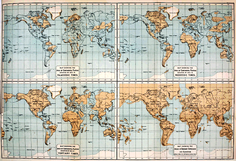
The Evolution of Climate.[DI]
[DI] Address delivered before the Royal Physical Society at the opening of the Session 1889-90.
One of the most interesting questions with which geological science has to deal is that of the evolution of climate. Although there is no general agreement as to how former climatic fluctuations came about, yet the prevalent opinion is that in the past, just as in the present, the character of the climate must have depended mainly on latitude and the relative position of the great land- and water-areas. This was the doctrine taught by Lyell, and its cogency none will venture to dispute. It is true he postulated a total redistribution of oceans and continents—a view which the progress of science has shown to be untenable. We can no longer speculate with him on the possibility of all the great land-areas having been grouped at one time round the equator, and at some other period about the poles. On the contrary, the evidence goes to show that the continents have never changed places with the ocean—that the dominant features of the earth’s crust are of primeval antiquity, and ante-date the oldest of the fossiliferous formations. The whole question of climatic changes, therefore, must be reconsidered from the point of view of the modern doctrine of the permanency of continental and oceanic areas.
But before proceeding to this discussion, it may be well to glance for a moment at the evidence from which it has been inferred that the climate of the world has varied. Among the chief proofs of climatic fluctuations are the character and the distribution of former floras and faunas. It is true, fossils — 350 — are, for the most part, relics of extinct forms, and we cannot assert of any one of these that its environment must have been the same as that of some analogous living type. But, although we can base no argument on individual extinct forms, it does not follow that we are precluded from judging of the conditions under which a whole suite of extinct organisms may have lived. Doubtless, we can only reason from the analogy of the present; but, when we take into account all the forms met with in some particular geological system, we seem justified in drawing certain conclusions as to the conditions under which they flourished. Thus, should we encounter in some great series of strata many reef-building corals, associated with large cephalopods and the remains of tree-ferns and cycads, which last from their perfect state of preservation could not have drifted far before they became buried in sediment, we should surely be entitled to conclude that the strata in question had been deposited in the waters of a genial sea, and that the neighbouring land likewise enjoyed a warm climate. Again should a certain system, characterised by the presence of some particular and well-marked flora and fauna, be encountered not only in sub-tropical and temperate latitudes but also far within the Arctic Circle, we should infer that such a flora and fauna lived under climatic conditions of a very different kind from any that now exist. The very presence, in the far north, of fossils having such a geographical distribution would show that the temperature of polar seas and lands could not have been less than temperate. When such broad methods of interpretation are applied to the problems suggested by former floras and faunas, we seem compelled to conclude that the conditions which determined the distribution of life in bygone ages must have been, upon the whole, more uniform and equable than they are now. It is unnecessary that I should go into detailed proof; but I may refer, by way of illustration, to what is known of the Silurian and Carboniferous fossils of the arctic regions. Most of these occur also in the temperate latitudes of Europe and North America, while many are recognised as distinctive types of the same strata nearly all the world over. As showing — 351 — how strongly the former broad distribution of life-forms is contrasted with their present restricted range, Professor Heilprin has cited the Brachiopoda. Taking existing species and varieties as being 135 in number, he remarks that “there is scarcely a single species which can be said to be strictly cosmopolitan in its range, although not a few are very widely distributed; and, if we except boreal and hyperboreal forms, but a very limited number whose range embraces opposite sides of the same ocean. On the other hand, if we accept the data furnished by Richthofen concerning the Chinese Brachiopoda we find that out of a total of thirteen Silurian and twenty-four Devonian species, no less than ten of the former and sixteen of the latter recur in the equivalent deposits of western Europe: and, further, that the Devonian species furnish eleven, or nearly 50 per cent. of the entire number, which are cosmopolitan or nearly so. Again, of the twenty-five Carboniferous species, North America holds fully fifteen, or 60 per cent., and a very nearly equal number are cosmopolitan.” The same palæontologist reminds us that by far the greater number of fossils which occur in the Palæozoic strata of Australia are present also in regions lying well within the limits of the north temperate zone. “In fact,” he continues, “the relationship between this southern fauna and the faunas of Europe and North America is so great as to practically amount to identity.”
But, side by side with such evidence of broad distribution, we are confronted with facts which go to show that, even at the dawn of Palæozoic times, the oceanic areas at all events had their more or less distinct life-provinces. While many of the old forms were cosmopolitan, others were apparently restricted in their range. It would be strange, indeed, had it been otherwise; for, however uniform the climatic conditions may have been, still that uniformity was only comparative. An absolutely uniform world-climate is well-nigh inconceivable. All we can maintain is that the conditions during certain prolonged periods were so equable as to allow of the general diffusion of species over vastly greater areas than now; and that such conditions — 352 — extended from low latitudes up to polar regions. Now, among the chief factors which in our day determine the limitation of faunas and floras, we must reckon latitude and the geographical position of land and water. What, then, it may be asked, were the causes which allowed of the much broader distribution of species in former ages?
It is obvious that before a completely satisfactory answer to that question can be given, our knowledge of past geographical conditions must be considerably increased. If we could prepare approximately correct maps and charts to indicate the position of land and sea during the formation of the several fossiliferous systems, we should be able to reason with some confidence on the subject of climate. But, unfortunately, the preparation of such correct maps and charts is impossible. The data for compilations of the kind required are still inadequate, and it may well be doubted whether, in the case of the older systems, we shall ever be able to arrive at any detailed knowledge of their geographical conditions. Nevertheless, the geological structure of the earth’s crust has been so far unravelled as to allow us to form certain general conceptions of the conditions that must have attended the evolution of our continents. And it is with such general conceptions only that I have at present to deal.
I said a little ago that the question of geological climates must now be considered from the point of view of the permanency of the great dominant features of the earth’s crust. I need not recapitulate the evidence upon which Dana and his followers have based this doctrine of the primeval antiquity of our continental and oceanic areas. It is enough if I remind you that by continental areas we simply mean certain extensive regions in which elevation has, upon the whole, been in excess of depression; by oceanic area, on the other hand, is meant that vast region throughout which depression has exceeded elevation. Thus, while the area of permanent or preponderating depression has, from earliest geological times, been occupied by the ocean, the continental areas have been again and again invaded by the sea—and — 353 — even now extensive portions are under water. It is not only the continental dry land, therefore, but all the bordering belt of sea-floor which does not exceed 1000 fathoms or so in depth, that must be included in the region of dominant elevation. Were the whole of this region to be raised above the level of the sea, the present continents would become connected so as to form one vast land-mass, or continental plateau. (D, Plate IV.)
All the sedimentary strata with which we are acquainted have been accumulated over the surface of that great plateau, and consequently are of comparatively shallow-water origin. They show us, in fact, that at no time in geological history has that plateau ever been drowned in depths at all comparable to those of the deeper portions of our oceanic troughs. The stratified rocks teach us, moreover, that the present land-areas have been gradually evolved, and that, notwithstanding many oscillations of level, these areas have continued to increase in extent—so that there is probably more land-surface now than at any previous era in the history of our globe. To give even a meagre outline of the evidence bearing upon this interesting subject is here impossible. All that I can do is to indicate very briefly some of the general results to which that evidence seems to lead.
The oldest rocks with which we are acquainted are the so-called Archæan schists[DJ] But these have hitherto yielded no unequivocal traces of organic life, and as their origin is still doubtful, it would obviously be futile to speculate upon the geographical conditions of the earth’s surface at the time of their formation. Reliable geological history only begins with the fossiliferous strata of the Palæozoic era. From these we learn that in the European area the Archæan rocks of Britain, Scandinavia, and Finland formed, at that time, the most extensive tract of dry land in our part of the world. How far beyond the present limits of Europe that ancient northern land extended we cannot — 354 — tell; but it probably occupied considerable regions which are now submerged in the waters of the Arctic Ocean. Further south, the continental plateau appears to have been, for the most part, overflowed by a shallow sea, the surface of which was dotted by a few islands of Archæan rocks, occupying the sites of what are now some of the hills of middle Germany and the Archæan districts of France and the Iberian Peninsula. Archæan rocks occur likewise in Corsica and Sardinia, and again in Turkey: they also form the nuclei of most of the great European mountain-chains, as the Pyrenees, the Alps, the Carpathians, and the Urals. These areas of crystalline schists may not, it is true, have existed as islands at the beginning of Palæozoic times, for they were doubtless ridged up by successive elevations at later dates; but their very presence as mountain-nuclei is sufficient to show that at a very early geological period, the continental plateau could not have been covered by any great depth of sea. We can go further than this—for all the evidence points to the conclusion that, even so far back as Cambrian times, the dominant features of the present European continent had been, as it were, sketched out. Looked at broadly, that part of the great continental plateau upon which our European lands have been gradually built up may be said to be traversed from west to east by two wide depressions, separated by an intervening elevated tract. The former of these depressions corresponds to the great Central Plain which passes through the south of England, north-east of France, and the Low Countries, whence it sweeps through Germany, to expand into the extensive low-grounds of central and northern Russia. The southern depression embraces the maritime tracts of the Mediterranean, and the regions which that sea covers. To these dominant features all the others are of subordinate importance. The two great troughs are belts of depression in the continental plateau itself. The northern one is of extreme antiquity—it is older, at all events, than the Cambro-Silurian period. Even at that distant date its southern limits were marked out by ridges — 355 — of Archæan rock, which, as I have said, seem to have formed islands in what is now central Europe. It was probably always the shallower depression of the two, for we have evidence to show that again and again, in Mesozoic and later times, the sea that overflowed what are now the central lowlands of Europe was of less considerable depth than that which occupied the Mediterranean trough.
[DJ] I need hardly remind geologists that some of the so-called “Archæan schists” may really be the highly altered accumulations of later geological periods.
If we turn to North America, we find similar reason to conclude, with Professor Dana, that the general topography of that region had likewise been foreshadowed as far back as the beginning of the Palæozoic era. Dana tells us that even then the formation of its chief mountain-chains had been commenced, and its great intermediate basins were already defined. The oldest lands of North America were built up, as in Europe, of azoic rocks, and were grouped chiefly in the north. Archæan masses extend over an enormous region, from the shores of the Arctic Ocean down to the great lake country, and they are seen likewise in Greenland and many of the Arctic islands. They appear also in the long mountain-chains that run parallel with the coast-lines of the Continent. In a word, the present distribution of the Archæan rocks, and their relation to overlying strata, lead to the belief that in North America, just as in Europe, they form the foundation-stones of that continent, and stretch continuously throughout its whole extent.
We know comparatively little of the geology of the other great land-masses of the globe, but from such evidence as we have there is reason to believe that these in their general structure have much the same story to tell as Europe and North America. In South America, Archæan rocks extend over vast areas in the east and north-east, and reappear in the lofty mountain-chains of the Pacific border. They have been recognised also in various parts of Africa, alike in the north and east, in the interior, and in the west and south. In Asia, again, they occupy wide areas in the Indian Peninsula; they are well developed in the Himalaya, while in China and the mountains and plateaux of central Asia, azoic rocks, which are probably of Archæan age, are well — 356 — developed. The crystalline schists, which cover extensive tracts in Australia and in the northern island of New Zealand, have also been referred to the same age. Thus, all the world over, Archæan rocks seem to form the surface of the ancient continental plateau upon which all other sedimentary strata have been accumulated. And in every region where Palæozoic rocks occur, we have evidence to prove that at the time these last were formed vast areas of the old continental plateau were under water.
The geological structure of the Palæozoic tracts of Europe and America has shown us that, during the protracted period of their accumulation, and notwithstanding many oscillations of level, the land-surface continued to increase. The same growth of dry land characterised Mesozoic and Cainozoic times—the primeval depressions that traverse the continental plateau became more and more silted up, and the sea eventually disappeared from extensive regions which it had overflowed in Palæozoic ages. This land-growth, of course, was not everywhere continuous. Again and again, throughout wide tracts, depression was in excess of sedimentation and elevation. Even at the present time, broad tracts of what was once dry land are submerged. But the simple fact that the younger fossiliferous strata do not extend over such wide areas as the older systems, is sufficient proof that our land-masses have all along tended to grow, and to become more and more consolidated.
Reference has already been made to the remarkable fact that no abysmal accumulations have yet been detected amongst the stratified rocks of the earth’s crust. Ordinary clastic rocks, such as shale, sandstone, and conglomerate—altered or unaltered, as the case may be—form by far the largest proportion of our aqueous strata, and speak to us only of shallow waters. It is true that some of our limestones must have accumulated in moderately deep clear seas, yet none of these limestones is of abysmal origin. They prove that portions of the continental plateau have now and again been submerged for several thousand feet, — 357 — but afford no evidence of depths comparable to those of the present oceanic basins. The enormous thickness obtained by the sedimentary strata can only be explained on the supposition that deposition took place over a gradually sinking area. And thus it can be shown that, within the continental plateau, movements of depression have been carried on more or less continuously during vast periods of time—and yet so gradually, that sedimentation was able to keep pace with them. Take, for example, the Cambrian strata of Wales and Shropshire—all, apparently, shallow-water deposits—which attain a thickness of 30,000 feet, or thereabout; or the Silurian strata of the same regions, which are not much less than 20,000 feet thick; and similar great depths of sedimentary rocks might be cited from North America. Passing on to later periods, we find like evidence of long-continued depression in the thick sediments of the younger Palæozoic systems. It is noteworthy, however, that when we come down to still later ages, the movements of depression, as measured by the depths of the strata, appear to have become less and less extensive and profound. Each such movement of depression was eventually brought to a close by one or more movements of upheaval—slowly or more rapidly effected, as the case may have been. Here, then, we are confronted with the striking fact that the continental plateau has, from time to time, sunk down over wide areas to depths exceeding those of existing oceans, and yet at so slow a rate, that sedimentation prevented the depressed regions from becoming abysmal. It is obvious, then, that such areas are now dry land simply because, in the long-run, sedimentation and upheaval have been in excess of depression.
And yet, notwithstanding the numerous upheavals which have taken place over the continental plateau, these have succeeded in doing little more than drain away the sea more or less completely from the great primeval depressions by which that plateau is traversed. If it be true, therefore, that the continental plateau owes its existence to the sinking down of the earth’s crust within the oceanic — 358 — basins—if the continents have been squeezed up by the tangential thrusts exerted by the sinking areas that surround them—then it follows that while lands have been gradually extending over the continental plateau, the bed of the ocean has been sinking to greater and greater depths.
If this general conclusion holds good, it is obvious that the oceanic troughs of early geological times could not have been so deep as they are now. During the Palæozoic period, the most continuous areas of dry land, as we have seen, were distributed over the northern parts of our hemisphere, while, further south, groups of islands indicated the continuation of the continental plateau. Doubtless South America, Africa, Asia, and Australia were, at that distant date, represented by similar detached areas of dry land. In a word, the primeval continental plateau was still largely under water. Judging from the character and broad distribution of the Palæozoic marine faunas the temperature of the sea was wonderfully uniform. There is certainly nothing to indicate the existence of such climatic zones as those of the present. We know very little of the terrestrial life of early Palæozoic times—the Cambro-Silurian strata are essentially marine. Land-plants, however, become more numerous in the Old Red Sandstone, and, as every one knows, they abound in the succeeding Carboniferous and Permian systems. And the testimony of these floras points to the same conclusion as that furnished by the marine faunas. The Carboniferous floras of the arctic regions, and of temperate Europe and America, not only have the same facies, but a considerable number of the species is common to both areas; while many European species occur in the Carboniferous strata of Australia and other distant lands. This common facies, and the presence of numerous cosmopolitan forms, surely indicate the former prevalence of remarkably uniform climatic conditions. The conditions, of course, need not—indeed, could not—have been absolutely uniform. At present the various climates which our globe experiences depend upon the amount of — 359 — heat received directly and indirectly from the sun—oceanic and aërial currents everywhere modifying the results that are due to latitude. It cannot have been otherwise in former times. In all ages the tropics must have received more direct sun-heat than temperate and polar regions; and however much the climatic conditions of the Palæozoic era may have differed from the present—however uniformly temperature may have been distributed—still, as I have said, absolute uniformity was impossible. It was doubtless owing to the fact that the dry lands of Palæozoic times were not only much less extensive than now, but more interrupted, straggling, and insular, that the climate of the globe was so equable. Under such geographical conditions, great oceanic currents would have a much freer course than is now possible, and warm water would find its way readily across wide regions of the submerged continental plateau into the highest latitudes. The winds blowing athwart the land would everywhere be moist and warm, and no such marked differences of temperature, such as now obtain, would distinguish the arctic seas from those of much lower latitudes. At the same time, the comparatively shallow water overlying the submerged areas of the continental plateau would favour the distribution of species, and thus bring about that wide distribution of cosmopolitan forms and general similarity of facies, which are such marked features of the Palæozoic faunas. It is even quite possible that migration may have taken place here and there across the great oceanic depression itself; for it may well be doubted whether, at so early a period, the depression had sunk down to its present depth below the level of the continental plateau.
Yet, notwithstanding such facilities for migration, and the consequent similarity of facies I have referred to, the Palæozoic faunas of different regions have usually certain distinctive characters. Even at the very dawn of the era the marine faunas were already grouped into provinces, sometimes widely separated from one another, at other times closely adjacent, so that it is evident that barriers — 360 — to migration here and there existed. It could hardly have been otherwise; for local and more widely-spread movements of elevation and depression took place again and again during Palæozoic times.
While the younger Palæozoic systems were being accumulated, excess of upheaval over depression resulted in the gradual increase of the land.[DK] The continental plateau came more and more to the surface, in spite of many oscillations of level. It is quite possible, nay, even probable that this persistent growth of land, and consequent modification of oceanic currents may have rendered the climatic conditions of later Palæozoic times less uniform: but, if so, such diminished uniformity has left no recognisable impress on either faunas or floras; for fossils characteristic of the Devonian and Carboniferous strata of temperate latitudes occur far within the Arctic Circle.
[DK] See footnote p. 341.
Descending to the Mesozoic era, we find that the character and distribution of marine faunas are still indicative of uniformity. There could have been little difference of temperature at that time between arctic seas and those of our own latitude. Cosmopolitan species abounded in the Jurassic waters, but were relatively less numerous in those of the Cretaceous period. Professor Neumayr maintains that already, in the Jurassic period, the climate had become differentiated into zones. This, he thinks, is indicated by the fact that coral reefs abound in the Jurassic strata of central Europe, while they are wanting in the contemporaneous deposits of boreal regions. Dr. Heilprin, on the other hand, is of opinion that this and certain other distinctive features of separate Jurassic life-provinces may not have been due to differences of temperature, but rather to varying physical conditions, such as character of the sea-bottom, depth of water, and so forth. Perhaps the safest conclusion we can come to, in the present state of the evidence, is that the climatic conditions of the Mesozoic era were, upon the whole, less obviously uniform than those of earlier ages, but that marked zones of — 361 — climate like the present had not as yet been evolved. At the same time, when we consider how many great geographical revolutions took place during the period in question, we must be prepared to admit that these could hardly fail to influence the climate, and thus to have induced modifications in the distribution of faunas and floras. And probably evidence of such modifications will yet be recognised, if indeed the phenomena referred to by Neumayr be not a case in point. It may be noted, further, that while, according to many botanists, the plants of the Palæozoic periods bespeak not only uniform climatic conditions but the absence of marked seasonal changes, those of late Mesozoic times are indicative of less uniformity. The Cretaceous conifers, for example, show regular rings of growth, and betoken the existence of seasons, which were less marked, however, than is now the case.
The geographical changes of Mesozoic times were notable in many respects. The dominant features of Europe, already foreshadowed in early Palæozoic times, had become more clearly outlined before the close of the Cretaceous period. Notwithstanding many movements of depression, the chief land-areas continued to show themselves in the north and north-west. The highest grounds were the Urals, and the uplands of Scandinavia and Britain. In middle Europe the Pyrenees and the Alps were as yet inconsiderable heights, the loftiest lands in that region being those of the Harz, the Riesen Gebirge, and other tracts of Archæan and Palæozoic rocks. The lower parts of England and the great lowland plains of central Europe were sometimes submerged in the waters of a wide, shallow sea, but ever and anon elevation ensued, new lands appeared, and these waters became divided into a series of large inland seas and lakes. In the south, a deep Mediterranean sea would appear to have persisted all through the Mesozoic era—a sea of considerably greater extent, however, than the present.
While in Europe the dominant features of the continental plateau run approximately east and west, in North America they follow nearly the opposite direction. In early Mesozoic — 362 — times, vast tracts of dry land extended across the northern and eastern sections of the latter area. Over the Rocky Mountain region, low lands and saline lakes appear to have stretched, while further west the area of the Great Plateau and the Pacific slope were covered by the sea. Towards the end of the Mesozoic era, the land in the far west became more continuous—a broad belt extending in the direction of the Pacific coast-line from Mexico up to high northern latitudes. In short, before the Cretaceous period closed, the major portion of North America had been evolved. A considerable tract of what is now the western margin of the continent, however, was still under water, while from the Gulf of Mexico (then much wider than now) a broad Mediterranean sea swept north and north-west through Texas and the Rocky Mountain region to communicate with the Arctic Ocean. All to the east of this inland sea was then, as it is now, dry land. Thus, up to the close of the Cretaceous period, in America and Europe alike, oceanic currents coming from the south had ready access across the primeval continental plateau to the higher latitudes. Southern Europe indeed, during Mesozoic times, was simply a great archipelago, having free communication on the one hand across the low-grounds of central and northern Russia with the arctic seas, and, on the other, across vast regions in Asia with the Indian Ocean.
Of the other great land-masses of the globe our knowledge is too limited to allow us to trace their geographical evolution with any confidence. But from the very wide distribution of Mesozoic strata in South America, Africa, Asia, and Australia, there can be no doubt that, at the time of their accumulation, enormous tracts in those regions were then under water. The land-masses, in short, were not so continuous and compact as they are at present. And although we must infer that considerable areas of Mesozoic land are now submerged, yet these cannot but bear a very small proportion to the wide regions which have been raised above the sea-level since Mesozoic times. In short, from what we do know of the geological structure — 363 — of the continents in question, we can hardly doubt that they have passed through geographical revolutions of a like kind with those of Europe and North America. Everywhere over the great continental plateau elevation appears, in the long-run, to have been in excess of depression, so that, in spite of many subsidences, the tendency of the land throughout the world has been to extend its margins, and to become more and more consolidated. The Mesozoic lands were larger than those of the preceding Palæozoic era, but they were still penetrated in many places by the sea, and warm currents could make their way over wide tracts that are now raised above the sea-level. Under such circumstances approximately uniform conditions of climate could not but obtain.
Great geographical changes supervened upon the close of the Cretaceous period. North America then acquired nearly its present outline. Its Mediterranean sea had vanished, but the Gulf of Mexico still overflowed a considerably wider region than now, while a narrow margin of the Pacific border of the continent continued submerged. In Europe elevation ensued, and the sea which had overspread so much of the central and eastern portions of our Continent disappeared. Southern Europe, however, was still largely under water, while bays and inlets extended northwards into what are now the central regions of the Continent. On to the close of the Miocene period, indeed, the southern and south-eastern tracts of Europe were represented by straggling islands. In middle Cainozoic times the Alps, which had hitherto been of small importance, were considerably upheaved, as were also the Pyrenees and the Carpathians; and a subsequent great elevation of the Alpine area was effected after the Miocene period. Notwithstanding these gigantic movements, the low-lying tracts of what is now southern Europe continued to be largely submerged, and even the central regions of the Continent were now and again occupied by broad lakes, which sometimes communicated with the sea. After the elevation of the Miocene strata, these inland seas disappeared, but the Mediterranean — 364 — still overflowed wider areas than it does to-day. Eventually, however, in late Pliocene times, the bed of that sea experienced considerable elevation; and it was probably at or about this stage that the Black Sea and the Sea of Asov retreated from the broad low-grounds of southern Russia, and that the inland seas and lakes of Austria-Hungary finally vanished.
The movements of upheaval, which caused the Cretaceous seas to disappear from such broad areas of the continental plateau, induced many changes in the floras and faunas of the globe. A notable break in the succession occurs between the Cretaceous and the Eocene, hardly one species of higher grade than the protozoa passing from one system to the other. In the Cainozoic deposits we are no longer confronted with numerous cosmopolitan species—the range of marine forms has become much more restricted. Nevertheless, the faunas and floras continue to be indicative of much warmer climates for arctic and temperate latitudes than now obtain. But, at the same time, differentiation of climate into zones is distinctly marked. In the early Cainozoic period, our present temperate latitudes supported a flora of decidedly tropical affinities, while the fauna of the adjacent seas had a similar character. Later on the climate of the same latitudes appears to have passed successively through sub-tropical and temperate stages. In short, a gradual lowering of the temperature is evinced by the character and distribution both of floras and faunas. The differentiation of the climate during one stage of the Cainozoic era is well illustrated by the Miocene flora. Thus, at a time when Italy was clothed with a tropical vegetation, in which palm-trees predominated, middle Europe had its extensive forests of evergreens and conifers, while in the region of the Baltic conifers and deciduous trees were the prevalent forms.
When one takes into consideration the fact that, notwithstanding many oscillations of level, the land during Cainozoic times was gradually extending, and the sea disappearing from wide regions which it had formerly — 365 — covered, one can hardly doubt that the seemingly gradual change from tropical to temperate conditions was due, in large measure, to that persistent continental growth. I confess, however, that it is difficult to account for the very genial climate which continued to prevail over the arctic regions. So far as one can gather from the evidence at present available, some of the marine approaches to those latitudes had been cut off by the movements of elevation which brought the Cainozoic era to a close, while the arctic lands were perhaps more extensive than they are now. The Cretaceous Mediterranean Sea of North America had vanished, and we cannot prove that the Tertiary Sea of southern Europe communicated across the low-grounds of Russia with the Arctic Ocean. We know, however, that the archipelago of southern Europe was in direct connection with the Indian Ocean, and it is most probable that a wide arm of the same sea stretched north from the Aralo-Caspain area through Siberia. Indeed, much of what are now the lowlands of western and northern Asia was probably sea in Tertiary times. It seems likely, therefore, that, even at this late period, marine currents continued to reach the Arctic Zone across the continental plateau. When the warm waters of the Indian Ocean eventually ceased to invade Europe, and the Mediterranean became much restricted in area, the climate of the whole Continent could not fail to be profoundly affected.
There is yet another line of evidence to which brief reference may be made. I have spoken of the remarkable uniformity of climatic conditions which obtained in Palæozoic times, and of the gradual modification of these conditions which subsequently supervened. Now, it is worthy of note that in their lithological characters the oldest sedimentary strata themselves likewise exhibit a prevalent uniformity which in later systems becomes less and less conspicuous. The Cambro-Silurian mechanical sediments, for example, maintain much the same character all the world over; and the like is true, although in a less degree, of the marine accumulations of the Devonian period. The — 366 — corresponding mechanical deposits of later Palæozoic ages continue to show more and more diversity, but at the same time they preserve a similarity of character over much more extensive areas than is found to be the case with the analogous sediments of the Mesozoic era. Finally, these last are more or less strongly contrasted with the marine mechanical accumulations of Cainozoic times, which are altogether more local in character. This increasing differentiation is quite in keeping with what we know of the evolution of our land-areas. In early Palæozoic ages, when insular conditions prevailed and the major portion of the primeval continental plateau was covered by shallow seas, it is obvious that mechanical sediments would be swept by tidal and other currents over enormous areas, and that these sediments would necessarily assume a more or less uniform character. Indeed, I suspect that much of the sediment of those early seas may have been the result of tidal scour, and that marine erosion was more generally effective then than it is now. With the gradual growth of the land and the consequent deflection and limitation of currents, marine mechanical sediments would tend to become more and more local in character. Thus the increasing differentiation which we observe in passing from the earlier to the later geological systems is just what might have been expected.
Summing up, now, the results of this rapid review of the evidence, we seem justified in coming to the following conclusions:—
(1.) In Palæozoic times, Europe and North America were represented by considerable areas of dry land, massed chiefly in the higher latitudes, while further south groups of smaller islands were scattered over the submerged surface of the primeval continental plateau. The other continents appear, in like manner, to have been represented by islands—some of which may have reached continental dimensions. A very remarkable uniformity of climate accompanied these peculiar geographical conditions.
(2.) In Mesozoic times, the primeval continental plateau — 367 — came more and more to the surface, but the land-areas were still much interrupted, so that currents from tropical regions continued to have ready access to high latitudes. The climate of the whole globe, therefore, was still uniform, but apparently not so markedly as in the preceding era.
(3.) In Cainozoic times, the land-masses continued to extend, and the sea to retreat from hitherto submerged areas of the continental plateau; and this persistent land-growth was accompanied by a gradual lowering of the temperature of northern and temperate latitudes, and a more and more marked differentiation of climate into zones.
Having thus very briefly sketched the geographical evolution of the land during Palæozoic, Mesozoic, and Tertiary times, and come to the general conclusion that climate has varied according to the relative position of land and sea, I have next to consider the geographical and climatic conditions of the Quaternary period. These, however, are now so well known, that I need to no more than remind you that, so far as the chief features of our lands are considered, all these had come into existence before the dawn of the Ice Age. The greater contours of the surface, which were foreshadowed in Palæozoic times, and which in Mesozoic times were more clearly indicated, had been fully evolved by the close of the Pliocene period. The connection between the Mediterranean and the Indian Ocean probably ceased in late Pliocene times. The most remarkable geographical changes which have taken place since then within European regions have been successive elevations and depressions, in consequence of which the area of our Continent has been alternately increased and diminished. At a time well within the human period, our own islands have been united to themselves and the Continent, and the dry land has extended north-west and north, so as to include Spitzbergen, the Faröe Islands, and perhaps Iceland. On the other hand, our islands have been within a recent period largely submerged. Similarly, in North America, we are furnished with many proofs — 368 — of like oscillations of level having taken place in Quaternary times. Is it possible, then, to explain the climatic vicissitudes of the Pleistocene period by means of such oscillations? Many geologists have tried to do so, but all these attempts have failed. It is quite true that a general elevation of the land in high latitudes would greatly increase the ice-fields of arctic regions, and might even give rise to perennial snow and glaciers in the mountain-districts of our islands. But it is inconceivable that any such geographical change could have brought about that general lowering of temperature over the whole northern hemisphere which took place in Pleistocene times. For we have to account not only for the excessive glaciation of northern and north-western Europe, and of the northern parts of North America, but for the appearance of snow-fields and glaciers in much more southern latitudes, and in many parts of Asia where no perennial snow now exists. Moreover, we have to remember that arctic conditions of climate obtained in north-western Europe even when the land was relatively much lower than it is at present. The arctic shell-beds of our own and other temperate regions sufficiently prove that geographical conditions were not the only factor concerned in bringing about the peculiar climate of the Pleistocene period. Then, again, we must not forget that at certain stages of the same period genial conditions of climate were coincident with a much wider land-surface in north-western Europe than now exists. The very fact that interglacial deposits occur in every glaciated region is enough of itself to show that the arctic conditions of the Pleistocene could not have resulted entirely from a mere elevation of land in the northern parts of our hemisphere.
The only explanation of the peculiar climatic vicissitudes in question which seems to meet the facts, so far as these have been ascertained, is the well-known theory advanced by Dr. Croll. After carefully considering all the objections which have been urged against that theory, there is only one, as it seems to me, that is deserving of serious attention. — 369 — This objection is not based on any facts connected with the Pleistocene deposits themselves, but on evidence of quite another kind. It is admitted that were the Pleistocene deposits alone considered, Croll’s theory would fully account for the phenomena. But, it is argued, we cannot take the Pleistocene by itself, for if that theory be true, then climatic conditions similar to those of the Pleistocene must have supervened again and again during the past. Where, then, we are asked, is there any evidence in Palæozoic, Mesozoic, or Cainozoic strata of former widespread glacial conditions? If continental ice-sheets, comparable to those of the Pleistocene, ever existed in the earlier ages, surely we ought to find more or less unmistakable traces of them. Now, at first sight, this looks a very plausible objection, but it has always seemed to me to be based upon an assumption that is not warranted by our knowledge of geographical evolution. Dr. Croll always admitted implicitly that high eccentricity of the earth’s orbit might have happened again and again without inducing glacial conditions like those of the Pleistocene. The objection takes no account of the fact that the excessive climate of the Glacial period was only possible because of special geographical conditions—conditions that do not appear to have been fully evolved before Pliocene times. No one has seen this more clearly than Mr. Wallace,[DL] with the general drift of whose argument I am quite at one. In earlier ages, the warm water of the tropics overflowed wide areas of our present continents—most of the dry land was more or less insular, and the seas within the Arctic Circle were certainly not cold as at present, but temperate and even genial. If we go back to Cambro-Silurian times, we find only the nuclei, as it were, of our existing continents appearing above the surface of widespread shallow seas. It is quite impossible, therefore, that under such geographical conditions, great continuous ice-sheets, like those of the Pleistocene, could have existed—no matter how high the eccentricity of the earth’s orbit — 370 — may have been. The most that could have happened during such a period of eccentricity would be the accumulation of snow-fields on mountains and plateaux of sufficient height, the formation here and there of local glaciers, and the descent of these in some places to the sea. And what evidence of such local glaciation might we now expect to find? No old land-surface of that far-distant period has come down to us: we look in vain for Cambro-Silurian roches moutonnées and boulder-clay or moraines. The only evidence we could expect is just that which actually occurs, namely, erratics (some of them measuring five feet and more in diameter) embedded in marine deposits. It may be said that a few erratics are hardly sufficient to prove that a true Glacial period supervened in Cambro-Silurian times, and I do not insist that they are. But I certainly maintain that if any lowering of the temperature were induced by high eccentricity of the earth’s orbit during Cambro-Silurian times, then ice-floated erratics are the only evidence of refrigeration that we need ever hope to find. The geographical conditions of early Palæozoic times forbade the formation of enormous ice-sheets like those of the Pleistocene period. Extreme climatic changes were then impossible, and periods of high eccentricity might have come and gone without inducing any modifications of flora and fauna which we could now recognise. We are ignorant of the terrestrial life of the globe at that distant period, and our knowledge of the marine fauna is not sufficient to enable us to deny the possibility of moderate fluctuations in the temperature of the seas of early Palæozoic times. Moreover, we must not forget there were then no such barriers to migration as now exist. If the conditions became temporarily unsuitable, marine organisms were free to migrate into more genial waters, and to return to their former habitats when the unfavourable conditions had passed away.
[DL] See Island Life.
The uniform climate so characteristic of the Cambro-Silurian period appears to have prevailed likewise during the later stages of the Palæozoic era. This we gather from — 371 — a general consideration of the floras and faunas, and their geographical distribution. The dry land, as we have seen, continued to increase in extent; but vast areas of the primeval continental plateau of the globe still continued under water, and currents from southern latitudes flowed unrestricted into polar regions. During the protracted lapse of time required for the formation of the later Palæozoic systems several periods of high eccentricity must have occurred. But, so far as one can judge, the disposition of the larger land-areas was never such as to induce a true Ice Age. Nevertheless we are not without evidence of ice-action in Old Red Sandstone, Carboniferous, and Permian strata. And it seems to me probable that the erratic accumulations referred to may really indicate local action, of more or less intensity, brought about by such lowering of the temperature as would supervene during a period of high eccentricity. It is true we may explain the phenomena by inferring the existence of mountains of sufficient elevation—and this, indeed, is the usual explanation. But it is doubtful whether those who adopt that view have fully considered what it involves. Take, for example, the case of the breccias and conglomerates of the Lammermuir Hills, which have all the appearance of being glacial and fluvio-glacial detritus. These deposits overlie the highly-denuded Silurian greywackés of Haddingtonshire in the north and of Berwickshire in the south, and have evidently been derived from the intervening high-grounds—the width of which between the Old Red Sandstone accumulations in question does not exceed eight or nine miles. The breccias reach a height of 1300 feet, while the dominating point of the intervening uplands is 1700 feet. Under present geographical conditions it is doubtful whether perennial snow and glaciers of any size at all could exist in the region of the Lammermuirs at a less altitude than 7000 feet or more. But between the breccias of Haddingtonshire and the equivalent deposits in Berwickshire there is no space for any intermediate range of mountains of circumdenudation of such a height. Moreover, we must remember that under the extremely uniform — 372 — conditions which obtained in Palæozoic times the snow-line could not possibly have been attained even at that elevation. When the Devonian coral-reefs described by Dupont were growing in the sea that overflowed western Europe, to what height must the southern uplands of Scotland have been elevated in order to reach the snow-line! We may make what allowance we choose for the denudation which the Silurian rocks of the Lammermuirs must have experienced since the deposition of the Old Red Sandstone, but it is simply a physical impossibility that mountains of circumdenudation of the desiderated height could ever have existed in the Lammermuir region at the time the coarse breccias were being accumulated.[DM] It seems to me, then, that these breccias are in every way better accounted for by a lowering of temperature due to increased eccentricity of the orbit. This view frees us from the necessity of postulating excessive upheavals over very restricted areas, and of creating Alps where no Alps could have existed.
[DM] It may be objected that the conglomerates were probably not marine, but deposited in lakes, the beds of which may have been much above sea-level. But from all that we know of the Old Red Sandstone of Scotland it would appear that the lakes of the period now and again communicated with the sea, and were probably never much above its level.
When we consider the enormous thickness of the strata that constitute any of our larger coal-fields, we can hardly doubt that one or more periods of high eccentricity must have occurred during their accumulation. It does not follow, however, that we should be able to detect in these strata any evidence of alternating cold and warm epochs. So long as ocean-currents from the tropics found ready entrance to polar regions across vast tracts of what is now dry land, extreme and widespread glacial conditions were impossible. Any lowering of temperature due to cosmical causes might indeed induce new snow-fields and glaciers to appear, or existing ones to extend themselves in northern regions and the most elevated lands of lower latitudes; but such local glaciation need not have seriously affected any of the areas in which coal-seams were being formed. For nothing — 373 — appears more certain than this—that our coal-seams as a rule were formed over broad, low-lying alluvial lands, and in swamps and marshes, along the margins of estuaries or shallow bays of the sea. Some seams, it is true, are evidently formed of drifted vegetable débris, but the majority point to growth in situ. The strata with which they are associated are shallow-water sediments which could only have been deposited at some considerable distance from any mountain-regions in which glaciers were likely to exist. It is idle, therefore, to ask for evidence of glacial action amongst strata formed under such conditions. The only evidence of ice-work we are likely to get is that of erratics. And these are not wanting, although it is probable that most of those which are found embedded in coals have been transported by rafts of vegetable matter or in the roots of trees. The same explanation, however, will not account for the boulders which Sir William Dawson has recorded from the coal-fields of Nova Scotia. He describes them as occurring on the outside of a gigantic esker of Carboniferous age, and thinks they were probably dropped there by floating-ice at a time when coal-plants were flourishing in the swamps on the other side of the gravel embankment.
If the disposition of the land-areas in Carboniferous times rendered such an ice-age as that of the Pleistocene impossible—in other words, if the effects flowing from high eccentricity of the orbit must to a large extent have been neutralised—the flora and fauna of the period can hardly be expected to yield any recognisable evidence of fluctuating climatic conditions. When our winter happened in aphelion new snow-fields might have appeared, or already existing glaciers might have increased in size; while, with the winter in perihelion, the temperature in northern latitudes would doubtless be raised. But the general result would simply be an alternation of warm and somewhat cooler conditions. And such fluctuations of climate might readily have taken place without materially modifying; the life of the period.
The breccias of the Permian system have been described by Ramsay as of glacial origin. Some geologists agree with him, while others do not—and many have been the ingenious suggestions which these last have advanced in explanation of the phenomena. Some have tried to show how the stones and blocks in the breccias may have been striated without having recourse to the agency of glacier-ice, but they cannot explain away the fact that many of the stones (which vary in size from a few inches to three or four feet in diameter) have travelled distances of thirty or forty miles from the parent rocks. Similar erratic accumulations, which may belong to the same system or to the Carboniferous, occur in India and Australia. According to Dr. Blanford, the Indian boulder-beds are clearly indicative of ice-action, and he does not think that they can be explained by an assumed former elevation of the Himalaya. On the contrary, he is of opinion that the facts are best accounted for by a general lowering of the temperature, due probably to the action of cosmical causes. Daintree, Wilkinson, R. Oldham, and others who have studied the Australian erratic beds have likewise stated their belief that these are of true glacial origin.
I may pass rapidly over the Mesozoic systems, taking note, however, of the fact that in them we encounter evidence of ice-action of much the same kind as that met with in Palæozoic strata. While, on the one hand, the Mesozoic floras and faunas bespeak climatic conditions similar to those of earlier ages, but probably not quite so uniform; on the other, the occurrence of erratics in various marine accumulations is sufficient to show that now and again ice floated across seas, the floors of which were tenanted by reef-building corals. The geographical conditions continued unfavourable to the formation of extensive ice-sheets in temperate latitudes, no matter how high the eccentricity of the orbit might have been. The erratics which occur in certain Jurassic and Cretaceous deposits are admitted by most geologists to have been ice-borne. Now, it is highly improbable that the transporting agent could have — 375 — been coast-ice, for it is hardly possible to conceive of ice forming on the surface of a sea in which flourished an abundant Mesozoic fauna. The erratics, therefore, seem to imply the existence in Mesozoic times of local glaciers, which here and there descended to the sea, as in the north-east of Scotland. The erratics in the Scottish Jurassic are evidently of native origin, and it is most improbable that those which have been met with in the Chalk of England and France could have floated from any very great distance. How, then, can we explain the appearance of local glaciers in these latitudes during Mesozoic times? The geographical conditions of the period could not have favoured the formation of perennial snow and ice in our area, unless our lands were at that time much more elevated than now. And this is the usual explanation. It is supposed that mountains much higher than any we now possess probably existed in such regions as the Scottish Highlands. It is easy to imagine the former existence of such mountains. So long a time has elapsed since the Jurassic period, that the Archæan and Palæozoic areas cannot but have suffered prodigious denudation in the interval. But, when one considers how very lofty, indeed, those mountains must have been, in order to reach the snow-line of Jurassic times, one may be excused for expressing a doubt as to whether the suggested explanation is reasonable. At all events, the phenomena are, to say the least, as readily explicable on the supposition that the snow-line was temporarily lowered by cosmical causes. Even with eccentricity at a high value, no great ice-sheets, indeed, could have existed, but local snow-fields and glaciers might have appeared in such mountain-regions as were of sufficient height. And this might have happened without producing any great difference in the temperature of the sea, or any marked modification in the distribution of life. In short, we should simply have, as before, an alternation of warm and somewhat cooler climates, but nothing approaching to the glacial and interglacial epochs of the Pleistocene.
These conclusions seem to me to be strongly supported — 376 — by the evidence of ice-action during Tertiary times. The gigantic erratics of the Alpine Eocene do not appear to have been derived from the Alps, but rather from the Archæan area of southern Bohemia. The strata in which they occur are, for the most part, unfossiliferous; they contain only fucoidal remains, and are presumably marine. How is it possible to account for the appearance of these erratics in marine deposits in central Europe at a time when, as evidenced by the Eocene flora and fauna the climate was warm? Are we to infer the former existence of an extremely lofty range of Bohemian Alps which has since vanished? Is it not more probable that here, too, we have evidence of a lowering of the snow-line, induced by cosmical causes, which brought about the appearance of snow-fields and glaciers in a mountain-tract of much less elevation than would have been required in the absence of high eccentricity of the orbit? If it be objected that such cosmical causes must have had some effect upon the distribution of life, I reply that very probably they had, although not to any extreme extent. The researches of Mr. Starkie Gardner have shown that the flora of the English Eocene affords distinct evidence of climatic changes. But as the geographical conditions of that period precluded the possibility of extensive glaciation, and could only, at the most, have induced local glaciers to appear in elevated mountain-regions, it seems idle to cite the non-occurrence of erratics and morainic accumulations in the Eocene of England and France as an argument against the application of Croll’s theory to the case of the erratics of the Flysch. I repeat, then, that under the geographical conditions of the Eocene, all the more obvious effects likely to have resulted from the passage of a period of high eccentricity would be the appearance of a few local glaciers, the existence of which could have had no more influence on the climate of adjacent lowlands than is notable in similar circumstances in our own day. It is absurd, therefore, to expect to find evidence in Eocene strata of as strongly contrasted climates as those of the — 377 — glacial and interglacial deposits of the Pleistocene. There must, doubtless, have been alternations of climate in our hemisphere; but these would consist simply of passages from warm to somewhat cooler conditions—just such changes, in fact, as are suggested by the plants of the English Eocene.
The evidence of ice-action in the Miocene strata is even more striking than that of which I have just been speaking. The often-cited case of the erratics of the Superga near Turin I need do little more than mention. These erratics were undoubtedly carried by icebergs, calved from Alpine glaciers at a time when northern Italy was largely submerged. The erratic deposits are unfossiliferous, and are underlaid and overlaid by fossiliferous strata, in none of which are any erratics to be found. What is the meaning of these intercalated glacial accumulations? Can we believe it possible that the Miocene glaciers were enabled to reach the sea in consequence of a sudden movement of elevation, which must have been confined to the Alps themselves? Then, if this be so, we must go a step further, and suppose that, after some little time, the Alps were again suddenly depressed, so that the glaciers at once ceased to reach the sea-coast. For, as Dr. Croll has remarked, “had the lowering of the Alps been effected by the slow process of denudation, it must have taken a long course of ages to have lowered them to the extent of bringing the glacial state to a close.” And we should, in such a case, find a succession of beds indicating a more or less protracted continuance of glacial conditions, and not one set of erratic accumulations intercalated amongst strata, the organic remains in which are clearly suggestive of a warm climate. The occurrence of erratics in the Miocene of Italy is all the more interesting from the fact that in the Miocene of France and Spain similar evidence of ice-action is forthcoming.
Opponents of Dr. Croll’s theory have made much of Baron Nordenskiöld’s statement that he could find no trace of former glacial action in any of the fossiliferous formations — 378 — within the Arctic regions. He is convinced that “an examination of the geognostic condition, and an investigation of the fossil flora and fauna of the polar lands, show no signs of a glacial era having existed in those parts before the termination of the Miocene period.” Well, as we have seen, there is no reason to believe that the geographical conditions in our hemisphere, at any time previous to the close of the Pliocene period, could have induced glacial conditions comparable to those of the Pleistocene Ice Age. The strata referred to by Nordenskiöld, are, for the most part, of marine origin, and their faunas are sufficient to show us that the Arctic seas were formerly temperate and genial. If any ice existed then, it could only have been in the form of glaciers on elevated lands. And it is quite possible that these, during periods of high eccentricity, may have descended to the sea and calved their icebergs; and, if so, erratics may yet be found embedded here and there in the Arctic fossiliferous formations, although Nordenskiöld failed to see them. One might sail all round the Palæozoic coast-lines of Scotland without being able to observe erratics in the strata, and yet, as we know, these have been encountered in the interior of the country. The wholesale scattering of erratics at any time previous to the Pleistocene, must have been exceptional even in arctic regions, and consequently one is not surprised that they do not everywhere stare the observer in the face.
The general conclusion, then, to which I think we may reasonably come, is simply this:—That geological climate has been determined chiefly by geographical conditions. So long as the lands of the globe were discontinuous and of relatively small extent, warm ocean-currents reaching polar regions produced a general uniformity of temperature—the climate of the terrestrial areas being more or less markedly insular in character. Under these conditions, the sea would nowhere be frozen. But when the land-masses became more and more consolidated, when owing to the growth of the continents the warm ocean-currents found less ready access to arctic regions, then the temperature — 379 — of those regions was gradually lowered, until eventually the seas became frost-bound, and the lands were covered with snow and ice. But while the chief determining cause of climate has been the relative distribution of land and water, it is impossible to doubt that during periods of high eccentricity of the orbit, the climate must have been modified to a greater or less extent. In our own day the geographical conditions are such that, were eccentricity to attain a high value, the climate of the Pleistocene would be reproduced, and our hemisphere would experience a succession of alternating cold and genial epochs.
But in earlier stages of the world’s history, the geographical conditions were not of a kind to favour the accumulation of vast ice-fields. During a period of extreme eccentricity, there would probably be fluctuations of temperature in high latitudes; but nothing like the glacial and interglacial epochs of the Pleistocene could have occurred. At most, there would be a general lowering of the temperature, sufficient to render the climate of arctic seas and lands somewhat cooler, and probably to induce the appearance in suitable places of local glaciers; and, owing to precession of the equinox, these cooler conditions would be followed by a general elevation of the temperature above the normal for the geographical conditions of the period. In Palæozoic and Mesozoic times, the effects of high eccentricity of the orbit appear to have been, in a great measure, neutralised by the geographical conditions, with a possible exception in the Permian period. But in Tertiary times, when the land-masses had become more continuous, the cosmical causes of change referred to must have had greater influence. And I cannot help agreeing with Dr. Croll that the warm climates of the Arctic regions during that era were, to some extent, the result of high eccentricity.
In concluding this discussion, I readily admit that our knowledge of geographical evolution is as yet in its infancy. We have still very much to learn, and no one will venture to dogmatise upon the subject. But I hope I have made — 380 — it clear that the evidence, so far as it goes, does not justify the confident assertions of Dr. Croll’s opponents, that his theory is contradicted by what we know of the climatic conditions of Palæozoic, Mesozoic, and Cainozoic times. On the contrary, it seems to me to gain additional support from the very evidence to which Nordenskiöld and others have appealed.
Note.—The accompanying sketch-maps (Plate IV.) require a few words of explanation. The geology of the world is still so imperfectly known that any attempt at graphic representation of former geographical conditions cannot but be unsatisfactory. The approximate positions of the chief areas of predominant elevation and depression during stated periods of the past may have been ascertained in a general way; but when we try to indicate these upon a map, such provisional reconstructions are apt to suggest a more precise and definite knowledge than is at present attainable. For it must be confessed that there is hardly a line upon the small maps (A, B, C) which might not have been drawn differently. This, of course, is more especially true of South America, Africa, Asia—of large areas of which the geological structure is unknown. But although the boundaries of the land-masses shown upon the maps referred to are thus confessedly provisional, the maps nevertheless bring out the main fact of a gradual growth and consolidation of the land-areas—a passage from insular to continental conditions. I need hardly say this is no novel idea. It was clearly set forth by Professor Dana upwards of forty years ago (Silliman’s Journal, 1846, p. 352; 1847, pp. 176, 381), and it received some years later further illustration from Professor Guyot, who insisted upon the insular character of the climate during Palæozoic times (The Earth and Man, 1850). It must be understood that the maps (A, B, C) are not meant to exhibit the geographical conditions of the world at any one point of time. In Map A, for example, the area coloured blue was not necessarily covered by sea at any particular stage in the Palæozoic era. It simply represents approximately the regions tended. But, as already stated, numerous oscillations of level occurred in Palæozoic times, so that many changes in the distribution of land and water must have taken place down to the close of the Permian period. The land-areas shown upon the map are simply those which appear to have been more or less persistent through all the geographical changes referred to. Similar remarks apply to the other maps representing the more or less persistent land-areas of Mesozoic and Tertiary times. Thus, for example, there are reasons for believing that Madagascar was joined to the mainland of Africa at some stage of the Mesozoic era, but was subsequently insulated before Tertiary times. Again, as Mesozoic era a land-connection obtained between New Zealand and Australia. The same naturalist also points out that a chain of islands, now represented by numerous islets and shoals, served in Tertiary times to link Madagascar to India. Map D shows the areas of predominant elevation and depression. The area coloured brown represents the great continental plateau, which extends downwards to 1000 fathoms or so below the present sea-level. The area tinted blue is the oceanic depression. From the present distribution of plants and animals, we infer that considerable tracts which are now submerged have formerly been dry land—some of these changes having taken place in very recent geological times. And the same conclusions are frequently suggested by geological evidence. There can be little doubt that Europe in Tertiary times extended further into the Northern Ocean than it does now. And it is quite possible that in the Mesozoic and Palæozoic eras considerable land-areas may likewise have appeared here and there in those northern regions which are at present under water. There is, indeed, hardly any portion of the continental plateau which is now submerged that may not have been land at some time or other. But after making all allowance for such possibilities, the geological evidence, as far as it goes, nevertheless leads to the conclusion that upon the whole a wider expense of primeval continental plateau has come to the surface since Tertiary times than was ever exposed during any former period of the world’s history.
[Mr. Marcou states (American Geologist, 1890, p. 229) that the idea of a gradual growth of land-areas originated with Elie de Beaumont, who was in the habit of showing such maps, and used them in his lectures at Paris as early as 1836. Professor Beudant published three of these same maps for the Jurassic, Cretaceous, and Tertiary seas in his Cours élémentaire de Géologie (1841); and Professor Carl Vogt in his Lehrbuch der Geologie und Petrefactenkunde (1845), which was confessedly based on Elie de Beaumont’s lectures during 1844-46, gives four maps of the Carboniferous, Jurassic, Cretaceous, and Tertiary seas.]
The Scientific Results of Dr. Nansen’s Expedition.[DN]
[DN] From The Scottish Geographical Magazine, 1891.
In the Appendix to his most interesting and instructive work, The First Crossing of Greenland, Dr. Nansen treats of the scientific results of his remarkable journey. The detailed enumeration of these results, he tells us, would have been out of place in a general account of his expedition, but will appear in due time elsewhere. Hence he confines attention in his present work to such questions as are of most obvious interest, such as the extent, outward form, and elevation of the inland-ice of Greenland. By way of introduction his readers are presented with some account of the geological history of the country, which, although it contains nothing that was not already familiar to geologists, will doubtless prove interesting to others. After indicating that Greenland would appear to be composed almost exclusively of Archæan schists and granitoid eruptive rocks, the author glances at the evidence which the Mesozoic and Cainozoic strata of the west coast have supplied as to the former prevalence of genial climatic conditions. Heer is cited to show that during the formation of the Cretaceous beds the mean temperature of north Greenland was probably between 70° and 72° F., while in later Cainozoic times it could not have been less than 55° F., in 70° N.L. These conclusions are based on the character of the fossil floras. Now the mean annual temperature — 383 — on the west coast of Greenland, where the relics of these old floras occur, is about 15° F., from which it is inferred that there has been a decrease of 40° since Cainozoic times. In those times, says Dr. Nansen, “the country must have rejoiced in a climate similar to that of Naples, while in the earlier Cretaceous period it must have resembled that of Egypt.” He then refers to the well-known fact that, long after the deposition of the Cainozoic beds of Greenland, intensely arctic conditions supervened, when the inland-ice of that country extended much beyond its present limits. This was the Glacial period of geologists, during which all the northern regions of America and Europe, down to what are now temperate latitudes were likewise swathed in ice. Various hypotheses have been advanced in explanation of these strange climatic vicissitudes, and some of them are very briefly discussed by Dr. Nansen. None of the suggested solutions of the problem quite satisfies him; but he appears to look with most favour on the view that great climatic revolutions in what are now polar regions may have resulted from movements of the earth’s axis. He admits, however, that there are certain strong objections to this hypothesis, and concludes that we have not yet got any satisfactory explanation to cover all the facts of the case. In discussing the question of a possible wandering of the pole, the author cites certain astronomical observations to show that the position of the axis is even now slowly changing, the movement amounting to half a second in six months. This is not much; but if the change, as he remarks, were to continue at the same rate for 3600 years, the shift would amount to one degree. Thus in a period of no more than 72,000 to 108,000 years Greenland might be brought into the latitude required for the growth of such floras as those of Cainozoic and Mesozoic times. Geologists will readily concede these or longer periods if they be required, but they will have graver doubts than Dr. Nansen as to whether any such great changes in the axis are possible. The astronomical observations referred to, even if they were fully confirmed, do not show that the movement is constant in one direction. They — 384 — indicated, as he mentions, a slight increase of latitude during the first quarter of 1889, followed in the second quarter of the same year by a decrease, which continued to January, 1890. Since the publication of Professor George Darwin’s masterly paper on the influence of geological changes on the earth’s axis of rotation, geologists have felt assured that the great climatic revolutions to which the stratified rocks bear witness must be otherwise explained than by a wandering of the pole. Indeed, the geological evidence alone is enough to show that profound climatic changes have taken place while the pole has occupied its present position. Thus, there is no reasonable grounds for doubting that during the Glacial period the pole was just where we find it to-day. For, under existing geographical conditions, could a sufficient lowering of temperature be brought about, snow-fields and ice-sheets would gather and increase over the very same areas as we know were glaciated in Pleistocene times. Still further, we have only to recall the fact that several extreme revolutions of climate supervened during the so-called Glacial period, to see how impossible it is to account for the phenomena by movements of the earth’s axis.
If it be true that the great climatic changes of the Pleistocene period did not result from a wandering to and fro of the pole, then it is not at all likely that the Mesozoic and Cainozoic climates of Greenland were induced by any such movement. But does the geological evidence justify us in believing that the climates in Greenland during Cretaceous and Tertiary times really resembled those of Egypt and southern Italy? It may be strongly doubted if it does. Palæontologists, like other mortals, find it hard to escape the influence of environment. They are apt to project the actual present into the past, without, perhaps, fully considering how far they are justified in doing so. Because there occur in Cretaceous and Tertiary strata, within Arctic regions, certain assemblages of plants which find their nearest representatives in southern Italy and Egypt, surely it is rather rash to conclude that Greenland has experienced climates like those now characteristic of Mediterranean lands. All that the evidence — 385 — really entitles us to assume is simply that the winter temperature of Greenland was formerly much higher than it is now. That great caution is required in comparing past with present climatological conditions may be seen by glancing for a moment at the character of the flora which lived in Europe during the interglacial phase of the Pleistocene period. The plants of that period are for the most part living species, so that while dealing with these we are on safer ground than when we are treating of the floras of periods so far removed from us as those of Tertiary and Cretaceous times. Now, in the Pleistocene flora of Europe we find a strange commingling of species, such as we nowhere see to-day over any equally wide area of the earth’s surface. During Pleistocene times many plants which are still indigenous to southern France flourished side by side in that area with species which are no longer seen in the same region; some of these last having retreated because unable to support the cold of winter, while others have retired to the mountains to escape the dryness of the summer. Similar evidence is forthcoming from the Pleistocene accumulations of Italy, northern France, and Germany. In a word, clement winters and relatively cool and humid summers permitted the wide diffusion and intimate association of plants which have now a very different distribution, temperate and southern species formerly flourishing together over vast areas of southern and central Europe. And similarly we find that during the same period the regions in question were tenanted by southern and temperate forms of animal life—elephants, rhinoceroses, and hippopotamuses, together with cervine, bovine, and other forms, not a few of which are still indigenous to our Continent—that ranged from the shores of the Mediterranean up to our own latitudes. We cannot doubt, indeed, that the present geographical distribution of plants and animals differs markedly from anything that has yet been disclosed by the researches of geologists. The climatic conditions of our day are exceptional as compared with those of earlier times, and the occurrence in Greenland of southern — 386 — types of plants, therefore, does not justify us in concluding that climates like those of southern Italy and Egypt were ever characteristic of arctic regions. It is a low winter temperature rather than a want of great summer heat that restricts the range northward of southern floras. If Greenland could be divested of its inland-ice—if its winter temperature never fell below that of our own island—it would doubtless become clothed in time with an abundant temperate flora.
Judging from what is known of the various floras and faunas that have successively clothed and peopled the world, from Palæozoic down to the close of Cainozoic times, the general climatic conditions of the globe, prior to the Glacial period, would seem to have been prevalently insular rather than continental as they are now. The lands appear to have been formerly much less continuous, and ocean currents from southern latitudes had consequently freer access to high northern regions than is at present possible. In no other way can we account for the facts connected with the geographical distribution and extent of the fossiliferous formations. But are we to infer, from the occurrence of similar assemblages of marine organic remains in arctic, temperate, and tropical latitudes, that the shores of primeval Greenland were washed by waters as warm as those of the tropics? Surely not: an absence of very cold water in the far north is all that we seem justified in assuming. And so, in like manner, the presence in Greenland of fossil floras having the same general facies as those that occur in the corresponding strata of more southern latitudes, does not compel us to believe that conditions at all similar to what are now met with in warm-temperate and sub-tropical lands ever obtained in arctic regions. A relatively high winter temperature alone would permit the range northward of many tribes of plants which are now restricted to southern latitudes. Yet, under the most uniform insular climatic conditions that we can conceive of, there must always have been differences due to latitude—although such differences were never apparently so marked as they are now.
In order to appreciate the character of the climate which must have prevailed when the lands of the globe were much more interrupted and insular than at present, we have only to consider how greatly isothermal lines, even under existing continental conditions, are deflected by ocean-currents. In the North Atlantic, for example, the winter isotherm of 32° F. is deflected northward from the parallel of New York to that of Hammerfest—a displacement of at least 30° of latitude. The Arctic Sea now occupies a partially closed basin, into which only one considerable current enters from the south. But in earlier ages the case was otherwise, and there was often communication across what are now our continental areas. Instead of being girdled, as at present, by an almost continuous land-mass, the Arctic Sea seems to have formed with the circumjacent ocean one great archipelago. Thus freely open to the influx of southern currents, it is not difficult to believe that the seas of the far north might never be frozen, and that an “inland-ice” like that of Greenland would be impossible. The present cold summers of that country, as the late Dr. Croll has insisted, are due not so much to high latitude as to the presence of snow and ice. Could these be removed, the summers would be as warm at least as those of England. Now the occurrence in arctic regions of Palæozoic and Mesozoic marine faunas is strongly suggestive of the former presence there of genial waters having free communication with lower latitudes; and it is to the presence of these warm currents, flowing uninterruptedly through polar regions, that we would attribute the high winter temperature and uniform climate to which the fossil floras and faunas of Greenland bear testimony.
If these views be at all reasonable, it seems unnecessary to call to our aid hypothetical changes in the position of the earth’s axis. It may be admitted, however, that the climate of the Arctic regions must have been from time to time more or less affected by those cosmical causes to which Croll has appealed. So long, however, as insular conditions prevailed, the changes induced by a great increase in the eccentricity of the earth’s orbit would not — 388 — necessarily be strongly marked. Dr. Nansen objects to Croll’s well-known theory that “it cannot account for the recurrence of conditions so favourable as to explain the existence in Greenland of a climate comparable to what we now find in tropical regions.” No doubt it cannot, but, as we maintain, there is no good reason for supposing that tropical or sub-tropical climates ever characterised any area within the Arctic Circle. The remarkable association in Europe, during so recent a period as the Pleistocene, of southern and temperate species of plants and animals, ought to warn us against taking the present distribution of life-forms as an exact type of the kind of distribution which characterised earlier ages. It is safe to say that were our present continental areas to become broken up into groups of larger and smaller islands, so as to allow of a much less impeded oceanic circulation, the resulting climatic conditions would offer the strongest contrast to the present. And as the lands of the globe were apparently in former times more insular than they are now, it is hazardous to compare the climates of the present with those of the past. It is reasonable to infer, from the occurrence in Greenland of fossil floras which find their nearest representatives in southern Europe and north Africa, that the winters of the far north were formerly mild and clement. But we cannot conclude, from the same evidence, that the Arctic summers were ever as hot as those of our present warm-temperate and sub-tropical zones.
But if the recent expedition has thrown no new light on the disputed question as to the cause of the high temperature which formerly prevailed in Greenland, it is needless to say that it has added considerably to our knowledge of the present physical conditions of that country. The view held by many that Greenland must be wrapped in ice has been amply justified, and we can now no longer doubt that the inland-ice covers the whole country from the 75th parallel southwards. A section of Greenland in the latitude at which it was crossed by Nansen and his comrades "gives — 389 — an almost exact mathematical curve, approximating very closely to the arc of a circle described with a radius of about 6500 miles. The whole way across the surface coincides tolerably accurately with this arc, though it falls away somewhat abruptly at the coasts, and a little more abruptly on the east side than the west." Taking the observations of other Arctic travellers with his own, Nansen is led to the conclusion that “the surface of the inland-ice forms part of a remarkably regular cylinder, the radius of which nevertheless varies not a little at different latitudes, increasing markedly from the south, and consequently making the arc of the surface flatter and flatter as it advances northwards.” He points out that this remarkable configuration must to a certain extent be independent of the form of the underlying land-surface, which, to judge from the character of the wild and mountainous coast-lands, probably resembles Norway in its general configuration—if, indeed it be not a group of mountainous islands. The buried interior of Greenland must in fact be a region of high mountains and deep valleys, all of which have totally disappeared under the enveloping mer de glace. It is obvious, as Dr. Nansen remarks, that the minor irregularities of the land “have had no influence whatever upon the form of the upper surface of the ice-sheet.” That surface-form has simply been determined by the force of pressure—the quasi-viscous mass attaining its maximum thickness towards the central line of the country, where resistance to the movement due to pressure must necessarily have been greatest. Thus although the larger features of the ice-drowned land may have had some influence in determining the position of the ice-shed, it is not by any means certain that this central line coincides with the dominant ridge or watershed of the land itself. For, as Nansen reminds us, the ice-shed of the Scandinavian inland-ice of glacial times certainly lay about 100 miles to the east of the main water-parting of Norway and Sweden. Similar facts, we may add, have been noticed in connection with the old ice-sheets of Scotland and Ireland.
The greatest elevation attained by the expedition was 9000 feet. How deeply buried the dominating parts of the land-surface may be at that elevation one cannot tell. It is obvious, however, that the mer de glace must be very unequal in thickness. According to Dr. Nansen the average elevation of the valleys in the interior cannot much exceed 2300 or 3300 feet, so that the ice lying above such depressions must have a thickness of 5700 to 6700 feet. It cannot, of course, lie so deeply over mountain-ridges. The eroding power of such a glacier-mass must be enormous, and Dr. Nansen does not doubt that the buried valleys of Greenland are being widened and deepened by the grinding of the great ice-streams that are ever advancing towards the sea.
The expedition met with no streams of surface-water on the inland-ice; indeed, the amount of superficial melting in the interior was quite insignificant. And yet, as is well known, many considerable streams and rivers flow out from underneath the inland-ice all the year round. It is obvious, therefore, that this water-supply does not come from superficial sources, as, according to Dr. Nansen, it is usually supposed to do. But surely it has long been recognised that such rivers as the Mary Minturn must be derived from sub-glacial melting. And the various causes to which our author attributes this melting have already frequently been pointed out. Earth-heat—the influence of pressure in lowering the melting-point of ice—and the friction induced by the movement of the ice itself have all long ago been recognised as factors tending to produce the sub-glacial water-drainage of an ice-sheet.
Dr. Nansen’s speculations on the origin of the “drumlins” and “kames” of formerly glaciated areas will interest geologists, but are not so novel as he supposes. His description of what are known as “drumlins” is not quite correct. These long lenticular banks cannot be said to lie upon boulder-clay, but are merely a structural form of that accumulation. And it is hardly the case that geologists have “performed the most acrobatic feats” in trying — 391 — to explain the origin of the banks in question. The usual explanation is that they have been formed underneath the ice as ground-moraine—the upper surface of which varies in configuration—being sometimes approximately even, as in broad mountain-valleys; at other times ridged and corrugated, as in open lowlands. And these modifications of surface are supposed to have resulted from the varying movement and pressure of the overlying ice-sheet. The drumlins, in fact, would appear to be analogous to the banks that accumulate in the beds of rivers. Many drumlins, indeed, are composed partly of solid rock and partly of boulder-clay, which would seem to have accumulated in the lee of the projecting rock, much in the same way as gravel and sand gather behind any large boulder in a stream-course. Dr. Nansen, apparently, to some extent confounds drumlins with “kames” and “åsar,” of which certainly many strange and conflicting explanations have been hazarded. These, however, differ essentially from drumlins, for they consist exclusively, or almost exclusively, of water-worn and more or less water-assorted materials. And one widely-accepted view of their origin is that they have accumulated in tunnels underneath an ice-sheet. This is practically the same view as Dr. Nansen’s. He thinks that when an ice-sheet has its under-surface furrowed by running water, the ground-moraine will tend to be pressed up into the river-channels. The water will, in this way, be compelled to hollow out the roof of its tunnel to a greater degree, and as the stream continues to work upwards the moraine will follow it, so as to partially fill the tunnel and form a ridge along the back of which the sub-glacial stream will run. The material forming the upper portion of the ridge will thus come to be composed mainly of water-worn and stratified detritus, derived from the erosion of the ground-moraine. This is an ingenious suggestion which may be of good service in some cases, but it is certainly inapplicable to most kames and åsar. If it were a complete explanation we ought to find these ridges consisting of an upper water-assorted portion and a lower unmodified morainic portion (boulder-clay). — 392 — But this is not the case, for most kames consist entirely, from top to bottom, of water-assorted materials. They are found running across an even or gently-undulating surface of boulder-clay, and sometimes they rest not on boulder-clay but solid rock.
Dr. Nansen considers another geological question which has given rise to much controversy, and is still far from being settled—namely, whether the oscillations of level which have left such conspicuous traces in northern regions are in any way connected with the appearance and disappearance of great ice-sheets. Can a big ice-sheet push down the earth’s crust by its weight? and does the crust rise again as the ice melts away? Could a thick ice-sheet exercise sufficient attraction upon the sea to cause it to rise upon the land, and thus explain the origin of some of the so-called raised beaches of this and other formerly glaciated lands? Can the weight of a great ice-sheet shift the earth’s centre of gravity, and, if so, to what extent? Each of these questions has been answered in the affirmative and the negative by controversialists, and, until the geological evidence has been completely sifted, each, doubtless, will continue to be alternately affirmed and denied. All that need be pointed out here is that some of the movements which occurred during the Pleistocene period were on much too large a scale to be explicable by any of the hypotheses referred to.
The Geographical Development of Coast-lines.[DO]
[DO] Presidential Address to the Geographical Section of the British Association, Edinburgh, 1892.
Amongst the many questions upon which of late years light has been thrown by deep-sea exploration and geological research, not the least interesting is that of the geographical development of coast-lines. How is the existing distribution of land and water to be accounted for? Are the revolutions in the relative position of land and sea, to which the geological record bears witness, due to movements of the earth’s crust or of the hydrosphere? Why are coast-lines in some regions extremely regular, while elsewhere they are much indented? About 150 years ago the prevalent belief was that ancient sea-margins indicated a formerly higher ocean-level. Such was the view held by Celsius, who, from an examination of the coast-lands of Sweden, attributed the retreat of the sea to a gradual drying up of the latter. But this desiccation hypothesis was not accepted by Playfair, who thought it much more likely that the land had risen. It was not, however, until after Von Buch had visited Sweden (1806-1808), and published the results of his observations, that Playfair’s suggestion received much consideration. Von Buch concluded that the apparent retreat of the sea was not due to a general depression of the ocean-level, but to elevation of the land—a conclusion which subsequently obtained the strong support of Lyell. The authority of — 394 — these celebrated men gained for the elevation theory more or less complete assent, and for many years it has been the orthodox belief of geologists that the ancient sea-margins of Sweden and other lands have resulted from vertical movements of the crust. It has long been admitted, however, that highly-flexed and disturbed strata require some other explanation. Obviously such structures are the result of lateral compression and crumpling. Hence geologists have maintained that the mysterious subterranean forces have affected the crust in different ways. Mountain-ranges, they conceive, are ridged up by tangential thrusts and compression, while vast continental areas slowly rise and fall, with little or no disturbance of the strata. From this point of view it is the lithosphere that is unstable, all changes in the relative level of land and sea being due to crustal movements. Of late years, however, Trautschold and others have begun to doubt whether this theory is wholly true, and to maintain that the sea-level may have changed without reference to movements of the lithosphere. Thus Hilber has suggested that sinking of the sea-level may be due, in part at least, to absorption, while Schmick believes that the apparent elevation and depression of continental areas are really the results of grand secular movements of the ocean. The sea, according to him, periodically attains a high level in each hemisphere alternately, the waters being at present heaped up in the southern hemisphere. Professor Suess, again, believing that in equatorial regions the sea is, on the whole, gaining on the land, while in other latitudes the reverse would appear to be the case, points out this is in harmony with his view of a periodical flux and reflux of the ocean between the equator and the poles. He thinks we have no evidence of any vertical elevation affecting wide areas, and that the only movements of elevation that take place are those by which mountains are upheaved. The broad invasions and transgressions of the continental areas by the sea, which we know have occurred again and again, are attributed by him to secular movements of the hydrosphere itself.
Apart from all hypothesis and theory, we learn that the surface of the sea is not exactly spheroidal. It reaches a higher level on the borders of the continents than in mid-ocean, and it varies likewise in height at different places on the same coast. The attraction of the Himalaya, for example, suffices to cause a difference of 300 feet between the level of the sea at the delta of the Indus and on the coast of Ceylon. The recognition of such facts has led Penck to suggest that the submergence of the maritime regions of north-west Europe and the opposite coasts of North America, which took place at a recent geological date, and from which the lands in question have only partially recovered, may have been brought about by the attraction exerted by the vast ice-sheets of the Glacial period. But, as Drygalski, Woodward, and others have shown, the heights at which recent marine deposits occur in the regions referred to are much too great to be accounted for by any possible distortion of the hydrosphere. The late James Croll had previously endeavoured to show that the accumulation of ice over northern lands during glacial times would suffice to displace the earth’s centre of gravity, and thus cause the sea to rise upon the glaciated tracts. More recently other views have been advanced to explain the apparently causal connection between glaciation and submergence, but these need not be considered here.
Whatever degree of importance may attach to the various hypotheses of secular movements of the sea, it is obvious that the general trends of the world’s coast-lines are determined in the first place by the position of the dominant wrinkles of the lithosphere. Even if we concede that all “raised beaches,” so-called, are not necessarily the result of earth-movements, and that the frequent transgressions of the continental areas by oceanic waters in geological times may possibly have been due to independent movements of the sea, still we must admit that the solid crust of the globe has always been subject to distortion. And this being so, we cannot doubt that the general trends of the world’s — 396 — coast-lines must have been modified from time to time by movements of the lithosphere.
As geographers we are not immediately concerned with the mode of origin of those vast wrinkles, nor need we speculate on the causes which may have determined their direction. It seems, however, to be the general opinion that the configuration of the lithosphere is due simply to the sinking-in and doubling-up of the crust on the cooling and contracting nucleus. But it must be admitted that neither physicists nor geologists are prepared with a satisfactory hypothesis to account for the prominent trends of the great world-ridges and troughs. According to the late Professor Alexander Winchell, these trends may have been the result of primitive tidal action. He was of opinion that the transmeridional progress of the tidal swell in early incrustive times on our planet would give the forming crust structural characteristics and aptitudes trending from north to south. The earliest wrinkles to come into existence, therefore, would be meridional or submeridional, and such, certainly, is the prevalent direction of the most conspicuous earth-features. There are many terrestrial trends, however, as Professor Winchell knew, which do not conform to the requirements of his hypothesis; but such transmeridional features, he thought, could generally be shown to be of later origin than the others. This is the only speculation, so far as I know, which attempts, perhaps not altogether unsuccessfully, to explain the origin of the main trends of terrestrial features. According to other authorities, however, the area of the earth’s crust occupied by the ocean is denser than that over which the continental regions are spread. The depressed denser part balances the lighter elevated portion. But why these regions of different densities should be so distributed no one has yet told us. Neither does Le Conte’s view, that the continental areas and the oceanic depressions owe their origin to unequal radial contraction of the earth in its secular cooling, help us to understand why the larger features of the globe should be disposed as they are.
Geographers must for the present be content to take the world as they find it. What we do know is that our lands are distributed over the surface of a great continental plateau of irregular form, the bounding slopes of which plunge down more or less steeply into a vast oceanic depression. So far as geological research has gone, there is reason to believe that these elevated and depressed areas are of primeval antiquity—that they ante-date the very oldest of the sedimentary formations. There is abundant evidence, however, to show that the relatively elevated or continental area has been again and again irregularly submerged under tolerably deep and wide seas. But all historical geology seems to assure us that the continental plateau and the oceanic hollows have never changed places, although from time to time portions of the latter have been ridged up and added to the margins of the former, while ever and anon marginal portions of the plateau have sunk to very considerable depths. We may thus speak of the great world-ridges as regions of dominant elevation, and of the profound oceanic troughs as areas of more or less persistent depression. From one point of view, it is true, no part of the earth’s surface can be looked upon as a region of dominant elevation. Our globe is a cooling and contracting body, and depression must always be the prevailing movement of the lithosphere. The elevation of the continental plateau is thus only relative. Could we conceive the crust throughout the deeper portions of the oceanic depression to subside to still greater depths, while at the same time the continental plateau remained stationary, or subsided more slowly, the sea would necessarily retreat from the land, and the latter would then appear to rise. It is improbable, however, that any extensive subsidence of the crust under the ocean could take place without accompanying disturbance of the continental plateau; and in this case the latter might experience in places not only negative but positive elevation. During the evolution of our continents, crustal movements have again and again disturbed the relative level of land and sea; but since the general result has been to increase the — 398 — land-surface and to contract the area occupied by the sea, it is convenient to speak of the former as the region of dominant elevation, and of the latter as that of prevalent depression. Properly speaking, both are sinking regions, the rate of subsidence within the oceanic trough being in excess of that experienced over the continental plateau. The question of the geographical development of coast-lines is therefore only that of the dry lands themselves.
The greater land-masses are all situated upon, but are nowhere co-extensive with, the area of dominant elevation, for very considerable portions of the continental plateau are still covered by the sea. Opinions may differ as to which fathoms-line we should take as marking approximately the boundary between that region and the oceanic depression; and it is obvious, indeed, that any line selected must be arbitrary and more or less misleading, for it is quite certain that the true boundary of the continental plateau cannot lie parallel to the surface of the ocean. In some regions it approaches within a few hundreds of fathoms of the sea-level; in other places it sinks for considerably more than 1000 fathoms below that level. Thus, while a very moderate elevation would in certain latitudes cause the land to extend to the edge of the plateau, an elevation of at least 10,000 feet would be required in some other places to bring about a similar result.
Although it is true that the land-surface is nowhere co-extensive with the great plateau, yet the existing coast-lines may be said to trend in the same general direction as its margins. So abruptly does the continental plateau rise from the oceanic trough, that a depression of the sea-level, or an elevation of the plateau, for 10,000 feet, would add only a narrow belt to the Pacific coast between Alaska and Cape Horn, while the gain of land on the Atlantic slope of America between 30° N.L. and 40° S.L. would not be much greater. In the higher latitudes of the northern hemisphere, however, very considerable geographical changes would be accomplished by a much less amount of elevation of the plateau. Were the continental — 399 — plateau to be upheaved for 3000 feet, the major portion of the Arctic Sea would become land. Thus, in general terms, we may say that the coast-lines of arctic and temperate North America and Eurasia are further withdrawn from the edge of the continental plateau than those of lower latitudes.
In regions where existing coast-lines approach the margin of the plateau, they are apt to run for long distances in one determinate direction, and, whether the coastal area be high or not, to show a gentle sinuosity. Their course is seldom interrupted by bold projecting headlands or peninsulas, or by intruding inlets, while fringing or marginal islands rarely occur. To these appearances the northern regions, as every one knows, offer the strongest contrast. Not only do they trend irregularly, but their continuity is constantly interrupted by promontories and peninsulas, by inlets and fiords, while fringing islands abound. But an elevation of some 400 or 500 fathoms only would revolutionise the geography of those regions, and confer upon the northern coast-lines of the world the regularity which at present characterises those of western Africa.
It is obvious, therefore, that the coast-lines of such lands as Africa owe their regularity primarily to their approximate coincidence with the steep boundary-slopes of the continental plateau, while the irregularities characteristic of the coast-line of north-western Europe and the corresponding latitudes of North America are determined by the superficial configuration of the same plateau, which in those regions is relatively more depressed. I have spoken of the general contrast between high and low northern latitudes; but it is needless to say that in southern regions the coast-lines exhibit similar contrasts. The regular coast-lines of Africa and South America have already been referred to; but we cannot fail to recognise in the much-indented sea-board and the numerous coastal islands of southern Chile a complete analogy to the fiord regions of high northern latitudes. Both are areas of comparatively recent depression. Again, the manifold irregularities of the coasts of — 400 — south-eastern Asia, and the multitudes of islands that serve to link that continent to Australia and New Zealand, are all evidence that the surface of the continental plateau in those regions is extensively invaded by the sea.
A word or two now as to the configuration of the oceanic trough. There can be no doubt that this differs very considerably from that of the land-surface. It is, upon the whole, flat or gently-undulating. Here and there it swells gently upwards into broad elevated banks, some of which have been traced for great distances. In other places narrower ridges and abrupt mountain-like elevations diversify its surface, and project again and again above the level of the sea, to form the numerous islets of Oceania. Once more, the sounding-line has made us acquainted with the notable fact that numerous deep depressions—some long and narrow, others relatively short and broad—stud the floor of the great trough. I shall have occasion to refer again to these remarkable depressions, and need at present only call attention to the fact that they are especially well-developed in the region of the western Pacific, where the floor of the sea, at the base of the bounding slopes of the continental plateau, sinks in places to depths of three and even of five miles below the existing coast-lines. One may further note the fact that the deepest areas of the Atlantic are met with in like manner close to the walls of the plateau—a long ridge, which rises midway between the continents and runs in the same general direction as their coast-lines, serving to divide the trough of the Atlantic into two parallel hollows.
But, to return to our coast-lines and the question of their development, it is obvious that their general trends have been determined by crustal movements. Their regularity is in direct proportion to the closeness of their approach to the margin of the continental plateau. The more nearly they coincide with the edge of that plateau, the fewer irregularities do they present; the further they recede from it, the more highly are they indented. Various other factors, it is true, have played a more or less important part in — 401 — their development, but their dominant trends were undoubtedly determined at a very early period in the world’s history—their determination necessarily dates back, in short, to the time when the great world-ridges and oceanic troughs came into existence. So far as we can read the story told by the rocks, however, it would seem that in the earliest ages of which geology can speak with any confidence, the coast-lines of the world must have been infinitely more irregular than now. In Palæozoic times, relatively small areas of the continental plateau appeared above the level of the sea. Insular conditions everywhere prevailed. But as ages rolled on, wider and wider tracts of the plateau were exposed, and this notwithstanding many oscillations of level. So that one may say there has been, upon the whole, a general advance from insular to continental conditions. In other words, the sea has continued to retreat from the surface of the continental plateau. To account for this change, we must suppose that depression of the crust has been in excess within the oceanic area, and that now and again positive elevation of the continental plateau has taken place, more especially along its margins. That movements of elevation, positive or negative, have again and again affected our land-areas can be demonstrated, and it seems highly probable, therefore, that similar movements may have been experienced within the oceanic trough.
Two kinds of crustal movement, as we have seen, are recognised by geologists. Sometimes the crust appears to rise, or, as the case may be, to sink over wide regions, without much disturbance or tilting of strata, although these are now and again more or less extensively fractured and displaced. It may conduce to clearness if we speak of these movements as regional. The other kind of crustal disturbance takes place more markedly in linear directions, and is always accompanied by abrupt folding and mashing together of strata, along with more or less fracturing and displacement. The plateau of the Colorado has often been cited as a good example of regional elevation, where we have a wide area of approximately horizontal strata apparently uplifted — 402 — without much rock-disturbance, while the Alps or any other chain of highly-flexed and convoluted strata will serve as an example of what we may term axial or linear uplifts. It must be understood that both regional and axial movements result from the same cause—the adjustment of the solid crust to the contracting nucleus—and that the term elevation, therefore, is only relative. Sometimes the sinking crust gets relief from the enormous lateral pressure to which it is subjected by crumpling up along lines of weakness, and then mountains of elevation are formed; at other times, the pressure is relieved by the formation of broader swellings, when wide areas become uplifted relatively to surrounding regions. Geologists, however, are beginning to doubt whether upheaval of the latter kind can affect a broad continental area. Probably, in most cases, the apparent elevation of continental regions is only negative. The land appears to have risen because the floor of the oceanic basin has become depressed. Even the smaller plateau-like elevations which occur within some continental regions may in a similar way owe their dominance to the sinking of contiguous regions.
In the geographical development of our land, movements of elevation and depression have played an important part. But we cannot ignore the work done by other agents of change. If the orographical features of the land everywhere attest the potency of plutonic agents, they no less forcibly assure us that the inequalities of surface resulting from such movements are universally modified by denudation and sedimentation. Elevated plains and mountains are gradually demolished, and the hollows and depressions of the great continental plateau become slowly filled with their detritus. Thus inland-seas tend to vanish, inlets and estuaries are silted up, and the land in places advances seaward. The energies of the sea, again, come in to aid those of rain and rivers, so that under the combined action of all the superficial agents of change, the irregularities of coast-lines become reduced, and, were no crustal movement to intervene, would eventually disappear. — 403 — The work accomplished by those agents upon a coast-line is most conspicuous in regions where the surface of the continental plateau is occupied by comparatively shallow seas. Here full play is given to sedimentation and marine erosion, while the latter alone comes into prominence upon shores that are washed by deeper waters. When the coast-lines advance to the edge of the continental plateau, they naturally trend, as we have seen, for great distances in some particular direction. Should they preserve that position, undisturbed by crustal oscillation, for a prolonged period of time, they will eventually be cut back by the sea. In this way a shelf or terrace will be formed, narrow in some places, broader in others, according to the resistance offered by the varying character of the rocks. But no long inlets or fiords can result from such action. At most the harder and less readily demolished rocks will form headlands, while shallow bays will be scooped out of the more yielding masses. In short, between the narrower and broader parts of the eroded shelf or terrace a certain proportion will tend to be preserved. As the shelf is widened, sedimentation will become more and more effective, and in places may come to protect the land from further marine erosion. This action is especially conspicuous in tropical and sub-tropical regions, which are characterised by well-marked rainy seasons. In such regions immense quantities of sediment are washed down from the land to the sea, and tend to accumulate along shore, forming low alluvial flats. All long-established coast-lines thus acquire a characteristically sinuous form, and perhaps no better examples could be cited than those of western Africa.
To sum up, then, we may say that the chief agents concerned in the development of coast-lines are crustal movements, sedimentation, and marine erosion. All the main trends are the result of elevation and depression. Considerable geographical changes, however, have been brought about by the silting up of those shallow and sheltered seas which, in certain regions, overflow wide areas of the continental plateau. Throughout all the ages, indeed, — 404 — epigene agents have striven to reduce the superficial inequalities of that plateau, by levelling heights and filling up depressions, and thus, as it were, flattening out the land-surface and causing it to extend. The erosive action of the sea, from our present point of view, is of comparatively little importance. It merely adds a few finishing touches to the work performed by the other agents of change.
A glance at the geographical evolution of our own Continent will render this sufficiently evident. Viewed in detail, the structure of Europe is exceedingly complicated, but there are certain leading features in its architecture which no profound analysis is required to detect. We note, in the first place, that highly-disturbed rocks of Archæan and Palæozoic age reach their greatest development along the north-western and western borders of our Continent, as in Scandinavia, the British Islands, north-west France, and the Iberian peninsula. Another belt of similarly disturbed strata of like age traverses central Europe from west to east, and is seen in the south of Ireland, Cornwall, north-west France, the Ardennes, the Thüringer-Wald, the Erz Gebirge, the Riesen Gebirge, the Böhmer-Wald, and other heights of middle and southern Germany. Strata of Mesozoic and Cainozoic age rest upon the older systems in such a way as to show that the latter had been much folded, fractured, and denuded before they came to be covered with younger formations. North and north-east of the central belt of ancient rocks just referred to, the sedimentary strata that extend to the shores of the Baltic and over a vast region in Russia, range in age from Palæozoic down to Cainozoic times, and are disposed for the most part in gentle undulations—they are either approximately horizontal or slightly inclined. Unlike the disturbed rocks of the maritime regions and of central Europe, they have obviously been subjected to comparatively little folding since the time of their deposition. To the south of the primitive back-bone of central Europe succeeds a region composed superficially of Mesozoic and Cainozoic strata for the most part, — 405 — which, along with underlying Palæozoic and Archæan rocks, are often highly-flexed and ridged up, as in the chains of the Jura, the Alps, the Carpathians, etc. One may say, in general terms, that throughout the whole Mediterranean area Archæan and Palæozoic rocks appear at the surface only when they form the nuclei of mountains of elevation, into the composition of which rocks of younger age largely enter.
From this bald and meagre outline of the general geological structure of Europe, we may gather that the leading orographical features of our Continent began to be developed at a very early period. Unquestionably the oldest land-areas are represented by the disturbed Archæan and Palæozoic rocks of the Atlantic sea-board and central Europe. Examination of those tracts shows that they have experienced excessive denudation. The Archæan and Palæozoic masses, distributed along the margin of the Atlantic, are the mere wrecks of what, in earlier ages, must have been lofty regions, the mountain-chains of which may well have rivalled or even exceeded in height the Alps of to-day. They, together with the old disturbed rocks of central Europe, formed for a long time the only land in our area. Between the ancient Scandinavian tract in the north and a narrow interrupted belt in central Europe, stretched a shallow sea, which covered all the regions that now form our Great Plain; while immediately south of the central belt lay the wide depression of the Mediterranean—for as yet the Pyrenees, the Alps, and the Carpathians were not. Both the Mediterranean and the Russo-Germanic sea communicated with the Atlantic. As time went on land continued to be developed along the same lines, a result due partly to crustal movements, partly to sedimentation. Thus the relatively shallow Russo-Germanic sea became silted up, while the Mediterranean shore-line advanced southwards. It is interesting to note that the latter sea, down to the close of Tertiary times, seems always to have communicated freely with the Atlantic, and to have been relatively deep. The Russo-Germanic — 406 — sea, on the contrary, while now and again opening widely into the Atlantic, and attaining considerable depths in its western reaches, remained on the whole shallow, and ever and anon vanished from wide areas to contract into a series of inland-seas and large salt lakes.
Reduced to its simplest elements, therefore, the structure of Europe shows two primitive ridges—one extending with some interruptions along the Atlantic sea-board, the other traversing central Europe from west to east, and separating the area of the Great Plain from the Mediterranean basin. The excessive denudation which the more ancient lands have undergone, and the great uplifts of Mesozoic and of Cainozoic times, together with the comparatively recent submergence of broad tracts in the north and north-west, have not succeeded in obscuring the dominant features in the architecture of our Continent.
I now proceed to trace, as rapidly as I can, the geographical development of the coast-lines of the Atlantic as a whole, and to point out the chief contrasts between them and the coast-lines of the Pacific. The extreme irregularity of the Arctic and Atlantic shores of Europe at once suggests to a geologist a partially-drowned land, the superficial inequalities of which are accountable for the vagaries of the coast-lines. The fiords of Norway and Scotland occupy what were at no distant date land-valleys, and the numerous marginal islands of those regions are merely the projecting portions of a recently-sunken area. The continental plateau extends up to and a little beyond the one hundred fathoms line, and there are many indications that the land formerly reached as far. Thus the sunken area is traversed by valley-like depressions, which widen as they pass outwards to the edge of the plateau, and have all the appearance of being hollows of sub-aërial erosion. I have already mentioned the fact that the Scandinavian uplands and the Scottish Highlands are the relics of what were at one time true mountains of elevation, corresponding in the mode of their formation to those of Switzerland, and, like these, attaining a great — 407 — elevation. During subsequent stages of Palæozoic time, that highly-elevated region was subjected to long-continued and profound erosion—the mountain-country was planed down over wide regions to sea-level, and broad stretches of the reduced land-surface became submerged. Younger Palæozoic formations then accumulated upon the drowned land, until eventually renewed crustal disturbance supervened, and the marginal areas of the continental plateau again appeared as dry land, but not, as before, in the form of mountains of elevation. Lofty table-lands now took the place of abrupt and serrated ranges and chains—table-lands which, in their turn, were destined in the course of long ages to be deeply sculptured and furrowed by sub-aërial agents. During this process the European coast-line would seem to have coincided more or less closely with the edge of the continental plateau. Finally, after many subsequent movements of the crust in these latitudes, the land became partially submerged—a condition from which north-western and northern Europe would appear in recent times to be slowly recovering. Thus the highly-indented coast-line of those regions does not coincide with the edge of the plateau, but with those irregularities of its upper surface which are the result of antecedent sub-aërial erosion.
Mention has been made of the Russo-Germanic plain and the Mediterranean as representing original depressions in the continental plateau, and of the high-grounds that extend between them as regions of dominant elevation, which, throughout all the manifold revolutions of the past, would appear to have persisted as a more or less well-marked boundary, separating the northern from the southern basin. During certain periods it was no doubt in some degree submerged, but never apparently to the same extent as the depressed areas it served to separate. From time to time uplifts continued to take place along this central belt, which thus increased in breadth, the younger formations, which were accumulated along the margins of the two basins, being successively ridged up against nuclei of older rocks. The latest great crustal movements in our — 408 — Continent, resulting in the uplift of the Alps and other east and west ranges of similar age, have still further widened that ancient belt of dominant elevation which in our day forms the most marked orographical feature of Europe.
The Russo-Germanic basin is now for the most part land, the Baltic and the North Sea representing its still submerged portions. This basin, as already remarked, was probably never so deep as that of the Mediterranean. We gather as much from the fact that, while mechanical sediments of comparatively shallow-water origin predominate in the former area, limestones are the characteristic features of the southern region. Its relative shallowness helps us to understand why the northern depression should have been silted up more completely than the Mediterranean. We must remember also that for long ages it received the drainage of a much more extensive land-surface than the latter—the land that sloped towards the Mediterranean in Palæozoic and Mesozoic times being of relatively little importance. Thus the crustal movements which ever and anon depressed the Russo-Germanic area were, in the long-run, counterbalanced by sedimentation. The uplift of the Alps, the Atlas, and other east and west ranges, has greatly contracted the area of the Mediterranean, and sedimentation has also acted in the same direction, but it is highly probable that that sea is now as deep as, or even deeper than, it has ever been. It occupies a primitive depression in which the rate of subsidence has exceeded that of sedimentation. In many respects, indeed, this remarkable transmeridional hollow—continued eastward in the Red Sea, the Black Sea, and the Aralo-Caspian depression—is analogous, as we shall see, to the great oceanic trough itself.
In the earlier geological periods linear or axial uplifts and volcanic action again and again marked the growth of land on the Atlantic sea-board. But after Palæozoic times, no great mountains of elevation came into existence in that region, while volcanic action almost ceased. In Tertiary times, it is true, there was a remarkable recrudescence of volcanic activity, but the massive eruptions of Antrim and — 409 — western Scotland, of the Faröe Islands and Iceland, must be considered apart from the general geology of our Continent. From Mesozoic times onwards it was along the borders of the Mediterranean depression that great mountain uplifts and volcanoes chiefly presented themselves; and as the land-surface extended southwards from central Europe, and the area of the Mediterranean was contracted, volcanic action followed the advancing shore-lines. The occurrence of numerous extinct and of still existing volcanoes along the borders of this inland-sea, the evidence of recent crustal movements so commonly met with upon its margins, the great irregularities of its depths, the proximity of vast axial uplifts of late geological age, and the frequency of earthquake phenomena, all indicate instability, and remind us strongly of similarly constructed and disturbed regions within the area of the vast Pacific.
Let us now look at the Arctic and Atlantic coast-lines of North America. From the extreme north down to the latitude of New York the shores are obviously those of a partially-submerged region. They are of the same type as the coasts of north-western Europe. We have every reason to believe also that the depression of Greenland and north-east America, from which these lands have only partially recovered, dates back to a comparatively recent period. The fiords and inlets, like those of Europe, are merely half-drowned land-valleys, and the continental shelf is crossed by deep hollows which are evidently only the seaward continuations of well-marked terrestrial features. Such, for example, is the case with the valleys of the Hudson and the St. Lawrence, the submerged portions of which can be followed out to the edge of the continental plateau, which is notched by them at depths of 474 and 622 fathoms respectively. There is, in short, a broad resemblance between the coasts of the entire Arctic and North Atlantic regions down to the latitudes already mentioned. Everywhere they are irregular and fringed with islands in less or greater abundance—highly-denuded and deeply-incised plateaux being penetrated by fiords, while low-lying and undulating lands — 410 — that shelve gently seaward are invaded by shallow bays and inlets. Comparing the American with the opposite European coasts one cannot help being struck with certain other resemblances. Thus Hudson Bay at once suggests the Baltic, and the Gulf of Mexico, with the Caribbean Sea, recalls the Mediterranean. But the geological structure of the coast-lands of Greenland and North America betrays a much closer resemblance between these and the opposite shores of Europe than appears on a glance at the map. There is something more than a mere superficial similarity. In eastern North America and Greenland, just as in western Europe, no grand mountain uplifts have taken place for a prodigious time. The latest great upheavals, which were accompanied by much folding and flexing of strata, are those of the Appalachian chain and of the coastal ranges extending through New England, Nova Scotia, and Newfoundland, all of which are of Palæozoic age. Considerable crustal movements affected the American coast-lines in Mesozoic times, and during these uplifts the strata suffered fracture and displacement, but were subjected to comparatively little folding. Again, along the maritime borders of north-east America, as in the corresponding coast-lines of Europe, igneous action, more or less abundant in Palæozoic and early Mesozoic times, has since been quiescent. From the mouth of the Hudson to the Straits of Florida the coast-lines are composed of Tertiary and Quaternary deposits. This shows that the land has continued down to recent times to gain upon the sea—a result brought about partly by quiet crustal movements, but to a large extent by sedimentation, aided, on the coasts of Florida, by the action of reef-building corals.
Although volcanic action has long ceased on the American sea-board, we note that in Greenland, as in the west of Scotland and north of Ireland, there is abundant evidence of volcanic activity at so late a period as the Tertiary. It would appear that the great plateau-basalts of those regions, and of Iceland and the Faröe Islands, were contemporaneous, and were possibly connected with an — 411 — important crustal movement. It has long been suggested that at a very early geological period Europe and North America may have been united. The great thickness attained by the Palæozoic rocks in the eastern areas of the latter implies the existence of a wide land-surface from which ancient sediments were derived. That old land must have extended beyond the existing coast-line, but how far we cannot tell. Similarly in north-west Europe, during early Palæozoic times, the land probably stretched further into the Atlantic than at present. But whether, as some think, an actual land-connection subsisted between the two continents it is impossible to say. Some such connection was formerly supposed necessary to account for life common to the Palæozoic strata of both continents, and which, as they were probably denizens of comparatively shallow water, could only have crossed from one area to another along a shore-line. It is obvious, indeed, that if the oceanic troughs in those early days were of an abysmal character, a belt of shallow water would be required to explain the geographical distribution of cosmopolitan marine life-forms. But if it be true that subsidence of the crust has been going on through all geological time, and that the land-areas have nothwithstanding continued to extend over the continental plateau, then it follows that the oceanic trough must be deeper now than it was in Palæozoic times. There are, moreover, certain geological facts which seem hardly explicable on the assumption that the seas of past ages attained abysmal depths over any extensive areas. The Palæozoic strata which enter so largely into the framework of our lands have much the same appearance all the world over, and were accumulated for the most part in comparatively shallow water. A petrographical description of the Palæozoic mechanical sediments of Europe would serve almost equally well for those of America, of Asia, or of Australia. Take in connection with this the fact that Palæozoic faunas had a very much wider range than those of Mesozoic and later — 412 — ages, and were characterised above all by the presence of many cosmopolitan species, and we can hardly resist the conclusion that it was the comparative shallowness of the ancient seas that favoured that wide dispersal of species, and enabled currents to distribute sediments the same in kind over such vast regions. As the oceanic area deepened and contracted, and the land-surface increased, marine faunas were gradually restricted in their range, and the cosmopolitan marine forms diminished in numbers, while sediments, gathering in separate regions, became more and more differentiated. For these and other reasons which need not be entered upon here, I see no necessity for supposing that a Palæozoic Atlantis connected Europe with North America. The broad ridge upon which the Faröe Islands and Iceland are founded seems to pertain as truly to the oceanic depression as the long Dolphin Ridge of the South Atlantic. The trend of the continental plateau in high latitudes is shown, as I think, by the general direction of the coast-lines of north-western Europe and east Greenland, the continental shelf being submerged in those regions for a few hundred fathoms only. How the Icelandic ridge came into existence, and what its age may be, we can only conjecture. It may be a wrinkle as old as the oceanic trough which it traverses, or its origin may date back to a much more recent period. We may conceive it to be an area which has subsided more slowly than the floor of the ocean to the north and south; or, on the other hand, it may be a belt of positive elevation. Perhaps the latter is the more probable supposition, for it seems very unlikely that crustal disturbances, resulting in axial and regional uplifts, should have been confined to the continental plateau only. Be that as it may, there is little doubt that land-connection did obtain between Greenland and Europe in the Cainozoic times along this Icelandic ridge, for relics of the same Tertiary flora are found in Scotland, the Faröe Islands, Iceland, and Greenland. The deposits in which these plant-remains occur are associated with great sheets of volcanic rocks, which in — 413 — the Faröe Islands and Iceland reach a thickness of many thousand feet. Of the same age are the massive basalts of Jan Mayen, Spitzbergen, Franz-Joseph Land, and Greenland. These lavas seem seldom to have issued from isolated foci in the manner of modern eruptions, but rather to have welled up along the lines of rectilineal fissures. From the analogy of similar phenomena in other parts of the world it might be inferred that the volcanic action of these northern regions may have been connected with a movement of elevation, and that the Icelandic ridge, if it did not come into existence during the Tertiary period, was at all events greatly upheaved at that time. It would seem most likely, in short, that the volcanic action in question was connected mainly with crustal movements in the oceanic trough. Similar phenomena, as is well known, are met with further south in the trough of the Atlantic. Thus the volcanic Azores rise like Iceland from the surface of a broad ridge which is separated from the continental plateau by wide and deep depressions. And so again, from the back of the great Dolphin Ridge, spring the volcanic islets of St. Paul’s, Ascension, and Tristan d’Acunha.
I have treated of the Icelandic bank at some length for the purpose of showing that its volcanic phenomena do not really form an exception to the rule that such eruptions ceased after Palæozoic or early Mesozoic times to disturb the Atlantic coast-lines of Europe and North America. As the bank in question extends between Greenland and the British Islands, it was only natural that both those regions should be affected by its movements. But its history pertains essentially to that of the Atlantic trough; and it seems to show us how transmeridional movements of the crust, accompanied by vast discharges of igneous rock, may come in time to form land-connections between what are now widely-separated areas.
Let us next turn our attention to the coast-lines of the Gulf of Mexico and the Caribbean Sea. These enclosed seas have frequently been compared to the Mediterranean, — 414 — and the resemblance is self-evident. Indeed, it is so close that one may say the Mexican-Caribbean Sea and the Mediterranean are rather homologous than simply analogous. The latter, as we have seen, occupies a primitive depression, and formerly covered a much wider area. It extended at one time over much of southern Europe and northern Africa, and appears to have had full communication across Asia Minor with the Indian Ocean, and with the Arctic Ocean athwart the low-lying tracts of north-western Asia. Similarly, it would seem, the Mexican-Caribbean Sea is the remaining portion of an ancient inland-sea which formerly stretched north through the heart of North America to the Arctic Ocean. Like its European parallel, it has been diminished by sedimentation and crustal movements. It resembles the latter also in the greatness and irregularity of its depths, and in the evidence which its islands supply of volcanic action as well as of very considerable crustal movements within recent geological times. Along the whole northern borders of the Gulf of Mexico the coast-lands, like those on the Atlantic sea-board of the Southern States, are composed of Tertiary and recent accumulations, and the same is the case with Yucatan; while similar young formations are met with on the borders of the Caribbean Sea and in the Antilles. The Bahamas and the Windward Islands mark out for us the margin of the continental plateau, which here falls away abruptly to profound depths. One feels assured that this portion of the plateau has been ridged up to its present level at no distant geological date. But notwithstanding all the evidence of recent extensive crustal movements in this region, it is obvious that the Mexican-Caribbean depression, however much it may have been subsequently modified, is of primitive origin.[DP]
[DP] Professor Suess thinks it is probable that the Caribbean Sea and the Mediterranean are portions of one and the same primitive depression which traversed the Atlantic area in early Cretaceous times. He further suggests that it may have been through the gradual widening of the central Mediterranean that the Atlantic in later times came into existence.
Before we leave the coast-lands of North America, I would again point out their leading geological features. In a word, then, they are composed for the most part of Archæan and Palæozoic rocks; no great linear or axial uplifts marked by much flexure of strata have taken place in those regions since Palæozoic times; while igneous action virtually ceased about the close of the Palæozoic or the commencement of the Mesozoic period. It is not before we reach the shores of the Southern States and the coast-lands of the Mexican-Caribbean Sea that we encounter notable accumulations of Mesozoic, Tertiary, and younger age. These occur in approximately horizontal positions round the Gulf of Mexico; but in the Sierra Nevada of northern Colombia and the Cordilleras of Venezuela the Tertiary strata enter into the formation of true mountains of elevation. Thus the Mexican-Caribbean depression, like that of the Mediterranean, is characterised not only by its irregular depths and its volcanic phenomena, but by the propinquity of recent mountains of upheaval, which bear the same relation to the Caribbean Sea as the mountains of north Africa do to the Mediterranean.
We may now compare the Atlantic coasts of South America with those of Africa. The former coincide in general direction with the edge of the continental plateau, to which they closely approach between Cape St. Roque and Cape Frio. In the north-east, between Cape Paria, opposite Trinidad, and Cape St. Roque, the continental shelf attains a considerably greater breadth, while south of Cape Frio it gradually widens until, in the extreme south, it runs out towards the east in the form of a narrow ridge, upon the top of which rise the Falkland Islands and south Georgia. Excluding from consideration for the present all recent alluvial and Tertiary deposits, we may say that the coast-lands from Venezuela down to the south of Brazil are composed principally of Archæan rocks; the eastern borders of the continent further south being formed of Quaternary and Tertiary accumulations. So far as we know, igneous rocks are of rare occurrence on the Atlantic — 416 — sea-board. Palæozoic strata approach the coast-lands at various points between the mouths of the Amazons and La Plata, and these, with the underlying and surrounding Archæan rocks, are more or less folded and disturbed, while the younger strata of Mesozoic and Cainozoic age (occupying wide regions in the basin of the Amazons, and here and there fringing the sea-coast) occur in approximately horizontal positions. It would appear, therefore, that no great axial uplifts have taken place in those regions since Palæozoic times. The crustal movements of later ages were regional rather than axial; the younger rocks are not flexed and mashed together, and their elevation (negative or positive) does not seem to have been accompanied by conspicuous volcanic action.
The varying width of the continental shelf is due to several causes. The Orinoco, the Amazons, and other rivers descending to the north-east coast, carry enormous quantities of sediment, much of which comes to rest on the submerged slopes of the continental plateau, so that the continental shelf tends to extend seawards. The same process takes place on the south-east coast, where the Rio de la Plata discharges its muddy waters. South of latitude 40° S., however, another cause has come into play. From the mouth of the Rio Negro to the terminal point of the continent the whole character of the coast betokens a geologically recent emergence, accompanied and followed by considerable marine erosion. So that in this region the continental shelf increases in width by the retreat of the coast-line, while in the north-east it gains by advancing seawards. It is to be noted, however, that even there, in places where the shores are formed of alluvia, the sea tends to encroach upon the land.
The Atlantic coast of Africa resembles that of South America in certain respects, but it also offers some important contrasts. As the northern coasts of Venezuela and Colombia must be considered in relation rather to the Caribbean depression than to the Atlantic, so the African sea-board between Cape Spartel and Cape Nun — 417 — pertains structurally to the Mediterranean region. From the southern limits of Morocco to Cape Colony the coastal heights are composed chiefly of Archæan and Palæozoic rocks, the low shore-lands showing here and there strata of Mesozoic and Tertiary age together with still more recent deposits. The existing coast-lines everywhere advance close to the edge of the continental plateau, so that the submarine shelf is relatively narrower than that of eastern South America. The African coast is still further distinguished from that of South America by the presence of several groups of volcanic islands—Fernando Po and others in the Gulf of Guinea, and Cape Verde and Canary Islands. The last-named group, however, notwithstanding its geographical position, is probably related rather to the Mediterranean depression than to the Atlantic trough.
The geological structure of the African coast-lands shows that the earliest to come into existence were those that extend between Cape Nun and the Cape of Good Hope. The coastal ranges of that section are much denuded, for they are of very great antiquity, having been ridged up in Palæozoic times. The later uplifts (negative or positive) of the same region were not attended by tilting and folding of strata, for the Mesozoic and Tertiary deposits, like those of South America, lie in comparatively horizontal positions. Between Cape Nun and Cape Spartel the rocks of the maritime tracts range in age from Palæozoic to Cainozoic, and have been traced across Morocco into Algeria and Tunis. They all belong to the Mediterranean region, and were deposited at a time when the southern shores of that inland sea extended from a point opposite the Canary Islands along what is now the southern margin of Morocco, Algeria, and Tunis. Towards the close of the Tertiary period the final upheaval of the Atlas took place, and the Mediterranean, retreating northwards, became an almost land-locked sea.
I need hardly stop to point out how the African coast-lines have been modified by marine erosion and the accumulation of sediment upon the continental shelf. The — 418 — extreme regularity of the coasts is due partly to the fact that the land is nearly co-extensive with the continental plateau, but it also results in large measure from the extreme antiquity of the land itself. This has allowed of the cutting-back of headlands and the rilling up of bays and inlets, a process which has been going on between Morocco and Cape Colony with probably little interruption for a very prolonged period of time. We may note also the effect of the heavy rains of the equatorial region in washing down detritus to the shores, and in this way protecting the land to some extent from the erosive action of the sea.
What now, let us ask, are the outstanding features of the coast-lines of the Atlantic Ocean? We have seen that along the margins of each of the bordering continents the last series of great mountain-uplifts took place in Palæozoic times. This is true alike for North and South America, for Europe and Africa. Later movements which have added to the extent of land were not marked by the extreme folding of strata which attended the early upheavals. The Mesozoic and Cainozoic rocks, which now and again form the shore-lands, occur in more or less undisturbed condition. The only great linear uplifts or true mountains of elevation which have come into existence in western Europe and northern Africa since the Palæozoic period trend approximately at right angles to the direction of the Atlantic trough, and are obviously related to the primitive depression of the Mediterranean. The Pyrenees and the Atlas, therefore, although their latest elevation took place in Tertiary times, form no exceptions to the rule that the extreme flexing and folding of strata which is so conspicuous a feature in the geological structure of the Atlantic sea-board dates back to the Palæozoic era. And the same holds true of North and South America. There all the coastal ranges of highly flexed and folded strata are of Palæozoic age. The Cordilleras of Venezuela are no doubt a Tertiary uplift, but they are as obviously related to the Caribbean depression as the Atlas ranges — 419 — are to that of the Mediterranean. Again, we note that volcanic activity along the borders of the Atlantic was much less pronounced during the Mesozoic period than it appears to have been in the earlier ages. Indeed, if we except the great Tertiary basalt-flows of the Icelandic ridge and the Arctic regions, we may say that volcanic action almost ceased after the Palæozoic era to manifest itself upon the Atlantic coast-lands of North America and Europe. But while volcanic action has died out upon the Atlantic margins of both continents, it has continued during a prolonged geological period within the area of the Mediterranean depression. And in like manner the corresponding depression between North and South America has been the scene of volcanic disturbances from Mesozoic down to recent times. Along the African coasts the only displays of recent volcanic action that appertain to the continental margin are those of the Gulf of Guinea and the Cape de Verde Islands. The Canary Islands and Madeira may come under the same category, but, as we have seen, they appear to stand in relationship to the Mediterranean depression and the Tertiary uplift of North Africa. Of Iceland and the Azores I have already spoken, and of Ascension and the other volcanic islets of the South Atlantic it is needless to say that they are related to wrinkles in the trough of the ocean, and therefore have no immediate connection with the continental plateau.
Thus in the geographical development of the Atlantic coast-lines we may note the following stages:—First, in Palæozoic times the formation of great mountain-uplifts, frequently accompanied by volcanic action. Second, a prolonged stage of comparative coastal tranquillity, during which the maritime ranges referred to were subject to such excessive erosion that they were planed down to low levels, and in certain areas even submerged. Third, renewed elevation (negative or positive) whereby considerable portions of the much-denuded Archæan and Palæozoic rocks, now largely covered by younger deposits, were converted into high-lands. During this stage not much rock-folding — 420 — took place, nor were any true mountains of elevation formed parallel to the Atlantic margins. It was otherwise, however, in the Mediterranean and Caribbean depressions, where coastal movements resulted in the formation of enormous linear uplifts. Moreover, volcanic action is now and has for a long time been more characteristic of these depressions than of the Atlantic coast-lands.
I must now ask you to take a comprehensive glance at the coast-lines of the Pacific Ocean. In some important respects these offer a striking contrast to those we have been considering. Time will not allow me to enter into detailed description, and I must therefore confine attention to certain salient features. Examining first the shores of the Americas, we find that there are two well-marked regions of fiords and fringing islands—namely, the coasts of Alaska and British Columbia, and of South America from 40° S.L. to Cape Horn. Although these regions may be now extending seawards in places, it is obvious that they have recently been subject to submergence. When the fiords of Alaska and British Columbia existed as land-valleys it is probable that a broad land-connection obtained between North America and Asia. The whole Pacific coast is margined by mountain-ranges, which in elevation and boldness far exceed those of the Atlantic sea-board. The rocks entering into their formation range in age from Archæan and Palæozoic down to Cainozoic, and they are almost everywhere highly disturbed and flexed. It is not necessary, even if it were possible, to consider the geological history of all those uplifted masses. It is enough for my purpose to note the fact that the coastal ranges of North America and the principal chain of the Andes were all elevated in Tertiary times. It may be remarked further that, from the Mesozoic period down to the present, the Pacific borders of America have been the scene of volcanic activity far in excess of what has been experienced on the Atlantic sea-board.
Geographically the Asiatic coasts of the Pacific offer a strong contrast to those of the American borders. The — 421 — latter, as we have seen, are for the most part not far removed from the edge of the continental plateau. The coasts of the mainland of Asia, on the other hand, retire to a great distance, the true margin of the plateau being marked out by that great chain of islands which extends from Kamchatka south to the Philippines and New Guinea. The seas lying between those islands and the mainland occupy depressions in the continental plateau. Were that plateau to be lifted up for 6000 or 7000 feet the seas referred to would be enclosed by continuous land, and all the principal islands of the East Indian Archipelago—Sumatra, Java, Celebes, and New Guinea, would become united to themselves as well as to Australia and New Zealand. In short, it is the relatively depressed condition of the continental plateau along the western borders of the Pacific basin that causes the Asiatic coast-lines to differ so strikingly from those of America.
From a geological point of view the differences are less striking than the resemblances. It is true that we have as yet a very imperfect knowledge of the geological structure of eastern Asia, but we know enough to justify the conclusion that in its main features that region does not differ essentially from western North America. During Mesozoic and Cainozoic times the sea appears to have overflowed vast tracts of Manchooria and China, and even to have penetrated into what is now the great Desert of Gobi. Subsequent crustal movements revolutionised the geography of all those regions. Great ranges of linear uplifts came into existence, and in these the younger formations, together with the foundations on which they rested, were squeezed into folds and ridged up against the nuclei of Palæozoic and Archæan rocks which had hitherto formed the only dry land. The latest of these grand upheavals are of Tertiary age, and, like those of the Pacific slope of America, they were accompanied by excessive volcanic action. The long chains of islands that flank the shores of Asia we must look upon as a series of partially submerged or partially emerged mountain-ranges, analogous geographically to the — 422 — coast-ranges of North and Central America, and to the youngest Cordilleras of South America. The presence of numerous active and recently extinct volcanoes, taken in connection with the occurrence of many great depressions which furrow the floor of the sea in the East Indian Archipelago, and the profound depths attained by the Pacific trough along the borders of Japan and the Kurile and Aleutian Islands—all indicate conditions of very considerable instability of the lithosphere. We are not surprised, therefore, to meet with much apparently conflicting evidence of elevation and depression in the coast-lands of eastern Asia, where in some places the sea would seem to be encroaching, while in other regions it is retreating. In all earthquake-ridden and volcanic areas such irregular coastal changes may be looked for. So extreme are the irregularities of the sea-floor in the area lying between Australia, the Solomon Islands, the New Hebrides, and New Zealand, and so great are the depths attained by many of the depressions, that the margins of the continental plateau are harder to trace here than anywhere else in the world. The bottom of the oceanic trough throughout a large portion of the southern and western Pacific is, in fact, traversed by many great mountain-ridges, the summits of which approach the surface again and again to form the numerous islets of Polynesia. But notwithstanding the considerable depths that separate Australia from New Zealand there is geological evidence to show that a land-connection formerly linked both to Asia. The continental plateau, therefore, must be held to include New Caledonia and New Zealand. Hence the volcanic islets of the Solomon and New Hebrides groups are related to Australia in the same way as the Liu-kiu, Japanese, and Kurile Islands are to Asia.
Having rapidly sketched the more prominent features of the Pacific coast-lines, we are in a position to realise the remarkable contrast they present to the coast-lines of the Atlantic. The highly-folded strata of the Atlantic sea-board are the relics of great mountains of upheaval, the — 423 — origin of which cannot be assigned to a more recent date than Palæozoic times. During subsequent crustal movements no mountains of corrugated strata were uplifted along the Atlantic margins, the Mesozoic and Cainozoic strata of the coastal regions showing little or no disturbance. It is quite in keeping with all this that volcanic action appears to have been most strongly manifested in Palæozoic times. So many long ages have passed since the upheaval of the Archæan and Palæozoic mountains of the Atlantic sea-board that these heights have everywhere lost the character of true mountains of elevation. Planed down to low levels, partially submerged and covered to some extent by newer formations, they have in many places been again converted into dry lands, forming plateaux—now sorely denuded and cut up into mountains and valleys of erosion. Why the later movements along the borders of the Atlantic basin should not have resulted in the wholesale plication of the younger sedimentary rocks is a question for geologists. It would seem as if the Atlantic margins had reached a stage of comparative stability long before the grand Tertiary uplifts of the Pacific borders had taken place; for, as we have seen, the Mesozoic and the Cainozoic strata of the Atlantic coast-lands show little or no trace of having been subjected to tangential thrusting and crushing. Hence one cannot help suspecting that the retreat of the sea during Mesozoic and Cainozoic ages may have been due rather to subsidence of the oceanic trough and to sedimentation within the continental area than to positive elevation of the land.
Over the Pacific trough, likewise, depression has probably been in progress more or less continuously since Palæozoic times, and this movement alone must have tended to withdraw the sea from the surface of the continental plateau in Asia and America. But by far the most important coastal changes in those regions have been brought about by the crumpling-up of the plateau, and the formation of gigantic mountains of upheaval along its margins. From remotest geological periods down almost to the present, the land-area has been increased from time to time by the — 424 — doubling-up and consequent elevation of coastal accumulations, and by the eruption of vast masses of volcanic materials. It is this long-continued activity of the plutonic forces within the Pacific area which has caused the coast-lands of that basin to contrast so strongly with those of the Atlantic. The latter are incomparably older than the former—the heights of the Atlantic borders being mountains of denudation of vast geological antiquity, while the coastal ranges of the Pacific slope are creations but of yesterday as it were. It may well be that those Cordilleras and mountain-chains reach a greater height than was ever attained by any Palæozoic uplifts of the Atlantic borders. But the marked disparity in elevation between the coast-lands of the Pacific and the Atlantic is due chiefly to a profound difference in age. Had the Pacific coast-lands existed for as long a period and suffered as much erosion as the ancient rocks of the Atlantic sea-board, they would now have little elevation to boast of.
The coast-lines of the Indian Ocean are not, upon the whole, far removed from the margin of the continental plateau. The elevation of East Africa for 6000 feet would add only a narrow belt to the land. This would still leave Madagascar an island, but there are geological reasons for concluding that this island was at a far distant period united to Africa, and it must therefore be considered as forming a portion of the continental plateau. The great depths which now separate it from the mainland are probably due to local subsidence, connected with volcanic action in Madagascar itself and in the Comoro Islands. The southern coasts of Asia, like those of East Africa, approach the edge of the continental plateau, so that an elevation of 6000 feet would make little addition to the land-area. With the same amount of upheaval, however, the Malay Peninsula, Sumatra, Java, and West Australia would become united, but without extending much further seawards. Land-connection, as we know, existed in Mesozoic times between Asia, Australia, and New Zealand, but the coast-lines of that distant period must have differed considerably — 425 — from those that would appear were the regions in question to experience now a general elevation. The Archæan and the Palæozoic rocks of the Malay Peninsula and Sumatra are flanked on the side of the Indian Ocean by great volcanic ridges, and by uplifts of Tertiary strata, which continue along the line of the Nicobar and the Andaman Islands into Burma. Thus the coast-lines of that section of the Indian Ocean exhibit a geographical development similar to that of the Pacific sea-board. Elsewhere, as in Hindustan, Arabia, and East Africa, the coast-lines appear to have been determined chiefly by regional elevations of the land or subsidence of the oceanic trough in Mesozoic and Cainozoic times, accompanied by the out-welling of enormous floods of lava. Seeing, then, that the Pacific and the Indian Oceans are pre-eminently regions which, down to a recent date, have been subject to great crustal movements and to excessive volcanic action, we may infer that in the development of their coast-lines the sea played a very subordinate part. The shores, indeed, are largely protected from marine erosion by partially emerged volcanic ridges and by coral islands and reefs, and to a considerable extent also by the sediment which in tropical regions especially is swept down to the coast in great abundance by rains and rivers. Moreover, as the geological structure of these regions assures us, the land would appear seldom to have remained sufficiently long at one level to permit of much destruction by waves and tidal currents.
In fine, then, we arrive at the general conclusion that the coast-lines of the globe are of very unequal age. Those of the Atlantic were determined as far back as Palæozoic times by great mountain-up lifts along the margin of the continental plateau. Since the close of that period many crustal oscillations have taken place, but no grand mountain-ranges have again been ridged up on the Atlantic sea-board. Meanwhile the Palæozoic mountain-chains, as we have seen, have suffered extensive denudation, have been planed down to sea-level, and even submerged. Subsequently converted into land, wholly or partially as the case may have been, — 426 — they now present the appearance of plains and plateaux of erosion, often deeply indented by the sea. No true mountains of elevation are met with anywhere in the coast-lands of the Atlantic, while volcanic action has well-nigh ceased. In short, the Atlantic margins have reached a stage of comparative stability. The trough itself, however, is traversed by at least two well-marked banks of upheaval—the great meridional Dolphin Ridge, and the approximately transmeridional Faröe-Icelandic belt—both of them bearing volcanic islands.
But while all the coast-lands of the Atlantic proper attained relative stability at an early period, those of the Mediterranean and Caribbean depressions have up to recent times been the scenes of great crustal disturbance. Gigantic mountain-chains were uplifted along their margins at so late a period as the Tertiary, and their shores still witness volcanic activity.
It is upon the margins and within the trough of the Pacific Ocean, however, that subterranean action is now most remarkably developed. The coast-lines of that great basin are everywhere formed of grand uplifts and volcanic ranges, which, broadly speaking, are comparable in age to those of the Mediterranean and Caribbean depressions. Along the north-eastern margin of the Indian Ocean the coast-lines resemble those of the Pacific, being of like recent age, and similarly marked by the presence of numerous volcanoes. The northern and western shores, however (as in Hindustan, Arabia, and East Africa), have been determined rather by regional elevation or by subsidence of the ocean-floor than by axial uplifts—the chief crustal disturbances dating back to an earlier period than those of the East Indian Archipelago. It is in keeping with this greater age of the western and northern coast-lands of the Indian Ocean that volcanic action is now less strongly manifested in their vicinity.
I have spoken of the comparative stability of the earth’s crust within the Atlantic area as being evidenced by the greater age of its coastal ranges and the declining — 427 — importance of its volcanic phenomena. This relative stability is further shown by the fact that the Atlantic sea-board is not much disturbed by earthquakes. This, of course, is what might have been expected, for earthquakes are most characteristic of volcanic regions and of those areas in which mountain-uplifts of recent geological age occur. Hence the coast-lands of the Pacific and the East Indies, the borders of the Caribbean Sea, the volcanic ridges of the Atlantic basin, the lands of the Mediterranean, the Black Sea, and the Aralo-Caspian depressions, the shores of the Red Sea, and vast tracts of southern Asia, are the chief earthquake regions of the globe. It may be noted, further, that shocks are not only most frequent but most intense in the neighbourhood of the sea. They appear to originate sometimes in the volcanic ridges and coastal ranges, sometimes under the floor of the sea itself. Now earthquakes, volcanoes, and uplifts are all expressions of the one great fundamental fact that the earth is a cooling and contracting body, and they indicate the lines of weakness along which the enormous pressures and strains induced by the subsidence of the crust upon its nucleus find relief. We cannot tell why the coast-lands of the Atlantic should have attained at so early a period a stage of relative stability—why no axial uplifts should have been developed along their margins since Palæozoic times. It may be that relief has been found in the wrinkling-up of the floor of the oceanic trough, and consequent formation of the Dolphin Ridge and other great submarine foldings of the crust; and it is possible that the growth of similar great ridges and wrinkles upon the bed of the Pacific may in like manner relieve the coast-lands of that vast ocean, and prevent the formation of younger uplifts along their borders.
I have already remarked that two kinds of elevatory movements of the crust are recognised by geologists—namely, axial and regional uplifts. Some, however, are beginning to doubt, with Professor Suess, whether any vast regional uplifts are possible. Yet the view that would — 428 — attribute all such apparent elevations of the land to subsidence of the crust under the great oceanic troughs is not without its difficulties. Former sea-margins of very recent geological age occur in all latitudes, and if we are to explain these by sub-oceanic depression, this will compel us to admit, as Suess has remarked, a general lowering of the sea-level of upwards of 1000 feet. But it is difficult to believe that the sea-floor could have subsided to such an extent in recent times. Suess thinks it is much more probable that the high-level beaches of tropical regions are not contemporaneous with those of higher latitudes, and that the phenomena are best explained by his hypothesis of a secular movement of the ocean—the water being, as he contends, alternately heaped up at the equator and the poles. The strand-lines in high latitudes, however, are certainly connected with glaciation in some way not yet understood; and if it cannot be confidently affirmed that they indicate regional movements of the land, the evidence, nevertheless, seems to point in that direction.
In concluding this imperfect outline-sketch of a large subject, I ought perhaps to apologise for having trespassed so much upon the domains of geology. But in doing so I have only followed the example of geologists themselves, whose divagations in territories adjoining their own are naturally not infrequent. From much that I have said, it will be gathered that with regard to the causes of many coastal changes we are still groping in the dark. It seems not unlikely, however, that as light increases we may be compelled to modify the view that all oscillations of the sea-level are due to movements of the lithosphere alone. That is a very heretical suggestion; but that a great deal can be said for it any one will admit after a candid perusal of Suess’s monumental work, Das Antlitz der Erde.
BATHY-HYPSOMETRICAL MAP
OF THE
WORLD
PLATE VI

NOTE
The map is coloured to show the surface relief of the Globe without water in the Ocean Basins.
EXPLANATION OF COLOURING
The Colouring is graded from the Darkest Tint at the Highest Level to the Lightest Tint on the Lowest.
THE END.
EDINBURGH
PRINTED BY ST GILES’ PRINTING COMPANY,
32 YORK PLACE.
| The Great Ice Age. (New Edition in Preparation.) Medium 8vo. Maps and Illustrations. Price, 24s. |
| Prehistoric Europe: A Geological Sketch. Demy 8vo. Maps and Illustrations. Price, 25s. |
| Outlines of Geology: For Junior Students and General Readers. Post 8vo. Illustrations. Price, 12s. |
| Songs and Lyrics, by Heinrich Heine and other German Poets; done into English Verse. Price, 4s. |
Transcriber’s Note
Hyphenation was not standardized.The section labeled “Explanation of Plate III.” (p. 325) in the original printed version appears to describe Plate IV and changed accordingly. Paragraphs split by illustrations were rejoined. Some plates were moved to end of the chapter. The cover was produced from an image made available at The Internet Archive and is placed in the Public Domain.