
UNITED STATES DEPARTMENT OF THE INTERIOR
Stewart L. Udall, Secretary
NATIONAL PARK SERVICE
Conrad L. Wirth, Director
HISTORICAL HANDBOOK NUMBER THIRTY-SIX
This publication is one of a series of handbooks describing the historical and archeological areas in the National Park System administered by the National Park Service, U.S. Department of the Interior. It is printed by the Government Printing Office and may be purchased from the Superintendent of Documents, Washington 25, D.C. Price 30 cents
by John M. Corbett
NATIONAL PARK SERVICE HISTORICAL HANDBOOK SERIES NO. 36
Washington, D.C., 1962
The National Park System, of which Aztec Ruins National Monument is a unit, is dedicated to conserving the scenic, scientific, and historic heritage of the United States for the benefit and enjoyment of its people.
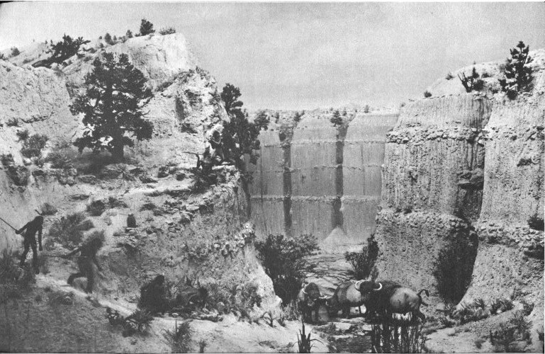
Frontispiece. A hunting scene of 10,000 years ago.
The San Juan River and its tributaries drain the region known as the Four Corners country—the area surrounding the point where New Mexico, Colorado, Utah, and Arizona meet in a common boundary at right angles. Rising high in the Rocky Mountains of Colorado, the San Juan flows southwestward to dip down into the northwestern corner of New Mexico; then it courses northwestward into Utah almost at the point of juncture of the four states. With many twists and curves, roaring through deep canyons and gulches, it proceeds generally westward to empty into the mighty Colorado River in the southeastern part of Utah.
The San Juan Basin is the major drainage basin of the Four Corners country. As such, its lower reaches formed a formidable barrier to travel by migrant primitive groups and to early white settlers as well. Its upper portions, however, especially its tributaries, were easier of access and supplied that most important element of all for life in the desert: water—water for drinking, water for irrigation.
The land between the tributaries is highly diversified; much is arid or semiarid with small streams running intermittently or with scattered springs that may be dry during parts of the year. Other areas are mountainous with swift-flowing streams. In places there are mesas, or large tablelands, which frequently are covered with forests of pine, juniper, and pinyon. It is a land of warm, often hot, summers and cool, sometimes very cold, winters; a land of sharp contrasts; a land that seems perpetual, yet never appears exactly the same on any two successive days.
Into this area many hundreds of years ago, possibly even thousands, came small bands of wandering hunters. Gradually some of them learned how to adapt to the rigors of the land. Eventually two [2] centers arose in which the local inhabitants successfully adjusted to their environment: one along the Chaco Wash in northwestern New Mexico, and the second in southwestern Colorado in many places on the La Plata, Mancos, and McElmo drainages. Chaco, the first of these cultural manifestations, takes its name from the best known and finest examples of such ruins in Chaco Canyon National Monument. The other is best known at, and named for, the area incorporated in Mesa Verde National Park.

On the northern side of the San Juan, most of its tributaries are perennially flowing streams and rivers, with broad, fertile valleys and bountiful plant and animal resources nearby. On one of these streams, the Animas, there existed a series of prehistoric towns and villages which exemplify the successful blending of cultural influences from both the major centers of Chaco and Mesa Verde. This is the general story of the San Juan River area, of the people who lived there long ago, and in particular the story of the great ruined pueblo on the Animas River near the present-day town of Aztec, N. Mex.
Ten thousand years ago, a small band of weary, footsore, hungry hunters cautiously approached a few bison which they had managed to stampede away from the main herd. Ten in number, the bison had finally paused to drink at a small spring in a rincon of the canyon wall and to graze upon the thick, tall grass. For a day and a half, the hunters had carefully followed the large, hairy mammals, hoping the beasts would lose their sense of danger and allow themselves to be boxed into a place where the hunters could approach close enough to kill them.
At last the moment was at hand! Warily, two hunters crawled along the slope of the canyon wall from opposite sides, seeking places from which they could throw large rocks upon the animals or hurl their spears with devastating force. Patiently five more hunters waited below, concealed by the tall grass or behind convenient boulders. When the first two were in place, the leader gave the signal. Rocks came crashing down on the startled bison; spears whistled through the air and thudded into soft flesh; one or two missed, but most found their targets. Shouts and cries filled the air. The bison, caught by surprise, whirled and milled around the waterhole for a moment, then several broke for the open country. One was wounded, the spear in its flank bobbing like a wave-tossed spindle. On this animal the hunters concentrated; three more spears found their target, and the great beast went down thrashing wildly. Two other animals lay maimed at the waterhole; one young calf, hobbling painfully, tried to get away to the open country but was quickly dispatched. The remaining six bison disappeared through the thickets and tall grass to the west.
The animals which were down but not dead were swiftly killed with spear thrusts through the eyes. Then the assembled hunters fell to the most important task of all. With quick strokes of their razor-sharp stone knives, they carefully peeled away the hide from one of the carcasses. The soft inner parts—the heart, kidneys, and liver—they immediately cut into pieces and ate raw on the spot, for they had not tasted meat for many days. In fact, for the last several days on the hunt, they had subsisted entirely on the few edible plants and roots they could easily find while tracking the bison. Now great chunks of meat were cut from the flanks and likewise consumed raw, until each hunter could eat no more. Then the men gathered up their weapons—long wooden spears with carefully made chipped flint or obsidian points. Some of the points were so deeply buried in the bodies that they broke loose from the shafts when the men tried to pry them free. Other shafts had broken, leaving the points embedded when the bison thrashed about trying to escape the sudden devastation. This was of minor concern—new shafts could be made, new points fashioned. It was [4] more important that once again there was meat enough to go around for the hunters, their mates, and their children.
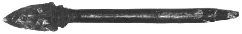
Spear point and foreshaft. Length 8″.
Now surfeited, the hunters dozed quietly in the shade out of the noonday sun. But not for long, for they must bring the rest of the band to participate in the feast. One hunter started back to the last camp where the women and children waited, existing on the remnants of the last kill and whatever edible plants, roots, nuts, and berries they might be able to find nearby. The other hunters proceeded with the skinning of the animals. To build a fire, one man found a dry log, in which he made a small hole with his stone knife. He sharpened another dry but tougher stick. Thrusting this into the hole, he twirled it rapidly between his hands until he built up sufficient friction to make a few small sparks in the log. These he deftly transferred to a little dry tinder, the flame of which he carefully nursed until twigs and branches could be added to make a real blaze. The fire would be welcome in the evening, for the days were getting shorter and the nights colder. When the women and children arrived, they would make crude lean-to or windbreak structures to help break the cold night winds from the north. They would scrape, clean, and dry the bison skins so that as the band headed southward, they would have the warm skins to wrap themselves in at night. During the day, while hunting or working around the camp, they needed little in the way of clothing—just simple loincloths. On damp, rainy days—and there seemed too many of these—brush shelters, fires, and the warm skins of the animals they had killed were sufficient.
By now the vultures were circling overhead, but it would be several days before these carrion birds could feast on what little might remain of the kill. The hunters and the rest of the band would stay at this spot until all the meat was exhausted, rancid as it might become. Then once again they would take up their spears and start after more game. This time they would head toward the south, for with the shortening days winter was coming, and the game was going south. But they would worry about the next hunt later. In the meantime all was well. It was a time for relaxation and rejoicing—they had food for many days; they had water; soon they would have shelter; and this was without doubt the best of all possible worlds in which to live.
Of course, such a scene is imaginary, but it could have taken place about 10,000 years ago, almost anywhere among the valley and canyon bottoms of what is now known as the Four Corners country of the Southwest. The great continental ice sheets never got this far south, and 10,000 years ago they were already retreating northward from their farthest expansion. Yet smaller glaciers in some of the surrounding mountains were also shrinking, and the general climate of the area must have been far different than it is today. No doubt it was colder and damper, with more rain and many swamps, lagoons, and lakes abounding in game animals and birds of all varieties. With a colder climate, the scenery too did not resemble that of today. High grasslands, extensive hardwood forests, and full-flowing streams and rivers characterized the region. The general land formations, however—the mountains, canyons, mesas, and plateaus—had been formed long millenia before, and as short a time as 10,000 years ago they would have been very much as they are today.
Geologists believe that after the last of the four great continental glaciations (i.e. the Wisconsin) there were three broad climatic periods over most of the western United States. These are called the Anathermal, which was cool and moist, becoming gradually warmer; the Altithermal, which was exceptionally dry; and the Medithermal, a relatively cool, moist period which is still in progress. Our imaginary tale about the hunters, if it had taken place, would have occurred during the Anathermal period.
These variations in climate have been determined by studying old stream terraces (streams cut deeper when there is more water, and they can carry a greater load of abrasive sands and gravels); old beach levels around ancient lakes (such as are prominent today around the Great Salt Lake in Utah); and ancient annual lake deposits of fine silts which form thin bands, or varves. Studies of animal life, both vertebrate and invertebrate, and plant life are important, for some life forms can exist only under certain limited climatic conditions. Bones and shells found in various deposits may help to indicate the type of climate existing when they were laid down. Plant fragments, pollen grains, and diatoms (microscopic plants with siliceous skeletons), are clues in telling the story of prehistoric times.
What the early hunters may have looked like no one really knows, for archeologists so far have not found a single undisputed trace of their physical remains. Skeletal fragments of what might be early man in this country have turned up in several places, but usually geologists, archeologists, and others cannot agree as to just how ancient these remains might be. One of the most likely candidates for the distinction of “earliest man” yet found in America was discovered in 1953 near Midland, Tex. Actually, these remains, [6] which consist of parts of a skull and fragments of other bones, were those of a female. They were found under geologic conditions that might indicate considerable age and in indirect association with types of artifacts which are dated, by other means, as being of Folsom age or slightly more recent. Unfortunately, since radiocarbon dates on some of this material vary widely and the local geology is so complicated, it is not positive that “Midland Man” is the oldest known American.
Many anthropologists, however, believe that even the earliest inhabitants of this country were of Asiatic descent and thus might well have resembled some of the modern American Indians.
We do not even know if they used animal skins as clothing. With a rather cool, damp climate, it can be assumed they had some sort of shelter and some types of body covering, even if nothing more than generous swabbings of bear grease. Today, near the tip of South America, a tribe of Indians—the Ona—exist in a very damp, cold climate. Eating mostly fish and sea mammals, they live in crude brush shelters and wear little if any clothing most of the time. In Africa certain primitive Pygmy tribes hunt game as large as giraffes with small bows and arrows. They wound their quarry first and then follow it, often for days, until they can bring down the weary animal at close range with their spears.
Perhaps that is how the early hunters in America survived. We cannot be positive, but we do know that scattered around the Four Corners country are a few sites where spear points, scrapers, and other implements have been found under conditions indicating great antiquity. In other cases throughout the greater Southwest, points have been found embedded in the remains of slaughtered animals of now extinct species. Often these remains are found in ancient swamps and waterholes, where it had been possible to trap or mire the animals and finally kill them; the mucky swampland has helped preserve the bones so that today the archeologist can tell the story of how they were slaughtered.
As the glaciers disappeared and the climate became warmer, the lakes, swamps, and lagoons gradually dried up, the grasslands became desiccated, the hardwoods disappeared from the valley bottoms. Small regional differences in climate, sometimes due to altitude, left some areas more desirable than others. Large mammals disappeared entirely, and the hunting and gathering people had to turn to smaller types of game such as elk, deer, rabbit, bear, and rodents. No doubt wild edible plants, berries, fruits, nuts, and even roots were gathered and eaten. In the Four Corners country, however, evidence for occupation by man during the Altithermal (or second post-glacial period) is almost entirely lacking. This was an exceptionally dry period, and few if any people could live there. It wasn’t until the climate became wetter and cooler again, [7] more like it is today, that man once again inhabited the Four Corners area in any great numbers.
About the time of Christ, in some parts perhaps even earlier, small bands of Indians entered the Four Corners country. It is possible that a few small groups of wandering hunters and gatherers who had survived the Altithermal were already living there, but the archeological evidence for their presence is very scanty. Under the impetus of new ideas, such as agriculture, these people may have been slowly settling down to become farmers.
Or possibly under the pressure of expanding populations elsewhere, groups seeking new lands suitable for agriculture moved into the area and either amalgamated with, or drove out, any local groups. If so, we do not know exactly where these people came from. Perhaps they came from the south, around the Mogollon Rim country of New Mexico where there is evidence that even earlier an agriculturally-based sedentary population had developed. Corn had been known in parts of the Southwest for a considerable time. (At Bat Cave in New Mexico, archeologists have uncovered a primitive type of corn which was grown at least several thousand years before the birth of Christ.)
Only with an assured food supply, part of which can be stored against bad years, can a group find time to devote its energies to the arts and to the development of greater skill in crafts. The idea of agriculture must have spread slowly, for it forced a radical change in the living habits of those who practiced it, compared to their old subsistence pattern of hunting and gathering. At first, the hunting group would regard this new plant as just another seed crop—to be gathered when it was ripe. They dumped the seed in the ground and went on about their business; when it ripened they returned to harvest the crop, much as they went each year to harvest the pinyon crop when it was ripe.
But as they became more dependent upon corn and added the cultivation of squash, these people discovered that two things are necessary for a group dependent upon agriculture: one, that most of the group has to remain nearby while the crop is planted, matured, and harvested (to protect it from rodents, deer, birds, and, probably, marauding tribes); second, that there must be a secure storage place for the surplus food and the seeds for next year’s crop. This latter requirement forced them to build storage pits lined with stone slabs, bark, and adobe which could be securely covered so that rodents and insects would not eat the surplus harvest.
Archeologists have long called these early inhabitants of the area “Basketmakers” because of the variety of beautiful baskets and sandals which they wove from fibrous plant materials. In the earlier part of this period, they did not know how to make or use pottery, [8] and baskets were important as storage containers or as vessels in which to cook by stone boiling. Although their descendants also made and used baskets, they never achieved the fine quality and artistry of the early Basketmakers.
Archeologists divide this Basketmaker phase into an early period of about 400 years and a later period (sometimes referred to as “Modified Basketmaker”) of about 350 years. The Modified Basketmakers had several important traits which the earlier ones lacked: namely, the bow and arrow, which replaced the atlatl (throwing stick); beans, which added important protein to the diet; and a knowledge of how to make pottery, which permitted much easier cooking and better storage of perishables.
The necessity for an assured food supply was of increasing importance, for there was a slowly but steadily growing population. Agriculture provided such a supply and freed a part of the population from subsistence activities, giving them leisure to devote to pursuits which were not necessary for mere existence. For example, turquoise—worked and polished into ornamental jewelry—seems to have been first used at this time. Small crude pottery figurines are also found, indicating a growing interest in religion and an increasing awareness of religious ideas. Kivas—developed from the idea of the older pithouse—first appear in this period. These provided a place for the performance of religious ceremonies and other nonsecular functions. The men evidently had the time to meet in council and debate communal problems. While the family unit was still important, the clan and even the entire community took on new important aspects of “togetherness.”
We do know what these people looked like, since quite a few well-preserved “mummies” have been found buried in dry caves. They were short, averaging 5 feet 3 or 4 inches for the men and about 5 feet for the women. Their general build was medium slender to stocky; their faces moderately long and narrow; skin color was light to dark brown; and their eyes were brown to black, as was their hair.
The Basketmakers used clothing of a sort; that is, they may have worn a loincloth or apron and probably had shoulder robes of untailored tanned hide for protection against cold. Woven bands or loincloths have been found in several sites. Most burials had no type of clothes but sometimes were wrapped in mantles or dried skins. Probably clothing was never worn very much. Certain “aprons” attached to waist cords and made of strings of cedar or yucca bast were evidently used as menstrual pads. Finely woven aprons may have been worn by the women on special “dress-up” occasions, but the scarcity of such items would indicate they were not for everyday wear.
They wore sandals made of woven yucca strips or cleaned fibers, [9] or sometimes of very fine cross-woven cord, with fringed toes and colored ornamentation. Human hair was used in making rope in considerable quantities; either it was cut off after death and utilized for this purpose, or was hacked short from time to time during life. Some burials, especially among the males, indicate rather fancy hair styles, and it may, therefore, have been the women who had their hair cropped to supply the material for ropes and belts.
Both men and women wore ornaments—bracelets, necklaces, and pendants fashioned of stone, bone, or even various dried berries. Beads were also made of olivella, conus, and abalone shell which probably were imported from the Pacific Coast by trading with intervening tribes. Fur blankets were fashioned by wrapping yucca-fiber strings with long narrow strips of rabbit fur and tying these fur-covered strings together in close parallel rows.
The Basketmakers were especially known for the fine types of woven containers they produced. Flexible seamless sacks, beautifully decorated in black, red-brown, and gray are sometimes found. Large, wide-mouthed ovoid baskets, carried on the back with the aid of a tumpline across the forehead, were used for bringing home seeds and other crops. Basket trays and bowls, with both close coiling and spaced coiling, were often highly ornamented, always in a symmetrical pattern. Designs usually consist of red figures outlined with black, alternating with black figures outlined in red.
The women ground corn on metates—flat slabs of rock in which eventually a deep groove was worn—with manos, or small hand stones. Stone of various sorts was used in making spear and dart points (and in the later part of the period, arrow points), knives, drills, gravers, pipes, and atlatl weights. Animal bone was carefully fashioned into awls, fleshers, scrapers, whistles, jewelry, and even gaming pieces. Wood was used for the atlatl and the dart, and later for bows and arrows, for digging sticks (for planting crops), scoops, feather boxes, and hair ornaments.
Basketmaker remains are found throughout the Four Corners country, the better specimens being recovered from dry caves where the more perishable materials are preserved. In open sites, only the stone and bone objects are left, along with the remains of house structures and storage pits.
In the Animas Valley, north of Durango, Colo., there was quite a concentration of early Basketmakers. Earl H. Morris, who conducted the first scientific explorations of Aztec Ruins, excavated a number of these sites in 1938 and 1939. Here, in an open talus site, he found the first evidence that the early Basketmakers had actual house structures. He gives a graphic description of a typical one:
A site for the dwelling was secured by digging a drift into the steep hillside and piling the excavated earth and stone out in front until a [10] terrace large enough to accommodate the projected house had been provided. The floor area was scooped out to shallow saucer shape—in this case 9 m. in diameter—and coated with mud. At the margins, the mud curved upward to end against the half-buried foot logs which were the basal course of the wall. The walls were composed of horizontal wood and mud masonry. They rose with an inward slant to a little better than head height, then were cribbed for a distance to reduce the diameter of the flat portion of the roof, which was of clay supported by parallel poles. The arc of stones was a retaining device placed to hold back the ever-growing accumulation of refuse that was dumped at the brink of the terrace.
Interior furnishings generally consisted of a heating-pit, slab-lined storage cists, some with above-floor mud domes, and usually grinding stones and metates. How such a structure was entered is not known; possibly it was through a smoke hole in the roof, as in the later and deeper pithouses, or perhaps it was through a lateral doorway with a high sill, traces of which no longer remain.
By A.D. 700, the Four Corners country was evidently well populated. In this later part of the Basketmaker period, the houses in open sites were usually more subterranean. These later houses, often with slab-lined and adobe-plastered walls, had a smaller second room or antechamber added on the front through which entrance was made. A few such ruined dwelling sites are known along the Animas River south of Durango. Morris felt that an adequate archeological survey would reveal a great many more, but extensive plowing of the area in recent historic times has long since removed the evidence. In the latter part of this period, the early Basketmakers evidently moved downstream where there was better land for cultivation and the growing season was slightly longer.
That they had a firm belief in a life in the hereafter is shown by the care with which they buried their dead and by the offerings placed with them. It is with these burials in dry caves that most of the perishable material relating to this period has been found. Frequently the bodies were wrapped in mantles of fur or feather string, and sometimes wrapped again in the tanned skins of deer or mountain sheep. Often the bodies have sandals on the feet (and occasionally an extra pair for replacement if the first wore out) and are accompanied by hair ornaments, necklaces, beads, pendants, baskets of corn and pinyon nuts, pipes and smoking material, gaming sets, flutes, and implements of warfare and the chase. The bodies were usually buried in the flexed position, that is, with the knees drawn up tightly and the hands folded across the chest. In the earlier part of the period, cave storage pits were used as burial places. Some bodies were placed in crevices behind fallen rocks within the cave. Other burials were in the open or in the talus slopes below the caves. In the latter part of the period, so much of the cave was used by the living that the dead were frequently [11] buried in the open in specially dug pits. In these cases, evidence of the perishable material has usually disappeared. In a few of the later graves, pottery is found as a grave offering. Morris reports one burial of this period that contained 11 pottery vessels.
The Basketmakers must have had warm feelings of affection for their young. There was a high mortality rate among the infants and children, but despite this they lavished great care on each small burial. Children might be buried in baskets or in large skin bags, but babies were carefully buried in their cradles. These cradles were made by bending a long slender stick into an oval shape, on which a framework of rods was tied to the outer oval in a crisscross pattern. The interior was padded with juniper bark and covered with fur-cloth blankets, which were often made from the soft, white stomach skins of rabbits. The cradle could be carried on the mother’s back, hung from a convenient peg in the home or on a tree branch when out of doors, or laid carefully on the ground in the shade, all without upsetting the baby. Diapers were made of soft shredded juniper bark, and juniper bark pads wrapped in soft skins were tied on the infants to prevent umbilical hernia.
Archeologists have dug up some unusual burials from this period. One was a male who, presumably after death, had been cut in two at the waist and then sewed together again. Why this was done, nobody knows. He was also wearing a pair of leather moccasins, an item not often found among the Basketmakers. Another burial, from the Canyon del Muerto in northeastern Arizona, consisted of only a pair of forearms and hands, lying palms up, side by side on a bed of grass. Wrapped around the wrists were three necklaces with abalone shell pendants. Ironically enough, included in the grave offerings were two pairs of the finest sandals ever found. Over the whole lay a large basket about 2 feet in diameter. Conjectures as to the “whys” and “whats” of this burial have been numerous, but probably the true reason will never be known.
The second broad period in the history of the San Juan area is that in which the Indians built communal dwellings called pueblos. These were stone and adobe structures, sometimes multistoried, facing a central plaza which contained one or more kivas. Very similar structures and village plans can be seen in a number of the existing pueblos of the Rio Grande today, notably Taos, Santo Domingo, and San Ildefonso.
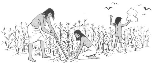
Over the previous centuries the inhabitants of the San Juan Basin, and especially the Animas Valley, had gradually developed a different way of life from that of the early Basketmakers. Certainly, they still grew corn, beans, and squash; still hunted and snared game; still grew old, died, and were buried. But in addition to having some of the better material things in life such as [12] pottery and the bow and arrow, they now placed a greater emphasis upon agriculture; hunting and seed gathering were secondary sources of food. In the spring, the corn seeds were carefully planted, watched over, watered, and cared for. As the plants matured, the men and young boys spent more time in the fields. During the day it was necessary to drive off the squirrels and birds; at night the green tender plants must be protected from the deer, rabbits, and nocturnal rodents. Water in this semiarid land had to be carefully managed, whether flood irrigation or planned canal irrigation was used. If all these factors were not judiciously controlled, there would be no crop. The forces of nature seemed increasingly important; too much sun could be as disastrous as too much water. Ceremonies were devised to propitiate the spirits and the gods, who, to the Indians resided in all aspects of nature. More time was devoted to seasonal religious activities, and great care was taken to educate the young in the proper performance of the ceremonies so they, too, might continue to prosper and live in harmony with nature.
Cotton was probably introduced at about the beginning of the Pueblo period, along with loom weaving. This allowed the making of true cloth, suitable for blankets, poncho-like shirts, sashes, wrap-around skirts, and other necessary items. One other important change at this time affected physical appearance. The soft cradle of the Basketmakers was replaced by the hard cradleboard of the Pueblos. Since the infant usually was bound securely upon his back in the cradle and was unable to roll around, the pressure of the hard board, instead of the softer cradle, caused the back of its head to become flattened, thus giving the whole head a much broader and rounder appearance. This skull flattening in no way affected the mentality of the child, but it must have been obvious to the parents what was causing it. Through continued use of the cradleboard, skull flattening must quickly have become a mark of distinction and charm and, in a few generations, it must have become the traditional head shape of the Pueblo Indians.
Dogs and turkeys were still the only domesticated animals, the turkeys probably kept as much for their feathers (and thus periodically plucked) as for their food value. Burials of both dogs and turkeys occur, indicating they were evidently regarded as more than mere food. Bones from the refuse piles indicate the people hunted—or acquired by trade—bear, elk, bison, wolf, mountain sheep, deer, and rabbits.
There was no sharp break between this period and the preceding Basketmaker. The Indians themselves did not know when they left one period and embarked upon the next. Actually, such “periods” are the classification devices of the archeologists, who need names to apply to the times at which different cultural and [13] evolutionary changes occur. In retrospect, the archeologist can see certain important changes which began to take place about A.D. 750. Liking to classify and categorize the remains they study, archeologists first divided this broad Pueblo period into five substages labeled Pueblo I, II, III, IV, and V. Later, the first two substages were grouped together as the Developmental Pueblo Period, the third was called the Great Pueblo Period, the fourth became known as the Regressive Pueblo Period, and the last as the Historic Pueblo Period. These terms are more meaningful and will be used hereafter. The last two do not concern us, for at the end of the Great Pueblo Period, seemingly at the time of the well-known drought (A.D. 1276-99), most of the pueblo-dwelling peoples left the San Juan area, never to return.
The most obvious change in the Developmental Pueblo Period, as compared to the preceding Basketmaker, was a gradual shift in the type of house construction. The single-unit mud, slab, and jacal semisubterranean house was giving way to the huge multistoried stone and adobe structures, which were to predominate in the Great Pueblo Period 250 years later. In some areas, even earlier than A.D. 750 a few people began to build single-room houses aboveground in a contiguous arrangement, often crescent-shaped, forming small villages. The construction varied from district to district. Some houses were quadrangular in form and wholly aboveground, made of adobe and mud with upright, supporting posts; others were still semisubterranean; some even showed the beginnings of true stone masonry.
At this time also, a new type of structure was coming into existence (though a few examples are known from late Basketmaker times). This new structure, the kiva, was simply a modification of, and change in, the use of the old pithouse. A kiva is a ceremonial room and clubhouse for the men, usually constructed underground (or, where aboveground, so clustered in other rooms as to appear belowground in its relation to the surrounding rooms). It is circular like the early pithouses, but normally contains a fireplace, a deflector (to prevent the draft from fanning the fire too much), and a ventilator shaft by which to bring in the fresh air. A “sipapu” (a small hole which supposedly leads to the underworld) was located in the floor on the opposite side of the fireplace from the deflector. Usually there was a bench around the inside of the kiva near the floor, which may either have been used as a place on which to store religious objects and other paraphernalia or may have served the functional purpose of strengthening the lower part of the kiva wall. Smaller kivas frequently had pilasters built upon the bench and extending upward a short distance; these supported the cribbed roof structure. Large kivas had four centrally located posts which helped support the roof. Entrance to a kiva was normally gained by means of a ladder through the central smoke hole in the roof.
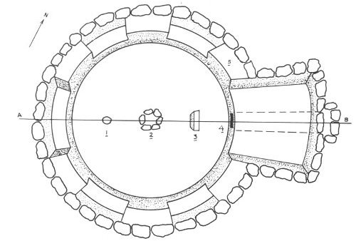
GROUND PLAN OF A TYPICAL KIVA
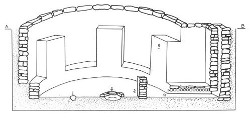
CROSS SECTION OF A TYPICAL KIVA 1. SIPAPU 2. FIREPIT 3. DEFLECTOR 4. AIR SHAFT (VENTILATOR) 5. PILASTER (ROOF SUPPORT)
It is difficult to assign the same dates to this Developmental Pueblo Period in all areas of the San Juan Basin. Culturally some sections seemed to lag behind others; some ideas, concepts, and artifacts spread and were accepted faster than others. Also, certain regions have been much better explored archeologically, and we know more about them.
Unfortunately, the Animas is one of the river valleys in the San Juan drainage which has not been particularly well surveyed or investigated archeologically. Accounts by early settlers, and passing references in some of Morris’ reports, indicate that in aboriginal times (certainly during Pueblo times), the valley was no doubt heavily populated. It should have been. Good water is readily available in the river and the climate is healthful; prehistorically, game must have abounded in the nearby foothills and mountains. Settlement and clearing of lands in more recent times have eliminated many of the prehistoric remains, but the higher banks along the river terraces still show low mounds of rubble, obviously man made, with indications of cobble and sandstone walls, which evidently were dwellings of the Pueblo Period.
Best known in this valley area are the cave and open sites that Morris excavated north of Durango and which contained the remains of early Basketmaker peoples already mentioned and the great pueblo of Aztec, near the town of the same name about 15 miles above the confluence of the Animas and San Juan Rivers. As described elsewhere, this latter structure was also excavated by Morris in 1916-21. Without doubt, parts of the valley were more or less continuously occupied from early Basketmaker times until the final abandonment of the Four Corners country about A.D. 1300. Although we have no firm data on which to base conclusions, it would be safe to assume that the Developmental Pueblo Period in the Animas Valley lasted from about A.D. 750 or 800 to 1050 or 1100, and that conditions in the living patterns of the people elsewhere were reflected in the Animas Valley.
As the Developmental Pueblo Period progressed, house arrangements became more complex. The next step seems to have been an extension of the earlier linear or crescent-shaped alinement of contiguous houses by adding on one or more wings, so that the resulting plan was L-shaped or formed a rectangular U. In these cases, the semisubterranean kiva was still retained in the courtyard as a definite religious structure. These types of planned communities are called “unit houses.” Most were single storied, though some may have had a second story added on the back tier of rooms.
Changes in pottery styles, and especially in decoration, are very marked during this period. Although plain gray ware was still [16] made, pottery with black designs on a white background shows up in great quantities. In the western part of the San Juan area, painted pottery with a pinkish-orange background and red designs makes its first appearance; examples of this type show up as trade pieces in eastern San Juan sites. The differences between culinary and nonculinary wares become more marked. The former are usually corrugated vessels, formed by pinching or indenting the clay coils while they were still plastic and before the pot was fired. Later in the period, this type of corrugation became quite decorative in itself and some of the better cooking ware aesthetically rivals the painted wares.
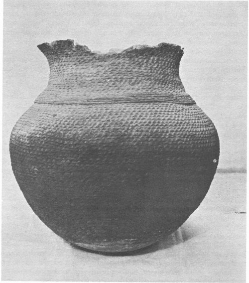
Corrugated cooking pot. Diameter at mouth, 11½″; Maximum diameter, 16⅓″; Height, 16″.
There was a greater variety of vessel forms and painted designs. For example, designs were no longer confined to the interiors of the bowls, but were also painted on the exteriors and upon a great variety of vessel forms. Many of these designs still seem to be derived from those inherent in basketry, others may have been taken from textile designs, and still others originated especially for use on pottery vessels. Principal design elements seem to have been parallel lines—sometimes straight, sometimes stepped or wavy—zigzags, triangles, checkerboards, and interlocking frets. In the latter part of the period, these elements became broader and heavier and were rendered with greater assurance. A slip or wash of very fine clay was now smeared on the vessel before firing to give it a smooth finish.
Burials were generally in refuse heaps, abandoned storage pits and rooms, or beneath the floors of houses. Infants and small children were frequently buried beneath the floors of houses, as though the parents either desired to keep them around as long as possible, or believed that the soul of the dead child would return with the birth of the next one if the body were close by. Grave offerings consist mainly of pottery, but we may be sure that various perishable objects also accompanied the dead; however, conditions for preservation are so poor in these open sites that most traces of perishable materials have long since disappeared.
In a few areas there are rather puzzling features about some of the burials. For example, along the La Plata drainage there are too few burials to account for the rather large population that must have lived there. Diligent searching has failed to reveal how the La Plata people disposed of most of their dead. In other places skull burials are found—without any bodies—and sometimes bodies are found without any skulls. Perhaps some of these people practiced taking trophy heads of warriors killed in combat or ambush. Now and then burials are found with an arrow embedded in the body, or with scrape marks on the skull which indicate that a person had been scalped, or with the skull smashed in, as though by a stone ax.
While open-armed warfare, as we know it today, was unfamiliar to the Pueblo Indians, life may not have always been calm and peaceful. Raiding or ambush parties, economic strife, the strains of increasing population, arguments over land and water rights, all may have contributed to making life uncertain during this period. And difficulties of a slightly different sort are shown in skeletons from Alkali Ridge in southwestern Utah, which show marked signs of malnutrition and diseases.
This was evidently a period of growth, development, transition, and some struggle. As in other periods, it is difficult to place sharp lines of demarcation between the Pueblo Period and the earlier [18] Basketmaker and between it and the later Great Pueblo Period. In all of the San Juan Basin, at any given moment, examples could be found of both old and new trends. Even in adjacent areas, there was no uniformity of cultural development. But by the end of this period, in one area or another, all the basic Pueblo traits were established. All that remained was for certain of these areas to become specialized along different lines, to become cultural “centers,” diffusing their ideas to neighboring groups, and in turn absorbing ideas from them. Throughout the San Juan Basin, the people were physically much alike; their language may well have been the same, or closely related, and there were probably free movements of people between towns and even between the more isolated groups and the larger centers of activity.
It is doubtful if any group was completely isolated. Intermarriage must have been common. Whole family and clan groups may have left one village and joined another, sometimes only a short distance away, sometimes far away. It would be almost impossible to trace such minor shifts in population; large-scale mass migrations might leave their imprint on the archeological record, but such evidence does not seem to exist, and it is doubtful if any mass movements of people occurred at this time.
At the close of this period, what were conditions in the lower Animas Valley, especially in the immediate vicinity of what is now the Aztec Ruins? Was there a small, early-type Developmental Pueblo Village at this particular spot? Or possibly a large “unit house” type structure? Lack of knowledge about the Animas Valley precludes a definite answer, and early excavations at Aztec Ruins were largely confined to the main ruins themselves. In most places the digging did not penetrate to what may have been the underlying and earlier remains. In a few places beneath the great ruins, where the excavations went deep enough and where the later building of the great pueblo had not eradicated them, there seem to be indications that there were kivas of an earlier type, and possibly a few scattered aboveground dwellings. An early-type Developmental Pueblo village may have stood at this same spot.
At the beginning of the Great Pueblo Period in the Animas Valley there may well have been a sizeable population living in scattered unit house dwellings and small villages, built largely of river cobbles and adobe mud. The area to the south of Aztec, in and around Chaco Canyon, and that to the northwest, in and around Mesa Verde, had each developed local variations in architectural style, religious concepts, and minor arts and crafts. Cultural influences from these two areas were to have a marked effect upon the large pueblo at Aztec that was built, abandoned, and reoccupied during this period.
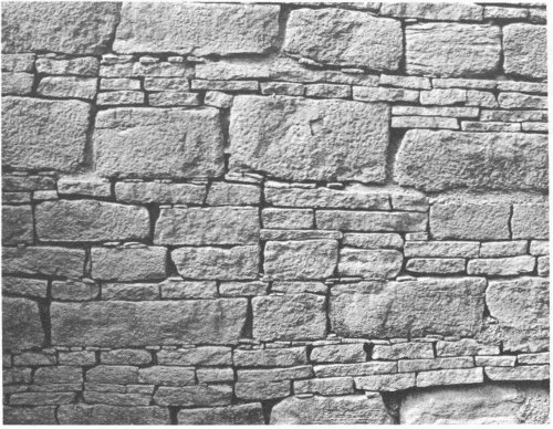
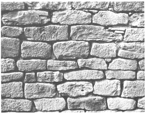
Chaco-style masonry wall.
The Chaco Wash (today a dry streambed during much of the year) rises in the high plains north of the Chacra Mesa, extends westward for 68 miles, and then twists sharply to the north to join the San Juan just above Shiprock, N. Mex. For about 20 miles it flows westward through a beautiful yellowish-brown sandstone canyon, the cliffs of which step back in a series of gigantic sandstone ledges. In places the canyon bottom is broad and level, but today it is scarred by a deep arroyo with branches which extend up each little side canyon, so that travel on foot across or up and down the canyon is difficult. A thousand years ago this arroyo did not exist, and the Chaco Wash was a shallow, clear-flowing year-round stream, meandering through a lush green valley. Where today the sandstone ledges stand starkly denuded of all trees, there was once a dense forest of pines and junipers. Along this canyon bottom and on the mesatops to the north and south, the prehistoric Chacoans erected some of the finest sandstone masonry pueblos in North America. A number of other large Chaco-like sites were built in places outside the canyon proper, and the influence of this building style was felt for 50 miles around.
To the northwest of Aztec, between the La Plata Mountains and the Sleeping Ute, in and around the area dominated by the large [20] tableland of Mesa Verde, a second regional culture center developed. These Indians lived along the main watercourses of the area—the McElmo and Montezuma—or dry-farmed the surrounding mesas. It was toward the end of this period that the Indians living in the Mesa Verde itself built their large imposing cliff dwellings.
Mesa Verde-style masonry wall.
By the end of the preceding Developmental Pueblo Period the communities in the San Juan area began to be more centralized and to be built according to preconceived plans. Such planning denotes a form of community control, or at least some kind of control over a fair-sized labor force. Today, community projects are frequently carried out in the pueblos by the majority of the people under the direction of their caciques, or leaders, after careful discussions and proper religious observances by the elders of the group. A similar form of self-government must have existed in the prehistoric pueblos. It was probably based on a time-honored tradition given sanction by religious beliefs which extended back as far as the late Basketmaker period where there were beginnings of large community kivas and centralized religious group activities.
With large groups of people living together, greater cooperation was mandatory, and through such cooperation the necessary tasks [21] were accomplished more quickly. Thus there was greater leisure for many people which could be devoted to the more interesting arts and crafts. Sometimes societies limit this greater freedom and leisure to a ruling class, but such does not seem to have been the case among the Pueblos. There are some indications, however, that especially in this period there may have been developing the concept of a priestly hierarchy that also exercised civil controls.
The Great Pueblo Period was a period of continued specialization, not only in architecture but also in ceramics and in the minor arts and crafts. North of the San Juan, most of the pottery seems to have been decorated with a carbon paint, that is, a paint made from vegetal dye. South of the San Juan, in the Chaco area, they generally seem to have used mineral paints. The pottery designs of this period were often hachured patterns, with the thin filling lines surrounded by heavier boundary lines. Band designs of steps, frets, and triangles were also used. Bowls, pitchers, ollas, and ladles were the common shapes; and some cylindrical vessels and effigy pots are known.
An equally popular ware, which was not painted, was the cooking, or “corrugated” ware mentioned earlier. In this period the coils of the vessel wall were still sometimes pressed together to form decorative designs, or sometimes were smoothed over so that an almost-plain vessel resulted.
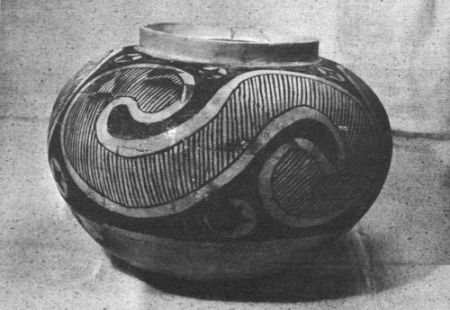
Chaco-style pottery pitcher. Diameter at mouth, 2½″; Maximum diameter, 4″; Height, 6¼″.
In the field of minor arts and ornaments, the people of this period reached a high degree of achievement. Olivella shell beads were [22] still widely used as well as stone beads and stone and shell pendants carved in the forms of birds and animals. Turquoise, which first seems to have been used in late Basketmaker times, was used extensively for some of the finest ornaments, not only for beads and pendants but also in beautiful mosaics.
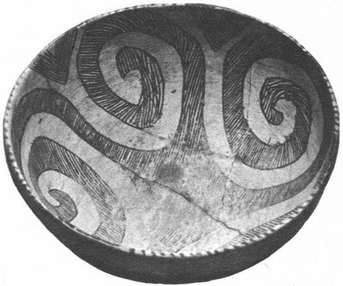
Chaco-style pottery bowl. Maximum diameter, 9″; Height, 4¼″.
However, it is the large multistoried pueblos of the Chaco Canyon and the great cliff dwellings of the Mesa Verde that attract the most attention. The native sandstone at Chaco Canyon made an excellent building material—it was easily obtainable, it fractured along natural cleavage planes into thin slabs, and it could be ground and pecked into large rectangular blocks. Both the availability of sandstone and the relative ease with which it could be worked were important factors in developing the Chaco style of architecture.
Some of these pueblos may have been as high as five stories; most were at least three or four stories. All show signs of constant alteration in individual rooms and in their general layout, as though some feverish urge was forcing the people to keep shifting the arrangement of their dwellings. Not all the rooms in any of the large pueblos were occupied simultaneously; usually the rooms toward the rear were used for storage or, in many cases, as dumps for refuse and garbage. Occasionally, burials are found in them.
All the great Chaco pueblos form self-contained units—that is, they were built around central plazas or courtyards, as in the case of Pueblo Bonito, with a low row of single-storied rooms closing off the formerly open side of the plaza, or they were roughly rectangular with closely knit contiguous rooms and internal kivas as in Yellow House. This closure, plus the fact that the doors and windows which formerly had opened outward at the rear or sides are now sealed up, has led many people to believe the later parts of this period were marked by trouble and strife and that this self-containment was a defensive measure.
At Chaco Canyon, many parts of the pueblo walls were finely made. Different styles of decoration were produced by using sandstone blocks of various sizes. An unusual effect was achieved by alternating bands of large rectangular blocks with a series of bands of much smaller, finely laminated standstone blocks. The interior of the walls consisted of crude rubble in adobe mud, and, where some form of banding technique was not used in the outer or veneer wall, the chinks between the larger stones were filled with adobe mud and spalls or very small chink stones. When carefully done, this technique also produced an attractive appearance. Since both the interiors and exteriors of walls were usually plastered with numerous thin layers of adobe, it is something of a mystery why the Indians took the trouble to produce such pleasing effects in their stone work and then to cover it up with plain plaster. It may be that what we regard as decoratively charming was to them simply a structural and engineering feature. They may have considered carefully spalled and banded masonry to be structurally sounder than simple rock, rubble, and plaster walls. Usually the walls of the upper stories are successively thinner, and a similar idea was used in the beams which form the room ceilings (and thus the floors of rooms above)—the heaviest beams were in the lower rooms, and those in the upper stories were correspondingly lighter and smaller.
In the Chaco-type great pueblo of this period, the majority of the rooms were large by pueblo standards. They were rectangular in shape (except for the kivas, which are circular) and often 8 to more than 12 feet long and 6 to 8 feet wide. Ceilings were 8 or 10 feet high, and doorways, usually with a raised sill, were 3 to 4 feet high and 2 to 3 feet wide. In comparison with the typical rooms in the Mesa Verde area, those in Chaco were very spacious.
In the Mesa Verde region the people were also learning to build in sandstone, but the available standstone was coarser than that in Chaco and did not have the clean fracture planes, and the masonry was of a thicker and seemingly cruder sort. Walls were made of rectangular blocks of tan sandstone which quite often were carefully shaped and ground to give a pleasing effect.
On the sloping green tabletop mountain, known as the Mesa Verde (from which the surrounding area gets its name), in the early part of this period (A.D. 1050-1200), the people built large unit-type pueblos upon the long finger-like mesatops which extend southward from an abruptly rising escarpment on the north. Most of these units were multistoried, and although they centered around a central plaza, they were much smaller, more tightly contained units than their Chaco Canyon counterparts of the same period. Frequently they contained at least one towerlike structure connected by an underground passage to a nearby kiva. One or more other [24] kivas might be located in, or front on, the small central plaza.
Although the rooms are smaller than the ones in the great communal houses of Chaco, they are solidly built of double course standstone blocks. Because in most cases the mesas are sloping southward, many of these unit houses were built upon one or more terraced flats. Frequently the only entrance into the pueblo was by staired entranceway leading from the south into the small interior court or plaza.
At Mesa Verde, in the latter part of this period (about A.D. 1200-1225), the people who had been living on the mesatops in the unit house type of dwelling seem suddenly to have abandoned these dwellings and taken up residence in the nearby caves. Here they built great pueblo-type structures, often of several hundred rooms with numerous associated kivas. Since they were limited by the ceiling of the caves to two and three-story structures, and not so exposed to the elements, it was not necessary to use such thick, strong walls, roofs, and ceilings. The general construction at Mesa Verde was therefore thinner than at Chaco, and the rooms and doorways are considerably smaller. In fact, with the warm southern exposure of the caves which were used, the people must have done most of their living and daily chores outside, in the small plaza areas and on the roofs of the lower tiers of rooms. The rooms themselves could be small, for they were probably used only for sleeping and storage. Because the native sandstone at Mesa Verde is coarser grained and does not fracture as easily into blocks and spalls, the style of alternating large and small banded masonry found at Chaco was not adopted there. But much of the stonework at Mesa Verde is nonetheless excellent; perhaps some builders had greater artistry than others, for some of the rooms, especially the circular towers, contain blocks which have been carefully pecked, ground, polished, and fitted into exact position with loving care.
In this period, also, a structure known as a Great Kiva comes into prominence. It usually has an entrance on the north side (instead of through the smoke hole), often with a stairway. It has a large raised firebox in the center of the south side, and occasionally another entrance there. In addition, on the east and west sides of the floor are large, rectangular stone-lined pits, built up above the floor. Their exact use is still a mystery, and perhaps they served more than one purpose. It has been suggested that when covered with boards, they would make excellent foot drums for the dances, or good places for the medicine men to conceal themselves while performing certain magical rites during initiation ceremonies. Finally, four large posts set into the floor of the kiva supported the roof. Great Kivas are fairly common in the Chaco area, but in the Mesa Verde vicinity they seem to be very rare.
In each of the two areas mentioned above—Chaco Canyon and [25] Mesa Verde—archeological work has revealed a continuous occupation of the sites and the immediate vicinity. At the great Aztec ruin, however, there is still some doubt as to what really happened. In two different time periods there seem to be strong architectural relations to both the Chaco and Mesa Verde centers, as well as close ties in ceramics and other items of material culture. Part of the intriguing mystery at Aztec is whether these similarities represent actual migrations from those centers on a fairly large scale, or an exchange of ideas, or small groups of migrants who strongly influenced the local population.
In the midst of the populous Animas Valley, along the edge of an old river terrace, early in the 1100’s a large multistoried stone pueblo was built in an architectural style reminiscent of that in Chaco Canyon. Did a large migrant group from the Chaco area—or some other area where Chaco-like people were living—move into the Animas Valley and erect this structure? Or did some of the local citizenry decide to join in a community effort and copy the building techniques of their neighbors to the south? If so, what was the impetus which launched the local people upon this ambitious project? Perhaps a small group of highly skilled technicians, under the leadership of a few “priests” or medicine men, came from the Chaco area into the Animas Valley. Once established there, by persuasion, teachings, or by religious magic and psychological control, they may have prevailed upon some of the local population to join them and to build their homes and kivas of sandstone blocks, in the traditional Chaco style.
We may never know the exact answer to these questions, but wherever the people came from, whoever they may have been, whatever the guiding impetus, Aztec pueblo, like Rome, was not built in a day. Dates from tree rings—as described later—indicate that the pueblo was built between A.D. 1110-1124, with the major construction periods in 1111 and 1115. Probably a small group, or just a clan, moved into the site about 1110, and finding it suitable for habitation erected the first small part of the pueblo. The next year a much larger group, perhaps several clans or more, joined the earlier settlers and more than 50 percent of the pueblo was finished. Then, in 1114 or 1115, a third wave of migrants arrived and essentially completed the pueblo, except for the one-story row of rooms which closed off the south side. It is possible that some of the indigenous Animas population joined these newcomers and moved in with them. From 1115 until about 1124 or 1125, occasional rooms were added as new quarters were necessary for newly married couples and as old rooms were used as refuse dumps.
To the northwest of the ruins, less than 2 miles away, the Indians found an outcropping of sandstone which could be broken into shape and then ground into rectangular blocks. These were hauled to the [26] proposed building site, where the women took over the construction. Holes were dug in the clay soil nearby, water poured into them, and then stirred to produce a thick adobe mud. This was used, along with crude unshaped sandstone blocks, as filler for the walls. On the outside, the women laid up the well-shaped blocks in regular courses, chinking them with small spalls or potsherds.
The rooms were laid out in rows adjoining one another; as one row was finished, another was added alongside of it. When several rows had been completed, second and possibly even third stories were added. The first group to arrive probably completed the major part of one wing; later groups added to this and erected the other wings and associated kivas until the entire pueblo had the traditional planned aspect of a typical plaza-enclosed Chaco pueblo. In the central plaza area several kivas were dug and roofed over at ground level. The fourth side consisted of a single row of one-storied rooms. Finally, even a fourth story may have been added in places. Sometimes a large square space was temporarily left open, later to be filled by a circular kiva.
Out in the plaza, during the latter part of this first occupation, work started on the Great Kiva, for this was the center of the ceremonial life of the entire pueblo. Here would be performed the ceremonies which would insure the inhabitants that theirs would be a long and happy life and that everything would prosper for the new community.
For roofing the rooms, main stringers of pine or juniper were used, and over these were laid splits of juniper or long poles of cottonwood. Next came a layer of rush or reed mattings and then a layer of dirt and adobe which formed the top of the roof, or the floor of the room above if there was more than one story.
The pine logs used for the main stringers are good-sized, many being 1 foot to 1½ feet in diameter and up to 10 or 12 feet long. Although juniper is still fairly abundant in the nearby country, good stands of pine today are many miles away. At the time the first parts of this pueblo were constructed, the pine forest may have been much closer. Perhaps extensive cutting hastened soil erosion and thus caused the forest growth to retreat.
Prehistorically it still was a long haul to bring in such big logs. Many people have assumed that the logs were floated down the Animas River. This would have been the easy way of doing it, but the logs found in situ in the ruins were obviously fresh cut, peeled while green, and show no scars. They must therefore have been carried overland from their source, no matter how far away, for it would have been impossible to float them downstream without being scarred and bruised in transit.
Through the growth of tree rings on pine logs, it is possible to date the time at which they were cut. If a tree is cut today, the [27] outermost ring constitutes its growth for the year in which it is cut. Counting toward the center of the tree ring by ring, you will arrive at the date at which the tree was a young sapling. Climatic factors, dry and wet spells, are reflected in the width of the rings. Dry years usually show small, odd-shaped or stunted rings; normal years show regular well-shaped rings, and extremely wet years may result in excessively large rings. These various rings, which are arranged into patterns, can be matched with similar tree-ring patterns from still older trees, and a chart of patterns can be prepared which will extend as far back in time as you can find specimens with overlapping patterns. Against this master chart the ring pattern of any particular tree can be compared and the specimen dated. Today archeologists have such a tree-ring master chart which extends back to the time of Christ for the San Juan area.
At Aztec, samples of tree rings were secured from some of the beams that still existed at the time this dating process was discovered. Such samples fall into two groups of dates. One group (with numerous samples) was placed between A.D. 1110 and 1124; the second group (with only six samples) between 1225 and 1252. The tree-ring dates indicate that the great pueblo at Aztec had undergone at least two major periods of construction. Since a large number of dates range from 1111 and 1115, this would appear to have been the first peak of building activity.
It is possible that earlier samples have rotted away or have been destroyed by later Indians or by the early white settlers. Moreover, all building activity probably did not suddenly cease in A.D. 1124; it may well have continued for another 10 years, but the beams representative of this later period have since been destroyed. We can safely say that the first construction period at Aztec pueblo occurred sometime between 1110 and 1130, with most of the development occurring around 1111 and 1115. Likewise, a second major construction period at Aztec occurred sometime between 1220 and 1260, with major development in the 25-year span between 1225 and 1250.
The two construction periods at Aztec, as indicated by the tree-ring dates, are corroborated nicely by other evidence found by Morris that Aztec actually was built by one group of people, abandoned, and then reoccupied at a later date by a slightly different group of people. Throughout all the rooms he dug, he found sterile layers of windblown sand and ruined debris from falling walls and ceilings. In this debris and under the sand he found Chaco-like pottery and artifacts. In addition there were surprisingly few burials. The last point might seem strange, except for the fact that even today, 40 years after Morris’ work and despite endless searching, archeologists have located few Chaco-type burials in Chaco Canyon itself. Whatever the burial customs of the Chaco people may have [28] been, they have eluded archeologists for many years. The absence of burials of this period at Aztec is a clue that probably a group of Chaco-like people, bearing the distinctive Chaco culture, may actually have moved into the Aztec area.
Morris wrote that he found many rooms built in typical Chaco-style architecture. Granting that the local sandstone was not quite as easily worked as that at Chaco, the large-size rooms, the high ceilings, the banded-veneer masonry walls, the large doorways, and other techniques used were very similar to the architectural techniques of the Chaco area.
Overlying the Chaco debris and sterile sand layers, Morris found pottery, household utensils, and burials characteristic of the classic Mesa Verde Period—a period which occurred later than the great Chaco Period. In addition, there were obvious architectural signs of rebuilding and remodeling within the pueblo. Large Chaco-type rooms had been made smaller by wattle-and-daub partition walls, while doorways had been shortened and narrowed more like the ones at Mesa Verde.
Thus there were two definite periods of occupation at Aztec, one by a Chaco-like people and one by a Mesa Verde-type people. The two major construction periods, as indicated by the tree rings, agree with Morris’ evidence of two occupation periods and, so far as we know, closely date those periods during which the pueblo was actively inhabited.
Aztec, at the height of the Chacoan occupation, must have been a fascinating sight. On a sunny summer day, the plaza and rooftops would have been a busy swarm of activity—mothers nursing and tending their young, grinding corn for tortillas, preparing meat for the stew pot, making baskets, and molding clay pots for later firing. Old men basked in the sun or instructed the young boys. Most of the men and older boys were busy tending the corn, beans, and squash in the fertile fields surrounding the pueblo. This was exacting work, since each plot, clan by clan, had to receive its carefully husbanded share of water from the irrigation ditch that ran along the slope of the high terrace just to the north of the pueblo. At times during the day, hunters would straggle in happily if burdened with game, sadly and slowly if empty-handed after a fruitless chase. Occasionally a wandering group of strangers would pass by with items to trade. They were made welcome and fed, and the whole plaza took on a festive air.
At night the pueblo must have presented a vastly different appearance: dark, mysterious, and quiet. Here and there a small dying fire cast a flickering glow upon a brown adobe wall. In one or two of the kivas, a faint light through the hatchway in the roof indicated preparations under way for a ceremony, or perhaps a special highly secret meeting of one of the clan societies. If you looked [29] closely you might make out one of the sentinels, silhouetted briefly against the night sky as he shifted position. But the pueblo was silent—a silence only broken by an occasional dog’s bark or baby’s wail—until, shortly after the morning star appeared, the hunters crept quietly out of the pueblo, and as the star faded, the broadening morning light heralded the approach of another day in the life of Aztec pueblo.
But something happened. For no reason we can ascertain today, the pueblo was abandoned by its first occupants. Presumably, this was a fairly fast exodus, but one in which the people had time to take most of their treasured possessions with them. There is no evidence that they were driven away by invaders, or by any other major catastrophe such as fire, flood, or pestilence. We do not know if they left en masse or perhaps more gradually, as they arrived, in clans and groups. If a few hardy souls stayed behind, or if a few weak stragglers couldn’t make the trip, there is no evidence. All we know is that by about A.D. 1125, or perhaps 1130, the pueblo was empty. For almost a hundred years the great structure stood alone, untended and uninhabited. Perhaps the local people occasionally used a loosening beam from the structure, or gathered up a few blocks from the slowly crumbling walls, or helped themselves to any readily useful articles left behind, but otherwise they and any passing wanderers seem to have left the place alone.
For years the wind blew the sand into the open doorways, through the widening cracks in the walls, past the sealed doorways, down through the floors, until even the deepest and most inaccessible rooms had a layer of 4, 6, or 8 inches of fine sand deposited over them and whatever secrets they held. Rats and other rodents infested the place and little disturbed the brooding silence except for their piping squeals. Occasionally weakened beams gave way or a wall here and there crashed down as its plaster and rubble fill were washed out by rains and melting snows. Bit by bit the old pueblo slowly crumbled.
Why and how the first great pueblo was built by a Chaco-like people and then suddenly and for no apparent reason abandoned is a real mystery. Strangely, this abandonment seems to agree roughly with the time at which the Chaco area itself was being depopulated. In Chaco Canyon, an arroyo, much like the one which exists today, was cutting its way backward up the canyon, and this arroyo-cutting would have made it impossible for many of the inhabitants to continue to flood-irrigate their fields. It may have been the basic factor involved in the general abandonment of the great communal dwellings of the Chaco Canyon around A.D. 1150, no doubt coupled with a certain amount of strife and considerable periods of drought.
But this would not have been true at Aztec. The Animas River is a perennial stream, and there is no apparent cause for the abandonment [30] of the pueblo by the Chaco-like people, unless for some reason they decided to leave Aztec because the last of their kinfolk in Chaco were leaving that area.
In fact, it could better be proposed that some of the first groups, which had to leave Chaco Canyon about 1100 because of the incipient arroyo and its accompanying loss of irrigation water and generally lowering water table, might actually have moved to the Animas and established Aztec. Perhaps a rather coincidental event may have occurred at Aztec which caused its abandonment just as Chaco Canyon was almost depopulated. The early settlers in the Animas recall evidence of a prehistoric canal flowing along the lower slopes of the terrace to the north of Aztec Ruins, somewhat lower than the modern one. This canal took off on the right bank of the river, several miles upstream from the pueblo. A major shifting of the river, a swing of the main stream against this old river terrace on the right bank, would have effectively cut the canal at a point below which the people could not take off water to irrigate their fields and in a manner they could not repair. Such a disaster would have forced them to move to other cultivable fields; if none were available nearby (and they may have all been taken up by other local groups), they would have had to go far away. They couldn’t return to Chaco Canyon or other areas near there, for these places too were being depopulated. So perhaps they followed some of their Chaco kinfolk who were intermittently migrating in groups to the Rio Grande, or to the Hopi country. In these new areas, mixing with the local population, they lost their distinct cultural identity. We can look at the modern Pueblo Indians of today and wonder if perhaps some of their long ago ancestors may not have actually lived at Aztec or in Chaco Canyon.
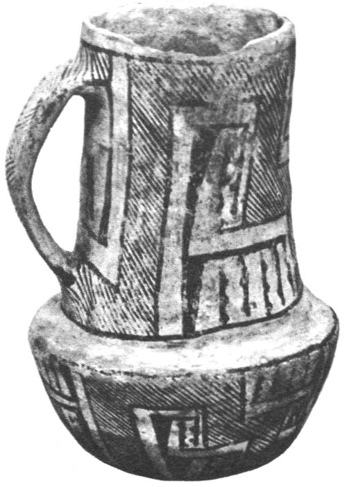
A pottery “kiva” jar. Mesa Verde style. Diameter at mouth, 4½″; Maximum diameter, 13⅓″; Height, 9½″.
But there is a double mystery at Aztec: as indicated earlier, overlying the evidences of a Chaco-phase occupation, Morris found evidence of rebuilding and rehabitation of many rooms. Large-sized Chaco rooms had been shortened, reduced, or cut off by interior walls and lowered ceilings. Older doorways had been blocked up, or had been partially filled and reduced in size. In some cases entire small rooms, complete with ceilings, had been built within larger rooms. New floors had been laid down upon the debris and windblown sand which partially filled some of the older rooms. Older beams had been pulled out of rooms and reused elsewhere, or new walls in a different style had been built in place of those that had collapsed.
A newer style of pottery, reminiscent of the Mesa Verde-type pottery, was prevalent. The majority of burials found within the ruins, 149 out of a total of 186, seemed to belong to a different period as shown by the type of artifacts associated with them. T-shaped doorways, an architectural trait characteristic of Mesa Verde times, was prevalent in the later parts of the pueblo. Keyhole-shaped kivas, another Mesa Verde trait, were inserted into and between rooms of the earlier period. And finally, the Great Kiva in the central plaza, which had fallen into disuse, was rehabilitated—in a much poorer style of construction, surely, but nonetheless obviously repaired and temporarily put back into use.
These factors inclined Morris to feel that some time after A.D. 1124 the pueblo at Aztec was abandoned by the Chacoan builders. Then about 1225, a new group arrived, bringing with them the general styles and culture of the area we know as Mesa Verde.
As with the earlier occupation at Aztec, we do not know exactly who these second people were or exactly where they came from, although it is obvious that they had a close affiliation with the people of the Mesa Verde area. Nor do we know if they were a large group, representing a mass migration, or whether once again some of the local population may have decided to attempt building a large community. Perhaps for a second time a few people, possessing special abilities or representing a religious organization, prevailed upon either the local population of the Animas Valley or wandering migrant groups to assist them in erecting large community structures.
We do know that at about this time there was a considerable [32] population shift all over the Mesa Verde area. The people were dispersing from their normal habitats and moving into more protected locations or consolidating into larger, more defensible units. In the Mesa Verde itself, for example, they were abandoning their mesatop pueblos and crowding together in the caves or moving out of the area entirely. In the Hovenweep area, they retreated to the heads of the canyons and built watchtowers along the canyon sides and bottoms to protect their dwindling water supplies. It was evidently a period of considerable strife and turmoil. There were short periods of recurrent drought, and possibly many of these groups had begun to fight among themselves over land and water rights and other necessities of life.
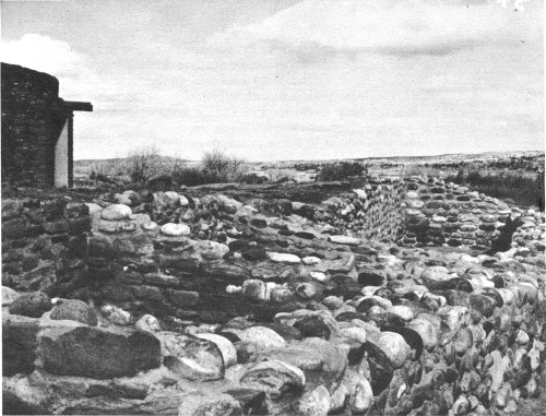
Cobblestone walls at Aztec Ruins.
The second occupation at Aztec was more intensive and one in which parts of the local population participated actively. The construction style of this period shows a considerable use of local cobblestones set in adobe mortar, as in many of the small ruins throughout the Animas. Sometimes cobblestone walls are overlaid or underlaid by, or even intermingled with, sandstone walls. It [33] was at this time also, as far as we know, that the other pueblo units—now all ruins—within the monument boundary were constructed, as well as several other major Mesa Verde-phase structures elsewhere in the Animas Valley.
In addition, large quantities of new material had to be secured fairly rapidly to keep pace with the feverish building activities at Aztec. While some of the rooms of the large Chaco-style pueblo were rehabilitated by these new inhabitants, others were dismantled and their materials, in addition to those from fallen walls, were used elsewhere. But even this great pueblo could not supply all the stone needed. So from the old quarry to the site of the pueblo two paths were built, side by side, each wide enough for eight men to walk abreast. For many months, men with stone mauls and hammers cracked and chopped and ground the sandstone into building blocks. Other men and the stronger boys toiled all day in straggling lines, carrying the blocks on large wooden litters or in great slings strung on poles. Long lines of workers streamed down one path, loaded with blocks, to return over the other path with their empty litters and slings.
Although the Great Kiva was repaired, with rather sloppy workmanship in many places, it was probably only used for a brief period. The focal point of the community’s religious life seems to have centered around the peculiar and somewhat puzzling tri-wall structures, two of which exist at Aztec. One is the excavated Hubbard Mound site just to the northwest of the main ruin; the other is Mound F, which is also to the northwest of the other major but largely unexcavated ruin—the East Ruin. If there was such a thing at this time as the beginning of a priestly hierarchy among the Pueblo peoples, these tri-wall structures with their centralized kivas may have been the domiciles and religious quarters of this hierarchy.
Once again life seemed to flourish at Aztec. This time, with all the extra pueblo units close to each other, the area must have resembled a veritable beehive. It would have taken an extensive farming area to support the population. If a shift in the river had cut the Chacoans’ canal, another shift back again may have made it possible to restore the old canal, improve it, and once again make the surrounding fields green in summer with growing corn, beans, squash, and cotton.
In contrast to the Chacoan occupation, Morris found a large number of burials (149) from this period, mostly in the rooms. Many were buried with great care and had numerous and varied grave offerings. For a while, evidently, the Pueblos prospered and traded far and wide for luxury items. But once again bad times set in, possibly accompanied by almost constant armed harassment by less fortunate groups. Although Morris did not find any direct evidence [34] that the people at Aztec were actually killed off or driven out by armed conflict, the later burials were all hastily made and usually unaccompanied by grave offerings. In addition, almost the entire east wing had been destroyed by fire. This could have been accidental and such a disaster might have proven the final straw for an already beleaguered group; or they may have fired the pueblo before leaving, or some marauding group might have been responsible.
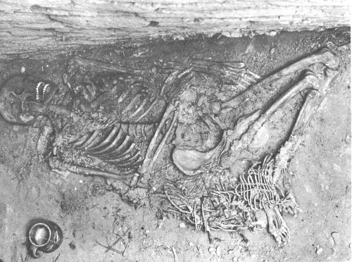
An Aztec Ruins burial with pottery mug in situ.
Exactly why, after 25 or 30 years, the second group also abandoned the site we may never know. Times were hard in the Four Corners country, and by 1300 this area seems to have been virtually depopulated. Perhaps the abandonment of Aztec, sometime after 1252, was simply a local manifestation of this much larger dispersal.
No doubt the great drought of the last quarter of that century contributed substantially to this general abandonment, but there must have been other factors at work as well. The Indians regard the forces of nature in a different manner than we do. They may have been struggling through long years, not only with nature but among themselves. They may have felt that their gods were against them, that somehow they had offended them, and that nothing [35] they could do in that country would be right again. It may have seemed easier to them, family by family, group by group, and perhaps pueblo by pueblo, to give up the struggle and go elsewhere, to start over in new surroundings where the gods might smile upon them once again.
Despite popular opinion, and despite the name applied to the ruins, the Indians who built this ancient pueblo were not related to the warlike Aztecs of Mexico. In the late 1800’s, there was considerable interest in the seemingly mysterious Aztec, Toltecs, and other Indians of Mexico. The writings of Stephens, Prescott and others had fired imaginations, and new communities—particularly those in the vicinity of Indian ruins—were often given names of Indian groups from south of the border.
So it was with the town of Aztec. When white settlers first moved into the Animas Valley, they were intrigued by the great stone ruins. Believing them to be the work of a long-vanished race from the south, they named their town Aztec.
The ruins, in turn, became known as “those ruins at Aztec” or simply as “the Aztec ruins,” and so the name remains today. We know now that the Aztecs of Mexico, whom Cortez conquered, had nothing to do with these ruins. In fact, they were built and abandoned several centuries before Cortez, and even before the Aztecs themselves were well established in the Valley of Mexico.
The earliest reference to ruins along the Animas River in the vicinity of Aztec is found on the map of Escalante’s Expedition in 1776-77. On that map, the cartographer, Miera y Pacheco, has written in between the lines representing the Animas and Florida Rivers the following:
The branches of these two rivers are capable of being inhabited by very large populations as is shown by the ruins of very ancient towns.
It is doubtful that Escalante or any of his party actually saw the Aztec ruins themselves, since the map would indicate that they were well north of that particular spot, probably somewhere in the vicinity of the present-day Durango. Further, the Escalante map shows the Rio Florida as flowing directly into the San Juan where actually it flows into the Animas. Likewise, it shows what are now known as the La Plata and Mancos Rivers as flowing into the Animas, whereas they flow directly into the San Juan. If any of the Escalante party had followed these streams or the Animas to their junction with the San Juan, these mistakes would not have been made on the map, so the party must, therefore, have been well north of what is now Aztec.
Possibly other earlier explorers may have passed near, or by, the Aztec ruins, but the next recorded visit occurred on August 4, 1859, when Dr. John Strong Newberry visited the site. Newberry, like many of the 19th-century men of science, was a man of many talents. He graduated from Western Reserve University in 1846, then obtained a degree in medicine, and later studied geology in Paris. At one time or another he was associated with the Smithsonian Institution and also taught geology at Columbian (now George Washington) University. In 1859, he accompanied Capt. T. N. Macomb (a topographical engineer) on an exploring trip from Santa Fe to the junction of the Grand (now upper reaches of the Colorado River) and Green Rivers where they formed the Colorado River. The following paragraph about the Aztec ruins is taken from his account of this trip:
The principal structures are large pueblos handsomely built of stone, and in a pretty good state of preservation. The external walls are composed of yellow Cretaceous sandstone, dressed to a common smooth surface without hammer-marks; in some places they are still 25 feet in height. As usual in buildings of this kind, the walls were unbroken by door or window to a height of 15 feet above the foundation. The interior shows a great number of small rooms, many of which are in a perfect state or preservation, and handsomely plastered. These structures are surrounded by mounds and fragments of masonry, marking the sites of great numbers of subordinate buildings; the whole affording conclusive evidence that a large population once had its home here.
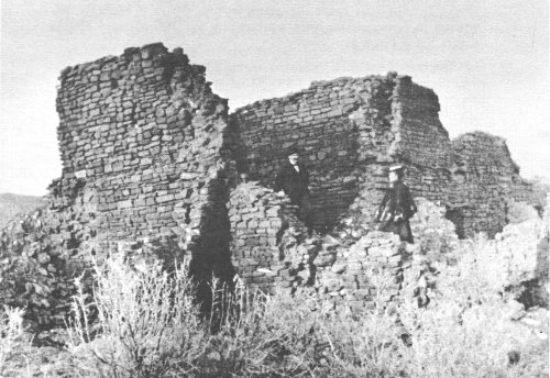
Aztec Ruins in 1895.
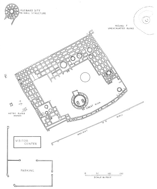
AZTEC RUINS—GROUND PLAN
White settlement of the valley around the ruins area began in 1876, and from that time on the ruins have been well known.
The first scientific investigations of the ruins were made in 1878, when Lewis H. Morgan visited the site and later published a description with a good ground plan. Morgan, sometimes known as “the father of American anthropology,” was one of the most distinguished scientists of the 19th century. He is well known for his ethnological studies of the Iroquois Indians in New York. Though usually thought of as a “social anthropologist,” Morgan had a great and abiding interest in archeology, particularly that of the southwestern part of what is now the United States, Mexico, and Central America. On his trip to the Southwest in 1878, he kept a journal full of observations and notes about the various ruins which he visited.
In those days the railroad extended only to Canyon City, Colo., and from there Morgan and his party had to proceed by wagon. One of the ruins which especially seemed to intrigue Morgan was the one on the Animas River, which we now call Aztec. He not only made a ground plan of the entire ruin, but noted that there were other structures of considerable size and interest in the immediate vicinity. He also entered some of the rooms, particularly in the west wing of the larger ruin, which still had their ceilings intact. Even at that time, evidently a good bit of the ruin had already been destroyed by the early settlers, for Morgan records the fact that one man at Animas City, who had lived near the ruins, told him that about one quarter of the stones had been taken away by the settlers to use in building houses, lining wells, or for other construction purposes. Morgan also talks about entering rooms on the second story, so presumably some of these upper stories may still have been intact in 1878.
In 1892, Warren K. Moorehead visited the Aztec ruins, studied them, and in 1908, he published an article and sketch map in the American Anthropologist. Moorehead is better known for his work among the prehistoric mounds and temples in southeastern United States than for investigations in the Southwest, but he was a competent archeologist and keen observer of prehistoric remains. He and his party, like other early explorers, were evidently able to enter a number of intact rooms—he says, “twenty or thirty apartments.”
In 1915, Dr. N. C. Nelson, who was then curator of archeology for the American Museum of Natural History, examined the ruins and was impressed by their potential for further intensive investigations. At this time the museum was undertaking the Archer M. Huntington Survey of the Southwest, one of the objectives of which was to make an intensive study of a large pueblo site. Because of Nelson’s recommendations, permission was obtained in 1916, from the owner, H. D. Abrams, to clear it of brush and [39] weeds and to make trial excavations, the expense of this undertaking being borne by J. P. Morgan. As a result of these preliminary investigations the museum decided that complete excavation and repair of the West Ruin was desirable not only for the purpose of procuring data on the culture of its ancient builders, but also, in order that it might be preserved as a permanent exhibit. As a result, the museum engaged the services of Morris, who for the next 5 years devoted his time and attention to very careful excavations of the West Ruin.
However, some 35 years before Morris undertook his excavations, an interesting and somewhat fortuitous event occurred at the old ruins that caused them to gain notoriety, at least locally.
By 1880 the settlers in the valley, concerned about the education of their children, had established a small, 1-room school. Sherman S. Howe, long a resident of the Animas area, was one of the first boys to attend this school, and in 1947, a few years before his death, he recorded for posterity his remembrances of the valley and the first real exploration of the Aztec ruins. A schoolteacher named Johnson, who hailed from Michigan and who must have been quite a remarkable man for his day, was greatly intrigued by the ruins. Sometime during the winter of 1881-82, he encouraged the school children to go out with him for a day on a trip to explore the ruins. Howe remembers the event well, for although he was among the younger boys, he was also among the first to volunteer to go. The following Saturday, about seven or eight of the boys arrived at the Aztec ruins with picks, shovels, and a crowbar, to meet with the teacher. As Howe used to tell it:
It was snowing a little and quite cold. We went into a second-story room, more than half full of dirt, and began digging down at the corner of the room. We struck the second floor at about five feet, and broke a hole through about two and one-half feet in diameter, but could see nothing but a black dungeon below. There was a prolonged debate about the depth of it, what might be at the bottom, and how a person could ever get back if he did go down there. Some thought it might be full of rats, skunks, bats, or rattlesnakes. We could imagine a hundred things. I believe the dread of ghosts was the worst.
Howe evidently wanted to be the first one down but the teacher felt it would be better if one of the older boys went first; so one was selected and lowered on a rope. Naturally at the last moment the boy was a little hesitant about being lowered into a dark hole which, after being sealed airtight for centuries, had a “musty odor which was not at all pleasant.” Finally, however, having been teased by his friends, he dropped down into the room. Soon the rest of the boys were also getting down the best way they could. As Howe described it:
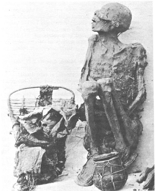
Mummies of Aztec Ruins.
We were in a room—a clean room, with ceiling and walls, open doorways, all just as they had been left. We were walking on floors which had not been trodden by human feet for centuries. There was an open door leading into the next room to the northwest. It was also clean and in perfect condition. There was no trash on the floor, no ashes, nor even a scrap of pottery.
Mr. Johnson seemed disappointed and puzzled. “Who were these people who built these large buildings and such splendid rooms? Did they not leave something behind that would give us some information? Could they not write, to give us some description of themselves or a bit of history?” Such thoughts and questions as these were racing through the mind of our teacher. He was thinking aloud, and making us do some thinking also. I felt very nervous and uncomfortable down in that dark, dismal place.
Disappointed at not finding anything in these first two rooms, the teacher and his boys broke a hole through one of the walls into a third room next door. This room, too, had been sealed for many centuries, and the candles they had brought would not burn properly until enough fresh air had circulated through the hole in the wall. But this room held a surprise for the boys. Bit by bit, as their candles burned better the room became brighter, and then:
When we could see across the room, there was a human skeleton facing us with its back to the wall. It had been placed there with no wrappings around it whatever. It was not mummified, but the ligaments had dried, holding the bones in place except that the head had tilted back and was resting against the wall. There was some dried skin and hair lying around it. The body had been flexed in the usual manner, but instead of wrapping and tying in the matting, as the custom was, it seemed to have been just placed there nude. We all stood motionless, nobody saying a word. It must be that we were struck dumb with awe, and that we were debating in our minds whether to stand our ground or retreat.
This was as much as the boys and the teacher could do in the short time they had the first day out at the ruins, but they all agreed that they would meet again the following Saturday and continue their explorations. However, during the week the boys had told their parents about what they were doing, and the next Saturday when Howe showed up there was a crowd of older men present who quickly began to break into a number of other rooms. Howe remembers entering one room with them:
We entered the room through the hole in the floor and passed through the open doorway into the northwest room. We broke a hole through the wall and entered the room to the northeast, and there we really did see things! I got into that room and stood, trying my best to take it all in and see everything I could, while that excited crowd were rummaging it, scattering and turning everything into a mess. There were thirteen skeletons ranging from infants to adults. The infants were two in number. The skulls had not knit together. One of them had two teeth. All were wrapped in matting similar to that around tea chests that come from China, and tied with strings made from fiber of the yucca plant. There were large pieces of cotton cloth. Most of it was plain, resembling our ten-ounce duck. It was in good state of preservation except that it was somewhat colored with age. Some of the cloth had a colored (red) design in stripes. There was also some feather cloth, and several pieces of matting of various types. There were several baskets, some of the best that I have ever seen, all well preserved. There were a lot of sandals, some very good, others showing considerable wear. There was a large quantity of pottery, all Mesa Verde. Some of the pottery was very pretty and new looking.
There were a great many beads and ornaments. I cannot give a description of these, as I had no opportunity to examine them closely. I remember seeing quite a lot of turquoise. There were a number of stone axes, polished, and much nicer in appearance than the average [42] type found in this vicinity. There were also skinning knives, so-called, and sandal lasts; cushions or rings they wore on their heads for carrying burdens—some made of yucca, nicely woven or braided; some made very plain, in coils of yucca strips, tied in various places to hold the strips together; some were made of juniper bark wrapped with strings, and some were made of corn husks. These may have been used also as jar rests to support vessels with convex bottoms which would not stand upright very well without some kind of support.
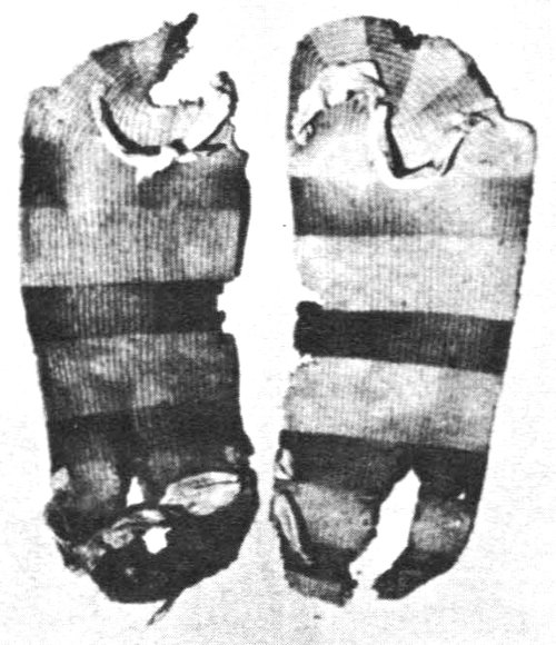
Woven yucca sandals.
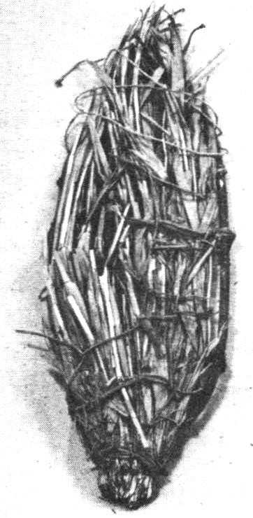
Probable snowshoe made of willow, reeds, and yucca fibers. Length 20″.
Obviously, findings such as these could not long remain a secret, and for a considerable time it was a favorite weekend sport to hunt for old remains at this ruin and others in the immediate vicinity. A great quantity of invaluable archeological material must have been carried away in this manner and has long since been lost or scattered among private individuals. A little of it got into museum collections, but most of it was carried off by the people who found it and who then left it in obscure corners of their houses until it was broken or lost. As Howe himself said in his later days when he remembered these early findings:
When we had finished this work, the stuff was taken out and carried off by different members of the party, but where is it now? Nobody knows. Like most of the material from the smaller pueblos around the larger buildings, it is gone. I, being only a small kid, did not get my choice of artifacts, I had to take what was left, which made a nice little collection, at that. But it, too, is about all gone.
We went on with our work, opening all of the rooms that visitors [43] now pass through with the guides, but we found nothing more. The holes that we made through the walls have been converted into doorways through which all visitors now pass from room to room.
For a number of years, rather indiscriminate looting by pothunters and others interested in these antiquities continued sporadically. Luckily, the pothunters did not get into the rooms which seemed to require a lot of hard work and digging, but merely broke into those rooms which were still more or less intact and in which readily accessible material was lying around on the floor or scattered through the debris.
In 1889, a patent covering the site of the Aztec ruins was issued to John R. Kuntz and continued in his possession until 1907, when it was transferred to H. D. Abrams. Due largely to the efforts of these gentlemen, the ruins were relatively protected against vandalism until it could be scientifically investigated by Morris in 1916.
The name of Earl H. Morris is well known in Southwestern archeology. Although he also did considerable archeological work in Central America, particularly at the Temple of the Warriors at Chichen Itza in Yucatan, trying to unravel the story of the prehistoric inhabitants of the American Southwest was always his first love. Morris was born on October 24, 1889, in Chama, N. Mex. His family had originally come west from the Pennsylvania oil fields in the mid-1870’s, and his father engaged in construction work such as building railway grades and roads, digging canals, and hauling freight. In 1891, the elder Morris moved his family to Farmington, N. Mex. There, he was able to rent out his teams on a canal construction project. This left him free to pursue his hobby—digging for Indian antiquities—the love of which he was able to impart to his son Earl.
When Earl was 3½ years old he actually excavated his first Indian pot. As he used to tell it:
One morning in March of 1893, Father handed me a worn-out pick, the handle of which he had shortened to my length, and said: “Go dig in that hole where I worked yesterday, and you will be out of my way.” At my first stroke there rolled down a roundish, gray object that looked like a cobblestone, but when I turned it over, it proved to be the bowl of a black-on-white dipper. I ran to show it to my mother. She grabbed the kitchen butcher knife and hastened to the pit to uncover the skeleton with which it had been buried. Thus, at three and a half years of age there had happened the clinching event that was to make of me an ardent pot hunter, who later on was to acquire the more creditable, and I hope earned, classification as an archaeologist.
Morris’ father was killed when he was 15, and he had to go to work to support his mother and to put himself through school and college as well. In 1908, he entered the University of Colorado, [44] but he left temporarily to join an archeological expedition to the Maya country of Guatemala. Later he returned to college and received his B.A. in 1914 and his M.A. in 1916.
The Earl Morris house about 1933; today the Aztec Ruins Visitor Center.
Having spent the winter of 1915 in New York City at Columbia University, Morris was well acquainted with the leading archeologists at the American Museum of Natural History. It was, therefore, upon Dr. Nelson’s recommendation that the ruins at Aztec would make an excellent subject for intensive study by the museum, that Morris was hired to conduct the investigations. He was in charge of the Aztec excavations from 1916-21, and sporadically through 1923, at which time the area became a National Monument. Morris was the first custodian, as they were called in those days, and was officially appointed on February 8, 1923, at the salary of $12 per annum.
He not only excavated the major part of the West Ruin very carefully, but also stabilized and repaired the walls as he went along, for the museum greatly desired that this ruin might be preserved as an outstanding monument. Later, in 1933-34, Morris’ services were loaned to the National Park Service by the Carnegie Institution so that he might accurately restore and reroof the Great Kiva at Aztec.
Morris dug in a number of other places throughout the Southwest in addition to Aztec and therefore was in a better position than any other man of his time to interpret and explain the development of the prehistoric cultures in the Four Corners country. He produced a number of valuable archeological reports, most of them under the auspices of the Carnegie Institution for which he worked for many years. With his death in 1956, Southwestern archeology suffered a severe loss, for there are not many scientific investigators with both his skill and motivation. As his lifelong friend A. V. Kidder has said about him:
Throughout his career, Morris was doubly motivated. First, of course, by the urge to trace the course and discern the causes of historical events and cultural developments. Secondly, by an exceptionally ardent wish to make evident to the world of today the achievements of the past. Back of this was his own admiration for and striving to preserve all ancient things that were beautifully and soundly made. I think he may also have felt, perhaps subconsciously, an obligation to repay, by rescuing their work from oblivion, the men and women of long ago whose artistry and manual skills gave him such keen and lasting pleasure.
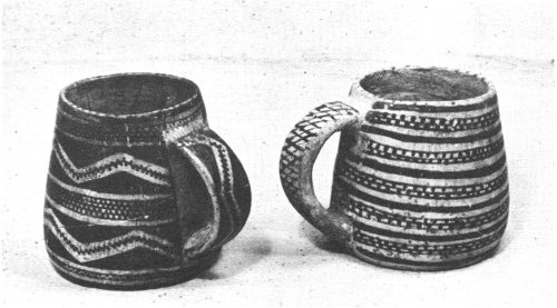
Mesa Verde-style pottery mugs. Left mug: Diameter at bulge, 4⅓″; Diameter at mouth, 3″; Height, 4¼″. Right mug: Diameter at bulge, 4⅓″; Diameter at mouth, 3″; Height, 4¼″.
Digging in ruins such as at Aztec, where a dry climate has helped preserve many perishable items normally lost to archeologists and where there was always the opportunity of suddenly discovering a fairly complete and undisturbed room, must have been a stimulating experience to a man of Morris’ capabilities. One has only to browse through his reports and articles, or to glance at the [46] pictures therein, to get the feeling of intense excitement about each discovery that prevailed throughout the 5 years he was digging there. It would be impossible to describe everything that Morris excavated, but several of the burials that he uncovered were of exceptional interest.
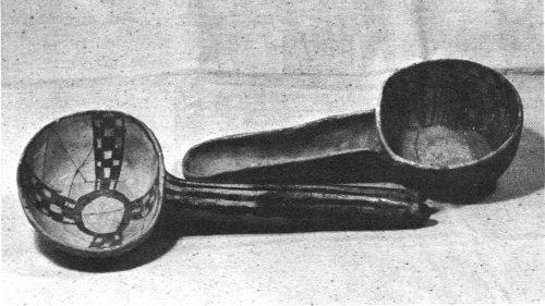
Pottery ladles from Aztec Ruins. Left ladle: Diameter of bowl, 4¼″; Handle length, 12½″; Height, 2¼″. Right ladle: Diameter of bowl, 5″; Handle length, 6¾″; Height, 2½″.
One consists of what may be the only known case of prehistoric Pueblo surgery. In one of the rooms Morris found the remains of a young female 17 to 20 years of age accompanied by several bowls and a pottery mug. The body had been wrapped in an excellently woven cotton cloth, which in turn, had been covered by a mantle of feather cloth and finally, with a mat of plaited rushes. The young lady had been seriously injured, perhaps in a fall, for the hip had been severely fractured, several vertebrae cracked, and both bones of the left forearm badly broken. But what was of particular interest, was that an attempt had been made to treat the broken arm. Six wooden splints, each flat on one side and convex on the other, had been bound in longitudinal position around the arm. As Morris said, if the Indians who attempted to help this girl realized that her pelvis was also broken they were unable to do anything about that, but evidently they had attempted to set the arm and return it to normal. Unfortunately, death occurred before sufficient time had elapsed to permit the healing to begin, so we do not know how successful this sort of treatment might have been. Although the surgery may seem crude and bungling to us, [47] at least it shows an awareness of what was wrong and an attempt to correct it.
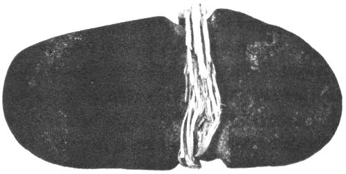
Full-grooved ax with fragment of hafting material. Length, 7″; Maximum width, 3½″; Width at groove, 2¾″.
Another fascinating burial was the one which Morris referred to as the “warrior’s grave”, in which he found an adult male buried in a grave-pit sunk into the floor of a room. A wrapping of feather cloth enveloped the entire body, and there had been an equally extensive outer covering of rush matting. Along with numerous other grave offerings of artifacts and pottery vessels, a large, ornate shield was laid over the body. It consisted of a flat piece of coiled basketry 36 inches long and 31 inches wide, and on one side was lashed a hardwood handle. The outermost 5 coils of the shield had been coated with pitch and thickly spangled with minute flakes of selenite; the next 5 were stained dark red, while the remaining 48 were greenish-blue. In addition to the shield there were axes of a form intermediate between axes and hammers, so that it would appear they were intended for use as weapons rather than tools. One is beautifully fashioned from a piece of hematite or similar iron ore, and both had wooden handles which lay near the right hand of the body. Near the left hand was a long knife of red quartzite, positioned so that it might have been inserted in a belt or girdle. Also beside the body was a long, thin, tapering wooden object which might have been interpreted as a digging stick but which Morris felt would also have been serviceable as a sword.
It is not often an archeologist has an opportunity to uncover spectacular remains of this sort, but these are only two of the fascinating burials which Morris recovered from the Aztec ruins. In all he found 186 interments. Strangely enough, only 6, with possibly 2 others, could be identified as belonging to the Chacoan phase at Aztec; 149 were definitely of the Mesa Verde period, 12 others probably so, and 17 were found in circumstances which made it impossible to tell to which period they belonged.
But burials were not the only things which Morris uncovered. He began his diggings in the southeast corner of the ruin, excavating the entire east wing from south to north. The problem of [48] moving the dirt, debris, and fallen rocks was considerable, especially when he did not want merely to pile it off to one side where he might subsequently have to move it a second time. Furthermore, the ruin was to be stabilized as a permanent monument, so it was necessary to remove the debris well outside the ruin area. At one time he evidently considered building a sluiceway from an irrigation ditch which runs along a higher level on the north side of the ruin, thinking that most of the debris could be dumped in the sluice box and washed out to a lower area by the river. Perhaps this scheme did not prove to be feasible, for instead, during the first season’s excavations, he constructed a narrow-gage tramway on which the workmen ran dump cars. Unfortunately, this method of dirt removal did not work satisfactorily either, because the relatively light rails which were used would not support the weight of the loaded dump trucks. He also had difficulty with the size and quality of the wheels on the dumpcarts. Although excavators elsewhere have sometimes used this method of removing dirt, it frequently presents its own type of engineering problems. In the remaining years of the work at Aztec, Morris employed horse-drawn carts which could be loaded directly from the excavations and hauled to a vacant area to be dumped.
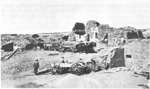
Early “diggings” at Aztec Ruins.
In many places the digging was extremely laborious, for over the centuries the dirt and debris had been packed into a consistency almost like that of concrete. In other places the rooms were full of all sorts of prehistoric rubbish, intermixed with broken artifacts [49] which had to be carefully sorted out. In describing the excavations in one room Morris said:
The ceiling failed in the most unusual way, the supports having been broken first at the center, then at each end, where they entered the wall. The small poles seemed to have parted from the walls almost as soon as the center timbers gave way. Some were standing upright against the end walls, while the majority were mashed back against and along the east wall. The splints, bark, and adobe were in a grievous tangle, most difficult to excavate. Above the first ceiling were decayed, but unburned, timbers and lumps of charcoal and reddened earth representing, respectively, the second and third ceilings.
Morris completely excavated the east wing and the eastern half of the north wing. In addition he also excavated 29 rooms in the west wing and about two-thirds of the small cobblestone 1-story rooms which close off the southern third of the plaza area.
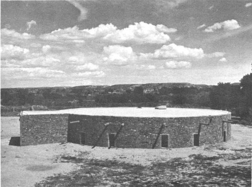
Exterior of the reconstructed Great Kiva.
Besides excavating many of the kivas enclosed within the pueblo rooms, Morris also excavated the large Chaco-like kiva in front of the northeast corner, as well as the Great Kiva which is centrally located on the south side of the plaza. Later, in 1933 and 1934, Morris returned to Aztec and supervised the stabilization and reconstruction of this Great Kiva, so that today you see it as it supposedly existed when the Indians used it for ceremonial purposes.
Immediately to the west of the main ruin, where the brush had been cleared, Morris found a rather extensive low mound area.
The surface was an orderless succession of hummocks and depressions, the former thickly strewn with cobblestones, the whole presenting an appearance characteristic of most of the ruins in this end of the valley.
Thinking these might be the remains of an earlier structure, he excavated most of it. To his surprise, the reverse proved to be true. Although there had undoubtedly been an earlier Chaco-like sandstone structure at this point, most of it had been torn down and the debris carried elsewhere or utilized in building the great ruin itself. Morris said:
Overlying the earliest remains there are deposits of clean earth, some of it presumably laid down by the elements, but the bulk of it is excavated earth intentionally dumped where it lies.
At some later date, the Mesa Verde-like people had built cobblestone houses, pit rooms, and small kivas on top of this earlier debris. Today the outline of some of these cobblestone walls can be seen on the ground just to the left of the visitor trail as it proceeds northward to enter the main part of the West Ruin.
Since Morris’ excavations at Aztec, there has been sporadic digging, much of it in connection with the Service’s ruins stabilization program. To prevent soil moisture from seeping into the lower footings of these ancient walls, it is frequently necessary to dig down to their bases and cap them with concrete or preserve them by other suitable methods. In doing so, old refuse pits, broken fragments of pottery, or even a burial is occasionally turned up.
Recently, in making excavations in which to place dry barrels for drainage purposes in two rooms on the east side, two interesting ovenlike structures, each exactly centered in a room, were accidentally found. Their location in adjoining rooms, and their central position in the rooms, precludes the possibility that they were pit ovens from an earlier period before the pueblo was built. Doubtless they had been placed deliberately in these two rooms, and they may have been used for roasting large quantities of corn or preparing certain types of baked corn meal or cornbread.
Also since Morris’ time, the rooms through which you may now pass, and which lie between the plaza proper and the rooms with the intact ceilings, have been partially excavated in order to allow you easier access to the plaza. Finally, as part of the stabilization program, the remaining rooms in the south wing which enclosed the plaza, and which were largely composed of cobblestones, were cleared and stabilized.
Morris also excavated a few rooms in the East Ruin simply as a test to see if it belonged to the same general period as the larger ruin in the west. From his findings there he felt that the East Ruin was erected during the Mesa Verde phase of Aztec.
In recent years, one other major excavation has been undertaken at Aztec. This was the complete clearing and stabilization of the circular structure to the north of the ruin known as the Hubbard Mound—a massive, circular, triple-walled structure, with underlying scattered remains of earlier structures. Two heavy radial cobblestone walls now extend to the south of the main structure, and excavations revealed remnants of other heavy walls disappearing under the road to the west. This indicates that the building had originally been one corner of a group of structures. The main part of the Hubbard Mound consists of three concentric circular walls; the spaces between the outer two rings are partitioned into rooms. There are 8 rooms in the inner circle, including an entrance room on the south, and 14 in the outer, if you again count an open passageway on the south side.
Interestingly enough, the three circular walls are heavier and extend deeper into the underlying sand than do the partition walls, and therefore were constructed first as continuous circles. Within the innermost circle there is a standard, small-type kiva. Evidently the entire structure represents a building for the use of a highly specialized religious organization. Part of the construction is of sandstone blocks, part is cobblestone, and all of it seems to have been generously plastered with adobe mud.
There are other examples of tri-walled structures in the Southwest, but they are not very numerous and the exact uses to which they might have been put are unknown. An analysis of materials found during the excavation of the Hubbard Mound reveals that it belonged to the Mesa Verde phase.
When Morris first undertook the excavations at Aztec it was his intention, and that of the American Museum of Natural History, to excavate the ruins completely. However, the undertaking was a massive one. World War I intervened, with all its uncertainties, and funds frequently ran short. In the later days of the excavations, Morris realized there was an advantage to leaving parts of any ruin unexcavated so that better archeological techniques in the future might extract information of which he was unaware. At present, the National Park Service feels much the same way. Perhaps 25 or 50 years from now further excavations may be undertaken in this area, but for the present, the ruins will be left as they are, complete with their feeling of mystery.
Aztec Ruins National Monument consists of an enclosed area of 27 acres containing six major archeological complexes of rooms and structures, and at least seven or eight smaller mounds which may [52] contain structures or may simply be trash and refuse mounds from the larger occupation zones. Two of these major complexes have been excavated: the West Ruin and the Hubbard Mound. Two of the others—the East Ruin and Mound F—have been tested. Mound F is evidently very similar to the Hubbard Mound.
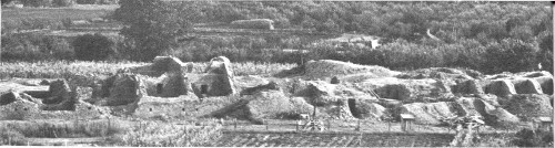
Aztec Ruins during excavations of the 1920’s.
The East Ruin, if excavated, might be similar in most respects to the West Ruin, both in appearance and time of occupation. As to whether the smaller mounds contain trash or house remains, only thorough archeological investigations can tell. Morris’ diggings and subsequent small tests have indicated there may be earlier (Developmental Pueblo) remains underlying the main prehistoric complexes. Also, such remains might still be found under the windblown sand in the flatter areas between the major ruins. No real archeological work has ever been done in the monument area to determine the possible extent of such earlier remains.
The two main sites seen by the visitor to the monument are, therefore, the West Ruin and the Hubbard Mound. The West Ruin was the one first entered by early settlers in the late 19th century. The profuse remains caused extensive digging and looting for about a decade. Then, under the ownership first of John R. Kuntz and later of H. D. Abrams, the area was given a certain amount of protection. During 1916-21, the American Museum of Natural History excavated extensively in the West Ruin under the guidance of Morris. Today, three-fourths of this ruin has been excavated, cleared, and stabilized so that you may gain a firsthand impression of its original appearance. The remaining one-fourth is largely unexcavated and, for all anyone knows, may contain archeological riches equal to any recovered in the early days or during the excavations by the American Museum of Natural History.
Although some of the rooms and walls seen by the first white settlers in the valley have now collapsed, evidence of at least three stories is still clearly visible in several places in the ruin. The main part consists of three sides of a rectangle with a slightly bowing outer wall on the fourth side, composed of single rooms, which seals off the central plaza. The only entrance into the pueblo was the one along the path by which visitors enter the ruin today.
The pueblo was built of yellowish-brown and tan sandstone blocks, most of them shaped into rectangles by pecking or grinding. To support the weight of the upper rooms, the lower walls are much thicker and are composed of rubble fill with an outer veneer wall of the better shaped rectangular blocks. In many places, the spaces between them are filled with small chinking stones set in adobe mud. Sometimes broken pieces of pottery vessels were used for spalls. Originally, the walls were plastered with layers of adobe, most of which, unfortunately, have eroded away.
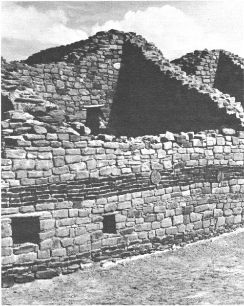
Section of wall at Aztec Ruins showing a band of green sandstone.
One unusual feature in the West Ruin consists of two very fine bands of green sandstone blocks which extend horizontally along the west outer wall of the pueblo and into a few of the interior [54] rooms of the southwest corner. There are indications in a few places that originally there may have been three such parallel bands.
The north and northwest sides of the ruin contain the most extensive building remains. The highest walls and best construction still exist there, and one can see evidence of at least three stories. Also in the north portion, along the extreme back row of rooms at the ground level, there is a series of seven rooms, each of which has its original ceiling intact. These seven were the first entered by early relic hunters, who found most of the original doorways to the south sealed up and who broke through the walls of each room in an easterly direction. These breaches in the walls have been repaired but left open, so that today you can go from one room to the next along the path taken by the early explorers rather than through the doorways used by the Indians.
From the plaza, the Indians gained access to these northwestern rooms by entering the west side rooms. Then, turning at right angles, they proceeded northward through the doorways and rooms until they reached the final row of rooms at the north.
Although not all are open to the public because of their difficulty of access, there are 19 rooms in the ruin which still have their original ceilings intact. In making a ceiling, the Indians used two or more main stringers—that is, large beams of pine or juniper—which they set into the walls of the room at a height of 8 or 9 feet, traversing the shorter dimension of the room. Running at right angles to the stringers, they placed cottonwood poles or splints of juniper, and, over these, reeds, rushes, or woven matting. Upon this they put adobe mud which was well packed to make a firm roof, or, if there was to be another room above it, a stout floor.
Since the entire ruin has not been excavated, it is possible there may be more rooms with ceilings intact, or others in which, although the ceilings have collapsed, the first-floor walls and part of the second remain. As far as we can tell from the excavated rooms and from the surface evidence, there are 221 first-story rooms. There are intact portions of 119 second-story rooms and at least 12 third-story rooms. When originally inhabited, there were many more than the 352 rooms that we can count today. Generally, access from one room to another was by doorways that led from the back or side portions of the pueblo out toward the central plaza. However, several rooms also had lateral doorways, many of which had at one time been sealed up, either by the first inhabitants or by the second group. When burials were made in a room, it must have been necessary to seal all the doorways, unless the bodies were placed in subfloor pits or covered with dirt or debris.
Among the second-story rooms in the northeastern section are four special doorways, each placed in the corner of a room so that [55] it connects with the adjoining diagonal room. As far as we know, corner doorways occur only in second-story rooms, with the possible exception of the double doorway mentioned below. One corner doorway leads into a room that had four normal doorways, one in each side. We do not know if this room had a special function, but it was the most accessible in the entire pueblo.
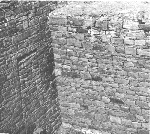
Section of wall at Aztec Ruins showing sealed door at left.
One corner doorway is possibly unique in the entire Southwest; beneath it is a second and much smaller one which led from the second-floor level into a first-floor room which could be entered only by this means. Although there is a step arrangement in this lower doorway, it is so small and its roof is so low that it must have been a matter of crawling rather than walking through it. This doorway enters the lower room so high in the wall that it would also have been necessary to have a ladder inside the room to enter or leave it.
In addition to doorways, many rooms, especially toward the back or sides of the pueblo and in the lower tiers, had one or two openings about a foot square, high in the back wall. These are above the height of an average man even today, and could not have served as view holes or windows for the Indians. They must have been put there for ventilation.
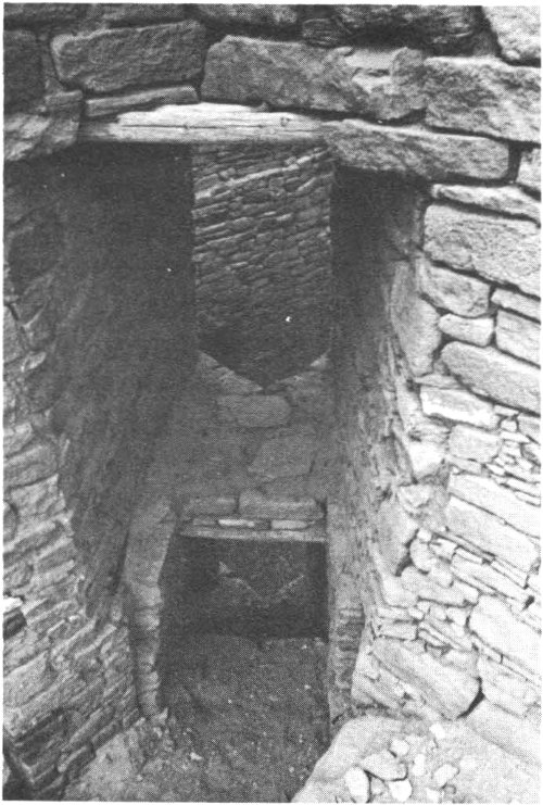
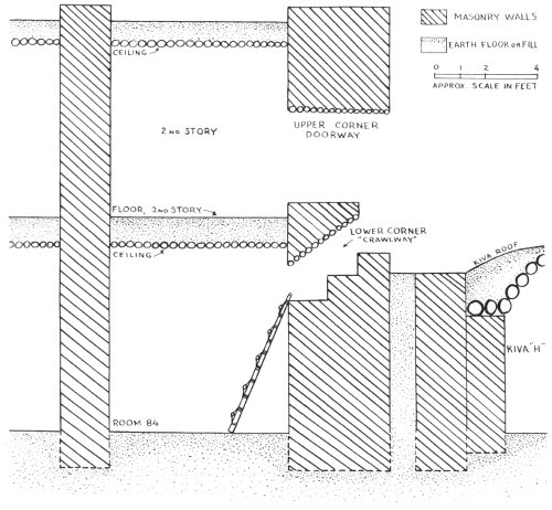
Cross section and photograph of an over-under corner doorway.
There are a few other openings in some walls which are not as large as the average doorway or as small as the ventilators. Usually these are placed at a medium height in the room and could well have served as windows to allow a view from one room to another. None of these so-called windows, however, opens to the rear or sides of the pueblo, nor is any known that opens onto the plaza in front.
Not counting the Great Kiva, which bulks so large in the plaza, excavations have revealed at least 29 other kivas or ceremonial chambers. Several, especially in the southeast corner, underlie the main structure and may represent kivas from the earlier or Developmental Pueblo Period. Besides the cluster of small kivas around the southeastern corner, there is a second grouping of larger kivas among the rooms in the northeast corner and out into the northeastern part of the plaza, where a rather large Chaco-type kiva is located. A third cluster, composed of smaller Mesa Verde-type keyhole kivas, is located near the southwestern corner of the pueblo, and Morris found scattered remains of one or two other kivas toward the front of the southwestern part.
The Great Kiva, or House of the Great Kiva as Morris called it, is centrally located in the south side of the plaza. It is essentially circular in form and has two distinct parts. The inner part—the kiva proper—has a floor about 8 feet below the surface. At ground level, and surrounding this inner section, is an outer circle of 14 arc-shaped rooms. Twelve of these are essentially similar, but the other two are markedly different. One is merely an open passage about 3½ feet wide which leads directly from the plaza to the head of the south stairway. The other is a large rectangular alcovelike structure on the north side of the kiva proper, with a stairway leading up into it from the kiva floor. On the north and west sides of this alcove, there is a low benchlike structure around the inner wall, and on the south side are what appear to be a piece of a wall and two rectangular masonry blocks. Toward the center back portion of the alcove is another low square masonry structure which may have been an altar. When excavated, this latter structure had burned poles embedded in the north side as though it once had a small roof or some kind of entablature over it.
The kiva proper is 41 feet 3½ inches wide at floor level and 48 feet 3½ inches wide at a height of 3 feet above the floor. This difference is caused by two benches or concentric rings which completely encircle the kiva base. At the north end three masonry steps led to the second bench, which at this point formed a fourth step in the stairway leading to the alcove. Above this, another [58] masonry step was surmounted by five sets of double juniper logs set in the sides of a recess, with an average rise of 9½ inches each. These logs formed the final steps leading from the kiva floor into the north alcove.
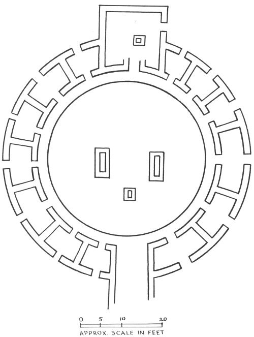
SCHEMATIC PLAN OF THE GREAT KIVA DURING CHACO TIMES
Originally there had also been a stairway on the south side, leading to the small exit at that point. Some time while the kiva was in use, these stairs had been eliminated, the two benches had been filled in smoothly at that point, and the recess above had been partially closed. The modern wooden stairways at both these points have been placed there by the National Park Service for the convenience of visitors.
On the floor of the kiva are remains of the central altar or firepit, flanked on either side by two large rectangular stone-lined pits, the bottoms of which are well below the kiva floor. These pits, often referred to as foot drums, may have served at other times as hiding places for the shamans, or medicine men, who performed magical rites during ceremonies.
Surrounding the kiva at ground level are 12 similar arc-shaped chambers of varying dimensions, which represent components of the building as last used. Some time during one or another of the several alterations made by the Indians on the Great Kiva, every door from the plaza into these peripheral chambers was sealed with masonry. The floor of the rooms was adobe, without much sign of use, and the quantity of gypsum found by Morris indicates they may have been painted white.
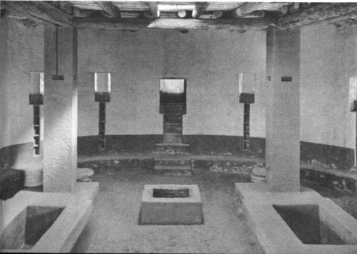
Reconstructed interior of the Great Kiva.
Once the outer doors were sealed, entrance was doubtless by way of the niched vertical stairways in front of each room. About 10 [60] inches from the top bench, in front of most of the alcove rooms, Morris found a slot 8½ inches wide and 8 inches deep which continued to the top of the wall. About a foot apart in each niche, were two round juniper sticks, laid side by side with their ends extending into the masonry. On the east side of the kiva, the veneer facing of the wall had fallen, and it could not be positively determined if these alcove rooms also had similar slot stairways in front of them. If they did not, the rooms would have been nonfunctional in connection with the kiva proper, and therefore the present-day restoration shows them correctly.
That the Great Kiva was originally roofed was determined by Morris’ finding the remains of four rectangular columns, countersunk below the level of the kiva floor and composed of alternating courses of masonry and wooden poles. Each course of wooden poles was laid at right angles to the alternating one below. Each column was supported by three thick circular sandstone blocks, evidently to prevent the weight of the columns, and the roof they supported, from pressing them down into the soft ground or spreading out the footings. In the excavation of the kiva fill Morris also found many pieces of charred timbers, so that although we do not know the exact method of roofing the kiva, one method which the Indians could have used has been duplicated in the modern reconstruction. Evidently the kiva burned and was then abandoned.
Just to the northwest of the main ruin at Aztec is a small tri-walled ceremonial structure known as the Hubbard Site. Sixty-four feet in diameter, it consists of three concentric walls of stone and adobe, with a small 24-foot circular kiva enclosed in the center. This kiva is not directly connected with any of the tri-walls; there is a space 1½ feet wide between the outer shell of the kiva and the inner side of the nearest wall. There are remains of eight roof pilasters, a central fireplace, a deflector, and a ventilator shaft in the kiva. On the south side are openings in the two outer walls, one directly behind the other, so that access could have been along this passage and then up over the roof of the kiva and down into it through the smoke hole. None of the rooms in the outer two circles connect in any way with the kiva.
There are seven rooms of roughly equal size within the inner circle; an eighth “room” might be the one mentioned above, which forms part of the passage leading out to the south. These rooms do not connect with each other, and access to each of them must have been through the roof.
In the outermost circle there are 13 rooms, with another constituting the outer portion of the south passage. This is the same number of alcoves as surrounded the Great Kiva, except that in the latter case two were entranceways. Here in the Hubbard Mound there is no north alcove entranceway as there is in the Great Kiva.
In the outer circle of rooms, the first four east of the south entrance opened into each other through a lateral doorway, and the next two rooms around to the northeast also opened into each other. The following room toward the north was self-contained. Proceeding around to the west, the next five rooms all opened on each other through lateral doorways. Finally, on the southwest there is a single room not connected to any other. None of the rooms in the outer circle opened onto any in the inner circle or to the outside, except for one doorway on the west which led to the series of five interconnecting rooms. The separate rooms and the other series of connecting rooms must have been entered through the roof.
Extending southward from the tri-wall structure are two massive parallel walls made of cobblestones laid in thick mortar, and two more equally massive walls extend westward from these. There are scattered smaller walls, also of cobblestones; while we do not know their original dimensions, they suggest rectangular enclosures which may have contained house rooms of lighter construction.
The ruins contained within the Aztec Ruins National Monument constitute a complex of prehistoric remains representative of several different construction periods. Different groups of Indians seemed to have been involved at various times, and only further excavation will fully clarify their relationships.
Aztec Ruins National Monument is located on the Animas River in northwestern New Mexico, about 20 miles below the Colorado State line and 14 miles above the point where the Animas flows into the San Juan. The monument is on the west bank of the Animas on high ground about halfway between the river and the low-lying hills and mesas which border the river valley.
The valley, although narrow at spots, is about 2 miles wide at the point where the ruins are located. The floor of the valley is composed of fertile alluvial soil, which produces fine crops if irrigated. Today, as in prehistoric times, the population of this area is concentrated along the river. It was this permanent source of water that induced the builders of the Aztec pueblo, and in later times the white man, to settle this valley. No doubt many of the fields cultivated today are the same ones that were tilled by the original inhabitants of the area.
The valley floor and valley terraces are dotted with saltbush, rabbitbrush, greasewood, and sagebrush. The riverbanks and ditches are lined with willows and huge cottonwoods. Cattails and reeds grow in the marshy areas, and wild roses grow in the shady spots. [62] The low hills and uplands bordering the river valley have a sparse cover of vegetation because of the small amount of rainfall. Therefore the main growth is juniper and pinyon. Typical of the Upper Sonoran Life Zone, these small, hardy trees can withstand dry periods and survive in semiarid country.
Today much of the valley is under cultivation or in pasture, and the mild and very dry climate is well suited to growing non-citrus fruit. Elevation at the monument is about 5,600 feet above sea level. Average annual rainfall is about 9½ inches; the humidity is usually very low. Temperatures will reach the mid-90’s during July and August, but evenings are cool and pleasant. Night temperatures in the 60’s are not uncommon even after the hottest summer days. Occasional afternoon thundershowers give relief from the heat during late July and August.
Skunk.
Spring and autumn are relatively dry seasons when the skies may [63] remain cloudless for weeks at a time. In September a great range of temperature from night to day—as much as 45°—is noticeable.
Porcupine.
The winters are mild. The temperature rarely drops to zero or below, and there are very few prolonged periods of cold weather. Infrequent snows are usually light, and melt quickly. Many days are warm and cloudless.
At the time that the Aztec pueblo was inhabited, no doubt a few deer, pronghorn (“antelope”), and bighorn could be found in and near the valley. Occasionally, deer still may be seen along the river to the north of Aztec Ruins. Many of the smaller animals which were familiar to the people of the Aztec pueblo are still present in the valley and may occasionally be observed in the monument. Jackrabbits, cottontails, rock squirrels, skunks, porcupines, and an occasional gray fox, all of which were probably well known to the Pueblo people, frequent the monument. Gambel’s quail and pheasants, [64] which are both relative newcomers, may also be seen in the monument. Ducks, geese, and a few large shore birds may be seen along the river during the cooler months. Meadowlarks, robins, and numerous other birds may be seen during warmer months.
Bobcat.
Several species of lizards and a few bullsnakes (which are harmless and beneficial and should not be disturbed) may be observed around the ruins area during summer.
Aztec Ruins National Monument was established by Presidential proclamation on January 24, 1923. Most of the land was donated to the Government by the American Museum of Natural History in 1921, 1928, and 1930. In 1931 an additional 6.8 acres was purchased by the Federal Government from the heirs of H. D. Abrams who had originally owned the entire site. And in 1947, the Southwestern Monuments Association purchased the 1.2 acres containing the Hubbard Mound and presented it to the Government. The monument, now containing 27.1 acres, is administered by the National Park Service, U.S. Department of the Interior.
Created in 1849, the Department of the Interior—America’s Department of Natural Resources—is concerned with the management, conservation, and development of the Nation’s water, wildlife, [65] mineral, forest, and park and recreational resources. It also has major responsibilities for Indian and Territorial affairs.
As the Nation’s principal conservation agency, the Department works to assure that nonrenewable resources are developed and used wisely, that park and recreational resources are conserved for the future, and that renewable resources make their full contribution to the progress, prosperity, and security of the United States—now and in the future.
A superintendent, whose address is Rt. 1, Box 101, Aztec, N. Mex., is in immediate charge of Aztec Ruins National Monument.
The visitor center at Aztec Ruins.
Other monuments in the National Park System also preserve the remains of different types of prehistoric ruins. Two of these, Mesa Verde National Park, Colo., and Chaco Canyon National Monument, N. Mex., contain remains of Indian groups which seem to have been related to those at Aztec Ruins National Monument. A third, Bandelier National Monument, N. Mex., contains remains of another type but still may be one of the areas in the Rio Grande drainage in which some of the Indians lived after they abandoned the San Juan region.
U.S. GOVERNMENT PRINTING OFFICE: 1963 of—665208