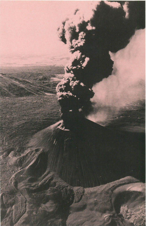
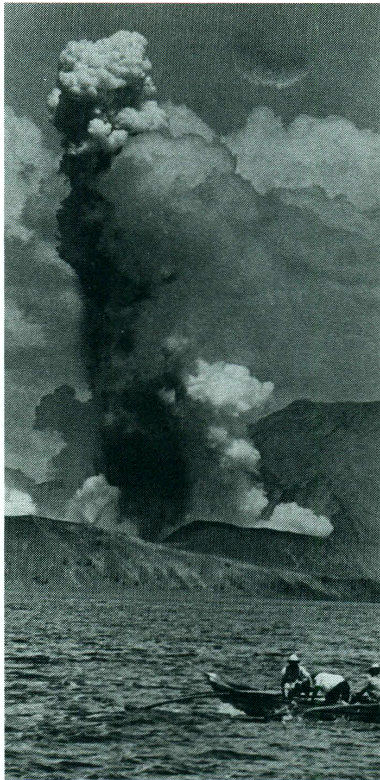
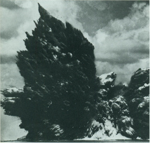
The eruption of Cerro Negro Volcano, near Leon, Nicaragua, during November 1968.
U. S. Department of the Interior / U. S. Geological Survey
by Robert I. Tilling
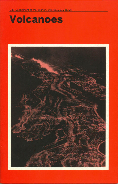
Cover and Title Page: Lava fountains and flows, Mauna Loa, Hawaii, July 6, 1975.
Volcanoes destroy and volcanoes create. The catastrophic eruption of Mount St. Helens on May 18, 1980, made clear the awesome destructive power of a volcano. Yet, over a time span longer than human memory and record, volcanoes have played a key role in forming and modifying the planet upon which we live. More than 80 percent of the Earth’s surface—above and below sea level—is of volcanic origin. Gaseous emissions from volcanic vents over hundreds of millions of years formed the Earth’s earliest oceans and atmosphere, which supplied the ingredients vital to evolve and sustain life. Over geologic eons, countless volcanic eruptions have produced mountains, plateaus, and plains, which subsequent erosion and weathering have sculpted into majestic landscapes and formed fertile soils.
Ironically, these volcanic soils and inviting terranes have attracted, and continue to attract, people to live on the flanks of volcanoes. Thus, as population density increases in regions of active or potentially active volcanoes, mankind must become increasingly aware of the hazards and learn not to “crowd” the volcanoes. People living in the shadow of volcanoes must live in harmony with them and expect, and should plan for, periodic violent unleashings of their pent-up energy.
This booklet presents a generalized summary of the nature, workings, products, and hazards of the common types of volcanoes around the world, along with a brief introduction to the techniques of volcano monitoring and research.

On August 24, A.D. 79, Vesuvius Volcano suddenly exploded and destroyed the Roman cities of Pompeii and Herculaneum. Although Vesuvius had shown stirrings of life when a succession of earthquakes in A.D. 63 caused some damage, it had been literally quiet for hundreds of years and was considered “extinct.” Its surface and crater were green and covered with vegetation, so the eruption was totally unexpected. Yet in a few hours, hot volcanic ash and dust buried the two cities so thoroughly that their ruins were not uncovered for nearly 1,700 years, when the discovery of an outer wall in 1748 started a period of modern archeology. Vesuvius has continued its activity intermittently ever since A.D. 79 with numerous minor eruptions and several major eruptions occurring in 1631, 1794, 1872, 1906 and in 1944 in the midst of the Italian campaign of World War II.

In the United States on March 27, 1980, Mount St. Helens Volcano in the Cascade Range, southwestern Washington, reawakened after more than a century of dormancy and provided a dramatic and tragic reminder that there are active volcanoes in the “lower 48” States as well as in Hawaii and Alaska. The catastrophic eruption of Mount St. Helens on May 18, 1980, and related mudflows and flooding caused significant loss of life (57 dead or missing) and property damage (over $1.2 billion). Mount St. Helens is expected to remain intermittently active for months or years, possibly even decades.
The word “volcano” comes from the little island of Vulcano in the Mediterranean Sea off Sicily. Centuries ago, the people living in this area believed that Vulcano was the chimney of the forge of Vulcan—the blacksmith of the Roman gods. They thought that the hot lava fragments and clouds of dust erupting from Vulcano came from Vulcan’s forge as he beat out thunderbolts for Jupiter, king of the gods, and weapons for Mars, the god of war. In Polynesia the people attributed eruptive activity to the beautiful but wrathful Pele, Goddess of Volcanoes, whenever she was angry or spiteful. Today we know that volcanic eruptions are not supernatural but can be studied and interpreted by scientists.
Volcanoes are mountains, but they are very different from other mountains; they are not formed by folding and crumpling or by uplift and erosion. Instead, volcanoes are built by the accumulation of their own eruptive products—lava, bombs (crusted over lava blobs), ashflows, and tephra (airborne ash and dust). A volcano is most commonly a conical hill or mountain built around a vent that connects with reservoirs of molten rock below the surface of the Earth. The term volcano also refers to the opening or vent through which the molten rock and associated gases are expelled.
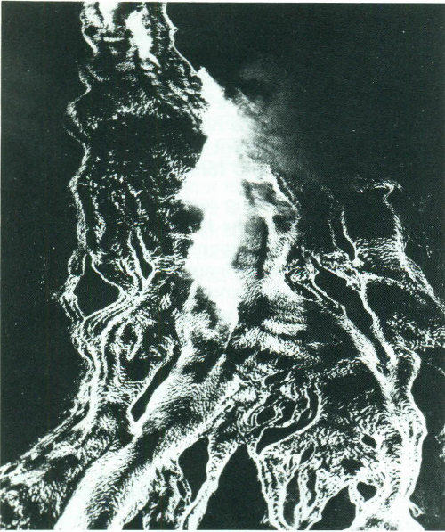
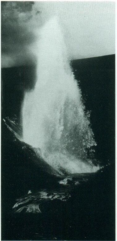
Fountaining lava and volcanic debris during the 1959 Kilauea Iki eruption of Kilauea Volcano, Hawaii.
Driven by buoyancy and gas pressure the molten rock, which is lighter than the surrounding solid rock, forces its way upward and may ultimately break through zones of weaknesses in the Earth’s crust. If so, an eruption begins, and the molten rock may pour from the vent as non-explosive lava flows, or it may shoot violently into the air as dense clouds of lava fragments. Larger fragments fall back around the vent, and accumulations of fall-back fragments may move downslope as ash flows under the force of gravity. Some of the finer ejected materials may be carried by the wind only to fall to the ground many miles away. The finest ash particles may be injected [5] miles into the atmosphere and carried many times around the world by stratospheric winds before settling out.
Molten rock below the surface of the Earth that rises in volcanic vents is known as magma, but after it erupts from a volcano it is called lava. Originating many tens of miles beneath the ground, the ascending magma commonly contains some crystals, fragments of surrounding (unmelted) rocks, and dissolved gases, but it is primarily a liquid composed principally of oxygen, silicon, aluminum, iron, magnesium, calcium, sodium, potassium, titanium, and manganese. Magmas also contain many other chemical elements in trace quantities. Upon cooling, the liquid magma may precipitate crystals of various minerals until solidification is complete to form an igneous or magmatic rock.
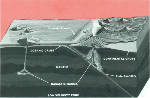
An idealized diagram of a volcano in an oceanic environment (left) and in a continental environment (right).
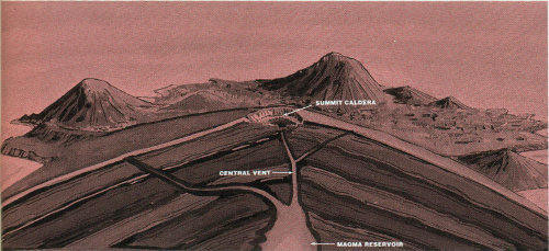
The diagram below shows that heat concentrated in the Earth’s upper mantle raises temperatures sufficiently to melt the rock locally by fusing the materials with the lowest melting temperatures, resulting in small, isolated blobs of magma. These blobs then collect, rise through conduits and fractures, and some ultimately may re-collect in larger pockets or reservoirs (“holding tanks”) a few miles beneath the Earth’s surface. Mounting pressure within the reservoir may drive the magma further upward through structurally weak zones to erupt as lava at the surface. In a continental environment, magmas are generated in the Earth’s crust as well as at varying depths in the upper mantle. The variety of molten rocks in the crust, plus the possibility of mixing with molten materials from the underlying mantle, leads to the [6] production of magmas with widely different chemical compositions.
If magmas cool rapidly, as might be expected near or on the Earth’s surface, they solidify to form igneous rocks that are finely crystalline or glassy with few crystals. Accordingly, lavas, which of course are very rapidly cooled, form volcanic rocks typically characterized by a small percentage of crystals or fragments set in a matrix of glass (quenched or super-cooled magma) or finer grained crystalline materials. If magmas never breach the surface to erupt and remain deep underground, they cool much more slowly and thus allow ample time to sustain crystal precipitation and growth, resulting in the formation of coarser grained, nearly completely crystalline, igneous rocks. Subsequent to final crystallization and solidification, such rocks can be exhumed by erosion many thousands or millions of years later and be exposed as large bodies of so-called granitic rocks, as, for example, those spectacularly displayed in Yosemite National Park and other parts of the majestic Sierra Nevada mountains of California.
Lava is red hot when it pours or blasts out of a vent but soon changes to dark red, gray, black, or some other color as it cools and solidifies. Very hot, gas-rich lava containing abundant iron and magnesium is fluid and flows like hot tar, whereas cooler, gas-poor lava high in silicon, sodium, and potassium flows sluggishly, like thick honey in some cases or in others like pasty, blocky masses.
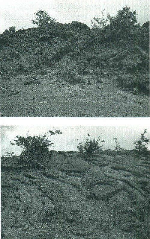
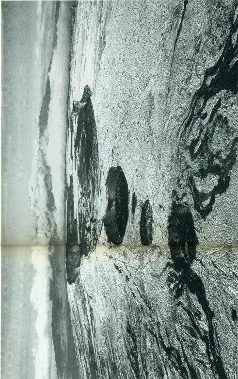
Two Polynesian terms are used to identify the surface character of Hawaiian lava flows. Aa, a basalt with a rough, blocky appearance, much like furnace slag, is shown at the top. Pahoehoe, a more fluid variety with a smooth, satiny and sometimes glassy appearance, is shown at the bottom.
All magmas contain dissolved gases, and as they rise to the surface to erupt, the confining pressures are reduced and the dissolved gases are liberated either quietly or explosively. If the lava is a thin fluid (not viscous), the gases may escape easily. But if the lava is thick and pasty (highly viscous), the gases will not move freely but will build up tremendous pressure, and ultimately escape with explosive violence. Gases in lava may be compared with the gas in a bottle of a carbonated soft drink. If you put your thumb over the top of the bottle and shake it vigorously, the gas separates from the drink and forms bubbles. When [7] you remove your thumb abruptly, there is a miniature explosion of gas and liquid. The gases in lava behave in somewhat the same way. Their sudden expansion causes the terrible explosions that throw out great masses of solid rock as well as lava, dust, and ashes.
The violent separation of gas from lava may produce rock froth called pumice. Some of this froth is so light—because of the many gas bubbles—that it floats on water. In many eruptions, the froth is shattered explosively into small fragments that are hurled high into the air in the form of volcanic cinders (red or black), volcanic ash (commonly tan or gray), and volcanic dust.
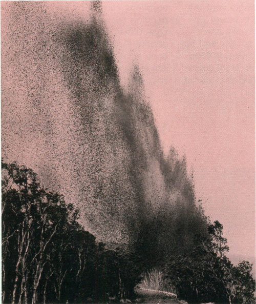
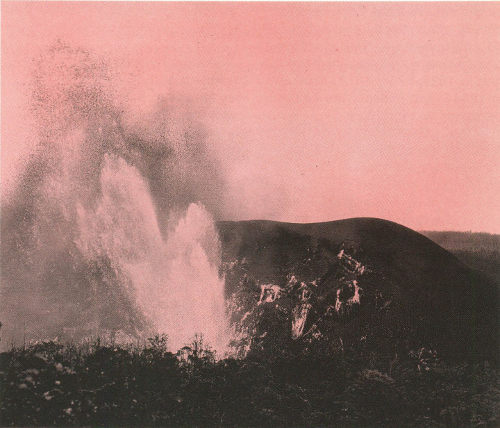
During the 1959 eruption of Kilauea Iki, fountaining lava and volcanic debris completely blocked several of the roads in the Hawaii Volcanoes National Park.
Geologists generally group volcanoes into four main kinds—cinder cones, composite volcanoes, shield volcanoes, and lava domes.
Cinder cones are the simplest type of volcano. They are built from particles and blobs of congealed lava ejected from a single vent. As the gas-charged lava is blown violently into the air, it breaks into small fragments that solidify and fall as cinders around the vent to form a circular or oval cone. Most cinder cones have a bowl-shaped crater at the summit and rarely rise more than a thousand feet or so above their surroundings. Cinder cones are numerous in western North America as well as throughout other volcanic terrains of the world.
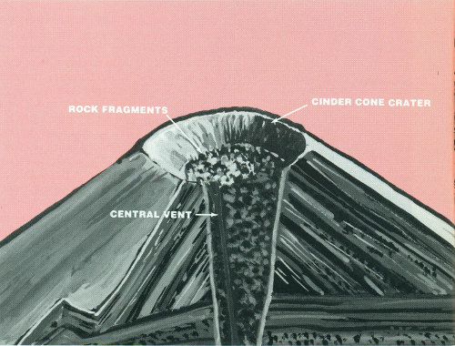
Schematic representation of the internal structure of a typical cinder cone.
In 1943 a cinder cone started growing on a farm near the village of Parícutin in Mexico. Explosive eruptions caused by gas rapidly expanding and escaping from molten lava formed cinders that fell back around the vent, building up the cone to a height of 1,200 feet. The last explosive eruption left a funnel-shaped crater at the top of the [9] cone. After the excess gases had largely dissipated, the molten rock quietly poured out on the surrounding surface of the cone and moved downslope as lava flows. This order of events—eruption, formation of cone and crater, lava flow—is a common sequence in the formation of cinder cones.
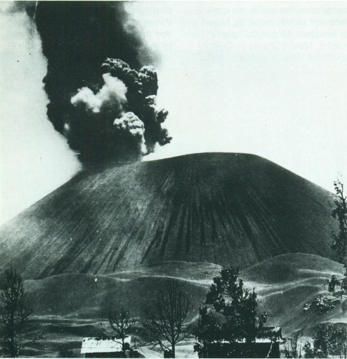
Parícutin Volcano, Mexico, is a cinder cone rising approximately 1,200 feet above the surrounding plain.
During 9 years of activity, Parícutin built a prominent cone, covered about 100 square miles with ashes, and destroyed the town of San Juan. Geologists from many parts of the world studied Parícutin during its lifetime and learned a great deal about volcanism, its products, and the modification of a volcanic landform by erosion.
Some of the Earth’s grandest mountains are composite volcanoes—sometimes called stratovolcanoes. They are typically steep-sided, symmetrical cones of large dimension built of alternating layers of lava flows, volcanic ash, cinders, blocks, and bombs and may rise as much as 8,000 feet above their bases. Some of the most conspicuous and beautiful mountains in the world are composite volcanoes, including Mount Fuji in Japan, Mount Cotopaxi in Ecuador, Mount Shasta in California, Mount Hood in Oregon, and Mount St. Helens and Mount Rainier in Washington.
Most composite volcanoes have a crater at the summit which contains a central vent or a clustered group of vents. Lavas either flow through breaks in the crater wall or issue from fissures on the flanks of the cone. Lava, solidified within the fissures, forms dikes that act as ribs which greatly strengthen the cone.
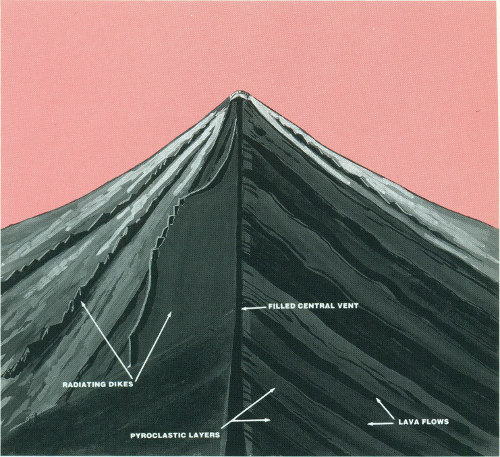
Schematic representation of the internal structure of a typical composite volcano.
The essential feature of a composite volcano is a conduit system through which magma from a reservoir deep in the Earth’s crust rises to the surface. The volcano is built up by the accumulation of material [11] erupted through the conduit and increases in size as lava, cinders, ash, etc., are added to its slopes.
When a composite volcano becomes dormant, erosion begins to destroy the cone. As the cone is stripped away, the hardened magma filling the conduit (the volcanic plug) and fissures (the dikes) becomes exposed, and it too is slowly reduced by erosion. Finally, all that remains is the plug and dike complex projecting above the land surface—a telltale remnant of the vanished volcano.
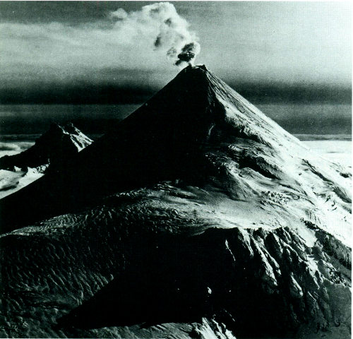
Shishaldin Volcano, an imposing composite cone, towers 9,372 feet above sea level in the Aleutian Islands, Alaska.
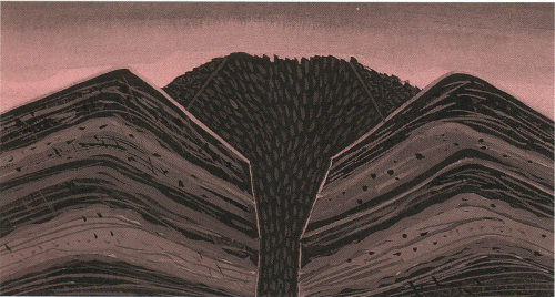
An interesting variation of a composite volcano can be seen at Crater Lake in Oregon. From what geologists can interpret of its past, a high volcano—called Mount Mazama—probably similar in appearance to present-day Mount Rainier was once located at this spot. Following a series of tremendous explosions about 6,800 years ago, the volcano lost its top. Enormous volumes of volcanic ash and dust were expelled and swept down the slopes as ash flows and avalanches. These large-volume explosions [12] rapidly drained the lava beneath the mountain and weakened the upper part. The top then collapsed to form a large depression, which later filled with water and is now completely occupied by beautiful Crater Lake. A last gasp of eruptions produced a small cinder cone, which rises above the water surface as Wizard Island near the rim of the lake. Depressions such as Crater Lake, formed by collapse of volcanoes, are known as calderas. They are usually large, steep-walled, basin-shaped depressions formed by the collapse of a large area over, and around, a volcanic vent or vents. Calderas range in form and size from roughly circular depressions 1 to 15 miles in diameter to huge elongated depressions as much as 60 miles long.
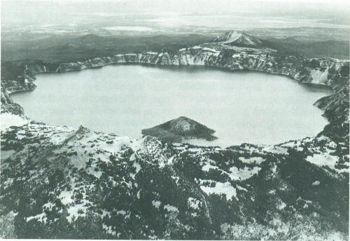
Crater Lake, Oregon; Wizard Island, a cinder cone, rises above the lake surface.
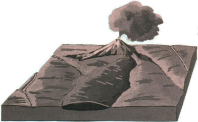
a. Magma, rising upward through a conduit, erupts at the Earth’s surface to form a volcanic cone. Lava flows spread over the surrounding area.
b. As volcanic activity continues, perhaps over spans of hundreds of years, the cone is built to a great height and lava flows form an extensive plateau around its base. During this period, streams enlarge and deepen their valleys.
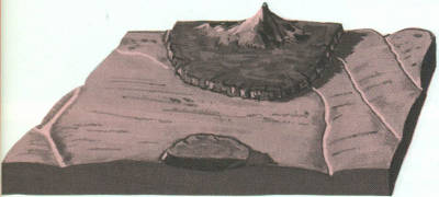
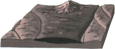
c. When volcanic activity ceases, erosion starts to destroy the cone. After thousands of years, the great cone is stripped away to expose the hardened “volcanic plug” in the conduit. During this period of inactivity, streams broaden their valleys and dissect the lava plateau to form isolated lava-capped mesas.
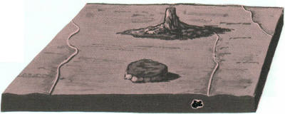
d. Continued erosion removes all traces of the cone and the land is worn down to a surface of low relief. All that remains is a projecting plug or “volcanic neck,” a small lava-capped mesa, and vestiges of the once lofty volcano and its surrounding lava plateau.
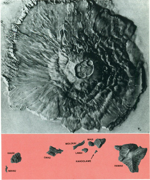
Shield volcanoes, the third type of volcano, are built almost entirely of fluid lava flows. Flow after flow pours out in all directions from a central summit vent, or group of vents, building a broad, gently sloping cone of flat, domical shape, with a profile much like that of a warrior’s shield. They are built up slowly by the accretion of thousands of highly fluid lava flows called basalt lava that spread widely over great distances, and then cool as thin, gently dipping sheets. Lavas also commonly erupt from vents along fractures (rift zones) that develop on the flanks of the cone. Some of the largest volcanoes in the world are shield volcanoes. In northern California and Oregon, many shield volcanoes have diameters of 3 or 4 miles and heights of 1,500 to 2,000 feet. The Hawaiian Islands are composed of linear chains of these volcanoes including Kilauea and Mauna Loa on the island of Hawaii—two of the world’s most active volcanoes. The floor of the ocean is more than 15,000 feet deep at the bases of the islands. As Mauna Loa, the largest of the shield volcanoes (and also the world’s largest active volcano), projects 13,677 feet above sea level, its top is over 28,000 feet above the deep ocean floor.
In some eruptions, basaltic lava pours out quietly from long fissures instead of central vents and floods the surrounding countryside with lava flow upon lava flow, forming broad plateaus. Lava plateaus of this type can be seen in Iceland, southeastern Washington, eastern Oregon, and southern Idaho. Along the Snake River in Idaho, and the Columbia River in Washington and Oregon, these lava flows are beautifully exposed and measure more than a mile in total thickness.
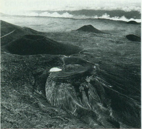
Mauna Loa Volcano, Hawaii, a giant among the active volcanoes of the world; snow-capped Mauna Kea Volcano in the distance.
The internal structure of a typical shield volcano.
A sketch of the havoc wrought in St. Pierre Harbor on Martinique during the eruption of Mont Pelée in 1902.
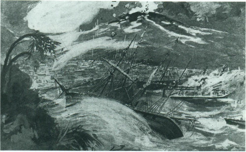
Volcanic or lava domes are formed by relatively small, bulbous masses of lava too viscous to flow any great distance; consequently, on extrusion, the lava piles over and around its vent. A dome grows largely by expansion from within. As it grows its outer surface cools and hardens, then shatters, spilling loose fragments down its sides. Some domes form craggy knobs or spines over the volcanic vent, whereas others form short, steep-sided lava flows known as “coulees.” Volcanic domes commonly occur within the craters or on the flanks of large composite volcanoes. The nearly circular Novarupta Dome that formed during the 1912 eruption of Katmai Volcano, Alaska, measures 800 feet across and 200 feet high. The internal structure of this dome—defined by layering of lava fanning upward and outward from the center—indicates that it grew largely by expansion from within. Mont Pelée in Martinique, Lesser Antilles, and Lassen Peak and Mono domes in California are examples of lava domes. An extremely destructive eruption [17] accompanied the growth of a dome at Mont Pelée in 1902. The coastal town of St. Pierre, about 4 miles downslope to the south, was demolished and nearly 30,000 inhabitants were killed by an incandescent, high-velocity ash flow and associated hot gases and volcanic dust. Only two men survived; one because he was in a poorly ventilated, dungeon-like jail cell and the other who somehow made his way safely through the burning city.
The Novarupta Dome formed during the 1912 eruption of Katmai Volcano, Alaska.
Schematic representation of the internal structure of a typical volcanic dome.
Congealed magma, along with fragmental volcanic and wallrock materials, can be preserved in the feeding conduits of a volcano upon cessation of activity. These preserved rocks form crudely cylindrical masses, from which project radiating dikes; they may be visualized as the fossil remains of the innards of a volcano (the so-called “volcanic plumbing system”) and are referred to as volcanic plugs or necks. The igneous material in a plug may have a range of composition similar to that of associated lavas or ash, but may also include fragments and blocks of denser, coarser grained rocks—higher in iron and magnesium, lower in silicon—thought to be samples of the Earth’s deep crust or upper mantle plucked and transported by the ascending magma. Many plugs and necks are largely or wholly composed of fragmental volcanic material and of fragments of wallrock, which can be of any type. Plugs that bear a particularly strong imprint of explosive eruption of highly gas-charged magma are called diatremes or tuff-breccia.
Volcanic plugs are believed to overlie a body of magma which could be either still largely liquid or completely solid depending on the state of activity of the volcano. Plugs are known, or postulated, to be commonly funnel shaped and to taper downward into bodies increasingly elliptical in plan or elongated to dike-like forms. Typically, volcanic plugs and necks tend to be more resistant to erosion than their enclosing rock formations. Thus, after the volcano becomes inactive and deeply eroded, the exhumed plug may stand up in bold relief as [19] an irregular, columnar structure. One of the best known and most spectacular diatremes in the United States is Ship Rock in New Mexico, which towers some 1,700 feet above the more deeply eroded surrounding plain. Volcanic plugs, including diatremes, are found elsewhere in the western United States and also in Germany, South Africa, Tanzania, and Siberia.
Ship Rock, San Juan County, New Mexico.
Also called “tuff cones,” maars are shallow, flat-floored craters that scientists interpret have formed above diatremes as a result of a violent expansion of magmatic gas or steam; deep erosion of a maar presumably would expose a diatreme. Maars range in size from 200 to 6,500 feet across and from 30 to 650 feet deep, and most are commonly filled with water to form natural lakes. Most maars have low rims composed of a mixture of loose fragments of volcanic rock and rocks torn from the walls of the diatreme.
Maars occur in the western United States, in the Eifel region of Germany, and in other geologically young volcanic regions of the world. An excellent example of a maar is Zuni Salt Lake in New Mexico, a shallow saline lake that occupies a flat-floored crater about 6,500 feet across and 400 feet deep. Its low rim is composed of loose pieces of basaltic lava and wallrocks (sandstone, shale, limestone) of the underlying diatreme, as well as random chunks of ancient crystalline rocks blasted upward from great depths.
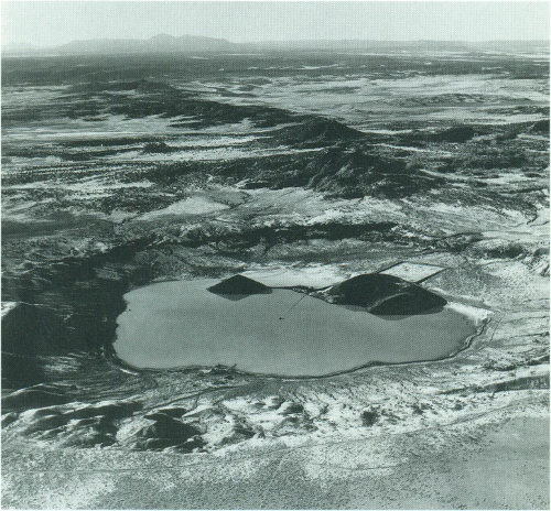
Zuni Salt Lake Maar, Catron County, New Mexico.
Some well-exposed, nearly circular areas of intensely deformed sedimentary rocks, in which a central vent-like feature is surrounded by a ring-shaped depression, resemble volcanic structures in gross form. As no clear evidence of volcanic origin could be found in or near these structures, scientists initially described them as “cryptovolcanic,” a term now rarely used. Recent studies have shown that not all craters are of volcanic origin. Impact craters, formed by collisions with the Earth of large meteorites, asteroids, or comets, share with volcanoes the imprints of violent origin, as evidenced by severe disruption, and even local melting, of rock. Fragments of meteorites or chemically detectable traces of extraterrestrial materials and indications of strong forces acting from above, rather than from below, distinguish impact from volcanic features.
Other possible explanations for these nonvolcanic craters include subsurface salt-dome intrusion (and subsequent dissolution and collapse); collapse caused by subsurface limestone dissolution and/or ground-water withdrawal; and collapse related to melting of glacial ice. An impressive example of an impact structure is Meteor Crater, Ariz., which is visited by thousands of tourists each year. This impact crater, 4,000 feet in diameter and 600 feet deep, was formed in the geologic past (probably 30,000-50,000 years before present) by a meteorite striking the Earth at a speed of many thousands of miles per hour.
In addition to Meteor Crater, very fresh, morphologically distinct, impact craters are found at three sites near Odessa, Tex., as well as 10 or 12 other locations in the world. Of the more deeply eroded, less obvious, postulated impact structures, there are about ten well-established sites in the United States and perhaps 80 or 90 elsewhere in the world.
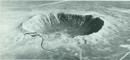
Meteor Crater, Arizona.
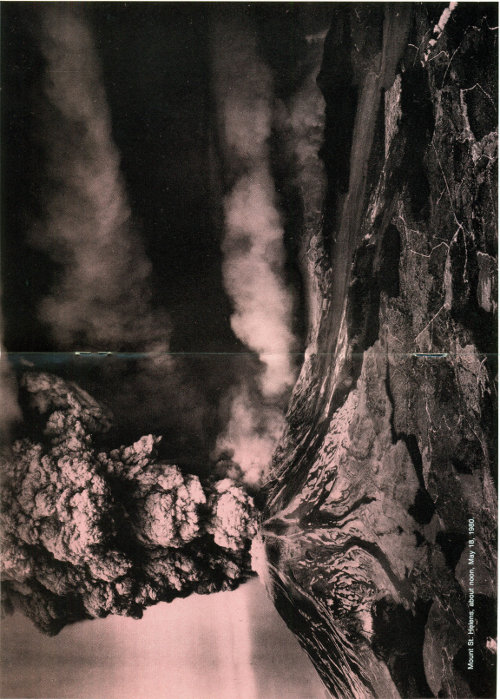
Mount St. Helens, about noon, May 18, 1980.
During an episode of activity, a volcano commonly displays a distinctive pattern of behavior. Some mild eruptions merely discharge steam and other gases, whereas other eruptions quietly extrude quantities of lava. The most spectacular eruptions consist of violent explosions that blast great clouds of gas-laden debris into the atmosphere.
The type of volcanic eruption is often labeled with the name of a well-known volcano where characteristic behavior is similar—hence the use of such terms as “Strombolian,” “Vulcanian,” “Vesuvian,” “Peléan,” “Hawaiian,” and others. Some volcanoes may exhibit only one characteristic type of eruption during an interval of activity—others may display an entire sequence of types.
In a Strombolian-type eruption observed during the 1965 activity of Irazú Volcano in Costa Rica, huge clots of molten lava burst from the summit crater to form luminous arcs through the sky. Collecting on the flanks of the cone, lava clots combined to stream down the slopes in fiery rivulets.
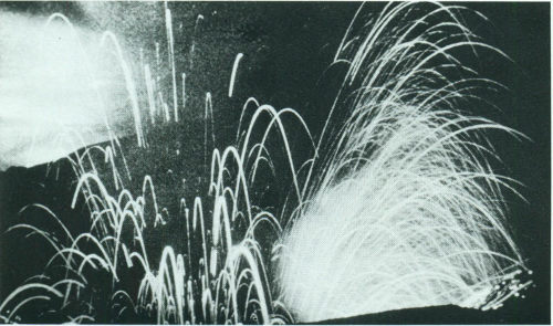
Irazú Volcano, Costa Rica, 1965.
In contrast, the eruptive activity of Parícutin Volcano in 1947 demonstrated a “Vulcanian”-type eruption, in which a dense cloud of ash-laden gas explodes from the crater and rises high above the peak. Steaming ash forms a whitish cloud near the upper level of the cone.
In a “Vesuvian” eruption, as typified by the eruption of Mount Vesuvius in Italy in A.D. 79, great quantities of ash-laden gas are violently discharged to form a cauliflower-shaped cloud high above the volcano.
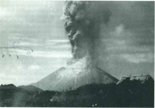
Parícutin Volcano, Mexico, 1947.
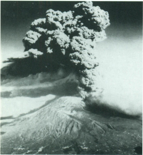
Mount Vesuvius Volcano, Italy, 1944.
In a “Peléan” or “Nuée Ardente” (glowing cloud) eruption, such as occurred on the Mayon Volcano in the Philippines in 1968, a large quantity of gas, dust, ash, and incandescent lava fragments are blown out of a central crater, fall back, and form tongue-like, glowing avalanches that move downslope at velocities as great as 100 miles per hour. Such eruptive activity can cause great destruction and loss of life if it occurs in populated areas, as demonstrated by the devastation of St. Pierre during the 1902 eruption of Mont Pelée on Martinique, Lesser Antilles.
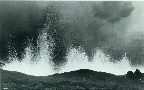
“Hawaiian” eruptions may occur along fissures or fractures that serve as linear vents, such as during the eruption of Mauna Loa Volcano in Hawaii in 1950; or they may occur at a central vent such as during the 1959 eruption in Kilauea Iki Crater of Kilauea Volcano, Hawaii. In fissure-type eruptions, molten, incandescent lava spurts from a fissure on the volcano’s rift zone and feeds lava streams that flow downslope. In central-vent eruptions, a fountain of fiery lava spurts to a height of several hundred feet or more. Such lava may collect in old pit craters to form lava lakes, or form cones, or feed radiating flows.
Mauna Loa Volcano, Hawaii, 1950.
“Phreatic” (or steam-blast) eruptions are driven by explosive expanding steam resulting from cold ground or surface water coming into contact with hot rock or magma. The distinguishing feature of phreatic explosions is that they only blast out fragments of preexisting solid rock from the volcanic conduit; no new magma is erupted. Phreatic activity is generally weak, but can be quite violent in some cases, such as the 1965 eruption of Taal Volcano, Philippines, and the 1975-76 activity at La Soufrière, Guadeloupe (Lesser Antilles).
The most powerful eruptions are called “plinian” and involve the explosive ejection of relatively viscous [27] lava. Large plinian eruptions—such as during 18 May 1980 at Mount St. Helens or, more recently, during 15 June 1991 at Pinatubo in the Philippines—can send ash and volcanic gas tens of miles into the air. The resulting ash fallout can affect large areas hundreds of miles downwind. Fast-moving deadly pyroclastic flows (“nuées ardentes”) are also commonly associated with plinian eruptions.
Kilauea Volcano, Hawaii, 1959.
Taal Volcano, Philippines, 1965.
Submarine volcanoes and volcanic vents are common features on certain zones of the ocean floor. Some are active at the present time and, in shallow water, disclose their presence by blasting steam and rock-debris high above the surface of the sea. Many others lie at such great depths that the tremendous weight of the water above them results in high, confining pressure and prevents the formation and explosive release of steam and gases. Even very large, deep-water eruptions may not disturb the ocean surface.
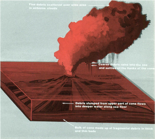
Schematic representation of a typical submarine eruption in the open ocean.
The unlimited supply of water surrounding submarine volcanoes can cause them to behave differently from volcanoes on land. Violent, steam-blast eruptions take place when sea water pours into active shallow submarine vents. Lava, erupting onto a shallow sea floor or flowing into the sea from land, may cool so rapidly that it shatters into sand and rubble. The result is the production of huge amounts of fragmental volcanic debris. The famous “black sand” beaches of Hawaii were created virtually instantaneously by the violent interaction between hot lava and sea water. On [29] the other hand, recent observations made from deep-diving submersibles have shown that some submarine eruptions produce flows and other volcanic structures remarkably similar to those formed on land. Recent studies have revealed the presence of spectacular, high-temperature hydrothermal plumes and vents (called “smokers”) along some parts of the mid-oceanic volcanic rift systems. However, to date, no direct observation has been made of a deep submarine eruption in progress.
During an explosive submarine eruption in the shallow open ocean, enormous piles of debris are built up around the active volcanic vent. Ocean currents rework the debris in shallow water, while other debris slumps from the upper part of the cone and flows into deep water along the sea floor. Fine debris and ash in the eruptive plume are scattered over a wide area in airborne clouds. Coarse debris in the same eruptive plume rains into the sea and settles on the flanks of the cone. Pumice from the eruption floats on the water and drifts with the ocean currents over a large area.
Submarine eruption of Myojin-sho Volcano, Izu Islands, Japan on September 23, 1952.
Geysers, fumaroles (also called solfataras), and hot springs are generally found in regions of young volcanic activity. Surface water percolates downward through the rocks below the Earth’s surface to high-temperature regions surrounding a magma reservoir, either active or recently solidified but still hot. There the water is heated, becomes less dense, and rises back to the surface along fissures and cracks. Sometimes these features are called “dying volcanoes” because they seem to represent the last stage of volcanic activity as the magma, at depth, cools and hardens.
Erupting geysers provide spectacular displays of underground energy suddenly unleashed, but their mechanisms are not completely understood. Large amounts of hot water are presumed to fill underground cavities. The water, upon further heating, is violently ejected when a portion of it suddenly flashes into steam. This cycle can be repeated with remarkable regularity, as for example, at Old Faithful Geyser in Yellowstone National Park, which erupts on an average of about once every 65 minutes.
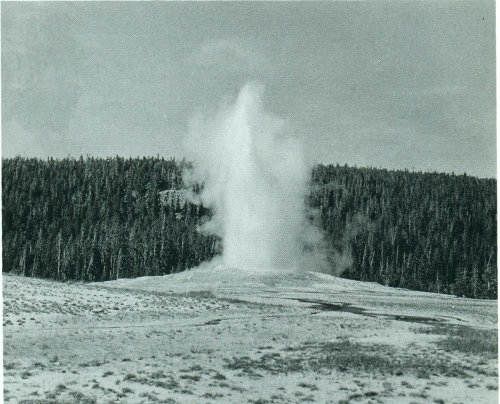
Old Faithful Geyser, Yellowstone National Park, Wyoming.
Fumaroles, which emit mixtures of steam and other gases, are fed by conduits that pass through the water table before reaching the surface of the ground. Hydrogen sulfide (H2S), one of the typical gases issuing from fumaroles, readily oxidizes to sulfuric acid and native sulfur. This accounts for the intense chemical activity and brightly colored rocks in many thermal areas.
Hot springs occur in many thermal areas where the surface of the Earth intersects the water table. The temperature and rate of discharge of hot springs depend on factors such as the rate at which water circulates through the system of underground channelways, the amount of heat supplied at depth, and the extent of dilution of the heated water by cool ground water near the surface.
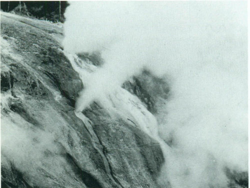
Black Growler steam vents (fumaroles), Norris Basin, Yellowstone National Park, Wyoming.
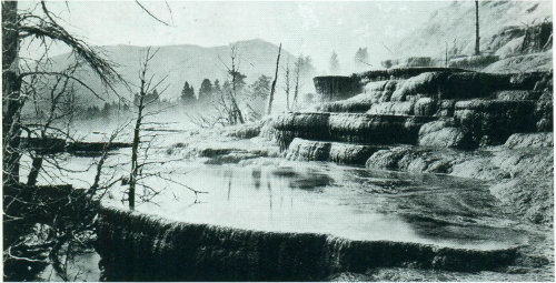
Mammoth Hot Springs, Yellowstone National Park, Wyoming.
There are more than 500 active volcanoes (those that have erupted at least once within recorded history) in the world—50 of which are in the United States (Hawaii, Alaska, Washington, Oregon, and California)—although many more are hidden under the seas. Most active volcanoes are strung like beads along, or near, the margins of the [33] continents, and more than half encircle the Pacific Ocean as a “Ring of Fire.”
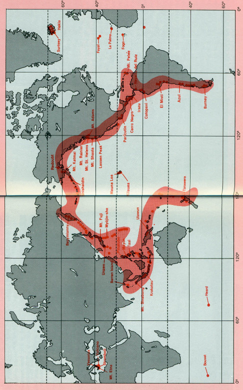
The distribution of some of the Earth’s 500 active volcanoes.
Many volcanoes are in and around the Mediterranean Sea. Mount Etna in Sicily is the largest and highest of these mountains. Italy’s Vesuvius is the only active volcano on the European mainland. Near the island of Vulcano, the volcano Stromboli has been in a [34] state of nearly continuous, mild eruption since early Roman times. At night, sailors in the Mediterranean can see the glow from the fiery molten material that is hurled into the air. Very appropriately, Stromboli has been called “the lighthouse of the Mediterranean.”
Some volcanoes crown island areas lying near the continents, and others form chains of islands in the deep ocean basins. Volcanoes tend to cluster along narrow mountainous belts where folding and fracturing of the rocks provide channelways to the surface for the escape of magma. Significantly, major earthquakes also occur along these belts, indicating that volcanism and seismic activity are often closely related, responding to the same dynamic Earth forces.
In a typical “island-arc” environment, volcanoes lie along the crest of an arcuate, crustal ridge bounded on its convex side by a deep oceanic trench. The granite or granitelike layer of the continental crust extends beneath the ridge to the vicinity of the trench. Basaltic magmas, generated in the mantle beneath the ridge, rise along fractures through the granitic layer. These magmas commonly will be modified or changed in composition during passage through the granitic layer and erupt on the surface to form volcanoes built largely of non-basaltic rocks.
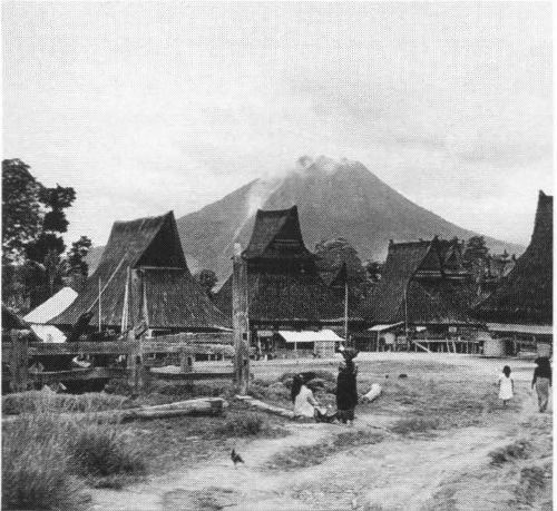
Mount Sinabung, Sumatra (By J. Baylor Roberts (c) National Geographic Society).
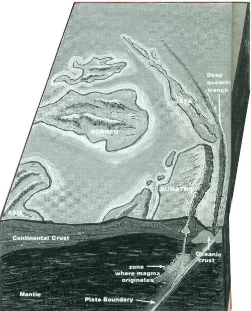
Island-arc environment
In a typical “oceanic” environment, volcanoes are aligned along the crest of a broad ridge that marks an active fracture system in the oceanic crust. Basaltic magmas, generated in the upper mantle beneath the ridge, rise along fractures through the basaltic layer. Because the granitic crustal layer is absent, the magmas are not appreciably modified or changed in composition and they erupt on the surface to form basaltic volcanoes.
Mauna Kea Volcano, Hawaii.
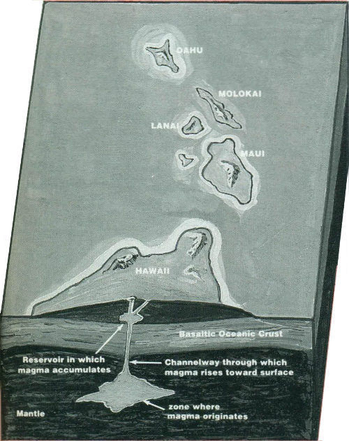
Oceanic environment
In the typical “continental” environment, volcanoes are located in unstable, mountainous belts that have thick roots of granite or granitelike rock. Magmas, generated near the base of the mountain root, rise slowly or intermittently along fractures in the crust. During passage through the granitic layer, magmas are commonly modified or changed in composition and erupt on the surface to form volcanoes constructed of nonbasaltic rocks.
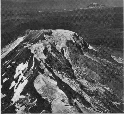
Mount Adams, Washington.
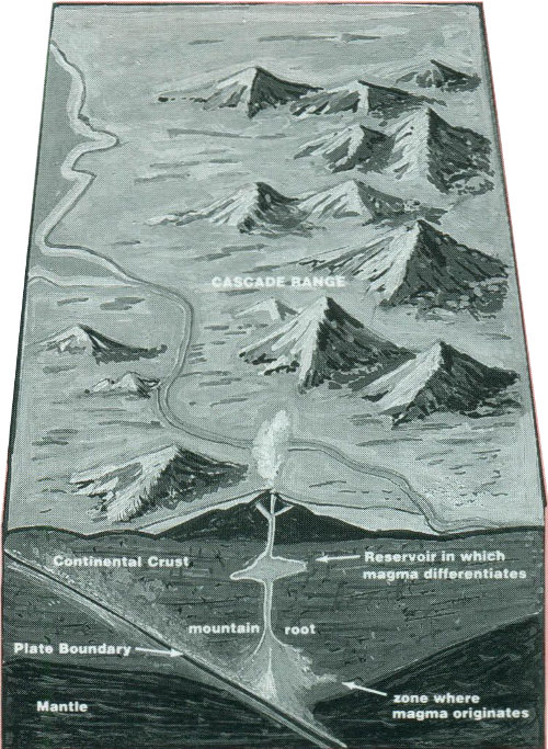
Continental environment
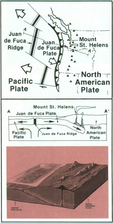
In the Pacific Northwest, the Juan de Fuca Plate plunges beneath the North American Plate, locally melting at depth; the magma rises to feed and form the Cascade volcanoes.
According to the now generally accepted “plate-tectonics” theory, scientists believe that the Earth’s surface is broken into a number of shifting slabs or plates, which average about 50 miles in thickness. These plates move relative to one another above a hotter, deeper, more mobile zone at average rates as great as a few inches per year. Most of the world’s active volcanoes are located along or near the boundaries between shifting plates and are called “plate-boundary” volcanoes. However, some active volcanoes are not associated with plate boundaries, and many of these so-called “intra-plate” volcanoes form roughly linear chains in the interior of some oceanic plates. The Hawaiian Islands provide perhaps the best example of an “intra-plate” volcanic chain, developed by the northwest-moving Pacific plate passing over an inferred “hot spot” that initiates [37] the magma-generation and volcano-formation process. The peripheral areas of the Pacific Ocean Basin, containing the boundaries of several plates, are dotted by many active volcanoes that form the so-called “Ring of Fire.” The “Ring” provides excellent examples of “plate-boundary” volcanoes, including Mount St. Helens.
The accompanying figure shows the boundaries of lithosphere plates that are presently active. The double lines indicate zones of spreading from which plates are moving apart. The lines with barbs show zones of underthrusting (subduction), where one plate is sliding beneath another. The barbs on the lines indicate the overriding plate. The single line defines a strike-slip fault along which plates are sliding horizontally past one another. The stippled areas indicate a part of a continent, exclusive of that along a plate boundary, which is undergoing active extensional, compressional, or strike-slip faulting.
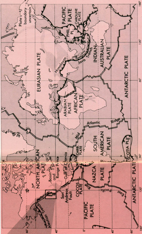
Major tectonic plates of the Earth.
Mariner 9 imagery of Olympus Mons Volcano on Mars compared to the eight principal Hawaiian Islands at the same scale (Mariner 9 Image Mosaic, NASA/JPL).
Volcanoes and volcanism are not restricted to the planet Earth. Manned and unmanned planetary explorations, beginning in the late 1960’s, have furnished graphic evidence of past volcanism and its products on the Moon, Mars, Venus and other planetary bodies. Many pounds of volcanic rocks were collected by astronauts during the various Apollo lunar landing missions. Only a small fraction of these [39] samples have been subjected to exhaustive study by scientists. The bulk of the material is stored under controlled-environment conditions at NASA’s Lunar Receiving Laboratory in Houston, Tex., for future study by scientists.
From the 1976-1979 Viking mission, scientists have been able to study the volcanoes on Mars, and their studies are very revealing when compared with those of volcanoes on Earth. For example, Martian and Hawaiian volcanoes closely resemble each other in form. Both are shield volcanoes, have gently sloping flanks, large multiple collapse pits at their centers, and appear to be built of fluid lavas that have left numerous flow features on their flanks. The most obvious difference between the two is size. The Martian shields are enormous. They can grow to over 17 miles in height and more than 350 miles across, in contrast to a maximum height of about 6 miles and width of 74 miles for the Hawaiian shields.
Voyager-2 spacecraft images taken of Io, a moon of Jupiter, captured volcanoes in the actual process of eruption. The volcanic plumes shown on the image rise some 60 to 100 miles above the surface of the moon. Thus, active volcanism is taking place, at present, on at least one planetary body in addition to our Earth.
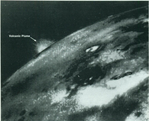
Spacecraft image, made in July 1979, shows volcanic plume rising some 60 to 100 miles above the surface of Io, a moon of Jupiter (Voyager 2 photo, NASA).
It has been said that the science of “volcanology” originated with the accurate descriptions of the eruption of Vesuvius in A.D. 79 contained in two letters from Pliny the Younger to the Roman historian Tacitus. Pliny’s letters also described the death of his uncle, Pliny the Elder, who was killed in the eruption. Actually, however, it was not until the 19th century that serious scientific inquiry into volcanic phenomena flourished as part of the general revolution in the physical and life sciences, including the new science of “geology.” In 1847, an observatory was established on the flanks of Vesuvius, upslope from the site of Herculaneum, for the more or less continuous recording of the activity of the volcano that destroyed the city in A.D. 79. Still, through the first decade of the 20th century, the study of volcanoes by and large continued to be of an expeditionary nature, generally undertaken after the eruption had begun or the activity had ceased.
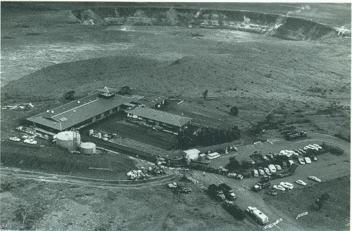
The U.S. Geological Survey’s Hawaiian Volcano Observatory, on the crater rim of Kilauea Volcano.
Perhaps “modern” volcanology began in 1912, when Thomas A. Jaggar, Head of the Geology Department of the Massachusetts Institute of Technology, founded the Hawaiian Volcano Observatory (HVO), located on the rim of Kilauea’s caldera. Initially supported by an association of Honolulu businessmen, HVO began to conduct systematic and continuous monitoring of seismic activity preceding, accompanying, and following eruptions, as well as a wide variety of other geological, geophysical, and geochemical observations and investigations. Between 1919 and 1948, HVO was [41] administered by various Federal agencies (National Weather Service, U.S. Geological Survey, and National Park Service), and since 1948 it has been operated continuously by the Geological Survey as part of its Volcano Hazards Program. The more than 75 years of comprehensive investigations by HVO and other scientists in Hawaii have added substantially to our understanding of the eruptive mechanisms of Kilauea and Mauna Loa, two of the world’s most active volcanoes. Moreover, the Hawaiian Volcano Observatory pioneered and refined most of the commonly used volcano-monitoring techniques presently employed by other observatories monitoring active volcanoes elsewhere, principally in Indonesia, Italy, Japan, Latin America, New Zealand, Lesser Antilles (Caribbean), Philippines, and Kamchatka (U.S.S.R.).
What does “volcano monitoring” actually involve? Basically, it is the keeping of a detailed “diary” of the changes—visible and invisible—in a volcano and its surroundings. Between eruptions, visible changes of importance to the scientists would include marked increase or decrease of steaming from known vents; emergence of new steaming areas; development of new ground cracks or widening of old ones; unusual or inexplicable withering of plant life; changes in the color of mineral deposits encrusting fumaroles; and any other directly observable, and often measurable, feature that might reflect a change in the state of the volcano. Of course, the “diary” keeping during eruptive activity presents additional tasks. Wherever and whenever they can do so safely, scientists document, in words and on film, the course of the eruption in detail; make temperature measurements of lava and gas; collect the eruptive products and gases for subsequent laboratory analysis; measure the heights of lava fountains or ash plumes; gage the flow rate of ash ejection or lava flows; and carry out other necessary observations and measurements to fully document and characterize the eruption. For each eruption, such documentation and data collection and analysis provide another building block in constructing a model of the characteristic behavior of a given volcano or type of eruption.
Volcano monitoring also involves the recording and analysis of volcanic phenomena not visible to the human eye, but measurable by precise and sophisticated instruments. These phenomena include ground movements, earthquakes (particularly those too small to be felt by people), variations in gas compositions, and deviations in local electrical and magnetic fields that respond to pressure and stresses caused by the subterranean magma movements.
Some common methods used to study invisible, volcano-related phenomena are based on:
1. Measurement of changes in the shape of the volcano—volcanoes gradually swell or “inflate” in building up to an eruption because of the influx of magma into the volcano’s reservoir or “plumbing system”; with the onset of eruption, pressure is immediately relieved and the volcano rapidly [42] shrinks or “deflates.” A wide variety of instruments, including precise spirit-levels, electronic “tiltmeters,” and electronic-laser beam instruments, can measure changes in the slope or “tilt” of the volcano or in vertical and horizontal distances with a precision of only a few parts in a million.
2. Precise determination of the location and magnitude of earthquakes by a well-designed seismic network—as the volcano inflates by the rise of magma, the enclosing rocks are deformed to the breaking point to accommodate magma movement. When the rock ultimately fails to permit continued magma ascent, earthquakes result. By carefully mapping out the variations with time in the locations and depths of earthquake foci, scientists in effect can track the subsurface movement of magma, horizontally and vertically.
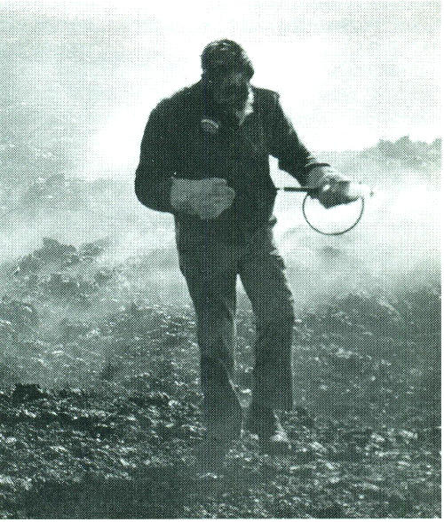
Scientist, wearing asbestos gloves and gas mask, samples volcanic gases from active vent.
3. Measurement of changes in volcanic-gas composition and in magnetic field—the rise of magma high into the volcanic edifice may allow some of the associated gases to escape along fractures, thereby causing the composition of the gases (measured at the surface) to differ from that usually measured when the volcano is quiescent and the magma is too deep to allow gas to escape. Changes in the Earth’s magnetic field have been noted preceding and accompanying some eruptions, and such changes are believed to reflect temperature effects and/or the content of magnetic minerals in the magma.
Recording historic eruptions and modern volcano-monitoring in themselves are insufficient to fully determine the characteristic behavior of a volcano, because a time record of such information, though perhaps long in human terms, is much too short in geologic terms to permit reliable predictions of possible future behavior. A comprehensive investigation of any volcano must also include the careful, systematic mapping of the nature, volume, and distribution of the products of prehistoric eruptions, as well as the determination of their ages by modern isotopic and other dating methods. Research on the volcano’s geologic past extends the data base for refined estimates of the recurrence intervals of active versus dormant periods in the history of the volcano. With such information in hand, scientists can construct so-called “volcanic hazards” maps that delineate the zones of greatest risk around the volcano and that designate which zones are particularly susceptible to certain types of volcanic hazards (lava flows, ash fall, toxic gases, mudflows and associated flooding, etc.).
A strikingly successful example of volcano research and volcanic-hazard assessment was the 1978 publication (Bulletin 1383-C) by two Geological Survey scientists, Dwight Crandell and Donal Mullineaux, who concluded that Mount St. Helens was the Cascade volcano most frequently active in the past 4,500 years and the one most likely to reawaken to erupt, “... perhaps before the end of this century.” Their prediction came true when Mount St. Helens rumbled back to life in March of 1980. Intermittent explosions of ash and steam and periodic formation of short-lived lava domes continued throughout the decade. Analysis of the volcano’s past behavior indicates that this kind of eruptive activity may continue for years or decades, but another catastrophic eruption like that of May 18, 1980, is unlikely to occur soon.
On 18 May 1982, the U.S. Geological Survey (USGS) formally dedicated the David A. Johnston Cascades Volcano Observatory (CVO) in Vancouver, Washington, in memory of the Survey volcanologist killed two years earlier. This facility—a sister observatory to the Hawaiian Volcano Observatory—facilitates the increased monitoring and research on not only Mount St. Helens but also the other volcanoes of the Cascade Range of the Pacific Northwest. More recently, in cooperation with the State of Alaska, the USGS established the Alaska Volcano Observatory in March 1988. The work being done at these volcano observatories provides important comparisons and contrasts between the behavior of the generally non-explosive Hawaiian shield volcanoes and that of the generally explosive composite volcanoes of the Cascade and Alaskan Peninsula-Aleutian chains.
Volcanoes both harass and help mankind. As dramatically demonstrated by the catastrophic eruption of Mount St. Helens on May 1980 and of Pinatubo in June 1991, volcanoes can wreak havoc and devastation in the short term. The types of volcanic and associated hazards are not described in this booklet but treated in several of the publications listed in Suggested Reading. However, it should be emphasized that the short-term hazards posed by volcanoes are balanced by benefits of volcanism and related processes over geologic time. Volcanic materials ultimately break down to form some of the most fertile soils on Earth, cultivation of which fostered and sustained civilizations. People use volcanic products as construction materials, as abrasive and cleaning agents, and as raw materials for many chemical and industrial uses. The internal heat associated with some young volcanic systems has been harnessed to produce geothermal energy. For example, the electrical energy generated from The Geysers geothermal field in northern California can meet the present power consumption of the city of San Francisco.
The challenge to scientists involved with volcano research is to mitigate the short-term adverse impacts of eruptions, so that society may continue to enjoy the long-term benefits of volcanism. They must continue to improve the capability for predicting eruptions and to provide decision makers and the general public with the best possible information on high-risk volcanoes for sound decisions on land-use planning and public safety. Geo-scientists still do not fully understand how volcanoes really work, but considerable advances have been made in recent decades. An improved understanding of volcanic phenomena provides important clues to the Earth’s past, present, and possibly its future.
Decker, Robert, and Decker, Barbara, 1989, Volcanoes: W.H. Freeman and Company, New York, 285 p. (Revised edition).
Editors, 1982, Volcano: in the series Planet Earth, Alexandria, Virginia, Time-Life Books, 176 p.
Harris, S.L., 1988, Fire mountains of the West: The Cascade and Mono Lake Volcanoes: Missoula, Montana, Mountain Press Publishing Company, 379 p.
Heliker, Christina, 1990, Volcanic and seismic hazards on the Island of Hawaii: Reston, Virginia, U.S. Geological Survey, 48 p.
Macdonald, G.A., 1972, Volcanoes: Englewood Cliffs, New Jersey, Prentice-Hall, Inc., 510 p.
Simkin, Tom, Tilling, R.I., Taggart, J.N., Jones, W.J., and Spall, Henry, compilers, 1989, This dynamic planet: World Map of volcanoes, earthquakes, and plate tectonics: U.S. Geological Survey, Reston, Virginia, prepared in cooperation with the Smithsonian Institution, Washington, D.C. (scale 1:30,000,000 at equator).
Tilling, R.I., Heliker, Christina, and Wright, T.L., 1989, Eruptions of Hawaiian volcanoes: Past, present, and future: Reston, Virginia, U.S. Geological Survey, 54 p.
Tilling, R.I., Topinka, Lyn, and Swanson, D.A., 1990, Eruptions of Mount St. Helens: Past, present, and future: Reston, Virginia, U.S. Geological Survey, 56 p. (Revised edition).
Tilling, R.I., 1991, Monitoring active volcanoes: Reston, Virginia, U.S. Geological Survey, 13 p. (Revised edition).
Wood, C.A., and Kienle, Jurgen, 1990, Volcanoes of North America: United States and Canada: New York, Cambridge University Press, 354 p.
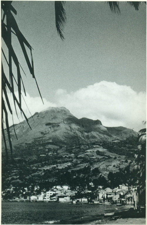
The port city of St. Pierre on the island of Martinique; Mont Pelée is in the background. In 1902, this city was entirely destroyed by pyroclastic flows; about 30,000 people died.

As the Nation’s principal conservation agency, the Department of the Interior has responsibility for most of our nationally owned public lands and natural and cultural resources. This includes fostering sound use of our land and water resources; protecting our fish, wildlife, and biological diversity; preserving the environmental and cultural values of our national parks and historical places; and providing for the enjoyment of life through outdoor recreation The Department assesses our energy and mineral resources and works to ensure that their development is in the best interests of all our people by encouraging stewardship and citizen participation in their care. The Department also has a major responsibility for American Indian reservation communities and for people who live in island territories under U S administration
U.S. Geological Survey
Information Services
P.O. Box 25286
Denver, CO 80225
For sale by the U.S. Government Printing Office
Superintendent of Documents, Mail Stop: SSOP, Washington, DC 20402-9328
U.S. GOVERNMENT PRINTING OFFICE: 1996 421-281