![Mesa Verde [Colorado] National Park, by United States Department of the Interior](images/cover.jpg)
The Project Gutenberg EBook of Mesa Verde National Park, by Anonymous

This eBook is for the use of anyone anywhere at no cost and with
almost no restrictions whatsoever.  You may copy it, give it away or
re-use it under the terms of the Project Gutenberg License included
with this eBook or online at www.gutenberg.org


Title: Mesa Verde National Park

Author: Anonymous

Release Date: April 29, 2014 [EBook #45535]

Language: English

Character set encoding: UTF-8

*** START OF THIS PROJECT GUTENBERG EBOOK MESA VERDE NATIONAL PARK ***


Produced by Stephen Hutcheson, Chris Curnow and the Online
Distributed Proofreading Team at http://www.pgdp.net
United States Department of the Interior
Harold L. Ickes, Secretary
NATIONAL PARK SERVICE
Arno B. Cammerer, Director

UNITED STATES
GOVERNMENT PRINTING OFFICE
WASHINGTON: 1936
A complete copy of the rules and regulations for governing the park may be seen at the office of the superintendent.
Automobiles
Secure automobile permit, fee $1 per car. Speed limit 35 miles per hour on entrance highway, 20 miles per hour in headquarters area and on ruin roads. Drive carefully; free wheeling is prohibited within the park.
Fires
Confine fires to designated places. Extinguish completely before leaving camp, even for temporary absences. Do not guess your fire is out—KNOW IT.
Firewood
Use only the wood that is stacked and marked “firewood” near your campsite. By all means do not use your ax on any standing tree or strip bark from the junipers.
Grounds
Burn all combustible rubbish before leaving your camp. Do not throw papers, cans, or other refuse on the ground or over the canyon rim. Use the incinerators which are placed for this purpose.
Hiking
Do not venture away from the headquarters area unless accompanied by a guide or after first having secured permission from a duly authorized park officer.
Hunting
Hunting is prohibited within the park. This area is a sanctuary for all wildlife.
Noise
Be quiet in camp after others have gone to bed. Many people come here for rest.
Park Rangers
The rangers are here to help and advise you as well as to enforce regulations. When in doubt, ask a ranger.
Ruins and Structures
Do not mark, disturb, or injure in any way the ruins or any of the buildings, signs, or other properties within the park.
Trees, Flowers, and Animals
Do not carve initials upon or pull the bark from any logs or trees. Flowers may not be picked unless written permission is obtained from the superintendent or park naturalist. Do not harm or frighten any of the wild animals or birds within the park. We wish to protect them for your enjoyment.
Visitors
Register and secure permit at the park entrance. Between travel seasons, registration and permit are arranged for at park headquarters.
| 1st century[1] B. C. or A. D. | The earliest occupation of Cliff Palace cave was probably before, or immediately following, the beginning of the Christian era. These earliest occupants, known to scientists as Basket Makers, were the first agricultural Indians of the Southwest. |
| 4th to 7th[1] centuries A. D. | By the beginning of the fourth century A. D., the early agriculturists were developing the art of pottery making. Later, their semisubterranean homes were spread widely over the Mesa Verde. |
| 7th to 10th[1] centuries A. D. | During the three or four centuries preceding 1000 A. D., the Pueblo Culture on Mesa Verde was developing from modest beginnings toward its classical stage, which culminated in the building of the great cliff dwelling. |
| 1066 | Earliest date established for large Mesa Verde cliff dwellings. (Beam section from Mug House.) |
| 1073-1273 | Construction of Cliff Palace. |
| 1276 | Beginning of 23-year drought, an important factor in forcing the Cliff dwellers from the Mesa Verde. |
| 1776 | Expedition of Padre Silvestre Velez de Escalante to southwestern Colorado. Party camped at the base of the Mesa Verde. |
| 1859 | Ascent of the north escarpment of Mesa Verde by Capt. J. N. Macomb, of the United States Army, and members of his party of geologists. |
| 1874 | Discovery of the ruins in the Mancos Canyon by W. H. Jackson, United States Geological Survey. Party attacked by Ute Indians. |
| 1888 | Discovery of Cliff Palace and other major ruins by Richard Wetherill and Charlie Mason. |
| 1891 | First organized archeological expedition to Mesa Verde, under direction of Baron G. Nordenskiöld. |
| 1906 | Mesa Verde National Park created June 29. |
| 1907 | Excavation of Spruce Tree House by Dr. J. Walter Fewkes, of Smithsonian Institution. |
| 1909 | Excavation of Cliff Palace. |
| 1911 | Excavation and repair of Balcony House by Jesse L. Nusbaum. |
| 1913 | First entrance road completed. First automobile in Spruce Tree Camp. Extension of park boundaries to include notable ruins and archeological remains. |
| 1914 | Construction of first wagon road from Spruce Tree Camp to principal cliff dwellings. |
| 1915 | Sun Temple excavated by Dr. Fewkes. |
| 1916 | Far View House excavated by Dr. Fewkes. |
| 1917 | First Government-constructed trails to Spring House and Soda Canyon. |
| 1918 | First camp accommodations established at Spruce Tree Camp. |
| 1919 | Square Tower House excavated. |
| 1921 | Establishment of superintendent’s office and home at Spruce Tree Camp. |
| 1925 | First unit of park museum constructed from donated funds. |
| 1926 | Excavation of Step House Ruin and discovery of very early occupation of cave by Basket Maker III culture predating the cliff dwellers by several hundred years. |
| 1928 | Exclusive jurisdiction of park tendered to the United States and accepted by act of Congress April 25. |
| 1934 | Completion of deep water well (4,192 feet). |
3.5 miles—Top of first grade—Mancos Valley and La Plata Mountains.
5.0 miles—Knife Edge Road—Montezuma Valley and Sleeping Ute Mountain.
10.5 miles—Scenic road to Park Point, highest elevation within Mesa Verde National Park, 8,575 feet above sea level; 2,200 feet above the Montezuma Valley. View into four States—Colorado, New Mexico, Arizona, and Utah.
16.0 miles—Pueblo III ruins on top of mesa—Far View House Ruin, Pipe Shrine House Ruin, Far View Tower Ruin.
18.5 miles—Cedar Tree Tower Ruin—road branches off to left.
20.0 miles—Park headquarters. Park ranger will meet your car and give information.
MOTOR CARAVANS TO RUINS—DAILY. USE YOUR OWN CAR. NO CHARGE FOR GUIDE SERVICE
8 a. m.—Earth Lodge A, Square Tower House, Little Long House, Sun Point, Fire Temple, Sun Temple. Return 11:15 a. m. Distance 6½ miles.
10 a. m.—A shortened trip of morning route to accommodate late comers. Return 11:15 a. m.
1:30 p. m.—Cliff Palace, Rim Drive, Balcony House. Return 4:15 p. m. Distance 7 miles.
3 p. m.—A shortened trip of the 1:30 route to accommodate late comers. Does not go through Cliff Palace but views this ruin from the top of the mesa. Return 4:30 p. m.
MOTOR CARAVAN TO PARK POINT—DAILY. USE YOUR OWN CAR
6:30 or 7 p. m.—Time of leaving will vary to arrive at Park Point to view colorful sunset. Ranger in charge will discuss the flora, geology, and scenic points. Distance 24 miles.
CAMPFIRE LECTURE—DAILY
8 p. m.—In circle at park headquarters. Archeological story of the Southwest.
9 p. m.—Ceremonial dance by Navajo Indians.
Museum—Open from 8 a. m. to 5:30 p. m. A splendid collection of material from the cliff ruins and other sections of the Southwest.
Community building—A display of cut wild flowers. Porch with comfortable chairs. View of Spruce Tree Ruin. Open at all times.
Spruce Tree Ruin—Below park headquarters. May be visited at your leisure without guide. Ranger on duty in this ruin for information.
Nature trail—The path to Spruce Tree Ruin has been prepared with a series of signs explaining the flora and rock formations.
Horseback trips—Splendid trails lead in all directions. Large, unexcavated ruins, magnificent canyons and mesas off the beaten path unfold the charm of this primitive region. Rates are very reasonable.
Hikes—To any section of the park can be arranged for with the park naturalist. If sufficient numbers enroll for such hikes, a naturalist guide will be provided.
At park headquarters, 20 miles from entrance. Spruce Tree Lodge—Cabins, tents, and meals. General store and curios. Free Government camp ground. Firewood and water furnished.
· SEASON FROM MAY 15 TO OCTOBER 15 ·
The mesa verde, or green mesa, so-called because its juniper and piñon trees give it a verdant tone, is 15 miles long by 8 miles wide. Rising abruptly from the valley on the north side, its top slopes gradually southward to the high cliffs bordering the valley of the Mancos River on the south. Into this valley open a number of large high-walled canyons through which occasionally, in times of heavy rain, raging torrents of water flow into the Mancos. In the shelter of the caves that have been eroded in the sides of these canyons are some of the best-preserved cliff dwellings in America, built many centuries ago by a tribe of peace-loving Indians who prized the security offered by the almost inaccessible caves. In order to preserve these cliff dwellings Mesa Verde National Park was created, but they are not the only attractions in the area. In the winter the park is closed to travel by deep snow, but in the early spring the blanket of snow is replaced by a mantle of flowers that change with the seasons, and to the story of the prehistoric inhabitants is added an absorbing story of nature that is peculiar to this mesa and canyon country.
“The Mesa Verde region”, writes Arthur Chapman, “has many attractions besides its ruins. It is a land of weird beauty. The canyons which seam the mesa, all of which lead toward the distant Mancos River, are, in many cases, replicas of the Grand Canyon of the Colorado. While the summer days are warm, the nights are cool, and the visitor should bring plenty of wraps besides the clothing and shoes necessary for the work of climbing around among the trails. It is a country for active footwork, just as it was in the days of the cliff dwellers themselves. But when one has spent a few days among the cedars and piñon pines of the Mesa Verde, well named Green Table by the Spaniards of early days, he becomes an enthusiast and will be found among those who return again and again to [2] this most unique of national parks to study its mysteries and its beauties from all angles.”
The northern edge of the mesa terminates in a precipitous bluff, averaging 2,000 feet above the Montezuma Valley. The general slope of the surface is to the south, and as the main road to the ruins meanders back and forth in heading each smaller canyon, many times skirting the very brink of the great northern fault line, tremendous expanses of diversified terrain are brought into view, first in Colorado and Utah, then in Arizona and New Mexico.
A new scenic road approximately 1 mile in length branches from the main highway at a point 8 miles beyond the entrance checking station and ascends to the crest of Park Point, the highest part of the Mesa Verde National Park, which attains an elevation of 8,575 feet above sea level.
From this majestic prominence the great Montezuma Valley, dotted with artificial lakes and fertile fields, appears as from an airplane, while to the north are seen the Rico Mountains and the Lone Cone of Colorado, and to the east, the La Plata Mountains. To the west the La Sals, the Blues, and Bears Ears, of Utah, dominate the horizon. Some of these landmarks are more than 115 miles distant. Southward numerous deep canyons, in which the more important cliff dwellings are found, subdivide the Mesa Verde into many long, narrow, tonguelike mesas. The dark purplish canyon of the Mancos River is visible in the middle foreground, and beyond, above the jagged outline of the mesa to the south, the Navajo Reservation, surrounded by the deep-blue Carrizos of Arizona and the Lukachukai and Tunichas of New Mexico.
In the midst of this great mountain-enclosed, sandy plain, which, seen from the mesa, resembles a vast inland sea surrounded by dark, forbidding mountains, rises Ship Rock (45 miles distant), a great, jagged shaft of igneous rock, 1,860 feet high, which appears for all the world like a great “windjammer” under full sail. Toward evening the illusion is perfect.
The distance from Park Point to Spruce Tree Camp, the park headquarters, is 12 miles. The entire road from the park entrance to headquarters, 20 miles, is gravel surfaced and oil treated, full double width, and cars may pass at any point thereon.
Although there are hundreds of cliff dwellings within the Mesa Verde National Park, the more important are located in Rock, Long, Wickiup, Navajo, Spruce, Soda, Moccasin, and tributary canyons. Surface ruins of a different type are widely distributed over the narrow mesas separating the numerous canyons. A vast area surrounding the park contains more or less important ruins of these early inhabitants, most important and easiest [3] of access from the park being the Aztec Ruins and Chaco Canyon National Monuments, New Mexico; the Yucca House National Monument, Colorado; and the Hovenweep National Monument, Colorado-Utah.
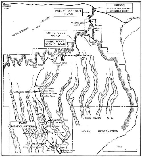
Road map of Mesa Verde National Park, showing important ruins on Chapin Mesa only.
Although the Spaniards were in the Mesa Verde region as early as 1765 and the Americans as early as 1859, it was not until 1872 that the first settlement was made. In that year the Mancos Valley, lying at the foot of the Mesa Verde, was settled, but because of the fact that the mesa itself was a stronghold of the warlike Ute Indians, many years passed before the cliff dwellings were discovered.
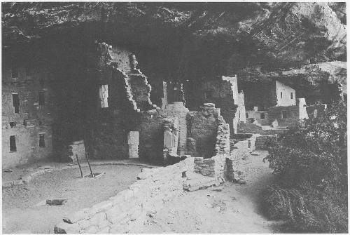
Spruce Tree House, a community dwelling of 114 rooms.
The ruins in the Mancos Canyon were discovered as early as 1874 when W. H. Jackson, who led a Government party, found there many small dwellings broken down by the weather. The next year he was followed by Prof. W. H. Holmes, later chief of the Bureau of American Ethnology, who drew attention to the remarkable stone towers also found in this region. Had either of the explorers followed up the side canyons of the Mancos they would have then discovered ruins which, in the words of Baron Gustav Nordenskiöld, the talented Swedish explorer, are “so magnificent that they surpass anything of the kind known in the United States.”
The largest cliff ruin, known as Cliff Palace, was discovered by Richard Wetherill and Charlie Mason while hunting cattle one December day in 1888. Coming to the edge of a small canyon they first caught sight of a village under the overhanging cliff on the opposite side, placed like a picture in its rocky frame. In their enthusiasm they thought it was a palace. With the same enthusiasm the visitors of today involuntarily express their pleasure and surprise as the spectacle breaks on their astonished vision.
Later these two men explored this ruin and gave it the name of Cliff Palace, an unfortunate designation, for it is in no respect a palace, but a community house, containing over 200 living rooms, former abodes of families, and 23 ceremonial rooms or kivas. They also discovered other community dwellings, one of which was called Spruce Tree House, from a large spruce tree, since cut down, growing in front of it. This had 8 ceremonial rooms and probably housed 300 inhabitants.
The findings of these two ruins did not complete the discoveries of ancient buildings in the Mesa Verde; many other ruins were found by the Wetherills, and others who need not now be mentioned. They mark the oldest and most congested region of the park, but the whole number of archeological sites may reach into the thousands.
Only a few of the different types of ruins that have already been excavated and repaired and are now accessible to the visitor are considered herein. This excavation and repair was the work of the late Dr. J. Walter Fewkes, formerly chief of the Bureau of American Ethnology, with the exception of Balcony House, which was done by Jesse L. Nusbaum. Hundreds of sites await scientific investigation, being accessible now only on foot or horseback mainly by means of trails.
Spruce Tree House, located in a large cave just across Spruce Tree Canyon from the museum, has been made readily accessible by a short [6] winding trail. This is the only excavated cliff dwelling in the park that may be visited without going on a conducted tour, and is open to the public at all times. A ranger is always on duty to protect the ruin from vandalism and to give information to the visitors.
GENERAL DESCRIPTION
The total length of Spruce Tree House is 216 feet, and its greatest width is 89 feet. During the excavation of the ruin in 1907, Dr. Fewkes counted 8 ceremonial rooms, or kivas, and 114 rooms that had been used for living, storage, and other purposes. At least 14 seemed to have been storage and burial rooms so that probably not more than 100 were used as dwellings. If it is considered that a family occupied each room, the population would have been large, but it is doubtful if all of the rooms were occupied at one time. An average of 2 or 3 persons to the room, making a total of not more than 300 for the entire village, would no doubt be a fair estimate.
Two hundred feet north of Spruce Tree House the canyon comes to an abrupt box end. A splendid spring flows from the base of the sandstone cliff, and it was to this spring that the cliff-dweller women went for water carrying it back to their homes in their big water jars. At the south end of the cave a trail, consisting of small toeholds cut in the cliff, led to the mesa top above. This trail was used by the men as they went to their mesa-top fields, where they raised corn, beans, and squash, and by the hunters as they went in search of deer and mountain sheep that lived in the forests above.
LIVING ROOMS
The rooms of Spruce Tree House are divided into two groups by a court or street running from the front to the back of the cave, at a point just south of the center of the village. The majority of the rooms are north of this street, and some of the walls show the finest work in the entire structure. The stones were well shaped and smoothed; the mud mortar was carefully worked into the crevices and compressed with thin stone wedges. Over many of the walls was spread a thin coat of reddish plaster, often decorated with paintings. These rooms, standing as when they were constructed 700 years ago, are mute evidence of the cleverness of the masons who built them.
Spruce Tree House has more walls that reach the top of the cave than any other ruin in the park. All through the central part the walls were three stories high and the top of the cave served as the roof of the upper rooms. The first- and second-story rooms, however, had their own ceilings. [7] Heavy rafters, running lengthwise of the rooms, were covered with a crosswise layer of small poles and withes, and these in turn were covered with a 3-inch layer of mud. Very often a small hatchway was left in one corner of the ceiling and a short ladder leaning in the corner of the lower room gave access to the room above.
Very few of the houses were equipped with fire pits. Most of the cooking was done in the open courts and the small fire pits can be found along the walls and in the corners of the courts and passageways.
CEREMONIAL ROOMS OR KIVAS
Spruce Tree House has eight of the circular, subterranean rooms that were set aside for ceremonial purposes. Similar rooms are still in use in the present day Pueblo Indian villages and are known as kivas.
Usually the kiva roofs have collapsed, but in Square Tower House two kivas have the original roofs almost intact. Following the plan of these original roofs, three of the kivas in Spruce Tree House have been reroofed and upon descending the ladder into one of these the details of construction may be noted.
Kivas in the Mesa Verde are always underground and are nearly always circular. The average diameter is 12 to 13 feet and the depth is such that the roof would clear a man’s head. At a point about 3 feet above the floor is a narrow ledge running entirely around the room. This ledge is known as the banquette and its exact use is unknown. On this ledge were built six stone buttresses or pilasters, and these, rising to within 2 or 3 feet of the top of the kiva, served as roof supports. Short beams were placed from pilaster to pilaster around the room and a second set of beams was laid across the angles made by the first set. This was continued until five or six sets of beams had extended this cribwork almost to the ground level. Horizontal beams were then placed across the top and the whole structure was covered with bark and earth. In the center of the roof a small square hole was left that served as a door and smoke vent.
On the south side of the kiva the banquette is wider between two of the pilasters than anywhere else around the room. This deep recess is often referred to as an altar, although its exact use is not known. Just back of the wall of this deep recess is a vertical shaft that leads down to meet a horizontal shaft that opens into the kiva just above the floor. This is the ventilator shaft. The fire, burning in the small pit in the center of the room, sent the smoke up through the hole in the roof, and the fresh air was drawn down through the ventilator shaft. Between the ventilator and the fire pit a small wall, known as the “deflector”, was constructed to keep the fresh air current from blowing on the fire.
Two or three feet from the fire pit, and in a straight line with the ventilator shaft, the deep recess, the deflector and the fire pit is a small hole in the floor of the kiva. This hole is usually about 3 inches in diameter and from 4 to 6 inches deep; its walls and bottom often covered with a smooth layer of mud. In the present day kivas this hole is known as the “sipapu”, and is considered to be the symbolic entrance to the underworld. The kiva was a combination ceremonial, club, and workroom for the men. Even in the present day villages the women are rarely ever allowed to enter the kivas because of the fact that the men take almost entire charge of the religious work. It is believed that each clan had its own kiva, and it will be noted that in almost every case the kiva is surrounded by a group of living rooms. The members of the clan no doubt lived in these rooms and the men held their ceremonies in the adjoining kiva. Two of the kivas in Spruce Tree House have side entrances that lead to nearby rooms. These rooms may have been the homes of the priests, or dressing rooms for them.
DATE OF OCCUPATION
Twenty-one of the roof beams in Spruce Tree House have been dated by tree-ring chronology. These dates show that the houses were constructed during the years between 1230 A. D. and 1274 A. D. In 1276 A. D. a 23-year period of drought began that caused the cliff dwellers to move to regions where there was a more permanent supply of water. In those same regions are the homes of the modern Pueblo Indians and no doubt some of these people are the descendants of the Cliff Dwellers.
Cliff Palace lies in an eastern spur of Cliff Canyon under the roof of an enormous cave that arches 50 to 100 feet above it. The floor of the cave is elevated about 200 feet above the bottom of the canyon and is just under the rim of the mesa. The entrance of the cave faces west, toward a great promontory upon which stands Sun Temple.
The total length of the cave is over 300 feet and its greatest depth is just under 100 feet. The vaulted roof is so high that the cave was always light and airy and offered a perfect home site to the cliff dwellers who were seeking protection from the elements as well as from their enemies.
Fortunately, the configuration of the cliffs above the ruin makes it possible to get a fine birdseye view from the rim of the mesa. Views obtained from the heads of the two trails are most striking and give an idea of the setting and size of the building before it is entered for closer inspection. The most spectacular view of Cliff Palace is from Sun Temple, [9] across the canyon. This is the only spot from which the entire ruin may be seen.
LIVING ROOMS
Cliff Palace is the largest known cliff dwelling. Dr. Fewkes, who excavated the ruin in 1909, placed the number of living rooms at slightly more than 200. Very few of the walls reached the top of the cave because of its great height, but many of the structures were as high as two and three stories. Near the south end of the ruin is the tallest structure, a four-story tower that reaches the cave roof. Ground space appropriate for building purposes was at a premium in the cave. To provide for an increasing population, second, third, and even fourth-story rooms were superimposed on the original single-story structures which predominated in the initial cliff-dweller occupation of this site.
When the cliff dwellers started building in the cave they were confronted with the problem of an uneven floor. The floor of the cave slanted from the back to the front and was covered with huge, angular boulders that had fallen from the cave roof. This problem the cliff dweller solved by erecting terraces and filling in the irregular places. The open spaces between the boulders were excellent for kivas, as there was not a great deal of excavation necessary. After the kiva walls were built the extra space was filled in with trash and dirt. When the flat kiva roof was added a level court resulted. Around this court the homes were constructed, often on the rough surfaces of the big boulders. Because of the uneven floor and the terracing that was necessary, six distinct terrace levels resulted.
KIVAS
Twenty-two kivas are located in the cave and another, lying about 50 feet from the western end, and thought to have been used by men living in the cave, brings the total to 23. Twenty of these conform to the plan of the typical Mesa Verde kiva, but three seem to be of a different type. These three, instead of being round, are square with rounded corners. The banquette is missing as well as the pilasters or roof supports.
STORAGE ROOMS
Because of the fact that the inhabitants of Cliff Palace were forced to store enough corn each fall to last until the next harvest a great many storage rooms were constructed. Any small nook or cranny that was too small for a home was utilized for that purpose. Far back in the cave a number were constructed of large, thin sandstone slabs. These slabs were placed on end to form small rectangular rooms, and when the door slabs were in place and all of the crevices were well chinked with mud the grain [10] was safe from the rodents. High up under the roof of the cave, at the back, was a long narrow shelf that was also utilized for storage space. A wall was built along the front of the ledge, closing it up completely, and the space back of the wall was divided into 14 small storage rooms. A ladder on the roof of one of the houses below gave access to the ledge.
PAINTINGS
In the third floor room of the four-story tower is the finest painting yet found in the Mesa Verde. The entire inner surface of the four walls was covered with bright red designs on a white background. The designs are similar to those found on cliff-dweller pottery. The white color was obtained by mixing finely ground gypsum with water to form a smooth paste; the red was obtained by treating hematite, or red ochre, in the same manner.
THE ROUND TOWER
The outstanding structure in Cliff Palace is the two-story round tower that stands just south of the center of the cave. Every stone in this tower is rounded to conform to the curvature of the walls and the graceful taper toward the top makes it one of the finest examples of masonry work in the region. When the early explorers first entered this tower the only object found was the most beautiful stone ax they ever discovered. Whether this tower was a home or whether it was constructed for some special purpose can only be conjectured.
POSSIBLE POPULATION
Because of the fact that Cliff Palace is the largest of all cliff dwellings, its population is of special interest. A close inspection of the rooms in the ruin shows that they are smaller, on the average, than the rooms in any of the other large cliff dwellings. When judged from our modern standards, it is difficult to imagine more than a couple of people living in each one. Our modern ideas, however, will not help us in understanding the people who once lived in Cliff Palace.
More than anything else the cliff dwellers desired security from their enemies. Their next desire was safety from the elements. When it is considered that these were the motivating influences, it can easily be understood that such minor matters as space and comfort would receive little consideration. Since the inhabitants were an easy-going, peace-loving group it can be imagined that crowded living conditions would not be objectionable. In addition it must be considered that the rooms were used principally as sleeping quarters. All activities were carried on in [11] the open courts and on the terraced roof tops. Even the cooking was done over open fires outside the houses.
An average of two to the room would give a population of 400; an average of three would place 600 in the cave. If every room were occupied at one time and if the average of two or three to the room is not too high, it would seem that a total population of 500 would not be too great for Cliff Palace.
Balcony House lies in Soda Canyon about 2½ miles southeast of Spruce Tree Camp, and is reached by a continuation of the Cliff Palace Road. It is one of the most picturesque of the accessible ruins in the park and occupies a better position for defense than most of the other ruins on the mesa. A few defenders could have repelled a numerous attacking force. Additional precautions have been taken at the south end of the ruin for the strengthening of its defenses, where the only means of reaching it is through a very narrow cleft. The south part of the ledge was walled up to a height of about 15 feet, the lower part of the wall closing the cleft being pierced by a narrow tunnel. Through this tunnel a man may creep on hands and knees from the cliff dwelling to the south part of the ledge, which affords a footing, with a precipice to the left and the cliff to the right, for about 100 paces. The ledge here terminates in the perpendicular wall of the canyon. The ruined walls of a strong tower, built to cut off approach on this side, may still be traced. At the north end of the ruin the foundation gave the builders considerable trouble, but the difficulties were skillfully overcome. A supporting wall was erected on a lower ledge, to form a stable foundation for the outer wall of the upper rooms, where the higher ledge was too narrow or too rough for building purposes.
South of the rooms fronted by this wall is a small open court, bounded at the back by a few very regular and well-preserved walls which rise to the roof of the cave. The poles supporting the floors of these upper-story rooms project about 2 feet to provide support for a balcony. Split poles, laid parallel with the front wall, were covered at right angles with rods of cedar bast and generously plastered with clay to form the floor of the balcony, which served as a means of outside communication between the rooms of the upper story. A low, thick parapet wall built on the edge of the precipice encloses the outer side of the northern court.
The funds for the excavation and repair of Balcony House in 1911 were largely furnished by the Colorado Cliff Dwellers Society, an organization founded and directed by Mrs. Gilbert McClurg, of Colorado [12] Springs, Colo., for the original purpose of stimulating interest in legislation for the preservation and protection of the prehistoric remains of the Mesa Verde, which led to the creation of this national park in 1906.
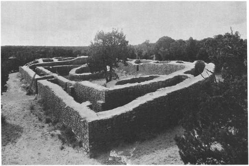
Square Tower House is situated in an eastern spur of Navajo Canyon nearly opposite a great bluff called Echo Cliff. An ancient approach to the ruin was from the canyon rim. It was used by the natives, but is almost impassable for white visitors. Foot holes for ascent and descent had been cut by the Indians in the cliff at a point south of the ruin which enabled them to reach the level on which the ruin is situated. Along the top of the talus there runs to the ruins a pathway which splits into an upper and a lower branch. The former, hugging the cliff, passes through the “Eye of the Needle”; the latter is lower down on the cliff.
The Square Tower House cave is shallow, its rear perpendicular, with roof slightly overhanging. At the extreme eastern end of the ruin the vertical face of the cliff suddenly turns at right angles, forming an angle in which, high above the main ruin, there still remain walls of rooms. To these rooms, which are tucked away just under the canyon rim, with only their front walls visible, the name “Crow’s Nest” is given. One end of a log, extending from a wall of one of these rooms, rests in a hole cut in the side of the cliff, a well-known method of cliff-house construction.
Some rooms in Square Tower House were devoted to secular, others to ceremonial purposes. The former have angular corners; the latter are circular. The rectangular rooms were constructed above ground; the circular were subterranean. These rooms do not differ radically from those of Spruce Tree House and other cliff dwellings. They have similar windows, door openings, and supports of balconies. There is little difference in the size of the stones used in the masonry at different heights. The absence of a cave recess in the rear of the building is significant, as it allowed the cliff to be used as the back wall of the rooms.
Square Tower House measures about 138 feet from its eastern to its western end. There are no streets or passageways as at Spruce Tree House and Cliff Palace, and no open spaces except on the kiva roofs. The rooms are continuous and compactly constructed. Excepting the spaces above the kivas, the walls are united from one end of the cave to the other. The foundations of the secular rooms are constructed on two levels, an upper and a lower. These rooms occupy the intervals between the kivas, never in front of them.
THE TOWER
The tower is, of course, the most conspicuous as well as the most interesting architectural feature of the ruin, being visible for a long distance as one approaches Square Tower House. Its foundation rests on a large boulder situated in the eastern section of the cave floor. This tower has three walls constructed of masonry, the fourth being the perpendicular rear wall of the cave. The masonry of the tower stands about 35 feet above the foundation, but the foundation boulder on which it stands increases its height over 5 feet.
On a projecting rock on the west side above the tower is the wall of a small, inaccessible room which may have been used as a lookout or as an eagle house.
The lowest story of the tower is entered from plaza B, and on the east side there are three openings, situated one over another, indicating the first, second, and third stories, but on the south side of the tower there are only two doorways. The roof of the lowest room is practically intact, showing good workmanship, but about half of its floor is destroyed. The upper walls of the second-story room have the original plaster, reddish dado below and white above. Although the third and fourth stories are destitute of floors, they are plastered.
KIVAS
Some of the best preserved circular ceremonial chambers (kivas) in the Southwest are to be seen in Square Tower House. The majority of the kivas belong to the pure type, distinguished by mural pilasters supporting a vaulted roof.
Kiva A is particularly instructive on account of the good preservation of its roof. Its greatest diameter is 13 feet 6 inches; or, measuring inside the banquettes, 11 feet 1 inch. The interior is well plastered with many layers of brown plaster. The pilasters are six in number, one of which is double. Two depressions are visible in the smooth floor, in addition to a fireplace and a sipapû. These suggest ends of a ladder, but no remains of a ladder were found in the room.
Kiva B is the largest ceremonial chamber in Square Tower House, measuring 16 feet 9 inches in diameter over all. This kiva is not only one of the best preserved, but also one of the most instructive in Square Tower House, since half of the roof, with the original cribbing, is still in place, extending completely around the periphery. It has six pilasters and as many banquettes. Where the plaster had not fallen, it was found to have several layers.
Sun Temple, a mysterious form of ruin.
PETROGLYPHS AND PICTOGRAPHS
The perpendicular cliff back of Square Tower House has several different forms of incised petroglyphs. From the fact that these usually occur on the cliff above the kiva roofs, they may be regarded as connected in some way with a religious symbolism. A few pictographs are also found on stones set in the walls of the rooms.
The ruin formerly called Willow House, but now known as Oak Tree House, lies on the north side of Fewkes Canyon, in a symmetrical cave and has an upper and a lower part. The two noteworthy features of Oak Tree House are the kivas and the remnant of the wall of a circular room made of sticks plastered with adobe but destitute of stone masonry.
Oak Tree House has seven kivas and may be called a large cliff dwelling. One of the kivas has a semicircular ground plan with a rectangular room on the straight side. There are no pilasters or banquettes in this kiva. The floor of another kiva was almost wholly occupied by a series of grinding bins, indicating a secondary use. The repair work on Oak Tree House has not yet been completed, but a small collection of specimens at one end of the ruin shows the nature of the objects thus far found.
Looking across Cliff Canyon from Sun Point one can see the fine ruin called Sun Set House, formerly known as Community House. This ruin, like many other cliff dwellings, has an upper and a lower house, the former being relatively larger than is usually the case. Although Sun Set House is accessible, it has never been excavated.
The cliff houses considered in the preceding pages are habitations. There are also specialized buildings on the Mesa Verde which were never inhabited but were used for other purposes. Two of these are supposed to have been devoted to religious purposes and are known as Sun Temple and Fire Temple.
Sun Temple is situated west of Cliff Palace, across Cliff Canyon on a high cliff at the entrance to Fewkes Canyon. Up to the year 1915 the site of Sun Temple was a mound of earth and stones, all showing artificial working or the pecking of primitive stone hammers. This mound had a circular depression in the middle and its surface was covered with trees [16] and bushes. No high walls projected above the ground nor was there any intimation of the size or character of the buried building. It was believed to be a pueblo or communal habitation. Excavation of this mound brought into view one of the most instructive buildings in the park.
Sun Temple is a type of ruin hitherto unknown in the park. The building excavated shows the best masonry and is the most mysterious form yet discovered in a region rich in so many prehistoric remains. Although at first there was some doubt as to the use of this building, it was early recognized that it was not constructed for habitation, and it is now believed that it was intended for the performance of rites and ceremonies; the first of its type devoted to religious purposes yet recognized in the Southwest.
The ruin was purposely constructed in a commanding situation in the neighborhood of large inhabited cliff houses. It sets somewhat back from the edge of the canyon, but near enough to present a marked object from all sides, especially the neighboring mesas. It must have presented an imposing appearance rising on top of a point high above inaccessible, perpendicular cliffs. No better place could have been chosen for a religious building in which the inhabitants of many cliff dwellings could gather and together perform their great ceremonial dramas.
The ground plan of the ruin has the form of the letter D. The building is in two sections, the larger of which, taken separately, is also D-shaped. This is considered the original building. The addition enlarging it is regarded as an annex. The south wall, which is straight and includes both the original building and the annex, is 131.7 feet long. The ruin is 64 feet wide.
There are about 1,000 feet of walls in the whole building. These walls average 4 feet in thickness, and are double, enclosing a central core of rubble and adobe. They are uniformly well made.
The fine masonry, the decorated stones that occur in it, and the unity of plan stamp Sun Temple as the highest example of Mesa Verde architecture.
The walls were constructed of the sandstone of the neighborhood. Many stone hammers and pecking stones were found in the vicinity.
THE SUN SYMBOL
On the upper surface of a large rock protruding from the base of the southwest corner of the building a peculiar depression, surrounded by radiating ridges, was found. To primitive minds, this may have appeared as a symbol of the sun and, therefore, deemed an object of great significance, to be protected as a shrine. This natural impression may have prompted Dr. Fewkes in the naming of this ruin.
ARCHITECTURAL FEATURES
There are three circular rooms in Sun Temple which from their form may be identified as ceremonial in function, technically called kivas. Two of these, free from other rooms, lie in the plaza that occupies the central part of the main building, and one is embedded in rooms of the so-called “annex.” Adjoining the last mentioned, also surrounded by rooms, is a fourth circular chamber which is not a kiva. This room was found to be almost completely filled with spalls or broken stones. Possibly this was the place where the stones were hewn into shape before they were laid in the walls.
The kiva that is situated in the west section of Sun Temple has a flue attached to the south side, recalling the typical ventilator of a Mesa Verde cliff kiva, and there are indications of the same structure in the two circular chambers in the court. These kivas, however, have no banquettes or pilasters to support a vaulted roof, and no fragments of roof beams were found in the excavations made at Sun Temple. East of Sun Temple, where formerly there was only a mound of stone and earth, there were found the remains of a circular tower.
Most of the peripheral rooms of Sun Temple open into adjoining rooms, a few into the central court, but none has external openings. Some of the rooms are without lateral entrances, as if it were intended to enter them through a hatch in the roof.
Not only pits indicative of the stone tools by which the stones forming the masonry of Sun Temple were dressed appear on all the rocks used in its construction, but likewise many bear incised symbols. Several of these still remain in the walls of the building; others have been set in cement near the outer wall of the eastern kiva. It is interesting to record that some of the stones of which the walls were constructed were probably quarried on the mesa top not far from the building, but as the surface of the plateau is now forested, the quarries themselves are hidden in accumulated soil and are difficult to discover.
AGE
Sun Temple is believed to be among the latest constructed of all the aboriginal buildings in the park, probably contemporary with Balcony House, Spruce Tree House, and Cliff Palace.
Because of the absence of timbers or roof beams it is impossible to tell when Sun Temple was begun or how long it took for its construction or when it was deserted. There are indications that its walls may never have been completed, and from the amount of fallen stones there can hardly be [18] a doubt that when it was abandoned they had been carried up in some places at least 6 feet above their present level. The top of the wall had been worn down at any rate 6 feet in the interval between the time it was abandoned and the date of excavation of the mound. No one can tell the length of this interval in years.
We have, however, knowledge of the lapse of time, because the mound had accumulated enough soil on its surface to support growth of large trees. Near the summit of the highest wall in the annex there grew a juniper tree of great antiquity, alive and vigorous when excavation work was begun. This tree undoubtedly sprouted after the desertion of the building and grew after a mound had developed from fallen walls. Its roots penetrated into the adjacent rooms and derived nourishment from the soil filling them.
Necessarily, when these roots were cut off the tree was killed. It was then cut off about a foot above the ground, but the stump remains. A section of this tree at that point was found by Gordon Parker, supervisor of Montezuma National Forest, to have 360 annual rings; its heart is decayed, but its size suggests other rings, and that a few more years can be added to its age. It is not improbable that this tree began to grow on the top of the Sun Temple mound shortly after the year 1540, when Coronado first entered New Mexico, but how great an interval elapsed during which the walls fell to form the mound in which it grew, and how much earlier the foundations of the ruined walls were laid, no one can tell. A conservative guess of 350 years is allowable for the interval between construction and the time the cedar began to sprout, thus carrying the antiquity of Sun Temple back to about 1200 A. D.
UNITY OF CONSTRUCTION
The argument that appeals most strongly to many in supporting the theory that Sun Temple was a ceremonial building is the unity shown in its construction. A preconceived plan existed in the minds of the builders before they began work on the main building. Sun Temple was not constructed haphazardly, nor was its form due to addition of one clan after another, each adding rooms to a preexisting nucleus. There is no indication of patching one building to another, so evident at Cliff Palace and other large cliff dwellings. The construction of the recess in the south wall, situated exactly, to an inch, midway in its length, shows it was planned from the beginning.
We can hardly believe that one clan could have been numerous enough to construct a house so large and massive. Its walls are too extensive; the work of dressing the stones too great. Those who made it must have belonged [19] to several clans fused together, and if they united for this common work they were in a higher state of sociological development than a loosely connected population of a cliff dwelling.
BUILDERS
On the theory that this building was erected by people from several neighboring cliff dwellings for ceremonies held in common, we may suppose that the builders came daily from their dwellings in Cliff Palace and other houses and returned at night, after they had finished work, to their homes. The trails down the sides of the cliffs which the workmen used are still to be seen. The place was frequented by many people, but there is no evidence that any one clan dwelt near this mysterious building during its construction.
The argument that cliff dwellers in the neighborhood built Sun Temple and that incoming aliens had nothing to do with its construction seems very strong. The architectural differences between it and Cliff Palace are not objections, for the architectural form of Sun Temple may be regarded as a repetition, in the open, of a form of building that developed in a cliff house; the rounded north wall conforms with the rear of a cave and the straight south wall reproduces the front of a cliff dwelling. The recess midway in the south wall of Sun Temple could be likened without forcing the comparison to a similar recess which occurs at the main entrance into Cliff Palace.
Sun Temple was not built by an alien people, but by the cliff dwellers as a specialized building mainly for religious purposes, and, so far as known, is the first of its type recognized in the Mesa Verde area.
FIRE TEMPLE
Fire Temple is one of the most remarkable cliff houses in the park, if not in the whole Southwest. It is situated in a shallow cave in the north wall of Fewkes Canyon, near the head of the same, and can readily be seen from the road along the southwest rim of the canyon. This ruin was formerly called Painted House, but when it was excavated in May 1920 evidence was obtained that it was a specialized building and not a habitation. The facts brought to light point to the theory that it was consecrated to the fire cult, one of the most ancient forms of worship.
The ruin is rectangular in form, almost completely filling the whole of its shallow cave, and the walls of the rooms extend to the roof. A ground plan shows a central court 50 feet long and about 25 feet broad, flanked at each end with massive-walled buildings two stories high. The walls of these rooms are well constructed, plastered red and white within and on [20] the side turned to the court. The white plaster is adorned with symbolic figures. The beams used in the construction of the ceiling of the lower room are missing, but the walls show clearly that the structure was formerly two stories high. No beams were used in the construction of the floors, the lower story having been filled in with fragments of rocks on which was plastered a good adobe floor.
The court or plaza was bounded by a low wall on the south side, the buildings enclosing the east and west ends, where there was a banquette, apparently for spectators. The north side of the court was formed by the solid rocks of the cliff, but on the lower part a narrow masonry wall had been laid up about head high, projecting from the cliff a foot and less on the top. The wall was formerly plastered red below and white above, triangular figures and zigzag markings recalling symbols of lightning on the line of the junction of the red and white surfaces.
About the center of the court on a well-hardened adobe floor there is a circular walled fire pit containing an abundance of ashes, and on either side of it are foundations of small rectangular structures.
In the central fire pit fire was kept burning during the elaborate fire dances of the natives, and possibly also a perpetual fire was conserved in this pit from one act of kindling the new fire to another. The function of the rectangular enclosures lying one on each side of the circular enclosures is unknown. The new fire may have been kindled in the middle of the three rooms of the lowest tier west of the main court. This is a painted room, and on its walls there still remain in fair preservation a row of five symbols of fire, numerous pictures of mountain sheep and other animals.
Just west of Fire Temple there is a group of rooms which were evidently habitations, since household utensils were found in them. One of these rooms has in the floor a vertical shaft which opens outside the house walls like a ventilator. The former use of this structure is unknown. Although the Fire Temple was not inhabited, there were undoubtedly dwellings nearby.
NEW FIRE HOUSE
A hundred feet east of the Fire Temple there are two low caves, one above the other, in which may have lived those who attended this sanctuary. The ruin is the New Fire House proper, or the habitation of the fire priests and their families. The rooms in the lower cave were fitted for habitation, consisting of two, possibly three, circular ceremonial rooms and a few secular rooms; but the upper cave is destitute of the former. The large rooms of the upper house look like granaries for the storage of provisions, although possibly they also were inhabited. In the rear of the large rooms identified [21] as granaries was found a small room with a well-preserved human skeleton accompanied with mortuary pottery. One of these mortuary offerings is a fine mug made of black and white ware beautifully decorated; a specimen worthy of exhibition with the best in any museum. In the rear of the cave were three well-constructed grinding bins, their metates still in place.
The upper house is now approached from the lower by foot holes in the cliff and a ladder. Evidences of a secondary occupation of one of the kivas in the lower house appear in a wall of crude masonry without mortar, part of a rectangular room built diagonally across the kiva. The plastering on the rear walls of the lower house is particularly well preserved. One of the kivas has, in place of a deflector and ventilator shaft, a small rectangular walled enclosure surrounded by a wall, recalling structures on the floor of the kivas of Sun Temple. The meaning of this departure from the prescribed form of ventilator is not apparent.
Hidden in the timber about one-half mile east of the main entrance highway, and a mile north of Spruce Tree Camp, are a tower and kiva of especial interest. The associating of the two, without dwellings accompanying them, is unique and leads to many conjectures as to their use and purpose.
The masonry is excellent and the massive character of the walls and the beautiful workmanship indicate some important use, for a large amount of labor was expended in the construction of the buildings of this group. Some of the stones are so large that it is difficult for one man to handle them. The components are beautifully dressed, especially those which form the rounded corners of the tower on the inner and outer boundaries. The walls of the tower are uniformly 2 feet in width, and at the highest point they still stand to the height of 15 feet.
Archeological investigations have shown that the later cultures of the Mesa Verde built compact pueblo-style structures on the open mesa land separating the deep canyons. Lacking natural protection of the caves and cliffs of the canyons, a closely knit and compact structure was necessary for defensive purposes. Not having to conform to the irregular contours of the cave as in the cliff-house type, the structure assumed a roughly rectangular shape in the open, with the kivas within, protected by the adjacent outside living and storage rooms. The roofed-over kivas formed small open courts within the higher outside walls. Structurally, there is but little difference between the cliff house and the pueblo; undoubtedly they are homogeneous.
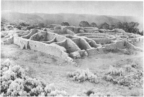
A Mesa Verde surface ruin. Far View House.
Four and a half miles north of Spruce Tree Camp the park road passes through 16 major and many minor mounds. This is the so-called Mummy Lake group, a misnomer, since the walled depression at the crest of the slope above the group was never used as a reservoir, although in the spring of the year water is still conducted thereto by the drainage ditches constructed by the early cowmen in the park in their efforts to impound sufficient water for their stock. And, again, mummies are never found where the least dampness occurs.
The first unit of this group to be excavated was named Far View House because of the wonderful panorama of diversified terrain that is visible in Colorado, New Mexico, and Arizona from the walls of the ruin. At the beginning of the work, this mound appeared very much as any of the other adjacent major mounds, no sign of standing wall appearing above the even contour of the ruin. Heavy growths of sagebrush covered the whole area. Three months’ time was devoted to the excavation in revealing the rectangular pueblo, 100 by 113 feet in size, now seen. The slow crumbling of the heavy dirt-covered roofs and the walls, together with the annual deposit of wind-blown sand from the San Juan country early each spring, gradually filled the rooms to the level of the standing walls, after which destructive elements and forces can little change the contour of any ruin.
The external features of Far View House are apparent as we approach its walls; mounting to the top of the highest wall we can best observe the general plan. This pueblo is rectangular in shape, consisting of concentrated rooms with a court surrounded by a wall annexed to the south side. On its southeast corner, a little less than 100 feet away, lies the cemetery from which have been taken a number of skeletons with their offerings of food bowls and other objects, such as was the custom of these people to deposit in the graves of their dead.
At its highest point on the north wall the pueblo had three stories, but on the southern side there was but a single story. This building was terraced, one tier of rooms above another. In the corner of the interior of the highest room may still be seen the ancient fireplaces and stones for grinding corn, set in their original positions as used by the former inhabitants. There are no external windows or passages, except on the south side where midway in length is a recess in which was placed a ladder in order to be hidden from view. The inhabitants evidently used the roof of the lowest terrace for many occupations. A birdseye view shows that all the rooms, now roofless, fall into two groups.
In the center of this mass of rooms is a kiva 32 feet in diameter, and around it are three smaller kivas. The size of the large kiva is noteworthy. In the cliff dwellings the kivas were necessarily small because of the limited floor space, but in the surface villages, where unlimited space was available, they were often large. This arrangement of one large kiva and several small ones is common. It might indicate that each clan had a small kiva of its own but that in the major ceremonies, when all of the clans worked together, the large ceremonial room was used. The structural details of the large kiva are identical with those of the smaller ones. The only variation is in the size.
The rooms surrounding these circular ones vary somewhat in form but are, as a rule, rectangular, the shapes of those near the kivas being triangular to fill the necessary spaces. The contents of the rectangular rooms show that they were inhabited. Artifacts were found and indications of various industries as well as marks of smoke from their fireplaces appear on the walls. From the nature of this evidence there is no doubt that Far View House was once inhabited by the people living the same way as those dwelling in Spruce Tree House.
The court added to the pueblo on its south side is enclosed by a low wall. Here were probably performed, in ancient times, the many religious dances and festivals.
Far View House is but one of the 16 pueblos in the Mummy Lake group, and at the period of maximum development could have housed a large population. To the north and east, where the two branches of Soda Canyon join, another large village or group has been located, and one can almost trace the trail across the west fork of Soda Canyon to the neighboring village and imagine the dusky visitors going from one to the other in prehistoric times. Each narrow tonguelike mesa of the Mesa Verde has its ruins of either isolated pueblo structures, or adjacent groups, denoting the widespread distribution of the mesa pueblo builders.
Pottery is the best index as to the chronological sequence of the ruins in the Southwest, and in examining the pottery of some of the mesa-type pueblos it is found that some contain pottery antedating that of the cliff-house culture, while others contain similar types. Undoubtedly, they were simultaneously inhabited, in part at least, and the transitory period was of long duration; but the period in prehistoric time when they were built and later deserted has not been determined. We cannot say from data now at hand when this took place, documentary history affording no help.
The aborigines who lived near these ruins when discovered in 1874 belong to the Utes, a Shoshonean stock who disclaimed all knowledge of the [25] people who constructed these buildings. They avoided them as uncanny and even now can only with difficulty be induced to enter them. They have dim legends of conflicts between the earliest Utes and cliff dwellers. Unfortunately, however, such legendary evidence is not reliable, as the general mythology of these people has been much distorted due to foreign contacts.
OTHER RUINS NEAR FAR VIEW HOUSE
During the season of 1922 excavation and repair work in the vicinity of Far View House was carried on simultaneously. Among the ruins excavated were Pipe Shrine House, One Clan House, Far View Tower, and Megalithic House.
In 1922 one of the Late Basket Maker pit houses was excavated on the mesa above Square Tower House. This structure is known as Earth Lodge A. Although it once had a mud and pole roof almost as high as a man’s head, nothing now remains but the underground part of the house. None of these pit houses have ever been found that have not been burned, and only a few pieces of charcoal remain as evidence of the former roof. The pit is 30 inches deep and 18 feet in diameter. In the center is a fire pit. In the floor are also four holes, forming a large square, in which the roof supports once stood. The walls of the pit were formerly plastered with a thick layer of mud, but only a few patches of this remain. Around the edge of the room, where the floor was low, were a number of small storage bins made of thin stone slabs. No side entrance was located during excavation. In some of the pit houses evidence has shown that entrance was often made by means of a ladder through the smokehole in the roof.
This was a typical home of the Late Basket Makers who were living in this region when the Pueblo Indians arrived about 700 A. D. These pit houses passed out of existence as soon as the masonry wall was perfected.
Of all the ruins in Mesa Verde National Park only 28 have been named and only 30 excavated. No survey of the unexcavated sites has been made, and the total number of ruins is unknown. Several hundred cliff dwellings have been discovered, and new ones will probably be found in the more remote canyons. The surface pueblos outnumber the cliff dwellings, and a careful search would reveal many that are now hidden by a thick growth of underbrush. The earth lodges of the Late Basket Makers are so common that hundreds will be brought to light by careful search. Dozens of them can be located in a half-hour walk over any of the mesas.
Dr. A. E. Douglass, director of Steward Observatory, University of Arizona, established the tree-ring chronology for dating Southwestern ruins. This chronology is based upon the facts that solar changes affect our weather and weather in turn the trees of the arid Southwest, as elsewhere, and that such affects are recorded in the variation of tree-ring growth during wet and dry years. Thus the tree-ring record of living trees has been extended into the past by arranging beams from historic pueblos in their proper sequence so that the inner diaries of one dovetailed the outer entries of its predecessor, and in turn overlapped the diary of the living trees. After completing the series from living trees and pueblos, of known dates, the record has been continued through the cross-sections of prehistoric beams of fir and pine that were chopped with the stone axes. The continuation of this chronology is only limited by the finding of earlier beams than those used in the established chronology.
The National Geographic Society tree-ring expedition took, in all, 49 beam sections from ruins within Mesa Verde National Park. During 1932 and 1933 further tree-ring research was carried on in this area and additional dates have been secured. Presuming that the year of cutting the timber was the year of actual use in construction, the following dates have been established for the major cliff dwellings:
Mug House, A. D. 1066
Cliff Palace, A. D. 1073-1273
Oak Tree House, A. D. 1112-84
Spring House, A. D. 1115
Hemenway House, A. D. 1171
Balcony House, A. D. 1190-1272
Long House, A. D. 1204-11
Square Tower House, A. D. 1204-46
Spruce Tree House, A. D. 1230-74
New Fire House, A. D. 1259
Ruin No. 16, A. D. 1261
Buzzard House, A. D. 1273
Since considerable tree-ring material from these ruins remains yet to be examined, the dates given above are not final. On the basis of present evidence, Cliff Palace, the largest and most complex cliff house within the park, shows an occupancy of 200 years.
It is an interesting fact that all of the dates fall just short of the beginning of the great drought, which the tree-ring chronology shows commenced in 1276 and extended to 1299, a period of 23 years.
In 1923 Roy Henderson and A. B. Hardin discovered the largest and finest watchtower that had yet been found. The tower was circular, 25 feet in height and 11 feet in diameter. Loopholes at various levels commanded the approach from every exposed quarter.
During the winter of 1924 the north refuse space of Spruce Tree House was excavated. Two child burials were found, one partially mummified, the other skeletal only. With one was found a mug, a ladle, a digging stick, and two ring baskets that had held food. Several corrugated jars were found, together with miscellaneous material. A layer of turkey droppings a foot thick indicated the space had been used as a turkey pen.
During January and February of 1926, when snow was available as a water supply, excavations were carried on in Step House Cave, by Superintendent Jesse L. Nusbaum. In 1891 Nordenskiöld had found many fine burials in this cave and it had suffered greatly from pothunting. The cliff dweller refuse at the south end of the cave had not been thoroughly cleaned out, however, and it was under this layer of trash that the important discovery was made. Three of the Lake Basket Maker pit houses were found, giving the first evidence that these people had used the caves before the cliff dwellers. Very few artifacts were found because of the earlier pothunting. In 1926 also a low, deep cave opposite Fire Temple was excavated, and a small amount of Basket Maker material found. Most interesting were two tapered cylinders of crystallized salt that still bore the imprint of the molder’s hands. While bracing a slipping boulder in Cliff Palace, Fred Jeeps found, in 1916, a sandal of the Early Basket Maker type that indicates a former occupancy of the cave by the first group of Agricultural Indians in this region.
In 1927 Bone Awl House was excavated. A series of unusually fine bone awls was found that suggested the name for the ruin. Much miscellaneous material was also found. Another small cliff dwelling nearby was cleaned out. One baby mummy and an adult burial were found, as well as some pottery and bone and stone tools. This ruin is reached by a spectacular series of 104 footholds that the cliff dwellers had cut in the almost perpendicular canyon wall.
During March of 1928 and the winter of 1929 restricted excavations were conducted in ruins 11 to 19, inclusive, on the west side of Wetherill Mesa. Several burials were found, all in poor condition because of dampness. Outstanding was an unusual bird pendant of hematite with crystal eyes set into drilled sockets with piñon gum. Forty-two bowls were reconstructed from the sherds found.
In the summer of 1929 Mr. and Mrs. Harold S. Gladwin and associates of Gila Pueblo, Globe, Ariz., assisted by Deric Nusbaum, conducted an archeological survey of small-house ruins on Chapin Mesa and in the canyon heads along the North Rim. The survey covered 250 sites. One hundred sherds were collected from each site and studied to identify the pottery types, the sequence of their development, and their relationship to pottery types of other southwestern archeological areas.
The forest fire of 1934 revealed many hitherto unknown ruins. Two splendid watchtowers were found on the west cliff of Rock Canyon. In a small area at the head of Long Canyon 10 new Early Pueblo ruins were located and no doubt scores of others will be found upon more careful search. In the heads of the small canyons many dams and terraces were noted.
In the stabilization program that was carried on in 1934-35 a number of artifacts were found. A certain amount of debris had to be moved in order that the weakened walls and slipping foundations might be strengthened and varied finds resulted. Axes, bone awls, sandals, pottery, planting sticks, and similar articles were most common, but a few burials were also found.
In August 1934 the undisturbed skeleton of an old woman was found on the bare floor of a small ruin just across the canyon from the public camp grounds. This skeleton, of particular importance because of fusion of the spinal column, had apparently remained exposed and undisturbed through more than seven centuries.
Because of the fact that no detailed, comprehensive survey has ever been made of the archeological resources of the park, the findings of new ruins, artifacts, and human remains are more or less regularly reported at the park museum.
The so-called “Mesa Verde cliff dwellers” were not the first of the prehistoric southwestern cultures, nor were they the first human occupants of the natural caves that abound in the area of the park. Centuries before the cliff-dweller culture with its complex social organizations, agriculture, and highly developed arts of masonry, textiles, and ceramics, it is thought that small groups of primitive Mongoloid hunters crossed from the northeastern peninsula of Asia to the western coast of Alaska. The Bering Strait, with but 60 miles of water travel, offered the safest and easiest route.
Just when these migrations to the east had their origin and how long they continued cannot definitely be said, but it is thought the earliest Mongoloid hunters were in northwestern America about twelve to fifteen [29] thousand years ago. When Columbus “discovered” America the continent was inhabited from Alaska to the Strait of Magellan and from the Pacific to the Atlantic coasts.
For perhaps several thousand years following the first migrations little of great significance developed. There undoubtedly was cultural progress, but it was slow, and in the long perspective of time its evidences are hardly discernible. With the knowledge and benefits of agriculture, which was probably developed first in Mexico, hunting gave way to husbandry, nomadism to sedentary life, and there followed a great period of change and advancement. The introduction of corn or Indian maize into what is now the southwestern United States may be called the antecedent condition for all advanced cultures of the area.
Evidence has not yet been established that the first of the maize-growing Indians of the Southwest were permanent occupants of the Mesa Verde. Nevertheless, in the Cliff Palace cave, well below the horizon or floor level of the cliff dwellers, archeologists have found a yucca fiber sandal of a distinctive type which is associated only with the first agricultural civilization. From this evidence it would be reasonable to assume that the caves of Mesa Verde at least offered temporary shelter, if not permanent homes, to the people of this period.
The earliest culture so far definitely identified as having permanent habitation on the Mesa Verde is the Basket Maker III or the Second Agricultural Basket Maker first found in Step House cave on the west side of the park below the debris of the latter cliff-house occupation. Recent excavations and archeological surveys furnish conclusive evidence that the second agricultural people were most numerous in the area now included in this national park, and they constructed their roughly circular subterranean rooms not only in the sandy floor of the caves but also in the red soil on the comparatively level mesas separating the numerous canyons. Late Basket Maker House A, formerly known as Earth Lodge A, is an excellent example of this early type of structure. Up to this time excavations have failed to uncover a single house structure of this type not destroyed by fire.
These early inhabitants made basketry, excelled in the art of weaving, and it is believed were the first of the southwestern cultures to invent fired pottery. The course of this invention can be traced from the crude sun-dried vessel tempered with shredded cedar bark to the properly tempered and durable fired vessel.
Then followed a long development in house structure, differing materially from this earlier type. Horizontal masonry replaced the cruder attempts of house-wall construction; rectangular or squarish forms replaced [30] the somewhat circular and earlier type; and gradually the single-room structure was grouped in ever-enlarging units which assumed varying forms of arrangement as the development progressed. The art of pottery making improved concurrently with the more complex house structure. This later period represents the intermediate era of development from the crude Late Basket Maker dwellings to the remarkable structures of the “Cliff House Culture.”
During this period of transition new people penetrated the area. The Basket Makers throughout the course of their development were consistently a long-headed group. The appearance of an alien group is recorded through the finding of skeletons with broad or round skulls and a deformed occiput. These new people, the Pueblos, took over, changed, and adapted to their own needs the material culture of the earlier inhabitants.
The cliff dwellers were not content with the crude buildings and earth lodges that satisfied as homes during earlier periods of occupancy. For their habitations they shaped stones into regular forms, sometimes ornamenting them with designs, and laid them in mud mortar, one on another. Their masonry has resisted the destructive forces of the elements for centuries.
The arrangement of houses in a cliff dwelling the size of Cliff Palace is characteristic and is intimately associated with the distribution of the social divisions of its former inhabitants.
The population was composed of a number of units, possibly clans, each of which had its more or less distinct social organization, as indicated in the arrangement of the rooms. The rooms occupied by a clan were not necessarily connected, although generally neighboring rooms were distinguished from one another by their uses. Thus, each clan had its men’s room, which is ceremonially called the “kiva.” Each clan had also one or more rooms, which may be styled the living rooms, and other enclosures for granaries. The corn was ground into meal in another room containing the metate set in a stone bin or trough. Sometimes the rooms had fireplaces, although these were generally in the plazas or on the housetops. All these different rooms, taken together, constituted the houses that belonged to one clan.
The conviction that each kiva denotes a distinct social unit, as a clan or a family, is supported by a general similarity in the masonry of the kiva walls and that of adjacent houses ascribed to the same clan. From the number of these rooms it would appear that there were at least 23 social units or clans in Cliff Palace.
Apparently there is no uniformity or prearranged plan in the distribution of the kivas. As religious belief and custom prescribed that these rooms [31] should be subterranean, the greatest number were placed in front of the rectangular buildings where it was easiest to construct them. When necessary, because of limited space or other conditions, kivas were also built far back in the cave and inclosed by a double wall of masonry, with the walls being spaced about two and a half to three feet apart. The section between the walls was then backfilled with earth or rubble to the level of the kiva roof. In that way the ceremonial structure was artificially made subterranean, as their beliefs required.
In addition to their ability as architects and masons, the cliff dwellers excelled in the art of pottery making and as agriculturists. Their decorated pottery—a black design on pearly white background—will compare favorably with pottery of the other cultures of the prehistoric Southwest.
As their sense of beauty was keen, their art, though primitive, was true; rarely realistic, generally symbolic. Their decoration of cotton fabrics and ceramic work might be called beautiful, even when judged by our own standards. They fashioned axes, spear points, and rude tools of stone; they wove sandals, and made attractive basketry.
The staple product of the cliff dwellers was corn; they also planted beans and gourds. This limited selection was perhaps augmented by piñon nuts and yucca fruit—indigenous products found in abundance. Nevertheless, successful agriculture on the semiarid plateau of the Mesa Verde must have been dependent upon hard work and diligent efforts. Without running streams irrigation was impossible and success depended upon the ability of the farmer to save the crop through the dry period of June and early July.
Rain at the right time was the all-important problem, and so confidently did they believe that they were dependent upon the gods to make the rain fall and the corn grow that they worshiped the sun as the father of all life and the earth as the mother who brought them all their material blessings.
From Dr. A. E. Douglass’s tree-ring chronology the earliest date so far established for the Mesa Verde cliff dwellings is 1066 A. D. and the latest date 1274 A. D. While it should not be imagined that these are the all-inclusive dates representing the total time of the cliff-dweller culture, it is interesting to note that this same tree-ring story tells us that a great drought commenced in 1276 and extended for a 23-year period to 1299. It may logically be presumed that the prehistoric population was gradually forced to withdraw from the area as the drought continued and to establish itself near more favorable sources of water supply.
The so-called “Aztec ruin”, which is situated on the banks of the Animas River in northwestern New Mexico, substantiates this hypothesis of the [32] voluntary desertion of the cliff dwellings. In this ruin is found unmistakable evidence of a secondary occupation which has been definitely identified as a Mesa Verde settlement.
It is thought that certain of the present-day Pueblo Indians are descendants, in part at least, of the cliff dwellers. Many of these Indian towns or pueblos still survive in the States of New Mexico and Arizona, the least modified of which are the villages of the Hopi, situated not far from the Grand Canyon National Park.
The fauna and flora of Mesa Verde should be particularly interesting to visitors. A combination of desert types from the lower arid country and mountain types, usually associated with regions of higher rainfall, occur here. The desert types are highly specialized to cope with their environment, particularly the plant and smaller animal life.
Rocky Mountain mule deer are perhaps the only big game to be found abundantly in the park. They are often seen. Their numbers in the park, however, vary greatly according to the season. It is hoped to reintroduce the native species of Rocky Mountain bighorn, as soon as range sufficient for the needs of this species has been added to the park.
Cougars, or mountain lions, are part of the wildlife of the park and, strange to say, are occasionally seen in broad daylight. In other national parks these animals are rarely seen even by rangers.
Coyotes and foxes are not as numerous as they once were on the mesa. As a result, many of the smaller animals such as porcupines and prairie dogs have greatly increased. Wildcats are fairly common but are only occasionally seen.
Game birds are represented by the dusky grouse and scaled quail, both desert types. No wild turkeys are found in the park now, although it is believed that they were once there. Fragments of bones discovered in the ruins indicate that the cliff dwellers kept turkeys. Whether these were wild turkeys from the mesa or birds brought in from elsewhere is a question that has not as yet been answered. At present the reintroduction of wild turkeys to Mesa Verde is under consideration.
Among the most interesting animal residents of Mesa Verde are the lizards. Some of these are: the horned lizard, the western spotted or earless lizard, the collared lizard, the striped race-runner, utas, rock swifts, and sagebrush swifts.
Although Mesa Verde receives considerably more rainfall than true desert areas, vegetation is fairly sparse at the best and is generally of the [33] arid type. Cacti of a number of varieties flourish but are conspicuous only in May and June when they bloom. Piñon pine, juniper, Douglas fir, and western yellow pine represent most of the large evergreens. Oregon grape, yucca, and mistletoe (on the junipers) are some of the other plants found over the area. Nearer the springs and water courses vegetation is much more luxurious, but unfortunately these spots are far below the level of the mesa and are mostly on privately owned land.

A yucca plant in fruit (Yucca baccata).
Mesa Verde National Park may be reached by automobile from Denver, Colorado Springs, Pueblo, and other Colorado points. Through Pueblo [34] one road leads to the park by way of Cañon City, from where one may look down into the Royal Gorge, the deepest canyon in the world penetrated by a railroad and river. This road passes through Salida and on through Gunnison and Montrose, and then south through Ouray, Silverton, and Durango. This route passes through some of Colorado’s most magnificent mountain scenery. Another road leads south from Pueblo through Walsenburg, across La Veta Pass, on through Alamosa, Del Norte, Pagosa Springs, and Durango, crossing Wolf Creek Pass en route. Both roads lead west from Durango to Mancos and on into the park.
Motorists coming from Utah turn southward from Green River or Thompsons, crossing the Colorado River at Moab, proceeding southward to Monticello, thence eastward to Cortez, Colo., and the park.
From Arizona and New Mexico points, Gallup, on the National Old Trails Road, is easily reached. The auto road leads north from Gallup through the Navajo Indian Reservation and a corner of the Ute Indian Reservation. At Shiprock Indian Agency, 98 miles north of Gallup, the San Juan River is crossed.
Mesa Verde National Park is approached by rail both from the north and from the south: From the north via the Denver & Rio Grande Western Railroad main transcontinental line through Grand Junction, and branch lines through Montrose and Durango; from the south via the main transcontinental line of the Santa Fe Railroad through Gallup, N. Mex.
The lines of the Denver & Rio Grande Western System traverse some of the most magnificent scenery of the Rocky Mountain region, a fact which gives the journey to Mesa Verde zestful travel flavor. Two main-line routes are provided to the Grand Junction gateway.
The Royal Gorge Route goes through the Grand Canyon of the Arkansas, now spanned by an all-steel suspension bridge, 1,053 feet above the tracks in the Royal Gorge. This route crosses Tennessee Pass (altitude, 10,240 feet) and follows the Eagle River to its junction with the Colorado River at Dotsero, thence to Grand Junction.
Service was inaugurated in June 1934 via the new James Peak Route of the D. & R. G. W., utilizing the Moffat Tunnel (altitude at apex, 9,239 feet), 6.2-mile bore which pierces the Continental Divide, 50 miles west of Denver. This route follows the Colorado River from Fraser, high on the west slope of the continent, through Byers Canyon, Red Gorge, Gore Canyon, and Red Canyon, thence over the Dotsero Cut-off to Dotsero, where it joins the Royal Gorge Route. The new line saves 175 miles in the distance from Denver to Grand Junction.
The Rio Grande Motor Way, Inc., of Grand Junction, Colo., from June 15 to September 15, operates a daily motor service from Grand Junction, Delta, Montrose, Ouray, Silverton, Durango, and Mancos, Colo., to Spruce Tree Lodge in Mesa Verde National Park. This motor bus leaves Grand Junction at 7:15 a. m., via the scenic Chief Ouray Highway, stopping en route at other places mentioned, crossing beautiful Red Mountain Pass (altitude, 11,025 feet), arriving at Spruce Tree Lodge at 7 p. m. The stage leaves the park at 7 a. m., arriving at Grand Junction at 5:40 p. m.
The round-trip fare between Grand Junction and the park is $26.56 if four or more persons make the trip, and increases as the number of passengers decreases.
Entrance to Mesa Verde from the south through Gallup, N. Mex., via the Navajo and Southern Ute Indian Reservations, is growing constantly in convenience and popularity. Hunter Clarkson, Inc., with headquarters at El Navajo Hotel, in Gallup, operates two-day round trip light sedan service, leaving Gallup at 8 a. m. on Mondays, Wednesdays, and Fridays, and returning to Gallup at 6 p. m. on Tuesdays, Thursdays, and Saturdays. This service permits the visiting of ruins in the park, in accordance with regular schedules, on the afternoon of the first day and on the morning of the second. The round trip fare per person (360 miles) is $25. A minimum of two passengers is required. Fare for children, five and under twelve, is $12.50. Meals and hotel accommodations en route or at the park are not included. El Navajo Hotel, operated by Fred Harvey, offers excellent overnight accommodations at Gallup.
The Cannon Ball Stage operates bus service from Gallup, via Shiprock and Farmington, to Durango, where connection may be made with the motor bus of the Rio Grande Motor Way, Inc., for the trip from Durango to the park. The Cannon Ball Stage bus leaves Gallup each day at 11:30 a. m., arriving at Durango at 4:45 p. m. Returning it leaves Durango at 8 a. m. and arrives at Gallup at 1 p. m. The fare from Gallup to Durango is $6 one way and $10.80 for the round trip.
The Mesa Verde National Park is under the exclusive control of the National Park Service of the Department of the Interior, which is authorized to make rules and regulations and to establish such service as it may deem necessary for the care and management of the park and the preservation from injury or spoliation of the ruins and other remains of prehistoric man within the limits of the reservation.
The National Park Service is represented in the actual administration of the park by a superintendent, who is assisted in the protection and interpretation [36] of its natural and prehistoric features by a well-trained staff. The present superintendent is Jesse L. Nusbaum, and his post-office address is Mesa Verde National Park, Colo.
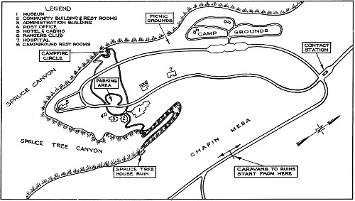
Headquarters Area.
The park season extends from May 15 to October 15, complete lodging and food accommodations and automobile stage service being available from June 15 to September 15. Informal lodging and meal accommodations are provided during the remainder of the park season.
Exclusive jurisdiction over the park was ceded to the United States by act of the Colorado Legislature approved May 2, 1927, and accepted by Congress by act approved April 25, 1928. There is a United States Commissioner at park headquarters.
Telegrams sent prepaid to Mancos, Colo., will be phoned to addressee at park office. The post-office address for parties within the park is Mesa Verde National Park, Colo.
Educational service, carefully planned to provide each visitor with an opportunity to interpret and appreciate the features of the Mesa Verde, is provided, without charge, by the Government. This service is directed by the park naturalist, who is assisted by a group of ranger naturalists.
During the season visitors are accompanied from the park museum to the various ruins by competent ranger naturalists. These men, well [37] trained in the social and biological sciences, make it their duty to help the visitor understand the natural and archeological features of the Mesa Verde. Because of the need of protecting the ruins and the somewhat devious trails by which they are reached, no one will be allowed to enter any ruin except Spruce Tree House unless accompanied by a ranger naturalist.
Each evening at 8 o’clock informal talks are given at the camp-fire circle near park headquarters. The superintendent, the park naturalist, and members of the educational staff give talks on the archeology of the region. Visiting scientists, writers, lecturers, and noted travelers often contribute to the evening’s entertainment. After the talks six of the best singers and dancers among the Navajo Indians employed in the park can usually be persuaded, by modest voluntary contributions on the part of the visitors, to give some of their songs and dances.
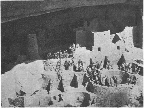
Competent ranger naturalists accompany visitors to the ruins. Grant Photo.
The park museum houses very important and comprehensive collections of excavated cliff-dweller and basket maker material, as well as restricted [38] collections of arts and crafts of modern Indians of the Southwest. These collections have been assembled through the conduct of excavations within the park and through loan or gift of materials by park friends or cooperating institutions. This material is arranged in a definite chronological order. By following through from the earliest culture to those of the present time a clear and concise picture of the former material cultures of the Mesa Verde and surrounding regions may be obtained.
One room has been set aside for natural history exhibits exemplifying the geology, fauna, and flora of this peculiar mesa-canyon country.
A part of the museum is given over to an excellent reference library and reading room. This library consists of books on archeology and related natural history subjects pertaining to this interesting region. Visitors have access to these books on application to the museum assistant who is in charge. These books may not be removed from the reading room.
The new public camp grounds are located in the piñons and junipers on the rim of Spruce Canyon only a few hundred feet from Spruce Tree Lodge and park headquarters. Individual party campsites have been cleared, and a protecting screen of shrubbery contributes to their privacy. Each site is provided with a fireplace, a table with seats, and a large level place for a tent. Good water has been piped to convenient places, and cut wood is provided without charge. Toilet facilities, showers, and laundry tubs are also provided. A ranger is detailed for duty in the camp grounds.
Leave your campsite clean when you have finished with it.
Do not drive cars on, or walk, over the shrubbery.
The camp ground facilities at Mesa Verde have been greatly improved and expanded through the work of the Civilian Conservation Corps.
Provisions for campers are obtainable at reasonable prices in any of the nearby towns. Groceries, gas, and oil can also be purchased at Spruce Tree Lodge.
Visitors who view the Mesa Verde from the automobile roads gain but an inkling of the weird beauty and surprises that this area holds for the more adventurous. Horseback and hiking trips along the rim rocks and into the canyons lead to spectacular ruins not seen from any of the roads. Such great ruins as Spring House, Long House, Kodak House, Jug House, Mug House, and Step House, as well as all of the ruins in the more remote canyons, can be reached by trail only. Each turn of the trail reveals [39] entrancing vistas of rugged canyons, sheer cliffs, great caves, hidden ruins, distant mountains, tree-covered mesas, and open glades.
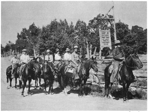
A party off for the less-frequented trails. Grant photo.
In making these trips it is important that the hiker prepare himself with proper footwear, as the trails are very precipitous in places.
There is an excellent hospital at park headquarters where medical and surgical service is provided to care for all emergency cases. Prices are regulated by the Secretary of the Interior.
At Spruce Tree Lodge, situated among the piñons and junipers overlooking Spruce, Spruce Tree, and Navajo Canyons, cottages and comfortable floored tents may be rented at prices ranging from $0.75 to $2 per day a person for accommodations only, and from $4.50 to $5.75 per day including meals. Meals, table d’hote and a la carte, at reasonable prices. Children: No charge under 3; half rates from 3 to 8. The official season for Spruce Tree Lodge is from June 15 to September 15.
The company also operates, for visitors who do not care to use their own cars or are without private transportation, automobile service to various ruins for $1 each, round trip. A special evening trip to Park Point to see the spectacular sunset from the highest point in the park is $1.50 per person.
OUT-OF-SEASON ACCOMMODATIONS
Before June 15 and after September 15, cabins may be rented from the caretaker of Spruce Tree Lodge at the regular rates. Meals, with breakfast 50 cents, and luncheon and dinner 75 cents, may be had at the Government dining hall. In nearby towns, less than an hour’s drive from park headquarters, accommodations are also obtainable.
PACK AND SADDLE ACCOMMODATIONS
Saddle horses, especially trained for mountain work, may be rented from the Mesa Verde Pack & Saddle Co. For short trips the rental is $1 for the first hour and 50 cents for each additional hour. For short 1-day trips for three persons or more the cost is $3.50 each; two persons $4 each; one person $6. Longer 1-day trips for experienced riders are available at $2 per person more than the rate for the shorter 1-day trips. All prices include guide service, and a slicker, canteen, and lunch bag are provided with each horse. Arrangements should be made the evening before the trip is taken.
PACK TRIPS
Nonscheduled pack trips to the more remote sections of the park may be arranged (2 days’ notice is required) at prices ranging from $9 a day each for parties of five or more to $15 a day for one person. This includes a guide-cook and furnishes each person with one saddle horse, one pack horse, bed, tent, canteen, slicker, and subsistence for the trip. Three days is the minimum time for which these trips can be arranged.
Glimpses of Our National Parks. An illustrated booklet of 92 pages containing descriptions of the principal national parks. Address the Director, National Park Service, Washington, D. C. Free.
Recreational Map. Shows both Federal and State reservations with recreational opportunities throughout the United States. Brief descriptions of principal ones. Free.
Fauna of the National Parks. Series No. 1. By G. M. Wright, J. S. Dixon, and B. H. Thompson. Survey of wildlife conditions in the national parks. 157 pages, illustrated. Superintendent of Documents, Washington, D. C. Price 20 cents.
Fauna of the National Parks. Series No. 2. By G. M. Wright and B. H. Thompson. Wildlife management in the national parks. 142 pages, illustrated. Superintendent of Documents, Washington, D. C. 20 cents.
Map of Mesa Verde National Park; 43 by 28 inches; scale, one-half mile to the inch. United States Geological Survey, Washington, D. C. Price 20 cents.
Panoramic View of Mesa Verde National Park; 22½ by 19 inches; scale, three-fourths mile to the inch. Superintendent of Documents, Washington, D. C. Price, 25 cents.
National Parks Portfolio. By Robert Sterling Yard. Cloth bound and illustrated with more than 300 beautiful photographs of the national parks. Superintendent of Documents, Washington, D. C. Price $1.50.
Booklets about the national parks listed below may be obtained free of charge by writing The National Park Service, Washington, D. C.
AREAS ADMINISTERED BY THE NATIONAL PARK SERVICE
End of the Project Gutenberg EBook of Mesa Verde National Park, by Anonymous

*** END OF THIS PROJECT GUTENBERG EBOOK MESA VERDE NATIONAL PARK ***

***** This file should be named 45535-h.htm or 45535-h.zip *****
This and all associated files of various formats will be found in:
        http://www.gutenberg.org/4/5/5/3/45535/

Produced by Stephen Hutcheson, Chris Curnow and the Online
Distributed Proofreading Team at http://www.pgdp.net


Updated editions will replace the previous one--the old editions
will be renamed.

Creating the works from public domain print editions means that no
one owns a United States copyright in these works, so the Foundation
(and you!) can copy and distribute it in the United States without
permission and without paying copyright royalties.  Special rules,
set forth in the General Terms of Use part of this license, apply to
copying and distributing Project Gutenberg-tm electronic works to
protect the PROJECT GUTENBERG-tm concept and trademark.  Project
Gutenberg is a registered trademark, and may not be used if you
charge for the eBooks, unless you receive specific permission.  If you
do not charge anything for copies of this eBook, complying with the
rules is very easy.  You may use this eBook for nearly any purpose
such as creation of derivative works, reports, performances and
research.  They may be modified and printed and given away--you may do
practically ANYTHING with public domain eBooks.  Redistribution is
subject to the trademark license, especially commercial
redistribution.


*** START: FULL LICENSE ***

THE FULL PROJECT GUTENBERG LICENSE
PLEASE READ THIS BEFORE YOU DISTRIBUTE OR USE THIS WORK

To protect the Project Gutenberg-tm mission of promoting the free
distribution of electronic works, by using or distributing this work
(or any other work associated in any way with the phrase "Project
Gutenberg"), you agree to comply with all the terms of the Full Project
Gutenberg-tm License available with this file or online at
  www.gutenberg.org/license.


Section 1.  General Terms of Use and Redistributing Project Gutenberg-tm
electronic works

1.A.  By reading or using any part of this Project Gutenberg-tm
electronic work, you indicate that you have read, understand, agree to
and accept all the terms of this license and intellectual property
(trademark/copyright) agreement.  If you do not agree to abide by all
the terms of this agreement, you must cease using and return or destroy
all copies of Project Gutenberg-tm electronic works in your possession.
If you paid a fee for obtaining a copy of or access to a Project
Gutenberg-tm electronic work and you do not agree to be bound by the
terms of this agreement, you may obtain a refund from the person or
entity to whom you paid the fee as set forth in paragraph 1.E.8.

1.B.  "Project Gutenberg" is a registered trademark.  It may only be
used on or associated in any way with an electronic work by people who
agree to be bound by the terms of this agreement.  There are a few
things that you can do with most Project Gutenberg-tm electronic works
even without complying with the full terms of this agreement.  See
paragraph 1.C below.  There are a lot of things you can do with Project
Gutenberg-tm electronic works if you follow the terms of this agreement
and help preserve free future access to Project Gutenberg-tm electronic
works.  See paragraph 1.E below.

1.C.  The Project Gutenberg Literary Archive Foundation ("the Foundation"
or PGLAF), owns a compilation copyright in the collection of Project
Gutenberg-tm electronic works.  Nearly all the individual works in the
collection are in the public domain in the United States.  If an
individual work is in the public domain in the United States and you are
located in the United States, we do not claim a right to prevent you from
copying, distributing, performing, displaying or creating derivative
works based on the work as long as all references to Project Gutenberg
are removed.  Of course, we hope that you will support the Project
Gutenberg-tm mission of promoting free access to electronic works by
freely sharing Project Gutenberg-tm works in compliance with the terms of
this agreement for keeping the Project Gutenberg-tm name associated with
the work.  You can easily comply with the terms of this agreement by
keeping this work in the same format with its attached full Project
Gutenberg-tm License when you share it without charge with others.

1.D.  The copyright laws of the place where you are located also govern
what you can do with this work.  Copyright laws in most countries are in
a constant state of change.  If you are outside the United States, check
the laws of your country in addition to the terms of this agreement
before downloading, copying, displaying, performing, distributing or
creating derivative works based on this work or any other Project
Gutenberg-tm work.  The Foundation makes no representations concerning
the copyright status of any work in any country outside the United
States.

1.E.  Unless you have removed all references to Project Gutenberg:

1.E.1.  The following sentence, with active links to, or other immediate
access to, the full Project Gutenberg-tm License must appear prominently
whenever any copy of a Project Gutenberg-tm work (any work on which the
phrase "Project Gutenberg" appears, or with which the phrase "Project
Gutenberg" is associated) is accessed, displayed, performed, viewed,
copied or distributed:

This eBook is for the use of anyone anywhere at no cost and with
almost no restrictions whatsoever.  You may copy it, give it away or
re-use it under the terms of the Project Gutenberg License included
with this eBook or online at www.gutenberg.org

1.E.2.  If an individual Project Gutenberg-tm electronic work is derived
from the public domain (does not contain a notice indicating that it is
posted with permission of the copyright holder), the work can be copied
and distributed to anyone in the United States without paying any fees
or charges.  If you are redistributing or providing access to a work
with the phrase "Project Gutenberg" associated with or appearing on the
work, you must comply either with the requirements of paragraphs 1.E.1
through 1.E.7 or obtain permission for the use of the work and the
Project Gutenberg-tm trademark as set forth in paragraphs 1.E.8 or
1.E.9.

1.E.3.  If an individual Project Gutenberg-tm electronic work is posted
with the permission of the copyright holder, your use and distribution
must comply with both paragraphs 1.E.1 through 1.E.7 and any additional
terms imposed by the copyright holder.  Additional terms will be linked
to the Project Gutenberg-tm License for all works posted with the
permission of the copyright holder found at the beginning of this work.

1.E.4.  Do not unlink or detach or remove the full Project Gutenberg-tm
License terms from this work, or any files containing a part of this
work or any other work associated with Project Gutenberg-tm.

1.E.5.  Do not copy, display, perform, distribute or redistribute this
electronic work, or any part of this electronic work, without
prominently displaying the sentence set forth in paragraph 1.E.1 with
active links or immediate access to the full terms of the Project
Gutenberg-tm License.

1.E.6.  You may convert to and distribute this work in any binary,
compressed, marked up, nonproprietary or proprietary form, including any
word processing or hypertext form.  However, if you provide access to or
distribute copies of a Project Gutenberg-tm work in a format other than
"Plain Vanilla ASCII" or other format used in the official version
posted on the official Project Gutenberg-tm web site (www.gutenberg.org),
you must, at no additional cost, fee or expense to the user, provide a
copy, a means of exporting a copy, or a means of obtaining a copy upon
request, of the work in its original "Plain Vanilla ASCII" or other
form.  Any alternate format must include the full Project Gutenberg-tm
License as specified in paragraph 1.E.1.

1.E.7.  Do not charge a fee for access to, viewing, displaying,
performing, copying or distributing any Project Gutenberg-tm works
unless you comply with paragraph 1.E.8 or 1.E.9.

1.E.8.  You may charge a reasonable fee for copies of or providing
access to or distributing Project Gutenberg-tm electronic works provided
that

- You pay a royalty fee of 20% of the gross profits you derive from
     the use of Project Gutenberg-tm works calculated using the method
     you already use to calculate your applicable taxes.  The fee is
     owed to the owner of the Project Gutenberg-tm trademark, but he
     has agreed to donate royalties under this paragraph to the
     Project Gutenberg Literary Archive Foundation.  Royalty payments
     must be paid within 60 days following each date on which you
     prepare (or are legally required to prepare) your periodic tax
     returns.  Royalty payments should be clearly marked as such and
     sent to the Project Gutenberg Literary Archive Foundation at the
     address specified in Section 4, "Information about donations to
     the Project Gutenberg Literary Archive Foundation."

- You provide a full refund of any money paid by a user who notifies
     you in writing (or by e-mail) within 30 days of receipt that s/he
     does not agree to the terms of the full Project Gutenberg-tm
     License.  You must require such a user to return or
     destroy all copies of the works possessed in a physical medium
     and discontinue all use of and all access to other copies of
     Project Gutenberg-tm works.

- You provide, in accordance with paragraph 1.F.3, a full refund of any
     money paid for a work or a replacement copy, if a defect in the
     electronic work is discovered and reported to you within 90 days
     of receipt of the work.

- You comply with all other terms of this agreement for free
     distribution of Project Gutenberg-tm works.

1.E.9.  If you wish to charge a fee or distribute a Project Gutenberg-tm
electronic work or group of works on different terms than are set
forth in this agreement, you must obtain permission in writing from
both the Project Gutenberg Literary Archive Foundation and Michael
Hart, the owner of the Project Gutenberg-tm trademark.  Contact the
Foundation as set forth in Section 3 below.

1.F.

1.F.1.  Project Gutenberg volunteers and employees expend considerable
effort to identify, do copyright research on, transcribe and proofread
public domain works in creating the Project Gutenberg-tm
collection.  Despite these efforts, Project Gutenberg-tm electronic
works, and the medium on which they may be stored, may contain
"Defects," such as, but not limited to, incomplete, inaccurate or
corrupt data, transcription errors, a copyright or other intellectual
property infringement, a defective or damaged disk or other medium, a
computer virus, or computer codes that damage or cannot be read by
your equipment.

1.F.2.  LIMITED WARRANTY, DISCLAIMER OF DAMAGES - Except for the "Right
of Replacement or Refund" described in paragraph 1.F.3, the Project
Gutenberg Literary Archive Foundation, the owner of the Project
Gutenberg-tm trademark, and any other party distributing a Project
Gutenberg-tm electronic work under this agreement, disclaim all
liability to you for damages, costs and expenses, including legal
fees.  YOU AGREE THAT YOU HAVE NO REMEDIES FOR NEGLIGENCE, STRICT
LIABILITY, BREACH OF WARRANTY OR BREACH OF CONTRACT EXCEPT THOSE
PROVIDED IN PARAGRAPH 1.F.3.  YOU AGREE THAT THE FOUNDATION, THE
TRADEMARK OWNER, AND ANY DISTRIBUTOR UNDER THIS AGREEMENT WILL NOT BE
LIABLE TO YOU FOR ACTUAL, DIRECT, INDIRECT, CONSEQUENTIAL, PUNITIVE OR
INCIDENTAL DAMAGES EVEN IF YOU GIVE NOTICE OF THE POSSIBILITY OF SUCH
DAMAGE.

1.F.3.  LIMITED RIGHT OF REPLACEMENT OR REFUND - If you discover a
defect in this electronic work within 90 days of receiving it, you can
receive a refund of the money (if any) you paid for it by sending a
written explanation to the person you received the work from.  If you
received the work on a physical medium, you must return the medium with
your written explanation.  The person or entity that provided you with
the defective work may elect to provide a replacement copy in lieu of a
refund.  If you received the work electronically, the person or entity
providing it to you may choose to give you a second opportunity to
receive the work electronically in lieu of a refund.  If the second copy
is also defective, you may demand a refund in writing without further
opportunities to fix the problem.

1.F.4.  Except for the limited right of replacement or refund set forth
in paragraph 1.F.3, this work is provided to you 'AS-IS', WITH NO OTHER
WARRANTIES OF ANY KIND, EXPRESS OR IMPLIED, INCLUDING BUT NOT LIMITED TO
WARRANTIES OF MERCHANTABILITY OR FITNESS FOR ANY PURPOSE.

1.F.5.  Some states do not allow disclaimers of certain implied
warranties or the exclusion or limitation of certain types of damages.
If any disclaimer or limitation set forth in this agreement violates the
law of the state applicable to this agreement, the agreement shall be
interpreted to make the maximum disclaimer or limitation permitted by
the applicable state law.  The invalidity or unenforceability of any
provision of this agreement shall not void the remaining provisions.

1.F.6.  INDEMNITY - You agree to indemnify and hold the Foundation, the
trademark owner, any agent or employee of the Foundation, anyone
providing copies of Project Gutenberg-tm electronic works in accordance
with this agreement, and any volunteers associated with the production,
promotion and distribution of Project Gutenberg-tm electronic works,
harmless from all liability, costs and expenses, including legal fees,
that arise directly or indirectly from any of the following which you do
or cause to occur: (a) distribution of this or any Project Gutenberg-tm
work, (b) alteration, modification, or additions or deletions to any
Project Gutenberg-tm work, and (c) any Defect you cause.


Section  2.  Information about the Mission of Project Gutenberg-tm

Project Gutenberg-tm is synonymous with the free distribution of
electronic works in formats readable by the widest variety of computers
including obsolete, old, middle-aged and new computers.  It exists
because of the efforts of hundreds of volunteers and donations from
people in all walks of life.

Volunteers and financial support to provide volunteers with the
assistance they need are critical to reaching Project Gutenberg-tm's
goals and ensuring that the Project Gutenberg-tm collection will
remain freely available for generations to come.  In 2001, the Project
Gutenberg Literary Archive Foundation was created to provide a secure
and permanent future for Project Gutenberg-tm and future generations.
To learn more about the Project Gutenberg Literary Archive Foundation
and how your efforts and donations can help, see Sections 3 and 4
and the Foundation information page at www.gutenberg.org


Section 3.  Information about the Project Gutenberg Literary Archive
Foundation

The Project Gutenberg Literary Archive Foundation is a non profit
501(c)(3) educational corporation organized under the laws of the
state of Mississippi and granted tax exempt status by the Internal
Revenue Service.  The Foundation's EIN or federal tax identification
number is 64-6221541.  Contributions to the Project Gutenberg
Literary Archive Foundation are tax deductible to the full extent
permitted by U.S. federal laws and your state's laws.

The Foundation's principal office is located at 4557 Melan Dr. S.
Fairbanks, AK, 99712., but its volunteers and employees are scattered
throughout numerous locations.  Its business office is located at 809
North 1500 West, Salt Lake City, UT 84116, (801) 596-1887.  Email
contact links and up to date contact information can be found at the
Foundation's web site and official page at www.gutenberg.org/contact

For additional contact information:
     Dr. Gregory B. Newby
     Chief Executive and Director
     gbnewby@pglaf.org

Section 4.  Information about Donations to the Project Gutenberg
Literary Archive Foundation

Project Gutenberg-tm depends upon and cannot survive without wide
spread public support and donations to carry out its mission of
increasing the number of public domain and licensed works that can be
freely distributed in machine readable form accessible by the widest
array of equipment including outdated equipment.  Many small donations
($1 to $5,000) are particularly important to maintaining tax exempt
status with the IRS.

The Foundation is committed to complying with the laws regulating
charities and charitable donations in all 50 states of the United
States.  Compliance requirements are not uniform and it takes a
considerable effort, much paperwork and many fees to meet and keep up
with these requirements.  We do not solicit donations in locations
where we have not received written confirmation of compliance.  To
SEND DONATIONS or determine the status of compliance for any
particular state visit www.gutenberg.org/donate

While we cannot and do not solicit contributions from states where we
have not met the solicitation requirements, we know of no prohibition
against accepting unsolicited donations from donors in such states who
approach us with offers to donate.

International donations are gratefully accepted, but we cannot make
any statements concerning tax treatment of donations received from
outside the United States.  U.S. laws alone swamp our small staff.

Please check the Project Gutenberg Web pages for current donation
methods and addresses.  Donations are accepted in a number of other
ways including checks, online payments and credit card donations.
To donate, please visit:  www.gutenberg.org/donate


Section 5.  General Information About Project Gutenberg-tm electronic
works.

Professor Michael S. Hart was the originator of the Project Gutenberg-tm
concept of a library of electronic works that could be freely shared
with anyone.  For forty years, he produced and distributed Project
Gutenberg-tm eBooks with only a loose network of volunteer support.

Project Gutenberg-tm eBooks are often created from several printed
editions, all of which are confirmed as Public Domain in the U.S.
unless a copyright notice is included.  Thus, we do not necessarily
keep eBooks in compliance with any particular paper edition.

Most people start at our Web site which has the main PG search facility:

     www.gutenberg.org

This Web site includes information about Project Gutenberg-tm,
including how to make donations to the Project Gutenberg Literary
Archive Foundation, how to help produce our new eBooks, and how to
subscribe to our email newsletter to hear about new eBooks.