*** START OF THE PROJECT GUTENBERG EBOOK 43963 ***
Cambridge Natural Science Manuals.
Geological Series.
THE PRINCIPLES
OF
STRATIGRAPHICAL GEOLOGY
London: C. J. CLAY AND SONS,
CAMBRIDGE UNIVERSITY PRESS WAREHOUSE,
AVE MARIA LANE.
AND
H. K. LEWIS,
136, GOWER STREET, W.C.
Leipzig: F. A. BROCKHAUS.
New York: THE MACMILLAN COMPANY.
Bombay: E. SEYMOUR HALE.
THE PRINCIPLES
OF
STRATIGRAPHICAL GEOLOGY
BY
J. E. MARR, M.A., F.R.S.
FELLOW AND LECTURER OF S. JOHN'S COLLEGE, CAMBRIDGE,
AND UNIVERSITY LECTURER IN GEOLOGY.
CAMBRIDGE:
AT THE UNIVERSITY PRESS.
1898
[All Rights reserved.]
Cambridge:
PRINTED BY J. & C. F. CLAY,
AT THE UNIVERSITY PRESS.
PREFACE.
The present work has been written in order that
students may gain by its perusal some idea of the
methods and scope of Stratigraphical Geology. I believe
that this idea can be obtained most satisfactorily, if a
large number of the details connected with the study of
the stratified rocks are omitted, and I have accordingly
given very brief accounts of the strata of the different
Systems.
The work is intended for use in conjunction with any
book which treats of the strata of the Geological Column
at considerable length; some of these books are mentioned
on pages 124, 125.
J. E. M.
Cambridge,
November, 1898.
CONTENTS.
ADDENDA ET CORRIGENDA.
p. 38, line 15 from bottom: for 'joining' read 'jointing'
p. 208, line 6 from bottom: for 'Dr' read 'Messrs Medlicott and'
p. 214, line 15 from bottom: after 'Permo-Carboniferous Strata'
insert 'through the Permian'
p. 217, last line of footnote: for 'Dr' read 'Messrs Medlicott and'
p. 217, insert a second footnote: 'For information concerning the
Permian volcanic rocks see Sir A. Geikie's Ancient Volcanoes
of Great Britain.'
p. 235, insert a footnote: 'A good account of the British Jurassic
rocks will be found in Mr H. B. Woodward's Memoir on
"The Jurassic Rocks of Britain." Mem. Geol. Survey,
1893—.'
p. 250, top line: for 'Gardiner' read 'Gardner'
[Trancriber's Note: Above corrections were made to the text.]
[1]
CHAPTER I.
INTRODUCTION.
It is the aim of the Stratigraphical Geologist to
record the events which have occurred during the
existence of the earth in the order in which they have
taken place. He tries to restore the physical geography
of each period of the past, and in this way to write
a connected history of the earth. His methods are in
a general way similar to those of the ethnologist, the
archæologist, and the historian, and he is confronted with
difficulties resembling those which attend the researches
of the students of human history. Foremost amongst
these difficulties is that due to the imperfection of the
geological record, but similar difficulty is felt by those
who pursue the study of other uncertain sciences, and
whilst this imperfection is very patent to the geologist, it
is perhaps unduly exaggerated by those who have only a
general knowledge of the principles and aims of geology.
The history of the earth, like other histories, is a
connected one, in which one period is linked on to the
next. This was not always supposed to be the case;
the catastrophic geologist of bygone times believed that
after each great geological period a convulsion of nature
left the earth's crust as a tabula rasa on which a new set
of records was engraved, having no connexion with those
[2]
which had been destroyed. Careful study of the records
of the rocks has proved that the conclusions of the
catastrophists were erroneous, and that the events of
one period produce their impression upon the history
of the next. Every event which occurs, however insignificant,
introduces a new complication into the conditions
of the earth, and accordingly those conditions are
never quite the same. Although the changes were no
doubt very slow, so that the same general conditions may
be traced as existent during two successive periods, minor
complications occurred in the inorganic and organic worlds,
and we never get an exact recurrence of events. Vegetable
deposits may now be in process of accumulation
which in ages to come may be converted into coal, but
the general conditions which were prevalent during that
Carboniferous period when most of our workable coal was
deposited do not now exist, and will never exist again.
The changes which have taken place and which are
taking place show an advance from the simple to the
more complex, and the stratigraphical geologist is confronted
with a problem to which the key is development,
and it is his task to trace the development of the earth
from the primitive state to the complex condition in
which we find it at the present day.
Our general ignorance of the events of the earliest
periods of the history of the earth will be emphasised
in the sequel, and it will be found that the complexity
which marks the inorganic and organic conditions which
existed during the deposition of the earliest rocks of
which we have detailed knowledge points to the lapse
of enormous periods of time subsequent to the formation
of the earth, and previous to the deposition of those
rocks. The imperfection of the record is most pronounced
[3]
for that long period of time, but in this respect the geologist
is in the same condition as the student of human
history, for the relics of the early stone age prove that
man in that age had attained a fairly high state of
civilisation, and the gap which separates palæolithic man
from the first of our race is relatively speaking as great
as that which divides the Cambrian period from the
commencement of earth-history. Nevertheless, human
history is a science which has made gigantic strides
towards the solution of many problems connected with
the development of man and civilisation, and similarly
geology has advanced some way in its task of elucidating
the history of our globe.
The task of the stratigraphical geologist is two-fold.
In the first place, he must establish the order of succession
of the strata, for a correct chronology is of paramount
importance to the student of earth-lore. The precautions
which must be taken in making out the order of deposition
of the rocks of any area, and correlating those of one
area with those of another will be considered in the body
of the work. When this task is completed, there yet
remains the careful examination of all the information
supplied by a study of the rocks of the crust, in order to
ascertain the actual conditions which existed during the
deposition of any stratum or group of strata. In practice,
it is generally very difficult to separate these two departments
of the labour of the stratigraphical geologist, and
the two kinds of work are often done to a large extent
simultaneously, or sometimes alternately. Frequently
the general succession of the deposits comprising an important
group is ascertained, and at the same time observations
made concerning the physical characters of the
deposits and the nature of their included organisms, which
[4]
are sufficient to afford some insight into the general history
of the period when these deposits were laid down; a more
detailed classification of the same set of deposits may be
subsequently made, and as the result of this, more minute
observations as to the variations in the physical and
biological conditions of the period are possible, which
permit us to write a much more concise history of the
period. So great has been the tendency to carry on work
in a more and more detailed manner, that it is very
difficult if not impossible to tell when any approach to
finality is reached in the study of a group of strata in any
area. Roughly speaking, we may state that our knowledge
of a group of strata is obtained by three processes,
or rather modifications of one process. The general order
of succession is established by the pioneer, frequently as
the result of work carried on through one or two seasons.
Subsequently to this, a more minute subdivision of the
rocks is possible as the result of labours conducted by one
or more workers who are enabled to avail themselves of
the work of the pioneer, and our knowledge of the rocks
is largely increased thereby. But the minutiæ, often of
prime importance, are supplied by workers who must
spend a large portion of their time in the area where the
work lies, and it is only in districts where work of this
character has been performed, that our knowledge of the
strata approaches completion. The strata of the Arctic
regions, for example, have in many places been examined
by pioneers, but a great deal remains to be done in those
regions; the main subdivisions only have been defined in
many cases, and our information concerning the physical
history of Arctic regions in past times is comparatively
meagre. To come nearer home—a few miles north of
Cambridge lies the little patch of Corallian rock at
[5]
Upware; it has been frequently visited, and a large suite
of organic remains extracted from it, but no one has
devoted the time to the collection of remains from this
deposit which has been devoted to that of some other
formations presently to be mentioned, and accordingly
our knowledge of the fauna of that deposit is far from
complete. Contrast with this the information we possess
of the little seam known as the Cambridge Greensand,
from which organic remains have been sedulously collected
during the extensive operations which have been
carried on for the extraction of the phosphatic nodules
which occur in the seam. The suite of relics of the organisms
of that period is accordingly far more perfect than in
the case of many other beds, and indeed the large and
varied collection of relics of the vertebrata of the period
which furnish much information of value to the palæontologist
would not have been gathered together, had not
this seam been so carefully worked, and an important
paragraph in the chapter bearing on the history of this
period would have remained unknown to us. Again, two
little patches of limestone of the same age, one in central
England and the other in the island of Gothland, have
been the objects of sedulous inquiry by local observers,
and we find again that our knowledge of the physical
history of the period, as regards these two regions, is
exceptionally perfect. Special stress is laid upon this
point, for in these days, when every county possesses its
learned societies whose members are desirous of advancing
in every possible way the progress of science, it is well to
insist upon the importance of this detailed work which
can only be done by those who have a large amount of
time to devote to the rigorous examination of the rocks of
a limited area.
[6]
CHAPTER II.
ACCOUNT OF THE GROWTH AND PROGRESS OF
STRATIGRAPHICAL GEOLOGY.
The history of the growth of a science is not always
treated as an essential part of our knowledge of that
science, and many text-books barely allude to the past
progress of the science with which they deal. The importance
of a review of past progress has, however, attracted
the attention of many geologists, and Sir Charles
Lyell, in his Principles of Geology, gave prominence to an
historical sketch of the rise and progress of the science.
Historical studies of this nature have more than an
academic value; the very errors made by men in past
times are useful as warnings to prevent those of the
present day from going astray; the lines along which a
science has progressed in the past may often be used as
guides to indicate how work is to be conducted in the
future; but perhaps the greatest lesson which is taught
by a careful consideration of the rise and progress of a
study is one which has a moral value, for he who pays
attention to the growth of his science in past times, gains
a reverence for the old masters, and at the same time
learns that a slavish regard for authority is a dangerous
thing. This is a lesson which is of the utmost importance
[7]
to the student who wishes to advance his science, and will
prevent him from paying too little attention to the work
of those who have gone before him, whilst it will enable
him to perceive that as great men have fallen into error
through not having sufficient data at their disposal, he
need not be unduly troubled should he find that conclusions
which he has lawfully attained after consideration of
evidence unknown to his predecessors clash with those
which they adopted. Want of this historic knowledge has
no doubt caused many workers to waste their time on work
which has already been performed, but it has also led
others to withhold important conclusions from their fellow-workers
because they were supposed to be heterodox.
In an uncertain science like geology one of the great
difficulties is to keep an even balance between contempt
and undue respect for authority, and assuredly a scientific
study of the past history of a science will do much to
enable a student to attain this end. It will be useful,
therefore, at this point to give a brief account of the rise
and progress of the study of stratigraphical geology, so
far as that can be done without entering into technical
details, at the same time recommending the student to
survey the progress of this branch of our science for himself,
after he has mastered the principles of the subject,
and such details as are the property of all who have
studied the science from the various text-books written
for advanced students.
William Smith, the 'Father of English Geology,' is
rightly regarded as the founder of stratigraphical geology
on a true scientific basis, but like all great discoverers,
his work was foreshadowed by others, though so dimly,
that this does not and cannot detract from his fame. It
is desirable, however, to begin our historical review at a
[8]
time somewhat further back than that at which Smith
gave to the world his epoch-making map and memoirs.
Before the eighteenth century, stratigraphical geology
cannot be said to have existed as a branch of science—the
way had not been prepared for it. Data had been accumulated
which would have been invaluable if at the
disposal of open-minded philosophers, but with few exceptions
prejudice prevented the truth from becoming known.
There were two great stumbling-blocks to the establishment
of a definite system of stratigraphical geology by
the writers of the Middle Ages, firstly, the contention that
fossils were not the relics of organisms, and, secondly,
when it was conceded that they represented portions of
organisms which had once existed, the assertion that they
had reached their present positions out of reach of the sea
during the Noachian Deluge. For full details concerning
the mischievous effects of these tenets upon the science
the reader is referred to the luminous sketch of the
growth of geology in the first four chapters of Sir Charles
Lyell's Principles of Geology.
The disposition of rocks in strata, and the occurrence
of different fossils in different strata, was known to Woodward
when he published his Essay toward a Natural
History of the Earth in 1695, and the valuable collections
made by Woodward and now deposited in the Woodwardian
Museum at Cambridge, show how fully he
appreciated the importance of these facts, though he
formed very erroneous conclusions from them, owing to
the manner in which he drew upon his imagination when
facts failed him, maintaining that fossils were deposited in
the strata according to their gravity, the heaviest sinking
first, and the lightest last, during the time of the universal
deluge. The following extracts from Part II. of Woodward's
[9]
book, show the position in which our knowledge of
the strata stood at the end of the seventeenth century:
"The Matter, subsiding ..., formed the Strata of Stone, of
Marble, of Cole, of Earth, and the rest; of which Strata,
lying one upon another, the Terrestrial Globe, or at least
as much of it as is ever displayed to view, doth mainly
consist.... The Shells of those Cockles, Escalops, Perewinkles,
and the rest, which have a greater degree of
Gravity, were enclosed and lodged in the Strata of Stone,
Marble, and the heavier kinds of Terrestrial Matter: the
lighter Shells not sinking down till afterwards, and so
falling amongst the lighter Matter, such as Chalk, and
the like ... accordingly we now find the lighter kinds of
Shells, such as those of the Echini, and the like, very
plentifully in Chalk.... Humane Bodies, the Bodies of
Quadrupeds, and other Land-Animals, of Birds, of Fishes,
both of the Cartilaginous, the Squamose, and Crustaceous
kinds; the Bones, Teeth, Horns, and other parts
of Beasts, and of Fishes: the Shells of Land-Snails: and
the Shells of those River and Sea Shell-Fish that were
lighter than Chalk &c. Trees, Shrubs, and all other
Vegetables, and the Seeds of them: and that peculiar
Terrestrial Matter whereof these consist, and out of which
they are all formed, ... were not precipitated till the last,
and so lay above all the former, constituting the supreme
or outmost Stratum of the Globe.... The said Strata,
whether of Stone, of Chalk, of Cole, of Earth, or whatever
other Matter they consisted of, lying thus each upon other,
were all originally parallel: ... they were plain, eaven, and
regular.... After some time the Strata were broken, on all
sides of the Globe: ... they were dislocated, and their
Situation varied, being elevated in some places, and
depressed in others ... the Agent, or force, which effected
[10]
this Disruption and Dislocation of the Strata, was seated
within the Earth."
Woodward's writings no doubt exercised a direct
influence on the growth of our subject, but the indirect
effects of his munificent bequest to the University of
Cambridge and his foundation of the Chair of Geology in
that University were even greater, for as will be pointed
out in its proper place, two of the occupants of that chair
played a considerable part in raising stratigraphical
geology to the position which it now occupies.
The discoveries which were made after the publication
of Woodward's book and before the appearance of the
map and writings of William Smith are given in the
memoir of the latter author, written by his nephew, who
formerly occupied the Chair of Geology at Oxford[1]. It
would appear that the fact that "the strata, considered
as definitely extended masses, were arranged one upon
another in a certain settled order or series" was first
published by John Strachey in the Philosophical Transactions
for 1719 and 1725. "In a section he represents, in
their true order, chalk, oolites, lias, red marls and coal,
and the metalliferous rocks" of Somersetshire, but confines
his attention to the rocks of a limited district.
The Rev. John Michell published in the Philosophical
Transactions for 1760 an "Essay on the Cause and
Phænomena of Earthquakes," but Prof. Phillips gives
proofs that Michell, who in 1762 became Woodwardian
Professor, had before 1788 discovered (what he never
published) the first approximate succession of the Mesozoic
rocks, in the district extending from Yorkshire to the
country about Cambridge. Michell's account was discovered
[11]
written by Smeaton on the back of a letter dated
1788. The following is the succession as quoted in
Phillips' memoir (p. 136):
|
Yards of thickness. |
| "Chalk |
120 |
| Golt |
50 |
| Sand of Bedfordshire |
10 to 20 |
Northamptonshire lime and Portland
lime, lying in several strata |
100 |
| Lyas strata |
78 to 100 |
| Sand of Newark |
about 30 |
| Red Clay of Tuxford, and several |
100 |
| Sherwood Forest pebbles and gravel |
50 unequal |
| Very fine white sand |
uncertain |
| Roche Abbey and Brotherton limes |
100 |
| Coal strata of Yorkshire |
—" |
The order of succession of the Cretaceous, Jurassic,
Triassic and Permian beds will be readily recognised as
indicated in this section, though the discovery of the
detailed succession of the Jurassic rocks was reserved for
Smith.
In the year 1778, John Whitehurst published An Inquiry
into the Original State and Formation of the Earth,
containing an Appendix in which the general succession
of the strata of Derbyshire is noted. The main points of
interest are that the author clearly recognised the 'toad-stones'
of Derbyshire as igneous rocks, "as much a lava
as that which flows from Hecla, Vesuvius, or Ætna,"
though he believed that they were intrusive and not
contemporaneous, and he also foreshadows the distinction
between the solid strata and the superficial deposits,—"we
may conclude," he says, "that all beds of sand and gravel
are assemblages of adventitious bodies and not original
[12]
strata: therefore wherever sand or gravel form the surface
of the earth, they conceal the original strata from our
observation, and deprive us of the advantages of judging,
whether coal or limestone are contained in the lower
regions of the earth, and more especially in flat countries
where the strata do not basset."
Werner, who was born in 1750, exercised more influence
by his teaching than by his writings. His ideas of
stratigraphical geology were somewhat vitiated by his
theoretical views concerning the deposition of sediment
from a universal ocean, in a definite order, beginning with
granite, followed by gneiss, schists, serpentines, porphyries
and traps, and lastly ordinary sediments. He recognised
and taught that these rocks had a definite order "in
which the remains of living bodies are successively accumulated,
in an order not less determinate than that of
the rocks which contain them[2]." The limited value of
Werner's stratigraphical teaching is accounted for by
Lyell, who remarks that "Werner had not travelled to
distant countries; he had merely explored a small portion
of Germany, and conceived and persuaded others to believe
that the whole surface of our planet, and all the mountain-chains
in the world, were made after the model of his own
province," and the author of the Principles justly calls
attention to the great importance of travel to the geologist.
Those who cannot travel extensively should at any rate
pay special attention to the works published upon districts
other than their own, and even at the present time, the
writings of some British workers are apt to be marked by
some of that 'insularity' which our neighbours regard as
a national characteristic.
It is now time to turn directly to the work of William
[13]
Smith, who, of all men, exercised the most profound
influence upon the study of stratigraphical geology and
may indeed be regarded as the true founder of that branch
of the science. The memoir of his life which was before
mentioned is all too short to illustrate the methods of
work which he followed, but in it we can trace his success
to three things:—firstly, his 'eye for a country,' to use a
phrase which is thoroughly understood by practical geologists,
though it is hard to explain to others, inasmuch
as it epitomises a number of qualifications of which the
most important are, a ready recognition of the main geological
features from some coign of vantage, an intuitive
perception of what to note and what to neglect, and the
power of storing up acquired information in the mind
rather than the note-book, so that one may use it almost
unconsciously for future work; secondly, ability to draw
conclusions from his observations, and thirdly, and
perhaps most important of all in its ultimate results, a
facility for checking these conclusions by means of further
observations, and dropping those which were clearly
erroneous, whilst extracting the truth from those which
contained a germ of truth mixed with error.
Besides writers referred to above "some foreign writers,
in particular Scilla and Rouelle, appear to have made
very just comparisons of the natural associations of fossil
shells, corals, &c. in the earth, with the groups of similar
objects as they are found in the sea, and thus to have
produced new proofs of the organic origin of these fossil
bodies; but they give no sign of any knowledge of the
limitation of particular tribes of organic remains to particular
strata, of the successive existence of different groups
of organization, on successive beds of the antient sea. Mr
Smith's claim to this happy and fertile induction is clear
[14]
and unquestionable[3]." We get a clue to the manner in
which he arrived at his view in the following passage[4]:—"Accustomed
to view the surfaces of the several strata
which are met with near Bath uncovered in large breadths
at once, Mr Smith saw with the distinctness of certainty,
that 'each stratum had been in succession the bed of the
sea'; finding in several of these strata abundance of the
exuviae of marine animals, he concluded that these
animals had lived and died during the period of time
which elapsed between the formation of the stratum
below and the stratum above, at or near the places
where now they are imbedded; and observing that
in the successively-deposited strata the organic remains
were of different forms and structures—Gryphites in the
lias, Trigoniæ in the inferior oolite, hooked oysters in the
fuller's earth,—and finding these facts repeated in other
districts, he inferred that each of the separate periods
occupied in the formation of the strata was accompanied
by a peculiar series of the forms of organic life, that
these forms characterized those periods, and that the
different strata could be identified in different localities
and otherwise doubtful cases by peculiar imbedded organic
remains[5]."
William Smith seems to have recognised intuitively
[15]
the truth of a law which was but dimly understood before
his time,—the law of superposition, which may be thus
stated: "of any two strata, the one which was originally
the lower, is the older." This may appear self-evident
but it was certainly not so. As the result of this recognition
he established the second great stratigraphical law,
with which his name will ever be linked, that strata are
identifiable by their included organisms.
Before Smith's time, geological maps were lithological
rather than stratigraphical, they represented the different
kinds of rocks seen upon the surface without regard to
their age; since Smith revolutionised geology, the maps
of a country composed largely of stratified rocks are
essentially stratigraphical, but partly no doubt on account
of adherence to old custom, partly on economic grounds,
the majority of our stratigraphical maps are lithological
rather than palæontological, that is the subdivisions of the
strata represented upon the map are chosen rather on
account of lithological peculiarities than because of the
variations in their enclosed organisms. It is hardly likely
that Government surveys will be allowed to publish
palæontological maps, which will be almost exclusively
of theoretical interest, and it remains for zealous private
individuals to accomplish the production of such maps.
When they are produced, a comparison of stratigraphical
maps founded on lithological and palæontological considerations
will furnish results of extreme scientific interest.
Turning now from Smith's contributions to the science
as a whole, we may now consider what he did for British
geology. His geological map was published in 1815 and
was described as follows:—"A Geological Map of England
and Wales, with part of Scotland; exhibiting the Collieries,
Mines, and Canals, the Marshes and Fen Lands originally
[16]
overflowed by the Sea, and the varieties of Soil, according
to the variations of the Substrata; illustrated by the most
descriptive Names of Places and of Local Districts;
showing also the Rivers, Sites of Parks, and principal
Seats of the Nobility and Gentry, and the opposite Coast
of France. By William Smith, Mineral Surveyor." The
map was originally on the scale of five miles to an inch.
In 1819 a reduced map was published, and in later years
a series of county maps. He also published several
geological sections, including one (in 1819) showing the
strata from London to Snowdon.
The student should compare Smith's map of the
strata with one published in modern times in order to
see how accurate was Smith's delineation of the outcrop
of the later deposits of our island.
The following table, taken from Phillips' memoir,
p. 146, is also of interest as showing the development
of Smith's work and the completeness of his classification
in his later years, and as illustrating how much we are
indebted to Smith for our present nomenclature, so much
so that as Prof. Sedgwick remarked when presenting the
first Wollaston Medal of the Geological Society to Smith,
"If in the pride of our present strength, we were disposed
to forget our origin, our very speech would bewray us: for
we use the language which he taught us in the infancy
of our science. If we, by our united efforts, are chiselling
the ornaments and slowly raising up the pinnacles of
one of the temples of nature, it was he who gave the
plan, and laid the foundations, and erected a portion of
the solid walls by the unassisted labour of his hands."[6]
[17]
Comparative View of the Names and Succession
of the Strata.
| Table drawn up in 1799. |
Table accompanying the map, drawn up in 1812. |
Improved table drawn up in 1815 and 1816 after
the first copies of the map had been issued. |
|
London Clay |
|
1 |
London Clay |
|
|
Clay or Brick-earth |
|
2 |
Sand |
|
|
|
3 |
Crag |
|
Sand or light loam |
|
4 |
Sand |
| 1 |
Chalk |
|
Chalk |
|
5 |
| Chalk |
 |
Upper |
| Lower |
|
| 2 |
Sand |
|
Green Sand |
|
6 |
Green Sand |
|
Blue Marl |
|
7 |
Brick Earth |
|
Purbeck Stone, Kentish Rag and Limestone of the vales
of Pickering and Aylesbury, Iron Sand and Carstone |
 |
8 |
Sand |
| 9 |
Portland Rock |
| 10 |
Sand |
| 11 |
Oaktree Clay |
| 12 |
Coral Rag and Pisolite |
| 13 |
Sand |
| 3 |
Clay |
|
Dark Blue Shale |
|
14 |
Clunch Clay and Shale |
|
|
15 |
Kelloway's Stone |
|
Cornbrash |
|
16 |
Cornbrash |
| 4 |
Sand and Stone |
|
|
17 |
Sand and Sandstone |
| 5 |
Clay |
|
|
|
| 6 |
Forest Marble |
|
Forest Marble Rock |
|
18 |
Forest Marble |
|
|
19 |
Clay over Upper Oolite |
| 7 |
Freestone |
|
Great Oolite Rock |
|
20 |
Upper Oolite |
| 8 |
Blue Clay |
 |
|
|
| 9 |
Yellow Clay |
|
|
| 10 |
Fuller's Earth |
|
21 |
Fuller's Earth and Rock |
| 11 |
Bastard ditto and Sundries |
|
|
| 12 |
Freestone |
|
Under Oolite |
|
22 |
Under Oolite |
| 13 |
Sand |
|
|
23 |
Sand |
|
|
24 |
Marlstone |
| 14 |
Marl Blue |
|
Blue Marl |
|
25 |
Blue Marl |
| 15 |
Blue Lias |
|
Blue Lias |
|
26 |
Blue Lias |
| 16 |
White Lias |
|
White Lias |
|
27 |
White Lias |
| 17 |
Marlstone, Indigo and Black Marls |
|
|
|
| 18 |
Red Ground |
|
Red Marl and Gypsum |
|
28 |
Red Marl |
| 19 |
Millstone |
|
Magnesian Limestone |
|
29 |
Redland Limestone |
|
Soft Sandstone |
|
|
|
| 20 |
Pennant Street |
 |
|
|
| 21 |
Grays |
Coal Districts |
|
30 |
Coal Measures |
| 22 |
Cliff |
|
|
| 23 |
Coal |
|
|
|
Derbyshire Limestone |
|
31 |
Mountain Limestone |
|
Red and Dunstone |
|
32 |
Red Rhab and Dunstone |
|
Killas or Slate |
|
33 |
Killas |
|
Granite, Sienite and Gneiss |
|
34 |
Granite, Sienite and Gneiss |
[18]
The above table contains a very complete classification
of the British Mesozoic rocks, one of the Tertiary strata
which is less complete, and a preliminary division of the
Palæozoic rocks into Permian (Redland Limestone),
Carboniferous (Coal Measures and Mountain Limestone),
Devonian (Red Rhab and Dunstone) and Lower Palæozoic
(Killas).
Since Smith's time the main work which has been
done in classification is a fuller elucidation of the sequence
of the Tertiary and Palæozoic Rocks, and this we may
now consider.
The Mesozoic rocks are developed in Britain under
circumstances which render the application of the test
of superposition comparatively simple, for the various
subdivisions crop out on the surface over long distances,
and the stratification is not greatly disturbed. With the
Tertiary and Palæozoic Rocks it is otherwise, for some
members of the former are found in isolated patches,
whilst the latter have usually been much disturbed after
their formation.
Commencing with the Tertiary deposits we may note
that "the first deposits of this class, of which the characters
were accurately determined, were those occurring
in the neighbourhood of Paris, described in 1810 by MM.
Cuvier and Brongniart.... Strata were soon afterwards
brought to light in the vicinity of London, and in
Hampshire, which although dissimilar in mineral composition
were justly inferred by Mr T. Webster to be of
the same age as those of Paris, because the greater
number of fossil shells were specifically identical[7]." It is
to Lyell that we owe the establishment of a satisfactory
classification of the Tertiary deposits which is the basis of
[19]
later classifications. Recognising the difficulty of applying
the ordinary test of superposition to deposits so
scattered as are those of Tertiary age in north-west
Europe, he in 1830, assisted by G. P. Deshayes, proposed
a classification based on the percentage of recent mollusca
in the various deposits. It may be noted, that although
this method was sufficient for the purpose, it has been
practically superseded, as the result of increase of our
knowledge of the Tertiary faunas, by the more general
method of identifying the various divisions by their
actual fossils without reference to the number of living
forms contained amongst them. The further study of
the British Tertiary rocks was largely carried on by
Joseph Prestwich, formerly Professor of Geology in the
University of Oxford.
Amongst the Palæozoic rocks, it has been seen that
the Permian, Carboniferous and some of the Devonian
beds were recognised as distinct by Smith, though a
large number of deposits now known to belong to the
last named were thrown in with other rocks as 'killas.'
The Devonian system was established and the name
given to it in 1838 by Sedgwick and Murchison, largely
owing to the palæontological researches of Lonsdale. An
attempt was subsequently made to abolish the system,
but the detailed palæontological studies of R. Etheridge
finally placed it upon a secure basis. The establishment
of the Devonian system cleared the way for the right
understanding of the Lower Palæozoic rocks, which
Sedgwick and Murchison had commenced to study before
the actual establishment of the Devonian system, and to
these workers belongs the credit of practically completing
what was begun by William Smith, namely, the establishment
of the Geological Sequence of the British strata.
[20]
The controversy which unfortunately marked the early
years of the study of the British Lower Palæozoic Rocks
is well-nigh forgotten, and in the future the names of
Sedgwick and Murchison will be handed down together,
in the manner which is most fitting.
Our account of the growth of British Stratigraphical
Geology is not yet complete. In 1854, Sir William
Logan applied the term Laurentian to a group of rocks
discovered in Canada, which occurred beneath the Lower
Palæozoic Rocks. Murchison shortly afterwards claimed
certain rocks in N.W. Scotland as being of generally
similar age, and since then a number of geologists, most
of whom are still living, have proved the occurrence of
several large subdivisions of rocks in Britain, each of
which is of pre-Palæozoic age.
The above is a brief description of the growth of our
knowledge of the order of succession of the strata which
is the foundation of Stratigraphical Geology. A sketch of
the manner in which the knowledge which has been obtained
has been applied to the elucidation of the earth's
history of different times would require far more space
than can be devoted to it in a work like the present, but
some idea of it may be gained from a study of the later
chapters of the book. It will suffice here to remark, that
to Godwin-Austen we owe the foundation of what may be
termed the physical branch of Palæo-physiography, which
is concerned with the restoration of the physical conditions
of past ages, while Cuvier and Darwin have exerted
the most influence on the study of Stratigraphical Palæontology.
[21]
CHAPTER III.
NATURE OF THE STRATIFIED ROCKS.
The present constituents of the earth which are accessible
for direct study are divisible into three parts.
The inner portion, consisting of rocks, is known as the
lithosphere; outside this, with portions of the lithosphere
projecting through into the outermost part, is the hydrosphere,
comprising the ocean, lakes, rivers, and all masses
of water which rest upon the lithosphere in a liquid
condition. The outermost envelope, which is continuous
and unbroken is the atmosphere, in a gaseous condition.
It is well known that some of the constituents of any one
of these parts may be abstracted from it, and become a
component of either of the others; thus the atmosphere
abstracts aqueous vapour from the hydrosphere, and the
lithosphere takes up water from the hydrosphere, and
carbonic anhydride from the atmosphere.
The nebular hypothesis of Kant and Laplace necessitates
the former existence of the present solid portions of
the lithosphere in a molten condition, and accordingly the
first formed solid covering of the lithosphere, if this
hypothesis be true, must have been formed from molten
material, or in the language of Geology, it was an igneous
rock. Consequently, the earliest sedimentary rock was
necessarily derived directly from an igneous rock, with
[22]
possible addition of material from the early hydrosphere
and atmosphere, and all subsequently formed sedimentary
rocks have therefore been derived from igneous rocks
(with the additions above stated) either directly, or indirectly
through the breaking up of other sedimentary
rocks which were themselves derived directly or indirectly
from igneous rocks. The observations of geologists show
that this supposition that the materials of sediments have
been directly or indirectly obtained for the most part from
once-molten rocks is in accordance with the observed
facts, and so far their observations testify to the truth of
the nebular hypothesis. This being the case, the study
of the petrology of the igneous rocks is necessary, in order
to arrive at a true understanding of the composition of
the sedimentary ones. The igneous rocks are largely
composed of four groups of minerals, viz.—quartz, felspars,
ferro-magnesian minerals, and ores. Of these the quartz
(composed of silica) yields particles of silica for the formation
of sedimentary rocks; the felspars, which are double
silicates of alumina and an alkali or alkaline earth, being
prone to decomposition furnish silicate of alumina and
compounds of soda, potash, lime, &c. The ferro-magnesian
minerals (such as augite, hornblende and mica) may
undergo a certain amount of decomposition, and yield
compounds of iron, lime, &c. We may also have fragments
of any of these minerals, and of the ore group in an
unaltered condition. The composition of a sedimentary
rock which has undergone no alteration after its formation
will therefore depend upon the character of the rock from
which it was derived, the chemical changes which take
place in the materials which compose it, before they enter
into its mass, and the mechanical sorting which they
undergo prior to their deposition.
[23]
In the above passage the terms igneous rock and
sedimentary rock have been used, and it is necessary to
give some account of the sense in which they were used.
An igneous rock is one which has been consolidated
from a state of fusion. It is not necessary to discuss here
the exact significance of the word fusion, and whether
certain rocks which are included in the igneous division
were formed rather from solution at high temperature
than from actual fusion. This point is of importance to
the petrologist, but to the student of stratigraphical
geology the term igneous rock may be used in its
most comprehensive sense. These igneous rocks were
consolidated either upon the surface of the lithosphere or
in its interior.
The other great group of rocks is one to which it is
difficult to apply a satisfactory name. They have been
termed by different writers, sedimentary, stratified,
derivative, aqueous, and clastic, but no one of these terms
is strictly accurate. The term sedimentary implies that
they have settled down, at the bottom of a sheet of water
for instance. It can hardly be maintained that limestones
formed by organic agency, like the limestones of coral
reefs, are sedimentary in the strict sense of the term, and
an accumulation like surface-soil can only be called a
sediment by straining the term. Stratified rocks are
those which are formed in strata or layers, but many of
the rocks which we are considering do not show layers on
a small scale, and igneous rocks (such as lava-flows) are
also found in layers, though such layers are not true
strata in the sense in which the term is used by geologists;
the term stratified is perhaps the least open to objection
of any of those named above. Derivative implies that the
fragments have been derived from some pre-existing rock,
[24]
but as there are many ways in which fragments of one
rock may be derived from another, the term is too comprehensive.
Aqueous rocks should be formed in water,
and most of the class of rocks which we are considering
have been so formed, but others such as sand-dunes and
surface-soil have not. (The term Aerial or Æolian has
been suggested to include these rocks which are thus
separated from the Aqueous rocks proper; the objection
to this is that the origin of these rocks is closely connected
with that of the true Aqueous rocks, and moreover the
group is too small to be raised to the dignity of a separate
subdivision.) Lastly, the name clastic has been given,
because the rocks so called are formed by the breaking up
of pre-existing rocks. There are two objections to this
name. In the first place, some rocks included under the
head clastic are formed by solution of material and its
consolidation from a state of solution by chemical or
organic agency, though we may perhaps speak of rocks
being broken up by chemical as well as by mechanical
action. The most important objection is that many
clastic rocks are formed by the breaking up of rocks
subsequently to their formation, and it has been proposed
that rocks of this nature should be termed cataclastic,
while those which are formed by the breaking up of pre-existing
rocks upon the earth's surface should be termed
epiclastic; another group formed of materials broken up
within the earth, and accumulated upon its surface as the
result of ejection of fragmental material from volcanic
vents being termed pyroclastic. This classification is
scientific, and under special circumstances is extremely
useful, but the older terms have been used so generally,
and with this explanation their use is so unobjectionable,
that they may be retained, and the term stratified will be
[25]
generally used to indicate all rocks which are not of igneous
origin or formed as mineral veins in the earth's interior.
The division of rocks into three great groups, the
Igneous, Stratified and Metamorphic (the latter name
being applied to those rocks which have undergone considerable
alteration since their formation), is objectionable,
since we have metamorphic igneous rocks as well as
metamorphic stratified ones. The most convenient
classification is as follows:—
| A. |
Igneous |
1.
2. |
|
Unaltered.
Metamorphic. |
| B. |
Stratified |
1.
2. |
|
Unaltered.
Metamorphic. |
It must be distinctly understood that all geological
phenomena must be taken into account by the stratigraphical
geologist. The upheaval of strata, the production
of jointing and cleavage in them, their intrusion by
igneous material, their metamorphism, give indications of
former physical conditions equally with the lithological
characters of the strata, and their fossil contents. Nevertheless
it is not proposed to give a full account of the
various phenomena displayed by rocks; the student is
referred to Text-books of General Geology for this
information. It will be as well here, however, to point
out in a few words the exact significance of the existence
of strata in the lithosphere.
The formation of strata and their subsequent destruction
to supply material for fresh strata are due to three
great classes of changes. Beginning with a portion of
lithosphere composed of rock, it is found that rock is
broken up by agents of denudation, as wind, rain, frost,
rivers and sea. These agents perform their function
[26]
mainly upon the portion of the lithosphere which projects
through the hydrosphere to form land, and the land is the
main area of denudation. The materials furnished by
denudation are carried away, and owing to gravitation,
naturally proceed from a higher to a lower level, often
resting on the way, but if nothing else occurs, ultimately
finding their way to the sea, where they are deposited
as strata. The sea is the principal area for the reception
of this material, and it is there accordingly that the bulk
of stratified rock is formed. If nothing else occurred, in
time the whole of the land would be destroyed, and the
wreckage of the land deposited beneath the sea as stratified
rock. As it is there is a third class of change,
underground change, causing movements of the earth's
crust (to use a term which can hardly be defined in few
words but which is generally understood), and as the
result of the relative uplift of portions of the earth's crust,
the stratified rocks formed beneath the oceans are raised
above its level, giving rise to new masses of land, which
are once more ready for destruction by the agents of
denudation. This cycle of change (all parts of which are
ever proceeding simultaneously) is one of the utmost
importance to the stratigraphical geologist.
Stratification is the rock-structure of prime importance
in stratigraphical geology, and a few words must here be
devoted to its consideration, leaving further details to be
dealt with hereafter. The surface of the ocean-floor is,
when viewed on a large scale, so level, that it may be
considered practically horizontal, and accordingly in most
places the materials which are laid down on the ocean-floor
give rise to accumulations which at all times have a
general horizontal surface (when the ocean-slopes depart
markedly from horizontality the deposits tend to abut
[27]
against these slopes rather than to lie with their upper
surfaces parallel to their original angle). A practically
horizontal surface of this character may give rise to a
plane of stratification (or bedding-plane) in more than one
way. A pause may occur during which there is a cessation
of the supply of material, so that the material which has
already been accumulated has sufficient time to become
partially consolidated before the deposition of fresh
material upon it. In this way a want of coherence between
the two masses is produced, along the plane of junction,
which after consolidation of the deposits causes an actual
divisional plane along which the two deposits may be
separated. This is a plane of stratification. The pause
may be produced in various ways, sometimes between
successive high tides, at others as the result of physical
changes which may have taken ages to happen. Again,
after material of one kind has been deposited, say sand,
some other substance such as clay may be accumulated on
its upper surface, giving rise to a plane of stratification
between two deposits of different lithological characters.
If this occurs alone, there may be actual coherence
between the two strata, so that it is erroneous to speak of
a plane of stratification as if it were always one along
which one deposit could be readily split from the other,
though as a general though by no means universal rule,
change from one kind of deposit to another is also marked
by want of coherence between the two. The material
between two planes of stratification forms a stratum or bed,
though if the deposit be very thin it is known as a lamina,
and the planes are spoken of as planes of lamination (no
hard and fast line can be drawn between strata and
laminæ; several of the latter usually occur in the space of
an inch).
[28]
A stratum will have its upper and lower surface
apparently parallel, though not really so, for no stratum
extends universally round the earth, and many of them
disappear at no great distance when traced in any direction.
Parts of one stratum may be composed of different
materials from other parts when traced laterally, thus one
stratum may be found composed essentially of sand in
one place, of mud in another, and of a mixture of the two
in an intervening locality. Whatever be the composition
of a stratum it dies out eventually, owing to the coming
together of the upper and lower bounding planes of stratification.
The stratum is thickest at some spot, from that
spot it becomes thinner in all directions, until it disappears
at last by the coalescence of the bounding-planes. This
is spoken of as thinning-out. Strata, then, consist of
lenticular masses of rock, separated from the underlying
and overlying strata by planes of stratification. The
shape of the lenticle may vary immensely, the thickness
bearing no definite relationship to the horizontal extent.
Some strata, many feet in thickness, may thin out and
disappear completely in the course of a few yards, whilst
others an inch or two in thickness may be traced horizontally
for many miles. We often find thin strata of coal
and limestone, extending for great distances, strata of
mud thinning out more rapidly, and sandstones still more
rapidly, but no universal rule connecting rapidity of
thinning-out with composition of the strata can be laid
down.
Having seen what a stratum is, it now remains to
speak of the composition of the stratified rocks. They
have been classified according to their composition, and
according to their origin. According to composition they
have been divided into:
[29]
Arenaceous rocks, composed essentially of grains of sand.
Argillaceous rocks, composed essentially of particles of mud.
Calcareous rocks, composed essentially of particles of carbonate
of lime.
Carbonaceous rocks, composed largely of hydrocarbon compounds.
Siliceous rocks, composed essentially of silica not in the form
of grains;
whilst according to their origin they have been separated into:—
Mechanically-formed rocks, composed of fragments derived from
other rocks by mechanical fracture.
Chemically-formed rocks, composed of particles which have been
chemically deposited from a state of solution.
Organically-formed rocks, composed of materials which have been
derived from a state of solution or from the gaseous condition
by the agency of organisms.
Whichever classification be adopted (and each is
useful for special purposes), it must be noted that no
hard and fast line can be drawn between one division
and another. A rock may be partly arenaceous and partly
calcareous, composed of a mixture of sand and lime, and
the same rock may similarly be partly mechanically and
partly organically formed, the sand being due to mechanical
fracture, and the lime to the agency of organisms, and
so with the other divisions.
As many of the changes which have occurred in past
times have been concerned in destruction and obliteration,
whilst deposition is the cause of preservation, the study
of deposits is peculiarly adapted for testing the truth of
the grand principle of geology that the changes which
have taken place in past times are generally speaking
similar in kind and in intensity of action to those which
are in progress at the present day, and a study of the
modern deposits is specially important as throwing light
upon the characters of those which have been formed in
past times. It will be abundantly shown in the sequel
[30]
that the deposits of the strata are in general comparable
in all essential respects with those which are being formed
at present, and accordingly they give most valuable
indications as to the nature of the physical and other
conditions under which they were laid down. The desert
sand, the precipitate of the inland sea, the reef-limestone
and many another deposit can thus be detected by an
examination of their lithological characters, combined with
consideration of other kinds of evidence. The petrology
of the sedimentary rocks is still in its infancy, though
much has already been done, but it offers a wide field of
inquiry to the field-geologist and worker with the microscope[8].
CHAPTER IV.
THE LAW OF SUPERPOSITION.
In a previous chapter this law was given as follows:
"Of any two strata, the one which was originally the
lower is the older;" the general truth of the law depends
upon the fact that except under very exceptional circumstances
the strata are deposited upon the surface of the
lithosphere, and not beneath it. There are occasions
where strata may be deposited beneath the lithosphere,
but as a general rule the geologist will not be misled by
such occurrences. In caverns, accumulations often occur
which are newer than the strata over the cavern roof, and
so long as caverns are formed in ordinary sedimentary
rocks, no great difficulty will result from this exception
to the law of superposition. When caverns occur beneath
masses of land ice, the order of superposition may be
misleading. A deposit may be formed on the surface of
the ice, and subsequently to this a newer deposit may be
laid down in a sub-glacial or englacial cavern; upon the
melting of the ice the newer deposit would be found with
the older one resting upon its surface.
Apart from these exceptional cases, the law as stated
holds good, but the reader will notice the insertion of the
word 'originally' which requires some comment.
[32]
A geologist speaks of one bed lying upon another not
only when the beds are horizontal, but when they are
inclined at any angle, until they become vertical, so that
until beds have been turned through an angle of 90° by
earth-movement the test of superposition is applicable,
but when they have been turned more than 90°, the
stratum which was originally lower rests upon that which
was originally above it, and in the case of these inverted
strata, the test of superposition is no longer applicable.
It was formerly supposed that cases of inversion were
comparatively rare and local, and that the test of superposition
could therefore be generally applied with confidence,
but it is now known that though this is generally
true of such strata as have been subjected only to those
widespread, fairly uniform movements which are spoken
of as epeirogenic or continent-forming, where the radius
of each curve is very long, inversion is a frequent accompaniment
of the more local orogenic or mountain-forming
movements, where the radius of a curve is short. Though
orogenic movements are limited as compared with those
of epeirogenic character, they often affect large tracts of
country, in which case the apparent order of succession of
the strata need not be the true one, and examples of
inversion may be frequent[9].
It is not easy to lay down any definite rules for
detecting inverted strata, where the top of an inverted
arch is swept off by denudation or the bottom of an inverted
trough concealed beneath the surface, beyond stating
that if an easily recognised set of beds is obviously
[33]
repeated in inverse order, inversion must have occurred,
though even then it may not be clear which side of the
fold shows the beds in original and which in inverted
sequence. Suggestions are frequently made that ripple-marks
and worm-tracks may be utilised in order to discover
inversion, for the well-formed ripple-marks will
appear convex on the upper surface of a bed which is not
inverted, and we may note concave casts of these ripple-marks
on the under surface of the overlying bed, whilst
worm-tracks will appear concave on the upper surface,
and their casts convex on the lower surface of the succeeding
bed under similar conditions. In the case of
inversion the occurrences will be the exact opposite to
these. Unfortunately ripple-marks and worm-tracks may,
as will appear in the sequel, be simulated by structures
produced in quite a different way, and unless the observer
is certain that he is confronted with true ripple-marks
and worm-tracks he may be seriously misled. The geologist
must take into account all the evidence at his
disposal, when he is dealing with cases of possible inversion,
but oftentimes he will after due consideration of all
the phenomena be left in doubt unless he is able to
supplement his observations on the succession of the
strata by evidence derived from the included fossils.
The test of superposition is most apt to be misleading
when the strata have been affected by the faults known
as reversed faults or thrust-planes.
Reference to text-books will show that a fold consists
of two parts, the arch and the trough, and that the two
are connected by a common-, middle-, or partition-limb.
In the case of an inverted fold, an S-shaped or sigmoidal
structure is the result (Fig. 1 A).
[34]

Fig. 1.
A. A sigmoidal fold, showing a bed xx in an overfold with arch (a),
trough (t) and common limb c.
B. A similar bed xx affected by a thrust-plane tt which replaces the
common limb.
Here the portions of any bed (xx) which occur in the
arch or trough are in normal position, and have not been
moved round through an angle of 90°, whilst the portion
which occurs in the common limb c has been moved round
through an angle greater than 90° and is inverted, so that
its former upper surface now faces downwards. In Fig.
1 B the common limb is replaced by a reversed fault, or
thrust-plane, and the inverted portion of the bed seen in
the common limb is therefore absent. An observer, applying
the test of superposition, might suppose that the
position of the bed x on the left-hand side of the figure
was a different bed from the portion which is seen on the
right-hand side, instead of belonging to the same bed,
and in this way, if a number of parallel thrust-planes
affected one bed or a set of beds, he might be led to infer
the occurrence of a great thickness of strata where there
was in reality a slight thickness, or even one bed only
[35]
repeated again and again by faulting. It is quite certain
that exaggerated estimates of the thickness of deposits
have frequently been made owing to the non-recognition
of the occurrence of repetition as a consequence of the
existence of thrust-planes.
Where thrust-planes are suspected, it is well to look
for some of the following features:
(a) The strata of a country affected by thrust-planes
often crop out as lenticular masses, thinning out rapidly
in the direction of the strike[10]. This is true of beds
thrown into sharp folds whether or not inverted, but the
lenticles will be wider in a direction at right angles to
that of the strike as compared with their length when
inversion has not occurred. It is also true of beds which
were originally deposited as lenticles, such as many massive
sandstones, and as almost any kind of deposit may
be formed originally as a lenticle, the test by itself is by
no means sufficient as a proof of thrusting, though it is
suggestive.
(b) The surfaces of the strata are often affected by
the striations known as slickensides, and the joint-faces of
gently inclined beds are also frequently marked by slickensides
which often run in a nearly horizontal direction.
(c) A parallel structure presenting the appearances
characteristic of the mechanically-formed features of a
foliated rock is often developed, and one or more of certain
accompanying phenomena will probably be found, which
will be noticed more fully in a later chapter.
(d) Extension or stretching of the rocks will have
been frequently produced, causing rupture, and the resulting
fissures are usually filled with mineral-veins, though
[36]
this occurrence is by no means characteristic of rocks
which have been affected by thrust-planes.
(e) Chemical changes may have occurred which have
resulted in the reconstitution of some of the rock-constituents,
which may crystallise where pressure is least, thus
we often find rocks which have undergone movements of
the type we are considering marked by the existence of
sericitic films upon the surfaces.
Another reservation must be made when considering
the law of superposition. The test is only applicable for
limited areas. Suppose we find a deposit of clay a resting
upon another deposit of limestone b in the south of
England, and can prove that the apparent succession is
the true one, that is, that there has been no inversion; it
is clear that the test of superposition is applicable in that
area. Now, we may be able to trace the two deposits
continuously across the country, one as a clay, the other
as a limestone; so that when we reach the north of
England we find the clay a still reposing upon the limestone
b. The test of superposition is applicable in that
area also, the clay of the northern area being newer than
the limestone of the same region. But, for reasons which
will ultimately appear, it by no means follows that the
clay of the north is newer than the limestone of the south,
although the two deposits are continuously traceable with
the same lithological characters; it may have been formed
simultaneously with the limestone of the south, or even
before it. Something more, therefore, than the test of
superposition is necessary in order to make out the
relative ages of continuous deposits in a wide region, and
this is still truer in the case of deposits which are discontinuous,
whether separated from one another by the
sea, or by outcrops of older or newer rocks.
[37]
A few words of warning may be added with reference
to the detection of bedding-planes. A bedding-plane is
one which separates two beds, and its existence is determined
during the deposition of the beds. Many other
planes are formed in rocks subsequently to their deposition,
and it is not always easy to distinguish these from
true bedding-planes. That even experienced observers
may be led astray is shown by the fact that, of recent
years, it has been proved that great masses of rock have
been claimed as of sedimentary origin, and their apparent
order of succession noted, which are in truth naught but
irregular masses of intrusive igneous rocks affected by
divisional planes which simulate bedding, produced in
the rocks subsequently to their consolidation. Joints,
faults, and cleavage-planes may all at times simulate
planes of bedding, and it is frequently very difficult to
distinguish them in the limited exposures with which a
geologist has oftentimes to deal. It is easier to make
suggestions for distinguishing bedding-planes from other
planes which simulate them, than to apply the suggestions
in practice, and the student of field geology will find that
experience is the only guide, though after years of experience
he may be confronted with cases where the evidence
is insufficient to convince him that he is dealing with
planes of stratification and not with some other structure.
From what has been remarked, it will be inferred that
the test of superposition though of prime importance to
the geologist is frequently insufficient to enable him to
ascertain the true order of succession of the strata, and he
is compelled to supplement this test by some other.
There are several useful physical tests which may frequently
be applied. Thus, if a rock a contains fragments
of another rock b, under such circumstances as to show that
[38]
the fragments of b were included in a during its deposition,
it is clear that b is older than a. Here again, it will be
found from what appears in a later chapter that the
student is confronted with difficulties when actually
examining rocks, for fragmental rocks of cataclastic origin,
where the fragments have been formed as the result of
fracture produced by earth-movements subsequently to
the deposition of the rock, simulate epiclastic rocks in
which the fragments were introduced during the accumulation
of the deposits to so surprising a degree as sometimes
to baffle the most experienced observer. Not only are
the fragments of these cataclastic rocks broken up, but
they may be further rounded so as to imitate in a remarkable
manner the water-worn pebbles of an epiclastic
conglomerate. Again, an older series of rocks may have
had structures impressed upon them as the result of
changes subsequent to their formation, and before the
formation of a newer set which the latter therefore do not
exhibit. Jointing, cleavage, and various metamorphic
phenomena may thus be exhibited by the older rocks,
but great care is required in applying this test, especially
with a limited thickness of rocks, as one set may not
exhibit the structures not because they were not in existence
when the structures were developed, but because
their nature is such that they were incapable of receiving
or retaining the structures. For instance a mass of grit
which is older than a mass of clay-slate may not be
cleaved, because, although subjected to the pressure which
produced the cleavage, it was of a nature not adapted to
the development of cleavage structure.
On the whole, application of tests dependent upon
physical features of rocks, does not often supplement to
any great extent the information supplied by ascertaining
[39]
the order of superposition, and in all cases, where possible,
every other kind of information should be supplemented,
by that which is acquired after examination of the included
organisms of the strata.
[40]
CHAPTER V.
THE TEST OF INCLUDED ORGANISMS.
The second great law of the Stratigraphical Geologist
is that fossiliferous strata are identifiable by their included
organisms, in other words, that we can tell the geological
age of deposits by examination of the fossils contained in
them, though the determination of age must be given in
more general terms in some cases than in others. Considerable
misconception has arisen concerning the value
of fossils as indices of age, and it is necessary therefore
to discuss the significance of the law of identification of
strata by their included organisms at some length.
The comparison between fossils and medals has frequently
been made and fossils have well been styled the
"Medals of Creation"; and the significance of fossils as
guides to the age of deposits may perhaps be made clearer
if we pursue this comparison some way. In the first place
there is clear indication of a gradual increase in the
complexity of organisation of the fossils as one passes from
the earlier to the later rocks, and accordingly the general
facies of a fauna is likely to furnish a clue to the age of
the rocks in which it is found, even though every species
or even genus represented in the fauna was previously
unknown to science. So an antiquary versed in the
evolution of art or metallurgy, might detect the general
[41]
age of a medal with whose image and superscription he
was not acquainted. He would know that a medal struck
in iron was formed subsequently to the bronze age, or
that one formed of palladium appertained to the present
century. But quite apart from any theoretical knowledge,
an antiquary would find as the result of accumulated experience
that certain medals are characteristic of certain
periods; he would learn that the denarius is characteristic
of a different period from that indicated by the coin of the
Victorian era, even though he had no knowledge of the
technicalities of numismatics. The same is the case with
the geologist. He may not be influenced by any knowledge
of the evolution of faunas and floras, but actual work
amongst the rocks will show him that the trilobite is not
found with the belemnite or the ichthyosaur with the
elephant, save under exceptional circumstances, which
only prove the rule, as for instance when worn bones of
ichthyosaurs are washed from their proper strata into
gravels with elephant-bones.
It must be distinctly understood that the determination
of fossils as characteristic of different periods is solely
made as the result of experience. No à priori reasoning
may give one indication of the actual range in time of a
species or genus; no one can say why Discina has a long
range in time, whilst that of the closely related Trematis
is very limited. This being the case, the greater the mass
of evidence which is accumulated as to the range of a
fossil, the greater will be the value of that fossil as a clue
to the age of the deposit in which it is found. This is so
important, that it requires more than mere notice. If a
fossil is found in abundance in a group of strata B in any
one area, and is not found in an underlying group A or
overlying group C in that area after prolonged search, we
[42]
may confidently speak of the fossil as characteristic of the
strata B in that area, though without further work, the
value of the fossil as a clue to age in other areas would
be unproved. It may nevertheless happen, that after
more prolonged search in A or C, in the original area a
few specimens of the fossil which has been spoken of as
characteristic of B may be found in one or other of them,
in small quantity. The value of the fossil as one characteristic
of B will be slightly diminished, though only
slightly, as it is not likely to turn up in numbers in the
strata A or C after the prolonged search. Should the
fossil be found also to be characteristic of the strata B
in areas other than the original one, it becomes of more
than local value, and if, after much study it is found to
characterise the same strata over wide areas, the cumulative
evidence now obtained will render the fossil peculiarly
important to the stratigraphical geologist. The
detection of characteristic fossils is not quite so simple
as might be supposed from the above remarks, for examination
of the position of one fossil will not prove the
contemporaneity of beds in different places, to prove this,
all the evidence at our disposal must be considered, for
reasons which will be presently pointed out.
As the result of accumulated knowledge, we can now
compile lists of characteristic fossils of the major subdivisions
of the strata, which are of world-wide utility and
as our knowledge increases, we are enabled to subdivide
the strata into minor divisions of more than local value.
What is a fossil? Before discussing the value of fossils
as aids to the stratigraphical geologist, it may be well to
make a few observations as to what constitutes a fossil.
It is difficult to give any concise definition, and as is often
the case in geology, an explanatory paragraph is of more
[43]
value than a mere definition. The term fossil was originally
applied to anything dug up from the rocks of the
earth's crust, and was used with reference to inorganic
objects as well as organic remains, for instance minerals
were spoken of as fossils. It is now applied essentially
though not exclusively to relics of former organisms, though
one still reads of fossil rain-drops, fossil sun-cracks, and so
on. Furthermore, the relics need not necessarily be parts
of the organism, the track of a worm or a bird's nest if
embedded in the strata would be termed a fossil. It is
generally agreed that no sharp line can be drawn between
recent and fossil organic remains which is based upon the
degree of mineralisation (or as it was sometimes termed
petrifaction) of the relics, for many true fossils have not
undergone mineralisation, subsequent to their entombment.
It has been suggested that the name fossil should be
applied to organic remains which have been entombed
by some process other than human agency, but this
restriction is undesirable. The stone-implement of the
river gravels is as genuine a fossil as the ammonite
extracted from the chalk, and the human relics of very
recent date may give information of a character quite
similar to that supplied by other remains, for instance, the
occurrence of moa-bones in New Zealand in accumulations
below those containing biscuit-tins and jam-pots
has been used as a geological argument pointing to the
extinction of the moa before the arrival of Europeans
in New Zealand. The biscuit-tin here serves all the
purposes of a fossil, and there is no valid reason why it
should not be spoken of as such.
This statement brings one to consider another method
which has been adopted in order to separate fossil
[44]
organisms from recent ones, namely the time-test. This
again is inapplicable, for no line can be drawn between the
shell which was buried in yesterday's tidal deposit and
that which has lain in the strata through geological ages,
and each may be equally useful to the geologist.
Whilst, then, we can give no definition of fossil which
is likely to meet with general acceptance, the term can
be so used, as not to give rise to any doubts as to its
meaning, and it is generally applicable to any organic
relics which have been embedded in any deposit or accumulation
by any agent human or otherwise.
Mode of occurrence of fossils. It will not be out of
place to say a few words as to the way in which fossils
are found in strata, as beds are often inferred to be unfossiliferous,
because of ignorance of methods which should
be pursued in searching for organic relics. It is unnecessary
to dilate upon the actual modes of preservation
of organisms, which is treated of fully in other works. In
the first place, it is rash to assert that any deposit is unfossiliferous
because no fossils have been found in it, even
after prolonged search. The Llanberis slates had been
eagerly searched for fossils for many years without result,
but that the search was not exhaustive was proved by the
discovery of trilobites in them some years ago. Seekers
after fossils are rather prone to confine their attention to
strata which are already known to be fossiliferous than to
pay much attention to those which have hitherto yielded
no organic remains.
Some kinds of deposits are more often fossiliferous
than others. Limestones which are frequently largely of
organic origin, are often rich in remains, and muddy
deposits more frequently furnish fossils than those of a
purely sandy nature. The difference in the yield is not
[45]
necessarily due to the original inclusion of more remains
in one rock than in another, but is often caused by the
obliteration of former relics owing to changes which have
taken place in the rocks subsequently to their deposition.
No sedimentary rock must be regarded as unfossiliferous,
however unfitted it appears for the preservation of fossils.
The writer has seen fossils, not only in coarse conglomerates,
rocks which frequently contain no traces of organisms,
but in deposits composed largely of specular iron ore,
and even in intrusive igneous rocks, though in the latter
case, the inclusion of fossils was due to circumstances
which cannot have occurred with frequency.
In sandy strata, the substance of the fossils has often
been completely removed, leaving hollow casts, which may
be almost or quite unrecognisable. In these circumstances,
much information may be obtained by taking impressions
of the casts in modelling wax or some other material.
The importance of this process may be judged from the
results it yielded to Mr Clement Reid in the case of the
fossils of the Pliocene deposits occurring in pipe-like
hollows in the Cretaceous rocks of Kent and the discovery
of the remarkable reptiles described by Mr E. T. Newton
from the Triassic sandstones of Elgin.
In argillaceous rocks which have been affected by the
processes producing cleavage, the fossils may be distorted
beyond recognition or owing to the difficulty of breaking
the rocks along the original planes of deposition, may
remain invisible. Under such circumstances, small
nodules of sandy or calcareous nature may sometimes be
found included in the argillaceous deposits and may perhaps
yield fossils. Oftentimes, also, where the argillaceous
rock is in close proximity to a harder rock, such as massive
grit, the argillaceous rock in close contiguity to the hard
[46]
rock may escape the impress of cleavage-structure, and
fossils may be readily extracted from rocks in this position
when not obtainable from other parts of the deposit. It
was under these circumstances that the trilobites alluded
to above were obtained from the Llanberis slates.
The fossils of calcareous rocks are often very obvious,
but difficult to extract, as they break across when the rock
is fractured. They are frequently obtainable in a perfect
condition when the rock is weathered. Occasionally they
may be extracted from certain argillaceous limestones if
the limestone be heated to redness, and suddenly plunged
into cold water. Fossils are often found in a state which
enables them to be readily extracted when a limestone is
coarsely crystalline, though they cannot be extracted in a
perfect condition when the same limestone is in a different
state.
Many microzoa, which are invisible in rocks, even
when viewed through a lens, may be found in microscopic
sections of calcareous and silicious rocks, and plant structures
may be detected under similar circumstances in the
case of carbonaceous rocks.
Various special methods of extracting fossils from
rocks have been described by different writers, many of
which are very complex, and require much time. The
mechanical action of the sand-blast and the solvent action
of various acids as hydrochloric and hydrofluosilicic have
been found of use upon different occasions[11]. The various
processes which have been utilised in order to extract and
develop fossils can, however, be best learned by information
obtainable from curators of palæontological collections,
[47]
and by actual experience, and there is yet much information
to be acquired as to the manner of extracting fossils
from various kinds of rocks.
Relative value of fossils to the Stratigraphical Geologist.
It has been hinted above that no general rule as to the
relative value of fossils as guides to the age of strata
can be laid down, and that the ascertainment of their
relative value is largely the result of actual experience.
It may be noted, however, that organisms which possess
hard parts are naturally more important to the geologist
than those which do not, as few traces of the latter are
preserved in the fossil state, and even when preserved
are usually too obscure to be of much practical use.
Of the organisms which do possess hard parts, different
groups have been utilised to a different degree, and one
group will be more or less important than another,
according to the use to which it is applied. Groups of
organisms which have a long range in time are naturally
useful for the identification of large subdivisions of the
strata, whilst those which have had a shorter range are
valuable when separating minor subdivisions.
Again, as the bulk of the sedimentary deposits has
been formed beneath the waters of the ocean, relics of
marine organisms are naturally more useful than those
of freshwater ones. Other things being equal, the more
easily the organism is recognisable, and the more abundant
are its remains, the greater its value to the stratigraphical
geologist, and as the remains of invertebrates are usually
found in greater quantities and in more readily recognisable
condition than those of the vertebrates, they have
been used more extensively as indices of age. Of the
invertebrates, the mollusca are often very abundant,
their remains are adapted for preservation, and their
[48]
characteristics have been extensively studied, and accordingly
they have been and are of great use to the geologist.
Of other groups, the graptolites, corals, echinids, brachiopods,
and trilobites have been very largely utilised. The
Lower Palæozoic strata have been divided into numerous
groups, each characterised by definite forms of graptolites,
and a similar use has been made of the ammonites in the
case of the Mesozoic rocks. It is not to be inferred that
these groups of organisms are naturally more useful than
other groups, on account of the extent to which they have
been used; we can merely state that they have been
proved to be useful as the result of prolonged study; when
other groups have received equal attention, they may well
be found to be equally useful for the purposes which we
have in view.
Contemporaneity and Homotaxis. From what has
been already stated, it will be recognised that the ages
of the various fossiliferous rocks of the geological column[12]
in any one area can be identified with greater or less
degree of certainty by reference to their included organisms,
the various subdivisions being marked by the
possession of characteristic fossils, and it will be naturally
and rightly inferred that the greater the number of
characteristic fossils of any one deposit, the more certain
is the identification of that deposit. In practice, geologists
are wont to ascertain the age of the strata after consideration
of all the fossils found therein, some of which
may be actually characteristic whilst many may come up
[49]
from the strata below, or pass into those above. Having
ascertained the order of succession and fossil contents of
the strata in various regions, it is the task of the geologist
to compare the strata of these two regions, and this
task is fraught with considerable difficulty. Much controversy
has arisen as to the degree of accuracy with
which strata of remote regions can be correlated, and the
subject is one which requires full consideration.
Suppose that a series of strata which we will call
A, B, and C is found in any one area, each member of
which contains characteristic fossils which enable it to
be recognised in that area, and we will further suppose
that in another area a series of strata A´, B´, and C´ is
discovered, of which A´ has the fauna of A in the former
area, and similarly B´ the fauna of B, and C´ that of C.
It cannot be assumed that the stratum A is therefore
contemporaneous with A´, B with B´, and C with C´, but
on the other hand, it must not be assumed that they are
not contemporaneous. This is a statement which requires
some comment. It has been urged that if the deposits
A and A´ in different localities contain the same fauna,
this is a proof that the two are not contemporaneous, for
some time must have elapsed in order to allow of the
migration of the organisms from one area to another, it
being justifiably assumed that they did not originate
simultaneously in the two areas. But everything depends
on the time taken for migration as compared with the
period of existence of the fauna. If the former was
extremely short as compared with the latter it may be
practically ignored, for we might then speak of the strata
as contemporaneous, just as a historian would rightly
speak of events in the same way which occurred upon the
same afternoon, though one might have happened an hour
[50]
before the other. Let us then glance at the evidence
which we have at our disposal, which bears upon this
matter.
The objection to identification of strata with similar
faunas as contemporaneous was urged by Whewell, Herbert
Spencer, and Huxley, and the latter suggested the term
Homotaxis or similarity of arrangement as applicable to
groups of strata in different areas, in which a similar
succession of faunas was traceable, maintaining that
though not contemporaneous the strata might be spoken
of as homotaxial. Huxley went so far as to assert that "for
anything that geology or palæontology are able to show
to the contrary, a Devonian fauna and flora in the British
Islands may have been contemporaneous with Silurian
life in North America, and with a Carboniferous fauna
and flora in Africa[13]," a statement which few if any living
geologists will endorse. If the statement be true, and the
fauna which we speak of as Devonian, when present be
always found (as it is) above that which we in Britain
know as Silurian and below that which we term Carboniferous,
the faunas must have originated independently in
the three centres, and disappeared before the appearance
of the next fauna, or having originated at the same centre,
each must have migrated in the same direction, spread
over the world, and become extinct as it reached the point
or line from which it started. Suppose for instance a
fauna A originates at the meridian of Greenwich, migrates
eastward, and dies out again when it once more reaches
Greenwich, that B and C do the same, at a later period,
then the fauna B will always be found above A and C
[51]
above B, but if B did not become extinct when it reached
the Greenwich meridian, it would continue its eastward
course, and C having in the meantime started on its first
round, the fossils of the fauna B would be found both above
and below those of C. It will be shown below that cases
of recurrence do occur, but nowhere do we find a Silurian
fauna above a Devonian one, or a Devonian one above one
belonging to the Carboniferous, nor is the fauna of a great
group of rocks found in one region above the fauna of
another group, and in another region below the same.
And this is true not only of the faunas of one major
division, such as those of the Silurian and Carboniferous
periods, but also of the faunas of many minor subdivisions
into which the large ones are separated, for instance we
do not find the Llandovery fauna of the Silurian period
which in Britain is found below the Wenlock fauna
embedded elsewhere in strata above the Wenlock. I
have simplified the statement by assuming that the
faunas are identical in the different localities, and exactly
similar throughout the whole thickness of the containing
strata, which is naturally not the case, but the additional
complexity does not conceal the truth of what has been
stated. In the absence of actual inversion of well-marked
faunas, only one explanation is possible, namely, that the
time for migration of forms is so short as compared with
the entire period during which the forms existed, that it
may be practically ignored, and the strata containing
similar faunas may be therefore spoken of truthfully as
contemporaneous and not merely homotaxial[14].
Apparent anomalies in the distribution of fossils.
There are several occurrences which have tended to
[52]
augment the distrust frequently felt concerning the value
of fossils as indices of the age of the beds in which they
occur, which may be here considered.
Though the greater number of fossil remains belonged
to organisms which lived during the time of accumulation
of the deposits in which they are now embedded, this is
by no means universally the case, and the occurrence of
remanié fossils, which have been derived from deposits
more ancient than the ones in which they are now found
is far from being a rare event. The existence of remains
of this nature in the superficial drifts and river-gravels of
our own country has long been recognised, and no one
would suppose that the Gryphæa and other shells
furnished by these gravels had lived contemporaneously
with the species of Corbicula, Unio and other molluscs
which are part of the true fauna of the gravels. In
this case the water-worn nature of the remains is a good
index to their origin, but in other cases, it is by no
means an infallible guide, for we sometimes find on the
one hand that remains of organisms proper to the deposits
in which they occur are water-worn, whilst on the other
the relics of remanié fossils are not. The now well-known
gault fossils of the Cambridge Greensand at the base of
the chalk were not always recognised as having been
derived from older beds, and there are certain fossils found
in nodules in the Cretaceous rocks of Lincolnshire, which
still form a subject for difference of opinion, for while
some writers maintain that they belong to the deposits
in which they are now found, others suppose that the
nodules have been washed out of earlier beds.
Occasionally we find forms which occurring in a set of
beds A in an area, are absent from the overlying beds B,
and appear again in the succeeding deposits C. Such cases
[53]
of recurrence are by no means rare, though many supposed
instances of recurrence have been recorded as the result
of stratigraphical or palæontological errors. The best
examples have been noted by Barrande among the Lower
Palæozoic deposits of Bohemia. The stage D of Bohemia
consists of five 'bandes' or subdivisions, the lowest (d 1),
central (d 3) and uppermost (d 5) divisions are mainly
argillaceous, whilst the second (d 2) and fourth (d 4) are
essentially arenaceous. Some of the forms found in d 1,
d 3 and d 5 have not been found in d 2 and d 4. The
best-known example is the trilobite Æglina rediviva. It
is clear that this and other forms did not become extinct
during the deposition of the strata of d 2 and d 4, though
they may have disappeared temporarily from the Bohemian
area, or else lingered on in such diminished numbers that
their remains have not been discovered. The range of the
organism is in fact right through the deposits of the
stage D, and the discontinuity of distribution is not a real
anomaly; it may be compared to some extent with cases
of discontinuous distribution in space. It is needless to
remark that the whole fauna does not disappear for a time
and then reappear, but only a few out of the many forms
which compose it. The comparative rarity of examples of
recurrence after long intervals is an indication that the
palæontological record as it is termed is not so imperfect
as some suppose, for if our knowledge of fossils were very
imperfect, we should expect cases of apparent recurrence
to be common, as the result of the non-detection of fossils
in the intermediate beds. One of the most marked cases
of apparent recurrence known some years ago was the
reappearance of a genus of trilobite Ampyx in Ludlow
rocks, found in the Bala rocks, but not in the Llandovery
or Wenlock strata. It has since been discovered in
[54]
Llandovery beds, and its eventual discovery in beds of
Wenlock age may be regarded as certain. A supposed
case of recurrence which would have been remarkable,
that of the disappearance of Phillipsia in Ordovician
rocks, its entire absence in those of Silurian age, and its
reappearance in the Devonian, has broken down, for the
supposed Ordovician form has been shown to belong
to an entirely different group of trilobites from that
containing the genus Phillipsia, and it has been therefore
renamed Phillipsinella.
Many apparent anomalies of distribution have been
explained as due to migration, but it is doubtful whether
any one of these supposed anomalies is actual and not due
to errors in determining the position of the beds or the
nature of their included fossils. Some of the supposed
anomalies have already been shown to be due to error,
and the others will almost certainly be cleared up. In
speaking of anomalies of distribution, the geologist can
only be guided by experience as to what constitutes an
anomaly. For instance the existence of a complete fauna
in any one place in the beds of a system above that to
which it is elsewhere confined would be regarded as
anomalous and as probably due to error, whilst the reappearance
of several forms in beds of a system higher
than that in which they had hitherto been found, could
hardly be considered as an anomaly. A geologist would
suspect the statement that after the disappearance of an
Ordovician fauna in an area and its replacement by a
Silurian fauna, the Ordovician fauna reappeared for a
time, but would not regard the statement that a Cenomanian
fauna partly reappeared in the Chalk Rock with
surprise.
The existence of a Silurian fauna in Ordovician times
[55]
was maintained by Barrande in the case of the Bohemian
basin. Lenticular patches of Silurian rocks having the
lithological characters of the Silurian strata are found in
the Ordovician beds of that region, and they contain
fossils specifically identical with those of the Silurian rocks.
Barrande explained this appearance as due to the existence
of a fauna in other regions resembling the Silurian
fauna of Bohemia, during the Ordovician period, when the
normal Ordovician fauna of Bohemia inhabited that area.
He supposed that in parts of the basin, when favourable
conditions arose, colonies of the foreign fauna settled for a
time, but did not get a permanent footing in the basin
until the commencement of Silurian times. The theory
of colonies has now been rejected for the Bohemian area,
and the phenomena shown to be due to repetition of
strata by folding and faulting, but it is a theory which is
again and again advocated in order to explain apparently
anomalous phenomena in other areas, and these apparent
anomalies which are so explained, must be regarded with
grave suspicion.
The various complexities alluded to in the foregoing
pages increase the difficulty experienced by the geologist
in correlating strata in different areas by their included
organisms, but no one of them disproves the possibility of
making these correlations, which can be carried on to a
greater or less extent according to the nature of the faunas.
A good deal of misconception has arisen concerning
the geographical distribution of former faunas, owing to
the tendency to compare them exclusively with the littoral
faunas of the present day. These littoral faunas have a
comparatively limited geographical distribution, the forms
of one marine province often differing considerably from
those of an adjoining one, and still more widely from one
[56]
which is remote, so that anyone confronted with the relics
of faunas from the existing Australian and European seas,
would find no indications furnished by identity of species
that the faunas were contemporaneous. Recent researches
have shown, however, that the creatures whose remains
are deposited at some distance from the coast-line have a
much stronger resemblance to one another than the
littoral organisms have, if the fauna of two distant
areas be compared. It is still a moot point which will
be discussed in a later chapter, how far the deep-sea
deposits of modern times are represented amongst the
strata of the geological column by deposits of similar origin.
But it is certain that many of the ancient strata are
not littoral deposits, and it will be found that it is by
comparison of the faunas of the deeper-water deposits
that the geologist correlates the strata of remote regions:
where shallow water deposits are formed, the faunas differ
markedly in different regions, and these shallow-water
forms can only be correlated owing to their occurrence
between deeper-water strata. Thus if strata A, B and C
be found in one area, and the fauna of A and C are deep-water
forms, those of B being shallow-water forms, and
in another area beds A´ contain the same fauna as A, and
C´ the same fauna as C whilst the fauna of B´ is different
from that of B, we can nevertheless correlate the strata
B and B´ (if they be conformable with the underlying and
overlying beds), because of the identity of age of the
associated beds in the two areas. It will possibly be
found that the strata A and C can be further subdivided
into A1, A2, ... &c. C1, C2, ... by the existence of minor
faunas, which are comparable in the two cases, but such
subdivisions may not be established in the case of the
beds B and B´.
[57]
To take actual examples:—The Llandovery beds of
Dumfriesshire can be subdivided into several minor divisions
each of which can be recognised in the Lake District
of England, and to a large extent in Scandinavia and
elsewhere, for the deposits in these areas are of deep-water
character, and the sub-faunas of the subdivisions
are similar in the different areas, but the Llandovery
rocks of the Welsh borderland are shallow-water deposits,
with a different fauna from that of the deep-water deposits
of this age, and can only be stated to be contemporaneous
with the Llandovery rocks elsewhere, because the deeper-water
faunas of the underlying Bala rocks and overlying
Wenlock rocks of the Welsh borders are respectively
similar to those of the Bala and Wenlock rocks of the
other regions. The shallow-water Llandoveries of the
Welsh borders have only been separated into two divisions,
upper and lower, and have not been split up into
a number of subdivisions, each characterised by a sub-fauna,
and each comparable with one of the subdivisions
of Dumfriesshire, Lakeland and the other regions where
the deep-water facies is found.
It will be seen that though the principle of William
Smith that strata can be recognised by their included
organisms has been extended since his time, and shown
to apply to far smaller subdivisions of the strata than
was suspected, the method of application is the same,
and is more or less successful according to the amount of
evidence which is accumulated in support of it.
[58]
CHAPTER VI.
METHODS OF CLASSIFICATION OF THE STRATA.
Earth-history like human history is the record of an
unbroken chain of events. The agents which have produced
geological phenomena have been in operation since
the earth came into existence. Accordingly a perfect
earth-history would be written as a continuous narrative,
just as would a complete history of the human race.
The historian of man finds it not only convenient but
necessary to divide the epoch of which he is writing into
periods of time, and so does the geologist, and in each
case the division is necessarily more or less arbitrary. It
is true that in writing the history or geology of a country,
marked events stand out which form a convenient means
of making divisions, but the marked events occurring in
one country are not likely to take place simultaneously
with those of another country, and consequently a classification
of this character is only locally applicable.
The classification which is at present used by geologists
was originally founded upon definite principles, and
although our principles of classification have, as will
appear, been somewhat altered subsequently, it has been
found more convenient to modify the original classification
than to adopt a new one in its entirety.
The largest divisions into which the strata of the
geological column were separated were instituted because
[59]
of the supposed extinction of faunas, and sudden or rapid
replacement by other faunas of an entirely different
character. This supposed rapid extinction and replacement
is now known to have been only apparent and
due to observation in restricted areas, and it is doubtful
whether the three great divisions founded upon them are
not rather mischievous than useful, as tending to disseminate
wrong notions.
Moreover there is considerable diversity of opinion as
to the terms to be adopted. The rocks were formerly
divided into Primary, Secondary, and Tertiary. Owing
chiefly to the use of the term Primary in another sense,
the alternative titles Palæozoic, Mesozoic and Cainozoic
(or Cænozoic) were suggested, and though the term
Primary has been definitely abandoned in favour of
Palæozoic, the words Secondary and Tertiary are used
extensively as synonyms of Mesozoic and Cainozoic. It
was soon perceived that the period of time included in
the Palæozoic age was much longer than the combined
periods of Secondary and Tertiary ages, and it was proposed
to group the latter under one title Neozoic, whilst
another suggestion was to split the Palæozoic age into an
earlier Proterozoic and later Deuterozoic division. The
interest excited by the advent of man is probably the
cause of the attempt to establish a Quaternary division,
which some hold to be a minor subdivision of the
Tertiary, whilst others would separate it altogether. The
terms Palæozoic, Mesozoic (or Secondary) and Cainozoic
(or Tertiary) are now used so generally that any attempt
to abolish them would be doomed to failure, but it must
be remembered that they are purely arbitrary expressions,
and the other terms which are not in general use, might
be dropped with advantage.
[60]
The other subdivisions have been used somewhat
loosely, and although an attempt has been made by the
International Geological Congress to restrict certain names
to subdivisions of varying degrees of value, it will probably
be found best to allow of a certain elasticity in the
use of terms, merely agreeing that they shall be used as
nearly as possible with the signification assigned to them
by the Congress. According to this classification, and
apart from the division into Palæozoic, Mesozoic and
Cainozoic, the strata of the geological column are grouped
into Systems, which are subdivided into Series, and the
series are further split up into Stages. A number of
chronological terms were also suggested, of equivalent
importance, thus the beds of a system would be deposited
during a Period, those of a series during an Epoch, and
those of a stage during an Age[15].
The rocks of the Geological Column were originally
divided into systems, owing to the occurrence of marked
physical and palæontological breaks between the rocks of
two adjacent systems, except in cases where a complete
change occurred locally in the lithological characters of
the rocks of two systems which were in juxtaposition:
it is necessary to consider for awhile the nature of these
breaks.
The most apparent physical break is where the rocks
of one set of deposits rest unconformably upon the rocks
of another one, indicating that the older set has been
[61]
uplifted and to some extent eroded before the deposition
of the strata of the newer set. This uplift and erosion
signifies a change from oceanic to continental conditions
in the area in which unconformity is found on a large
scale, and accordingly a long period of time would elapse
during which the continental surface would not receive
deposits, so that the highest rocks of the underlying
system would be considerably older than the lowest rocks
of the one which succeeds it. Such a break may be
obviously utilised for purposes of classification, but as
some areas of the earth's surface must have been occupied
by the waters of the ocean when other regions formed
land, deposit in some areas must constantly have occurred
simultaneously with denudation in others, and any classification
founded upon the existence of unconformities will
therefore have a purely local value.
Another, and less apparent physical break, which will
also be locally applicable, may be due to the depression of
an area to so great a depth that little or no deposit was
formed upon the ocean floor there during the period of great
depression; but as a break of this character is difficult to
detect, the existence of unconformities has alone been
practically utilised as a means of separating strata into
systems owing to marked physical change, except in the
cases where the lithological character of the strata
completely changes, as between the Triassic and Jurassic
rocks of England.

Fig. 2.
Palæontological breaks or breaks in the succession of
organisms are in many cases, the result of physical breaks,
and accordingly it is often possible to separate one set of
strata from another by the existence of a combined
physical and palæontological break between them. It is
by no means necessary however that a physical break
[62]
should be accompanied by a break in succession of the
organisms, and the latter may also occur without the
former. It was once maintained that a palæontological
break was due to the complete and sudden extinction of a
fauna and its entire replacement by a new one, but this is
far from true, and accordingly the breaks differ in degree.
Study of the strata shows that when the succession is not
to any extent interrupted, the species do not appear
simultaneously, but come in at different horizons, and
they disappear in the same way. In Figure 2 let A
represent a set of conformable strata ab ... k, and suppose
the vertical lines represent the ranges of the various
species found in these strata. It will be seen that of 27
species whose range is shown only 2 pass through the
whole thickness, so that the fauna of k is very different
from the fauna of a, nevertheless the fauna of each stratum
[63]
is closely similar to that of the underlying as well as to
that of the overlying stratum, and though most of the
species of k are different from those of a, this need not
be the case with the genera. The fauna of the set of
strata would contain every species whose range is represented,
and for convenience' sake it might be said to be
composed of sub-faunas, one of which occurs in each
division ab ..., but the separation into sub-faunas would
be artificial and merely for convenience' sake, for there is
no break between any two sub-faunas. Turning now to
B (Fig. 2), an attempt is made there to show what
happens when there has been a physical break, resulting
in the denudation of the strata ghik, and the deposition
of another set op ... unconformably upon those deposits
of the earlier set which have not been denuded. As the
result of this we note, first, that the relics of organisms
which existed in the area during the deposition of ghik,
and were entombed in those strata, are destroyed by the
processes of denudation, and a large number of organisms
which lived long after the deposition of f, and disappeared
not simultaneously but at different times during the
period when denudation was in operation, seem to become
extinct simultaneously at the top of f, though, if we
could visit an area which was receiving sediment during
the period of denudation, we should find them dying out
in the rocks of that region at different levels. Furthermore,
whilst denudation is going on, a longer or shorter
period of time elapses, during which the upheaved area
receives no deposit, and accordingly no organisms which
lived during that period are preserved in the upheaved
area. During this time a set of deposits lmn may have
been laid down elsewhere, and besides the gradual disappearance
of some of the organisms of ab ... k, there will
[64]
have been a gradual appearance of new species. When
the upheaved area is once more submerged, a new set of
deposits op ... is accumulated in it, and the species which
gradually appeared in adjoining regions will now migrate
to it, and will seem to come in simultaneously at the
bottom of o; accordingly we may find that there is not a
single species which passes through from f to o and the
palæontological break in this area is complete, though it
is clear that it only implies local change, and that we
may and indeed must find intermediate forms in other
regions which fill up the gap.
As an illustration of the local character of a palæontological
break we may cite the case of the Carboniferous
and Permian systems of Britain. These rocks are separated
from one another in our area by a physical and
palæontological break, but in parts of India, and other
places, we find a group of rocks now known as the Permo-Carboniferous
rocks which contain a fauna intermediate
in character between those of the Permian and Carboniferous
systems, and a study of this fauna shows that
the hiatus which exists locally is filled by the species
contained in the Permo-Carboniferous rocks.
A palæontological break may, like a physical one,
result from depression of the ocean-floor to so great a
depth, that no organisms are preserved there during the
period of great depression, and the remarks made concerning
a depression of this nature when speaking of
physical breaks will apply here also.
A local palæontological break may result owing to
physical changes without the production of an unconformity
in the area, or its submergence to a great depth,
or if an unconformity is found, the break may be more
marked owing to other physical changes. The difference
[65]
between the Upper and Lower Carboniferous faunas is
very marked in England, where the Upper Carboniferous
beds were deposited under physical conditions different
from those of the Lower Carboniferous, and accordingly
the corals, crinoids and other open-water animals which
flourished in Lower Carboniferous times are rare or altogether
absent in the higher rocks. Where the change of
conditions did not occur to a great extent as in parts of
Spain and North America, the similarity between the
two faunas is much more pronounced. Again, there is an
unconformity between the Cretaceous and Eocene beds
of England, which is accompanied by a palæontological
break, but this break is more pronounced owing to difference
of physical conditions, for we find abundance of
gastropods in the lower Tertiary beds, and a rarity of
these shells at the top of the chalk of England, though
where physical conditions were favourable for the growth
of gastropods, their shells are found in the higher strata
of chalk age, and the palæontological break is not so
apparent.
A palæontological break may occur also as the result
of climatic change, though actual instances of this occurrence
are much more difficult to detect owing to the
general absence of any evidence of climatic change other
than that supplied by the organisms themselves. Still,
when no physical break exists, and the lithological characters
of a group of sediments remain constant throughout,
indicating the prevalence of similar physical conditions
through the period of deposition of the sediments, if the
fauna suddenly changes, there must have been cause for
the change, and in the absence of any other cause which
is likely to produce the change, alteration of the character
of the climate may be suspected.
[66]
It follows from the observations which have been
made, that although the rocks of the Geological Column
may be divided into systems owing to the existence of
physical and palæontological breaks, and this classification
may be and has been applied generally, the line of demarcation
between the rocks of two systems will be a purely
conventional one, where there is no break, and, to avoid
confusion, that line when once drawn should be adopted
by everyone, unless good cause can be shown for its
abandonment.
The subdivision of systems into series has been conducted
in a manner generally similar to that in which
large masses of strata have been grouped into systems,
with the exception that actual breaks need not occur.
The subdivision was usually made on account of marked
differences in the lithological characters or fossil contents
of the rocks of the various series, and frequently the
lithological characters as well as the fossil contents are
dissimilar; taking the rocks of the Silurian system of the
typical Silurian area as an example, we find the Llandovery
rocks largely arenaceous, the Wenlock rocks largely
calcareo-argillaceous, and the Ludlow rocks argillaceo-arenaceous,
whilst the fauna of the Wenlock rocks differs
from that of the Llandovery rocks below and also from that
of the Ludlow rocks above. The Llandovery, Wenlock
and Ludlow therefore constitute three series of the Silurian
system, but the lines of demarcation between these series
are nevertheless conventional, for it has been suggested
that a more natural division, as far as the British rocks
are concerned, could be made by drawing a line, not as at
present at the base of the Ludlow, but in the middle of
that series as now defined, and uniting the Lower Ludlow
beds with the Wenlock strata to form a single series.
[67]
The same process as that adopted in the case of series
has been essentially pursued in subdividing these into
stages. Each stage is usually different from that above
and below in its lithological characters, fossil contents, or
both, though the difference is usually less in degree than
that which has been utilised for the demarcation of series.
A stage is often, though not always, composed of deposits
of one kind of sediment, and is furthermore frequently
characterised by the possession of one or, it may be, two,
three or more characteristic fossils. Thus the Wenlock
series is divided in the typical area into Woolhope limestone,
Wenlock shale, and Wenlock limestone, and the very
names given to these stages indicate that each is largely
composed of one kind of material. Their fossils are also
to some extent different, though the difference between
them is not likely to be of so marked a nature as that
which exists between the faunas of separate series.
It will be seen that the system differs from the series
and the series from the stage in degree rather than in
kind, and no hard line can be drawn between divisions of
different degrees of magnitude. It follows therefore that
frequently a mass of sediment which one author will
consider sufficiently important to constitute a system will
be defined by another as a series, and similarly a series of
one writer may become a stage of another.
The student of Stratigraphical Geology will find the
expression 'fossil zone' occurring over and over again in
geological literature, and as the term has been used somewhat
vaguely by many writers and is apt to be misunderstood,
it will be useful to notice the expression at some
length.
Strictly speaking the term zone (a belt or girdle),
when applied to distribution of fossils, should refer to
[68]
the belt of strata through which a fossil or group of fossils
ranges. Generally speaking, the expression is used in
connexion with one fossil; thus we speak of the zone of
C[oe]nograptus gracilis, the zone of Cidaris florigemma and
the zone of Belemnites jaculum, though sometimes it is
used with reference to more than one species, as the zone
of Micrasters and the Olenellus zone. The term has been
used not of a belt of strata but of a group of organisms[16],
and zones defined as "assemblages of organic remains of
which one abundant and characteristic form is chosen as
an index," but if it be agreed that the term should be
applied to strata and not to organisms this might be
modified and the definition run:—'Zones are belts of
strata, each of which is characterised by an assemblage of
organic remains of which one abundant and characteristic
form is chosen as an index.'
It has been objected that the subdivision of strata
into zones has been pushed too far, but this is merely
because in the establishment of zones, workers find it
easier to work out the successive zones where the strata
are thin and presumably deposited with extreme slowness,
than where they are much thicker and have been rapidly
accumulated, and accordingly, as the subdivision of strata
into zones is a recent event, geological literature contains
many more references to thin zones than to those of great
thickness. Where an abundant and characteristic form
(which is chosen as an index) of an assemblage of organic
remains ranges through a great thickness of deposit, there
is no objection to speaking of the whole as a zone, and it
cannot be divided. To give some idea of the variations
in the thickness of strata through which these abundant
[69]
and characteristic forms will range, I append a list of the
zones of graptolites which have been established amongst
the Silurian rocks of English Lakeland and the thickness
of each (which in the case of the thicker deposits is
naturally only approximate):—
| Zone of |
Thickness. |
| Feet. |
Inches. |
| Monograptus leintwardinensis |
5000 |
0 |
| Monograptus bohemicus |
5000 |
0 |
| Monograptus Nilssoni |
1000 |
0 |
| Cyrtograptus Murchisoni |
1000 |
0 |
| Monograptus crispus |
22 |
0 |
| Monograptus turriculatus |
60 |
0 |
| Rastutes maximus |
25 |
0 |
| Monograptus spinigerus |
3 |
0 |
| Monograptus Clingani |
3 |
0 |
| Monograptus convolutus |
7 |
6 |
| Monograptus argenteus |
0 |
8 |
| Monograptus fimbriatus |
7 |
6 |
| Dimorphograptus confertus |
25 |
0 |
| Diplograptus acuminatus |
2 |
6 |
It must not be supposed that each of the subdivisions
in the above list is of equal importance, and has occupied
approximately the same length of time for its formation,
but a study of the strata proves by various kinds of
evidence that the deposits in which the characteristic
forms range through a small thickness of rock were on the
whole deposited much more slowly than where the range
is continuous through a great thickness of deposit.
The geological systems, as originally founded, were
not very accurately separated from one another except
locally. A comprehensive view of the characters of a
system was taken, and accordingly the lines of demarcation
between the same systems adopted by workers in
[70]
different countries were by no means necessarily at or
near the same geological horizon. As the result of more
recent work, the establishment of fossil zones has been
growing apace, and though many of these are seen to
have only local significance, it is found as the result of
experience that many of them are widely spread and occur
in the same order in different localities; accordingly the remarks
that have been made concerning the contemporaneity
of strata apply to these zones also. After a study
of this kind, a much more accurate comparison of strata is
possible, and correlation of strata can be carried on to a
much greater extent than when the systems were only
roughly subdivided by reference to breaks, differences of
lithological character, and general comparison of the
faunas; accordingly whilst largely retaining the old
names, the old method of classification is being partly
superseded, and the included faunas alone are utilised to
establish accurate correlations of the strata in various
parts of the world. How far this correlation can be
carried on remains to be seen, for the work though well
advanced has by no means reached completion, and predictions
as to the ultimate issue are useless without the
experience by means of which only the work can be done.
The difference between the methods of classification is
well shown by an examination of the old and new divisions
of the chalk. It was formerly roughly divided mainly by
lithological characters into Chalk Marl, Lower Chalk
without flints, Middle Chalk with few flints and Upper
Chalk with many flints, but no two observers would
probably agree as to where the deposit with few flints
ceased and that with many commenced. The chalk is
now separated on palæontological grounds into Cenomanian,
Turonian, Senonian and Danian, and the superiority of
[71]
the new method to the old is practically shown by the
abandonment of the old classification except for very
rough purposes, and the general acceptance of the new
one. Many other examples might be given, but this one
will suffice. In the case of some of the systems, the
Carboniferous for example, the old classification founded
upon lithological characters is largely extant, and it has
been inferred therefore that no accurate subdivisions of
the Carboniferous rocks can be made by reference to the
faunas, owing to the rapidity with which the deposits
were accumulated. It is by no means certain because the
work has not been done that it cannot be done, and the
experience obtained from a study of other strata in which
subdivisions have been established by reference to the
fauna would lead one to suppose that the non-establishment
of subdivisions of the Carboniferous strata is due to
our want of knowledge rather than to their non-existence.
The establishment of a classification on palæontological
lines by no means does away with the necessity for local
classifications on a lithological basis, and it has already
been remarked that important results will follow from a
comparison of the classifications of sediments founded on
the two lines, results which have hitherto largely escaped
our attention owing to the existence of a cumbrous
classification attained by the application sometimes of one
method, at other times of the alternative one.
[72]
CHAPTER VII.
SIMULATION OF STRUCTURES.
Although it is easy to give an account of the structures
which are of importance to the student of the stratified
rocks, actual observation of these structures is frequently
attended with difficulties owing to the close imitation
of one structure by another, and the past history of the
science shows that erroneous conclusions have been
reached again and again on account of the incorrect
interpretation of structures.
Simulation of organisms has frequently been the cause
of error. Inorganic substances take on the form of organisms
with various degrees of closeness. The dendritic
markings produced by efflorescences of oxide of manganese
are familiar to all, and as the name implies, they simulate,
to some extent, plant remains. More complex chemical
changes have resulted in the production of rock-masses in
which, not the outward form alone but, the internal
structure of organisms is reproduced with more or less
approach to fidelity, as the rocks which contain the
supposed organisms described as Eozoon bohemicum, E.
bavaricum, and, we may add, E. canadense. Mechanical
changes in rocks subsequent to their formation may also
cause the simulation of organisms by inorganic substances.
Prof. Sollas has given reasons for considering the structure
[73]
described as Oldhamia to be inorganic, and in the
Carboniferous Sandstones of Little Haven, Pembrokeshire,
every stage in the formation of tubular bodies resembling
worm-tubes, as the result of complex folding of the
strata, may be observed, whilst in other cases we find
imitation of worm-tracks, as has been observed before.
It is when one inorganic structure is simulated by
another that the stratigraphical geologist is most likely
to be led astray, and accordingly it is worth noting some
cases where this has occurred, as a warning, for it must
not be supposed that the cases here noted are the only
ones which are likely to occur.
It has been seen that the existence of bedding-planes
is of prime importance to the geologist, and their
detection is a matter of supreme moment. Under
ordinary circumstances there is no great difficulty in
distinguishing bedding-planes from other planes, but the
importance of discovering them is often greatest when
the difficulty is most pronounced. In rocks which have
undergone no great amount of disturbance the planes
of stratification are often marked by their regular parallelism,
the separation of layers having different lithological
characters by these planes, the arrangement of the longer
axes of pebbles parallel to them, and the occurrence of
fossils and also of rain-prints, ripple-marks and other
structures produced during deposition, upon the surfaces
of the strata, but none of these appearances is necessarily
conclusive, especially in areas where the rocks have been
subjected to orogenic movements. In regularly-jointed
rocks, jointing may well be mistaken for bedding, and there
is often great difficulty in discriminating between bedding
and cleavage, especially when the exposures of rock are of
small extent. Fossils may be dragged out along planes
[74]
at an angle to the true bedding, pebbles will be compressed
by cleavage so that their longer axes do not
remain parallel to the bedding-planes but now lie parallel
to the superinduced planes of cleavage, and a structure
closely resembling 'ripple-mark' may be produced on
planes other than those of original bedding, as the result
of puckering. The alternation of rocks having different
lithological characters may also be misleading. Intrusion
of dykes along cleavage-planes, followed by decomposition
of the dyke-rock causing it to resemble a sediment, and
formation of mineral veins along the same planes, may
give rise to an apparent succession of rocks of different
lithological characters which could easily mislead an
observer and cause him to mistake the cleavage-planes
for planes of stratification. In rocks which have undergone
great lateral pressure, the beds of different lithological
character may be folded in such a way as to give
very erroneous ideas of the true dip of the rock on a
large scale. In Fig. 3 the dip of the rocks in a small
exposure might appear to be in the direction indicated by
the unfeathered arrow, whilst the true dip of the strata as
[75]
a whole, leaving the minor foldings out of account, is in
the direction of the feathered arrow, at the inclination
represented by the dotted line. The minor folds in a
case like that represented may extend upwards for
scores or even hundreds of feet, so that an error as to the
direction and amount of dip may be made, even if the
observer faces a cliff of considerable height.
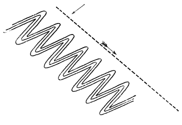
Fig. 3.
False-bedding on a large scale may be a cause of
error. In the Penrith Sandstone of Cumberland, the
planes of deposition are often found dipping in one
direction in a large quarry, but inspection of a wider area
shows that this is not the true dip of the beds as a whole,
but merely a local dip due to deposition on a slope, and
any one attempting to calculate the total thickness of the
beds by reference to these divisional planes might be
seriously led astray. A reference to Fig. 4 will explain
this. The lines AA´, BB´ are the true bedding-planes
cut across in the section, whilst the lines sloping to the
right from xx are only lines of false-bedding on a large
scale. An exaggerated estimate of the thickness of the
deposit would be made by measuring the thickness of
each of these stratula from A to A´ and adding these
thicknesses together, whereas the actual thickness of the
middle bed is the distance between A and B or A´
and B´.
Fig. 4.
When rocks have been affected by thrust-planes, the
simulation of bedding may be carried out to a very full
[76]
extent. Not only do the major thrust-planes resemble
bedding-planes but the minor thrusts produce an appearance
of divisional planes separating stratula or laminæ, and a
close approximation to false-bedding is the result. To
this structure Prof. Bonney has given the name 'pseudo-stromatism[17].'
It may be developed in rocks of all kinds,
whether possessing original planes of stratification or not,
and as a result of its existence the geologist may be
seriously misled, not merely by mistaking the direction
of the strata, but also the nature of the rock, for we may
find it produced in an unstratified glacial till, and in
a massive igneous rock, and in each case the resulting
rock will resemble a sedimentary deposit, and of course
the observer may be confirmed in his erroneous opinion
by the formation of apparent fossils, ripple-marks or other
objects which he might expect to discover in sediments.
As illustrative examples, reference may be made to a
number of schistose rocks, in which the planes of discontinuity
(which are in truth planes of foliation) have
been taken for bedding-planes and the rocks claimed as
sedimentary though they are in reality igneous; for
instance many of the rocks of the Laurentian of Canada,
of the Hebridean of the North West Highlands, and some
of the ancient rocks of Anglesey.
A foliated structure may, as is now well known, be
simulated by a structure developed in a rock prior to its
consolidation. The similarity of flow structure of some
lavas to the foliated structure of a schist was long ago
pointed out by Darwin and Scrope, and recent work has
proved that parallel structure due to differential movement
prior to consolidation may be developed in plutonic
[77]
rocks, as shown by Lieut.-General McMahon in the
Himalayan granites, and by Lawson amongst the plutonic
rocks of the Rainy Lake Region; and as the foliated
structure may be mistaken for original stratification the
same may occur, and has occurred, when dealing with this
flow-structure.
This is not the place to discuss the truth of the old
theory of progressive metamorphism, in which it was
maintained that a gradual passage could be traced
between ordinary sediments and plutonic rocks, but it
may be pointed out that much of the evidence which was
relied upon to prove the theory was fallacious and due to
the confusion of the parallel structure set up in plutonic
rocks prior to, or subsequent to, consolidation, with
original stratification. Recent study of metamorphic
rocks has proved that the parallel structures developed
in the rocks of an area which has undergone metamorphism
may be produced by three distinct processes; they may be
original planes of deposition, or formed in a solid rock
subsequently to its formation, or in an igneous rock before
its consolidation, and although it is sometimes possible to
separate the structures produced by these processes, this
is not always the case[18]. When a plutonic rock contains
large phenocrysts and an eye-structure is developed in it,
it may simulate a conglomerate, the rounded phenocrysts
being taken for pebbles[19]. Still closer simulation of an
[78]
epiclastic conglomerate may be produced in other ways
and will be referred to immediately.
We have already seen that the existence of unconformities
has been utilised in the demarcation of large
divisions of strata in various regions, and whether they be
utilised in this manner or not, their detection is a matter
of importance to the stratigraphical geologist, as they
afford information concerning the occurrence of great
physical changes during their production. These unconformities
may also be closely simulated by structures
produced in very different manner.
The occurrence of an unconformity implies the denudation
of one set of beds before the deposition of another
set upon them, and accordingly the denuded edges of the
lower set will somewhere abut against the lower surface
of the lowest deposit or deposits of the overlying set[20].
The existence of an unconformity may often be detected in
section, but when the unconformity is upon a large scale
this may not be possible, but it will be discovered by
mapping the strata and will be apparent on a map owing
to the deposits of the lower set of beds abutting against the
others. This is well seen where the Permian rocks of
Durham, Yorkshire, and Nottinghamshire rest upon different
members of the underlying Carboniferous series, and
[79]
will be noticed on any good geological map of England.
But a similar effect may be caused by a fault, so that mere
inspection of a map or even of the strata in the field and
discovery of one set of beds ending off against another
does not prove unconformity. When the fault is a normal
one, with low hade (that is, having a fissure approaching
the vertical position), the outcrop of the fault-fissure will
approximate to a straight line if the fault has a straight
course, even if the ground be very uneven, whereas, if the
plane of unconformity has not been tilted to a high angle
from its original horizontal position, it will crop out in a
sinuous manner across uneven ground, in a way similar to
that of beds which are nearly horizontal, so that though
the general trend of the outcrop of the plane of unconformity
may be fairly straight, its deviation from a
straight line will be frequent and marked, as seen in the
case of the Permian unconformity above referred to.
But if the unconformable junction has been highly
inclined its outcrop will resemble that of a normal fault,
or if the fault be a thrust-plane with high hade, the
outcrop of this will resemble that of an unconformable
junction which has not been greatly tilted from its
original horizontal position. In these cases we require
more evidence before we can decide whether we are
dealing with an unconformable junction or a faulted one.
The lowest deposits of the newer set of strata lying
above an unconformity have probably been laid down in
water near the shore-line. As the unconformity, if large,
implies elevation above the sea-level, the deposits first
formed after this elevation has ceased, and depression
commenced, will necessarily be littoral in character and
possibly of beach-formation, and accordingly we often find
that an unconformity is marked by the existence of an
[80]
epiclastic conglomerate immediately above the plane of
unconformity and, although this need not be continuous,
it is usually found somewhere along the line of junction.
The conglomeratic base of the Lowest Carboniferous
strata when they repose upon the upturned edges of the
Lower Palæozoic rocks of the dales of West Yorkshire
is well known, and may be cited as an example. The
association of conglomerates with unconformities is
indeed so frequent that its possible occurrence will
always be suspected and sought by the geologist. Unfortunately
the result of recent observation is to show
that along thrust-planes of which the outcrop simulates
those of unconformable junctions, the difficulty of discrimination
may be increased by the existence of cataclastic
rocks which bear a close resemblance to epiclastic
conglomerates, and which may be and have been styled
conglomerates. It is well known that fragments of the
adjoining rocks are knocked into a fault-fissure during
the occurrence of the movements which cause the fault, to
constitute a fault-breccia, and as the result of the abrasion
of these fragments by chemical or mechanical agency, the
angular fragments may become rounded and converted
into rounded pebble-like bodies, when the rock is changed
into a fault-conglomerate. Fig. 5, from a photograph
kindly supplied by Prof. W. W. Watts, shows a stage in
the formation of a conglomerate of this nature from a
fault-breccia; the fragment on the right remains angular,
whilst those on the left have become much more rounded.
The illustration is from a case described by Mr Lamplugh
occurring in the slaty rocks of the Isle of Man,
and Mr Lamplugh's paper[21] furnishes the reader with
[81]
references to other examples of the production of similar
rocks. No general rule can be laid down for distinguishing
the true from the apparent unconformity, for the
attendant phenomena will differ in each case; but if a
fault-conglomerate should be suspected, the observer
should try to ascertain whether fragments of a newer rock
are imbedded in an older one, which sometimes occurs;
he should note the existence of extensive slickensiding
along the plane of junction and along planes of faulting,
though the existence of these, implying as it does the
[82]
occurrence of differential movement along the plane, does
not prove that the movement was necessarily great, or
that it did not take place along a plane of original
unconformity; above all, he should look for structures
such as mylonitic structure, pseudo-stromatism, development
of new minerals, crushing out and stretching of
fossils and fragments and, in short, for any structure which
is familiar to him as a result of orogenic movements.

Fig. 5.
The effects of thrusting not only give rise to appearances
suggestive of unconformity, but naturally also
to a simulation of overlap. The thrust-planes are often
parallel to original bedding-planes for some distance, but
must cut across them sooner or later, producing lenticular
masses which might be supposed to be due to the thinning
out of beds as the result of cessation of deposition in a
lateral direction.
Attention has already been directed to the deceptive
appearance of great thickness of strata which is due
to repetition of one stratum or set of strata by a series of
thrust-planes, so that there is no actual inversion of any
part of a bed. When masses of limestone are affected in
this way, the thrust-planes may become sealed up, as the
result of chemical change, and a compact irregular mass
of limestone devoid of any definite divisional planes may
be the consequence, and beds of grit sometimes exhibit
the same feature to some extent.
Enough has been said to show that simulation of one
structure by another has frequently occurred in rocks in
so marked a degree as to render mistakes easy; and that
these examples of 'mimicry' in the inorganic world are
particularly frequent in rocks which have been subjected
to great orogenic movements. The student will do well
to acquaint himself with the macroscopic and microscopic
[83]
structures which may be taken as characteristic of the
rocks which have been thus affected, some of which
can usually be detected with ease, and when he discovers
them he may suspect that many phenomena which appear
explicable in one way were in reality produced in a
different one, for it is frequently very true of a region in
which the rocks have been violently squeezed, stretched
and broken that 'things are not what they seem.'
[84]
CHAPTER VIII.
GEOLOGICAL MAPS AND SECTIONS.
The writer does not propose to give an account of the
intricacies of geological mapping, for their right consideration
requires a separate treatise[22]; all he desires is to call
attention to some of the uses of geological maps as a
means of conveying information. A geological map may
be looked upon as an attempt to express as far as possible
in two dimensions phenomena which possess three dimensions;
this can be done to some extent on the actual
surface of the map, by conventional signs, still more fully,
by supplementing the map with sections; but best of all
by a geological model, which is cut across in various
directions in order to show the underground structure as
well as that of the surface.
The ordinary geological map is one which shows the
outcrop of the strata, subdivided according to age, as they
would be seen upon the surface of the earth after stripping
off the superficial accumulations, and it is to be feared that
the term 'geological map' is associated in the minds of most
students with a map of this character and of no other.
[85]
Nevertheless, a great many most important observations
other than those connected with the order of succession of
the strata are capable of representation upon a geological
map, and the possession of a large number of maps of any
area upon the geology of which a person is engaged—each
map to be used for recording observations of a particular
kind—will save much writing in note-books and,
what is of more importance, will allow him to compare
observations which have been made at different times at
a glance, instead of causing him to search through a series
of note-books. Still, however well furnished with maps,
the geologist will find a note-book essential[23].
The earliest geological maps represented the variations
in the surface soils, or at most the general lithological
characters of the rocks which by their decay furnished
the materials for the soils. We have seen that the first
chronological map was due to William Smith, and most
subsequent English geological maps have been based
upon his map of the strata of England and Wales. The
order of succession of the strata is represented in these
maps to some extent by the use of arrows to indicate
the direction of dip of the strata, though this is not an
unerring guide where strata are reversed, and accordingly
the addition of a legend at the side of the map may be
looked upon as essential to the correct understanding of
the map itself. The legend is usually in the form of a
section of a column, the strata being arranged in right
order, the oldest at the base and the newest at the
[86]
summit, the colours by which the strata are indicated
being similar to those placed upon the map. Other
information besides the mere order of succession of the
strata may appear in the legend; thus their relative and
actual thicknesses can be indicated if the column is drawn
to some definite scale, and a brief description of the
lithological characters of the rocks may well be appended
to the side of the column. On the actual maps it is
customary to exhibit the outcrop of the junctions of all
igneous rocks as well as of the sedimentary ones: the
nature of the metamorphism which sedimentary rocks have
undergone at the contact with igneous ones may be and
often is indicated by suitable signs; the position of faults
is shown, and often also that of metalliferous veins, the
nature of the ore in the latter being further indicated in
some suitable manner, as by giving the recognised symbol
for the metal; and in many maps an attempt is made to
show the variations in dip and strike of the cleavage-planes.
The Geological Survey of the United Kingdom publishes
two sets of maps, one showing the 'solid geology'
and the other the 'superficial geology.' It is easier to
understand these terms than to define them, for in Britain
there is a sharp line between the two everywhere except
near Cromer. The maps showing the superficial geology
represent gravels, glacial drifts and other incoherent
accumulations of geologically recent origin, which to a
greater or less extent mask the strata below which are
usually composed of more or less solidified material. The
maps showing the solid geology display the outcrops of
these strata, though it is usual to insert alluvium upon
these maps, as it is often impossible to trace the junction-lines
of the strata below it. Attention has already been
[87]
directed to the fact that these maps of solid geology,
though chronological, that is, having the strata represented
according to age, are founded largely upon
lithological differences, rather than upon included
organisms; and it has been stated that for theoretical
purposes two sets of chronological maps, one founded
upon lithological differences, the other upon difference of
fossil organisms, would be extremely valuable.
Other phenomena are often best represented upon
separate maps, for if all observations are crowded upon
one map the result will be very confusing. Special
glacial maps showing the contour of the country, with
the portions between the contour lines coloured differently
according to altitude, say the country between sea-level
and 500 feet light green, that between 500 and 1000 dark
green, that between 1000 and 1500 light brown and so on,
exhibiting the direction of all observed glacial striae, the
distribution of boulders so far as it is possible, and any
other glacial phenomena which can be noted upon the
map, will be valuable to the student of glaciation[24].
Various structural features may be well displayed on
separate maps. The trend of the axes of folds will be
useful, and may be accompanied by other information of
cognate character[25]; maps of the distribution of joint
[88]
planes may be given in combination with those showing
the folding of the strata if it be desired to exhibit the
relationship between these; or with the physical features
of the country, if the dependence of physical features
upon joint structure be under consideration[26]. Much
information concerning cleavage may be acquired from a
map showing anticlinal and synclinal axes of cleavage[27], or
the actual strike of the cleavage over different parts of a
map may be represented, and its relationship to the
geological structure of the district exhibited[28].
Maps exhibiting changes in physical geography appertain
to the geologist as well as to the geographer. The
position of ancient beaches, former lakes, representation
of the changes in the courses of rivers and kindred
phenomena may be shown upon maps, and will prove
useful[29].
A perusal of the maps to which reference has been
made above will give the student some notion of the
extent to which maps may be utilised to represent geological
structures, and may suggest other methods by
which they may be utilised.
A geological section is usually drawn in order to
exhibit the lie of the rocks, as it would be seen if a
vertical cutting were made in that part of the earth's
[89]
crust which is under consideration. The character of the
section will depend upon circumstances. The Geological
Survey of Great Britain issues two kinds of sections which
are usually spoken of as vertical sections and horizontal
sections, though each is in truth a vertical section; but
whereas in the former the horizontal distance represented
is small as compared with the thickness of the strata, in
the latter the rocks of a considerable horizontal extent of
country are exhibited in the section, and the section is
not carried down to a great depth below the earth's
surface. There is no essential difference between the
two kinds of section, and often sections are drawn which
cannot be definitely classed as belonging to either kind,
but in extreme cases the vertical section is a representation
of the order of succession as it would appear if the
rocks were horizontal, no matter how disturbed they may
be in reality; whereas the horizontal section represents
the strata as they actually occur, with all the folds and
faults by which they are affected. The accompanying
figure (Fig. 6) represents a horizontal section on the left
side of the figure with a vertical section of the same rocks
on the right side.
Fig. 6.
Vertical sections are extremely useful when it is
desirable to compare variations in the strata over wide
extents of country: this can be done by drawing a series
of columns of the strata, each showing in vertical section
the lithological characters and thicknesses of the strata in
[90]
one place, whilst the relationship between the strata of
two different places may be indicated by joining the beds
of the same age by dotted lines as shown in Fig. 7[30].
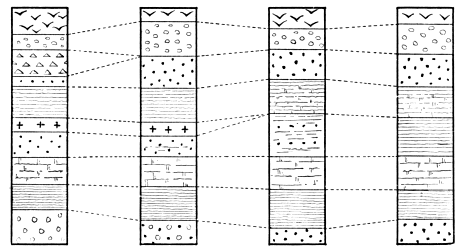
Fig. 7.
[91]
The horizontal section is one which is in constant use
by the practical geologist: the results of the first traverse
of a district may be jotted down in his note-book in the
form of a horizontal section (with accompanying notes),
and the written memoir on the geology of any district
composed largely of stratified rocks will almost certainly
require illustration by means of these sections. Perhaps
nothing more clearly marks the careful observer than the
nature of the sections which he makes, and geological
literature is too frequently marred by the publication of
slovenly sections. A badly drawn section not only offends
the eye, it may and frequently does convey inaccurate
information.
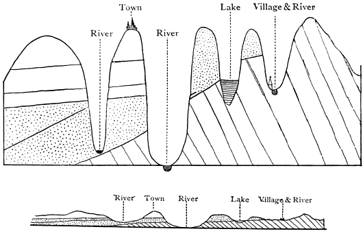
Fig. 8.
[92]
In the above figure (Fig. 8) taken from Sir Henry de
la Beche's "Sections and Views Illustrative of Geological
Phænomena," Plate II., the lower drawing represents a
section drawn to true scale, while that above shows
one which is exaggerated. The student who saw this
would infer that the uppermost beds on the left side
of the upper section rested unconformably upon the
dotted beds beneath, and once abutted against them in
that portion of the figure where the beds have been
removed by denudation in the deep valley, whereas an
examination of the section drawn to true scale shows that
the unconformity does not exist (although there is one at
the base of the deposits marked by dots), and that there
is room for the higher deposits to pass above those marked
by dots at the place where the former have been removed
by denudation. Whenever possible, horizontal sections
should be drawn to true scale, the vertical heights being
on the same scale as the horizontal distances. Sections
which are so drawn represent the nature of the surface of
the country as well as the relationship of the strata, and
often illustrate in a marked degree the influence which
the character of the strata has exerted upon the nature of
the superficial features of a country. If it be impossible
to draw a section in which the elevations and horizontal
distances are represented upon a true scale, the former
ought to be drawn on a scale which is a multiple of
the latter; thus the vertical heights may be shown on
2, 3, or 4 or more times the scale chosen for the horizontal
distances; when this is done, it will often be necessary to
show the strata with an exaggerated dip, and accordingly
the exaggerated section loses some of its value, though if
vertical and horizontal scales bear some definite proportion
it will still be more valuable than a rough diagram which
is not drawn to any scale.
[93]
Section-drawing cannot be satisfactorily accomplished
without some practice, and the student is strongly advised
to acquire the art of drawing good sections; the writer
can assert as the result of considerable experience in the
conduct of examinations of all kinds, that slovenly sections
are the rule in candidates' papers, and good sections very
rarely appear. Study of the six-inch maps and horizontal
sections (drawn on the same scale) of the Geological
Survey of the United Kingdom will enable the student to
familiarise himself with admirable sections, and it should
be his aim to produce sections like these. He is recommended
to take some of these six-inch maps which show
contour-lines as well as the disposition of the strata, and
to draw sections on the scale of six inches to the mile,
vertical and horizontal, exhibiting the proper outline of
the ground and the arrangement of the strata, and afterwards
to compare them with the published sections. The
sections should be drawn as far as possible at right angles
to the general strike of the strata. Some datum-line is
taken for the base of the section (say sea-level) and offsets
drawn vertically from this where the section crosses a
contour-line or recorded height. The height is marked
on these offsets; thus if a recorded height of 2700 feet
(just over half a mile) occurred on the line of section a
height of somewhat over three inches is marked on the
offset, and so with the other points where the section
crosses contours or recorded heights. By joining these
points on the offsets, giving the connecting lines curves
similar to those which are likely to occur in nature, the
general character of the surface of the ground is represented.
The geology of the district is next shown.
Wherever a dip is marked on the map, the direction and
amount of dip is shown by a short line on the section, and
[94]
where dips are not actually seen along the line of section,
the dips which are nearest to that line on the map must
be considered, and marked on the section. The lines of
junction between the various deposits shown by different
colours upon the map are inserted on the section as
short lines, the inclination being judged by study of the
nearest dips; faults and igneous rocks must be marked
off, and any indication of the hade of the fault or the
slope of the edges of the igneous rock which the map
affords will be taken into account. The section will
then appear somewhat as shown in the following figure:

Fig. 9.
and sufficient indication of the trend of the rocks will be
obtained to shew that they form portions of curves which
may then be filled in as shown in Fig. 10 and the section
will be complete.

Fig. 10.
It will be noticed that the small dyke of igneous rock
on the right of the main dyke is joined to it lower down,
though no indication of this is given along the line of
section; but the requisite information for this and evidence
of the existence of the small dyke proceeding from the
left-hand side of the main one may be obtained by the
[95]
study of the rocks in a valley on one side or other of the
line of section.
After the student has become conversant with the
nature of geological maps and sections, and has read Sir
A. Geikie's Outlines of Field Geology, he should on no
account omit to learn something of the art of making
geological maps, by going into the field and attempting to
produce a map, for the art of geological surveying does
not come naturally to any one, and some acquaintance with
the methods of surveying is a necessity to everyone who
wishes to make original geological observations, though
all cannot expect to afford the time and acquire the skill
necessary for the production of maps vying with the detailed
maps of the Government Survey. Before actually
attempting to draw lines on a map on his own account,
he will do well to tramp over a portion of a district with
the published geological map in his hands, selecting a
country which is not characterised by great intricacy of geological
structure, and he can then attempt to represent the
geology of another portion of the same district without consulting
the published map. Of all the districts of Britain
with which he is acquainted the writer believes that the
basin of the river Ribble, in the neighbourhood of the
town of Settle in the West Riding of Yorkshire, is best
adapted for studying field geology in the way suggested
above, for the main geological features are marked by
extreme simplicity, and the exposures are good, whilst the
presence of an important fault-system and of a great unconformity
relieve the area from monotony. Anyone who
stands on the summit of Ingleborough or Penyghent will
grasp the main features of a portion of the district without
any difficulty, for it lies beneath his feet like a geological
model, and when the student has mastered and mapped
[96]
in the leading features, he can find bits of country with
geology of varying degrees of complexity amongst the
Lower Palæozoic rocks of the valleys which run down to
Ingleton, Clapham, Austwick and Settle.
The biologist is supplied with laboratories at home
and abroad, where he may study his science under the
best conditions. Would that some munificent person
would found, in a district like that referred to above, a
geological station where Cambridge students would have
the means of acquiring a knowledge of field-geology under
conditions more favourable than those presented by the
flats around the sluggish Cam!
[97]
CHAPTER IX.
EVIDENCES OF CONDITIONS UNDER WHICH STRATA
WERE FORMED.
The establishment of the order of succession of the
strata, and the correlation of strata of different areas
merely pave the way for the geologist. To write the
history of the earth during various geological ages, he has
to ascertain the physical and climatic conditions which
prevailed during the successive geological periods, and to
study the various problems connected with the life of each
period. In the present chapter an attempt will be made
to illustrate the methods which have been pursued in
order to write to the fullest degree which is compatible
with our present knowledge, the earth-history of various
ages of the past. In making this attempt, the physical
and climatic conditions may be first considered, and their
consideration followed by that of the changes in the
faunas, though it will frequently be necessary to refer to
one set of conditions as illustrative of the other.
It will be assumed here that the great principle of
geology, that the modern changes of the earth and its
inhabitants are illustrative of past changes, is rigidly true.
Reference will be made to this principle in a later chapter,
but it is sufficient to state here that the study of the
[98]
sediments which have been deposited from the commencement
of Lower Palæozoic times to the times in which we
now live bear the marks of having been formed under
physical conditions, which, in the main, are similar in kind
to those which prevail upon some part of the surface of the
lithosphere at the present day.
One of the most important inferences of the stratigrapher
relates to the existence of marine or terrestrial
conditions over an area at any particular time, and we
may, in the first place, consider the evidence which
supplies us with a clue to this subject.
It has been previously stated that the ocean is essentially
the theatre of deposition, the land that of destruction,
and accordingly, the presence of deposit as a general rule
indicates the evidence of marine conditions during the
formation of those deposits, though this is not universally
the case. Again, as denudation is practically confined to
the land areas, and the shallow-waters at their margins,
unconformity on a large scale gives evidence of the
existence of terrestrial conditions in the area in which
it is developed, during its production. Accordingly a mass
of deposit separated from deposits above and below by
marked unconformities shows the alternation of terrestrial
conditions (during which the unconformity was produced)
and marine conditions (during which the deposits were
laid down). The deposits formed after an unconformity
has been developed will naturally be of shallow-water
character, as will also be those of the period immediately
preceding the incoming of conditions which will cause the
occurrence of another unconformity, and between these
two shallow-water periods will occur a period when deeper-water
conditions probably prevailed. We can therefore
not only divide the history of any particular area into a
[99]
series of chapters, of which every two successive ones will
describe a continental period and a marine one, but each
marine period may be divided into three phases—a shallow-water
phase at the commencement, an intermediate
deeper-water phase, and a shallow-water phase at the end.
These phases are frequently complicated by the occurrence
of a host of minor changes, but on eliminating these, the
effects of the three great phases are shown by study of
the nature of the strata, and their recognition does much
to simplify the detailed study of the stratigraphical geology
of various parts of the earth's surface.
In discriminating between terrestrial conditions and
marine ones, the existence of unconformities is of great
importance in marking terrestrial conditions and is often
the only available evidence, for no accumulations or
deposits formed on the land may be preserved to testify
to the terrestrial conditions[31]. When terrestrial deposits
and accumulations do occur, they are extremely important,
and it is necessary to allude to the points wherein they
differ from marine deposits.
Apart from organic contents, the mechanically formed
deposits of rivers and lakes resemble in general characters
the shallow-water deposits of the ocean, though they are
usually less widely distributed. It is the accumulations
which have actually been formed as æolian rocks, or those
which have been laid down as chemical precipitates in
salt-lakes which, by study of lithological characters, furnish
the most convincing evidence of their terrestrial origin.
[100]
Many æolian accumulations may be looked upon as
soils, if the term soil be used in a special sense to refer
to the accumulations which are produced as the result
of the excess of disintegration over transportation in an
area, whilst others are due to transport which has not
been sufficiently effective to carry the material to the sea.
When the weathered material accumulates above the
weathered rock, it depends chiefly upon climate whether
the disintegrated rock becomes mingled with much
decayed organic matter forming humus. If this organic
matter exists in quantity, the probability is that the
accumulation is a terrestrial one, though this is by no
means necessarily the case, for under exceptional circumstances
a good deal of humus may be deposited in the
sea, as beneath the mangrove-swamps which line the
coasts of some regions, and to go further back, in the
case of the Cromer Forest series of Pliocene times, or
some coals, such as the Wigan Cannel Coal of the Carboniferous
strata.
In addition to the work of water, which affects both
land and sea-deposits, the land is especially characterised
by the operations of wind and frost upon it, for these
produce results which may frequently serve to differentiate
a land-accumulation from a deposit laid down beneath
sea-level. The effect of wind in rounding the grains of
sand which are blown by it is well-known, and samples of
the 'millet-seed' sands of desert regions are preserved in
most museums. The greater rounding which characterises
wind-borne as compared with water-borne sand grains is
due, in great measure, to the greater friction between the
grains when carried by the air than when swept along by
the water. Under favourable circumstances water-worn
grains may become rounded, especially when agitated by
[101]
gentle currents sweeping over a shoal[32]; but a large mass
of sand, in which most of the grains have undergone much
rounding so as to give rise to 'millet-seed' sand, will
nevertheless be probably formed by wind-action except
where a marine deposit is formed of material largely
derived from an earlier æolian one. The effect of frost is
to split rocks into fragments which are more or less
angular before they are subjected to water-action. The
broken fragments are prone to collect on slopes as screes,
and as any scree-material falling into the sea is likely
to become rounded except under conditions which rarely
prevail, the existence of much scree-material in a rock
suggests its terrestrial origin. Glaciers gave rise to terrestrial
moraines, which may occasionally be identified as
land-accumulations by mere inspection of their physical
characters, but all geologists are aware of the difficulties
with which they are confronted when they attempt to
discriminate between terrestrial and marine glacial deposits.
The existence of much material amongst the stratified
rocks which has been precipitated from a state of solution
is an indication of the terrestrial origin of the rocks, which
were laid down on the floors of the inland seas, separated
more or less completely from the open ocean; for the
waters of the ocean are capable of retaining in solution
all of the material which is brought down to them, and
accordingly precipitates of carbonate of lime, rock-salt,
gypsum and other compounds formed from solution, are
only formed on a large scale in inland lakes, though they
may be formed to some extent when the water of a
[102]
lagoon is only slightly connected with that of the open
ocean, and the evaporation is great, for instance in the
lagoons of coral reefs. Certain physical features often mark
the deposits of chemical origin, cubical or hopper-crystals
of rock-salt may be dissolved, and the hollow afterwards
filled with mud, so that the rock surfaces are sometimes
marked with pseudomorphs of mud after rock-salt. Sun-cracks
and rain-prints impressed on the rock are not
actual indications of terrestrial origin of the rocks on which
they are found, for the shallow-water muds of an estuary
may be deposited in the sea and yet exposed to the action
of the air at low tide, but they mark very shallow-water
deposits which have been exposed to the atmosphere
immediately after their formation if not during the time
they were formed, and they frequently occur amongst the
deposits of inland lakes.
It will be observed that the characters of the terrestrial
accumulations serve to distinguish them to some
extent from the marine ones, but they also enable one
to detect to some degree the actual conditions under
which the accumulation was produced, whether on the
mountain-slope, or in the plain, the desert or the fen, the
river-bank or the lake-floor.
The conditions of formation of the marine deposits
may be distinguished within certain limits with ease, by
examination of their physical characters, for the near-shore
deposits will generally be coarser and contain more
mechanically-transported material than the sediments
which accumulate at a greater distance from the shore,
though it is not safe to infer that deposits are formed
away from the shore on account of the absence of
mechanically-transported sediments. In districts where
the mechanically-transported material is rapidly deposited,
[103]
organic deposits of great purity may form close to the
coast-line; for instance, when the rivers of a country end
in fjords, the mechanical sediments are deposited in the
fjords, and the sea around the coast is free from this
sediment, and there the organisms can build up deposits
of great purity; and a similar thing may happen when the
rivers on one side of a country have short courses, and
do not carry down much sediment, which occurs when the
watershed is near the coast. On the one hand, clay
may be formed in considerable purity near the coast,
where the supply of mud is so great that the organisms
existing there can do little in the way of contribution to
the mass of the deposit, or it may be formed on the other
hand in great depths of the ocean, where the supply of
sediment is extremely small, but where all the organic
tests become dissolved; as the characters of the deep sea
clays are mainly negative, a geologist examining the rocks
of the geological column would have much difficulty in
distinguishing a deep-water clay from a shallow-water one
by its lithological characters only. In cases of difficulty,
information of importance is likely to be furnished by
examination of the relative thickness of equivalent deposits
in adjoining areas, for if we find a mass of clay a few feet
thick in one region represented by hundreds of feet of
clay and limestone in another, the former mass probably
accumulated slowly and at some distance from the land;
again, the uniformity of lithological characters of a deposit
over a very wide area is a possible indication of its
formation away from land, but this is not a safe guide,
for reasons which will eventually appear, unless it can be
shown that the deposit is everywhere of the same age.
A clue to climatic conditions is frequently furnished
by the physical characters of accumulations, especially
[104]
terrestrial ones. The accumulations containing a large
percentage of hydrocarbons have probably been formed
under fairly temperate and moist climatic conditions,
whilst the existence of millet-seed sandstones associated
with chemical deposits points to desert conditions and
inland lakes, requiring a dry climate and probably a warm
one. Glaciated surfaces and glacial deposits of course
indicate a low temperature. Some geologists profess that
occasionally they can even determine the direction of the
prevailing winds during past periods, by examination of
the character of ripple-marks, rain-pits and other features,
though it is doubtful whether much reliance can be placed
upon these obscure indications.
Useful as is the physical evidence supplied by deposits,
as an index to the conditions under which they were
formed, it is usually only supplementary to the evidence
derived from a study of the fossils. Fossils when present
in the rocks, usually supply considerable information concerning
the prevalent conditions during the deposition
of the rocks. By them we can not only separate marine
from terrestrial deposits, but also freshwater deposits from
æolian accumulations; each kind of deposit will generally
contain the remains of organisms which existed under the
conditions prevalent in the area of formation of the rock,
though it is of course a frequent thing for a terrestrial
creature or plant to be washed into a freshwater area or
into the sea. In an æolian deposit, the invertebrate
remains may be those of any air-breathing forms, as
insects, galley-worms, spiders, scorpions and molluscs.
The land-molluscs are all univalve. Of vertebrates, we
may find the bones and teeth of amphibians, reptiles,
birds and mammals. Occasionally freshwater or even
marine forms may be found in an æolian deposit, but they
[105]
will be exceptional. Marine shells are often blown
amongst the sand-grains of the coastal dunes, and seagulls
and other birds frequently carry marine organisms far
inland.
The creatures frequenting fresh water differ from those
of the land and of the sea. The most abundant vertebrate
remains will be those of fishes, and of the invertebrates
we find mollusca preponderate. The variety of molluscs
is not so great as in the case of marine faunas. The
bivalves always possess two muscular scars on each valve
(except adult Mulleria); whilst many marine shells as the
oyster have only one muscular scar on each valve. (See
Fig. 11.)

Fig. 11.
A. Monomyary shell with one scar. B. Dimyary shell with
two scars.
These scars mark the attachment of the adductor
muscles, for drawing the valves together, and the shells
with only one impression on each valve are called monomyary,
those with two impressions dimyary. The discovery
of monomyary shells indicates with tolerable certainty the
marine character of the deposit in which they are found,
though their absence cannot be taken as proof of freshwater
[106]
origin. The beaks or umbones of the bivalves are
often corroded in freshwater deposits, as may be seen by
examining shells of the common freshwater mussel. "All
univalve shells of land and freshwater species, with the
exception of Melanopsis and Achatina, which has a slight
indentation, have entire mouths; and this circumstance
may often serve as a convenient rule for distinguishing
freshwater from marine strata; since if any univalves
occur of which the mouths are not entire, we may presume
that the formation is marine[33]."
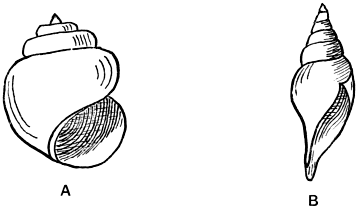
Fig. 12.
A. Holostomatous shell. B. Siphonostomatous shell.
In Fig. 12 A shows a freshwater shell (Vivipara) with
entire mouth, whilst B exhibits the shell of a marine
gastropod (Pleurotoma) with a notched mouth. The
entire-mouthed shells are called holostomatous whilst those
which are notched, the notch being often prolonged into a
canal, are termed siphonostomatous.
Many groups of invertebrates are seldom or never
found in fresh water. Of exclusively or nearly exclusively
[107]
marine creatures we may name the foraminifera, radiolaria,
sponges with a hard framework, most hydrozoa
which secrete hard parts, corals, echinoderms, cirripedes,
king-crabs, locust-shrimps, most polyzoa, brachiopods,
pteropods, heteropods, and cephalopods. Of extinct
groups, the graptolites and trilobites seem to have been
entirely confined to the sea.
In the modern and comparatively modern deposits,
the forms frequently belong to existing genera, and we
get fairly conclusive evidence of the conditions of deposit
by determination of the genera. The terrestrial (including
freshwater) molluscs have mostly a long range in time.
We find pulmoniferous gastropods of living genera in the
Carboniferous period, one (Dendropupa) belongs to a subgenus
of the modern land-shell Pupa, the other (Zonites)
to a subgenus of the snail group Helix. Many freshwater
molluscs as Unio, Cyclas, and Physa are found amongst
the secondary rocks, and give a clue to the origin of the
deposits which contain them. Many extinct genera are
closely allied to modern genera, and their mode of existence
may be assumed with fair certainty. With all
these guides, we may sometimes be left in doubt as to the
conditions of deposit when organisms are few in number;
thus, it is yet a matter for discussion whether the Old
Red Sandstone and many of the deposits of the Coal
Measures of Britain were of freshwater or marine origin.
In considering the possibility of fossils having been
carried from land to water or vice versa, it will be remembered
that generally speaking they are more readily
transferred from a higher to a lower level, so we are
more likely to find remains of land-animals and plants in
fresh water or the sea, and relics of freshwater animals
and plants in the sea, than of marine or freshwater animals
[108]
and plants in land, or marine organisms in fresh water.
River-gravels and lacustrine deposits are especially prone
to contain a considerable intermixture of land-forms with
those proper to the station.
Fossils supply much information concerning the depth
and distance from land at which the deposits were laid
down. When portions of the ocean-water have been
separated to form inland lakes, the water becomes saltier
than that of the open ocean, if the evaporation is greater
than the supply of fresh water, and the life of the inland
sea undergoes change under the unfavourable conditions
set up. Many forms disappear altogether, and those
which survive tend to become stunted, and the shells of
many of the mollusca are abnormally thin; the fauna of
an inland sea though it may have abundance of individuals
is apt to be characterised by paucity of species.
Turning now to the faunas of the open oceans, it is
found that in addition to latitude, the distribution of
organisms is affected by depth, and by the nature of the
sea-floor, and accordingly we find different organisms in
different areas; and in examining the same area the
organisms inhabiting different depths are not all the
same, and at the same depth some kinds of animals have
different stations from those of others, one creature being
confined to a sandy floor, another to a muddy one, and so
on[34]. The oceans have been divided into 18 provinces,
each of which is more or less characterised by the possession
of peculiar forms which are termed endemic, in
contrast to the sporadic forms which are widely distributed.
In any area which is margined by a coast line,
[109]
the molluscs are distributed in zones which were formerly
classed as follows:—the littoral zone between tide marks,
the laminarian zone from low water to fifteen fathoms,
the coralline zone between fifteen and fifty fathoms, and
the deep-sea coral zone from fifty fathoms to one hundred
fathoms or more; this last depth was once supposed to
mark the limit of the downward extension of marine life,
but as the result of modern deep-sea soundings we know
that organisms extend to a much greater depth, and the
deep-sea fauna, owing to uniformity of conditions over
wide areas, contains fewer endemic forms in proportion
to the sporadic ones than the shallow-water[35]. The
deep-sea deposits entomb the remains of these deep-sea
organisms and also of numerous pelagic organisms which
live upon the surface of the ocean, whose remains sink to
the ocean-floor after death. Amongst the deposits of the
deeper parts of the ocean, we find many which are almost
exclusively composed of the tests of foraminifera, radiolaria
and pteropods, the spicules of sponges, and the
frustules of diatoms; and accordingly the existence of
foraminiferal, pteropodan, radiolarian, and diatomaceous
oozes, amongst the strata of the geological column, has
been taken by some as indicating the prevalence of deep-sea
conditions during the formation of those deposits: as
the purity of a calcareous ooze depends upon the absence
of mechanical sediment, or volcanic dust, and as the
component organisms of these oozes are pelagic forms
which live near the continents as well as in the open
oceans, the presence of calcareous oozes implies the existence
of a clear sea during their deposition but not
necessarily of a deep one, for if the sea-area be far away
from land masses, or if the sediment be strained off in
[110]
fjords, calcareous oozes may be formed in shallow water.
The existence of pure radiolarian or diatomaceous deposits
is better evidence of deep water, for if they were formed
in shallow water we should expect an intermixture of
calcareous tests, whereas these are dissolved whilst sinking
into the extreme depths of the ocean. As the deep-sea
creatures are under very different conditions from those
of shallower waters, we might expect marked structural
differences between the deep and shallow-water creatures:
one such difference has been emphasized, namely the
occurrence of animals which are blind or have enormously
developed eyes in the great depths of the sea, where the
only light is due to phosphorescent organisms. This is
well seen in the case of many recent crustacea, and has
been noted by Suess in the case of the trilobites of some
beds which he accordingly infers to be of deep-water
origin, and it is interesting to find that these creatures
are found in deposits which give independent evidence of
an open-water origin. The Æglinæ of the Ordovician
strata are frequently furnished with enormous eyes, and
they are often accompanied by blind trilobites, and in
Bohemia the blind and large-eyed forms are sometimes
different species of the same genus, for instance Illænus[36].
As one would naturally expect, the actual depth at
which deposits were formed can generally be calculated
with a greater degree of certainty amongst the newer
rocks than amongst the older ones. In the case of the
Pliocene Crags, the depth in fathoms may be confidently
given. In the Cretaceous rocks attempts have been
made to give numerical estimates of the depths at which
different accumulations were formed, but some differences
of opinion have arisen in the case of these rocks. In the
[111]
Palæozoic rocks, only a rough idea of the general depth
can usually be obtained, and no attempt to calculate the
depth in fathoms is likely to be even approximately
correct in the present state of our knowledge.
The comminution of fossils has sometimes been taken
as an indication of shallower water origin of the deposits
which contain them, but although the hard parts of
organisms in a broken condition have frequently been
shattered by the action of the waves, they may also be
broken at great depths by predaceous creatures, and in
many instances the fracture is the result of earth-movements
occurring subsequently to the formation of the
deposits.
Turning now to the difference in organisms which
results from difference of station, it will be sufficient to
give a quotation from Woodward's Manual of the Mollusca
as an illustration:—"In Europe the characteristic genera
of rocky shores are Littorina, Patella, and Purpura; of
sandy beaches, Cardium, Tellina, Solen; gravelly shores,
Mytilus; and on muddy shores, Lutraria and Pullastra.
On rocky coasts are also found many species of Haliotis,
Siphonaria, Fissurella, and Trochus; they occur at various
levels, some only at the high-water line, others in a
middle zone, or at the verge of low-water. Cypræa and
Conus shelter under coral-blocks, and Cerithium, Terebra,
Natica and Pyramidella bury in sand at low-water, but
may be found by tracing the marks of their long burrows
(Macgillivray)[37]."
The geologist will naturally select sporadic forms
rather than endemic ones in comparing the strata of
different areas, but how far differences in faunas are the
result of existence at different times, and how far they
[112]
are due to difference of conditions affecting contemporaneous
organisms can only be discovered as the result of
accurate observation. The main points to be regarded
when comparing the successive faunas of different regions
have been noticed in this and the preceding chapters, and
it has been shown that as the evidence is cumulative, it
requires the collection of a large number of facts obtained
by observation of the strata before accurate inferences
can be drawn.
The indications of climatic conditions furnished by
organisms require some consideration. In the comparatively
recent deposits it is not difficult to get some notion
of the prevalent climatic conditions when the fossils belong
to forms closely related to modern genera. The existence
of the arctic birch and arctic willow, and of shells belonging
to species now living north of the British Isles, in deposits
of comparatively recent date in Britain would afford
convincing evidence of the occurrence of colder climatic
conditions than those which are now prevalent in the
area, even if the evidence were not confirmed as it is,
by physical proof of glaciation in deposits of the same
age. Nevertheless, even in these recent beds, we have a
useful warning, by finding species of elephant and rhinoceros
associated with northern forms like the lemming,
glutton, and musk-ox. We know that the species of
elephant and rhinoceros (the mammoth and woolly rhinoceros)
were provided with thick coverings which would
enable them to resist the severity of an arctic climate,
but had not these coverings been found, we might have
been puzzled by the association of forms whose nearest
allies are sub-tropical with others of arctic character. As
we go back in time and deal with earlier deposits, the
ascertainment of the climatic conditions becomes more
[113]
difficult, as the fossils mostly belong to extinct species,
genera or even families.
In these circumstances, it is very dangerous to draw
conclusions as to climatic conditions from examination
of a few forms, but when we find that plants and animals,
terrestrial and marine forms, vertebrates and invertebrates
alike point to the same conclusion, as in the London Clay,
where all the fossils belong to forms allied to those now
living under sub-tropical conditions, the state of the
climate may be inferred with considerable certainty[38]. The
character of the fossils must be taken into account rather
than their size. There was a tendency amongst geologists
to believe that large organisms probably indicate warm
conditions. Recent researches in arctic seas have dispelled
this belief. Marine algæ of enormous size are found in
the cold seas, and the size of creatures, abundance of
individuals and variety of forms in the arctic faunas of
some regions is very noteworthy. In the Kara Sea, for
instance, a variety of creatures were dredged up during
the voyage of the Vega, and Baron Nordenskjöld makes
the following pertinent remarks about them: "For the
science of our time, which so often places the origin of a
northern form in the south, and vice versa, as the foundation
of very wide theoretical conclusions, a knowledge
of the types which can live by turns in nearly fresh water
of a temperature of +10°, and in water cooled down to
-2·7° and of nearly the same salinity as that of the
Mediterranean, must have a certain interest. The most
remarkable were, according to Dr Stuxberg, the following:
a species of Mysis, Diastylis Rathkei Kr., Idothea entomon
Lin., Idothea Sabinei Kr., two species of Lysianassida,
[114]
Pontoporeia setosa Stbrg., Halimedon brevicalcar Goës,
an Annelid, a Molgula, Yoldia intermedia M. Sars, Yoldia
(?) arctica Gray, and a Solecurtus[39]. "The temperatures
were taken by a centigrade thermometer. Again we read
of the results of dredging off Cape Chelyuskin. "The
yield of the trawling was extraordinarily abundant; large
asterids, crinoids, sponges, holothuria, a gigantic sea-spider
(Pycnogonid), masses of worms, crustacea, etc. It
was the most abundant yield that the trawl-net at any one
time brought up during the whole of our voyage round the
coast of Asia, and this from the sea off the northern
extremity of that continent[40]."
Amongst the marine invertebrates reef-building corals
and mollusca perhaps furnish the best evidence of climatic
conditions. The coral-reefs of the Jurassic rocks with
large gastropods and lamellibranchs clustered around them
have been appealed to in proof of the existence of sub-tropical
conditions during their formation; further back
in time we find evidence of climate furnished by the
fossils of the Silurian rocks of the Isle of Gothland in the
Baltic Sea. Of these, Lindström writes "The fauna had a
tropical character. In consideration of the great numbers
of Pleurotomariae, Trochi, Turbinidae and the large
Pteropods the assumption of a tropical character of the
fauna may seem justifiable[41]."
Structure may give some indication of climate even
though the organism is not allied to living species. The
bark of trees in arctic regions is often thicker than in
more temperate regions, and the leaves of arctic plants
[115]
often have special characters to enable them to resist the
long periods during which they are deprived of water,
though the fact that desert-plants frequently shew similar
modifications deprives this test of any particular value
except as a means of corroborating conclusions reached
from other evidence[42]. The shells of arctic mollusca may
become stunted, but this is not by any means universal,
and the same result may be brought about by other
abnormal conditions, as for instance the increase of salt
in a water area by evaporation.
On the whole, an examination of the evidence available
for ascertaining the character of climate by reference
to included organisms, shews that inferences may be
drawn within certain limits, but that the task is a difficult
one not unaccompanied by danger, and every kind of
available evidence derived from a study of physical
phenomena and the included organisms should be utilised
before any conclusion is drawn.
The likelihood of accurate inference is increased by
comparing the faunas of various areas; should they seem
to indicate a progressive lowering of climate when passing
from lower to higher latitudes, it is probable that the
indication is correct. The student is referred to a paper
by the late Professor Neumayr for an account of the
existence of climatic zones during the Mesozoic Period[43].
CHAPTER X.
EVIDENCES OF CONDITIONS UNDER WHICH STRATA
WERE FORMED, CONTINUED.
In the preceding chapter, attention was drawn to the
indications as to conditions of deposition furnished by the
sediments of any one locality, and only passing reference
was made to variation in the nature of the sediments
and their organic contents, when the deposits are traced
laterally from place to place; some attention must now be
paid to this matter.
It is sometimes inferred that, whereas similarity of
organisms is a dangerous guide in correlating the strata
of two areas, accurate correlations may be made, if the
deposits can be traced continuously through the intervening
interval; no doubt the task is simplified when this can
be done, but the continuity of deposit of one particular
composition is no more proof of contemporaneity than the
occurrence of the same fossils continuously through the
interval, imbedded in strata of different character, indeed
probably not so much so. The existence of widespread
masses of conglomerate, which are not found as linear
strips, but which extend in all directions, is in itself an
indication of this; the Oldhaven pebble bed for instance,
in the Tertiary rocks of the London basin, is very widely
distributed. We cannot suppose that coastal conditions
[117]
prevailed far away from the shore-line, and accordingly
when a conglomerate occurs in a widespread sheet, and
not in a linear strip, this is indicative that the deposit
has not been formed continuously but that strip has been
added to strip along an advancing or receding shore line,
and if this happens with conglomerates, it must occur
also in the case of other deposits.
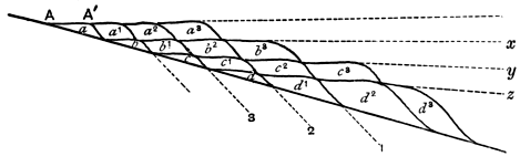
Fig. 13.
In Fig. 13[44] let A represent a shore line of a continent
which is undergoing gradual elevation. A deposit of
pebbles a will be formed against the coast, one of sand
b further away, then one of mud c and lastly limestone d,
may be formed in the open sea away from land. Naturally
there may be intermingling of two kinds of deposit at
the junctions, but for the sake of simplicity this may be
disregarded. During the accumulation of the deposits
a, b, c, d, certain sporadic forms may be distributed
throughout all the deposits, and some of them may
become extinct before the deposition of these beds is
completed, if the process is carried out on a large scale;
we may speak of the characteristic fossils of this period
as fauna I. As the result of elevation or of mere silting
up of the sea-margin, or of both combined, the next mass
of pebble-deposit will be laid down further away from
[118]
the original shore, for the shore line will now be at A´
and not at A, and it will partly overlap the mass of sand
b; the sand b1 will also be deposited somewhat further
out and partly overlap the mud c, and similarly the mud
c1 will partly overlie the limestone d. During the formation
of a1, b1, c1, d1, other sporadic forms belonging to a
fauna II may replace those of the first fauna. In the same
way a2, b2, c2, d2 will be deposited, and in the meantime a
new fauna III may arise and replace II. So the process
will go on until we finally have a group of deposits lying
one over the other, consisting of a basal accumulation of
limestone, succeeded by mud, sandstone and pebble-beds
in succession. Each of these will be continuous, though
the inner part of the pebble-deposit was formed long
before the outer part of the limestone, which is nevertheless
beneath a mass of pebble-deposit continuous with
that formed first, and the various deposits will be separated
by fairly horizontal planes x, y, z, which might be regarded
as bedding planes, but which are not so, strictly speaking.
The true bedding planes will occur at a slight angle to
these planes of separation, for the structure resembles
false bedding on a gigantic scale, but of course, the lines
separating two masses of similar deposit will be practically
horizontal and parallel to the planes of demarcation of
two distinct kinds of material. The lines separating
two faunas would, under the conditions postulated, run
approximately parallel to the planes of separation of
adjoining deposits of the same lithological character but
would pass from conglomerate, through sandstone, mud
and limestone, as indicated by the lines 1, 2, 3, ... and
the deposits between adjoining lines would be contemporaneous[45].
In nature, complications will arise, owing to
[119]
the gradual appearance and disappearance of forms, and
the existence of endemic species in contemporaneous
deposits formed in different stations and having different
lithological characters.
If elevation ceased and were succeeded by depression,
the exact opposite would occur, and the pebble beds
would be overlain by sandstones, these by muds, and lastly
limestones would appear. It follows that during a
marine phase occurring between two unconformities we
should have a V-shaped accumulation of deposits with
the apex pointing to the part of the shore line which
was last submerged before the commencement of elevation,
as shewn in Fig. 14, though the beds of the apex will in
most cases be denuded during the re-emergence.
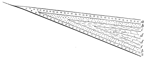
Fig. 14.
Indications of the non-coincidence of the planes
separating faunas and those which separate deposits of
one lithological character from those of another have
already been detected, for instance the 'greensand'
condition of the Cretaceous period occurs in some places
during the existence of one fauna, and in others during
that of another, though the planes have not been traced
[120]
continuously. Mr Lamplugh has furnished another example
amongst the Cretaceous rocks of Yorkshire and Lincolnshire,
but as has already been observed, a great deal
remains to be done in this direction, and geologists are
much in want of two sets of stratigraphical maps, in one
of which the lines are drawn with reference to the differences
of lithological character, whilst in the other they
separate different faunas.
The student will notice the normal recurrence of
deposits in definite order; conglomerate succeeded by
sandstone, mud and limestone, in a sinking area, and limestone
succeeded by mud, sandstone and conglomerate in a
rising area. Naturally many instances of departure from
this rule are seen, owing to local conditions, but on a large
scale, it is very frequently noted, and recognition of this
will enable the student to remember the variations in the
lithological characters of the deposits more easily, than if
he simply acquired them from a text-book without taking
heed as to their significance.
Upon the variations in the lithological characters of
deposits and of their faunas, when the beds are traced
laterally depends very largely the successful ascertainment
of the existence of former coast-lines, the restoration
of which constitutes an important part, of Palæo-physiography,
concerning which some observations may here be
made[46]. If a set of deposits having different lithological
characters can be proved to be contemporaneous, the
coarser detrital accumulations will point to the approach
to a coast-line, and the actual position of the coast during
the period of accumulation of the deposits may be very
accurately fixed. The pebble-beds at the base of the
[121]
Cambrian rocks of Llanberis indicate the existence of a
coast-line in that position during the accumulation of
those pebble-beds. Similar pebble-beds occur at St
David's, at the base of the Cambrian, but it is impossible
in the case of these rapidly accumulated sediments to
say that two deposited so far away from one another
were actually contemporaneous, and therefore although
we might draw a line through Llanberis and St David's
to indicate the old coast-line of the period, it does not
follow that the actual beach existed simultaneously at
the positions indicated. The palæo-physiographer, however,
attempts to restore the physical conditions of greater
thicknesses of deposit; for instance, the distribution of
land and sea during Lower Carboniferous times over the
area now occupied by the British Isles is often taken
to illustrate the methods of restoration of ancient
features, and all admit that the lithological and palæontological
characters of the rocks indicate a shallowing of
the Carboniferous sea when passing northwards towards
Scotland. For conveying an idea of the restorations
to the student, it is almost imperative to portray the
distribution of land and sea upon a map, and this can
only be done by drawing definite lines. It must be
distinctly understood that these lines are necessarily only
an approximation to the actual position of the ancient
shore-lines, which must have shifted again and again
during the long period occupied by the accumulation of
the Lower Carboniferous strata, so that a true idea of the
positions of the Lower Carboniferous shore-lines could
only be obtained by placing on a series of maps the
successive shore-lines of different parts of the Lower
Carboniferous period, and taking a composite photograph
of these, which would appear as a wide belt of shaded
[122]
portion of the map with no definite boundaries. The
utmost that the maker of palæo-physiographical maps can
expect to indicate, when dealing with considerable thicknesses
of strata, is an approximation to the mean position
of the shore-lines of the period when these strata were
deposited. This is extremely valuable in enabling the
student to understand the significance of the variations in
the characters of the strata and their organic contents, if
he distinctly recognises the generalised nature of the map.
Examination of any two palæo-physiographical maps of
the same period by different authors will shew wide
divergences in the details, but a general resemblance of
the main features. The reader will do well to consult
Prof. Hull's restoration of the physical features of Old Red
Sandstone and Lower Carboniferous Times on Plate VI.
of his Contributions to the Physical History of the British
Isles, and compare it with the map drawn by Prof. Green
(Coal: its History and Uses, by Profs. Green, Miall,
Thorpe, Rücker, and Marshall, Fig. 3, p. 38), which will
be found to bear out this statement.
Valuable as the published maps of palæo-physiography
are as an aid to the student in understanding the significance
of the variations of characters amongst the
sediments, he will do well to supplement them by maps
which he fills in for himself. He is recommended to procure
a number of outline maps of England, or of the
British Isles, and when studying in detail the characters
of the British sedimentary rocks formed during the various
periods, to place a blank map by his side when beginning
the study of each period or important portion of a
period. On this map he should jot down the geographical
distribution of the different kinds of sediments, using the
conventional signs indicated at p. 90: thus, in the case of
[123]
the Lower Carboniferous rocks he would place the conventional
sign for limestone in Derbyshire, a combination
of those for limestone and shale in Yorkshire, and would
add to these the sandstone sign in Northumberland. He
should also note the general character of the fossils, using
abbreviations for such terms as fresh-water fossils, shallow-sea
fossils, deep-water fossils. After reading the account
of the group of rocks in a comprehensive text-book, and
inserting his notes on the map, he should proceed to insert
the probable position of the coast-lines. He should
also take notes of any indications of contemporaneous
volcanic action, though these might well be inserted on a
separate map. If this course be pursued, the student will
not only have the significance of the variations amongst
the strata impressed upon his mind, but he will have a
means of obtaining at a glance the distribution of
sediments and faunas of different kinds in the British area
during the principal geological periods. On another set
of maps he may indicate the axes of the orogenic movements
which have occurred at different times, and when
his various maps are completed, he will have the materials
for the construction of a general account of the various
geological processes which have been concerned with the
building of the British area.
When an area like Britain has been studied, the
student may proceed to construction of maps of wider
regions, and he will find that in doing this, new sets of
facts must be taken into consideration, as for instance the
occurrence of different faunas on opposite sides of once-existing
continental masses, and the problems connected
with the present distribution of the faunas and floras.
For an instance of the importance of the former distribution
of life the reader may consult the twelfth section of
[124]
the first part of Professor Suess' Das Antlitz der Erde,
whilst a good account of the value of recent geographical
distribution of organisms in supplying a clue to former
distribution of land and sea will be found in Mr A. R.
Wallace's Island Life, Chapter xxii.
Should the method suggested above be adopted, the
student is likely to acquire a much more coherent idea of
the significance of the facts of stratigraphical geology
than can be obtained by a mere perusal of the accounts of
the strata given in those portions of the various text-books
which are devoted to a consideration of the stratigraphical
branch of the science.
[125]
CHAPTER XI.
THE CLASSIFICATION OF THE STRATIFIED ROCKS.
In the succeeding chapters, a general account of the
characters of the Geological Deposits of different periods
will be given, for the purposes of illustrating the principles
to the consideration of which the earlier chapters have been
devoted. It is not proposed to enter into a description of
numberless details, which would only confuse the student
who wished to grasp the main principles, for many facts
have been recorded which it is necessary to notice in
a comprehensive text-book treating of stratigraphical
geology, though their full significance is not yet grasped.
The writer, while noting the main characters of the
various subdivisions of the different stratigraphical
systems, will assume that this work is used in conjunction
with some recognised text-book. The stratigraphical
portion of Sir A. Geikie's Class Book of Geology gives an
admirable general account of the British Strata, while
the larger text-book by the same author has a condensed
though very full account of the rocks of the
stratigraphical column in all parts of the world, and
this is supplemented by numerous references to the original
works wherein further descriptions may be found.
The English edition of Prof. E. Kayser's Text-Book of
[126]
Comparative Geology, edited by P. Lake, is also well
adapted to the wants of the student, and an excellent
account of the strata is given in Mr A. J. Jukes-Browne's
Handbook of Historical Geology, which may be read with
the same author's Building of the British Isles.
The reader who refers to different text-books will be
struck with the variations of nomenclature even amongst
the larger stratigraphical divisions, for two authors seldom
subdivide the geological column into the same number of
rock-systems. The following classification will be here
adopted:—
| Groups. |
Systems. |
Cainozoic or
Tertiary |
 |
Recent
Pleistocene
Pliocene
Miocene
Oligocene
Eocene |
Mesozoic or
Secondary |
|
Cretaceous
Jurassic
Triassic |
| Palæozoic |
|
Permian
Permo-Carboniferous
Carboniferous
Devonian
Silurian
Ordovician
Cambrian |
| Precambrian. |
|
A few remarks may be given as to the reason for
adopting this classification.
It is not for a moment suggested that the Systems
have the same value, if the time taken for their accumulation
be alone considered. The beds classified as Recent,
[127]
for example, were probably accumulated during a lapse of
time far shorter than that occupied for the deposit of
some of the series or even stages of a system like the
Silurian, but the recent rocks acquire a special significance
from the fact that we are living in the period,
and the Cainozoic rocks as a whole are capable of greater
subdivision than the earlier groups, on account of the
greater ease with which they can be studied, owing to the
small amount of disturbance which they have usually
undergone when compared with that which has affected
older rocks, and the closer resemblance of their faunas and
floras to those of existing times.
With reference to the groups, the writer has already
commented upon the use of the terms Palæozoic, Mesozoic
and Cainozoic; below the lowest Palæozoic rocks (those of
the Cambrian system) lie a group of rocks which have
been variously spoken of as Azoic, Eozoic, and Archæan.
There is an objection to the use of any one of these words
in this sense; the objection in the case of the first two is
that the term is theoretical and probably incorrect, whilst
the word Archæan, otherwise suitable, has also been used
in a more restricted sense. In these circumstances the
term Precambrian will be used when referring to any
rocks which were formed below Palæozoic times, though
no doubt when this obscure group of rocks is more
thoroughly understood a satisfactory classification will be
applied to it.
Taking the other groups into account, the lower
systems of the Palæozoic group will be found to vary
greatly according to the views of different writers;
some make only one system, the Silurian, others two, the
Cambrian and Silurian. The three systems are here
adopted, not only because the one, Silurian, is too
[128]
unwieldy on account of its size and requires subdivision
(and the Cambrian and Silurian however defined, will be
found to be of very unequal importance, whereas the
three systems adopted are of fairly equal value), but
especially because when the term Ordovician is used,
the significance of the other terms Cambrian and Silurian
is at once understood.
An attempt has been made to shew that the Devonian
system is non-existent, but the result of modern research
is to shew that the rocks placed in this system are worthy
of the distinction, both from their importance and from
the distinctness of the fauna from those of the underlying
and overlying systems.
The Permo-Carboniferous system is adopted, because
an important group of deposits has recently been brought
to light which were not represented either in the Permian
or Carboniferous system as originally defined.
Some authors have advocated the union of the Permian
and Triassic systems into one system placed at the base
of the Mesozoic group. This is unnecessary, and would
depart from the classification originally proposed, which
is to be deprecated, unless there is any strong reason for
it.
The Mesozoic systems are classified according to the
method generally adopted. Were a fresh classification to
be proposed, a portion of the Cretaceous system might be
included with the Jurassic rocks, but it is better to adhere
to the old classification.
The divisions of the Cainozoic rocks are hardly systems
in the sense in which the term is used in the case of the
older rocks, but the reason for using these smaller subdivisions
has already been mentioned. The addition of the
Oligocene to the original divisions suggested by Lyell has
[129]
been found useful, and the term will be used in this
work.
The reasons for the adoption of the particular minor
subdivisions (series and stages) in the following chapters
will frequently appear when the rocks of the various
systems are described, and need not be further alluded to
in this place.
Although most geologists describe the stratified rocks
in ascending sequence beginning with the oldest, and
proceeding towards the newest, others, and notably Lyell,
adopted the opposite method and commenced with an
account of the newest beds. The argument generally
used for the latter method is that it is easier to work
from the study of the known to that of the less known,
and as the faunas of the newest rocks are most like the
existing faunas, the student would more readily follow a
description of the rocks in the order which is opposite to
that in which they were deposited.
In practice, the study of the sediments in their proper
order, that is, in the order of deposit, will not be found to
task the student to any great extent, especially if, as
is very desirable, he has studied the main facts and
principles of Palæontology before commencing the study of
the rock-systems in detail. There is one reason for beginning
with the study of the older sediments which
outweighs any reasons which can be advanced against it,
namely that the events of any period produce their effect
not only upon the strata of that period, but also on those
of succeeding periods.
The task of the stratigraphical geologist is really to
learn the evolution of the earth, in its changes from the
simple to the more complex conditions, and it is quite
obvious that it is unnatural to attempt any study of
[130]
evolution by working backward. For this reason the
study of the sediments will be here made in the order
which is usually adopted, by passing from the older to the
newer, and from the simple to the more complex.
The British strata will be mainly considered, though
references will frequently be made to their foreign
equivalents, and a fuller account of the latter will be
added when the British strata are abnormal, as are those
of Triassic times, and also when a period is not represented
amongst the strata of the British Isles, as for instance, the
Permo-Carboniferous and Miocene periods.
The student is recommended to refer constantly to
good geological maps of the British Isles, of Europe, and
of the world. Of maps of the British Isles, mention may
be made of Sir A. Ramsay's geological map of England,
Sir A. Geikie's map of Scotland, and his map of the
British Isles, J. G. Goodchild's map of England and
Wales, a map of Europe by W. Topley and one of the
world reduced from that by J. Marcou, accompanying the
first and second volumes of the late Sir J. Prestwich's
Geology. For special purposes more detailed maps will be
studied, including the one-inch maps of H. M. Geological
Survey, and the index map on a smaller scale. Lastly, for
an account of British Geology, reference must be made to
H. B. Woodward's Geology of England and Wales, where
the British formations are described in order, and to
W. J. Harrison's Geology of the Counties of England and
Wales, where the stratigraphical geology of the country
is given under the head of the different counties, which
are taken in alphabetical order.
In concluding this chapter, it is hardly necessary to
say that every opportunity of studying the characters of
the deposits and their fossils in the field should be eagerly
[131]
seized, and that much information may be acquired even
on a railway journey, especially as to the influence which
the deposits exert upon the scenery of a region[47].
CHAPTER XII.
THE PRECAMBRIAN ROCKS.
Study of a geological map of the world will shew
that extensive regions, such as parts of Scandinavia, many
tracts of Central Europe, a large area in Canada, and a
considerable portion of Brazil and the adjoining countries
are occupied by crystalline schists, which underlie the
oldest known sedimentary strata in those places. These
crystalline schists form the floor upon which the sediments
constituting the bulk of the geological column rest, and
it is necessary that we should know something of the
character of this floor. Other rocks which can be definitely
proved to be of Precambrian age are often found
associated with the crystalline schists, and these associated
rocks have often undergone more or less alteration subsequently
to their formation. The difference between the
coarser types of crystalline schists and these associated
rocks is sometimes so marked that geologists have
necessarily paid attention to it, and separated the two
groups of rocks; the term Archæan has been used by
some geologists to include the crystalline schists, and
Eparchæan for the associated rocks of known Precambrian
age, but though this separation may sometimes be effected,
there are cases when it is impossible to draw any sharp
[133]
line of demarcation between 'Archæan' and 'Eparchæan'
types.
In the present state of our knowledge, a chronological
classification of the Precambrian rocks when applied to
wide and distant regions is destined to break down, and it
will be convenient if we consider at some length the
features of the Precambrian rocks of a particular region,
and apply the knowledge thus gained to a study of
Precambrian rocks of other areas, and to a consideration
of our knowledge of the Precambrian rocks as a whole.
In doing so, the term 'crystalline schists' will be used
somewhat vaguely with reference to a complex of schistose
rocks of which the mode of origin cannot be fully determined.
We may take our own country as a region where
a good development of the Precambrian rocks occurs.
A few explanatory remarks concerning the mode of
detection of Precambrian rocks may not be amiss. If
any true organisms have been hitherto discovered amongst
the rocks formed before Cambrian times they are valueless
as a means of correlating rocks, and accordingly
lithological characters only are available in attempting to
correlate the rocks of one area with those of another.
Those who have read the preceding chapters will have
gathered that comparisons founded on similarity of lithological
character are not so valuable as those made after
careful scrutiny of the fossils of strata, but they are by no
means valueless, and when the rocks of two areas which
are not far distant from one another present close lithological
resemblances, their general contemporaneity may
be inferred with some degree of certainty.
It is only when we get the lowest Cambrian strata
overlying earlier rocks that we have absolute proof of the
Precambrian age of the latter, and it is necessary, therefore,
[134]
that we should have some definite lower limit to
the rocks of the Cambrian system. It is now generally
agreed that that limit shall be drawn at the base of a
group of rocks containing what is known as the Olenellus-fauna,
which will be considered at greater length in the
next chapter, and it will be well, if the term Cambrian
be not in future applied to any rocks beneath the ones
containing the relics of this fauna, for otherwise there is
danger of the indefinite downward extension of the Cambrian
system. We need not be surprised to find great thicknesses
of rock below the rocks containing the Olenellus-fauna,
and passing upwards with complete conformity
into those rocks; nevertheless, if it can be shewn that the
Olenellus-fauna had not appeared during the deposition
of the underlying group, the rocks of that group should
be termed Precambrian. A case of this nature has not
yet been detected in our area, and all the rocks which
have been proved to be Precambrian in Britain are
separated from the overlying Cambrian rocks by a physical
break, though that break is not necessarily very large,
and in some districts is probably of little importance.
Hitherto the Olenellus-fauna has been detected in
Ross, Warwickshire, Shropshire, Worcestershire and probably
in Pembrokeshire, and the rocks underlying the
Olenellus-beds in those counties can be proved to be
Precambrian (i.e. if the Olenellus-age of the Pembrokeshire
rocks be ultimately established, and the researches
of Dr Hicks tend to prove that it will almost certainly be
done). It will be convenient if we take the instances
where the age of the rocks can be proved with certainty
or with a considerable degree of probability first, and then
consider the examples of rocks which are found below
Cambrian strata, though these have not hitherto yielded
[135]
the Olenellus-fauna, concluding with a notice of rocks
which have been claimed to be of Precambrian age on
account of their lithological characters, though they are
not now seen to be immediately succeeded by strata
appertaining to the Cambrian system.
Commencing with the region where we have the
greatest development of the known Precambrian rocks,
namely Ross, Sutherland and the Hebrides, we may explain
the general relationship of the rocks by means of
a generalised section (Fig. 15).
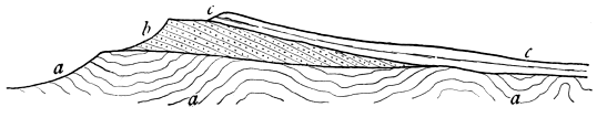
Fig. 15.
The lowest rocks a are crystalline schists, they are
succeeded by a set of arenaceous rocks b known as the
Torridonian beds, which rest unconformably upon the
upturned edges of the crystalline schists, whilst the
Cambrian rocks, c, rest with another unconformity sometimes
upon the partly denuded Torridonian beds, or where
the latter have been completely removed, as on the right
side of the figure, directly upon the crystalline schists,
thus presenting an example of unconformable overlap.
The occurrence of the Olenellus-fauna in the basement
beds of the Cambrian system near Loch Maree, proves
the Precambrian age of the Torridonian strata, whilst
the unconformable junction between the latter and the
crystalline schists indicates that we are here dealing with
two distinct sets of Precambrian rocks, one of Eparchæan
and the other of Archæan type.
[136]
The crystalline schists consist of rocks of very varied
lithological characters, some with gneissose, and others
with schistose structure, and they vary in degree of
acidity from ultrabasic rocks to those of acid composition.
Most of them exhibit parallel structures, which in many
cases can be shewn to have been impressed on the rocks
subsequently to their consolidation, though this need not
have occurred and probably did not occur with some of
them, especially the granitoid gneisses. The researches
of the members of H. M. Geological Survey have shewn
that many of these rocks were originally intrusive igneous
rocks, though it is not yet known into what rocks those
which were first consolidated were injected, and the
origin of the bulk of the schists still remains to be
elucidated. Subsequently to their consolidation and before
the deposition of the earliest Torridonian rocks they were
subjected to more than one set of earth-movements, which
folded them and impressed a series of parallel structures
upon many of them; and accordingly we find that the
pebbles of the crystalline schists which are found amongst
the basal conglomerates of the Torridonian rocks consist
of fragments which had undergone the alteration caused
by these earth-movements before they were denuded from
their parent-rocks[48].
The Torridonian system is composed of rocks which
are largely of arenaceous character, the most prominent
beds being formed of red sandstones, and the bulk of the
fragments in them have clearly been derived by denudation
from the crystalline schists, many of the beds being
[137]
composed of arkose, where the quartz is mixed with a
large proportion of felspar and often of ferro-magnesian
minerals. The deposits are clearly sedimentary, and are
as little altered as many strata of much more recent
origin, only possessing structures produced by metamorphic
action under exceptional circumstances. The detailed
researches of the geological surveyors prove that the
rocks of this system have a much greater thickness
and are of more varied lithological characters than was
previously supposed. The total thickness of the strata is
over 10,000 feet, and the sandstones are associated with
deposits of a muddy character, and with occasional bands
of limestone; in these circumstances the discovery of
fossils would excite no surprise, and in 1891 Sir A.
Geikie announced the detection of "traces of annelids
and some more obscure remains of other organisms in
these strata," which have not yet been described[49]. These
Torridonian strata furnish us with the most satisfactory
group of Precambrian sediments yet detected in Britain[50].
In the south-east Highlands is a great mass of crystalline
schists of a less gneissose character than that of the
north-west, to which Sir A. Geikie has applied the name
Dalradian. Many of these schists will be found by examination
of the geological map of Scotland to be separable
into divisions, which by means of their lithological characters
can be traced long distances across the country, and
they present all the characters of sedimentary rocks,
though they are associated with intrusive igneous rocks,
[138]
and have undergone great metamorphic changes since
their formation. Cambrian rocks have not yet been
discovered immediately above them, though they are
clearly older than Ordovician times, but the existence of
rocks associated with them along their north-west borders,
which in lithological characters closely resemble some of
the rocks of the crystalline schists of the north-west
Highlands, indicates the probability of their general
Precambrian age. In some instances, the extreme types
of metamorphism which they exhibit are the result of the
kind of action usually termed pyrometamorphic as has
been shewn by Mr G. Barrow[51].
In England and Wales the rocks which have been
shewn or inferred to be Precambrian, when not intrusive,
are largely of volcanic origin. The most satisfactory
example of the occurrence of the Olenellus-fauna is that
of the Cambrian Comley sandstone of Shropshire, which
rests unconformably upon a set of rocks termed by Dr
Callaway the Uriconian rocks; the latter are essentially
volcanic, and strongly resemble Precambrian rocks of
other British areas. There is also strong reason to
suppose that the sediments to which the name Longmyndian
has been applied, which have been described by the
Rev. J. F. Blake, are of Precambrian age, for, as Professor
Lapworth has pointed out, the three great subdivisions
of the Cambrian system are present in the area under
consideration, and the rocks of each are entirely different
from those of the adjoining Longmynd area. In Shropshire
therefore we meet with one set of volcanic rocks,
and another set consisting of sedimentary rocks, of which
[139]
the former is certainly, the latter almost certainly of
Precambrian age, and as the Longmyndian rocks are in a
comparatively unaltered condition, consisting of normal
sediments, we may well expect the discovery of fossils in
them also[52]. The Olenellus-fauna has been found near
Nuneaton in Warwickshire in beds which unconformably
succeed volcanic rocks, the Caldecote series of Prof.
Lapworth, and the latter are therefore of Precambrian
age[53]. A few fossils belonging to the Olenellus-fauna have
occurred in the oldest Cambrian rocks of the Malvern
district, and these rocks rest unconformably upon those
of an old ridge which is therefore composed of Precambrian
rocks. The rocks of this ridge are largely of
intrusive igneous origin, though parallel structures have
been impressed upon them as the result of subsequent
deformation, but some of the rocks are almost certainly
of contemporaneous volcanic origin[54]. In the Wrekin
ridge, igneous and pyroclastic rocks are found succeeded
unconformably by Cambrian rocks which resemble those
[140]
of the Malvern and Nuneaton districts, and probably
belong to the period of existence of the Olenellus-fauna,
and these igneous and pyroclastic rocks are presumably
of Precambrian age, and the contemporaneous rocks
constitute Dr Callaway's typical Uriconian group. Volcanic
ashes and breccias are accompanied by devitrified
pitchstones and intruded granitic rocks, which may or may
not be all of the same general age[55]. The rocks which
have been claimed as Precambrian in Pembrokeshire and
in Caernarvonshire have the same general characters as
those of the Wrekin ridge. Pyroclastic rocks underlie
the oldest Cambrian rocks, with discordance between the
two, and associated with these pyroclastic rocks are quartz
felsites which according to some are of contemporaneous
nature whilst others maintain their intrusive origin. In
each county granites are found which are now generally
recognised to be intrusive, though there seems to be no
doubt as to their being of the same general age as the
rocks with which they are associated, and therefore presumably
Precambrian. The Pembrokeshire rocks are
marked by the occurrence of a certain amount of metamorphism,
probably of more than one kind, which has
converted pyroclastic volcanic rocks into sericitic-schists
and quartz-felsites into hälleflintas[56]. The term Pebidian
[141]
given by Dr Hicks to the contemporaneous volcanic
fragmental rocks should be retained, and if these rocks
be eventually shewn to be contemporaneous with similar
volcanic rocks of other districts, may be applied generally,
as it has priority over other terms as Uriconian and
Caldecote series. The term Dimetian was applied to
rocks known to be intrusive, and must be dropped as a
chronological term, whilst the existence of an Arvonian
system separate from the Pebidian system is not fully
proved.
In Caernarvonshire two ridges are found, the one
running from Bangor to Caernarvon, and the other through
Llanberis lake. The rocks of these are generally similar
to those of St Davids, and as the lowest Cambrian rocks
of the area closely resemble those of St Davids, the Precambrian
age of the rocks of these ridges is rendered
highly probable, though until the discovery of the
Olenellus-fauna in the area, it cannot be regarded as
proved[57].
The actual position of the similar rocks of Anglesey
has not been so clearly fixed, as the rocks associated with
them are of Ordovician age, but their resemblance to the
rocks of the adjoining regions renders their Precambrian
age highly probable. It is interesting to find in association
[142]
with the rocks which resemble those of Caernarvonshire,
others which Sir A. Geikie recognises as quite
similar to some existing amongst the crystalline schists
of the north-west Highlands of Scotland, and when these
ancient rocks of Anglesey have been mapped in detail,
they will probably be found to present greater variety
than is afforded by any Precambrian rocks of Great
Britain occurring S. of the Scotch border[58].
Of rocks whose age is more uncertain, but which are
probably of Precambrian age, those of Charnwood Forest
in Leicestershire may first be noticed. They are largely
of pyroclastic origin, and from their likeness to similar
rocks of proved Precambrian age, they are very probably
of this age, as suggested by Messrs Hill and Bonney[59].
A group of crystalline schists is found in the south of
Cornwall, especially near the Lizard, and similar rocks
are found in the Channel Isles. As their relationship to
newer rocks is not clear, little can be said about them,
which has not already been noticed in mentioning the
crystalline schists of other regions[60].
The Precambrian rocks of the European continent
consist largely of crystalline schists which in their general
aspects recall those of the north-west Highlands of
Scotland. Important masses are found in Bavaria,
[143]
Bohemia, France, Spain, Scandinavia and Russia. The
Scandinavian and Russian rocks of Archæan type are in
places succeeded by the Olenellus-bearing beds of the
Cambrian rocks, and rocks of Eparchæan character are
not extensively developed, though certain Norwegian
rocks may be the equivalents of the Torridonian rocks of
Scotland, and other rocks of this type are found in places
in Sweden. In Bohemia and in Brittany Precambrian
strata of Eparchæan type have been discovered, and this
type probably occurs elsewhere in Europe.
The North American rocks require some notice, for it
was in Canada that the existence of Precambrian rocks
was first recognised, and the term Laurentian, originally
applied to an Archæan type of Precambrian rocks in
Canada, was subsequently adopted in speaking of many
Precambrian rocks elsewhere, though it is now wisely
restricted to the type of rock in the original area to which
the name was first given. These Laurentian rocks acquired
a special, interest on account of the occurrence in their
limestones of a supposed reef-building foraminifer, Eozoon
canadense, but detailed study of its structure and mode
of occurrence has convinced most geologists that the
structure is inorganic.
The Laurentian rocks of the typical Laurentide region
are largely crystalline schists associated with massive
crystalline rocks. The attempt to separate them chronologically
into a Lower and Upper division was premature,
as shewn by the fact that many of them, upon detailed
study, prove to be intrusive igneous rocks. In the neighbourhood
of Lake Huron, a set of sedimentary rocks
overlying the Archæan rocks is of Eparchæan type,
consisting to a great extent of volcanic rocks, clay-slates
and schists with intrusive igneous rocks; it has been
[144]
termed the Huronian System, and this term has also
been extensively applied to other Eparchæan types found
elsewhere, but should be restricted to the rocks of the
Huron district. A number of other rocks of Eparchæan
type have been discovered in various parts of North
America, and have been grouped together under the
title of Algonkian, a name proposed for them by Dr
C. D. Walcott, and an attempt has been made to arrange
them in chronological order, though in the absence of
fossils, the rocks of different districts can only be so
arranged by reference to lithological characters; nevertheless
a detailed study of the Eparchæan and some of the
more finely crystalline schistose rocks points to the existence
of a number of divisions of sedimentary rocks of
Precambrian age, some of which may attain to the dignity
of forming separate systems[61]. By far the most instructive
development of American Precambrian rocks has been
found in the Rainy Lake region of Canada, and it is the
subject of a special memoir by Dr A. C. Lawson[62]. The
Archæan rocks of the region are divided into a lower
Laurentian and an upper division, which is further subdivided
into the Coutchiching series below and the Keewatin
series above, though the rocks of the Keewatin
series are largely of Eparchæan character. The Laurentian
rocks of this region resemble those of the Laurentide
area, and consist of highly crystalline schistose and
gneissose rocks associated with compact rocks. The
Coutchiching series consists of mica schists and grey
[145]
laminated gneisses, which appear to have been of sedimentary
origin, altered by subsequent metamorphic action,
while the Keewatin series, which reposes sometimes upon
the rocks of the Coutchiching series (when the junction
is an unconformable one), sometimes upon the Laurentian
rocks, is formed of pyroclastic rocks and lava flows with
intercalated sedimentary rocks; some of the Keewatin
rocks are highly metamorphosed but others have undergone
little or no metamorphic change. The most important
point in connexion with these rocks of the Rainy
Lake Region has reference to the relationship between the
Laurentian rocks and those of the Coutchiching and
Keewatin series. Lawson demonstrates the igneous nature
of the Laurentian rocks, and brings forward evidence of
various kinds that they were formed "by the fusion of the
basement or floor upon which the formations of the upper
division of the Archæan were originally deposited. With
the fusion of this floor it seems probable that portions of
the superincumbent strata, which once formed integral
parts of either the Coutchiching series or the Keewatin,
have also been absorbed into the general magma, and
reappeared on crystallization as Laurentian gneiss. This
fusion, however, only extended up to a certain uneven
surface, which surface constitutes the demarcation between
the present upper and lower Archæan. Above this surface,
or upper limit of fusion, the formation of the Coutchiching
and Keewatin series retained their stratiform or bedded disposition,
and rested as a crust of hard and brittle rocks upon
the magma, subject to its metamorphosing influences[63]."
We may now pass briefly in review the evidence
which has been so far obtained as to the mode of formation
of the various Precambrian rocks. The existence
[146]
of a very varied fauna amongst the earliest Cambrian
strata has been commented upon by many geologists, and
according to accepted explanations of the origin of that
fauna, an enormous period of time elapsed before the
deposition of the earliest Cambrian strata. During portions
of that long period, the undoubtedly clastic rocks
of Eparchæan type were deposited, and probably many
others which are now so altered by metamorphism, like
some of the Coutchiching rocks of Canada, that their
original clastic origin can only be inferred and not directly
proved. Volcanic activity was very rife during the deposition
of some of these Eparchæan rocks, though perhaps
not more so than during the formation of some of the
Lower Palæozoic Rocks. All attempts to prove the occurrence
of organisms in Precambrian strata have hitherto
failed, for no undoubted fossil has been described which is
unhesitatingly accepted as of Precambrian age, notwithstanding
the many asserted occurrences of such fossils.
That fossils will eventually be discovered is more than
probable, and their non-detection at the present time is in
no way very surprising, when we remember the long time
that elapsed after the existence of stratified rocks below the
Upper Palæozoic rocks had been recognised, before definite
faunas were discovered in them. The determination of the
Precambrian age of stratified rocks is recent, and now that
this determination has been made, the search for fossils will
be more eager, and is likely to be rewarded by their discovery.
Furthermore, experience shows that when fossils
are discovered in rocks of unknown age, there is a tendency
to refer those rocks to some known period, and consequently
we may actually possess Precambrian fossils, out of beds
which have been erroneously referred to the Cambrian or a
later period.
[147]
Another important question is that of the metamorphism
of a large number of Precambrian rocks, and here
again recent research tends to show that the metamorphism
is not of a kind different from that which occurred
after the end of Precambrian times; the discovery of crystalline
schists in Norway, Kirkcudbrightshire and Westmorland
amongst Lower Palæozoic rocks, which resemble
those of Archæan masses in all respects except in the
extent of area which they cover, shows that similar processes
to those which occurred in Precambrian times went
on during later periods, though perhaps not on so large a
scale. The great extent of these metamorphic rocks of
Precambrian age can hardly be due in any great degree
to the longer time during which they have been subjected
to metamorphic influence, for there is evidence that much
of the change took place in Precambrian times, far more
than has occurred since, and it is a significant fact that
these old rocks are more extensively penetrated by
intrusive igneous masses than those of later periods; here
again we find that much of the intrusion actually occurred
in Precambrian times. The greater extent of intrusion
and metamorphism amongst these Precambrian rocks than
amongst later sediments indicates some differences of
conditions in the case of Precambrian and later times.
If besides intrusion, actual fusion of floors of Precambrian
rocks occurred, we may well suppose that the earlier
records of the rocks are for ever lost to us, the earliest
sediments having been fused, but that the history of life
upon our earth is to be revealed to us first in so late a
stage as that of Cambrian times is highly improbable, and
we may look forward with confidence to laying bare the
records of the rocks composing the geological column some
way below the Cambrian portion of the column.
[148]
Upon this foundation of igneous rock, sediment and
volcanic material, formed in Precambrian times, whose
history we have only begun to study, was laid down the
great mass of sediment which the geologist has more
completely studied, where abundant traces of life are
preserved, and concerning whose history we can gain a
greater insight than is permitted us in the case of the
old Foundation Stones.
[149]
CHAPTER XIII.
CYCLES OF CHANGE IN THE BRITISH AREA.
Before studying in further detail the strata of the
geological column, it will be convenient to deal with the
great physical changes which have occurred in the British
area from Precambrian times to the present day, as this
will clear the way for a right appreciation of the main
variations in the characters and distribution of the strata.
At the end of Precambrian times there was a general
upheaval of the British area, and this we may speak of
as the First Continental Period. It was followed by
depression and extensive sedimentation, proceeding more
or less continuously though with local interruptions through
Lower Palæozoic times, so that so far as Britain is
concerned we may speak of Lower Palæozoic times as
constituting the First Marine Period. Extensive upheaval
gave rise to continental tracts and mountain
chains, and deposits of abnormal character (as compared
with ordinary marine deposits) at the end of Lower
Palæozoic times;—the Devonian period was one of elevation
and denudation, and we may therefore refer to it
as the Second Continental Period. This was followed by
depression and sedimentation in Carboniferous times, and
these Carboniferous times constitute the Second Marine
[150]
Period. Elevation gave rise to continental tracts and
mountain chains at the end of Carboniferous times, and
here again we find proofs of extensive denudation and the
formation of abnormal deposits:—the Permo-Triassic
period is the Third Continental Period. Depression set
in during early Jurassic times and continued throughout
the Mesozoic and the early part of Tertiary times, which
form the Third Marine Period. Disturbances culminating
in Miocene times once more produced terrestrial conditions.
In this, the Fourth Continental Period, we are
still living.
From what has been previously written it will be seen
that each of the marine periods should be marked by an
early and late shallow-water phase, separated by an intervening
marine phase, and the importance of the phases
will depend upon the length of time during which they
existed, and will differ markedly in different cases, whilst
the distinctness of the middle phase from the upper and
lower, will depend upon the magnitude of the maximum
submergence.
During the first marine period submergence was
comparatively rapid, and the shallow-water phase only
lasted through very early Cambrian times in most regions,
whilst the deep-water phase, complicated by many minor
upheavals, extended through the main part of Cambrian,
Ordovician and Silurian times, and was replaced by the
later shallow-water phase at the end of Silurian times.
The second marine period again was ushered in by
rapid submergence, so that the shallow-water phase was
brief, and the main mass of the Lower Carboniferous
strata was deposited in deep water; but, unlike the first
marine period, the second was characterised by the
occurrence of a long interval of time marking the later
[151]
shallow-water phase, during which the whole of the Upper
Carboniferous strata were deposited. The Carboniferous
Marine Period is the simplest of the three with which we
have to deal, as the local oscillations occurring on a fairly
large scale for such movements were less frequent than
was the case during the first and third marine periods.
The third marine period had a long shallow-water
phase at the commencement, with many minor oscillations,
causing great variation in the character of the
deposits and frequent minor unconformities. This shallow-water
phase existed throughout Jurassic and Lower
Cretaceous times. The deep-water phase existed during
the deposition of the Upper Cretaceous deposits, and was
succeeded by the second shallow-water phase, when the
early Tertiary strata were accumulated.
The difference between the elevations which accompanied
the Continental Periods and those which have
been alluded to as minor elevations is no doubt one of
degree, but in considering the British strata only no
confusion is likely to arise on this account, as the difference
was here very great.
The events which occurred during the continental
periods are of extreme importance to the geologist.
Every great upheaval was accompanied by crumpling and
stiffening of portions of the earth's crust, and a definite
trend was given to the strata as the result of these
movements. It is to the earth-movements of the four
great continental periods that the present structure
of the British Isles is largely due, and in any attempt
to restore the physical history of our islands considerable
attention must be paid to the changes which
were produced in the stratified rocks during these periods
of earth-movement.
[152]
CHAPTER XIV.
THE CAMBRIAN SYSTEM.
Classification. The rocks of the Cambrian system
when found reposing on Precambrian rocks in Britain
are always separated from the latter by an unconformity.
The typical development of the rocks of the system, as
the name implies, is in the hilly region of Caernarvonshire
and Merionethshire in North Wales, and they are also
well represented in South Wales, the border counties
between England and Wales, and the North-West Highlands
of Scotland. Two distinct classifications of the
Cambrian rocks of Britain are in use, the original one
founded on variations of lithological character, whilst the
second depends upon faunistic differences, but the original
lithological classification has been to some extent modified
to make it locally correspond with the classification based
upon palæontological grounds. The following table will
shew the differences:—
| Lithological Classification. |
Palæontological Classification. |
| Tremadoc Slate Series[64] |
|
Beds with Intermediate Fauna |
| Lingula Flags Series |
|
Beds with Olenus Fauna |
| Menevian beds (formerly included in Lingula Flags) |
|
Beds with Paradoxides Fauna
Beds with Olenellus Fauna |
Solva beds
Caerfai beds |
|
Formerly grouped
together as Harlech
or Llanberis beds |
The original lithological classification was essentially the
result of Prof. Sedgwick's work in North Wales, while
the classification according to faunas is the outcome of
the researches of Dr Hicks in South Wales.
Description of the Strata. The Cambrian rocks of
North Wales occur in two complex anticlines, separated
by an intermediate syncline of Ordovician strata occupying
the Snowdonian hills. The southerly or Harlech
anticline forms a part of Merionethshire to the east of
Harlech, whilst the northern one is developed around
Bangor and Llanberis. The South Welsh Cambrian rocks
are chiefly found on either side of the Pembrokeshire axis
of Precambrian rocks which runs through St David's.
As the corresponding rocks of the two regions were
deposited in bathymetrical zones of much the same depth,
it will be convenient to give a general account of the
rocks of the two regions at the same time, leaving the
student to acquire information of the detailed variations
in the larger text-books and in special memoirs[65].
The strata of the Caerfai and Solva groups show the
prevalence of the shallow-water phase almost uninterruptedly
through the whole of the time occupied by their
accumulation in the Welsh areas. They consist chiefly of
basal conglomerates, succeeded by alternations of grits
and shales, though the latter are often converted into
slates, owing to the subsequent production of cleavage.
The basal conglomerates of the Caerfai beds are frequently
marked by the existence of enormous pebbles, composed
of fragments of the rocks of the underlying Precambrian
groups, and the possibility of the occurrence of glacial
action during their accumulation as advocated by Dr Hicks
must be taken into account. Above these beds are
various coloured grits, with alternations of muddy sediments
often coloured red[66]. The Solva group consists of
massive grits, of various colours, also with alternations
of mud, which have prevalent purple and green hues.
The great thickness of the strata of the Caerfai and
Solva Series, which sometimes exceeds 10,000 feet, must
also be noted.
The Menevian beds consist essentially of very fine,
well laminated black and grey muds, which are of a
[155]
texture favourable for the production of a somewhat
regular jointing, causing the rock to break into small
rectangular blocks. They are thin, not exceeding 600
feet in thickness, and indicate the incoming of the general
deep-water phase of the Lower Palæozoic epoch. The
Lingula Flags mark a local return to shallower water
conditions, especially in the central portion. The total
thickness is over 3,000 feet, of which the lower stage
(locally the Maentwrog series) is over 500 feet, and
consists of blackish muds, the middle (Festiniog stage[67])
is about 2,000 feet thick, and is composed chiefly of
shallower water gritty flags, whilst the upper (Dolgelly)
stage is of about the same thickness as the lower stage
and has similar lithological characters.
The Tremadoc Slates are about 1,000 feet thick. They
are divided into a lower and upper stage, of about equal
thickness, and are essentially composed of iron-stained
slates, with a considerable admixture of calcareous matter
in some parts of South Wales, when they furnish the
nearest approach to a limestone which has been found
amongst the Welsh Cambrian strata. They were probably
formed in a fairly deep sea.
Much pyroclastic rock and some lava flows are intercalated
amongst the Welsh Cambrian sediments. Tuffs
are formed in the lower beds of St David's, and lavas
and ashes have been found amongst the Lingula
Flags and Tremadoc Slates of North Wales, while the
Lingula Flags of South Wales have furnished several
bands of ash to the north of Haverfordwest. Much of
the material of the grits and muds may be derived from
[156]
volcanic rocks, though how far this is so cannot be stated
in the absence of information obtained by detailed petrological
examination of the rocks.
The various isolated outcrops of Cambrian strata
amongst the counties of the Welsh borders and adjoining
Midland counties indicate a great thinning of the
Cambrian rocks in this direction.
The probable equivalents of the Caerfai rocks occur at
Nuneaton, Comley, and on the flanks of the Wrekin and
Malvern hills. The thin basal conglomerates are succeeded
by quartzites, and sometimes red calcareous sandstones
(Comley sandstone). These rocks are succeeded by thin
arenaceous and calcareous beds which represent either
the Solva or Menevian beds of Wales. The Lingula Flags
are represented by the Malvern Shales of the Malvern
area and the Stockingford Shales of Nuneaton, whilst the
Tremadoc Slates have as their equivalents the Shineton
Shales. The exact thicknesses of these deposits do not
seem to have been recorded, but Prof. Lapworth observes
that in central Shropshire "the Comley and Shineton
groups which ... have a collective thickness of perhaps less
than 3,000 feet, we have apparently a condensed epitome
of the entire Cambrian system as at present generally
defined."
The Cambrian rocks of the North-west Highlands
consist of a thin conglomerate succeeded by grits and
flags with shaley beds, and above these a mass of limestone,
which may represent some of the Ordovician
deposits as well as those of Cambrian age. Pending a
complete description of the faunas of these rocks, it is
sufficient to state that the only fauna which has hitherto
been described in detail indicates the existence of Lowest
Cambrian rocks. Further remarks will be made on this
[157]
head when describing the character of the Cambrian
faunas. The Cambrian rocks of the North-west Highlands
are also very thin as compared with those of Wales,
so that the Highland and Welsh borderland regions
appear to have existed as a deeper sea area than that
which is indicated by the Cambrian rocks of Wales, an
inference which is to some extent borne out by study of
the Cambrian rocks of extra-British areas, to which we
may now turn.
The principal European developments of Cambrian
rock are found in Scandinavia, Russia, Bohemia and Spain,
and of these the Scandinavian one is by far the most fully
developed, as there is a complete sequence in the rocks of
that peninsula. They occur both in Norway and Sweden,
but the Swedish exposures are the most interesting in
most respects, especially those of Westrogothia and Scania.
The rocks are of no great thickness, and consist essentially
of black carbonaceous shales, with inconstant bands of
impure black limestone composed almost entirely of the
remains of trilobites or more rarely of brachiopods. These
Alum Shales, as they are termed, rest unconformably
upon Precambrian rocks, and have arenaceous and conglomeratic
deposits at the base. In Russia the rocks are
still further attenuated, and have not yielded the relics of
so many faunas as have been found in the Scandinavian
Cambrian rocks.
The Bohemian development is incomplete, owing
apparently to an unconformity at the base of the overlying
Ordovician rocks, while the Spanish deposits which seem
fairly thick and composed largely of mechanical sediments
have not been worked out in very great detail.
The American development of Cambrian rocks resembles
the European one in many striking particulars,
[158]
and as in the case of Europe, there are lateral variations
in the lithological characters of the rocks, though in the
opposite direction, the shallow-water deposits occurring on
the east coast, and the deep-water deposits further west.
The general distribution of the different types of
Cambrian strata in Europe and North America has been
accounted for on the supposition that in Cambrian times
a tract of land lay over much of the present site of the
North Atlantic Ocean, and that the detritus of that land
formed the shallow-water accumulations of Wales and the
east of Canada, whilst further away from it were deposited
the open-sea accumulations of Scandinavia and Russia on
one side and of the more westerly regions of North
America on the other, as indicated in Fig. 16.
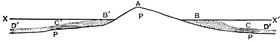
Fig. 16.
- P. Precambrian Rocks.
- A. Land.
- XX´. Sea level.
- BB´. Shore deposits.
- CC´. Deep-water deposits.
- DD´. Abyssal deposits.
The Cambrian Faunas. The Cambrian Period has
been termed the age of trilobites, for they are the
dominant forms of the time, but they are associated with
many other forms of invertebrata; indeed all the great
groups of this division are represented in the earliest
Cambrian fauna. Dr C. D. Walcott records representatives
of Spongiae, Hydrozoa, Echinodermata, Annelida,
Brachiopoda, Lamellibranchiata, Gastropoda, Pteropoda,
Crustacea and Trilobita as occurring in the Olenellus beds
of North America and other groups are represented in the
rocks of this age in the Old World. The Cambrian
[159]
trilobites as a whole are of more generalised types than
those of the later systems which furnish their remains, as
indicated especially by the looseness of the body, and
the large number of body rings in many of the genera,
while the tail or pygidium was small and formed of
only a few coalesced segments, as pointed out by Barrande.
In the later trilobites the test is more compact,
there are on the whole fewer body rings, as more of
these have become fused into a tail which is therefore
larger than that of the average tail of the Cambrian
trilobite.
Taking the faunas in order, the oldest or Olenellus
fauna has furnished a great variety of forms in the North-west
Highlands of Scotland, Shropshire, Scandinavia,
Esthonia, Sardinia, Canada, and Newfoundland, whilst
representative species of the fauna have been recorded
also from Worcestershire, Warwickshire, Pembrokeshire,
India, China, and Australia.
The dominant form is the trilobite of the genus or
group Olenellus, which contains a great variety of species
referable to three or four divisions which have been
ranked as separate genera by some writers. Associated
with Olenellus are trilobites belonging to other genera,
which are found in higher deposits, though there represented
by different species.
Brachiopods are fairly abundant, especially those provided
with a horny shell; of these, the genus Kutorgina
is widely distributed.
The zoological relationships of several of the fossils of
this horizon are as yet doubtful. The Archæocyathinæ
show affinities with certain corals; a number of tests,
included in the genus Hyolithes and its allies are doubtfully
referred to the Pteropods, and the position of the
[160]
genus Volborthella is uncertain. Special attention is
directed to these doubtful relationships, as it is possible
that a number of 'generalised forms' of organisms occur
in these strata[68].
It should be noticed here that faunas have been
discovered which are possibly of earlier date than the
Olenellus fauna, as they do not correspond with it, or
with those of newer strata. One, the Neobolus fauna of
the Salt Range of India, occurs in beds below those with
Olenellus, though it is not yet clear that Olenellus will
not be eventually discovered associated with it, whilst the
other, the Protolenus fauna of Canada, is of unknown
age[69].
The Olenellus beds are succeeded by beds containing
the Paradoxides fauna, which have been found in North
and South Wales, Shropshire, Scandinavia, Bohemia,
Spain, and North and South America. Olenellus and its
allies became extinct (or else so scarce that no relics of
them have been discovered in the Paradoxides beds)
before the commencement of the deposition of the strata
containing the Paradoxides fauna, and few genera pass
from the beds with the one fauna to that containing the
other. The Paradoxides fauna existed for a considerable
period, and the beds have been divided into a series of
zones characterised by different species of Paradoxides, thus
[161]
Dr Hicks records the following zones in Pembrokeshire[70]:—
| Zone of |
Paradoxides |
Davidis |
|
Menevian. |
| " |
" |
Hicksii |
| " |
" |
Aurora |
|
Solva. |
| " |
" |
Solvensis |
| " |
" |
Harknessi |
Dr Tullberg divides the Paradoxides beds of Scania
into thirteen zones, though only a few of these are
characterised by definite species of Paradoxides. The
Olenellus beds have not yet been divided into zones,
though this will probably be the outcome of further
study[71].
The strata with Paradoxides are succeeded by those
with the Olenus fauna, characterised by the genus Olenus
and a large number of allied genera or sub-genera as some
prefer to term them. The genus Olenus (sensu stricto) is
very abundant in the lower part of the series, whilst the
allied forms are more abundant in the upper beds. The
genus Paradoxides and its associates disappeared before
the deposition of these strata containing Olenus and its
allies, and indeed the complete change in the character of
the faunas in Europe is very remarkable. The Olenus
[162]
fauna has been found in North Wales, Pembrokeshire,
Warwickshire, Worcestershire, and abroad in Scandinavia
and Canada. It is interesting to note among the fossils
of the Olenus beds the occurrence of a graptolite which is
associated with Olenus in Scandinavia; this is the earliest
recorded appearance of a group which is destined to play
so important a role amongst the fossils of the succeeding
system[72]. The following zones have been detected by Dr
S. A. Tullberg amongst the Olenus beds of Scania:—
| Zone of |
Acerocare ecorne. |
| " |
Dictyograptus flabelliformis. |
| " |
Cyclognathus micropygus. |
| " |
Peltura scarabæoides. |
| " |
Eurycare camuricorne. |
| " |
Parabolina spinulosa. |
| " |
Ceratopyge sp. |
| " |
Olenus (proper). |
| " |
Leperditia. |
| " |
Agnostus pisiformis. |
The beds with Dictyograptus flabelliformis form a
wonderfully constant horizon at or near the top of the
Olenus beds. They are found in North Wales, the Border
Counties between Wales and England, France, Scandinavia,
Russia and Canada.
The passage fauna of the beds which are the equivalents
of the Tremadoc Slates may be spoken of as the
Ceratopyge fauna, for Ceratopyge forficula, a remarkable
species of trilobite, characterises it in Scandinavia, and
[163]
will probably be found elsewhere. Ceratopyge beds have
been found in North and South Wales, Shropshire, Scandinavia,
Bavaria and North America, and in each case
the fauna is intermediate in character between that of the
Cambrian and that of the Ordovician system, containing
the loosely-formed trilobites of the former with the more
compact ones of the latter. The genus Bryograptus, a
many-branched graptolite, also appears to characterise this
fauna[73].
The faunas of the Cambrian rocks have not been
studied in sufficient detail, with reference to the physical
surroundings of the organisms, to throw much light upon
the conditions under which the strata were deposited,
though the evidence obtained from an examination of
the lithological characters of the deposits is generally
corroborated by study of the organic contents.
[164]
CHAPTER XV.
THE ORDOVICIAN SYSTEM.
Classification. The Ordovician strata were originally
divided into series by Sedgwick as follows:—
Upper Bala,
Middle Bala,
Lower Bala,
Arenig.
The Arenig series was at one time included by some
writers with the Lower Bala under the name Llandeilo,
but the word Llandeilo is now used in the sense of
Sedgwick's Lower Bala. The Middle Bala is often spoken
of as Caradoc, but the terms Bala and Caradoc are sometimes
used interchangeably. As much confusion attaches
to the use of the name Bala without explanation, the
alternative titles have been largely adopted, and as the
series are well defined there is no objection to their
use, save that some expression is wanted equivalent to
Upper Bala. The local term Ashgill shales was originally
applied by Mr W. Talbot Aveline to beds of this age in
Lakeland, and I have elsewhere suggested the use of this
name for the whole series in that region; its use may
well be extended to the series which is developed in many
parts of Britain and the continent. The terms which
will be used here, therefore, for the different series of
the Ordovician system are the following:—
[165]
| Ashgill |
Series |
(= Upper |
Bala) |
| Caradoc |
" |
(= Middle |
" ) |
| Llandeilo |
" |
(= Lower |
" ) |
| Arenig. |
" |
|
Adopting a palæontological classification, we may speak
of the Arenig and Llandeilo beds as those containing
the Asaphus fauna, whilst the Caradoc and Ashgill beds
possess the Trinucleus fauna; this is the terminology
employed by Angelin for the equivalent strata of Sweden.
It must be noted that here the names applied are not
those of absolutely characteristic genera, as was the case
with those adopted for naming the Cambrian faunas, for
both Asaphus and Trinucleus range through the beds of
the system; but whereas Asaphus is most abundant in
the beds of the two lower series, Trinucleus occurs most
frequently in those of the two upper series.
Description of the strata. The Ordovician rocks are
found over large tracts in North and South Wales, in
the counties on the Welsh border, in Lakeland and the
outlying districts in the Southern Uplands of Scotland,
and in detached areas in Ireland. There are three main
types of deposit:—(i) the volcanic type, in which the
ordinary sediments are associated with a large amount of
contemporaneous volcanic matter, (ii) the black shale
type, with a fauna consisting largely of graptolites, and
(iii) the ordinary sedimentary type, in which we find
alternations of grits, shales, and more or less impure
limestones. We also find developments which are intermediate
between any two or even all three of these types.
The first type is characteristically developed in Caernarvonshire
and Merionethshire, the second in the Dumfriesshire
Uplands, and the third in the Girvan district of Ayrshire.
[166]
The variation in the thickness of these three types of
deposit is shown in the accompanying sections of the
Caernarvon, Merioneth, Moffat and Girvan regions (see
Fig. 17).
Fig. 17.
Showing the variations in the characters of the Ordovician deposits
of the three principal types.
Scale 1 in. = 1000 feet.
A = Arenig. L = Llandeilo. C = Caradoc.
The thickness of the Arenig rocks of the Scotch areas is unknown.
The North Welsh area gives two different developments
of the Ordovician strata, one of which is much
less volcanic than the other. In the Merioneth-Caernarvon
area, two great masses of volcanic rock form the Aran and
Arenig hills of Merioneth and the Snowdonian group of
Caernarvon. The former are of Arenig, the latter of
Caradoc age. The Merionethshire volcanic rocks consist
of a great thickness of lavas and ashes of intermediate
composition (anderites), associated with sandy and muddy
[167]
sediments of no great vertical depth. The Llandeilo beds
of this area are chiefly of the nature of black shales,
while the Caradoc series is represented by volcanic lavas
and ashes of acid composition (felsites) with a few thin
interbedded sediments. A calcareous ash forming the
summit of Snowdon is of importance as being on the
same horizon as a limestone (the Bala limestone) found
in the other North Welsh area. The Ashgill series is not
represented in Snowdonia.
In the other North Welsh tract, around Bala Lake,
the volcanic matter is much less conspicuous. The Arenig
rocks are not seen nearer than the Arenig mountains
which form the western boundary of this second tract.
The Llandeilo beds consist of shaley deposits with a well-marked
limestone, the Llandeilo limestone, in the centre,
whilst the Caradoc beds consist chiefly of muddy sediments
with some thin ashes and a limestone, the Bala
limestone, at the top. The Ashgill series contains a basal
limestone, the Rhiwlas limestone, succeeded by shales,
and another thin limestone called the Hirnant limestone
at the summit.
In South Wales the Arenig beds[74] are chiefly composed
of slates, and are divisible into an upper and lower group.
The total thickness is about 2000 feet. The Llandeilo
beds contain three series:—
| Upper Llandeilo Slates |
1000 |
| Llandeilo Limestone |
200 |
| Lower Llandeilo Slates |
800. |
The Caradoc beds consist of black graptolitic shales of
no great thickness, succeeded by an impure limestone on
the horizon of the Bala limestone, while the Ashgill
series like that of North Wales is separated into upper
and lower limestone stages with an intervening stage
composed of shales.
The deposits of the Welsh borderland are well
developed in Shropshire, where there is practically a
repetition of the Caernarvon-Merioneth development,
with variations in detail. The Arenig and Caradoc
volcanic rocks are not so thick as those of the Welsh
district, but are nevertheless of considerable importance[75].
In the hilly region of Cumberland, Westmorland, and
the adjoining parts of Yorkshire the succession differs from
that of any of the Welsh regions, for the great period of
volcanicity was during the formation of the Llandeilo
rocks, and there were merely sporadic outbursts in Arenig
and Caradoc times. The Arenig rocks consist of black
shales with interstratified beds of coarser sediment, and
some thin lavas and ashes of intermediate type. The
Llandeilo series is represented by a very great thickness
of volcanic rocks, varying in composition from basic to
acid lavas, with associated pyroclastic rocks. The rocks
of the Caradoc period largely consist of impure limestone
with associated argillaceous rocks, and contemporaneous
volcanic rocks of acid character. A marked unconformity
is found locally in the centre of these. The Ashgill series
consists of a basal limestone with shales above, and there
is evidence that volcanic activity had not become extinct
during the deposition of the rocks of this series.
[169]
Passing on to Scotland, the graptolitic type is admirably
shown in the southern Uplands of the neighbourhood
of Moffat, Dumfriesshire. The base of the Ordovician
system has not been found, but the lowest series seems to
be represented by shales with a graptolite possibly of
Arenig age. Above this are volcanic beds succeeded by
a group of black shales known as the Moffat shales. They
are only about six hundred feet in thickness, and yet
represent much of the Ordovician and part of the Silurian
strata as developed elsewhere. The beds belonging to
the Ordovician system are divided into two series, the
Glenkiln shales below and the Hartfell shales above.
The former consist of intensely black muds with few
fossils save graptolites, and a deposit of chert at the base
which is composed of radiolaria. The graptolites of the
black shales are Upper Llandeilo forms, but the thin
deposit of radiolarian chert may represent the rest of the
Llandeilo period and part of the Arenig period also. The
Hartfell shales are also usually black graptolite shales
with lighter deposits nearly barren of organic remains;
they represent the Caradoc and Ashgill series and pass
conformably into the deposits of Silurian age[76]. The
ordinary sedimentary type of Ordovician rocks is found
in Ayrshire, though a few thin graptolitic seams are
[170]
intercalated with the conglomerates and shelly sands,
clays and limestones of the region, which is therefore
peculiarly valuable as affording a means of comparison of
the shelly type with the graptolitic type of Ordovician
deposits. The Arenig series consists of black shales with
graptolites, and these rocks are succeeded by a volcanic
group which is probably of Llandeilo age. Above these
volcanic beds, as in Dumfriesshire, we find three great
divisions, two of which are of Ordovician, the third of
Silurian age. The Ordovician divisions are respectively
termed the Barr series, which is the equivalent of the
Glenkiln shales, and the Ardmillan series above, equivalent
to the Hartfell shales[77].
It is interesting to find that in the north of Ireland
the rocks generally coincide in characters with those which
are found along the same line of strike in Great Britain;
thus, the Girvan type appears in Londonderry, Tyrone
and Fermanagh, the Moffat type in County Down, and the
Lake District type in the counties of Dublin and Kildare.
On the continent the volcanic material which plays so
important a part in the constitution of the Ordovician
accumulations of Britain is practically absent, and the
strata are largely composed of accumulations of shale and
limestone with occasional coarser deposits. In Scandinavia,
the Arenig beds consist of limestones with a few shales,
the Llandeilo deposits are largely calcareous, those of
Caradoc age are partly calcareous and towards the top
usually argillaceous, while the equivalents of the British
[171]
Ashgill series are calcareous at the base and argillaceous
at the summit. In Russia the calcareous matter preponderates
over the argillaceous material.
Ordovician strata are also found in Belgium, France,
Bohemia, and other places, and are largely composed of
mechanical sediments of varying degrees of fineness
mixed occasionally with some calcareous matter.
The variation in the characters of the Ordovician
strata of Britain points to accumulation in a fairly
deep sea, usually at some distance from the land, but
dotted over with volcanoes which often rose above the
water, causing the addition of much volcanic material
to the ordinary sediments, and the existence of minor
unconformities at different horizons along their flanks.
As these unconformities are not always associated with
volcanic material it is obvious that uplifts must have
occurred occasionally during the deposition of the rocks;
one important uplift is indicated by the occurrence of an
unconformity in the Arenig rocks of Wales, while another
is seen amongst the Caradoc rocks of the Welsh borders.
On the whole, however, the period was one of slow subsidence,
the deposition of material generally keeping pace
with this subsidence, and accordingly there is a great
uniformity of characters amongst the strata over wide
areas. The probable continuation through the Ordovician
period of the tract of land over the present site of the
N. Atlantic ocean which as we have reason to suppose
existed during Cambrian times, is indicated by similar
changes of lithological character amongst the strata when
traced from Britain eastward to Russia in both Cambrian
and Ordovician times, and the continuance of these conditions
over the American area is also indicated by study of
the variations amongst the American Ordovician deposits.
[172]
The Ordovician Faunas. The Ordovician period has
justly been termed the Period of Graptolites, which are
the dominant forms of the time, and continue in abundance
throughout the period. The abundance of graptolites
in black shales associated with few other organisms
has often been noted. It appears to be due to a large
extent to the slow accumulation of the graptolitic deposits,
allowing an abundance of these creatures to be showered
upon the ocean floor, after death, for the evidence derived
from detailed examination of their structure points to
their existence as floating organisms. The tests of other
creatures largely calcareous may well have been dissolved
before reaching the sea-floor. In support of the view
that these black shales are abysmal deposits may be
noted the singular persistence of their lithological
characters over wide areas, their replacement by much
greater thicknesses of normal sediments along the ancient
coast-lines, the frequent occurrence together of blind
trilobites with those having abnormally large eyes when
these creatures are associated with graptolites in the
black shales, and lastly the interstratification of the
black shales with radiolarian cherts similar to the modern
abysmal radiolarian oozes. If this be so, we ought to find
graptolites in marine deposits of all kinds, and indeed
they are found there, though largely masked by the mass
of sediment and the hosts of other included fossils, so that
their discovery is rendered much more difficult than when
they occur in the black shales,—a state of things which
is familiar in the case of other pelagic organisms as
Globigerinæ, radiolaria, and pteropods, whose tests abound
in the abysmal deposits and are comparatively rare in
those of terrigenous origin[78].
The characters of the Ordovician trilobites have
already been noticed. These organisms are abundant,
and occur in sediments of all kinds. Of other groups,
the significance of the radiolaria has been referred to
above. Corals occasionally form reef-like masses of limestone
as in the limestones of the Caradoc epoch; the
echinoderms are well represented, cystids being locally
abundant; of the crustacea, many remains of tests of
phyllocarida have been recorded; the brachiopods are
very abundant, and of the mollusca, lamellibranchs, gastropods
and cephalopods all occur with frequency though
none of these groups is very prevalent. Certain forms
have been referred to pteropods though with doubt, and
other shells seem to be referable to the heteropods. The
existence of vertebrates during Ordovician times is not,
in the opinion of many geologists, proved, though remains
of fishes have been recorded from the Ordovician strata of
North America; but it is desirable that more evidence of
this occurrence should be given[79].
The distribution of the Ordovician faunas like that of
the sediments points to the prevalence of open ocean
conditions over wide areas during the period, with occasional
approaches to land, which was often of a volcanic
nature. Around this land clustered the ordinary invertebrates,
building up coral-reefs and shell-banks, whilst
away in the open oceans the graptolites floated, almost
alone, and sank to the ocean floor after death.
[174]
CHAPTER XVI.
THE SILURIAN SYSTEM AND THE CHANGES WHICH
OCCURRED IN BRITAIN AT THE CLOSE OF SILURIAN
TIMES.
Classification. The Silurian system was originally
divided by its founder, Sir R. I. Murchison, into three
series, as follows:—
| Ludlow |
Series |
| Wenlock |
" |
| Llandovery |
" |
The term May Hill, proposed by Sedgwick, is sometimes
used as synonymous with Llandovery. This
classification omits a somewhat important set of beds
intercalated between those of the Llandovery and Wenlock
series known as the Tarannon shales, and in Britain if we
were to classify afresh, it would be more convenient to
include some of the beds formerly referred to the Ludlow
in the Wenlock. I shall, however, adopt the old and
well-established classification, adding the term Tarannon
to Llandovery, and speaking of the Llandovery-Tarannon
series. The nature of the two classifications is shown in
the following table:
[175]
| Stages. |
Old Classification. |
New Classification. |
Palæontological
Classification. |
| 1 Upper Ludlow |
|
Ludlow |
 |
Downtonian |
 |
Fauna with Encrinurus |
| 2 Aymestry Limestone |
| 3 Lower Ludlow |
|
Salopian |
| 4 Wenlock Limestone |
|
Wenlock |
| 5 Wenlock Shale |
| 6 Woolhope Limestone |
| 7 Tarannon Shales |
|
|
Valentian |
|
Fauna with Harpes |
| 8 Upper Llandovery |
|
Llandovery |
| 9 Lower Llandovery |

Fig. 18.
L = Ludlow. W = Wenlock. Ll-T = Llandovery-Tarannon.
Description of the strata. Lithologically the Silurian
deposits of Britain form a continuation of those of the
Ordovician period, with a local interruption due to the elevation
of portions of Wales and the Welsh borders at the
close of Ordovician times. Elsewhere we find a predominance
of shales passing into grits at the top of the system,
the change indicating the incoming of the shallow-water
phase before the commencement of the second continental
period. Particular stress is laid upon the predominant
shaley character of the beds, for, on account of the richness
and variety of the faunas of the calcareous rocks,
greater attention is naturally paid to them in geological
works, and the student may get a false idea of their
relative importance. An attempt is made below (Fig. 18)
to give a general idea of the variations in lithological
[176]
characters of the Silurian rocks in different parts of
Britain.
The Silurian strata are mostly found in the same
localities as those which furnish exposures of the rocks of
Ordovician age.
The development in the typical Silurian region of the
Welsh borders is characterised by the abundance of
calcareous matter which is found there as compared with
that which exists in the other British localities.
The Llandovery strata are sandy, often conglomeratic,
with a fair amount of calcareous matter in places. The
arenaceous nature is undoubtedly due to the proximity of
land caused by local upheaval at the end of Ordovician
times, and the Upper Llandovery rocks sometimes rest
unconformably on the Lower ones, at other times on
Ordovician, Cambrian, or even Precambrian rocks. The
Tarannon shales are light green shales with intercalated
grits. The Wenlock series consists of a group of shales
separating a lower, very inconstant, earthy limestone from
an upper, more constant, thicker and purer limestone.
The latter, the Wenlock limestone, is composed of fragments
and perfect specimens of various fossils, and the
fragmentary nature of many of the shells indicates the
occurrence of wave-action and probable formation in
shallow water, in some places against coral-reefs.
The Lower Ludlow beds consist of sandy shales; they
are separated from the Upper Ludlow beds by an impure
limestone, the Aymestry limestone. The Upper Ludlow
beds consist mainly of grits and flags, often coloured red
towards the summit.
In North Wales the Llandovery beds occasionally
present the shelly arenaceous types of deposit as near
Llangollen, at other times as near Conway, Corwen, and
[177]
in Anglesey, the graptolitic shale type. They also rest
unconformably upon the Ordovician rocks in this area.
The Tarannon shales resemble those of the border county.
The Wenlock series consists essentially of shales, while
the Ludlow development differs from that of the borders
in its greater thickness and the absence of any calcareous
band in the centre. In Central Wales the graptolitic
type of the Llandovery-Tarannon series is found, but the
graptolite-bearing shales of the Llandovery epoch are
thin beds occurring between grits and flags no doubt
deposited in shallow water, and this division of the series
is of very great thickness.
In South Wales the Silurian rocks are very similar
to those of the Welsh borders, save that the calcareous
deposits are fewer and thinner.
The Lake District Silurian strata generally resemble
those of North Wales. The Llandovery-Tarannon rocks
are of the graptolite-shale type, intercalated with fine
grits in the case of the beds of Tarannon age. The
Wenlock beds consist of shales, and the Ludlow beds of
gritty shales beneath, and massive flags and grits at the
summit. These Ludlow beds are here of great thickness
(certainly not less than 7000 feet) and were obviously
accumulated for the most part in shallow water.
The Llandovery-Tarannon rocks of Southern Scotland
show the two types which prevailed in the Moffat and
Girvan areas in later Ordovician times. The Llandovery
beds of Moffat are known as the Birkhill shales, and are
very thin. The representatives of the Tarannon shales,
however, the Gala beds, consist mainly of grits, and attain
a great thickness. In the Girvan area, the Llandovery
beds are of the shelly type. Here as at Moffat and in
the Lake District there is perfect conformity between
[178]
the beds of Ordovician and those of Silurian age, and
accordingly it is instructive to note the completeness
of the palæontological break, especially in the Moffat
district. The higher Silurian beds of Southern Scotland
present a general resemblance to those of North Wales
and the Lake District[80].
On the European continent we find indications of
conditions similar to those which prevailed during the
Ordovician period; the strata become much thinner and
more calcareous in Scandinavia, and still thinner in the
Baltic provinces of Russia, where they consist very largely
of calcareous matter. In central Europe the greater
abundance of calcareous matter, compared with that which
is found in the Ordovician strata of that region, points
to a change in physical conditions which became still
more marked after Silurian times.
In North America, the succession is very similar to
that of Britain, the calcareous development of the Silurian
rocks being found around Niagara, but towards the close
of Silurian times the shallow-water phase became marked
in places by the deposition of chemical precipitates which
indicate the separation of a portion of the late Silurian
ocean from the main mass during the period of formation
of these abnormal deposits.
The conditions of Silurian times, until the advent of
the shallow-water phase, recall those of Ordovician times
and point to a wide expanse of ocean at some distance
[179]
from the land, though the earliest deposits become
arenaceous where they were deposited against an old land
surface formed by the elevation of the Welsh Ordovician
rocks, which were denuded to supply this material. One
marked difference existed between the physical conditions
of our area during Ordovician and Silurian times,
for the volcanic activity which was rife during Ordovician
times almost ceased during Silurian times, except in
the region now occupied by the extreme south-west of
Ireland, and accordingly volcanic material does not appreciably
contribute to the formation of the Silurian
deposits. The shallowness of the sea-floor at times is
marked by the occurrence of masses of reef-building
corals in the limestones, and these probably indicate the
prevalence of a fairly warm climate, an inference supported
by the nature of the Gastropod fauna of Gothland,
as noticed in Chap. IX.
The shallow-water phase commences fairly simultaneously
over the whole area at the beginning of the
deposition of the Lower Ludlow rocks, and becomes more
marked in the Upper Ludlow rocks, being most noticeable
at their extreme summit, when a change occurred which
will be considered at the conclusion of this chapter.
The Silurian Faunas[81]. The Silurian period has been
termed the period of Crinoids, and this group of creatures
certainly contained a great variety of very remarkable
forms, which are specially numerous in the Wenlock
Limestone of the Welsh borders, Gothland, and North
America, but many of the rocks of the system display
few traces of these organisms. The trilobites and graptolites
[180]
still contribute largely to the fauna, the latter
becoming very scarce at the summit of the system,
though a few specimens have been detected in the rocks
of the succeeding system. The trilobites belong to few
genera though these are mostly more highly organised
than those of the Ordovician period. The genus Harpes
has been taken as fairly characteristic of the lower part
of the system in Sweden, and it occurs there abundantly
in places in Britain, whilst Encrinurus is more abundant
in the upper series, but both of these genera range from
higher Ordovician beds into the Devonian. Mention has
already been made of the corals. Brachiopods are very
abundant, and Mollusca appear with considerable frequency.
The appearance of true insects is of importance,
cockroaches have been recorded from Silurian rocks and
a number of other insects have lately been recorded from
Canada[82]. Eurypterids occur in considerable abundance
in the higher parts of the system, as do also the remains
of fish.
The close of Silurian times ushered in the second
continental period in Britain when a large part of our
area and the adjoining areas to the north and north-east
were uplifted to form land, which in the case of our
area was interpenetrated by watery tracts, whose exact
nature is still a subject of dispute. Accordingly the
deposits which were formed during this period are local
and in some cases abnormal, but they will be considered
[181]
in the next chapter. Simultaneously with the formation
of these deposits, uplift of the sea-floor converted wider
and wider areas into land, and this land underwent considerable
denudation, so that the tops of the anticlines
were worn away. The general trend of the anticlines
was east-north-east and west-south-west, and accordingly
a series of mountain chains possessed that direction, for
the epeirogenic movements were accompanied by orogenic
ones. Between the regions of uplifts were depressions in
which sediments accumulated. The principal axes of
uplift in our area range through the North of Scotland
towards Scandinavia, across the Southern Scotch Uplands
to the North of Ireland, through the Lake District and
through Wales. As the result of lateral pressure, a
cleavage structure was impressed on many of the Lower
Palæozoic rocks, the strike of the rocks extended in the
direction of the ridges and depressions, and the rocks as
a whole became considerably compacted and hardened,
thus producing one of the most important portions of
the framework of our island, for although the ancient
mountain chains were largely denuded during their elevation,
and their stumps were afterwards covered by later
deposits, upon the removal of these, the ancient stumps
were once more exposed as fairly rigid masses which do
not yield greatly to denuding influences, and accordingly
stand out as the most important upland regions of Britain
at the present day.
It is interesting to notice, as an illustration of the
now well established fact that successive earth movements
often occur in the same direction, that the axes
of the folds produced during this second continental
(Devonian) period, run parallel with the lines separating
tracts of different lithological characters. It has been
[182]
seen that the Ordovician and Silurian rocks of the
Southern Uplands continue into Ireland, and that the
beds of similar characters run in belts having a general
east-north-east and west-south-west trend, which accordingly
must have been the direction of the coast-line
parallel to which they were deposited, and as that coast-line
was due to uplift, the movement which produced it
would naturally produce foldings with east-north-east and
west-south-west trend. This is one of many cases where
the lines separating belts of rock having different lithological
characters run parallel to axial lines of folds which
have been produced in the rocks at a later period.
As the result of the existence of land over parts of
north-west Europe in Devonian times, it is comparatively
rare to find a passage from normal Silurian rocks into
normal Devonian ones; there is often an unconformity
above the Silurian strata. As we proceed southwards
towards central Europe, where the epeirogenic and
orogenic movements died out, this is not the case, and
we get complete conformity between marine sediments of
the Silurian and Devonian periods.
[183]
CHAPTER XVII.
THE DEVONIAN SYSTEM.
Classification. As a result of the movements which
were briefly described in the last chapter, two types of
Devonian deposit are found in the British Isles, and are
called respectively the Devon type and the Old Red
Sandstone type. The latter rocks, formerly divided into
three divisions, are now separated into two only, the upper
and lower Old Red Sandstone, and the exact relation of
these to the different subdivisions of the rocks of Devon
type remains to be settled. The Devon type itself has
given rise to much difference of opinion, two local classifications
have been applied, one for the rocks of North
Devon and another for those of South Devon. The
classification which has been most generally adopted is as
follows:—
|
N. Devon. |
S. Devon[83]. |
| Upper Devonian (Clymenian) |
|
Pilton Beds
Cucullæa (Marwood) Beds
Pickwell Down Sandstone |
|
Entomis Slates
Goniatite Limestones and Slates
Massive Limestones |
| Middle Devonian (Eifelian)
[184] |
 |
Morte Slates
Ilfracombe Beds |
|
Middle Devonian Limestones
Ashprington Volcanic Series
Eifelian Slates and Shaly Limestones |
| Lower Devonian (Coblenzian) |
|
Hangman Grits
Lynton Slates
Foreland Grits |
|
Lower Devonian Slates
Lincombe and Warberry Grits and Meadfoot Sands |
The division into Lower Middle and Upper Devonian
is generally adopted, though the alternative titles given
to these divisions are not always used with the same
signification, and the distribution of the different local
stages given in the above classifications is usually adopted
in the main, though a detailed comparison of the
Devonian beds of North and South Devon is still attended
with difficulty.
More than once an attempt has been made to prove
that the apparent succession of the North Devon rocks,
which is that given in the above table, is not the true
one, and of recent years Dr Hicks has obtained a number
of fossils from the Morte Slates which had hitherto yielded
none, and he believes that these fossils indicate that the
Morte Slates are on a lower horizon than the beds on
which they rest. Whatever be the ultimate verdict, we
can, at any rate, say that the "Devonian Question," as it
is termed, is not settled[84].
Description of the Strata. The general variations in
[185]
the lithological characters of the deposits of Devonian age
will be seen from the accompanying figure which represents
the deposits of Britain as they occurred from north
to south before they had been affected by subsequent
earth-movements (Fig. 19). The conventional signs
which are used are similar to those which have been used
in other parts of this work, and will save description of
the section.

Fig. 19.
| A. |
Lower Palæozoic and Precambrian Rocks. |
| N.S. |
North of Scotland |
|
Old Red Sandstone Type. |
| C.V. |
Central valley of ditto |
| W. |
Wales |
| N.D. |
North Devon |
|
Devon Type. |
| S.D. |
South Devon |
The ridges separate different deposits of Devonian
rocks, which were possibly deposited in isolated areas,
though there was probably connexion between them at
any rate at times.
The Old Red Sandstone type consists to a large extent,
as the name implies, of sandstones which are coloured red
by a deposit of peroxide of iron around the sand grains.
They are separable into a lower and upper division with
an unconformity often occurring between them. The
lower Old Red passes down in places into the Silurian
rocks with perfect conformity, and the upper Old Red
similarly passes up into the Carboniferous strata. The
existence of pebble beds at different horizons is a noteworthy
feature. They are frequently found at or near
the base of the two divisions. The sandstones of the
lower division are often accompanied by flagstones, while
[186]
the red sandstones of the upper division usually have
deposits of yellow and brown sandstone intercalated
between them. Inconstant beds of limestone, known as
cornstones, are found in both divisions, and Prof. Sollas
has shown that some of these, at any rate, are true
mechanical deposits, formed by the destruction of pre-existing
strata of limestone and the deposition of the
resulting fragments from a state of suspension. In
Scotland a great thickness of volcanic material of various
kinds is associated with the two divisions. For the sake
of simplicity this is omitted from Fig. 19[85]. It is not
known how far normal sediments are associated with the
Old Red Sandstone type of deposit. The existence of
some in South Wales is suggested by evidence supplied
by the late Mr J. W. Salter.
The Devon type, as will be seen in the figure, consists
of rocks which are to a great extent of normal character.
We find in Devonshire alternations of sandstones, shales
and limestones, but even here, red sandstones, which are
comparable with those of the Old Red type occur in
diminished amount: the Foreland Grits and Pickwell
Down Sandstones are both coloured red, and are like the
sandstones formed further north. The recognition of this
fact induces one to believe that the contrast between
the two types of rock which are found at a short distance
from one another on opposite sides of the Bristol Channel
is not so marked as one is sometimes led to suppose.
The rocks of North Devon differ from those of South
Devon chiefly owing to the amount of calcareous sediment
found in the two areas, for limestones occur in South
[187]
Devon to a great extent, and in North Devon there is a
comparative poverty of this kind of sediment. Here,
again, the apparent difference is possibly greater than the
real one. The North Devon limestones have in places
been stretched out after their formation and thus rendered
thinner, and the highly-cleaved limestones are occasionally
mistaken for shales, while in South Devon there is
evidence of thickening of the limestones by folding subsequently
to their deposition. Allowing for these changes,
however, there is still a marked diminution in the
amount of coarse mechanical sediments and increase in
the quantity of calcareous matter as one passes from
North to South Devon, and this prepares one for the
condition of things met with on parts of the continent,
where the mechanical sediments become finer and thinner
on the whole as one travels southward, until, when we
reach the Bohemian area, the Devonian rocks are found
to be largely composed of calcareous sediments.
It is interesting to find that in North America the
two types of Devonian strata recur, and present characters
generally similar to those which they possess upon this
side of the Atlantic.
Passing now to a consideration of the conditions
under which the Devonian rocks were deposited, we
may examine the bearing of the character of the strata as
a whole, and then proceed to more detailed consideration
of the nature and conditions of deposits of the two types.
The gradual increase in calcareous matter and dying
out of mechanical sediments as one travels southward
points to recession from land in that direction, and we
have already seen that the epeirogenic and orogenic
movements of this continental period elevated the
Silurian sea-floor in the north, and gave rise to a Northern
[188]
Continent, while oceanic conditions continued further
South, and allowed the accumulation of sediments lying
conformably upon those of Silurian age, and giving indications
of the prevalence of physical conditions during
Devonian times which were in the main similar to those
of the preceding Silurian period.
In the shallow waters adjoining the land of the
Northern Continent the Old Red Sandstones were laid
down, and the exact conditions under which they were
accumulated is a matter of some interest. The late Sir
Andrew Ramsay gave reasons for supposing that many
red deposits were accumulated in the waters of inland
lakes, which underwent rapid evaporation, and his views
have been applied, with much corroborative evidence by
Sir A. Geikie, to account for the red sandstones of Devonian
age, which he believes to have been accumulated
in a series of inland lakes, though others hold a different
opinion, and consider that the Old Red Sandstone waters
had a direct connexion with those of the open ocean;
the question is too intricate to be discussed at length
here. Besides the difference of physical characters of
the two types of strata, the difference in the nature of
their included organisms is significant. The ordinary
invertebrates, as corals, crinoids, brachiopods and molluscs
are extremely rare in the Old Red Sandstone, which
contains remarkable remains of Agnatha fishes and eurypterids,
and although these are also found associated with
a true marine fauna in Russia, Germany and Bohemia,
the rarity or apparent absence of the ordinary marine
invertebrates, though only negative evidence, which is
proverbially dangerous, must be regarded.
The North Devon rocks are sediments which might
well be accumulated on the shores of a continent, while
[189]
those of South Devon, with their abundant coral reefs,
and other organic limestones were no doubt deposited in
a clearer sea, at a greater distance from the land, and the
clear water deposits of Germany and still more of
Bohemia, were accumulated in the open ocean. It is
interesting to note in these Bohemian deposits abundance
of shells of a Pteropod Styliola which has been proved by
Prof. H. A. Nicholson to form masses of limestone in the
Devonian system of Canada. The modern distribution of
the Pteropoda suggests the open ocean character of the
deposits which contain them even so far back as Devonian
times, though one cannot conclude that these deposits are
really analogous to the so-called Pteropod ooze of modern
seas which, as a matter of fact, is largely composed of
foraminiferal tests with a considerable percentage of
pteropod shells.
The Devonian flora and faunas. The plant remains in the
Lower Palæozoic rocks are few in number. Some undoubted
terrestrial plants have been discovered, but the prevalent
flora of lower Palæozoic times, so far as yet known, was
one consisting of Algæ. In Devonian times we begin to
meet with a number of Cryptogams of higher type, allied
to those which form the dominant flora of the succeeding
period. The fauna is in many ways remarkable. The
Devonian period has been termed the period of ganoid
fishes, and the remarkable remains, so graphically described
by the late Hugh Miller, are indeed peculiarly
characteristic of Devonian times, but they are largely
though by no means exclusively entombed in rocks of the
Old Red Sandstone type[86]. The Devon type of rock contains
a great abundance and variety of the problematical
group, the Stromatoporoids, which contribute extensively
[190]
to the formation of many of the limestones, and although
these organisms are not by any means confined to Devonian
strata, their abundance and variety therein might
lead one to speak of the period as that of Stromatoporoids.
The remains of corals are very abundant in the
limestones, and, as already stated, frequently give rise to
true reef-masses. The graptolites, as remarked in the
previous chapter, disappear in the rocks of the Devonian
period, and as only one or two fragments have been found,
we may assert that the group was practically extinct
at the end of Silurian times, though species of one
genus, Monograptus, lingered for a short time in greatly
diminished quantity. The trilobites which played so
important a part amongst the faunas of Lower Palæozoic
times still occur fairly abundantly amongst the rocks of
the Devonian system, and there is a very interesting
point to be noticed in connexion with them. They seem
to have become practically extinct in the succeeding
Carboniferous period, where few genera are found, and
the decadence of the group began in Devonian times.
In these circumstances it is interesting to note the
tendency displayed by the creatures to possess spiny
coverings. It is true that Acidaspis, the most spinose
of all trilobites, is abundant in Ordovician and Silurian
strata, and that other spinose trilobites are found there,
but the peculiarity of the Devonian trilobites is, that
genera which were previously smooth, or rarely possessing
one or few spines, are found represented by extremely
spinose species in these beds,—the spines being developed
from all parts of the test, sometimes as a fringe
to head or tail, sometimes as prominent projections from
glabella and neck segment, and frequently in rows down
the body segments. Besides Acidaspis, we find spinose
[191]
species of Phacops, Homalonotus, Cyphaspis, Bronteus and
Encrinurus in Devonian strata, and the occurrence of these
forms is so frequent and world-wide, that one might
perhaps infer with confidence that an unknown fauna
containing many spiny trilobites was of Devonian age.
The abundance of Eurypterids has been previously
noted. Occurring as they do in Silurian rocks, they are
far more abundant in those of Devonian age, and are
found indifferently in sediments of Old Red and Devon
types. Of air breathers, several insects have been found
in the strata of different parts of the world.
The ordinary marine faunas are otherwise intermediate
in character between those of the Silurian and Carboniferous
periods, but there are several characteristic Devonian
genera, and no one who is acquainted with the peculiarity
of the Devonian fauna would deny to the Devonian strata
the right to rank as a separate system, containing a fauna
as well marked in its way as that of the Silurian system
below or that of the Carboniferous above. Special stress
is laid upon this point because it has been suggested that
the Devonian system should be abolished, and its strata
either divided between the Silurian and Carboniferous
systems or referred exclusively to the latter system[87].
CHAPTER XVIII.
THE CARBONIFEROUS SYSTEM.
The Classification. The British rocks of the Carboniferous
system have been classified according to their
lithological characters, but as the classification has been
altered from time to time, we may use that which seems
most acceptable to the majority of British geologists at
the present day. According to this, the beds are grouped
as below:—
| Upper Carboniferous |
|
Coal Measures
Millstone Grit |
|
Ardwick Stage
Pennant Stage
Gannister Stage |
| Lower Carboniferous |
|
Carboniferous (Mountain) Limestone Series. |
The Lower Carboniferous beds have been further subdivided
into:—
Yoredale Series or Upper Limestone Shales,
Mountain Limestone,
Lower Limestone Shales, with Sandstones and Conglomerates,
but as these lithological types are found to be very
variable when traced laterally for comparatively short
distances, it is found more satisfactory to use the terms in
a purely lithological sense rather than with chronological
significance.
[193]
The somewhat abnormal development of the higher
portions of the Carboniferous rocks of Britain renders
the local classification only partially applicable in other
regions, and as our knowledge progresses, a palæontological
classification will probably be adopted. This has already
been done with the more purely open-water sediments of
Russia and Eastern Asia, where the development of the
beds is more normal. There the rocks are classified as
under:—
Upper Carboniferous or Gshellian,
Middle Carboniferous or Moscovian,
Lower Carboniferous,
and as this classification has already been found to be
applicable over rather wide areas, it is almost certain
that, as in the case of the rocks of other systems, it will
prove more serviceable than one which is mainly (though
not quite exclusively) based upon vertical variation of
lithological characters, especially as the Carboniferous
rocks over large tracts in North America possess faunas
which are similar to those which have been discovered in
Russia, Eastern Asia and North Africa.
Description of the strata. The variations in the
lithological characters and fossil contents of the British
Carboniferous strata when traced from north to south
have been so frequently described, and utilised as a means
of illustrating the indications as to local variations in
physical conditions which are supplied by those strata,
that little need be said upon the subject. The restoration
of the physical geography of Carboniferous times over the
British area will be found in a chapter by the late
Professor Green in the work upon Coal by various professors
at the Yorkshire College of Science and also in
Prof. Hull's Physical History of the British Isles. Some
[194]
modifications must be made in these restorations as the
result of recent research, the principal being caused by
discoveries amongst the Carboniferous rocks of Devonshire.
Taking the strata in vertical succession, we find evidence
of the occurrence of a complete marine period (the
second great marine period) between the second and third
continental periods. The first shallow-water phase over a
great portion of the British Isles is marked by thin
terrigenous sediments, indicating that the period was a
brief one; it was followed by the deep-water phase,
probably of some length, lasting through the greater part
of the remainder of Lower Carboniferous times; while the
concluding shallow-water phase was lengthy as compared
with that of the beginning of the period, and is marked
by the accumulation of the great thickness of deposits
belonging to the Millstone Grit and Coal Measures.
There is no doubt, however, that in some parts of the
British area minor changes produced local terrestrial
conditions during the period, and accordingly we find that
the deepest water deposits of the system in Britain are
succeeded by an unconformable junction with the sediments
of the upper portion of the system.
The general change in the lithological characters of
the beds of the Lower Carboniferous division when traced
from south to north is shewn in the following diagram
(Fig. 20).
It will be seen that the land and open sea areas were
in the respective positions which they occupied during
Devonian times, but that as the result of greater submergence,
with which the accumulation of sediment
did not keep pace, the shallow-water marine deposits
of Devonian age are in Devon replaced by open-sea
[195]
deposits[88], while shallow-water marine deposits further
north replace the anomalous deposits which were found
there during the Devonian period.

Fig. 20.
- a. Radiolarian cherts of Devon.
- b. Mountain limestone of Central England.
- c. Mechanical sediments of Northern England.
- d. Freshwater deposits of Southern Scotland.
- O.R. Older rocks.
Owing to the accumulation of thick masses of sediment,
the Lower Carboniferous sea of the north of
England appears to have been largely silted up, and
although the organic deposits of the south are so thin
that they did not render the sea shallow in that region,
the general level of the Lower Carboniferous floor of the
south was also uplifted, and actually converted into land,
as the result of the upward movement which took place
in Devonshire and tracts of France; and owing to silting
up in the north, and elevation in the south, a general
plane surface was produced over very extensive areas, not
only in Britain but upon the Continent, upon which the
peculiar deposits and accumulations of Upper Carboniferous
times were laid down, sometimes in shallow water, sometimes
upon the land, and often under conditions which
cannot at present be determined with accuracy. That
the deposits of the Millstone Grit and Coal Measure
[196]
epochs were to a large extent laid down in water is
admitted by all, and in the case of many of the deposits
of the Millstone Grit, and some thin deposits of
the Coal Measures, it is equally clear that the water area
was part of an expanse of ocean, for we find marine
fossils, as corals, crinoids, and cephalopods, in these beds.
Associated with them in the Coal Measures are other
beds in which the ordinary Carboniferous genera of
marine invertebrates are absent, and their place is taken
by shells which bear much resemblance to the modern
fresh-water mussel, and it has been maintained with good
reason that as the ordinary marine forms are rarely or
never mixed with those resembling recent fresh-water
shells, the latter are truly fresh-water[89]. If this be so,
many of the mechanically formed sediments of the Coal
Measures were of fresh-water origin, laid down in
shallow lagoon-like expanses, probably shut off from the
main ocean by a narrow portion of intervening land,
which was occasionally destroyed, thus permitting incursions
of salt-water when some of the ordinary marine
invertebrates of the period obtained a temporary footing
in the area.
There is not only a difference of opinion as to the mode
of accumulation of many of the mechanical sediments
of the Coal Measures, but also as to that of the coal-seams
which accompanied them. Two different theories have
been put forward to account for these coal-seams, which
are usually spoken of as the drift theory and the growth-in-place
theory. According to the former, in its extreme
[197]
application, coal is an aqueous deposit formed by the
settlement of drifted masses of vegetation upon the floor
of a water-tract, while those who push the growth-in-place
theory to its extreme limits maintain that coal is
the result of growth of vegetation upon the actual site
where the coal is now found. Much apparently conflicting
evidence has been advanced by the advocates of the two
hypotheses, and special cases of coal-formation have been
appealed to by each in support of their views; thus the
existence of coal composed largely of bodies which
resemble the spores of modern lycopods,—objects of so
resinous a nature that they float on the surface until
they are decomposed,—is cited by the upholders of the
growth-in-place theory, while the supporters of the other
hypothesis can point with equal force to the occurrence
of the finely divided carbonaceous mud containing
remains of fishes which gives rise to cannel coal in some
places. One of the main assertions in support of the
growth-in-place theory was that of the supposed universality
of 'underclays' or old surface soils beneath all coal-seams,
but though these are common, they are far from
universal. It is impossible to do justice in small compass
to this question of coal-formation, but it may be pointed out
that much of the difference of opinion can be understood if
it be remembered that the term 'coal' is rather a popular
term which has been admitted into scientific terminology,
and therefore used somewhat loosely, than a strictly
scientific term applied to a definite substance, and accordingly,
just as at the present day we find carbonaceous
substances growing in one place on land to form peat, in
other places on a tract sometimes dry and sometimes
submerged, to form the carbonaceous deposits of the
cypress-swamps, and once more accumulated beneath the
[198]
shallows of a sea as a sediment to form the carbonaceous
muds of the ocean margins where the mangroves grow, so
the diverse substances which are included under the
general term coal may have accumulated in one place on
land, in another beneath water, and in a third on an area
alternately dry and submerged. This is not a question of
great importance; the important point is that accumulations
of vegetation on a fairly large scale are found at the
present day on plains, for even if they grow on mountain
regions, the deposits are readily denuded before they are
covered up, and also it must be noted that a moist climate
is necessary for the growth of much vegetation. The
conclusion that the accumulations of coaly matter were
formed on plains is borne out by their great horizontal
extent as compared with their thickness, and it is now
generally agreed that the coal vegetation which is found
in the normal coal-measures was essentially a swamp
vegetation.
An attempt has been made to prove that an upland
vegetation of very different character existed contemporaneously
with it, but reasons will be given in the sequel
for concluding that this supposed upland Carboniferous
flora is everywhere of later date.
The later shallow-water phase of Carboniferous times,
as already stated, was unusually long, it was also very
widespread, and appears to have been accompanied over
wide areas by humid conditions during its continuance,
and accordingly the marsh conditions which existed during
Upper Carboniferous times were probably on a larger
scale than that of similar conditions before or after.
Special stress is laid upon this fact, as it is a good
illustration of the view which seems to be gaining ground,
that every period possessed peculiar conditions never to
[199]
be repeated, which must have left their impress upon the
character of the sediments.
Though the conditions above described were widespread,
they were naturally not universal, and accordingly
in many parts of the world, as previously stated, we find
true marine deposits of Upper Carboniferous times, though
even these were sometimes replaced during part of the
epoch, by conditions which were favourable for the formation
of coal-seams in those places. Interruption in the
continuance of a humid temperate climate over the
regions of North-West Europe is also suggested by the
discovery of deposits which are maintained to be of glacial
origin amongst the Coal Measures of France[90].
The Floras and Faunas. The flora of the Carboniferous
rock is so noteworthy that the period has been
termed the Period of Cryptogams; the remains of ferns,
horsetails, and clubmosses predominate, and many of the
forms reached a gigantic size. Though the floras of the
various stages are marked by a general resemblance,
there are differences which enable the palæobotanist to
ascertain the stratigraphical position of the beds by
reference to the included plant remains, and a considerable
number of successive floras have been described[91]. The
invertebrate fauna does not differ on the whole very
greatly from that of Devonian times, though the trilobites
are now becoming rare, and the mollusca assume a more
prominent position as compared with the brachiopods.
Corals occur in abundance in the calcareous deposits of
the period, and frequently give rise to sheets of reef-formation,
[200]
but the foraminifera and crinoidea certainly
play the principal part as limestone-producers, and the
influence of the latter in giving rise to great masses of
limestone which are frequently used for ornamental purposes
is too well known to need more than passing
reference. The air-breathers have also been detected in
greater abundance, though they are rare, when we
consider the comparatively favourable conditions for their
preservation presented by the Coal Measure rocks.
Myriopods, arachnids, insects and pulmoniferous gastropods
have however been found with tolerable frequency.
The danger of arguing from imperfect data is well illustrated
by the great addition to our knowledge of the
insect-fauna of these times due to the exploration of the
beds of one small coal-field, that of Commentry in France,
of which the insects have been described by M. C.
Brongniart. The vertebrates are represented by a considerable
variety of fishes, and less abundant though
tolerably numerous remains of Amphibia, which occur in
the Carboniferous rocks of the North of England, Ireland,
France, North America and elsewhere.
The existence of definite zones of organisms in the
case of the Carboniferous rocks has been denied, and it
appears to be considered by some that the Carboniferous
rocks were accumulated so rapidly as compared with
rocks of some other systems that the fauna remained very
similar throughout. It is very doubtful if this was so.
In the case of other systems, the division into zones has
only been accomplished by means of more detailed researches
than those which have been conducted amongst
the Carboniferous rocks of Britain: again, the occurrence
of successive floras suggests that there may have been a
similar succession amongst the faunas, and finally we find
that zonal division has been carried on to some extent
[201]
amongst the Carboniferous strata of other regions. The
following classification of the Russian type of sediment
may prove useful, as an indication of the possibility of
more detailed separation of our own beds:—
Gshellian
(with Fusulina and Archimedipora) |
|
Beds with Spirifera fascigera, Spiriferina Saranae, &c.
Beds with Producta cora, P. uralica, Camarophoria crumena, &c.
Beds with Syringopora parallela and Spirifera striata. |
| Moscovian |
|
Stage of Spirifera mosquensis. |
| Lower Carboniferous |
|
Stage of Spirifera Kleini.
Coals, Sandstones and Shales with
Noeggerathia tenuistriata and Producta gigantea.
Stage of Producta mesoloba. |
The marine fauna of the Upper Carboniferous beds,
which is so poorly represented in Britain, but is well
developed in Spain, Russia, Asia and North America, is
largely characterised by the abundance of foraminifers
of the genus Fusulina and Fusulinella and of bryozoa
of the genus Archimedipora. It is very desirable that
the truly marine fauna of the Spirorbis limestone and
other marine bands of the British Coal Measures should
be carefully studied to see if they present any close relationship
with that of the Gshellian beds[92].
CHAPTER XIX.
THE CHANGES WHICH OCCURRED DURING THE THIRD
CONTINENTAL PERIOD IN BRITAIN; AND THE FOREIGN
PERMO-CARBONIFEROUS ROCKS.
At the close of Carboniferous times a marked change
took place in the nature of the earth-movements. The
prevalent depression which occurred over the British and
adjoining regions during Carboniferous times was replaced
by upward movement, accompanied by orogenic folds,
which once more brought on continental conditions and
developed a series of mountain ranges. The change is
marked even at the close of Carboniferous times by the
abnormal red sandstones of the uppermost part of the
Carboniferous system which are found around Whitehaven
in Cumberland and Rotherham in Yorkshire, as the
Whitehaven Sandstone and Rotherham Red Rock. These
movements continued through Permian and Triassic
times, and it is to them and to the climatic conditions
of the periods, that the anomalous nature of the Permo-Triassic
deposits is largely due, as will be shewn in the
succeeding chapters. At present it is our purpose to call
attention to the effect of these movements upon the
sediments which had been deposited previously to their
occurrence.
[203]
Over the British area, two different systems of orogenic
movement can be detected, producing folds of which the
axes run approximately at right angles to one another.
One of these, of which the Pennine system is the best
representative in Britain, caused the production of elevations
having axes in a general north and south direction,
and we may therefore speak of it as the Pennine system
of movement, while the other, which gave rise to folds
running in an east and west direction, is well represented in
the Mendip Hills, and may be therefore termed the Mendip
system, though it is more widely known as the Hercynian
system, as, on the Continent, the rocks which are greatly
affected by it form the foundations of the region occupied
by the ancient Hercynian forest.
The effects of these systems were in the main similar;
they resulted in the uplift of parallel belts of country to
form hill-ranges with intervening lowlands, but when
studied in detail the movements are seen to be of a
different character. The Pennine system of movements
was of a type which is familiar to the geologists as
developed in the Great Basin Region of the western
territories of North America, and produced what is spoken
of as Basin-Range structure. The movements were of
the nature of direct uplift, causing fracture, only accompanied
by folding in a minor degree, and accordingly the
hills are composed of terraced scarps, with one gently
sloping side, and one steep scarp-side, the latter on the
upthrow side of the fault, as seen in Fig. 21.
In the Mendip system, the folds were of the Alpine
type, which is a familiar product of lateral pressure, consisting
essentially of overfolds, though these are often
complicated by reversed faults.
Of the Pennine system, the Pennine Chain itself furnishes
[204]
the most noteworthy example in Britain, but we
have indications of other folds of this system, such as that
which runs from the Lake District to the Ayrshire coast,
which is partly concealed as the result of other movements,
and a still more marked one, in the rocks of the Malvern
Hills.
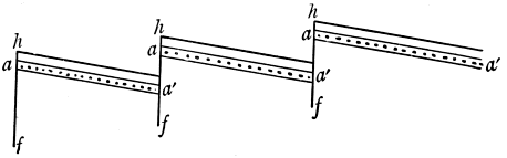
Fig. 21.
a a´. One stratum displaced by faults f f. h. Hills.
The Mendip system is well shewn in the Mendip Hills,
but the remains of a still more important anticline are
seen in South Devon and Cornwall, separated from the
Mendip Hills by the great syncline of Devon. Another
parallel anticline runs from Lancashire to Yorkshire at
right angles to the Pennine Chain and separates the coal-field
of Cumberland and that of Northumberland and
Durham, from those of South Lancashire, and Yorkshire,
Notts, and Derbyshire.
On the European continent the Ural Chain is the
most important uplift of the system of which the Pennine
Chain forms a minor representative, while the Hercynian
system has caused the compression and stiffening of many
of the Carboniferous and earlier rocks which now rise to
the surface in many parts of central Europe.
The extensive continental area which was the result
of these uplifts not only determined the formation of
abnormal deposits, but allowed the occurrence of a long
[205]
period of time subsequently to the close of the Carboniferous
period, of which few deposits now exposed in Europe
are representative, and we must accordingly seek other
regions in order to find typical representatives of this
Permo-Carboniferous period, of which the strata developed
in the Salt Range of India have been most carefully
worked, especially by Dr Waagen, though marine sediments
of the period are known elsewhere, as in Spitsbergen,
the Ural Mountains, China and Australasia; and a group
of somewhat anomalous sediments of this age in parts of
India, Australia and South America is of peculiar interest,
on account of the insight as to the climatic conditions of
the times which it affords.
The Permo-Carboniferous Rocks. In the Salt Range
of the North-West of India an interesting series of sandstones
alternating with limestones rests unconformably
upon lower rocks. The sandstones are known as the
Speckled Sandstones, while the limestones are termed the
Productus Limestones. The Lower and Middle Speckled
Sandstones are succeeded by the Lower Productus Limestone
which is separated from the Lower division of the
Middle Productus Limestone by the Upper Speckled
Sandstone; these are all of the Permo-Carboniferous
period, while the upper part of the Middle Productus
Limestone and the Upper Productus Limestone belongs
to the Permian period. The fossils, largely invertebrates,
are intermediate in character between those of Carboniferous
and Permian ages. Similar fossils are found in the
marine Permo-Carboniferous beds of the other areas which
have been named above. The Lower Speckled Sandstone
is of interest on account of the occurrence of boulder-beds
within it, and this division of the sandstone has been
correlated with the lowest (Talchir) stage of the Permo-Carboniferous
[206]
strata of other parts of India, while the
other Speckled Sandstones and those divisions of Productus
Limestone which are referred to the Permo-Carboniferous
are correlated with the higher divisions of other parts.
Special mention is made of the Talchir division, on
account of the occurrence therein of boulder beds which
have long been known, and whose glacial origin was
inferred by Dr W. T. Blanford forty years ago. The
accumulations shew signs of having been deposited in
water, but the existence of large subangular, sometimes
striated boulders therein, which must have come from
distant sources, and the occasional occurrence of striated
rock surfaces on the strata upon which the Talchir beds
repose unconformably points to ice-action; this would
not be so very remarkable if it were an isolated case,
though sufficiently so, from the comparative nearness
of the region to the equator; but researches conducted in
different parts of the southern hemisphere have brought
to light similar, and sometimes even more striking
evidences of glacial action in widely distinct regions[93]. In
Australia they have been found in New South Wales,
Victoria, South Australia, East Australia and Tasmania;
the Dwyka boulder-conglomerates of South Africa and
certain deposits of similar character discovered by Prof.
Derby in Southern Brazil have been referred to the same
period, and their glacial origin has also been inferred.
This widespread distribution of deposits which are
generally contemporaneous, of which the glacial origin
may now be taken as established, is extremely remarkable,
[207]
and must be taken into careful consideration by those
who put forward theories framed to account for former
climatic changes.
The Flora and Fauna. The flora of the Permo-Carboniferous
beds has caused as much discussion as the
question concerning the origin of the boulder-deposits.
In the southern hemisphere, the Permo-Carboniferous
rocks of those countries which have yielded boulder-beds
also contain remains of a flora which is now known as
the Glossopteris flora, from the prevailing genus, which
is associated with other genera, such as Gangamopteris.
These fossils appear to be ferns, though their modern allies
have not been indicated with certainty; associated with
them are rare cycads and conifers. The Glossopteris flora
is markedly contrasted with the Coal-Measure flora of the
northern hemisphere with its giant lycopods. Moreover
Glossopteris appears in the northern hemisphere in rocks
of later date than the Permo-Carboniferous period. It
has been suggested that the Glossopteris flora originated
in a continent in the southern hemisphere, on which the
boulder beds were also formed in isolated water areas, and
that some of the forms migrated northwards. To this
continent the name Gondwanaland has been applied by
Prof. Suess, from the Gondwana series of the Permo-Carboniferous
rocks of India, in which the Glossopteris flora is
found, and it has also been maintained that the southern
Glossopteris flora was contemporaneous with the northern
flora of ordinary Coal-measure type, though whether this
was so to any extent remains to be proved, for the beds
containing the Glossopteris flora are distinctly newer than
any which have furnished a typical northern Coal-measure
flora. In any case, the change of floras between Coal
Measure and Permo-Carboniferous times is very marked,
[208]
and when taken in connexion with the widespread glacial
deposits, is one of the most striking phenomena displayed
by the rocks of the stratified column[94].
The fauna has already been noticed. It consists of
brachiopods, some of which are of peculiar genera. The
general similarity of the faunas in regions so remote as
Spitsbergen, the Ural Mountains, India, and New South
Wales, indicates an extensive sea during the period. It
can hardly be supposed that the fauna of Permo-Carboniferous
times has been completely described, for the fossils
of one or two areas only have been made known to us
with any degree of fulness, and when the Permo-Carboniferous
and marine Permian faunas are as well known as
those of Triassic times (and the latter have only been
fully described very recently) there is no doubt that the
important break which was at one time supposed to exist
between Palæozoic and Mesozoic faunas will be filled in
satisfactorily[95].
CHAPTER XX.
THE PERMIAN SYSTEM.
Classification. It has already been observed that as
the result of the Pennine and Mendip systems of earth-movement,
the Carboniferous rocks of Britain are succeeded
by a marked unconformity, and that the rocks of
the succeeding Permian and Triassic systems of Britain
shew an abnormal development. The principal areas where
Permian rocks are found are on either side of the Pennine
Chain in the North of England, but sporadic exposures of
rocks of this age are found in some of the Midland and
Southern counties. The Permian rocks have been well
studied in Germany, and the German names are sometimes
adopted in Britain, and the following comparison
will prove useful:—
| Britain. |
Germany. |
|
Magnesian Limestone
Marl Slate |
Magnesian Limestone
Kupferschiefer |
} |
Zechstein. |
| Lower Permian Sandstones |
Rothliegende. |
|
The term Zechstein has been applied in a somewhat
different sense by different writers, but the one given in
the table appears to find most favour.
In a region which was essentially continental, considerable
variations in the lithological characters of the rocks
[210]
may be expected, when the strata are traced laterally,
but we nevertheless find that the differences are not so
great as was formerly supposed to be the case when
certain red sandstones lying above recognised Permian
strata in the district on the west side of the Pennine
Chain towards its northern extremity were also referred
to the Permian; these sandstones (the St Bees Sandstones)
are now generally admitted to be of Triassic age,
and comparison between the rocks on opposite sides of
the Pennine Chain is much simplified, as seen below.
| West side. |
East side. |
| Thin Magnesian Limestones and Marls |
Magnesian Limestone |
| Hilton Shales |
Marl Slate |
| Penrith Sandstone and Brockrams |
Lower Permian Sandstones. |
Description of the Strata. On the east side of the
Pennine Chain, the Lower Permian sandstone is an inconstant
deposit often consisting of yellow false-bedded
arenaceous strata. The Marl Slate is an argillaceous
shale, often containing bituminous matter, and yielding
several fish-remains and some plants; it is usually only
a few feet in thickness. The Magnesian Limestone is
typically developed in Durham as a yellow or greyish
limestone containing a variable percentage of carbonate
of magnesia; when traced southward, it alters its characters,
becoming mixed with mechanical deposits, and some
chemical precipitates in places, so that at Mansfield it
appears as a red sandstone with grains cemented by a
mixture of carbonates of lime and magnesia; and, like the
rest of the Permian strata, it has disappeared when we
reach Nottingham. In addition to the southward thinning
of the Permian beds of this area, there is some
evidence of their disappearance in a westerly direction,
[211]
though, as the present strike of the beds is nearly north
and south, the indications of this are less convincing.
On the east side of the Pennine Chain, the main
difference observable is the relative thickness of the
major divisions. The Lower Permian sandstones have
thickened out considerably, while the reputed representatives
of the Magnesian Limestone are thin. The Penrith
sandstone is of considerable interest. It contains in
places, as near Appleby, thick deposits of breccia consisting
of angular fragments chiefly composed of Carboniferous
Limestone, which in many cases have undergone subsequent
dolomitisation, embedded in a matrix of red sandstone.
This breccia is known as brockram. Many beds
of the Penrith sandstone are composed of crystalline
grains of sand, due to deposition of silica in crystalline
continuity with the quartz of the original grain
after the formation of the deposit; of more significance,
for our present purpose, is the presence of other accumulations
of the sand, in which the individual grains often
approach the form of spheres, thus resembling the 'millet-seed'
sands of modern desert regions. The Hilton shales
are grey sandy shales, with plant remains, and above them
are variable deposits including thin magnesian limestones
which have yielded no fossils.
The isolated Permian deposits of the midland and
southern counties of England consist of red marls and
sandstones with occasional breccias, and in the absence of
fossils, their exact position in the Permian series is still
unknown.
The German Permian rocks resemble those of Britain,
especially as seen in Durham, in many particulars, and
give indications of formation under physical and climatic
conditions generally similar to those which were then
[212]
prevalent in the British area. At Stassfurt, in Germany,
the less soluble constituents of ocean water are accompanied
by a great variety of salts:—chlorides, sulphates
and borates; and the very soluble salts of potassium and
magnesium known as the Abraum salts are found in
abundance as well as the less soluble salts of sodium and
calcium. The occurrence of these very soluble salts is so
infrequent on a large scale among the rocks of the
Geological Column, and the matter is one of so great
theoretical import, that it is necessary to take special note
of their presence in the Permian strata.
The frequent existence of chemical deposits in the
Permian Rocks of N.W. Europe, the formation of red
sandstones, and the dolomitisation of limestone beds and
fragments of pre-existing limestones point to inland seas
of a Caspian character, while the evaporation necessary
for the formation of the precipitates also indicates a fairly
warm temperature. The presence of millet-seed sands,
in very lenticular patches, suggesting former sand-dunes,
and the occurrence in places of breccias (like some
parts of the brockram) almost devoid of matrix, piled up
against pre-existing cliffs, recalling screes of modern
times, give almost certain evidence of the occurrence of
land tracts most probably of desert character, during part
of the period of accumulation of the materials of the
Permian rocks. The fossil evidence supports this view,
and geologists are mostly agreed that the Permian rocks
of north-west Europe were accumulated in an area of
desert character, occupied in part by inland seas, though
there is much difference of opinion as to the extent of
these seas, some geologists holding that a number of
isolated sheets of water were necessary to produce the
distribution and character of the accumulations. It is
[213]
still a vexed question with British geologists how far the
Pennine ridge stood up as land during the period, but
leaving this and other minor considerations out of account,
it may be noted that the similarity of deposits in the
different areas, whether we examine the order of succession,
the lithological characters or the included fossils,
suggests communication between the water tracts of
different regions, though this communication need not
have been more than a series of straits, or comparatively
narrow belts of water[96].
The extensive development of Permian and Triassic
rocks with terrestrial characters in the southern hemisphere
also, and the absence of newer deposits in many
places, suggests that the land areas of these times in that
hemisphere have largely remained such ever since, in
which case, the Permo-Triassic series of movements produced
a marked direct effect upon our present continental
areas, and at any rate produced an indirect one upon the
British land tracts.
The presence of anomalous deposits of Permian age
over wide areas need not be surprising, but it would be
indeed remarkable if no ordinary marine type of Permian
rocks was known, and the researches of recent years have
proved that this type is extensively developed, in Eastern
Europe, Asia, and North America, where Permian rocks
consisting of limestones, with a greater or less admixture
of mechanical deposits, occur in some abundance. The
[214]
studies of Waagen and others in India have given us the
farthest insight into the nature of these beds. Below is
a general classification taken from Waagen's work:—
| Salt Range. |
|
Germany. |
Base of Trias
Unfossiliferous Shale and Sandstone
Top Beds of Upper Productus Limestone |
|
Passage Beds into Trias |
| Cephalopoda Beds of Upper Productus Limestone |
 |
Gypsum Beds |
Middle Division of Upper Productus Limestone
Lower Division of Upper Productus Limestone |
|
Zechstein (in restricted sense) |
| Upper Division of Middle Productus Limestone |
|
Weissliegende and Kupferschiefer |
| Middle Division of Middle Productus Limestone |
|
Rothliegende. |
It will be seen that in the Salt Range there is a
complete passage from the Permo-Carboniferous strata through the Permian
into the Trias, and the detailed work which has been
carried out by Waagen and others amongst the rocks of
the Salt Range must make this, for the present at all
events, the type area for the marine development of the
strata of Permo-Carboniferous and Permian ages.
The Permian flora and fauna. The Permian flora
presents some difficulties. The flora of the Zechstein
consists largely of ferns and conifers, but that of the
Rothliegende of Germany has been compared with that
of the Carboniferous, and if a true Permian flora of the
northern hemisphere has many forms of Carboniferous
affinities, the presence of the Glossopteris flora in Permo-Carboniferous
rocks of more southerly regions seems to
[215]
imply its origin there and slow migration northwards. It
must be noted, however, that the Rothliegende has been
divided by some geologists into an upper and lower
division, of which the lower is actually referred to the
Carboniferous system. All that can be now said is, that
our knowledge of the floras of Permo-Carboniferous and
Permian times is still incomplete, and that the difficulties
will no doubt be cleared up as the result of further
work.
The invertebrate fauna of the north-west European
Permian deposits is chiefly noticeable on account of the
paucity of species, though individuals are often abundant.
The shells are also sometimes stunted and occasionally
distorted. These characters bear out the supposition that
the aqueous deposits were laid down in inland seas of
Caspian character and not in the open ocean. Polyzoa,
brachiopods, and lamellibranchs predominate, but other
groups are found. The vertebrates consist of forms of
fish, amphibia and reptiles, and the Permian rocks are
the earliest strata in which the remains of true Reptilia
are known to occur with certainty. The Reptiles belong
to the orders Anomodontia (Theromora) and Rhynchocephalia,
of which the former is exclusively Permian and
Triassic, while the latter is abundant in the strata of
those periods, but is represented at the present day by
the genus Sphenodon of New Zealand. The Amphibia
belong to the order Labyrinthodontia which ranges from
Carboniferous to Lower Jurassic, but the members of the
order are most abundant in Permian and Triassic strata,
and these periods may be spoken of as the Periods of
Labyrinthodonts.
A few words must be said of the fauna of the truly
marine Permian beds. It is much richer than that of the
[216]
abnormal deposits of north-western Europe, and its study
is important as furnishing another link between Palæozoic
and Mesozoic life. Many Palæozoic genera pass up into
the Permian rocks, and, as will be ultimately seen, several
occur in those of the Triassic system, and one or two even
in the basal Jurassic strata, though Mesozoic forms predominate
in the Lower Jurassic Rocks, and there is a
fairly equal admixture of forms usually considered as
Palæozoic and of those generally regarded as Mesozoic in
Triassic rocks, while the Palæozoic forms still predominate
over the Mesozoic in the Permian strata. Along
with these characteristic Palæozoic genera, it is interesting
to find representatives of more than one genus of the
tribe of Ammonites, which is to take so prominent a place
in the fauna of the Mesozoic rocks, amongst the true
marine Permian sediments of India and other areas.
The announcement of the contemporaneity of ammonites
with fossils regarded as exclusively palæozoic was received
with considerable doubt, but this contemporaneity is now
clearly established, and need not be regarded as in any
way anomalous.
With the deposition of the Permian rocks, Palæozoic
time comes to an end, but as already remarked there is
no marked and sudden change to characterise it. Had
our classification been originally founded on study of the
Indian Rocks instead of those of Britain, and similar
terms adopted, the line of demarcation between Palæozoic
and Mesozoic rocks would probably have been drawn
below the Permo-Carboniferous deposits, and if it had
been based on study of other areas, perhaps elsewhere.
The palæontological break is purely local, and it is of the
utmost importance that it should be recognised as such,
and that it should not be considered that division into
[217]
Palæozoic and Mesozoic implies some great and widespread
change which occurred between the times covered by the
deposits of each of these great divisions[97].
CHAPTER XXI.
THE TRIASSIC SYSTEM.
Classification. The term Triassic has been applied to
these rocks on account of the threefold division into which
those of Germany naturally fall. These three divisions
are:—
Keuper,
Muschelkalk,
Bunter;
but above the Keuper beds we find a group of deposits of
some importance, which shew affinities with both Triassic
and Jurassic rocks, which may be looked upon as true
passage beds, though they are generally placed in the
Triassic System. They are known as Rhætic or locally
in Britain as Penarth Beds. The Muschelkalk is usually
considered to be unrepresented in Britain, and accordingly
the British deposits may be, and are usually grouped as
under:—
| Rhætic or Penarth beds |
|
| Keuper |
 |
Keuper Marls
Keuper Sandstones |
| [Muschelkalk] absent |
| Bunter |
|
Upper Red and Mottled Sandstones
Bunter Pebble Beds
Lower Red and Mottled Sandstones. |
[219]
The threefold grouping has been applied more or
less universally, but when used outside the north-west
European area, it loses its significance, as the conditions
which enable one to differentiate the rocks of the three
divisions were naturally only prevalent over a limited
area.
Description of the strata. The British Triassic rocks
possess a certain sameness as regards their general characters,
consisting mainly of mechanical sediments coloured
red by peroxide of iron, with occasional chemical precipitates
of rock-salt and gypsum. They have a wider distribution
over Britain than have the Permian rocks, and
the lithological characters of the different subdivisions do
not as a rule vary to a remarkable degree when traced
laterally. The differences in detail in the characters of
the various deposits are noteworthy, and an explanation
of the exact origin of some of these abnormal deposits
which will satisfy everyone is not yet forthcoming.
Leaving the details out of consideration for the moment,
and looking at the general aspect of the deposits, the
prevalence of conditions generally similar to those which
existed over the British Isles in the preceding Permian
period is decidedly indicated by the nature of the strata,
though the continental conditions appear to have been
more widely established over our area, as shewn by the
general absence of any calcareous deposits resembling the
Magnesian Limestone. We find chemical precipitates,
millet-seed sandstones, and scree-like breccias in the
British Triassic rocks as well as in those of Permian age,
and the paucity of a marine invertebrate fauna in the
Triassic rocks of Britain is even more apparent than in
the Permian strata. It is only at the extreme close of
the Triassic period, during the deposition of the rocks
[220]
which are admitted on all hands to be of Rhætic age, that
we note the incoming of those marine conditions over our
area, which prevailed so extensively, with few local exceptions,
during the remainder of the Mesozoic and the early
part of Tertiary times; the Rhætic beds, in fact, mark the
commencement of the third marine period. Referring to
the strata in further detail, we may proceed to consider
the character of the different subdivisions in the order of
their formation, commencing as usual with the oldest.
The Bunter deposits rest in places upon those of Permian
age with an unconformity at the junction, but as these
unconformities occur frequently among the British Triassic
rocks, it is doubtful whether this unconformity marks
more than very local change of physical conditions. The
lower and upper divisions of the Bunter sandstone consist
of false-bedded red and variegated sandstones, and there
is no great difficulty in explaining their formation in
desert areas with tracts of water, but the great change
which marks the appearance and disappearance of the
middle division, the Bunter pebble beds, requires some
explanation, for the contrast between the lithological
characters of the rocks of this division and those of the
rocks appertaining to the preceding and succeeding
division is very marked. The matrix differs, but the
main difference is the abundance of pebbles, mostly of
fairly uniform size, well rounded, and largely consisting
of liver-coloured quartzite. Much difference of opinion
exists as to the exact origin of these pebble beds, and the
source of the pebbles, but without entering into this
vexed question, it may be remarked that the agency of
rivers has been somewhat generally invoked to account
for their transport, and the conditions during their accumulation
need not have been very different from those
[221]
which are now found in northern India where the torrential
rivers of the south side of the Himalayan chains
debouch upon the plain, and spread an abundant deposit of
well-worn pebbles over the finer silts which were previously
laid down thereon.
The junction of the Bunter and Keuper beds requires
a short notice. It is usually if not always an unconformable
one in Britain, and it is generally assumed that the
absence of the Muschelkalk of the Continent is due to the
presence of land undergoing denudation in Britain during
the time when the Muschelkalk was elsewhere deposited,
though it is quite possible that the Muschelkalk epoch is
represented in Britain not only by the time which elapsed
when the unconformity was being impressed on the rocks,
but also during the true deposition of the upper part of
the Bunter beds, or the lower part of the Keuper, or both.
The Keuper sandstones and marls contain a great
development of chemical deposits, of millet-seed sands,
and of many other features pointing to desert conditions,
such as sun-cracks, tracks of animals impressed upon a
rapidly drying surface, and pseudomorphs of mud after
rock salt in the form of cubes and hopper-crystals;
furthermore we find the scree-like breccias at different
horizons of the Keuper beds where they abut against the
old Mendip ridge composed largely of mountain-limestone
which furnished the fragments, as was the case with the
brockrams abutting against the Pennine ridge. It must
be noted that the chemical precipitates of Triassic age
consist of the less soluble substances dissolved in ocean
water, namely, gypsum and rock salt, whilst the more
deliquescent potash and magnesia salts are not represented
in Britain.
Turning to these continental beds, we get evidence of
[222]
a general approach to open sea conditions as we pass away
from Britain in a south-easterly direction as roughly shewn
in the following diagram (Fig. 22), where B represents the
Bunter beds, M the Muschelkalk, and K the Keuper.

Fig. 22.
It will be seen that the mechanical sediments gradually
die out and become replaced by calcareous material
as one passes from Britain towards Switzerland; the
Muschelkalk is very thin in the east of France and
thickens out in Germany, while in Switzerland Keuper,
Muschelkalk and Bunter are alike largely represented by
calcareous deposits, and the mechanical deposits are
chiefly argillaceous, the only important sandstone being
situated at the extreme base of the Bunter series.
The marine development of the Triassic system is naturally
the one which is most widely spread, though full
appreciation of its importance has only taken place as
the result of researches in distant climes of recent years.
It is found in southern Europe, in Spitsbergen, in considerable
tracts of Asia, including India, and along the
Pacific coast region of North America, and everywhere
possesses much the same characters.
It will be seen from the above remarks that the
physical conditions which prevailed in the continental
area of Triassic times which is now partly occupied by the
British Isles are most closely represented by those of the
desert regions of central Asia, hemmed in by the mountain
[223]
ranges which intercept the vapour-laden winds of the
oceans, and cause them to precipitate the great bulk of
their vapour on the seaward slopes of the mountains, so
that they blow over the deserts as dry winds, causing the
fall of any large amount of rain to be a rare though by no
means unknown event in the desert regions.
Flora and Fauna of the Period. The Triassic flora is
essentially similar to that of the higher Permian strata,
though many of the genera are different.
The invertebrate fauna of the British deposits is, as
might be expected, very poor until the beds of the Rhætic
series are reached. In the beds below the Rhætics, the
principal invertebrate remains are the tests of the crustacean
genus Estheria, though a few obscure lamellibranch
shells have been recorded. The vertebrate fauna is of
great interest. A number of fishes have been found, the
most remarkable of which is the genus Ceratodus, occurring
in the Rhætic beds of Britain and lower Triassic
strata of foreign countries. It is closely related to the
Barramunda of the Queensland rivers belonging to the
order Dipnoi. As in the Permian strata, abundance of
Labyrinthodont amphibians have been discovered, and
the reptiles belong to the orders Anomodontia and Rhynchocephalia.
In the Rhætic beds of Britain and in still
lower Triassic beds abroad the orders Ichthyopterygia and
Sauropterygia (represented by Ichthyosaurus and Plesiosaurus)
are found.
The Triassic rocks also yield the earliest known mammals,
the best known, Microlestes, occurring in the Triassic
rocks of Britain and the Continent. These mammals are
now placed in a subclass Metatheria of the order Monotremata.
The marine invertebrate fauna of the normal Triassic
[224]
rocks presents some points of considerable interest. As
already remarked, the fauna may be looked upon as a
passage fauna between that of Palæozoic and that of
Mesozoic times, the number of Palæozoic forms which
pass into the Trias being approximately comparable with
those which appear here and range upwards into higher
Mesozoic strata. This may be well seen by examining
the table given in >Chapter XXI. of the Second Edition of
Sir Charles Lyell's Student's Elements of Geology, in which
three columns shew the genera of Mollusca common to
older rocks, those characteristic of the Trias, and those
common to newer rocks. Amongst the first are Orthoceras,
Bactrites, Loxonema, Murchisonia, and Euomphalus, in the
second column are Ceratites, Halobia (Daonella), Koninckina,
and Myophoria, and in the third, Ammonites,
Cerithium, Opis, Plicatula and Thecidium[98].
The Ammonites are largely utilised in the case of the
Mesozoic strata for separation of these strata into zones,
each zone being characterised by some species of Ammonite,
and the researches of Mojsisovics have proved
that this zonal subdivision, long adopted for Jurassic
rocks, is also applicable to those of Triassic age[99]. He
gives the following table of the classification of the
Triassic rocks of the Mediterranean Province, which is
reproduced, as it is founded upon Palæontological evidence,
and will probably be widely adopted.
[225]
| Series |
|
Zonal Divisions |
| Rhætic |
|
1. Zone of Avicula Contorta |
| Juvavic |
Upper Juvavic
Middle Juvavic
Lower Juvavic |
2. Zone of Sirenites Argonautae
3. Zone of Pinnacoceras Metternichi
4. Zone of Cyrtopleurites bicrenatus
5. Zone of Cladiscites ruber
6. Zone of Sagenites Giebeli |
| Carnic |
Upper Carnic
Middle Carnic
Lower Carnic |
7. Zone of Tropites subbullatus
8. Zone of Trachyceras Aonoides
9. Zone of Trachyceras Aon |
| Noric |
Upper Noric
Lower Noric |
10. Zone of Protrachyceras Archelaus
11. Zone of Protrachyceras Curionii |
| Muschelkalk |
Upper Muschelkalk
Lower Muschelkalk |
12. Zone of Ceratiles trinodosus
13. Zone of Ceratiles binodosus |
| Buntsandstein |
Werfener Schichten |
14. Zone of Tirolites Cassianus |
[226]
CHAPTER XXII.
THE JURASSIC SYSTEM.
The Jurassic rocks were formerly separated on account
of differences of lithological character into Oolites
and Lias, but it was apparent that the Oolites were more
important than the Lias, and a fourfold division was
made into:—
Upper or Portland Oolites
Middle or Oxford Oolites |
|
= Malm |
Lower or Bath Oolites
Lias. |
|
= Dogger |
The Lias strata have also been spoken of as the Black
Jura, the Lower Oolites and part of the Oxford Oolites as
Brown Jura, and the rest of the Oxford Oolites with the
Portland Oolites as White Jura.
As the outcome of a detailed study of the faunas of
the Jurassic rocks, a further subdivision has been made,
partly based upon the original British series, but the
divisions are defined with greater accuracy, so that they
are applicable over wider areas. They are as follows:—
| Upper Oolites |
|
Purbeckian
Portlandian
Kimmeridgian |
| Middle Oolites |
|
Corallian
Oxfordian
Callovian [227] |
| Lower Oolites |
|
Bathonian
Bajocian |
| Lias |
|
Toarcian
Liassian
Sinemurian. |
Many of these series have been still farther subdivided
into smaller stages, and the whole differentiated into a
number of zones characterised by different forms of
Ammonites. Dr E. von Mojsisovics gives thirty-two
Ammonite zones, of which fourteen occur in the Lias,
eight in the Lower Oolites, six in the Middle Oolites, and
four in the Upper Oolites.
Characters of the strata. The whole of the Jurassic
rocks and also those of Lower Cretaceous age may be
regarded as having been deposited during the first shallow
water phase of the third marine period, but this shallow
water phase is represented by strata which are varied
owing to numerous marine changes resulting in the
production of land at times, and estuarine conditions,
shallow water, marine conditions, and somewhat deeper
sea conditions respectively at other times, and accordingly
the strata of the British Isles vary greatly when traced
laterally. That the uplifts of the Permo-Triassic periods
produced some effect on the nature and distribution of
the Jurassic rocks is certain, but it is not quite clear how
far the ridges produced by these uplifts were submerged
and denuded during the deposition of the main portion of
the Jurassic strata.
Viewed broadly, the Jurassic rocks of Britain may be
regarded as consisting of three great clay deposits, the
[228]
Lias, Oxford and Kimmeridge Clays, alternating with
the deposits of variable lithological characters, which
compose the Bajocian, Bathonian, Corallian, Portlandian
and Purbeckian subdivisions. This essentially argillaceous
character of a large part of the deposits of
Jurassic age is often overlooked, as, owing to their sameness
and the comparative paucity of organisms constituting
the faunas in the clays, their description in text-books
can be given at much shorter length than that
of the more variable and highly fossiliferous deposits
which separate the clays. The following figure (Fig. 23)
roughly represents the nature of the different divisions
of the rocks of this system when traced across England
from south-west to north-east.
Fig. 23.
Vertical scale: 1 in. = about 1000 feet.
It will be seen that the greatest variations in lithological
character occur in the Bathonian and Bajocian
beds, and it will be of interest to give some account of
[229]
the principal variations and to attempt to account for
them. In so doing it will be convenient to consider the
four major divisions of the Jurassic rocks separately, and
to enter into particulars concerning the local classification
applied to the rocks of these divisions.
The Lias. The British Lias deposits are divided into
the Lower Lias, the Marlstone, and the Upper Lias corresponding
in general terms only with the Sinemurian,
Liassian, and Toarcian. The Marlstone is separated from
the Upper and Lower Lias on account of the greater
percentage of carbonate of lime which it contains, so that
the bands of argillaceous limestone are much more marked
in the Marlstone than in the upper and lower divisions,
which consist chiefly of clay. The three divisions possess
very much the same characters throughout the country,
though the presence of the Mendip ridge and its continuation
beneath London is marked by the attenuation
of this and succeeding strata, and by the conglomeratic
character of some of the Liassic strata where they abut
against it. The British Lias, as a whole, seems to have
been deposited in a fairly shallow sea at no great distance
from the land. It passes down conformably into the
Rhætic beds, indeed the zone of Ammonites (Aegoceras)
planorbis, referred by British geologists to the Lower Lias
is included by some continental writers with the Rhætic
beds, and the plane of demarcation here as in other cases
is conventional.
The Lower Oolites. Of all the British strata, these
perhaps cause most trouble to the learner, on account of
the different nomenclature applied to the rocks in different
parts of England, and the rapid variations in lithological
character, when the beds are traced laterally. The following
divisions are usually adopted for the beds of the
[230]
south-western counties where the most marked marine
development occurs:—
Cornbrash,
Forest Marble,
Great Oolite (with Bradford Clay),
Fuller's Earth,
Inferior Oolite.
Of these divisions, the uppermost one, the Cornbrash,
though thin, retains its characters with great constancy
across the island. Of the others the Forest Marble may
be looked upon as a local development of the upper
portion of the Great Oolite, and the Fuller's Earth is a
local deposit, so that the Inferior Oolite and Great Oolite
constitute the important divisions of the Lower Oolites.
The variations in the characters of the rocks may be best
shown in tabular form.
| Gloucestershire, &c. |
South Northamptonshire |
N. Northamptonshire and Lincoln |
Yorkshire |
| Cornbrash |
Cornbrash |
Cornbrash |
Cornbrash |
| Great Oolite |
Great Oolite
(Upper part)
Northamptonshire |
Great Oolite Clay
Great Oolite Limestone
Upper Estuarine |
Upper Estuarine |
| ............... |
............... |
............... |
............... |
|
|
Series |
Series |
|
|
Lincolnshire Limestone |
Scarbro' Limestone |
|
Sands |
|
Middle Estuarine Series |
| Inferior Oolite |
|
Lower Estuarine Series |
Millepore Oolite |
|
|
|
Lower Estuarine Series |
| Upper Lias |
Upper Lias |
Upper Lias |
Upper Lias |
The dotted line shows roughly the division between Bathonian and
Bajocian.
[231]
The changes may be explained very simply if we leave
out of account for the moment the development of Lincolnshire
Limestone, with its equivalent the Scarbro'
Limestone, and the Millepore series. The beds in
Gloucestershire and other south-western counties are
essentially marine; whilst in Northamptonshire and
Lincolnshire estuarine conditions set in after the deposition
of the Upper Lias, and continued throughout
the deposition of the Bajocian and Lower Bathonian beds,
being replaced by marine conditions during the formation
of the Upper Bathonian strata, and still further north in
Yorkshire the estuarine conditions generally prevailed
throughout Bajocian and Bathonian times. These changes
point to the existence of land towards the north. The
general simplicity is modified by temporary prevalence
of marine conditions twice over (during the deposition
of the Millepore Oolite and the Scarbro' Limestone) in
Yorkshire, and once (during the deposition of the Lincolnshire
Limestone) in Lincolnshire.
Certain local deposits have not been noticed, but two
of them merit brief reference. At the base of the Great
Oolite of Oxfordshire is an estuarine deposit of finely
laminated mechanical sediment mixed with calcareous
matter known as the Stonesfield Slate, especially interesting
on account of its fossils, while a bed with similar
lithological characters but with a different fauna occurring
at the base of the Lincolnshire Limestone (of Bajocian
age) is termed the Collyweston Slate. Neither of these
deposits is a slate in the true sense of the word, as they
have not been affected by cleavage subsequently to their
accumulation, but each has been somewhat extensively
used for roofing purposes.
The Middle Oolites are much less complicated though
[232]
considerable variations arise with respect to the Corallian
Rocks. The Oxfordian with Callovian consist chiefly of
clay, though the Callovian of the south of England is
represented by calcareous sandstone, with a peculiar
fauna which seems to be represented in the lower part
of the Oxford Clay further north, though this Callovian
fauna has not been everywhere recognised.
The Corallian of the southern counties consists of
limestones with calcareous grits, the limestones being often
largely composed of the remains of reef-building corals,
and a similar development of the rocks of this series is
found in Yorkshire, while a local development of the
same character is found at Upware in Cambridgeshire,
though in the other parts of the Fenland counties the
Corallian is represented by an argillaceous deposit with
Corallian fossils known as the Ampthill Clay.
The Upper Oolites have a tolerably constant base, the
Kimmeridge Clay, usually consisting of laminated bituminous
argillaceous material, but the Portlandian and
Purbeckian divisions vary greatly, and are only locally
developed, though their absence in some parts of central
England is no doubt due to unconformity.
The Portlandian rocks of the south of England consist
of limestones and sandstones which pass further northward
into shallower water mechanical deposits often
charged with iron hydrate, and the beds disappear in
Oxfordshire. The Purbeckian rocks of the south are also
limited as regards area of exposure: they consist of
estuarine deposits with some terrestrial accumulations of
the nature of old surface soils. Representations of the
Portlandian and Purbeckian beds are found in Lincolnshire
and Yorkshire, as arenaceous deposits in the former
county and argillaceous ones in the latter. Both are
[233]
marine deposits of a northern type, developed elsewhere
in northern European and circumpolar regions, and in
these counties we find a complete passage from the
Jurassic rocks through the Cretaceous rocks, but the
exact lines of demarcation between the different series
of the passage beds are difficult to define.
The foreign Jurassic rocks of Europe and of some parts
of Asia strongly resemble in general characters those
which have been described above as occurring in Britain.
One of the most remarkable features of the Jurassic rocks
as a whole, is the absence of the Lias over wide areas, the
continental period which in Britain existed in Permo-Triassic
times is elsewhere frequently replaced by one of
Liassic age.
The Jurassic and Cretaceous rocks are of interest on
account of the evidence which they supply as to the
existence of climatic zones in these periods, which run
fairly parallel with those at present existing. The late
Dr Neumayr in a paper already cited divides the world
during later Mesozoic times into four distinct climatic
zones, equatorial, north and south temperate and boreal
zones (the corresponding austral zone is not known owing
no doubt to the extensive sea of South Polar regions and
our general ignorance of its lands). In Europe the
Mediterranean Province belongs to the equatorial zone,
the Middle European to the North temperate zone, and
the Russian or Boreal to the Boreal zone. The last-named
is marked partly by negative characters, the
absence of certain Ammonite-genera and of coral reefs
being noticeable, whilst the lamellibranch Aucella is very
frequent. In the North temperate zone, certain Ammonite
genera as Aspidoceras and Oppelia are abundant
and there are also extensive coral-reefs. The Equatorial
[234]
zone is marked by the Ammonite-genera Phylloceras and
Lytoceras and by the Diphya group of Terebratulæ. It is
of special interest to note that the fauna of the South
temperate bears closer relationship to that of the North
temperate than to that of the intermediate Equatorial
zone.
Jurassic floras and faunas. The Jurassic flora is very
similar in its characters to that of the Lower Cretaceous
rocks, and the two taken together afford a decided contrast
with that of later Palæozoic times, and also with that
which succeeds them in the Upper Cretaceous rocks,
which bears a marked resemblance to the existing flora.
Cycads predominate, accompanied by conifers, and a fair
number of ferns and Equisetaceæ.
The Jurassic fauna is specially noteworthy on account
of the character of the vertebrata, but some notice of the
invertebrates must also be taken. The abundance of
corals in the Temperate zones has already been pointed
out, but the mollusca form the bulk of the invertebrate
fauna, lamellibranchs, gastropods and cephalopods being
all abundant; of the last-named the ammonites and
belemnites contribute most largely. The vertebrates include
remains of fishes, amphibia, reptiles, birds and
mammals. The Jurassic reptilia furnish representatives
of some modern orders as the Chelonia and Crocodilia, but
the most important orders are essentially characteristic of
later Mesozoic times and their representatives abound in
the Jurassic strata. These are the Sauropterygia (including
the Plesiosaurs), the Ichthyopterygia (including the
Ichthyosaurs), the Dinosauria, and the Pterosauria commonly
known as Pterodactyls. No birds have hitherto been
discovered in the British Jurassic rocks, but the Solenhofen
Slate of Bavaria (of Kimmeridgian age) has furnished
[235]
the celebrated Archæopteryx macrura, which is not only
placed in a family but also in an order by itself, the order
Saururæ. Many remains of mammals have been extracted
from the estuarine deposits of Stonesfield, and the
old surface soils of the Purbeckian beds; representatives
of the Monotremata are furnished by the Plagiaulacidæ
and Tritylodontidæ, the former family containing the
genus Plagiaulax of the Purbeck Beds and the latter,
Stereognathus of the Stonesfield slate. The Marsupialia
are represented by the Amphitheridæ, Spalacotheridæ and
Triconodontidæ. Some forms have been referred to the
Insectivora, but there is still disagreement concerning the
correctness of this reference.
Before dismissing the subject of the Jurassic fossils,
attention may be called to a feature which has been
frequently commented upon, namely, the general resemblance
of the flora and fauna of Jurassic times to the
modern Australian fauna and flora. The explanation which
has been offered to account for this resemblance has been
given in a preceding chapter, where it was stated that
Mr A. R. Wallace considers, after review of the geological
and biological evidence, that Australia was severed from
the adjoining continental lands in Mesozoic times, and
that the higher forms of life which on the larger continents
have replaced the earlier and lower forms have not
succeeded in obtaining a footing in Australia, which
therefore furnishes us with a local survival of a once widespread
fauna. In connection with this matter the actual
existence of the genus Trigonia (a form peculiarly abundant
in Jurassic strata and characteristic of Mesozoic
strata in Britain) in the Australian sea is of considerable
interest.
[236][100]
CHAPTER XXIII.
THE CRETACEOUS SYSTEM.
Classification. The rocks of the Cretaceous system
are conveniently divided into Upper and Lower Cretaceous.
The following classification has been widely used for the
British deposits, and is founded on lithological characters:
| Upper Cretaceous |
|
Upper Chalk with flints |
|
Chalk |
| Middle Chalk with few flints |
| Lower Chalk without flints |
| Chalk Marl | |
| Upper Greensand |
| Gault |
| Lower Cretaceous |
|
Lower Greensand
Wealden
Hastings sands |
As the result of examination of the faunas, a more
generally applicable classification has been established
and is now largely adopted. It is as follows:
Danian
Senonian
Turonian
Cenomanian |
|
Upper Cretaceous |
Albian
Aptian
Neocomian |
|
Lower Cretaceous |
[237]
In this classification the Neocomian practically represents
the Wealden and Hastings beds, the Aptian the
Lower Greensand and the Albian the Gault, placed
according to this classification in the Lower Cretaceous,
while the Upper divisions represent the strata above the
Gault, consisting essentially of Chalk in England.
Description of the Strata.
(i) The Neocomian and Aptian Beds. In the south
of England the Lower Cretaceous beds succeed the
Jurassic rocks with little or no break, and the type of the
lower beds is similar to that of the beds deposited during
the Purbeck age, consisting of estuarine deposits of
variable characters, chiefly arenaceous below (the Hastings
sands) and argillaceous above (the Wealden series), though
impure limestones are found, largely composed of the
shells of the freshwater Paludina, and much ironstone
is developed in places. At the close of Neocomian
times, the freshwater conditions in southern England
were replaced by marine conditions and the Lower
Greensand strata with their marine fauna were deposited
in the Aptian sea. The Neocomian and Aptian
beds thin out westward, and much more rapidly to the
northward, so that both divisions disappear against the
now buried ridge which forms a continuation of the
Mendip axis. North of this they appear in another form.
At first the highest Aptian beds alone are developed as
shore deposits. Passing into Norfolk lower beds come in
until in Lincolnshire we get a complete development
of the Neocomian and Aptian beds with a marine facies,
though of fairly shallow water character, whilst in Yorkshire
the two divisions are represented by a deeper water
[238]
clay, forming the Upper portion of the Speeton series.
There is a consensus of opinion in favour of the Neocomian
beds of southern Britain having been laid down
in an estuary of a river flowing from the west over a
continent now destroyed. To the north of this river
stood the London ridge of the Palæozoic rocks, the northern
borders of which formed the coast line off which were
deposited the sediments of Neocomian and Aptian ages
which occur in northern England. Before the deposition
of the Albian beds a considerable upheaval of some parts
of Britain occurred, and an unconformity separates the
higher Cretaceous beds from older strata of Cretaceous
and Jurassic ages, thus complicating the major phases by
local changes in the characters of the strata.
(ii) The Albian and higher Cretaceous Beds. The
commencement of the deep-water phase of the third
marine period may be said to occur in Albian times in
Britain, reaching its maximum during the deposition of
the chalk. The existence of a deeper sea towards the
north of England is indicated by the characters of the
Albian and newer strata. The Albian beds of gault
consist of a stiff clay in southern England, replaced by
coarser mechanical sediments towards the west. As one
passes north from the London ridge (which exerted its
influence in Albian times, after which it was finally
buried in sediment) the gault thins out, and becomes
gradually replaced by calcareous deposit when it is known
as the red chalk which replaces the gault in northern
Norfolk, Lincolnshire and Yorkshire.
A local unconformity separating the chalk and gault
in parts of East Anglia points to another local uplift with
its accompanying complications in the characters of the
strata. After the uplift had ceased, general depression
[239]
must have occurred, and the various divisions of the
chalk were accumulated in a fairly open sea, though, for
reasons to be given presently, this was probably of no
great lateral extent, save when united with the open
ocean, probably in a manner similar to the connexion
between the Gulf of Mexico and the Atlantic.
The general variations in the lithological characters of
the various members of the Cretaceous system will
probably be rendered clearer by reference to the accompanying
diagram (Fig. 24) representing the variations when
traced across England from south to north[101].
Fig. 24.
- Ch. Chalk.
- Al. Albian.
- Ap. Aptian.
- N. Neocomian.
- J. Jurassic.
The clue to the physical geography of Britain during
Cretaceous times is furnished to a considerable extent by
[240]
study of the foreign deposits. In Northern Europe the
Cretaceous beds of England are met with in Northern
France, and there the characters are generally speaking
similar to those of our British deposits. In Germany
shallower water conditions prevailed, the lower beds
gradually disappear, and the upper beds are replaced by
mechanical sediments of various degrees of coarseness,
becoming on the whole coarser, as one travels eastward,
so that in Saxony the chalk is partly replaced by arenaceous
deposits (the 'Quader' sandstones) which are
responsible for the remarkable scenery of the Elbe district
above Dresden. In passing northwards, indications of
similar change are noted in the deposits of Denmark and
Scania, whilst to the south, we get a complete change in
the character of the rocks, after crossing the Loire in
France, and a similar change is observable in districts
lying further east. Furthermore, as will be noted more
fully in a subsequent paragraph, the character of the
Upper Cretaceous flora indicates the existence of a large
tract of land lying to the north and north-west of Europe,
so that it would appear that the Cretaceous rocks of
Northern Europe were deposited in a gulf-like expansion
of a western ocean, bounded on the north by Scandinavia,
on the west by eastern Germany, and on the south by a
ridge running eastward from the mouth of the Loire[102].
We may speak of this gulf as the Chalk gulf. To the
south of the presumed ridge the character of the strata
alters, and also that of the included organisms. This
southern type of Cretaceous rocks is one which is very
widely spread, being found in Europe south of the Loire,
[241]
and of the Alps, and in Greece and Turkey, while it also
occurs in the northern parts of Africa. The beds of this
type are traceable through Asia Minor into India and to
the shores of the Indian Ocean, indicating the existence
of a widespread Cretaceous ocean, which is sometimes
spoken of as the Hippurite-limestone sea, for reasons
which will eventually appear. The deposits are largely
formed of hard limestone which is very different in its
character from the soft chalk of the northern gulf.
The climatic conditions which prevailed during Cretaceous
times were apparently similar in most respects
to those of the preceding Jurassic period, and as already
stated the climatic zones which Neumayr defined for
Jurassic times are also maintained by him to have existed
during the Cretaceous period. The existence of cold has
sometimes been inferred from the presence of large
foreign blocks in the chalk, especially at its base, but if
these are due to the transport, they might well be caused
by masses of floating ice, which are often found at
considerable distances from the coast in temperate regions
after the break-up of the frost which succeeds an unusually
hard winter. The flora and fauna are not suggestive of
severe conditions.
The Cretaceous flora and fauna. It has been noted
in the last chapter that the gymnospermous flora of the
Jurassic period, in which cycads form a considerable
percentage of the whole flora, was prevalent in Lower
Cretaceous times. In the Upper Cretaceous rocks this
flora is replaced by one which consists to a large extent
of dicotyledonous angiosperms. These are found in the
Upper Cretaceous rocks of Europe and North America,
and as the researches of botanists indicate their origin in
circumpolar regions, their arrival in Europe is an additional
[242]
argument in favour of the existence of an extensive
northern continent, sending a prolongation to the southward
in eastern Europe.
The invertebrate fauna bears considerable resemblance
to that of Jurassic times, and many of the dominant
Jurassic genera are also found in Cretaceous rocks. A
most interesting feature is connected with the character
and geographical distribution of the Ammonites. In
Europe they are almost exclusively confined to the deposits
of the northern gulf, and before their final disappearance
they undergo many changes of form. We find the discoid
spiral shells of earlier times, but these are accompanied
by shells which are straight, curved, boat-shaped, and
coiled into various helicoid spirals, sometimes having the
whorls in contact, while at other times they are separate.
In the chalk of Britain gastropods are on the whole
rare, and this fact serves to emphasize the palæontological
break which occurs between the Cretaceous and Tertiary
rocks; but when conditions were favourable, as during the
deposition of some of the strata of the Middle Chalk,
gastropods are abundant, and some are related to Tertiary
genera, so that we may assume that the palæontological
break alluded to is exaggerated by the difference of
conditions which prevailed during the deposition of the
earliest Tertiary and latest Cretaceous sediments.
In the Cretaceous deposits of the southern sea, where
the Ammonite tribe is almost unknown, the remarkable
family of the lamellibranchs known as the Hippuritidæ
furnish the dominant invertebrates of the period, and the
representatives of this family are exceedingly scarce
amongst the Cretaceous strata of the northern gulf, though
they are found on two or three horizons.
Of vertebrates, the most interesting are the reptiles.
[243]
The families which predominate in Jurassic times have
many representatives amongst the Cretaceous strata also,
but the order Squamata is represented by the sub-order
Pythonomorpha, which is characteristic of the Cretaceous
rocks. The best known representative is the gigantic
Mosasaurus. Lastly, we have the remarkable toothed
birds or Odontornithes, now placed in different orders,
the genus Hesperornis being the only representative of
the sub-order Odontolcæ of the Ratitæ, whilst Ichthyornis
and allied forms are placed in the sub-order Odontormæ
of the Carinatæ.
[244]
CHAPTER XXIV.
THE EOCENE ROCKS.
Classification. The Eocene Beds of the south of England
have been subdivided according to the variations
in their lithological characters, and the subdivisions have
received local names. The following classification is
generally adopted, though the different subdivisions are
by no means of equal value:
| Upper Eocene |
|
Upper Bagshot Beds
Barton Beds |
|
| Middle Eocene |
|
Bracklesham Beds |
|
| Lower Eocene |
|
Lower Bagshot Beds |
|
| London Clay[103] |
|
| Oldhaven Beds |
|
Lower London Tertiary Strata |
| Woolwich and Reading Beds |
| Thanet Sands |
The deposits vary greatly when traced abroad, and
the exact equivalents of the minor subdivisions of the
British rocks can seldom be ascertained at any distance
from England, though the division into Upper, Middle,
and Lower Eocene can be made over wide areas.
Description of the strata. The character of the strata
of Europe and Asia indicates the persistence of the
[245]
northern gulf and southern ocean of Cretaceous times in
Eocene times also, though the area of each had shrunk
in the meantime, owing to the physiographical changes
which occurred at the end of Cretaceous times, giving rise
to more extended land areas, and producing a shallow
water phase over wide extents of ocean,—the final
shallow water phase of the third and last great marine
period of the British area. It is difficult to ascertain the
exact importance of the physical break between Cretaceous
and Eocene rocks in the south-east of England,
owing to the subterranean solution of the upper part of
the chalk, subsequently to the deposition of the Eocene
strata, but the contraction of the Cretaceous gulf is shown
in several ways, one of the most significant being the
distribution of Cretaceous and Eocene rocks in the south-west
of England. The existence of an outlier of Cretaceous
rock at Buckland Brewer in North Devon, only
three miles from the Atlantic Ocean, indicates the former
extension westward of the Upper Cretaceous beds, while
the occurrence of an outlier of Eocene rocks at Bovey
Tracey in South Devon, resting not on Cretaceous but on
Palæozoic rocks, shows that there was an uplift after the
deposition of the Cretaceous rocks and before the Eocene
rocks were deposited there, and that during the period of
uplift the Cretaceous rocks were removed.
Owing to these physical changes, the Eocene rocks of
Britain are mainly mechanical sediments, some, as the
Oldhaven beds, being composed of coarse pebbles over a
fairly wide district, while some of the earlier Eocene
rocks are estuarine or fluvio-marine.
The Eocene rocks of Britain occur in four areas,
namely, the London Basin, the Hampshire Basin, the
Bovey Tracey outlier, and the north-east of Ireland and
[246]
western Isles of Scotland. The deposits of the three
southern areas may be considered together, and give
general indications of an approach to land when passing
westward. The Lower London Tertiary strata are fluvio-marine
at the east end of the London Basin; they become
shallower water deposits when traced westward, and begin
to disappear. The London Clay is an estuarine deposit,
which is generally supposed to have been laid down at
the mouth of a large river flowing from the west. It is
absent in the Bovey Tracey outlier.
Local disturbances caused the existence of a shallow
water region in the east during the deposition of the
Middle and Upper Eocene deposits, and accordingly the
well-marked marine deposits which form the representatives
of these divisions in Hampshire are replaced by the
Bagshot beds of the London Basin, consisting chiefly of
coarse mechanical sediments with a poor marine fauna,
but even in the west shallow water prevailed at times
during the accumulation of various plant-bearing strata.
The Middle Eocene beds only are found in the Bovey
Tracey outlier, though the Upper Eocene beds may
originally have been laid down in that area, and subsequently
denuded.
The fourth area displays a very different succession
of Eocene strata, and one of extreme interest. Mechanical
sediments and plant-bearing clays and lignites alternate
with a vast accumulation of basaltic lavas, indicating the
outbreak of the volcanic forces in the British area, after a
period of quiescence which lasted through the greater
part of Mesozoic times. The region in which these lavas
were poured out was probably a land area during the
greater part of the period of volcanic activity, but the
horizontal lie of the lava flows and their wide extent
[247]
indicate the existence of a flat tract of country, gradually
raised into a plateau by the accumulation of sheet over
sheet of basalt. How far this plateau extended it is
impossible to say. The distribution of the lavas at the
present day is somewhat limited in our isles, but there is
no sign of dying out at the present margins of the accumulations,
and they have probably escaped denudation in
these regions, as maintained by Professor Judd, on account
of the faults which have depressed them, while the
portions which were not depressed have been removed by
denudation. Two views as to the origin of the lavas have
been put forward: according to Prof. Judd, they were
poured forth from gigantic volcanoes, while Sir A. Geikie
maintains that they represent portions of massive or
fissure eruptions, the molten rock having welled out from
great cracks in the earth, which are now filled by once
molten rock in the form of dykes. As these dykes extend
far away from the present volcanic plateau, one actually
extending to the Yorkshire coast, we may well believe,
whatever was the origin of the sheets of lava, that they
were formerly spread far away from their present terminations[104].
Without entering here into a discussion of the
exact nature of extrusion of these igneous sheets, it will
suffice to say that all the evidence points to the formation
of extensive plateaux, which must have presented a fairly
uniform surface, similar to that which is still found characterising
the volcanic districts of the western territories of
North America.
The Eocene rocks of the north-west of Europe possess
characters very similar to those of the south of England,
and there are indications that the northern gulf had
diminished in extent towards the east as well as towards
the west.
Passing to southern Europe, Central Asia and northern
Africa, we find the conditions of Cretaceous times reproduced,
and an extensive series of marine deposits
extends very widely over these regions, the most persistent
deposit being a mass of limestone of Middle Eocene age,
which is almost entirely composed of the tests of Nummulites,
whence the development is known as the
Nummulitic Limestone facies, and we may speak of the
ocean as the Nummulitic Limestone Sea. The incoming
of shallow water conditions marked by accumulation of
coarse mechanical sediments towards the end of the
Eocene period in some parts of the southern European
area indicates the setting in, even then, of those continental
conditions which culminated during the Miocene
period.
In North America we get similar evidence of the
contractions of the oceans which in Mesozoic times
occupied large expanses of our present continents.
The climatic conditions of Eocene times have been
noticed in passing in chapter IX., and evidence was
given to prove the prevalence of a warmer climate over
the British area than that which now exists. A study
of the floras of various parts of the northern hemisphere
suggests that climatic zones, whose lines of demarcation
ran practically parallel with the Equator, existed in Eocene
times also, though further information upon this subject
is desirable.
The Eocene flora and fauna. The flora of prevalent
[249]
dicotyledonous angiosperms, which appeared in Upper
Cretaceous times, also marks the Eocene and later deposits,
but a study of the floras indicates that the differentiation
which now marks off the floras of different areas from one
another had not occurred to so great an extent as at the
present time. The existence of a rich flora in the Eocene
beds of circumpolar regions in the northern hemisphere
should be noted, though perhaps its importance has been
somewhat exaggerated.
The invertebrate fauna shows an approximation to
that of the present day. The remarkable ammonite fauna
of Mesozoic times has disappeared, and gastropods and
lamellibranchs predominate, many of the forms belonging
to existing genera, though very rarely to existing species.
The Nummulites are the most characteristic Eocene
fossils, and the period may be spoken of as the Nummulitic
Period, though it is now known that Nummulites are
not confined to the Eocene strata.
The vertebrate fauna is very noteworthy. The fishes
and reptiles are closely related to existing forms, and the
orders of reptiles which predominated in Mesozoic times
have completely disappeared. But the mammals are the
most interesting vertebrates of the Eocene period. Instead
of the lowly organised forms of Mesozoic times, we find
representatives of many orders, including the highest, the
Primates. The generalised forms which serve as links
between groups which are now separated to a considerable
extent are of particular importance. They have been
detected in Eocene rocks of various regions, though the
most complete series have been obtained from the Eocene
rocks of North America and made known to us through
the numerous memoirs of Professors Cope and Marsh[105].
[250]
CHAPTER XXV.
THE OLIGOCENE AND MIOCENE PERIODS.
(i) The Oligocene Beds.
Classification. The Oligocene Beds of Britain are
classified as follows:—
| Upper |
|
Wanting |
| Middle |
|
Hempstead Beds |
| Lower |
|
Bembridge Beds
Osborne Beds
Headon Beds |
Description of the strata. Little need be said of the
deposits of this period, either in Britain or abroad, except
to remark that they show the further spread of continental
conditions over the regions now occupied by land. The
British deposits are now seen in the Hampshire Basin
only, and have been spoken of as the fluvio-marine series,
as many of the strata were laid down in continental sheets
of water, while the true marine sediments are thin and
infrequent.
The lithological characters of deposits formed under
these conditions naturally vary greatly, consisting of
different kinds of mechanical sediments occasionally mixed
with thin freshwater marls and limestones. On the
Continent similar conditions prevailed, though the occurrence
of fairly wide tracts of level surface is indicated by
the widespread distribution of beds of brown coal or
[252]
lignite, and the coarse and thick Oligocene 'nagelfluh' of
Switzerland points to the elevation of mountain ranges in
the neighbourhood.
The flora and fauna. The remarks made concerning
the Eocene flora and fauna are generally applicable to
those of Oligocene times, except that the Oligocene fossils
bear a still closer resemblance to living forms, and the
Nummulites are no longer dominant.
(ii) The Miocene Period. Beds of Miocene age are
wanting in Britain, and on the Continent they occur in
isolated basins deposited in gulf-like prolongations of the
ocean, never very far from land. A description of the
strata and their fossil contents would be of little use for
our present purposes, and the remarks made concerning
the Oligocene beds will apply to the Miocene strata
also.
The period was mainly remarkable on account of the
important physical changes which occurred, to which
we must devote some consideration. Commencing with
the British area, we find in the south evidence of the
separation of the London and Hampshire Basins at this
time, for the Oligocene beds of Hampshire are tilted up
on the south side of an anticline, which separates the
Hampshire Basin from that of London, indicating that
the movement was post-Miocene, while in Kent, beds
of Pliocene age rest on the denuded top of the chalk,
showing that the elevation and denudation which accompanied
it were pre-Pliocene; the great Wealden
anticline is thus seen to be of Miocene age. On the
north side of the London Basin the line of demarcation
between Eocene and Mesozoic beds runs approximately
parallel to the strike of the latter in that part of Britain,
and this points to the elevation of the Mesozoic strata
[253]
which gave them their present south-easterly dip about
the same period, though in the absence of Oligocene rocks
it cannot be definitely stated that the movement was
altogether post-Oligocene. The present physical geography
of considerable parts of Britain must date from
Miocene times.
Important as the changes were in Britain, they were
slight as compared with those which affected Europe and
many parts of Asia. The great mountain chains of the
Old World received their maximum uplift during this
great period of earth-movement, and orogenic structures
were impressed upon the rocks of many regions, for the
Tertiary Mountain Chains of the Old World have an
Alpine structure impressed upon them as the result of
intense lateral pressure, accordingly we find the Eocene
strata lifted far above their original level to heights of
8,000 feet in the Alps and over 12,000 feet in the
Himalayas. Away from these marked uplifts epeirogenic
movements caused the disappearance of the seas of
earlier Eocene times, so that towards the close of the
Miocene Period, the main features of the Eurasian
continent were much as they are now. The present
drainage-systems must have originated at the same time,
and the sculpture of our continent has been carried on
more or less continuously by subaerial agents from
Miocene times to the present day. That any addition to
the total area of land was made is doubtful. The land
which appears to have existed to the west of Britain
during Cretaceous and Eocene times finally disappeared
beneath the waters of the Atlantic Ocean, and the movement
probably gave rise to the prominent submarine
feature which now exists at some distance from the coast
of Ireland. A great marine period is now existent in our
[254]
ocean areas, but so far as the existing continents are
concerned, we are living on the fourth continental period
which practically came into existence in Miocene times.
The strike of the uplifted strata naturally coincides on
the whole with the axes of the major uplifts, and accordingly
we find the Mesozoic and early Tertiary strata
folded around axes which have a prevalent east and west
direction, with others which have a trend at right angles
to this. The strike of the British Mesozoic rocks seems
to have been determined by each of these sets of movements,
so that although it is east and west in the south of
England, it runs north and south in the eastern counties
north of the Thames.
In America, although epeirogenic movements had
occurred before Miocene times, with the formation of
wide continental tracts, these appear to have been of the
nature of plains, diversified by extensive inland sheets of
water, and uplift of orogenic character converted these
plains into uneven tracts in Miocene times. Many of
the movements in America, which like those of Europe
are still progressing with enfeebled power, differ from
those of Eurasia, giving rise to raised monoclinal blocks
rather than to violent folds of Alpine character, as seen in
the western territories of North America, and as proved
also by the differential movements which are now known
to affect the Atlantic coast of that continent.
Accompanying these changes in the earth's crust were
others which affected the climate, at any rate locally.
The warm climate of Eocene times gradually gave way to
a cooler climate in Oligocene times, and this lowering
of temperature was still further advanced in Miocene
times, though there is evidence that the temperature
of those parts of Europe which have strata representative
[255]
of the Miocene period was higher than it is at the
present day.
Owing to the changes which occurred in Miocene
times, the area of sedimentation was extensively shifted to
our present oceans, and accordingly we find that the
times subsequent to those of the Miocene uplifts are
marked by scattered accumulations of continental character,
with a few insignificant marine strata seldom found far
inland from the present coast-lines.
[256]
CHAPTER XXVI.
THE PLIOCENE BEDS.
Classification. The Italian Pliocene Beds which have
long been known have been divided into three stages, to
which names have been applied which are somewhat widely
used, though the division of the British deposits into
the same three stages has not been made. The stages
are:—
Astian.
Plaisancean.
Zanclean.
The classification of the British deposits may be made
as follows:—
Cromer "Forest" Series.
Weybourne Crag and Bure Valley Beds.
Chillesford Crag.
Norwich Crag and Red Crag.
Upper Coralline Crag.
Lower Coralline Crag.
As the English deposits are somewhat scattered it is
difficult to make out the exact order of succession, but
the above shows the classification which is adopted by
the best authorities, the Norwich Crag (or Fluvio-marine
Crag as it is sometimes termed) being now supposed to
represent the upper portion of the Red Crag.
[257]
Description of the strata. The British deposits are
chiefly found in the counties of Norfolk and Suffolk, but
isolated patches have been detected in Kent and at
St Erth in Cornwall; while the inclusion of Pliocene
fossils in the glacial deposits of Aberdeenshire and on the
west coasts and islands of Great Britain suggests the
occurrence of Pliocene beds beneath sea-level, around the
British coasts, at no great distance from the land.
The term 'Crag' has been applied to shelly sands
of which the British Pliocene beds are largely composed.
The oldest British Pliocene strata are supposed to be the
Lenham Beds, occurring in 'pipes' on the Chalk of the
North Downs, which are referred to the Lower Coralline
Crag, and some writers believe that the St Erth beds of
Cornwall are of similar age[106]. The former are ferruginous
sands, and the latter shelly sands and clays. The higher
beds of the Coralline Crag are found in Suffolk, and are
largely calcareous, being made of remains of polyzoa,
molluscs, and other invertebrates. They were probably
deposited in deeper water than the rest of the British
Pliocene strata, and contain a far larger percentage of
carbonate of lime. The Red Crag consists of ferruginous
shelly sands, of the nature of sand-banks, formed near
land; while the Norwich Crag is of a still more littoral
character, and contains remains of land shells and the
bones of mammalia mingled with the marine shells of the
coast. The higher Pliocene deposits are also coastal
accumulations, even the so-called Forest bed being a
deposit and not a true surface soil, as proved by the
observations of Mr Clement Reid. At the summit of the
Cromer 'Forest' Series, however, is a true freshwater bed.
[258]
These British deposits appear to have been laid down on
a coast line which formed one side of the estuary of a
large river, of which the present Rhine is the 'betrunked'
portion (to use a term introduced by Prof. W. M. Davis)[107].
On the European continent, marine Pliocene beds are
found in Belgium and Italy. The former deposits greatly
resemble our Crags, whilst the latter are of interest on
account of the mixture of volcanic beds with marine
sediments in Sicily, showing that the formation of Etna
commenced in Pliocene times. Various deposits formed
in inland basins are found in France and Germany, but
the most remarkable occur in the Vienna basin, where
Caspian conditions prevailed over large areas, and the
ordinary strata alternate with chemical deposits of which
the best-known are the celebrated rock salt masses of
Wieliczka, near Cracow. At the same time volcanic
activity was rife to the south of the Carpathian mountains.
Other deposits, which are partly referable to the Pliocene
period, occur in Greece at Pikermi, and in India in the
Siwalik hills; these are celebrated for their remarkable
mammals, as are the Pliocene strata of the Western
territories of North America. The occurrence of marked
earth-movements since Pliocene times is indicated by the
nature of the deposits of Barbadoes, where radiolarian
cherts have furnished two echinids which are described by
Dr Gregory as deep-sea forms. These beds were once
referred to the Miocene period, but there is good reason
for assigning them to a later date, and correlating them
with the Pliocene beds of other areas, in which case there
must have been a considerable uplift in this region
[259]
since Pliocene times, a fact of great theoretical importance.
The climatic conditions of Pliocene times show steady
fall of temperature. The early Pliocene beds of Britain
were deposited during the prevalence of warmer temperatures
than those which now exist in the same area, but
during later Pliocene times, the temperature was at first
similar to that now prevailing, and afterwards distinctly
colder, and we find in the upper Pliocene beds the remains
of organisms of a northern type. In the uppermost
deposit of the Cromer 'Forest' Series, the arctic birch
and arctic willow indicate the commencement of the
cold which culminated in the succeeding 'Great Ice Age.'
The flora and fauna. Little need be said of the
Pliocene fossils: the flora approaches that of present
times, and the invertebrates are in most cases specifically
identical with those now living. The vertebrates alone
differ markedly from living forms, being chiefly of extinct
species, and in many cases belonging to extinct genera.
It is interesting to find that the mammalian fauna of
Pliocene times resembles the existing fauna of the area
in which the beds are found, a fact long ago observed by
Darwin. Thus the European Pliocene mammals are
like existing European forms, whilst in Australia the
mammalian terrestrial fauna consists of Marsupials, and
in South America there are Edentata of Pliocene age[108].
CHAPTER XXVII.
THE PLEISTOCENE ACCUMULATIONS.
Classification. The term Pleistocene, as used here, is
approximately equivalent to the expressions 'Glacial
Period' and 'Great Ice Age' of some writers; but I have
adopted it in preference to these expressions, because
it may eventually be possible to define the Pleistocene
period in such a manner as to give the term a strictly
chronological meaning, whereas the other terms indicate
the existence of climatic conditions which must have
ceased in some areas sooner than in others. At present,
climatic change gives us the best means for separating
the accumulations formed subsequently to the Pliocene
period over large parts of the Eurasian land-tract, and the
most convenient division of these continental accumulations
is to refer them to three periods, viz.:—
The Forest Period (in which we are now living).
The Steppe Period.
The Glacial Period.
Some of the accumulations which were formed during
the Steppe period are included in the Pleistocene period
by many writers, but I prefer to treat of them as post-Pleistocene.
In the present state of our knowledge of the glacial
deposits any attempt to make a classification applicable
[261]
over very wide areas is doomed to failure, and the very
principles upon which the classification should be based
are a subject of disagreement. The most promising basis
for classification is founded on alternate recession and
advance of land-ice, though the proofs that advance takes
place simultaneously over very wide areas are not yet
forthcoming. Dr J. Geikie in the last edition of his work
The Great Ice Age adopts four periods of glaciation,
with intervening periods of recession, and this division
accords with the observations of many foreign geologists.
In order to understand the method of classification upon
this basis, a few words concerning glacial deposits in
general will not be out of place. Glacial accumulations
may be divided into three classes:—(i) true glacial
accumulations, formed on, in, and under the ice, and left
behind upon its recession, (ii) marine glacial deposits, laid
down in the sea, when floating ice is extensively found on
its surface, and (iii) fluvio-glacial deposits, laid down by
streams which come from the ice. The two former
indicate glacial conditions, while the occurrence of
fluvio-glacial deposits overlain by true glacial deposits
indicates an advance of land-ice, for the fluvio-glacial
deposits are accumulated in front of those which are truly
glacial. Accordingly if we find alternations of glacial
and fluvio-glacial deposits on a large scale, we may fairly
infer the alternation of periods of great glaciation with
others when the ice diminished, or in other words of glacial
and interglacial periods. There is, however, in many
cases great difficulty in distinguishing glacial deposits
from marine glacial ones, while some of the true glacial
deposits formed in the ice (englacial deposits) cannot
readily be distinguished from those of fluvio-glacial
origin. Furthermore, as the terminal moraines of land-ice
[262]
often rest upon other true glacial deposits, it is often
difficult to know whether we are dealing with the products
of one or two glaciations over limited areas. The test
of superposition is often applicable, and one is enabled to
obtain some clue as to the relative order of events. In
England at least three periods of glaciation seem to
be indicated by the glacial deposits. On the east coast
the Cromer Forest Series is succeeded by the Cromer
Till, and in Yorkshire the Basement Clay occupies a
similar position with regard to the overlying glacial
accumulations to that of the Cromer Till. Whether
these deposits be marine or terrestrial, and the evidence
is not yet sufficient to settle this question to the satisfaction
of all geologists, there is no doubt that they are
glacial. Above them, in East Anglia, lies the Contorted
Drift, the origin of which is still a moot point, and it is
overlain by the great Chalky Boulder Clay, which extends
far and wide over East Anglia, the Midland Counties and
into Yorkshire. Evidence has been adduced to connect
this with the till or boulder clay which spreads over the
upland districts of the north of England at the foot of the
main hill-systems. This set of deposits indicates a second
glaciation. As the upland till is often ploughed out by
glaciers which have left their traces in the form of
moraines in our upland regions, we seem here to have
evidence of a third glaciation, which naturally leaves
no traces in the southern districts, and the exact age of
this cannot be ascertained in the absence of fossil evidence,
though we may provisionally refer it to the Pleistocene
period.
Another attempt has been made to classify the glacial
deposits, on the supposition that there have been periods
of elevation and depression of the land during Pleistocene
[263]
times. Some writers advocate one interglacial period
when the land was depressed to an extent of 1400 and
perhaps 2000 feet, while others have advocated the
occurrence of a number of such interglacial marine
periods. The evidence for the supposed oscillations is
furnished by the existence of shell-bearing sands associated
with boulder clays at high levels, the best known
being on Moel Tryfan in Caernarvonshire, near Macclesfield
in Cheshire, and near Oswestry in Shropshire. As many
geologists believe that these shells have been carried
to their present position by ice in a way which it is not
our province to discuss here, we may dismiss this method
of classification as based upon events which cannot be
proved to have occurred. In the present state of our
knowledge, it is indeed best to avoid, as far as possible,
classifications which are intended to be applicable over
wide regions, and to devote our attention to local details,
gradually piecing together the evidence which is obtained as
the result of exhaustive examination of each separate area[109].
The foregoing remarks will convince the student that
any attempt to show the distribution of land and sea
during any part of the glacial period is not likely to meet
with general acceptance, as so much depends upon the
terrestrial or marine origin of the deposits of the lowlands,
and the mode of formation of the shell-bearing drifts
of high levels. The occurrence of elevation to a greater
height than that which our country at present possesses
during portions at any rate of the glacial period has been
inferred on general grounds, but direct evidence in favour
of it is furnished by the existence of a number of ancient
valleys on the land around our coasts, whose floors are
often considerably below sea-level, while the valleys are
now completely filled up with glacial accumulations,
except where they have been partially re-excavated by
streams which for some distance run above the courses of
the ancient streams.
The climatic conditions of glacial times can only be
briefly touched upon in this place. If the periods of
[265]
advance can be proved to be contemporaneous over wide
areas, this points to alternations of colder and warmer
periods, or at any rate of drier and wetter periods, though
local advance may be due to a number of causes. It must
be borne in mind that with the temperature remaining
the same, advance of ice can be brought about by
increased precipitation of aqueous vapour in the form
of snow.
The question of the cause of the glacial period is one
that only indirectly affects the stratigraphical geologist
until he has accumulated sufficient evidence to indicate
the cause. It must suffice to observe that the extremely
plausible hypothesis of Croll (for which the student should
consult Dr Croll's Climate and Time) does not explain
the apparent gradual lowering of climate throughout
Tertiary times till the cold culminated in the Pleistocene
period, and the student will do well to remain in suspense
concerning the cause of the Ice Age until further evidence
has been brought to bear upon it.
The glacial flora and fauna. The glacial deposits
naturally yield few traces of life, except those which have
been derived from other deposits, and we are dependent for
our information concerning the fauna and flora of the
glacial period upon the remains furnished by the interglacial
deposits. Unfortunately it is very hard to
ascertain which deposits are interglacial, and many which
have been claimed as such are either preglacial or postglacial.
The meagre evidence which we possess points to
the existence of an arctic fauna or flora in Britain during
the prevalence of this glacial period. A question which
has received much attention of recent years is that of the
existence of preglacial or interglacial man, on which much
has been written. The existence of man in glacial times
[266]
is probable, but it is the opinion of many of those who
are most competent to form a judgment, that it has not
been proved in the only conclusive way, namely, by the
discovery of relics of man in deposits which are directly
overlain by glacial deposits, or which at any rate are
demonstrably older than glacial deposits[110].
CHAPTER XXVIII.
THE STEPPE PERIOD.
The occurrence of a period marked by dry climate
over wide areas of the Eurasian continent, and possibly
also in North America, is evidenced by the widespread
distribution of an accumulation known as loess, concerning
the origin of which there has been much difference of
opinion, though that it was formed subsequently to the
glacial period seems to be generally admitted, inasmuch
as it is largely composed of rearranged glacial mud. The
formation of the loess as a steppe-deposit was first advocated
by Baron von Richthofen, and his views were
supported by Nehring after study of the loess-fauna.
Richthofen's explanation of the loess as due to the spread
of dust by wind in a dry region is becoming widely
accepted, and it necessitates the widespread occurrence of
steppe conditions, as the loess has a very extensive
geographical range, and may be truly regarded as the
normal continental deposit of Eurasia during the period
immediately succeeding the glacial period. In our own
country, as the sea cannot have been far distant during
these times the normal loess is not found, but several
accumulations occur, which on stratigraphical and palæontological
grounds must be regarded as synchronous with
the formation of the loess. These are certain rubble-drifts
of the southern counties, the older river-gravels
[268]
of southern England, and some of the older cave deposits
of various parts of England. It is doubtful whether any
classification into minute subdivisions can be adopted for
them, though Prof. Boyd Dawkins has advocated their
separation into an older age of River Drift Man, and
a newer period of Cave Man, on account of the evidences
of a lower state of civilisation afforded by examination of
the River Drift implements when compared with those
fashioned by Cave Man. Roughly speaking, the Steppe
period corresponds with the period during which Palæolithic
man existed, at any rate in north-west Europe, and
we may speak of the Steppe period as the Palæolithic
period, without asserting that Palæolithic man necessarily
disappeared at the time when the climate changed and
caused the replacement of Steppe conditions by others
favourable to forest-growth.
Description of the accumulations. The loess consists of
unstratified calcareous mud or dust, with a peculiar vertical
fracture, and is interesting rather on account of the
nature of its fossils and of its distribution than for its
lithological characters. As it is not found in Britain it is
not necessary to say much about it, but merely to refer
to the published descriptions[111].
The British deposits require some notice, as their
characters and mode of occurrence are of some significance.
Along the south coast are deposits of coarse rubble which
have yielded some organic remains, which have been
described by Mr Clement Reid[112], who also discusses their
[269]
origin. The rock, also known as the Elephant Bed, consists
of angular fragments of flint and chalk, and seems to
have been produced by streams which were able to flow
over the surface of the chalk when it was frozen. Many
other similar deposits in the south of England, which
are found on the open surface, may have had a similar
origin.
The Palæolithic river-gravels are found at various
distances above present river-levels, and are the surviving
relics of alluvial deposits which were laid down when the
rivers ran at a higher level than they now do. That they
are newer than the main glacial drifts of the region in
which they occur is indicated by the frequent presence
in them of boulders derived from the drift. Their
antiquity is shown by the physical changes which
have occurred since their deposition (there having been
sufficient time since then to allow of the excavation of
some river-valleys to a depth of over one hundred feet
beneath their former level), and also by the character
of the included mammals which will presently be referred
to. The deposits vary in coarseness, like those of modern
alluvial flats, from the coarse gravels of the river-beds to
the fine loams and marls of the flood-plains. They are
found, in Britain, with their typical mammalian remains,
south-east of a line drawn from the mouth of the Tees to
the Bristol Channel.
The cave-deposits have a wider distribution than
those which have just been noticed, being also found to
the north-west of the above-mentioned line in Yorkshire,
and in North and South Wales. In the south of England
they are found as far east as Ightham in Kent, and in a
westerly direction to Torquay and Tenby. The Ightham
deposits occur in fissures and consist of materials which
[270]
were apparently introduced from above by river action[113].
The cave-deposits of limestone areas are sometimes found
in fissures, but at other times in caverns with a fairly
horizontal floor, on which the various accumulations lie in
order of formation. The deposits vary in character and
may be divided into three groups, though accumulations
of intermediate character are found; the first group
consists of cave-earths and cave-breccias—formed by
weathering of the limestone, and the retention of the
insoluble residue, as a more or less ferruginous mud,
mixed with angular fragments of limestone, and with the
remains of creatures which inhabited the caves; the
second group consists of true deposits laid down under
water, as gravels, sands, and laminated clays; while the
third is composed of limestone deposited from solution in
water, in the form of stalagmite[114].
The organic contents of the Palæolithic period are of
much interest, and it is desirable to discuss their character
before making further observations upon the physical
conditions of the period.
The Palæolithic flora and fauna. The plants of some
of the earlier deposits of the age we are considering show
the prevalence of cold conditions during their accumulation,
for instance the Arctic birch and Arctic willow are
[271]
found in the accumulations beneath the implement-bearing
Palæolithic deposits of Hoxne in Suffolk[115]. The
invertebrate fauna consists essentially of the remains of
molluscs. The loess molluscs are chiefly pulmoniferous
gastropods which lived upon the land, though swamp
forms are occasionally associated with them. The palæolithic
river-gravels have yielded numerous land- and
freshwater-molluscs of living species, though some which
are abundant in the British gravels are now extinct in
Britain, e.g. Cyrena (Cobicula) fluminalis and Unio littoralis.
Marine deposits of this age are occasionally found,
as at March, in Cambridgeshire, where the fauna closely
resembles that of our present sea-shores.
The vertebrate remains are much more remarkable,
and it is not quite clear that the association of forms
whose living allies now live under widely different conditions
has been satisfactorily explained. The river-gravels
and cave-deposits contain remains of temperate forms, as
the bison, and brown bear, associated with those of
northern forms, as the mammoth, woolly rhinoceros,
glutton, reindeer, and musk ox, and also with those whose
living allies are inhabitants of warmer regions, like the
lion, hyæna, and hippopotamus. One of the most remarkable
creatures is the sabre-toothed lion or Machairodus,
remains of which have been discovered in Kent's Cavern,
Torquay, and in the caves of Cresswell Crags, Derbyshire.
The loess fauna consists of characteristic steppe
animals, such as the jerboa, Saiga antelope and steppe-porcupine,
and it is interesting to find an indication of
this fauna in the Ightham fissures.
[272]
The first undoubted relics of mankind are found in
the Palæolithic deposits, which are very widely spread
over the Eurasian continent. They consist mainly of
implements of bone and stone, the latter being chipped,
but never ground or polished, though both bone and
stone implements are frequently ornamented with engraved
figures. The cave-deposits have furnished implements
of a higher type than those usually found in the
river-drifts, but the latter are also found in caverns in
deposits beneath those containing the higher type, hence
the division of the period into two minor periods, that of
river-drift man, and that of cave-man[116].
There are several questions of interest connected with
the Palæolithic fauna, three of which deserve some notice
here. The absence of the relics of the Palæolithic mammalia
and of the human implements in the river-gravels
north-west of the line drawn between the Tees and Bristol
Channel, and the presence of the mammalian remains in
the caverns of that area requires some explanation. One
such explanation assumes that the relics were destroyed
in the open country to the north-west of that line, owing
to glaciation, but it is not by any means universally
accepted.
Another difficulty which in the opinion of some writers
has not been fully cleared up is the mixture of apparently
southern forms like the Hippopotamus, with others of
northern character like the Musk ox, under such conditions
as to show that the creatures lived in the British
[273]
area contemporaneously. Seasonal migration might account
for it, but the wide belt of overlap of apparent
northern and southern forms requires something more,
though secular changes of climate might shift the belt of
seasonal overlap from one place to another, causing the
entire belt of overlap to extend over a considerable
distance.
The third, and perhaps most important difficulty is
the abrupt change from the Palæolithic type of implement
to the Neolithic type, characteristic of the next period.
Some implements, as those of the kitchen-middens of
Denmark, and those found at Brandon and Cissbury in
this country, have been appealed to as intermediate in
character, but evidence has been brought forward to show
that each set is truly Neolithic, the one being the implements
of the lowly fisher-folk who lived contemporaneously
with the makers of the highly finished polished implements
of Denmark, while the others are unfinished implements
thrown away during the manufacture on account of flaws
or accidental fractures. The difficulty is increased when
we take into account the great physical and faunistic
changes which occurred between Palæolithic and Neolithic
times.
The country was undoubtedly more elevated than it is
at present during portions if not during the whole of
Palæolithic times, as shown by the appearance of the
great mammals in Britain, the discovery of their remains
beneath sea-level, and especially the occurrence of remains
in the caverns of rocky islands such as those of the Bristol
Channel, where they could not possibly have existed
unless the present islands were connected with the mainland.
The fossils of the times between the Glacial period and
[274]
the Neolithic period indicate variations of climatic conditions.
Upon this point I cannot do better than quote the
words of Sir John Evans in his Presidential Address to
the British Association at Toronto[117]. "At Hoxne the
interval between the deposit of the Boulder clay and of
the implement-bearing beds is distinctly proved to have
witnessed at least two noteworthy changes in climate.
The beds immediately reposing on the clay are characterised
by the presence of alder in abundance, of hazel,
and yew, as well as by that of numerous flowering plants
indicative of a temperate climate very different from that
under which the Boulder clay itself was formed. Above
these beds characterised by temperate plants, comes a
thick and more recent series of strata, in which leaves of
the dwarf Arctic willow and birch abound, and which were
in all probability deposited under conditions like those of
the cold regions of Siberia and North America.
"At a higher level, and of more recent date than these—from
which they are entirely distinct—are the beds
containing the Palæolithic implements, formed in all
probability under conditions not essentially different from
those of the present day."
[275]
CHAPTER XXIX.
THE FOREST PERIOD.
Subsequently to Palæolithic times, the physical conditions
over Eurasia changed greatly, and at the commencement
of Neolithic times the conditions were
favourable for the growth of forests over wide regions
of that continent. At the commencement of the Forest
period the physical conditions were very much the same
as they are at present, though minor changes have of
course taken place since then, including probably a
submergence of large parts of Britain to a depth of about
fifty feet beneath its former level, as indicated by the
existence of Neolithic submerged forests round many
parts of our coast-lines.
The Forest period may be best subdivided for local
purposes by reference to the civilisation of mankind at
different times, and in this way we obtain the following
divisions:
Historic Iron age.
Prehistoric Iron age.
Bronze age.
Neolithic age.
A classification may also be based upon changes in the
flora. In Denmark the peat deposits of this age are
[276]
divisible into five layers, characterised by different dominant
forms of trees. These are as follows in descending
order:
| Fifth layer: |
Beech |
... |
Iron age |
| Fourth layer: |
Alder |
| Third layer: |
Oak |
... |
Bronze age |
| Second layer: |
Scotch Firs |
... |
Neolithic age |
| Lowest layer: |
Poplar. |
In our own country the forest growth has been much
interfered with by man, but the lower fenland peat gives a
good example of the material formed by forest growth. It
is not necessary to touch on the various accumulations
which are now being formed in different parts of our
island, except to remark that the deposits of the Forest
period give indications of earth-movements on a small
scale, which is well seen in the fenland, where the forest
peat is covered in places by a "buttery clay" with Scrobicularia
piperata indicating submergence, and above this
is a marsh peat.
The flora and fauna of the Forest period are practically
those of the present day, though the larger forms of
mammalia have disappeared one by one. The Irish elk
and Bos primogenius probably became extinct early in the
period, while as far as Britain is concerned the wolf, bear,
and beaver have disappeared within historic times.
The relics of man deserve passing notice. The Neolithic
period is characterised by the absence of metal
instruments, though those made of stone were much more
highly finished than those of Palæolithic times, and were
often ground and polished. The first metal which was
largely worked was bronze, which gradually replaced
stone, though stone was extensively used in the Bronze
age, as indicated by the imitation of bronze implements
[277]
in stone. The Bronze age in turn was replaced by the
Prehistoric iron age; at first, when iron was scarce, bronze
implements were merely tipped with iron, but ultimately
the one metal was practically replaced by the other.
The date of the Palæolithic period is unknown; no
approximate date can be satisfactorily assigned to it,
but various calculations, founded on different data, have
been made as to the age of the Neolithic period, and
several of them agree in placing it at about 7000 years
from the present time.
It will be seen that no sudden and violent change
marks the incoming of the human race, which to the
geologist is but one of a large number of events which
have followed each other in unbroken sequence, and
accordingly the thread of the story where abandoned by
the geologist is taken up by the antiquary, and passed on
by him to the historian[118].
CHAPTER XXX.
REMARKS ON VARIOUS QUESTIONS.
There are many problems connected with geology
which can only be solved by detailed study of the
stratified rocks, and when solved the principles of the
science will be more fully elucidated. In the present
state of our knowledge some of these problems are ripe
for discussion, others can merely be indicated, while
others again have probably remained hidden, though it
will be the task of the geologist of the future to clear
them up. Among the many questions which demand
knowledge of stratigraphical geology for their right understanding
are the following, which will be briefly considered
in this chapter:—the changes in the position of land and
sea in past times, and the growth of continents; the
replacement of a school of uniformitarianism by one of
evolutionism; and the duration of geological time.
Changes in the position of land and sea. Certain
physicists have arrived at the conclusion that the general
position of our oceans and continents was determined at a
very early period in the earth's history, and that the
changes which have occurred in their position since then
have been comparatively insignificant. The wide extent
of land over which stratified rocks are distributed at once
indicates that from the point of view of the geologist the
[279]
changes have been very important, and it is worth
inquiring whether they are not sufficiently important
to prove that the primitive oceans and continents have
undergone so much alteration as to be unrecognisable.
Some authorities, while recognising the great changes
which have occurred in the relative position of land and
sea during those periods of which geologists have direct
information, suppose that the changes took place to a
large degree in certain 'critical areas' bordering the
more stable areas of permanent ocean on the one side and
permanent land on the other.
In discussing the question of general permanence of
land and ocean regions it will be convenient to commence
with a study of the present land areas, and at the outset
we may take into consideration the present distribution
of marine sediment over different parts of the land, using
the last edition of M. Jules Marcou's geological map of
the world for the purpose[119]. A glimpse at this map indicates
that more than half of the land areas are occupied
by rocks which are as yet unknown (many of which may
be marine sediments), or by crystalline schists of which
the mode of origin has not yet been fully explained,
so that a large part of Central Asia, the interior of Africa,
and of South America may have existed as land from very
early times, and the same may be said of smaller portions
of Europe and North America. Actual observation of a
geological map therefore indicates the possibility that
about half of the land surfaces may have existed as such
through very long periods, but though there is a possibility
of this, the probability is not very great. The
unknown regions, as remarked above, may consist to a
[280]
considerable extent of marine sediments, and the existence
of isolated patches of late Palæozoic and of Mesozoic
strata in the heart of Central Asia, points to the submergence
of much wider regions than those in which
these isolated patches have been found. Again, the
character of the sediments when they abut against the
crystalline schists frequently proves that these sediments
once extended further over the crystalline schists, and
have since been removed by denudation, so that even
if we assume that the crystalline schists are all of very
early date, and not necessarily formed in any case from
marine sediments, we cannot suppose that all the area
occupied by them has existed as land for long periods of
time. On the other hand, the major part of Europe and
North Africa, extensive tracts in Asia, the greater part of
Australia, a very large part of North America and considerable
tracts of South America give proofs of having
been occupied by the oceans in Palæozoic and later
times.
It may be answered that most of these regions containing
marine sediments occur in critical areas, which
have undergone a certain amount of oscillation owing to
earth-movements, and that the interior parts of the great
continental masses have been practically stationary. But
if these lands had been land-areas through geological
ages they must have been acted upon by the agents
of subaerial denudation, throughout these ages, and long
ago reduced to peneplains[120] unless the action of these
subaerial agents was counteracted by that of elevating
forces, but if these forces were sufficient to counteract the
action of subaerial denudation through countless ages,
[281]
they were also sufficient to raise extensive tracts of land
above sea-level, and materially to alter the distribution of
land and sea, and if elevation could go on to this extent,
why not also depression?
Proceeding a step further, and examining the character
of the sediments as well as their geographical distribution,
we find further evidence of great crust-movements.
It has been urged that deep-water sediments do not
occur amongst the strata found on the continents,—that
there are no representatives of the abysmal deposits of
recent ocean floors amongst the strata of the geological
column[121], but the researches of the last two decades have
brought to light foraminiferal and radiolarian deposits,
pteropodal deposits, and possibly deep-sea clays, which
are comparable with those in process of formation at great
depths in existing oceans, and though the proofs of their
deep-sea origin are not always as full as might be desired
in the case of the older rocks[122], we can speak with greater
certainty when we examine those of Tertiary age, and
if the deep-sea accumulations of this late date can be
uplifted above sea-level, this is much more likely to have
occurred with those of past times. When a deposit like
the radiolarian rock of Barbadoes, the deep-water character
of which has been conclusively proved, can be elevated
into land since Miocene or possibly Pliocene times, it is
evident that the crust-movements have been sufficient to
produce the most profound changes in the distribution of
land and sea during the long ages which are known to us.
Another argument against the occurrence of extensive
changes has been derived from an examination of those
islands which are spoken of as oceanic islands. Strictly
[282]
speaking an oceanic island is one in which the present
fauna and flora give indications of their introduction by
transport across intervening sea, and no indications of the
existence of forms of life which inhabited it when it was
once united to a continent; it may be inferred with a
considerable degree of certainty that these islands have
been isolated for long periods of time. It has been stated
that these oceanic islands never contain marine sediments
of any considerable degree of antiquity, and that there are
therefore no traces of former continents over those wide
tracts of ocean which are occupied by oceanic islands.
The evidence is of a negative character. The islands
would be less likely to exhibit ancient sediments than
continents, for being near the ocean, they would be readily
submerged, and the older deposits masked by newer ones,
though this need not necessarily account for the entire
absence of ancient rocks amongst them. The danger of
the argument lies in the fact that we do not yet know
how far these old rocks really are absent, as the geology
of the oceanic isles has not been fully explored from this
point of view, and already several cases of the asserted
presence of ancient rocks on these islands have been
recorded.
The argument derived from the present distribution
of organisms is far too complex to be discussed here, and
the student is recommended to read a masterly review of
the evidence in Dr W. T. Blanford's Presidential Address
to the Geological Society in 1890, on the question of the
Permanence of Ocean Basins[123]. After reviewing the
evidence furnished by a study of modern distribution he
concludes that it "is far too contradictory to be received
as proof of the permanence of oceans and continents."
The existence of former extensive land tracts over
regions now occupied by sea is naturally more difficult to
prove than that of sea over land, as we depend upon inference
rather than actual observation to a much greater
degree than when considering the permanence of continents,
nevertheless a considerable amount of indirect
evidence in favour of the existence of widespread land
tracts over our present ocean regions has been accumulated
and will be briefly noticed. We may take first the
evidence derived from the nature of sediments, and afterwards
that which has been acquired by studying distribution
of organisms in past times.
The indications of existence of an extensive tract of
continent over the North Atlantic Ocean, during Palæozoic
times have already been considered, and it was seen
that the thinning out of the Palæozoic sediments when
traced away from the present Atlantic borders in an
easterly direction over Europe and in a westerly one over
North America pointed to the existence of this Palæozoic
'Atlantis,' as maintained by Prof. Hull in his work, "Contributions
to the Physical History of the British Isles."
This writer gives some reasons for supposing that the
continental mass began to break up towards the end of
Palæozoic times, though it is not clear that complete
replacement of land by sea occurred, and the nature of the
Wealden deposits has been pointed to as evidence of the
existence of an extensive tract of land to the west of
Britain during the Cretaceous period.
The Palæontological evidence in favour of destruction
of ancient continental areas and their replacement by the
sea is more satisfactory than that which is based on
physical grounds. The distribution of the Glossopteris
flora of the Permo-Carboniferous period points to the
[284]
former existence of a great southern continent, including
the sites of Australia, India, South Africa and South
America,—the Gondwanaland of Prof. E. Suess[124].
Again, a study of Jurassic and Cretaceous faunas has
led palæontologists to conclude that there was a connexion
betwixt S. Africa and India in Mesozoic times across a
portion of the area now occupied by the Indian Ocean,
and also between S. Africa and S. America, and these
inferences are supported by study of the distribution of
existing forms.
The sudden appearance of the Dicotyledonous Angiosperms
in Upper Cretaceous rocks has also been used as
evidence of destruction of considerable tracts of land
subsequently to Upper Cretaceous times, and there is a
certain amount of evidence in favour of the existence of
this land in the north polar region, in an area now largely
occupied by water, though relics of it are left, as the
Faroe Isles, Spitsbergen, Novaya Zembla and Franz
Josef Land.
I cannot conclude the consideration of the question of
permanence of oceans and continents more fitly than by
quoting from Dr Blanford's address. He says, "There is
no evidence whatever in favour of the extreme view
accepted by some physicists and geologists that every
ocean-bed now more than 1000 fathoms deep has always
been ocean, and that no part of the continental area has
ever been beneath the deep sea. Not only is there clear
proof that some land-areas lying within continental limits
have at a comparatively recent date been submerged over
1000 fathoms, whilst sea-bottoms now over 1000 fathoms
deep must have been land in part of the Tertiary era,
[285]
but there are a mass of facts both geological and biological
in favour of land-connexion having formerly existed
in certain cases across what are now broad and deep
ocean[125]."
Growth of continents. Whatever view as to the general
permanence of continents and oceans be ultimately established,
the occurrence of widespread changes in the position
of land and sea is indisputable, and it is of interest for us
to consider the nature of these changes in the formation
of continents. Prof. J. D. Dana has put forward a hypothesis
of growth of continents by a process of accretion,
causing diminution in the oceanic areas, which at the same
time became deeper: such growth need not always take
place in exactly the same way, and study of the distribution
of the strata of the North American continent suggests
that the growth there was endogenous, the older rocks
lying to the west and north forming a horseshoe shaped
continent enclosing a gulf-like prolongation of the Atlantic,
which became contracted by deposition and uplift in
successive geological periods, though it is still partly
existent as the Gulf of Mexico. The Eurasian continent,
especially its western portion, suggests more irregular
growth around scattered nuclei of older rocks, though the
process is not completed, and many gulf-like prolongations,
as the Baltic and the Mediterranean, still remain as
water-tracts, which have not yet been added to the
continents.
Although extensive additions to continents may be
and no doubt are often largely due to epeirogenic movements,
the influence of orogenic movements on continent-formation
is very pronounced. As the result of orogenic
movements, the rocks of portions of the earth's crust
[286]
become greatly compressed, and give rise to masses which
readily resist denudation; moreover, these comparatively
rigid masses, as shown by M. Bertrand, tend to undergo
elevation along the same lines as those which formed the
axes of previous elevations, and accordingly after a continental
area has undergone denudation for a considerable
period, the uplands consist of rocks which have undergone
orogenic disturbance, while the tracts of ground which
are occupied by rocks which have not suffered disturbances
of this character, even if originally uplifted far above sea-level,
tend to be destroyed, and ultimately occupied by
tracts of ocean. Stumps of former mountain chains may
be again and again established as nuclei of continents and
as every period of orogenic movement will add to the
number of these nuclei, the continental areas must in
course of time become more complex in structure. Moreover,
as some areas are affected by orogenic movements to
a greater extent than others, the complexity of different
continental masses will vary. Thus, western Europe
has been affected by orogenic movements during many
periods since the commencement of Cambrian times and
its structure is extremely complex, while the central and
western parts of Russia have not been subjected to violent
orogenic disturbances since Cambrian times, and accordingly
we find the structure of that area comparatively
simple; the greater part of Africa seems to have escaped
these movements since remote times, and the structure of
that continent is extremely simple when compared with
the Eurasian continental tract. It need hardly be stated
that the formation of extensive chains composed of volcanic
material, by accumulation of lavas and ashes on the earth's
surface, may give and often has given rise to more rigid
tracts, which will bring about the same effects as those
[287]
produced by orogenic disturbance as illustrated on a small
scale by the Lower Palæozoic volcanic rocks of Cambria
and Cumbria.
Uniformitarianism and Evolution. According to the
extreme uniformitarian views held by some geologists, the
agents which are in operation at the present day are
similar in kind and in intensity to those which were at
work in past times, though no geologist will be found who
is sufficiently bold to assert that this holds true for all
periods of the earth's history, but only for those of which
the geologist has direct information derived from a study
of the rocks, and he is content to follow his master Hutton
in ignoring periods of which he cannot find records amongst
the rocks. The modern geologist, however, while rightly
regarding the rocks as his principal source of information
finds that he cannot afford to ignore the evidence furnished
by the physicist, chemist, astronomer and biologist, which
throws light upon the history of periods far earlier than
those of which he has any records preserved amongst the
outer portions of the earth itself, just as the modern historian
is not content with written records, but must turn
to the 'prehistoric' archæologist and geologist for information
concerning the history of early man upon the
earth. Interpreting the scope of geology in this general
way, rigid uniformitarianism must be abandoned. Assuming
that the tenets of the evolutionist school are
generally true, the question is, how far does this affect
the geologist in his study of those periods of which we
have definite records amongst the rocks? This is a
question which cannot readily be answered at the present
day, for our study of the rocks is not sufficiently far
advanced to enable us to point out effects amongst the
older rocks which were clearly caused by agents working
[288]
with greater intensity than they do at present, but as, on
the other hand, we cannot prove that these effects are due
to agents working with no greater intensity than that
which now marks these operations, it is unphilosophical
to assume the latter. No student of science at the
present day would state that because there has been no
observed case of incoming of fresh species within the time
that man has actually observed the present faunas and
floras, the hypothesis of evolution of organisms is disproved,
for the time of observation has been too short,
and similarly the time which has elapsed since the formation
of, say, the Cambrian rocks may have been too short,
as compared with the time which has elapsed since the
formation of the earth, to allow of any important change
in the operation of the geological agents.
Leaving out of account, for the moment, the actual
evidence which has been derived from a study of the
rocks, we may briefly consider the theoretical grounds
upon which the substitution of an evolutionist school
of geology for one of uniformity has been suggested[126].
The principal sources of energy which have exerted an
influence upon geological changes are the heat received
from the sun and that given off from the earth itself, both
of which must have diminished in quantity throughout
geological ages. To the former source we largely owe
climatic changes and the operations of denudation, and
accordingly of deposition; to the latter, those of earth-movement
and vulcanicity. It by no means follows that
because the agents were once potentially more powerful
than now, they would necessarily produce greater
effects, for that depends to some extent upon the various
[289]
conditions which prevailed at different times. To give an
example:—if there had at any time been a universal
ocean of considerable depth, however active the agents of
denudation were then, they could produce no effect whatever,
having nothing to work upon; to take a less extreme
case, if our continents at any past time were smaller
and less elevated than at present, agents of denudation
working with greater intensity than that of the present
agents need not necessarily have produced a greater
amount of denudation than that which is going on at the
present day. Again, let us consider vulcanicity: "It is as
certain," says Lord Kelvin, "that there is less volcanic
energy in the whole earth than there was a thousand
years ago, as it is that there is less gunpowder in a
'Monitor' after she has been seen to discharge shot and
shell, whether at a nearly equable rate or not, for five hours
without receiving fresh supplies than there was at the
beginning of the action." But it does not follow that the
manifestations of volcanic activity were necessarily more
violent in early geological times than now, for the degree
of violence would be affected by other things than the
volcanic energy, such as the thickness of the earth's crust.
And now, let us consider briefly the characters of the
rocks of the crust, to see if they throw any light upon this
question. The earliest sediments of which we have any
certain knowledge resemble in a striking manner those
formed at the present day, and they seem to have been
formed under very much the same conditions, though further
work may show that there were somewhat different
conditions which did produce definite differences in the
characters of the earlier strata[127]. Our knowledge of earth-movement
[290]
and vulcanicity which took place in past times
is still too small to enable us to draw any certain conclusions
connected with the subject under discussion from
it. Perhaps the most suggestive indication of one set of
conditions having been generally similar in those early
periods of which we have definite records amongst the
rocks is furnished by study of past climate. If we
accept the nebular hypothesis as a starting point, we
must admit that in the early stages of the earth's history
the temperature of the surface, which would then be
largely dependent upon the amount of heat given out
from the earth itself as well as upon that received from
the sun, must have been much higher than it is at the
present day, and indeed the mere diminution of the
amount of heat received from the sun would probably be
sufficient to account for a very marked lowering of the
temperature. Besides this change of temperature, resulting
in gradual lowering of temperature over the whole earth's
surface, we have other changes dependent upon different
conditions, as proved by the fact, that there have been
alternations of glacial and genial periods. If the general
temperature had been very high in the early periods of
which we have actual records, the oscillations would not
be sufficient to produce a lowering of temperature sufficient
to cause glacial periods, whereas if it had not been
appreciably higher than now, glacial periods might be
produced. This may be represented diagrammatically.
Let a represent the temperature at the commencement
of earth-history and b that necessary for glaciation,
and bc the lapse of time between then and now. The
curved line indicates the gradual fall in temperature
due to diminution of the amount of heat, while the
zigzag line represents the oscillations due to secular
[291]
climatic changes. If the Cambrian period x occurred
comparatively soon after the commencement of earth-history
as shown in fig. A, no glaciation could be produced,
even during periods when secular changes caused colder
conditions than the mean, whereas if the Cambrian period
occurred at a time very remote from the commencement of
earth-history as shown in B, glacial conditions could be produced
then as now, for the mean temperature, as shown by
the distance of the curve from the line bc, would be practically
as it now is. The studies of the last few decades
have brought into prominence the occurrence of glacial
periods in remote times, probably in early Palæozoic
times; and as far as the mean temperature of the earth's
surface is concerned, it would appear, from the knowledge
in our possession, that matters were not very different in
those early times from what they now are.
Fig. 25.
Some further remarks will be made in subsequent
paragraphs concerning the period of the earth's history at
which the geologist is first furnished with definite records,
but in the meantime it may be observed that the geologist
will do well, when working amongst the strata, to
consider that the more active operation of agents, even in
times of which he has definite knowledge, may have
produced effects which he should be prepared to discover,
[292]
as their discovery would be of considerable importance,
and that he should not be content to infer that because
it has been proved that agents operating with the same
intensity as that which they have at present, may have
produced all the effects which he can actually observe,
they therefore necessarily did produce them.
Recurrences. Absolute uniformity of conditions is
impossible, even in a single area. Every change which
takes place upon the earth produces conditions somewhat
dissimilar from those which previously existed, and these
will leave their effects upon the physiography of the area.
For this reason, assuming that the conditions have gradually
changed from simpler to more complex, every period
of time will have been marked by conditions which never
prevailed before or afterwards, and these will leave their
impress upon the deposits of the period. It is doubtful
for instance, as already remarked, whether the exact
conditions which gave rise to the extensive deposits of
vegetable matter in Carboniferous times which now form
coal, ever occurred to a like extent in previous or subsequent
periods, and accordingly, though we have deposits
of coal of other ages, none are so extensive as those of the
Coal Measures. Again, as the strata of one period are
largely composed of denuded particles of pre-existing
strata, which were derived directly or indirectly from
igneous rock, the soluble material existing in the igneous
rocks must have been gradually eliminated unless restored
by other processes, and we might expect to find that
early sediments have, on the whole, a larger proportion of
soluble silicates than the later ones.
Besides these changes, there are physical changes
which are recurrent, and cause conditions generally similar
to pre-existing ones to occur in an area after an interval of
[293]
dissimilar ones. We have seen that deposits tend to vary
according to the distance from the coast, limestone being
succeeded by mud, this by sand and gravel, and after
subsidence the sand and gravel are succeeded by mud, and
that by limestone. These changes will produce some
effect upon the organisms, and the recurrence of organisms
is a well-known event, of which cases have been cited
in a former chapter.
Again we find, as already pointed out, recurrence of
climatic changes, with alternation of glacial and warmer
periods, and these may have been very widespread, and
would influence the other physical conditions, as well as
the distribution of the organisms. Vulcanicity may have
been more rife at some periods than others, for instance
there seems, in the present imperfect state of our knowledge,
evidence of enfeebled vulcanicity in later Mesozoic
times, and of its renewed activity in Tertiary times.
Again, orogenic movements seem to have occurred more
extensively at some times than others, as for instance in
early upper Palæozoic times, at the end of the Palæozoic
epoch, and in early Tertiary times, though this may also
be an apparent and not an actual truth, due to imperfect
knowledge. In any case, in limited areas, there seem to
have been alternations of periods of uplift accompanied by
marked orogenic movements, and of widespread depression,
accompanied by sedimentation.
The subject of rhythmic recurrence is worthy of
further study. This recurrence in combination with
evolutionary change may account for the apparent marked
difference between Cambrian and Precambrian times, a
difference which strikes some geologists as being too great
to be accounted for as due to our ignorance only.
Organic evolution. This subject is too wide for more
[294]
than passing notice in a work of this character. The
evidence of Palæontology is of extreme importance to the
biologist, and indeed, the way in which evolution of
organisms has occurred can only be actually demonstrated
by reference to Palæontology, and the study of Palæontology
has already given much information concerning the
lines on which evolution has proceeded in different groups
of organisms. It must be remembered that the major
divisions of the invertebrata were in existence in very
early times; indeed representatives of most of them are
found in the rocks containing the earliest known fauna,
that of the Olenellus beds of Cambrian age. If our
present views as to evolution be correct, there is no doubt
that the period which elapsed between the appearance of
life upon the globe and the existence of the Olenellus
fauna must have been very great, possibly, as Huxley
suggested, much greater than that which has elapsed
between early Cambrian times and the present day. If
this be so, however probable it is that we shall carry our
knowledge of ancient faunas far back beyond Cambrian
times, it is extremely improbable that we shall ever get
traces of the very earliest faunas which occupied our
earth.
Geological time. Various attempts have been made
to give numerical estimates of the lapse of time which
occurred since the earth was formed, or since the earliest
known rocks were deposited. These attempts may be
classed under two heads, namely, those made by physicists,
mainly on evidence obtained otherwise than by a study of
the rocks, and those made by geologists by calculating
the mean rate of denudation and deposition of the rocks,
and estimating the average thickness of the rocks of the
geological column.
[295]
The calculations of physicists as to the age of the
earth vary:—Lord Kelvin assigned 20,000,000 years as
the minimum and 100,000,000 as the maximum duration
of geological time. Prof. Tait has halved Lord Kelvin's
minimum period, while Prof. G. Darwin admits the possibility
of the lapse of 500,000,000 years.
The estimates made by geologists, which will appeal
more directly to the geological student, also vary considerably,
though they bear some proportion to those
which have been put forward by the physicists. Prof. S.
Haughton[128] assigned a period of 200,000,000 years for
the accumulation of the rocks of the geological column;
Mr Clifton Ward[129] one of 62,000,000 years, after studying
the rocks of the English Lake District, and allowing for
the gaps in the succession; Mr A. R. Wallace[130] further
lowers the time for the formation of the column to
28,000,000 years; Sir A. Geikie[131] gives 73,000,000 years
as the minimum and 680,000,000 as the maximum; while
Mr J. G. Goodchild has lately[132] estimated the period at
over 700,000,000 years.
Interesting as these figures are, they probably convey
little to the ordinary reader, and it is doubtful whether
the geologist is really affected by them to any extent
when picturing to himself the vast duration of geological
time. One numerical estimate probably does impress
him, namely that made by Croll as to the date of
the Great Ice Age, for if the Ice Age be so remote as
[296]
Croll imagined, the commencement of earth-history must
be inconceivably more remote; as Croll's estimate is not
generally accepted, it is doubtful how far geologists are
thus influenced, and probably the fact which does impress
them most, leaving fossils out of account, is the very little
change which has occurred in historic or even in prehistoric
times as compared with the vast changes which
are familiar to them after studying the strata of the
geological column.
It is, after all, the succession of varied faunas which
really gives students of the rocks the most convincing
proof of the vast periods of geological time. If anyone
doubts this assertion, let him consider what impression
would be made upon him by observing the several
thousand feet of strata of the column if none of them
contained any organisms. Cognisant as he is of the
slow rate of change of existing organisms, the fact that
fauna has succeeded fauna in past times brings home to
him in an unmistakeable manner the great antiquity of
the earliest fossiliferous rocks, and as our detailed knowledge
of these faunas increases the impression of great
lapse of time is intensified. And if the earliest fossiliferous
rocks be of such vast antiquity, and, as has been
remarked, the period of their formation is comparatively
recent with reference to the actual commencement of
earth-history, the latter must indeed be inconceivably
remote, and numerical estimates can do but little to
familiarise us with the significance of the vast time which
has rolled by since the world's birthday.
[297]
INDEX.
[
A ][
B ][
C ][
D ][
E ][
F ][
G ]
[
H ][
I ][
J ][
K ][
L ][
M ]
[
N ][
O ][
P ][
Q ][
R ][
S ][
T ]
[
U ][
V ][
W ][
Y ][
Z ]
Abraum salts,
212
Æolian rocks,
24,
99,
100
Age, definition of,
60
Albian series,
236,
238
Algonkian rocks,
144
Ampthill clay,
232
Angelin, N. P.,
161,
162,
165
Aptian series,
236,
237
Aqueous rocks,
24
Archæan rocks,
132
Ardmillan series,
170
Ardwick stage,
192
Arenaceous rocks,
29
Arvonian rocks,
141
Asaphus fauna,
165
Ashgill series,
164,
165,
167-
169
Ashprington series,
184
Astian series,
256
Atlantis,
283
Aveline, W. T.,
164
Aymestry limestone,
175,
176
Bagshot beds,
244,
246
Bajocian series,
227,
231
Bala limestone,
167
Bala series,
164
Barr series,
170
Barrande, J.,
53,
55,
159,
161,
163
Barrois, C.,
239
Barrow, G.,
138
Barton beds,
244
Bath oolites,
226
Bathonian series,
227,
231
Bed,
27
Bedding plane,
27
Bell, A.,
257
Belt, T.,
153,
162
Bembridge beds,
251
Bertrand, M.,
87,
286
Birkhill shales,
177
Black Jura,
226
Blake, J. F.,
138-
140
Blanford, W. T.,
206,
208,
217,
282,
284
Bonney, T. G.,
76,
141,
142
Boulder clay,
262
Bracklesham beds,
244
Bradford clay,
230
Break, palæontological,
61;
physical, 60
Bristow, H.,
239
Brockram,
211
Brögger, W. C.,
161-
163
Brongniart, H.,
18
Brongniart, C.,
200
Bronze age,
275-
277
Brown Jura,
226
Bunter sandstone,
218,
220-
222
[298]
Bure valley beds,
256
Buttery clay,
276
Caerfai beds,
152,
154,
156
Calcareous rocks,
29
Caldicote series,
139
Callaway, C.,
138-
140
Callovian series,
227,
232
Cambrian faunas,
158-
163
Cambrian system,
152-
163
Caradoc series,
165,
168-
171
Carbonaceous rocks,
29
Carboniferous fauna and flora,
199-
201
Carboniferous limestone,
192,
194,
195
Carboniferous system,
192-
201
Carnic beds,
225
Cataclastic rocks,
24
Cave man,
268
Cenomanian series,
236
Ceratopyge fauna,
162
Chalk,
236,
238,
239
Chalk marl,
236
Chemically-formed rocks,
29,
101
Chillesford crag,
256
Chronological terms,
60
Clastic rocks,
24
Climatic conditions,
103,
112,
290,
291
Climatic zones, in Jurassic times,
233;
in Cretaceous times,
241
Clymenian beds,
183
Coal,
196-
199
Coal measures,
192;
mode of formation of,
195-
199
Coblenzian beds,
184
Collyweston slate,
231
Colonies, theory of,
55
Contemporaneity of strata,
48
Continents, growth of,
285-
287
Cope, E.,
249
Corallian series,
227,
232
Coralline crag,
256,
257
Cornbrash,
230
Cornstones,
186
Coutchiching series,
144
Crags,
256-
259
Cretaceous fauna and flora,
241-
243
Cretaceous system,
236-
243
Croll, J.,
265,
295,
296
Cromer Forest series,
100,
256,
259
Cromer till,
262
Cucullæa beds,
183
Cuvier, Baron G.,
18,
20
Dalradian rocks,
137
Dana, J. D.,
285
Danian series,
236
Darwin, C.,
20,
76
Darwin, G.,
295
Daubrée, A.,
88
David, T. W. E.,
206
Davis, W. M.,
258,
280
Dawkins, W. B.,
266,
268,
270,
272,
277
Deep-sea deposits,
109
De Hayes, G. P.,
19
De la Beche, Sir H.,
92
Deposition, order of,
37,
116
Derivative rocks,
23
Devonian flora and fauna,
189-
191
Devonian system,
183-
191
Dictyograptus fauna,
162
Dimetian rocks,
141
Dogger,
226
Downtonian beds,
175
Dwyka conglomerate,
206
Edwards, F. E.,
250
Eifelian beds,
184
[299]
Encrinurus fauna,
185
Englacial deposits,
261
Entomis slates,
183
Eocene fauna and flora,
248,
249
Eocene rocks,
244-
250
Eozoon canadense,
143
Eparchæan rocks,
132
Epeirogenic movements,
32
Epiclastic rocks,
24;
simulation by cataclastic rocks,
38,
80
Epoch, definition of,
60
Estuarine series,
230
Etheridge, R.,
19
Ettingshausen, Baron von,
250
Evans, Sir J.,
266,
270,
274,
277
Evolution,
287,
293
Feistmantel, O.,
208
Fenland,
276
Fluvio-glacial deposits,
261
Foreland grits,
184
Forest marble,
230
Forest period,
260,
275-
277
Fossils,
42;
strata identifiable by,
40;
mode of occurrence of,
44;
relative value of,
47;
remanié,
52;
geographical distribution of,
55;
as indicative of physical conditions,
104
Fossil zone,
67
Foster, C. Le N.,
239
Fox, H.,
195
Freshwater deposits,
104;
distinction from marine,
105
Fuller's earth,
230
Fusulina beds,
201
Gala beds,
177
Gannister stage,
192
Gardner, J. S.,
250
Gault,
236,
238
Geikie, Sir A.,
60,
84,
95,
125,
130,
137,
141,
142,
144,
186,
188,
199,
247,
295
Geikie, J.,
263
Girvan type,
170
Glacial deposits, permo-carboniferous,
206;
Pleistocene, 260-
266
Glacial period,
260-
266
Glenkiln shales,
169,
170
Glossopteris flora,
207,
208,
214
Godwin-Austen, R. A. C.,
20
Gondwana series,
207
Gondwanaland,
207,
284
Goniatite beds,
183
Goodchild, J. G.,
87,
130,
263,
295
Great ice age,
295,
296
Great oolite,
230,
231
Gregory, J. G.,
258
Green, A. H.,
122,
139,
193
Greensand, Lower,
236;
Upper, 236
Groom, T. T.,
178
Gshellian beds,
193,
201
Hampshire basin,
245
Hangman grits,
184
Harker, A.,
30,
88
Harkness, R.,
161
Harmer, F. W.,
258
Harpes fauna,
175
Harrison, W. J.,
130
Hartfell shales,
169,
170
Hastings sands,
236,
237
Haughton, S.,
295
Headon beds,
251
Heim, A.,
32
Hempstead beds,
251
Hercynian systems of folds,
203
Hicks, H.,
134,
141,
153,
154,
160,
161,
163,
167,
184,
266
Hickson, S. J.,
109
[300]
Hill, A.,
239
Hill, E.,
142
Hilton shales,
210,
211
Hind, W.,
196
Hinde, G. J.,
169,
195
Hippurite limestone,
241,
242
Hirnant limestone,
167
Homotaxis,
48
Hughes, T. McK.,
141,
264,
266
Hull, E.,
120,
122,
193,
283
Hume, W. F.,
239
Hunt, A. R.,
101
Huronian system,
143
Hutton, J.,
287
Huxley, T. H.,
50,
250
Igneous rocks,
21-
23
Ilfracombe beds,
184
Inferior oolite,
230
Inverted strata,
32;
detection of,
32
Iron age,
275,
276
Judd, J. W.,
239,
247
Jukes, J. B.,
84
Jukes-Browne, A. J.,
126,
239,
264
Jurassic beds,
225
Jurassic fauna and flora,
234,
235
Jurassic system,
226-
235
Kayser, E.,
125,
191
Keewatin series,
144
Kelvin, Lord,
289
Kendall, P.,
257
Keuper beds,
218,
221,
222
Kidston, B.,
199
Kimmeridge clay,
232
Kimmeridgian series,
226
King, W.,
217
Kjerulf, Th.,
88
Koninck, L. de,
201
Kupferschiefer,
209
Lake, P.,
126,
178
Lamina,
27
Lamplugh, G. W.,
80,
119,
264
Lapworth, C.,
32,
138,
139,
156,
168-
170,
173,
178,
179
Laurentian rocks,
143
Lawson, A. C.,
144,
145
Lehmann, J.,
77
Lenham beds,
257
Lewis, H. C.,
263
Lias,
226,
229
Liassian series,
227,
229
Lincolnshire limestone,
230,
231
Lincombe and Warberry grits,
184
Lindström, G.,
114
Lingula flags,
152,
155,
156
Linnarsson, J. G. O.,
161
Llandeilo limestone,
167
Llandeilo series,
165,
167
Llandovery series,
174-
177
Loess,
267
Logan, Sir W.,
20
London Basin,
245
London clay,
113,
244,
246
Longmyndian rocks,
138
Lower London Tertiary beds,
244,
246
Lubbock, Sir J.,
270,
277
Ludlow series,
174-
176
Lydekker, R.,
250
Lyell, Sir C.,
6,
12,
19,
106,
129,
224,
263,
270
Lynton slates,
184
McCoy, Sir F.,
201
McMahon, C. A.,
77
Madsen, H. P.,
277
Magnesian Limestone,
209-
211
Malm,
226
Maps, geological,
84,
130;
use of,
86,
120,
121
[301]
Marcou, J.,
130,
279
Marine deposits,
102;
nature of fossils in,
107
Marl slate,
209,
210
Marlstone,
229
Marsh, O. C.,
249
Marwood beds,
183
Matthew, G. F.,
160-
162,
180
Meadfoot sands,
184
Mechanically formed rocks,
29,
102
Mello, J. M.,
270
Mendip system of folds,
203
Menevian beds,
152,
154,
156,
161
Metamorphic rocks,
25
Miall, L. C.,
122
Michell, J.,
10,
11
Millepore oolite,
230,
231
Miller, H.,
189
Millet seed sands,
100
Millstone grit,
192
Miocene period,
252-
255
Moffat shales,
169,
177
Mojsisovics, E. von,
224,
227
Morgan, C. Ll.,
141
Morte slates,
184
Moscovian beds,
193,
301
Mountain limestone,
192
Murchison, Sir R. I.,
19,
20,
174,
179
Murray, Sir J.,
30
Muschelkalk,
218,
221,
222
Nehring, A.,
267,
268
Neobolus fauna,
160
Neocomian series,
236-
238
Neolithic age,
275-
277
Neumayr, M.,
115,
233
Newton, E. T.,
45
Nicholson, H. A.,
189,
250
Noachian Deluge,
8
Noetling, F.,
160
Nordenskjöld, A. E.,
113,
114
Noric beds,
225
Northamptonshire sands,
230
Norwich crag,
256,
257
Nummulitic limestone,
248
Old red sandstone,
183,
185,
186,
188,
191
Oldham, R. D.,
208
Oldhaven beds,
244,
245
Olenellus fauna,
134,
153,
156-
160
Olenus fauna,
152,
161,
162
Oligocene beds,
251,
252
Oligocene fauna and flora,
252
Oolite,
226
Ordovician faunas,
172,
173
Ordovician system,
164-
173
Organically formed rocks,
29,
102,
109
Orogenic movements,
32
Osborne beds,
257
Owen, Sir R.,
277
Oxford clay,
232
Oxford oolite,
226
Oxfordian series,
227,
232
Palæolithic fauna and flora,
270-
274
Palæolithic man,
268,
272-
274
Palæolithic period,
267-
274
Palæontological break,
61
Palæo-physiography,
120
Paradoxides fauna,
152,
160,
161
Peat deposits,
275,
276
Pebble beds of Bunter,
218
Pebidian rocks,
140
Pengelly, W.,
270
Pennant stage,
192
Pennine system of folds,
203
Penrith sandstone,
75,
210,
211
Period, definition of,
60
[302]
Permanence of ocean basins,
278-
285
Permian fauna and flora,
214-
216
Permian system,
209-
217
Permo-carboniferous fauna and flora,
207,
208
Permo-carboniferous glacial deposits,
206
Permo-carboniferous period,
205-
208
Phillips, J.,
10,
11,
201
Physical break,
60
Pickwell Down sandstone,
183
Pilton beds,
183
Plaisancean series,
256
Planes of lamination,
27
Planes of stratification,
27
Pleistocene fauna and flora,
265,
266
Pleistocene period,
260-
266
Pliocene fauna and flora,
259
Pliocene period,
256-
259
Portland oolites,
226
Portlandian series,
226,
232
Prado, C. de,
161
Precambrian rocks,
132;
mode of formation of,
146
Preller, C. S. du R.,
264
Prestwich, Sir J.,
19,
130,
279
Productus limestones,
205,
206,
214
Protolenus fauna,
160
Pseudo-stromatism,
76
Purbeckian series,
226,
232
Pyroclastic rocks,
24
Quader sandstone,
240
Ramsay, Sir A. C.,
130,
153,
163,
188
Reading beds,
244
Recurrences,
292
Red crag,
256,
257
Reid, C.,
45,
257,
264,
268,
271
Renard, A.,
30
Reversed fault,
34
Rhætic beds,
218
Rhiwlas limestone,
167
Richthofen, Baron von,
267,
268
Ridley, H. N.,
271
River drift man,
268
Rotherham red rock,
202
Rothliegende,
209
Rouelle,
13
St Bees sandstone,
210
St Erth beds,
257
Salopian beds,
175
Salter, J. W.,
161,
162,
186
Scarbro' limestone,
230,
231
Schists, crystalline,
76,
77,
133,
147
Scilla, A.,
13
Screes,
101
Scrope, G. P.,
76
Sections, geological,
84;
use of,
88
Sedimentary rocks,
23
Sedgwick, A.,
16,
19,
20,
153,
174
Senonian series,
236
Series, definition of,
60
Seward, A. C.,
113,
208
Sigmoidal structure,
33
Siliceous rocks,
29
Silurian faunas,
179,
180
Silurian system,
174-
182
Simulation of structures,
72
Sinemurian series,
227,
229
Smith, W.,
8,
12-
18,
57,
85
Soil,
100
Solenhofen slate,
234
Sollas, W. J.,
288
Solva beds,
152,
154,
156,
161
Speckled sandstone,
205,
206
Speeton series,
238
[303]
Spencer, H.,
50
Spirorbis limestone,
201
Stages, definition of,
60
Steppe period,
260,
267-
274
Stonesfield slate,
231
Strachey, J.,
10
Strahan, A.,
239,
264
Strata,
27;
classification of,
58,
125
Stratification,
26
Stratified rocks,
23;
composition of,
28;
origin of,
29;
classification of,
28,
125;
symbols to represent,
90
Stratigraphical geology, aim of,
1;
W. Smith, founder of,
8,
12-
18
Suess, E.,
110,
123,
207,
284
Superposition, law of,
31
Surveying, geological,
84
Systems, definition of,
60
Talchir stage,
205,
206
Tarannon shales,
174-
177
Teall, J. J. H.,
289
Terrestrial rocks,
99
Thanet sands,
244
Thinning out,
28
Thrust plane,
34;
detection of,
35,
82
Tiddeman, B. H.,
87,
263,
270
Till,
262
Time, geological,
294-
296
Toarcian series,
227,
229
Topley, W.,
130,
239
Torridonian beds,
135-
137
Tremadoc slates,
152,
155,
162,
163
Triassic fauna and flora,
223-
225
Triassic system,
218-
225;
ammonite zones of,
225
Trinucleus fauna,
165
Tullberg, S. A.,
162
Turonian series,
236
Unconformity,
60,
78,
98
Underclays,
197
Uniformitarianism,
287-
292
Uriconian rocks,
138
Ussher, W. A. E.,
183
Valentian beds,
175
Verneuil, E. P. de,
161
Volcanic rocks, Cambrian,
155;
Carboniferous, 199;
Devonian, 184,
186;
Eocene, 246,
247;
Ordovician, 165-
170;
Precambrian, 146
Vulcanicity,
289
Waagen, W.,
213,
214
Walcott, C. D.,
144,
158,
160,
161,
173
Wallace, A. R.,
124,
235,
240,
281,
295
Ward, J. C.,
87,
88,
263,
295
Warming, E.,
115
Watts, W. W.,
142,
168,
178
Wealden beds,
236,
237
Webster, T.,
18
Weissliegende,
214
Wenlock limestone,
175,
176
Wenlock series,
174-
177
Wenlock shale,
175-
177
Werfener Schichten,
225
Werner, A. G.,
12
Weybourne crag,
256
Whewell, W.,
50
Whidbourne, G. F.,
91
White Jura,
226
Whitehaven sandstone,
202
Whitehurst, J.,
11,
12
Wiman, C.,
46
Wood, S. V.,
250,
259
[304]
Woodward, H.,
191
Woodward, H. B.,
68,
130,
131
Woodward, J.,
8-
10
Woodward, S. P.,
108,
111
Woolhope limestone,
175
Woolwich beds,
244
Wright, G. F.,
263
Yoredale series,
192
Zanclean series,
256
Zechstein,
209
Zone, fossil,
67;
ammonite, 225,
237;
graptolite, 69
CAMBRIDGE: PRINTED BY J. AND C. F. CLAY, AT THE UNIVERSITY PRESS.
[i]
Cambridge Natural Science Manuals.
BIOLOGICAL SERIES.
General Editor, A. E. Shipley, M.A.
| Elementary Palæontology—Invertebrate |
H. Woods, M.A., F.G.S. |
6s. |
| Elements of Botany |
F. Darwin, M.A., F.R.S. |
4s. 6d. |
| Practical Physiology of Plants |
F. Darwin, & E. H. Acton, M.A. |
4s. 6d. |
| Practical Morbid Anatomy |
H. D. Rolleston, M.D., F.R.C.P.
& A. A. Kanthack, M.D., M.R.C.P. |
6s. |
| Zoogeography |
F. E. Beddard, M.A., F.R.S. |
6s. |
| Flowering-Plants and Ferns |
J. C. Willis, M.A. In two vols. |
10s. 6d. |
| The Vertebrate Skeleton |
S. H. Reynolds, M.A. |
12s. 6d. |
| Fossil Plants |
A. C. Seward, M.A., F.G.S. |
2 vols. Vol. I. 12s. |
| Outlines of Vertebrate Palæontology |
A. S. Woodward. |
14s. |
| The Soluble Ferments and Fermentation |
J. Reynolds Green, Sc.D., F.R.S. |
12s. |
| Zoology |
E. W. MacBride, M.A. and
A. E. Shipley, M.A. |
[In the Press. |
PHYSICAL SERIES.
General Editor, R. T. Glazebrook, M.A., F.R.S.
| Heat and Light |
R. T. Glazebrook, M.A., F.R.S. |
5s. |
| " " in two separate parts |
" " |
each 3s. |
| Mechanics and Hydrostatics |
R. T. Glazebrook, M.A., F.R.S. |
8s. 6d. |
| " " in three separate parts |
| Part I. |
Dynamics |
" " |
4s. |
| " II. |
Statics |
" " |
3s. |
| " III. |
Hydrostatics |
" " |
3s. |
| Solution and Electrolysis |
W. C. D. Whetham, M.A. |
7s. 6d.
[Out of print. |
| Electricity and Magnetism |
R. T. Glazebrook, M.A., F.R.S. |
In Preparation. |
GEOLOGICAL SERIES.
| Petrology for Students |
A. Harker, M.A., F.G.S. |
7s. 6d. |
| Handbook to the Geology of Cambs |
F. R. C. Reed, M.A. |
7s. 6d. |
| The Principles of Stratigraphical Geology |
J. E. Marr, M.A. |
6s. |
| Crystallography |
Prof. W. J. Lewis, M.A. |
14s. Net. |
Laboratory Note-Books of
Elementary Physics |
} |
|
{ |
L. R. Wilberforce, M.A., and
T. C. Fitzpatrick, M.A. |
|
I. Mechanics and Hydrostatics.
II. Heat and Optics.
III. Electricity and Magnetism. |
each 1s. |
Other volumes are in preparation and will be announced shortly.
[ii]
Press Opinions.
BIOLOGICAL SERIES.
A Manual and Dictionary of the Flowering Plants and
Ferns. Morphology, Natural History and Classification.
Alphabetically arranged. By J. C. Willis, M.A., Gonville
and Caius College. In Two Volumes. Crown 8vo. With
Illustrations. 10s. 6d.
Bookman. One of the most useful books existing for students of botany....
The student who has this book and the chances which Kew, or even one of
the smaller gardens, affords him, will make a steady and really scientific
progress.
Elements of Botany. By F. Darwin, M.A., F.R.S. Second
Edition. Crown 8vo. With numerous Illustrations. 4s. 6d.
Journal of Education. A noteworthy addition to our botanical literature.
Practical Physiology of Plants. By F. Darwin, M.A.,
F.R.S., Fellow of Christ's College, Cambridge, and Reader
in Botany in the University, and E. H. Acton, M.A., late
Fellow and Lecturer of St John's College, Cambridge. With
Illustrations. Second Edition. Crown 8vo. 4s. 6d.
Nature. The authors are much to be congratulated on their work, which
fills a serious gap in the botanical literature of this country.
Zoogeography. By F. E. Beddard, M.A., F.R.S. With
Maps. 6s.
Daily Chronicle. Although included in the series of Cambridge Natural
Science Manuals, and therefore designed chiefly for students of biology,
Mr Beddard deals with his subject in a clear and graphic way that should
commend his book to the general reader interested in the question. His
style, while never lacking dignity, avoids the dulness which too often
accompanies that virtue.
Elementary Palæontology—Invertebrate. By Henry
Woods, M.A., F.G.S. With Illustrations. Crown 8vo.
Second Edition. 6s.
Nature. As an introduction to the study of palæontology Mr Woods's
book is worthy of high praise.
Outlines of Vertebrate Palæontology for the use of
Students of Zoology. By A. S. Woodward, Assistant
Keeper in the Department of Geology in the British
Museum. Demy 8vo. 14s.
Athenæum. Mr Woodward, in studying vertebrate fossils for the purpose
of this volume, takes the biological view, and has designed his work primarily
for the assistance of students of vertebrate morphology and zoology. Mindful,
however, of the geological side of the subject, he has introduced a chapter
on the succession of the vertebrate faunas, offering a brief but convenient
summary of the distribution of vertebrate life throughout geologic time.
The author is to be congratulated on having produced a work of exceptional
value, dealing with a difficult subject in a thoroughly sound manner.
The Vertebrate Skeleton. By S. H. Reynolds, M.A.,
Trinity College. Crown 8vo. 12s. 6d.
British Medical Journal. A volume which will certainly take its place
amongst the standard text-books of the day.
[iii]
Practical Morbid Anatomy. By H. D. Rolleston, M.D.,
F.R.C.P., Fellow of St John's College, Cambridge, Assistant
Physician and Lecturer on Pathology, St George's Hospital,
London, and A. A. Kanthack, M.D., M.R.C.P., Lecturer
on Pathology, St Bartholomew's Hospital, London. Crown
8vo. 6s.
British Medical Journal. This manual can in every sense be most highly
recommended, and it should supply what has hitherto been a real want.
The Soluble Ferments and Fermentation. By J.
Reynolds Green, Sc.D., F.R.S., Professor of Botany to
the Pharmaceutical Society of Great Britain. Demy 8vo.
12s.
Nature. It is not necessary to recommend the perusal of the book, to all
interested in the subject since it is indispensable to them, and we will merely
conclude by congratulating the Cambridge University Press on having added
to their admirable series of Natural Science Manuals an eminently successful
work on so important and difficult a theme, and the author on having written
a treatise cleverly conceived, industriously and ably worked out, and on the
whole, well written.
Brewer's Journal. It will of course find a place in every brewer's library,
and will be a work much studied and much pondered over by the thoughtful
and highly trained men who now represent our profession.
PHYSICAL SERIES.
Mechanics and Hydrostatics. An Elementary Text-book,
Theoretical and Practical, for Colleges and Schools. By
R. T. Glazebrook, M.A., F.R.S., Fellow of Trinity College,
Cambridge, Director of the National Physical Laboratory.
With Illustrations. Crown 8vo. 8s. 6d.
Also in separate parts.
Part I. Dynamics. 4s.
Part II. Statics. 3s.
Part III. Hydrostatics. 3s.
Knowledge. We cordially recommend Mr Glazebrook's volumes to the
notice of teachers.
Practical Teacher. We heartily recommend these books to the notice of
all science teachers, and especially to the masters of Organised Science
Schools, which will soon have to face the question of simple practical work
in physics, for which these books will constitute an admirable introduction
if not a complete vade mecum.
Heat and Light. An Elementary Text-book, Theoretical and
Practical, for Colleges and Schools. By R. T. Glazebrook,
M.A., F.R.S. Crown 8vo. 5s. The two parts are also
published separately.
Heat. 3s.
Light. 3s.
Journal of Education. We have no hesitation in recommending this
book to the notice of teachers.
Practical Photographer. Mr Glazebrook's text-book on "Light" cannot
be too highly recommended.
[iv]
GEOLOGICAL SERIES.
Handbook to the Geology of Cambridgeshire. For the
use of Students. By F. R. Cowper Reed, M.A., F.G.S.,
Assistant to the Woodwardian Professor of Geology. With
Illustrations. Crown 8vo. 7s. 6d.
Nature. The geology of Cambridgeshire possesses a special interest for
many students.... There is much in Cambridgeshire geology to arouse interest
when once an enthusiasm for the science has been kindled, and there was
need of a concise hand-book which should clearly describe and explain the
leading facts that have been made known.... The present work is a model of
what a county geology should be.
The Principles of Stratigraphical Geology. By J. E.
Marr, M.A., Fellow of St John's College, Cambridge.
Crown 8vo. 6s.
Nature. The work will prove exceedingly useful to the advanced student;
it is full of hints and references, gathered during the author's long experience
as a teacher and observer, and which will be valuable to all who seek to
interpret the history of our stratified formations.
University Extension Journal. Mr Marr is an old University Extension
lecturer, and his book, which is distinguished by the lucidity and thoroughness
which characterise all his work, cannot fail to be of service to University
Extension students who are making a serious study of Geology.
Crystallography. By W. J. Lewis, M.A., Professor of
Mineralogy in the University of Cambridge. Demy 8vo.
14s. net.
Athenæum. Prof. Lewis has written a valuable work.... The present work
deserves to be welcomed not only as a greatly needed help to advanced
students of mineralogy, but as a sign that the study itself maintains an
honoured place in the university Science Course.
Nature. The author and the University Press may be congratulated on
the completion of a treatise worthy of the subject and of the University.
Petrology for Students. An Introduction to the Study
of Rocks under the Microscope. By A. Harker, M.A.,
F.G.S., Fellow of St John's College, and Demonstrator in
Geology (Petrology) in the University of Cambridge.
Crown 8vo. Second Edition, Revised. 7s. 6d.
Nature. No better introduction to the study of petrology could be
desired than is afforded by Mr Harker's volume.
London: C. J. CLAY AND SONS,
CAMBRIDGE UNIVERSITY PRESS WAREHOUSE,
AVE MARIA LANE
AND
H. K. LEWIS, 136, GOWER STREET, W.C.
Medical Publisher and Bookseller.
Transcriber's Note
Any obsolete or alternate spelling and grammar was retained. All obvious
typographical errors were corrected. Although hyphenation of words has
been standardized to the most prevalent occurrence, the six occurrences of
fresh-water were not converted to freshwater (30 occurrences) due to usage.
Corrected spellings: Godwin-Austen (p. 20); Whidbourne (p. 191); and
Ichthyopterygia (p. 223).
*** END OF THE PROJECT GUTENBERG EBOOK 43963 ***