Transcriber's Note:
This text includes characters that require UTF-8 (Unicode) file encoding:
œ (oe ligature)
ἡ θὰλασσα Ἄραβα (Greek)
° (degree sign; temperature, latitude and longitude)
¼ ½ (fractions)
· (raised dot, used in lieu of decimal point)
If any of these characters do not display properly or appear as garbage, make sure your text reader's "character set" or "file encoding" is set to Unicode (UTF-8). You may also need to change the default font.
This book contains many abbreviations that have been expanded using the title attribute. Screenreader users may wish to set their computer to read only the title attribute.
Additional notes are at the end of the book.
REGIUS PROFESSOR OF NATURAL HISTORY, LECTURER ON MINERALOGY, AND KEEPER OF THE MUSEUM IN THE UNIVERSITY OF EDINBURGH;
Fellow of the Royal Societies of London and Edinburgh; Honorary Member of the Royal Irish Academy; of the Royal Society of Sciences of Denmark; of the Royal Academy of Sciences of Berlin; of the Royal Academy of Naples; of the Geological Society of France; Honorary Member of the Asiatic Society of Calcutta; Fellow of the Royal Linnean, and of the Geological Societies of London; of the Royal Geological Society of Cornwall, and of the Cambridge Philosophical Society; of the Antiquarian, Wernerian Natural History, Royal Medical, Royal Physical, and Horticultural Societies of Edinburgh; of the Highland and Agricultural Society of Scotland; of the Antiquarian and Literary Society of Perth; of the Statistical Society of Glasgow; of the Royal Dublin Society; of the York, Bristol, Cambrian, Whitby, Northern, and Cork Institutions; of the Natural History Society of Northumberland, Durham, and Newcastle; of the Imperial Pharmaceutical Society of Petersburgh; of the Natural History Society of Wetterau; of the Mineralogical Society of Jena; of the Royal Mineralogical Society of Dresden; of the Natural History Society of Paris; of the Philomathic Society of Paris; of the Natural History Society of Calvados; of the Senkenberg Society of Natural History; of the Society of Natural Sciences and Medicine of Heidelberg; Honorary Member of the Literary and Philosophical Society of New York; of the New York Historical Society; of the American Antiquarian Society; of the Academy of Natural Sciences of Philadelphia; of the Lyceum of Natural History of New York; of the Natural History Society of Montreal; of the Franklin Institute of the State of Pennsylvania for the Promotion of the Mechanical Arts; of the Geological Society of Pennsylvania; of the Boston Society of Natural History of the United States; of the South African Institution of the Cape of Good Hope; Honorary Member of the Statistical Society of France; Member of the Entomological Society of Stettin, &c. &c. &c.
APRIL 1850 ... OCTOBER 1850.
VOL. XLIX.
TO BE CONTINUED QUARTERLY.
ADAM AND CHARLES BLACK.
LONGMAN, BROWN, GREEN, & LONGMANS, LONDON.
1850.
EDINBURGH:
PRINTED BY NEILL AND COMPANY, OLD FISHMARKET.
| CONTENTS. | ||
|---|---|---|
| PAGE | ||
| Art. I. | Geographical Distribution of Animals. By Professor Louis Agassiz:— | |
| Different Views on the Subject.—Results of Geological Observations.—Facts and Suppositions.—Natural Limits for Animals.—Limitations and Adaptations.—Influence of Heights and Depths.—Distribution of Mammalia.—Creations on each Continent.—Zoological Provinces.—General Conclusion, | 1-25 | |
| Additional Illustrations of the Geographical Distribution of Animals:— | ||
| 1. Geographical Distribution of Sturgeons, | 25 | |
| 2. Fishes of Lake Superior compared with those of the other great Canadian Lakes, | 27 | |
| 3. General Observations; all Fresh-water Fishes of North America different from those of Europe—Lake Superior and the Lakes north of it constitute a distinct Zoological District—These Fishes have been created where they now live—Deductions from this fact, | 30 | |
| II. | On the Geography and Geology of the Peninsula of Mount Sinai, and the adjacent Countries. By John Hogg, M.A., F.R.S., F.L.S.; Honorary Secretary of the Royal Geographical Society, &c. (With a coloured Geological Map.) Communicated by the Author. (Continued from Vol. xlviii., p. 219), | 33 |
| III. | Synopsis of Meteorological Observations made at the Observatory, Whitehaven, Cumberland, in the year 1849. By John Fletcher Miller, Esq., F.R.S., F.R.A.S., &c. Communicated by the Author, | 53 |
| IV. | The Completed Coral Island. By James D. Dana, Geologist to the American Exploratory Expedition, &c., &c., | 65 |
| V. | Biographical Notice of Leopold Pilla, the Geologist. By H. Coquand. Communicated by the Author, | 68 |
| VI. | On the Chronological Exposition of the Periods of Vegetation, and the different Floras which have succeeded each other on the Earth's surface. According to the views of M. Brongniart. (Concluded from Vol. xlviii., p. 330):— | |
| Fossil Plants of the Permian Period.—Vosgian Period.—Jurassic Period.—Tertiary Period, | 72-97 | |
| VII. | Glacial Theory of the Erratics and Drift of the New and Old Worlds. By Professor Agassiz:— | |
| Glacialists and Antiglacialists.—Erratic basins of Switzerland.—Similar phenomena observed in other parts of Europe.—Points necessary to be settled; first, the relation in time and character between the Northern and the Alpine erratics.—Traced in North America.—-Not yet settled whether any local centres of distribution in America; but the general cause must have acted in all parts simultaneously. This action ceased at 35° north latitude; this incompatible with the notion of currents.—In both hemispheres a direct reference to the Polar Regions. Difficulty as to so extensive formation of Ice, removed; difficulties on the theory of Currents, the effects contrary to experience of Water-Action.—Erratic phenomena of Lake Superior.—The Iceberg theory.—Description of appearances at Lake Superior.—Drift: contains mud, and is without fossils.—Example of juxtaposition of stratified and unstratified Drift, at Cambridge.—Date of these phenomena not fully determined, but doubtless simultaneous all over the Globe.—The various periods and kinds of Drift distinguished.—Accompanied by change of level in the Continent, | 97-98 | |
| VIII. | Description of the Marine Telescope. By John Adie, F.R.S.E., F.R.S.S.A. Communicated by the Author, | 117 |
| IX. | Experimental Investigations to Discover the Cause of the Change which takes place in the Standard Points of Thermometers. By John Adie, F.R.S.E., F.R.S.S.A. Communicated by the Author, | 122 |
| X. | Observations on the Discovery, by Professor Lepsius, of Sculptured Marks on Rocks in the Nile Valley in Nubia; indicating that, within the historical period, the river had flowed at a higher level than has been known in Modern Times. By Leonard Horner, Esq., F.R.S.S. L. & E., F.G.S., &c. Communicated by the Author. With a Plate, | 126 |
| XI. | On the Salmon Tribe (Salmonidæ); their Classification, Geographical Distribution, &c., | 144 |
| XII. | Results of Observations made by the Rev. F. Fallows, at the Cape of Good Hope, in the years 1849-30-31. Produced under the superintendence of G. B. Airy, Esq., Astronomer Royal, | 148 |
| XIII. | Discovery of the Great Lake Ngamiof South Africa, | 150 |
| XIV. | Dr Davy's Brief Sketch of the Geology of the West Indies. Communicated for the Philosophical Journal, | 158 |
| XV. | On the Differences between Progressive, Embryonic, and Prophetic Types in the Succession of Organized Beings through the whole range of Geological times, | 160 |
| XVI. | On a New Analogy in the Periods of Rotation of the Primary Planets discovered by Daniel Kirkwood of Pottsville, Pennsylvania, | 165 |
| XVII. | Scientific Intelligence:— | |
| METEOROLOGY. | ||
| 1. Use of Coloured Glasses to assist the View in Fogs. 2. Ozone, | 170-171 | |
| HYDROGRAPHY. | ||
| 3. On the Phenomena of the Rise and Fall of the Waters of the Northern Lakes of America. 4. Water Thermometer. 5. On the Falls of Niagara. 6. On the Existence of Manganese in Water. 7. Arsenic in Chalybeate Springs, | 172-175 | |
| GEOLOGY. | ||
| 8. The Coal Formation of America. 9. River Terraces of the Connecticut Valley, | 175-177 | |
| ZOOLOGY. | ||
| 10. Fossil Crinoids of the United States. 11. Discovery of Coral Animals on the Coast of Massachusetts. 12. On the Circulation and Digestion of the Lower Animals. 13. Distribution of the Testaceous Mollusca of Jamaica. 14. Metamorphoses of the Lepidoptera. 15. On the Zoological Character of Young Mammalia. 16. The Manatus or Sea Cow, the Embryonic Type of the Pachydermata. 17. Fossil Elephant and Mastodon from Africa. 18. Cauterization in the case of Poisonous Bites. 19. Dental Parasites, | 177-184 | |
| ARTS. | ||
| 20. The Steamboat New World. 21. Use of Parachutes in Mines. 22. Adulterations of Drugs. 23. To restore Decayed Ivory. 24. Ivory as an Article of Manufacture. 25. Flexible Ivory. 26. Air-Whistle. 27. Curious Electrical Phenomenon, | 184-188 | |
| XVIII. | List of Patents granted for Scotland from 22d March to 22d June 1850, | 189 |
Memorandum.—New Publications will be noticed in our next Number.
MEMORANDUM.
Owing to the large space occupied by the Proceedings of the British Association for the Promotion of Science, held at Edinburgh in the month of August, 1850, various interesting communications are delayed until the next number of the Philosophical Journal.
By Professor Louis Agassiz.
The greatest obstacles in the way of investigating the laws of the distribution of organized beings over the surface of our globe, are to be traced to the views generally entertained about their origin. There is a prevailing opinion, which ascribes to all living beings upon earth one common centre of origin, from which it is supposed they, in the course of time, spread over wider and wider areas, till they finally came into their present state of distribution; and what gives this view a higher recommendation, in the opinion of most men, is the circumstance, that such a method of distribution is considered as revealed in our sacred writings. We hope, however, to be able to shew that there is no such statement in the Book of Genesis; that this doctrine of a unique centre of origin, and successive distribution of all animals is of very modern invention; and that it can be traced back for scarcely more than a century in the records of our science.
There is another view to which, more recently, naturalists have seemed to incline; viz., the assuming several centres of origin, from which organized beings were afterwards diffused over wider areas, in the same manner as according to the first theory, the difference being only in the assumption of several centres of dispersion instead of a single one.
We have recently been led to take a very different view of the subject, and shall presently illustrate the facts upon which the view rests. But before we undertake to introduce more directly this subject, there is another point which requires [Pg 2]preliminary investigation, which seems to have been entirely lost sight of by all those, without exception, who have studied the geographical distribution of animals, and which seems to us to be the keystone of the whole edifice, whenever we undertake to reconstruct the primitive plan of the geographical distribution of animals and plants. The distribution of organized beings over the surface of our globe in its present condition cannot be considered in itself; and without an investigation, at the same time, of the geographical distribution of those organized beings which have existed in former geological periods, and had become extinct before those of the present creation were called into being. For it is well ascertained now that there is a natural succession in the plan of creation—an intimate connection between all the types of the different periods of the creation from its beginning up to this day; so much so, that the present distribution of animals and plants is the continuation of an order of things which prevailed for a time at an earlier period, but which came to an end before the existing arrangement of things was introduced.
The animal kingdom, as we know it in our days, is therefore engrafted upon its condition in earlier periods; and it is to the distribution of animals in these earlier periods that we must look, if we would trace the plan of the Creator from its commencement to its more advanced development in our own time.
If there is any truth in the view that animals and plants originated from a common centre, it must be at the same time shewn that such an intimate connection between the animals existed at all periods; or, at least, we should, before assuming such a view for the animals living in our days, discover a sufficient reason for ascribing to them another mode of dispersion than to the animals and plants of former periods. But there is such a wonderful harmony in all the great processes of nature, that, at the outset, we should be carefully on our guard against assuming different modes of distribution for the organized beings of former periods, and for those which at present cover the globe. Should it be plain that the animals and plants did not originate from a common [Pg 3]centre at the beginning of the creation, and during the different successive geological periods, we have at once a strong indication that neither has such been the case with the animals of the present day; and, on the other hand, if there were satisfactory evidence that the animals and plants now living originated from a common centre, we should consider the matter carefully before trusting to the views derived from geological facts. Let us, therefore, examine first the value of the evidence on both sides.
We have already expressed, and we repeat here, our earnest belief that the view of a unique centre of origin and distribution rests chiefly upon the supposed authority of the Mosaic record; and is in no way sustained by evidence derived from investigations in natural history. On the contrary, wherever we trace the animals in their present distributions, we find them scattered over the surface of our globe in such a manner, according to such laws, and under such special adaptations, that it would baffle the most fanciful imagination to conceive such an arrangement as the mere results of migrations, or of the influence of physical causes over the dispersion of both animals and plants. For we find that all animals and plants of the arctic zones agree in certain respects and are uniform over the three continents which verge towards the northern pole, whilst those of the temperate zone agree also in certain respects, but differ somewhat from each other within definite limits, in the respective continents. And the differences grow more and more prominent as we approach the tropical zone, which has its peculiar Fauna and Flora in each continent; so much so, that it is impossible for us to conceive such a normal arrangement, unless it be the result of a premeditated plan, carried out voluntarily according to predetermined laws.
The opinion which is considered as the Biblical view of the case, and according to which all animals have originated in a common centre, would leave us at a loss for any cause by which to account for the special dispersion of animals and plants beyond the mere necessity of removing from the crowded ground to assume wider limits, as their increased number made it constantly more and more necessary and imperative. According to this view, the animals of the arctic [Pg 4]zone as well as those of the tropics,—those of America as well as those of New Holland,—have been first created upon the high lands of Iran, and have taken their course in all directions, to settle where they are now found to be strictly limited. It does not appear how such migrations of polar animals could have taken place over the warmer tracts of land which they had to cross, and in which they cannot even be kept alive, in our days, with the utmost precautions: nor how the terrestrial animals of New Holland, which have no analogies in the main continents, could have reached that large island, nor why they should have all moved thither. And, indeed, it is impossible, with such a theory, to account, either for the special adaptation of types to particular districts of the earth's surface, or for the limited distribution of so many species which are found only over narrow districts in their present arrangement. It is inconsistent with the structure, habits, and natural instincts of most animals, even to suppose that they could have migrated over any great distances. It is in complete contradiction with the laws of nature, and all we know of the changes our globe has undergone, to imagine that the animals have actually adapted themselves to their various circumstances during their migration, as this would be ascribing to physical influences as much power as to the Creator himself.
And, again, the regular distribution, requiring precise laws, as we find it does, cannot be attributed either to the voluntary migration of animals, or to the influence of physical causes, when we see so plainly that this distribution is in accordance with the geographical distribution of animals and plants in former geological periods. But about this presently. We will only add, that we cannot discover in the Mosaic account anything to sustain such a view, nor even hints leading to such a construction. What is said of animals and plants in the first chapter of Genesis, what is mentioned of the preservation of these animals and plants at the time of the deluge, relates chiefly to organized beings placed about Adam and Eve, and those which their progeny had domesticated, and which lived with them in closer connection.
Let us now look at the results of geological investigations [Pg 5]respecting the origin of earlier races of animals and plants. It is satisfactorily ascertained at present, that there have been many distinct successive periods, during each of which large numbers of animals and plants have been introduced upon the surface of our globe, to live and multiply for a time, then to disappear and be replaced by other kinds. Of such distinct periods, such successive creations, we now know at least about a dozen, and there are ample indications that the inhabitants of our globe have been successively changed at more epochs than are yet fully ascertained. But whether the number of these distinct successive creations be twelve or twenty, the fact stands in full light and evidence, that animals and plants which lived during the first period disappeared, either gradually or successively, to make room for others, and this at often-repeated intervals; and that the existence of animals and plants which live now is of but recent origin, is equally well ascertained.
There is another series of phenomena, not less satisfactorily established, which go to shew that the extent of dry land rising above the surface of the ocean has neither been equally extensive at all times, nor has it had the same outline at all periods. On the contrary, we know that, early in the history of our globe, there has been a period, when but few low groups of islands existed above the surface of the ocean, which, through successive elevation and depression, have gradually enlarged and modified the extent and form of the mainland.
Again, in examining the remains of organized beings preserved in the different strata constituting the solid crust of our globe, we find that at each period, animals and plants were distributed in the ocean and over the mainland in a particular manner, characteristic of every great epoch. A closer uniformity in their distribution is found in the earlier deposits, so much so that the oldest fossils discovered in the southern extremity of Africa, on the eastern and southern shores of New Holland, and in Van Diemen's Land, in North America, or in various parts of Europe, are almost identical, or at least so nearly related, that they resemble each other much more than the animals and plants which at present [Pg 6]live in the same countries; shewing that uniformity in the aspect of the surface of the globe, as well as in the nature of animals and plants, was at first the prevailing rule, and that, whatever was the primitive region of these animals and plants, their types occupied much more extensive districts than any race of living beings during later periods. Are we to infer from this fact, that, at that period, these animals and plants originated from one common centre, and were distributed equally all over the globe? By no means. Though slight, we find nevertheless such differences among them in distant parts of the world as would rather sustain the view of an adaptation in the earliest creations to more uniform circumstances, than that of one centre of origin for all animals and plants of those days. During later periods, indeed, we find from geological evidence that large islands had been formed, more extensive tracts of land elevated above the surface of the ocean, and the remains both of the animals and plants derived from these different regions present already marked differences when we compare them with each other,—varieties similar to those which exist between the respective continents at present, though perhaps less marked. Shall we here again assume that animals and plants originated from another centre, or from the same centre as those of former periods, to migrate over those different parts of the world, through the sea as well as over land? It is impossible to arrive at such a conclusion, when we consider the distribution of fossil remains in the more recent geological deposits, or in those strata which were formed during the latest geological periods, immediately before the present creation. For we find in these comparatively modern beds a distribution of fossil remains which agrees in a most remarkable manner with the present geographical arrangement of animals and plants. For instance, the fossils of modern geological periods in New Holland are of the same types as most of the animals now living there. Again, the recent fossils of Brazil belong to the same families as those prevailing at present in Brazil; though, in both cases, fossil species are distinct from living ones. If, therefore, the organized beings of the recent geological periods had arisen from one central point of distribution, to be dispersed [Pg 7]and finally to become confined to those countries where their remains are found in a fossil condition, and if the animals now living had also spread from a common origin over the same districts, and had then been circumscribed within equally distinct limits, we should be led to the unnatural supposition, that animals of two distinct creations, differing specifically throughout, had taken the same lines of migration, had assumed finally the same distribution, and had become permanent in the same regions, without any other inducement for their removal and final settlement than the mere necessity of covering more extensive ground after they had become too numerous to remain any longer together in one and the same district. This were to ascribe to the animals themselves, or to the physical agents under which they live, and by which they may be influenced, as much wisdom, as much providential forethought, as is evinced throughout nature, both in the distribution of animals, and in their special adaptation to particular portions of the globe in which they are closely circumscribed at present, and to which they were limited under similar circumstances during those periods which preceded immediately the present arrangement of things. Now these facts in themselves leave not the shadow of a doubt in our mind, that animals were primitively created all over the world, within those districts which they were naturally to inhabit for a certain time. The next question is—were these organized beings created in pairs, as is generally thought and believed? The opinion, that all animals must be[N1] referred to one single, primitive pair, is derived from evidence worthy of consideration, no doubt, but the value of which may fairly be questioned by naturalists; since this point, at least if we except Adam and Eve, is entirely of human construction, and only assumed because it is thought to shew a wise economy of means in the established order of things which exists. It is supposed, that, if one pair were sufficient, there is no reason why the Creator should have introduced at one time a greater number of each kind, as economy of means is always considered an indication of high wisdom. But are not these human considerations? And if they are, and if we are entitled to question their value, let us [Pg 8]see how they answer the object which was intended, namely, the peopling of the whole world with various races of organized beings.
Whenever we consider the economy of nature, we observe great varieties in the habits of different animals. There are, indeed, some which live constantly in pairs, and which by nature are designed to perpetuate their races in that way, and to spread generation after generation over their natural boundaries, thus mated. But there are others to which it is equally natural to live in herds or shoals, and which we never find isolated. The idea of a pair of herrings, or of a pair of buffaloes, is as contrary to the nature and habits of those animals[N2], as it is contrary to the nature of pines and birches to grow singly, and to form forests in their isolation.
But we can go further. There are animals in which the number of individuals of different sexes is naturally unequal, and among which there are either constantly more males or constantly more females born, as the result of their peculiar nature and habits in the creation. A bee-hive never consists of a pair of bees; and never could such a pair preserve the species, with their habits. For them it is natural to have one female and many males devoted to it, and thousands of neutral bees working for them. And this is the natural original mode of existence among that species of animals, which it would be utterly contrary to the laws of nature to consider as derived from a single pair. There are a number of birds, on the contrary, in which only a few males are universally found with many females, living together in companies, such as the pheasants, and our domesticated fowls. It were easy to multiply examples in order to shew that a creation of all animals in pairs would have been contrary to their very nature, as we observe it in all. To assume that they have changed this nature would be to fall back upon the necessity of ascribing to physical influences a power which they do not possess,—that of producing changes in the very nature of organized beings, and of modifying the primitive plan of the Creator.
Again, there are animals which, by nature, are impelled to feed upon other animals. Was the primitive pair of lions to abstain from food until the gazelles and other antelopes had [Pg 9]sufficiently multiplied to preserve their races from the persecution of these ferocious beasts? Were all animals, and the innumerable tribes of ferocious fishes which live upon smaller ones, to abstain from food till these had been multiplied to a sufficient extent to secure their preservation? Or were, perhaps, the carnivorous animals created only at a later period? But we find them everywhere together. They constitute natural, harmonious groups with the herbivorous tribes, both in the waters and on land, preserving among each other such proportions as will maintain for ages an undisturbed harmony in the creation.
Again, we find animals and plants occurring in distinct districts, unconnected with each other, in such ways that it would seem almost impossible for either to migrate from any point of their natural circle of distribution over its whole surface. Have, for instance, such animals as are found identical both in America and Europe been created either in Europe or in America, and wandered from one of the continents over to the other? Have those species which occur only in the far north, and upon the higher summits of the Alps, been created either in the Alps or in the north, and wandered from one place to the other? We are at a loss for substantial arguments for believing that either one or the other place has been the primitive location of such animals, or for denying their simultaneous creation in both.
Evidence could be accumulated to shew, we will not say the improbability only, but even the impossibility, of supposing that animals and plants were created in single pairs, and assumed afterwards their present distribution. But the facts mentioned will be sufficient to introduce our argument, and from all we know of the laws of nature and of the distribution of animals, we conclude that they could neither originate from a single pair, nor upon a single spot. And as for plants, we would ask naturalists whether it were not superfluous to create more than a single stalk of most plants, as vegetables, with a few exceptions, may multiply extensively from a single stem. But if it is granted that animals could not originate from a single pair, nor upon a single spot, what is the more natural view to take of the subject?
[Pg 10]Without entering fully into this question, we may as well state that we have been gradually led to the conclusion, that most animals and plants must have originated primitively over the whole extent of their natural distribution. We mean to say that, for instance, lions, which occur over almost the whole of Africa, over extensive parts of Southern Asia, and were formerly found even over Asia-Minor and Greece, must have originated primitively over the whole range of these limits of their distribution. We are led to these conclusions by the very fact, that the lions of the East Indies differ somewhat from those of Northern Africa; these, again, differ from those of Senegal. It seems more natural to suppose that they were thus distributed over such wide districts, and endowed with particular characteristics in each, than to assume that they constituted as many species; or to believe that, created anywhere in this circle of distribution, they have gradually been modified to their present differences in consequence of their migration. We admit these differences to be primitive and contemporaneous, from the fact, that there are other animals of different genera extending over the same tracts of land which have different representatives in each, circumscribed within narrower bounds, and this particular combination in each special district of the wider circle covered by the lion, seems, in our opinion, the strongest argument in favour of the view, that the particular districts of distribution have been primitively ascribed, with definite limits, to each species. Why should the antelopes north of the Cape of Good Hope differ from those of Arabia, or those of the Senegal, or those of the Atlas, or those of the East Indies, if they were not primitively adapted with their special modifications to those districts, when we see the lion cover the whole range? And why should the varieties we notice among the lions within these boundaries not be primitive, though not constituting distinct species, when we see the herbivorous species of the same genus differ from one district to another? And why should the differences in that one species of lion be the result of changes in its primitive character, arising from its distribution into new districts, when we see that the antelopes are at once fixed as distinct species over the same ground?
[Pg 11]This argument cannot be fully appreciated by those who are not extensively acquainted with natural history, but we may, perhaps, make it plainer by alluding to some other similar facts. Our fresh waters teem everywhere with animals and plants. Fishes and mollusca are among the most prominent of their animals. Let us compare for a moment the different species which occur in the Danube, in the Rhine, and in the Rhone, three hydrographic basins entirely unconnected with each other throughout their whole extent. They spring from the same mountain chain, as we may take the Inn as the source of the Danube. These three great rivers rise within a few miles of each other. Nevertheless, most of their fishes differ, but there are some which are common to the three. We find the pickerel,—the European pickerel, in the three basins. The eel is also common to them all. One kind of trout occurs in the three. But how strange the distribution of some others!—for instance, the perches. In the Rhine we find Perca fluviatilis, and Acerina cernua; in the Rhone, Perca fluviatilis, and Aspro vulgaris; in the Danube, Perca vulgaris, Lucio-perca Sandra, Acerina cernua, A. Schraitzer, Aspro vulgaris, and A. Zingel. If these animals had not originated in these rivers separately, why should not such closely-allied species, some of which occur in the three basins, have all spread equally into them? and if they originated in the separate basins, we have within close limits a multiple origin of the same species.
And that this multiple origin must be admitted as a fact is shewn by the following further evidence. Among the carpes we find, for instance, Barbus, Gobio, Carpio, common to the three. But the Danube has three Gobios, whilst the others have but one, one of the Danube being identical with the one of the other two rivers. The most striking fact, however, occurs in the genus Leuciscus. Leuciscus dobula is common to the three; but in addition to it, the Danube has several species which occur neither in the Rhine nor in the Rhone. The basin of the Rhone, again, has several species which occur neither in the Danube nor in the Rhine; and in the Rhine, there are species which belong neither to the Rhone nor to the Danube. Now, we ask, could all these [Pg 12]species of Leuciscus have been created in one of the basins,—in the Danube for instance,—and have migrated in such a way, that a certain number of the species should remain solely in the Danube, while some others left the Danube altogether to settle finally only in the Rhone, and others to settle only in the Rhine; that one accompanying those species peculiar to the Rhone, remained in the Danube with those species peculiar to it, and settled also in the Rhone, with those species peculiar to that river, and also in the Rhine with the species peculiar to the Rhine? And whether we assume the Rhone as the primitive centre, instead of the Danube or the Rhine, the argument holds equally good. We have one species common to the three rivers, and several species peculiar to each, which could never have migrated (if migration took place) in such a manner as to assume their present combinations. But if, on the contrary, we suppose that all the species originated in the rivers where they occur, then we have again a multiple origin of that species which is common to the three, for it were wonderful if that one alone had migrated, when they are all so closely allied. Here, again, we arrive at the conclusion, that the same species can have a multiple origin, in the same manner as, from the considerations alluded to before, we have decided that species do not originate from single pairs, but in their natural proportion with the other species with which they live simultaneously over the whole ground which they cover. And this is the view which we take of the natural distribution of animals, that they originated primitively over the whole extent of their natural distribution; that they originated there, not in pairs, but in large numbers, in such proportions as suits their natural mode of living, and the preservation of species; and that the same species may have originated in different unconnected parts of the more extensive circle of their distribution. We are well aware that there are very many species which are known to have spread beyond what we would call their natural limits; species which did not occur in North America before the settlement of the whites, that are now abundant here over very extensive tracts of country; other species which have been introduced from [Pg 13]America into Europe, and also into other parts of the world, in different ways. But these are exceptional facts; and, what is more important, these changes in the primitive distribution of organised beings, both animals and plants, have taken place under the influence of man,—under the influence of a being acting not merely from natural impulses, or under the pressure of physical causes, but moved by a higher will. So that these apparent exceptions to the rule would only go to confirm it; as, within the limits of these secondary changes, we see a will acting, just as we consider that the primitive distribution of all organized beings has been the result of the decrees of the Creator, and not the result of mere natural influences.
Having thus led the way to what we would consider as a fairer ground for investigating the natural geographical distribution of animals and plants, let us now examine the natural lines which seem to regulate this distribution. Nothing can be more striking to the observer than the fact, that animals, though endowed with the power of locomotion, remain within fixed bounds in their geographical distribution, although an unbounded field for migration is open to them in all directions, over land, through the air, and through the waters. And no stronger argument can be introduced to shew that living beings are endowed with their power of locomotion to keep within general boundaries, rather than to spread extensively. There is another fact which shews that animals are made to remain within these natural limits. We would allude especially to the difficulty we experience whenever we attempt to transport animals from their native country into other countries, even if we secure for them as nearly as can be the same conditions in which they used to live. Again, observe the changes which animals undergo when they are once acclimatized to countries different from their native land. There can be no more striking evidence of this than the endless variety of our domestic animals, and there is no subject which more requires a renewed and careful investigation than this. We do not, however, feel competent to introduce this point more fully to the notice of our readers. Some facts bearing upon the question may best be mentioned [Pg 14]in a reference to the different animals which man has thus made subservient to his social condition. We shall here allude only to the laws of distribution of wild animals in their natural condition.
It has already been stated, that the present distribution of animals agrees with the distribution of extinct types belonging to earlier geological periods, so that the laws which regulate the geographical distribution of animals seem to have been the same at all times, though modified in accordance with the successive changes which the animal kingdom has undergone from the earliest period of its creation to the present day. The universal law is, that all animals are circumscribed within definite limits. There is not one species which is uniformly spread all over the globe, either among the aquatic races or among the terrestrial ones. Of the special distribution of man, who alone is found everywhere, we shall speak hereafter. The special adaptation of animals to certain districts is not merely limited to the individual species. We observe a similar adaptation among genera, entire families, and even whole classes. For instance, all Polypi, Medusæ, and Echinoderms, that is to say all Radiata, without exception, are aquatic.[1] That large group of animals has not a single terrestrial representative upon any point of the surface of the globe; and during all periods of the history of our earth, we find that they have always been limited to the liquid element. And they are not only aquatic, they are chiefly marine, as but exceedingly few of them are found in fresh waters. Among Mollusca we find almost the same adaptation. Their element also is the sea. The number of fresh-water species is small, compared with that of marine types; and we find terrestrial species in only one of their classes. In former periods, also, Mollusca were chiefly marine; fluviatile and terrestrial types occurring only in more recent periods.
[Pg 15]With the Articulata, we find another state of things. Two of their classes, the worms and Crustacea, are chiefly marine, or at least aquatic, as we have a number of fresh-water worms, and some fresh-water Crustacea. But insects are, for the most part, chiefly terrestrial, feeding upon terrestrial plants, at least in their full-grown condition; though a large number of these animals are fluviatile, and even some marine, during their earlier periods of life. In the Vertebrata, the adaptations are more diversified. Only one class of these animals is entirely aquatic—the fishes; and the number of the marine species is far greater than that of the fresh-water kinds. Among reptiles there are many which are aquatic, either throughout life, or through the earlier period of their existence. But, as if animal life rose to higher organization, as it leaves the ocean to inhabit dry land or fresh waters, we find that the greater number of the aquatic reptiles are fluviatile, and but a few marine. This fact agrees wonderfully with the natural gradation of the classes already mentioned. The lower type of animals, the Radiata, is almost exclusively marine. Among Mollusca, we have a greater number of marine types, a large number of fluviatile species, and fewer terrestrial, and these are the highest in their class. Again, among Articulata, the lower classes, worms and Crustacea, are marine, or at least fluviatile, whilst the highest class, that of insects, is chiefly terrestrial or fluviatile, during the earlier periods of their growth. Among the Vertebrata we see the lowest form, that of fishes, entirely aquatic, and the same rule applies partially to the reptiles; but as the class rises, the number of the fluviatile species is greater than that of the marine types. Next, among birds, which by their structure are exclusively adapted to live in the atmospheric air, we find the larger number to be terrestrial, and only the lower ones to live upon water, or dive occasionally into it, always seeking the surface, however, to breathe and to perform their most important vital functions. It is, nevertheless, not a little strange, that this class should by nature be adapted to rise into the air, just as if the first tendency towards liberating them from the aquatic element had been [Pg 16]carried to an excess, and gave them a relation to the earth which no other class, as a whole, holds to that degree, except, perhaps, the insects, which are placed among the Articulata in the same relation to the lower classes and the natural element, which the class of birds maintains among Vertebrata. The highest class of Vertebrata affords us examples of these three modes of adaptation, the lowest of these being entirely aquatic, and even absolutely marine; next, we have fluviatile types of the large terrestrial mammalia, in the family of Manatees, again, a swimming family among Carnivora, another flying, most of them however walking upon their four extremities on solid ground, but at the head of all, man, standing upright, to look freely upwards, and to contemplate the whole universe.
This wonderful adaptation of the whole range of animals, as it exists at present, shews the most intimate connection with the order of succession of animals in former geological periods. The four great types, Radiata, Mollusca, Articulata, and Vertebrata, were introduced at the beginning simultaneously. However, the earliest representatives of these great types were all aquatic. We find in the lowest beds which contain fossils, Polypi, together with star-fishes, bivalve shells, univalves, chambered shells, cases of worms, and Crustacea, being representatives of at least seven out of nine classes of invertebrate animals, if we are not allowed to suppose that Medusæ existed also, and if insects were still wanting for a time. But, in addition to these, fishes among Vertebrata are introduced, but fishes only, all of which are exclusively marine. At a somewhat later period insects come in. We find next reptiles in addition to fishes—the lower classes, or invertebrates, continuing to be represented through all subsequent epochs, but by species changing gradually at each period, as all classes do after they have been once introduced. The first representatives among reptiles are marine, next huge terrestrial ones, some, perhaps, flying types, and with them, and perhaps even before them, birds, allied to the wading tribes: still later, Mammalia, beginning again with marine and huge terrestrial types, followed by the [Pg 17]higher quadrupeds; and, last only, Man,—at the head of the creation, in time as well as in eminence, by structure, intelligence, and moral endowments.
Besides the general adaptation of animals to the surrounding media, there is a more special adaptation, which seems not less important, though it is perhaps less striking. Animals, as well as plants, do not live equally at all depths of the ocean, or at all heights above its surface. There must be a deep influence upon the geographical distribution of animals in a vertical direction derived from atmospheric pressure above the surface of the waters, and from the pressure of the water itself at greater and greater depths,—the level of the ocean, or a small elevation above its surface, or a shallow depth under its surface, being the field of the most extensive and intensive development of animal life. And it is not a little remarkable that in the same classes we should find lower types at greater depths in the ocean, and also lower types at greater heights above. We will quote a few examples, to shew how much we may expect from investigations pursued in this direction, for at present we have but little information which can aid us in ascertaining the relationship between atmospheric and hydrostatic pressure and the energies of animal life.
Among Polypi, the higher forms, such as Actiniæ, are more abundant in shallow water than the lower coral-forming types. Among Medusæ, the young are either attached to the bottom, or grow from the depth, while the perfect free forms of these animals come to the surface. Among Echinoderms, the Crinoids are deep-water forms; free star-fishes and Echini, and, above all Holothuriæ, living nearer the surface. Among Mollusca, the Acephala, which are lowest, have their lower types,—the Brachiopods, entirely confined to deep waters; the Monomyarians appear next, and, above them, the Dimyarians; among these latter, the highest family, the Nayades, rises above the level of the ocean into the fresh waters, and extends even to considerable heights above the sea, in lakes and rivers. A number of examples of all classes should be mentioned, to shew that this is the universal case; as, for instance, among Crustacea the Macrura are, in general [Pg 18]species of deeper water than the true crabs, of which some come even upon dry land. Again, on the slopes of our mountains, the highest forms among Mammalia which remain numerous are the Ruminants and Rodents. There are no Carnivora living in high regions. Among birds of prey, we have the vultures, rising above the highest summits of mountains, while eagles and falcons hover over the woods and plains, by the water sides, and along the sea-shores. Among reptiles, salamanders, frogs, and toads occur higher than any turtles, lizards, &c. But the same adaptation may be traced with reference to the latitudes under which animals are found. Those of the higher latitudes, the arctic and antarctic species, resemble both the animals of high, prominent mountain chains, and those of the deep sea-waters, which there meet in the most unexpected combinations (and it is surprising to see how extensively this is the case); while, in lower latitudes, towards the tropics, we find everywhere the higher representatives of the same families. For instance, among Mammalia we observe monkeys only in warm latitudes, and they die out in the warmer parts of the temperate zone. The great development of Digitigrades—lions, tigers, &c., takes place within the tropics, smaller species, like wolves and foxes, weasels, &c., occurring in the north, whilst the Plantigrades, which come nearer and nearer to the seal, follow an inverse progression, the largest and most powerful of them being the arctic ice bear, which meets there his family relations, the Pinnipedia, that are so numerous in the polar regions. Again, the families of Ruminants and Pachyderms seem to form an exception, for though belonging to the lower types of Mammalia, they prevail in the tropical zone; but let us remember that they were among the earlier inhabitants of our globe, and the fact of their occurring more extensively in warm climates is rather a reminiscence of the plan of creation in older times, than an adaptation to the law regulating at present the distribution of organized beings. The gradation of animals among birds being less satisfactorily ascertained, we do not venture to say anything respecting their geographical distribution, in relation to climates. But among reptiles, we cannot overlook the fact, that the crocodiles, which are [Pg 19]the highest in structure, are altogether[N3] tropical, and the Batrachians, which rank lowest, especially the salamandroid forms, are rather types of the colder temperate zone than of the warm, &c. From these facts it is plain, that the geographical distribution of all groups has a direct reference to atmospheric and hydrostatic pressure on one side, and also to the intensity of light and heat over the surface of the globe.
The special adaptation of minor groups begins very early in the history of our globe, and extends at present all over its surface. In the same manner as animals are adapted to natural limits in their large primitive groups which we call classes, we find also the minor divisions more closely adapted to particular circumstances of the physical condition of all parts of the globe. Among Mammalia, the great type of Marsupialia is placed in New Holland, and extends little beyond that continent into the adjacent islands. A very few representatives of that family are found in America. Asia, Africa, the colder parts of North America, and its southern extremity, are entirely deprived of this type. The family of Edentata, again, has its centre of development in South America, where the sloth, dasypus, ant-eaters, &c., form characteristic types, of which a few analogues occur in Africa, along its southern extremity and western coast. Now it is a fact upon which we cannot insist too strongly, that the same districts of New Holland and South America were, during an earlier geological period comparatively recent, the seat of an equally wide development of the same animals in the same extensive proportion as at present. We need only refer to the beautiful investigations of Dr Lund, upon the fossil mammalia of Brazil, and to those, no less important, of Professor Owen, upon the fossil remains of mammalia of New Holland, to leave not a shadow of doubt upon this adaptation, which indicates distinctly these two regions, at two distinct periods remote from each other, as the points of development of two distinct families, which have never spread over other parts of the globe at any period since the time of their existence, indicating at least two distinct foci of creation, with the same characters, at two successive epochs; a [Pg 20]fact which, in our opinion, can never be reconciled to the idea of a unique centre of origin of the animals now living. But though other families have never been and are not now localized in so special a manner, we nevertheless find them circumscribed within certain limits, in particular districts, or, at least, in particular zones.
As already mentioned, the monkeys are entirely tropical. But here, again, we notice a very intimate adaptation of their types to the particular continents, as the monkeys of tropical America constitute a family altogether distinct from the monkeys of the Old World, there being not one species of any of the genera of Quadrumana, so numerous on this continent, found either in Africa or in Asia. The monkeys of the Old World, again, constitute a natural family by themselves, extending equally over Africa and Asia; but the species of Africa differ from those of Asia; and there is even a close representative analogy between those of different parts of these two continents; the orangs of Africa, the chimpanzee and gorilla, corresponding to the red orang of Sumatra and Borneo, and the smaller long armed species of continental Asia. And what is not a little remarkable is the fact, that the black orang occurs upon that continent which is inhabited by the black human race, whilst the brown orang inhabits those parts of Asia over which the chocolate-coloured Malays have been developed. There is again a peculiar family of Quadrumana confined to the Island of Madagascar—the makis—which are entirely peculiar to that island, and the eastern coast of Africa opposite to it, and to one spot on the western shore of Africa. But in New Holland, and the adjacent islands, there are no monkeys at all, though the climatic conditions seem not to exclude their existence any more than those of the large Asiatic islands, upon which such high types of this order are found. And these facts more than any other, would indicate that the special adaptation of animals to particular districts of the surface of our globe is neither accidental, nor dependent upon physical conditions, but is implied in the primitive plan of the creation itself. Whatever classes we may take into consideration, we shall find similar adaptations, and though, perhaps, the greater [Pg 21]uniformity of some families renders the difference of the types in various parts of the world less striking, they are none the less real. The Carnivora of tropical Asia are not the same as those of tropical Africa, or those of tropical America. Their birds and reptiles present similar differences. The want of an ostrich in Asia, when we have one, the largest of the family, in Africa, and two distinct species in Southern America, and two cassowaries, one in New Holland, and another in the Sunda Islands, shews this constant process of analogous or representative species repeated over different parts of the world to be the principle regulating the distribution of animals, and the fact that these analogous species are different, again, cannot be reconciled to the idea of a common origin, as each type is peculiar to the country where it is now found. These differences are more striking in tropical regions than anywhere else. The rhinoceros of the Sunda Islands differs from those of Africa, and there is none in America. The elephant of Asia differs from that of Africa, and there is none in America. One tapir is found in the Sunda Islands, there is none in Africa, but we find one in South America, &c. Everywhere special adaptation, particular forms in each continent, an omission of some allied type here, when in the next group it occurs all over the zone.
As we ascend into the temperate zone, we find, however, the similarity greatly increased. The difference between the species of the same family in temperate Asia, temperate Europe, and temperate America is much less than between the corresponding animals of the tropical zone, and no doubt it is to this great assemblage of more uniform animals, living originally within the main seat of human civilization, that we must ascribe the idea of their common origin, which has so long prevailed and been so serious an obstacle to a real insight into these natural phenomena. What, indeed, could be more natural for man, when for the first time reflecting upon nature around him,—when seeing, as far as he could extend his investigations, all things alike,—than to imagine that every thing arose from a common centre, and spread with him over the world, as it has been the fate of the white race, and of that only, to extend all over the globe, and that, influenced [Pg 22]by the phenomena of the zone in which he lived and wandered, and from which he extended farther, he took it for granted that all animals followed the same laws. But now that we know the whole surface of our globe so satisfactorily, there can no longer be a question about the difference between animals and plants in the lower latitudes in all continents. Besides, we see them equally striking in the southernmost extremities of the three great continents, so that there can no longer be any doubt about the primitive adaptation of these various types to the continents where they live, as we do not find a single one naturally diffused everywhere over all continents. Notwithstanding, therefore, the slighter differences we notice between the animals of different continents in the temperate zone, we are thus led step by step to ascribe to them also a special origin upon those continents where they now occur.
But as soon as we rise to the highest latitudes, the uniformity becomes so close, that there is no longer any marked difference noticed between the animals about the arctic regions, either in America, Europe, or Asia; and we are naturally led to restrict the idea of a common centre of origin, or at least of a narrow circle of primitive development, to those animals which spread equally over the icy fields extending around the northern pole upon the three continents which meet in the north. The phenomena of geographical distribution which we observe there among the terrestrial animals are repeated in the same manner among the aquatic ones. The fishes in the arctic seas do not materially differ on the shores of Europe, Asia, and America, and through the northern Atlantic and through Behring's Straits they extend more or less towards the colder temperate zone, or migrate into it at particular seasons of the year, as do most birds of the arctic regions also. But in the temperate zone we begin to find more and more marked differences between the inhabitants of different continents, and even between those of the opposite shores of the same ocean; as, for instance, the fishes of Europe (some of the northern species excepted) are not identical with those of the temperate shores of North America, notwithstanding the very open field left for their uniform distribution [Pg 23]across the Atlantic. Such is also the case between the fishes of Western Africa and those of Central America, and between those of the southern extremities of these continents. The fishes of the Indian Ocean, and the fishes of the Pacific vary greatly, and, though some families have a wider range, there are many which are circumscribed within the narrowest limits. It is one of the most striking phenomena[N4] in the geographical distribution of aquatic animals, to find entire families of fishes completely circumscribed within particular groups of islands, such, for instance, as the Labyrinthici, which are peculiar to the Sunda Islands, and the family of Goniodonts, which are found only in the rivers of South America.
A similar narrow limitation occurs also among the terrestrial animals, as the family of Colubris is entirely circumscribed within the boundaries of the warmer parts of the American continent. The appearance during the warmer season of the year of a few species of that family in the Northern States, does not make this case less strong. Examples might be multiplied without end to shew everywhere special adaptation, narrow circumscription, or representative adaptation of species in different parts of the world; but those mentioned will be sufficient to sustain the argument that animals are naturally antochthones wherever they are found, and have been so at all geological periods; that in northern regions they are most uniform; that their diversity goes on increasing through the temperate zone till it reaches its maximum in the tropics; that this diversity is again reduced in the aquatic[N5] animals towards the antarctic pole, though the physical difference between the southernmost extremities of America, Africa, and New Holland, seems to have called for an increased difference between their terrestrial animals.
We are thus led to distinguish special provinces in the natural distribution of animals, and we may adopt the following division as the most natural: First, the arctic province, with prevailing uniformity. Second, the temperate zone, with at least three distinct zoological provinces—the European temperate zone, west of the Ural Mountains, the Asiatic temperate [Pg 24]zone east of the Ural Mountains, and the American temperate zone, which may be subdivided into two, the eastern and the western—for the animals east and west of the Rocky Mountains differ sufficiently to constitute two distinct zoological provinces. Next, the tropical zone, containing the African zoological province, which extends over the main part of the African continent, including all the country south of the Atlas and north of the Cape Colonies; the tropical Asiatic province, south of the great Himalayan chain, and including the Sunda Islands, whose Fauna has quite a continental character, and differs entirely from that of the Islands of the Pacific, as well as from that of New Holland; the American tropical province, including Central America, the West Indies, and tropical South America. New Holland constitutes in itself a special province, notwithstanding the great differences of its northern and southern climate, the animals of the whole continent preserving throughout their peculiar typical character. But it were a mistake to conceive that the Faunæ or natural groups of animals are to be limited according to the boundaries of the mainland. On the contrary we may trace their natural limits into the ocean, and refer to the temperate European Fauna the eastern shores of the Atlantic, as we refer its western shores to the American temperate Fauna. Again, the eastern shores of the Pacific belong to the western American Fauna, as the western Pacific shores belong to the Asiatic Fauna. In the Atlantic Ocean there is no purely oceanic Fauna to be distinguished, but in the Pacific we have such a Fauna, entirely marine in its main character, though interspread with innumerable islands extending east of the Sunda Islands and New Holland to the western shores of tropical America. The islands west of this continent seem, indeed, to have very slight relations in their zoological character with the western parts of the mainland. South of the tropical zone we have the South American temperate Fauna, and that of the Cape of Good Hope, as other distinct zoological provinces. Van Diemen's Land, however, does not constitute a zoological province in itself, but belongs to the province of New Holland, by its zoological character. Finally, the antarctic circle encloses a [Pg 25]special zoological province, including the antarctic Fauna, which, in a great measure, corresponds to the arctic Fauna in its uniformity, though it differs from it in having chiefly a maritime character, while the arctic Fauna has an almost entirely continental aspect.
The fact that the principal races of man, in their natural distribution, cover the same extent of ground as the great zoological provinces, would go far to shew that the differences which we notice between them are also primitive; but for the present we shall abstain from further details upon a subject involving so difficult problems as the question of the unity or plurality of origin of the human family, satisfied as we are to have shewn that animals, at least, did not originate from a common centre, nor from single pairs, but according to the laws which at present still regulate their existence.
[1] The following statements have been strictly considered, and are made in reference to a revised classification of the animal kingdom, the details of which must, however, be omitted here, as they would extend this article beyond our allotted bounds.
The sturgeons are generally large fishes, which live at the bottom of the water, feeding with their toothless mouths upon decomposed organized substances. Their movements are rather sluggish, resembling somewhat those of the cod-fish.
Their geographical distribution is quite peculiar, and constitutes one of their prominent peculiarities. Located as they are, in the colder portions of the temperate zone, they inhabit either the fresh waters or the seas exclusively, or alternately both these elements,—remaining during the larger part of the year in the sea, and ascending the rivers in the spawning season. Although adapted to the cold regions of the temperate, they do not seem to extend into the arctic zone, and I am not aware that they have been observed in any of the waters of the warmer half of the temperate zone. The great basin of salt-water lakes or seas which extends east of the Mediterranean, seems to be their principal abode in the Old World, or at least the region in which the greater number of species occur; and each species takes a wide range, extending up the Danube and its tributaries, and all the Russian rivers emptying into the Black [Pg 26]Sea. From the Caspian they ascend the Wolga in immense shoals, and are found further east in the lakes of Central Asia, even as far as the borders of China. The great Canadian lakes constitute another centre of distribution of these fishes in the New World, but here they are not so numerous, nor do they ever occur in contact with salt water in this basin.
Northwards, there is another great zone of distribution of sturgeons, which inhabit all the great northern rivers emptying into the Arctic Sea, in Asia as well as in America. They occur equally in the intervening seas, being found on the shores of Norway and Sweden, in the Baltic and North Seas, as well as in the Atlantic Ocean, from which they ascend the northern rivers of Germany, as well as those of Holland, France, and Great Britain. Even the Mediterranean and the Adriatic have their sturgeons, though few in number. There are also some on the Atlantic shores of North America, along the British possessions as well as the northern and middle United States. They seem to be exceedingly numerous in the Northern Pacific, being found everywhere from Behring's Straits and Japan to the northern shores of China, and on the north-west coast of America, as far south as the Columbia River. Again, the so-called western waters of the United States have their own species, from the Ohio down to the lower portion of the Mississippi, but it does not appear that these species ascend the rivers from the Gulf of Mexico. I suppose them to be rather entirely fluviatile, like those of the great Canadian lakes.
Beyond the above limits southwards there are nowhere sturgeons to be found, not even in the Nile, though emptying into a sea in which they occur; and as for the great rivers of Southern Asia and of tropical Africa, not only the sturgeons, but another family is wanting there,—I mean the family of Goniodonts, which in Central and Southern America takes the place of the sturgeons of the north. Again, all the species in different parts of the world are different.
It is a most extraordinary fact, which will hereafter throw much light upon the laws of geographical distribution of animals and their mode of association, viz., that certain families are entirely circumscribed within comparatively narrow limits, and that their special location has an unquestionable reference to the location of other animals; or, in other words, that natural families, apparently little related to each other, are confined to different parts of the world, but are linked together by some intermediate form, which itself is located in the intermediate track between the two extremes. In the case now before us, we have the sturgeons extending all around the world in the northern temperate hemisphere, in its seas as well as in its fresh waters, all closely related to each other. Neither in Asia nor in Africa is there an aberrant form of that type, or any representative type in the warmer zones; but in North America we have the genus Scaphirhynhus, which occurs in the Ohio and Mississippi, [Pg 27]and which forms a most natural link with the family of Goniodonts, all the species of which are confined exclusively to the fresh waters of Central and South America. The closeness of this connection will be at once perceived by attempting to compare the species of true Sonicariæ with the Scaphirhynhus. I know very well, that the affinities of Goniodonts and Siluroids with sturgeons are denied, but I still strongly insist upon their close relationship, which I hope to establish satisfactorily in a special paper, as I continued to insist upon the relation between sturgeons and gar-pikes, at one time positively contradicted and even ridiculed. I trust then to be able to shew, that the remarkable form of the brains of Siluridæ comes nearer to that of sturgeons and Lepidostei than to that of any other family of fishes. This being the case, it is obvious that there must be in the physical condition of the continent of America some inducement not yet understood, for adaptations so special and so different from what we observe in the Old World. Indeed, such analogies between the organized beings almost from one pole to another, occur from man down to the plants in America only, among its native products; while, in the Old World, plants as well as animals have more circumscribed homes, and more closely characterized features, in the various continents, at different latitudes.
As for the species of sturgeons which occur in the Canadian lakes, I know only three from personal examination, one of which was obtained in Lake Superior, at Michipicotin, another at the Pic, and the third at the Sault; though I know that they occur in all other Canadian lakes, yet it remains to be ascertained how the species said to be so common in Lake Huron, compared with those of Lake Superior, and with those in the other great lakes and the St Lawrence itself. As for the Atlantic species, ascending the rivers of the United States west and south of Cape Cod, I know them to differ from those of the lakes, at least from those which I possess from Lake Superior. The number of species of this interesting family which occur in the United States is, at all events, far greater than would be supposed from an examination of the published records. Upon close comparison of the specimens[N6] in my collection from different parts of the country, and in different museums, as those of the Natural History Society of Boston, of Salem, of the Lyceum of New York, my assistant, Mr Charles Giran, and myself, have discovered several species not described. For this comparison I was the better prepared, as I had an opportunity in former years of studying almost all the European species in a fresh condition, during a prolonged visit in Vienna.
[2] Agassiz's Lake Superior, p. 264.
Besides the interest there is everywhere in studying the living [Pg 28]animals of a new country, there is a particular interest to a naturalist in ascertaining their peculiar geographical distribution, and their true affinities with those of other countries. It is only by following such a course, that we can hope to arrive at any exact results as to their origin. In this respect the fresh-water animals have a peculiar interest, as from the element they inhabit, they are placed under exceptional circumstances.
Marine animals, as well as those inhabiting dry land, seem to have a boundless opportunity before them to spread over large parts of the earth's surface, and their locomotive powers would generally be sufficient to carry them almost anywhere; but they do not avail themselves of the possibility; notwithstanding their facilities for locomotion, they for the most part remain within very narrow limits, using their liberty rather to keep within certain definite bounds. This tendency of the higher animals especially, to keep within well-ascertained limits, is perhaps the strongest evidence that there is a natural connection between the external world and the organised beings living upon the present surface of our globe. The laws which regulate these relations, and those of geographical distribution in particular, have already been ascertained to a certain extent, and will receive additional evidence from the facts recorded during our journey.
The fresh-water animals are placed in somewhat different circumstances. Their abode being circumscribed by dry land, within limits which are often reduced to a narrow current of water, and being further, for the most part, prevented by structural peculiarities from passing from the rivers into the ocean, they are confined within narrower limits than either terrestrial or marine types. Within these limits again they are still further restricted; the shells and fishes of the head waters of large rivers, for instance, being scarcely ever the same as those of their middle or lower course, few species extending all over any fresh-water basin from one extreme of its boundary to the other; thus forming at various heights above the level of the sea, isolated groups of fresh-water animals in the midst of those which inhabit the dry land. These groups are very similar in their circumscription to the islands and coral reefs of the ocean; like them, they are either large or small, isolated and far apart, or close together in various modes of association. In every respect they form upon the continents, as it were, a counterpart of the Archipelagos.
From their circumscription, these groups of lakes present at once a peculiar feature in the animal kingdom, their inhabitants being entirely unconnected with any of the other living beings which swarm around them. What, for instance, is there apparently in common between the fishes of our lakes and rivers, and the quadrupeds which inhabit their shores, or the birds perching on the branches which overshadow their waters? Or what connection is there between the [Pg 29]few hermit-like terrestrial animals that live upon the low islands of the Pacific and the fishes which play among the corals, or in the sand and mud of their shores? And nevertheless there is but one plan in the creation; fresh-water animals under similar latitudes are as uniform as the corresponding vegetation, and however isolated and apparently unconnected the tropical islands may seem, their inhabitants agree in their most important traits.
The best evidence that in the plan of creation animals are intended to be located within circumscribed boundaries, is further derived from their regular migrations. Although the arctic birds wander during winter into temperate countries, and some reach even the warmer zones; although there are many which, from the colder temperate climates, extend quite into the tropics, there is nevertheless not one of these species which passes from the northern to the southern hemispheres; not one which does not return at regular epochs to the countries whence it came from. And the more minutely we trace this geographical distribution, the more we are impressed with the conviction that it must be primitive; that is to say, that animals must have originated where they live, and have remained almost precisely within the same limits ever since they were created, except in a few cases, where, under the influence of man, those limits have been extended over large areas. To express this view still more distinctly, I should say the question to be settled is, whether for instance the wild animals which live in America originated in this continent, or migrated into it from other parts of the world; whether the black bear was created in the forests of New England and the northern states, or whether it is derived from some European bear, which by some means found its way to this continent, and being under the influence of a new climate, produced a new race; whether the many peculiar birds of North America which live in forests composed of trees different from those which occur either in Europe or Asia, whether these birds, which themselves are not identical with those of any other country, were or were not created where they live; whether the snapping turtle, the alligator, the rattlesnake, and other reptiles which are found only in America, have become extinct in the Old World after migrating over the Atlantic, to be preserved in this continent; whether the fishes of the great Canadian lakes made their appearance first in those waters, or migrated thither from somewhere else? These are questions which such an inquiry into the geographical distribution of animals involves; it is the great question of the unity or plurality of creations; it is not less the question of the origin of animals from single pairs or in large numbers; and, strange to say, a thorough examination of the fishes of Lake Superior, compared with those of the adjacent waters, is likely to throw more light upon such questions, than all traditions, however ancient, however near in point of time to the epoch of creation itself.
In order to proceed methodically in this investigation, our first [Pg 30]step must be to examine minutely, whether the fishes of Lake Superior are the same as those of other lakes, in this or any other country; and, if not, how they differ. To satisfy ourselves in this respect, we shall successively examine all the families of fishes, which have representatives in those great fresh-water seas. (Agassiz on Lake Superior, p. 246.) Professor Agassiz, after admirable histories of the fishes of Lake Superior, concludes with the following excellent observations:—[3]
[3]
Lake Superior,
p. 373.
Such a critical revision of the fishes of Lake Superior, and the other great Canadian lakes, was the first necessary step in the investigation I am tracing, in order to ascertain the natural primitive relations between them and the region which they inhabit. Before drawing the conclusions which follow directly from these facts, I should introduce a similar list of the fishes living in similar latitudes, or under similar circumstances, in other parts of the world; and more particularly of the species of Northern Europe. But such a list, to be of any use, should be throughout based upon a critical comparative investigation of all the species of that continent, which would lead to too great a digression. The comparison of the fresh-water fishes of Europe, which correspond to those of North America, has been carried so far, that I feel justified in assuming, what is really the fact, that all the species of North America, without a single exception, differ from those of Europe, if we limit ourselves strictly to fishes which are exclusively the inhabitants of fresh water.
I am well aware that the salmon which runs up the rivers of Northern and Central Europe, also occurs on the eastern shores of the northern part of North America, and runs up the rivers emptying into the Atlantic. But this fish is one of the marine arctic fishes, which migrates with many others, annually further south, and which migratory species is common to both continents. Those species, however, which never leave the fresh waters, are, without exception, different on the two continents. Again, on each of the continents, they differ in various latitudes; some, however, taking a wider range than others in their natural geographical distribution.
The fresh-water fishes of North America, which form a part of its temperate fauna, extend over very considerable ground; for there is no reason to subdivide into distinct faunæ the extensive tracts of lands between the arctics and the Middle States of the Union. We notice over these, considerable uniformity in the character of the fresh-water [Pg 31]fishes. Nevertheless, a minute investigation of all their species has shewn that Lake Superior proper, and the fresh waters north of it, constitute in many respects a special zoological district, sufficiently different from that of the lower lakes and the northern United States, to form a natural division in the great fauna of the fresh-water fishes of the temperate zone of this continent.
We have shewn that there are types, occurring in all the lower lakes, which never occur in Lake Superior and northwards, and that most of the species found in Lake Superior are peculiar to it; the Salmonidæ only taking a wider range, and some of them covering almost the whole extent of that fauna, while others appear circumscribed within very narrow limits.
Now, such differences in the range which the isolated species take in the faunæ, is a universal character of the distribution of animals; some species of certain families covering, without distinction, extensive grounds, which are occupied by several species of other families, limited to particular districts of the same zone.
But after making due allowance for such variations, and taking a general view of the subject, we arrive, nevertheless, at this conclusion; that all the fresh-water fishes of the district under examination are peculiar to that district, and occur nowhere else in any other part of the world.
They have their analogues in other continents, but nowhere beyond the limits of the American continent do we find any fishes identical with those of the district, the fauna of which we have been recently surveying. The lamprey eels of the lake district have very close representatives in Europe, but they cannot be identified. The sturgeons of this continent are neither identical with those of Europe nor with those of Asia. The cat-fishes are equally different. We find a similar analogy and similar differences between the perches, pickerels, eelpouts, salmons, and carps. In all the families which occur throughout the temperate zone, there are near relatives on the two continents, but they do not belong to the same stock. And in addition to these, there are also types which are either entirely peculiar to the American continent, such as Lepidosteus and Percopsis, or belong to genera which have not simultaneous representatives in the two worlds, and are therefore more or less remote from those which have such close analogues. The family of Percoids, for instance, has several genera in Europe, which have no representatives in America; and several genera in America which have no representatives in Europe, besides genera which are represented on both continents, though by representatives specifically distinct.
Such facts have an important bearing upon the history of creation; and it would be very unphilosophical to adhere to any view respecting its plan, which would not embrace these facts, and grant them their full meaning. If we face the fundamental question which is at the bottom of this particular distribution of animals, and ask [Pg 32]ourselves, where have all these fishes been created, there can be but one answer given which will not be in conflict and direct contradiction with the facts themselves, and the laws that regulate animal life. The fishes, and all other fresh-water animals of the region of the great lakes, must have been created where they live. They are circumscribed within boundaries over which they cannot pass, and to which there is no natural access from other quarters. There is no trace of their having extended further in their geographical distribution at any former period, nor of their having been limited within narrower boundaries.
It cannot be rational to suppose that they were created in some other part of the world, and were transferred to this continent, to die away in the region where they are supposed to have originated, and to multiply in the region where they are found. There is no reason why we should not take the present evidence in their distribution as the natural fact respecting their origin, and that they are, and were from the beginning, best suited for the country where they are now found.
Moreover, they bear to the species which inhabit similar regions, and live under similar circumstances in Europe and Asia, and the Pacific side of this continent, such relations, that they appear to the philosophical observer as belonging to a plan which has been carried out in its details with reference to the general arrangement. The species of Europe, Asia, and the Pacific side of this continent, correspond in their general combination to the species of the eastern and northern parts of the American continent, all over which the same general types are extended. They correspond to each other on the whole, but differ as to species.
And again, this temperate fauna has such reference to the fauna of the arctic, and to that of the warmer zones, that any transposition of isolated members of the whole plan would disturb the harmony which is evidently maintained throughout the natural distribution of organized beings all over the world. This internal evidence of an intentional arrangement, having direct reference to the present geographical distribution of the animals, dispersed over the whole surface of our globe, shews most conclusively, that they have been created where they are now found. Denying this position were equivalent to denying that the creation has been made according to a wise plan. It were denying to the Creator the intention of establishing well-regulated natural relations between the beings he has called into existence. It were denying him the wisdom which is exemplified in nature, to ascribe it to the creatures themselves,—to ascribe it even to those creatures in which we hardly see evidence of consciousness, or, worse than all, to ascribe this wonderful order to physical influence or mere chance.
As soon as this general conclusion is granted, there are, however, some further adaptations which follow as a matter of course. Each [Pg 33]type, being created within the limits of the natural area which it is to inhabit, must have been placed there under circumstances favourable to its preservation and reproduction, and adapted to the fulfilment of the purposes for which it was created. There are in animals peculiar adaptations which are characteristic of their species, and which cannot be supposed to have arisen from subordinate influences. Those which live in shoals cannot be supposed to have been created in single pairs. Those which are made to be the food of others cannot have been created in the same proportions as those which feed upon them. Those which are everywhere found in innumerable specimens, must have been introduced in numbers capable of maintaining their normal proportions to those which live isolated, and are comparatively and constantly fewer. For we know that this harmony in the numerical proportions between animals is one of the great laws of nature. The circumstance that species occur within definite limits where no obstacles prevent their wider distribution, leads to the further inference that these limits were assigned to them from the beginning and so we would come to the final conclusion, that the order which prevails throughout the creation is intentional,—that it is regulated by the limits marked out on the first day of creation,—and that it has been maintained unchanged through ages, with no other modifications than those which the higher intellectual powers of man enable him to impose upon some of the few animals more closely connected with him, and in reference to those very limited changes which he is able to produce artificially upon the surface of our globe.[4]
[4] The above view of the geography of animals appeared partly in an American periodical and partly in Professor Agassiz's beautiful and important work (just received) on Lake Superior.
By John Hogg, M.A.,
F.R.S., F.L.S.;
Honorary Secretary of the Royal Geographical
Society, &c.
Communicated by the Author.
(Continued from page 219.)
This town is named in Scripture Elath or Eloth; in the
Septuagint Αἰλὰθ, and Αἰλὼν; Αἰλὰς, Ἀειλὰ, or Aila by the
Greeks; Ælana by the Romans; and Ailah by the Arabians:
it is described in 1 Kings ix. 26, as on the shore of the Red
Sea in the land of Edom;
and in 2 Chron. viii. 17, at the
sea-side in the land of Idumea.
From Procopius, in the 6th
[Pg 34]century, we learn the following exact account,[5] which agrees
very well with the site of those mounds—the eastern limits
of Palæstina (including of course that part of the peninsula
which he elsewhere relates[6] was called Palæstina Tertia),
reach along the Red Sea. On the shore is placed the town
Aïlas, where, the sea ending, it is contracted into a very narrow
bay.
Edrisi, in the 12th century, terms the steep descent from
the Desert El Tyh by El Nakb to Akaba—Akaba Ailah
—i.e.,
the Descent of Ailah;
and Makrisi, in the 14th century,
as cited by Burckhardt (p. 511), speaks of the Akaba,
or steep mountain before Aila.
Consequently, I take it to
be correct that these mounds indicate the former position of
Elath,[7] on the shore of the Sea of Edom or Idumea—an arm
of the Red Sea.
At a short distance from them, but westward, a large space, like a marsh, seemed to be impregnated with nitre, which is left incrusted in some spots upon their surface. From hence, going up the extensive valley El Araba, it is found to be full of sand drifts, with here and there a few trees scattered about; the torrents, after rain, flow along the west side, and their waters, which are not absorbed by the sand, enter the sea at the north-west angle. The width of this part of the Wadi is near 5 miles, but in advancing farther to the north it becomes wider. The mountains on the east are high—from 2000 to 2500 feet; being of granitic, or rather porphyritic formation, they are highly picturesque, and have fine, lofty, jagged peaks: but those on the west, which are sandstone and chalk, are lower; rising to about a level with the desert El Tyh, they do not exceed 1500, or in places 1800 feet in elevation.
[Pg 35]Not far from Wadi Ghadyan,[8] towards the west side, a great marsh-like tract, apparently impregnated with nitre, exhibits an incrustation on its surface. And the water in the spring itself is, according to M. De Bertou, strong of sulphur.
Passing the opening of Wadi Beianeh, and still ascending, the most elevated table-land or small plateau of the Wadi-El-Araba is reached at about the line of 30° north latitude, and 35° 15' east longitude nearly, which is very near 500 feet higher than the level of the Gulf of Akaba, according to Herr Schubert. About that point the water-shed occurs; some of the waters of the Araba flow south into the sea of Akaba, but most are carried off north by the tributaries of the Wadi-el-Jeib into the Dead Sea.
The same traveller (Schubert) found the depression of the
bed of that deep Wadi at about 4 miles south of El Weibeh
(hole with water,
) to be 91 Paris feet, or 97 English feet
below the level of the Red Sea; the commencement, or most
southern limit of that depression taking place at about 15
miles northward of Gebel Harun in Wadi-el-Araba. Consequently,
the Dead Sea, Asphaltic Lake (Bahr Lut)—the
Sea of Lot
—must lie considerably lower than the level of
the Gulf of Akaba; indeed, Herr Schubert gives the level of
the Dead Sea as being 598 Paris feet, and M. Russegger
even more than 1300 English feet below that of the Mediterranean.
These geographical facts then afford, as some authors have supposed, sufficient evidence that the River Jordan, although taking its source at an elevation of 1800 feet in the north Syrian mountains—has not flowed through the entire valley El Araba into the Gulf of Akaba; or rather, into the Red Sea, beyond what is now the Strait of Tiran. And certainly these facts are decisive that it never has done so—if the natural conformation of this region has always been the same, as it now exists with regard to depth and height. But against its having continued the same, ab initio, up to the present time, [Pg 36]much reasonable hypothesis, and several remarkable appearances may be fairly advanced.
Of the latter, some are the volcanic phenomena apparent around the Dead Sea and El Ghor,[9] on the north; in the basaltic cliffs and creeks nearly opposite the Isle of Kureiyeh; the frequent displacements of strata and rocks in many places on the north-west side of the Gulf of Akaba; the coincidences exhibited by the strata in the Isle of Tiran, with those of the Arabian and Sinaic shores; and the volcanic remains and crater-like hills between them and Sherm on the south. Moreover, it may be collected from Scripture, that certain changes had actually been effected in the vicinity of the Dead Sea (Gen. xix. 25); and that they were caused by fire (Ibid. xxiv. 28); if then, at that period, the southern part of the valley of the Jordan, the plain of the Dead Sea, and El Ghor had, through igneous, or volcanic, or other agency, sunk much below their former levels, it is possible that a corresponding elevation of the land in Wadi-el-Araba might have taken place at the same (or perhaps at another) time, by the same (or by a subsequent similar) agency.
Again, it seems probable from Scripture, that the Dead
Sea and Wadi-el-Araba had been once continued, or more
connected in their levels; because in Joshua iii. 16, and xii. 3,
the former is called the sea of the plain (even) the Salt Sea;
and in Deut. iv. 49, only the sea of the plain;
the original
Hebrew expression in all three verses is, Yam ha Arabah;
that is, the Sea of the Araba; and the Septuagint renders it
ἡ θάλασσα Ἄραβα. Ha Arabah,
in Hebrew, signifies the
same as El Arabah in Arabic—a desert-plain,
or a plain.
So, likewise, we find in Deut. ii. 8, the children of Edom
described as dwelling in Seir, through the way of the Plain
from Elath, and from Eziongaber;
the Hebrew and Greek
words for the plain are here also the same, viz., Arabah.
Consequently, these passages from Scripture, shewing that
both extremes, north and south, of this great plain or Wadi,
[Pg 37]bore the same appellation, prove that it was esteemed one
entire valley in its whole extent, from the Dead, or Salt Sea,
to Elath and Eziongaber on the Red Sea, or Ælanitic Gulf,
in the land of Edom (1 Kings ix. 26, and 2 Chron. viii. 17.)
And, indeed, according to Dr Robertson, no such division of
it, as M. De Bertou and some other travellers assert, into
Wadi-el-Akaba, and Wadi-el-Araba,[10] at this day exists.
After having attained the highest point, or short table-land
of the Wadi-el-Araba, the descent in fact begins in a
direct line nearly due north to the Dead Sea; it is in places
more elevated, rougher, and more sandy than in others; and
its width also becomes greater. Gebel-el-Beianeh appears
the loftiest of the chain on the west; but this is scarcely
two-thirds as high as the east range, Gebel-el-Shera (Mount
Seir); the former is entirely sterile and arid, whilst the latter
is covered with herbs and occasional trees, and seems to
have a sufficiency of rain. The east Wadis also, which are
numerous, are filled with trees, shrubs, and flowers; and
their eastern and higher portions, being well cultivated, yield
good crops. So Strabo, calling the district Nabathæa,
states it abounded in pastures; ἡ Ναβαταία πολύανδρος οὖσα ἡ χώρα καὶ ἔυβοτος;[11] and being the country of Esau, it was of the
fatness of the earth, and of the dew of heaven from above.
—Gen.
xxvii. 39.
The range of Mount Seir, Gebel-el-Shera, i.e., the mountains
of a region
or tract,
under which I have only included
those mountains, commencing with Mount Seir itself
on the north, and extending to Gebel-el-Ithm on the
south. On the eastern side is now sandstone, veined with
oxide of iron; and those mountains still further to the east,
forming a part of the Nabathæan chain, are limestone with
flints, of the same cretaceous series as that of the Sinaic Peninsula;
they present many varied forms and shapes.
El Araba, in the approach to Wadi Gharandel, is more covered with shifting sands, broken by innumerable undulations, and low hills; into these sands the waters of Wadi [Pg 38]Gharandel, which, according to Burckhardt, have a sulphureous taste, lose themselves. In the ascent of this Wadi (Gharandel) towards Gebel Kula, a mountain is climbed which is composed of calcareous rocks, sandstone and flints, lying over each other in horizontal layers. Gebel Kula is covered on its summit, with a chalky surface. But in Wadi Dalegheh the mountains are calcareous, with some flints, and perfectly bare.
East of these valleys, and distant about six miles, are said
to be the vestiges of a Roman road, which probably led near
Usdaka—the Szadeke of Burckhardt—to Petra. Near that
place is a hill with some considerable ruins, very possibly
the remains of what the Peutingerian Table calls Zadagasta;
which word seems to have been corrupted into Zadeka, and
Sudaka, or Usdaka. A fine spring, or Ain, is there much
noted. Also, further north five or six miles, at Ain Mefrak,
some ruins are visible. And the same traveller noticed, a
few miles north of the present picturesque village of Eljy—situate
a little east of Petra, in a more fertile spot—the substructions
of walls and paved roads, all constructed of flints.
The present road, traversed by the Hadj, or pilgrims, from
Syria to Mecca, passes about five miles more eastwards,
through Maan (Maon, Judges x. 12), placed in a rocky district.
This town is divided by two hills, on each of which
stands a portion of it. The fruits, especially pomegranates,
peaches, apricots, and grapes, are there excellent, and are
much sought after by the Syrian pilgrims. Burckhardt (p.
436), says here, are several springs, to which the town owes
its origin;
and I presume the word itself, Ma'an, is abbreviated
by use from Mayan, signifying a fountain.
Fourthly.—Petra,
the Greek appellation of the capital
of the ancient Nabathæa, or territory of the Nabathæi, and
the Edom of Scripture, was called in Hebrew, Sela; both
words meaning a rock,
and the first of which gave its
name to the country—Arabia Petræa.
It is also called
Joktheel, in 2 Kings xiv. 7. Strabo has distinctly recorded
that Petra was the capital of the Nabathæans who were
Idumæans.
(Lib. xvi.) The former appellation having been
bestowed upon this people as descendants of Nebaioth,
[Pg 39](1 Chron. i. 29), or Nebajoth (Gen. xxv. 13), who was Abraham
and Hagar's grandson, and Ishmael's first-born son.
Petra is correctly described by the same Greek geographer,
as well as by the Roman naturalist. The short account of
the last I here transcribe: Nabatæi oppidum includunt
Petram nomine in convalle, paulo minus duum mill. passuum
amplitudinis, circumdatum montibus inaccessis amne interfluente.
[12]
I will not add here any description of the very magnificent
remains of this remarkable city, the city of the Rock—or
rather excavated and carved out of the natural rock—whose
dwellings are said to have been in the clefts of the
rock,
(Obadiah 3), since they are now so well known.
Coming to Petra from Eljy, on the east, the body of the regular mountain on that side is limestone, and higher than the red sandstone, where the tombs in Wadi Mousa are excavated. The cliffs at Petra are of red sandstone, which is soft and easily cut, causing the sculptures to decay quickly, unless where they may have been protected from the weather. This formation extends far to the north and south, and rests on the lower masses of porphyry.
The colour of the sandstone rocks in Wadi Mousa is not a
dull monotonous red, but a variety of bright hues, from the
deepest crimson,
as Dr Robinson writes (vol. ii., p. 531),
to the softest pink; verging also sometimes to orange and
yellow. These varying shades are often distinctly marked by
waving lines, imparting to the surface of the rock a succession
of brilliant and changing tints, like the hues of watered
silk, and adding greatly to the imposing effect of the sculptured
monuments.
The site of Petra, in the high ravine, is called by the
Arabs, Wadi Mousa; most likely corrupted from Moseroth, or
Mosera (Deut. x. 6), where Aaron died and was buried.
It is extremely interesting, and is well watered by a flowing
stream—the El Syk of Burckhardt. The sandstone rocks,
with their craggy and precipitous sides, have their summits
resembling rounded peaks; peaks, probably owing to the
softness of the stone, rounded by the effects of weather.
[Pg 40]The height of this Wadi is estimated at near 2200 feet above
the adjoining Wadi-el-Araba. To the west of Petra, Mount
Hor, Gebel Harun constitutes the loftiest point of this sandstone
tract. It stands out conspicuously, and is a cone irregularly
truncated with three rugged peaks, of which that to
the NE. is the highest, and has upon it the Mahommetan
Wely; or the tomb of Aaron, called Neby Harun. This peak
rises to about 2700 feet above Wadi Mousa, or to 5300 feet
above the sea.
Captains Irby and Mangles, the first Europeans who ascended
Gebel Harun, thus describe the view from the summit.
It is
extremely extensive in every direction; but the eye rests on few
objects which it can clearly distinguish, and give a name to, although
an excellent idea is obtained of the general face and features of the
country. The chain of Idumean mountains, which form the western
shore of the Dead Sea, seem to run on to the south, though losing
considerably in their height. They appear in this point of view,
barren and desolate. Below them is spread out a white sandy plain,
seamed with the beds of occasional torrents, and presenting much
the same features as the most desert parts of the Ghor. Where this
desert expanse approaches the foot of Mount Hor, there arise out
of it, like islands, several lower peaks and ridges, of a purple colour,
probably composed of the same kind of sandstone as that of Mount
Hor itself, which, variegated as it is in its hues, presents in the distance
one uniform mass of dark purple. Towards the Egyptian side
there is an expanse of country without features or limit, and lost in
the distance. The lofty district which we had quitted in our descent
to Wadi Mousa, shuts up the prospect on the south-east side; but
there is no part of the landscape which the eye wanders over with
more curiosity and delight than the crags of Mount Hor itself, which
stand up on every side, in the most rugged and fantastic forms, sometimes
strangely piled one on the other, and sometimes as strangely
yawning in clefts of a frightful depth.
Under the term Nabathæan Chain, or the chain of the mountains of Edom, I have restricted those mountains beginning north of 30° N. Lat., and which then tend round northward, by the east of Petra. They are the loftiest on the east, attaining probably to an altitude of 3000 feet above the Wadi-el-Araba. This chain presents to the view, on the east, long elevated ranges of limestone, sometimes with flints, but of more easy slopes, without precipices, being smooth and rounded. Further still to the east, the high plateau of the Great Eastern Desert—of which El Nejd is a portion—stretches [Pg 41]out to an almost indefinite extent. To the west and north, and around Mount Hor, lofty party-coloured sandstone ridges and cliffs prevail; then succeed high masses of porphyry, constituting the body of the mountains, but lower than the sandstone. And, lastly, more northwards, the chain sinks down into low hills of argillaceous rock, or of limestone.
The entire breadth of the Seir range seems not to exceed eighteen English miles, between Wadi-el-Araba and the Eastern Desert; whilst that of the more northern, or Nabathæan chain, does not exceed twenty-two miles between those districts.
Going west from Petra, the valley of the Araba is again entered, where the deeper Wadi-el-Jeib is seen to wind along, very near the middle of it, from the south, then sweeping off NW., it meets the Wadi-el-Jerafah, which comes in from the SW. Afterwards, it is called only Wadi-el-Jeib; and being a deep valley within a larger valley, it forms the chief water-course of the greater portion of the Araba, and carries down to the Dead Sea, in the wet season, an immense body of water.
El Araba, more to the north of Gebel Harun, is much wider; in parts of it there are gravel hills; and here and there, masses of porphyry lie about in the sand, having been washed down by the torrents. Eleven or twelve miles north of that Mount (Hor), occurs the pass of Nemela among low hills of limestone, or rather a yellowish argillaceous rock, the dark steep mass of the mountain being porphyry, as before described; thence the Wadi ascends between the porphyry and limestone formations; and on the top is a little basin of yellow sandstone capping the porphyry.
Coming back southward through the Wadi-el-Araba, as far
as the embouchure of the valley of the Jerafah—meaning
gullying,
—which is about a mile wide, the mountains on
this west side are found to be composed of chalk and limestone;
and, in many places, with large pieces of black flint.
On the north, and to the east of Lussan, the mountains of
Idumæa are lofty, consisting of precipitous limestone ranges;
the solitary conical mount, about 600 feet above the plain,
named Gebel Araif-el-Naka—the crest of a she-camel,
[Pg 42]forms a conspicuous object; it is calcareous, and strewed with
flints. Low ridges extend from it westward and eastward;
the latter terminating in a headland or bluff, called Gebel
Makrah.
The wide sandy Wadi-el-Ghudhagidh—the Ghudhaghidh of Robinson—is probably the Gudgodah; or, as it is written in Hebrew, Ghudghodah, mentioned in Deut. x. 7, whither the Israelites journeyed from Mosera (Wadi Mousa) after Aaron's death. After this valley were some low chalky cliffs, and then succeeded a barren flinty tract.
Towards the NW. and W., a broad open district stretches
out apparently to Gebel Jaraf, said to be 1300 feet above the
sea level, through which is the course of the Wadi Khereir,
elevated about 1000 feet at its nearest point to that mount,
and flowing northward into the large Wadi-el-Agaba,—upon
one side, and to Gebel Yelak, the white mountain,
on the
other side; but it is broken in some places by limestone or
chalk hills.
The Wadi Ghudhagidh, and the more southern tributaries
of the Jerafah, flow to the NE. to the Dead Sea, as already
explained; and they, with some smaller winter torrents that
unite with them, are the only water-courses in this part of
Arabia Petræa which supply that sea. On the SE. of the
upper Jerafah, some low limestone ridges present themselves;
but, on the other side is the sandy plain El Adhbeh: beyond
this, northwards, follows a level plain covered with pebbles
and black flints. The high West Desert, called by the Arabs
El Tyh, the wandering,
and so named in Edrisi and Abul-feda,
near its centre at Nakhl, signifying date trees
(at
which station there exists a grove of those trees), at an
elevation of near 1500 feet above the sea, consists of vast
plains, or plateaux of varying, mostly higher, altitudes, a
sandy, flinty, or gravelly soil, and limestone hills of the cretaceous
or secondary formation, having very irregular ridges
disposed in different directions.
The numerous Wadis, or water-courses, and winter torrents of this enormous desert, all run to the N. or NW., and pour their waters into the Mediterranean Sea; while those Wadis that lie on the other side of the Great Mountain range, [Pg 43]which bounds the desert in its western and southern extremities—Gebel-el-Rahah and Gebel-el-Tyh—divide their waters, and so supply, in part, the Gulf of Suez, and in part the Gulf of Akaba. Of the former Wadis, two are the principal; namely, Wadi-el-Agaba, which rises somewhat to the east of the line of 34° E. long.; and Wadi-el-Arish, which Russegger and later authors affirm as springing to the west of it, and of Gebels Heiyalah, Yelak, and Mishea, and of which Wadi Nesil seems to me to be only a tributary.
The chain called Gebel-el-Egmeh, or El Odjme by Burckhardt, appears, as he says, chalky; and such, also, is the soil of the plain, and frequently covered with black pebbles (flints); it unites with the higher chain of the Gebel-el-Tyh, about the centre of the Peninsula,—that is to say, of the Peninsular Triangle, and where the branches North-el-Tyh and South-el-Tyh separate. There the height of the summit of El Tyh is given by Russegger as 4322 Paris feet, or 4615 English feet, above the sea; descending thence by the pass of Mureikhi, into the sandy plain of Debbet-el-Ramleh, the elevation of that plateau, just about the middle of it, and about half way to the head of Wadi-el-Sheikh, is near 4000 feet above the sea level; Alahadar being a little to the east.
In the Wadi El Sheikh, meaning the Valley of the Elder,
or Chief,
which is one of the principal valleys in the Peninsula,
before coming to Moses' seat
(Mokad Seidna Mousa),
occurs a range of low hills of a substance called Taffal, chiefly
a detritus of the felspar of granite, like pipe clay. The easiest
approach to the present Sinaic district is by the east side of
this Wadi, which leads into the wider Wadi, or plain El
Raha, i.e., a plain surrounded by hills.
The view of
Gebels El Deir (The Convent
), the now-termed Horeb,
Humer (red), and others, from thence is very striking. The
lower granitic mountains of the present Sinai are more regularly
shaped than the upper; being less rugged, they have
no insulated peaks; and their summits terminate in smooth
curves. Whilst in the ascent to the higher mountains, peaks
on peaks arise, of the form of sharp cones, and of various
altitudes. Gebel Mousa, or Moses' Mount,
is of red granite
for about half-way up; all the rest being a yellowish granite,
[Pg 44]with small black grains, and from Wadi Leja (asylum
),
these colours appear most distinct. The height of the apex
of G. Mousa peak, which does not exceed fifty yards in width,
was ascertained by Lieutenant Wellsted, from the mean of
observations, to be 7505 feet above the sea of Akaba; and
that late, able, and lamented officer, who was upon that summit
in January, and enjoyed the advantage of a clear
serene atmosphere,
which, in a more advanced season of
the year, would have been hazy, with a blue mist, arising
from the powerful sun, was thereby enabled, by means of
angles taken to the hills on the Arabian coast, ninety miles
distant, to correctly fix the geographical position of the
mountain.
He has also well described the most extensive
view from that peak, as follows:—
The Gulfs of Suez and Akaba are distinctly visible; from the
dark-blue waters of the latter, the island of Tiran, considered by the
ancient geographers as sacred to Isis,[13] rears itself. Mount Agrib
(Garib), on the other hand, points out 'the land of bondage.' Before
me is St Catherine, its bare, conical peak now capped with snow.
In magnificence and striking effect, few parts of the world can surpass
the wild, naked scenery everywhere met with in the mountain-chain
which girds the sea-coast of Arabia.
... The
monkish Mount Sinai itself, and the hills which compose the district
in its immediate vicinity, rise in sharp, isolated, conical peaks.
From their steep and shattered sides huge masses have been splintered,
leaving fissures rather than valleys between their remaining
portions. These form the highest part of the range of mountains
that spread out over the Peninsula, and are very generally, in the
winter months, covered with snow, the melting of which occasions
the torrents which everywhere devastate the plains below. The peculiarities
of its conical formation, render this district yet more distinct
from the adjoining heights that appear in successive ridges beyond
it, while the valleys which intersect them are so narrow that
few can be perceived. No villages and castles, as in Europe, here
animate the picture; no forests, lakes, or falls of water, break the
silence and monotony of the scene. All has the appearance of a
[Pg 45]vast and desolate wilderness, either grey, darkly-brown, or wholly
black.
[14]
And Dr Lepsius remarks on this mountain, that—
Although it is certainly a high mountain, still it is a secondary one,
and almost eclipsed by others of the Great Southern Chain, the
geographical centre of which is neither in Gebel Mousa, nor the
loftier Gebel Katherin, but in the more southern, and considerably
more elevated Gebel-um-Schomar.
Gebel Katherin, composed principally of a coarse red granite,
presents the same conical peaks. But in Wadi Owasz, S.
by W., from the last mountain, Burckhardt noticed a
small chain of white and red sandstone hills in the midst of
granite.
Gebel-um-Schomar (Mount Mother Schomar
), also consists
chiefly of granite; the lower part red, but the top is almost
white. In its middle, between the granite, occur broad
layers of brittle black slate, mixed with veins of quartz and
felspar, and with micaceous schist. Its extreme peak, about
8800 feet above the sea, is sharp pointed, and seems to be
inaccessible, owing to its perpendicular and smooth sides.
Burckhardt, in his attempt to ascend it, was obliged to halt
at about 200 feet below it. This was, until recently, esteemed
the highest point in the Peninsula; but, according to Herr
Russegger, two or three other peaks, to the south of it, are
about 500 feet more lofty; the extreme elevation of this last
group, which seems not to bear any distinct appellation, he
estimates at 9300 English feet.
I here add, after the latter author, a sketch of the granite peaks of the high Modern-Sinaic mountains, from north to south, as they present so interesting and remarkable an appearance.
[Pg 46]In the narrow valley, a little south of Gebel Mohala, which is all granite, on the east side of, or opposite to, the Schomar, is a spring named Tabakat, where beautiful porphyry is observed.
The south side of Mount Schomar is very abrupt, and there is no secondary chain between it and the other lofty southern mountains, and the long gravelly plain El Kaa.
From that plain, entering Wadi Hebron—a ravine about
100 yards wide—fragments of rocks, principally of granite and
porphyry washed down by torrents, are frequent; a small
stream is seen flowing among them; in spots, some date trees
occur, and likewise the manna-producing tamarisk. Continuing
to ascend, a moderately-steep pass is reached; afterwards,
a descent of about 700 feet leads into the sandy Wadi
Solaf wine valley;
and then, gaining, with some difficulty,
the summit of a steeper pass, the north-west angle of the
extensive Wadi Raha is come to. Here, again, the present
Sinaic group, beyond the plain, exhibits its rugged mountains
of dark granite, with stern, naked, splintered peaks, and
ridges of indescribable grandeur.
Next, turning to the north down the narrow declivity
called Nakb Hawi, the windy pass,
of which the stupendous
granite walls or cliffs elevate themselves to about 800
feet, passing to the west end of Wadi Solaf, where it meets
Wadi Firan and Wadi-el-Sheikh, and following the last valley
as far as El Szaleib, that ascent is attained. There the formation
consists of granite, on the upper beds of which run
layers of red felspar. North-east of Wadi-el-Ush is situate
Gebel Sheyger, which affords some native cinnabar. The
three principal passes leading from the sandy Debbet-el-Ramleh
on to the great desert over the Tyh range, are,
El Mureikhi near the centre and near Gebel-el-Egmeh; then
El Warsah, said to be of too rapid an ascent for caravans;
and the third, which is most to the west, El Rakineh (the
painted.) Afterwards, at some distance to the NW., is the
valley opening past Ras Wadi Gharandel, that has already
been described.
Proceeding, again, across the plain El Ramleh, and over
the pass Mureikhi on to the Desert-el-Tyh, in the approach
[Pg 47]to the castle of Nakhl, on the east, a few miles off, low
chalky hills appeared; and in places there were holes wherein
rock-salt had been dug. The water at Nakhl is brackish,
and the ground chalky, covered with loose pebbles. Wadi
Nesil was observed to be overgrown with green shrubs.
Gebel-el-Thughar, signifying the mouths,
presents a mountainous
tract, in which followed a valley with calcareous hills:
here deep sands were lodged, and large insulated rocks of a
porous tufa, called by Burckhardt tufwacke, lie scattered in
many places.
The termination of the vast gravelly plain we had been crossing
from Nakhl was now at hand; but we could yet see it spreading
out wide to our left, the mirage giving its distant portions the appearance
of a succession of blue lakes; directly in front were the
mountains which close it in; and far to the right we could see,
stretching away, a still higher range running to the north, and on
the left the tops of the mountains about Wadi Gharandel, the Taset
(cup) Soddur being conspicuous afar. We entered these mountains
by a slight ascent, which struck soon after the head of a long winding
valley descending towards Suez: the immense plain we had
traversed, floated away in mist, and we had now done with the plateau
of the Great Desert.
[15]
Thence a plain, which is below the level of the Desert-el-Tyh, and covered with moving sands, extends as far as the sea-shore. These sands are collected by the winds, in many spots, into hills 30 or 40 feet high. The wells at Mabuk afford good water by digging to the depth of 10 or 12 feet.
Fifthly, Once more leaving Suez; after having passed over a small piece of marine and alluvial formation near the sea, and taking a westerly direction, a narrow tract of tertiary sandstone, so designated by Russegger, is observed; it is a plain which gradually ascends from the shore of the Gulf, and in it is placed the Castle of Ajroud; the water obtained there is very bitter. Beyond this to the west, the plain becomes sandy, and covered with black flints.
But the soil and hills at Wadi Emshash, which signify the
Valley of the Waterpits,
near Ajroud, are calcareous:
[Pg 48]the well there, called Bir Emshash, yields after rain good
drinking water. The hills around Ajroud consist of tertiary
limestone and marl. More to the south, Gebel Ataka divides
this formation, itself being a secondary limestone belonging
to the cretaceous series, and, according to Dr Robinson, is
strewed thickly with flint pebbles. It terminates in Ras
Ataka, or Cape Deliverance,
on the Gulf. The sandy and
gravelly plain, El Baidea, the Wadi Tawarik of others, has
been named by some, the Valley of Moses,
Wadi Mousa;
it communicates on the west with Wadi-el-Tyh.
Gebel Deraj (steps) is limestone of the same cretaceous series as Mount Ataka; and this formation stretches out southwards to a great distance, constituting a large portion of the East Egyptian Desert.
Then on the south of the former mountain, a band of
granite, which forms the northern ridge of Gebel Kallala, is
observed, wherein there exist remains of old copper mines.
Those called Reigatamerih, situate among low hills, have
evidently been worked by the ancients, as well from the quantity
of pottery and scoriæ there, as from the remains of
miners' houses, and the regular manner in which the caverns
have been cut, following up the veins.
[16]
Near, on the SE., there is a well (bir) named Horreh,
whose water is bad, owing to the sulphur which it contains.
This is placed in Wadi Araba, an extensive valley, running in
a direction nearly due W. and E., and descending from Wadi
Chaderat very rapidly to the shore of the gulf, which is here
termed by the Arabs Mersa Zafraneh, i.e., Harbour of Saffron.
The coast itself is flat and marshy. The headlands
on the south are a conglomerate, or breccia rock, of the Tertiary
formation, composed of shells, stones, and other substances,
held together by a calcareous cement. The Arabs
report, that a carriage-road anciently existed through the
Wadi Araba, and led to the Bay of Zafraneh. This, I conceive,
might have been the road of communication to the
[Pg 49]Egyptian colonies and copper mines on the opposite Sinaic
peninsula, in Wadi Maghara, Sarbut-el-Chadem, &c., and over
which the produce of those mines, having been shipped from
the harbour of Zelime to the Mersa Zafraneh, might have
been conveyed in waggons to the Nile. But, whether or not
the Araba mountains that rise a little to the south of the
opposite coast of the Peninsula had received the same appellation
from this valley, there seems to be no testimony to
decide. The Monastery of St Antony
—Deir Antonios—distant
about 17 miles from the sea, is a fortified convent of
Copts, surrounded by a strong wall, of about 35 feet in height,
the entrance to which is by a trap-door, wherefrom a rope
descends, as in the present Sinaic convent. The keep, or
place of safety, is an insulated tower, defended by a drawbridge.
According to common statement, this was the abode
and place of burial of St Antony, the founder of Monachism.
The mountains to the south, at the northern end of which
stands the convent, are calcareous (of the same cretaceous
formation), containing in places a great deal of salt. They
are known to the Arabs by the term of Gebel Kallala, and, in
fact, constitute the southern ridge of that chain. Another
large and similarly protected convent, called Deir Bolos
(Paul), distant from the former[17] about 15 miles in a direct
SE. line, is situate in a picturesque place, and about
10 miles from the nearest point of the Gulf of Suez.
An adjoining garden abounds in date and other fruit-trees.
On the east, between this convent and the sea, Wadi Girfeh
is approached, among low hills: on the tops of some of
these the substructions of houses are visible, having been
built with uncemented stones. Also some chambers, or
catacombs, are cut in the rock: in the larger were found
crystals of rock-salt; the strata are composed of limestone,
and contain many fossils. Broken pieces of terra cotta vases,
chiefly red, are everywhere observed; and they, with other
vestiges, probably point out the site of a Roman colonial
town.
[Pg 50]Proceeding from St Paul's to the SE., for near 15 miles, the line of the primitive mountains is reached on the left, whilst the secondary chain of Gebel Kallala, consisting of limestone with ammonites, is continued on the right, or west. South of Wadi Dthahal micaceous schist approaching to gneiss occurs, and a little further, the primitive and sandstone, or gritstone rocks join. Thence the secondary, or cretaceous mountains, diverging to the south and south-west, gradually decrease in altitude.
Again, southwards, some more ancient copper-works are
noticed; and then, Gebel Horvashia, whose formation is
granite, rises a few miles off to the SE.; in its natural basin
much good water is retained after rain. Wadi Abu Hadth
next attracts attention from its possessing a good deal of
fine herbage, and many gum-arabic trees. Of the granite
mountains in this region, Gebel Agrib, or Garib, or Gharib
(camel's hump
) is the loftiest, as it elevates itself to
about 6000 feet above the sea level; and from its position it
forms a conspicuous landmark far out at sea.
The ascent of this majestic mountain, from its steepness and numerous ravines, is found to be fatiguing. Mr J. Wilkinson[18] describes it as follows:—
The first evening we reached the base of the highest cone,
where we slept, and ascended the next morning to the summit, from
which we had a view of the mountains on either side of the sea, and
the different plains. We tracked the gazelles very nearly to the
summit, and every now and then in the ravines found some solitary
plants growing under the shade of a projecting stone. The peaks of
this mountain resemble the Aiguilles near Mount Blanc; but, to
equal that mountain in beauty, it requires the lower parts to be
covered with the woods and verdure of the Alps, and the desert plain
below to be exchanged for the green meadows of Switzerland. I
calculate the height to be 5513 feet above the ravine in the plain
below, which is a few hundred feet above the level of the sea.
About ten miles southward, Bir-el-Dara—the Well of
Dara,
below the mountain of that name, occurs; there, likewise,
copper scoriæ, smelting furnaces, and miners' houses,
are observed.
[Pg 51]Further south, more copper mines are seen in a bare place, among low hills, all of which have been examined for the ore.
Advancing south-eastwards by the plain, some calcareous rocks are passed, and afterwards a line of sandstone,[19] with limestone over it, running parallel to, and nearly equidistant between the two primitive ridges. Wadi-el-Enned succeeds to the eastward, where a beautifully clear rivulet is found; but its water is too bad for the use of animals, being chiefly serviceable for the nourishment of numerous date palms. This spot lies at the foot of some limestone hills of the cretaceous series that join the eastern granitic ridge.
Next, on the south, comes Gebel Kuffra, where the water
is so salt as only to be drunk by camels. Gebel Dochan,
(smoke)—the Mons Porphyrites
of the ancients—rising
about eleven miles more southward, and in the same line with
the supposed site of Myos Hormus, Μuὸς Ὅρμος, the mouse
harbour,
is too distant from our proposed limits, to receive
a full description in the present Memoir. I will only remark
that at Mount Dochan, there exist some interesting ruins, and
those vast quarries, from which Rome took so many superb
pieces of porphyry, to adorn her baths and porticoes.
[20] On its
southern side, Mr J. Wilkinson adds, we met with some
Breccia Verde; and of other kinds of Breccia we had observed
great quantities and varieties at Dochan.
The sea-shore,
about Myos Hormus, is bare and deserted; to the west, at
some distance from the harbour, the granitic chain extends;
on the east, between it and the sea, a low ridge of limestone
hills, which unites with the primitive rocks on the north,
comes down towards the shore. And, in the distance, on
the north, is seen the mountain El Zeit, so called from the
quantity of petroleum found there; whence project two small
[Pg 52]headlands, forming two gulfs, at the entrance of which are
many long sandbanks. May not this be the 'mons Eos' of
Pliny?
[21]
This Gebel Zeit, or Mount of Oil,
runs out into a promontory
on one side of the Strait of Jubal; at its foot a
copious supply of Petroleum, or rock oil, is obtained. It is
about as liquid as turpentine, of a black or dark-brown
colour, and is collected by the Greek Christians of Tur, who
take it there and sell it, for rheumatism and for healing
sores. The Arabs call it Zeit-el-Gebel—oil of the mountain.
South of this promontory the sea is studded with a number of small islands, some of which are described by Strabo; all, however, I believe, except Shadwan, which is of secondary limestone, are of recent marine formation—chiefly of Coral.
(Conclusion in our next Number.)
[5] Procopii de Bell. Pers., lib. i., cap. 19.
[6] Procop. de Ædificiis Justiniani, lib. v., cap, 8. Tom. ii. Edit. Par. 1663.
[7] Ailah was in the middle ages considered (Robinson, i., p. 252, and Lepsius' Tour, p. 20), as Elim, the sixth station of the Israelites after they passed the Red Sea. But I apprehend that the error very likely arose from the word Αἰλὰμ occurring in the Alexandrine MS., (2 Kings xvi. 6; and 2 Chron. viii. 17), for Αἰλὰθ, which is used in the LXX., in those verses. So Αἰλὰμ had here been mistaken for Αἰλεὶμ, Elim, the word which is found in Exodus, xvi. 1; of the LXX.
[8] How Robinson could suppose that this might afford a trace of Eziongaber, I cannot imagine. See Bib. Res., vol. i., pp. 251, 268.
[9]
Ghor signifies a long valley between two mountains.
Refer to some of
these volcanic indications, p. 122 of Dr Kitto's Physical Geography of the Holy
Land.
El Ghor, on the south of the Dead Sea, abounding in salt, is most probably
the valley of salt
mentioned in 2 Kings xiv. 7.
[10]
See M. De Bertou's paper in the Journal of the Royal Geographical Society,
vol. ix., p. 282.
[11] Strabo Geog., vol. ii., lib. 16-35, p. 1103. Edit. Falconer.
[12] Plin. Nat. Hist., Lib. vi. cap. 28.
[13] Isis is supposed to be the same as Io, and the island of Tiran is evidently, as I have already stated in a preceding note, that which Procopius names Ἰωταβη, Iotabe. This word is probably derived from Ἰοὺς τὰ ἄβατα,—the shrine, or sacred place, of Io.
[14] Travels in Arabia, vol. ii., p. 97.
[15]
Bartlett's Forty Days in the Desert,
p. 167.
[16] Mr J. Wilkinson on the Eastern Desert of Upper Egypt, p. 32, vol. ii. Journal of the Royal Geographical Society.
[17]
See the Views of the Convents of St Paul and St Anthony, plate 51, p. 128,
chap. vi., book ii., vol. i., in Pococke's Description of the East.
[18] Journal of the Royal Geographical Society, vol. ii. p. 39.
[19]
Mr J. Wilkinson (ibid, Note, p. 41), says, Judging from the angle of its
dip, it formerly rose over the lower, or eastern primitive range, from which,
however, it is now separated by a valley, or bed of a torrent.
[20]
Ibid, p. 42.—Pliny writes of the quarries, quantis libet molibus cædendis
sufficiunt Lapidicinæ.
Lib. 36, cap. 7. They produced red porphyry of a
most beautiful, close-grained kind; so Pliny says, rubet porphyrites in eadem
Œgypto.
[21] Ibid., p. 51.
By John Fletcher Miller, Esq., F. R. S., F. R. A. S., &c.
Communicated by the Author.
| STANDARD BAROMETER,[22] Corrected and Reduced to 32° Fahrenheit. |
||||||
|---|---|---|---|---|---|---|
| 1849. | Max. | Min. | Mean at 3 P.M. |
Mean at 10 P.M. |
Mean Atmospheric Pressure. |
Range. |
| Inches | Inches | Inches | Inches | Inches | Inches | |
| Jan. | 30·173 | 28·680 | 29·654 | 29·679 | 29·666 | 1·493 |
| Feb. | 30·774[23] | 28·890 | 30·012 | 30·012 | 30·012 | 1·884 |
| March | 30·494 | 29·140 | 29·940 | 29·949 | 29·944 | 1·354 |
| April | 30·147 | 29·123 | 29·551 | 29·563 | 29·571 | 1·024 |
| May | 30·147 | 29·052 | 29·749 | 29·763 | 29·770 | 1·095 |
| June | 30·122 | 29·516 | 29·867 | 29·873 | 29·884 | 0·606 |
| July | 30·295 | 29·216 | 29·763 | 29·770 | 29·780 | 1·079 |
| Aug. | 30·189 | 29·175 | 29·785 | 29·788 | 29·800 | 1·014 |
| Sept. | 30·464 | 28·924 | 29·826 | 29·831 | 29·842 | 1·540 |
| Oct. | 30·489 | 29·129 | 29·720 | 29·731 | 29·739 | 1·360 |
| Nov. | 30·137 | 28·737 | 29·637 | 29·668 | 29·666 | 1·400 |
| Dec. | 30·721[24] | 29·078 | 29·843 | 29·835 | 29·853 | 1·643 |
| Means | 30·346 | 29·055 | 29·778 | 29·788 | 29·794 | 1·291 2·094 |
|
[22]
The readings of the barometer hitherto used required an additive correction of about 0·08 inch. All past results will be reduced to the standard instrument. | ||||||
| [23] Uncorrected Maximum, 30·820 inches. | ||||||
| [24] Uncorrected Maximum, 30·752 inches. | ||||||
| STANDARD BAROMETER, Corrected and Reduced to 32° Fahrenheit. |
||
|---|---|---|
| 1849. | Pressure of Vapour. |
Mean Pressure of Dry Air. |
| Inches | Inches | |
| Jan. | 0·236 | 29·430 |
| Feb. | ·265 | 29·747 |
| March | ·264 | 29·680 |
| April | ·256 | 29·315 |
| May | ·354 | 29·416 |
| June | ·357 | 29·527 |
| July | ·426 | 29·354 |
| Aug. | ·436 | 29·364 |
| Sept. | ·413 | 29·429 |
| Oct. | ·316 | 29·423 |
| Nov. | ·295 | 29·371 |
| Dec. | ·233 | 29·620 |
| Means | ·321 | 29·473 |
| SELF-REGISTERING THERMOMETER. | ||||||
|---|---|---|---|---|---|---|
| 1849. | Absolute Max. Min. |
Mean of Max. | Mean of Min. | Mean Monthly Temperature. |
Range. | |
| ° | ° | ° | ° | ° | ° | |
| Jan. | 50· | 18·7 | 42·14 | 35·82 | 38·987 | 31·3 |
| Feb. | 51· | 30· | 45·91 | 40·07 | 42·990 | 21· |
| March | 54· | 28· | 46·79 | 39·96 | 43·375 | 26· |
| April | 62· | 29· | 49·73 | 38·51 | 44·124 | 33· |
| May | 70· | 36·5 | 60·51 | 45·85 | 53·185 | 33·5 |
| June | 67·5 | 40·5 | 61·53 | 48·55 | 55·044 | 27· |
| July | 75·5 | 46· | 63·93 | 53·74 | 58·835 | 29·5 |
| Aug. | 72· | 46·5 | 64·05 | 55·03 | 59·541 | 25·5 |
| Sept. | 74· | 42·5 | 62·56 | 50·48 | 56·524 | 31·5 |
| Oct. | 64· | 34· | 52·16 | 43·11 | 47·636 | 30· |
| Nov. | 55· | 27·7 | 47·85 | 42·77 | 45·310 | 27·3 |
| Dec. | 52·5 | 25· | 41·69 | 35·93 | 38·810 | 27·5 |
| Means | 62·3 | 33·7 | 53·2 | 44·15 | 48·696 | 56·8 |
| PLUVIOMETER. | ||
|---|---|---|
| 1849. | Rain and Snow. | Snow. |
| Inches | Inches | |
| Jan. | 5·683 | |
| Feb. | 2·045 | |
| March | ·837 | |
| April | 1·488 | ·090 |
| May | 3·037 | |
| June | 1·224 | |
| July | 5·478 | |
| Aug. | 3·771 | |
| Sept. | 2·814 | |
| Oct. | 5·252 | |
| Nov. | 4·974 | |
| Dec. | 2·396 | |
| Means | 38·999 | ·090 |
| 1849. | Wet Days. | Evaporation Gauge. | Prevailing Winds. Two Daily Observations. | Force of Wind, 0-5. |
|---|---|---|---|---|
| Inches | ||||
| Jan. | 20 | ·909 | SW. | 3·2 |
| Feb. | 12 | 1·024 | SW. | 2·1 |
| March | 13 | 1·558 | SW. & NW. | 2·1 |
| April | 16 | 2·620 | Easterly. | 2·5 |
| May | 14 | 3·886 | SW. | 2·0 |
| June | 10 | 5·076 | SW. | 1·9 |
| July | 18 | 4·156 | NW. | 2·3 |
| Aug. | 19 | 2·657 | SW. | 1·4 |
| Sept. | 12 | 3·337 | E., Variable | 1·5 |
| Oct. | 17 | 1·723 | SW. | 2·3 |
| Nov. | 24 | ·960 | SW. | 2·4 |
| Dec. | 15 | ·793 | E., Variable | 1·8 |
| Means | 190 | 28·699 | SW. | 2·1 |
| At 3h P.M. | ||||
|---|---|---|---|---|
| 1849. | Mean of Dry Bulb. |
Mean of Wet Bulb. |
Mean Dew-Point Deduced.[25] |
Complete- ment of Dew-Point. |
| ° | ° | ° | ° | |
| January | 40·28 | 39·02 | 36·68 | 3·60 |
| February | 44·66 | 42·50 | 40·08 | 4·46 |
| March | 45·85 | 43·17 | 40·02 | 5·82 |
| April | 48·66 | 43·94 | 39·13 | 9·53 |
| May | 58·79 | 52·85 | 48·39 | 10·40 |
| June | 60·23 | 53·44 | 48·68 | 11·54 |
| July | 63·13 | 57·47 | 53·82 | 9·30 |
| August | 62·43 | 57·77 | 54·59 | 7·84 |
| Sept. | 61·95 | 56·48 | 52·87 | 9·08 |
| October | 51·17 | 48·13 | 45·09 | 6·06 |
| November | 46·65 | 45·10 | 43·23 | 3·41 |
| December | 40·25 | 38·74 | 36·40 | 3·79 |
| Means, | 52·00 | 48·21 | 44·91 | 7·07 |
| 1848, | 51·93 | 48·23 | 44·98 | 6·95 |
| 1847, | 51·94 | 44·12 | 7·82 | |
[25]
From Mr Glaisher's Hygrometrical Tables, the accuracy of which my
own series of observations made in the years 1847 and 1848, for the purpose
of testing their correctness, shew in a very striking manner; and I
think every meteorologist must feel himself greatly indebted to Mr Glaisher
for this valuable compilation, which is also based on observations made under
his own superintendence at the National Observatory. | ||||
| Weight of Vapour. | ||||
|---|---|---|---|---|
| 1849. | In a Cubic foot of Air. |
Required for Saturation of a Cubic foot. |
Degree of Humidity, (complete Saturation =1·000). |
Weight of a Cubic foot of Air. |
| Grains. | Grains. | Grains. | ||
| January | 2·80 | 0·32 | 0·899 | 546·2 |
| February | 3·04 | 0·57 | 0·844 | 546·8 |
| March | 3·03 | 0·72 | 0·811 | 543·7 |
| April | 2·87 | 1·23 | 0·701 | 535·1 |
| May | 3·93 | 1·73 | 0·696 | 527·2 |
| June | 3·91 | 1·99 | 0·663 | 527·8 |
| July | 4·70 | 1·77 | 0·726 | 522·6 |
| August | 4·85 | 1·50 | 0·767 | 523·2 |
| Sept. | 4·55 | 1·71 | 0·728 | 523·7 |
| October | 3·58 | 0·87 | 0·804 | 533·8 |
| November | 3·41 | 0·43 | 0·888 | 538·8 |
| December | 2·71 | 0·41 | 0·878 | 548·1 |
| Means, | 3·61 | 1·10 | 0·784 | 534·7 |
| 1848, | ||||
| 1847, | ||||
[Pg 55]SOLAR AND TERRESTRIAL RADIATION.
| Absolute Minima. | Mean Nocturnal Temperature. | ||||||
|---|---|---|---|---|---|---|---|
| 1849. | Six's Thermo- meter, 4 feet above Ground. | On Grass | On Wool on Grass | Six's Thermo- meter, 4 feet above Ground. |
Naked Thermo- meters On Grass | Naked Thermo- meters On Wool on Grass | Naked Thermo- meters Difference |
| ° | ° | ° | ° | ° | ° | ° | |
| January, | 18·7 | 04·0 | 02·8 | 35·82 | 30·35 | 27·71 | 2·64 |
| February, | 30·0 | 20·5 | 18·0 | 40·07 | 35·38 | 33·08 | 2·30 |
| March, | 28·0 | 19·5 | 14·7 | 39·96 | 34·88 | 32·60 | 2·28 |
| April, | 29·0 | 21·3 | 16·0 | 38·51 | 32·72 | 28·88 | 3·84 |
| May, | 36·5 | 26·0 | 22·0 | 45·85 | 39·27 | 36·27 | 3·00 |
| June, | 40·5 | 29·5 | 25·0 | 48·55 | 41·06 | 37·86 | 3·20 |
| July, | 46·0 | 33·0 | 29·0 | 53·74 | 45·52 | 42·43 | 3·09 |
| August, | 46·5 | 35·0 | 31·5 | 55·03 | 49·20 | 46·05 | 3·20 |
| September, | 42·5 | 31·8 | 28·0 | 50·48 | 42·84 | 39·53 | 3·31 |
| October, | 34·0 | 24·5 | 18·5 | 43·11 | 37·15 | 33·46 | 3·69 |
| November, | 27·7 | 19·5 | 14·5 | 42·77 | 37·79 | 35·72 | 2·07 |
| December, | 25·0 | 17·5 | 11·5 | 35·93 | 30·29 | 27·08 | 3·21 |
| 1849, | 33·7 | 23·5 | 18·8 | 44·15 | 38·04 | 35·05 | 2·98 |
| 1848, | 32·5 | 20·2 | 43·79 | 35·73 | |||
| 1847, | 33·7 | 20·5 | 43·50 | 35·95 | |||
| 1846, | 36·1 | 23·1 | |||||
| Terrestrial Radiation. | ||||||||
|---|---|---|---|---|---|---|---|---|
| Maximum. | Minimum. | Mean. | ||||||
| 1849. | On Grass. | On Wool on Grass | Day. | On Grass | On Wool on Grass | Day. | On Grass | On Wool on Grass |
| ° | ° | ° | ° | ° | ||||
| January, | 14·7 | 21·5 | 3d | 1·0 | 1·5 | 7th | 5·47 | 8·11 |
| February, | 11·5 | 13·0 | 17th | 1·5 | 1·5 | 3, 22d | 4·69 | 6·99 |
| March, | 14·5 | 16·0 | 31st | 0·0 | 1·5 | 11,12th | 5·08 | 7·36 |
| April, | 11·5 | 17·5 | 11th | 3·0 | 3·0 | 3d | 5·79 | 9·63 |
| May, | 12·0 | 17·5 | 1st | 1·5 | 2·5 | 15th | 6·58 | 9·58 |
| June, | 14·0 | 19·5 | 4th | 2·0 | 3·5 | 26th | 7·49 | 10·69 |
| July, | 16·0 | 20·0 | 16, 17th | 3·0 | 4·0 | 4th | 8·22 | 11·31 |
| August, | 19·0 | 22·0 | 4th | 2·0 | 3·0 | 26th | 5·78 | 8·98 |
| September, | 13·0 | 18·5 | 27th | 2·0 | 2·5 | 16, 20th | 7·64 | 10·95 |
| October, | 14·0 | 21·0 | 17th | 0·0 | 1·0 | 25, 30th | 5·96 | 9·65 |
| November, | 10·5 | 13·2 | 24, 28th | 1·5 | 1·5 | 8th | 4·98 | 7·05 |
| December, | 17·5 | 21·0 | 4th | 0·0 | 0·5 | 8th | 5·64 | 8·85 |
| 1849, | 14·0 | 18·4 | 1·46 | 2·16 | 6·11 | 9·09 | ||
| 1848, | 15·9 | 1·94 | 8·06 | |||||
| 1847, | 15·1 | 1·14 | [26] | 7·45 | ||||
| 1846, | 14·6 | 1·35 | [27] | 7·45 | ||||
| [26] In 1847, the Thermometer was on Cork throughout the year. It is here reduced to the Standard of Raw Wool. | ||||||||
| [27] In 1846, the Thermometer was placed on Cork in cloudy and wet weather. The results are reduced to the Standard of Raw Wool, by adding 0°·25 to the recorded annual mean. | ||||||||
| In Sun's Rays. | |||
|---|---|---|---|
| 1849. | Max. | Mean. | Solar Radiation.[28] |
| ° | ° | ° | |
| January, | 59 | 45·5 | 03·37 |
| February, | 67 | 54·4 | 08·49 |
| March, | 77 | 61·3 | 14·51 |
| April, | 93 | 69·3 | 19·57 |
| May, | 133 | 88·0 | 27·49 |
| June, | 106 | 89·2 | 27·67 |
| July, | 106 | 96·3 | 32·37 |
| August, | 104 | 85·8 | 21·75 |
| September, | 102 | 81·1 | 18·54 |
| October, | 75 | 64·9 | 12·74 |
| November, | 67 | 50·9 | 03·05 |
| December, | 56 | 44·1 | 02·41 |
| 1849, | 87·0 | 69·2 | 15·99 |
| 1848, | |||
| 1847, | 90·2 | 71·0 | 17·15 |
| 1846, | |||
|
[28]
Difference between the mean maximum in the Sun's rays, and the mean maximum in the shade. |
|||
The Barometer (the frame of which is brass) is a standard made by Barrow, under the direction of James Glaisher, Esq., of the Greenwich Observatory.
The adjustment for the difference of capacity of tube and cistern is effected previous to every observation, and the correction for capillarity and reduction to the temperature of 32° is made at the close of each month.
The difference between its readings and those of the Greenwich standard is scarcely appreciable, being only 0·002 inch.
The Dry and Wet Bulb Thermometers, also made by Barrow, are considered to have identical readings under similar circumstances, and both, too, agree with the Greenwich standard thermometer. The Dew-point apparatus, now discontinued, approximates very closely in its readings to the dry and wet bulb thermometers.
The Self-registering Thermometer is a large Six made by Dollond in 1840, and its average difference from the standard is within 2/10ths of a degree. A duplicate and precisely similar thermometer (which has also been repeatedly compared with a standard at every part of the scale) is fixed by its side, so that in case of No. 1 getting out of order, No. 2 can be resorted to without detriment to the results.
These instruments all have a northern aspect, and are placed about 4 feet above the ground. The naked thermometers employed for indicating the relative amount of solar and terrestrial radiation, are precisely similar to those in use at the Government Observatories.
The Rain and Evaporation Gauges are 8 inches in diameter, and the metres are graduated to the 1/1000th part of an inch. Both are read off daily. The aperture of the rain-gauge is about 7 feet above the ground. The evaporation dish is mounted on a moveable stand, 4 feet 4 inches in height, and the circular shelf on which the vessel rests, is just large enough to hold it. The gauge receives a fair proportion of wind and sunshine, and is always exposed in the open air during the day, except when rain is falling. At night and in wet weather, it is placed under a capacious shed, 9 feet in height, and open in front. Thus, it is conceived that the evaporating surface is freely acted upon by all the circumstances concerned in promoting this important natural process.
The direction of the wind is taken twice daily, and its force is registered on an arbitrary scale from 0 to 6; the highest number is reserved for storms approaching the hurricane in violence, and is very rarely recorded.
January.—A damp wet month, except the first week, when sharp [Pg 57]frost prevailed. The mean temperature is 0°·68 above the average. On the night between the 2d and 3d, a naked thermometer on the grass fell to 4°, and one on raw wool to 2°·8 below zero, being the lowest temperature I have recorded. The radiation indicated by raw wool was 21°·5. Between one and two o'clock on the morning of the 10th, a terrific thunder-storm burst suddenly over the town, and spread great alarm amongst the slumbering inhabitants. Seven or eight dazzling discharges of the electric fluid, followed by deafening crashes, succeeded each other in about as many minutes. The storm was almost vertical; and between several of the flashes and the accompanying thunder, there was scarcely an appreciable interval, certainly not more than a single second of time. The war of the elements ceased as suddenly as it commenced, and altogether, the storm did not last more than ten minutes. The wind, which previously blew a heavy gale, lulled almost to a calm as the last peal died away. The storm was followed by a heavy fall of rain and hail. It appears to have been pretty much confined to this town and neighbourhood. Thunder was also heard on the evening of the 14th, and lightning was seen on the nights of the 21st, 26th, and 29th. Saturn's ring was perceived at this Observatory on the night of the 31st, after a long continuance of damp, wet weather. As this singular appendage was readily seen, and was well and sharply defined, I have no doubt the instrument would have shewn it ten or fourteen days earlier, had the nights been at all favourable. The ring was also seen on the night of the 11th of September 1848, during its temporary reappearance.
February.—A fine, dry, and mild month. The temperature 3°·49 above the average of twelve years. On the 11th, the barometer attained the remarkably high point of 30·82 at this Observatory, which is about 90 feet above the sea level. At the Royal Observatory, Greenwich (40 feet above sea), the maximum was 30·85, being greater than any reading since January 1825, when the barometer at the Royal Society's apartments attained to 30·841, at 81 feet above the sea level; and there is no other instance recorded in the Philosophical Transactions of a reading so high as 30·8, from the commencement of the series in 1774. The maxima of pressure recorded on the 11th in various parts of the country, were all found to give a reading of 30·90 at the mean sea level.
On the 18th, primroses were in flower on the cliffs between Panton and Harrington.
March.—Similar to February. Temperature 2°·29 above the average, and the complement of the dew-point 2°·40 below the mean of the two preceding years.
First Quarter.—The temperature of the first quarter of 1849 is 2°·16 above the average of twelve years, and the complement of the dew-point is 1°·52 below that of the corresponding quarter in the unhealthy years 1847 and 1848.
[Pg 58]The average fall of rain is 11·593 inches; in 1849, we have had 8·565, or 3·02 inches below the usual quantity.
The deaths in the quarter ending March 31, in the town and suburb of Preston Quarter, are 168, being 16 above the corrected quarterly average, which is 152. In the corresponding quarters of 1848 and 1849, the deaths were 250 and 187 respectively.
The deaths exceed the births by 25 in number.
April.—A fine, dry, but cold month. The temperature 1°·95 below the average. On the 23d the cuckoo was heard, and on the following day the swallow was seen in this neighbourhood. On Good Friday, the 6th, two parhelia, accompanied by a halo, were seen by a friend who was fishing by the river Calder. The sky was covered with a thin cirro-stratus, so that the images did not present any defined outline or disc, but consisted of three circular patches of light of nearly equal intensity, so much so, that it was difficult to distinguish the real from the phantom suns. The phenomena were first noticed about 5 P.M., and they remained visible till near six. The ring or halo passed through the centres of the parhelia, one of which was to the left, and the other to the right of the sun, with which they formed a straight line.
May.—A fine month, with an average mean temperature. The sun shone out on 29 days. The depth of rain is about an inch above the average quantity.
June.—A very dry month, and by far the coldest June I have recorded in the last seventeen years. The mean temperature is no less than 3°·67 below the average. The hay harvest began in this neighbourhood about the 20th.
The thermometer on the grass, on raw wool, was below the freezing point on eight nights; on the nights of the 8th and 10th it fell to 27°·5, and on that of the 19th and 20th, to 25°. On several mornings ice was seen in the immediate vicinity of the town, and on the 3d of the month there was a somewhat heavy fall of snow amongst the mountains. Highbell, Kentmere, High Street, and the mountains around Mardale, were covered with the mantle of winter to the depth of 6 inches. Such an incident has not occurred, it is said, since 1827, when several sheep were lost and smothered in snow-drifts on Mosedale and Helvellyn; and Skiddaw was covered with snow. Both snow and hail are recorded on the 10th in the register kept for me at Bassenthwaite Halls, at the foot of Skiddaw.
What is most remarkable, this unusual coldness does not appear to have been experienced at all in the southern counties of England. At Greenwich, the temperature is stated to be of the same value as that of the average from 70 years, but less than that of the preceding eight years, by 1°·9. According to Mr Glaisher's tables, published in the Registrar-General's Report for the June quarter, the mean temperature in Cornwall and Devonshire exceeds that of the corresponding month in 1847, by 0°·7, and south of lat. 52°, it is in [Pg 59]excess 9/10ths of a degree. Between the parallels 52° and 53°, the temperature is 1°·2 below that of June 1847; between 53° and 54°, it is 2°·1, and at Whitehaven, in lat. 54½°, it is 2°·7 below that of June 1847.
The extraordinary depression in the temperature has therefore been unparticipated in, by places situated south of the parallel of 53°.
Second Quarter.—The mean temperature of the quarter ending June 30, is 1°·92 below the average of twelve preceding years; and the difference between the air and dew-point temperatures is 1°·32 above that of the corresponding quarter in the years 1847 and 1848.
The average fall of rain is 8·15 inches; in the second quarter of 1849, the fall is 5·74 inches, or 2·40 inches under the normal quantity.
The deaths in the town and suburb are 139, being 21 above the corrected average number, which is 117. In the June quarters of 1847 and 1848 the deaths were 177 and 147 respectively. The births exceed the deaths by 59.
July.—Cold and wet. Temperature 1°·82 below the average. The hay harvest began in this neighbourhood about the 20th June; meadow hay was rather light on the ground, but the crop generally was well secured.
August.—Average temperature and depth of rain, with a serene and stagnant atmosphere. The complement of the dew point is 1°·78 below the average of the month in the two preceding years.
September.—A fine, mild, and rather dry month, with serene atmosphere. At the close of the month, several of the public fountains were dry, and most of the pumps in the town had ceased to yield their supplies.
Third Quarter.—The temperature of the quarter ending September 30th is 0°·37 below the average, and the complement of the dew-point, as compared with the two previous years, is 0°·5 below the mean. The depth of rain is 0·36 inch under the average quantity, which is 12·42 inches. The deaths in the third quarter of 1849, in the town and suburb, are 168, or 47 above the corrected average number; and, except in 1846, a greater number than has occurred in any September quarter since the register was begun in 1839. In the September quarter of the last four years, the deaths are as under: 1846, 255; 1847, 148; 1848, 142; and 1849, 168. The births exceed the deaths by six in number. During this quarter we had a few cases of Asiatic cholera in this town, chiefly in the month of September; and at the adjacent seaport of Workington the disease was of a most malignant character, and exceedingly fatal. The total number of deaths from the commencement of the epidemic on the 13th of August, till it entirely ceased on the 6th of November, was 172. In 1841, the population was 6041, which gives a [Pg 60]mortality of 2·8 per cent., or one death in every 35 persons, from cholera. It is, however, believed that the population of Workington has decreased since the last census was taken; and at the time the epidemic was raging, most of the respectable inhabitants had left the place; so that the ratio of mortality amongst the then residents must have been considerably greater than is here stated. A singular fact connected with the disease is its sudden cessation for several days, at the expiration of which it returns with increased virulence. In the week between the 25th and 31st of August, the deaths were 65; from the 31st August to the 8th September there were none; on the 8th, 12; 9th and 10th, none; on the 11th, 13; and on the 12th only one death; 13th, 11; from the 14th to the 19th inclusive, the deaths averaged 2·5 daily, but on the 20th they rose to 13; and between the 21st and the end of September there were only eight deaths, which occurred on the 21st, 22d, 25th, and 27th.
Between the 1st and 20th of October the deaths were 32, and during that period there were frequently none for three or four consecutive days. There was only one death after the 20th October. It occurred on the 6th of November, when the pestilence ceased. I am informed by a resident medical gentleman, that at the commencement of the disease the cases were rapidly fatal, many of them after eight or ten hours' illness, and it was then almost entirely confined to the lower classes.
The proximate cause of the exceedingly fatal character of the disease
at this seaport is probably to be found in the effluvia engendered
by the extensive tract of marshy land, called the Cloffocks,
adjoining
the river Derwent, and in the immediate vicinity of the town.
What is most remarkable, the first case of cholera at Workington
occurred on the same day of the same month, in the same house, and
even in the same room in the said house, where the epidemic first
broke out in the summer of 1832. There is no peculiarity in the
situation of the house, nor can any reason be assigned for this most
singular coincidence. I am informed that very few insects were seen
about the river, and, during the height of the disease, the rooks
entirely forsook their old-established quarters in the grounds adjoining
the Hall.[29]
October.—Cold, with an average fall of rain (5¼ inches.) The mean temperature is 2°·5 below the average. The grain crops were [Pg 61]above an average in point of quantity, and they were got under cover in excellent condition. Garden fruit, as pears, apples, &c., were not so plentiful as usual. On the evening of the 28th, that rare phenomenon a lunar rainbow, was seen from the grounds at Tarn Bank, near Cockermouth, by Isaac Fletcher, Esq., to whom I am indebted for the following description of it:—
In the early part of the evening the sky was clear, but at 8h 30m a dense mist rose from the river Derwent and entirely overspread a large segment of the northern horizon; whilst to the south, the atmosphere continued comparatively clear, the moon, within four days of full, shining brightly near the meridian. About 9h 10m, there was a faint luminous arch in the north, which was evidently a lunar rainbow, or rather a fog-bow, for no rain whatever was visible at the time. The light reflected by the arch was white, and perfectly free from prismatic colour. Its breadth was considerable, perhaps 4° or 5°, and its centre or highest part, passed close under the star [Greek:b] Ursæ Majoris, so that the extreme altitude of the arch was probably about 18° or 20°. The edges were not sharply defined, but gradually shaded off. It was noticed that the denser the fog became, the more apparent was the arch, and vice versa, so that the phenomenon could not have been of an auroral character. The phenomenon was watched for ten or fifteen minutes, when the gradual dispersion of the fog, by destroying the refracting medium, put an end to this interesting appearance.
November.—As usual, a very dull, damp month, with but little difference between the temperature of the days and nights. Temperature 1°·20 above the average.
Early on the morning of the 2d, a swallow was seen on the wing in the immediate vicinity of this town. The maximum temperature of the day was 55°. Between the 9th and 12th inclusive, the extremes of day and night temperature only varied 2 degrees.
December.—A fine dry month with occasional frosty nights. Temperature 2°·15, and rain 2·19 inches below the average. Two loud peals of thunder and much lightning on the night of the 14th.
The remarkable meteor observed at Edinburgh on the evening of the 19th, and minutely described by Professor Forbes who witnessed it, was also seen at Whitehaven under the same circumstances and at the same time.
Last Quarter.—The mean temperature of the last quarter of 1849 is 1°·15 below the average, and the complement of the dew-point is 0°·87 below the mean of the two preceding years. The average depth of rain for the quarter is 14·64 inches; in 1849 the quarterly fall is 12·62 inches, or 2·02 inches under the normal quantity. The deaths in this quarter, in the town and suburbs, are 131, being 4 below the average number.
It is pleasant to have to announce a favourable change in the sanitary condition of this town, and to record the termination of an [Pg 62]excessive mortality, which uninterruptedly prevailed for a period of two years and a half; for this is the only quarterly period wherein the deaths have not exceeded the average since March 1846.
In the corresponding quarters of 1846, 1847, and 1848, the deaths were 215, 161, and 176 respectively. The births exceed the deaths by 34.
The Aurora Borealis.—There have been seven exhibitions of the aurora borealis during the year 1849, two of which were sufficiently remarkable to merit something more than a passing notice.
The first occurred on the evening of January 14th. At 10 P.M., a well-defined auroral arch, about 5° in width, extended from NNE. to W., its highest part reaching nearly to Arided in Cygnus. At 11h there was one complete arch, and segments of two other arches, all brilliant, crossing each other in the NW., and throwing off intensely bright streamers, some of which reached the altitude of the Pointers. The aurora was now exceedingly beautiful, and emitted considerable light. The streamers appeared to have a duplex lateral motion, running along the upper edge of the arch from west to north, and then backwards from north to west. The clear sky beneath the arches was almost black, from contrast. At 11h 30m the arches had broken up, and the streamers appeared to emanate from the horizon.
February 18.—At 9 P.M. there was a brilliant band of auroral light in the east about 6° in width, which shot upwards towards the zenith, throwing off short lateral streamers. At times, a complete arch of varying width extended from the eastern to the western horizon; at others, it was broken up into two or more detached portions. At 9h 45m, a magnificent rainbow-like arch about 2° in width, spanned the heavens from ENE. to WSW. The altitude of the centre was apparently about 75°; the lower edge, at or near the highest point of the arch, was bounded by the star Castor. The arch was beautifully defined, and of perfectly even width throughout its entire extent; it disappeared in a few minutes after my attention was called to it, and soon after the sky became overcast. But for the absence of the moon, it might easily have been mistaken for a lunar rainbow. A precisely similar arch made its appearance here on the evening of the 21st of March 1833, and as far as my observation goes, these perfect rainbow-like arches are of exceedingly rare occurrence.
The following phenomenon though unconnected with auroræ, is probably of electric origin; and, as an unusual atmospheric appearance, is worthy of being placed on record:—September 16.—The sky was mostly overcast throughout the day, except a segment extending from WSW. to ENE., which was bright and clear to an altitude of about 15°. The upper boundary of the clear blue space was an elliptical segment formed by a sheet of white cloud, which was partially illuminated towards the western extremity, and somewhat [Pg 63]resembled an auroral arch. I first noticed this blue arch about 3 P.M., and from that time until it disappeared, about six o'clock, there was not the slightest apparent change, either in its altitude or position. It was observed as early as 7 o'clock in the morning, when it was, nearer to the horizon.
General Remarks.—The year 1849 is the driest we have had since 1844; the fall of rain (39 inches) is 7·9 inches under the average annual depth, which is 47 inches nearly. From some cause, the annual quantity of rain at this place is evidently on the decrease, and the diminution is, I believe, general all over the north of England. Probably the large amount of moor and waste marshy land brought into cultivation of late years, and the more efficient drainage of the country generally, by diminishing the evaporating surface, and so interfering with that invisible process of nature which is the source of every kind of atmospheric deposition, may have led to this and other changes which appear to have occurred in the climate of England within the last half century. In the first seven years (1833-39) after I began to keep a meteorological record, the average annual depth of rain was 49·93 inches, or 50 inches nearly; in the last seven years, ending with 1848, the average is reduced to 43·74 inches. The greatest quantity in the last 17 years is 59 inches, in 1836; the least, 34·69 inches in 1842. The three driest years in the period are 1842, 1844, and 1849, which yielded 34·69 inches, 36·72 inches, and 39 inches.
The temperature of the past year (48°·69) is about half a degree below the climatic mean, which is 49°·02. The coldest year of the last 17 was 1845, and the mildest, 1846; the mean temperatures of these years were 47°·49 and 50°·85 respectively.
The naked thermometer on the grass, placed on raw wool, has been at or below the freezing point in every month of 1849; viz., in January, on 19 nights; in February, on 14; in March, on 13; in April, on 18; in May, on 11; in June, on 8; in July, on 1; in August, on 2; in September, on 5; in October, on 16; in November, on 13; and in December, on 24 nights. The amount of radiant heat thrown off from the earth's crust at night, in the year 1849, as indicated by naked thermometers placed on raw wool and on grass, is much greater than usual. The evaporation exceeds the fall of rain in five months of 1849; viz., in March, April, May, June, and September. In 1849, we have had 12 perfectly clear days; 163 days more or less cloudy but without rain; 190 wet days; 261 days on which the sun shone out; 33 days of frost; 13 of hail; 7 of snow; 10 of thunder and lightning; and 7 days in which lightning occurred without thunder. There have also been three lunar halos, one lunar rainbow, a double parhelion, and seven appearances of the aurora borealis.
The clear days are 14, the days of sunshine are 13, and the wet days are 8 less than the average number. The past year has therefore [Pg 64]afforded a smaller share of blue sky and a less amount of sunshine than usual, although the depth of rain and the number of wet days are both below the average for the locality.
The quantity of electricity in the air was extremely small down to the end of July, after which it was restored to its average amount.
This fact is strikingly exhibited by the following table of continuous observations taken by M. Quetelet with Peltier's electrometer:—
| Average 1844-1848. | Mean 1849. | |
|---|---|---|
| ° | ° | |
| January, | 53 | 39 |
| February, | 47 | 36 |
| March, | 38 | 27 |
| April, | 27 | 20 |
| May, | 21 | 16 |
| June, | 18 | 13 |
| July, | 19 | 14 |
| August, | 21 | 21 |
| September, | 24 | 24 |
In 1849, the deaths exceed the calculated average number by 79, and the births exceed the deaths by 74.
In the seven years ending with 1845, the mean annual number of deaths in the town and suburb, with an assumed population of 17,867, is 410, being 22·9 per thousand, or one death in every 43·5 persons. In 1846, 1847, and 1848 (assumed average population 18,329), the mean annual number is 694, being 37·8 deaths per thousand, or 1 in every 26·4 persons in those three most unhealthy years. In 1849 the deaths are 606, which, assuming the population to be the same as in 1848, give 32·2 deaths per 1000, or 1 death in every 31 persons. The average annual number of deaths in the ten years 1839-48 is 495, which, with an assumed population of 17,713, gives 27·9 per 1000, or 1 death in every 35·7 inhabitants.
So that the mortality in 1849, although still above the average, shews a marked improvement in the health of the town as compared with any of the three preceding years; and, in the last quarter, the deaths are below the average for the period.
The Observatory, Whitehaven,
13th March 1850.
[29] The cause of this fearful epidemic is still a mystery. The meteorological conditions of the atmosphere, although slightly abnormal, are wholly inadequate to account for its induction. It is most probably induced by some gaseous poison diffused through the atmosphere, but of a nature so subtle that the most delicate analysis fails to detect its presence. According to the experiments of Dr Dundas Thompson of Glasgow, no solid matter existed in the air, but ammonia was obtained from it in the proportion of 0·319 grain of caustic ammonia, or 0·731 grain of carbonate of ammonia, to 1000 pounds of air.
By James D. Dana,
Geologist
to the American Exploratory Expedition, &c., &c.
The Coral Island, in its best condition, is but a miserable residence for man. There is poetry in every feature; but the natives find this a poor substitute for the bread-fruit and yams of more favoured lands. The cocoa-nut and pandanus are, in general, the only products of the vegetable kingdom afforded for their sustenance, and fish and crabs from the reef their only animal food. Scanty, too, is the supply; and infanticide is resorted to in self-defence, where but a few years would otherwise overstock the half-dozen square miles of which their little world consists.
Yet there are more comforts than might be expected on a land of so limited extent, without rivers, without hills, in the midst of salt water, with the most elevated point but ten feet above high tide, and no part more than 300 yards from the ocean. Though the soil is light and the surface often strewed with blocks of coral, there is a dense covering of vegetation to shade the native villages from a tropical sun. The cocoa-nut—the tree of a thousand uses—grows luxuriantly on the coral-made land, after it has emerged from the ocean; and the scanty dresses of the natives, their drinking-vessels and other utensils, mats, cordage, fishing-lines, and oil, besides food, drink, and building material, are all supplied from it. The Pandanus, or screw-pine, flourishes well, and is exactly fitted for such regions: as it enlarges and spreads its branches, one prop after another grows out from the trunk and plants itself in the ground; and by this means its base is widened and the growing tree supported. The fruit, a large ovoidal mass, made up of oblong dry seed, diverging from a centre, each near two cubic inches in size, affords a sweetish-husky article of food, which, though little better than prepared corn-stalks, admits of being stored away for use when other things fail. The extensive reefs abound in fish which are easily captured; and the natives, with wooden hooks, often bring in larger kinds from the deep waters. From such resources a population of 10,000 persons is supported on the single Island of Taputeouea, whose whole habitable area does not exceed six square miles.[30]
Water is usually to be found in sufficient quantities for the use of the natives, although the land is so low and flat. They dig wells five to ten feet deep in any part of the dry islets, and generally obtain a constant supply. These wells are sometimes fenced around with special care; and the houses of the villages, as at Fakaafo, are often clustered about them. On Aratica (Carlshoff) there is a watering-place [Pg 66]50 feet in diameter, from which our vessels in a few hours obtained 390 gallons. The Tarawan Islands are generally provided with a supply sufficient for bathing, and each native takes his morning bath in fresh water, esteemed by them a great luxury.
The only source of this water is the rains, which, percolating through the loose surface, settle upon the hardened coral rock that forms the basis of the island. As the soil is white, or nearly so, it receives heat but slowly, and there is consequently but little evaporation of the water that is once absorbed.
These islands, moreover, enclose ports of great extent, many admitting even the largest class of vessels; and the same lagoons are the pearl fisheries of the Pacific.
An occasional log drifts to their shores; and at some of the more isolated atolls, where the natives are ignorant of any land but the spot they inhabit; they are deemed direct gifts from a propitiated deity. These drift-logs were noticed by Kotzebue, at the Marshall Islands, and he remarked also that they often brought stones in their roots. Similar facts were observed by us at the Tarawan group, and also at Enderby's Island, and elsewhere.
The stones at the Tarawan Islands, as far as we could learn, are generally basaltic, and they are highly valued for whetstones, pestles, and hatchets. The logs are claimed by the chiefs for canoes. Some of the logs on Enderby's Island were forty feet long, and four in diameter.
Fragments of pumice and resin are transported by the waves to the Tarawan Islands. We were informed that the pumice was gathered from the shores by the women, and pounded up to fertilize the soil of their taro patches; and it is so common, that one woman will pick up a peck in a day. Pumice was also met with at Fakaafo. Volcanic ashes are sometimes distributed over these islands, through the atmosphere; and in this manner the soil of the Tonga Islands is improved, and in some places it has received a reddish colour.
The officers of the Vincennes
observed several large masses of
compact and cellular basalt on Rose Island, a few degrees east of
Samoa: they lie two hundred yards inside of the line of breakers.
The island is uninhabited, and the origin of the stories is doubtful;
they may have been brought there by roots of trees, or perhaps by
some canoe.
Notwithstanding the great number of coral islands in the Paumotu Archipelago, the botanist finds there, as Dr Pickering informs me, only twenty-eight or twenty-nine native species of plants. The following are the most common of them: Portulacca, two species; Scævola Konigii. Pisonia? one species; Tournefortia sericea; Pandanus odoratissimus; Lepidium, one species; Euphorbia, one species; Morinda citrifolia; Bœrhavia, two species; Cassytha, one species; Heliotropium prostratum, Pemphis acidula, Guettarda speciosa, Triumphetta procumbens, Sauriana maritima; Convolvulus, one species; Urtica, one or two species; Asplenium nidus; [Pg 67]Achyranthus, one species; a species of grass. One or two rubiaceous shrubs. Polypodium.
On Rose Island, Dr Pickering found only the Pisonia and a Portulacca. The Triumphetta procumbens, a creeping plant, takes root, like the Portulacca, in the most barren sands, and is very common. The Tournefortia and Scævola are also among the earliest species. The Pisonia, a tree of handsome foliage, the Pandanus, or screw-pine, and the cocoa-nut (always an introduced species), constitute the larger part of the forests. In the Marshall group, where the vegetation is more varied, Chamisso observed fifty-two native plants, and, in a few instances, the banana, taro, and bread-fruit.
The language of the natives indicates their poverty, as well as the limited productions and unvarying features of the land. All words, like those for mountain, hill, river, and many of the implements of their ancestors, as well as the trees and other vegetation of the land from which they are derived, are lost to them; and as words are but signs for ideas, they have fallen off in general intelligence. It would be an interesting inquiry for the philosopher, to what extent a race of men, placed in such circumstances, are capable of mental improvement. Perhaps the query might be best answered by another: How many of the various arts of civilized life could exist in a land where shells are the only cutting instruments? The plants, in all but twenty-nine in number,—but a single mineral,—quadrupeds, none, with the exception of foreign mice,—fresh water barely enough for household purposes,—no streams, nor mountains, nor hills! How much of the poetry or literature of Europe would be intelligible to persons whose ideas had expanded only to the limits of a coral island,—who had never conceived of a surface of land above half a mile in breadth, of a slope higher than a beach, of a change of seasons beyond a variation in the prevalence of rains? What elevation in morals should be expected upon a contracted islet, so readily overpeopled that threatened starvation drives to infanticide, and tends to cultivate the extremest selfishness? Assuredly, there is not a more unfavourable spot for moral or intellectual development in the wide world than the Coral Island, with all its beauty of grove and lake.
These islands are exposed to earthquakes and storms, like the continents, and occasionally a devastating wave sweeps across the land. During the heavier gales the natives sometimes secure their houses by tying them to the cocoa-nut trees, or to a stake planted for the purpose. A height of ten or twelve feet, the elevation of their land, is easily overtopped by the more violent seas; and great damage is sometimes experienced. The still more extensive earthquake waves, such as those which have swept up the coast of Spain, Peru, and the Sandwich Islands, would produce a complete deluge over these islands.—(United States' Exploring Expedition.—Geology.—By James Dana, p. 75.)
[30] There are a few islands better supplied with vegetable food, though the above statements are literally true of a large majority.
By H. Coquand.[31]
Communicated by the Author.
Again, to bring to your recollection the numerous works which have placed Pilla among the most eminent geologists of Italy, is to do honour to the memory of an associate, whose recent loss we lament, by bestowing well-merited praises on the greatness of mind in a citizen, who nobly sacrificed a life already illustrious, and which the future promised to render still more so, to the good of his country. Yes, Italy has always been tellus magna virum! The chances of war, the rage of civil discord, the insults of foreign domination, may have eclipsed its political name, but they could not extinguish its genius. The blast of revolutions has respected the triple halo with which the sciences, letters, and the arts, have adorned its brow. By entrusting to one of his friends the task of enumerating his scientific labours, the Society imposes on him a very painful duty; but he undertakes it with feeling and gratitude; for the public homage rendered to the virtues of those whom we have loved, seems to bring them back to us, and softens the awards of destiny, which has too soon snatched them from us.
Leopold Pilla was born in the kingdom of Naples. While still young, the exciting scenes of Vesuvius attracted his attention, and determined his scientific career. In 1832, he undertook to write the annals of this volcano, and gave its history in two periodical collections.[32] It was at this period that he proved the production of flames in volcanic eruptions, and deduced from thence the ingenious conclusions which you judged worthy of a place in your memoirs.[33] This remarkable work, which of itself would have been sufficient to establish his scientific reputation, was soon followed by numerous others, which shed a new lustre on his name. The [Pg 69]study of the extinct volcano of Rocca Monfina,[34] in the Campania, illustrated the theory of craters de soulevement, and enriched it with facts of the highest importance.
With a mind at once philosophical and cultivated, he was able to generalise and describe, to unite erudition with good taste, and to treat questions of deepest science with that grace and picturesqueness of style, which renders them popular without detracting from their accuracy. His love for geology amounted to enthusiasm; he was therefore so zealous in propagating his views, that certain jealous minds could not pardon him, and led him to atone for his fault, by a voluntary exile. The apostle of the science, he likewise was its martyr; thus nothing was wanting to his fame. It is the privilege of men of genius to be persecuted. Obliged to yield to the storm, Pilla left Naples, but by his writings he belonged to Italy at large; and the unanimous acclamation which greeted him in the chair formerly occupied by Galileo, conferred on him by the liberality of the Grand Duke of Tuscany, formed at once his triumph and revenge.
Besides the works mentioned, we owe to him a Mineralogical Treatise on Rocks;[35] an Introduction to the Study of Mineralogy;[36] and a Geological Itinerary from Naples to Vienna.[37] Thus, by approving the new productions which his activity produced, and which caused him to be better appreciated by the nation which had adopted him, the Tuscans had only to sanction the judgment they had already given of our savant, founded on his reputation and works.
Pilla left his heart at Naples. That city contained all the
objects of his affections—a father, who had guided his first
attempts in the field of science, and his family—a classical soil
which had revealed to him the secret of its revolutions, a majestic
landscape, which he could not find among the monotonous
plains of Pisa, and above all his own Vesuvius. It was
[Pg 70]in this way that he recalled to his mind the mountain which
had been the subject of his daily study, and from whose summit
nature presented herself to his eyes in the most striking
contrasts, revealing to his view its subterranean convulsions,
connected with the delightful picture of the Gulf of Baia. All
his thoughts brought him back to Naples. When, from the
height of the terraces of Campiglia our view extended from
the peaks of Mount Amiata to the banks of the Popolonia,
and from the Tuscan Archipelago to the distant horizons of
Corsica and Sardinia, my poor friend often interrupted our
reveries by saying,—It is almost as beautiful as Naples,
but my Vesuvius is wanting;
and then adding, How unfortunate
it is that Werner did not lay the foundation of
geology at Naples; he would have made it Plutonian.
Thus
the love of his country, and the recollection of its wonders,
were confounded in his mind with the cultivation of the
science, and gave to his animated and poetical conversation
a touching melancholy which agreeably tempered his vivacity.
During the years of his professorship at Pisa, Pilla published, in succession, a comparative Essay on the formations which compose the soil of Italy;[38] a Collection of the Mineral riches of Tuscany;[39] two Memoirs on the Etrurian Formation;[40] History of an Earthquake felt in Tuscany, in 1846;[41] many notices respecting the Calcare-rosso, and on the temperature observed in the wells of Monte-Massi;[42] lastly, the first volume of his Treatise on Geology.[43] The entire work would have formed four octavo volumes. The materials were prepared, but death left the work incomplete. As these various writings are in the hands of all geologists, we give no analysis of them; which indeed would only be a faint reflection from the pictures present to your memory. I may [Pg 71]merely say, that the elevated considerations of the general physics of the globe to which he has risen in appreciating and investigating the causes of earthquakes, the comprehensive and methodical plan on which he has projected this geological treatise, by affording us a proof of the fertility and maturity of his mind, shew us, at the same time, the importance of the part reserved for a philosopher, whom death has removed from the present scene before he had reached his thirty-sixth year.
The war of independence raged at the time when Pilla
was about to visit the north of Europe, in order to complete
his studies in practical geology, by comparing the different
formations. Every generous heart in Italy beat high
at the report of the insurrection of Milan; and the Universities
of Pisa and Sienna, by demanding arms and first flying
to the scene of danger, shewed that hearts, proved in the fire
of science, are prepared for great things. Pilla marched at
the head of his pupils, and led them in the path of glory, as
he had done in that of philosophy. The love of country and
thirst for independence, by subjugating his heart, had stifled
the calculation of reason under the impulse and delirium of
enthusiasm. He had foreseen the issue of the struggle;
for he said to me some days before setting out for the plains
of Lombardy, the hour of our fall has struck. Italy loses
by fourteen ages of servitude the splendour of her early
days. They are leading us to slaughter; but we must teach
our children how to die, in order that they may know how
they may one day become free.
The University legion formed a small corps which was placed on the right wing of the Piedmontese army, and occupied the positions of Curtatone and Montanara. The principal effort of the Austrian army was directed against these lines, in the affair of the 29th May 1848. Attacked by 13,000 imperial troops, the Tuscans resisted courageously, and did not fall back till they had left 250 of their men on the field of battle. Their heroic resistance paved the way for the success of Goito. Pilla was found among the dead.
[31] Read to the Geological Society of France, at their meeting on the 16th of April 1849.
[32] Spettatore del Vesuvio et Bulletino del Vesuvio. Napoli, 1832.
[33] Sopra la produzione delle fiamme nei vulcani, e sopra le consequenze che se ne possono tirare. Atti del Congresso di Lucca, 1845.
[34] Memoires de la Société Geologique de France, t. i., 2me serie.
[35] Trattato mineralogico delle Roccie, Napoli.
[36] Introduzione allo studio della geologia, Napoli.
[37] Osservazioni Geologiche che si possono fare lungo la strada da Napoli a Vienna.
[38] Saggio comparative dei terreni che compongono il suolo de l'Italia, Pisa.
[39] Breve cenno sopra la richezza mineralogica della Toscano, Pisa.
[40] Sulla vera posizione del terreno di macigno in Italia, Pisa; and Memoires de la Société geologique de France, 2me serie, t. ii.
[41] Storia del tremuoto che ha devastuto i paesi della costa Toscana, il di 14 Agosto 1846, Pisa.
[42] Miscellanee di fisica e di Storia naturale di Pisa, anno 1, Nos. 7 and 8.
[43] Trattato di geologia, t. i., Pisa, 1847.
According to the views of M. Brongniart.
(Continued from p. 330 of Volume 48.)
II. Permian Period.—The nature of the vegetables which
appear peculiar to this epoch, is far from being determined
in a positive manner; for the few localities where the fossils
we consider as belonging to it, have hitherto been found, are
not perhaps really of a formation very identical and truly contemporaneous.
For it may be asked, whether the bituminous
and copper slates of the county of Mansfield, classed by all
geologists with the zechstein, and the sandstone of Russia,
placed by M. M. Murchison and Verneuil in their Permian
formation, are really contemporaneous? Finally, is there
greater reason for classifying the slates of Lodève, considered
by M. M. Dufresnoy and Elie de Beaumont as depending on
the variegated sandstone, but so different from the same
sandstone of the Vosges in its flora, in this period, which
would thus be a kind of passage from the coal period, so well
characterised, to the vosgian or variegated sandstone, which
differs from it in so decided a manner?
On account of these doubts, M. Brongniart indicates these three floras separately; 1st, The Flora of the bituminous slates of Thuringia, composed of algæ, ferns, and coniferæ; 2d, The Flora of the Permian sandstones of Russia, which comprehends ferns, equisetaceæ, lycopodiaceæ, and nœggerathiæ; 3d, The Flora of the slates of Lodève, which is composed of ferns, asterophylliteæ, and coniferæ.
"We perceive that there are great specific differences between the plants of these localities, and that hitherto no species common to them has been found. Must we ascribe these differences to the influence of the great diversity of geographical position, or is there, besides, a difference in the period of their origin among these formations? The only character which tends to bring these two latter Floras near [Pg 73]each other, is the relation which both of them bear to the coal-formations, of which they seem to be a kind of extract, reminding us more especially of the most recent beds.
"With regard to the plants of the bituminous slates of the Mansfeld district, they are so few in number, and appear to have been deposited in conditions so different, that we can with difficulty compare them with the two other Floras. Yet the species of Sphenopteris are extremely like each other in the three formations, and an exact comparison would perhaps establish the identity of many of them. The Pecopteris crenulata of Ilmenau, is only perhaps an imperfect state of the Pecopteris abbreviata of Lodève; lastly, the Callipteris of the Permian formation of Lodève have a very close connection between themselves and the Callipteris of the coal-formation.
"We may add, with regard to the bituminous slates of Thuringia, that many of these fossils appear to be marine plants, whose numbers would become much more considerable if we did not suppress all the imperfect impressions which have been described as such, and which are nothing more than fragments of ferns or altered coniferæ.
"II. Reign of the Gymnosperms.—During the preceding periods, and particularly during the Carboniferous period, the Acrogenous cryptogams predominated, and the Gymnospermous dicotyledons, less numerous, shewed themselves in unusual forms, and sometimes so anomalous that we are in doubt whether to place them in this or the preceding department; such are the Asterophylliteæ. At a later period, on the contrary, these anomalous and ambiguous forms, whose classification is often obscure, disappear; Acrogenous cryptogams and Gymnospermous dicotyledons evidently enter into families still existing, differing from them only in generic forms; the Ferns and Equisetaceæ, which represent the acrogens, are less numerous; the Coniferæ and Cycadeæ almost equal them in number, and usually exceed them in frequency, especially in the second period; by their abundance and size they afford the essential character of all these formations; lastly, the Angiospermous dicotyledons are wholly wanting, and the monocotyledons are in very small numbers.
[Pg 74]"This reign of the Gymnospermous dicotyledons is divided into two periods; the first, in which the Coniferæ predominate, and in which the Cycadeæ scarcely appear; the second, in which this family becomes predominating in the number of species, in frequency and variety of generic forms. The latter may be divided into many epochs, each presenting peculiar characters.
"III. Vosgian Period.—This period, which does not appear to have been of long duration, and comprehends only the variegated sandstone properly so called, presents the following characters; 1st, The existence of ferns, pretty numerous, of forms very often anomalous, evidently constituting genera now extinct, and which are not found even in the most recent formations; such are the Anomopteris and the Crematopteris. Stems of arborescent ferns are more frequent than during the Jurassic period; true Equisetums are very rare; the Calamites, or rather perhaps the Calamodendrons, are abundant. 2d, The Gymnosperms are represented by two genera of Coniferæ, Voltzia and Haidingeria, of which the species and specimens are very numerous. The Cycadeæ, on the contrary, are very rare. M. Schimper mentions only two species founded on two unique specimens of a very imperfect character, and the determination of which may be considered doubtful.
"This consideration appears to me to separate completely, in a botanical point of view, the period of the variegated sandstone from that of the Keuper, although both are placed by geologists in the trias-formation. For the Cycadeæ become very abundant in the Keuper, are perfectly characterised, and often analogous to those of the Jurassic period; while the Coniferæ of the variegated sandstone are, on the contrary, wanting in this formation.
"IV. Jurassic Period.—This period is one of the most extensive by the formations which it comprehends, and the variety of different special epochs of vegetation which it embraces; although we cannot refuse to comprehend, under a common title, epochs during which very analogous forms have succeeded each other. It thus comprehends from the Keuper inclusively, up to the Wealdean formations. In fact, we find [Pg 75]the Pterophyllum of the Keuper appear anew, with slight specific differences in the Wealdean formations. The equisetites of the Keuper extend to the mean oolithic formation; the baiera of the Lias likewise recurs in the Wealdean beds of the north of Germany; the Sagenopteris and the Camptopteris likewise appear in the Keuper, Lias, and Oolite.
"Yet these common characters, which indicate a great analogy between the Floras of each of these epochs of formation, do not prevent each of them having characters of its own, and often an assemblage of species, almost all peculiar to each particular epoch. We ought, therefore, to distinguish here those various subdivisions, the number of which will perhaps be afterwards multiplied, when we become better acquainted with the vegetables of each of the stages of the Jurassic formations.
"Keupric Epoch.—M. Brongniart then gives an enumeration of the vegetables of the Keupric epoch, which, in regard to the Amphigenous cryptogams, consist of Algæ; in regard to the Acrogenous cryptogams, of Ferns and Equisetaceæ; in the case of the Gymnospermous dicotyledons of Cycadeæ and Coniferæ; lastly, of two doubtful monocotyledons (Palæoxyris and Preisleria.)
"On comparing this Flora with that of the variegated sandstone of the Vosges, and with that of the Lias, we perceive that it has nothing in common with the first except the palæoxyris, which appears very nearly related to that of the variegated sandstone; on the contrary, it resembles the Flora of the Lias or Oolite in the ferns, many of which are specifically identical, or nearly allied in the Nilsonia and Pterophyllum, which are likewise either identical, or very nearly connected specifically with the Lias.
"Lias Epoch.—The Liasic epoch furnishes Amphigenous cryptogams, consisting of Algæ, mushrooms, and lichens; Acrogenous cryptogams, such as Ferns, Marsileaceæ, Lycopodiaceæ, and Equisetaceæ; Gymnospermous dicotyledons, represented by the Cycadeæ and Coniferæ; finally, doubtful monocotyledons, consisting of Proacites and Cyperites.
"The essential characters of this epoch are therefore, 1st, The great predominance of Cycadeæ, already well established, [Pg 76]and the presence of numerous genera in this family, particularly Zamites and Nilsonia; 2d, The existence of many genera among the ferns with reticulated nerves, which scarcely shew themselves, and under forms not greatly varied, in the most ancient formations; but some of which, notwithstanding, already begin to appear in the epoch of the Keuper. Such are the Camptopteris and Thaumatopteris.
"Oolitic Epoch.—The Oolitic epoch furnishes, among Amphigenous cryptogams, the Algæ; among the Acrogenous cryptogams, Ferns, Marsileaceæ, Lycopodiaceæ, and Equisetaceæ; among the Gymnospermous dicotyledons, Cycadeæ and Coniferæ; lastly, among the doubtful monocotyledons, Podocarya and Carpolithes.
"This list is chiefly founded on the fossils, so varied in character, collected on the coasts of Yorkshire, near Whitby and Scarborough, in beds which are referred to different parts of the inferior oolite, and particularly to the great oolite. It likewise contains a small number of species found in the slaty limestone of Stonesfield, near Oxford, depending on these same beds.
"In France, the fossils of this formation have been collected in the neighbourhood of Morestel, near Lyon, by Dr Lortet; at Orbagnoux and Abergemens, near Nantua, in the department of the Ain, by M. Itier; in the vicinity of Chateauroux, near Châtillon-sur-Seine, by Colonel Moret; at Mamers, in the department of Sarthe, by M. Desnoyers; and, lastly, in the greatest quantity by M. Moreau, in beds of oolithic limestone of a very pure white, in the neighbourhood of Verdun, and near Vaucouleurs. Some species have likewise been found at other points of the Jura, in Normandy, near Valogne, in the neighbourhood of Alençon, in each of these localities in very small number. But the greater part of these species are not yet described and figured, and they generally differ as species from those of England. The ferns are generally less numerous, and not so well preserved; we must, however, except the Hymenophyllites macrophyllus, found in a perfect state at Morestel, and likewise observed at Stonesfield, and in Germany. The Cycadeæ, the species of which are not greatly varied, are referrible to the genera Otozamites [Pg 77]and Zamites; Ctenis, Pterophyllum, and Nilsonia have not yet been observed; lastly, the Coniferæ of the genus Brachyphyllum are there particularly abundant, and more frequent than in the other localities.
"In Germany, it is more especially in the slaty limestone of Solenhofen, near Aichstædt, that these fossils have been observed, and particularly those of the family of Algæ. M. Gæppert likewise notices many Cycadeæ in the Jurassic formation of Ludwigsdorf, near Kreuzburg, in Silesia.
"But these localities, so diverse, are referrible to very different stages of the Oolithic series, and perhaps will constitute, when they are better known, and more fully explored, distinct epochs.
"The distinctive characters of this epoch, comprising the whole extent we have assigned to it, from the Lias to the Wealdean formation exclusively, are; among the Ferns, the rarity of ferns with reticulated nervures, so numerous in the Lias; among the Cycadeæ, the frequency of Otozamites and Zamites, properly so called; that is to say, Cycadeæ most analogous to those of the existing period, and the diminution of Ctenis, Pterophyllum, and Nilsonia, genera much more remote from living species; finally, the greater frequency of Coniferæ, viz., Brachyphyllum and Thuites, much rarer in the Lias.
"Wealdean Epoch.—This epoch affords, Amphigenous cryptogams, the Algæ; among Acrogenous cryptogams, Ferns, Marsileaceæ, and Equisetaceæ; among Gymnospermous dicotyledons, Cycadeæ and Coniferæ; lastly, some Carpolithes as plants of a doubtful class.
This enumeration results principally from discoveries
made, in recent years, in the Wealdean formations of the north
of Germany, at Osterwald, Schaumberg, Buckeburg, Oberkirke,
&c., of which the fossil plants were first described by M.
Ræmer, and afterwards in a more complete manner by M.
Dunker, in his monograph of these formations. To these
species must be added others, less numerous and varied, previously
discovered in the Wealds of England, near Tilgate
Forest, and Hastings in Sussex, and which are so well described
by M. Mantell.
[Pg 78]This same formation has likewise been found in France, near Beauvais, by M. Graves, who observed there Lonchopteris Mantelli, and some other plants, of which M. Brongniart has not seen specimens, and which he quotes from Graves on the geology of the department of the Oise.
"These species, 61 in number, enumerated above, appear to be all peculiar to this formation, with the exception, perhaps, of Baiera Huttoni, which seems to be identical with the species of the Bayreuth Lias and Scarborough Lias; but their generic forms are almost all the same as those of the Lias and Oolitic formations. The Cycadeæ, however, already appear less numerous relatively to the ferns.
"We further observe, that this fresh-water formation, which, according to our view, terminates the reign of the Gymnosperms is connected, by the whole of its characters with other epochs of the vegetation of the Jurassic formation, and is distinguished from the Cretaceous epoch, which succeeds it, by the complete absence of every species which could be arranged among the Angiospermous dicotyledons, both in France and England, as well as in the deposits of northern Germany, so rich in varied species. On the contrary, in the lower chalk, cretaceous glauconia, the quadersandstein or planerkalk of Germany, we immediately find many kinds of leaves evidently belonging to the great division of Angiospermous dicotyledons, as well as some remains of palms, of which no trace is observable in the Wealdean deposits.
"I class among the Cycadeæ the stems of the Tilgate forest, formerly designated by the name of Clatharia Lyellii, and which I have considered as a stem related to the Dracæna. The whole of its characters, although the almost entire absence of the tissues prevents us examining its anatomy, appear to me to render this connection most probable, and particularly to indicate the relations between this stem and that of Zamites gigas found at Scarborough.
"The abundance of Lonchopteris Mantelli is a character of the Wealdean formations of the south of England and the department of the Oise, where this fossil seems to make its appearance, at least in fragments, in the greater number of localities, where these beds are exposed by the excavation of [Pg 79]potter's clay in this formation, near Savignies. In Germany, on the contrary, this species is wanting, and Abietites Linkii becomes the predominating plant. With regard to Brachyphyllum, I have not yet had it in my power to study them in a natural state; but the figures given of them leave little doubt as to their analogy with the species of the Oolitic epoch.
"The abundance of the Cycadeæ likewise forms a distinctive character of the Wealdean formations of Germany. Still there are, as has been seen, many species common to the two basins; and I may add, that probably the Sphenopteris Gœpperti, Dunk., does not differ from Sphenopteris Phillipsii, Mant.
"I have not included in this list some marine plants mentioned as belonging to the beds of this epoch; 1st, because it appears to me doubtful whether they really belong to the Wealdean and not to the Glauconian epoch; 2dly, because it still appears to me uncertain, whether the species mentioned, Chondrites æqualis and intricatus, are quite identical, specifically with the species of this name belonging to the fucoidal sandstone lying above the chalk.
"III. Reign of the Angiosperms.—The dominating character of this last transformation of the vegetation of the globe, is the appearance of Angiospermous dicotyledons, those vegetables which actually constitute more than three-fourths of the vegetable creation of our epoch, and which appear to have acquired this predominance from the commencement of the Tertiary formations. For a long period I was of opinion that these vegetables did not begin to appear till after the chalk, with the earliest beds of the Tertiary formations; but more recent investigation has shewn that beds belonging to the Chalk formation present some very distinct examples.
"These vegetables appear even at the beginning of the Chalk formation; for it is certain that many well-determined species exist in the quadersandstein and planerkalk of Germany, which appear to correspond to the green sandstone of France, or green sand of English geologists; although this formation in France and England has never yielded any of them, but only some examples of Cycadeæ, Coniferæ, and marine plants. [Pg 80]But in southern Sweden, at Kopingue in Scania, some specimens of dicotyledonous leaves appear associated with a species of Cycadeæ, in beds which have been referred to the greensand; so that the whole Chalk formation would appear to constitute a first period in the reign of the Angiosperms, forming, so to speak, the passage between the vegetation of the Secondary and that of the Tertiary formations, still presenting, as the first, a few Cycadeæ, as the following, some Angiospermous dicotyledons, and thus paving the way to the considerable development of these vegetables in the succeeding period. This period is besides characterised by many Coniferæ peculiar to it, and which appear very distinct from those of the Wealdean formations, and from those of the Eocene epoch of the Tertiary formations; and such in particular are the Cunninghamites.
"We can therefore distinguish two great periods in the reign of the Angiosperms:
"1st, The Cretaceous period, a kind of period of transition.
"2dly, The Tertiary period, presenting all the characters arising from the predominance of Angiosperms, Dicotyledons, and Monocotyledons, and divisible into many epochs, the characters of which will not be well established until we have removed all doubts as to the agreement of the different local series of the Tertiary formations.
"V. Cretaceous Period.—The Cretaceous period, properly so called, comprehends perhaps many distinct epochs; but the beds where fossil vegetables have been observed, not having been always classified with precision in the different subdivisions of this formation, it is impossible to establish their chronology with certainty. Besides, we must distinguish an epoch which appears immediately to precede this formation, and one which follows it, and yet differs from the Eocene period.
"We are acquainted with fossil vegetables of the Cretaceous period:—
"1st, Sub-Cretaceous Epoch.—In the subcretaceous marine lignites of the Isle of Aix, near La Rochelle, and of Pialpinson, in the department of the Dordogne; these are the most ancient beds of the Cretaceous formation, or the last of the [Pg 81]Jurassic period. Here have been found only marine plants, wood, and branches of Coniferæ.
"2d, In the chloriteous chalk or greensand of southern England, the neighbourhood of Beauvais and Maus; only Cycadeæ and marine plants have been observed there.
"3d, In the same formation in Scania, where M. Nilson has observed leaves of Dicotyledons mixed with leaves of Cycadites.
"4th, At Niederschœna, near Freyberg, in Saxony, beds, analogous to greensand or quadersandstein, containing fossils of considerable variety, Cycadeæ, Coniferæ, and Dicotyledons, particularly Credneria.
"5th, In the quadersandstein of Bohemia and Silesia, at Blankenburg, at Teifenfurth, Teschen, &c., where this sandstone is characterised by the presence of dicotyledonous leaves of the genus Credneria, by Cyeadeæ, and particularly by Coniferæ of considerable variety, described by M. Corda in Reuss' work on the Chalk of Bohemia.
"6th, In France, in the iron sands connected with the green sandstones, near Grand-Pré, in the department of Ardennes, where M. Buvignier has found two fossil vegetables of a very remarkable character, a stalk of an arborescent fern, and a cone previously observed in England in the same formation.
"But in other places, and in beds belonging to epochs certainly different, this period has presented only marine vegetables; such more especially are those fucoidal sandstones or macigno, characterised by Chondrites targionii, æqualis, intricatus, &c., now designated by the name of fucoidal sandstone or flysch—the geological epoch of which has long been doubtful, but which observers seem to agree in considering as a distinct formation, superior to the chalk, and inferior to the most ancient beds of the Tertiary formations.
"These fucoidal sandstones form a very distinct epoch, which hitherto appears to be characterised only by marine vegetables, and what, at least in a botanical point of view, would form the line of demarcation between the Cretaceous and Tertiary formations; for it is remarkable that the fuci found there in such great numbers have little connection with [Pg 82]those of the Chalk, properly so called, and none whatever with those of the most ancient beds of the Tertiary formations, such as those of Monte-Bolca.
From the study and comparison of these fossils, derived
from such various sources, we may divide the Cretaceous period
into three epochs, of which the middle one is the true Cretaceous
epoch. The others, characterised almost exclusively
by marine vegetables, are somewhat doubtful with regard
to their true geological position; the one, more ancient than
the Chalk, contains only the subcretaceous lignites of the
neighbourhood of La Rochelle, and the Department of Dordogne;
the other, superior to the Chalk, corresponds to the
Sandstone with fucoides.
The subcretaceous epoch comprehends Algæ, Naiadeæ, and Coniferæ.
"This small Flora is almost entirely founded on fossil plants, collected among the marine lignites of the Isle of Aix, near La Rochelle, long since described by M. Fleureau de Bellevue.
"The difference of the vegetables does not appear to admit of connecting this Flora with that of the inferior chalk or greensand; but it would require to be more completely examined, both with regard to its precise geological epoch and the entire amount of vegetable species which it contains. The most abundant and characteristic of these species is the Rhodomelites strictus, whose branches, crossed and mingled with Zosterites, constitute the mass of these lignites with the wood of Coniferæ, which have not yet been studied, and small branchlets, very rare, of Brachyphyllum orbignianum.
"I have referred to this period the two Cystoseirites,[N35] described by M. de Sternberg, and mentioned by him as found in the beds between the jurassic slates and the chalk in Transylvania.
Does this fossil Flora correspond to a formation almost
entirely marine, but cotemporary with the Wealdean epoch?
New investigations can alone determine this, but we may
suppose an analogy between the Brachyphyllum of the
epochs.
2d, Cretaceous Epoch.—The Cretaceous epoch presents us, [Pg 83]among the amphigenous cryptogams, with Algæ, some of which are doubtful; among the Acrogenous cryptogams, with ferns; the Monoctyledons are here represented by two species of palms; the Gymnospermous dicotyledons by the cycadeæ and coniferæ; the Angiospermous dicotyledons by a species of Acerineæ, a betulaceæ, a cupulifera, salicineæ, an acerineæ, and a juglandeæ; lastly, a few dicotyledons remain, but the determination of the families to which they belong is uncertain.
"We ought, moreover, to notice at least from ten to twelve species of dicotyledonous leaves, indeterminate, and often imperfect, figured by Geinitz, Reuss, Corda, and Gœppert, or existing in collections.
"This Flora, which contains from sixty to seventy species, is, as we perceive, remarkable in this respect, that the Angiospermous dicotyledons nearly equal the Gymnospermous dicotyledons, and in the existence of a pretty considerable number of well characterised Cycadeæ, which cease to appear at the Eocene epoch of the Tertiary formations.
"The genus Credneria, containing dicotyledonous leaves, with a very peculiar nervation, but the affinities of which are doubtful, is likewise one of the characteristic forms of this epoch, in a pretty considerable number of localities. With regard to the species of dicotyledonous leaves, referred to determined families, I may remark that these supposed relations, founded on very imperfect specimens, and very few in number, are still very uncertain, and incapable of furnishing a basis for comparison with the other Floras, nor any certain conclusion.
"3d, Fucoidian Epoch.—This epoch, which seems to me to form the most natural limit between the Cretaceous and Tertiary periods, is characterised by those deposits, so rich in Algæ, of a very peculiar form, that they have been called the sandstones or macignos à fucoïdes, or the flysch of Switzerland,—a formation very widely spread, especially in southern Europe, from the Pyrenees, as far as the vicinity of Vienna, and even to the Crimea.
"I have not hitherto found land plants mingled with these marine species. I do not believe that fossil woods have been met with.
[Pg 84]Almost all these Algæ appear to belong to the same group,
the genus Chondrites; and although the species are pretty
numerous, they pass from one to another by almost insensible
shades. The Algæ of the neighbourhood of Vienna, placed
in the genus Munsteria, are very ill characterised, and perhaps
are not congenerous with those of the jurassic limestone
of Solenhofen; but they appear to me to have been
found in the same formation, designated by the name of gray
calcareous slate, of the sandstone of Vienna, as the Chondrites
of the same country.
The Flora of the fucoidean sandstone is constituted by twelve species of Algæ (Chondrites and Munsteria.)
"What is remarkable in this series of species is, that they have nothing in common, either with the Algæ of the Subcretaceous epoch, or with those of the Eocene epoch, and particularly of Monte-Bolca, with which this Flora should be almost cotemporary, according to many geologists. The identity of these species of Algæ is likewise remarkable in all the localities, however distant from each other—localities so numerous, in regard to the greater number of these species, that I have been unable to enumerate them.
"The Chondrites targionii, or perhaps a distinct species, but very nearly related, is the only one presented in another formation, in the greensand and gault of the Isle of Wight, in England, according to M. Fitton; and in this same formation, in the department of the Oise, according to M. Graves.
"M. Kurr has likewise described and figured, under the name of Chondrites bollensis, a fucus of the Lias—the very varied forms of which are almost identical with the Chondrites targionii, æqualis, and difformis.
"VI. Tertiary Period.—Considered as a whole, the vegetables of this period, cotemporary with all the Tertiary deposits, and continued even in the vegetation which now covers the earth's surface, is one of the best characterised. The abundance of Angiospermous dicotyledons, that of the monocotyledons of diverse families, but especially the Palms, during a part at least of this period, immediately distinguish it from the most ancient periods. Yet the observations made on the Cretaceous epoch have established a kind of [Pg 85]transition between the forms of the Secondary epochs and those of the Tertiary epochs, which was not suspected a few years ago. But while, at this period, the Angiosperms appear nearly to equal the Gymnosperms, in the Tertiary period, they greatly exceed them; while at the Cretaceous epoch, there are still Cycadeæ and Coniferæ allied to the genera inhabiting tropical regions; during the Tertiary period, the Cycadeæ appear to have been completely wanting in Europe, and the Coniferæ belong to the genera of the temperate regions.
"Notwithstanding this assemblage of characters common to the whole Tertiary period, there are evidently notable differences in the generic and specific forms, and in the predominance of certain families at different epochs of this long period; but here we often experience serious difficulties in establishing a uniformity as to time among the numerous local formations which constitute the different Tertiary formations. In assigning the different localities where fossil vegetables have been observed to the principal divisions of the Tertiary series, I have not followed exactly the bases admitted by M. Unger in his Synopsis; I have approached nearer to the distribution adopted by M. Raulin, in his Memoir on the Transformations of the Flora of Central Europe during the Tertiary period (Ann. Sc. Nat., t. x., p. 193, Oct. 1848), which refers many of the formations, classified by M. Unger in the Miocene division, to the Pliocene, or most recent epoch. Yet, according to the advice of M. Elie de Beaumont, I have not placed all the Lignite formations of Germany in the Pliocene division, as M. Raulin has done, nor all of them in the Miocene division, like M. Unger; but, conformably to the old opinion of my father, I have left the Lignites from the shores of the Baltic, which include amber, in the inferior division of the old basins of Paris, London, and Brussels, considering them cotemporary with the Soisson Lignites. Those of the banks of the Rhine, of Wetteravia and Westphalia, are arranged in the Miocene division; those of Styria, and part of Bohemia, on the contrary, are placed among the recent or Pliocene formations.
"This distribution agrees pretty generally with the nature [Pg 86]of the vegetables contained in them. One important point only leaves me in doubt: this relates to the Lignites of the environs of Frankfort or Wetteravia, the plants of which are pretty generally analogous to those of Œningen or Partschlug in Styria; although their geological position seems to call upon us to refer them to a more ancient formation.
"It is probable that a more complete knowledge of these diverse deposits would lead to a division into distinct epochs more numerous; but I think that, in the meantime, the division into three principal epochs, which I shall designate, with the majority of geologists, by the names Eocene, Miocene, and Pliocene, is sufficient for a comparison of the successive changes of the vegetable kingdom. I shall point out for each of them the localities which I think should be comprehended under these different designations.
"With regard to the general characters which result from the comparative examinations of these Floras, we find that the number of species, in the great divisions, are thus distributed in these three Floras:—
| Eocene Epoch. | Miocene Epoch. | Pliocene Epoch. | ||||
|---|---|---|---|---|---|---|
| Cryptogams, | 33 | ... | 10 | ... | 13 | ... |
| Amphigenous, | ... | 16 | ... | 6 | ... | 6 |
| Acrogenous, | ... | 17 | ... | 4 | ... | 7 |
| Phanerogams, | ... | ... | ... | ... | ... | ... |
| Monocotyledons, | 33 | 33 | 26 | 26 | 4 | 4 |
| Dicotyledons, | 143 | ... | 97 | ... | 195 | ... |
| Gymnosperms, | ... | 40 | ... | 19 | ... | 31 |
| Angiosperms, | ... | 103 | ... | 78 | ... | 164 |
| Total, | 209 | ... | 209 | ... | 212 | ... |
"It may only be remarked that, in the first column, or Eocene formation, the fossil fruits of the Isle of Sheppey—a part only of which have been described by M. Bowerbank—have a great influence on the numbers of the different divisions of Phanerogams, and that this locality appears altogether exceptional, and is, perhaps, an example of the effect of currents conveying exotic fruits from remote climates, and accumulating them on a point of the shores of Europe.
[Pg 87]"In this point of view, the enumeration of the plants of this first epoch is in no way comparable to that of the other epochs, where I have refrained even from introducing the small number of fossil plants from the Tertiary formations of the equatorial regions that are known, in order to confine myself to a comparison of the Tertiary Floras of Europe.
"With regard to the characters drawn from vegetable forms during these three epochs, the most remarkable appear to me, 1st, In the Eocene period, the presence, but rarity, of the palms, limited to a small number of species.
"The predominance of Algæ and marine Monocotyledons, which must be ascribed to the great extent of marine formations during this epoch.
"The existence of a great number of extra European forms, resulting especially from the presence of the fossil fruits of Sheppey.
"2d, In regard to the Miocene epoch, the abundance of palms in the greater number of localities belonging, without doubt, to this epoch; the existence of a considerable number of non-European forms, in particular of the genus Steinhauera, which appears to me to be a rubiaceæ allied to nauclea, found in many localities of these formations.
"3d, In regard to the Pliocene epoch, the great predominance and variety of Dicotyledons, the rarity of Monocotyledons, and, above all, the absence of Palms; lastly, the general analogy of the forms of these plants with those of the temperate regions of Europe, North America, and Japan.
"A remarkable character of the Floras of these three epochs, but which is most striking in regard to the last, in which the dicotyledonous plants are most numerous, is the absence of the most numerous and characteristic families of the division of Gamopetalis. Thus, among the numerous impressions of Partschlug, Œningen, Hœrring, Radoboj, &c., there is nothing to indicate the existence of the Compositæ, Campanulaceæ, Personneæ, Labiaceæ, Solaniæ, Boraginaæ, &c.
"The only Monopetales mentioned in great numbers are the Ericaceæ, Ilicineæ, some Sapotaceæ, and Styraceæ, families which belong almost as much to the Dialypetales as to the Gamopetales.
[Pg 88]"In the Miocene flora only have been pointed out many Apocyneæ, and Rubiaceæ, which I have mentioned above.
"1. Eocene Epoch.—This epoch, in the most precise limits, comprehends plastic clay with its lignites, the coarse Parisian limestone and gypsum which lie above it in the same basin; but I have not thought it worth while, in the meantime, to separate from it some formations which, according to the investigations of modern geologists, are placed between the Cretaceous formations and the inferior parts of the formations mentioned; such are the Nummulitic formations of the Vicentin, comprehending the celebrated locality of Monte-Bolca, and probably some others near it, such as Salcedo, in the Vicentin. I have likewise joined to this Flora of the Eocene formations a very remarkable locality of the basin of Paris, the relations of which with the Tertiary beds are not yet perfectly determined,—these are the beds of a species of ancient Travertin which, near Sezanne, contain numerous fossil vegetables still undescribed, and of which I shall here notice the most remarkable. These plants have very peculiar remains, and belong probably to a special Flora, unless the differences can be ascribed to a diversity of station.
"Besides the different members of the Eocene formation, properly so called, of the Paris basin, I comprehend in this Flora the fossils of the same formation in England, at the Isle of Wight, and Isle of Sheppey in the London basin. These latter fossils, consisting almost solely of fruits transformed into pyrites, constitute a whole which has no analogue in any other of the Tertiary basins of Europe; not only in the number and diversity of these fruits, but in their peculiar characters, which remove them widely from the plants whose leaves occur in the other beds of the same geological epoch. Everything, therefore, would lead us to suppose that these fruits, although belonging to plants cotemporaneous with the Eocene deposits of Europe, have been brought from distant countries by marine currents, just as fruits are still brought from the equatorial regions of America to the coasts of Ireland or Norway by the great current of the Atlantic. The deposit in the Isle of Sheppey appears therefore to be an [Pg 89]accidental case in the Eocene deposits, and the Paris basin presents none of these fossils.
"The Tertiary basin of Belgium, which follows that of London, has yielded, near Brussels, some fossil fruits in very small numbers, but which appear identical with one of the genera most abundant at Sheppey. This is the Nipadites, considered at first as a species of Coco, under the name of Cocus burtini.
Lastly, following the advice of my learned associate, M.
Elie de Beaumont, I have included in the same Flora the
plants contained in the Lignites of the shores of the Baltic
and Pomerania, so rich in amber, in which these vegetables
have often been preserved. It is to the labours of M. Gœppert
that we are indebted for a knowledge of these vegetables,
most frequently represented by very small fragments,
the relations of which he has determined with much skill and
accuracy.
With materials collected in these various localities, but of which the greater part are still unpublished, we may construct the Flora of the Eocene epoch; but the list, comprehending only the species described, or at least determined, is only a mere sketch.
M. Brongniart then gives the names of the vegetables belonging to the Eocene epoch; these are, for the Amphigenous cryptogams, algæ, and mushrooms; for the Acrogenous cryptogams, hepatici, mosses, ferns, equisetaceæ, and characeæ. The Monocotyledons present Naiades, Nipaceæ, and palms. The Gymnospermous dicotyledons are represented by Coniferæ (Cupressinæ, Abietineæ, Taxineæ, and Gnetaceæ.) Lastly, among the Angiospermous dicotyledons, we find examples of Betulaceæ, Cupuliferæ, Juglandeæ, Ulmaceæ, Proteaceæ, Leguminosæ, Œnothereæ, Cucurbitaceæ, Sapindaceæ, Malvaceæ, Ericaceæ, and three doubtful families (Phyllites, Antholithes, and Carpolithes.)
"The most remarkable characters of this Flora are,—
"1st, The great quantity of Algæ and marine Naiades, characters owing to the extent and thickness of the marine formations of this epoch.
"2d, The great number of Coniferæ, the greater part belonging [Pg 90]to genera still existing, but among which the Cupressineæ appear to predominate, especially if we admit as positively belonging to this family the various fruits of the Isle of Sheppey, which M. Bowerbank has described under the name of Cupressinites, and of which M. Endlicher has formed the genera Callitrites, Frenelites, and Solenostrobus. If these fruits really belong to European vegetation, they indicate very peculiar generic forms, probably now wholly extinct.
"3d, The existence of many large species of palm, equally shewn by the occurrence of their leaves and stems.
"2. Miocene Epoch.—This Eocene or middle epoch of the Tertiary formations appears to me to comprehend the following localities among those which have furnished materials for the study of the vegetation of the Tertiary period: 1st, In the environs of Paris, the superior sandstones, or those of Fontainebleau and the Meulieres, or Buhrstone, which crown our coasts; 2d, The sandstone, with impressions, in the environs of Mans and Angers, and probably those of Bergerac, in the department of the Dordogne; 3d, A part of the Tertiary formations of Auvergne, and particularly those of the mountain Gergovia, formations which, by their impressions, appear more ancient than those of Menat, but which perhaps all belong to different stages of the Pliocene epoch; 4th, The fresh-water formations of Armissan, near Narbonne, the Gypsum of Aix in Provence, the Lignites of Provence, whose vegetable fossils are scarcely known; finally, the Lacustrine formations, rich in the wood of palms, and in stems of Monocotyledons, from Upper Provence, near Apt and Castellane; 5th, A part of the Tertiary formations of Italy, and particularly those of Superga, near Turin; 6th, The Mollasse of Switzerland, with its Lignites, at Lausanne, Kœpfnac, and Horgen, containing the remains of palms; 7th, The Lignites of the banks of the Rhine near Cologne and Bonn, at Friesborf, Liblar, &c., sometimes enclosing wood of palms, and those of Wetteravia at Nidda, near Frankfort, and other places; as well as those of Weisner near Cassel, which all appear to be of the same epoch, although those of Wetteravia, by the abundance of certain genera of Dicotyledons, such as juglans [Pg 91]and acer, and even by many cases of specific identity, seem to make a nearer approach to the Pliocene flora; 8th, A part of the Lignites of Bohemia, and particularly those of Altsattel, whose fossils, described by M. de Sternberg and M. Rossmæssler, generally agree with those of the other localities already mentioned. The other Lignites of Bohemia, those of Bilin and of Comothau in particular, enter completely into the Pliocene flora; 9th, Hœrring in the Tyrol, and Radoboj in Croatia, of which M. Unger has so well described the numerous impressions in his Chloris Protogæa, and which have almost become the type of the Miocene flora.
"With the exception of the Lignite formations of the neighbourhood of Cassel and Frankfort—the species of which have often numerous points of connection with those of Œningen and Parschlug, and which enter rather into the Pliocene flora—the different localities I have mentioned have numerous relations between them as to their fossil vegetables. Thus, the Nymphea Arethusæ is found in the Meulières or Buhrstone of Paris, and in the marls of Armissan; the Flabellaria rhapifolia and maxima recur at Hœring in the Tyrol, at Radoboj in Croatia, and in the superior sandstones of the environs of Angers and Perigneux.
"The Callitrites Brongniartii, Endl., is likewise met with in the formations of Armissan, Aix, in Provence, at Hœring and Radoboj.
"Lastly, the Steinhauera globosa of the Altsattel Lignites in Bohemia, is likewise found in the sandstone of the vicinity of Maus; and the Platanus Hercules of Radoboj, in Croatia, has been sent to me from Armissan, near Narbonne, by M. Toumal.
These facts would probably multiply by a more attentive
study of the different localities; but as it is, they leave little
doubt as to the synchronism of the greater part of these local
formations.
In the Flora of the Miocene formations, Amphigenous cryptogams occur, represented by Algæ and mushrooms; Acrogenous cryptogams, represented by mosses, ferns, and Characeæ; Monocotyledons, among which we find Naiades, Gramineæ, Liliaceæ, and Palms; of the Gymnospermous dicotyledons, [Pg 92]Coniferæ; and Angiospermous dicotyledons, among which occur Myriceæ, Betulineæ, Cupuliferæ, Ulmaceæ, Moreæ, Plataneæ, Salicineæ, Lawrineæ, Umbelliferæ, Karolangeæ, Combretaceæ, Calycantheæ, Leguminosæ, Anacardiæ, Xanthoxyleæ, Juglandeæ, Rhamneæ, Acerineæ, Nympheaceæ, Apocyneæ, and Rubiaceæ.
"The most striking characters of this epoch consist of the mixture of exotic forms at present peculiar to regions warmer than Europe, with vegetables growing generally in temperate countries; such as the palms, a species of bamboo, Lawrineæ, Combretaceæ, Leguminosæ of warm countries, Apocyneæ, analogous, according to M. Unger, to the genera of equatorial regions, a Rubiaceæ altogether tropical, united with erables, walnuts, birches, elms, oaks, charmes, &c., genera proper to temperate or cold regions. The presence of equatorial forms, and particularly of palms, appears to distinguish this epoch essentially from the following one. Lastly, we likewise observe the very small number of vegetables with a monopetalous corolla, limited to species referred to the family of Apocyneæ by Unger, and to the genus Steinhauera, founded on a fruit which has much relation to that of Nauclea among the Rubiaceæ.
"3. Pliocene Epoch.—This epoch, embracing all the Tertiary formations superior to the fahluns of Touraine, comprehends pretty numerous localities rich in fossil vegetables, and whose position in these formations is determined as much by the ensemble of the vegetables they contain, as by their other geological characters. The Tertiary basins which, it appears to me, must serve as the basis of this Flora, both by their identity, and the numerous and carefully-studied vegetables they contain, are: 1st, That of Œningen, near Shaffouse, the species of which have been long since studied and well determined by M. Alex. Braun, whose work, though unpublished, has been communicated to many naturalists, and particularly to M. Unger.[44] 2d, That of Parschlug, in Styria, the numerous impressions of which M. Unger has collected, studied, and determined, partly published by him in his Chloris Protogæa, and presented altogether in a special enumeration of these species recently published under the title of Flora of Parschlug. In this locality alone, M. Unger has recognised and classified 140 different species; it is the most numerous local Flora with which we are acquainted, and the identity of a great number of species with those of Œningen, indicates well the synchronism of these two local formations. Such other points in Styria appear likewise to be of the same epoch, as well as many localities in Hungary so rich in silicified wood. In Bohemia, the tripoli slates of Bilin and Comothau, which contain a pretty considerable number of plants described by M. de Sternberg, are no doubt referrible to this epoch, according to the nature of these plants. Lastly, the Tertiary hills, called the sub-appennine hills of Plaisantin, of Tuscany, and a part of Piedmont, as well as the gypseous formation of Stradella, near Pavia, so rich in impressions of leaves, form part of this epoch; but, with the exception of this latter point, these formations contain, in general, few vegetables.
[Pg 93][Pg 94]"In France, the Pliocene epoch probably comprehends a part of the fresh-water deposits of Auvergne and Ardêche. Thus, the slates of Menat and those of Rochesauve appear to me to furnish a Flora very similar to those of Œningen and Parschlug. With regard to the marls of Gergovia and Merdogne, near Clermont, I think they ought rather to be classed in the Miocene epoch; but this question can be settled only by a more attentive determination of the species. The Flora, which recapitulates all that has been described or named in these formations, is, however, essentially founded, [Pg 95]as may be seen by the indication of localities, on the two basins of Parschlug and Œningen.
"The Flora of the Pliocene formations is constituted by Amphigenous cryptogams, comprehending algæ and mushrooms; by Acrogenous cryptogams, including a muscite, ferns, lycopodiaceæ, and equisitaceæ; by Monocotyledons, naiades, gramineæ, cyperaceæ, and liliaceæ; by Gymnospermous dicotyledons, coniferæ, represented by cupriessineæ, abietineæ, and taxineæ; finally, by Angiospermous dicotyledons, comprehending myriceæ, betulaceæ, cupuliferæ, ulmaceæ, balsamifluæ, salicineæ, laurineæ, thymaleæ, santalaceæ, corneæ, myrtaceæ, calycantheæ, pomaceæ, rosaceæ, amygdaleæ, leguminosæ, anacardeæ, juglandeæ, rhamneæ, celastrineæ, sapindaceæ, acerineæ, tiliaceæ, magnoliaceæ, capparideæ, sapoteæ, styraceæ, oleaceæ, ebenaceæ, ilicineæ, and ericaceæ.
"The Pliocene epoch, considered in relation to Europe, for I have intentionally excluded from the preceding list some fossils of the Antilles referred to these formations, offers as peculiar characters an extreme analogy to the existing Flora of the temperate regions of the northern hemisphere; I do not say of Europe, for this Pliocene flora comprehends many genera strangers in the present time to Europe, but proper to the vegetation of America or temperate Asia. Such are, if we admit the accuracy of the generic relations established by the botanists to whom these determinations are owing, taxodium, salisburia, comptonia, liquidambar, nyssa, robinia, gleditschia, bauhinia, cassia, acacia, rhus, juglans, ceanothus, celastrus, sapindus, liriodendron, capparis, sideroxylon, achras, and symplocos, all genera foreign to temperate Europe, but in which they have been found in a fossil state, but which, for the most part, still occur in the temperate regions of other parts of the globe.
"As to other genera still existing in Europe, but which contain only a small number of species, we find many more of them in a fossil state; such are the Erables, of which 14 species are enumerated in this Flora of the Pliocene epoch, and the Oaks, which are 13 in number. It ought to be remarked, that these species come from two or three very circumscribed localities which, in the present time, probably [Pg 96]would not furnish, in a circuit of many leagues, more than three or four species of these genera. Lastly, another character, which I have already spoken of, and which makes this Flora to differ still further from that of our epoch, is the absence, or at least the small number and nature of the plants with Gamopetalous corollas.
"Thus, there are only twenty plants of this Flora arranged in the families of this division, and all are referrible to this group of Hypogynous gamopetales, which I have distinguished by the name of Isogynes; in the general organization of the flowers, they approach nearest to the dialypetales.
"Is this absence of Anisogynous gamopetales, and with irregular ovaries, the result of chance; or does it arise from this, that many of these plants, particularly among the species of temperate regions, are herbaceous, and that herbaceous plants are generally in conditions less favourable for passing into a fossil state? Or, lastly, did those families, which some botanists have been led to consider the most elevated in organization, not yet exist? These are points which cannot be positively determined in the present state of our knowledge.
"We may however remark, that at the Miocene epoch, these plants were still less numerous, but belonging to other families; and that at the Eocene period, no one is mentioned by the authors who have shewn the connection between the fossil and living plants, without having any preconceived idea on the subject.
"Another fact to be noticed, but which likewise probably depends on the herbaceous nature of these vegetables, and their leaves not being shed, is the almost complete absence of Monocotyledons, ferns, and mosses, which establishes, in regard to these families, a very great difference between the Pliocene flora and that of modern Europe.
"A difference not less important distinguishes this Flora from that of the most ancient epochs; namely, the absence, in all these formations, of the family of Ferns, which, on the contrary, furnishes so prominent a feature in the Miocene epoch. No trace of them occur in Europe in the Pliocene formations I have enumerated; while the woods of this family are very abundant in the formations of the West Indies, which is considered [Pg 97]as an epoch at least as recent as the Pliocene formation, which appears to indicate that at this period the zones of vegetation were distributed nearly as at present.
"Indeed, in these modern formations of the Antilles, we find among the fossil woods, the only portions of their vegetables that have hitherto been collected, specimens which indicate the existence, not only of numerous and varied palms, but of many other families of the equatorial zone, such as Lianes, nearly related to Bauhinia and Menispermeæ, Pisonia, &c. The vegetation of the Antilles had therefore at this period the characters of the equatorial zone, as in Europe it had then the characters of the temperate zone.
Lastly, and to terminate our observations on this Flora of
the latter geological epoch which preceded the present one,
we would remark that, notwithstanding the general analogies
which exist between the vegetables of these formations and
those now living in the temperate regions, no species appears
to be identical, at least with the plants that still grow in
Europe; and if, in some rare cases, complete identity appears
to exist, it is between these vegetables and American
species. Thus the Flora of Europe, even at the most recent
geological epoch, was very different from the European Flora
of the present day.
—L'Institut.
[44] The following interesting observations on the Œningen formation are by Professor Agassiz, who refers it to the Miocene not to the Pliocene class:— mdash;"This picture would be incomplete did I not institute a farther comparison between the present vegetation of those regions and the fossil plants of modern geological epochs. If we compare, namely, the Tertiary fossil plants of Europe with those living on the spot now, we shall be struck with the differences of about the same value as those already mentioned between the eastern and western coasts of the continents under the same latitudes. Compare, for instance, a list of the fossil trees and shrubs from Œningen, with a catalogue of trees and shrubs of the eastern and western coasts, both of Europe, Asia, and North America, and it will be seen that the differences they exhibit scarcely go beyond those shewn by these different Floræ under the same latitudes. But what is quite extraordinary and unexpected is the fact, that the European fossil plants of that locality resemble more closely the trees and shrubs which grow at present in the eastern parts of North America, than those of any other part of the world; thus, allowing us to express correctly the differences already mentioned between the vegetation of the eastern and western coasts of the continents, by saying that the present eastern American flora, and I may add, the fauna also,[A] and probably also that of eastern Asia, have a more ancient character than those of Europe and of western North America. The plants, especially the trees and shrubs growing in our days in this country and in Japan, are, as it were, old fashioned; they bear the mark of former ages—a peculiarity which agrees with the general aspect of North America; the geological structure of which indicates that this region was a large continent long before the extensive tracts of land had been lifted above the level of the sea in any other part of the world.
"The extraordinary analogy which exists between the present Flora and Fauna of North America, and the fossils of the Miocene period in Europe, would also give a valuable hint with respect to the mean annual temperature of that geological period.
Œningen, for instance, whose fossils of all classes have perhaps been more
fully studied than those of any other locality, could not have enjoyed, during
that period, a tropical or even a subtropical climate, such as has often been assigned
to it, if we can at all rely upon the indications of its Flora; for this is so
similar to that of Charleston, South Carolina, that the highest mean annual temperature
we can ascribe to the Miocene epoch in central Europe must be reduced
to about 60° Fah.; that is to say, we infer from its fossil vegetation that
Œningen had, during the Tertiary times, the climate of the warm temperate
zone, the climate of Rome, for instance, and not even that of the northern shores
of Africa. We are led to this conclusion by the following argument:—The
same isothermal line which passes at present through Œningen, at the 47th degree
of northern latitude, passes also through Boston, lat. 42°. Supposing now
(as the geological structure of the two continents and the form of their respective
outlines at that period seem to indicate), that the undulations of the isothermal
lines which we notice in our days existed already during the Tertiary period,
or, in other words, that the differences of temperature which exist between
the western shores of Europe and the eastern shores of North America, were
the same at that time as now, we shall obtain the mean annual temperature of
that age by adding simply the difference of mean annual temperature which
exists between Charleston and Boston (12° Fah.) to that of Œningen, which is
48° Fah., as modern Œningen agrees almost precisely with Boston, making it
60° Fah.; far from looking to the northern shores of Africa for an analogy,
which the different character of the respective vegetations would render still less
striking. The mean annual temperature of Œningen, during the Tertiary period,
would not therefore differ more from its present mean than that of Charleston
differs from that of Boston.
—Agassiz, on Lake Superior, p. 150.
[A] The characteristic genera Lagomys, Cheldyra, and the large Salamanders with permanent gills, remind us of the fossils of Œningen, for the present fauna of Japan, as well as the Liquidambar, Carya, Taxodium, Gleditschia, &c., &c.
By Professor L. Agassiz.
Glacialists and Antiglacialists.—Erratic basins of Switzerland.—Similar phenomena observed in other parts of Europe.—Points necessary to be settled; first, the relation in time and character between the Northern and the Alpine erratics.—Traced in North America.—Not yet settled whether any local centres of distribution in America; but the general cause must have acted in all parts simultaneously.—This action ceased at 35° north latitude; this incompatible with the notion of currents.—In both hemispheres a direct reference to the Polar Regions.—Difficulty [Pg 98]as to so extensive formation of Ice, removed; difficulties on the theory of Currents, the effects contrary to experience of Water-Action.—Erratic phenomena of Lake Superior.—The Iceberg theory.—Description of appearances at Lake Superior.—Drift; contains mud, and is without fossils.—Example of juxtaposition of stratified and unstratified Drift, at Cambridge.—Date of these phenomena not fully determined, but doubtless simultaneous all over the Globe.—The various periods and kinds of Drift distinguished.—Accompanied by change of level in the Continent.
So much has been said and written within the last fifteen years upon the dispersion of erratic boulders and drift, both in Europe and America, that I should not venture to introduce this subject again, if I were not conscious of having essential additions to present to those interested in the investigation of these subjects.
It will be remarked by all who have followed the discussions respecting the transportation of loose materials over great distances from the spot where they occurred primitively, that the most minute and the most careful investigations have been made by those geologists who have attempted to establish a new theory of their transportation by the agency of ice.
The part of those who claim currents as the cause of this transportation has been more generally negative, inasmuch as, satisfied with their views, they have generally been contented simply to deny the new theory and its consequences, rather than investigate anew the field upon which they had founded their opinions. Without being taxed with partiality, I may, at the outset, insist upon this difference in the part taken by the two contending parties. For, since the publication of Sefstroem's paper upon the drift of Sweden, in which very valuable information is given respecting the phenomena observed in that peninsula, and the additional data furnished by De Verneuil and Murchison upon the same country and the plains of Russia, the classical ground for erratic phenomena has been left almost untouched by all except the advocates of the glacial theory. I need only refer to the investigations [Pg 99]of M. de Charpentier, Escher, Von Derlinth and Studer, and more particularly to those extensive and most minute researches of Professor Guyot in Switzerland, without speaking of my own and some contributions from visitors,—as the Martins, James Forbes, and others, to justify my assertion, that no important fact, respecting the loose materials spread all over Switzerland, has been added by the advocates of currents since the days of Sanssure, De Luc, Escher and Von Buch; whilst Professor Guyot has most conclusively shewn that the different erratic basins in Switzerland are not only distinct from each other, as was already known before, but that in each the loose materials are arranged in well-determined regular order, shewing precise relations to the centres of distribution, from which these materials originated; an arrangement which agrees in every particular with the arrangement of loose fragments upon the surface of any glacier, but which no cause acting convulsively could have produced.[46]
The results of these investigations are plainly that the boulders found at a distance from the Central Alps, originated from their higher summits and valleys, and were carried down at different successive periods in a regular manner, forming uninterrupted walls and ridges, which can be traced from their starting-point to their extreme peripheric distribution.
I have myself shewn that there are such centres of distribution in Scotland, and England, and Ireland; and these facts have been since traced in detail in various parts of the British islands by Dr Buckland, Sir Charles Lyell, Mr Darwin, Mr M'Laren, and Professor James Forbes, pointing clearly to the main mountain groups as to so many distinct centres of dispersion of these loose materials.
Similar phenomena have been shewn in the Pyrenees, in the Black Forest, and in the Vosges, shewing beyond question, that whatever might have been the cause of the dispersion of [Pg 100]erratic boulders, there are several separate centres of their distribution to be distinguished in Europe. But there is another question connected with this local distribution of boulders which requires particular investigation, the confusion of which with the former has no doubt greatly contributed to retard our real progress in understanding the general question of the distribution of erratics.
It is well known that Northern Europe is strewed with boulders, extending over European Russia, Poland, Northern Germany, Holland, and Belgium. The origin of these boulders is far north in Norway, Sweden, Lapland, and Liefland; but they are now diffused over the extensive plains west of the Ural Mountains. Their arrangement, however, is such that they cannot be referred to one single point of origin, but only in a general way to the northern tracts of land which rise above the level of the sea in the arctic regions. Whether these boulders were transported by the same agency as those arising from distinct centres, on the main Continent of Europe, has been the chief point of discussion. For my own part, I have indeed no doubt that the extreme consequences to which we are naturally carried by admitting that ice was also the agent in transporting the northern erratics to their present positions, has been the chief objection to the view, that the Alpine boulders have been distributed by glaciers.
It seemed easier to account for the distribution of the northern erratics by currents; and this view appearing satisfactory to those who supported it, they at once went further, and opposed the glacial theory even in those districts where the glaciers seemed to give a more natural and more satisfactory explanation of the phenomena. To embrace the whole question it should be ascertained:
First, Whether the northern erratics were transported at the same time as the local alpine boulders, and if not, which of the phenomena preceded the other; and again, if the same cause acted in both cases, or if one of the causes can be applied to one series of these phenomena, and the other cause to the other series. An investigation of the erratic phenomena in North America seems to me likely to settle this [Pg 101]question, as the northern erratics occur here in an undisturbed continuation over tracts of land far more extensive than those in which they have been observed in Europe. For my own part, I have already traced them from the eastern shores of Nova Scotia, through New England and the north-western States of North America and the Canadas as far as the western extremity of Lake Superior, a region embracing about thirty degrees of longitude. Here, as in Northern Europe, the boulders evidently originated farther north than their present location, and have been moved universally in a main direction from south to north.
From data which are, however, rather incomplete, it can be further admitted that similar phenomena occur further west across the whole continent, everywhere presenting the same relations. That is to say, everywhere pointing to the north as to the region of the boulders, which generally disappear about latitude 38°.
Without entering at present into a full discussion of any theoretical views of the subject, it is plain that any theory, to be satisfactory, should embrace both the extensive northern phenomena in Europe and North America, and settle the relation of these phenomena to the well-authenticated local phenomena of Central Europe.
Whether America itself has its special local circumscribed centres of distribution or not, remains to be seen. It seems, however, from a few facts observed in the White Mountains, that this chain, as well as the mountains of north-eastern New York, have not been exclusively,—and for the whole duration of the transportation of these materials,—under the influence of the cause which has distributed the erratics through such wide space over the continent of North America. But, whether this be the case or not (and I trust local investigations will soon settle the question), I maintain that the cause which has transported these boulders in the American continent, must have acted simultaneously over the whole ground which these boulders cover, as they present throughout the continent an uninterrupted sheet of loose materials, of the same general nature, connected in the same general manner, and evidently dispersed at the same time.
[Pg 102]Moreover, there is no ground, at present, to doubt the simultaneous dispersion of the erratics over Northern Europe and Northern America. So that the cause which transported them, whatever it may be, must have acted simultaneously over the whole tract of land west of the Ural Mountains, and east of the Rocky Mountains, without assuming anything respecting Northern Asia, which has not yet been studied in this respect; that is to say, at the same time, over a space embracing two hundred degrees of longitude.
Again, the action of this cause must have been such, and I insist strongly upon this point, as a fundamental one, the momentum with which it acted must have been such, that after being set in motion in the north, with a power sufficient to carry the large boulders which are found everywhere over this vast extent of land, it vanished, or was stopped, after reaching the thirty-fifth degree of northern latitude.
Now it is my deliberate opinion that natural philosophy and mathematics may settle the question, whether a body of water of sufficient extent to produce such phenomena can be set in motion with sufficient velocity to move all these boulders; and nevertheless stop before having swept over the whole surface of the globe. Hydrographers are familiar with the action of currents, with their speed, and with the power with which they can act. They know also how they are distributed over the globe. And, if we institute a comparison, it will be seen that there is nowhere a current running from the poles towards the lower latitudes, either in the northern or southern hemisphere, covering a space equal to one-tenth of the currents which should have existed to carry the erratics into their present position. The widest current is west of the Pacific, which runs parallel to the equator, across the whole extent of that sea from east to west, and the greatest width of which is scarcely fifty degrees. This current, as a matter of course, establishes a regular rotation between the waters flowing from the polar regions towards lower latitudes.
The Gulf Stream, on the contrary, runs from west to east, and dies out towards Europe and Africa, and is compensated by the currents from Baffin's Bay and Spitzbergen emptying [Pg 103]into the Atlantic, while the current of the Pacific, moving towards Asia, and carrying floods of water in that direction, is maintained chiefly by antarctic currents, and those which follow the western shore of America from Behring's Straits. Wherever they are limited by continents, we see that the waters of these currents, even when they extend over hundreds of degrees of latitude, as the Gulf Stream does in its whole course, are deflected where they cannot follow a straight course.
Now, without appealing with more detail to the mechanical conditions involved in this inquiry, I ask every unprejudiced mind acquainted with the distribution of the northern boulders, whether there was any geographical limitation to the supposed northern current to cause it to leave the northern erratics of Europe in such regular order, with a constant bearing from north to south, and to form, on its southern termination, a wide, regular zone from Asia to the western shores of Europe, north of the fiftieth degree of latitude, before it had reached the great barrier of the Alps? I ask, whether there was such a barrier in the unlimited plains which stretch from the Arctic seas uninterrupted over the whole northern continent of America as far down as the Gulf of Mexico?
I ask, again, why the erratics are circumscribed within the northern limits of the temperate zone, if their transportation is owing to the action of water currents? Does not, on the contrary, this most surprising limit within the arctic and northern temperate zones, and, in the same manner, within the antarctic and southern temperate zones, distinctly shew that the cause of transportation is connected with the temperature or climate of the countries over which the phenomena were produced? If it were otherwise, why are there no systems of erratics with an east and west bearing, or in the main direction of the most extensive currents flowing at present over the surface of our globe?
It is a matter of fact, of undeniable fact, for which the theory has to account, that, in the two hemispheres, the erratics have direct reference to the polar regions, and are circumscribed within the arctics and the colder part of the temperate [Pg 104]zones. This fact is as plain as the other fact, that the local distribution of boulders has reference to high mountain ranges, to groups of land raised above the level of the sea into heights, the temperature of which is lower than the surrounding plains. And what is still more astonishing, the extent of the local boulders, from their centre of distribution, reaches levels, the mean annual temperature of which corresponds, in a surprising manner, with the mean annual temperature of the southern limit of the northern erratics.
We have, therefore, in this agreement, a strong evidence in favour of the view that both the phenomena of local mountain erratics in Europe, and of northern erratics in Europe and America, have probably been produced by the same cause.
The chief difficulty is in conceiving the possibility of the formation of a sheet of ice sufficiently large to carry the northern erratics into their present limits of distribution; but this difficulty is greatly removed when we can trace, as in the Alps, the progress of the boulders under the same aspect from the glaciers now existing, down into regions where they no longer exist, but where the boulders and other phenomena attending their transportation shew distinctly that they once existed.
Without extending further this argumentation, I would call the attention of the unprejudiced observer to the fact, that those who advocate currents as the cause of the transportation of erratics, have, up to this day, failed to shew, in a single instance, that currents can produce all the different phenomena connected with the transportation of the boulders which are observed everywhere in the Alps, and which are still daily produced there by the small glaciers yet in existence. Never do we find that water leaves the boulders which it carries along in regular walls of mixed materials; nor do currents anywhere produce upon the hard rocks in situ the peculiar grooves and scratches which we see everywhere under the glacier and within the limits of their ordinary oscillations.
Water may polish the rocks, but it nowhere leaves straight scratches upon their surface; it may furrow them, but these [Pg 105]furrows are sinuous, acting more powerfully upon the soft parts of the rocks or fissures already existing; whilst glaciers smooth and level uniformly the hardest parts equally with the softest, and, like a hard file, rub to uniform continuous surfaces the rocks upon which they move.
But now let us return to our special subject, the erratics of North America.
The phenomena of drift are more complicated about Lake Superior than I have seen them anywhere else; for, besides the general phenomena which occur everywhere, there are some peculiarities noticed which are to be ascribed to the lake as such, and which we do not find in places where no large sheet of water has been brought into contact with the erratic phenomena. In the first place, we notice about Lake Superior an extensive tract of polished, grooved and scratched rocks, which present here the same uniform character which they have everywhere. As there is so little disposition, among so many otherwise intelligent geologists, to perceive the facts as they are, whenever they bear upon the question of drift, I cannot but repeat, what I have already mentioned more than once, but what I have observed again here over a tract of some fifteen hundred miles, that the rocks are everywhere smoothed, rounded, grooved and furrowed in a uniform direction. The heterogeneous materials of which the rocks consist are cut to one continuous uniform level, shewing plainly that no difference in the polish and abrasion can be attributed to the greater or less resistance on the part of the rocks, but that a continuous rush cut down everything, adapting itself, however, to the general undulations of the country, but nevertheless shewing, in this close adaptation, a most remarkable continuity in its action.
That the power which produced these phenomena moved in the main from north to south, is distinctly shewn by the form of the hills, which present abrupt slopes, rough and sharp corners towards the south, while they are all smoothed off towards the north.
Indeed, here, as in Norway and Sweden, there is on all the hills a lee-side and a strike-side. As has been observed in Norway and Sweden, the polishing is very perfect in many [Pg 106]places, sometimes strictly as brilliant as a polished metallic surface, and everywhere these surfaces are more or less scratched and furrowed, and both scratches and furrows are rectilinear, crossing each other under various angles; however, never varying many points of the compass on the same spot, but in general shewing that where there are deviations from the most prominent direction, they are influenced by the undulations of the soil. It has been said, that the main direction of these striæ was from north-west to south-east, but I have found it as often strictly from north to south, or even from north-east to south-west; and if we are to express a general result, we should say that the direction, assigned by all our observations to the various scratches, tends to shew that they have been formed under the influence of a movement from north to south, varying more or less to the east and west, according to local influences in the undulations of the soil. It is, indeed, a very important fact, that scratches which seem to have been produced at no great intervals from each other, are not absolutely parallel, but may diverge for ten, fifteen, or more degrees. There is one feature in these phenomena, however, in which we never observe any variation. The continuity of these lines is absolutely the same everywhere. They are rectilinear and continuous, and cannot be better compared than with the effects of stones or other hard materials dragged in the same direction upon flat or rolling surfaces; they form simple scratches extending for yards in straight lines, or breaking off for a short space to continue again in a straight line in the same direction, just as if interrupted by a jerk. There are also deeper scratches of the same kind, presenting the same phenomena, only, perhaps, traceable for a greater distance than the finer ones. These scratches, instead of appearing like the tracing of diamonds upon glass, as the former do, would rather assume the appearance of a deeper groove, made by the point of a graver, or perhaps still more closely resemble the scratches which a cart-wheel would produce upon polished marble, if the wheel were chained, and coarse sand spread over the floor. The appearance of the rock, crushed by the [Pg 107]moving mass, is especially distinct in limestone rocks, where grooves are seldom nicely cut, but present the appearance of a violent pressure combined with the grooving power, thus giving to the groove a character which is quite peculiar, and which at once strikes an observer who has been familiar with its characteristic aspect. Now, I do not know upon what the assertions of some geologists rest, that gravel, moved by water under strong heavy currents, will produce similar effects. Wherever I have gone since studying these phenomena, I have looked for such cases, and have never yet found modern gravel currents produce any thing more than a smooth surface, with undulating furrows following the cracks in the rocks, or following their softer parts; but continuous straight lines, especially such crushed lines and straight furrows, I have never seen.
When we know how extensive the action of water carrying mud and gravel is on every shore and in every water-current,—when we can trace this action almost everywhere, and nowhere find it similar to the phenomena just described, I cannot imagine upon what ground these phenomena are still attributed to the agency of currents. This is the less rational as we have at present, in all high mountain chains of the temperate zone, other agents, the glaciers, producing these very same phenomena, with precisely the same characters, to which therefore a sound philosophy should ascribe, at least conditionally, the northern and alpine polished surfaces, and scratched and grooved rocks, or at least acknowledge that the effect produced by the action of glaciers more nearly resembles these erratic phenomena than does that which results from the action of currents. But such is the prejudice of many geologists, that those keen faculties of distinction and generalization, that power of superior perception and discrimination, which have led them to make such brilliant discoveries in geology in general, seem to abandon them at once as soon as they look at the erratics. The objection made by a venerable geologist, that the cold required to form and preserve such glaciers, for any length of time, would freeze him to death, is as childish as the apprehension [Pg 108]that the heavy ocean-currents, the action of which he sees everywhere, might have swept him away.[47]
Now that these phenomena have been observed extensively, we may derive also some instruction from the limits of their geographical extent. Let us see, therefore, where these polished, scratched, and furrowed rocks have been observed.
In the first place they occur everywhere in the north within certain limits of the arctics, and through the colder parts of the temperate zone. They occur also in the southern hemisphere, within parallel limits, but in the plains of the tropics, and even in the warmer parts of the temperate zone we find no trace of these phenomena, and nevertheless the action of currents could not be less there, and could not at any time have been less there than in the colder climates. It is true, similar phenomena occur in Central Europe, and have been noticed in Central Asia, and even in the Andes of South America, but these always in higher regions, at definite levels above the surface of the sea, everywhere indicating a connection between their extent and the colder temperature of the places over which they are traced.
More recently, a step towards the views I entertain of this subject has been made by those geologists who would ascribe them to the agency of icebergs. Here, as in my glacial theory, ice is made the agent; floating ice is supposed to have ground and polished the surfaces of rocks, while I consider them to have been acted upon by terrestrial glaciers. To settle this difference we have a test which is as irresistible as the other arguments already introduced.
Let us investigate the mode of action, the mode of transportation of icebergs, and let us examine whether this cause is adequate to produce phenomena for which it is made to account. As mentioned above, the polished surfaces are continuous over hills, and in depressions of the soil, and the scratches which run over such undulating surfaces are nevertheless continuous in straight lines. If we imagine icebergs moving upon shoals, no doubt they would scratch and polish [Pg 109]the rocks in a way similar to moving glaciers. But upon such grounds they would sooner or later be stranded; and if they remained loose enough to move, they would, in their gyratory movements, produce curved lines, and mark the spots where they had been stranded with particular indications of their prolonged action. But nowhere upon arctic ground do we find such indications. Everywhere the polished and scratched surfaces are continuous in straight juxtaposition.
Phenomena analogous to those produced by icebergs would only be seen along the sea-shores; and if the theory of drifted icebergs were correct, we should have, all over those continents where erratic phenomena occur, indications of retreating shores as far as the erratic phenomena are found. But there is no such thing to be observed over the whole extent of the North American continent, nor over Northern Europe and Asia, as far as the northern erratics extend. From the arctics to the southernmost limit of the erratic distribution, we find nowhere the indications of the action of the sea as directly connected with the production of the erratic phenomena. And wherever the marine deposits rest upon the polished surfaces of ground and scratched rocks, they can be shewn to be deposits formed since the grooving and polishing of the rocks, in consequence of the subsidence of those tracts of land upon which such deposits occur.
Again, if we take for a moment into consideration the immense extent of land covered by erratic phenomena, and view them as produced by drifted icebergs, we must acknowledge that the icebergs of the present period at least, are insufficient to account for them, as they are limited to a narrower zone. And to bring icebergs in any way within the extent which would answer for the extent of the distribution of erratics, we must assume that the northern ice-fields, from which these icebergs could be detached and float southwards, were much larger at the time they produced such extensive phenomena than they are now. That is to say, we must assume an ice period; and if we look into the circumstances, we shall find that this ice period, to answer to the phenomena, should be nothing less than an extensive cap of ice upon both poles. [Pg 110]This is the very theory which I advocate; and unless the advocates of an iceberg-theory go to that length in their premises, I venture to say, without fear of contradiction, that they will find the source of their icebergs fall short of the requisite conditions which they must assume, upon due consideration, to account for the whole phenomena as they have really been observed.
But without discussing any farther the theoretical views of the question, let me describe more minutely the facts, as observed on the northern shores of Lake Superior. The polished surfaces, as such, are even, undulating, and terminate always above the rough lee-side turned to the south, unless upon gentle declivities, where the polished surfaces extend in unbroken continuity upon the southern surfaces of the hills, as well as upon their northern slopes. On their eastern and western flanks, shallow valleys running east and west are as uniformly polished as those which run north and south; and this fact is more and more evident, wherever scratches and furrows are also well preserved and distinctly seen, and by their bearings we can ascertain most minutely, the direction of the onward movement which produced the whole phenomena. Nothing is more striking in this respect than the valleys or depressions of the soil running east and west, where we see the scratches crossing such undulations at right angles, descending along the southern gentle slope of a hill, traversing the flat bottom below, and rising again up the next hill south, in unbroken continuity. Examples of the kind can be seen everywhere in those narrow inlets, with shallow waters intersecting the innumerable highlands along the northern shores of Lake Superior, where the scratches and furrows can be traced under water from one shore to the other, and where they at times ascend steep hills, which they cross at right angles along their northern slope, even when the southern slope, not steeper in itself, faces the south with rough escarpments.
The scratches and furrows, though generally running north and south, and deviating slightly to the east and west, present, in various places, remarkable anomalies, even in their general course along the eastern shore of the lake. Between [Pg 111]Michipicotin and Sault St Marie, we more frequently see a deflection to the west than a due north and south course, which is rather normal along the northern shore proper, between Michipicotin and other islands, and from the Pic to Fort-William; the deep depression of the lake being no doubt the cause of such a deviation, as large masses of ice could accumulate in this extensive hollow cavity before spreading again more uniformly beyond its limits. To the oscillations of the whole mass in its southerly movement, according to the inequalities of the surfaces, we must ascribe the crossing of the straight lines at acute angles, as we observe also at the present day under the glaciers, as they swell and subside, and hence meet with higher and lower obstacles in their irregular course between the Alpine valleys.
In deep, narrow chasms, however, we find now and then greater deviations from the normal direction of the striæ, where considerable masses of ice could accumulate, and move between steep walls under a lateral pressure of the masses moving onwards from the north. Such a chasm is seen between Spar Island and the main land opposite Prince's Location, south of Fort-William, where the furrows and scratches run nearly east and west. But here also, there is no tumultuous disturbance in the continuation of the phenomena, such as would occur if icebergs were floated and stranded against the southern barrier. The same continuity of even, polished surfaces, with their scratches and furrows, prevails here as elsewhere. The angles which these scratches form with each other are very acute, generally not exceeding 10°; but at times they diverge more, forming angles of 15°, 20°, and 25°. In a few instances, I have even found localities where they crossed each other at angles of no less than 30°; but these are rare exceptions. It may sometimes be noticed that the lines running in one direction form a system by themselves, varying very little from strict parallelism with each other, but crossing another system, more or less strongly marked, of other lines equally parallel with each other. At other times, a system of lines, strongly marked and diverging very slightly, seem to pass over another system, in which the lines form various angles with each other. Again, there are [Pg 112]places,—and this is the most common case, where the lines diverge slightly, following, however, generally one main direction, which is crossed by fewer lines, forming more open angles. These differences, no doubt, indicate various oscillations in the movement of the mass which produced the lines, and shew probably its successive action, with more or less intensity, upon the same point at successive periods, in accordance with the direction of the moving force at each interval. The same variations within precisely the same limits may be noticed in our day on the margin of the glaciers produced by the increase or diminution of the bulk of their mass, and the changes on the rate of their movement.
The loose materials which produced, in their onward movement under the pressure of ice, such polishing and grooving, consisted of various-sized boulders, pebbles, and gravels, down to the most minute sand and loamy powder. Accumulations of such materials are found everywhere upon these smooth surfaces, and in their arrangement they present everywhere the most striking contrast when compared with deposits accumulated under the agency of water. Indeed, we nowhere find this glacial drift regularly stratified, being every where irregular accumulations of loose materials, scattered at random without selection, the coarsest and most minute particles being piled irregularly in larger or smaller heaps, the greatest boulders standing sometimes uppermost, or in the centre, or in any position among smaller pebbles and impalpable powder.
And these materials themselves are scratched, polished and furrowed, and the scratches and furrows are rectilinear as upon the rocks in situ underneath, not bruised simply, as the loose materials carried onward by currents or driven against the shores by the tides, but regularly scratched, as fragments of hard materials would be if they had been fastened during their friction against each other, just as we observe them upon the lower surface of glaciers where all the loose materials are set in ice, as stones in their setting are pressed and rubbed against underlying rocks. But the setting here being simply ice, these loose materials, fast at one time and moveable another, and fixed and loosened again, have rubbed [Pg 113]against the rock below in all possible positions; and hence, not only their rounded form, but also their rectilinear grooving. How such grooves could be produced under the action of currents, I leave to the advocates of such a theory to shew; as soon as they shall be prepared for it.
I should not omit here to mention a fact which, in my opinion, has a great theoretical importance, namely, that in the northern erratics, even the largest boulders, as far as I know, are rounded, and scratched and polished; at least, all those which are found beyond the immediate vicinity of the higher mountain ranges, shewing that the accumulations of ice which moved the northern erratics covered the whole country; and this view is sustained by another set of facts equally important, namely, that the highest ridges, the highest rugged mountains, at least, in this continent and north of the Alps in Europe, are as completely polished and smoothed as the lower lands, and only a very few peaks seem to have risen above the sheet of ice; whilst, in the Alps, the summits of the mountains stand generally above these accumulations of ice, and have supplied the surface of the glaciers with large numbers of angular boulders, which have been carried upon the back of glaciers to the lower valleys and adjacent plains without losing their angular forms.
With respect to the irregular accumulation of drift-materials in the north, I may add, that there is not only no indication of stratification among them, such, unquestionably, as water would have left, but that the very nature of these materials shews plainly that they are of terrestrial origin; for the mud which sticks between them adheres to all the little roughnesses of the pebbles, fills them out, and has the peculiar adhesive character of the mud ground under the glaciers, and differing entirely in that respect from the gravels, and pebbles, and sands washed by water-currents, which leave each pebble clean, and never form adhering masses, unless penetrated by an infiltration of limestone.
Another important fact respecting this glacial draft consists in the universal absence of marine, as well as fresh-water fossils in its interior—a fact which strengthens the [Pg 114]view that they have been accumulated by the agency of strictly terrestrial glaciers; such is, at least, the case everywhere far from the sea-shore. But we may conclude that these ancient glaciers reached, upon various points, the sea-shore at the time of their greatest extension, just as they do at present in Spitzbergen and other arctic shores; and that therefore, in such proximity, phenomena of contact should be observed, indicating the onward movement of glacial material into the ocean, such as the accumulation within these materials of marine fossil remains, and also the influence of the tidal movements upon them. And now such is really the case. Nearer the sea-shores we observe distinctly, in some accumulations of the drift, faint indications of the action of the tide, reaching the lower surface of glaciers, and the remodelling to some extent of the materials which these poured into the sea. A beautiful example of the kind may be observed near Cambridge, along Charles River, not far from Mount Auburn, where the unstratified glacial drift (a) presents in its upper masses strictly the characters of true terrestrial glacial accumulation, but shews underneath faint indications (b) of the action of tides. Above, regular tidal strata (c) are observed, formed probably after the masses below had subsided. The surface of this accumulation is covered with soil (d).
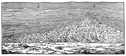
The period at which these phenomena took place cannot be fully determined, nor is it easy to ascertain whether all [Pg 115]glacial drift is contemporaneous. It would seem, however, as if the extensive accumulation of drift all around the northern pole in Europe, Asia, and America was of the same age as the erratic of the Alps. The climatic circumstances capable of accumulating such large masses of ice around the north pole, having no doubt extended their influence over the temperate zone, and probably produced, in high mountain chains, as the Alps, the Pyrenees, the Black Forest, and the Vosges, such accumulations of snow and ice as may have produced the erratic phenomena of those districts. But extensive changes must have taken place in the appearance of the continents over which we trace erratic phenomena, since we observe in the Old World, as well as in North America, extensive stratified deposits containing fossils which rest upon the erratics; and as we have all possible good reasons and satisfactory evidence for admitting that the erratics were transported by the agency of terrestrial glaciers, and that, therefore, the tracts of land over which they occur stood at that time above the level of the sea, we are led to the conclusion that these continents have subsided since that period below the level of the sea, and that over their inundated portions, animal life has spread, remains of organized beings have been accumulated, which are now found in a fossil state in the deposits formed under those sheets of water.
Such deposits occur at various levels in different parts of North America. They have been noticed about Montreal, on the shores of Lake Champlain, in Maine, and also in Sweden and Russia; and what is most important, they are not everywhere at the same absolute level above the surface of the ocean, shewing that both the subsidence and the subsequent upheaval which has again brought them above the level of the sea, have been unequal; and that we should therefore be very cautious in our inferences respecting both the continental circumstances under which the ancient glaciers were formed, and also the extent of the sea afterward, as compared with its present limits.
The contrast between the unstratified drift and the subsequently [Pg 116]stratified deposits is so great, that they rest everywhere unconformably upon each other, shewing distinctly the difference of the agency under which they were accumulated. This unconformable superposition of marine drift upon glacial drift is so beautifully shewn at the above-mentioned locality near Cambridge (see diagram, p. 114.) In this case the action of tides in the accumulation of the stratified materials is plainly seen.
The various heights at which these stratified deposits occur, above the level of the sea, shew plainly, that since their accumulation the main land has been lifted above the ocean at different rates in different parts of the country; and it would be a most important investigation to have their absolute level, in order more fully to ascertain the last changes which our continents have undergone.
From the above mentioned facts, it must be at once obvious that the various kinds of loose materials all over the northern hemisphere, have been accumulated, not only under different circumstances, but during long-continued subsequent distinct periods, and that great changes have taken place since their deposition, before the present state of things was fully established.
To the first period,—the ice period, as I have called it,—belong all the phenomena connected with the transportation of erratic boulders, the polishing, scratching, and furrowing of the rocks, and the accumulation of unstratified, scratched, and loamy drift. During that period the mainland seems to have been, to some extent at least, higher above the level of the sea than now; as we observe, on the shores of Great Britain, Norway, and Sweden, as well as on the eastern shores of North America, the polished surfaces dipping under the level of the ocean, which encroaches everywhere upon the erratics proper, effaces the polished surfaces, and remodels the glacial drift. During these periods, large terrestrial animals lived upon both continents, the fossil remains of which are found in the drift of Siberia, as well as of this continent. A fossil elephant, recently discovered in Vermont, adds to the resemblance, already pointed out, between the [Pg 117]northern drift of Europe and that of North America; for fossils of that genus are now known to occur upon the northern-most point of the western extremity of North America, in New England, in Northern Europe, as well as all over Siberia.
To the second period we would refer the stratified deposits resting upon drift, which indicate, that during their deposition the northern continent had again extensively subsided under the surface of the ocean.
During this period, animals, identical with those which occur in the northern seas, spread widely over parts of the globe which are now again above the level of the ocean. But, as this last elevation seems to have been gradual, and is even still going on in our day, there is no possibility of tracing more precisely, at least for the present, the limit between that epoch and the present state of things. Their continuity seems almost demonstrated by the identity of fossil-shells found in these stratified deposits, with those now living along the present shores of the same continent, and by the fact, that changes in the relative level between sea and mainland are still going on in our day.
Indications of such relative changes between the level of the waters and the land are also observed about Lake Superior. And here they assume a very peculiar character, as the level of the lake itself, in its relation to its shores, is extensively changed.[48]
[45] Vide Lake Superior, its physical character, vegetation, and animals. By Professor Louis Agassiz. 1850.
[46] A comparison of the maps, shewing the arrangement of the moraines upon the glacier of the Aar, in my Système Glaciaire, with the maps which Professor Guyot is about to publish of the distribution of the erratic boulders in Switzerland, will shew more fully the identity of the two phenomena.
[47] Berlin Academy, 1846.
[48]
An interesting account of the natural terraces around Lake Superior is
given at p. 413-416 of Lake Superior.
By John Adie, F.R.S.E.,
F.R.S.S.A.
Communicated by the Author.
The instrument which has been popularly named the Water, or Marine Telescope, from the power given by its use to see into the water, consists of a tube of metal or wood, of a convenient length, to enable a person looking over the gunnel of a boat to rest the head on the one end, while the other is below the surface of the water; the upper end is so formed, that the head may rest on it, both eyes seeing freely into the tube. Into the lower end is fixed (water-tight) a [Pg 118]plate of glass, which, when used, is to be kept under the surface of the water.
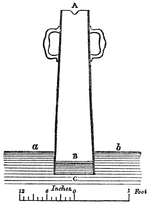
A very convenient size for the instrument represented in the above figure, is to make the length AC, 3 feet, and the mouth A, where the face is applied, of an irregular oval form, that both eyes may see freely into the tube, with an indentation on one side, that the nose may breathe freely, not throwing the moisture of the breath into the tube. B is a round plate of glass, 8 inches diameter, over which is the rim or edge C; this rim is best formed of lead, ¼ of an inch thick, and 3 inches deep; the weight of the lead serves to sink the tube a little into the water. Holes must be provided at the junction of B to C, for the purpose of allowing the air to escape, and bring the water into contact with the glass; on each side there is a handle for holding the instrument. This size and form is very much that of the instrument brought from Norway by John Mitchell, Esq., Belgian Consul, of Mayville, with the improvement for excluding the breath, and allowing the water to get into contact with the glass, which was not provided for in that instrument.
The reason why we so seldom see the bottom of the sea, or of a pure lake, where the depth is not beyond the powers of natural vision, is not that the rays of light reflected from the objects at the bottom are so feeble as to be imperceptible [Pg 119]to our sense, from their passage through the denser medium of the water, but from the irregular refractions given to the rays in passing out of the water into the air, caused by the constant ripple or motion of the surface of the water, where that refraction takes place. Reflections of light from the surface also add to the difficulty; and before we can with any just hope expect to see the objects distinctly at the bottom, these obstructions must be removed.
This is done to a very great extent by the use of the instrument which forms the subject of this notice; the tube serves to screen the eyes from reflections, and the water being in contact with the glass plate, all ripple is got rid of, so that the spectator, looking down the tube, sees all objects at the bottom, whose reflective powers are able to send off rays of sufficient intensity to be impressed on the retina, after suffering the loss of light caused by the absorbing power of the water, which obeys certain fixed laws, proportionate to the depth of water passed through; for as light passing through pure sea-water loses half its intensity for each 15 feet through which it passes,[49] we must, from this cause alone, at a certain depth lose sight of objects of the brightest lustre. The perfect purity of the water, and its freedom from all muddy particles floating in it, form an important element in the effective use of the water-telescope; for example, in the Frith of Forth, and similar estuaries, where the influx and reflux of the tide keep particles of mud in constant motion, the instrument is of little or no use; for these act in exactly the same way in limiting our vision through water, as a fog does through the air: it is therefore only in the pure waters of our northern and western shores that this contrivance is applied with any advantage; and in such situations we can speak of its powers with confidence. In a trial made with the instrument last autumn on the west coast of Scotland, the bottom was distinctly seen (a white bottom) at a depth of 12 fathoms; and on a black, rocky bottom, at 5 fathoms under water, objects were so distinctly seen that the parts of a wreck were taken up—the [Pg 120]exact place of which was not known previous to its use. In these experiments a lenticular form of glass was made use of at the bottom of the tube, having a plane surface to the water, but no great or marked advantage was observable from this construction. With respect to the history of this contrivance for viewing the bottom of the sea, we are unable to assign any particular date: so far as our information goes, it has been in use from a very remote period. We are informed that it is in general use in seal-shooting along our northern and western islands, where, sometimes in the form of an ordinary washing-tub, with a piece of glass fixed in its bottom, the shot-seal was looked for, and the grappling-hook let down to bring him to the surface. It may not be generally known, that in seal-shooting, the shot or wounded seal always seeks the bottom, from which he never rises after death, till washed ashore by the action of the sea: it is only when the fatal ball deprives him of the power of diving that he is ever found at the surface. In such employments, therefore, the use of this instrument, however modified, must form an important auxiliary to the best rifle. Throwing oil over the surface of the water is used in the same pursuits; but this only so far stills the ripple, leaving the reflections. Our eminent engineer, Mr Robert Stevenson, made use of the water-telescope more than 30 years ago, in works connected with harbour improvement in the north of Scotland; it has also been used to examine the sand-banks, &c., at the bottom of the River Tay, but in this case the mud prevented its use in any considerable depth of water. To obviate this difficulty, the construction was modified thus: by making the tube of considerable length, and placing the glass at the lower end, this tube was thrust through the water till within a few feet of the bottom, acting as a cofferdam to set aside the dirty water, and enable the bottom to be seen; but in this method of application it was found very difficult to hold the tube down in the water from its buoyant power, and we are informed by Mr Thomas Stevenson, C. E., that, he understood from this cause its use had been discontinued. He suggested a simple remedy; viz., to fill up the empty tube with pure water. We are indebted to Mr Mitchell, the gentleman [Pg 121]already mentioned, for having brought this instrument into notice in the public prints, under the name of Norwegian water-telescope, on the shores of which country it is stated to be much used in fishing—in particular, that of the herring; but the herring-fishers on the east coast of Scotland inform us, that they require no such auxiliary, as, from the surrounding elevated grounds, they can tell the position of the shoal, and, from their motions seen from such situations, they know where they are to be found when they go out a-fishing.[50]
[49] Leslie's Elements of Nat. Phil., p. 19.
[50] Norwegian Water-Telescope.
The water-telescope is thus noticed in a very promising periodical, the American Annual of Scientific Discovery, just published, of which a copy reached us a few days ago.—Ed. Phil. Journal.
The water-telescope is an instrument which the people of Norway have found of so great utility, that there is scarcely a single fishing-boat without one of three or four feet in length, which they carry in their boats with them when they go a-fishing. When they reach the fishing-grounds, they immerse one end of this telescope in the water, and look through the glass, which shews objects some ten or fifteen fathoms deep as distinctly as if they were within a foot of the surface. When a shoal of fish comes into their bays, the Norwegians instantly prepare their nets, man their boats, and go out in pursuit. The first process is minutely to survey the ground with their glasses, and where they find the fish swarming about in great numbers, they give the signal, and surround the fish with their large draught-nets, and often catch them in hundreds at a time. Without these telescopes their business would often prove precarious and unprofitable; as the fish, by these glasses, are as distinctly seen in the deep, clear sea of Norway, as gold-fish in a crystal jar. This instrument is not only used by the fishermen, but is also found aboard the navy and coasting-vessels of Norway. When their anchors get into foul ground, or their cables warped on a roadstead, they immediately apply the glass, and, guided by it, take steps to put all to rights, which they could not do so well without the aid of the rude and simple instrument, which the meanest fisherman can make up with his own hands, without the aid of a craftsman. This instrument has been lately adopted by the Scotch fishermen on the Tay, and, by its assistance, they have been enabled to discover stones, holes, and uneven ground, over which their nets travel, and have found the telescope answer to admiration, the minutest object in twelve feet of water being as clearly seen as on the surface. We see no reason why it could not be used with advantage in the rivers and bays of the United States.
By John Adie, F.R.S.E., F.R.S.S.A.
Communicated by
the Author.
It has long been known to experimentalists that, in thermometers constructed with the greatest care, a change takes place after a lapse of time in the standard points, as given by the melting of ice and boiling of water under a fixed pressure; on this account it has been recommended by most writers, where the employment of thermometers is treated of, that they should from time to time be compared one with another, and also at the freezing point. This change is a rising of the mercury in the tube, so that, after a length of time, the mercury will not sink to the point laid off in the construction of the instrument. To investigate to what cause this change was due, formed the object of my experiments: Was it a change in the glass of which the bulbs are formed, or in the mercury with which they are filled? I was aware that thermometers filled with alcohol were not subject to this change, which would lead to the inference, that the change was in the mercury and not the glass; but then, in the spirit-thermometer, air is left above the column of spirit, whereas, in those constructed with mercury, the air is expelled, and there is a vacuum above the column; consequently, the bulb is pressed together with the force of an atmosphere on all sides; might not this force, acting for a length of time, cause some small alteration in the arrangement of the particles forming the glass of the bulb?
This is the explanation accepted by most of the Italian
and French writers on this subject. Some suppose that the
mercury may contain air and moisture within its particles;
but such a hypothesis I think inadmissible, as in the case of a
vacuum over the mercury, these particles would seek the void,
and cause rather a depression than a rising of the freezing
point. Mr Daniell, in his Essay on Climate, adopts the same
view; and Sir John Herschel, in his article Heat,
in the
Encyclopædia Metropolitana, says: The freezing point upon
the mercurial thermometer has been supposed to undergo
[Pg 123]some slight variation, so as to appear too low upon the scales
of those instruments which have been long made; and it is said
that, in such cases, the just indication was again recovered by
breaking off the end of the stem, so as to admit atmospheric
air.
But, as I had observed that the change went on for a
time only, after which it ceased, and that it affected thermometers
sealed with air over the mercury, as well as those
with a vacuum, I undertook the following experiments:—
In September 1848 I made four thermometers having long degrees,—such that 1/10° might be easily noted, constructed of the same draft of glass tube; two of these I placed in boiling water, and kept them at that temperature for a week: my object in this was to learn if any change in the form of the bulb would take place from this slow process of annealing, as glass is known to undergo some change from such exposure.
The four thermometers were now filled with pure mercury: two of these were sealed with a vacuum over the mercury; one tube that had been boiled, and the other not: the other two tubes were sealed with air over their columns, and the freezing points of all were marked on the tubes; after which they were placed in a window freely exposed to light, where they were left till January 1849—a space of four months—when they were again placed in melting ice, and the freezing points marked; they had risen ·24°, ·24°, ·20°, ·06° parts of a degree. The whole four thermometers were now placed in boiling water, and kept there for a week, when the freezing points were again observed to have risen respectively ·48°, ·41°, ·50°, ·45°.
The instruments were now left exposed to light as at first; and, in January 1850, the freezing points were again observed, when they were found to have farther risen ·12°, ·18°, ·20°, ·13°; and, lastly, they were observed in May 1850, when no change from last observation was notable.
The whole amount of rising of the freezing point in these four thermometers, after a lapse of eighteen months, is respectively ·84°, ·83°, ·90°, ·65°; and these changes may be the full amount that would take place were the instruments observed after a greater lapse of time. From my experience, I know that there is a period after which no change takes [Pg 124]place; but, from the method in which these experiments have been conducted, I am not at present in a condition to assign a time; moreover, it is evident that this period will be much modified by circumstances. The results above stated form the following Table:—
| No. | Description of Thermometer. |
Value of one Degree of Fahr. |
Observed rise, Jan. 1849. |
Rise after having been boiled for a week |
Rise at Jan. 1850. |
Total rise. |
|---|---|---|---|---|---|---|
| 1. | Sealed in vacuum, not boiled. |
0·166 | 0·24 | 0·48 | 0·12 | 0·84 |
| 2. | Sealed in vacuum and boiled. |
0·168 | 0·24 | 0·41 | 0·18 | 0·83 |
| 3. | Sealed with air, not boiled. |
0·199 | 0·20 | 0·20 | 0·20 | 0·90 |
| 4. | Sealed with air, boiled. |
0·154 | 0·06 | 0·13 | 0·13 | 0·65 |
From inspection of the Table, no very remarkable difference is observable in the rising of these four instruments. No. 4 appears to have risen less during the first period, but goes along with the others afterwards. The effect of exposure to the temperature of boiling water shews that, under high temperature, the change goes on much faster than at the ordinary temperature of the air; from the Table it will be observed, that about twice the amount of change was caused by the boiling of the thermometers for a week, than had taken place between the first and second observations, a period of four months.
It does not appear that the boiling of the thermometer tubes for eight days, previous to their being filled with mercury, had produced any change on the form of the bulbs; we should at least infer this from the change in their freezing points keeping pace so nearly with those which had not been boiled.
[Pg 125]I now come to the concluding experiment with these instruments, and, it appears to me most interesting and anomalous. The four tubes being placed in pounded ice, the columns stood at the points indicated in the last column of the Table; in this situation the tops of the tubes were broken off, so as to admit the free pressure of the air, and instantly the thermometers fell, in the order of their numbers, ·54, ·43, ·40, ·35 of a degree, now indicating on their scales +·30, +·40, +·50, +·35. The remarkable features shewn by this experiment are; first, that the two thermometers sealed with vacuum, and the two having air over their columns, should have risen nearly equally, when two had their bulbs pressed with the whole force of an atmosphere, while the other two had no pressure externally, farther than that caused from changes in the pressure of the atmosphere. Next, that on being opened, those with air over them should have started down nearly as much as those with a vacuum; and on all these appears a permanent change from three to five-tenths of a degree. I confess that I am very much at a loss to account for these singular changes; atmospheric pressure on the bulbs would account for the change in those sealed with a vacuum; for we can easily suppose that a permanent form had been taken from long exposure to that pressure by the glass forming the bulbs: besides this permanent form, there appears to have been a spring inwards, which instantly sprung out on removal of the pressure by the admission of air over the mercury; but the same reasoning will not apply to the thermometers having air over the mercury; and before I attempt to make any suggestions as to the cause of these changes, I propose to institute the following experiments. Having had three thermometers blown and filled with mercury, I shall make one with a perfect vacuum over the mercury, the next with air over it, and the third with air condensed over it; and, noting the changes that may go on in these, I hope to be able to assign a cause or causes for the change. It is argued by some continental writers on this subject that the reason why we do not perceive any change in the freezing point in spirit-thermometers is from the great expansion of spirit above mercury, volume for volume, thereby [Pg 126]requiring a much smaller mass of fluid to give the same length of a degree: this I propose to test by making a thermometer with the same size of tube and bulb as those to be experimented on with mercury. In mentioning these experiments to Professor Forbes, he kindly put me in possession of some spirit-thermometers, one of these, made in 1837, having a very large bulb—this, with three others, shewed no change in the places of their freezing points.
By
Leonard Horner, Esq., F.R.S.S. L. & E., F.G.S., &c.
Communicated by the Author. With a Plate.
The recent archaeological[N7] researches of Professor Lepsius in Egypt, and the Valley of the Nile, in Nubia, have given a deserved celebrity and authority to his name, among all who take an interest in the early history of that remarkable portion of the Old World. While examining the ruins of a fortress, and of two temples of high antiquity at Semne, in Nubia, he discovered marks cut in the solid rocks, and in the foundation-stones of the fortress, indicating that, at a very remote period in the annals of the country, the Nile must have flowed at a level considerably above the highest point which it has ever reached during the greatest inundations in modern times. This remarkable fact would possess much geological interest with respect to any great river, but it does so especially in the case of the Nile. Its annual inundations, and the uniformity in the periods of its rise and fall, have been recorded with considerable accuracy for many centuries; the solid matter held in suspension in its waters, slowly deposited on the land overflowed, has been productive of changes in the configuration of the country, not only in times long antecedent to history, but throughout all history, down to the present day. Of no other river on the earth's surface do we possess such or similar records; and moreover, the Nile, and the changes it has produced on the physical character of Egypt, are intimately associated with the earliest records and traditions of the human race. Everything, therefore, relating to the physical history of the Nile Valley must always be an object of interest; but the discovery of Professor Lepsius [Pg 127]is one peculiarly deserving the attention of the geologist; for he does not merely record the facts of the markings of the former high level of the river, but he infers from these marks, that since the reign of Mœris, about 2200 years before our era, the entire bed of the Nile, in Lower Nubia, must have been excavated to a depth of about 27 feet; and he further speculates as to the process by which he believes the excavation to have been effected.
It will be convenient, before entering upon the observations I have to offer upon the cause assigned by Professor Lepsius for the former higher levels of the Nile indicated by these marks, that I should give the description of the discovery itself, by translating Dr Lepsius's own account of it, in letters which he addressed to his friends, Professors Ehrenberg and Böckh of Berlin, from the island of Philæ, in September 1844.[51]
"You may probably remember, when travelling to Dongola on the Lybian side of the Nile, and in passing through the district of Batn el hagér, that one of the most considerable of the cataracts of the country occurs near Semne, a very old fortress, with a handsome temple, built of sandstone, in a good state of preservation; the track of the caravan passing close to it, partly over the 4000-year-old artificial road. The track on the eastern bank of the river is higher up, being carried through the hills; and you must turn off from it at this point in order to see the cataract. This Nile-pass, the narrowest with which I am acquainted, according to the measurement of Hr. Erbkam, is 380 metres (1247 English feet) broad;[52] and both in itself, and on account of the monuments existing there, is one of the most interesting localities in the country, and we passed twelve days in its examination.
"The river is here confined between steep rocky cliffs on both sides, whose summits are occupied by two fortresses of the most ancient and most massive construction, distinguishable at once from the numerous other forts, which, in the time of the Nubian power in this land of cliffs, were erected on most of the larger islands, and on the hills commanding the river. The cataract (or rapid) derives its name of Semne from that of the higher of the two fortresses on the western bank; that on the opposite bank, as well as a poor village lying somewhat south of it, is called Kumme. In both fortresses the highest and best position is occupied by a temple, built of huge blocks of sandstone, of two kinds, which must have been brought from a great distance through the rapids; for, southward, no sandstone is found nearer than Gebel Abir, in the neighbourhood of Amara and the island of Sai (between 80 and 90 English miles), and northward, there is none nearer than the great division of the district at Wadi Haifa (30 miles distant.)
"Both temples were built in the time of Tutmosis III., a king of the [Pg 128]18th dynasty, about 1600 years before Christ; but the fortresses in which they stand are of a more ancient date. The foundations of these are granite blocks of Cyclopian dimensions, resting on the rock, and scarcely inferior to the rock itself in durability. They were erected by the first conqueror of the country, King Sesuatesen III., of the 12th dynasty, in order to command the river, so easily done in so narrow a gorge. The immediate successor of this king was Amenemha III., the Mœris of the Greeks: he who accomplished the gigantic work of forming the artificial lake of Mœris, in the Fayoum, and from whose time—the most flourishing of the whole of the old Egyptian kingdom—the risings of the Nile in successive years, doubtless by means of regular markings, as indeed Diodorus tells, remained so well known, that, according to Herodotus, they were recorded in distinct numbers from the time of Mœris. It appears that this provident king, occupied with great schemes for the welfare of his country, considered it of great importance that the rising of the Nile on the most southern border of his kingdom should be observed, and the results forthwith communicated widely in other parts of the land, to prepare the people for the inundations. The gorge at Semne offered greater advantages for this object than any other point; because the river was there securely confined by precipitous rocky cliffs on each side. With the same view he had doubtless caused Nilometers to be fixed at Assuan and other suitable places; for without a comparison with these, the observations at Semne could be of little use.
"The highest rise of the Nile in each year at Semne, was registered by a mark, indicating the year of the king's reign, cut in the granite, either on one of the blocks forming the foundation of the fortress, or on the cliff, and particularly on the east or right bank, as best adapted for the purpose. Of these markings eighteen still remain, thirteen of them having been made in the reign of Mœris, and five in the time of his two next successors. These last kings discontinued the observations; for, in the meantime, the irruption of the Asiatic pastoral tribes into Lower Egypt took place, and wellnigh brought the whole kingdom to ruin. The record is almost always in the same terms, short and simple: Ra en Hapi em renpe ... mouth or gate of the Nile in the year.... And then follows the year of the reign, and the name of the king. It is written in a horizontal row of hieroglyphics, included within two lines—the upper line indicating the particular height of the water, as is often specially stated—
"The earliest date preserved is that of the sixth year of the king's reign, and he reigned 42 years and some months. The next following dates are, the years 9, 14, 15, 20, 22, 23, 24, 30, 32, 37, 40, 41, and 43; and include, therefore, under this king, a period of 37 years. Of the remaining dates, that only of the 4th year of his two successors is available; all the others, which are on the west or left bank of the river, have been moved from their original place by the rapid floods which have overthrown and carried forward vast masses of rock. One single [Pg 129]mark only, that of the 9th year of Amenemha, has been preserved in its original place on one of the building stones, but somewhat below the principal rapid.[53]
"We have now to consider the relation which these—the most ancient of all existing marks of the risings of the Nile—bear to the levels of the river in our own time. We have here presented to us the remarkable facts, that the highest of the records now legible; viz., that of the 30th year of the reign of Amenemha, according to exact measurements which I made, is 8·17 metres (26 feet 8 inches) higher than the highest level to which the Nile rises in years of the greatest floods; and further, that the lowest mark, which is on the east bank, and indicated the 15th year of the same king, is still 4·14 metres (13 feet 6½ inches); and the single mark on the west bank, indicating the 9th year, is 2·77 metres (9 feet) above the same highest level.
The mean rise of the river, recorded by the marks on the east bank,
during the reign of Mœris, is 19·14 metres (62 feet 6 inches) above the
lowest level of the water in the present day, which, according to the
statements of the most experienced boatmen, does not change from year
to year, and therefore represents the actual level of the Nile, independently
of its increase by the falls of rain, in the mountains in which its
sources are situated. The mean rise above the lowest level, at the present
time, is 11·84 metres (38 feet 8 inches); and, therefore, in the time
of Mœris, or about 2200 years before Christ, the mean height of the
river, at the cataract or rapid of Semne, during the inundation, was
7·30 metres (23 feet 10 inches) above the mean level in the present
day.
Such are the facts recorded by Dr Lepsius; and then follow, in the same letter, his views as to the cause of the remarkable lowering of the level of the river.
There is certainly no reason for believing,
he says, "that there has
been any diminution in the general volume of water coming from the
south. The great change in the level can, therefore, only be accounted
for by some changes in the land, and these must also have altered the
whole nature of the Nile Valley. There seems to be but one cause for
the very considerable lowering of the Nile; namely, the washing out and
excavations of the catacombs (Answaschen und Aushölen der Katakomben);
and this is quite possible from the nature of the rocks themselves,
which, it is true, are of a quality that could not well be rent
asunder, and carried away by the mere force of the water, but might
be acted upon directly by the rising of the water-level, and the consequent
effects of the sun and air on the places left dry, causing cracks,
into which earth and sand would penetrate, which would then give rise
to still greater rents, until, at last, the rocks would of themselves fall
[Pg 130]in, by having been hollowed out, a process that would be hastened in
those parts of the hills where softer and earthy beds existed, and which
would be more easily washed away. But that, in historical times, within
a period of about 4000 years, so great an alteration should take place in
the hardest rocks, is a fact of the most remarkable kind,—one which may
afford ground for many other important considerations.
"The elevation of the water-level at Semne must necessarily have affected all the lands above; and, it is to be presumed, that the level of the province of Dongola was at one time higher, as Semne cannot be the only place in the long tract of cliffs where the bed of rock has been hollowed out. It is to be conceived, therefore, that not only the widely-extended tracts in Dongola, but those of all the higher country in Meroë, and as far up as Fasogle, which, in the present day, are dry and barren on both sides of the river, and are with difficulty irrigated by artificial contrivances, must then have presented a very different aspect, when the Nile overflowed them, and yearly deposited its fertile mud to the limits of the sandy desert.
"Lower Nubia also, between Wadi Haifa and Assuan, is now arid almost throughout its whole extent. The present land of the valley, which is only partly irrigated by water-wheels, is, on an average, from 6 to 12 feet higher than the level to which the Nile now rises; and although the rise at Semne might have no immediate influence upon it, yet what has occurred there makes it more than probable, that at Assuan there was formerly a very different level of the river, and that the cataracts there, even in the historical period, have been considerably worn down. The continued impoverishment of Nubia is a proof of this. I have no manner of doubt that the land in this lower part of the valley, which, as already stated, is at present about 10 feet above the highest rise of the Nile, was inundated by it within historical time. Many marks are also met with here, that leave no doubt regarding the condition of the Nile Valley antecedent to history, when the river must have risen much higher; for it has left an alluvial soil in almost all the considerable bays, at an average height of 10 metres (32 feet 9 inches) above the present mean rise of the river. That alluvial soil, since that period, has doubtless been considerably diminished in extent by the action of rain. On the 17th of August Hr. Erbkam and I measured the nearest alluvial hillock in the neighbourhood of Korusko, and found it 6·91 metres (22 feet 7 inches) above the general level of the valley, and 10·26 metres (33 feet 7 inches) above the present mean rise of the river. That rise, which at Semne, on account of the greater confinement of the stream between the rocks, varies as much as 2·40 metres (7 feet 10 inches) in different years, varies at Korusko less than 1 metre (3 feet 3 inches).
"Near Abusimbel, on the west bank, I found the ground of the temple 6·50 metres (21 feet 2 inches) above the highest water-level. This temple, it is well known, was built under Rameses the Great, between 1388 and 1322 years before Christ. Near Ibrim there are, on the east bank, four grottoes excavated in the vertical rock that bounds the river, which belong partly to the 18th and partly to the 19th dynasties; the last, under Rameses the Great, [Pg 131]is also the lowest, and only 2·50 metres (8 feet 1 inch) above the highest inundation; the next in height is 2·70 metres (8 feet 9½ inches) above the former, and was made 250 years earlier, under Tutmes III. Although I only measured the present level of the valley near Korusko, nevertheless it appears to me that, during the whole of the new kingdom, that is, from about 1700 years before Christ to this time, the Nile has not reached to the full height of the low land of the valley.
It is, however, conceivable that, at the time when the present low
land of the Nubian Valley was formed, the cataracts at Assuan were in a
totally different state; one that would, in some degree, justify the overcharged
descriptions of the ancients, according to whom they made so
great a noise that the dwellers near them became deaf. The damming up
of the inundation at Assuan could have no material influence on Egypt,
any more than that at Semne, or the land from thence to Assuan.
It appears therefore, from the above statements, that at the time mentioned, the Nile, during the inundations, stood 26 feet 8 inches higher than the highest level to which it now rises in years of the greatest floods; and that, to account for this, Professor Lepsius conceives that, between the time of Mœsis and the present day, the bed of the Nile, from a considerable distance above Semne to Assuan, must have been worn down to that extent. In the index to the volume of the Berlin Monatsbericht, in which the letters of Professor Lepsius are inserted, there is the following line:—
Nil, senkung seines Bettes um 25 Fuss seit 4000 Jahren.
Nile, sinking of its bed about 25 feet (Paris) within the last 4000
years.
Rivers are, undoubtedly, among the most active agents of change that are operating on the earth's surface; the solid matter which renders their waters turbid, and which they unceasingly carry to the sea, afford indisputable proof of this agency. But the power of rivers to abrade and wear down the rocks over which they flow, and to form and deepen their own bed, depends upon a variety of circumstances not always taken into account; and although the great extent of that power, in both respects, is shewn in the case of many rivers, to conclude, as some have done, from these instances, that all rivers have excavated the channels in which they flow, is a generalization that cannot be safely assented to. The excavation of the bed of a river is one of those problems in geological dynamics which can only be rightly solved by each particular case being subjected to the rigorous examination of the mathematician and the physicist. The solid matter which rivers carry forward is in part only the produce of their own abrading power; and the amount of it must be proportional to that power, which is mainly dependent on their velocity; they are the recipients of the waste of the adjoining lands by other combined agencies, and the carriers of it to the lower districts and to the sea. They often afford the strongest evidence of [Pg 132]the vast lapse of time that must be included between the beginning and close of a geological period; and, when they flow through countries whose remote political history is known to us, they supply a scale by which we may measure and estimate that lapse of time. This is especially so in the case of the Nile.
When so startling an hypothesis as that now referred to, viz., that the entire bed of so vast a river as the Nile, for more than 250 miles, from Semne to Assuan, has been excavated, within historical time, to a depth of 27 feet, is made by a person whose name carries so much weight in one department of philosophical inquiry, the statement involves such important geological considerations, that it becomes the duty of the geologist to examine, and thoroughly test the soundness of the explanation, in order that the authority of Professor Lepsius, for the accuracy of the facts observed, may not be too readily admitted as conclusive for the correctness of his theory of the cause to which they owe their existence. That there has been such an undoubting admission, appears from the following passage in the work of one of the latest writers on Nubia:—
The translation of the name of this town (Aswán) is 'the opening;'
and a great opening this once was, before the Nile had changed its character
in Ethiopia, and when the more ancient races made this rock (at
the first cataract) their watch-tower on the frontier between Egypt and
the south. That the Nile has changed its character, south of the first
cataract, has been made clear by some recent examinations of the shores
and monuments of Nubia. Dr Lepsius has discovered water-marks so
high on the rocks and edifices, and so placed as to compel the conviction
that the bed of the Nile has sunk extraordinarily by some great natural
process, either of convulsion or wear. The apparent exaggerations of
some old writers about the cataracts at Syene may thus be in some measure
accounted for. If there really was once a cataract here, instead of
the rapids of the present day, there is some excuse for the reports given
from hearsay by Cicero and Seneca. Cicero says, that 'the river throws
itself headlong from the loftiest mountains, so that those who live nearest
are deprived of the sense of hearing, from the greatness of the noise.'
Seneca's account is: 'When some people were stationed there by the Persians,
their ears were so stunned with the constant roar, that it was found
necessary to remove them to a more quiet place.'
[54]
Note.—The learned author of an article on Egyptian Chronology
and History in the Prospective Review
for May 1850, in referring
to the contributions of Professor Lepsius to Egyptian history,
says, He has discovered undescribed pyramids, equal in number to
those known before; has traced the Labyrinth, and ascertained its
founder. He has detected inscriptions on the banks of the Nile,
which show that its bed has subsided many feet in historic times.
9th June 1850.
[Pg 133]In the assumption of an excavation of the bed of the river, we have no small amount of wear to deal with, for the distance from Semne to Assuan, following the course of the river, is not less than 250 miles; and if, as Professor Lepsius supposes, the excavation extended to Meroë, we have a distance, between that place and Assuan, of not less than 600 miles.
Although these records of a former high level of the Nile at Semne had not been noticed by any traveller prior to Professor Lepsius, we may rest fully assured of the accuracy of his statements, from the habitual care and diligence, and the established character for fidelity, of the observer. The silence of other travellers may be readily accounted for by this, that none of them appear to have remained more than a very short time at this spot—not even the diligent Russegger—whereas we have seen that Professor Lepsius passed twelve days in the examination of this gorge in the Nile Valley.
The theory of a lowering of the bed of the river by wearing, involves two main considerations, viz., the power of the stream, and the degree of hardness of the rocks acted upon. The power depends upon the volume and velocity of the river—the velocity on its depth, and the degree of inclination of the bed: the hardness of the rocks we can form a tolerable estimate of when we know their nature. To judge, therefore, of the probability of the hypothesis of Professor Lepsius, we must inquire into the physical and geological features of the Nile Valley, in Nubia.
In the observations I have now to offer, my information has been derived of course entirely from the works of other travellers, particularly those of Burckhardt, Rüppell, and Russegger,[55] and especially the latter, who travelled in Nubia in 1837; for he not only enters far more into the details of the natural history of the country, but he is the only traveller in Nubia who appears, from previous acquirements, to have been competent to describe its natural history with any degree of accuracy—I refer more particularly to the physical and geological features of the country. Besides full descriptions in his volumes, he has given a geological map of Nubia, and also several sections, or what may more properly be called vertical sketches—a term that would, perhaps, be a more appropriate designation for all sections that are not drawn to a true scale, or at least when the proportion of height to horizontal distance is not stated.
[51] Bericht über die zur Bekantmachung geeigneten Verhandlungen der Königl. Preuss. Akademie der Wissenshaften zu Berlin. Aus dem Jahre 1844.
[52] The breadth of the river itself. See Letter to Hr. Böckh, p. 27.
[53] See Plate I.
[54] Miss Martineau's Eastern Life, vol. i., p. 99.
[55] Reisen in Europa Asien und Afrika, in der Jahren 1835, bis 1841.—Stuttgart 1841-1846.
Russegger informs us,[57] that he believes he was the first traveller [Pg 134]who had succeeded in making a series of barometrical measurements along the Nile Valley, from the Mediterranean to Sennaar and Kordofan, and thence to the 10th degree of north latitude. He gives the following altitudes, above the sea:—
| Paris Feet. | English Feet. | ||
| The upper part of the Cataract of Assuan, | 342 | = | 364·37 |
| Korusko, on the right bank of the Nile, in Nubia, | 450 | = | 479·43 |
| Wadi-Halfa, | 490 | = | 522·00 |
| New Dongola, | 757 | = | 806·52 |
| Abu Hammed, | 963 | = | 1026·00 |
I shall now give the length of the Nile along its course from Abu Hammed to the island of Philæ, at the head of the cataract of Assuan. I employ for this purpose the map in the atlas which accompanies the work of Russegger, which bears the date of 1846, and which, doubtless, was constructed on the best authorities. He mentions a map of General von Prokesch with great praise.[58] It flows:—
| German M. | English M. | ||
| From NE. to SW., from Abu Hammed to Meroë, about | 31 | = | 150 |
| It makes a curve between Meroë and Old Dongola, of about | 16 | = | 77 |
| It flows between Old and New Dongola, from SE. to NW., about | 16 | = | 77 |
| Then, with some short windings, nearly due north to the island of Sais, for about | 30 | = | 145 |
| And from Sais to the island of Philæ, from SW. to NE., about | 68 | = | 327 |
| Making the whole length of the course, from Abu Hammed to Philæ, about | 161 | = | 776 |
Ascending the river, we have, between Philæ and Korusko, a distance of 24 German, or 115½ English miles, and without any rapid, except one near Kalabsche. Korusko being 115 feet above the head of the cataract of Assuan, at Philæ, we have an average fall of the river between these two places of a foot in a mile.
Between Korusko and Wadi-Halfa there is no rapid. The distance being 20 German, or 96⅓ English miles, and the difference of altitude being 42½ feet, we have an average fall throughout that part of the river's course of not more than 5·3 inches in a mile.
This very inconsiderable fall need not surprise us; for the average [Pg 135]fall of the Nile in Lower Egypt, at the lowest water, is little more than one-third of that now stated. At the time of the highest water the surface of the Nile, at Boulak, near Cairo; that is, about 116 miles in a direct line from the coast is only 43·437 English feet above the level of the Mediterranean, and at the time of the lowest water, only 17·33 feet. Thus, in the first case, there is an average fall of about 5·00 inches; in the second, of not more than 1·80 inches in a mile.[59]
Between Wadi Halfa and Dale, a distance of about 94 miles, six cataracts, or schellals, as they are called in the language of the country, are marked in Russegger's map. And here, it may be as well to notice, that there are no cataracts, in the ordinary sense of the term, on the Nile; no fall of the river over a precipice; all the so-called cataracts are rapids, where the river rushes through rocks in its bed; the rapids varying in their length and degrees of inclination. We have no measurements of their lengths or of their falls, except as regards the first and second cataracts. The former, according to Russegger, has a fall of about 85 English feet in a distance of about 8 miles; and he describes the latter as extending from 5 to 6 stunden; that is, from 12 to 14½ miles, but he does not give the height. Speaking of the schellals above Semne, Russegger says, that all may be passed in boats without difficulty for about six weeks, or two months in the year. This is the case also, at the cataract or rapid of Assuan. But between Wadi-Halfa and Dale, with some inconsiderable spaces of free navigable water, in the ordinary state of the river, there is an almost uninterrupted series of rapids. We have no measurement of the height of Dale above Wadi-Halfa, near to which the second great cataract of the Nile occurs; but this is the part of the river's course where the fall is greatest, and from Semne to Dale there are about 45 miles of this more rapid fall.
From Dale to New Dongola, a distance of 35 German, or about 168 English miles, only three rapids are marked on Russegger's map—the highest being at Hannek, about 26 English miles below New Dongola. New Dongola being 806 English feet above the sea, and the distance from that place to the rapid of Hannek being 26 miles only, we may with probability estimate the surface of the river at the rapid of Hannek at 780 feet above the sea. Now, Wadi-Halfa being 522 feet, we have a difference of height, between these two last-named places, of 258 feet; and the length of the river's course between them being 236 miles, we have an average fall of 13·12 inches in a mile; that is, in the part of the river's course where nine rapids occur, in the provinces of Batn-el-Hadjar, [Pg 136]Sukkot, and Dar-el-Mahass, where the river flows over granite and other plutonic rocks; gneiss, mica-schist, and other hard rocks, which Russegger considers to be metamorphic. But between Semne and the head of the second cataract at Wadi-Halfa, there is not a continuous rapid stream; for Hoskins says, that about two miles above that cataract, the river has a width of a third of a mile, and, when he passed it the water was scarcely ruffled.[60]
From the rapid of Hannek to Abu Hammed, the distance is 329 English miles, and the difference of altitude is 246 English feet. We have thus an average fall in that distance of 9·00 inches in a mile.
Thus, in the 776 miles between Abu Hammed and Philæ, we have an average fall of the Nile
| Of 9·00 | inches in a mile, | for a distance of | 329 | miles. |
| Of 13·12 | ......... | ......... | 236 | ... |
| Of 5·30 | ......... | ......... | 96 | ... |
| Of 12·00 | ......... | ......... | 115 | ... |
[56] With reference to the object of this paper.
[57] Reisen, Bd. ii., 545.
[58]
Über den Stromlauf und das zunächst liegende Uferland des Nils, von der
zweiten Katarakte bis Assuan, besitzen wir eine vortreffliche Karte namlich:
Land zwischen der kleinen und grossen Katarakten des Nil. Astronomisch
bestimmt und aufgenommen in J. 1827, durch v. Prokesch. Nil Grundrisse der
Monumente. Wien, 1831.
—Reisen Bd. ii., Thl. iii. 86.
[59] Russegger, Reisen, Bd. i., 258.
[60] Travels in Ethiopia, p. 272.
Our information is very scanty respecting the breadth and depth of the river, either at the time of lowest water or during the inundations. About two miles above Philæ, it is stated by Jomard[61] to be 3000 metres, or nearly two English miles wide. At the second cataract, or rapid of Wadi-Halfa, it spreads over a rocky bed of nearly two miles and a-quarter in width (2000 klafter),[62] but contracts above the rapid to a third of a mile. Russegger also states, that the Nile, near Boulak, in Lower Egypt, is 2000 toises, nearly two-and-a-half English miles in breadth, and yet that it is considerably wider in some parts of Southern Nubia; but Burckhardt says, that the bed of the Nile in Nubia is, in general, much narrower than in any part of Egypt. Near Kalabsche, about 30 miles above Philæ, the river runs through a gorge not more than 300 paces wide, and its bed is full of granite blocks. It shortly afterwards again widens for some distance; but near Sialla, 78 miles above Philæ, it is contracted by the sandstone hills on both sides coming so near each other, that the river's bed is again not more than from 250 to 300 paces wide. It is about 600 yards broad about two miles above the second cataract near Wadi-Halfa, but is again very much contracted in the rocky region of Batn-el-Hadjar. At Aulike it is only 200 paces broad.[63]
I have not met with any measurements of the depth of the river
[Pg 137]in any part of its course in Nubia; but Hoskins describes it as being
so shallow at the island of Sais, 327 miles above Philæ, on the 9th
of June, which would be before the commencement of the inundation,
as only to reach the knees of the camels.[64] Near Derr, about
86 miles below the Cataract of Wadi-Halfa, Norden, in January,
found the river so shallow that loaded camels waded through it, and
his boat frequently struck the ground. In May, Burckhardt found
the river fordable at Kostamne, 53 miles above Philæ; and Parthey
states, that between Philæ and the island of Bageh, to the west of
it, the river is so shallow before the commencement of the inundation,
that it may be waded through.[65] Burckhardt says, that from
March to June the Nile-water, in Nubia, is quite limpid.[66] Miss
Martineau, who visited Nubia in December and January, speaking
of the river above Philæ says, that it was divided into streamlets
and ponds by the black islets. Where it was overshadowed it was
dark-gray or deep blue, but when the light caught it rushing between
a wooded island and the shore, it was of the clearest green.
[67] At
the second cataract she describes the river as dashing and driving
among its thousand islets, and then gathering its thousand currents
into one, proceeds calmly in its course.
[68]
Although we have no accurate measurements of the velocity of the Nile in Nubia, we may arrive at an approximate estimate of it by comparing its fall with that of a river well known to us.
I have stated the fall of the Nile in different parts of its course to be 5·30, 9·00, 12·00, and 13·12 inches in a mile. The fall of the Thames from Wallingford to Teddington Lock, where the influence of the tide ends, is as follows:—
| Length of course. | Fall. | Fall in inches per mile. | |
|---|---|---|---|
| Miles. F. | Feet. in. | ||
| From Wallingford to Reading Bridge, | 18·0 | 24·1 | 15·72 |
| From Reading to Henley Bridge, | 9·0 | 19·3 | 25·68 |
| From Henley to Marlow Bridge, | 9·0 | 12·2 | 16·20 |
| From Marlow to Maidenhead Bridge, | 8·0 | 15·1 | 22·32 |
| From Maidenhead to Windsor Bridge, | 7·0 | 13·6 | 23·16 |
| From Windsor to Staines Bridge, | 8·0 | 15·8 | 23·52 |
| From Staines to Chertsey Bridge, | 4·6 | 6·6 | 17·28 |
| From Chertsey to Teddington Lock, | 13·6 | 19·8 | 17·40 |
| 77·4 | 125·11 |
[Pg 138]In general, the velocity may be estimated at from half-a-mile
to two miles and three-quarters per hour; but the mean velocity may
be reckoned at two miles per hour. In the year 1794, the late Mr
Rennie found the velocity of the Thames at Windsor two miles and
a half per hour.
[69]
It will thus be seen that the velocity of the Nile is probably greatly inferior to that of the Thames; for it appears that, except during the inundation, for more than half the year the depth is inconsiderable. The average fall when greatest, that is, including the province of Batn-el-Hadjar, where the rapids chiefly occur, is considerably less than that of any part of the above course of the Thames; so that there must be long intervals between the rapids where the fall must be far less than 13 inches in a mile. The breadth of the Nile is vastly greater; but supposing the depth of the water to be the same as that of the Thames, on account of the friction of the bed, the greater breadth would add very little to the velocity. If we assume the average depth of the Thames in the above distance to be 5 feet, and that it flows with an average velocity of 2 miles in an hour, and if we assume the average depth of the Nile in that part of its course where the fall is 13·12 inches to be 10 feet, when not swollen by the rise, the velocity would be 2⅘ miles nearly in an hour,[70] if the fall were equal to that of the Thames. We shall probably come near the truth, by assuming the velocity of the Nile on this part at 2 miles in an hour. That it must be considerably less in the other divisions of the course I have named, and especially in that part immediately below the second cataract, where the average fall is only 5·30 inches for a distance of 96 miles, is quite evident.
The power of a river to abrade the soil over which it flows, so far as water is by itself capable of doing so, must depend upon its volume and velocity, and the degree of hardness of the material acted upon. The power is increased when the water has force enough to transport hard substances. But even transported gravel has little action on the rocks with which it comes in contact, when it is free to move in running water, unless the fall be considerable, and, consequently, the velocity and force of the stream great. When stones are firmly set in moving ice, they then acquire a great erosive power, cutting and wearing down the rocks they are forcibly rubbed against; but this condition never obtains in Lower Nubia, as ice is unknown there.
[61]
Description de l'Égypte.—Separate Memoir entitled, Description de
Syène et des Cataractes.
[62] Russegger, Bd. ii., 3 Thl. 85.
[63] Russegger, Bd. ii., 3 Thl. 76.
[64] Travels, p. 257.
[65] Wanderungen durch das Nilthal, von G. Parthey, Berlin 1840. 378.
[66] Travels, pp. 9 and 11.
[67] Eastern Life, i. 10½.
[68] Ib., 144.
[69] Rennie, Report on Hydraulics, in the Fourth Report of the British Association for the Advancement of Science, 1834, p. 487.
[70] I state this on the authority of my friend, W. Hopkins, Esq., of Cambridge.
One kind only of regularly stratified rock occurs in the 776 miles [Pg 139]from Abu Hammed to Philæ; viz. a silicious sandstone, similar to that which occurs to a great extent on both sides of the Nile in Upper Egypt, and which Russegger, after a very careful examination of it there, considers to be an equivalent of the greensand of the cretaceous rocks of Europe. The tertiary nummulite limestone, so abundant in Egypt, has not hitherto been met with in Nubia.
The Nile flows over this sandstone for nearly 426 miles of the entire distance, but not continuously. At Abu Hammed, it flows over granitic rocks, and these continue from that place for about 120 miles. There is then about 215 miles of the sandstone, which is succeeded by igneous and metamorphic rocks, that continue for 195 miles without any interruption, except a narrow stripe of sandstone of about 15 miles near Amara. It is in this region of hard igneous rocks that nearly all the rapids occur, between that of Hannek and the great or second cataract at Wadi-Halfa. From the latter place there is sandstone throughout a distance of about 196 miles, and then commences the granitic region of the Cataract of Assuan, through which the Nile flows about 35 miles. Thus we have about 350 miles of igneous and metamorphic[N8] rocks, and about 426 of sandstone.
The general hard nature of the igneous and metamorphic rocks, over which the Nile flows for about 155 miles above Semne, and for about 40 immediately below it, will be recognised by my naming some of the varieties described by Russegger, viz. granites of various kinds, often penetrated by greenstone dykes; sienite, diorite, and felspar porphyries; gneiss, and clay slate, penetrated by numerous quartz veins.
The siliceous sandstone is very uniform in its character; and in Nubia, as in Egypt, the only organic bodies which it has as yet been found to contain, are silicified stems of wood. Occasionally, as in the neighbourhood of Korusko, interstratified beds of marly clay are met with.[71]
When, therefore, we take into account the hard nature of the siliceous sandstone, the durability of which is shewn by the very ancient monuments of Egypt and Nubia, that are formed of it, and the still greater hardness of the granites and other crystalline rocks, it is manifest that the wearing action of a river flowing over so gentle a fall, can scarcely be appreciable. If the occasional beds of marly clay occur in the bank of the river, they may be washed out, and blocks of the superincumbent sandstones may fall down; but such an operation would have a tendency to raise rather than deepen the bed of the river at those places; unless the transporting power of the stream were far greater than can exist with so moderate a fall, especially in that part of the river below Semne, where, for 96 miles, it is not more than 5·3 inches, and for 115 miles below that, not more than 12 inches in a mile. Even if we suppose the river to [Pg 140]have power to tear up its bed for some distance above Semne and below it, as far as the rapid of Wadi-Halfa, it is evident that the materials brought down would be deposited, except the finest particles, in that tranquil run of 96 miles, which may be almost compared to a canal. The drains in Lincolnshire are inclined 5 inches to a mile.[72] When the annual inundations commence, the water of the Nile comes down the rapid at Assuan of a reddish colour, loaded with sand and mud only; whatever detrital matter of a larger and heavier kind the Nile may have brought with it, is deposited before it reaches that point.
From all these considerations, therefore, I come to the conclusion,
that the bed of the Nile cannot have been excavated, as Professor
Lepsius supposes, since the date of the sculptured marks on the rock
at Semne. He says, Es lässt sich kaum eine andere Ursache für
das bedentende Fallen des Nils denken, als ein Answaschen und
Aushölen der Katakomben.
By the word Katakomben he can only
mean natural caverns in the rock; but such caverns are rarely, if
ever, met with in sandstones, and only occasionally in limestones. If
the course of the Nile were over limestone instead of sandstone,
we could not for a moment entertain the idea of a succession of
caverns for 200 miles beneath its bed, sometimes two miles in width,
the roofs of which were to fall in; and where the igneous rocks prevail,
this explanation is wholly inapplicable.
But besides the objections arising from the nature of the rocks,
and the inconsiderable fall of the river, there is still another difficulty
to overcome. It is to be borne in mind, that this lowering of the
bed of the Nile, from Semne to Assuan, is supposed to have taken
place within the last 4000 years. Between the first cataract at
Assuan and the second at Wadi-Halfa, there are numerous remains
of temples on both banks of the Nile, some of very great antiquity.
From Wadi-Halfa to Philæ,
says Parthey, there is a vast number
of Egyptian monuments, almost all on the left bank of the river,
and so near the water that most of them are in immediate contact
with it.
[73] We may rest assured that the builders of these would
place them out of the reach of the highest inundations then known.
Although we have many accurate descriptions of these monuments,
the heights of their foundations above the surface of the river
are not often given; they are, however, mentioned in some instances.
I shall describe the situations of some of these buildings
relatively to the present state of the river's levels, and shall begin
with those on the island of Philæ.
This island, according to the measurements of General von Prokesh,
is 1200 Paris feet (1278 English) in length, and 420 (447)
in breadth, and is composed of granite. Lancrot informs us, that,
à l'époque des hautes eaux, l'île de Philæ est peu élevé audessus
[Pg 141]de leur surface, mais lorqu'elles sont abaissées elle les surpasse de
huit metres.
It was formerly surrounded by a quay of masonry,
portions of which may be traced at intervals, and in some places
they are still in good preservation. The south-west part of the
island is occupied by temples. According to Wilkinson, the principal
building is a temple of Isis commenced by Ptolemy Philadelphus,
who reigned from 283 to 247 years before Christ; and he adds,
that it is evident an ancient building formerly stood on the site of
the present great temple. Lancrot, in referring to this more ancient
building, says:—Il y a des preuves certaines d'une antiquité
bien plus reculeé encore, puisque des pierres qui entrent dans la construction
de ce même grand temple, sont des débris de quelque construction
antérieure.
Rossellini considers that it was built by Nectanabis.
The first king of Egypt, of the Sebennite dynasty of that
name, ascended the throne 374 years B.C., the second and last ceased
to reign about 350 years B.C.[74]
Rossellini[75] informs us, that on the island of Bageh, opposite to Philæ, there are the remains of a temple of the time of Amenophis II., and a sitting statue of granite representing him. He was a king in the earlier years of the 18th dynasty, which, according to the Chevalier Bunsen,[76] began in the year 1638, and ended in 1410 B.C.
Gau,[77] in describing a temple at Debu, about 12 miles above Philæ, which he visited in January, and consequently during the time of low water, states that he discovered under the sand, at the edge of the river, the remains of a terrace leading towards a temple.
A short distance north of Kalabsche, about 30 miles above Philæ,
at Beil-nalli, Rossellini[78] speaks of a small temple in the following
terms:—Among the many memorials that still exist of Ramses II.,
the most important, in a historical point of view, is a small temple or
grotto excavated in the rock;
and Wilkinson mentions it as a
small but interesting temple excavated in the rock, of the time of
Rameses II., whom Champellion supposes to be the father of Sesostris
or Rameses the Great.
[79] He was the first king of the 19th
dynasty, which began in the year 1409 B.C.[80]
Gau[81] thus describes a monument at Gerbé Dandour:—La
chaine de montagnes qui borde le Nil est, dans cet endroit, si approchée
du lit de ce fleuve, qu'il ne reste que très peu d'espace sur
la rive. Cet espace est presque entièrement occupé par le monument,
[Pg 142]et la rivière, dans ses débordemens, arrive jusqu'au pied du mur de
la terrasse.
Parthey informs us that the temple of Sebua is about 200 feet distant from the river, in which distance there are two rows of sphinxes, and that the road between them, from the temple, ends in wide steps at the water's edge; and he adds, that Champellion refers this temple to the time of Rameses the Great.[82]
It thus appears that monuments exist close to the river, some of which were constructed at least 1400 years before our era; so that taking the time of Amenemha III. to be, as Professor Lepsius states, 2200 years B.C., the excavation of the bed of the Nile which he supposes to have taken place, must have been the work, not of 4000 years but of 800. If the erosive power of the river was so active in that time, it cannot be supposed that it then ceased; it would surely have continued to deepen the bed during the following 3000 years.
At all events, the buildings on the island of Philæ demonstrate that the bed of the Nile must have been very much the same as it is now, 2200 years ago; and even a thousand years earlier it must have been the same, if the foundation of the temple on the island of Begh, opposite to Philæ, be near the limit of the highest rise of the Nile of the present time; so that there could be no barrier at the Cataract of Assuan to dam up the Nile when they were constructed; and thus the deafening sound of the waterfall recorded by Cicero and Seneca must still be held to be an exaggeration.
The existence of alluvial soil, apparently of the same kind as that
deposited by the Nile, in situations above the Cataract of Assuan,
at a level considerably above the highest point which the inundations
of the river have reached in modern times, to which allusion is
made by Professor Lepsius, has been noticed by other travellers,
and even at still higher levels than those he mentions. Whether
that alluvial soil be identical with, or only resembles the Nile deposit,
would require to be determined by a close examination, and
especially with regard to organic remains, if any can be found in it.
There is no evidence to shew that it was deposited during the historical
period, and it may be an evidence of a depression and subsequent
elevation of the land antecedent to that period. It may not be of
fresh-water origin, but the clay and sand, or till, left by a drift while
the land was under the sea. For remote as is the antiquity of Nubia
and Egypt, in relation to the existence of the human race, it appears
to be of very modern formation in geological time. The greater
part of Lower Egypt, probably all the Delta, is of post-pliocene age,
and even late in that age; and the very granite of the Cataract of
Assuan, that of which the oldest monuments in Egypt are formed,
and which, in the earlier days of geology, was looked upon as the
[Pg 143]very type of the rock on which the oldest strata of the earth were
founded, is said to have burst forth during the later tertiary period.
We learn from Russegger, that the low land which lies between the
Mediterranean and the range of hills that extends from Cairo to the
Red Sea at Suez, and of which hills a nummulite limestone constitutes
a great part, is composed of a sandstone which he calls a
Meeresdiluvium,
a marine diluvial formation, and considers to be
of an age younger than that of the sub-appennines.[83] This sandstone
he found associated with the granite above Assuan, and covering the
cretaceous sandstone far into Nubia. It appears, therefore, that, in
the later ages of the tertiary period, this north-eastern part of Africa
must have been submerged, and that very energetic plutonic action
was going forward in the then bed of the sea. The remarkable fact
of the granite bursting through this modern sandstone is thus described
by Russegger:—
We arrived at a plateau of the Arabian Chain south-east of Assuan.
It is about 200 feet above the bed of the Nile, and consists of the
lower and upper sandstone, which are penetrated by innumerable granite
cones from 20 to 100 feet in height, arranged over the plateau in parallel
lines, very much resembling volcanic cones rising from a great cleft. The
sandstone is totally altered in texture near the granite, and has all the
appearance as if it had been exposed to a great heat. 'I cannot refrain,'
he says, 'from supposing that the granite must have burst, like a volcanic
product, through long wide rents in the sandstone, and that, in this way,
the conical hills were formed.'
[84]
An eruption of a true granite during the period of the sub-appennine formations, one possessing the same mineral structure as that we know to have been erupted during the period of the palæozoic rocks, would be a fact of so extraordinary a kind, that its age would require to be established on the clearest evidence, and especially by that of organic remains in the sandstone.
Having thus ventured—I trust without any want of the respect due to so eminent a person—to reject the hypothesis proposed by Professor Lepsius for the high levels of the Nile at Semne, indicated by the sculptured marks he discovered, it may perhaps be expected that I should offer another more probable explanation. If in some narrow gorge of the river below Semne, a place had been described by any traveller, where, from the nature of the banks, a great landslip, or even an artificial dam, could have raised the bed to an adequate height; that is, proportionate to the fall of the river, as it was more distant from Semne, a bar that, in the course of a few centuries, might have been gradually washed away, I might have ventured to suggest such a solution of the problem. But without any information of the existence of such a contraction of the river's channel, or [Pg 144]any exact knowledge of the natural outlets and dams to running water along the 250 miles of the Nile Valley, from Semne to Assuan, it would be idle to offer even a conjecture. These marks are unquestionably very difficult to account for, in the present imperfect state of our knowledge of the structure of that portion of the Nile Valley; and any competent geologist, well versed in the questions of physical structure involved, who may hereafter visit Nubia, would have a very interesting occupation in endeavouring to solve the difficulty.
7th April 1850.
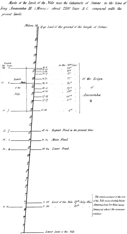
[71] Russegger, Bd. ii., 1 Thl. 569 to 584.
[72] Rennie, Report cited above, p. 422.
[73] Parthey, 318.
[74] Russegger, Reison, Bd. ii. 300 and 320. Lancrot, Description de l'Égypte, Memoire sur l'île de Philæ, 15-58. Rossellini, I Monumenti dell'Egitto e della Nubia. Monumenti del Culto, 187. Wilkinson's Thebes and General View of Egypt, 466. Smith's Dictionary of Greek and Roman Biography, Arts. Ptolemy, Ph. and Nectanabis.
[75] P. 187.
[76] Egyptens Stelle in der Weltgeschichte.—Drittes Buch, 122.
[77] Antiquités de la Nubie, p. 6.
[78] Tome III., Parte II., p. 6.
[79] Thebes, &c., p. 482.
[80] Bunsen, as above.
[81] P. 9.
[82] Warnderungen, &c., 334.
[83] Reisen, Bd. I., s. 273.
[84] Id., Bd. II., I. Thl. s. 328.
So long as the family Salmonidæ remains circumscribed[N9] as it was established by Cuvier, it seems to be a type almost universally diffused over the globe, occurring equally in the sea and in fresh-water, so that we are left almost without a clue to its natural relations to the surrounding world. Joh. Muller, working out some suggestions of Prince Canino, and introducing among them more precise anatomical characters, had no sooner subdivided the old family of Salmonidæ into his Salmonidæ, Characini, and Scopelini, than light immediately spread over this field. Limited now to such fishes as, in addition to the mere general character of former Salmonidæ, have a false gill on the inner surface of the operculum, the Salmonidæ appeared at once as fishes peculiar to the northern temperate region, occurring in immense numbers all around the Arctic[N10] Sea, and running regularly up the rivers at certain seasons of the year to deposit their spawn, while some live permanently in fresh water. We have thus in the true Salmonidæ actually a northern family of fishes, which, when found in more temperate regions, occurs there in clear mountain rivers, sometimes very high above the level of the sea, near the limits of perpetual snow, or in deep, cold lakes. That this family is adapted to the cold regions is most remarkably exemplified by the fact that they all spawn late in the season, at the approach of autumn or winter, when frost or snow has reduced the temperature of the water in which they live nearly to its lowest natural point. The embryos [Pg 145]grow within the egg very slowly for about two months before they are hatched; while fecundated eggs of some other families which spawn in spring and summer, give birth to young fishes a few days after they are laid. The Salmonidæ, on the contrary, are born at an epoch when the waters are generally frozen up; that is at a period when the maximum of temperature is at the bottom of the water, where the eggs and young salmons remain among gravel, surrounded by a medium which scarcely ever rises above thirty or forty degrees.
It is plain from these statements, and from what we know otherwise of the habits of this family, that there is no one upon the globe living under more uniform circumstances, and nevertheless the species are extremely diversified, and we find peculiar ones in all parts of the world, where the family occurs at all. Thus we find in Lake Superior species which do not exist in the course of the Mackenzie or Saskatchewan[N11], and vice versa; others in the Columbia river which differ from those of the Lena, Obi, and Yenisei, while Europe again has its peculiar forms.
Whoever takes a philosophical view of the subject of Natural History, and is familiar with the above stated facts, will now understand why, notwithstanding the specific distinctions there are between them, the trouts and white fishes are so uniform all over the globe. It must be acknowledged that it is owing to the uniformity of the physical condition in which they occur, and to which they are so admirably adapted by their anatomical structure, as well as by their instinct. Running up and down the rapid rivers and mountain currents, leaping even over considerable waterfalls, they are provided with most powerful and active muscles; their tail is strong and fleshy, and its broad basis indicates that its power is concentrated; it is like the paddle of the Indian who propels his canoe over the same waters. Their mouth is large, their jaw strong, their teeth powerful, to enable them to secure with ease the scanty prey with which they meet in these deserts of cold water; and, nevertheless, though we cannot but be struck by the admirable reciprocal adaptation between the structure of the northern animals and the physical condition in which they live, let us not mistake these adaptations [Pg 146]for a consequence of physical causes; let us not say that trouts resemble each other so much because they originated under uniform conditions; let us not say they have uniform habits because there is no scope for diversity; let us not say they spawn during winter, and rear their young under snow and ice, because at that epoch they are safer from the attacks of birds of prey; let us not say they are so intimately connected with the physical world, because physical powers called them into existence; but let us once look deeper, let us recognise that this uniformity is imparted to a wonderfully complicated structure: they are trouts with all their admirable structure, their peculiar back-bones, their ornamented skull, their powerful jaws, their moveable eyes, with their thick, fatty skin and elegant scales, their ramified fin rays, and with all that harmonious complication of structure which characterizes the type of trouts, but over which a uniform robe, as it were, is spread in a manner not unlike an almost endless series of monotonous variations upon one brilliant air, through the uniformity of which we still detect the same melody, however disguised under the many undulations and changes of which it is capable.
The instincts of trouts are not more controlled by climate than those of other animals under different circumstances. They are only made to perform at a particular season, best suited to their organization, what others do at other times. If it were not so, I do not see why all the different fishes, living all the year round in the same brook, should not spawn at the same season, and finally be transformed into one type; have we not, on the contrary, in this diversity under identical circumstances, a demonstrative evidence that there is another cause which has acted, and is still acting, in the production and preservation of these adaptations; a cause which endowed living beings with the power of resisting the equalizing influence of uniform agents, though at the same time placing these agents and living beings under definite relations to each other?
That trouts are not more influenced by physical conditions than other animals is apparent from the fact that there are lakes of small extent and of most uniform features, in which [Pg 147]two or three species of trout occur together, each with peculiar habits; one more migratory, running up rivers during the spawning season, &c., while the other will never enter running waters, and will spawn in quiet places near the shore; one will hunt after its prey, while the other will wait for it in ambuscade; one will feed upon fish, the other upon insects. Here we have an example of species with different habits, where there would scarcely seem to be room for diversity in the physical condition in which they live; again, there are others living together in immense sheets of water, where there would seem to be ample scope for diversity, among which we observe no great differences, as is the case between the Siscowet and the lake trout in the great northern lakes.
If these facts, statements, and inductions were not sufficient to satisfy the reader of the correctness of my views, I would at once refer to another material fact, furnished us by the family of Salmonidæ, namely, the existence of two essential modifications of the true type of trouts, occurring everywhere together under the same circumstances, showing the same general characters, back-bones, skull, brain, composition of the mouth, intestines, gills, &c., &c., but differing in the size of the mouth, and in the almost absolute want of teeth, these groups being that of the white fishes, Coregoni, and that of the true trouts, Salmones.
Now, I ask, where is there, within the natural geographical limits of distribution of Salmonidæ, a discriminating power between the physical elements under which they live, which could have introduced these differences?—a discriminating power which, allotting to all certain characters, should have modified others to such an extent as to produce apparently different types under the same modification of the general plan of structure. Why should there be, at the same time, under the same circumstances, under the same geographical distribution, white fishes with the habits of trouts,—spawning like them in the fall, growing their young like them during winter,—if there were not an infinitely wise Supreme Power, if there were not a personal God, who, having first designed, created the universe, and modelled our solar system, called successively, at different epochs, such animals into [Pg 148]existence under the different circumstances prevailing over various parts of the globe, as would suit best this general plan, according to which man was at last to be placed at the head of creation? Let us remember all this, and we have a voice uttering louder and louder the cry which the external world equally proclaims, that there is a Creator, an intelligent and wise Creator, an omnipotent Creator of all that exists, has existed, and shall exist.
To come back to the Salmonidæ, I might say, that when properly studied, there is not a species in nature, there is not a system of organs in any given species, there is not a peculiarity in the details of each of these systems, which does not lead to the same general results, and which is not on that account equally worth our consideration.
A minute distinction between species is again, above all, the foundation of our most extensive views of the whole, and of our most sublime generalizations. The species of Salmonidæ call particularly our attention, from the minuteness of the characters upon which their distinction rests. Their number in the north of this continent (North America) is far greater than would be supposed from the mere investigation of those of the great lakes; but I shall, for the present, limit myself to these.—Agassiz, Lake Superior, p. 366.
Produced under the superintendence of G. B. Airy, Esq., Astronomer Royal.
This important work, containing the earliest fruits of the Cape Observatory; and, while the first, at the same time some of the most valuable contributions to Southern Astronomy,—has been received too late to allow us to do more than barely mention the titles in the present number.
We are tempted, however, to extract the following short notice of a remarkable meteor; because it tends to establish the connection so very much wanted between shooting-stars [Pg 149]on the one hand, and meteorites, or meteor-stones, on the other hand. The phenomenon in question had a something of the characteristics of each, but was more of the nature of the latter body, in which case the mere fact of its appearing at the epoch of the shooting-stars, maybe considered in some degree significant of a connection, more especially when confirmed by a second instance in another year; while, moreover, the November period of shooting-stars had not then been suspected; and these two observations not only serve to confirm that period, but also to give the retrogression of the nodes of the orbit, which has been suspected.
P. S.
Mr Fallows to the Secretary of the Admiralty.
Royal Observatory, Cape of Good Hope,
November 9, 1829.
"Sir,—The inclosed document was drawn up at my request, by Captain Ronald. At the moment the first explosion took place (ten in the evening), I was writing in a room adjacent to that of the Transit, and imagined from the loudness of the report that it might be a signal of distress from some vessel in Table Bay. Shortly after, perhaps four or five minutes, for I cannot be certain, having no suspicion of what had been observed in the Transit-room, I heard a second report, but it was somewhat fainter than the former. This phenomenon has been noticed at Simon's Town, Stellenbosch, and beyond Koe‑berg.[85]—I have, &c.,
Fearon Fallows.
(INCLOSURE.)
Captain Ronald to Mr Fallows.
Observatory, Cape of Good Hope,
20th October 1829.
"Sir,—As it may not be uninteresting perhaps to make some record of the circumstances attending the appearance of a meteor which was observed last evening, I beg leave to convey to you the following notice: remarking that having seen it only through the open roof of the Observatory, which prevented me from following the direction it took, my report must necessarily be so far incomplete.
"At the time of the occurrence of the phenomenon in question, [Pg 150]about ten in the evening, I was in the Transit-room, engaged in observing the passage of a star, when a blaze of intensely vivid light was observed a little to the West of North, about the height of the Equator, and which continued for perhaps a couple of seconds.
"While registering the observation, a loud report was heard nearly in the same direction, resembling that of a piece of heavy ordnance at the distance of two or three miles. The interval between the flash and the report reaching me, must have been between the limits of 2m 40s and 2m 45s, from the circumstance of my having observed the light just before the star (g Ceti) had come to the second wire[86] of the instrument, which, on referring to the transit-book, would have taken place at 23h 57m 47s·6 nearly, and therefore the occurrence of the phenomenon may be safely referred to 23h 57m 45s; and as, on hearing the report, I immediately consulted the Sidereal clock, which indicated 0h 0m 30s, I think that the error in assuming the elapsed time as above cannot be supposed to amount to five seconds.
"There was little peculiar in the state of the weather or atmosphere; the day had been rather more than usually cool, the highest temperature being 68° Fahrenheit, the wind from the south, and moderate, with slight passing showers. The evening was nearly clear, with a light air from the south-west, atmosphere rather dry; the barometer standing at 30in·20, and the thermometer at 52°, and both were observed to rise suddenly after the explosion, the barometer by 0in·01, and the thermometer by 0°·1, though they regained their original position in a short time afterwards.—I have, &c.,
"W. Ronald.
By referring to my Meteorological Journal, it appears that a
meteor of somewhat similar appearance was noticed in Cape Town
early on the morning of the 6th November last year.—W. R.
[85] i.e., 20 miles to the South, 25 to the East, and 15 to the North.
[86]
The Transit of g Ceti (2 Ceti) over the second wire, on this day is blank;
and the word meteor
is written in the margin. The first and third wires are
23h 57m 27s·9 and 23h 58m 7s·4.
Ngamiof South Africa.
Geographical discovery in Africa has even excited more interest than similar explorations in any other part of the world, and with reason—for, while it is one of the oldest and earliest peopled of lands; while the human race first attained there a high degree of civilization, and a high degree of knowledge in the arts of peace and war, of science and literature; [Pg 151]with a grandeur in some things, and a skill in others never since equalled; yet it is now the country of all others on the face of the globe concerning which we know least. In other continents there are undoubtedly parts not yet visited by Europeans, or worthy of being more fully explored; but they are but inconsiderable spots compared with the almost boundless spaces of Central Africa, where no foot of a white man has ever yet trod, and of the greater part of which no semi-fabulous native accounts even have ever reached us. So that age after age the civilization of the enlightened nations of the world is gradually losing the hold which it once had, at least along the northern shores of this vast continent; and the land of Ham is gradually reverting to a state of primeval wilderness, fenced in from all the rest of the world by the obstructive power of ignorance and position.
And yet to no other part of the world has so continued a stream of geographical explorers been poured, and is even pouring still; but invariably either the deadly climate of the more fertile parts, or the passive but all-powerful impediments offered by the more desert portions, as well as the active opposition of natives, more savage and sanguinary than in any other part of the world, have invariably, by death or otherwise, put an untimely stop to the progress of the travellers.
Under these circumstances it must be highly encouraging to all interested in the prosecutions of African geography, to hear that an actual and tangible discovery, and one of the most important kind for the country in which it was effected, and for the prosecution of still further research, has just been made, in the fact of the Rev. David Livingston, a missionary of the London Society, having at least reached the great lake[87] of South Africa.
The circumstance requires perhaps something more than mere notice, and to have more names mentioned in connection with it, from its being part of a general system of co-operation in which many have borne a part, and a very important [Pg 152]and necessary part, towards the result which has been finally achieved; and at the very least, the name of the Rev. Mr Moffat, the fellow missionary of Mr Livingston, deserves mention whenever the great lake is spoken of.
Its existence had been suspected long since, and its discovery has been a constant theme of conversation for many years past at the Cape. But yet the information of its whereabout, and size, and nature, were so very scanty, as to throw more doubt over the matter, the further that it was examined into. Up to a very recent date, the only persons who had ever been able within the colony to bear testimony to the fact of the existence of the great lake, from personal knowledge, were two young Bechuana brought down by D. A. Smith's expedition. They said, that when they were children, and their tribe was flying from their enemies, they had been at one period close to the great lake; but, after the closest cross-questioning, they left the matter more uncertain than ever, for from the length of time that their tribe was flying about in the desert in various directions, it would have been quite possible to have reached the sea either to the east or west, or the colony to the south; and nothing certain could be made out as to the mean resulting direction of the marching and countermarching.
Nevertheless, many were the ardent explorers who endeavoured
to reach this consummation, so greatly to be desired,
amid the arid plains of South Africa. The last which started,
and by far the most important of all that were ever organized
in South Africa, was that of the Cape Town Association
for Exploring Central Africa,
and which started in 1834,
and returned in 1836. The party consisted of about seven
Europeans, as many waggons, and about thirty natives. The
whole was under the direction of Dr Andrew Smith, staff-surgeon,
who had admirably qualified himself for the command,
by the experience of very many years spent chiefly in
the interior, and amongst the natives. Among the members of
the expedition, were an astronomer, well supplied with instruments,
and two artists, and Mr Charles Bell for landscape,
topography, and the manners and customs of the natives;
and another, Mr Ford, for the natural history department.
[Pg 153]Dr Smith took upon himself especially the zoology, the ethnology,
and geology; and the others all contributed according
to their powers, while the whole of their notes and journals
of every kind were to be made over to the association.
The expedition started in 1834, reached at length the Rev. Mr Moffat's residence at Kuruman, then the outpost of the Missionary stations; by him it was carried on further into the Zoolah country, to the abode of the great chief Umsiligas. This seemed for various reasons the furthest northing that the expedition could make, but a small party went on in light marching order a little further, so as to be just able to say that 23° south latitude had actually been reached, before the retrograde movement was begun.
The chief result of this expedition has been the publication of Dr A. Smith's beautiful and valuable zoological work, for the publication of which the government granted a sum of money.
The personal journal, the astronomical, geographical, geological, and meteorological observations, have still to come; likewise Dr Smith's own observations touching the history, language, and other particulars of the various tribes of aborigines whom he met with; as well as Mr Charles Bell's inimitable drawings of the manners, customs, and appearances of the natives, and his expressive landscape scenery.
This degree or measure of success seemed to put the great lake further off than ever. Europeans despaired of their ever finding or beholding[N12] it, and none but traders and huntsmen subsequently traversed that part merely of the road towards it, which the expedition did pass over; while the only scientific mission which has acted since in South Africa, viz., that of Captain Sir J. E. Alexander, sent out by the Royal Geographical Society of London,—hopeless, apparently, of doing anything by following Dr Smith's route, travelled and explored along the western coast.
It was remarked long since by the North American Indians
and other aborigines, that the black-robe chiefs of
the mission
had always preceded the daring hunter and
the crafty trader; and in no country has the preceding spirit
of the missionaries been more evident than in South Africa.
While pushing their stations continually further and further
[Pg 154]into the interior, they christianize and civilize the tribes as
they go, and so leave the way paved and open behind them;
a most important condition, when it is remembered what excessive
distances a traveller is there from his resources, and
in what an impracticable country.
Silently, but surely, has this operation been going on, until as it were, almost by natural causes, a point has been reached, within which the lake was but at a moderate distance. Starting from Mr Moffat's advanced post of Kuruman, Mr Livingston had founded the station of Kolobeng further north; and then it only required a small advance of money to pay the expense of the long contemplated journey. That sum was furnished by two lay gentlemen, Messrs Murray and Oswell,—and this great cynosure of South African geography, fell, in the ripeness of time, an easy prize.
But if we have this much to say for the effective lever which the missionary system affords for geographical discovery, we cannot say so much as we should like in favour of the manner in which it has been worked in this instance, though it may be better than in the generality of cases.
There has been of late, it must be confessed, rather a decline of the true scientific spirit of geographical exploration; and men have too frequently been contented with filling their books with accounts merely of what they shot and what they eat; unable to give any more intelligent account of the country than the natives themselves.
Hardly any better, the Rev. Mr Rebman, who is supposed to have discovered in 5° S. lat., and 3 or 400 miles within the eastern coast of Africa, a mountain reaching above the limits of perpetual snow, and which may be the source of the Nile on the one hand, and of the rivers which feed the great lake Ngami on the other; for though he has been twice to the mountains, yet he has sent home such puerile statements, that the fact of its being snow at all which was thought to have been seen, is now contested; and the height, latitude, longitude, &c., of the mountain are quite uncertain.
Mr Livingston has done much better than this, though there is almost everything for the geographer, the botanist, &c., to do; but no fault is to be imputed to him, he had a higher object in view: we mention the case so prominently [Pg 155]here, rather to incite scientific men to go and do their part. We append Mr Livingston's letter to the end of this notice, and will merely condense here the principal notabilia.
The latitude of the E. corner of the lake at its junction with the effluence the Zonga, was measured with a sextant, to be 20° 20´ S. The longitude was estimated at 24° E., consequently about midway between the E. and W. coasts. The height above the level of the sea was thermometrically determined at 2200 feet. The length and breadth were stated by the natives at 70 and 15 miles; Mr Livingston saw in the former direction an uninterrupted horizon of water.
The feeder of the lake coming down from the north was described only by the natives; but its water being very clear, even during its annual risings, and these being incomprehensible to the inhabitants of that part of the country, this course may be expected to be long, and not improbably rising from a snowy mountain.
The effluent of the lake, the Zonga, was travelled along by Mr L. for 300 miles; as the water was clear, the stream placid, the banks thickly clothed with beds of reeds, and the height above the sea 2200 feet,—it may be presumed that this river does not communicate with the ocean, and that it is gradually dissipated like other rivers there by evaporation and absorption.
The banyan, the palmyra, and the baobab, taking the place of the cactus, aloe, euphorbia and acacia, indicate the arrival in a better watered country and a totally different botanical region than any previously reached from the Cape.
The inhabitants of the lake Bayeiye,
seem to be a new
race; their language was unknown; and they possess several
remarkable habits and customs totally at variance with the
characteristics of all the South African tribes, Hottentots,
Bushmen, Caffres, Bechuana, Zoolahs, &c., south of the
tropics; as for instance, their having canoes, killing the hippopotami[N13]
with harpoons attached to ropes, and catching fish in
nets.
The head of a fish which abounds in the lake, as well as a fearful fly which stings the oxen to death, have been sent home, and are declared to be new.
In conclusion, we have the pleasure of adding that although [Pg 156]the Geographical Society could not exactly award with propriety their Royal gold medal to discoveries in their science; made in a secondary point of view, and but indifferently described, when it should be reserved for a Bruce or a Humboldt,—yet they have with great satisfaction and alacrity awarded the value of the medal in money; and it is devoutly to be hoped that Mr L. may be spared to continue the exploration which he has thus auspiciously begun.
P. S.
Letter from the Rev. David Livingston, addressed to the Rev. Arthur Tidman,
Foreign Secretary, London Missionary Society.
Banks of the River Zonga, 3rd September 1849.
Dear Sir,—I left my station, Kolobeng (situated 25° South lat., 26 East long.), on the 1st of June last, in order to carry into effect the intention, of which I had previously informed you, viz. to open a new field in the North, by penetrating the great obstacle to our progress, called the Desert, which, stretching away on our West, North-West, and North, has hitherto presented an insurmountable barrier to Europeans.
A large party of Griquas, in about thirty waggons, made many and persevering efforts at two different points last year; but, though inured to the climate, and stimulated by the prospect of much gain from the ivory they expected to procure, want of water compelled them to retreat.
Two gentlemen, to whom I had communicated my intention of proceeding to the oft-reported lake beyond the desert, came from England for the express purpose of being present at the discovery, and to their liberal and zealous co-operation we are especially indebted for the success with which that and other objects have been accomplished. While waiting for their arrival, seven men came to me from the Batavana, a tribe living on the banks of the lake, with an earnest request from their chief for a visit. But the path by which they had come to Kolobeng was impracticable for waggons; so, declining their guidance I selected the more circuitous route, by which the Bermangueato usually pass, and, having Bakwains for guides, their self-interest in our success was secured by my promising to carry any ivory they might procure for their chiefs in my waggon; and right faithfully they performed their task.
When Sekhomi, the Bermangueato chief, became aware of our intentions to pass into the regions beyond him, with true native inhumanity he sent men before us to drive away all the bushmen and Bakalihari from our route, in order that, being deprived of their assistance in the search for water, we might, like the Griquas above mentioned, be compelled to return. This measure deprived me of the opportunity of holding the intercourse with these poor outcasts I might otherwise have enjoyed. But through the good providence of God, after travelling about 300 miles from Kolobeng, we struck on a magnificent river on the 4th of July, and without further difficulty, in so far as water was concerned, by winding along its banks nearly 300 miles more, we reached the Batavana, on the lake Ngami, by the beginning of August.
Previous to leaving this beautiful river on my return home, and commencing
our route across the desert, I feel anxious to furnish you with the impressions
produced on my mind by it and its inhabitants, the Bakoba or Bayeiye. They
are a totally distinct race from the Bechuanas. They call themselves Bayeiye
(or men), while the term Bakoba (the name has somewhat of the meaning of
slaves,
) is applied to them by the Bechuanas. Their complexion is darker
than that of the Bechuanas; and, of 300 words I collected of their language[N14],
only 21 bear any resemblance to Sitchuana. They paddle along the rivers
and lake in canoes hollowed out of the trunks of single trees; take fish in nets
made of a weed which abounds on the banks; and kill hippopotami with
[Pg 157]harpoons attached to ropes. We greatly admired the frank, manly bearing
of these inland sailors. Many of them spoke Sitchuana fluently, and, while the
waggon went along the bank, I greatly enjoyed following the windings of the
river in one of their primitive craft, and visiting their little villages among
the reed. The banks are beautiful beyond any we had ever seen, except perhaps
some parts of the Clyde. They are covered, in general, with gigantic
trees, some of them bearing fruit, and quite new. Two of the Baobab[N15] variety
measured 70 to 76 feet in circumference. The higher we ascended the river,
the broader it became, until we often saw more than 100 yards of clear deep
water between the broad belt of reed which grows in the shallower parts.
The water was clear as crystal, and as we approached the point of junction
with other large rivers reported to exist in the North, it was quite soft and cold.
The fact that the Zonga is connected with large rivers coming from the north
awakens emotions in my mind, which make the discovery of the lake dwindle
out of sight. It opens the prospect of a highway, capable of being quickly
traversed by boats, to a large section of well-peopled territory.
One remarkable feature in this river is its periodical rise and fall. It has risen nearly three feet in height since our arrival, and this is the dry season. That the rise is not caused by rains is evident from the water being so pure. Its purity and softness increased as we ascended towards its junction with the Tamunakle, from which, although connected with the lake, it derives the present increased supply. The sharpness of the air caused an amazing keenness of appetite, at an elevation of little more than 2000 feet above the level of the sea (water boiled at 207½° thermometer), and the reports of the Bayeiye, that the waters came from a mountainous region, suggested the conclusion that the increase of the water, at the beginning and middle of the dry season, must be derived from melting snow.
All the rivers reported, to the north of this, have Bayeiye upon them, and there are other tribes on their banks. To one of these, after visiting the Batavana, and taking a peep at the broad part of the lake, we directed our course; but the Batavana chief managed to obstruct us, by keeping all the Bayeiye near the ford on the opposite bank of the Zonga. African chiefs invariably dislike to see strangers passing them to tribes beyond. Sebitoane,—the chief who in former years saved the life of Sechele our chief,—lives about ten days north-east of the Batavana. The latter sent a present as a token of gratitude. This would have been a good introduction; the knowledge of the language, however, is the best we can have. I endeavoured to construct a raft, at a part which was only fifty or sixty yards wide, but the wood, though sun-dried, was so heavy it sunk immediately; another kind would not bear my weight, although a considerable portion of my person was under water. I could easily have swam across, and fain would have done it; but, landing without clothes, and then demanding of the Bakoba the loan of a boat, would scarcely be the thing for a messenger of peace, even though no alligator met me in the passage. These and other thoughts were revolving in my mind as I stood in the water,—for most sorely do I dislike to be beaten,—when my kind and generous friend Mr Oswell, with whom alone the visit to Sebitoane was to be made, offered to bring up a boat at his own expense from the Cape, which, after visiting the chief, and coming round the north end of the lake, will become missionary property. To him and our other companion Mr Murray, I feel greatly indebted,—for the chief expense of the journey has been borne by them. They could not have reached this point without my assistance; but, for the aid they have rendered in opening up this field, I feel greatly indebted; and, should any public notice be taken of this journey, I shall feel obliged to the directors if they express my thankfulness.
The Bayeiye or Bakoba listened to the statements made from the Divine
Word with great attention, and, if I am not mistaken, seemed to understand
the message of mercy delivered better than any people to whom I have
preached for the first time. They have invariably a great many charms in the
villages; stated the name of God in their language (without the least hesitation)
to be Oreeja;
mentioned the name of the first man and woman, and
some traditionary statements respecting the flood. I shall not, however, take
these for certain, till I have more knowledge of their language. They are
[Pg 158]found dwelling among the reed all round the lake, and on the banks of all the
rivers to the north.
With the periodical flow of the rivers great shoals of fish descend. The people could give no reason for the rise of the water, further than that a chief, who lives in a part of the country in the north, called Mazzekiva, kills a man annually and throws his body into the stream, after which the water begins to flow.
The sketch which I enclose is intended to convey an idea of the river Zonga
and the lake Ngami. The name of the latter is pronounced as if written
with the Spanish ñ, the g being inserted to shew that the ringing sound is
required. The meaning is Great Water.
The latitude, taken by a Sextant
on which I can fully depend, was 20° 20´ south, at the north-east extremity,
where it is joined by the Zonga; longitude about 24° east. We do not, however,
know it with certainty. We left our waggon near the Batavana town, and
rode on horseback about six miles beyond it to the broad part. It gradually
widens out into a Firth about 15 miles across, as you go south from the town,
and in the south-south-west presents a large horizon of water. It is reported to
be about 70 miles in length, bends round to the north-west, and there receives
another river similar to the Zonga. The Zonga runs to the north-east. The
thorns were so thickly planted near the upper part of this river, that we left
all our waggons standing about 180 miles from the lake, except that of Mr Oswell,
in which we travelled the remaining distance; but for this precaution our
oxen would have been unable to return. I am now standing at a tribe of
Bakurutse, and shall in a day or two re-enter the desert.
The breadth marked is intended to show the difference between the size of the Zonga, after its junction with the Tamunakle and before it. The farther it runs east, the narrower it becomes. The course is shewn by the arrow-heads. The rivers not seen, but reported by the natives, are put down in dotted lines. The dotted lines running north of the river and lake, shew the probable course of the Tamunakle, and another river which falls into the lake at its north-west extremity. The arrow-heads shew also the direction of its flow. At the part marked by the name of the Chief Mosing it is not more than 50 or 60 yards in breadth, while at 20° 7´ it is more than 100, and very deep.
The principal disease reported to prevail at certain seasons appears, from the account of the symptoms the natives give, to be pneumonia and not fever. When the wind rises to an ordinary breeze, such immense clouds of dust arise from the numerous dried-out lakes called salt-pans, that the whole atmosphere becomes quite yellow, and one cannot distinguish objects more than two miles off. It causes irritation in the eyes, and, as wind prevails almost constantly at certain seasons, this impalpable powder may act as it does among the grinders in Sheffield. We observed cough among them, a complaint almost unknown at Kolobeng. Musquitoes swarm in summer, and the Banyan and Palmyra give in some parts an Indian cast to the scenery.
(Signed) David Livingston.
[87] This lake must not be confounded with the smaller one, supposed by the Portuguese to exist on the coast of Zanzibar.
Communicated for the Philosophical Journal.
In the preceding lecture, I brought under your notice the antagonist and compensating, or correcting influences of animal life in [Pg 159]preserving the uniformity of composition of the atmosphere. In the earth we witness influences of the like kind, as it were opposed to each other, and producing opposite effects. Water, in its operation, aided by air, may be considered as destructive, wearing away rocks and mountains, and carrying their comminuted parts to lower levels, and even into the sea, to be buried in its depths. Fire may be considered as restorative; acting below the surface, it melts and also consolidates, according to its degree of intensity, tending to reproduce crystalline rocks in one instance, and stratified in the other. Even when it appears most eminently to act according to our ordinary notions of its operation as a devastating and destroying agent, for example, in the eruption of a volcano, the ashes which are discharged into the atmosphere, and are widely scattered by the winds, even when they fall on the adjoining countries, may help to supply the place of the old surface-materials, carried away by streams and floods, and to renovate the soil with new elements of fertility. And acting in another form and manner, the same power which occasions volcanic eruptions appears to be productive of another effect, viz., the gradual elevation of the bed of the sea, tending to the formation of new land, of which we seem to have examples in the extension of certain coasts, and the appearance of rocks and dry land above the waves, preceded by a gradual diminution of the water over the spots where these remarkable phenomena occur.
Of most of the geological changes alluded to in the preceding remarks, the West Indies afford well marked instances.
From the continent of America are to be seen vast rivers flowing into the sea, turbid with the detritus of the country through which they have descended in a course of thousands of miles, and discolouring and freshening the waters with which they mix at an extraordinary distance from land. Between their mouths on the coasts and their rapids in the boundary hills of the interior, immense level, or almost level tracts occur,—marsh, morass, and sandbank, neither land nor water, covered chiefly with aquatic plants,—tracts formed by deposits from the great rivers, and commonly of materials somewhat coarser and heavier than those which are longer suspended and are carried out into the sea in consequence of their greater fineness.
In many of the islands not only are there rocks to be seen evidently of volcanic origin—columnar basalt, trachyte[N16], and many varieties of tufa, but also craters from whence eruptions have taken place, and in which the fires are hardly yet extinct that once acted, as is indicated by the hot steams and exhalations still proceeding from them.
Moreover, in some of these islands, rocks of volcanic origin, crystalline in their structure, and totally destitute of organic remains, are associated with others of a perfectly different character, stratified and abounding in organic remains,—various species of sea shells and of coral; and it is worthy of notice, that, in one of the instances in [Pg 160]which the appearance is best observed, viz., at Brimstone Hill, in St Christopher's, the volcanic rock, flanked by the stratified rock, and the latter—an aggregate of shells, coral, and calcareous marl, has its strata highly inclined, tilted up as it were by the former.
Other islands, or parts of islands, occur, in which there are only partial volcanic traces, and these not so much of volcanic action and disturbance on the spot, as of materials, such as ashes, thrown up by volcanoes, and those distant ones. The island Barbados is an example. Composed in great parts of a calcareous aggregate, in which organic remains abound, it has very much the character, in its peculiar features, of having been raised from the bed of the ocean (where it is certain it was formed), by some mighty force, slowly acting, and which, it is probable, is acting still.
Nor is there wanting in these seas instances of islands, in which almost every variety of formation is exemplified. Barbados, in its smaller portion—the Scotland district, exhibits some interesting varieties, such as beds of chalk abounding in the remains of microscopic animalcules, strata of sandstone, some siliceous, some calcareous; the one without organic remains, containing, however, deposits of coal and bitumen; the other—the latter having included in them organic remains, and of a kind to connect them with the calcareous rock of which the larger portion of the island is formed, for instance, the spines of echini and the teeth of squali. The larger islands, Trinidad and Jamaica, Port Rico, and Cuba, yield examples, still more in point. In Trinidad I am not aware that any volcano, or crater of one, has been discovered, or any rocks evidently volcanic in their origin; but from the imperfectly crystalline rocks, destitute of organic remains and distinct stratification, to clays and marls, to mud eruptions or volcanoes as these are sometimes called, through limestones and sandstones stratified, and containing organic remains, a tolerably well-marked series may be traced. In the adjoining and smaller island Tobago some of the same series are observable, but in a broken manner, not a little interesting and instructive. There, highly crystalline rocks, destitute of organic remains,[N17] are in juxtaposition with others abounding in these remains; coral rock is even found resting on granite; and in another situation the latter rock is contiguous to mica slate, in which quartz in mass is not of rare occurrence.
[88] Lectures on the Study of Chemistry, in connection with the Atmosphere, the Earth and the Ocean, and Discourses on Agriculture, with Introductions on the present State of the West Indies, and on the Agricultural Societies of Barbados. By John Davy, M.D., F.R.S., &c. London, Longmans. 1850.
It was a great improvement in our zoological investigations when the differences in their relations, according to the various degrees of affinity or analogy which exist between animals, were pointed out, and successively better understood. In earlier times, zoologists made [Pg 161]no distinction between the different relations which existed among animals. Affinity and analogy, so dissimilar in their essential characters, were constantly mistaken one for the other; and upon the peculiarities which struck the observer most at first sight, animals were brought together, sometimes upon the ground of true affinity, sometimes, also, upon the ground of close analogy; and though comparative anatomy did put the mistakes arising from such confusion right, by showing that external appearances were sometimes deceptive, and that a more intimate knowledge of internal structure was necessary fully to understand the real relations between animals, there remained, nevertheless, a degree of uncertainty in many[N18] cases, as long as the principles of affinities and of analogies were not fully distinguished. Every naturalist now knows that true relationship—affinity—depends upon a unity in structure, however diversified the forms may be under which their fundamental structure is displayed. For instance, the affinity of whales and the other mammalia was not understood before it was shown that, under the form of fishes, these animals had truly the same structure as the highest vertebrata.
Again, the forms of cetacea exemplify the analogy there is between whales and fishes. They are related to mammalia; they are analogous[N19] to fishes; they bear close affinity to the mammals which nurse their young with milk; they have rather close analogy to the gill-breathing fishes.
Since the fossil animals which have existed during former periods upon the surface of our globe, and which have successively peopled the ocean and the dry land, have been more carefully studied than they were at the beginning of these investigations; since they are no longer considered as mere curiosities, but as the earlier representatives of an order of things which has been gradually and successively developed throughout the history of our globe, facts have been brought to light which now require a very careful examination, and will lead to a more complete understanding of the various relations which exist between these extinct types and those which still continue to live in our days. Upon close comparison of these facts, I have been led to distinguish two sorts of relations between the extinct animals, and those of our days, which seem to me to have been either overlooked or not sufficiently distinguished. Indeed, the general results derived from Palæontological investigations, seem scarcely to have gone beyond showing that the animals of former ages are specifically and frequently also generically distinct from those of the present creation; and also to establish certain graduation between them, agreeing more or less with the degree of perfection which we recognise between the living animals according to their structure.
It is now pretty generally understood that fishes, which rank lowest among the Vertebrata, have existed alone during the oldest periods; that the reptiles which, in the gradation of structure, rank next [Pg 162]above them, have followed at a later period; that still later the birds, which, according to their anatomy, rank above reptiles, have next made their appearance; and that mammalia, which stand highest, have been introduced last, and even among these the lower families seem to have been more numerous, before the higher ones prevailed over them. Man, at last, has been created, only after all other types had acquired their full development. These facts which, in such generality are fully exemplified in every country in the order of succession of the different fossil characteristics of the various geological deposits, shew plainly that a gradation really exists in this succession, and constitutes one of the most prominent characters of the development of the animal kingdom as a whole.
If we investigate, however, this gradation, and the order of succession of animals more closely, we cannot but be struck with the different relations which exist between the fossils and the living animals. Many extinct types have been pointed out as characteristic of different geological periods, which combine, as it were, peculiarities which at present are found separately in different families of animals.
I may mention as such, the Ichthyosaur[N20], with their fish-like vertebræ, their dolphin or porpoise-like general form, and several special characters reminding us of their close relation to the Crocodilian reptiles; thus combining characters of different classes in the most extraordinary manner.
Again, the Pterodactyli, in which reptilian characters are combined with peculiarities reminding us both of birds and bats.
Again, the large carnivorous[N21] fishes of the coal period, combining peculiarities of the Saurians, with true fish characters; and so on.
These relations are of an entirely different kind from those which I have pointed out between some of the older fossils and the early stage of growth of the living representatives of the same families.
For instance, the fossil fishes with a heterocercal tail, found below the new red sandstone, down to the lowest deposits, reminds us of the peculiar termination of the vertebral column in all fish embryos of species living in the present period, to whatever family they may belong, indicating a similarity of structure in the oldest representative of this class, with the earliest condition of the germs of those animals in our days.
Let us now examine whether we can properly understand the bearings of these relations, and the meaning of such differences.
In the first place, I have mentioned the gradual progress, which is observed in the succession of the different classes of Vertebrata. This progress is exemplified by a series of types which differ from each other, but which shew, when arranged in a series, a gradation which agrees in general with the structural gradation, which we may establish upon anatomical evidence. For instance, the salamanders, with their various forms, rank below the tailless[N22] Batrachians.
And where we have a succession of those animals in the tertiary [Pg 163]deposits as they occur in various parts of Europe, we may fairly say that the fossils form, in their succession, a series of progressive types.
Another example may perhaps illustrate the point more fully. The orthocera of the oldest periods precede the curved lituites, which, in their turn, are followed by the circumvolute[N23] nautilus. Here, again, we have a natural gradation of a series of progressive types. Again, among crinoids, we find, in the older deposits, a variety of species resting upon a stem, while free crinoids begin to appear only during the secondary deposit and prevail, in the present creation, over those attached to the soil. Here, again, we have a series of progressive types developed successively, which are apparently independent of each other and seem to bear no other relation to each than that arising from the general character of the group to which they belong. Such types exemplify simply in the groups to which they belong, a real progress in the successive development of the peculiarities which characterise them as natural divisions among animals. Such forms I shall call Progressive Types.
The relations, however, which are exemplified in the oldest fishes, in the ichthyosaurians, in the pterodactyls or in the megalosaurians, seem to me to be clearly of a different character, and to differ from simple progressive types, inasmuch as those which appear earlier, combine peculiarities which, at a later period, appear separately in distinct forms. For instance, the reptilian characters which we recognise in the sauroid fishes, are developed at a later period in animals no longer belonging to the class of fishes, but constituting by themselves new types, provided with additional peculiarities which separate them fully from the fishes in general, as well as from those fishes in which we recognise some relation to reptiles during a period when no reptile existed.
Again, the ichthyosaurians, though true reptiles appearing long after fishes had been called into existence, and during an early period of the history of the reptiles, still shew their relation to fishes by the character of their vertebral column, and foreshadow, as it were, in their form, the cetacea of later ages, as well as many forms of the gigantic saurians of the secondary period. The same may be said of the pterodactyls, which are also true reptiles, but, in which the anterior extremity foreshadow peculiarities characteristic of birds and bats. Such types I shall call Prophetic Types.
To an analytic mind the examination of the peculiarities of such animals may foretell[N24] a higher progress of development, carried out in real existence, only during a later period, even if he had never seen the later ones; for in such types the germs of a future development may be recognised, and upon close examination, truly referred to the peculiarities of other higher groups, even if the intermediate links remained unknown, which, however, as the matter now stands, [Pg 164]can leave no doubt in our mind that these prophetic types really foreshadowed that diversity of forms which has been created since they have gone by. We may also say that these prophetic types lay before us the course of thoughts which has been carried out in the plan of creation by the Supreme intelligence, who called them into existence in rich order of succession, and in so diversified relations. The recognition of this prophetic character of certain types of extinct animals is not only important in a philosophical point of view; I have no doubt it will ultimately and rapidly lead to a better, fuller, higher, and deeper understanding of the various relations which exist between animals. Let me at once point to some of these relations which might never have been understood but for this appreciation.
Among Crinoids, we have not only progressive types, as I have already quoted, but we have also prophetic ones. The Cystidæ are truly prophetic of the Echini proper. I may only mention the genus Echinocrinus to shew the link.
The Pentremites, again, are the prophetic type foreshadowing the star-fishes. And often in subordinate groups we may find such close relations between genera of the same minor divisions; such, for instance, as the genus Encrinus, in which the genera Apiocrinus and Pentacrinus, are simultaneously foreshadowed. Perhaps, in this case, a distinction might be introduced between truly prophetic types and synthetic types, in which the characters of later groups are rather more combined than really foreshadowed.
As for the relation between older types and the embryos of the living representatives of the same families which are so extensively observed in almost all groups of the animal kingdom, which have existed during earlier periods, it may best be expressed if we call those fossils which exemplify, in full grown animals, forms which exist at present only in the earliest stages of growth of our living animals, Embryonic Types, in counterdistinction from the progressive types, and from the prophetic types. These embryonic types may be purely such, or they may be at the same time either progressive types, or even prophetic types. I shall call purely embryonic types those in which we recognise peculiarities characteristic of the embryo of the same family. For instance, the older Sauroids, which have the upper lobe of the tail prolonged, or the common Crinoids provided with a stem, which resemble the young Comatulæ, &c., &c. I shall distinguish, as progressive embryonic types, those in which we recognise simultaneously a relation to the embryo of the same family, when they form besides a link in the natural chain of progressive development. Such, for instance, as the oldest Salamanders, or the earliest Sirenoid Pachyderm. Finally, I shall call prophetic embryonic types those in which we have embryonic characters, combined with the peculiarities which stamp the type as a prophetic one, [Pg 165]such, for instance, as the Echinoid and Asteroid Crinoids of the former ages.
The fact that these different types may thus present complications of their character, or appear more or less pure and typical, goes further to shew how deeply diversified the plan of creation is, and how many relations should be simultaneously understood before we are prepared to have a full insight into the plan of creation. There we see one type forming simply, and alone, the first link of a progressive series. There we see another which foreshadows types, which appear isolate afterwards. There we see a third, which, in its full development, exemplifies a state which is transient only in higher representatives of the same family. And then, again, we see these different relations running into each other, and reminding us that, however difficult it may be for us to see at one glance all this diversity of relations, there is, notwithstanding, an intelligence which not only conceived these various combinations, but called them into real existence in a long succession of ages.—L. Agassiz in the American Association for the Advancement of Science, August 1849.
At the recent meeting of the Association for the Advancement of Science, an announcement was made, which, if it is found to be correct, will be regarded as relating to one of the most important discoveries which have been made in astronomy for years. It is no less than a new law of the solar system, closely resembling those of Kepler, which form the groundwork of many of the problems of astronomy. Mr S. C. Walker read to the Association a letter from Mr Daniel Kirkwood, of Pottsville, Pa., the discoverer of this new law, from which we make some extracts, omitting all that refers to the higher branches of mathematics.
While we have in the law of Kepler a bond of mutual relationship
between the planets, as regards their revolutions around the
sun, it is remarkable that no law regulating their rotations on their
axes has ever been discovered. For several years I have had little
doubt of the existence of such a law in nature, and have been engaged,
as circumstances would permit, in attempting its development.
I have at length arrived at results, which, if they do not justify me
in announcing the solution of this important and interesting problem,
must at least be regarded as astonishing coincidences.
After stating some equations, he gives the following tables as the data on which he has proceeded:—
| Planet's name. | Mean dist. from the sun in miles. | Mars. | Square root of Mars | No. of rotations in one sid. period. |
|---|---|---|---|---|
| Mercury, | 36,814,000 | 277,000 | 526·3 | 87·63 |
| Venus, | 68,787,000 | 2,463,836 | 1·569·6 | 230·90 |
| Earth, | 95,103,000 | 2,817,409 | 1·678·5 | 366·25 |
| Mars, | 144,908,000 | 392,735 | 626·7 | 669·60 |
| Jupiter, | 494,797,000 | 953,570,222 | 30·879·8 | 10·471·00 |
| Saturn, | 907,162,000 | 284,738,000 | 16·874·1 | 24·620·00 |
| Uranus, | 1,824,290,000 | 35,186,000 | 5·931·5 |
From these data he deduces the following law:—The square of
the number of a primary planet's days in its year, is as the cube of
the diameter of its sphere of attraction in the nebular hypothesis.
"The points of equal attraction between the planets severally (when in conjunction), are situated as follows:—
| Miles from the former. | Miles from the latter. | ||
| Between | Mercury and Venus, | 8,029,600 | 23,943,400 |
| " | Venus and the Earth, | 12,716,600 | 13,599,400 |
| " | Earth and Mars, | 36,264,600 | 13,540,400 |
| " | Jupiter and Saturn, | 266,655,000 | 145,710,000 |
| " | Saturn and Uranus, | 678,590,000 | 238,538,000 |
"It will be seen from the above, that the diameter of the earth's sphere of attraction is 49,864,000 miles. Hence the diameters of the respective spheres of attraction of the other planets, according to my empirical[N25] law, will be found to be as follows:—
| Diameter of sphere of Attraction. | |
| Mercury, | 19,238,000 |
| Venus, | 36,660,000 |
| Mars, | 74,560,000 |
| Jupiter, | 466,200,000 |
| Saturn, | 824,300,000 |
The volumes of the sphere of attraction of Venus, Mars, and
Saturn in this table, correspond with those obtained from the preceding
one; that of Mars extending 61,000,000 miles beyond his
orbit, or to the distance of 206,000,000 miles from the sun. This
is about 2,000,000 or 3,000,000 miles less than the mean distance
of Flora, the nearest discovered asteroid. That of Mercury extends
about 11,000,000 miles within the orbit; consequently, if there be
an undiscovered planet interior to Mercury, its distance from the
Sun, according to my hypothesis, must be less than 26,000,000
miles. Jupiter's sphere of attraction extends only about 200,000,000
of miles within his orbit, and leaving 89,000,000 miles for the
asteroids. It is only in the most distant portion of this space, where
small bodies would be likely to be detected, that none have yet been
discovered.
[Pg 167]Mr Kirkwood then modestly concludes:—
The foregoing is submitted to your inspection with much diffidence.
An author, you know, can hardly be expected to form a
proper estimate of his own performance. When it is considered,
however, that my formula involves the distances, masses, annual revolutions,
and axial rotations of all the primary planets in the system,
I must confess I find it difficult to resist the conclusion, that
the law is founded in nature.
After this letter had been read, Mr Walker said, that, induced by the importance of the subject, he had at once proceeded to verify the data and conclusions of Mr Kirkwood, and had found that there was nothing in them requiring modification, except, perhaps, the substitution of some more recent values for the masses of Mercury and Uranus. This theory and that of Laplace, with reference to nebulæ, mutually strengthen each other; although the latter has been a mere supposition, while the former rests upon a mathematical basis. In a later letter, which was also read, Mr Kirkwood says that he has pursued this subject for the last ten years, it having been first suggested to him by the nebular hypothesis, which he thought could be established by some law of rotation.
Mr Walker then entered into a lengthened examination of the data on which the law rests, and seemed to come to the conclusion, that, as far as we know at present, everything is in favour of the truth of the law, except that it requires the assumption of another planet between Jupiter and Mars.
Mr Walker closed his examination by saying, "We may, therefore, conclude, that, whether Kirkwood's analogy is or is not the expression of a physical law, it is, at least, that of a physical fact in the mechanism of the universe. The quantity on which the analogy is based has such immediate dependence upon the nebular hypothesis, that it lends strength to the latter, and gives new plausibility to the presumption that this, also, is a fact in the past history of the solar system.
"Such, then, is the present state of the question. Thirty-six elements of nine planets (four being hypothetical) appear to harmonize with Kirkwood's analogy in all the four fundamental equations of condition for each planet.
"To suppose that so many independent variable quantities should harmonize together by accident, is a more strained construction of the premises than the frank admission that they follow a law of nature.
"If, in the course of time, the hypotheses of Laplace and Kirkwood should be found to be the laws of nature, they will throw new light on the internal organization of the planets in their present, and in any more primitive, state through which they may have passed.
"For instance, we may compute the distance from the centre at [Pg 168]which any planet must have received its projectile force, in order to produce, at the same time, its double movement of translation and rotation.
"If the planet, in a more primitive state, existed in the form of a ring revolving round the Sun, having its present orbit for that of the centre of gravity of the ring, the momentum of rotation must, by virtue of the principle of conservation of movement, have existed in some form in the ring. It is easy to perceive that this momentum is precisely the amount which must be distributed among the particles of the ring, in order to preserve to all the condition of dynamical equilibrium, while those of each generating surface of the ring were wheeling round with the same angular velocity.
"If the planets have really passed from the shape of a revolving ring to their present state, the prevalence of Kirkwood's analogy shews a nice adaptation of parts in every stage of the transition.
"If the primitive quantity of coloric (free and latent) had undergone a very great change beyond that now indicated in the cooling of their crusts; if the primitive quantity of movement of rotation had been different from its actual value for any planet; if the law of elasticity of particles for a given temperature and distance from each other varied from one planet to another in the primitive or present state; in either of these cases, the analogy of Kirkwood might have failed. As it is, no such failure is noticed; we are authorised, therefore, to conclude, that the primitive quantity of coloric, the law of elasticity, the quantity of movement of rotation, the past and present radii of percussion, the primitive diameter of the generating surface of the rings, and the present dimensions and density of the planets, have been regulated by a general law, which has fulfilled for all of them the four fundamental conditions of Kirkwood's hypothesis[N26].
We may extend the nebular hypothesis and Kirkwood's analogy
to the secondary system. If they are laws of nature, they must
apply to both. In the secondary systems, the day and month are
the same. This fact has remained hitherto unexplained. Lagrange
shewed that if these values were once nearly equal, a libration sets
in round a state of perfect equality; but he offered no conjecture as
to the cause of the primitive equality. On the nebular and Kirkwood's
hypothesis, it would only be necessary that, upon the breaking
up of the ring, the primitive diameter of the generating figure
and law of relative density of layers should be preserved.
Professor Peirce, whose opinions will probably be regarded as of more value on such a subject than that of any other man in this country,—especially since his successful discussion with Leverrier,—remarked, that Kirkwood's analogy was the only discovery of the kind since Kepler's time that approached near to the character of his three physical laws. Bode's law, so called, was at best only an imperfect analogy. Kirkwood's analogy was more comprehensive, and more in harmony with the known elements of the system. The [Pg 169]diameter of the sphere of attraction, a fundamental element in this analogy, now for the first time gave an appearance of reality to Laplace's nebular hypothesis which it never had before. The positive testimony in its favour would now outweigh the former negative evidence in the case, however strong it may have been. It follows at least from Kirkwood's analogy, that the planets were dependent upon each other, and therefore connected in their origin, whatever may have been the form of the connection, whether that of the nebular hypothesis, or some other not yet imagined.
At a later period of the meeting, M. B. A. Gould junior, stated
that he had gone through the necessary calculations, using different
quantities, and had come to the same conclusions as Mr Walker.
He expressed his opinion, that at some future day the world will
speak of Kepler and Kirkwood as the discoverers of great planetary
laws.
The members generally expressed the opinion, that Laplace's nebular hypothesis, from its furnishing one of the elements of Kirkwood's law, may now be regarded as an established fact in the past history of the solar system.—American Annual of Scientific Discovery, p. 335.
Note.—Such, at least, is rather a representation of American opinions than of our own. We are inclined to compare it more with Bode's law than with Kepler's. The former is a mere arithmetical accident, applying indifferently well to a portion only of the planets, and having nothing of reason to advance for its establishment. The latter are essential parts of mechanics and gravitation, and precisely and perfectly, and necessarily true, not only in every part of the solar system, but through the whole universe.
The fact of axial rotations being the groundwork of Kirkwood's analogy seems fatal to it, for gravitation takes no more account of the time of rotation of a planet than it does of specific gravity; all calculations of the movement of the body in space are equally independent of the one and the other.
Under these circumstances, the degree of accuracy with which it may be found to apply is the only saving clause. Messrs Walker and Gould investigating the subject independently, and with better constants of mass and distance than Kirkwood had been able to procure, declare that it appears perfectly! We are sorry that the late hour at which we have received this paper has prevented us either from giving it in full, or from testing the theory rigidly.
It will be observed that, according to Kirkwood's theory, in order to compute the time of axial rotations of any planet, it is necessary to have its mass and mean distance, together with the same quantities for the planets on either side of it. Now, these quantities are only obtainable for Venus, the Earth, Saturn, and Uranus (a planet being lost between Mars and Jupiter); and the rotation of Uranus [Pg 170]not having been obtained as yet, there remains only the three first by which the theory can be tested.
In a preliminary calculation which we have instituted, we do not find the results so accordant as we had been led to expect, but still sufficiently so to give a certain probability of the approach to truth, in a case where the quantity had not been observed.
Viewed in this light, some very interesting results are obtained. 1st, The idea entertained by Bianchini and other observers, that the rotation of Venus is nearly 24 times as long as hitherto supposed, is utterly untenable.
2d, The time of rotation of Uranus, a quantity never yet observed (but doubtless capable of being observed by a telescope of Lord Rosse's calibre, removed to a table-land in a tropical country) is given; and appears so very different from any other yet observed, especially so from those of its neighbours Saturn and Jupiter, being = 1·396779, earth's = 0·997270 (sidereal rotation in mean solar days.)
3d, Knowing the rotations of Jupiter and Mars, we may supply, by using the analogy conversely, the diameters of their spheres of attraction, and thus get at the elements of the lost planet between Mars and Jupiter, and these appear[N36] to be:—mean distance = 2·9085111 (earth unity), mass in terms of Sun 1/1353240, sidereal rotation in earth's mean solar days 2·406104, and diameter of sphere of attraction 0·830951, in terms of earth's distance. The size is thus a little larger than Mars. The slowness of rotation is remarkable, especially in the case of a planet which is supposed since to have burst into pieces: the Americans have called it Kirkwood.
P. S.
1. Use of Coloured Glasses to assist the View in Fogs.—M.
Lavini of Turin, in a letter to the editor of L'Institut at Paris, makes
the following curious observation, which, if confirmed, may prove to
be of great importance:—When there is a fog between two corresponding
stations, so that the one station can with difficulty be seen
from the other, if the observer passes a coloured glass between his
eye and the eye-piece of his telescope, the effect of the fog is very
sensibly diminished, so that frequently the signals from the other
station can be very plainly perceived; when, without the coloured
glass, even the station itself is invisible. The different colours do
not all produce this effect in the same degree, the red seeming to be
the best. Those who have good sight prefer the dark-red, while
[Pg 171]those who are short-sighted like the light-red better. The explanation
of this effect seems to depend upon the fact, that the white
colour of the fog strikes too powerfully upon the organ of sight,
especially if the glass have a somewhat large field. But by the insertion
of the coloured glass, the intensity of the light is much diminished
by the interception of a part of the rays, and the observer's
eye is less wearied, and, consequently, distinguishes better the outlines
of the object observed.
2. Ozone.—Chemists are not yet fully agreed concerning the nature or production of this singular substance, ozone. To Schonbein and Williamson we are indebted for most of our knowledge concerning it. The latter has supposed it to be a compound of oxygen and hydrogen, from the fact, that, when the ozone completely freed from moisture was passed over ignited copper, water was produced. De la Rive produced it by passing a current of electricity through pure dry oxygen gas contained in a receiver. It is also obtained in large quantities by passing oxygen gas over moistened phosphorous, and afterwards drying it. Thus prepared, it is a powerful chemical agent, possesses bleaching properties, oxidises the metals with rapidity, and destroys India-rubber. The hydrogen acids of sulphur are decomposed by it, water being formed by uniting with the hydrogen of the acid, and sulphur being set free. Professor Horsford has observed that ozone, subjected to a heat of 130° Fah., entirely loses its properties. Ozone, like chlorine, precipitates iodine, colouring a solution of iodide of potassium, and starch a deep blue colour. The peculiar smell, prevalent in the vicinity of objects struck by lightning, as well as that occasioned by the excitation of an electrical machine, and by the striking of two pieces of silica together, it is believed to be occasioned by ozone.—Editors.—Annual of Scientific Discovery, p. 219.
Method of Determining the Amount of Ozone in the Atmosphere.—At the meeting of the American Association, an instrument for determining the relative quantity of ozone in the air was presented by Professor Horsford. It consisted of a tube, containing at one end a plug of asbestus, moistened with a solution of iodide of potassium and starch. This plug within the tube, attached to an aspirator, would, as air passed over it, become blue. If much water flowed from the aspirator, and of course much air flowed over the asbestus before it became blue, the quantity of ozone indicated would be small. If but little water flowed (and this could be measured), the quantity of ozone indicated would be greater. The quantities of ozone would be inversely as the volumes of air passing through the tube before blueness is produced.—Annual of Scientific Discovery, p. 219.
3. On the Phenomena of the Rise and Fall of the Waters of the
Northern Lakes of America.—At a meeting of the American Academy,
February 1849, Mr Foster, of the United States Mineral
Survey in the North-west Territory, presented the result of some observations,
undertaken with a view of determining whether the waters
of the northern lakes are subject to any movements corresponding to
tidal action. The result of these observations had convinced him
that these waters do not rise and fall at stated periods, corresponding
to the ebb and flow of the tide, but are subject to extraordinary
risings, which are independent of the influence of the sun and moon.
These risings attracted the attention of the earliest voyageurs in
these regions. Charlevoix, who traversed the lakes nearly a century
ago, says, in reference to Lake Ontario:—I observed that in this
lake there is a sort of reflux and flux almost instantaneous; the
rocks near the banks being covered with water, and uncovered again
several times in the space of a quarter of an hour, even if the surface
of the lake was very calm, with scarce a breath of air. After
reflecting some time on this appearance, I imagined it was owing to
springs at the bottom of the lake, and to the shock of their currents
with those of the rivers which fall into them from all sides, and
thus produce those intermitting motions.
The same movements
were noticed by Mackenzie in 1789; by an expedition under Colonel
Bradstreet in 1764; on Lake Erie in 1823, and at various later
periods. In the summer of 1834, an extraordinary retrocession of
the waters of Lake Superior took place at the outlet of Sault St Marie.
The river at this place is nearly a mile wide, and in the distance of
a mile falls 18·5 feet. The phenomena occurred about noon. The
day was calm, but cloudy. The water retired suddenly, leaving the
bed of the river bare, except for a distance of thirty rods, and remained
so for nearly an hour. Persons went out and caught fish
in pools formed in the depressions of the rocks. The return of the
waters is represented as having been very grand. They came down
like an immense surge, and so sudden was it, that those engaged in
catching fish had barely time to escape being overwhelmed. In the
summer of 1847, on one occasion the water rose and fell at intervals of
about fifteen minutes during an entire afternoon. The variation was
from twelve to twenty inches, the day being calm and clear; but the
barometer was falling. Before the expiration of forty-eight hours,
a violent gale set in. At Copper harbour, the ebb and flow of the
water through narrow inlets and estuaries has been repeatedly noticed
when there was not a breath of wind on the lake. Similar phenomena
occur on several of the Swiss lakes. Professor Mather, who
observed the barometer at Copper harbour during one of these fluctuations,
remarks:—As a general thing, fluctuations in the barometer
accompanied fluctuations in the level of the water; but sometimes
[Pg 173]the water-level varied rapidly in the harbour, while no such
variations occurred in the barometer at the place of observation.
As a general rule, these variations in the water-level indicate the approach of a storm, or a disturbed state of the atmosphere. The barometer is not sufficiently sensitive to indicate the sudden elevations and depressions, recurring, as they often do, at intervals of ten or twelve minutes; and the result of observations at such time may, in some degree, be regarded as negative. Besides, it may not unfrequently happen, that, while effects are witnessed at the place of observation, the cause which produced them may be so far removed as not to influence the barometer. We are, therefore, led to infer that these phenomena result, not from the prevalence of the winds acting on the water, accumulating it at one point and depressing it at others, but from sudden and local changes in the pressure of the atmosphere, giving rise to a series of barometric waves. The water, conforming to the laws which govern two fluids thus relatively situated, would accumulate where the pressure was the least, and be displaced where it was the greatest. It has been remarked by De la Beche, that a sudden impulse given to the particles of water, either by a suddenly increased or diminished pressure, would cause a perpendicular rise or fall, in the manner of a wave, beyond the height or depth strictly due to the mere weight itself. The difference in the specific gravity of the water of the lakes and the ocean may cause these changes to be more marked in the former than in the latter.—American Annual of Scientific Discovery, p. 245.
4. Water Thermometer.—Lieut. Maury states that he has been very much assisted in developing his theory of winds and currents by means of the thermometer used by some vessels for determining the temperature of the water. It was by means of these observations on the temperature of the water that he was enabled to prove that, off the shores of South America, between the parallels of 35° and 40° south, there is a region of the ocean in which the temperature is as high as that of our own Gulf stream, while in the middle of the ocean, and between the same parallels, the temperature of the water is not so great by 22°. Now, this very region is noted for its gales, being the most stormy that the as yet incomplete charts of the South Atlantic indicate. Lieut. Maury says, however, that very few navigators make use of the water thermometer, so that he has experienced some inconvenience in his undertaking. He is the more surprised at this, from the fact that New York owes much of her commercial importance to a discovery that was made by this thermometer. At the time when Dr Franklin discovered the Gulf Stream, Charleston had more foreign trade than New York and all the New England States together. Charleston was then the half-way house between New and Old England. When a vessel, in attempting to enter the Delaware or Sandy Hook, met a north-west gale or snow storm, as at certain seasons she is apt to do, instead of [Pg 174]running off for a few hours into the Gulf Stream to thaw and get warm, as she now does, she used to put off for Charleston or the West Indies, and there remained till the return of spring before making another attempt. A beautiful instance this of the importance and bearings of a single fact, elicited by science from the works of nature.—Annual of Scientific Discovery, p. 160.
5. On the Falls of Niagara.—If we follow the chasm cut by the
Niagara river, down to Lake Ontario, we have a succession of strata
coming to the surface of various character and formation. These
strata dip south-west or towards the Falls, so that, in their progress
to their present position, the Falls have had a bed of very various
consistency. Some of these strata, as the shales and medina sandstone,
are very soft, and, when they formed the edge of the Fall, it probably
had the character of rapids; but, wherever it comes to an edge
of hard rock, with softer rock-beds below, the softer beds, crumbling
away, leave a shelf projecting above, and then the fall is perpendicular.
Such is the case at present; the hard Niagara limestone
overhangs in tables the soft shales underneath, which at last are
worn away to such an extent as to undermine the superincumbent
rocks. Such was also the case at Queenston, where the Clinton
group formed the edge, with the medina sandstone below. This
process has continued from the time when the Niagara fell directly
into Lake Ontario to the present time, and will continue so long as
there are soft beds underneath hard ones; but, from the inclination
of the strata, this will not always be the case. A time will come
when the rock below will also be hard. Then, probably, the Falls
will be nearly stationary, and may lose much of their beauty from
the wearing away of the edge rendering it an inclined plane. I do
not think the waters of Lake Erie will ever fall into Lake Ontario
without any intermediate cascade. The Niagara shales are so extensive
that possibly, at some future time, the river below the cascade
may be enlarged into a lake, and thus the force of the falling
water diminished; but the whole process is so slow, that no accurate
calculations can be made. The Falls were probably larger, and
stationary for a longer time at the Whirlpool
than anywhere else.
At that point there was no division of the cataract, but at the
Devil's Hole
there are indications of a lateral fall, probably
similar to what is now called the American Fall. At the Whirlpool,
the rocks are still united beneath the water, shewing that they
were once continuous above its surface also.[89]—Agassiz on Lake
Superior, p. 15.
6. On the Existence of Manganese in Water.—At a meeting of the American Academy, in January 1849, Dr Charles T. Jackson [Pg 175]stated that he had discovered the presence of manganese in the water of streams, lakes, &c., almost universally. He detected it in water from the middle of Lake Superior, in Cochituate water, and in water from various sources. It has usually been regarded as iron in previous analyses. He considered the observation as having an important bearing in accounting for the deposits of bog manganese at the outlets of ponds, lakes, and in bogs, as well as for the source of the oxide of manganese in the blood.—Annual of Scientific Discovery, p. 202.
On the Presence of Organic Matter in Water.—The following facts relative to the presence of organic matter in water were presented to the British Association, by Professor Forchhammer, as the result of extended observations on the water, near Copenhagen.
1st, The quantity of organic matter in water is greatest in summer. 2d, It disappears, for the most part, as soon as the water freezes. 3d, Its quantity is diminished by rain. 4th, Its quantity is diminished if the water has to run a long way in open channels. The hypermanganate of potash or soda is recommended by the Professor as a most excellent test for the presence of organic matter in water.
7. Arsenic in Chalybeate Springs.—Since the discovery of arsenic in the deposits from certain chalybeate springs, it has been asked whether the poisonous properties of this substance are not neutralized by the state in which it is found. M. Lassaigne has finished a series of experiments connected with this subject, for the purpose of ascertaining the proportion of arsenic contained, in what state of combination it exists, and the nature of the action which these arseniferous deposits exert in the animal economy. The following are M. Lassaigne's conclusions:—1. In the natural deposits of the mineral waters of Wattviller, arsenic exists to the amount of 2·8 per cent. 2. A portion of these deposits, representing 1·76 grains of arsenic acid, or 1·14 grains of arsenic, produced no effect upon the health of a dog. 3. This non-action shews that the poisonous property of the arsenic is destroyed by its combination with the peroxide of iron, and thus confirms what has been before asserted, that peroxide of iron, by combining with arsenious[N27] and arsenic acid, destroys their poisonous properties, and consequently becomes an antidote for them.
[89] The data on which these and the previous remarks on the geology of the Falls are founded, are derived from Professor James Hall's investigations in the New York State Survey.
A.
8. The Coal Formation of America.—The coal regions of America are, from the explorations which have thus far been made, supposed to be divided into three principal masses; the great central tract, extending from Tuscaloosa, Alabama, to the west of Pennsylvania, and being apparently continued to New Brunswick and Nova[N28] Scotia; the second tract strikes north-westward from Kentucky, crosses the Ohio, and stretches through Illinois to the Mississippi River; a third [Pg 176]region, smaller than the others, lies between the three great lakes—Erie, Huron, and Michigan. Competent geologists affirm that, from a comparison of the coal strata of contiguous basins, these are no more than detached parts of a once continuous deposit.
The extent of this enormous coal field is, in length, from north-east to south-west, more than 720 miles, and its greatest breadth about 180 miles; its area, upon a moderate calculation, amounts to 63,000 square miles! In addition to these, there are several detached tracts of anthracite in Eastern Pennsylvania, which form some of the most remarkable coal tracts in the world. They occupy an area of about 200 square miles.
The strata which constitute this vast deposit comprehend nearly all the known varieties of coal, from the dryest and most compact anthracite to the most fusible and combustible common coal. One of the most remarkable features of these coal-seams is their prodigious bulk. The great bed of Pittsburgh[N29], extending nearly the entire length of the Monongahela River, has been traced through a great elliptic area, of nearly 225 miles in its longest diameter, and of the maximum breadth of about 100 miles, the superficial extent being 14,000 square miles, the thickness of the bed diminishing gradually from 12 or 14 feet to 2 feet. In 1847 the anthracite coal regions of Pennsylvania furnished 3,000,000 tons, and 11,439 vessels cleared from Philadelphia in that year, loaded with the article. The produce in 1848 and the present year, is of course larger.
The bituminous coal area of the United States is 133,132 square miles, or one 17th part of the whole. The bituminous coal area of British America is 18,000 square miles, or one 45th part; Great Britain, 8139 square miles; Spain, 3408 square miles, or one 52d part; France, 1719 square miles, or one 118th part; and Belgium, 518 square miles, or one 122d part. The area of the Pennsylvania anthracite coal formations is put down at 437 square miles; and that of Great Britain and Ireland anthracite and culm, at 3720 square miles. The anthracite coal of Great Britain and Ireland, however, is not nearly so valuable an article of fuel as the anthracite coal of Pennsylvania, nor does a given area yield so much as the latter.—New York Express. American Annual of Scientific Discovery, p. 271.
9. River Terraces of the Connecticut Valley.—At the meeting
of the American Association in August, President Hitchcock of
Amherst College, read a paper On the River Terraces of the Connecticut
Valley, and on the Erosions of the Earth's Surface.
He
stated that his paper must be considered as containing a few facts
and suggestions and not a finished theory. He has examined the
valley from its mouth to Turner's Falls, and carefully measured the
heights of the terraces. "As you approach the river you find plains
of sand, gravel, or loam, terminated by a slope sometimes as steep
as 35°, and a second plain, then another slope and another plain,
[Pg 177]and so on, sometimes to a great number. I find that these terraces
occur in successive basins, formed by the approaches of the mountains
upon the banks at intervals. Sometimes the basin will be 15
or 20 miles in width, but usually much narrower; and it is upon
the margins of these basins that the terraces are formed. I have
rarely found terraces more than 200 feet above the river, which
would be in Massachusetts, about 300 feet above the ocean, and at
Hanover, N.H.,[N30] about 560 feet. Nowhere do they exist along any
river, unless that river has basins. As to the materials of which
they are formed they appear exceedingly artificial. The outer or
highest terrace is generally composed of coarser materials than the
inner ones. They are all composed of materials which are worn
from the rocks, but the outer terrace oftener is full of pebbles, some
of them as large as 12 inches, while the materials of the inner seem
reduced to an impalpable powder, like the soil of a meadow which is
overflowed during high water. Whence did these materials originate?
The materials were first worn from solid rocks, and afterwards
brought into these valleys. The outer terrace appears to have
been often in part the result of the drift agency. Afterwards, the
river agency sorted the materials, and gave them a level surface, the
successive basins having at that time barriers. The inner terrace
appears to have been, at least in its upper part, the result of deposition
from the river itself.
I will now mention a few facts which I have observed. The
terraces do not generally agree in height upon the opposite sides of
the valley. The higher ones oftener agree, perhaps, than the lower
ones. If formed, as I suppose, from the rivers, we should expect
this. The terraces slope downwards in the direction of the stream.
The same terrace which, near South Hadley, is 190 feet above the
river, slopes until, at East Hartford, it is only 40 feet above the
river, thus sloping 150 feet more than the slope of the river
itself, in a distance of 40 or 50 miles. This shows that they
could not have been formed by the sea or by a lake, for they would
then have been horizontal. The greatest number of terraces observed
is eight or nine. Generally there are but two or three.
President Hitchcock then gives his view of the precise mode in which
these terraces were formed, illustrating them by references to other
parts of our country, and concludes by a notice of the erosions of the
earth's surface.—Annual of Scientific Discovery, 1850, p. 229.
10. Fossil Crinoids of the United States.—At the meeting of the American Association, 1849, a paper on the fossil crinoids of Tennessee, by Professor Troost, was read by Professor Agassiz.[90] The [Pg 178]species embraced are not less than eighty-eight in number, of which only half a dozen have been described. It is the opinion of Professor Hall that all the silurian formations of New York, previous to the beginning of the geological survey, did not afford more than four or five. Now, about sixty species have been ascertained. Professor Hall mentioned the fact, that all the crinoids of the lower silurian rocks, with the exception of one species, have five pelvic plates, and we never find one with three, or any other number of these plates, before we reach the highest deposits. In Tennessee, the crinoids are so abundant, that Professor Troost states that he had been able to collect some 300 or 400 good specimens of seven or eight different species in a single morning. In relation to the abundance of these fossils in the United States, Professor Agassiz remarked, that it is not, perhaps, sufficiently appreciated of what importance, and of what immense value the study of these fossil crinoids may be for the progress of palæontology. American students should be proud of these materials, by which they will be able to throw so much light upon these almost extinct families by their personal investigations, which will not only render them independent of the palæontologist from abroad for information with regard to the succession of types, and the full illustration of these structures, but really afford correct standards for comparison. It is the more desirable that all these fossils should be made known, as the family of crinoids is so reduced in our days that we can form no idea of the living animals of that group, of their diversity of form, modification of character, and peculiarity of position, from the living type only. He doubted whether the number of crinoid heads of all species found in Europe, now existing in the Museums of Europe, is one-third the number of those which have been found by a single gentleman in Tennessee in one morning. Now, with such materials, consider what precise and what minute investigations could be made. And if these facts could be once fully ascertained and well illustrated, there is no doubt that the series of crinoids, and their succession in former ages, will be established from American standards, and will no longer rest upon the European evidence, which has often been derived from the examination of small fragments of those ancient fossils, found in unconnected basins for the most part, so that their geological succession could be ascertained only with great doubt and difficulty. In conclusion, Professor Agassiz would venture to say, that geologists who have had any opportunity to compare the position of the ancient rocks on this continent of North America with the corresponding deposits of Europe, would agree with him in saying that the geology proper, the stratography of North America, will afford the same precise and well authenticated standards for the appreciation of the order of succession of rocks, as fossils will for the order of succession of living beings.—American Annual of Scientific Discovery, p. 282.
[Pg 179]11. Discovery of Coral Animals on the Coast of Massachusetts.—Professor Agassiz, while on an expedition in one of the vessels of the coast survey during the past summer, obtained by means of a dredge, from a depth of seventy-two feet, in the Vineyard Sound off Gay Head, several specimens of a coral with its animals. By great care and attention they were preserved alive in glass jars for more than six weeks, and afforded an excellent opportunity for an examination and observation of their structure and habits. These corals belong to the genus Astrangia, and have been named by Professor Agassiz, in honour of Professor Dana, geologist of the exploring expedition, Astrangia Dana.
This species presents two varieties. Some are of a pink or rose colour, others are white. The general form of the animal is a cylinder (as of all Polypi) resting on its base, and expanded on the upper margin; thus expanded it is about two lines in diameter. The number of tentacles is definite, but it is not always the same absolute number. It never exceeds twenty-four; in earlier periods of life there are only twelve, and there is even an epoch when there are only six.
It is, perhaps, a matter of surprise that the coral animal should have been found in this latitude. They teem in the warm latitudes; but there are very few species in the more temperate regions, and but for the opportunity afforded by the coast survey, the existence of these animals could not have been suspected on these shores. For many years, however, dead fragments had been found along the shores; but whether they lived there naturally or not had not been ascertained.—American Annual of Scientific Discovery, p. 311.
12. On the Circulation and Digestion of the Lower Animals.—Professor Agassiz states, that the circulation of the invertebrata cannot be compared to that of the vertebrata. Instead of the three conditions of chyme, chyle, and blood, which the circulating fluid of the vertebrata undergoes, the blood of that class of the invertebrata which he had particularly studied, the annelida or worms, is simple coloured chyle. The receptacles of chyle in different parts of the body are true lymphatic hearts, like those found in the vertebrata; this kind of circulation is found in the articulata and mollusks, with few exceptions, and in some of the echinoderms. In the medusæ and polyps, instead of chyle, chyme mixed with water is circulated; this circulation is found in some mollusks and intestinal worms. Professor Agassiz thinks, that the embryological development of the higher animals shews a similar succession in the circulating function. As regards the connection between respiration and circulation in vertebrata, the gills are found between branches of the blood system; in invertebrata, the chyliferous system is acted on by the respiration. The gills of fishes, therefore, cannot be compared to the gills of crustacea, articulata, and mollusks. In fact, no gills are connected with [Pg 180]the chymiferous circulation. Animals having this circulation, have no true respiration. They have only tubes to distribute freshly aërated water to different parts of the body.—Proc. Bost. Nat. Hist. Soc.
13. Distribution of the Testaceous Mollusca of Jamaica.—The great number of species is remarkable. A few miles of coast, without the aid of storms, and without dredging, yielded 450 species. In the small bay of Port Royal, 350 marine species were found. A pint of sand, taken from a surface three yards long, contained 110 species. Probably there are 350 or 400 specimens of land shells, and two or three times as many of marine species. Extensive districts occur, however, which are nearly destitute of land or marine shells. They are accumulated in favourable stations.
The difference in the extent of the distribution of the marine and of the terrestrial species is remarkable. A majority of the marine species are known to occur in the other islands; probably not more than 10 or 15 per cent. of them will be found to be peculiar to Jamaica. But of the land shells, 95 per cent. are peculiar to the island. The limited distribution of the terrestrial species is remarkable. A few are generally distributed, but a large number are limited to districts of a few miles in diameter; and several, although occurring abundantly, could be found only within the space of a few rods. Only seventeen fresh-water species were found. Favourable stations for fresh-water species are rare.
In respect of the number of individuals of mollusca in Jamaica, as compared with more northern latitudes, the rule so obvious in the class of fishes is not applicable to the same extent. Of fishes, the species are much more numerous, but individuals much less so. Of the mollusca, the total number of individuals is about the same as in this latitude, and the number of species represented by a profusion of individuals is about the same. But the number of species not occurring abundantly is much greater, so that the average of individuals to all the species is less than in this latitude. From a comparison of the laws of distribution of the marine and terrestrial species in the Antilles, it follows that the number of the latter must exceed that of the former. With the insular distribution of the terrestrial species may be associated the fact, that the coral reefs are all fringing, for both facts are connected with the geological fact, that these islands are in a process of elevation.—Professor Adams before the American Association.—American Annual of Scientific Discovery, p. 334.
14. Metamorphoses of the Lepidoptera.—Professor Agassiz said that he had, during the past season, been studying the metamorphoses of the Lepidoptera, and, to his great surprise, he had found that one stage in the transformation of these insects has been overlooked by naturalists. We knew the Lepidoptera in three conditions,—that of the worm, furnished with jaws and jointed, the chrysalis, and the perfect insect with four wings. The change not before [Pg 181]described, which he had noticed, is somewhat concealed under the skin of the caterpillar. The animal at a certain period swells at the thoracic[N31] region, and becomes extremely sensitive to the touch in this part, the skin being, in fact, in a state of inflammation. On cutting open the skin at this place, Professor Agassiz found beneath it a four-winged insect, before it had passed into the chrysalis state. The wings were long enough to extend half the length of the perfect insect. The posterior pair he found to be membraneous bags, somewhat flattened, like the respiratory vesicles of marine worms, with distinct ribs, which are blood-vessels. The anterior pair are also bags, with their upper half stiff and inflexible, like the elytra of coleoptera. The legs are tubular, but not joined, as in the perfect insect. The jaws are changed into two long tubes, which are bent backwards, as are also the antennæ. In the chrysalis, the wings are flattened and soldered together, as are the legs and sucking-tubes, which are bent backwards. The order of development of the different parts and the coleopterous condition at an incomplete stage, show that naturalists have been in error in placing chewing insects, as the coleoptera, above the sucking insects. The order should be reversed. Professor Agassiz said that he had confirmed his observations in many specimens, by examining them just at the moment when the skin begins to split on the back.—American Annual of Scientific Discovery, p. 327.
15. On the Zoological Character of Young Mammalia.—At the meeting of the American Association for the Promotion of Science, Professor Agassiz remarked, that zoologists have, in their investigations, constantly neglected one side of their subject, which, when properly considered, will throw a great amount of new light on their investigations. Studying animals, in general, it has been the habit to investigate them in their full grown condition, and scarcely ever to look back for their characters in earlier periods of life. We scarcely ever find, in a book of natural history, a hint as to the difference which exists in the young and old. Perhaps in birds, the colour of the young may be noticed; and it is generally known, that the young resemble the female more than the male; but as to precise investigation of the subject, we are deficient. But if the early stages of life have been neglected, there is one period in the history of animals which has been thoroughly investigated, for the last twenty-five years,—embryology. The changes which take place within the egg itself, and which give rise to the new individual, have been thoroughly examined; but, after the formation of the new being, the changes in its form which it passes through, up to its full grown condition, have been neglected. It had been his object to investigate this subject, because he had been struck with the deficiency there is on this point in our works; and in making this investigation, he had found that the young animals, in almost all classes, differ widely from what they are in their full-grown condition. For instance, a young bat, a young [Pg 182]bird, or a young snake, at a certain period of their growth within the egg, resemble each other so much, that he would defy the most able zoologist of our day to distinguish between a robin and a bat, or between a robin and a snake. There is something of high significance in this fact. There is something common to all these. There is a thought behind these material phenomena, which shews that they are all combined under one rule, and that they only come under different laws of development, to assume, finally, different shapes, according to the object for which they were introduced.
There is a period of life, in which, whatever may be the final form of their organs of locomotion, whatever may be the final difference between the anterior and posterior extremities, vertebrated animals have uniform legs, in the shape of little paddles or fins. This is the case with lizards as well as birds. A robin's wing and a robin's leg, which are so different from a bat's wing and a bat's leg, do not essentially differ when young from the leg and arm of a bat. Wherever we observe combined fingers preserving this condition, we have a decided indication that such animals rank lower in the group to which they belong. This is all-important, as we are enabled at once to group animals which are otherwise allied, in a natural series, as soon as we know whether they have combined or divided fingers. And the degree of division to which the legs rise in their development is a safe guide in our classification. Look, for instance, at the legs of dogs and cats, in which the fingers are completely separated, and so elongated, that the animals walk naturally upon tip-toe, and compare them with others, bears, for instance, which walk upon the whole sole of the foot; and, again, with those of seals or bats, which remain united, and constitute either fins or a wing.
There are other reasons sufficient to convince us that the order of arrangement which he had assigned them, according the development of the fingers, is justified by the state of development of the other organs of the mammalia, and especially of their higher organs and intellectual faculties and instincts. And I will also add, says Professor Agassiz, that mankind are not excluded from this connection, but, in common with other vertebrata, we are all at one stage of existence provided with paddles or fins, which are afterwards developed into legs and arms.—American Annual of Scientific Discovery, p. 324.
16. The Manatus or Sea Cow, the Embryonic Type of the Pachydermata?—Professor Agassiz thinks that the Manati have been improperly considered cetaceans: they differ from them in the form of the skull, which is elongated, and in the position of the nostrils, which are in front. On the other hand, the skull resembles that of the elephant in front (particularly when seen from above), in some of the details of the facial bones, which are not like those of the cetacea, in the palatine bones, the arrangement of the teeth, and in the curve of the lower jaw. Professor Agassiz, believed [Pg 183]this to be the true embryonic type of the Pachydermata[N32].—American Annual of Scientific Discovery, p. 313.
17. Fossil Elephant and Mastodon from Africa.—M. Gervais communicated to the French Academy, on March 12th, that he had just received from Algiers, a drawing of the molar tooth of a fossil elephant, whose genus is very easily recognised, and which indicates a species more resembling those found in a fossil state in Europe, than the present African elephant. This tooth was found at Cherchell, in the province of Oran. Sicily has hitherto been the southernmost point on the Mediterranean where the fossil elephant has been found.
At the same time, he also mentioned the discovery, near Constantine, of some fossil remains of mastodons. Though fossil remains of this animal have been previously found in all the other portions of the world, these are the first discovered in Africa. The remains found are a tooth and a rib, and, as far as can be judged from a drawing, they belonged to an animal more resembling the mastodon brevirostris, or the arvernensis, than the mastodon angustodens.—American Journal of Scientific Discovery, p. 287.
18. Cauterization in the case of Poisonous Bites.—In the Comptes
Rendus for January 8th, we find an article by M. Parchappe, containing
the result of his observations on the question, whether the
spread of poison produced by a bite can be prevented by cauterizing.
He was induced to examine into this subject, because M. Renard had
stated that cauterization was found to have no effect when applied
even within five minutes after the bite in the cure of one sort of
virus, and within one hour in that of another. These results, he was
aware, though derived from experiments upon animals, would weaken
the confidence of physicians and patients in the only mode that
medicine possesses of preventing the bad effect of a bite from any
poisonous animal, where, as is generally the case, some considerable
time must elapse before the remedy can be applied. M. Parchappe,
accordingly, made several experiments upon dogs, with an extract of
nux vomica, all of which go to confirm him in ascribing to cauterization,
a power even greater than that commonly allowed it.—From
these experiments it results, that the immediate amputation or destruction
in the living portion with which the extract of nux vomica
has come in contact, has the power of preventing the bad effects of
the poison, even when it has been in contact for some time.
The
author is aware, that there is considerable difference between the
virus of animals, and the substance used by him, with reference to
their direct and remote effects, but thinks that every one must admit
that there is a great analogy between them, is of the opinion, that
in both cases the poison remains in the bitten part for a considerable
time before it is transmitted to the rest of the body, and that cauterizing
should be adopted in all cases where a poisonous bite is even
suspected.
[Pg 184]19. Dental Parasites.—At a meeting of the American Academy, December 1849, a paper was read by Dr H. J. Bowditch, on the animal and vegetable parasites infesting the teeth, with the effects of different agents in causing their removal and destruction. Microscopical examinations had been made of the matter deposited on the teeth and gums of more than forty individuals, selected from all classes of society, in every variety of bodily condition, and in nearly every case animal and vegetable parasites in great numbers had been discovered. Of the animal parasites there were three or four species, and of the vegetable one or two. In fact, the only persons whose mouths were found to be completely free from them cleansed their teeth four times daily, using soap once. One or two of these individuals also passed a thread between the teeth to cleanse them more effectually. In all cases the number of the parasites were greater in proportion to the neglect of cleanliness.
The effect of the application of various agents was also noticed. Tobacco juice and smoke did not impair their vitality in the least. The same was also true of the chlorine tooth-wash, of pulverized bark, of soda, ammonia, and various other popular detergents. The application of soap, however, appeared to destroy them instantly. We may hence infer that this is the best and most proper specific for cleansing the teeth. In all cases where it has been tried, it receives unqualified commendation. It may also be proper to add, that none but the purest white soap, free from all discolorations, should be used.—American Annual of Scientific Discovery, p. 320.
[90] These fossiliferous remains were discovered in the carbonaceous and silurian strata of the State, and shew a wonderful development of that form of animal on the shores during the palæozoic period. Thirty-one genera, sixteen of which are considered by Professor Troost as new, are enumerated.
20. The Steamboat New World.—Every year sees some new
steamboat constructed, which surpasses in size, magnificence, or
speed those previously made. There is no doubt that the mechanics
of this country excel those of any other in their inland
steamboats, and it is also probable that in a few years the same
can be said of our sea-going steamships, though it must be allowed
that those hitherto produced are, with few exceptions, decided failures.
During the present year, the new steamboat New World
has commenced running. She is said to be the longest boat ever
put on the stocks in this country, and the longest afloat in the
world. Her length is 337 feet; extreme width, 69 feet; the
engine is 76 feet in cylinder, 15 feet in stroke, and the wheels of
iron, 46 feet in diameter. She draws 4½ feet of water. The engine
is a low pressure one, and though the boat is so very long she obeys
the helm with great readiness. Her decorations are all of the most
superb and costly character.
If we even attain any greater speed either in our inland or sea-going steam-vessels, it will be principally by enlarging their size. Though some improvements will doubtless be made in the engines [Pg 185]and in the models of the vessels, yet the great gain will be by increasing the tonnage, for the reason that the size, and consequent room for engines and coal, increases much faster than does the opposition caused by the water and the air.—American Annual of Scientific Discovery, p. 30.
21. Use of Parachutes in Mines.—It is well known that vertical ladders for descending into deep mines are very fatiguing, so that the miners prefer to trust themselves to baskets suspended by ropes, and in many cases the baskets are the only means provided for descending and ascending. But accidents frequently occur from the breaking of the ropes, in spite of all the precautions that can be taken to prevent it. The Brussels Herald states that some experiments have lately been made on a large scale in Belgium with a contrivance intended to remedy this evil. The basket or cuffert is so made, that, in case the rope breaks, it immediately springs open, forming a sort of parachute, which is held suspended in the air by means of the strong current which, it is well known, is always rushing up from mines, owing to the temperature below being higher than that above. The effect of this apparatus was shown before a numerous company, several miners entrusting themselves to the basket, which was so arranged that at a certain point the rope broke; they were sustained in the air by the open basket, so that the experiments were entirely satisfactory.
22. Adulteration of Drugs.—At a meeting of the New York Academy of Medicine, June 1849, an elaborate report was presented by Dr M. J. Bailey, on the practical operation of the law prohibiting the importation of adulterated and spurious drugs, medicines, &c.
The report states, that since the law took effect, July 1848, over 90,000 lbs. of drugs of various kinds have been rejected and condemned in the ports of the United States. Of these, 34,000 lbs. was included under the comprehensive title of Peruvian bark, 16,343 lbs. rhubarb root, 11,707 lbs. jalap root, about 2000 lbs. senna, and about 15,000 lbs. of other drugs. The agitation of the bill which preceded the passage of the law had its effect abroad, and the supply of adulterated drugs from foreign markets has greatly decreased. The domestic supply, has on the contrary increased. Within a recent period, quinine in considerable quantities has been found in the market, adulterated to the extent of some twenty or twenty-five per cent. These frauds were undoubtedly perpetrated by or among our own people. The material used for the adulteration of the quinine was found, on analysis, to be mannite and sulphate of barites, in nearly equal weights. The latter article has long been used for this purpose, but not until lately has mannite been detected in the sulphate of quinine. It seems to have been ingeniously substituted for salicine, and a somewhat similar substance prepared from the poplar bark; which articles have heretofore been extensively used for like purposes. The ingenuity consists in the fact, that it is [Pg 186]much more difficult to detect the adulterations when effected by the admixture of mannite, than when by the admixture of salicine, &c., while the former can be furnished for less than one-fourth of the expense of the latter.
For some years past an extensive chemical establishment has been in operation at Brussels, in Belgium, built up at great expense and care, and expressly designed for the manufacture, on a large scale, of imitations of all the most important foreign chemical preparations used in medicine; while, at the same time, an agent was travelling in this country making sales, and soliciting orders in all the principal towns on our sea-board. The articles were prepared and put up with consummate skill and neatness; and the imitation was so perfect that it was impossible for the unsuspecting purchaser to distinguish them from the genuine, notwithstanding that, in some instances, they did not contain over five per cent. of the substances represented by the label. Since the law went into effect at the port of New York, not a single package has been presented for entry. Dr Bailey states, however, that he has been informed that the persons formerly connected with the Brussels firm, are now in this country engaged in the same iniquitous business; hence the adulterations spoken of.—Annual of Scientific Discovery, p. 188.
23. To restore Decayed Ivory.—Mr Layard, in his explorations among the ruins of Nineveh, discovered some splendid works of art carved in ivory, which he forwarded to England. When they arrived there, it was discovered that the ivory was crumbling to pieces very rapidly. Professor Owen was consulted to know if there was any means of preventing the entire loss of these specimens of ancient art, and he came to the conclusion that the decay was owing to the loss of the albumen in the ivory, and therefore recommended that the articles be boiled in a solution of albumen. The experiment was tried, with complete success, and the ivory has been rendered as firm and solid as when it was first entombed.
24. Ivory as an Article of Manufacture.—There are several sorts of ivory, differing from each other in composition, durability, external appearance, and value. The principal sources from which ivory is derived are the western coast of Africa and Hindostan: Camaroo ivory is considered the best, on account of its colour and transparency. In some of the best tusks the transparency can be discovered even on the outside. The manufacturers have a process by which they make poor ivory transparent, but it lasts only for a short time. A third kind of ivory, called the Egyptian, has lately been introduced, which is considerably lower in price than the Indian, but in working there is much waste. By an analysis, the African ivory shows a proportion of animal to earthy matter of 101 to 100; the Indian, 76 to 100; and the Egyptians, 70 to 100. The value of ivory consumed in Sheffield, where it is much used in making handles for cutlery, is very great, and nearly 500 persons [Pg 187]are employed in working it up. To make up the weight of 180 tons consumed in that place, there must be about 45,000 tusks, whose average weight is nine pounds each, though some weigh from 60 to 100 pounds. According to this, the number of elephants killed every year is 22,500; but allowing that some tusks are cast, and some animals die, it may be fairly estimated that 18,000 are killed every year merely for their ivory, which is contrary to the usual belief that the ivory used comes from the tusks cast by living elephants. These estimates, it will be seen, are for Sheffield merely.
25. Flexible Ivory.—M. Charriere, a manufacturer of surgical instruments in Paris, has for some time been in the habit of rendering flexible the ivory which he uses in making tubes, probes, and other instruments. He avails himself of a fact which has long been known, that when bones are subjected to the action of hydrochloric acid, the phosphate of lime, which forms one of their component parts, is extracted, and thus bones retain their original form and acquire great flexibility. M. Charriere, after giving to the pieces of ivory the required form and polish, steeps them in acid alone, or in acid partially diluted with water, and they thus become supple, flexible, elastic, and of a slightly yellowish colour. In the course of drying, the ivory becomes hard and inflexible again, but its flexibility can be at once restored by wetting it either by surrounding it with a piece of wet linen, or by placing sponge in the cavities of the pieces. Some pieces of ivory have been kept in a flexible state in the acidulated water for a week, and they were neither changed, nor injured, nor too much softened, nor had they acquired any taste or disagreeable smell.
26. Air-Whistle.—Mr C. Daboll, of New London, Connecticut, has
invented a whistle that speaks with a most miraculous organ
whenever its services are required for the purpose of alarm or warning.
It is designed for the use of vessels at sea or on the coast, as
on our eastern shores, where dense fogs prevail, and vessels are
liable to come in collision before they are conscious of each other's
approach. Its great advantage is its power of communicating sounds
for a distance of from 4 to 5 miles, far exceeding the largest bells.
An experimental one has been placed on Bartlett's Reef, and the
pilot of the Lawrence
states that he has heard it when about 4
miles off from Bartlett's Reef, against the wind, which was blowing
quite fresh at the time. This was on a clear day, and when the
whistle was blown at his request, and also by advice of the inventor,
so that the distance might be marked. It is probable that, under
the same circumstances, the tones of a bell could not have been heard
more than from one half to three-fourths of a mile. The pilot of the
steamer Knickerbocker
reports, that he made the whistle during
a dense fog, thirteen minutes' running-time of the steamer, before
coming up with the station where it is located. He therefore must
have been some four or five miles distant from it when he heard it.
[Pg 188]This whistle consists of an air chamber or condenser, of boiler iron sufficiently[N33] strong to resist almost any pressure, an air-pump, and a whistle similar to the ordinary ones used on locomotives. By means of the air-pump operating into this chamber, a pressure of air is obtained in it of any required amount,—say one, two, or three hundred pounds to the square inch. When the air is so compressed, it is made to operate the whistle by simply opening a valve, and gives a distinct clear sound.
A memorial has been presented to the Treasury Department, signed by most of the commanders and pilots of the steamboats running through Long Island and Fisher's Island Sounds, setting forth the advantages to be derived to navigation from this whistle, and urging that it be introduced into the light vessels, and at all stations where the government intends to afford protection to navigation.—Annual of Scientific Discovery, p. 70.
27. Curious Electrical Phenomenon.—We learn from a letter
from a gentleman connected with the Bay State Mills, at Lawrence,
Massachusetts, some facts with reference to a new and curious application
of electricity which has been introduced in those mills. The electricity
is generated by the motion of the machinery, and is employed
for lighting up the gas burners. It exists in large quantities in the
card-rooms, where there are many belts running on iron pulleys, and,
in the cold dry atmosphere of winter, often producing serious damage
to the quality of the cording. The manner in which it was discovered
that this electricity could be applied to lighting up,
is somewhat
curious. When the gas was first let into the pipes in the mills, one
of the overseers discovered fire setting out from one of the pipes near
a belt, and on examination it was ascertained that a small stream of
gas was escaping. It was surmised that it had been ignited by the
electricity, and to prove it, an experiment was tried. Near a large
belt in the carding-room was a gas-burner, and on a bench between
them there was placed a small quantity of wool, which is a non-conductor
of electricity. If a person stood upon this wool, reaching one
hand within two or three inches of the belt, and touching the gas-burner
with one finger of the other, the escaping gas was at once
ignited with an explosion like that of a percussion-cap,—the body of the
operator thus being made the medium for conducting the electricity.
The writer adds,—We shall be able to make a great saving of
expense in the woollen manufacture, as soon as we can discover an
effective method of conducting the electricity away from the cards, as
we shall then be able to dispense entirely with the use of oil on the
wool, we shall save at least $30,000 per annum, when the mills are
in full operation.
—American Annual of Scientific Discovery p.
117.[Pg 189]
1. To James Higgins, of Salford, in the county of Lancaster, machine
maker, and Thomas Showfield Whitworth, of Salford aforesaid, improvements
in machinery for preparing, spinning, and doubling cotton,
wool, flax, silk, and similar fibrous materials.
—22d March 1850.
2. To Francais Vouillon, of Princes Street, Hanover Square, in
the county of Middlesex, manufacturer, improvements in the manufacture
of hats, caps, bonnets, and other articles made of the same or
similar materials.
—26th March 1850.
3. To William Edward Newton, of the Office for Patents, 66 Chancery
Lane, in the county of Middlesex, civil engineer, improvements in
the manufacture of knobs of doors, articles of furniture, or other purposes,
and in connecting metallic attachments to articles made of glass,
or other analogous materials.
—26th March 1850.
4. To Jonathan Charles Goodall, of Great College Street, Camden
Town, in the county of Middlesex, card-maker, improvements in machinery
for cutting paper.
—27th March 1850.
5. To Charles Felton Hailsman, of Argyle Street, in the county of
Middlesex, gentleman, improvements in machinery for spinning or
twisting cotton, wool, or other fibrous substances.
—28th March 1850.
6. To Robert Milligan, of Harden, near Bingley, in the county of
York, manufacturer, an improvements mode of treating certain floated
warp, or welt, or both, for the purpose of producing ornamented fabrics.
—28th
March 1850.
7. To Robert White, and James Henderson Grant, both of Dalmarnock
Road, Glasgow, North Britain, engineers, certain improvements
in machinery, or apparatus to be used in mines, which improvements,
or parts thereof, are also applicable to other purposes of a similar
nature.
—11th April 1850.
8. To William M'Lardy, of Manchester, gentleman, certain improvements
in machinery or apparatus for preparing and spinning cotton
and other fibrous substances.
—15th April 1850.
9. To John Scoffern, of Essex Street, in the county of Middlesex,
M. B., improvements in the manufacture and refining of sugar, and in
the treatment and use of matters obtained in such manufacture, and in
the construction of valves, and in such and other manufacture.
—17th
April 1850.
[Pg 190]10. To James Buck Wilson, of St Helens, in the county of Lancaster,
rope-maker, certain improvements in wire ropes.
—22d April
1850.
11. To Thomas Symes Prideaux, of Southampton, gentleman, improvements
in puddling, and other furnaces.
—26th April 1850.
12. To Charles Cowper, of Southampton Buildings, Chancery Lane,
in the county of Middlesex, certain improvements in the treatment of
coal, and in separating coal and other substances from foreign matters,
and in the artificial fuel and coke, and in the distillation and treatment
of tar and other products from coal, together with improvements in the
machinery and apparatus employed for the said purposes,
being a communication.—26th
April 1850.
13. To Vidie Lucien, late of Paris, in France, but now of South
Street, Finsbury, French Advocate, improvements in conveyances on
land and water.
—26th April 1850.
14. To Robert Dalgleish, of Glasgow, in the county of Lanark, in
Scotland, merchant and calico printer, certain improvements in printing,
and in the application of colours to silk, cotton, linen, woollen, and
other textile fabrics.
—27th April 1850.
15. To Ethian Campbell, of the city of New York, in the United
States of America, philosophical, practical, and experimental engineer,
certain new and useful improvements for generating and applying
motive power, and for propelling vessels.
—30th April 1850.
16. To Robert Reid, of Glasgow, in the county of Lanark, manufacturer,
certain improvements in weaving.
—3d May 1850.
17. To Maxwell Miller, of Glasgow, in the county of Lanark, coppersmith,
certain improvements in distilling and rectifying.
—3d May
1850.
18. To Thomas Keely, of the town and county of Nottingham, manufacturer,
and William Williamson, of the same place, frame-work
knitter, certain improvements in looped or elastic fabrics, and in
articles made therefrom; also certain machinery for producing the said
improvements, which is applicable in whole or in part to the manufacture
of looped fabrics generally.
—8th May 1850.
19. To Peter Armand Le Comte Moreau Fontaine, of 4 South
Street, Finsbury Square, in the county of Middlesex, patent agent, certain
improvements for the production of heat and light, which improvements
are applicable to ventilation, and the prevention of explosions,
being a communication.—9th May 1850.
20. To Ethian Baldwin, of the city of Philadelphia and State of
[Pg 191]Pennsylvania, in the United States of America, a new and useful
method of generating and applying steam in propelling vessels locomotive,
and stationary machinery.
—9th May 1850.
21. To Jacob Cannon, of Hyde Park, in the county of Middlesex,
gentleman, improvements in melting, moulding, and casting sand,
earth, and other substances for paving, building, and various other useful
purposes.
—20th May 1850.
22. To George Jackson, of Belfast, Ireland, flax-dresser, improvements
in heckling machinery.
—24th May 1850.
23. To Frederick Rosenberg, Esquire, of Albermarle Street, in the
county of Middlesex, and Conrad[N34] Montgomery, Esquire, of the Army and
Navy Club, Saint James's Square, in the same county, improvements
in sewing, cutting, boring, and shaping wood.
—24th May 1850.
24. To George Ford Hayward, of St Martins Le Grand, in the
county of Middlesex, improvements in obtaining power,
being a communication.—27th
May 1850.
25. To Joseph Barrans, of St Pauls, Deptford, in the county of
Kent, engineer, improvements in axles and axle-boxes of locomotive
engines, and other railway carriages.
—27th May 1850.
26. To Samuel Fisher, of Birmingham, in the county of Warwick,
engineer, improvements in railway carriage-wheels, axles, buffer, and
draw-springs, and hinges for railway carriage and other doors.
—28th
May 1850.
27. To Thomas Chandler, of Stockton, Wilts, improvements in
machinery for applying liquid manure.
—28th May 1850.
28. To Thomas Dickson Rotch, Esquire, of Drumlamford House, in
the county of Ayr, North Britain, improvements in separating various
matters usually found combined in certain saccharine, saline, and ligneous
substances.
—28th May 1850.
29. To Henry Columbus Hurry, of Manchester, in the county of
Lancaster, civil engineer, certain improvements in the method of lubricating
machinery,
—29th May 1850.
30. To Simon Pincoffs, of Manchester, in the county of Lancaster,
merchant, certain improvements in the ageing process in printing and
dyeing calicoes, and other woven fabrics, which improvements are also
applicable to other processes in printing and dyeing calicoes and other
woven fabrics.
—30th May 1850.
31. To William MacAlpine, of Spring Vale, in the county of Middlesex,
general dresser, and Thomas MacAlpine, of the same place,
manager, improvements in machinery for washing cotton, linen, and
other fabrics.
—31st May 1850.
[Pg
192]32. To Charles Andrew, of Compstall
Bridge, in the county of Chester,
manufacturer, and Richard Markland, of the same place, manager,
certain improvements in the method of, and in the machinery or apparatus
for, preparing warps for weaving.
—31st May 1850.
33. To James Palmer Budd, of the Ystalyfera iron works, Swansea,
merchant, improvements in the manufacture of coke.
—31st May 1850.
34. To John Dalton, of Hollingsworth, in the county of Chester, calico
printer, certain improvements in and applicable to machinery or apparatus
for bleaching, dyeing, printing, and finishing textile and other
fabrics, and in the engraving of copper rollers, and other metallic bodies.
—5th
June 1850.
35. To Frederick Albert Gatty, of Accrington in the county of
Lancaster, Manchester, manufacturing chemist, a certain process, of
certain processes for obtaining carbonate of soda and carbonate of potash.
—5th
June 1850.
36. To Jules Le Bastier, of Paris, in the Republic of France, but now
of South Street, Finsbury, in the county of Middlesex, gentleman, certain
improvements in machinery or apparatus for printing.
—6th June
1850.
37. To William Robertton, of Gateshead Mill, Neilston, in the
county of Renfrew, in that part of the United Kingdom of Great Britain
and Ireland called Scotland, machine maker, improvements in certain
machinery used for spinning and doubling cotton and other fibrous substances.
—7th
June 1850.
38. To Francis Tongue Rufford, of Prescott House, in the county of
Worcester, fire-brick manufacturer, Isaac Marson, of Cradley, in the
same county, potter, and John Finch, of Pickard Street, City Road, in
the county of Middlesex, manufacturer, improvements in the manufacture
of baths and wash tubs, or wash vessels.
—10th June 1850.
39. To Baron Louis Le Presti, of Paris, in the Republic of France
improvements in hydraulic presses, which are, in whole or in part, applicable
to pumps and other like machines.
—10th June 1850.
40. To Arthur Elliot, machine maker, of Manchester, in the
county of Lancaster, and Henry Heys, of the same place, book-keeper,
certain machinery for manufacturing woven fabrics.
—14th June 1850.
41. To Charles Cowper, of Southampton Buildings, Chancery Lane,
in the county of Middlesex, patent agent, improvements in instruments
for measuring, indicating, and regulating the pressure of air, steam, and
other fluids, and in instruments for measuring, indicating, and regulating
the temperature of the same, and in instruments for obtaining motive
power from the same.
—14th June 1850.
Punctuation, use of hyphens, and accent marks were standardized. Obsolete and alternative spellings were left unchanged. Spelling corrections are provided as footnotes, below.
Several tables in the Climate of Whitehaven article were too wide to display on a standard computer screen. The tables have been divided, with the left-most column replicated, for ease of reading. Leading and trailing zeros were added to align numbers in columns.
The book originally contained two Tables of Contents, the second of which pertained to the ensuing volume. The second Table of Contents was removed from this edition.
Footnotes were numbered sequentially, indented and moved to the end of the article or table in which the anchor occurs.
[N1] 'he' to 'be'
[N2] 'nimals' to 'animals'
[N3] 'alogether' to 'altogether'
[N4] 'phemonena' to 'phenomena'
[N5] 'acquatic' to 'aquatic'
[N6] 'thes pecimens' to 'the specimens'
[N7] 'archaiologcal' to 'archaeological'
[N8] 'metmorphic' to 'metamorphic'
[N9] 'circumcribed' to 'circumscribed
[N10] 'Artic' to 'Arctic'
[N11] 'Saskatchawan' to 'Saskatchewan'
[N12] 'heholding' to 'beholding'
[N13] 'hippotami' to 'hippopotami'
[N14] 'languge' to 'language'
[N15] 'Boabob' to 'Baobab'
[N16] 'trachite' to 'trachyte'
[N17] 'reremains' to 'remains'
[N18] 'may' to 'many'
[N19] 'analagous' to 'analogous'
[N20] 'Ichthysaur' to 'Ichthyosaur'
[N21] 'carniverous' to 'carnivorous'
[N22] 'tailess' to 'tailless'
[N23] 'circomvolute' to 'circumvolute'
[N24] 'fortell' to 'foretell'
[N25] 'emperical' to 'empirical'
[N26] 'hypothethis' to 'hypothesis'
[N27] 'arsenuous' to 'arsenious'
[N28] 'Novia' to 'Nova'
[N29] 'Pittsburg' to 'Pittsburgh'
[N30] 'N.U.' to 'N.H.'
[N31] 'thoraci' to 'thoracic'
[N32] 'Packydermata' to 'Pachydermata'
[N33] 'sufficently' to 'sufficiently'
[N34] 'Conard' to 'Conrad'
[N35] 'Cystoseirites' for 'Cystosceri'es'
[N36] 'appears' to 'appear'