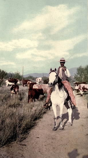
A Cowboy
Transcriber's Note:
Obvious typographical errors have been corrected. Inconsistent spelling and hyphenation in the original document have been preserved.
The Table of Contents for this book refers to it as Volume II. The Title Page and List of Illustrations refer to it as Volume III.
The Table of Contents for this volume refers to chapters ultimately published in a subsequent volume. Those chapter listings are retained, but the page number links are not active.
EDITION ARTISTIQUE
The World's Famous
Places and Peoples
AMERICA
BY
JOEL COOK
In Six Volumes
Volume III.
MERRILL AND BAKER
New York London
THIS EDITION ARTISTIQUE OF THE WORLD'S
FAMOUS PLACES AND PEOPLES IS LIMITED
TO ONE THOUSAND NUMBERED AND REGISTERED
COPIES, OF WHICH THIS COPY IS
NO. ____
Copyright, Henry T. Coates & Co., 1900
Volume II
| PAGE | ||
| VIII. | Around the Harbor of New York, | 3 |
| IX. | The Environment of Long Island Sound, | 89 |
| X. | Ascending the Hudson River, | 129 |
| XI. | A Glimpse of the Berkshire Hills, | 241 |
| XII. | The Adirondacks and their Attendant Lakes, | 271 |
| XIII. | Crossing the Empire State, | 329 |
| XIV. | Descending the River St. Lawrence, | 399 |
VOLUME III
| PAGE | ||
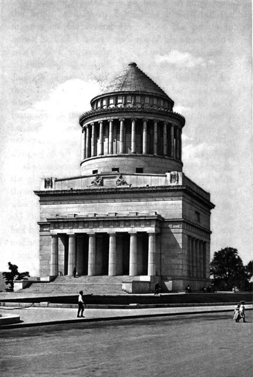
| Grant's Tomb, New York, | 58 | |
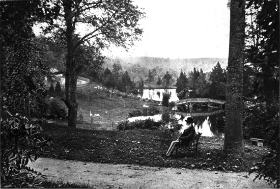
| William Cullen Bryant at "Cedarhurst," Roslyn, | 94 | |
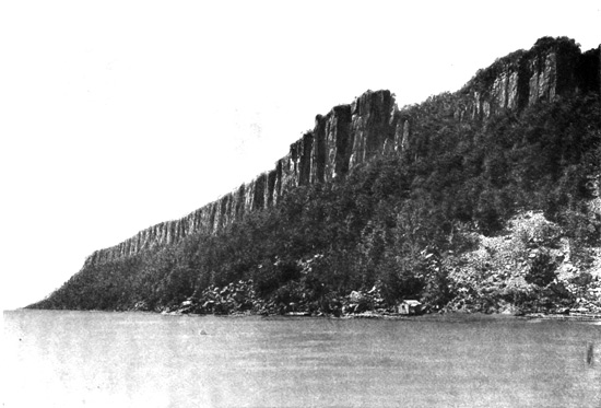
| Palisades of the Hudson, | 132 | |
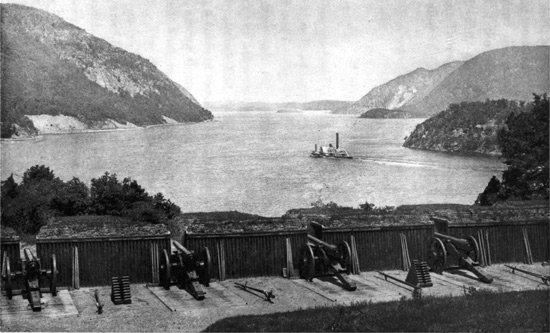
| Up the Hudson from the Water Battery, West Point, | 162 | |
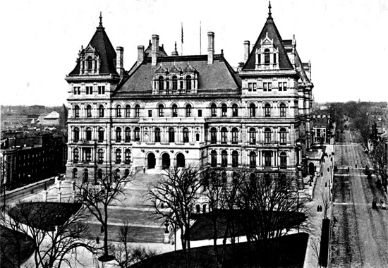
| State Capitol, Albany, N. Y., | 204 | |
AMERICA,
PICTURESQUE AND DESCRIPTIVE.
VIII.
AROUND THE HARBOR OF NEW YORK.
Hendrick Hudson—The Ship "Half Moon"—Manhattan Island—New Amsterdam—Hudson River—Fire Island—Navesink Highlands—Sandy Hook—Liberty Statue—Governor's Island—Jersey City—Hoboken—Weehawken—The Kills—Perth Amboy—Staten Island—New Dorp—Commodore Vanderbilt—Hackensack River—Passaic River—Paterson—Newark—Elizabeth—Rahway—Raritan River—New Brunswick—Battle of Monmouth—Molly Pitcher—Greater New York—Battery Park—Bowling Green—Broadway—Trinity Church—Famous and Sky-Scraping Buildings—Wall Street—National City Bank—St. Paul's Church—City Hall Park—Chemical Bank—Dry Goods District—Cooper Institute—Peter Stuyvesant—Union Square—Tammany Hall—Madison Square—Fifth Avenue—Washington Square—Little Church Around the Corner—Murray Hill—John Jacob Astor—Alexander T. Stewart—Fifth Avenue Architecture—The Vanderbilts—New York Public Library—Famous Churches—Jay Gould—Metropolitan Museum—Central Park—Museum of Natural History—Morningside Park—Riverside Park—Spuyten Duyvel Creek—Battle of Harlem Heights—Fort Washington—Morrisania—Croton Aqueducts—High Bridge—The Bronx—Van Cortlandt Park—Bronx Park—Pelham Bay Park—Hunter's Island—East River and its Islands—Hell Gate—Brooklyn Bridge—City of Churches—Brooklyn Development—Fulton 4 Street—Brooklyn Heights—Plymouth Church—The Beecher Family—Church of the Pilgrims—Pratt Institute—Greenwood Cemetery—Its Famous Tombs—Ocean Parkway—Prospect Park—Coney Island—Its Constant Festival—Brighton and Manhattan Beaches—View from the Observatory.
HENDRICK HUDSON.
The redoubtable navigator for the Dutch East India Company, Hendrick Hudson, after exploring Delaware Bay, sailed along the New Jersey coast and entered Sandy Hook, discovering, on September 11, 1609, the Hudson River. There is a vague tradition that the first European who saw the magnificent harbor of New York was the Florentine, Verrazani, who came as early as 1524. Hudson was searching for the "Northwest Passage," and when he steered his little ship, the "Half Moon," into the great river, with its swelling tide of salt water, was sure he had found the long-sought route to the Indies. He explored it as far up as the present site of Albany, creating a sensation among the Indians, who flocked to the shores to see the "great white bird," as they called the "Half Moon," because of its wide-spreading sails. He traded with them for tobacco and furs, finding the Lenni Lenapes on the western bank and the Mohicans on the eastern side, and to impress them with his prowess, put them in a great fright by shooting off his cannon. Upon returning from Albany, the Indians gave him a feast on an island, breaking their arrows in token that they 5 meant no treachery. Hudson had a goodly store of seductive "schnapps," and offered them some in return for their hospitality. They examined it closely, smelt it, but passed it along without tasting. Finally one, somewhat bolder, partook, and drinking a good deal, fell in a drunken stupor for several hours. When finally aroused he said the Dutchmen had the strongest water he had ever tasted, and the other Indians then became eager to try the fire-water too, and soon they were all under its influence, and thus became firm friends of the Dutch.
The scene of this great carousal is said to have been the island where is now the city of New York. The Indian word Man-a-tey means "the island," and from this they named the place Man-a-hat-ta-nink, the "island of general intoxication." Ticknor, in his guide-book, gravely tells us that "from the scene of wassail and merriment which followed the meeting of the sailors and the Indians, the latter called the island Manhattan, "the place where they all got drunk." Thus, at the beginning, this noted locality acquired a reputation which many attest as existing with undiminished lustre in maturer years. By way of variety in this connection, it may be related that Washington Irving, in Knickerbocker's veritable history of New York, has this to say: "The name most current at the present day, and which is likewise countenanced by the great historian Vander-Donck, is Manhattan, which is said to have originated in a 6 custom among the squaws, in the early settlement, of wearing men's hats, as is still done among many tribes. 'Hence,' as we are told by an old Governor, who was somewhat of a wag, and flourished almost a century since, and had paid a visit to the wits of Philadelphia, 'hence arose the appellation of man-hat-on, first given to the Indians, and afterwards to the island'—a stupid joke, but well enough for a Governor." Irving continues: "There is another, founded on still more ancient and indisputable authority, which I particularly delight in, seeing it is at once poetical, melodious and significant, and this is recorded in the before-mentioned voyage of the great Hudson, written by Master Juet, who clearly and correctly calls it Manna-hatta, that is to say, the island of Manna, or, in other words, 'a land flowing with milk and honey.'"
NEW AMSTERDAM AND ITS HARBOR.
About five years elapsed after Hudson's discovery before a colony was firmly fixed on Manhattan Island, which, when fairly started in 1614, was a little palisade fort and four small log houses. The Dutch called their possessions the Niew Netherlands, named the colony Nieu Amsterdam, and the land across the East River was known as Nassau, the earliest name of Long Island. Hudson was so impressed with the Highlands and the Catskills, which he passed in exploring the river, that he named it the "River of the 7 Mountains," but this was changed by the Dutch to Mauritius, in honor of Prince Maurice of Nassau. The Indians along the banks called the river Shatemuc and Cahohatatea. The English, shortly after the discovery, began calling it the Hudson River, but later, it was generally styled the North River to distinguish it from the Delaware or South River; and North River is the name now generally used in New York. The Manhattan colony was of slow growth, and the first Dutch Governor sent out was a Westphalian, Peter Minuit, a thrifty old fellow, who, by again making good use of "schnapps," bought the whole of Manhattan Island in 1626 from the Indians for beads and trinkets valued at sixty guilders, about $25. There were a thousand people there in 1644, making the original Dutch aristocracy of the "Knickerbockers," this name being adapted later from Irving, and they impressed their peculiarities upon the early city; but their descendants have largely given place to a newer aristocracy of wealth and an army of immigrants from all races. The last Dutch Governor, Peter Stuyvesant, arrived in 1647, and for protection the colonists had then built a fence across the island along what is now the line of Wall Street. An Indian scare a few years later caused this to be replaced with a wall of cedar palisades, and it ultimately developed into the city wall. Thus enclosed, the Mayor of New Amsterdam was required to walk around the walls every morning at sunrise, unlock 8 the gates and give the keys to the commander of the fort down at the Battery. When the Duke of York's English expedition came over in 1664 and overturned the government of old Stuyvesant, surnamed "Peter the Headstrong," and his Knickerbockers, at the same time changing the city's name to New York, it had three hundred and eighty-four houses, and in 1700 the population had increased to about six thousand. The first English Governor was Sir Edmund Andros.
The remote sources of the Hudson River are in Hamilton and Essex Counties, in the Adirondacks, in northeastern New York State, the highest at four thousand feet elevation above the sea, the head streams being outlets for a large number of highland lakes. The river flows over three hundred miles to the sea, and has few tributaries, the largest being the Hoosac and the Mohawk. Its lower course is a long tidal estuary, the tidal head being at Troy, from whence the fall in level to the ocean is only about five feet. The estuary below Manhattan Island expands into the noble New York harbor, enclosed between Long Island on the east and Staten Island on the west, the latter being the Indian Aquehonga, meaning the "high sandy banks." The harbor entrance from the sea, at Sandy Hook, is eighteen miles below the city. Inside Sandy Hook is the lower bay, of triangular form, extending nine to twelve miles on each side, the Narrows, a deep channel 9 about a mile wide at the northeastern angle, opening into the upper bay, which is an irregular oval, about eight by five miles. This extends northward into the Hudson River, westward into Newark Bay, and has the tidal strait of East River leading north to Long Island Sound, on the eastern side of Manhattan. Within the bays and rivers around New York there are over a hundred miles of available anchorage ground, and the Government is now making a channel to the sea through Sandy Hook bar, forty feet deep at low water.
ENTERING NEW YORK HARBOR.
The approach from the sea to Sandy Hook is first guided for the modern navigator by the flashing white light on Fire Island, a low sand-strip on the Long Island Coast; and then there rise in front the Highlands of the Navesink, on the Jersey Coast south of Sandy Hook, with a pair of twin lighthouses perched upon their green slopes. The Hook, a long strip of yellow sand enclosing the harbor, also has another lighthouse on its northern end. Here are the expanding works of a formidable fort defending the harbor entrance, and an artillery trial and proving ground. Behind the Navesink Highlands and the Hook, the Jersey shore of the lower bay stretches far back westward into Raritan Bay, thrust up into the land between New Jersey and Staten Island. The green hills of this island, crowned with villas, 10 make the northwestern boundary of the bay. To the right hand of the Hook, and north of the entrance, is the sand strip of Coney Island, with its stretch of hotels and buildings, the popular seashore resort of New York. Within the Hook is the lower Quarantine on the west bank of Romer Shoal, and over opposite is Gravesend Bay, behind Coney Island. The Narrows, where the Hudson has forced an outlet through a broken-down mountain range, is partly obstructed by an island reef of rocks. The hill-slopes, together with the island, are fortified, Forts Hamilton and Tompkins being on either hand, named after Alexander Hamilton and Daniel D. Tompkins, the latter having been a Governor of New York and Vice-President of the United States. On the island is the little red sandstone Fort Lafayette, where many famous political prisoners were confined during the Civil War. Within the Narrows the upper bay spreads out, the high Staten Island hills, covered with noble mansions, rising on the left hand, while on the right are the hamlets on the lower shores of Long Island, with the distant tombs of Greenwood Cemetery behind. The villages of Clifton and Stapleton and the Quarantine Station are on Staten Island, Stapleton being the yachting headquarters. Bedloe's and Ellis's Islands are passed, the latter being the landing-place of arriving emigrants, while on the former, now called Liberty Island, is the colossal Liberty Statue presented to the United States by 11 France in commemoration of the Centenary of the Declaration of Independence in 1876. This statue, designed by Bartholdi and erected ten years later, is a female figure holding aloft a torch—"Liberty enlightening the world." It is made of copper and iron, and weighs two hundred and twenty-five tons. The statue is one hundred and fifty-one feet high, and stands on a granite pedestal one hundred and fifty-five feet high.
Over on the western side, behind these small islands, the Jersey shore recedes, and the strait making the boundary of Staten Island, which the Dutch named the Kill von Kull, stretches around behind that island to Arthur Kill and sundry railway coal-shipping ports on its banks, where the great coal roads come out from the Pennsylvania mines. Just in the entrance to East River is Governor's Island, with an old-fashioned circular stone fort, called Castle William, and the more modern defensive work, Fort Columbus. On Governor's Island is the United States Army headquarters. This old Castle William, with another very similar circular fort, then called Castle Clinton, on the Battery at the lower end of Manhattan Island, were the defensive works of New York in the eighteenth century. Castle Clinton is now an aquarium. Red Hook, the jutting point of Brooklyn, is opposite Governor's Island, and above it the East River opens, the strait flowing between New York and Brooklyn, and connecting the harbor 12 with Long Island Sound, twenty miles distant, beyond the famous "Hell Gate," once the terror of the mariner, but since improved by costly rock excavations which have made a deep and safe channel. Through the East River and Hell Gate flows the greater part of the Hudson River tidal current. Both the East and North Rivers are lined on either side for miles by piers crowded with shipping, and the tall towers and ponderous cables of the Brooklyn Bridge rise high above the East River, while behind the foliage-covered Battery Park stretches the metropolis, with its many huge buildings.
JERSEY CITY AND STATEN ISLAND.
Communipaw, the lower end of Jersey City, is opposite the Battery, and above it the Jersey City front on the Hudson River is occupied for miles by railway terminals, making a succession of piers, ferry-houses and grain elevators. Originally Jersey City was the sandy peninsula of Paulus Hook, a tongue of flat farming land stretching down between the Hudson River and Newark Bay. The termination of this peninsula is Communipaw, long a sleepy village, originally granted to a Dutch West India Company Director—Michael Pauw. He was proud of this domain, of which he was the patroon, so he called it Pavonia or Communipauw, the "Commune of Pauw." His Dutch garrison massacred the Indians in the neighborhood, and soon afterwards, in retaliation, 13 they exterminated all the Dutch but one family. At Jersey City there come out to the Hudson River all the great Trunk Line railways from the West, with the single exception of the New York Central Railroad. In the Revolution, the site of the present Pennsylvania Railroad Terminal Station was a British fortification, which was partly stormed and captured, with a number of prisoners, in 1779, by Major Henry Lee. Jersey City is entirely a growth of the nineteenth century, at the beginning of which it had a population of only thirteen persons, living in a single house. It now has two hundred and fifty thousand, and is replete with important manufacturing establishments, its expansion having come from the overflow of New York and the wonderful development of its railway system. While spreading over much surface, yet it presents little attraction beyond the enormous railway terminals and factories. The traveller rarely stops there, but rushes through to get into or out of New York. To the northward is Hoboken, with sixty thousand people, including many Germans, and it has large silk factories. Here, in strange contrast with the commercial aspect of everything around, the river front rises in a bluff shore, crowned by a grove of trees and running up into a low mound, whereon is the "Stevens Castle." This was the home of Edwin A. Stevens one of the projectors of the Camden and Amboy Railroad. He endowed the Stevens Institute of Technology at Hoboken, 14 and spent his declining years and much of his railway fortune in building the "Stevens Battery," a noted warship, for New York harbor defense, which he bequeathed his native State of New Jersey, and that Commonwealth shortly afterwards sold it to be broken up for old iron. Beyond is the village of Weehawken, with the Elysian Fields, where Aaron Burr killed Alexander Hamilton in the duel of 1804, then a pleasant rural resort, but now largely absorbed by railway terminals. This duel arose from political quarrels, and at the first fire Hamilton received a wound from which he died the next day. Behind Jersey City rises the long rocky ridge of Bergen Hill, through which all but one of the railways cut their routes by tunnels or deep fissures, and its outcroppings above Weehawken come forward to the Hudson River bank in the grand escarpment of the Palisades. These remarkable columnar formations of trap rock extend for twenty miles along the western shore of the river, and in part appear to be built up of basalt. To connect the various railways terminating at Jersey City with New York, a tunnel is being constructed under the Hudson River; and two others, and also a gigantic bridge, are projected.
I have already referred to Staten Island, which is the western border of New York harbor, where its pleasant hill-slopes add so much to the scenic beauty. The narrow "Kills," stretching for nearly twenty miles down to Perth Amboy, make its western boundary, 15 separating the island, which is the Borough of Richmond in Greater New York, from New Jersey, to which by right it is said to belong. It covers about sixty square miles, with its diversified hill-slopes rising in some places to an elevation of over four hundred feet, and has probably seventy thousand population. It is shaped something like a leaf, hung, as it were, upon the long projecting peninsula between Newark Bay and New York harbor, the Kill von Kull stretching westward to divide it from this peninsula, which at that part is the town and port of Bayonne, running off into Bergen Point at the lower end of Bergen Hill. It was from Bergen Point that General Washington in 1787 was rowed in a barge to New York, to be inaugurated the first President of the United States. From Elizabethport, on the western side of Newark Bay, the Arthur Kill stretches, a narrow strait, far southward, broadening somewhat into Staten Island Sound, and debouching at Perth Amboy into the western end of Raritan Bay. Perth Amboy was the terminus of the original line of the Camden and Amboy Railroad. It was the capital of the Colonial Province of New Jersey two centuries ago, and its eligible position at the confluence of Staten Island Sound and the Raritan River and Bay, the point of union of the various interior water ways, made it at that early period very ambitious. In fact, "Perthtown, or Ompoge on Ambo" (the Indian name for the point, which meant "round and hollow"), 16 then rivalled New York in commercial importance. Its name came from the Earl of Perth, one of the grantees of lands in East Jersey. Early travellers flocked thither, praising its merits; and even William Penn was persuaded to go over and look at it, oracularly declaring, "I have never seen such before in my life," whatever that might have meant. But New York, with its great harbor, ultimately overshadowed Amboy, and it has since dropped out, even as a way-station on the route between the two leading cities. It has about fifteen thousand inhabitants, and its trade chiefly consists in shipping coal and fire-clay, brought out by the railroads.
The loyal Jerseyman will never forgive New York for having captured Staten Island. After the English came to New York in 1664, under the grant of King Charles II. to the Duke of York of all the country from Canada down to Virginia, the Duke granted to Berkeley and Carteret the portion lying between the Hudson and Delaware Rivers. This grant grieved the New Yorkers, for they said it gave away the best lands around their harbor, so they tried to get it all back, and managed to capture Staten Island. Some sharp fellow invented the fiction, on which they resolutely insisted, that the Arthur Kill was really the Hudson River; and, taking possession, they never gave it up. A legal contest was fought for over one hundred and fifty years, and it was not 17 until 1833 that a treaty between the two States declared the Kills to be their boundary. Staten Island is about sixteen miles long, and from its eastern slopes has a noble outlook over the Lower New York Bay towards the ocean. Fine beaches line these coasts, which rise sharply into hills inland, and most of the eligible sites are crowned with villas. It was at Stapleton, on Staten Island, that Commodore Cornelius Vanderbilt, the head of the great family, was born in 1794, and he laid the foundation of his great fortune, at the age of sixteen years, by sailing a ferryboat to New York, six miles away. Upon a plateau in the centre of the island is the village of New Dorp, the original settlement of the Vanderbilts, a farm of about four hundred acres. Here the Commodore came in his youth, and here his son, William H. Vanderbilt, was born and lived for many years, an agricultural laborer for his father. Here also is a little Moravian church they attended, and upon a terraced hill behind it, the highest part of the island, is the spacious gray granite mausoleum, within which rest the two great millionaires, father and son, with some of their children. In the old churchyard are the graves of many other Vanderbilts and their collaterals. At Port Richmond, over on the Kill, the most considerable town on the island, and formerly the county-seat, is the house, now a hotel, in which Aaron Burr died in 1836. 18
SOME NEW JERSEY TOWNS.
Westward from Bergen Hill and the Palisades are the meadows which stretch down to Newark Bay, and meandering through them to form it are the Hackensack and Passaic Rivers. The name of Hackensack means, in the original Indian dialect, the "lowlands," and it was given by them also to the channel around Bergen Point, by which the waters of Newark Bay reach New York harbor. This river drains the western slopes of the Palisades. Passaic means "the valley," and the name seems to have referred to the country through which that stream flows. The Passaic River, which is ninety miles long, comes from the mountains of Northern New Jersey and flows a tortuous course to Paterson, fifteen miles northwest of Jersey City, where there is an admirable water power which has created a manufacturing town of over one hundred thousand people, having extensive silk and cotton mills and locomotive factories. The river describes a curve, forming the boundary of the city for more than nine miles, on all sides excepting the south, and its rapids and falls descend seventy-two feet, the falls being a most picturesque cataract with fifty feet perpendicular descent. The town was named after Governor William Paterson of New Jersey, who signed its incorporation act July 4, 1792, the manufacturing corporation projecting it having been formed under the auspices of Alexander Hamilton. 19
The Passaic flows onward past Newark nine miles west of Jersey City, another extensive and prosperous manufacturing city of two hundred and fifty thousand inhabitants, turning out goods of all kinds with an annual value of over $100,000,000. This city spreads far across the flat surface above Newark Bay and adjoining the Passaic, and to the northward its suburbs run up into the attractive hills of Orange. Market Street is a fine highway through the business section, while a large area is covered by comfortable and handsome residences, among which passes Broad Street, its finest avenue, one hundred and thirty-two feet wide, shaded by majestic trees, bordered with many ornamental buildings, and skirting three attractive parks embowered with elms. Newark is a great iron and steel centre, makes fine jewelry, good carriages and excellent leather, and also brews much lager beer. Yet few would suppose it had a strictly Puritan origin. In 1666, hearing the praises of East Jersey, a body of discontented men of Connecticut, headed by their pastor, Abraham Pierson, journeyed to the Passaic meadows and bought these lands from the Hackensack Indians "for one hundred and thirty pounds, twelve blankets and twelve guns." In early life the pastor had preached at Newark in England, for which he had quite an affection, and he gave the Jersey settlement its name. When Philadelphia was founded, the fame of Newark spread down there as a producer of excellent cider and seductive Jersey 20 apple jack. Its most famous son of modern times was General Phil Kearney.
Five miles beyond Newark the diminutive Elizabeth River flows down to the Kills, and here is the city of Elizabeth, with fifty thousand people, noted as one of the handsomest of the Jersey towns. Like Newark and Paterson, it is really an outlying suburb of New York, providing homes for much of the overflow of population, who rush into the metropolis for business every morning, and back again every evening. Under the name of Elizabethport it spreads down to the Arthur Kill, and over there are most of its factories and extensive coal-shipping piers. The original settlement dates from 1665, when it was named in honor of Lady Elizabeth, wife of Sir George Carteret, one of the grantees of East Jersey. The early inhabitants were largely Puritans, and its chief establishment is the extensive works of the Singer Sewing Machine Company. Here was founded the College of New Jersey, afterwards removed to Princeton, and a tablet marking the original site was unveiled in 1897. A few miles beyond, another little river flows down to the Kills, first named after old Rahwack, the Indian sachem whose tribe owned the land thereabouts, and here is another thriving town, Rahway, which is noted for its carriages. At Menlo Park, nearby, the electrical inventor, Thomas A. Edison, sustained by New York capital, toiled for years in seclusion to perfect his discoveries, and developed 21 the germ that has grown to such vast proportions. The "Wizard of Menlo Park" afterwards located his chief laboratory and his home at Newark. Then, crossing what are known as the "Short Hills" westward, past many villages, among them Metuchen, once the domain of Metuching, the Indian "King of the Rolling Land," we come to the Raritan River, thirty-one miles from Jersey City.
Here debouches the Delaware and Raritan Canal at New Brunswick, a city of twenty-five thousand people. The Raritan flows through the red shales and sandstones of Central New Jersey, generally a chocolate-colored stream, and goes off to form Raritan Bay, fifteen miles below. Factories cluster on the New Brunswick lowlands along the river and canal, but there is a handsome town built upon the higher grounds, encircling the lower and older portions like a crescent. The Dutch came here from the Hudson River early in the eighteenth century and found a village which had been started by some fishermen from Long Island. They organized the town, naming it in honor of the Ducal House of Brunswick. Its most prominent feature is Rutgers College, housed in red sandstone buildings upon attractive grounds, alongside the railway, a venerated foundation of the Dutch Reformed Church, originally chartered by King George III. as "Queen's College," but afterwards receiving the name of Rutgers from a benefactor in 1826. It has an important adjunct 22 in the New Jersey Agricultural College. There is also the Dutch Reformed Theological Seminary, the first established in America, and dating from 1771, its main building, also named from its chief benefactor, being Hertzog Hall. An early traveller, visiting New Brunswick in 1748, described it as "a pretty little town with four churches;" and these quaint buildings are still there, the ancient Christ Church being surrounded with the graves of the first settlers. Eighteen miles to the southeast the Revolutionary battle of Monmouth was fought in June, 1778, and a monument commemorates it at Freehold (Monmouth Court-house). Sir Henry Clinton, having evacuated Philadelphia, was marching towards New Brunswick, intending to embark on the Raritan for New York. Washington, coming from Valley Forge in pursuit, gave him battle. The day was very hot, and the result was an uncertainty, General Charles Lee's misconduct, for which Washington reprimanded him on the field, preventing a victory, and at night the British withdrew quietly. Lee was afterwards court-martialed and suspended from command for a year. Monmouth was the scene of "Molly Pitcher's" famous exploit. She was Mary Hays of Carlisle, Pennsylvania, wife of John Hays, a soldier in the First Pennsylvania Artillery. Molly was with the army, and engaged in bringing water to the battery, which was behind a hedgerow, her husband managing one of the cannon. The British made a charge, 23 and a shot killing him, the officers, having no one to manage the gun, ordered it withdrawn. Molly saw her husband fall and heard the order; dropping her bucket, she seized the rammer and served the gun with skill and dexterity. Next morning General Greene presented her to General Washington, who conferred upon her the office of Sergeant. She afterwards lived at Carlisle Barracks, and died there in 1823.
GREATER NEW YORK.
The Dutch city of New Amsterdam, which became New York by the English conquest in 1664, was of slow growth. It had hardly more than twenty thousand inhabitants at the time of the Revolution, being less than either Boston or Philadelphia, and a map made in 1767 shows that the town scarcely extended beyond Wall Street. At the beginning of the nineteenth century there were sixty thousand people, and its rapid growth began through large immigration after the War of 1812, and was stimulated by the completion of the Erie Canal in 1825, which gave it greatly increased foreign trade. By the new Charter of "Greater New York" coming into operation in 1897, the city was made, next to London, the largest in the world, being expanded beyond Manhattan Island, so as to include all the outlying cities. It now consists of five boroughs, Manhattan, the Bronx, Brooklyn, Queens and Richmond, having an area of three hundred and twenty square miles, and a population 24 exceeding three and one-half millions. If Jersey City and the other New Jersey settlements on the west side of the Hudson were added, the population would be four millions. This great city is about thirty-five miles long from north to south, and nineteen miles wide. The long and narrow island of Manhattan stretches thirteen miles, while it is not much over two miles broad in the widest part, and sometimes narrows to a few hundred yards, particularly in the northern portion. The Harlem River and the winding strait of Spuyten Duyvel separate northern Manhattan from the mainland. The island is very rocky, excepting the southern part, which is alluvial, and at the upper end the cliffs rise precipitously from the Hudson over two hundred and thirty feet into Washington Heights, and the surface descends sharply on the eastern side to the Harlem flats. It does not take the visitor long to recognize, however, that the capacious harbor, the converging rivers and numerous adjacent arms of the sea combine all the requisites of a great port, and they could not have been better planned if human hands had fashioned them. There is a vast wharf-frontage, for over fifty miles of shore-line are available for shipping, thus accommodating an almost limitless commerce. This has made the metropolis and continues its wonderful growth.
At the lower end of Manhattan is the Battery Park, of about twenty acres, with the elevated railways 25 coming over it from both sides of the city, and joining at the lower point of the island in a terminal station at the South Ferry. Here were located the old forts for the city defense, but the park superseded them after the War of 1812, and in the earlier years of the nineteenth century this was the fashionable resort for an airing. The old circular fort, Castle Garden, now the Aquarium, was formerly a popular place of amusement, and here, under the auspices of the great manager, Barnum, Jenny Lind made her first appearance in America in 1850. The Park contains a statue of John Ericsson. The lower point of the island is Whitehall Slip, and here is the Government Barge Office, an appanage of the Custom House. To the northward of the Battery is the Bowling Green, the space between them having been the site of the original Dutch palisade fort which guarded New Amsterdam. A row of fine residences was built here, which afterwards became the favorite locality for steamship offices, and the new Custom House is now being constructed on their site. This Bowling Green, a triangular space of about a half-acre, was in the early days surrounded by the homes of the proudest Knickerbockers. For seven years during the Revolution, and until the evacuation, November 25, 1783, this was the British headquarters. Here lived Cornwallis, Howe and Clinton, Benedict Arnold occupied No. 5 Broadway, and Washington's headquarters was in No. 1, on the west side, now occupied 26 by the towering Washington Building, rising nearly three hundred feet to the top of the cupola. To the eastward is the spacious Produce Exchange, in Italian Renaissance, with its huge square tower, part of the ground on which it stands having been the site of the house where Robert Fulton lived and died. Talleyrand also once lived on Bowling Green. In the centre is the statue of Abraham de Peyster, an original Knickerbocker, erected in 1895. There was a leaden statue of King George III. here at the opening of the Revolution, but it was pulled down when the Declaration of Independence was promulgated in 1776, carried to Litchfield, Connecticut, and melted into bullets for the Continental soldiers, so that it was facetiously said at the time that "King George's troops will probably have his melted Majesty fired at them."
BROADWAY.
The two smaller streets on either side of the Bowling Green, Whitehall and State Street, unite to the northward and form Broadway. This is the chief highway of New York, and one of the most famous in the world, extending in various forms all the way to Yonkers, a distance of nineteen miles. The long and narrow formation of Manhattan Island puts Broadway longitudinally in the centre of the city, and necessarily throws into it an enormous traffic. One can hardly make any extended movements in New York without getting into Broadway. Hence the noted 27 street has its show, always on exhibition, of the restless rush of life in the modern Babylon. The architecture of its great buildings, which tower far skyward, excites admiration, and its perpetual din of traffic, with the moving crowds and jam of vehicles, is the type of New York activity. This wonderful street is eighty feet wide between the buildings, and extends of that width from the Bowling Green five miles to Central Park at Fifty-ninth Street; and from its upper end, beyond this, the "Grand Boulevard," one hundred and fifty feet wide, with pretty little parks in the centre, is prolonged northward. In its course, which inclines somewhat to the westward, Broadway diagonally crosses Fifth, Sixth and Seventh Avenues, and at the Central Park boundary intersects Eighth Avenue. Here is the "Merchant's Gate," entering the Park from Broadway, the opposite entrance from Fifth Avenue being known as the "Scholar's Gate." The intermediate entrances at Sixth and Seventh Avenues are the "Artist's Gate" and the "Artisan's Gate."
A survey of Broadway gives the best idea of the characteristics of New York. Its lower course is a succession of wealthy financial and business establishments and huge office buildings, and the adjacent streets on either side are similarly occupied. Banks, trusts, insurance offices, and manufacturers' and merchants' counting-rooms, railroad and steamship offices are everywhere. But in the midst of all this 28 display of worldly wealth and grandeur is the quiet graveyard at the head of Wall Street, wherein stands the famous Trinity Church. Its chimes, morning and evening, summon the restless brokers and business men to attend divine service, though few may take heed. It is a wealthy parish, with over $500,000 annual revenue, maintaining a magnificent choir and various charities, and owns valuable buildings all about. The old graveyard stretches along Broadway, and in Church Street, behind, the elevated railway trains rush by every few minutes. It is part of the valuable domain of Trinity Church that "the heirs of Anneke Jans" have long been trying to recover. Anneke Jans Bogardus was an interesting Dutch lady who died in Albany in 1663, having outlived two husbands. The first husband owned the whole of the Hudson River front of New York between Chambers and Canal Streets, with a wide strip running back to Broadway. Her heirs sold this to the British Colonial Government, and it was known as the "King's Farm," being afterwards given as an endowment to Trinity Church. This is what the present generation of heirs want to recover, but thus far have gained more notoriety than cash by the effort.
In 1696 the first Trinity Church was built, being afterwards burnt, while a second church was built and taken down, to be replaced by the present fine Gothic brownstone edifice, whose magnificent spire 29 rises two hundred and eighty-four feet. This church was dedicated in 1846, and its chancel contains a splendid reredos of marble, glass and precious stones, the memorial of William B. Astor, while the bronze doors are a memorial of his father, John Jacob Astor. The churchyard is chiefly a mass of worn and battered gravestones, resting in the busiest part of New York, the oldest stone being dated 1681, for it has been a burial-place more than two centuries. Near its northern border is the Gothic "Martyrs' Monument," erected over the bones of the patriots who died in the British prison-ships, moored over on the Brooklyn shore during the Revolution. There are hints, however, that it was not so much the reverent memory of these heroes that prompted the erection of the monument as the desire of the vestry to stop the proposed opening of a street through the yard. There is also a remembrance that, while these patriots were in prison dying, among their relentless foes was the Trinity rector, Dr. Inglis. When General Washington came into New York in 1776 he desired to worship at the church, and sent an officer to Dr. Inglis, on Sunday morning, to request that he omit reading the usual prayers for the king and the royal family. The rector refused, and afterwards said: "It is in your power to shut up the churches, but you cannot make the clergy depart from their duty." Among the noted graves is that of Charlotte Temple, under a flat stone, having a cavity out of 30 which the inscription plate has been twice stolen. Her romantic career and miserable end, resulting in a duel, have been made the basis of a novel. William Bradford's grave is here, one of Penn's companions in founding Philadelphia; but he removed to New York, published the first newspaper there, and for fifty years was the official printer. A brownstone mausoleum covers the remains of Captain James Lawrence of the frigate "Chesapeake," killed in action in 1813, when his ship was taken by the British ship "Shannon," his dying words being, "Don't give up the ship." Here also are buried Alexander Hamilton, Robert Fulton, Albert Gallatin and other famous men, almost the latest grave being that of General Philip Kearney, killed in the Civil War.
SOME FAMOUS BUILDINGS.
The great number of immensely tall office-buildings on lower Broadway, literally "sky-scrapers," so encompass the street as to give it the appearance of a deep canyon as one gazes along it between them. The Bowling Green Building out-tops the Washington Building, and there are the Welles, Standard Oil and Aldrich Court Buildings, the latter marked by a tablet of the Holland Society, being erected on the site of "the first habitation of white men on Manhattan Island." Opposite it is one of the most curious appearing of these tall structures, the Tower 31 Building, nearly two hundred feet high and only twenty-five feet wide. Just above, the tall light sandstone building of the Manhattan Life Company is surmounted by a cupola three hundred and fifty feet high. The Empire Building rises twenty stories, and the American Surety Building at the corner of Pine Street, nearly opposite Trinity churchyard, twenty-three stories, three hundred and six feet, being surmounted by the various weather-gauging instruments of "Old Probabilities." Here are also the magnificent buildings of the Union Trust and the Equitable Life Companies.
Opposite Trinity Church, Wall Street leads off from Broadway, with winding course and varying width, down to the East River, following the line of the ancient Dutch palisade wall which it has replaced. Here is the financial centre and the domain of the bankers. One block down, Broad Street enters from the south, and the narrower Nassau Street goes out to the north. At this corner, on the one hand, is the white marble Drexel Building, Mr. J. Pierpont Morgan's office, and on the other the United States Treasury and Assay Office. The huge Manhattan Trust Building also is there, rising three hundred and thirty feet, and opposite is the Stock Exchange, while across Broad Street from the latter is the Mills Building, the home of many bankers and brokers. In Nassau Street is the magnificent building of the Mutual Life Insurance Company. These financial 32 structures at Broad and Wall Streets are regarded as the most valuable real estate in the world. The Treasury and Assay Office contain most of the gold owned by the Government, and in the latter the kegs of gold are made up that are shipped to Europe. It holds millions of gold bars that make annual excursions in fast steamers across the ocean and back again, to adjust our varying foreign exchange balances. The Treasury is a white marble building fronted by an imposing colonnade and a broad flight of steps, and here is a bronze statue of Washington on the spot where he was inaugurated the first President of the United States in 1789, the location being then occupied by the old Federal Hall, where the first Congress met. Farther down Wall Street, the next corner is William Street, where there is a massive dark granite building with an elaborate Ionic colonnade. The interior contains a large rotunda surmounted by a dome supported by eight immense columns of Italian marble. This building was originally constructed for the Merchants' Exchange, and it afterwards became the Custom House. It is hereafter to be the office of the National City Bank, the largest financial institution of New York. Wall Street goes on to the river, where there is a ferry to Brooklyn. Down William Street is the broad, low, granite building, with a columned portico, of the Farmers' Loan and Trust Company, another financial institution of renown. 33
It is evident, as Broadway is traversed northward between the huge office-letting structures, reared skyward, and among them the little, narrow, crooked streets, pouring their traffic into the main stream, carrying a vast, surging mass of humanity, that the crowded-in New Yorker, deprived of lateral expansion, thus seeks needed relief by mounting upward. Fulton Street here stretches across the island from river to river, the turmoil from its conflicting streams of traffic showing the full tide of restless development in lower Broadway. Above is the white marble Park Bank and the enormous St. Paul Building, rising three hundred and eight feet, twenty-six stories high. Opposite is the sombre church of St. Paul, with a tall spire, the oldest church-building in New York, built in 1756, containing the memorial of General Montgomery, who fell at the storming of Quebec in 1775, and in the graveyard a monument to Emmet, the Irish patriot. Just beyond is the triangular City Hall Park, with Park Row diagonally entering Broadway. Here can be got an idea of the rush and restlessness of New York, for two enormous streams of traffic pour together into lower Broadway, at probably the worst street-crossing in the world.
THE CITY HALL PARK.
The New York City Hall Park was the ancient "Commons," or public pasturage, and it now contains the headquarters of the city government, and 34 may be regarded as the political and business centre. It is enclosed by Broadway, Park Row and Chatham Street, a triangular space, formerly a sort of garden around the City Hall, but now well occupied by other buildings. At the southern extremity is the Post-office, which cost $7,000,000, a grand granite structure in Doric and Renaissance, with a fine dome and tower, which are a landmark for miles. Around this Park, and in the many streets radiating from it, are a vast aggregation of corporate institutions and great buildings devoted to all kinds of business. Here are the offices of newspapers, banks, trusts, insurance companies, railways, lawyers, politicians, exchanges, etc., with lunch-rooms and restaurants of every grade, liberally provided to feed or stimulate the multitude. The famous hotel of a past generation, the Astor House, rich in historical associations, stands on the opposite side of Broadway from the Post-office. Along Park Row are the great newspapers, and here is Printing House Square, adorned with statues of Benjamin Franklin and Horace Greeley, appropriate in this region deluged with printer's ink. Here is the Ivins Syndicate Building, finished in 1898, the loftiest structure in New York, twenty-nine stories, its towers rising three hundred and eighty-two feet. The tall and narrow Tribune Building, of red brick with white facings, has its clock tower reared two hundred and eighty-five feet, while beyond is the Pulitzer Building, of brownstone, 35 with a gilded dome, its apex rising three hundred and seventy-five feet. The building of the American Tract Society on Nassau Street is twenty-three stories and three hundred and six feet high, with a restaurant on the top. Park Row runs into Chatham Square, over which the Brooklyn Bridge terminal comes out, with elevated and surface railroads all about. This is a location of cheap shops and concert halls, and is prolonged into the Bowery, an avenue of the humbler classes, lined with shops, theatres and saloons, generally crowded, and having four sets of street cars running on the surface, besides the elevated roads above. The ancient Dutch farms on this part of the island were known as the "Bauereies," whence came the name of the street.
Chambers Street bounds the City Hall Park on the north, and upon it faces the Court-house, a massive Corinthian building of white marble, finished in 1867, famous as the structure which the "Tweed Ring" of that time used to extract about $15,000,000 from the city treasury on fraudulent bills, or more than five times the actual cost of the work. It stands on part of the site of an old fort, which in the Revolution was the British outpost commanding the approach to the city by the Northern or Bloomingdale Road, now Broadway. The City Hall, to the southward, is a less pretentious and much older building, constructed in the Italian style, of white marble with freestone at the back to the northward, it being supposed 36 at the time of its completion, 1812, that "no one of importance would ever live to the north of the building," then a broad expanse of farms. Here is the office of the Mayor and the meeting-place of the Board of Aldermen, and its chief apartment is the "Governor's Room," adorned with portraits of various Governors of New York and Revolutionary patriots, and having among its treasures Washington's desk and chair which he used when first President of the United States, and also the chairs of the First Congress. To the southwest of the City Hall a fine statue of Nathan Hale, an early victim of the Revolution, executed by the British in New York in 1776, faces Broadway.
Near Chambers Street and the northern end of the Park a noted building stands on the opposite side of Broadway, a modest brownstone structure without any pretension nor of much height, but containing a famous bank, whose phenomenal success is everywhere known. This is the Chemical Bank, originally started as a chemical manufacturing company with banking privileges. The chemistry seems to have been a failure and soon abandoned, but the banking talents were so well developed that the shares of $100 par value have sold for over forty times that sum. The capital is only $300,000, but it has amassed a surplus over twenty times the amount, and is the strongest bank in New York. Among the large shareholders are said to be three 37 New York ladies who married foreign titles—the Dowager Duchess of Marlborough (who was Miss Pine, afterwards Mrs. Hamersley, and now Lady Beresford), the Duchess de Dino (Miss Sampson), and the Comtesse de Trobriand (Miss Jones). It is here that the noted Mrs. Hetty Green generally conducts her financing, a lady of immense fortune and peculiar ideas, who has been one of the greatest money accumulators of New York. Across Chambers Street, and occupying an entire block, is the building that originally was "Stewart's Store," where the late Alexander T. Stewart made most of his success in the dry-goods trade, now converted into a vast office building for all kinds of business. This was the outpost of the "Dry Goods District," for Broadway northward for several blocks, including a wide belt of adjacent streets, now deals with all kinds of products of the mill and loom, clothing and similar articles. Here are located the agents and factors for many mills at home and abroad, and their traffic sometimes exceeds a thousand millions of dollars a year. The pulse of the American dry-goods trade throbs in this locality, weakening or strengthening as poor or good crops give the farmers and working-people a surplus to spend upon dress. Mr. Stewart once said that if every woman decided to pass a single season without a new bonnet it would sufficiently diminish trade to bankrupt this whole district. Canal Street crosses New York through the northern portion of the district, 38 a broad highway, formerly a water course draining an extensive swamp across Broadway to the Hudson River. In this locality, east of Broadway, are two famous regions—the "Five Points," now, however, much improved, and "Chinatown." The latter, in Mott Street, has its Joss House, restaurant, theatre and opium joints, and is picturesque with swinging lights and banners. In Leonard Street, standing where once was part of the swamp, is the noted Tombs City Prison, thus named because originally it was a sombre gray building in the gloomy Egyptian style, but this was recently replaced by a modern structure. The Criminal Courts adjoining are connected with it by a bridge.
PETER COOPER AND PETER STUYVESANT.
At Bond Street, in advancing up Broadway, are encountered the booksellers, this with adjacent streets being the home of much of that trade. In Lafayette Place is the spacious Astor Library, and in the wide Astor Place is the handsome new building of the Mercantile Library. The former is now a part of the New York Public Library. A half-century ago the site of the Mercantile Library was occupied by the "Astor Place Opera House," then a leading theatre, and in the adjacent streets occurred the "Macready riots" in 1849. The rivalries of Edwin Forrest and Macready resulted in an effort by the partisans of the former to prevent the latter from playing in the Opera 39 House on the night of May 10th. The Forrest faction attacked the building with stones, and the police being unable to control them, troops were called out, and, firing several volleys along Astor Place, they suppressed the riot and dispersed the mob, but at a cost of about sixty killed and wounded. At the end of Astor Place and its junction with Third Avenue is the Cooper Institute, occupying an entire block, a large brownstone building with a fine front, founded and endowed in 1857, at a total cost of about $1,000,000, by Peter Cooper, for the free education of men and women in science and art. His statue stands in front. It also received in 1900 additional gifts from his executors and $300,000 from Andrew Carnegie. Peter Cooper was a wealthy manufacturer and merchant of the broadest philanthropy. At a recent anniversary of the Institute his son-in-law, Abram S. Hewitt, speaking of him, said: "Fifty years ago three men, all of whom started in life as poor boys, got together and talked over various ways by which they could be of benefit to the public. They were Peter Cooper, Ezra Cornell and Matthew Vassar. The latter said he would found a school for girls, and he founded Vassar College. Mr. Cornell said he would found a school for boys, and he founded Cornell University. Peter Cooper said he would found a school for both girls and boys, and he founded Cooper Union. But Mr. Cooper's school differs from the others, in that here, any boy or girl may receive 40 an education absolutely free of charge." Opposite the Cooper Institute is an immense red building, the "Bible House," the home of the American Bible Society, where the Scriptures are printed by the millions, in all languages, for distribution throughout the world—over eighty different languages and dialects being used.
Diagonally northeast from Astor Place runs Stuyvesant Street, formerly the country lane leading out to the ancient farmhouse of old Governor Stuyvesant, surnamed "Peter the Headstrong." Here was built "St. Mark's Church in the Bowerie" in the last century, then a mile out of town, and the quaint little Stuyvesant House still stood, at that time, perched on a high bank near the church, having, with its odd-looking overhanging upper story, been built of small yellow bricks brought out from Holland. In the days of New Amsterdam this region was Governor Stuyvesant's "Bauerie," and to it he retired when compelled to surrender to the English in 1664. He lived in this secluded spot for eighteen years, dying in 1682, and his brown gravestone occupies a place in the wall of the church. He was the last of the Dutch Governors, energetic, aristocratic and overbearing, and described by Irving as a man "of such immense activity and decision of mind that he never sought nor accepted the advice of others;" Irving further saying that he was a "tough, sturdy, valiant, weather-beaten, mettlesome, 41 obstinate leather-sided, lion-hearted, generous, spirited old Governor."
Returning to Broadway, for a mile or more it, with the adjacent streets, is the great retail shopping district. Here on the pleasant afternoons are throngs of shoppers. A short distance above, Broadway bends to the left, displaying Grace Church, with its rich marble façade, beautiful spire, and adjoining rectory, chantry and church house, an unique ecclesiastical group, dating from 1846, when it was far "up town," but now almost covered-in by the huge surrounding stores. Fourteenth Street crosses beyond, and here is Union Square, a pretty oval park of about four acres, adorned by an ornamental fountain and statues of Washington, Lafayette and Lincoln. Large buildings and stores surround the square, the chief being Tiffany's noted jewelry establishment. Fourteenth Street is a wide avenue, with an extensive shipping trade. To the eastward of Broadway is the Academy of Music and the noted Tammany Hall. This is the seat of the "Tammany Society," established in 1789 for benevolent purposes, but now controlled by the Democratic political organization ruling New York. The Hall is a capacious brick structure with stone facings, surmounted by a statue of its presiding genius, the old chief and warrior of the Lenni Lenapes, St. Tammany, who with outstretched hand beneficently looks down upon the street. The sturdy Indian, however, was probably more used to the mild and just methods 42 of William Penn and his Quakers on the Delaware than to the political schemes on the Hudson, of which fate seems to have made him a patron saint.
MADISON SQUARE.
Broadway reaches Madison Square at Twenty-third Street, another wide highway crossing the city, and also intersects Fifth Avenue, which is the western side of the Square. This junction has a park of about six acres, surrounded by large hotels and noted buildings, and alongside the triangular intersection of Broadway and Fifth Avenue is a handsome granite monument to General Worth, a hero of the War with Mexico. The plateau on which it stands is usually availed of as the site for the official reviewing stage for processions. This Square is the great centre of elaborate civic and military displays, and has, with its surroundings and the light stone of the adjacent buildings, an air that is decidedly Parisian, it occupying much the same position for New York as the Place de la Concorde in Paris, or Trafalgar Square in London. In Madison Square are statues of Admiral Farragut (the finest statue in New York), William H. Seward, President Arthur and Roscoe Conkling. At the northwest corner of the Square was for many years Delmonico's famous restaurant, since moved farther up town. Its owner, after feeding wealthy New Yorkers on the choicest viands for several decades, finally lost his mind, and in a fit of aberration 43 wandered over into the wilderness in New Jersey, and becoming lost in the woods, actually died of starvation. The new Appellate Court of New York is on the eastern side of the Square; at the northeast corner is the Madison Square Garden, and at the southeast corner the Madison Square Presbyterian Church, where the great clerical censor of New York, Rev. Dr. Parkhurst, occupies the pulpit. Madison Square may be regarded as the social centre of modern New York. Far to the northward Fifth Avenue stretches, with its rows of palatial brownstone residences, and towards the north-northwest Broadway extends for two miles to Central Park, passing many hotels, theatres, and the tall "French flats" that have been devised for residences in the crowded city where the land surface is so scarce. It also passes, at the intersection of Sixth Avenue, the Greeley and Herald Squares, with statues of Horace Greeley and William E. Dodge, and the New York Herald Building. A short distance beyond is the Metropolitan Opera House, the finest theatre in the city, rebuilt after a fire in 1893. Broadway at Fifty-ninth Street reaches the southwest corner of Central Park and intersects Eighth Avenue, and here is the Columbus Monument, a tall shaft surmounted by a marble statue, erected in 1892. Broadway then becomes the magnificent "Grand Broadway Boulevard," with rows of trees, prolonged far northward. 44
FIFTH AVENUE.
Fifth Avenue, one hundred feet wide, is probably the New York street that is most talked about, for they say the main object of working so hard to get rich in the metropolis is to be able to live in a fine mansion on Fifth Avenue. This great highway extends northward almost in the centre of Manhattan Island, but it has an humble beginning, starting from the original "Potter's Field," where for many years the outcast and the unknown were buried and over a hundred thousand corpses are believed to have been interred. When the city spread beyond this cemetery it was decided to make the place a park, and thus was formed Washington Square on Fourth Street, a short distance west of Broadway, an enclosure of about nine acres. From this Square Fifth Avenue is laid in a straight line six miles northward, to the Harlem River. The fine Washington Centennial Memorial Arch spans the avenue at the southern end, near the Square, marking the Centenary of Washington's inauguration as President. In the lower portions the famous avenue has been largely invaded by business establishments, but above, it is the finest residential street in the world, there being four or five miles of architectural magnificence, in which for two miles it borders Central Park. The street displays the best dwelling and church architecture, the progress northward into the newer portion 45 showing how the styles have changed. All railways have been carefully excluded from this street. At the southern end the older houses are generally of brick, gradually developing into the use of brownstone facings, and then into almost uniform rows of elaborate brownstone buildings, with imposing porticos reached by high and broad flights of steps. The rich yet gloomy brown is somewhat monotonous, but as Central Park is approached this is broken, as all styles of designs and materials are used. Fifth Avenue has the great "Methodist Book Concern" at Twentieth Street, and in this neighborhood are also several of the leading book houses. The wealthy and exclusive Union Club is at Twenty-first Street, with the Lotus Club in a more modest house adjacent.
Northward from Madison Square the great street stretches up the aristocratic grade of Murray Hill, with its rows of stately buildings. Parallel and a short distance eastward is Madison Avenue, also a street of fashionable residence, and second only to Fifth Avenue in grandeur. At Twenty-ninth Street is the plain and substantial granite Dutch Reformed Church, and to the eastward is an odd-looking little church that has attained a wide reputation. It is a picturesque aggregation of low brick buildings, set back in a small enclosure between Fifth and Madison Avenues, and looking like a quaint mediæval structure. Some years ago a pompous rector, when asked to read the last prayers over the dead body of an 46 actor, sent the sorrowing friends to this church, saying he could not thus pray for the ungodly, but they might be willing to do it at the little church around the corner. The public quickly caught on, through newspaper aid, and the result was that this attractive Church of the Transfiguration performed the last rites in presence of an overflowing congregation, and its official title has since been overshadowed by the popular one of "the Little Church Around the Corner." It is much attended by the theatrical fraternity, and contains a handsome memorial window to Edwin Booth.
Mounting the gentle grade of Murray Hill, we come to Thirty-fourth Street, the locality typifying the two greatest fortunes amassed in America before the advent of the Vanderbilts. The whole block between Thirty-third and Thirty-fourth Streets is occupied by the towering Waldorf-Astoria Hotel, built of brick and sandstone in German Renaissance, and occupying the land originally the home of the Astors, while across Thirty-fourth Street is the white marble Stewart palace. The ancestor of the Astor family, John Jacob Astor, accumulated the largest fortune known in this country before the Civil War, his estates representing the early growth of New York, and the wealth coming from the advancing value of land as the city expanded. He was a poor German peasant-boy who came from the village of Waldorf, near Heidelberg, to London, and worked 47 there prior to 1783, making musical instruments for his brother. In that year, at the age of about twenty, he sailed for America with $500 worth of instruments, meeting a furrier on the ship, who suggested that he trade the instruments for American furs. This he did in New York, and returning to London, sold the furs at a large profit. Coming back to New York, he established a fur-trade with England, and built ships for his business. He prospered, and at the beginning of the nineteenth century was worth $250,000. Then he began buying land and houses in New York, built many buildings, and was so shrewd in real-estate investments that they often increased a hundredfold. He was liberal and charitable, and dying in 1848, his estate, then the largest in the country, was estimated at $25,000,000. His chief public benefaction was the Astor Library, which his son, William B. Astor, also aided, so that besides the buildings it has an endowment of about $1,800,000. The great Astor estates, now represented by the fourth generation, are estimated at over $200,000,000.
The splendid palace at the northwest corner of Fifth Avenue and Thirty-fourth Street was built by Alexander T. Stewart when at the height of his fame as the leading New York merchant. Intended to eclipse anything then known in New York, he expended $3,000,000 upon the building and its decoration, so that this house outshone all other New York 48 residences until the Vanderbilt palaces were erected farther out Fifth Avenue. Its latest occupant has been the Manhattan Club. Stewart's fortune was accumulated through the facilities at New York for successful trading, though much of his wealth was afterwards invested in large buildings in profitable business localities, and notably in great hotels. Stewart, like Astor, began his career with almost nothing, but at a later period. He was born at Belfast, Ireland, in 1802, studied at Trinity College, Dublin, but before taking his degree migrated to New York as a teacher in 1818. He got into the dry-goods trade in a small way near the City Hall Park, and his business grew until he acquired all the adjacent buildings, and put up the store at Chambers Street, and afterwards the retail store farther up Broadway. Enlarging in every direction, his business became the greatest in the country, with branches in the leading cities. He was an extensive importer, and owned various factories making the fabrics he sold. His business methods were profitable but unpopular, involving the remorseless crushing of rivals, so that he had few friends and many enemies. Yet he was charitable, sending a shipload of provisions to relieve the Irish famine in 1846, and he made large public gifts to aid suffering. When he died he was building on Fourth Avenue an enormous structure intended as a "Home for Working Girls," on which $1,400,000 were expended. It was opened soon after 49 his death, but with such stringent regulations that a rebellion soon arose among the intended beneficiaries, and it had to be closed. There was a shrewd suspicion that the difficulty came by design, for the building was soon reopened as a hotel. Stewart had scarcely moved into his marble palace when he died, his body being put temporarily into a vault in the churchyard of old "St. Mark's Church in the Bowerie," awaiting removal to the magnificent mausoleum preparing for it at Garden City, Long Island. Then came the horrible news that the corpse had been stolen to avenge business tyranny. The childless widow lived in gloomy grandeur in the palace until her death, rarely seeing visitors, and having watchmen pacing the sidewalk at all hours. Stewart left no direct descendants, and his great business has gone, like his estate, to strangers.
THE VANDERBILTS.
The construction of the white marble Stewart palace was the first serious innovation made upon the rich brownstone fronts of Fifth Avenue, the possession of which was a necessary adjunct to social standing in New York before the Civil War. The material, quarried generally in Connecticut, was in such extensive use that it gave a distinctive coloring to New York, its sombreness and uniformity of architecture making most of the residential streets corridors of gloom. For years, as a local authority described 50 it, "our new houses and blocks were all turned out from the same moulds, and apparently congealed from the same coffee-colored liquid." The builders, since the war, have made large inroads with other materials, thus giving more individuality to the finer buildings of later construction. To the eastward, Fourth Avenue is tunnelled for several blocks under Murray Hill, to carry street railways up to the Grand Central Station at Forty-second Street, the open spaces above, giving the tunnel light and air, being surrounded by pleasant little parks, so that the widened street, called Park Avenue, is an attractive residential region, the view being closed to the northward by the louvre domes of the Vanderbilt railway station.
Continuing out Fifth Avenue, the "Old Brick Church" of the Presbyterians, built solid and substantial, with a tall spire, stands about on the most elevated portion of Murray Hill, the congregation dating from 1767. A short distance beyond, at Thirty-ninth Street, is the finest club-house in New York, the elaborate brick and brownstone Union League Club, its spacious windows disclosing the luxurious apartments within. Just above is the historic Vanderbilt house, where the old Commodore lived—a wide, brownstone dwelling, having alongside a carriage entrance into a small courtyard. The Vanderbilt fortunes, the greatest accumulated, represent the financially expansive facilities of modern New York 51 as manipulated by corporation management and the Stock Exchange. Commodore Cornelius Vanderbilt, born on Staten Island in 1794, in 1817, at the age of twenty-three, owned a few small vessels, and estimated his wealth at $9000. He became a steamboat captain, and went into the transportation business between New York and Philadelphia, afterwards broadening his operations, and in 1848 owning most of the profitable steamboat lines leading from New York. When the California emigration fever began, he started ocean steamers in connection with the transit across the Isthmus of Panama. This business grew, and at the height of his steamship career the Commodore owned sixty-six vessels. The finest, named the Vanderbilt, which cost him $800,000, he gave the Government for a war vessel, to chase the rebel privateers. As American vessel-owning became unprofitable, he determined to abandon it and devote himself to railway management, having already bought largely of railway stocks. When he thus changed, he estimated his fortune at $40,000,000. He got control of various railroads leading east, north and west from New York, buying the shares at low prices, his excellent methods improving their earning powers, so that their value greatly enhanced. The greatest of these corporations was the New York Central and Hudson River Railroad. When the Commodore died his estate was estimated at $75,000,000, left almost wholly to his son William 52 H. Vanderbilt. When the latter died it had reached $200,000,000, bequeathed chiefly to his two eldest sons, Cornelius, who died in 1899, and William K. Vanderbilt. The family are now housed in a row of palaces farther out the avenue near Central Park, and there are fabulous estimates of their colossal fortunes, which are the greatest in America, and probably in the world.
Upon the west side of Fifth Avenue the New York Public Library is being erected on the site of the old Croton Reservoir, which occupied the summit of Murray Hill, and behind it is the pretty little Bryant Park, extending to Sixth Avenue. This Library comes from the consolidation of the Astor and Lenox Libraries, augmented by the Samuel J. Tilden Trust Fund, amounting to about $2,500,000. North of this, Forty-second Street crosses the city, having the Grand Central Station of the Vanderbilt lines opposite Fourth Avenue, the only railway station in New York, though other roads are expecting to come in by tunnels under the rivers. At Forty-third Street and Fifth Avenue is the finest American synagogue, the Jewish Temple Emanu-El, a magnificent specimen of Saracenic architecture, the interior being rich in Oriental decoration. Creeping plants tastefully overrun the lower portions of its two great towers. There are numerous fine churches on this portion of the avenue, two of which are rather more famous than the others. When the old Dutch Governor Peter 53 Minuit bought Manhattan Island from the Indians, he founded an orthodox Dutch church in 1628. This church is now a costly brownstone structure in Decorated Gothic at the corner of Forty-eighth Street, having a crocketed spire two hundred and seventy feet high. Its inscription tells us it is the "Collegiate Reformed Protestant Dutch Church of the City of New York, organized under Peter Minuit, Director General of the New Netherlands, in 1628, chartered by William, King of England, 1696." The present church was built in 1872. Occupying the entire block at Fiftieth Street is the magnificent white marble Roman Catholic Cathedral of St. Patrick, in Decorated Gothic, with two spires rising three hundred and thirty-two feet. This noble church much resembles the great Cathedral at Cologne, particularly in the interior. Behind it, fronting on Madison Avenue, is the Archbishop's white marble residence, and adjacent is the old building of Columbia College, the original King's College of New York, founded in 1754 by a fund started from the proceeds of various lotteries, which then raised $17,215. It now has new buildings elsewhere.
In the neighborhood of these churches there must not be overlooked, in this part of Fifth Avenue, the residence of Helen Gould, a square-built house with an elaborate portico, at the corner of Fifty-seventh Street. This was originally the home of one of the most extraordinary men ever developed in New 54 York—Jay Gould. He was an orphan boy in Northeastern Pennsylvania, who became a clerk in a country store, a surveyor and map-maker, and finally was employed in a tannery, and to sell its leather first took him to New York. Finally he removed there, and soon became a leading Wall Street stock operator. Nobody ever made such daring ventures; he became the "great bear" on the market, wrecking, pulling down, ruining; controlling newspapers, courts, legislatures, and being even accused of trying to bribe a President. Then, as he acquired wealth, he became an extensive investor in railways and telegraphs, and died, leaving a fortune estimated at $80,000,000. He is buried in a magnificent mausoleum, a miniature of the Pantheon, in Woodlawn Cemetery, in the northern suburbs, and his daughter Helen is trying, by her beneficent charities, to make the best use she can of the share of the money she inherited. Westward from Fifty-first Street are the famous Vanderbilt palaces where most of the sons and daughters of William H. Vanderbilt reside, five grand residences which cost $15,000,000 to build and furnish. Standing among them is the Fifth Avenue Presbyterian Church, said to be the largest and wealthiest in the world of this denomination, where the late pastor, Dr. John Hall, is described as preaching to $250,000,000 every Sunday. This is the most splendid portion of Fifth Avenue, with grand residences all about, and as Central Park is approached, 55 there are also enormous apartment-houses and huge hotels. The avenue reaches the Park at Fifty-ninth Street, and for two miles its grand buildings face that attractive pleasure-ground. At Seventieth Street is the Lenox Library, the benefaction of James Lenox, and at Eighty-second Street the Metropolitan Museum of Art, containing some of the finest collections in the world, and patterned largely after the British Museum. Its treasures of art and science, antiquities and museums, are valued at $9,000,000, and it has an elaborate building fronting on Fifth Avenue, within the Park.
CENTRAL PARK.
New York is very proud of its great pleasure-ground, the Central Park, upon which has been lavished all that art and money could accomplish. This Park is a parallelogram in the centre of Manhattan Island, a half-mile wide and two and a half miles long, covering eight hundred and forty-three acres, though nearly one-fourth of this space is occupied by the Croton water reservoirs. The original surface was either marsh or rock, very rough, and with topography generally the reverse of that needed for a park. It took prodigious labor and an enormous outlay to overcome the difficulties, but skillful engineering and landscape gardening have made the most of the unsightly surface, so that it has become one of the handsomest parks in the world, its beauties increasing 56 as the growing trees mature. Entering at the "Scholar's Gate" from Fifth Avenue, the road within the Park leads by a gently winding course past vista views and pretty lakes to the Mall, or general promenade. Here, on pleasant days, thousands gather to listen to the music. To the westward are broad green surfaces giving a tranquil landscape, and looking northward through the avenue of elms upon the Mall, a little gray stone tower called the Observatory closes the view far away over another pretty lake. At the end of the Mall a terrace is crossed bordering this lake, the ground sloping to its edges. Here a fountain plashes on one side, and on the other is the concert ground, overlooked by the Pergola, a shaded Gallery. Across the lake, on the Observatory side, is the Ramble, a rocky, forest-covered slope with paths winding through it, and on the highest point a massive Belvedere. There are a menagerie and an aviary, and the children have playgrounds and varied amusements. Beyond this enchanting region the road winds past statues and ever-changing beauties of garden and landscape, and comes out in a space alongside the smaller reservoir, where stands Cleopatra's Needle, brought from Egypt and set up near the Museum of Art. Then the road passes alongside the larger reservoir, with barely enough room to get through between it and Fifth Avenue, though both are admirably masked. The northern portion of the Park has greater natural attractions and less 57 ornamentation, the land ascending to a fine lookout on the western side, where there is a grand view over the Harlem River, displaying the tall arches of the "High Bridge" bringing the Croton Aqueduct across, and the tower alongside, which makes a high level reservoir. The expanding city, however, is extending its buildings over large surfaces north and west of the Park.
One Hundred and Tenth Street is the northern boundary of Central Park. Upon the western side of the Park, in Manhattan Square, is being gradually constructed the American Museum of Natural History, with elaborate buildings and collections already exceeding $3,000,000 in value. Near the northwestern corner of the Park, extending to One Hundred and Twenty-third Street, is the long and narrow Morningside Park, a high elevation held by massive retaining walls on the hill-slope, and ascended by flights of steps. Morningside Avenue, its western boundary, has at One Hundred and Twelfth Street what will be the largest ecclesiastical edifice in the United States, the new Episcopal Cathedral of St. John the Divine, of which the corner-stone was laid in 1892, and building slowly progresses. The splendid St. Luke's Hospital adjoins to the northward, while to the northwest, on an elevated site overlooking the Hudson River, are the fine new buildings of Columbia College in an enclosure of about twenty acres. This great University has buildings and collections 58 valued at $7,000,000, an endowment of $12,000,000, and is attended by about two thousand students. Farther westward, upon the high ground at the edge of the Hudson River, stretches the stately Riverside Park for about three miles, making a magnificent drive, along which many handsome residences are being constructed. Near its northern end is the tomb of General Grant, a white granite mausoleum ninety feet square and surmounted by a cupola, which was finished in 1897 and cost $600,000. The interior arrangement is like Napoleon's tomb in Paris, the body, contained in a red porphyry sarcophagus, being placed in an open crypt below the centre of the dome. Beyond Central Park, the broad public roads known as the Boulevards traverse the island northward, and many elaborate structures are being erected along them.
SPUYTEN DUYVEL AND CROTON.
The Spuyten Duyvel Creek, the strait connecting the Harlem with the Hudson, winds through a deeply-cut gorge around the northern end of Manhattan and makes it an island. Knickerbocker, the veracious historian of early Dutch New York, tells how it got its name. Old Governor Stuyvesant, he says, had a wonderful trumpeter, Anthony von Corlaer, who persisted in swimming across during a violent storm, and lost his life. Thus of it, Knickerbocker writes: "The wind was high, the elements were in an uproar, and no Charon could be found to ferry the adventurous 59 sounder of brass across the water. For a short time he vapored like an impatient ghost upon the brink, and then, bethinking himself of the urgency of his errand (to arouse the people to arms), he took a hearty embrace of his stone bottle, swore most valorously that he would swim across in spite of the devil—en spyt den duyvel—and daringly plunged into the stream. Luckless Anthony! Scarcely had he buffeted half-way over when he was observed to struggle violently, as if battling with the spirit of the waters. Instinctively he put his trumpet to his mouth, and giving a vehement blast, sank forever to the bottom. The clangor of his trumpet, like that of the ivory horn of the renowned Paladin Orlando, when expiring on the glorious field of Roncesvalles, rang far and wide through the country, alarming the neighbors around, who hurried in amazement to the spot. There, an old Dutch burgher, famed for his veracity, and who had been a witness to the fact, related to them the melancholy affair, with the fearful addition (to which I am slow in giving belief) that he saw the Duyvel, in the shape of a huge moss-bunker (a species of inferior fish), seize the sturdy Anthony by the leg and drag him beneath the waves. Certain it is, the place, with the adjoining promontory which projects into the Hudson, has been called Spyt den Duyvel ever since."
The narrow and elevated northern prolongation of 60 Manhattan is the picturesque district of Washington Heights. Here is the attractive Trinity Church Cemetery, laid out on the battlefield of Harlem Heights, a hotly contested Revolutionary conflict, fought on September 16, 1776, and some distance northward, on the highest point of the island, elevated two hundred and sixty feet above the Hudson River, there are still seen the remains of Fort Washington, which was bravely but unsuccessfully defended against British attacks in the following November, and had to be abandoned. Across the Harlem River is the ancient suburb of Morrisania. Here was Washington's headquarters during those conflicts, and here lived Lewis Morris, one of the signers of the Declaration of Independence, and his half-brother, Gouverneur Morris, a noted New York statesman, who bore a striking resemblance to General Washington. The historic old house at Morrisania was afterwards acquired by Madame Jumel, and when Aaron Burr, in his old age and poverty, met this wealthy widow, he courted and married her in 1833, he being then seventy-eight years old. Here they lived for a brief period "during the days of his octogenarian love," as the annalist has it, but soon quarrelled and separated. The house is now preserved as a Revolutionary Museum. Not far away was the Grange, the home of Alexander Hamilton, who planted there a group of thirteen trees named after the thirteen original States of the Union, 61 in which all flourished, as we are credibly informed, excepting the "South Carolina tree," which persisted in growing up very crooked. Upon the top of Washington Heights and the precipitous slopes of the Spuyten Duyvel and Harlem there are many fine villas, and down in the bottom of the gorge the New York Central Railroad seeks its route out to the Hudson River bank. The historic old King's Bridge spans the Harlem, deep down in the valley, while all along the river is the fine new drive, the "Speedway," upon which the New Yorkers display the qualities of their fastest horses.
The splendid Washington Bridge, built of steel at a cost of $2,700,000, carries one of the Boulevards across the Harlem at a height of one hundred and fifty feet; but the great landmark is the High Bridge which brings the Croton Aqueduct over, its tall granite piers and graceful arches displaying singular beauty from every point of view. This aqueduct is forty miles long, and has been well described as "a structure worthy of the Roman Empire." It originally cost $12,500,000, subsequent improvements absorbing millions more. The Croton River, coming down through Westchester County, falls into the Hudson about twenty-five miles above the city, and its headwaters are dammed, making artificial lakes gathering the supply. The Aqueduct was finished in 1842, and, going through tunnels and rock-cuttings, has a cross-section of about fifty-four feet and an inclination 62 of one foot to the mile, or thirty-three feet in the distance to the Harlem River. About one hundred and fifteen millions of gallons go through it daily, moving at the rate of a mile and a half per hour. Three huge pipes carry the water across the High Bridge at one hundred and sixteen feet elevation. There are eight arches in the river crossing, their openings being eighty feet wide and one hundred feet high, to allow the passage of vessels, and seven narrower arches of fifty feet span on the banks. At the New York end of this picturesque bridge is the tall tower, rising two hundred and sixty-five feet, which has water pumped into its surmounting tank to supply the highest parts of the island. New York, however, long since outgrew the capacity of this famous aqueduct, so that a new one of much greater size was tunnelled underground and finished in 1890, which is fourteen feet high, and bored at an average depth of one hundred and fifty feet below the surface, and is carried three hundred feet under the Harlem River bed, its estimated daily capacity being three hundred millions of gallons. The receiving reservoirs in Central Park hold over a thousand millions of gallons. An imposing gate-house at One Hundred and Thirty-fifth Street admits this supply into the northern city mains. The great Quaker Bridge dam across the Croton is two hundred and seventy-seven feet high and thirteen hundred and fifty feet long, making the most enormous artificial 63 reservoir in the world, holding forty thousand millions of gallons. It has cost New York over $70,000,000 to thus insure an ample water supply, free of all risk from drought.
THE BRONX AND THE NEW PARKS.
Across Harlem River, to the north and east, is the attractive region of the Bronx, much of the surface being yet in its primitive condition as maintained in the old estates that have come down from the early days of the Knickerbockers. Here are being laid out several new and large parks. Van Cortlandt Park, near the Hudson, about four miles north of the High Bridge, covers about eleven hundred acres, Pelham Bay Park, on the shore of Long Island Sound, nine miles from the Harlem, seventeen hundred and fifty acres, and the Bronx Park, between them, six hundred and fifty acres. These three great pleasure-grounds are being gradually developed, and the plan is to connect them with magnificent tree-lined avenues six hundred feet wide. The western verge of Van Cortlandt Park finely overlooks the Hudson, and it is intended largely for military uses, with parade-grounds and rifle-ranges. It has an attractive lake; and the quaint old mansion where lived the Van Cortlandts, whose successive generations owned the estate, built in 1748, is preserved as a Museum of Colonial Relics. To the eastward, a shallow and almost aimless little stream, flowing from 64 above White Plains down to Long Island Sound, with many pools and rapids, and occasionally broadening into mirror-like lakes, was long the eastern boundary of New York City. This is the Bronx River, coming through a green, well-watered and shaded valley, a half to three-quarters of a mile wide, and a considerable part of this bewitching region makes the Bronx Park,
"Where gentle Bronx, clear, winding, flows
The shadowy banks between;
Where blossomed bell or wilding rose
Adorns the brightest green."
The wildness and seclusion of this place, its natural charms and romantic character, make one almost believe that New York cannot possibly be near such an attractive wilderness. Nature seems to have especially designed it for a park, and art cannot improve it. Huge rocks and giant trees flourish here, among them the Delancey pine, one hundred and fifty feet high and straight as an arrow, standing in a prominent position and having a huge branch reaching upward upon one side, with interlacing boughs, making it appear not unlike a gigantic harp. The Delanceys once owned the place. A "balanced boulder" is nearby, weighing hundreds of tons, yet very easily rocked. The Bronx in one portion flows deep down between high, rocky walls, where the thin-armed white birches wave their slender limbs a hundred feet above the water. Here was an early home of the 65 Lorillards, now a Museum and large Botanical Garden. Here are also the grounds of the New York Zoological Society, the animals roaming in extensive enclosures, where they are placed, as far as possible, in their native surroundings.
The peninsula of Throgg's Neck is the northern headland at the entrance of East River into Long Island Sound. Beyond this, the waters deeply indent the New York shore, and there is thrust out the green peninsula of Pelham Neck. This is some distance beyond the Bronx. Eastchester Bay is on the southern side of the neck; Pelham Bay beyond it; and immediately in front City Island, reached by a long drawbridge. To the north is Hunter's Island, connected by another bridge. Hunter's Island and more than two square miles of the hills and meadows adjacent on the mainland make the new park of Pelham Bay. Various old mansions scattered over this domain were the homes of the Hunters, Lorillards and other prominent families. The island belonged to many generations of Hunters, and near the bridge a large gateway has "Hunter's Island" carved on one of the marble gate-posts. Years ago another wealthy man bought the island, and these words offending him, he brought a marble-mason out from New York, who chiselled them off, and carved instead the words "Higgins's Island." But after Higgins had his day and was gathered unto his fathers, the next owner, revering rather the antiquity 66 of the place, had "Higgins" eliminated and "Hunter's Island" restored, though the gate-post became quite thin under this treatment. On the western edge of Pelham Bay Park is Hutchinson's River, flowing down into Eastchester Bay, and recalling the days of the Salem witchcraft. Poor Anne Hutchinson fled here to escape burning as a witch, and on City Island built a hut on a little cape still called Anne Hook. She lived there peacefully for a year, harming nobody and declining every invitation to stir from her humble abode. One day a young girl went to visit Anne, but found the hut in ashes, and before the door lay the poor woman, where she had been tomahawked and scalped by the Indians. No one has built a house on Anne Hook since, and many have been the tales told of ghostly Indian revels on bleak and rainy nights around the site of the burning hut. On the mainland were Indian villages, and here have been found relics, and in 1899 there was exhumed the skeleton of an Indian warrior.
EAST RIVER AND HELL GATE.
The Harlem River, flowing into the East River, divides Manhattan from Ward's Island, and this, with Randall's Island to the north and Blackwell's Island to the south, forms the group of "East River Islands" upon which are the penal and charitable institutions of the great city. The chief of these are on Blackwell's Island, a long, narrow strip stretching 67 nearly two miles in the centre of East River, and barely more than two hundred yards wide. It covers one hundred and twenty acres, and has the penitentiary, almshouses, workhouses and hospitals, the spacious buildings being of granite quarried there by the convicts. Over on the New York City shore is the extensive Bellevue Hospital. In cases of vagrancy and minor crimes, the offender is said to be "sent up to the Island." Ward's Island has a surface of two hundred acres, and here are the Lunatic Asylum and Emigrant Hospital. Randall's Island has the institutions for children and idiots, while upon Hart's Island, out in Long Island Sound, are industrial schools and the pauper cemetery. The buildings are all upon a most elaborate scale, and it costs over $2,000,000 for their annual maintenance. A steamboat ride along East River, with these extensive establishments and their well-kept grounds passing in review, is a most interesting suburban excursion.
The Long Island shore to the southward of Ward's Island is thrust out in a way that curves and contracts the East River passage, which, turning eastward just below where the Harlem River comes in, goes through the famous Hell Gate to reach the Sound. Formerly, the swift tidal currents boiled and eddied through this dangerous pass, Hallett's Point, jutting out from Long Island, narrowing the channel, and Pot Rock, Flood Rock, the Gridiron and other reefs making navigation perilous. Many were the 68 wrecks here, and frequent ineffective efforts were made to improve the passage. The Government finally undertook the work in 1866 under a comprehensive plan projected by General Newton. His first task was the removal of the Hallett's Point reef, a mass of rock projecting three hundred feet into the stream and throwing the whole tidal current coming in from the Sound against the great opposing rock called the Gridiron. He first sunk a shaft upon the Point and excavated the inland side so that it made a perpendicular wall which was curved around, and designed for the future edge of the river. From the shaft, tunnels were bored into the reef under the river in radiating directions, being connected by concentric galleries. The design was to remove as much rock as possible without letting the water in from overhead, and then to blow the rocky roof and supporting columns into fragments and remove them at leisure. This work began in 1869, the shaft being sunk thirty-two feet below mean low water and the tunnels drilled out, inclining downward under the river. In 1876 the task was finished, and thousands of separate dynamite blasts had been placed in the roof and supporting columns, ready for the explosion on Sunday, September 24th. This being the greatest artificial explosion ever attempted, there was much trepidation shown in New York for fear of the shock, while everywhere the keenest interest was taken in the result. The blast was entirely successful, being 69 discharged by General Newton's little child, who touched the electric key. The calculation had been so accurately made that the great reef was pulverized, and the fragments fell into the spaces excavated beneath without causing more than a slight tremor in the adjacent region. By a similar system and more extensive work, Flood Rock was afterwards removed from mid-channel, the second great blast reducing it to fragments, being discharged in October, 1885. The terrors of Hell Gate are gone, though the tide still flows swiftly through the strait.
THE BROOKLYN BRIDGE.
The growth of population on Long Island has caused various new bridges and tunnels to be projected for crossing East River. One new bridge is to cross at Blackwell's Island, with a pier on the island. Another now nearly completed, and estimated to cost $10,000,000, crosses from Grand Street to Broadway in Brooklyn. The Long Island Railroad is arranging to bore a tunnel under East River, to be operated by electricity, to bring its trains into New York. The East River being the locality for most of the foreign shipping, the bridges are at high elevations, the great Brooklyn Bridge, which crosses from City Hall Park, being one hundred and thirty-five feet above the water. Its massive piers are among the tallest structures about New York, rising two hundred and sixty-eight feet. This, the largest 70 suspension bridge in the world, was begun in 1870 and opened for traffic in 1885. The piers stand upon caissons sunk into the rocky bed of the river, which is forty-five feet below the surface on the Brooklyn side and ninety feet below on the New York side. Their towers carry four sixteen-inch wire cables that sustain the bridge, which is built eighty-five feet wide, giving ample accommodation for two railways, two wagon roads also carrying electric cars, and a wide raised footway in the centre. The bridge cost nearly $15,000,000, the distance between the piers is about sixteen hundred feet, and its entire length between the anchorages of the cables is three thousand four hundred and seventy-five feet. The cable anchorages are enormous masses, each containing about thirty-five thousand cubic yards of solid masonry. The whole length of the bridge and its elaborate approaches is considerably over a mile. Its projector was John A. Roebling, who died during the early work, and its builder, his son Washington Roebling, who caught the dreaded "caisson disease" while superintending labor under water, and for years afterward an invalid, watched the progress of the later work from his chamber window on Brooklyn Heights nearby. The bridge has carried an enormous traffic, taxing its capacity to the utmost, and its passengers average over a million a week. The view from its raised footway is one of the most superb sights of New York, disclosing both cities, 71 and the extensive wharves and commerce of East River, the Navy Yard just above, and for miles over the surrounding region and down through the harbor to the distant blue hills of Staten Island.
THE CITY OF CHURCHES.
The Borough of Brooklyn, which has grown from the overflow of New York, whose people are said to go over there "chiefly to sleep or be buried," is popularly known as the "City of Churches." A large portion of the working population of the metropolis, as well as the merchants and business men, make it their home and dormitory, while there are beautiful cemeteries in the suburbs peopled largely by dead New Yorkers. Greenwood, overlooking New York harbor from Gowanus Heights in South Brooklyn, is regarded as one of the finest American cemeteries. In no other city can be found such an aggregation of churches, developed in a past generation, and under the ministry of a regiment of distinguished clergymen, then led by Beecher and Storrs, so that the popular title was well bestowed. Brooklyn is entirely the growth of the nineteenth century, a growth due to the inability of New York to spread, excepting far northward. It stretches several miles along East River and three or four miles inland, and grows rapidly. When the century began, however, it was hard work to find three thousand people there, and, strangely enough, they had to cross over to New 72 York to go to church. Just about the time old Peter Minuit was buying Manhattan from the Indians, a band of Walloons first settled in Brooklyn. Their descendants drove cows across East River to Governor's Island to graze, the Buttermilk Channel between them being then shallow enough for fording, though it is now scoured out deep enough to float the largest vessels, the docks located where the cows then crossed now accommodating an enormous commerce. At first a little ferry from Fulton Street to Peck Slip, New York, accommodated the straggling village, and it has grown into more than a dozen steam ferries of the largest capacity, which (besides the bridge) will carry daily a half-million people across at one cent apiece, this fleet of packet-boats being the greatest transporters of humanity in the world.
The Indians called the region around Wallabout Bay, and Gowanus Mercychawick, meaning "the sandy place." When the Walloons came along, they began settling on the shores of the bay, which they called Waal-bogt, afterwards gradually changed to its present name of Wallabout. In 1646 the town was organized by Governor Kieft as Breuckelen, he appointing Jan Eversen Bout and Huyck Aertsen as "schepens" or superintendents to preserve the peace and regulate the community. During the Revolution the British prison-ships were moored in the Wallabout, and it is estimated that eleven thousand five hundred Americans, chiefly seamen, died upon them, 73 the shores of the bay being full of dead men's bones, which the tides for many years washed out from the sand. In 1808 these bones were finally collected and put in a vault near the Navy Yard, which had been established on the bay. This is the chief naval station of the United States, covering about eighty-eight acres, including all the available space. There is attached a large naval hospital, while between the two is the immense Wallabout Market, covering forty-five acres, the largest in Brooklyn, its buildings being brick structures in the old Dutch style.
Fulton Street is the chief highway of Brooklyn, beginning almost under the shadow of the great Bridge. It is a broad and attractive street, stretching six miles to the eastern edge of the city, and about one mile from the river it passes the various city buildings, including the Post-office, Court-house and Borough Hall, all handsome structures. In front of the Borough Hall is a fine statue of Brooklyn's most famous clergyman, Henry Ward Beecher. From Fulton Street radiate several of the highways leading into the fashionable residential quarter,—Brooklyn or Columbia Heights,—overlooking East River, where the tree-bordered streets are lined with costly and attractive dwellings. Here in Orange Street, in a very quiet spot, is Brooklyn's most noted edifice, a plain, wide, unornamented brick building, with the inscription, "Plymouth Church, 1849." Here preached for nearly forty years, until he died in 74 1887, Beecher, the great Puritan, whose family was so noted. His father, Lyman Beecher, like the son, fought slavery and intemperance in Boston, Litchfield and Cincinnati, and was an impressive pulpit orator. The old man was eccentric, however, and after being wrought up by the excitement of preaching, is said to have gone home and let himself down by playing on the fiddle and dancing a double-shuffle in the parlor. He had thirteen children, nearly all famous, and has been described as "the father of more brains than any other man in America." Four sons were clergymen and two daughters noted authoresses. Henry Ward, who ruled Brooklyn, and Harriet, who wrote Uncle Tom's Cabin, were among the great leaders of the anti-slavery movement.
Clinton Street leaves Fulton a little beyond Orange, and passes southward through Brooklyn Heights, being the chief street of the fashionable district. Embowered in trees, handsome churches and residences border it, and Pierrepont, Remsen, Montague and other noted streets extend at right angles from it to the edge of the bluff, where the Heights fall sharply off to the river. Here, at seventy feet elevation, and overlooking the lower level of buildings and piers at the water's edge, are the terraces where the finest residences are located, having a magnificent outlook upon the harbor and New York City beyond. The ships land their cargoes within almost a stone's throw of the palaces. 75 In this district there are several large apartment-houses and various clubs, a statue of Alexander Hamilton adorning the front of the Hamilton Club at Remsen and Clinton Streets. Upon Remsen Street is another noted building, the Congregational "Church of the Pilgrims," a spacious graystone edifice with towers, its most prominent tower and spire being a commanding landmark for vessels sailing up New York Bay. There is let into the outer wall of this church, about six feet above the pavement, a small piece of the original "Plymouth Rock" whereon the Pilgrims in 1620 landed in Massachusetts Bay—a dark, rough-hewn fragment, projecting with irregular surface a few inches from the wall. As an author, lecturer and preacher, the veteran pastor for over a half-century, Dr. Richard Salter Storrs, acquired wide renown. Upon Clinton Street is the elegant Pointed Gothic brownstone St. Ann's Episcopal Church, famous for its choir, and on Montague Street the Holy Trinity Church, its spire rising two hundred and seventy-five feet. But almost everywhere are churches, there being about five hundred in Brooklyn. The noted Pratt Institute is one of the best known charities of the city, founded and endowed by Charles Pratt, an oil prince, as a technical school, its spacious and well-equipped buildings caring for thirty-four hundred students. The object of this noble institution is "to promote manual and industrial education, and to inculcate habits of industry and thrift." 76
GREENWOOD CEMETERY AND PROSPECT PARK.
A border of tombs almost surrounds Brooklyn, for in the suburbs are the great cemeteries which are the burial-places of both cities. In lovely situations upon the surrounding hills are Greenwood, Cypress Hills, Evergreen, Holy Cross, Calvary, Mount Olivet, The Citizens' Union, Washington and other cemeteries, occupying many hundreds of acres. Of these, the noted Greenwood is the chief, covering some four hundred acres on Gowanus Heights, south of the city. This is a high ridge dividing Brooklyn from the lowlands on the south side of Long Island, and it has elevations giving charming views. The route to it crosses various railroads leading to Coney Island, which is the ultimate objective point of most Brooklyn lines of transit. A neat lawn-bordered road leads up to the magnificent cemetery entrance on Fifth Avenue, an elaborate and much ornamental brownstone structure rising into a central pinnacle over a hundred feet high. This entrance covers two fine gateways, with representations of Gospel scenes, the principal being the Raising of Lazarus and the Resurrection. The grounds display great beauty, the ridgy, rounded hills spreading in all directions, the surface being an alternation of hills and vales, vaults terracing the hillsides, with elaborate mausoleums above and frequent little lakes nestling in the pleasant valleys. Vast sums have been expended on 77 some of the grander tombs, which are upon a scale of great magnificence. The attractive rural names of the walks and avenues, the delicious flowers and foliage, the balmy air, the lakes, valleys and points of beautiful outlook giving grand views over New York Bay and the surrounding country, make Greenwood a park as well as a cemetery, and it is generally admitted to be without a peer. Many costly pantheons and chapels cover the remains of well-known people, and one mausoleum is a large marble church. A three-sided monument of peculiar construction standing on a knoll marks the resting-place of Samuel F. B. Morse, the telegrapher. Horace Greeley's tomb has his bust in bronze on a pedestal. A colossal statue surmounts the grave of the great De Witt Clinton, the Governor of New York who built the Erie Canal and thus secured the commercial supremacy of the city. The romantic career of Lola Montez ended in Greenwood. Commodore Garrison, who was at one time Vanderbilt's rival in steamship management, is interred in a mosque. The tomb of the Steinways is a large granite building. A magnificent marble canopy crowns the Scribner tomb, having beneath it an angel of mercy. There is an appropriate monument to Roger Williams. Here are also buried Elias Howe, the inventor of the sewing-machine, Peter Cooper, Henry Ward Beecher, James Gordon Bennett, Henry George and others of fame. The Firemen, 78 the Pilots and the New York Volunteers all have grand monuments, the statue sentinels of the latter overlooking the bay. Among these magnificent sepulchres, probably the most magnificent is that of Charlotte Canda, an heiress, who died in early youth, her fortune being expended upon her tomb.
There is a high lookout upon the eastern border of this attractive place, where the flat land at the base of the ridge spreads for miles away to the sea. The Coney Island hotels, by the ocean side, are dim in the distance, and far over the water the Navesink Highlands close the view beyond Sandy Hook. The many railroads leading to Coney Island can be traced out, as on a map, across the level land. Over on the western side of the cemetery is another lookout, having a broad view of Brooklyn and the harbor, extending to the hills of Staten Island and the distant Jersey lowlands beyond. This is the verge of Gowanus Heights, with the busy commerce of the port spread at its base. It is this magnificent scene which the marble sentinels overlook who are guarding the Volunteers' Monument erected by the city of New York.
Between Greenwood Cemetery and Prospect Park there are various railways, all going to Coney Island, and also the Ocean Parkway, leading thither, a splendid boulevard, two hundred feet wide, and planted with six rows of trees, being flanked on 79 either side by a broad cycle-path. It is laid in a straight line from the southwestern corner of the Park for three miles to the great seaside resort. Prospect Park covers nearly a square mile on an elevated ridge on the edge of Brooklyn, and it has great natural attractions which did not need much change to improve the landscape, while the fine old trees that have been there for centuries are in magnificent maturity. Its woods and meadows, winding roads, lakes and views, combine many charms. On Lookout Hill, rising two hundred feet, the most commanding point, with a view almost entirely around the compass, there is a monument on the slope in memory of the Maryland troops who fell in the Revolutionary battle of Long Island, fought in August, 1776, on these heights. The Park is ornamented with several statues, including one of Abraham Lincoln, and there is a bust of John Howard Payne, the author of Home, Sweet Home. It has an extensive lake, a deer preserve, children's playgrounds, and a concert grove and promenade. The main entrance is a fine elliptical plaza with a splendid fountain, and adorned by a Memorial Arch to the Soldiers and Sailors of the Civil War, and a statue of James Stranahan, a venerable citizen of Brooklyn, foremost in all its good works, who died in 1898. The Brooklyn Institute, an academy of art and science with a large membership, has a large building in the Park. 80
CONEY ISLAND.
Pretty much all routes through Brooklyn, as already indicated, lead to Coney Island, the barren strip of white sand, clinging to the southern edge of Long Island, about ten miles from New York, which is the objective point of the populace when in sweltering summer weather they crave a breath of sea air. The antiquarians of the island insist that it was the earliest portion of these adjacent coasts discovered, and tell how Verrazani came along about 1529 and found this sand-strip, and how Hudson, nearly a century later, held conferences with the Indians on the island. But however that may be, its wonderful development as a summer resort has only come since the Civil War. It has a hard and gently-sloping beach facing the Atlantic, and can be so easily and cheaply reached, by so many routes on land and water, that it is no wonder, on hot afternoons and holidays, the people of New York and Brooklyn go down there by the hundreds of thousands. Coney Island is about five miles long, and from a quarter-mile to a mile in width, being separated from the adjacent low-lying mainland only by a little crooked creek and some lagoons. It has two bays deeply indented behind it, Gravesend Bay on the west and Sheepshead Bay on the east. The name is derived from Cooney Island, meaning the "Rabbit Island," rabbits having been the chief inhabitants in earlier 81 days. The Coney Island season of about a hundred days, from June until September, is an almost uninterrupted festival, and nothing can exceed the jollity on these beaches, when a hot summer sun drives the people down to the shore to seek relief and have a good time. They spread over the miles of sand-strip, with scores of bands of music of varying merit in full blast, minstrel shows, miniature theatres, Punch and Judy, merry-go-rounds and carrousels, big snakes, fat women, giant, dwarf, midget and pugilistic exhibitions, shooting-galleries, concerts, circuses, fortune-tellers, swings, toboggan slides, scenic railways, and myriads of other attractions; lakes of beer on tap, with ample liquids of greater strength; and everywhere a good-humoured crowd, sight-seeing and enjoying themselves, eating, drinking, and very numerously consuming the great Coney Island delicacy, "clam-chowder." To the clam, which is universal and popular, the visitors pay special tribute. This famous bivalve is the Mya Arenaria of the New England coast, said to have been for years the chief food of the Pilgrim fathers. Being found in abundance in all the neighboring waters, it is served in every style, according to taste. As the Coney Island "Song of the Clam" has it:
"Who better than I? in chowder or pie,
Baked, roasted, raw or fried?
I hold the key to society,
And am always welcome inside."
The long and narrow Coney Island sand-strip may be divided into four distinctive sections—a succession of villages chiefly composed of restaurants, lodging-houses and hotels, built along the edge of the beach, and usually on a single road behind it. In the past generation the rougher classes best knew its western end or Norton's Point, a resort of long standing. The middle of the island is a locality of higher grade—West Brighton Beach. Here great iron piers project into the ocean, being availed of for steamboat landings, restaurants and amusement places, while beneath are bathing establishments. Electricity and fireworks are used extensively to add to the attractions, and there is also a tall Observatory. The broad Ocean Parkway, coming down from Prospect Park and Brooklyn, terminates at West Brighton Beach. East of this is a partially vacant, semi-marshy space, beyond which is Brighton Beach, there being a roadway and elevated railroad connecting them. Brighton is the third section, and about a half-mile farther east is the fourth and most exclusive section—Manhattan Beach. Here are the more elaborate and costly Coney Island hotels. In all this district the power of the ocean is shown in the effect of great storms, which wash away roads, railways and buildings, and shift enormous amounts of the sands from one locality, piling them up in front of another. Huge hotels have had to be moved, in some cases bodily, a thousand feet back inland from the ocean 83 front, to save them, and immense bulkheads constructed for protection; but sometimes the waves play havoc with these. Very much of the money spent by the visitors has to be devoted to saving the place and preventing the wreck of the great buildings. But this does not worry the visitors so much as it does the landlords. On a hot day the vast crowds arriving on the trains are poured into the hotels, and swarm out upon the grounds fronting them, where the bands play. Here the orchestras give concerts to enormous audiences. The piazzas are filled with supper-parties, the music amphitheatres are crowded, and thousands saunter over the lawns. As evening advances, the blaze of electric illumination and brilliancy of fireworks are added, and the music, bustling crowds and general hilarity give the air of a splendid festival. The bathing establishments are crowded, and many go into the surf under the brilliant illumination. Not a tree will grow, so that the view over the sea is unobstructed, and out in front is the pathway of ocean commerce into New York harbor, with the twinkling, guiding lights of Sandy Hook and its attendant lightships beyond. What a guardian to the mariner is the lighthouse:
"'Tis like a patient, faithful soul
That, having reached its saintly goal,
And seeing others far astray
In storms of darkness and dismay,
Shines out o'er life's tempestuous sea,
A beacon to some sheltered lee,—
The haven of eternity."
The tall Observatory, on its airy steel framework, rises three hundred feet to overlook the wonderful scene. When the top is reached, the first impression made is by the dissonant clangor of the many bands of music below, heard with singular clearness and much more intensity of sound than on the ground. This discord ascends from all sorts of structures, generally having flat pitch-and-gravel roofs, forming a variegated carpet far below. Coney Island stretches along the ocean's edge, with the lines of foaming surf slowly rolling in. To the eastward, at Brighton and Manhattan Beaches, it bends backward like a bow, with semicircular indentations where the sea has made its inroads. To the westward, the curve of the beach is reversed, and the extreme point of the island ends in a knob having a distinctive hook bent back on the northern side. Behind the long and narrow strip of sand there are patches of grass, and much marsh and meadow, spreading away to the northward, and meandering through the marsh can be traced the crooked little tidal creek and series of lagoons separating Coney from the mainland. Far away northward runs the broad tree-bordered Ocean Parkway, with the hills of Prospect Park and the tombs and foliage of Greenwood Cemetery hiding Brooklyn, and closing the view at the distant horizon. Various railways stretch in the same direction, some crossing the bogs on extended trestle-bridges. Many carriages are moving and thousands of people walking 85 about in the streets and open spaces beneath us, while upon the ocean side the piers extend out in front, with their steamboats sailing to or from the Narrows to the northward, around the knob and hook at Norton's Point. Far south over the water are the distant Navesink Highlands behind Sandy Hook and the low adjacent New Jersey Coast, gradually blending into the Staten Island hills to the westward. Around from the south to the east is the broad and limitless expanse of ocean, where, in the words of Heinrich Heine:
"The cloudlets are lazily sailing
O'er the blue Atlantic sea."
Far to the eastward, seen across the broad Jamaica Bay, are more low sandy beaches, each with its popular resort, though all pale before the crowning glories of Coney Island. There is Rockaway, with its iron pier and railway connecting with the mainland to the northeast, also Arverne and Edgemere, the distant cottage-studded Long Beach, and the hazy sand-beaches of Far Rockaway. And as we gaze over this wondrous scene down by the water side, the freshening wind gives a pleasant foretaste of old ocean, and recalls the invocation of Barry Cornwall:
"The sea! the sea! the open sea!
The blue, the fresh, the ever free!
Without a mark, without a bound,
It runneth the earth's wide regions round.
"I'm on the sea! I'm on the sea!
I am where I would ever be,
With the blue above, and the blue below,
And silence wheresoe'er I go.
"I never was on the dull tame shore,
But I loved the great sea more and more."
IX.
THE ENVIRONMENT OF LONG ISLAND SOUND.
The Isle of Nassau—Captain Adraien Blok—Roodt Eylandt—Block Island—Great South Bay—Great South Beach—Jamaica Bay—Hempstead Bay—Fire Island and its Lighthouse—Shinnecock—Quogue-East Hampton—Lyman Beecher—John Howard Payne—Garden City—Jericho—Elias Hicks—Flushing Bay—Throgg's Neck—Willett's Point—Little Neck Bay—Great Neck—Sands Point—Harbor Hill—William Cullen Bryant—Oyster Bay—Lloyds' Neck—Nathan Hale—Ronkonkoma Lake—The Wampum Makers—Mamaroneck—Byram River—The Wooden-Nutmeg State—Brother Jonathan—Greenwich—Old Put's Hill—Stamford—Colonel Abraham Davenport—The Dark Day—Norwalk—Sasco Swamp—Fairfield—Pequannock River—Bridgeport—Phineas T. Barnum—Joyce Heth—General Tom Thumb—Jenny Lind—Old Stratford—Milford—New Haven—Quinnepiack—John Davenport—Yale College—Killingworth—Elihu Yale—Steamboat Fulton—East and West Rocks—The Regicides—Wallingford—James Hillhouse—Savin Rock—Saybrook Point—Guilford—Connecticut River—The Sachem's Head—Thimble Islands—Saybrook Platform—Old Saybrook—Thames River—New London—Groton—Silas Deane—Fort Hill—Pequot Hill—Defeat of the Pequots—Pawcatuck—Stonington—Watch Hill Point—Westerly—Orient Point—Plum Island—Plum Gut—Shelter Island—The Gull Islands—The Horse Race—Fisher's Island—Gardiner's Island—Lyon Gardiner—Captain Kidd and his Buried Treasures—Sag Harbor—Montauk Indians—Money Pond—Fort Pond Bay—Montauk Point and its Lighthouse—Ultima Thule—Isle of Manisees—Block Islanders—Whittier—Palatine Wreck. 90
THE ISLE OF NASSAU.
The first white man who sailed upon Long Island Sound was the bluff old Dutch navigator, Captain Adraien Blok. Desirous of adventure and spoil, he built upon the shore of the Battery, in 1614, the first ship ever constructed at New York, a blunt-pointed Dutch sloop-yacht of sixteen tons, which he named the "Onrest." The four little huts he had upon the shore to house his builders and crew were among the first structures of the early Manhattan colony. Fitting her out, he braved the terrors of the Hell Gate passage and started on a voyage of discovery on Long Island Sound, which he explored throughout. He found the mouth of the principal river of New England, the Connecticut, and coasting around Point Judith, entered Narragansett Bay, and cast anchor before an island with such conspicuously red-clay shores that he called it Roodt Eylandt, or the Red Island, on which Newport now stands. Then he ventured out to sea and found the bluff shores of Block Island, to which he gave his own name. Sated with exploration and loaded with spoil exchanged with the Indians, he then returned to New York and told of his wonderful adventures. His was the first vessel, manned by white men, known to have sailed upon the "Mediterranean of America," as Long Island Sound is popularly called. This grand inland sea is generally from twenty to thirty miles wide, and is 91 enclosed by Long Island, the ancient Isle of Nassau of the Dutch, stretching for one hundred and thirty miles eastward from New York harbor, and being likened to a fish lying upon the water. It has a generally bluff northern shore along the Sound, and the southern coast, which is low and level almost to the eastern extremity, lies nearly due east and west, the island finally breaking into a chain of narrow peninsulas and islands facing the rising sun. The southern border is a continuous line of broad lagoons, separated from the Atlantic by long and narrow sand-bars. The chief lagoon is the Great South Bay, eighty miles long, fronted by the curious formation of the Great South Beach, stretching its entire length, and from one to five miles wide. Upon the outer beaches, and within the lagoons, are a succession of noted seashore resorts. Eastward, beyond Jamaica Bay and Rockaway, is Long Beach, and behind it Hempstead Bay. Then come Jones' Beach and Oak Island, with Massapequa, Amityville and Lindenhurst behind them. Then we are at Babylon and Bayshore, with the Great South Bay fronted by Fire Island, and beyond it the long sand-strip of the Great South Beach. The famous lighthouse of Fire Island, the guiding beacon to New York, one hundred and sixty-eight feet high, is flanked by summer hotels, and its flashing electric light of twenty-three million candlepower is the most powerful on the Atlantic Coast. The Great South Bay spreads far eastward past 92 Patchogue to Moriches, and then comes Quogue and the Hamptons, where the level land rises into the Shinnecock hills. At the eastern extremity are Amagansett and Montauk. It is a long coast, fringed with lights to point the mariner's way into New York harbor.
They tell us that when the "Onrest" came into the Sound there were thirteen tribes of Indians on Long Island, and that it was the mint for the aborigines, these tribes being the great makers of wampum, the Indian money, for which its beaches and bays furnished the materials. The Montauks, on the eastern end, were the most formidable, and were usually carrying on wars with the Pequots, across the Sound in New England. Out on Shinnecock Neck is the reservation where live the small remnant of the Shinnecock tribe, there being barely a hundred of them, each family in a little house on a little farm it tills. Around Jamaica Bay once lived the Jameko tribe, all now disappeared. At quaintly named Quogue, Daniel Webster used to go fishing and bathing. The hill tops of the Hamptons have perched upon them the picturesque old Dutch windmills which are so attractive to the artists, and at East Hampton still stands the venerable gabled house where lived Lyman Beecher in his earlier ministry, and where his elder children, Catharine and Edward Beecher, were born. Here also passed his boyhood, before he began wandering over the earth, 93 the author of Home, Sweet Home, John Howard Payne, his father being the village schoolmaster. Payne's quaint little shingled cottage is East Hampton's most sacred memorial. The inhabitants of East Hampton are so much in love with their healthy home, which dates from 1648, that on its two hundred and fiftieth anniversary, celebrated in 1898, the announcement was made that they "like East Hampton in a thick fog better than any other place in full sunshine." Eastward from Jamaica, in the western centre of Long Island, are Creedmoor, the noted rifle range, Hempstead, where the New York troops were mobilized in 1898 for the Spanish War, and Garden City, the model suburban town laid out by Alexander T. Stewart, containing a handsome Episcopal Cathedral. Not far away is Hicksville, and to the northward the ancient town of Jericho. This was a tract bought from the Indians by Robert, the brother of Roger Williams, in 1650, which afterwards became a place of Quaker settlement, and here lived and preached for sixty years the famous Elias Hicks, the founder of one of the Quaker sects. He was an opponent of war and of slavery, and rode all over the country as a missionary preacher.
THE NORTHERN LONG ISLAND SHORE.
The steamboat entering Long Island Sound from New York, after passing Hell Gate and crossing Flushing Bay, emerges from the strait of East River 94 between Throgg's Neck and Whitestone. Upon the end of Throgg's Neck, the jutting point has the graystone ramparts and surmounting earthworks of its ancient guardian, Fort Schuyler. Thrust forward from the Long Island shore, as if to meet it, is the protruding headland of Willett's Point, the Government torpedo station. Here also is an old stone fort down by the waterside, with the extensive ramparts of a modern fort on the bluff above. These are the defensive works commanding the approach to New York from Long Island Sound. In the neighboring havens are favorite anchorages for yachts. Beyond are the expansive waters of the Sound, and far off southward, thrust into the land, are the deep recesses of Little Neck Bay, made famous by its clams, and protected to the eastward by the curiously bifurcated peninsula of Great Neck. The northern Long Island shore is very irregular, and rises into hills. Bold peninsulas and deep bays form it, the surface being corrugated into hillocks and valleys, and penetrated by narrow, shallow harbors. The waves of the Sound have eroded the shores into steep and often precipitous bluffs of gravel, sometimes rising a hundred feet above the water, where narrow beaches, strewn with boulders, border them. At Sands Point is a great peninsula protruding in high sandy bluffs, and behind it is the highest mountain on Long Island, Harbor Hill, rising three hundred and fifty feet above the village of Roslyn, at the head of the 95 deeply indented Hempstead Harbor, where lived at his home of Cedarmere, for many years, William Cullen Bryant, who now sleeps in the little cemetery.
Oyster Bay is deeply indented into the land to the eastward, surrounded by villas and attractive homes, and beyond protrudes the broad, high headland of Lloyds' Neck. This was strongly fortified by the British in the Revolution, and King William IV., then the youthful Duke of Clarence, was at one time an officer of the garrison. It was attacked and captured by the Americans who came over from Connecticut in 1779, the garrison being taken prisoners. Subsequently the British again took possession, and the French from Newport attacked them in 1781, but were repulsed. The hero of Oyster Bay is Captain Nathan Hale of Connecticut, whose statue stands in New York City Hall Park. He had been sent by Washington in 1776, across the Sound, to examine the British defenses of Brooklyn, and, returning, was captured by some Tories at Oyster Bay, and the next day hanged in New York as a spy. Though but twenty-one years old, he met his fate bravely, saying: "I only regret that I have but one life to give for my country." The British destroyed his farewell letters, the provost-marshal saying "that the rebels should not know they had a man in their army who could die with so much firmness." Oyster Bay was bought in 1653 from the Matinecock 96 Indians by a Pilgrim colony from Sandwich, Massachusetts, and a treaty made at Hartford established it as the boundary between the Dutch of New York and the English of New England. To the eastward are Huntingdon, Setauket and Port Jefferson, popular resorts, and inland are Jerusalem and Islip, the latter settled and named in the seventeenth century by emigrants from old Islip, Oxfordshire, England. Here is the famous Ronkonkoma Lake, so named by the Indians from the white sand of its shores. It is a pretty sheet of fresh water among the forests, about a mile in diameter, of great depth, and has neither inlet nor outlet, though its surface level regularly rises and falls every four years. Here lived the chief wampum makers, the Secatogue and Patchogue tribes. Their wampum mainly consisted of the thick blue part of clam shells, ground into the form of bugle beads, and strung upon cards a foot long.
ENTERING NEW ENGLAND.
Coming out of New York on the northern shore of Long Island Sound, the land is found to be profusely sprinkled with outcropping rocks, a development so universal that to one place the Indians gave the name of Mamaroneck, meaning "the place of rolling-stones." These rocks are gathered into piles for fences, which cross the surface in all directions, and it requires serious effort to till the stony land. About twenty-five miles from New York is the Byram 97 River, the Connecticut boundary, the old saying being that New England stretches "from Quoddy Head to Byram River." This original Yankee land, though the smallest section of the United States, has made the deepest impress upon the American character. They have not enjoyed the agricultural advantages of other sections, the bleak climate, poor soil and lavish distribution of rocks and sterility making farming hard work with meagre results, so that the chief Yankee energy has been devoted to the development of manufactures, literature, commerce and the fisheries; this wonderful race who have had to practically live by their wits having admirably succeeded. Crossing Byram River brings us into the "Land of Steady Habits," Connecticut, the "Wooden-Nutmeg State," the special home of "Yankee Notions," which gave the country the original personation of "Brother Jonathan" in Governor Jonathan Trumbull, who was so useful to General Washington. Consulting him in many emergencies, Washington was wont to remark, "Let us hear what Brother Jonathan says," a phrase finally popularly adopted by making him the national impersonation.
Connecticut has the great Puritan College of the country—Yale—ruled by the Congregationalists. It has varied manufactures, to which its abundant water-powers contribute, and in which nearly all its people are engaged, its methods being largely the inventions 98 of its own sons, of whom three are prominent—Eli Whitney of the cotton-gin, Samuel Colt of the revolver, and Charles Goodyear of india-rubber fame. When De Tocqueville was in America, he was much impressed by the development of the inventive genius, education and political force of the State, which he described as a little yellow spot on the map, and at a dinner he proposed a toast, saying, in his quaint, broken English: "And now for my grand sentiment: Connect-de-coot—de leetle yellow spot dat make de clock-peddler, de school-master and de Senator; de first give you time, de second tell you what to do with him, and de third make your law and civilization." Connecticut gets more patents proportionately than any other State, one to eight hundred inhabitants being annually granted; it makes clocks for all the world, and leads in india-rubber and elastic goods, in hardware and myriads of "Yankee notions," besides being well in the front for sewing-machines, arms and war material. It is named after the chief New England river, and its rugged surface is diversified by long ridges of hills and deep valleys, running generally from north to south, being the prolongation of mountain ranges and intervales that are beyond the northern border. The picturesque Housatonic comes from the Massachusetts Berkshire hills down through the western counties; the centre is crossed by the Connecticut Valley, which has great fertility and beautiful scenery, while in the eastern 99 section the Quinnebaug River makes a deep valley, and, flowing into the Thames, seeks the Sound at New London. These many hills make many streams, all having water-powers, around which cluster numerous busy factories.
The southwestern town of Connecticut is Greenwich, and in front Greenwich Point is thrust out into the Sound, while, as the Yankee land is entered by railway, on a high hill stands the Puritan outpost, seen from afar—a stately graystone Congregational Church with its tall spire. The ancient Greenwich village was built on the hillside at Horse Neck, and it was here, in 1779, that General Putnam swiftly galloped down the rude rocky stairway leading from the old church, to get away from the British dragoons, on what has since been known as "Old Put's Hill," and they were too much astonished either to chase or shoot him. Beyond is Stamford, a busy factory town, where lived in the eighteenth century Colonel Abraham Davenport, described as "a man of stern integrity and generous benevolence." He was a legislator, and when, on May 19, 1780, the memorable "Dark Day" came in New England, some one, fearing it was the day of judgment, proposed that the House adjourn. Davenport opposed it, saying, "The day of judgment is either approaching, or it is not; if it is, I choose to be found doing my duty; I wish therefore that candles may be brought." This scene has been immortalized by 100 Whittier. The town of Norwalk is beyond, another nest of busy mills, spreading upward on the hill-slopes from the Sound. The original settlers bought from the Indians in 1640 a tract extending "one day's north walk" from the Sound, and hence the name. Fine oysters are gathered in the spacious bay, and the people make shoes and hats, locks and door-knobs. On the lowlands to the eastward the Pequot Indian nation, once ruling all this part of New England, the name meaning "the destroyers," was finally overpowered in 1637 by the Colonial troops in the Sasco Swamp, now a cultivated farm, with almost the only highly fertile land seen in the immediate region. Most of the Pequots were captured and sold as slaves in the West Indies. Beyond is tranquil Fairfield, embowered in trees and introduced by a rubber-factory, its green-bordered streets lined with cottages, and church-spires rising among the groves, while along the shore it has the finest beach on Long Island Sound.
BRIDGEPORT, OLD STRATFORD AND MILFORD.
Pequannock, the "dark river" of the Indians, flows out of the hills to an inlet of the Sound, where the enormous mills of the active city of Bridgeport have gathered a population of over fifty thousand people, in a hive containing some of the world's greatest establishments for constructing sewing-machines and firearms, building carriages, and making 101 cutlery, corsets and soaps, while other goods also occupy attention. The grand Seaside Park esplanade overlooks the harbor, and towards the north the city stretches up the slopes into Golden Hill, named from its glittering mica deposits, where magnificent streets display splendid buildings. When the Pequots were exterminated in 1637, colonists founded this town, gradually crowding the Paugusset Indians, who owned the land, into a small reservation on Golden Hill. The great establishments to-day are the Wheeler and Wilson and Howe Sewing-Machine Works, Sharp's Rifle Factory and the Union Metallic Cartridge Company; and Bridgeport is also the headquarters of the chief American circus. The stately and high-towered mansion of Waldemere fronts the park, and was the home of Bridgeport's best-known townsman, the veteran showman, Phineas T. Barnum. Born in Connecticut, at Bethel, in 1810, he died at Bridgeport in 1891. He first developed the financial advantages of amusing the public, and possibly humbugging them on a grand scale, and by working upon his oft-quoted theory that "the people liked to be humbugged," twice amassed a large fortune. In early life he wandered over the country earning a precarious livelihood in various occupations, and in Philadelphia in 1834 began his career as a showman. He bought for $1000 a colored slave-woman, Joyce Heth, represented to be the nurse of George Washington and one hundred 102 and sixty-one years old. From her exhibition his receipts reached $1500 a week, and she died the next year. In 1842 he began exhibiting Charles S. Stratton, "General Tom Thumb," a native of Bridgeport, born in 1832, whose size and growth were as usual until his seventh month, when he had a stature of twenty-eight inches, and ceased to grow. Barnum exhibited him in the United States, France and England, and attracted world-wide notoriety. Barnum started the American fashion of paying extravagant sums to opera-singers, in 1849 engaging Jenny Lind to sing at one hundred and fifty concerts in America for $1000 a night, the gross receipts of a nine months' tour being $712,000. He subsequently had his fortune swept away through endorsing $1,000,000 notes for a manufacturing establishment that went down in the panic of 1857. His fortunes were revived, however; he had museums in the leading cities, and in his later life had the "Greatest Show on Earth," which set out every spring from Bridgeport. Tom Thumb in 1863 married Lavinia Warren of Middleboro', Massachusetts, a dwarf like himself, and he died in 1882.
To the eastward a short distance, and in sharp contrast with active Bridgeport, is quiet old Stratford, with Stratford Point protruding in front into the Sound, at the entrance of the stately and placid Housatonic, which comes down through the meadowland just beyond the village. Here there are neither 103 watering-place hotel nor busy factory to disturb the ancient order of things, encumber the greensward, or encroach upon the sleepy and comfortable houses, where one may dream away in the twilight, under the shade of grand trees that are even older than the town. Stratford is much the same now as when settled by a Puritan colony from Massachusetts in 1639, the leader and pastor being Adam Blackman, whom Cotton Mather called "a Nazarite purer than snow and whiter than milk." Across the patches of marshland, adjoining the Housatonic, is Milford, its half-mile-long stretch of village green neatly enclosed, and its houses upon the bank of the silvery Wap-o-wang, back of which spread the wide streets lined by rows of overarching elms. A colony from Milford in England settled here in 1639 and soon crowded the Indians off the land, establishing the primitive church, which was the usual beginning of New England settlements. Then, true to the American instinct, they proceeded to hold a convention, the result being the adoption of the following platform:
Voted, That the earth is the Lord's and the fulness thereof.
Voted, That the earth is given to the saints.
Voted, That we are the saints.
They had a good deal of trouble afterwards, both with the Dutch from New York and the Indians, but the saints ultimately possessed the earth in peace, 104 and their successors are now making straw hats for the country.
THE CITY OF ELMS.
The city of New Haven, the most populous in Connecticut, having a hundred thousand people, is built upon a plain, surrounded by hills, at the head of a deep bay extending several miles northward from Long Island Sound. The magnificent elms, arching over the streets and the Public Green, and grandly rising in stately rows, make the earliest and the deepest impression upon the visitor. In one of his most eloquent passages, Henry Ward Beecher said that the elms of New England are as much a part of her beauty as the columns of the Parthenon were the glory of its architecture. The grand foliage-arched avenues of New Haven are unsurpassed elsewhere, so that they are the crowning glory as well as the constant care of the townsfolk. Among the finest is the avenue separating the Yale College grounds from the Public Green—a magnificent Gothic aisle of the richest foliage-covered interlacing boughs. The Indian name for the region round about New Haven was Quinnepiack, and the placid Quinnepiack River, coming from the northward, flows through a deep valley past the towering East Rock into the harbor. Old John Davenport was the leader and first pastor of the infant colony that settled here. He was a powerful Anglican parish pastor of London who had joined the Puritans, and in 1637 105 was forced to leave for New England with many of his people. They spent a year in Boston, but in April, 1638, sailed around Cape Cod to the Sound, and landed at Quinnepiack, where they laid out a town plan with nine squares for buildings, surrounding a large central square, the Public Green. At the foundation, Davenport delivered a most impressive sermon from the text, "Wisdom hath builded her house; she hath hewn out her seven pillars;" and from this came the original scheme of government for the colony by the seven leading church members, who were known as the "seven pillars." The colony got on well with the Indians, who revered Davenport, calling him "so big study man." They bought the whole tract of one hundred and thirty square miles from the Indians for thirteen coats. At first, however, they did not prosper, their trading ventures proving unfortunate, and they determined to abandon the place and remove elsewhere, selecting Jamaica, and afterwards Galloway in Ireland. The ship carrying their prospectors to Ireland sailed in January, 1647, but was never heard from afterwards, save when, as the legend has it, "the spectre of the ship sailed into the harbor in the teeth of a head-wind, and when in full view of the anxious people, it slowly melted into thin air and vanished." Then they decided to remain, and getting on better, in 1665 united their plantation with that of Connecticut at Hartford, under the condition that each 106 should be a capital, a compact observed until 1874, when Hartford was made the sole capital. The British in July, 1779, attacked and partly burnt and plundered the town, the Americans galling them by desultory attacks as they passed through the streets. They captured Rev. Naphtali Daggett, President of Yale College, musket in hand, and with repeated bayonet-thrusts forced him to guide them. When he was wearied and sore from wounds they asked, "Will you fight again?" He sturdily answered, "I rather believe I shall if I have an opportunity." Being forced to pray for the King, he did it thus: "O Lord, bless thy servant King George, and grant him wisdom, for thou knowest, O Lord, he needs it."
The great fame of New Haven comes from Yale College, having two hundred and fifty instructors and over twenty-five hundred students, the orthodox Congregational University of New England, which for two centuries has exerted a most advantageous and widely diffused influence upon the American intellectual character, and around it and its multitude of buildings of every kind clusters the town. In the year 1700 ten clergymen planned to have a college in the colony of Connecticut, and for the purpose contributed as many books as they could spare for its library. In 1701 it was chartered, and began in a very small way at Saybrook, at the mouth of Connecticut River, during the first year having only one 107 student. The pastor of the adjacent village of Killingworth was placed in charge, and for several years the students went there to him, though the commencements were held at Saybrook, and in 1707 the college was located at Saybrook. Subsequently, for a more convenient location, it was removed to New Haven, the first commencement being held there in 1718, and its first building being named Yale College, in honor of Elihu Yale, a native of the town, born in 1648, who went abroad, and afterwards became Governor of the East India Company. He made at different times gifts of books and money amounting to about five hundred pounds sterling, the benefactions being of greater value because of their timeliness. His name was afterwards adopted in the incorporation of the university. Timothy Dwight and Theodore D. Woolsey were perhaps the greatest Presidents of Yale, and among its graduates were Jonathan Edwards, Eli Whitney, Samuel F. B. Morse, Benjamin Silliman, Noah Webster, John C. Calhoun, J. Fenimore Cooper, James Kent, William M. Evarts, John Pierpont and Samuel J. Tilden. The College buildings are of various ages and styles of architecture, the original ones being the plain "Old Brick Row" on College Street, northwest of the Public Green, behind which what was formerly a large open space has been gradually covered with more modern structures. The line of ancient buildings facing the Green has a venerable and scholarly 108 aspect, stretching broadly across the greensward, fronted by noble elms arranged in quadruple lines along the street. One of these houses, Connecticut Hall, was built with money raised by a lottery, and from the proceeds of a French prize-ship in the colonial wars, when Connecticut aided the King by equipping a frigate. There are on the campus statues of the first rector, Abraham Pierson, President Woolsey and Professor Silliman. Various elaborate buildings are also upon adjacent grounds, such as the Peabody Museum, the Sheffield Scientific School, of four halls; the Divinity Halls, Observatory, Laboratory and Gymnasium, while the entrance to the campus from the Public Green is by an imposing tower-gateway known as Phelps Hall. The Peabody Museum has one of the best natural-history collections in the country, and the College Library approximates three hundred thousand volumes. Besides the Academic Department, Yale has schools of Science, Law, Medicine, Theology and the Fine Arts, and its properties and endowments exceed $10,000,000, the grounds occupying nine acres.
NEW HAVEN ATTRACTIONS.
But New Haven is much more than Yale College. It is a great hive of industry, manufacturing all kinds of "Yankee notions," with agricultural machinery, corsets, scales, organs, pianos, carriages, hardware and other things, and it has a large commerce 109 along the coast and with the West Indies. It was to New Haven that the first steamboat navigating Long Island Sound went from New York in March, 1815, the Fulton, which occupied eleven hours in going there, and fifteen hours in returning two days later, being delayed by fog, subsequently, however, making the trip in less time. This boat was constructed by Robert Fulton, and carried a figure-head of him on her bow. She was one hundred and thirty-four feet long, and of three hundred and twenty-seven tons, built with a keel like a ship, having a sloop bow, and being rigged with one mast and sails to accelerate her speed. She was managed by Elihu S. Bunker, and her ability to pass through Hell Gate against a tide running six miles an hour was regarded as one of the marvels of that time. The New York Evening Post of March 25, 1815, describing her, said, "We have been assured that this establishment has cost $90,000, and we believe it may with truth be affirmed that there is not in the whole world such accommodations afloat as the Fulton affords. Indeed, it is hardly possible to conceive that anything of the kind can exceed her in elegance and convenience." Many were the races she had with the "packet-sloops" that plied on the Sound and often beat her, when the wind was fair.
There are tastefully adorned suburbs surrounding New Haven, where the hills afford charming prospects. The two great attractions, however, are the 110 bold and impressive promontories known as the East and West Rocks, which are high buttresses of trap rock, lifting themselves from the plain on each side of the town in magnificent opposition, and rising four hundred feet. The geologists say they were driven up through the other strata, and some people think these grim precipices in remote ages may have sentinelled the outflow of the Connecticut River, between their broad and solid bases, to the Sound. Each tremendous cliff is the termination of a long mountain range coming down from the far North. The Green Mountain prolongation, stretching through ridges southward from Vermont, is represented in the West Rock, while the East Rock terminates the Mount Tom range, through which the Connecticut River breaks its passage in Massachusetts, and part of which rises a thousand feet in the "Blue Hills of Southington," which are the most elevated portion of Connecticut. Thus projected out upon the plain, almost to Long Island Sound, the summits of these two huge rocks afford grand views. In the Judge's Cave, a small cleft in a group of boulders on the West Rock, the three regicides, Goffe, Whalley and Dixwell were in hiding for some time in 1661, and the three streets leading out to this rock from the city are named after them. It is recorded that a man living about a mile away took them food until one night a catamount looked in on them, and "blazed his eyes in such a frightful manner as 111 greatly to terrify them." Dixwell's bones repose upon the Public Green at the back of the "Centre Church," which stands in the row of three churches occupying the middle of the Green that was the graveyard of colonial New Haven, and Whalley is buried nearby.
There is a grand approach to the East Rock, which is elevated high above the marshy valley of Mill River, winding about its base, and upon the topmost crag is a noble monument reared to the soldiers who fell in the Civil War. The whole surface of the East Rock is a park, and upon the face of the cliff the perpendicular strata of reddish-brown trap stand bolt upright. From this elevated outpost there is a charming view over the town spreading upon the flat plain, and the little harbor stretching down to the Sound; and beyond, across the silvery waters, can be traced the hazy hills of Long Island, twenty-five miles away. Two little crooked rivers come out of the deep valleys on either side of the great rock, winding through the town to the harbor, while all about, the country is dotted with flourishing villages. Among them is Wallingford, to which the railway leads northeast amid meadows and brickyards until it reaches the high hill, whose church-towers watch over the population, largely composed of plated-ware makers. When this town was founded, John Davenport came out from New Haven and preached the initial sermon from the appropriate text, "My beloved hath a vineyard on a very fruitful hill." 112
Hillhouse Avenue, a broad and beautiful elm-shaded street bordered by fine mansions, leads out to the "Sachem's Wood," which was the home of the Hillhouses, of whom James Hillhouse was the great Connecticut Senator after the Revolution. His remains repose in the old Grove Street Burying-Ground, where rest many other famous men of the Academic City, among them Timothy Dwight, Lyman Beecher, Samuel F. B. Morse, Benjamin Silliman, Elbridge Gerry, Roger Sherman, of whom Jefferson wrote that he "never said a foolish thing in his life," Eli Whitney, and Noah Webster, who, before he compiled his famous dictionary, had published the "Elementary Spelling Book," which had a sale of fifty millions of copies. The New Haven City Hall, fronting the Green, is one of the finest municipal buildings in New England. The three churches occupying the centre of the Green are the North, the Centre, and Trinity churches, the first two Congregationalist and the last Episcopal, the row presenting a curiously quaint and ancient appearance. The favorite resort of the people of New Haven is Savin Rock, a promontory four miles away, pushing a rocky front to the Sound at the end of a long sandy beach, and having a good view, being located westward from the harbor entrance.
OLD SAYBROOK.
The Connecticut River flows into Long Island Sound thirty-three miles east of New Haven at Saybrook 113 Point. Between is the venerable village of Guilford, where Fitz Greene Halleck was born, and where the three regicides were also for some time hidden. Out in front is the bold and picturesque Sachem's Head, which got its name from a tragedy of the Pequot War in 1637. The Mohican chief Uncas pursued a Pequot warrior out on this point, and shooting him, put his head in the fork of an oak tree, where it remained many years. The group of Thimble Islands are off shore, having been repeatedly dug over by deluded individuals searching for the buried treasures of Captain Kidd. Saybrook Point was the place of earliest settlement in Connecticut. The first English patent for lands on these coasts was granted to Lord Saye and Seal and Lord Brooke, and the colony was given their double name. The original settlement was planned with great care, as it was expected to become the home of noted men, and a fort was built on an isolated hill at the river's mouth. According to the British historian, it was to Saybrook that Cromwell, Pym, Hampden and Haselrig, with their party of malcontents, intended to emigrate when they were stopped by the order of King Charles I. Had this migration been made, it might have greatly changed the subsequent momentous events in England ending with the execution of that king. A little westward of the old colonial fort guarding the river entrance, a public square was laid out, where, according to the town plan, their houses 114 were to have been built. The first Yale College at Saybrook was a narrow one-story house eighty feet long, and looking much like a ropewalk, which was afterwards removed, with the college, to New Haven. Its founders were pious men, who in 1708 drew up the celebrated "Saybrook Platform," with a declaration that "the churches must have a public profession of faith, agreeable to which the instruction of the college shall be conducted."
The ancient fort at Saybrook, built by Plymouth people in 1635, stood upon a steep and solitary knoll near the Connecticut River, which in 1872 was carried off bodily by a railroad to make embankments across the adjacent lowlands. The earliest governor of the colony came out in 1636, Colonel Fenwick, afterwards one of the regicide judges. Old Saybrook is now a quiet village, chiefly spread along one handsome wide street, canopied over by the arching branches of its stately elms, under which the distant vista view looks almost like a scene through a veritable foliage tunnel. The broad Connecticut flows in front, back and forth with the tide from the Sound, its restfulness in keeping with the ancient town, as yet uninvaded by business bustle or manufacturing energy. The Saybrook fort repelled the Pequots in 1637; and afterwards, in the Connecticut boundary disputes with the Dutch at New York, the latter, according to the veracious chronicler, marched against it "brimful of wrath and cabbage," but seeing it 115 would be stoutly defended, he adds that "they thought best to desist before attacking." The British captured it in 1814, and ascending the river in a sudden raid, destroyed a large number of vessels.
THE THAMES TO THE PAWCATUCK.
The river Thames, coming down out of the hills and receiving the Quinnebaug, flows into the Sound twenty miles east of the Connecticut, and here is the pleasant city of New London, with about fifteen thousand people. Thus the early settlers renewed in the New England colony the names of old London and Father Thames, replacing the original Indian titles of Pequot for the town and Mohegan for the river. New London is built on a hillside, famous for comfortable old mansions and noble trees on the hilly streets, running down the declivity to the harbor, in the upper part of which is a navy yard. On either side of the harbor entrance are the gray walls and grassy mounds of the ancient defensive works, Forts Griswold and Trumbull, which got their chief scars during the Revolution. The most sacred New London memory is of Nathan Hale, who lived there, his little house being preserved as a relic. The Thames is a fine estuary, and upon it are sailed the great Yale and Harvard boat-races. New London was the headquarters of the Connecticut navy during the Revolution, a fleet of twenty-six vessels. After Arnold's treason, he came in September, 1780, with 116 ships and a large force of troops, captured Fort Trumbull and burnt the town. Afterwards they attacked Fort Griswold across the river, losing large numbers in storming it, and when the garrison had surrendered they were massacred. A fine granite Obelisk contains the names of the slain, and bears the inscription: "Zebulon and Naphtali were a people that jeoparded their lives till death in the high places of the Lord." The people of New London go down to the Sound for recreation and clam-bakes, the wide-spreading beaches having numerous hotels and summer cottages. All this region in the early times was the home of the Niantic Indians, a clan of the Narragansetts, their sachem being Ninigret, the brother of Canonicus and uncle of Miantonomoh, whose names are preserved in powerful American warships.
Beyond the Thames is Groton, known as the home of Silas Deane, the early American diplomatist, a hilly township, with little good soil. On its verge are Fort Hill, where Sassacus, the sachem of the Pequots, had his royal fortress, and Mystic, with the popular resort of Mystic Island just off shore. To the northward of Mystic is Pequot Hill, where Colonel Mason attacked that tribe in May, 1637. He had marched out of Rhode Island with ninety English and over four hundred Mohicans and Narragansetts under the sachems Uncas and Miantonomoh, but when they arrived at the Pequot stronghold, the Indian 117 allies were afraid to attack and drew off. Nothing daunted, Mason and his colonial soldiers prepared to do the work alone, and as a preliminary knelt down in prayer. At the sight of this, another sachem, Wequash, who had been their guide, was amazed and asked an explanation, and when he understood it, became so impressed that he was converted, afterwards preaching throughout New England. Mason and his men assaulted the stronghold in the darkness, and got inside the palisades, but being overwhelmed by the superior numbers, fell back after setting fire to the wigwams. The fire compelled the Pequots to flee, and then the English and friendly Indians surrounded the hill and shot down the fugitives, there being six hundred Pequots shot or burnt, this being the death-blow to the tribe. Old Cotton Mather, who recorded it, wrote: "It was a fearful sight to see them frying in the fire, and the streams of blood quenching the same, and horrible was the stink and scent thereof; but the victory seemed a sweet sacrifice, and they gave the praise thereof to God." Sassacus, from Fort Hill, sent reinforcements, but they were too late, although they harassed Mason's retreat, and Sassacus was soon forced also to flee, the remnant of the Pequot tribe being killed or captured in Sasco Swamp.
This region was Pawcatuck, and its chief town now is Stonington, built on a fine harbor, near the Rhode Island boundary, which is protected by the 118 protruding arm of Watch Hill Point, the whole coast thereabout being filled with summer hotels and cottages. Stonington is on a narrow rocky peninsula, and of this town, in the early part of the nineteenth century, President Dwight of Yale College wrote, referring to its reputation, that "Stonington and all its vicinity suffers in religion from the nearness of Rhode Island." The place was bombarded for three days, in 1814, by a British fleet, but all attempts to land were successfully repulsed. Watch Hill Point is a high bold promontory, with sand beaches stretching both ways and hooking around westward so as to enclose Stonington harbor. To the eastward is Westerly on the Pawcatuck River, noted for its fine granite quarries and textile factories.
EASTERN LONG ISLAND.
From the Long Island shore, opposite the mouth of Connecticut River, there protrudes northeastward an elongated and almost bisected peninsula, ending in Orient Point. The eastern end of Long Island divides into two arms, this being the northern one, having at its outer extremity Plum Island, the passage between being the famous "Plum Gut," a short cut occasionally taken by cunning yachtsmen racing around Long Island. Orient Point was originally the "Oyster Pond Point," its name having been modernized, and Plum Island, covering more than a square mile, is said to have been bought from the Indians by 119 the first colonists in 1667 for a hundred fish-hooks and a barrel of biscuit. A succession of islands stretches out from it over northeastward towards the Rhode Island shore, and these guard the entrance to the Sound. The southern arm of Long Island extends much farther eastward than the northern one, and ends in Montauk Point. Enclosed between these branching peninsulas is Shelter Island, thus appropriately named from its well protected harbors. It is a delicious island, about four by six miles in extent, picturesque and irregular in outline, having cliffs and promontories dropping off into tiny coves and bays with little beaches, their shores rich with the attractions that shells and sea mosses give. In the interior are rolling hills and fresh-water ponds. Out in front on either hand are the blue waters of Peconic and Gardiner's Bays, with the broad Atlantic beyond. This island was the home of the Manhasset Indians, and that was its early name. To its hospitable shores fled some of the persecuted Quakers of New England, when driven out by the Puritans, the settlement being made as early as 1652. The records tell that in the eighteenth century George Whitefield came and preached here with such fervor and success that he was constrained to ask, "And is Shelter Island become a Patmos?" It is in a delightful location, and from the breezy hill-tops which have a grand outlook over the azure waters there can be seen a vision 120
"——of islands that together lie
As quietly as spots of sky
Amongst the evening clouds."
The array of islands guarding the entrance to the Sound beyond Plum Island begins with Great Gull and Little Gull Islands, the latter marking the edge of the "Horse Race," as the rapid tidal current in and out of the Sound between Little Gull and Fisher's Island is called. This Race is off the mouth of the Thames River, beyond which is Fisher's Island, nearer the Connecticut shore, an island nine miles long, and forming a sort of barrier protecting the Thames entrance from the ocean storms. This elongated island, covering about twelve square miles, was originally "Ye Governour's Farme of Fyscher's Island," owned by Governor John Winthrop of Connecticut, to whom it was granted in 1668, remaining in his family for two centuries, when a wealthy New Yorker bought it for a stock-farm. The adjacent waters are now a favorite locality for United States naval evolutions. To the eastward of Shelter Island, and lying in front of Gardiner's Bay, is Gardiner's Island, covering about six square miles, and having a long protruding northern point stretching up towards Plum Island. This island was the Indian Monchonock, and Lyon Gardiner, the first Englishman who settled anywhere in the State of New York, came along in 1639, and bought it from them for some rum and blankets, a gun and a large black dog, 121 and his descendants have since been the owners. He was a veteran of Cromwell's wars, and always had the confidence of the Indians. Gardiner's Island was a favorite resort of the noted freebooter Captain Kidd, and while thousands of people at many places have at various times searched for his buried treasures, this is the only place that anything was ever found. Kidd was the son of a Scottish clergyman, became a mariner, and was sent from New York in an armed vessel to chase the pirates off the coast. Succeeding admirably, he was placed at the head of a new ship, the "Adventure," with one hundred and fifty men, and sent to chastise the freebooters in the East Indies. But after rounding the Cape of Good Hope and entering the Indian Ocean he turned pirate himself, crossing the Indian and Pacific Oceans, rounding Cape Horn, sailing up the Atlantic, and sweeping the West Indies. In two years he circumnavigated the world, became the most famous pirate in history, and landed at Gardiner's Island, burying his treasures. He was afterwards captured in Boston and sent to London, where he was hanged in 1701 on a charge of murder. The Earl of Bellamont, Governor of Massachusetts, took from Kidd part of his plunder, and learning the hiding-place on Gardiner's Island, had the locality dug up, recovering gold, silver, jewels and merchandise, valued at $70,000. Kidd's exploits are commemorated in a song which is of world-wide renown, thus beginning: 122
"I'll sing you a song that you'll wonder to hear,
Of a freebooter, lucky and bold—
Of old Captain Kidd—of the man without fear,
How himself to the devil he sold.
"His ship was a trim one as ever did swim,
His comrades were hearty and brave,—
Twelve pistols he carried, that freebooter grim,
And he fearlessly ploughed the wild wave."
To the southward of Shelter Island, on the southern peninsula of Long Island, is the well-protected roadstead of Sag Harbor, formerly a famous whaling port, but most of its maritime glory has departed. Massachusetts fishermen first settled the place, and it had at one time a fleet of over forty whale ships, earning $1,000,000 a year; but the California gold-hunting fever in 1849-50 is said to have diverted its mariners and began the paralysis of this industry, which subsequently died out almost everywhere. It has about two thousand people, and its admirable situation has made it an attractive summer resort, while it is also developing some manufactures. On the peninsula to the southward are perched various old-time windmills, with their broad gyrating sails, in the wide-spreading land of the Hamptons. Far to the eastward the peninsula stretches out to Montauk Point, the end of Long Island. Here is the reservation of the remnant of the Montauk Indians, their name meaning the "Fort Country," as they were the most powerful tribe on the island, and made some defenses in their hilly region. The Sachem Wyandance who 123 was at their head when the white men came, in the seventeenth century, was wise and sagacious, and became their firm ally, fighting the Pequots and their other enemies. In all the adjacent waters vast numbers of menhaden are caught. Here was located the camp, in 1898, where the American troops returning from the torrid heats and malaria of the Cuban-Spanish war recuperated, over thirty thousand men being cared for previously to discharge. Captain Kidd was at one time around here also, and is supposed to have sunk bags of treasure in one of the little lakes, which has since been called Money Pond, but none was ever found there. Fort Pond Bay, a spacious harbor on the northern side of Montauk Point, has been often suggested as a haven for transatlantic steamers, being safe and commodious. The plan suggested is to bring the passengers by fast railway trains from New York. Out on the eastern rocky buttress of Montauk Point is the tall white lighthouse tower, containing a most powerful Fresnel light, the gift of the French Government, visible for twenty miles at sea, its intense white light varied by occasional flashes. This is the guiding beacon of the eastern extremity of Long Island, and the solid buttress on which it stands Mrs Sigourney calls—
"Ultima Thule of this ancient isle,
Against whose breast the everlasting surge,
Long travelling on and ominous of wrath,
Forever beats."
THE ISLE OF MANISEES.
Fifteen miles northeast of Montauk Point, out in the ocean, is Block Island, lying midway between the extremity of Long Island and Point Judith, on the western side of the entrance to Narragansett Bay. It is about eight miles long, with a prominent white light for a beacon on each end, north and south, and is a curious isolated place amid the rolling waves of the Atlantic. Its balmy climate and equable temperature have made it a favorite summer resort, being popularly called the "Bermuda of the North," while some of its admirers say it is destined to become the American Isle of Wight. It was known to the Indians as Manisees, the "Isle of the Little God," and when the whites first came, its aboriginal people were great wampum makers. The Puritans campaigned on the island, defeating the Indians, and in 1638 they sent sixty feet of wampum to Boston for tribute, but the English did not permanently settle there till 1661. It is an elongated island, with high bold shores, abrupt hills, narrow valleys and sundry ponds, one, the "Great Salt Pond," near its centre, being of considerable size. The surface, however, is entirely destitute of trees, and the only harbor is behind the protecting refuge of a breakwater, built some time ago by the Government. As the ocean waves are always buffeting and washing away the shores, its ultimate total disappearance is predicted, but this impending 125 fate is said not to seriously alarm the inhabitants, who are, by the way, almost all Baptists. Until recently, so little was actually known of these Block Island folk, who were nearly all born there, and relatives, that a strong belief was prevalent on the adjacent mainland that the genuine native Block Islanders had only one eye apiece. They are strange and antiquated, and many of the old people have never been off the island. Some of them recall as a wonderful journey taken years ago, in early youth, how they ventured so far away from home as to sail "across to the Continent," as they call the remainder of the United States. They gather sea-weed, which brings them quite a revenue, and dig peat, which is largely used for fuel. Their little stone-walled fields, ancient windmills and lily-strewn ponds are picturesque, and their ancestors are buried in the ancient burying-ground, which visitors find interesting, and then climb Beacon Hill to get a view that is unique in being an almost complete circle of the sea. This attractive place, swept by ocean breezes, is the eastern outpost of Long Island, and no better idea of it has ever been given than by Whittier's poem on the Palatine wreck, opening by describing Block Island:
"Leagues north, as fly the gull and auk,
Point Judith watches with eye of hawk;
Leagues south, thy beacon flames, Montauk!
"Lonely and wind-shorn, wood-forsaken,
With never a tree for Spring to waken,
For tryst of lovers or farewells taken,
"Circled by waters that never freeze,
Beaten by billow and swept by breeze,
Lieth the island of Manisees,
"Set at the mouth of the Sound to hold
The coast lights up on its turret old,
Yellow with moss and sea-fog mould.
"Dreary the land when gust and sleet
At its doors and windows howl and beat,
And Winter laughs at its fires of peat!
"But in summer-time, when pool and pond,
Held in the laps of valleys fond,
Are blue as the glimpses of sea beyond;
"When the hills are sweet with brier-rose,
And, hid in the warm, soft dells, unclose
Flowers the mainland rarely knows;
"When boats to their morning fishing go,
And, held to the wind and slanting low,
Whitening and darkening, the small sails show,—
"Then is that lonely island fair;
And the pale health-seeker findeth there
The wine of life in its pleasant air.
"No greener valleys the sun invite,
On smoother beaches no sea-birds light,
No blue waves shatter to foam more white!"
X.
ASCENDING THE HUDSON RIVER.
Hudson River Scenery—Fort Washington—Fort Lee—The Palisades—Piermont—Greenwood Lake—Tuxedo Lake—Font Hill—Yonkers—Philipse Manor—Mary Philipse—Hastings—Dobbs's Ferry—Tappan Zee—The Flying Dutchman—Tarrytown—André and Arnold—Tappan—Irvington—Sunnyside—Washington Irving—The Sleepy Hollow—Ichabod Crane—Point-no-Point—Rockland Lake—Sing-Sing—Croton Point—Haverstraw Bay—Stony Point—Treason Hill—Verplanck's Point—The Highlands—The Donderberg and its Goblin—Peekskill—Anthony's Nose—Iona Island—West Point—Forts Clinton and Montgomery—Sugar Loaf Mountain—Buttermilk Falls—Constitution Island—Susan Warner—General Kosciusko—Beverly House—Arnold's Treason—Old Cro' Nest—Flirtation Walk—The Storm King—Mount Taurus—Joseph Rodman Drake—The Culprit Fay—Cornwall—Fishkill—Newburg Bay—Newburg and Washington's Headquarters—Ural Knapp—The Tower of Victory—Enoch Crosby, the Spy—The Devil's Dance Chamber—The Long Reach—Poughkeepsie—Lakes Mohonk and Minnewaska—Vassar College—Crom Elbow—Rondout—Kingston—Esopus—Rhinebeck and Rhinecliff—Ellerslie—Rokeby—Wilderscliff—Montgomery Place—Plattekill Clove—Saugerties—Livingston Manor—Clermont—Chancellor Livingston—Fulton's First Steamboat—Catskill Mountains—Natty Bumppo—Rip Van Winkle—Slide Mountain—Kaaterskill Clove—Kaaterskill Falls—Haines's Falls—The Big Indian—City of Hudson—The Dutch—New Lebanon—The Shakers—Mother Ann Lee—Kinderhook—Stuyvesant Landing—Martin Van Buren—Schodack—The Mohicans—Beeren Island—The Overslaugh—The Patroons—The Van Rensselaers—The Anti-Rent War—Albany—New York State Capitol—Albany Medical College—Calvin 130 Edson—Albany Academy—Prof. Joseph Henry—Dudley Observatory—Van Rensselaer Mansion—Vanderheyden Palace—Lydius House—Balthazar Lydius—Anneke Jans Bogardus—Albany Regency—Schuyler Mansion—Erie Canal Basin—Troy—The Monitor—Mohawk River—Stillwater—Schuylerville—Burgoyne's Defeat—General Fraser's Death—Round Lake—Ballston Spa—Saratoga Lake and Town—High Rock Spring—Sir William Johnson—Saratoga Hotels—Saratoga Springs—Congress Spring—Hathorn Spring—Mount McGregor—Fort Edward—Israel Putnam—Jenny McCrea—Baker's Falls—Sandy Hill—Quackenboss' Adventure—Glen's Falls—Last of the Mohicans—Hawkeye—Sources of the Hudson—The Adirondack Wilderness—Hendrick Spring—The Tear of the Clouds—Indian Pass—Tahawas, the Sky-Piercer—Schroon Lake—The Battenkill.
THE HUDSON RIVER SCENERY.
The noble Hudson is one of the most admired of American rivers. It does not possess the vine-clad slopes and ruined castles and quaint old towns of the Rhine, but it is a greater river in its breadth and volume and the commerce it carries. It has scenery fully as attractive in the Palisades and Highlands, the Helderbergs and Catskills, and on a scale of far more grandeur, while the infinite variety of its shores and villas and the many flourishing river towns are to most observers more pleasing. A journey along the Hudson presents ever varying pictures of rural beauty, in mountain, landscape, field and village; at times almost indescribably grand, and again entrancing in the autumn's gorgeous coloring of the forest-clad slopes, and the brilliant picture under our clear American skies. George William Curtis, voicing the 131 opinion of most of our countrymen, is enthusiastic about the Hudson, saying: "The Danube has in part glimpses of such grandeur, the Elbe sometimes has such delicately pencilled effects, but no European river is so lordly in its bearing, none flows in such state to the sea. Of all our rivers that I know, the Hudson with this grandeur has the most exquisite episodes. Its morning and evening reaches are like the lakes of a dream." The Hudson may not have as many weird and elfish legends as so many historic centuries and the mythical preceding era have gathered upon the annals of the Rhine, but its beauties, tragedies and folklore have been a favorite theme, and the romantic and poetic fancies of Irving, Drake and Cooper, with many others, have given it plenty of fascinating literature and picturesque incident. Oliver Wendell Holmes thus sings the praises of the Hudson:
"I wandered afar from the land of my birth,
I saw the old rivers renowned upon Earth;
But fancy still painted that wide-flowing stream,
With the many-hued pencil of infancy's dream.
"I saw the green banks of the castle-crowned Rhine,
Where the grapes drink the moonlight and change into wine,
I stood by the Avon, whose waves, as they glide,
Still whisper his glory who sleeps by their side.
"But my heart would still yearn for the sound of the waves,
That sing as they flow by my forefathers' graves;
If manhood yet honors my cheek with a tear,
I care not who sees it—nor blush for it here.
"In love to the deep-bosomed stream of the West,
I fling this loose blossom to float on its breast;
Nor let the dear love of its children grow cold,
Till the channel is dry where its waters have rolled."
THE PALISADES.
In ascending the Hudson from New York, there are passed on either hand the heights which were covered in early Revolutionary days with the defenses of New York, Fort Washington and Fort Lee, but beyond the names no trace of either fort remains. The British captured both in the latter part of 1776, and afterwards held them. Fort Lee is now a favorite picnic ground. Above it rises the great wall of the Palisades, the wonderful formation built up of columned trap rock that extends along the western river bank for twenty miles up to Piermont, this rocky buttress making the northern limit of New Jersey on the Hudson River. Occasionally a patch of trees grows upon the tops or sides of the Palisades, while the broken rocks and débris that have fallen down make a sloping surface from about half-way up their height to the water's edge. These columns rise in varying heights from three to five hundred feet. This grand escarpment of the Palisades is a giant wall along the river bank, sometimes cut down by deep and narrow ravines, through which the people behind them get brief peeps at the picturesque stream far below. Their general surface makes a sort of long and narrow table-land, barely a half-mile 133 to a mile wide, dividing the Hudson from the valley of the Hackensack to the westward, the top being usually quite level, and in most cases having a growth of trees. These desolate-looking Palisades are a barrier dividing two sections of country seeming in sharp contrast. To the westward, the inhabitants lead simple pastoral lives in a region of farm land and dairies. To the eastward, the opposite shore of the Hudson is a succession of villas and fashionable summer resorts, whither the New York people come out, seeking a little rest and freshness after the season's dissipation. From the tops of the Palisades are admirable views both east and west, displaying some of the finest sunrises and sunsets seen along the great river. Extensive blasting operations, to get the building-stone and paving material for which they form valuable quarries, are marring the beauty of the Palisades, but legal arrangements are maturing for their preservation. Their highest elevation, the Indian Head, not far above Fort Lee, rising five hundred and ten feet, has been ruined by these blasts, which at times will break off many thousand tons of rock at a single explosion.
The rocky buttress of Piermont, the termination of the Palisades on the Hudson, gets its name from a pier, a mile long, which is extended from the shore at the foot of the mountain out to deep water, and a branch of the Erie railway terminates here. This line runs inland northwestward through a fine country. 134 Over there is Greenwood Lake, known as the "miniature Lake George," a beautiful river-like body of water, ten miles long and a mile wide, almost entirely enclosed in the mountains, and presenting extremely picturesque scenery. This lake is at a thousand feet elevation, with clear and deep spring water, and in the neighborhood are the smaller but as charming Lakes Wawayanda, Macopin and Sterling. The long look over mountain and vale causing an expression of surprise in broken English from an Indian gazing upon the attractive prospect, is said to have named the first of these pretty little lakes;—"Away, way, yonder," he said, but it sounded like "Wa-wa-yanda," and the name has since clung to it. Not far away, among these mountains, is Tuxedo Lake, the fashionable resort of the Tuxedo Park Association, also reached by the Erie railway. This club of wealthy New Yorkers has made a paradise among the Allegheny foothills, with game-preserves, golf-links, club-house, and many cottages for the members.
Above Spuyten Duyvel Creek the western Hudson River shore presents the monotonous front of these Palisades, stretching for miles apparently without a sign of active life; but the eastern bank is a far different picture of undulating hills, with gentle slopes to the water's edge, and covered in every eligible position with an endless variety of villas, presenting every phase of artistic taste and the development of 135 abundant wealth. These summer homes upon the Hudson are among the crowning glories of the ever-changing river scene. Here is the famous Font Hill, now the Convent of Mount St. Vincent. In 1850 the tragedian Edwin Forrest built it for his home, a mediæval graystone castle, with moat and drawbridge and six battlemented towers; but he held it only a few years, when he quarrelled with his wife, and sold the estate for $100,000 to the Sisters of Charity of the Order of St. Vincent de Paul for their Mother House, which had to remove from the site of Central Park in New York. The cross now surmounts the tallest castle tower, and it is surrounded by noble trees which have grown higher than the turrets, while on the hill behind, and almost overshadowing the little castle, is a huge red-brick convent building. Lawns slope down to the shore, and there are superb river views, with the grand wall of the Palisades rising high in front.
Yonkers is seventeen miles above New York, a galaxy of castellated and ornamental mansions fringing the town about, upon the amphitheatre of hills surrounding the flat depression on which it is mainly built. The little Neperhan or Sawmill River pours down a series of rapids through it before reaching the Hudson, with factories bordering the banks, while the great Vanderbilt railway, the New York Central, with a half-dozen sets of rails, runs along the front of the town. Here are now forty thousand 136 people, in sharp contrast with the time when Hendrick Hudson, exploring the river, anchored in front of the little Indian village of Napperhamok, or the "Rapid Water." Curiosity brought them out in canoes to examine his ship, the "Half Moon," and he bought oysters and beans, saying he found them "a loving people who attained great age." The Dutch early bought land from these Indians for a settlement, and it became the domain of Patroon Vanderdonck, who set the town going under the name of Yonk-heer, or the "young master," meaning the heir of the family. Then the English came along and it became the "Philipse Manor," the old stone manor house built in 1682 being the antiquarian attraction, and used now as a sort of City Hall, a Soldiers' Monument standing in front. This was a manor of twenty-four thousand acres stretching along the river from Spuyten Duyvel up to the Croton. The third of the English lords of the manor was Fredericke Philipse, who was a shrewd aristocrat, and during the Revolution tried the difficult political game of a neutral, desirous of keeping on the winning side. But neither party trusted him, and although Washington had been his guest in the famous old manor house, yet he was attainted of treason by the State of New York, his great manor confiscated, cut up into small tracts and sold. The romance of Yonkers is the love story of his daughter, Mary Philipse, the "belle of the Hudson Valley." 137 Tradition tells of her as the first love of Washington, but he wooed in vain, and she married another. Cooper made her the heroine of his novel The Spy.
The lands of this manor are among the most prized locations on the Hudson. Magnificent estates cover the sloping eastern bank, with hundreds of villas of all kinds and styles, fortunes being expended upon their elaborate decoration. Highly ornamental grounds upon the hillsides and terraces surround costly houses, built to reproduce palaces, churches, castles, baronial halls and old manors, with some sombre buildings not unlike tombs. There is every conceivable structure the florid imagination of an architect can fashion into a dwelling, some being of great size. They show up prettily among the trees, and some are thrust out upon crags almost overhanging the river, others nestle far back in clefts, and still others are set high upon the slopes. Amid the grand display is the villa-environed and exclusive town of Hastings-on-the-Hudson; and a mile above, and still in the gilded colony, is the village of Dobbs's Ferry. It got its name from the venerable John Dobbs, a Swede, who came over from the Delaware River to run the ferry during the Revolution. Not long ago some of the modern aristocrats of the place got ashamed of their old Dobbs heritage and sought to change the name to Paulding. Then came a sharp controversy, fanned into fever heat by the sensational warriors of the New York newspapers. 138 Soon, however, the Pauldingites surrendered, old Dobbs was vindicated, and Dobbs's Ferry the place remains. It was here in the Livingston Mansion, in 1783, that Generals Washington, Carleton and Clinton met to finally settle the terms of English recognition of American independence. Two miles above is Irvington, with more elaborate villas. This favored region of the Hudson is the choicest abiding-place of the New York multi-millionaires, and a newspaper scribe on one occasion counted in the space of six miles above Hastings the rural homes of sixty-three men whose aggregate wealth was estimated at more than $500,000,000. The single million fellow no longer cuts a figure in such a galaxy. On an eminence near Irvington stood the country house of the wealthiest of them, loftily situated, a white stone building with a tall tower, having very attractive surroundings. This was the Paulding Manor of Lyndehurst, the home of Jay Gould.
THE TAPPEN ZEE.
Over opposite, the grand terminating buttress of the Palisades, Piermont, compresses the river channel, the rocks then receding, so that to the northward it broadens into the beautiful lake of the Tappan Zee. Here is the boundary dividing New Jersey from New York, and the long ridge, retiring from the river, stretches inland some miles, encircles the town of Nyack, and comes back to the river some 139 distance above in an abrupt elevated cliff known as Point-no-Point. This lake is over four miles wide, and is the scene of the legend of "The Flying Dutchman of the Tappan Zee." Irving tells us that often in the still twilight of a summer evening, when the sea would be as glass, and the opposite hills threw their shadows half across it, a low sound would be heard, as of the steady vigorous pull of oars, though no boat could be seen. Some said it was a whale-boat of the ancient water-guard, sunk by the British ships during the war, but now permitted to haunt its old cruising-grounds. But the prevalent opinion connected it with the awful fate of "Rambout Van Dam of graceless memory." He was a roystering Dutchman of Spuyten Duyvel, who in a time long past navigated his boat alone one Saturday the whole length of the Tappan Zee to attend a quilting-party at Kakiat, on the western shore. Here he danced until midnight, when he started home. He was warned it was the verge of Sunday morning, but he went off, swearing he would not land until he reached Spuyten Duyvel, if it took him a month of Sundays. He was never seen afterwards, but may still be heard, plying his oars, being "the Flying Dutchman of the Tappan Zee, doomed to ply between Kakiat and Spuyten Duyvel until the day of judgment." There is also another legend of a stout, round, Dutch-built vessel of the olden time, with high bow and stern, sailing up New York harbor in 140 the teeth of wind and tide. She never returned down the Hudson, but the Dutch skippers plying the river often saw her, sometimes along the Palisades, or off Croton Point, or in the Highlands, but never above them. Sometimes it was by the lightning flashes of a storm upon a pitchy night, and giving glimpses of her careering across the Tappan Zee or the wide waste of Haverstraw Bay. Sometimes on quiet moonlight nights she would lie under a high bluff in the Highlands, all in deep shadow, excepting her topsails glittering in the moonbeams. She appeared always just before or after or during unruly weather, and all the skippers knew her as the "Storm Ship." Some maintained this phantom was the "Flying Dutchman," come from the Cape of Good Hope into more tranquil waters. Others held it to be Hendrick Hudson and the shadowy crew of the "Half Moon" sailing to their revels in the Catskills. We are told by Irving that "she still haunts the Highlands and cruises about Point-no-Point. People living along the river insist they sometimes see her in summer moonlight, and that in a deep still midnight they have heard the chant of her crew as if heaving the lead."
Tappan Village, naming the Tappan Zee, is some distance back from Piermont. Over on the eastern bank, nearly opposite Nyack, is Tarrytown, the "Torwen-Dorp" or "Wheat-Town" of the ancient Dutch, which has gradually changed to the present 141 name. The genial Irving, never at a loss for a reason for the names of places along the river, tells how the good housewives named it Tarrytown because of their spouses' propensity to linger in the village tavern on market days. It is now one of the most elegant places on the Hudson, notable for its splendid villas. The attractive region about the Tappan Zee is full of Revolutionary memories, and particularly of the great historic tragedy made by the treason of Arnold and the capture of André. Major John André, at the age of twenty-nine, in 1780, was Adjutant General of the British Army, then commanded by Sir Henry Clinton in New York. On September 20th André came to Dobbs's Ferry to meet Arnold, with whom he had been in secret correspondence in reference to the surrender of West Point, where Arnold commanded. The next night he met Arnold at Stony Point, just below the Highlands, and started back with Arnold's passport and documents enabling the British to so direct an attack upon West Point as to capture it. These papers were in Arnold's handwriting, and at his suggestion André concealed them between the soles of his feet and his stockings. André tried to make his way down the eastern side of the Hudson to New York in disguise, taking the Tarrytown road, through what was then known as the "neutral ground," which was overrun by marauders from both armies. When within a half-mile of Tarrytown, at a little stream 142 since called André's Brook, he was captured by Paulding, Williams and Van Wert, three American scouts, whom he mistook for his own partisans, and they searched him and found the treasonable papers. Rejecting all bribes, they took him across the Hudson to Tappan, then the American army headquarters, where he was condemned and hanged as a spy on October 2d. The old house wherein he was imprisoned still stands in Tappan, and his remains were interred there until 1821, when they were conveyed to Westminster Abbey, London.
THE HOME OF WASHINGTON IRVING.
Near Irvington is Sunnyside, long the home of the famous and genial Washington Irving. In the early days this house was built by a cynical Dutch councillor named Wolfert Acker, who inscribed over the door, "Lust in Rust,"—meaning "pleasure in quiet,"—whence the English called it "Wolfert's Roost." As the Spanish Escurial had been modelled after the famous gridiron of the blessed Saint Lawrence, so this loyal councillor is said to have modelled his house after the cocked hat of the doughty Dutch Governor, Peter the Headstrong. The old house with its quaint Dutch gables became in time the castle of Baltus Van Tassel, and being held by Jacob Van Tassel, an active American partisan during the Revolution, the British sacked and burned it. The eastern front is overrun by ivy given Irving by Sir Walter Scott at 143 Abbotsford, and originally from Melrose Abbey. The great author lived here from 1846 until his death in 1859, and his pen has immortalized the neighborhood. Nearby is the sequestered vale of Slaeperigh Haven, famed in the "Legend of the Sleepy Hollow." Not far from Tarrytown, he writes, there is a little valley, or rather a lap of land among high hills, one of the quietest places in the whole world. A small brook glides through it with just murmur enough to lull one to repose; and the occasional whistle of a quail or tapping of a woodpecker is almost the only sound that ever breaks in upon the uniform tranquility. At the opening of this hollow, by the side of a winding lane, stands the ancient Dutch church, which is the oldest religious house in New York State. It is a curious little building with a diminutive spire enclosing a bell with the inscription, "Si . Deus . Pro . Nobis . Contra . Nos . 1685"—If God for us, who against us. It was built of bricks brought out from Holland, and in the ancient and mossy graveyard, almost under the shadow of the old church, Irving is buried. He lies upon a beautiful sunny slope, whence one can look into the Sleepy Hollow, and also far over the lovely Tappan Zee and its pleasant surroundings, a spot he selected for his tomb. Longfellow thus sweetly sings of this modest grave:
"Here lies the gentle humorist, who died
In the bright Indian Summer of his fame
A simple stone, with but a date and name,
Marks his secluded resting place, beside
The river that he loved and glorified.
Here in the autumn of his days he came,
But the dry leaves of his life were all aflame
With tints that brightened and were multiplied.
How sweet a life was his; how sweet a death!
Living, to wing with mirth the weary hours,
Or with romantic tales the heart to cheer;
Dying, to leave a memory like the breath
Of summer, full of sunshine and of showers,
A grief and gladness in the atmosphere."
Only a short distance from the church is the old bridge made famous in the legend describing the escapade of the schoolmaster, Ichabod Crane, with his "soft and foolish heart toward the sex." In his love he had a rival in the stalwart and muscular Brom Bones. The legend tells us that Ichabod taught the Dutch urchins of these parts, and at the same time paid court to old farmer Van Tassel's daughter, the fair Katrina. Brom Bones, otherwise Brom Van Brunt, determined to drive him away. One dismal night Ichabod left the Van Tassel mansion in very low spirits. In the hush of midnight he could hear the watchdog bark, distant and vague, from the far opposite shore of the Hudson. Irving tells us a belief existed in a spectre—the Headless Horseman of Sleepy Hollow—supposed to be the spirit of a Hessian trooper whose head had been carried off by a cannon-ball. Nearing the old church, this horrid ghost appeared in pursuit of Ichabod, who was bestride 145 an inflexible old horse called Gunpowder. The terrified schoolmaster made all haste to reach the bridge, having passed which, he would be beyond the power of his pursuer. He spurred Gunpowder forward, but looking back, beheld the spectre close behind him, and in the very act of hurling its horrid head at him. The crash came; Ichabod rolled to the ground; the spectre and Gunpowder rushed past him in a whirlwind. Next day, we are told, a shattered pumpkin was found in the road, and not long afterwards Brom Bones led Katrina to the altar, but the luckless Ichabod was never heard of again.
In the hills behind Point-no-Point, on the western verge of the Tappan Zee, at one hundred and sixty feet elevation, is Rockland Lake, a crystal sheet of water which gives New York much of its ice supply, the blocks being sent from the top of the hill on a long slide to the barges that carry it down the river. As they glide along, they look in the distance, under the sunlight, like a string of diamonds. Hook Mountain, separating the lake from the river, is over six hundred feet high, and out of the lake flows the Hackensack River behind the Palisades, through the Jersey meadows to Newark Bay. Just above Tarrytown, on the eastern shore, is Sing-Sing Village, on a pretty slope, the name coming from the Indian Ossining, meaning "a stony place." Here, just back from the shore, is the famous Sing-Sing Prison, the long, low tiers of white stone buildings having the 146 railway tunnelled through them, and the pleasant village rising on the hillside behind. The convicts built their own prison many years ago, with stone hewn out of an adjacent marble ridge, called Mount Pleasant. Just above, the long forest-covered projection of Teller's or Croton Point, thrust for two miles, or more than half-way across the broad river, from the eastern bank, makes the northern boundary of the Tappan Zee. The West Shore railway, which has come up through the Hackensack Valley from Jersey City, emerges high on the western hills and runs gradually down to the river bank, so that the Hudson above has a railway on either shore. Alongside the Point, the Croton River flows in, the Reservoir being about six miles up that stream. It was off Teller's Point the British sloop "Vulture" anchored, when she brought André up from New York for his interview with Arnold.
ENTERING THE HIGHLANDS.
Beyond Teller's Point is another broadened expanse of the Hudson, Haverstraw Bay, spreading in parts five miles wide, its western shore lined with brickmaking establishments, lime-kilns and the factories which break up the stone quarried in the neighboring hills into Belgian blocks for New York street paving. Far in front, over the spacious bay, looms up the distant range of Hudson River Highlands, an outcrop of the great Kittatinny ridge, 147 stretching broadly across the country, a part of the same deep blue-gray mountain wall we have already penetrated farther south. Its changing hues and appearance, as approached, remind of Campbell's couplet in the Pleasures of Hope:
"'Tis distance lends enchantment to the view,
And robes the mountain in its azure hue."
High Torn, just behind the bank below Haverstraw, rises over eight hundred feet, while above is Stony Point, the outcrop of a long line of limestone hills stretching into the river. Between it and the town, standing on a little eminence not far from the shore, was the frame house of Smith the Tory, known as the "Treason House," where André and Arnold had their clandestine meeting to arrange the surrender of West Point, this eminence now being known as "Treason Hill." Across the ferry to Verplanck's Point, on the opposite shore, André went when the meeting was over, and started on his fateful journey down to Tarrytown. The two Points suddenly narrow the Hudson, above Treason Hill, to a half-mile width, and they make the northern boundary of Haverstraw Bay. This is a region filled with Revolutionary memories. These Points commanded the southern river entrance to the Highlands, and behind them, back of the western shore, rises the buttress of the Kittatinny and the outpost of the pass, the massive Donderberg Mountain, eleven hundred 148 feet high. The eastern Point was part of the Van Cortlandt manor, whose heiress, Gertrude, married Philip Verplanck, for whom it was named. Forts were built on both Points to control the river, and the British surprised and captured both of them in June, 1779, giving Washington much annoyance; but General Wayne, in July, by one of the most brilliant movements of the war, surprised and recaptured Stony Point. On the site of the old fort, and built of some of its materials, is now a little lighthouse guiding the river navigation. Over on the opposite shore, behind Verplanck's Point, Baron Steuben drilled the Revolutionary soldiers. This region now is chiefly devoted to the peaceful occupations of burning lime and making bricks.
The Hudson bends towards the northeast along the base of the towering Donderberg,—the Thunder Mountain,—the limestone quarries cut into its cliffs looking much like an old-time fortress. The narrow river contracted in the pass always has gusty winds blowing over it, and this was a weird region in the ancient Dutch régime, many a tale of woe and wonder being told by the skippers who sailed that way. Irving records how they used to "talk of a little bulbous-bottomed Dutch goblin in trunk-hose and sugar-loaf hat, with a speaking-trumpet in his hand, which they say keeps the Donder-Berg." He declares "they have heard him in stormy weather, in the midst of the turmoil, giving orders in Low Dutch 149 for the piping up of a fresh gust of wind, or the rattling off of another thunder-clap; that sometimes he had been seen surrounded by a crew of little imps, in broad breeches and short doublets, tumbling head over heels in the rack and mist, and playing a thousand gambols in the air, or buzzing like a swarm of flies about Anthony's Nose; and that at such times the hurry-scurry of the storm was always greatest." The genial historian supports this statement by testimony. "Skipper Daniel Ouslesticker of Fish Kill, who was never known to tell a lie," declared that in a severe squall he saw the goblin "seated astride of his bowsprit, riding the sloop ashore full butt against Anthony's Nose," but that he was happily exorcised by "Dominie Van Geisen of Esopus, who happened to be on board, and who sang the song of Saint Nicholas, whereupon the goblin threw himself up in the air like a ball, and went off in a whirlwind, carrying away with him the nightcap of the Dominie's wife, which was discovered the next Sunday morning hanging on the weathercock of Esopus Church steeple, at least forty miles off." Such misadventures occurring, the skippers for a long time did not venture past the Donderberg without lowering their peaks in homage, "and it was observed that all such as paid this tribute of respect were suffered to pass unmolested."
The Hudson River Highlands in some peaks rise nearly sixteen hundred feet. The river, coming 150 from the north, breaks through them in a series of short bends, making narrow reaches, and in the fifteen miles required for the passage presents some of the most attractive American scenery. Beyond Verplanck's Point is the town of Peekskill, with the mountain range trending far away to the northeast, the river flowing along its base, and from the view ahead seeming to come from the lowlands beyond Peekskill. It was not strange, therefore, that in the early seventeenth century one of the Dutch skippers who braved the goblin of the Donderberg, in his explorations should have sailed his sloop up there, got into a shallow creek, and run aground. This was the misfortune of the honest Dutch mariner Jan Peek; but he made the best of it, and seeing that the soil of the valley was fertile, settled there, and the creek became Peek's Kill, and thus named the town. The rich Canopus Valley is to the northeastward, and the mountains blend so well that the sharp right-angled bend the river makes into the Highlands is completely hidden.
ANTHONY'S NOSE.
Thus rise, high over the valley, "the rough turrets of the Highland towers." The Indians believed this mountain region was created by the mighty spirit Manetho, to protect his favorite abodes from the unhallowed eyes of mortals. Their tradition was that the vast mountains of rock were raised before 151 the Hudson poured its waters through them, and within them was a prison where the omnipotent Manetho confined rebellious spirits. Here, bound by adamantine chains, jammed in rifted pines, or crushed under ponderous crags, they groaned for ages. At length the mighty Hudson burst open their prison-house, rolling its overwhelming tide triumphantly through the stupendous ruins. Entering the pass, it really seems as if the Hudson River channel ought to run up where Jan Peek went, but instead it goes sharply around the ponderous base of the Donderberg Mountain. This is a very narrow gateway, where the swift tidal current makes the "Race," and in an instant the contracted passage is opened between the Donderberg on the left and Anthony's Nose on the right, entering this beautiful Highland district, which Chateaubriand has likened to "a large bouquet tied at its base with azure ribbon." As the narrow strait is traversed, Iona Island, tree-clad and attractive, appears ahead, and the winds usually blow a lively gale, buffeted from one mountain side to the other. The tide runs swiftly around the base of Anthony's Nose, and the romantic Brocken Kill pours down his sloping side, while through the jutting point of the Nose the railway has pierced a tunnel, making on either side a veritable nostril. The huge tree-covered mountain rises grandly to the clouds, while just over the tunnel at the point, a mass of protruding rocks and timber makes a first-class 152 pimple to ornament the Nose. This is one of the prominent Highland peaks, rising over twelve hundred feet, and is said by some to have been named from a fancied resemblance to the nose of the great St. Anthony, the Egyptian monk of the third century.
Irving, however, has given us the more popular tradition that it was named in memory of luckless Anthony the Trumpeter, who met his fate at Spuyten Duyvel. The veracious historian Knickerbocker writes: "It must be known that the nose of Anthony the Trumpeter was of a very lusty size, strutting boldly from his countenance like a mountain of Golconda, being sumptuously bedecked with rubies and other precious stones—the true regalia of a king of good fellows—which jolly Bacchus grants to all who bouse it heartily at the flagon. Now, thus it happened, that bright and early in the morning the good Anthony, having washed his burly visage, was leaning over the quarter railing of the galley, contemplating it in the glossy wave below. Just at this moment, the illustrious sun, breaking in all his splendor from behind a high bluff of the Highlands, did dart one of his most potent beams full upon the nose of the sounder of brass, the reflection of which shot straightway down hissing hot into the water and killed a mighty sturgeon that was sporting beside the vessel. This huge monster, being with infinite labor hoisted on board, furnished a luxurious repast to all the crew, being accounted of excellent 153 flavor, except about the wound, where it smacked a little of brimstone, and this, on my veracity, was the first time that ever sturgeon was eaten in these parts by Christian people. When this astonishing miracle became known to Peter Stuyvesant, and he tasted of the unknown fish, he, as may well be supposed, marvelled exceedingly, and as a monument thereof, he gave the name of 'Anthony's Nose' to a stout promontory in the neighborhood, and it has continued to be called 'Anthony's Nose' ever since that time."
WEST POINT.
The most famous locality in the Highlands is West Point. "In this beautiful place," wrote Charles Dickens, "the fairest among the fair and lovely Highlands of the North River; shut in by deep green heights and ruined forts, and looking down upon the distant town of Newburg, along a glittering path of sunlit water, with here and there a skiff, whose white sail often bends on some new tack as sudden flaws of wind come down upon her from the gullies in the hills, hemmed in besides, all around, with memories of Washington and events of the Revolutionary war: is the Military School of America." Opposite Anthony's Nose, Montgomery Creek flows in, its mouth broadened into a little bay. Upon the high rocks at the entrance, on either side, stood the great defenders of the lower Highlands during the early Revolution, Forts Clinton and Montgomery, considered impregnable 154 then, and to bar the river passage a ponderous iron chain on timber floats was stretched across the channel to Anthony's Nose. The Continental Congress spent $250,000 on these obstructions, but the British in 1777 surprised and captured the forts, destroyed the chain and burnt the gunboats guarding it. This was a great victory, but barren of results, for Burgoyne's surrender soon afterwards compelled them to abandon this region and retire down towards New York. There are traces of the forts, and a flagstaff on the hill north of the creek marks the site of Fort Montgomery. Just above, on the eastern bank, is the charming and symmetrical cone of the Sugar Loaf Mountain, with several smaller companions, and the vista views along the river, and through some of the deep valleys between these mountains, are magnificent. The little town of Garrison's fringes the shore, the school of the Sisters of St. Francis, formerly a popular hotel, is perched high on the cliff on the western bank; while in front the dome of the West Point Library and the barracks rise in view upon the Point itself, which stretches completely across the view, its extremity hidden by the jutting headlands of the eastern bank. Here comes down in rainy weather the frothy current of the beautiful Buttermilk Falls, for a hundred feet over the rocks into the river, and the West Shore Railroad, winding along the edge of the cliffs, cuts or goes through their extended points, and finally darts 155 into a long tunnel bored right under the West Point Academy.
The Hudson River, some distance above, bends sharply around the little lighthouse on the end of West Point, its extremity being a moderately sloping rock covered with cedars, the reef going deep down into the water, while on its highest part is a monument to General Kosciusko, who had much to do with constructing the original military works. The flat and elevated surface, some distance inland, plainly visible both from up and down the river, is the Parade Ground, the Academic buildings being constructed around it, while behind them on higher ground is the dome-crowned library. The surface of West Point is not so high as the surrounding mountains, but its advanced position completely commands the river approach both ways, and hence its military importance. Along the water's edge at the Point the rocks are worn smooth, it is said, by so many cadets sitting there in the summer time. Just above is the cove, where they swim and practice at pontoon-bridge building, and back of this cove is the artillery ground, the guns being fired at the huge side of old Cro' Nest Mountain to the northward. Gee's Point is also above, and from its extremity was extended the second big chain across to Constitution Island, used during the later years of the Revolution, to obstruct the passage, also buoyed on timber floats; some of its huge links being still preserved. Constitution Island 156 was long the home of Susan Warner, the authoress, who died in 1885, and her grave is in West Point Cemetery. Her Hills of the Shatemuc is full of Hudson River scenes, but her best-known book was The Wide, Wide World, published in 1850.
The military post and academy of West Point is about fifty miles north of New York, the Government domain covering twenty-four hundred acres. The buildings stand on a plain of one hundred and sixty acres, elevated one hundred and fifty-seven feet above the river, with mountains all around, rising in some cases fifteen hundred feet, the highest being old Cro' Nest. South of the Academy, on a commanding hill six hundred feet high, are the ruins of Fort Putnam, the chief work during the Revolution. When that war began in 1775 it was ordered that the passes of the Hudson through the Highlands should be fortified, and Fort Constitution was built on the opposite island. As the higher adjacent hills commanded it, this work was soon abandoned, and three years later West Point was selected and fortified, with Fort Clinton at the Point, and several other formidable works, becoming the "American Gibraltar," the second massive chain being then extended across to the island as an additional protection. It was considered the most important post in the country, and at the time of Arnold's treason in September, 1780, was garrisoned by over three thousand men, and had one hundred and eighteen 157 cannon in the various works. After peace came, the military defenses fell into ruin; but Washington repeatedly recommended that a military school be established at West Point, and in 1802 it was authorized by Congress, going into operation in 1812. The earthworks of the original Fort Clinton on the point, built by the youthful engineer Thaddeus Kosciusko in 1778, have been restored, and are carefully preserved. This young officer, descended from a noble Polish family, had not completed his studies in the military school of Warsaw when he eloped with a girl of high rank. The enraged father pursued and captured them, and the youthful lover was compelled either to slay the father or abandon the daughter. He chose the latter, and going to Paris met Dr. Franklin, who soon filled him with a desire to help the struggling Americans, and he came over and entered the army as an engineer in 1776. He served with distinction throughout the war, was made a General, and publicly thanked by Congress. He fought afterwards in the Polish Revolution, and retiring to Switzerland, died in 1817. He is buried in the Cathedral Church of Cracow, and near that city a mound one hundred and fifty feet high has been raised to his memory, earth being brought from every battlefield in Poland. The Kosciusko monument of marble was erected in memory of the noble Pole in an angle of Fort Clinton at West Point in 1829. 158
ARNOLD'S TREASON.
West Point itself saw no fighting, the great event of its early history being Benedict Arnold's treason. Across the river from the Point, and under the shadow of Sugar Loaf Mountain, is Beverly Cove, with a little wharf, where then stood Beverly House, previously the home of a prominent loyalist, Colonel Beverly Robinson of Virginia. Dr. Dwight, afterwards President of Yale College, was Chaplain of a Connecticut regiment at West Point in 1778, and he then climbed the Sugar Loaf, describing its view over the Highlands as "majestic, solemn, wild and melancholy." Arnold, when he plotted for the surrender of the post with André at Treason Hill, below the Highlands, agreed to the treason for $50,000 gold and a Brigadier General's commission in the British army. Believing the plot was working prosperously, Arnold, after the interview, had crossed from the Point over to Beverly House, his headquarters, and three days afterwards breakfasted there on September 24, 1780. Hamilton and Lafayette arrived early that morning and met him, announcing that Washington was at the ferry below and would soon join them. While at the table, Arnold received a letter from an officer down the river with the startling intelligence, "Major André of the British army is a prisoner in my custody." Arnold is said to have acted with wonderful coolness in the presence 159 of his distinguished company, and although evidence of his own guilt might at any moment have arrived, he thoroughly concealed his emotions. Ordering a horse prepared, on the plea that his presence was needed "over the river," he left the table and went up stairs to his wife. He briefly told her they must part, perhaps forever, as his life depended on speedily reaching the British lines. The poor young wife, a bride of less than two years, was horror-stricken, and swooning, sank senseless upon the floor. Arnold dare not summon assistance, but kissed their sleeping infant, and mounting his horse galloped down to the wharf. Here he jumped into his six-oared barge, ordering them to row him swiftly down the Hudson, strengthening their energies by a promised reward of two gallons of rum. The oarsmen worked with a will, not knowing where they were going, and were astonished when he got below the Highlands to find him guiding them to the British sloop "Vulture." They were kept aboard as prisoners by Arnold's orders, and saw him greeted as a friend by their enemies. Even Sir Henry Clinton, when they arrived in New York, despised this meanness and ordered their liberation.
Washington arrived at Beverly House soon after Arnold had left, being anxious to see him, but could not find him. The General took a hasty breakfast and crossed over the river to West Point seeking him, but having no suspicions. He was disappointed 160 at not finding Arnold there, and talking to Colonel Lamb, commanding Fort Clinton, the latter told him he had not heard from Arnold for two days. Washington's suspicions began to awaken, and crossing back to Beverly House, he was met by Hamilton, with the papers found upon André, revealing Arnold's guilt. He summoned Lafayette and Knox for counsel, and the deepest sorrow evidently stirred Washington's bosom as he asked them the memorable question, "Whom can we trust now?" But soon the condition of the deserted wife, who was frantic with grief and apprehension, aroused his liveliest sympathy. Describing the scene, Hamilton wrote: "The General went up to see her. She upbraided him with being in a plot to murder her child, for she was quite beside herself. One moment she raved; another she melted into tears. Sometimes she pressed her infant to her bosom and lamented its fate, occasioned by the imprudence of its father, in a manner that would have moved insensibility itself." Washington did all in his power to soothe her, believing her innocent of previous knowledge of her husband's guilt. After Arnold had got safely aboard the "Vulture," he wrote to Washington, imploring protection for his wife and child, saying: "She is as good and innocent as an angel, and as incapable of doing wrong." Ample protection was afforded, and they were sent safely to her friends. She was Miss Shippen of Philadelphia, and only eighteen years old 161 when Arnold, then the Military Governor of Philadelphia, married her in 1778, his second wife. The infant, James Robertson Arnold, afterwards became a distinguished officer in the British army, serving with credit in different parts of the world, and rising to the rank of Lieutenant General, dying in London in 1854. Benedict Arnold was made a Major General by the British, and was given a considerable sum of money; but his life was unhappy, as he was shunned and often insulted, and sinking into obscurity, he died in London in 1801. His treason was deliberately plotted, investigation showing he had been over a year in correspondence with the enemy, and had sought the command at West Point, given him in August, 1780, in order to compass its surrender.
OLD CRO' NEST AND THE STORM KING.
The dark pile of old Cro' Nest, guarding the northern side of West Point, rises fourteen hundred and eighteen feet, one of the noblest mountains of the Highlands. Beyond it, the Storm King and Mount Taurus are the northern portals of the pass, with Pollopell's Island, rocky and tree-clad, lying in the river between, and farther on the distant hazy shores enclosing Newburg Bay. These buttresses of the northern entrance solidly rise as protectors of the pass into the valley:
"Mountains that like giants stand
To sentinel enchanted land."
On the northern side of the promontory making the Point, upon a little level plain above the cliffs, overlooking the river, and almost under the shadow of old Cro' Nest, is the West Point Cemetery. Here is buried General Winfield Scott. Upon the Parade Ground is the Battle Monument, erected in 1894, a column seventy-eight feet high, surmounted by a statue of Victory. Down along the most beautiful part of the shore at the Point, and leading to Kosciusko's Garden, a favorite resort of the Polish officer, is the secluded path which generations of impulsive young cadets have known as the "Flirtation Walk." Beginning at the roadway, high on the bluff, overlooking the river, it winds with devious turns down the declivity, and after curving around the promontory near the water's edge, sweeps grandly up the incline again. This trysting-path leads under a lacework of foliage, giving it pleasant and meditative gloom even when the sun shines brightly. Over across the river is the village of Cold Spring, having both above and below the shores rising steeply, and hung upon the edge is the pretty Church of St. Mary's, with its columned portico and surmounting belfry. Nearby the railway running along the shore pierces a tunnel through a rugged protruding rock. Here is the Cold Spring foundry that makes cannon for the army. Almost under the Parade Ground on the northern side is the Siege Battery, where the guns in time of artillery practice carry on a noisy 163 and reverberating warfare across the Cove against the dark and towering side of old Cro' Nest. This grand mountain, the target for the youthful gunners, inspired the muse of George P. Morris, the lyric poet of the Highlands, whose delightful home was at Undercliff, across the river above, at the foot of Mount Taurus. His eyes perpetually feasted upon the view of this peak, and thus he described it:
"Where Hudson's wave o'er silvery sands
Winds through the hills afar,
Old Cro' Nest like a monarch stands
Crowned with a single star."
The northern portal of the Highlands is guarded on either hand by the Storm King, rising fifteen hundred and twenty-nine feet, and Mount Taurus, fifteen hundred and eighty-six feet. There are also a galaxy of attendant peaks. Beyond Mount Taurus is Breakneck Hill, rising nearly twelve hundred feet, with a chain of mountains stretching far to the northeast, among them the Old Beacon and the towering Grand Sachem, sixteen hundred and eighty feet high. The Storm King was the old Boter-Berg of the early Dutch, thus named because, to their matter-of-fact minds, the mountain resembled nothing so much as a huge lump of butter. Similarly, the eastern portal of the pass was Bull Mountain originally, but has since been more classically transformed into Mount Taurus. The ancient Knickerbocker 164 legend records how the primitive inhabitants chased a wild bull around this mountain to the peak beyond it, where he fell and broke his neck, thus naming both of them, though Breakneck Hill yet awaits a more classic transformation.
The geologists tell us that in early ages, like the Minisink of the Delaware, the region north of the Highlands adjacent to the Hudson Valley was a vast lake, extending back to Lake Champlain, which still remains as a fragment of the inland sea, following the melting of the great glacier. To get a southern outlet, the river broke through the mountain barrier and formed the winding and romantic Highland Pass. There is a grand outlook from the summit of the Storm King over this valley to the northward. The river expands into the beautiful Newburg Bay, its most perfect land-locked harbor, and its course can be traced through the "Long Reach" for more than twenty miles, a broad, straight stream between the pleasant banks, up to Crom Elbow, the "Krom Elleboge" of the original Dutch colonists. Villages dot the shores, and fertile fields stretch up on either hand, while hung in mid air, far away across the water, is the distant, slender, spider-like span of the high railway bridge at Poughkeepsie, the route by the "back door" into New England, which has gone through such serious throes of reconstruction. Upon the left hand the Catskills, and upon the right hand the Berkshire Hills of Western Massachusetts, bound 165 the distant horizon. Behind, and to the southward, the river can be traced as it winds through the Highlands down to Anthony's Nose, while nearer, one can look into the depression on top of the adjoining mountain, within a surrounding amphitheatre of peaks that makes the striking resemblance giving the significant name to the old Cro' Nest.
THE CULPRIT FAY.
Between the Storm King and old Cro' Nest is the deep and beautiful Vale of Tempe, with wild ravines furrowed through it, forming channels for clear mountain streams, and the trees conceal many a delicious dell. In this picturesque nook among the mountains is laid the scene of Joseph Rodman Drake's charming poem of "The Culprit Fay":
"'Tis the middle watch of a summer's night,
The earth is dark but the heavens are bright;
Naught is seen in the vault on high
But the moon and the stars and the cloudless sky,
And the flood which rolls its milky hue,
A river of light on the welkin blue.
The moon looks down on old Cro' Nest,
She mellows the shades on his shaggy breast,
And seems his huge gray form to throw
In a silver cone on the wave below;
His sides are broken by spots of shade,
By the walnut bough and the cedar made,
And through their clustering branches dark
Glimmers and dies the fire-fly's spark,
Like starry twinkles that momently break
Through the rifts of the gathering tempest's rack."
The story is told that Drake, then about twenty-one years of age, and James Fenimore Cooper and Fitz-Greene Halleck, who were his close friends, in August, 1816, were strolling through these Highlands. His companions got into a discussion, holding that our American rivers gave no such rare opportunities for poetic fancy as the streams of older lands. Drake disputed this, and, to prove the contrary, composed within three days this exquisite poem, which has largely made his fame. It is a simple yet interesting story. The fairies living in this beautiful valley are called together at midnight to punish one who has broken his vow, and they sentence him to a difficult penance, with all the evil spirits of air and water opposing. The genius of the poet interweaves the poem with every natural attraction the locality affords. Thus are the fairies summoned to the dance:
"Ouphe and goblin! imp and sprite!
Elf of eve and starry fay!
Ye that love the moon's soft light,
Hither, hither, wend your way.
Twine ye in a jocund ring;
Sing and trip it merrily;
Hand to hand and wing to wing,
Round the wild witch-hazel tree."
These Cro' Nest fairies are a dainty race. Owlet's eyes are their lanterns; they repose in cobweb hammocks swung on tufted spears of grass and rocked by midsummer night zephyrs; some lie on beds of 167 lichen, with pillows of the breast-plumes of the humming-bird; others nestle in the purple shade of the four-o'clock, or in rock-niches lined with dazzling mica. Velvet-like mushrooms are their tables, where they quaff the dew from the buttercup. Their king's throne is of spicewood and sassafras, supported on tortoise-shell pillars and draped with crimson tulip-leaves. The "culprit" himself, however, in his beautiful outfit and quaint adventures, gives the best imagery of the poem. At the opening of his journey, chagrined and fatigued, he captures a spotted toad for a steed, and bridles her with silk-weed twist, spurring her onward with an osier whip. Arriving at the water's edge, he plunges in, but leeches, fish and other watery foes drive him back with bruised limbs. The use of cobweb lint and the balsam dews of sorrel and henbane relieve his wounds, and being refreshed by the juices of calamus, he embarks in a mussel-shell boat, painted brilliantly without and tinged with pearl within. He gathers a colen-bell for a cup, and sculls into the middle of the stream, laughing at the foes who chatter and grin in the water. There he sits in the moonlight, until a sturgeon, coming by, leaps glistening into the silvery light; and then, like a liliputian Mercury, balancing upon one foot, he lifts the flowery cup and catches the sparkling drop that washes the stain from his wing. He returns to the shore, having sweet nymphs grasping the sides of the boat with their tiny hands 168 and urging it onward. The next enterprise of the "culprit" is more knightly. He is arrayed as a fairy cavalier, in acorn helmet, plumed with thistle-down, corselet made of a bee's nest, and cloak of butterfly wings. His shield is a lady-bug's shell; his lance a wasp-sting; his spurs of cockle-seed; his bow of vine-twig strung with corn-silk; and his arrows, nettle-shafts. He mounts a fire-fly steed, and waving a blade of blue grass, speeds upward to catch a flying meteor's spark. Again the spirits of evil are let loose, those of air being as bad as those of water. A sylphid queen tries to enchant him with her beauty and kindness; she toys with the butterfly cloak as he tells the dangers he has passed. But he never forgets the object of his pilgrimage, and triumphing over the foes of air, he is escorted with honor by the sylph's lovely retinue; his career is resumed, his flame-wood lamp rekindled, and before a streak of dawn is proclaimed in the eastern sky by the sentry elf, the "Culprit Fay" has made his full penance and been welcomed back to all his original glory. Drake died at the early age of twenty-five, a victim of consumption, and his grave is beside the little river Bronx in New York. To his memory his friend Halleck wrote the noted poem, thus beginning:
"Green be the turf above thee,
Friend of my better days!
None knew thee but to love thee,
Nor named thee but to praise."
NEWBURG BAY.
Emerging from the Highlands, the gentle slopes of the town of Cornwall are under the shadow of the Storm King, while the mountain range stretches off to the northeast, with Fishkill village in front, and the Revolutionary signal station of the Old Beacon standing up prominently behind. These mountains were the Indian Matteawan, the "Council of Good Fur." The same name was given the stream draining their sides until the Dutch called it Vis Kill, or Fish Creek, and hence its present name and that of the village. The shores of Newburg Bay seem low, as they are dwarfed by the mountains, and on the western slope an elevated bench of table-land in terraces stretches back to the distant hills. The town of Newburg, which has about twenty-five thousand people, spreads up these terraces, and in front there are storehouses, mills and railway terminals. When Hendrick Hudson sailed his ship "Half Moon" through the Highlands, he was attracted by the site of Newburg, and wrote: "It is as beautiful a land as one can tread upon; a very pleasant place to build a town on." A tribe of the Minsis who had a village known as the Quassaic, meaning "the Place of the Rock," then occupied it, and would not for a half-century permit a settlement. They were driven away, however, and a colony of Lutherans from the Palatinate came here and founded the "Palatine 170 Parish of Quassaic." They did not flourish, and ultimately some Scots arrived from the Tay, and seeing quite a resemblance to their old home, named the place Newborough. Its most distinguished citizen has probably been General John E. Wool, born here in 1788. At the southern end of this pleasant town, a short distance back from the river, is its chief celebrity, a low, old-fashioned graystone building, appearing to be almost all roof, from which tall chimneys rise. There is a broad lawn and flagstaff in front, and a grove for the background. This is the historic house, maintained by New York State as a relic, which was General Washington's headquarters during the closing campaign of the Revolution. It was built by Jonathan Hasbrouck, a Huguenot, in 1750, and is also known as the Hasbrouck House. In its centre is a large hall, having a huge fireplace on one side, and containing seven doors, but only one window. This was Washington's reception hall, and here he dined with his guests. At the foot of the flagstaff on the lawn is buried the last survivor of Washington's Life Guard, Ural Knapp, who died in 1856 at the age of ninety-seven. This Guard, organized in Boston in 1776, continued as his bodyguard throughout the war, and was selected from all the regiments of the army. Knapp was its sergeant, and at his last public appearance at a banquet in Newburg, the old man made a brief address, concluding with an invitation to the entire 171 company to attend his funeral; four months later they did so.
The "Tower of Victory" is a fine monument, built on the grounds by the Government, and surmounted by a statue of Washington in the act of sheathing his sword. A bronze tablet with the figure of Peace announces that it was erected "in commemoration of the disbandment, under proclamation of the Continental Congress of October 18, 1783, of the armies by whose patriotic and military virtue our National independence and sovereignty was established." It was at Newburg that Washington was offered the title of King by the officers of the army, but declined it. Over at Fishkill is the old Verplanck House, with its quaint dormer windows, which was the headquarters of Baron Steuben, and here, upon the disbandment of the army, was held the meeting of the officers at which was formed the Society of the Cincinnati, Washington being its first president. The mountainous region east and south and the "neutral ground" were the haunts of Enoch Crosby of Massachusetts, the American spy of the Revolution, whose exploits all about this locality Fenimore Cooper wove into his novel The Spy, a Tale of the Neutral Ground, which made the novelist's earliest fame. The ancient Wheaton House, around which much of the tale centred, is still there. The Murderer's Creek comes down to the Hudson through Newburg,—an attractive stream which deserved a 172 better name, but did not get it until N. P. Willis, who lived at Cornwall, and who converted the Dutch "Butter Hill" into the Storm King, and "Bull Hill" into Mount Taurus, tried his persuasive powers at Newburg and got this stream softened into the pleasant Indian name of Moodna. The neighborhood of Newburg is famous from a scientific standpoint for the finding of the remains of mastodons. One was unearthed there in 1899, making the eleventh found in Orange County, New York, during the past century, some of them being among the finest specimens extant.
At the head of Newburg Bay, on the western shore, is a rocky platform down by the waterside, known as the "Devil's Dance Chamber." When the "Half Moon" came up the river and anchored for the night, this broad flat rock, now almost hidden by cedars, was the scene of a wild midnight revel of the Indians, with all the accessories of song and dance, fire and war-paint, at which the Dutch sailors marvelled exceedingly, calling it the "Duyvel's Dans-Kamer." Here the warlike Minsis of the Quassaic, before going on hunting expeditions or the warpath, would paint themselves grotesquely and dance around a fire with horrible contortions, singing and yelling under direction of the soothsayers or "medicine men." They believed, if this was kept up long enough, the evil spirit would appear, either as a wild beast or a harmless animal; if the former, it foreboded 173 ill-fortune and the expedition was abandoned, while the latter was a good omen. These hideous performances afterwards scared old Governor Peter Stuyvesant, according to the veracious Knickerbocker, when he sailed up the river, for the historian says, "Even now I have it on the point of my pen to relate how his crew was most horribly frightened, on going on shore above the Highlands, by a gang of merry, roystering devils, frisking and curvetting on a huge flat rock projecting into the river, and which is called the Duyvel's Dans-Kamer to this very day."
POUGHKEEPSIE AND VASSAR.
The Hudson River's "Long Reach" stretches many miles almost due northward, and on it is Poughkeepsie, with thirty thousand population, midway between New York and Albany. Near here lived stout Theophilus Anthony the blacksmith, who forged the great chains stretched across the Hudson in the Highlands, for which the British burnt his house and carried him a captive down to the New York prison-ships. Here, at Locust Grove, a foliage-covered rocky point protruding into the river, was long the home of Professor Samuel F. B. Morse, the inventor of the electric telegraph. Poughkeepsie spreads broadly upon its group of gentle hills, with the great railway-bridge crossing high overhead, elevated two hundred feet above the water, and nearly a mile and a half long. The Poughkeepsie streets, lined with 174 fine elms, maples and acacias, rise upon the sloping banks to a height above the bridge level, the town being environed by rocky buttresses. The Indians named the place Apo-keep-sinck, or the "pleasant and safe harbor," and in it they housed their canoes. From this was gradually evolved the present name, through a variety of spellings, of which no less than forty-two different styles are found in the old records of the town. The "safe harbor" of the Indians was between two protruding rocky bluffs, and is now filled with wharves. The rapid Winnakee Brook leaps into it, a stream which the Dutch called the Fall Kill. The northern bordering bluff was their Slange Klippe, or the "Adder Cliff," infested with venomous serpents, and the other is the "Call Rock." Tradition tells that once a band of Mohican warriors who had made a foray into New England brought here some Pequot captives, among them a young chief who was tied to a tree for a sacrifice, when a shriek startled them, and a girl, leaping from the thicket, implored his life. She also was a captive Pequot and his affianced. As the captors debated, the warwhoop was suddenly sounded by hostile Hurons, and they seized their arms for defense. The maiden released her lover, but in the conflict they were separated, and a Huron carried her off. The young chief was almost inconsolable, but he pursued them beyond the river, and conceived a daring plan for rescue. He entered the Huron camp disguised 175 as a wizard, found the maiden ill, and her Huron captor implored the wizard to save her life. This he essayed to do, she recognized him, and eluding the Huron vigilance, they escaped at nightfall. They made their way to the Hudson, paddled over in a canoe, and though pursued, he brought her into the "safe harbor," concealed her, and then, by the aid of the friendly Indians he found there, beat off the Hurons.
The Dutch often sailed by, and cast longing eyes upon this spot, so favorable for a settlement, but it was nearly a century after Hudson's exploration when the venerable yet venturesome Baltus Van Kleek concluded it was about time to take possession. He landed in the harbor, became the lord of the manor, and in 1705 built near the Winnakee Brook a stout fortress-dwelling, which stood until recently. It was loop-holed for musketry, and in it the New York Legislature met for two sessions during the Revolution. Out in front was the "Call Rock," where old Baltus and his friends used to stand and hail the passing Dutch sloops when they wanted to get the news or journey upon the river. The New York State Convention met at Poughkeepsie in 1788, and ratified the Federal Constitution by the small majority of three, after a protracted debate. From its many elevations, this leading city of the Hudson Valley has a superb outlook, only limited by the Catskills far to the northwest, the Highlands down 176 the river, and the dark-blue Shawangunk ridge off to the westward, where the attractive lakes Mohonk and Minnewaska, the former at twelve hundred and the latter at eighteen hundred feet elevation, nestle high among the mountain peaks, overshadowed by the bold summits of Paltz Point and Sky Top. Here flows deep in the valley the pretty Wallkill, out to the Rondout and the Hudson, giving the railroad a route into the mountain fastness.
About two miles back from the river, and behind the city, is Vassar College, the foremost educational institution for women in the world. The splendid buildings stand in grounds covering two hundred acres, attractively laid out, and the main building, modelled after the Tuileries, with high surmounting dome, is five hundred feet long. From Sunset Hill, their highest eminence, there is a panorama of the Hudson for forty miles. This college was the gift of Matthew Vassar, a wealthy Poughkeepsie merchant and brewer, of English birth, who desired to make it the most complete foundation of its kind, and gave and bequeathed $1,000,000 besides the land, there being over $400,000 expended upon the buildings. His nephews have since made large additional gifts. Here is provided a complete mathematical, classical and English education for several hundred female students. Its main building is the chief structure of Poughkeepsie. There are art galleries, a museum, library and observatory. The museum 177 of American birds is the most complete existing, there is a fine gallery of water-colors, and a collection of ancient weapons and armor, including the halberd of King Francis I. The founder, having an ample fortune and no children, devoted the closing years of his life to this beneficent work, the college being begun in 1861 and opened in 1865. He labored assiduously at its development and died at his post of duty. Three years after the opening, when attending the annual meeting of the trustees, while reading his address, he was suddenly stricken with death.
CROM ELBOW TO KINGSTON.
Upon the Hudson River's "Long Reach" is the favorite locality of the winter "ice-boat races," this exhilarating sport in boats on runners speeding over the ice, before the wind, being much enjoyed. A few miles above Poughkeepsie the reach comes to an abrupt termination, in the bent and narrow pass, where the cliffs compress the channel and form the crooked strait known as the Crom Elbow, the Dutch and English words having the same meaning. Above, the western shore for a long distance is lined with apple orchards and vineyards, while the eastern bank for over thirty miles is a succession of villas interspersed with hamlets. Moving northward, the noble Catskill range comes into full view, gradually changing from distant gray to nearer blue, and then to green with the closer approach. Along the river for 178 many miles, where these magnificent mountains give such a grand front outlook, there are a series of old Knickerbocker estates, many occupied by the descendants of the early settlers. Here was the princely home of the late William B. Dinsmore of Adams Express Company, a business begun in 1840 with two men, a wheelbarrow and a boy, Dinsmore being one of the men and the late John Hoey of Long Branch the boy. Dinsmore built his gorgeous palace on the Hudson—and died. On the western shore is Pell's great apple orchard, shipping the fruit from twenty-five thousand trees all over the world. Some distance above, the Rondout Creek comes out through a deep gorge, having the twin cities of Rondout and Kingston nestling among its bordering hills. They have together over twenty-five thousand people. This was the outlet of the abandoned Delaware and Hudson Canal. Kingston Point, the mouth of the creek, was the place of earliest Dutch settlement in this part of New York, where they called it Wittwyck, or the "Wild Indian Town," and for defense built a redoubt, whence come the name of Rondout.
The historic city of Kingston spreads back to Esopus Creek, a short distance inland, and was the Esopus town of colonial times, the name coming from the Indian dwellers here, meaning "the river." The old "Senate House" of Kingston, built in 1676, was the first meeting-place of the New York Legislature, and it now contains a collection of Dutch and other 179 relics. The Esopus Indians broke up the original settlements with a terrible massacre, but Huguenot refugees came and re-peopled the place, and during the Revolution Esopus was such a "nest of rebels" that when the British came along in 1777 they burnt it. This punishment was inflicted because it was made the capital and the first New York State Constitution had been framed here during the preceding February. The tale is told that the British landing to burn the town scared a party of Dutch laborers, who briskly scampered off. One of them stepped on a hay-rake, and the handle flying up gave him a sharp rap on the head. Being frightened more than hurt, and sure that a Britisher closely pursued him, he fell on his knees, and imploringly exclaimed, "Mein Gott, I give up; hooray for King Shorge!" Kingston is a great producer of flagstones and manufactory of Rosendale cements, made from a fine-grained, hard, dark-blue stone, which is broken, burnt in kilns with coal, ground, and then prepared for market. Mixed with clean sharp sand, this cement becomes in time entirely impervious to water, and has all the strength of the best natural building stones.
GREAT HISTORIC ESTATES.
The solid old German burgher William Beckman came over from his native Rhine in 1647, and went sailing up the Hudson, his Fatherland memories being delighted at the sight of a noble hill on the 180 eastern bank, opposite Rondout Creek. He settled there, building a house, and behind the hill started the town of Rhinebeck, a combination of his own name and that of his native river. This well-known Rhinecliff stands up alongside the Hudson, much like a vine-clad slope bordering the great German river, and is adorned with the ancient Beckman House, a stone structure built for a fort and dwelling. Famous estates surround Rhinebeck. Here is Ellerslie, the summer home of Levi P. Morton, formerly Vice-President, fronting the river for a long distance. The Astor estate of Rokeby, which was the home of William B. Astor and his son William Astor, is north of Rhinebeck, the house, surmounted by a tower, standing in a spacious park about a mile back from the river. Rokeby was a noted place in Revolutionary days, the home of General Armstrong, whose daughter married the elder Astor. Here is the Fleetwood estate, with its old house, built in 1700, having the "cannon-room" in front, with a port-hole facing the river. Here are Wilderstein and Grasmere, the home of the Livingston descendants, also Wildercliff, built by Rev. Freeborn Garrettson, one of the founders of the Methodist Church in America, its name signifying the "wild Indian's cliff." Garrettson was educated in Maryland for the Church of England. As a matter of conscience he afterwards espoused the cause of the Methodists, then in their infancy, entered their ministry, freed his slaves, 181 and preached the gospel of Methodism everywhere, declaring his firm faith in a special Providence, and often proving it in his own person. Once a mob seized him and was taking him to jail, when a sudden and overpowering flash of lightning dispersed them, and he was left unmolested. In 1788 he came to New York in missionary work, and was made Presiding Elder of the district between Long Island Sound and Lake Champlain. Coming to Clermont, among his converts was the sister of Chancellor Livingston, and he married her in 1793, shortly afterwards building his house at Wildercliff. This was long a home for Methodist clergymen, his daughter continuing his hospitality. Another historic estate, just above Rokeby, is Montgomery Place, the home of another Livingston, the widow of General Montgomery, who was in the colonial attack upon Quebec, by Wolfe, and afterwards, in the early days of the Revolution, led a forlorn hope against Quebec, and perished as Wolfe had before him. His young widow lived here a half-century, and her brother's descendants now possess it.
Krueger's Island, on the eastern shore, discloses in a grove a picturesque ruin, with broken arches, specially imported from Italy by a former owner of the island to give it a flavor of antiquity. The Catskills now rise in grander view, the Plattekill Clove comes down out of them, and Esopus Creek from the south flows into the Hudson. The Dutch called this 182 Zaeger's Kill, which time corrupted into Saugerties, a pleasant factory village built behind the flats at the creek's mouth, and having the Catskills for a splendid background. Opposite, on the eastern bank, is Tivoli, and near here is located the parent estate of these historic homes. Robert Livingston came from Scotland to America in 1672 and married a member of the Schuyler family, who was the widow of a Van Rensselaer. He was a patrician of high degree, of the family of the Earls of Linlithgow, and seeking a home in the American wilderness, settled on the Hudson. He first lived at Albany, and being Secretary to the Indian Commissioners, he acquired extensive tracts of land fronting the river, which afterwards became the basis of great wealth. In 1710 these lands were consolidated under one English patent, giving him a princely domain of one hundred and sixty-two thousand acres for an "annual rent of twenty-eight shillings, lawful money of New York," equalling about $3.50. This "Livingston Manor" gave him a seat in the Colonial Legislature, and he built his manor-house upon a grassy point along the Hudson River bank, at the mouth of "Roeleffe Jansen's Kill," flowing in a few miles north of Tivoli. The greater part of the manor descended to his son Robert, who built a finer mansion there, known as "Old Clermont," which the British burnt during the Revolution. In this house was born the grandson, the famous Chancellor of New York, Robert R. Livingston, 183 who had so much to do with guiding the course of the State in that momentous era. He built the present Clermont mansion on the river bank above Tivoli. It is on a bluff shore, a grand estate surrounding it, and sloping gradually up to the hill-tops stretching to the horizon behind. This estate extended back originally to the Berkshire hills. The full glory of the Catskills is spread out in panorama before this noted mansion, with the distant hotels perched on the mountain tops.
Chancellor Livingston was sent Minister to France, and when he returned he brought over merino sheep, introducing them into this country. His great honor as a man of science comes from his connection with Fulton's steamboat experiments. He met Fulton in Paris, and was closely connected with the first steamboat on the Hudson, which in fact could not have been built without his aid. By the help of Livingston's money, Fulton in 1807 built this steamboat in New York, naming her the "Clermont" in his honor. The experiment was publicly derided as "Fulton's Folly," but he persevered and succeeded. The "Clermont" was one hundred feet long, twelve feet beam and seven feet depth. In September, 1807, she made the first successful experimental trip from New York to Albany in thirty-six hours, charging the passengers $7.50 fare. She afterwards made regular trips, and on October 5, 1807, the Albany Gazette announced: "Mr. Fulton's new steamboat left New 184 York on the 2d, at ten o'clock A.M., against a strong tide, very rough water, and a violent gale from the north. She made a headway against the most sanguine expectations and without being rocked by the waves." Chancellor Livingston in Jefferson's Administration negotiated the cession of Louisiana by France to the United States, and ripe with honors, he died at Clermont in 1813.
THE CATSKILL MOUNTAINS.
Opposite these great estates, the Catskill Mountains rise in all their glory, spreading across the western horizon at a distance of eight to ten miles from the Hudson River. They stretch for about fifteen miles, and the range covers some five hundred square miles. The most prominent peaks in the view are Round Top and the High Peak, rising thirty-seven hundred and thirty-eight hundred feet, and in front of them, on lower elevations, are the summer hotels that have such superb views over the Hudson River valley. The town of Catskill on the river—a flourishing settlement of five thousand people—is the usual point of entrance, and from it a railway extends back to the bases of the mountains. An inclined plane railway over a mile long then ascends the face of the range, sixteen hundred feet high, to the hotels. This "Otis Elevating Railway," which accomplishes its journey in about ten minutes, is said to be the greatest inclined road in the world. 185 The Indians knew these grand peaks as the Onti Ora, or "Mountains of the Sky," thus named because in some conditions of the atmosphere they appear like a heavy cumulus cloud hanging above the horizon. The weird Indian tradition was that among these mountains was held the treasury of storms and sunshine for the Hudson, presided over by the spirit of an old Indian squaw who dwelt within the range. She kept the day and the night imprisoned, letting out one at a time, and made new moons every month and hung them up in the sky, for they first appeared among these mountains, and then she cut up the old moons into stars. The great Manitou also employed her to manufacture thunder and clouds for the valley. Sometimes she wove the clouds out of cobwebs, gossamers and morning dew, and sent them off, flake by flake, floating in the air, to give light summer showers. Sometimes she would blow up black thunder-storms and send down drenching rains to swell the streams and sweep everything away. All these storms coming from the west appeared to originate in the mountains. The Indians also told of the imps that haunted their dells, luring the hunters to places of peril. When the Dutch colonists came along, they sent expeditions into the mountains, searching for gold and silver, but chiefly found wildcats, causing them to be named the Kaatsbergs, and from this their present title has come to be, in time, the Kaatskills or the Catskills. 186
These attractive mountains are a group of the Alleghenies, having spurs extending northwest and west, at right angles to the general trend of the range, thus giving them quite a different form from that usual in the Allegheny ridges. They assume also more of the abrupt and rocky character of the Alpine peaks, and instead of the usual folds or fragments of arches commonly seen elsewhere, the Catskill crags are masses of piled-up strata in the original horizontal position. They have a most precipitous declivity facing the east towards the river valley. Deep ravines, which the Dutch called "Cloves," are cut into them by the mountain torrents, descending in places in beautiful cascades, sometimes for hundreds of feet. This aggregation of rocky cliffs and rounded peaks, and the intersecting gorges and smiling verdant valleys, have become a great resort for the summer pleasure-seeker, with myriads of hotels and boarding-places, where it is said that eighty to a hundred thousand people will go in the season. Their eastern verge is drained by the Hudson, while the many brooks and kills flowing out to the westward are gathered into the two branches that form the Delaware River.
From their eastern front, where the huge hotels, built at twenty-four hundred feet elevation, are anchored by ponderous chain cables to keep them from being overthrown by the wind, there is an unrivalled view over the valley. The Hudson River stretches 187 a silvery streak across the picture, and can be traced nearly a hundred miles from West Point up to Albany. Its distant diminutive steamboats slowly move, and like a shining thread, as the western sun strikes the car-windows and is reflected, a railway train glides along the bank ten miles away, seen so well, and yet so small. The perpendicular mountain wall brings the valley almost beneath one's feet, the buildings looking like children's toy houses, the trees like dwarfed bushes, and the fields, with their alternating green and brown colors, contrasting as the spaces on a chess-board. Wagons crawl like little ants upon the narrow mud-colored lines representing roads. The broad valley, though its surface is rugged and has high hills surmounted by patches of woodland, is so far below that it appears from above as a flat floor. Thus it stretches off to the river, with a sparkling pond here and there, and extending beyond to the eastern horizon the view is enclosed by the dark-blue Berkshire hills in Massachusetts, forty miles away. Behind them, on favored days, rise like a misty haze, off to the northeast, the White Mountains of New Hampshire. It was in this region that James Fenimore Cooper located the "Leather Stocking Tales," for his home at Cooperstown was on the Catskills' western verge. Natty Bumppo climbed up the mountain to get this wonderful view. "What see you when you get there?" asked Edward. "Creation," said Natty, sweeping one hand around 188 him in a circle, "all creation, lad," and then he continued, "If being the best part of a mile in the air, and having men's farms at your feet, with rivers looking like ribands, and mountains bigger than the 'Vision' seeming to be haystacks of green grass under you, give any satisfaction to a man, I can recommend the spot."
RIP VAN WINKLE AND THE KAATERSKILL.
These Catskill Mountains were purchased from the Indians on July 8, 1678, by a company of Dutch and English gentlemen, who took their title at a solemn conclave held at the Stadt Huis in Albany, where the Indian chief Mahak-Neminea attended with six representatives of his tribe. The Indians seem to have soon disappeared, and the region for a century or more remained mythical and almost unexplored, thus contributing to the many fairy tales that have got mixed up with its history. It was among these wonderful mountains that Washington Irving was thus enabled to discover Rip Van Winkle. Down on the mountain side, upon the margin of a deep dark glen leading up from Catskill Village, stands Rip Van Winkle's ancient little cabin. It is within the vast amphitheatre where Hendrick Hudson's ghostly crew held their revels and beguiled him to drink from the flagon which put him into his sleep of twenty years. It was a curious revel, for with the gravest faces, and in mysterious silence, they rolled 189 their nine-pin balls, which echoed along the mountains like rumbling peals of thunder. The huge cliffs overhanging the dark glen were evidently put there for just such a ghostly scene, and even now the old denizens of the Catskills are said to never hear a summer thunder-storm reverberating among these mountains without concluding that the Dutch ship's company from the "Half Moon" are again playing at their game of nine-pins. There is still pointed out the slab of rock on which Rip took his long sleep, and until recently there is said to have lived in the old cabin an alleged "Van Winkle" who made a pretence to be a descendant of the original Rip, and dispensed to the weary traveller liquids fully as sulphurous as those in the flagon of the ghostly crew. Among these mountains originated many of the quaint Dutch legends that have got so interwoven into the early history of New York that it is hard to separate the fact from the fiction.
It was not until 1823 that the first summer hotel was built in the Catskills, a rude little structure standing where is now the Mountain House, near the summit of the inclined plane railway. The highest peak of the range is Slide Mountain, in the western Catskills, at the head of the Big Indian Valley, rising forty-two hundred and five feet. A large portion of this mountain, including the crest, is a New York State reservation, and from its top six States are in view. These Catskill peaks are built up of huge and 190 jagged piles of crags and broken stone, through which the torrents have carved the "Cloves." The stratified rocks are easily split into layers, and they furnish the towns along the Hudson with much of the flagging used for footwalks. Enormous boulders, some as big as a house, are liberally strewn about, where they were dropped by the great glacier. Among the grandest of the gorges, which the torrents have cleft, is the Kaaterskill Clove, its stream, after various windings, finally flowing eastward towards the Hudson. As the name Kaatskill comes from the cat, so the Kaaterskill is regarded as derived from an animal of most complete feline development, the "gentleman cat." The steep borders of this Kaaterskill Clove, a wonderful canyon, down in the bottom of which ice and snow remain during the summer, furnish many points of remarkable outlook, giving a startling realization of the vast scale of these mountains. The stream bubbles far below, heard but not seen, and the mountain peaks above are occasionally obscured by passing clouds. Adjoining this canyon is an immense gorge carved out of the hills, into which pours the majestic Kaaterskill Falls, plunging down an abyss of two hundred and sixty feet in two leaps, respectively of one hundred and eighty and eighty feet. The stream is dammed above the cataract, so that in times of drouth the water may be retained and the falls thus be exhibited at intervals by turning on the water, as is the case with various 191 cataracts in Switzerland. Few waterfalls have had more praises sung than this ribbon of spray, which was a favorite both of Cooper and Bryant. An inscription on the rock at the foot preserves the memory of a faithful dog, who once jumped down to follow a stone, because he thought it his master's bidding.
The unique description of the Kaaterskill Falls by Cooper's Leather Stocking is interesting. He says, "The water comes crooking and winding among the rocks, first so slow that a trout might swim in it, and then starting and running just like any creature that wanted to make a far spring, till it gets to where the mountain divides like the cleft hoof of a deer, leaving a deep hollow for the brook to tumble into. The first pitch is nigh two hundred feet, and the water looks like flakes of driven snow afore it touches the bottom; and then the stream gathers itself together again for a new start, and may be flutters over fifty feet of flat rock before it falls for another hundred, where it jumps about from shelf to shelf, first turning this a-way, and then turning that a-way, striving to get out of the hollow, till it finally comes to the plain. To my judgment, it's the best piece of work I've met with in the woods, and none know how often the hand of God is seen in the wilderness but them that rove it for a man's life." William Cullen Bryant thus sings the praises of the Kaaterskill Falls:
"'Midst greens and shades the Kaaterskill leaps
From cliffs where the wood-flower clings;
All summer he moistens his verdant steeps
With the sweet, light spray of the mountain springs;
And he shakes the woods on the mountain side,
When they drip with the rains of autumn tide.
"But when in the forest bare and old,
The blast of December calls,
He builds, in the star-light clear and cold,
A palace of ice where his torrent falls,
With turret, and arch, and fret-work fair,
And pillars blue as the summer air."
At the head of the Kaaterskill Clove are Haines's Falls in a picturesque environment, the stream making two main leaps of one hundred and fifty and eighty feet, and other plunges lower down, descending in all four hundred and seventy-five feet, within the distance of a quarter of a mile. The water here is also dammed to make a better exhibition. A main railway route into the Catskills is from Kingston up the valley of Esopus Creek, gradually ascending to its sources in the southwestern part of the range. This leads past the highest peak, Slide Mountain, past Shandaken or "the rapid water," and up the Big Indian Valley, at the head of which the summit is crossed between the waters of the Hudson and the Delaware. The "Big Indian" whose memory is thus preserved was Winnisook, a savage seven feet high. He fell in love with a white maiden of the lowlands, who, however, married one Joe Bundy instead, but got along so unhappily that she finally ran away to her dusky lover. Winnisook on one occasion 193 came down to the lowlands with his tribe on a cattle-stealing expedition, and Joe Bundy shot and mortally wounded him, saying, "The best way to civilize the yellow serpent is to let daylight into his black heart." The Big Indian was afterwards found dead standing upright in the hollow of a large pine tree. The inconsolable maiden, overwhelmed with grief, is said to have spent the rest of her life near Winnisook's grave, while the stump of the pine was preserved until the railroad came along and covered it with an embankment. The whole Catskill region is full of charming places, and the vast summer crowds who visit it never tire of the bracing atmosphere, and the magnificent and ever-changing panorama of cloud and sunshine and diversified landscape, exhibited from its magnificent mountain tops.
"'Tis here the eastern sunbeams gild
The hills which rise on either hand;
Till showers of purple mist are spilled
In glittering dewdrops o'er the land."
THE DUTCH AND THE SHAKERS.
When Hendrick Hudson came up the river he found sand-bars above the Catskills, and anchored his "Half Moon" near Mount Merino, at what is now the head of ship navigation upon the Hudson, one hundred and fifteen miles from New York. Just beyond, a high plateau sloping to the shore is covered by the city of Hudson, having a green island in front, 194 and over opposite the little town of Athens, with a lighthouse in midstream between them. Hudson has ten thousand people, a picturesque city sloping up Prospect Hill, which rises five hundred feet for a noble background, and it once had more ships and commerce than the city of New York. A colony of thrifty Quakers from New England started the settlement, which had many fishermen and whalers, and a large fleet of ships sailing to Europe and the Indies, fifteen loaded vessels having cleared from its wharves in a single day. But Napoleon's wars swept away its fleet and commerce, and the last ship was sold in 1845, so that its commercial greatness is only a tradition; although it has become a seat of considerable manufactures. Its most noted citizen was General Worth, a hero of the Mexican War, whose monument stands on Fifth Avenue, New York. Both sides of the river here are inhabited by the Dutch, and in fact theirs is the universal language of the Hudson from Kingston up to Albany. These Dutch of New York have given the country some notable men, among them General Philip Schuyler, Colonel Van Rensselaer, General Stryker and others of the Revolution, and President Martin Van Buren. They view with pardonable pride the important share they have had in founding and building up the Empire State, and Rev. Dr. Henry A. Van Dyke has poetically and ingeniously described the "Typical Dutchmen" of New York: 195
"They sailed from the shores of the Zuyder Zee
Across the stormy ocean,
To build for the world a new country
According to their notion:
A land where thought should be free as air
And speech be free as water;
Where man to man should be just and fair,
And Law be Liberty's daughter.
"When the English fleet sailed up the bay,
The small Dutch town was taken;
But the Dutchmen there had come to stay;
Their hold was never shaken.
They could keep right on, and work and wait
For the freedom of the nation;
And we claim to-day that New York State
Is built on a Dutch foundation."
From the Taghkanic range of the Berkshire hills, behind Hudson City, a pretty stream comes down in many falls and cascades to the river just northward, whose charming valley was known among the Dutch as "Het Klauver Rack," or the "Clover Reach," modernized since, however, into the Claverack Creek. The Columbia Springs are in this valley, and farther on is Kinderhook Village, while back on the hills at a thousand feet elevation above the river, most picturesquely located, are the Lebanon Springs. Here is the noted Shaker settlement of New Lebanon, founded by "Mother Ann" in the eighteenth century. The sect has been declining in recent years, however. This is the governing Shaker community, and it has been well said, of these celibates, that "by frugality 196 and industry they give us many useful things, but they do not produce what the Republic most needs—men and women." They cultivate large tracts of land, produce and sell quantities of herbs, seeds and botanic medicines, and make baskets, brooms and sieves. Ann Lee was the wife of a blacksmith in Manchester, England, and had been the mother of several children. She had what she claimed as Divine revelations, and was confined in a lunatic asylum for reviling matrimony. Being released in 1770, she founded the new sect, announcing, "I am Ann, the Word," and to escape further persecution migrated to New York, where she was made its spiritual head. Converting many, she established at New Lebanon the capital of the Shaker world, which has been called "the rural Vatican which claims a more despotic sway over the mind of man than ever the Roman Pontiff assumed." She claimed her Divine revelation to be that she was the female manifestation of Christ upon earth, the male manifestation having been Jesus, and the Deity being considered a duality, composed of both sexes. The Shakers call themselves the "United Society of Believers in Christ's Second Appearing." They have entire community of property, believe idleness to be sinful, and everyone able to work is employed. In worshipping they "exercise both soul and body," singing and dancing, and at times of fervent excitement making, with regularity and perfect rhythm, rapid bodily evolutions. 197 In these they form in circles around a band of singers, to whose music they "go forth in the dances of them that make merry." Since the death of "Mother Ann" the Shaker community has been ruled by what is known as the "Holy Lead," composed of the first and second elders and elderesses. A peculiar tenet is that persons may join the sect after death, and among these posthumous members are Washington, Lafayette, Pocahontas, Napoleon and Tamerlane; and they hold that woman is supreme over mankind. Near the village and among the Berkshire hills, just over the border in Massachusetts, is their "Mount Sinai," where, according to the tradition, the Shakers hunted Satan throughout a long summer night, finally killing and burying him. They tell us that Washington and Lafayette still keep guard over his grave, mounted on white horses, and can be seen on summer nights by any of the truly faithful who may pass that way.
The village of Kinderhook is in the Claverack Valley, and out in front on the Hudson is its port, Stuyvesant Landing, where the testy old Governor, Peter Stuyvesant the "Headstrong," made his landing when he came up the river to attack the great Patroon, Killian Van Rensselaer. Hendrick Hudson is said to have first named Kinderhook, or "Children's Point," because he saw here a crowd of Indian children watching his vessel. On the Lindenwold estate at Kinderhook, embowered in linden trees, 198 lived for many years President Martin Van Buren, a descendant of the early Dutch settlers, and the shrewdest New York politician of his time. Over on the western bank is the Chaney Tinker Lighthouse, mounted on a crag a hundred feet high, and the distant horizon is bounded by the Helderbergs, a long range of peaks, lower, however, than the Catskills. Above, at Schodack Landing on the eastern shore, was the seat of the council-fire of the Mohicans, called by the French the Loups or Wolves. The word "Is-cho-da" in their language means the "fireplace," and from this has come the name. When Hudson ascended the river, he found the Mohicans occupying its shores for a hundred miles above Rondout Creek, but the race dwindled, until it became the handful to whom the noted Jonathan Edwards ministered in the eighteenth century, at Stockbridge, Massachusetts. Hudson passed a day with them at Schodack, was treated hospitably, and wrote that their land was "the finest for cultivation he ever set foot on." Two centuries later, Cooper lamented the Last of the Mohicans.
THE LAND OF THE PATROONS.
We have now come to the high and rocky Bear or Beeren Island, which in New York's early days was the southern boundary on the river of the domain of the great Patroon, Killian Van Rensselaer. It marks the limit of two counties on either bank, Greene and 199 Columbia below, joining Albany and Rensselaer above. Here stood the proud castle of Rensselaerstein, cannoned and fortified, where the Patroon's agent, the bold and doughty Nicolas Kroon, compelled all the Dutch sloops coming up from New Amsterdam to dip their colors in token of his sovereignty, and pay tribute for the privilege of entering the sacred domain. We are told that all passing craft yielded homage excepting two large whales, which in 1647 swam by and went up to the Mohawk, greatly terrifying the honest Albany burghers. Above the island, the Normanskill and other streams come down from the Helderbergs, making the shoals of the "Overslaugh," which the Government has improved by an extensive dyke system to deepen the river channel up to Albany. There are long and narrow alluvial islands on these flats, among which tows of Erie Canal barges thread their careful way; and ahead, the city of Albany comes into view with its bridges in front, and the grand new Capitol building elevated high on the hill above the town, its red-topped pyramidal roofs seen from afar.
We are now at the domain of the great Patroon, the region around Albany and Troy. When Hudson anchored his ship below the shoals, he came with five of his sailors up to Albany in a row-boat and examined the location. The result was that from his report Albany was actually settled, five years later, in 1614, by the "United Nieu Nederlandts Company," 200 who built a trading-post, thus making Albany, after Jamestown in Virginia, the oldest European settlement in the original thirteen colonies. The post was located on an island just below the city, near which the Normanskill flowed out through the forest on the western bank—the Indian Tawasentha, or "place of many dead." This island was called the "Kasteel," and in the "castle" a garrison of about a dozen Dutchmen conducted a profitable fur-trade with the Mohicans. Ultimately a freshet drove them to the mainland and they built a fort at the mouth of the Normanskill, and in 1623 a stockade was constructed above, at Albany, named Fort Orange in honor of the Prince of the Netherlands. In 1629 colonists were sent out from Holland, and the patroon system established. The Dutch West India Company made arrangements for extensively colonizing the New Netherlands, and passed a charter of exemptions and privileges to encourage patroons (or patrons) to make settlements. Every patroon establishing a colony was to have there within four years, as permanent residents, at least fifty persons, over fifteen years of age, of whom one-fourth were to arrive the first year. A director of the company, Killian Van Rensselaer, a pearl merchant of Amsterdam, was granted a patroonship, and got the officials at Fort Orange to buy extensive tracts from the Indians. He thus, with three others, acquired a manor extending twenty-four miles along the Hudson, from Beeren 201 Island up to the Mohawk River, and this manor, which afterwards became the sole property of his family, was subsequently enlarged to extend twenty-four miles back from the Hudson in both directions, and contained over seven hundred thousand acres. The Patroon was a feudal lord, possessing absolute title to the soil, with power to administer civil and criminal justice, and enjoying other rights that reduced his colonists to a condition little better than serfs. His son Johannes inherited this patroonship from Killian, and it went by entail through five generations, when the United States laws barred further succession. The last Patroon, General Stephen Van Rensselaer, died in 1839, and his son Stephen, the sixth of the line, still styled by courtesy "the Patroon," died in 1868, aged eighty years. The original settlement of Fort Orange in the manor of Rensselaerwyck, as it was called, became a centre of the fur-trade, and a town quickly grew around the fort, which the English, upon their occupation in 1664, named Albany.
THE ANTI-RENT WAR.
As population increased on the adjacent lands, they began taking leases from the Patroon, paying rent for their farms, and this produced one of the bitterest conflicts known in American politics, the New York "Anti-Rent War." After the Revolution the inhabitants increased rapidly, and General Stephen 202 Van Rensselaer, then the Patroon, leased farms in perpetuity, upon the nominal consideration for eight years of "a peppercorn a year," and at the expiration of this time these leases drew a rent estimated at six per cent. interest on the land value, about $5 per acre, payable in the produce of the soil, fowls, and days' service with wagons and horses, the latter designed to secure road-making. When the old General died in 1839, the entail being abolished, he divided the manor between his two sons, Stephen getting Albany County on the west bank, and William, Rensselaer County on the east bank, including Troy. He had been a lenient landlord, but the tenants became anxious, especially about what was known as the "quarter sales clause" in their leases, giving the landlord the right to claim one-fourth the purchase money whenever the land passed by purchase, this condition being really inserted to prevent alienation, as it did not become operative when the land was sold or descended to one of the original tenant's family. The tenants proposed that the landlord should sell the reservations, releasing them from the rentals and making them owners in fee, but this was declined. The tenants then employed counsel, who advised that the landlord's right was absolute, but suggested, while there was no legal remedy, that it would be good policy to make the rent collections so difficult, the landlord would be willing to come to terms; that they band together and give each other 203 notice of the approach of bailiffs, so the service of legal process would be troublesome. William H. Seward, Governor of New York, espoused their cause, and to this advice, he being a candidate for re-election in 1840, he added the recommendation that the "anti-renters" should organize and send to the Legislature men who would hold the balance of power between the great parties, thus forcing the passage of laws relieving them.
Then began the "anti-rent" conflicts convulsing New York politics for years. They formed an active and powerful political party, and created other organizations, disguised as Indians, who attacked the law officers. These supposed red men killed a man at Grafton in Rensselaer County, and all legal efforts failed to discover the culprits. Other similar manors existed in different parts of New York State where payment of rents of much the same character was resisted, and these regions also were excited. Outbreaks continued several years, until in 1845 Governor Silas Wright issued a proclamation declaring Delaware County, on the western verge of the Catskills, in a state of insurrection. This caused additional trouble, but the "anti-renters" disposed of Wright by defeating him for re-election in 1846, and he died soon afterwards. They elected their own candidate for Governor, John Young, who pardoned out of jail nearly everybody imprisoned for "anti-rent" crimes. The disputes finally got into the 204 courts, and the Van Rensselaers, fatigued with the controversy, sold all their rights to a Colonel Church. He was sustained by legal decisions, and then adopted a compromising policy, which quieted the agitation. He released the rentals and gave fee-simple titles, so that at least three-fourths of the old manor became without rental. His method of compromise was based on a scale: for a farm of one hundred and sixty acres where the annual rent was twenty-two and one-half bushels of wheat, four fat fowls and one day's service, the value was fixed at $26, being six per cent. interest on $433, and by paying this the tenant got his fee-simple title. Thus the harassing conflict which frequently required troops to be called out at Albany and elsewhere was finally adjusted.
THE CITY OF ALBANY.
Albany, the New York State Capital, has over one hundred thousand people. The city rises from the strip of level land along the river bank, in a series of terraces, to a height of nearly two hundred feet, the top being surmounted by the Capitol Building in a spacious park, back of which the surface extends westward in a sandy, almost level plain. The city spreads broadly along the river, where there are wharves, foundries, railway stations, mills, storehouses and lumber yards. Deep ravines are scarred into the hill behind them, and rows of fine old Knickerbocker houses line the hilly streets, with frequent 205 church towers and spires rising above them. The main street, just back from the river, is Broadway, of varying width, but of the first commercial importance. At right angles to it, leading up the hill, is State Street, a noble avenue, one hundred and fifty feet wide, the front approach to the Capitol. This is the finest building in New York State, was thirty years in construction, and has cost $25,000,000. It is a quadrangle three hundred feet wide and four hundred feet deep, with an unfinished central tower, intended to be three hundred feet high, and Louvre pavilion towers at the angles. It is built in the French Renaissance, of a light-colored granite, pleasantly contrasting with the red-tiled roofs. Few of the pretentious buildings of the world occupy a more commanding situation, standing aloft like the Capitol at Washington, and, seen from afar, a complete old-time French chateau. Mr. E. A. Freeman has written of it, "If anyone had come up to me and told me in French, old or new, that the new Capitol was 'Le Chateau de Monseigneur le duc d'Albanie,' I could almost have believed him." Its architecture combines features adapted from the Louvre and Hotel de Ville of Paris and the Lyons Maison de Commerce. It stands in Capitol Square, a park of about eight acres, of which it covers three acres. The finest halls are the Senate and Assembly Chambers, to which grand stairways lead, and the interior is decorated with rich carvings, rare marbles and emblematic 206 frescoes. The New York State Library, of nearly two hundred thousand volumes, is in the building. Upon the six dormer windows opening in the interior court are emblazoned the heraldic insignia of six noted families distinguished in New York history—Stuyvesant, Schuyler, Livingston, Jay, Clinton and Tompkins.
Southward from the Capitol Square is the spacious and comfortable Executive Mansion, with an extensive lawn, on Eagle Street. On the same street, to the northeast of the Square, is the City Hall, a fine Gothic building with an elaborate bell tower. Also on Eagle Street is the Albany Medical College, having one of the finest Medical Museums in the country. Among its curios is the embalmed body of Calvin Edson, the "walking skeleton." This curious man came to Albany in 1830, being then forty-two years old and five feet two inches high, yet weighing only sixty pounds. He exhibited himself, and appeared in a play as Jeremiah Thin. He had a good appetite, but the more he ate the thinner he grew, until in 1833, the food ceasing to nourish him, he literally starved to death amid plenty, and when the end came, weighed but forty-five pounds. His widow sold his body to the college, and he now stands in a glass case, preserved with the skin on, labelled "No. 1," and excepting discoloration is said to appear not very different from when living. On the northern side of the Square is the Albany Academy, one of the 207 chief city schools, where Professor Joseph Henry was for several years an instructor, and noted as the place where he first demonstrated the theory of the magnetic telegraph by ringing a bell by an electric spark transmitted through a mile of wire strung around the room. The Dudley Astronomical Observatory is a small but imposing building upon an eminence overlooking the Hudson, having a munificent endowment begun by Mrs. Blandina Dudley in memory of her husband, a wealthy Albany merchant. A charming spot is Washington Park, westward from the Capitol, an enclosure of eighty-one acres, surrounded by ornamental villas, with magnificent views and most tastefully arranged. Part of this Park is land given the city by King James II.
INTERESTING BUILDINGS.
The most noted old Albany building is at the northern end of Broadway, in grounds extending to the river, and surrounded by fine trees, the ancient Van Rensselaer Mansion, commonly called the "Patroon's,"—a broad house with porch and wide central hall. This occupies the site of the first mansion, which was covered with a roof of reeds. Over on the opposite side of the river at Greenbush, the "Greene Bosch" or "pine woods" of the original settlers, is the Patroon's other residence, built of bricks from Holland, by the second Patroon Johannes. Port-holes were cut in the walls for the musketeers, 208 it having been a fort in the Indian forays. The family burial-ground adjoins the mansion. State Street, at the corner of Pearl, which is parallel with Broadway, is the most interesting historic locality of ancient Albany. Here stood that elaborate dwelling of the Knickerbockers, regarded as the best specimen of old Dutch architecture in New York State, the "Vanderheyden Palace," an extensive building with two tall gables facing the street. One of the old burghers, Johannes Beekman, built it in 1725, and during the Revolution Jacob Vanderheyden of Troy bought it, and lived there many years in the almost regal state of the Dutch aristocracy. Washington Irving tells of it in the story of Dolph Heyliger, in Bracebridge Hall, as the residence of "Herr Anthony Vanderheyden," and when Irving transformed Van Tassel's old farmhouse into his villa at Sunnyside he made a gable in imitation of one of these, and also captured the old weather-vane of the "Palace"—a horse going at full speed—to mount on top of it. Upon the opposite corner was the quaint "Lydius House," the home of Rev. John Lydius, the owner of a great manor at Fort Edward, farther up the Hudson, and in front of it stood the crooked elm, giving the locality the name of the "Old Elm Tree Corner." This tree is said to have been planted by Philip Livingston, a signer of the Declaration of Independence, who lived in an adjoining house. The "Lydius House" had been built as a parsonage for 209 the clergyman sent out to the old Dutch church, Rev. Gideon Schaats, the bricks, tiles, iron and woodwork, together with the church bell and pulpit, all coming from Holland in 1657, in the same ship. During many years its only occupant was Balthazar Lydius, an eccentric bachelor, a tall, spare, morose and irritable Dutchman, fond of bottle and pipe, and having a round bullet head thinly sprinkled with white hair. He gloried in his celibacy until the infirmities of age came upon him, when it is said he gave a pint of gin for an Indian squaw, called her his wife, and they lived contentedly together until he died. This was the oldest brick building in the United States; its partitions were made of mahogany and the exposed beams were richly carved.
The antique pulpit, which came across in the ship with the materials of the "Lydius House," has done duty from then until now in various Dutch churches of Albany. It is of carved oak, octagonal in form. The original church stood in the middle of State Street, a low building with a tall pyramidal roof and little steeple, since removed to widen the street. The church gallery was quite low, while the huge stove warming the building was put upon a platform so high that the sexton had to step on it from the gallery when he wanted to kindle the fire. The astute Albany philosophers of those days believed heat descended from above. The bell-rope hung from the little steeple down into the centre of the church, and 210 here, at eight o'clock at night, was rung the "suppawn bell," a signal to the obedient people to eat their "suppawn" or hasty pudding, and go to bed. Albany in the olden time had a quaint aspect because of the predominance of steep-roofed houses, with their terraced gables, but many of them have given way for modern improvements. Upon State Street, at the corner of James, lived in one of these the famous Anneke Jans Bogardus, who died there in 1663, the owner of the lands in New York city now partly held by Trinity Church, which her heirs have acquired so much notoriety in trying to recover. A bank now occupies the site. Albany has had some interesting history. In 1754 the Congress met here which was the first colonial organization, and finally developed into the Continental Congress. Seven colonies, north of Maryland, sent twenty-five Commissioners, who made a treaty with the Iroquois, the Indian league of the "Six Nations." Afterwards, under the guidance of Benjamin Franklin, a plan was adopted for a union of the colonies, its provisions being much similar to the United States Constitution of 1787. Thus the germ of the American Union was first developed at Albany. Her influences have been powerful in politics. For many years the "Albany Regency" controlled the old Democratic party, this name having been given by Thurlow Weed, then editor of the Albany Evening Journal, to a junta of politicians usually assembling there, headed by Martin 211 Van Buren. Subsequently, another combination at Albany was potential in ruling the Whigs and in controlling the Republican party—the political firm of "Seward, Weed and Greeley." Albany manœuvres managed to control the preliminaries that twice made Grover Cleveland President; and in both parties the Albany political "patroons" are still industriously at work.
Among the finest Albany buildings is the magnificent new Episcopal Cathedral of All Saints, an English Gothic structure, as yet incomplete, which will be one of the most beautiful churches in America. In the southern part of the city is the Schuyler Mansion, built in 1760, a brick house with a broad front, having a closed octagonal porch over the doorway and spacious apartments; its lawns in the olden time reaching to the Hudson, where now the city is densely built. Peter Schuyler was the first Mayor of Albany, and his descendant, General Philip Schuyler of the Revolution, occupied a large space in New York history. In this house Alexander Hamilton was married to Elizabeth Schuyler, and a subsequent owner, Mrs. McIntosh, was made the wife of Millard Fillmore, President of the United States. General Schuyler and his family always dispensed a princely hospitality in this mansion. In 1781, towards the close of the Revolution, it was the scene of a stirring event. The British, discovering that Schuyler was at home, tried to capture him. The house was then 212 distant from the small town and surrounded by forests. A party of Canadians and Indians prowled for several days in the woods, and capturing a laborer, learnt that the General was in the house with a bodyguard of six men. The laborer escaped afterwards and notified the General. Upon a sultry day in August, when three of the guards were asleep in the basement and the other three lying on the grass in front of the house, a servant announced that a stranger at the back gate wished to speak with the General. The errand being apprehended, the doors and windows were barred, the family collected up stairs, and the General hastened to his bedchamber for his arms. From the window he saw the place surrounded by armed men, and fired a pistol to arouse the guards on the grass and alarm the town. At this moment the enemy burst open the doors, when Mrs. Schuyler suddenly discovered she had left her infant in the cradle in the hall below. She rushed to the rescue, but the General stopped her. One of her daughters then quickly ran down stairs, and carried the infant up in safety. An Indian who had entered hurled a tomahawk, as she rushed up the stairs, which cut her dress within a few inches of the baby's head, and striking the hand-rail made a deep scar. As she ran up stairs, the Tory commander, thinking her a servant, called out, "Wench, where is your master?" With great presence of mind she quickly replied, "Gone to alarm the town." General Schuyler heard 213 her, and taking advantage, threw up a window, crying out loudly, as if to a multitude, "Come on, my brave fellows, surround the house and secure the villains!" The marauders, who were then plundering the plate in the dining-room, becoming frightened, beat a hasty retreat, taking prisoners the three guards who were in the house. The brave daughter, who made the gallant rescue, afterwards became the wife of the last Patroon Van Rensselaer, while the infant she saved lived until 1857, and was Schuyler's last surviving child, Mrs. Catharine Cochran of Oswego, New York. General Schuyler is buried in the beautiful Albany Rural Cemetery, north of the city, and nearby is Palmer's famous figure of the "Angel at the Sepulchre." Here is also the tomb of President Chester A. Arthur, who died in 1886.
THE MODERN TROY.
Travelling northward along the Hudson, the broad basin where the Erie Canal comes out to the river is passed, being shielded by a pier eighty feet wide and nearly a mile long. Here is the vast storehouse for Canadian and Adirondack lumber brought by the canals, a leading Albany industry, there being ten miles of dockage within this basin for the lumber barges. The Erie Canal from the west, and also the Champlain Canal from the north, here have their outlets into the Hudson. Both sides of the river are lined with villages between Albany and Troy—there 214 being Greenbush, East Albany, Bath, Troy and West Troy, and beyond, Lansingburgh and Waterford at the confluence of the Mohawk. This series of cities and towns stretching for ten miles along the shores, with intervals of farm land, have an aggregate population exceeding three hundred thousand, with large manufactures and commerce. There are extensive iron mills on the river and upon Green Island in front of Troy, where General Gates had the camp for his Revolutionary army which fought Burgoyne at Saratoga. Upon the western bank is the Watervliet Arsenal, where the government manufactures army supplies, an enclosure of over a hundred acres. Troy is a fringe of city extending along the eastern bank and up the steep ridge behind, crowned by the imposing Byzantine buildings and spires of St. Joseph's Theological Seminary. This high ridge, bordering the alluvial flat on which the modern Troy is built, thoroughly carries out the Grecian idea which was adopted to supersede the original Dutch name of Vanderheyden which was given the town. From the northeast Mount Olympus and from the east Mount Ida frown upon Troy, and this modern Mount Ida does not hesitate at times to hurl down Jove's thunderbolts in the form of destructive landslips. Derick Vanderheyden leased this estate from the Patroon in 1720, and it slept in Dutch peacefulness until after the Revolution, when in 1789 it had twelve dwellings and the freeholders adopted the 215 present name. Just before this, Jacob Vanderheyden had removed to Albany to occupy his "Palace." The opening of the Erie Canal gave Troy great prosperity. It has fine water-power, and thus became a busy manufacturing centre. Here are the great Albany and Rensselaer Iron Works, which were famous makers of armor plates and cannon in the Civil War, and the Berdan Horseshoe Mill, the largest in the country, which has the biggest water-wheel, eighty feet in diameter, turned by one of the kills coming down from the mountain behind the town. It was here that John Ericsson built the little "Monitor" ironclad which defeated the "Merrimac" at Fortress Monroe in 1862. There are also great textile mills and a vast laundry. Its famous Polytechnic Institute is an endowment of the last Patroon, Stephen Van Rensselaer, who was Troy's steady benefactor.
THE DEFEAT OF BURGOYNE.
The Mohawk, its principal tributary, flows into the Hudson just above Troy, and each, being a mountain torrent, has brought down large alluvial deposits making extensive flats between the hills, so that their junction is marked by fertile islands and low shores, backed by picturesque ridges bordering broad valleys. Here are Green Island, Adam's Island and Van Schaick's Island, making an extensive delta. The Mohawk, after flowing from central New York nearly one hundred and forty miles in a rich agricultural 216 section, pours down the falls at Cohoes, and enters the Hudson through four separate channels formed by these islands. The Mohawk Valley is largely a pastoral region, its dairies and cheeses having much fame, and in the lower valley hop-growing and broom-making are important industries, chiefly controlled by the Shakers. At one of their settlements, about six miles northwest of Albany, their foundress, "Mother Ann," who died in 1784, is buried. The Hudson flows to its confluence with the Mohawk, with generally rapid current, bordered by rich plains, as it is ascended to Stillwater, and thirteen miles beyond, to Schuylerville, where Fish Creek comes in, the outlet of Saratoga Lake.
Here is a region of great historic interest, for through it marched Sir John Burgoyne's army in 1777 to disastrous defeat. At and above Stillwater, and Bemis's Heights beyond, was the scene of his closing conflict, while Schuylerville stands upon the site of his camp at the time of his final surrender. General Schuyler, from whom the village is named, was then the owner of the entire domain of Saratoga. Burgoyne had come south from Canada to meet another British force thought to be advancing up the Hudson from New York, the design being to cut the rebellious colonies in two and defeat them in detail. The rebels hung upon Burgoyne's flanks, and at Bennington, Vermont, Stark's bold movement in August captured a large force of Hessians. Schuyler sent 217 Arnold up the Mohawk, who cut off another detachment under St. Leger, who had come over from Oswego, intending to make a detour to Albany. In September, Burgoyne came to Saratoga, and had his first contest south of the springs, with the Americans under Gates. Afterwards, each army encamped within cannon-shot of the other until October 7th, Burgoyne all the while hoping for some diversion from the lower Hudson. The British camp was on the river below Schuylerville, and on that day they marched out to give battle, Burgoyne's chief lieutenant, General Fraser, directing the movements. Fraser was in full uniform, mounted upon an iron-gray steed, and became a most conspicuous object. Colonel Morgan, who had a force of Virginia sharpshooters, perceived this, and calling a number of his best men around him, pointed to the British right wing, which was making a victorious advance under Fraser's inspiration, and said: "That gallant officer is General Fraser; I admire and honor him, but it is necessary he should die; victory for the enemy depends on him; take your stations in that clump of bushes and do your duty." Within five minutes afterwards he was mortally wounded. His aid, recognizing that he was a conspicuous mark, had just observed: "Would it not be prudent for you to retire from this place?" and he had scarcely got the reply out of his mouth, "My duty forbids me to fly from danger," when he was shot. He survived throughout the night, and 218 asked to be buried in a redoubt he had built on a hill near the Hudson. He died next day, and at sunset a funeral procession moved towards the redoubt. The Americans saw it, and, ignorant of what it meant, cannonaded, but desisted on learning the mournful object; and then a single cannon, fired at intervals, reverberated along the Hudson; an American minute-gun in memory of a brave soldier.
Fraser's fall caused the British defeat, and they afterwards abandoned guns and baggage trains and retreated north to Schuylerville. Burgoyne's provisions gave out, many auxiliaries deserted him, the camp was incessantly cannonaded, and finally, with his forces reduced below six thousand men, on October 17th, he surrendered. It was said at the time, in the British Parliament, that the campaign thus ended "had left the country stripped of nearly every evidence of civilized occupation," and in its result it was declared to be "one of the fifteen decisive battles of the world." There were six members of Parliament among the captive officers, and Burgoyne gave up forty-two brass cannon. His army was held in captivity nearly five years, till the end of the war, at first near Boston, and later in Virginia. This victory was the turning-point of the Revolution. Among its results were, an appreciation of twenty per cent. in Continental money; the bold stand of Lord Chatham and Edmund Burke in Parliament, denouncing the method of conducting the war; the sending of cheering 219 words to the struggling colonies by Spain, Holland, Russia and the Vatican; and the paving of the way for France to acknowledge the independence of the United States—all the result, under Providence, of Fraser's indiscreet devotion to duty. In the neighborhood is the great Methodist camp-meeting ground of Round Lake, and farther on Ballston Spa, where the Kayaderosseras Creek winds through a beautifully shaded valley and flows into Saratoga Lake. In the early part of the nineteenth century this was the greatest watering-place in America, its waters being chemically similar to those of Saratoga. Its Sans Souci Hotel, opened in 1804, was then the grandest in the country, and here were hatched most of the political schemes of the days of Presidents Madison, Monroe and Jackson, the "Albany Regency" in its palmiest days flourishing throughout the summer time on its lawns and porches. But much of Ballston's glory has departed, eclipsed by the newer radiance of its great neighbor, six miles away. The Saratoga Lake is three miles east of Ballston, an oval-shaped lake eight miles long, from which Fish Creek meanders off to the Hudson at Schuylerville. As the fishes thus ascended from the river into the lake, the Indians named it Saraghoga, or "the place of the herrings."
SARATOGA.
The famous watering-place, Saratoga, is a comparatively small town upon a level and somewhat barren 220 plateau. A short distance north of Saratoga Lake, with a boulevard and electric road connecting them, is the shallow valley wherein are the famous mineral springs. Their virtues were long known to the Iroquois, and when the renowned French explorer Jacques Cartier ascended the St. Lawrence in 1535, searching for the "northwest passage," the Indians on the river bank told him about these springs and their wonderful cures. The Mohawks, who had these waters in their special keeping, regarded them with veneration. In August, 1767, their great English friend and adopted sachem, Sir William Johnson, who is said to have been the father of a hundred children, was suffering from re-opened wounds received in battle, and the tribe held a solemn council and determined to take him to this "medicine spring of the Great Spirit." They carried him on a litter many miles to the "High Rock Spring," and he was the first white man who saw it. His strength was regained in four days, and he wrote General Schuyler, "I have just returned from a most amazing spring which almost effected my cure." This spring, coming out of its conical rock reservoir, much like a diminutive geyser, and then called the "Round Rock Spring," was the first one known. There were occasional visitors during the Revolution, and the cutting of a road some time afterwards from the Mohawk through the forests to reach it, opened the place to the public. To-day, Saratoga is an aggregation 221 of some of the greatest hotels in the world, with many smaller ones and numerous cottages. There is a permanent population of about twelve thousand, often swollen to fifty thousand in August and September, the "season." A shallow valley contains most of the springs, around which the town clusters, with extensive suburbs of wooden houses, groves and gardens. The valley is crossed by the chief street, Broadway, a magnificent avenue, one hundred and fifty feet wide, with spacious sidewalks shaded by rows of grand old elms and, in the centre of the settlement, bordered by enormous hotels. The greatest of these is the famous Grand Union, a vast structure of iron and brick, fronting eight hundred feet on Broadway, and having over two thousand beds, the largest watering-place hotel in the world. A garden and park are enclosed by its spacious wings, and here fountains plash and bands play, while the visitors promenade or sit and gossip upon the extensive piazzas. Its front piazza, spreading along Broadway, is eight hundred feet long and three stories high. Its dining-hall is two hundred and seventy-five feet long and sixty feet wide, the largest in existence, and seats seventeen hundred people at table. The United States Hotel, north of the Grand Union, and Congress Hall, across Broadway, are also enormous caravansaries, and in busy times these three hotels will accommodate over six thousand guests, the cost of running each of them for 222 one day being $7500 to $10,000. Everything in these gigantic hotels is arranged upon a scale of splendor and immensity almost requiring a railway train to take the visitor about them.
Many of the twenty-eight mineral springs of Saratoga border Broadway or are near it, and the most noted, the "Congress" and the "Hathorn," are on either side of Congress Hall, thus being easy of access. The geologists say these springs rise from a line of "fault," which brings the slaty formations of the Hudson River against the sandstones and limestones that are above. They are generally muriated saline springs of about 50° temperature, the Congress Spring having about the strength of Kissingen Racoczy, but a milder taste, while the Hathorn Spring, its great rival, contains more chloride of sodium and iron. Some of the springs are chalybeate, others sulphurous or iodinous, and all are highly charged with carbonic acid gas. The Saratoga Seltzer resembles the seltzer of Germany, and the Geyser Spring is so highly charged that when drawn from a faucet it foams like soda water. The waters are both tonic and cathartic. The "High Rock Spring" bubbles up through an aperture in a conical rock composed of calcareous tufa, which has been formed by the deposits from the waters. This rock is four feet high, with a rounded top, in the centre of which is a circular opening a foot in diameter. The depth of the spring from the present top 223 of the rock is thirty-two feet. The waters used to overflow occasionally and increase the size of the rock by the deposits, but a tree was blown down and cracked the rock, since which the waters will only rise to about six inches below the top. A pagoda covers it, beneath which water is ladled out to the thirsty. The Congress Spring is in a tasteful park, having this and the Columbian Spring under an elaborate pavilion. This Congress Spring was found by a hunting party who went through the valley in 1792, and named it in honor of a member of Congress who was with them. To this park go the crowds in the morning before breakfast to drink the waters, which are freely furnished either cold or hot, and music plays while the people drink glass after glass. Each pint of Congress water contains about seventy-five grains of mineral constituents and forty-nine cubic inches of carbonic acid gas. It is cathartic and alterative. The Columbian Spring has much more iron, and is a tonic and diuretic. The Hathorn Spring is in a large building adjoining Broadway, and was found when digging for the foundations of a new house. It is a powerful cathartic, containing nearly ninety-four grains of mineral constituents and forty-seven cubic inches of carbonic acid gas in each pint, and it is also a tonic and diuretic. The chief medicinal rivalries of Saratoga have been based upon the respective merits of the Congress and Hathorn waters, and great controversy has at times been thus inspired. 224
There are other noted springs—the Hamilton, a mild cathartic; the Putnam, chalybeate, and having a bathing establishment; the Pavilion, a cathartic; the United States, a mild, agreeable tonic; and the Seltzer, rising through a tube several feet high, over the rim of which it flows, a sparkling and invigorating drink. The Empire closely resembles Congress water; the Red Spring is charged with much iron; and the Saratoga "A" Spring is a mild cathartic. Then there are the Saratoga Vichy, Saratoga Kissingen, Carlsbad, Magnetic, Imperial, Royal, Star, Excelsior, Eureka, White Sulphur and Geyser Springs, most of them in the outskirts. The Geyser spouts twenty-five feet high, is deliciously cold, and exhilarates like champagne. The Glacier Spring nearby was found by sinking an artesian well three hundred feet; its waters spout high above the tube, and are powerfully cathartic. There are six spouting springs, the Geyser being the best known; but of all the springs of Saratoga, the waters of barely a half-dozen are much used. The Congress, Empire and Hathorn Springs send their bottled waters all over the world. The springs are all wonderfully clear and sparkling, most of the waters pleasant to drink, and it is such a Saratoga fashion to go about imbibing and tasting these waters of rival virtues, that the visitors sometimes get into a plethoric condition that becomes uncomfortable if not dangerous. But the springs are not the chief attraction of Saratoga, and in fact the veteran 225 visitors do not partake of them at all, but freely confess that they come not to drink the waters, but to see the life and be "in the swim," for in the season the crowd at Saratoga, unlike anywhere else, includes the leaders of all sets. The proximity of the Adirondacks gives the bracing ozone of mountain air, and in the cosmopolitan throng is generally included the best the country can show of fashion and wealth. It is a great place for holding all kinds of conventions, and many are the political, corporation and stock-jobbing schemes hatched on the great hotel piazzas. It is also famous for dresses and diamonds, and wonderful is the elaborateness of millinery, gowns and jewels. The glitter of diamonds dazzles at every turn as they sparkle under the brilliant electric lights illuminating the evening scene. It was said not long ago, in a description of Saratoga, that if the Grand Union Hotel should ever perish in the height of the season, with all it contains, the future explorer who might delve in its ruins would come upon the rarest diamond mine the world ever knew.
Upon Saratoga Lake is the famous restaurant where "Saratoga chips" were invented and are served, this route being a favorite drive for the people who attend the numerous conventions, for whose use an elaborate Convention Hall has been erected on Broadway, seating five thousand persons. On the western shore of the lake, just where the Kayaderosseras River flows in from Ballston, is pointed out the 226 battlefield on which the legend says that in the days of the warlike Mohawks and fierce Mohicans they had a deadly combat, a thousand warriors being engaged, when suddenly the Great Spirit sent a miraculous white dove over the lake and battlefield, having such an effect that the conflict ceased, their tomahawks fell useless at their feet, and they smoked the calumet of peace. To the northward of Saratoga is the extensive Woodlawn Park, the home of the late Judge Henry Hilton. Ten miles northward is Mount McGregor, rising twelve hundred feet and giving a magnificent view. It was here that General Grant was taken in his last illness in 1885, and the cottage in which he died is now the property of New York State and open to the public.
FORT EDWARD.
The upper Hudson River has various falls providing good water-power, which are largely availed of by paper-mills. The famous Fort Edward, one of these noted paper-making towns, is but a short distance from Saratoga. The railroad, leading from Saratoga and the south to Lake Champlain and the north, here crosses the Hudson in a region of great historic interest. This was the beginning of the portage in early times between the river and the lake, the railway route following the ancient Indian trail. The two waters are actually connected by the Champlain Canal, and, curiously enough, this makes 227 New England an island, thus realizing the belief of the original explorers. Rev. Robert Cushman, who preached the first sermon before the Massachusetts Pilgrims at Plymouth in 1621, afterwards published it with an introduction describing New England, in which he says: "So far as we can find, it is an island, and near about the quantity of England, being cut out from the mainland in America, as England is from the main of Europe, by a great arm of the sea (Hudson's River) which entereth in forty degrees and runneth up northwest and by west, and goeth out either into the South Sea (Pacific Ocean) or else into the Bay of Canada (Gulf of St. Lawrence)." There can still be seen at Fort Edward traces of the ramparts of the old fort commanding the portage, which was held and fought for in the eighteenth century. Originally a noble domain around it of one thousand square miles was granted to "our loving subject, the Reverend Godfridius Dellius, Minister of the Gospell att our city of Albany," for "the annual rent of one Raccoon Skin." The old gentleman, however, fell from grace, and the domain was taken away from him and the New York Legislature suspended him from the ministry for "deluding the Mohawk Indians, and illegal and surreptitious obtaining of said grant." Then it went to his successor, Rev. John Lydius, who lived in the quaint "Lydius House" in Albany. The first fort was built soon after Lydius took possession, and in 1744 he established 228 a fur-trading station. A military road was then constructed from Saratoga to Whitehall on Lake Champlain, here crossing the river, and it was commanded by three forts, one at this crossing. The French destroyed the first fort, but Sir William Johnson made a successful expedition into the Lake Champlain district in 1755, and built here the strong post of Fort Edward. It was an important work during the whole French and Indian War, lasting seven years, and it was here that Lord Amherst organized the army which conquered Canada in 1759.
At Fort Edward first appeared as a British soldier one of the greatest heroes of the Revolution, Israel Putnam. He had joined Sir William Johnson's expedition as captain in a Connecticut regiment. He performed here a daring exploit; the wooden barracks had caught fire and the garrison vainly tried to subdue the flames, which approached the powder magazine, and the danger was frightful. The water-gate was opened, and the soldiers in line passed buckets of water up from the river, when Putnam mounted the roof of the next building to the magazine and threw the water on the fire. The commander, fearing for his life, ordered him to desist, but he would not leave until he felt the roof giving away. Then he got alongside the magazine, its timbers already charred, and hurled bucket after bucket upon it, with final success, the magazine being saved and an explosion prevented. The fire was quenched, but 229 the burnt and blistered hero was for a month a sufferer in the hospital. Putnam had an adventure at the rapids a few miles below Fort Edward, where he was out with a scouting party, and being alongside the bank alone in his boat, was surprised by the Indians. He could not cross the river above the rapids quickly enough to elude their muskets, and the only escape was down the cataract. Without hesitation, to the astonishment of the savages, his boat shot directly down the foaming, whirling current, amid eddies and over rugged rocks, and in a few moments he had escaped them, and was floating on the tranquil river below. Believing him to be protected by the Great Spirit, they dared not follow. Shortly afterwards, returning from a scout on Lake Champlain, Putnam's party was surprised, and the Indians captured and bound him to a tree. While thus situated, a battle between his friends and the enemy raged for an hour around the tree, he being under the hottest fire, but he was unscathed. The Indians were beaten and had to retreat, but they took their captive along, determined to have vengeance by roasting him alive. He was again tied to a tree, and the fire had been kindled and was blazing when the French commander, Molang, discovered and rescued him. Thus was Putnam seasoned for his great work in the Revolution.
The tragic murder of poor Jenny McCrea is also associated with Fort Edward. This post in the Revolution was held in 1777 by an American garrison, 230 who retired before the advance of Burgoyne's army southward. Jenny McCrea, the graceful and winning daughter of a Presbyterian clergyman, who was betrothed to an officer in Burgoyne's army, was visiting a widow lady at Fort Edward. In order to secure Indian co-operation, Burgoyne had offered bounties for prisoners and scalps, at the same time forbidding the killing of unarmed persons. He found it difficult, however, to restrain the savages, who went about in small bodies seeking captives, and one of these parties, prowling around Fort Edward, entered the house where Jenny was staying and carried off Jenny and her friend. An alarm was given, and troops sent after them. The Indians had caught two horses, on one of which Jenny was mounted, when the pursuers assailed them with a volley of bullets. The Indians were unhurt, but the fair captive was mortally wounded and fell, and, as tradition relates, expired at the foot of a huge pine tree, which remained a memorial of the tragedy for nearly a century. The savages thus lost their prisoner, but they quickly scalped her, and taking her long black tresses, bathed in blood, to Burgoyne's camp, they claimed reward. They were accused of her murder, but denied it, and the horrid tale, magnified by repetition, caused the greatest indignation. General Gates issued an address, charging Burgoyne with hiring savages to scalp Europeans and their descendants, and describing Jenny as having been "dressed to 231 meet her promised husband, but met her murderers." For this crime, it was added, Burgoyne had "paid the price of blood." Poor Jenny's murder, with Burgoyne's defeat, was employed most effectively by the opposition in the British House of Commons, Chatham and Burke eloquently denouncing the barbarity and merciless cruelties of his unfortunate campaign. Her lover declined longer to stay in Burgoyne's army, but retired to Canada, living there till old age. Jenny's remains are interred in the beautiful cemetery overlooking the Hudson above Fort Edward, marked by a monument recording her murder by a band of Indians at the age of seventeen, and reciting that the memorial was erected "To record one of the most thrilling incidents in the annals of the American Revolution; to do justice to the fame of the gallant British officer to whom she was affianced; and as a simple tribute to the memory of the departed." This gentle maiden's sacrifice was of priceless value in producing the revulsion of sentiment in Europe that had so much to do with the final success of the Revolution.
BAKER'S FALLS AND GLEN'S FALLS.
In coming to Fort Edward, the Hudson River sweeps around a grand curve from the west towards the south, much of its course over cascades and down rapids that are lined with mills. In a mile it descends eighty feet, these rapids being known as Baker's Falls, and just above is the village of Sandy 232 Hill, having in its centre a pleasant elm-shaded green. Here was enacted a tragedy, in some respects rivalling the tale of Pocahontas. A party of sixteen, carrying supplies to Lake George, was surprised and captured by Indians, and taken to the trunk of a fallen tree on the spot where is now the village green, bound by hickory withes and seated in a row. The savages then began at the end of the row and tomahawked them one after another until only two remained, Lieutenant McGinnis commanding the party and a young teamster named Quackenboss. The tomahawk was brandished over the former, when he threw himself backward and tried to break his bonds. A dozen tomahawks instantly gleamed over him, and lying on his back he defended himself with his heels, but he was soon hacked to death. Quackenboss alone remained, and the deadly hatchet was raised over his head, when suddenly the arm of the savage was seized by a squaw, who cried, "You shall not kill him; he no fighter; he my dog." They spared him to become a beast of burden. Staggering under a pack of plunder almost too heavy to carry, they marched him towards Canada, the Indians bearing his companions' scalps as trophies. They sailed along Lake Champlain in canoes, and at the first Indian village at which they halted he was compelled to "run the gauntlet." He ran between rows of savages armed with heavy clubs, who beat him, an ordeal in which he was severely injured. The Indian woman, 233 however, took him to her wigwam, bound up his wounds, and carefully nursed him until he recovered. He was ultimately ransomed, obtaining employment in Montreal. Finally returning to his home, he lived to a ripe old age, telling of his adventures until he died in 1820.
Following the curving Hudson River bank around to the westward, another series of rapids and cascades is ascended to the thriving manufacturing town of Glen's Falls. This magnificent cataract pours through a wild ravine having over seventy feet descent, the water flowing upon rough masses of black marble composing the rocky terraces the stream has broken down. The Mohicans had significant names for this famous cataract. One was Kayandorossa, meaning the "long deep hole," applied to the ravine; and another, Che-pon-tuc, or "hard climbing; a difficult place to get around." Along the north side of the ravine, upon a beautiful plain, is the manufacturing settlement of about ten thousand people, who use the admirable water-power and get the black marble out of adjacent quarries. Vast numbers of logs coming down the Hudson are gathered in a boom above the town, and sawmills cut them into lumber. Paper-mills cluster about the falls, and marble-saws work up the black rocks. In the centre of the ravine, above the falls, a cavern is hewn where a rocky islet makes a rude abutment for a bridge pier. Father Jogues, who came over from Lake George in 1645, was the 234 first white man who saw this attractive region, and he wrote that the Indians then called the Hudson "Oi-o-gue" or "the beautiful river," while the Hollanders, settled on it farther down, had named it the "river Van Maurice." When the Dutch made their first explorations they found that the lower Mohawk and the upper valley of the Hudson, with the country northward extending into the Adirondacks, was the home of the Mohicans, an Algonquin tribe, and always at war with the Mohawks, their western neighbors higher up that valley. It was thought probable that with a view of securing assistance in this inveterate feud, the Mohicans received the Dutch settlers so amicably and gave them lands.
James Fenimore Cooper located around Glen's Falls the scene of his novel, the Last of the Mohicans, in which Hawkeye, looking out of the cavern in the ravine, gives his admirable description of the cataract as it appeared in the French and Indian War, before the millwright had come along to disturb the scenery. "Ay," he said, "there are the falls on two sides of us, and the river above and below. If you had daylight it would be worth the trouble to step up on the height of this rock and look at the perversity of the water. It falls by no rule at all; sometimes it leaps, sometimes it tumbles; there it skips; here it shoots; in one place 'tis as white as snow, and in another 'tis as green as grass; hereabouts it pitches into deep hollows that rumble and quake the 'arth, and thereaway 235 it ripples and sings like a brook, fashioning whirlpools and gullies in the old stone as if 'twere no harder than trodden clay. The whole design of the river seems disconnected. First it runs smoothly as if meaning to go down the descent as things were ordered; then it angles about and faces the shores; nor are there places wanting where it looks backward, as if unwilling to leave the wilderness to mingle with the salt!"
SOURCES OF THE HUDSON.
The noble Hudson River, which we have ascended to Glen's Falls, flows out of the great Adirondack wilderness of Northern New York, the headwaters draining its extensive southern declivity. Among these virgin Adirondack woods and mountains, near the Long Lake, is the remote source of the western branch of the Hudson, the "Hendrick Spring." Surrounded by forest and swamp, this cool and shallow pool, about five feet in diameter, fringed by delicate ferns, and overhung with vines and shrubbery, is the beginning of the great river, and named in honor of its discoverer and first explorer:
"Far up in the dim mountain glade,
Wrapped in the myst'ry of its shade,
On a cold rock, a dewdrop fell,
And slumbered in its stony shell,
Till brewed within its rocky bed,
There trickled out a silver thread,
A little, shy, lost waterling,
That marks the cradled mountain spring."
The Hendrick Spring is within a half-mile of Long Lake and upon the same summit, the latter discharging its waters northward into the St. Lawrence. The little stream from this source gathers force, and flows through a chain of brooks and ponds to the lovely Catlin Lake. High peaks environ them, and their swelling waters make much of the river on coming to the confluence with the northern branch of the Hudson at the outlet of Harris Lake. Here there blooms, all about, the splendid cardinal plant, its showy flower glowing like a flame.
The most elevated fountain head of the Hudson is upon the northern branch. Within the inmost recesses of the mountain wilderness, in a ravine between two of the highest peaks, the river has its spring nearest the sky, known as "The Tear of the Clouds," a lofty pool, adjacent to one of the noted Adirondack portages, the Indian Pass, at about forty-three hundred feet elevation above the sea. From this pool the water flows out through the Feldspar Brook into the Opalescent River, which does not go far before it tumbles down the picturesque cascade of the Hanging Spear, leaping fifty feet into a narrow abyss between perpendicular walls, and emerging among a mass of huge boulders. All these rocks, like the greater part of the Aganus-chion, or Black Mountains, as the Indians often called the Adirondacks, are composed largely of the labradorite or opalescent feldspar, which fills the stream-bed with 237 beautiful pebbles of blue or green or gold, many of them having all the colors. Thus glittering with the splendors of its rich coloring under the sunlight, the Opalescent River falls into Sandford Lake. A visitor to the Indian Pass says the explorers entered the rocky gorge between the steep slopes of Mount McIntyre and the cliffs of Wallface Mountain to the westward. Clambering high above the bottom of the canyon, they could see the famous Indian Pass between these mountains in all its wild grandeur. Before them rose a perpendicular cliff nearly twelve hundred feet from base to summit, its face being apparently as raw as if only just cleft. Above sloped Mount McIntyre, still more lofty than the cliff of Wallface, and in the gorge between lay piles of rocks, grand in dimensions and awful in aspect, as if hurled there by some terrible convulsion. Through these came the little stream going to the Hudson, bubbling along from its source close by a fountain of the Ausable. In spring freshets their waters commingle, part finding their way to the ocean at New York and part at Newfoundland.
Still another spring of clear cold water is a source of the Hudson, sending down the mountain side a vigorous rivulet, falling into the Opalescent. This fountain bubbles from a mass of loose rocks, some weighing a thousand tons apiece, about a hundred feet from the summit of the noble Mount Marcy, which the Indians called Tahawus, the "Sky-piercer." 238 From these sources among the Adirondacks flows the most important river of New York, uniting the waters of myriads of lakes and springs to form the noble stream which is picturesque and attractive throughout the whole of its course of three hundred miles to the sea. The main branches of the upper Hudson unite almost under the shadow of Tahawus, and flowing a tortuous course, it receives the outlet of Schroon Lake, the largest in the Adirondacks, covering about twenty square miles, the junction-point being but a short distance west of Lake George. Then flowing southward and turning eastward, it emerges from the mountain wilderness, and in about a hundred miles reaches its great cataract at Glen's Falls. Sweeping around the grand bend below, and tumbling down Baker's Falls, past Fort Edward and the rapids of Fort Miller, it receives the largest tributary from the eastward, the Battenkill, a rapid shallow stream flowing from the Green Mountains of Vermont. Thence its course is southward, every mile from the wilderness to the sea being replete with historic and scenic attractions:
"Queen of all lovely rivers, lustrous queen
Of flowing waters in our sweet new lands,
Rippling through sunlight to the ocean sands,
Within a smiling valley, and between
Romantic shores of silvery summer green;
Memorial of wild days and savage bands,
Singing the patient deeds of patriot hands,
Crooning of golden glorious years foreseen."