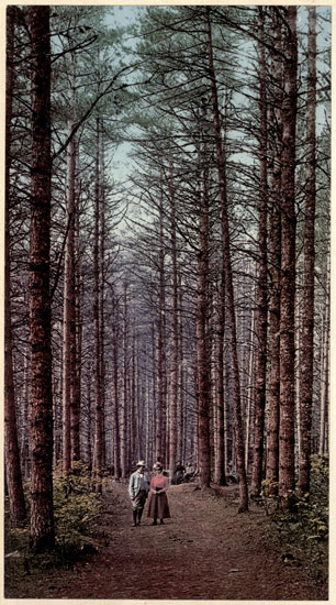
Cathedral Woods, Intervale, N. H
Transcriber's Note:
Obvious typographical errors have been corrected. Inconsistent spelling and hyphenation in the original document have been preserved.
The spellings of General McClellan and Fort McHenry have been normalized.
The Table of Contents for this volume refers to chapters ultimately published in a subsequent volume. Those chapter listings are retained, but the page number links are not active.
EDITION ARTISTIQUE
The World's Famous
Places and Peoples
AMERICA
BY
JOEL COOK
In Six Volumes
Volume I.
MERRILL AND BAKER
New YorkLondon
THIS EDITION ARTISTIQUE OF THE WORLD'S
FAMOUS PLACES AND PEOPLES IS LIMITED
TO ONE THOUSAND NUMBERED AND REGISTERED
COPIES, OF WHICH THIS COPY IS
NO. ____
Copyright, Henry T. Coates & Co., 1900
The American is naturally proud of his country, its substantial growth and wonderful development, and of the rapid strides it is making among the foremost nations of the world. No matter how far elsewhere the American citizen may have travelled, he cannot know too much of the United States, its grand attractions and charming environment. Though this great and vigorous nation is young, yet it has a history that is full of interest, and a literature giving a most absorbing story of rapid growth and patriotic progress, replete with romance, poetry and a unique folklore.
The object of this work is to give the busy reader in acceptable form such a comprehensive knowledge as he would like to have, of the geography, history, picturesque attractions, peculiarities, productions and most salient features of our great country. The intention has been to make the book not only a work of reference, but a work of art and of interest as well, and it is burdened neither with too much statistics nor too intricate prolixity of description. It covers the Continent of North iv America, from the Atlantic to the Pacific, and from the Gulf of Mexico to the Canadian Dominion and Alaska. It has been prepared mainly from notes specially taken by the author during many years of extended travel all over the United States and Canada. A method of treatment of the comprehensive subject has been followed which is similar to the plan that has proved acceptable in "England, Picturesque and Descriptive." The work has been arranged in twenty-one tours, each volume beginning at the older settlements upon the Atlantic seaboard; and each tour describing a route following very much the lines upon which a travelling sightseer generally advances in the respective directions taken. The book is presented to the public as a contribution to a general knowledge of our country, and with the hope that the reader, recognizing the difficulties of adequate treatment of so great a subject, may find in the interest it inspires, an indulgent excuse for any shortcomings.
J. C
Philadelphia, September, 1900.
Volume I
| PAGE | ||
| I. | The Environment of Chesapeake Bay, | 3 |
| II. | The Great Theatre of the Civil War, | 99 |
| III. | The Valley of the Delaware, | 143 |
| IV. | Crossing the Alleghenies, | 275 |
| V. | Visiting the Sunny South, | 343 |
| VI. | Traversing the Prairie Land, | 401 |
| VII. | Glimpses of the Great Northwest, | 447 |
VOLUME I
| PAGE | ||
| In the Congressional Library, Washington, D. C | 24 | |
| Natural Bridge, Virginia | 54 | |
| Washington Monument, Richmond, Va. | 112 | |
| Penn's Letitia Street House, Removed to Fairmount Park | 152 | |
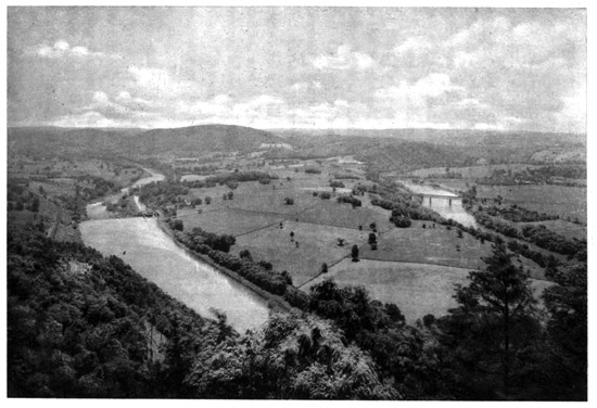
| Loop of the Schuylkill from Neversink Mountains | 188 | |
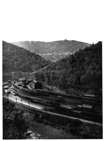
| Mauch Chunk | 234 | |
AMERICA,
PICTURESQUE AND DESCRIPTIVE.
I.
THE ENVIRONMENT OF CHESAPEAKE BAY.
The First Permanent Settlement in North America—Captain John Smith—Jamestown—Chesapeake Bay—The City of Washington—The Capitol—The White House—Elaborate Public Buildings—The Treasury—The State, War and Navy Departments—The Congressional Library—The Smithsonian Institution—Prof. Joseph Henry—The Soldiers' Home—Agricultural Department—Washington Monument—City of Magnificent Distances—Potomac River—Allegheny Mountains—The Kittatinny Range—Harper's Ferry—John Brown—The Great Falls—Alexandria—Mount Vernon—Washington's Home and Tomb—Washington Relics—Key of the Bastille—Rappahannock River—Fredericksburg—Mary Ball, the Mother of Washington—York River—The Peninsula—Williamsburg—Yorktown—Cornwallis' Surrender—James River—The Natural Bridge—Lynchburg—Appomattox Court-House—Lee's Surrender—Powhatan—Dutch Gap—Varina—Pocahontas—Her Wedding to Rolfe—Her Descendants, the "First Families of Virginia"—Deep Bottom—Malvern Hill—General McClellan's Seven Days' Battles and Retreat—Bermuda Hundred—General Butler—Shirley—Appomattox River—Petersburg—General Grant's Headquarters—City Point—Harrison's Landing—Berkeley—Westover—William Byrd—Chickahominy River—Jamestown Island—Gold Hunting—The Northwest Passage—First Corn-Planting—Indian Habits—First House of Burgesses—Tobacco-Growing—Virginia Planters—Importing Negro Slaves—Newport News—Merrimac 4 and Monitor Contest—Hampton Roads—Hampton—Old Point Comfort—Fortress Monroe—Fort Algernon—Fort Wool—Elizabeth River—Norfolk—Portsmouth—Great Dismal Swamp—The Eastern Shore—The Oyster Navy—William Claiborne—Kent Island—Lord Baltimore—The Maryland Palatinate—Leonard Calvert's Expedition—St. Mary's—Patuxent River—St. Inigoe's—Severn River—Annapolis—United States Naval Academy—Patapsco River—Baltimore—Jones's Falls—Washington Monument—Battle Monument—Johns Hopkins and his Benefactions—Baltimore and Ohio Railroad—Druid Hill—Greenmount Cemetery—Fort McHenry—The Star-Spangled Banner.
CAPTAIN JOHN SMITH.
When Captain Christopher Newport's expedition of three little ships and one hundred and five men, sent out by the "Virginia Company" to colonize America, after four months' buffeting by the rough winter storms of the North Atlantic, sought a harbor of refuge in May, 1607, they sailed into Chesapeake Bay. These three little ships were the "Susan Constant," the "Good Speed" and the "Discovery;" and upon them came Captain John Smith, the renowned adventurer, who, with Newport, founded the first permanent settlement in North America, the colony of Jamestown. The king who chartered the "Virginia Company" was James I., and hence the name. As the fleet sailed into the "fair bay," as Smith called it, the headlands on either side of the entrance were named Cape Charles and Cape Henry, for the king's two sons. Their first anchorage was in a roadstead of such attractive character that they named the adjacent 5 land Point Comfort, which it retains to this day; and farther inland, where Captain Newport afterwards came, in hopes of getting news from home, is now the busy port and town of Newport News. Sir Walter Raleigh, in the previous century, had sent out his ill-starred expedition to Roanoke, which had first entered this great bay; and at the Elizabeth River, which they had named in honor of Raleigh's queen, they found the Indian village of Chesapik, meaning "the mother of waters;" and from this came the name of Chesapeake Bay. Raleigh had landed colonists here, as well as at Roanoke, and when the "Virginia Company" sent out Newport's expedition it laid three commands upon those in charge: First, they were to seek Raleigh's lost colonists; second, they were to find gold; and third, they were to search for the "northwest passage" through America to the Pacific Ocean. So strong was the belief in finding gold in the New World that the only consideration King James asked for his charter was the stipulation that the "Virginia Company" should pay him one-fifth of the gold and silver found in its possessions.
As none of Raleigh's colonists could be found, the expedition sailed up the James River after considerable delay, and, selecting a better place for a settlement, landed at Jamestown May 13, 1607, where Smith became their acknowledged leader, and preserved the permanency of the colony. This famous 6 navigator and colonist was a native of Willoughby, in Lincolnshire, England, born in January, 1579. When scarcely more than a boy he fought in the wars of Holland, and then he wandered through Europe and as far as Egypt, afterwards returning to engage in the conflict against the Turks in Hungary. Here he won great renown, fighting many desperate combats, and in one engagement cutting off three Turks' heads; but he was finally wounded and captured. The sober, investigating historians of a later day have taken the liberty to doubt some of Smith's wonderful tales of these remarkable adventures, but he must have done something heroic to season him for the hardy work of the pioneer who was the first to succeed in planting a colony in North America. After the Turks made him a prisoner, he was sold as a slave in Constantinople, being condemned to the hardest and most revolting kinds of labor, until he became desperate under the cruelties and escaped. Then he was for a long time a wanderer through the wilderness, traversing the forests of Russia, and pushing his way alone across Europe, until, almost worn out with fatigue and hardships, he arrived in England just at the time Newport's expedition was being fitted out; and still having an irrepressible love for adventure, he joined it.
CHESAPEAKE BAY.
There can be no better place for beginning a survey of our country than upon this great bay, which 7 Smith and his companions entered in 1607. Chesapeake Bay is the largest inland sea on the Atlantic Coast of the United States. It stretches for two hundred miles up into the land, between the low and fertile shores of Virginia and Maryland, both of which States it divides, and thus gives them valuable navigation facilities. In its many arms and estuaries are the resting-places for the luscious oysters which its people send all over the world. It is one of the greatest of food-producers, having a larger variety of tempting luxuries for the palate than probably any other region. Along its shores and upon its islands are numberless popular resorts for fishing and shooting, for its tender and amply-supplied water-foods attract the ducks and other wild fowl in countless thousands, and bring in shoals of the sea-fishes, which are the sportsmen's coveted game. Its terrapin are famous, while its shores and borderlands, particularly on the eastern side, are a series of orchards and market-gardens, providing limitless supplies of fruits, berries and vegetables for the Northern markets. It receives in its generally placid bosom some of the greatest rivers flowing down from the Allegheny Mountains. The broad Susquehanna, coming through New York and Pennsylvania, makes its headwaters, and it receives the Potomac, dividing Maryland from Virginia, and the James, in Virginia, both of them wide estuaries with an enormous outflow; and also numerous smaller streams, 8 such as the Rappahannock, York, Patuxent, Patapsco, Choptank and Elizabeth Rivers. Extensive lines of profitable commerce, all large carriers of food-supplies, have transport over this great bay and its many arms and affluents. Canals connect it with other interior waters, and leading railways with all parts of the country, while there are several noted cities upon its shores and tributaries.
THE CITY OF WASHINGTON.
The most famous of all these cities of the Chesapeake region is Washington, upon the Potomac, and we will therefore begin this story at the American National Capital. The striking thing about Washington is that, unlike other capitals of great nations, it was created for the sole purpose of a seat of government, apart from any question of commercial rank or population. It has neither manufactures nor commerce to speak of. After the adoption of the Federal Constitution there was a protracted conflict in Congress over the claims of rival localities for the seat of government, and this developed so much jealousy that it almost disrupted the Union at its inception. General Washington, then the President, used his strong influence and wise judgment to compromise the dispute, and it was finally decided that Philadelphia should remain the capital for ten years, while after the year 1800 it should be located on the Potomac River, on a site selected by Washington, 9 within a district of one hundred square miles, ceded by Maryland and Virginia, and which, to avoid any question of sovereignty or control, should be under the exclusive jurisdiction of Congress. The location was at the time nearly in the geographical centre of the then thirteen original States. As the city was designed entirely on the Maryland side of the Potomac, the Virginia portion of the "Federal District of Columbia," as it was called, was retroceded in 1826, so that the District now contains about sixty-five square miles. The capital was originally called the "Federal City," but this was changed by law in 1791 to the "City of Washington." The ground plan of the place was ambitious, and laid out upon an extensive undulating plateau bordered by rolling hills to the northward and westward, and sloping gently towards the Potomac River, between the main stream and the eastern branch, or Anacostia River. This plan has been well described as "a wheel laid upon a gridiron," the rectangular arrangement of the ordinary streets having superimposed upon it a system of broad radiating avenues, with the Capitol on its hill, ninety feet high, for the centre. The Indians called the place Conococheague, or the "roaring water," from a rapid brook running through it, which washed the base of the Capitol Hill, and was afterwards very properly named the Tiber, but has since degenerated into a sewer. A distinguished French engineer of the time, Major 10 L'Enfant, prepared the topographical plan of the city, under the direction of Washington and Jefferson, who was Secretary of State; and Andrew Ellicott, a prominent local surveyor, laid it out upon the ground. The basis of the design was the topography of Versailles, but with large modifications; and thus was laid out the Capital of the United States, which a writer in the London Times, some years ago, called "the city of Philadelphia griddled across the city of Versailles."
The original designers planned a city five miles long and three miles broad, and confidently expected that a vast metropolis would soon be created, though in practice only a comparatively limited portion was built upon, and this is not where they intended the chief part of the new city to be. Of late years, however, the newer portions have been rapidly extending. No man's name was used for any of the streets or avenues, as this might cause jealousy, so the streets were numbered or lettered and the avenues named after the States. The corner-stone of the Capitol was laid in 1793, its front facing east upon the elevated plateau of the hill, and the town was to have been mainly built upon this plateau in front of it. Behind the Capitol, on its western side, the brow of the hill descended rather sharply, and here they laid out a wide and open Mall, westward over the lower ground to the bank of the Potomac River, more than a mile away. Off towards the 11 northwest, at the end of one of the diagonal avenues, they placed the Executive Mansion, with its extensive park and gardens stretching southward to the river, and almost joining the Mall there at a right angle. The design was to have the city in an elevated and salubrious location, with the President secluded in a comfortable retreat amid ample grounds, but nearly a mile and a half distant in the rural region. But few plans eventuate as expected; and such is the perversity of human nature that the people, when they came to the new settlement, would not build the town on Capitol Hill as had been intended, but persisted in settling upon the lower ground along and adjacent to the broad avenue leading from the Capitol to the Executive Mansion; and there, and for a long distance beyond the latter to the northward and westward, is the city of Washington of to-day. Pennsylvania Avenue, one hundred and sixty feet wide, joining these two widely-separated Government establishments and extending far to the northwest, thus became the chief street of the modern city. To Washington the Federal Government was removed, as directed by law, in 1800, the actual removal being conducted by Tobias Lear, who had been President Washington's private secretary, and was then serving in similar capacity for President John Adams. He packed the whole archives and belongings of the then United States Government at Philadelphia in twenty-eight wooden boxes, loaded 12 them on a sloop, sailed down the Delaware, around to the Chesapeake, and up the Potomac to the new capital, and took possession. The original Capitol and Executive Mansion were burnt by the British during their invasion in 1814, when Washington had about ten thousand population; it now contains over three hundred thousand, of whom fifty thousand are army and navy officers and civil servants and their families, and about eighty thousand are colored people.
THE CAPITOL.
The crowning glory of Washington is the Capitol, its towering dome, surmounted by the colossal statue of America, being the prominent landmark, seen from afar, on every approach to the city. The total height to the top of the statue is three hundred and seventy-five feet above the Potomac River level. The grand position, vast architectural mass and impressive effect of the Capitol from almost every point of view have secured for it the praise of the best artistic judges of all countries as the most imposing modern edifice in the world. From the high elevation of the Capitol dome there is a splendid view to the westward over the city spread upon the lower ground beyond the base of Capitol Hill. Diagonally to the southwest and northwest extend two grand avenues as far as eye can see—Maryland Avenue to the left leading down to the Potomac, and carrying the line of the Pennsylvania Railroad to the river, where it crosses 13 over the Long Bridge into Virginia; and Pennsylvania Avenue to the right, stretching to the distant colonnade of the Treasury Building and the tree-covered park south of the Executive Mansion. Between these diverging avenues and extending to the Potomac, more than a mile away, is the Mall, a broad enclosure of lawns and gardens. Upon it in the foreground is the Government Botanical Garden, and behind this the spacious grounds surrounding the Smithsonian Institution; while beyond, near the river bank, rises the tall white shaft of the Washington Monument, with its pointed apex.
On either side spreads out the city, the houses bordering the foliage-lined streets, and having at frequent intervals the tall spires of churches, and the massive marble, granite and brick edifices that are used for Government buildings. In front, to the west, is the wide channel of the Potomac, and to the south and southeast the Anacostia, their streams uniting at Greenleaf's Point, where the Government Arsenal is located. On the heights beyond the point, and across the Anacostia, is the spacious Government Insane Asylum. Far away on the Virginia shore, across the Potomac, rises a long range of wooded hills, amid which is Arlington Heights and its pillared edifice, which was the home of George Washington Parke Custis, the grandson of Mrs. Washington and General Washington's adopted son, and was subsequently the residence of General Robert E. Lee, who married 14 Miss Custis. Spreading broadly over the forest-clad hills is the Arlington National Cemetery, where fifteen thousand soldiers of the Civil War are buried. At the distant horizon to the left rises the spire of Fairfax Seminary, and beyond, down the Potomac, is seen the city of Alexandria, the river between being dotted with vessels. To the northwest, behind the Executive Mansion, is the spacious building of the State, War and Navy Departments, having for a background the picturesque Georgetown Heights, just over the District boundary, their tops rising four hundred feet above the river. Farther to the northward is Seventh Street Hill, crowned with the buildings of Howard University, and beyond it the distant tower of the Soldiers' Home. All around the view is magnificent; and years ago, before the city expected to attain anything like its present grandeur, Baron von Humboldt, as he stood upon the western verge of Capitol Hill and surveyed this gorgeous picture, exclaimed: "I have not seen a more charming panorama in all my travels."
After the British burnt the original Capitol, it was rebuilt and finished in 1827; but the unexampled growth of the country and of Congress soon demanded an extension, which was begun in 1851. It is this extension which supplied the wings and dome, designed and constructed by the late Thomas U. Walter, that has made the building so attractive. This grand Republican palace of government, stretching over 15 seven hundred and fifty feet along the top of the hill, has cost about $16,000,000. The old central building is constructed of Virginia freestone, painted white, the massive wings are of white marble from Massachusetts, and the lofty dome is of iron. The dazzling white marble gleams in the sunlight, and fitly closes the view along the great avenues radiating from it as a common centre. The architecture is classic, with Corinthian details, and, to add dignity to the western front, which overlooks the city, a magnificent marble terrace, eight hundred and eighty-four feet long, has been constructed at its base on the crest of the hill, which is approached by two broad flights of steps.
The Capitol is surrounded by a park of about fifty acres, including the western declivity of the hill and part of the plateau on top. Upon this plateau, on the eastern front, the populace assemble every fourth year to witness the inauguration of the President when he is sworn into office by the Chief Justice, and delivers his inaugural address from a broad platform at the head of the elaborate staircase leading up to the entrance to the great central rotunda. In full view of the President, as he stands under the grand Corinthian portico, is a colossal statue of Washington, seated in his chair of state, and facing the new President, as if in solemn warning. The rotunda is the most striking feature of the Capitol interior; it is nearly one hundred feet in diameter, and rises one hundred 16 and eighty feet to the ceiling of the dome, which is ornamented with fine frescoes by Brumidi. Large panelled paintings on the walls just above the floor, and alti rilievi over them, represent events in the early history of the country, while at a height of one hundred feet a band nine feet wide runs around the interior of the dome, upon which a series of frescoes tell the story of American history from the landing of Columbus. But, most appropriately, the elaborate decorations, while reproducing so much in Indian legend and Revolutionary story, are not used in any way to recall the Civil War. Away up in the top of the dome there is a Whispering Gallery, to which a stairway laboriously leads.
The old halls of the Senate and House in the original wings of the Capitol are now devoted, the former to the Supreme Court and the latter to a gallery of statuary, to which each State contributes two subjects, mostly Revolutionary or Colonial heroes. Beyond, on either hand, are the extensive new wings—the Senate Chamber to the north and the Representatives' Hall to the south. Each is surrounded by corridors, beyond which are committee rooms, and there are spacious galleries for the public. Each member has his chair and desk, the seats being arranged in semicircles around the rostrum. In practice, while the House is in session, the members are usually reading or writing, excepting the few who may watch what is going on, because they are specially interested 17 in the matter under consideration; and the member who may have the floor and is speaking is actually heard by very few, his speech being generally made for the galleries and the official stenographers and newspaper reporters. Debate rarely reaches a point of interest absorbing the actual attention of the whole House, most of the speech-making seeming to be delivered for effect in the member's home district, this method being usually described as "talking for Buncombe." The other members read their newspapers, write their letters, clap their hands sharply to summon the nimble pages who run about the hall upon their errands, gossip in groups, and otherwise pass their time, move in and out the cloak- and committee-rooms, and in various ways manage not to listen to much that goes on. Nevertheless, business progresses under an iron-clad code of procedure, the Speaker being a despot who largely controls legislation. The surroundings of the Senate Chamber are grander than those of the House, there being a gorgeous "Marble Hall," in which Senators give audience to their visitors, and magnificently ornamented apartments for the President and Vice-President. The President's Room is only occupied during a few hours in the closing scenes of a session, this small but splendid apartment, which has had $50,000 expended upon its decoration, being a show place for the remainder of the year. 18
THE WHITE HOUSE.
The most famous building in Washington, though one of the least pretentious, is the Executive Mansion, popularly known as the "White House," being constructed, like the older part of the Capitol, of freestone, and painted white. It stands within a park at some distance back from the street, a semicircular driveway leading up to the Ionic colonnade supporting the front central portico. It is a plain building, without pretensions in anything but its august occupancy, and the ornamental grounds stretch down to the Potomac River, which flows about two hundred yards below its southern front. It is two stories high, about one hundred and seventy feet long, and eighty-six feet deep. This building, like the Capitol, was burnt in the British invasion of 1814 and afterwards restored. Unlike the nation, or the enormous public buildings that surround and dwarf it, the White House has in no sense grown, but remains as it was designed in the lifetime of Washington. It is nevertheless a comfortable mansion, though rigid in simplicity. The parlor of the house, the "East Room," is the finest apartment, occupying the whole of that side, and is kept open for visitors during most of the day. The public wander through it in droves, walk upon the carpets and recline in the soft chairs, awaiting the President's coming to his almost daily reception and handshaking; 19 for they greatly prize this joint occupancy, as it were, and close communion with their highest ruler. This is an impressive room, and in earlier times was the scene of various inauguration feasts, when Presidents kept open house for their political friends and admirers.
The "East Room" was a famous entertainment hall in President Jackson's time. On the evening of his inauguration day it was open to all comers, who were served with orange punch and lemonade. The crowds were large, and the punch was mixed in barrels, being brought in by the bucketful, the thirsty throngs rushing after the waiters, and in the turmoil upsetting the punch and ruining dresses and carpets. The punch receptacles were finally taken out into the gardens, and in this way the boisterous crowds were drawn off, and it became possible to serve cake and wine to the ladies. Various traditions are still told of this experience, and also of the monster cheese, as big as a hogshead, that was served to the multitude at Jackson's farewell reception. It was cut up with long saw-blades, and each guest was given about a pound of cheese, this feast being the talk of the time. Jackson's successor was Martin Van Buren, who came from New York, the land of big cheeses. Being bound to emulate his predecessor, an even larger cheese was sent him, and cut up in the "East Room." The crowds trampled the greasy crumbs into the carpets and hangings, and all the furniture 20 and fittings were ruined. Now no guest comes unbidden to dine at the White House; but the change in the fashion aided in defeating Van Buren, who was a candidate for a second election in 1840. He stopped keeping open house in order to save the furniture and get some peace, and during several months preceding the election many persons arrived at the White House for breakfast or dinner and threatened to vote against Van Buren unless they were entertained. This, with the fact noised abroad that he had become such an aristocrat that his table service included gold spoons, then an unheard of extravagance, proved too much for him. Van Buren was beaten for re-election by "Old Tippecanoe"—General William Henry Harrison.
A corridor leads westward from the "East Room," through the centre of the White House, to the conservatories, which are prolonged nearly two hundred feet farther westward. A series of fine apartments, called the Green, Blue and Red Rooms, from the predominant colors in their decorations, are south of this corridor, with their windows opening upon the gardens. These apartments open into each other, and finally into the State Dining Hall on the western side of the building, which is adjoined by a conservatory. North of the corridor the first floor contains the family rooms, and on the second floor are the sleeping-rooms and also the public offices. The Cabinet Room, about in the centre of the building, 21 is a comparatively small apartment, where the Cabinet meetings assemble around a long table. On one side of it, at the head of a broad staircase, are the offices of the secretaries, over the East Room; and on the other side, the President's private apartment, which is called the Library. Here the President sits, with the southern sun streaming through the windows, to give audience to his visitors, who are passed in by the secretaries. One of the desks, which is usually the President's personal work-table, has a history. The British ship "Resolute," years ago, after many hardships in the fruitless search for Sir John Franklin, had to be abandoned in the Arctic seas. Portions of her oaken timbers were taken back to England, and from these, by the Queen's command, the desk was made and presented to President Grant, and it has since been part of the furniture in the Library. An adjacent chamber, wherein the Prince of Wales slept on his only visit to America, and the chamber adjoining, are the two sleeping-rooms which have been usually occupied by the greatest Presidents. The accommodations are so restricted, however, that a movement is afoot for constructing another presidential residence, on higher land in the suburbs, so that the White House may be exclusively used for the executive offices.
ELABORATE PUBLIC BUILDINGS.
The great public buildings used for Government purposes are among the chief adornments of Washington. 22 To the eastward of the White House is the Treasury Building, extending over five hundred feet along Fifteenth Street, enriched by a magnificent Ionic colonnade, three hundred and fifty feet long, modelled from that of the Athenian Temple of Minerva. Each end has an elaborate Ionic portico, while the western front, facing the White House, has a grand central entrance. This was the first great building constructed for a Government department, and is the headquarters of the Secretary of the Treasury. Upon the western side of the White House is the most splendid of all the department buildings, accommodating three of them, the State, War and Navy Departments. It is Roman Doric, built of granite, four stories high, with Mansard and pavilion roofs and porticoes, covering a surface of five hundred and sixty-seven by three hundred and forty-two feet. The Salon of the Ambassadors, or the Diplomatic Reception Room, is its finest apartment, and is the audience chamber of the Secretary of State, who occupies the adjoining Secretary's Hall, also a splendid room. This great building is constructed around two large interior courts, the Army occupying the northern and western wings, and the Navy the eastern side, where among the great attractions are the models of the famous warships of the American Navy. To the northward of the White House park and furnishing a fine front view is Lafayette Square, containing a bronze equestrian statue of General Jackson 23 by Clark Mills; beyond, on the western side, is the attractive Renaissance building of the Corcoran Art Gallery, amply endowed by the late banker, William W. Corcoran, and containing his valuable art collections, which were given to the public. The foundation of his fortune was laid over a half-century ago, when he had the pluck to take a Government loan which seemed slow of sale. His modest banking house still exists as the Riggs Bank, facing the Treasury.
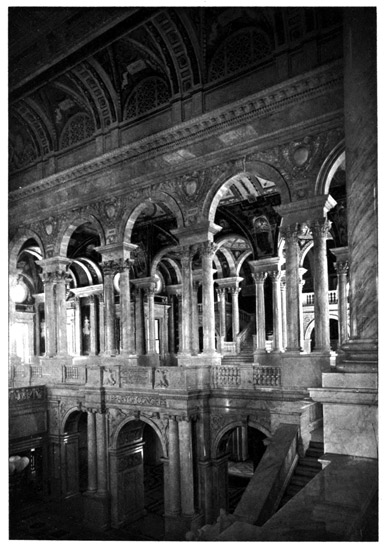
The most admired of the newer public buildings in Washington is the Congressional Library, on the plateau southeast of the Capitol, an enormous structure in Italian Renaissance, a quadrangle four hundred and seventy feet long and three hundred and forty feet wide, enclosing four courts and a central rotunda. It was finished in 1897, and cost about $6,200,000. Its elevated gilded dome and lantern are conspicuous objects in the view. This great Library, the largest in the country, is appropriately ornamented, and its book-stacks have accommodations for about five millions of volumes, the present number approximating one million, with nearly three hundred thousand pamphlets. The Pension Building is another huge structure, northwest of Capitol Hill, built around a covered quadrangle, which is used quadrennially for the "Inauguration Ball," a prominent Washington official-social function, which was adopted to relieve the White House from the former 24 feasting on the inauguration night. This house, accommodating the army of pension clerks, has running around the walls, over the lower windows, a broad band, exhibiting in relief a marching column of troops, with representations of every branch of the service. Seventh Street, which crosses Pennsylvania Avenue about midway between the Capitol and the Treasury, has to the northward the imposing Corinthian Post-office Building, formerly the headquarters of the postal service. Behind this is the Department of the Interior, popularly known as the Patent Office, as a large part of it is occupied by patent models. This is a grand Doric structure, occupying two blocks and embracing about three acres of buildings, the main entrance being a magnificent portico, seen from Pennsylvania Avenue. The new General Post-office Department Building is on Pennsylvania Avenue, covering a surface of three hundred by two hundred feet, and having a tower rising three hundred feet. It has just been completed. The Government Printing Office, where the public printing is done, and the Treasury Bureau of Engraving and Printing, where all the Government money issues and revenue stamps are made, are large and important buildings, though not specifically attractive in architecture.
THE SMITHSONIAN INSTITUTION.
Upon the Mall stands the Smithsonian Institution, of world-wide renown, one of the most interesting 25 public structures in Washington, its turrets and towers rising above the trees. The origin of this famous scientific establishment was the bequest of an Englishman, James Smithson, a natural son of Hugh Smithson, Duke of Northumberland, born in 1765. He was known as Louis Macie at Oxford, graduating under that name; early developed scientific tastes; was a Fellow of the Royal Society, the friend and associate of many of the most learned men of his time, and lived usually in Paris, where in the latter part of the last century he took the family name of his father. He died in Italy in 1829. In Washington's Farewell Address, issued in 1796, there occurs the phrase, "An institution for the increase and diffusion of knowledge," and it was well known that the Father of his Country cherished a project for a national institution of learning in the new Federal City. This was evidently communicated to Smithson by one of his intimates in Paris, Joel Barlow, a noted American, who was familiar with Washington's plan, and in this way originated the residuary bequest, which was contained in the following clause of Smithson's will: "I bequeath the whole of my property to the United States of America, to found at Washington, under the name of the Smithsonian Institution, an establishment for the increase and diffusion of knowledge among men." Upon the death of Smithson's nephew, without heirs, in 1835, this bequest became operative, and the United States 26 Legation in London was notified that the estate, then amounting in value to about £100,000, was held in possession of the Accountant-General of the Court of Chancery. This was something novel in America, and when the facts became public opposition arose in Congress to accepting the gift, eminent men, headed by John C. Calhoun, arguing that it was beneath the dignity of the United States to receive presents. Others, however, led by John Quincy Adams, ardently advocated acceptance. The latter carried the day; Richard Rush was sent to London, as agent, to prosecute the claim in the Court of Chancery, in the name of the President of the United States; and the legacy was obtained and delivered at the Mint in Philadelphia, September 1, 1838, in the sum of 104,960 British sovereigns, and was immediately recoined into United States money, producing $508,318.46, the first installment of the legacy. There were subsequent additional installments, and the total sum in 1867 reached $650,000. This original sum was deposited in the Federal Treasury in perpetuity, at six per cent, interest, and the income has been devoted to the erection of the buildings, and, with other subsequently added sums, to the support of the vast establishment which has grown from the original gift.
The Smithsonian Institution was formally created by Act of Congress, August 10, 1846, the corporation being composed of the President, Vice-President, members of the Cabinet and Chief Justice, who are 27 constituted the "establishment," made responsible for the duty of "the increase and diffusion of knowledge among men." The Institution is administered by a Board of Regents, including in addition three Senators, three members of the House, and six citizens appointed by Congress; the presiding officer, called the "Chancellor," being usually the Chief Justice, and the secretary of the board is the Executive Officer. The late eminent Professor Joseph Henry was elected secretary in 1846, and he designed the plan and scope of the Institution, continuing as its executive head until his death in 1878. His statue stands in the grounds near the entrance. Two other secretaries followed him, Spencer F. Baird (who was twenty-seven years assistant secretary), and upon his death Samuel P. Langley, in 1888. The ornate building of red Seneca brownstone, a fine castellated structure in the Renaissance style, was designed in 1847 and finished in 1855. Its grand front stretches about four hundred and fifty feet, and its nine towers and turrets, rising from seventy-five to one hundred and fifty feet, stand up prettily behind the groves of trees. This original building contains a museum of natural history and anthropology. In connection with it there is another elaborate structure over three hundred feet square—the National Museum—containing numerous courts, surrounding a central rotunda, beneath which a fountain plashes. This is under the same management, and directly supported 28 by the Government, the design being to perfect a collection much like the British Museum, but paying more attention to American antiquities and products. This adjunct museum began with the gifts by foreign Governments to the Philadelphia Centennial Exposition in 1876, most of them being still preserved there. The Smithsonian Trust Fund now approximates $1,000,000, and there are various other gifts and bequests held in the Treasury for various scientific purposes similarly administered.
Briefly stated, the plan of Professor Henry was to "increase knowledge" by original investigations and study, either in science or literature, and to "diffuse knowledge" not only through the United States, but everywhere, and especially by promoting an interchange of thought among the learned in all nations, with no restriction in favor of any one branch of knowledge. A leading feature of his plan was "to assist men of science in making original researches, to publish them in a series of volumes, and to give a copy of them to every first-class library on the face of the earth." There is said to be probably not a scientific observer of any standing in the United States to whom the Institution has not at some time extended a helping hand, and this aid also goes liberally across the Atlantic. As income grew, the scope has been enlarged. In the various museums there is a particularly good collection of American ethnology, and a most elaborate display of American fossils, 29 minerals, animals, birds and antiquities. There are also shown by the Fish Commission specimens of the fishing implements and fishery methods of all nations, an exhibition which is unexcelled in these special departments. Many specifically interesting things are in the National Museum. The personal effects of Washington, Jackson and General Grant are there. Benjamin Franklin's old printing-press is preserved in a somewhat dilapidated condition, and there is also the first railway engine sent from England to the United States, the original "John Bull," built by Stephenson & Son at Newcastle-on-Tyne in June, 1831, and sent out as "Engine No. 1" for the Camden and Amboy Railroad crossing New Jersey, now a part of the Pennsylvania Railroad. It weighs ten tons, and has four driving-wheels of fifty-four inches diameter. This relic, after being used on the railroad for forty years, until improved machinery superseded it, has been given the Government as a national heirloom. Among the anthropological collections is a chronologically arranged series illustrating American history from the period of the discovery to the present day. This includes George Catlin's famous collection of six hundred paintings, illustrating the manners and customs of the North American Indians. One of the most important features of the work of this most interesting establishment is its active participation in all the great International Expositions by the loan to them of 30 valuable exhibits under Government direction and control.
THE SOLDIERS' HOME AND WASHINGTON MONUMENT.
The city of Washington, with progressing years, is becoming more and more the popular residential city of the country. It is one of the most beautiful and attractive, the admirable plan, with the wide asphalted streets, lined with trees, opening up vista views of grand public buildings, statues, monuments or leafy parks, making it specially popular. The northern and northwestern sections, on the higher grounds, have consequently spread far beyond the Executive Mansion, being filled with rows of elaborate and costly residences, the homes of leading public men. The streets are kept scrupulously clean, while at the intersections are "circles," triangles and little squares, which are availed of for pretty parks, and usually contain statues of distinguished Americans. Among the noted residence streets are Vermont, Massachusetts and Connecticut Avenues and K Street and Sixteenth Street, all in the northwestern district. Among the many statues adorning the small parks and "circles" are those of Washington, Farragut, Scott, Thomas, McPherson, Dupont, Logan, Franklin, Hancock, Grant, Rawlins and Martin Luther, the latter a replica of the figure in the Reformation Monument at Worms.
To the northward the suburbs rise to Columbia 31 Heights, with an elevated plateau beyond, where there is a Government park covering nearly a square mile of rolling surface, and surrounding one of the noted rural retreats on the borders of the Capital, the "Soldiers' Home." This is an asylum and hospital for disabled and superannuated soldiers of the American regular army, containing usually about six hundred of them, and founded by General Winfield Scott, whose statue adorns the grounds. Its cottages have been favorite retiring-places of the Presidents in the warm weather. Amid lovely surroundings the veterans are comfortably housed, and in the adjacent cemetery thousands of them have been buried. Scott's statue stands upon the southern brow of the plateau, where a ridge is thrust out in a commanding situation; and from here the old commander of the army forty and fifty years ago gazes intently over the lower ground to the city three miles away, with the lofty Capitol dome and Washington Monument rising to his level, while beyond them the broad and placid Potomac winds between its wooded shores. This is the most elevated spot near Washington, overlooking a wide landscape. In the cemetery at the Soldiers' Home sleeps General Logan, among the thousands of other veterans. To the westward the beautiful gorge of Rock Creek is cut down, and beyond is Georgetown, with its noted University, founded by the Jesuits in 1789, and having about seven hundred students. In the Oak Hill Cemetery, 32 at Georgetown, is the grave of John Howard Payne, the author of "Home, Sweet Home," who died in 1852. Far away over the Potomac, in the Arlington National Cemetery, are the graves of Generals Sherman and Sheridan.
Down near the Potomac, on the Mall, to the westward of the Smithsonian turrets, is the extensive brick and brownstone building representing the dominant industry of the United States, which gives the politicians so much anxiety in catering for votes—the Agricultural Department. Here are spacious gardens and greenhouses, an arboretum and herbarium, the adjacent buildings also containing an agricultural museum. As over three-fifths of the men in the United States are farmers and farm-workers, and many others are in the adjunct industries, it has become a popular saying in Washington that if you wish to scare Congress you need only shake a cow's tail at it. This department has grown into an enormous distributing office for seeds and cuttings, crop reports and farming information. Among its curiosities is the "Sequoia Tree Tower," formed of a section of a Sequoia or Big Tree of California, which was three hundred feet high and twenty-six feet in diameter at the base.
Behind the Agricultural Department, and rising almost at the river bank, and in front of the Executive Mansion, is the noted Washington Monument, its pointed apex elevated five hundred and fifty-five 33 feet. This is a square and gradually tapering shaft, constructed of white Maryland marble, the walls fifteen feet thick at the base and eighteen inches at the top, the pyramidal apex being fifty-five feet high and capped with a piece of aluminum. Its construction was begun in 1848, abandoned in 1855, resumed in 1877 and finished in 1884, at a total cost of $1,300,000. The lower walls contain stones contributed by public corporations and organizations, many being sent by States and foreign nations, and bearing suitable inscriptions in memory of Washington. A fatiguing stairway of nine hundred steps leads to the top, and there is also a slow-moving elevator. From the little square windows, just below the apex, there is a grand view over the surrounding country. Afar off to the northwest is seen the long hazy wall of the Blue Ridge or Kittatinny Mountain range, its prominent peak, the Sugar Loaf, being fifty miles distant. To the eastward is the Capitol and its surmounting dome, over a mile away, while the city spreads all around the view below, like a toy town, its streets crossing as on a chess-board, and cut into gores and triangles by the broad, diagonal avenues lined with trees, the houses being interspersed with many foliage-covered spaces. Coming from the northwest the Potomac passes nearly at the foot of the monument, with Arlington Heights over on the distant Virginia shore, and the broad river channel flowing away to the southwest until lost among the 34 winding forest-clad shores below Alexandria. From this elevated perch can be got an excellent idea of the peculiarities of the town, its vast plan and long intervals of space, so that there is quite plainly shown why the practical Yankee race calls it the "City of Magnificent Distances." Possibly one of the best descriptions of Washington and its characteristics is that of the poet in the Washington Post:
A city well named of magnificent distances;
Of boulevards, palaces, fountains and trees;
Of sunshine and moonlight whose subtle insistence is—
"Bask in our radiance! Be lulled by our breeze!"
A city like Athens set down in Arcadia;
White temples and porticoes gleaming 'mid groves;
Where nymphs glide and smile as though quite unafraid o' you,
The home of the Muses, the Graces, the Loves;
The centre of Politics, Letters and Sciences;
Elysium of Arts, yet the Lobbyist's Dream;
Where gather the clans whose only reliance is
Gold and the dross that sweeps down with its stream;
An isle of the lotus, where every-day business
Sails on its course all unvexed by simoons;
No bustle or roar, no mad-whirling dizziness
O'er velvety streets like Venetian lagoons;
A town where from nothing whatever they bar women,
From riding a bicycle—tending a bar;
Ex-cooks queen society—ladies are charwomen—
For such the plain facts as too often they are.
A city where applicants, moody, disconsolate,
Swoop eager for office and senseless to shame;
The "heeler" quite certain of getting his consulate,
Although, to be sure, he can't sign his name;
A town where all types of humanity congregate;
The millionaire lolling on cushions of ease;
The tramp loping by at a wolfish and hungry gait;
And mankind in general a' go as you please.
A city in short of most strange inconsistencies;
Condensing the history of man since the fall;
A city, however, whose piece de resistance is
This—'tis the best and the fairest of all.
THE POTOMAC AND THE ALLEGHENIES.
The Potomac is one of the chief among the many rivers draining the Allegheny Mountains. It originates in two branches, rising in West Virginia and uniting northwest of Cumberland; is nearly four hundred miles long; has remarkably picturesque scenery in the magnificent gorges and reaches of its upper waters; breaks through range after range of the Alleghenies, and after reaching the lowlands becomes a tidal estuary for a hundred miles of its final course, broadening to six and eight and ultimately sixteen miles wide at its mouth in the Chesapeake. Washington is near the head of tidewater, one hundred and twenty-five miles from the bay; and for almost its entire course the Potomac is an interstate boundary, between Maryland and West Virginia and Virginia. Its name is Indian, referring to its use in their primitive navigation, the original word "Petomok" meaning "they are coming by water"—"they draw near in canoes." The Alleghenies, where this noted river originates, are a remarkable geological formation. The Atlantic Coast of the United States has a general trend from the northeast to the southwest, 36 with bordering sand beaches, and back of them a broad band of pines. Then, towards the northwest, the land gradually rises, being formed in successive ridges, with intervening valleys, until it reaches the Alleghenies. The great ranges of this mountain chain, which is geologically known as the Appalachian System, run almost parallel to the coast for over a thousand miles, from the White Mountains of New Hampshire down to Alabama. They are noted mountains, not very high, but of remarkable construction, and are said to be much older in geological formation than the Alps or the Andes. They are composed of series of parallel ridges, one beyond the other, and all following the same general course, like the successive waves of the ocean. For long distances these ridges run in perfectly straight lines, and then, as one may curve around into a new direction, all the others curve with it. The intervening valleys are as remarkable in their parallelism as the ridges enclosing them. From the seaboard to the mountains the ranges of hills are of the same general character, but with less elevation, gentler slopes, and in most cases narrower and much more fertile valleys.
The South Mountain, an irregular and in some parts broken-down ridge, is the outpost of the Alleghenies, while the great Blue Ridge is their eastern buttress. The latter is about twenty miles northwest of the South Mountain, and is the famous Kittatinny 37 range, named by the Indians, and in their figurative language meaning "the endless chain of hills." It stretches from the Catskills in New York southwest to Alabama, a distance of eight hundred miles, a veritable backbone for the Atlantic seaboard, its rounded ridgy peaks rising sometimes twenty-five hundred feet north of the Carolinas, and much higher in those States. It stands up like a great blue wall against the northwestern horizon, deeply notched where the rivers flow out, and is the eastern border for the mountain chain of numerous parallel ridges of varying heights and characteristics that stretch in rows behind it, covering a width of a hundred miles or more. Within this chain is the vast store of minerals that has done so much to create American wealth—the coal and iron, the ores and metals, that are in exhaustless supply, and upon the surface grew the forests of timber that were used in building the seaboard cities, but are now nearly all cut off. The great Atlantic Coast rivers rise among these mountain ridges, break through the Kittatinny and flow down to the ocean, while the streams on their western slopes drain into the Mississippi Valley. The Hudson breaks through the Kittatinny outcrop at the West Point Highlands, the Delaware forces a passage at the Water Gap, the Lehigh at the Lehigh Gap, below Mauch Chunk; the Schuylkill at Port Clinton, the Susquehanna at Dauphin, above Harrisburg, and the Potomac at Harper's Ferry. All these 38 rivers either rise among or force their winding passages through the various ranges behind the great Blue Ridge, and also through the South Mountain and the successive parallel ranges of lower hills that are met on their way to the coast, so that all in their courses display most picturesque valleys.
HARPER'S FERRY AND JOHN BROWN.
The Potomac, having flowed more than two hundred miles through beautiful gorges and the finest scenery of these mountains, finally breaks out at Harper's Ferry, receiving here its chief tributary, the Shenandoah, coming up from Virginia, the Potomac River passage of the Blue Ridge being described by Thomas Jefferson as "one of the most stupendous scenes in nature." The Shenandoah—its name meaning "the stream passing among the spruce-pines"—flows through the fertile and famous "Valley of Virginia," noted for its many battles and active movements of troops during the Civil War, when the rival forces, as fortunes changed, chased each other up and down the Valley; and Harper's Ferry, at the confluence of the rivers, and the towering Maryland Heights on the northern side and the Loudon Heights on the Virginia side, the great buttresses of the river passage, being generally held as a northern border fortress. These huge mountain walls rise fifteen hundred feet above the town, which has a population of about two thousand. 39
Harper's Ferry was also the scene of "John Brown's raid," which was practically the opening act of the Civil War, although actual hostilities did not begin until more than a year afterwards. "Old John Brown of Osawatomie" was a tanner, an unsettled and adventurous spirit and foe of slavery, born in Connecticut in 1800, but who, at the same time, was one of the most upright and zealous men that ever lived. In his wanderings he migrated to Kansas in 1855, where he lived at Osawatomie, and fought against the pro-slavery party. His house was burnt and his son killed in the Kansas border wars, and he made bloody reprisals. Smarting under his wrongs, he became the master-spirit of a convention which met at Chatham, Canada, in May, 1859, and organized an invasion of Virginia to liberate the slaves. Having formed his plans, he rented a farmhouse in July about six miles from Harper's Ferry, and gathered his forces together. On the night of October 16th, with twenty-two associates, six being negroes, he crossed the bridge into Harper's Ferry, and captured the arsenal and armory of the Virginia militia, intending to liberate the slaves and occupy the heights of the Blue Ridge as a base of operations against their owners. A detachment of United States marines were next day sent to the aid of the militia, and, after two days' desultory hostilities, some of his party were killed, and Brown and the survivors were captured and given up to the Virginia authorities for 40 trial. His final stand was made in a small engine-house, known as "John Brown's Fort," which was exhibited at the Chicago Exposition in 1893. Brown and six of his associates were hanged at the county-seat, Charlestown, seven miles southwest of Harper's Ferry, on December 2d, Brown facing death with the greatest serenity. His raid failed, but it was potential in disclosing the bitter feeling between the North and the South, and it furnished the theme for the most popular and inspiring song of the Civil War:
"John Brown's body lies mouldering in the grave,
But his soul goes marching on."
THE GREAT FALLS AND ALEXANDRIA.
The Potomac continues its picturesque course below Harper's Ferry, and passes the Point of Rocks, a promontory of the Catoctin Mountain, a prolongation of the Blue Ridge. There were battles fought all about, the most noted being at South Mountain and Antietam, to the northward, in September, 1862; while it was at Frederick, fifteen miles away, during this campaign, that Barbara Frietchie was said to have waved the flag as Stonewall Jackson marched through the town, immortalized in Whittier's poem. Here is buried Francis Scott Key, author of the "Star-Spangled Banner," who died in 1843, and a handsome monument was erected to his memory in 1898. The Potomac reaches its Great Falls about fifteen miles above Washington, where it descends 41 eighty feet in about two miles, including a fine cataract thirty-five feet high. Below this is the "Cabin John Bridge," with one of the largest stone arches in the world, of two hundred and twenty feet span, built for the Washington Aqueduct, carrying the city water supply from the Great Falls. On Wesley Heights, to the northward, the new American University of the Methodist Church is being constructed.
Below Washington, the river passes the ancient city of Alexandria, a quaint old Virginian town, which was formerly of considerable commercial importance, but is now quiet and restful, and cherishing chiefly the memory of George Washington, who lived at Mount Vernon, a few miles below, and was its almost daily visitor to transact his business and go to church and entertainments. The tradition is that Madison, who was chairman of the Committee of Congress, selected Alexandria for the "Federal City," intending to erect the Capitol on Shooters' Hill, a mile out of town, as grand an elevation as the hill in Washington; but he was overruled by the President because the latter hesitated to thus favor his native State. Had Madison had his way, the town probably would not now be so sleepy. The modest little steeple of Christ Church, where Washington was a vestryman, rises back of the town, and his pew, No. 5, is still shown, for which, when the church was built and consecrated in 1773, the records show that he paid thirty-six pounds, ten shillings. To construct 42 this church and another at the Falls, the vestry of Fairfax parish, in 1766, levied an assessment of 31,185 pounds of tobacco, and the rector's salary was also paid in tobacco. After the Revolution, to help support the church, Washington and seven others signed an agreement in the vestry-book to each pay five pounds annual rental for the pews they owned. Robert E. Lee was baptized and confirmed and attended Sunday-school in this old church, and tablets in memory of Washington and Lee were inserted in the church wall in 1870. At the Carey House, near the river, Washington, in 1755, received from General Braddock, who had come up there from Hampton Roads, his first commission as an aide to that commander, with the rank of Major, just before starting on the ill-starred expedition into Western Pennsylvania. Alexandria has probably fifteen thousand people, and on the outskirts is another mournful relic of the Civil War, a Soldiers' Cemetery, with four thousand graves. Below Alexandria, the Hunting Creek flows into the Potomac, this stream having given Washington's home its original name of the "Hunting Creek Estate."
WASHINGTON'S HOME AND TOMB.
Mount Vernon, the home and burial-place of George Washington, is seventeen miles below the city of Washington, the mansion-house, being in full view, standing among the trees on the top of a bluff, rising 43 about two hundred feet above the river. As the steamboat approaches, its bell is tolled, this being the universal custom on nearing or passing Washington's tomb. It originated in the reverence of a British officer, Commodore Gordon, who, during the invasion of the Capital in August, 1814, sailed past Mount Vernon, and as a mark of respect for the dead had the bell of his ship, the "Sea Horse," tolled. The "Hunting Creek Estate" was originally a domain of about eight thousand acres; and Augustine Washington, dying in 1743, bequeathed it to Lawrence Washington, who, having served in the Spanish wars under Admiral Vernon, named it Mount Vernon in his honor. George Washington was born in 1732, in Westmoreland County, farther down the Potomac, and when a boy lived near Fredericksburg, on the Rappahannock River. In 1752 he inherited Mount Vernon from Lawrence, and after his death the estate passed to his nephew, Bushrod Washington, subsequently descending to other members of the family. Congress repeatedly endeavored to have Washington's remains removed to the crypt under the rotunda of the Capitol originally constructed for their reception, but the family always refused, knowing it was his desire to rest at Mount Vernon. The grounds and buildings being in danger of falling into dilapidation, and the estate passing under control of strangers, a patriotic movement began throughout the country for the purchase of the portion containing 44 the tomb and mansion. The Virginia Legislature, in 1856, passed an act authorizing the sale, and under the auspices of a number of energetic ladies who formed the "Mount Vernon Association," assisted by the oratory of Edward Everett, who traversed the country making a special plea for help, a tract of two hundred acres was bought for $200,000, being enlarged by subsequent gifts to two hundred and thirty-five acres. These ladies and their successors have since taken charge, restoring and beautifying the estate, which is faithfully preserved as a patriotic heritage and place of pilgrimage for visitors from all parts of the world.
The steamboat lands at Washington's wharf at the foot of the bluff, where he formerly loaded his barges with flour ground at his own mill, shipping most of it from Alexandria to the West Indies. The road from the wharf leads up a ravine cut diagonally in the face of the bluff, directly to Washington's tomb, and alongside the ravine are several weeping willows that were brought from Napoleon's grave at St. Helena. Washington's will directed that his tomb "shall be built of brick," and it is a plain square brick structure, with a wide arched gateway in front and double iron gates. Above is the inscription on a marble slab, "Within this enclosure rests the remains of General George Washington." The vault is about twelve feet square, the interior being plainly seen through the gates. It has upon the floor two large stone coffins, that on the 45 right hand containing Washington, and that on the left his widow Martha, who survived him over a year. In a closed vault at the rear are the remains of numerous relatives, and in front of the tomb monuments are erected to several of them. No monument marks the hero, but carved upon the coffin is the American coat-of-arms, with the single word "Washington."
The road, farther ascending the bluff, passes the original tomb, with the old tombstone antedating Washington and bearing the words "Washington Family." This was the tomb, then containing the remains, which Lafayette visited in 1824, escorted by a military guard from Alexandria to Mount Vernon, paying homage to the dead amid salvos of cannon reverberating across the broad Potomac. It is a round-topped and slightly elevated oven-shaped vault. The road at the top of the bluff reaches the mansion, standing in a commanding position, with a fine view over the river to the Maryland shore. It is a long wooden house, with an ample porch facing the river. It is built with simplicity, two stories high, and contains eighteen rooms, there being a small surmounting cupola for a lookout. The central portion is the original house built by Lawrence Washington, who called it his "villa," and afterwards George Washington extended it by a large square wing at each end, and when these were added he gave it the more dignified title of the "Mansion." 46 The house is ninety-six feet long and thirty feet wide, the porch, extending along the whole front, fifteen feet wide, its top being even with the roof, thus covering the windows of both stories. Eight large square wooden columns support the roof of the porch. Behind the house, on either side, curved colonnades lead to the kitchens, with other outbuildings beyond. There are various farm buildings, and a brick barn and stable, the bricks of which it is built having been brought out from England about the time Washington was born, being readily carried in those days as ballast in the vessels coming out for Virginia tobacco. The front of the mansion faces east, and it has within a central hall with apartments on either hand. At the back, beyond the outbuildings and the barn, stretches the carriage road, which in Washington's time was the main entrance, off to the porter's lodge, on the high road, at the boundary of the present estate, about three-quarters of a mile away. Everything is quiet, and in the thorough repose befitting such a great man's tomb; and this is the modest mansion on the banks of the Potomac that was the home of one of the noblest Americans.
THE WASHINGTON RELICS.
As may be supposed, this interesting building is filled with relics. The most valuable of all of them hangs on the wall of the central hall, in a small glass case shaped like a lantern—the Key of the Bastille—which 47 was sent to Washington, as a gift from Lafayette, shortly after the destruction of the noted prison in 1789. This is the key of the main entrance, the Porte St. Antoine, an old iron key with a large handle of peculiar form. This gift was always highly prized at Mount Vernon, and in sending it Lafayette wrote: "It is a tribute which I owe as a son to my adopted father; as an aide-de-camp to my general; as a missionary of liberty to its patriarch." The key was confided to Thomas Paine for transmission, and he sent it together with a model and drawing of the Bastille. In sending it to Washington Paine said: "That the principles of America opened the Bastille is not to be doubted, and therefore the key comes to the right place." The model, which was cut from the granite stones of the demolished prison, and the drawing, giving a plan of the interior and its approaches, are also carefully preserved in the house.
The Washington relics are profuse—portraits, busts, old furniture, swords, pistols and other weapons, camp equipage, uniforms, clothing, books, autographs and musical instruments, including the old harpsichord which President Washington bought for two hundred pounds in London, as a bridal present for his wife's daughter, Eleanor Parke Custis, whom he adopted. There is also an old armchair which the Pilgrims brought over in the "Mayflower" in 1620. Each apartment in the house is named for a State, and cared for by one of the Lady-Regents of the 48 Association. In the banquet-hall, which is one of the wings Washington added, is an elaborately-carved Carrara marble mantel, which was sent him at the time of building by an English admirer, Samuel Vaughan. It was shipped from Italy, and the tale is told that on the voyage it fell into the hands of pirates, who, hearing it was to go to the great American Washington, sent it along without ransom and uninjured. Rembrandt Peale's equestrian portrait of Washington with his generals covers almost the entire end of this hall. Here also is hung the original proof-sheet of Washington's Farewell Address. Up stairs is the room where Washington died; the bed on which he expired and every article of furniture are preserved, including his secretary and writing-case, toilet-boxes and dressing-stand. Just above this chamber, under the peaked roof, is the room in which Mrs. Washington died. Not wishing to occupy the lower room, after his death, she selected this one, because its dormer window gave a view of his tomb. The ladies who have taken charge of the place deserve great credit for their complete restoration; they hold the annual meeting of the Association in the mansion every May.
As the visitor walks through the old house and about the grounds, solemn and impressive thoughts arise that are appropriate to this great American shrine. From the little wooden cupola there is seen the same view over the broad Potomac upon which 49 Washington so often gazed. The noble river, two miles wide, seems almost to surround the estate with its majestic curve, flowing between the densely-wooded shores. Above Mount Vernon is a projecting bluff, which Fort Washington surmounts on the opposite shore—a stone work which he planned—hardly seeming four miles off, it is so closely visible across the water. In front are the Maryland hills, and the river then flows to the southward, its broad and winding reaches being seen afar off, as the southern shores slope upward into the forest-covered hills of the sacred soil of the proud State of Virginia. And then the constantly broadening estuary of the grand Potomac stretches for more than a hundred miles, far beyond the distant horizon, until it becomes a wide inland sea and unites its waters at Point Lookout with those of Chesapeake Bay.
MARY, THE MOTHER OF WASHINGTON.
To the southward of the Potomac a short distance, and flowing almost parallel, is another noted river of Virginia, the Rappahannock, rising in the foothills of the Blue Ridge, and broadening into a wide estuary in its lower course. Its chief tributary is the stream which the colonists named after the "good Queen Anne," the Rapid Ann, since condensed into the Rapidan. The Indians recognized the tidal estuary of the Rappahannock, for the name means "the current has returned and flowed again," referring 50 to the tidal ebb and flow. Upon this stream, southward from Washington, is the quaint old city of Fredericksburg, which has about five thousand inhabitants, and five times as many graves in the great National Cemetery on Marye's Heights and in the Confederate Cemetery, mournful relics of the sanguinary battles fought there in 1862-63. The town dates from 1727, when it was founded at the head of tidewater on the Rappahannock, where a considerable fall furnishes good water-power, about one hundred and ten miles from the Chesapeake. But its chief early memory is of Mary Ball, the mother of Washington, here having been his boyhood home. A monument has been erected to her, which it took the country more than a century to complete. She was born in 1706 on the lower Rappahannock, at Epping Forest, and Sparks and Irving speak of her as "the belle of the Northern Neck" and "the rose of Epping Forest." In early life she visited England, and the story is told that one day while at her brother's house in Berkshire a gentleman's coach was overturned nearby and its occupant seriously injured. He was brought into the house and carefully nursed by Mary Ball until he fully recovered. This gentleman was Colonel Augustine Washington, of Virginia, a widower with three sons, and it is recorded in the family Bible that "Augustine Washington and Mary Ball were married the 6th of March, 1730-31." He brought her to his home in Westmoreland County, 51 where George was born the next year. His house there was accidentally burnt and they removed to Fredericksburg, where Augustine died in 1740; but she lived to a ripe old age, dying there in 1789. When her death was announced a national movement began to erect a monument, but it was permitted to lapse until the Washington Centenary in 1832, when it was revived, and in May, 1833, President Jackson laid the corner-stone with impressive ceremonies in the presence of a large assemblage of distinguished people. The monument was started and partially completed, only again to lapse into desuetude. In 1890 the project was revived, funds were collected by an association of ladies, and in May, 1894, a handsome white marble obelisk, fifty feet high, was created and dedicated. It bears the simple inscription, "Mary, the Mother of Washington."
WILLIAMSBURG AND YORKTOWN.
Again we cross over southward from the Rappahannock to another broad tidal estuary, an arm of Chesapeake Bay, the York River. This is formed by two comparatively small rivers, the Mattapony and the Pamunkey, the latter being the Indian name of York River. It is quite evident that the Indians who originally frequented and named these streams did not have as comfortable lives in that region as they could have wished, for the Mattapony means "no bread at all to be had," and the Pamunkey means 52 "where we were all sweating." To the southward of York River, and between it and James River, is the famous "Peninsula," the locality of the first settlements in Virginia, the theatre of the closing scene of the War of the Revolution, and the route taken by General McClellan in his Peninsular campaign of 1862 against Richmond. Williamsburg, which stands on an elevated plateau about midway of the Peninsula, three or four miles from each river, was the ancient capital of Virginia, and it has as relics the old church and magazine of the seventeenth century, and the venerable College of William and Mary, chartered in 1693, though its present buildings are mainly modern. This city was named for King William III., and was fixed as the capital in 1699, the government removing from Jamestown the next year. In 1780 the capital was again removed to Richmond. This old city, which was besieged and captured by McClellan in his march up the Peninsula in May, 1862, now has about eighteen hundred inhabitants.
Down on the bank of York River, not far from Chesapeake Bay, with a few remains of the British entrenchments still visible, is Yorktown, the scene of Cornwallis's surrender, the last conflict of the American Revolution. Sir Henry Clinton, the British commander-in-chief in 1781, ordered Lord Cornwallis to occupy a strong defensible position in Virginia, and he established himself at Yorktown on 53 August 1st, with his army of eight thousand men, supported by several warships in York River, and strongly fortified not only Yorktown, but also Gloucester Point, across the river. In September the American and French forces effected a junction at Williamsburg, marching to the investment of Yorktown on the 28th. Washington commanded the besieging forces, numbering about sixteen thousand men, of whom seven thousand were Frenchmen. Upon their approach the British abandoned the outworks, and the investment of the town was completed on the 30th. The first parallel of the siege was established October 9th, and heavy batteries opened with great effect, dismounting numerous British guns, and destroying on the night of the 10th a frigate and three large transports. The second parallel was opened on the 11th, and on the 14th, by a brilliant movement, two British redoubts were captured. The French fleet, under Count De Grasse, in Chesapeake Bay, prevented escape by sea, and Cornwallis's position became very critical. On the 16th he made a sortie, which failed, and on the 17th he proposed capitulation. The terms being arranged, he surrendered October 19th, this deciding the struggle for American independence. When the British troops marched out of the place, and passed between the French and American armies, it is recorded that their bands dolefully played "The World Turned Upside Down." Considering the momentous results following 54 the capitulation, this may be regarded as prophetic. Yorktown was again besieged in 1862 by McClellan, and after several weeks was taken in May, the army then starting on its march up the Peninsula.
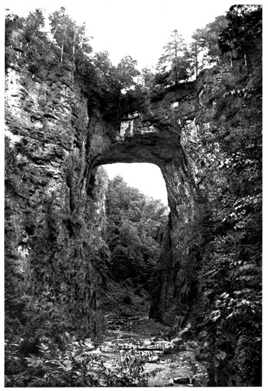
THE NATURAL BRIDGE.
The chief river of Virginia is the James, a noble stream, rising in the Alleghenies and flowing for four hundred and fifty miles from the western border of the Old Dominion until it falls into Chesapeake Bay at Hampton Roads. Its sources are in a region noted for mineral springs, and the union of Jackson and Cowpasture Rivers makes the James, which flows to the base of the Blue Ridge, and there receives a smaller tributary, not inappropriately named the Calfpasture River. The James breaks through the Blue Ridge by a magnificent gorge at Balcony Falls. Seven miles away, spanning the little stream known as Cedar Brook, is the famous Natural Bridge, the wonderful arch of blue limestone two hundred and fifteen feet high, ninety feet wide, and having a span of a hundred feet thrown across the chasm, which has given to the county the name of Rockbridge. Overlooking the river and the bridge and all the country roundabout are the two noble Peaks of Otter, rising about four thousand feet, the highest mountains in that part of the Alleghenies. This wonderful bridge is situated at the extremity of a deep chasm, through which the brook flows, across the top 55 of which extends the rocky stratum in the form of a graceful arch. It looks as if the limestone rock had originally covered the entire stream bed, which then flowed through a subterranean tunnel, the rest of the limestone roof having fallen in and been gradually washed away. The bridge is finely situated in a grand amphitheatre surrounded by mountains. The crown of the arch is forty feet thick, the rocky walls are perpendicular, and over the top passes a public road, which, being on the same level as the immediately adjacent country, one may cross it in a coach without noticing the bridged chasm beneath. Various large forest trees grow beneath and under the arch, but are not tall enough to reach it. On the rocky abutments of the bridge are carved the names of many persons who had climbed as high as they dared on the steep face of the precipice. Highest of all, for about seventy years, was the name of Washington, who, in his youth, ascended about twenty-five feet to a point never before reached; but this feat was surpassed in 1818 by James Piper, a college student, who actually climbed from the foot to the top of the rock. In 1774 Thomas Jefferson obtained a grant of land from George III. which included the Natural Bridge, and he was long the owner, building the first house there, a log cabin with two rooms, one being for the reception of strangers. Jefferson called the bridge "a famous place that will draw the attention of the world;" 56 Chief Justice Marshall described it as "God's greatest miracle in stone;" and Henry Clay said it was "The bridge not made with hands, that spans a river, carries a highway, and makes two mountains one."
THE JAMES RIVER AND POWHATAN.
Following down James River, constantly receiving accessions from mountain streams, we soon come to Lynchburg, most picturesquely built on the sloping foothills of the Blue Ridge, and having fine water-power for its factories, a centre of the great tobacco industry of Virginia, supporting a population of about twenty thousand people. Lynchburg was a chief source of supply for Lee's army in Eastern Virginia until, in February, 1865, Sheridan, by a bold raid, destroyed the canal and railroads giving it communication; and, after evacuating Richmond, Lee was endeavoring to reach Lynchburg when he surrendered at Appomattox, about twenty miles to the eastward, on April 9, 1865, thus ending the Civil War. The little village of Appomattox Court House is known in the neighborhood as Clover Hill. When Lee surrendered, casualties, captures and desertions had left him barely twenty-seven thousand men, with only ten thousand muskets, thirty cannon and three hundred and fifty wagons.
The James River, east of the Blue Ridge, drains a grand agricultural district, and its coffee-colored 57 waters tell of the rich red soils through which it comes in the tobacco plantations all the way past Lynchburg to Richmond. In its earlier history this noted river was called the Powhatan, and it bears that name on the older maps. Powhatan, the original word, meant, in the Indian dialect, the "falls of the stream" or "the falling waters," thus named from the falls and rapids at Richmond, where the James, in the distance of nine miles, has a descent of one hundred and sixteen feet, furnishing the magnificent water-power which is the source of much of the wealth of Virginia's present capital. The old Indian sachem whose fame is so intertwined with that of Virginia took his name of Powhatan from the river. His original name was Wahunsonacock when the colonists first found him, and he then lived on York River; but it is related that he grew in power, raised himself to the command of no less than thirty tribes, and ruled all the country from southward of the James to the eastward of the Potomac as far as Chesapeake Bay. When he became great, for he was unquestionably the greatest Virginian of the seventeenth century, he changed his name and removed to the James River, just below the edge of Richmond, where, near the river bank, is now pointed out his home, still called Powhatan. It was here that the Princess Pocahontas is said to have interfered to save the life of Captain John Smith. Here still stands a precious relic in the shape of an old chimney, 58 believed to have been originally built for the Indian king's cabin by his colonist friends. It is of solid masonry, and is said to have outlasted several successive cabins which had been built up against it in Southern style. A number of cedars growing alongside, tradition describes as shadowing the very stone on which Smith's head was laid. It may not be generally known that early in the history of the colony Powhatan was crowned as a king, there having been brought out from England, for the special purpose, a crown and "a scarlet cloke and apparrell." The writer recording the ceremony says quaintly: "Foule trouble there was to make him kneele to receive his crowne. At last, by leaning hard on his shoulders, he a little stooped, and three having the crowne in their hands, put it on his head. To congratulate their kindnesse, he gave his old shoes and his mantell to Captaine Newport, telling him take them as presents to King James in return for his gifts."
THE INDIAN PRINCESS POCAHONTAS.
The James River carries a heavy commerce below Richmond, and the channel depths of the wayward and very crooked stream are maintained by an elaborate system of jetties, constructed by the Government. Both shores show the earthworks that are relics of the war, and Drewry's Bluff, with Fort Darling, the citadel of the Confederate defence of the 59 river, is projected across the stream. Below is Dutch Gap, where the winding river, flowing in a level plain, makes a double reverse curve, going around a considerable surface without making much actual progress. Here is the Dutch Gap Canal, which General Butler cut through the narrowest part of the long neck of land, thus avoiding Confederate batteries and saving a detour of five and a half miles; it is now used for navigation. Just below is the large plantation of Varina, where the Indian Princess Pocahontas lived after her marriage with the Englishman, John Rolfe. Its fine brick colonial mansion was the headquarters for the exchange of prisoners during the Civil War.
The brief career of Pocahontas is the great romance of the first settlement of Virginia. She was the daughter and favorite child of Powhatan, her name being taken from a running brook, and meaning the "bright streamlet between the hills." When the Indians captured Captain John Smith she was about twelve years of age. He made friends of the Indian children, and whittled playthings for them, so that Pocahontas became greatly interested in him, and the tale of her saving his life is so closely interwoven with the early history of the colony that those who declare it apocryphal have not yet been able to obliterate it from our school-books. Smith being afterwards liberated, Pocahontas always had a longing for him, was the medium of getting the colonists 60 food, warned them of plots, and took an interest in them even after Smith returned to England. The tale was then told her that Smith was dead. In 1614 Pocahontas, about nineteen years old, was kidnapped and taken to Jamestown, in order to carry out a plan of the Governor by which Powhatan, to save his daughter, would make friendship with the colony, and it resulted as intended. Pocahontas remained several weeks in the colony, made the acquaintance of the younger people, and fell in love with Master John Rolfe. Pocahontas returned to her father, who consented to the marriage; she was baptized at Jamestown as Lady Rebecca, and her uncle and two brothers afterwards attended the wedding, the uncle giving the Indian bride away in the little church at Jamestown, April 5, 1614. A peace of several years' duration was the consequence of this union. Two years afterwards Pocahontas and her husband proceeded to England, where she was an object of the greatest interest to all classes of people, and was presented at Court, the Queen warmly receiving her. Captain Smith visited her in London, and after saluting him she turned away her face and hid it in her hands, thus continuing for over two hours. This was due to her surprise at seeing Smith, for there is no doubt her husband was a party to the deception, he probably thinking she would never marry him while Smith was living. The winter climate of England was too severe for her, 61 and when about embarking to return to Virginia she suddenly died at Gravesend, in March, 1617, aged about twenty-two. She left one son, Thomas Rolfe, who was educated in London, and in after life went to Virginia, where he became a man of note and influence. From him are descended the famous children of Pocahontas—the "First Families of Virginia"—the Randolph, Bolling, Fleming and other families.
SHIRLEY, BERKELEY AND WESTOVER.
The winding James flows by Deep Bottom and Turkey Bend, and one elongated neck of land after another, passing the noted battlefield of Malvern Hill, which ended General McClellan's disastrous "Seven Days" of battles and retreat from the Chickahominy swamps in 1862. The great ridge of Malvern Hill stretches away from the river towards the northwest, and in that final battle which checked the Confederate pursuit it was a vast amphitheatre terraced with tier upon tier of artillery, the gunboats in the river joining in the Union defense. Below, on the other shore, are the spacious lowlands of Bermuda Hundred, where, in General Grant's significant phrase, General Butler was "bottled up." Here, on the eastern bank, is the plantation of Shirley, one of the famous Virginian settlements, still held by the descendants of its colonial owners—the Carters. The wide and attractive old brick colonial house, with its 62 hipped and pointed roof, stands behind a fringe of trees along the shore, with numerous outbuildings constructed around a quadrangle behind. It is built of bricks brought out from England, is two stories high, with a capacious front porch, and around the roof are rows of dormer windows, above which the roof runs from all sides up into a point between the tall and ample chimneys. The southern view from Shirley is across the James to the mouth of Appomattox River and City Point.
The Appomattox originates in the Blue Ridge near Lynchburg, and flows one hundred and twenty miles eastward to the James, of which it is the chief tributary. It passes Petersburg twelve miles southwest of its point of union with the James, this union being at a high bluff thrust out between the rivers, with abrupt slopes and a plateau on the top, which is well shaded. Here is the house—the home of Dr. Epps—used by General Grant as his headquarters during the operations from the south side of the James against Petersburg and Lee's army in 1864-65. Grant occupied two little log cabins on top of the bluff, just east of the house; one his dwelling and the other his office. One is still there in dilapidation, and the other is preserved as a relic in Fairmount Park, Philadelphia. A short distance away is the little town of City Point, with its ruined wharves, where an enormous business was then done in landing army supplies. To the eastward the 63 James flows, a steadily broadening stream, past the sloping shores on the northern bank, where, at Harrison's Landing, McClellan rested his troops after the "Seven Days," having retreated there from the battle at Malvern Hill. His camps occupied the plantations of Berkeley and Westover, the former having been the birthplace of General William Henry Harrison, who was President of the United States for a few weeks in 1841, the first President who died in office. The Berkeley House is a spacious and comfortable mansion, but it lost its grand shade-trees during the war. A short distance farther down is the quaint old Queen Anne mansion of red brick, with one wing only, the other having been burnt during the war; with pointed roof and tall chimneys, standing at the top of a beautifully sloping bank—Westover House, the most famous of the old mansions on the James. It was the home of the Byrds—grandfather, father and son—noted in Virginian colonial history, whose arms are emblazoned on the iron gates, and who sleep in the little graveyard alongside. The most renowned of these was the second, the "Honourable William Byrd of Westover, Esquire," who was the founder of both Richmond and Petersburg.
William Byrd was a man of imposing personal appearance and the highest character, and his full-length portrait in flowing periwig and lace ruffles, after Van Dyck, is preserved at Lower Brandon, 64 farther down the river. He inherited a large landed estate—over fifty thousand acres—and ample fortune, and was educated in England, where he was called to the bar at the Middle Temple, and made a Fellow of the Royal Society. The inscription on his Westover tomb tells that he was a friend of the learned Earl of Orrery. He held high offices in Virginia, and possessed the largest private library then in America. In connection with one Peter Jones, in 1733, he laid out both Richmond and Petersburg on lands he owned, at the head of navigation respectively on the James and the Appomattox. He left profuse journals, published since as the Westover Manuscripts, and they announce that Petersburg was gratefully named in honor of his companion-founder, Peter Jones, and that Richmond's name came from Byrd's vivid recollection of the outlook from Richmond Hill over the Thames in England, which he found strikingly reproduced in the soft hills and far-stretching meadows adjoining the rapids of the James, with the curving sweep of the river as it flowed away from view behind the glimmering woods. He died in 1744. Westover House was McClellan's headquarters in 1862. The estates have gone from Byrd's descendants, but the house has been completely restored, and is one of the loveliest spots on the James. Major Augustus Drewry, its recent owner, died in July, 1899, at an advanced age. Coggins Point projects opposite Westover, and noted 65 plantations and mansions line the river banks, bearing, with the counties, well-known English names. Here is the ruined stone Fort Powhatan, a relic of the War of 1812, with the Unionist earthworks of 1864-65 on the bluff above it. Then we get among the lowland swamps, where the cypress trees elevate their conical knees and roots above the water. The James has become a wide estuary, and the broad Chickahominy flows in between low shores, draining the swamps east of Richmond and the James. This was the "lick at which turkeys were plenty," the Indians thus recognizing in the name of the river the favorite resort of the wild turkey.
THE COLONY OF JAMESTOWN.
We have now come to the region of earliest English settlement in America, where Newport and Smith, in 1607, planted their colony of Jamestown upon a low yellow bluff on the northern river bank. It is thirty-two miles from the mouth of the James River, and the bluff, by the action of the water, has been made an island. The location was probably selected because this furnished protection from attacks. The later encroachments of the river have swept away part of the site of the early settlement, and a portion of the old church tower and some tombstones are now the only relics of the ancient town. The ruins of the tower can be seen on top of the bluff, almost overgrown with moss and vines. 66 Behind is the wall of the graveyard where the first settlers were buried. A couple of little cabins are the only present signs of settlement, the mansion of the Jamestown plantation being some distance down the river.
When the English colony first came to Jamestown in 1607, they were hunting for gold and for the "northwest passage" to the East Indies. In fact, most of the American colonizing began with these objects. They had an idea in Europe that America was profuse in gold and gems. In 1605 a play of "Eastward, Ho" was performed in London, in which one of the characters said: "I tell thee golde is more plentifull in Virginia than copper is with us, and for as much redde copper as I can bring, I will have thrice the weight in golde. All their pannes and pottes are pure gould, and all the chaines with which they chaine up their streetes are massie gould; all the prisoners they take are fettered in golde; and for rubies and diamonds they goe forth in holidays and gather them by the seashore to hang on their children's coates and sticke in their children's caps as commonally as our children wear saffron, gilt brooches, and groates with hoales in them." The whole party, on landing at Jamestown, started to hunt for gold. Smith wrote that among the English colonists there was "no talk, no hope, no work, but dig gold, wash gold, refine gold, loade gold." They found some shining pyrites that deceived them, and 67 therefore the first ship returning to England carried away a cargo of shining dirt, found entirely worthless on arrival. The second ship, after a long debate, they more wisely sent back with a cargo of cedar. They hunted for the "northwest passage," first going up the James to the falls at the site of Richmond, but returning disappointed. It was this same hunt for a route to the Pacific which afterwards took Smith up the Chickahominy, where he got among the swamps and was captured by the Indians.
The Jamestown colonists met with great discouragements. Most of them were unfitted for pioneers, and the neighboring swamps gave them malaria in the hot summer, so that nearly half perished. Smith, by his courage and enterprise, however, kept the colony alive and took charge, being their leader until captured by the Indians, and also afterwards, until his return to England. Among the first constructions at Jamestown were a storehouse and a church. These, however, were soon burnt, and a second church and storehouse were erected in September, 1608. This church was like a barn in appearance, the base being supported by crotched stakes, and the walls and roof were made of rafts, sedge and earth, which soon decayed. When Smith left Jamestown for England in 1609 the place contained about sixty houses, and was surrounded by a stockade. Smith early saw the necessity of raising 68 food, and determined to begin the growing of maize, or Indian corn. Consequently, early in 1608 he prevailed upon two Indians he had captured to teach the method of planting the corn. Under their direction a tract of about forty acres was planted in squares, with intervals of four feet between the holes which received the Indian corn for seed. This crop grew and was partly harvested, a good deal of it, however, being eaten green. Thus the Indian invented the method of corn-planting universally observed in the United States, and this crop of forty acres of 1608 was the first crop of the great American cereal grown by white men. Wheat brought out from England was first planted at Jamestown in 1618 on a field of about thirty acres, this being the first wheat crop grown in the United States.
Captain John Smith, before he left Jamestown, estimated that there were about fifty-five hundred Indians within a radius of sixty miles around the colony, and in his works he enumerates the various tribes. Describing their mode of life, he wrote that they grew fat or lean according to the season. When food was abundant, he said, they stuffed themselves night and day; and, unless unforeseen emergencies compelled them to arouse, they dropped asleep as soon as their stomachs were filled. So ravenous were their appetites that a colonist employing an Indian was compelled to allow him a quantity of food double that given an English laborer. In a period of 69 want or hardship, when no food was to be had, the warrior simply drew his belt more tightly about his waist to try and appease the pangs of hunger. The Indians, when the colonists arrived, were found to divide the year into five seasons, according to its varying character. These were, first, Cattapeuk, the season of blossoms; second, Cohattayough, the season when the sun rode highest in the heavens; third, Nepenough, the season when the ears of maize were large enough to be roasted; fourth, Taquetock, the season of the falling leaves, when the maize was gathered; and fifth, Cohonk, the season when long lines of wild geese appeared, flying from the north, uttering the cry suggesting the name, thus heralding the winter.
The colony was very unfortunate, and in 1617 was reduced to only five or six buildings. The church had then decayed and fallen to the ground, and a third church, fifty by twenty feet, was afterwards built. Additional settlers were sent out from England in the next two years, and the Virginians were granted a government of their own, the new Governor, Sir George Yeardley, arriving in the spring of 1619. The Company in London also sent them a communication "that those cruell laws, by which the ancient planters had soe long been governed, were now abrogated in favor of those free laws which his majesties subjects lived under in Englande." It continued by stating "That the planters might have 70 a hande in the governing of themselves yt was granted that a generall assemblie should be held yearly once, whereat to be present the governor and counsell with two burgesses from each plantation, freely to be elected by the inhabitants thereof, this assemblie to have power to make and ordaine whatsoever laws and orders should by them be thought good and profitable for their subsistence." The Governor consequently summoned the first "House of Burgesses" in Virginia, which met at Jamestown, July 30, 1619, the first legislative body in America. Twenty-two members took their seats in the new church at Jamestown. They are described as wearing bright-colored silk and velvet coats, with starched ruffs, and as having kept their hats on as in the English House of Commons. The Governor sat in the choir, and with him were several leading men who had been appointed by the Company on the Governor's Council. They passed various laws, chiefly about tobacco and taxes, and sent them to England, where the Company confirmed them, and afterwards, in 1621, granted the "Great Charter," which was the first Constitution of Virginia.
The colonists got into trouble with the Indians in 1622, and having killed an Indian who murdered a white man, Jamestown was attacked and the inhabitants massacred, three hundred and forty-five being killed. Governor Butler, who visited the place not long after the massacre, wrote that the houses were 71 the "worst in the world," and that the most wretched cottages in England were equal, if not superior, in appearance and comfort to the finest dwellings in the colony. The first houses were mostly of bark, imitating those of the Indian; and, there being neither sawmills to prepare planks nor nails to fasten them, the later constructions were usually of logs plastered with mud, with thatched roofs. The more pretentious of these were built double—"two pens and a passage," as they have been described. As late as 1675 Jamestown had only a few families, with not more than seventy-five population. Labor was always in demand there, and at first the laborers were brought out from England. There was no money, and having early learnt to raise tobacco from the Indians, this became the chief crop, and, being sure of sale in England, became the standard of value. Tobacco was the great export, twenty thousand pounds being exported in 1619, forty thousand in 1620 and sixty thousand in 1622. Everything was valued in tobacco, and this continued the practical currency for the first century. They imported a lot of copper, however, with which to make small coins for circulation. As the tobacco fluctuated in price in England, it made a very unstable standard of value. Gradually, afterwards, large amounts of gold and silver coin came into Virginia in payment for produce, thus supplanting the tobacco as a standard. 72
THE VIRGINIAN PLANTERS.
Land was cheap in Virginia in the early days. In 1662 the King of Mattapony sold his village and five thousand acres to the colonists for fifty match-coats. During the seventeenth century the value of land reckoned in tobacco, as sold in England, averaged for cleared ground about four shillings per acre, the shilling then having a purchasing power equal to a dollar now. It was at this time that most of the great Virginian estates along James River were formed, the colonists securing in some cases large grants. Thus, John Carter of Lancaster took up 18,570 acres, John Page 5000 acres, Richard Lee 12,000 acres, William Byrd 15,000 acres, afterwards largely increased; Robert Beverley 37,000 acres and William Fitzhugh over 50,000 acres. These were the founders of some of the most famous Virginian families. The demand for labor naturally brought Virginia within the market of the slave trader, but very few negroes were there in the earlier period. The first negroes who arrived in Virginia were disembarked at Jamestown from a Dutch privateer in 1619—twenty Africans. In 1622 there were twenty-two there, two more having landed; but it is noted that no negro was killed in the Jamestown massacre. In 1649 there were only three hundred negroes in Virginia, and in 1671 there were about two thousand. In the latter part of the seventeenth 73 century the arrivals of negro slaves became more frequent—labor being in demand. The records show that the planters had great difficulty in supplying them with names, everything being ransacked for the purpose—mythology, history and geography—and hence the peculiar names they have conferred in some cases on their descendants. In 1640 a robust African man when sold commanded 2700 pounds of tobacco, and a female 2500 pounds, averaging, at the then price of tobacco, about seventeen pounds sterling for the men. Prices afterwards advanced to forty pounds sterling for the men. In 1699 all newly arrived slaves were taxed twenty shillings per head, paid by the master of the vessel.
As the colony developed, the typical dwelling became a framed log building of moderate size, with a big chimney at each end, there being no cellar and the house resting on the ground. The upper and lower floors were each divided into two rooms. Such a house, built in 1679, measuring forty by twenty feet, cost twelve hundred pounds of tobacco. Finally, when more prosperity came in the eighteenth century, the houses were developed and enlarged into more pretentious edifices, built of bricks brought out from England. These were the great colonial houses of the wealthy planters, so many of which exist until the present day. The most prosperous time in colonial Virginia was the period from 1710 until 1770. The exports of tobacco to England and flour 74 and other produce to the West Indies made the fortunes of the planters, so that their vast estates and large retinues of slaves made them the lordly barons whose fame spread throughout Europe, while their wealth enabled them to gather all the luxuries of furniture and ornament for their houses then attainable. It was in these noble colonial mansions, surrounded by regiments of negro servants, that the courtly Virginians of the olden time dispensed a princely hospitality, limited only by their ability to secure whatever the world produced. The stranger was always welcome at the bountiful board, and the slave children grew up amid plenty, hardly knowing what work was. This went on with more or less variation until the Civil War made its tremendous upheaval, which scattered both whites and blacks. But the typical Virginian is unchanged, continuing as open-hearted and hospitable, though his means now are much less. To all he has, the guest is welcome; but it is usually with a tinge of regret that he recalls the good old time when he might have done more.
HAMPTON ROADS AND FORTRESS MONROE.
The constantly broadening estuary of the James assumes almost the proportions of an inland sea, and in the bays encircled by the low shores are planted the seed oysters, which are gathered by fleets of small vessels for transplanting into salt-water beds. In front, near the mouth of the river, is thrust out 75 the long point of Newport News, with its grain elevators and shipyards, dry-docks and iron-works, the great port of the James River, which is the busy terminal of railways coming from the West. Here is a town of thirty thousand people. It was almost opposite, that in the spring of 1862 the Confederate ram "Merrimac" (then called the "Virginia"), armored with railroad rails, came suddenly out from Norfolk, and sank or disabled the American wooden naval vessels in Hampton Roads; the next day, however, being unexpectedly encountered by the novel little turret iron-clad "Monitor," which had most opportunely arrived from the upper Hudson River, where Ericsson had built her. The "Merrimac" was herself soon disabled and compelled to retire. This timely and dramatic appearance of "the little Yankee cheese-box on a raft" made a sudden and unforeseen revolution in all the naval methods and architecture of the world. Around the point of Newport News the James River debouches into one of the finest harbors of the Atlantic Coast, Hampton Roads, named from the town of Hampton on the northern shore. This is the location of a Veteran Soldiers' Home, with two thousand inmates, an extensive Soldiers' Cemetery, and of the spacious buildings of the Normal and Agricultural Institute for Negroes and Indians, where there are eight to nine hundred scholars, this being a foundation originally established by the Freedmen's Bureau, the chief object 76 being the training of teachers for colored and Indian schools.
The little peninsula of Old Point Comfort, which makes the northern side of the mouth of the James and juts out into Chesapeake Bay, has upon it the largest and most elaborate fortification in the United States—Fortress Monroe. It is related that when Newport and Smith first entered the bay in 1607, and were desirous of ascending the James, they coasted along the southern shore and found only shallow water. Starting out in a boat to hunt for a channel up which their ships could pass, they rowed over to the northern shore and discovered deeper water entering the James, close to this little peninsula, there being twelve fathoms depth, which so encouraged Smith that it confirmed him in naming the place Point Comfort. This channel, close inshore, could be readily defended, as it was the only passage for vessels of any draft, and consequently when the colony got established at Jamestown they built Fort Algernon at Point Comfort to protect the entrance to the James. In 1611 this fort was described as consisting of stockades and posts, without stone or brick, and containing seven small iron guns, with a garrison of forty men.
After the British invasion of Chesapeake Bay, in 1814, when they burnt the Capitol and White House at Washington, it was quickly decided that no foreign foe should be again permitted to do such a thing, and that an elaborate work should be built to defend the 77 entrance to the bay. General Simon Bernard, one of Napoleon's noted engineers, offered his services to the United States after the downfall of the Emperor, and he was placed in charge, with the duty of constructing, at the mouth of James River, a fortification which would command the channel into that river and to the Norfolk Navy Yard, and at the same time be a base of operations against any fleet attempting to enter the bay and menace the roadstead. Bernard built in 1819, and several following years, an elaborate fortress, with a broad moat and outlying water-battery, enclosing eighty acres, the ramparts being over two miles in circumference. It was called Fortress Monroe, after the then President James Monroe, of Virginia. Out upon an artificial island, known as the Rip-raps, built upon a shoal some two miles off-shore, and in the harbor entrance, the smaller works of Fort Wool were subsequently constructed, and the two make a complete defense for the Chesapeake Bay entrance. During all the years this fortress has existed it has never had occasion to fire a gun at an enemy, but its location and strength were invaluable to the North, who held it during the Civil War. It is the seat of the Artillery School of the army. To the southward, at the waterside, are the hotels of Old Point Comfort, which is one of the favorite seaside watering-places of the South. In front is the great Hampton roadstead, usually containing fleets of wind-bound vessels and some men-of-war. 78
NORFOLK AND ITS NEIGHBORHOOD.
Over on the southern side of Chesapeake Bay is the Elizabeth River, in reality a tidal arm of the sea, curving around from the south to the east, and having Norfolk on its northern bank and Portsmouth opposite. The country round about is flat and low-lying, and far up the river are Gosport and the Navy Yard, the largest possessed by the United States. There are probably sixty thousand population in the three towns. The immediate surroundings are good land and mostly market gardens, but to the southward spreads the great Dismal Swamp, covering about sixteen hundred square miles, intersected by various canals, and yielding cypress, juniper and other timber. It is partly drained by the Nansemond River, on which, at the edge of the swamp, is the little town of Suffolk, whence the Jericho Run Canal leads into Lake Drummond, a body of water covering eighteen square miles and twenty-one feet above tidewater. Mrs. Harriet Beecher Stowe has woven much of the romance of this weird fastness and swamp into her tale of Dred. The Dismal Swamp Canal, twenty-two miles long, and recently enlarged and deepened, passes through it from Elizabeth River to the Pasquotank River of North Carolina, and the Albemarle Canal also connects with Currituck Sound. This big swamp was first explored by Colonel William Byrd, of Westover, 79 in 1728, when he surveyed the boundary between Virginia and North Carolina.
All about the Norfolk wharves are cotton bales, much timber, tobacco and naval stores, and immense quantities of food and garden products, not forgetting a profusion of "goobers," all awaiting shipment, for this, next to Savannah, is the greatest export port for food and other supplies on the Southern Atlantic. The "goober," or peanut, is the special crop of this part of Virginia and Carolina. The cotton compresses do a lively business in the cotton season, the powerful hydraulic pressure squeezing the bale to barely one-fourth its former size, and binding it firmly with iron bands, thus giving the steamers increased cargo. In the spring the shipment North of early fruits and vegetables is enormous, vast surfaces being devoted to their growth, the strawberry beds especially covering many acres. The oyster trade is also large. The settlement of Norfolk began in 1680, and in 1736 it was made a borough. Portsmouth was established later, but the starting of the navy yard there, which has become so extensive, gave it great impetus. Portsmouth claims that in the Civil War, in proportion to size, it sent more soldiers to the Southern armies and had more dead than any other city. The capacious naval hospital and its fine grove of trees front Portsmouth towards the harbor. Norfolk has St. Paul's Church, founded in 1730, as its chief Revolutionary relic—an 80 ancient building, with an old graveyard, and having in its steeple the indentation made by a cannon-shot, when a British fleet in 1776 bombarded and partly burnt the town. An old-fashioned round ball rests in the orifice; not, however, the one originally sent there by the cannoneers. Relic-hunters visiting the place have a habit of clandestinely appropriating the cannon-ball, so the sexton, with an eye to business, has some on hand ready to put into the cavity, and thus maintain the old church's patriotic reputation. A novel sight in Norfolk is its market, largely served by negroes—old "mammies" with bright bandannas tied about their heads and guarding piles of luscious fruits; funny little pickaninnies who execute all manner of athletic gyrations for stray pennies, queer old market wagons, profusions of flowers, and such a collection of the good things of life, all set in a picture so attractive that the sight is long remembered.
THE EASTERN SHORE.
Northward from Old Point Comfort and Hampton Roads the great Chesapeake Bay stretches for two hundred miles. It bisects Virginia and Maryland, and receives the rivers of both States, extending within fourteen miles of Pennsylvania, where it has as its head the greatest river of all, the Susquehanna, which the Indians appropriately called their "great island river." Its shores enclose many islands, and are indented with innumerable bays and inlets, the 81 alluvial soils being readily adapted to fruit and vegetable growing, and its multitudes of shallows being almost throughout a vast oyster bed. It has, all about, the haunts of wild fowl and the nestling-places of delicious fish. These shores were the home—first on the eastern side and afterwards on the western—of the Nanticokes, or "tidewater Indians," who ultimately migrated to New York to join the Iroquois or Five Nations, making that Confederacy the "Six Nations." From Cape Charles, guarding the northern entrance to the Bay, extends northward the well-known peninsula of the "Eastern Shore," a land of market gardens, strawberries and peaches, which feeds the Northern cities, and having its railroad, a part of the Pennsylvania system, running for miles over the level surface in a flat country, which enabled the builders to lay a mathematically straight pair of rails for nearly ninety miles, said to be the longest railway tangent in existence.
Chesapeake Bay is now patrolled by the oyster fleets of both Virginia and Maryland, each State having an "oyster navy" to protect its beds from predatory forays; and occasionally there arises an "oyster war" which expands to the dignity of a newspaper sensation, and sometimes results in bloodshed. The wasteful methods of oyster-dredging are said to be destroying the beds, and they are much less valuable than formerly, although measures are being projected for their protection and restoration 82 under Government auspices. We are told that a band of famished colonists who went in the early days to beg corn from the Indians first discovered the value of the oyster. The Indians were roasting what looked like stones in their fire, and invited the hungry colonists to partake. The opened shells disclosed the succulent bivalve, and the white men found there was other good food besides corn. All the sites of extinct Indian villages along the Chesapeake were marked by piles of oyster shells, showing they had been eaten from time immemorial.
The English colonists at Jamestown were told by the Indians of the wonders of the "Mother of Waters," as they called Chesapeake Bay, about the many great rivers pouring into it, the various tribes on its shores, and the large fur trade that could be opened with them; so that the colonists gradually came to the opinion that the upper region of the great bay was the choicest part of their province. Smith explored it and made a map in 1609, and others followed him, setting up trading-stations upon the rivers as far as the Potomac and the Patuxent. Soon this new country and its fur trade attracted the cupidity of William Claiborne, who had been appointed Treasurer of Virginia, and was sent out when King James I. made it a royal province, the king telling them they would find Claiborne "a person of qualitie and trust." He was also agent for a London Company the king had chartered to make 83 discoveries and engage in the fur trade. Claiborne, in 1631, established a settlement on Kent Island, the largest in the bay, about opposite Annapolis, and one hundred and thirty miles north of the James, which thrived as a trading station and next year sent its burgesses to the Assembly at Jamestown.
CALVERT AND MARYLAND.
Sir George Calvert, who had been private secretary to Lord Cecil in Queen Elizabeth's reign, and also held office under King James, upon retiring was created Baron of Baltimore in Ireland, and purchased part of Newfoundland, which he called Avalon. He sent out a colony and afterwards visited Avalon; but, being discouraged by the cold climate, he abandoned the colony, and persuaded the next king, Charles I., to give him land on both sides of Chesapeake Bay north of the Potomac. Before the deed was signed, however, Baron Baltimore died, and his son, Cecilius Calvert, succeeded him and received the grant. This was one of the greatest gifts of land ever made, extending northward from the Potomac River, including all Maryland, a broad strip of what is now Pennsylvania, all of Delaware, and a good deal of West Virginia. The charter made the grant a Palatinate, giving Lord Baltimore and his heirs absolute control of the country, freedom to trade with the whole world and make his own laws, or allow his colonists to do this. The price was the delivery of two Indian 84 arrows a year at the Castle of Windsor, and one-fifth of all the gold and silver found. This grant was dated on June 20, 1632, and the name first intended by Calvert for his colony was Crescentia; but in the charter it was styled Terra Mariæ, after Queen Henrietta Maria, or "Mary's Land." The expedition came out the following winter, leaving the Isle of Wight in November in two vessels, named the "Ark" and the "Dove," under command of Leonard Calvert, Cecil's brother, there being two hundred emigrants, nearly all Roman Catholics, like their chief, and mostly gentlemen of fortune and respectability. While the colony was Catholic, Cecil Calvert inculcated complete toleration. In his letter of instructions he wrote: "Preserve unity and peace on shipboard amongst all passengers; and suffer no offence to be given to any of the Protestants; for this end cause all acts of the Roman Catholic religion to be done as privately as may be;" and he also told his brother, the Governor, "to treat all Protestants with as much mildness and favor as justice would permit," this to be observed "at land as well as at sea." In March, 1633, they entered the Chesapeake and sailed up to the Potomac River, landing at an island and setting up a cross, claiming the country for Christ and for England.
The "Ark" anchored, and the smaller "Dove" was sent cruising along the shore of the Potomac above Point Lookout, "to make choice of a place 85 probable to be healthfull and fruitfull," which might be easily fortified, and "convenient for trade both with the English and savages." The little "Dove" sailed some distance up the Potomac, examining the shore, and encountered various Indians, who were astonished when they saw the vessel, diminutive, yet so much larger than their canoes, and said they would like to see the tree from which that great canoe was hollowed out, for they knew nothing of the method of construction. The colonists talked with the Indians, having an interpreter, and Leonard Calvert asked a chief: "Shall we stay here, or shall we go back?" To this a mysterious answer was made: "You may do as you think best." Calvert did not like this, and decided to land nearer the bay, so his vessel dropped down the river again, and they finally landed on a stream where they found the Indian village of Yoacamoco. The Indians were very friendly, sold part of their village for some axes and bright cloth, gave up their best wigwams to Calvert and his colonists, and in one of these the Jesuit fathers held a solemn service, dedicating the settlement to St. Mary; and thus was founded the capital of the new Palatinate of Maryland. Under Calvert's wise rule the colony prospered, kept up friendliness with the Indians, enjoyed a lucrative trade, and, after a long struggle, ultimately managed to make Claiborne abandon the settlement on Kent Island, which became part of Maryland. To the northward of them 86 was the estuary of the Patuxent River, meaning "the stream at the little falls." St. Mary's County is the peninsula between the Patuxent and the Potomac, terminating at Point Lookout, and a quiet and restful farming country to-day. Leonardstown, on the Patuxent, named after Leonard Calvert, is the county-seat; but the ancient village of St. Mary's, the original colony and capital, afterwards superseded by Annapolis, still exists, though only a few scattered bricks remain to mark the site of the old fort and town. At St. Inigoe's is the quaint colonial home of the Jesuit fathers who accompanied Calvert, and its especial pride is a sweet-toned bell, brought out from England in 1685, which still rings the Angelus. At Kent Island scarcely a vestige remains of Claiborne's trading-post and settlement.
THE MARYLAND CAPITAL.
The settlers of Maryland were not all Roman Catholics, however, for Puritan refugees came in there. Above the Patuxent is the estuary of the Severn River, and here, in a beautiful situation, is Annapolis, the capital of Maryland, which has about eight thousand inhabitants, and was originally colonized in 1649 by Puritans driven from the James River in Virginia by the Episcopalians in control there. The settlement was at first called Providence, and Richard Preston, the eminent Quaker, was long its commander. Afterwards it was named 87 Anne Arundel Town, after Lady Baltimore, which still is the name of its county, although the town came to be finally known as Annapolis, from Queen Anne, at the beginning of the eighteenth century, who gave it valuable presents. It is now best known as the seat of the United States Naval Academy, which has a fine establishment there, founded by George Bancroft, the historian, when he was Secretary of the Navy, in 1845. Its ancient defensive work, Fort Severn, has been roofed over, and is the Academy gymnasium. The city was made the capital of Maryland in 1794, the government being then removed from St. Mary's, and the State Capitol is a massive brick structure, standing on an eminence, with a lofty dome and cupola, from which there is a fine view of the surrounding country and over Chesapeake Bay. In the Senate Chamber General Washington surrendered his Commission to the American Colonial Congress which met there in December, 1783, and in it also assembled the first Constitutional Convention of the United States, in 1786. In front of the building is a colossal statue of Chief Justice Taney, of the Supreme Court of the United States, a native of Maryland, who died in 1864. Annapolis formerly had an extensive commerce and amassed much wealth, until eclipsed by the growth of Baltimore, and now its chief trade, like so many of the towns of the Chesapeake, is in oysters. 88
THE MONUMENTAL CITY.
The head of Chesapeake Bay, on either side of the Susquehanna River, is composed of various broad estuaries, with small streams entering them. To the eastward the chief is Elk River, and to the westward are the Gunpowder and Bush Rivers, with others. Not far above the Severn is the wide tidal estuary of the Patapsco, so named by the Indians to describe its peculiarity, the word meaning "a stream caused by back or tidewater containing froth." A few miles up this estuary is the great city and port of the Chesapeake, Baltimore, so named in honor of Lord Baltimore, and containing, with its suburbs, over six hundred thousand people. The spreading arms of the Patapsco, around which the city is built, provide an ample harbor, their irregular shores making plenty of dock room, and the two great railways from the north and west to Washington, which go under the town through an elaborate system of tunnels, give it a lucrative foreign trade in produce brought for shipment abroad. From the harbor there are long and narrow docks, and an inner "Basin" extending into the city, and across the heads of these is Pratt Street. This highway is famous as the scene of the first bloodshed of the Civil War. The Northern troops, hastily summoned to Washington, were marching along it from one railway station to the other on April 19, 1861, when a Baltimore mob, sympathizing 89 with the South, attacked them. In the riot and conflict that followed eleven were killed and twenty-six were wounded. A creek, called Jones's Falls, coming down a deep valley from the northward into the harbor, divides the city into two almost equal sections, and in the lower part is walled in, with a street on either side. Colonel David Jones, who was the original white inhabitant of the north side of Baltimore harbor, gave this stream his name about 1680, before anyone expected even a village to be located there. A settlement afterwards began eastward of the creek, known as Jonestown, while Baltimore was not started until 1730, being laid out westward of the creek and around the head of the "Basin," the plan covering sixty acres. This was called New Town, as the other was popularly termed Old Town, but they subsequently were united as Baltimore, having in 1752 about two hundred people.
Baltimore is rectangular in plan and picturesque, covering an undulating surface, the hills, which are many, inclining either to Jones's Falls or the harbor. Its popular title is the "Monumental City," given because it was the first American city that built fine monuments. At the beginning of the nineteenth century the State of Maryland erected on Charles Street a monument to General Washington, rising one hundred and ninety-five feet, a Doric shaft of white marble surmounted by his statue and upon a base fifty feet square. This splendid monument 90 stands in a broadened avenue and at the summit of a hill, surrounded by tasteful lawns and flower gardens, with a fountain in front. It makes an attractive centre for Mount Vernon Place, which contains one of the finest collections of buildings in the city, and presents a scene essentially Parisian. Here are the Peabody Institute and the Garrett Mansion, both impressive buildings. Baltimore has a "Battle Monument," located on Calvert Street, in Monument Square, a marble shaft fifty-three feet high, marking the British invasion of 1814, and erected in memory of the men of Baltimore who fell in battle just outside the city, when the British forces marched from Elk River to Washington and burnt the Capitol, and the British fleet came up the Patapsco and shelled the town. The city also has other fine monuments, so that its popular name is well deserved.
The City Hall is the chief building of Baltimore, a marble structure in Renaissance, costing $2,000,000, its elaborate dome rising two hundred and sixty feet, and giving a magnificent view over the city and harbor. There are two noted churches, the Mount Vernon Methodist Church, of greenstone, with buff and red facings and polished granite columns, being the finest, although the First Presbyterian Church, nearby, is regarded as the most elaborate specimen of Lancet-Gothic architecture in the country, its spire rising two hundred and sixty-eight feet. The Roman Catholic Cathedral is an attractive granite church, 91 containing paintings presented by Louis XVI. and Charles X. of France. Cardinal Archbishop Gibbons, of Baltimore, is the Roman Catholic Primate of the United States. The greatest charities of the city are the Johns Hopkins Hospital and the Johns Hopkins University, endowed by a Baltimore merchant who died in 1873, the joint endowments being $6,500,000. Hopkins was shrewd and penurious, and John W. Garrett persuaded him to make these princely endowments, much of his fortune being invested in the Baltimore and Ohio Railroad, of which Garrett was President in its days of greatest prosperity. This railroad is the chief Baltimore institution, giving it a direct route to the Mississippi Valley, and was the first started of the great American trunk railways, its origin dating from 1826, when the movement began for its charter, which was granted by the Maryland Legislature the next year. This charter conferred most comprehensive powers, and the story is told that when it was being read in that body one of the members interrupted, saying: "Stop, man, you are asking more than the Lord's Prayer." The reply was that it was all necessary, and the more asked, the more would be secured. The interrupter, convinced, responded: "Right, man; go on." The corner-stone of the railway was laid July 4, 1828, beginning the route from Baltimore, up the Potomac and through the Alleghenies to the Ohio River. 92
DRUID HILL AND FORT McHENRY.
Baltimore is proud of the great art collection of Henry Walters in Mount Vernon Place, exhibited for a fee for the benefit of the poor; and it also has had as a noted resident Jerome Bonaparte, brother of Napoleon, who married, and then discarded by Napoleon's order, Miss Patterson, a Baltimore lady. Dr. Oliver Wendell Holmes has remarked that three short American poems, each the best of its kind, were written in Baltimore: Poe's Raven, Randall's Maryland, My Maryland, and Key's Star-Spangled Banner. It is also proud of its park—"Druid Hill"—a splendid pleasure-ground of seven hundred acres, owing much of its beauty to the fact that it had been preserved and developed as a private park for a century before passing under control of the city. The route to it is by the magnificent Eutaw Place, and the stately entrance gateway opens upon an avenue lined on either hand by long rows of flower vases on high pedestals, laid out alongside Druid Lake, the chief water-reservoir. The Park has an undulating surface of woodland and meadow, with grand old trees and splendid lawns, making a scene decidedly English, not overwrought by art, but mainly left in its natural condition. The mansion-house of the former owner, now a restaurant, occupies a commanding position, and on the northern side the land rises to Prospect Hill, with an expansive 93 view all around the horizon and eastward to Chesapeake Bay.
In this beautiful park the higher grounds are used for water-reservoirs. Baltimore has the advantage of receiving its supply by gravity from the Gunpowder River to the northward, where a lake has been formed, the pure water being brought through a tunnel for seven miles to the reservoirs, of which there are eight, with a capacity of 2,275,000,000 gallons, and capable of supplying 300,000,000 gallons daily. These reservoirs appear as pleasant lakes, Montebello and Roland, with Druid Lake, being the chief. Across the ravine of Jones's Falls is Baltimore's chief cemetery, Greenmount, a pretty ground, with gentle hills and vales. Here, in a spot selected by herself, is buried Jerome's discarded wife, Madame Patterson-Bonaparte, whose checkered history is Baltimore's chief romance. Here also lie Junius Brutus Booth, the tragedian, and his family, among them John Wilkes Booth, who murdered President Lincoln.
The most significant sight of Baltimore, however, is its old Fort McHenry—down in the harbor, on the extreme end of Locust Point, originally called Whetstone Point, where the Patapsco River divides—built on a low-lying esplanade, with green banks sloping almost to the water. It was the strategic position of this small but strong work, thoroughly controlling the city as well as the harbor entrance, that held Baltimore 94 during the early movements of the Civil War, and maintained the road from the North to Washington. Its greatest memory, however, and, by the association, probably the greatest celebrity Baltimore enjoys, comes from the flag on the staff now quietly waving over its parapets. Whetstone Point had been fortified during the Revolution, but in 1794 Maryland ceded it to the United States, and the people of Baltimore raised the money to build the present fort, which was named after James McHenry, who had been one of the framers of the Federal Constitution and was Secretary of War under President Washington. When Admiral Cockburn's British fleet came up the Chesapeake in September, 1814, the Maryland poet, Francis Scott Key, was an aid to General Smith at Bladensburg. An intimate friend had been taken prisoner on board one of the ships, and Key was sent in a boat to effect his release by exchange. The Admiral told Key he would have to detain him aboard for a day or two, as they were proceeding to attack Baltimore. Thus Key remained among the enemy, an unwilling witness of the bombardment on September 12th, which continued throughout the night. In the early morning the attack was abandoned, the flag was unharmed, and the British ships dropped down the Patapsco.
Key wrote his poem on the backs of letters, with a barrel-head for a desk, and being landed next day he showed it to friends, and then made a fresh 95 copy. It was taken to the office of the Baltimore American and published anonymously in a handbill, afterwards appearing in the issue of that newspaper on September 21, 1814. The tune was "Anacreon in Heaven," and there was a brief introduction describing the circumstances under which it was written. It was first sung in the Baltimore Theatre, October 12th of that year, and afterwards became popular. The flag which floated over Fort McHenry on that memorable night is still preserved. Fired by patriotic impulses, various ladies of Baltimore had made this flag, among them being Mrs. Mary Pickersgill, who is described as a daughter of Betsy Ross, of Philadelphia, who made the original sample-flag during the Revolution. The Fort McHenry flag contains about four hundred yards of bunting and is nearly square, measuring twenty-nine by thirty-two feet. It has fifteen stars and fifteen stripes, which was then the official regulation, there being fifteen States in the American Union. The poem of the Star-Spangled Banner, thus inspired and written, has become the great American patriotic anthem, and has carried everywhere the fame of the fort, the city, and the flowery flag of the United States. The following is the song, with title and introduction, as first published:
DEFENCE OF FORT McHENRY.
Tune—"Anacreon in Heaven."
O! say can you see by the dawn's early light,
What so proudly we hailed at the twilight's last gleaming,
Whose broad stripes and bright stars through the perilous fight,
O'er the ramparts we watch'd, were so gallantly streaming?
And the Rockets' red glare, the Bombs bursting in air,
Gave proof through the night that our Flag was still there;
O! say does that star-spangled banner yet wave
O'er the land of the free, and the home of the brave?
On the shore dimly seen through the mists of the deep,
Where the foe's haughty host in dread silence reposes;
What is that which the breeze, o'er the towering steep,
As it fitfully glows, half conceals, half discloses?
Now it catches the gleam of the morning's first beam,
In full glory reflected now shines in the stream.
'Tis the star-spangled banner, O! long may it wave
O'er the land of the free, and the home of the brave!
And where is that band who so vauntingly swore
That the havoc of war and the battle's confusion,
A home and a country should leave us no more?
Their blood has washed out their foul steps pollution.
No refuge could save the hireling and slave
From the terror of flight or the gloom of the grave,
And the star-spangled banner in triumph doth wave
O'er the land of the free, and the home of the brave!
O! thus be it ever when freemen shall stand
Between their lov'd homes and the war's desolation,
Blest with vict'ry and peace, may the Heav'n rescued land,
Praise the Power that hath made and preserv'd us a nation!
Then conquer we must, when our cause it is just,
And this is our motto: "In God is our Trust."
And the star-spangled banner in triumph shall wave
O'er the land of the free, and the home of the brave!
II.
THE GREAT THEATRE OF THE CIVIL WAR.
On to Richmond—Horace Greeley's Editorial Standard—The Conflict's Ebb and Flow—The Two Battles of Bull Run—Arlington—Manassas—McDowell against Beauregard—Lee and Jackson against Pope—Antietam—The Emancipation Proclamation—Fredericksburg—Burnside against Lee—Chancellorsville—Lee and Jackson against Hooker—Death of Stonewall Jackson—Guinney Station—The Wilderness—Mine Run—Grant's Southern March—Battles of the Wilderness—Spottsylvania—Hanover Court-House—Ashland—Richmond—The Capitol—Washington's Statues—Stonewall Jackson's Statue—Confederate White House—General Lee's House—The First House—St. John's Church—Patrick Henry—Libby Hill and Prison—Belle Isle—Rocketts—Hollywood Cemetery—Noted Graves—McClellan's Siege of Richmond—Drewry's Bluff—Chickahominy Swamps—Fair Oaks—Seven Days' Battles—Gaines' Mill—Cold Harbor—Malvern Hill—Harrison's Landing—Grant's Siege of Richmond—Second Battle of Cold Harbor—Bermuda Hundred—Petersburg—Capture of Richmond—Kilpatrick's Raid—Piedmont—Charlottesville—University of Virginia—Monticello—Thomas Jefferson—Shenandoah Valley—Cross Keys—Jackson's Exploits—Cedar Mountain—General Sheridan—Cedar Creek—Sheridan against Early—Luray Cavern—Battlefield of Gettysburg—Lee Marches into Pennsylvania—Hooker Resigns—Meade against Lee—Gettysburg Topography—Seminary Ridge—Cemetery Ridge—The Round Tops—Confederate Advance to Carlisle and the Susquehanna—Three Days' Battle—Reynolds Killed—The Round Tops Attacked—General Sickles Wounded in Peach Orchard—Ewell Repulsed at Cemetery—Pickett's Charge and Repulse—Cushing and Armistead Killed—High-Water Mark Monument—Lee Retreats—Gettysburg 100 Monuments—Jenny Wade—National Cemetery—Lincoln's Immortal Dedication—Valley of Death—Massachusetts Color-Bearer—The Reunited Union.
ON TO RICHMOND.
Lay down the Axe; fling by the spade:
Leave in its track the toiling plough;
The rifle and the bayonet blade
For arms like yours were fitter now;
And let the hands that ply the pen
Quit the light task, and learn to wield
The horseman's crooked brand, and rein
The charger on the battlefield.
Thus trumpeted William Cullen Bryant in "Our Country's Call," while the most powerful American editor of the time of the Civil War, Horace Greeley, raised his standard at the head of the New York Tribune's editorial page early in 1861 with the words "On to Richmond." The region between Washington and Richmond, and much of the adjacent country stretching southward beyond James River and northward into Pennsylvania, will always be historic because of the momentous movements, sanguinary conflicts and wonderful strategy of the great American Civil War from 1861 to 1865. We have described the environment of Chesapeake Bay, and now proceed to a consideration of this noted region west of the bay, where the tide of battle repeatedly ebbed and flowed. The first northern invasion of the Virginia Peninsula and the abortive siege of Richmond in the summer of 1862 were followed by 101 McClellan's retreat, Pope's defeat and the southern invasion of Maryland, which was checked at Antietam in the autumn. The northern attacks at Fredericksburg in December and at Chancellorsville in the spring of 1863 were followed by the invasion of Pennsylvania, checked at Gettysburg, the "high-water mark" of the rebellion; and Grant's march down through "the Wilderness" in 1864, followed by his gradual advances south of the James, forced the evacuation of Richmond, and Lee's final surrender at Appomattox in 1865.
THE TWO BATTLES OF BULL RUN.
The main route from Washington to the South crossed the Potomac, then as now, by the "Long Bridge," passing in full view of the yellow Arlington House, fronted by its columned porch. This historic building was the home of General Robert E. Lee in his early life, the chief Confederate Commander during the Civil War. The estate is now a vast cemetery, and upon it and all about to the westward are the remains of the forts and earthworks erected for the defence of Washington. After the war began, in April, 1861, the Northern troops were gradually assembled in and around Washington; but there came an imperative demand from the country that they should go forth and give the Confederates battle and capture Richmond before their Congress could meet, the opening of the session being fixed 102 for July 20th. The Southern armies were entrenched at Manassas Junction, west of Washington, and at Winchester to the northwest, and they were making forays almost in sight of Washington. General McDowell, with nearly forty thousand men, marched out of the Washington fortifications on July 17th to attack General Beauregard at Manassas. The Confederates brought their Winchester army hastily down, and took position along the banks of Bull Run, a tributary of the Occoquan, their lines stretching for about eight miles. McDowell attacked on the morning of the 21st, each side having about twenty-eight thousand available men. The conflict lasted with varying success most of the day, McDowell being finally beaten and retreating to Washington.
Thirteen months later, after McClellan's retreat from Richmond, was fought in almost the same place, on August 29 and 30, 1862, the second battle of Bull Run. General Pope had a considerable force in Northern Virginia, and when McClellan, whom Pope superseded, retreated from before Richmond, and started on his return from James River, Lee moved nearly his whole army up from Richmond, hoping to fall upon Pope before McClellan could join him. On August 22d the opposing forces confronted each other along the Rappahannock, when General Stuart, with the Confederate cavalry, made a raid around Pope's lines to the rear, reaching that general's headquarters and capturing his personal baggage, in which 103 was his despatch book describing the position of the whole Northern army. This gave Lee such valuable information that on the 25th he sent Stonewall Jackson with thirty thousand men, who, by a forced march, went around the western side of the Bull Run Mountains, came east again by the Thoroughfare Gap, and on the night of the 27th was in Pope's rear, and had cut his railroad connections and captured his supplies at Manassas. Pope, discovering the flanking movement, began falling back towards Manassas, and Jackson then withdrew towards the Gap, waiting for Lee to come up. There were various strategic movements afterwards, with fighting on the 29th; and on the 30th the Confederate wings had enclosed as in a vise Pope's forces to the west of Bull Run, when, after some terrific combats, Pope retreated across Bull Run towards Washington. Pope had about thirty-five thousand men and Lee forty-six thousand engaged in this battle. During the night of September 2d Jackson made a reconnoissance towards Washington, in which the Union Generals Stevens and Kearney were killed at Chantilly, and the authorities became so apprehensive of an attack upon the Capital that they ordered the whole army to fall back behind the Washington defenses. Pope was then relieved, at his own request, and the command restored to McClellan. The Confederates marched northward across the Potomac and McClellan followed, ending with the battles of South Mountain 104 and Antietam, later in September, when Lee retreated and recrossed the Potomac into Virginia on the 18th. The significant result of this conflict and withdrawal was the issue of the famous Emancipation Proclamation. President Lincoln had made a vow that if Lee was driven back from Maryland he would issue a proclamation abolishing slavery, which was done September 22, 1862.
FREDERICKSBURG AND THE WILDERNESS.
The route from Washington to Richmond skirts the Potomac for a long distance south of Alexandria, winding among hills and forests, crossing various broad creeks and bayous, among them the Occoquan, the outlet of Bull Run, and then diverges towards the Rappahannock. This is more historic ground, for the terrible battle of Fredericksburg was fought here in December, 1862, and the battle of Chancellorsville, to the westward, in May, 1863, where Stonewall Jackson lost his life. The "Wilderness" is to the southward of the Rappahannock, occupying about two hundred square miles, a plateau sloping to cultivated lowlands on every side. The original forests were long ago cut off, and a dense growth of scrub timber and brambles covered nearly the whole surface, with an occasional patch of woodland or a clearing. After the battle of Antietam the anxiety for another forward movement to Richmond led the Administration to remove McClellan, and then General 105 Burnside took command. His troops crossed the Rappahannock in December to attack General Lee's Confederate position on the Heights of Marye, where they were strongly entrenched; but the attack failed, the shattered army after great carnage withdrawing to the north bank of the river, and it lay there for months in winter quarters. Burnside was superseded by General Hooker, and in May, 1863, the Northern army again crossed the Rappahannock at several fords above Fredericksburg and started for Richmond. Lee quickly marched westward from Fredericksburg, and Lee and Hooker faced each other at Chancellorsville. Then came another of Stonewall Jackson's brilliant flank movements. Chancellorsville is on the eastern border of the Wilderness, and Jackson, making a long detour to the south and west through that desolate region, got around and behind Hooker's right flank, surprised him, and sent General Howard's entire corps in panic down upon the rest of the Union forces, making the greatest surprise of the war. During that same night Jackson, after his victory, was accidentally shot by his own men, a blow from which the Confederacy never recovered. Twelve miles south of Fredericksburg, at Guinney Station, is the little house where Jackson died. He and his aides, after reconnoitering, had returned within the Confederate lines, and the pickets, mistaking them for the enemy, fired into the party. Several of his escort were killed and Jackson was shot in 106 three places, an arm being shattered. Being put upon a litter one of the bearers stumbled, and Jackson was additionally injured by being thrown to the ground. The arm was amputated, but afterwards pneumonia set in, which was the immediate cause of his death. He lingered a week, dying May 10th, in his fortieth year, his last words, dreamily spoken, being: "Let us cross over the river and rest under the shade of the trees." It is said this loss of his ablest lieutenant had such an effect upon Lee that he afterwards aged rapidly, and his hair quickly whitened. The spot where Jackson was shot is alongside the Orange Plank Road, and is marked by a granite monument. Jackson is buried at Lexington, Virginia, where he had previously been a professor in the Military Academy. Hooker withdrew across the Rappahannock, Lee started northward, Hooker was succeeded by Meade, and the battle of Gettysburg was fought at the beginning of July.
Then came another movement towards Richmond, late in the year 1863. Meade marched down to the Wilderness in November, had heavy skirmishing and fought the battle of Mine Run on its western border, and then went back and into winter quarters. General Grant came from the West, took command, and early in May, 1864, started on his great march to Richmond through the Wilderness, with Lee constantly fighting on his right flank and front. There followed during that month a series of sanguinary 107 battles, in this inhospitable region, in which the losses of the two armies exceeded sixty thousand men. While moving southward, Grant faced and fought generally westward. It took him ten days to progress a dozen miles, and he could only move during the lulls in the fighting, the advance being usually made by changing one corps after another from the right to the left by marching in the rear of the main body, thus gradually prolonging the left wing southward through the forbidding country. Lee pressed forward into the vacated space, fortifying and fighting, his object being to force Grant eastward and away from Richmond, which was towards the south. "More desperate fighting has not been witnessed upon this Continent," said Grant of this struggle in the Wilderness; and later he wrote to Washington the famous declaration of his intention "to fight it out on this line if it takes all summer." The whole of this desolate region south and west of Fredericksburg and down to Spottsylvania is filled with the remains of the fortifications constructed in these memorable battles. Grant said that "In every change of position or halt for the night, whether confronting the enemy or not, the moment arms were stacked the men entrenched themselves," adding, "It was wonderful how quickly they could construct defenses of considerable strength." Thus the way was worked, by shovel and shell and musket and axe, through the Wilderness. There is a plan afoot for acquiring 108 these battlefields and the connecting roads, so as to preserve this historic ground as a public reservation.
The railway route to Richmond goes through the Wilderness, thinly peopled, sparsely cultivated, and exhibiting a few negro settlements, where they sun themselves alongside their cabins and watch the trains go by. There is an occasional horse or cow, but almost the only animals visible are the nimble-footed and hungry-looking "razor-backed" hogs that range the scrub timber in search of a precarious living. Once in awhile is seen an old homestead that has survived the ruin of the war, but the few buildings are generally most primitive, the favorite style being a small wooden cabin set alongside a huge brick chimney. It is said the chimney is first built, and if the draught is all right they then build the little cabin over against it and move in the family. The agriculture does not appear much better until Richmond is approached, where the surface of the country improves. At Hanover Court House are more signs of battlefields, for here McClellan had his early conflicts in besieging Richmond in 1862, while Grant came down from the Wilderness and had the battles of the North Anna near the end of May, 1864, and of Cold Harbor in June, after which he moved his army to the south side of James River. Ashland, sixteen miles north of Richmond, is in an attractive region, and is a favorite place of suburban residence. 109 This was the birthplace of Henry Clay, in 1777, and is the seat of Randolph Macon College.
THE CITY OF RICHMOND.
Richmond, the capital of Virginia, has about one hundred and thirty thousand population, and occupies a delightful situation. The James River flows around a grand curve from the northwest to the south, and pours over falls and rapids, which display many little cascades among a maze of diminutive islands. There are on the northern bank two or three large hills and several smaller ones, and Richmond is built upon these, it is said like Rome upon her seven hills. The State Capitol and a broad white penitentiary crown two of the highest. The town was founded at the falls of the James in 1737, and the capital of Virginia was moved here from Williamsburg in 1779, when there was only a small population. The place did not have much history, however, until it became the Capital of the Confederacy, and then the strong efforts made to capture it and the vigorous defence gave it world-wide fame. Beginning in 1862 it was made an impregnable fortress, and its fall, when the Confederate flank was turned in 1865 through the capture of Petersburg, resulted from General Lee's retreat westward and his final surrender at Appomattox. When Lee abandoned Petersburg there was a panic in Richmond, with riot and pillage; the bridges, storehouses and mills were fired, and nearly 110 one-third of the city burnt. It has since, however, been rebuilt in better style, and has extensive manufactures and a profitable trade.
The centre of Richmond is a park of twelve acres, surrounding the Capitol, a venerable building upon the summit of Shockoe Hill, and the most conspicuous structure in the city. It was built just after the American Revolution, the plan having been brought from France by Thomas Jefferson, and modelled from the ancient Roman temple of the Maison Carrée at Nismes, the front being a fine Ionic portico. From the roof, elevated high above every surrounding building, there is an excellent view, disclosing the grand sweep of the river among the islands and rapids, going off to the south, where it disappears among the hills behind Drewry's Bluff, below the town. The square-block plan with streets crossing at right angles is well displayed, and the abrupt sides of some of the hills, where they have been cut away, disclose the high-colored, reddish-yellow soils which have been so prolific in tobacco culture, and give the scene such brilliant hues, as well as dye the river a chocolate color in times of freshet. The city spreads over a wide surface, and has populous suburbs on the lower lands south of the James. This Capitol was the meeting-place of the Confederate Congress, and the locality of all the statecraft of the "Lost Cause." It contains the battle-flags of the Virginia troops and other relics, and in a gallery built around the rotunda 111 are hung the portraits of the Virginia Governors and of the three great military chiefs, Lee, Johnston and Jackson. Upon the floor beneath is Houdon's famous statue of Washington, made while he was yet alive. In 1785, the talented French sculptor accompanied Franklin to this country to prepare the model for the statue, which had been ordered by the Virginia Government. He spent two weeks at Mount Vernon with Washington, taking casts of his face, head and upper portion of the body, with minute measurements, and then returned to Paris. The statue was finished in 1788, and is regarded as the most accurate reproduction of Washington existing. A statue of Henry Clay and a bust of Lafayette are also in the rotunda.
On the esplanade north of the Capitol is Crawford's bronze equestrian statue of Washington upon a massive granite pedestal, one of the most attractive and elaborate bronzes ever made. The horse is half thrown upon his haunches, giving the statue exceeding spirit, while upon smaller pedestals around stand six heroic statues in bronze of Virginia statesmen of various periods—Patrick Henry, Thomas Jefferson, Thomas Nelson, George Mason, Andrew Lewis and Chief Justice John Marshall—the whole adorned with appropriate emblems. This artistic masterpiece was constructed at a cost of $260,000. In the centre of the esplanade is Foley's bronze statue of Stonewall Jackson, sent from London in 112 1875 by a number of his English admirers as a gift to the State of Virginia. It is of heroic size, standing upon a pedestal of Virginia granite, and is a striking reproduction. The inscription is: "Presented by English gentlemen as a tribute of admiration for the soldier and patriot, Thomas J. Jackson, and gratefully accepted by Virginia in the name of the Southern people." Beneath is inscribed in the granite the remark giving his sobriquet, which was made at the first battle of Bull Run in 1862, where Jackson commanded a brigade. At a time when the day was apparently lost, his troops made so firm a stand that some one, in admiration, called out the words that became immortal: "Look, there is Jackson standing like a stone wall!" A short distance from the Capitol is the "Confederate White House," a square-built dwelling, with a high porch in the rear and a small portico in front. Here lived Jefferson Davis during his career as President of the Confederacy; it is now a museum of war relics. Nearby is St. Paul's Episcopal Church, where Davis was attending service on the eventful Sunday morning in April, 1865, when he was brought the fateful telegram from General Lee which said that Richmond must be immediately evacuated. In the central part of the residential quarter, on Franklin Street, is the plain brick house which during the Civil War was the home of General Lee. It is related that after the Appomattox surrender, when he returned to this 113 house, the people of Richmond got an idea that he was suffering privations and his family needed the necessaries of life. His son, Fitz Hugh Lee, afterwards said that the people then vied with each other in sending him everything imaginable. So generous were the gifts that the upper parts of the house were filled with barrels of flour, meats and many other things, and the supplies became so bountiful that Lee directed their distribution among the poor. This house is now occupied by the Virginia Historical Society. A magnificent equestrian statue of General Lee was erected on Park Avenue in 1890.
Some Richmond memorials, however, antedate the Civil War. Its "first house"—a low, steep-roofed stone cabin on the Main street, said to have been there when the town site was first laid out—is an object of homage. The popular idea is that the Indian King Powhatan originally lived in this house, but it was probably constructed after his time. Not far away, upon Richmond or Church Hill, stands St. John's Church among the old gravestones in a spacious churchyard. It was built in 1740—a little wooden church with a small steeple. Here the first Virginian Convention was held which paved the way for the Revolution in 1775, and listened to Patrick Henry's impassioned speech—"Give me liberty or give me death." The pew in which he stood while speaking is still preserved. An adjoining eminence is called Libby Hill, where lived Luther Libby, who 114 owned most of the land thereabout. Under its shadow was the Libby Prison of the Civil War, since removed to Chicago for exhibition. It had been a tobacco warehouse, occupied by Libby Co., but during the war it held at various times over fifty thousand Northern prisoners. All the captured soldiers were first taken to Libby, the commissioned officers remaining there, while the privates were sent to points in the interior. The most noted event in the history of this prison was the boring of a tunnel through the eastern wall, in February, 1864, by which one hundred and nine prisoners, led by Colonel Streight, managed to escape into an adjoining stable and storehouse, and though more than half of them were recaptured, the others got safely out of Richmond and into the Union lines.
The water power of the James River supplies huge flour mills and other factories, and alongside the stream are the extensive Tredegar Iron Works at the base of Gamble Hill, one of the largest iron and steel works in the Southern States. Here were made the Confederate cannon, shot and shell, and the primitive armor plates for their few warships. This hill also overlooks the James River and Kanawha Canal, an interior water way going westward beyond the Alleghenies. In mid-river above is Belle Isle, a broad, flat island, which during the war was a place of imprisonment for private soldiers, but upon it is now an iron mill. Along the lower river are the 115 wharves and shipping, in the section called Rocketts, and here are also the tobacco storehouses and factories, the chief Richmond industry, for it is the world's leading tobacco mart, receiving and distributing most of the product of the rich soils of Virginia, Kentucky and Carolina. The pungent odor generally pervades the town, for whichever way the wind may blow it wafts the perfume of a tobacco or cigarette factory. The Tobacco Exchange is the business centre, and this industry is of the first importance. The modern-built City Hall, adjacent to the Capitol Park, is one of Richmond's finest buildings.
In the western suburbs, upon the river bank, and in a lovely position, is the famous Hollywood Cemetery, the terraced sides of its ravines being occupied by mausoleums and graves, while in front the rushing rapids roar a requiem for the dead. The foliage is luxuriant; and, while occupying only about eighty acres, it is a most beautiful burial-place. Here are interred two Virginia Presidents—James Monroe and John Tyler. An elaborate monument marks the former, and a magnificent tree is planted at Tyler's grave—his daughter, buried nearby, having for a monument a tasteful figure of the Virgin. The Hollywood Cemetery Association is to place a monument on Tyler's grave. Here are also buried Confederate Generals A. P Hill, J. E B. Stuart, the dashing cavalryman, and George E. Pickett, who led the desperate Confederate charge of the Virginia 116 Division at Gettysburg. It also contains the graves of the eccentric John Randolph of Roanoke; Commodore Maury, the navigator; Henry A. Wise, Governor of Virginia when the State seceded, and Thomas Ritchie, long editor of the Richmond Enquirer, a most powerful writer and political leader in the early part of the nineteenth century, who is regarded in Virginia as the "Father of the Democratic Party." There are crowded into this cemetery in one place twelve thousand graves of Confederate soldiers, and in the centre of the ghastly plot there rises a huge stone pyramid, ninety feet high, erected as a memorial by the Southern women. Vines overrunning it almost conceal the rough joints of the stones. No name is upon it, for it was built as a monument for the unnamed dead. On three sides are inscriptions; on one "To the Confederate Dead;" on another "Memoria in Æterna," and on a third "Numini et Patriæ Asto." As they fell on the adjacent battlefields or died in the hospitals, unclaimed, they were brought here and buried in rows. In one urgent, terrible season, time not being given to prepare separate graves, the bodies were interred on the hillside in long trenches. This sombre pyramid and its immediate surroundings are impressive memorials of the great war. From any of the Richmond hills can be seen other grim mementos. Almost all the present city parks were then army hospitals or cemeteries; all the chief highways lead 117 out to battlefields, and most of them in the suburbs are bordered with the graves of the dead of both armies. All around the compass the outlook is upon battlefields, and on all sides but the north upon cemeteries.
McCLELLAN'S SIEGE OF RICHMOND.
The great memory of Richmond for all time will be of the Civil War, when for three years battles raged around it. The first movement against the city was McClellan's siege in 1862, and the environs show abundant remains of the forts, redoubts and long lines of earthworks by which the Confederate Capital was so gallantly defended. The earliest attack was by Union gunboats in May, 1862, against the batteries defending Drewry's Bluff on James River, seven miles below the town, the defensive works being so strong that little impression was made, but enough was learned to prevent any subsequent naval attack there. McClellan came up the Peninsula between James and York Rivers, approached Richmond from the east, and extended his army around to the north, enveloping it upon a line which was the arc of a circle, from seven miles east to five miles north of the city. The Chickahominy flows through a broad and swampy depression in the table-land north and east of Richmond, bordered by meadows, fens and thickets of underbrush. It thus divided McClellan's investing army, and the first 118 great battle near Richmond was begun by the Confederates, who took advantage of a heavy rain late in May which had swollen the river and swamps. They fell upon the Union left wing on May 31st, and the indecisive battle of Fair Oaks, in which the losses were ten thousand men, was fought southwest of the Chickahominy. General Joseph E. Johnston, the Confederate Commander, was badly wounded, and General Lee succeeded him, continuing in command until the war closed. Extensive cemeteries now mark this battlefield among the swamps. During June the heat and malaria filled McClellan's hospitals with fever cases, and he had to move the greater portion of his army to higher ground north of the Chickahominy, where he erected protective earthworks. These still exist, with the formidable ranges of opposing Confederate works on the south side of the river.
One of the most brilliant Confederate movements of the war followed. McClellan's right wing stretched around to the village of Mechanicsville, five miles north of Richmond, and Lee determined to overwhelm this wing. Stonewall Jackson had been driving the Union troops out of the Shenandoah Valley northwest of Richmond, and late in June began a combined movement with Lee's army at Richmond. Longstreet and Hill crossed the Chickahominy above Mechanicsville and attacked the Union right, beginning the "Seven Days' Battles," lasting from June 119 25 to July 1, 1862. Jackson was to have got down the same day from the Shenandoah Valley, but his march was delayed, and this gave time for McClellan to withdraw his wing and extensive baggage trains across the swamps below, the stubborn defense by his rear guards making the fierce conflict of Gaines' Mill, on the second day, during which Jackson, coming from the northward and joining the others, compelled the Union lines to change front, the contest thus turning into the first battle of Cold Harbor, in which the rear held their ground until the retreat was completed across the Chickahominy, and withdrew, destroying roads and bridges behind them. McClellan then made a further retreat, for which these obstructive tactics gave time, across the White Oak Swamp down the river, moving on a single road, leading to higher ground, which was held by hasty defenses. The Confederate attacks upon this new line made the battles of Savage Station, Charles City Cross Roads, and Frazier's Farm, the pursuit being checked long enough to permit another retreat and the formation of lines of defense on Malvern Hill, fifteen miles southeast of Richmond, adjoining James River. The Confederates again attacked, but met a disastrous check; and, wearied by a week of battles and marches, they then desisted, closing the seven days' fighting, in which both sides were worn out, and the losses were forty thousand men. McClellan's army, having retreated from around Richmond, 120 afterwards withdrew farther down James River to Harrison's Landing, and here they rested. Subsequently they were removed by vessels to Washington for the later campaign which resulted in the second battle of Bull Run, McClellan being superseded for a brief period by Pope. This brilliant Confederate movement against McClellan raised the siege and relieved Richmond, emboldening them to make their subsequent aggressive campaigns across the Potomac, which were checked at Antietam and at Gettysburg.
GRANT'S SIEGE OF RICHMOND.
There were no Union attacks directly against Richmond in 1863. The second great movement upon the Confederate Capital began in June, 1864, when Grant came down through the Wilderness, as already described, and attacked the Confederates at Cold Harbor. Lee was entrenched there in almost the same defensive position occupied by McClellan's rear when protecting his retreat across the Chickahominy two years before. Grant made little impression, but in a brief and bloody battle lost fifteen thousand men. He then turned aside from this almost impregnable position to the northeast of Richmond, went south to the James River, and, crossing over, started a new attack from a different quarter. This removed the seat of war to the south of Richmond, and in September, 1864, General Butler's 121 Unionist troops from Bermuda Hundred captured Fort Harrison, a strong work on the northeast side of the James, opposite Drewry's Bluff, and not far from Malvern Hill. The campaign then became one of stubborn persistence. Throughout the autumn and winter Grant gradually spread his lines westward around Petersburg, so that the later movements were more a siege of that city than of Richmond. City Point, at the mouth of the Appomattox, flowing out from Petersburg to the James, became his base of supplies. As the Union lines were extended steadily westward, one railway after another, leading from the far South up to Petersburg and Richmond, was cut off, and Lee was ultimately starved out, forcing the abandonment of Petersburg in the early spring of 1865, and the evacuation of Richmond on April 3d, with the retreat of Lee westward, and the final surrender at Appomattox six days later, causing the downfall of the Confederacy, and ending the war.
From the top of Libby Hill in Richmond the route is still pointed out by which the swiftly moving Union troops, after that fateful Sunday of the evacuation, advanced over the level lands from Petersburg towards the burning city. The bridges across the James were burnt, and acres of buildings in the business section were in flames when they came to the river bank and found that the greater portion of the affrighted people had fled. The Yankees quickly 122 laid a pontoon bridge, crossed to Shockoe Hill, rushed up to the Capitol, and raised the Union "Stars and Stripes" on the roof, replacing the Confederate "Stars and Bars." Then they went vigorously to work putting out the fires, and the new infusion of life given the city by its baptism of blood imparted an energy which has not only restored it, but has given it an era of great prosperity. It is a curious fact that the nearest approach any Northern troops made to Richmond during the progress of the war was in March, 1864. A precursor to Grant's march through the Wilderness was a dashing cavalry raid from the northward, the troopers crossing the Chickahominy, then unguarded, and advancing to a point about one mile from the city limits. Here they met some resistance, and, learning of defensive works farther ahead, General Kilpatrick, who commanded the raiders, retreated. General Lee's troops were then fifty miles away from Richmond, guarding the lines along the Rappahannock.
PIEDMONT AND THE SHENANDOAH VALLEY.
In the great strategic movements of the opposing armies of the Civil War they repeatedly traversed a large part of Virginia and Maryland to the northwest of the route between Washington and Richmond. Like the general coastal formation east of the Alleghenies, Virginia rises into successive ridges parallel with the mountains. The first range of low 123 broken hills stretching southwest from the Potomac are called in different parts the Kittoctin, Bull Run and other mountains extending down to the Carolina boundary. From these, what is known as the Piedmont district stretches all across the State, and has a width of about twenty-five miles to the base of the Blue Ridge, being a succession of picturesque valleys and rolling lands, the general elevation gradually increasing towards the northwest, where it is bordered by the towering Blue Ridge and its many spurs and plateaus, with passages through at various gaps. The Blue Ridge is elevated about fifteen hundred feet at the Potomac, but Mount Marshall, at Front Royal, rises nearly thirty-four hundred feet, and the Peaks of Otter, farther southwest, are much higher. Beyond this is the great Appalachian Valley, which stretches from New England to Alabama, the section here being known as the "Valley of Virginia," and its northern portion as the Shenandoah Valley. This is a belt of rolling country, with many hills and vales, diversified by streams that wind among the hillsides, and having a varying breadth of ten to fifty miles in different parts. Beyond it, to the northwest, are the main Allegheny Mountain ranges. The opposing troops marched and fought over all this country in connection with the greater military movements, and here was the special theatre of Stonewall Jackson's exploits and his wonderful marches and quick manœuvres which made his 124 troops proudly style themselves his "foot cavalry." The memory of Jackson is cherished by the Southern people more than that of any other of their leaders in the Civil War, and his brilliant exploits and inopportune death have made him their special hero.
In the Piedmont region, to the southeast and in front of the Blue Ridge, are the towns of Leesburg, Manassas, Warrenton, Culpepper, Orange and Charlottesville, all well known in connection with the opposing military movements. Charlottesville, about sixty-five miles northwest of Richmond, in a beautiful situation, was an important Confederate base of supplies. Here are now about six thousand people, and the town has its chief fame as the seat of the University of Virginia and the home of Thomas Jefferson. The University was founded mainly through the exertions of Jefferson, and has some five hundred students. Its buildings are a mile out of town, and the original ones were constructed from Jefferson's designs and under his supervision, the chief being the Rotunda, recently rebuilt, and the modern structures for a Museum of Natural History and an Observatory. Jefferson was proud of this institution, and in the inscription which he prepared for his tomb described himself as the "author of the Declaration of Independence, and of the statute of Virginia for religious freedom, and father of the University of Virginia." Among its most famous 125 students was Edgar Allan Poe, and a fine bronze bust of him was unveiled at the University in 1899, on the fiftieth anniversary of his death. Thomas Jefferson lived at Monticello, the old house being an interesting specimen of early Virginia architecture, and standing on a hill southeast of the town. Here he died just fifty years after the Declaration was promulgated, July 4, 1826, and he is buried in the family graveyard near the house. Monticello is now celebrated for its native wines.
The Shenandoah Valley during the war was noted for the way in which the opposing forces chased each other up and down, with repeated severe battles. Here was fought, in June, 1862, the battle of Cross Keys, near the forks of the Shenandoah. Jackson had previously retreated up the Valley, but by a series of brilliant movements, begun after the battle of Fair Oaks before Richmond, he was able to meet and defeat in detail the various armies under Banks, Fremont, McDowell and Shields, thus managing to foil or hold in check seventy thousand men, while his own troops were never more than twenty thousand. Then coming southward out of the Valley, he joined in turning McClellan's right wing before Richmond at the end of June, afterwards following up Banks in August, and defeating him at Cedar Mountain, near Culpepper; then joining in the defeat of Pope at the second battle of Bull Run; then capturing Harper's Ferry and eleven thousand men September 15th, 126 and finally taking part in the battle of Antietam two days later. When Grant began his siege of Richmond after the second battle of Cold Harbor, in 1864, he made General Sheridan commander of the troops in the Shenandoah Valley, and fortune turned. Sheridan opposed Early, and in September and October had a series of brilliant victories, the last one at Cedar Creek, where he turned a rout into a victory by his prompt movements. Sheridan had been in Washington, and came to Winchester, "twenty miles away," where he heard "the terrible grumble and rumble and roar" of the battle, and made his noted ride, the exploit being so conspicuous that he received the thanks of Congress. Early in 1865 he made a cavalry raid from Winchester, in the Valley, down to the westward of Richmond, around Lee's lines, and rejoined the army at Petersburg, having destroyed the James River and Kanawha Canal and cut various important railway connections in the Confederate rear. The Shenandoah Valley to-day is very much in its primitive condition of agriculture, but has been opened up by railway connections which develop its resources, and its great present attraction is the Cave of Luray. This cavern is about five miles from the Blue Ridge, and some distance southwest of Front Royal. It is a compact cavern, well lighted by electricity, and is more completely and profusely decorated with stalactites and stalagmites than any other in the world. Some of the chambers 127 are very imposing, and all the more important formations have been appropriately named. The scenery of the neighborhood is picturesque, and the cavern has many visitors.
THE BATTLEFIELD OF GETTYSBURG.
In considering the great theatre of the Civil War, attention is naturally directed to the chief contest of all, and the turning-point of the rebellion, the battle of Gettysburg, fought at the beginning of July, 1863. After the victory at Chancellorsville in May the Confederates determined to carry the war northward into the enemy's country. Gettysburg is seven miles north of the southern boundary of Pennsylvania, and over forty miles from the Potomac River. To the westward is the long curving range of the South Mountain, and beyond this the great Appalachian Valley, a continuation of the Shenandoah Valley, crossing Central Pennsylvania in a curve, and here called the Cumberland Valley. In the latter are two prominent towns, Chambersburg in Pennsylvania, and Hagerstown in Maryland, on the Potomac. General Lee, in preparation for the march northward, gathered nearly ninety thousand men at Culpepper in Virginia, including Stuart's cavalry force of ten thousand. General Hooker's Union army, which had withdrawn across the Rappahannock after Chancellorsville, was then encamped opposite Fredericksburg, and one hundred and fifty miles south of 128 Gettysburg. Lee started northward across the Potomac, but Hooker did not discover it for some days, and then rapidly followed. The Confederates crossed between June 22d and 25th, and concentrated at Hagerstown, in the Cumberland Valley, up which they made a rapid march, overrunning the entire valley to the Susquehanna River, and appearing opposite Harrisburg and Columbia. Hooker, being late in movement, crossed the Potomac lower down than Lee, on June 28th, thus making a northern race, up the curving valleys, with Lee in advance, but on the longer route of the outer circle. There was a garrison of ten thousand men at Harper's Ferry on the Potomac, and Hooker asked that they be added to his army; but the War Department declined, and Hooker immediately resigned, being succeeded by General George G. Meade, who thus on the eve of the battle became the Union commander.
There are two parallel ridges bordering the plain on which Gettysburg stands. The long Seminary Ridge, stretching from north to south about a mile west of the town, gets its name from the Lutheran Theological Seminary standing upon it; and the Cemetery Ridge to the south of the town, which partly stretches up its slopes, has on its northern flat-topped hill the village cemetery, wherein the principal grave then was that of James Gettys, after whom the place was named. There is an outlying eminence called Culp's Hill farther to the east, making, 129 with the Cemetery Ridge, a formation bent around much like a fish-hook, with the graveyard at the bend and Culp's Hill at the barb, while far down at the southern end of the long straight shank, as the ridge extends for two miles away, with an intervening rocky gorge called the Devil's Den, there are two peaks, formed of tree-covered crags, known as the Little Round Top and the Big Round Top. These long parallel ridges, with the intervale and the country immediately around them, are the battlefield, which the topographical configuration well displays. It covers about twenty-five square miles, and lies mainly southwest of the town.
It was on June 28th that General Meade unexpectedly assumed command of the Union army, and he was then near the Potomac. General Ewell with the Confederate advance guard had gone up the Cumberland Valley as far as Carlisle, and his troopers were threatening Harrisburg. Nobody had opposed them, and the Confederate main body, which had got much ahead of Hooker, was at Chambersburg. Lee being far from his base, and hearing of the Union pursuit, then determined to face about and cripple his pursuers, fixing upon Gettysburg as the point of concentration. He ordered Ewell to march south from Carlisle, and the other commanders east from Chambersburg through the mountain passes. The Union cavalry advance under General Buford reached Gettysburg on June 30th, ahead of the Confederates, 130 and Meade's army was then stretched over the ground for more than forty miles back to the Potomac, all coming forward by forced marches. As soon as Meade became aware of Lee's changed tactics he concluded that this extended formation was too risky, and decided to concentrate in a strong position upon the Pipe Creek hills in Maryland, about fifteen miles south of Gettysburg, and issued the necessary orders. Thus the battle opened, with each army executing a movement for concentration.
THE GREAT BATTLE.
The battle began on July 1st, the Union Cavalry, which had gone out to the west and north of Gettysburg, becoming engaged with the Confederate advance approaching the town from the passes through the South Mountain. The cavalry, at first victorious, was soon overwhelmed by superior numbers, and infantry supports arrived, under General Reynolds; but he was killed, and they were all driven back and through Gettysburg to the cemetery and Culp's Hill, which were manned by fresh troops that had come up. Meade was then at Pipe Creek, laying out a defensive line, but when he heard of Reynolds' death and the defeat, he sent General Hancock forward to take command, who decided that the Cemetery Ridge was the place to give battle. Ewell had in the meantime extended the Confederate left wing around to the east of Culp's Hill and held 131 Gettysburg, but active operations were suspended, and the night was availed of by both sides to get their forces up and into position, which was mainly accomplished by morning.
When the second day, July 2d, opened, the armies confronted each other in line of battle. The Union troops were along the Cemetery Ridge and the Confederates upon the Seminary Ridge, across the intervale to the west, their lines also stretching around through Gettysburg to the north of the cemetery, and two miles east along the base of Culp's Hill. In the long intervening valley, and in the ravines and upon the slopes of the Cemetery Ridge and Culp's Hill, the main battle was fought. The attack began by General Longstreet advancing against the two Round Tops, but after a bloody contest he was repulsed. General Sickles, who held the line to the south of the Little Round Top, then thought he could improve his position by advancing a half-mile into the valley towards the Seminary Ridge, thus making a broken Union line, with a portion dangerously thrust forward. The enemy soon took advantage of this, and fell upon Sickles, front and flank, almost overwhelming his line in the "Peach Orchard," and driving it back to the adjacent "Wheat Field." Reinforcements were quickly poured in, and there was a hot conflict, Sickles being seriously wounded and his troops almost cut to pieces. About the same time Ewell made a terrific charge out of Gettysburg 132 upon the Cemetery and Culp's Hill, with the "Louisiana Tigers" and other troops, effecting a lodgement, although the defending soldiers wrought great havoc by a heavy cannonade. The Union gunners on Little Round Top ultimately cleared the "Wheat Field," and then the combatants rested. Lee was much inspirited by his successes, and determined to renew the attack next morning.
Upon the third and last day, July 3d, General Meade opened the combat early in the morning by driving out Ewell's forces, who had effected a lodgement on Culp's Hill. General Lee did not learn of this, but he was full of the idea that both the Union centre and right wing had been weakened the previous day, and during the night he planned an attack in front, to be accompanied by a cavalry movement around the Union right to assail the rear, thus following up Ewell's supposed advantage. To give Stuart with the cavalry time to get around to the rear, the front attack was not made until afternoon. During the morning each side got cannon into position, Lee having one hundred and twenty guns along Seminary Ridge, and Meade eighty in the Cemetery and southward, along a low, irregular stone pile, forming a sort of rude wall bordering the road leading from Gettysburg south to Taneytown, in Maryland. The action began about one o'clock in the afternoon, when the Confederates opened fire, and the most terrific artillery duel of the war took place 133 across the intervening valley, six guns being discharged every second. The troops suffered little, as they kept down in the ground, but several Union guns were dismounted. After two hours deafening cannonade Lee ordered his grand attack, the celebrated charge by General Pickett, a force of fourteen thousand men with brigade front advancing across the valley. They marched swiftly, and had a mile to go, but before they were half-way across all the available Union guns had been trained upon them. Their attack was directed at an umbrella-shaped clump of trees on the Cemetery Ridge at a low place where the rude stone wall made an angle, with its point outside. General Hancock commanded this portion of the Union line. The grape and canister of the Union cannonade ploughed furrows through Pickett's ranks, and when his column got within three hundred yards, Hancock opened musketry fire with terrible effect. Thousands fell, and the brigades broke in disorder; but the advance, headed by General Armistead on foot, continued, and about one hundred and fifty men leaped over the stone piles at the angle to capture the Union guns. Lieutenant Cushing, mortally wounded in both thighs, ran his last serviceable gun towards the wall, and shouting to his commander, "Webb, I will give them one more shot!" he fired the gun and died. Armistead put his hand on the cannon, waved his sword, and called out, "Give them the cold steel, boys!" then, pierced 134 by bullets, he fell dead alongside of Cushing. Both lay near the clump of trees, about thirty yards inside the wall, their corpses marking the farthest point to which Pickett's advance penetrated. There was a hand to hand conflict; Webb was wounded, and also Hancock, and the slaughter was dreadful. The Confederates were overwhelmed, and not one-fourth of the gallant charging column, composed of the flower of the Virginia troops, escaped, the remnant retreating in disorder. Stuart's cavalry failed to coöperate as intended, having met the Union cavalry about four miles to the east of Gettysburg, and the conflict ensuing prevented their attacking the Union rear. After Pickett's retreat there was a general Union advance, closing the combat.
The point within the angle of the stone wall where Cushing and Armistead fell has been commemorated by what is known as the "High-Water Mark Monument," for it was placed at the point reached by the top of the flood-tide of the rebellion, as afterwards there was a steady ebb. During the night of July 3d Lee began a retreat, and aided by heavy rains, usually following great battles, the Confederates next day withdrew through the mountain passes towards Hagerstown, and afterwards escaped across the Potomac. Upon the day of Lee's retreat, Vicksburg surrendered to General Grant, and these two events began the Confederacy's downfall. There were engaged in the battle of Gettysburg about eighty thousand 135 men on each side, the Union army having three hundred and thirty-nine cannon and the Confederates two hundred and ninety-three. It was the largest battle of the Civil War in the actual numbers engaged, and one of the most hotly contested. The Union loss was twenty-three thousand and three killed, wounded and prisoners, and the Confederate loss twenty-three thousand seven hundred and sixty-eight.
THE GETTYSBURG MONUMENTS.
The battlefield of Gettysburg is better marked, both topographically and by monuments, than probably any other battlefield in the world. Over a million dollars have been expended on the grounds and monuments. The "Gettysburg Battlefield Memorial Association," representing the soldiers engaged, has marked all the important points, and the tracts along the lines, over four hundred and fifty acres, have been acquired, so as to thoroughly preserve all the landmarks where the most important movements were executed. There are some five hundred monuments upon the field, placed with the utmost care in the exact localities, and standing in woods or on open ground, by the roadsides, on stony heights and ridges in gardens, and of all designs, executed in bronze, marble, granite, on boulders and otherwise. Marking-posts also designate the positions of the various organizations in the opposing armies. To the north and west of Gettysburg is the scene of the first day's 136 contest, but the more interesting part is to the southward. Ascending the Cemetery Hill, there is passed, by the roadside, the house of Jenny Wade, the only woman killed in the battle, accidentally shot while baking bread. The rounded Cemetery Hill is an elevated and strong position having many monuments, and here, alongside the little village graveyard, the Government established a National Cemetery of seventeen acres, where thirty-five hundred and seventy-two soldiers are buried, over a thousand being the unknown dead. A magnificent battle monument is here erected, surmounted by a statue of Liberty, and at the base of the shaft having figures of War, History, Peace and Plenty. This charming spot was the centre of the Union line, then a rough, rocky hill. The cemetery was dedicated in November, 1863, Edward Everett delivering the oration, and the monument on July 1, 1869. At the cemetery dedication President Lincoln made the famous "twenty-line address" which is regarded as the most immortal utterance of the martyr President, and has become an American classic. The British Westminster Review described it as an oration having but one equal, in that pronounced upon those who fell during the first year of the Peloponnesian War, and as being its superior, because "natural, fuller of feeling, more touching and pathetic, and we know with an absolute certainty that it was really delivered." The President was requested to say a few 137 words by way of dedication, and drawing from his pocket a crumpled piece of paper on which he had written some notes, he spoke as follows:
"Fourscore and seven years ago our fathers brought forth upon this continent a new Nation, conceived in liberty and dedicated to the proposition that all men are created equal. Now we are engaged in a great civil war, testing whether that nation or any nation, so conceived and so dedicated, can long endure. We are met on a great battlefield of that war. We are met to dedicate a portion of it as the final resting-place of those who here gave their lives that that nation might live. It is altogether fitting and proper that we should do this. But, in a larger sense, we cannot dedicate, we cannot consecrate, we cannot hallow this ground. The brave men, living and dead, who struggled here, have consecrated it far above our power to add or detract. The world will little note, nor long remember, what we say here, but it can never forget what they did here. It is for us, the living, rather to be dedicated here to the unfinished work that they have thus far so nobly carried on. It is rather for us to be here dedicated to the great task remaining before us—that from these honored dead we take increased devotion to the cause for which they here gave the last full measure of devotion—that we here highly resolve that the dead shall not have died in vain—that the nation shall, under God, have a new birth of freedom, and that 138 government of the people, by the people, for the people, shall not perish from the earth."
A mile across the valley the Lutheran Seminary is seen, the most conspicuous landmark of the Confederate line. To the southeast from the cemetery is Culp's Hill, strewn with rocks and boulders and covered with trees. The Emmettsburg road goes southward down the valley, gradually diverging from the Union line, and crossing the fields that were the battleground on the second and third days. It is bordered by numerous monuments, some of great merit, and leads to the "Peach Orchard," where the line bends sharply back. Peach trees are replanted here as the old ones fall. The "Wheat Field" is alongside, now grass-grown. Beyond it the surface goes down among the crags and broken stones of the "Devil's Den," a ravine through which flows a stream, coming from the orchard and wheat field, and separating them from the rocky "Round Tops," the sandstone cliffs of the "Little Round Top" rising high above the ravine. The fields sloping to the stream above the Den are known as the "Valley of Death." Among these rocks there are many monuments, made of the boulders that are so numerous. A toilsome path mounts the "Big Round Top" beyond, and an Observatory on the summit gives a good view over almost the entire battlefield. This summit, more than three miles south of Gettysburg, has tall timber, preserved as it was in the battle. 139 There are cannon surmounting the "Round Tops," representing the batteries in action. Across the valley to the west is the long fringe of timber that masked the Confederate position on Seminary Ridge. A picnic-ground, with access by railway, is located alongside the "Round Tops." The lines of breastworks are maintained, and upon the lower ground, not far away, are preserved the rough stone walls, and to the northward is the little umbrella-shaped grove of trees at which Pickett's charge was directed. The Twentieth Massachusetts regiment brought here a huge conglomerate boulder from New England and set it up as their monument, their Colonel, Paul Revere, being killed in the battle.
There was no fighting along the Confederate line on Seminary Ridge until the scene of the first day's conflict is reached, to the northwest of Gettysburg. Here is marked where General Reynolds fell, just within a grove of trees, and a fine equestrian statue of him has been erected on the field. From his untimely death, Reynolds is regarded as the special Union hero of the battle, as Armistead was the Southern. Nearby a spirited statue, the "Massachusetts Color-Bearer," holds aloft the flag of the Thirteenth Massachusetts regiment, standing upon a slope, thus marking the spot where he fell at the opening of the conflict. Such is the broad and impressive scene of one of the leading battles of the world, and the greatest ever fought in America. But happily 140 the passions which caused it have been stilled, and the combatants are now again united in their patriotic devotion to a common country. As Longfellow solemnly sounds his invocation in the Building of the Ship, so now do all the people in the reunited Union:
"Thus too, sail on, O Ship of State!
Sail on, O Union, strong and great!
Humanity with all its fears,
With all the hopes of future years,
Is hanging breathless on thy fate!"
III.
THE VALLEY OF THE DELAWARE.
Delaware Bay—Cape May—Cape Henlopen—Delaware Breakwater—Maurice River Cove—The Pea Patch—Newcastle—Mason and Dixon's Line—Fort Christina—Wilmington—The Duponts—Brandywine—William Penn—West Jersey—Pennsylvania—Upland—The Ship "Welcome"—Philadelphia—Shackamaxon—The Lenni Lenapes—The City Hall—Independence Hall—Benjamin Franklin—Betsy Ross and the American Flag—Stephen Girard—Girard College—Notable Charities and Buildings—Christ Church—Old Swedes' Church—Longfellow's Evangeline—Cathedral of St. Peter and St. Paul—University of Pennsylvania—City of Homes—John Bartram and his Garden—Fairmount Park—Laurel Hill—Wissahickon Creek—Germantown—Johannes Kelpius—The Schuylkill River—Tom Moore—Pennsylvania Dutch— Valley Forge—Reading—Port Clinton—Pottsville—Anthracite Coal-fields—New Jersey Coast Resorts—Atlantic City—Ocean Grove—Asbury Park—Long Branch—St. Tammany—Poquessing—Rancocas—The Neshaminy—The Log College—Bristol—Burlington—Pennsbury Manor—Bordentown—Admiral Stewart—Joseph Bonaparte—Camden and Amboy Railroad—Delaware and Raritan Canal—Trenton Gravel—Trenton, its Potteries, Crackers and Battle—The Swamp Angel—Morrisville—General Moreau—Princeton and its Battle—General Mercer—Princeton University—Jonathan Edwards—Marshall's Walk—Pennsylvania Palisades—Forks of the Delaware—Easton—Lafayette College—Ario Pardee—Phillipsburg—Morris Canal—Lake Hopatcong—Lehigh River—Bethlehem—Lehigh University—The Moravians—Count Zinzendorf—Teedyuscung—Allentown—Lehigh Gap—Mauch Chunk—Asa Packer—Coal Mining—Summit Hill—The 144 Switchback—Nescopec Mountain—Wyoming Valley—Wilkesbarre—Harvey's Lake—Scranton—Wyoming Massacre—The Foul Rift—The Terminal Moraine—The Great Glacier—Belvidere—Delaware Water Gap—The Wind Gap—Minsi and Tammany—The Minisink—The Buried Valleys—Nicholas Depui—George La Bar—Stroudsburg—Pocono Knob—Bushkill—Walpack Bend—Pike County—Dingman's Choice—Waterfalls—Milford—Tom Quick, the Indian Killer—Tri-States Corner—Neversink River—Port Jervis—Delaware and Hudson Canal—High Point—The Catskill Flags—Hawk's Nest—Shohola—The Lackawaxen and its Battle—The Sylvania Society—Horace Greeley—Blooming Grove—Pocono High Knob—Hawley—The Wallenpaupack—The Indian Orchard—Honesdale—Washington Irving—The Gravity Railroad—Carbondale—Mast Hope—Narrowsburg—Cochecton—Hancock—Delaware Headwaters—Popacton River—Mohock River—Deposit—Oquaga Creek and Lake—Lake Utsyanthia—Ote-se-on-teo, Source of the Delaware.
DELAWARE BAY.
The famous navigator of the Dutch East India Company, Hendrick Hudson, was the first white man who entered Delaware Bay. He discovered it on August 28, 1609, two weeks before he entered Sandy Hook Bay and found the Hudson River. When Thomas West, Lord De La Warr, Governor of Virginia, was driven by stress of weather into the bay in 1611, his name was given the river. In 1614 another redoubtable old skipper of the Dutch East India Company, Captain Carolis Jacobsen Mey, searching, like all the rest of the navigators of those days, for the northwest passage to Asia and the Indies, came along there with a small fleet of sixty-ton 145 frigates, and tried to give the river and its capes his names; but only one of these has survived, Cape May. The southern portal at the entrance, which he wished to make Cape Carolis, was named a few years afterwards, by the Swedes, Cape Henlopen. The Indians called the river "Lenape-wihituck," or the "river of the Lenapes," meaning "the original people," or, as sometimes translated, the "manly men," the name of the aboriginal confederation that dwelt upon its banks. It had various other names, for when the Swedes came, the Indians about the bay called it "Pantoxet." In an early deed to William Penn it is called "Mackeriskickon," and in another document the "Zunikoway." Some of the tribes up the river named it "Kithanue," meaning the "main stem," as distinguished from its tributaries, and those on the upper waters called it the "Lemasepose," or the "Fish River," for the Upper Delaware was then a famous salmon stream, and its early Dutch explorers thus came to calling it the "Fish River" also. The Delaware, from its source in the Catskills to the sea, is about three hundred and sixty miles in length.
The estuary of Delaware Bay is about sixty miles long and thirty miles broad in the widest part, contracting towards the north to less than five miles. The capes at the entrance are about fifteen miles apart. As a protection to shipping, the Government began, on the Cape Henlopen side, in 1829, the 146 construction of the famous Delaware Breakwater. It consists of a stone breakwater about twenty-six hundred feet long facing the northeast, and an icebreaker about fourteen hundred feet long, at right angles, facing the upper bay. These were completed in 1870, there being an opening between them of about sixteen hundred feet width, which was afterwards filled up. The surface protected covers three hundred and sixty acres, and the whole work cost about $3,500,000. It was estimated in 1871 that fully twenty thousand vessels every year availed of the protection of this breakwater, the depth of water being twenty-four feet behind it—sufficient for most of the shipping of that day. But as vessels have become larger and of deeper draft, they have not been able to use it, and the Government has recently begun the construction of another and larger breakwater for a harbor of refuge in deeper water adjoining the regular ship channel, some distance to the northward. Delaware Bay divides the States of Delaware and New Jersey. The first settlement in Delaware was made by the Dutch near Lewes in 1630, but the Indians destroyed the colony; and in 1638 a colony of Swedes and Finns came out under the auspices of the Swedish West India Company, landed and named Cape Henlopen, and purchased from the Indians all the land from there up to the falls at Trenton, finally locating their fort near the mouth of Christiana Creek, and naming the country 147 Nya Sveriga, or New Sweden. The Swedes and Dutch quarrelled about their respective rights until New York was taken by the English in 1664, after which England controlled. The first settlement in New Jersey was made by Captains Mey and Jorisz in 1623, who built the Dutch Fort Nassau a short distance below Philadelphia; but it did not last.
Delaware Bay is an expansive inland sea, subject to fierce storms, and broadening on its eastern side into Maurice River Cove, noted for its oysters. A deep ship channel conducts commerce through the centre of the bay, marked by lighthouses built out on mid-bay shoals, and, as the shores approach, by range lights on the banks, the Delaware Bay and River being regarded as the best marked and lighted stream in the country. Up at the head of the bay, years ago, a ship loaded with peas and beans sank, and this in time made at first a shoal, and afterwards an island, since known as the "Pea Patch." Here and on the adjacent shores the Government has lately erected formidable forts, which make, with their torpedo stations in the channel, a complete system of defensive works in the Delaware, first put into active occupation during the Spanish War of 1898, as a protection against a hostile fleet entering the river. Over in the "Diamond State" of Delaware, near here, on the river shore, is the aged town of Newcastle, quiet and yet attractive, having in operation, and evidently to the popular satisfaction, the whipping-post and 148 stocks, a method of punishment which is a terror to all evil-doers, and is said to be most successful in preventing crime, as thieves and marauders give Newcastle a wide berth. This was originally a Swedish settlement, the standard of the great Gustavus Adolphus being unfurled there in 1640, when it was called Sandhuken, or Sandy Hook, it being a point of land jutting out between two little creeks. The Dutch soon captured it, changing the name to New Amstel; and about 1670 the settlement, then containing nearly a hundred houses, became New Castle, under English auspices. The northern boundary of the State of Delaware, dividing it from Pennsylvania, is an arc of a circle, made by a radius of twelve miles described around the old Court House at Newcastle, which still has in its tower the bell presented by Queen Anne.
MASON AND DIXON'S LINE.
In coming over by railroad from the Chesapeake to the Delaware, the train, after crossing the broad Susquehanna and the head of Elk, and rounding in Maryland the Northeast Arm of Chesapeake Bay, soon enters the State of Delaware near the northeastern corner of the former State. This corner is at the termination of the crescent-shaped northern boundary of Delaware. The northern boundary of Maryland here beginning and laid down due west, to separate it from Pennsylvania, is the famous "Mason 149 and Dixon's Line," surveyed by Charles Mason and Jeremiah Dixon, two noted English mathematicians and astronomers in the eighteenth century. This boundary gained great notoriety because it so long marked the northern limit of slavery in the United States. For almost a century there were conflicts about their respective limits between the rival proprietaries of the two States, producing sometimes riot and bloodshed, until, in 1763, these men were brought over from England, and in December began laying out the line on the parallel of latitude 39° 43' 26.3" North. They were at the work several years, surveying the line two hundred and forty-four miles west from the Delaware River, and within thirty-six miles of the entire distance to be run, when the French and Indian troubles began, and they were attacked and driven off, returning to Philadelphia in December, 1767. At the end of every fifth mile a stone was planted, graven with the arms of the Penn family on one side and of Lord Baltimore on the other. The intermediate miles were marked by smaller stones, having a P on one side and an M on the other, all the stones thus used for monuments being sent out from England. After the Revolution, in 1782, the remainder of the line was laid down, and in 1849 the original surveys were revised and found substantially correct.
When the little colony of Swedes and Finns under Peter Minuet came into Christiana Creek in April, 150 1638, and established their fort, they began the first permanent settlement in the valley of the Delaware. It was built upon a small rocky promontory, and they named it Christina, in honor of the daughter of Gustavus Adolphus. The Dutch afterwards captured it and called it Fort Altena; but the town retained part of the original name in Christinaham, and the creek also retained the name, the English taking possession in 1664. The Swedes, however, regardless of the flag that might wave over them, still remained; and their old stone church, built in 1698, still stands, down near the promontory by the waterside, in a yard filled with time-worn gravestones. This old Swedes' Church of the Holy Trinity, the oldest now on the Delaware, was dedicated on Trinity Sunday, 1699, and Rev. Ericus Tobias Biorck came out from Sweden to take charge as rector. It was sixty by thirty feet and twenty feet high, and a little bell tower was afterwards added. The ancient church was recently thoroughly restored to its original condition, with brick floor, oaken benches, and stout rafters supporting the roof. This interesting church building is in a factory district which is now part of Wilmington, the chief city of Delaware, a busy manufacturing community of sixty-five thousand people, built on the Christiana and Brandywine Creeks, which unite about a mile from the Delaware. This active city was laid out above the old settlement, in 1731, by William Shipley, who came from Leicestershire, 151 England. Ships, railway cars and gunpowder are the chief manufactures of Wilmington. The Brandywine Creek, in a distance of four miles, terminating in the city, falls one hundred and twenty feet, providing a great water power. Up this stream are the extensive Dupont powder-mills, among the largest in the world, founded by the French statesman and economist, Pierre Samuel Du Pont De Nemours, who, after the vicissitudes of the French Revolution, migrated with his family to the United States in 1799, and was received with distinguished consideration. He afterwards was instrumental in securing the treaty of 1803 by which France ceded Louisiana, and was in the service of Napoleon, but finally returned to America, where his sons were conducting the powder-works, and he died near Wilmington in 1817. Admiral Samuel Francis Dupont, of the American Navy, was his grandson. Farther up the Brandywine Creek, at Chadd's Ford and vicinity, was fought, in September, 1777, the battle of the Brandywine, where the English victory enabled them to subsequently take possession of Philadelphia.
WILLIAM PENN.
Above Wilmington, the Delaware River is a noble tidal stream of about a mile wide, flowing between gently sloping shores, and carrying an extensive commerce. The great river soon brings us to the famous Quaker settlements of Pennsylvania. William 152 Penn, who had become a member of the Society of Friends, was bequeathed by his father, Admiral Sir William Penn, an estate of £1500 a year and large claims against the British Government. Fenwick and Byllinge, both Quakers, who had proprietary rights in New Jersey, disputed in 1674, and submitted their difference to Penn's arbitration. He decided in favor of Byllinge, who subsequently became embarrassed, and made over his property to Penn and two creditors as trustees. This seems to have turned Penn's attention to America as a place of settlement for the persecuted Quakers, and he engaged with zeal in the work of colonization, and in 1681 obtained from the king, for himself and heirs, in payment of a debt of £16,000 due his father, a patent for the territory now forming Pennsylvania, on the fealty of the annual payment of two beaver skins. He wanted to call his territory New Wales, as many of the colonists came from there, and afterwards suggested Sylvania as specially applicable to a land covered with forests; but the king ordered the name Pennsylvania inserted in the grant, in honor, as he said, of his late friend the Admiral. In February, 1682, Penn, with eleven others, purchased West Jersey, already colonized to some extent. Tradition says that some of these West Jersey colonists sent Penn a sod in which was planted a green twig, to show that he owned the land and all that grew upon it. Next they presented him with a dish 153 full of water, because he was master of the seas and rivers; and then they gave him the keys, to show he was in command and had all the power.
When William Penn was granted his province, he wrote that "after many waitings, watchings, solicitings and disputes in council, this day my country was confirmed to me under the great seal of England." He had great hopes for its future, for he subsequently wrote: "God will bless and make it the seed of a nation; I shall have a tender care of the government that it will be well laid at first." Some of the Swedes from Christina had come up the river in 1643 and settled at the mouth of Chester Creek, at a place called Upland. The site was an eligible one, and the first parties of Quakers, coming out in three ships, settled there, living in caves which they dug in the river bank, these caves remaining for many years after they had built houses. Penn drew up a liberal scheme of government and laws for his colony, in which he is said to have had the aid of Henry, the brother of Algernon Sidney, and of Sir William Jones. He was not satisfied with Upland, however, as his permanent place of settlement, but directed that another site be chosen higher up the Delaware, at some point where "it is most navigable, high, dry and healthy; that is, where most ships can best ride, of deepest draught of water, if possible, to load or unload, at the bank or key-side, without boating or lightening of it." This site being selected between 154 the Delaware and Schuylkill Rivers, and the city laid out, Penn, with about a hundred companions, mostly Welsh Quakers, in September, 1682, embarked for the Delaware on the ship "Welcome," arriving at Upland after a six weeks' voyage, and then going up to his city site, which he named Philadelphia, the "City of Brotherly Love."
The first explorers of the Delaware River found located upon the site of Philadelphia the Indian settlement of Coquanock, or "the grove of long pine trees," a sort of capital city for the Lenni Lenapes. Their great chief was Tamanend, and the primeval forest, largely composed of noble pine trees, then covered all the shores of the river. The ship "Shield," from England, with Quaker colonists for Burlington, in West Jersey, higher up the river, sailed past Coquanock in 1679, and a note was made that "part of the tackling struck the trees, whereupon some on board remarked that 'it was a fine spot for a town.'" When Penn sent out his advance agent and Deputy Governor, Captain William Markham, of the British army, in his scarlet uniform, to lay out the plan of his projected city, he wrote him to "be tender of offending the Indians," and gave instructions that the houses should have open grounds around them, as he wished the new settlement to be "a green country town," and at the same time to be healthy, and free from the danger of extensive conflagrations. Penn bought the land farther down the Delaware from the 155 Swedes, who had originally bought it from the Indians, and the site for his city he bought from the Indians direct. They called him Mignon, and the Iroquois, who subsequently made treaties with him, called him Onas, both words signifying a quill pen, as they recognized the meaning of his name. Out on the Delaware, in what is now the Kensington shipbuilding district, is the "neutral land of Shackamaxon." This word means, in the Indian dialect, the "place of eels." Here, for centuries before Penn's arrival, the Indian tribes from all the region east of the Alleghenies, between the Great Lakes, the Hudson River and the Potomac, had been accustomed to kindle their council fires, smoke the pipe of deliberation, exchange the wampum belts of explanation and treaty, and make bargains. Some came by long trails hundreds of miles overland through the woods, and some in their birch canoes by water and portage. It was on this "neutral ground" by the riverside that Penn, soon after his arrival, held his solemn council with the Indians, sealing mutual faith and securing their lifelong friendship for his infant colony. This treaty, embalmed in history and on canvas, was probably made in November, 1682, under the "Treaty Elm" at Shackamaxon, which was blown down in 1810, the place where it stood by the river being now preserved as a park. Its location is marked by a monument bearing the significant inscription: "Treaty Ground of William 156 Penn and the Indian Nation, 1682—Unbroken Faith." Thus began Penn's City of Brotherly Love, based on a compact which, in the words of Voltaire, was "never sworn to and never broken." It is no wonder that Penn, after he had seen his city site, and had made his treaty, was so abundantly pleased that he wrote:
"As to outward things, we are satisfied, the land good, the air clear and sweet, the springs plentiful, and provision good and easy to come at, an innumerable quantity of wild fowl and fish; in fine, here is what an Abraham, Isaac and Jacob would be well contented with, and service enough for God, for the fields here are white for harvest. O, how sweet is the quiet of these parts, freed from the anxious and troublesome solicitations, harries and perplexities of woeful Europe."
The Lenni Lenapes, it is stated, told Penn and his people that they often spoke of themselves as the Wapanachki, or the "men of the morning," in allusion to their supposed origin in the lands to the eastward, towards the rising sun. Their tradition was that at the time America was discovered, their nation lived on the island of New York. They called it Manahatouh, "the place where timber is got for bows and arrows." At the lower end of the island was a grove of hickory trees of peculiar strength and toughness. This timber was highly esteemed for constructing bows, arrows, war-clubs, etc. When 157 they migrated westward they divided into two bands. One, going to the upper Delaware, among the mountains, was termed Minsi, or "the great stone;" and the other band, seeking the bay and lower river, was called Wenawmien, or "down the river." These Indians originated the name of the Allegheny Mountains, which they called the Allickewany, the word meaning "He leaves us and may never return"—it is supposed in reference to departing hunters or warriors who went into the mountain passes.
THE QUAKER CITY.
The great city thus founded by William Penn is built chiefly upon a broad plain between the Delaware and Schuylkill Rivers, about one hundred miles from the sea, and upon the undulating surface to the north and west. The shape of the city is much like an hour-glass, between the rivers, although it spreads far west of the Schuylkill. The Delaware River, in front of the built-up portion, sweeps around a grand curve from northeast to south, and then, reversing the movement, flows around the Horseshoe Bend below the city, from south to west, to meet the Schuylkill. The railway and commercial facilities, the proximity to the coal-fields, and the ample room to spread in all directions, added to the cheapness of living, have made Philadelphia the greatest manufacturing city in the world, and attracted to it 1,300,000 inhabitants. The alluvial character of the shores of 158 the two rivers surrounds the city with a region of the richest market gardens, and the adjoining counties are a wealthy agricultural and dairy section. Clay, underlying a large part of the surface, has furnished the bricks to build much of the town. Most of the people own their homes; there are over two hundred and fifty thousand dwellings and a thousand miles of paved streets, and new houses are put up by the thousands every year as additional territory is absorbed. When Penn laid out his town-plan, he made two broad highways pointing towards the cardinal points of the compass and crossing at right angles in the centre, where he located a public square of ten acres. The east and west street, one hundred feet wide, he placed at the narrowest part of the hour-glass, where the rivers approached within two miles of each other. This he called the High Street, but the public persisted in calling it Market Street. The north and south street, laid out in the centre of the plat, at its southern end reached the Delaware near the confluence with the Schuylkill. This street is one hundred and thirteen feet wide, Broad Street, a magnificent thoroughfare stretching for miles and bordered with handsome buildings. Upon the Centre Square was built a Quaker meeting-house, the Friends, while yet occupying the caves on the bluff banks of the Delaware that were their earliest dwellings, showing anxiety to maintain their forms of religious worship. This meeting-house has since multiplied 159 into scores in the city and adjacent districts; for the sect, while not increasing in numbers, holds its own in wealth and importance, and has great influence in modern Philadelphia. Afterwards the Centre Square was used for the city water-works, and finally it was made the site of the City Hall.
The bronze statue of the founder, surmounting the City Hall tower at five hundred and fifty feet elevation, clad in broad-brimmed hat and Quaker garb, carrying the city charter, and gazing intently northeastward towards the "neutral land of Shackamaxon," is the prominent landmark for many miles around Philadelphia. A blaze of electric light illuminates it at night. This City Hall, the largest edifice in America, and almost as large as St. Peter's Church in Rome, has fourteen acres of floor space and seven hundred and fifty rooms, and cost $27,000,000. It is a quadrangle, built around a central court about two hundred feet square, and measures four hundred and eighty-six by four hundred and seventy feet. The lower portion is of granite, and the upper white marble surmounted by Louvre domes and Mansard roofs. This great building is the official centre of Philadelphia, but the centre of population is now far to the northwest, the city having spread in that direction. The City Hall, excepting its tower, is also being dwarfed by the many enormous and tall store and office buildings which have recently been constructed on Broad and other streets near it. Closely adjacent 160 are the two vast stations of the railways leading into Philadelphia, the Broad Street Station of the Pennsylvania system, and the Reading Terminal Station, which serves the Reading, Baltimore and Ohio and Lehigh Valley systems. Also adjoining, to the northward, is the Masonic Temple, the finest Masonic edifice in existence, a pure Norman structure of granite two hundred and fifty by one hundred and fifty feet, with a tower two hundred and thirty feet high, and a magnificent carved and decorated granite Norman porch, which is much admired.
The great founder not only started his City of Brotherly Love upon principles of the strictest rectitude, but he was thoroughly rectangular in his ideas. He laid out all the streets on his plan parallel to the two prominent ones, so that they crossed at right angles, and his map was like a chess-board. In the newer sections this plan has been generally followed, although a few country roads in the outer districts, laid upon diagonal lines, have been converted into streets in the city's growth. Penn's original city also included four other squares near the outer corners of his plan, each of about seven acres, and three of them were long used as cemeteries. These are now attractive breathing-places for the crowded city, being named after Washington and Franklin, Logan and Rittenhouse. The east and west streets Penn named after trees and plants, while the north and south streets were numbered. The chief street of the city 161 is Chestnut Street, a narrow highway of fifty feet width, parallel to and south of Market Street. Its western end, like Walnut Street, the next one south, is a fashionable residential section, both being prolonged far west of the Schuylkill River. In the neighborhood of Broad Street, and for several blocks eastward, Chestnut Street has the chief stores. Its eastern blocks are filled largely with financial institutions and great business edifices, some of them elaborate structures.
INDEPENDENCE HALL.
Upon the south side of Chestnut Street, occupying the block between Fifth and Sixth Streets, is Independence Square, an open space of about four acres, tastefully laid out in flowers and lawns, with spacious and well-shaded walks. Upon the northern side of the square, and fronting Chestnut Street, is the most hallowed building of American patriotic memories, Independence Hall, a modest brick structure, yet the most interesting object Philadelphia contains. It was in this Hall, known familiarly as the "State-house," that the Continental Congress governing the thirteen revolted colonies met during the American Revolution, excepting when driven out upon the British capture, after the battle of the Brandywine. The Declaration of Independence was adopted here July 4, 1776. The old brick building, two stories high, plainly built, and lighted by large windows, was begun 162 in 1732, taking three years to construct, having cost what was a large sum in those days, £5600, the population then being about ten thousand. It was the Government House of Penn's Province of Pennsylvania. There has recently been a complete restoration, by which it has been put back into the actual condition at the time Independence was declared. In the central corridor stands the "Independence bell," the most sacred relic in the city. This Liberty bell, originally cast in England, hung in the steeple, and rang out in joyous peals the news of the signing of the Declaration. Running around its top is the significant inscription: "Proclaim Liberty throughout the Land unto all the Inhabitants Thereof." This bell was cracked while being rung on one of the anniversaries about sixty years ago. In the upper story of the Hall, Washington delivered his "Farewell Address" in closing his term of office as President. The eastern room of the lower story is where the Revolutionary Congress met, and it is preserved as then, the old tables, chairs and other furniture having been gathered together, and portraits of the Signers of the Declaration hang on the walls. The old floor, being worn out, was replaced with tiles, but otherwise the room, which is about forty feet square, is as nearly as possible in its original condition. Here are kept the famous "Rattlesnake flags," with the motto "Don't Tread on Me," that were the earliest flags of America, preceding the Stars and 163 Stripes. Of the deliberations of the Congress which met in this building, William Pitt wrote: "I must declare that in all my reading and observation, for solidity of reasoning, force of sagacity, and wisdom of conclusion, under such a complication of difficult circumstances, no body of men could stand before the National Congress of Philadelphia." In this building is Penn's Charter of Philadelphia, granted in 1701, and West's noted painting of "Penn's Treaty with the Indians." There are also portraits of all the British kings and queens from Penn's time, including a full-length portrait of King George III., representing him, when a young man, in his coronation robes, and painted by Allan Ramsay.
Other historic places are nearby. To the westward is Congress Hall, where the Congress of the United States held its sessions prior to removal to Washington City. To the eastward is the old City Hall, where the United States Supreme Court sat in the eighteenth century. Adjoining is the Hall of the American Philosophical Society, founded by Benjamin Franklin, and an outgrowth of his Junto Club of 1743. It has a fine library and many interesting relics. Franklin, who was the leading Philadelphian of the Revolutionary period, came to the city from Boston when eighteen years old, and died in 1790. His grave is not far away, in the old Quaker burying-ground on North Fifth Street. A fine bronze statue of Franklin adorns the plaza in front of the Post-office 164 building on Chestnut Street. Farther down Chestnut Street is the Hall of the Carpenters' Company, standing back from the street, where the first Colonial Congress met in 1774, paving the way for the Revolution. An inscription appropriately reads that "Within these walls, Henry, Hancock and Adams inspired the delegates of the colonies with nerve and sinew for the toils of war." On Arch Street, east from Franklin's grave, is the house where Betsy Ross made the first American flag, with thirteen stars and thirteen stripes, from a design prepared by a Committee of Congress and General Washington in 1777. In this committee were Robert Morris and Colonel George Ross, the latter being the young woman's uncle. It appears that she was expert at needlework and an adept in making the handsome ruffled bosoms and cuffs worn in the shirts of those days, and had made these for General Washington himself. She had also made flags, and there is a record of an order on the Treasury in May, 1777, "to pay Betsy Ross fourteen pounds, twelve shillings twopence for flags for the fleet in the Delaware River." She made the sample-flag, her uncle providing the means to procure the materials, and her design was adopted by the Congress on June 14, 1777, the anniversary being annually commemorated as "Flag Day." Originally there was a six-pointed star suggested by the committee, but she proposed the five-pointed star as more artistic, and they accepted 165 it. The form of flag then adopted continues to be the American standard. She afterwards married John Claypole, whom she survived many years, and she died in January, 1836, aged 84, being buried in Mount Moriah Cemetery, on the southwestern border of the city.
GIRARD COLLEGE.
The name of Girard is familiar in Philadelphia, being repeated in streets, buildings, and financial and charitable institutions. On Third Street, south from Chestnut Street, is the fine marble building of the Girard Bank, which was copied after the Dublin Exchange. This, originally built for the first Bank of the United States, was Stephen Girard's bank until his death. One of the greatest streets in the northern part of the city is Girard Avenue, over one hundred feet wide, stretching almost from the Delaware River westward far beyond the Schuylkill River, which it crosses upon a splendid iron bridge. In its course through the northwestern section, this fine street diverges around the enclosure of Girard College, occupying grounds covering about forty-two acres. Stephen Girard, before the advent of Astor in New York, amassed the greatest American fortune. He was born in Bordeaux in 1750, and, being a sailor's son, began life as a cabin boy. He first appeared in Philadelphia during the Revolution as a small trader, and after some years was reported, in 166 1790, to have an estate valued at $30,000. Subsequently, through trading with the West Indies, and availing of the advantages a neutral had in the warlike period that followed, he rapidly amassed wealth, so that by 1812, when he opened his bank, he had a capital of $1,200,000; and so great was the public confidence in his integrity that depositors flocked to his institution. He increased its capital to $4,000,000; and when the war with England began in that year he was able to take, without help, a United States loan of $5,000,000. He was a remarkable man, frugal and even parsimonious, but profuse in his public charities, though strict in exacting every penny due himself. He contributed liberally to the adornment of the city and created many fine buildings. He despised the few relatives he had, and when he died in 1831 his estate, then the largest known in the country, and estimated at $9,000,000, was almost entirely bequeathed for charity.
Stephen Girard left donations to schools, hospitals, Masonic poor funds, for fuel for the poor, and other charitable purposes; but the major part of his fortune went in trust to the city of Philadelphia, partly to improve its streets and the Delaware River front, but the greater portion to endow Girard College. This was in the form of a bequest of $2,000,000 in money and a large amount of lands and buildings, together with the ground whereon the College has been built. He gave the most minute directions 167 about its construction, the institution to be for the support and instruction of poor white male orphans, who are admitted between the ages of six and ten years, and between the ages of fourteen and eighteen years are to be bound out as apprentices to various occupations. A clause in the will provides that no ecclesiastic, missionary or minister of any sect whatever is to hold any connection with the College, or even be admitted to the premises as a visitor; but the officers are required to instruct the pupils in the purest principles of morality, leaving them to adopt their own religious beliefs. The College building is of white marble, and the finest specimen of pure Grecian architecture in the United States. It is a Corinthian temple, surrounded by a portico of thirty-four columns, each fifty-five feet high and six feet in diameter. The building is one hundred and sixty-nine by one hundred and eleven feet, and ninety-seven feet high, the roof being of heavy slabs of marble, from which, as the College stands on high ground, there is a grand view over the city. Within the vestibule are a statue of Girard and his sarcophagus. The architect, Thomas U. Walter, achieved such fame from this building that he was afterwards employed to extend the Capitol at Washington. There are many other buildings in the College enclosure, some being little less pretentious than the College itself. This comprehensive charity has been in successful operation over a half-century, and it supports 168 and educates some sixteen hundred boys, the endowment, by careful management, now exceeding $16,000,000.
Philadelphia is great in other charities, and notably in hospitals. Opposite Girard College are the magnificent buildings of the German Hospital and the Mary J. Drexel Home for the education of nurses, established by the munificence of John D. Lankenau, the widowed husband of the lady whose name it bears. The Drexel Institute, founded by Anthony J. Drexel, is a fine building in West Philadelphia, with $2,000,000 endowment, established for "the extension and improvement of industrial education as a means of opening better and wider avenues of employment to young men and women," and it provides for about two thousand students. The Presbyterian, Episcopal, Jewish, Methodist and Roman Catholic hospitals, all under religious care, are noted. Philadelphia is also the great medical school of the country, and the University, Jefferson, Hahnemann and Women's Colleges, each with a hospital attached, have world-wide fame. The oldest hospital, the Pennsylvania Hospital, occupying an entire block between Spruce and Pine and Eighth and Ninth Streets, was founded in 1752, and is supported almost entirely by voluntary contributions. In 1841 it established in West Philadelphia a separate Department for the Insane. The Medico-Chirurgical Hospital is a modern foundation which has grown to 169 large proportions. There are many libraries—not only free libraries, with branches in various parts of the city, for popular use, supported by the public funds, but also the Philadelphia Library, founded by Franklin and his friends of the Junto Literary Club in 1731, and its Ridgway Branch, established, with $1,500,000 endowment, by Dr. James Rush—a spacious granite building on Broad Street, which cost $350,000. One of the restrictions of his gift, however, excludes newspapers, he describing them as "vehicles of disjointed thinking." The Pennsylvania Historical Society also has a fine library pertaining to early Colonial history, and many valuable relics and manuscripts, including the first Bible printed in America, and the original manuscripts of Home, Sweet Home, and the Star-Spangled Banner.
NOTABLE PHILADELPHIA BUILDINGS.
There are many notable structures in Philadelphia. The United States Mint, opposite the City Hall, and fronting on Chestnut Street, has executed nearly all the coinage of the country since its establishment in 1792, the present building having been completed in 1833. It contains a most interesting collection of coins, including the "widow's mite." A fine new mint is now being erected on a much larger scale in the northwestern section of the city. The Bourse, on Fifth Street near Chestnut, erected in 1895 at a cost of $1,500,000, is the business centre, its lower 170 hall being the most spacious apartment in the city, and the edifice is constructed in the style of Francis I. The white marble Custom House, with fine Doric portico, was originally erected in 1819, at a cost of $500,000, for the second United States Bank, this noted bank, which ultimately suspended, having been for many years a political bone of contention. On the opposite side of the street, covering a block, is a row of a half-dozen wealthy financial institutions, making one of the finest series in existence, granite and marble being varied in several orders of architecture. The Post-office building, also on Chestnut Street, a grand granite structure in Renaissance, with a façade extending four hundred feet, cost over $5,000,000. The plain and solid Franklin Institute, designed to promote the mechanical and useful arts, is not far away.
Down nearer the river is the venerable Christ Church, with its tall spire, built in 1727, the most revered Episcopal church in the city, and the one at which General Washington and all the Government officials in the Revolutionary days worshipped. William White, a native of the city, was the rector of this church and chaplain of the Continental Congress, and in 1786 was elected the Episcopal Bishop of Pennsylvania, being ordained by the Archbishop of Canterbury at Lambeth in February, 1787. He presided over the Convention, held in this church in 1789, which organized the Protestant Episcopal 171 Church in the United States. Christ Church still possesses the earliest chime of bells sent from England to America, and the spire, rising nearly two hundred feet, is a prominent object seen from the river. Bishop White died in 1836, aged 88. He was also, in his early life, the rector of St. Peter's Church, another revered Episcopal church at Third and Pine Streets. In its yard is the grave of Commodore Stephen Decatur, the famous American naval officer, who, after all his achievements and victories, was killed in a duel with Commodore Barron in 1820, his antagonist also dying. The most ancient church in Philadelphia is Gloria Dei, the "Old Swedes'" Church, a quaint little structure near the Delaware River bank in the southern part of the city, built in 1700. The early Swedish settlers, coming up from Fort Christina, erected a log chapel on this site in 1677, at which Jacob Fabritius delivered the first sermon. After he died, the King of Sweden in 1697 sent over Rev. Andrew Rudman, under whose guidance the present structure was built to replace the log chapel; and it was dedicated, the first Sunday after Trinity, 1700, by Rev. Eric Biorck, who had come over with Rudman. Many are the tales told of the escapades of the early Swedes in the days of the log chapel. The Indians on one occasion undermined it to get at the congregation, as they were afraid of the muskets which the men shot out of the loopholes. The women, however, scenting danger, 172 brought into church a large supply of soft-soap, which they heated piping hot in a cauldron. When the redskins made their foray and popped their heads up through the floor, they were treated to a copious bath of hot soap, and fled in dismay. This is the "Old Swedes'" Church at Wicaco of which Longfellow sings in Evangeline. The poet, in unfolding his story, brings both Evangeline and Gabriel from Acadia to Philadelphia in the enforced exodus of 1755, and thus graphically describes the Quaker City:
"In that delightful land which is washed by the Delaware's waters,
Guarding in sylvan shades the name of Penn, the Apostle,
Stands on the banks of its beautiful stream the city he founded.
There all the air is balm, and the peach is the emblem of beauty,
And the streets still re-echo the names of the trees of the forest,
As if they fain would appease the Dryads whose haunts they molested.
There, from the troubled sea, had Evangeline landed an exile,
Finding among the children of Penn a home and a country.
Something, at least, there was, in the friendly streets of the city,
Something that spake to her heart and made her no longer a stranger;
And her ear was pleased with the Thee and Thou of the Quakers,
For it recalled the past, the old Acadian country,
Where all men were equal, and all were brothers and sisters."
In Philadelphia it is said Evangeline lived many 173 years as a Sister of Mercy, and it was thus that she visited the ancient almshouse to minister to the sick and dying on a Sabbath morning:
"As she mounted the stairs to the corridors, cooled by the east wind,
Distant and soft on her ear fell the chimes from the belfry of Christ Church,
While intermingled with these, across the meadows were wafted
Sounds of psalms that were sung by the Swedes in their church at Wicaco."
There she found the dying Gabriel, and both, according to the tradition, are buried in the yard of the Roman Catholic Church of the Holy Trinity, at Sixth and Spruce Streets:
"Still stands the forest primeval; but far away from its shadow,
Side by side, in their nameless graves, the lovers are sleeping.
Under the humble walls of the little Catholic churchyard,
In the heart of the city, they lie unknown and unnoticed.
Daily the tides of life go ebbing and flowing beside them,
Thousands of throbbing hearts, where theirs are at rest and forever;
Thousands of aching brains, where theirs no longer are busy;
Thousands of toiling hands, where theirs have ceased from their labors;
Thousands of weary feet, where theirs have completed their journey."
In the ancient graveyard of "Old Swedes" is buried Alexander Wilson, the American ornithologist, who was a native of Scotland, but lived most of 174 his life in Philadelphia, dying in 1813. The largest church in the city is the Roman Catholic Cathedral of St. Peter and St. Paul, fronting on Logan Square, an imposing Roman Corinthian structure of red sandstone, two hundred and sixteen by one hundred and thirty-six feet, and crowned by a dome rising two hundred and ten feet. The chief institution of learning is the University of Pennsylvania, the most extensive and comprehensive College in the Middle States, dating from 1740, and munificently endowed, which occupies, with its many buildings, a large surface in West Philadelphia, and has three thousand students. This great institution originated from a building planned in 1740 for a place in which George Whitefield could preach, which was also used for a charity school. This building was conveyed to trustees in 1749 to maintain the school, and they were in turn chartered as a college in 1753 "to maintain an academy, as well for the instruction of poor children on charity as others whose circumstances have enabled them to pay for their learning." This charitable feature is still maintained in the University by free scholarships.
Philadelphia is eminently a manufacturing city, and its two greatest establishments are the Cramp Shipbuilding yards in the Kensington district and the Baldwin Locomotive Works on North Broad Street, each the largest establishment of its kind in America. The city has spread over a greater territory than 175 any other in the United States, and sixteen bridges span the Schuylkill, with others in contemplation, its expansion beyond that river has been so extensive. The enormous growth of the town has mainly come from the adoption of the general principle that every family should live in its own house, supplemented by liberal extensions of electrical street railways in all directions. Hence, Philadelphia is popularly known as the "City of Homes." As the city expanded over the level land, four-, six-, eight-and ten-room dwellings have been built by the mile, and set up in row after row. Two-story and three-story houses of red brick, with marble steps and facings, make up the greater part of the town, and each house is generally its owner's castle, the owner in most cases being a successful toiler, who has saved his house gradually out of his hard earnings, almost literally brick by brick. There is almost unlimited space in the suburbs yet capable of similar absorption, and the process which has given Philadelphia this extensive surface goes on indefinitely. The population is also regarded as more representative of the Anglo-Saxon races than in most American cities, though the Teuton numerously abounds and speedily assimilates. The greatest extent of Philadelphia is upon a line from southwest to northeast, which will stretch nearly twenty miles in a continuous succession of paved and lighted streets and buildings. 176
FAIRMOUNT PARK AND SUBURBS.
Philadelphia, excepting to the southward, is surrounded by a broad belt of attractive suburban residences, the semi-rural region for miles being filled with ornamental villas and the tree-embowered and comfortable homes of the well-to-do and middle classes. Down the Schuylkill is "Bartram's Garden," now a public park, where John Bartram established the first botanic garden in America, and where his descendants in 1899 celebrated the two hundredth anniversary of his birth on June 2, 1699. His grandfather was one of the companions of William Penn, and John Bartram, who was a farmer, mastered the rudiments of the learned languages, became passionately devoted to botany, and was pronounced by Linnæus the greatest natural botanist in the world. Bartram bought his little place of about seven acres in 1728, and built himself a stone house, which still exists, bearing the inscription, cut deep in a stone, "John and Ann Bartram, 1731." He wrote to a friend describing how he became a botanist: "One day I was very busy in holding my plough (for thou seest I am but a ploughman), and being weary, I ran under a tree to repose myself. I cast my eyes on a daisy; I plucked it mechanically and viewed it with more curiosity than common country farmers are wont to do, and I observed therein many distinct parts. 'What a shame,' said my mind, or 177 something that inspired my mind, 'that thou shouldst have employed so many years in tilling the earth and destroying so many flowers and plants without being acquainted with their structure and their uses.'" He put up his horses at once, and went to the city and bought a botany and Latin grammar, which began his wonderful career. He devoted his life to botany, travelled over America collecting specimens, and died in 1777. At the mouth of the Schuylkill River is League Island, where the United States has an extensive navy yard, and a reserve fresh water basin for the storage of naval vessels when out of commission. The attractive Philadelphia suburban features spread westward across the Schuylkill, and are largely developed in the northwestern sections of Germantown and Chestnut Hill, Jenkintown and the Chelten-hills. In this extensive section the wealth of the people has of late years been lavishly expended in making attractive homes, and the suburban belt for miles around the city displays most charming scenery, adorned by elaborate villas, pleasant lanes, shady lawns and well-kept grounds.
The chief rural attraction of Philadelphia is Fairmount Park, one of the world's largest pleasure-grounds. It includes the lands bordering both sides of the Schuylkill above the city, having been primarily established to protect the water-supply. There are nearly three thousand acres in the Park, 178 and its sloping hillsides and charming water views give it unrivalled advantages in delicious natural scenery. At the southern end is the oldest water reservoir of six acres, on top of a curious and isolated conical hill about ninety feet high, which is the "Fair Mount," giving the Park its name. The Schuylkill is dammed here to retain the water, and the Park borders the river for several miles above, and its tributary, the Wissahickon, for six miles farther. The Park road entering alongside the Fairmount hill passes a colossal equestrian statue of George Washington, and beyond a fine bronze statue of Abraham Lincoln, and also an equestrian statue of General Grant. The roadways are laid on both sides of the river at the water's edge, and also over the higher grounds at the summits of the sloping bordering hills, thus affording an almost endless change of routes and views. The frequent bridges thrown across the river, several of them carrying railroads, add to the charm. An electric railway is constructed through the more remote portions, and displays their rustic beauty to great advantage. All around this spacious Park the growing city has extended, and prosperous manufacturing suburbs spread up from the river, the chief being the carpet district of the Falls and the cotton-mills of Manayunk, the latter on the location of an old-time Indian village, whose name translated means "the place of rum." In this Park, west of the Schuylkill, was 179 held the Centennial Exposition of 1876, and several of the buildings remain, notably the Memorial Art Gallery, now a museum, and the Horticultural Hall, where the city maintains a fine floral display. William Penn's "Letitia House," his original residence, removed from the older part of the city, now stands near the entrance to the West Park.
A large part of the northeastern bank of the Schuylkill adjoining the Park is the Laurel Hill Cemetery. Its winding walks and terraced slopes and ravines give constantly varying landscapes, making it one of the most beautiful burial-places in existence. In front, the river far beneath curves around like a bow. Some of its mausoleums are of enormous cost and elaborate ornamentation, but generally the grandeur of the location eclipses the work of the decorator. Standing on a jutting eminence is the Disston Mausoleum, which entombs an English sawmaker who came to Philadelphia without friends and almost penniless, and died at the head of the greatest sawmaking establishment on the Continent. At one place, as the river bends, the broad and rising terraces of tombs curve around like the banks of seats in a grand Roman amphitheatre. Here is the grave of General Meade who commanded at Gettysburg. In a plain, unmarked sepulchre fronting the river, hewn out of the solid rock, is entombed the Arctic explorer who conducted the Grinnell expedition in search of Sir John Franklin, Dr. Elisha Kent 180 Kane. A single shaft on a little eminence nearby marks the grave of Charles Thomson, the Secretary of the Continental Congress that made the Declaration of Independence. Some of the graves are in exquisite situations, many having been chosen by those who lie there. Here are buried Thomas Godfrey, the inventor of the mariner's quadrant; General Hugh Mercer, who fell at the head of the Pennsylvania troops in the Revolutionary battle of Princeton, the Scots' Society of St. Andrew having erected a monument to his memory; Commodore Isaac Hull, who commanded the American frigate "Constitution" in the War of 1812 when she captured the British frigate "Guerrière;" Harry Wright, the "father of base-ball," who died in 1895; and Thomas Buchanan Read, the poet-artist. At the cemetery entrance is the famous "Old Mortality" group, carved in Scotland and sent to Philadelphia. The quaint old Scotsman reclines on a gravestone, and pauses in his task of chipping-out the half-effaced letters of the inscription, while the little pony patiently waits alongside of him for his master and Sir Walter Scott to finish their discourse.
The peculiar charm of Philadelphia suburban scenery, however, is the Wissahickon—the "catfish stream" of the Indians. This is a creek rising in the hills north of the city, and breaking through the rocky ridges, flowing by tortuous course to the Schuylkill a short distance above Laurel Hill. It is 181 an Alpine gorge in miniature, with precipitous sides rising two to three hundred feet, and the winding road along the stream gives a charming ride. Populous suburbs are on the higher ridges, but the ravine has been reserved and carefully protected, so that all the natural beauties remain. A high railway bridge is thrown across the entrance of the gorge at the Schuylkill, and rounding, just beyond, a sharp rocky corner, the visitor is quickly within the ravine, the stream nestling deep down in the winding fissure. For several miles this attractive gorge can be followed; and high up on its side, in a commanding position near the summit of the enclosing ridge, one of the residents has placed a statue of William Penn, most appropriately bearing the single word at its base—"Toleration." This splendid gorge skirts the northwestern border of the popular suburb of Germantown, and the creek emerges from its rocky confines at the foot of Chestnut Hill, where it rends the ridge in twain, and the hillsides are dotted with attractive villas. This is a fashionable residential section whose people have a magnificent outlook over the rich agricultural region of the upper Wissahickon Valley and the hills beyond.
In Germantown is the historic Chew House, bearing the marks of cannon balls, which was the scene of the battle of Germantown in October, 1777, when the British under Lord Howe, then holding Philadelphia, defeated General Washington, and the darkest 182 period of the Revolution followed, the Americans afterwards retiring to their sad winter camp at Valley Forge. This suburb of Germantown is almost as old as Philadelphia. It was originally settled in 1683 by Germans who came from Cresheim, a name that is preserved in the chief tributary of the Wissahickon. Their leader was Daniel Pastorius, who bought a tract of fifty-seven hundred acres of land from William Penn for a shilling an acre, and took possession on October 6th. Their settlement prospered and attracted attention in the Fatherland. In 1694 a band of religious refugees, having peculiar tenets and believing that the end of the world was approaching, determined to migrate to Germantown. They were both Hollanders and Germans, and came from Rotterdam to London, whence, under the guidance of Johannes Kelpius, they sailed for America upon the ship "Sara Maria." They were earnest and scholarly men, and Kelpius, who was a college graduate, was a profound theologian. They called themselves the "Pietists." Upon their voyage they had many narrow escapes, but every danger was averted by fervent prayers. Their vessel ran aground, but was miraculously floated; they were nearly captured by the French, but, mustering in such large numbers on the deck of the "Sara Maria," they scared the enemy away; they were badly frightened by an unexpected eclipse of the sun; but in every case prayers saved them, and on 183 June 14th they safely landed in Chesapeake Bay, marching overland to the Delaware and sailing up to Philadelphia, where they disembarked.
In solemn procession, on June 23, 1694, led by Kelpius, they walked, two and two, through the little town, which then had some five hundred houses. They called on the Governor, William Markham, representing Penn, and took the oath of allegiance to the British Crown. In the evening they held a solemn religious service on "the Fair Mount," at the verge of the Schuylkill. In it they celebrated the old German custom of "Sanct Johannes" on St. John's eve. They lighted a fire of dry leaves and brushwood on the hill, casting into it flowers, pine boughs and bones, and then rolled the dying embers down the hillside as a sign that the longest day of the year was past, and the sun, like the embers, would gradually lose its power. The next morning was the Sabbath, and they went out to Germantown, where they were warmly welcomed. They built their first house, since called the Monastery, near the Wissahickon Creek, where they worked and worshipped. Their house they called "The Woman of the Wilderness," and upon its roof, day and night, some of them stood, closely observing the changing heavens. With prayers and patience they watched for the end of the world and the coming of the Lord, and they obeyed the ministry of Kelpius. He lived in a cave, and as his colony of enthusiasts gradually 184 dwindled, through death and desertion, he came to be known as the "Hermit of the Wissahickon." Here he dug his well two centuries ago, and the "Hermit's Pool" still exists. He constantly preached the near approach of the millennium, and exhibited his magical "wisdom stone." Finally, wearying yet still believing, he gave up, cast his weird stone into the stream, and in 1704 he died, much to the relief of the neighboring Quaker brethren, who did not fancy such mysterious alchemy so near the city of Penn. These "Pietists," or "Kelpians," as they were afterwards called, dispersed over the country, and had much to do with guiding the religious life and mode of worship among the early German settlers in Pennsylvania. Everywhere in German Pennsylvania there are traces of their influence, and especially at Ephrata and Waynesboro they have had pious and earnest followers. After the death of Kelpius, their last survivor in Germantown was Dr. Christopher DeWitt, famed as a naturalist, an astronomer, a clock-maker and a magician. He was a close friend of John Bartram, lived an ascetic life, became blind and feeble, and finally died an octogenarian in 1765, thus closing with his life the active career of the Kelpian mystics.
THE SCHUYLKILL RIVER.
One of the romances of Fairmount Park is attached to the little stone cottage, with overhanging 185 roof, down by the Schuylkill River bank, where tradition says that the Irish poet, Tom Moore, briefly dwelt when he visited Philadelphia in the summer of 1804. This cottage tradition may be a myth, but the poet when here composed an ode to the cottage and to the Schuylkill, which is as attractive as the bewitching river scene itself. The famous ballad begins:
"I knew by the smoke that so gracefully curled
Above the green elms that a cottage was near,
And I said, 'If there's peace to be found in the world,
A heart that was humble might hope for it here.'"
Tom Moore's letters written at that time generally showed dislike for much that he saw on his American journey, but he seems to have found better things at Philadelphia, and was delighted with the Quaker hospitality. His ode to the Schuylkill shows that its beauties impressed him, and gives evidence of his regard for the people:
"Alone by the Schuylkill, a wanderer roved,
And bright were its flowery banks to his eye;
But far, very far, were the friends that he loved,
And he gazed on its flowery banks with a sigh.
"The stranger is gone—but he will not forget,
When at home he shall talk of the toil he has known,
To tell with a sigh what endearments he met,
As he stray'd by the wave of the Schuylkill alone!"
The Schuylkill River is the chief tributary of the Delaware, an Allegheny Mountain stream about one 186 hundred and twenty miles long, coming out of the Pennsylvania anthracite coal-fields, and falling into the Delaware at League Island in such a lowland region that its mouth is scarcely discernible. In fact, the early Dutch explorers of the Delaware passed the place repeatedly and never discovered it; and when the stream above was afterwards found by going overland, and traced down to its mouth, they appropriately called it the Schuylkill, meaning the "hidden river." The Indian name was the "Gans-howe-hanne," or the "roaring stream," on account of its many rapids. The lowest of these, which gave the name of the "Falls" to a Philadelphia suburb, was obliterated by the backwater from the Fairmount water-works dam. The river valley is populous, rich in manufactures and agriculture, and, as it winds through ridge after ridge of the Allegheny foothills, displays magnificent scenery. Both banks are lined with railways, which bring the anthracite coal from the mines down to tidewater.
Journeying up the Schuylkill, we pass the flourishing manufacturing towns of Conshohocken and Norristown and come into the region of the "Pennsylvania Dutch," where the inhabitants, who are mostly of Teutonic origin, speak a curious dialect, compounded of German, Dutch, English and some Indian words, yet not fully understood by any of those races. These industrious people are chiefly farmers and handicraftsmen, and they make up much of the population 187 of eastern Pennsylvania, while their "sauerkraut" and "scrapple" have become staple foods in the State. Twenty-four miles above Philadelphia, alongside a little creek and almost under the great Black Rock, a towering sandstone ridge, was the noted Valley Forge, the place of encampment of Washington's tattered and disheartened army when the defeats at Brandywine and Germantown and the loss of Philadelphia made his prospects so dismal in the winter of 1777-78, one of the severest seasons ever experienced in America. The encampment is preserved as a national relic, the entrenchments being restored by a patriotic association, with the little farmhouse beside the deep and rugged hollow, near the mouth of the creek, which was Washington's headquarters. Phœnixville and Pottstown are passed, and Birdsboro', all places of busy and prosperous iron manufacture, and then the river valley leads us into the gorge of the South Mountain.
READING AND POTTSVILLE.
The diminutive Schuylkill breaks its passage through this elevated range, with Penn's Mount on one side and the Neversink Mountain on the other, and here is located the most populous city of the Schuylkill Valley—Reading, with seventy thousand population, a seat of iron-making and extensive railway shops, having a fertile agricultural region in the adjacent valleys. This expanding and attractive city 188 gives its name to, and obtains much of its celebrity from the "Philadelphia and Reading Railway," the colossal financial institution whose woes of bankruptcy and throes of reconstruction have for so many years occupied the attention of the world of finance. This great railway branches at Reading, and its western line runs off through red sandstone rocks and among iron mills and out upon a high bridge, thrown in a beautiful situation across the Schuylkill, and proceeds over the Lebanon Valley to the Susquehanna River at Harrisburg. This rich limestone valley, between the South Mountain and the Blue Ridge, is a good farming district, and also a wealthy region of iron manufacture. The Reading system also sends its East Pennsylvania route eastward to Allentown in the Lehigh Valley, and thence to New York. Factory smokes overhang Reading, through which the Schuylkill flows in crooked course, spanned by frequent bridges, and puffing steam jets on all sides show the busy industries. A good district surrounds Reading in the mountain valleys, and the thrifty Dutch farmers in large numbers come into the town to trade. The high forest-clad mountains rise precipitously on both sides, with electric railways running up and around them, disclosing magnificent views. The "old red sandstone" of these enclosing hills has been liberally hewn out to make the ornamental columns for the Court House portico and build the castellated jail, and also the red gothic chapel 189 and elaborate red gateway of the "Charles Evans' Cemetery," where the chief townsfolk expect, like their ancestry, to be buried. The visitor who wishes to see one of the most attractive views over city, river, mountain and distant landscape can climb by railway up to the "White Spot," elevated a thousand feet above the river, on Penn's Mount. This point of outlook is an isolated remnant of Potsdam sandstone, lying, the geologists say, unconformably on the Laurentian rock.
Beyond Reading, the Schuylkill breaks through the Blue Ridge at Port Clinton Gap, eighteen miles to the northwest. The winding and romantic pass is about three miles long, and just beyond there is, at Port Clinton, a maze of railway lines where the Reading Company unites its branches converging from various parts of the anthracite coal-fields. The Little Schuylkill River here falls into the larger stream, and a branch follows it northward to Tamaqua, while the main line goes westward to Pottsville. The summit of the Blue Ridge is the eastern boundary of the coal-fields, and the country beyond is wild and broken. The next great Allegheny ridge extending across the country is the Broad Mountain beyond Pottsville, though between it and the Blue Ridge there are several smaller ridges, one being Sharp Mountain. The country is generally black from the coal, and the narrow and crooked Schuylkill has its waters begrimed by the masses of 190 culm and refuse from the mines. Schuylkill Haven, ninety miles from Philadelphia, is where the coal trains are made up, and branches diverge to the mines in various directions. Three miles beyond is Pottsville, confined within a deep valley among the mountains, its buildings spreading up their steep sides, for here the malodorous and blackened little river breaks through Sharp Mountain. This is a city of fifteen thousand people, and the chief town of the Schuylkill or Southern coal-field, which produces ten millions of tons of anthracite annually. The whole country roundabout is a network of railways leading to the various mines and breakers, and there are nearly four hundred miles of railways in the various levels and galleries underground. We are told that in the eighteenth century John Pott built the Greenwood Furnace and Forge, and laid out this town; and afterwards, when coal-mining was developed, there came a rush of adventurers hither; but of late years Pottsville has had a very calm career.
To the northward of the Schuylkill or Southern coal-field, and beyond the Broad Mountain, is the "Middle coal-field," which extends westward almost to the Susquehanna River, and includes the Mahanoy and Shamokin Valleys. Both these fields also extend eastward into the Lehigh region; and it is noteworthy that as all these coal measures extend eastward they harden, while to the westward they soften. The hardest coals come from the Lehigh district, and 191 they gradually soften as they are dug out to the westward, until, on the other side of the main Allegheny range, they change into soft bituminous, and farther westward their constituents appear in the form of petroleum and as natural gases. The region beyond Pottsville is unattractive. Various railways connect the Schuylkill and Lehigh regions, and cross over or through the Broad Mountain. The district is full of little mining villages, but has not much else. It is a rough country, with bleak and forbidding hills, denuded of timber by forest fires, with vast heaps of refuse cast out from the mines, some of them the accumulations of sixty or seventy years. Breakers are at work grinding up the fuel, which pours with thundering noise into the cars beneath. The surface is strewn with rocks and débris, and the dirty waters of the streams are repulsive. These blackened brooks of the Broad Mountain are the headwaters of the Schuylkill River.
THE NEW JERSEY COAST RESORTS.
The Delaware River divides Pennsylvania from New Jersey, and at Camden, opposite Philadelphia, there has grown another large city from the overflow of its population. Ferries, and at the northern end of Philadelphia harbor an elevated railway bridge, cross over to Camden, while for miles the almost level surface of New Jersey has suburban towns and villas, the homes of thousands whose business 192 is in Philadelphia. The New Jersey seacoast also is a succession of watering-places where the population goes to cool off in the summer. The whole New Jersey coast of the Atlantic Ocean is a series of sand beaches, interspersed with bays, sounds and inlets, a broad belt of pine lands behind them separating the sea and its bordering sounds and meadows from the farming region. This coast has become an almost unbroken chain of summer resorts from Cape May, at the southern extremity of New Jersey, northeastward through Sea Isle City, Avalon, Ocean City, Atlantic City, Brigantine, Beach Haven, Sea Girt, Asbury Park, Ocean Grove, Long Branch, Seabright, etc., to Sandy Hook, where the long sand-strip terminates at the entrance to New York harbor. To these many attractive places the summer exodus takes the people by the hundreds of thousands. The chief resort of all is Atlantic City, which has come to be the most popular sea-bathing place of the country, the railroads running excursion trains to it even from the Mississippi Valley. Three railroads lead over from Philadelphia across the level Jersey surface, and their fast trains compass the distance, fifty-six miles, in an hour. The town is built on a narrow sand-strip known as Absecon Island, which is separated from the mainland by a broad stretch of water and salt meadows. Absecon is an Indian word meaning "the place of the swans." The beach is one of the finest on the coast, and along 193 its inner edge is the famous "Board Walk" of Atlantic City, an elevated promenade mostly forty feet wide, and four miles long. On the land side this walk is bordered by shops, bathing establishments and all kinds of amusement resorts, while the town of hotels, lodging-houses and cottages, almost all built of wood, stretches inland. The population come out on the "Board Walk" and the great piers, which stretch for a long distance over the sea. It is the greatest bathing-place in existence, and in the height of the season, July and August, fifty thousand bathers are often seen in the surf on a fine day, with three times as many people watching them. Enormous crowds of daily excursionists are carried down there by the railways. The permanent population is about twenty thousand, swollen in summer often fifteen- or twenty-fold. Atlantic City is also a popular resort in winter and spring, and is usually well filled at Eastertide.
The other New Jersey resorts are somewhat similar, though smaller. Cape May, on the southern extremity of the Cape, is popular, and has a fine beach five miles long. The coast for many miles northeastward has cottage settlements, the beaches having similar characteristics. Many of these settlements also cluster around Great Egg Harbor and Barnegat Bay, both favorite resorts of sportsmen for fishing and shooting. Asbury Park and Ocean Grove are twin watering-places on the northern Jersey coast 194 which have large crowds of visitors. The former is usually filled by the overflow from the latter, who object to the Ocean Grove restrictions. Ocean Grove is unique, and was established in 1870 by a Camp Meeting Association of the Methodist Episcopal Church. Here many thousands, both young and old, voluntarily spend their summer vacations under a religious autocracy and obey the strict rules. It is bounded by the sea, by lakes on the north and south, and by a high fence on the land side, and the gates are closed at ten o'clock at night, and all day Sunday. The drinking of alcoholic beverages and sale of tobacco are strictly prohibited, and no theatrical performances of any kind are allowed. No bathing, riding or driving are permitted on Sunday, and at other times the character of the bathing-dresses is carefully regulated. There is a large Auditorium, accommodating ten thousand people, and here are held innumerable religious meetings of all kinds. The annual Camp Meeting is the great event of the season, and among the attractions is an extensive and most complete model of the City of Jerusalem.
To the northward is Long Branch, the most fashionable and exclusive of the New Jersey coast resorts, being mainly a succession of grand villas and elaborate hotels, stretching for about four miles along a bluff which here makes the coast, and has grass growing down to its outer edge almost over the water. In the three sections of the West End, 195 Elberon and Long Branch proper, the latter getting its name from the "Long branch" of the Shrewsbury River, there are about eight thousand regular inhabitants, and there come here about fifty thousand summer visitors, largely from New York. The great highway is Ocean Avenue, running for five miles just inside the edge of the bluff, which, in the season, is a most animated and attractive roadway. The hotels and cottages generally face this avenue. The most noted cottages are the one which General Grant occupied for many years, and where, during his Presidency in 1869-77, he held "the summer capital of the United States," and the Franklyn Cottage, where President Garfield, after being shot in Washington, was brought to die in 1881. The most famous show place at Long Branch is Hollywood, the estate of the late John Hoey, of Adams Express Company, who died there in 1892, its elaborate floral decorations being much admired.
SHACKAMAXON TO BRISTOL.
Journeying up the Delaware from Philadelphia, we pass Petty Island, where the great Indian chief of the Lenni Lenapes, Tamanend, had his lodge—the chieftain since immortalized as St. Tammany, who has given his name to the Tammany Society of politicians who rule New York City. Petty on the old maps is called Shackamaxon Island, a derivation of the original Indian name of Cackamensi. St. Tammany 196 is described as a chief who was so virtuous that "his countrymen could only account for the perfections they ascribe to him by supposing him to be favored with the special communications of the Great Spirit." In the eighteenth century many societies were formed in his honor, and his festival was kept on the 1st of May, but the New York Society is the only one that has survived. Farther up, the Tacony Creek flows into the Delaware, the United States having a spacious arsenal upon its banks. The name of this creek was condensed before Penn's time, by the Swedes, from its Indian title of Taokanink. Beyond, the great manufacturing establishments of the city gradually change to charming villas as we move along the pleasant sloping banks and through the level country, and soon we pass the northeastern boundary of Philadelphia, at Torresdale. This boundary is made by the Poquessing Creek, being the aboriginal Poetquessink, or "the stream of the dragons."
Across the river, on the Jersey shore, formerly roamed the Rankokas Indians, an Algonquin tribe, whose name is preserved in the Rancocas Creek, which is one of the chief tributaries flowing in from New Jersey. At Beverly, not far above, is one of the most popular suburban resorts, the villas clustering around a broad cove, known as Edgewater, which appears much like a miniature Bay of Naples. Over opposite is the wide Neshaminy Creek, flowing down from the Buckingham Mountain in Pennsylvania, its 197 Indian title of Nischam-hanne, meaning "the two streams flowing together," referring to its branches. The earliest settlers along this creek were Scotch-Irish, and their pastor in 1726 was Rev. William Tennent, the famous Presbyterian preacher, who founded the celebrated "Log College" on the Neshaminy, "built of logs, chinked and daubed between, and one story high," as it was well described. From this simple college, which was about twenty feet square, were sent out many of the famous Presbyterian preachers of the eighteenth century; and from it grew, in 1746, the great College of New Jersey at Princeton, and in 1783 Dickinson College, at Carlisle, Pennsylvania, besides many other schools which were started by its alumni. William Tennent's son, Gilbert, was his assistant and successor. The great Whitefield preached to an audience of three thousand at this College in 1739. He was attracted there by Gilbert Tennent's fame as a preacher, and of him on one occasion wrote, "I went to the meeting house to hear Mr. Gilbert Tennent preach, and never before heard I such a searching sermon; he is a son of thunder, and does not regard the face of man."
The Delaware River broadens into two channels around Burlington Island, having on either hand the towns of Bristol and Burlington, both coeval with the first settlement of Philadelphia, and Bristol at that early day having had an ambition to become the location 198 of Penn's great city. The ferry connecting them was established two years before Penn came to Philadelphia, and in the eighteenth century they had a larger carrying trade. Bristol began in 1680 under a grant from Edmund Andros, then the Provincial Governor of New York, for a town site and the ferry, which is curiously described in the Colonial records as "the ferry against Burlington," then the chief town in West Jersey. The settlement was called New Bristol, from Bristol in England, where lived Penn's wife, Hannah Callowhill. It was the first county seat of Bucks when Penn divided his Province into the three counties—Chester, Philadelphia and Buckingham. It was for many years a great exporter of flour to the West Indies. Its ancient Quaker Meeting House dates from 1710, and St. James' Episcopal Church from 1712; but the latter, which received its silver communion service from the good Queen Anne, fell into decay and has been replaced by a modern structure. Its Bath Mineral Springs made it the most fashionable watering-place in America in the eighteenth century, but Saratoga afterwards eclipsed them, and their glory has departed. Prior to the Revolution, Bristol built more shipping than Philadelphia; and, while quiet and restful, its comfortable homes and the picturesque villas along the Delaware River bank above the town tell of its prosperity now. 199
OLD BURLINGTON.
The ancient town of Burlington, clustered behind its "Green Bank" or river-front street on the New Jersey shore, antedates Philadelphia five years. The Quaker pioneers are believed to have been the first Europeans who saw its site. The noted preacher George Fox, in 1672, journeyed from New England to the South, and rode on horseback over the site of Burlington at Assiscunk Creek, reporting the soil as good "and withal a most brave country." When Penn became Trustee for the insolvent Billynge, a Proprietor of West Jersey, much of his land was sold to Quakers, who migrated to the American wilderness to escape persecution at home. Thus Burlington was the first settlement founded by Quaker seekers after toleration in the New World:
"About them seemed but ruin and decay,
Cheerless, forlorn, a rank autumnal fen,
Where no good plant might prosper, or again
Put forth fresh leaves for those that fell away;
Nor could they find a place wherein to pray
For better things. In righteous anger then
They turned; they fled the wilderness of men
And sought the wilderness of God. And day
Rose upon day, while ever manfully
Westward they battled with the ocean's might,
Strong to endure whatever fate should be,
And watching in the tempest and the night
That one sure Pharos of the soul's dark sea—
The constant beacon of the Inner Light."
In the spring of 1677 the "goode shippe Kent," Gregory Marlowe, master, sailed from London, bound for West Jersey, with two hundred and thirty Quakers, about half coming from London and the others from Yorkshire; two dying on the voyage. They ascended the Delaware to the meadow lands below the mouth of Assiscunk Creek, landing there in June, and in October made a treaty with the Indians, buying their lands from the Rancocas as far up as Assunpink Creek at Trenton. Their settlement was first called New Beverly, and then Bridlington, from the Yorkshire town whence many of them came, but it finally was named Burlington. They made a street along the river, bordered with greensward, and called the "Green Bank," and drew a straight line back inland, calling it their Main Street, and the Londoners settled on one side and the Yorkshiremen on the other. The old buttonwood tree, to which was moored the early ships bringing settlers, still stands on the Green Bank, a subject of weird romance. Elizabeth Powell, the first white child, was born in July, 1677. The next May, 1678, they established a "Monthly Meeting of Friends" at Burlington, of which the records have been faithfully kept. In June the graveyard was fenced in, and the old Indian chief, Ockanickon, a Quaker convert to Christianity, was among the first buried there. In August the first Quaker marriage was solemnized in meeting, this first certificate being signed by ten men and three 201 women Friends as witnesses. In 1682, just as Penn was coming over, they decided to build their first meeting house—a hexagonal building, forty feet in diameter, with pyramidal roof, which was occupied the next year. In 1685 they decided that a hearse should be built, the entry on the record being an order for a "carriage to be built for ye use of such as are to be laid in ye ground."
Burlington grew, and was long the seat of government of the Province of West Jersey, being the official residence of the Provincial Governors, the last of whom was William Franklin, natural son of Benjamin Franklin. It had wealthy merchants and much shipping, and, despite its peacefulness, equipped privateers to fight the French. Its famous old Episcopal Church of St. Mary had the corner-stone laid in 1703 under the favor of Queen Anne, who made a liberal endowment of lands, much being yet held, and gave it a massive and greatly prized communion service. This old church is cruciform, with a little belfry, and a stone let into the front wall bears the inscription "One Lord, one faith, one baptism." In the extensive churchyard alongside is the modern St. Mary's Church, of brownstone, with a tall spire, also cruciform. This is the finest church in Burlington. When "Old St. Mary's" was built with its belfry, the Friends did not like the innovation, and long gazed askance at the "steeple house," as they called it; so that Talbot, the first rector, sturdily retaliated, 202 calling the Quakers "anti-Christians, who are worse than the Turks." Many of St. Mary's parishioners of to-day are descended from these maligned Quakers. The early records of the Meeting are filled with entries showing that charges were brought against members for various shortcomings. One was admonished for "taking off his hat" at a funeral solemnized in the "steeple house;" others gave testimony of "uneasiness" on account of the placing of "gravestones in the burial-ground;" a query was propounded, "Are Friends in meeting preserved from sleeping or any other indecent behavior, particularly from chewing tobacco and taking snuff?" A record was also made of testimony against "a pervading custom of working on First days in the time of hay and harvest" when rain threatened. The descendants of these good people have established St. Mary's Hall and Burlington College, noted educational institutions. Probably the most famous son of Burlington was the distinguished novelist, James Fenimore Cooper, born in 1789, but taken in his infancy by his parents to his future home at Cooperstown, in Central New York. The town was bombarded by the British gunboats that sailed up the Delaware in 1778, but since then the career of Burlington has been eminently peaceful.
BORDENTOWN AND ITS MEMORIES.
Above Burlington Island the Delaware winds around a jutting tongue of flat land, "Penn's Neck," 203 which is one of the noted regions of the river, the ancient "Manor of Pennsbury." This was Penn's country home, originally a tract of over eight thousand acres, the Indian domain of "Sepessing." His house, which he occupied in 1700-01, was then the finest on the river, but it long ago fell into decay, and the manor was all sold away from his descendants during the eighteenth century. At the eastern extremity of "Penn's Neck," on the New Jersey shore, is White Hill, with the village of Bordentown beyond, up Crosswick's Creek. Here is a region redolent with historical associations. The old buildings along the river bank were the railway shops of the famous "Camden and Amboy," whose line, coming along the Delaware shore, goes off up Crosswick's Creek to cross New Jersey on the route to New York. Above is the dense foliage of Bonaparte Park, now largely occupied by the Convent and Academy of St. Joseph. Bordentown was a growth of the railway, having been previously little more than a ferry, originally started by Joseph Borden. Its most distinguished townsman was Admiral Charles Stewart, "Old Ironsides" of the American navy, a relic of the early wars of the country, his crowning achievement being the command of the frigate "Constitution" when she captured the two British vessels, "Cyane" and "Levant." He was the "Senior Flag Officer" of the navy when he died in 1860 on his Bordentown farm, to which he had returned. The 204 old house where he lived is on a bluff facing the river. He was the grandfather of the noted Irish leader, Charles Stewart Parnell.
To Bordentown, in 1816, Joseph Bonaparte, the ex-King of Naples and of Spain, and eldest brother of Napoleon, came to live, as the Count de Survilliers, and bought the estate known since as Bonaparte Park. It was through Stewart's persuasion, mainly, that he located there, the estate covering ten farms of about one thousand acres. Lafayette visited him in 1824, and Louis Napoleon, afterwards Napoleon III., in 1837. Joseph returned to Europe in 1839, dying in Florence in 1844. Another famous resident of Bordentown was Prince Murat, the nephew of Napoleon and of Joseph, and the son of the dashing Prince Joachim Murat, who was King of the Sicilies, and was shot by sentence of court-martial after Waterloo. Prince Murat came in 1822, bought a farm, got married, lived a rather wild life, but was generally liked, and, going through various fortunes, returned to France after the Revolution of 1848 and was restored to his honors. He was with Marshal Bazaine in the capitulation of Metz in 1870 and became a prisoner of war, and died in 1878.
THE STORY OF CAMDEN AND AMBOY.
The great memory of Bordentown, however, is of the famous railroad, originally begun there, whose managers for nearly a half-century so successfully 205 ruled New Jersey that it came to be generally known throughout the country as "the State of Camden and Amboy." In the little old Bordentown station, which still exists, set in the bottom of a ravine, with the house built over the railroad, were for many years held the annual meetings of the corporation; and its magnates also met in almost perpetual session, to generally run things, social, political and financial, for the State of New Jersey, and semi-annually declare magnificent dividends. Not far from this station a monument marks the place of construction of the first piece of railway track in New Jersey, laid by the Camden and Amboy Company in 1831. Upon this track the first movement of a passenger train by steam was made by the locomotive "John Bull," on November 12th of that year. This granite monument, erected in 1891 to commemorate the sixtieth anniversary, stands upon a foundation composed of the stone blocks on which the first rails were laid, and two of these original rails encircle it. A bronze tablet upon the monument represents the old "John Bull," with his primitive whisky-cask tender, and the two little old-time passenger coaches which made up the first train he drew. Thus began the great railroad highway between the two chief cities of the United States.
The original method of transport between Philadelphia and New York was by steamboat on the Delaware to South Trenton, stages from Trenton to New Brunswick on the Raritan River, and then by 206 steamboat to New York. This was the "Union Line," which for many years carried the passengers, and of which John Stevens was the active spirit. He conceived the first idea of a railway, and in 1817 procured the first railway charter in America for a railroad upon his stage route between Trenton and New Brunswick. In subsequent years there were advocates both of a railway and a canal across New Jersey, his son, Robert L. Stevens, being the railway chieftain, while Commodore Robert F. Stockton championed the canal, the rival projects appearing before the New Jersey Legislature in 1829-30, and causing a most bitter controversy. It is related that the conflict was ended in a most surprising manner. Between the acts of a play at the old Park Theatre in New York, Stevens and Stockton accidentally met in the vestibule, and after a few minutes' talk agreed to end their dispute by joining forces. The result was that on February 4, 1830, both companies were chartered—the "Camden and Amboy Railroad and Transportation Company" and the "Delaware and Raritan Canal Company." In furtherance of this compromise, what is known as the celebrated "Marriage Act" was passed a year later, creating the "Joint Companies," their stock being combined at the same valuation, though each had a separate organization. They were given a monopoly of the business, paying transit dues to the State of ten cents per passenger and fifteen cents per ton of freight 207 carried, and this afterwards practically paid all the expenses of the New Jersey State Government. The railroad was completed between Bordentown and Amboy in 1832, and on December 17th the first passengers went through, fifty or sixty of them. It was a rainy day, and the cars were drawn by horses, for they could not in those days trust their locomotive out in the rain. The next year regular travel began, galloping horses taking the cars from Bordentown over to Amboy in about three hours, there being three relays. Later in the year the locomotive "John Bull" took one train daily, each way. In 1871 all the railway and canal properties of the two companies, which had become very extensive, were absorbed by the Pennsylvania Railroad, which pays as rental 10 per cent. annual dividends on the stocks.
The line of the Delaware and Raritan Canal begins at Crosswick's Creek in Bordentown, and is constructed alongside the Delaware River up to Trenton, and thence across New Jersey to the Raritan River at New Brunswick. This is a much-used "inside water route," and it had one of the old lines of the railroad constructed on the canal bank all the way. It was in former times a very profitable route, and is said to have made most of the dividends of the old monopoly, as it carried the greater part of the freight between the cities. It was originally projected in 1804, but the scheme slumbered for years. When the route was surveyed through Princeton, 208 where Commodore Stockton lived, he became interested, and he induced his father-in-law, John Potter, of South Carolina, who had over $500,000 in the United States Bank, to withdraw the money and invest it in the canal, he being the chief shareholder. Thus his fortune was not only saved from the bank's subsequent collapse, but was increased by the profitable investment. The canal is forty-three miles long, with fourteen locks in its course, having an aggregate rise and fall of one hundred and fifty feet. Its enlargement to the dimensions of a ship canal is suggested.
THE TRENTON GRAVEL.
In journeying up the Delaware and approaching Trenton, we have passed through a region of most interesting geological development. All along are evidences of the deposit of the drift from above, which is popularly known as the "Trenton gravel." The Delaware flows southeast from the Kittatinny Water Gap to Bordentown, and then, impinging against the cretaceous stratified rocks of New Jersey, abruptly turns around a right-angled bend and goes off southwestward towards Philadelphia. The river has thus deposited the Trenton gravels, composed of the drift of most of the geological formations in its upper waters, throughout its course, on the Pennsylvania side from Trenton down below Philadelphia. This deposit is fifty feet deep on the river bank in Philadelphia, and underlies the river bed for nearly a 209 hundred feet in depth. At Bristol the deposit stretches two miles back from the river, and at Trenton it is almost universal. The material, which in the lower reaches is generally fine, grows coarser as the river is ascended, until at Trenton immense boulders are often found imbedded. We are told by geologists that at the time of the great flood in the river which deposited the gravel, the lower part of Philadelphia, the whole of Bristol and Penn's Neck and almost all Trenton were under water. The gravel has disclosed bones of Arctic animals—walrus, reindeer and mastodon—and also traces of ancient mankind. The latter have been found at Trenton and on Neshaminy Creek, indicating the presence of a race of men said to have lived about seven thousand years ago. The river has also made immense clay deposits all along, which was done at a time when the water flowed at a level more than a hundred feet higher than now.
In the early geological history of the Delaware it is found that all southern New Jersey lay deep beneath the Atlantic, whose waves broke against the ranges of hills northwest and north of Philadelphia, and an inlet from the sea extended into the great Chester limestone valley behind them. This whole region, then probably five hundred feet lower than now, was afterwards slowly upheaved, and the waters retreated. Subsequently the climate grew colder, and the great glacial ice-cap crept down from Greenland 210 and Labrador, forming a huge sea of ice, thousands of feet thick, which advanced on the Delaware to Belvidere, sixty miles north of Philadelphia. Then there came another gradual change; the land descended to nearly two hundred feet below the present level, and again the waters overflowed almost the whole region. This was ice-cold, fresh water, bearing huge icebergs and floes, which stranded on the hills, forming a shore on the higher lands northwest of Philadelphia. The river channel was then ten miles wide and two hundred feet deep all the way down from Trenton, and a roaring flood depositing the red gravel along its bed. As the torrent, expending its force, though still filled with mud and sand from the base of the glacial ice-cap, became more quiet, it laid down the clays, the stranded icebergs dropping their far-carried boulders all along the route. This era of cold water and enormous floods is computed to have occupied a period of about two hundred and seventy thousand years, and then the "Ice Age" finally terminated. The land rose about to its present level, the waters retreated, and elevated temperatures thawed more and more of the glaciers remaining in the headwaters, so that there came down the last great floods which deposited the "Trenton gravel." The river was still wide and deep, and Arctic animals roamed the banks. Mankind then first appeared, living in primitive ways in caves and holes, and hunting and fishing 211 along the swollen Delaware ten thousand years ago. Occasionally they dropped in the waters their rude stone implements and weapons, which were buried in the gravel, and, being recently found, are studied to tell the story of their ancient owners. The river deposited its gravel and the channel shrunk with dwindling current, moving gradually eastward as it eat its way into the cretaceous measures. The primitive man retired, making way for the red Indian, and the present era dawned, with the more moderate climate, and with again a slow sinking of the land, which the geologists say is now in progress.
TRENTON AND ITS BATTLE MONUMENT.
Trenton, the capital of New Jersey, is thirty miles from Philadelphia, a prosperous city with seventy thousand people. The first and most lasting impression many visitors get of it is of the deep rift cut into the clays and gravels of the southern part of the town, to let the Pennsylvania Railroad go through. Here, as everywhere, are displayed the lavish deposits of the "Trenton gravel" as the railway passes under the streets, and even under the Delaware and Raritan Canal, to its depressed station alongside Assunpink Creek of Revolutionary memory, the chief part of the city spreading far to the northward. Trenton is as old as Philadelphia, its reputed founder being Mahlon Stacy, who came up from Burlington Friends' Meeting, while the settlement was named 212 for William Trent, an early Jersey law-maker. The Trenton potteries are its chief industry, established by a colony of Staffordshire potters from England, attracted by its prolific clay deposits; and the conical kilns, which turn out a product worth five or six millions of dollars annually, are scattered at random over the place. Their china ware has been advanced to a high stage of perfection, and displays exquisite decoration. The Trenton cracker factories are also famous. The finest building is the State House, as the Capitol is called, the Delaware River's swift current bubbling over rocks and among grassy islands out in front of the grounds. At Broad and Clinton Streets, the intersection of two of the chief highways, mounted as an ornament upon a drinking-fountain, is the famous "Swamp Angel" cannon, brought from Charleston harbor after the Civil War. This was one of the earliest heavy guns made, plain and rather uncouth-looking, about ten feet long, and rudely constructed in contrast with the elongated and tapering rifled cannon of to-day, and it rests upon a conical pile of brownstone. It was the most noted gun of the Civil War, an eight-inch Parrott rifle, or two-hundred-pounder, and, when fired, carried a one-hundred-and-fifty-pound projectile seven thousand yards from a battery on Morris Island into the city of Charleston, which was then regarded as a prodigious achievement. It is a muzzle-loader, weighing about eight tons, and burst after firing thirty-six 213 rounds at Charleston, in August, 1863, the fracture being plainly seen around the breech.
Trenton's great historical feature is the Revolutionary battlefield, now completely built upon. Washington, having crossed the Delaware on Christmas night, in the early morning of December 26, 1776, marched down to Trenton, and surprised and defeated the Hessians under Rahl, who were encamped north of Assunpink Creek. A fine battle-monument stands in a small park adjoining Warren Street, at the point where Washington's army, coming into town from the north, first engaged the enemy. Here Alexander Hamilton, then Captain of the New York State Company of Artillery, opened fire from his battery on the Hessians, who fled through the town, along Warren, then called King Street. The monument is a fluted Roman-Doric column, rising one hundred and thirty-five feet, surmounted by a statue of Washington, representing him standing, field-glass in hand, surveying the flying Hessians, his right arm pointing down Warren Street. The elevated top of this monument gives a grand view over the surrounding country, the course of the Delaware being traced for miles. The subsequent fortnight's campaign ending in the battle of Princeton revived the drooping spirits of the Americans, and was said by as accomplished a soldier as Frederick the Great to be among "the most brilliant in the annals of military achievements." Trenton is at the head of tidewater on the Delaware, 214 the stream coming down rapids, known as the "Falls." On the Pennsylvania side is Morrisville, called after Robert Morris, who lived there during the Revolution. His estate subsequently became the home of the famous French General Jean Victor Moreau, the victor at Hohenlinden, who was exiled by Napoleon in 1804. He returned to Europe afterwards at the invitation of the Czar Alexander, and devised for him a plan for invading France. They were both at the battle of Dresden in 1813, and were consulting about a certain manœuvre when a cannon ball from Napoleon's Guard broke both Moreau's legs, and he died five days afterwards.
PRINCETON BATTLE AND COLLEGE.
A few days after Washington's victory at Trenton, Cornwallis, in January, 1777, advanced across Jersey to crush the Americans, but he was repulsed at the ford of Assunpink Creek in Trenton. Then Washington resorted to a ruse. Leaving his camp-fires brightly burning near the creek at night to deceive the enemy, he quietly withdrew, and made a forced march ten miles northeast to Princeton, and fell upon three British regiments there, who were hastening to join Cornwallis, defeating them, and storming Nassau Hall, in which some of the fugitives had taken refuge. Trenton is in Mercer County, named in honor of General Hugh Mercer, who fell in this battle, at the head of the Philadelphia troops. 215 Princeton is a town of about thirty-five hundred inhabitants, a quiet place of elegant residences, in a level and luxuriant country. It is the seat of the College of New Jersey, originally founded at Elizabeth, near New York, in 1746, and transferred here in 1757. It is best known as Nassau Hall, or Princeton University, being liberally endowed, and having notable buildings surrounding its spacious campus, and is a Presbyterian foundation, which has about eleven hundred students. The original Nassau Hall erected in 1757, but burnt many years ago, was so named by the Synod "to express the honor we retain in this remote part of the globe to the immortal memory of the glorious King William the Third, who was a branch of the illustrious House of Nassau." Dr. John Witherspoon, the celebrated Scotch Presbyterian divine, who was one of the signers of the Declaration of Independence, was for thirty years its President, and among the early graduates were two other signers, Richard Stockton and Benjamin Rush. The final conflict of the battle of Princeton raged around this venerated building, and Washington presented fifty guineas to the College to repair the damage done by his bombardment. In the adjacent Presbyterian Theological Seminary have been educated many able clergymen. In Princeton Cemetery are the remains of the wonderful preacher and metaphysician, Jonathan Edwards, who became President of the College in 1758, dying shortly afterwards. A 216 panegyrist, describing his merits as a great Church leader, compressed all in this remarkable sentence: "These three—Augustine, Calvin and Jonathan Edwards." His son-in-law and predecessor as President was Rev. Aaron Burr; and near his humble monument is another, marking the grave of his grandson, who was an infant when the great preacher died, and whose career was in such startling contrast—the notorious Aaron Burr, Vice-President of the United States.
MARSHALL'S WALK.
The Delaware River above Trenton is for miles a stream of alternating pools and rapids, with canals on either side, passing frequent villages and displaying pleasant scenery as it breaks through the successive ridges in its approach to the mountains. Alongside the river, in Solebury, Bucks County, in the early part of the eighteenth century, was the humble home of the pioneer and hunter, Edward Marshall, who made the fateful "walk" of 1737, the injustice of which so greatly provoked the Indians, and was a chief cause of the most savage Indian War of Colonial times. All the country west of the Delaware, as far up as the mouth of the Lackawaxen River, was obtained from the Indians by the deception of this "walk." The Indians in those early times measured their distances by "days' journeys," and in various treaties with the white men transferred tracts of land by the measurement of "days' walks." William Penn 217 had bought the land as far up as Makefield and Wrightstown in Bucks County, and after his death his descendants, Thomas and Richard Penn, became anxious to enlarge the purchase, and this "walk" was the result. After a good deal of preliminary negotiation, several sachems of the Lenni Lenapes were brought to Philadelphia, and on August 25, 1737, made a treaty ceding additional lands beginning "on a line drawn from a certain spruce tree on the river Delaware by a west-northwest course to Neshaminy Creek; from thence back into the woods as far as a man can go in a day and a half, and bounded in the west by Neshaminy or the most westerly branch thereof, so far as the said branch doth extend, and from thence by a line to the utmost extent of the day and a half's walk, and from thence to the aforesaid river Delaware; and so down the courses of the river to the first-mentioned spruce tree." The Indians thought this "walk" might cover the land as far north as the Lehigh, but there was deliberate deception practiced. An erroneous map was exhibited indicating a line extending about as far north as Bethlehem on the Lehigh, and this deceived the Indians. The white officials had previously been quietly going over the ground far north of the Lehigh, blazing routes by marking trees, all of which was carefully concealed, and Marshall and others had been employed on these "trial walks." A reward of five hundred acres of land was promised the walkers. 218
Marshall and two others, Jennings and Yeates, were selected to do the walking, all young and athletic hunters, experienced in woodcraft and inured to hardships. The walk was fixed for September 19th, under charge of the Sheriff, and before sunrise of that day a large number of people gathered at the starting-point at Wrightstown, a few miles west of the Delaware. An obelisk on a pile of boulders now marks the spot at the corner of the Quaker Burying Ground, bearing an inscription, "To the Memory of the Lenni Lenape Indians, ancient owners of this region, these stones are placed at this spot, the starting-point of the 'Indian walk,' September 19, 1737." The start was made from a chestnut tree, three Indians afoot accompanying the three walkers, while the Sheriff, surveyors and others, carrying provisions, bedding and liquors, were on horseback. Just as the sun rose above the horizon at six o'clock they started. When they had gone about two miles, Jennings gave out. They halted fifteen minutes for dinner at noon, soon afterwards crossed the Lehigh near the site of Bethlehem, turned up that river, and at fifteen minutes past six in the evening, completing the day's journey of twelve hours actual travel, the Sheriff, watch in hand, called to them, as they were mounting a little hill, to "pull up." Marshall, thus notified, clasped his arms about a sapling for support, saying "he was almost gone, and if he had proceeded a few poles farther he must have fallen." Yeates seemed less 219 distressed. The Indians were dissatisfied from the outset, claiming the walk should have been made up the river, and not inland. When the Lehigh was crossed, early in the afternoon, they became sullen, complaining of the rapid gait of the walkers, and several times protesting against their running. Before sunset two Indians left, saying they would go no farther, that the walkers would pass all the good land, and after that it made no difference how far or where they went. The third Indian continued some distance, when he lay down to rest and could go no farther.
The halt for the night was made about a half-mile from the Indian village of Hokendauqua, a name which means "searching for land." This was the village of Lappawinzoe, one of the sachems who had made the treaty. The next morning was rainy, and messengers were sent him to request a detail of Indians to accompany the walkers. He was in ugly humor and declined, but some Indians strolled into camp and took liquor, and Yeates also drank rather freely. The horses were hunted up, and the second day's start made along the Lehigh Valley at eight o'clock, some of the Indians accompanying for a short distance through the rain, but soon leaving, dissatisfied. The route was north-northwest through the woods, Marshall carrying a compass, by which he held his course. In crossing a creek at the base of the mountains, Yeates, who had become very lame 220 and tired, staggered and fell, but Marshall pushed on, followed by two of the party on horseback. At two o'clock the "walk" ended on the north side of the Pocono or Broad Mountain, not far from the present site of Mauch Chunk. The distance "walked" in eighteen hours was about sixty-eight miles, a remarkable performance, considering the condition of the country. The terminus of the "walk" was marked by placing stones in the forks of five trees, and the surveyors then proceeded to complete the work by marking the line of northern limit of the tract across to the Delaware River. This was done, not by taking the shortest route to the river, but by running a line at right angles with the general direction of the "walk;" and after four days' progress, practically parallel to the Delaware, through what was then described as a "barren mountainous region," the surveyors reached the river, in the upper part of Pike County, near the mouth of Shohola Creek, just below the Lackawaxen.
The Indians were loud in their complaints of the greediness shown in this walk, and particularly of the carrying of the surveyors' line so far to the northward, which none of them had anticipated. Marshall was told by one old Indian, subsequently, "No sit down to smoke—no shoot squirrel; but lun, lun, lun, all day long." Lappawinzoe, thoroughly disgusted, said, "Next May we will go to Philadelphia, each one with a buckskin, repay the presents, and take 221 the lands back again." The lands, however, were sold to speculators, so this was not practicable, and when the new owners sought to occupy them, the Indians refused to vacate. This provoked disputes over a half-million acres, a vast domain. The Penns, to defend their position, afterwards repudiated the surveyors, and they never fulfilled their promise to give Marshall five hundred acres. This did not mend matters, however, and the Lenni Lenape Indians' attitude became constantly more threatening, until the scared Proprietary invited the intervention of their hereditary enemies, the Iroquois Confederation, or Six Nations. In 1742 two hundred and thirty leading Iroquois were brought to Philadelphia, and the dispute submitted to their arbitration. They sided with the Proprietary, and the Lenni Lenapes reluctantly withdrew to the Wyoming Valley, part going as far west as Ohio. But they thirsted for revenge, and when the French began attacking the frontier settlements, these Indians became willing allies, making many raids and wreaking terrible vengeance upon the innocent frontiersmen throughout Pennsylvania. Marshall, who never got his reward, removed his cabin farther up the Delaware, above the mouth of the Lehigh. The Indians always pursued him, as an arch-conspirator, for a special vengeance. They attacked his cabin, killing his wife and wounding a daughter, he escaping by being absent. They made a second attack, and killed a son. 222 His whole life was embittered by these murders, and he lost no opportunity for retaliation, removing, for greater safety, to an island in the river. They pursued him for forty years, a party of Indians, during the Revolution in 1777, coming all the way from Ohio to kill him, but he eluded them and escaped. His closing years, however, were passed peacefully, and he died at the age of ninety at his island home in the Delaware.
THE NARROWS AND THE FORKS.
The Tohickon Creek, the chief stream of Bucks County, flows into the Delaware at Point Pleasant, its Indian name of Tohick-hanne meaning "the stream crossed by a drift-wood bridge." Here in the river are many rapids or "rifts," some having been given curious names by the early raftsmen who used to "shoot" them—such as the "Buck Tail rift," the "Cut Bite rift," the "Man-of-War rift," the "Ground Hog rift," and the "Old Sow rift." The river makes many sweeping curves in passing through the gorges, and it displays the Nockamixon Rocks or "Pennsylvania Palisades," a series of about three miles of beetling crags, of rich red and brown sandstone, rising four hundred feet, almost perpendicularly, and making a grand gorge known as the Narrows. The ridge which the river thus bisects is known as Rock Hill in Pennsylvania, and across in New Jersey stretches away to the northeast as the 223 Musconetcong Mountain. Above, the Musconetcong River, the Indian "rapid runner," flows in at Reigelsville, a town on both sides of the Delaware. This was the Indian village of Pechequeolin in the early eighteenth century, where iron works, the first on the Delaware, were started in 1727, famous for making the "Franklin" and "Adam and Eve" stoves that were so popular among our ancestors, the latter bearing in bold relief a striking representation of our first parents in close consultation with the serpent. Just above, the Delaware comes out through the massive gorge of the Durham Hills or South Mountain, north of which the Lehigh River flows in from the southwest amid iron mills and slag heaps, with numerous bridges bringing the various Lehigh coal railways across from Easton to Phillipsburg. This is the confluence with the Lehigh, known in early times as the "Forks of the Delaware." To this place the Lenni Lenapes often came to treat and trade with the Penns, and a town was founded there when John Penn was the Proprietor. He was then a newly-married man, and had courted his bride, a daughter of Lord Pomfret, at her father's English country-house of Easton in Northamptonshire. So the new town was called Easton and the county Northampton, at the junction of the Delaware with the Indian Lechwiechink, signifying "where there are forks." This name was shortened to Lecha, and afterwards became the Lehigh. The two towns literally 224 hang upon the hillsides, Mount Parnassus looking down upon Phillipsburg, named after the old chief Phillip, who had the original village there, while Easton is compressed between the South Mountain and the long ridge of Chestnut Hill, rising seven hundred feet, where the Paxinosa Inn recalls the sturdy Paxanose, the last of the Shawnee kings who lived east of the Alleghenies. Through these towns and across the bridges spanning the Delaware roll constant processions of coal trains bringing the anthracite out from the Lehigh and Wyoming coal-fields to market.
Easton dates from 1737 and has about fifteen thousand people, but its growth did not come until the coal trade was developed. The Lehigh Canal started this, and upon it Asa Packer was a boatman before the railway era, and carried goods for the industrious Frenchman, Ario Pardee, who then had a mill and store at Hazleton, back in the interior. These were the two leaders in developing the Lehigh coal trade. The chief institution of Easton is Lafayette College, a Presbyterian foundation, its main building being Pardee Hall, a gift of Ario Pardee. It is largely a school of the mine, and is devoted to that branch of scientific research. Here often came the famous Teedyuscung, the eloquent sachem of the Lenni Lenapes, who, in the councils at the "Forks," pleaded for his people's rights. The last remnant of his tribe, having been pressed farther 225 and farther towards the setting sun, now live as the "Delaware Indians" out in Oklahoma, there being barely ninety of them, where Hon. Charles Journeycake, at last advices, was the "King of the Delawares," the successor of Teedyuscung and of St. Tammany. Phillipsburg was originally settled by Dutch, and its prosperity was based chiefly on the Morris Canal, which crossed New Jersey through Newark to New York harbor, a work since abandoned for transportation purposes. It was a wonderful canal in its day, crossing mountain ranges of nine hundred feet. This was made possible by the high elevation of Lake Hopatcong, which furnished most of the water for the levels. While some of the elevations were overcome by locks, the greater ones were mounted by inclined planes up which the boats were drawn, the machinery of the planes being worked by water-power taken from the higher canal levels. Its chief usefulness now is the supply of water to Newark, the descent from Lake Hopatcong on that side being nine hundred and fourteen feet. This beautiful lake, supplied with the purest spring water, is nine miles long and about four miles wide, dotted with islands, its rock-bound shores encompassed by surrounding mountains giving charming scenery. Small steamboats navigate it, and the name Hopatcong means "Stone over the Water," referring to an artificial causeway of stone the Indians had, connecting with one of the islands, but which is now submerged. 226
BETHLEHEM AND THE MORAVIANS.
The Lehigh River flows out of the Alleghenies through a deep and tortuous valley which rends the mountain ridges until it strikes against the South Mountain range, here called the Durham Hills, and then turns northeast along its base to the Delaware. At this bend the Saucon Creek comes in from the south and the Monocacy Creek from the north, and here, twelve miles from Easton, is Bethlehem. This manufacturing town of twenty thousand population is one of the noted places of the Lehigh Valley. A large part of the lowlands along the river are occupied by the extensive works of the Bethlehem Steel Company, where the big guns, armor and crank-shafts are made for the navy, while on the slopes of the South Mountain are the noble buildings of the Lehigh University, the munificent benefaction of Asa Packer, supporting four hundred students of the technical studies developing mining and railways. On the hill slopes of the northern river bank is the original Moravian town, oddly built of bricks and stone, with a steep slate roof on nearly every house. It was one of the earliest and the most important of the settlements in America of the refugee followers of John Huss, the "Congregation of the United Brethren," and for a century was under its absolute government. In the winter of 1740 the first trees were cut down that formed the log hut which was the 227 first house on this part of the Lehigh. Count Zinzendorf, their leader, arrived from Moravia, with his young daughter Benigna, before the second house was built, and celebrated with the settlers the Christmas Eve of 1741. They had called the place Beth-Lechem, "the house upon the Lehigh," but it is related that towards midnight on this occasion Zinzendorf, becoming deeply moved, seized a blazing torch and earnestly sang a German hymn:
"Not Jerusalem—lowly Bethlehem
'Twas that gave us Christ to save us."
Thus the young settlement got its name. Receiving large accessions by immigration, it soon grew into activity, and outstripping Easton, became the commercial depot of the Upper Delaware and the Lehigh, sending missionaries among the Indians, and during the Revolution was a busy manufacturing town. For the first thirty years it was a pure "commune," the church elders regulating the labor of all the people, and afterwards, until 1844, the church council of the "Congregation" ruled everything, this exclusive system being then abandoned. Proceeding up a winding highway from the river, the old "Moravian Sun Inn" is passed, the building, dating from 1758, being modernized; and mounting the higher hill above the Main Street, the visitor soon gets into the heart of the original Moravian Colony, among the ancient and spacious hip-roofed, slate-covered stone 228 houses, with their ponderous gables. Though dwelling in communism, the Moravians strictly separated the sexes in house, street, church and graveyard, taking good care of the lone females, whether maidens or widows. Here are the "Widows' House" and the "Single Sisters' House," quaintly attractive with their broad oaken stairways, diminutive windows, stout furniture and sun-dials, tiled and flagged pavements, low ceilings, steep roofs and odd gables. The "Sisters' House" was built in 1742. The "Congregation House" and "Theological Seminary" are also here; and, best known of all, the Moravian "Young Ladies' Seminary," an extensive and widely celebrated institution, dating from 1749, whose educational methods are those founded by the noted John Amos Commenius, who flourished in the seventeenth century, and whose life-size portrait bust is sacredly preserved in the school, as is also the old sun-dial of 1748 on the southern front of one of the buildings.
The Moravian Church, a large square building, fronts the Main Street, and here are held the great festivals at Christmas and Easter which bring many visitors to Bethlehem. Its most interesting adjunct is the "Dead House" alongside, a small pointed gothic steep-roofed building, which is used whenever a member dies. The public announcement of the death is made at sunrise from the church cupola by the "trombone choir," who go up there and vigorously blow their horns, one standing facing each of the four 229 points of the compass. The funeral services are held in the church, but the corpse is not taken there, it being deposited in the "Dead House," and guarded by the pall-bearers during the ceremony. This ended, a procession solemnly marches farther up the hill, led by the trombones, playing a dirge, escorting the corpse and mourners to the ancient graveyard. Here are the graves of the faithful, resting beneath grand old trees, all the men on one side of the central path and the women on the other. There are no monuments or family lots, but the graves stretch across the cemetery in long rows, each row being completed before another is begun, the latest corpse, without reference to relationship, being laid alongside the last interred, so that the row of graves shows the chronological succession of the deaths. All are treated alike, the dead bishop resting alongside the humblest of the flock, a small square stone being laid upon each flattened grave, marked with name and date of birth and death, and usually a number. Only one person—a woman—has any sign of distinction above the others in this unique cemetery. She was Deaconess Juliana Nitschman, wife of Bishop John Nitschman, who died in 1751, greatly beloved by the Congregation, and was honored by being given a special grave in the path in the centre of the yard, between the men and the women. There are some fifty graves of Indian converts in the early days, among them "Tschoop of the Mohicans," 230 whom Cooper, the novelist, has immortalized, the brave and eloquent father of his hero Uncas. The record of the conversion of the famous King Teedyuscung is kept in the Moravian Congregation, and his exploits are frequently described in their annals. He lived on the meadow land down by the river, having gone there in 1730 from near Trenton, where he was born about 1700, and in 1742 he released the lands at Bethlehem to the Moravians. He was impressed by the persuasions of the preachers, and after a long probation, in 1750 was baptized under the name of Gideon. Bishop Cammerhoff, on March 12th, made an entry which, translated, reads, "To-day I baptized Tatius Kundt, the chief among sinners." He was made Grand Sachem of the Lenni Lenapes in 1754, but he backslid from the Church, and joined in the pillage and massacre of the Colonial wars. He became dissipated, but was afterwards reconciled to the whites and removed to Wyoming, where the Iroquois in 1763 made a raid, and finding him in a drunken stupor in his wigwam, they set fire to it and he was burnt to death.
During the Revolution the Moravians were of great use to the army, conducting hospitals at Bethlehem and providing supplies. In 1778 the "Single Sisters" made and presented to Count Pulaski a finely embroidered silk banner, afterwards carried by his regiment, and preserved by the Maryland Historical Society. Longfellow has beautifully enshrined this 231 memory in his "Hymn of the Moravian Nuns" at its consecration:
"When the dying flame of day
Through the chancel shot its ray,
Far the glimmering tapers shed
Faint light on the cowled head,
And the censer burning swung
Where before the altar hung
That proud banner, which, with prayer,
Had been consecrated there;
And the nuns' sweet hymn was heard the while
Sung low in the dim mysterious aisle—
"'Take thy banner. May it wave
Proudly o'er the good and brave,
When the battle's distant wail
Breaks the Sabbath of our vale;
When the clarion's music thrills
To the heart of these lone hills;
When the spear in conflict shakes,
And the strong lance, quivering, breaks.'"
MAUCH CHUNK AND COAL MINING.
The Lehigh above Bethlehem comes through the clear-cut "Lehigh Gap" in the Blue Ridge, which stretches off to the northeast, where are two other notches, one cut partly down and the other deeply cut—the first being the "Wind Gap" and the other the "Delaware Water Gap." The Indians used to tell the early pioneers that the wind came through the one and the water through the other. The Jordan Creek flows out from the South Mountain, and in the valley is Allentown, the chief city of the Lehigh, 232 having thirty thousand people, and numerous factories and breweries. Here is the township of Macungie, which is Indian for "the feeding-place of bears." It was to Allentown, when the British captured Philadelphia, that in 1777 were hastily taken the Liberty Bell and the chimes of Christ Church and St. Peter's Church, being concealed beneath the floor of old Zion Church to prevent their capture and confiscation. Above Allentown the Lehigh traverses the valley between the South Mountain and the Blue Ridge, passing Catasauqua, "the thirsty land," and Hokendauqua, seats of extensive iron manufacture, the first of these establishments on the Lehigh, founded in 1839 by David Thomas, who came out from Wales for the purpose. Then we get among the slate factories in crossing the vast slate measures that adjoin the Blue Ridge, and go quickly through the deep notch in the tall and here very narrow ridge, the waters foaming over the slaty bed, its thin layers standing up in long straight lines across the stream. Beyond is another valley, and then comes the wide-topped range known as the Broad Mountain. In this valley was Gaudenhutten, where the Indian trail, known as the "Warrior's Path," crossed the Lehigh, and where the first Moravian missionaries from Bethlehem came and built a church and converted the Indians. It was the scene of one of the terrible massacres of the Colonial wars. Within the gorge of the Broad Mountain is the oddest town on the Lehigh, Mauch Chunk. 233
This noted coal town has two principal streets—one laid along the front of a mountain wall above the river bank, and the other at right angles, stretching back through a cleft in the mountain. Most things are set on edge in Mauch Chunk, and the man who may have the front door of his house on the street often goes out of an upper story into the back yard, which slopes steeply upward. Mount Pisgah rises high above, crowned with the chimneys of the machine-house of an inclined-plane railway. A view from it discloses a novel landscape beneath, the railroads, canal, river and front street all being compressed together into the narrow curving gorge which bends around Bear Mountain, the "Mauch Chunk" over opposite. The red sandstone is universal, and the chocolate-colored roads leading out of town are carved into the mountain walls. Through the centre of the place the river pours over a canal dam, its roaring mingled with the noise of constantly moving coal trains. The curious conical Bear Mountain, around which everything curves, rises seven hundred feet high, and the town, which has about four thousand people, rests at various elevations, wherever houses can get room to stand—in gullies or gorges, or hanging on the hillsides. From every point of view rises the tall and quaintly turreted tower of St. Luke's Episcopal Church, looking like an ancient feudal castle of the Rhine, which was built as a memorial of Asa Packer by his widow; for here was 234 his home, and his grave is in the cemetery almost over the roof of his house.
At Summit Hill, nine miles northwest of Mauch Chunk, the anthracite coal of this region was first discovered. Philip Ginter, a hunter, found it while roaming over Sharp Mountain in 1791. This "stone coal" was carried down to Philadelphia and exhibited, and a company was formed, taking up ten thousand acres on the mountain and opening a mine. For thirty years they had disappointments, as nobody would use the coal, which cost about $14 per ton to transport to Philadelphia. To cheapen this, efforts were made to improve the navigation of the Lehigh, out of which grew the canal which was the early route of the coal to that city. Asa Packer once said that in 1820 three hundred and eighty-five tons went to Philadelphia, and this choked the market. In 1827, when the mining at Summit Hill had got a good start, the "Switchback" gravity railroad was built to bring the coal out from the mines to the river at Mauch Chunk. The loaded coal cars ran by their own momentum nine miles down a grade of about ninety feet to the mile. To get the cars back, they were hauled up the inclined plane on Mount Pisgah, then run by gravity six miles inland to Mount Jefferson, where they were hauled up a second plane, and then they ran three miles farther by gravity to the mines. This route was used for many years, but was afterwards superseded by another railway, and now 235 the famous "Switchback" is a summer excursion route for tourists who delight in the exhilarating rides down the gravity slopes. At Summit Hill and in the Panther Creek Valley, a large output of coal is mined and sent through a railway tunnel to the Lehigh, and there is at Summit Hill a burning mine which has been smouldering more than a half-century. Asa Packer developed this region, while, farther up the river, branch lines come in from the Mahanoy and Hazleton regions, which were the field of operations of Ario Pardee; and the two went hand in hand in fostering the prosperity of the Lehigh Valley.
The upper waters of the Lehigh flow through a wild canyon, the river at times almost doubling upon itself as it makes sharp bends around the bold promontories. Enormous hills encompass it about, the stream often flowing through the bottom with the rush and foam of a miniature Niagara rapids. The canal, abandoned above Mauch Chunk, was destroyed by a freshet many years ago, but the amber-colored waters still pour over the dilapidated dams and through the moss-grown sluices. There are log houses for the lumbermen, also an almost obsolete industry, and finally the railways abandon the diminutive Lehigh and climb over the desolate Nescopec Mountain, to go through the Sugar Notch and down the other side into the Vale of Wyoming and to the banks of the Susquehanna. Upon the eastern 236 slopes of the Nescopec the Lehigh has its sources, gathering the tribute of many small streams between this ridge and Broad Mountain.
THE VALE OF WYOMING.
The railroads cross the height of land between the sources of the Lehigh and the affluents of the Susquehanna, through the Sugar Notch, at about eighteen hundred feet elevation. When the train moves out to the western verge of Nescopec Mountain there suddenly bursts upon the gladdened sight the finest scenic view in Pennsylvania—over the fair Vale of Wyoming, with all its gorgeous beauties of towns and villages, forests and farms, under the bright sunlight, and having laid across it the distant silver streak of the glinting Susquehanna River, all spread out in a magnificent picture seen from an elevation of twelve hundred feet above the river level. For nearly twenty miles the Susquehanna can be traced through the long, trough-like valley, from where it breaks in through the Lackawannock Gap in the North Mountain, under Campbell's Ledge, far to the northward, away down south to where it passes out the narrow gorge at Nanticoke Gap. The long ridges of the Nescopec and Moosic Mountains enclose the valley on one side, and over on the other are the great North Mountain or Shawnee range, and the higher ridge of the main Allegheny range behind. In the distant northeast the view is prolonged up the 237 Lackawanna Valley. In this splendid Wyoming Vale, spread out like a map, is a landscape of rich agriculture, dotted over with towns and villages, coal-breakers and huge culm-piles, the long snake-like streaks of railways crossing the scene bearing their little puffing engines. It looks much like what one sees out of a balloon. Here is the village of Nanticoke, then Plymouth, then the spreading city of Wilkesbarre, and, far beyond, the foliage-hidden houses of Pittston, near the gorge where the river flows in. Between them all are clusters of villages and black coal heaps, with myriads of the little green and brown fields, making distant farms. The river reaches sparkle in the light as the long shadows are cast from the mountains, and the train runs rapidly down the mountain side and across the valley to its chief city, Wilkesbarre.
When the broad and shallow and rock-strewn river Susquehanna, on its way down from Otsego Lake in New York to the Chesapeake, breaks through the North Mountain, its valley expands to three or four miles in width, making a fertile region between the high enclosing ridges which the Indians called Maughwauwama, or the "extensive flat plains." This sonorous name underwent many changes, finally becoming known as Wyoming. Luzerne County is the lower and Lackawanna County the upper portion of this noted valley, which is the greatest anthracite coal-field in the world. These Wyoming coal measures 238 underlie seventy-seven square miles, having veins averaging eighty feet in thickness, and about eighty thousand tons to the acre, the aggregate deposit of coal being estimated to exceed two thousand millions of tons. The large population and enormous production have caused all the railways to send in branches to tap its lucrative traffic, so that it is the best-served region in Pennsylvania. It has two large cities—Wilkesbarre, in Luzerne, and Scranton, in Lackawanna. Wilkesbarre is on the eastern Susquehanna river bank, a town of forty thousand people, named after the two English champions of American Colonial rights. It covers much surface in the centre of the valley, with suburbs spreading far up the mountain sides. But from almost every point of view in the city the outlook is over black culm-heaps or coal-breakers or at rows of coal cars, so that there is a monotony in the steady reminder of the source of their riches, the omnipresent anthracite. About twelve miles northwest of Wilkesbarre, up in the North Mountain range, is the largest lake in Pennsylvania—Harvey's Lake—elevated nearly thirteen hundred feet and covering about two square miles. It is named after one of the early pioneers from Connecticut, and its outflow comes down to the Susquehanna near Nanticoke Gap. Its pleasant shores are a favorite resort of the Wilkesbarre people. The flourishing city of Scranton is about nineteen miles north of Wilkesbarre, in the Lackawanna Valley. 239 It has grown to a population of a hundred thousand people, and is picturesquely situated among the coal mines, with a higher elevation than Wilkesbarre, being nearly eleven hundred feet above tide, at the confluence of the Roaring Brook with the Lackawanna River; and it has extensive iron industries, being the chief city of northeastern Pennsylvania. The Wyoming and Lackawanna coal pits, while the greatest anthracite producers, are not generally so deep as those of the Lehigh or Schuylkill regions. The deepest Pennsylvania shaft goes down seventeen hundred feet near Pottsville. Some of the Wyoming galleries run a mile and a half underground from the shaft, following the coal veins underneath and far beyond the Susquehanna.
This noted Wyoming Vale, in the early history of the Pennsylvania frontier, was bought from the Iroquois Indians, the "Six Nations," by an association of pioneer settlers from Connecticut. Good management, due largely to the judicious methods of the early missionaries, kept them at peace with the Indians. Count Zinzendorf, with a companion, came up from Bethlehem in 1742, before the Connecticut purchase, and founded a Moravian mission among the Shawnees in the valley. It is said that they were suspicious of European rapacity and plotted his assassination, and the historian relates that the Count was alone in his tent, reclining upon a bundle of dry weeds, destined for his bed, and 240 engaged in writing or in devout meditation, when the assassins crept stealthily up. A blanket-curtain formed the door, and, gently raising the corner, the Indians had a full view of the patriarch, with the calmness of a saint upon his benignant features. They were struck with awe. But this was not all. The night was cool, and he had kindled a small fire. The historian continues: "Warmed by the flame, a large rattlesnake had crept from its covert, and, approaching the fire for its greater enjoyment, glided harmlessly over one of the legs of the holy man, whose thoughts at the moment were not occupied upon the grovelling things of earth. He perceived not the serpent, but the Indians, with breathless attention, had observed the whole movement of the poisonous reptile; and as they gazed upon the aspect and attitude of the Count, their enmity was immediately changed to reverence; and in the belief that their intended victim enjoyed the special protection of the Great Spirit, they desisted from their bloody purpose and retired. Thenceforward the Count was regarded by the Indians with the most profound veneration."
When the Revolution came, the settlement was a thriving agricultural colony of about two thousand people, scattered over the valley, with a village on the river shore just above the present site of Wilkesbarre. In June, 1778, a force of British troops, Tories and Indians entered the valley and attacked 241 them, and on July 3d the terrible Wyoming massacre followed, in which the British officers were unable to set any bounds to the atrocious butchery by their savage allies, who killed about three hundred men, women and children. The poet Campbell has painted the previous pastoral scene of happiness and content in "Gertrude of Wyoming," and told the tale of atrocity perpetrated by the savages, which is one of the most horrible tragedies of that great war. This poem tells of
"A stoic of the woods—a man without a tear."
Beside the river below Pittston and near the village of Wyoming, having the great North Mountain for a background, was Fort Forty, the scene of the chief atrocities of the massacre, the site being now marked by a granite obelisk. Here is the burial-place of the remains of the slaughtered. "Queen Esther's Rock" is pointed out, where the half-breed Queen of the Senecas, to avenge the death of her son, is said to have herself tomahawked fourteen defenceless prisoners. Most of the survivors fled after this horror, and they did not return to the valley until long after peace was restored, when the infant settlement was renewed in the founding of Wilkesbarre. Far up on the side of the grand peak guarding the northern portal of the Lackawannock Gap is the broad shelf of rock which embalms in "Campbell's Ledge" the memory of the great English poet who has so graphically told the harrowing tale. 242
THE TERMINAL MORAINE.
The Delaware River above the "Forks," at the mouth of the Lehigh, breaks through a narrow notch in the Chestnut Hill ridge known as the "Little Water Gap," while farther to the northeast the ridge continues through New Jersey as the Jenny Jump Mountain. Above this is the noted "Foul Rift," where the river channel is filled with boulders and rocks of all sizes and shapes, the dread of the raftsmen who gave it the name, for many a raft has been wrecked there. But while this place is shunned by the navigator, it has an absorbing attraction for the geologist. This was where the great "Terminal Moraine" of the glacial epoch crossed the Delaware, recalling the "Ice Age," to which reference has already been made. When the vast Greenland ice-cap crept down so as to overspread northeastern America and northwestern Europe and filled the intervening Atlantic bed, it broke off many rocky fragments in its southward advance, scratching the surfaces of the ledges, and the fragments held in its grip, with striated lines and grooves in the direction of its movement. The ice steadily flowed southward, coming over mountain and valley alike in a continuous sheet, enveloping the ocean and adjacent continents, and finally halted on the Delaware about sixty miles north of Philadelphia. Its southern verge spread across America from Alaska to St. 243 Louis, and thence to the Atlantic on the northern coast of New Jersey. Its southern boundary entered Western Pennsylvania near Beaver, passing northeast to the New York line; then turning southeast, it crossed the Lehigh about ten miles northwest of Mauch Chunk and the Delaware just below Belvidere. It crossed New Jersey to Staten Island, traversed the length of Long Island, and passed out to sea, appearing on Block Island, Cape Cod, St. George's Bank and Sable Island Shoal, south of Nova Scotia. The boundary of the glacier west of the "Foul Rift" on the Delaware appears as a range of low gravel hills, which are piled upon the slate hills of Northampton farther west, and reach the base of the Blue Ridge three miles east of the "Wind Gap." The boundary here mounted and crossed the Kittatinny ridge sixteen hundred feet high, being well shown upon its summit, and then passed over the intervening valley to the Broad Mountain or Pocono range. The Delaware at the "Foul Rift" is elevated two hundred and fifty feet above tide; and where the glacier boundary crossed the mountains in the interior it was at about twenty-six hundred feet elevation on the highest land in Potter County, the Continental watershed.
This vast glacier was so thick as to overtop even Mount Washington, for it dropped transported boulders on the summit of that highest peak in New England. Its southern edge in Pennsylvania was at 244 least eight hundred feet thick in solid ice. A hundred miles back among the Catskills it was thirty-one hundred feet thick, and two hundred miles back in northern New England it was five thousand to six thousand feet thick, being still thicker farther northward. The Pocono Knob, near Stroudsburg, in Pike County, Pennsylvania, out-topped the glacier, and jutted out almost like an island surrounded by ice. The late Professor H. Carvill Lewis, who closely studied this glacier, has described how, all over the country which it covered, it dropped what is known as the "northern drift," or "till," or "hardpan," in scattered deposits of stones, clay, gravel and débris of all kinds, brought down from the northward as the ice moved along, and irregularly dumped upon the surface, thickly in some places and thinly in others, with many boulders, some of enormous size. It abraded all the rock surfaces crossed, and transported and rounded and striated the fragments torn off in its resistless passage. The line of farthest southern advance of the ice is shown by the "Terminal Moraine," stretching across country, which put the obstructions into the "Foul Rift." A glacier always pushes up at its foot a mound of material composed of fragments of rocks of all shapes and sizes, which the ice has taken up at various points along its flow and carried to its terminus, thus forming the moraine. This "Terminal Moraine" has been traced and carefully studied for four hundred miles across Pennsylvania, 245 showing throughout a remarkable accumulation of drift materials and boulders, heaped into irregular hills and hollows over a strip of land nearly a mile wide. The action of the Delaware River currents at the "Foul Rift" has washed out the finer materials and cobblestones, leaving only the larger boulders and rocks to perplex the navigator.
Some of the performances of this great glacier in the region adjacent to the Delaware are remarkable. It has carried huge granite boulders from the far north and planted them all along the summit of the Kittatinny where it crossed. It has torn out big pieces of limestone, some of them thirty feet long, from their beds in Monroe County, north of this range, carried them in the ice more than a thousand feet up its steep northern face and over the summit, finally dropping them on the south side in the moraine in the slate valley of Northampton. These immense limestone rocks made comparatively short journeys, but one ponderous boulder of syenite from the Adirondacks was found in Northampton, well rounded and dressed, having travelled in the ice at least two hundred miles. There has also been found a "glacial groove" upon the rocks of the Kittatinny near the Water Gap, where some ponderous fragment, imbedded in the ice, as it moved along has gouged out a great scratch six feet wide and seventy feet in length. Although this ice had evidently resistless power in its slow motion, yet it seems to have 246 had small influence upon the topography of the country. It appears to have merely "sand-papered" the surfaces of the rocks. It passed bodily across the sharp edges of the upright sandstone strata of the Kittatinny, yet has not had appreciable effect in cutting the ridge down, the glaciated portion east of the "Wind Gap" appearing as high and as sharply defined as the unglaciated part to the westward of the moraine. The glacier made many lakes north of the moraine, due to the "kettle holes" and obstruction of streams by unequal deposits of drift. It is inferred in the estimates of the duration of the glacier, from astronomical data, that the cold period began two hundred and eighty thousand years ago, the greatest cold being many thousand years later. The intense cold began moderating eighty thousand years ago, but the sea of ice remained long afterwards, and steadily diminished under the increasing heat. So many thousand years being required for melting, there are data inducing the belief that the ice-cap did not retreat from this part of the country back to Greenland until within ten thousand or fifteen thousand years ago. Then came the floods of water from the melting glacier, and it is significant that the Indians in the spacious valley northwest of the Kittatinny called that fertile region the "Minisink," meaning "the waters have gone," indicating their legendary memory of the floods following the melting and retreat of the glacier and the final outflow of its waters. 247
THE DELAWARE WATER GAP.
Belvidere, the "town of the beautiful view," nestles upon the broad terraces under the Jersey ridges at the mouth of Pequest Creek, and looks prettily out upon the high hills and distant mountains across the Delaware. Above the town, the river makes a great bend to the westward in rounding the huge and almost perpendicular mass of Manunka Chunk Mountain, a name which has been got by a process of gradual evolution from its Indian title of "Penungauchung." Here, through a gorge just above, is got the first view of the distant Water Gap, cleft down in the dark blue Kittatinny ten miles away. Approaching it as the river winds, all the views have this great Gap for the gem of the landscape, the ponderous wall of the Kittatinny stretching broadly across the horizon and steadily rising into greater prominence as it comes nearer.
"I lift my eyes and ye are ever there,
Wrapped in the folds of the imperial air,
And crowned with the gold of morn or evening rare,
O, far blue hills."
As it is gradually approached, the Gap and its enclosing ridge attain enormous proportions, dwarfing the smaller hills, among which the narrow, placid river flows below; and it is realized how tame are all the other ridges through which the Delaware has passed compared with this towering Blue Ridge, 248 having the low-lying Blockade Mountain just behind, and partly closing the Gap. Soon we reach the foot of the range, and, bending with the river suddenly to the left, enter the Gap. Scarcely have we entered when the river, which has been swinging to the left, bends around again gradually to the right, and in a moment we are through the gorge, the river then circling around the Blockade Mountain, which has been so named because it seems always stupidly in the way.
The Indians called the Water Gap "Pohoqualin," meaning "the river between the mountains." The Delaware flows through it with a width of eight hundred feet and at an elevation of about three hundred feet above tide. It is twenty-nine miles northeast of the Lehigh Gap where the Lehigh River passes the Blue Ridge, and there are five other gaps between them, of which the "Wind Gap," heretofore referred to, is the chief. For many years this Wind Gap provided the only route to reach the country north of the Kittatinny. About two and a half miles southwest of the Delaware is "Tat's Gap," named in memory of Moses Fonda Tatamy, an old time Indian interpreter in this region, and familiarly called "Tat's" for short. The greatest of all these passes, however, is the Water Gap, where the Blue Ridge, rent asunder, has two noble peaks guarding the portals, towering sixteen hundred feet high, and named in honor of the Indians—Mount Minsi in Pennsylvania, 249 after the tribes of the Minisink, and Mount Tammany in New Jersey, for the great chief of the Lenni Lenapes.
"Crags, knolls and mounds, in dire confusion hurled,
The fragmentary elements of an earlier world."
The Water Gap is a popular summer resort, there being numerous hotels and boarding-houses in eligible locations all about it, and the romantic scenery has been opened up by roads and paths leading to all the points of view. It is on such a stupendous scale, and exhibits the geological changes wrought during countless ages so well, that it always attracts the greatest interest. To the northward spread the fertile valleys of the Minisink; and the Delaware, which below the Gap flows to the southeast, passing through all the ridges, comes from the northeast above the Gap, and flows along the base of the Kittatinny for miles, as if seeking the outlet which it at length finds in this remarkable pass.
THE MINISINK.
From the elevated points of outlook at the Water Gap the observer can gaze northward over the fertile and attractive hunting-grounds of the Minsis, the land of the Minisink stretching far up the Delaware, and from the Kittatinny over to the base of the Pocono Mountain. This is the region of the "buried valleys," remarkable trough-like valleys, made during 250 an ancient geological period, and partially filled up by the débris from the great glacier. From the Hudson River in New York, southwest to the Lehigh, and just beyond the Kittatinny range, two long valleys, with an intervening ridge, stretch across the country. The Delaware River, from Port Jervis to Bushkill, flows down the northwestern of these valleys, then doubles back on itself, and breaks through the intervening ridge at the remarkable Walpack Bend into the other valley, and follows it down to the Water Gap. The northwestern valley begins at Rondout on the Hudson, crosses New York State to Port Jervis, where the Delaware, coming from the northwest, turns to the southeast into it, occupying it for thirty miles to Bushkill, and then the valley continues past Stroudsburg, just above the Water Gap, to the Lehigh River at Weissport, below Mauch Chunk. The other valley is parallel to it at the base of the Kittatinny. These valleys, underlaid by the shales as bed-rocks, have been filled up with drift by the glacier from one hundred to seven hundred feet in depth, and they constitute the famous region of the Minisink.
In this fertile district was the earliest settlement made by white men in Pennsylvania, the Dutch from the Hudson River wandering over to the Delaware at Port Jervis through these valleys, and settling on the prolific bottom lands along the river, many years before Penn came to Philadelphia. They opened copper-mines 251 in the Kittatinny, just above the Water Gap, and made the old "Mine Road" to reach them, coming from Esopus on the Hudson. The records at Albany of 1650 refer to specimens brought from "a copper-mine at the Minisink." The Provincial authorities at Philadelphia do not appear to have had any clear knowledge of settlers above the Water Gap until 1729, when they sent a surveyor up to examine and report, and he found Nicholas Depui in a snug home, where he had bought two islands and level land on the shore from the Indians some time before. Like the Dutch settlers above, Depui had no idea where the river went to. He was a French Huguenot exile from Holland, and, without disputing with the surveyor, he again bought his land, nearly six hundred and fifty acres, in 1733, from the grantees of the Penns. His stockaded stone house was known as Depui's Fort, and after him the Water Gap was long called "Depui's Gap." Old George La Bar was the most famous resident of the Water Gap. Three brothers La Bar, Peter, Charles and Abraham, also French Huguenots, lived near the Gap, and each married a Dutch wife. In 1808, however, this region became too crowded for them, and Peter, at the age of eighty-five, migrated to Ohio to get more room. When ninety-eight years old his wife died, and in his one hundredth year he married another out on the Ohio frontier, and lived to the ripe age of one hundred and five. Peter, when he migrated, 252 left his son George La Bar at the Gap, where he had been born in 1763. George was the famous centenarian of Pennsylvania, who died at the age of one hundred and seven, being a vigorous axeman almost until the day of his death. He was too young for a Revolutionary soldier, but when the War of 1812 came he was too old. In 1869, at the age of one hundred and six, a visitor describes him as felling trees and peeling with his own hands three wagon-loads of bark, which went to the tannery. He never wore spectacles, always used tobacco, voted the straight Democratic ticket, and at every Presidential election from Washington to Grant, and could not be persuaded to ride on a railway train, regarding the cars as an innovation.
In this region of the Minisink is the pleasant town of Stroudsburg, the county-seat of Monroe, its beautiful valley being well described by a local authority as "full of dimpling hills and fine orchards, among which stalwart men live to a ripe old age upon the purest apple whisky." Its finest building, the State Normal College, handsomely located on an elevated ridge, has three hundred students. The town was named for Jacob Stroud, a pioneer and Indian fighter, who was with General Wolfe when he scaled the Heights of Abraham, and, capturing Quebec, changed the map of Colonial America. Marshall's Creek comes down to join its waters with Brodhead's Creek below Stroudsburg, and a few miles above displays 253 the pretty little cataract of Marshall's Falls. Six miles northwest of Stroudsburg is the Pocono Knob, rising in stately grandeur as it abruptly terminates the Pocono Mountain wall on its eastern face. It was this Knob which stood out as an island in the edge of the great glacier, a deep notch separating its summit from the plateau behind, and the Terminal Moraine encircles its sides at about two-thirds its height. In the river bottom lands are fertile farms, and a great deal of tobacco is raised. Thus the river leads us to Bushkill and the great Walpack Bend. The Delaware, coming from the northeast, impinges upon the solid sandstone wall of the "Hog's Back," the prolongation of the ridge dividing the two "Buried Valleys." This ridge bristles with attenuated firs, and hence its appropriate name. The Big Bushkill and the Little Bushkill Creeks, uniting, flow in from the west, and the Delaware turns sharply eastward and then back upon itself around the ridge into the other valley, and resumes its course southwest again down to the Water Gap. This double Walpack curve, making a perfect letter "S," is so narrow and compressed that a rifleman, standing on either side, can readily send his bullet in a straight line across the river three times. The Indian word Walpack means "a turn hole." The Delaware here is a succession of rifts and pools, making a constant variation of rapids and still waters, with many spots sacred to the angler, and displaying magnificent 254 scenery as the lights and shadows pass across the beautiful forest-covered hills enclosing its banks.
BUSHKILL TO PORT JERVIS.
Bushkill village is in a picturesque location, opening pleasantly towards the Delaware. It is also just over the Monroe border, in Pike County, long ago described by Horace Greeley as "famous for rattlesnakes and Democrats," but now more noted for its fine waterfalls and attractive scenery, its many streams draining numerous beautiful lakes, and dancing down frequent roaring rapids in the journey to the Delaware. The falls of the Little Bushkill near the village is the finest cataract in Pennsylvania. From Bushkill, bordering the eastern bank of the Delaware, for thirty miles up to Port Jervis, is one of the best roads in the world. The Marcellus shales of the Buried Valley, which form the towering cliffs bordering the river along the base of which the road is laid, make a road-bed as smooth and hard as a floor, the chief highway of this district, for the railway has not yet penetrated it. Over on the other side of the river the great Kittatinny ridge presents an almost unbroken wall for more than forty miles from the Water Gap up to Port Jervis. Frequent creeks come in, all angling streams, the chief of them being Dingman's, which for several miles displays a series of cataracts, and at its mouth has the noted Pike County village of "Dingman's Choice," at which is 255 located the time-honored Dingman's Ferry, across the Delaware. The source of Dingman's Creek is in the Silver Lake, about seven miles west of the Delaware, and in its flow it descends about nine hundred feet, breaking its way over the various strata of Catskill, Chemung and Hamilton sandstones. The upper cataracts, called the Fulmer and Factory Falls and the Deer Leap, are located in a beautiful ravine known as the Childs Park, while, below, the creek pours over the High Falls, one hundred and thirty feet high, a short distance from the river. Near this is the curious Soap Trough, an inclined plane descending one hundred feet, always filled with foam, down which comes the Silver Thread, a small tributary stream. The gorge by which Dingman's Creek comes out is deep and massive, the entrance being a narrow canyon cut down into the Marcellus shales which make the towering cliffs along the river. There are also fine cataracts on the Raymondskill and the Sawkill, flowing into the Delaware above. The cliffs here rise into Utter's Peak, elevated eight hundred feet, giving a magnificent view along the valley.
The little town of Milford, the county-seat of Pike, is one of the gems of this district, spread over a broad terrace on the bluff high above the Delaware, with a grand outlook at the ponderous Kittatinny in front, rising to its greatest elevation at High Point, six miles away, where a hotel is perched on the summit. Surrounded by mountains, the late N. P 256 Willis, when he visited Milford, was so impressed by its peculiar situation that he described it as "looking like a town that all the mountains around have disowned and kicked into the middle." Thomas Quick, Sr., a Hollander, who came over from the Hudson in 1733, was the first settler in Milford. His noted son, Thomas Quick, the "Indian Killer," was born in 1734. "Tom Quick," as he was called, was brought up among the Indians, and had the closest friendship for them; but when the terrible Colonial war began, the savages, in a foray, killed and scalped his father almost by his side, Tom being shot in the foot, but escaping. Tom vowed vengeance, and ever afterwards was a perfect demon in his hatred of the Indians, sparing neither age nor sex. After the French and Indian war had closed and peace was proclaimed, he carried on his own warfare independently. The most harrowing tales are told of his Indian murders, some being horribly brutal. He never married, but hunted Indians and wild beasts all his life, and was outlawed by the Government, it being announced that no Indian who killed him would be punished; but he finally died in bed in 1796. He was entirely unrepentant during his last illness, regretting he had not killed more Indians; and after saying he had killed ninety-nine during his life, he begged them to bring in an old Indian who lived in the settlement, so that he might appropriately close his career by killing the hundredth redskin. 257 The most noted Milford building is "Pinchot's Castle," on the hillside above the Sawkill, a Norman-Breton baronial hall, the summer house of the Pinchot family of New York, whose ancestor, a French refugee after Waterloo, was an early settler here.
Seven miles above Milford the Delaware River makes the great right-angled bend in its course, from the southeast to the southwest, which is known as the "Tri-States Corner," and here, on the broad flats at the mouth of the Neversink River, is the town of Port Jervis. From the village of Deposit, ninety miles above, the Delaware descends in level five hundred and seventy feet; and from Port Jervis down to the Water Gap, forty-three miles, the descent is one hundred and twenty-seven feet. In the first it falls six feet per mile and in the latter only three feet, the difference being caused by the entirely changed conditions above and below the great bend. Above, the Delaware flows through the ridges by a winding ravine cut transversely across the hard rocks almost all the way, while below, it meanders parallel to the ridges along the outcrop of the softer rocks of the Marcellus shales and Clinton formations in the long, trough-like buried valleys. The Neversink comes from the northeast through one of these valleys which is prolonged over to the Hudson, the source of the Neversink being on a divide of such gentle slope that the large spring making the head sends part of its waters the other way, through 258 Rondout Creek into the Hudson. A long, narrow peninsula, just at the completion of the great bend, juts out between the Neversink and the Delaware, ending in a sharp, low, wedge-like rocky point, the extremity being the "Tri-States Corner," where the boundary line between New Jersey and New York reaches the Delaware, and ends in mid-river at the boundary of Pennsylvania. This spot was located after a long boundary war, and the fact is duly recorded on the "Tri-States Rock," down at the end of the point. The Delaware and Hudson Canal, constructed in 1828, and coming over from Rondout Creek through the Neversink Valley, made Port Jervis, which was named after one of its engineers. The canal goes up the Delaware to the Lackawaxen, and then follows that stream to Honesdale. The Erie Railway also comes through a gap in the Kittatinny (here called the Shawangunk Mountain, meaning the "white rocks"), descends to Port Jervis, and then follows up the Delaware. These two great public works have made the prosperity of the town, which has a population of over ten thousand. The long and towering ridge of Point Peter, forming the northwestern boundary of the Neversink Valley, and thrust out to the Delaware, bounding the gorge through which the river comes, overlooks the town. On the other side is the highest elevation of the Kittatinny and the most elevated land in New Jersey, High Point, rising nineteen hundred and sixty feet. 259
THE CATSKILL FLAGS.
The broadened valley of the Delaware extends a short distance above Port Jervis, the canal and railway rounding the ponderous battlements of Point Peter and then proceeding up the river, one on either bank. About three miles above the "Port," as it is familiarly called, the valley contracts to a rock-enclosed gorge, for here the Delaware emerges from its great canyon in the Catskill series of rocks, in the bottom of which it flows from Deposit, at the northern boundary of Pennsylvania, eighty-seven miles above. The remarkable change seen in the surrounding topography indicates the presence of a different rock formation from that passed below, and the river runs out of the Catskill rocks over the "Saw-mill rift." For thirty miles above, to the northern line of Pike County, at Narrowsburg, the river banks mostly are only mere shelves a few rods wide, and frequently present nothing but the faces of rocky walls, rising perpendicularly from the water to a height of six hundred feet or more. From the expanding limestones below, the valley here suddenly contracts in the flags and ledges of the Catskill series. All the small streams coming from the bluffs back of the cliffs descend with rapid fall, and frequently over high cascades. These Catskill flags, built up in vast construction, rear their gaunt and weather-beaten jagged walls and wood-crowned turrets on high. 260 Perched far up on the New York side, at the narrowest part of this remarkable gorge, is an eyrie called the "Hawk's Nest," which gives a wonderful view, reached by a road carved out of the rocky side of the abyss. This road, hung on the perpendicular wall five hundred feet over the river, is the only available route to the part of New York north of Port Jervis. The canal and railway, far below, are each set on a shelf cut out of the rocky banks. The enclosing cliffs rise higher as the river is ascended, sometimes reaching an elevation of twelve hundred feet; and here for miles are seen the famous Delaware and Starucca flags, rising hundreds of feet in a continuous wall of bluish-gray and greenish-gray flaggy sandstones. They are extensively quarried and shipped to New York. Both railway and canal construction through this deep cleft were enormously costly.
THE BATTLE OF LACKAWAXEN.
Here is Shohola Township, on the Pennsylvania shore, a wild and rocky region fronting on the river for about ten miles, and Shohola Creek rushes down a rocky bed through a deep gorge to seek the Delaware. It was at this place the surveyors' line was drawn from the Lehigh over to the Delaware, after Marshall's fateful walk. The "Shohola Glen," a favorite excursion ground, has the channel of the creek, only forty feet wide, cut down for two hundred feet deep into the flagstones, and it plunges over 261 four attractive cascades at the Shohola Falls above. A short distance northward the Lackawaxen flows in through a fine gorge, broadening out as the Delaware is approached; and the canal, after crossing the latter on an aqueduct, goes up the Lackawaxen bank. A grand amphitheatre of towering hills surrounds the broad flats where the Lackawaxen brings its ample flow of dark amber-colored waters out of the hemlock forests and swamps of Wayne County to this picturesque spot. Here was fought, on July 22, 1779, the battle of Lackawaxen or the Minisink, the chief Revolutionary conflict on the upper Delaware. The battlefield was a rocky ledge on the New York side, elevated about five hundred feet above the river, amid the lofty hills of Highland Township, in Sullivan County. The noted Mohawk chief, Joseph Brandt, with a force of fifteen hundred Indians and Tories, came down from Northern New York to plunder the frontier settlements. Most of the inhabitants fled down to the forts on the Lehigh or across the Blue Ridge, upon his approach; but a small militia force was hastily gathered under Colonels Hathorn and Tusten to meet the enemy, whom they found crossing the Delaware at a ford near the Lackawaxen. Hathorn, who commanded, moved to attack, but Brandt rushed his Indians up a ravine, intercepting Hathorn just as he got out on the rocky ledge, and cutting off about fifty of his rear guard. Hathorn had ninety men with him, who quickly threw up a 262 rude breastwork, protecting about a half-acre of the ledge. Their ammunition was scant, it was a terribly hot day, they had no water, and were soon surrounded; but for six hours they bravely defended themselves, when, the ammunition being all gone, the Indians broke through their line. Tusten was attending the wounded, and with seventeen wounded men, whom he was alleviating, was tomahawked, all being massacred. The others fled, many being slain in the pursuit. Forty-four of the little band were killed, and the fifty in the rear guard who had been cut off were never afterwards heard of. Years afterwards, the bones of the slain in this terrible defeat were gathered on the field and taken across the Blue Ridge to Goshen for interment, and in 1822 a monument was erected at Goshen in their memory, Colonel Hathorn, who was then living, making an address. On the centenary anniversary in 1879 a monument was dedicated on the field, where faint relics of the old breastwork were still traceable on the rocky ledge perched high above the river, almost opposite the mouth of the Lackawaxen.
THE SYLVANIA SOCIETY.
The county of Wayne is separated from the county of Lackawanna by the great Moosic Mountain range, the divide between two noted rivers, the Lackawaxen and the Lackawanna. The former, draining its southeastern slopes to the Delaware, was the 263 "Lechau-weksink" of the Indians, meaning "where the roads part," evidently referring to the parting of the Indian trails at its confluence with the Delaware; the latter, flowing out to the Susquehanna on its northwestern side, was the "Lechau-hanne," or "where the streams part," signifying the forks of two rivers. We ascend the Lackawaxen, finding the route up the gorge along the canal towpath, once the great water way of the Delaware and Hudson Company for bringing out coal, but now abandoned, as the railway route is cheaper. This canal, opened in 1828, was one hundred and seventeen miles long, and ascended from tidewater on the Hudson at Rondout to four hundred and fifty feet elevation at Port Jervis, and nine hundred and sixty-five feet at Honesdale. Its route throughout is through grand river gorges and the most magnificent scenery.
It was in this beautiful region, just south of the river, that Horace Greeley, in 1842, started what he called the "Sylvania Society," founded to demonstrate the wisdom of "the common ownership of property and the equal division of labor," which Greeley was then advocating by lectures and in his newspaper. Many eminent persons took stock in the society at $25 per share, and the experiment of co-operative farming was begun in a region of rough and rocky Pike County soil, where the amateur farmers also found amusement, for it is recorded that "the stream was alive with trout, and the surrounding 264 hills were equally well provided with the largest and liveliest of rattlesnakes." They had weekly lectures and dancing parties, the colony at one time numbering three hundred persons, Mr. Greeley, who took the deepest interest, frequently visiting them. The society was a success socially and intellectually, but the labor problem soon caused trouble. A Board of Directors governed the farm and assigned the laborers their work, the principle of equality being observed by changing them from one branch of labor to another day by day. But trouble soon came, for there were too many wayward sons sent out from New York to the colony who never had worked and never intended to, but preferred going fishing. Various of the females also decidedly objected to taking their turns at the washtub. The abundance of rattlesnakes had influence, and one day a venturesome colonist brought in seventeen large rattlers, causing dire consternation. They tanned the skin of one big fellow, and made it into a pair of slippers, which were presented to Mr. Greeley on his next visit. As is usually the case, the colonists had ravenous appetites, and it was impossible to raise enough food crops to feed them, so that food had to be bought, and the capital was thus seriously drawn upon. In 1845 they had a prospect of a generous yield at the harvest, when suddenly, on July 4th, a deadly frost killed all their crops; and this ended the experimental colony. In two days everybody had left the 265 place, and Greeley was almost heartbroken at the failure of his cherished plans. A mortgage on the farm was foreclosed and the land sold to strangers. A Monroe County farmer, who had invested $1800 in the enterprise and lost it, became so angry at the collapse that he went to New York, as he said, "to give Horace Greeley a Monroe County Democrat's opinion of him." He found the great editor at work in the Tribune office, and began berating him. Greeley, as soon as a chance was given, asked his visitor how much he had lost by the failure. He replied, "Eighteen hundred dollars;" when, without further parley, Greeley drew a check for the amount and handed it to him. The farmer was so astonished and impressed by this most unexpected action that he immediately became, as he afterwards stated, "a Greeley Whig," and remained one all his life.
ASCENDING THE LACKAWAXEN.
At Glen Eyre, the Blooming Grove Creek flows merrily into the Lackawaxen, coming out from Blooming Grove Township to the southward, an elevated wooded plateau in the interior of Pike, which is the common heading ground for numerous streams radiating in every direction, and containing a score of attractive lakes. This region is a wilderness where deer, bears and other wild animals roam, while the streams are noted angling resorts. In it are the two famous "Knobs," the highest elevations of the whole 266 Pocono range, the southern or "High Knob" rising two thousand and ten feet, out-topping the Kittatinny "High Point." This "Knob" stands like a pyramid, at least five hundred feet above all the surrounding country, excepting its neighbor, the "North Knob," which is only one hundred feet lower. These are the northeastern outposts of the Pocono range. Upon the top of the "High Knob" is a large boulder of white conglomerate, dropped by the ice in the glacial period, and this summit gives the most extensive view in Pennsylvania, over dark, fir-covered ridges in every direction, interspersed with lakelets glistening in the sunlight. There is not a house to be seen, and scarcely a clearing, but all around is one vast wilderness. The greater part of this region is the estate of the "Blooming Grove Park Association," covering thirteen thousand acres, surrounded by a high fence, and stocked with game and fish, there being over $300,000 invested in the enterprise. Here elk and deer are bred, there are abundant hares and rabbits, and also woodcock, grouse and snipe shooting. The spacious club-house is elevated high above the rocky shores of Lake Giles, a most beautiful circular sheet of clear spring water, fourteen hundred feet above tide, and to it the anglers and hunters take their families and enjoy the pleasures of the virgin woods.
The Wallenpaupack Creek, coming out of the Pocono plateau and the Moosic Mountain, makes the 267 boundary between Pike and Wayne Counties, and flows into the Lackawaxen at Hawley. For most of the distance its course is deep and sluggish, but approaching the edge of the terrace, within a couple of miles of the Lackawaxen, it tumbles over cataracts and down rapids through a magnificent gorge, so that, from its alternating characteristics, the Indians rightly called it the Walink-papeek, or "the slow and swift water." It descends a cascade of seventy feet, and then goes down the Sliding Fall, a series of rapids interspersed with several small cataracts. Farther down are two cascades of thirty feet each, and then the main plunge, the Paupack falls of sixty-one feet, almost at its mouth, the whole descent being about two hundred and fifty feet. Hawley has thriving mills, whose wheels are turned by this admirable water-power, and it is also a railway centre for coal shipping. Its people are noted makers of silks, and of cut and decorated glassware. Judge James Wilson, one of the signers of the Declaration of Independence, was an early settler on the Wallenpaupack.
Above Hawley, in a broadened intervale of the Lackawaxen, was the famous "Indian Orchard," where the first settlement, made in 1760, grew afterwards into Honesdale, now the county-seat of Wayne. This was a tract of land in the valley upon which the lofty Irving Cliff looks down; and it was named from a row of one hundred apple trees which the Indians had planted at regular intervals along the river bank. 268 The tradition was that ninety-nine trees bore sweet fruit, while one every alternate year had a crop of sour apples. Upon a large clearing at the water's edge, paved with flat stones, the Indians held their feasts and performed their religious rites. The orchard and stones have disappeared, but the plow still turns up Indian relics. This place was selected by the Delaware and Hudson Company for the head of their now abandoned canal, at the base of the Moosic Mountain, and it was named Honesdale, in honor of the first president of the canal company, Philip Hone, described as "the courtliest Mayor New York ever saw." Within the town the two pretty streams unite which form the Lackawaxen, making lakelets on the plain, and from the shore of one of these the rocks rise almost perpendicularly nearly four hundred feet. In 1841 Washington Irving came here with some friends, making the journey on the canal, and climbed these rocks to overlook the lovely intervale, and thus the Irving Cliff was named. Writing of his visit, he spoke in wonder of the beautiful scenery and romantic route of the Delaware and Hudson Canal, saying: "For many miles it is built up along the face of perpendicular precipices, rising into stupendous cliffs, with overhanging forests, or jutting out into vast promontories, while upon the other side you look down upon the Delaware, foaming and roaring below you, at the foot of an immense wall or embankment which supports the canal. Altogether, it is one of 269 the most daring undertakings I have ever witnessed, to carry an artificial river over rocky mountains, and up the most savage and almost impracticable defiles. For upward of ninety miles I went through a constant succession of scenery that would have been famous had it existed in any part of Europe."
From Honesdale a gravity railroad crosses the Moosic Mountain into the Lackawanna Valley at Carbondale. This was originally used to bring the coal out for the canal, but has been abandoned for this purpose, being now confined to passenger service. It has twenty-eight inclined planes, and crosses the summit at Far View, at an elevation of nearly two thousand feet. The first locomotive brought to America, built at Stourbridge, England, in 1828, the "Stourbridge Lion," was used on the levels of this railroad, the face of a lion adorning the front of the boiler giving it the name. When brought out in 1829 the triumphant claim was made that it "would run four miles an hour." The road passes over extended mountain tops, giving far-seeing views; and among these sombre rounded ridges in the wilderness of Wayne are the sources of the Lackawaxen. Carbondale, built on the coal measures of the upper Lackawanna Valley, has about eighteen thousand population; but all its coal now goes to market by other railway routes, the gravity road and the canal being found too expensive carriers in the fierce competition of the anthracite industry. 270
THE HEADWATERS OF THE DELAWARE.
The Delaware, above the Lackawaxen, flows between massive cliffs in a deeply-cut gorge through the flagstones. At Mast Hope, years ago, was got the biggest pine tree ever cut on the Delaware for a vessel's mast. The "Forest Lake Association," another hunting- and fishing-club near here, has an extensive estate covering the high ridge between the Delaware and the Lackawaxen. At Big Eddy the river makes a sort of lake two miles long, of pure spring water, the widest and deepest part of the Delaware beyond tidewater. Stupendous cliffs contract the river above at the Narrows, where the village of Narrowsburg is built, and this region and the neighboring lake-strewn highlands of Sullivan County, New York, were the chief scenes of Cooper's novel, The Last of the Mohicans. As we advance through its upper canyon, the Delaware grows gradually smaller, but the enclosing ridges recede and leave a broad and fertile valley. Here are the villages of Damascus and Cochecton, connected by a bridge, and having together probably a thousand inhabitants. The original Indian village was Cushatunk, meaning the "lowlands," and from this Cochecton is derived. It was the sad scene of various Indian forays and massacres before and during the Revolution. For many years lumbering and tanning were great industries in this region, but they have almost entirely passed away. 271
We are coming to the headwaters of the Delaware. At Hancock, elevated about nine hundred feet above tide, the Delaware divides. The Popacton, or east branch, comes in, the Mohock, or western branch, however, being the larger stream, and making the boundary between Pennsylvania and New York above their junction. These two branches, after flowing nearly parallel for a long distance across Delaware County, New York, separated by a broad mountain ridge about eleven miles wide, unite around the base of a great dome-like hill at Hancock, the spot having been appropriately named by the Indians Sho-ka-kin, or "where the waters meet." Thirteen miles above is Deposit, at the New York boundary, where Oquaga Creek comes down from the mountains to the westward. This was formerly an important "place of deposit" for lumber, awaiting the spring freshets to be sent down the Delaware, and hence its name. High hills surround Deposit, the river makes a grand sweeping bend, and nearby is the beautiful mountain lake of Oquaga, of which Taylor writes: "If there is a more restful place than this, outside 'God's acres,' I have failed to find it;" adding, "The mountain road to the lake is picturesque enough to lead to Paradise." The headwaters of the Delaware rise upon the western slopes of the Catskill Mountains in Delaware and Schoharie Counties, New York. The source is about two hundred and seventy miles almost directly north of Philadelphia. 272 In a depression on the western slope of the Catskill range, at an elevation of eighteen hundred and eighty-eight feet above tidewater, is the head of the Delaware, Lake Utsyanthia, a secluded little sheet of the purest and most transparent spring water. It is also called Ote-se-on-teo, meaning the "beautiful spring, cold and pure." It is a mirror of beauty in a wooded wilderness, its surroundings being most wild and picturesque. From this little lakelet flows out the Mohock, winding down its romantic valley, and receiving many brooks and rills, passing a village or two, and bubbling along for forty miles to Deposit, and thence onward as the great river Delaware to the ocean. Thus Tennyson sings of the Brook:
"I chatter, chatter, as I flow
To join the brimming river,
For man may come, and man may go,
But I go on forever."