| The etext replicates the original book. Some obvious typographical errors have been corrected; a list follows this etext. The author’s incorrect and varied spellings of Spanish has not been corrected, modernized or normalized. |
FRANCISCO DE FRIAS
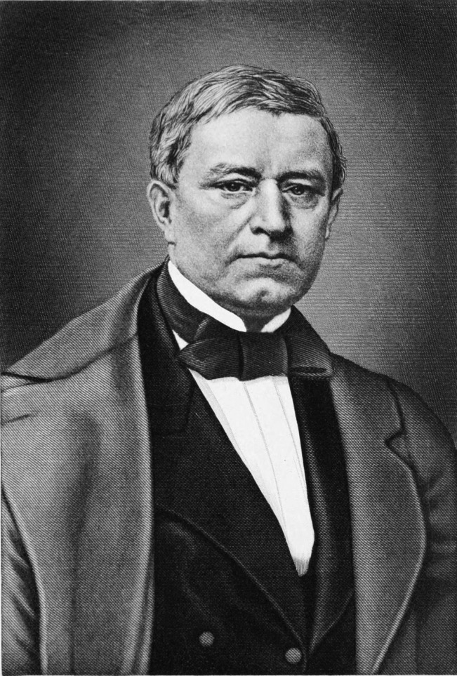
One of the foremost agricultural and economic scientists of his time, Francisco de Frias y Jacott, Count of Pozos Dulces, was born in Havana on September 24, 1809, and died in Paris, France, on October 24, 1877. He studied in the United States and Europe, specializing in physics and chemistry, and then sought to devote his genius to the economic welfare of Cuba. He wrote notable works on Cattle Breeding, on Chemical Research, and on Labor and Population. His patriotic spirit provoked Captain-General Canedo to banish him for a time, but on his return as editor of El Siglo he conducted so powerful a campaign for social, economic, political and administrative reforms that the Spanish government was constrained to heed him and to plan new legislation for Cuba. For this purpose it formed a Junta of Information, of which he was a member representing Santa Clara. Upon the failure of that body he wrote a memorable protest against the policy which had compelled that result, and a year later removed to Paris.
BY
WILLIS FLETCHER JOHNSON
A.M., L.H.D.
Author of “A Century of Expansion,” “Four Centuries of
the Panama Canal,” “America’s Foreign Relations”
Honorary Professor of the History of American Foreign
Relations in New York University
WITH ILLUSTRATIONS
VOLUME FIVE

NEW YORK
B. F. BUCK & COMPANY, Inc.
156 Fifth Avenue
1920
Copyright, 1920,
By CENTURY HISTORY CO.
——
All rights reserved
ENTERED AT STATIONERS HALL
LONDON, ENGLAND.
PRINTED IN U. S. A.
REPUBLICA DE CUBA
——
SECRETARIA DE AGRICULTURA, COMERCIO Y TRABAJO
————
Habana, Cuba,
July 11, 1919.
TO WHOM IT MAY CONCERN:
The information in this volume pertaining to Cuba and her natural resources, climate, soil, mines, forests, fisheries, agricultural products, lands, rivers, harbors, mountains, mineral zones, quarries, foreign and domestic commerce, business opportunities, etc., has been compiled under the auspices of the Department of Agriculture, Commerce and Labor, and has been verified by the Bureau of Information.
It is intended to acquaint the world with the truth and actual facts in regard to Cuba, and for the guidance of those who may be interested.
Respectfully,

SECRETARY OF AGRICULTURE
COMMERCE & LABOR.
NATURE designed Cuba for greatness. That salient fact is written large and clear upon every page of the island’s history. He must lack vision who can not discern it even in the annals of political, military and social development of the Cuban nation. Although one of the earliest lands in the Western Hemisphere to be discovered and colonized, it was actually the last of all to be erected into political independence and thus to enter into an opportunity for improving fully the incomparable opulence of its natural endowment. No land ever shows of what it is capable until it is permitted to do so for its own sake and in its own name.
During the long and tedious centuries of Spanish domination, therefore, the resources of Cuba remained largely latent. That is to be said in full view of the notorious fact that the island was openly declared to be “the milch cow of Spain.” In those two facts appears perhaps the most impressive of all possible testimonies to the surpassing richness of the island. If while it was a mere colony, only partially developed and indeed with its resources only in part explored and imperfectly understood, and with the supreme incentive to enterprise denied it—if in these unfavorable circumstances, we say, it could be a source of so great revenue to Spain and in spite of thus being plundered and drained could still accumulate so considerable a competence for its own people, what must its material opulence prove to be under its own free rule, with every advantage and every encouragement for its full development according to the knowledge of Twentieth Century science?
We need not be fanciful or visionary if we believe that some important purpose was subserved in such withholding of Cuba from complete development until so late a date. Her neighbors went on ahead, developing their resources, and passing through all the political and social vicissitudes of which colonial and national experience is capable, inevitably with a great proportion of sheer loss through ill-directed experimentation. Cuba on the contrary remained held in abeyance until in the fulness of time she could profit from the experience and example of others and thus gain her development at a minimum of effort and expense and with a maximum of net profit.
The beneficent design of nature, to which we have alluded, is to be seen, moreover, in the inherent conditions of insular existence. No other great island of the world is so fortunate in its geographical placing, either strategically or climatically, nor is any other comparable with it in topography and material arrangement and composition. It lies midway between the two great continents of the Western Hemisphere, within easy reach of both across landlocked seas, where it receives the commerce of both and serves as a mart of exchange between them. Similarly it lies between the Temperate Zone and the Torrid Zone, so as to receive at its very doors the products of each and of both, the products, that is to say, of all the world. Nor is it less significant that it lies directly upon the line of commerce and travel not only between North and South but equally between East and West, on the line of passage between the Atlantic and the Pacific and between the lands which border the one and those which occupy the shores of the other. Such strategic position—the strategy of commerce—is unique and incommensurable in value.
Equally beneficent is the climatic situation of Cuba. Mathematically lying just within the tropical zone, it in fact enjoys a temperance of climate surpassing that of the temperate zone itself. It has all the geniality of the regions which lie to the south of it, so that it can produce all the fruits of the sultry tropics in profusion throughout a year-round season of growth; yet it escapes the oppressive and enervating heat which makes life in those lands burdensome to the visitor and indolent to the native. It has the comfort and the tonic properties of northern climes, yet without the trying and sometimes disastrous fluctuations and extremes which too often there prevail. As a result, Cuba can produce, if not always in fullest perfection yet with a gratifying degree of success, practically all the vegetable life of the world, from that which thrives close to the Arctic Circle to that which luxuriates upon the Equator.
In coastal contour, and thus in profusion of fine harbors, Cuba enjoys preeminence among the countries of the world. In varied contour of mountain, valley and plain, in endowment with springs and rivers, she is conspicuously fortunate. The often quoted tribute which her first discoverer paid spontaneously to her magic beauty has been repeated and confirmed uncounted times, with a deeper significance as it has been found that the beauty of this island is not merely superficial but intrinsic, and that Cuba is as hospitable to the interests and welfare of the visitor and resident as she is fair to the passing eye.
It is a grateful task to dwell in these pages upon the varied and opulent resources of the island, in all the natural conditions of the mineral, the vegetable and the animal kingdoms. We shall see that the hopes and dreams of the early conquerors, of rich mines of gold, have been far more than realized in other ways which they knew not of. The mines of what they regarded as base metals, and of metals unknown to them, are richer far than they ever hoped deposits of the “precious” metal to be, while the products of forests and plantations are immeasurably richer still. Today Cuba stands before the world a Treasure Island of incomparable worth even in her present estate, and of an assured potentiality of future opulence which dazzles the imagination.
We shall see, too, most grateful and inspiring of all, how at last the people of Cuba have come into their own and are improving the vast endowment with which nature has so bounteously provided them. It has been only since they gained their independence that they could or would do this; the result being that a score of years have seen more progress than the twenty score preceding. Indeed we may say that the great bulk of this progress has been achieved in the last six or seven years, the earlier years of independence being unfortunately marred with untoward circumstances of dissension and revolt which held in check the progress which the island should have made. But with the final establishment of a government capable of fulfilling all its appropriate functions, the advance of Cuba has been and is to-day swift and unerring.
The taking advantage of natural conditions and resources through scientific applications, the organization and administration of such governmental institutions as best conduce to the security, the prosperity and the happiness of a self-governing people, are agreeable themes to contemplate and are profitable to study. We shall see how agriculture, mining, manufactures and commerce have been promoted in both extent and character. We shall see how all parts of the island realm have been made accessible, for business or for pleasure, with railroads and a marvellous system of highways for motor vehicles. We shall learn of the sanitation of what was once a pestilence infested land until it has become one of the three or four most healthful in the world.
We shall see, too, the practical creation and universal development of a scheme of free popular education which to-day gives to what was within the memory of living men one of the most illiterate of countries such school facilities as scarcely any other can surpass. If we were writing in this volume of some long-established Commonwealth, with many generations, perhaps centuries, of progress and culture behind it, we should not be able to restrain our admiration of much that has been accomplished. When we consider that we are writing of a land that suffered nearly four centuries of repression and oppression, followed by a dozen years of devastating strife, and less than twenty years ago began to live the free life of a sovereign people, we are entranced with amazement at the memory of what Cuba has been, with appreciation of what she is, and with the assured promise of what she is to be.
It was a fascinating task to trace the story of her existence in its many phases, largely of vicissitude, from the days of Diego Velasquez to those of Mario Menocal. But that after all was a record of what has been, of what has largely passed away. More welcome is it to contemplate what Cuba actually is, in present realization and achievement, and to scan with sane and discriminating vision the prospect of what she may be and what, we may well believe with confidence, she will be. It is to reveal the actual Cuba of to-day, and to suggest the surely promised Cuba of to-morrow, that these pages are written. So far as they may seem technical and statistical, their very dryness contains a potency of suggestion surpassing the dreams of romance. So far as they may seem touched with imagination, speculation, enthusiasm, they are still based upon the practical and indubitable foundation of ascertained facts. Their aim is to present to the world an accurate, comprehensive and sympathetic living picture of the Twentieth Century Republic of Cuba, and as such they are submitted to the reader with a cheerful confidence, if not always in the adequacy of its treatment, at least in the unfailing interest and merit of the theme.
January, 1920.
WILLIS FLETCHER JOHNSON.
| PAGE | ||
| Chapter I. The People of Cuba | 1 | |
| The People of Cuba—Hospitality Their Characteristic—Love of Children—Founders of the Cuban Nation from the Southern Provinces of Spain—An Admixture of French Blood—Immigration from Northern Spain—English, Irish, Italian and German Immigrants—Colonists from the United States. | ||
| Chapter II. The Topography of Cuba | 10 | |
| The Topography of Cuba—Five Distinct Zones—The Mountain Ranges—Plateaus and Plains—The Highest Peak in Cuba—The Organ Mountains—Beautiful Valleys and Fertile Plains—Action of the Water Courses—Character of the Soil. | ||
| Chapter III. The Climate of Cuba | 19 | |
| The Climate of Cuba—Freedom from Extremes of Temperature—Influence of the Trade Winds—No Ice and Little Frost—The Rainy Season and the Dry Season—Gloomy Days Practically Unknown. | ||
| Chapter IV. Province of Havana | 21 | |
| The Province of Havana—The Pivotal Province of the Island—Visits by Columbus and Velasquez—Topography of the Province—Soil and Products—Agricultural Wealth—The Fruit Industry—Manufacturing—The Harbor of Havana—Transportation Facilities—The Water Supply—The Climate—The Seat of Government and Social Centre of the Island. | ||
| Chapter V. Province of Pinar del Rio | 34 | |
| The Province of Pinar del Rio—A Picturesque Region—Interesting Topography—The Organ Mountains—The Vinales Valley—A Rare Palm Tree—Hard Wood Timber—Agriculture—Harbors and Fishing Interests—Tobacco Lands of the Vuelta Abajo—Coffee Plantations—Mineral Resources. | ||
| Chapter VI. Province of Matanzas | 49 | |
| The Province of Matanzas—Comparatively Unimportant in History—A Great Drainage and Traffic Canal—Rivers and Mountains—The Coast and Islands—The Henequen Industry—The City of Matanzas—The Caves of Bellamar—Sugar Production—Mineral Resources. | ||
| Chapter VII. Province of Santa Clara | 60 | |
| The Province of Santa Clara—A Land of Great Variety of Scenes—Ancient Gold-Seeking—The Mountain Ranges—Rich Lands of the Parks and Valleys—Rivers and Lakes—Harbors—Cities of the Province—The “Swamp of the Shoe”—Forests, Sugar Plantations, Tobacco, and Coffee—Opportunities for Stock Raising. | ||
| Chapter VIII. Province of Camaguey | 71 | |
| The Province of Camaguey—Where Columbus First Landed—In the Days of Velasquez—Events of the Ten Years’ War—Topography of the Province—Mountain Ranges—Rivers and Coastal Lagoons—Harbors—Lack of Railroads—The Sugar Industry—Minerals—American Colonies—Some Noted Men. | ||
| Chapter IX. Province of Oriente | 83 | |
| The Province of Oriente—Area and Topography—Mountains and Rivers—Fine Harbors—Great Sugar Mills—Scene of the First Spanish Settlement in Cuba—The Bay of Guantanamo—Santiago de Cuba—Copper Mines—Manzanillo—The Cauto Valley—Sugar Plantations and Stock Ranches—Timber and Minerals—American Colonies. | ||
| Chapter X. The Isle of Pines | 99 | |
| The Isle of Pines—An Integral Part of Cuba—American Settlements and Claims—Character of the Island—Infertile and Storm Swept—Vast Deposits of Muck—Marble Quarries—Efforts to Promote Agricultural Interests. | ||
| Chapter XI. Mines and Mining | 104 | |
| Mines and Mining—The Early Quest of Gold—First Working of Copper Mines—The Wealth of El Cobre—Copper in All Parts of Cuba—Operations in Pinar del Rio—Vast Iron Deposits in Oriente—Nickel and Manganese—Exports of Ore—American Investigation of Chrome Deposits—Many Beds of Great Richness—Manganese and Chrome for All the World. | ||
| Chapter XII. Asphalt and Petroleum | 126 | |
| Asphalt and Petroleum—Ocampo’s Early Discovery at Puerto Carenas—Humboldt’s Reports of Petroleum Wells—Prospecting for Oil in Many Places—Some Promising Wells—Asphalt Deposits of Great Value—Prospects for Important Petroleum Developments. | ||
| Chapter XIII. Forestry | 135 | |
| Forestry—Vast Resources of Fine Woods Recklessly Squandered in Early Times—Houses Built of Mahogany—Hundreds of Varieties of Valuable Timber Trees—A Catalogue of Sixty of the Most Useful—Need of Transportation for the Lumber Trade—Forests Owned by the State. | ||
| Chapter XIV. Agriculture | 144 | |
| Agriculture—The Chief Interest of Cuba—Fertility of Soil, Geniality of Climate, and Variety of Products—The Rainfall—Many Farmers Specialists—The Government’s Experimental Station—Opportunities for Stock-Raising—Work of the Department of Agriculture—Its Various Bureaus—Value of Experimental Work Begun by General Wood and Extended by President Menocal—Improving Live Stock—Fruit Growing—Grains and Grasses—Combating Insect Pests—Bureau of Plant Sanitation. | ||
| Chapter XV. Sugar | 160 | |
| “King Cane”—Cuba’s Crop and the World’s Production—Natural Conditions Favorable to Sugar Culture—Extent of Lands Still Available—The “Savana” and “Cienaga” Lands—Assured Projects for Draining Great Swamps—Potential Increase of Sugar Production in Cuba—Methods of Planting, Culture and Harvesting—The Labor Problem—Improved Machinery—Something About the Principal Sugar Producing Concerns in Cuba and the Men Who Have Created Them and Are Directing Them—The Largest Sugar Company in the World—Cuba’s Assured Rank as the World’s Chief Sugar Plantation. | ||
| Chapter XVI. Tobacco | 183 | |
| The Tobacco Industry—First European Acquaintance with the Plant—The Famous Fields of the Vuelta Abajo—Immense Productivity—Methods of Culture and Harvesting—Various Regions of Tobacco Culture—Insect Pests—Wholesale Use of Cheesecloth Canopies—Monetary Importance of the Industry. | ||
| Chapter XVII. Henequen | 190 | |
| The Henequen Industry—The Source of Binding Twine for the Wheat Fields—Cuban Plantations Now Surpassing Those of Yucatan—Methods of Growth and Manufacture—Magnitude of the Industry and Possibilities of Further Extension. | ||
| Chapter XVIII. Coffee | 197 | |
| The Coffee Industry—Early Plantations Which Were Neglected and Abandoned—An Attractive Industry—Methods of Culture—Harvesting and Marketing the Crop—Government Encouragement Being Given for Extension of the Industry. Chapter XIX. The Mango | 203 | |
| The Mango—The King of Oriental Fruits—Two Distinct Types in Cuba—All Varieties Prolific—The Trees and the Fruits—Some of the Favorite Varieties—Marketing and Use. | ||
| Chapter XX. Citrus Fruits | 211 | |
| Citrus Fruits—American Introduction of the Commercial Industry—Varieties of Oranges—Comparison with Florida and California Fruit—Grape Fruit in the Isle of Pines—Limes and Wild Oranges. | ||
| Chapter XXI. Bananas, Pineapples and Other Fruits | 219 | |
| Antiquity and Universality of the Banana—Its Many Uses—Commercial Cultivation in Cuba—Methods of Culture—Varieties—Pineapple Culture in Cuba—One of the Staple Crops—Difficulty of Marketing—The Canning Industry—The Fruit of the Anon—The Zapote or Sapodilla—The Tamarind—The Mamey—The Guava—The Mamoncillo—Figs of All Varieties—The Aguacate. | ||
| Chapter XXII. Grapes, Cacao, and Vanilla | 232 | |
| Grape Culture Discouraged by Spain—Recent Development of the Industry—Much Wine Drinking but Little Drunkenness—Food and Drink in the Cacao—The Chocolate Industry—Culture and Manufacture of Cacao—The Vanilla Bean—Methods of Gathering and Preparing the Crop. | ||
| Chapter XXIII. Vegetable Growing | 240 | |
| Vegetable Growing in Cuba—Regions Most Suitable for the Industry—Seed Brought from the United States—Winter Crops of Potatoes—Green Peppers a Profitable Crop—Cultivation of Tomatoes and Egg Plants—Okra—Lima Beans and String Beans—Squashes and Pumpkins—Desirability of the Canning Industry—Utility of Irrigation—Prospects of Profit in Truck Farming. | ||
| Chapter XXIV. Standard Grains and Forage | 248 | |
| Indian Corn Indigenous—Improvements in Culture Desirable—Millet or Kaffir Corn—Neglect of Wheat Growing—Culture of Upland Rice—Possibilities of Swamp Rice Culture—Profusion of Meadow and Pasture Grasses—Experiments with Alfalfa—Cultivation of Cow Peas and Beans—Peanut Plantations. | ||
| Chapter XXV. Animals | 257 | |
| Paucity of Native Fauna—Deer, Caprimys and Ant Eaters—The Sand Hill Crane—Guinea Fowls, Turkeys and Quails—Buzzards, Sparrow Hawks, Mocking Birds and Wild Pigeons—Varieties of Parrots—The Oriole—The Tody—The Lizard Cuckoo—The Trogon—Water Birds. | ||
| Chapter XXVI. Stock Raising | 263 | |
| Introduction of Horses and Cattle by the Spaniards—Improvement in the Quality of Stock—A Favorable Land for Cattle Ranges—Importation of Blooded Stock from the United States and Europe—Introduction of the Zebu—Great Profits in Hog Raising—Forage, Nuts and Root Crops for Stock Food—Sheep and Goat Raising for Wool, Meat and Hides—Value of the Angora Goat. | ||
| Chapter XXVII. Poultry: Bees: Sponges | 278 | |
| Recent Scientific Development of the Poultry Industry—President Menocal’s Importations of Choice Stock—Opportunities for Agriculture—Wild and Domesticated Bees—Varieties of Honey Yielding Flowers—Large Exportations of Wax and Honey—Valuable Sponge Fisheries on the Cuban Coast. | ||
| Chapter XXVIII. Places of Historical Interest | 284 | |
| Historic Interest of Havana Harbor—The Romance and Tragedy of El Morro—“The Twelve Apostles”—The Vast Fortress of La Cabaña—The “Road Without Hope”—A Scene of Slaughter—Cells of the Fortress Prison—The Castillo de Punta—The Ancient City Walls—The Romance of La Fuerza—Ancient Churches and Convents of Havana—The Cathedral and the Tomb of Columbus—The San Francisco Convent—San Agustin—La Merced—Santa Catalina—Santo Angel—Santa Clara—The Convent of Belen—The Old Echarte Mansion—La Chorrera—Fort Cojimar—Some Ancient Watch Towers and Fortresses—The Botanical Gardens. | ||
| Chapter XXIX. Havana | 303 | |
| The Charms of Havana—Early History of the City—Made the Capital of Cuba—The Quarries from Which It Was Built—Something About Its Principal Streets and Buildings—Various Sections of the City—On the Road to the Almandares—Principe Hill—The University of Havana—The Famous Prado—The National Theatre—The Central Park and Parque de Colon—Colon Cemetery—Music in Havana—Favorite Drives and Resorts—The Bathing Beach—Fishing—Jai Alai—Baseball—Horse Racing—Golf—Buildings of the Various Government Departments—Memories of the Old Presidential Palace—Some Fine New Buildings—The New Presidential Palace—The New Capitol—The National Hospital. | ||
| Chapter XXX. A Paradise of Palm Drives | 326 | |
| A Paradise of Palm Drives—Splendor of the Flamboyans—The Road to Guines—A Fine Drive to Matanzas—Roads from Havana to Guanajay, Artemisa and the Ruby Hills—Old Military Roads Improved and Extended—Fine Drives in Pinar del Rio—The Valley of Vinales—Some Wonderful Landscapes and Seascapes—Roads Radiating from Matanzas—The Roads of Santa Clara and Camaguey—Road Making Among the Mountains of Oriente. | ||
| Chapter XXXI. Bays and Harbors | 340 | |
| The Bays and Harbors of the Cuban Coasts—Bahia Honda—Cabanas—Mariel—Havana—Matanzas—The Land-Locked Bay of Cardenas—Santa Clara Bay—Sagua—Caibarien—The Bay of Nuevitas—Manati—Puerto Padre—Gibara—Banes—Nipe—Levisa—Baracoa—Guantanamo—Santiago—Manzanillo—Cienfuegos—Batabano—Santa Cruz—Various Other Ports, Great and Small. | ||
| Chapter XXXII. Railroad Systems in Cuba | 353 | |
| Origin of the Railroad Systems of Cuba—The United Railways of Havana—The Matanzas Railway—Electric Lines Around Havana—The Great Work of Sir William Van Horne—The Cuba Company’s Railroad System—The Cuba Central Road—The North Shore Line—Other Lines and Branches Existing or Projected. | ||
| Chapter XXXIII. Money and Banking | 361 | |
| Money and Banking in Cuba—The First Currency of the Island—The First Monetary Crisis at Havana—Development of Modern Coinage and Currency—Single Standard and Double Standard—Colonial Paper Money—Stabilization of Currency Under American Rule—Statistics of Shipments of Money—Coinage of Cuban Money Under the New System—Financing the Foreign Commerce of the Island. | ||
| Chapter XXXIV. Public Instruction | 367 | |
| The Educational System of Cuba—Influences of Clericalism—Work of General Wood and Mr. Frye—Cooperation of Harvard University—Dr. Lincoln de Zayas—The Teaching of English—Progress Under President Menocal—Scope of the System—Some Special Schools—Normal Schools—The Institute of Havana—The National University—Cooperation with the United States—The Free Public Library. | ||
| Chapter XXXV. Ocean Transportation | 376 | |
| Importance of Ocean Transportation to the Insular Republic—Development of the United Fruit Company—The Ward Line and Its Fleet—A Network of Communications with All Parts of the World—Service of the Munson Line—The Peninsular and Occidental Company—The Railroad Ferry Service from Key West to Cuba—The Pinillos Izquierdo Line from Spain—The Morgan or Southern Pacific Line—The Great Fleet of the Compagnie General Transatlantique—A New Line from Japan—Customs Regulations—The Consular Service of Cuba. | ||
| Chapter XXXVI. American Colonies in Cuba | 390 | |
| American Colonies in Cuba—Founded After the War of Independence—Pernicious Activities of Unscrupulous American Speculators—Heroic Efforts of Illfounded Colonies—The Story of La Gloria and Its Neighbors—Colonization of the Isle of Pines—The Colony of Herradura—Various Colonies in Oriente—Inducements to Further Colonization. | ||
| INDEX | ||
| FULL PAGE PLATES | |
| Francisco de Frias | Frontispiece |
| FACING PAGE | |
| The Vinales Valley | 36 |
| San Juan River, Matanzas | 54 |
| On the Cauto River | 92 |
| National Theatre, Central Park, Havana | 144 |
| The Gomez Building | 190 |
| Pablo Desvernine | 284 |
| In New Havana | 296 |
| Colon Park | 306 |
| An Avenue of Palms | 326 |
| Grand Central Railway Station, Havana | 354 |
| Leopoldo Cancio | 362 |
| The Chamber of Commerce, Havana | 376 |
| TEXT EMBELLISHMENTS | |
| City Hall and Plaza, Cardenas | Page 56 |
| A Mountain Road, Oriente | “ 84 |
| Cuban Rural Home | “ 145 |
| Fruit Vender, Havana | “ 209 |
IN the last analysis, of course, the people of a country have much to do in making it what it is, or what it may be. From them must come the life, energy, character and development. They will regulate its social standing and fulfill the promise of its future. Society in Cuba, as in nearly all long settled countries, is many sided, and while resembling, more or less, that of all civilized communities, certain racial traits stand out prominently in the Island Republic.
If asked to name the most prominent or salient characteristics dominating the Cuban race, we should probably be justified in saying: unfailing hospitality, exceptional courtesy, and unmeasurable love of children.
Hospitality in Cuba is not a pose, but on the contrary is perfectly natural, having descended from a long line of ancestors, as have the beauty of eyes and teeth and color of hair. Hospitality among those of higher education, like courtesy, is tempered with good form that breeding has rendered an essential characteristic of the individual. Journeying through the rural or remote sections, it is so manifestly genuine that unless held back or retarded through diffidence or suspicion, no one can avoid being deeply impressed with the extent to which hospitality has pervaded every corner of the country.
John B. Henderson, the naturalist, in his “Cruise of the Barrera,” refers to an occasion when, after serving coffee in the house of a native family living far from contact with the outside world, a dollar had been surreptitiously given to a child; and when the guests, whom he had never seen before, were quite a mile away, the father came running breathlessly down the mountain path to return the money, which he said he could not possibly accept under any circumstances.
True courtesy, also, has kept hospitality close company in all grades of society. Among the higher ranks of scholars, statesmen and Government officials, the visitor who by chance has occasion to call on the Chief of any Department, if said individual belongs to the old type of genuine nobility, from the moment he crosses the threshold will note certain polite forms that, while never obtrusive, are always in evidence.
No word, gesture or deed will come from the host that can possibly jar the sensibilities of the visitor, no matter what his errand may be. During his stay, courtesy will seem to pervade the atmosphere, and the caller cannot help feeling absolutely at home. Upon leaving, he will be made to feel that he has been more than welcome, and even if the topic discussed or the nature of the errand has been delicate, he will realize that he has been given all the consideration that one gentleman could expect of another.
The educated Cuban is by birth, by nature and by training, a polished gentleman and a diplomat; a man who will be at ease in any position, no matter how difficult, and whose superior, socially or intellectually, is seldom found in any court, committee or congregation of men. This all prevailing trait of courtesy is also surprisingly manifest among those who have had no advantages of education, and who have been denied the wonderfully civilizing influence of travel and contact with the outside world. Nor is this trait of courtesy and self possession confined by any means to the man.
Love of children, and willingness to make any sacrifice for their happiness, are perhaps exaggerated developments of the motherly instinct. A man will be polite to you in Cuba even if he intends to sign your death warrant the next moment. A Cuban mother will yield to any caprice of her children, even although she may realize that in so doing she endangers their future. As a result, Cuban children, although lovable and affectionate, are not always well behaved or gentle mannered. Still this depends largely, as it would in any country, on the temperament and education of the mother, who in Cuba has all to do towards forming the character of the child, especially the daughter, in whose “bringing up” the father is supposed to take no immediate interest or part.
The love which parents, rich or poor, educated or ignorant, bestow on their children, no matter how many little ones may compose the family, or how small the purse which feeds them, is proverbial. No child, even of a far removed relative, is ever permitted to enter an institution of charity if it can be avoided, but will find instead an immediate and hearty welcome in the family of a man who may not know at times where to look for money for the next day’s meal.
The original stock from which sprang the natives of Cuba, and from which many of their traits undoubtedly came, reverts back to the followers of Columbus, and to the old time conquerors of Mexico and the New World. These gentlemanly adventurers were mostly from the southern provinces of the Iberian Peninsula, whose blood was more or less mixed with that of the Moor, and whose chief physical characteristics were regularity of features, beauty of eyes, teeth and hair, and whose mental attributes were dominated by pride, ambition, love of pomp and ceremony, with great powers of endurance, a strong aversion to ordinary forms of labor, exceptional courtesy, and an intelligence frequently marred with almost unbelievable cruelty.
These original pioneers or soldiers of fortune in Cuba found the climate exceedingly to their liking and, after love of conquest and adventure had been tempered by increasing years, and the possible accumulation of modest means, they settled down to quiet and fairly industrious lives in the Pearl of the Antilles. From them sprang the true Cuban race, in which still remain many of the physical, moral, and intellectual traits of their ancestors.
Some of these early settlers made wives of comely Indian women, whose beauty had captured their fancy, and while the influence of the kindly, pleasure-loving “Cubenos” has not made any deep or striking impression on the race, it may account for the quite common fondness of display and love of gaiety found in the Cuban of today.
Next to the pioneers of Andalusia and southern Spain, it is probable that the introduction of French blood has influenced the Cuban type and life more than any other race foreign to the Island. Back in the seventeenth century French traders and privateers made frequent visits to Cuba, and some of them found Cuban wives, whose descendants afterward became citizens of the country. Then again, in the very first years of the nineteenth century, a large influx of French settlers, forced by revolution from Santo Domingo, fled as refugees to Cuba and made for themselves homes in Santiago and Santa Clara, whence with the increase of Havana’s distinction as the capital, many of them transferred their abiding place to that province and to Pinar del Rio, bringing with them their experience as coffee growers; this in the early part of the nineteenth century, becoming one of the most important industries of the Island.
In the province of Havana, social life and the Cuban race itself, to a certain extent, were influenced by the various officials and army officers sent there from the mother country, many of whom found wives and made homes in Havana, bringing with them the predominating traits and customs of Madrid and other cities of Central Spain, which had given them birth.
In later years, when Cuba began to obtain some prominence in the industrial and commercial world, immigrants from the mother country came to Havana in steadily increasing numbers. These were mostly from Galicia and other northern coast provinces of Spain. They were a plodding, frugal and industrious people, who, leaving a country that offered little compensation for the hardest forms of labor, found easier work and higher pay in Spain’s favorite colony.
The Gallego in Cuba, however, prefers the life of the city, in which he plays quite an important part, since beginning at the very bottom of the ladder, through patient thrift and industry, maintained throughout a comparatively few years, he often succeeds in becoming the proprietor of a bodega, the ubiquitous barber shop, the corner café, or the sumptuous hotel on the Prado.
In the commercial life of the Island, he has a serious rival in the Catalan, who, while possessed of many of the traits of the hard working son of Galicia, is perhaps his superior in establishing successful enterprises of larger scope. The Catalan seldom if ever fails in business, and in energy, persistence and keen foresight, is quite the equal of those most famous of all traders and men of commerce, the sons of Israel.
Since the capture of Havana in 1763, when some of the members of the English army, captivated by the climate, concluded to remain there permanently, a small influx of English immigrants may be traced along through the past century, but never in sufficient numbers to play a very important part in the social or economical life of the country. Nevertheless, those who came and remained as permanent residents of Cuba, brought with them the elements of courage, thrift and integrity which characterize the English colonist in all parts of the world. Strange to relate, the general rule in regard to the unconformity of the English, when living in foreign climes, does not seem to apply in Cuba.
The immigrant from Great Britain, who settled in Cuba, while leaving the imprint of his character on his descendants, has nevertheless, sooner or later, become in many respects a typical native of the country, adopting even the language, and using it as his own, while his children, bright blue eyed and keenly intelligent, are often permitted to remain ignorant of their paternal tongue. Hence it is that we frequently meet with Robert Smith, Henry Brown, Herbert Clews, Frank Godoy, Tom Armstrong and Billy Patterson, sons or grandsons of former British subjects, who would look at you in doubt and fail to comprehend if saluted with such a common phrase as “a fine day” in English. Cuba has appreciated the sterling value of the small English immigration that has come to her shores, and only regrets that there is not more of it.
Quite a large sprinkling from the Emerald Isle have become permanent residents of Cuba, and aside, perhaps, from a little trace of the original brogue, it would be hard to distinguish them from the wide awake Gallegos. The men of no race will so quickly adjust themselves to circumstances, and become, as it were, members of the family, no matter whether they settle in France, Italy, Spain, Cuba or the United States, as will the immigrants from Ireland. The Irishman brings with him, and always retains, his light-hearted, go-as-you-please and take-it-as-it-comes characteristics, no matter where he settles. More than all, the Irishman seldom makes trouble in any country but his own, and seems not only content, but quite willing, to accept the customs of his adopted country, even to the point of “running it” if opportunity offers.
Why more Italians have not settled in Cuba, a country that in many respects resembles some sections of southern Italy, is not easy to determine, although it is probably due to a lack of propaganda on the part of the Republic itself. Occasional commercial houses are found, owned by Italians who have been residents there for many years, and a few of the laboring class, seeking higher wages within the last few years, have made their homes in Havana. Marvellous opportunities in the various fields of agriculture wait the keen witted thrifty Italian in Cuba. The certainty of a competence, if not a fortune, in small stock raising and grape growing, evidently has not been brought to his attention, otherwise more would have come and settled permanently in a country with whose people, in their fondness for music, their religious and social customs, they have much in common.
Of the Germans, of whom quite a number came to Cuba within the last thirty years, a different tale is told. The Teuton who roams abroad seems to come always with a definite purpose. He is diplomatic, courteous, observing, hard working, but essentially selfish in his motives, and makes no move the object of which is not to impress on the land he visits, or in which he may become a permanent resident, every custom, tradition and practice of the Fatherland that can possibly be implanted in the country that has given him shelter or social recognition. His club, his habits, his beer, his songs, his language and his precepts of “Deutscher Ueber Alles,” are spread to the utmost of his ability. But the German has been efficient and has catered in all his commercial dealings to the customs, caprices and even to the vices or weaknesses of the people with whom he trades and comes in contact. Hence it is that, up to the outbreak of the war of 1914, Germany certainly had the advantage over every competitor for trade from the Rio Grande to Patagonia.
Strange as it may seem, although Cuba is no farther from American territory in Florida than is Philadelphia from the City of New York, there was very little immigration from the United States and almost no citizens of that country, in spite of the attractions of the Pearl of the Antilles, had apparently ever thought of making a home in Cuba, until the Spanish-American War brought an army of occupation to the City of Havana in the fall of 1898.
Following this army, as a result perhaps of favorable reports that came from the lips of returning soldiers, quite an influx of Americans, actuated by curiosity or motives of trade, came to Cuba and remained here permanently, many marrying into Cuban families, purchasing farms, or establishing branch houses and independent industries in the Island Republic. Most of these have succeeded socially and financially.
The larger part of the American settlers of 1900 came from Florida, and the Gulf States, although scattered throughout the various colonies of the Island are found people from almost every State of the Union. While the greater part of them, owing to the attractiveness and to better transportation facilities have remained in or near Havana, quite a number have settled in the Province of Camaguey, most of whom have prospered there as stock raisers and followers of agricultural industries.
The American as a rule, although of little experience as a colonizer, has nevertheless readily adapted himself to circumstances, and had made fast friends in his new surroundings. Many broad and excellent changes have been brought about by this influx of citizens from the sister Republic of the North. Most important of all was the introduction of an excellent system of modern sanitation which the Cuban has appreciated and followed with zeal. The absolute elimination of yellow fever and every other disease common to the tropics, can be placed to the credit of the country that became sponsor for Cuban Independence.
To this immigration may be attributed, also, many changes in Cuban social life, especially the gradually broadening sphere of activity among Cuban women, and the removal of some of the social barriers which from the immemorial had placed her in the position of a treasured toy, rather than that of an independent partner, and a responsible unit in the game of life.
The impress of American influence on education, too, has been very great, since almost the first move of the military forces that took charge of the Island’s affairs with the exit of Spanish authority was to establish in Cuba a public school system, and modern ideas of education.
To the American farmer and fruit grower of Florida was due also the introduction of the citrus fruit industry, and the growing of vegetables on a large scale for the northern market, and while these enterprises are still, to a certain extent, in their infancy, many millions of dollars have been added thus to the wealth of the Island. In spite of what has been done, truth compels the statement, however, that in the United States really little is known of Cuba and her opportunities, although from the beginning of that country as a nation, aside from Mexico, geographically Cuba has been her closest neighbor.
There are great possibilities for American enterprise in the Island Republic, in agriculture, in stock raising, mining and other industries that American genius in the near future will undoubtedly discover and develop.
TOPOGRAPHICALLY the surface of Cuba may be divided into five rather distinct zones, three of which are essentially mountainous. The first includes the entire eastern third of the province of Oriente, together with the greater part of its coast line, where the highest mountains of the Island are found. The second includes the greater part of the province of Camaguey, made up of gently rolling plains broken by occasional hills or low mountains, that along the northern coast, and again in the southeast center of the Province, rise to a height of approximately 1500 feet above the general level.
The next is a mountainous district including the greater part of eastern Santa Clara. The fourth comprises the western portion of this province together with all of Matanzas and Havana. The surface of this middle section is largely made up of rolling plains, broken here and there by hills that rise a few hundred feet above the sea level.
The fifth includes the province of Pinar del Rio, the northern half of which is traversed from one end to the other by several more or less parallel ranges of sierras, with mean altitudes ranging from 1,000 to 2,000 feet, leaving the southern half of the Province a flat plain, into which, along its northern edge, project spurs and foothills of the main range.
The highest mountains of Cuba are located in the province of Oriente, where their general elevation is somewhat higher than that of the Allegheny or eastern ranges of the United States. The mountainous area of this province is greater than that of the combined mountain areas of all other parts of the Island. The mountains occur in groups, composed of different kinds of rock, and have diverse structures, more or less connected with one another.
The principal range is the Sierra Maestra, extending from Cabo Cruz to the Bay of Guantanamo, forty miles east of Santiago. This chain is continuous and of fairly uniform altitude, with the exception of a break in the vicinity of Santiago where the wide basin of Santiago Bay cuts across the main trend of the range. The highest peak of the Island is known as Turquino, located near the middle of the Sierra Maestra, and reaching an altitude of 8,642 feet.
The hills back of Santiago Bay, separating it from the Valley of the Cauto, are similar in structure to the northern foothills of the main sierra. In the western part of the range, the mountains rise abruptly from the depths of the Caribbean Sea, but near the City of Santiago, and to the eastward, they are separated from the ocean by a narrow coastal plain, very much dissected. The streams which traverse it occupy valleys several hundred feet in depth, while the remnants of the plateau appear in the tops of the hills.
East of Guantanamo Bay there are mountains which are structurally distinct from the Sierra Maestra, and these continue to Cape Maisi, the eastern terminus of Cuba. To the west they rise abruptly from the ocean bed, but further east, they are bordered by terraced foothills. Towards the north they continue straight across the Island as features of bold relief, connecting with the rugged Cuchillas of Baracoa, and with “El Yunque” lying to the southwest.
Extending west from this eastern mass are high plateaus and mesas that form the northern side of the great amphitheatre which drains into Guantanamo Bay. Much of this section, when raised from the sea, was probably a great elevated plain, cut up and eroded through the ages since the seismic uplift that caused its birth.
The most prominent feature of the northern mountains of Oriente Province, west of “El Yunque,” is the range comprising the Sierras Cristal and Nipe. These extend east and west, but are separated into several distinct masses by the Rio Sagua and the Rio Mayari, which break through and empty into harbors on the north coast. The high country south of these ranges has the character of a deeply dissected plateau, the upper stratum of which is limestone.
The character of the surface would indicate that nearly all the mountains of the eastern part of Oriente have been carved through erosion of centuries from a high plateau, the summits of which are found in “El Yunque” near Baracoa, and other flat topped mountains within the drainage basins of the Mayari and the Sagua rivers. The flat summits of the Sierra Nipe are probably remnants of the same great uplift.
Below this level are other benches or broad plateaus, the two most prominent occurring respectively at 1500 and 2000 feet above sea level. The highest summits rise to an altitude of 2800 or 3000 feet. The 2000 foot plateau of the Sierra Nipe alone includes an area estimated at not less than 40 square miles. It would seem that these elevated plateaus with their rich soils might be utilized for the production of wheat, and some of the northern fruits that require a cooler temperature than that found in other parts of Cuba.
In the province of Oriente, the various mountain groups form two marginal ranges, which merge in the east, and diverge toward the west. The southern range is far more continuous, while the northern is composed of irregular groups separated by numerous river valleys. Between these divergent ranges lies the broad undulating plain of the famous Cauto Valley, which increases in width as it extends westward. The northern half of this valley merges into the plains of Camaguey, whose surface has been disturbed by volcanic uplifts only by a small group known as the Najassa Hills, in the southeast center of the province, and by the Sierra Cubitas Range, which parallels the coast from the basin of Nuevitas Bay until it terminates in the isolated hill known as Loma Cunagua.
The central mountainous region of the Island is located in the province of Santa Clara, where a belt of mountains and hills following approximately northeast and southwest lines, passes through the cities of Sancti Spiritus and Santa Clara. Four groups are found here, one of which lies southwest of Sancti Spiritus, and east of the Rio Agabama. A second group is included between the valleys of the Agabama and the Rio Arimao.
The highest peak of Santa Clara is known as Potrerillo, located seven miles north of Trinidad, with an altitude of 2,900 feet. A third group lies southeast of the city of Santa Clara, and includes the Sierra del Escambray and the Alta de Agabama. The rounded hills of this region have an altitude of about 1,000 feet although a few of the summits are somewhat higher.
The fourth group consists of a line of hills, beginning 25 miles east of Sagua la Grande, and extending into the province of Camaguey. The trend of this range is transverse to the central mountain zone as a whole, but it conforms in direction with the general geological structure of the region.
East of the city of Santa Clara the hills of this last group merge with those of the central portion of the province. The summits in the northern line reach an altitude of only a thousand feet. The principal members are known as the Sierra Morena, west of Sagua la Grande, Lomas de Santa Fe, near Camaguani, the Sierra de Bamburanao, near Yaguajay, and the Lomas of the Savanas, south of the last mentioned town.
In the province of Pinar del Rio, we find another system, or chain of mountains, dominated by the Sierra de los Organos or Organ mountains. These begin a little west of Guardiana Bay, with a chain of “magotes,” known as the “Pena Blanca,” composed of tertiary limestone. These are the result of a seismic upheaval running from north to south, almost at right angles with the main axis of the chains that form the mountainous vertebrae of the Island.
Between the city of Pinar del Rio and the north coast at La Esperanza, the Organos are broken up into four or five parallel ridges, two of which are composed of limestone, while the others are of slate, sandstones and schists. The term “magote,” in Cuba, is applied to one of the most interesting and strikingly beautiful mountain formations in the world. They are evidently remnants of high ranges running usually from east to west, and have resulted from the upheaval of tertiary strata that dates back probably to the Jurassic period.
The soft white material of this limestone, through countless eons of time, has been hammered by tropical rains that gradually washed away the surface and carved their once ragged peaks into peculiar, round, dome-shaped elevations that often rise perpendicularly to a height of 1,000 feet or more above the level grass plains that form their base. Meanwhile the continual seepage of water formed great caverns within that sooner or later caved in and fell, hastening thus the gradual leveling to which all mountains are doomed as long as the world is supplied with air and water. The softening and continual crumbling away of the rock have formed a rich soil on which grows a wonderful wealth of tropical vegetation, unlike anything known to other sections of Cuba, or perhaps in the world.
The valley of the Vinales, lying between the City of Pinar del Rio and the north coast, might well be called the garden of the “magotes,” since not only is it surrounded by their precipitous walls, but several of them, detached from the main chain, rise abruptly from the floor of the valley, converting it into one of the most strangely beautiful spots in the world.
John D. Henderson, the naturalist, in speaking of this region, says: “The valley of the Vinales must not be compared with the Yosemite or Grand Canon, or some famed Alpine passage, for it cannot display the astounding contrasts of these, or of many well-known valleys among the higher mountains of the world. We were all of us traveled men who viewed this panorama, but all agreed that never before had we gazed on so charming a sight. There are recesses among the Rocky Mountains of Canada in which one gazes with awe and bated breath, where the very silence oppresses, and the beholder instinctively reaches out for support to guard against slipping into the awful chasm below. But the Valley of Vinales, on the contrary, seems to soothe and lull the senses. Like great birds suspended in the sky, we long to soar above it, and then alighting within some palm grove, far below, to rejoice in its atmosphere of perfect peace.”
A mountain maze of high, round-topped lomas dominates almost the entire northern half of Pinar del Rio. It is the picturesque remnant of an elevated plain that at some time in the geological life of the Island was raised above the surface 1500, perhaps 2000, feet. This, through the erosion of thousands of centuries, has been carved into great land surges, without any particular alignment or system.
Straight up through the center of this mountainous area are projected a series of more or less parallel limestone ridges. These, as a rule, have an east and west axis, and attain a greater elevation than the lomas. They are known as the Sierras de los Organos, although having many local names at different points. Water and atmospheric agencies have carved them into most fantastic shapes, so that they do, in places, present an organ pipe appearance. They are almost always steep, often with vertical walls or “paradones” that rise 1000 feet from the floor or base on which they rest.
The northernmost range, running parallel to the Gulf Coast, is known as the “Costanero.” The highest peak of Pinar del Rio is called Guajaibon, which rises to an altitude of 3000 feet, with its base but very little above the level of the sea. It is probably of Jurassic limestone and forms the eastern outpost of the Costaneros.
The southern range of the Organos begins with an interesting peak known as the Pan de Azucar, located only a few miles east of the Pena Blanca. From this western sentinel with many breaks extends the great southern chain of the Organos with its various groups of “magotes,” reaching eastward throughout the entire province. At its extreme eastern terminus we find a lower and detached ridge known as the Pan de Guanajay, which passes for a few miles beyond the boundary line, and into the province of Havana.
Surrounding the Organos from La Esperanza west, and bordering it also on the south for a short distance east of the city of Pinar del Rio, are ranges of round topped lomas, composed largely of sandstone, slate and shale. The surface of these is covered with the small pines, scrubby palms and undergrowth found only on poor soil.
From the Mulato River east, along the north coast, the character of the lomas changes abruptly. Here we have deep rich soil covered with splendid forests of hard woods, that reach up into the Organos some ten miles back from the coast. Along the southern edge of the Organos, from Herredura east, lies a charming narrow belt of rolling country covered with a rich sandy loam that extends almost to the city of Artemisa.
Extensions, or occasional outcroppings, of the Pinar del Rio mountain system, appear in the province of Havana, and continue on into Matanzas, where another short coastal range appears, just west of the valley of the Yumuri. This, as before stated, has its continuation in detached ridges that extend along the entire north coast, with but few interruptions, until merged into the mountain maze of eastern Oriente.
Outside of the mountainous districts thus described, the general surface of Cuba is a gently undulating plain, with altitudes varying from only a few feet above the sea level to 500 or 600 feet, near El Cristo in Oriente. In Pinar del Rio it forms a piedmont plain that entirely surrounds the mountain range. On the south this plain has a maximum width of about 25 miles and ascends gradually from the shores of the Caribbean at the rate of seven or eight feet to the mile until it reaches the edge of the foothills along the line of the automobile drive, connecting Havana with the capital of Pinar del Rio.
North of the mountain range the lowland belt is very much narrower and in some places reaches a height of 200 feet as a rule deeply dissected, so that in places only the level of the hill tops mark the position of the original plain.
The two piedmont plains of Pinar del Rio unite at the eastern extremity of the Organos Mountains and extend over the greater part of the provinces of Havana and Matanzas and the western half of Santa Clara. The divide as a rule is near the center of this plain, although the land has a gradual slope from near its northern margin towards the south.
In the neighborhood of Havana, the elevation varies between 300 and 400 feet, continuing eastward to Cardenas. The streams flowing north have lowered their channels as the land rose, and the surface drained by them has become deeply dissected, while the streams flowing toward the south have been but little affected by the elevation and remain generally in very narrow channels.
East of Cardenas the general elevation of the plain is low, sloping gradually both north and south from the axis of the Island. Considerable areas of this plain are found among the various mountain groups in the eastern half of Santa Clara province, beyond which it extends over the greater part of Camaguey and into Oriente. Here it reaches the northern coast between isolated mountain groups, extending as far east as Nipe Bay, and toward the south merges into the great Cauto Valley.
From Cabo Cruz the plain extends along the northern base of the Sierra Maestra to the head of the Cauto valley. Its elevation near Manzanillo is about 200 feet, whence it increases to 640 feet at El Cristo. In the central section of Oriente, the Cauto River and its tributaries have cut channels into this plain from 50 to 200 feet in depth. In the lower part of the valley these channels are sometimes several miles across and are occupied by alluvial flats or river bottoms. They decrease in width towards the east and in the upper part of the valley become narrow gorges.
A large part of this plain of Cuba, especially in the central provinces, is underlaid by porous limestone, through which the surface waters have found underground passages. This accounts for the fact that large areas are occasionally devoid of flowing surface streams. The rain water sinks into the ground as soon as it falls, and after flowing long distances under ground, emerges in bold springs, such as those of the Almandares that burst out of the river bank some eight miles south of the City of Havana. Engineers of the rope and cordage plant, just north of the City of Matanzas, while boring for water, found unexpectedly a swift, running river, only ten feet below the surface, that has given them an inexhaustible supply of excellent water.
Most of the plains of Cuba above indicated have been formed by the erosion of its surface, and are covered with residual soil derived from the underlying limestones. Where they consist of red or black clays they are exceedingly fertile. Certain portions of the plains, especially those bordering on the southern side of the mountains of Pinar del Rio, are covered with a layer of sand and gravel, washed down from the adjoining highlands, and are inferior in fertility to soils derived from the erosion of limestone. Similar superficial deposits are met in the vicinity of Cienfuegos, and in other sections of the Island, where the plain forms a piedmont adjacent to highlands composed of silicious rocks.
SINCE on the climate of country depends largely its healthfulness, nothing perhaps is of greater importance, especially to the man who wishes to find some place where he may build his permanent home and raise his family; to him this feature above all demands careful consideration.
The most striking and perhaps the most important fact in regard to the climate of Cuba is its freedom from those extremes of temperature which are considered prejudicial to health in any country. The difference between the mean annual temperature of winter and that of summer is only twelve degrees, or from 76 degrees to 88 degrees. Even between the coldest days of winter, when the mercury once went as low as 58 degrees, and the extreme limit of summer, registered as 92 degrees, we have a difference of only 34 degrees; and the extremes of summer are seldom noticed, since the fresh northeast trade winds coming from the Atlantic sweep across the Island, carrying away with them the heated atmosphere of the interior.
The fact that the main axis of the Island, with its seven hundred mile stretch of territory, extends from southeast to northwest, almost at right angles to the general direction of the wind, plays a very important part in the equability of Cuba’s climate. Then again, the Island is completely surrounded by oceans, the temperature of which remains constant, and this plays an important part in preventing extremes of heat or cold.
Ice, of course, cannot form, and frost is found only on the tops of the tallest mountain ranges. The few cold days during winter, when the thermometer may drop to 60 after sundown, are the advance waves of “Northers” that sweep down from the Dakotas, across Oklahoma and the great plains of Texas, eventually reaching Cuba, but only after the sting of the cold has been tempered in its passage of six hundred miles across the Gulf of Mexico.
A temperature of 60 degrees in Cuba is not agreeable to the natives, or even to those residents who once lived in northern climes. This may be due to the fact that life in the Tropics has a tendency to thin the blood, and to render it less resistant to low temperature; and also because Cuban residences are largely of stone, brick or reinforced concrete, with either tile or marble floors, and have no provision whatever against cold. And, although the walls are heavy, the windows, doors and openings are many times larger than those of residences in the United States, hence the cold cannot readily be excluded as in other countries. There is said to be but one fire-place in the Island of Cuba, and that was built in the beautiful home of an American, near Guayabal, just to remind him, he said, of the country whence he came.
Again in the matter of rainfall and its bearing on the climate of a country, Cuba is very fortunate. The rains all come in the form of showers during the summer months, from the middle of May until the end of October, and serve to purify and temper the heat of summer. On the other hand, the cooler months of winter are quite dry, and absolutely free from the chilling rains, sleets, snows, mists and dampness, that endanger the health, if not the life, of those less fortunate people who dwell in latitudes close to 40 degrees.
Cloudy, gloomy days are almost unknown in Cuba, and the sun can be depended upon to shine for at least thirty days every month, and according to the testimony of physicians nothing is better than sunshine to eliminate the germs of contagious diseases. Hence we can truthfully says that in the matter of climate and health, Cuba asks no favor of any country on earth.
THE Province of Havana, with its area of 3,171 square miles, is the smallest in Cuba, and yet, owing to the city of Havana, capital of the Republic, it plays a very important part in the social, political and economic life of the Island.
Geographically, it is the pivotal province of Cuba, since the narrowest place across the long arch-like stretch of the Island is found along the border between Havana and Pinar del Rio, where only twenty-two miles lie between the Mexican Gulf and the Caribbean Sea. The province proper measures about thirty miles from north to south, with an average width of fifty-five.
The topography of Havana includes a varied assortment of hills, ridges, plateaus, valleys and plains, so that the scenery never becomes monotonous; and with the numerous automobile drives that radiate from the Capital, shaded with the luxuriant foliage of royal palms, bamboo and other forms of tropical vegetation, it offers to the tourist and traveler an almost endless panorama of charming change and pleasant surprise. The average altitude of Havana province is slightly lower than that of either Matanzas or Pinar del Rio, bordering on the east and west.
Columbus, on his second voyage of discovery, cruised along the southern coast of Cuba until he reached a point a little west of the Indian village of Batabano. Here he heard of another island not far to the south. Leaving the coast he threaded his way through shoals and scattered keys, that even up to the present time have been only imperfectly charted, and finally, on July 12, 1494, landed at some place on the northern shore. He called this island the Evangelist. It is the largest of a chain of keys running parallel with this part of the south coast, irregular in form with an area of approximately eight hundred square miles, and forms the southern half of the judicial district of Havana.
Columbus remained here, taking on fresh water and wood, until July 25, and then began his return voyage east, sailing over shoals that displayed so many varying shades of green, purple and white, that his mariners are said to have become alarmed.
Some twenty years later Diego Velasquez cruised along the southern coast to a point west of the Guines River, where he founded a city, which he called San Cristobal de la Havana. The fifty odd colonists whom he left behind soon became dissatisfied with the general surroundings of the spot which he had selected for their abiding place and moved over to the north shore of the Island near the mouth of the Almandares River, which they found in every way more agreeable as a place of permanent residence. In 1519 a second move was made to the Bay of Carenas, where they located permanently on the harbor, destined soon after to become the most important port of the West Indies.
The inhabitants of that irregular group of palm thatched huts little dreamed that four centuries later the Port of Havana would have a foreign commerce whose tonnage is excelled by only one other in the Western Hemisphere.
With the exception of the low, grass-covered plains of the southern shore, the topography of the Province of Havana is undulating and picturesque. The northern shore, throughout most of its length, especially from the City of Havana west to Matanzas, rises more or less abruptly from the beach until it reaches a rather uneven plateau, several hundred feet above the level of the sea.
In the northwestern corner, some two miles back from the shore line, the “Pan” or “Loma of Guayabon,” which is really a continuation of the Organ Mountains of Pinar del Rio, forms a palm covered, picturesque ridge, six hundred feet in height, extending from east to west for several miles. Along the southern edge of this range of hills, runs a beautiful automobile drive, connecting the capital with the city of Pinar del Rio, the wonderful valley of the Vinales, Guane and the extreme western end of the Island. A drive leading from the city of Guanajay extends fifty miles northwest to the Bay of Bahia Honda, chosen originally as a coaling station for the Navy, but never occupied.
In the east central part of the province lie two small mountains known as the Tetas de Bejucal, and from them, extending in an easterly direction into the Province of Matanzas, are broken ridges, plateaus, and hills that form one of the connecting links between the Organ group of mountains in the west, and the still higher cordilleras of the Province of Oriente in the extreme east.
With the exception of the coastal plain running along the southern boundary, the remainder of the province is undulating, more or less hilly, and quite picturesque in its contour. A little east of the Tetas de Bejucal, from the top of the divide that forms the water shed of the province, looking south, one sees below him the Valley of the Guines, known as the Garden of Havana. Thousands of acres are here spread out before the view, all irrigated by the Guines River, whose source is in the never failing springs that gush from the base of a mountain ridge in the east center of the Province.
The rich soil of this section, furnished as it is with water throughout the year, produces a marvelous yield of sugar cane, potatoes, tomatoes, peppers, egg plants and other vegetables, affording an inexhaustible supply during the winter to the capital, forty miles north. Engineers are making a study of this river so that its water may be more economically distributed and the acreage of irrigated lands greatly increased.
In the southwestern quarter of Havana Province, known as the Tumbadero District, experiments were first made in growing tobacco under cheese cloth. These were so successful that in a few years Tumbadero, or Havana wrappers, became famous for their fineness of texture, and within a short time thousands of acres in that section were converted into fields, or vegas, whose returns in tobacco leaf product were excelled in value only by those of the celebrated Vuelta Abajo district of Pinar del Rio. The towns of Alquizar and Guira de Melina were built and sustained by the reputation of the Tumbadero wrapper, and the tobacco district was soon extended well up into the center of the province, including Salud, Rincon, San Antonio de los Banos, and Santiago de las Vegas. In the northwestern corner of the Island, the rich valley extending south and east of the “Pan de Guayabon,” including the towns of Caimito, Hoyo Colorado, and Guayabal, has recently rivaled the Tumbadero district in the excellence of its tobacco, and excels in citrus fruit.
Over three-fourths of Havana Province have been blessed with a remarkably fertile soil, and although much of it has been under cultivation for three centuries or more, with the judicious use of fertilizers, the returns, either in fruit or vegetables, are very gratifying to the small farmer.
Along the delightfully shaded automobile drives that radiate from the Capital in nearly all directions, the price of land within thirty miles of the city has risen so rapidly that it is being given over almost entirely to suburban homes and country estates, maintained by the wealthy residents of the capital. In a climate where frost is unknown, where the foliage remains fresh and green throughout the winter, it is comparatively easy to convert an ordinary farm into a veritable garden of Eden.
One of the most beautiful places on the Island within the last few years has been created by General Mario G. Menocal, President of the Republic. It covers several hundred acres and is known as “El Chico,” or the “Little One.” A commanding residence of Cuban colonial architecture, standing a little back from the road, has been surrounded with beautiful drives, lined with every variety of fruit tree, flower and ornamental plant known to Cuba. The green lawn sweeps up to the stately building occupied by President Menocal as a residence or country seat in summer. On this place may be found many varieties of poultry, recently imported from the United States for experimental purposes, in which the President is deeply interested. Competent gardeners and caretakers are maintained, with the result that “El Chico,” where General Menocal and his family spend much of their time, has become one of the show places of the Province.
Col. Jose Villalon, Secretary of Public Works, and Col. Charles Hernandez, Director of Posts and Telegraph, have pretty country estates located west of Havana, not far from El Chico.
The soil of the Province, throughout most of its extent, has been formed through the erosion of tertiary limestone, colored in many places a reddish brown of oxide of iron that has impregnated most of the soils of Cuba. Just south of Havana, serpentine has obtruded through the limestone along a belt some two or three miles in extent, and forms the round topped hills in evidence from the bay.
The greater part of Havana Province, when found by the Spaniards, was covered with forests of hard woods, that were gradually cut away during the centuries in which the land has been tilled. The trees, according to early records, included cedar, mahogany, acana, majagua and others, still found in the mountainous districts and those sections of Cuba not yet brought under cultivation. These valuable hard woods formed the posts, joists, rafters, doors and windows of nearly all the old-time residences of early days. Many buildings that have remained standing through centuries, have ceilings that are supported by heavy carved timbers of mahogany and give promise still of long years of service if permitted to remain.
The basic wealth of the province, as in nearly all other sections of Cuba, is dependent on agriculture, although since the inauguration of the Republic in 1902, manufacturing and various other industries are beginning to play a prominent part in her economical wealth.
In agricultural products, the Guines Valley previously referred to undoubtedly produces greater returns than any other similar lands in Cuba. Hundreds of thousands of crates of tomatoes, egg plants and other vegetables, that have been raised through the whiter month by irrigation, are shipped to the United States from December to April. Thousands of barrels of Irish potatoes from the Guines Valley, also, are sold in Philadelphia, New York and Boston during the month of March, at prices averaging four dollars per hundred weight.
In the Valley of Caimito, Guayabal and Hoyo Colorado, large crops of vegetables are shipped to the northern markets during the winter months, when good prices are assured. A certainty of profit, however, can only be depended on where irrigation from wells is secured.
Large acreages of pineapples are grown in the same district, although the center of the pineapple industry in Havana today is located about thirty miles east of the City, on the road to Matanzas. Over a million crates every year are shipped out of Havana to the northern markets between the middle of May and the middle of July.
It is probable that no section of either the West Indies or the United States offers greater opportunities for the canning industry than is found in Cuba at the present time, especially in the Province of Havana, where facilities for transportation are plentiful. A general canning and preserving plant, intelligently conducted, could be operated in this province throughout the entire year. In this way all of the surplus pineapples not shipped abroad could be utilized.
During the last few years several manufacturing industries have sprung up on the outskirts of Havana, all of which seem to be yielding satisfactory returns. Three large breweries are turning out a very good grade of beer that is disposed of throughout the Island. The plants are located in the suburbs of Havana, each surrounded by grounds rendered attractive by landscape gardeners and furnishing places for recreation and rest to both rich and poor on holidays, which are plentiful in Cuba. A large up-to-date bottling plant, located just west of the City, manufactures the containers for the output of the breweries.
Between the city of Havana and the suburb of Ceiba, a modern rubber tire and tube factory has been established, and is said to be working on full time with very satisfactory profits. Several large soap and perfume factories, recently established, are supplying the demand for these products with satisfaction, it is said, both to the manufacturer and the consumer.
A number of brick yards and tile factories are located not far from the City, the combined output of which is large. The erection of wooden buildings within the city limits of Havana is not tolerated. In fact they are not at all popular in Cuba since the climate is not conducive to the preservation of wood, aside from cedar and mahogany or other hard woods, which are too expensive for construction work. Limestone, easily worked, and of a fine quality for this climate, is found in abundance, hence it is that the vast amount of building going on at the present time in Cuba makes heavy demands on both this material and brick, for all constructive purposes.
Nature has again favored this Island in her large deposits of excellent cement-clay, limestone and sand, which are essential to the manufacture of cement. The Almandares factory located on the west bank of that river has long been in successful operation. Within the last year another large modern cement factory has been established on the eastern shores of the harbor of Mariel, twenty-five miles west of Havana, and today is turning out high-grade cement at the rate of six hundred barrels per day.
Local factories have had a monopoly of the match-making industry in Cuba for many years. Few, if any matches are imported from abroad, and may never be, owing to the fact that the people of Cuba prefer the wax taper match. Although short and rather inconvenient to those who are not accustomed to this miniature candle, the flame burns longer and persists more successfully in a breeze, hence it is probable that the Cuban match will hold its own against all competitors. Quite a revenue is derived from the penny stamp tax placed on each box of matches.
Large quantities of pine lumber are imported into Cuba from the Gulf cities, especially from South Pascagoula, Miss., and Mobile. This material is used throughout the island for interior work, sash, doors, blinds, etc. Unless covered with paint, hard pine is not very lasting in this climate, for which reasons, perhaps, show cases, fancy work and ornamental doors are usually built of the native cedar and majagua, which are practically impervious to either decay or attack from boring insects.
The most important industry of the Province, from the monetary viewpoint, at least, is the manufacture of cigars and cigarettes, which are produced in greater quantity in Havana and throughout the province than in any other part of the world. It is needless to state that the cigars made in Havana from the celebrated Vuelta Abajo leaf are shipped from this capital to all parts of the world, and may be found, it is said, on the private desk of every crowned head in Europe. Large shipments are made every year, also, to Japan and the Orient. Thousands of men and girls are employed in this industry, the value of which, in the export trade alone, amounts to over $30,000,000 a year.
The Province has but one harbor of any importance, the Bay of Havana, located near the center of the north coast. It covers several square miles, and although the entrance between the promontory of Morro and the Punta is only a few hundred yards across, the channel is deep, perfectly protected, and leads to an anchorage sufficient for large fleets of vessels. The shore portions of the main body of the harbor were rather shallow in early times, but during recent years have been well dredged up to the edge of the surrounding wharves, thus reclaiming a large amount of valuable land, and greatly increasing the capacity of the Bay for shipping purposes.
Since the inauguration of the Republic in 1902, a series of large, modern, perfectly equipped piers, built of concrete and iron, have been extended out from the shore line of the western side of the bay, so that the largest ships may now discharge and take on cargoes, eliminating thus, to a great extent, the custom of lightering which prevailed only a few years ago. Owing to the fact that nearly all the principal railroad systems of Cuba radiate from the Capital, each with a terminal system connecting with the wharves, the transportation facilities of this port are superior to any others in Cuba.
Steam and sail vessels are leaving Havana for different parts of the world every day in the year, and it is a fact of which the Republic has reason to be proud, that under normal conditions, or up to the beginning of the great war, a greater amount of tonnage entered and left the Harbor of Havana than that of any other city of the Western hemisphere, with the exception of New York. Dredging is still going on with new wharves in process of construction and projected, so that today frontage on the bay is valuable and hard to secure at any price.
Owing to its excellent transportation facilities and to the local market furnished by the City of Havana itself, the growing of fruits and vegetables, within a radius of one hundred miles from the capital, has proved more profitable than in other parts of the Island.
Although several small streams flow to the north and south of the dividing ridge, passing through the center of the Island, none of them, either in length or depth, could well be termed rivers.
The Almandares, that has its origin in a group of magnificent springs near the western center of the Province, meanders through a comparatively level valley, emptying into the Gulf of Mexico, some three miles west of Havana Harbor. The mouth of this stream, with a depth of twelve or fourteen feet, accommodates schooners that come for sand and cement at the factory.
The Vento Springs, already referred to, are a most valuable asset of the City of Havana, since the abundant flow of water, that through skilful engineering has been conveyed some eight miles into the City, is of excellent quality. The quantity of water, with economy, is sufficient, according to engineering estimates, for a city of one or two millions.
In the latter part of the 16th century the Italian engineer Antonelli cut several ditches across the intercepting ridges and brought water from the Almandares River into the city of Havana, not only for domestic purposes but in sufficient quantity to supply the ships that dropped into port on their long voyages between Spain and the eastern coast of Mexico.
On November 7, 1887, the famous Spanish engineer D. Francisco Albear y Lara completed the present aqueduct and system of water works by which the springs of Vento are made to contribute to the present Havana, with its 360,000 inhabitants, a supply of excellent drinking water, although only a small portion of the flow is utilized.
Owing to the peculiar coral and soft limestone formation on which the soil of this province has been deposited, numerous lagoons and rivers flow beneath the surface at various depths, ranging from 30 to 300 feet. These, when found and tapped, furnish an abundance of splendid fresh water, seldom contaminated with objectionable mineral matter. At the Experimental Station at Santiago tiago de las Vegas, a magnificent spring of water was discovered at a little over one hundred feet in depth.
Other springs have formed a shallow lagoon just south of the city of Caimito, the exit from which is furnished by a small swift running stream, that after a surface flow of five or six miles suddenly plunges down into the earth some forty feet or more, disappearing entirely from view and never reappearing, as far as is known. Like many other streams of this nature, it may come to the surface in the salt waters of the Caribbean, off the south coast.
The disappearance of this river takes place within a hundred yards of the railroad station, in the town of San Antonio de los Banos, and furnishes rather an interesting sight for the tourist who is not familiar with this peculiar phenomenon.
Although the City of Havana is considered one of the most delightful winter resorts in the Western Hemisphere, there are many who claim, and with reason perhaps, that the Capital has many advantages also as a place in which to spend the summer. Many visitors from the Gulf States in summer have been loath to leave Cuba.
The mean annual temperature of Havana varies only twelve degrees throughout the year. During the winter the mercury plays between the two extremes of 58 and 78 degrees, with an average of about 70. During the summer the temperature varies from 75 to 88 degrees, although there are occasional records where the mercury has reached 92 degrees. Even at this temperature, however, no great inconvenience is experienced, since the cool, strong, northeast winds, that blow from the Atlantic, straight across the Island, sweep into the Caribbean the overheated atmosphere that otherwise would hang over the land as it does in the interior of large continents, even in latitudes as high as northern Canada.
This continual strong current of air, that blows from the Atlantic during at least 300 days in the year, with its healthful, bracing influence, tempers the heat of the sun that in latitude 22 is directly overhead, and probably prevents sun strokes and heat prostrations, which are absolutely unknown in Havana at any time of the year.
During the first Government of Intervention, American soldiers in the months of July and August, 1900, put shingled roofs on barracks and quarters built at Camp Columbia, in the suburbs of Havana, without the slightest discomfort. Officers who questioned the men with more or less anxiety, since they were not accustomed to the tropics, were laughed at for their fears, the soldiers declaring that, “although the sun was a little hot, the breeze was fine, and they didn’t feel any heat.” Of the thousands of horses and mules brought from Kentucky and Missouri not one has ever fallen, or suffered from heat prostration in the Island of Cuba.
The nights are invariably cool, so much so that even in July and August, during the early morning hours, a light covering is not uncomfortable. There is every reason to believe that in the near future summer resorts will be successfully established on many of the elevated plateaus and mountainous parks in various sections of the Island.
The Province of Havana, even during the times of Spanish rule, had three or four fine military drives radiating to the south and west of the Capital. Since the inauguration of the Republic, these highways, shaded with the evergreen laurel, the almendra, flamboyant and many varieties of palm, including the royal and the cocoanut, have been converted into magnificent automobile drives, to which have been added many kilometers of splendidly paved roads known as carreteras, which connect the towns and villages of the interior with each other as well as the capital with the principal cities of other sections of Cuba.
Along these highways every three or four miles, are found road repair stations supported by the Department of Public Works, in which laborers to whom the keeping up of the road is assigned, live, and which shelter the necessary rollers and road builders under their direction. These stations are well built, well kept, and sometimes rather picturesque in appearance. Their presence should be a guarantee of the permanence and extension of good road-building in Cuba.
The political, social and commercial heart of the Republic of Cuba centers in the city of Havana, hence the province shares more directly in the national life and prosperity than any other. Cables, wireless stations and passenger ships of various lines coming and going every day in the year, maintain constant touch with outside world centers.
The Presidency, the various departments of the Federal Government, the Army, Navy, higher Courts, Congress and Universities all pursue their activities at the capital. The surrounding province, therefore, although the smallest of the Island, will probably always remain the most important political division of the Republic.
TOPOGRAPHICALLY, the Province of Pinar del Rio is perhaps the most picturesquely beautiful in the Island. Owing also to its variety of soils, mahogany red, jet black, mulatto or brown, and the grey sands of the south and west, Pinar del Rio offers marvellous opportunities for many agricultural industries. Tobacco, of which it produces over $30,000,000 worth annually, has always been the most important product of this section of Cuba.
This Province, with its area of 5,764 square miles, owing to the fact, perhaps, that it lay west of Havana, the capital, and thus outside of the line of traffic and settlement that began in the eastern end of the Island, has played historically and politically a comparatively small part in the story of the Pearl of the Antilles. Its capital, Pinar del Rio, located about one hundred and twenty-five miles west of Havana, on the Western Railroad, was founded in 1776, and claims today a population of 12,000 people.
The delightful aroma and flavor of the tobacco grown in the section of which this city is the center, and whose quality has been equaled in no other place, has rendered this province, in one way at least, famous throughout the entire civilized world.
The topography of the province is more distinctly marked than that of any other in Cuba. The greater part of the surface, including the entire southern half, together with the coast plains between the mountains and the Gulf of Mexico, is quite level. Rising almost abruptly from the flat surface, we have the western terminus of the great central chain of mountains that forms the backbone of the Island. This begins near the shores of Guadiana Bay and extends in a northeasterly direction throughout almost the entire length of the Province. The main or central ridge of the Pinar del Rio system is known as the Sierra de Los Organos, or Organ Mountains, owing probably to the fact that the sides of these mountains, in many places, form great perpendicular fluted columns, whose giant organ like shafts reach upward for hundreds of feet.
From this western terminal point the mountains rapidly widen out like an arrow head, so that between San Juan y Martinez on the south, and Malos Aguas on the north, the foot hills approach close to both coasts. On the south, however, they quickly recede towards the Capital, some twenty miles north, whence they continue throughout the northern center of the Province in a line more or less direct, leaving the southern half a great, broad level plain.
On the north coast, from the harbor of San Gayetano east, the mountains with their adjacent foothills follow more closely the shore line, until at Bahia Honda, sixty miles west of the city of Havana, they come almost down to the head of the harbor, gradually receding a little from this point east, until the chain disappears some ten miles west of the boundary line that separates Pinar del Rio from Havana.
Strange as it may seem, nature in her mysterious caprice has twice repeated the form of a shoe at separate points in the outline of the south coast of Cuba. The first, known as the Peninsula of the Zapata, with its definitely formed heel and toe, is in the Province of Santa Clara; and again a second perfect shoe; that resembles with its high heel set well forward a slightly exaggerated type of the shoe so popular with the women of Cuba and all Latin American countries, forms the extreme western terminus of the Island and is almost separated from the mainland by a chain of shallow lakes. It extends from Cape Francis on the east to Cape San Antonio, some seventy-five miles west, with an average width of only about ten miles. Just in front of the heel we have the indentation known as the Bay of Corrientes, while on the opposite side, or top of the foot, lies the quiet and protected Bay of Guadiana. The lighthouse of Cape San Antonio is located on the extreme western point. From the toe to the heel, following the arch of the foot for forty miles, runs a low range of hills that introduce the mountain system of Cuba, developing later into the great central chain that continues to the other end of the Island.
Between the City of Pinar del Rio and Vinales, the range is broken up into three parallel ridges, the central one composed of limestone, while the other are of slates, schists and sand. The highest peak, known as the Pan de Guajaibon, has an altitude that has been variously estimated from 2500 to 3,000 feet. It rises abruptly from the narrow plain of the north coast, about eight miles, southwest of the harbor of Bahia Honda, and is difficult of ascent. The various parks, plateaus and circular basins or sumideros, often of large extent, with subterranean exits, form strangely picturesque spots that burst on the traveler, mounted on his sturdy sure footed pony, unexpectedly, and if a lover of scenery he will leave with sincere regret.
One of these charming valleys, known as Vinales, lies between two prominent ridges, about twenty miles north of the City of Pinar del Rio, and is in many respects the most glorious bit of scenery in all the West Indies. A splendid macadamized automobile drive winds from the capital up along the foot hills to the crest of the ridge, whence it descends, crosses the valley, cuts through the northernmost ridge, and continues on to La Esperanza, on the north shore of the Province.
THE VINALES VALLEY
A scene in the heart of the wonderland of Pinar del Rio, which innumerable tourists have declared second to no other spot in the world in romantic beauty and fascinating charm. The combination of cliffs and plain, with the rich coloring of tropical flora, is so bewildering as to create the illusion of a stage-setting made for scenic effect by some master artist.

Rex Beach, the novelist, writer and traveler, looked down from his auto into the valley for the first time in 1916. Stopping the machine suddenly, he jumped to the ground and stood spellbound, looking down into that beautiful basin, over a thousand feet below. After a moment’s pause he exclaimed: “I have visited every spot of interest from northern Alaska to Panama, and traveled through many countries, but never before in my life have I met anything so picturesquely, dramatically beautiful as this valley, this dream garden that lies at our feet. There is nothing like it in the Western Hemisphere, probably not in all the world.”
The length of the basin is not over twenty miles while its width varies from three to ten. The floor is level, covered with rich waving grass, watered by a little stream, that comes meandering through the valley, dives beneath a mountain range, afterwards to reappear from a grotto-like opening on the northern side, beyond the valley, whence its waters eventually find their home in the Gulf of Mexico.
The peculiar, almost unreal, indentations of the northern ridge are silhouetted so vividly against the sky above that from the southern shore of the valley one is inclined at times to believe them fantastically formed clouds. The remarkable feature, however, of Vinales lies in the peculiar round-topped mountains that rise abruptly from the level surface below, and project themselves perpendicularly into the air, to a height varying from 1,200 to 2,000 feet.
Unique imposing formations, resulting from millions of years of tropical rains and rock erosion, are covered with dense forests of strange palms and thousands of rare plants, whose varied foliage seems to be peculiar to this isolated spot in the western central part of Pinar del Rio. These singular dome-like lomas of Vinales, looming up so unexpectedly from the valley below, are usually accessible from one side, although but very few people seem to have taken the trouble to climb to their summits. All of these mountains and foothills, composed of limestone formations, are honeycombed with caves, some of them of rare beauty.
Shortly after the founding of the Republic, a group of men composed mostly of naturalists and scientists, representing the Smithsonian and like institutions in the United States, together with several Cuban enthusiasts in the study of nature, spent several months studying the fauna and flora of the Vinales Valley. In fact they rambled and worked through most of the line of foothills that traverse Pinar del Rio between its central ridges and the Gulf of Mexico. Some of the party were specialists in tertiary fossils, others in the myriad varieties of submarine life. These latter spent considerable time studying the various species of radiata, mollusca, crustacea and allied forms of life on the inner side of the long coral barrier reef which parallels the shore of the province of Pinar del Rio, from Bahia Honda to Cape San Antonio. Many new varieties of the snail family, also, were discovered and studied.
In this connection it may be stated that a very rare variety of the palm family, the Microoyco Calocoma, commonly called the Cork Palm, found only in Pinar del Rio, seems, owing perhaps to some unfavorable change in climate or surrounding conditions, to be disappearing from earth. Not more than seventy specimens are known to exist and these are all growing in an isolated spot in the mountains back of Consolacion del Sur. Several of them have been transplanted to the grounds of the Government Experimental Station for study and care. One also has been removed to the grounds of the President’s home at El Chico. The palms are not tall, none reaching a height of more than twenty feet, with a diameter of perhaps eight inches.
This rare palm is one of those miraculous survivals of the carboniferous age that by some strange protecting influence have survived all the great seismic upheaval and geological changes wrought on the earth’s surface during the millions of years since the epoch, when this and similar varieties of carboniferous plants were the kings of the vegetable world. Their dead forms are frequently found imprinted in the coal fields of Pennsylvania and Brazil, but only in Cuba has this family of ancient palms persisted, mute survival of an antiquity that probably antedates any other living thing on earth. So slow is the growth of this remarkable plant, that only one crown of leaves appears each year. By simply counting the circles of scars left by the fallen leaves, it is clearly demonstrated that many of these remnants of a remote geological past were living in the mountains of Pinar del Rio long before Columbus dreamed of another continent. Some of them are today over a thousand years old, and may have antedated the fall of Rome, if not the birth of Christ on earth.
A strange variety of indigenous wild legumes, belonging probably to the cow-pea tribe, is found growing luxuriantly in the low sandy soil of the southwestern coast. The vine forms a splendid cover crop of which cattle are very fond, while the peas, although small, are delicious eating. Plants of the lily family are found in great quantities in some of the fresh water lagoons of this Province, the ashes of which furnish 60% of high-grade potash.
Back in the mountains of Pinar del Rio, an exploring party from the Experimental Station came across, most unexpectedly, a little group of five immense black walnut trees. No one knows whence came the seed from which they sprung, since the district has never been settled, and the black walnut is not known in any other part of the Island. It is quite probable that many, if not all, of the forest trees of a commercial value in the Gulf States, and perhaps further north, would thrive in Cuba if planted there.
There is much fine, valuable hard-wood timber in the mountain ranges of Pinar del Rio, between Vinales and Bahia Honda, but lack of facility for the removal to the coast will probably cause it to remain unmolested for some years to come.
The extreme length of Pinar del Rio, from southwest to northeast, in a straight line, is nearly two hundred miles, while its average width is fifty. The rivers and streams all have their sources in the central divide, and flow to the north and south, emptying into the Gulf of Mexico and the Caribbean Sea. None of these, of course, are available for navigation more than a few miles up from their mouths, and while serving as drainage streams during the rainy season, many of them, unfortunately, cease to flow during the dry months of February and March.
Some of them, with sources in large springs, back in the mountains, could be used very advantageously, with small expense, for irrigation purposes, thus rendering adjoining lands, especially in the tobacco and vegetable district, doubly valuable. With the control of the water supply, the profit to be made from these lands, on which three or four crops may be gathered a year, would seem almost incredible, especially if compared with the returns of similar lands in the United States.
As an illustration, in any of the rich sandy soils bordering streams like the Rio Hondo or Las Cabezas of the south coast, or the Manimani or the Mulata of the north coast, whose waters are always available for irrigation purposes, in January, February or March corn and cow peas may be planted on the same ground in the early spring. Crops from these may be gathered in late May or June, and the same land planted in carita beans, sweet potatoes or squash, that may be removed in September, leaving the field to be again planted in October with tobacco, peanuts, yuca, potatoes, peppers, tomatoes, egg plants or okra, that when gathered in January and February will bring splendid returns in either the local markets of Havana, or the early spring markets of the Atlantic and Gulf Coasts of the United States.
The short streams flowing from the mountain chains along the north coast are the Mariel, the Manimani, the Mulata, the San Marcos, the Guacamayo, the Caimito and Mantua, and the Rio Salado. Returning on the south coast we have the Cabeza, the Guama, Ovas, Hondo, Herradura, San Diego, Los Palacios, Bacuranabo, Sabanal and the Bayale.
The northern coast of Pinar del Rio is fortunate in having three of the finest harbors of Cuba, bordering on the Gulf of Mexico. First, the beautiful Bay of Mariel, located about 30 miles west of Havana, has a narrow, deep entrance with a lighthouse on the eastern point, and the Government Quarantine Station for foreign ships on the western side at the entrance. This Bay rapidly widens out into a large deep basin, three miles in length from north to south, with an average width of perhaps a mile, together with several prolongations towards the west, all furnishing excellent anchorage and securely protected against any possible weather.
The shores of Mariel are beautiful. Palm covered bluffs several hundred feet in height rise almost abruptly from the eastern side of the Bay. On top of this promontory or plateau is located a fine two-story building, erected in 1905 as a club house, but occupied at the present time by Cuba’s Naval Academy. The view from the crest over the surrounding country, with its tall mountains in the distance, its forest covered foothills and great valleys planted in sugar cane to the south and west, with the Gulf of Mexico lying off to the north, presents a picture of rare tropical beauty.
Between this promontory and the lighthouse a modern cement factory was built in 1917, turning out at the present time 1,000 barrels of Portland Cement per day, while near the head of the Bay, a narrow gauge railroad, bringing asphalt from back in the foothills, terminates alongside the shipping wharf.
The quaint little fishing village of Mariel is located on the shore at the southern end of the Bay. Its inhabitants, although leading rather an uneventful life, seem quite content to remain, although Havana is less than thirty miles distant over a splendid automobile drive; one of the most beautiful in Cuba. The Quarantine Station is splendidly equipped and always in readiness to take care of any ship’s crew or passengers that may be detained by orders of the authorities in Havana. Mariel, owing to its natural beauty and its proximity to Havana, is frequently visited by President Menocal in his yacht, and furnishes a delightful, cool resting place for anyone during the summer season.
Ten or twelve miles further west, we have the Bay of Cabanas, another perfectly land-locked harbor, whose deep entrance is divided by an island into two channels. These open out into a wide picturesque expanse of water, extending east and west for some ten miles or more, with an average width of two or three.
On the small island that almost obscures the mouth of the harbor from the sea, a little old Spanish fort, with its obsolete guns, up to the present unmolested, bears mute evidence to those times when visits of pirates, with the equally troublesome corsairs of France and England, were common, and provision for defense was absolutely necessary. The village of Cabanas, in order to secure better protection from the danger mentioned, is located two or three miles back from the eastern end of the harbor.
Great fields of sugar cane surround the Bay on all sides. These, of course, have been greatly extended since the European War and the increased demand for sugar. A beautiful automobile drive that branches from the main line or Pinar del Rio road, at Guanajay, passes along the crest of the ridge of hills back of the Bay of Cabanas, for over ten miles, giving at almost every turn a new view to this beautiful sheet of water. Once known to the outside world, this magnificent Bay of Cabanas would soon become a popular resort for private yachts that spend the winter season in tropical waters.
Fifteen miles further west, this same winding, hill-climbing, macadamized Government driveway, reaches another splendid harbor known as Bahia Honda, or Deep Bay. Like most of the bays of Cuba, the entrance to this, although comparatively narrow, is deep, and with two range lights maintained for the purposes of easy access day and night. This harbor extends back from the Gulf of Mexico some seven or eight miles, with an average width of three or four, furnishing good anchorage for ships of any draught.
Bahia Honda was selected by the United States Government in 1902, as a coaling station, a large body of land on the western shore being reserved for that purpose. Owing, however, to the completion of the Panama Canal later, and to the consequent advantages of having a naval station closer to the line of maritime travel, between Panama and the Atlantic Coast, Bahia Honda was surrendered to the Government of Cuba and Guantanamo became the principal United States Naval Station for the West Indies.
The harbor of Bahia Honda, dotted with islands, and with comparatively high lands extending all along its western and southern shores, offers the same advantages, not alone for an extensive commerce, but as a rendezvous for foreign yachts and pleasure craft, during the closed season or winter months of the north. The little village bearing the same name, two miles back from the Bay, is reached by a branch from the main driveway connecting Bahia Honda with Havana and intermediate cities.
The Bay of La Esperanza, one hundred miles west of Havana, is inclosed by the long chain of islands and coral reefs known as the “Colorados,” that lie some eight or ten miles off the mainland, and protect three-fourths of the shore of Pinar del Rio from the heavy waves of the Gulf of Mexico. The entrance to this and adjacent bays is through narrow breaks in the barrier reef. Its waters have an average depth of only two or three fathoms; nevertheless considerable amounts of copper ore are shipped from the mines some fifteen miles back in the mountains during all seasons of the year.
Along the western shore of the main body of this Province, we have the harbors of Dimas and Mantua. Like the Esperanza, they are comparatively shallow bays, entered through breaks in the Colorado Reefs, but still available for moderate draft vessels in all seasons of the year.
In the angle of the ankle, formed by the shoe-like extension of the Province of Pinar del Rio, we have a beautiful wide indentation of the coast known as Guardiana Bay. On the shores, some ten years ago, was located a Canadian colony, but, owing to its isolation, and lack of transportation of all kinds, it has since been practically abandoned. This settlement, like the Isle of Pines, had little to recommend it except its beautiful climate and its perfect immunity from the cares and troubles of the outside world.
Aside from wide, deep indentations from the sea, and shallow landing places at the mouths of rivers, the south coast of Pinar del Rio has nothing to offer in the shape of harbors. Nevertheless, owing to the presence of long lines of outlying keys, and to the fact that northerly winds produce only smooth water off these shores, there is considerable local traffic carried on between various places on the south coast and Batabano, whence connection with Havana is secured by rail. A large part of the charcoal used in the capital is cut from the low lying forests that cover almost the entire length of Pinar del Rio’s south coast.
Across the ankle-like connection between the mainland and the peninsula forming the western extremity of the Island a depression runs from Guardiana Bay on the west to the Bay of Cortez on the east. Numerous fresh water lagoons or inland lakes lie so close that a small amount of dredging would cut a canal from one shore to the other, and save thus over a hundred miles of travel for local coasting vessels. At the present time these lakes, with their rich growth of aquatic plants, furnish a retreat during the winter season for many varieties of wild ducks, which the game laws of Cuba are endeavoring to protect. Wild deer are also very plentiful throughout the greater part of the Province, especially in the mountainous districts and in the jungles of the south coast.
The capital, Pinar del Rio, is a modern and rather attractive little city of some 12,000 inhabitants, located on a gentle rise of ground in the western center of the Province. Immediately surrounding it is the celebrated tobacco district known as the Vuelta Abajo, or Lower Turn, so called, perhaps, owing to the fact that the coast line of this section recedes rapidly towards the south and west.
The choice lands of this locality cover a relatively small area, not over thirty miles from east to west and less than half that distance from north to south. And even within this circumscribed area, the best tobacco is grown only in little vegas, or oases, whose soil seems to contain mineral elements the character of which has never been discovered, but that nevertheless give to the plant a peculiarly delightful aroma and flavor, not known to the tobacco of any other part of the world. As a result, the price of these little vegas, so favored by Nature, is very high, often running into thousands of dollars per acre.
Pinar del Rio is connected with Havana by the Western Railway, that traverses almost the entire length of the Province, terminating at the present time at the town of Guane within thirty miles of Guardiana Bay. This railroad furnishes transportation for the great level plains, together with the fertile foot hills that occupy the southern half of the Province.
An extension of the line has been granted and contracts signed carrying it around the western terminus of the Organ Mountains, whence it will follow the line of the north shore, returning east to Havana. This line when completed will furnish transportation to the entire length of the coast lands bordering on the Gulf of Mexico.
Along the Western Road are a number of prosperous little cities or villages, with populations varying from two to eight thousand, including Artemisa, Candelaria, San Cristobal, Taco-Taco, Los Palacios, Herradura, Consolacion del Sur, Ovas, etc., all of which are located along the foothills, and in the tobacco district is known as the Partido or Semi Vuelta. Beyond Pinar del Rio, we have San Luis, Martinez and Guane, which claim to be within the charmed zone of Vuelta Abajo.
Tobacco is also grown around the little town of Vinales, nestling in the center of that valley, and in nearly all of the foothills that border the north coast; hence the tobacco industry in this end of the Island, greatly exceeds in value, that of sugar cane, which up to the beginning of the great war, was grown only in the basins of rich heavy soil surrounding the harbors of Mariel, Cabanas and Bahia Honda. There are seven ingenios or sugar mills within the limits of this province that produced together 645,000 bags of sugar in 1918.
The growing of fruits and vegetables, especially since the birth of the Republic, was introduced into Pinar del Rio as an industry by Americans, many of whom settled along the line of the Western Road, many of these, taking advantage of the rich sandy loams between the railroad line and the Organ Mountains, have built up a really important industry not before known to Cuba.
An American colony was started at Herradura, one hundred miles west of Havana in 1902. Unfortunately, the inhabitants of the little settlement gave nearly all of their capital and energy to the planting of citrus fruit groves, which as a whole, have rather disappointed their owners. This was not because the growing of citrus fruit cannot be successfully carried on in Pinar del Rio, but was in most instances owing to the fact that the areas planted were very much larger than the available help could possibly handle and care for intelligently; hence many groves, lacking this care, have lapsed into grazing lands, whence they came.
The growing of vegetables, green peppers, tomatoes, egg plants and beans, especially where farms were located near enough to streams to provide irrigation during the months of January, February and March, has proven very profitable, and within the near future will undoubtedly be still further extended.
In the early part of the 19th century, and for that matter, up to the abolition of slavery in 1878, the production of coffee in the mountainous districts of Pinar del Rio was the chief industry in the Province. Beautiful estates, the ruins of which are frequently scattered along the line of the Organ Mountains, especially in that section of the range included between San Cristobal and Bahia Honda, and splendid country homes with approaches cut from the main highways of travel up into these delightful picturesque retreats, were occupied during the summer months by prominent citizens of Havana, who found the growing of coffee both profitable and agreeable. The coffee trees still grow, although uncared for, and many thousand of pounds are still brought out of this almost forgotten district, on mule back, to be sold to the country groceries of Bahia Honda and San Cristobal, where the green beans bring twenty dollars per hundred weight.
With the introduction of colonists from the Canary Islands, Italy, and other countries who love the fresh air of the mountains, and who do not object to the isolation which naturally follows a residence in remote sections, there is every reason to believe that the coffee industry will again be resumed. The settlement of these hills and vales with families whose children can assist in the picking of berries, will make the growing of coffee a great success.
Until 1913 the mining interests of Pinar del Rio were practically ignored, in spite of the fact that several excavations or shafts, that had been worked many years before, gave evidence of the existence of copper. It was in this year that Luciano Diaz, formerly Secretary of Public Works, became interested in the district known as Matahambre. Competent mining engineers, brought from the United States, assured Mr. Diaz that his claim was valuable, and merited the investment of capital. This proved to be true, since the mine has produced high-grade copper at the rate of about five million dollars per year since the date of its opening.
Valuable deposits of manganese, too, have been recently discovered in the western end of the province, and will undoubtedly be developed in the near future. Excellent iron ore is found in the same chain, west of the capital, but owing to the difficulties of transportation, the mines have never been operated. Asphalt, asbestos and other substances used in the commercial world, are found at various points along the range, and await only intelligent direction and capital for their development.
Although Narciso Lopez, with his unfortunate followers, endeavored to arouse the people of this Province against the iniquities of Spanish rule in the year 1852, the revolution had never reached the west until the winter of 1896, when General Antonio Maceo, with his army of Cuban veterans, carried the “invasion of the Occident” to its ultimate objective. After one of the most skilfully conducted campaigns known to history, he rested for a few weeks in the little town of Mantua, within a few miles of the extreme western shore of Cuba.
The crossing of the Trocha, that had been built between the harbor of Mariel and the south coast, by this invading army, was very distasteful to General Weyler, who soon filled Pinar del Rio with well armed regiments and gave Maceo battle for more than a year. Short of ammunition, and in a section of the country where it was almost impossible for the expedition to aid him, General Maceo was compelled to keep up a running fight for many months, and in the Organ Mountains and in their various spurs toward the north coast were fought some of the most stubbornly contested engagements of the War of Independence.
HISTORICALLY the province of Matanzas has played a comparatively unimportant part in the various events that have influenced the destiny of the Island. In the early days of conquest, little mention of the district was made. Grijalva, however, with a small body of men, was the first of the Spanish conquerors who, pushing his way along the northern coast of Cuba, reached the harbor now known as Matanzas on October 8, 1518. A very substantial fort of the same excellent style of military architecture as that seen in Havana, was erected on the western shore of the Bay of Matanzas to protect the city from invasion, in the middle of the eighteenth century.
The province of Matanzas joins Havana on the east and has an area of 3,257 square miles. The surface as a whole is comparatively level, although the chain of mountains, which forms the backbone of the entire Island, is represented along the center of Matanzas in a series of low peaks and foothills sloping away to the northwest corner, in which the capital, Matanzas, is located on a bay of the same name.
Across the eastern center of the Province of Matanzas, nature left a depression that extends from the north coast at Cardenas, almost if not quite, to the shore of the Caribbean, at the Bay of Cochinos. The elevation above the sea level is so slight throughout this belt that a series of fresh water lagoons, swamps and low lands, without natural drainage of any kind, has rendered the district almost useless for agriculture and grazing purposes during the rainy season. Between the months of May and November this section is frequently flooded so that animals occasionally perish and crops are frequently destroyed.
To relieve the situation a drainage canal was proposed a few years ago, that should furnish an artificial exit for the surplus water into the Bay of Cardenas. The length of the proposed canal was thirty miles, and work began on the big ditch in 1916. At the present time it is practically completed, at a cost of approximately five millions of dollars. Its width varies from sixteen to forty-four meters, carrying an average depth of one and a half meters, or five feet.
The possibility of eventually converting this drainage canal into an avenue of traffic, between the north and the south coasts, furnishing thus water, or cheap transportation, between Havana, Matanzas, Cardenas and Cienfuegos, or other ports on the south coast, has naturally appealed to engineers who have studied the terrain. There are no engineering difficulties that would prevent a canal of this kind from being converted into a deep ship canal across the Island which would shorten the distance between New York and Panama by at least two hundred miles. Steamers bound north from Panama would then cross the Caribbean, pass through from Cochinos Bay to Cardenas, entering at once the Gulf Stream, the force of whose current would still further shorten the time between Panama and Pacific ports on the south, and all Atlantic ports north of Cuba. The engineering problem could not be more simple, since it is merely a question of dredging through earth and soft limestone rock for a distance of seventy-five miles, taking advantage, as does the present drainage canal, of the Auton River, where it empties into Cardenas Bay. That such a saving of time and distance will some day be consummated is more than probable. Not only the economics and benefits to be derived from such a shortening of miles between local points in times of peace, but the strategic advantage of the short cut for naval units in time of war, are more than manifest to any one at all familiar with the geography of Cuba and the West Indies. Cuba, for commercial and economical reasons, is deeply interested in the construction of a canal that would make the Province of Matanzas an intersea gateway, not only for her own coastwise trade, but for much of the northbound traffic that in the near future will carry millions of tons of raw material from the west coast of South America to the great manufacturing centers of the North Atlantic.
Running parallel with the north shore, a short series of remarkable hills rise abruptly from the surrounding level plain to an altitude of a thousand feet or more. One of these is known as the “Pan de Matanzas,” whose round, palm covered top may be seen for many miles at sea. Ships coming from New York usually make this peak above the horizon before any other part of the Island comes into view.
The Yumuri River, at some time in the remote geological past cut its way through these hills and found exit in Matanzas Bay. The valley lying between two of these parallel ridges, through which the Yumuri flows, has been rendered famous by Alexander Humboldt, who visiting the spot in the winter of 1800, traveling over most of South and Central America, pronounced it the most beautiful valley in the world. No terms of praise are too great to bestow on the Yumuri; but in truth it must be said that Humboldt had never seen the Valley of Vinales, one hundred and thirty miles west, or he would probably have hesitated in bestowing such superlative praise on the Yumuri.
Only a few miles south of the Yumuri, another river known as the San Juan has broken through the ridge which lies along the western shore, and empties its waters into the bay. Another small stream, the Canima, pouring its waters into the Bay, a little further east, flows through a series of limestone cliffs covered with a wealth of tropical forest and furnishes a source of recreation to visitors and many people of the capital, who make excursions to the head of navigation in motor launches.
The Province has an average length of about 70 miles, with a width from north to south of fifty miles, and forms a fairly regular parallelogram. From the center of the coast line a narrow neck of land, known as the Punta Hicaco, projects out toward the northeast for some fifteen miles, inclosing the Bay of Cardenas on the west. The outer shore of this strip of land, known as El Veradero, forms the finest bathing beach in all Cuba, to which those who do not find it convenient to visit the United States in summer, can come during the warmer months.
A chain of islands varying in size from little keys of a half acre to that of Cayo Romano, seventy miles long, extends from a few miles east of Punta Hicaco, along the north shore of Cuba to the Harbor of Nuevitas, a distance of three hundred miles. The Bay of Cardenas, although large in extent is rather shallow in comparison with most harbors of Cuba. Extensive dredging, however, has rendered it available for steamers of 20-foot draft.
The southern boundary of the Province is formed by the River Gonzalo, fairly deep throughout half its length, but obstructed by shoals at the mouth. The upper extension of this stream, known as Hanabana, flows along the larger part of its eastern boundary. Just south of the Gonzalo River lies the great Cienaga de Zapato, or Swamp of the Shoe, which belongs to the Province of Santa Clara. The land along the northern bank of the river is also low and marshy, with sharp limestone rocks frequently cropping out on the surface. Of navigable rivers, Matanzas has really none worthy of mention but with railroads it is quite well supplied.
The surface as a whole is slightly rolling and has long been under cultivation, especially in the production of sugar cane, for which nearly all of this section is excellently adapted. There are forty sugar plantations in active operation in Matanzas Province, producing in 1917 over four million sacks. The cultivation of sugar cane, as in other provinces, is the chief source of wealth and yields the greatest revenue.
In recent years, or since revolutions have practically destroyed the industries of Yucatan, capital has been attracted to the cultivation of henequen, and to the extraction of the fibre known as sisal, from which not only rope and cables are made, but also binding twine, so essential to the wheat crop of the United States.
Leaving the city of Cardenas, which promises soon to be another great sisal center, and traveling west over the automobile drive towards Matanzas, a perfect panorama of growing henequen is spread out on both sides of the road as far as the eye can reach. The peculiar bluish green color of the fields of this valuable textile plant, dotted as they are with royal palms, produce a fascinating effect as one passes through league after league of henequen.
There are many limestone hills, plateaus and plains in Matanzas Province, whose surface, covered with a thin layer of rich red soil, is especially adapted to the growth and cultivation of henequen, and it is quite possible that the sisal industry, in a short time, may equal if not excel in importance the sugar industry of the province.
Some twenty years ago a complete plant was established in the city of Matanzas for the manufacture of cables, cordage and binding twine for the local market. Thousands of acres of barren hillsides south of the city were planted in henequen at that time, and have since furnished enough raw material to keep this rope factory going throughout the entire year. The decortator, or machine by which the sisal is separated from the pulp of the leaves, is located near the crest of the hill, about a half a mile back of the factory. From this point down to the plain below, the green fresh sisal is conveyed by gravity in iron baskets, where it is received by women and spread out on wire lines to dry. Twenty-four hours later it is carried into the factory and there spun into rope of all sizes, from binding twine to the twelve-inch hawsers. Water was found alongside the factory only a few feet below the surface, where an underground stream furnishes an inexhaustible supply.
Several millions were invested in the Matanzas henequen industry, started by a company of Germans, who recently sold out to local and foreign capitalists. It is said that the capacity of the plant will be greatly increased.
The city of Matanzas, capital of the Province, is spread out over the side and along the base of the low hill that forms the western shore of the Bay. Although not possessing the wealth of Havana, the general appearance of the city, with its substantial stone buildings, gives every evidence of prosperity and comfort. Its population numbers approximately 40,000, the greater part of whom are interested in sugar, henequen and other local industries of the section.
Matanzas was first settled in 1693, but the modern city is laid out with wide streets, the oldest of which as usual radiate from the central plaza or city park, a quaint square ornamented with oriental palms and tropical flowers. The most pretentious drive of this provincial capital, however, has been built along the shore of the bay, a beautiful wide avenue lined with laurels and with statues of various local heroes, which add greatly to its interest. The view from the opposite side of the bay is excelled only by that of Havana from the heights of Cabanas.
Just back of the City, or rather on the edge of its northwestern boundary, perched on the front of a commanding promontory known as La Loma de Monserrate, is located a quaint little cathedral dedicated to the Virgin of El Cobre. The altar and background of the nave are constructed of cork, brought from Spain for that purpose many years ago. From the crest of this flat topped hill, protected on the north by a stone wall, with spacious seats of the same material, under the shade of laurel trees, the traveller has spread before him a beautiful view of the Yumuri Valley, over which Humboldt gazed with admiration some hundred years ago.
SAN JUAN RIVER, MATANZAS
Second only to Havana itself on the northern coast of Cuba is the great commercial and residence city of Matanzas. Instead of standing upon the shore of a land-locked bay, however, Matanzas is built on the banks of the San Juan River, a broad, deep stream affording admirable facilities for navigation, and lined for a considerable distance partly with handsome houses and business buildings and partly with busy docks and wharves, thronged with vessels of all descriptions.

Leading from the Capital are several very beautiful automobile drives; one reaching out towards the north and rounding the eastern terminus of the Yumuri Valley, gives a beautiful view of that charming basin as it stretches away toward the west.
Another delightful drive sweeps along the south shore towards Cardenas. A few miles from Matanzas, however, a sharp turn to the right leads up on to the summit of the ridge south of Matanzas. The drive passes through the long stretches of henequen fields whose plants furnish the fibre to the factory near the railway station.
On the crest of the plateau, under the shade of a small grove of trees, is found an odd little building that serves as the entrance to the Bellamar Caves. This famous underground resort is quite well known to tourists who visit Cuba in the winter season. Visitors are lowered by means of an elevator to a depth considerably below the level of the sea, after which guides take the party in charge and lead the way through several miles of interesting underground passages, ornamented with stalactites, stalagmites and other beautiful formations peculiar to those old time waterways that forced their tortuous channels through the bowels of the earth thousands of years ago.
Many of these formations are of a peculiar pearl white with a delicate texture that resembles Parian marble and gives a metal-like ring when struck. The entire cave is lighted with electricity and entrance to the more inaccessible spots has been rendered possible through artificial steps and balustrades. The city of Matanzas furnished an interesting and pleasant spot in which the tourist can spend a few days agreeably.
The harbor of Matanzas is a wide mouthed roadstead, cutting back from the Atlantic some five or six miles with a width varying from three to four. Dredging within recent years has greatly improved the port, although with deep draft vessels, lightering is still necessary to convey freight from the warehouses out to the various places of anchorage.
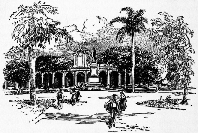
CITY HALL AND PLAZA, CARDENAS
The view of the City, covering the slopes of the hills on the west as you enter the bay, is very attractive. Since the Province of Matanzas has no harbors on the south coast, nearly all the sugar produced in her forty big mills is shipped from either Matanzas or Cardenas, both of which are connected with railroads that tap the various agricultural sections lying south of them.
The second city of the Province, Cardenas, is located on Cardenas Bay, a large and well protected harbor thirty miles east of Matanzas. In comparison with most of the harbors, however, it is comparatively shallow, needing a good deal of dredging to make it available for deep draft vessels. Cardenas, like Matanzas, is comparatively modern, with wide streets, regularly laid out. The old square, with its statue of Columbus, has been recently remodeled at considerable cost.
The first serious indication of revolt on the part of the Cuban people against the rule of Spain, was started here by General Narciso Lopez, who landed at Cardenas with 600 men, mostly Americans from New Orleans, on May 19, 1850. Within a few hours they had captured the Spanish garrison and made prisoners of Governor Serrute and several of his officials. The city was theirs, but to the unspeakable chagrin of General Lopez, only one man came to his aid on Cuban soil, and before nightfall, after defeating a Spanish column sent to oppose him, the disappointed revolutionist abandoned the city, and with his followers embarked for Key West.
It was on May 11, 1898, that Cardenas Bay became the scene of an engagement between blockading vessels of the United States fleet and the Spanish batteries, in which Ensign Worth Badgley was killed, he being the first officer to lose his life in the war.
The exportation of sugar from the rich lands tributary to this bay has always given Cardenas importance as a shipping point and rendered it, for a city of only 30,000, quite a wealthy and prosperous community. Many beautiful residences have been built along its stately avenues, and the great henequen industry recently started in the great fields to the west will add, undoubtedly, to the wealth of the locality. Splendid stone warehouses line the shore for a mile or more, with a capacity sufficient to hold in storage while necessary the enormous crop of sugar that is produced in the province.
The presence of naphtha and many surface indications of oil deposits south and east of the City of Cardenas have rendered that section attractive as a field of exploration. Up to the present time, however, no paying wells have been found, although many expert oil men are still confident that the entire district from Cardenas to Itabo, and even further east, will some day prove a valuable field for petroleum products.
Midway between Cardenas and the City of Matanzas, just north of the beautiful highway connecting these two cities, rises a range of low serpentine hills, whose altitude is approximately five hundred feet. These peculiarly symmetrical, round, loaf-like elevations above the level surface of the surrounding country, are covered with a short scrubby growth of thorny brush, and several varieties of maguey, of the century plant family. Nothing else will grow on these serpentine hills; hence in most respects they are decidedly unattractive. Since the beginning of the international war, however, and the great demand for chrome, some local mineralogists noted that little streams and rivulets running down these hills left deposits of a peculiar black, glistening sand. This sand, when analyzed, proved to come from the erosion of chromite, the mineral so much in demand by the smelting industry of the United States for hardening steel. In the spring of 1918 two well-known mining engineers and geologists, with instructions from Washington, visited several of these serpentine hills and found valuable deposits of chromite that will probably furnish a very profitable source of this much sought-for mineral and add greatly to the mining industry of this province.
During the War of Independence, Generals Antonio Maceo and Maximo Gomez led the invading columns of the Revolutionary Army into this Province for the first time, in the fall of 1896. The great beds of dead leaves lying between rows of cane, dried by the November winds, formed useful material for the insurgent armies. The torch once applied to this vast tinder box, with the prevailing easterly winds, all Matanzas was aflame. Under cover of the great canopy of smoke which rose over the land, the invading armies of the Occident swept rapidly on through the Province, fighting only when compelled to, since the object of the invasion was to carry the war into Havana and Pinar del Rio, where Revolution had never before been known.
The vast cane fields that today line the railroad tracks on both sides, bear no evidence of the ravages of Revolution, while handsome modern mills, many of which have been erected since the beginning of the great European War of 1914, have helped to feed the world with sugar that could be obtained in sufficient quantities in no other place.
PROBABLY in no part of Cuba is the topography more varied or the scenery more beautiful than in the Province of Santa Clara, with its area of 8,250 square miles. Mountain, valley, table land and plain seem to be thrown together in this, the central section of the Island, in reckless yet picturesque confusion. The main system of mountains, extending throughout the entire length of Cuba, disappears and reappears along the northern coast of Santa Clara, thus permitting easy communication between her rich central plains, covered with sugar estates, and her harbors on the coast.
In the southwestern center of this province, we have another group of mountains, foot hills and fertile valleys, in which are located some of the old coffee estates of slavery days, established at the close of the 18th century, shortly after the negro uprising in Santo Domingo. These cafetales, in the early half of the following century, made Cuban coffee famous throughout the world. Nestling within this mountain cradle lies the city of Trinidad, founded by Diego Velasquez in January, 1514. The presence of gold, which the Indians panned from the waters of the Arimo River, rendered Trinidad an important center for the early Spanish conquerors during the first years of Cuban history. Sancti Spiritus, lying on the edge of a fertile plateau, some forty-five miles to the northeast, was founded a few months later.
Gold was the god of the Spanish conquerors, and to secure it was their chief aim and ambition. Its discovery in this section of Santa Clara brought hope to them and despair to the Indians, on whom the former depended for labor with which to dig this precious metal from the earth. Velasquez found the natives of Trinidad, like those of Oriente, a gentle, confiding people, who asked only permission to live as they had always done; tilling the soil, fishing, visiting and dancing, at which they were most clever, an ideal and harmless life, suited to their tastes. They grew corn, sweet potatoes, tobacco and yucca, from which they made their cazaba bread, still used by the country people of the present day. The Spaniards, however, soon changed this earthly dream of ease and joy into one of arduous and repugnant toil, rather than to submit to which, many of them committed suicide by poison and by drowning.
Velasquez, enthusiastic over the locality of his newly founded city, Trinidad, despatched at once one of his caravels to La Espanola in Santo Domingo, with orders to bring back cattle, mares and other material necessary to further the interests of the new settlement. And so it came to pass that this section of southern Santa Clara, with its fertile lands, beautiful scenery and promise of gold, played an important part in the early colonization of the Island.
The desire to accumulate wealth through the toil of the unhappy Indians, of whom the Spaniards made slaves, tempted even Las Casas, the great defender of the Cuban aborigines, to accept assignment of them as a gift from the crown, so that he might share something of the prosperity of the early conquerors. It is reported that Las Casas repented this departure from the path of rectitude and afterwards was led to indorse the importation of African slaves in order to save the Cuban Indians from extermination.
It was on the banks of the beautiful Arimo, some twenty-five miles east of Trinidad, that this celebrated old historian and defender of the faith maintained his ranch and other worldly possessions. Throughout the sixteenth century this section of Santa Clara was an important station on the line of travel between Santiago de Cuba and Havana.
Caravels leaving “Tierra Firme,” or the great continent of South America, that had been discovered, frequently made this shore, on the other side of the Caribbean, or were driven against it by storms, the crews afterwards reaching Santiago de Cuba by travel overland, along the south coast. Owing probably to the fact that all of this coast, from the mouth of the Zaza River east to the Cauto, is low, covered with dense jungle, reports reached Spain to the effect that the most of Cuba was a swamp, which is far from the truth, since by far the greatest portion of the Island is rolling and mountainous.
More than half of Santa Clara is hilly and broken, although owing to the fertility of the soil this interferes but little with the agricultural development of the Province.
The mountains of Santa Clara form the central zone of the great volcanic upheaval that raised Cuba from the depths of the Caribbean. A broad belt or double chain lies between the city of Santa Clara and Sancti Spiritus. Another ridge, just south of the latter city, extends from the Tunas de Zaza railroad to a point east of the Manatee River, near the harbor of Cienfuegos. A second group lies between the valleys of the rivers Arimao and Agabama, names taken from the original appellations given them by the Indians.
The highest peak of this central region, called Potrerillo, is located some seven miles north of Trinidad and reaches an altitude of about 3,000 feet. The mountains of this group extend northwest as far as the Manicaragua Valley. A third group, lying southeast of the city of Santa Clara, includes the Sierra del Escambray and the Sierra de Agabama. The average altitude of these latter hills is only about a thousand feet.
Another range of hills begins at a point on the north coast of the Province, twenty-five miles east of Sagua la Orande, and runs parallel with the north shore of the Island into the Province of Camaguey, in the western edge of which it disappears in the great level prairies of that region. The highest peaks of this group are the Sierra Morena, west of Sagua la Grande, and the Lomas de Santa Fe, near Camajuani. A little further east they are known as the Lomas de Las Sabanas.
With the exception of the northern coast range, the other ranges of Santa Clara have resulted from seismic forces, working apparently at right angles to the main line of upheaval, leaving the tangled mass of hills and valleys characteristic of this great central zone of the Province. What is known as the schistose or pre-cretaceous limestones of Trinidad, are supposed to be the oldest geological formations in the Island of Cuba.
From the foot of the Sierra de Morena, near the north coast, a wide, comparatively level plain sweeps across the province to the Caribbean Sea, broken only at a few points by one or two abrupt hills, northeast of Cienfuegos. Lying between the northern chain of mountains and the coast, we find quite a broad area of rich level land washed by the salt water lagoons of the north shore.
Again, in the extreme southeast corner of Santa Clara, is found another large tract comprising perhaps a thousand square miles, located between the Zaza and the two Jatabonico rivers that form the boundary between the province and Camaguey.
Between the various chains of mountains and hills that cut the province of Santa Clara into hundreds of parks and valleys, are exceptionally rich lands, sufficiently level for cultivation. The Manicaragua Valley, sloping towards the eastern edge of the Bay of Cienfuegos, is noted for an excellent quality of tobacco grown in that region.
Of navigable rivers, owing to the short plains between the various divides and the coast line, there are practically none in Santa Clara, although many of the streams have considerable length, and are utilized for floating logs to the coast during the rainy season. The Arimao, with its falls, known as the Habanillo, is a picturesque and beautiful stream, rising in the mountains of the southern central zone and flowing in a westerly direction, until it empties into the Bay of Cienfuegos.
The Canao, another small stream with its source near the city of Santa Clara, takes a southwesterly course and empties into the same bay. The Damiji flows south to and into Cienfuegos Harbor. The Hanabana rises in the northwestern extremity of the province, and, flowing south and west, forms much of its western boundary until it empties into a little lake a few miles north of the Bay of Cochinos, known as El Tesoro or Treasure Lake. From this a continuation of the river known as the Gonzalo runs due west throughout the entire length of the Cienaga de Zapata until it empties into Broa Bay, an eastern extension of the Gulf of Batabano.
The Manatee River is a small stream with its origin in the center of the nest of mountains that lie north of Trinidad; it flows south until it empties into the Caribbean, midway between the ports of Casilda and Tunas de Zaza. The Zaza River has its origin in a number of tributary streams in the northeast corner of the Province, whence it wanders through many twists and turns between hills and ridges until it finally passes into the level lands of the southwest corner of the Province, whence it eventually finds its way to the Caribbean. This stream, although troubled with bars just beyond its mouth, has a considerable depth for some twenty or more miles.
The most important river commercially in this Province, known as the Sagua, rises a little west of the capital, Santa Clara, and flows in a northerly direction until it empties into the Bay across from the Sagua Light on the north coast. The city of Sagua la Grande, a small but aristocratic place, is located about twenty miles from the mouth of the river, and is the distributing point for that section of the province. The river is navigable for small boats from the port of Isabella to the city above. Another small stream, known as the Sagua la Chica, empties into the Bay, about midway between La Isabella and the port of Caibarien.
The southern coast of the province of Santa Clara, not including the indentations of gulfs and bays, is approximately two hundred and fifty miles long. This, of course, includes the great western extension of the Zapata peninsula, whose shore line alone is one hundred miles in length. The northern shore, bordering on the great lagoon that separates it from the Atlantic, measures one hundred and fifty miles, forming thus for the province an irregular parallelogram whose average width north to south is about seventy-five miles.
In the center of the south coast we find the harbor of Cienfuegos, a beautiful, perfectly land-locked, deep water bay, dotted with islands, from whose eastern shores tall mountains loom up on the near horizon in majestic beauty. One of the picturesque old forts of the early eighteenth century on the west bank of the channel guards the approach to the entrance of the harbor. Some ten miles back, located on a gently sloping rise of ground, is the city of Cienfuegos, which next to Santiago de Cuba is the most important shipping port on the southern coast.
As far as definitely known, this port was first entered by the old Spanish conqueror Ocampo, in 1508. No definite settlement was made however, until 1819, when refugees from the insurrection of Santo Domingo established a colony, from which rose the present city of Cienfuegos. These involuntary immigrants from Santo Domingo were coffee growers in their own country, and from their efforts splendid coffee plantations were soon located in the rich valleys and on the mountain sides that lay off towards the northeast. Large groves of coffee, struggling under the dense forest shade, still survive in these mountains, from which the natives of the district bring out on mule back large crops of excellent coffee that have been grown under difficulties.
The city of Cienfuegos, or a Hundred Fires, is substantially built of stone and brick, with wide streets, radiating from a large central plaza, as in all Spanish cities the favorite meeting place where people discuss the topics of the day, and listen to the evening concerts of the municipal band. There are several social clubs in Cienfuegos and a very good theatre, together with the city hall and hospital, which are creditable to the community. The population is estimated at 36,000.
Sancti Spiritus is one of the seven cities founded by Diego Velasquez in 1514, and still bears every evidence of its antiquity. Its streets are crooked and but little has been done to bring the city into line with modern progress. This is owing largely to the fact of its being located twenty-five miles back from the southern coast, and some ten miles off the main railroad line, connecting the eastern and western sections of the Island. It lies on the edge of the plateau, east of the mountain group of southern Santa Clara. An old, tall-towered church still bears the date of its founding by Velasquez. The city has a population of approximately 15,000.
Santa Clara, the capital, is located almost in the center of the province, well above the sea level. Its wide, well kept streets are suggestive of health and prosperity. It was founded in 1689, and until 1900 was the eastern terminus of the main railroad line running east from Havana. Rich fertile lands surround Santa Clara, while the mining interests a little to the south, although not at present developed, give every promise of future importance. Copper ore of excellent quality has been found in a number of places between Santa Clara and Trinidad, while silver, zinc and gold are found in the same zone, but up to the present not in quantities that would justify the investment of capital in their development. Ten thousand tons of asphalt are mined annually not far from the city, and considerable tobacco is grown in the surrounding country. The population is estimated at 15,000.
Sagua la Grande is located on the Sagua River, twenty miles up from the port of La Isabella. It is a comparatively modern city, with wide streets, and is the distributing point for the large sugar estates of that section. Its population is 12,000.
The Port of Caibarien has grown into considerable importance owing to the large amount of sugar brought in by the different railroads, for storage in the big stone warehouses that line the wharf. Shoal water necessitates lightering out some fifteen miles to a splendid anchorage under the lee of Cayo Frances, on the outer edge of the great salt water lagoon which envelops the entire north coast of Santa Clara. The population is 7,000.
Five miles west, on the line between Caibarien and Santa Clara, is the little old city of Remedios, that once occupied a place on the coast, but was compelled by the unfriendly visits of pirates, as were many other cities in Cuba in the olden days, to move back from the sea shore, so that the inhabitants could be warned of an approaching enemy. Around Remedios, large fields of tobacco furnish the chief source of income to this city of six or seven thousand people.
The great “Cienaga de Zapata,” or Swamp of the Shoe, so called on account of its strange resemblance to a heeled moccasin, although geographically a part of the Province of Matanzas, has nevertheless always been included in the boundaries of Santa Clara. Its length from east to west is about sixty-five miles, with an average width from north to south of twenty. Many plans, at different times since the first Government of Intervention, have been formed for the drainage and reclaiming of this great swamp of the Caribbean, whose area is approximately twelve hundred square miles.
Nearly all of the surface is covered with hard wood timber, growing in a vast expanse of water, varying in depth from one to three feet. Owing to its lack of incline in any direction, reclamation of this isolated territory is not easy, although the land, after the timber was removed and the water once disposed of, would probably be very valuable.
Enormous deposits of peat and black vegetable muck, cover the western shores of this peninsula and will, when utilized for either fuel, fertilizer or gas production, be an important source of revenue, as will its forests of hard wood, when transportation to the coast is rendered possible.
Just east of the heel of the “Zapata” and some forty miles west of the harbor of Cienfuegos, a deep, open, wide-mouthed roadstead projects from the Caribbean some eighteen miles into the land, almost connecting with the little lake known as “El Tesero” or Treasure, located at the most southerly point of the Province of Matanzas. This roadstead, known as the Bay of Cochinos, furnishes shelter from all winds excepting those from the south, against which there is no protection, although abutments thrown out from the shore might give artificial shelter, and thus render it a fairly safe harbor.
Quite a large forest of valuable woods lies a few miles back from the coast, between Cochinos Bay and the harbor of Cienfuegos. The broken surface of the dog teeth rocks, however, upon which this forest stands, renders the removal of logs difficult and dangerous, since iron shoes will not protect the feet of draft animals used in the transport of wood to the coast. A narrow strip of very good vegetable land, running only a mile or so back from the beach, extends along this section of the coast for about twenty-five miles, awaiting the intelligent efforts of some future gardener to produce potatoes and other vegetables on a large scale for spring shipments to Cienfuegos.
The great source of wealth of the Province of Santa Clara, of course, is sugar, and to that industry nearly all of her industrial energies are at present devoted. Seventy great sugar estates, with modern mills, are located within the Province, yielding an annual production of approximately eight million sacks of sugar, each weighing 225 pounds. The fertility of Santa Clara soil has never been exhausted, and the great network of railroads covering the Province furnishes easy transportation to the harbors of Cienfuegos, Sagua and Caibarien. Considerable amounts of sugar are also shipped from Casilda, the port of Trinidad on the south coast, and some from Tunas de Zaza, at the mouth of the Zaza River, thirty miles further east. The sugar produced in the Province in 1918 was valued at eighty million dollars.
The tobacco of Santa Clara Province, although not of the standard quality obtained in the western provinces of Pinar del Rio and Havana, still forms a very important industry. That coming from the Manicaragua Valley, northeast of Cienfuegos, has obtained a good reputation for its excellent flavor.
Coffee culture in the mountains and valleys lying between Trinidad and Sancti Spiritus, introduced by French refugees from the Island of Santo Domingo the first years of the last century, was at one time a very important industry. With the introduction of machinery for hulling and polishing the beans, and with better facilities for the removal of the crop to the coast, there is every reason to believe that this industry, in the near future, will resume some of the importance which it enjoyed half a century ago, or before the abolition of slavery rendered picking the berries expensive, since this work can be done only by hand. The growing of coffee offers a delightful and profitable occupation to large families, since the work of gathering and caring for the berries is a very pleasant occupation for women and children.
Owing to the fertility of the soil of Santa Clara, the abundance of shade, rich grass, and plentiful streams of clear running water flowing from the mountains, there is perhaps no section of Cuba that offers greater inducement to the stock raiser.
The breeding of fine horses, of high-grade hogs, of angora goats, sheep and milch cows, will undoubtedly, when the attention of capital is called to the natural advantages of this section of the country, rival even the sugar industry of the Province. In no part of the world could moderate sized herds of fine animals be better cared for than on the high table lands and rich valleys of Santa Clara.
Santa Clara bore its part in the trials and sufferings endured by the patriots of Cuba in the War of Independence. The range of mountains between Sancti Spiritus and Trinidad, during those four fearful years, furnished a safe retreat for the Cuban forces, when the soldiers of Spain, abundantly supplied with ammunition, which their opponents never enjoyed, pressed them too hard. It was in these dense forests and rocky recesses which Nature had provided that the great old chieftain, General Maximo Gomez, in the last years of the war, defied the forces of Spain.
ACCORDING to the log of the Santa Maria, the first glimpse of the Island of Cuba enjoyed by Christopher Columbus, sailing as he did in a southwesterly course across the Bahama Banks, is supposed by many to have been at some point along the northern coast of what is now known as the Province of Camaguey. The area of this Province, including Cayos Romano, Guajaba, Sabinal and Coco, is approximately 11,000 square miles. The general trend of the coast lines is similar to those of the Province of Santa Clara, and the length of each is approximately one hundred and seventy-five miles. The average width of the province is eighty miles, although between the southern extension of Santa Cruz del Sur and the mouth of the harbor of Nuevitas, we have a hundred miles.
The same gentle graceful inoffensive natives were found in this section of Cuba as those who first received the Spanish conquerors at Baracoa and other places in the Island. Those of the great plains belonging to this province were known as Camagueyanos, and although for many years Spain called this section of the island Puerto Principe, the musical Indian term stuck, and with the inauguration of the Republic in 1901, the name of Camaguey was officially given to this part of Cuba.
In the year 1515, Diego Velasquez, with his fever for founding cities, established a colony on the shore of the Bay of Nuevitas, and christened it Puerto Principe. In those early days, however, there was no rest for the unprotected, hence the first settlement was moved in a short time to another locality not definitely known, but a year later the city was permanently established in the center of the province, about fifty miles from either shore, where it remains today, with many features of its antiquity still in evidence.
The first of the old Spanish adventurers who succeeded in making himself both famous and rich without flagrant trespass of law, was Vasco Porcallo de Figueroa, one of the original settlers whom Velasquez left in the City of Puerto Principe founded in 1515. This sturdy old pioneer did not bother with gold mining, but succeeded in securing large grants of land in the fertile plains of Camaguey, where he raised great herds of cattle and horses, exercising at the same time a decidedly despotic influence over the natives and everyone else in that region.
Vasco, although spending more than half of the year in the cities of Puerto Principe and Sancti Spiritus, had a retreat of his own, probably some place in the Sierra de Cubitas, where he held princely sway and guarded his wealth from intrusive buccaneers and other ambitious adventurers of those times. It was he who, meeting Hernando de Soto on his arrival at Santiago de Cuba, escorted that famous explorer across the beautiful rolling country of Camaguey, which he seemed to consider as his own special domain, and finally accepted the position of second in command in that unfortunate expedition of De Soto into the Peninsula of Florida in 1539. Fighting the savage Seminoles was not however to his taste, and the old man returned to Havana inside of a year, mounted his horse and rode home, firmly convinced, he said, that Camaguey was the only country for a white man to live and die in.
Even with the removal of the capital far into the interior, the peacefully inclined citizens were not free from molestation and unwelcome visits. During the middle of the seventeenth century, the famous English corsair, Henry Morgan, afterwards Governor of Jamaica, paid his respects to several Cuban cities, including Puerto Principe. In 1668 he crossed the Caribbean with twelve boats and seven hundred English followers, intending to attack Havana. He afterward changed his mind, however, and landing in the Bay of Santa Maria began his march on the capital of Camaguey.
The inhabitants made a desperate resistance, the Mayor and many of his followers being killed, but the town was finally compelled to surrender and submit to being sacked, during which process many women and children were burned to death in a church behind whose barred doors they had taken refuge. Morgan finally retired from Puerto Principe with his booty of $50,000 and five hundred head of cattle.
During the Ten Years’ War the province of Camaguey became the center of active military operations. The inhabitants of this section had descended from the best families of Spain, who had emigrated from the Mother Country centuries before. They were men of refinement and education, men whose prosperity and contact with the outside world had made life impossible under the oppressive laws of the Spanish monarchy.
Ignacio Agramonte, a scion of one of the best known families of Camaguey, was a born leader of men, and soon found himself in command of the Cuban forces. The struggle was an ill advised one, because the odds in numbers were too great, and the resources of the Cubans were so limited that success was impossible. The effort of General Agramonte and his followers, all men of note and social standing, was a brave one, and the sacrifice of the women, the mothers, sisters and daughters, of that period, were not surpassed by any country in its fight for liberty.
But the unfortunate death of General Agramonte, and the long uphill struggle, brought about the inevitable. The treaty of Zanjon in 1878 was ultimately forced upon the revolutionists, many of whom afterwards emigrated with their families to the United States, where some have remained as permanent citizens of that Republic; among others, Doctor Enrique Agramonte, a brother of Ignacio, who after fighting through the ten tiresome years, left his country, never to return.
In the more recent struggles for Cuban liberty, known as the War of Independence, Camaguey again took a prominent part and General Maximo Gomez, who had succeeded Agramonte at his death, and General Antonio Maceo, had the satisfaction of carrying the campaign of the Occident, from Oriente, across Camaguey, where they defeated the Spanish forces in several battles, and in the winter of 1896 led their victorious troops in three parallel invading columns, to the extreme western end of the Island. Thus the revolution was carried for the first time in history beyond the Jucaro and Moron Trocha, or fortified ditch, near the western border of Camaguey.
Narrow crooked streets still prevail in some parts of Camaguey and the erection of modern buildings, that has become so common in Havana, has not reached this quiet old municipality of the plains which still lives and breathes an atmosphere smacking of centuries past.
Topographically, although the surface of Camaguey, in altitude and contour, varies much, it is, as a whole, far more level than any other province in the Island. Great fertile savannas and grass covered plains predominate in almost every part. The potreros, or grazing lands, of Camaguey, have made it famous as the breeding place par excellence for horses and cattle, and its equal is not found anywhere in the West Indies.
In spite of the comparatively level nature of the country, with the exception of the low, heavily covered forest belt that sweeps along the entire southern coast, extending back from ten to twenty-five miles, the rest of the province partakes more of the character of an elevated plateau, interspersed with low ranges of mountains and foothills, which give pleasing diversity to the general aspect of the country.
The longest range in Camaguey is a continuation of the great central chain, that follows the trend of the Island. It begins with a prominent peak known as the Loma Cunagua, which rises abruptly from the low level savannas ten miles east of the town of Moron in the northwestern corner of the Province. A little further southeast, the range again appears and finally develops into the Sierra de Cubitas, which follows the direction of the north coast, terminating finally in the picturesque peak of Tubaque, on the Maximo River.
A small stream, known as the Rio Yaguey, sweeps west along the southern edge of this ridge and finally breaks through its western end, emptying into the lagoon or Bay of Cayo Romano. A parallel range of lower hills, with various spurs, lies a little south of the main Sierra de Cubitas. The bountifully watered prairies, valleys and parks south and west of these hills form the ideal grazing ground of the Pearl of the Antilles. Several large herds of fine hogs and cattle, recently established in this section, will soon play an important part in the meat supply of Cuba.
As in Santa Clara, an independent group, or nest, of low peaks and beautiful forest covered hills, occupies the southeastern center of the Province of Camaguey. The lands in this section are very fertile and the delightful variety of hill, valley and plain renders it a very attractive country in which to make one’s permanent home. Several elevations of moderate altitude, known as lomas, rise from the more level country, a little to the north of the above mentioned district, and form something of a connecting link between the Najasa, or mountains of the southwest, and the Sierra de Cubitas of the north shore.
As before mentioned, several chains of the north coast, originating in Santa Clara, sweep over and terminate in Camaguey, some ten or fifteen miles east of the boundary line. The mountains of this district, owing to the fact that they were distant from the coast, have never been denuded of their virgin forests, and with the opening of the Cuba Railroad, connecting Santa Clara with Santiago de Cuba on the south coast, and the Bay of Nipe on the north, a considerable quantity of valuable timber has been taken out within recent years.
Camaguey has no rivers of importance, although numerous streams flowing from the central plateaus, toward both the northern and southern coast, are utilized during the rainy season to float logs to shipping points. These short streams, varying from ten to thirty miles in length, each form basins or valleys of rich grass lands that are always in demand for stock raising. Between the Jatobonico del Sur, which forms a part of the western boundary of the Province, and the Rio Jobobo, which forms the southeastern boundary, are more than a dozen streams emptying into the Caribbean. Among these are Los Guiros, the Altamiro, the Najasa and the Sevilla.
The Najasa has its origin a little south of the City of Camaguey, and passes through a heavily timbered country, carrying many logs to the landing of Santa Cruz del Sur. A railroad was surveyed from the latter city to the capital some years ago, but has never been completed.
On the north coast, between the Jatibonico del Norte, which forms the northwestern boundary, and the Puentes Grandes, forming the northeastern, we have some ten or a dozen short streams, among the most important of which are the Rio de los Perros, emptying into the Lagoon of Turaguanao; the Rio Caonao emptying into the lagoon of Romano; the Jiguey, cutting through the western extremity of the Sierra de Cubitas and emptying into the eastern end of the above mentioned lake; the Rio Maximo, rising on the south side of the chain, sweeping around its eastern end and emptying into the Bay of Sabinal; and the Saramaguacan, one of the longest in the province, rising in the mountains of the Najasa, whence it flows in a northeasterly direction and empties into the harbor of Nuevitas. Both the Chambas and the Rio Caonao, when not obstructed by mud bars at their mouths, are navigable for light draft schooners and sloops, for some twelve or fifteen miles into the interior.
At no point on the south Coast of Camaguey can be found any harbor worthy of the name, although at Jucaro, Santa Cruz del Sur and Romero, considerable timber and sugar are shipped from piers that extend out into the shallow waters of the Jucaro and Guacanabo gulfs.
The long system of salt water bays or lagoons, beginning at Punta Hicaco in Matanzas, continues along the entire north coast of Camaguey and terminates in the beautiful harbor of Nuevitas. The lagoons of Camaguey are formed by a series of keys or islands, of which Cayo Romano, seventy-five miles in length, with an average width of ten miles, is the most important.
Although most of the area of this island is covered with a dense jungle of low trees, the eastern end rises to quite a high promontory, with more or less arable land, planted at the present time in henequen, and yielding a very good revenue to the owner. An unknown number of wild ponies, variously estimated at from six hundred to two thousand, inhabit the jungles of Cayo Romano, living largely on the leaves of the forest, and consequently degenerating in size and form to such an extent that they have a very little commercial value.
Cayo Coco, really an extension of Romano, reaches out to the westward some fifteen miles further, while the Island of Guajaba, separated by a narrow pass with only three feet of water, incloses the beautiful harbor of Guanaja. Sabinal, some 25 miles in length by ten or twelve in width, forms the northern shore of the harbor of Nuevitas. On the latter key there is fairly good grazing ground and much territory that eventually will probably be planted in henequen, as is the promontory of Nuevitas, just north of the city of that name.
These salt water lakes or bays are often twenty-five miles or more in length by ten wide and with an average depth of fifteen feet. Unfortunately, not only are they separated by narrow passes seldom carrying over three feet, but exit to the ocean for any craft drawing over five or six feet is very difficult to find.
The harbor of Nuevitas, in the northwestern corner of the Province, is one of the finest in the Island. Its width varies from three to ten miles, while its length is approximately twenty, carrying excellent deep water anchorage throughout almost its entire extent. A peculiar river-like opening, six miles in length, deep and narrow, connects it with the Atlantic Ocean.
In proportion to its size, the province of Camaguey has less railroad mileage than any other in the Island. Until 1902, when Sir William Van Horn, late President of the Cuba Company, connected the City of Santa Clara by rail with Santiago de Cuba, there were but two railroads in that section of the country. One, the Camaguey & Nuevitas Road, connected the capital with practically the only shipping point on the north coast. Another, built many years before, for military purposes, connected the town of San Ferrando, on the north coast, with Jucaro on the south coast, and ran parallel with what was known as the Trocha, a military ditch about eighty kilometers in length, with two story concrete forts at each kilometer, and low dug-outs, or shooting boxes, located midway between the principal forts. The ground was cleared on either side of the railroad for a kilometer, while on both sides a perfect network of barbed wire, fastened by staples to the top of wood stakes, rendered it difficult for either infantry or cavalry to cross from one side to the other. This modern military device was established by the Spanish forces in 1895, so as to prevent the Cubans from carrying the revolution into Santa Clara and the western provinces.
As in the other provinces of Cuba, cane growing and the making of sugar forms the chief industry, although, owing to the wonderfully rich potreros, or grazing lands of Camaguey, the raising of live stock in the near future will doubtless rival all other sources of wealth in that section.
There are twenty sugar mills in the province with a production of approximately 3,000,000 bags. The two mills at Las Minas and Redencion, between Camaguey and Nuevitas, have been in operation for many years, but with the opening up of the Van Horn railroad a new impetus was given to sugar production, and during the past ten years, some eighteen new mills have been established at various points along the railroad where lands were fertile and comparatively cheap.
A line known as the North Shore Railroad of Cuba, connecting the city of Nuevitas with Caibarien, in Santa Clara Province, some 200 miles west, was surveyed and capital for it was promised, in 1914. The breaking out of the European war delayed work on the road, but its completion can be assured in the near future.
Several large sugar estates have been located along the line that will open up a territory rich in soil and natural resources. Important iron mines, too, in the foothills of the Sierra de Cubitas, are waiting only this transportation to add an important revenue to the Province. A great deal of valuable timber will be available when the line is in operation.
Owing to the large beds of valuable ore belonging to the mineral zone of the Cubitas, it is quite probable that the mining industry will some day rank next to that of general farming in Camaguey, although as far as natural advantages are concerned, there is no industry which in the end can rival that of stock raising.
During 1895, the first year of the War of Independence, over a million head of sleek, fat cattle were registered in the Province of Camaguey, where the grasses are so rich that an average of seventy head can be kept in condition throughout the year on a hundred acres of land. The two grasses commonly found in Camaguey were both brought from abroad. Of these, the Guinea, imported from western Africa, grows luxuriantly on all the plateaus and higher lands of the province, while the Parana, a long running grass from the Argentine, does best in the lower lands and savannas. One stock man of Camaguey at least, has succeeded in producing splendid fields of alfalfa, from which seven or eight cuttings are taken each year.
Fruits of all kinds, especially oranges and pineapples, grow luxuriantly in this Province, but owing to the lack of transportation, the railroad haul to Havana being practically prohibitory, shipments of fruit and vegetables to the northern markets are confined almost entirely to a steamer which leaves the harbor of Nuevitas once every two weeks.
Owing perhaps to the rich and comparatively cheap lands offered by the Province of Camaguey, more Americans are said to have settled in this section than in any other part of Cuba. The first colony, called La Gloria, was located in 1900 on the beautiful bay of Guanaja or Turkey Bay, some five or six miles back from the shore. The location, although healthful and in a productive country, was most unfortunate as far as transportation facilities were concerned. Two hundred or more families made clearings in the forests of the Cubitas, and there made for themselves homes under adverse circumstances. The worst of these was the isolation of the spot, and lack of communication with any city or town nearer than Camaguey, some forty-five miles southwest, or Nuevitas, forty miles east; without railroads, wagon roads, or even water communication by vessels drawing over seven feet.
The Zanja, or ditch, some three miles in length, connecting the harbor of Nuevitas with Guanaja Bay, was recently dredged to a depth of three or four feet, so that launches can now pass from La Gloria to Nuevitas, but aside from the fertility of the soil, there was but little to commend La Gloria as a place of permanent residence. Only grit and perseverance on the part of sturdy Americans has sustained them during the past sixteen years. But they concluded to make the best of the situation in which they found themselves, and are producing nearly everything needed for their subsistence. A considerable amount also of farm produce and fruit will soon be shipped to northern markets from the harbor of Nuevitas. A very creditable agricultural fair is held in La Gloria each winter, and the contents of the weekly paper seems to bear every evidence of progress and content. In spite of adverse conditions, the people of La Gloria have prospered and enjoy there many comforts not found in colder climates, and with the opening up of the North Shore Road, this really attractive section of country, which includes several smaller colonies scattered along the water front, will be brought in close touch once more with the civilization of the outside world.
Another colony, also unfortunate in its location, was established at Ceballos on the Jucaro and Moron railroad, about eight miles north of its junction with the Cuba Company road at Ciego de Avila. The soil was well adapted to the growth of citrus fruit, and large groves were laid out by Americans, some ten or twelve years ago, along the line of the old clearing that bordered the Trocha. The groves, as far as nature could provide, were successful, but the excessive freight rates between Ceballos and either the city of Havana or the Bay of Nipe, have proved discouraging to the original settlers.
Several smaller colonies have been located along the Cuba Company’s railway and the line connecting the city of Camaguey with Nuevitas, but again the long distance between these points and large markets, either local or foreign, have worked to the disadvantage of the growers. If stock raising instead of fruit growing had occupied the time and attention of these American pioneers, more satisfactory results would have been obtained.
Nuevitas, located on the southern shore of the harbor of that name, is a modern city with wide streets and a population of approximately 7,000 people. Its location, at the terminus of the Camaguey Railroad, and on the only harbor of the north coast, renders it a place of considerable commercial importance, since large quantities of sugar, lumber and livestock leave the port during the year, while coasting steamers of local lines touch every few days.
Camaguey, the capital of the Province, so long known as Puerto Principe, has a population of about 45,000 people. The natives of this city have long enjoyed and merited an enviable reputation for integrity, intelligence and social standing, traits that were inherited from a number of excellent families who came to Cuba from Southern Spain in the early colonial days. The rich grazing lands of Camaguey and the salubrious climate, not only of the north coast, but of the great plateaus of the interior, were very attractive to the better class of pioneers who came over in the sixteenth century in search of peace, permanent homes and wealth based on legitimate industry.
There is no section of the Island more highly esteemed for the integrity of its people than that of the isolated, aristocratic city of Camaguey, such as the families of Agramonte, Betancourt, Cisneros, Luaces, Sanchez, Quesada and Varona. Nearly all these families through the long painful Ten Years’ War suffered privations, followed by exile and loss of everything but pride, dignity and good names.
Most of them made permanent homes in the United States, but many of their children, educated in the land that gave their parents shelter, have returned to their native country and occupied positions of trust and responsibility in the new Republic.
THE Province of Oriente, called by Spain Santiago de Cuba, forms the eastern extremity of the Island, and is not only the largest in area, but, owing to the exceptional fertility of its soil, the great number of magnificent harbors, the size and extent of its plains and valleys, together with the untold wealth of its mines of iron, copper, manganese, chrome and other minerals, it must be considered industrially as one of the most important provinces of Cuba.
Its area consists of 14,213 square miles, its form is triangular, Cape Maysi, the eastern terminus of the island, forming the apex of the triangle, while the base, with a length of about one hundred miles, extends from Cabo Cruz along the Manzanillo coast to the north shore. One side of the triangle, formed by the south coast, has a length of nearly 250 miles, while another, without counting the convolutions of the sea coast, borders for two hundred miles on the Atlantic.
Mountain chains follow both the north and south shores of Oriente, while about one-third of its area, which composes the eastern section, is a great tangle or nest of irregular mountains, flat top domes, plateaus, and foothills, with their intervening basins, parks and valleys.
While the main chain, or mountainous vertebrae, seems to disappear in the Sierra de Cubitas of Camaguey, it reappears again, just west of the Bay of Manati, in the extreme northern part of the province, and extends along the north shore at broken intervals, until it finally melts into that great eastern nest of volcanic upheavals that forms the eastern end of the Island. From this north shore chain, innumerable spurs are thrown off to the southward between Manati and Nipe Bay, reaching sometimes twenty-five or thirty miles back into the interior.

A MOUNTAIN ROAD, ORIENTE
Along the southern shore of Oriente from Cabo Cruz to Cabo Maysi, ascending at times abruptly from the beach, and at others dropping back a little, we have the longest and tallest mountain range of Cuba. One peak, known as Turquino, located midway between the city of Santiago de Cuba and Cape Cruz, reaches an altitude of 8,642 feet.
From the crest of this range, known as the Sierra Maestra, the great network of spurs are thrown off to the north toward the valley of the Cauto, while between these mountain offshoots several of the Cauto’s most important tributaries, including the Cautill, Contraemaestre and Brazos del Cauto, have their sources.
Most of the mountainous districts are still covered with dense tropical forests that contain over three hundred varieties of hard woods, the cost of transportation alone preventing their being cut and marketed.
The interior of the Province, from the Mayari River west, is the largest valley in Cuba, with a virgin soil marvellously rich through which runs the Cauto River, emptying into the Caribbean Sea, a little north of the City of Manzanillo. This stream, with its tributaries, forms the most extensive waterway in the Island.
A tributary on the north known as the Rio Salado, rising south of the city of Holguin, flows in a westerly direction and empties into the Cauto just above the landing of Guamo, some fifteen miles from the Caribbean. Small streams empty into all of the numerous deep water gulfs and bays that indent the north coast of Oriente. Each serves its purpose in draining adjacent lands, but none, with the exception of the Mayari, is navigable. This stream, the most important perhaps of the north coast, rises in the eastern center of the Province, cutting its way west along the base of the Crystal Mountains, until it reaches their western end, whence it makes a sharp turn to the north, and after tumbling over the falls, gradually descends and empties into Nipe Bay.
The Sagua de Tanamo and its tributaries drain quite a large basin east of the Mayari, and empty into the Gulf of Tanamo. The Moa, a short stream, rises not far from the Tanamo but flows north to the ocean. The Toa, flowing east, cuts through valleys for fifty miles, and finally empties into the Atlantic thirty miles west of Cape Maysi.
But little is known of this river; and like many of the streams which for countless centuries have been cutting their tortuous ways through the table lands and gorges of the eastern part of Oriente, its shores have seldom been visited by human beings since the Siboney Indians, who once made that section their home, gave up trying to be Christians and took their chances of happiness on the other side of the “Great Divide.”
The Harbor of Puentes Grandes, that separates Oriente from Camaguey on the north coast, is sufficiently deep for ordinary draft vessels, but owing to sand spits and coral reefs that extend for some distance out into the Atlantic, and to the fact that good harbors lie within a few miles on either side, commerce up to the present has never sought this place as a port of entry.
About twelve miles east, however, we have the Bay of Manati with a fairly easy entrance and an elbow-like channel that will give anchorage to vessels drawing fathoms. On the shore of Manati Bay has been established a very fine sugar mill surrounded by thousands of acres of cane grown in the Yarigua Valley. Sugar is exported from this port directly to the United States.
Within the next twenty-five miles, east, are found two well protected harbors, Malagueta and Puerto Padre. The latter is the deeper and more important, owing to the large basin of fertile lands immediately surrounding it. Puerto Padre has excellent anchorage and belongs to the type of narrow mouthed bays so common to the north coast of Cuba.
On the eastern shore of Puerto Padre are located two of the Cuban American Sugar Company’s largest mills, “El Chaparra” and “Las Delicias,” each with a capacity of 600,000 bags of sugar per year. These two mills are considered, both in location and equipment, among the finest in the world. The sugar, of course, is shipped directly from Puerto Padre to New York, rendering them independent of railroad transportation, and consequently large revenue producing properties.
General Mario Menocal, General Manager of the Cuban American Company’s mills, began his great industrial career at Chaparra, which he left to assume the Presidency of the Republic in 1913. It is a very neat little city, with wide avenues, comfortable homes, good schools and many of the conveniences of much larger places. President Menocal visits Chaparra several times during the grinding season each year.
Some thirty-five miles east we have the large open roadstead of Jibara, with sufficient depth of water to provide for shipping, but with very little protection from northerly gales. On the western side of this harbor is located the city of Jibara, which forms the shipping place for the rich Holguin district, some thirty miles south.
Some forty miles further east, around the bold Punta de Lucrecia, we have another fine, deep-water, perfectly protected harbor, known as the Bay of Banes, whose rich valleys lying to the south and west contribute cane to the Ingenio Boston, belonging to the United Fruit Company, whose output is approximately half a million bags of sugar per year.
Southeast of Banes, about fifteen miles, we reach the entrance of the Bay of Nipe, considered one of the finest and best protected harbors in the world. Its entrance is sufficiently wide for ships to pass in or out at ease, while the bay itself furnishes forty-seven miles of deep water anchorage.
Nipe Bay is a little round inland sea, measuring ten miles from north to south by fifteen from east to west. The Mayari River flows into the bay from the southern shore and furnishes, for light draft boats, transportation to the city, some six miles up the river. On the north shore of the bay is located the town of Antilla, terminus of the northern extension of the Cuba Company’s lines, and one of the most important shipping places on the north coast. On the Bay of Nipe is located the Ingenio Preston, one of the finest sugar mills in Cuba, contributing 371,000 bags in the year 1918 to the sugar stock of the world.
Some seven or eight miles east of the entrance of Nipe lies another large, beautiful, land-locked bay, or rather two bays, separated by a tongue of land extending into the entrance of the harbor and known as Lavisa and Cabonico, both of which are deep, although the first mentioned, with a length of eight miles and a width of six, is the larger of the two. The shores of both these harbors are covered with magnificent hardwood forests, most of which have remained intact. The lands surrounding them are rich, and will, within a very short time, probably be converted into large sugar estates. These beautiful virgin forests, with their marvellously fertile soil, surrounding the harbors of Lavisa and Cabonico, might have been purchased ten years ago at prices varying from eight to twelve dollars an acre. In 1918 they were sold at fifty dollars per acre, and were easily worth twice that sum.
Fifteen miles further east we have another fine deep-water harbor known as Tanamo. Its entrance is comparatively easy, and although the bay is very irregular in shape, the channel furnishes good anchorage for fairly deep draft vessels. The Sagua de Tanamo River, whose tributaries drain the rich valleys south of the bay, has its source in the great nest of mountains in the eastern end of Oriente.
Baracoa, some twenty miles east, is a small, picturesque anchorage, but with almost no protection against northerly winds, and for this reason cannot rank as a first class port, although a good deal of shipping leaves it during the year, the cargoes consisting mostly of cocoanuts and bananas, for which this district has always been quite a center of production in Oriente.
It was on this harbor that Diego Velasquez made the first settlement in Cuba, in the year 1512. He called it the city of Nuestra Senora de la Asuncion, but the original Indian name of Baracoa has remained attached to the spot where Spanish civilization began in the Pearl of the Antilles.
It was here that General Antonio Maceo with a little band of thirty men landed from Costa Rica in March, 1895, and began the War of Independence, which ultimately led to the formation of the Republic of Cuba.
Rounding Cape Maysi at the extreme eastern end of Cuba, and following the south coast, no harbor is found until we reach Guantanamo Bay, nearly a hundred miles west. This magnificent harbor was first visited by Columbus on his second voyage when he sailed along the south coast in 1494. The celebrated navigator referred to it as “Puerto Grande,” but the original Indian name of Guantanamo again replaced that of the white invaders.
The Bay of Guantanamo is considered one of the finest harbors in the world. It was selected from all the ports of Cuba by Captain Lucien Young in 1901 as the best site for a naval station in the West Indies for the United States Navy. Arrangements were later made between Cuba and authorities in Washington, by which it was formally ceded for that purpose. Not only is Guantanamo a large bay, extending some fifteen miles up into the interior, but its mouth is sufficiently wide and deep to permit three first-class men of war to enter or leave the harbor abreast at full speed, without danger of collision or contact with the channel’s edge on either side.
The Guantanamo River, after draining the great wide valleys that lie to the north and west, enters the Bay on the western shore. The City of Guantanamo, some fifteen miles back, is connected by rail with the coast, and also with the city of Santiago de Cuba, fifty miles further west. It was founded toward the end of the eighteenth century by French refugees from Santo Domingo, and has at present a population of 28,000.
Eleven large sugar estates are located in the Guantanamo valley, which is one of the largest cane producers in Oriente.
Fifty miles further west we find the harbor of Santiago de Cuba, absolutely land-locked, and probably the most beautiful of all in the West Indies. Its entrance, between two headlands, is narrow and might easily escape observation unless the passing vessel were less than a mile from shore. Rounding the high promontory of the east, with its old-fashioned fort of the middle eighteenth century, one enters a magnificent bay, dotted with palm covered islands, gradually opening and spreading out towards the north. Its winding channels present changing views at every turn, until the main or upper bay is reached, on the northern shore of which is located the city of Santiago de Cuba, that for half a century after its founding in 1515 was the capital of Cuba.
Santiago played a very important part in the early history, or colonial days, of the Pearl of the Antilles, passing through the trials and tribulations that befell the first white settlers in this part of the Western Hemisphere. Not many years after its founding, it was sacked and burned by French corsairs.
Santiago was one of the few cities in all Cuba that retained the names given them by their Spanish founders. It was here in June, 1538, that Hernando de Soto, appointed Governor by the King of Spain, recruited men for that unfortunate expedition into the great unknown territory across the Gulf, which cost him his life, although his name became immortal as the discoverer of the Mississippi River.
Santiago became famous in American history through the destruction of Cervera’s fleet by Admirals Sampson and Schley, and the capitulation of the city to United States forces in July, 1898. It has a population of about 45,000. The city lies on the southern slope of the plateau, rising from the bay towards the interior. Its streets are well laid out and fairly wide, with several charming little parks, or plazas, such as are found in all Latin American cities.
The commercial standing of the city is based on the heavy shipments of sugar and ores, iron, copper and manganese mined in the surrounding mountains. The building of the Cuba Company’s railroad connecting it with the other end of the Island and with the Bay of Nipe on the north coast, did much towards increasing the importance of Santiago. The outlying districts of the city are reached by a splendid system of automobile drives, surveyed and begun at the instigation of General Leonard Wood, then governor of the Province, in 1900. These well-built, macadamized carreteras wind around hills and beautiful valleys, many of which have a historic interest, especially the crest of the Loma San Juan, or San Juan Hill, captured by the American forces in the summer of 1898. A unique kiosk has been built on the summit of this hill from which a view of El Caney, over toward the east, and many other points which figured in that sharp, brief engagement, are indicated on brass tablets, whose pointed arrows, together with accompanying descriptions, give quite a comprehensive idea of the battle which loosened the grip of the Spanish monarchy on the Pearl of the Antilles, and made Cuban liberty possible for all time to come. In the valley just below is a beautiful Ceiba tree, under which the peace agreement between American and Spanish commanders was concluded in July, 1898. The grounds are inclosed by an iron fence with various inscriptions instructive and interesting.
Santiago is named in honor of the Patron Saint of Spain, and the Archbishop of Cuba, in keeping with custom and early traditions, still makes his headquarters in this picturesque and historically interesting capital of the Province of Oriente.
Between Santiago and Cabo Cruz, one hundred and fifty miles west, is but one harbor worthy of mention, the Bay of Portillo, a rather shallow although well protected indentation of the south coast. On the rich level lands at the base of the mountains back of and around the harbor of Portillo, grow enormous fields of cane, feeding the mill on the western side of the bay. Several other indentations of the south coast furnish landing places from which either timber or agricultural products may be shipped, when southerly winds do not endanger the anchorage. A small harbor known as Media Luna, between Cabo Cruz and Manzanillo, forms the shipping place of the Ingenio Isabel, which produced 175,000 sacks of sugar in 1918.
The somewhat shallow harbor of Manzanillo is located at the mouth of a small stream in the Sierra Maestra. Vessels of more than fifteen feet draft, find the Manzanillo channel somewhat difficult. The city itself is comparatively modern, with wide streets regularly planned and laid out. Its population is about 18,000, although the municipal district contains some 35,000 inhabitants. Manzanillo is one of the chief shipping ports and distributing points for the rich valley of the Cauto, the largest valley by far in Cuba. This river during the rainy season is navigable for river boats for some hundred miles to the interior. Bars that have formed near its mouth on the west shore of Guacanabo Gulf prevent the navigation of deeper craft.
The City of Bayamo, located on the Bayamo River, a tributary of the Cauto, is connected by the southern branch of the Cuba Company’s Railroad with Manzanillo, twenty-five miles west, and also with Santiago de Cuba. It was one of the original seven cities founded by Diego Velasquez in 1514. In the early days of colonial occupation, Bayamo passed through the same period of trials and tribulations that afflicted nearly all of the early settlements in Cuba.
Historically it has never been prominent as the birth-place of struggles in which the natives of Cuba endeavored to throw off the yoke of Spain. It was the home of Cespedes, the first revolutionary President of the Island, who freed his slaves in 1868, and with a small force of men raised the cry known as the “Crita de Baire,” that started the Ten Years’ War.
Again, in February, 1895, General Bartolome Maso with his son and a few loyal companions left his home in the city of Bayamo, and at his farm called “Yara” declared war against the armies of the Spanish Monarchy, never surrendering until Independence was eventually secured through the defeat of Spain by American forces in 1898. The city, although boasting only of some 5,000 inhabitants, is located in the fertile plains of the Cauto Valley, known throughout the world as the largest sugar cane basin ever placed under cultivation. The Cuban National Hymn had its origin in this little city and is known as the “Himno de Bayamo.”
ON THE CAUTO RIVER
The Cauto River, traversing Oriente Province, is the largest stream in Cuba, and is of inestimable value for navigation, for water supply, and for drainage. It is the salient feature of many fine landscape scenes, ranging from the idyllic to the majestic.

Holguin, located in the northern center of the Island, among picturesque hills and fertile valleys, is the most important city in northern Oriente. It was founded in 1720, receiving its charter in 1751, and boasts of a population of about 10,000. The harbor of Gibaro, twenty-five miles north, with which it is connected by rail, is the shipping port of the Holguin district. The country is very healthful and long noted as a section in which Cuban fruits acquire perhaps their greatest perfection. Americans living in this city, within the last ten years, have established splendid nurseries, known throughout the Island.
Victoria de las Tunas, a small city located on the Cuba Company’s Railroad, some 20 miles from the western boundary of the Province, acquired celebrity in the War of Independence owing to its capture after a siege of several days by the Cuban forces under General Calixto Garcia, in the fall of 1897.
It was in this engagement that Mario Menocal, then Chief of Staff with the rank of Colonel in the insurgent forces, distinguished himself through a brilliant charge made at a critical moment, in which he led his Cuban cavalry against the well equipped forces of Spain. Colonel Menocal was wounded in this engagement, but as a reward for intelligent and courageous action he was shortly afterward made Brigadier General, and given command of the insurgent forces in the Province of Havana, which he held up to the time of the Spanish surrender in 1898.
An incident indicative of the character and discipline of the Cuban forces took place at the capture of Victoria de las Tunas, when General Calixto Garcia, after caring for the Spanish wounded, furnished an escort to protect his prisoners and non-combatants who wished to leave the city, in a march overland to the town of Manati, where they were delivered into the safe keeping of the Spanish authorities, as the Cubans were unable to keep prisoners owing to shortage of food. General Calixto Garcia was a native of Holguin, owing to which fact, perhaps, much consideration was shown to both persons and property in the surrounding district, where he had both friends and relatives.
The sugar industry, of course, as in all provinces but Pinar del Rio, is the chief source of wealth in Oriente. The entire northeastern half, including the great valley of the Cauto River, as well as the rich lands in the valley of Guantanamo, and the basin surrounding the Bay of Nipe, are devoted almost entirely to the production of sugar. The European War of 1914 gave a great impetus to this industry, owing to the demands made by the allies for this staple food product. An illustration of this may be found in the increased acreage of cane in Oriente between the years of 1913 and 1918. In 1913 Oriente was producing 3,698,000 bags, while in 1918 the sugar crop reach 6,463,000 bags. Forty-two large sugar centrals are in operation in Oriente at the present time, with a marked increase each year.
Next in importance to the production of sugar ranks stock raising. Thousands of acres that cover the plateaus, foothills, mountains, parks and valleys, supplied as they are with an abundance of fresh water and splendid grass, furnish strong inducements to the stock grower of Oriente, who has nothing to fear from cold, snow, drought or storm. The profits of stock raising where the business is conducted under intelligent management, are certainties, which is true of all sections of the Island adapted to this industry.
Coffee, as in the provinces of Santa Clara and Pinar del Rio, owes its introduction into Cuba to the French refugees who, driven by revolution out of Santo Domingo, fled to Cuba and settled there in the first years of the nineteenth century. The large profits that have resulted from the cultivation of sugar cane have undoubtedly drawn capital from the coffee industry, and unless a sufficient amount of cheap labor can be secured, the gathering of this crop is not always profitable. In spite of the rather heavy tariff, and the excellent quality of the bean, it is compelled to compete with the imported article from Porto Rico and other countries. It is quite probable, too, that through years of neglect in cultivation, the habit of prolific bearing has deteriorated.
The rich, narrow, deep soiled vales among the tangled mountains that cover the eastern extremity of the province are especially adapted to the growth of cacao, but in spite of most satisfactory returns most of the farmers of Cuba seem to prefer life in the open potreros, with its cultivation of sugar cane and care of live stock, to that of comparative retirement, imposed upon those who devote themselves to coffee and cacao in the mountainous districts. Cacao, nevertheless, owing to the more extensive manufacture of chocolate in all parts of the world, is in increasing demand, and it is practically certain that the near future will bring immigrants from mountainous countries, who will find the cultivation of both coffee and cacao to their liking, as well as to their permanent profit.
But very little tobacco is grown in Oriente, aside from that which has long been cultivated on the banks of the Mayari River. In the neighborhood of the little village bearing that name, considerable tobacco of an inferior grade has been grown for many years, The German Government up to the blockading of her ports in 1914, consumed almost the entire Mayari crop, the soldiers of that country seeming to prefer it to any other tobacco.
More valuable timber grows in the interior of Oriente than in any other part of Cuba, and much of it will probably remain standing until more economical methods are introduced by which logs can be conveyed to the coast for shipment. Large amounts of cedar and mahogany are exported every year from Oriente, especially from the valley of Sagua de Tanamo, which empties into Tanamo Bay on the north coast.
Several American colonies have been located in the different parts of this province, most of them devoting their energies to the growing of fruits and vegetables that are shipped to northern markets from the terminus of the railroad at Antilla, on Nipe Bay. Some of them, too, have built up stock farms that are giving splendid results.
Owing to the size of the province, and its comparatively few inhabitants, greater opportunities for colonization are found here than in the western end of the Island. Thousands of acres of magnificent lands, at present owned in huge tracts, are still available for purchase and division into small farms. These would furnish homes for families that might be brought from Italy and the Canary Islands greatly to the profit of the Republic itself as well as to the immigrants. People of this class are especially desired in Oriente, and every effort is being made by the Government to encourage their immigration, since energy, combined with a fair degree of intelligence, on the rich lands of this section of Cuba, can result only in success.
The mineral wealth of Oriente is undoubtedly greater than that of any of the other provinces. Although both iron and copper have been mined here for many years, the mineral zones of the Island have never been fully exploited, or even intelligently prospected, by men familiar with the mining industry. Copper was discovered by the early Spanish conquerors and mined at El Cobre, in the early years of the 16th century. The ore deposits of this mine have never been exhausted, and are still worked with profit. The same mineral has been discovered in other sections of the province, but owing to lack of transportation facilities, but little effort has been made towards mining it. The Spanish Iron Company, for more than a half century, has been taking iron ore from the sides of the mountains on the coast, just east of the city of Santiago de Cuba, and shipping it from the port of Daquiri.
These mines are in the form of terraces, that are cut into the sides of the mountains, so that the ore can be easily withdrawn and shipped to the United States for smelting purposes. These properties have recently changed hands, and with the investment of greater capital will soon be put into a still higher state of production.
Perhaps the most profitable iron mines in the Republic are those owned by the Bethlehem Steel Company, in the Valley of the Mayari, some eighteen or twenty miles back from the coast. The mineral here is easily removed from the surface, and sent by gravity down to the large reducing mills on the shore of the Bay, where most of the waste material is washed out with water. The iron ore of Oriente is of a very high grade and is impregnated with a sufficient amount of nickel to add greatly to its value.
The recent demand for chrome, brought about by the enormous increase in the consumption of steel in the United States, brought the chrome districts of the world, including those of Cuba, into considerable prominence. The great shortage of tonnage, too, made it inconvenient to bring chrome from Brazil. Recent investigations made in Cuba, however, demonstrated the fact that this Province alone, with the investment of a few hundred thousand dollars in road building, can supply the mills of the United States with all the chrome and manganese needed for the development of the steel industries. Several manganese mines are being worked at the present time, most of them on the northern slope of the Sierra Maestra, whence the ore is conveyed by rail to Santiago de Cuba and shipped to Atlantic ports, where the demand is greatest.
The development of the mining industry in Oriente has hardly begun, but with the enormous amount of iron and copper that will be needed for building purposes throughout the world in the near future, there is every reason to believe that this province will have an opportunity to open up and to work many of her mines, with very satisfactory returns on the capital invested.
ALTHOUGH from the early days of Spanish conquest the Isle of Pines was considered by Spain as an integral part of Cuba, as are Cayo Romano and all other adjacent islands, in the treaty of Paris that concluded the controversy in regard to Spain’s possessions in the West Indies the Isle of Pines was referred to as a locality distinct in itself, and as possibly not coming within the jurisdiction of Cuban territory.
A rule placed on any mariner’s chart of the West Indies, connecting in a straight line Cabo Cruz, in the Province of Oriente, and Cape San Antonio, the western extremity of Cuba, includes the Isle of Pines within the limits of the seismic uplift which formed the Pearl of the Antilles. More than all, during much of the geological history of the region across the shallow sandy bed, covered now with only a few fathoms of water, the Isle of Pines was connected by land with Cuba.
During the first government of American intervention, several ambitious citizens of the United States bought large tracts of territory in the Isle of Pines, whose owners considered them of so little value that they parted with them at prices varying from 75¢ to $1.25 per acre. These properties were immediately divided up into small farms, varying from five to forty acres, and placed on the market in the United States. With glowing descriptions of the country they were sold at prices gradually increased from $15 to $50 and even $75 an acre.
In view of the beautiful printed matter so widely distributed, and the values which fertile farming lands in the United States had acquired in recent years, these prices apparently did not seem exorbitant, especially to men of means, who during the greater part of their experiences had fought out the struggle of life in the cold northwest. Many Americans were thus induced to come and settle in the Isle of Pines, with the hope, if not of amassing a fortune as pictured in the alluring terms of the propaganda, at least of securing a competence for their declining years.
More than all, the Isle of Pines was thoroughly advertised throughout the American Union as belonging to the United States, whose emblem of Liberty floated as an indication of ownership never to be lowered. This matter of ownership was finally brought before the Congress of the United States and through treaty with the Republic of Cuba, afterwards confirmed by decision of the Supreme Court of the United States, was definitely settled in favor of the smaller Republic. Cuba, in consideration of the waiving of all American claims on the Isle of Pines, agreed to cede to the United States coaling stations at Bahia Honda and Guantanamo. Thus the disputed territory retained its original position as the southern half of the judicial district of the Province of Havana.
The Island contains approximately 1200 square miles, a third or more of which is occupied by a large swamp bounded on the north by a depression running east and west across the Island, and extending to its southern shore on the Caribbean. The soil as a rule is sandy and poor, lacking nearly all the essential elements of plant food, and hence, for successful agriculture, needs large quantities of fertilizer.
The natural drainage of the Island is good, and the climatic conditions are almost identical with those of Cuba. Aside from poverty of soil, that which has most obstructed its prosperity is its geographical position, lying as it does some fifty miles from the mainland, within the curve formed by the concave littoral of the southern shore, from which it is separated by shallow seas and sand bars. The only harbor with sufficient depth for ocean going steamers is the open roadstead of La Ensenada de Siguanea, which furnishes little or no protection from heavy western winds. Vessels plying between the Isle of Pines and the United States are compelled to go several hundred miles out of their way in rounding the western extremity of Cuba.
All products raised in the Isle of Pines at the present time are shipped on light draft steamers to the landing of Batabano, whence they are transferred to a branch of the United Railways of Havana and carried across Cuba to the wharves of the capital for export. This loss of time and breaking of bulk has been, of course, disadvantageous to the fruit and vegetable growers of the Isle of Pines. Nevertheless large shipments, especially of grape fruit, have been made, and during those seasons in which Florida has suffered from frost, the returns to the grower have been very satisfactory.
Unfortunately, too, this interesting outpost of the Republic of Cuba lies directly within the path of the cyclones which during the months of September and October form in the Lesser Antilles to the southwest, and travelling northwesterly rake the Caimeros, the Isle of Pines and the extreme western end of Cuba. These great whirling storms usually pass through the straits between Cape San Antonio and Yucatan, following the curve of the western Gulf States until exhausted in the forests of northern Florida and Georgia. The cyclone of October, 1917, destroyed all the fruit of the Isle of Pines and practically ruined the citrus groves, greatly discouraging the people who had devoted so many years of time and toil to their care and development.
In spite of these disadvantages, however, the greater part of the Americans who have made their homes in the Isle of Pines, with genuine Yankee grit, refuse to lose courage, and have started all over again to restore those sections that were temporarily devastated. The Isle of Pines is not an attractive place for the man of small means, since considerable capital is absolutely necessary for successful agriculture in that section. Nevertheless, there is every reason to believe that with time, and intelligently directed effort, the Island may eventually become a really valuable asset to the Republic.
There seems to be no reason why the great deposits of muck from the swamps which form the southern part of the Island, lying also along the coast of the mainland in many places, might not be transferred to those soils of the Isle of Pines lacking in humus, and thus in time build a foundation of sufficient fertility to produce almost any crop desired.
In the northern half of the Isle of Pines are several low mountains, or ridges and hills, especially on either side of Nueva Gerona, which are composed largely of crystalline marble known as the Gerona marble. It is probable also that this same material forms part of the Sierra Pequena, or Little Ridge, located a few miles east, as well as that of the Sierra de Canada seen in the distance.
This marble is thoroughly crystalline, retaining little or no trace of organism that it may originally have held. The greater part of it is rather coarse, although there are some beds of fine white statuary marble. The color varies from pure white to dark grey, with strongly marked banding in places. These rocks probably belong to the Paleozoic age, although the crystalline character of the material renders the period of their origin somewhat doubtful. In some beds the impurities of the original limestone have recrystallized and formed silicate minerals, chiefly fibrous hornblende. This deposit of marble has been estimated to be not less than 2,000 feet in thickness.
The drinking water of the Isle of Pines is abundant, and like that of nearly all other parts of Cuba is of excellent quality. Several mineral springs exist which have a local reputation for medicinal properties. Many beautiful homes, and miles of splendid driveways, have been built by the property owners of the Isle of Pines, who have a natural pride in its beauty and development.
To those pioneers from the United States who have done so much towards the regeneration and building up of this section, that has always been agriculturally despised, or at least ignored by the natives, the Government of Cuba feels greatly indebted, and it realizes fully that only through immigration of this kind will this excellent work be continued. Agricultural fairs, to which the Government of Cuba contributes a generous amount for prizes, are held each year in the Island, and social life among the residents, enlivened as it is by visitors from the north during the winter season, is said to be charming.
The principal cities are Nueva Gerona and Santa Fe, while numberless small colonies are found every few miles along the highways that have been built within the last ten years. The Isle of Pines has an attractive future and many of the rosy dreams of the early American pioneers, with time, patience and capital, will undoubtedly be realized.
AFTER a lapse of more than four centuries, there are grounds for believing that the dreams of the early Spanish conquerors, who overran Cuba shortly after its discovery by Columbus, may be realized, though not exactly as they expected. Gold may never be found in paying quantities, yet the mineral wealth of the Island may exceed in value its present agricultural output, which amounts annually to hundreds of millions of dollars. The followers of Columbus as a rule cared little for the more quiet pursuits of agriculture, but were obsessed with a craving for the precious metals, and during the first half of the 16th century, with the aid of the Indians, mined and shipped a sufficient amount of gold to encourage greatly the rulers of Spain, who were quite as persistent in their craze for the yellow metal as were the pioneers of the New World.
Narvaez, Velasquez’s most active lieutenant, at the head of 150 men in 1512, marched from Oriente westward in a wild search for gold. Samples of this metal were found in various places and sent back to Velasquez, who forwarded them to King Ferdinand. The seven cities founded within the next two years were said to have been selected, not owing to the fertility of their soil or on account of advantageous locations, but solely with reference to their proximity to gold deposits.
In spite of these early discoveries, however, the amount of gold found in Cuba, although encouraging at the time, has never approached the value of other metals far more common and found in almost unlimited quantities. The district that first seems to have yielded a fair amount of gold was along the shores of the Arimao River, where the Cubenos panned a few hundred dollars in nuggets from the bed of the stream, and this determined the location of the city of Trinidad in 1514.
The first and largest shipment of gold from the Island of Cuba, amounting to $12,437, was forwarded to Spain in the summer of 1515, and was converted into coin of the realm by the King. Since the royal share was one-fifth of all produced, it would seem that the total yield during the first four years in Cuba amounted to $62,000.
The large quantities of gold found in Mexico by Cortez, some ten years later, so greatly excited the Spanish conquerors in their quest for this metal, that gold mining in Cuba gradually became an abandoned industry, and by 1535 had practically ceased. Since that time there have been no discoveries that would seem to justify further search.
Some time during the year 1529, copper was discovered on the crest of a hill known as Cardenillo, about ten miles west of Santiago de Cuba. Mines in this vicinity had apparently been previously worked by the Cubeno Indians, who did not enlighten the Spaniards in regard to their existence. The value of the find was not recognized until a certain bell-maker, returning as a passenger from Mexico, visited the mines and analyzed samples of the ore. As a result of his report the people of Santiago soon became aroused over the prospective value of the find and petitioned the crown for experts and facilities with which to develop the mine.
Dr. Ledoux, the famous French metallurgist, carefully analyzed the ore from these mines, and as a result reached the conclusion that the natives of Cuba, although apparently making no use of the copper themselves, had trafficked with the Indians of Florida, since in the many assays made of the copper relics of those tribes, it was found that the same percentage of silver and gold were contained in them as was found in the ore of the Cuban deposits. No other copper ores known have percentages of silver and gold so closely identical to those of “El Cobre.”
Little was done, however, toward the development of the Santiago mines until 1540, when the Spanish crown found itself short of material with which to make castings for its artillery and ordered an investigation of the Cuban copper deposits. In April of 1540, a German returning from a Flemish settlement in Venezluela visited “El Cobre” and entered into an agreement with the town council to work the mine. The ore yielded, according to the records, from 55% to 60% of pure copper, carrying with it also gold and silver. Samples were again sent to Spain to be tested by the crown. In 1514 forty negroes were set to work in the mines, under the direction of Gaspar Lomanes, and smelted some 15,000 pounds.
In 1546 the German referred to above, John Tezel of Nuremberg, returned from Germany, where he had carried samples of ore from the “El Cobre” and reported it “medium rich in quality and very plentiful in quantity.” Tezel spent the remainder of his life, 20 years, in exploiting the copper of that section.
Up to 1545 Juan Lobera had shipped 9,000 pounds of Cuban Copper to Spain. In the spring of 1547 still further shipments that had arrived in Seville and were ordered cast into artillery to be placed in the first fort in Cuba, La Fuerza, for the protection of the City of Havana. Three cannon were cast, of which one, a falconet, burst in the making, and was perhaps responsible for the report that Cuban copper was of “an intractable quality.”
Don Gabriel Montalvo, appointed Governor of Cuba in 1573, was much impressed by the reports he had heard of the rich copper deposits near the city of Santiago de Cuba, and visited some of the old workings, but found the native Cubenos very reluctant to give him information in regard to mineral deposits, fearing evidently that they would be compelled to work in them as miners.
A copper deposit was soon afterwards found near Havana, and samples of ore were forwarded to Spain with the request that 50 negroes be detailed to exploit the mine. The quality of the ore was apparently satisfactory for the casting of cannon, and the king ordered that it be used for ballast in ships returning from Havana, in order to furnish material for the Royal Spanish Navy.
In 1580, some mining was done, but the find soon proved to be a pocket and not a true vein, and the cost of transportation to Havana was declared prohibitive, in spite of the fact that it showed a “fifth part good copper.” Other copper mines were afterwards reported in the neighborhood of Bayamo, near the southeastern center of the Province of Oriente.
In May, 1587, although comparatively little copper had been taken from “El Cobre” mine, due largely to lack of food crops in the vicinity with which to supply the slaves, the Governor reported that “There is so much metal, and the mines are so numerous that they could supply the world with copper, and only lately there is news of a new mine of even better metal than the rest.”
Effective work in these mines began in 1599. The much needed protection from the incursion of pirates and privateers, that had long preyed on Spain’s possessions in the West Indies, revived industries of all kinds in Cuba, especially copper mining and ship-building. Juan de Texeda, who had been commissioned by the King to go to Havana and do what he could towards protecting the rich shipments of gold that were being sent from Mexico to Spain against the attacks of the English Admiral, Drake, sampled Cuban copper and pronounced it excellent. On the site of the present Maestranza Building, now devoted to the Department of Public Works and the Public Library, Texeda soon established a foundry, where he “cast the copper into both cannon and kettles.”
The mining of copper with profit depends on the price of the metal in the market and on the cost of extracting and transporting the ore to the smelter. This, of course, is true with all metals, hence it frequently happens that mines containing abundant ore are not worked, owing to the fact that the cost of production, when taken into consideration with the market price, eliminates the possibility of profit. During the past century the mines of “El Cobre” and vicinity, the extent of whose deposits seem to be almost unlimited, have been worked at such times and to such an extent as the market price of the ore would seem to justify.
Indications, such as boulders that through seismic disturbances or erosion seem to have rolled down from their original beds, and occasional outcroppings of copper-bearing ore, are found in every Province of the Island, although up to 1790 but few explorations worthy of mention were made outside of the Province of Oriente. The demands for metals of all kinds, especially chrome, manganese and copper, have resulted in more or less desultory prospecting since 1915, which has resulted in finding outcroppings of copper scattered throughout the mountains of Pinar del Rio. Claims have been located near Mantua, Vinales, Las Acostas, Santa Lucia, Pinar del Rio, and at various places between La Esperenza and Bahia Honda along the north coast.
Reports of copper or “claims,” resulting from traces found, have been made also in the Isle of Pines and at Minas, only a short distance east of the city of Havana, in that province. Copper claims have been registered near Pueblo Nuevo, too, in the Province of Matanzas. In the province of Santa Clara, claims have been recorded in the districts of Cienfuegos, Trinidad and Sancti Spiritus. Several very promising copper mines have been opened up in this province that will undoubtedly yield a profit if worked under intelligent management and with the judicious employment of capital. In the Province of Camaguey, copper has been discovered near Minas, and as several different places along the line of the Sierra de Cubitas. In Oriente, copper claims have been registered near Holguin and Bayamo, while “El Cobre,” of course, has been famous for its yield of ore since the days of the Spanish conquerors.
The excessive demand for copper resulting from the War in Europe, together with the high prices offered for that metal, recalled the fact that many years ago Spanish engineers and prospectors, among the hills of Pinar del Rio, frequently found small outcroppings of copper ore, and in some cases sank shafts for short distances, where the ore had been removed and carried to the coast on mule back. The low price of copper at that time, however, and the scarcity of labor following the abolition of slavery at the conclusion of the Ten Years’ War, discouraged serious work on the part of the old timers, traces of whose efforts still remain at various points along the northern slope of the Organos Mountains.
The first record we have of the exploration of the mineral zone in which the famous copper mine of this Province was discovered, dates back to 1790, but it resulted in no definite or profitable work. An English company of which General Narciso Lopez was president, during the early part of the 19th century, made some explorations in the district of El Brujo and Cacarajicara, located in the mountains back of Bahia Honda; but the defeat of Lopez’s revolutionary forces, and his subsequent execution in 1851, put an end to the effort.
Shortly after the Spanish American War, Col. John Jacob Astor, the American millionaire, became interested in the copper deposits of Pinar del Rio, which resulted in the establishment of several claims, none of which, however, were developed. Shortly after this a Mr. Argudin located claims known as Regelia and Jesus Sacramento, the former only two kilometers from that of the mine Matahambre. A small amount of preliminary work was done, but apparently proved unpromising.
In 1912 Alfredo Porta, a well-known citizen and politician of Pinar del Rio, interested Mr. Luciano Diaz, a former Secretary of the Treasury and a man of some means, in a claim which he had denounced some eight kilometers back from La Esperanza, on the north coast of the province. Messrs. Porta and Diaz secured the services of an experienced mining engineer, Mr. Morse, who visited the district, made a careful survey of the claim, and informed the owners that in his estimate Matahambre was worthy of the investment of any amount of capital, since the grade of the ore, and the amount exposed through Mr. Morse’s preliminary work, was sufficient to place it in the list of paying mineral properties.
Work began at Matahambre in the early part of 1913 under the technical direction of C. L. Constant, of New York. During the first year a number of galleries, only a little below the surface, were thrown out in different directions. Paying ore found in these galleries was very promising. The first two carloads of ore, shipped by rail from the City of Pinar del Rio to Havana, sold for a sufficient amount of money to pay for all of the preliminary work that had been done. In 1915, a shaft was sunk to a depth of 100 feet and afterwards carried down to the 400-foot level, where it about reached the level of the sea. Later this shaft was sent down 150 feet further. The ore taken out at the 400-foot level proved to be the highest grade of all found, although it is said that no ore was encountered at any depth that was not of sufficient value more than to pay for the cost of mining. In fact the percentage of gold and silver in many cases has paid for the expense of mining the copper. In 1918, six shafts, known as 5, 6, 7, 8, 9 and 10, were in operation, and all yielding excellent ore. There are some 15 different varieties of copper ore taken from Matahambre.
The ore for some time was conveyed to the docks at Santa Lucia with mule teams and motor trucks. These were eventually replaced by wire cables and the ore was sent to the coast by gravity, greatly decreasing the cost of transportation. Splendid wharves and receiving sheds, dumps, etc., have been built at Santa Lucia, whence the ore is lightered out to deep water anchorage. Fully 300 tons a day are now being removed and conveyed to the landing. An average of 8,000 tons a month is shipped in steamers that can take aboard 800 tons a day. This mineral is consigned to the United States Metal Refining Company. In 1916, thirty-three steamers carried 75,000 tons of mineral to this Company.
Quite a little city has sprung up around the mine, and 2,000 men are given employment by the Company. Comfortable quarters have been erected for the officials, employees and other members of the force. A large amount of ore was mined in 1918 and held for the completion of a new concentration plant, which will enable the Company to utilize ore which under war freight rates would not have been profitable to export. Following the demise of Sr. Luciano Diaz, his son Antonio Diaz assumed control and is carrying on the work of the proposed improvements.
At the time of the closing of the Spanish régime in Cuba, fourteen mineral claims had been made in the Province of Pinar del Rio. Between 1909 and 1911, 212 were denounced, including 48 of the Company headed by Mr. Astor. From 1911 to 1918, 2970 claims were registered in the Bureau of Mines. A large proportion of the interest in copper mining in Pinar del Rio was undoubtedly the result of the wonderful wealth that has come from Matahambre, the ore from which mined in 1916 was valued at $5,500,000.
Not until the early part of the 19th century did the presence of those enormous deposits of iron ore found throughout the mountain districts of Oriente present themselves to the outside world as a profitable commercial proposition.
Nearly all of the great iron deposits of Oriente lie within a few feet of the surface; and on the southern slopes of the Sierra Maestra it is necessary only to scrape the dirt from the side of the hills, take out the ore and send it down to the sea coast by gravity. Similar conditions exist at the Mayari mines on the north coast, just back of Nipe Bay, where the deposits need nothing but washing with cold water. The soil being thus removed at little cost, the iron is ready for shipment to the smelters of the United States.
In spite of the fact that this ore was found to be equal to the best Swedish, and that nature in her own laboratories had supplied the requisite amount of nickel and manganese, making these mines of Oriente perhaps the most valuable in the world, but little attention has been paid to this marvellously rich source of minerals, beyond those few who are drawing dividends from the industry. The recent purchase of the Spanish American Iron Company’s holdings at Daiquiri for $32,000,000, however, has called the attention of mining interests in the United States to the fact that millions of tons of untouched ore still lie in the eastern provinces of Cuba. Twenty-five percent of the area of Oriente contains wonderful deposits of ore, mostly iron, and awaits only the necessary capital to place it on the markets of the world.
This nickeliferous iron ore, in which the presence of nickel, so essential to the making of steel, has been contributed by nature in just the right proportions, is found in large quantities also in the provinces of Camaguey and Pinar del Rio. The extent of these mineral deposits is not yet known, but millions of tons are in sight, awaiting only cheap transportation to bring them into the markets of the world, where the grade and quality of the ore will undoubtedly command satisfactory prices.
Up to the present time nearly all of the iron ore exported from Cuba comes from the large deposits of Oriente. The iron on the south coast is loaded into the steamers from the wharves at Daiquiri and Juraguay. That on the north coast, brought down from the Mayari mines, is shipped from the harbor of Nuevitas.
Below are given the tons of copper and iron shipped from Cuba during the year from July, 1917, to June, 1918:
| IRON tons |
COPPER tons | |
| July to December, 1917 | 272,403 | 41,809 |
| January to June, 1918 | 218,301 | 52,569 |
| Total | 490,704 | 94,378 |
On the south side of the Sierra de Cubitas, in the Province of Camaguey, a distinctly marked zone of this excellent iron ore runs parallel to the main chain of the Cubitas for many miles. Grass covered hills, rising more or less abruptly from the surface, seem to be composed of solid masses of iron ore. So great is the value of this mineral zone that the North Shore Road of Cuba, now under construction and practically completed from its eastern deep water terminus on Nuevitas Harbor to the Maximo River just east of the Sierra de Cubitas, was primarily intended as a means of exploiting and conveying the ore from this zone to the sea coast.
In the western portion of the Organ Mountains of Pinar del Rio, other deposits of nickeliferous iron have been denounced and registered, although the cost of building a railroad to deep water on the north coast up to the present prevented the development of the mines, located about 20 miles southeast of Arroyo de Mantua.
With the enormous amount of constructive work that will undoubtedly follow the great European War, in which iron and steel will play such an important part, there is every reason to believe that capital will be forthcoming with which to build the necessary roads and to develop the nickel bearing iron ores of Cuba.
Structural steel, today and in the future, will probably play a greater part in the world’s progress and development than any other one of the products of nature. The demand for steel, of course, was greatly accentuated by the European conflict, without which modern warfare would be practically impossible. The splendid steel turned out in our mills of today would be impossible of manufacture without the addition of a certain percentage of either manganese or chrome. The alloys of these two metals with iron gives steel its elasticity, hardness and real value.
Manganese ores are found in California, Colorado, Arkansas, Georgia, Michigan, New Jersey and Virginia, but nowhere within the limits of the United States have the United States have the deposits of manganese proved to be sufficiently extensive to supply the domestic requirements of the country, even in normal times. The total output of manganese in the United States in 1901 was less than 12,000 tons. Southern Russia contains very large deposits of the metal, but up to 1919, 70% to 80% of the manganese consumed in the United States had been brought from the interior of Southern Brazil.
The immediate and imperative demand for both manganese and chrome, impelled the Government at Washington to seek other sources, closer by, in order to save the time consumed in securing shipments from Brazil.
Small amounts of manganese had been secured from Cuba during the ten years previous to the War, but the extent of these deposits remained unknown until, in the spring of 1918, the United States Geological Survey and Bureau of Mines sent two expert engineers, Messrs. Albert Burch, consulting engineer of the Bureau of Mines, and Ernest F. Burchard, geologist of the United States Geological Survey, to Cuba in order to ascertain the quality and quantity of manganese and chrome that might be furnished by that Republic.
The party reached Havana in the latter part of February, and were there joined by Sr. E. I. Montoulieu, a Cuban mining engineer, detailed by the Treasury Department to act as an escort and associate throughout research work in the Island. During the two months of their stay these gentlemen made a rapid survey of the more important chrome and manganese zones, the report of which was made to the United States Government in September of 1918.
The chrome deposits, which up to the time of the visit of these engineers had attracted attention in Cuba, are all located within distances varying from ten to twenty-five miles from the north coast of the Island. Some twelve groups were examined which displayed considerable diversity in quality, size and accessibility.
Manganese claims have been registered near Mantua and Vinales, in the Province of Pinar del Rio, but time did not permit an extended study of those deposits. Valuable manganese deposits of known value are found also in the districts of Cienfuegos and Trinidad in the Province of Santa Clara. By far the largest deposits of this ore, and the only ones that are being extensively worked, are located in the Province of Oriente.
The most westerly deposit of chrome visited was found in the eastern part of Havana province, and two others were located, one near Coliser, in the Province of Matanzas, another near Canasi, and a third near the automobile drive about half way between the City of Matanzas and Cardenas. In the province of Camaguey, only a few miles north of the city, valuable deposits of chrome were found quite accessible to the railroad for shipment. Other chrome deposits were found in Oriente; one near Holguin, another south of Nipe Bay, and three groups in the mountains not far from the coast between Punta Corda and Baracoa.
All of the chrome deposits examined by these engineers were found in serpentinized basic rocks. The ore lies in lenticular and tabular masses, ranging in thickness from one to more than fifty feet. The ore is generally fine grained to medium coarse, and runs from spotted material, consisting of black grains of chromite ranging in diameter from 1/30 to ¼ of an inch, embedded in light green serpentine, to a solid black material containing little or no visible serpentine.
Most of the masses of ore are highly inclined and certain of them are exposed in ravines, on steep hillsides and in mountainous or hilly regions. The deposits west of Nipe Bay are in areas of moderate relief, and those near Camaguey are in an area of very low relief. The deposits in the eastern part of Oriente, which are the largest visited, are in a mountainous country and very difficult of access.
In Havana Province small pockets of chrome ore have been found about two miles south of Canasi, ten miles from the railroad. A little mining has been done and about 600 tons of ore shipped.
In Matanzas Province small deposits of chrome were visited on the “Jack” claim, seven miles northwest of the railroad station on Mocha, and on the Anna Maria claim ten miles west of Cardenas. The latter is only two miles from the railroad but no ore had been shipped from it. Considerable development work has been done on the “Jack” claim and about 450 tons of ore were on hand in February of 1918.
Another promising claim was located in a group of several serpentine hills that rise from the comparatively level surface about a mile north of kilometer 36, on the automobile drive between Cardenas and Matanzas. The outcropping chrome and loose lumps of float, found on the surface, were of high grade, exceeding probably 50%.
Since the visit of the American engineers another very promising chromite claim has been located some four kilometers from the railroad, near Coliseo, in the Province of Matanzas. The owners of this claim announce an unlimited quantity of good grade ore, and were shipping in the winter of 1918 and 1919 two carloads of ore per day to the United States by rail, using the Havana and Key West Ferry. Messrs. Burch and Burchard state in their report that the geological conditions in the areas referred to above warrant further exploration.
The deposits of chrome examined in Camaguey consist of three groups, which lie along a narrow zone, beginning nine miles north of the City of Camaguey and extending southeast to a point only two miles from Alta Gracia, on the Nuevitas Railroad. A level plain, covered with a thin mantle of clay and limonite gravel, extends from the City of Camaguey northward until its junction with the hills of the Sierra de Cubitas, rendering the country easily accessible by wagon road. Float ore is found in this zone, and broken ore caps some ten or twelve small hills that rise from five to fifty feet above the surrounding surface. In this zone there are also fifteen or more other outcroppings of chromite, most of them obscured by broken ore and rock debris. Prospecting has been done here to obtain samples of ore for analysis, but it has not shown either the nature or the extent of the deposits. On the surface, however, there is a considerable quantity of ore in the form of broken rocks or coarse float, probably 20,000 tons.
Ten samples of ore from the deposits near Camaguey contain from 27% to 36% of chromic oxide. Only two produced less than 30% while a few ran above 35%. This is a low grade ore but is suitable for certain purposes. If it should require concentration, sufficient water is available in small streams within a mile of the deposit.
Twenty miles north of Camaguey, near the eastern end of the Cubitas iron ore beds, are several other deposits of chrome that were examined by A. C. Spencer of the United States Geological Survey in 1907. All of these denoted noteworthy quantities of chrome float, apparently of high grade, and the occurrence of tabular bodies of chrome from one to five feet in width. On one claim boulders of chrome ore are distributed over a belt of some 1700 feet, and on another, fragments of ore are found in an area 150 by 250 feet. On still another claim, five deposits lie within an area measuring 1200 by 3000 feet. One of these seems to be continuous for something over 900 feet.
Both chrome and manganese are scattered throughout various sections of Oriente and the largest deposits of these minerals as well as those of iron are located in this Province. Small deposits of chrome are located some seven miles northeast of Holguin, on the slopes of a low ridge of serpentine that lies between two higher ridges of steeply inclined limestone, about a half mile distant from each other. One pocket had yielded about 150 tons of ore, which with 25 tons of float was ready for shipment in March, 1918. Analysis of samples showed an average of 34% of chromic oxide. The maximum content of chromium in pure chromite is 46.66% and the content of chromic oxide is 68%. Late in July of that year the company’s consulting engineer reported that a large body of 40% ore had been developed, and that in all about 500 tons were ready for shipment.
One of the larger deposits of chrome that gives promise of a considerable output is located on the south slope of the Sierra de Nipe, about seven miles southeast of Woodfred, the headquarters of the Spanish American Iron Company’s Mayari mines. The upper part of the ore body crops out of a steep hillside about 300 feet above a mountain stream, flowing into a small tributary of the Mayari River, and seems to be from ten to thirty feet in thickness. Where it does not crop out, it lies from 30 to 50 feet below the surface. The ore varies in quality, the better grade carrying as high as 48% of chromic oxide, with 7% to 15% of silica, and 7% to 10% of iron. The deposit was estimated to contain about 50,000 tons of chrome ore, 25,000 tons of which would carry more than 40% of chromic oxide and the remaining 25,000 tons between 34% and 40%.
The Cayojuan group of chrome ore claims are located on both sides of a small river emptying into Moa Bay, and lie at an altitude of about 750 feet above the sea level. An outcrop that extends around the hill for about 300 feet, and covers some 6,400 square feet, has been prospected. Samples on analysis gave an average of 38.1% chromic oxide.
The Narciso claim, which nearly surrounds the above group, includes an ore body that crops out on a steep hillside, about 500 feet above the river. A sample of ore from this outcrop showed an analysis of 34.8% of chromic oxide.
The Cromita claims, one the left side of the river, contain three known ore bodies, and hundreds of tons of boulder float ore, in an arroyo or gulch. The ore bodies are exposed on the side of a bluff at a height of 150 to 300 feet above the river. The most northerly ore body shows a face 20 feet wide and 15 feet high. The middle body includes an outcrop 75 feet long and 50 feet high and has been penetrated by cutting a tunnel. Geological conditions would indicate that these bodies are connected within the hill. Samples of these ores on analysis varied from 26% to 40.5% of chromic oxide.
The deposits of the Cayojuan group contain probably about 22,500 tons of available chrome ore, but may run as high as 60,000 tons. These estimates include 2,000 tons of float ore in the Cayojuan River and the tributary arroyo. The group of deposits is about eight miles by mule trail from an old wharf at Punta Gorda, to which a road will have to be built along the valley of the Cayojuan, a narrow gorge bordered in many places by steep cliffs. A light tramway for mule cars, or a narrow gauge steam railway, will probably be the most economical way of removing the ore.
The Potosi chrome claim is located on Saltadero Creek four miles above its mouth. This is a tributary of the Yamaniguey River. The ore body is a steeply dipping lens that reaches a depth of more than 100 feet and at one place has a thickness of 250 feet with a length along the strike, of 45 feet. The upper edge crops out about 325 feet above the creek bed, and about 600 feet above sea level. The ore is medium to coarse grained. Some of the material in the drifts is spotted but most of the outcropping and float ore is black and of good appearance. According to the analysis that accompanied the report of G. W. Maynard, the representative ore contains 35% to 41% chromic oxide. This deposit contains from 10,000 to 20,000 tons and the work of getting the ore to the coast involves rather a difficult problem in transportation.
A small body of chrome ore occurs on the Constancia claim, three-quarters of a mile south of Navas Bay, and about 100 feet above the sea level. The ore body appears to extend about 50 feet along the face of a gently sloping hill. It is not of a uniform quality, being largely a spotted ore; that is chromite mixed with serpentine ganue. About six feet of better ore, however, is exposed in a cut some 25 feet in length. This contains 39.4% chromic oxide. Water for concentration is available near by in the Navas River, and a road could easily be built to the bay, but this is not deep enough for steamers, so it would have to be lightered four miles north to Taco Bay, or ten miles southeast to Baracoa. Another body containing about 10,000 tons of chrome ore of low-grade lies in the mountain eight miles south of Navas Bay.
The reserves of marketable chrome ore that have been prospected in Cuba up to the summer of 1918, range from 92,500 long tons to 170,000. The largest known deposits of chrome ore, or at least the largest of those visited by the engineers Burch and Burchard in the spring of 1918, are those of the Caledonia, and the Cayojuan and the Potosi claims, near the northeast coast of Oriente Province, in a region of rather difficult access. According to indications, they will probably yield 130,000 tons of ore, most of which can be brought to the present commercial grade by simple concentration.
The next largest group of chrome ore deposits is near Camaguey. They are very easy of access, but are of a lower grade than those of Oriente. They appear to contain a maximum of about 40,000 tons of ore that can be gathered by hand from the surface.
Near Holguin, Cardenas and Matanzas, are small stocks of ore ready for shipment, perhaps 1,000 tons. The most productive chrome mine operating in the fall of 1918 seemed to be that of the “Britannia Company,” located about twelve miles southwest of Cardenas and about 80 miles from Havana. Two carloads a day were being shipped by rail from Coliseo to Havana, and thence by ferry to Key West and northern smelters.
The manganese ores of Cuba occur principally in sedimentary rocks such as limestone, sandstone and shale, that in places have become metamorphosed, but in the most heavily mineralized zones are associated with masses of silicious rocks, locally temed “jasper” and “byate.” In one locality the manganese and its silicious associates were found in igneous rocks, such as Latite-porphyry and Latite. The sedimentary rocks with which manganese deposits are usually associated are in some places nearly horizontal, but generally show dips ranging from a few degrees to forty-five or more. The inclined beds usually represent portions of local folds. Some faulting is shown in the vicinity of various manganese deposits and may have influenced the localization of the deposits.
Manganese ore is found in Oriente, Santa Clara and Pinar del Rio provinces, but only in Oriente has it been found in large commercial quantities. In Oriente the deposits are in three areas, one north and northeast of Santiago de Cuba, another south of Bayamo and Baire, and the third on the Caribbean coast between Torquino Peak and Portillo. The first two include the most extensive deposits on the Island. In Santa Clara ore has been found near the Caribbean coast west of Trinidad, and in Pinar del Rio Province manganese ore occurs north of the city of Pinar del Rio and farther west near Mendoza.
The deposits of the northeast coast and those south of Bayamo, distant from each other approximately 100 miles, show nevertheless an interesting concordance in altitude. They stand from 500 to 1200 feet above sea level and nearly all of them are at altitude near 600 and 700 feet, suggesting a relation between the deposition of the manganese and a certain stage in the physiographic development of the region. Most of the manganese ore deposits are above drainage level, on the slopes of hills of moderate height, the maximum relief in the immediate vicinity of the deposits seldom exceeding 500 feet.
The deposits of manganese ore examined in Cuba are rather diverse, but may be grouped into three general physical types—buried deposits, irregular masses associated with silicious rock or “jaspar,” and deposits in residual clay. The buried deposits comprise several varieties, one of the most common being of poorly consolidated beds of sandy chloritic material, cemented, with manganese oxides, that fill inequalities in the surface of hard rocks. Other bedded deposits clearly replace limestone, shale conglomerate or other rocks, and tabular masses of ore are interbedded with strata of nearly horizontal limestone. The ore consists largely of Pyrolusite, but many deposits contain Psilomelane, Manganite and Wad, or mixtures of all these materials. The richness of the deposits varies considerably. Most of the richest masses are associated with the “jaspar,” but masses that have replaced limestone are also very rich.
The deposits of manganese examined in the Santiago district comprise the Ponupo Group, the Ysobelita, Botsford, Boston, Pilar, Dolores, Laura, San Andrea, Cauto or Abundancia, Llave and Gloria Mines, together with the Caridad and Valle prospects. All of these properties except the two prospects are producing ore. The Ponupo, Ysobelita and Boston mines were opened many years ago and have produced a large quantity of ore. The Ponupo and Ysobelita are still relatively large producers, though the grade of ore is not so high as that shipped in the earlier days. The Ponupo mine is connected with the Cuba Railroad at La Maya by a branch two miles long, and a narrow gauge track from Cristo, on the Cuba Railroad, runs to the Ysobelita mine three miles distant. Extensions of this line to the Boston and Pilar mines can be made with little additional outlay. The Dolores and Laura mines are near the Guantanamo & Western Railroad, not far from Sabanilla station, and the Cauto mine is adjacent to the Cuba Railroad at Manganeso Station. The other mines are from one to eight miles from the railroad, to which the ore is hauled mainly by oxcarts. In the rainy season these roads are impassable, and even in the dry season they include many difficult places, so that the quantity of the output is much less than could be mined under different circumstances.
The ore is mined by hand, mostly from open cuts, though short drifts and tunnels have been run into lenses of ore at the Ponopu, Cauto and Laura mines, and a slope has been driven on a thin tabular mass of ore between strata of limestone, dipping about 34 degrees, at the Botsford.
High grade ore may be selected in mining the richer parts of these deposits, but most of it requires mechanical treatment, such as long washing and jigging to free it from clay, sand and other impurities. At one mine the ore is cleaned by raking over a horizontal screen in a stream of water. Log washers are in operation at some mines and under construction at others. At one time a system of washing, screening and jigging is employed. They daily production of manganese ore in March, 1918, from this district, was about 300 tons.
The approximate average composition of the ore now shipped is as follows:
| Manganese | 38.885% |
| Silica | 12.135% |
| Phosphorus | .084% |
| Moisture | 11.201% |
The greater part of the manganese ore from this district contains from 36% to 45% manganese, a few thousand tons running over 45%.
The manganese deposits examined by Messrs. Burch and Burchard south of Bayamo consist of the Manuel, Costa group, 18 to 23 miles by wagon road southwest of Bayamo; the Francisco and Cadiz groups, 15 and 20 miles southeast of the same city; and Guinea, Llego and Charco Redondo, seven to eight miles southeast of Santa Rite; and the Adriano and San Antonio mines, 9 to 10 miles south of Bayari. Other deposits, further to the southeast, are in what is known as the Los Negros district. But little mining has been done so far in this district. Deposits of milling ore are available and will undoubtedly be developed later if prices remain favorable.
It was estimated in April, 1918, that the output of manganese from this district, during 1918, would not exceed 12,000 tons, half of which would be high-grade ore carrying from 45% to 55% of manganese. Later developments, however, indicated a much larger output.
The reserve of manganese ore in this section was estimated at about 50,000 tons, but this does not include the Los Negros district which lies further southeast, 25 to 35 miles from the railroad. Engineers who have examined this zone believe that with good transportation facilities it will yield a large output of high-grade ore from many small deposits.
Aside from difficult transportation facilities in some districts, one of the chief obstacles in the way of a large yield of ore from the mines has resulted from an inability to hold a sufficient number of miners at certain mines, owing to an inadequate supply of foodstuffs. Many workmen preferred to work in the sugar mills where good food was more readily obtained and living conditions were easier. Lack of explosives also handicapped mining in some districts. The building of narrow gauge railroads in which the Cuban Federal Government will probably assist will greatly contribute to the successful or profitable mining of manganese in the Province of Oriente. The fact that most of the ore is removed during the dry season, when the Cuba Company’s roads are taxed to the limit in conveying sugar cane to the mills, also renders transportation by rail rather uncertain.
Despite the handicaps outlined above, operators of manganese mines are striving to increase their output, and there is a strong interest taken everywhere in Cuba in developing manganese prospects. If railway cars and ships are provided for transporting the ore, food for the mine laborers, and explosives for blasting, the outlook for a steadily increasing production is good. The output for 1918 was estimated at between 110,000 and 125,000 tons, more than 90% of which runs from 36% to 45% manganese, the remainder being of a higher grade. The reserves of manganese ore in the mines above referred to in Oriente Province are estimated at from 700,000 to 800,000 tons, 85% of which is located in the district northeast of Santiago.
THE presence of bituminous products in Cuba has been a matter of record since the days of the early Spanish conquerors. Sebastian Ocampo, that adventurous follower of Columbus, in the year 1508 dropped into one of the sheltered harbors of the north coast, not previously reported, in order to make repairs on some of his battered caravels. Much to his surprise and delight, while careening a boat to scrape the bottom some of his men ran across a stream of soft asphalt or mineral pitch, oozing from the shore near by. Nothing could have been more convenient for Ocampo, and according to the early historians he made a very favorable report on the advantages of Cuba for ship building. First she had well protected harbors in plenty, with an abundance of cedar and sabicu from which to cut planking; there were majagua, oak and other woods from which to hew the timbers. Tall straight pines grew near the harbor of Nipe that would do for masts. From the majagua bark and textile plants, tough fibre could be obtained with which to make the rigging. Both iron and copper were at hand for nails and bolts. All that was lacking seemed to be the material for the sails, and even this could have been found had he known where to look.
So convenient did this harbor prove to the needs of Ocampo that he called it Puerto Carenas, by which name it was known until 1519, when the 50 odd citizens left by Velasco a few years before on the south coast, where they had tried to found a city, moved up from the Almandares to Puerto Carenas and straightway changed its name to the Bay of Havana, by which it has since been known.
The same little stream of semi-liquid asphalt can today be seen, issuing from the rocky shore along the east side of the bay. This deposit was mentioned by Oviedo in 1535, who referred also to other asphalt deposits found along the north coast of what was then known as Puerto Principe. These asphalt deposits, so close to the shore, were undoubtedly utilized by the navigators of the 16th and following centuries in making repairs to the numerous fleets that were kept busy plying between Spain and the New World.
Alexander Von Humboldt, who in the year 1800 came across from Venezuela to Cuba to study the flora, fauna and natural resources of the Island, mentioned what he called the petroleum wells of the Guanabacoa Ridge, located not far from Havana, at a point once known as the mineral springs of Santa Rita. Richard Cowling Taylor and Thomas C. Clemson, in a book published in 1837, mentioned “the petroleum wells of Guanabacoa” which had been known for three centuries and that were undoubtedly the wells to which Baron Von Humboldt had previously referred. La Sagra, too, in 1828, described petroleum fields located near Havana, and in 1829, Joaquin Navarro described several deposits of bituminous material in a report which he made to the “Real Sociedad Patriotica.”
The bituminous deposits referred to by Taylor and Clemson proved to be a solid form of asphalt. It was afterward used in large quantities as a substitute for coal. They speak of finding crude petroleum also, filling the cavities in masses of chalcedony, only a few yards distant from the asphalt. The place referred to was afterwards ceded to the mining companies of Huatey and San Carlos, located twelve miles from Havana, where may still be seen the original wells.
In a report on bituminous products of the Island by G. C. Moisant, reference is made to a liquid asphalt or petroleum found in Madruga, a small town southeast of Havana. This petroleum product, according to recent investigations, flows from cavities in the serpentine rocks found near Madruga and surrounding towns.
An oil claim was registered in 1867 near Las Minas, 18 kilometers east of Havana, as the result of oil indications in the cavities of rocks that cropped out on the surface. A well was opened that yielded some oil at a depth of 61 meters. This was sunk later to 129 meters but afterwards abandoned. Within the last few years several wells have been drilled in the vicinity of the old Santiago claim and have produced a considerable amount of oil.
The General Inspector of Mines, Pedro Salterain, in 1880 reported the presence of liquid asphalt, or a low grade of crude petroleum, that flowed from a serpentine dyke, cropping out on the old Tomasita Plantation near Banes, on the north coast some twenty miles west of Havana. The product was used for lighting the estate. All of the wells of this province are located on lands designated by geologists as belonging to the cretaceous period. This is true of those properties where indications of petroleum are found near Sabanilla de la Palma and La Guanillas, in the Province of Matanzas.
During a century or more, hydrocarbon gases have issued from the soil in a district east of Itabo, in the Province of Matanzas. In 1880, Manuel Cueto had a well drilled on the Montembo Farm in this district. He finally discovered at a depth of 95 meters a deposit of remarkably pure naphtha which yielded about 25 gallons a day. It was a colorless, transparent, liquid, very inflammable, and leaving no perceptible residue after combustion. Cueto afterwards opened another well to a depth of 248 meters and there discovered a deposit of naphtha that produced 250 gallons per day. According to T. Wayland Vaughn of the United States Geological Service such gases are plentiful in the surrounding hills.
In June, 1893, commercial agents of the United States Government reported that petroleum had been found near Cardenas of a grade much better than the crude oils imported from the United States. In November, 1894, another commercial agent from Washington reported that asphalt deposits near the city of Cardenas could produce from a thousand to five thousand tons of this material a year.
In 1901 Herbert R. Peckham, describing asphalt fields east and south of Cardenas, mentions the drilling of a well by Lucas Alvarez, in search of petroleum, which he found at a depth of 500 feet, and from which he pumped 1000 gallons of petroleum, but this exhausted the supply of the well. As a result of investigations made by Mr. Peckham, seepages of crude oil and liquid asphalt of varying density may be found here over a district measuring about 4,500 square miles.
Near the city of Santa Clara there is a petroleum field known as the Sandalina, samples of which were analyzed by H. M. Stokes in 1890, which he reported to be quite similar to the crude petroleum of Russia. In the neighborhood of Sagua and Caibarien, in the northern part of Santa Clara Province, petroleum fields have recently been discovered, and others in the southern part of the Province of Matanzas.
Large deposits of asphalt, of varying grades and densities, have been found at intervals along the north coast of the Province of Pinar del Rio. From the harbor of Mariel a narrow gauge road has been built back to mines some six miles distant, over which, up to the beginning of the European War, asphalt was brought to the waterside and loaded directly into sailing vessels, bound for the United States and Europe. Other deposits have been found at La Esperanza and Cayo Jabos, a little further west along the same coast, and in the estimation of some well informed engineers this Pinar del Rio coast furnishes the most promising field for petroleum prospecting of all in Cuba.
As a result of the petroleum excitement, brought about by reports of surface indications and of the success of the Union Oil Company’s drillings, many claims have been registered for both asphalt and petroleum within recent years. Up to the last day of December, 1917, 215 claims were filed in the Bureau of Mines, covering an area of about 25,000 acres. In the same time 88 claims, scattered throughout the various Provinces, were registered for oil, comprising a total area of about 40,000 acres.
This scramble for oil lands has resulted in the formation of some fifty different companies, most of which have issued large amounts of stock, and many of which will properly come under the head of “wildcat” adventures. This, however, has happened in other countries under similar circumstances; notably in the United States.
In the fall of 1918 some 15 companies were drilling for oil, most of which yielded very little results. This was due in some instances to inadequate machinery, and in others to inefficient workmen, together with absolute lack of any definite knowledge of the district in which they were working. In addition to this, nearly all of the wells drilled have either found oil or stopped at a depth of 1000 feet. In only a few instances have wells been sunk to a depth of 3000 feet, and most of these were in a section where almost nothing was known of the geology of the country.
In Sabanilla de la Palma, the Cuban Oil and Mining Corporation drilled to a depth of 1036 feet. On reaching the 120-foot level, they penetrated a layer of asphalt four feet in thickness, and found petroleum in small quantities at two other levels. At 1037 feet they met petroleum of a higher grade, and are planning to sink the well to a depth of 4000 feet with the idea of finding still richer deposits.
About two kilometers west of Caimito de Guayabal, near the western boundary of Havana Province, Shaler Williams has drilled several wells, one to a depth of 1800 feet, which produced oil and gas, but in small quantities. The gas has furnished him light and power on his farm for several years.
Since 1914 the Union Oil Company has been successfully exploiting the Santiago claim near Bacuranao, some 12 miles east of Havana. During 1917 and 1918, this company drilled ten wells with varying results. One of these reached a depth of 700 feet, producing three or four barrels of excellent petroleum per day, but was afterwards abandoned. Wells 2 and 3 were abandoned at a depth of only a few hundred feet on account of striking rock too difficult to penetrate. Well No. 4, at a depth of 560 feet, produced oil at the rate of 10 to 15 barrels per day. No. 5 yielded 400 barrels per day. No. 6 was abandoned at 1912 feet without showing any oil. No. 7 yielded petroleum at 1000 feet, but only in small quantities. No. 8, at 1009 feet, produces a good supply of oil. No. 9, at the same depth, also produces oil, while No. 10, sunk to a depth of 1012 feet, produced a little oil at 272 and 1000 feet. These ten wells have all been drilled in a restricted area measuring about 300 meters each way.
The crude petroleum of the Union Oil Company’s wells is of a superior quality, analysis showing 13% gasoline and 30% of illuminating oil. Between December, 1916, and June, 1918, these wells produced 1,740,051 gallons of crude. This oil is at present sold to the West Indian Refining Company at the rate of 12¢ per gallon.
Just north of the Union Oil Company’s wells are what are known as the Jorge Wells, where the Cuban Petroleum Company have been drilling for oil since 1917. They sank one well to 840 feet, which at first produced 25 barrels a day, but afterwards dropped to two barrels a day, although producing a great quantity of gas. Well No. 2 of this company, sunk to 111 feet, was abandoned. Well No. 3 produced 210 barrels the first day, but afterwards dwindled to an average of 100 barrels a day. In the month of June, 1918, 3,385 barrels of oil were produced, together with a large amount of gas, that is consumed for fuel in the two furnaces of the company. All of this petroleum is sold to the West Indian Refining Company, of Havana.
In another section of the Jorge Claim, the Republic Petroleum Company drilled a well to a depth of 2,200 feet, finding petroleum at 995 feet. East of the Santiago or Union Oil Company’s wells, the Bacuranao Company sank a well to a depth of 1009 feet, that produced 12 barrels per hour during several days. This company delivers its oil to market over the Union Oil Company’s pipe lines.
The wells drilled on the Union Oil Company’s property, together with those of the Jorge claim, are all grouped in an area that does not exceed 20,000 square meters. Nearly all have produced petroleum at a depth of approximately 1000 feet, most of them in small quantities; but they may nevertheless be considered as producing on a commercial basis, since their product sells at a good price.
The oil wells of Cuba so far have not produced anything like the enormous quantities that issue from the wells in the United States and Mexico, but the results are encouraging, especially since the explorations so far have been confined to a very moderate depth, seldom exceeding 1500 feet. It is quite probable that wells in this section will be ultimately drilled to a depth of at least 4,000 feet.
Petroleum, as we know, is found in many different kinds of geological formations. In Pennsylvania we meet crude oil in the Devonic and carboniferous strata; in Canada in the Silurian; in the State of Colorado in the cretaceous; in Virginia in the bituminous coal lands; in South Carolina in the Triassic; in Venezuela it occurs in mica formations; while in the Caucasus again it is in the cretaceous. No fixed rule therefore can be said to designate or control the geological formation that may yield oil.
All of the petroleum found in Cuba, so far, seems to have its origin in cretaceous formations, corresponding probably to the Secondary. A somewhat significant fact is that petroleum in this Island seems to be invariably associated with igneous rocks. So far all of it, or at least all in wells worthy of consideration, seems to come from deposits that lie along the lines of contact between the serpentines and various strata of sedimentary rocks. Up to the present, wells that have been drilled in sedimentary strata, at any considerable distance from the intrusion of serpentine rocks, have produced no results.
E. de Goyler has reached the conclusion that the oils found below the serpentine, or at points of contact between serpentine and sedimentary rocks, had their origin in Jurassic limestone. Rocks of this period form a large part of the Organ Mountains of Pinar del Rio, and the above quoted authority is confident that the asphalt and petroleum fields found in the immediate vicinity of serpentine thrusts during volcanic action are all filtrations from deposits far below the surface. This view seems to agree with results of observation made in the neighborhood of the Bacuranao oil fields, where the drills have usually penetrated a considerable depth of serpentine rock before meeting the petroleum-bearing strata of sand and limestone.
Frederick C. Clapp, in his study of the structural classification of fields of petroleum and natural gas, read before the Geological Society of America, stated that in Cuba there are undoubtedly deposits which he designates as coming from a subdivision of sedimentary strata, with masses of lacolites, an unusual form of deposit, met in the Furbero Petroleum fields of Mexico, where oil bearing strata lie both above and below the lacolite.
The consensus of opinion among experts who have examined the recent explorations in the neighborhood of Bacuranao seems to be that in spite of the fact that no oil well in Cuba, up to the present, has produced large quantities of petroleum, there is excellent reason for believing that wells drilled to a depth of three or four thousand feet, in zones that have been carefully studied by competent geologists, may yet rival in amount of production those of the best petroleum fields in other parts of the world.
The deposits of asphalt in Cuba, in view of the extensive road building planned for this Republic, have an undoubted present and future value well worthy of consideration. Asphalt of excellent quality, and of grades varying all the way from a remarkably pure, clean liquid form, up through all degrees of consistency to the hard, dry, vitreous deposits that resemble bituminous coal sufficiently to furnish an excellent fuel, is found in Cuba in large quantities. Most of it is easily accessible, and of grades that command very good prices for commercial purposes in the world’s markets.
THE virgin forests of Cuba, at the time of the Spanish conquest, were rich in hardwoods, such as mahogany, cedar, rosewood, ebony, lignum-vitæ and many others unknown in the markets of the United States. During four centuries these forests have been one of Cuba’s most important assets. Unfortunately this source of wealth has been drawn upon without forethought or discrimination since the first white settlers began to use the products of the forest in 1515.
The completion of the North Shore Railroad of Camaguey, extending from Caibarien to Nuevitas, will soon open up the great hardwood forests of the Sierra de Cubitas and add greatly to the wealth of that district.
There are 367 varieties of valuable forest trees, described with more or less detail in the Bureau of Forestry connected with the Department of Agriculture of Cuba. More than half of these are susceptible of taking a high polish, and would if known undoubtedly command remunerative prices in the hardwood markets of the world. At the present time, two only, cedar and mahogany, are sought and quoted in the commercial centers of the United States.
While we find in Cuba few forest trees common to the United States, nearly all of the standard woods, such as oak, hickory, ash, maple, beech and walnut, seem to have their equivalents, from the viewpoint of utility at least, in the native woods of this Island. For purposes of manufacture, carriage making, naval uses, house building, cabinet work and fine carving, or general construction, Cuba has many woods of unsurpassed merit and often of rare beauty.
The following list contains 60 of the most useful woods found in the forests of Cuba. Nearly all of these take a very high polish and are valuable in the arts as well as for construction purposes. Not more than a half dozen, unfortunately, are known to the hardwood trade, even by name, and since most of these names are purely local, they would mean little to the dealers outside of the Island of Cuba, where most of them are in daily use;
Acana: indigenous to Cuba; grows to height of 50 feet with diameter of two feet; hard, compact, deep wine color; used in general construction work, and is especially valuable for making carpenters’ planes and tools. Wears indefinitely. Sp. Gr. 1.28.
Aceitillo: indigenous; grows to height of 30 feet; common throughout the Island; strong and tough; light yellow color; used for general construction. Sp. Gr. 1.04.
Aite: indigenous; grows to height of 25 feet; diameter 2 feet; of common occurrence; strong and compact; light brown color; used in cabinet work. Sp. Gr. 1.07.
Ayua Blanco: indigenous; 55 feet in height; 2 feet in diameter; found in Pinar del Rio and Isle of Pines; soft; white in color; used for boxes, beehives, cross beams; produces a gum used in medicine. Sp. Gr. 0.72.
Almacigo Colorado: indigenous; 50 feet in height; 2 feet in diameter; found everywhere; soft; reddish color, used for fence posts and charcoal; has medicinal properties and produces resin. Sp. Gr. 0.38.
Amiqua: indigenous; 40 feet in height; 7 feet diameter; hard, compact, reddish in color; found in light soils; used for joists and beams, and for wagons. Sp. Gr. 1.16.
Algarrobo: indigenous; 75 feet in height, diameter 4½ feet; strong; yellowish color; found in deep soils; used for building purposes; yields a varnish and has medicinal properties. Sp. Gr. 0.64.
Ateja Macho: indigenous; 50 feet in height; 3 feet in diameter; found throughout Island, also in Isle of Pines; flexible and hard; grey in color; used in general construction and ship building; Sp. Gr. 0.87.
Ateja Hembra: indigenous; 50 feet in height; 3 feet diameter; found in Pinar del Rio; hard, compact and heavy grained; yellow in color; found in deep soils; used for general carpenter work. Sp. Gr. 0.62.
Aguacatillo: indigenous; 55 feet in height; found all over Island, including Isle of Pines; soft and light; light green color; found in black lands; general carpenter work; Sp. Gr. 1.14.
Arabo: indigenous; 25 feet in height; found on coast; fibrous, compact and strong; reddish brown color; used for poles and general carpenter work; bears fruit eaten by cattle; takes beautiful polish; Sp. Gr. 1.52.
Abran de Costa: indigenous; found Pinar del Rio; strong, compact; mahogany color; cabinet work; Sp. Gr. 0.97.
Baga: indigenous; 25 feet in height; found on coast and on river banks; very light in weight; greyish brown in color; used for fish net floats; bears fruit eaten by cattle; Sp. Gr. 0.6.
Baria: indigenous; 50 feet in height; found all over Island, in deep soil; easily worked, dark brown color; used in general carpenter work; flowers produce feed for bees; takes a fine polish; Sp. Gr. 0.78.
Brazilete Colorado: indigenous; 25 feet in height; found on coast, also in the savannas; excellent wood; reddish brown; used for turning purposes and inlaid work; takes high polish; produces a dye; Sp. Gr. 0.9.
Bayito: indigenous; 30 feet in height; found in Pinar del Rio; hard and compact; variegated brown color; used for frames, posts, etc.; takes high polish. Sp. Gr. 1.25.
Caguairan or Quiebra Hacha: indigenous; 45 feet height, 3 feet diameter; found in Oriente; resists rot; compact, heavy and hard; reddish brown color; used for beams, channel posts, etc. Sp. Gr. 1.44.
Cana Fistola Cimarrona: indigenous; 45 feet in height, scattered over Island; beautiful, strong and resistant wood; reddish in color; adapted for tool handles. Sp. Gr. 0.87.
Caimitillo: indigenous; 35 feet height; found all over Island; hard, tough wood; used in carriage manufacture; bears fruit; Sp. Gr. 1.1.
Carey de Costa: indigenous small tree, found on coasts and savannas; heavy and brittle; dark tortoise shell color; takes beautiful polish; used for cabinet work; Sp. Gr. 1.04.
Cerillo: indigenous; 35 feet in height; diameter 18 inches; found in western end of Island; excellent wood; yellow in color; used for cabinet work; takes fine polish; Sp. Gr. 0.56.
Carne de Doncella: indigenous; 50 feet height; 18 inches diameter; common in forests; compact, tough and hard; rose color; grown in rich lands; used for table tops and carriage work. Sp. Gr. 0.92.
Chicharron Amarillo: indigenous; 36 feet in height; 18 inches in diameter; common in forests; strong, elastic and durable; dark yellow color; used for posts, sleepers, channel stakes, etc. Sp. Gr. 0.96.
Chicharron Prieto: indigenous; 36 feet height; 18 inches diameter; strong solid wood; brown color; used in carriage work.
Caoba or Mahogany: five varieties of this tree; indigenous; 36 feet in height, from six to twelve feet in diameter; grows all over the Island; excellent and durable wood; color mahogany or dark red; used for fine carpenter work and furniture; Sp. Gr. 1.45.
Cedro or Cedar: four varieties; indigenous; 60 to 75 feet in height; 6 feet in diameter; found all over Island; soft and easily worked; light mahogany color; used in fine carpenter work; cabinet work; Sp. Gr. 0.9.
Cuya o Carolina: three varieties; indigenous; very hard and compact; light wine color; used for uprights, beams and construction work. Sp. Gr. 1.02.
Dagame: indigenous; 40 to 45 feet in height; 18 inches in diameter; grows on hilly land; strong and compact; yellowish grey color; used for carpentry and carriage work; Sp. Gr. 0.74.
Royal Ebony: indigenous; 34 feet in height; found on coast lands; good wood; black in color; used for canes; inlaid work; familiar in United States for fine cabinet work; Sp. Gr. 1.17.
Espuela de Caballero: indigenous; small tree, found all over Island; excellent wood; yellow to red in color; used for fancy canes, turning and inlaid work; Sp. Gr. 0.9.
Fustete: indigenous; 36 feet in height; found in dense forests or Oriente and Camaguey; dark wine color; used for carpenter and carriage work; is yellow dye wood; Sp. Gr. 1.32.
Granadillia: indigenous; 20 to 25 feet in height; small diameter; hard, compact and tough; mottled brown and bright yellow in color; used for fine inlaid work and canes; Sp. Gr. 0.89.
Guama de Costus: indigenous; 25 to 35 feet in height; hard, tough and compact; light cinnamon color; used in construction work and for ox-yokes and plows; Sp. Gr. 0.68.
Guayabo Cotorrero: indigenous; 25 to 30 feet in height; small diameter; all over Island; ductile, chrome yellow color; used for cabinet work; tool handles; Sp. Gr. 0.92.
Guaracan Prieto or Lignum Vitae: indigenous; 55 to 60 feet in height; comparatively slender; found on coast; durable and compact; dark brown mottled with yellow; used for turning, banisters, croquet balls, and shaft bearings; Sp. Gr. 1.17.
Guayacan Blanco: indigenous; 30 to 35 feet in height; slender, strong and compact; light yellow color; grows on black lands; especially useful for carriage and wagon spokes; Sp. Gr. 0.79.
Humus: indigenous; hard compact and tough; blood red in color; fine carpentry and cabinet work; furnishes a dye; Sp. Gr. 0.84.
Jiqui: indigenous; 50 to 60 feet in height; 3 feet diameter; strong, hard, durable, dark brown in color; found in all soils; used for supports, posts, channel stakes and stakes for boundary lines; never rots in swamp land; makes good charcoal.
Jucaro Prieto: two varieties; indigenous; 60 to 75 feet in height; four feet in diameter; all over Island; very strong; impervious to rot in swampy and bad lands; used for wagon and carpenter work; especially adapted for pilings.
Jucaro Amarillo: indigenous; 30 to 35 feet in height; slender; all over the Island; strong and compact, yellow color, especially adapted for posts and wagon axles; Sp. Gr. 1.13.
Jacaranda: indigenous; 45 to 55 feet in height; strong, tough and resistant; yellowish grey; carpenter and furniture work; Sp. Gr. 0.89.
Jagua: indigenous; 30 to 35 feet in height; 18 inches in diameter; found all over Island; strong, elastic and durable; yellow in color; adapted for carriage work, moulds, lances, etc.
Jatia: indigenous; 25 to 30 feet in height; 16 inches in diameter; found in eastern end of Island; strong, hard and compact; dark yellow; used in cabinet work and canes; Sp. Gr. 0.94.
Jayajabico: indigenous; small tree, found in Pinar del Rio; hard, tough and compact; light chestnut color; used in carriage work, cabinet work, canes, etc.; Sp. Gr. 1.12.
Lebrisa: indigenous; 25 to 30 feet in height; eastern end of the Island; strong and resistant; yellowish color; adapted for axles, tillers, and general carpenter work; Sp. Gr. 1.00.
Majugua Macho: indigenous; three varieties; 45 to 50 feet in height; 3 feet in diameter; found all over Island; very resilient and flexible; mouse color; variegated with black and cream splashes used in fine cabinet and furniture work; also fine for carriage work, knees and arches. From the inner bark natives braid a strong picket rope in a few minutes; Sp. Gr. 0.59.
Maboa: indigenous; 30 to 45 feet in height; 2 feet in diameter; found in all forests; strong and compact, ash color; used for beams, posts and also for cabinet work; Sp. Gr. 1.3.
Manzanillo: indigenous; 20 to 25 feet in height; 3 feet in diameter; found on coast; good wood; yellowish grey color; found in the low lands; used for furniture and fine cabinet work; Sp. Gr. 0.7.
Mamoncillo: indigenous; 55 to 60 feet in height; 3 feet in diameter; found all over the Island; hard and compact; light mahogany color; yields an edible plum; used in cabinet work; Sp. Gr. 0.85.
Moral Negro: found all over the Island, strong and solid; dark chestnut color; used in fine carpentry and cabinet work; Sp. Gr. 0.75.
Moruo: indigenous; 50 to 60 feet in height; found in all forests; good wood; wine colored; used for general carpentry and carriage work; takes a high polish; Sp. Gr. 1.06.
Ocuje: indigenous; 45 to 50 feet in height; strong, tough and resistant; red color; used in carriage work and channel stakes; Sp. Gr. 0.77.
Palo de Lanza: (lance wood) indigenous; 30 to 35 feet in height; very resilient and flexible; light yellow color; used for yard sticks, tool handles, light strong poles and wood springs; Sp. Gr. 0.84.
Palo Campeche: (log wood) indigenous; 25 to 35 feet in height; found in deep forests; hard, heavy and compact; deep purple color; used for turning and produces log wood dye; Sp. Gr. 0.9.
Roble: five varieties; indigenous; 40 to 45 feet in height; good wood, general carpenter work and shelving; Sp. Gr. 0.73.
Sabina: indigenous; found in eastern end of Island; hard beautiful wood, mottled chocolate color; furniture and general construction; Sp. Gr. 0.65.
Sabicu: indigenous; very large tree, sometimes called imitation mahogany; hard, tough and compact; mahogany color; used for rail chalks, port holes of ships, wagons, etc.
Tagua: indigenous; 25 to 30 feet in height; hard, compact and durable; used for fine cabinet work and musical instruments; Sp. Gr. 0.7.
Yaba: indigenous; 45 feet in height; abundant, strong and compact; reddish color; used for wagon work, general construction and turning; Sp. Gr. 0.88.
Tana: indigenous; very hard, inflexible; grows in damp and sandy soils; specially adapted for naval construction; Sp. Gr. 1.02.
Yamagua: indigenous; 30 to 35 feet in height; 20 inches in diameter; excellent wood; reddish yellow; used in general construction work; Spec. Gr. 0.7.
Specimens of all these woods, together with some three hundred others, form a collection that may be seen at any time at the Government Experimental Station at Santiago de las Vegas.
Scattered throughout the broad grass covered savannas that lie along some parts of the coast of Cuba, are found heavily wooded clumps of forest trees, that stand up out of the grassy plains like islands, and give rather a peculiar effect to the landscape. In these “Cayos de Monte,” as they are called, are found nearly all of the small, hard and durable woods of Cuba, such as Ebony, Lignum Vitae or Guayacan, Grenadillo and others of similar character, that seldom make tall trees, but that frequently have a value in the markets of the world that cause them to be sold by the pound or hundredweight, instead of by board measure.
The great bulk of timber lands, or virgin forests of Cuba, are scattered throughout the mountainous districts of the Island, mostly in Santa Clara and Oriente, and belong to non-resident owners living in Spain. While the timber is very valuable, the cost of cutting and getting out the logs with the help of oxen, precludes any possibility of profit and will insure their remaining untouched until less expensive methods are found for their removal to the coast. The price of these lands vary at the present time from $3 to $15 per acre, and they can be purchased only in large tracts.
In passing it may be mentioned that many of the forest lands of the mountainous districts are located within the mineral zones of the Island, but the purchase of the property does not carry with it a right to the ore deposits that may lie below the surface. These can be acquired only through registering mineral claims or “denouncements” in accordance with the laws of the Republic.
Along the southern coast of Cuba, bordering on the Caribbean, especially in the Province of Camaguey, are still large areas of virgin forests growing on low, flat lands. Some of these are traversed by streams, down which the logs are rafted during the rainy season.
Quite a large area of forest is still retained by the Government. The sale of these lands is forbidden by law, although under certain conditions they may be rented to private parties. Some of them have been distributed among the veterans of the War of Independence.
The total amount of forest still retained by the Republic is estimated at 37,000 caballeries or 1,226,450 acres, of which 519,144 acres are located in the Province of Oriente; 307,910 in Santa Clara; 148,200 in Pinar del Rio; 113,620 in Matanzas; 88,130 in Camaguey and 49,400 in the Province of Havana.
THE Island of Cuba is essentially an agricultural country. Its fertile soils have come from the constant erosion of rocks by heavy rains, through eons of time. Mountain torrents have brought down the debris of crumbling mountains of feldspar, shale and limestone to be deposited on the plains below, while rushing streams have eaten their way into the plateaus of Pinar del Rio and Oriente, until we have at last a marvellously rich, tropical island garden, supplied by Nature with all the ingredients needed to maintain its fertility for many centuries to come.
More important perhaps than fertility of soil, is the fact that Cuba lies just within the edge of the Tropics, securing thereby an immunity from snow, cold wind and frost. This enables her to grow many crops that otherwise would be barred. More than all, those vegetables that in the United States and more northern climes thrive during only a few months of summer, may be grown in Cuba at almost any time in the year.
On the other hand it is true that many of the great grain crops, such as wheat, rye, oats and barley, cannot be successfully grown in Cuba, or at least on only a few of the more elevated plateaus of Santa Clara and Oriente. But, even were it possible to grow wheat in Cuba, it is more profitable to buy grain from districts further north, giving in exchange sugar, tobacco, henequen, coffee, cacao, hides, honey, citrus fruits and winter vegetables.
NATIONAL THEATRE, CENTRAL PARK, HAVANA
The builders of the city of Havana through more than four centuries paid commendable attention to the right placing of important buildings, not only for convenience but also for picturesque and artistic effect. Thus the National Theatre, one of the most commodious and beautiful playhouses in the world, has for its setting the equally beautiful Central Park, and is approached by the famous thoroughfare of the Prado. Other notable public and private buildings are suitably grouped about it, making a civic centre of rarely impressive appearance.

Freedom from frost means much to the agriculturist, since it relieves him from the anxiety suffered by the farmers of Florida and the Gulf States, that although lying on the other side of the Tropic of Cancer, and enjoying sufficient warmth to produce vegetables during the winter months, are nevertheless exposed to the danger of absolute ruin, or at least the loss of a year’s work.

CUBAN RURAL HOME
That, however, which favors successful agriculture in Cuba more than anything else, is the fact that her copious rainfall begins in May, and continuing throughout the warm months of summer terminates in the latter part of October, leaving the winter cool and dry, so that fall crops may ripen and be gathered free from danger of the cold, rainy days of December so common in the Gulf States.
In stock raising, also, not only is the Island supplied with an abundance of nutritious grass, on which animals may graze throughout the year, but the young are never subjected to loss from the cold winds, sleets, and driving storms, that decimate the herds of less favored countries in the North.
Cuba undoubtedly has some agricultural drawbacks and disadvantages, but few that may not be successfully overcome with intelligent management and the judicious care which renders stock raising profitable in any country. The one great advantage of the Republic lies in the fact that the farmer, if he so desires, can put in three hundred and sixty five days of every year at profitable work in his fields, orchards or pastures, with no time necessarily lost. Nor is he compelled to work half the year to provide food and fuel sufficient to feed and keep warm during the remaining six months of comparative idleness.
Owing to the exceptional natural facilities for producing sugar and tobacco cheaply and easily, the farmers of Cuba largely become, in one sense of the word, “specialists,” and little by little have fallen into the habit of producing enormous crops of these two staples that are sold abroad, while food crops are imported at an expense far above that which it would cost to produce them in the Island. This neglect of food and forage crops would seem to render Cuba an ideal place for the general farmer and stock raiser, and the Department of Agriculture, under the direction of General E. Sanchez Agramonte, is now making every effort to place the advantages of the country for diversified farming before the outside world, so that practical farmers and families from agricultural districts abroad may be induced to come to Cuba and settle permanently.
The Republic ultimately will raise her own live stock and should produce sufficient corn, rice, beans, peanuts and perhaps wheat to be, to a large extent at least, independent of the outside world. With this purpose in view the Department of Agriculture has encouraged immigration and through the Experimental Station at Santiago de las Vegas is making greater efforts than ever before to ascertain just what crops and what seeds or plants are best adapted to the soil and climate of Cuba.
This information is being gathered and carefully digested so that it may be given to the homeseekers and settlers of which the country stands in such urgent need. At the request of the Secretary of Agriculture, Dr. Calvino, chief of the Government Station, together with his staff, is searching for and bringing from all parts of the globe every plant and every variety of animal that can be utilized for food purposes.
Nearly every variety of wheat, corn, sorghum, rice, potatoes, grains and tubers, is being tested and tried on the 160 acres of land belonging to the station. Grapes, peaches, plums and other semi-tropical fruits are being planted, experimented with and carefully watched for results, while forage plants and grasses from South America, Africa, Australia, India, China, Europe and the United States are being tried, each under conditions approaching as nearly as possible those of its original habitat.
Although Cuba with its adjacent islands has an area of only about 45,000 square miles—approximating the area of the State of Mississippi—one finds many varieties of soil, the characteristics of which, even when lying contiguous, are so varied as to be astounding. High and comparatively dry plateaus, in places, rise almost abruptly from low level savannas that remain moist in the driest seasons of the year. Rich deep soiled mountain sides and valleys may be found within a few miles of pine barrens, whose hillsides are valued only for the mineral wealth that may lie beneath the surface.
Great areas of rich virgin forest, in both mountain and plain, still exist, especially in the eastern half of the Island, where many thousands of acres in the open, if planted with suitable grasses, would support countless herds of cattle and live stock. To bring all of this territory as soon as possible into a state of profitable cultivation, and thus supply permanent homes for farmers and stock raisers, is the great aim and purpose of the Department of Agriculture in Cuba today, and to the consummation of these plans Secretary Agramonte is devoted, with a most able and energetic Assistant Secretary in Dr. Carlos Armenteros.
The great pressing problems of agriculture in the Republic would seem to be quite sufficient for any one man’s energies, but, as the present government was planned and organized, an enormous amount of additional work, including the supervision of mines, forests, weights, measures, bank inspection, commerce and labor, come under its jurisdiction, rendering the responsibilities of the Department heavier and more complicated than any other branch of the Government, and demanding a degree of persistence and versatility probably not called for on the part of any other Cabinet Officer.
The Department of Agriculture has a personnel of 640 while approximately a million and a half dollars are appropriated by the Budget for carrying on the work of the Department. For convenience of administration the Department is divided into the following sections:
In addition to these are several Bureaus, stations and offices that report directly to the Assistant Secretary.
The Section of Agriculture, naturally, is the largest and most comprehensive of the various divisions or branches of the Department. Under its direction are the six various “granjas” or Agricultural Schools that are maintained, one in each Province. The distribution of seeds and the awarding of agricultural prizes come under its direction, as so also the inspection of fish, turtling and sponging, and the registration of domestic animals, including horses, mules and cattle.
It has also charge of all agricultural fairs and exhibitions, either foreign or domestic. The purpose of the “Granjas” or agricultural schools is to educate the children of the rural districts along those lines which will tend to make them practical farmers and useful citizens of the community. Pupils are admitted at the age of fourteen and are given tuition, board, lodging and clothes at the expense of the Government.
An excellently equipped laboratory for the analysis of soils, fertilizer, or other material pertaining to agricultural industries, is maintained by the Division of Agriculture, and forms one of the most useful branches of the Department.
The Division of Commerce and Industry is entrusted with the inspection of nearly everything pertaining to the commerce and industry of the country. One very important branch is that of the inspection of banks, tobacco factories, sugar plantations and mills, and general industries of the Island. A Bureau of Statistics is also attached to this Division.
The Division of Veterinary Science and Animal Industry, is entrusted with the development of animal industry throughout the Island, and with the duty of protecting, as far as possible, livestock of all kinds from disease, either foreign or domestic. A laboratory, thoroughly equipped, is maintained as an auxiliary of this Division, enabling the Director to determine the nature of any given disease and to provide means and material for combating it.
Under the direction of the same Section are six poultry stations, one in each Province, where experiments are conducted with reference to poultry raising and to the cure of infectious diseases that may afflict. Three breeding stations, too, dependent on this Bureau, have been established in the eastern, central and western districts.
The Division of Forests and Mines, owing to the incalculable wealth of Cuba’s mines of iron, copper, manganese, chrome, etc., and to the immense value of her virgin forests of hard woods, scattered throughout the mountainous districts of the interior is of special importance. Forest inspectors are maintained whose duty is to see that timber is not cut without authorization from either government or private lands, or surreptitiously smuggled away from the coast. The enormous acreage, too, of the red and yellow mangrove, remarkably rich in tannin, that encircles nearly all the islands bordering on the interior lagoons, and the making of charcoal carried on in these districts, are supervised by the forest inspectors.
Every mineral claim located in the Republic must be reported to the Director of Mines in charge of this Division, where it is registered in books kept for the purpose in the name of the individual petitioning, with the date and hour of record, together with the dimensions or boundaries of said claim carefully indicated. With this registration a payment of $2 for each hectare of land is made and receipted for, which entitles the owner, after said claim has been surveyed by the engineers pertaining to the Division of Mines, to the sole privilege of working the claim, or taking either mineral asphalt or oil from beneath the surface.
In the Division of Trade Marks and Patents, one of the most important in the Department, patents and trade-marks are granted for a nominal sum to both citizens and foreigners. Companies that have secured patents in foreign countries, after producing evidence to that effect, may duplicate or extend their patents in this office, and trade-marks that have been established in other countries may be registered in Cuba on proper application. Patents for books and publications are also handled in this Division.
The Department of Meteorology is responsible for all astronomical and meteorological observations, and for the publication of data in regard thereto. The Weather Bureau and all observatories come under its jurisdiction, together with the publication of official time. It is responsible for the collection of all data concerning weather and climate that may affect crops, which data is published weekly, monthly and annually.
Under the Division of Immigration, Colonization and Labor matters pertaining to subjects connected with immigration, wages, hours and working condition of laborers and their connection with capital or employers, are handled and adjusted. During the year 1918, this Bureau amicably settled eighteen labor disputes, thus avoiding threatened strikes. Records of all accidents to labor are kept on file.
Every immigrant entering the Island of Cuba from any country must be provided with $30 in cash before being released from Triscornia, the receiving station on the Bay of Havana. From this station immigrants without means are looked after by the Division of Immigration, and the company or person, who, desiring his services, takes him out, is required to give a bond that he will not become a public charge. This Department also issues permits to sugar estates, corporations or companies who wish to import labor on a large scale.
Under the direction of this Division, the Government has started a colony for laborers at Pogolotti, a suburb of Havana, where 950 houses have been built, each with a parlor, two bedrooms, a bath, kitchen and a yard. They are rented to laborers only, at a monthly rental of $3.12. Of this $2.71 is applied to the credit of the renter towards the purchase of the house, the remainder going for expenses of administration and water. The purchase price is fixed at $650, and when this has been paid the laborer becomes the owner.
In addition to the above mentioned Divisions or Sections there are several independent Bureaus or offices, reporting directly to the Sub-Secretary and acting under his instructions. Among these is the Bureau of Game and Bird Protection, organized to enforce the law regulating the open and closed seasons for hunting deer, and the various game birds, ducks, pigeons, quail, etc., that abound in Cuba. The work of this Bureau is conducted along lines and methods similar to those employed in the United States. The duties of the Director of this most worthy Institution are onerous and unending and to his indefatigable energy is due the saving of thousands of valuable birds and animals.
A Bureau known as the Bureau of Publications and Exchanges is charged with the publication in Spanish of an Agricultural Review, intended for the enlightenment of the agriculturists of the Island. In this monthly are printed the reports of the many experiments and important work carried on at the Government’s Experimental Station at Santiago de las Vegas, and other matters pertaining to Agricultural industries.
It is the desire of the Government of Cuba to encourage immigration, and to invite especially agriculturists and farmers from all countries, and to use every legitimate means of inducing the better class of immigrants to make permanent homes in the agricultural districts of the Island. But in order to guard against misleading information, and possible failure on the part of settlers from foreign countries in Cuba, one of the main objects of the Bureau of Information of the Department of Agriculture is not only to promulgate the exact truth, as far as possible, in regard to conditions, but also to protect the homeseeker against the machinations of irresponsible real estate agents, and the disappointment that would result from the purchase or cultivation of lands that could not give satisfactory returns.
The Government wants every homeseeker or investor of capital in Cuba to make a success of his undertaking, since only success redounds to the credit and reputation of the Republic. Hence every effort is being made to advise prospective settlers and investors, in regard to any legitimate undertaking that may be contemplated. This advice is invariably gratis and correspondents are requested not to enclose stamps for replies to their communications, since these are official and do not require postage. Personal interviews are invited at all times under the same conditions.
During the first Government of Intervention, under the direction of General Leonard Wood, an agricultural experimental station was inaugurated on the outskirts of the little town of Santiago de las Vegas, some ten miles from the City of Havana. One hundred and sixty-six acres were purchased for the use of the station and Mr. Earle, formerly connected with the Department of Agriculture in Washington, was installed as Director.
The grounds were well located, with a fine automobile drive passing along its eastern boundary and the Havana Central Railroad close by on the west. A large quadrangular edifice occupied by Spanish military forces, was transformed into the main building of the station. Other houses for the protection of stock, machinery, etc., were soon added, while resident homes were built for the officers of the station.
An abundant source of good water was found at a depth of one hundred feet and large steel tanks were erected so irrigation could be utilized where needed.
Choice fruit and shade trees were brought, not only from the different provinces of Cuba, but also from other parts of the tropical world and planted for experimental purposes. Of the latter the Australian eucalyptus has made a wonderful growth.
A splendid staff of botanists, horticulturists, bacteriologists and men versed in animal industry were installed to assist the Director. Considerable valuable pioneer work was done by these men and much useful knowledge was imparted to the farmers of Cuba.
With the installation of the Cuban Republic, several changes were made in the Direction of the Station, but the routine work was carried on with a fair degree of success. To bring about radical reforms among the older agriculturists, who for many years have been addicted to the antiquated methods of their forefathers, is not an easy task in any country. To separate the administration of the Agricultural Station of Cuba from the bane of politics was still more difficult.
With the inauguration of General Menocal’s second term in office, several changes were made, the result of which have been both marked and beneficial. General Eugenio Sanchez Agramonte, former President of the Senate and an ardent lover of everything connected with farm life, was appointed Secretary of Agriculture, while Doctor Carlos Armenteros, an enthusiastic and indefatigable worker, was made Assistant Secretary.
General Agramonte, realizing all that a well conducted experimental station meant to the agricultural interests of the country, after careful search and examination into credentials, selected Dr. Mario Calvano, an Italian by birth, but cosmopolitan in education and experience, for the new Director of the Station, while larger credits and a greater number of assistants were placed at his disposal.
The result was to a high degree both beneficial and satisfactory. The main building was renovated and, as the Director said, “made possible,” from floor to ceiling. The southwestern part of the edifice was turned over to the Department of Woods, Textile Plants and Allied Studies, and here may be found, labeled and artistically arranged, most of the indigenous woods of the forests of Cuba, both in the natural state and highly polished. Samples of every textile plant known to the Island, of which there are many, hang from the wall, showing the plant as it was taken from the fields, and how it looks after being decorticated.
Leaving this section one steps down into a small garden, covering not over a quarter of an acre, in which may be found growing specimens of valuable and interesting plants and trees that have been gathered from Cuba and from other parts of the world so that their adaptability to this soil and climate may be studied.
The entire northern side of the building is given over to Animal Industry and to Bacteriology, where experiments of vital importance to animal life are conducted under the direction of experts. Not long ago men were brought from the Bureau of Animal Industry in Washington to assist the Station to establish a plant for the manufacture of the serum that has proven so efficacious in protecting hogs from the cholera or pintadilla, as it is known in Cuba. Considerable space is given over to the raising of guinea pigs, for use in experiments in making cultures of the germs that produce anthrax and other diseases that might endanger the herds of the Island.
Many splendid specimens of live stock, at the order of the Secretary, have been purchased in the United States and other parts of the world and brought to the station for breeding purposes. Some twenty odd magnificent stallions, most of them riding animals and cavalry remounts, were secured in Kentucky and other states during the spring of 1918 and brought to the station, where they have been divided among branch stations located in the other provinces of the Island.
Excellent specimens of cattle also, including the Jersey, the Holstein, the Durham and Cebu or sacred cattle of India, have been purchased abroad and brought to the Station and then installed in splendid quarters, built of reinforced concrete for their accommodation. The Cebu has been crossed in Cuba with the native cattle for some years past with very satisfactory results. Doctor Calvino states that a two-year old steer, resulting from the cross between a Cebu and a native cow, will weigh quite as much as would the ordinary three-year old of straight breeding.
Many specimens of thoroughbred hogs, including the Duroc, the Poland China, the Berkshire and the Tamworth, have been brought to the station, where they and their progeny seem to thrive even better than in the countries where the breed originated. Angora goats, too, that came from the Northwest, from Texas, and the mountains of Georgia, have given very satisfactory results in Cuba.
Several thousand chickens, including the Rhode Island Red, the Plymouth Rock, the Orpington, Minorcan and several varieties of Leghorns, were imported from the United States and brought to the Station, where they seem to be doing very well.
Under the direction of Doctor Calvino, nearly every acre of the Station has been devoted to some useful purpose. The grounds on either side of the main driveway are instructive and interesting. As the winter visitor passes down the long lane, he will find various tracts under comparatively intensive cultivation, planted in nearly all the vegetables common to the United States in addition to those found in Cuba. Among others are tomatoes, egg plants, green peppers, okra, beans, peas, potatoes, sweet potatoes, peanuts, cabbage, beets, malanga, yucca, name, acelgas and chayete. Each variety is carefully labelled, with time of planting and other data necessary for complete reports on results obtained.
Other sections are given over to fruits, and nut bearing trees, those indigenous to Cuba and those brought from other countries. Among the indigenous fruits we have the beautiful mango, the agucate, the guanabana, the marmoncillo, the mamey, colorado and amarillo, the anon, the nispero or zapote, the caimito, the tamarind, the ciruela, and all varieties of the citrus family.
Large beautiful groves of oranges, limes, lemons and grape fruit in full bearing, form a very interesting part of the station’s exhibit. Some sixteen varieties of the banana, the most productive source of nourishing food of all the vegetable kingdom, may be studied here under favorable conditions.
Several acres have been given over to seed beds and nursery stock, which in a short time will supply valuable plants of many kinds to other parts of the Island. A section has been devoted to the cultivation of various textile plants, including the East Indian jute, the ramie, common flax, and the malva blanca of Cuba.
The large patio that occupies the center of the main building is adorned not only with many beautiful flowers common to this latitude, but also with quite a number of ornamental palms not common to Cuba, or at least, not to the Province of Havana. The charm of the spot is due not alone to the interest that arises from an opportunity to study animal and vegetable life under favorable conditions, but also the high degree of intelligent efficiency that has been introduced into the life of the Station with the advent of the present Secretary of Agriculture and Director, Dr. Calvino. Its beneficial influence is felt throughout the entire Republic.
Owing to the fact that agricultural products form the chief source of Cuba’s revenues, the protection of her various grains, grasses and useful plants from infection and disease of whatever nature, becomes a matter of prime importance. Plant diseases and insect pests have brought ruin to agricultural efforts in many parts of the world. Fortunately perhaps most of the country’s agricultural effort is devoted to the production of sugar cane, which is subject to less danger from disease than almost any other plant of great economical value or utility.
Tobacco, in the western end of the Island, has long been made the subject of study and care, with the result that efficient protection has been secured. Various other plants, however, and especially fruits, are extremely susceptible to disease and to infection. Some of these including citrus fruits, the cocoanut and the mango, have recently suffered severely from diseases that have been imported from other countries.
Cuba probably suffers less from these troubles than any other country within the tropics. Nevertheless her cocoanut industry, owing to the introduction of what is termed “bud rot,” a few years ago, was reduced from an annual exportation of 20,000,000 nuts to only a little over 2,000,000. A disease introduced from Panama also greatly injured a variety of the banana known as the “manzana.”
Not, however, until the unfortunate arrival of the “Black Fly,” discovered in India in 1903, and afterwards in some mysterious way conveyed to Jamaica, whence it found its way into Cuba in 1915, near Guantanamo, did the Government awaken to the fact that it was confronted by a serious pest that threatened not alone the citrus fruit industry, but the production of mangoes and also coffee.
As soon as the Department of Agriculture became aware of the nature of this new disease, steps were taken to combat it scientifically, and with all of the resources at the disposal of the Government. An appropriation of $50,000 was at once granted and afterwards extended to $100,000. With this fund the Bureau of Plant Sanitation was quickly organized, with a central office in Havana. Competent inspectors were assigned to the three principal ports, where supervision over both imports and exports is conducted.
Inspectors in each province were installed to investigate the condition of various crops with special attention given to the Black Fly. Squads of trained men were organized to combat this pernicious diptera, especially in the vicinity of the City of Havana, whence the disease had been brought from Guantanamo. Passengers probably carried infected mangoes from that city to Vedado, a suburb of the capital, and from this center the Black Fly spread over a radius of ten miles around the city, giving the Bureau of Plant Sanitation an infinite amount of trouble.
Expert entomologists and trained men were brought from Florida to aid in the eradication of the enemy. A systematic pruning, spraying and general campaign against the Black Fly has been carried on ever since with more or less success. Badly infected trees have been cut down and burned, while gangs of men, organized as “fly fighters,” are conveyed in automobiles with their apparatus from one orchard to another, keeping up a continual struggle against this destructive insect.
In the neighborhood of Guantanamo, where the pest had secured a foothold, a determined warfare is being waged. This enemy to several of the best fruits is undoubtedly one of the most difficult to contend with that has appeared in Cuba, but with the expenditure of time, money and much effort, it will undoubtedly be eradicated.
The Bureau of Plant Sanitation is under the direction of Dr. Johnson, a highly trained and energetic official who has devoted the greater part of his life to the study of plant enemies and to the successful elimination of the danger and loss that come from them.
CONSIDERED from the point of view of agriculture, manufactures or commerce, Cane is King in Cuba. The sugar crop of 1918, amounting to 25,346,000 bags, or 3,620,857 tons, was sold for over $350,000,000; and the crop of 1919, consisting of 27,769,662 bags, equivalent to 3,967,094 tons, will probably realize the sum of $500,000,000. The significance of these facts may be strikingly appreciated by making a simple comparison. The Cuban sugar crop of 1919 is worth $200 for every man, woman and child on the island; while the corn crop of the United States, the most valuable crop of that country, worth $3,000,000,000, is equal to only $30 per capita of the population.
The production and consumption of sugar throughout the world was practically doubled during the fifteen years preceding the world war. The total production for 1914 was 18,697,331 tons, of which 8,875,918 tons came from beets, and 9,821,413 tons from cane. As a consequence of the war, the world production for 1919 was only 16,354,580 tons, of which only 4,339,856 tons were obtained from beets, while 12,014,724 tons were obtained from cane. The crop of 1919 shows, therefore, a gross shortage of 2,342,751 tons compared with that of 1914, without taking into account the normal increase in consumption indicated by the experience of the fifteen years before the war; during which period the production of cane sugar in Cuba was actually trebled in volume, showing an average annual increase of approximately 125,000 tons. The production of sugar in Cuba in 1914 was 2,597,732 tons, and in 1919 it was 3,967,064 tons; showing an average annual increase of about 275,000 tons, or approximately seven per cent. These figures, taken with those of the fifteen preceding years, indicate that the development of the cane sugar business in Cuba during the past twenty years, or since the establishment of the Republic, has been of steady growth and healthy proportions.
Natural conditions have greatly favored the growing of sugar cane in Cuba, and the demand for sugar throughout the world has increased so rapidly that it is not surprising that this industry has become paramount in the insular Republic. Begun on a small scale and in almost indescribably primitive fashion nearly four hundred years ago, as related in the first volume of the History of Cuba, it was not until near the end of the sixteenth century that the industry was established on a secure foundation. Even then it received little encouragement from the Spanish Government, and it was not until the close of the eighteenth and opening of the nineteenth century that it began to assume the proportions for which nature had afforded opportunity. With the emancipation of the island from peninsular rule, however, and the firm establishment of a government of Cuba by Cubans and for Cubans, the sugar industry has developed into proportionately one of the greatest in the world.
A general impression prevails that practically all of the lands in Cuba are adapted to the profitable cultivation of sugar cane; that numerous large and desirably located tracts, suitable in character and sufficient in area to justify the installation of modern “centrales” or factories of normal average capacity, are still to be found, scattered throughout the island and purchasable at nominal cost when compared with their economic value; and that the annual production of sugar in Cuba can, therefore, be profitably increased to the extent even of “supplying the whole world with all the sugar it needs.” This impression is, however, erroneous and misleading. General James H. Wilson, commanding the Military Department of Matanzas and Santa Clara under the first Government of Intervention, who was esteemed an authority on the subject, reported in 1899 that it was a mistake to suppose that all Cuban lands were of the first quality, such as would grow sugar cane continuously for twenty or thirty years without replanting; that there were in fact few such estates in Cuba; that most of the land, whether red or black soil, produces cane for only twelve or fifteen years, and much of it for from three to five years only; and that, in the two provinces named, there was then little new or virgin cane land left, nearly all of first class quality having at some time been under cultivation. In this report he did not, however, take into account the extensive areas of “cienaga” or swamp lands, which would not be available for cane growing purposes until drained. Since then it has also been satisfactorily demonstrated that some of the so-called “savana” land, which has a “mulatto” or yellow soil, hitherto regarded as worthless for sugar-producing purposes, can be made to produce good crops of cane by the judicious application of fertilizers and with suitable methods of cultivation. Sufficient time has not elapsed to determine the durability of such plantations.
More conservative opinions, entitled to serious and careful consideration, have been expressed to the effect that first class new and virgin cane lands, favorably located and now available, can still be purchased in Cuba at figures as low as twenty dollars an acre and in sufficient area to make possible the profitable production of 3,000,000 tons of sugar above the present output, which approximates 4,000,000 tons; increasing the total to 7,000,000. It does not seem that such great areas could easily be hidden under a bushel in as small an island as Cuba, and it is probable that not more than one half of the total area of the new lands, purchasable at such a price, would be suitable for cane-growing purposes; in which case the cost would be raised to approximately forty dollars an acre for the actual cane-producing area. If these opinions and claims are accepted, it would seem unreasonable to expect that such large areas of land, yet remaining and now available, could average as good or prove as economically productive as the lands now actually under cultivation; and it would not, therefore, seem unreasonable to assume that to produce 3,000,000 additional tons of sugar would require an area nearly if not quite as large as that now required to produce the present annual output of approximately 4,000,000 tons. It is certainly difficult to believe that the area of land now producing sugar could be duplicated from the new and virgin lands now available in Cuba. The recent purchase of considerable acreages along the line of the newly constructed Northern Railway by the American Sugar Refining Company and the Czarnikow-Rionda interests, at prices ranging from seven hundred and fifty to one thousand dollars a caballeria, or about seventy five dollars an acre, for the actual cane-growing and sugar-producing area, would seem to emphasize the conclusion that first class new and virgin cane lands, yet remaining and now available in Cuba, are not so plentiful or so cheap as claimed by some and generally supposed.
The total area of Cuba is estimated at a maximum of about 30,000,000 acres; and it is probable that not more than ten per cent of this total area, or 3,000,000 acres, is adapted to and now available for the profitable cultivation of sugar cane, with sugar at even relatively normal pre-war average prices. Indeed it is doubtful if even continuance of the present abnormally high prices for sugar could greatly enlarge such now available area. Large tracts of the richest lands in Cuba, favorably conditioned and advantageously located but now covered by “cienagas” or swamps, can however be effectively and economically drained and made available for the cultivation of sugar cane; and such lands when drained should produce sugar more economically and profitably than any similar area of land in the island now growing cane. The largest of these swamps are in the Cauto River valley, in the vicinity of the Bay of Cardenas, and along the line of the Roque Canal leading thereto, and in the region covered by the Cienaga de Zapata. The reclaimable area of these swamp lands is estimated at not less than 750,000 acres.
Putting the present average annual production of cane in Cuba at 20 long tons, and the average yield of sugar at 11.25 per cent, or 2.25 tons an acre, and assuming a gross yearly production of 4,000,000 tons of sugar, indicates that about 35,000,000 tons of cane are grown upon approximately 1,750,000 acres of land; and allowing an additional 500,000 acres, to provide for and cover planting, replanting as pasturage, it would seem that approximately 2,250,000 acres of the best conditioned and most favorably located cane lands now available are required to produce the present output of 4,000,000 tons. Careful consideration of the subject leads to the conclusion that there are not now available in the island over 500,000 acres of new and virgin lands, upon which cane can be planted and profitably grown, with sugar at prices approximating the pre-war ten-year average. But these additional lands cannot reasonably be expected to average as good or prove as economically productive as the lands now actually planted with and growing cane. It should not be unreasonable to allow, for planting, replanting and pasturage, the additional 250,000 acres required to complete the estimated 3,000,000 acres given as the probable maximum area adapted to, and now available for, the profitable cultivation of cane in Cuba; unless and until the swamp lands, having an area of about 750,000 acres, shall be drained, reclaimed and put under cultivation. Assuming that the additional 500,000 acres of land now available would yield in the same proportion as the lands now planted and producing, an increase of only 1,125,000 tons of sugar yearly would result, which would raise the total annual production to about 5,125,000 tons. Should the swamp lands be reclaimed and made productive, upon the same basis of calculation there would be a further increase of only 1,687,500 tons, bringing the total production of sugar in Cuba up to a maximum of only 6,812,500 tons a year, or at most, in round figures, about 7,000,000 tons. It seems most improbable that a larger production could be developed and permanently maintained, unless through fertilization and improved methods of cultivation, including irrigation; and it appears doubtful if such measures would more than compensate for the natural deterioration of soil and exhaustion of lands, that will inevitably result from long continued cultivation; for much of the lands now under cultivation will not produce for periods longer than from three to seven or at most ten years.
The Cienaga de Zapata is the largest and most easily drainable of the swamp areas mentioned. It is a vast alluvial plain, built up of the washings of the most fertile and durable cane growing lands of Cuba, enriched by the decomposition of the vegetable growth of uncounted centuries. It has a total area of 15,307 caballerias, or 505,154 acres; which is greater than the sugar-producing area of the Island of Porto Rico, or that of the Hawaiian Islands; indeed it is nearly as large as both combined. The net reclaimable area is not less than 450,000 acres; which is sufficient to provide cane for thirty “centrales” of 250,000 bags, or fifteen of 500,000 bags capacity each; equivalent to an output of 7,500,000 bags, or approximately 1,000,000 tons of sugar a year; the production of which would be effected under a combination of advantageous economic conditions not found in the production of sugar elsewhere in Cuba, if in the world. Chief among these advantageous conditions are the fertility of the soil, the extent and compactness of the area of land, its convenient and economical accessibility to a deep water port, and the fact that the entire area can be irrigated with water from the drainage canals at a maximum lift of not over ten feet. The drainage of these lands can be effected entirely by gravity and at a cost not exceeding twenty dollars per acre for the net sugar producing area. Comprehensive surveys have been made for effecting the drainage of this great territory by well known American engineers; and a plan providing for the utilization of the lands, when drained, has been prepared by Mr. R. G. Ward of New York City, who was one of the chief factors under Sir William Van Home in the building and putting into successful operation of the original main line of the Cuba Railroad, extending from Santa Clara to Santiago. Under the franchises or concessions controlled by Mr. Ward, the not distant future may, therefore, see the present output of sugar in Cuba increased by approximately one-fourth, from the now neglected lands of the Cienaga de Zapata.
According to Mr. H. A. Himely, who is a recognized authority on the subject, 196 “centrales” handled the crop of 1919, amounting to 27,769,662 bags, or 3,967,064 tons of sugar. These “centrales” varied in output, from a minimum capacity of only 145 to a maximum of 701,768 bags, showing an average of about 142,000. Hence it is clear that the word “central” conveys no definite idea of capacity, and constitutes no exact unit of thought or calculation. Let us, however, assume that the word applies to a complete modern sugar factory of 250,000 bags yearly capacity, each bag containing 325 pounds of sugar; an output of 81,250,000 pounds. Factories of such capacity may be installed as single units or in multiple units. To obtain maximum results it is necessary that they shall be provided with sufficient areas of suitable land in one contiguous and reasonably compact body, within easy access of an economical deep water port, so that the costs of hauling and delivering the cane to the mill, and of transporting the sugar and molasses to the port, or shipside, may be reduced to the minimum. Now, of the new and virgin cane lands still remaining and now available in Cuba, there are few if any now obtainable which answer to these demands; and it is questionable if there are yet remaining and now available in the island new and virgin lands in tracts of sufficient size and aggregate area to warrant the installation of more than twenty “centrales,” having a combined yearly capacity of 5,000,000 bags. Indeed it is believed that it would be difficult if not impossible to find desirable and economically satisfactory locations for even so large a number.
Wherever possible, virgin forests are cleared and planted for cane fields, as the accumulated humus of centuries produces a growth of cane that with care will endure for from five to twenty-five years without replanting. In Oriente cane fields are still producing good crops which were planted fifty and even sixty years ago. This method of cane culture is, however, most uneconomical, since the soil in time will certainly become exhausted. No plant responds more quickly to judicious and generous use of fertilizers than does sugar cane; and, according to the best authorities, no matter how rich the soil may be, it pays to fertilize.
In opening up a sugar plantation, the trees are first felled and the trunks of valuable timber drawn off the land, while the limbs, brush and other waste materials are piled and burned. Owing to the previous shade of the trees, the ground is free from weeds, and but little preparation of the soil is required.
For the first planting, men with heavy sharp pointed “jique” sticks, about five feet in length, travel on parallel lines across the fields, jabbing these stakes into the ground at intervals of four or five feet. Behind them follow others, bearing sacks of cane cut into short pieces, containing one or two joints each, a piece of which is thrust into each hole, and the earth pressed over it with the bare foot. From the eyes of these sections of cane in the rich, moist earth there quickly rise shoots or sprouts of cane, and under the influence of the heavy tropical rains that fall during the summer months the growth is so rapid that the young cane shades the ground before weeds have time to grow. According to the usual custom of the country, the stumps of trees are left to rot and enrich the soil. Thus in the course of a few years a plantation is started at comparatively small cost, from which cane may be cut without replanting for many years to come.
Where sugar plantations are developed upon “savana” lands, the rows may be laid out with greater regularity and cultivated with modern machinery and implements until the cane has secured sufficient growth. At the expiration of eighteen months from the first planting, the cane should be ready for the mill. Cutters, with heavy machetes, go into the fields, seize the stalks of cane with the left hand, and with one deft blow of the machete cut them close to the ground. With three or four more strokes the canes are stripped of their leaves, topped, cut in halves and thrown into piles, ready to be loaded upon carts and carried to the mills or railroad stations.
During recent years hand labor in the fields has been difficult to secure in Cuba, and since the beginning of the European War the wages of cane cutters have risen from the usual average of $1.25 to $2.50 and even as high as $3.00 a day. Cuba has never had a sufficient amount of resident labor to handle her enormous crops of sugar. Thousands of men are brought to the Island annually, from Spain, the Azores, the Canary Islands, Venezuela, Panama and the West India Islands. Most of these laborers return to their homes at the end of the season, as they can live there in comfort upon the money earned until the next cane-cutting season. A machine for cutting cane, to do the work of forty men, has been invented and in 1918 received practical trial, which is said to have been fairly satisfactory. It is possible that this and other labor saving machinery will soon be perfected so that the large number of field hands now required may thus be replaced, to some extent, and the cost of cane culture and cutting correspondingly reduced.
Heavy two wheeled carts, drawn by from four to eight oxen, are still generally used to convey the cane from the fields to the mills or railroad stations. Plowing, also, is done largely with oxen, although these are being replaced on the more modern and up to date estates by traction engines hauling gang plows, and by motor driven trucks for the transportation of the cane. One of the latter, which was first used in 1918, is provided with several light steel demountable bodies, that are dropped at convenient places through the cane fields, where they are loaded and then drawn up again upon the frame of the truck by the power of the motor. The load of cane is then carried to the mill or loading station, and the empty body brought back to the field for reloading. Meanwhile other bodies have been loaded with cane, and the operation is repeated. Other experiments are being made with trucks of the ordinary type, mounted upon low wheels carrying so called caterpillar belts, so that they may be used in wet weather and on soft ground. These contrivances have not, however, eliminated the ox cart, which still hauls from the fields over ninety per cent of the cane produced in Cuba.
Labor plays an important part in the cost of producing sugar in Cuba and largely determines the profits of the industry. In 1914 the cost of producing a pound of sugar, in most of the well located and otherwise favorably conditioned mills in Cuba, was estimated at about two cents; and in some of the exceptionally favored mills even this figure left a margin of profit. But with the rapid rise in wages following the outbreak of the European War, and the consequent increase of expense of cultivating, cutting and handling cane, the cost of making sugar has become increasingly difficult to determine, as the wage rate may vary, both from day to day, and also in the different sections of the island, where labor may be scarce or plentiful.
The urgent demand for sugar brought about by the European War caused many fields to be planted with cane the soils of which were not suited for the purpose. Mills were also erected at several places in districts not favored by nature for sugar production. Later, when the selling price of sugar was fixed by the Sugar Commission appointed for that purpose, these less fortunately situated mills, compelled as they were to pay practically double the usual amounts for labor, found little if any profit remaining at the end of the year’s operations. Those mills favored by fertile lands and good locations yielded and continue to yield excellent returns upon the capital invested, in spite of the increased cost of labor.
In Cuba two altogether different methods are employed for planting, cultivating, cutting and delivering cane to the mills or loading stations, known, respectively, as the “Administration” and the “Colono” systems. Under the Administration system the work is directed by the management of the enterprise, and all labor and other expenses involved are paid by the owners of the property. Less than ten per cent of the cane annually produced is grown and delivered by this system. More than ninety per cent is, therefore, grown and delivered by the Colono system, which constitutes the distinctive feature of Cuban agriculture so far as it relates to the production of sugar. The system differs from the usual tenant-farming system in that there is no agreed sharing of the crop or fixed cash rental paid by the Colono to the landlord, in cases where the Colono is not himself the proprietor of the land in question. The system applies alike to lands owned by the enterprise, privately owned, or leased by the enterprise or the Colono; the terms and conditions varying slightly in each case. By a process of bargaining, based upon local conditions, the Colono gets from 4½% to 8%, with a probable average of 6¼%, of the weight of cane grown and delivered, in sugar, or its value in cash. That is to say, for every 100 pounds of cane grown and delivered by him he would get an average of 6¼ pounds of sugar, or its market value, in cash. Deducting the 6¼ pounds, paid as an average to the Colono, from the 11¼ pounds, given as the average yield of sugar, leaves only 5 pounds to the enterprise, out of which all expenses must be paid before profits or dividends can be shown. Moreover, under this system, any reduction in the yield of sugar would fall entirely upon the enterprise until it reached the 6¼% payable, on an average, to the Colono. As an illustration, take the crop of 1918 and 1919, amounting to 4,000,000 tons of sugar; about 2,222,225 tons went to the Colono, to cover the “cost of cane,” while only 1,777,775 tons went to the enterprise to cover all other expenses and provide for dividends upon the capital invested: and, should the yield of sugar have fallen one per cent, equivalent to 355,555 tons, the Colono would have received the same, while the enterprise would have received only 1,422,220 tons—and so on, until the enterprise would get nothing at all, although the earnings of the Colono would remain unchanged.
The system is, therefore, well named, for the Colono receives first consideration, while the enterprise carries the burden and accepts all risks; against which the advantage of a possible abnormal yield is certainly an inadequate compensation. Furthermore the mill owners generally assume the burden and risk of “financing” their Colonos; frequently advancing credits of from three to five times the amounts contributed by the Colono himself. However, with all its disadvantages, the Colono system is likely to prevail for some time to come, as it is doubtful if, under existing labor conditions, the large tonnage of cane now required could otherwise be obtained. The “guajiro,” or cane-cutter, is the autocrat of the situation; he knows he is scarce and, therefore, believes that he is indispensable. As a result, his efficiency has fallen from three and a quarter to two and a quarter tons a day; while his earnings, on a tonnage basis, have risen from 150% to 200%, when compared with pre-war conditions. The only solution for this unfavorable situation seems to depend upon the provision of continuous employment for labor, and the effecting of a rearrangement of the Colono system so as to permit of the performance of all heavy work, such as plowing and preparing the lands for planting, and hauling the cane from the fields, by the owners of the sugar-producing properties. They can afford to equip their establishments for the doing of such work upon a large and comprehensive scale, that will accomplish an indirect reduction in the present cost of producing and delivering cane to the mills, which, while increasing the profits of the Mill Owners, will not reduce the net earnings of labor or of the Colono.
Natural conditions combine to favor the production of sugar in Cuba. Ample rains, so essential to the growth of cane, fall during the summer season while the cane is growing; and during the rest of the year the weather is sufficiently cool to bring about the complete ripening of the cane and the formation of its sucrose content, and to make possible the easy harvesting and handling of the cane in the fields, and its economical conveyance to the “centrales.” Careless and uneconomical methods have heretofore prevailed in the treatment of soils and in the cultivation of cane, which will undoubtedly be remedied in due course of time.
Under a more intensive system of cultivation, assisted by a better selection of seed, and the judicious and generous employment of fertilizers, including irrigation, wherever practicable, the position of Cuba as the largest and most economical producer of sugar in the world will be permanently assured.
No account of the sugar industry of Cuba would be complete which failed to make special mention of some of the most notable enterprises now existing in that Island; or of the men mainly responsible for their inception and development. Taking them in the order of their productive capacity, the following list covers the most important of such properties:
| Mills | Bags | Percentage | |
| Controlled | Produced | of Crops | |
| Cuba Cane Sugar Corp | 17 | 4,319,189 | 15.59 |
| Cuban-American Sugar Co | 6 | 1,938,368 | 7.00 |
| Rionda Properties | 7 | 1,856,563 | 6.60 |
| United Fruit Co | 2 | 776,045 | 2.80 |
| Atkins Properties | 4 | 736,043 | 2.66 |
| Poté Rodriguez Properties | 2 | 625,054 | 2.29 |
| West Indies Sugar Finance Corp | 3 | 619,204 | 2.23 |
| Gomez-Mena Properties | 2 | 605,000 | 2.19 |
| Cuba Company Properties | 2 | 587,800 | 2.12 |
| Mendoza-Cunagua Property | 1 | 452,583 | 1.64 |
The Cuba Cane Sugar Corporation was organized in 1915, to acquire and operate eighteen sugar properties upon which options had been obtained by Don Manuel Rionda, head of the long established sugar brokerage firm called the Czarnikow-Rionda Company, of New York City; who, though for many years a resident of the United States, still clings to his Spanish citizenship. Shortly after the organization of the corporation another large sugar property, including a railroad leading to a port on the Caribbean Sea, was acquired; but soon thereafter one of the original properties purchased was sold and another was dismantled, so that seventeen is the actual number now owned and operated by the corporation. Mr. Rionda deserved and received great credit for having negotiated, organized and launched the Cuba Cane Sugar Corporation, as and when he did; and the great success which almost immediately attended its consummation brought him great prestige and made him at once a dominant factor in and authority upon matters relating to sugar. It is immaterial that the eminence achieved was due largely, if not entirely, to the successive rises in the price of sugar, which applied especially to the crops of 1916, 1917 and 1919; for nothing succeeds like success.
The Cuba Cane Sugar Corporation was organized and financed upon the strength of a letter written by Mr. Rionda to Messrs. J. & W. Seligman & Co., of New York, on December 16, 1915, in which he made an “estimate that, with sugar at the lowest, say 2 cents per pound, the Corporation would earn at least 1½ times the dividends on its preferred stock.” The f. o. b. production cost for the crop of 1915 and 1916, immediately following, was reported as 2.748 cents per pound, notwithstanding the fact that the sellers of the properties acquired had paid the so-called dead season expenses. It is clear, therefore, that, “with sugar at its lowest, say 2 cents per pound,” the first year’s operations of the corporation would have shown an operating deficit of 0.748 cents per pound, instead of earning “at least 1½ times the dividends on its preferred stock,” as estimated by Mr. Rionda. The large gross operating profits reported for the first year’s operations were, therefore, due in part to the exclusion of the dead season expenses, but mainly to the rise in price of sugar, from 2 cents per pound in July, 1915, to an average of 4.112 cents per pound during the crop season of 1915 and 1916. Such profits might possibly be creditable to Mr. Rionda’s business acumen, but it cannot be justly claimed that they were due to the infallibility of his original estimates, or to his demonstrated administrative capacity for the successful handling of so large and complex an enterprise, the physical conditions of which make administrative co-ordination extremely difficult and expensive. Nevertheless, he has profited by the experience of succeeding years, and shows an increasing capacity for coping with the numerous and complicated problems involved in the administration of the largest sugar producing enterprise in the world; and it is generally conceded that the abnormally large profits now earned by the corporation, as the result of further rises in the price of sugar, will provide for the readjustments of and cover the improvements to the various properties comprised, that are necessary to put the property, taken as a whole, upon an absolutely satisfactory and permanently impregnable footing, physically and financially. This goal is known to accord with Mr. Rionda’s ardent desire, as constituting the consummation of his most commendable aspirations, and the crowning glory of his achievements. It is intimated that he will then, and not until then, retire from the field of his activities, in which he has played so conspicuous a role.
The Cuban-American Sugar Company was incorporated in 1906, as a holding company, to acquire the entire capital stock of five independent companies then engaged in the cultivation of sugar cane and the manufacture of raw and refined sugar in the Island of Cuba. Other properties were acquired in 1908, and again in 1910, including a refinery located at Gramercy, Louisiana. On September 30, 1918, the Company owned 504,391 acres of land, of which 157,000 acres or 31 per cent were planted with cane. It also leased 16,713 acres of land, of which 7,825 acres or 47 per cent were under cultivation. Thus there was a total of owned and leased lands of 521,104 acres, of which 164,825 acres or 32 per cent were producing cane. The Cuban-American Sugar Company was for years the largest sugar producing enterprise in the world, until the organization of the Cuba Cane Sugar Corporation, which alone out-ranks it. It has grown out of the Chaparra Sugar Company, now one of its subsidiary companies; which was organized shortly after the conclusion of the Spanish-American War by State Senator Robert B. Hawley, of Galveston, Texas, who at the very beginning employed as his confidential representative and manager of the Chaparra property General Mario G. Menocal, now President of the Cuban Republic but still regarded as the actual General Manager of the Cuban-American Company’s properties in Cuba. The capabilities, enterprise and industry of these two men, and the warm personal as well as cordial business relations established and maintained between them, made it not only possible but easy for each to supplement and co-operate with the other; and to those conditions the great success of the Cuban-American Sugar Company is attributed. While it is true that this Company, like all others, has profited greatly by the high prices resulting from the War, it is also true that the foundations of the success that has been attained by it were laid by the courageous enterprise and perfected by the untiring industry of Mr. Hawley, made effective in Cuba by the energetic and loyal co-operation of General Menocal and his large following of patriotic Cuban compadres, without whose assistance no sugar producing enterprise in Cuba has ever been or will ever be a complete success. Indeed it is largely because of the wise recognition of and sympathetic relations established with the Cuban people by Mr. Hawley that the securities of the Cuban-American Sugar Company are quoted in the markets of the world at higher figures than those of any other sugar producing enterprise.
The Rionda Properties are seven in number, comprising five estates which are in effect the personal property of Don Manuel Rionda, his relatives and family associates, and two others in which he is the controlling factor. All of these properties are operated as separate and independent units, or as individual or one-man enterprises, in the development and supervision of which few have equaled and none have been more successful than Mr. Rionda. Part of this success has been due to the fact that during the creative period these independent properties have been as a rule under the management of members of his own family, prominent among whom were two nephews, Don Leandro J. Rionda and Don José B. Rionda, both capable men, who grew up with the properties they came to administer, thus acquiring that close personal touch with employees and conditions which is so desirable an asset, but which is unfortunately lost to the larger enterprises, and who rendered to their uncle, Don Manuel, the loyalty he had inspired in them and so richly deserved at their hands. In such circumstances it is not to be wondered at that success of a high order has attended their co-operative efforts. Mr. Rionda has no children of his own and it is probably for this reason that so close an affection and so intimate business relations exist between him and his two nephews and the fine sugar producing properties they have developed under his auspices.
The United Fruit Company entered the sugar business through an accident; and yet it is the only company that combines all the essentials for producing, transporting and refining sugar. Shortly after the conclusion of the Spanish-American War, the Company acquired the Banes property, and also a large tract of land on the Bahia de Nipé, now known as the Nipé Bay property, upon both of which bananas were planted on an extensive scale. But it was soon discovered that atmospheric conditions in that part of Cuba were unfavorable to the successful production of bananas. Therefore in order to utilize the lands which it had acquired the Company planted them with cane and began the production of sugar; it was of course already a transportation company; and now it has built a refinery in Boston, to which its raw sugar is shipped from Cuba on its own steamers, and there refined; thus completing the cycle of operations from planting the cane to marketing the product. No other sugar producing enterprise has ever gone into the business upon such comprehensive lines. Such however are the lines upon which everything undertaken by Andrew W. Preston and Minor C. Keith, the directing geniuses of that company, is planned and projected; which largely accounts for the enviable success that has always crowned their efforts.
The Atkins Properties comprise one property belonging to Mr. Edward F. Atkins, of Boston, who is reputed to be the first American to have acquired a sugar property in Cuba, and three others belonging to or controlled by the Punta Alegre Sugar Company, the most active personality connected with which is Mr. Robert W. Atkins. The Punta Alegre Sugar Company was incorporated, in 1915, as a holding and operating company, engaged in the business of owning and operating sugar plantations and factories in the Island of Cuba. It owns and controls 40,831 acres and leases 25,717 acres of land; and is reported to be doubling the capacity of its central at Punta Alegre. Credit for the suggestion and initiative that resulted in the combination of these properties and the organization of this Company is generally given to Mr. Ezra J. Barker (Ray Barker) of New York, and Major Maude, a retired British Army officer who for many years has resided in Cuba. The prestige and financial standing of the officers and directors of and of the capitalists interested in the Punta Alegre Sugar Company and the Atkins Properties is sufficient to guarantee the successful operation of these properties.
The Poté Rodriguez Properties are the personal property of Don José Lopez Rodriguez, who is a Spanish subject residing in Havana, and known to every body as “Poté.” Some say that this nickname is an abbreviation of the word “poder,” or “power.” Certain it is that Don Poté Rodriguez is, in fact, a human dynamo, the very embodiment of power and push. Beginning as a book-seller, stationer and printer, on Obispo Street, Havana, where he still conducts that business and makes his headquarters, he has, in recent years, acquired a controlling interest in the Banco Nacional de Cuba, a corporation having a capital of $8,000,000; he has also invested several millions of dollars in an elaborate suburban annex to the city of Havana, including a large Portland cement plant; he has contracted to dig the Roque Canal, projected to drain the Jovellanos Flats and part of the Cienaga or swamp lands near Cardenas; and he is the sole owner of the Central España, the pride of his heart, upon which he has worked day and night for years, hoping to make it the largest producing sugar “central” in Cuba. But despite his efforts three other “centrales” surpass it in productive capacity.
The West Indies Sugar Finance Corporation is a protege if not actually a subsidiary of the B. H. Howell-Cuban-American-National Sugar Refining Company group, which under the intelligent and experienced direction of Mr. H. Edson, of New York City, has come to be a factor of prime importance in the sugar business in Cuba. It is claimed that the tonnage of cane obtained from the lands of one of the properties owned by this Corporation in the season of 1918-19 averaged higher than that of any other sugar producing property in Cuba; and that the average yield of sugar was as good as the best. The splendidly economical milling plants at Tinguaro, Chaparra and Delicias were installed under Mr. Edson’s direction, and it is reasonable to assume that the mills of his own corporation are equally efficient. Few men interested in the sugar business in Cuba have had a broader, more varied or more useful experience; and there are none whose judgment as to the value of cane lands and sugar properties is more to be relied upon.
The Gomez-Mena Properties were united and built up by Don Antonio Gomez-Mena, a Spanish subject, who has resided for many years in Cuba, where he developed a large mercantile business in the city of Havana; out of the profits of which he began the building of the well known Manzaña de Gomez-Mena, or Gomez-Mena Block, which has recently been completed by his heirs; and also acquired and developed the two sugar properties with which his name is identified, and which are now owned by his son, Don Andres Gomez-Mena. These “centrales,” known as Amistad and Gomez-Mena, and located respectively near Guines and San Nicolas, in the southeastern part of the Province of Havana are of special interest since on them more clearly than elsewhere in Cuba are practically demonstrated the benefits to be derived from irrigation and the value of cienaga or swamp lands when drained and reclaimed. When Señor Gomez-Mena purchased the properties they were regarded as of little value, because a large part of the area consisted of swamp lands, carrying an excess of water, while the balance was composed of higher lands of a character so dry as to be practically valueless for purposes of agriculture. It was rightly reasoned that both of these difficulties could be overcome. So the wet lands were drained and the dry lands were irrigated; with the result that these two properties are now regarded as among the most profitably productive sugar estates in Cuba; relative areas, of course, being taken into consideration.
The Cuba Company Properties were developed by Sir William C. Van Home for the purpose primarily of providing traffic for the newly constructed Cuba Railroad; which fact accounts for their location along that line, remote from shipping ports, at a time when more desirable locations could have been acquired, looked at from the point of view of economical sugar production. Nevertheless both of these properties seem to have paid well upon the capital invested in them, while at the same time contributing handsomely to swell the revenues of the Cuba Railroad; all of which speaks well for the sagacity and enterprise of Sir William Van Home, and increases the credit to which he is justly entitled.
The Mendoza Cunagua Property differs from all other sugar producing properties in Cuba in that it was projected, developed and built up as a complete whole, from start to finish, by a group of Cuban capitalists dominated by members of the well known and highly respected Mendoza family; the most active personalities in the enterprise being Don Antonio and Don Miguel Mendoza. Considered in every feature and detail, the Central Cunagua Property is probably the most complete and most perfectly appointed and equipped cane growing and sugar producing establishment that was ever created as the result of one continuous and comprehensive effort; Don Antonio Mendoza having the credit for its accomplishment. At Cunagua more than any where else in connection with the growing of cane and the production of sugar does the human equation receive prime consideration, as compared with the beasts of the field, or the machinery of the factory; all of which are, however, looked upon as assets and are well cared for. So well and thoroughly, indeed, was all of this planned and accomplished, and so promisingly did everything point towards a future rich with reward, honestly earned and well deserved by the creators of this splendid property, that it is in a sense regrettable to have to add that the Central Cunagua Property has recently been sold to the American Sugar Refining Company of New York City; which company has also acquired additional lands in its vicinity, upon which a duplicate of the Central Cunagua will be installed.
There are many other meritorious cane growing and sugar producing enterprises in Cuba, that are deserving of consideration; but which cannot be satisfactorily described within the space here available for the purpose. It must suffice to add that of the total sugar produced in Cuba during the season of 1918 and 1919, amounting to 27,747,704 bags, 13,587,733 bags or 49.04 per cent were produced by sixty-five properties owned or controlled by American interests, and 14,159,971 bags or 50.96 per cent were produced by one hundred and thirty-one properties owned or controlled by Cuban and European interests. It may not be amiss also to call attention to the fact that the sugar crop of Cuba, for the season of 1918-19 amounted to nearly one-fourth of the total sugar production of the world. If allowance is made for the normal average increase in consumption of sugar, as indicated by experience during the fifteen years just before the European War, the world’s production of sugar for the year 1919 should have been 21,813,551 tons, while in fact it amounted to only 16,354,580 tons. This shows that the actual net shortage in the world’s production of sugar amounted to 5,458,971 tons instead of the 2,342,751 tons commonly mentioned, the latter figures representing only the difference in production between the years 1914 and 1919. This indicates that there are no grounds for apprehension on the part of anyone contemplating investing in desirable property in Cuba, as to the world’s production overtaking the world’s consumption of sugar for a number of years to come. The economic position of Cuba as the premier sugar-producing country of the world may therefore be confidently regarded as secure.
THIS strangely hypnotic leaf of the night-shade family seems to have originated in the Western Hemisphere, and that variety familiar to commerce, known as the Nicotina Tabacum, was in popular use among the aborigines of the West Indies, Mexico and the greater part at least of the North American continent, probably for thousands of years before the written history of man began.
Christopher Columbus and his followers noted the fact that the Indians of Cuba wrapped the clippings from peculiar aromatic dark brown leaves in little squares of corn husks, which they rolled and smoked with apparent pleasure. It did not take long for the Spanish conquerors to fall into the habit of the kindly natives who received them and who almost immediately offered them cigars in token of welcome to the Island of Cuba.
Tobacco was grown at that time in nearly all parts of the Island. Rumor soon circulated, however, that the best weed was grown only in the extreme western end of Cuba, known today as the Vuelta Abajo, or down turn, and the report proved true, since only in Pinar del Rio is grown the superior quality of leaf that has made that section famous throughout the world. Neither has careful study or analysis of soils betrayed the secret of this superiority over tobacco grown in other parts of the Island.
The choice tobaccos of the Vuelta Abajo are grown in a restricted section of which the City of Pinar del Rio is the approximate center. The whole area of the Vuelta will not exceed thirty miles from east to west, nor is it more than ten miles from north to south. And even in this favored district, the really choice tobacco is grown in little “vegas,” or fields, comprising usually a small oasis from three to fifteen acres in extent, in which a very high grade of tobacco may be grown, while adjoining lands, similar in appearance, but lacking in the one magic quality which produces the desired aroma and flavor, are largely wanting. The prices obtained for the tobacco grown on these favored “vegas” seem almost incredible. A bale of this tobacco, weighing between 80 and 90 pounds, will readily sell at from $100 to $500.
When one considers that with the use of cheese cloth as a protection from cut worms, from eight to twelve bales are taken from an acre, valued at $200 each, which means a return of approximately $2,000 per acre for each crop, the importance of the tobacco crop in Vuelta Abajo may be appreciated.
The value of an acre of any land that will return $2,000 annually to the grower, at 10% interest on invested capital, would be $20,000. It is needless to state that this price for tobacco lands, even in Vuelta Abajo, does not prevail. It is nevertheless true, that many first-class vegas of tobacco are held at prices that place them practically beyond the reach of purchase.
In spite of the undoubted profits of tobacco growing in Cuba, the condition of the “veguero,” as far as financial prosperity is concerned, is far from enviable. As a rule, while knowing how to grow tobacco, he does not know, nor does he care to learn, how to grow anything else. All of his energy and time are devoted to the seed bed, the transplanting, the cultivation, cutting, and curing of the leaf. He seldom owns the soil on which the crop is grown, and usually prefers to be a “Partidario” or grower of tobacco on shares with the owner.
The owner furnishes the land, the seed, the working animals and what is more important still, credit at the nearest grocery or general store, on which the family lives during the entire year, and for which the interest paid in one form or another constitutes a burden from which the “veguero” seldom escapes. The latter furnishes the labor, time, care and knowledge necessary to bring the crop to a successful termination. When the tobacco is sold, the “veguero” receives his part of the returns, pays his bills, and usually invests the remainder in lottery tickets and fighting chickens.
The life of the tobacco plant, from transplanting to the time in which it is due and removed from the fields, is only about ninety days. The selected seed is sown in land on which brush or leaves have been previously burned, destroying injurious insect life, while furnishing the required potash to the soil. The seed beds are known as “semilleros” and are carefully tended until the plants are five or six inches in height, when they are removed and carried to the “vega,” previously prepared with an abundance of stable manure or other fertilizer, well rotted and plowed in. In three months’ time, with care and careful cultivation, a crop will be ready for cutting and curing.
The semilleros are prepared usually during the latter part of September, or early October, when the fall showers are still plentiful. By the first of January, if the plants have had sufficient growth and the weather is cool, clear and dry, the leaves are cut in pairs, either united to the stalk or connected by needle and heavy thread, and afterwards strung over a bamboo or light pole known as a “cuje.”
To each “cuje” are assigned two hundred and twenty pairs of leaves. These are carried to the tobacco barns, with sides built usually of rough board slabs, above which is a tall sharp roof, made from the leaves of the guana palm. Only one or two openings are placed in each tobacco barn to admit the required amount of air, while the tobacco, still supported on poles, goes through a process of curing, which the experienced “veguero” watches with care.
At the proper time the crop is removed from the poles and done up in “mantules” or bundles, which are afterwards delivered to the “escogidos,” where tobacco experts select and grade the leaves in accordance with their size and condition. After this they are baled and incased in “yagua,” a name given to the broad, tough base of the royal palm leaves, and sent to Havana or other central mart for sale. Tobacco buyers from all over the world come to Havana every fall to purchase their supplies of raw material for manufacture into cigars and cigarettes.
Excellent tobacco is grown also in the Valley of Vinales, and may be successfully cultivated in nearly all of the valleys, pockets and basins that lie in the mountains of Western and Northern Pinar del Rio. This tobacco as a rule is graded in quality and price a little below that of the choice Vuelta Abajo center.
Along the line of the Western Railroad, extending east from Consolacion del Sur to Artemisa, tobacco is also grown on the rolling lands and among the foothills that lie between the railroad and the southern edge of the Organ Mountains. This section, some fifty miles in length, with an average width of five or six miles, in which tobacco forms quite an important product, is known as the Semi-Vuelta or Partido district. Its leaf, however, brings in the open market only about half the sum received for the Vuelta Abajo. Nevertheless, at all points in this section where irrigation is possible, the culture of tobacco, especially when grown under cheese cloth, is profitable.
Again, along the banks of several rivers south and east of the City of Pinar del Rio, especially along the Rio Hondo, a very good quality of tobacco is grown in the sandy lands rendered fertile by frequent overflow of these streams in the rainy season as they pass through the level lands of the southern plains.
The chief enemies of the tobacco plant are some five or six varieties of worms that cut and eat the leaves. The larvae are hatched from the eggs of different kinds of moths that hover over the tobacco fields at night. Some are hatched from egg deposits on the plant itself, and at once begin eating the leaf, while others enter the ground during the day, coming out during the evening to feed, and no field unless protected by cheese cloth, or carefully watched by the patient veguero, can escape serious damage or complete destruction from these enemies of tobacco. It is a common thing at sundown to see the father, mother and all members of the family big enough to walk, down on hands and knees, hunting and killing tobacco worms. On bright moonlight nights, the worm hunt is carried on assiduously, and in the early hours of dawn the veguero and his family, if the crop is to be a success, must be up like the early bird and after the worm, otherwise there will be nothing to sell at the end of the season.
Even with the greatest care, the worms will take a pretty heavy toll out of almost any field, and to save this loss, the system of covering tobacco fields with cheese cloth was introduced into Cuba from the State of Florida, some twenty years ago. Posts, or comparatively slender poles, are planted through the field at regular intervals, usually sixteen feet apart. From the tops of these, galvanized wire is strung from pole to pole, in squares, while over this is spread a specially manufactured cheese cloth or tobacco cloth, usually woven in strips of a width convenient to fit the distance between the poles. The seams are caught together with sail needles and cord, making a complete canopy that not only covers the field but has side walls dropping from the white roof to the ground below. Screen doors or gates are built in the side walls, so that mules with cultivators may pass through and work under these great white canopies, which protect the growing plants from the cut worm and save the poor old veguero and his family from the bane of their lives. The cost of poles, wire and covering cloth, under normal conditions, is about $300 per acre, and when to this are added several carloads of manure or other fertilizer, the expense of covering, fertilizing, cultivating and caring for an acre of tobacco will easily reach $500, whence the deduction that tobacco crops must bring a good price in Cuba is evident.
As a result of these huge tent-like canopies, that frequently cover hundreds of acres, every leaf is perfect, and if of sufficient size and fineness, may be used as a wrapper. When one takes into consideration the fact that a “cuje,” or 220 pairs of leaves strung on a pole, is worth from $4 to $5, and that the same leaves when perforated by worms, can be used only as cigar fillers, worth from 75¢ to $1.35 per “cuje,” the advantage of cheese cloth covering to a tobacco field becomes evident. Owing to lack of capital, however, the small native farmer usually is compelled to do without cheese cloth, and to rely upon the laborious efforts of himself and his family, to keep the worm pest from absolutely ruining his crop.
The tobacco industry at the present time commercially ranks next to sugar. The total value of the crop in 1917 approximated $50,000,000, of which $30,000,000 was exported to foreign countries. Of the exportations of that year, the largest item consisted of the leaf itself, packed in bales numbering 291,618, valued at $19,169,455; cigars, 111,909,685 valued at $9,548,933; cigarettes, 12,047,530 packages, valued at $406,208; picadura or smoking tobacco, 261,461 kilos, valued at $251,874. There were 258,994,800 cigars during the same year consumed in Cuba, with an approximate value of $12,000,000; of cigarettes, 355,942,855 packages, valued at $7,830,742; and of picadura, 393,833 pounds valued at $196,719. During the four years inclusive from 1913 to 1917 the value of exported tobacco increased a little over $6,000,000, while domestic consumption increased about one-half or $3,000,000.
In the various factories of cigars and cigarettes of Havana, some 18,000 men and 7,000 women are employed. In other sections of the Island, outside of the capital, some 16,000 men and 13,000 women are engaged in the manufacture of cigars and cigarettes, making a total of 34,000 men and 20,000 women employed in the tobacco industry, aside from those who are engaged in tobacco cultivation in the fields of the various provinces.
NEXT to the “Manila hemp” of the Philippines, which is really a variety of the banana, the henequen of Yucatan is probably the most important cordage plant in the world. The name henequen is of Aztec origin, and the plant itself, a variety of the agave or century plant family, is indigenous to Yucatan, whence it has been introduced not only into other sections of Mexico but also into Cuba, Central America and the west coast of South America. No satisfactory substitute has been found for henequen in the manufacturing of binder twine, so essential to the harvesting of the big grain crops in the Western States of America.
Revolutions in Mexico following the overthrow of Porfirio Diaz succeeded for a time at least in paralyzing if not destroying the sisal industry that had made Yucatan celebrated throughout the world and had caused Merida to be known as a city of millionaires; and shortly before the beginning of the great European War, men who had devoted their lives to henequen culture and who feared that Mexico could no longer be relied on for this product, began to look over the Cuban field for opportunity for the more extensive cultivation of the plant.
A superficial survey convinced them that large areas of soft lime rock land, covered with a thin layer of rich red soil, furnishing all the elements essential to the successful growth of henequen, were to be had in Cuba. Similar soils are found in Yucatan, where the average annual rainfall and general climatic conditions are so nearly like those of Cuba that it is fairly to be assumed that a crop which will do well in the one land will also flourish in the other. In consequence, large areas, in which Cuban, Spanish and American capitalists are interested, have been planted with henequen in Cuba.
THE GOMEZ BUILDING
One of the finest business buildings in Havana is the great Gomez Building, which occupies an entire block fronting upon the beautiful Central Park and reached by way of the Prado. Although only five stories in height, it vies in appearance and commodiousness with the best business buildings in any American city. Its site was well chosen for the display of its handsome architecture and commanding proportions, and it stands in proximity to the National Theatre and other noteworthy structures.

The first planting on a large scale was done by the Carranza Brothers, of Havana, just south of the city of Matanzas, about twenty years ago; Don Luis Carranza having married a daughter of Don Olegario Molino, of Yucatan, and thus having become interested in the characteristic industry of the latter country. A company of Germans afterward purchased the property and close by the railroad station erected a very complete plant for the decortication of the henequen and the manufacture of its fibre into rope and cordage of all sizes, from binder twine to twelve-inch cables. From this establishment for years the Cuban demand was chiefly supplied.
Shortly after Cuba, in 1917, followed the United States in declaring war against Germany, the Spanish Bank of Havana purchased this property from the owners, and at once increased its capital stock to six millions of dollars; two and a half million preferred and three and a half million common stock. At the present time the estate consists of three plantations on which henequen is grown, located at Matanzas, Ytabo and Nuevitas, with a total area of 120 caballerias or 4,000 acres of land. It is said that owing to the demands of the European War, and the rise of the price from 7¢ to 19½¢ per pound, the net returns of the Matanzas Cordage Company the first year after purchasing the estate amounted to $800,000.
The International Harvester Company of the United States has purchased a tract of 3,300 acres of excellent henequen land near the city of Cardenas, on the north coast of the province of Matanzas, for experiment and demonstration, and under the direction of Yucatecos familiar with the industry has planted it in henequen. This action was taken by this company largely because of the uncertain and unsatisfactory conditions of the henequen industry in Yucatan, caused by Mexican revolutions and the arbitrary conduct of Mexican officials. In the year 1916, 444,400,000 pounds of henequen were exported from the Gulf ports of Mexico and sold almost entirely in the United States, at 15¢ per pound, since which time the price has risen to 19½¢ per pound. This unprecedented figure was brought about by the practical seizure of the Yucatan crop by ex-Governor Alvarado, who allowed the actual growers only 7¢ per pound for the sisal, he appropriating the difference between that and the market price in New York.
Twenty more caballerias or 666 acres of henequen are owned by independent parties in the neighborhood of Nuevitas, on the north coast of the Province of Camaguey. The Director-General of Posts and Telegraph, Colonel Charles Hernandez, with a few associates, has purchased 175,000 acres along the southern shore of the Little Zapata, that forms the extreme western end of Pinar del Rio. It is proposed to establish here large plantations of henequen, that will give employment to many natives of the tobacco district who are now out of work during some seasons of the year.
The City of Cardenas, on the north coast, promises soon to become another great henequen center, and the traveler riding west over the main automobile drive leading out of Cardenas may view a panorama of growing henequen spread out on both sides of the road as far as the eye can reach. The peculiar bluish green of this plant growth, dotted with royal palms, adds an odd color effect to the landscape, not easily forgotten.
Putting the maximum annual production of henequen or sisal hemp in Yucatan at 1,200,000 bales, of 400 pounds to the bale, and assuming an average yield of three bales per acre, indicates that about 400,000 acres of land are actually producing hemp in that country; and allowing for a margin of twenty five per cent of such area, to cover and provide for depletion and propagation, it would seem that about 500,000 acres of land is the approximate area now actually planted with and growing henequen on that peninsula. These statements are made to justify the calling of attention to the fact that large areas of more or less flat, rocky lands exist in various localities throughout the island of Cuba, notably in the western extremity of the Province of Pinar del Rio, along the north coast from the city of Matanzas to the Bahia de Cardenas, on the Cayos and, at intervals, along the north coast from Caibarien to the Bay of Nipe, and especially along the Caribbean Coast, in the vicinity of the Cienaga de Zapata; all of which lands are possessed of the same physical characteristics, and are subject to the same climatic conditions that apply to the lands in Yucatan now planted with henequen and at the present time successfully producing sisal hemp. The aggregate of these several areas of henequen lands is conservatively estimated at not less than 1,000,000 acres: or double the area now planted with henequen in Yucatan.
About 9,000 acres of these Cuban lands are now actually planted with and successfully growing henequen; and about 5,000 acres are now producing sisal hemp which in quantity and quality compares favorably with the product of the best henequen lands in Yucatan. The results obtained from these lands now actually planted and producing are conclusive as to the results that could be obtained if other and larger areas of such lands should be planted with henequen.
Furthermore a large part of these Cuban henequen lands are so level and have such uniform, unbroken surfaces that, at an expense less than that involved in preparing the henequen lands of Yucatan, they could be put in condition to be kept clean mainly by motor-driven mowing machinery, instead of the enormously expensive man-power machete system employed upon the rougher lands of Yucatan. In addition to such advantages these rocky areas either comprise, or are margined by, large areas of rich land capable of producing many important items required for human sustenance; while in Yucatan everything needed to sustain human life has to be imported.
Finally, when consideration is given to the fact that sugar cane must be cut during the dry season, while henequen can be cut and defibered more advantageously during the wet season, it will readily be seen that the co-ordination of these two operations, whenever possible, will tend to solve and favorably determine the problem and cost of labor involved in the production of both sugar and hemp. Administration expenses would also be reduced by such co-ordination. These several advantages should, therefore, contribute to make Cuba an active competitor with Yucatan for the sisal hemp business, within the near future. The plan projected by R. G. Ward for the drainage and development of the lands contained in the Cienaga de Zapata, already mentioned in a preceding chapter of this volume, contemplates the co-ordination of the sugar and hemp industries upon a scale so large and comprehensive as to merit great success. The consummation of such an enterprise should make a definitely favorable and permanent impression upon the future of the two industries involved. With a proper combination of capital and enterprise, the henequen-hemp business in Cuba could readily be developed to a point where it would rank second only to sugar in importance and profit yielding possibilities; and such development should have a direct bearing upon the certainty of supply and cost of the daily bread of the people of the whole earth. It is, therefore, worthy of the most serious consideration.
Henequen offers many advantages to capital, especially to those investors who dislike to take chances on returns. First of all, the crop is absolutely sure, if planted on the right soil. Lack of rains or long droughts are matters of no importance, and the plant will continue to thrive and grow without deterioration in the quality of fiber. In Cuba this growth is said to average one inch on each leaf per month, and since it grows, as an old expert expressed it, “both day and night, rain or shine, even on Sundays and feast days, there is nothing to worry about.” Also it has practically no enemies. Cattle will not eat it unless driven by starvation, which could not occur in Cuba. The crop is never stolen, as the product could not be sold in small quantities. Since the plant is grown on rocky lands, the leaves may be cut and conveyed to the decortication plant at any season of the year.
The life of the henequen plant is fifteen to twenty years, and the average yield in Cuba is said to be about 70 pounds of fiber to every 1,000 leaves, and over 100 pounds are said to have been secured in favorable localities. This compares well with the average yield in Yucatan. In this connection it may be noted that at the World’s Exhibition in Buffalo, sisal hemp made from henequen in Cuba won the world medal in competition with Yucatan and other countries.
The following is an authentic estimate of the cost of growing henequen and producing sisal or fibre from the same in Cuba. One hundred acres are used as the unit of measure:
| Cost of 100,000 plants @ $40 per M | $ 4,000 |
| Cost of preparing land | 1,000 |
| Cost of planting @ $5 per M | 500 |
| Cost of caring for and cultivation during four years | 2,500 |
| $8,000 | |
| Cost of cutting, conveying, decortication and baling | 4,000 |
| $12,000 | |
|
The returns from the first cutting four years after planting should be: 100,000 plants with 30 leaves to the plant yield, 3,000,000 leaves 3,000,000 leaves (60 lbs. fiber each 1000 leaves) 210,000 lbs. @ 10¢ per lb $21,000 | |
| Cost of production | 12,000 |
| Net profit per 100 acres | $9,000 |
| Net profit per acre | $90 |
Practical work in the field has demonstrated the fact that the cost of producing henequen fibre or sisal, if carried on during a period of ten years with the present price of labor, will amount to three cents per pound, or $6,300 for the production of 210,000 pounds of fibre coming from 100 acres of land. To this may be added for interest on capital invested and possible depreciation of plant or property, $1,700, making a total of $8,000.
This sum, representing the average annual cost of producing, subtracted from $21,000, the normal value of the crop at 10¢ per pound, will leave a net return of $13,000 for the 100 acres, or $130 net profit per acre.
TO either Arabia or Abyssinia belongs the honor of having been the birth place of those previous shrubs that were the forerunners of all the great coffee plantations of two hemispheres. And from the seeds of this valued plant is made probably the most universally popular beverage of the world. The people of Europe, North Africa and Western Asia all drink coffee. The same is true in most countries of South and Central America, while in the United States and the West Indies no breakfast is complete without it.
Of all known nations, however, the people of Cuba consume the greatest amount of the beverage per capita. Both in the city and in the country, the fire under the coffee urn always burns, and neither invited guest nor passing stranger crosses the threshold of a home without being offered a cup of coffee before leaving.
The introduction of coffee into Cuba, as before stated in this work, was due to the influx of refugees, flying from the revolution in Santo Domingo, in the first years of the nineteenth century. The majority of these immigrants, of French descent, and thoroughly familiar with the culture of coffee, settled first in the hills around Santiago de Cuba on the south coast, where they soon started coffee plantations that later became very profitable. Others located in the mountainous districts of Santa Clara around the charming little city of Trinidad, where fine estates were soon established and excellent coffee produced.
From these first settlements the culture of the plant rapidly spread to nearly all of the mountainous portions of the Island, where the soil was rich, and where forest trees of hard wood furnished partial shade, so essential to the production of first-class coffee. In the mountains, parks and valleys that lie between Bahia Honda, San Cristobal and Candelaria, in the eastern part of Pinar del Rio, many excellent estates were established whose owners, residing in homes that were almost palatial in their appointments, spent their summers on their coffee plantations, returning to Havana for the winter.
Revolutions of the past century unfortunately destroyed all of these beautiful places, leaving only a pile of tumbled-down walls and cement floors to mark the spot where luxurious residences once stood. Cuba, during the first half of the 19th century, and even up to the abolition of slavery in 1878, was a coffee exporting country, but with the elimination of the cheap labor of slaves, and the larger profits that accrued from the cultivation of sugar cane, the coffee industry gradually dropped back to a minor position among the industries of the Island, and thousands of “cafetales” that once dotted the hills of Cuba were abandoned or left to the solitudes of the forests where they still yield their fragrant fruit “the gift of Heaven,” as the wise men of the East declared.
Of all the varied agricultural industries of Cuba there is none, perhaps, that will appeal more than coffee growing to the home-seeker of moderate means, the man who really loves life in the mountains, hills and valleys beside running streams, where the air is pure and the shade grateful, and the climate ideal. The culture of coffee is not difficult, and by conforming to a few well-known requirements which the industry demands it can easily be carried on by the wife and children, while the head of the family attends to the harder work of the field, or to the care of livestock in adjacent lands.
The plant itself is an evergreen shrub with soft gray bark, and dark green laurel-like leaves. The white-petaled star-shaped flowers, with their yellow centers, are beautiful, and the bright red berries, growing in clusters close to the stem are not unlike in appearance the marmaduke cherries of the United States. The fragrance that fills the air from a grove of coffee trees can never be forgotten.
The shrub is seldom permitted to grow more than ten feet in height and begins to bear within three or four years from planting. The berries ripen in about six months from the time of flowering. Each contains two seeds or coffee beans, the surrounding pulp shriveling up as the time approaches for picking.
During the gathering of the crop women and children work usually in the shade of taller trees, such as the mango or aguacate, stripping the fruit from the branches into baskets or upon pieces of canvas laid on the ground, which may be gathered up at the corners and carried to the drying floors where the berries are spread out as evenly and thinly as possible and given all the air and sunlight available. Early in the morning these are raked over to insure rapid drying. When sufficiently dry the berries are run through hulling machines which remove the outer pulp, leaving the finished green bean of commerce.
Approximately 500 trees are planted to the acre in starting a coffee plantation, and these will yield under favorable conditions at the expiration of the fourth year about one half of a pound to a tree, or 250 pounds to the acre, the value of which would be $50. The sixth year these trees should produce one pound each, making the return from one acre $100. Two years later these same trees will yield $200 per acre, and the tenth year $300. Each succeeding year, if well cared for, the yield should increase until the trees reach maturity at twenty-five years.
On the western slopes of the great Cordilleras that sweep throughout the length of Mexico, several varieties of excellent coffee are found. Among these is one, that through some freak of nature, afterwards encouraged and developed by the natives of that district, has been induced to produce two crops a year. It is stated on reliable authority also that trees ten years old, in this restricted area of western Mexico, will yield five pounds of berries to the tree, or in the two periods of annual bearing a total of ten pounds to each plant. The Department of Agriculture is endeavoring to secure both seed and nursery stock from this district, which will be transplanted to the Experimental Station at Santiago de las Vegas, and definite data secured in regard to the success of this variety of coffee in Cuba.
Where several small coffee farms are located in the same vicinity, hulling machines may be purchased jointly, and serve the needs of other growers in the district. The crop when dried, cleaned and placed in hundred-pound sacks, is usually strapped to the backs of mountain ponies and thus conveyed to the nearest town or seaport for shipment to Havana.
A coffee planter can always store his crop in the bonded warehouses of Havana or other cities, and secure from the banks, if desired, advances equivalent to almost its entire value. The price of green coffee on the market at wholesale ranges from 20¢ to 25¢ per hundred weight.
It is a common sight either in Bahia Honda or Candelaria to see long trains of ponies bringing coffee in from the outlying foot hills, or mountain districts. It is usually sold direct to local merchants, who pay for the unselected unpolished beans, just as they come from the hands of the growers, $20 per hundred weight. This high price is paid owing to the fact that the Cuban product is considered, at least within the limits of the Republic, the best coffee in the world, and it will bring in the local markets a higher price than coffee imported from the foreign countries. The retailers after roasting coffee, get from 40¢ to 50¢ per pound for it.
In spite of its superiority and the demand for native coffee, less than 40% of the amount consumed is grown in Cuba. Most of it is imported from Porto Rico and other parts of the world, and this, regardless of the fact that nearly all of the mountain sides, valleys and foothills belonging to the range that extends through Pinar del Rio from Manatua in the west to Cubanas in the east, are admirably adapted to the cultivation of coffee, as also are the mountains of Trinidad and of Sancti Spiritus in the Province of Santa Clara, the Sierra de Cubitas and la Najassa in Camaguey, and the Sierra Maestra range that skirts the full length of the southern shore of Oriente.
The available lands for profitable coffee culture in Cuba are almost unlimited and are cheap, considering the fertility of the soil, the abundance of timber still standing, the groves of native fruit trees, the good grass found wherever the sun’s rays can penetrate, the splendid drinking water gushing from countless springs, and the many industries to which these lands lend themselves, waiting only the influx of capital, or the coming of the homeseeker.
The Government of Cuba is anxious to foster the coffee industry, which was once a very important factor in the prosperity of the Island. The first protective duty was imposed in 1900; $12.15 being collected for each 100 kilos (225 lbs.) of crude coffee, if not imported from Porto Rico, that country paying only $3.40. During the first years of the Cuban Republic this duty was increased to $18 per hundred kilos, and later, 30% was added, making a total duty paid of $23.40 on every 225 pounds of coffee imported. Porto Rico, however, is favored with a reduction of 20% on the above amount by a reciprocity treaty, which compels that country at present to pay only $18.20 per hundred kilos.
Coffee in Brazil has been sold at from four to five cents per pound and yet, we are told, with profit. On the supposition that it would cost 8¢ per pound to grow it in Cuba, with the average market for the green berries at 22¢, the profit derived from a coffee plantation properly located and cared for is well worth considering, and since the grade produced is one of the finest in the world, there is no reason why this Island should not in time, supply if not the entire amount, at least a large part of the high-grade coffee consumed in the United States.
With the resumption of industries that must follow the termination of the European War, the Government will do all in its power to persuade families from the mountainous district of Europe to settle and make their homes in Cuba. Some of them undoubtedly will be attracted to the forest covered hills that offer so much in the way of health, charming scenery and opportunities for the homeseeker with his family. It would be a most delightful example of agricultural renaissance, if the hundreds of “cafateles,” abandoned for half a century, should again be brought to life, with the resurrection of the old-time coffee plantations, as an important Cuban industry.
OF all Oriental fruits brought to the Occident, the golden mango of India is undoubtedly king. For thousands of years, horticulturists of the Far East, under the direction of native princes, have worked towards its perfection. Just when the seeds were introduced into Cuba, no one knows, but certain it is that so favorable were both soil and climate that the mango today, in the opinion of the natives at least, furnishes the Island its finest fruit. It has so multiplied and spread throughout all sections that it plays an important part in the decoration of the landscape.
Next to the royal palm, the mango is more frequently seen in traveling along railroads or automobile drives than any other tree. Its beautiful dark green foliage, tinged during spring with varying shades, from cocoanut yellow to magenta red, is not only attractive to the eye but gives promise of loads of luscious fruit during the months of June, July and August.
There are two distinct races or types of this family in Cuba, one known as the mango, and the other as the manga. The terminations would suggest male and female, although no such difference exists in sex. Both in form and fruit, however, the types are quite different.
The mango is a tall, erect tree, reaching frequently a height of 60 or 70 feet, with open crown and strong, vigorous limbs. The fruit is compressed laterally, has a curved or beak-like apex, yellow or yellowish green in color, often blushed with crimson. It is rich in flavor but filled unfortunately with a peculiar fibre that impedes somewhat the removal of the juicy pulp.
Nearly all varieties of mangoes are prolific bearers. Their handsome golden yellow tinted fruit not infrequently bends limbs to the breaking point, so great is its weight. The fruit is from three to five inches in length, and will weigh from five to twelve ounces. The skin is smooth and often speckled with carmine or dark brown spots, and in most of the seedlings there is a slightly resinous odor, objectionable to strangers.
The manga, quite distinct from the mango both in form of tree and in appearance of fruit, is easily distinguished at a distance. It grows from 30 to 40 feet in height, is beautifully rounded or dome shaped, and has a closed crown or top. The panicles in early spring are from 12 to 24 inches in length, pale green in color, usually tinged with red, and in contrast with the deep green of its foliage produce rather a startling effect.
There are two types of the manga, one known as the Amarilla and the other as the Blanca. More of the latter are found in the neighborhood of Havana than in any other section of the island. Three of the most perfect samples of the manga blanca, both in tree and fruit, are found within a few rods of each other on the northern side of the automobile drive from Havana to Guanajay, between kilometers 35 and 36.
The mangas also are prolific bearers, whose fruit ripens in July and August, a month or so later than the mango. The fruit is roundish, very plump, and with the beak or point of the mango entirely missing. Its color is lemon yellow with a delicate reddish blush, the length about three inches and the weight from five to eight ounces. The skin, rather tough, peels readily, and in eating should be torn down from the stem towards the apex. The same fibre is present as in the mango, while the pulp is very juicy, sweet, slightly aromatic and pleasant in flavor.
The manga amarilla, closely allied to the blanca, is a very common form and quite a favorite in the markets of Havana, where it is found towards the end of July. The fruit is a deeper yellow than the blanca, very juicy, and also very fibrous, with a weight varying from four to eight ounces. These, with the mangoes above described, are seedling trees that have gradually spread throughout the Island, the seed being scattered along public highways and forest trails by men and animals. Horses, cattle, goats and hogs are very fond of the mango.
Since all mangoes give such delightful shade, and yield such an abundance of luscious fruit throughout spring and early summer, the seed has been planted around every home where space offered in city, hamlet or country bohio. The center or “batey” of every sugar and coffee estate in Cuba is made comfortable by their grateful shade, while single trees coming from seeds dropped in the depths of the forest have gradually widened out into groves. During the years of the Cuban War for Independence, the fruit from these groves, from May until August, furnished the chief source of food for insurgent bands that varied anywhere from 200 to 2000 men.
During the middle of the last century, when large coffee estates nestled in the hills of Pinar del Rio, the mango, with its grateful shade and luscious fruit, indicated the home or summer residence of the owner. Today, of the house only broken stones and vine-covered fallen walls remain, but the mangoes, old and gnarled, still stand, while around them have spread extensive groves of younger trees, bearing each year tons of fruit, with none to eat it save the occasional prospector, or the wild hog of the forest.
The Filipino mango, although not very common in Cuba, is occasionally found in the western part of the Island, especially in the province of Havana, where it was introduced many years ago, probably from Mexico, although coming originally from the Philippine Islands, where it is about the only mango known. The tree is rather erect, with a closed or dome-shaped top, something similar to the manga. Its fruit is unique in form—long, slender, sharply pointed at the apex, flattened on the sides, and of a greenish yellow to lemon color when ripe. The pulp is somewhat spicy and devoid of the objectionable fibre common to seedling mangoes. It is usually preferred by strangers, although not as sweet and delicious in flavor as other varieties of this family. The tree is comparatively small, seldom reaching more than 30 feet in height. The fruit is from four to six inches in length and will weigh from six to twelve ounces. The Filipino has suffered but very little change in its peregrinations throughout two hemispheres. It is not a prolific bearer, but its fruit commands a very good price in the market. The Biscochuelo mango is of the East Indian type, although the time and manner of its introduction into Cuba is somewhat obscure. French refugees from Santo Domingo may have brought it with them in 1800. It is found mostly in the hills near Santiago de Cuba, especially around El Caney, and is quite plentiful in the Santiago markets during the month of July. The fruit is broadly oval with a clear, orange colored skin and firm flesh, and is rather more fibrous than the Filipino. Its flavor is sweet and rich, while its weight varies from eight to fourteen ounces. This variety of the mango is not closely allied to any of the above mentioned types, but keeps well, and would seem to be worthy of propagation in other sections of the Island.
Something over a half century ago, a wealthy old sea captain of Cienfuegos, returning from the East Indies, brought twelve mango seeds that were planted in his garden near Cienfuegos. One of the best of the fruits thus introduced is called the Chino or Chinese mango, and is probably the largest seedling fruit in the Island. On account of size it sells in Havana at from 20¢ to 40¢, although it is quite fibrous and rather lacking in flavor. This mango, through care and selection, has undergone considerable improvement, so that the Chino today is a very much better fruit than when brought to Cienfuegos sixty years ago.
During the early Napoleonic wars, a shipload of choice mangoes and other tropical fruit from India was sent by the French Government to be planted in the Island of Martinique. The vessel was captured, however, by an English man-of-war and carried into Jamaica. From this island and from Santo Domingo, the French refugees introduced a number of mangoes, including nearly all those that are now growing in Oriente, while the manga, so common in Havana Province and Pinar del Rio, is thought to have been brought from Mexico, although its original home, of course, was in India and the Malaysian Islands.
The fancy mangoes of Cuba today have all been imported within recent years at considerable expense from the Orient, and their superiority over the Cuba seedlings is due to the patient toil and care spent in developing and perpetuating choice varieties of the fruit in India. Of these fancy East Indian mangoes, the Mulgoba probably heads the list in size, quality and general excellence. The fruit is almost round, resembling in shape a small or medium sized grape fruit. Its average weight is about sixteen ounces, although it sometimes reaches twenty-four or more. When entirely ripe the Mulgoba is cut around the seed horizontally. The two halves are then twisted in opposite directions, separating them from the seed, after which they may be eaten in the inclosing skin, with a spoon.
The pulp is rich, sweet, of delightful flavor, and absolutely free from fibre of any kind, which is true of nearly all East Indian mangoes. Budded trees begin to bear the third or fourth year, yielding perhaps 25 mangoes. The sixth or seventh year, dependent on soil and care bestowed, they should bear from three to five hundred. In the tenth year, mangoes of this variety should average at least a thousand fruit to the tree and will bring from $1 to $3 a dozen in the fancy fruit stores of the United States.
The Bombay is another excellent mango, devoid of fibre. Its weight is somewhat less than the Mulgoba, ten ounces being a fair average. Another East Indian variety known as the Alfonse has the size and weight of the Bombay, although differing in flavor and in its form, which is heart shaped. Its weight will average ten ounces.
A close companion of the Alfonse is known as the “Favorite,” whose fruit will average about sixteen ounces. The Amani is another choice East Indian mango of much smaller size, since it weighs only about six ounces. The “Senora of Oriente” is one of the varieties of the Filipino introduced into that Province many years ago, and has proved very prolific. It is fibreless, of good commercial value, the weight of the fruit varying from ten to twelve ounces. It is long and carries a very thin seed; its color is greenish yellow.
The “Langra” is another importation from India, a large long mango weighing about two pounds, lemon yellow in color, of good qualities, with a sub-acid flavor.
The “Ameere” is similar to the Langra in color and quality, the fruit weighing only about one pound.
The “Maller” is very closely allied to both the above mentioned types, and bears a very excellent fruit with slightly different flavor and odor.
The “Sundershaw” is probably the largest of all mangoes, the fruit varying from two to four pounds in weight, fibreless, with small seed, but with a flavor not very agreeable.
All of the above mentioned varieties of mangoes have been introduced into Cuba at considerable expense and grafted on to seedling trees, producing the finest mangoes in the world. Owing to their scarcity at the present time in the western hemisphere, very remunerative prices are secured even in the markets of Havana. Shipments consigned to the large hotels and fancy fruit houses in the United States have brought of course much higher prices.
In the hands of a culinary artist the mango has many possibilities, both in the green and the ripe state. From it are made delicious jams, jellies, pickles, marmalade, mango butter, etc. It is used also, as is the peach, in making pies, fillings for short cake, salads, chutneys, etc.
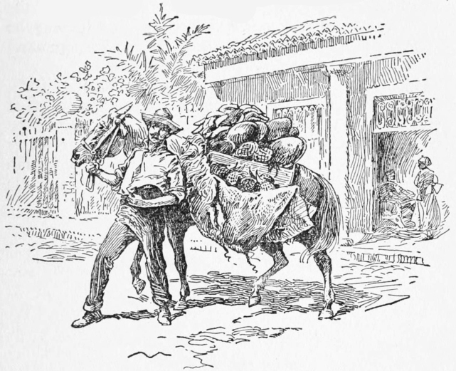
FRUIT VENDER, HAVANA
This handsome tree, especially the variety known as the manga, with its round symmetrical dome-like form, its rich glossy foliage of leaves that are never shed and that remain green throughout the entire year, adds not only to the beauty of the landscape, but furnishes most grateful shade to all who may seek a rest along the roadside.
It is more than probable that the Government of Cuba will select the manga as the natural shade tree for its public highways and automobile drives. The experiment has been made in some places with excellent success, and the delicious fruit yielded in such abundance would furnish refreshing nourishment for the wayfarer during spring and early summer.
Choice varieties of the mango are comparatively unknown in northern countries. Unfortunately the first samples that reached northern markets came from Florida seedlings, and owing to their slightly resinous or turpentine flavor, did not meet with a very ready acceptance. The rich, delicious, fibreless pulp of the East Indian mangoes, if once known in the larger cities of the North, would soon create a furore, that could only be satisfied by large shipments, and that would command prices higher than any other fruit grown.
The mango, too, as a shade tree, or producer of fruit, has one great advantage over the orange and many other trees. It will thrive in the soil of rocky hills and in the dry lands whose impervious sub-soil would bar many other trees. The day is not far distant when the mango will be not the most popular but also the most profitable fruit produced of any tree in the West Indies.
ALTHOUGH the forests of Cuba abound in several varieties of the citrus family growing wild within their depths, the fruit was probably brought from Spain by the early conquerors. The beautiful, glossy-leafed trees of the wild sour and bitter oranges are met today throughout most of the West Indies, and are especially plentiful in this island. The seeds have probably been carried by birds, but the wild fruit, although seldom if ever sweet, with its deep red color, is not only ornamental to the forest, but often refreshing to the thirsty individual who may come across it in his travels. The lime is also found in more or less abundance, scattered over rocky hillsides, where the beautiful lemon-like fruit goes to waste for lack of transportation to market.
Almost everywhere in Cuba are found a few sweet orange trees that were planted years ago for home consumption, but only with the coming of Americans have the various varieties been planted systematically, in groves, and the citrus fruit has assumed its place as a commercial industry in the Island.
Homeseekers from Florida found the native oranges of Cuba, all of which are called “Chinos” or Chinese oranges to distinguish them from the wild orange of the woods, to be not only sweet but often of superior quality to those grown either in Florida or California. A prominent horticulturist, who during the first Government of American Intervention made a careful study of the citrus fruit of Cuba, stated that the finest orange he had ever met during his years of experience was found in the patio or backyard of a residence in the City of Camaguey. The delicious fruit from that tree he described as an accident or horticultural freak, since no other like it has been found in the island.
The rich soils, requiring comparatively little fertilizer, were very promising to the settlers who came over from Florida in 1900, and many of these pioneers planted large tracts with choice varieties of the orange, brought from their own state, and from California. Capital was interested in many sections, and extensive estates, orange groves covering hundreds and even thousands of acres, were planted near Bahia Honda, fifty miles west of Havana. Other large plantings were made on the Western Railroad at a point known as Herradura, in the province of Pinar del Rio, 100 miles from the capital.
Smaller groves were planted in the neighborhood of San Cristobal and Candelaria, in the same province, some fifty miles from Havana. Other American colonies set out large groves in the eastern provinces; one at a station of the Cuban Railroad, in Camaguey, known as Omaha; another east of the harbor of Nuevitas. Orange groves were planted, too, at the American colony of La Gloria and at nearby places on the Guanaja Bay of the north shore.
One of the largest plantings of citrus fruit was started on the cleared lands of the Trocha, in the western part of Camaguey, some ten miles north of Ciega de Avila, while at several different points along the Cuba Company’s Road, orange groves were started during the early days following its construction. Both the provinces of Santa Clara and Matanzas, also, came in for more or less extensive citrus fruit culture, while in the Isle of Pines, during the first years of the present century, large holdings of cheap lands were purchased by American promoters, and afterwards sold in small tracts to residents of the United States who were promised fortunes in orange culture.
Some of these various ventures in citrus fruit culture, especially those where intelligence was used in the selection of soils, and sites commanding convenient transportation facilities, have proved quite profitable. Many of them, however, far removed from convenient points of shipment to foreign markets, have failed to yield satisfactory returns and some have been abandoned to weeds, disease and decay.
Some of the earliest and best kept groves were started in 1902 and 1903, along the beautiful Guines carretera, or automobile drive, between Rancho Volero and the Experimental Station at Santiago de las Vegas. These groves have all reached their maturity and with their close proximity to the local market of Havana, and easy transportation to the United States, have been, and are, successful and profitable investments.
The first of these covered some 400 acres, all planted in choice varieties of oranges by Mr. Gray of Cincinnati. In this vicinity too, close by the Experimental Station, is the Malgoba Estate, the most extensive and successful nursery, not only in citrus fruit, but for nearly every other valuable plant, fruit, flower or nut bearing tree indigenous to or introduced into Cuba. This nursery, as well as the beautiful, orderly kept grounds of the Experimental Station, will be found very interesting and perhaps valuable to the visitor from northern countries.
Some of the most successful groves in Cuba have been those planted in what is known as the Guayabal District, located near the Guanajay Road, in the extreme northwestern corner of the Province of Havana, within 25 miles, or easy automobile drive, from the capital of the Island. The oranges produced in this district are all from comparatively small orchards, well cared for, whose fruit is sold to local purchasers and conveyed in trucks to the markets of Havana. These oranges are sold in on the trees, at prices varying from $10 to $20 per thousand. The grape fruit, or toronja, alone is crated and shipped to the United States, where the market for some years has been quite satisfactory, especially when heavy frosts have cut short the yield of Florida groves.
The great mistake of many of the early investors of capital in citrus fruits in Cuba was not alone in the selection of the site, but in the fact that enormous tracts of land were prepared at heavy expense and groves set out with varieties not only unsuited to the market, but in tracts so large that protection from disease, and from the tall rank grasses of the island, was practically impossible.
There is perhaps no fruit grown for commercial purposes that requires more constant care and intelligent supervision than the orange and grape fruit. An orange grove must be kept free from weeds, grass and running vines; must be frequently cultivated to form a dust mulch; the trees must be sprayed with insecticides and should be always under the eye of an expert horticulturist, or orange grower, who will recognize and combat not alone the scale insect but scores of other diseases that may attack the trees at any time. These, if neglected for a year, or even for a few months, will make inroads into the health of a grove that spells heavy loss if not ultimate ruin.
In Florida and California these facts, of course, are well known, and the rules for successful orange culture are carefully followed. But in the early rush for cheap lands in Cuba, and the selfish desire of the promoter for huge profits and quick sales, regardless of the welfare of the purchaser, tracts were purchased and trees were set out with neither capital nor provision for the care and fertilizer required to keep a grove thriving, from the time of planting the nursery stock to its ultimate maturity.
Experience has proved that the most successful varieties of oranges, intended for the export trade, are those that bear very early in the fall, and very late in the spring, avoiding thus all competition with oranges from Florida and the Bahamas. Of these the early and the late Valencias, together with the Washington navel, that will easily stand shipment even to Europe and other distant markets, probably have the preference among most growers in Cuba.
The quality of this fruit is excellent, and although the navel orange among some growers has gotten into ill repute, the fault lies not in the orange itself, but in the fact that inferior nursery stock was imposed upon many planters during the first days of the Republic. During the past six years, first-class well selected and packed fruit has brought from $2 to $5 per crate, and sometimes more, in the eastern and northern markets of the United States, while common oranges, sold by the truck load in the Havana market, bring to the grower from $6 to $12 per thousand, choice fruit selling at from $10 to $20 per thousand.
For general commercial purposes, especially for shipment abroad, the Washington navel or Riverside oranges have probably no superior in Cuba. They are large in size, weighing from 1½ to 2 pounds each. When properly grown the skin is thin, with deep red color, and the fruit is full of juice, as one may judge from the fact that no orange will exceed a pound in weight and not be juicy.
The navel orange is seedless and exceedingly sweet, although lacking somewhat in the spicy flavor found in other varieties. Its season for ripening in this latitude varies from August to November, and extends into January. In planting groves with this variety care must be taken that the buds come from trees producing first-class fruit, since the type is liable to degenerate, unless the grower selects ideal trees from which to cut his bud wood.
Both the Jaffa and the Pineapple orange are popular in Cuba, especially for the local markets of the island, since they ripen during what is known as the middle orange season, or from December to March. The pineapple orange is probably one of the most prolific of the mid-season type. The fruit is pear-shaped, orange yellow in color, and one of the most highly flavored oranges grown in Cuba. Its skin is thin. The form of the tree is upright in growth rather than spreading.
The Jaffa is a dainty round orange, of medium size, golden yellow in color, with a thin skin, and pulp tender and juicy. It keeps well and is, as a rule, a prolific bearer. The tree is upright in shape, compact and not prone to disease.
The late Valencia, sometimes called Hart’s Tardiff, for commercial purposes and shipment abroad is recognized as one of the most reliable varieties grown in the island. It is seldom ripe before the month of March, and is very much better during May and June. Its commercial season extends from March to about the first of August, while the fruit of some trees has been kept in good condition even longer than this. The tree is thrifty and very prolific, bearing heavy crops every year. The fruit is of medium size to large, depending on the amount of fertilizer and care given it, while the color is a bright golden yellow. Good late Valencia oranges, during the months of May, June and July, have never sold in the Havana market for less than $15 to $20 per thousand. When the tree is properly cared for, and the fruit is thoroughly ripe, the late Valencia is one of the best of the citrus family.
The Parson Brown is probably the earliest orange of all varieties that have been imported. It sometimes ripens during the latter part of August. The fruit is of good size and very sweet, with no particularly marked flavor. The color of the peel is a greenish yellow, and it may be eaten even before the yellow color appears. Its early appearance on the market is the only thing, perhaps, that recommends it for commercial purposes.
In 1915 some small plantings were made in Havana Province of an orange brought from Florida, known as the Lu Gim Gong. The principal merit of this orange is said to be in its keeping quality on the tree. The fruit, we are told, will hang on the branches in excellent edible condition from one year to another. If this reputation can be maintained in Cuba, oranges for the local market may be had all the year round. Sufficient time has not elapsed however, since the first trees were brought into the island, to pass judgment on its merits or its commercial value.
Although up to the inauguration of the Republic in 1902, the grape fruit, known in Cuba as the toronja, was little valued, the people of Cuba have gradually acquired a fondness for it, especially with the desayuno or early morning coffee. Owing to this fact there is a rapidly growing local demand for the toronja that promises quite a profitable home market for this really excellent fruit. The grape fruit of Cuba, although but little attention has been given to the improvement of varieties, has been favored in some way by the climate itself, and that of the entire Island, including the Isle of Pines, is very much sweeter and juicier than that grown in the United States.
The cultivation of grape fruit in Cuba, especially in the Isle of Pines, has been very successful as far as the production of a high-grade fruit is concerned. The trees are prolific and the crop never fails. Unfortunately, grape fruit shipped from Cuba to the United States has not always found a profitable market, and there have been seasons when the crop became an absolute loss, since the demand abroad was not sufficient to pay the transportation to northern markets. As the taste for grape fruit grows, it is possible that this occasional glutting of the market may become a thing of the past, but at the present time many of the groves of grape fruit in Cuba are being budded with oranges. This is true also of lemon trees.
Limes, as before stated, are quite abundant in some parts of the Island, growing wild in the forests of hilly sections. The recent demand for citric acid would suggest that the establishment of a plant for its manufacture might solve the problem of enormous quantities of citrus fruit that must go to waste every year unless some method of utilizing it is discovered in the locality where found.
There are over 20,000 acres today in this republic on which citrus fruit is grown. The total value of the estates is estimated at about fifteen millions of dollars, but with each year it becomes more apparent that the area of really profitable citrus culture should be limited to a radius of not more than one hundred miles from some port whence regular shipments can be made to the United States. This is an essential feature of the citrus fruit industry. Its disregard means failure.
The wild varieties of the orange, both the bitter and the sour, although too isolated and scattered for commercial purposes, are often a godsend to the prospector in the forest covered mountains, since the juice of the sour orange mixed with a little water and sugar makes a very pleasant drink. The wild trees themselves, with their symmetrical trunks, dark glossy evergreen leaves, white, fragrant flowers, and deep golden red fruit, that hangs on the tree for months after maturity, furnish a very attractive sight to the traveler, as well as a safe indication of the fact that in Cuba the citrus fruit, if not indigenous to the soil, has found a natural home.
THE banana is of East Indian origin, but of an antiquity so great that man has no record of its appearance on earth as an edible fruit, nor can any variety of the plant be found today growing wild. The importance of the banana as a source of food for the human race in all warm countries of low altitude is probably equaled by no other plant, owing to the fact that a greater amount of nourishment can be secured from an acre of bananas than from any other product of the soil.
The banana has accompanied man into all parts of the tropical world, and for the natives at least still remains the one unfailing staff of life. The bulb once placed in moist fertile earth will continue to propagate itself and to produce fruit indefinitely, even without care of any kind, although for commercial purposes it may be improved and its productiveness increased through selection and cultivation.
Few if any plants that nature has given us can be utilized in so many ways as the banana. The fruit when green, and before the development of its saccharine matter takes place, consists largely of starch and gluten, furnishing a splendid substitute, either boiled or baked, for the potato. Cut into thin slices, and fried in hot oil or lard, it becomes quite as palatable as the Saratoga chips of the United States. When baked in an oven and mashed with butter or sauce, it is not a bad substitute for the potato, and far more nourishing.
When sun-dried and finely ground, a splendid highly nutritious banana-flour is produced, that is not only pleasant to the taste, but according to the report of physicians far more easily digested and assimilated than is the flour of wheat or corn. From good banana flour, either bread, crackers, griddle cakes or fancy pastry may be made, that would be relished on any table.
The green fruit, when cut into small cubes, toasted and mixed with a little mocha coffee to give it flavor, offers the best substitute for that beverage that has been found up to the present time. When scientifically treated with sugar, the semi-ripe fruit with the addition of flavoring extracts may be converted into very good imitations of dried figs, prunes and others forms of preserves, that are not only healthful and palatable, but are nutritious, and may well serve as an important contribution to the food products of the world.
Interesting and important experiments with banana-flour and the various products of both the ripe and the green fruit were made in Camaguey some years ago. The results were exceedingly satisfactory, but with the death of the inventor this promising industry was permitted to drop into disuse. Had Cuba been able to command the use of, or fall back on this splendid substitute for wheat flour, there would have been no bread famine in the island, such as occurred in the spring of 1918, and the Republic would have been independent of outside assistance.
Bananas for commercial purposes, or rather for export, have been grown for many years in the eastern end of the Island, especially in the neighborhood of Nipe Bay, where deep, rich soil, combined with the heavy rainfall of summer, results in rapid growth and full development of the fruit. The banana grown for shipment to the United States is known in Cuba as the Johnson. There are several types of this, but all resemble closely the bananas of Costa Rica and other Central American countries, where the United Fruit Company controls the trade. Owing to the fact that this Company owns its own groves in Central America, conveniently located for loading its ships, the United States is supplied today almost entirely from that section, and the exportation of bananas from Cuba has been materially reduced.
Banana lands, too, are almost invariably well adapted to the growing of sugar cane, hence the great fields of Nipe Bay, and that part of Oriente once devoted to the cultivation of bananas, were eagerly sought by the sugar companies of the Island, and most of the territory converted into big sugar cane plantations.
There are probably twenty varieties of bananas cultivated in different parts of Cuba. Some twelve or more of these may be seen growing at the Experimental Station at Santiago de las Vegas. The variety preferred for local consumption and always in constant demand is the large cooking bananas, known in the United States as the plantain. This banana is not eaten in its natural state, but when cooked, either green or ripe, it finds a place on every table in Cuba.
The plant is tall and the fruit at least twice as long as that of the ordinary banana of commerce. It is not as prolific as other varieties, seldom bearing more than 30 or 40 to the stem, but it is found on every farm on the Island and is relied on as a source of food, even more than is the potato. The bunches under normal conditions command in the market prices varying from 20¢ to 60¢, dependent upon the number of “hands” or bananas to the stalk.
The banana plant reaches a height of twelve or fifteen feet and is reproduced from the sucker or offshoot of the original bulb. About 400 hills are set out to the acre. In twelve months the first comes to maturity, producing a single bunch of fruit, whose price, dependent on variety and size, varied from 20¢ to $1. Each main stalk during the year sends up six or eight suckers, that are used to increase the acreage as desired. Bananas for export are grown profitably only on or near the edge of deep water harbors, where transportation to northern markets is assured.
A description of all of the many varieties of the banana grown in Cuba would be perhaps superfluous. The most commonly cultivated for the table, and eaten without cooking, is known as the Manzana or Apple Banana. Its flavor may suggest the apple, although the choice of name is probably accidental. The bunch is rather small, and the fruit is bright yellow, only about one-half the length of the banana of commerce, and stands out more or less horizontally from the stem on which it grows. The average price of these when found in the market is about 35¢ per bunch.
Some three or four varieties of the red banana are grown in Cuba, and while quite hardy and easily cultivated they are not prized in the Indies as in the United States. The dwarf banana, or Platano Enano, has a very pleasant flavor, not unlike that of the Johnson, or banana of commerce, and may be found in almost every garden in the Island. The plant reaches a height of only five or six feet, and the bunches of fruit are long and heavy, filled almost to the tip, and often supported by a forked stock, caught under the neck of the stalk so that the weight of the fruit will not break or pull over the plant itself.
Another very choice banana is called the “Platano Datil,” or date banana. The stalks are relatively small and hold but little fruit in comparison with other varieties, seldom having more than two or three hands to the bunch. The fruit itself is from two and a half to three inches in length, round and plump, with a thin skin that can be slipped off, like a glove, but with a flavor that is probably the most delicate and delicious of the whole Musa family.
Approximately 125,000,000 pounds of bananas are exported from the Island each year, valued under normal conditions at a little over a million dollars. The great bulk of bananas grown in Cuba are for domestic consumption.
Agriculture, although rapidly assuming as it should the dignity of a science, still has its caprices or apparent contradictions. And so it happens that the choicest flavored and highest priced bananas of the world are grown in the waterworn pockets of almost barren dog-teethed rocks—“los dientes de perro” of the extreme eastern end of Cuba, just back of Cape Maysi.
Here the coast rises from sea level in a series of four or five steps or comparatively flat plateaux, each some four or five hundred feet above the other, until an altitude of two thousand feet is reached. The rocks are soft limestone and in the millions of waterworn pockets, the leaves and dust of the forest jungle have left their deposit for ages. In this shallow soil bananas not only grow luxuriously but have a remarkably delicate and delicious flavor, essentially their own.
The secret of this wondrous growth and par excellence however, lies not alone in the rocky soil, but in the fact that generous nature at this point, contributes an abundant shower of rain almost every day in the year. The low, heavily waterladen clouds of the West Indian seas, driven by easterly winds strike this series of table lands, one rising above the other, and shower the lands with daily rains. Hence it is that while the average rainfall of Cuba is 54 inches, this series of table land of Cape Maysi has an annual rainfall of 125 inches.
The result is that in spite of difficult access and a cultivation confined to the hoe, millions of bunches of choice bananas are grown and shipped from the mouth of the Little Yumuri every year. United Fruit steamers on their way north from South and Central American banana fields stop at the above landing to take on a top dressing of fancy fruit.
Owing to the fact that the banana has practically no season, or rather that it may bear in any month, four suckers of varying ages are set out in each hill, from which four bunches of fruit, some three months apart, will result during the year. With four hundred stands or hills to the acre, the annual yield should be, approximately 1,600 bunches, and whether the crop is disposed of in the local markets or converted into banana flour, the growing of bananas may be made one of the important industries of Cuba.
Patient toil and judicious selection have made the modern pineapple one of our most delightful of all fruits, in addition to which, in those countries not too far removed from markets, it has assumed an important place as a commercial industry. The fruit of the pineapple, like that of the strawberry, is a strange compound or consolidation of hundreds of little fruits, in one symmetrical cone, tinted when ripe with shades varying from greenish yellow to golden red or orange. Like the strawberry, it is a ground fruit that must be planted and cultivated along the lines that bring best results with ordinary field crops.
Pineapples have been grown in Cuba since the beginning of the Spanish occupation, perhaps even before, although no mention is made of them as being cultivated by the Indians. As a commercial product the growing of the pineapple on a large scale began during the first Government of Intervention, although they were shipped abroad to some extent before that time. In point of money value, the industry ranks next to that of the citrus fruit. Although up to the present time most of the pineapples intended for export are grown within fifty miles of the city of Havana, over a million crates are annually shipped to the United States.
Pineapples may be grown on any rich soil in Cuba, and are considered one of the staple crops. The slips or offshoots from the parent plant are set out in long ridges some four feet apart, with intervening spaces averaging a foot. These produce fruit in one year from planting, and from each original stalk an average of six suckers may be taken for planting in other beds, so that with a very small start the acreage may be easily increased five or six-fold each year.
About 8,000 plants are considered sufficient for an acre of ground; and the cost of them when purchased averages about $30 per acre, while the preparation of the land for pineapple culture will amount to somewhat more. The net returns under favorable circumstances will vary from $75 to $100. The average net profit from pineapples grown near Artemisia and Campo Florida is said to be about $50 per acre. The high price of sugar, since the beginning of the European War, has, however, caused much of the former pineapple acreage to be converted into cane fields.
The profit derived from pineapple culture, as in all fruits or vegetables of a perishable nature, depends very largely upon the shipping facilities of the locality selected. Pineapples cannot long be held on the wharf waiting for either trains or steamers. In this connection it may be mentioned that the daily ferry between Key West and Havana, by which freight cars can be loaded in the fields and shipped to any city in the United States without breaking bulk, has been very beneficial to growers.
The Red Spanish, owing to its excellent shipping qualities, is preferred to all others for export, although many other varieties, such as the “Pina blanca” or sugarloaf, which will not stand shipment abroad, are used for local consumption and bring an average price of ten cents retail throughout the year.
The largest pines grown for commercial purposes include the Smooth Cayenne, a beautiful fruit, varying in weight from five to fifteen pounds. Unfortunate is he who may have partaken of the rich sweet, juicy Sugar Loaf of Cuba, since it will discourage his fondness for the Smooth Cayenne, the much advertised Honolulu and other cone shaped products, whose flavor is not in keeping with their appearance.
So delicious in flavor is the sugar loaf pine in comparison with those large varieties suited only for canning or cooking purposes, that the latter have never become sufficiently popular in Cuba to induce cultivation. In the Isle of Pines, however, as well as in Florida, the smooth Cayenne is grown and shipped to the nondiscriminating who live abroad. With care in packing, however, the sugarloaf may reach northern markets.
The pineapple more than any other fruit appeals to the canning industry, especially in Cuba, where hundreds of thousands that have ripened too late for the northern markets are left to rot in the fields. There are no better pineapples grown in the world than in the Island of Cuba, and the excess or overproduction of the fruit within the next few years will undoubtedly be handled by properly equipped canning factories and thus add another industry to the revenues of the Island.
The Anon is a small shapely tree seldom growing over twenty feet in height and common throughout all Cuba. The fruit of the Anon, sometimes called the sugar-apple, resembles a small round greenish white cone, about the size of the ordinary apple. Its delightful pulp suggests a mixture of thick sweetened cream, adhering to smooth black sunflower seeds. Although delicious to eat fresh from the tree, and very useful in making ices, it does not readily endure shipment, and is thus confined commercially to the local markets of the larger cities in Cuba.
The Chirimoya, belonging to the same family, is undoubtedly the queen of the Anones. It is larger than the Anon, reaching the size of an ordinary grape-fruit. Its pulp is white, soft and very delicate, while the skin, unlike the Anon, is smooth, yellowish in color, with a blush of red.
The Zapote, Nispero or Sapodilla, as it is variously termed, is a beautiful ornamental tree of the forest, indigenous to tropical America and the West Indies. The tree, with its trim shapely trunk and branches, its crisp, dark green foliage that never fails, adds greatly to the beauty of parks and lawns. The wood is hard, reddish and very durable. From the trunk exudes chicle gum, used in the United States for making chewing-gum. In England, since it is more plastic than caoutchouc, and more elastic than gutta-percha, it is employed as an adulterant to these products. The fruit in size and color resembles somewhat a small russet apple. It has a delightfully sweet juicy pulp, not unlike a persimmon touched with frost. The small glossy seeds are easily removed, and the fruit is very refreshing when left on ice, or in the early morning hours. Only with extreme care in packing could zapotes, like many other fruits of Cuba, stand shipment to foreign countries.
The Tamarind is a tall, beautiful tree frequently 70 to 80 feet in height, with a soft, delicate, locust-like foliage, and purplish or orange veined flowers in terminal clusters. The Tamarind probably originated in Abyssinia or some other part of eastern tropical Africa, but at the present time it is scattered throughout the entire tropical world, and is very common in Cuba. There is perhaps no tree known whose fruit furnishes a more refreshing fruit than the Tamarind. It is said to have been brought to Cuba from Southern Europe more than a century ago, whence it has since been scattered throughout the forest, through the medium of birds. From its branches, after the flowers have disappeared, hang clusters of brown colored, bean-like brittle pods. These when ripe are filled with a sweet yet pleasantly acid pulp, which when mixed with water makes a refreshing, slightly laxative and healthful drink.
The Mamey Colorado is another giant tree of the forest, belonging to the Sapodilla family and indigenous to tropical America. Its fruit is oval in form, some six or eight inches in length, covered with a tough brown skin, and filled with a rich peculiar dark red pulp, inclosing a long, smooth, coffee-colored seed, that is easily separated from the edible part of the fruit. In consistency and flavor, it suggests slightly a well-made pumpkin pie. Those unaccustomed to the fruit would probably find it unpleasantly rich. The yellow or Mamey de Santo Domingo is a true Mamey, entirely different from the Mamey Colorado. The tree is large, tall and quite common in the forests of the Island. Its fruit is round, russet yellow in color and equivalent to a large grapefruit. It is used only as a preserve, and in that capacity serves a useful purpose.
The Guava, or Guayaba, as it is known in Spanish countries, springs up unwanted in almost every field of Cuba. Its nature is that of a shrub, spreading out with little form or symmetry. If permitted to propagate itself, it soon becomes a pest difficult to eradicate. A few choice varieties, one of which is known as the Pear Guava, imported from Peru, are very palatable. The meat of the latter is white, rather juicy and free from seeds. The common Guayaba of the field, while sometimes eaten raw, is always in demand for jellies, Guayaba paste and marmalades, which have a ready sale in Cuba and in the United States and are very popular in the latter country. Animals of all kinds, especially pigs and horses, are very fond of it.
The Mamoncillo is another beautiful forest tree indigenous to Cuba, that spreads out like a giant live-oak or mammoth apple tree. Its round, russet green fruit hangs from every branch, and is refreshing to the traveler who stops a moment beneath its shade. Its slightly acid pulp covers a rather large round seed, the whole resembling a tough skinned plum, although the tree belongs to an entirely distinct family.
Figs of all varieties, green, black and yellow, may be found in almost every garden in Cuba. No effort has been made to preserve them for commercial purposes, but when ripe they are very refreshing taken with “desayuno” or the early morning meal.
The Aguacate is another valuable product of the Caribbean Basin, and seems to be indigenous to nearly all its shores, including Mexico and Central and South America. It extended south along the Pacific Coast also, as far as Peru, where the Spanish conquerors found it in use among the people of the Incas. Oviedo, in his reports to Charles I of Spain in 1526, stated that he had found this peculiar fruit on the Caribbean shores of both South and Central America.
It was also indigenous to Mexico, where the Aztecs called it the Ahuacatl, whence came the Spanish name of Aguacate, by which it is known in Cuba. The name Avocado has been adopted by the Department of Agriculture of the United States, in order to avoid the confusion resulting from the many local names under which this fruit is known in various countries.
The aguacate of Cuba is a tall handsome tree of the forest, scattered more or less throughout all portions of the Island. It frequently reaches a height of 70 or 80 feet, and although of an open spreading nature, nevertheless furnishes grateful shade. There are many types, although systematic efforts to classify them botanically have not been very successful. The distinction between them usually made is dependent largely upon the shape of the fruit or its color.
The most common variety in Cuba is probably the long, pear-shaped aguacate, although trees bearing round and oblong fruit are often met, especially where they have been planted in gardens or orchards. In color the fruit is usually bright green, or greenish red. Some types again will vary from greenish red to a reddish purple.
The pear shaped aguacates vary in length from five to ten inches, and will average probably a pound and a half in weight. The round or oblong types are usually green in color, with a diameter of five or six inches. The skin is about 1/16th of an inch in thickness, smooth and bright, and peels freely from the inclosed meat. The meat is rather difficult to describe since it resembles in flavor and texture no other edible fruit known. Its color is golden yellow, resembling both in consistency and shade, rich, cold butter, and is used sometimes as a substitute for this product of the dairy. Close to the skin the meat has a slightly greenish tinge. It is very rich in oil and has a pleasant nutty flavor, that evades all description.
The aguacate may be eaten just as it comes from its thin shell-like covering. In the center of the fruit is a large hard seed some two and a half inches in diameter. This never adheres to the pulp, and may be lifted out readily so that the fruit can be eaten with a spoon.
The aguacate forms the finest salad in the world. When used for this purpose the pocket from which the seed was removed is usually filled with broken ice, over which is poured a dressing of salt, vinegar and mustard or pepper, as fancy may happen to dictate. When filled with small cubes of sugar loaf pineapple and mayonnaise dressing, you have a “salad divine.” When taken this way, the aguacate is cut in half, the shell-like covering forming the bowl from which it is eaten. Owing to its content of oil, and other nutritious elements, the aguacate will probably go further towards sustaining life and producing energy than any other fruit known. It is also excellent when removed from the peel, cut into cubes and eaten in soup.
The tree is a prolific bearer, the fruit ripening during the months of July to October inclusive. Other varieties recently introduced come into bearing in October and remain in fruit until January, some occasionally holding over until the month of March.
In the development and improvement of the aguacate, it is the aim of the horticulturist to lengthen the bearing period as much as possible, and through selection to eliminate any space between the pulp and the seed; for the latter, if loose, will often bruise the fruit in handling and shipping. Since the aguacate, like most fruit trees, is not true to seed, this work can be accomplished only through grafting, and although successful, requires care and experience. The ordinary aguacate of the forest bears the fourth or fifth year from the seed, while the grafted varieties will bear the third year. A tree of the latter type, when five years of age, will bear from one hundred to five hundred aguacates, that will average two pounds in weight, and will sell in the fruit markets of the United States at from $1 to $3 a dozen.
The tree may be grown on any well drained land and under conditions similar to those of the mango. On hillsides that have sufficient depth of soil, it does very well, and as the demand for fancy fruit in the palatial hotels of the United States increases, the growing of aguacates for commercial purposes will undoubtedly be undertaken in Cuba or a still larger scale.
IN spite of the fact that the Grape is indigenous to Cuba, prohibitory laws on the part of Spain discouraged its culture in all of her colonies, so that vine culture in the Island has had no opportunity to thrive. The few isolated specimens found occasionally in gardens have produced excellent fruit, especially in the neighborhood of Guantanamo, where French refugees from Santo Domingo introduced a few plants in the beginning of the 19th century.
Realizing the importance of grape culture in any country where possible, Dr. Calvino, Director of the Government Experiment Station, in the first days of his administration, sent into the forests of Cuba for healthy specimens of the wild grape, indigenous to the country, known as the “Uva Cimarron.” These were brought to the Station and set out in soil especially prepared. After less than a year had elapsed, four or five lanes, several hundred feet in length, for which trellises of wire have been provided, showed wonderful growth. This native sour grape has simply covered the supports with a wilderness of leaves, vines and fruit.
Correspondence with Professor Munson of Texas, one of the most noted grape specialists of the United States, resulted in bringing to Cuba a dozen or more varieties of choice grapes from that section. These, together with others brought from France, Spain and other European countries, have been planted at the Station, where, in spite of the change of climate and conditions, they seem to thrive. The Director is planning to bud the wild stock of the Cuban grape with all of these choice imported varieties, in order to ascertain which may give the best results in this country.
Several acres are devoted to this experimental grape field and have been supplied with convenient trellises and facilities for irrigation. The Director and those interested with him are much encouraged with the present stage of the experiment and have great confidence in their ability to establish successfully in Cuba many of the choice grapes of the world, although the medium of the vigorous Cimarron grape of the island. If these experiments prove successful, there is no reason why many of the hillsides of this country should not be converted into immense vineyards, and the cultivation of grapes become a prominent and permanent source of agricultural wealth.
Although intoxication among the inhabitants of Cuba is almost unknown, the drinking of wine, as in all other Latin American countries, has been a custom from time immemorial and the annual importation of wine, most of which comes from Spain, approximates $2,500,000 a year. Should the culture of grapes in Cuba meet with the success expected, there is no reason why this industry, together with that of wine making, might not be carried on in connection with coffee growing in the mountains, since the soils of the fertile hills throughout the Island are adapted to the culture of both at the same time.
In the matter of popular beverages it is somewhat interesting to note that in each hemisphere, nature provided trees of the forest, the fruit of which for countless centuries has furnished to man beverages that today are almost as essential as food. In fact the Cacao of the western hemisphere is a very nutritious food and drink at the same time. While coffee is indigenous to Arabia and Abyssinia, whence the trees have been carried into nearly all parts of the tropical world, cacao, on the other hand, was indigenous to the West Indies, to Mexico, Central America and probably to all countries bordering on the Caribbean. The shores of the latter great sea or basin of the ocean, with their rich warm valleys formed by the rivers tributary to it, are the natural home of the cacoa, botanically known as Theobroma, or food of the gods.
When Cortez forced himself as an unwelcome guest upon Montezuma, in the first quarter of the sixteenth century, he found a delicious drink called caca-huatl, made by the Aztecs from the seeds of this really marvellous plant. The taste of chocolate is so delicate and so palatable that fondness for the drink does not have to be acquired in any country. From the West Indies cacao, or cocoa beans, were carried to Spain and the cultivation of the plant was introduced into the warmer latitudes of the eastern hemisphere. The government of Spain, with its short-sighted greed of those days, succeeded in keeping the manufacture of this drink more or less secret from the outside world, and for chocolate demanded prices so high that only the rich could afford to buy it, retarding thus its general use in Europe for nearly a century.
The consumption of chocolate today, both as a beverage and as a food, especially in the manufacture of confections, has assumed throughout the world very large proportions. Approximately 150,000,000 pounds of chocolate and cocoa produced from the cacao trees of the Caribbean basin are consumed in civilized countries, while the demand for the beans is increasing by rapid bounds every year.
There is perhaps no form of nutritious food more condensed and complete than that of the better grade of chocolate. Nine-tenths of the content of this wonderful bean are assimilated by the system, hence its value not only to travelers but also to armies and forces in the field, who demand condensed foods like chocolate, with a large amount of nourishment in a very small bulk. An analysis of cacao yields of carbohydrates, 37%; of fat, 29%; and of protein, 22%. In the better grades of chocolate, used for both food and drink, there is practically no waste.
From the above it may be readily seen that the cultivation of cacao, from which the chocolate and cocoa of commerce are derived, has become one of the standard agricultural industries of the world, and one which for the future gives great promise, since the demand for the cacao beans is increasing rapidly, as is also the market price.
The Central American republics bordering on the Caribbean, as well as the northern coast of Colombia and Venezuela, are the greatest producers of cacao, while Trinidad, Cuba and other islands of the West Indies, produce considerable amounts.
The culture of cacao, like that of coffee and citrus fruits, is a healthful and profitable employment, and especially agreeable for those fond of life in the open, and who enjoy living in the mountains and valleys that slope toward the Caribbean and the Gulf of Mexico. Its cultivation may be carried on where conditions are favorable, in company with coffee, since while the latter is grown on the fertile foothills and mountain sides, cacao is at its best in the sheltered valleys of the forest. Cacao demands a rich, deep, moist soil, well drained, since the roots of the tree will not tolerate standing water, and the subsoil, if not pervious, must lie at least six feet below the surface.
The forest-covered valleys of tropical Cuba, receiving as they do the washings of the hillsides, upon which decayed vegetable matter has accumulated during centuries, furnish ideal locations for cacao. In preparing for the cultivation of the plant, all underbrush is removed, leaving only the tall stately trees, that although giving the required shade will still admit some sunlight to the soil below; otherwise the cacao, reaching up for the light, assumes a tall slender growth, inconvenient in gathering the crop. Trees for commercial purposes should not attain a height of more than 25 or 30 feet, the branches leaving the trunk six or eight feet from the ground. They are planted as a rule from 12 to 15 feet apart, which is equivalent to from 200 to 300 trees per acre.
There are several varieties of the cacao, although that in common use in Cuba is known as the Cacao Criolla, and is not subject to diseases as are some of the other varieties grown in South America. The fruit is an elongated pod of cucumber shape, with a rough corrugated skin, hanging close to the trunk and branches. The side facing the sun carries shades of red and yellow that produce a rather startling color effect when first seen in the forest.
The cacao has two major crops each year. The pods when ripe are removed from the trees with a hooked pruning knife attached to a bamboo pole, and collected into piles, sometimes covered with earth, where they undergo a period of fermentation lasting five or six days. After this the seeds are removed from the pods and carefully dried for the market. In the days of Montezuma such was the value of the cacao seeds or beans that they took the place of money or small change in adjusting purchases, and they are recognized even today among the Indians in representation of values. In the cacao factories, the oil of the bean, which represents 50% of its weight, is extracted and known to the trade as cocoa butter. The residue, known as the cacao nib, is ground and forms the chocolate and cocoa of commerce. Even the hulls are used to make a low grade of cocoa known as “La Miserable.”
The tree comes into bearing the fourth year after planting and attains its maturity in about twelve years, with a life extending over a half a century or more. The yield per tree varies greatly, or from four to twelve pounds annually, with an average, under favorable conditions, or five or six pounds. This extreme range in the productivity of cacao is dependent almost entirely on the fertility of the soil, since the plant is greedy in its demand for nourishment, and it quickly responds to the generous use of fertilizer. In the ordinary sense of the term no cultivation whatever is given to the cacao tree, since it is truly speaking a denizen of the forest, doing better when the soil above its roots is never disturbed, although a mulch of leaves to maintain the moisture is very beneficial. Weeds and brush that may appear are removed with a machete.
The successful culture of cacao requires experience and care, especially during the period of fermentation through which the pods must pass before the removal of the seeds. This latter work is done usually by women and children, hence, as in the case of coffee, cacao in many senses of the word is well adapted to colonies and settlements composed of families who have grouped together and made permanent homes in the mountains and valleys that border on the Caribbean and the Gulf.
Cuba is exporting at the present time, mostly from the province of Oriente, approximately two and a half million pounds of cacao, valued at $15.20 per hundred pounds, or $380,000. The commodity is staple and the demand at good prices constant, while the cacao once prepared for market does not deteriorate or suffer loss if sale is delayed, all of which is to the advantage of the grower.
The north shores of the Province of Pinar del Rio, swept by the northeast trade winds throughout the entire year, furnish in many places conditions most favorable to the culture of cacao and coffee. The same is true of southeastern Santa Clara, of the northern slopes of the Sierra de Cubitas and of the coasts of Oriente from the Bay of Nipe on the north, clear around to Cabo Cruz on the southwest.
Both in nature and in its domestic use, cacao and the vanilla bean have always been more or less closely associated. Both are denizens of the deep forest, and are indigenous to the two Americas from Mexico to Peru. The Aztecs of Anhuac, the Mayas of Central America, and the subjects of the Incas, further south, added the delicate flavor of the vanilla to their chocolate, made from the beans of the caca-huatl, from which the name of cacao was taken. This association of vanilla with chocolate and other confectioneries has continued into modern times.
The so-called vanilla bean is not, as the name would indicate, of the legume family, but is an orchid, climbing the trunks of trees that grow on the rich soils of tropical forests. The vine may be germinated from seed planted in leaf mold at the base of the tree, but where cultivated it is propagated from cuttings and must have the shade of trees in order to thrive, climbing the trunks to a height of 20 to 30 feet, by means of fibrous roots that come from nodes along its length.
The leaves are bright green, long and fleshy; the flowers are white and usually fragrant, having eccentric forms peculiar to the orchid family. The pods, from six to nine inches in length, are cylindrical and some three-eighths of an inch in thickness. The vine begins to bear in the third year from planting and will continue to do so for thirty to forty years with but little care or culture. The pods are gathered before they are fully ripe, dried in the shade and “sweated” or fermented in order to develop and fix the delightful aroma for which they are famous.
It is during this period of fermentation that the bean requires careful watching and expert knowledge in order that the process of sweating may be perfect, since upon this chemical change in the texture of the beans the value of the product really depends. After fermentation the pods are carefully dried, tied in small bundles and made ready for market or export. They will keep indefinitely and the high prices secured for very small bulk renders them an attractive crop to handle.
The vanilla of commerce is not only used to flavor chocolate, sweetmeats and liquors, but also enters into the composition of many perfumes, owing to an aromatic alkaloid that exudes from and crystallizes on the outer coating of the best quality beans. These under normal conditions are worth from $12 to $16 per pound.
Owing perhaps to the lack of experimental initiative, the vanilla bean, although at home in the heavy forests of Cuba, with the exception of a few instances has never attracted the attention of those who are in a position to grow and care for this valuable plant. In conjunction with cacao, coffee, or any industry carried on in the rich forest-covered mountain valleys of the Island, there is no reason why the culture of the vanilla bean should not be made very profitable.
Aside from the removal of the beans from the vine, the only effort required is that of assisting nature in the fertilization of the flowers, which in the forest, of course, is carried on by insects, but for commercial purposes, in order to insure a large crop of beans, it is well to see that each flower is fertilized by shaking a little of the pollen upon the stamens. This is readily done with the use of a light bamboo ladder that may be carried from tree to tree.
Indians from the eastern forests of Mexico, between Vera Cruz and Tampico, would readily come to Cuba to teach the best methods of curing or take charge of the treatment of the beans after picking, and thus insure the success of a very profitable crop, which up to the present has received practically no attention.
WITH the advent of the American colonists in 1900, truck gardening sprang rapidly into prominence in Cuba until today it forms an important part of the small farmer’s revenue. Most of the well-known vegetables of the United States are grown here, not only for local markets, but for shipment abroad. They are usually planted at the close of the rainy season in October or November, and are brought to maturity in time to reach the North during winter and early spring, when high prices prevail.
Those vegetables from which the best results have been obtained are early potatoes, tomatoes, eggplants, sweet peppers, okra, white squash, and string beans. These may be grown in the rich soils of any part of the Island, but are only profitable when cultivated close to railroads or within easy reach of steamship lines having daily sailings from Havana. Profits depend on location, soil, water supply, intelligent cultivation and success in reaching markets in which there is a demand for the product.
The long belt of land lying just south of the Organ Mountains of Pinar del Rio, extending from east to west throughout the province, furnishes the largest tract for vegetable growing in Cuba. The conditions in this section are exceptionally favorable to that industry. Close to the base of the mountain range, the surface is rather rolling, but soon slopes away into the level prairies extending out toward the Caribbean. The soil as a rule is a dark grey sandy loam, easily worked at all seasons, and responds quickly to the use of fertilizers and to cultivation.
Numerous small streams that have their origin back in the mountains, furnish excellent natural drainage, and some of them can easily be used for irrigating purposes, if necessary, in the dry months of February and March. The Western Railway of Havana runs through the entire length of the vegetable belt, reinforced by a splendid automobile drive, more or less parallel, connecting the further extremity of Pinar del Rio with the markets and wharves of Havana.
These lands are very productive, and under intelligent management, especially when irrigation can be employed, may be rendered exceedingly profitable, through the cultivation of vegetables. In some sections, the semi-vuelta or Partido tobacco fields monopolize the use of the land during the fall months, but there are nevertheless hundreds of thousands of acres in this district that if properly cultivated, and conducted in connection with canning plants, would yield large revenues to the Island.
Nearly all seed is brought from the United States, fresh, each year, and the planting season for some crops begins in September, extending through the entire winter, especially where irrigation or fortunate rains furnish a sufficient amount of moisture to carry the crop through the dry months of early spring.
The methods employed in vegetable growing are identical with those of the United States, and the results are practically the same, aside from the one important fact that all fall grown vegetables, or those that may be placed on the markets of large cities in the United States between January and April, bring, as a rule, very high prices.
Later in the spring the vegetable gardens of Florida and the Gulf States come into competition, causing the growers of the Island gradually to yield to those of sections further north. It is at this time, or in the late spring, that the canning industry could take care of the great surplus of vegetables that for any reason might fail to find a profitable market abroad. Well equipped plants could handle this crop with great benefit both to the vegetable growers and the canners.
Irish potatoes, planted in the fall so that the crop may be brought to maturity in March, have proven very successful throughout this section, as well as in the beautiful Guines Valley, southeast of Havana. The potato growers of Cuba have experimented with nearly all of the standard varieties of the United States and it is rather difficult to determine which has given the best results.
The Early Rose variety of Irish potato is quite a favorite in Cuba, owing to its rapid growth and productivity. Later potatoes, while finding a sale perhaps in the local market, are not considered profitable, since, as a rule, one can procure during summer and fall excellent potatoes from Maine and Nova Scotia, with greater economy than by growing them in Cuba, at times when the land can be more profitably used for other purposes.
Potatoes, of course, need barn yard manures and fertilizers, the more the better; or rather, the greater is the return. The yield varies according to conditions anywhere from forty to one hundred barrels and more per acre. The Cuban product is almost invariably of good quality, and when placed in the eastern markets of the United States in the month of March, will bring anywhere from $6 to $10 per barrel. Under normal conditions $8 seems to be the ruling price for Cuban potatoes on the wharves at New York, where they are sold as exotics or new potatoes. Thus $500 may be considered a fair return per acre.
Green peppers, too, have been found to be one of the most satisfactory and profitable crops in Cuba. They are planted in rows three feet apart, spaced a foot or more in the row so that they can be kept clean with adjustable cultivators drawn by light ponies. Hand cultivation, although sometimes indulged in, with the present price of labor is practically impossible.
A well-known pepper grower of the Guayabal district, in the northwestern corner of Havana Province, on less than a hundred acres of land, grew 6,000 crates of green peppers in the winter of 1917-18, that netted him $6 per crate in the City of New York. Peppers are easily grown and handled, and the market or demand for them seems to be quite constant, hence they have become one of the favorite vegetables for the export trade.
Tomatoes, too, are grown very successfully in Cuba during the late fall and winter. The seed is secured from reliable houses in the United States each year, and is selected largely with reference to the firmness or shipping quality of the fruit. The methods of cultivation are similar to those employed in the United States. The weeds are usually killed out of the field in the early spring, and kept down with profitable cover crops, such as the carita and velvet bean. These, when turned under or harvested by hogs, place the soil in perfect condition.
The planting is done usually in October and November and the cultivation carried on either with native horses or mules, or gasoline-propelled cultivators. The yield where the water control and other conditions are favorable, is large, and the price secured in the northern markets varies from $2 to $5 per half bushel crate. It is true that when tomatoes from Florida and the Gulf States begin to go north in large quantities, there are frequently reports of glutted markets and falling prices. It is then that the canning factory comes to the rescue of the planter and contracts for the remainder of his stock at satisfactory prices.
Of all varieties, the Redfield Beauty is probably the tomato most in vogue among growers in Cuba. It grows luxuriantly and yields from two hundred to three hundred crates per acre.
Eggplants as a rule are successfully grown on all rich mellow soils. The methods of cultivation are almost identical with those employed in growing tomatoes. A small pear shaped variety is grown for the local markets in Havana and other cities, but for export purposes it would be unsatisfactory. The finest varieties known in the States are all found here. The yield under favorable conditions is large and the crop stands shipment for long distances without injury.
As a rule the prices obtained in the north have rendered the growing of egg plants very profitable. From $3 to $7 per crate are the usual limitations in price. The uncertainty of this price, however, in different seasons, has rendered the production of the eggplant rather an interesting gamble. This is true regardless of the quality of the fruit, in nearly all products sold in distant markets.
Okra, or quimbombo, as the vegetable is called in Cuba, while not as a rule commanding fancy prices, nevertheless brings satisfactory returns, both abroad and in the local market, where the demand is more or less steady. Like all others mentioned, it is strictly a late fall or winter vegetable, and its cultivation is identical with methods employed in the United States. Prices usually obtained are from two to three dollars a half bushel crate.
The growing of lima beans in Cuba has proved a gilt-edge undertaking for those who have been careful in the selection of seed and proper cultivation after planting. The price obtained in the United States has varied between $2 and $8 per hamper, or bean basket, with an average of perhaps $5. The crop is quickly grown and with sufficient labor to gather the beans at the proper time the grower is relieved of his only cause for worry. The labor problem can usually be overcome if the farm is located near any one of the small towns where help of women and children is available.
String beans, while readily grown in Cuba, do not always find a demand in the northern markets sufficient to justify the fancy prices frequently obtained for other vegetables. The local demand in Havana, while not large, is nevertheless satisfactory to the small farmer living within a short distance of the city, where he can deliver his crop without the expense of railroad transportation.
The summer squash, too, succeeds very well in Cuba, and if the crop does not encounter the competition of the growers in the Gulf States, it is, as a rule, fairly profitable. A variety of the native squash known as the Calabaza, always finds a ready sale in the local markets. This prolific Criolla production is almost always planted with corn by the native farmers, since its yield never fails and its market is constant and satisfactory.
Recent experiments have been made by an American grower who has imported the seed of the small pie-pumpkin into Cuba. To use his own words, “This variety grows even faster than weeds, and the pumpkins cover the ground so thick that you can hardly avoid walking on them.” They make a very fine fall and winter crop, with an average yield of five tons per acre. This delicate variety of pumpkin, when canned, will probably prove available for export purposes.
The great drawback to profitable vegetable growing in Cuba lies largely in the uncertainty of the northern markets, where prices fluctuate so rapidly, with the minimum and the maximum so far apart, that it is difficult for the vegetable grower, a thousand miles away, to count with any certainty on the returns from his crops when shipped abroad. The establishment of receiving agents, perhaps, under the control of men who were financially interested with the growers themselves, might remedy this difficulty. The canning industry, if established on a sufficiently broad scale, would also add stability to the price of all crops grown in Cuba, and place the cultivation of vegetables on a more certain foundation.
The introduction of irrigation, wherever possible, insures so generous a crop of almost any vegetable planted in this Island, that the returns to the grower, even where the price may not be fancy, will be decidedly remunerative. The incalculable advantages to be secured by irrigation, especially in the growing of vegetables, planted in the late fall and gathered during the winter and early spring, when rains are not always forthcoming, is a matter in which the Department of Agriculture is deeply interested.
One of the best irrigation engineers of the United States has been invited to go over the field of Cuba, and to advise the Government in regard to the various localities in which irrigation plants may be installed with success and profit to the growers. These plans when carried out will prove of marvellous benefit to the agricultural industry and will greatly increase the revenues derived from tobacco, as well as from vegetables.
The great advantage, however, enjoyed by all vegetable growers in Cuba, lies in the fact that stormy weather never interferes with the cultivation of crops; sunshine may be depended upon every day of the year, and the farmer is seldom if ever compelled to lay aside his implements, and wait for the weather to adjust itself to his needs. In other words, he can always work if he wants to, and the market abroad, if he “strikes it right,” may yield him a small fortune from a comparatively few acres in a very few months.
It would be misleading to the prospective farmer or stranger to quote the almost fabulous returns at times secured on some favored spot, but with irrigation, which insures absolute control of the growing crop, the profits from vegetable raising may run anywhere from $100 to $500 per acre, and more.
Among those “striking it rich” incidents that may be occasionally found, may be mentioned a little tract of ground consisting of only four acres of land, located along the railroad track, not 100 yards from a station on the Western Railway. Here two Spanish storekeepers placed under cultivation four acres of land that had been previously prepared with a carita bean crop, hog fed and turned under. These partners had a well sunk in the middle of the tract, and a little gasoline engine installed that enabled them to adjust the water supply each day to the requirements of the field.
Here they planted eggplants, tomatoes, green peppers and Irish potatoes. The cultivation was done by one man and a pony. During the gathering of the crops some additional help was required, although the two owners worked hard themselves during late afternoons and early mornings. The return from these crops during the four months in which they were in the ground, amounted to $6,430.
Incidents of this kind are not by any means common, but nevertheless they give some indication of what may be accomplished in growing vegetables in Cuba, when the work is conducted along modern lines and under intelligent management. Capital, of course, is necessary, as in all other industries, but the reward, even with the element of the gamble taken into consideration, is to say the least very tempting.
CORN or Maize was probably indigenous to the Island of Cuba, since it was one of the chief staples of food used by the Siboney Indians at the time of Columbus’s visit. This cereal may be grown in any of the provinces, although varieties introduced from the United States do not give the results that might be expected.
The native Cuban corn has a comparatively short ear with its point closed by Nature. This prevents the entrance of the grub or worm, so destructive to the northern varieties that have been introduced here. The kernel is hard, bright, yellow, rich in proteins and in oil, and is very nutritious as a food.
In spite of the small size of the ear, on rich lands 40 bushels per acre are frequently secured, so that, taking into consideration the fact that two crops may be successfully grown in twelve months, the sum total of the yield is not bad, and the price of maize in the local markets is always satisfactory. Experiments are being carried on at the present time towards improving the native Cuban corn, some of which have met with success.
The method of growing corn in Cuba has little to recommend it. Improvements will come, however, as a result of the excellent instructive work being carried on by the Government Experimental Station. As a rule, corn in Cuba is planted too close, and with absolutely no attention paid to the selection of seed; hence we seldom find more than one ear to a stalk.
A rather novel experiment, carried on by Mr. F. R. Hall, of Camaguey, has proved quite satisfactory in increasing the length of the ear. His corn is grown in hills four feet apart and cultivated in both directions. Two grains are planted in the hill, one a grain of selected Cuban corn, the other a grain of first-class American corn. The latter will make the taller stalk of the two, and from the former, or native stock, the tassel is nipped off, so that only pollen from the American corn is permitted to fall upon the silk and thus fertilize the native ear.
The result of this experiment has been a very much larger ear, the tip of which has retained the tight twist of the husk, peculiar to native corn. This closes in and protects the grain from attack of worms or borers. By selecting from this cross, and again crossing or fertilizing with Northern corn, a greatly improved variety of maize has been produced. This experiment is sufficient to demonstrate that a great deal may be done towards improving both the size and quality of Cuban corn.
Between the rows, calabaza, a variety of native pumpkin, greatly resembling that of the United States, is grown as a rule, thus following one of the precepts of New England. In this connection pumpkins from Massachusetts seed give excellent results, planted with corn. The demand for corn in the market, owing to the large amount consumed in the Island, insures always a good price to the grower.
Nearly all varieties of millet and kaffir corn thrive well in Cuba and furnish a very nutritious food for both stock and poultry. This millet, or “millo,” of which two varieties, the tall white and the short black, are in common use, is apparently free from enemies, and since it seems to thrive in seasons either wet or dry, and in lands either moist or subject to drought, the crop is considered very reliable and hence profitable especially where poultry raising is contemplated.
Wheat was grown at one time for home consumption, in the Province of Santa Clara. Here, on the high table lands, with a comparatively low temperature during the cool, dry winter months, it came to maturity. In one locality west of the city of Sancti Spiritus in Santa Clara, there is quite an extensive table land, with an altitude of some 2,000 feet, where a very good variety of wheat was grown along about the middle of the 19th century. It is said to have furnished an abundance of good grain that was highly prized in that section. Just why its cultivation was abandoned is not known, aside from the fact that most of the agriculturists found growing sugar cane vastly more profitable. With money from the sugar crop flour could be purchased and the demands of the baker satisfied.
Experiments are contemplated in the near future in the growing of wheat in this same locality. But regardless of the results, it is more than probable that custom or inclination will impel the people of Cuba under normal conditions to purchase their wheat from the United States.
Nevertheless, extensive experiments in the propagation of wheat, the seed of which has been brought from many countries, are now in process of development in the grounds of the Government Agricultural Station.
These will probably be supplemented a little later by plantings from selected seeds of the most promising varieties on the fertile soils of high plateaus in southeastern Santa Clara. Experimental work at the Central or Havana Station facilitates also the study of any disease that may attack different varieties of wheat before they have been accepted as permanently successful in Cuba.
Next to wheat bread, rice is in greater demand than any other food staple in Cuba. Large quantities are imported every year from India, and were it not for the low price of the product, greater attention would probably have been paid to its local production. Upland or dry rice has been grown to a certain extent in Cuba for many years. Nearly every farmer with suitable soil, who can command irrigation in any form, has a small patch of rice for his own consumption, and that grown from the Valencia seed is much preferred to the imported rice.
The European War, with its attendant difficulties of high freights and shortages of shipping, has stimulated the planting of rice in Cuba to a greater extent than ever before. A series of experiments are now being carried on at the Government Agricultural Station, in order to secure more definite knowledge in regard to the success of rice in various soils, altitudes and months of planting. For this purpose seeds of the Valencia, Barbados and Bolo, the exotics also from Honduras and Japan, together with American upland and golden rice, are being tried. The last-named seems excellently adapted to Cuban soil and latitude.
In order for rice to be successfully grown, however, certain conditions are absolutely essential. Most important of these is first, a fairly rich soil, underlaid with an impervious subsoil of clay, and located in sections where irrigation, or the application of water to the crop, may be possible. Comparatively level valleys or basins, lying close to the mountains, that have impervious clay subsoil, are considered favorite localities. The preparation for rice, as with most other crops, necessitates the extermination of all weeds and the thorough ploughing or pulverizing of the soil, after which it should be planted with drilling machines as is wheat or oats. The sowing of the rice in seed beds to be afterwards transplanted requires entirely too much hand labor for the successful cultivation of this or any other crop in Cuba, unless perhaps an exception might be made of tobacco and a few winter vegetables. Machinery adapted to the cultivation of rice or any other crop, is absolutely essential to successful agriculture in Cuba at the present time.
Rice is planted with the earliest spring rains of March or April, when possible, so that the crop may be taken off in August or September. When lack of early rains renders this dangerous, it is planted in late May, or early June, and gathered in the month of October. Seeds of a variety of rice that is said to thrive in salt marshes have been received at the Experimental Station and will be thoroughly tried out a little later.
North and east of Moron, in western Camaguey, are low savannas extending over thousands of acres that are covered during much of the rainy season with a few inches of water, and where the surface, even during the dry season, is moist, although not muddy. These great level areas have practically no drainage and are almost invariably saturated with water, although in no sense of the word can they be considered swamps, and if planted in rice, as are the low prairies of southern Louisiana and Texas, would seem to give promise of success. In the district above mentioned, these flat damp lands extend in a wild belt for many miles along the north coast of Camaguey, between the mountains and the ocean. They are covered with grass on which cattle feed during the dry season.
There are many other similar lands located at different points along the coast of Cuba. If these could be successfully dedicated to the cultivation of rice, following where convenient the methods prevalent in the western Gulf States, an enormous saving to the Island would be made as well as the development of a now neglected industry. The importation of rice from the orient and other foreign countries amounts to approximately three hundred and thirty million pounds, valued at $12,000,000.
With the increase of population and the demand for rice as a staple food product, the cultivation of this grain, so popular in all Latin-American Republics, will undoubtedly be considered. Experiments now being carried on at the Government Station will ultimately determine the varieties and conditions under which it can be most economically and successfully grown in Cuba.
In spite of the fact that two of the best grasses known, both of which are said to yield even better here than in either Africa or the plains of Parana, whence they came, flourish in Cuba, the Island still imports large quantities of hay from the United States for use in cities. The potreros or meadows of Cuba with their great fields, stretching over many leagues of territory, are as rich as any known, and can support as a rule at least twenty head of cattle to every caballeria or 33 acres.
The Parana grass of South America grows on the low lands of Cuba with a luxuriance that will almost impede travel through it on horseback. The jointed stems of this grass, interlacing with each other, frequently grow to a length of ten or 12 feet. The same is true of the Guinea, brought from the west coast of Africa, which is adapted to the higher lands and hillsides, and where the soil beneath is rich, it often reaches a height of 6 or 8 feet, completely hiding the grazing cattle or the man who may be endeavoring to force his way afoot across the field in search of them. The native indigenous grasses of the Island, although suitable for grazing purposes, are rather tough and hard and will not fatten livestock as will the two grasses referred to above.
Probably the best permanent pasture in Cuba is secured by planting Bermuda. This grass has been imported from the United States and installed in Cuba with splendid results. On rich soils the growth is rank, and the sod firm, with a larger yield probably on account of the more favorable climate. Stock of all kind, especially horses and hogs, are very fond of the Bermuda grass, preferring it in fact to any other.
Some stock growers, in the Province of Camaguey, are planting large fields of it, as one rancher explained “just to tickle the palate” of his brood mares. This same grass, too, is being used for lawns in nearly all parks and private grounds in the neighborhood of Havana. With a little care at the beginning of the rainy season, a splendid firm lawn can be made with Bermuda in a few weeks.
Recognizing the value of alfalfa, which is today probably the standard forage of the Western and Southwestern States of North America, experiments were made in Cuba at different times, but not always with success. A fairly good stand was apparently secured on President Menocal’s farm “El Chico,” just out of Havana. But in spite of earnest efforts on the part of the gardener, weeds eventually choked it out, so that the field was abandoned. At the Experimental Station a small tract of alfalfa has been recently planted that seems to give promise of permanence and complete success.
In the Province of Camaguey, a well-known stock raiser from Texas secured seed from his native state that had been inoculated, and planted it in drills three feet apart. All weeds had been previously exterminated through the use of a heavy cover crop of velvet beans, turned under. As soon as the alfalfa began to show, light-pony-drawn cultivators were kept running between the rows, cutting out every weed that appeared, and allowing the alfalfa gradually to spread, until the spaces between rows were completely covered, and further cultivation was unnecessary. The soil was rich and moist, and could be irrigated in February or March if necessary. From his alfalfa today, he is making seven heavy cuttings a year, which demonstrates the fact that this valuable forage plant under favorable conditions can be successfully grown in Cuba.
Cowpeas of almost all varieties are successfully grown in Cuba as they are in the Gulf States of America, where the climate, aside from cold rains and frost in winter, is somewhat similar to Cuba. Both the peas and the pea-vine hay command good prices throughout the year, in the local markets of the cities; hence the cultivation of this excellent forage plant and vegetable, especially when grown with corn, is in common practice.
A variety of the cowpea, known as La Carita, is very popular in Cuba, owing to its large yield, and to the fact that after a shower of rain it can be planted with profit any month of the year, with the exception perhaps of July and August. The carita belongs to the running or ground covering variety, and if grown with corn will use the stalks on which to climb, without detriment to the major crop. The pods are long and filled with peas about the size of the small Navy beans of New England. The color is a cream white, with a little dark stain around the germ, which gave it the name of Carita or little face. The pea for table use is excellent, of splendid flavor, and becomes soft and palatable with an hour’s cooking. The vines make good hay, and the average yield of beans is about 1200 pounds to the acre, which at prices varying from five to ten cents per pound forms quite a satisfactory crop.
The kinds of beans grown in Cuba are almost unlimited. Various soils of the Island seem adapted to the legume family, and many varieties have been introduced not only from the United States but from Mexico and Central America. One indigenous bean, the botanical name for which has not been determined, is found growing wild along the southern coast of Pinar del Rio. The pods are well filled, and although the bean is very small it is nevertheless delicious eating. The running vines make a perfect mat or surface carpet and yield an abundance of hay, nutritious and greatly liked by stock. The origin and habits of this bean, and the extent to which it might be improved by cultivation, are being studied by the Government Experimental Station at the present time.
Of all forage and food crops grown in Cuba, there is none, perhaps, more universally successful than the peanut. The little Spanish variety, owing to its heavy production of oil, is popular and very prolific in all parts of the Island where the soil is sandy.
On the red lands, or those that have a clay basis, the Virginia peanuts thrive wonderfully well. Unlike the little Spanish, the Virginia, or larger varieties, are usually planted in the spring months, and continue growing all through the summer. The yield of the Virginia peanut is large, and the hay resulting from the vines, under favorable conditions, will approximate two tons or more per acre. This hay is considered one of the best forage crops, and the field, after the peanuts have been removed for market, can be very profitably converted into a hog pasture, so that the small nuts, and those that escape the harvester, are turned into excellent account, and the field is put into splendid condition for the next planting.
The yield of the Spanish peanut varies according to conditions of soil, and control of water, anywhere from 40 to 100 bushels per acre. Every bushel of Spanish peanuts will produce one gallon of oil, the price of which at the present time exceeds $1. From each bushel of nuts with the shells ground in, about 20 pounds of splendid oil-cake are secured. This, fed to stock, especially to hogs, in combination with corn or yucca, is undoubtedly one of the finest foods for fattening and quick growth that can be found. Peanut-cake readily brings in Havana from $30 to $40 per ton.
CUBA, like the other West Indian Islands, is strangely poor in its indigenous mammals. The largest wild animal is the deer, a beautiful creature, resembling much the graceful Cervidae of the Virginia mountains. It is in fact a sub-species of the American deer. But these were imported into Cuba from some unknown place, and at a time of which there is no record extant. They are very plentiful throughout nearly all of the thinly settled sections of Cuba, especially in the Province of Pinar del Rio, where, in places not hunted, they exhibit very little fear of man and frequently appear near native huts in the hills, drawn there probably through curiosity, which is one of the weak points of these most beautiful denizens of the forest.
The abundance of food and absence of cold throughout the year, as well as the shelter given by the dense woodland and mountains, has led to their rapid increase. The game laws also protect them from destruction with the exception of a brief period during the late fall and winter.
A peculiar animal known as the Hutia, of which there are three varieties in Cuba, together with the small anteater, known as the Solenoden, represent the entire native mammalian fauna of the Island. Hutia is the name given in Cuba to three species of the Caprimys, which belong to this country. The largest of the three is distributed over the entire Island. It weighs about ten pounds and is frequently seen in the tree tops of the forest, living on leaves and tender bark. The other species are only about half the size of the former. One of these has a long rat-like tail with which it hangs to limbs of trees, as does the American opossum. The third species is confined to the Province of Oriente. Outside of Cuba only two of the Caprimys or Hutias are found, one in the Bahamas, and the other in Jamaica and Swan Island, now almost extinct. The Hutias are arboreal rodents. Those of the mountains rear their little families among the boulders of the tall sierras, where the feeble voices of the young can often be heard by one who listens carefully. Their faint cry is very suggestive of the peep of little chickens. Hutias are sometimes kept as pets in the country.
The large rodents, as a new world product, attained their maximum development a very long while ago, during the middle Tertiary period. Since that time the group has been steadily diminishing, and the extensive land areas over which they once thronged have undergone many changes. The Caprimys are a stranded remnant whose ancestral relations are difficult to trace.
The largest bird of the Island is the Cuban sandhill crane (Grus nesiotes). This rather rare representative of the feathered tribe is found occasionally on grassy plains surrounding the western end of the Organ Mountains of Pinar del Rio. They are also quite plentiful along the foothills, and on the grass covered plateaus just south of the Cubitas Mountains, in Camaguey, where they were at one time quite tame. These birds are found also in Mexico and in the United States, and when less than a year old are excellent eating. They stand about four feet in height and are only a trifle smaller than the whooping crane of the western plains of the United States.
The guinea-fowl is one of the most common birds of Cuba and was introduced by the early Spanish conquerors who brought it from the Cape Verde Islands, whence it had been carried from Africa. This bird, which has exceptional ability in taking care of itself, while found on nearly every native farm, soon became wild in Cuba, and is quite plentiful in some of the dense forests of the Island, especially in the Province of Camaguey, where it occasionally furnished food for the insurgents during the War of Independence. The wild guinea is excellent eating, resembling in size and quality the prairie chicken once so common on the western prairies of the United States.
The domestic turkey is, of course, indigenous to almost all parts of North and Central America. Of its introduction into Cuba there is practically no record. The climate of the Island is very congenial to turkeys, hence far less trouble is found in raising them than in the United States.
The Cuban “bob-white” with its cheerful note is common throughout the Island. He is slightly smaller and darker than the American quail, which some time in the remote past migrated to Cuba. The game laws of the Island protect both of these birds quite efficiently, otherwise they would long ago have been extinguished.
The ubiquitous turkey buzzard is also common in Cuba and quite as obnoxious as in the southern states of America.
The little Cuban sparrow hawk, similar to if not identical with that of the United States, is also found in the Island, as is also the king bird, which retains his pugnacious habits, not hesitating to tackle anything that flies. Many varieties of the owl are also found in Cuba, including the large handsome white owl.
The mocking bird of the South, that king of song birds, to which Linnaeus gave the name of Minus Polyglottus Orpheus, is usually in evidence with his beautiful song, if not always in sight. The sweet voiced meadow lark of the United States also is very common in Cuba.
The wild pigeons, once so plentiful in the United States, are still found in Cuba. Their roosting places are in the deep forests. The Province of Camaguey seems to be their favorite rendezvous. Other pigeons found in Cuba are the West Indian mourning dove, the Zenaida dove, and the little Cuban ground dove. Another beautiful representative of the dove family is the native white crowned pigeon (Columba Leucocephala) gentle, lovable creatures that make delightful pets for children. Two specimens of these doves are domiciled in the Zoological Park at Washington.
Parrots, of course, are indigenous to Cuba. Several varieties are represented, the largest of which, with its brilliant green plumage and red head, can be easily tamed, while its linguistic ability rapidly develops with a little patience. These birds when not mating fly in great flocks, sometimes alighting near homes in the forest, their unmelodious chatter rendering conversation impossible. The squabs are excellent eating and are sometimes used for that purpose. Another Cuban parrot, the Amazona Leucocephala, makes its nest in holes excavated in the upper reaches of the royal palm, 50 or 60 feet above the ground.
A striking bird, peculiar to the coastal regions, is the Cuban oriole; a black bird with bright yellow shoulders, rump and tail coverts, the under side of the wings also yellow. As a general alarmist, he is equal to the cat bird, also found in Cuba. A little sneaking about the thicket will lure the oriole from his hiding place and cause him to scold and revile the intruder. The Cuban green woodpecker and the white-eyed vireo are also garrulous birds often met in company with the oriole.
One of the most beautiful birds of Cuba is the little tody, which, with the exception of humming birds that are also very plentiful, is the smallest of the feathered inhabitants of the Island. Its length from tip of bill to tip of tail is only a little over three inches. The entire back of the bird is a brilliant grass green. On its throat is a large patch of bright scarlet, bordered by a zone of white at the angle of the bill, replaced toward the posterior end of the patch by a bright blue. The under parts are white and smoky, while the flanks are washed with a pale scarlet. This little jewel of a bird may be found anywhere in Western Cuba, usually in low shrubbery, bordering some path, from which he invites your attention by a song that recalls faintly the note of the kingfisher.
Scattered throughout the island and especially plentiful in the Sierras, is the Cuban lizard-cuckoo, known to the natives as the arriero. He is about twenty inches in length, the long broad tail representing about three-fifths while the bill will add almost two inches. The arriero is one of the most interesting members of Cuban avifauna. His color is a pale greyish brown with a metallic flush. The throat and the anterior part of the under-surfaces are grey, washed with pale brown, while the posterior portion is a pale reddish brown. The large, broad tail feathers are tipped with white and crossed by a broad band of black.
He is a veritable clown, of curious and inquiring turn of mind, and extremely amusing in his antics. Having responded to your call, he will inspect you carefully, moving his tail sidewise, or cocking it up like a wren. He may slink away like a shadow, or he may spread his wings and tumble over himself, chattering as if he had discovered the most amusing thing in the world, and was bubbling over with mirth.
One of the most strikingly colored birds in Cuba is the trogon. The top of his head is metallic purple, the entire back metallic green, while the under parts are pale grey, a little lighter at the throat. The posterior and under tail coverts are scarlet, while the primaries of the wing, and part of the secondaries, are marked with white bars. The outer tail feathers also are tipped with broad bands of white, the combination giving to the bird a strikingly brilliant appearance. The Trogon is inclined to conceal his beauty in thickets, and rarely displays himself in the open. His call suggests that of the northern cuckoos.
Water birds are very plentiful, especially in the shallow lagoons that for hundreds of miles separate the mainland from the outlying islands. The largest and most striking of these is probably the flamingo, great flocks of which may be seen in the early morning, spreading out like a line of red-coated soldiers along the sand spits, or restingas, that frequently reach out from shore a mile or more, into the shallow salt waters. The flamingos are very shy, seldom permitting man to approach within 200 yards.
Another beautiful water bird is the Sevilla that reaches, with maturity, about the size of the Muscovy cock. Until nearly a year old this beautiful inhabitant of the lagoons is snow white, after which his color changes to a bright carmine red. In the unfrequented lagoons he is still very plentiful. In the same waters are found many varieties of the heron family, including the much sought for little white heron, with its beautiful plumage, from which the aigrettes so popular among women as ornaments are obtained.
One of the most peculiar and conspicuous birds in Cuba is the ani, found everywhere throughout the Island where there are cattle, even approaching the outskirts of large cities. The ani is about the size of a small crow, jet black in color with a metallic sheen, and carries a peculiar crest on the upper mandible. It lives almost entirely on ticks or other parasitic insects that trouble cattle. It will sit perched on the back of an ox, hunting industriously for ticks, which process or favor is apparently enjoyed by the patient beasts.
SOME of the men who followed Christopher Columbus across the Atlantic at the close of the 15th century were accustomed to stock raising in Spain, and all of them realized the value of the horse to the mounted warrior, armed with long lance or sharp cutlass, with which he could ride down the poor naked Indians of Cuba. They had come from Seville and the southern provinces, and had perhaps acquired their appreciation of the horse from the Arab, who made this noble animal his companion, and to all intents and purposes a member of his family.
The conquerors brought with them their animals and thus the equine race was introduced for the first time into the Western Hemisphere. All that came from Spain in the early days were of Arabian stock, which, although permitted to deteriorate, has still retained many of the characteristics of the parent stock, among which are endurance and gentleness. A colt that has always run wild over the ranges of Cuba, can be easily broken to the saddle in a few hours.
Owing to the abundance of food throughout the year, and to the absence of sleet, snow or cold rains, that sometimes chill and retard the growth of young colts, this Island is probably quite as well adapted to the breeding and raising of horses as any place in the world. During the first Government of Intervention, a large number of American horses were brought to Cuba by the Army of Occupation, and in spite of this abrupt change of climate and conditions, cavalry officers stated that never before had they found a place where their mounts seemed to thrive so well, and to remain so free from disease. Out of two thousand horses stationed at Camp Columbia, in the year 1901, only three were found in the hospital, two of these suffering from accidents, and the third, from a mild case of imported glanders.
The native horses, although smaller than the American, are hardy, gentle and easily kept, and unless taught to eat corn, invariably prefer the rich grasses to which they have always been accustomed. This native stock, when crossed with good Kentucky, Missouri or Montana stallions, produces really excellent service animals, especially for the saddle.
Since the accession of General Menocal to the Presidency, and especially since his appointment of General Sanchez Agramonte as Secretary of Agriculture, rapid strides have been made in the introduction of fine thoroughbred stallions, most of them gaited saddle animals that have been imported from Kentucky, and brought to Cuba for breeding purposes. These animals have been distributed by the Department of Agriculture throughout the different provinces, and improvement in resulting colts is already beginning to be apparent.
Probably one half of the native horses of Cuba in 1895 were killed or rendered useless during the War of Independence, which began in that year. This, of course, was a great loss to the Island, but so rapid is the rate of increase in this balmy climate that horses have again become quite plentiful and consequently cheap.
Registered in the Department of Agriculture, in the year 1918, for the Province of Oriente, were 218,876 horses; in Santa Clara were 212,985; in Camaguey 129,023; in Matanzas, 108,900; in Havana, 94,214, and in Pinar del Rio, 63,021; making a total of 827,019 registered in the Island.
The small, pony-built, light stepping, sure-footed horses, of the original or native stock of the Island, especially in the interior, are quite cheap; mares selling in some places at from $10 to $20, while geldings of the same grade will bring from $20 to $40, and stallions from $25 to $50.
Nevertheless, a well gaited and spirited native saddle horse, in the City of Havana, will find a ready market at anywhere from $75 to $200. Imported saddle animals, well gaited, and from good stables, bring in Cuba prices varying from $300 to $2,000; the price varying with the merit of the animal and the fancy of the purchaser. With splendid grasses, balmy climate, and excellent water, there is no reason why the breeding of horses in Cuba, especially those types suited for fancy saddle animals, military remounts and polo ponies, should not be profitable and successful in every sense of the word.
Good mules are always in demand in Cuba, although not many are bred in the Island, and most of them up to the present have been imported from Missouri, Texas and other sections of the United States. Under normal conditions a pair of good mules in Havana will bring from $250 to $500. Scattered throughout the country in 1918 were approximately 61,000 mules, and about 3,250 asses.
When the first Spanish settlers, most of whom were lured to Cuba through the hope of finding gold in quantities never realized, saw the great, broad and rich grass covered savannas of Camaguey, dreams of riches from cattle raising with far more promise than the fortunes expected from easily found gold tempered their disappointment, and laid the foundation for future prosperity.
A few cattle were brought over from Spain in the first expeditions and left at Santo Domingo, where they at once began to multiply and thrive. From this fountain head, Diego Velasquez brought several boatloads to Cuba, that were distributed among his friends in the seven cities of which he was the founder.
The original cattle were of a type peculiar to Spain in the 16th century; rather small, well shaped and handsome animals, of a light brown or dark jersey color, similar to that of the wild deer in shade, and usually carrying a dark streak along the spine, with a rather heavy cross of black at the shoulders. Although almost no care was given to these animals, and no attempt made at selection or improvement of the breed, they continued to multiply and thrive on the rich native grasses of the savannas throughout the Island.
In 1895, there were approximately 3,000,000 head registered in Cuba by the Spanish colonial authorities. Beef was then plentiful and cheap, and Cuba was supplying the British colonies of the Bahama Islands with nearly all the meat consumed. Most of it was shipped from the harbor of Nuevitas across the banks to Nassau.
With the beginning of the War of Independence, as in all wars, food was a matter of prime necessity; hence the great herds of cattle roaming the fields of the eastern provinces became at once legitimate prey, and since there was no commissary department, and but little effort made on either side to protect beef from unnecessary slaughter, thousands of head of cattle were killed, not alone for food, but by each army, the insurgent and the Spanish, in order to prevent the other side from getting the benefit of the food. With this reckless method of destruction, at the expiration of the struggle in 1898, 85%, perhaps 90%, of the cattle of the Island had been wiped out of existence.
The shortage of beef, of course, was serious, and at the beginning of the first Government of Intervention steps were taken by General Brooke and later by General Wood to encourage the immediate importation of cattle from any locality where they might happen to be available. Hence cattle were imported indiscriminately from Texas, Louisiana, Florida and Venezuela, with the natural result that the breeding animals of succeeding years were composed of a very mixed and ill selected lot.
With the installation of the Republic, measures were taken to remedy this misfortune, and to improve the breed. Many private individuals who had always been interested in the cattle industry imported thoroughbred bulls from the United States. Quite a number of American stock raisers, mostly from Texas and other southern states, attracted by the stories of fine cheap grazing lands, with fresh grass throughout the year, came to Cuba and settled in Camaguey. Many of these brought with them a stock of better animals.
When General Menocal assumed the Presidency in 1913 the further importation of good cattle was encouraged, and an Agricultural Exposition or Stock Fair was held at the Quinto de Molinos, or Botanical Gardens in Havana, where stock breeders from all over the world vied with each other in the exhibition of fine, thoroughbred animals of many kinds. An excellent exhibition of Jerseys, imported in 1901 by Joaquin Quilez, then Governor of the Province of Pinar del Rio, represented a fine grade of milch cows.
Cattle came not only from the United States, but crossed the Atlantic from Holland and from France, while a very attractive breed of handsome, dark red cattle, were placed on exhibition by the late Sir William Van Horne, which he had previously imported from the Western coast of Africa. Most interesting, perhaps, of all, were several specimens of the Zebu, a large variety of the sacred cattle of India, that had previously been introduced from abroad, and kept at the Experimental Station at Santiago de las Vegas.
The Zebu, although of somewhat self-willed disposition, and with an inclination to jump any fence under seven feet, is nevertheless proving a very important addition to the breeding stock of Cuba. This largest specimen of the bovine species, standing at the shoulders some six feet in height, when crossed with the ordinary cow of Cuba, produces a much larger and stronger animal, with this very important advantage, that at two years of age, a weight equivalent to or in excess of the ordinary three years old, is attained, while the quality of the meat is in no way impaired.
The Zebu is not only valuable for beef breeding purposes but is probably unequaled in the capacity of a draft ox. A pair of Zebus, when yoked to a cart or wagon, will drop into a trot with an ordinary load at daylight in the morning, and without serious effort make fifty miles by sunset. The strength of these animals is almost incredible, and the cross with the common cow will undoubtedly furnish a valuable adjunct to successful stock growing in the Republic.
In all stock raising enterprises, plenty of fresh water is absolutely essential. Rivers or running streams are most desirable acquisitions to any ranch. Where these cannot be found, wells are usually sunk and water met at depths varying from twenty to two hundred feet. In the foothills and mountainous districts, never failing streams are found in abundance.
There still remain hundreds of thousands of acres of well watered and well drained lands, that possess all the conditions desired for stock raising. Much of the territory formerly devoted to grazing has been recently planted in sugar cane, owing to the high prices of sugar, resulting from the European War. In spite of this fact there are still large tracts in nearly every province of the Island that not only are available for stock raising, but would, if sown in grasses and forage plants, produce, under proper management, returns per acre quite as satisfactory as those derived from sugar cane.
In both Havana and Matanzas Provinces good lands command a price that is rather prohibitive for grazing purposes. But in Pinar del Rio, and the three large eastern provinces of the Island, there are still extensive tracts, both in the level sections, and in the foothills, that are ideal grazing lands, and if not absorbed in the near future by the cane planters, these lands will eventually, owing to their advantages for stock raising, yield revenues quite as satisfactory as those of any other in the Republic.
These lands can be secured at the present time, in large tracts, at prices varying from $15 to $50 per acre, and if properly administered, will easily yield an annual net return from 25% to 50% on the investment. One prominent stock raiser in the Province of Camaguey, an American who, starting with nothing, has built up a very tidy fortune in the last ten years, stated that his return in the year 1918 represented a profit of 104% on his capital invested. This excellent showing, however, may have resulted from the practice of buying calves at low figures that have been dropped in less advantageous sections, and removing them to rich potreros where they were quickly fattened for the Havana market.
Cuba at the present time is importing approximately $10,000,000 worth of pork and pork products annually, notwithstanding the fact that this Island, owing to exceptional conditions for raising hogs economically, could not only supply the local demand, but could and will ultimately, export pork products to all of the Latin American countries bordering on the Caribbean Sea and the Gulf of Mexico.
Hogs breed twice a year in Cuba, and the climate, free from extremes of heat or cold, enables probably a larger percentage of the young to be brought to maturity, with less care and less risk, than in any section of the United States. Science today has rendered it possible to eliminate the danger from contagious disease to pork; hence it is that raising of small stock, especially hogs, under the supervision of intelligent management, is bound to prove one of the most remunerative industries of this country.
Hogs were introduced into Cuba from Spain by the early Spanish settlers, but no effort was made either to improve the breed by selection or even to prevent its retrograding through lack of care and good food. Nearly all hogs raised in Cuba, even at the present time, are permitted to run in droves in the forests and foothills of the thinly settled sections, as did their ancestors four centuries ago.
Even the owners of these droves have but little idea of the number of hogs belonging to them. Monteros, or forest men, are hired to herd them, which is done with the assistance of dogs. The hogs in this way are followed from place to place where the forests may furnish natural food for the mothers and their progeny. As a rule, at evening each day, the montero or herder, in order to keep up a partial contact between him and his drove, carries a few ears of corn slung over his shoulder in a sack, or to the saddle of his horse. This he shells and drops as he rides along the narrow trails of the forest, uttering at the same time a peculiar cry or call, heard in the mountain jungles of the hog districts, when the monteros are coaxing their herds out into the open, so that they may catch a glimpse of them before they dodge back into the leafy glades of the interior.
This semi-savage breed of hogs of course would cause a smile if seen on a first-class stock farm in the United States. He is usually black in color, long and lank, resembling very much the “razor back,” once common in the southern part of the United States. He is prolific, a good fighter, and hustles for his own living, since nothing is provided for him excepting what he picks up in the forest. This, however, is pretty good feed.
The royal palm that covers many of the hillsides and slopes of the long mountain chains throughout Cuba, produces a small nut called palmiche, which furnishes a never-failing food and aids the stock man greatly in raising hogs. The palmiche, picked up by the animals at the base of the palms or cut by the monteros, who with the assistance of a rope easily climb these tall smooth barked ornaments of the forest, will keep animals in fairly good condition throughout the year.
The palmiche, however, although only about the size of the kernel of a hazel nut, is very hard, and much of it is rather indigestible. This nut, when ground and pressed yields about 20% of excellent oil, either for lubricating or commercial purposes, while the residue of the nut, or pressed cake of the palmiche, from which the worthless part has been separated previous to grinding, owing to its rich content of protein and oil, furnishes an easily digested and splendid food.
The recent demand for oil has resulted in the introduction of a number of presses in Cuba since the beginning of the European War, and the palmiche cake is being placed on the market as a stock food product. In this form it is quite probable that a valuable adjunct will soon be added to the other natural foods of the country.
Palmiche fed pork in Cuba, or for that matter wherever it has been eaten, is considered a greater delicacy than any other pork in the world, and in this Island is preferred to either turkey or chicken. This is owing to the peculiar nutty flavor which the palmiche imparts to the meat of the forest-bred hog. Young palmiche fed pork, known as lechon, roasted over a hardwood or charcoal fire, during the holidays of Christmas and New Year’s in Havana, readily retails at 75¢ to $1 per pound, and little roasting pigs at that time of the year will bring from five to ten dollars each.
The pork industry, however, in Cuba, to be really successful should be conducted along lines similar to those of the United States. Excellent food can be provided for hogs, fresh and sweet at all times of the year, simply by planting the various crops with reference to the season and period needed for feeding. Among those foods best adapted to sows and growing pigs in Cuba are peanuts, cow peas, sweet potatoes, sugar cane, calabasa or pumpkins, chufas, malanga, and other root crops peculiar to the country. For topping off, or putting into condition, shoats for six weeks before being sent to market should be fed on either corn or yucca, or both.
The latter, yucca, is one of the best root crops grown in the Island for fattening hogs. The tuber, some three or four feet in length, with a diameter of three or four inches, comes from a closely jointed plant that at maturity varies in height from three to five feet. The stalk of these plants, if cut into short joints, and planted in furrows about three feet apart, produces its crop of tubers in about twelve months, although the yield will increase for five or six months after this. The yucca tubers are covered with a cocoanut brown peel, while the inside, consisting of almost pure starch, is white as milk.
Yucca will produce a splendid, firm fat on pork in a very short time, and has the advantage over corn in the fact that the weight of the crop, from an acre of land, varies from four to twelve tons, according to the quality of the soil, and hogs delight in harvesting the crop themselves.
At the Experimental Station at Santiago de las Vegas may be seen many excellent breeds of hogs that were introduced from the United States some years ago. Among these are found the Duroc or Jersey Red, the Hampshire, the Chester White, the Berkshire and Tamworth, all of which under the favorable conditions found at the Station have done remarkably well. Interesting experiments on the various foods of the Island, and their adaptability as food for hogs, are being carried on there throughout the year. Those breeds which seem to give the greatest promise, up to the present, are the Duroc and the Hampshire. Some very interesting animals have been produced from crosses between Hampshires, Durocs and Tamworths, the shoulder mark or saddle band of the Hampshire being prominent in all of its crosses.
The population of Cuba is rapidly approaching three millions, and no people in the world are more addicted to the use of pork in all its forms than those not only in Cuba but in all the Latin American Republics lying to the west and south of the Caribbean. The hog industry at the present time does not begin to supply the local demand, and probably will not for some years to come. Fresh pork before the European war seldom varied throughout the year from the standard price of ten cents per pound on the hoof, while hams imported from the United States brought twenty-five cents at wholesale in Havana.
With the use of dams and turbines, power can be easily secured from the many mountain streams with which to furnish refrigeration and cold storage, and there is no reason why a pork-packing industry, combining the curing of hams, shoulders, etc., should not be carried on successfully. Branches of large packing houses in the United States have long imported their hams and shoulders, in brine, afterwards smoking them in Cuba. Experts in pork packing soon discovered that most of the small hard woods of the Cuban forests were splendidly adapted for smoking meat, giving it a piquant and aromatic flavor, pleasing to the taste.
With the large local demand for hams, shoulders, bacon, etc., a profitable business is assured from the beginning, while the proximity of so many Latin Republics south and west of the Caribbean render the prospect of the export trade very promising.
Owing to the genial climate, sheep in Cuba, lacking the necessity for wool with which to retain warmth, very naturally lose it within a comparatively few years. Mutton, however, always commands a good price in the local markets, hence it is that the raising of sheep for food, especially by those small farmers who are close to large markets, will always yield a satisfactory return.
The large hotels of Havana, especially during the tourist season, are compelled to supply mutton of good quality to their guests, and since the local supply is not sufficient, a considerable amount of this excellent food is imported, dressed, from the United States. In this latitude, where green grass may be found in abundance throughout the year, sheep may be profitably raised and used in many ways. They are close grazers and will keep down the heavy growth of grass in citrus fruit groves, and also along the roadsides and in the surface drains that border hundreds of miles of automobile drives scattered throughout the Island.
Thousands of dollars are expended by the Department of Public Works every year in cutting out this rank growth of grass, so that the flow of water in the ditches may not be impeded. This work could undoubtedly be done by sheep, and a great deal of manual labor be saved, if the system of roadside grazing was once introduced into this country. Sheep are found in small numbers throughout all parts of the Island, and up to the present the Government has made no attempt to register them.
So far no discrimination has been used in introducing those breeds of sheep best suited for the production of mutton. That which the Island has is usually tender, and of excellent flavor, and if small farmers would take the trouble to import good rams from desirable breeds in the United States, the raising of mutton, even as a side issue, would add greatly to the revenue of farms located near large consuming centers.
The Republic of Mexico for many years has derived a very large revenue from the sale of goat skins, most of which were purchased by the New England shoe factories, while the by-products in the form of salted and sun dried meat, fat and other materials, always command a market. Recent years of devastation, however, have practically annihilated all of the great herds once so profitable, since for three or four years they furnished food to the roving bands of different contestants in that unfortunate country.
In the various mountain chains, foothills and fertile ravines of Cuba are hundreds of thousands of acres of forest land, in much of which sufficient sunlight enters to permit of new growth, the tender shoots of which are preferred by both goats and deer to any other food in the world. More than all, the goat is by nature a hill climber, and is never content until he gains the nearest ascent from which he can look down on his companions below.
For many years to come, most of these vast ranges will be unfenced and free, and the keeping of the goats will require nothing more than a herder with a couple of good dogs for every thousand head. With this excellent food that can serve no other purpose, and the splendid water of mountain streams, the goat industry in Cuba could not fail to be profitable, and yet the raising of goats has never been considered there commercially.
Under the management of men who are familiar with the raising of goats for their hides, and by-products, there is no reason why this industry should not assume importance in Cuba, especially since these animals are invaluable for cleaning out undergrowth economically and effectively.
Although it is a well established fact that the Angora goat will thrive in any country that is not low and damp, with the exception a few pairs of Angoras, that were introduced at the Experimental Station at Santiago de las Vegas some years ago, the breeding of this variety of goat has never attracted the attention which it deserves. Those of the station, although not located under the ideal conditions which prevail in the mountains, have nevertheless fulfilled the reputation which this animal enjoys in other parts of the world.
The Angora, unlike the sheep, does not lose or drop its beautiful silky fleece when introduced into a warm climate. It is, however, desirable to shear the mohair twice a year instead of once, in order to avoid loss that might come from pushing its way through heavy underbrush in the mountains. In raising or breeding this variety of goat, where the long fine fleece is the chief source of income, provision should be made for rounding up and coralling the herd each night, in order to insure against the possibility of loss from dogs or theft, although the goat himself is an excellent fighter, and stoutly resents the intrusion of any enemy.
Under favorable circumstances the annual increase of kids will amount to 100% of the number of ewes in the flock. The young bucks, of course, when a year old may be sold at a profit, as is the ordinary goat, but since the finest yield of hair comes from the younger animals, it would seem ill advised to dispose of them until at least five or six years old.
The average price of a good angora ewe for breeding purposes is about $15, and the value of the mohair has been increasing steadily for the past ten years. Its price, of course, depends on the length and fineness of the fleece, and varies at the present time from 75¢ to $1 per pound. When it is considered that a good angora will produce five or six pounds of fleece each year, and that the entire expense is practically that of herding and clipping, the profit of the business is apparent. On the basis of a six-pound yield to each goat, and an average price of 83-1/3¢, a revenue of $12,000 would be derived from a herd of 2,400 goats that would cost $36,000; or in other words the net returns would exceed 25% on the capital invested.
Aside from a sufficient amount of land on which to establish night corrals, and the purchase of a few good collie dogs, there need be no other initial expense than that of the purchase of breeding animals themselves. Good herders can be readily secured at a salary of $50 per month and the feeding range is not only free but practically unlimited.
When it is considered that the angora, when living on high lands, with plentiful food and water, is free from disease, and that the capital stock is multiplying at the rate of 50% per year, with an overhead expense that may be considered as almost nothing, and an absolutely assured market at good prices for the mohair, the raising and breeding of angora goats would seem to be a very profitable investment in Cuba.
The deer of Cuba, while resembling in color, general form and configuration of antlers the deer of Florida, is somewhat smaller in size, the average height of the buck at the shoulders being only about three feet. Although hunted considerably during the open season, they are still very plentiful in Cuba, and if not chased by dogs soon become quite tame.
If deer parks or reserves were established in the mountains where these animals could be confined, cared for and bred, a market for venison could undoubtedly be found in the United States, while many city parks and zoological gardens would find them interesting and ornamental as an exhibit of the Cervidae family from Cuba.
NOTWITHSTANDING the fact that several millions a year are expended by the people of the Republic in bringing poultry and eggs to Cuba, no steps were taken towards what might be termed systematic poultry raising until American colonists began experimenting with different breeds brought from the United States during the first Government of Intervention. And even since that time there are very few who have carried on really scientific experiments towards determining what varieties of chickens may give the best results in this country.
In regard to breeds it would seem that the Rhode Island Red has the preference in Cuba, although many others, including the Wyandotte, Plymouth Rock and Orpington, as well as the Black Minorcan and other Mediterranean breeds, have their advocates here as in the United States.
The native hen of the Island sprang probably from some Mediterranean breed, that through lack of care has sadly degenerated. She is rather prolific as a layer, however, and asks no assistance in finding her own food, nor will a quarter of a mile flight give her the slightest difficulty.
The one breed that has been given a very high degree of attention in Cuba is the fighting cock, whose value may run anywhere from $5 to $100 or more. On these is bestowed more care than is received by any prize chicken in the north. They are serviceable, of course, only for purposes of sport, fighting chickens being a favorite pastime of the country people in all Latin American countries. The native hen of Cuba, when crossed with well bred Rhode Island Red or Plymouth Rock roosters, produces a very good all around chicken, which will thrive even under adverse conditions.
In the fall of 1915, President Menocal imported from the United States several thousand excellent hens for experimental and breeding purposes. These are installed in modern poultry houses on his farm, “El Chico,” only a few miles from the City of Havana, and have done very well.
Turkeys, too, do remarkably well in Cuba when given free range, and they are not subject to those ills which result from sleet, snow and chilling winds that decimate the little ones in most parts of the United States.
Cuba seems to be the natural home of the Guinea hen since those foods which this fowl likes best are found in all parts of the Island, and in many sections Guineas have escaped from domestication, taken to the forest and formed great flocks of both white and grey varieties. These furnish splendid wing shooting to those who enjoy the sport.
In view of the rapidly increasing demand for Guinea pullets in all of the big hotels in the United States, where they seem to be taking the place of the prairie chicken of the past, it would seem that the raising of Guinea hens for the American market should certainly prove extremely profitable. Fields of the short or white millet planted on any farm will serve to keep them satisfied, and at the same time diminish the tendency to wander away from home. In a country where neither shelter or food is needed, and where the birds command very remunerative prices, Guinea raising ought to be tempting.
Very few have gone into poultry raising along scientific or intelligent lines, which seems rather odd when we consider that fresh eggs vary in price from four to five cents, under normal conditions, all the year round, and chickens of the most scrawny type bring from sixty cents to one dollar.
The poultry business offers many advantages in Cuba; first of which may be mentioned, an excellent local market for both chickens and eggs; second, that green food and insects may be found in abundance throughout the year; that open or wire screen houses alone are necessary for protection, the necessity for artificial heat being, of course, non existent.
In a country free from frost and where flowers bloom more or less continuously throughout the year, we might expect to find and do find a Bee paradise. Often, in seeking shelter either from a tropical sun or a threatening shower, in the shade of one of the Magotes of Pinar del Rio, or while passing through the deep, rock-walled pass of the Paredones, in the Sierra de Cubitas, one will find pools of a strange looking substance in the dust at his feet. Investigation discloses the fact that it is honey, fallen from overhanging rocks where wild bees have made their homes in the cavities above, the warmth of the sun having melted an overfilled comb so that the honey collected at the foot of the cliff below.
Native wild bees are very plentiful in Cuba, and strange to say possess no sting, but produce a honey that is very sweet. During the latter part of the 16th century a German variety of bee was introduced, from the Spanish colony of Saint Augustine, Florida. About the middle of the 19th century the Italian bee was introduced, and is probably more productive of honey than any other in Cuba. With the coming of American colonists in 1900, modern hives were introduced and the business of gathering and exporting both honey and wax was systematized for the first time.
Many large apiaries exist, especially in the province of Pinar del Rio. Those who devote their time to the culture of bees naturally seek the various localities where flowers are plentiful, sometimes moving the hives from one section to another in order to take advantage of the presence of honey-bearing flowers in various localities. The bloom of the royal palm, so plentifully scattered over the Island, especially in those mountainous districts where the soil is deep and rich, furnishes an excellent food for bees, as do the morning glory, the flowering majagua and hundreds of other plants whose local Spanish names cannot be interpreted.
In the location of bee colonies the character and quantity of the food is a matter of prime importance. The honey yielding flowers, on which the bees depend for their sustenance, vary greatly with the locality, especially with its proximity to the coast or to the mountains. The sources of wax, too, vary greatly with the location. As an illustration, foundation comb in Cuba should never be supplied to bees located near the coast, since experience has proved that they will build up comb much faster near the coast without the assistance of artificial foundation.
The quality of honey, too, depends much upon the nature of the flowers found in any given locality. In the interior nearly all honey is of excellent quality, while on the coast, quite a large percentage will lack more or less in flavor, and is almost subject to danger from fermentation. It has been noted too that colonies in the interior, when young queens are available, will swarm, even when not crowded for room; whereas on the coast bees do not swarm so readily, probably because they have such an abundance of wax with which to build comb.
During the month of January bees secure an abundance of food throughout the interior from the Aguinaldo Blanco, or white morning-glory. On the coast a large amount of honey is derived from the bloom of a small tree, not botanically classified, during a short period of seldom more than a week. In February, throughout the interior, bees derive large quantities of honey from flowers of the Rapitingua and from the Mango, while on the coast, during this month, food is not abundant.
In March, throughout the interior, the flowers of many fruit trees, found wild in the forest, give an abundance of honey, while on the coast the Roble Blanco, or so called white oak, furnishes food. In April, in the interior, food is derived from many plants then in bloom, while on the coast the flowers of the Salsa, Pelotajo, Bacuaya and the Guana Palm furnish an abundance of food. The months of May and June, in the interior, contribute comparatively few honey yielding flowers, while on the coast the mangroves, the Guana Palm, and one or two other plants yield food in great quantities.
In July and August the scarcity of honey bearing flowers continues in the interior while on the coast the Guamo yields food. In September and October, throughout the interior, honey is derived from the Toruga and a few other flowers. On the coast, during these months, the same flowers yield honey but in less quantity. In the months of November and December, throughout the interior, a heavy flow of honey is derived from a plant known as the Bellflower, while on the coast at this season, food is scarce.
Where groves of citrus fruit abound excellent honey is derived from the flowers of the orange and grape fruit throughout much of the winter.
As a result of experience in apiculture during the past fifteen years, $2 per hive is the average annual income derived when located under favorable circumstances. One bee keeper who cares for a colony of 1200 hives has found that by adding 25 to 30 pounds of sugar towards the support of each hive, during the months when food is scarce, this average of $2 per hive in annual profit is increased to $5 and even more.
The exportation of wax for the fiscal year 1916-17 amounted to approximately 1,300,000 pounds, valued at $340,000. Of this amount about a million pounds was exported to the United States, while 300,000 pounds went to Great Britain. In the same year over 12,000,000 pounds of honey were shipped abroad, valued at $650,000. Nearly 10,000,000 pounds of this went to the United States, Great Britain taking the larger part of the remainder.
Most of the honey exported from Cuba is strained and sells in bulk for about five cents per pound. To those fond of bees, apiculture in Cuba will always form for the settler a source of added pleasure and profit, especially in those sections where coffee, cacao and citrus fruit form the chief source of income.
Next to the Bahama Islands, surrounded as they are by hundreds of square miles of shoal water, the shores of Cuba probably produce more good sponges than any other part of the western hemisphere. In the quiet waters protected by out-lying barrier reefs that in places stretch for hundreds of miles along the shores of Cuba, many varieties of sponges are found. The longest of the sponge zones is found in the shallow waters protected by the Islands and reefs that stretch along the north coast of Cuba from Punta Hicaco opposite Cardenas, to the harbor of Nuevitas, some 300 miles east. Both sponges and green turtles are found here but never have been extensively hunted except by the Bahama Islanders, who before the inauguration of the Cuban revenue service used to sneak across the old Bahama Channel in the darkness of the night and back of the uninhabited keys reap rich rewards in the sponge fields of the northern coast.
Batabano on the south coast, opposite the city of Havana, is the great center of the sponge fisheries that cover the shallow flats between the mainland and the Isle of Pines and extend from the Bay of Cochinos in the east to the extreme western terminus of the Island at Cape San Antonio.
The domestic consumption of sponges in Cuba is very large and in the year 1916-17 only 261,800 pounds were exported which had a value of $230,000.
TO the lover of romance or student of history, few spots in the western hemisphere, perhaps, have greater charm and interest than Morro Castle, high perched on the promontory that guards the eastern entrance of Havana Harbor. Seen at early dawn from the open port of an entering steamer, its great, rugged, picturesque bulk seems to assemble from the spectral mists of a legendary past, while all those intensely dramatic scenes of which El Morro has been the center, pass before one like the dreamy reality of a moving picture play.
Resurrected from the tales of centuries, gone and almost forgotten, one sees the lonely old watch tower that back in the early days of the 16th century stood guard on the hill top of Morro, so that the pirates and cruel rovers of the sea during those days of greed, lust and crime, could not take the little community of Havana unawares. Then come the later days, when the ever recurring wars of Europe cast their ugly shadows over even remote points on the western shore of the Atlantic, and corsairs of foreign nations were ever anxious to pounce on the Pearl of the Antilles, and seize within the harbor some of the rich Spanish galleons, laden with Aztec gold and loot.
Through this panorama of the past comes the picture of England’s fleet of 200 ships manned by 32,000 men under Albemarle and Pococke, lying in a semicircle off the entrance of the harbor, with old Morro now well equipped for battle. Its thick walls, rugged embattlements, fighting turrets, embrasures, emergency bridges, powder magazines, store rooms, ammunition dumps, secret passages and dark dungeons, and bristling guns, were Spain’s chief bulwark in the defense of Havana. Solid shot and shell from a thousand guns crisscrossed between sea and land, and in the center of the turmoil, defending the fort and the honor of Spain, stood one courageous young officer, Commander Luis Velasco, surrounded by a little group of volunteers, who had sworn to hold the fort or die in its defense.
PABLO DESVERNINE.
Born in Havana in 1854, and educated at the University of Havana and at Columbia University, New York, Pablo Desvernine y Galdos has long ranked among the foremost members of the Cuban bar. During General Brooke’s Military Governorship at the beginning of the first American intervention he was Secretary of Finance; he was President of the Agricultural Expositions of 1911 and 1912; was Minister to the United States in 1913; and in 1914 was made by President Menocal Secretary of State. Since 1900 he has been Professor of Civil Law in the University of Havana. He is the author of several works on Civil and International Law.
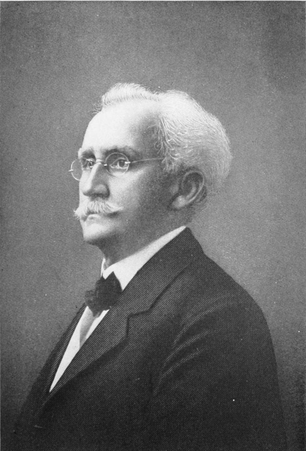
Then, after a month of continuous fighting, came the note from the British, stating that El Morro was undermined and an offer of 24 hours in which to surrender, and Velasco’s reply, in which he informed his enemy that the match might be applied and the walls blown up, but within the breach he would be found still defending the castle.
The mine was exploded and the south wall torn asunder, while Velasco, fighting to the last, received the wound that sent him over the Great Divide and soon brought to an end Havana’s defense against the British. Imagination easily recalls the salute of cannon on the following day, announcing the death of one of Spain’s most courageous fighters, while every shot of the defending guns was echoed by one of the British ships, firing as a tribute to the courage of the young officer who had defied their entire fleet for nearly a month.
Morro was begun in 1589 by the Italian engineer, J. Bautista Antonelli, and completed in 1597. Little change has occurred during the last two centuries, and its rugged old walls will probably continue to resist the winter storms of the Gulf for centuries to come. Many of Cuba’s patriots and heroic figures have been confined in the dungeons of Morro, including the first President of the Republic, that kind hearted, genial old gentleman of letters, Don Tomas Estrada Palma, who died the victim of base ingratitude on the part of men for whose freedom and happiness he had devoted all of the best years of his life.
El Morro is still occupied, as in the olden days, by the coast artillery of Cuba, and is well worth a trip across the bay, where one may pass a pleasant afternoon in interesting introspection, and enjoy at the same time one of the most delightful views of land and sea from any point in the West Indies.
Just within the entrance, and on the shore at the foot of Morro, are located 12 huge, old-time muzzle loading cannon, known as the Twelve Apostles, that sweep the opposite shore and were supposed to render impossible the entrance of any hostile ship, or any effort to cut away the heavy iron cable that in earlier days stretched across the entrance to the harbor from El Morro to the fortress of La Punta on the other side. These curious old iron guns, dedicated to the saints, were cast by Don Juan Francisco de Guenes and installed by him in the form of a crescent, that boded destruction to all invaders from the sea.
Some 500 yards further east, along the coast, is installed a similar group of cannon, 12 in number, that forms a battery known as La Pastora. These guns were made by Francisco Cagigal de la Vega and were placed on the lower shelf of the outside coast at a point not easily seen from the sea where they were supposed to render a forced entrance to the bay practically impossible.
A little further within the narrow entrance to the harbor of Havana, and stretching for a half a mile along the eastern shore, lies the largest and most impressive ancient fort of the western hemisphere. This fortress is known as la Cabaña, owing to the fact that several cabins once stood along this ridge, some 200 feet in height, overlooking the City of Havana. La Cabaña is massive in its structure, built of stone and earth on the crest of the ridge, with a steep descent to the water’s edge. It is surrounded on all sides by a wide deep moat, across which no enemy, even in modern times, could possibly pass. The destruction of the fort with high explosives and long range guns would, of course, be easily accomplished, but as an example of 18th century military engineering and architecture, it has no rival in the western world. Some 50 acres are covered with the walls, patios, surface and underground dungeons, prisons, buildings, moats and outer defenses of this fortification.
The work was begun on November 4, 1763, shortly after the evacuation of Havana by the British, and was concluded in 1774. The cost of the work is said to have been $14,000,000, although much of it was probably done by slaves, for whose services little or nothing was paid, nor could the value of their labor be easily estimated. The same engineer Antonelli, of Italian origin, who built El Morro, displayed his military genius in the plans of La Cabaña.
The original approach of this fortress was over a cobbled path that wound up a steep incline, from a little landing opposite the foot of O’Reilly Street, terminating finally in the southern opening to the moat. This path was known during the long years of the Ten Years’ War, and the War of Independence, as “El Camino sin Esperanza” or the Road without Hope, since those who climbed its winding way as prisoners seldom descended to the plain below, unless in rude boxes on the way to their last resting place. Even this privilege was denied to the great majority of political prisoners who were executed under the laurels that shade the first part of the moat.
This wide deep moat, varying in width from sixty to a hundred feet, with a depth that will average fifty, extends from one end of the fortress to the other, paralleling the harbor on which it fronts, and separating the main body of the fortress from well planned and easily defended outer works. Stone stairways were built at different places against the walls of these outer ramparts to facilitate the movement of troops in defense of the citadel, but with wide gaps crossed by wooden bridges that once knocked away would render the stairways useless to the enemy.
A few hundred feet beyond the avenue of laurels, and close by an opening of the wall into the main fortress, a bronze placque, some six feet by twelve, marks one of the places where political prisoners were executed throughout the latter half of the 19th century. The bronze was cast in France and represents the execution of a group of insurgent soldiers. In the left half of the placque is represented a squad of Spanish soldiers in the act of firing. Above all floats the figure of an angel endeavoring to shield the martyrs who are giving up their lives for the cause of Cuban Liberty.
Passing through this great eastern wall of the citadel the visitor steps into an interior, grass covered court, several hundred feet in length by eighty or more in width. Along the southern end of the court may be seen the remnant of a painted line at about the height of a man’s breast. On this spot, it is said, over a thousand men were executed during the period of the Ten Years’ War and the three years’ War of Independence. Most of the old line has been dug away by knife points of visitors in search of bullets that were imbedded in the wall during the many executions that took place at its base. At the further, or northern end of this tranquil plot of ground, heavily barred iron gates cover a series of steps which formed an emergency entrance from the moat into the main body of the fortress.
A quarter of a mile further north, along the main extension of the moat, is a wide wooden bridge that connects the outer ramparts with the citadel, the roadway passing through a massive and impressive gate or portal, over which a carved inscription gives the dates in which the work was begun and concluded, together with the name of its founders and the Spanish officers in command at the time of its construction.
The grounds within are ample for military drill and instruction and are well equipped for the care and maintenance of a defending force. When Spain’s army retired from Cuba in the last days of 1899, both Cabañas and Morro presented a very different appearance from that of today. Long lines of cells had been built into the stone walls, in which hundreds, if not thousands, of political prisoners had spent years of confinement. Each of these dreary, cheerless abodes was about 30 feet in width by 60 in length, with a low arched ceiling and massive barred doors, facing the west.
Each cell was supposed to accommodate fifty men, and some of them contained long parallel wooden bars, between which prisoners might swing hammocks if they were fortunate enough to possess them. Many men prominent in Cuban political and military life have occupied these cells of Cabañas and also those of its companion, El Morro. General Julio Sanguily, among others, passed three years in cell No. 57, until, through the urgent intercession of the American Government, he was finally set at liberty and permitted to enter the United States, of which he claimed citizenship.
Stretching along the western face of the fortress is a wide stone parapet overlooking the bay and the City of Havana opposite. Planted on its surface is a long line of interesting brass cannon, ornamented with Spanish coats of arms and bearing inscriptions that tell of their making in Seville, at various periods throughout the 18th century. These cannon are used today for saluting purposes when foreign men of war enter the harbor on friendly visits.
Near the center of the citadel stood a small stone chapel that would accommodate 50 or 100 men. Near one end was built a round pagoda-like altar before which the condemned could kneel in prayer during their last night on earth, since those who entered its tragic portals well knew that at sunrise the following morning they would face the firing squad that would pass them on to eternity. This historically tragic apartment has recently been converted into a moving picture hall for the benefit of Cuban soldiers who are at present stationed in Cabañas.
Visitors at Cabañas during normal times of peace will find soldier guides quite willing to carry one down into the subterranean depths of the fortress and along the narrow dark passageways that were tunneled into the earth, supposedly to detect possible mining operations of the enemy from the outside. During the War of Independence, however, extending from 1895 to 1899, these underground tunnels were occupied by prisoners, most of whom dying in the dismal depths were given burials so shallow by their companions, who must have dug the graves with their fingers, that in passing along by lantern light, shortly after American occupation, one frequently stumbled over skulls and bones that protruded from the earthen floor below.
The aspect of Cabañas today, with its well cleaned, whitewashed walls, with its comfortable officers’ quarters and shady grounds, is quite cheerful, and one can hardly believe that less than a quarter of a century ago Cabañas fortress was one of the modern horrors that cried out to the civilized world for the abolition of Spanish control in America.
Occupying the low rocky ledge immediately opposite Morro is the picturesque little fort known as the Castillo de Punta, or Fortress on the Point, begun in 1589, and intended to complete the protection to the entrance of the harbor. The style of architecture is identical with that of El Morro, but far less pretentious in size and plan. The fort is protected from the sea by several outlying shelves of coral rock, and was at one time surrounded by a moat as was La Fuerza, the first stone fortress constructed in the Western Hemisphere. The walls are not over 20 feet in height and over the main entrance a tablet gives the name of Governor-General Tejada, during whose period of office it was built, together with the date of its construction.
La Punta afforded efficient aid to its companion El Morro, on the opposite side of the bay, during the siege by the English in 1762, and in one corner of the reception room may be seen the fragment of an iron shell, fired from the British fleet during the siege of Havana.
La Punta is the headquarters of the Navy Department. Its presence at the angle of the Prado and the Gulf Avenue, that extends west along the sea shore, is a quiet but efficient reminder of the olden days when fortresses of this type formed the only protection enjoyed by the people who were then residents of the capital of Cuba.
Until the middle of the 19th century, Havana, like nearly all of the capitals built by Spanish conquerors in the Western Hemisphere, was a walled city. These walls were built of coral limestone quarried along the sea front, which with exposure to the atmosphere becomes quite hard. The same engineering ability demonstrated by the builders of El Morro, Cabanas and La Punta, was evident in the 17th century wall, that had the fortress of La Punta as its starting point and ran in practically a straight line south until it reached the shores of the Bay near its southwestern terminus.
These walls were about 12 feet through at the base and some 20 feet in height. Throughout the entire line was a series of salients, bastions, flanks and curtains that were dominant features in the military architecture of those times. At the top were parapets on which the garrison gathered for the defense of the City.
Work on the walls began with a body of 9,000 peons in 1633 and a contribution of $20,000 in gold that was exacted by order of the Spanish Crown from the rich treasuries of Mexico in order to hurry its completion. Only two gates were constructed at first, one of these at La Punta and the other at the head of Muralla Street, which latter formed the main or principal entrance for commercial purposes. A third was afterwards opened near the corner of the old Arsenal for the convenience of people engaged in ship building at that point.
Extending along the water front were gradually built continuations of this wall with coral ledges forming a solid base. These eventually closed the city on all sides. This stupendous work was not completed until 1740, and even after this date occasional additions were made for purposes of better defense. Although the Spanish treasury at that time was being filled with gold from Mexico and Peru, it would seem that the Crown was very loath to part with the money, and compelled the colonies of the Western Hemisphere to build their own defenses and to make whatever improvements they considered necessary, either from contributions levied on commerce, or with the use of slaves whose services their owners were compelled to furnish at their own expense.
Up to the departure of Spain’s army from Havana in 1899, sections of the old wall, several blocks in length, extending through the heart of the city, still remained intact. These, with their salients, bastions, flanks, etc., formed an interesting landmark of the olden days, when Spanish knights clad in hauberks and hose, donned their breastplates and plumed helmets to fight against the British who besieged the city in 1763. Today only one short section remains, a picturesque remnant of the past, with its little round, dome-covered watch tower still intact. This is located just north of the Presidential palace on the crest of the green lawn that slopes away towards La Punta, about a third of a mile distant.
Near the landing place at the foot of O’Reilly Street, used by visiting officials and officers of the Navy, stands La Fuerza. On this site was built the first permanent or stone defense of the city in 1538. The original walls and fortifications have seen many changes since that date but one cannot look at them without recalling the pathetic figure of Dona Isabel de Bobadilla, who in 1539, on the drawbridge of La Fuerza, where she and her husband, Hernando de Soto, had lived, said “Adios,” as with an army of 900 men and 350 horses, he set out for the conquest of Florida “and all the territory that might lie beyond.”
Day after day, for more than two years, it is said, this faithful wife walked the parapets of La Fuerza straining her eyes to see his flagship arise above the horizon of the Gulf, and when at last a storm beaten bark brought back a few survivors of the expedition, whose leader had hoped to rival if not surpass the deeds of Cortez in Mexico, or Pizarro in Peru, she learned that her lord and lover would return no more, that even his body would never be recovered from the yellow waters of the Mississippi. It was then that her soul, too, sank into the sea of despair and soon joined its companion on the shore beyond.
The dark dungeons of La Fuerza have held hundreds of Cuban patriots until death or deportation to Africa brought relief. The old stone steps descending to the ground floor are worn into veritable pockets by the tramp of feet during a continual occupancy of almost 400 years. Every outer wall, parapet, alcove and dungeon, if able to speak, “could a tale unfold.” Now all is silent save the sound of an occasional bugle, the music of the artillery band, or the laughter of children playing on the green lawn that separates it from the Senate Chamber.
The first church built on the Puerto de Carenas, as the Harbor of Havana was called by the founders of the city, was of adobe, roofed with yagua from the guana palm. This was destroyed in 1538 by the pirates. Owing to the extreme poverty of the inhabitants, and to the fact that in spite of the wealth controlled by the churches of the mother country its representatives in the Western Hemisphere, especially in the City of Havana, were left to shift for themselves, and very few contributions for church building came across the seas to Cuba—it being assumed evidently that the people of a community deserved no better church than their financial means justified—it was not until well into the 17th century that churches were constructed that would at all compare with the beautiful ecclesiastical structures of Europe. Most of those of Havana, that were built during the 17th and 18th centuries, resemble, both in material and architecture, the rather heavy, ponderous and so called Gothic style that prevailed throughout the Latin American world.
Immediately back of the old Presidential Palace, former headquarters of the Captains General of Spain, stands the former convent and church of Santo Domingo, whose erection was due to the liberality of the Conde de Casa Bayamo, whose picture until recently hung in the sacristy. This building occupied the block of ground between O’Reilly and Obispo and Mercaderes and San Ignacio Streets. It was reconstructed in 1738 and became the Royal University of Havana. When the University was transferred to the beautiful site on the heights of Principe, overlooking Havana from the west, this old relic of bygone ages, with its ponderous walls and picturesque patio, became the Institute of Havana, where students still receive that which in English would be equivalent to a high school education. One portion of the square is today used as a police station, while the church itself, with its crude stone figures of saints standing in relief from the outer walls, is practically abandoned and will probably soon be removed, for the modest type of sky-scraper or office building that is becoming quite common throughout the city.
The cathedral, one of the largest and most imposing of the churches of Havana, was built by the Jesuits, on the north edge of the old basin or arm of the Bay that extended from the present shore along the line of the street now known as Empedrado, as far west as the little San Juan de Dios Park. This church is built of the tough coral limestone used in nearly all of the important buildings that stood within the walls of old Havana. The church, together with the convent and offices in the rear, is in the form of an irregular quadrangle, covering about a block of ground, the rear facing the bay itself. The architecture is of the so-called Gothic that prevails in all of the old-time churches and convents of the Island. Owing to the fact that, up to 1899, it contained the bones of Christopher Columbus, this building has always been one of the prominent places of interest in the city. A tablet in marble, over the entrance on San Ignacio Street, states that it was consecrated by his Excellency, Pedro Agustin Morel de Santa Cruz, Bishop of Havana, on September 8, 1755. This church was declared the Cathedral of Havana in 1789.
The former tomb of Columbus was located in a niche built for the purpose on the west side of the altar. When the Spanish forces departed from the Island in 1899, at the request of the Pope the remains of Columbus were removed from their long resting place in the Cathedral and carried to Seville, Spain, where they are at present interred. The interior of the edifice, although not as elaborately decorated as are some of the other churches, is nevertheless imposing and well worth a few moments pause to the passing visitor.
The San Francisco Convent, one of the oldest churches of Havana, was completed by Order of the Franciscans in 1591. A part of the hard coral shore that formed the western edge of the bay, a few blocks south of the Plaza de Armas, formed a solid foundation for the original building which, owing to faulty material and construction, lapsed into ruins in 1719. In 1738 the structure which now occupies the spot was built under the direction of Bishop Juan Lazo. The tower of the Church proper is considered one of the best samples of ecclesiastic architecture in Havana. This building fronts on Oficios Street and extends from the Plaza of San Francisco south for more than a block, parallel with the Bay front. The old San Francisco convent is the most massive structure of its kind in Havana. Its long lofty arched passages were well built and give promise of remaining intact through centuries yet to come. The large patio in the center is today filled with flowers and admits light to the many offices, once occupied by the palefaced, sad-eyed inmates of the convent, now resounding with the click of typewriters and the tread of feet bent on the ordinary affairs of life. In 1856 this building became the depository, or general archive, of the Spanish administration of affairs in the Island. The first American Government of Intervention used it as a Custom House, where Major General Bliss had his headquarters. Shortly after the inauguration of the Republic of Cuba this property together with that of the square now used by the Institute, was purchased from the Church and continued to be used as the custom house. In 1916 the old convent, thoroughly renovated, became the permanent headquarters for the Department of Posts and Telegraphs, for which it is well adapted. The custom house was transferred to the San Francisco Wharf, a handsome structure that also shelters the administration of Trisconia. From 1608 the San Francisco Church was used as the starting point of the religious processions which annually passed the “Via de Cruces” or Way of the Cross, along Amargua Street terminating at the Church of El Cristo at the corner of Aguacate Street, which was built in 1640.
The San Agustin Convent was built by the order of San Agustin on Amergura Street at the corner of Aguiar Street. A tablet on the church itself states that it was completed in the year 1659. There is nothing of special interest connected with this church other than its antiquity and its general air of isolated depression.
La Merced, located at the corner of Cuba and Merced Streets, was the culmination of an effort to establish a Merced Convent for that part of the City of Havana. It was begun in 1746 but not completed until 1792. La Merced is today considered the most fashionable church in the Island of Cuba, and during times of religious festivals the decorations of flowers and illumination of candles are very imposing. This church, and the National Theatre, during the opera season, furnish perhaps the two most interesting places in which to study Havana’s élite society.
IN NEW HAVANA
While many streets in Havana appear to belong to some Spanish city of centuries ago, many others vie with those of New York and Washington in their up-to-date Twentieth Century aspect. There are in both public and private edifices many examples of the finest modern architecture and construction, some rising many stories above the two-and three-storied buildings characteristic of former years.

In 1689 the convent of Santa Catalina was built on the square facing O’Reilly Street, between Compostela and Aguacate Streets, the dedication of the church taking place in 1700. This convent has been famous for two centuries for its wealth, devotees vying with each other in the amount of money or property which they could contribute to the coffers of the church. It is said that $15,000 was the smallest contribution that could be accepted from any woman who chose to devote her life and fortune to the promotion of the Catholic faith and the prosperity of the Church. No limit was fixed to the amount of the individual contributions from novitiate nuns, and many of the wealthiest women of Havana society have disappeared from the social world, within its walls. The property was sold in 1917 for a million dollars and the inmates were removed to the new quarters located on the plateau in Vedado.
The picturesque church that stands on the crest of the hill in the district of Jesus del Monte was built in 1689. The view from the front of this church, looking over the city and bay beyond, is very pleasing.
An attractive church from the viewpoint of its minarets and architecture, known as Santo Angel, is located on a small hill of that name near the junction of Cuarteles with Monserrate Street, overlooking the long stretch of green sward that extends from the new Presidential Palace to the Park of Luz Caballero. This church, in spite of its name, seems to have been selected by fate to suffer a number of serious reverses. In 1828 a stroke of lightning toppled over the tall spire on its eastern front, and again in 1846 a hurricane that did but little damage to the city tore down the cupola and brought with it the entire end of the building. In spite of this however the church has recently entered into a period of prosperity and is today the center of fashionable congregations who usually assemble there for twelve o’clock late mass.
Santa Teresa was founded in 1701 and is located at Compestela and Teniente Rey Streets.
The convent of Santa Clara was built in 1664 and began with a fund of $550. It extends from Cuba to Havana Streets and from Sol to Luz Streets, covering two solid blocks of ground, and is the largest convent in the Island of Cuba. Owing to the recent increase in the price of city property, the space covered by this convent is valued at $1,500,000.
In 1704 the convent of Belen was founded at the corner of Compostela and Luz Streets, covering an entire block of ground that had served previously as a recreation park for the Bishop of Compostela. Within this convent the Jesuit Order established what was known as the “Royal College of Havana,” whence were graduated some of the city’s famous lawyers and scholars. This order maintains an Observatory and weather bureau, whence reports in regard to storms in the Caribbean are contributed to the daily papers. Belen, among the devout Catholics of Cuba, is undoubtedly one of the most popular institutions of the West Indies.
Shortly after the inauguration of Woodrow Wilson as President of the United States, Mr. William E. Gonzalez was appointed Minister Plenipotentiary from that country to the Republic of Cuba, and took up his residence in the old colonial mansion built by the Echarte family, located on the corner of Santa Catalina and Dominguez Streets. This beautiful quinta occupies a block of ground in the old aristocratic residence district of Cerro, some three miles distant from Central Park. The building, although only one story in height, is quite imposing, built of stone with white marble floors throughout, inclosing a beautiful patio that forms one of the unique and charming attractions of old-time residences in Havana. A wide marble flagged gallery runs all around this patio from which a soft subdued light enters the many rooms facing upon it. A broad porch, whose heavy flat roof is supported by long rows of stone columns, faces the south, and above it flies the Stars and Stripes from sunrise to sunset. The garden or grounds occupying the eastern half of the block are filled with beautiful shade trees and sweet scented flowers that have been brought from many parts of the world, while in front a row of stately royal palms reach up some 80 feet or more toward the blue sky.
La Chorrera, the Fort of Almandares, is a picturesque little old fort, some fifty feet square and two stories in height, built of coral rock in the year 1646, which rests upon a little islet not much bigger than the fort itself, at the eastern entrance of the Rio Almandares. Slave labor undoubtedly entered into the construction of this fort, although it is said to have cost 20,000 ducats. A flight of stone steps has been built up to the second floor that communicates with the entrance to the fort. Over this is a tablet giving the date of construction and the name of its builders.
During the siege of Havana by the British in 1762, Lord Albemarle determined to land troops west of the City in order to take advantage of Principe Heights, overlooking the capital from the west. On June 10 a portion of the British fleet began bombarding La Chorrera. Its commanders, Captain Luis de Aguiar and Rafael de Cardenas, made a very stubborn resistance, yielding only when their ammunition had been completely exhausted. This fort is easily reached by the Vedado car line, from which a short walk of two blocks brings one to the mouth of the Almandares, on which the fort is located.
On the western point, guarding the entrance of the little ensenada or inlet of Cojimo, four miles east of El Morro is Fort Cojimar, almost the duplicate of La Chorrera, which was constructed at the same time. These quaint monuments of the past add considerable historic and picturesque beauty to the northern coast of Cuba. All of them may be reached by beautiful automobile drives and are well worth a few moments in passing.
The Torreon de la Playa, a small round watch tower, was erected on the eastern shores of La Playa, some three miles west of the Almandares River, where watchmen were kept both day and night to advise the authorities and inhabitants of the struggling young colony of the approach of pirates from the west, or any suspicious sails that might hove in sight. This structure was built by order of the Town Council, the “Cabilda,” on order issued on March 8, 1553, naming each individual who was to contribute either in money or men towards the work. The money contributed was exacted only from some half dozen of the inhabitants and amounted to a “real” or ten cents a day. The well-to-do inhabitants were called on each to furnish one negro with his tools, or lacking tools, a “batey” or boat in which to convey material.
A similar tower known as the Torreon de San Lazaro was built in 1556 upon the western edge of the little inlet, which until the inauguration of the Republic in 1902 occupied the space where the beautiful equestrian statue of General Antonio Maceo now stands.
The picturesque fort known as Atares, located on the hill that commands the extreme southwestern end of the bay, was begun in 1763, immediately after the departure of the British, and completed in 1767. It is occupied at the present time by a small detachment of Cuban artillery, and is sacred in the eyes of all Americans owing to the fact that General Crittenden of Kentucky, and his 50 companions who had joined the unfortunate band of Cuban liberators under the command of Narciso Lopez, were executed on the western slope of the hill in August, 1851. Atares is easily reached by the Jesus del Monte cars, and the view from the top of the hill is worth the climb.
The Castillo del Principe, the last fortification of the 18th century, was placed on the western edge of the Principe plateau, on the same spot where Lord Albemarle with his British troops looked down on the City of Havana during the siege of 1762. Fort Principe was begun in 1774 and completed in 1794. The general style of architecture is similar to that of all the military structures of this period, although Principe is larger and more commodious than Atares. A deep moat surrounds the fortification and an old style drawbridge connects the outer edge with the entrance to the citadel itself. Since the beginning of the Cuban Republic the fort has been used as a state penitentiary, and is a model of ideas and methods in the treatment of its convicts. The inmates are not only taught to read and write, but learn useful trades as well. Those of musical bent have formed a brass band, in which they have been encouraged under the intelligent direction of General Demetrio Castillo, who has had charge of the prisoners in Cuba almost since the beginning of the Republic.
The view from the top of the hill is one of the most attractive in the Province of Havana, and may be reached either by the Principe car line, which terminates at its base, or by an automobile drive which leads through a winding way up the hillside to the very entrance of the fortress.
The Botanical Gardens, Quinto de Molinos, are a beautiful property fronting on Carlos Tercero Street and extending along the north side of the drive from Infanta Street to the foot of Principe Hill. They belong to the Government. On the corner of Infanta Street is located the new City Hospital, the largest and most complete institute of its kind in the West Indies. Just beyond are the ground of the Botanical Gardens and the Quinto de Molinos, forming a long, beautiful well laid out, shaded park. Its graveled walks lined with many varieties of stately palms and tropical plants some indigenous and some brought from other parts of the world, render the ground a charming and interesting retreat, not far from the center of the City. The estate covers some 40 acres, and within its limits are held Agricultural and Live Stock fairs, that under normal conditions take place annually. These grounds, during Spanish colonial times, were used as a summer residence by the Captains-General of Cuba, and for that reason have a certain degree of historical interest, since here Generals Martinez Campos, Weyler and Blanco, with many of their predecessors, passed much of their time during the summer season.
Several picturesque kiosks and artistic structures with seats have been built for the benefit of the public, and usually during the winter season open air concerts are given within the grounds once or twice a week by the Municipal Band. The Quinto is easily reached either by street car or automobile and there is probably no place within the city limits where one can pass a more restful and profitable hour, than within the shade of the Botanical Gardens of Havana.
HAVANA is one of the most charming capitals in the New World. Its very name, Indian in its origin, conjures up a vivid panorama of four centuries, crowded with tragedy, pathos, adventure, bold deeds, cruel crimes and noble sacrifices; on whose rapidly moving film the hand of fate has pictured every phase of human emotion from the wild dreams of world conquerors, to the hopeless despair of hunted Cubenos, who preferred death to slavery. It was on the 25th day of July, 1515, that Diego Velasquez, while cruising along the south coast of the Island, stopped on the sandy beach near a native fishing village called Metabano. The Indians belonged to a tribe known as the Habanas; one of the thirty different divisions of the Cubenos. Grass-covered plains extending back from the beach seemed to impress Velasquez favorably, so he founded a city there and called it San Cristobal de la Habana.
Toward the close of the year 1519, however, the colonists evidently disapproved of Velasquez’s selection and moved their town across to the north coast of the Island at the mouth of the Almandares, where northeasterly winds made the summers more agreeable. This little stream, emptying into the Gulf of Mexico, had a depth of twelve or fifteen feet at the mouth, sufficient for the caravels of those days. But some of the City Fathers, in their wanderings to the eastward, found the beautiful bay, then known as Carena. A prophetic glimpse into the future may have furnished the motive for another change; at any rate a year later they picked up their household fixtures, carrying with them the town records, and established the City where it now stands, on the eastern shores of one of the finest land locked harbors in the world. In 1556 Havana became the capital of Cuba, the rendezvous of all Spanish fleets in the Occident, as well as the key to the Gulf of Mexico.
Havana in the early days of the 16th century consisted of several groups or clusters of palm thatched huts, not far from the bay, with little that could suggest a city in embryo. As in all cities built by the Spaniards in the New World, the first permanent buildings were churches and monasteries erected for the benefit of the Catholic clergy and built, as a rule, of adobe or mamposteria, with walls two or three feet in thickness. The material used was a mixture of rock, earth and sand, inclosed in facings of plaster. Many of them were decorated with crude figures and images of saints popular in the community.
Later, quarries of soft limestone were found in abundance, and from these, blocks were easily cut which, after exposure to the atmosphere, formed a hard, durable building material. The coral rock of which both Morro and Cabañas were built was taken from old quarries scattered along the north shore from Morro eastward. From these quarries came also the stone that built the spacious San Francisco Convent, occupied today by the Central post office.
As in all Spanish towns, in the New World at least, a plaza or open square formed the center from which the principal streets radiated. On the eastern side of the plaza of Havana, in front of La Fuerza, was erected in after years El Templete, in honor of the first mass held by the inhabitants of Havana, which took place under a giant ceiba growing close to the shore of the harbor, in 1519.
Nearly all of the permanent structures in Havana, up to the middle of the 17th century, were located on or near the water front, some distance in from La Punta. Many of these, including La Fuerza, the San Francisco convent, the old cathedral and La Maestranza, were built of coral limestone cemented with a mixture the formula for which is said to have been lost, but which in these buildings has endured the wear of centuries. Excellent clay for making tile and brick was later found not far south of the City, so that the more pretentious buildings were covered with roofs of the criolla tiles that are still common throughout all Latin America.
Before the middle of the 15th century, the clearing in which Havana was located was extended out as far as the street now known as Monserrate, running from the Gulf front across to the southwestern extension of the bay. In 1663 a splendid wall was begun along this line and completed with the help of slaves in 1740. It ran almost north and south, inclosing the city on the west, and protected it from all attacks coming from the land side. This wall was twenty feet in height and twelve feet thick at the base, surmounted at frequent intervals by quaint round-topped turrets. It had its angles, bastions and points of vantage for defensive purposes, the work, according to experts, representing a very high degree of engineering ability on the part of those who planned it.
With the exception of one angle and its turret, which stands in front of the new Presidential Palace, the old walls were removed in 1902, thus depriving Havana of perhaps the most picturesque feature of the ancient city.
Just in front of this wall on the west, a wide clearing was made to prevent surprise attacks from the forests beyond. With the felling of the trees, grass soon grew along its entire length, hence the name Prado, which means meadow, became permanently attached to it, and so the green lawn in front of the old walls of the 17th century was transformed two hundred years later into Havana’s most aristocratic avenue.
The principal thoroughfare, leading from the southern side of the Plaza de Armas to the Prado, was called Obispo or Bishop Street, which name it still retains. It is said that the first Bishop of Havana was in the habit of taking his daily walk out along this road to the main gate of the City; hence the name.
Beginning at the water front and running from La Fuerza west, parallel to Obispo, is O’Reilly Street, named in honor of one of Cuba’s most energetic Governors-General, who controlled the affairs of Havana in 1763, and who was, as the name suggests, of Irish antecedents. Just north of O’Reilly and parallel to it we have Empedrado Street which won its distinction by being paved from the old Cathedral to San Juan de Dios Park in the time of Governor General Las Casas. South of Obispo came Obrapia Street, or the Lane of Pious Works. Beyond and parallel to it came Lamparilla Street, which earned this cognomen owing to the fact that some progressive citizen in the early days hung a lantern in front of his residence for the benefit of the public at large.
Next comes Amargua Street, or the Bitter Way. It is along Amargura that certain pious and penitent monks were said to practice flagellation. With shoulders bent, and on their knees, they invited the blows of whips while wending their way out towards the edge of the city. Incidentally they collected alms en route. On the southeast corner of Amargura and Mercaderes Streets a peculiar cross in stucco, painted green, is built into the wall of the house where, centuries ago, lived a high dignitary of the church, before which all passing religious processions paused for special prayers.
There is hardly a square within the old walled city that has not some story or legend whose origin goes back to the days of Velasquez, De Soto, Cortez of Mexico, and other celebrated conquerors of the New World.
The Havana of today is a strange mingling of modern, reinforced cement and stone structures, five or six stories high, with little one or two-story, thick-walled, tile roofed samples of architecture that prevailed three hundred years or more ago. City property, however, is increasing so rapidly in value that many old landmarks along the narrow streets of the wall inclosed section are being torn down and replaced with large, well equipped office buildings.
COLON PARK
Colon Park, one of the most beautiful pleasure grounds of the Cuban capital, is also known as the Campo de Marte, and is at the southern end of the famous Prado. It is noted for its marvellous avenues of royal palms. From it the Call de la Reina, once one of the most fashionable streets of the city but now given up to business, runs westward toward the Botanical Gardens.

With the accumulation of sugar estates, coffee plantations, cattle ranches and resultant wealth, people of means began to seek summer homes beyond the walls of the old City. All men in those days went heavily armed for any danger that might threaten, while numerous slaves furnished protection from common thieves and highwaymen.
With the development of the outlying districts, trails and roads soon began to reach out both to the west and south, followed some years later by what were known as Caminos Reales or Royal Roads, connecting Havana with Matanzas, Santa Clara, Cienfuegos, Trinidad, Sancti Spiritus, Remedios, Camaguey and Santiago de Cuba.
One road, known still as El Cerro, ran southwest along the crest of a ridge that led towards the western part of the Island and in after years connected Havana with the big coffee plantations in the mountains and foothills of Pinar del Rio. Along this road were built the first suburban residences and country homes of the aristocracy of Havana.
Many of these places were cut out of dense woods, and on one of them, until less than ten years ago, the original owner, the Conde de Fernandina, retained a full square of dense primeval forest, not a tree of which had been removed since the days of Columbus. This remnant of virgin wilderness, located on the corner of El Cerro and Consejero Arango Streets, was for some six years passed by the electric car line of El Cerro.
All of this section of the City, of course, was long ago built up with handsome residences that sheltered most of the old Cuban families, who had inherited the right to titles, coats of arms, and other paraphernalia pertaining to the monarchy of Spain. Tulipan Park marks the center of this aristocratic district, and still retains much of its old-time atmosphere of colonial prestige.
Further south ran another winding trail that gradually ascended a range of hills, forming the divide from which the undulating surface slopes towards the south coast, thirty miles away, where Velasquez located the original site of Havana. This thoroughfare is known as Jesus del Monte, or Jesus of the Mountain, and has become quite popular in recent years on account of reputed healthfulness due to its elevation above the sea.
When the last remnants of the Spanish army returned to Spain in 1899, that portion of the City called El Vedado, or The Forbidden, extending from the Beneficencia, or Orphan Asylum, out to the Almandares River, three miles distant, was nothing but a goat pasture, with a low sea front of sharp coral rocks. Its soil was thin and the district apparently had nothing to recommend it aside from its view of the ocean.
A little dummy engine pulled a shaky, shabby car out to the Almandares, making four trips a day. Just why it ran at all was a mystery to the inhabitants, since there was but little inducement to travel in that direction. The entire expanse of land from the Santa Clara Battery to the Almandares, and miles beyond, could have been purchased for a song, but no one wanted it.
Two years later some “fool American” erected an attractive bungalow on the line, about half way to the Almandares, and not long after, sign boards could be seen with the notice, “Lots for sale,” which invariably occasioned smiles, since there were no purchasers. But around the bungalow were laid out pretty grounds, and the suggestion took root. Two men of means erected beautiful places close by, and the building of homes in the cactus-covered flats became a fad.
The price of lots, which began at ten cents a square meter, soon rose to a dollar, then two dollars, five, ten, twenty-five, and today this entire section from Havana to the Almandares and beyond, from the dog teeth coral of the coast, up over the crest of the Principe Hill, is covered with beautiful modern mansions with splendid grounds, and forms the residential pride and show ground of the city.
This marvelous increase in development of suburban property, which seems to continue with leaps and bounds, has long since passed the Almandares River and reached out to the Playa and to the Country Club, while even further west land is sold by the square meter and not by the caballeria. All has taken place since Leonard Wood stepped into the Palace as Governor-General of Cuba in the year 1900.
Another well-known highway that played an important part in the early history of Havana was called La Reina. This wide, beautiful avenue begins at the Parque Colon and runs due west until at the crest of the first ridge the name changes to Carlos Tercero, passing between avenues of laurels until it reaches the Quinto de los Molinos and the Botanical Gardens. Passing on around the southern edge of the Principe Plateau, the avenue continues on to Colon Cemetery, a beautiful spot, commanding a view of the mouth of the Almandares, and that portion of Vedado lying between it and the Gulf. Since Havana has but one cemetery for a city of over 360,000 inhabitants, travel to the last resting place is somewhat constant over this really beautiful road.
The view from the western terminus of Principe Hill is one of the finest in Cuba’s capital. It was this crest that the English Colonel Howe, after landing his force of three thousand men in 1762 at the mouth of the Almandares River, ascended and from it saw for the first time the old walled city lying at his feet, in all its primitive glory.
This commanding position on the western edge of the Principe Plateau, with the City of Havana, the Botanical Gardens and the beautiful Quinto de los Molinos lying at its base, was chosen for the site of the University of Havana, and no more appropriate place for an institution of this kind could have been selected. In the near future it will undoubtedly become one of the most important seats of learning in Latin America.
Near the head of the western extension of Havana Harbor is the Loma of Atares, on whose summit rests a picturesque 18th century fortress of the same name. The hill rises abruptly several hundred feet above the level plain, and commands all approaches to the City both from the south and the west.
The prado or meadow, that extended along the western front of Havana’s embattled ramparts, is today changed into a wide esplanade, along which runs a double driveway for automobiles and carriages. Through the center, between double rows of laurels and flamboyans, are shaded walks, shrubs and rare plants of the tropics. On both sides of this fashionable street, sumptuous mansions, many of them homes of millionaires and distinguished men of this western Paris, have been built since the inauguration of the Republic. Attempts have been made at different times to change the name of this avenue, but the people of Havana, up to the present, have insisted on retaining the term first given it, the “Prado,” that always lay between the City gates and the western forests.
On the east lies the former walled city with its narrow streets and antique buildings and picturesque landmarks of bygone centuries. On the west we have the more modern City, that extends for miles both south and west, where beautiful residences have been erected, some of them palatial in size and appointments. Several of the more prominent hotels, too, are located on the Prado where it forms the western boundary of “Parque Central,” that delightful retreat in the City’s center. In front of the Park was the large gate that gave entrance and exit to the traffic of the old time thoroughfares of Obispo and O’Reilly. Many beautiful club buildings, whose cost ran into millions, are located along the Prado.
At the southwestern corner of the Park is the new National Theatre, a magnificent piece of architecture covering an entire block of ground, and costing some $3,000,000. This theatre is the largest and best equipped place of amusement in Havana, and at its entertainments may be found the elite of the Island republic. The season of grand opera continues for approximately six weeks every winter, during which the best artists of Italy, France, Spain and the Metropolitan Opera of New York furnish entertainment to a music-loving audience, whose taste is as refined and critical as any in the world.
The “Parque Central” covers an area equivalent to two city squares, in which many beautiful shade trees, including the evergreen laurel, the flamboyan, date and royal palms, and other plants and flowers peculiar to the tropics, add shade and beauty to the spot. In its center rises an imposing statue in marble of José Marti.
From this central point the Prado continues south until it terminates in the “Parque de los Indies.” Adjoining on the west is the “Parque de Colon,” with an area equivalent to four large city blocks. Stately royal palms, india rubber trees, flowering majaguas, cocoanuts and rare tropical plants, render this park one of the most interesting in the City.
Leading away from the head of the Parque de Colon we find a wide avenue known as La Reina, that extends westward and upward to the summit of Belascoain, where its width is more than doubled in the Avenue known as Carlos Tercero. This continues west between two long rows of shade trees, outside of which are two more drives running parallel to the main or central avenue.
This continues out beyond the Botanical Gardens, the Quinto de los Molinos, whence the main street curves around the crest of the Plateau of El Principe, and continues on two miles to Colon Cemetery near the further end of the Plateau, on the east bank of the Almandares.
Colon cemetery is one of the finest in Latin America. The monument dedicated to the seventeen firemen who perished beneath the falling wall of a burning house, consists of a single shaft some fifty feet in height, surmounted by the figure of an angel, supporting in her arms an exhausted fireman. Cameos in marble of the faces of the men who died in the performance of duty, are cut around the base of the monument. Another beautiful example of the sculptor’s art stands above the tomb of the “Inocentes,” where lie buried the bodies of the eight youths who were executed by the Spanish Volunteers, at the foot of the Prado on November 27, 1871. In this cemetery are buried also many of Cuba’s famous men and women whose graves are carefully kept, and on Decoration Day are visited by thousands of people, friends, relatives and admirers, who leave their tributes of flowers, kind thoughts and tears.
Music in all its varied forms, from grand opera to the rhythmic beat of the kettle drum, (which plays such an important part in the orchestras of native negroes) probably furnishes the chief source of pleasure and entertainment in the Republic of Cuba. The Havanese have always been a music loving people, and really excellent musicians are common in the Capital.
The Municipal Band of Havana, with some eighty artists, under the direction of Guillermo Tomas, furnishes music, either in Central Park or the Malecon, several evenings each week. It is in attendance also at nearly all official functions, and funerals of prominent men, soldiers, and officers of the Government.
This same band has won at different times the admiration and approval of many audiences in the United States, including that of critical Boston, where concerts were given in Symphony Hall in 1915. It was also heard at New York City’s Tercentenary Celebration during the fall of the same year. Director Tomas is very proud of the medal awarded to his band by the judges of the Buffalo Exposition in 1901.
Many other excellent bands belonging to the Navy, and to different branches of the Army, are noted for their music, and share with the Municipal in entertaining the public during different evenings of the week at the Malecon, and at various parks scattered throughout the City.
The Conservatory of Music located on Galiano Street near Concordia Street has turned out many brilliant artists during its career of half a century or more. Recitals of music are usually held in the National Theatre or in the Salons of the Academy of Arts and Sciences on Cuba Street. In these halls nearly all the celebrated artists of the world have given concerts, and hardly a week passes without entertainments by the best local talent.
Next to music, driving, either in automobiles or open carriages, over the beautiful “Careteras” radiating from the City, furnishes probably the most popular form of diversion in Cuba. Nearly every evening throughout the year, the view of the Malecon where the Prado and the beautiful Gulf Shore Drive meet is a scene of animation not soon to be forgotten.
The circular Glorieta, with its dome-shaped roof, supported on heavy stone columns, shelters some one of the famous National bands while hundreds of people in machines, in carriages, on stone benches and iron seats, enjoy the music and between selections chat about the various topics of the day. From eight until ten, under the shadow of the grim old fortress “la Punta,” and in the blaze of electric lights which line the Prado and the Malecon, this diversion holds the public, including all grades of society, from the highest officials to the humblest clerk, or girl worker in the tobacco factories, who enjoy the benefits of a true democracy, social and political and financial.
Some two miles west of the mouth of the Almandares, a little inlet known as La Playa, fairly well protected from the outer sea, furnishes the nearest bathing beach for the citizens of Havana and visitors from abroad. Since the temperature of the Gulf Stream which sweeps along this part of the northern coast is practically uniform throughout the year, bathing may be indulged in with pleasure both summer and winter. In the latter season, however, owing to cool winds that sometimes blow across the Gulf from the north, only visitors from the United States and tourists take advantage of this sport. The residents of Havana confine their bathing season largely to the strictly summer months from May until November.
The Havana Yacht Club stands just back from the beach, and from its front extends some two hundred feet out into the water a splendid concrete pier, shaded by canvas awnings, and patronized by members of the club and its guests. This club was established during the first Government of Intervention and counts among its members many of the best families of Havana. The interest in yachting has grown rapidly and every year brings with it interesting sloop yacht and motor boat races, held either at the Playa or at Varadero, near Cardenas.
During the bathing season the Marine Band furnishes music from five until seven in the afternoons. This is enjoyed not only by the members of the Yacht Club, but also by crowds who throng the beach for a mile or more on either side.
The finest beach of Cuba, however, is known as the Varadero, located on the sea side of Punta Icaca, a narrow strip of land that projects into the Bay of Cardenas. Here many of the regattas are held during the summer months, when visitors from the capital go to Cardenas to enjoy the twenty mile stretch of outside surf bathing. Bathing places cut out of the coral rocks along the beach of Vedado are also used, especially by the citizens of that locality.
Fishing is a sport that furnishes most enjoyable entertainment for those who are fond of it. Handsome specimens of the finny tribe are frequently brought in by men and boys, who drift in small boats along the coast, a mile or so out, and fish both for the table and for profit. Tourists often find amusement in going out in motor launches at night and fishing for shark off the mouth of the harbor. Since sharks are usually plentiful, and of sufficient size to give the angler a tussle before being brought up to the boat and dispatched, this form of amusement appeals as a novelty to many who come from the interior of the United States.
The markets of Havana are full of excellent fish that are caught all along the Gulf Stream, between Cuba and the coast of Florida. These are brought in sloops provided with the usual fish well, which keeps them fresh until thrown on the wharf just before daylight. The varieties most sought for, or prized, are the red snapper, known in Spanish as the “Pargo,” the sword fish, and the baracuta, which are splendid fish, from two to three feet in length and very game, when caught with hook and line.
Of the smaller fish, the Spanish mackerel, the mullet, the needle fish, and scores of other varieties are always found in abundance. The pompano, peculiar to the Gulf of Mexico, owing to its delicious flavor and its entire lack of small bones is probably the most prized of all, and commands a very high price when it reaches the table of fashionable hotels in the United States.
The game of Jai Alai was introduced here from the Basque Provinces of Spain, during the first Government of Intervention in 1900, and became very popular with both Cubans and visitors from the United States. General Leonard Wood and his aides soon acquired the habit of visiting the Fronton and spending an hour or so in practice every morning.
Jai Alai is played in a building erected for the purpose with a court some two hundred feet in length, inclosed on three sides by smooth stone walls, perhaps forty feet in height, and having a concrete floor. It is played with two opponents on each side known as the blues and the whites. The ball is similar to that of the tennis court, made in Spain with a high degree of resiliency and costing five dollars. It is thrown from a long narrow wicker basket, or scoop, slightly curved at the point, to retain the ball while swung to the head or end wall. The gloved part of the instrument is firmly strapped to the forearm of the player. The ball is caught in this sling-like scoop, and from its length of some thirty inches or more is driven with great force from the further end of the court to the opposite wall. On the rebound it must be caught by one of the two opponents, on either fly or first bound, otherwise a point is scored against the side that falls.
A three-inch band is painted around the end of the court, parallel with the floor and about four feet above it. The ball must strike the wall above this band, and the science of the play is to drive it into the corner at such an angle that your opponents will find it impossible to catch it as it caroms back.
Once the game starts, the ball never stops its flight through the air, from the wicker scoop to the end of the wall and back, until an error is made which counts against the side that fails to catch it. And since the player cannot hold the ball in his wicker sling for an instant, the action is decidedly rapid and the excitement soon becomes intense.
A player may occasionally be seen to leap into the air, catch and fire the ball back to the end of the court, he himself falling flat on his back, leaving his partner to take care of the return. Thirty points constitute the usual game and about an hour is required in which to play it. Jai Alai was suspended during the latter part of President Estrada Palma’s term, on account of the heavy betting that accompanied it, but owing to insistent popular demand, it was again installed at the Fronton in the Spring of 1918.
The game of baseball, brought to Cuba in the year 1900, from the very start gained a popularity among the natives that has never ceased for a moment. It is today the national sport of Cuba, and quite a number of high-priced players from Cuba have occupied prominent places in the big league clubs of the United States. The local clubs of Havana play a splendid game, as several crack teams from the United States have discovered to their surprise and cost, many of them having been sent home badly beaten.
The king of sports, however, in Havana, is horse racing, first introduced from the United States in 1907. Such was its popularity that capitalists some four years ago, were encouraged to erect in the suburb of Marianao the finest racing pavilion in the West Indies. The mile track and the beautiful grounds which surround it are all that lovers of the sport could desire; while the view from the Grand Stand, across a tropical landscape whose hillsides are covered with royal palms, with dark green mountains silhouetting the distant horizon, gives us one of the most picturesque and attractive race tracks in the world.
Between the Plaza and Camp Columbia are located the golf links of Havana, which owing to the natural beauty of the grounds, and the charm of the surrounding country, with its view of the ocean and distant palm covered hills, render golfing a pleasure for at least three hundred and thirty days a year. These natural advantages have made the links of the Country Club of Havana celebrated in all places where golfing news reaches those who are devoted to the game.
In the various public buildings in Havana occupied by the Government of Cuba may be traced many styles of architecture that have followed each other from the beginning of the 16th century to well into the 20th. The old Fort of La Fuerza, that dates from 1538, is now occupied by the Secretary of War and Navy, and from it orders are issued directing the management of the two arms of the service, which in Cuba are combined under one directorate. Aside from modern windows, shutters and up-to-date office furniture, no changes have been made in the general outline or contour of this antiquated old fortress, whose entrance and drawbridge face the Templete close by on the spot where the residents of Cuba held their early Town Councils and listened to the singing of their first mass, four centuries ago.
Next in line of antiquity would come the old San Franciscan Convent, that in 1916 was converted into a spacious and artistic post-office, where the Director General of Posts and Telegraphs looks after that important branch of the Government Service.
Next in point of age comes the home of the Department of Public Works in the Maestranza, along the northeastern front of which runs a remnant of the old sea wall, extending along the west shore of the harbor from the Cathedral to the head of Cuba Street. This thick walled building, of only two stories, began as an iron and brass foundry, in which cannon were made several centuries ago and during later years of Spanish Colonial occupancy was used as a warehouse for rifles, sabres, pistols and small arms in general. Here were outfitted officers and men of the Spanish Volunteers, or loyalists of the Island, during Cuba’s century of revolutions. With the occupation of American troops in 1900, this building, covering over a block of ground, was converted into offices of the Sanitary Department and allied branches, who vouched for the city’s health and cleanliness during that period. It was here that Major Gorgas, now Major General, held sway and directed the campaign that exterminated the stegomyia mosquito, and thus put an end to the dreaded scourge of yellow fever in Cuba. It is at present occupied by the various branches of Public Works under the direction of Col. José R. Villalon, who has earned the reputation of being one of the most tireless and persistent workers in the Government. The National Library, whose entrance faces on Chacon Street at present, shares the accommodations of the Maestranza.
The Department of Sanitation, with all of its vast ramifications, whose jurisdiction covers the entire Island, is located in an old colonial building fronting on Belascoain near the corner of Carlos Tercero Street, and with its ample patio covers an entire block of ground. This Department is located more nearly at the center of modern Havana than any of the other Government offices.
One of the oldest public buildings, and the largest used for purposes of Government, known as La Hacienda, is located on the water front between Obrapia Street and the Plaza de Armas. During the many years of Spanish rule, not only the Custom House, but nearly all the more important branches of Government, were located within its walls. With the inauguration of the Republic, the National Treasury was installed in the southwest corner of the building, under the direction of Fernando Figuerdo, who has retained this position of trust during all changes of administration. The remainder of the ground floor is occupied by the National Lottery and offices connected with that Institution, which extend into the entresuelo, or half-story, just above. The second floor is occupied by the Hacienda, or Treasury Department, whose offices surround the central patio on all four sides. The third and fourth floors are devoted to the central offices of the Department of Agriculture, including the headquarters of its Secretary, General Sanchez Agramonte. The upper floor, or azotea, is used by the Laboratory of the Department of Agriculture. The Hacienda is rather an imposing building from the Bay, on which it faces, and plays a very important part in the Government work of the Island.
To the outside world the best known building is probably the old Governor-General’s palace, fronting on the Plaza de Armas and occupying the square of ground between Tacon and Mercaderes Streets and between Obispo and O’Reilly Streets. The palace is two stories in height and belongs to what may be termed the modern colonial style of Cuban architecture, with very high ceilings, enormous doors and tall iron-barred windows that descend to the floor. The interior of the Palace is occupied by a very pretty palm court with a statue of Christopher Columbus posing in the center, facing the wide deep entrance that opens from the Plaza. This building was erected in 1834, as a residence and headquarters for the Governors General sent out from Spain, many of whom have occupied the Palace between that date and the year 1899, when the last Governor General took his departure. It was here that General Martinez Campos, in the winter of 1896, penned his cablegram to the Spanish sovereign, stating that Generals Maximo Gomez and Antonio Maceo, with their insurgent forces, had crossed the Trocha into Pinar del Rio, for which reason he tendered his resignation, acknowledging his failure to arrest the tide of Cuba’s War of Independence. Within this same palace General Weyler planned his scheme of reconcentration, or herding of the pacificos, non-combatants, old men, women and children, into barbed wire stockades, where a quarter of a million of them died of exposure, disease and hunger. It is said that when informed of their condition and the fearful death rate, he remarked, “Excellent! Let these renegade mothers die. We will replace them with women who will bear children loyal to Spain.” It was here also that his more humane and civilized successor, General Blanco, who in the last days of 1897 had tried hard to save Spain’s one remaining colony in America, felt the shock of the explosion that sank the battleship Maine in Havana Harbor in February, 1898, and exclaimed as he looked across the bay toward the wreck: “This will mark the saddest day of Spain’s history.” Within the same room too, Cuba’s first President, the beloved and revered Tomas Estrada Palma, with tears of humiliation in his eyes, handed his resignation as President to the American Secretary of War, William H. Taft, and left for his almost forgotten farm in the forests back of Manzanillo, where he passed his last days as a martyr to the greed and cruelty of his own people.
Diagonally across from the old Presidential Palace, on the northwest corner of the Plaza de Armas, stands the Senate Chamber, a two-story building of the same attractive architecture found in the old Palace. It is in a way a companion to this building, having been designed and directed as the home and office of the various Lieutenant-Generals of the Island, in which capacity it served until the termination of Spanish rule in Cuba. During the two years of American Intervention, various military departments made their headquarters within this structure, but with the installation of the Republic in 1902 it was formally dedicated to the use of the Senate, and officers connected with that branch of the Legislative government. The lofty salon fronting the Plaza de Armas served as the Senate Chamber. The 24 members of the upper house held sessions there on Mondays, Wednesdays and Fridays of each week. As with the Presidential Palace, the somewhat lavish use of marble in patios, floors, stairways, balconies, etc., is much in evidence in this building.
Just north of the Senate Chamber, and covering the east side of the long block on Tacon Street, between the Palace and the Bay, are located the Bureau of Secret Service, the Department of Government, and those of State of Justice, all installed at the present time in the same building.
This building during Colonial days was occupied by the Department of Engineers, and with the beginning of American intervention was turned over to Brigadier General William A. Ludlow, to whose energy is due the credit of rapidly and effectively cleaning up the city of Havana after its sanitary abandonment of three centuries duration. General Ludlow shared the building with General Enoch Crowder. The Palace of State and Justice has been remodeled and renovated from foundation to azotes. All of its floors and most of its walls are now finished and decorated in a manner appropriate to the uses to which it is dedicated.
During the regime of General Leonard Wood, through an official decree of that most competent commander, three public buildings were added to the capital of the Republic, each now bearing his name in an appropriate placque or tablet in the wall. The first of these was a Bacteriological Laboratory, now known as the General Wood Laboratory, located on Carlos Tercero Street in front of the Botanical Gardens. Bacteriological experiments, which up to that time had been conspicuous by their absence, have since been carried on faithfully in Havana under the direction of the celebrated expert in that science, Dr. Aristides Agramonte.
Next in order was a handsome three-story stone building, located on Belascoain a block from the corner of Carlos Tercero Street, dedicated to the school of Industrial Arts and Sciences. The instruction given in this Institution since its foundation in 1901, has been efficient, and of excellent service to the youth of Havana, many of whom have taken very kindly to this much needed innovation.
The third of these institutions fathered by General Wood is the Academy of Sciences and Fine Arts, located on Cuba Street near Amargura Street. This institution has been a boon and a blessing to the intellectual life of Havana, since for the first time suitable quarters were offered to celebrated lecturers, artists and musicians, who find in Havana appreciative audiences, and where, since the founding of the Academy, local talent had a fitting theatre in which to display its merit.
Since the beginning of the Republic in 1902, under President Estrada Palma, the old Governor General’s Palace was found rather limited in its accommodations. Not only was it compelled to shelter the President and his family, together with the many offices belonging to the Executive Department, but it also shared its accommodations with the City Council, and many of the dependencies of that Institution. With the rapid growth of the City, and the unavoidable increase in the work of all departments, consequent on the development of commerce and trade with the outside world, these quarters, each year, have been found increasingly cramped and unsatisfactory.
During the regime of President José Miguel Gomez, a new Presidential palace was planned, and work was begun on it on the site formerly occupied by the Villa Nueva Station, belonging to the United Railways of Havana. This ample space, facing for several blocks on the Prado and Colon Park, was exchanged, by an Act of Congress, for the old Arsenal Grounds on the water front, desired by the railways for a Grand Central Station, for which they were excellently adapted. The plans of this structure, as well as the beginning of the work, were found to be most unsuited to a Presidential Palace, and by order of President Menocal, at the suggestion of the Secretary of Public Works, work was discontinued and abandoned for other plans and better construction.
Previous to the inauguration of President Menocal funds were voted for the erection of a Provincial Palace or State House, on the property belonging to the Government located between Monserrate and Zuleuta Streets, just at the head of the long, beautiful stretch of open land that sweeps down to the sea from the crest of the low hill, where rests the last remnant of the city walls. This location, with its view of the Luz Caballero Park, of the entrance of the Bay of Havana and the Morro Headland on the opposite side, is one of the finest in the City, and naturally appealed to the artistic taste of General Menocal as the true location for a Presidential Palace. The Provincial Building had been planned on a scale altogether unsuited for the offices of a Provincial Council, whose members were limited to less than ten, and whose services were of so little utility that several proposals for their discontinuance had been considered. More than all, funds for the completion of the building had been more than exhausted, and large debts to contractors were pending. To relieve this emergency and liquidate the indebtedness, it was finally resolved by the National Congress to take over the property, reimbursing the Provincial Government with the $540,000 which they had expended, and to dedicate this building to the purpose of a Presidential Palace that would be more appropriate to the demands of the Executive Department in a rapidly growing Republic.
A million dollars was appropriated for this purpose, which sum has since been augmented in order to carry out the interior decoration of the building along lines that would be in keeping with its proposed use. The new Presidential Palace is four stories in height built of white stone, the architecture being a harmonious combination of the Medieval and Renaissance, terminating with a magnificent dome that rises from the center of the building. The interior decoration of the new Palace has had the benefit of skilled experts, and everything is in harmony with the purpose to which the building was dedicated. The great Salon de Honor is in the style of Louis XVI, while the State Dining Room is modeled after the Italian Renaissance. The main entrance, principal staircase, the hall and the general dining-room are of Spanish Renaissance. The Salon de Damas is decorated in modern French style. All of the other rooms that pertain to the personal equipment of the Palace, and comprise the east wing, follow the same general line of architecture and decorations, varying only in design and colors. The Palace is beyond doubt, in location, design and decoration, one of the most beautiful and interesting structures of its kind in the western hemisphere.
Work on the new capitol building, which is to replace the architectural mistake of its original founders, was begun in 1918, with the purpose of making this building the most imposing and stately modern structures of its kind in the West Indies. It will be four stories in height and cover 5,940 square meters of ground, with a floor space of 38,195 square meters. Above this spacious structure will rise a splendid dome in keeping with the architecture of the main building. One half of the building will be devoted to the use of the House of Representatives, while the other will be occupied by the Senate. It will contain offices and apartments for the Vice President, Committee halls, etc., and will be furnished with all of the conveniences and improvements of modern times. The Hall of Representatives will accommodate 133 members, and may be increased up to 218. The Senate Chamber has ample capacity for the 24 senators, with accommodations in each of these Congressional halls for visitors and the general public. Elevators will reach all floors and the interior decorations will be in keeping with the purpose to which the new Capitol Building is devoted.
During the Presidency of General Mario Menocal, work was begun on the National Hospital, which when completed, will be one of the finest institutions of its kind in the world. The grounds are located on the northwest corner of Carlos Tecero and Belascoain Streets, occupying the eastern extension of the Botanical Gardens that adjoin the hospital grounds on the west. The location, near the center of what may be termed modern Havana, is excellent, and the work as planned will constitute a very important adjunct to the maintenance of health in Havana.
The plans contemplate the erection of 32 modern buildings, constructed of white limestone and reinforced concrete. Sixteen, or one-half of these had been finished in the fall of 1918. This hospital when complete will cost approximately a million and a half of dollars, and will rank with those of the best of America and Europe. The institution has been named in memory of General Calixto Garcia.
TO those who are fond of motoring in the tropics, the world offers no more delightful field than the Island of Cuba from the end of October until early May, with Havana as a point of departure. Some fourteen hundred kilometers or 850 miles of clean, cream colored macadamized drives stretch out to the east, south and west of Havana, each inviting the tourist or lover of nature to feast his eyes on a fascinating panorama of mountain, hill and dale; of canon, cliff and undulating plain.
Long lines of stately royal palms, of white-trunked Cuban laurel, from whose branches the glossy green leaves never fall, of cocoas, mangoes, almonds, tamarinds, and a score of others, border mile after mile of the national highways, furnishing grateful shade and softened light that otherwise would try the eyes. Every turn and curve of the driveway brings change. There is no sameness of landscape, no monotony of level. Each mile, each moment, presents something new. Expectation is seldom disappointed.
Nothing perhaps is more startlingly novel or strikingly beautiful than when, in early summer, the touring car, rounding a curve, suddenly brings to view a line of flamboyans in full bloom. Lips open in surprise, eyes fasten on what seems a forest of fire. The great banks of brilliant red and golden yellow waving in the breeze need only smoke to proclaim the roadside all ablaze. The camouflage of Nature is perfect and strangers of the tropics will bid the chauffeur pause until they can feast their eyes on this riot of color.
AN AVENUE OF PALMS
The splendid highways which under the Republic have been created in all parts of Cuba have not been left as mere roadways, but have been provided with hundreds of thousands of shade trees, for the comfort of travellers as well as for the scenic beauty which they enhance. There are hundreds of miles of driveways shaded and adorned with stately palms or other trees, like that shown in the illustration.

The most interesting excursions through Cuba radiate from the Capital. One of exceptional charm stretches east through Matanzas to Cardenas, a comparatively modern, well built little city of some thirty thousand souls, resting on the southern shore of Cardenas Bay, just a hundred miles from Havana.
One of the old colonial, solidly-built military roads leaving Havana was constructed along a comparatively straight line for 48 kilometers to the little city of Guines, located in the southeastern center of the province of Havana. The road, bridges, and culverts are built solidly of stone, while giant laurels, almonds and flamboyans on both sides of the way furnish a continuous stretch of shade beneath which the voyager travels from one end of the road to the other. This drive is over a rolling, and in places a decidedly hilly country, which relieves monotony and at the same time adds greatly to the picturesqueness of the highway. Many little villages such as San Francisco, Cotorro, Cautro Caminos, Jamaica, San Jose, Ganuza and Loma de Candela or “Hill of the Candle,” are passed between Havana and Guines. These, to the stranger are always a source of novelty and interest. From the top of the Loma de Candela, a beautiful view of the valley below spreads out towards the south. This is known as the Valley of Guines, a large part of which has the good fortune to have been brought under a rather crude but nevertheless efficient system of irrigation many years ago. The water for this irrigation comes from a large spring that, like many others in the Island, bursts from some big cavern below the surface and forms a river that eventually reaches the sea a little east of the village of Batabano, on the south coast. Some three miles from Guines the river is brought under control by a rather crude dam of cement through which it is distributed by ditches over the lands, referred to usually as the “Vegetable Garden of the Province of Havana.” Here large quantities of tomatoes, egg plants, peppers, squash and Irish potatoes are grown during the late fall and winter months. The produce of this section is shipped to the United States as long as market prices justify, after which ready sale is found in the local markets of the capital.
From Guines another drive extends some 13 kilometers towards the northeast to the town of La Catalina on the way to Matanzas. The distance from Havana to Matanzas is shortened by a connecting link 16 kilometers in length which branches off the Guines highway at Ganuza, and runs due east through La Catalina to the town of Madruga, 63 kilometers from Havana. This section of the road follows a ridge of low hills or mountains. From Madruga the drive turns sharply to the northeast, entering the Province of Matanzas, 25 kilometers east of the border line.
The drive from Havana to Matanzas is 100 kilometers or 60 miles in length, and passes through a section of country every mile of which brings to view charming bits of tropical scenery, together with an opportunity to see something of the life of the inhabitants in the interior of the Island. If one has time to stop, or cares to leave the main highway at Ceiba and cross the ridge of hills about a mile distant, a beautiful little valley lies below, on the other side of the divide. The drive from Havana to Matanzas is usually made in about three hours, and, aside from the attractions furnished by the city and its suburbs spread out along the western side of the harbor, will furnish a very pleasant diversion for an early morning or late afternoon excursion.
Another of the old Spanish colonial military roads, leaving Havana through the suburb of Marianao, sweeps away towards the southwest in a comparatively straight line until it reaches the city of Guanajay, 42 kilometers distant. Here the road divides, one branch running due south to the little city of Artemisa, located in the center of the pineapple district, which furnishes a large part of the fruit shipped to the United States. From Havana to Artemisa, 58 kilometers, Cuban laurels, royal palms and flamboyans furnish a continuous and often dense shade throughout its entire length. In some places, for miles, the road resembles a long green tunnel passing through foliage that arches up from the sides and meets in the center above. From Las Mangas, 7 kilometers south of Artemisa, the road swings sharply to the westward and so continues through a more open country with less shade and less traffic. There is no speed limit on the country roads of Cuba, and if the condition of the drive permits, one can skip along at a 40 or 50 mile clip between villages, with little danger of interference. This westerly drive swings on through Candelaria, 82 kilometers from Havana, where one gets the first glimpse of the long picturesque range of the Organ Mountains some five miles away to the north. These parallel the road to the western terminus of the Island.
From the village of Candelaria a short drive not over five miles in length reaches up to the base of the Ruby hills, which at this point form a perpendicular cliff several hundred feet in height, over which falls a stream of water whose volume during the winter is comparatively small, but the drop is perpendicular and the roar of the torrent during the rainy season can be easily heard at Candelaria. Just above the falls are a group of mineral springs, iron, sulphur, etc., that were once very popular, and during slavery days, which terminated in 1878, many families passed the warm months at these baths, the ruins of which can still be seen. About four kilometers of this road to the falls is macadamized and the remainder can be negotiated readily by an ordinary carriage. A connecting link some 20 kilometers in length has been proposed to connect Candelaria with San Diego de Nunez and Bahia Honda on the north coast, but the cost of the road through the mountains may prevent its completion for some time.
San Cristobal, 10 kilometers further west, and 92 kilometers from Habana, was the terminus of one of the old military roads at the beginning of the Cuban Republic. Since this time a beautiful automobile drive has been continued out to Guane, 246 kilometers from Havana, and will soon reach La Fe and Los Arroyos, two points on the extreme western coast about 30 kilometers further on.
Nine kilometers west of San Cristobal a connecting link with the main highway has been built to the town of Taco-Taco, about a mile and a quarter distant on the railroad, with another branch 7 kilometers in length running due north to the foot of the mountains. This road will be built straight across the Organ Range, through Rangel and Aguacate, to Bahia Honda on the north coast, passing the old time “cafetales” or coffee plantations of Pinar del Rio, and also through some of the rich mineral zones of that region. The uncompleted link is only about 20 kilometers but is over a rather difficult mountainous country.
At the 117th kilometer post a highway of six kilometers connects with the town of Palacios on the Western Railway, while at the 123rd, still another branches south to Paso Real with a northern extension that reaches San Diego de los Banos, 9 kilometers distant. This road too, will eventually cross the mountain range and connect with Consolacion del Norte, whence the road has already been completed to Rio Blanco on the north coast, 9 kilometers away.
The drive from the main line to San Diego de los Banos is through an extremely picturesque country of hill and dale, and the village itself is well worthy of a visit. Like the Candelaria Springs, the San Diego Baths have long been famous, and the latter still continue to be so. The springs of hot and cold water impregnated with sulphur, iron and other minerals are said to have valuable medicinal qualities.
From the cross roads at the 123rd kilometer the main trunk-line passes through a series of low hills, but with grades so reduced that motors have no difficulty in negotiating them. From the town of Consolacion, 151 kilometers from Havana, one enters the eastern border of the celebrated Vuelta Abaja tobacco district that lies spread out on either side of the driveway. On either side are low hills with gentle slopes and little oases or “vegas” of land that are not only rich, but contain that mysteriously potent quality which from time immemorial has produced the finest tobacco in the world.
Pinar del Rio, the capital of the province, is located at the 172nd kilometer and forms a center from which five different automobile drives radiate. The western line, which may be considered as an extension of the main highway, will eventually connect San Antonio, the western terminus of the Island, with Cape Maisi in the east, 800 miles away. This road to the northwest soon enters the mountains, through which it passes many rises, falls and unexpected turns, bringing into view a picturesque country, rugged but not forbidding. At kilometer 200, a point known as Cabezas or “the Head,” the drive turns at a right angle and sweeps down towards the plain below, terminating at Guane, 246 kilometers from Havana, on the western edge of the celebrated Vuelta Abajo. A shorter line between Pinar del Rio and Guanes, passing through San Juan y Martinez, is under process of construction. The latter city is located in the western center of the Vuelta Abajo district.
From this city, a modern little place of some 12,000 or 15,000 inhabitants, another branch of the trunk line, 25 kilometers in length, passes through a level country until it reaches La Paloma, a landing place for coasting vessels and light draft steamers of the Caribbean Sea.
From the capital of the Province due north a line 52 kilometers in length has been built straight across to La Esperanza on the north coast, a little fishing village located on the bay formed by the outlying islands some six miles from the mainland. The road ascends by comparatively easy grades to a height of some 1800 feet, where the top of the ascent is reached. Here the line takes a sharp curve to the east, bringing suddenly into view, as Rex Beach exclaimed: “The most picturesquely, dramatically beautiful valley in the world!” This strangely hidden mountain recess or park is known as the Valley of Vinales, and forms part of a strange basin, that has been carved out of the heart of the Organ range by erosion, leaving a quiet grass covered, flat bottomed basin 2,000 feet below the top of the ridge from whose level surface strange, round topped limestone hills are lifted perpendicularly to an altitude of 2000 feet. A small stream courses through the rich grass that carpets the floor, and one lone picturesque little village, with houses of stone and roofs of tile, nestles in its center. The inhabitants of the place seem absolutely content with its quiet charm and seldom see anything of the outside world, except as represented by the occasional tourist, who sweeps through with his car, stopping for a moment perhaps for some simple refreshment, and then on, through the narrow gap between the towering “magotes” that form the northern wall of the valley. Here the road suddenly swings to the west, following the foot of the mountain which towers above for a few kilometers, whence it again turns north, and passes out into the comparatively barren pine covered hills that continue on through San Cayetano until the gulf coast is reached at La Esperanza.
In returning after a rather primitive fish breakfast which can be had at La Esperanza, it is worth one’s while to pause for a moment in front of the little country school, on the west side of the road, just before the Valley is entered from the north, and there to secure a child guide, whom the courteous professor will indicate, and with the services of this little pilot you may find the reappearing river, a stream that slips under the base of the mountain within the valley, and reappears from a picturesque, cave-like opening on the other side. The stream is only a few yards in width, with the water clear as crystal and very pleasant to drink.
Standing on the rocks in the shade of the cliffs above, one can hear the roar of the water some place back in the depths of the range, where it evidently falls to a lower level. A visit to this spot gives one an opportunity to note and observe at close hand the peculiar formations of the rocks, full of pockets and openings, from every one of which protrudes some strange growth of tropical vegetation. To explore the Valley of Vinales and its various turns, narrowing up between steep walls in some places, opening out into beautiful parks at others, would require a week at least, but would afford a rare diversion never to be regretted.
The little city of Guanajay, at which the long western automobile drive divides, is located on an elevated plateau, some thousand feet above the level of the sea. From the little central plaza of the town a beautiful road leaves in a northerly direction, passing through cane fields and grazing lands for some five or six kilometers, until it reaches the crest from which the road descends to the harbor of Mariel. It is worth while to pause at this point and note the beautiful panorama of hills on all sides and the tall peaks of the Organ range of Pinar del Rio to the westward. From this point down, for two kilometers, the descent is rather steep, winding, and picturesque.
Thirteen kilometers from Guanajay the little fishing village of Mariel is found at the head of one of the deep protected harbors of the north coast. The view from the head of the bay is very interesting, with high flat promontories on the east, perched on the crest of one of which is the Naval Academy of the Republic, the Annapolis of Cuba. A little further on may be seen a large cement plant erected in 1917, beyond which, on the point, is the quaint old light-house that has done duty for many years. The western shore line is broken into tongue-like projections, with deep recesses between, all covered with fields of waving sugar cane.
On the extreme western point, at the entrance of the harbor, is located the Quarantine Station where passengers and crews from foreign vessels in which some infectious disease has appeared are cared for in cleanly commodious quarters until the sanitary restriction is removed. The National Quarantine Station has been chosen by President Menocal as a favorite anchorage for his private yacht during the warm months of summer. Fishing in this bay, too, attracts many tourists.
Near kilometer 10, on the Mariel Drive, the road divides, the western branch sweeping away at right angles through rich cane fields as far as the eye can see and gradually ascending towards the little village of Quiebra Hacha, near which are several magnificent sugar estates whose mills grind day and night through six or eight months every year. At the 18th kilometer, the road turns due west and follows the crest of a range of low hills which sweep along the southern shore of the harbor of Cabanas.
The view of this bay from the drive is one of the finest in Cuba. Every turn of the road shows some part of the bright blue waters, dotted with palm crested islets a thousand feet below. The entrance of the harbor, with a small island just inside the mouth, its quaint old 17th century fortress recalling the days of the pirates and buccaneers of the Spanish Main, can be seen in the distance.
For eight or ten miles the drive follows the general trend of the shoreline, leaving it finally with a graceful turn and many changes of level, as hill after hill is either climbed or circled. The driveway sweeps on westward through a country devoted to cane growing and stock raising, until another beautiful deep water harbor known as Bahia Honda is sighted off to the northwest Eventually the drive passes through and terminates abruptly about a kilometer and a half beyond the little village of Bahia Honda or Deep Bay, that was built over two kilometers back from the head of the harbor over a century ago, when the inhabitants still feared the incursion of enemies from the sea. The town lies just at the foot of forest covered hills that come gradually down from the Organ Range some six miles back. The town itself, aside from a certain quaintness, common to all interior cities of Cuba, has but little interest. A short driveway leads to the head of the bay and the inshore lighthouse.
The harbor is some five or six miles in length by three or four in width, and furnishes splendid anchorage even for deep draft vessels. This bay was originally chosen as the north shore coaling station for the United States Government in Cuba, but afterwards was abandoned as unnecessary. Two range lights render entrance at night easy, while just west of the mouth on the long line of barrier reefs known as the Colorados, stands the new Gobernadora lighthouse, erected a few years ago for the benefit of ships plying between Havana and Mexico.
The drive from Havana to Bahia Honda, with the little digression towards Mariel, is sixty miles in length. The rather heavy grades in places, and the beauty of the scenery throughout its entire length, discourage fast motoring, but the jaunt can easily be made between “desayuno” at seven and the Cuban “almuerzo” or breakfast at eleven. No trip of equal length in the Republic furnishes greater charm to the lover of picturesque Nature than does this north shore drive to Bahia Honda. When connected as planned, with Vinales, some 50 kilometers further west, it will rank with, if not excel, any other drive known in the tropical world.
From Matanzas several short lines radiate, all of which are interesting, especially those which wander through the valley of the Yumuri, and another seven kilometers in length which follows the shore line and sweeps up over the ridge, affording a beautiful view of the Yumuri, stretching out to the westward. Another short line, only a few kilometers in length, has been built to the caves of Bellamar, a favorite resort for winter tourists.
Another drive reaching south to La Cidra, 16 miles distant, on the railroad to Sabanilla, enables one to form some conception of the country to the southward of the capital. Only a few kilometers from Matanzas one of the main trunk lines has been completed as far east as Contreras, 60 kilometers. From this line, just beyond Ponce, a branch runs 8½ kilometers to the charming little city of Cardenas, resting on the southern edge of the bay.
Extending from Cardenas due west is another line, terminating at the little town of Camarioca, 18 kilometers distant. Some five kilometers along this road a branch sweeps north 10 kilometers to the Playa of Varadero, the finest beach in the Island of Cuba, where many of the wealthier families assemble for the summer to enjoy surf bathing on the outer shore, and where the annual regatta is held during the season.
From Contreras the northern trunk line has been projected eastward, through Corralillo, across the border into the Province of Santa Clara. Short stretches of this line have been completed from the towns of Marti and Itabo, but up to January 1, 1919, no trunk line extended further west than Cardenas.
Cienfuegos, one of the principal seaports of the south coast of Santa Clara, is the center from which two automobile drives radiate. One runs 26 kilometers to the westward, terminating at Rodas and passing through a number of rich sugar estates. The other runs northeast, through Caunao, Las Guaos, Cumaneyagua, and Barajagua, terminating at Manicaragua, 38 kilometers distant. It penetrates the valley of the Arimao where a good quality of tobacco, known as the Manicaragua, is grown. The scenery is delightfully picturesque and interesting. Manicaragua is on the western edge of one of Santa Clara’s most important mining districts.
From Casilda, another seaport on the south coast, a short line has been built to the quaint, old-time city of Trinidad, perched on the side of a mountain and founded by the companions of Christopher Columbus in 1514. This road has been extended further north ten kilometers and will eventually reach the important railroad junction and road center of Placetas, on the Cuba Company’s line, connecting the western with the eastern end of the Island.
From Santa Clara, the capital of the Province, several short lines radiate in different directions. The longest sweeps through a rich cane and cattle country, connecting the villages of La Cruz, Camajuani, Taguaybon and Remedios, and terminating at Caibarien, the principal seaport on the northeast coast of the Province. None of the trunk lines proposed, up to January, 1919, had crossed the line into Camaguey.
Camaguey, owing perhaps to the fact that the province is less thickly settled than any other in Cuba, has but few auto drives; the only ones worthy of mention radiating from the capital, Camaguey. One runs west some 10 kilometers, parallel with the Cuba Company’s railroad lines, while the other extends east 34 kilometers passing through the charming agricultural experimental station of Camaguey. This splendid provincial institution, under the direction of Mr. Roberto Luaces, is located five miles from the city. Since the greater part of the province is comparatively level, road building in Camaguey is not expensive and will probably be rapidly extended in the near future.
Oriente, owing to its mountainous character, presents more serious engineering and financial problems than any other of the Island. The wealth of its natural resources, however, especially in cane lands and mineral deposits, will undoubtedly furnish an impetus for further building.
At present several short lines radiate from Santiago de Cuba, its capital, located on the beautiful harbor of that name. One of these runs due north to Dos Caminos, and then west to Palma Soriana, passing through San Luis. The length of this line is approximately 40 kilometers. Still another, fifteen kilometers long, reaches Alto Songo, northeast of Santiago, passing through Boniato, Dos Bocas, and El Cristo.
During General Wood’s administration of Santiago Province surveys were made at his instigation and roads were completed to nearly all those points of historical interest where engagements took place between Americans and Spanish troops in the summer of 1898. One of these lines, six kilometers in length, carries the visitor to the village of El Caney, where the brave Spanish General Vara del Rey lost his life in its defense. The fortifications were shelled and captured by General William A. Ludlow of the U. S. Engineering Corps.
Another, reaching out towards the northeast some five kilometers, terminates at the top of San Juan hill, where Theodore Roosevelt got his first experience of mauser rifle fire. On the crest of this loma a little pagoda has been erected, from the second story of which splendid views of the surrounding country may be enjoyed and of all places where engagements occurred. Brass tablets form the window sills of this picturesque outlook, each one carrying an arrow stamped in the brass, indicating the various points of interest, followed by a brief description of the places, with dates of battles, etc. On the same road may be seen the famous ceiba tree under which the armistice was signed terminating the war between Spain and the United States.
Another short line ascends to the crest of a hill in the Sierra Maestra from which may be enjoyed a charming view of the Bay, city and surrounding country for many miles. The longest automobile drive in Oriente extends from the harbor of Manzanillo on the west coast almost due east to the village of Juguani, 58 kilometers away, passing through Yara, Veguitas and Bayamo. This line is being rapidly extended to Baire, and thence on to Palma Soriana, thus completing the connection between Manzanillo and Santiago de Cuba.
A short line from Baracoa on the extreme northeastern coast of the Island, has been built in a southerly direction to Sabanilla, 12 kilometers. Local machines can be found at all of these points that will carry the tourist the length of the line, enabling him to form some conception of a section that otherwise could be penetrated only by mountain ponies or on mule back.
NOTHING is more essential to the general prosperity of a mercantile country than good harbors. They are the economic gateways to the interior, through which all foreign trade must come and go. Cuba in this sense is essentially fortunate, especially along her north coast, where sixteen large, deep, well protected bays and harbors of the first order empty into the Gulf of Mexico, and into the north Atlantic, furnishing thus direct avenues of trade to the greatest commercial centers of the world.
Four harbors and bays of the first order are distributed along the southern coast, emptying into the Caribbean, and through that great tropical sea pass the avenues of trade that connect Cuba with the republics of Central America, Colombia, Venezuela, the Guianas, Brazil, Uruguay and the Argentine, while the Panama Canal permits direct water communication, not only with the republics of Ecuador, Peru, Bolivia and Chile, but also with the west coast of Mexico, and the United States, as well as with Japan and the Orient. With North Africa and the Mediterranean are direct lines of trade through the old Bahama Channel, while central and southern Africa are reached by way of the Lesser Antilles and Barbadoes.
Most of the foreign trade at the present time is with the American ports along the eastern coast of the Atlantic and through the Gulf ports by which Cuba has access to the Mississippi Valley, while along the Gulf Stream Cuba has a direct avenue, as well as a favorable current, that carried her commerce to England, France and other countries of western Europe.
Beginning with the harbors and bays of the north coast we have the western group located in Pinar del Rio, on the Gulf of Mexico, not distant from Vera Cruz and Tampico in Mexico, or Galveston in Texas, while almost facing them we have New Orleans, Pascagoula, Mobile and Pensacola, with Tampa on the Florida coast.
On this group the first is that fine deep land locked deep-water harbor of Bahia Honda (deep bay), sixty miles west of Havana, that was first selected by the Government of the United States as a coaling station, but afterwards surrendered for Guantanamo on account of the latter’s proximity to the Panama Canal and the Pacific, to which it gives entrance. Bahia Honda has a deep, rather narrow and fairly straight channel that leads from the Gulf into a beautiful sheet of water, extending some five or six miles into the interior, where good anchorage may be found for quite a fleet of vessels. A twelve mile light is located on the western entrance of the harbor, while two fine range lights enable shipping to leave or enter at night. The little town of Bahia Honda, three miles back, is connected with the port by a fine macadam highway. Owing to the fact that this section of Pinar del Rio, although rich in minerals, has not been brought under development up to the present, most of the commerce is confined to the local trade between Bahia and Havana, sixty miles distant.
Twelve miles further east and forty-eight miles from Havana, we have the beautiful harbor of Cabanas, a large, double-purse-shaped, interior bay, that extends some ten miles from east to west and furnishes one of the most picturesque land-locked harbors on the north coast. A small island in the entrance, on which is located one of the old time forts of the 17th century, obscures the bay itself from passing vessels. The shores of Cabanas are covered with extensive sugar cane fields that furnish cane to the surrounding mills, while its commerce is at the present time almost entirely local.
Located in the same province, some 18 miles further east, and only 30 from Havana, is the harbor of Mariel, a single-purse-shaped bay, that from its narrow entrance opens out to a broad picturesque sheet of water extending southward some four or five miles, while several prolongations extend out towards the southwest, bordered with rich sugar cane plantations. The little fishing village of Mariel is located at the extreme head of the bay and connected with Havana by automobile drive, as are the two harbors previously mentioned. A high table land extends along much of the eastern shore of this harbor, on the summit of which stands the Cuban Naval Academy. Near the entrance, on the eastern shore, is located a new cement factory with a capacity of a thousand barrels a day. On the western side of the entrance is the quarantine station, to which all infested vessels are sent, and where delightful accommodations are found ashore for both passengers and crew, who may be detained by sanitary officials of the central government.
The fine deep-water harbor of Havana, which boasts of a foreign trade excelled in the western hemisphere only by that of New York City, is, of course, the most important commercial gateway of the Republic of Cuba. It is one of those deep, narrow-necked, purse-shaped harbors, so characteristic of the Island, and furnishes splendid anchorage, with well equipped modern wharves, for handling the enormous bulk of freight that comes and goes throughout every day of the year. After passing the promontories of El Morro and Cabanas, that stretch along the eastern side of the entrance for a mile or more, the remainder of the shores of the Bay of Havana are comparatively low, although high ridges and hills form a fairly close background in almost every direction. Within the last ten years a great deal of dredging and land reclaiming has taken place in this harbor, increasing greatly not only the depth of water but also the available building sites. A series of magnificent modern wharves have been built along the western shore of the harbor, furnishing splendid shipping facilities for incoming and outgoing vessels. The upper portions of these buildings are occupied by the Custom House and Quarantine authorities. The southwest extension of this bay, recently dredged, furnishes access to deep draft steamships up to the site of the old Spanish Arsenal, that in 1908 was converted into the freight and passenger yards of the United Railroads. Along the docks, where steamers of the P. & O. SS line are moored, were built and launched many of Spain’s ships that centuries ago fought with Great Britain for the dominion of the seas. On the broad topped promontory that lies along the eastern shore, southeast of Cabanas, is located Trisconia, a splendidly equipped detention camp for immigrants and passengers coming from infested ports in different parts of the world. Excellent accommodations are there provided during the period of detention, which may last anywhere from five to fifteen days. This is the “Ellis Island” of Cuba, and has been a credit to the Republic since the first year of its installment in 1902, during which time it has been under the able direction of Dr. Frank Menocal, who takes great personal pride in having Trisconia, with its floating population, running sometimes into the thousands, one of the best appointed stations of its kind in the Western Hemisphere.
The harbor of Matanzas, sixty miles east of Havana, is a beautiful wide mouthed bay, or open roadstead, facing on the Gulf Stream as it sweeps between northern Cuba and southern Florida. This picturesque sheet of water reaches back into the land some six or eight miles, and although not noted for its depth, nevertheless furnishes safe anchorage for the fleet of tramp steamers found there during the larger part of the year, loading sugar from the many centrals scattered throughout the Province of Matanzas. Into this harbor, from the west, opens the Yumuri gorge, through which runs the river whose waters in ages past carved out the famous valley of the Yumuri, whose beauty was extolled by Alexander Von Humboldt during his travels in the western world. Covering the western shores of the bay, that slope down from the top of the hills to the water’s edge, lies the city of Matanzas, while off to the east and south may be seen great fields of sugar cane and henequen, that form two of the important industries of the Province.
Forty miles further east we find the beautiful landlocked bay of Cardenas, whose northwestern shore is formed by a long sandy strip of land extending in a curve out into the sea and known as the Punta de Hicacos. Cardenas Bay is some thirty miles in length from east to west, by ten or twelve from north to south, and is protected from the outside sea by a chain of small keys or islands, through which a deep ship channel was dredged during the first decade of this century. This furnishes entrance to one of the largest sugar exporting points of Cuba, the City of Cardenas.
East of the harbor of Cardenas lies Santa Clara Bay, also protected by outlying keys, but without deep water anchorage. These island dotted bays, separated from each other only by islands, and connected by comparatively shallow channels, extend from Punta Hicacos, some 300 miles eastward, to the Harbor of Nuevitas.
Seventy-five miles east of Cardenas we find the bay of Sagua, very similar to the others, and with a depth not exceeding twelve or fifteen feet. This harbor is located on the northern shore of the Province of Santa Clara, and its port, Isabela de Sagua, is the shipping point for a large amount of the sugar produced along the north coast of the province. The rivers emptying into the bay of Sagua, as well as the bay itself, are noted for their splendid fishing ground, tarpon being especially abundant; also for the small delightfully flavored native oyster.
Still further east we have another important shipping port known as Caibarien, located on Buena Vista Bay, that unfortunately has an average depth of only 12 or 15 feet, necessitating lighterage out to the anchorage at Cayo Frances, 18 miles distant, where ships of the deepest draft find perfect protection while loading.
On the north shore of the Province of Camaguey we have but one harbor of the first order, the Bay of Nuevitas, but this harbor may easily lay claim to being one of the best in the world. Its entrance is narrow, resembling a river, some six miles in length and with a rather swift running current, depending upon the flow of tide, as it passes in or out. The Bay itself is a beautiful sheet of water of circular form, with an extension of deep water reaching out towards the west some 15 miles, and connected with the Bay of Carabelas, Guajaba and Guanaja, forty or fifty miles further west. Along these quiet landlocked lagoons are located the American colonies of La Gloria, Columbia, Punta Pelota and Guanaja.
There are many reasons for believing that the entrance to this harbor was the place where Columbus spent several days scraping and cleaning the bottom of his caravels, while a few of his companions made a journey into the interior, finding very agreeable natives but no indications of gold. From Nuevitas is shipped nearly all of the sugar made in the Province of Camaguey, together with a great deal of fine hardwood, cut in the Sierra de Cubitas Mountains.
The north shore railroad, beginning at Caibarien some 300 kilometers distant, has its eastern terminus on Nuevitas Bay, and will, when completed, greatly increase the trade of splendid sugar and vegetable land, as well as the mining zone, rich in iron and chrome, that lies just south of the Sierras.
Thirty miles further east we have the harbor of Manati, with a narrow but comparatively deep and easy entrance, which soon opens out into the usual long pouch shaped bay, on the shore of which are the sugar mills of Manati. This harbor, although not ranked among the largest, nevertheless can accommodate a large fleet of merchant ships or tramp steamers waiting for their cargoes of sugar and hardwood timber.
Malageta, some ten miles east of Manati, cannot be properly ranked as a harbor of the first class, although it furnishes protection for vessels of moderate draft.
Puerto Padre, 20 miles east of Manati, is another large pouch-shaped deep water harbor like nearly all those of the north coast, and owing to the location on its southern shore of two of the largest sugar mills in the world, Chaparra and Las Delicias, with a combined production of over a million bags a year, it may be justly ranked as one of the most important harbors of Oriente.
Fifty miles further east we have the open roadstead of Gibara, a deep indentation of the sea that gives, unfortunately, but little protection from northerly gales, but since Gibara is the exit for the rich Holguin district of northern Oriente, its commerce is extensive.
Sixty miles further east, after rounding Lucrecia Point, where the coast for the first time faces due east, we have another fine deep water harbor known as Banes, on whose shores is located a large sugar mill known as “Boston,” with an annual output of 500,000 bags.
Some ten miles southeast of Banes we enter the Bay of Nipe, the largest landlocked harbor in Cuba. Nipe is a beautiful sheet of water, whose southern and western shores are low, although mountains can be seen in the distance in almost any direction. Nipe contains forty square miles of deep water anchorage, with a width from east to west of twelve miles and from north to south of seven to eight miles. The Mayari River, one of the most important streams of the north coast of Oriente Province, empties into Nipe. On the north shore of the bay the little town of Antilla forms the northeastern terminus of the Cuba Company’s railroad, connecting Orient with Havana and the western end of the Island. The land surrounding the bay is exceptionally rich and is owned largely by the United Fruit Company. Here they originally cultivated large fields of bananas, but owing to their extensive plantations in Costa Rica, and to the high price of sugar brought about by the war, their Cuban properties have been converted into sugar plantations. The splendid mills of Preston are located on Nipe Bay, from which a half million bags of sugar are shipped every year to the outside world. The rich mines of the Mayari district belonging to the Bethlehem Steel Company are located back of Nipe Harbor and contribute considerably to the commerce of this port.
Some five or six miles east of the entrance of Nipe we have the deep double harbors of Cabonico and Levisa; the latter large and circular in form, while Cabonico is comparatively small, and separated from Levisa by a narrow peninsula that extends almost into the single entrance of the two bays. The lands around this harbor are largely covered with forests of magnificent hard woods, while the soil is rich enough to produce cane for a quarter of a century or longer without replanting.
Some 15 miles further east we have another fine large bay with a narrow entrance on the Atlantic, known as Sagua de Tanamo. This bay is very irregular in form, with many ramifications or branches reaching out towards the east, south and west, while into it flows the Tanamo River, draining the forest covered valleys and basins that lie between the mountains of eastern Oriente and the north shore.
Baracoa, an open roadstead, celebrated owing to the fact that here the Spanish conquerors made their first settlement in the Pearl of the Antilles in 1512, is a very picturesque bay, but unfortunately with almost no protection from northerly winds that prevail during the winter months. Cocoanuts form the chief article of export from Baracoa, which is the last port of any note on the north coast of Cuba.
Although the south coast of Cuba contains some of the finest harbors in the world, Dame Nature was not quite so generous with her commercial gateways along the Caribbean as along the shores bordering on the Atlantic and the Gulf of Mexico. Some 85 miles west of Cape Maisi we come to the Bay of Guantanamo, a long, deep indentation from the Caribbean, extending ten or twelve miles straight up into the land, and in its upper extension opening out into quite a wide sheet of water. Guantanamo is deep, well protected, and of sufficient area to furnish excellent anchorage for the navy of the United States. That which for naval purposes gives Guantanamo especial strategic value is the fact that its mouth, free from obstructions, is so wide that three first-class battleships can leave or enter at full speed, without danger of collision or interference, either with each other or with the inclosing shores. This feature of the bay, which is not often found in well protected harbors, together with the fact that it practically commands the Caribbean Sea, and lies almost in a direct line between the Atlantic Coast and the Panama Canal, were the reasons why Guantanamo was selected in preference to all other bays as the United Naval Station in the Republic of Cuba. During the last ten years many improvements have taken place in Guantanamo and today its importance is not excelled by that of any other naval station in the Western Hemisphere. The Guantanamo Valley, one of the richest in the Island, furnishes a large amount of cane that supplies seven or eight sugar mills located a little back from the shore of the Bay.
Fifty miles further west, near the center of the southern coast of Oriente, the pent up streams and basins of the geological past have broken through the chain of mountains bordering the Caribbean and by erosion have formed one of the finest and most picturesque harbors in the world. The Morro of Santiago stands on a high promontory at the eastern entrance of its narrow mouth, passing through which the Bay rapidly opens up into a charming panorama of palm covered islands, strips of white beach, and distant mountains, that combine to render Santiago one of the most beautiful harbors in the world. The City of Santiago lies on a side hill sloping down to the water’s edge, and owing to the fact of its being the southeastern terminus of the Cuba Company’s lines, which connect it with Havana, and to the natural wealth of the Province of Oriente itself, of which Santiago is the chief commercial city, it has no rival in the Republic outside of Havana. Several lines of steamers connect Santiago, not only with the Atlantic and Gulf ports of the United States, but also with Jamaica, Porto Rico, Panama and Europe.
Manzanillo, located on the west coast of Oriente, at the head of the Gulf of Guacanabo, is the most important harbor in that section of the province, and owing to the rich country lying back of it, whence are shipped not only sugar, but hardwoods, hides and minerals, Manzanillo Harbor is one of the most important in the eastern end of the Island. Between this and Cienfuegos, which is the most important port on the south coast of central Cuba, we have a stretch of several hundred miles in which only harbors of the second order are found.
Cienfuegos, or a “Hundred Fires,” is another of those beautiful, storm protected inland pockets, with a narrow river-like channel connecting it with the Caribbean. An old time 17th century fort nestles on the western shore of the entrance, an interesting reminder of the days in which every city and every harbor had to protect itself from the incursions of privateers and pirates. Cienfuegos Bay extends from southeast to northwest a distance of about fifteen miles, with a varying width of from three to seven miles. The bay is dotted with charming islands, many of which have been converted into delightful homes and tropical gardens, where the wealthy people of the city pass most of their time in summer. The city itself lies on the northern shore and is comparatively modern, with wide streets and sidewalks. Good wharves and spacious warehouses line the shores of the commercial part of the city. Cienfuegos is the main gateway, not only for the sugar of southern Santa Clara but for the whole southern coast of the central part of the Republic. Its commerce ranks next to that of Santiago de Cuba, and the bay itself is one of the most interesting in the Island.
Further west, towards Cape San Antonio, while we have many comparatively shallow harbors and embarcaderos or shipping points for coasting vessels and those of light draft, there are no other deep harbors aside from that of the Bay of Cochinos, or Pig Gulf, which is really an indentation of the coast line, extending from the Caribbean up into the land some fifteen miles, with a width of 10 or 12 miles at its mouth, gradually tapering towards the north, but furnishing no protection from southerly gales.
On either side of this bay are located low lands and swamps including those of the Cienaga de Zapata, most of which will never be cultivated unless drained. Extensive forests of hardwood timber surround the bay in all directions. Several big drainage propositions have been projected at different times but none, up to the present, have been carried into execution.
Batabano, almost due south of Havana, is quite a shipping point, receiving fish, sponge and charcoal from the shallow waters and low forests along the south coast of Havana Province and Pinar del Rio. Fruit and vegetables are landed here from the Isle of Pines, but owing to the shallow waters of the bay and its utter lack of protection from any direction but the north, it can hardly be considered a harbor.
Of harbors of the second order, Cuba has some twenty on the north coast, most of which have depths varying from 10 to 15 feet, although a few may be found difficult of entrance at low tide for boats drawing over ten feet. Beginning on the northwest coast of Pinar del Rio, near Cape San Antonio, we have El Cajon, Guardiana Bay, and moving northward, Pinatillo, Mantua, Dimas and San Cayetano. At all of these with the exception of the first, the light draft coasting steamers of the Menendez Line stop every five days in their trips around the western end of the Island, between Habana and Cienfuegos on the south coast. Santa Lucia, a few miles west of San Cayetano, is used as the shipping port for copper from the Matahambre Mines. The ore, however, is conveyed in lighters across the bay and transferred to steamers near Cayo Jutias.
East of Havana, about half way to Matanzas, we have the embarcadero of Santa Cruz, from which many vegetables, especially onions, are shipped to Havana. Still further east, on the outer island shore is a harbor of the second order near Paredon Grande, carrying twelve feet, and used largely by fishermen and turtlers in stormy weather. Between Cayo Confitas and Cayo Verde, there is a wide break in the barrier reef that permits vessels in distress to find protection during periods of storm. Some thirty miles west of Nuevitas is another break in the barrier reef over which schooners drawing not more than seven or eight feet can find shelter in the Bay of Guajaba. This is the deepest water approach to the American colony of La Gloria. A little blasting would improve it.
Nuevas Grandes, located midway between Nuevitas and Manati, on the coast of Camaguey, is not easy of entrance in bad weather owing to surf breaking on the outlying reefs, nor is the country back of it sufficiently productive to give promise of much commerce in the future.
On the north coast of Oriente we have a number of comparatively shallow harbors, some of which furnish very good protection for vessels in bad weather. The more important of these are Puerto Vita, Puerto Sama, Tanamo and Puerto Naranjo.
Along the south coast of Oriente we have Imias Sabana la Mar, Puerto Escondido, Playa de Cuyuco and Daiquiri which, with the exception of the latter, from which the Daiquiri iron mines ship their ore, have practically no commerce.
West of Santiago, on the same coast, are the little landing places of Dos Rios, Cotibar, Turquino and Mota. Between the last two, however, we have a fairly good harbor known as Portillo, that furnishes ample protection for vessels drawing not more than 15 feet, and is the shipping point for the output of the sugar estates that surround Portillo Bay.
Between Cabo Cruz and Manzanillo are the embarcaderos of Nequiro, Media Luna, Ceiba Hueca and Campechuela, from nearly all of which a considerable amount of sugar is shipped during the season.
North of Manzanillo, and extending west along the coast of Camaguey and Santa Clara, we have the shallow harbors of Romero, Santa Cruz del Sur, Jucaro, Tunas de Zaza and Casilda. The southern coast steamers stop at each of these ports, and quite a large amount of sugar and hardwood is shipped from them.
From Cienfuegos west we have the Bahia de Cochinos and Batabano already mentioned, together with La Paloma, Punta de Cartas, Bay of Cortes and the Gulf of Corrientes, all of which are located along the south shore of Pinar del Rio, and have quite an extensive local trade in charcoal, fish and hardwood.
SOMEWHAT strange to relate, railroad building, insofar as it applied to Spanish territory, had its inception in Cuba, at a time when the Island was one of Spain’s colonial possessions. A few rich planters owning large properties at Guines, an exceptionally fertile district some forty miles from the capital, had kept in touch with experiments in railroad building and steam locomotives, as a new source of power in the commercial world, and for the purpose of trying out the practicability of this new means of transportation bought a steam railway locomotive, together with the necessary rails and equipment, for use in transporting sugar cane and other produce from one point to another on their own plantations. Besides this, the Nuevitas-Puerto Principe Railroad was the first public service steam railroad ever built on Spanish soil.
What is known as the United Railways of Havana may justly claim to be the father of public railway transportation in the Island, since the founders of the Company took advantage of the railway nucleus at Guines, and gradually extended the line through various private properties until it reached the city of Havana, while branches and connections were thrown out in other directions. With the consent of the Colonial Government, the entire property was later acquired at auction by an English Company and began business as the United Railways of Havana.
In 1886 the Company took over another short line known as the Alfonso XII Railroad, that had been built three years before. After various fusions and transfers, these properties were combined in one, with an initial capital of $16,875,196. The complete system of wharves and warehouses at Regla passed into the possession of the Company at the same time. Afterwards the short line connecting the city of Havana with the suburb of Marianao was absorbed, followed later by the taking over of the Cardenas and Jucaro Line.
In 1906 the Matanzas Railway was brought into the corporation, giving it at that time a combined length of 1127 kilometers, most of which was included in the Provinces of Havana and Matanzas. Later the United Railways were extended into the Province of Santa Clara as far east as La Esperanza, making in the year 1903, over the Cuban Central Railway, the much-desired connection with the Cuba Railroad to Santiago de Cuba and the Bay of Nipe. In 1907 the Western Railway of Havana, connecting the capital with Pinar del Rio, and the still further extension westward to the town of Guane, were brought under the control of the United Railways.
From Guane north and east a new North Shore Road for Pinar del Rio has been projected, which will circle around the western end of the Organ Mountains passing through the towns of Mantua, Dimas and La Esperanza, paralleling the Gulf Coast of the Province of Pinar del Rio until it reaches Bahia Honda, where it will connect with the western extension of the Havana Central now terminating at Guanajay. This projected line, which has been approved by Congress and the Railroad Commission, will pass through a comparatively undeveloped section of the Island, whose rich mineral zones and fertile agricultural lands between Bahia Honda and Guanajay have long suffered for lack of transportation. A very substantial subsidy which will materially assist in the construction of the road, may be considered as a guarantee of its early completion.
GRAND CENTRAL RAILWAY STATION, HAVANA
The city of Havana is not only the chief port but also the chief railroad centre of Cuba, from which radiate trunk lines running east, west and south, to all parts of the island, besides, of course, numerous short suburban lines. Since the establishment of the Cuban Republic, by mutually advantageous arrangement between the Government and the companies, a general terminal for all these roads has been provided in a handsome and commodious building conveniently placed adjacent to the water front.
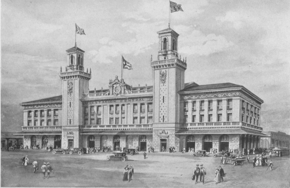
The new electric lines connecting Havana with Guanajay in the west, and Guines towards the southeast, were joined to the United Railways, and a magnificent railway terminal was built on the old Arsenal grounds, acquired from the Government. This is a splendid modern four-story building of brick, stone and steel, with two artistic towers reaching a height of 125 feet, making it one of the most imposing edifices in the City. From this station trains arrive and depart for every part of the Island.
The combined mileage at present operating under the control of the United Railways of Havana is 1,609 kilometers or 963 miles.
From the viewpoint of commercial progress and utility it may be safely stated that Sir William Van Horne, by building the much needed connecting link of railroad between the eastern terminus of the United Railways at Santa Clara and the two terminals of the Cuba Company’s road at Antilla on the north coast, and Santiago de Cuba on the south, conferred on this Island a greater benefit than any other one man in that realm of affairs.
Immediately after the American occupation of the Island, Sir William Van Horne visited Cuba, en route to Demarara, British Guiana, and got only as far as Cienfuegos, Cuba. He later rode over the rich country lying between Santa Clara and the city of Santiago de Cuba, and in his fertile brain was promptly visualized a line of railroad passing through the center of the three eastern and largest provinces of the Island, and terminating on the shore of the two finest bays of Oriente, connecting this by rail with the west portion of Cuba. The Foraker Resolutions prohibited the securing of a franchise for the building of such a railroad, and but little encouragement was given Sir William Van Horne, while a number of obstacles were presented, including difficulties in securing right of way for the proposed railroad, without the right of condemnation. Owners of properties that were practically inaccessible, and whose products could not be exported except at great cost, were seemingly blind to the advantages that would accrue to them from the construction of such a line. This big-brained pioneer, however, who had only recently built the Canadian Pacific across the plains and mountains of the North American Continent, did not hesitate a moment in undertaking and carrying out his project of connecting the capital of Cuba with the rich and undeveloped territory lying to the eastward. Where right of way was not granted willingly he bought the properties outright, and built his railroad practically over his own farms and fields, with but little local assistance and no land grants of any kind.
The Cuba Company’s line, including the branches contributary to it and under its direction, measures 717 miles. The main line begins at Santa Clara and passes through Placetas del Sur, Zaza del Medio, Ciego de Avila, Camaguey, Marti, Victoria de las Tunas, Cacocum, Alto Cedro and San Luis, to Santiago de Cuba, a distance of 573 kilometers. From Alto Cedro a line was built north to Antilla, 50 kilometers distant on Nipe Bay, whence the greater portion of the freight destined for northern markets is shipped directly to New York.
Of the numerous branch lines, beginning in the west, may be mentioned two that leave Placetas del Sur, one extending north to Placetas and through connections to the harbor of Caibarien; the other, built in a southerly direction, to the city of Trinidad on the south coast. From Zaza del Medio, in the Province of Santa Clara, a branch extends almost due south to Sancti Spiritus, and thence, through connections with the Sancti Spiritus Railroad to Zaza on the shore of the Caribbean. At Ciego de Avila, the Cuba Company’s road is crossed by what is known as the Jucaro & Moron Road, built many years ago as a military line through the center of the trocha, or barrier, intended to prevent insurrectionary troops passing from Camaguey into the western part of the Island. This short stretch of railway connects San Fernando on the north coast with Jucaro on the Caribbean.
At Camaguey, the old Camaguey and Nuevitas Road during many years had enjoyed a monopoly in the transportation of products to the coast. The Cuba Company absorbed and incorporated the road, securing thus a valuable adjunct to its system. The Bay of Nuevitas was not of sufficient depth to permit large vessels loading at the old wharves, so the Cuba Company extended the road five kilometers to Punta de Pastelillo, where sugar warehouses and wharves have been built, so that sugar from all the mills of central Camaguey can be delivered aboard ship, doing away with the old system of lightering out to deep water.
From Marti, 60 kilometers east of Camaguey on the main line, a southeastern extension was built across country to the City of Bayamo, in the southwestern center of the Province of Oriente, 127 kilometers distant. Another branch built from Manzanillo on the west coast of Bayamo, 56 kilometers in length, opened up a section of country previously inaccessible. From Bayamo a road parallel to the main line has been built east to San Luis, 98 kilometers, furnishing an exit for one of the richest sections of the Cauto Valley, and also for the rich mineral zones that lie on the southern slope of the Sierra Maestra Mountains. This line from Marti to San Luis passes through one continuous stretch of sugar cane fields, extending as far as the eye can reach, north and south, throughout its entire length.
From Cacocum a short line of 18 kilometers extends north to Holguin. Up to the completion of this connecting link, the city of Holguin, in north central Oriente, had been connected with the outside world only through the medium of a short road terminating at Gibara on the Atlantic coast, where coasting steamers stopped weekly.
A branch from Placetas del Sur to Casilda, 90 kilometers, is in process of construction. Another will connect the city of Camaguey with Santa Cruz del Sur on the Caribbean, 98 kilometers away. At San Luis connection is made with the Guantanamo & Western Railway, where passengers for the United States Naval Station on Guantanamo Bay, and the rich sugar districts lying north and west of the harbor, are transferred.
The Cuba system is equipped with 156 locomotives, 125 passenger coaches, 5013 freight cars, 70 baggage cars and 131 construction cars. In the harbors of Antilla and Nuevitas twelve steamers, tugs and launches are employed in making the various necessary transfers of material from one point to another. On the lines of the Cuba system and its branches are 30 sugar estates and mills, with nine new ones under construction. Daily trains connecting Havana with Santiago de Cuba leave the terminal station at 10.00 P.M., making the trip in about 24 hours.
With the completion of the Cuba Company’s lines, the interior of the Provinces of Oriente, Camaguey and much of Santa Clara were opened up to the commerce of the world for the first time. During the years that have elapsed since its completion, a large amount of valuable hard wood, cedar, mahogany, etc., growing along the line, have been cut and shipped to nearby seaports for export to the United States and other countries. With the building of this line, too, some of the richest lands of Cuba were rendered available for the production of sugar, and today a vast area is under cultivation in cane, and four hundred thousand tons or more of sugar, with the assistance of this road, was delivered each year to the Allies who were fighting in France and Belgium. Thus Sir William Van Home’s foresight enabled the Republic of Cuba to “do its bit” in a very practical way towards the furtherance of the cause of universal democracy.
No account of the Cuba Railroad would, however, be complete which failed to make mention of the part played in its construction and initial organization by Mr. R. G. Ward, of New York City, whose energy and industry, first as manager of construction and later as manager of operation, combined with the character of the men by whom he surrounded himself are generally recognized as having been potent if not dominant factors in determining the rapidity with which the original main line of that railroad, extending from Santa Clara to Santiago, was built, and the promptness and thoroughness with which it was put into operation. The importance of this achievement is emphasized, when it is taken into consideration that the entire line was located and built without the right of eminent domain, which necessitated the acquisition of practically the whole of the right of way through private negotiation. It is stated that the cross-ties and rails were placed by track-laying machines of his devising, which, with crews of less than one hundred men, could, and often did, lay down three miles of full-tied, full-spiked and full-bolted track per day per machine. He also is credited with having inaugurated the policy of employing Cubans or residents of Cuba, whenever it was possible to obtain them to do the work required. Rather than import telegraph operators needed to run the newly constructed railroad, he opened and operated, free of all cost or expense to the students, a School of Telegraphy, under the direction of Horace H. McGinty, through whose administration nearly one hundred operators were qualified for positions in less than six months. Sir William Van Horne, who himself was an expert railroad telegraph operator, regarded this as a “marvelous achievement, creditable alike to Mr. Ward, to Mr. McGinty, and to the character and capacity of the young Cuban students;” many of whom have since held good positions in Cuba, in Mexico and in the Argentine Republic.
The Cuba Central Road of the Province of Santa Clara occupies third place in commercial importance among Cuba’s system of railroads. This Company’s lines were built largely for the benefit of the older sugar estates of Santa Clara, located around Sagua la Grande, Remedios, Caribarien, Cienfuentes, Isabel de las Lajas, etc. The main line of the Cuba Central extends from Isabel de Sagua, a port on the north coast, almost due north to Cruces, a junction on the Cuba Road midway between Santa Clara and Cienfuegos.
Another important division of the line runs from Sagua east to the seaport of Caibarien, passing through Camajuani and Remedios. The Cuba Central lines, while public highways in every sense of the word, may be classed among the roads dedicated largely to the service of the sugar planters of Santa Clara.
Among the independent projected lines of Cuba, the North Shore Road, at present under construction at several different points in the Provinces of Camaguey and Santa Clara, is one of marked importance. This road has its western terminal at Caibarien, on the north shore of Santa Clara, whence it extends eastward, passing through an exceptionally rich valley that furnishes cane to some half-dozen large sugar mills, and continues eastward through Moron, in the Province of Camaguey. It parallels the north coast, extending eastward across the rich grazing lands of the Caunao River, and stretching out further eastward, traverses the virgin forests that lie between the Sierra de Cubitas and the Bays of Guanaja and Guajaba. Leaving the Cubitas slope, it crosses the Maximo and eventually reaches deep water anchorage on the shores of the western extension of Nuevitas Harbor.
This line is at present under construction from Nuevitas westward and from Moron both east and west. In the winter of 1918-19 the line was finished from the deep water terminal on Nuevitas Harbor as far west as the Maximo River. When completed it will pass through one of the richest agricultural and mineral sections of the Island.
From the crossing of the Maximo a branch line is being built around the eastern end of the Sierra de Cubitas in order to tap the rich Cubitas iron mines, whose deposits are waiting only transportation in order to contribute a large share of wealth to the prosperity of the Republic.
A perusal of Cuban history shows that within a few years after the country was settled, questions in regard to the exchange value of its moneys arose, which were not effectually resolved till the lapse of nearly four centuries later, upon the establishment of the Cuban Republic.
As with the other early Spanish colonies of the New World, the circulating medium was at first solely metallic. A credit currency was not suited to a primitive country, whose foreign trade was largely clandestine, open to piracy and other perils, its lawful commerce being limited to the port of Cadiz, Spain, under the monopoly of a board of trade known as the “Contratacion de las Indias,” succeeded in 1740 by the “Real Compania de la Habana,” till the English occupation in 1762.
The position of Cuba on the highroad between Europe and Latin America made its harbors the Mecca of the Spanish fleets of those days. The gold and silver mines of Mexico and South America poured their millions into the Island after the year 1545, when the deposits of San Luis Potosi were opened to the world, the volume of the output being brought to Havana before distribution to Europe and other parts.
Instead of ships making the transatlantic journey alone as at present, large merchant fleets, laden with immense treasure, were convoyed by war vessels at long intervals, as a safeguard against filibusters and buccaneers as well as to preclude possible competition.
In 1550 a monetary crisis occurred in Havana, owing to the failure of the governor, Dr. Gonzalo Perez de Angulo, to enforce the provision of the Spanish law, that the silver Real should be estimated at 34 maravedis, instead of 40 to 44, the commercial rate prevailing at Vera Cruz, Santo Domingo, Cartagena de las Indias and other points near the silver mines. The governor, actuated by private interests, claimed that conditions in Cuba justified the same rate as in these places, and that the legal rate of 34 to 1, if applied, would drain the country of its silver stock.
These views were also expressed by travellers going from Mexico to Spain, who were obliged to make a long stoppage in Havana, where their money was exchanged, insisting that they should receive the larger or commercial rate for their silver as in other places.
Not disposed to change his attitude in the matter, the Spanish King issued a royal circular reasserting the legal rate of 34 to 1 for Cuba, under a penalty of 100,000 maravedis, instead of 10,000 as fixed in his former order, for each violation.
The sovereign mandate was complied with, as peace and policy required, but this demand for a higher valuation of money in Cuba than in the mother country is taken as the origin of the premium afterwards placed on Spanish coin, with which the people of later times are familiar.
When in the year 1779 the Spanish gold onza was coined, its par value was estimated at 16 pesos in Spain. But in Cuba it was shortly afterwards taken to represent 17 pesos, or a premium of about 6%, which it continued to hold until the repatriation of Spanish money a few years ago. This premium was expected to keep gold in the country, at an excess valuation, along with the annual output of $800,000 in silver coming from Mexico, sugar and tobacco being exported from Cuba to North America and Europe as an offset thereto.
LEOPOLDO CANCIO
Born at Sancti Spiritus on May 30. 1851, Leopoldo Cancio y Luna rose to eminence as a jurist, economist and financier; and for many years has filled the chair of Economics and Finance in the University of Havana. As one of the founders of the Autonomist party he became a Deputy in the Spanish Cortes after the Ten Years’ War. Under the Governorship of General Brooke he was Assistant Secretary and under General Leonard Wood he was Secretary of Finance, an office which he now fills in the Cabinet of President Menocal. He was the author of the great monetary reforms of 1914.

When the modern Spanish centen or alfonsino, and the French Louis or 20 franc gold piece, came into vogue, they were also admitted to Cuba at the same ratio as the onza, namely a 6% premium or 17 to 18 approximately, to the detriment of Cuban industry and commerce, throughout the course of the nineteenth century.
In the year 1868 Spain passed from a silver to a double standard, adopting the peseta as the monetary unit, equal in weight and fineness to the French franc and that of other countries of the Latin Union, composed of France, Belgium, Italy, Switzerland and Greece by the monetary conventions of 1865 and 1868. The Isabellan silver escudo, adopted in Spain as the unit by the law of June 24, 1864, was thereby demonetized.
But the Spanish peseta, consisting of gold or silver indifferently, while circulating freely in Cuba along with French gold and American currency in recent times till 1915, did not become the unit of value in the Island. The Spanish gold dollar (peso oro Espanol), an imaginary coin equal to five Spanish gold pesetas (of 24.8903 grains of pure gold each) considered at a premium of 106, weighing 21.13 grains of fine gold (as a result of the 6% premium), and circulating in the form of current Spanish or French gold pieces, was taken as the standard. By reason of such premium these coins were received in the country at $5.30 oro espanol for the centen (25 peseta gold piece) and $4.24 oro espanol for the Louis and doblon (25 franc and 25 peseta gold pieces of equal weight and fineness), which values they held till the last of Spanish money circulation in the Island.
The use of Colonial paper money in Cuba, during the wars with the Spanish government, did not substantially lessen the demand for actual coin, and it was not until after the Spanish-American War of 1898 that new conditions arose which afforded credit and security for the introduction of a composite system of currency.
When the American government was established at Santiago in 1898, one of its first acts was to stabilize the currency of the eastern part of the Island. United States money was forthwith adopted as the lawful medium and Spanish silver was eliminated accordingly. In the provinces of Havana, Pinar del Rio, Matanzas and Santa Clara, Spanish gold and silver continued in use, along with French gold and U. S. currency, at varying market quotations from day to day, until the adoption of a national standard by the Cuban Congress under the law of October 29, 1914, by virtue of which the Cuban gold peso, of weight and fineness similar to the American dollar, was declared the unit, and United States money a legal tender.
Under the authority of the Secretary of Finance, Spanish and other moneys were shipped abroad from Cuba as follows
| Fiscal Year 1914-1915 (ending June 30th): | ||
| United States | $3,032,529.00 | |
| Spain | 1,435,192.00 | |
| Canary Islands | 66,000.00 | $4,533,721.00 |
| Fiscal Year 1915-1916: | ||
| United States | 17,337,734.00 | |
| Spain | 17,411,003.00 | |
| France | 60,000.00 | |
| Canary Islands | 38,300.00 | 34,847,037.00 |
| Fiscal Year 1916-1917: | ||
| United States | 317,253.00 | |
| Spain | 24,332,707.00 | |
| Mexico | 45,000.00 | |
| Canary Islands | 13,240.00 | 24,708,200.00 |
| Total, reduced to U. S. Currency | $64,088,958.00 | |
Of the above shipments, those to the United States were principally for recoinage to Cuban gold of the new issue and were brought back later in national coin. They also include $5,934,810.00 Spanish silver (value in U.S. currency) sent to Spain between August, 1915, and June, 1917. This delicate operation was affected gradually and in such a manner as not to disturb the monetary or exchange values of the country. By June 1, 1916, all conversions of accounts had been practically made to the new system.
As a result of the new monetary law and its regulations, the entire supply of Cuban money was minted at Philadelphia, through the medium of the National Bank of Cuba, the Government Fiscal Agents, in the following quantities:
| Gold Coins: | $20 pieces | $1,135,000 | |
| 10 pieces | 12,635,000 | ||
| 5 pieces | 9,140,000 | ||
| 4 pieces | 540,000 | ||
| 2 pieces | 320,000 | ||
| 1 pieces | 17,250 | $23,787,250 | |
| Silver Coins: | $1 pieces | 2,819,000 | |
| 40¢ pieces | 1,128,000 | ||
| 20¢ pieces | 2,090,000 | ||
| 10¢ pieces | 625,000 | 6,662,000 | |
| Nickel Coins: | 5¢ pieces | 340,450 | |
| 2¢ pieces | 228,210 | ||
| 1¢ pieces | 187,120 | 755,780 | |
| Total Coinage | $31,205,030 | ||
The above national supply of coin, together with perhaps twice the same amount of U. S. currency in general circulation, has been found sufficient for the country’s normal needs, and Cuba thereby automatically becomes, in law and in fact, a part of the American monetary system of the present day.
As the country exports the bulk of its products and imports most articles of consumption and use, including machinery and implements, it follows that Cuba is in normal times one of the highest priced countries of the world, and under conditions due to the European War the cost of living is enormous.
To move the country’s resources annually requires the use of millions of dollars from abroad, which the banks obtain and circulate in legal tender (which means United States money and Cuban coin) according to local demands.
It follows, therefore, that the chief functions of banking in Cuba are Discount, Deposit, Exchange, Collections, Collateral Loans, Foreign Credits and the distribution of money throughout the country.
The principal banks serving the financial needs of Cuba are the following:
The National City Bank of New York. Capital, $25,000,000.
Banco Español de la Isla de Cuba. Capital, $8,000,000.
Banco National de Cuba. Capital, $6,860,455.
Banco Territorial de Cuba. Capital, $5,000,000.
Royal Bank of Canada. Capital and surplus, $25,000,000.
The Trust Company of Cuba. Capital, $500,000.
Banco Mercantile Americano de Cuba. Capital, $2,000,000; surplus, $500,000.
Banco Prestatario de Cuba. Capital, $500,000. (Makes loans on personal property, approved notes, mortgages, etc.)
THINKING men and women, the world over, realize that the hope, security and well being of the future lies in properly educating the children of the present. From an educated community we have nothing to fear. Mistakes in government policies may occur, but where intelligence dwells, right and justice will soon prevail over wrong. Education to-day is universally recognized as the most efficient and potent safeguard against crime and lawlessness of all kind, and in no section of the world is the need of general education more gravely manifest than in the Latin-American Republics of the Western Hemisphere.
Education in all of these countries, from the beginning of their existence as colonies of Spain, has been, unfortunately under the control of the Church, and with the exception of Cuba, largely so remains to-day. Even in this progressive little Republic, the clerical influence on tuition, from the kindergarten to the university, is more or less prevalent. The influence of the priest and the prelate, exerted in the home, usually through the mother, still casts its shadow over true educational progress, especially among those of the gentler sex. There are, of course, many well educated women in Cuba, but they are women whose intellectual longings and aspirations could not be held in check.
True, some of the most brilliant men in Cuba have been pupils of church institutions, but men of this stamp and minds of this calibre held from birth all the promise and potency of greatness. Their intellectual lights could not be hidden under the proverbial bushel.
In 1896 the population of the Island was 1,572,791, of whom 1,400,884 were unable to read, 33,003 knew how to read but not to write, while 19,158 had received the advantages of what was termed higher education. Even this paucity of true knowledge was frequently superficial and sadly warped by obsolete tradition.
When, at the beginning of American intervention, that generous and able group of American officers under General Wood took charge of affairs in Cuba, the need of even a rudimentary education among the untutored masses was painfully apparent. A report of conditions prevailing was forwarded to Washington. Secretary Root referred the matter to President Eliot of Harvard, and as a result Mr. Alexis E. Frye was sent to Havana to establish in Cuba the American school system, or one as nearly like that in vogue in the United States as conditions would permit.
The selection of Mr. Frye was a wise one, and the people have never ceased to be grateful for the admirable and unselfish efforts of that remarkably clever teacher to place public instruction on a firm foundation in Cuba. After going carefully over the ground and studying the situation thoroughly Mr. Frye, working by candle light in a backroom of the Hotel Pasaje, drafted the school law and wrote the rules and regulations that today form the base of public instruction in the island. Soon after, Mr. Frye was appointed Superintendent of Schools. His salary was $400 a month, but every month’s pay check was divided into eight parts and distributed among those schools where it would do the most good. He would accept no recompense whatever for himself.
In the work of establishing a modern system of education in Cuba Mr. Frye received valuable aid from a remarkably gifted and brilliant young Cuban named Lincoln de Zayas. Dr. de Zayas was a descendant of one of the most prominent families in Havana. He had been educated in the United States, was graduated from the school of medicine of Columbia University in New York, was a master of some five or six languages, and knew the character of his own people. He assisted Mr. Frye in solving many delicate problems and in overcoming troublesome obstacles, many of which resulted from the former ecclesiastical control of everything pertaining to education. Dr. Francisco Barrero, a writer, student and poet, was made assistant director of education.
During the second year of American intervention, Mr. Frye interested Harvard University in the subject of Cuban education. This finally resulted in an invitation from that institution to a large body of potential Cuban teachers to come to Boston and enjoy during the summer months special instruction provided for them by the president and faculty of the University. Through Mr. Frye’s efforts and those of General Wood, then Military Governor of the Island, the Washington government became interested in the school problem in Cuba, and through the War Department furnished passage in one of the large American transports for all teachers who cared to visit the United States in the interest of Cuban education. Some 1600 teachers, mostly young ladies, were selected from applicants in various parts of the Island, and conveyed on the U.S. transport General McClellan to the city of Boston, where they were comfortably lodged and cared for during a period of three months as guests of Harvard University.
The direct educational benefit derived by these young Cuban teachers was almost incalculable. A great majority of them had no knowledge whatever of the English language, and knew but little of the outside world. The press of Cuba in those days was limited in its fund of general information or other matter that might be of educational value to the reading public. Nor had education, especially among women, been encouraged during the days of Spain’s control over the island.
The summer work at Harvard was a revelation. The educational seed fell upon receptive soil, and the young teachers who were fortunate enough to be selected as guests of that institution gave an excellent account of themselves in work that followed during the early days of the Republic. Incidentally Mr. Frye chose one of these young teachers as his companion through life. After Mr. Frye’s departure, Lieut. Hanna, at the suggestion of General Wood, made some changes and additions to the public school system of Cuba, conforming it somewhat to the methods then in vogue in the State of Ohio.
With the installation of the Cuban Republic in 1902 public instruction came directly under the supervision of the Central or Federal Government, and the Secretary of Public Instruction was made a member of the President’s Cabinet, adding thus dignity and importance to that branch of work on which the character of succeeding generations depended. Unfortunately for the cause of education it has been found rather difficult to separate the Department of Public Instruction from a certain amount of political interference, which has tended to mar its efficiency and retard progress.
With the beginning of the second Government of Intervention in 1906, Dr. Lincoln de Zayas was made Secretary of Public Instruction under Governor Magoon, and with his untiring devotion to the cause of true knowledge, as well as his keen insight into the modern or more improved methods of teaching, interest in public instruction in Cuba was greatly revived, and English began to assume a far more important role in the primary and grammar schools than in former days.
The services of an excellent teacher, Miss Abbie Phillips, of California, was secured as General Superintendent of English throughout the Republic, and under her direction was formed a corps of remarkably competent Cuban women, who accomplished much in a short time towards making the study of English in the public schools more popular than it had been. With the death of Dr. de Zayas the cause of public instruction seemed again partially to relapse into its former desuetude. Yet in spite of the misfortune that thus befell it, the work has proceeded more satisfactorily than might have been expected, owing to the strong desire on the part of the youth of the Republic to learn, and to shake off the fetters that had previously kept them in a kind of a respectable ignorance.
During President Menocal’s administration the resignation of the Secretary of Public Instruction gave opportunity for the selection and appointment to that office of Dr. Dominguez Roldan, who has endeavored to inject new life into the cause and to place this important branch of the Government once more in a position that will command the respect, not only of the people of Cuba, but also of the outside world. New school houses, designed expressly for the purpose, are replacing the old and inadequate buildings that were formerly rented. The study of English, that had been discouraged by his predecessor, is being again revived, and many steps in the cause of learning are being taken whose wisdom will become evident in the near future.
In 1913, when Mario G. Menocal assumed the direction of the Government of Cuba, there were but 262 schools in the island, while to-day there are 1136, showing an increase of 1074; with 335,291 pupils attending. No fewer than 1746 teachers have been appointed and added to the Department of Public Instruction in Cuba. In addition to this two night schools have recently been established, one in Santiago de Cuba and one in Bayamo. Four kindergartens, or “School Gardens,” as they are now termed, have recently been established in the Province of Santa Clara.
At the present time, throughout the Republic of Cuba, there is a total of 5,685 teachers in the primary schools. Among these are included 116 teachers who render special service throughout the different sections of the country, 19 teachers of night schools, 118 teachers devoted to school gardens, 40 teachers of cutting and sewing, 26 teachers of English, 21 of Sloyd, and 4 teachers devoted to instruction in jails. In 1915 a normal school, co-educational, was established in each of five of the Provinces. Havana has two normal schools, one for boys and the other for girls.
During the year 1918 a school of Domestic Economy, Arts and Sciences, known as the “School of the Home,” was established. The object of this school, as that of similar institutions, is to prepare the future wife and mother so that she may be able to undertake in an intelligent manner the direction of the home. Among the subjects taught are accounting, domestic economy, moral and civic obligations, hygiene, the care of infants and of the sick, cutting, sewing, dressmaking, basket-making, and elementary physics and chemistry, which form the base of scientific cooking. In addition to these, gardening, the care of animals, ordinary and higher cooking are taught; also washing and ironing, dyeing, the removing of stains, and the proper method of cleaning and taking care of shoes. In order to make the school popular and to insure its success, a society of patriotic and intelligent women has been formed, from which much practical benefit is expected in the future.
In order to provide for and to permit the scientific development both physical and mental of the Cuban youth, the Department of Public Instruction has established a separate institution, with an experimental annex, for the purpose of studying the eccentricities and aptitudes of Cuban children.
The order of sequence of public instruction in Cuba, as previously stated, has followed very largely that of the United States. The school gardens are followed by primary and grammar schools, all suitably graded, and the course of studies is more or less similar to that of the United States.
The Institute of Havana, located for many years in the old convent building just back of the Governor General’s Palace, occupies a place between the grammar school and the University. The course of studies and scope of this institution is similar to the average high school of America. New buildings are being erected for the accommodation of the several thousand boys and girls who attend the institute, and with its removal to more commodious and congenial quarters, this important seat of learning will be reorganized with greatly increased efficiency.
The National University of Havana was founded under the direction of monks of the Dominican Order on January 5, 1728, and until the installation of the Republic occupied the old convent that afterwards served as the Institute. To-day the University of Havana can boast of one of the most picturesque and delightful locations occupied by any seat of learning in the world. It crowns the northeast corner of the high plateau, overlooking the capital of the Republic from the west. Its altitude is several hundred feet above the plain below, with the Gulf of Mexico close by on the north and old Morro Castle standing at the entrance of a beautiful harbor, that stretches out along the far eastern horizon, sweeping afterwards toward the south. The city of Havana fills the center of the picture, while in the immediate foreground nestle the forests of the Botanical Gardens and the Quinto de los Molinos, or summer residence of the former Spanish Governor Generals, with their beautiful drives sweeping along the front and up to the crest of the plateau.
The broad stone staircase at the entrance to the grounds is quite in keeping with the dignity of the place and the numerous buildings devoted to various departments of learning are harmonious in design and commodious in appointment. A giant laurel, with an expanse of shade that would protect a small army of men, occupied the center of an old courtyard that once belonged to the fortifications commanding the Principe Heights.
To these buildings will soon be added another to be known as the National School of Languages, at a cost of $150,000. This edifice, sumptuous in its appointments, will be dedicated largely to the reciprocal study of Spanish and English. American students who wish to perfect their knowledge of Spanish will be invited from the various universities of the United States to visit Cuba, at stated periods of the year, for the purpose of studying and improving their acquaintance with this language through direct contact with the students and professors of the University. The latter, on the other hand, will be afforded an excellent opportunity to perfect their knowledge of English by mingling with visiting students from the United States, and it is believed that the result of acquaintances and friendships, formed in this way, many of which will be sustained through life, will add greatly to those bonds of friendship and mutual understanding that resulted from America’s assistance to Cuba in her War for Independence, and that for a thousand reasons should never be permitted to relapse or sink into indifference.
The national or public library of Cuba, located in the Maestranza, one of the most substantial of those old buildings that have come down from the days of Spanish dominion, was founded during the first American intervention by General Leonard Wood, on October 18, 1901. It is open to the public every day of the week except Sunday, from 8 to 11 in the morning and from 1 to 5 in the afternoon, except Saturday, when access may be secured at any time between 8 and 12 in the morning.
The library contains at the present time about twenty thousand volumes. This does not however include a great mass of pamphlets and unbound manuscripts, documents, papers, etc., which form a valuable part of the collection. These volumes are largely in Spanish, French and English, and include all of the more important branches of human knowledge. Among them may be found an excellent collection of the best encyclopedias and dictionaries of those languages.
Its collection of American History is extensive; in addition to which may be mentioned a valuable collection of works on international law, given by the eminent jurist Dr. Antonio S. de Bustamante, who represented the Republic of Cuba at the Peace Conference in Paris at the conclusion of the Great War.
Among other gifts to the public library may be mentioned a series of large, beautiful, artistic drawings in colors, that represent all that is known of the Aztec and Toltec life existing in the Republic of Mexico at the time of the Spanish Conquest in the early part of the 16th century. These engravings have been drawn and colored with marvelous care. They are assembled in the form of an atlas which permits close study and makes one of the most interesting and valuable contributions of this kind to be found in any part of the world. They were presented to Cuba by General Porfirio Diaz, President of the Republic of Mexico.
Arrangements have been made to catalogue the volumes of the library. For this purpose experts have been secured and the space amplified, and when this work is completed, while the library will not offer the luxurious quarters of institutions of its kind in other countries, it will be useful and accessible to those who wish to avail themselves of its services.
TRANSPORTATION is the handmaid of production. Where transportation facilities are faulty, exchange of commodities is necessarily restricted to local demands, and commerce with the outside world is practically impossible. Good harbors are among the first essentials to foreign trade, and with deep, well protected bays, Cuba has been bountifully supplied. Every sheltered indentation of her two thousand miles of coast line, from the days of Colon, has been an invitation for passing ships to enter. The wealth of the island in agriculture and mineral and forest products, has made the visits of these ocean carriers profitable; hence the phenomenal growth of Cuba’s foreign commerce.
In spite of the stupid restriction of trade enforced by Spain in the early colonial days, contraband commerce assumed large proportions during the 17th century, and when England’s fleet captured Havana in 1763, the capital of Cuba enjoyed a freedom of foreign exchange never before known. Quantities of sugar, coffee, hides and hardwoods, large for those times, demanded transportation during the second quarter of the 19th century. Foreign trade, too, was greatly stimulated in Cuba by conditions resulting from the Civil War in the United States. The rapid development of the sugar industry following this war soon called for more permanent lines of ocean transportation.
THE CHAMBER OF COMMERCE, HAVANA
The Chamber of Commerce is one of the oldest civic organizations in Cuba, which even under the repressive and discouraging rule of Spanish Governors did much for the material progress of the Island. Under the Republic its activities and achievements have of course been immensely increased, and it is now appropriately housed in one of the finest public buildings of the capital. A certain resemblance to the famous Cooper Union building in New York has often been remarked, though the Havana edifice is the more ornate and attractive of the two.

The interdependence of produce and transportation is well illustrated in the early history of what is now known as the United Fruit Company. In 1870, Captain Lorenzo D. Baker was in command of a small, swift coasting schooner en route from Jamaica to Boston. On the wharf at Kingston lay some 40 bunches of bananas, a few of which were ripe, others lacking 10 days or more in which to change their dull green coats into the soft creamy yellow of the matured fruit. Captain Baker was fond of bananas, and ordered that the lot be placed on board his schooner, just before sailing. Fortune favored him and strong easterly beam winds brought him into the harbor of Boston in 10 days, with all of the bunches not consumed en route in practically perfect condition. Many friends of Capt. Baker, to whom this delicious fruit was practically unknown, got a taste of the banana for the first time. Among these was Andrew W. Preston, a local fruit dealer in Boston, who was greatly impressed with the appearance of the fruit, and the success which had attended Captain Baker’s effort to get the bananas into the market without injury.
Mr. Preston reckoned that if a schooner with a fair wind could land such delicious fruit in Boston in ten days, steamers could do the same work with absolute certainty in less time. This far sighted pioneer and promoter of trade realized that three factors were essential to building up an industry of this kind. First, there must be a market for the product, and he was confident that the people of Boston and the vicinity could soon be educated to like the banana and to purchase it if offered at a fair price. Next, a sufficient and steady supply must be provided. Third, reliable transportation in the form of steamers of convenient size and suitable equipment must be secured, in order to convey the fruit with economy and regularity to the waiting market or point of consumption. True, he at first failed to interest other fruit dealers in the project. “It had never been done and consequently was a dangerous innovation that would probably prove unprofitable.” But Mr. Preston had visualized a new industry on a large scale, and with the faith of the industrial pioneer he finally succeeded in persuading nine of his friends to put up with him each $2,000, and to form a company for the purpose of growing bananas in the West Indies, of chartering a steamer suitable for the transportation, and finding a market for the produce in Boston.
The details were worked out carefully and the first cargo purchased in Jamaica and landed in New England proved a decided success. During the first two or three years the accruing dividends were invested in fruit lands in Jamaica and everything went well. Not long after, however, it was found that a West Indian cyclone could destroy a banana field and put it out of business in a very few hours. More than one field or locality in which to grow bananas on a large scale was necessary to provide against the possible failure of the crop at some other point.
In the meantime another broad minded and determined pioneer in the world of progress, Minor C. Keith, a youth of 23, was trying to build a railroad some 90 miles in length from Puerto Limon to the capital, San Jose, in the highlands of Costa Rica. The greater part of this road was through dense jungle and forest almost impenetrable, with nothing in the shape of freight or passengers from which revenues could be derived until the road was completed to the capital. Mr. Keith had a concession from the Costa Rican Government, but the Government had no funds with which to aid the builder in his enterprise, and this young engineer, through force of character and moral suasion, kept his two thousand workmen in line without one dollar of money for over 18 months. Food he managed to scrape up from various sources, but the payday was practically forgotten. In the meantime, some banana plants were secured from a plantation in Colombia, and set out on the virgin soils along the roadway through which Mr. Keith was laying his rails. These grew marvellously, and not only supplied fruit for the Jamaica negroes engaged in the work, but soon furnished bananas for export to New Orleans, and thus was started a rival industry to that of Mr. Preston, on the shores of the Western Caribbean.
It was not long before Mr. Keith, who struggled for 20 years to complete his line from the coast to the capital of Costa Rica, came into contact with Mr. Preston. These captains of industry realized the advantages of co-operation, and in a very short time organized the United Fruit Company, which is probably the greatest agricultural transportation company in the world to-day. Its various plantations include lands in Colombia, Panama, Costa Rica, Honduras, Guatemala and Jamaica. Large plantations of bananas belonging to the company were until recently on the harbors of Banes and Nipe, on the north coast of Oriente, in the Island of Cuba, but these were subjected to strong breezes from the northeast that whipped the leaves and hindered their growth. Then too, it was soon discovered that these lands were better adapted to the cultivation of sugar cane, hence bananas of the United Fruit Company disappeared from the Nipe Bay district, to be replaced by sugar plantations that to-day cover approximately 37,000 acres and in 1920 will reach 50,000 acres. Over 200,000 acres on the coast of the Caribbean are devoted to the cultivation of bananas. About 30,000 head of cattle are maintained as a source of food for the thousands of laborers, mostly Jamaicans, who are employed in the fields of the United Fruit Company, which comprise an aggregate of 1,980,000 acres; while 743 miles of standard gauge railway, together with 532 miles of narrow gauge roads, are owned and operated throughout the various plantations.
In the year 1915, 46,000,000 bunches of bananas were shipped by the United Fruit Company from the shores of the Caribbean to the United States, while the sugar plantations owned by the Company on the north coast of Oriente Province, in Cuba, produced sugar in 1918 that yielded a net return of $5,000,000.
In order to provide transportation for this enormous agricultural output this company to-day owns and operates one of the biggest fleets of steamships in the world. Forty-five of these ships, with tonnages varying from 3,000 to 8,000, especially equipped for the banana trade, and with the best of accommodations for passengers, have an aggregate tonnage of 250,000; while 49 other steamers were chartered by the company before the war, making the total tonnage employed in the carrying trade approximately half a million.
Nearly all these steamers, which connect the coast of the Caribbean with New York, Boston and New Orleans, touch, both coming and going, at the City of Havana, thus giving that port the advantage of unexcelled transportation facilities, and connecting Cuba not only with the more important cities of the Gulf of Mexico, New York and New England, but also with Jamaica, Caribbean ports, and the South American Republics lying beyond the Isthmus of Panama, along the western shores of that continent.
No steamship line perhaps has been more closely related to the commercial development of Cuba than has the New York & Cuba Mail Steamship Company. This line had its origin in a carrying trade between Cuba and the United States started by the firm of James E. Ward & Co. The members of the firm were Mr. James E. Ward, Mr. Henry B. Booth and Mr. Wm. T. Hughes. The Company was incorporated under the laws of the State of New York and formally organized in July, 1881, with Mr. Ward as President, Mr. Booth as Vice President and Mr. Hughes as Secretary and Treasurer. When first organized the Company had only four ships, the Newport, Saratoga, Niagara and Santiago, with a gross tonnage of 10,179. Between the date of its organization and its transfer to the Maine Corporation, or during a period of 26 years, the company acquired 19 vessels, with a total gross tonnage of 84,411. In addition to the above the company has operated under foreign flags eight other ships aggregating a tonnage of 26,624.
The four original steamers mentioned above were owned in part by the builders, Messrs. John Roach & Son, and a few other individuals. The original firm however sold its ships to the Company at the time of its reorganization. Of the vessels acquired by the company, the majority were built under contract by Messrs. Roach & Son, and Wm. Cramp & Sons’ Ship and Engine Building Company. Among the ships that were purchased and not built especially for this company, were the two sister ships Seguranca and Vigilancia, built in 1890 for the Brazil Line. The steamships City of Washington and City of Alexandria were originally owned by the Alexandria Line, and passed into the hands of the Ward Line after its organization. The Matanzas, formerly the Spanish steamer Guido, that had left London with a valuable cargo of food, munitions and money with which to pay off Spanish troops in Cuba, was captured by the American forces during the early part of the war with Spain, in an attempt to run the blockade that had been established, and was afterwards sold by the American Government to the Ward Line.
The business of this company, after its organization, began with a passenger and freight service connecting the cities of Havana, Santiago and Cienfuegos with New York. With the acquisition of the Alexandria Line, the service of the company was extended to Mexico, and a number of ports have been added to its itinerary both in Cuba and in Mexico. The line to-day maintains a service on each of the following routes: New York to Havana and return; New York to Havana, Progreso, Yucatan, and Vera Cruz, returning via Progreso and Havana to New York; New York to Tampico, Mexico, calling occasionally on return voyages at other ports when cargoes are offered; New York to Guantanamo, Santiago, Manzanillo and Cienfuegos, returning according to the demands of shipping interests; New York to Nassau, in the Bahamas, Havana, and return. The sailings average about five a week and schedules are prepared from time to time to meet the requirements of trade. Passengers on this line are carried in three distinct classes, first cabin, intermediate, and steerage, the vessels being constructed with reference to suitable accommodations for the various classes.
The principal railway and other connections are as follows: At New York in general with all railroads terminating at that port, as well as all foreign and domestic water lines that move traffic via that port; at Havana with the United Railways of Havana and the Cuba Railroad; at Tampico with the Mexican Central Railway for interior points in Mexico; at Progreso with the United Railways of Yucatan for Merida, Campeche and other interior points; at Vera Cruz with the National Railways of Mexico and the Interoceanic Railroad for interior points of Mexico, as well as with the Vera Cruz and Pacific Railroad for interior points of Mexico and the Pacific Coast; at Puerto Mexico with the Tehuantepec National Railway, for points on the Isthmus of Tehuantepec and on the Pacific Coast. Connection is also made at Vera Cruz with the Compañia Mexicana de Navegacion for traffic to Tuxpam, Coatzacoalcos, Tlacotalpam and Frontera, ports on the Gulf of Mexico. At Santiago connection is made with the Cuba Eastern Railway and Cuba Railroad for points throughout the interior of Cuba; at Guantanamo with the Cuba Eastern Railway and at Cienfuegos with the Cuban Central Railroad.
The company has contracts with the United States Government for the transportation of mails between New York and Havana, and between New York, Havana and Mexico. It also has a contract with the Bahamas Government for the transportation of mails.
The following is a list of the vessels owned or operated by the company.
| Steamers: | |
| Havana | Matanzas |
| Saratoga | Antilla |
| Mexico | Camaguey |
| Morro Castle | Santiago |
| Esperanza | Bayamo |
| Monterey | Manzanillo |
| Segurancia | Yumuri |
| Vigilancia | Guantanamo |
| Seneca | |
| Tugs and Steam Lighters: | |
| Colonia | Auxiliar |
| Nautilus | Comport |
| Neptuno | Edwin Brandon |
| Hercules |
The total gross tonnage of the steamers and tugs above mentioned is 84,000 tons.
One of the oldest and most important lines in the carrying trade of the Caribbean is known as the Munson Steamship Line, and was founded in 1872 by Walter D. Munson. The trade began with sailing vessels but the increase in traffic was so great that these were soon replaced with steamers. The steamships in the service of the Munson Line to-day number 140, with an average tonnage of 2,500 tons each, dead weight.
These vessels sail from nearly every port in Cuba, connecting the Island with nearly all of the Atlantic and Gulf Coast ports of the United States. The passenger steamers of the Munson Line ply between New York, Nuevitas and Nipe Bay of the Province of Oriente. The passenger steamers, although not touching at Havana, are equipped for the accommodation of passengers that leave from the ports of the eastern provinces of the Island.
During the late European War twelve of the Munson steamships were placed in the service of the United States and three under the British flag.
The Peninsular and Occidental Steamship Company operates a daily passenger, mail and freight service between Havana and Key West, Florida. Since 1912 this company has maintained practically a daily service between the two ports and maintains also a bi-weekly service between Havana and Port Tampa, Florida. Owing to the frequency of the sailings, the P. & O. SS. Co. is considered the official mail route between the United States and Cuba.
The company operates also the Florida East Coast Car-Ferry freight service between Havana and Key West. This service was made possible by the extension of the Florida East Coast Railroad from the southern points of the peninsula out over the long line of keys that terminates in the Island of Key West.
The erection of this viaduct, built at an enormous expense, of stone and concrete, was the realization of Henry W. Flagler’s dream of modern transportation facilities between the United States and Cuba. The car ferry service was inaugurated in January, 1915. At the present time two of these great car ferryboats, with a capacity of 28 standard freight cars each, make a round trip every twenty-four hours between the two ports. These two vessels transport approximately 1,150 cars in and out of Cuba every month, carrying over 35,000 tons each way in that length of time.
Since the inauguration of the service more business has been offered than can be handled during certain months of the year, and it has been found necessary to refuse large quantities of cargo destined for the Republic of Cuba. The advantage of this service to the Cuban fruit and vegetable growers has been very great, since they are enabled to load in the Cuban fields freight cars belonging to almost every line in the United States, so that this produce may be shipped direct, without breaking bulk, to any market in the United States.
In the year 1870 the Pinillos Izquierdo Line of steamers was established between Spain and the Island of Cuba. The home office of this line is in Cadiz, Spain. Their vessels are engaged in freight and passenger service touching at the following points in the Peninsula: Barcelona, Palma de Majorca, Valencia, Alicante, Malaga, Cadiz, Vigo, Gijon and Santander.
En route the Canary Island and Porto Rico are also visited while the terminal points on this side of the Atlantic are New Orleans, Galveston, Havana and Santiago de Cuba. All of their steamers carry mail. Their fleet consists of nine steamers with a combined tonnage of 78,000 tons as follows:
| Infanta Isabel | 16,500 tons | 2000 passengers |
| Cadiz | 10,500 tons | 1500 passengers |
| Barcelona | 10,500 tons | 1500 passengers |
| Valbanera | 10,500 tons | 1500 passengers |
| Catalina | 8,000 tons | 1000 passengers |
| Martin Sáena | 5,500 tons | 800 passengers |
| Balmes | 6,500 tons | 800 passengers |
| Conde Wifredo | 5,500 tons | 800 passengers |
| Miguel M. Pinillos | 4,500 tons | 500 passengers |
| 78,000 tons |
The Southern Pacific, originally known as the Morgan line, established a transportation service between Gulf ports and the Island of Cuba many years ago, beginning with two side-wheel walking-beam steamboats of about 800 tons dead weight. They were heavy consumers of coal and had a speed of from 9½ to 11 knots. A few years later the steamers Hutchinson and Arkansas, both side wheelers, were added to the fleet. Still later the single propeller steamers Excelsior and Chalmette, of about 2,400 tons each, were placed in the service of the Southern Pacific Line. These combined freight and passenger boats were well built and seaworthy fourteen knot steamers, of an equipment considered modern at that time. The Louisiana entered the service in 1900, but owing to an error in loading freight, it turned turtle at the docks in New Orleans and became a total loss. The Excelsior and Chalmette are still maintaining an efficient weekly service between New Orleans and Havana.
The Compagnie General Transatlantique, generally known as the French Line, connecting western France, Northern Spain and the Canary Islands, with Cuba, Porto Rico, Vera Cruz, Mexico, and the city of New Orleans, was established in 1860.
St. Nazaire on the Bay of Biscay in France is the headquarters of this line. Their steamers touch at Santander and Coruña on the north coast of Spain; at the Canary Islands, Porto Rico, Martinique, Santiago de Cuba, Havana, Vera Cruz, and New Orleans. Their fleet consists of 13 ships with a combined tonnage of 153,500 tons.
The steamship Lafayette, of 15,000 tons, is equipped for the accommodation of 1,620 passengers. The Espana, of 15,000 tons, carries 1,500 passengers; the Flanders, of 12,000 tons, carries 1,250 passengers; the Venizia, of 12,000 tons, carries 700 passengers; the Navarre, of 10,000 tons, carries 1,000 passengers; the Venezuela, of 7,000 tons, carries 500 passengers.
The Caroline, the Mississippi and the Georgie are each steamers of 13,000 tons. The Honduras is a 12,000 ton ship; the Hudson 11,000 tons; the Californie 10,500 tons, and the Virginie 10,000 tons. The seven last mentioned vessels carry cargo only.
During August, 1919, the 7,000 ton steamer Panama Canal arrived in Cuba from Japan, inaugurating a new steamship line between Japan and the United States, touching at Cuban ports. The line is known as the Osaka Shosen Kaisha, of Osaka, Japan. The fleet consists of 186 steamers plying between Japan and different parts of the world. The headquarters for this company has been established at Chicago, Illinois, owing to connections that have been made with the Chicago, Milwaukee and St. Paul Railroad.
Steamers eastward bound from Japan will bring rice and general cargo, most of which will be consigned to the Island of Cuba, owing to the heavy consumption of that article of food in that Republic. New Orleans will be the terminus in the United States of the line. On the initial trip of the Panama Canal 50,000 sacks of rice grown in Japan were consigned to Cuban merchants in Santiago de Cuba and Cienfuegos. The return cargoes will be composed largely of cotton, taken aboard at New Orleans, and with sugar and tobacco shipped from Cuba to the Orient. This line has begun with one sailing each way per month, all steamers touching at Havana for freight and passengers.
The Customs regulations of Cuba require five sets of invoices for Havana and four for all other points; which must be written in ink, in either English or Spanish. If they are typewritten the original imprint must be included, but the others may be carbon copies. Invoices must give the names of shippers and consignees, and of vessels; marks and numbers, description of merchandise, gross and net weights by metric system, price, value, and statement of expenses incurred. If there are no expenses, that fact must be stated. Prices must be detailed, on each article, and not in bulk. Descriptions of merchandise must be detailed, telling the materials of each article and of all its parts. Descriptions of fabrics must tell the nature of the fibre, character of weave, dye, number of threads in six square millimeters, length and width of piece, weight, price, and value. All measurements must be in metric units.
At the foot of each sheet of the invoice must be a signed declaration, in Spanish, telling whether the articles are or are not products of the soil or industry of the United States. If the manufacturer or shipper is not a resident of the place where the consulate is situated, he must appoint in writing a local agent to present the invoice and the agent must write and sign a declaration concerning his appointment. Stated forms are prescribed and are furnished by consuls for manufacturers, producers, owners, sellers and shippers.
Freight charges to the shipping port, custom house and statistical fees, stamps, wharfage and incidental expenses must be included in the dutiable value of goods, and must be stated separately; but insurance and consular fees must not be included.
Each invoice must cover a single, distinct shipment, by one vessel to one consignee. Separate consignments must not be included in one invoice. Invoices under $5, covering products of the soil or industry of the United States must be certified in order to enjoy the provisions of the reciprocity treaty between the two countries. Invoices and declarations must be written on only one side of the paper, and no erasures, corrections, alterations or additions must be made, unless stated in a signed declaration.
Domestic and foreign merchandise from the United States must be separately invoiced. Invoices are not required on shipments of foreign goods of less value than $5.
Fabrics of mixed fibres must be so stated, with a statement of the proportion of the principal material, upon which the duty is to be computed. Cotton goods pay duty according to threads, and silk and wool ad valorem. Samples of cotton goods are taken at the custom house, and should be provided for that purpose to avoid mutilation of the piece. Duties on ready made clothing are based on the chief outside fabric. A surtax of 100% is placed on ready-made cotton clothing, and a surtax of 30% on colored threads.
Two copies of each set of bills of lading must be given, but on merchandise of less than $5 value need not be certified.
Invoices covering shipments of automobile vehicles must state maker, name of car, style of car, year of make, maker’s number on motor, number of cylinders, horse power, and passenger capacity.
If after an invoice has been certified it or any part of it is delayed in shipment, the steamship company must mark on the bill of lading opposite the delayed goods “Short Shipped,” but the invoice need not be recertified. The consignee should, however, be informed.
The list of articles admitted into Cuba free of duty comprises samples of fabrics, felt, and wall paper, of a prescribed size, samples of lace and trimmings, and samples of hosiery, provided that they are rendered unfit for any other purpose than that of samples; trained animals, animals, portable theatres, and other articles for public entertainment, not to remain in Cuba longer than three months; receptacles in which fruits or liquids were exported from Cuba and which are being returned empty; furniture, clothing and other personal property of immigrants, or of travellers, showing evidence of having already been used; agricultural implements not including machinery; and pictures, posters, catalogues, calendars, etc., not for sale but for free distribution for advertising purposes.
The importation into Cuba is forbidden or restricted of foreign coins of anything but gold, save those of the United States; gunpowder, dynamite and other explosives, save by special permit of the Interior Department; and silencers for firearms. Arms of more than .32 caliber, .44 caliber revolvers, and automatic pistols require special permit.
Consular fees for certification are: On shipments worth less than $5, nothing; from $5 upward and less than $50, fifty cents; from $50 upward and less than $200, $2; over $200, $2 plus ten cents for each $100 or fraction thereof. Extra copies of invoices, 50 cents each. Invoice blanks, ten cents a set. Certifying bills of lading, $1.
Cuban consulates are situated in the United States and its possessions as follows: Atlanta, Ga.; Baltimore, Md.; Boston, Mass.; Brunswick, Ga.; Chattanooga, Tenn.; Chicago, Ill.; Cincinnati, Ohio.; Detroit, Mich.; Fernandina, Fla.; Galveston, Tex.; Gulfport, Miss.; Jacksonville, Fla.; Kansas City, Mo.; Key West, Fla.; Los Angeles, Cal.; Louisville, Ky.; Mobile, Ala.; New Orleans, La.; New York; Newport News, Va.; Norfolk, Va.; Pascagoula, Miss.; Pensacola, Fla.; Philadelphia, Penn.; San Francisco, Cal.; Savannah, Ga.; St. Louis, Mo.; Tampa, Fla.; Washington, D. C.; and Aguadilla, Arecibo, Mayagues, Ponce, and San Juan, Porto Rico.
AMERICAN soldiers returning to the United States at the conclusion of her little war with Spain, in the summer of 1898, brought wonderful stories of Cuba, with glowing accounts of her climate, her rainfall, her rich soil and natural advantages. Schemes for the colonization of the Island were immediately formed and some of them put into effect during the early days of the Government of Intervention.
Unfortunately, most of these enterprises originated with speculators, and so-called land-sharks, who sought only to secure large tracts of territory, at the smallest possible cost, and with the assistance of attractive literature place them on the market in the United States, at prices which would enable them, even when sold on the installment plan to make a thousand percent or more profit on the capital invested.
This method of settling up the country would not have been so objectionable had the promoters of the schemes taken the pains to locate their colonies in those sections of the Island where transportation facilities, if not immediately available, could at least be reasonably sure in the near future.
Up to the present, a logical, common sense plan in the colonization in this Island has in no instance been carried out. On the contrary, every American colony that has yet been established in Cuba, and her adjacent Islands, has been located with disregard to the first essentials of success. These hapless experiments have met with a fate that was inevitable and in most instances can be described with one word “Failure.”
The first American Colony in Cuba was started on Broadway, New York City, by a land speculator, who, through correspondence, learned of a large property that could be had in Cuba with a small cash payment, at what seemed to be a ridiculously low price; in other words at about 80 cents an acre. An option was secured on several thousand acres, the larger part of which, perhaps, was available for general agricultural purposes. But the location with reference to transportation facilities was one of the most unfortunate that could have been selected. This colony was called La Gloria, and while La Gloria has not been a failure, nothing in the world has saved it but the pluck, and persistent and intelligent effort of a courageous and most commendable community of Americans.
Some 800 of these, not knowing where they were going, other than that it was somewhere in Cuba, were dumped by a chartered steamer in the harbor of Nuevitas, 40 miles from their destination. This they afterwards reached with the aid of light draft schooners, or shallow, flat-bottom boats, pushed through a muddy ditch some three or four miles, and as many more over sand shoals, where the passengers were compelled to get out and wade. Worse than all, when finally landed on the south shore of Guajaba Bay, they were obliged to wade through a swamp for another five miles, in mud knee-deep, or more, in order to reach the high ground on which they were to make their future homes in a foreign land.
Many of these colonists, disappointed and deceived, failed to stand the strain, and those who had the necessary funds, or could borrow, returned disgusted to their homes in the United States. Others, after studying the soil and noting the splendid growth of forest and vegetation, lulled into resignation by soft, cool breezes from the Atlantic Ocean, and the bright sunshine that seldom missed a day, made up their minds to stick to the game and to see it out, which they did.
Their efforts in the end were crowned with a certain degree of success, and the near future holds out to them the promise of fairly satisfactory transportation for their fruit, vegetables and other products, to profitable markets, both in Cuba and the United States.
The colony of La Gloria in the fall of 1918 contained about 75 families and comprised, all told, probably 500 people. This estimate includes the little nearby settlements of Guanaja, Punta Pelota, Columbia, Canasi, The Garden, and other little suburbs or groups of families, scattered throughout the district.
With the Cubans, the people of La Gloria have always maintained the most friendly relations, while mutual esteem and respect is the rule of the district. The Mayor of La Gloria, a Cuban, was elected by popular vote, and is highly esteemed in the community as a man who has been always an enthusiastic and efficient supporter of the interests of the colony. Seventy per cent of the population is American. La Gloria has always been fortunate in having a good school in which both Spanish and English are taught.
The town itself is located on the northern edge of the plateau, or rise of ground overlooking the savanna that separates it from the bay. A fairly good road some five miles in length, built at Government expense, connects the town with the wharf, whence, up to the winter of 1918, all produce was sent for shipment to the harbor of Nuevitas some forty miles east by launch.
The streets are very wide, shaded with beautiful flowering flamboyans, and the houses, many of them two stories in height, are built of native woods, cedar, mahogany, etc., products of the saw mills of the neighborhood. These, as a rule, are kept painted, and the general appearance of the town, although not bustling with business, is one of comfort, cleanliness and thrift.
It is not an exaggeration to state that there is no little town in conservative New England where less of waste, or disfiguring material, even in back yards, or rear of houses, can be found, than in the little town of La Gloria. The furnishing of most of the houses consists of a strange mingling of articles of comfort brought from home, combined with other things that have been improvised and dug out of their tropical surroundings.
A mistake, made in the early days of La Gloria, and one common to every American colony in the West Indies, has been the exclusive dedication of energy, effort and capital to the growth of citrus fruit. The first essential factor to the success of a colony in any climate is food, and forage for animals. This, in nearly every American town in Cuba, has been ignored, every effort being expended on the planting and promotion of a citrus grove from which no yield could be expected inside of five or six years, and during which time, many a well meaning farmer has become discouraged or has exhausted his capital, leaving his grove in the end to be choked up with weeds and ruined by the various enemies of the citrus family. However, the people of La Gloria planted and stuck to their orange trees and many of these, today, are yielding very satisfactory returns, in spite of the serious lack of transportation.
The best land belonging to the colony is located in the district known as Canasi, some three miles south of the town, in the direction of the Cubitas Mountains. There are 600 acres in this section devoted to oranges and grape fruit, all of which have been well cared for and are increasing in value each year.
The citizens of the colony have joined forces and built a well equipped packing plant, 100 feet in length by 30 feet in width, from which, last year, were shipped 432,000 loose oranges, and 9,200 boxes of grape fruit, the latter going to the United States by the way of Nuevitas. All of this fruit at the present time is hauled by wagon, some eight or nine miles to the wharf, on the bay, whence it is conveyed to the harbor of Nuevitas for sale and shipment.
La Gloria’s hope of really satisfactory transportation facilities is vested in the North Shore Railroad of Cuba, and her dream of suitable connections with the outside world of trade will soon be realized. La Gloria has many things to commend it, aside from soil and climate. One of these is excellent drinking water, found at an average depth of twenty feet. The soil on which the town is built is largely impregnated with iron ore, which forms a splendid roadbed, and enables the population to escape the seas of mud that are rather common throughout the interior, excepting along macadamized roads.
Most vegetables, with the exception of potatoes, may be grown throughout the entire year in La Gloria, and a variety of potato adapted to that peculiar soil will probably be found in the near future. A serious mistake common not only in La Gloria but in nearly all other colonies in Cuba has been neglect in sowing forage plants and thus providing for live stock, so essential to the success of any farming district.
That which is most to be admired in La Gloria, is the class of people who form the backbone of the colony, and who certainly came from excellent stock, proved by their successful efforts in overcoming difficulties that would have discouraged a less persevering community. The colony supports a weekly newspaper, and holds annual agricultural fairs that are a credit to the district.
The second and most serious experiment in colonization in Cuba was staged in the Isle of Pines. In the year 1900 this intrepid storm sentinel of the Caribbean offered several advantages for a successful exploitation of the American public. In spite of the fact that this Island had always formed an integral part of Cuba, it was advertised throughout the United States as American property, and the flag raised by the Government of Intervention was pointed to as a permanent asset of that particular section.
Again the promoters of this pretentious colonization scheme absolutely ignored the basic principles of success in colony work. In other words they did not take into account that not only was the Isle of Pines devoid of a first-class harbor, but that the chances of securing direct transportation between that section and the United States was decidedly remote.
Through the hypnotic influence of beautifully worded advertisements and attractive pictures, large numbers of settlers from the United States and Canada, especially from Minnesota and the Dakotas, were tempted to locate in the Isle of Pines, or to purchase property, usually on the installment plan, which they had never seen, and for which they paid exorbitant prices.
Tracts that cost from 90¢ to $1.20 per acre, were divided into 10, 20 and 40 acre farms, and sold at prices ranging from $25 in the beginning up to $75 and even $100 per acre in 1918. These prices have always been out of proportion to the quality of the soil, and the location of the land, since lands far more fertile, and within easy reach of steamers leaving Havana daily, might have been found on the mainland of Cuba, that would give the prospect of a fair chance of success in almost any agricultural undertaking.
Here again the prospective settler was advised to start citrus fruit groves, to the exclusion of forage and other crops from which immediate returns would have encouraged the farmer, and permitted him to live economically while making up his mind as to the advisability of citrus fruit culture, which is a specialized form of horticulture, requiring much technical knowledge, and a great deal of experience to insure satisfactory results.
In the Isle of Pines, as in La Gloria, while many men have been disappointed, and many families have left the country in despair, there still remains a nucleus of hard working, intelligent and enterprising men who, in spite of the disadvantages that will surround them, have made for themselves comfortable homes, and who enjoy the quiet, dreamy life that soon becomes essential to the man who remains long in the tropics.
The Isle of Pines ships a considerable amount of fruit and vegetables each year, through Havana, to markets in the United States. How often the balance may be found on the profit side of the ledger, however, is open to question. The Isle of Pines undoubtedly offers an excellent retreat for those who have become tired of the strenuous life of cities, and who prefer to pass the remainder of their days in pleasant, healthful surroundings. To do this, of course, requires an income that will insure them against any little petty annoyance that might come from a disturbing cyclone, or a low price for grape fruit in northern markets.
The enterprising promoters connected with the early colonization of the Isle of Pines made a second experiment at Herradura, in the Province of Pinar del Rio, 90 miles from the city of Havana by rail. Here they purchased some 22,000 acres of land in 1902, paying, it is said, an average price of a dollar an acre, and started the third American colony in Cuba under the name of Herradura.
In the colonization work, the old La Gloria and Isle of Pines method of advertising was faithfully followed, and with results eminently satisfactory to the promoters, most of whom have acquired comfortable fortunes, at the expense of Americans and Canadians in the United States who were anxious to find homes where they could enjoy life and perhaps prosper in the Tropics.
The larger part of the Herradura tract, especially that which lay along the Western Railroad, was a light sandy soil, used by the natives in the olden days for grazing cattle, and burned over every winter, thus destroying nearly all of the humus in the land. This property was divided into 40-acre tracts and sold at $20 per acre. As soon as the settlers from the United States began to arrive in any numbers, the price was advanced to $40. Citrus fruit was held out to prospective home seekers as the surest means of securing an easy life and a fortune after the first four or five years.
Under favorable conditions, where all the essential elements to success are combined, this is possible. But Herradura did not combine all of the required features, hence hundreds of acres of abandoned groves can be seen along the railroad track for miles, as one enters the Herradura district. The cyclone of 1917 which added the last straw to the proverbial camel’s back, in the Isle of Pines, swept across the western end of Pinar del Rio Province also, and only those groves that had been provided with wind-breaks escaped from blight and ruin in the hurricane.
Today there are about 25 families, with perhaps 100 inhabitants, remaining in the colony of Herradura. Some of these settlers, men of experience, who came from the citrus grove districts of Florida, and others who took up general farming on the better lands, some two or three miles north of the railroad, have succeeded, and have built for themselves comfortable homes where rural life is enjoyed to the utmost.
Some of them have their machines with which they can motor over a splendid automobile drive to Havana, and spend a few days in the capital, during the opera season. Nearly all of them have a few saddle horses that furnish splendid exercise and amusement for the younger members of the colony. One of the successful old timers of Herradura is Mr. Earle, formerly chief of the Government Experimental Station at Santiago de Las Vegas, a scientific farmer and a good business man. Mr. Earle located on good land in a little valley well back from the road, planted 40 acres in citrus fruit and has succeeded where others failed.
On all lands where irrigation is possible, the growing of vegetables, especially peppers and egg plants, has proven very satisfactory. The average number of crates per acre is 350, and a dollar per crate net is the estimated average profit. The irrigation comes either from wells or little streams.
The raising of pigs and poultry has helped greatly all those farmers of Herradura who had the foresight not to neglect the live stock and poultry end in their farming enterprises.
The price of fairly good land in Herradura today is from $25 to $50 per acre. The successful owner of a well cared for citrus grove in this colony values it at $1,500 per acre. The freight on fruit and vegetables from Herradura to the city of Havana over the Western Road, is ten cents per box.
The colony boasts of a very comfortable school house, which also serves as a church and town hall. The old standbys, as they call themselves, seldom complain of their lot, and could hardly be induced to change or seek homes in other localities.
There are some half dozen American and Canadian colonies in the Province of Oriente, most of them scattered along the line of the Cuba Company’s railroad that has brought the interior of that province into contact with the seaports of Antilla, on the north coast, and Santiago de Cuba on the south. The colony of Bartle is the westernmost, located about fifty miles from the borderline between that province and Oriente.
The Bartle tract consisted originally of 5,000 acres, 3,000 of which lie north of the railroad and the remainder extending toward the south. Most of the land is covered with a heavy forest of hard woods and the work of clearing is a serious proposition, although the soil, once freed from stumps, is exceptionally rich and productive. Less than 2,000 acres have been cleared up to the present, and some three or four hundred have been planted in citrus fruit. Good water is found at a depth of 25 feet.
There are approximately 200 permanent residents in this little settlement, which has been laid out to advantage with its Plantation House, hotel, church, stores, etc., and a very neat railway station. The buildings are nearly all frame, painted white with green trimmings. In Bartle, as in all colonial settlements in Cuba up to the present, the planting of citrus fruit seems to have been the aim and ambition of the settlers, who are about evenly divided between Canadians and Americans.
Just south of Bartle are a number of small estates on land that belonged to the late Sir Wm. Van Horne, father of the Cuba Company Railroad.
Twenty miles further east a colony has been established at Victoria de las Tunas, one of the storm centers of the various revolutionary movements on the part of the Cubans against Spanish control. There are some 800 or 900 acres of citrus fruit groves, in various stages of production, within a radius of fifteen miles surrounding the town of Victoria de las Tunas. In nearly all of the American and Canadian colonies in the Province of Oriente, settlers have learned, at times through bitter experience, that it was an economical mistake to devote all of their energies to the production of citrus groves that could give them no returns inside of five years, and that, with the exception of the local markets of Camaguey, Manzanillo and Santiago de Cuba, neither oranges nor lemons would bring a sufficient price to pay for the cost of packing, transportation and sale. Grape fruit usually yielded a profit, if the market happened to be just right; or in other words, if competing shipments from Florida and California did not lower the price below the margin of profit.
Twenty-two miles still further east we find the colony of Omaja, boasting a population of nearly 300 people, most of whom are Americans, although a number are from England and Canada. A small group of hard working Finlanders, too, have joined their fortunes with the settlers of Omaja. The surrounding country is quite attractive, and was at one time a huge cattle ranch, covering some 50,000 acres of land, divided between heavy forests and open savannas.
Omaja has the usual complement of post-office, school-house, churches and stores, with a sufficient variety of creeds to satisfy almost any community. Some 700 or 800 acres of citrus fruit have been planted in Omaja, about one-half of which is grape-fruit and Valencia oranges. Omaja has an encouraging amount of social and musical activity which lightens the more serious burdens of life in the colony.
Some 30 miles north of Santiago de Cuba, and 50 miles south of Antilla, the shipping point on Nipe Bay, are two small colonies only a few miles apart known as Paso Estancia and Bayate. There are some 40 or 50 permanent settlers in Paso Estancia, Americans, Canadians and English. They have made clearings in the thick virgin forests and made for themselves comfortable and rather artistic little homes; frame buildings covered with zinc roofs, perched on hillsides, convenient to swift running streams.
The “Royal Palm” Hotel, a cement building, furnishes accommodations for newcomers and guests. The view from the hotel, looking across a delightful panorama of forest covered hills and valleys, gives a certain lasting charm to the vicinity.
The settlers of this section evidently were advised of the mistakes made in other parts of the Island, and while the growing of citrus fruits seems to have been the main object, food products, corn, vegetables, coffee, cacao, cattle, hogs and forage were not neglected.
A few miles south is the colony of Bayate, settled very largely by Swedish Americans, whose programme has been quite a departure from that of other colonists in Cuba. Their children are being taught Spanish in the schools so that they may bring their parents more closely in contact with their Spanish speaking neighbors. There are approximately 200 settlers in this community, most of whom have devoted their energies to growing sugar cane, for which the land in the neighborhood is excellently adapted. The Auza mill, twelve miles further down the railroad, buys all of the cane they can raise, giving them in exchange 5½ lbs. of sugar for every 100 pounds of cane. There is a very decent little hotel, built of mahogany and cedar, furnishing accommodations to guests who may happen to stop.
Bayate has its school house, for which the Cuban Government furnishes two teachers, one of whom teaches in Spanish and the other in English. Most of the settlers have their own cows, pigs and an abundance of chickens. Some of them are planting coffee and cacao on the hill sides. Two crops of corn may be easily grown in this section, and nothing perhaps in Cuba, brings a better price, especially in the western end of the Island.
It would seem quite probable that general farming will eventually take the place of the citrus fruit grove in Cuba, as a source of permanent income and profit. The demand for sugar, brought about by the European War, greatly increased the acreage of cane, and has undoubtedly saved many American colonies, especially those of Oriente, from economical disaster.
It is to be hoped that the Cuban Government, in the future, may be induced to provide some kind of supervision over projected colonies in regard to the selection of localities, the character of soil, and the election of agricultural undertakings which will insure success. It is the desire of the Government that all homeseekers, if possible, may find life in Cuba both pleasant and profitable, and only in some such way can the mistakes of colonization in the past be avoided.
A, B, C, D, F, G, H, I, M, O, P, R, S, T, V, W, Y.
Agramonte, General Eugenio Sanchez, Secretary of Agriculture, 154.
Agriculture, 144;
typical rural home view, 145;
natural advantages of soil and climate, 145;
Department of Agriculture, 148;
Division of Agriculture, 148; of Commerce, 149;
of Veterinary Science and Animal Industry, 149;
of Forestry and Mines, 149;
of Trade Marks and Patents, 150;
of Meteorology, 150;
of Immigration, Colonization and Labor, 150;
of Game and Bird Protection, 151;
of Publicity and Exchanges, 152;
Experiment Station, 153;
breeding live stock, 155;
fruits and vegetables, 156;
combatting insects and diseases, 157;
“black fly,” 157.
See Grains, Grass, Fruit, Vegetables, Stock-Raising.
American Colonists, 80, 103, 390;
deluded by speculators, 391;
ill-chosen sites, 391;
La Gloria, 392;
relations with the Cubans, 392;
increasing and assured prosperity for those who persevere, 393;
Isle of Pines, 394;
Herradura, Pinar del Rio, 396;
Bartle, 398;
Victoria de las Tunas, 399;
Omaja, 399;
Paso Estancia and Bayate, 400.
American Legation at Havana, 298.
Animals, Indigenous, 257;
the hutia, 257;
sandhill crane, 258;
guinea fowl, 258;
turkey, 259;
quail, 259;
buzzard, 259;
sparrow hawk, 259;
mocking bird, 259;
pigeons, 259;
parrots, 260;
tody, 260;
orioles, 260;
lizard cuckoo, 261;
trogon, 261;
flamingo, 262;
Sevilla, 262;
ani, 262.
See Poultry, Stock Raising, Bees.
Asphalt and Petroleum:, 126;
early discovery of pitch, 126;
observations of Alexander von Humboldt, 127;
in Havana Province, 128;
in Matanzas, 128;
in Pinar del Rio, 129;
many wells sunk, 130, et seq.
Atkins, Edward F., Sugar promoter, 177.
Banking. See Money and Banking.
Bees, for honey and wax, 280;
exceptional facilities for culture, 281;
trade in wax, 282.
Birds. See Animals.
Botanic Gardens, 301.
Cacao, 233;
for food and drink, 234;
varieties, 236;
culture, 236.
Camaguey Province, 71;
history, 71;
topography, 74;
harbor of Nuevitas, 78;
resources and industries, 79;
American colonies, 80;
Camaguey City, 82;
chrome deposits, 116.
Canning, opportunity for industry, in pineapples, 226.
Cardenas, City, 56;
City Hall and Plaza, scene, 56;
Industries, 57;
mines, 58.
Cauto River, 85.
Chocolate. See Cacao.
Chrome. Sec Mines and Mining.
Cienaga de Zapata, 67; plans for draining, 165.
Cienfuegos, 65.
Clay and Cement, 27.
Climate, 19;
equable temperature, 19;
rainfall, 20;
at Havana, 31.
Cocoa. See Cacao.
Coffee, 197;
origin of Cuban plantations, 197;
many abandoned groves, 198;
methods of culture, 199;
profits of crop, 199; marketing, 200; encouragement for the industry, 201.
Commerce. See Ocean Transportation, and Railroads.
Cork Palm, 38.
Customs. See Ocean Transportation.
Drives: A Paradise of Palm-shaded automobile highways, 326;
roads radiating from Havana, 327;
to Matanzas, 328;
to Artemisa, 328;
to Candelaria, 329;
San Cristobal, 329;
Bahia Honda, 320;
San Diego de los Banos, 330;
Pinar del Rio, 331;
Valley of Vinales, 331;
Mariel, 333;
radiating from Matanzas, 335;
Cardenas, 336;
Cienfuegos, 336;
Trinidad, 336;
radiating from Santa Clara, 337;
Camaguey, 337;
Santiago, 337;
among Mountains of Oriente, 338.
Forestry, 135;
great number and variety of trees, 135;
alphabetical list of sixty leading kinds, with characteristics of each, 136, et seq.;
location of timber lands, 142;
extent, 143.
Fruits: Aguacate, 228;
varieties, 229;
for salads, 230.
Anon, or sugar apple, 226.
Bananas, the world’s greatest fruit, 219;
methods of use, 219;
grown for commerce, 220;
soil and cultivation, 221;
varieties, 222;
possibilities of the crop, 223.
Chirimoya, 226.
Citrus fruits, 211;
orange groves, 212;
discretion and care needed in culture, 214;
varieties of oranges, 215;
grape fruit, 217;
limes, 217.
Figs, 228. Grapes, 232;
experiments with various kinds, 233;
wine-making, 233.
Guava, 228.
Mamey, 227.
Mamoncillo, 228.
Mango, foremost fruit of Cuba, 203;
the Manga, 204;
varieties and characteristics, 204, et seq.;
for both fruit and shade, 209;
fruit vender in Havana, scene, 209.
Pineapples, 224;
soil and culture, 224;
profits of crop, 225;
varieties, 225;
for canning, 226.
Sapodilla, see Zapote.
Tamarind, 227.
Zapote, 226.
Grain: Indian corn, 248;
Kaffir corn, 249;
millet, 249;
wheat, 249;
rice, 250;
opportunities for rice culture, 251.
Grasses and Forage Plants: Parana grass, 253;
Bermuda grass, 253;
alfalfa, 253; cow peas, 254;
beans, 255;
peanuts, 255.
Guantanamo, 89.
Harbors: Havana, 28, 342;
Mariel, 41, 341;
Cabanas, 42, 341;
Bahia Honda, 42, 341;
Cienfuegos, 65, 349;
Nuevitas, 78, 345;
Nipe, 87, 346;
Guantanamo, 89, 347;
Santiago, 87, 348;
Matanzas, 343;
Cardenas, 344;
Sagua, 344;
Caibarien, 344;
Manati, 345;
Puerto Padre, 346;
Banes, 346;
Cabonico and Levisa, 347;
Sagua de Tanamo, 347;
Baracoa, 347;
Manzanillo, 349;
Batabano, 350.
Minor
harbors, 350, et seq.
Hawley, Robert B., Sugar promoter, 175.
Havana, City: history, 303;
famous streets and buildings, 304 et seq.;
modern development of city and suburbs, 307;
El Vedado, 308;
places of Interest, 309;
National Theatre, 310;
the Prado, 310;
parks, 211;
Colon Cemetery, 311;
Municipal Band and other musical organizations, 312;
Conservatory of Music, 312;
drives, 313;
bathing beaches, 313, 314;
Havana Yacht Club, 314;
fishing, 314;
Jai Alai, 315;
baseball, 316;
horse racing, 317;
golf, 317;
the Templete, 317;
the Maestranza, 318;
Department of Sanitation, 318;
La Hacienda, 319;
old Governor-General’s palace, 319;
Senate Chamber, 320;
“General Wood Laboratory,” 321;
School of Industrial Arts and Sciences, 322;
Academy of Sciences and Fine Arts, 322;
President’s Palace, 322;
new Capitol, 324;
National Hospital 325.
See Places of Historical Interest.
Havana, Province: topography, 21;
Valley of the Guines, 23;
tobacco region, 24;
forests, 25;
agriculture and horticulture, 26;
industries, 27;
harbor of Havana, 28;
water supply, 30;
climate, 31.
Henequen: world-wide importance, 53;
brought from Yucatan, 190;
first plantation, 191;
International Harvester Company’s plantation, 191;
possibilities of extension of the industry, 192;
advantages of soil and climate, 193;
estimates of cost and profit, 195.
Himely, H. A., estimates Sugar crop, 166.
Holguin, 93.
Iron. See Mines and Mining.
Magotes, 14.
Manganese. See Mines and Mining.
Manzanillo, 92.
Matanzas Province: Topography, 49;
drainage system, 49;
Yumuri River and Valley, 51;
resources, 52;
henequen and sisal, 53;
Matanzas City, 54;
Caves of Bellamar, 55;
Cardenas, 56;
mines, 58;
sugar, 58;
chrome, 116.
Menocal, Mario G., Sugar promoter, 175.
Mines and Mining: Pinar del Rio, 47;
Matanzas, 58;
Oriente, 96;
early search for gold, 104.
Copper: El Cobre mines, 105;
near Havana, 106;
Bayamo, 107;
Matanzas, 108;
Santa Clara, 108;
Camaguey, 108;
Pinar del Rio, 109;
American interests in, 109;
Matahambre mines, 110.
Iron, in Oriente, 111;
Camaguey, 112;
Pinar del Rio, 112;
nickeliferous ores, 112;
statistics of shipments of iron and copper ores, 112.
Manganese, in Oriente, Pinar del Rio and Santa Clara, 115, 120, 121, 122;
analysis of ore, 123; output, 124.
Chrome, in Havana, Matanzas, Camaguey and Oriente, 115;
United States Geological Survey’s prospects, 114, 117;
many rich deposits, 117 et seq.
Money and Banking: Early monetary systems, 361;
double standard adopted, 363;
stabilization under American occupation, 363;
present standard and unit, 364;
statistics, 364;
list of principal banks of Cuba, 366.
Ocean Transportation: United Fruit Company, origin of, 376;
Lorenzo D. Baker and Andrew D. Preston, 377;
Minor C. Keith’s Costa Rica railroad, 378;
development of world’s greatest agricultural transportation company, 379;
magnitude of its fleet, 379.
New York and Cuba Mail Company, origin and development of, 380;
Ward, Alexandria and other lines merged, 381;
extent of service, 381 et seq.;
its fleet, 382.
Munson Steamship Line, 383;
extent of its service, 383.
Peninsular and Occidental Steamship Company, 383;
its great ocean and railroad ferry from Havana to Key West, 384.
Pinillos Izquiendo Line, between Cuba and Spain, 384;
its large fleet, 385.
Southern Pacific, formerly Morgan, Line, 385.
French Line, 385;
its fleet, 386.
Japanese Line, Osaka Shosen Kaisha, 386.
Customs regulations, 387;
invoices, 387;
consular fees, 389;
Cuban consulates in United States and its territories, 389.
Organ Mountains, 13.
Oriente Province: Topography, 83;
picture of mountain road, 84;
rivers, 85;
sugar, 86;
Guantanamo, 89;
Santiago, 89;
resources and industries, 95;
mines, 96;
iron, 110;
chrome and manganese, 117.
Packing Houses, opportunity for, 273.
“Paradise of Palm Drives,” 326.
People of Cuba: Their hospitality and other traits, 1;
domestic habits, 2;
racial descent, 3;
Gallegos and Catalans, 5;
English, 5;
Irish, 6;
Italians, 6;
Germans, 7;
Americans, 7.
Petroleum. See Asphalt.
Pinar Del Rio Province: Topography, 34;
Valley of Vinales, 36;
harbors, 41;
Pinar del Rio City, 45;
Vuelta Abajo tobacco region, 45;
mines, 47.
Places of Historic Interest, 284-302:
Atares Fort, 300;
Bayamo, 92;
Belen Convent and College, 298;
Bellamar Caves, 55;
Cabanas, la, 286;
history, 286;
prison and place of execution, 287;
“Road without Hope,” 287;
present condition, 289.
Cathedral, Havana, 294;
Castillo del Principe, 300;
Chorrera, la, fort, 299;
City Wall of Havana, 291;
Cojimar fort, 299;
Echarte mansion, 298;
Fuerza, la, 292;
Institute of Havana, 294;
Jesus del Monte church, 297;
Merced, la, convent, 296;
Morro Castle, Havana, 284;
Punta, la, 290;
Quinto de Molinos, 301;
San Augustin convent 296;
San Francisco church and convent, 295;
Santa Catalina convent, 296;
Santa Clara convent, 297;
Santa Teresa church, 297;
Santo Angel church, 297;
Santo Domingo church and convent, 293;
Torreon de la Playa, 299;
Torreon de la San Lazaro, 300;
“Twelve Apostles,” at El Morro, 286.
Poultry: Varieties, 278;
Turkeys, 279;
Guinea hens, 279.
Public Instruction: Backward state under Spanish rule, 367;
progress under American occupation, 368;
Alexis E. Frye, Superintendent, 368;
Lincoln de Zayas, 368;
great aid from Harvard University, 369;
schools placed under National government, 370;
Miss Abbie Phillips, General Superintendent of English, 370;
Dr. Dominguez Roldan, Secretary of Public Instruction, 371;
increase in schools and school attendance during President Menocal’s administration, 371;
“School of the Home,” 372;
Institute of Havana, 372;
National University, 373;
National School of Languages, 373;
National Public Library, 374.
Puerto Principe. See Camaguey.
Railroads: First railroad on Spanish soil in Cuba, 353;
United Railways of Havana, 353;
Matanzas Railway, 354;
extension of system, 354;
electric lines, 354.
Sir William Van Horne’s great work, 355;
Cuba Company’s line and branches, 356 et seq.;
work of R. G. Ward in building and equipping Cuba Company’s lines, 358.
Cuba Central road and branches, 359.
North Shore road, 360.
Rionda, Don Manuel, Sugar promoter, 173.
Santa Clara Province:
History, 60;
mountains, 62;
rivers, 64;
Cienfuegos, 65;
Sancti Spiritus, 66;
Cienaga de Zapata,67;
resources and industries, 68;
coffee, 69.
Santiago, 89.
Schools. See Public Instruction.
Shipping. See Ocean Transportation.
Sisal. See Henequen.
Sponges, extent of industry, 283.
Sports: Automobiling, 326 et seq.;
bathing beaches, 313;
yachting, 314; fishing, 314;
Jai Alai, 315;
baseball, 316;
horse racing, 317;
golf, 317.
Stock Raising: Horses introduced into Cuba, 263;
recent importations from the United States, 263;
breeds and numbers, 264;
mules, 265.
Cattle, 265;
importations, 266;
choice breeding, 267;
crossing with the zebu, 267;
advantages of Cuba for stock raising, 268.
Swine, 269;
advantages for hog raising, 270;
palmiche and yuca for hog food, 271;
varieties of swine, 272;
opportunity for packing plants in hog products, 273.
Sheep, for food, 273.
Goats, for meat, skins and hair, 274;
Angoras, 275;
profits, 276.
Sugar: In Matanzas, 58;
Santa Clara, 68;
Camaguey, 79;
Oriente, 86;
El Chaparra and Las Delicias, 86;
Bay of Nipe, 87;
magnitude of crop, 160;
favorable natural conditions, 161;
reports and estimates of available lands, 161 et seq.;
possible output, 164;
plans for draining swamp lands, 164;
Cienaga de Zapata, 165;
Mr. R. G. Ward’s projects, 166;
Mr. H. A. Himely’s estimates of crop, 166;
methods of planting and cultivation, 167;
the labor problem, 168;
“Administration” and “Colono” systems, 170;
Cuba Cane Sugar Corporation, 173;
Cuban-American Sugar Company, 175;
Rionda Sugar Properties, 176;
United Fruit Company’s Sugar Properties, 177;
Atkins Sugar Properties, 177;
Poté Rodriguez Sugar Properties, 178;
West Indies Sugar Finance Corporation, 178;
Gomez-Mena Properties, 179;
Cuba Company Properties, 180;
Mendoza-Cunaga Properties, 180;
Cuba’s relation to the world’s supply of sugar, 181.
Tobacco: Tumbadero, in Havana, 24;
Vuelta Abajo, Pinar del Rio, 45;
early history, 183;
profits of crop, 184;
method of growing, 184;
various regions of growth, 186;
insect pests, 186;
growing under cheesecloth, 187;
magnitude of industry, 188.
Topography, of Cuba: Mountain systems, 10;
Sierra Maestra, 11;
El Yunque, 11;
Sierras Cristal and Nipe, 12;
Najassa Hills, 12;
Sierra Cubitas, 13;
Sierra del Escambray, 13;
Sierras Morena, and de Bamburano, 13;
Sierra de los Organos, 13;
Vinales Valley, 14;
Magotes, 14;
plains, 16.
Vanilla, 237;
growth and preparation for market, 238.
Vegetables: Beans, Lima and string, 244;
Egg plant, 243;
Okra, 244;
Peppers, 242;
Potatoes, 242;
Pumpkins, 245;
Squashes, 245;
Tomatoes, 243.
Ward, R. G., plans for draining Cienaga de Zapata, 166;
railroad construction and equipment, 358.
Yumuri River and Valley, 51.
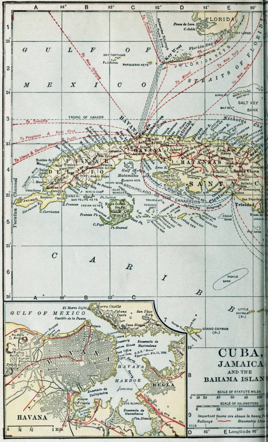

| Typographical errors corrected by the etext transcriber: |
|---|
| so that it can product=> so that it can produce {pg vii} |
| The shores of Mariel are beautfiul=> The shores of Mariel are beautiful {pg 41} |
| at the southern end of the Bat=> at the southern end of the Bay {pg 41} |
| aferwards was led=> afterwards was led {pg 61} |
| on the party of=> on the part of {pg 80} |
| Mexican revoultions=> Mexican revolutions {pg 191} |
| they should fear=> they should bear {pg 207} |
| any woman whose chose to devote=> any woman who chose to devote {pg 297} |
| the installment plant=> the installment plan {pg 395} |