 The Old Vincennes Trace near Xenia, Illinois
Transcriber’s Note: Obvious errors in spelling and punctuation have been corrected except for narratives and letters included in this text. Footnotes have been moved to the end of the text body. Also images have been moved from the middle of a paragraph to the closest paragraph break, causing missing page numbers for those image pages and blank pages in this ebook.

THE ARTHUR H. CLARK COMPANY
CLEVELAND, OHIO
1904
COPYRIGHT, 1904
BY
The Arthur H. Clark Company
ALL RIGHTS RESERVED
| PAGE | ||
| Preface | 11 | |
| I. | The Clark Routes through Illinois | 15 |
| II. | Miami Valley Campaigns | 72 |
| III. | St. Clair’s Campaign | 108 |
| IV. | Wayne and Fallen Timber | 160 |
| Appendixes | 219 | |
| I. | The Old Vincennes Trace near Xenia, Illinois | Frontispiece |
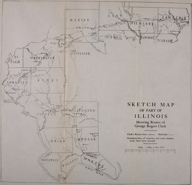
| II. | Sketch Map of Part of Illinois, Showing Clark’s Routes | 21 |
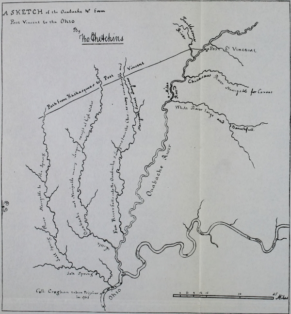
| III. | Hutchins’s Sketch of the Wabash in 1768 (showing trace of the path to Kaskaskia; from the original in the British Museum) | 35 |
| IV. | The St. Louis Trace near Lawrenceville, Illinois | 62 |
| V. | A Part of Arrowsmith’s Map of the United States, 1796 (showing the region in which Wilkinson, Scott, Harmar, St. Clair, and Wayne operated) | 117 |
| VI. | Dr. Belknap’s Map of Wayne’s Route in the Maumee Valley, 1794 (from the original in the Library of Harvard University) | 197 |
This volume treats of five of the early campaigns in the portion of America known as the Mississippi Basin—Clark’s campaigns against Kaskaskia and Vincennes in 1778 and 1779; and Harmar’s, St. Clair’s, and Wayne’s campaigns against the northwestern Indians in 1790, 1791, and 1793-94.
Much as has been written concerning Clark’s famous march through the “drowned lands of the Wabash,” the important question of his route has been untouched, and the story from that standpoint untold. The history of the campaign is here made subservient to a study of the route and to an attempted identification of the various places, and a determination of their present-day names. Four volumes of the Draper Manuscripts in the library of the State Historical Society of Wisconsin give a vast deal of information on this subject. They are referred to by the library press-mark.
Turning to the study of Harmar’s, St. Clair’s, and Wayne’s routes into the Northwest, the author found a singular lack of detailed description of these campaigns, and determined to combine with the study of the military roadway a comparatively complete sketch of each campaign, making use, in this case as in that of Clark’s campaigns, of the Draper Manuscripts.
A great debt of thanks is due to Mr. Reuben Gold Thwaites, Secretary of the State Historical Society of Wisconsin, for assistance and advice; to Josiah Morrow of Lebanon, Ohio, the author is indebted for help in determining portions of Harmar’s route; and to Francis E. Wilson, President of the Greenville Historical Society, many thanks are due for help in questions concerning the pathway of the intrepid leader known to the East as “Mad Anthony” Wayne, but remembered in the West as the “Blacksnake” and the “Whirlwind,” because he doubled his track like a blacksnake and swept over his roads like a whirlwind.
A. B. H.
Marietta, Ohio, September 14, 1903.
On the twenty-fourth of June, 1778, George Rogers Clark, with about one hundred and seventy-five patriot adventurers, left the little pioneer settlement on Corn Island, in the Ohio River, opposite the present site of Louisville, Kentucky, for the conquest of the British posts of Kaskaskia and Vincennes in the “Illinois country.”[1]
The boats running day and night, the party reached Clark’s first stopping-place, an island in the Ohio near the mouth of the Tennessee River, in four days. Just below this island was the site of old Fort Massac—now occupied by Metropolis, Massac County, Illinois—built probably by a vanguard[Pg 16] from Fort Duquesne, a generation before, when the French clearly foresaw the end of their reign on the upper Ohio. Here, almost a century before that, was the old trading-station of Juchereau and the mission of Mermet—the subsequent “soul of the mission of Kaskaskia,” as Bancroft describes him. The situation was strategic on two accounts: it was a site well out of the reach of the Ohio floods, and it was near the mouths of both the Tennessee and Cumberland Rivers—valleys known of old to the Shawanese and Cherokees. As a coign of vantage for traders and missionaries, it had been of commanding importance. It was, likewise, near the Ohio terminus of several old buffalo routes across Illinois, roads which became connecting links between Kaskaskia, on the river bearing that name near the Mississippi, and the mission at Fort Massac. The old paths of the buffalo, long known as hunting traces, offered the traveler from the Ohio to the old-time metropolis of Illinois a short-cut by land, saving thrice the distance by water, and obviated stemming the swift tides of the Mississippi. One of the prin[Pg 17]cipal backbones of Illinois was threaded by these primeval routes, and high ground between the vast cypress swamps and mist-crowned drowned lands of Illinois was a boon to any traveler, especially that first traveler, the bison. This high ground ran between Kaskaskia and Shawneetown, on the Ohio River, the course becoming later a famous state highway. Its earliest name was the “Kaskaskia Trace.”
Clark’s spies, sent out to Illinois a year before, undoubtedly advised him to land at Fort Massac and, gaining from there this famous highway, to pursue it to Kaskaskia. His plan of surprising the British post necessitated his pursuing unexpected courses. It was well known that the British watched the Mississippi well; therefore he chose the land route. Here, at the mouth of the Tennessee, his men brought in a canoe full of white traders who had recently been in Kaskaskia; certain of these were engaged to guide Clark thither. The party dropped down to Massac Creek, which enters the Ohio just above the site of the old fort, and in that inlet secreted their flat-boats ready to begin their intrepid[Pg 18] march of one hundred and twenty miles across country.[2]
As this little company of eight or nine score adventurers drew around their fires on Massac Creek, they little dreamed, we may be sure, of the fame they were to gain from this plucky excursion into the prairies of Illinois. It was impossible for them to lift their eyes above the commonplaces of the journey and the possibilities of the coming encounter, and see in true perspective what the capture of Illinois meant to poor Kentucky. It is not less difficult for us to turn our eyes from these general results, which were so brilliant, and get a clear insight into the commonplaces of this memorable little campaign—to hear the talk of the tired men about the fires as they cleaned the heavy clods of mud from shoes and moccasins, examined their guns, viewed the night, and then talked softly of the[Pg 19] possibilities of the morrow, and dreamed, in the ruddy firelight, of those at home. Of all companies of famous campaigners on the Indian trails of America, this company was the smallest and the most picturesque. Clark had but little over half the force which Washington commanded at Fort Necessity in 1754.
Little Massac Creek is eleven miles in length but drains seventy square miles of territory. This fact is a significant description of the nature of the northern and central portions of Massac County. From the Cache River a string of lakes extends in a southeast and then northeast direction to Big Bay River, varying in width from one to four miles; around the lakes lies a much greater area of cypress swamps and treacherous “sloughs” altogether impassable. The water of these lakes drains sometimes into the Cache and at other times into the Big Bay—depending upon the stage of water in the Ohio.[3]
There were three routes from Fort Massac toward Kaskaskia; one, which may well be called the Moccasin Gap route, circled[Pg 20] to the eastward to get around the lakes and swamps of Massac County; it passed eastward into Pope County, where it struck the Kaskaskia-Shawneetown highway. This route ran two and one-half miles west of Golconda, Pope County, and on to Sulphur or Round Spring. From thence through Moccasin Gap, section 3, township 12, range 4E, Johnson County; thence it ran directly for the prairie country to the northward. As noted, this route merged into the famous old Kaskaskia and Shawneetown route across Illinois—what was known as the Kaskaskia Trace—in Pope County. It was this course which in earliest times had been blazed by the French as the safest common highway between Kaskaskia and the trading and mission station (and later fort) at Massac. The trees along the course were marked with the proper number of miles by means of a hot iron, the figures then being painted red. “Such I saw them,” records Governor Reynolds, “in 1800. This road made a great curve to the north to avoid the swamps and rough country on the sources of the Cash [Cache] river, and also to obtain [Pg 23] the prairie country as soon as possible. This road ... was called the old Massac road by the Americans.”
Click here for larger image size
SKETCH MAP OF PART OF ILLINOISShowing Routes of George Rogers Clark
The second route circled the Massac County lakes to the westward, cutting in between them and the canyons of the Cache River, near what is familiarly known as Indian Point (section 33, township 13, range 3E, Massac County), or one mile south of the northwest corner of Massac County; thence, running north of northwest, it crossed the Little Cache (Dutchman’s Creek) one and one-half miles north of Forman. Thence the route is up the east side of the Cache and through Buffalo Gap, section 25, township 11, range 2E, Johnson County, to the prairie land beyond. The third route follows the second through Massac County.
It is important to note here that the Illinois of Clark’s day—as is partly true now—was composed of three kinds of land: swampy or “drowned” lands, prairie land, and timber land. Being practically a level country, the forests became as prominent landmarks as mountains and hills are in rugged districts. Routes of travel clung[Pg 24] to the prairies; and camping-places, if water could be had in the neighborhood, were always chosen on the edge of a forest where wood could be obtained. Between wood and water, of course the latter was the greater necessity. The prairie district in Illinois does not extend below Williamson County, and famous Phelps Prairie in that county is the most southern in the state.[4] Both routes from Fort Massac made straight, therefore, for Phelps Prairie, in which the town of Bainbridge, Williamson County, now stands. Here the two routes joined again; or, rather, the Buffalo Gap route met, in Phelps Prairie, the Kaskaskia Trace, as the “Old Massac Road” had met it in Pope County. The former point of intersection was on the “Brooks place,” section 9, township 9, range 2E, Williamson County.[5] The Buffalo Gap route was known as the “middle trail;” the third route northwest from Fort Massac pursued this path to a point on the Cache above Indian Point; thence it swung westward, keeping far south of the prairie land,[Pg 25] passed near Carbondale, Williamson County, and crossed the Big Muddy River at Murphysboro.[6] It was known as the “western trail.” Not touching the prairie land, it is plain that the route could be used only in the driest of midsummer weather.
The evidence that Clark’s guides took the middle trail is overwhelming; the western trail was too wet and did not touch any prairie—this utterly excludes that route from the list of possibilities. According to Clark’s Memoir, on the third day out the party reached a prairie where the chief guide became confused; Clark’s command to him was to discover and take them into the hunter’s road that led from the east into Kaskaskia. There can be no doubt that this “hunter’s road” which came from the east was the Kaskaskia-Shawneetown trace, which the Old Massac Road joined in Pope County, or that the middle trail was the one which the party had been following; the junction of the middle trail on the Brooks Place, above mentioned, is in Phelps Prairie and about a three days’ march from Fort Massac. The junction of[Pg 26] the trail passing from Fort Massac eastward of the Massac County lakes with the Kaskaskia and Shawneetown trace is not more than a day’s march from Fort Massac and is not in a prairie. There can be no doubt, therefore, that Clark’s brave band stole northward on the middle trace, the Buffalo Gap route. Clark would not have commanded his guide, under pain of death, to find the Kaskaskia Trace if the party had been traversing that trace and had merely missed the way. Every implication is that the Kaskaskia Trace was the goal sought and not yet found.
The first day’s march of about eighteen miles was a hard one, passing over the winding trail which skirted the southern side of the marshes that flanked the sloughs and lakes of Massac County, but finally leading to the bluffs, near the Cache River, where, probably on Indian Point, the first night’s camp was pitched.[7]
The first taste of the swamps of Illinois was not discouraging, and on the day after, June 29, the march was resumed. The route today was on the top of the water[Pg 27]shed between the Cache River on the left (west) and Dutchman’s Creek on the right. Buffalo Gap was passed today, a mile south of the present Goreville, Johnson County. Camp was pitched this night, after a twenty-mile march, probably at the spring two miles north of the present Pulley’s Mill. The route all day was along the buffalo trail or hunter’s road from which Buffalo Gap received its name.[8] This gap, like Moccasin Gap to the eastward, was a famous portal to the prairie country for the bison, Indian, and white man. Two old-time state roads were built through these two gaps.[9]
Pushing forward from the spring near Pulley’s Mill on the morning of June 30, the Virginians ere long came into the prairie lands lying in Williamson County. Phelps Prairie was reached first, the path entering the southern portion of the prairie. Here it was that “John Saunders, our principal guide, appeared confused, and we soon discovered that he was totally lost.” These Illinois prairies are almost treeless, save near[Pg 28] the water courses; the grass in the old days grew rank and high and one could tell his course only, perhaps, by the stars, if the pathways were obscured. The paths in these prairies are overgrown in the summer time,[10] and it is probable that this is why Clark’s guide, attempting to find the Kaskaskia Trace, lost his bearings. The important landmarks in these prairies were the forests which often bounded them and in many instances extended into them. These extremities of the forests were and are still known as “points,” and many of them are yet landmarks in Illinois history. A spring beside a point in a prairie made an ideal camping-spot known to half a continent in the olden time. Clark’s campground in Phelps Prairie was, without doubt, at a spring just west of Bainbridge.
Northward from Phelps Prairie two routes ran to Kaskaskia: a wet and a dry route. The one which we may call the highland route led north through Herrin’s Prairie and swung around to the Mississippi by heading such streams as Pipestone, Rattlesnake, and Galium, crossing the Big Muddy[Pg 29] River at Humphry’s Ford, section 30, township 8, range 2E.[11] This was the dry route, the preferable one the year round. Another shorter course ran northwest and crossed many of the streams which the highland route headed. There can be little doubt that Clark’s guides chose this latter course. By Clark’s Memoir we know it to have been a dry season, and the shortest, and probably the least traveled, course would best suit his plan of surprising Kaskaskia. The shortness of the time (four days) in which the distance to Kaskaskia was covered from Phelps Prairie almost precludes the possibility of his having used the longer watershed route.
On the first day of July, then, the little army moved from near the present Bainbridge along a well-known trail which crossed Crab Orchard Creek at Greathouse Crossing[12] (section 2, township 9, range 1W)[13] and the Big Muddy at Marshall’s Shoals, section 6, township 9, range 1W,[Pg 30] southwest of De Soto, Jackson County.[14] It is possible that camp, on the night of July 1, was pitched at Greathouse Crossing; if so the day’s march was not a long one. From the Big Muddy the trail struck to the watershed between the Beaucoup and its tributaries on the north and the tributaries of the Big Muddy on the south, running near the present Lenan in Jackson County. The course now was a watershed route from the Big Muddy to the St. Mary River, and is marked today by the significant names of such high altitude towns as Shiloh Hill, Teacup Knob, and Wine Hill. Through these places an ancient highway has coursed from times to which the memory of white men runneth not to the contrary. Water was scarce on the highest grounds, but springs, here and there, were well known, and at one of these, probably near Lenan (section 15, township 8, range 3), the adventurers paused, on the night of September 2, and built their evening fires.[15][Pg 31]
The end was now almost in sight; two days more and the immediate basin of the Mississippi River would be reached, and the success or failure of the daring raid be decided. It can be easily imagined that it was a silent and eager body of men which, on September 3, strode forward over the rolling hills of Randolph County on the old trail. Their excitement must have been intense. The old trail from Lenan entered Randolph County near the center of section 12, township 7, south of range 5 W and passed over Teacup Knob in section 5 and near the present Wine Hill P. O. Pushing on over the hills, the St. Mary River was reached at the site of what became the “Old State Ford,” near Welge Station (formerly Bremen Station) on the Wabash, Chester and Western Railroad—section 1, township 7 S., range 6 W.[16] Here the last camp of the march was pitched on the night of July 3—the “glorious Fourth” was to see the little invading army lying quietly on the outskirts of quaint old Kaskaskia.
From the state ford on the St. Mary, the course was the highland route running near[Pg 32] Diamond Cross.[17] Here, on the watershed between the tributaries of the St. Mary and the Kaskaskia, lay the worn Vincennes Trace running northeast from Kaskaskia to the Wabash. It is probable that Clark entered this highway before the Kaskaskia River was reached.[18] And at the end of the journey awaited victory; Governor Rochblave was completely surprised, and Kaskaskia was captured by the perilous feat of actually marching up to it and taking possession of it with the assumed arrogance of a powerful conqueror.
From the moment Kaskaskia was in Clark’s hands he turned his attention to Vincennes, and in July, through the coöperation of the French priest Gibault, the inhabitants were induced to proclaim themselves American subjects and to hoist an American flag. Captain Helm of Clark’s little army was posted at Vincennes with a guard, and Helm it was who was captured[Pg 33] in the fall by the British Lieutenant-governor Hamilton of Detroit. The latter had pushed his difficult way up the Maumee and down the Wabash to seize the revolted town.[19] Throughout the winter Clark feared a swift advance from Vincennes; and, to save himself from being captured by Hamilton, Clark desperately resolved to capture him. By February 5 a new “grand army,” of four companies, possibly one hundred and sixty strong, well-armed, but without tents and horse, save a few packhorses, departed from Kaskaskia on the desperate journey across the swimming prairies and flooded rivers of Illinois for Vincennes.[20] Had one man dropped from the ranks each mile, not one of the one hundred and sixty would have reached the Wabash. Few expeditions in American history have been recounted more than this; it is strange that the route of this immortal little army has never been care[Pg 34]fully considered—for the story of the route is almost the whole story of the campaign.
Click here for larger image size
Hutchins’s Sketch of the Wabash in 1768, Showing Trace of the Path to Kaskaskia[From the original in the British Museum]
Crossing the Kaskaskia River February 5, 1779, Clark’s army lay three miles from Kaskaskia, for two days, “to tighten belts.”[21] It is impossible to determine how much was known of their path onward. To many it had been well known for nearly a century—an old watershed prairie route marked out by the buffalo and followed by missionaries—the Appian Way of Illinois. The difficulty in studying this route, it should be stated at once, arises from the fact that while Kaskaskia was formerly the metropolis of western Illinois, the rise of St. Louis across the Mississippi had the effect of altering previously traveled routes. What has been ever known as the St. Louis Trace, coursing across Illinois from Vincennes to the Mississippi, became in the nineteenth century what the old Kaskaskia Trace had been in the eighteenth century, just as what had been the “Old Massac Road” became known as the St. Louis-Shawneetown Road. As [Pg 37] a result, the later Kaskaskia travelers followed the St. Louis Trace—much-traveled, broad, and hard—as far westward as Marion County, and then turned due southwest to Kaskaskia. Therefore it is necessary not to confound the ancient Kaskaskia trace to Vincennes with the later Kaskaskia trace which was identical for some distance with the more northerly St. Louis Trace.[22] At the same time it is easy to err in separating the older and newer routes too widely in the attempt not to confound them. The newer St. Louis Trace runs across from Indiana (Vincennes) to Missouri (St. Louis) through the Illinois counties of Lawrence, Richland, Clay, Marion, Clinton, and St. Clair. The course is practically that of the old Mississippi and Ohio (now the Baltimore and Ohio Southwestern) Railway. The route passed over the best course between the points, as proved by the railway surveyors and en[Pg 38]gineers. But many rivers blocked the way; the first of these from Vincennes was the Embarras—so called, as in the case of many streams, because the great floods left deposits of driftwood which seriously impeded navigation. West of the Embarras came the petulant Little Wabash and the Big Muddy, draining thousands of square miles of swamp and prairie, and, in rainy seasons, uniting and spreading out five miles in width. West of the tributaries of the Little Wabash come those of the Kaskaskia. A few smaller Wabash and Mississippi tributaries, such as the Bonpas and St. Mary are headed by this trans-Illinois route, but it was not, in one sense, a watershed route, crossing the Embarras, Little Wabash, Fox, Beaucoup, and Kaskaskia and their tributaries.
These streams flow southward. Kaskaskia lay some fifty miles south of St. Louis and the later St. Louis Trace. The route of the more ancient Kaskaskia Trace to Vincennes, therefore, ran some seventy-five miles in a northeast direction; then, turning due east, it ran about one hundred miles to the Wabash. For the first seventy-five[Pg 39] miles it was a watershed route, coursing along the highland prairies between Three Mile, Plum, Crooked, Grand Point, and Raccoon Creeks—all tributaries of the Kaskaskia River—on the west and north, and the heads of the St. Mary, Beaucoup, and Big Muddy Rivers on the east and south. This backbone line of prairie land runs straight northeast through Randolph and Washington Counties, cutting into corners of Perry, Jefferson, and Marion Counties. But here in Marion County the backbone, which had been accommodatingly trending eastward, turned quickly to the north to avoid the treacherous Little Wabash; at this point the old trace divided into two courses both of which ran to Vincennes. One course, probably that known later as the eastern half of the St. Louis Trace, passed through the center of Clay, Richland, and Lawrence Counties, crossing both the Little Wabash and Big Muddy a short distance above their junction, the Embarras near Lawrence, and the Wabash at Vincennes. The other branch of the Kaskaskia Trace passed through the northern portion of Wayne, Edwards and Wabash Counties,[Pg 40] crossing the Little Wabash and Fox some two miles above their junction, the Bonpas River, near Bonpas, and the Wabash, two miles above St. Francisville. From this ford the route led up the eastern shore of the Wabash about nine miles to Vincennes. By any route, at any time of year, the journey across Illinois was a hardship no thinking man would undergo, save only on the most important mission; in the winter season—with the Wabash a surging sea, the Little Wabash a running lake, Crooked Creek treacherously straight, water frozen on the prairies, the “points” of timber swampy morasses—all communication landward was cut off, with the beavers and blue racers swimming for the high ground.
In their right mind, Clark’s adventurers would probably not have faced the wilderness into which they strode on the morning of February 7 on any private affair of life or death. Two magnetic influences drew them on; these Americans had brought to Illinois the spirit of 1775, a breath of a boasted freedom that was half license, in which the hot-headed French exulted. Believing the Americophobite British, the[Pg 41] inhabitants of Kaskaskia had feared the barbarian Virginians more than any savages; Clark made capital of this in securing Kaskaskia, and later, by the kindness with which he treated the inhabitants and the freedom he gave them, accomplished a moral victory as sweeping and as picturesque as his military achievement. The proposed plan to carry to reconquered Vincennes the blessings of liberty enjoyed at Kaskaskia under Virginian rule appealed strongly to the impressionable habitants; to Clark’s own patriot soldiers the Vincennes campaign was the very acme of frontier adventure. Again, the young, daring Clark—quiet, resourceful, irrepressible—was a potent factor in pushing these men out on a journey of such unparalleled hardship. True, it is difficult to look beyond the later George Rogers Clark, of soiled reputation, to the cool, brave youth of twenty-seven years who led these men through the prairies of Illinois in 1779. To dim the brilliant lustre of such days as these was a heavy—if not the heaviest—price to pay for indiscretions of later years. Yet, as the records of this handful of men[Pg 42] are studied, and especially when the track of their memorable march is picked out and followed, one can fancy the clear, bright picture of the Clark of 1779 and, happily, believe for the moment that there is no connection between him and the later Clark whom the Spaniards knew. It is plain that the French were charmed by the dashing Virginian and his Vincennes chimera. The record Clark left of the expedition—written ere the grasshopper was a burden or those were darkened who stood at the windows—clearly implies that the expedition was launched with a levity that it is sure all did not feel, though it may have been perfectly assumed; and as the days passed we shall see that Clark hurried on in order to get his men too far to turn back. His diplomatic endeavors, throughout those marvelous fifteen days, to lure his men on, to lift their thoughts from their sufferings and incite them to their almost superhuman tasks, are perhaps without parallel in the history of marching armies in America.
Departing from the two days’ camping-place, three miles from Kaskaskia, the course, for almost the entire first day, lay through[Pg 43] thick forests, which have quite disappeared since that time, on the watershed between the Kaskaskia tributaries on the northwest and those of the St. Mary on the southeast.[23] Fortunately the journey at the outset was comparatively easy; the weather was warm for the season, though rainy. A good march was made on the seventh through the forests and out into Lively Prairie, half a mile northeast of Salem, Randolph County, where the course of the old trail is well known. Beyond this, Flat Prairie opened the way toward the “Great Rib,” as the French knew the ridge in Grand Cote Prairie (La Prairie de la Grande Côte) on which the present village of Coultersville, Randolph County, stands. The first night’s camp was pitched probably in Flat Prairie, between Salem and Coultersville.[24] The[Pg 44] authoritative record for this day’s march, as of all others, is the official Bowman’s Journal:[25] “Made a good march for about nine hours; the road very bad, with mud and water. Pitched our camp in a square, baggage in the middle, every company to guard their own squares.” On the eighth the record continues: “Marched early through the waters, which we now began to meet in those large and level plains, where, from the flatness of the country, [water] rests a considerable time before it drains off; notwithstanding which, our men were in great spirits, though much fatigued.” By the eighth it would seem the little band had reached the lower plains in the northwest corner of Perry County, two and a half miles northwest of Swanwick, where the headwaters of the Big Muddy tributary of the Kaskaskia were crossed, and the prairie south of Oakdale, Washington County, at which point Elkhorn Creek was crossed at the famous “Meadow-in-the-Hole” of old French days.[Pg 45] This region was also known as Corne de Cerf, Elkhorn Prairie, Elkhorn Point and Ayres Point.[26] Prairie, forest, and bottom land were not far apart here. The “Meadow-in-the-Hole” was a singular little meadow, fifty or sixty yards wide, located on a “dry branch” of the Elkhorn and thirty feet lower than the surrounding forests—at what is now Oakdale on the Elkhorn.[27] From the present Oakdale the pathway ran from Elkhorn Prairie through Nashville Prairie, circling half a mile to the north and northeast of Nashville, Washington County. Turning to the east here, it coursed onward to a celebrated “point” of woods called Grand Point, near the present Grand Point Creek, section 32, township 2, south range 1W, two miles and a half northwest of Richview, Washington County.[28] From thence it circled northeast through section 9 in Grand Prairie Township, the extreme northwest township of Jefferson County.[29] The second night’s camp may[Pg 46] have been pitched on Grand Point Creek, near Richview; and that of the ninth on Raccoon Creek, near Walnut Point, one mile north of Walnut Hill, Marion County. The old trail from Grand Prairie, Jefferson County, entered Marion County at section 32, Centralia Township, on the old Israel Jennings farm. Walnut Hill was two miles north of due east from the Jennings farm, through which, it may be added in passing, ran the later famous St. Louis-Shawneetown road.[30] Bowman’s record for the ninth and tenth reads: “9th. Made another day’s march. Fair part of the day. 10th. Crossed the river of the Petit Fork upon trees that were felled for that purpose, the water being so high there was no fording it. Still raining and no tents. Encamped near the river. Stormy weather.”
Here we have the first definite mention of a camping-place; the Petit Fork was the Adams or Horse tributary of Skillet Creek—the first tributary of the Little Wabash and Big Wabash the army encountered.[31] The crossing-place was near Far[Pg 47]rington, Jefferson County[32]—fifteen short miles from Walnut Point and known in early days as Yellow Bark.[33] The feat of felling trees across this rushing stream being accomplished, the men crawled over and encamped on the eastern bank. A picture of the army splashing along through the watery prairies would be greatly prized today, but a picture of it creeping across Petit Fork on felled tree-trunks would be of extraordinary interest; it is one of the remarkable incidents of the heroic adventure.
Of these days the accounts of Clark furnish us almost no information.[34] The incident of the Petit Fork was not sufficiently notable to receive mention, for Clark wrote Mason: “The first obstruction of any consequence that I met with was on the 13th [the Little Wabash];” yet in his Memoir—written, it must be remembered, as late as 1791—he describes the march to[Pg 48] the Little Wabash as made “through incredible difficulties, far surpassing anything that any of us had ever experienced.” The Letter breathes the spirit of the youth, for it was written in 1779; the Memoir ever reads like an old man’s reminiscences. Clark’s diplomacy in securing the loyalty of his men through great discouragements indicates a high order of the best qualities of a military commander. “My object now,” he writes, “was to keep the men in spirits.” He allowed the men to kill game and hold typical Indian feasts after the hard day’s wet march. Before their rousing fires, with venison and bear meat savoring the air, little wonder the night brought partial forgetfulness of the day’s fatigue. The four companies took turns at being hosts; the company on duty each day being supplied with horses on which to transport the game brought down. And throughout every day’s march Clark, and his equally courageous officers, made light of all difficulties, and “putting on the woodsman, shouting now and then and Running as much through the mud and water as any of them. Thus, Insensibly, without a mur[Pg 49]mur, was those men led on to the Banks of the Little Wabash which we reached on the 13th.” The spectacle, here presented, of officers inveigling soldiers forward, is one of the most singular in the history of the West. We may well believe Clark refers particularly to the two French companies which composed a most important arm of his force—the Virginians, perhaps, not needing equal inspiration to endeavor. The climax in Clark’s diplomacy was reached as he now approached the flood-tides of the raging Little Wabash.
It is necessary here to emphasize that the army, turning eastward just north of present Nashville, abandoned the watershed to which their path had thus far held; the route now was nearly due east, across the tributaries of the Little Wabash. Of these, Petit Fork (Adams tributary of the Skillet) was the first to be encountered; it was passed with great heroism on the tenth of February. On the eleventh the eastward route was followed and the Saline River (Skillet Creek) was crossed. Bowman’s record reads: “11th. Crossed the Saline river. Nothing extraordinary this day.[Pg 50]” The route between the Skillet and Little Wabash may have been either one of the two courses mentioned, not over five miles apart, and running parallel to each other. The northern passed through the southern portion of Clay County, the southern through the northern portion of Wayne. There were two encampments between the Petit Fork and the Little Wabash; if the northern route was pursued, these camps were near Xenia and Clay City in Wayne County; if the southern route was followed, the camps were near Blue Point and Mount Erie in Wayne County. Bowman’s record for the twelfth is: “12th. Marched across Cot plains;[35] saw and killed numbers of buffaloes. The road very bad from the immense quantity of rain that had fallen. The men much fatigued. Encamped on the edge of the woods. This plain or[Pg 51] meadow being fifteen or more miles across, it was late in the night before the baggage and troops got together. Now twenty- [forty-] one miles from St. Vincent. 13th. Arrived early at the two Wabashes. Although a league asunder, they now made but one. We set to making a canoe.” Clark’s records of the arrival at the Little Wabash read (from his Memoir): “This place is called the two Little Wabashes; they are three miles apart and from the Heights of the one to that of the other on the opposite shores is five miles the whole under water genly about three feet Deep never under two and frequently four;” (from Letter to Mason) “Arriving at the two Little Wabashes, although three miles asunder—they now make but one—the flowed water between them being at least three feet deep and in many places four. Being near five miles to the opposite hills, the shallowest place, except about one hundred yards, was three feet.” So far as these records go, either the Clay or the Wayne County route might have been that pursued. The long prairie of which Bowman speaks would have been, on the Clay[Pg 52] County route, “Twelve Mile Prairie” situated between the present towns on the Baltimore and Ohio Southwestern Railway, Xenia and Clay City; on the Wayne County route it would have been “Long Prairie” lying between Blue Point and Mount Erie. The “two Wabashes” on the Clay County route would have been the Little Wabash River and the Big Muddy Creek. By the Wayne County route the two Wabashes would have been the Little Wabash and Fox River.
The indefatigable Lyman C. Draper, after a large correspondence with many of the best informed men in Illinois on the subject of the crossing-place of the Little Wabash, came to the firm conclusion that the two Wabashes were the Little Wabash and the Fox; the present writer after studying that correspondence and visiting the ground in question—which Mr. Draper did not find time to do—quite as firmly believes that the crossing-place was above the junction of the Little Wabash and Big Muddy Creek at the old McCauley’s settlement—in the southeast corner of section 21 of Clay County, range 8E, two miles[Pg 53] east of old Maysville, which was three-fourths of a mile south of the present Clay City station on the Baltimore and Ohio Southwestern Railway. By this upper route Clark would have been on higher ground before and after crossing the Little Wabash. It is quite sure his party passed a salt spring (see p. 66) and the only one in this region was on this upper route. And finally, Bowman states that on the day after crossing the Little Wabash the party crossed the Fox River. This could not have been possible if the Little Wabash and Fox were crossed simultaneously. But even a slight discussion of the question may well be relegated to an appendix.[36] At either crossing-place, and the two are but a few miles apart, a most desperate situation confronted the intrepid Clark and his tired band of invaders.
“... I Viewed this Sheet of water for some time with Distrust,” Clark wrote in his Memoir, “but accusing myself of Doubting I amediately Set to work without holding any consultation about it or suffering anybody else to do so in my presence[Pg 54] ordered a perogue amediately built and acted as though crossing the water would be only a piece of diversion.... My aneziety [anxiety] to cross this place continually increased as I saw that it would at once fling us into a situation of folorn hope as all Ideas of a Retreat would in some Measure be done away that if the Men began after this was accomplished to think seriously of what they had really suffered that they preferd Risking any seeming difficulty that might probably turn out favourable than to attempt to Retreat when they would be certain of Experiencing what they had already felt and if the weather should but Freeze altogether impracticable, except the Ice would bear them.” The heroism of Clark’s crossing of the Little Wabash has been retold on a thousand pages but it has rarely been suggested that he hurried into these dangers eagerly because they would serve to thwart any hope of retreat. He not only “burned his bridges,” but hastened impetuously across waters that could never be bridged, in the hope that they would freeze and cut off all dreams of retreat. This memoir, let[Pg 55] it again be remarked, was written many years after the event—after Clark saw his great feat somewhat in the light we see it today. His letter to Mason, however, was written in the same year that the march was made; if not so self-laudatory, it is as interesting as the memoir, and perhaps more authentic. He thus described the crossing in that document: “This [flood] would have been enough to have stopped any set of men not in the same temper that we were. But in three days we contrived to cross by building a large canoe, ferried across the two channels; the rest of the way we waded, building scaffolds at each to lodge our baggage on until the horses crossed to take them.” Bowman’s record is that of the soldier: “14th. Finished the canoe and put her into the river about 4 o’clock in the afternoon. 15th. Ferried across the two Wabashes, it being then five miles in water to the opposite hills, where we encamped. Still raining. Orders not to fire any guns for the future, but in case of necessity.”
When, near Olney, Clark’s men crossed the Fox River on the 16th of February, it[Pg 56] is probable that they camped on what is now the St. Louis Trace Road on one of the northeastern tributaries of the Fox. The day after, an early start was made in order that the famed Embarras might be reached before nightfall. It can well be believed that an intense, hushed excitement prevailed. The success of the invasion must depend on a swift surprise; it was probable that all would be lost if the approach was discovered; for, the Wabash being out of banks, the enemy, doubtless well supplied with boats, would have Clark’s band at their mercy. The provisions were fast giving out; surrender or starvation stared Clark in the face if discovered. Accordingly, Commissary Kennedy with three guides was sent forward “to cross the river Embarrass,” Clark wrote in his Memoir, “... and, if possible, to get some vessels in the vicinity of the town [Vincennes], but principally if he could get some information.” “About an hour, by sun, we got near the river Embarras,” Bowman wrote in his Journal; “Found the country all overflowed with water.” The Embarras was reached near Lawrenceville[Pg 57] and the river was descended a few miles—“Traveled till 8 o’clock in mud and water,” wrote Bowman—before a camping-spot was found.
On the morning of the eighteenth the morning gun at Fort Sackville (Vincennes) was heard. The Wabash was reached at two o’clock in the afternoon, but no boats could be found by the parties of searchers sent out on rafts and in a canoe. Affairs were growing desperate, and the “very quiet but hungry” men set to work building canoes. Messengers were sent to hurry on “The Willing” but did not find her. “No provisions of any sort,” writes Bowman on the nineteenth, “now for two days. Hard fortune!” On the twentieth, as work on the canoes advanced, a canoe containing five Frenchmen from Vincennes was captured, and Clark learned that he was not yet discovered. On the twenty-first the army began to be ferried across the Wabash, “to a small hill called [Mammelle ?].” The crossing-place cannot be determined with precision. It was below the mouth of the Embarras, and not lower on the Wabash than a mile and a half above[Pg 58] St. Francisville. Several mammelles (bluffs) lie on the eastern bank of the Wabash here. One lies four and one-half miles below the mouth of the Embarras. As the current was swift, the river broad, and the point of embarkation somewhat below the mouth of the Embarras, it is probable that the army landed further down the Wabash than has usually been described.[37] A march of three miles northward was made by the vanguard on the day it crossed, seemingly from the “lower” to the “upper” mammelle—the “next hill of the same name,” according to Bowman. On the twenty-second another league was covered by exhausting efforts, making in all six miles from the crossing-place. The camp this night is definitely known to be a high, twenty-acre sugar orchard still remembered as “Sugar Camp,” three and one-half miles from Vincennes. Clark was now at the lower end of the “Lower Prairie,” and there were two courses to Vincennes which lay on the rising ground across the three miles of[Pg 59] flooded prairie.[38] One, by way of the Grand Marais or swamp in the middle of the prairie, was impassable; the other route, known as the “two buttes route,” was the difficult alternative. The first butte was “Warrior’s Island,” a ten-acre hill heavily wooded, a mile and a half from Sugar Camp and two miles from Vincennes. It could be and was reached by the strong men wading breast high, drawing or paddling their feebler comrades in the canoes. The second butte, “Bunker Hill,” was not on the direct line to Vincennes, but was a high point to the east on the same plateau on which Vincennes stood. At one o’clock of the twenty-third, the floundering army, half numb with cold and weak from exposure, reached Warrior’s Island. From here Clark sent his first message, diplomatically directed to the inhabitants of Vincennes:
“Gentlemen—Being now within two miles of your village with my army, determined to take your fort this night, and not being willing to surprise you, I take this method to request such of you as are true citizens, and willing to enjoy the liberty I[Pg 60] bring you, to remain still in your houses, and those, if any there be, who are friends to the king, will instantly repair to the fort[39] and join the Hair-buyer General,[40] and fight like men. And if any such as do not go to the fort shall be discovered afterwards, they may depend on severe punishment. On the contrary, those who are true friends to liberty may depend on being well treated; and I once more request them to keep out of the streets, for every one I find in arms on my arrival I shall treat as an enemy.”[41]
At eight o’clock that night the famished army waded to Bunker Hill, and soon the outskirts of the town were invested, under fire of the fort. On the twenty-fourth Hamilton surrendered, and the campaign, prosecuted under difficulties which today cannot be justly described, ended in complete triumph.
Nothing can impress one with the heroism [Pg 63] of this march like a visit to these low lands which are now proving of great value to horse and cattle owners of northern Illinois as grazing grounds. Though my journey over Clark’s route was made at the driest and most favorable season of the year, the mists, heavy as clouds, lay along the Bonpas, Fox, Little Wabash, Big Muddy, and Skillet and between them, and a thunderstorm made the modern road a veritable slough. From Vincennes to Xenia, the Baltimore and Ohio Southwestern Railway is parallel with the old St. Louis Trace which was Clark’s route here.[42] But the student will find the journey by the old trace, throwing its curling lengths along the hills from Lawrenceville to Sumner, a most interesting though taxing experience. At Sumner the trace drops into the bottom-lands where the mists seem to lie forever and where little villages are perched upon knolls of a few thousand feet in diameter, surrounded by swamps and prairies that are now being drained and[Pg 64] cultivated widely. Here the old trace—for the ancient name clings to it—is helped along by dint of corduroy bridges and stone and wooden culverts. Between Sumner and Olney the corduroy bridges are frequent and exceedingly rough, particularly if you are hurrying along at nightfall to gain the portals of a comparatively comfortable inn at Olney. Westward the road ploughs its way through the marshes and the mist to the little Big Muddy and across to the Little Wabash about where the old trace ran. Here the fogs lie heaviest, shutting off all view of the low-lying, bushy wastes. In midsummer the fog and marshes warn the explorer away; what of this land when the rivers are loosed by the winter floods and are streaming wildly along the vast stretch of the stunted bush and vine? The scene presented to Clark’s Virginians and Frenchmen in February 1779 cannot by any means be pictured by one to whom these swamps are unknown; to such as know them, the picture, though probably imperfect, is one of horror. To row a boat where the current is swift is fatiguing labor, and to walk in the water, when each step[Pg 65] may find one in a sink-hole and where the rank grasses, growing from heavy tufts, hold one’s feet as a cord, is all that the strongest man can endure for even a short period. The little spots of ground which here and there rise above the flood are covered with driftwood and infested with snakes.
In midsummer the scene was more pleasant. “Beyond Ombra we enter a Tartarian meadow,” wrote Volney in 1804, “interspersed with clumps of trees, but in general flat and naked, and windy and cold in winter. In summer it is filled with tall and strong shrubs, which brush the legs of the rider in his narrow path so much, that a journey out [to Kaskaskia] and back will wear out a pair of boots. Water is scarce [for drinking], and there is danger of being bewildered, as happened to one of my fellow travellers, three years before, when, with two others, he roamed about for seventeen days. Thunder, rain, gnats, and horse flies, are very troublesome in summer.”[43]
Of the journey from Vincennes to Kas[Pg 66]kaskia in 1804 Volney gives the following itinerary:
“Road from Fort Vincennes to Kaskaskias
| Miles | Hours | |
| To Ombra creek[44] | 9 | 2 |
| To Elm in the meadow | 13½ | 3 |
| To Cat River[45] | 13½ | 3 |
| To the Yoke[46] | 15 | 3 |
| To the Salt spring[47] | 6 | 1½ |
| To the Slaves gibbet[48] | 15 | 3 |
| [Pg 67]To Great Point[49] | 15 | 2½ |
| To the Coffee-pot[50] | 12 | 2 |
| To the Yellow bark[51] | 15 | 3 |
| To Walnut Point[52] | 15 | 2½ |
| Beyond this is a beaver dam,[53] destroyed. At a cross road you take the left, which is shortest. There is no water for eighteen miles, and you fall into the main road at Pointe aux Fesses.[54] | ||
| To the [Beaver] Dam | 4½ | 1 |
| To the three-thorned Acacia[55] | 12 | 2 |
| To Pointe aux Fesses[56] | 15 | 3 |
| To the Meadow of the Hole[57] | 15 | 3 |
| [Pg 68]To the Great Rib[58] | 15 | 3 |
| To Lepronier[59] | 12 | 2 |
| To Kas[kaskia] | 18 | 4 |
| —— | —— | |
| Totals[60] | 220½ | 43½” |
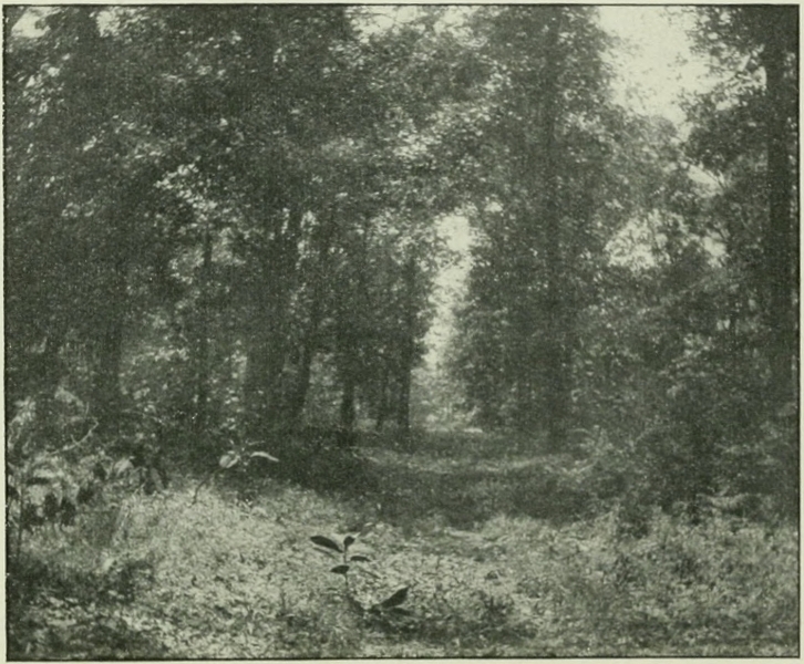
The junction of the old Kaskaskia Trace with the modern St. Louis Trace was on the Isaac Elliott farm, one mile east of old Xenia, half a mile north of the newer Xenia.[61] It was pointed out to the writer by Sandy Alexander Nelms of Salem, Illinois, one of the very few remaining old-time stage-drivers on the St. Louis Trace of the thirties, who was born near this junction. He remembers portions of the old path very well, though it has not, within his lifetime, been used as a highway. Within the borders of the present Xenia[Pg 69] the outline of the old trace is exceedingly plain. The frontispiece of this volume is from a recent photograph of this part of the road. Mr. Nelms informs the writer that the old trace could, in early years, be followed by the camping-spots, where blue-grass sprang up when the prairie-grass was killed out.[62] Blue-grass on the Illinois routes, like the apple-trees on the old track from Albany to the Mohawk in New York, was the first sign of coming civilization. Mr. Nelms remembers with distinctness that in a corn-field near the present Baltimore and Ohio Southwestern Railway depot at Xenia the route of the old trace could be followed by the color of the earth and heavier growth of corn. The general color of the field was black but a wide strip of yellowish clay was the course of the old Kaskaskia Trace—generations of travel over the narrow aisle in the old-time forests having changed the nature of the soil. Here, it is said, the crop of corn was distinctly heavier and better than elsewhere on the prairie.[Pg 70]
Wherever this old trace may be found it speaks of Clark and Clark only. All the story of its other days is forgotten for those hard fifteen during which that daring youth drew his comrades “insensibly” onward, amid jests and raillery, to the British stronghold from which thousands of savages had been urged to war upon the feeble Kentucky stations. Boone’s Wilderness Road meant much, but if Fort Sackville and the other Wabash Valley centers had been a trifle more potent than they were, it would have become as overgrown as was Braddock’s Road when Forbes marched to Fort Duquesne three years after Braddock. The two posts at the termini of the Vincennes Trace, and the dark councils of their commanders, were a more serious menace to Kentucky’s safety than all the redskins north of the Ohio River. It was the British-fed, British-armed, and British-led Indians that made possible the dream of a reconquest of Kentucky.
After George Rogers Clark led his men over that narrow, winding trace, through flooded Grand Cote Prairie and over the[Pg 71] raging Little and Great Wabash, that danger of British conquest of Kentucky was practically eliminated from the western situation.
The capture of Vincennes was the first chapter in the conquest of the Old Northwest.
The various campaigns directed from Kentucky and western Pennsylvania had, by 1779, comparatively freed what is now eastern and central Ohio of red-men. Little by little they had been pushed in a northwesterly direction until the headwaters of the Great and Little Miami and Scioto were reached. Here on the backbone of Ohio, near the headwaters of the St. Mary and Auglaize Rivers—a pleasant country which the Indians always loved—the most heroic stand was yet to be made against the encroaching white men.
The point of vantage was well chosen, as the bloody years of 1780-1795 proved. The forests were divided by large stretches of open land, which were easily cultivated and exceedingly rich. To the northward flowed the Auglaize River affording a highway to the great Maumee Valley and Lake[Pg 73] Erie. The St. Mary offered a roundabout water route to the same goal—a goal fortified by the line of British forts on the Lakes. Here encouragement of every description was to be had at all times—at the price of steadily resisting and ravaging the advancing American frontier line.
The three rivers, the Scioto and the two Miamis, offered thoroughfare from this vantage ground southward toward the Kentucky stations. The important Indian towns were located on the upper waters of the Little Miami, the Auglaize, and Maumee, with other villages on the portages between these streams and in the lower valleys of the Auglaize and Maumee. The largest Indian villages were the settlements at the junctions of the Maumee and Auglaize and the St. Mary and St. Joseph. The key of the region was the junction of the St. Mary with the St. Joseph—four water avenues, leading east (Maumee), west (Wabash), south (St. Mary), and north (St. Joseph), and each filled with Indian clearings and villages.
The land was covered with a network of Indian trails running in every direction, of[Pg 74] which surprisingly little can be definitely stated. Considering how numerous are the old-time maps which show the roads of the red-men in eastern and central Ohio and in Kentucky, it is remarkable that almost none give the routes in western Ohio and eastern Indiana. By comparison of contemporaneous authorities it is certain there were three important landward thoroughfares leading northward from the Ohio River into the region here under view. In general terms, the most easterly of these ascended the valley of the Little Miami; another passed northward on the watershed between the two Miamis; the third ran north from the present site of Cincinnati on the watershed to the west of the Great Miami, with branches running into and up the river valley itself. All of these routes led to the strategic portages which connected the two Miamis and the Scioto with the St. Mary and Auglaize tributaries of the Maumee.[63]
The unfortunate Bowman expedition of[Pg 75] 1779[64] went up the Little Miami to the Shawanese villages along that river. In the year following George Rogers Clark waged his campaign against the celebrated Shawanese town of Piqua on the Mad River tributary of the Little Miami, cutting a road for his packhorses and mounted six-pounder on the east side of the Little Miami.[65] Two years later Clark executed one of the most successful campaigns yet made into the region north of the Ohio. Moving from near the mouth of the Licking (the usual place of rendezvous of all the Kentucky expeditions into Ohio) it is believed the expedition took the central track between the Miamis, reaching the Great Miami near the site of Dayton. From thence the route was up that river to the portage. “The British trading-post,” wrote Clark to the governor of Virginia,[66] “at the head of the Miami and carrying-place to the waters of the lake shared the[Pg 76] same fate [as the towns Clark attacked in person] at the hands of a party of one hundred and fifty horse, commanded by Colonel Benjamin Logan.” This post was, undoubtedly, historic Loramie’s Store, the trading-post on Loramie’s Creek, Shelby County, Ohio, at the southern end of the portage to the St. Mary River.
Thus after a number of years of fighting, the Kentuckians had at last struck at the vital spot. This blow ended the Revolutionary warfare in the West. The British having lost, some time ago, the war in the East, had until now assisted the Indians in an attempt to retrieve the situation by ousting the brave pioneers from the West. The presence of the hero of Vincennes so far north as the portage to the St. Mary and Auglaize was proof enough that their hope of conquest in the West was idle.
But hope would not down, and much of the hard story to which these pages are to be devoted would never have had a part in American history had the British now, once for all, given up the design of countenancing the Indians in an attempt to hem in and push back the frontiers of[Pg 77] expanding America. The contest until now, 1783, had been one solely of retaliation on the part of the Kentuckians; by treaties, oft confirmed, the Indians had given up all title and claim to the lands south of the Ohio River. From 1785, when the treaty of Fort McIntosh was made with the Wyandot, Delaware, Chippewa, and Ottawa nations, and 1786, when the treaty of Fort Finney was made with the Shawanese, the United States ceded to these Indians all the lands lying between the Muskingum and Wabash Rivers north of a line drawn from Fort Laurens to the Miami-St. Mary portage and thence to the mouth of River de la Panse on the Wabash.
The northern valley of the Ohio River, for a long distance into the interior, now coming into the possession of the United States, the inevitable struggle to hold it drew on apace. The tribes of the Miamis nation, Twightwees or Miamis proper, Weas or Ouiatenons, Piankeshaws, and Shockeys, on the upper Wabash, being troublesome, George Rogers Clark moved northward from Vincennes with nearly a thousand troops in the fall of 1786; but[Pg 78] Clark’s deportment was demoralizing and his campaign was a practical failure. However, before starting on the Wabash campaign, Clark had ordered Colonel Logan to strike again at the towns at the head of the Great Miami. With four or five hundred mounted riflemen Logan accomplished the task of destroying eight Indian villages and taking several score of prisoners.
The foregoing details form a necessary introduction to the new era in the West, heralded by the passage of the Ordinance of 1787 and the forming of the government of the Territory Northwest of the Ohio River at Marietta July 16, 1788. Until this time the question of western defense had been a problem for Pennsylvania and Virginia to solve by means of their frontier militia. Now the United States Government took up the tangled problem, by empowering President Washington, on September 29, 1789, to call out the militia of the frontier states to repel the incursions of the savages.
From the time of the organization of the Northwest Territory until 1790, the Indians of the Maumee region steadily increased[Pg 79] their marauding expeditions, striking at every point along the Ohio River from the mouth of the Scioto to the mouth of the Wabash. The Government was overwhelmed with petitions and remonstrances from citizens of all classes in Kentucky. Judge Innes addressed the Secretary of War from Kentucky: “I have been intimately acquainted with this district from November 1783.... I can venture to say, that above 1500 souls have been killed and taken in the district, and migrating to it; that upwards of 20,000 horses have been taken ... and other property ... carried off and destroyed by these barbarians, to at least £15,000.”[67]
The ringleaders of these marauding bands were the Miami tribes of the upper Wabash and Miami Rivers, and Shawanese who dwelt with them. The Delawares and Wyandots, who now, in 1789, signed the Treaty of Fort Harmar (which only confirmed the previous treaties of Fort Stanwix and Fort McIntosh) were not, at first, guilty of connivance; though soon they[Pg 80] joined the Indian confederacy regardless of their promises.
It is interesting to note at the outset that the savages to whom the attention of the nation was now about to be attracted were styled, generally, the “Northwestern Indians.” The significance of this is that now, when at last run to bay, the final campaigns in that long series of conflicts begun by Washington and Braddock and Forbes on the heads of the Ohio (1754-58), continued by Bouquet on the Muskingum (1764), Dunmore on the Scioto (1774), Crawford on the Sandusky (1781), and Clark on the Miami (1782), were to be fought to a triumphant conclusion in the region of the Wabash. These savages were the same that had ever fought the advancing fire-line of civilization—the Miamis, Delawares, Shawanese, Wyandots, and their confederates. Driven westward for nearly half a century, they made a final stand at the western extremity of Lake Erie, almost under the guns of the British forts, and are known collectively now in 1790 as the “Northwestern Indians.” The story of our actual conquest of the interior of Amer[Pg 81]ica from the aboriginal inhabitants is practically the story of the campaigns which resulted in the acquisition successively of the Allegheny, Beaver, Muskingum, Scioto, Miami, Maumee, and Wabash river valleys. Fallen Timber sealed the doom of the Indian and ended a struggle begun at Fort Necessity in 1754. The conquest would not have taken one-half the time it did had the Indian not become allied now to France and now to England, alliances which introduced perplexing and delicate international questions which prolonged the pitiful struggle.
On the sixth of October, 1789, President Washington, acting under the new powers conferred upon him, addressed a communication to Governor St. Clair requesting accurate information as to whether or not “the Wabash and Illinois Indians are most inclined for war or peace.”[68] If found to favor the former course the governor was empowered “to call on the lieutenants of the nearest counties of Virginia and Pennsylvania, for such detachments of militia as[Pg 82] you may judge proper, not exceeding, however, one thousand from Virginia and five hundred from Pennsylvania.”[69] With the prophetic foresight which so frequently marked Washington’s estimate of the future he added: “As it may be of high importance to obtain a precise and accurate knowledge of the several waters which empty into the Ohio, on the northwest, and of those which discharge themselves in the lakes Erie and Michigan, the length of the portage between, and nature of the ground, an early and pointed attention thereto is earnestly recommended.”[70] Anthony Gamelin, a trusty scout, was sent up the Wabash River to test the sentiments of the Wabash and Miami Indians in April 1790; the gist of his report was that the young men of the nations could not be restrained from war, that the majority of the savages had “a bad heart.” The influence of McKee and Girty was in absolute authority.[71] “I now enclose the proceedings of Mr. Gamelin,” wrote Major Hamtramck to Gov[Pg 83]ernor St. Clair from Vincennes, May 22, 1790, “by which your excellency can have no great hopes of bringing the Indians to a peace with the United States.”[72] The reasons are thus stated by Governor St. Clair to the Secretary of War: “The confidence these [Indians] have in their situation, the vicinity of many other nations, either much under their influence, or hostilely disposed towards the United States, and pernicious councils of the British traders, joined to the immense booties obtained by their depredations on the Ohio.”[73]
By July 16 Governor St. Clair was ready to put in motion the campaign which was voted by all concerned to be inevitable. There was a double danger in further delay; the Indians were growing more bold each day, and the people along the western frontier were beginning to distrust the strength of the Government which, while claiming them, failed utterly to protect them. Only a week before (July 7) Judge Innes wrote these startling words to the Secretary of War: “I will, sir, be candid[Pg 84] on this subject.... The people say they have long groaned under their misfortunes, they see no prospect of relief.... They begin to want faith in the Government, and appear determined to revenge themselves: for this purpose a meeting was lately held in this place, by a number of respectable characters, to determine on the propriety of carrying on three expeditions this fall.”[74]
Accordingly by circular letters to the county lieutenants dated Fort Washington, July 16, 1790, St. Clair called upon three hundred men from Nelson, Lincoln, and Jefferson Counties, Virginia, to rendezvous at Fort Steuben (Steubenville, Ohio) September 12; seven hundred men from Madison, Mercer, Fayette, Bourbon, Woodford, and Mason Counties to rendezvous at Fort Washington September 15; and five hundred men from Washington, Fayette, Westmoreland, and Allegheny Counties, Pennsylvania, to rendezvous four miles below Wheeling on September 3. From this on affairs moved swiftly. On July 14—the day before the circular letters[Pg 85] were sent off—General Harmar contracted with Elliott and Williams of Kentucky for one hundred and eighty thousand rations of flour, two hundred thousand rations of meat, eight hundred and sixty-eight horses equipped, one horse-master general, eighteen horse-masters, one hundred and thirty drivers, to be delivered at Fort Washington by October 1. On August 23, Secretary of War Knox wrote Governor St. Clair that he had ordered two tons of best rifle and musket powder, four tons of lead bullets, cartridge paper, case shot for five and a half inch howitzers and for three- and six-pounders to be hurried on from Philadelphia to the Ohio River. A thousand dollars was forwarded to Fort Washington for contingent expenses. Knox hurried a letter on to the governor of Virginia asking him to use his influence to induce the veteran Kentucky colonels Logan and Shelby to join the army at Fort Washington as volunteers for “the accomplishment of the public good,” and a letter to Harmar requesting him to invite “those characters,” and to treat them with “the greatest cordiality.” St. Clair wrote immediately[Pg 86] to the British commander at Detroit explaining candidly the nature of the campaign now on foot, explicitly stating its object and asking that the enemy should receive no assistance from British traders “from whose instigation,” he made bold to add, “there is good reason to believe, much of the injuries committed by the savages has proceeded.”
Everything considered, the young government responded nobly to the call of its western citizens. This was its first war, and one has to know only a little of the struggles for mere equipoise and maintenance since the close of the Revolution to realize that a war at this time, of any proportions, was a most trying and exhausting undertaking. This has never been sufficiently emphasized. His first inauguration now two years past, the labors of his new honors were already bearing heavily upon the first president. If greater trials had ever been his portion, even in the struggle for independence, they had in a measure been anticipated and borne with a patience commensurate with the great interests at stake. He had been able to[Pg 87] manœuver his armies from red-coat generals’ grasp, and the fretful complainings of the “times that tried men’s souls” were alternately hushed in the presence of gloom and scattered in the hour of victory. But now the clash of personal interest and state pride rose loud about the chief executive, and advisers, who had once lost all thought of self in the common danger, now became uncertain quantities in the struggle for personal advancement, and bickered spitefully over matters of preferment and policy. The country which Washington loved never needed his services more than now when these untried problems of currency, debt, and policy—and now of war—came rapidly to the front.
The President’s call for militia was answered with too great alacrity. A motley collection of Kentucky militia was assembling by the middle of September, and those from Pennsylvania reached Fort Washington on the twenty-fourth. The Kentuckians were formed into three battalions under Majors Hall, M’Mullen, and Bay, commanded by Lieutenant-colonel Trotter—under whom they were anxious to[Pg 88] serve. The Pennsylvanians were formed in one battalion under Lieutenant-colonel Trubley and Major Pond, the whole commanded by Colonel John Hardin, subject to General Harmar’s orders. The regulars were formed in two battalions under Major John P. Wyllys and Major John Doughty. The company of artillery, having three pieces of ordnance, was under the command of Captain William Ferguson. A battalion of flying militia or light mounted troops was commanded by Major James Fontaine. The entire army numbered one thousand four hundred and fifty-three, of which three hundred and twenty were regulars. The “army” had assembled quickly; the stores had been forwarded to the place of rendezvous with exceeding despatch and faithfulness. The army was fatally weak in two particulars: many undisciplined old men and boys had volunteered as substitutes; and the arms, furnished by the volunteers themselves, were in lamentably poor condition. Taken all in all, with the exception of armament, which was somewhat bettered at Fort Washington, this first little American army that[Pg 89] now began an invasion of the Maumee Valley was in no better or no worse condition than the ordinary militia forces formerly put into the field by Pennsylvania or Kentucky.
On the twenty-sixth of September the militia, eleven hundred strong, under Colonel Hardin, set forth from Fort Washington, striking in a northwesterly direction toward the valley of the Little Miami, on General Clark’s route of 1780. David H. Morris, making a slight error in dates, leaves this account, which gives, as the first day’s march of the militia, four miles: “On the 29th of September, we took up our march for the Maumee Villages, near where Fort Wayne now stands, and proceeded four miles.”[75][Pg 90]
Of the start from Fort Washington Thomas Irwin leaves record: “My Second visit to Said Cincinnati was as a volunteer from Washington, Pa. on Harmars Campaign about the first week in October 1790.... Fort Washington was Built, not finished, in my absence. The Militia from Kentucky and Pennsylvania Rendezvoused There at the same time Marched from Thence for the Indian Towns Between the 10th and 15th of october 1790 on the Trace made By General Clark from Kentucky in october 1782[76] which crossed the[Pg 91] river hill[77] north of Fort Washington passed Mcmillins[78] Spring as it was afterwards Called Encamped at reading until Harmar came up with the regular Troops.”
At the beginning of the last century Harmar’s route was easily traced through Warren County, running north of Mason and west of Lebanon.[79] On September 30 the regulars under General Harmar left Fort Washington, by way of the same route, it would seem, as the militia. Captain Armstrong’s record for the day reads: “The army moved from Fort Washington, at halfpast ten o’clock, A. M.,—marched about seven miles N. E. course—hilly, rich[Pg 92] land. Encamped on a branch of Mill creek.” How one can understand from this record that Harmar’s route followed what later became known as the “old Wayne Road” or “old Hamilton Road” up Mill Creek Valley is beyond the ken of the present writer. Encamping on the night of September 2 on Muddy Creek, Warren County, General Harmar lay one mile south of the militia encampment.[80] On the day following he moved through Hardin’s camp, which was located a few miles southwest of Lebanon, and rested one mile in advance on Turtle Creek.[Pg 93] Here the divisions of the army united, and here the line of march was formed, according to Armstrong’s journal, on September 3.
A. H. Dunlevy, a pioneer in this neighborhood west of Lebanon in 1798, left record that near his home on the old route was the site of one of Harmar’s camps—possibly that of Colonel Hardin. A half acre was cleared and several graves were then visible there. “The brush,” he wrote, “was piled in heaps around the camp. These brush heaps were decayed in 1798 but made fine harbors for snakes and as the warm sun of spring came out, I think hundreds of them could be seen in an hour passing from one brush heap to another. I used to amuse myself in watching their movements and noting their peculiar colors. Every kind of snake seemed to nestle together in those brush heaps.”[81]
On the fourth the combined army moved in a northwesterly direction through the Turtle Creek Valley and, continuing over the hilly region northeast of Lebanon, crossed the Little Miami at what has long[Pg 94] been known as Fish-pot Ford about six miles northeast of Lebanon.[82] Moving up the east bank of the river, camp was pitched one mile north of the crossing-place on Cæsar’s Creek.[83] The route the day following was up the river on the famous war path toward the Indian Chillicothe and Piqua towns in the valleys of that and the Mad River, along the general alignment of the Little Miami Railroad. Marching ten miles, according to Captain Armstrong, the army encamped “at five o’clock on Glade creek, a very lively, clear stream.”
On the sixth, the site of old Chillicothe was reached; “recrossed the Little Miami,” says Armstrong, “at half past one o’clock, halted one hour, and encamped at four o’clock on a branch.” Morris’s account from the thirtieth of September reads:[Pg 95] “Thirtieth, we moved forward on the old Indian trail leading to the old Chilcothie town, on the little Miami, and after several days marching, arrived at the place where the town once stood. Here we fired off our guns; and in the evening, having recrossed the river, encamped about a mile above, near where James Galloway now lives.”
The old Indian trail ran from Chillicothe to Old Piqua across Mad River Township, Clark County, where, five miles west of Springfield, Tecumseh was born. After Clark’s destruction of this village in 1780, its inhabitants moved across to the Great Miami where New Piqua was built, and which was destroyed by Clark in 1782. The path Harmar now followed bore toward the northwest, taking him to the site of the later Piqua on the Great Miami. Armstrong’s journal reads: “7th.... Passed through several low praries, and crossed the Pickaway fork of Mad river.... Encamped on a small branch, one mile from the former. Our course the first four miles north, then northwest.—Nine miles.”
The Irwin MS., from the point of union of Harmar and Harding, reads: “formed[Pg 96] the Line of march there which was in Two Lines one on the right and one on the Left of sd Trace a strong front and Rear guard on Said Trace the Baggage in the Center Passed near where the Town of Lebanon Stands in Warren County west of Waynesville and Xenia Crossed Mad river perhaps 10 miles from Dayton Struck the great Miami near the old Piqua Towns that was Detroyed By sd Genl. Clark Crossed the Miami some Distance above Them.”
For the journey between the two Miamis the Morris journal is perhaps most definite: “On the day following, we crossed Mad river, and camped near New Carlisle,[84] in Clark county, and within one mile of Epee town, located precisely where Elnathan Cory now lives. This town gave name to the creek on which it stood, now called Honey-creek.... Here we killed 20 cows intended for beef.... The next day we crossed Indian creek ... and same day crossed Lost Creek in Miami county.... On this evening, we encamped at a spring, on the farm formerly[Pg 97] owned by Nathaniel Gerrard, and about two miles from the town of Troy. Gen. Harmar gave to this spring, the name Tea Spring, as he and his officers refreshed themselves there, on that beverage.”
Armstrong’s record for the eighth and ninth is: “The army moved at halfpast nine o’clock. Passed over rich land, in some places a little broken: passed several ponds, and through one small prarie, a N. W. course.—Seven miles. 9th—The army moved at halfpast nine o’clock. Passed through a level, rich country, well watered: course N. W.,—halted halfpast four o’clock, two miles south of the Great Miami.—Ten miles.”
These commonplace records do not in any way represent the real state of affairs; perhaps they suggest only the topics of conversation of the vanguard of scouts and guides that led the army. The little band of troops was now in the heart of the enemy’s country. The face of the land was covered with forests, broken here and there by patches of bush and prairie. That the Indians knew of their advance, there was little doubt. When, where, or how[Pg 98] they would oppose that advance, no one knew. The Great Miami was now reached and soon the strategic portage of the St. Mary would be taken possession of. The course would then be down grade to the Miami towns on the Maumee. Would the enemy rally here on the watershed crest near the old French fort on the Loramie? Such speculations as these occupied many more minds, it may confidently be believed, than thoughts of the streams or prairies crossed. The records left us tell only of the commonplaces, leaving the human element to the imagination. Yet this can be better conceived if the route is correctly outlined.
On the tenth of September Harmar crossed the Great Miami River. “At the crossing,” wrote Armstrong, “there is a handsome high prairie on the S. E. side.” “On the following day,” reads the Morris record, “we crossed the big Miami, a little above the town of Piqua, near Manning’s old mill.... This evening we encamped not far from upper Piqua.” This agrees with the Irwin MS. previously quoted.
On the eleventh the army moved to and[Pg 99] crossed Loramie’s Creek, seven miles from its camping-place of the preceding night (ten miles from the camp near the Great Miami of September 9). Of the route from the Great Miami onward, Irwin states: “Crossed Loirimous Creek a short Distance from its mouth into the great Miami river had a pretty good Indian Trace from there to what was Called the old french store or Trading house at St marys had a good Trace from there to the Maumee towns.” The Morris record reads: “Next day, we took up our march for Lorrimiers, a French trader at St. Marys—... We crossed Lorrimie creek on the next morning, at a village that had been burned by Clark or Logan, some ten years before. From here, we passed over the summit level for St. Marys, where we encamped.... Having crossed St. Marys we encamped on its eastern bank.”[85]
On September 12, by Armstrong’s jour[Pg 100]nal, the army “crossed a stream at seven miles and a half running N. E. on which there are several old camps, much deadened timber, which continues to the river Auglaize, about a mile. Here has been a considerable village—some houses still standing. This stream is a branch of the Omi [Maumee] river, and is about twenty yards wide.”
From this on the route was along the old trace which followed the St. Mary, some distance to the northward of the immediate bank, to its junction with the Maumee, where the army arrived on the seventeenth of September, having accomplished the hard march of over one hundred and sixty miles in eighteen days by the regulars and twenty by the militia.
On the thirteenth, “I think the 1st or 2d morning after we Left St Marys,” according to Mr. Irwin, “8 or 10 mounted men went out in Search of some horses that had Been Lost or missing over night Started a Smart young Indian without a gun in the open woods—Took him prisoner Brought him into Camp ... he give Every information respecting the movements of the[Pg 101] Indians Stated they had Determined to move Their families and property out of the Towns and Burn Them. Six hundred men was Detached or Drafted from the army placed under the Command of Col. Hardin he Being the 2d in Command with orders to proceed as quick as possible to the Towns. When We arrived found what the prisoner Stated was True 2 Indians happened to Be under the Bank of the river when the army came up they tried to Escape the Troops Discovered them and about 100 guns was Discharged at them one was found Dead the Next Day in the Brush, The Ballance of the army arriv’d at the Towns two Days after the first got there I was with the rear.”[86]
Signs that the Indians had retreated in a northwesterly direction being discovered, General Harmar, on the eighteenth, ordered Colonel Trotter of the militia to follow and attack them with a force of three hundred men. The detachment was provided with three days rations. About one mile from[Pg 102] camp an Indian was pursued and killed. A little later a second solitary Indian scout was killed—after wounding one of his assailants. Trotter moved hither and thither with apparent aimlessness until nightfall when he returned to camp—to Harmar’s disgust. The militia in camp had scattered in various directions searching for corn and other plunder which the savages had buried. The gun fired to call these into camp, Trotter affirmed, was thought to be an alarm signal for him to return. The men under Trotter displayed no more military characteristics than the prowling militia left at the encampment. Such men, it was sure, would suffer at the hands of the fierce, watchful enemy, if ever their turn should come.
It came on the very next day! It was now Colonel Hardin’s turn to strike a blow, and he was ordered out on the Indian path which ran northwest toward the Kickapoo towns. Proceeding about eleven miles from camp (Fort Wayne, Indiana) to near the point where the Goshen state road crosses the Eel River, the keen scouter John Armstrong saw important “signs” and[Pg 103] heard an alarm gun in front. Hardin did not act on the advice and made no disposition of his troops for battle. Soon after, Armstrong discovered the fires of the Indian camp—but Hardin, scorning the enemy, pushed straight on. The Indian commander—the famous Miami warrior, Little Turtle—based his plans on just such recklessness. Deep in the brush and grass on either side of the trail his dogs of war crouched silent as cougars. The army had walked well into the trap before two crimson streaks of fire flashed out in the very faces of the troopers. The militia bolted at breakneck speed—some never stopping in their flight until they reached the Ohio River. A small band of regulars under Armstrong retired slightly and held their ground temporarily; then they retreated to Harmar’s camp. This savage stroke cost heavily, the Indians killing almost an average of a white man apiece—the loss, about one hundred, equalling, probably, the number of the waylaying savage force. It was one of the bloodiest ambuscades in western history. Armstrong’s journal for the nineteenth reads:[Pg 104] “Attacked about one hundred Indians fifteen miles west of the Miami village; and from the dastardly conduct of the militia, the troops were obliged to retreat. I lost one sergeant, and twenty-one out of thirty men of my command. The Indians on this occasion gained a complete victory—having killed, in the whole, near one hundred men, which was about their number. Many of the militia threw away their arms without firing a shot, ran through the federal troops and threw them in disorder.” Of the Indians Armstrong adds “they fought and died hard.”
When Hardin’s troops returned, they found that Harmar had moved two miles down the Maumee in the work of destroying the Indian villages and crops. From this camp, an old Shawanese village, various companies were sent out in different directions to finish the work of destroying the Indian settlements. On the night of the twenty-first, when seven miles distant from the Miami village, Colonel Hardin proposed to Harmar that he be allowed his pick of the militia with which to return secretly upon the Indians. It was believed, and[Pg 105] spies no doubt so reported, that the Indians had returned to their central villages at the junction of the St. Mary and St. Joseph. Harmar acquiesced, feeling that another blow would undoubtedly prevent the savages from following the army.
The force was composed of three hundred and forty militia, under Majors Hall and McMullen, Major Fontaine’s mounted militia, and sixty regulars under Major Wyllys. The Miami town was reached after sunrise. Hardin’s plan was to surround secretly the village and make a simultaneous attack from all sides. Major Hall’s battalion was sent to cross the St. Mary and hold themselves in readiness to attack from the rear when the main body, which would cross the Maumee at the common ford, fell upon the village in front. Hall’s men wantonly fired on a fugitive Indian before the signal for attack was given; to make matters worse the militia under McMullen and Fontaine began pursuing the various parties of flying redskins, leaving Major Wyllys and the regulars unsupported. The latter crossed the Maumee, according to the fixed scheme, but[Pg 106] were suddenly assailed by an overpowering force led by Little Turtle and were compelled to return with loss of many men, including Major Wyllys himself. The militia then hastened back to the main army. Miserable as had been the deportment of the militia, their muskets had done severe execution, and Harmar had no fear now of an Indian attack—nor the slightest remnant of confidence in any but the fragment of regular troops left to him.
On the twenty-third the army took up the line of outward march for Fort Washington and reached the Ohio on the fourth day of November, having lost one hundred and eighty-three killed and thirty-one wounded. Major Wyllys and Lieutenant Frothingham of the regulars, and Major Fontaine and Captains Thorp, McMurtrey, and Scott, and Lieutenants Clark and Rogers of the militia were the principal officers sacrificed.
On the other hand there is ground for partly agreeing with Irwin that Harmar’s campaign was not wholly a defeat. The Indian loss was as large as the American—and this was a great deal accomplished.[Pg 107] Few armies before had entered the Indian land and not been followed by the Indians on the return with distinct losses. Harmar’s repeated though costly operations on the Maumee had given the Indians all the battle they wished; indeed it is not too much to say that they were stunned.
Harmar wrought wide destruction but of the kind that made the Indians of the Maumee irrevocably and bitterly angry. The main boast of the returning campaigners was that the enemy did not pursue them—which, after all, was more significant than we can realize today. It illustrates in a word the exact effect of the raid; the Indians were dumbfounded at the arrival of a white army so far within their forests. They knew as well as the whites that the punishment administered to the frontiersmen was almost wholly due to the rash boldness of the latter, who, rushing heedlessly after the scurrying savages, made ambuscades possible. Yet Harmar’s actual success was only in burning villages and crops, and sending crowds of old men and women and children fleeing to the swamps and forest[Pg 109] fastnesses. Practically, it was the old story of a score of Kentucky raids into the “Indian side” of the Ohio over again. “You are the ‘town-destroyer,’” was the cry of an old chieftain to President Washington, “and when that name is heard our women look quickly behind them and turn pale.” But there was something more to be done on the Maumee than to make squaws turn pale! That would not keep back the murdering bands from the infant settlements along and below the Ohio.
This became plain so suddenly that the shock was felt throughout the East. In no way could the Northwestern Indians have struck home more quickly than by perpetrating the terrible Big Bottom Massacre. The New England colony which, led by Rufus Putnam, founded Marietta at the mouth of the Muskingum had, by January 1790, expanded in all directions.[87] One company of pioneers had ascended the Muskingum to Big Bottom, Morgan County, Ohio. At dusk, on the second night in January, 1791, a band of savages crossed the river at Silverheels Riffle above the[Pg 110] unprotected blockhouse, and entered the settlement feigning friendship. The pioneers offered them a portion of the evening meal, when a sudden burst of flame swept the room. Several whites fell straight forward into the fireplace before which they were eating; others, to the number of fourteen, were instantly put to death. But one blow was struck by the whites at Big Bottom. The goodwife of the woodsman Meeks, uninjured by the first fire that swept the cabin, took advantage of the cloud of smoke to seize a broad-ax standing by the wall. As an Indian strode forward to the bloody finale, the glittering blade sank deeply into his shoulder. It was but one blow—but it was a token of a Nation’s anger; it meant as much as the blood-red battle-ax the departing murderers left beside the smouldering ruins of Big Bottom blockhouse.
The message of that war-club sped eastward. The blow at the New England colony was sure to attract unusual attention, and no doubt played an important part in deciding the great question of the hour. This was a question of war or peace. As[Pg 111] in the year previous, so now in 1791 (as well as in later times) there were many who opposed Indian warfare from humanitarian principles. Suffice it to say these opponents of war did not live on the Muskingum or Licking Rivers! Yet peace, for all concerned, if it could be secured at an honorable price, was most desirable, and the United States faced the question fairly and with energy. As early as December, 1790, the famous Seneca chieftain Cornplanter, being in Philadelphia, was urged not only to present the exact feeling of the Government to the Six Nations in New York and on the Allegheny, but was asked to visit the hostile western nations as a peace messenger. The declaration of war by the savages at Big Bottom in no wise deterred the United States from this purpose of obtaining peace at the least price in blood and treasure. In March, 1791, Colonel Thomas Proctor was sent to the Senecas to urge the young men of that tribe not to take the war path, and then was ordered to go with Cornplanter to the Maumee River. The task was dangerous and laborious, but Proctor pushed his way through the forests[Pg 112] of Pennsylvania and New York to the Senecas who kept so well the western door of the “Long House of the Iroquois.” It was a fruitless mission. “The people at the setting sun are bad people,” said an old warrior to the intrepid herald; “you must look when it is light in the morning until the setting sun, and you must reach your neck over the land, and take all the light you can, to show the danger.”
The Senecas were right and the further Proctor “reached his neck out” over the land the more plainly was this seen to be true. Gordon, the British commander at Niagara, forbade him taking ship for the Maumee; “the unfriendly denial,” he wrote the Secretary of War, “puts a stop to the further attempting to go to the Miamies.” Another item in his letter was of significance: Joseph Brant with forty warriors had gone westward to the confederated tribes on an unknown mission.
In April, Colonel Timothy Pickering was also sent to the Senecas, and, meeting them in convention at Painted Post, urged the chieftains to hold back the young men from joining the hostile tribes. Governor St.[Pg 113] Clair likewise sent messages, especially to the western tribes urging that hostile bands be withdrawn from the frontier ere the United States should be compelled to bring heavy chastisement. But peace is sometimes as costly, and more so, than war; such proved to be the case now. It was early believed by the most farsighted that a crushing defeat of the northwestern confederacy would be a great saving of blood. And so while peaceful efforts were being forwarded as effectually as the situation of the distant tribes and the hostility of English agents permitted, warlike preparations were likewise being made. As the spring of 1791 opened, the frontiers were overrun with murderous bands and the cry from the infant West to the central government could not be unheeded. “I most earnestly implore the protection of government,” wrote the brave Putnam to Washington, “for myself and friends inhabiting these wilds of America.” The cry from Kentucky and the lower Ohio was equally piercing.
The plan of the United States at this juncture was wholly in keeping with its dignity and its power. Failing in an[Pg 114] attempt of reconciliation, it was determined to throw into the Indian land several raiding bands of horsemen “to demonstrate that they [the savages] were within our reach, and lying at our mercy.”[88] In case these strokes did not awe the offenders, a grand campaign on an extensive scale was to be inaugurated. Fearing the worst, though hopeful of the better, preparations for all these movements were put on foot, to be countermanded if peaceful measures sufficed. The attitude of the Government at this serious crisis of its first Indian war must be judged humane and generous. The Indians protested that they had never ceded an inch of territory northwest of the Ohio; yet at four treaties supposed representatives of all the nations concerned had received from American commissioners payment for all lands now (1791) occupied or claimed by the white men. In each case the nations had been formally invited to each treaty; they now averred that only irresponsible chieftains had signed these treaties. In a single instance it is possible[Pg 115] to believe that unscrupulous Indians might have so deceived the government officials and wronged the Indians, but that this could have occurred on three occasions was manifestly absurd. The Ohio Company purchase and the Symmes purchase had been made, the pioneers had emigrated and settled the lands. The Government had given no white man right to cross the treaty line. Those settlements could not be uprooted without great injustice. The war seemed, therefore, an imperative necessity, and the Government had no honorable alternative if peace efforts failed. We have had many dealings with the Indians since 1790, and it is of some comfort to rest assured that our first Indian war was eminently just and right.
Unless otherwise ordered, Brigadier-general Scott of Kentucky was to make a dash at the Indian villages on the upper Wabash in the early summer. A little later General Wilkinson was scheduled to lead another raiding band to the populous settlement on the Eel River, a northern tributary of the Wabash. These swift strokes, it was hoped, would compel the Indians to confer con[Pg 116]cerning peace. No rift in the dark war-clouds occurred, despite the efforts of Knox and St. Clair to establish an armistice, and Scott marched northward in May and Wilkinson in August. Like similar raids, these two were successful failures. Villages and crops were ruined and captives were taken. Many squaws “looked behind them and turned pale” perhaps, but in effect they had an opposite influence from that hoped: they undid whatever little good the efforts to secure peace had accomplished. There was now utmost need for the final “grand campaign.”
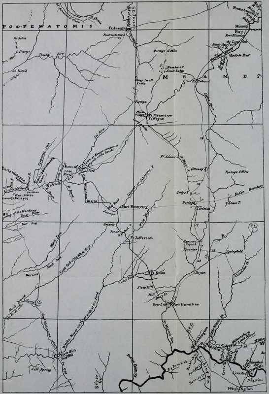
Click here for larger image size
A Part of Arrowsmith’s Map of the United States, 1796[Showing the region in which Wilkinson, Scott, Harmar, St. Clair, and Wayne operated]
The army of the United States now consisted of three or four hundred soldiers—the First Regiment—distributed among the frontier forts on the Ohio River. It was ordered that the depleted ranks of this regiment be filled by recruits to be raised “from Maryland to New York inclusive,” and that a full Second Regiment be raised, one company from South Carolina and one from Delaware and the remainder in the four New England states.[89] The troops were to be mustered by companies, to [Pg 119] rendezvous at Fort Pitt. Governor Arthur St. Clair was created Major-general and placed in command of the new army. Brigadier-general Richard Butler was appointed second in command. The object of the campaign was to establish a line of military posts from Fort Washington on the Ohio to the Maumee, where, at the Miami village at the junction of the St. Mary and St. Joseph, a strong fort was to be built, “for the purpose of awing and curbing the Indians in that quarter, and as the only preventative of future hostilities.”[90] In present day terms the army was to march from Cincinnati, Ohio, and erect a fort on the site of Fort Wayne, Indiana. In every order the underlying theory of the Government is plain—the one end sought was peace. “This [peace] is of more value than millions of uncultivated acres,” were the words of the Secretary of War in St. Clair’s instructions.[91] It was a war of self-defense, not a war of conquest.[Pg 120]
The business dragged at every point. In the hope that the Indians would come to reason, Scott’s raid was delayed a week at the start. Wilkinson, who was to move northward June 10, did not march until August 1. The continued anticipation of good results from these expeditions, which would render the grand campaign unnecessary, tended to lessen the energies of the preparations. General Butler was assigned the duty of raising the recruits in the East—a discouraging task. The pay offered did not equal an average day’s wage. The campaign was not entirely popular and promised innumerable hardships. Enlistments came in slowly, and, in many instances, only the unfit and unworthy offered. As late as April 28 the Secretary of War wrote General Butler: “None of the companies of the Eastern States are yet nearly completed.” As early as May 12 he wrote St. Clair: “It will at least be the latter end of July, or the beginning of August before your force shall be assembled.” Originally the army was to march from Fort Washington on July 10.[Pg 121]
General St. Clair left Philadelphia March 28 for the Ohio, to superintend affairs at the point of rendezvous. With “a degree of pain and difficulty that cannot well be imagined,” St. Clair, already a sick man, pushed on to Pittsburg and Lexington, Kentucky, reaching Fort Washington on the fifteenth of May. One week later (May 22) General Butler reached Pittsburg, to receive the army and the stores and ammunition and hurry all on to Fort Washington. But every rod became a mile and every hundredweight a ton. It was not until the fifth of June that the troops from the East reached Fort Pitt—eight hundred and forty-two soldiers of the twelve hundred Secretary Knox had promised May 19. And yet, few as they were, no boats had been prepared to carry them south, and indeed very few in which to transport the slowly accumulating stores and ammunition. Contractor Duer and Quartermaster Samuel Hodgdon seemingly believed that barges grew on the rich banks of the Ohio and flat-boats were to be picked from the trees. The congestion of troops and stores which now resulted at Pittsburg was quite[Pg 122] as appalling as the former scarcity of every needful thing. As rapidly as conditions permitted, General Butler wrought a certain kind of order out of the chaos, but not a kind that augured well for the future. That could hardly have been expected. In one way or another various craft were knocked together, filled, and set afloat in good hope of reaching Fort Washington. June dragged by, and July. August found Butler and Quartermaster-general Hodgdon still at Pittsburg, and it was not until the twenty-sixth of that month that the last of the army began the voyage southward—sixty precious days late.
On July 21 Secretary Knox wrote St. Clair at Fort Washington: “The president is greatly anxious that the campaign be distinguished by decisive measures.” A letter of August 4 reads: “The president still continues anxious that you should, at the earliest moment, commence your operations;” and another under the date of September 1 reads: “[The president] therefore enjoins you, by every principle that is sacred, to stimulate your operations in the highest degree, and to move as rapidly as[Pg 123] the lateness of the season, and the nature of the case will possibly admit.” It is a matter of record that at the time this letter was written neither General Butler or Quartermaster-general Hodgdon had so much as reached the rendezvous. The latter’s delay was never explained and General Butler was utterly dependent upon quartermaster and contractor. Butler was at last ordered to Fort Washington by Secretary Knox in the following peremptory words, which implied neglect and carelessness—a rebuke which was, perhaps, as undeserved as it was sharp: “I have received your letter of the 18th instant, which has been submitted to the President of the United States, and I am commanded to inform you that he is by no means satisfied with the long detention of the troops on the upper parts of the Ohio, which he considers unnecessary and improper. And it is his opinion, unless the highest exertions be made by all parts of the army, to repair the loss of the season, that the expenses which have been made for the campaign, will be altogether lost, and that the measures, from which so much has been[Pg 124] expected, will issue in disgrace.”[92] However the quartermaster-general had been ordered as early as June 9 to “consult Major General Butler upon all objects of the preparations and as soon as possible repair to headquarters.”[93]
Yet, had the army been assembled at Fort Washington July 15 instead of September 5, there would have been no such thing as moving northward for weeks. No sooner had the first of the troops reached St. Clair than it was clear that he had made no mistake in hurrying to the point of rendezvous. For instance the carriages of the guns used in Harmar’s campaign were ruined and had not been replaced. There was no corps of artificers and drafting was resorted to in order to secure smiths, carpenters, harness-makers, wheelwrights, etc. With the arrival of Major Ferguson, June 20, it became clear that nearly all the am[Pg 125]munition had yet to be properly prepared; a laboratory had to be built; the shells had to be filled with powder, likewise the artillery cartridges, the shells for howitzers and musket cartridges. Not only did enough of this work have to be done for the immediate use of the army, but a sufficient supply had to be prepared for each of the posts to be erected between Fort Washington and the Maumee, and to supply the main fort on the Maumee and its defenders until spring. The carriages of the guns that arrived from Philadelphia were rendered useless and new ones had to be made. Almost all arms which the troops brought to Fort Washington were out of repair. An armory had to be built, and, says General St. Clair, “so fast did the work of that kind increase upon our hands, that at one time it appeared as if it would never be got through with.”[94]
An indeterminate amount of powder shipped from Philadelphia was practically ruined before it reached Fort Washington; one boatload was entirely submerged on the way from Fort Pitt. The officers[Pg 126] attempted to keep this from the men but the news leaked out. “The powder was very bad,” records Ensign Pope of the militia, “I fired at a tree several times and hit but seldom; it would not force the ball.” Such of the powder as was good stood little chance of remaining so in the wretched tents that were palmed off on the quartermaster-general. Colonel Mentgetz, inspector, is our authority for the fact that, with the exception of two companies, the tents would not keep out rain at either front or back. General Harmar said the flanks of the tents were of Russian sheeting and the ends were of crocus or osnaburg and would not, in his opinion, keep out rain. According to Major Zeigler the tents were infamous and “many hundred dozen of cartridges were destroyed, and the troops, not being kept dry were sick in great numbers.”[95] The packsaddles were too big—“big enough for elephants,” said an officer; the axes sent from Philadelphia were useless—“would bend up like a dumpling,” according to Major Zeigler. In fact Fort Washington was[Pg 127] transformed into a manufacturing city, and there was almost no kind of work that was not done—though often the necessary tools had first to be made. Two traveling forges had been sent west of which only the anvils were missing!
It is not to be wondered that St. Clair, as General Harmar afterward said, was often the first up in the morning and went the rounds of the shops and laboratories greatly disturbed over the vast amount of work to be done, the difficulty in the doing of it, and the ominous delay. For, with the heat of the summer’s end, the grass was fast withering, which meant that feed for the horses must be transported—an item of great magnitude.
The failure of the quartermaster-general to come forward, even when ordered to do so, compelled St. Clair to bear the brunt of all the results of mismanagement and delay. As noted, the delay of the quartermaster was never explained. His very appointment occasioned an outcry among officers who had known him; the soldiers laughed many of his measures to scorn. One of his employees who arrived at Fort[Pg 128] Washington in charge of horses had, seemingly, no knowledge whatever of frontier life. The horses were not provided with hopples or bells; released from their long confinement in the barges they broke for the woods and many were never again secured. St. Clair facetiously hinted that their master would have had to wear a bell, had he gone to seek them, in order to be secure from becoming lost. It was found later that the horses had been fed, not from troughs, as ordered, but from the sandy river beach, where their grain was strewn and much wasted, the horses also injuring each other in an attempt to eat it.
But patience is exhausted before one half of the miserable story is told. More than enough has been suggested to show the condition of the “grand army” that had gathered and was now about to march northward. It is almost needless to add that an eternal jealousy between militia and regulars existed; that the troops were wretchedly clad; that nothing was known of the country through which the march was to be made, and less than nothing of the foe that was to be met and conquered.[Pg 129] The camp of the army (except artificers) was moved by St, Clair on August 7 six miles northward from Fort Washington to Ludlow’s Station,[96] where the pasturage was better and where the troops were not under the influence of the dramshops at the little settlement about the fort.
On the arrival of General Butler and Quartermaster Hodgdon, September 7, a slight delay occurred through Butler’s being appointed president of a court-martial which General Harmar had demanded and by which he was honorably acquitted. It was September 17 before the advance was begun from Ludlow’s Station northward.
When the army, twenty-three hundred strong, at last filed out from Ludlow’s Station, the plan seems to have been to build two forts between Fort Washington and the proposed fort on the Maumee, the first at the ford, twenty-three miles north, on the Great Miami, and the second about the same distance in advance and twice as far from the Maumee.[97][Pg 130]
The army marched from Ludlow’s Station under the command of General Butler and reached the Miami September 17. St. Clair returned to Fort Washington to hurry up the contractor’s agents and muster in the militia he had called from Kentucky. From September 17 to October 4 the army was busy building a fort at “Camp Miami,” which St. Clair named Fort Hamilton.[98]
On October 3 Butler made the last preparations for the march, Fort Hamilton being nearly completed. All the artillery cartridges (except sixty rounds) were distributed, and one half of the stock of musket cartridges. A body of contractor’s stores was thrown across the Miami, under cover, to join the army on its march.
Concerning the route and the road, little was known. At the outset of the campaign St. Clair in his instructions was ordered “to appoint some skillful person to make actual surveys of your march, to be corrected, if the case will admit of it, by[Pg 131] proper astronomical observations, and of all posts you may occupy.”[99] The first settlers in the Miami purchase[100] had spread inland a few miles at this time; one settlement, Ludlow’s Station, was made five miles up Mill Creek and another twelve miles up the Great Miami. Butler’s route from Ludlow’s Station to the site of Fort Hamilton was undoubtedly already an open trail that far. The day before he advanced from Fort Hamilton, Butler wrote St. Clair: “I have just received a verbal report from Captain Ginnon, the surveyor, who is returned. He has been seven miles, and says the face of the country is level but very brushy, and in his opinion it is impracticable for loaded horses to get on without a road.[101] Of this I will be a better judge as I advance and try the present order of march, &c. Should I find it impracticable to execute, I feel confident that any directions that may be necessary to facilitate the move[Pg 132]ments will meet your approval. The road is cut one and a-half miles to a good stream of water and ground to encamp on. Five miles advanced of that is a large creek, which is three feet deep at the place he crossed, but a little below is a ford, ...”
On the fourth of October, with enough provisions to last a few days, without its commander, who was at Fort Washington hurrying on three hundred militia, the army under Butler crossed the Miami River and entered the shadows of the Indian land. We have no definite record of the first days’ marches. It would not seem that more than five miles a day were accomplished. The route was in alignment with the Eaton Road between Hamilton and Eaton, Preble County. Four Mile (from Hamilton) Creek—then known as Joseph’s Creek—was crossed near the old “Fearnot Mill,” and the first encampment was made near what was afterward known as Scott’s tanyard on Seven Mile Creek—then called St. Clair’s Creek.[102] The line of march was up Seven Mile Creek, west of Eaton, where the creek was forded. “The trace cannot now be[Pg 133] definitely located,” wrote a Preble County annalist, a generation ago. “It was not cut to as great width as most of the military roads, and the line has been almost wholly obscured by the growth of the forest and the action of the weather upon the soil.”[103]
Narrow as the road here was, it was cut wider than St. Clair intended. After the first day or two General Butler, as he suggested in his letter of October 3, decided that St. Clair’s tri-track plan of march was impracticable, and gave orders that but one road should be cut, and that the army march in a body.
On the seventh St. Clair came hurrying on from Fort Washington to join his army. The militia had gone on on the fifth, but in bad temper. Several deserted even upon arriving at Fort Washington. A sergeant and twenty-five men deserted on the night of the third. A score of men deserted from Fort Hamilton the night before the army marched. The anxiety of the officers, and the herculean efforts to get the army into fighting trim, had not created a very loyal spirit in the men who marched.[Pg 134] A little more chicanery and misjudgment and the entire army would have mutinied. St. Clair, before mounting his horse, wrote Knox that his troops amounted in all to twenty-three hundred. “I trust I shall find them sufficient,” he added. The words remind one of Braddock’s last letter to the British Ministry before leaving Fort Cumberland for the death-trap on the Monongahela in 1755. Major Ebenezer Denny traveled with St. Clair as aide-de-camp and has left us the official account of the army’s march. Denny was not anxious to serve. “You must go,” General Harmar declared, “some will escape and you may be among the number.”[104]
St. Clair and Denny reached Fort Hamilton on the seventh, and on the day following pushed on after the army over the narrow course it had made; this was running “north sixteen degrees.” Four encampments were passed and the militia, and St. Clair reached his army that evening. There was full need of him. The army was making but five miles a day; and at that disastrously slow pace the stores[Pg 135] were not keeping up. Tonight (the eighth) St. Clair wrote a stinging letter to Israel Ludlow. Instead of having ninety thousand rations, as was promised, St. Clair had to write “by day after tomorrow I shall not have an ounce unless some arrives.... If you found the transportation impracticable, you ought to have informed me, that I might have taken means to have got supplies forward, or not have committed my army to the wilderness.... No disappointment should have happened which was in the power of money to prevent; and money could certainly have prevented any here.... Want of drivers will be no excuse to a starving army and a disappointed people.”[105]
Another exceedingly unfortunate affair demanded St. Clair’s attention, in his opinion, that night. He had given carefully studied and explicit orders by which the army should march. As noted, General Butler changed the order of march as he threatened to do in his letter to St. Clair from Fort Hamilton. The reasons for the[Pg 136] change did not appeal to the commander-in-chief; Butler was called to account for his action, apologized, and stated his reasons. St. Clair had ordered that the army march in three lines, contending that it was far more easy to cut three roads, ten feet in width each, than to cut one road of thirty or forty. St. Clair’s method was that pursued by the wisest and most successful generals—Forbes and Bouquet—in hewing the first roads across the Alleghenies. “The quantity of timber,” St. Clair records, “increases in a surprising proportion, as the width of the road is increased;”[106] the veteran conqueror of Fort Duquesne, General Forbes, wrote his right-hand man Colonel Bouquet under the same circumstances, urging the cutting of several paths, saying, “I don’t mean here to cut down any large trees, only to clear away the Brushwood and saplins....”[107] Temporarily, St. Clair allowed Butler’s alteration to stand, but[Pg 137] insisted that it should soon be corrected as the army pushed on.
The result was that Butler conceived an intense dislike for St. Clair. The latter has placed it on record that, upon Butler’s arrival at Fort Washington, “he was soured and disgusted, and I suppose it was occasioned by the fault that had been found with the detention of the Troops up the river;”[108] Knox’s rebuke, previously quoted, would make plain the reason of any disinterest on the part of General Butler. St. Clair’s reproof here and now seemed to increase it; “from that moment,” St. Clair said, “his coolness and distance increased, and he seldom came near me. I was concerned at it, but as I had given no cause, I could apply no cure.”[109] As the half mutinous, because half fed, army blundered on, it might seem that lack of provisions was its most serious menace; yet it becomes pretty clear that the estrangement of Butler and St. Clair was even more serious.
On the ninth of October, the army pushed on nine miles, and the horses being tied up[Pg 138] at night an eight o’clock start was achieved on the morning of the tenth, but only eight miles were traversed. At two o’clock on the afternoon of the eleventh the army drew out into the low prairie land which lies six miles south of Fort Jefferson, Darke County, Ohio, and halted for the night to search for a safe path through it. On the day after, a party led by General Butler found a “deep-beaten” Indian trail which skirted the lower levels “avoiding the wet land,” and this was followed for five and a half miles. There is no record that St. Clair followed an Indian trail until near the center of Darke County. The course heretofore had been run by the compass.[110]
From this night’s encampment St. Clair rode forward a short mile and chose the site for the next fort on the line from the Ohio River to the Maumee. The spot chosen was near the present site of Fort Jefferson, Ohio—latitude 50° 4´ 22´´ N. The work of erecting the new post was undertaken with alacrity by many of the soldiers and officers—the latter working in the mud with the men. Major Ferguson[Pg 139] found the lack of axes a serious handicap, there being but one ax to three workmen.[111] Yet these discouragements were not as disheartening as the continual dearth of provisions. This undermined discipline, perseverance, loyalty, and honor. Desertions became more alarmingly frequent, but men who were not fed could not work and would not march. As half-rations, and those exceedingly poor, became the necessary order of the day, the army slowly melted from under the discouraged St. Clair. Every night found the army smaller and yet more discouraged.[112] In vain St. Clair beseeched Hodgdon to hurry on provisions.[113] But the contractor’s horses were[Pg 140] lacking and those to be had were unfit for the heavy loads bound to them.
And here at Fort Jefferson another and[Pg 141] more pitiful estrangement between St. Clair and Butler occurred. While the fort was being erected, the latter officer came to St. Clair’s tent and, in view of the slow advance of the army and the lateness of the season, asked St. Clair for a thousand picked men with permission to hurry on by a forced march to the Maumee and begin the erection of the fort there to be built. “I received the proposal,” records St. Clair, “with an astonishment that, I doubt not, was depicted in my countenance, and, in truth, had liked to have laughed in his face, which he probably discovered. I composed my features, however, as well as I could, told him, though it did not appear to me, at first view, as a feasible project, nevertheless, it deserved to be considered; that I would consider it attentively, and give him an answer in the morning, which I accordingly did, with great gravity: and from that moment, his distance and reserve increased still more sensibly.”[114] Butler seems to have considered himself treated with contempt in this instance. It cannot be supposed that such a brave veteran[Pg 142] officer as Butler could have asked a thing which it was out of St. Clair’s power to grant; yet from the records of the condition of affairs it is difficult to see how St. Clair could have risked dividing his army which, for the whole week following, was on half-rations, and men deserting by twos and threes and even scores every night. Passing the question—which in no way can be decided—of the propriety of Butler’s plan, the circumstance seems to have deeply embittered a brave and good man with whom Fate had been dealing most unkindly since the very beginning of the present campaign. As will be seen, it were a kindness to Butler to believe that continued untoward fortune rendered him mentally incapable of acting henceforward in a sane manner toward General St. Clair.
Explorations were carried on throughout the twenty-third and the line of march on the Indian trail, previously discovered, was renewed on the twenty-fourth; the army stumbled helplessly on to Greenville Creek, where the city of Greenville, Ohio, now stands. This small effort to advance was more than the hungry army could endure[Pg 143] and one whole dark week was spent here waiting for provisions. The condition of army discipline was probably indescribable. The Kentuckians, who formed the large portion of the militia, were not afraid of the savages but the lack of food completely demoralized them. On the last day of October a large party numbering at least sixty deserted, and, hastening down the roadway which the army had cut, threatened to seize the provision train that was supposed to be slowly nearing the sorry army. The threat cast a gloom over the army and St. Clair was compelled to order out the First Regiment, not so much in pursuit of the deserters,[115] as for the protection of the needed provisions. The army, weakened by the absence of this regiment, marched on—following an Indian trail that ran north from Greenville on the general alignment of the present Fort Recovery Road. St. Clair states the direction of the path as “north 25° west.”[116]
Added to St. Clair’s many discourage[Pg 144]ments and Butler’s disaffection, was physical ailment. The touch of gout experienced on the journey over the Alleghenies did not leave him. In his meager Journal he records on October 24: “So ill this day that I had much difficulty in keeping with the army.”[117] November dawned wet and cold but on the first his “friendly fit of gout” was growing better.
On the third of November the army made its last day’s march—little dreaming that it was the last or that just ahead lay the bloodiest battlefield in American pioneer history. The Thomas Irwin manuscript, previously quoted,[118] gives us a glimpse of the day that is of singularly pathetic interest. “In the afternoon of the 3d Something Broke which Caused a general halt Nearly one hour the Day was Cold us waggoners in front had a very handy way of making fire we made up a Large fire Several of the officers Collected around to warm themselves Genl St Clair was Brought and took a Seat he not Being able to walk they Discoursed on Different Subjects one was[Pg 145] where they thought we were the general oppinion was that we had passed over the Dividing ridge Between the Miamie waters and was then on the waters of St. Marys Col Serjant Came up at the time Stated the advance gard had Chased 4 or 5 Indians from a fire out of a thicket & got part of a venison at it he Likewise stated there had Been more Indians Seen that Day than any Day previous The General observed that he Did not think the Indians was watching the motions of the army with a view to attack them other than Steal horses or Catch a person if they had a Chance We all Coincided [?] in that oppinion.” Poor St. Clair! Was ever a general more terribly mistaken? Just beyond lay Little Turtle, now closing swiftly in on the doomed army.
“The army moved about two miles,” continues Irwin, “from there Halted to Encamp at a good place But Scarce of Water an Express Came up from the advance gard give information that they had arrived at a fine running Stream of water and a good place to Encamp the army moved to Sd Creek got there a Little after Sunset. it[Pg 146] was Between 8 & 9 oclock Before the army got fixed to Rest.” Then follows the ominous sentence: “this was on the 3d of November 1791.”
Happy it is that the bloody promontory to which St. Clair’s army hobbled late on that cold November night can forever bear the cheerful name which another and more successful campaigner—whose soldiers were not always half-famished—gave it. And still no thoughtful student can look upon the slow-moving Little Wabash from the present site of Fort Recovery, Ohio, without remembering that here Camp Destruction was pitched before ever Fort Recovery was erected. A fine high plateau or promontory thrusts itself out into the lower flats through which the river curves. At its extreme point the river approaches on the left and in front. On the right are extensive fields where the sunlight plays so tenderly that it is difficult to picture the rank swamp which lay there a century ago. Beyond the river, level flats extend half a mile and more to the foothills beyond.
Major Denny had accompanied the[Pg 147] advance guard and quartermaster to this spot, and though “it was farther than could have been wished,” word was sent back to the army advising that the march be continued to that point. It being “later than usual when the army reached the ground this evening,” records Denny, “and the men much fatigued prevented the General from having some works of defense immediately erected.” The army camped in a hollow square on the summit of the promontory; General Butler commanded the right and front and his troops under Majors Butler, Clarke, and Patterson lay in two lines along the edge of the high ground near the Wabash. The left was composed of the battalions under Bedinger and Gaither, in the first line, and Lieutenant-colonel Darke’s troops in the second. “The army was Encamped in a hollow Square,” says Irwin, “allong the Bank of sd Creek perhaps 50 yards Between the Lines so that the rear Could go to the Creek for water.” The militia was sent forward across the Wabash and encamped about one-fourth of a mile in the bottoms. The tired men fell to work gathering wood, and soon two rows[Pg 148] of fires were brightly blazing in the narrow avenue between the troops of Butler on the left and Darke on the right. The rain had turned to snow. Many of the exhausted men sank instantly to sleep.
As if half conscious of the doom hanging over the army, certain of the officers were given to pondering on the number of Indians seen that day. “Fresh signs,” writes Denny, “... appeared today in several places; parties of riflemen detached after them, but without success.” The Irwin MS. reads: “The advance gard Seen they Supposed about 30 Indians in the Bottom on the other Side of sd Creek [Wabash] when they arrived at it in the Evening and had Seen Considerable Sign that Day.” The premonition of disaster intensified as the camp became quiet and the blazing fires were brightly reflected in the light snow. Among certain officers the premonition took shape, and it was determined to send out a party to reconnoiter. Captain Butler at first resolved to lead the party, but soon thought it improper to leave the camp. Accordingly, Colonel Gibson went to Captain Slough of the first battalion of levies[Pg 149] carrying a raccoon in his hand; finding Slough, he invited him to his tent to see “how to dress a racoon Indian fashion.”[119] Captain Butler joined them, and the three went to General Butler’s tent where wine was served. Slough agreed to go out with a party of volunteers, nominally to catch “some of the rascals who might attempt to steal horses.” It is plain, whatever the officers may have given as a reason for the scouting expedition, that Slough was sent to feel of the woods—to guard against surprise. His line of men paraded in the firelight before Butler’s tent before stealing out beyond the lines. Passing Colonel Oldham’s tent, Slough stopped and informed that officer of the detachment and its mission. Colonel Oldham “was lying down with his clothes on” and “requested me not to go, as he was sure my party would be cut off, for, says he, I expect the army will be attacked in the morning; I replied, that as I had received my orders I must go.”
Slough led his party through the militia camp and onward about a mile on the[Pg 150] Indian trail. Here they were divided, each party hiding on opposite sides of the path. Soon a party of Indians passed each hiding company; one company opened fire. It was not long before the men realized that something extraordinary was on hand. A larger body of Indians soon came near Slough’s band on the left of the trace, paused, and coughed as if to attract another volley, and then passed on. The scouting party came together on the trail and agreed that an Indian army was advancing; a hurried march to camp followed. On the way “every fifteen or twenty yards we heard something moving in the woods on both sides of the path, but could not see what it was,” wrote Slough. It was a thrilling moment when these men heard Little Turtle’s quiet lines worming their way through the underbrush—an army making so strange a noise in the night that even frontiersmen could not recognize it. Yet an unrecognized sound brought utmost alarm; “we pushed on,” said Slough, “and gained the militia camp as soon as possible.”
Slough’s first thought was to send word[Pg 151] immediately to St. Clair. He hurried to Colonel Oldham’s tent. “I was just going to dress myself,” says Oldham, “and go and inform the commander in chief about it; I will thank you [Slough] to inform the general that I think the army will be attacked in the morning.”
Slough hastened to General Butler’s tent, but, seeing no one but the sentry, passed on to Colonel Gibson’s tent. Here he aroused Gibson and Doctor M’Croskey, and repeated his alarming story. He asked Gibson to go with him to General Butler. Colonel Gibson was not dressed, and urged Slough to go alone and arouse Butler. He obeyed, and as he returned to General Butler’s tent the latter walked out of it and went to the fire. Calling Butler aside, that the sentry should not overhear the news, “I told him what colonel Oldham had said, and that, if he thought proper, I would go and make the report to general St. Clair. He stood some time, and after a pause, thanked me for my attention and vigilance, and said, as I must be fatigued I had better go and lie down. I went from him and lay down....” It was five days before[Pg 152] General St. Clair heard of Slough’s scouting episode of the night of November 3.[120]
All that Slough and Oldham suspected was true and more. All night long the Indians crept around the army, ready for an attack at sunrise. The army began stirring at an early hour; some there were, it is sure, who anxiously awaited the dawn. The troops paraded under arms, as usual, before sunrise. Ranks had just been broken when a scattering fire was heard in the militia camp, and soon the Indian yell. The militia stood a moment and then fell back to the river, crossed it, and were upon Major Butler’s and Clark’s battalions, throwing the latter into a confusion that was never remedied despite the energy of those officers. The Indians were upon the heels of the militia, but were repulsed by the fire of the first line. With well-timed accuracy the Indians charged the opposite side of the square, where, too, they were at first repulsed. The American army was now practically surrounded—the savages lying hidden in the brush, forests, and[Pg 153] high grass on the low ground which surrounded the promontory on three sides and in front. The artillery was placed at the center of the two sides of the square and here the battle raged most fiercely. For some time, it would seem, the honors of the conflict were evenly divided. But from the position of the two armies it can readily be seen that the American fire was not so effective as that of the savages whose firmness and audacity was unparalleled. From their concealed position it required little marksmanship to pick men off rapidly on the high ground just beyond and hidden only by a low-lying cloud of smoke from their own guns. The officers, hurrying back and forth, offered conspicuous targets. From St. Clair (who had to be assisted to mount his horse) down, the officers were brave and efficient. As St. Clair passed down one line, Butler passed up the other. They never met, though St. Clair frequently asked for Butler as the battle wore away.
At last it was agreed that things were going badly and that a bayonet charge, only, would dislodge the enemy, who were rapidly cutting down the efficient strength[Pg 154] of the army—making particular havoc among the officers. Colonel Darke was thereupon ordered to turn the left flank of the enemy, which he accomplished with firmness and success—driving the savages several hundred yards. Yet soon they swarmed back, not being held where they were, and, in turn drove the troops backward. About the cannon, which the Indians were taught to dread, the battle ebbed and flowed bloodily. As fast as the gunners were shot down others took their places. Now and again the red line swept up to the guns and the piles of slain were scalped, amid the smoke, in the very face of the army. On the left flank, too, the savages were beginning to overpower and gain the summit of the promontory and enter the lines. They were charged fiercely but after each charge there was a sudden dearth of officers, and the lines returned very thin. The army was now attacked from every side, though not until late in the long three hours of conflict did the Indians take the initiative. Their settled plan was to get the troops in range, lie low, make no noise save with their guns, retire[Pg 155] when assaulted, but follow back eagerly. Such tactics were all that were necessary. As in Braddock’s battle beside the Monongahela, so here, the white army on higher ground in plain sight could not do such fatal execution, by any means, as the Indian army strewn among the standing and fallen trees, the brush and rank grasses of the lower ground, and on the sloping sides of the promontory.
By nine o’clock the army had been exposed for three hours to the merciless Indian fire. Hundreds had fallen; the ground was literally covered with dead and dying. The only question was, Could the remainder escape? The army was cut off from the road. Benjamin Van Cleve, a young man, has left record of this memorable break for the road when order to retreat was at last given: “I found,” he says, “the troops pressing like a drove of bullocks to the right. I saw an officer ... with six or eight men start on a run a little to the left of where I was. I immediately ran and fell in with them. In a short distance we were so suddenly among the Indians, who were not apprised of our[Pg 156] object, that they opened to us and ran to the right and left without firing. I think about two hundred of our men passed through them before they fired.”[121] An opening being made, the army poured heedlessly along. No order or semblance of order existed, save in a remnant of Clark’s command which essayed to cover the rear. In the very rear, on a horse which could not be pricked out of a walk, came St. Clair, unmindful of the bloody tumult behind him where the old men and wounded were being killed.
This awful battle was a fitting close for such a campaign. In almost every sense it was the greatest defeat suffered by white men on this continent at the hands of aborigines. St. Clair’s army numbered on the eve of November 3 one thousand four hundred and eighty-six men and eighty-six officers. Of these, eight hundred and ninety men and sixteen officers were killed or wounded. The army poured back to Fort Jefferson and then on to Fort Washington. The path hewn northward became, like[Pg 157] Braddock’s Road, a route for the hordes of Indians toward the frontiers. Their victory, so bloody, so overwhelming, gave confidence. Perhaps never before nor afterward did any battlefield present a scene equal to that Wabash slaughter field. The dying were tortured and the dead frightfully mutilated. On the theory that the army sought to conquer the Indian land, sand was crushed into the eyes of the dead in cruel mockery. Several scores of women followed the army—though contemporary records are singularly silent on this point.[122] Many of them, it is sure, fell into the hands of the savages and the first white visitors to the battleground found great stakes driven through many corpses.[123]
The two underlying causes for this terrible reverse of American arms were the long delay in getting the army on its feet, properly supplied; and the undisciplined condition of the troops. The immediate cause of the defeat was, without question, the failure of all the officers who knew of[Pg 158] Captain Slough’s discoveries on the night of November 3 to communicate them to General St. Clair. Colonel Oldham ordered Slough to St. Clair; he went only to General Butler who dismissed him without acceding to his spoken request to be allowed to take the news to the commander-in-chief. The words of the standard authority on St. Clair’s defeat are perhaps severe, but no new information has come in half a century to give ground for altering them; Albach says: “The circumstances under which the omission occurred, would favor an inference that he [Butler] sacrificed the safety of the army to the gratification of his animosity against St. Clair. The evidence given before the committee of Congress is conclusive that he failed, at least to perform his whole duty in the premises.”[124] Butler’s side of the story could never be told; fatally wounded while heroically exhorting his men, the poor man was carried to his marquee under an oak, by his brother, Captain Edward Butler. Propped up on his mattress, a loaded revolver placed in each hand, the old veteran was left to his fate.[Pg 159] As his friends left the tent by the rear, the Indians surged in at the front.[125]
St. Clair’s road northward was the main thoroughfare to Fort Hamilton and Fort Jefferson from the Ohio and, though superseded by another route soon built parallel to it, was ever of importance in the burst of population from Pennsylvania and Kentucky into the Old Northwest. But the soldiers of St. Clair’s successor were too superstitious to follow that ill-starred track. And, as Forbes came successfully to Fort Duquesne over a new route built parallel to Braddock’s, so the second conqueror of the Old Northwest cut a new road parallel to St. Clair’s.
The defeat of St. Clair’s army cast a nation into gloom. As the terrible tidings sped eastward a thousand frontier cabins were filled with dismayed men, women, and children. The passion into which it is said the patient Washington was thrown, upon hearing the melancholy story, was typical of the feeling of a whole people. There could be no doubt, now, what the future would bring forth; a deluge of raiding savages, such as had never overrun the frontiers since Braddock’s defeat in 1755, would certainly come; the desperate cry, “White men shall not plant corn north of the Ohio,” would now ring out over the thin fringe of frightened settlements on the Miami and Muskingum, and with that cry would come frenzied raiders from whose tomahawks men would do well to escape death and women be fortunate if[Pg 161] they were quickly killed. From all the western settlements in Kentucky, Ohio, and Pennsylvania a cry, anxious and often piteous, was hurried over the mountains to Philadelphia for aid and protection.
The young government now faced a problem difficult in the extreme with fine courage, fully conscious of its own dignity and its own latent power. Within six weeks of St. Clair’s annihilation, the Secretary of War submitted a statement to Congress which summed up the situation briefly and clearly. The former treaties with the Indians, the efforts for peace, the sorry details of the campaign were all described. Peaceful and warlike efforts, alike, had failed. So much for the past. For the future, the plan was already formulated and ready for adoption by Congress. First, the war must be brought to an end; if peace could be secured without further resort to arms, well and good; “it is submitted,” read the Secretary’s communication, “that every reasonable expedient be again taken ... that the nature of the case, and a just regard to the national[Pg 162] reputation, will admit.” Those in best position to judge, however, were sure that the pride of victory was so strong among the confederated nations that “it would be altogether improper to expect any favorable result from such [peaceful] expedients,” and Congress was warned accordingly that it was “by an ample conviction of superior force only, that the Indians can be brought to listen to the dictates of peace on reasonable terms.” It was properly insisted that relinquishment of territory formerly ceded by the savages could not be arranged “consistently with a proper regard to national reputation.” The plan included the organization of a new army, comprising three hundred cavalry, three hundred artillerymen, and five regiments of infantry of four thousand five hundred and sixty men. It was to be styled “The Legion of the United States,” and was to be divided into four sub-legions of one thousand two hundred and eighty non-commissioned officers and privates each. The mistakes of the past dictated the necessity of having this force disciplined “according to the nature of the service;” its ultimate object was to[Pg 163] establish a strong post on the present site of Fort Wayne, Indiana.
To secure a comprehensive grasp of the interesting campaign now undertaken, it is necessary to keep in mind simultaneously three situations: this new army, the moving companies of peace commissioners, and that ragged pathway northward from Fort Washington with the little stockade forts which guarded it. These varying phases will be treated chronologically, at the risk of coherency, and the scattered threads gathered much in the tangled order in which they were spun amid many hopes and many fears.
One of the first important matters, in this as in previous campaigns, was to retain the neutrality of the Six Nations. The efforts in the year preceding had been approximately successful, though, according to his biographer, Stone, Joseph Brant with a party of Mohawks was present at St. Clair’s defeat. As early as January 9, 1792, an express was hurried off to the Reverend Samuel Kirtland, veteran missionary among the Iroquois, informing him[Pg 164] that Colonel Pickering had invited the principal chiefs of the Six Nations to visit Washington. He was urged to assist in securing their acquiescence, especially Joseph Brant’s, and to accompany them on the journey.
The next act of Secretary Knox is peculiarly significant and interesting. Captain Peter Pond, a trader, and one William Steedman were ordered to proceed westward to the hostile tribes on the Maumee, feigning to be traders. “No doubt can exist,” wrote Knox, “that our strength and our resources are abundant to conquer, and even extirpate the Indians.... But this is not our object. We wish to be at peace with those Indians—to be their friends and protectors—to perpetuate them on the land. The desire, therefore, that we have for peace, must not be inconsistent with the national reputation. We cannot ask the Indians to make peace with us, considering them as the aggressors: but they must ask a peace of us. To persuade them to this effect is the object of your mission. Insinuate, upon all favorable occasions, the humane disposition of the United States;[Pg 165] and, if you can by any means ripen their judgement, so as to break forth openly [disclose yourselves], and declare the readiness of the United States to receive, with open arms, the Indians, ... do it.... You might persuade some of the most influential chiefs to repair to our posts on the Ohio, and so, from post to post, to this place.”[126] Perhaps never in warfare were spies sent amongst an enemy on so remarkable a mission.
In response to the Government’s invitation, fifty Indian chieftains from the Six Nations arrived in Philadelphia on March 13. They were treated with utmost courtesy by the government officials and proper gifts distributed. Among other benefits, fifteen hundred dollars a year was promised by the United States to be spent encouraging education and agriculture in the Iroquois land. The chief boon secured by this display of hospitality and liberality was the promise that the Six Nations would wholly abstain from war and would immediately send a delegation to the western tribes to[Pg 166] mediate between them and the United States, secure an armistice, and make plans for a final treaty of peace. In this promise the Government placed great hope. The Six Nations were the most prominent of their race on the continent and their chieftains exerted an influence equaled by none. Having received, in person, from the nation’s highest executive officers, protestations of friendliest nature, they were the best emissaries that could possibly treat with the hostile tribes on the Maumee on behalf of the Government.
Yet efforts to avert war did not stop here. By May it was determined to send an envoy extraordinary to the Maumee, if the hazard could possibly be accomplished. The Iroquois chiefs would, it was believed, keep their solemn pledges, yet affairs of such a nature usually developed very slowly among red-men and in the present crisis there was no time to be lost. Accordingly a fitting personage was chosen by President Washington to make the perilous attempt. His choice fell quickly on the brave leader of the Ohio Company pioneers to Marietta—General Rufus Putnam.[Pg 167] Sufficient provision for his family in case of a disastrous termination of his journey being promised by the Government, the quiet, bold pioneer departed from his frontier home on May 22 for Fort Washington. His instructions were explicit. He was first to assure the hostile nations that the United States did not in the least desire any of the Indian’s land, but rather solemnly pledged itself to “guaranty all that remain, and take the Indians under our protection.” In turn the Indians were to agree to a truce and call in all war-parties. The most prominent chiefs were to be invited to Philadelphia to make a treaty; on his way westward General Putnam was empowered to release all Indian prisoners retained at Fort Washington and give the women presents to carry home with them in token of the Government’s pacific intentions.[127]
The frontier to which Putnam now came was in need of brave men and strong. These had been long months since that dark November day when the remains of St. Clair’s shattered army poured back upon[Pg 168] Fort Jefferson and Fort Hamilton, Brigadier-general Wilkinson now commanded at Fort Washington and with a firm hand was managing affairs on the firing-line. His outposts, Forts Hamilton and Jefferson, were frequently surrounded by Indian scouts sent down the narrow trace from Little Turtle’s cantonments on the Maumee, but no attack on these posts had yet been made in force. Such an attack was frequently anticipated, and many sudden calls to arms sounded now and again within the little garrisons lost so far within the northern forests. The brave Captain John Armstrong still commanded at Fort Hamilton, guarding the strategic ford of the Great Miami and the narrow roadway toward Fort Jefferson and the silent corpse-strewn battle-ground beyond. Wilkinson’s principal duty was to keep the garrisons of his three little forts alive and in heart, and keep a watchful eye on the victorious enemy. In January, calling on volunteers from the country about Cincinnati, Wilkinson organized a little company to visit St. Clair’s slaughter-ground. The snow was two feet deep—a depth seldom if ever[Pg 169] exceeded in southwestern Ohio. Kentucky volunteers crossed the Ohio on ice above the mouth of the Little Miami. Leaving Fort Washington January 25, the fatal field was reached February 1. Such was the depth of snow that comparatively few bodies could be found, save as here and there, on knolls and ridges, a white mound of driven snow marked where a wolf had left a scalped and mangled corpse. The winter of 1791-92 likewise witnessed the erection of an intermediary post between Forts Hamilton and Jefferson, most appropriately named Fort St. Clair. It was erected by a body of men under command of Captain John S. Gano, under whom William Henry Harrison served, half a mile west of the present site of Eaton, Preble County, at St. Clair’s Crossing of “Garrison Branch” of Seven Mile Creek.
As the spring of 1792 opened, and the forest roads became passable, it was expected that the Indians, by a concerted movement, would attempt to sweep the three forts north of the Ohio and make good their unjust claim to possession of that northern shore.[Pg 170]
Accordingly spies were kept well out on the trails for any sign of an advancing army. Others were sent nearer the Indian’s lair. On April 7 two messengers, Freeman and Gerrard, were sent from Fort Washington with a speech to the hostile tribes, being ordered to follow Harmar’s Trace up the Little and Great Miamis. Three days later Wilkinson sent word to Armstrong to order out a spy by way of St. Clair’s road, who should carefully study the route all the way to the Miami towns. Accordingly one of the boldest men on the frontier, William May, was ordered to “desert” to the enemy and, shaving his head and adopting their dress and manner of living, to learn all that was being planned and done in the red-men’s camps. On May 12 Sergeant Reuben Reynolds was ordered to “desert” from Fort St. Clair and also follow St. Clair’s route to the Maumee and reside with the Indians until a favorable opportunity to return occurred. On May 20 Colonel Hardin and Captain Alexander Trueman left Fort Washington for the Maumee, bearing an official message from the Government, of similar tenor to that[Pg 171] given to General Putnam. Thus six men had preceded Putnam to the Maumee, and only two of them went merely as spies—May and Reynolds. The fate of four of these men dampened the ardor of the frontier people for peaceful efforts. Freeman, Gerrard, Trueman, and Hardin were all murdered before reaching the Maumee. Reynolds and May returned in safety later in the year.
General Putnam learned at Fort Washington of the fate of his predecessors and determined not to throw life away uselessly. Favorable messages having been received from the upper Wabash, he turned all his efforts toward securing a meeting with the Wabash Indians in the fall of the year at Vincennes, Indiana. No more attempts were made to reach the Maumee over the “Bloody Way,” as the Indians termed the route north from Fort Washington. “The President of the United States must know well why the blood is so deep in our paths,” exclaimed a Shawanese chieftain, “... he has sent messengers of peace on these bloody roads, who fell on the way.” A messenger was even now pre[Pg 172]paring to come this way to whom bloody roads were not new and for whom they had no fear. Leaving the Indian commissioners going slowly on their way to a conference with the hostile tribes at “Auglaize”—the mouth of the Auglaize River where Defiance, Ohio, now stands—and Putnam waiting for the Weas and Kickapoos to assemble at Vincennes, let us look back to the gathering “Legion of the United States” into whose ready hands the matter of peace would go when the Indians got courage enough to throw off the mask.
It was one thing to plan an army on paper but a far more serious task to raise and organize it. And first and foremost arose the trebly difficult task of choosing a leader. The officers of Revolutionary days were fast passing into old age, and as Washington looked about him to the comrades of former years, there were few left capable of taking up the difficult task that St. Clair laid down. A memorandum left by Washington indicates the serious necessity of a wise choice and the nature of the possible candidates. Lincoln was sober,[Pg 173] honest, and brave, but infirm and past the vigor of life; Baron Steuben, a stickler for tactics, was likewise sober and brave and sensible, but a foreigner; Moultrie was brave and had fought against the Cherokees, but Washington knew little of him; McIntosh was considered honest and brave but was not well known and consequently not popular, and was infirm; Wayne was “More active and enterprising than Judicious and cautious. No œconomist it is feared:—open to flattery—vain—easily imposed upon and liable to be drawn into scrapes. Too indulgent (the effect perhaps of some of the causes just mentioned) to his Officers. Whether sober—or a little addicted to the bottle I know not;” Weedon was not deficient of resource and was of a convivial nature though not unduly so; Hand was sensible and judicious and not intemperate; Scott was brave and “means well” but not suited for extensive command, convivial; Huntington, sober, sensible, discreet; Wilkinson, lively, sensible, pompous, and ambitious, “whether sober or not I do not know;” Gist, activity and attention doubtful, but of noble spirit; Irvine, sober,[Pg 174] tolerably sensible, prudent, an “œconomist;” Morgan, fortunate and had met with éclat, possibly intemperate, troubled with palpitation and illiterate; Williams sensible though vain, in poor health; Putnam, (Rufus) strong-minded, discreet, “nothing conspicuous in character ... known little out of his own State and a narrow circle;” Pinckney, brave, honorable, erudite, sensible and a stickler for tactics.[128]
No other officers are named as possible candidates for a position no one could possibly desire. As the list stands, it forms a startling refutation of the oft repeated saying that though drinking was common in the old days it was not carried to excess. The problem with Washington seems to have been, speaking mildly, to find a responsible man with a clear head. His decision at first seems to have wavered between Lincoln and Moultrie; under these men as major-generals, Wayne, Morgan, and Wilkinson might serve as brigadiers. What may have induced the final decision[Pg 175] cannot be stated definitely, but the command was at last offered to Brevet Major-general “Mad” Anthony Wayne and it was accepted. Brevet Brigadier-generals Wilkinson and Thomas Posey were second in active command. Major-general Scott was to command fifteen hundred mounted Kentucky militia.
As with Washington, so with Wayne, the most serious task was to choose his officers from the recruits which early in 1792 were hurried on to Pittsburg to defend the frontier under the dashing hero of Stony Point—Wayne’s appointment having been well received everywhere save in Virginia and Kentucky. If the army was to be disciplined “according to the nature of the service”—Indian-fighting—Indian-fighters must do the training. “We will be under the necessity,” wrote Wayne to Knox from Pittsburg, “of discharging many of the men—who never were—nor never will be fit for service, they are at present a nuisance to the Legion & a useless expense to the publick.... You may rest assured I will carefully guard against improper appointments or recommendations—we[Pg 176] shall have some difficulty before we can purge the Legion of Characters who never were fit for Officers.”[129] Such administrative ability as this was the very thing needed on the frontier; it drove from the gathering army many useless characters and made possible the encouragement and promotion of such valuable men as Lieutenant William Clark (of Lewis and Clark fame), Eaton, and William Henry Harrison. The fine spirit of Wayne infused courage throughout the frontier and made men eager to serve and win promotion, though sometimes “without shoez or shirts called upon to do the hardest duty & 7 mo. pay due—while they have not money to buy a chew of tobacco.”[130]
One of the most interesting manuscripts now extant of Wayne, his army, its marches and battles, is preserved in the library of the State Historical Society of Wisconsin. Its author was no less a personage than Brigadier-general Thomas Posey, associated with General Wilkinson as second in com[Pg 177]mand of the army. General Posey’s journal continually emphasizes the human element in the scenes through which he passed, and frequent side-lights from this hitherto unused source will be introduced in this narrative.[131] Posey reached Pittsburg on August 2. “As we passed through the upper part of Virginia,” he leaves record of the journey across the mountains, “the people would often say what a pitty, such a likely parcel of young men were Going to be Slaughtered by the indians as Genl St Clair’s army was.” One of the most striking observations of Pittsburg was the ominous statement, “at least one half of the People of Pittsburg are in mourning for Genl Richard Butler.” Throughout the summer the gathering troops remained at Pittsburg while rigid examinations and drilling exercises were begun. On November 28 the army moved down the Ohio to a distance of seven miles above Fort McIntosh at the mouth of Beaver Creek and twenty-two miles below Pittsburg; this place was accordingly named Legionville. Here,[Pg 178] “out of the reach of whisky, which baneful poison is prohibited from entering this camp,” as Wayne wrote the Secretary of War,[132] winter quarters were established, houses for the soldiers being erected first and those for officers afterward. Severe daily drilling was the order of the day at Legionville, the result of which, though delayed, was sure.
While Wayne was whipping an army into shape on the upper Ohio two events were on the tapis at opposite corners of the Black Forest of the West to which the officials at Philadelphia were paying much heed. At Vincennes, on the twentieth of September, Putnam was scheduled to meet the delegates of the Wabash Nations for a treaty of peace, and early in October the commissioners from the Six Nations were to meet the chiefs of the disaffected northwestern tribes at the mouth of the Auglaize on the broad Maumee. At Vincennes Putnam accomplished all that could have been expected, and a treaty was signed by thirty-one Wabash chiefs on September 27. The treaty, finally, was not ratified by the United[Pg 179] States Senate because of an objectionable clause which was not compatible with the law of eminent domain.[133]
Where Defiance, Ohio, now stands, flanked by its two rivers, one of the most unique conventions in our history assembled as the autumn winds stirred the forests. From the east, Cornplanter and a stately retinue of forty-eight chiefs of the Six Nations proceeded to “Au Glaize.” From even the far-away Canadian Nations emissaries arrived. When at last the famous convention assembled, and the pipe passed from chieftain to chieftain, two speakers, only, addressed the assembly. Red Jacket spoke for the Senecas and the delegation from the[Pg 180] Iroquois land. A Shawanese chieftain, whose name was not recorded, answered on the part of the hostile tribes. His words were a bold rebuke to the Six Nations for maintaining friendship with the United States. “... although you consider us your younger brothers,” sneered the Shawanese, “your seats are not at such a distance, but what we can see your conduct plainly; these are the reasons why we consider you to speak from the outside of your lips; for whenever you hear the voice of the United States, you immediately take your packs and attend their councils.... We see plainly folded under your arm the voice of the United States—wish you to unfold it to us, that we may see it freely and consult on it.” So saying he threw a triple string of wampum across the fire to the Senecas rather than handing it across in a friendly way. That Philadelphia conference of last March did not please the western tribes.
In turn the Seneca sketched the story of the French and English domination and of the birth of the United States, which, he said, desired peace with the confederated[Pg 181] Indians. The Shawanese repeated the story of St. Clair’s disaster of the year before and asserted that the Indians claimed certain lands east of the Ohio and all lands west of that river. Those to the eastward would be given up for proper compensation. In reply to the Seneca’s desire to bring about a treaty with the hostile nations, the Shawanese replied: “Inform General Washington we will treat with him, at the Rapids of Miami, next spring, or at the time when the leaves are fully out.... We will lay the bloody tomahawk aside, until we hear from the President of the United States....”[134] Cornplanter returned eastward with his delegation and the reports of the convention were hurried on to Philadelphia with the ominous hint that no boundary would ever be consented to by the northwestern Indians save only the Ohio River. The message as it spread across the Alleghenies brought dark days and anxious nights to cabins on the thin fringe of pioneer settlements from the Muskingum to the Miami.[Pg 182]
As the winter winds came down from the north, two of the spies sent out from Fort Washington came in from the forests—May from Niagara and Reynolds from Montreal. Leaving Fort Hamilton, May crossed St. Clair’s battlefield; beyond, in Harmar’s trail, he found Trueman and two other men killed and scalped; captured, he was saved from death by Simon Girty and sold to Matthew Elliott, in whose employ he labored on the lakes. In numerous instances he identified scalps of friends, in particular that of Colonel Hardin. In September Girty had gone on a raiding expedition to “Fallentimber” between Forts St. Clair and Hamilton to capture horses, saying that he would “do every mischief in his power” and “raise hell to prevent a peace.”[135] Reuben Reynolds, after varied experiences, came down from Montreal through the Vermont forests to Philadelphia, where his deposition was taken by Washington’s secretary, Lear, October 19. The Lake Superior Indians had joined the confederacy and “they expected to have three thousand or three[Pg 183] thousand five hundred Indians in the field against the Americans.”[136] May, with equally exaggerated reports, affirmed that there were “3,600 warriors” at the Auglaize River.[137] Not long after this Wayne entertained at his camp at Legionville several of the chiefs of the Allegheny, Cornplanter, New Arrow, Big Tree, and Guasutha. Pointing to the Ohio from where he sat, one of them—according to Posey’s journal—said: “My Heart & mind is fixed on that River & may that water Continue to run & remain the boundary of everlasting Peice, between the white & Red People on its opposite shores.”
Few who had been watching the western situation believed but that spring would bring war. The Indians did not even keep the promised truce. Major Adair, encamped beside the “Bloody Way” within sight of Fort St. Clair, was murderously attacked by Indians early in the morning of November 6. Six whites were killed and five wounded and a large number of packhorses purloined. However few attacks[Pg 184] such as this occurred along the frontier. In March, President Washington appointed the commissioners who were to treat with the Indians at the rapids of the Maumee “when the leaves are fully out.” Benjamin Lincoln, Beverly Randolph, and Timothy Pickering were appointed, and received their commissions April 26. General Lincoln left on the twenty-seventh with the baggage for Niagara by way of the Mohawk Valley; Pickering and Randolph left Philadelphia by way of the Susquehanna on April 30.
On the same day another delegation departed from the upper Ohio for the West but not altogether on a peaceful mission; it was Wayne’s army, disciplined, hardened, and eager for the long-anticipated conflict. To Wayne, war seemed inevitable; when informed that the commissioners were to be sent to the Maumee according to agreement, he playfully expressed a desire to be present “with 2500 of his commissioners in company, with not a single Quaker among them!” Before leaving Legionville he had ordered a number of color flags for the sub-legions of the Secretary of War saying,[Pg 185] with the confidence of a man who could not but win, “they shall never be lost.”
Thus the third army of the United States floated down the winding Ohio in April, 1793. No other army on the Ohio, since the day Forbes’s and Bouquet’s British regulars left Fort Pitt, could be compared with it in discipline and trustworthiness. Harmar’s and St. Clair’s armies were rabbles beside it. Yet there had been a great struggle to secure proper subordination of officers and proper loyalty on the part of the rank and file. Liberty meant license on the frontier, and here lay Wayne’s heaviest task and greatest victory. With a trained, sober army victory was a matter of time only. However, the Government still looked for a happy outcome of the convention at the rapids of the Maumee; and Wayne was strictly ordered to make no hostile movement until the result of that meeting was known. It was expected that, by August 1, the question of war or peace would have been decided. Wayne landed, and encamped about a mile below Fort Washington, where the high waters left only one convenient spot, which was[Pg 186] accordingly dubbed “Hobson’s Choice.” The encampment extended to within four hundred yards of the village of Cincinnati, according to the Posey journal. From this village and its stock “of ardent spirit and caitiff wretches to dispose of it” Wayne was anxious to be separated.
The summer passed slowly, and each day’s tidings from the north was awaited with such patience as could be mustered. Faithful drilling, interrupted by fevers and influenza, was the order of the day, according to General Posey’s record. The number of challenges and duels suggests something of the social order. On one occasion an officer challenged one of his superiors who, in reply, had him arrested to obviate an encounter. In June a premature report came that the peace commissioners had failed in their mission. “We now have but one alternative left,” wrote Posey, “and this is We must meet the Savage foe, The Emortal Washington at the Head of our Government, and the Old hero Genl Wayne and His well disciplined Legion, we have little to fear accept our god and fear him in love.” The summer[Pg 187] wore on with little or no definite tidings from the north. The troops were exercised daily and the necessities of the possible campaign were pushed on up the line of forts from the Ohio River to Fort Jefferson. Contractors and quartermasters were kept busy supplying the comparatively large army. The army and the nation waited for word from the rapids of the Maumee. What would that word be?
As the leaves began to open, the emissaries of a hundred Indian nations were threading the forests of the Old Northwest and Canada upon trails converging on the western shore of Lake Erie. Roche de Bout,[138] as the locality of the “Rapids of the Miami of the Lakes” was known, was on the present site of Maumee City, Ohio. Great fields of Indian corn spread up and down both sides of the broad valley; a score of vegetable plants thrived amid the corn. In the same area probably no such amount of ground was under cultivation by Indian squaws as in the Maumee Valley. The spreading fields supported many villages and it was from these important centers of[Pg 188] Indian life that so many marauding parties descended upon Kentucky, calling forth retaliating armies such as those of Clark, Harmar, and St. Clair. And Harmar, only, had actually reached this populous and fertile lair. Here the convention was to be held. The United States commissioners had proceeded to Niagara where they were entertained generously by Governor Simcoe at Navy Hall, a mile distant from Fort Niagara, being advised that the delegates from the various nations would undoubtedly be late arriving on the ground. On July 5, Colonel Brant and fifty Indians arrived at Fort Erie from the Maumee to meet and interview the American commissioners. This delegation alleged that the warlike actions of General Wayne had prevented the meeting at the rapids and inquired specifically whether or not the commissioners were properly authorized to run a new boundary line. Before this advanced deputation returned it was clear that the Indians would refuse to recognize any treaty made since the famous Stanwix treaty of 1768.[139] By their instructions[Pg 189] the commissioners[140] were ordered to insist upon the boundaries established at the Treaty of Fort Harmar.[141] From the beginning, despite the liberality of the offers of the United States—trading-posts north of the Ludlow Line to be evacuated and fifty thousand dollars to be paid to settle any miscellaneous claims by Indians not benefited in previous treaties—there was no hope of reconciliation. In fact there was no agreement even among the “hostile” and the “peaceful” nations at Roche de Bout. The delegates from the Six Nations did not agree with the ill-disposed councils of the embittered Shawanese and Miami warriors and were not advised of the final decision of the council. The American commissioners were ever held off at arm’s length. On the twenty-first of July they reached the mouth of the Detroit River, and took quarters with Captain Matthew Elliott. From this point communications passed to and fro between the real convention at Roche de Bout and the Americans[Pg 190] fifty miles away. The last message from the Indians was sent August 13. Its important paragraph read: “At our general council, held at the Glaize last fall, we agreed to meet commissioners from the United States, for the purpose of restoring peace, provided they consented to acknowledge and confirm our boundary line to be the Ohio: and we determined not to meet you, until you gave us satisfaction on that point: that is the reason we have never met.”[142] On the sixteenth day of August the commissioners replied that the above message was a virtual declaration of war, and declared that “impartial judges will not attribute the continuance of the war to them.”[143]
A glimpse into the council of Indians at the rapids is afforded us in the deposition made by an unknown Pennsylvanian youth, who was captured by Wea Indians in 1783 and who had lived among the Indians throughout the ten years since that time. He attended the treaty. On the tenth of July there were fourteen hundred Indians[Pg 191] present; on the twentieth, twenty-four hundred. Of these, eighteen hundred were warriors. It was unanimously agreed that the Ohio should be made the boundary line and that the Indians be paid for Kentucky. Simon Girty, Governor Simcoe’s aide-de-camp, a Lieutenant Silvy of the Fifth (British) Regiment, and another British officer remained at Colonel McKee’s house, which was fifty yards distant from the council fire.
In the evenings the head chiefs, especially those of the Shawanese and Delaware nations, met with Colonel McKee and his guests. “McKee always promised that the King, their Father, would protect them & afford them every thing they wanted in case they went to war.... Advise that they ought not to make Peace upon any other terms than to make the Ohio the boundary line. After the final decision, McKee furnished the savages with arms, ammunition, scalping knives and Tomahawks even more than they could use this winter.” On the twenty-eighth of July the Indians separated to reassemble “at au-Glaize twenty-four days from that time[Pg 192]” to watch Wayne and attack him if opportunity offered.[144]
Instantly a score of Indian runners were hurrying south and east to Knox and Wayne with the secret code message to prepare for war.[145] The exact date of Wayne’s receipt of this message (sent from Niagara, August 23) is not recorded. It was two hours after midnight, September 24, when the express thundered into Petersburg, Kentucky, with an order to General Scott “to take the field with the Mounted Volunteers & to be at Fort Jefferson By the first of October.”[146] Hobson’s Choice was the scene of intense activity as September drew to a close, and by October 5 all was in readiness for the northward[Pg 193] movement. Excluding invalids, and garrisons to be left at the four forts on the line of march, Wayne estimated his available force at twenty-six hundred regulars and three hundred and sixty mounted volunteers. “... you may rest assured,” Wayne wrote Knox upon leaving Fort Washington, “that I will not commit the legion [risk an engagement] unnecessarily; and unless more powerfully supported ... I will content myself by taking a strong position advanced of [Fort] Jefferson, and by exerting every power, endeavor to protect the frontiers, and to secure the posts and army during the winter.”[147]
Already the far-sighted Wayne had anticipated the matter of road-building, an important department of a pioneer general’s duty in which he particularly excelled. As early as July 10, the American commissioners to the hostile tribes wrote Secretary Knox that the Indian scouts reported that Wayne “has cut and cleared a road, straight from fort Washington, into the Indian country, in a direction that would have[Pg 194] missed fort Jefferson; but that, meeting with a large swamp, it was, of necessity, turned to that fort, and then continued six miles beyond it.”[148] The very fact that when Wayne left Fort Washington, October 7, he covered the seventy-five odd miles to the site of Fort Greenville (Greenville, Ohio) in six days is proof enough that the Indians’ spies were well within the mark in saying that a road had been built; more than that, packhorses had been wearing it deep into the ground with heavy loads of food for mouths and guns, and large droves of cattle had already rough-stamped Wayne’s Trace from the Ohio to the Stillwater. Faithful James O’Hara was quartermaster and Elliott and Williams the contractors. Colonel Robert Elliott, a native of Hagerstown, Pennsylvania, met his death at the hands of the savages at the “bigg hill” near Fort Jefferson while engaged in hurrying on provisions to the northern posts. “Mr Elliott had on a wig,” records General Posey in a strain of gloomy defiance, “the indians will not get his skulp.[Pg 195]”
Mad Anthony Street, in Cincinnati, is the beginning of Wayne’s Road northward up Mill Creek Valley, thence running northwest to Fort Hamilton on the watershed south of the head branches of the West Fork. The route through Hamilton is given by Everts as across the sites of Snider’s paper-mill, Niles tool works, and Cape and Maxwell’s plant.[149] The old track crossed the Miami a few rods south of the eastern end of the High Street bridge and from there circled around the west end of what is locally known as the “Devil’s Backbone” on what was L. D. Campbell’s peninsula but which is now an island. Wayne’s first camp was at Five Mile Spring, southeast of the village of Five Mile. The old route passed over the present site of that village and kept on the eastern side of Seven Mile Creek all the way to Fort St. Clair (Eaton, Preble County). Two Mile, Four Mile, Seven Mile, and Nine Mile Creeks were all so named from Wayne’s crossing-places. Following up the valley of Seven Mile about two miles, the old track leaves it near Nine Mile Creek and[Pg 196] turns due north, leaving Butler County in Wayne Township, section 6. In Preble County the “south end” of Wayne’s Trace has always been used as a highway and known as “Wayne’s Trace Road.” The trace passes through Washington Township east of Eaton, crossing the Greenville Road on a bluff near a sycamore-tree on the east side of the road. It crossed Banta’s Fork at or near the “Forty-foot Pitch” and ascended the high bank at a point on the east side of the present road. The swamp which the Indian spies said had turned Wayne’s route nearer Fort Jefferson than was originally intended evidently lay in the vicinity of Ithaca, Twin Township, Darke County. The first settler in Brown Township, John Woodington, made his clearing beside Wayne’s Trace on the farm owned by William Herdman in section 28 on the Greenville Pike. Through these parts the explorer will find the famous old track partially marked out by the growths of young sycamores which sprang up here when the forests were cut down. Many of the first settlers “saw on the uncovered roots of trees, along the trace, the indisputable [Pg 199] marks of wagon wheels or of the heavy ordinance trains.”[150]
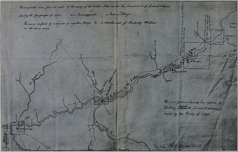
Click here for larger image size
Dr. Belknap’s Map of Wayne’s Route in the Maumee Valley, 1794[From the original in the library of Harvard University]
A happy interest attaches to an old route like Wayne’s, from the very fact that the labor spent in hewing it out and in transporting over it vast quantities of provisions and ammunition was not expended in vain. Wayne’s Road, like Forbes’s route across the Alleghenies, led to victory; the dark winding tracks of the armies of Braddock and St. Clair possess a romantic element that is fascinating in the extreme, but wholly unsatisfactory. There is an inspiration in following the rough tracks of men who won which is not found in the paths of men who, after struggles perhaps more heroic because facing greater odds, failed. Wayne was a thousand times better equipped for his campaign than was St. Clair. Before his campaign, the savage war was not taken very seriously. Now proper preparations had been made, approximately sufficient stores accumulated, the official personnel sifted down; and as the “Legion of the United States” went swiftly forward in the October sunlight of[Pg 200] that Indian summer, there was a sane consciousness of preparedness and power which was all but victory. The Indians were quick to recognize and describe, in their figurative way, the two chief characteristics of Wayne as a frontier commander—he was both the “Black Snake” and the “Whirlwind.” When in motion, he swept through the forests like a cyclone; the record of no pioneer army in America equals the marching records of Wayne’s Legion. It was a standing order that every march should be under high pressure and that no break or interruption should in any case delay the movement of the main body a single moment. This impressed the savages tremendously; they had known no such army as this—which advanced into their country almost as fast as others had run out of it. Thus they talked of the “Whirlwind” around their northern fires. Wayne, too, was a “Black Snake.” He was as cunning as he was impetuous. As will be seen, he built roads he never traversed, doubled his track, and over and again completely outwitted the astonished Indian spies that attempted, with sharp eyes in[Pg 201] the brown leaves, to fathom his purposes.
The lateness of the season prevented a more elaborate campaign than Wayne had suggested to the Secretary of War. The army swept northward to Greenville Creek and on the present site of Greenville, Ohio, erected Fort Greenville—named by Wayne in honor of his dead friend General Nathaniel Greene of Revolutionary fame. By November 16, Posey records, all the houses were completed and once more the drilling and manœuvering began. We have it under the hand of the same authority that General Wayne affirmed that never in the Revolutionary War had he commanded such well-drilled troops as these which spent the winter with him buried deep in those Ohio forests. It is sure that a general never needed well-drilled soldiers more; and no less sure that no troops needed encouragement more than these. There were, however, the bright sides to life even here. Though coffee was a dollar and brown sugar seventy-five cents a pound, and whiskey five dollars a gallon, yet there was good cheer and merrymaking. A battery was built for the officers to play “fiver,[Pg 202]” of which the younger men became very fond. On one evening the veteran General Scott entertained the officers in his apartments and was drawn out to tell of pioneer Kentucky in whose battles he had displayed so much courage and lost his three sons. “He told us how Colo Boon first discovered Kentucky,” wrote Posey; “‘Colo Boon was a very enterprizing, smart man,’ said General Scott, ‘but very whimsical.’” There were frequent scouting expeditions in which the whole garrison was interested. On one occasion Wells’s audacious rangers fell upon three Indians at their midday repast; one of the three in the pursuit was compelled to leap into a creek and when he “came up” he was found to be a white man, Christopher Miller. His life being saved, he renounced the wild career, visited his aged parents in Kentucky, and then returned to become one of Wayne’s most successful spies. No doubt the soldiers laughed at this transformation of a red into a white man, and perhaps swore that if other Indians were dowsed equally well they would be found to be equally white and to be wearing British uniforms![Pg 203]
There was one duty that fell now to Wayne that was not congenial. Posey was one of the detachment which pushed forward in the December snow to St. Clair’s slaughter-ground and erected there the most advanced of the chain of forts between the Ohio and Maumee. As the company neared the spot, Captain Edward Butler touched Posey on the shoulder and said: “When you reach the ground go to a large spreading oak which you cannot fail to see. Under that oak my brother’s marquee was pitched and there you will find his bones which you can identify by a fracture of one thigh bone.”
“We went to the place,” writes Posey, “and found part of his [General Richard Butler’s] bones, his skull and both thy bones, one we discovered had been broken.... We collected all the bones and laid them in one Pile, on every skul bone you might see the mark of the skulping knife a round every skul bone.” The pieces of guns—many barrels bent double by fiendish Indians—were collected, and four cannon were discovered just where an Indian prisoner had said they would be[Pg 204] found. A strong fort was built and very appropriately named Fort Recovery, Captain Alexander Gibson commanding the garrison. On the sixth day, a portion of the party returned to Fort Greenville. The erection of Fort Recovery was another leap toward the Maumee and soon Indians began to arrive at Fort Greenville bearing white flags and talking of an armistice and peace. Wayne, obeying orders from the Secretary to end the war without another campaign if possible, received the emissaries as though he believed their lying rôle. Deceived by Wayne’s attitude, one of the Allegheny chiefs, Big Tree, committed suicide. He had sworn to kill three hostile Indians to avenge the death of his “very dear friend” General Butler; exasperated at the hint of peace he made way with himself.
The peace emissaries, and all talk of an armistice, faded with the winter snows, and by early summer every plan for the crucial campaign had been made both by the Indians and by Wayne. It was July before Scott’s fifteen hundred mounted volunteers arrived at Greenville. Already one bloody[Pg 205] skirmish had taken place near the walls of Fort Recovery in which near a thousand Indians had participated. Large quantities of stores had been forwarded to Greenville and Fort Recovery, and the grand advance on the Maumee was on the eve of starting. Of this campaign we have Lieutenant Boyer’s official narrative,[151] supplemented by the slight records of Posey and Lieutenant William Clark, a brother of George Rogers Clark.[152]
At eight o’clock in the morning of July 28 Wayne with two thousand regulars and fifteen hundred mounted volunteers set out for the Maumee Valley from Fort Greenville. The route followed by St. Clair and used during the winter by the Fort Recovery garrison was the course pursued, and camp was pitched in the afternoon on Still[Pg 206]water Creek after a twelve-mile march. The next day the army was off before sunrise; we “pushed forward without regard to bag or baggage,” records Clark, “as if not in search, but in actual pursuit of a flying & disorderly enemy.” Fort Recovery was reached at noon and the army camped a mile beyond. On the day following the army crashed onward, following the winding stream called a tributary of the “St. Mary’s” by St. Clair, but which was in fact the head of the Wabash. Clark says the stream was crossed “more than a dozen times” and “Camp Beaver Swamp” was pitched where the stream was found to be impassable, eleven miles from Fort Recovery. Much of the journey today had been through wide prairies covered with nettles, the water unfit to drink and mosquitoes, “larger than I ever saw,” observed Boyer. Today the road was opened as the army advanced and the route was up the Wabash from the present village of Fort Recovery, Mercer County, Ohio.
The construction of a bridge at Camp Beaver Swamp seventy yards in length delayed the army one day but enabled the[Pg 207] road-cutters to hew a way through to the St. Mary River.[153] On August 1, the army pressed on over the backbone of Ohio and down the northern slope into the basin of the Maumee River, and encamped beside the famous little St. Mary River. Today, emerging suddenly from the vast stretch of nettles and brush that grew in the swampy district, the army suddenly drew out into a beautiful level meadow, every corps of the army having the first view of all the other divisions. This day Clark affirms that the army crossed the trace followed by General Harmar in 1790 to the Miami village. Tonight the army encamped by the St. Mary and on the morrow the erection of what was first called Fort Randolph and later Fort Adams was begun.[154] This was the seventh fortified post in the chain from the Ohio and was located on the south bank of the St. Mary, four miles above Rockford[Pg 208] (the old Shane’s Crossings), Mercer County, Ohio.
On the fourth the army hurried on about eleven miles to “a small, dirty water,” as Clark described it, “a branch of the Glaize [Auglaize] River,” where camp was fortified for the night. The day after, a march of equal length “down the creek” to the camp described by Boyer as “Camp forty-four miles in advance of Fort Recovery.” Wayne’s camps were each proof against insult from the enemy, which accounts for his encamping early each afternoon. On the afternoon of August 6, the army reached the banks of the celebrated “Glaize,” the Auglaize River. Here, according to Posey, a stronger encampment than usual was built, named Fort Loramie.
As the Maumee was neared the feeling of the army was intense. While at Fort Adams, Wayne had made feints at cutting two roads, one down the St. Mary River and another northwest straight toward Roche de Bout. These routes were both opened for some distance, that down the St. Mary at least as far as the famous ford at Shane’s Crossing—the present Rock[Pg 209]ford.[155] That the Indian spies would report the building of these roads, there was no doubt. But when on August 4 the swift advance was renewed neither road was followed! A straight course northward into the Auglaize Valley was taken—a route that could not have been pursued in any but the driest weather. It ran northward from Fort Adams, probably near the Fort Jennings of the War of 1812, situated on the left bank of the Auglaize in the northwest part of Jennings Township, Putnam County, Ohio. Thence the route was straight down the Auglaize in general alignment with the present Defiance Road.
Wayne’s tactics in road-building as he neared the enemy’s villages is perhaps quite unparalleled; indeed, as will be emphasized, this remarkable campaign was not less[Pg 210] impressive to the savages—these swift plunges through the forests, the sudden pauses and the astonishing feints—than was the battle which soon crushed the Indian confederacy. At the same time the careful historian would greatly err should he not give Wayne credit for obeying, even now, the earnest commands of his superiors to secure an armistice and a peace without a battle. Secretary Knox had, over and again, urged Wayne to secure peace without bloodshed if possible. A battle in any case was hazardous; there were possibilities of defeat; there were greater promises of a continuous war even in case of an American victory. The British had displayed characteristic arrogance in building a fort at Roche de Bout this very spring, around which the Indian cohorts were probably gathering. Complications with England were undoubtedly possible, if not entirely probable. From Lieutenant Clark’s journal it is clear that General Wilkinson proposed, as soon as the Auglaize was reached, to make a dash with a flying column upon the populous district at the junction of the Auglaize with the Maumee.[Pg 211] Wayne refused to consider the plan[156]—and throughout the remainder of Clark’s journal his words are well-nigh abusive of General Wayne’s whole management of the campaign.[157] The dare-devil Wayne’s caution at this strategic juncture of this important campaign portrays an element of steadiness for which the hero of Stony Point has perhaps never received sufficient credit.
On the eighth of August, after marching through five miles of cornfields, where were “vegetables of every kind in abundance,” according to Boyer, the tired Legion came in view of the Maumee, of which they and a whole nation had heard so much. The spot[Pg 212] of encampment was the site of the present city of Defiance on the commanding point between the rivers, and here in the three days succeeding, Fort Defiance was erected. To the Indians the name of the spot was Grand Glaize.[158] Wells’s rangers reported that the Indian army was lying two miles above the British fort, on the west bank of the Maumee. According to Posey, Wayne on the eleventh despatched an old Indian to the hostile camp with offers of peace; two days later an old squaw was posted off with a similar message. Neither returned. On the sixteenth, the fort being nearly completed, Major Hunt was left in command, and the grand advance began. The route was down the left bank of the Maumee straight toward the painted lines of Little Turtle’s army. Christopher Miller—the red-man made white by that plunge in the creek—met the army today with a message from the chieftain White Eyes, Clark records, asking Wayne to remain ten days at Grand Glaize, not erecting a fort, and the Indians would perhaps treat with him.[Pg 213] “This letter,” Lieutenant Clark states, “was generally considered as a challenge.”[159]
Nineteen miles was made the first day (August 16) and twelve the day following. As the road was “generally bad,” as Boyer affirms, these tremendous marches must be considered remarkable, for each camp was heavily fortified and the enemy was just at hand. The spies in advance were unceasing in their vigilance and activity; and on the eighteenth poor May, who had lived with the Indians as a spy the preceding winter at Wayne’s command, was entrapped and captured, suffering a most cruel death. This day the army encamped forty-one miles from Fort Defiance and made a strong entrenchment which was named Fort Deposit. Here the heavy baggage was stored that the troops might go into action unencumbered.
On the twentieth, at seven in the morning, the Legion advanced in fighting order. The Indian army, its left wing lying on[Pg 214] Presque Isle, was stretched across the valley for two miles in a well-chosen position. A tornado had swept the forest here and the mass of fallen trees offered a particularly advantageous spot for the Indians’ favorite method of fighting. Such spots were very common in the old Black Forest of the West and were generally known as “fallen timber” by the Indians and pioneers;[160] in them cavalry was almost useless. Thus the mounted volunteers, the Indians believed, would be debarred from the fight.
At eleven o’clock the advanced lines met. At the first burst of sudden flame the American vanguard of volunteers was staggered, perhaps surprised at the fire from an unseen enemy lying beneath the tangled wind-rack of the forest. The guards on the right fell back through the regulars commanded by Cook and Steele. The[Pg 215] regulars were thrown into confusion. It was fifteen minutes before order was restored but when joined by the riflemen and legionary cavalry, a charge with trailed arms was ordered and the savages were pricked out from their lairs with the point of the bayonet. A heavy firing on the left announced that the battle now was raging there, but only for a moment. The whole Indian plan of battle was destroyed by the impetuous bayonet charges of troops hard-drilled in the dull days at Legionville, Hobson’s Choice, and in the snows of Greenville. The redskins hid where a tornado had passed—not expecting another more destructive than the first! For two miles the scattering horde was pursued headlong through the forests. A halt was ordered just within sight of the British fort, whose guns were silent though menacing. The Indians poured on down the valley toward the present site of Toledo and Lake Erie.
The battle of Fallen Timber was a decisive and important victory. The Indians numbered about fifteen hundred; a considerable number of advancing allies never[Pg 216] reached the battle-ground. The rapid strides of Wayne had forced the meeting unexpectedly. Those ten days the Indians had requested for conference would have largely increased their strength. The number killed and wounded on either side was inconsiderable; forty Indians, only, were found on the two-mile field of conflict. Twenty-six killed and eighty-seven wounded, was the Legion’s loss. Of the Kentuckians, who hardly got into the action on account of the swift success of the Legion, seven privates were killed, and ten privates and three officers were wounded.
Remaining three days on the battle-field, Wayne destroyed many acres of corn and many Indian huts and then returned to Fort Defiance. Thence he ascended the Maumee to the junction of the St. Mary and St. Joseph—Harmar’s battle ground—and built a fort which he permitted the oldest officer (Posey?) to name “Fort Wayne in honor of the hero of Stony Point.” From Fort Wayne the army ascended the St. Mary to Fort Adams, and thence passed to Loramie’s, where a new[Pg 217] Fort Loramie was erected. The troops from there opened a new route across to Fort Greenville. Here, in the following year, the awed and broken Indian nations signed the Treaty of Fort Greenville which practically reaffirmed the previous Treaty of Fort Harmar.
Viewed as a whole, Wayne’s campaign is most interesting from the standpoint of road-building. It was Wayne’s advance which awed the savages, not the battle of Fallen Timber. The army crashing northward through the forests as though ever in the pursuit of a foe, the impregnable forts that arose here and there, the strongly fortified camps, the fleet and active scouting parties, the stern but even temper of Wayne’s exhortations for peace, and at last, the fierce bayonet charge amid the prostrate trees, accomplished the very mission of the hour. That winding line of a road from the Ohio to Roche de Bout, and the five new forts that sprang up on it in 1793 and 1794, have left their impress strongly upon western history. The Indians never forgot the “Whirlwind,” who was[Pg 218] also a “Black Snake.” Since that road was built, the Indian race has never been a national menace. Bloody battles there have been, but at no time has the expansion of the United States been seriously jeopardized by Indian hostility.
Clark’s conquest of Vincennes was now made good by the conquest of the Maumee Valley; Harmar’s reverses and St. Clair’s annihilation were avenged—the Old Northwest was won.
“... on the [24th] of June 1778 we left our Little Island and Run about a mile up the River in order to gain the main Channel and shot the Falls at the very moment of the sun being in a great Eclipse which caused Various conjectures among the superstitious as I knew that spies were kept on the River below the Towns of the Illinois I had resolved to march part of the way by Land and of course left the whole of our baggage, except as much as would equip us in the Indian mode. The whole of our force, after leaving such as was Judged not competent to the expected fatiegue, Consisted only of four companies, commanded by Captns Jno. Montgomery,[Pg 222] J. Bowman, L. Helm, and W. Harrod my force being so small to what I expected owing to the various circumstances already mentioned I found it necessary to alter my plans of operations, as post St. Vincent at this time was a Town of considerable force consisting of near four Hundred militia with an Indian Town adjoining and great numbers continually in the Neighborhood, and in the scale of Indian affairs of More Importance than any other. [I] had thought of attacking it first but now found that I could by no means venture near it Resolved to begin my career in the Illinois where there was more Inhabitants but scattered in different Villages, and less danger of being immediately overpowered by the Indians, and in case of necessity, [we could] probably make our retreat good to the Spanish side of the Mississippi, but if Successful here [we] might pave our way to the possession of Post St. Vincent.... As I intended to leave the Ohio at Ft. Massiac 3 leagues below the Tennessee I landed on Barritaria a small island in the mouth of that River in order to prepare for the march ... having every thing pre[Pg 223]pared we moved down to a little gul[ley] a small distance above Massiac in which we concealed our Boats and set out a Northwest course, nothing remarkable on this rout, the weather was favorable, in some parts water scarce as well as game, of course we suffered drought and Hunger but not [to] excess, on the third Day, John Saunders, our principal guide, appeared confused we soon discovered that he was totally lost without there was some other cause of his present conduct I asked him various question, and from his answers I could scarcely determine what to think of him, whether or not he was sensible that he was lost the thought of which [?] or that he wished to deceive us the cry of the whole Detachment was that he was a Traitor, he beged that he might be suffered to go some distance into a plain that was in full view to try to make some discovery whether or not he was right. I told him he might but that I was suppitious [suspicious] of him from his conduct that from the first of his being employed always said that he knew the way well that there was now a different appearance that I saw the nature of the Cuntry[Pg 224] was such that a person once acquainted with it could not in a short time forget it that a few men should go with him to prevent his escape—and that if he did not discover and take us into the Hunters Road that lead from the East into Kaskaskia that he had frequently described that I would have him Immediately put to death which I was determined to have done, but after an Hour or two’s search he came to a place that he perfectly knew and we discovered that the poor fellow had been as they call it bewildered. On the eavining of the fourth of July we got with in a few miles of the Town.”
Mr. Draper founds his conclusion that the “two Wabashes” were the Little Wabash and the Fox wholly on present-day (1878-90) reports[163] of the nature of the country at the Little Wabash above the mouth of the Fox and above the mouth of the Big Muddy. The reports he received from residents of the neighborhoods carry evidence that the ground between the Little Wabash and Fox most nearly agrees with Clark’s and Bowman’s descriptions of the crossing-place.[164] This is true, and is of importance. But Clark’s and Bowman’s use of the word “heights” was merely relative; Mr. Draper’s correspondents speak of high grounds and low grounds as the land[Pg 226] lies today. With water but three or four feet deep, a few acres of land might have been uncovered, though not sufficiently elevated today to be termed a hill or even high ground. There is a point on the Little —abash above the mouth of the Fox that can be made to answer in a general way Clark’s and Bowman’s descriptions—going on the doubtful supposition that their descriptions were entirely accurate. In order to find a spot where Clark saw nearly five miles of water before him, Mr. Draper suggests a point about two miles above the mouth of the Fox, where there is a wide bottom on the west of the Little —abash, another bottom between that stream and the Fox, and another east of the Fox.[165] The possibility that the distance was exaggerated by Clark (who said Vincennes was two hundred and forty miles from Kaskaskia when it was not over one hundred and seventy-five) is not considered. As a matter of fact, the whole plan of finding today five miles of low ground from any point west of the Little —abash to the east of either the Fox or the Big Muddy, is over[Pg 227]thrown by Clark’s statement in the Memoir that (on the western side of the Little Wabash) “we formed a camp on a height which we found on the bank of the river.” Mr. Draper’s objection to the Little Wabash and Big Muddy crossing-place was because the high ground on the bank of the Little Wabash (seemingly here referred to by Clark) prevented there being five miles of low ground to the opposite side of the Big Muddy.[166] If Clark and Bowman gave the distance of width of water correctly, the crossing-place was two miles above the mouth of the Fox, and Clark’s statement of forming a camp on a height on the river bank is totally inexplicable—for there is no height at this point to answer such a description. If, by “nearly” five miles, Clark meant three miles, misjudging distance on water inversely with the usual way, his camp could have been on the immediate high bank of the Little Wabash above the mouth of the Big Muddy.[167]
Certain other considerations have a ten[Pg 228]dency to influence the present writer in believing that the crossing-place was here—above the mouth of the Big Muddy. It was exceedingly wet from the day Clark left Kaskaskia; even on the watersheds he found deep standing water. On reaching the Petit Fork he found the rivers at flood-tide. By turning north to the Clay County route he would strike the Little Wabash at a more northerly point, and would almost completely head the deep little Bonpas which lay between the Fox and the Big Wabash. The Clay County route was in one sense, then, a watershed route, compared with the Wayne County route. It is difficult to believe that Clark’s guides would ignore this after having been compelled to cross the Petit Fork on felled trees. Again, on the second day out from the crossing-place of the Little Wabash, Bowman records: “16th. Marched all day through rain and water; crossed Fox river.” If this entry is correct, of course the Little Wabash and Big Muddy crossing-place is completely established. Mr. Draper, holding that the Fox was crossed simultaneously with the Little Wabash on the fifteenth, suggests[Pg 229] that Bowman meant Bonpas for Fox.[168] Choosing between possible errors, the present writer finds it easier to believe that Bowman misjudged the width of water crossed on the fifteenth, than that he called the Bonpas the Fox. For on the seventeenth the heads of the Bonpas are specifically accounted for by Bowman as follows: “17th. Marched early; crossed several runs, very deep.” Mr. Draper does not account for these, and it is difficult to do so if they were not the heads of the Bonpas. For, if Clark crossed the Little Wabash just above the mouth of the Fox, his route, after crossing the Bonpas, was northeast, and would, without any sort of question, have been on watersheds between little tributaries, first of the Bonpas, and then of the Embarras. Again, by every account, it is sure Clark and Bowman expected to strike the Embarras, and strike it at about seven or eight miles due west from Vincennes. If, as Draper believed, they were pursuing an old trail, which, it is well known,[169] ran from the crossing-place of the Little Wabash[Pg 230] two miles above the mouth of the Fox to the Wabash just below the mouth of the Embarras, how can it be explained that the army reached, or ever intended to reach, the Embarras seven or eight miles above its mouth? The very name would warn them away and it seems highly improbable that, if what was later known as the southern route was traversed, the army would ever have seen the Embarras.
“The next Day after the rear arrived a Detachment of 400 men was ordered out under the Command of Col. Trotter of Kentucky with orders to assertain what Course the Indians had went to Draw 2 Days provisions and Be out over night I was a volunteer in Sd. Detachment There was about 25 Mounted men attached to the Same a short Distance after we crossed the St Joseph River from where part of the Town stood fell in with 2 Indians Killed Both and Lost one man marched all Day after in good order Seen considerable Signs Could not assertain which way They had gone The Six pounders was Shot about Sun Set at the main Camp The Col Concluded it was Done to Call the Com[Pg 232]mand in we returned to Camp a short time after Dark Lay out side of Camp all night had our own guards out, Turned out next morning to perform the 2d Day under Command of Col Hardin went a northwest Course from whence we Crossed sd river after going 3 or 4 mile found a Large fresh Indian trail pursued it with all Speed in Single file or in any way they Could get allong from front to the rear was over half a mile The Indians retreated with a view to draw the front into ambuscade which they Done Completely with Two fires Cut off the front Entirely our Company being in front the first Day had to take the rear the Second Day when the front was Cut off we formed a Line in the rear Cols Hardin Hall and Major Fountain was all on horse Back halted with us when we formed, The Indians pursued the front untill they Come within one hundred yards Then halted we had But about 75 in our Company had all treed in Line across the trace They Could see the officers on horse Back with us we Stood in that situation untill near Dark Then Covered the retreat got into Camp a short time after Dark I[Pg 233] never could assertain how many men we Lost in that Scrap a Captn Scott son of Gen or governor Scott of Kentucky was killed in that Scrap our Troops was very much scattered a Number Came in after Night as the Cannon was fired Every hour through the Night at the main Camp perhaps there was 15 or 20 killed, perhaps more or Less The Commencement was one of the most unexpected Surprises Ever any troops met with Two of us went out and Examined their Encampment where their trace was first Discovered over 2 mile on this Side where the Battle was as there was there a general Halt for a short time I would have Said there was 4 or 5 hundred Indians and we had not Near as many Men that Day as was out the Day Before There was Experienced officers along that ought to have known Better they was too anxious on the pursuit the Troops should have Been marched in such a Situation that no advantage Could have Been Taken of them as was the Case the Day Before The army remained in Camp perhaps 2 Days making ready to return to Fort Washington when the army moved from Camp perhaps about[Pg 234] the 10th or 12th of November 1790 four or five mounted men with an officer placed themselves on a high Eminence so that they could see over all the place where the Indian town Stood about two hours after the army Cleared out the Indians Came in from Different Quarters to get provision as they had Considerable hid under ground Said Spies remained there untill Dark Came into Camp which was about 4 or 5 mile Informed Harmar and the officers what Discoveries they had made a Detachment of 4 or 5 hundred men was Drafted from the Different Companies of sd army that Night to be on the ground Next morning by Day Light and to Be placed under the Command of Col Hardin the plan of attack was made By the officers previous to their march and was well Executed By the officers and troops Engaged in the Same There was too few troops in said Detachment for the number of the Enemy they had to Contend with if 200 men had arrived there about Sunrise they would have give the Enemy a Complete Defeat They give them a pretty good Drubing as it was There was about 60 regulars under the[Pg 235] Command of Major —— They fought well Done great Execution Lost Their major and Lieutenant in the Battle. Col Hardins post in The aforesaid plan was on The west side of The St. Joseph river opposite to where The Indian town stood he was There in good Time The other Troops Crossed the Maumee went right to where The Town Stood The Indians was Encamped in and round where it stood Major Fountain had the Command of The Light horse and mounted men he Charged right in among The Enemy fired off his pistols and Drew his Sword Before They Could recover The Shock George Adams informed them that he was Near The Major at That Time That it appeared when The Enemy got over Their surprise Ten or Twelve Indians Discharged Their guns at him The Major kind of fell or hung on his horse They then Discharged Several Guns at said Adams he received Several flesh wounds But recovered By this Time The Militia and regulars Come up. The Indians fought with Desperation was Drove from Their Encampment By The Militia and regulars Down The Bank into the river which was[Pg 236] perhaps 20 yards wide and perhaps 6 inches Deep Col Hardins men on The opposite Side which placed them Between two fires The Indians charged on Hardins troops having no other Chance to Escape Hardins troops give way and retreated the Same way They went out and was not in That Battle any more. Some of the Troops informed me That Major Fountain was Living when our Troops Drove the Indians from The Battle ground. Major Mcmillin of Kentucky Collected The Troops and Tarried on The Battle Ground untill They Indians had entirely Disappeared and not one to Be Seen or heard I never understood what was the Number of our Troops Killed by the Enemy on That Campaign Though it was Considerable my oppinion is There was more Indians Killed in That Battle Than was Killed when Genl —ayne defeated Them in 1794 if Harmar had Sent out a Detachment of Six hundred men Next Day to Collected The Dead and Buried Them and assertained how many of The Enemy was Killed I think There would have Been no risk in it as The Indians was So Completely Cut up on The Day of The[Pg 237] Battle Such a move would have Been an honor and Credit to that Campaign I can Never agree That Harmars Campaing was a Defeated one.”
[1] For a sketch of the position of this campaign in the Revolution, and its leading details see Historic Highways of America, vol. vi, pp. 161-166.
[2] Our principal source of information concerning the Kaskaskia campaign is George Rogers Clark’s Memoir, written probably in 1791, the original of which is preserved in the Draper Manuscripts in the library of the State Historical Society of Wisconsin. Extracts of such portions as refer to the march to Kaskaskia will be found in Appendix A.
[3] Page’s History of Massac County, p. 35.
[4] Draper MSS., xxi J, fols. 40, 44.
[5] Id., fol. 51.
[6] Id., fol. 27.
[7] Id., fol. 76.
[8] Id., fol. 83; xxii, fol. 6.
[9] Id., xxii, fol. 5.
[10] Id., xxi, fol. 42; cf. p. 65.
[11] Id., xxi, fols. 40, 42. Probably the route of the later St. Louis-Shawneetown trace; see p. 34.
[12] Id., xxii, fols. 11, 35.
[13] Id., xxii, fol. 35.
[14] Id., xxi, fols. 16, 27, 29, 51, 52; and xxii, fols. 30, 35.
[15] Id., xxii, fols. 30, 37. Cox’s Creek was crossed twice, the east fork in section 7, township 7, range 4, and the west fork in section 12, township 7, range 5.
[16] Id., xxi, fols. 80, 81; xxii, fol. 37.
[17] Id., xxii, fol. 37.
[18] Clark approached Kaskaskia by the route and the ford over the Kaskaskia River which he pursued on the Vincennes campaign in the February following. (English’s Conquest of the Northwest, vol. i, p. 288.)
[19] Historic Highways of America, vol. vii, p. 168.
[20] A galley-batteau, armed with two four-pounders and four swivels, and carrying forty-six men, under the command of Captain John Rogers, left Kaskaskia February 4, for Vincennes by the river route. It was named “The Willing.”
[21] Probably at “a small branch about three miles from Kaskaskia” mentioned by Clark in his letter to Mason (English’s Conquest of the Northwest, vol. i, p. 430).
[22] The map of Clark’s route from Kaskaskia to Vincennes in the standard work on his campaigns of 1778-79, English’s Conquest of the Northwest (vol. i, pp. 290-291), gives only the later Kaskaskia trace of the eighteenth century—the modern route which it is sure Clark did not pursue.
[23] Draper MSS., xxv J, fol. 76. See map on page 21.
[24] It seems to the writer useless to spend time and space in attempting to place exactly Clark’s camping-spots. He has made several exhaustive schedules of these camps and all the contradictions discussed pro and con. At best, any outline of camps must be purest conjecture, and therefore not authoritative or really valuable. In certain instances the camping-spots are definitely fixed by contemporaneous records. Only these will be definitely described in this record—the others being placed more or less indefinitely.
[25] In possession of the Kentucky Historical Society; first published in the Louisville Literary News, November 24, 1840; see English’s Conquest of the Northwest, vol. i, pp. 568-578, from which our quotations are made.
[26] Draper MSS., xxv J, fols. 37, 57, 58, 77.
[27] Id., fol. 78.
[28] Id., fol. 77.
[29] Id.
[30] Id.
[31] Id., xxiv, fols. 6-8.
[32] Id., xxv, fol. 50.
[33] Volney’s A View of the Soil and Climate of the United States of America (Brown’s translation) 1808, pp. 339-341.
[34] These are the Memoir and the Letter to Mason previously described.
[35] No explanation of “Cot plains” was offered to Mr. Draper by his Illinois correspondents. If the present writer be allowed a pure guess it would be that “Cot” was the American spelling of the French Quatre, “four;” “Cot plains” would then be a “Four Mile Prairie” east or northeast of Skillet Creek. The Clay County route cut off a corner of Romaine Prairie just here—which may have been known as “Four Mile Prairie” in earliest days. It is not known that such was the case.
[36] See Appendix B.
[37] Draper MSS., xxv J, fol. 112. Clark’s men marched two leagues before reaching “Sugar Camp.” Mr. English’s map (Conquest of the Northwest, vol. i, p. 313) and Bowman’s Journal are therefore utterly at variance.
[38] Draper MSS., xxv J, fol. 91.
[39] The British Fort Sackville.
[40] Referring to the fact that Hamilton was accused of buying scalps of Americans from the Indians. The shrewdness of this communication is conspicuous, the result of the experiences at Kaskaskia.
[41] English’s Conquest of the Northwest vol. i, p. 572.
[42] The author bases his remarks wholly on the belief, it will be observed, that Clark crossed the Little Wabash east of Clay City.
[43] See note 10.
[44] An interesting English version of Embarras—denoting the Creole pronunciation. On Hutchins’s old map of 1768 the Embarras is called the “Troublesome River”—see map, p. 35.
[45] The western branch of the Bonpas, or the Fox?
[46] All efforts to find any locality bearing this name have failed. Possibly it was a double bend of the Little Wabash, east of Clay City, which may resemble an ox yoke. “Ox Bow” is not an uncommon name for such reverse curves of rivers in several of our states.
[47] A well-known salt spring lies just west of the McCauley settlement crossing of the Little Wabash.—Draper MSS., xxv J, fol. 25.
[48] Mr. Draper suggests that this may have been near Enterprise, Wayne County, in keeping with the idea that the route here described was the route that Clark followed. The most definite point known on Volney’s route west of the Embarras was the Salt Spring, above mentioned, and this was on the more northerly route which crossed the Little Wabash east of Clay City. Slaves Gibbet must therefore have been just east of Xenia.
[49] Probably Harvey’s Point, six or eight miles southeast of Salem.
[50] Skillet Creek.
[51] At the crossing of “Petit Fork”—Adams tributary of Skillet.
[52] Near Walnut Hill.
[53] Perhaps on head of Big Muddy in Grand Prairie.
[54] There seem to have been two old-time routes around Grand Prairie; the points of junction seem to have been in Grand Prairie and Elkhorn Prairie. Pointe aux Fesses is identified as Elkhorn Point, northeast of Oakdale.
[55] In Grand Prairie.
[56] See note 54.
[57] Oakdale.
[58] Coultersville.
[59] Northwest of Steel’s Mills.
[60] Mr. Draper reduces these estimates to “probabilities,” giving as the total distance 156 miles (Draper MSS., xxv J, fol. 49).
[61] This point of junction is eighteen miles east of Salem, which is given as the point of junction on Mr. English’s map of Clark’s route.—Conquest of the Northwest, vol. i, pp. 290, 291. Salem is the junction of the modern route from Kaskaskia with the St. Louis Trace.
[62] Additional testimony to the same effect is found in Draper MSS., xxv J, fol. 76.
[63] Evans’s History of Scioto County and Pioneer Record of Southern Ohio contains the best map of western Ohio extant.
[64] Historic Highways of America, vol. vi, p. 166.
[65] Josiah Morrow, to whom the author is indebted for much help in the study of Harmar’s route, affirms that in the land records of Warren County he has found reference to this as “Clark’s old war-road.”
[66] November 27, 1782.
[67] American State Papers, vol. iv (Indian Affairs, vol. i), p. 88.
[68] American State Papers, vol. iv (Indian Affairs, vol. i), p. 97.
[69] Id.
[70] Id.
[71] Id., pp. 93, 94; St. Clair to Knox, Id., p. 87.
[72] Id.
[73] Id.
[74] Id., p. 88.
[75] The authorities used in connection with Harmar’s route and march are: the Journal of Captain John Armstrong, of the Regulars (Dillon’s History of Indiana, pp. 245-248); Thomas Irwin’s account of Harmar’s and St. Clair’s campaigns, in the Draper MSS., iv U, fols. 3-17; Hugh Scott’s Narrative, Id., fol. 99, and David H. Morris’s Narrative, in the Troy (Ohio) Times of January 29, 1840. Hereafter these will be referred to by name only. Harmar’s route out of Cincinnati is thus described by J. G. Olden in his Historical Sketches and Early Reminiscences of Hamilton County, Ohio: “Moved from Ft. Washington up the little ravine that runs into Deer Creek near what is now the head of Sycamore street, Cincinnati, thence through Mt. Auburn and along the general course of what is now the Reading turnpike to the little stream since known as Ross run where he encamped for the night in what is now Section 4 Mill creek township near where Four Mile tavern was built. The next day he moved, still on Clark’s old trace, now Reading turnpike, passing near where the school-house now stands in Reading, thence on to the little run east of where Sharonville now is, where he encamped for the [second] night.”
[76] An error for 1780. As noted, three well-known expeditions had gone northward from the present site of Cincinnati before Harmar’s: Bowman in 1779, Clark in 1780, and Clark again in 1782. In 1782 Clark passed northward on the watershed between the Miamis. It was therefore Clark’s route of 1780 which Harmar’s militia followed.
[77] Mt. Auburn. Dr. Daniel Drake, writing in 1801, says: “Main street, beyond Seventh, was a mere road nearly impassable in muddy weather which, at the foot of the hills, divided into two, called the Hamilton and the Mad-river road. The former took the course of the Brighton House; the latter made a steep ascent over Mount Auburn.”
Of a later road on Harmar’s Trace we have this record: “1795 Road laid out from Main Street, Cincinnati, northeast nearly on Harmar’s trace (six miles) to the road connecting Columbia and White’s Station [Upper Carthage]” (History of Hamilton County, p. 223).
[78] Lick Schoolhouse, Deerfield Township, Warren County?
[79] History of Warren County (Chicago, 1882), p. 410.
[80] Josiah Morrow offers this correction for future editions of Armstrong’s Journal: “The printed journal of Armstrong’s makes the first ten miles of the third day in a northwest course. Even if this be understood as meaning west of north, it would take the army to the west of West Chester in Butler County. If we assume northwest to be an error for northeast, ‘the first five miles over a dry ridge to a lick’ would bring the army to the lick at Lick School-house in Deerfield township, Warren county; and the next ‘five miles through a low swampy country to a branch of the waters of the Little Miami’ would be over the swampy land of early times in the vicinity of Mason, and there is a tradition that the army stopped for a time on Little Muddy creek, on the farm formerly owned by Joseph McClung, north of Mason.”
[81] MSS. in possession of Josiah Morrow, Lebanon, Ohio.
[82] A western tributary of the Little Miami, down which Harmar is supposed to have marched to Fish-pot Ford, was formerly known as Harmar’s Run.
[83] Armstrong’s printed Journal reads Sugar Creek for Cæsar’s Creek. Either this was an older name or the result of a typographical error. As the name Cæsar comes from a negro who resided here with the Indians, it is probable that, as Josiah Morrow assumes, “the soldier wrote Seezar or Seizar, which the printer mistook for Sugar.”
[84] A station on the Big Four Railway, twelve miles northeast of Troy.
[85] In General Wayne’s campaign in 1794 a trace known as “Harmar’s Trace” was crossed just south of the St. Mary River in Mercer County (see p. 207). If Harmar recrossed the St. Mary and proceeded south of the river to “Shane’s Crossing” (Rockford, Mercer County) this is the only record of it.
[86] The Irwin MS. account of the operations of the army on the Maumee is intensely vivid, and, though incomplete, should be preserved in lasting form. It will be found in Appendix C.
[87] Historic Highways of America, vol. ix, ch. 2.
[88] American State Papers, vol. iv (Indian Affairs, vol. i), p. 129.
[89] Id., p. 171.
[90] Id., p. 172. This project was suggested by General St. Clair the year previous, but was not countenanced by the Government. American State Papers, vol. iv (Indian Affairs, vol. i), p. 100.
[91] Id., p. 172.
[92] American State Papers, vol. iv (Indian Affairs, vol. i), p. 192. Officers who had orders from Butler to march were, in some instances, delayed nearly a week before they received the necessary provisions with which to do so.—St. Clair’s Narrative of the Campaign against the Indians (1812), p. 228.
[93] Id., p. 193.
[94] St. Clair’s Narrative, p. 12.
[95] Id., p. 207.
[96] Cummingsville—“six miles from the fort [Washington], along what is now ‘Mad Anthony Street.’”—History of Hamilton County, (Cleveland, 1881), p. 78.
[97] Knox to Washington, October 1, 1791, American State Papers, vol. iv (Indian Affairs, vol. i), p. 244.
[98] The site of Fort Hamilton was in the present city of Hamilton, Ohio, and was described in 1875 as located on the ground reaching from Stable Street to the United Presbyterian Church, and stretching from the Miami River eastward to the site of the Universalist Church.
[99] American State Papers, vol. iv (Indian Affairs, vol. i), p. 173.
[100] Historic Highways of America, vol. ix, ch. 2.
[101] American State Papers, vol. iv (Indian Affairs, vol. i), p. 245. St. Clair had ordered Butler to proceed in three parallel paths each ten feet in width.
[102] Everts’s Atlas of Butler County, Ohio, p. 23.
[103] History of Preble County, Ohio (1881), p. 19.
[104] St. Clair Papers, vol. ii, p. 252.
[105] St. Clair Papers, vol. ii, p. 247. This letter may have been written at Fort Hamilton.
[106] St. Clair’s Narrative, p. 32. It is difficult to harmonize St. Clair’s own words concerning the width of the roadway with those of the editor of The St. Clair Papers, vol. ii, p. 292, note.
[107] Historic Highways of America, vol. v, p. 144. Cf. Harmar’s order of march p. 96.
[108] St. Clair’s Narrative, p. 31.
[109] Id., p. 32.
[110] The St. Clair Papers, vol. ii, pp. 251, 262.
[111] St. Clair’s Narrative, p. 210.
[112] The St. Clair Papers, pp. 254, 255.
[113] St. Clair wrote Hodgdon regarding supplies as follows: “Forty-five thousand rations of provisions should move with the army; ... twice in every ten days forty-five thousand rations should move from Fort Washington to the next post, until three hundred and sixty thousand rations were sent forward; ... forty-five thousand rations should again move with the army from the first post to a second, and an equal number twice in every ten days until the residue of the three hundred and sixty thousand were carried forward, and so on from post to post, still moving with forty-five thousand rations. They have failed entirely in enabling me to move with forty-five thousand rations, and from the letter above mentioned, the agent seems not to expect to move any beyond this place; for he says: ‘If you move from thence (meaning this place) shortly, and take ten days’ provisions with you, it will deprive us of the means to transport what may be necessary after that is exhausted.’ After, then, that you know exactly what the contractors can do as to transportation, (for so far as they can do it, it is their business, and must not be taken out of their hands) you will take your measures so, as that, on the 27th instant, I may be able to move with three hundred horse-loads of flour, and that one hundred and fifty horse-loads succeed that every seven days; one hundred and fifty horses being sent back every seven days. For whatever expense may attend the arrangement, this shall be your warrant; and I am certain, from your personal character, as well as from your zeal for the public good, that no unnecessary expense will be incurred. It is to be observed, that our beef will be expended about the 5th or 6th of next month. When I left Fort Washington, the agent of the contractors informed me that he expected a drove of cattle very soon; whether they are arrived or not I am not informed. I have written to him on this occasion; but I request you to inform yourself, and, if necessary, to make provision there also; and, indeed, there is not a moment to lose about it, and to provide for any deficiency. He writes me that the measures he has taken will give a supply to the last of December or a month longer, but nothing must be left to hazard.”—The St. Clair Papers, vol. ii, pp. 248-249.
[114] St. Clair’s Narrative, p. 33.
[115] The St. Clair Papers, vol. ii, p. 257.
[116] American State Papers, vol. iv (Indian Affairs, vol. i), p. 137.
[117] Id., p. 137.
[118] See p. 89.
[119] St. Clair’s Narrative, pp. 213-219.
[120] American State Papers, vol. iv (Indian Affairs, vol. i), p. 138; St. Clair’s Narrative, p. 55.
[121] Albach’s Annals of the West, p. 584.
[122] Atwater’s History of Ohio, p. 142.
[123] Captain Robert Buntin to Governor St. Clair, February 13, 1792 (Dillon’s History of Indiana, p. 283).
[124] Annals of the West, p. 590.
[125] MS. of Thos. Posey, Draper MSS., xvi U, vol. 3. Cf. page 203.
[126] American State Papers, vol. iv (Indian Affairs, vol. i), p. 227.
[127] American State Papers, vol. iv (Indian Affairs, vol. i), pp. 234-236.
[128] MSS. in the New York State Library in Washington’s handwriting; Magazine of American History, vol. iii (February, 1879), pp. 81-88.
[129] Wayne to Knox, October 5, 1792, Draper MSS., v U, fol. 21.
[130] Id., Armstrong to Wilkinson, September 13, 1792.
[131] Journal of Thomas Posey, Draper MSS., xvi U, vol. 3. Hereafter this will be referred to merely by name.
[132] March 30, 1793.
[133] The fourth article was the objectionable one. It read: “The United States solemnly guaranty to the Wabash, and Illinois nations, or tribes of Indians, all the lands to which they have a just claim; and no part shall ever be taken from them, but by a fair purchase, and to their satisfaction. That the land originally belonged to the Indians; it is theirs, and theirs only. That they have a right to sell, and a right to refuse to sell. And that the United States will protect them in their said just rights.” American State Papers, vol. iv (Indian Affairs, vol. i), p. 338. No citizen of the United States had or has a right to refuse to sell land to the Government. Such a right could not be given to an Indian tribe.
[134] American State Papers, vol. iv (Indian Affairs, vol. i), pp. 323-324.
[135] Id., p. 244.
[136] Id.
[137] Id., p. 243.
[138] A standing rock in the Maumee River.
[139] Historic Highways of America, vol. vi, pp. 21-23.
[140] American State Papers, vol. iv (Indian Affairs, vol. i), pp. 340-342.
[141] Historic Highways of America, vol. ix, ch. 2.
[142] Id., p. 356.
[143] Id., p. 375.
[144] Deposition of an unknown, but in Wayne’s handwriting. Draper MSS., v U, fol. 24.
[145] The following innocent sentence was to signify that war should immediately begin: “Although we did not effect a peace, yet we hope that good may hereafter arise from the mission.” Wayne was provided with the commissioners’ signatures as a guard against forgery.—American State Papers, vol. iv (Indian Affairs, vol. i), P. 359.
[146] Scott to Governor Shelby of Kentucky, “Petersburg 24th Sept 1793 2 oclock in the morning.” Draper MSS., v U, fol. 25.
[147] Wayne to Knox, October 5, 1793. American State Papers, vol. iv (Indian Affairs, vol. i), p. 361.
[148] Id., p. 351.
[149] Atlas of Butler County, Ohio (1875), p. 23.
[150] History of Preble County, Ohio (1881), p. 22.
[151] A Journal of Wayne’s Campaign. Being an Authentic Daily Record of the most Important Occurrences during the Campaign of Major General Anthony Wayne, against the Northwestern Indians; Commencing on the 28th day of July, and ending on the 2d day of November, 1794; including an account of the great battle of August 20th. By Lieutenant Boyer (Cincinnati, 1866).
[152] A copy of Clark’s journal is in the Draper MSS. (v U, fols. 33-92). The original is owned by Mrs. A. J. Ballard of Louisville, Kentucky.
[153] Relics made from logs of this bridge, well preserved by their position in swampy ground, are not uncommon in Mercer County.
[154] Posey refers to this fort only as Fort Adams; Clark mentions it only as Fort Randolph. Boyer gives no name, referring to it as “the garrison.”
[155] A venerable resident of Rockford, Mr. Bronson Roebuck, aged eighty-one, informs the writer that the road from Fort Adams passed down the north bank of the St. Mary through an Indian village, Old Town, on the farm of Rouel Roebuck, about two miles east of Rockford, and continued down the valley to the present site of Willshire; thence it continued to Fort Wayne but at a further distance from the river.
[156] Just as St. Clair refused Butler’s proposal at Fort Jefferson in the campaign of 1791.
[157] “The scheme [of surprising the Indians] was proposed, and certain success insured if attempted. Gen Wilkinson suggested the plan to the Commander-in-Chief, but it was not his plan, nor perhaps his wish, to embrace so probable a means for ending the war by compelling them to peace. This was not the first occasion or opportunity which presented itself to our observant General [Wilkinson] for some grand stroke of enterprise, but the commander-in-chief rejected all and every of his plans”—fol. 42. Clark’s criticisms and objections fill his remaining pages—fols. 42-50, 52, 57, 58, 59.
[158] Glaize was from the French meaning “clay;” Auglaize River was the “river of the clay banks.”
[159] Clark adds, in thoroughly hostile tone, that Wayne would have answered it but for the intervention of General Wilkinson.—Fol. 50.
[160] As mentioned in our narrative, p. 182, it was to a “fallen timber” on the Bloody Way between Forts Hamilton and St. Clair that Girty with a party of Indians went in the fall of 1792 on a raiding expedition. The name is preserved, at least in one instance, in West Virginia in Fallen Timber Run, Wetzel County. The modern spelling is “Fallen Timbers.”
[161] See ante, page 18, note 2. The original of Clark’s Memoir is found in the Draper MSS., xlvii J, fols. 1-128.
[162] See ante, page 53.
[163] Draper MSS., xxv J, fols. 14-60.
[164] Id., xxiv, fol. 9; xxv, fols. 14-20, 60.
[165] Id., fols. 14, 43.
[166] Id., xxiv, fol. 9.
[167] Id.
[168] Id., fols. 49, 50.
[169] Id., xxiv, fol. 13.
[170] See ante, page 101, note 86. The extract here given is from Draper MSS., iv U, fols. 3-17.
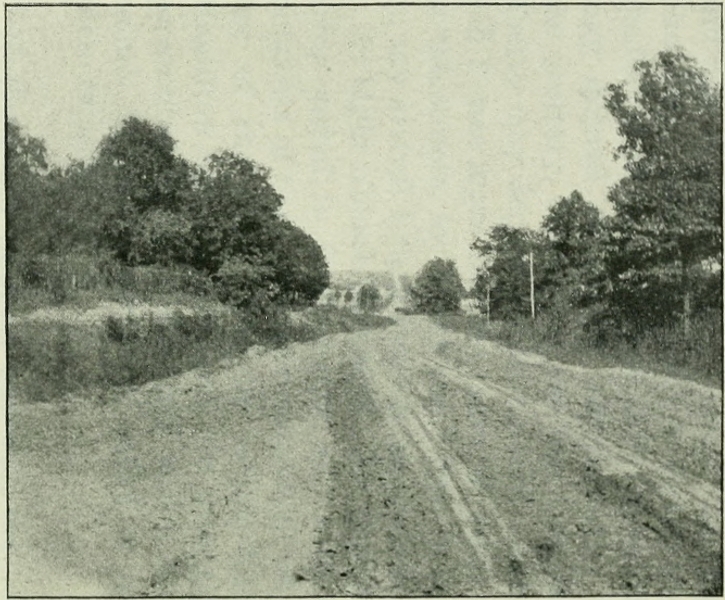