
The Project Gutenberg EBook of Historic Highways of America (Vol. 9), by
Archer Butler Hulbert

This eBook is for the use of anyone anywhere at no cost and with
almost no restrictions whatsoever.  You may copy it, give it away or
re-use it under the terms of the Project Gutenberg License included
with this eBook or online at www.gutenberg.org/license


Title: Historic Highways of America (Vol. 9)
       Waterways of Westward Expansion - The Ohio River and its Tributaries

Author: Archer Butler Hulbert

Release Date: October 18, 2012 [EBook #41103]

Language: English

Character set encoding: ISO-8859-1

*** START OF THIS PROJECT GUTENBERG EBOOK HISTORIC HIGHWAYS OF AMERICA ***


Produced by Greg Bergquist and the Online Distributed
Proofreading Team at http://www.pgdp.net (This file was
produced from images generously made available by The
Internet Archive/Canadian Libraries)
Transcriber’s Note: Obvious errors in spelling and punctuation have been corrected. Footnotes have been moved to the end of the text body. Also images have been moved from the middle of a paragraph to the closest paragraph break, causing missing page numbers for those image pages and blank pages in this ebook.
THE ARTHUR H. CLARK COMPANY
CLEVELAND, OHIO
1903
COPYRIGHT, 1903
BY
The Arthur H. Clark Company
ALL RIGHTS RESERVED
| PAGE | ||
| Preface | 9 | |
| I. | Our First Glimpse of the Ohio | 15 |
| II. | The Indian Side | 48 |
| III. | “The Navigator” | 73 |
| IV. | The Evolution of River Craft | 100 |
| V. | Three Generations of Rivermen | 151 |
| VI. | The Navigation of the Ohio | 189 |
| I. | Bonnécamps’s Map of the Ohio River; 1749 | 24 |
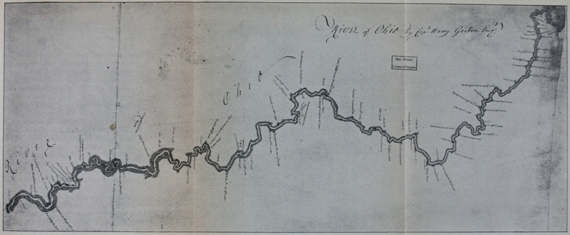
| II. | Captain Gordon’s Map of the Ohio; 1766 | facing 48 |
| III. | Rufus Putnam’s Map of the Ohio River and Settlements; 1804 | 71 |
In the study of Waterways of Westward Expansion, the Ohio River—the “Gateway of the West”—occupies such a commanding position that it must be considered most important and most typical. Such is its situation in our geography and history that it is entitled to a most prominent place among Historic Highways of America which greatly influenced the early westward extension of the borders and the people of the United States. Not until a late period in the expansion era—the day of steam navigation—did the Great Lakes rise to importance as highways of immigration, and south of the Ohio River Basin there was no westward waterway of importance. The day of the keel-boat and barge was of moment in the broadening of the American sphere of influence on this continent, and nowhere is the study of these [Pg 10]ancient craft made to so good advantage as on the Ohio and its tributaries.
This monograph is devoted, therefore, to the part played by this waterway as a road into the West. The two introductory chapters, concerning Céloron and the first occupation of the Old Northwest, added to previous volumes of this series (iii, iv, v, and vi), complete the legendary and historical setting necessary for a proper view of the Ohio in the first momentous years of the nineteenth century. The occupation and filling of the southern shores of the Ohio was the story of Volume VI; the story of the filling of the northern shore is outlined in the second chapter of this book. With the position of the first colonies and settlements in the great valley well comprehended, and a conception of the origin of the different colonies and their varied types, the next logical step in our study is the rise of the river trade and its evolution.
It is hardly necessary to point out to any reader of these volumes that the Ohio River was the highway upon which all of the great early continental routes focused. Washington’s Road, Braddock’s Road, [Pg 11]Forbes’s Road, and Boone’s Road—like the Indian and buffalo trails they followed—had their goal on the shores of this strategic waterway. The westward movement was by river valleys (a fact perhaps never sufficiently emphasized) and not until the Tennessee, Monongahela, Kanawha, and Kentucky Rivers were reached were any waters found to run parallel with the social movement itself.
When this goal of half a century was reached, then followed a half century of river travel that is being forgotten with remarkable rapidity. This cannot be realized until one marks out for himself the task, for instance, of learning how a keel-boat was made and how it was operated. The echo of the steersman’s voice and the tuneful note of the bargeman’s horn have faded from our valleys; and with this music has passed away a chapter of our history of vital importance and transcendant human interest.
For the sum and substance of Chapter III, the author is indebted, as the title indicates, to the painstaking labor of one Zadoc Cramer, a statistical hero of a time [Pg 12]when a man who could “earn his salt” was making a good day’s wage, and when it seemed likely that Pittsburg might become one of the principal cities of the West.
A. B. H.
Marietta, Ohio, July 23, 1903.
The Ohio River is a greater and more important stream than is generally realized. It drains a vast and rich territory; its northern source is in latitude 42° 20´, while its mouth, thirteen hundred miles away, is in latitude 37° north. Its eastern tributaries are in longitude 78°, while its outlet is in longitude 89° 20´. It thus comprises 5° 2´ of latitude and 11° 20´ of longitude. The Ohio drains a greater area than the Mississippi above the mouth of the Missouri; nearly one quarter of the waters which flow into the Gulf of Mexico come from it. The lower Mississippi and Missouri, only, drain more territory than the Ohio; but the downfall of rain in the Missouri drainage is not so great in actual water supply as that which falls within the 214,000 square miles drained by the Ohio. Moreover, in the district drained by the two[Pg 16] heads of the Ohio, the Allegheny and the Monongahela (20,000 square miles), it has been estimated that the ratio of discharge to downfall is much greater than on any of the tributaries of the Mississippi. In 1868, 1,342,605,725,800 cubic feet of water passed Pittsburg, and in 1869, 1,634,846,499,200 cubic feet. At the same time the annual downfall of rain in the entire Ohio drainage was twenty and one-half trillion cubic feet, while the discharge of the Ohio into the Mississippi at Cairo was five trillion cubic feet. The ratio of discharge to downfall therefore was 0.24.
These estimates, which undoubtedly approximate the truth, are of moment to our study. Nature cast, with a lavish hand, her waters where they would count tremendously in the opening of this continent: for the waters that fell here flowed into the West and the social movement was to be westward. The Ohio, more than any river, was to influence the flood-tides of immigration. The provision of water was, comparatively, abundant; that was the first necessity. A large proportion of the water that fell flowed away; that was the second[Pg 17] necessity. It flowed approximately west; that was the third necessity. Thus it is that this river, of all rivers, has a place among the Historic Highways of America which were controlling forces in the early days of our national expansion westward.
There are various theories concerning the name Ohio, the most popular and generally acceptable being that Ohio was the English way of spelling and pronouncing the name Oyo, “beautiful” which the Indians had given to the river. The French, who usually translated Indian names, called the Ohio River La Belle Rivière. Later came the English, and the Iroquois name Oyo was Anglicized to Ohio, the modern name of the river. This makes a very satisfactory explanation of La Belle Rivière, were it not that the Reverend John Heckewelder affirmed that the French name Belle Rivière was not a translation from the Indian, since there was no such Indian word meaning “beautiful.” Mr. Heckewelder felt dissatisfied with the theory that Ohio meant “beautiful,” and while yet associated with the Indians and familiar with their language, made a study[Pg 18] of their names for the Ohio River with interesting and enlightening results. In tracing the derivation of the word Ohio he shows that, in the Miamis language, O’hui or Ohi, when prefixed, meant “very,” while Ohiopeek meant “very white” (caused by froth or white caps) and Ohiopeekhanne meant “the white foaming river.” He further states: “The Ohio river being in many places wide and deep and so gentle that for many miles, in some places, no current is perceivable, the least wind blowing up the river covers the surface with what the people of that country call ‘white caps;’ and I have myself witnessed that for days together, this has been the case, caused by southwesterly winds (which by the by are the prevailing winds in that country) so that we, navigating the canoes, durst not venture to proceed, as these white caps would have filled, and sunk our canoe in an instant. Now, in all such cases, when the river could not be navigated with canoes, nor even crossed with this kind of craft—when the whole surface of the water presented white foaming swells, the Indians would, as the case[Pg 19] was at the time, say, ‘juh Ohiopiechen, Ohiopeek Ohiopeekhanne;’ and when they supposed the water very deep they would say, ‘kitschi Ohiopeekhanne,’ which means, ‘verily this is a deep white river.’”[1]
The traders who penetrated the Indian country were commonly careless of the pronunciation of names; any word which bore a fragment of similarity to the true name was satisfactory. There is, however, great excuse for this, as it was impossible for white men to acquire the “Indian ear” and pronounce the gutturals of the Indian language. Thus the abridgement of many words was carried to such an extent that nothing significant of the original Indian name remains. The newcomer learned of his predecessor and the “nick-names” were adopted and handed down leaving the true names to pass out of memory and existence. For instance Pittsburg was commonly called “Pitt” by the traders; Youghiogheny, “Yough;” Hockhocking, “Hocken.” Our word Lehigh has no signification but was shortened from the original Indian name[Pg 20] Leehauhanne. In this same manner, the traders adopted the first syllables of the word Ohiopeekhanne, thus obtaining an easier name to pronounce and remember.
The Reverend Mr. Heckewelder is probably the best authority on Indian names and customs, so that, presumably, his version of the derivation and meaning of the name Ohio is the most authentic; but, the question remains, why should the French have called it La Belle Rivière? One cannot pass, however, without noting that in the Onondaga language there was a word ojoneri—the j being pronounced like our y. The Reverend David Zeisberger, who compiled a copious dictionary of the Onondaga language, asserted that ojoneri meant “beautiful” but in an adverbial sense, describing the manner in which something is done—synonymous with our word well. If the French translated an Indian name La Belle Rivière, it was the first syllables of this word, ojoneri, that they translated—about as correctly as Washington translated Illinois when he first heard it “Black Island” (Île Noire) or Lieutenant-governor Hamilton of Detroit translated Rivière[Pg 21] d’Anguille (Eel River, as the Indians called it) as if it were Rivière d’Anglais.
It is believed that the famous La Salle was the discoverer of the Ohio; three years of his life are unaccounted for at a moment when, as Fate would have it, we would like most to know where the brave explorer went. Suddenly we lose sight of La Salle near Niagara—searching earnestly for a great western river. Where he went we do not know but there is evidence that he came to what the French later knew as La Belle Rivière and descended it to “the Falls,” or Louisville, Kentucky, about 1670.
The earliest actual description of the Allegheny and Ohio Rivers is contained in the narratives of two men who came to the Ohio about the middle of the eighteenth century. Here we find the earliest authentic experience of travelers on this great water highway. This first glimpse of the Allegheny and Ohio is alluring in its suggestiveness; there is so much to be noted, between the lines. No story of the Ohio can be written without presenting the faintly filled-in pictures of Céloron and Bonnécamps: of the rugged hills, the rapid[Pg 22] waters, the humorous scattering of the Loups and Renards; the solemn proclamations “in a loud voice” of sovereignty; the flotilla of canoes sweeping around the hill and out of sight. But almost all of this is left to the imagination; lacking this, the story is but a meaningless record of landings and departures, harangues and horrors. To every reader the story must appear differently, but to all it must be a first glimpse of the primeval Ohio.
On the afternoon of the fifteenth day of June in the year 1749 a gallant company of French, with savage allies, under the direction of Monsieur Céloron de Bienville, embarked on the St. Lawrence in twenty-three canoes at La Chine near Montreal. Progress was slow for, in addition to the passengers, provisions, and camp necessities, the weight of a number of leaden plates caused the canoes to glide deeply in the clear waters. It is to the journals of Céloron and Father Bonnécamps, both of which are preserved in the archives of the Department of the Marine, in Paris, that we owe our knowledge of this first recorded voyage down La Belle Rivière, and with [Pg 25] this expedition of 1749 begins the authentic history of the Ohio River.[2]
Céloron and his detachment, with M. de Contrecœur as captain, proceeded up the St. Lawrence and into the lakes. After coasting the southern shore of Lake Erie, he arrived at the Chautauqua portage—now known as Barcelona or Portland—on the sixteenth of July; and with the dawn of the following day began the ascent of Chautauqua Creek, called by the French Rivière aux Pommes. Much patience and labor was expended on this unnavigable stream, and it was not until the twenty-second of the following month that the band entered Chautauqua Lake, having spent six days of this time in toiling over the six-mile portage which connects Chautauqua Creek with the lake. Céloron now voyaged down the lake and on the morning of the twenty-fourth of July entered Cone[Pg 26]wango Creek. The water was low and, borrowing the words of Céloron: “On the 29th at noon I entered ‘la Belle Rivière’ I buried a plate of lead at the foot of a red oak on the south bank of the river Oyo and of the Chauougon, not far from the village of Kanaouagon, in latitude 42° 5´ 23´´.”[3] Of this same occasion Father Bonnécamps wrote: “Finally, overcome with weariness, and almost despairing of seeing the Beautiful River, we entered it on the 29th at noon. Monsieur de Céloron buried a plate of lead on the south bank of the Ohio; and, farther down, he attached the royal coat of arms to a tree. After these operations, we encamped opposite a little Iroquois village, of 12 or 13 cabins; it is called Kananouangon.[4]
It is an ancient custom of the French people to assert claim to lands in their possession by burying leaden plates at the mouths of all streams that drain that territory. When Céloron started upon his memo[Pg 27]rable journey he carried with him six leaden plates. These plates were about eleven inches long, seven and a half inches wide, and one-eighth of an inch thick. Each was engraved with an appropriate inscription, leaving a blank space for date and name of place of deposit at the mouths of the various streams.[5] A Procès Verbal, similar in nature to the inscription on the plate, was drawn up and signed by the officers present. To the nearest tree was tacked a plate of sheet-iron stamped with the royal arms. The officers and men of the expedition were drawn up in battle array and the chief in command shouted “Vive le Roi,” declaring possession in the name of the King of France. La Salle established this custom on this continent in the latter part of the seventeenth century and now this chevalier of the order of St. Louis penetrates the half-known Central West to make good the precedent established fifty years and more ago.
Although the treaty of Aix la Chapelle ended a tedious war in Europe, many points of controversy remained unsettled in the[Pg 28] New World. At the conclusion of the war, England lost no time in taking measures to occupy the disputed territory. The Ohio Company was formed and the crown granted half a million acres to this association on the condition that settlements protected by forts be made upon the granted lands. These demonstrations on the part of their rivals had aroused the French to action. The Marquis de la Galissonière, Governor of Canada, dispatched Céloron and his company with orders to descend La Belle Rivière and take possession of all the territory drained by it and its tributaries, in the name of the King of France. In order to reach the field of action he has come a forty-four days’ journey filled with bitter lessons. Today his first leaden plate has been buried, and tonight his weary “soldiers” have, for the first time, pitched their camp on the bank of the river in question. The first act of the real mission he has come to perform took place this afternoon with the interment of the plate—but that is only one of six! They rest in disputed territory and already has Céloron sent his right-hand man, M. de Joncaire,[Pg 29] on to La Paille Coupée,[6] to reassure the suspicious savages.
On the thirtieth the expedition moved on to Paille Coupée. Here a council was conducted by Joncaire whom the Indians addressed as “our child Joncaire.” He had previously been adopted by the Indians and consequently had a great influence over them.[7] The “speech” of the Marquis de la Galissonière, brought and presented by Céloron to the Iroquois, is especially interesting and to the point, as it plainly shows the French attitude with reference to the English:
“My children, since I have been at war with the English, I have learned that that nation has deceived you; and not content with breaking your heart, they have profited by my absence from this country to invade the land which does not belong to them and which is mine. This is what determined me to send to you Mr. Céloron, to inform you of my intentions, which are, that I will not suffer the English on my land; and I invite you, if you are my true[Pg 30] children, to not receive them any more in your villages. I forbid, then, by this belt, the commerce which they have established lately in this part of the land, and announce to you that I will no longer suffer it. If you attack them you will make them retire and send them home; by that means you will be always peaceable in your village. I will give you all the aid you should expect from a good father. If you come to see me, next spring, you will have reason to be satisfied with the reception which I will give you. I will furnish you with traders in abundance, if you wish for them. I will even place here officers, if that will please you, to govern you and give you the good spirit, so that you will only work in good affairs. The English are more in the wrong in coming to this land, as the Five Nations have told them to fly from there to the mountains. Give serious attention, my children, to the words which I send you; listen well, follow it, it is the way to see always in your villages a haven beautiful and serene. I expect from you a reply worthy of my true children. You see the marks to be respected which I have attached[Pg 31] along La Belle Rivière, which will prove to the English that this land belongs to me and that they cannot come here without exposing themselves to be chased away. I wish for this time to treat them with kindness and warn them; if they are wise they will profit by my advice.”[8]
The result of this council was not entirely satisfactory to the French. It was too plainly evident that there existed a feeling in favor of the English. Bonnécamps writes in his journal: “... and in the evening he received their reply, that every one had been satisfied—if one could believe it sincere; but we did not doubt that it was extorted with fear.”[9] Such fears, however, did not alter the determination of the French. On July 31, Céloron writes: “I sojourned at this village, [Paille Coupée] having been stopped by the abundance of rain, which pleased us much. The water rose three feet during the night.”[10][Pg 32]
The expedition left Paille Coupée on the first of August and journeyed all day “between two chains of mountains, which bordered the river on the right and left.” Father Bonnécamps notes that “the Ohio is very low during the first twenty leagues; but a great storm, which we had experienced on the eve of our departure, had swollen the waters, and we pursued our journey without any hindrance.”[11] Under date of August 1, Father Bonnécamps, tourist-like, recounts a snake story, accompanying it by the impressions of a newcomer into the Ohio Basin:
“Monsieur Chabert on that day caught seven rattlesnakes, which were the first that I had seen. This snake differs in no way from others, except that its tail is terminated by seven or eight little scales, fitting one into another, which makes a sort of clicking sound when the creature moves or shakes itself. Some have yellowish spots scattered over a brown ground, and others are entirely brown, or almost black.
“There are, I am told, very large ones.[Pg 33] None of those which I have seen exceed four feet. The bite is fatal. It is said that washing the wound which has been received, with saliva mixed with a little sea-salt, is a sovereign remedy. We have not had, thank God, any occasion to put this antidote to the test.”
After having marched nearly four leagues on this first day of August, the party reached a village of Loups and Renards—clans of the Delaware Nation.[12] Having been informed of the approach of this expedition, all except one man had fled. Céloron explained to this solitary individual that he did not mean to harm the Indians, and invited them “to go to the village lower down, which was but four or five leagues distant, where he would speak to them.” Proceeding on down the river he passed another Loup village of about the same size, six cabins. To these inhabitants he also addressed himself and requested them also to go to the most considerable village, where he promised to[Pg 34] “speak to them on the part of their Father Onontio.” They arrived there a little after the travelers.
At this “considerable village” of Loups, after having progressed eight or nine leagues in the hot August sun, the tired company rested during the night. The second of August was spent at the village, and Céloron spoke, conciliating the assembled savages.
Under date of August 3, Father Bonnécamps writes: “We continued our route, and we marched, as on the first day, buried in the somber and dismal valley, which serves as the bed of the Ohio.” During this day’s journey, two Indian villages were passed. The first village was abandoned by its inhabitants in favor of the woods, at the approach of the expedition. The second village, Venango,[13] consisted of but nine or ten cabins. Céloron disembarked here and spoke to the inhabitants “nearly as I had spoken to the Loups, and reëmbarked immediately. This evening I buried a lead plate and the arms of the king by a tree, and drew up the Procès Ver[Pg 35]bal.”[14] This second plate was buried “near” or “underneath” a large boulder upon which were numerous Indian hieroglyphics. Following the course of the river, this rock was about nine miles below the mouth of French Creek, then called Rivière aux Bœufs by the French. According to Bonnécamps: “we buried a 2nd plate of lead under a great rock, upon which were to be seen several figures roughly graven,”[15] while Céloron himself informs us: “I ... have buried on the south bank of the Ohio, four leagues below the River aux Bœufs, opposite a bald mountain and near a large stone, on which are seen several figures, rather roughly engraved, a lead plate and attached in the same place to a tree the arms of the king.”[16] This plate has never been found.
On the morning of the fourth, a conference was held, it being decided that Joncaire with the chiefs should precede the party to Attiqué and inform the inhabitants[Pg 36] of the good intentions of the approaching band, and to beg them not to flee from their village. Of this day Father Bonnécamps writes:
“The 4th. We continued our route, always surrounded by mountains—sometimes so high that they did not permit us to see the sun before 9 or 10 o’clock in the morning, or [after] 2 or 3 in the afternoon. This double chain of mountains stretches along the Beautiful River, at least as far as rivière à la Roche (‘Rocky River’). Here and there, they fall back from the shore, and display little plains of one or two leagues in depth.” Céloron seems to have had his mind too full of serious matters to notice his surroundings or, at least, to have given us the benefit of any observations; and Father Bonnécamps’s eyes are the first through which we can gaze upon the primeval Ohio.
On the fourth the expedition made about fifteen leagues. Camp was broken at an early hour on the fifth, and after having journeyed three or four leagues the voyageurs passed a river, the confluence of which with the Allegheny, Céloron describes as “very[Pg 37] beautiful;” a league further down they passed another. “They are both south of la Belle Rivière. On the heights there are villages of Loups and Iroquois of the Five Nations. I encamped early to give time to Mr. de Joncaire to arrive at the village Attické.”[17]
After having journeyed about five leagues on the sixth they reached Attiqué where they found Joncaire and his chiefs awaiting their arrival; all the inhabitants of the village had fled to the woods. “I reëmbarked and I passed the same day the ancient village of the Chaouanons [Shawanese], which has been abandoned since the departure of Chartier and his band, who were removed from this place by the orders of the Marquis de Beauharnois, and conducted to the river Vermillon, in the Wabash, in 1745.”[18] At this place Céloron “encountered” six English traders with fifty horses and about one hundred[Pg 38] and fifty packs of peltry with which they were returning to Philadelphia. Céloron warned these Englishmen against intruding upon the territory of the French king and gave them a letter to deliver to the governor of Pennsylvania at Philadelphia.[19]
On the seventh they passed a village of Loups where only three men remained—“the rest of their people had gone to Chinique, not daring to remain at home. I invited these three men to come with me to Chinique to hear what I had to say to them.” Céloron tells us that they reëmbarked and proceeded on down to “Written Rock” which was inhabited by the Iroquois and governed by an old woman[20] who is “entirely devoted to the English.” All the savages had fled in alarm from the village and “there only remained ... six English traders, who came before me trembling.... I made them the same summons as to the others, and I wrote to[Pg 39] their governor.... This place is one of the most beautiful that until the present I have seen on the Belle Rivière.”[21]
This village was commonly known throughout the pioneer period as Shannopin’s Town; it was about four miles above the junction of the Allegheny and Monongahela Rivers. There could be nothing more singular than the omission of any references to the Monongahela River, but neither Céloron nor Bonnécamps refer in any wise to it. As they did not travel at night and as, from the Ohio River, the Allegheny does not now, and did not then, appear to be so important a stream as the Monongahela, there can be but one explanation for this astounding omission. As no mention whatever is made of the Monongahela, and as no plate was buried here, either Céloron’s party did not see it, or, believing it took its rise in Pennsylvania and was already settled by the English, they tacitly omitted to claim it for their king. The first supposition is absurd; the formation of the country is particularly significant and would attract the attention of the most unobserv[Pg 40]ing; the meeting of the river tides, the difference in the color of the waters—everything would attract the attention of the voyageur. The second supposition is inexplicable; the only possible shred of evidence that the French ever intended that the English should have even a chance to claim any land in the Monongahela Valley is in the Sixth Article of the capitulation signed by Washington at Fort Necessity in 1754.[22]
The company spent the night of the seventh about three leagues below “Written Rock,” and as Chiningué was but two leagues below the camp they easily reached this town, which was one of the “most considerable on the Belle Rivière,” the following day. Céloron informs us that this village consisted of fifty cabins of Loups, Iroquois, and Shawanese, and Father Bonnécamps records that they called it Chiningué from its close proximity to a river of that name.[23] This place (a few[Pg 41] miles below the present Economy, Pennsylvania) has figured prominently in later Indian history as Logstown. Croghan’s Journal under date of August, 1749, says that “Monsieur Celaroon with two hundred French soldiers” had passed through Logstown just before his arrival. Inquiring of the inhabitants the object of “Celaroon’s” expedition, he was told that “it was to drive the English away, and by burying iron plates, with inscriptions on them at the mouth of each remarkable creek, to steal away their country.”[24]
Upon reaching Chiningué Céloron compelled several English whom he found established there to leave and sent by them a letter, similar to the one previously spoken of, to Governor Hamilton. The Indians were very suspicious of Céloron, and here his Iroquois and Abenaki allies deserted him. They treated his speech with contempt and tore down the plates which had been nailed upon the trees.
Céloron left Chiningué on the eleventh and at noon of the thirteenth interred a[Pg 42] plate of lead “at the entrance of the river and on the south bank of the Kenawah, which discharges itself to the east of the river Ohio.”[25] According to Bonnécamps’s journal, the plate was interred at the mouth of the Kanonouaora. This third plate was probably buried at the mouth of Wheeling Creek in West Virginia, though the descriptions of the place as given by both Céloron and Bonnécamps are so vague that it is quite impossible to identify positively the site.[26]
At seven o’clock on the morning of the fourteenth, the expedition was again on its way down the river. They passed two rivers, the entrances of which, Céloron tells us, were very beautiful. On the fifteenth the route was continued, and a leaden plate was interred “at the foot of a maple, which forms a tripod with a red oak and a cone pine, at the entrance of the river Yenanguekouan, on the west shore of this river ... and in the same place[Pg 43] attached to a tree the arms of the King.”[27] Father Bonnécamps gives, as the name of this river, Jenanguékoua. This, the fourth plate, was interred at the mouth of the Muskingum River in Ohio, on the site of old Fort Harmar and within the present city of Marietta. This plate, found in 1798 by some boys bathing in the Muskingum, was presented to the Antiquarian Society of Massachusetts in the library of which it is now preserved.
On the sixteenth at nine o’clock, the party resumed its journey, making nearly twelve leagues. On the seventeenth Céloron makes record of having seen two “beautiful” rivers the names of which he says he does not know. “I disembarked early to hunt, being altogether reduced to a diet of bread.”[28]
The journey was resumed at an early hour the next day, but the party was forced to camp at noon, as the rain prevented their continuing. On this day, the eighteenth of August, the fifth leaden plate was “buried, at the foot of a tree, on the south[Pg 44]ern shore of the Ohio and the eastern shore of Chiniondaista.”[29] Father Bonnécamps gives the name of this river, the Great Kanawha, Chinodaichta. The spelling of the name on the plate, which was found in 1846 and has been preserved by the Virginia Historical Society, differs somewhat from that of the Journal, that on the plate being Chinodahichetha. This place, where the fifth plate was interred, was named Point Pleasant, West Virginia, by the early settlers and still bears that name.
At this point the expedition was delayed on account of rain, but all reëmbarked on the twentieth, and during the day encountered a Loup, who, upon being asked how many inhabitants there were at St. Yotoc,[30] replied there were eighty or a hundred cabins. On the following day Joncaire, two chiefs of the Sault de St. Louis, three Abenakis chiefs, and M. de Niverville were sent ahead to St. Yotoc “to tranquilize the nations and restore their spirits, in case[Pg 45] any carrier of news had troubled them.”
Céloron gave his envoys a start of several hours before resuming his journey. By embarking early on the morning of the twenty-second, they were enabled to reach St. Yotoc that day, and encamped opposite the village. The next three days were spent in holding councils. The Chaouanons (Shawanese) inhabitants of “St. Yotoc” were very suspicious of the French and their intentions. Bonnécamps says: “Monsieur the Commandant had great difficulty to reassure them.” “The situation of the village of the Chaouanons is quite pleasant—at least, it is not masked by the mountains, like the other villages through which we had passed. The Sinhioto river, which bounds it on the West, has given it its name. It is composed of about sixty cabins. The Englishmen there numbered five. They were ordered to withdraw, and promised to do so.”
The expedition embarked on the morning of the twenty-sixth of August and reached Rivière la Blanche[31] that night at ten[Pg 46] o’clock. Here they waited two days for Le Baril, the chief, and his band of Miamis, to join them and proceed to La Demoiselle to hear Céloron’s speech. “Finally, on the morning of the 31st, they appeared, followed by their women, their children, and their dogs. All embarked, and about 4 o’clock in the afternoon we entered Rivière à la Roche, after having buried the 6th and last leaden plate on the western bank of that river,[32] and to the north of the Ohio.”[33] “I ... have buried on the point formed by the right shore of the Ohio, and the left of the River la Roche, a plate of lead, and attached to a tree the arms of the king.”[34]
With the burial of this sixth and last leaden plate, which, so far as known, has never been discovered, Céloron’s voyage[Pg 47] on La Belle Rivière ended, and on the morning of the first of September the canoes began the ascent of the shallow Rivière à la Roche en route to Quebec by way of Lake Erie.
Through the eyes of these travelers the Governor of New France looked upon the great valley of the Ohio and realized its extent and strategic value. The many large rivers entering it, the Indian villages which dotted its banks and, more than all else, the avidity of English traders for the fur trade of these villages, were the items in the report of these first voyageurs which led quickly to the French fort-building here and precipitated the old French War.
Click here for larger image size
Captain Gordon’s Map of the Ohio River (1766)From original in Library of Congress
The campaign of General John Forbes in 1758, which ended French rule on the Ohio, gave the Ohio Valley to the English. From this time on, the entire sweep of territory between the Atlantic Ocean and the present Pittsburg may be termed English territory. While England now nominally came into possession of all of this portion of New France, the lands on either side of the Ohio River below Pittsburg were claimed by the Indian nations inhabiting them, and the Crown attempted, in the Proclamation of 1763, to preserve these lands for the Indians by prohibiting the migrations of the colonists. The Treaty of Fort Stanwix in 1768, and the expansion of Virginia into the vast tract south of the Ohio have been recounted.[35] It is sufficient to recall here that this treaty gave to Virginia [Pg 49] the entire southern bank of the Ohio and all the territory southward to the banks of the Tennessee. The treaty was made with the Iroquois, the conquerors of half a continent, not with the Delawares and Shawanese and Southern Nations, who camped and hunted there. These dependents of the Iroquois contested the treaty stoutly and not until 1774 did the Shawanese even pretend to agree to its stipulations. This agreement was secured by what is known as Dunmore’s War and was the direct result of General Andrew Lewis’s bloody victory over the allied Indians at the mouth of the Great Kanawha River, October 10, 1774. It is not less than significant that this decisive battle which assured the Old Southwest to the Americans, should have been fought practically over the burial place of Céloron’s fifth leaden plate which claimed the land for France. By the time of the outbreak of the Revolutionary War, the entire southern shore of the Ohio had been abandoned by Indians, though for many years they continually invaded the pleasant country which was fast filling with a scattered white population.[Pg 50]
The story of the conquest and occupation of the northern side of the Ohio River is as bitter and bloody a tale as that of the southern side. The artificial division of the Middle West into states has resulted in some very artificial historical distinctions; the Ohio River has perhaps never been considered a mighty boundary line on the brink of which civilization paused for many critical years. The northern bank of the Ohio was, through many years, known as the “Indian Side;” and while western Virginia and Kentucky were counting their tens of thousands, the “Indian Side” was forbidden territory. The Ohio River was the western boundary of the colonies and of the United States for seventeen years: from 1768 until 1785. When, in 1783, the United States by the Treaty of Paris came into possession of the territory between the Alleghenies and the Mississippi, the “men who wore hats” had not purchased an acre of land north and west of the Ohio River from its bareheaded inhabitants.
In 1785 at the Treaty of Fort McIntosh the United States secured from its actual possessors (the Iroquois claims having been[Pg 51] satisfied at a second treaty at Fort Stanwix, October 1784) the first grant of land north of the Ohio. The western boundary line of the United States now began on Lake Erie, ascended the Cuyahoga, descended the Tuscarawas to the site of Fort Laurens, ran west to the portage between the Miami and St. Mary Rivers; ascending the Maumee to Lake Erie it followed the lake shore to the starting point. The lands south, east, and west of this line were given to the United States so far as the Indians “formerly claimed the same.” This was the first of a long series of treaties each of which gave the northwest side of the Ohio River to the United States.
Thus in 1785 the Ohio Valley legally became a part of the territory of the United States.
By an ordinance immediately passed by Congress, this tract of land north of the Ohio River was ordered to be surveyed, the lots to be sold by the Government in order to create a fund to pay the war debt. A geographer and surveyors were appointed to survey and plat seven ranges of townships westward from the Pennsylvania[Pg 52] boundary. These were to be sold by townships by commissioners of the loan office of the several states after proper advertisement.
Thus, at the stroke of a pen, the Ohio River became a division line between empires differing wholly from each other. The “Virginia Side” was peopled by southerners according to the Virginia system, which allowed a man to take and mark for himself unappropriated lands. Thus the entire southern shore of the Ohio had been occupied by Virginians, Pennsylvanians, and North Carolinians. By act of Congress the New England system was extended to the land lying north of the Ohio; the land was to be properly surveyed and sold. The Ohio River at once became the western projection of Mason and Dixon’s Line. In some such way as Chevalier has suggested, the Ohio River became a division fence between Roundhead and Cavalier. South of the river, lands were taken up by southerners in the old Virginia way; north of the river the New England system obtained, as though prophesying that the dominant race was to be of New England stock. It was a[Pg 53] momentous turning point in the history of the Central West when Congress made the New England system operative on the “Indian Side” of the Ohio, banishing at once and forever from that great area the strife and suffering caused by the thousand conflicts of overlapping “tomahawk claims” and incorrect and confusing “surveys.”
But these acts of Congress were far more easily passed than enforced. In the first place, even before the land north of the Ohio was purchased by the United States, white settlers began crossing the Ohio and settling on the “Indian Side.” By the year 1780 the Indian Side of the river had been quite wrested from the savages, at least from Pittsburg down to the Scioto. Mclntosh had built Fort Laurens on the Tuscarawas and, with the help of others, the Delawares had been driven from the Muskingum Valley. Clark had captured Illinois and it was now a part of Virginia. Many invasions from Kentucky had passed up the Scioto and the Miamis, In all these campaigns the soldiery was largely made up of the border settlers of western Pennsylvania and Virginia, and[Pg 54] they somehow conceived the notion that they were as much entitled as any one to the splendid lands from which they had driven the Indians. Heretofore the states and the Government had done everything in reason to encourage the western movement and protect it. No one perhaps realized that the Ohio River was to be considered, in any sense, a boundary line. Yet the United States recognized the Indian right and took such means as were possible to accomplish an utterly impossible thing. The lands on the northern side of the Ohio River were to be preserved to the Indians until purchased from them. It was even decreed that retaliatory raids of the whites should not cross the Ohio. As early as 1779 “trespassers” of a law as inherently impossible as the Proclamation of 1763, made settlements on the Indian Side of the Ohio “from the river Muskingum to Fort Mclntosh, and thirty miles up some of the branches of the Ohio river.”[36] Colonel Brodhead at Fort Pitt immediately despatched Captain Clark to drive off the intruders.[Pg 55]
The commissioners at the Fort Mclntosh treaty (1785) were not blind to such possibilities, and took occasion to forward the following instructions to Colonel Harmar at Fort Pitt, January 24, 1785: “Surveying or settling the lands not within the limits of any particular State being forbid by the United States, in Congress assembled, the commander will employ such force as he may judge necessary in driving off persons attempting to settle on the lands of the United States.”[37] The task laid upon Colonel Harmar was a most unpopular and impossible one. By this time the country south of the Ohio was teeming with a great restless population.
There were, by 1785, a hundred thousand people in what we know as West Virginia and Kentucky. The first comers had fallen upon the very best lands and appropriated them. There is no doubt that all the fertile “bottoms” along the southern shore of the Ohio River had been “staked out” and more or less “improved” by this time. Washington alone, through his agents Crawford and Freeman, had secured not[Pg 56] less than sixty thousand acres on the Ohio and Little and Great Kanawha before this time. Other far-sighted, enterprising men, like Patrick Henry, had secured other tracts of land. It must be remembered, too, that this was a day of no roads; lands lying away from the immediate river valleys could be reached and improved only with the greatest difficulty.
It is therefore no wonder that the southern shore of the Ohio was crowded at this time with a swarm of pioneers whose uncouth faces and unkempt appearance suggested plainly the labor they had endured to reach and hold the river—their goal. They looked across to the fertile bottoms on the Indian Side and the splendid stretches of land in the valleys of the Muskingum, Hocking, Scioto, and Miami Rivers. They and their children had conquered that land; under a score of fierce leaders they had flung themselves upon the upper Muskingum and driven the Delawares away to the Lakes, or upon the Scioto and sent the Shawanese scurrying up the Sandusky or Maumee. Yet there on the trees on the other side were nailed proclamations[Pg 57] from the commanding officer at Fort Pitt warning them against settling on those lands.
Little wonder they defied the proclamation. In less than two months after Colonel Harmar had received the instructions to drive off all settlers from these lands of the United States, he sent a force under Ensign Armstrong down the river from Pittsburg. His report was most alarming;[38] he affirmed that there were three hundred families at the falls of the Hocking and an equal number on the Muskingum; on the Miami and Scioto Rivers the number of “intruders” was placed at fifteen hundred. “From Wheeling to that place [Miami],” he wrote, “there is scarcely one bottom on the river but has one or more families living thereon.” These settlers “were equal to self-government,” writes William Henry Smith, “and, if undisturbed, would soon have laid the foundations of a State on the Ohio.”[39] Indeed, a call was issued by these pioneers March 12, 1785, for an election of members to a convention for the framing of a constitution[Pg 58] for the government of a new state; elections were to be held at the mouths of the Miami, Scioto, and Muskingum Rivers and one at the house of Jonas Menzons in the present Belmont County, Ohio. The advertisement of these elections was signed by John Emerson and its final paragraph denied the right of Colonel Harmar to dispossess the settlers on the Indian Side, in the following terms:
“I do certify that all mankind, agreeable to every constitution formed in America, have an undoubted right to pass into every vacant country, and there to form their constitution, and that from the confederation of the whole United States, Congress is not empowered to forbid them, neither is Congress empowered from that confederation to make any sale of uninhabited lands to pay the public debts, which is to be by a tax levied and lifted [collected] by authority of the Legislature of each State.”[40][Pg 59]
On January 31, 1786, a treaty was concluded at the mouth of the Great Miami with the Shawanese. The United States received from that dangerous nation a title to the lower Ohio Valley. But the general government was by this time at its wits’ end to keep the acquired territory from the restless inhabitants of its own impoverished colonies. Colonel Harmar wrote the Secretary of War now that he had, by force of arms, driven off all intruders for a distance of seventy miles below Pittsburg, but that the number beyond “was immense” and that nothing could prevent the lands being occupied in the old Virginia way “unless Congress enters into immediate measures.” Congress took the cue and resolved that if troops stationed at Pittsburg could not enforce its commands, a new garrison must be established on the lower Ohio. Accordingly Colonel Harmar was ordered to take post on the north side of the Ohio between the Muskingum and the Miami Rivers, where he could successfully keep the front ranks of the immigration army from crossing the river, and where he could also protect the surveyors of the seven ranges[Pg 60] from any insults of the Indians.[41] Under this order Fort Harmar was erected at the mouth of the Muskingum River (Marietta, Ohio) in 1785. Fort Harmar and Fort Finney, erected at the mouth of the Miami, nominally accomplished the purposes for which they were erected; the immigration movement across the Ohio was stopped until preparations had been made for it. They were the first legal homes of Americans north of the Ohio River after the Revolutionary War.
In the meantime propositions for the government of this great region north of the Ohio River were being debated in Congress; and finally it was declared to be the “Territory Northwest of the River Ohio” by the Ordinance of 1787. This famous act had been pending three years in Congress, but was passed within twelve days of the arrival in New York of Dr. Manasseh Cutler, hero-preacher and skilled diplomat; he came as the authorized agent of an Ohio Company of Associates which had been formed by Revolutionary veterans[Pg 61] under the leadership of General Rufus Putnam in Boston in 1786 with special reference to the western land bounties promised by Congress in 1776 to faithful soldiers. The Ordinance organized from the lands ceded to the government by the several states the magnificent territory now occupied by the states of Ohio, Indiana, Illinois, Michigan, and Wisconsin. The act itself was conceived in a petition signed by these Revolutionary soldiers composing the Ohio Company of Associates, and forwarded by General Putnam to General Washington, praying that the Government redeem its worthless scrip by grants of western land.
This a grateful government was willing to do. The difficulty was that it would be hazardous to organize a territory, to be suckled and protected at great expense, unless a considerable fraction of the area thus organized should be populated and developed by worthy citizens. The Ohio Company of Associates offered to take a million and a half acres. This was not satisfactory to the delegates in Congress. It was a mere clearing in all that vast[Pg 62] stretch of territory between the Ohio, the Mississippi, and the Great Lakes. It was, therefore, on a momentous mission of reconciliation that Dr. Cutler hurried to New York. The “Territory Northwest of the River Ohio” could not be erected unless the Ohio Company took a considerable part of the lands. The Ohio Company, on the other hand, could not take land without the assurance that it was to be an integral part of the United States. The Ohio Company would make the Ordinance possible; the Ordinance made the Ohio Company’s purchase possible.
In order to realize the hopes of his clients, and, at the same time, satisfy the demands of the delegates at Congress, Dr. Cutler added to the grant of the Ohio Company an additional grant of three and a half million acres, taken by a Scioto Company on behalf of Colonel Duer and others. Thus by a stupendous speculation, unhappy in its results but compromising in no way the Ohio Company or its agent, and by shrewdly, though without dissimulation, announcing his determination to obtain lands from the individual states if Congress[Pg 63] would not now come to terms, Dr. Cutler won a signal victory. The famed Ordinance was passed, corrected almost to the letter of his amendments, and Congress entered into the greatest private contract it had ever made. It was signed by Dr. Cutler and Major Winthrop Sargent for the Ohio Company and Samuel Osgood and Arthur Lee for the Treasury Department, October 27, 1787.
Speaking in general terms, therefore, the Ohio Valley from the Pennsylvania line to the mouth of the Muskingum was, in 1785-86, surveyed into the “Seven Ranges;” southwest of this, down the valley, came the Ohio Company grant of 1787. This embraced the lands from the seventh through the seventeenth range. The earnestness of these New Englanders is suggested by the immediate payment of half a million dollars down, when the contract was signed with the United States, and by the immediate arrival on the Ohio of the Ohio Company’s vanguard of settlers. These forty-eight “Pilgrims of Ohio,” under the leadership of the noble Putnam, reached the Youghiogheny by[Pg 64] way of the Old Glade Road through Pennsylvania in the midwinter of 1787-88. On the seventh of the following April they landed at the mouth of the Muskingum. Here, across the Muskingum from Fort Harmar, they built their pioneer castle, around which grew up Marietta—named in honor of Marie Antoinette, whom its founders, old Revolutionary veterans, had learned to love. In July, General Arthur St. Clair, the newly-appointed governor of the Territory Northwest of the River Ohio arrived, and with imposing ceremony, the administration of the great Territory was inaugurated. Within two years five colonies had been planted by the Ohio Company, four in the Muskingum Valley and one on the Ohio, opposite the mouth of the Little Kanawha River. The “Indian Side” of the “white foaming river” had now received its first permanent quota of white settlers.[42][Pg 65]
In the same year, 1787, John Cleves Symmes and associates, largely from New Jersey, entered into correspondence with Congress for the purchase of a million acres of land north of the Ohio, lying between the Little and Great Miami Rivers. This “Symmes” or “Miami” purchase was achieved, and the Marietta pioneers saw the Miami settlers passing down the Ohio late in 1788 en route to their lands two hundred miles away. In point of daring no pioneer movement in America, save only the founding of Boonesborough, Kentucky, was more plucky than the founding of what is now Cincinnati. In December, Losantiville (Cincinnati) was settled, opposite the mouth of the Licking River. The Symmes company also settled Columbia, at the mouth of the Little Miami, and North Bend (Indiana) a little to the west. Each of the three settlements vied with the others for supremacy. Judge Symmes located at North Bend, but Fort Washington was erected at Losantiville and, the name being changed to Cincinnati, that settlement became the metropolis of the Ohio River below Pittsburg; the seat of[Pg 66] government of the Northwest Territory was moved hither in 1790.
Therefore in 1790, when the Indian War broke out, the northern bank of the Ohio was settled, in a certain sense, between the mouths of the Muskingum and Scioto and the mouths of the Little and the Great Miami. But these light spots in all the darkness of the Black Forest, as the West was familiarly called, were, after all, but one shade lighter than the surrounding wilderness. The population of the Ohio Company settlements was only a few score; Cincinnati, six years after its founding, could only number, garrison and all, an equal number of hundreds. The founders of Cincinnati, like those of Marietta, were of the best of colonial and revolutionary stock; but, because of the contaminations of the rough frontier, their settlements became what Pittsburg was throughout its early history. General Richard Butler, had he lived, might well have written Governor St. Clair at Cincinnati in 1800 the same words he penned General Irvine at Pittsburg in 1782—“am happy to find you can manage the d—ls of that country and the[Pg 67] b—tes of the garrison.” Of Pittsburg in 1782 General Irvine wrote his wife: “There never was, nor I hope will there ever be, such a wretched, villainous place as this.” Of Marietta, equally disagreeable pictures were drawn by contemporaneous writers. It was a question whether or not the leaven of New England could leaven the whole lump. It did—with the help of good Virginian blood.
The next tract of land to be opened was that lying between the Ohio Company’s purchase and Judge Symmes’s, a six thousand square mile tract bounded on the east by the Scioto and on the west by the Little Miami. This was the Virginia Military District. The Old Dominion had voted her soldiers upon continental and state establishment bounties in western lands. The land that was granted (practically the old Henderson purchase between the Green and Tennessee Rivers) did not prove large enough. Virginia, guarding against this very contingency, had reserved the tract between the Scioto and Little Miami for bounty lands when she ceded her county of Illinois to the Government in 1784. There[Pg 68]fore in 1790 Congress passed a law “directing the Secretary of War to make return to the Governor of Virginia of the names of the Virginia officers and men entitled to bounty-lands, and the amount in acres due them.” The same act authorized the agents of the said troops to locate and survey for their use, between the two rivers, apparently in the wretched Virginia fashion, such a number of acres of land as, together with the number already located on the waters of the Cumberland, would make the amount to which they were entitled; these locations and surveys to be recorded, together with the names of those for whom they were made, in the office of the Secretary of State. The President was then directed to issue letters patent for these lands to the persons entitled to them, for their use or the use of their heirs, assigns, or legal representatives. The Secretary of State should forward these deeds to the executive of Virginia, to be delivered to the proper persons. It will be seen that the national Government issued the deeds, but did not make the surveys.[43][Pg 69]
The Indian War which raged from 1790 to 1795 was fought almost wholly north of the Ohio River basin with Fort Washington as the base of supplies.[44] The conflict delayed the pioneer movement into the Ohio Valley but, after the treaty of Greenville (1795), the movement was renewed with a rush. The Virginia Military District now (1796) began filling with Virginians, and under good and great men such as General Nathaniel Massie and Duncan McArthur, subsequently governor of Ohio, became a power in the old Northwest.
We have intimated that the original Ohio Company purchase and the Virginia Military District adjoined; upon the utter failure of the Scioto Company, which had been a party with the Ohio Company in its first contract, the additional lands taken by Colonel Duer came again into the possession of the United States and were known as Congress Lands. This tract embraced about four thousand square miles and stretched over the twenty odd miles on the Ohio between the Ohio Company lands and those of the Virginia Military District.[Pg 70]
Thus at the opening of the actual pioneer period, about 1800, we find both shores of the Ohio dotted with settlements. In Virginia and Kentucky there are Pittsburg, Charleston, Wheeling, Limestone (Maysville), and Louisville; and on the old-time Indian Side are Beaver (Fort Mclntosh), Wellsburg, Marietta (Fort Harmar), Gallipolis, Manchester, Columbia, Cincinnati; and Madison and Clarksville, Indiana. By 1800 there are forty-five thousand inhabitants in the entire Northwest Territory, of which probably twenty-five thousand are in the Ohio Valley. Kentucky contains a population of over two hundred thousand; not such a large fraction are on the Ohio however, as is true in the Northwest Territory. The question of conquest is past, though still for a decade the British, who have sullenly withdrawn across the Detroit River, will continue to incite the Indians until Harrison shall annihilate Tecumseh’s confederacy at Tippecanoe in 1811. But so far as the Ohio Valley is concerned the question is one of occupation; and now come the streams of immigration from all easterly points of the compass to this great waterway.
As the eighteenth century neared its close the great highways converging upon Pittsburg and its neighboring towns on the Youghiogheny and Monongahela became the routes of the great flood-tide of immigration which in a day filled the Middle West with towns and cities. The emigrant reached navigable waters at Pittsburg, if he came over Forbes’s Road or the Pittsburg Pike; if he followed Braddock’s Road he found himself on navigable waters at Brownsville, or, continuing the land journey, he reached Wheeling on the Ohio. If he came over the Genesee Road through New York he would reach the Allegheny waters at Warren or Watertown, Pennsylvania.
At any of these points he would, perhaps, provide himself with a handbook of information concerning his prospective route.[Pg 74] One of these, The Navigator, was published in Pittsburg in the first year of the nineteenth century by Zadok Cramer. Its title-page (fifth edition) affirms the book to be “the trader’s useful guide in navigating the Monongahela, Allegheny, Ohio and Mississippi Rivers; containing an ample account of these much admired waters, from the head of the former to the mouth of the latter; a concise description of their towns, villages, harbours, settlements, &c with particular directions how to navigate them, in all stages of the water, pointing out their rocks, ripples, channels, islands, bluffs, creeks, rivers &c. and the distances from place to place.”[45]
Perhaps the typical emigrant would not secure such a guide book but the information for which he made eager inquiry at his port of embarkation is contained here and is of great interest to the student of the times because of the variety of matters treated. Of the Ohio and its two great tributaries let us quote the following information:
“Monongahela
“This river rises at the foot of the Lau[Pg 75]rel Mountain, in Virginia, thence meandering in a N. by E. direction, passes into Pennsylvania, and receives Cheat river from the S.S.E. Thence winding to a N. by W. direction, separates Fayette and Westmorland from Washington county, and passing into Allegheny county receives the Youghiogheny river at Pittsburgh, fifteen miles below the mouth of the former, and by land, fifty-five below Cheat. The Monongahela is about 450 yards wide at its mouth, measuring from the top of bank to bank, and in the fall and spring freshes has water enough to carry ships of 400 tons burthen; these, however, subside quickly and render the navigation for such vessels very precarious. One great difficulty attending the navigation of vessels of burden down this river arises from the almost impossibility of keeping them in the proper channel, it being in many places very narrow, and full of short turns around points of islands which are numerous. This observation will also apply to the Ohio, especially as low down as Wheelen [Wheeling], ninety miles below Pittsburgh.”
The waters of the Monongahela River,[Pg 76] in those days as in these, were very muddy, and had it not been for the magnificent trees which abundantly lined the firm banks, the stream could not have been termed very beautiful. These trees were chiefly walnuts, black-oaks, hickories, maples, and button-woods, and afforded a bountiful supply of logs for the many sawmills which the pioneers had already erected along the river at the mouths of the various tributaries. Mr. Cramer tells us that the lumber obtained from these logs was floated down to Pittsburg, Wheeling, or some more remote point, and sold for a price ranging from a dollar to a dollar and a half per hundred feet. The country of the Monongahela was, even at this early day (1806), well populated; the land along the river was fertile and productive, and sold at any price from twelve to thirty dollars an acre. The “bottoms” contained many valuable sugar-maples and Cramer estimated that, if properly managed, each tree would yield four pounds of maple-sugar per annum—about one dollar a tree each season.
“The mean velocity of the current of[Pg 77] this river is about two miles an hour, and is in a middling state of the water, uninterrupted with falls, impeding the navigation, from Morgantown to its mouth, a distance of one hundred miles; thence upwards the navigation is frequently interrupted by rapids, but is navigable however for small crafts for fifty or sixty miles further. The west branch in high water is navigable for fifteen miles, and communicates with a southern branch of the Little Kenhawa, by a portage of eight miles.”
According to The Navigator, such cereals as wheat, oats, barley, rye, and buckwheat were already raised to “great perfection” in the valley of the Monongahela. It was a soil especially adapted to raising exceptional wheat crops and Mr. Cramer informs us that the flour made from Monongahela Valley wheat sold for two dollars more per barrel in New Orleans than Kentucky flour. Apples and peaches were staple fruit crops of the Monongahela country and these fruits were not infrequently made into brandy. Peach brandy was a luxury in the South and sold at a dollar a gallon.[Pg 78]
“Allegheny
“This is a beautiful, large and navigable river, taking its rise in Lycoming county, P. within a few miles of the head waters of Sinemahoning creek, a navigable stream that falls into the Susquehanna river, to which there is a portage of 23 miles. Thence pursuing a N. course passes into New-York state, winding to the N. W. about 20 miles, turns gradually to the S. W. enters Pennsylvania, and meandering in about that direction 180 miles, joins the Monongahela at Pittsburgh.
“Few rivers and perhaps none excel the Allegheny for the transparency of its waters....
“Its mean velocity is about two miles and a half an hour. In its course it receives many large and tributary streams; among these are the Kiskimenetas, Mohulbuckitum, Tobas, French creek, &c. French creek is navigable to Waterford; thence to Lake Erie is but fifteen miles portage. To render the communication more complete the legislature of Pennsylvania have passed a law for the erection of a turnpike between Waterford and Erie. Another communica[Pg 79]tion to lake Erie is by way of Chataughque creek and lake; here is a portage of only nine miles, and affording ground for an excellent waggon road. We understand a ware-house is already established at Chautaughque lake. The navigation by this route is said to be the best of the two. At the mouth of a creek, also called Chautaughque emptying into lake Erie, a town has been recently laid off called Portland nine miles from Chataughque lake. This town is about thirty miles below the town of Erie, and ten below the line between Pennsylvania and New-York, John M’Mahon proprietor.”
The trade between the Allegheny River and the Lakes was at this time well established and, it was predicted, would become of great importance. Pittsburg was receiving from Onondaga salt works in New York State two thousand barrels of salt annually. Immense quantities of timber were also constantly being hurried toward their destinations by the current of the Allegheny. Quite an extensive trade in salt fish from Lake Erie was carried on in 1806, and Mr. Cramer expresses an earnest[Pg 80] hope that this trade would be encouraged to the extent of superseding the importing of fish from beyond the mountains, for the fish brought over the mountains then cost twelve cents while those from Lake Erie could be offered for four cents and perhaps less per pound.
“In return we could send up whiskey, bar-iron, castings, cider, bacon, apples, glass, nails, &c. and this would be keeping trade among ourselves, which is always preferable to the sending away specie for articles of home consumption. It has been suggested that merchandize could be bro’t to Pittsburgh from New-York, by way of the lake and down this river, for about three cents a pound, which is one half less than is given from Philadelphia. By this route, there would be a portage of fifteen miles from Albany on the Hudson to Schenectada on the Mohawk, 10 miles around the falls of Niagara, and fifteen between Erie and Waterford, making in all forty miles land carriage from New-York to Pittsburgh. The Pennsylvanians, however, are struggling for a turnpike road all the way over the mountains, which when com[Pg 81]pleated, will no doubt tend to lessen the very heavy carriages that are now paid on merchandize of all kinds.”
The current of the Allegheny River is much more rapid than that of the Monongahela; and in the days of The Navigator, as now, the clear, transparent waters of the Allegheny marked their course across the yellow, muddy waters of the Monongahela. And even three miles below the junction, the waters of the Allegheny were to be distinguished from the Monongahela. “Here [at the junction of the two rivers] the Allegheny is about 450 yards wide, and when an island lying to the right is completely washed away, which is accomplishing rapidly, the river here will be at least 800 yards wide. Will not the inquiring mind, on examination, have cause to entertain an opinion with us, that the bed of this river has greatly shifted its situation; and that it once washed the hill now a considerable distance to the east; and that the ground on which Pittsburgh now stands has been made by its withdrawing, through time and accident, from that hill to its present channel?
“Ohio
“This river commences at the junction of the two above mentioned rivers, and here also commences its beauty. It has been described, as ‘beyond all competition, the most beautiful river in the universe, whether we consider it for its meandering course through an immense region of forests, for its clean and elegant banks, which afford innumerable delightful situations for cities, villages and improved farms: or for those many other advantages, which truly entitle it to the name originally given it by the French, of La Belle Rivière.’ This description was penned several years since, and it has not generally been thought an exaggerated one. Now, the immense forests recede, cultivation smiles along its banks, towns every here and there decorate its shores, and it is not extravagant to suppose that the day is not far distant when its whole margin will form one continued village.”
Mr. Cramer further states that his reasons for such a supposition are numerous. Among those which he gives are: the large tracts of fertile lands that are connected [Pg 83]with the Ohio River by means of the navigable waters that empty into it; the high, dry and usually healthy river bottoms of exceptional extent, fertility and beauty; and the extraordinarily superior navigation of the Ohio, by means of whose waters the abundant products of these extensive and fertile lands must eventually be distributed.
“At its commencement at Pittsburgh, it takes a N.W. course for about 30 miles, then turns gradually to W.S.W. and pursuing that course for about 500 miles, winds to the S.W. for nearly 160 miles, then turns to the W. for about 276 miles, then S.W. for 160 miles, and empties into the Mississippi in a S.E. direction, about 1100 below Pittsburgh, and nearly the same distance above New-Orleans, in lat. 36. 43 m. N. It is amazingly crooked, so much so indeed, that in some places a person taking observations of the sun or stars, will find that he sometimes entirely changes his direction, and appears to be going back again; but its general course is S. 60 d. W. Its general width is from 500 to 800 yards, but at the rapids and near the mouth, it is considerably wider.[Pg 84]”
We can easily agree with Mr. Cramer that the numerous islands, found in the Ohio River, added greatly to its picturesque grandeur; yet, he reminds us, they caused many shoals and sandbars and greatly embarrassed navigation. Some of these islands contain several acres of rich and fertile soil and, The Navigator tells us, were covered with a luxuriant growth of timber; when cleared and planted with fruit trees the orchards thrived amazingly, bearing the choicest fruit and the crop seldom failing. This was also the case when fruit trees were planted on the river bottoms, the excellent crops, in both instances, being due to the same cause: a sandy, fertile soil.
“In times of high freshes, vessels of almost any tonnage may descend, and it is never so low, but canoes and other light crafts can navigate it. Many of the impediments that are now met with while the water is low, might in a dry time be got rid of, and that at a very inconsiderable expense: at least the expense would be by no means inadequate to the advantages accruing from the undertaking, if properly managed.[Pg 85]
“Rocks that now, during the dry season, obstruct or render dangerous the navigation of the large flat bottomed, or what are called Kentucky boats, might be blown, even a considerable depth under water; channels might be made through the ripples, and the snags and the fallen timber along the banks entirely removed.
“These improvements together with many others that might be enumerated will undoubtedly, sooner or later, be carried into effect, as they appear to be a national concern of the first importance.
“The Ohio has on its left in descending a part of Pennsylvania, Virginia, Kentucky, and the S. W. territory; on the right, Pennsylvania, Ohio and Indiana territory. It receives in its course many large, navigable streams, the principal ones are, Big Beaver, Muskingum, Little and Great Kenhawa, Sandy, Scioto, Little and Great Miami, Licking, Kentucky, Salt, Green, Wabash, Cumberland and Tennessee; these will be more particularly mentioned in their proper places.”
It is of interest to note what Mr. Cramer has to say of the fish of the Ohio River.[Pg 86] He tells us they were numerous and of various kinds: the catfish, weighing from three to eighty pounds; the buffalo, from five to thirty; the pike, from four to fifteen pounds; the sturgeon, from four to ten; the perch, from one to twenty-five; the sucker, from one-half a pound to six pounds; and occasionally a few herring were caught. A fisherman, drawing in his seine in the spring of 1805, found among other fish, it is said, a few shad of three or four pounds. These were caught at Pittsburg. A great many felt disposed to dispute that these were salt water shad considering the great distance from the sea, but all who tasted of them positively identified them, in taste and shape, as the shad which were caught in the Delaware River. Eels and soft-shell turtles, though occasionally caught, were not plentiful in 1806. The numerous and various kinds of wild ducks and the few geese which frequented the river often furnished food for pioneers descending the Ohio; for the purpose of shooting ducks and geese, turkeys, and occasionally a deer or bear, the boats were always well supplied with fire-arms.[Pg 87]
“We should be glad could some method be devised to ascertain annually the state of the trade of our rivers—could not houses for this purpose be established, say at Pittsburg and Louisville, to take an account of all cargoes that descend the Ohio? A statement of this kind published yearly would show the growing increase of our exportations, and no doubt would be interesting to the trading part of the community, and perhaps have a tendency to rouse the spirits of the more indolent and careless.
“To the vast quantities of produce and articles of our own manufacture that are sent down this river, consisting of flour, whiskey, peach brandy, cider, beer, bar-iron, hollow-ware, earthern-ware, cabinet works, boots, hoes, plow-irons, mill-irons, chairs, biscuit, bread, cheese, bacon, beef, pork, lumber, linen, &c. &c. we must not forget to mention a part of the articles which are brought up in return, viz. large quantities of cotton, furs, peltries, lead and hemp. As the articles of cotton and lead can be brought up in this way much cheaper than by bringing them over the mountains, and as they are in great and[Pg 88] constant demand in this country, we hope that those concerned will use all due exertion in pushing this part of our trade, which in time we may presume will become a very considerable object to those engaged in it.”
The “Instructions” in The Navigator to emigrants afford a very clear idea of the nature and needs of river travel in the first half-decade of the eighteenth century: The first thing to be attended to by emigrants was to secure a boat, and be on the alert to take advantage of the first flood. Mr. Cramer speaks with emphatic indignation concerning the dishonesty often manifested by the builders of the river boats. He asserts that a great per cent of the accidents which happened on the Ohio and Mississippi Rivers were due either to unpardonable carelessness or stinginess of the builder, who either slighted his work or used unfit timber. He earnestly recommends the appointment of boat-inspectors to be stationed wherever boats were built, thereby avoiding many serious accidents caused by unsafe boats. Mr. Cramer attempts to impress upon all who were[Pg 89] purchasing Kentucky boats that those intended for navigating the Mississippi must necessarily be constructed differently and of much stronger timber; he suggests and urges that the owner have them narrowly examined, before embarkation, by one who understands the form and strength of a boat suitable for navigating the Mississippi River.
“Flat and Keel boats may be procured at New-Geneva, Brownsville, Williamsport, Elizabethtown, M’Keesport, on the Monongahela, and perhaps several places on the Youghiougheny; at Pittsburgh, Beaver, Charlestown, and Wheelen, Marietta, Limestone, Cincinnati, the Falls, &c. and at most of the above places vessels of considerable burden are built and freighted to the Islands, and to different ports in Europe, their principal cargoes consisting of flour, staves, cordage, cotton, hemp, &c.”
The spring and autumn were the two seasons when the Ohio could be most advantageously navigated. The spring season began at the breaking up of the ice, about the middle of February, and lasted for three months. The fall season gener[Pg 90]ally began in October and lasted until the advent of winter, or about the first of December. At this time the forming ice prevented navigation. These spring and fall freshets, however, could not be called periodical, as they entirely depended upon the rainfall and the earliness or tardiness of the beginning and ending of winter. Nor were these seasons of high water entirely confined to the spring and autumn. It commonly occurred that in the summer season a heavy rainfall in the Appalachian ridges, where the creeks and rivers that flow into the Monongahela take their rise, would cause a considerable freshet in the Ohio; or a swelling of the current of the Allegheny and other rivers often happened in the summer months and occasioned a sufficient amount of water, if taken immediate advantage of, to render the navigation of the Ohio perfectly possible. These out-of-season freshets, however, subsided rapidly and if the owner of a boat wished to take advantage of one and go down the river, he had to embark immediately.
“When provided with a good boat and[Pg 91] strong cable of at least 40 feet long there is little danger in descending the river in high freshes, when proper care is taken, unless at such times as when there is much floating ice in it. Much exertion with the oars is, at such times, generally speaking of no manner of use; indeed it is rather detrimental than otherwise, as such exertion frequently throws you out of the current which you ought to continue in, as it will carry you along with more rapidity, and at the same time always takes you right. By trusting to the current there is no danger to be feared in passing the islands as it will carry you past them in safety. On the other hand, if you row, and by so doing happen to be in the middle of the river on approaching an island, there is great danger of being thrown on the upper point of it before you are aware, or have time to regain the current. In case you get aground in such a situation, become entangled among the aquatic timber, which is generally abundant, or are driven by the force of the water among the tops or trunks of other trees, you may consider yourself in imminent danger; nothing but the presence[Pg 92] of mind and great exertion can extricate you from this dilemma.
“As frequent landing is attended with considerable loss of time and some hazard, you should contrive to land as seldom as possible, you need not even lie by at night, provided you trust to the current, and keep a good look out; if you have a moon, so much the better. When you bring to, the strength of your cable is a great safe-guard. A quantity of fuel and other necessaries, should be laid in at once, and every boat ought to have a canoe along side, to send on shore when necessary.
“Though the labour of navigating this river in times of fresh is very inconsiderable to what it is during low water, when continual rowing is necessary, it is always best to keep a good look out, and be strong handed.—The wind will sometimes drive you too near the points of the islands, or on projecting parts of the main shore, when considerable extra exertion is necessary to surmount the difficulty. You will frequently meet with head winds, as the river is so very crooked that what is in your favour one hour, will probably be directly[Pg 93] against you the next, and when contrary winds contend with a strong current, it is attended with considerable inconvenience, and requires careful and circumspect management, or you may be driven on shore in spite of all your efforts. One favourable circumstance is, that the wind commonly abates about sunset, particularly in summer.
“Boats have frequently passed from Pittsburgh to the mouth of Ohio in 15 days, but in general 10 days from Pittsburgh to the falls is reckoned a quick passage.
“Descending the river when much incommoded with floating ice, should be as much as possible avoided, particularly early in the winter, as there is a great probability of its stopping your boat; however, if the water is high, and there is an appearance of open weather, you may venture with some propriety, if the cakes are not so heavy as to impede your progress, or injure your timbers; the boat will in such case, make more way than the ice, a great deal of which will sink and get thinner as it progresses, but on the other hand, if the water is low, it is by no means safe to em[Pg 94]bark on it when anything considerable of ice is in it.
“If at any time you are obliged to bring to on account of the ice, great circumspection should be used in the choice of a place to lie in; there are many places where the shore projecting to a point, throws off the cakes of ice towards the middle of the river, and forms a kind of harbour below. By bringing to in such a situation, and fixing your canoe above the boat, with one end strongly to the shore, and the other out in the stream sloping down the river, so as to drive out such masses of ice as would otherwise accumulate on the upper side of your boat, and tend to sink her and drive her from her moorings, you may lie with a tolerable degree of safety.—This is a much better method than that of felling a tree on the shore above, so as to fall partly into the river, for if in felling it, it does not adhere in some measure to the trunk, or rest sufficiently on the bank, the weight of accumulated ice will be apt to send it adrift, and bring it down, ice and all, on the boat, when no safety can be expected for it. The reflection here naturally occurs, how[Pg 95] easy it would be, and how little it would cost, in different places on the river where boats are accustomed to land, to project a sort of pier into the river, which inclining down stream, would at all times insure a place of safety below it. The advantages accruing from such projection to the places where they might be made would be very considerable, bring them into repute as landing places, occasion many boats and passengers to stop there, who otherwise would not, and soon repay the trifling expense incurred by the erection.
“The above observations are more particularly applicable to the Ohio; the following apply to the Mississippi, and point out the greatest impediments and the most imminent dangers attending the navigation of this heavy-watered and powerful river:
“These are, 1st. The instability of the banks.
2. Planters, sawyers, and wooden islands.[46][Pg 96]
“We shall endeavor to instruct the unexperienced navigator how to avoid them. The instability of the banks proceeds from their being composed of a loose sandy soil, and the impetuosity of the current against their prominent parts, which, by undermining them unceasingly, causes them to tumble into the river, taking with them everything that may be above. And if when the event happens boats should be moored there, they must necessarily be buried in the common ruin, which unfortunately has been sometimes the case. For which reason, navigators have made it an invariable rule never to land at or near a point, but always in the sinuosity or cove below it, which is generally lined with[Pg 97] small willows of the weeping kind, whence some call them although improperly, willow points, and which being generally clear of logs and planters, the landing is easily effected, by running directly into them, the resistance of the willows destroying a part of the boat’s velosity, and the rest is overcome without much exertion by holding fast to the limbs which surround you.—In those places the river generally deposits the surplus of soil, with which it is charged from the continual cavings of the points, and so forms new land on one side by destroying some on the other.
“The banks of this river from where it receives the Missouri to its mouth, being with a few exceptions below high water mark, an immense country is inundated, when the river is in its highest state, by which those extensive swamps are formed and supplied, which prove the nurseries of myriades of musquitoes and other insects (to the no small inconvenience of the traveller) and the never failing source of grievous diseases to the inhabitants. There are also streams, which at all times sally forth from the main river with astonishing[Pg 98] rapidity, and whose vortex extends some distance into the stream. Boats once sucked into such bayous are next to lost, it being almost impossible to force so unwieldy a machine as a flat bottomed boat against so powerful a current. It will therefore be safest for boats, never to keep too close to shore, but to keep some distance out in the river. To avoid planters and sawyers requires nothing more but attention, for they always occasion a small breaker whereever they are, and if your boat seems to be hurried towards them row the boat from them, else if you are dilatory you must abide by the consequence.
“Wooden-Islands are more dangerous than real ones the former being an obstacle lately thrown in the way of the current, and the bed of the river not having had sufficient time to form that bar or gradual ascent from the bottom of the river to the island, which divides the current at some distance from the point of the island above water, the current will hurry you against them, unless you use timely exertion. From all this it must be evident how imprudent it is attempting to go after night,[Pg 99] even when assisted by a clear moon; but after you are once arrived at Natchez, you may safely proceed day and night, the river from that place to its mouth being clear, and opposing nothing to your progress but a few eddies into which you may occasionally be drawn and detained for a short time.”
The evolution of craft on the Ohio River portrays in a remarkable manner the economic development of the Central West. Being the one practicable artery in the empire between the Appalachian uplift and the Mississippi, and the Blue Ridge and the Great Lakes, this river was, from the beginning of the eighteenth century onward, the main route of immigration and commerce, and the story of those years is contained in the story of these craft which carried the freight and fortune of the millions who came and built homes and labored here.
The greater the detail with which this study is examined the more interesting and enlightening it becomes. Of the score and more of distinctive craft which regularly plied this waterway not one but is significant of some change in the social order of[Pg 101] things, indicative of some open or secret development which, unnoticed at the time perhaps, marked a new forward movement in our social evolution. Such an indication may be thought slight but it was a straw which marked the direction of the sweeping current of advance, and the swiftness of it. Compared with the evolution of methods of travel by land, the evolution on our rivers was rapid and spectacular. The “freighter” or “Conestoga” of 1790 was practically the same as that of 1840: a half century had witnessed little change in wagons and stages, save minor improvements. But compare the craft of 1790 on the Ohio with that of 1840. The canoe, pirogue, keel-boat, “bark,” barge, brig, schooner, galley-boat, batteau, and dug-out were forgotten—a consequence of the early application of steam-power to boats rather than to vehicles. When, in 1811, “The Orleans” went steaming down the Ohio from Pittsburg, and when, six years later, the “Washington” convinced a desparing public that steamboat navigation would succeed on “western waters” the new era in western history dawned.[Pg 102]
In the earliest days the primitive light canoe, the unwieldy pirogue, and the heavy batteau were the common means of navigation on the Ohio. The canoe was made from the bark of trees; quickly made and quickly worn out, if the water was low, by continually coming in contact with the bottom. The pirogue was likewise quickly made; the canoe was paddled, the pirogue pushed by oars or setting-poles. The canoe easily glided up stream; the pirogue ran easily with the current but could not ascend the stream without the expenditure of much labor. Often the words canoe and pirogue were used interchangeably of the same craft; in George Rogers Clark’s famous march to Vincennes in 1779, the army, upon arriving at the Little Wabash, February 13, built a boat which in Bowman’s Journal is called a “canoe,” and in Clark’s Memoir, a “pirogue.” The batteau, better known in the West as the barge, was a square box of any length, width, and depth. It was distinctively a downstream craft, and in the early days rarely ascended with a load any river of current. The canoe and pirogue, compared with the[Pg 103] barge, were craft of little burden though those of generous size would carry the loads of a score of men. The barge or batteau was the freight craft and could be loaded with any burden the stage of water permitted.
These three craft reigned supreme on the Ohio and its tributaries probably until the close of the Revolutionary War, or about 1785. The canoe never abdicated and never can so long as man loves the water; at numerous points along the Ohio today many a tourist may be seen enjoying the exquisite delight of “paddling his own canoe.” The batteau or barge has its direct descendant in the wooden and magnificent steel barges in which thousands of tons of coal and ore are transported yearly up and down the Ohio. The pirogue has been forgotten. But in the era of exploration and conquest these boats had a story which disproves the adage that history repeats itself. The history of that last half of the eighteenth century cannot be repeated here or elsewhere. There is no other valley in the world that is to be found, explored, conquered, reconquered[Pg 104] and settled like the Ohio Basin. What a line of daring voyageurs that was from La Salle to Céloron and Washington, who feasted their eyes upon the virgin beauty of La Belle Rivière, from their heavily-loaded, long canoes; in these craft came the explorers of Ohio and Kentucky, Indiana and Illinois; they ploughed the waters of the Muskingum far back in the distant day when those waters were, as the name implies, clear as an elk’s eye; they forged slowly up the Licking and Scioto, the Beaver and the Kanawhas. In the early days the canoe was the customary bearer of two significant kinds of freight: wampum and Indian goods and presents, and packs of peltry. The history of the canoe cannot be repeated, for the Indians are vanished who loved the bright presents brought to them from the East; and the fur bearing animals which once supplied the eastern markets are gone. We speak of the value of our cargoes on the Ohio today; it is great, truly; but what would be the value today of the furs brought in one season down the Wabash, Licking, Miami, Scioto, Kanawha, Muskingum, and Beaver and up[Pg 105] the Ohio to Pittsburg, in those days when canoes bore their precious tons of freight? Compared to the number of persons engaged in it, the old trade (in today’s markets) would be considered a hundred per cent more remunerative.
The burdens those long canoes could bear should not be underestimated. When Washington made his journey down the Ohio in 1770 he “embarked in a large canoe,” October 20, at Pittsburg, “with sufficient store of provisions and necessaries, and the following persons, besides Dr. Craik and myself, to wit: Capt. Crawford, Joseph Nicholson, Robert Bell, William Harrison, Charles Morgan and Daniel Rendon, a boy of Capt. Crawford’s....”
In the era of conquest the canoe played an important part in transporting small bodies of men swiftly and, which was frequently not less important, silently, to their destinations. But now it was that the heavy barge acquired importance as a factor in the making of the West. It was the quarter-master’s and commissariat’s sole reliance, and in these great clumsy hulks which floated with the current, sometimes[Pg 106] with the aid of sails, were transported the armament and stores which made possible the forts that at once came into existence in the valley—Forts Mclntosh, Henry, Harmar, Finney, Washington, and others. These boats were huge boxes, covered and uncovered, square at each end, and flat-bottomed. A batteau, in distinction from a barge, was widest in the middle and tapered to a point at each end, of about fifteen hundred-weight burden and could be managed by two men with oars and setting-poles.[47]
The batteau form was more or less adopted by later barges; but the ordinary early barge was much the shape of the present-day coal barge. The “canal boat” form, or batteau, was a later development.
American expansion westward, as elsewhere suggested, was favored more by the Ohio River than by any and all others: it ran the right way. Throughout the earlier decades of the pioneer era the greater portion of traffic was down stream. Even in the later days of steamboating the downstream traffic was ever heaviest. In 1835 the total tonnage received and entered at[Pg 107] the port of Pittsburg was 63,221 tons; of this, 41,533 tons was export. In 1837 the total number of boats arriving at Pittsburg from February 10 to July 1 was five hundred and ninety-three; the total number departing was five hundred and eighty-two.[48] If the upstream trade did not equal the downstream trade in the days of steamboats, it can be readily imagined how great was the difference in the days of rowed and pushed craft. Upstream traffic began to thrive with the founding of Pittsburg and other cities in the upper Ohio Valley. A market was then created, and the product of the lower valley began to ascend.
Thus dawned the era of the famous keel-boat, the first craft of burden that plied to and fro on western waters. True, the name was applied to craft that came earlier. Colonel Burd, the English officer who led one of the marauding expeditions from Detroit into Kentucky in the Revolutionary War, came from the lakes and ascended the Licking in keel-boats. It is given on good authority that Tarascon, Berthoud and[Pg 108] Company of Pittsburg introduced the use of keel-boats on the Ohio in 1792.[49]
The keel-boat heralded a new era in internal development, an era of internal communication never known before in the Central West. As a craft it is almost forgotten today. Our oldest citizens can barely remember the last years of its reign; but the cry of the steersman to “lift” and “set” that once rang in our river valleys, is still one of the undying memories of their childhood days. It was a long, narrow craft perhaps averaging twelve to fifteen feet by fifty, and pointed at both prow and stern. On either side were provided what were known as “running boards,” extending from end to end. The space between, the body of the boat, was enclosed and roofed over with boards or shingles. A keel-boat would carry from twenty to forty tons of freight well protected from the weather; it required from six to ten men, in addition to the captain, who was usually the steersman, to propel it upstream. Each man was provided with a pole to which was affixed a heavy socket,[Pg 109] The crew, being divided equally on each side of the boat, “set” their poles at the head of the boat; then bringing the end of the pole to the shoulder, with bodies bent, they walked slowly along the running boards to the stern—returning quickly, at the command of the captain, to the head for a new “set.” “In ascending rapids, the greatest effort of the whole crew was required, so that only one at a time could ‘shift’ his pole. This ascending of rapids was attended with great danger, especially if the channel was rocky. The slightest error in pushing or steering the boat exposed her to be thrown across the current, and to be brought sideways in contact with rocks which would mean her destruction. Or, if she escaped injury, a crew who had let their boat swing in the rapids would have lost caste. A boatman who could not boast that he had never swung or backed in a chute was regarded with contempt, and never trusted with the head pole, the place of honor among the keel-boat men. It required much practice to become a first rate boatman, and none would be taken, even on trial, who did not possess great[Pg 110] muscular power.”[50] Under certain circumstances it was serviceable to catch hold of the bushes and trees on a river’s bank and pull a keel-boat upstream; this was commonly known as “bushwhacking” and was particularly useful in times of high water. The number of keel-boats on the Ohio was not as large, probably, as would be supposed. It is on record that from November 24, 1810 to January 24, 1811—two winter months—twenty-four of these craft descended the “falls” of the Ohio at Louisville. It is probable that at this time there were not over three or four hundred keel-boats regularly plying the Ohio and its tributaries.
The narrowness of the keel-boat, it will be noted, permitted it to ply far up the larger tributaries of the Ohio and to a considerable way up its smaller tributaries—territory which the barge and flat-boat could never reach. It is probable, therefore, that the keel-boat brought much territory into touch with the world that otherwise was never reached save by the heavy freighter and the pack-saddle; indeed it is[Pg 111] probable that this was the greatest service of the keel-boat—to reach the rich interior settlements and carry their imports and exports. The place of the keel-boat is now taken by such packets as the Greenwood and Lorena which bring to Pittsburg the produce of such valleys as the Kanawha and the Muskingum. In this connection it is proper to emphasize a fact suggested elsewhere: that the inhabitants of the Central West, from the earliest times until today, have found the favorite sites of occupation to be in the interior of the country, beside the lesser tributaries of the Ohio.[51] Thus as the pioneer settlements spread up on the Licking, Muskingum, Hockhocking, Scioto, and Miami, a boat like the keel-boat, which could ply in any season of the year and on the narrow creeks and “runs,” was an inestimable boon. Again, take for instance the salt industry, which in the day of the keel-boat was one of the most important, if not the most important, in the Central West; as values were a century ago the best of men did well to “earn his salt.” These salt springs[Pg 112] and licks were found at some distance from the main artery of travel, the Ohio, and it was the keel-boat, more enduring than the canoe, and of lighter weight and draught and of lesser width than the barge, which did the greater part of the salt distribution, returning usually with loads of flour. The heyday of the keel-boat was also the day of the portage path—which played a most important part in the development of the land. These portages or carries were mostly located far in the interior where rivers flowing in opposite directions took their rise. The keel-boat was the only craft of burden that could ascend many of our streams to the carrying-place; they were also less unwieldy to carry than the old batteau which was used also in the portage carrying-trade.[52] Mention has been made of Burd’s invasion of Kentucky during the Revolutionary War, in keel-boats. If this was not a misnomer it is probable that they were brought from the lakes and carried across the portage, as was done in the case of Hamilton’s capture of Vincennes.
The keel-boat may be considered, there[Pg 113]fore, the first upstream boat of burden which plied the Ohio and its tributaries; its special functions: first, the upstream trade, second, to touch and connect interior settlements and do the carrying-trade of the portages.
The great craft of burden on the Ohio and its larger tributaries were the barges and the flat-boats, the latter commonly known as the Kentucky “broad-horns” or Kentucky boats, and New Orleans boats. The Ohio and Mississippi barge resembled the “West Country” barges of England and the “wherries” of London. They were great, pointed, covered hulks carrying forty or fifty tons of freight and manned by almost as many men. They were the great freighters of the larger rivers, descending with the current and ascending by means of oars, poles, sails and cordelles—ropes by which the craft was often towed from the shore. The following description of a barge journey, from the pen of the famous naturalist Audubon, is perhaps one of the most accurate left to us:
“We shall suppose one of these boats under way, and, having passed Natchez,[Pg 114] entering upon what were called the difficulties of their ascent. Wherever a point projected so as to render the course or bend below it of some magnitude, there was an eddy, the returning current of which was sometimes as strong as that of the middle of the great stream. The bargemen, therefore, rowed up pretty close under the bank, and had merely to keep watch in the bow lest the boat should run against a planter or sawyer. But the boat has reached the point, and there the current is to all appearance of double strength and right against it. The men, who have rested a few minutes, are ordered to take their stations and lay hold of their oars, for the river must be crossed, it being seldom possible to double such a point and proceed along the same shore. The boat is crossing, its head slanting to the current, which is, however, too strong for the rowers, and when the other side of the river has been reached, it has drifted perhaps a quarter of a mile. The men are by this time exhausted, and, as we shall suppose it to be 12 o’clock, fasten the boat to a tree on the shore. A small glass of whiskey is given[Pg 115] to each, when they cook and eat their dinner, and after resting from their fatigue for an hour, recommence their labors. The boat is again seen slowly advancing against the stream. It has reached the lower end of a sandbar, along the edge of which it is propelled by means of long poles, if the bottom be hard. Two men, called bowsmen, remain at the prow to assist, in concert with the steersman, in managing the boat and keeping its head right against the current. The rest place themselves on the land side of the footway of the vessel, put one end of their poles on the ground and the other against their shoulders and push with all their might. As each of the men reaches the stern, he crosses to the other side, runs along it and comes again to the landward side of the bow, when he recommences operations. The barge in the meantime is ascending at a rate not exceeding one mile in the hour.
“The bar is at length passed, and as the shore in sight is straight on both sides and the current uniformly strong, the poles are laid aside, and the men being equally divided, those on the river side take to[Pg 116] their oars, while those on the land-side lay hold of the branches of willows or other trees, and thus slowly propel the boat. Here and there, however, the trunk of a fallen tree, partly lying on the bank and partly projecting beyond it, impedes their progress and requires to be doubled. This is performed by striking into it the iron points of the poles and gaff-hooks, and so pulling around it. The sun is now quite low, and the barge is again secured in the best harbor within reach for the night, after having accomplished a distance of perhaps fifteen miles. The next day the wind proves favorable, the sail is set, the boat takes all advantages, and meeting with no accident, has ascended thirty miles—perhaps double that distance. The next day comes with a very different aspect. The wind is right ahead, the shores are without trees of any kind, and the canes on the bank are so thick and stout that not even the cordelles can be used. This occasions a halt. The time is not altogether lost, as most of the men, being provided with rifles, betake themselves to the woods and search for the deer, the hares or the[Pg 117] turkeys that are generally abundant there. Three days may pass before the wind changes, and the advantages gained on the previous five days are forgotten. Again the boat proceeds, but in passing over a shallow place, runs on a log, swings with the current, but hangs fast with her lee-side almost under water. Now for the poles! All hands are on deck, bustling and pushing. At length, towards sunset, the boat is once more afloat, and is again taken to the shore where the wearied crew pass another night.
“I could tell you of the crew abandoning the boat and cargo and of numberless accidents and perils, but be it enough to say, that advancing in this tardy manner, the boat that left New Orleans on the 1st of March, often did not reach the Falls of Ohio [Louisville] until the month of July, sometimes not until October; and after all this immense trouble, it brought only a few bags of coffee and at most one hundred hogsheads of sugar. Such was the state of things as late as 1808. The number of barges at that period did not amount to more than 25 or 30, and the largest prob[Pg 118]ably did not exceed one hundred tons burden. To make the best of this fatiguing navigation, I may conclude by saying that a barge which came up in three months, had done wonders, for I believe few voyages were performed in that time.”[53]
This is the story of an Orleans boat in distinction from a Kentucky boat which was smaller and not so well finished.[54] The heavy up-river loads of the Orleans boats—sugar and molasses—were very important cargoes and illustrate the place the barge took in pioneer history; they were the freighters which carried on the larger rivers the heavy cargoes of a country fast filling with a new population. They plied, like the keel-boat, up and down stream but could not ascend the smaller rivers or reach portages of the larger streams because of their draught and size. There were, of course, small barges that could go wherever a keel-boat went; it was these that were common on certain portage path trades.[55] The small barge was prac[Pg 119]tically a keel-boat (without running boards) save only in shape.
The flat-boat was the important craft of the era of immigration, the friend of the pioneer. It was the boat that never came back, a downstream craft solely. The flat-boat of average size was a roofed craft about forty feet long, twelve feet wide and eight feet deep. It was square and flat-bottomed and was managed by six oars; two of these, about thirty feet long, on each side, were known as “sweeps” and were manned by two men each; one at the stern, forty or fifty feet long including its big blade, was called the “steering oar;” a small oar was located at the prow, known as the “gouger,” which aided in steering the boat in swift water. One man only was needed at the steering oar and at the gouger.
“Kentucky” and “New Orleans” were the significant names for the old-time flat-boats, for Kentucky and New Orleans were the destinations of the large majority. The nominal difference between a Kentucky and New Orleans boat was that the former was commonly roofed only half over while[Pg 120] the latter was stronger and was entirely covered with a roof. How to buy or build a “flat” was the first query of the pioneer father as he finally arrived at one of the ports on the upper Ohio. Often several families joined together and came down the river on one flat-boat, a motley congregation of men, women, children and domestic animals surrounded by the few crude, housekeeping utensils which had been brought over the mountains or purchased at the port of embarkation. Perhaps all of the details which engrossed a prospective pioneer’s attention are suggested in the previous quotations from The Navigator.
These Kentucky “broadhorns,” or “broadhorn flatboats” as they were also called, almost invariably carried a tin horn by means of which some one on board would announce their arrival or make known their whereabouts in a fog. This weird music, reverberating from hill to hill, was heard far and wide and was welcomed by the country people.
The history of the flat-boat comes down within the present generation, for as late[Pg 121] as the beginning of the Civil War flat-boating was common on the Ohio River. In the early day the flat-boat was the sign of immigration; not so in the later day. The flat-boats of the fifties bore cargoes to the southern ports, or cargoes to be retailed along the Mississippi River plantations. Any enterprising man who owned or could build a “flat,” bought up the crops of his neighborhood, put them aboard, and was ready to start on the “fall rise.” Flat-boats were loaded at the bow—sometimes through trapdoors in the roof—the cargo stored away in the hold. For through freight, apples and potatoes were the staples. If it was intended to “coast” (peddle the cargo to the plantations) the freight also included cider, cheese, pork, bacon, and even cabbage. Apple and peach brandy was a most profitable investment; especially if apple brandy, with a few peaches in it, could be palmed off on the thirsty darkies as peach brandy.
A yellow page of an old account-book of 1858 leaves record that the proprietor of one “flat” purchased the entire product of a neighboring farm and took it south that[Pg 122] fall. The items and their cost price on shore is interesting:
| 350 bu. wheat @ $1.05 per bu. | $367.50 |
| 208 bbls potatoes @ 2.05 per bbl. | 426.40 |
| 17 bbls seed potatoes @ 1.2 5 per bbl | 21.25 |
| 20 hogs, 6086 lbs. @ 4.33 per hundred | 263.52 |
| 5 bbls beans | 15.25 |
| 9 bbls & 13½ lbs. sauer-Kraut | 66.87 |
| Portion of a flat boat | 70.00 |
| ————— | |
| $1,230.79 |
A yearly cash income of $1,230.79 would make many a farmer of our day contented.
The proprietor of the flat-boat left on his three thousand mile trip taking only a couple of farm hands with him as crew. They lived in the stern of the boat under the same roof that sheltered the cargo, but separated by a partition. It was all clear sailing, night and day. Almost the only work was to keep the craft in the current. Several miles above the “falls” at Louisville, pilots would be found in skiffs ready to climb aboard and steer the “flat” down the rapids for ten dollars or less. If the[Pg 123] cargo was intended for the coasting trade, business began at the first large plantations. This was in the day of overseers who liberally patronized these “coasters,” giving in payment drafts on New Orleans. The darkies were, in some cases, allowed to make their own purchases; they did not neglect the liquor, often exchanging molasses for brandy even, gallon for gallon.
Upon arriving at his destination, the proprietor sold his remaining stock and boat, invested his money in sugar and molasses, and embarked with his freight on a packet for home. Thus two profits were cleared.
The advent of the Civil War was evident to these latter day boatmen; watches were always kept on the outlook lest the “lines” be cut. At the opening of the war flat-boats were frequently fired upon. When the business was again revived in 1866 it was a new, sad South the flat-boat men found. The negroes were “free,” the overseers gone, the coasting trade ruined; through freights were found to be the only ones that paid after 1865.
Collins asserts that Captain Jacob Yoder[Pg 124] took the first flat-boat down the Ohio and Mississippi Rivers to New Orleans in 1782; “the late Capt. Jos. Pierce of Cincinnati, Ohio, had erected over the remains of his old friend Capt. Jacob Yoder, an iron tablet (the first cast west of the Alleghanies) thus inscribed:
‘JACOB YODER
Was born at Reading, Pennsylvania, August 11, 1758; and was | a soldier of the Revolutionary army in 1777 and 1778. | He emigrated to the West in 1780; and in May, 1782, from Fort Redstone, | on the Monongahela river, in the | First Flat Boat. | That ever descended the Mississippi river, he landed in | New Orleans, with a cargoe of produce. | He died April 7, 1832, at his farm in Spencer County, Kentucky, and lies | here interred beneath this tablet.’”
Flat-boats were, both in early and modern times, always used or sold at their destination for lumber. Thus the early bargemen and flat-boat men who made down river trips returned largely on foot, until the era of steamboats. The long journey across country from New Orleans through the low fever-infested country and[Pg 125] into Kentucky was a dangerous and arduous experience.[56] “A large number of these boatmen were brought together at New Orleans. Their journey home could not be made in small parties, as they carried large quantities of specie, and the road was infested by robbers. The outlaws and fugitives from justice from the states resorted to this road. Some precautionary arrangements were necessary. The boatmen who preferred returning through the wilderness organized and selected their officers. These companies sometimes numbered several hundred, and a greater proportion of them were armed. They were provided with mules to carry the specie and provisions, and some spare ones for the sick. Those who were able purchased mules, or Indian ponies, for their use, but few could afford to ride. As the journey was usually performed after the sickly season commenced, and the first six or seven hundred miles was through a flat, unhealthy[Pg 126] country, with bad water, the spare mules were early loaded with the sick. There was a general anxiety to hasten through this region of malaria. Officers would give up their horses to the sick, companions would carry them forward as long as their strength enabled; but although everything was done for their relief which could be done without retarding the progress of their journey, many died on the way or were left to the care of the Indian or hunter who settled on the road. Many who survived an attack of fever, and reached the healthy country of Tennessee, were long recovering sufficient strength to resume their journey home. One would suppose that men would have been reluctant to engage in a service which exposed them to such great suffering and mortality without extraordinary compensation; but such was the love of adventure and recklessness of danger which characterized the young men of the West, that there was no lack of hands to man the boats, although their number increased from twenty-five to fifty per cent yearly. The fact that some of these boatmen would return with fifty Spanish dollars, which[Pg 127] was a large sum at that day, was no small incentive to others, who perhaps never had a dollar of their own.”[57]
The “ark” of pioneer days was, as the name implies, the earliest type of houseboat. “These boats,” Mr. Harris records, “are generally called ‘Arks;’ and are said to have been invented by Mr. Krudger, on the Juniata, about ten years ago [1795]. They are square, and flat-bottomed; about forty feet by fifteen, with sides six feet deep; covered with a roof of thin boards; and accommodated with a fire-place. They require but four hands to navigate them, carry no sail, and are wafted down by the current.”[58]
Rafting logs down the Ohio was one of the great employments of the men of three-quarters of a century ago. “Our raft,” testified an old voyageur who went down the Allegheny and Ohio from Olean, New York in 1821, “was one hundred and twenty feet long and sixty wide and about two[Pg 128] feet deep. It had eight oars. In the center was our cabin, which was twenty by sixteen, and contained, of course, our provisions and valuables, ... and our stove. This was a patent range peculiar to those days and quite wonderful in its way. It was made of a wooden box lined with clay. It had a hole in the top for a kettle, and another through which the smoke passed to an aperture in the roof of our cabin, left for that purpose.... Our crew consisted of ten persons, including a man and his wife and one child, who were going to migrate.... There are many eddies along the river and at them we tried to tie up at night in order to be out of the current.... From Pittsburg to Cincinnati, five hundred miles, the river being broad and deep and free from snags, we could travel night and day.... At one point in our trip we saw a raft stranded on an island; but the Captain did not seem to take the matter very seriously to heart, and answered our salutations by singing and dancing and lustily waving his hat as we passed by.... At Limestone, [Maysville] Ky., seventy miles east of Cincinnati,[Pg 129] I stopped and sold some shingles, the raft and the rest of the crew going on. After I had transacted my business, I took passage on another going to C. [Cincinnati]. At L. [Limestone] I remember seeing a bell on a tavern for the first time. This raft had the misfortune to run into a flatboat loaded with coal, and also the audacity to sneak off before the damage was discovered to avoid both delay and expense.... Once there [at Cincinnati] we hired a gang of men to wash the lumber, which was covered with dirt and weeds; they then drew it to the lumber yard, where we sold it.... I was not sorry when I reached my home ... on the evening of the 10th of June. I had been away since the middle of February.”[59]
The galley—a model boat with covered deck impelled by oarsmen—was not an unfamiliar craft in the early river days. It was such a boat as this that General George Rogers Clark armed as a gunboat on the lower Ohio and used as a patrolling gunboat during the Revolutionary War. The[Pg 130] famed “Adventure Galley,” of the New England pilgrims to Marietta, was a craft of this pattern. It was forty-five feet long and twelve feet wide, with an estimated burden of fifty tons. Her bows were raking or curved, strongly built with heavy timbers and covered with a deck roof.[60] It is probable that the first mail boats which ran on the Ohio in 1793 were of similar design. This service, established by Jacob Myers between Cincinnati and Pittsburg, was advertised on November 16 as leaving Cincinnati at 8 A. M. every alternate Saturday, requiring one month for the round trip. The proprietor took great credit to himself, “claiming to be ‘influenced by love of philanthropy and desire of being serviceable to the public.’ He further stated: ‘No danger need be apprehended from the [Indian] enemy, as every person on board will be under cover, made proof against rifle or musquet balls, and port holes for firing out of. Each boat is armed with six pieces carrying a pound ball; also a number of good musquets, and amply supplied with ammunition, strongly manned with choice[Pg 131] hands, and the masters of approved knowledge. A separate cabin is partitioned off for accommodating ladies on their passage; conveniences are constructed so as to render landing unnecessary, as it might, at times, be attended with danger. Rules and regulations for maintaining order and for the good management of the boats, and tables of the rates of freightage, passage, and carrying of letters; also, of the exact time of arrival and departure at all way places, may be seen on the boat and at the printing office in Cincinnati. Passengers supplied with provisions and liquors, of first quality, at most reasonable rates possible. Persons may work their passage. An office for insuring at moderate rates the property carried, will be kept at Cincinnati, Limestone, (i. e. Maysville) and Pittsburgh.’ Packet-boat promises then, like steamboat promises nowadays, were not always kept; instead of on November 30th, the second boat did not leave until December 10th, ‘precisely at 10 o’clock in the morning.’”[61]
In the days before steamboats, sails were greatly used on almost every manner[Pg 132] of craft, and were made of every conceivable material. The great barges of early days were moved by sails when the wind was favorable.[62] Both barges and keel-boats were “provided with a mast, a square sail....”[63] Canoes were frequently provided with sails and their progress was more or less dependent on the winds.[64]
The story of the building of the first brigs and schooners on the Ohio and its tributaries, the dreams of their proprietors and masters, and the experiences of their crews, is a subject worthy of a volume. The building of these larger craft for the Mississippi and ocean trade suggests at the outset the long, conflicting story of Mississippi control which can only be hinted at here.
This business of building sailing vessels in the Ohio Basin began the decade before the nineteenth century opened, and grew more and more important until steam[Pg 133] navigation revolutionized the river trade. These brigs and schooners were, without doubt, distinctively down river craft, which never returned; they were therefore the export carriers, and the importance of their place in history may be found in the fact that their appearance marks the rise of the export business to a position of prominence, as the use of the keel-boat marked the rise of what may be called interstate commerce.
In the year 1792 the company of shipbuilders previously mentioned, Tarascon, Berthoud, and Company, who put the first keel-boats into business on the Ohio, built the schooner “Amity” of one hundred and twenty tons, and the “Pittsburgh,” a ship of two hundred and fifty tons. In 1793 the schooner “was sent to St. Thomas, and the ship to Philadelphia, both laden with Flour. The second summer, they built the brig ‘Nanina,’ of two hundred, and the ship ‘Louisiana,’ of 350 tons. The brig was sent direct to Marseilles; the ship was sent out ballasted with our stone coal, which was sold at Philadelphia, for 37 1-2 cents per bushel. The year after they built the ship[Pg 134] ‘Western Trader’ of 400 tons.”[65] By 1800, therefore, cargoes of flour, iron, beef, pork, glass-ware, furniture of black walnut, wild cherry, and yellow birch, and beverages of varying character were awaiting the great hulls of these new ships of several hundred tons. In 1803 Thaddeus Harris found several of these ships on the stocks at Pittsburg; three had been launched before April, “from 160 to 275 tons burden.”[66] On May 4 he wrote at Marietta: “the schooner ‘Dorcas and Sally,’ of 70 tons, built at Wheeling and rigged at Marietta, dropped down the river. The following day there there passed down the schooner ‘Amity,’ of 103 tons, from Pittsburg, and the ship ‘Pittsburg,’ of 275 tons burden, from the same place, laden with seventeen hundred barrels of flour, with the rest of her cargo in flat-bottomed boats. In the evening the brig ‘Mary Avery,’ of 130 tons, built at Marietta, set sail. These afforded an interesting spectacle to the inhabitants of this place, who saluted the[Pg 135] vessels as they passed with three cheers, and by firing a small piece of ordnance from the banks.”[67] “The building and lading of ships is now considered as an enterprize of the greatest importance in this part of the country. The last (1802) there were launched from the ship-yard of Captain Devol, on the Muskingum river, five miles above its mouth, the ship ‘Muskingum,’ of 204 tons, owned by Benjamin Ives Gilman, Esq. and the brigantine ‘Eliza Greene,’ of 115 tons, owned by Charles Greene, Esq. merchants at Marietta. At the spring flood of the present year, the schooner ‘Indiana,’ of 100 tons, the brig ‘Marietta,’ of 130 tons, and another of 150 tons, also built here, were launched and descended the river for New Orleans and the trade to the West Indies. Good judges of naval architecture have pronounced these vessels equal, in point of workmanship and materials, to the best that have been built in America. The firmness and great length of their planks, and the excellency of their timbers, (their frames being almost wholly composed of black walnut, a wood which, if[Pg 136] properly selected, has nearly the strength of white oak, and the durability of the live oak of the south without its weight) it is believed will give these vessels the preference over any built of the timber commonly made use of, in any market where there are competent judges. This part of the country owes much to those gentlemen, who, in a new and experimental line, have set this example of enterprize and perseverance.”[68] One ship from Marietta is said to have had the existence of her port of clearance questioned in Italy.
In 1811 we learn that ship-building was not prospering as might be supposed; misfortunes and accidents “have given a damp to ships building at present.”[69] On an inland river, where the winds and the amount of rainfall at any time were very uncertain, it must have been a most difficult thing to cope successfully with low water and shifting sand bars and other innumerable obstacles to navigation in the Ohio. The times were ripe for another power, one which did not require[Pg 137] that the vessels have deep draught, as was the case with sailing vessels.
The dawning of the new era of steam navigation cannot be introduced better than by quoting a unique paragraph from The Navigator of 1811:
“There is now on foot a new mode of navigating our western waters, particularly the Ohio and Mississippi rivers. This is with boats propelled by the power of steam. This plan has been carried into successful operation on the Hudson river at New York, and on the Delaware between New Castle and Burlington.—It has been stated that the one on the Hudson goes at the rate of four miles an hour against wind and tide on her route between New York and Albany, and frequently with 500 passengers on board. From these successful experiments there can be but little doubt of the plan succeeding on our western waters, and proving of immense advantage to the commerce of our country. A Mr. Rosewalt, a gentleman of enterprise, and who is acting it is said in conjunction with Messrs. Fulton and Livingston of New York, has a boat of this kind now on the stocks at Pitts[Pg 138]burgh, of 138 feet keel, calculated for 300 or 400 tons burden. And there is one building at Frankfort, Kentucky, by citizens who no doubt will push the enterprise. It will be a novel sight, and as pleasing as novel to see a huge boat working her way up the windings of the Ohio, without the appearance of sail, oar, pole, or any manual labour about her—moving within the secrets of her own wonderful mechanism, and propelled by power undiscoverable!—This plan if it succeeds, must open to view flattering prospects to an immense country, an interior of not less than two thousand miles of as fine a soil and climate, as the world can produce, and to a people worthy of all the advantages that nature and art can give them, a people the more meritorious because they know how to sustain peace and live independent, among the crushing of empires, the falling of kings, the slaughter and bloodshed of millions, and the tumult, corruption and tyranny of all the world beside. The immensity of country we have yet to settle, the vast riches of the bowels of the earth, the unexampled advantages of our water courses, which[Pg 139] wind without interruption for thousands of miles, the numerous sources of trade and wealth opening to the enterprising and industrious citizens, are reflections that must rouse the most dull and stupid.... From the canoe, we now see ships of two or three hundred tons burden, masted and rigged, descending the same Ohio, laden with the products of the country, bound to New Orleans,—thence to any part of the world.—Thus the rise and progress of the trade and the trader on the western waters, thus the progress of our country from infancy to manhood, and thus the flattering prospects of its future greatness through the channels of the Ohio and Mississippi rivers.”[70]
These words came true in a miraculously short space of time. Previous to the adoption of the steamboat navigation, say in 1817, the whole commerce from New Orleans to the upper country was carried in about twenty barges, averaging one hundred tons each, and making but one trip a year. The number of keel-boats employed on the Upper Ohio could not[Pg 140] have exceeded one hundred and fifty, carrying thirty tons each, and making one trip from Pittsburg to Louisville and back in two months, or about three voyages in the season. The tonnage of all the boats ascending the Ohio and Lower Mississippi was then about sixty-five hundred.
In 1811 the first steamboat was constructed at Brownsville, Pennsylvania, on the Monongahela. Several others were built soon after, but it was probably fifteen years before steamboats came into such general use as to cause any diminution in the flat-and keel-boat navigation. These first boats were built after models of ships, with deep holds. They also were constructed with low pressure engines and heavy machinery. Hence they were useless in low water, very hard to propel against the current, and their carrying capacity was greatly reduced. In order to attain greater speed, the builders soon made the boats long and narrow but it was not until they came to the decision that boats would run faster on the water than in it, and began making them flat and broad, that they finally got a boat capable[Pg 141] of carrying a thousand tons, when drawing only four feet, and when empty only two and one-half feet. Then with a high pressure engine at each wheel they could make unprecedented speed; and these boats afforded traveling and freight accommodations equal to any. Although the prices of passages did not exceed hotel rates, yet more bountifully filled tables were not to be found on land and the boats were marvels of splendor in their appointments. The chief improvement made in the river steamboats was placing one large wheel at the stern of the boat entirely behind the hulk and with long paddles the full length of the beam, operated by double engines and quartering cranks. This had the advantage of allowing the wheel to fly in the eddy water of the boat, while it cleared the boat of the afterdraft. With these improvements rapid currents and shallow waters could be conquered.
In 1832 it was calculated that the whole number of persons deriving subsistence on the Ohio, including the crews of steam- and flat-boats, mechanics and laborers employed in building and repairing boats, woodcut[Pg 142]ters, and persons employed in furnishing, supplying, loading and unloading these boats, was ninety thousand. At this time, 1832, the boats numbered four hundred and fifty and their burden ninety thousand tons. In 1843 the whole number of steamboats constructed at Cincinnati alone was forty-five; the aggregate amount of their tonnage was twelve thousand and thirty-five tons, and their cost $705,000. This gives an average of two hundred and sixty-seven tons for each boat and about $16,000 for the cost of each.
The models of these 1843 boats, as well as their finish and accommodations, evinced a progressive improvement upon earlier boats. They had more length and less draught, and were faster than those of the last generation, while the hulls were more staunch, though they contained less weight of timber. The cabins were not so gaudy and expensive as those of former years but were greatly superior in comfort and convenience.
In 1844 the number of steamboats employed in navigating the Mississippi and its tributaries was four hundred and fifty.[Pg 143] The average burden of these boats was 200 tons each, making an aggregate of 90,000 tons and their aggregate value, at $80 per ton, was $7,200,000. Many of these were fine vessels, affording most comfortable accommodations for passengers, and compared favorably in all particulars with the best packets in any part of the world. The number of persons engaged in navigating the steam-boats at this time varied from twenty-five to fifty for each boat, or an average of about thirty-five persons, which gives a total of 15,750 persons employed.
It appears from the reports of the Louisville and Portland Canal at this time that more than seven hundred flat-boats passed that canal in one year. There were, therefore, probably four thousand descending the Mississippi, and counting five men to a boat there were 20,000 persons employed in flat-boating. The cost of these boats was in the neighborhood of $400,000, which, as they did not return, was an annual expense; the cost of loading, navigating, and unloading them approximated $900,000, making a total annual expenditure upon this class of boats $1,300,000.[Pg 144]
If, in 1834, the number of steamboats on western waters was two hundred and thirty, and they carried 39,000 tons, the expense of running them could be estimated as follows:[71]
| 60 boats, over 200 tons, 108 running days, at $140. per day— | $1,512,000. |
| 70 boats, 120-200 tons, 240 running days, at $90. per day— | 1,512,000. |
| 100 boats, under 120 tons, 270 running days, at $60. per day— | 1,620,000. |
| ——————— | |
| Total yearly expenses | $4,645,000. |
In 1844 the calculation was:
| 110 boats, over 200 tons, 180 running days, at $140 per day— | $2,772,000. |
| 140 boats, 120-200 tons, 240 running days, at $90 per day—[Pg 145] | 3,024,000. |
| 200 boats, under 120 tons, 280 running days, at $60— | 3,240,000. |
| ——————— | |
| Total yearly expenses | $9,036,000. |
This sum, reduced to the different items producing it, would be apportioned as follows:
| For wages, 36% | $3,252,960. |
| For wood, 30% | 2,710,800. |
| For provisions, 18% | 1,626,480. |
| For contingencies, 16% | 1,445,760. |
| ————— | |
| Total | $9,036,000. |
To this should be added:
| Insurance, 15% on $7,200,000 | $1,080,000. |
| Louisville and Portland Canal tolls— | 250,000. |
| Interest on $7,200,000. Investment at 6% | 432,000. |
| Wear and tear of boats, 20% | 1,440,000. |
| —————— | |
| Total | $12,238,000. |
| Add for flat-boats, as above, | 1,380,000. |
| —————— | |
| Total annual cost of transportation | $13,618,000. |
There were steadily employed at the Cincinnati shipyards, during the year 1843, in the heavier portions of the work, 320 hands at the boatyards, 200 joiners, 200 engine- and foundry-men, 50 painters, making the total number of persons employed 770.
Within the same year, there were built at Louisville, New Albany, and Jeffersonville, 35 boats, of 7,406 tons, which cost $700,000. These boats cost $20,000 each, averaged 211 tons, and cost about $95 per ton.
At Pittsburg, the same year, there were built 25 boats, of 4347 tons; the average tonnage of these boats was about 173 tons.
The aggregate number of boats built in 1843, is about as follows:
| Cincinnati, | 45 boats, | 12,035 | tons |
| Louisville, New Albany, and Jeffersonville | 35 boats, | 7,406 | “ |
| Pittsburg, | 25 boats, | 4,347 | “ |
| Add for all other places, | 15 boats, | 3,000 | “ |
| ——— | |||
| Total. | 26,788 | tons |
The whole tonnage of western boats previous to 1843, being 90,000 tons, and the annual loss by destruction and superannuation being twenty per cent, the decrease by the latter cause for 1843, was 18,000 tons, and the increase 26,788 tons, making a net increase of 8,788 tons.
By the official returns in 1842 it appears that the whole steamboat tonnage of the United States was 218,994 tons; this was divided as follows:
Southwest
| New Orleans, | 80,993 | tons |
| St. Louis, | 14,725 | “ |
| Cincinnati, | 12,025 | “ |
| Pittsburg, | 10,107 | “ |
| Louisville, | 4,618 | “ |
| Nashville, | 3,810 | “ |
| ———— | ||
| Total | 126,278 | tons. |
Northwest
| Buffalo, | 8,212 | tons |
| Detroit, | 3,296 | “ |
| Presque Isle, | 2,315 | “ |
| Oswego, | 1,970 | “ |
| Cuyahoga, | 1,859 | “ |
| ———— | ||
| Total | 17,652 | tons. |
Seaboard
| New York, | 35,260 | tons |
| Baltimore, | 7,143 | “ |
| Mobile, | 6,982 | “ |
| Philadelphia, | 4,578 | “ |
| Charleston, | 3,289 | “ |
| Newbern, | 2,854 | “ |
| Perth Amboy, | 2,606 | “ |
| Apalachicola, | 1,418 | “ |
| Boston, | 1,362 | “ |
| Norfolk, | 1,395 | “ |
| Wilmington, | 1,212 | “ |
| Georgetown, | 1,178 | “ |
| Newark, | 1,120 | “ |
| Miscellaneous, | 4,767 | “ |
| ———— | ||
| Total | 76,064 | tons. |
At this time the steamboat tonnage belonged to the internal commerce of the country, as, with the exception of two or three in the Gulf of Mexico, we had no steam vessels engaged in foreign commerce. Of the whole 218,994 tons, it appears that two-thirds belonged to the West; and as a portion of the other tonnage was employed on routes leading to the West and connecting with our highways, the commerce of the West no doubt amounted to more than[Pg 149] two-thirds of the commerce of the Union. And, estimating the number of steamboats from their average tonnage, there must have been in 1842, one thousand in the United States, of which six hundred belonged to the West.
The table of tonnage above given, shows where this vast commercial marine was employed; first, in the Mississippi Basin; next, in the city of New York; and then on the Lakes. From the port of New York there were some seventy or eighty steamboats constantly running—on the Lakes there were hundreds. In the valley of the Mississippi the number of steamboats they employed was equal to the whole number of those employed in England. This will appear from the following statement from McCullough’s gazetteer of the steamboat tonnage of Great Britain in 1834:
| Steam Ships | Tonnage | |
| England | 434 | 43,877 |
| Scotland | 105 | 13,113 |
| Ireland | 84 | 17,674 |
| British dependencies | 49 | 8,032 |
| —— | ——— | |
| Total, | 672 | 82,696 |
It appears then that the steamboat tonnage of the Mississippi Valley (1842) exceeded by forty thousand tons the entire steamboat tonnage of Great Britain (1834). In other words, the steamboat tonnage of Great Britain was only two-thirds that of the Mississippi Valley. The magnitude of this fact will be best appreciated by considering that the entire tonnage of the United States was but two-thirds that of Great Britain, showing that this proportion is exactly reversed in western steamboat trade. The influence of the West in pushing the steamboat to its ultimate use as a common carrier has been most remarkable.
The history of the Ohio Basin rivermen, from those who paddled a canoe and pushed a keel-boat to those who labor today on our steamboats has never been written. The lights and shades of this life have never been pictured by any novelist and perhaps they never can be. Even the student who gleans imperfect pictures from the miscellanies preserved in local histories, must in the very nature of the case, secure but a poor focus on realities. Study as you will, you will only make yourself ridiculous when you attempt to talk to one of the old-time rivermen. Your use and even pronunciation of words will seem absurd; if the dictionary is on your side, so much the worse for the dictionary. An attempt will create in the enthusiast much the same feeling that will be felt on giving a veteran[Pg 152] of Gettysburg a copy of an historical novel describing the battle; it may have thrilled you but your old soldier friend will say “That man never was in battle.” The old riverman will, by his smile, make you conscious that you speak in unfamiliar terms, though his manner may be politeness itself. “You have never been in battle” will be the gist of his implications.
The first generation of rivermen, excluding, of course the Indians, would cover the year from 1750 to 1780 and would include those whose principal acquaintance with the Ohio and its tributaries was made through the canoe and pirogue. The second generation would stretch from 1780 or 1790 to 1810, and for our purposes will include those who lived in the heyday of the keel- and flat-boat. The third generation would carry us forward from 1810 to about 1850, and in this we would count the thousands who knew these valleys before the railway had robbed the steamboat of so much of its business and pride. This classification is extremely loose; it will help us, however, to place some limits on a subject as boundless as human ambition.[Pg 153]
For, taken through the years, the human element in the historical phases of these valleys has remained practically unchanged. Greed of the great round dollar has been the commanding passion, and nowhere has it burned more fiercely. All the crimes, treacheries, deceptions, and frauds practiced under the sun have been repeated on the Ohio between Pittsburg and Cairo. Some, perhaps unknown elsewhere, have here been committed. But here, too, that old-time clear love of living for life’s sake only, the thing which makes sailors sing the world over, was deeply felt. In its lower extremities the river reaches practically southern climes while its northern arms reach out into New York and Pennsylvania. On its northwestern shore settled many colonies from New England; on the south-eastern coast flocked the Virginians. Thus, from the standpoint of temperament, the Ohio offers a most remarkable field of study of human types. As said, it was the western projection of Mason and Dixon’s Line; but instead of being a mere geographical technicality, it was a teeming highway where passion, hate, love, and fraternity[Pg 154] were every day displayed until the great crisis was finally passed. For, be it remembered, there was civil war on the Ohio long before Fort Sumter belched its defiance to secessionism. True, western Virginia and Kentucky were not unbalanced by the fervor that swept the South, but this river highway between them and Ohio, Indiana, and Illinois (as loyal as Vermont or Massachusetts) was the meeting-place of hundreds who could not meet without striking fire. Brought up in this zone where issues were plain and where it was not derogatory to carry a broken nose or a blackened eye any time between 1840 and 1860, fired to fast thinking and faster action by the passionate current in which they lived, were many of the bravest leaders of the Civil War, such as Lincoln, Grant, and Sherman. Our study here has nothing to do with the history of the Civil War, but disclosures made at that time bring out most plainly the position of the Ohio Valley in the Union, and the political consequences. It has been in place elsewhere to define the various stocks of people who entered the Ohio Valley a century ago and[Pg 155] who have been its controlling spirits since their entrance. Of these the rivermen were a part, moved by one and the same force politically. Some were of the North and some came up from the South, and they wrangled for years over the problems solved by the Civil War.
But now, turning specifically to our classification, let us glance at the first generation of Ohio rivermen: those who knew these waters before and during Revolutionary days. At the outset it is clear that their tasks are as strange to us as the sights upon which their eyes feasted and the sounds which day and night were sounding in their ears. They were engaged in the only trade known in the valley then—the fur trade. At about midsummer, or a little earlier, the fur trade of the entire Ohio Basin focused at the mouth of the Monongahela for transportation to Philadelphia and Baltimore or on the lower Ohio for shipment by canoe down the Ohio and Mississippi. When the curtain of actual history arose on the Ohio River, the fur traders formed the motley background in the drama in which Céloron, Contrecœur,[Pg 156] Villiers, Washington, and Gist stood out clearly in the dark foreground. Céloron found them here and there in 1750 and sent them back to Virginia with a sharp letter to Governor Dinwiddie. Indeed it was these first rivermen who floated on the Ohio in canoes laden with peltry who brought on apace the Old French War. Nominally, of course, it was that quota of one hundred families with which the Ohio Company promised to people its two hundred thousand acre grant between the Monongahela and Kanawha Rivers which alarmed the Quebec government; but in reality it was the Virginia and Pennsylvania fur traders in whose canoes thousands of dollars’ worth of beaver skins were being kept from the St. Lawrence. From village to village these traders passed, securing from the natives their plunder of river and forest. In their long canoes the packs were carefully deposited, and payment was made in goods, of which ammunition and fire-arms were of most worth. Though these were the first rivermen, they as frequently came by land as by water. But, when in their canoes, they were the first[Pg 157] to ply the western rivers. They, first of white men, learned the old-time riffles—many of which became known to millions by the names these first voyageurs gave them. They knew islands which have long since passed from sight; they knew the old licks and the old trails. They practiced the lost arts of the woodsman; they had eyes and ears of which their successors in these valleys do not know. They did not become white Indians for, it would seem, they did not mingle as closely with the red-men as did the French; but they became exceedingly proficient in the Indian’s woodland wisdom. Browned by the sun and hardened by wind and rain and snow they were a strong race of men; they could paddle or walk the entire day with little fatigue. Yet their day’s work was not such usually that it made mere brute machines of them. Not as boisterous as the French on the Great Lakes and their tributaries, these first Americans in the West were yet a buoyant crew; there were songs to be sung as the canoe glided speedily along beneath the shadows of those tremendous forest trees; dangers intensified the joys, and, as[Pg 158] everywhere else, added a flavor to living, a romantic tinge to what otherwise might have been commonplace. There was no caste, no clique, no faction; even Virginian and Pennsylvanian eyed one another more considerately on the Ohio than elsewhere; true, the quarrel at last grew bitter, even here, but it was confined to the possession of Pittsburg and did not concern the valley as a whole.
With the deepening of the struggle for the Ohio its first generation of voyageurs became of great importance. Their knowledge of the river and the land through which it flowed was of moment to marching armies, scouts and spies, peace commissioners, military superintendents, commanders of forts, cohorts of surveyors, land companies, investors, promoters, and pioneers. With the passing of the fur trade, a score of remunerative openings was at the command of the rivermen who had learned well his lesson. Thus with the opening of the new era of the barge and keel-boat the old-time voyageur could remain upon the scene, or, like Daniel Boone, paddle away to the West and in a new land[Pg 159] live over again the days when the forests were fresh and green.
With the filling of the Ohio Valley came the introduction of these heavy freight craft, the barge and flat-boat, and, almost immediately, the keel-boat, the first upstream craft. To row or steer a barge or flat or to pole a keel-boat was work no voyageur of earlier times had undertaken. It was rougher work than had ever been demanded of men in the West and it soon developed rougher men than the West had ever seen. Social conditions, growing spasmodically complex in a new country, made them worse. Once free of savage red-men, the Ohio Valley became a famous retreat for criminals of every class from every state; horse thieves, gamblers, and men guilty of far worse crimes were comparatively safe on the Ohio by 1800; and, in the descending barge or flat, could pass on into a new career under new names in Kentucky, Ohio, or beyond. Added to this scum of the older communities must be counted the hundreds who had served in the western armies which were now disbanded, many of whom bred in roughest[Pg 160] surroundings now sank quickly to their social level in the fast-filling West they had freed. This type of hardy but vicious manhood found hard work awaiting them on the rivers where millions of tons of freight were waiting to be moved. They laid down a heavy musket and picked up a heavier oar; but the two forms of occupation were not dissimilar, for both offered a life of alternate labor and rest. On these first freight craft in the West the work was severe in the extreme, but it was not continuous; it was often a desperate pull today and leisure tomorrow. A writer of a generation ago caught the exact spirit of this life at this transitional state:
“The Ohio River being once reached, the main channel of emigration lay in the water-courses. Steamboats as yet were but beginning their invasion, amid the general dismay and cursing of the population of boatmen that had rapidly established itself along the shore of every river. The early water life of the Ohio and its kindred streams was the very romance of emigration; no monotonous agriculture, no toilsome wood-chopping could keep back the[Pg 161] adventurous boys who found delight in the endless novelty, the alternate energy and repose of a floating existence on those delightful waters. The variety of river craft corresponded to the varied temperaments of the boatmen. There was the great barge with lofty deck requiring twenty-five men to work it up-stream; there was the long keel-boat, carrying from twenty-five to thirty tons; there was the Kentucky ‘broadhorn,’ compared by the emigrants of that day to a New England pig-sty set afloat, and sometimes built one hundred feet long, and carrying seventy tons; there was the ‘family-boat,’ of like structure, and bearing a whole household, with cattle, hogs, horses, and sheep. Other boats were floating tin shops, blacksmith’s shops, whiskey shops, dry-goods shops. A few were propelled by horsepower. Of smaller vessels there were ‘covered sleds,’ ‘ferry flats,’ and ‘Alleghany skiffs;’ ‘pirogues’ made from two tree trunks, or ‘dug-outs’ consisting of one.”
“The bargemen were a distinct class of people,” writes Mr. Cassedy, “whose[Pg 162] fearlessness of character, recklessness of habits and laxity of morals rendered them a marked people. Their history will hereafter form the groundwork of many a heroic romance or epic poem. In the earlier stages of this sort of navigation, their trips were dangerous, not only on account of the Indians whose hunting-grounds bounded their track on either side, but also because the shores of both rivers were infested with organized banditti, who sought every occasion to rob and murder the owners of these boats. Beside all this the Spanish Government had forbidden the navigation of the lower Mississippi by the Americans, and thus, hedged in every way by danger, it became these boatmen to cultivate all the hardihood and wiliness of the Pioneer, while it led them also into the possession of that recklessness of independent freedom of manner, which even after the causes that produced it had ceased, still clung to and formed an integral part of the character of the Western Bargeman. It is a matter of no little surprise that something like an authentic history of these wonderful men has never been writ[Pg 163]ten. Certainly it is desirable to preserve such a history, and no book could have been undertaken which would be likely to produce more both of pleasure and profit to the writer and none which would meet with a larger circle of delighted readers. The traditions on the subject are, even at this recent period, so vague and contradictory that it would be difficult to procure anything like reliable or authentic data in regard to them. No story in which the bargemen figured is too improbable to be narrated, nor can one determine what particular person is the hero of an incident which is in turn laid at the door of each distinguished member of the whole fraternity.”[72]
“The crews were carefully chosen. A ‘Kentuck,’ or Kentuckian, was considered the best man at a pole, and a ‘Canuck,’ or French Canadian, at the oar or the ‘cordelles,’ the rope used to haul a boat upstream. Their talk was of the dangers of the river; of ‘planters and sawyers,’ meaning tree trunks imbedded more or less firmly in the river; of ‘riffles,’ meaning[Pg 164] ripples; and of ‘shoots,’ or rapids (French chutes). It was as necessary to have violins on board as to have whiskey and all the traditions in song or picture of ‘the jolly boatman’ date back to that by-gone day. Between the two sides of the river there was already a jealousy. Ohio was called ‘the Yankee State’ and Flint tells us that it was a standing joke among the Ohio boatmen when asked their cargo to reply, ’Pitcoal indigo, wooden nutmegs, straw baskets, and Yankee notions.‘ The same authority describes this sort of questioning as being inexhaustible among the river people and asserts that from one descending boat came this series of answers all of which proved to be truthful:
“‘Where are you from?’
‘Redstone.’
‘What is your lading?’
‘Millstones.’
‘What’s your captain’s name?’
‘Whetstone.’
‘Where are you bound?’
‘To Limestone.’”
“It was the highway of emigration,” a pioneer has written of the Ohio in its early[Pg 165] years, “by the old and nearly forgotten flat-boat system.... I was familiar with the sight of these primitive navigators and their sluggish moving vessels when in the early spring days they came down.... I have seen several generations on a single flatboat, from the white haired grand-sire and his aged helpmate, seated in rude chairs of domestic manufacture, with split hickory bottoms, down to the infant babe nestled in its rough hewn cradle, made by the ax of the stalwart young man, father to a group of little ‘towheads’ who surrounded the parents, and their small assortment of household goods. A cow—that domesticated helpmate to the family of the emigrating poor—was generally tied near the center of the flatboat, and on the lumber or planks that were intended, when the voyage terminated, to be made into flooring, and combine with the broken up flat-boat to make a quickly constructed home at some point on the forest covered hills of Kentucky or Ohio, or on the low, flat lands that border the Mississippi.... They were going to settle in the wilderness, with a cow, a flitch of bacon, a small coop of[Pg 166] chickens, and, generally, a large family of children.”
Among the heroes of the days of the keel-boat, stands Mike Fink who, in his own words, is described as follows: “I can out-run, out-hop, out-jump, throw down, drag out and lick any man in the country. I’m a Salt-river roarer; I love the wimming and I’m chock full of fight.” Of this typical leader of his class an old magazine, the Western Monthly, gives us this description: “His weight was about 180 pounds; height about five feet, nine inches; broad, round face, pleasant features, brown skin, tanned by sun and rain; blue, but very expressive eyes, inclining to grey; broad, white teeth, and square, brawny form, well proportioned; and every muscle of his arms, thighs and legs, was fully developed, indicating the greatest strength and activity. His person, taken altogether, was a model for a Hercules, except as to size.” No plucky adventure or cunning trickery performed by bargemen from the Hudson to the Mississippi but seems to have been accredited by some one at some time to Mike Fink. One of these, told of[Pg 167] Fink et al., is sufficiently typical to represent the other ninety-nine. Voyaging down the Ohio, Fink one day noticed a flock of fine sheep on shore, and, being out of fresh provisions, he determined to secure a supply of mutton without the delay and vexation attendant upon any financial exchange. In his cargo was a number of bladders of Scotch snuff. Obtaining a quantity of this drug he caught a few sheep, rubbed it on their heads and faces, and instantly sent a messenger for the owner whose house was not far distant.
By the time this man appeared the sheep Fink had dosed were deporting themselves in a manner at once disgraceful to the remainder of the flock and prodigiously marvelous to the eyes of their dazed owner. Leaping and bleating, the distracted animals were pawing their heads, rubbing them wildly on the ground and acting in general as though possessed of devils and on the point of dashing down the river bank into the water.
“What’s the matter with my sheep?” exclaimed the alarmed owner.[Pg 168]
“Don’t you know?” said Mike, suspiciously.
“No, I don’t!”
“Didn’t you ever hear of black murrain?”
“Yes,” was the terrified reply.
“Well, that’s it—all sheep up the river’s got it dreadful—dyin’ like rotten dogs, hundreds daily.”
“You don’t tell!” cried the victim; “and what’s the cure?”
“Nothin’ but killin’ ’em to prevent it’s spreadin’; it’s dreadful catchin’, is black murrain.”
The riverman was at once begged to kill the infected sheep and throw their bodies into the current of the river. Mike did not at once agree, but when a couple of gallons of peach brandy was named as a consideration, he consented. And that night as his boat left the cove its freight was increased by many pounds of mutton and something less than two gallons of peach brandy. The same story is told of other bargemen in various portions of the Union but, whoever was guilty of the theft, it is typical of all so far as their attitude to the public is concerned.[Pg 169]
Such men, being constantly on the move, were hard to place, and as difficult to bring to justice as a government official. A keel-boat captain surrounded by a swarthy crew which he had treated liberally to plunder would not be attacked by any posse in its right mind. On one occasion—whether or not the story is true, the spirit of it is no misrepresentation—Mike Fink was so earnestly desired that a reward was offered for his capture. When his boat was anchored at Louisville an old friend of Mike’s, a constable, approached him and expressed the desire to bring him to trial in order to obtain the promised reward. At the same time he assured the culprit that there was no evidence that could result in conviction. The keel-boat man took pity on his friend and agreed, after some consideration, to acquiesce on one condition: he would go if he could be drawn thither in his yawl, surrounded by his men.
The condition was agreed to. “Accordingly a long-coupled wagon was procured, and, with oxen attached, it went down the hill, at Third Street for Mike’s yawl. The road, for it was not then a street, was very[Pg 170] steep and very muddy at this point. Regardless of this, however, the boat was set upon the wagon, and Mike and his men, with their long poles ready, as if for an aquatic excursion, were put aboard, Mike in the stern. By dint of laborious dragging, the wagon had attained half the height of the hill, when out shouted the stentorian voice of Mike calling to his men, ‘Set poles!’—and the end of every long pole was set firmly in the thick mud; ‘Back her!’ roared Mike, and down the hill again went wagon, yawl, men, and oxen. Mike had been revolving the matter in his mind and had concluded that it was best not to go; and well knowing that each of his men was equal to a moderately strong ox, he had at once conceived and executed this retrograde movement. Once at the bottom, another parley was held and Mike was again overpowered. This time they had almost reached the top of the hill, when ‘Set poles! Back her!’ was again ordered and again executed. A third attempt, however, was successful, and Mike reached the court house in safety; and, as his friend, the constable, had endeavored to induce[Pg 171] him to believe, he was acquitted for lack of sufficient evidence. Other indictments, however, were found against him, but Mike preferred not to wait to hear them tried; so, at a given signal he and his men boarded their craft and again stood ready to weigh anchor. The dread of the long poles in the hands of Mike’s men prevented the posse from urging any serious remonstrance against his departure. And off they started with poles ‘tossed.’ As they left the court house yard Mike waved his red bandanna, which he had fixed on one of the poles, and promising to ‘call again’ was borne back to his element and launched once more upon the waters.”[73]
Our inability to believe such stories is only an additional proof that those days might as well be a cycle as a century behind us, so far as catching the genuine atmosphere of them is concerned. It was a rough day on shore, a day when, so the story goes, a Louis Phillippe could not treat an Ohio innkeeper with hauteur (after announcing that he would “be King of France”) without being thrown into the[Pg 172] street to the accompaniment of the boast: “We are all Kings over here.” English travelers in the middle West have probably left truer pictures of actual social conditions in the days of the keel-boat and barge than we have elsewhere. We think many of these accounts are, like Dickens’s Notes, exaggerated. If any of them are true, all might as well be. And, at any rate, whatever the social average, we can be very certain that the rivermen had the hardest work and were the hardest type of all laborers in the new West.
A hint has been dropped some pages before about the feeling of the old-time rivermen concerning the introduction of steam navigation. In this series of monographs it has been in place now and then to refer to the anger and disgust of every class of men engaged in land transportation over the introduction of new methods. The old packhorse-men were intensely incensed at the introduction of wheeled vehicles on the great routes of trade and immigration, and even opposed the widening of Indian trails and the building of roads. The first wagons were assaulted[Pg 173] and demolished. In turn the “waggoners” and teamsters opposed the building of canals and the improvement of the rivers. Teamsters, tow-boat men, and rivermen were foremost in opposing the railway. Something of the same spirit exists in certain parts today, in the struggle which is on, and which is growing more bitter each year, between railway and electric roads.
The conflict between the new and the old was probably more fierce on the rivers than elsewhere, for the reason that one route was common to all. The canal and highway were not often contiguous, and the railway was yet further removed, because it followed the waterways which the roads frequently avoided. On the river the barge and steamboat moved side by side; they landed at the same ports, and never lost sight of each other. It was a significant repetition of history, recalling the day when the wheeled vehicle was introduced on roads never used save by the packhorse-men. In each instance improved methods of locomotion came into violent contact with the old. And, as in the case of the struggle between angry packhorse-men and[Pg 174] wagon- and coach-drivers, the new method was a labor-saving invention. No string of ponies could bear what a great Conestoga wagon would carry. It took less “hands” to transport a given amount of freight on wagons than by the old packsaddle system. The difference in the case of barge and flat-boat and steamboat was much more marked and the struggle so much more bitter. True it is that in both cases the amount of business soon increased with improved facilities—for the wagon was as much in advance of the packsaddle as the steamer was in advance of the flat-boat—but this did not allay temporary hostility.
River life at once underwent a great change with the gradual supremacy of the steamboat in the carrying trade of the Ohio and its tributaries. The sounding whistle blew away from our valleys much that was picturesque—those strenuous days when a well developed muscle was the best capital with which to begin business. Of course the flat-boat did not pass from our waters, but as a type of old-time rivermen their lusty crews have disappeared. The business interests of the new West, growing to[Pg 175] greater proportions each year, demanded all hands “on deck.”
In connection with that first generation of rivermen it was observed that social equality was a general rule. There were no distinctions; every man was his own master and his own servant. In the days of keel-boats and flat-boats conditions changed, as we have observed in the case of Mike Fink who was “captain” of his boat and the leader of his own henchmen. This has been touched upon in the consideration of the evolution of river craft, and may be suggested, only in passing, here; the second generation of rivermen were accustomed to obey orders of superiors, and society was divided sharply into two classes, the serving and the served. With the supremacy of the steamboat this division is reduplicated over and again; here are found four general classes, the proprietors, navigators, operators, and deckhands.
The upper ranks of the steam-packet business have furnished the West with some of its strongest types of aggressive manhood. Keen-eyed, physically strong, acquainted with men and equal to any[Pg 176] emergency, the typical captain of the first half century of steamboating in the West was a man any one was glad to number among his friends and acquaintances.
But between the pilot house and the deck lay a gulf—not impassable, for it was very frequently spanned by the worthy—deep, and significant. Until the Civil War “deckoneering” was, largely, the pursuit of whites. A few plantation owners rented out slaves to steamboat owners, but negroes did not usurp the profession until they were freed. This was contemporaneous with the general introduction of steam railways.
A heterogeneous population—not touched in the foregoing generalizations—has made the waters of the Ohio Basin its home. They may be classed as vagrants, gamblers, and banditti. The first class would include both the indolent and the vicious population that has swarmed the Ohio and its tributaries from times immemorial. In all sorts of conceivable craft, resembling each other only in the sole particular of buoyancy, these vagrants have been floating our waters and mooring[Pg 177] their boats along our shores for a hundred years or more. In house-boats of all possible sizes, shapes, heights, depths, and stenches these idlers and triflers have lived and trained their sons and daughters to live. Their staple means of existence has been fishing and filching, and, while living, are seemingly the happiest of people and no questions asked. To dig a few hills of potatoes and snatch a few ears of corn or a melon, to conciliate and lead away a watch-dog, to “run” the trot-line, to barter stolen articles in a contiguous county, makes up the happy round of their useless lives. If it is true that every man is as lazy as he dare be the Ohio River can boast the most daring set of men in the world. It is interesting to note that at the beginning of the last century those who were engaged in legitimate business on western waters were not considered as holding a respectable social position. “This voyage performed,” we read in The Navigator for 1818, “which generally occupies three month ... the trader returns [from New Orleans] doubly invigorated, and enabled to enlarge his vessel and cargo,[Pg 178] he sets out again; this is repeated, until perhaps getting tired of this mode of merchandizing, he sets himself down in some town or village as a wholesale merchant, druggist or apothecary, practicing physician, or lawyer, or something else, that renders him respectable in the eyes of his neighbors, where he lives amidst wealth and comforts the remainder of his days—nor is it by any known that his fortune was founded in the paddling of a canoe, or trafficking in apples, cider-royal, peach-brandy, whiskey, &c. &c. &c.”
This refers to the early trader; the house-boater of the later day was not, primarily, engaged in any trade, though many were. Nearly every kind of a shop known on land has floated on the Ohio. As a class, however, the proprietors of these craft were, and are, fishermen. “Queer people you meet on the river,” wrote a correspondent who recently journeyed down the Ohio by canoe, “but perhaps the most interesting of all are the ‘shanty-boat’ tribe. We had had a long, hard morning’s pull against head winds and had made little progress, were behind time and were dis[Pg 179]couraged. We were passing the lone shanty-boat of a river tradesman, tied up on shore, waiting for the wind ‘to lay.’ Chris hailed him and asked leave to boil coffee on his stove. I expected a rebuff, but the trader cordially invited us to ‘walk in, gentlemen; you seem ruther fagged. Set down, set down. I seen you uns a passin’ us above t’other day, but this old tortus runs night and day and gits ahead of the rabbit sometimes while you’re taking a nap.’ And so the loquacious old chap ran on. Glad of a rest, we stayed and drifted with him some ten or twelve miles that night, bunking on a pile of bags in a corner. To be sure the wily old fox turned our visit to his profit. He proved to us plainly, by river logic, what our experience had already shown—that we had certain cumbrous baggage that ought to be disposed of, and he bought it of us for a song, ‘jest to accommodate you uns, you know; I’m allers a-buyin’ a lot o’ no-account truck, jest to help folks out.’ Very likely! But the information he gave proved so valuable, his bacon tasted so good, that night spent with him drifting and resting was so[Pg 180] pleasant—what did I care if it was all a scheme to strike a trade. Long into the night I sat with him as he steered his clumsy craft and shouted his queerly quavered songs. Finally he lapsed into silence. The frogs took up the song and had a monopoly, except for the gurgling of the water and the distant baying of a hound. I was just ready to feel romantic and silently soliloquizing the moon, when I heard a loud whisper from the other end of the shanty-boat, as one of the trader’s young hopefuls said to his brother, ‘Say, Bill, let’s take the skiff and go ashore and steal that hound barking.’ ‘Shet up, you young rascal,’ said the old man, never losing his good humor. ‘You’ve got dogs enough a’ready to start a Noah’s Ark. What do yer want with any more? You roll in.’ Many kinds of people inhabit these shanty-boats. These boats are built at a cost of from twenty dollars up to two or three hundred. The ground to build on is free. There is no rent to pay. There is change of air and scenery. One house serves for winter and summer residences—the current and towboat carrying you back[Pg 181] and forth. You can always be traveling, yet always at home. Your livelihood is gained sometimes one way, sometimes another—who questions? A man builds such a home, puts his family aboard; or, if he has no family, gets a cook if he chooses.... Then he drifts lazily during the summer, fishing, trapping, stealing and making his way to warmer climes as winter approaches. Far down at New Orleans or elsewhere, spring finds him and he sells out to return, or tows back with some fleet of barges, to begin again. Or a trader will load up at Pittsburg or Cincinnati with dry-goods, trinkets, queensware, everything, and make his way trading with the farmers or trappers, until at the end of the journey he has a rich store of bartered goods to sell ere his northward return. They are a careless, happy-go-lucky tribe of migrants—caring little for the morrow. ‘Do you see this little chap?’ said a big rough-bearded fellow to me one day, as he squeezed between his knees a fat, freckled, chuggy, grinning little cub. ‘Well, he’s five year old, born on the river, and he likes it better’n any other place. Don’t you, hey,[Pg 182] Johnny?’ And so they eat their day’s food, sleep in their floating homes, saw their old broken fiddles or pump wheezy accordeons, and are happy. Or sometimes as we often saw, an honest mechanic will build a cozy floating house, furnish it in comfortable style and moor it near his factory, saving rent and owning his home.”
Several significant social changes wrought by the Civil War have been noted; it put an end to the days of the “coasting” trade of the flat-boats and to the “deckoneering” of white men. It also marked the passing of the old gambling days in the steam-boat business. The three previous decades were famous days for a swarm of recognized banditti which may be said to have almost lived upon the Ohio-Mississippi boats. The opulence and chivalry of Southern planters who traveled largely by steam-packets made gambling a source of immense revenue to such as always won.
It was always cards, and the steamboat is the ideal hunting-ground of the gambler and card-sharp; here is money, and those who have it are utterly at leisure. Back in the days of the third generation of river[Pg 183]men, gambling, like drinking intoxicants, was not a social disgrace; many men of national reputation “sat in” on games of chance which are now outlawed. In such a social atmosphere and in such environment little wonder that the river-boats gained most unenviable reputation, until at last boat-owners were compelled to prohibit all such pastimes. Gamblers at times took possession of steamers and captains and clerks had almost no way to protect the passengers. It is said that sometimes as high as ten thousand dollars and more has changed hands in one night in games played between sporting men and rich planters.
The story of one gambler’s night is probably typical of the roughest of this phase, with the exception of actual murder which was, all too frequently, the climax of a night’s gaming.
“Coming up on the ‘Sultana’ one night,” a gambler leaves record, “there were about twenty-five of the toughest set of men as cabin passengers I believe I ever met. They were on their way to Napoleon, Ark. which at that time was a great town and known as the jumping off place.[Pg 184] In those days these Napoleon fellows were looked upon as cut-throats and robbers, and thought nothing of murdering a fellow simply to make them appear big men with their gang. I had for a partner a man named Canada Bill, as game a party as ever strode the deck of a steamboat, and one of the shrewdest gamblers I ever encountered. As soon as supper was over this gang of Arkansas toughs got in the cabin and of course wanted to play cards. Bill had opened up business in the main hall, and a great crowd had gathered about him. I saw that most of these devils had been drinking, and gave Bill the nod, which he of course understood. He only played a short while and left the game, pretending to be broke. Then we fixed it up that I should do the playing and he would watch out for any trouble. Well, the result was I got about everything the twenty-five men had, including their watches, and beat some seven or eight other passengers. The men all took it apparently good-natured at the time, but as the night wore on and they kept drinking from their private flasks I made a sneak to my room and changed[Pg 185] my clothes. By the back stairs I slipped down into the kitchen and sent a man after my partner. I had blackened my face, and looked like one of the negro rousters. I only had time to warn him, when a terrible rumpus upstairs told me the jig was up, and with their whiskey to aid them they were searching for me, and if they caught me it would be good day to me. I paid the cooks to keep mum, and Bill made himself scarce. They had their guns out, and were kicking in the state-room doors hunting for me. Some of them came down on deck, and were walking back and forth by me, cursing and threatening vengeance. I heard one of them ask a roustabout if he had noticed a well-dressed man down on deck lately. He of course had not, as Bill had gone back up the kitchen stairs, and with these devils was raising Cain, looking for me, and my disguise had not been discovered under the darkness of the night. The boat was plowing her way along up the coast. The stevedores were shouting to the darkies, hurrying them along with the freight for a landing soon to be reached. The boat’s whistle blew, and soon she was[Pg 186] heading in for the shore. A crowd of these fellows were waiting for me, as they suspected I would try and get off. They were looking, mind you, for a well-dressed man. As soon as the boat landed about ten of them, guns in hand, ran out over the stage to shore and closely scanned the face of every person that came off. There was a stock of plows to be discharged from the boat’s cargo, and noting the fact, I shouldered one and with it followed the long line of ‘coons’ amid the curses of the mates, and fairly flew past these men who were hunting me. I kept on up the high bank and over the levee, and when I threw my plow in the pile with the others, made off for the cotton fields and laid flat on my back until the boat got again under way, and the burning pine in the torches on deck had been extinguished. It was a close call, I can assure you. Bill met me at Vicksburg the next day and brought the boodle, which we divided. He said the crowd took lights and searched the boat’s hold for me after we left the landing. Bill must have played his part well, as he told me afterward that they never suspicioned[Pg 187] him. Yes, I could tell many of my exploits. The river was for the greater portion of my gambling career my strongest hold. But it’s all over now. Even should a man strike a big winning, there are always too many smart Alecks about, and you would have to whack up with so many that there would be little left for the winner.”
The days of gambling on the river boats are not altogether gone but the days of the inland-water pirate are days of the distant past. In the time of the keel- and flat-boat the Ohio, and its tributaries to a certain extent, were infested with gangs of cut-throats and robbers whose exploits challenge the pen of a Scott. In certain portions of the river boatmen never dared to tie up at night, but kept their craft fairly in the swiftest current in order to hasten by these haunts. It was the common tradition among boatmen that their craft floated faster at night than in daylight; whatever the ground for this belief, it is certain the fastest current was all too slow if night found a voyageur, for instance, in the neighborhood of the notorious Hurricane Island between Illinois and Kentucky. Near[Pg 188] here one Wilson, according to the Kentucky historian Collins, fitted up a “home” in famed Cave-in-Rock on the Illinois shore. This great cavern measures two hundred feet in length, eighty in width, the entrance being twenty-five feet high. Wilson’s “place” was known as “Liquor Vault and House of Entertainment.” “Its very novelty attracted the attention of the boats descending the river, and the crews generally landed for refreshments and amusements. Idle characters after awhile gathered here, and it soon became infamous for its licentiousness and blasphemy. Wilson ... formed a band of robbers, and laid plans of the deepest villainy....”[74]
Some of the gang escaped when they found public vengeance aroused against them, but some were taken prisoners; Wilson himself lost his life at the hands of one of his own gang, tempted by the large reward offered for his head. Not long after, in the upper part of this mysterious cavern, were found sixty skeletons, confirming the tale of systematic confidence, betrayal, and murder.
The neglect of the Ohio River by the United States government cannot be better suggested than by comparing the expenditures on that river with the appropriations for the great land thoroughfare—the Cumberland Road. In thirty-two years (1806-1838) the government spent $6,823,559.52 on the Cumberland Road. In seventy-five years (1827-1902) $6,752,042.04 was appropriated for the Ohio River and much of that was portioned out to the Mississippi, Missouri, and Arkansas.
It is impossible to determine with absolute assurance when and where the first prominent movement looking toward the improvement of the Ohio River originated. With the burst of population into the West came the realization that the great waterway was a priceless possession.
It would be interesting to know in detail[Pg 190] the actual condition of the Ohio, say at the dawning of the eighteenth century. That it was greatly clogged with sunken logs and protruding reefs and bars, of course, goes without saying. Perhaps the average stage of water was less than it is today; and yet the vast amount of water that stood in the tangled forests and open swamps and meadows drained off so slowly as to maintain a more uniform stage of water than is true in our day of alternate flood and drought. If less water flowed in the Ohio’s bed a century ago the volume was at least more uniform than it is today.
As early as January 1817 a resolution was passed by the Legislature of Ohio inviting the coöperation of Virginia, Pennsylvania, Kentucky, and Indiana for the improvement of their great waterway. Virginia, Pennsylvania, and Kentucky promptly responded, and in 1819 a preliminary examination was made by General Blackburn of Virginia, General John Adair of Kentucky, General E. W. Tupper of Ohio and Walter Lowrie, Esq. of Pennsylvania who made reports to their several legislatures under the date of November 2, 1819.[Pg 191] But during the generation following, each of these commonwealths became absorbed in internal improvements. Ohio, for instance, between 1819 and 1844, built seven hundred and sixty-five miles of canals costing nearly ten millions and almost as many miles of turnpike at a cost of four millions. Ohio also built seventy miles of railway, and in 1836 began to improve her most valuable river, the Muskingum, for slackwater navigation. Thus there was reason enough why Ohio could not undertake the improvement of the Ohio River. Her sister states were equally engaged with internal affairs, and though some steps were taken toward surveying the Ohio along the shores of several states the matter was left, as should have been the case, to the general Government.
This meant a long delay, but at last, in 1825, the great work was undertaken; since 1836 there has been a continual struggle to compel the Government to do its duty by the Ohio River and its great commerce. In 1837 the Government commenced a system of surveys and an improvement of the low-water channels by means of riprap[Pg 192] stone dams, arranged so as to prevent the spread of the water by guiding and maintaining it in comparatively narrow channels. The work was put under the direction of Captain Sanders of the War Department. This system was continued at intervals until 1844, when, the appropriation being exhausted, the work suddenly ceased, not to be resumed until 1866.
Something of the difficulties of the old engineers may be estimated from the records left by them concerning the various obstructions in the Ohio River. “Thirty years ago,” wrote an engineer in 1866, “there were considerable tracts of woods abounding the stream ... forming dangerous obstructions to navigation. Gradually, since that period, the number of settlers along the river valley has greatly increased, and the bottom lands ... have been cleared; so that comparatively few trees remain that are liable to fall into the stream. And the same is true of most of the principal tributaries. I refer to this to show the probability that when the present snags and logs are removed, a slight expenditure annually will keep the river clear[Pg 193] of this character of obstructions.” The snags and logs of generations had been almost untouched by the government—“left to the uncertain and unpaid-for attention of private individuals.” The plan now (1866) to rid the valley entirely of these great impediments to navigation marks a new era in the history of the Ohio. It was found, upon examination, that in the six hundred odd miles between Pittsburg and Louisville there were seventy-five separate points where there were snags, forty-nine “logs and loggy places,” twenty-eight wrecks and seventy-two “sunken boats &c.” Between Louisville and Cairo there were some sixty additional obstructions of similar nature—a total of two hundred and eighty-five obstruction points. A schedule of these obstructions, between Pittsburg and Wheeling for instance, will be found interesting. The asterisks refer to obstructions in or near the channel at comparatively low water:[Pg 194]
| Distance from Pittsburg. | Snags, etc. | Wrecks, etc. | Remarks. |
| 2½ | Wreck. | In the right channel of Brunot’s island below the point on the left side. | |
| 3 | Wreck. | Same side as last, half mile below. | |
| 31⁄3 | Sunken barge. | Left channel Brunot’s island, first below point. | |
| 4 | 2 wrecks.* | Sunken in main channel near old pork-house; one of them has lately washed ashore.[Pg 195] | |
| 9¾ | Sunken barge. | In shore on left side in way of good landing; above Hamilton’s house, on Neville island, a large coal barge has stranded just below, but may be gotten off. | |
| 13 | 2 wrecks.* | Above Boyle’s landing; first, on right side, across channel, is very dangerous; second, in above, left. | |
| 15 | Wreck. | Near Shousetown, left side, close in shore.[Pg 196] | |
| 16 | Snag. | Opposite Sewickley, a little below Boyle’s landing. | |
| 16½ | Sunken barge. | Right shore below Sewickley, in way of boats at high water. | |
| 18½ | Stranded barge.* | Coal barge stranded, Logtown bar, below Economy. | |
| 19½ | Sunken barge.* | In channel of two boats, Logtown creek. | |
| 21 | Snag. | Below foot of Crow island, right side.[Pg 197] | |
| 232⁄3 | Snag. | One-third mile above Freedom, Penn., right side. | |
| 24 | Snag. | Close in shore at Freedom. | |
| 24¼ | Snag. | In main channel, very large, below landing. | |
| 301⁄3 | Sunken boat. | Close in to right; not dangerous below Raccoon creek. | |
| 30¼ | Sunken boat. | In channel below last; dangerous.[Pg 198] | |
| 33½ | Snag. | Opposite Industry, below Safe Harbor landing. | |
| 332⁄3 | Sunken boat.* | Left side below last. | |
| 41 | Snag. | Sunken barge. | Left channel of Line island there is a snag. |
| 42½ | Wreck. | Wreck of steamer Winchester, burnt, left channel of Babb’s island, Va., shore; not much in the way. | |
| 49¾ | Sunken boat.* | In channel foot of Baker’s island; dangerous. | |
| 63 | Snag. | Foot of Brown’s island; old.[Pg 199] | |
| 63¼ | Snag. | Center of River, head of cable eddy. | |
| 67 | Wreck and cofferdam. | Left channel, pier Pittsburg and Steubenville railroad bridge. | |
| 67½ | Sunken barge. | Left side above Steubenville; dangerous. | |
| 68 | Sunken barge. | Opposite Steubenville landing, center of river. | |
| 70¾ | Snags.* | Several in the vicinity of the Virginia and Ohio cross creeks.[Pg 200] | |
| 73¼ | Sunken boats.* | Two, right side, above Wellsburg, Va. | |
| 76 | Sunken boats.* | Left, below block-house run. | |
| 76½ | Snag. | Right side, below last; should come out. | |
| 78¾ | Wreck. | Old, opposite brick house, close on left shore. | |
| 81½ | Snags. | Two, right of channel, above Warren. | |
| 81¾ | Snag.* | Old, right side, near white frame house.[Pg 201] | |
| 83 | Ice breaker. | Head of Pike island, at coal shaft. | |
| 84 | Sunken barge.* | Edge of bar, not dangerous, opposite brick house. | |
| 87 | Logs, etc. | Left and center, bottom of river, one mile below Burlington. | |
| 88 | Sunken boat. | Sunken ferry-boat, close in right side, Martinsville. | |
| 89¼ | Sunken barge.* | At ship-yard, Wheeling, dangerous.[75] |
Captain Sanders, in the forties, had estimated that it cost about fifteen dollars to remove each ordinary snag from the Ohio. In the Mississippi the roots of snags could be thrown into the deep pools where they would soon become buried in mud; but on the Ohio such pools were not frequent and it was usually necessary to carry the roots ashore and destroy them with gunpowder. Sanders reported that up to September 1837 there had been three thousand three hundred and three obstructions removed from the Ohio. In 1839 there had been about ten thousand removed; at which time the work ceased. Some of the snags were six feet in diameter at the butt and over one hundred feet in length. In a report in 1835, on Mississippi improvement, Lieutenant Bowman stated: “It is a well-established fact that snags do not move far from where they first fall in, the weight of the earth attached to their roots serving as an anchor. It is also well established that trees which once float seldom form snags. Admitting this, it is sufficiently evident that if the banks are once cleared, there can be no subsequent formation of snags.[Pg 203]”
Second only to such obstructions was the “Falls of the Ohio,” the one spot in all its course of nearly a thousand miles where steamboat navigation was impossible until the construction of a canal, which followed the route of the ancient portage path two and one-half miles in length between the present sites of Louisville and Shipping-port, Kentucky. In this distance the Ohio makes a fall of about twenty-five feet caused by a ledge of rocks extending across the river. Steamboating is impracticable here save only when the river is at flood-tide.
A company was incorporated by the legislature of Kentucky to cut a canal around the falls in 1804, but nothing was done until January 12, 1825, when the Louisville and Portland Canal Company was organized, with a capital of $600,000. The stock was taken by about seventy persons, residing in Kentucky, Ohio, Missouri, New Hampshire, Massachusetts, New York, Pennsylvania, and Maryland, the United States holding 2,335 shares, and 1,665 issued to private individuals. Many difficulties attended the construction of the work, which was not completed until[Pg 204] December 5, 1830. During the year 1831 406 steamboats, 46 keel-boats, and 357 flat-boats, measuring 76,323 tons, passed through the locks.[76]
The venture was highly successful from a financial point of view thanks to outrageous tolls that were charged. A twenty-four thousand dollar boat of three hundred tons running between Cincinnati and St. Louis expended in tolls in the Louisville and Portland Canal in five years a sum equal to her entire cost. “A boat of one hundred and ninety tons, owned at Cincinnati, has been in the habit of making her trips from this city to St. Louis and back, in two weeks, and has passed the canal four times in one month. Her toll, each trip, at $60 per ton, was $114, and her toll for one month was $456, or at the rate of $5,472 per year, which is nearly half the value of such a boat.”[77]
From 1831 to 1843, 13,756 steamboats passed through the Canal, and 4,701 keel[Pg 205]and flat-boats, with a total tonnage of two and a half million tons, netting a toll of $1,227,625.20.[78] On the stock owned by the United States a cash dividend (to 1843) of $258,378 was earned—$23,378 more than the Government’s original investment. Other stockholders fared equally well from this systematic highway robbery. Such a drain on the public purse as was the Louisville-Portland Canal in the “good old days” would not be countenanced a moment today. The canal was rebuilt and enlarged in 1872, and in 1874 it passed into the control of the United States by the authority of Congress.
Following is a synopsis of the expenditures on account of the canal previous to June 11, 1874, the date when the United States assumed complete control and management:
| “Expended by the canal company on original canal. | $1,019,277.09 |
| Expended by the canal company on subsequent improvements and construction | 120,000.00[Pg 206] |
| Expended by the canal company for enlargement of canal | 1,825,403.00 |
| Expended by the United States for enlargement of canal, from appropriations | 1,463,200.00 |
| Expended by the United States from funds derived from toll collections | 150,000.00 |
| —————— | |
| Total cost | $4,577,880.09 |
Cost of the canal to the United States.
| Original stock | $ 233,500 |
| Total appropriations for enlargement | 1,463,200 |
| Canal bonds paid | 1,172,000 |
| —————— | |
| Gross cost | $2,868,700 |
| Amount of dividends paid by the canal company to the United States | 257,778 |
| —————— | |
| Net cost | $2,610,922”[79] |
The following table shows the traffic, in tons, of the canal since 1886:[Pg 207]
| Articles. | 1886 to 1901 inclusive. | Fiscal year 1902. | Total for 16 years. | |
| Coal | 22,365,240¾ | 1,019,947½ | 23,385,188¼ | |
| Salt | 124,363¾ | 5,760¼ | 130,124 | |
| Oil | 60,944¼ | 1,211½ | 62,155¾ | |
| Whiskey | 21,442¼ | 1,117 | 22,559¼ | |
| Tobacco | 90,270½ | 1,705 | 91,975½ | |
| Cotton | 140,213 | 2,299½ | 142,512½ | |
| Lumber | 3,401,021 | 85,305½ | 3,486,326½ | |
| Corn and wheat | 151,621 | 5,933½ | 157,554½ | |
| Iron: ore and manufactured | 518,642½ | 34,634½ | 553,277 | |
| Steel rails | 685,182 | 183,016 | 868,198 | |
| Produce | 84,396½ | 4,864 | 89,260½ | |
| Hay and straw | 198,523½ | 6,224¼ | 204,747¾ | |
| Flour | 19,830½ | 510½ | 20,341 | |
| Stock | 98,954 | 4,233¾ | 103,187¾ | |
| Sugar and molasses | 125,746¾ | 11,022½ | 136,769¼ | |
| Staves and shingles | 475,310¾ | 34,405½ | 509,716¼ | |
| Cement | 40,568¾ | 835¾ | 41,404½ | |
| Miscellaneous | 1,319,552 | 69,518½ | 1,389,070½ | |
| ——————— | —————— | ——————— | ||
| Total | 29,921,823¾ | 1,472,545 | 31,394,368¾ | [80] |
Since 1825, when the first step toward improving the Ohio was taken, the general plan has been to secure additional low-water depths at islands and bars by the construction of low dams across chutes, by building dikes where the river was wide and shallow, by dredging and by the removal of rocks and snags. Various plans of improvement were seriously mooted. Among these Charles Ellet’s plan of supplying the Ohio with a regular flow of water by means of reservoirs was strongly urged upon the Government about 1857.[81] Near the same time Herman Haupt proposed a plan of improvement by means of a system of longitudinal mounds and cross dams so arranged as to make a canal on one side of the river some two hundred feet wide, or a greater width, and reducing the grade to nearly an average of six inches per mile between Pittsburg and Louisville.[82] A few years later Alonzo Livermore secured a patent for a combination of dams and peculiar open chutes through the[Pg 209] dams, arranged so as to retard the flow and lessen the velocity of the water from higher to lower pools without interfering with the free passage of the boats through the chutes; chutes were substituted for locks.
In 1866 the condition of the river improvements and the great change in the river trade—which loudly called for improved methods—is tersely summed up by Engineer W. Milnor Roberts as follows:
“For the purpose intended, namely, the making of an improved low-water navigation, looking to a depth not exceeding two and one-half feet, the general plan designed, and in part executed, under the superintendence of Captain Sanders, was judicious; and if all the proposed dams had been finished in accordance with his plans there would have been a better navigation, especially for low-water craft, than there has been during the twenty-two years which have elapsed since the works were left, many of them, in a partly finished condition. Some of these wing dams, as might reasonably have been anticipated, have, in the course of years, been gradually injured by the action of floods, and in[Pg 210] some cases portions of the stone have been removed by persons without authority, for their own private purposes. It is important to note the change which has taken place in the coal trade, not only on account of its great and increasing magnitude, but on account of the altered system upon which it is conducted. Formerly, and at the time when the riprap dams were constructed, the coal business was carried on by means of floating coal barges, drawing at most four feet water, which were not assisted in their descending navigation by steamers, and which never returned, but were sold as lumber at their point of destination. The increasing demand down the river for the Pittsburg coal, the increase in the value of lumber, and the general systematizing of the trade, all combine to revolutionize the mode of transportation. It is now [1866] carried on by means of large barges, each containing ten to twelve, some as high as sixteen thousand bushels of coal, which are arranged in fleets, generally of ten or twelve barges, towed by powerful steamers built and employed for that special purpose. Enough of these[Pg 211] barges are owned by the coal operators to enable them to leave the loaded barges at their various points of coal delivery, down the Ohio, or on the Mississippi and other rivers, while they return to Pittsburg with a corresponding fleet of empty barges, to be again loaded, ready for the next coal-boat freshet. As these barges, when loaded draw from six feet to eight feet of water, it is obvious that they can only descend when there is what is now called a ‘coal-boat rise’ in the river—that is, a flood giving not less than eight feet water in the channels.
“This coal shipment from Pittsburg, which in 1844 only amounted to about 2,500,000 bushels per annum, now amounts to about 40,000,000 bushels per annum. I have, in the special report mentioned, referred to the construction of railroads as having affected the business which was formerly carried on the Ohio river during the comparatively low water. The lower the water, the higher the rates of freight and passenger travel, when there was no railroad competition; but now, when the prices on the river during very low water approach[Pg 212] the railroad prices, the freight, whenever it can, will of course take the railroad, on account of the saving of time and greater certainty of delivery; and thousands of passengers always prefer the railroad to the river. But in this connection it is proper to note that since 1844 a large local business between various points on the Ohio, both freight and passenger, has gradually sprung up and become important, which scarcely had existence at that time. The population along the river and in the counties in the several States bordering upon it, and tributary to the river business, has wonderfully increased. So that although a portion of the river business has been attracted to the railroad, the business of steamboats, as a whole, independently of the coal trade, has become much greater than it was in 1844. Meanwhile the coal business has more than kept pace with the increase of population and wealth along the Ohio, in consequence of a steadily augmenting demand for the Pittsburg coal on the Mississippi and other western rivers.”[83]
The method of inland navigation by means of slackwater formed by dams passable by locks was early proposed for the Ohio River after the first experiment made of this method on the Green River, Kentucky, in 1834-36 by Chief Engineer Roberts. The successful operation of this system on the Monongahela and Muskingum Rivers exerted a powerful influence in its favor, and for many years its adoption on the Ohio was urged patiently though unsuccessfully. At last the important matter was advocated with success, and in 1885 the first of a series of locks and movable dams was erected at Davis Island, four and one-half miles below Pittsburg. The work now is rapidly being completed, the plan being to give a minimum depth of six feet of water in the Ohio by means of thirty-eight dams and locks between Pittsburg and the mouth of the Great Miami, below Cincinnati. This form of improvement will of course be extended in time to the mouth of the Ohio.
From past experience with dams in the river, the cost of locks is estimated as follows:
For an average lock of six hundred feet length and one hundred and ten feet width, with navigable pass of six hundred feet length, and with weirs of two hundred and forty feet available openings, all arranged to provide six feet navigable depth in the shoalest parts of the improved channels of the pools, with an average lift at each dam of seven and two-tenths feet:
| Lock, including cofferdam, excavations, foundations, masonry, timber, and ironwork of fixed and movable parts, power plant, machinery, and accessories | $350,000 |
| Navigable pass; same items as above | 150,000 |
| Weirs, piers, abutments; same items as above | 170,000 |
| Miscellaneous, including local surveys, purchase of sites, embanking, retaining, riprapping, and paving of banks, lock employees’ houses, storehouses, other buildings, dredging of approaches to locks and passes,[Pg 215] dredging of shoals and removal of obstructions in pools, engineering work of location, construction, and inspection, office work of engineering and disbursements, and other contingencies | 200,000 |
| ———— | |
| Total | $870,000 |
But the extra width and height of lock esplanade filling, extra length of weirs, and extra channel dredging, incident to the individual locations of the dams, increase the above estimates to final totals of from nine hundred and fifty thousand dollars to one million, one hundred thousand dollars at the individual dams.
The expenditures of the Government on the Ohio River from 1827 to 1902 are as follows:[Pg 216]
| Act of Congress. | Appropriation. | Remarks. |
| March 3, 1827, | $30,000.00 | |
| March 3, 1835, | 50,000.00 | |
| July 2, 1836, | 20,000.00 | |
| March 3, 1837, | 60,000.00 | |
| July 7, 1838, | 50,000.00 | |
| June 11, 1844, | 100,000.00 | |
| March 3, 1847, | 6,479.25 | |
| August 30, 1852, | 90,000.00 | |
| June 23, 1866, | 172,000.00 | Allotment of money already appropriated, for improving Mississippi, Missouri, Arkansas, and Ohio Rivers. |
| June 23, 1866, | 80,000.00 | Allotment for snag boats and apparatus for improving western rivers. |
| March 2, 1867, | 100,000.00[Pg 217] | |
| July 25, 1868, | 85,000.00 | Allotment for repair, preservation, extension, and completion of river and harbor works. |
| July 11, 1870, | 50,000.00 | |
| March 3, 1871, | 50,000.00 | |
| June 10, 1872, | 200,000.00 | |
| March 3, 1873, | 200,000.00 | |
| June 23, 1874, | 150,000.00 | |
| March 3, 1875, | 300,000.00 | |
| August 14, 1876, | 175,000.00 | |
| June 18, 1878, | 300,000.00 | |
| June 18, 1878, | 50,000.00 | Harbor of refuge at or near Cincinnati. |
| March 3, 1879, | 250,000.00[Pg 218] | |
| June 14, 1880, | 250,000.00 | |
| March 3, 1881, | 350,000.00 | |
| March 21, 1882, | 100,000.00 | Continuing work on Davis Island dam. |
| August 2, 1882, | 350,000.00 | |
| August 2, 1882, | 16,000.00 | Harbor of refuge near Cincinnati, Ohio. |
| July 5, 1884, | 600,000.00 | |
| July 5, 1884, | 17,000.00 | Same. |
| August 5, 1886, | 375,000.00 | |
| August 11, 1888, | 380,000.00 | |
| September 19, 1890, | 300,000.00 | |
| January 19, 1891, | 2,128.87 | Relief of Stubbs & Lackey. Treasury settlement No. 2593. |
| July 13, 1892, | 360,000.00[Pg 219] | |
| August 18, 1894, | 250,000.00 | |
| June 3, 1896, | 250,000.00 | |
| July 1, 1898, | 15,000.00 | Allotment for restoring levee and banks of Ohio River at or near Shawneetown, Ill. |
| March 3, 1899, | 375,000.00 | |
| June 13, 1902, | 359,000.00 | Amount appropriated, $400,000; $41,000 being for Falls of Ohio River, at Louisville, Ky. |
| —————— | ||
| Total, | $6,565,608.12 |
| Total of appropriations, 1827-1902, | $6,565,608.12 | ||
| Total of allotments, 1827-1898, | 352,000.00 | ||
| Received from sales, 1866-1893, | 7,790.50 | ||
| ——————— | $6,925,398.62 | ||
| Appropriations not drawn, 1827, 1852, | 5,023.47 | ||
| Allotments not drawn, 1866, 1868, | 43,134.60 | ||
| Returned by Treasury settlements, | 30.07 | ||
| Amounts transferred to other works, | 125,168.44 | ||
| ——————— | 173,356.58 | ||
| ——————— | |||
| Total, | $6,752,042.04 | [84] |
[1] Transactions American Philosophical Society (new series), vol. iv, pp. 369-370.
[2] Bonnécamps’s journal was accompanied by a MS. map drawn by himself upon which were marked all the places mentioned in his journal of this expedition (1749). This map was preserved in the archives of the Department of the Marine with his journal but disappeared between 1892 and 1894 and its location today is unknown.
[3] Warren, Pennsylvania; O. H. Marshall’s “Céloron’s Expedition,” Magazine of American History, vol. 2, no. 3, (March 1878).
[4] Jesuit Relations and Allied Documents, vol. lxix, p. 165.
[5] Historic Highways of America, vol. iii, pp. 71-72.
[6] Brokenstraw Creek.
[7] Céloron’s Journal in Darlington’s Fort Pitt, p. 17.
[8] Céloron’s Journal in Darlington’s Fort Pitt, pp. 18-19.
[9] Jesuit Relations and Allied Documents, vol. lxix, p. 165.
[10] Céloron’s Journal in Darlington’s Fort Pitt, p. 21.
[11] Jesuit Relations and Allied Documents, vol. lxix, p. 167.
[12] For a sketch of Indian occupation of the Allegheny Valley see Historic Highways of America, vol. iii, pp. 59-62.
[13] Franklin, Pennsylvania.
[14] Céloron’s Journal in Darlington’s Fort Pitt, p. 24.
[15] Jesuit Relations and Allied Documents, vol. lxix, p. 169.
[16] Céloron’s Journal in Darlington’s Fort Pitt, p. 25.
[17] Id., p. 25. Parkman places Attiqué on the site of Kittanning, Pennsylvania (See Parkman’s Montcalm and Wolfe, vol. i, p. 45). This view is supported by Lambing (Catholic Historical Researches, January 1886, pp. 105-107, note 6).
[18] Céloron’s Journal in Darlington’s Fort Pitt, p. 26.
[19] This letter, dated August 6, with two others, all bearing the signature of Céloron, has been preserved in the archives of the State of Pennsylvania. For copy of translation see Rupp’s Early History of Western Pennsylvania, p. 36.
[20] Queen Alliquippa.
[21] Céloron’s Journal in Darlington’s Fort Pitt, p. 27.
[22] Toner’s Journal of Colonel George Washington, 1754, pp. 157-158. In this article it was demanded that the English should not return across the Alleghenies for one year.
[23] Shenango, in English accounts.
[24] O. H. Marshall’s 14 Céloron’s Expedition,’ Magazine of American History, vol. 2, no. 3, (March 1878).
[25] Céloron’s Journal in Darlington’s Fort Pitt, p. 39.
[26] The location of the burial places of Céloron’s leaden plates as given in Darlington’s Fort Pitt, which would naturally be considered authoritative, are inexplicably contradictory.
[27] Céloron’s Journal in Darlington’s Fort Pitt, p. 40.
[28] Id., p. 40.
[29] Id., pp. 40, 41.
[30] St. Yotoc was probably a corruption of Scioto. Father Bonnécamps calls it Sinhioto. It was near the present site of Alexandria, Ohio, at the mouth of the Scioto River.
[31] Rivière Blanche was a name given by the French to several streams which contained unusually clear waters. From distances mentioned this was probably the Little Miami. Dunn (History of Indiana, p. 65, note 1) thinks it was the present White Oak Creek.
[32] Rivière à la Roche (Rocky River) was the present Great Miami. It was called the “Rocky River” because of its numerous rapids.
[33] Jesuit Relations and Allied Documents, vol. lxix, p. 183.
[34] Céloron’s Journal in Darlington’s Fort Pitt, p. 52.
[35] Historic Highways of America, vol. vi, ch. i.
[36] The St. Clair Papers, vol. ii, p. 1.
[37] Id., p. 3, note 1.
[38] Id., vol. ii, p. 4, note.
[39] Id., p. 5, note.
[40] Id., p. 5, note. Legally John Emerson had no rights northwest of the Ohio River; but as an exponent of the American idea he had a sort of justification; see Professor Frederick J. Turner’s studies, American Historical Review, vol. 1, pp. 70-87, 251-268.
[41] The MS. Harmar Papers; St. Clair Papers, vol. ii, p. 7, note 1.
[42] The rights to certain lands on the upper Muskingum Valley, where David Zeisberger had located the Moravian towns in 1773, were vested in the Moravian Church. Gnadenhutten, Ohio, was, technically, the first white settlement in Ohio after the French locations along the Lakes. King’s Ohio, p. 119.
[43] Hinsdale’s Old Northwest (1888), pp. 290-292.
[44] Historic Highways of America, vol. viii.
[45] The Navigator (fifth edition), Pittsburg, 1806.
[46] “Planters are large bodies of trees firmly fixed by their roots in the bottom of the river, in a perpendicular manner, and appearing no more than about a foot above the surface of the water in its middling state. So firmly are they rooted, that the largest boat running against them, will not move them, but they frequently injure the boat.
“Sawyers, are likewise bodies of trees fixed less perpendicularly in the river, and rather of a less size, yielding to the pressure of the current, disappearing and appearing by turns above water, similar to the motion of a saw-mill saw, from which they have taken their name.
“Wooden-Islands, are places where by some cause or other, large quantities of drift wood, has through time, been arrested and matted together in different parts of the river.”
[47] Harris’s Tour (1805), p. 38.
[48] Harris’s Pittsburgh Business Directory for the year 1837, pp. 178, 287.
[49] Id., p. 277.
[50] The American Pioneer, vol. ii, p. 271.
[51] Historic Highways of America, vol. i, p. 57.
[52] See note 55.
[53] Cassedy’s History of Louisville, pp. 64-67.
[54] American Pioneer, vol. ii, p. 63.
[55] Wisconsin Historical Collections, vol. iv, p. 183; xii, p. 400; vii, p. 371.
[56] An itinerary of the route from New Orleans northward is given in The Navigator (1817), p. 306. For a description of the journey see American Pioneer, March, 1842.
[57] American Pioneer, vol. ii, pp. 163-164.
[58] Harris: Tour, pp. 30-31; cf. p. 139 where the author states the historical succession of river craft as: canoe, pirogue, keel-boat, barge, and ark.
[59] Interview with William DeForest published in the Cincinnati Commercial Gazette, May, 1883.
[60] Dr. S. P. Hildreth’s Pioneer History, p. 205.
[61] Collins’s History of Kentucky, vol. ii, pp. 113-114.
[62] Burner’s Notes, p. 400.
[63] Cassedy’s History of Louisville, p. 64.
[64] Butler’s Journal for October 9, 1785, The Olden Time, vol. ii, p. 442. Cf. Wisconsin Historical Collections, vol. xi, p. 13, note.
[65] Harris’s Pittsburgh Business Directory (1837), pp. 276-277.
[66] Harris: Tour, p. 43.
[67] Id., pp. 52-53.
[68] Id., pp. 140-141.
[69] The Navigator (1811), p. 69.
[70] The Navigator, (1811), pp. 31-33.
[71] The authority for these and many of the following facts is derived from a Memorial of the Citizens of Cincinnati to the Congress of the United States Relative to the Navigation of the Ohio and Mississippi Rivers, Cincinnati, 1844.
[72] Cassedy’s History of Louisville, pp. 62-63.
[73] Cassedy’s History of Louisville, pp. 78-79.
[74] Collins’s History of Kentucky, vol. ii. p. 147.
[75] Id., p. 251.
[76] House Reports 39th Congress, Second Session, Ex. Doc. 56, part 2, p. 323.
[77] Memorial of the Citizens of Cincinnati to the Congress of the United States, 1844, p. 39.
[78] Id., p. 38.
[79] Annual Report of the Chief of Engineers, U. S. Army, 1902, Appendix H. H., p. 1978.
[80] Id., p. 1980.
[81] House Records, 41st Congress, Third Session, Ex. Doc. no. 72, p. 4.
[82] Id., p. 5.
[83] House Reports 39th Congress, Second Session, Ex. Doc. 56. Part II, p. 262.
[84] Report of the Chief of Engineers U. S. Army, 1902, Appendix D. D., p. 1846.
End of the Project Gutenberg EBook of Historic Highways of America (Vol. 9), by
Archer Butler Hulbert

*** END OF THIS PROJECT GUTENBERG EBOOK HISTORIC HIGHWAYS OF AMERICA ***

***** This file should be named 41103-h.htm or 41103-h.zip *****
This and all associated files of various formats will be found in:
        http://www.gutenberg.org/4/1/1/0/41103/

Produced by Greg Bergquist and the Online Distributed
Proofreading Team at http://www.pgdp.net (This file was
produced from images generously made available by The
Internet Archive/Canadian Libraries)


Updated editions will replace the previous one--the old editions
will be renamed.

Creating the works from public domain print editions means that no
one owns a United States copyright in these works, so the Foundation
(and you!) can copy and distribute it in the United States without
permission and without paying copyright royalties.  Special rules,
set forth in the General Terms of Use part of this license, apply to
copying and distributing Project Gutenberg-tm electronic works to
protect the PROJECT GUTENBERG-tm concept and trademark.  Project
Gutenberg is a registered trademark, and may not be used if you
charge for the eBooks, unless you receive specific permission.  If you
do not charge anything for copies of this eBook, complying with the
rules is very easy.  You may use this eBook for nearly any purpose
such as creation of derivative works, reports, performances and
research.  They may be modified and printed and given away--you may do
practically ANYTHING with public domain eBooks.  Redistribution is
subject to the trademark license, especially commercial
redistribution.


*** START: FULL LICENSE ***

THE FULL PROJECT GUTENBERG LICENSE
PLEASE READ THIS BEFORE YOU DISTRIBUTE OR USE THIS WORK

To protect the Project Gutenberg-tm mission of promoting the free
distribution of electronic works, by using or distributing this work
(or any other work associated in any way with the phrase "Project
Gutenberg"), you agree to comply with all the terms of the Full Project
Gutenberg-tm License (available with this file or online at
http://gutenberg.org/license).


Section 1.  General Terms of Use and Redistributing Project Gutenberg-tm
electronic works

1.A.  By reading or using any part of this Project Gutenberg-tm
electronic work, you indicate that you have read, understand, agree to
and accept all the terms of this license and intellectual property
(trademark/copyright) agreement.  If you do not agree to abide by all
the terms of this agreement, you must cease using and return or destroy
all copies of Project Gutenberg-tm electronic works in your possession.
If you paid a fee for obtaining a copy of or access to a Project
Gutenberg-tm electronic work and you do not agree to be bound by the
terms of this agreement, you may obtain a refund from the person or
entity to whom you paid the fee as set forth in paragraph 1.E.8.

1.B.  "Project Gutenberg" is a registered trademark.  It may only be
used on or associated in any way with an electronic work by people who
agree to be bound by the terms of this agreement.  There are a few
things that you can do with most Project Gutenberg-tm electronic works
even without complying with the full terms of this agreement.  See
paragraph 1.C below.  There are a lot of things you can do with Project
Gutenberg-tm electronic works if you follow the terms of this agreement
and help preserve free future access to Project Gutenberg-tm electronic
works.  See paragraph 1.E below.

1.C.  The Project Gutenberg Literary Archive Foundation ("the Foundation"
or PGLAF), owns a compilation copyright in the collection of Project
Gutenberg-tm electronic works.  Nearly all the individual works in the
collection are in the public domain in the United States.  If an
individual work is in the public domain in the United States and you are
located in the United States, we do not claim a right to prevent you from
copying, distributing, performing, displaying or creating derivative
works based on the work as long as all references to Project Gutenberg
are removed.  Of course, we hope that you will support the Project
Gutenberg-tm mission of promoting free access to electronic works by
freely sharing Project Gutenberg-tm works in compliance with the terms of
this agreement for keeping the Project Gutenberg-tm name associated with
the work.  You can easily comply with the terms of this agreement by
keeping this work in the same format with its attached full Project
Gutenberg-tm License when you share it without charge with others.

1.D.  The copyright laws of the place where you are located also govern
what you can do with this work.  Copyright laws in most countries are in
a constant state of change.  If you are outside the United States, check
the laws of your country in addition to the terms of this agreement
before downloading, copying, displaying, performing, distributing or
creating derivative works based on this work or any other Project
Gutenberg-tm work.  The Foundation makes no representations concerning
the copyright status of any work in any country outside the United
States.

1.E.  Unless you have removed all references to Project Gutenberg:

1.E.1.  The following sentence, with active links to, or other immediate
access to, the full Project Gutenberg-tm License must appear prominently
whenever any copy of a Project Gutenberg-tm work (any work on which the
phrase "Project Gutenberg" appears, or with which the phrase "Project
Gutenberg" is associated) is accessed, displayed, performed, viewed,
copied or distributed:

This eBook is for the use of anyone anywhere at no cost and with
almost no restrictions whatsoever.  You may copy it, give it away or
re-use it under the terms of the Project Gutenberg License included
with this eBook or online at www.gutenberg.org/license

1.E.2.  If an individual Project Gutenberg-tm electronic work is derived
from the public domain (does not contain a notice indicating that it is
posted with permission of the copyright holder), the work can be copied
and distributed to anyone in the United States without paying any fees
or charges.  If you are redistributing or providing access to a work
with the phrase "Project Gutenberg" associated with or appearing on the
work, you must comply either with the requirements of paragraphs 1.E.1
through 1.E.7 or obtain permission for the use of the work and the
Project Gutenberg-tm trademark as set forth in paragraphs 1.E.8 or
1.E.9.

1.E.3.  If an individual Project Gutenberg-tm electronic work is posted
with the permission of the copyright holder, your use and distribution
must comply with both paragraphs 1.E.1 through 1.E.7 and any additional
terms imposed by the copyright holder.  Additional terms will be linked
to the Project Gutenberg-tm License for all works posted with the
permission of the copyright holder found at the beginning of this work.

1.E.4.  Do not unlink or detach or remove the full Project Gutenberg-tm
License terms from this work, or any files containing a part of this
work or any other work associated with Project Gutenberg-tm.

1.E.5.  Do not copy, display, perform, distribute or redistribute this
electronic work, or any part of this electronic work, without
prominently displaying the sentence set forth in paragraph 1.E.1 with
active links or immediate access to the full terms of the Project
Gutenberg-tm License.

1.E.6.  You may convert to and distribute this work in any binary,
compressed, marked up, nonproprietary or proprietary form, including any
word processing or hypertext form.  However, if you provide access to or
distribute copies of a Project Gutenberg-tm work in a format other than
"Plain Vanilla ASCII" or other format used in the official version
posted on the official Project Gutenberg-tm web site (www.gutenberg.org),
you must, at no additional cost, fee or expense to the user, provide a
copy, a means of exporting a copy, or a means of obtaining a copy upon
request, of the work in its original "Plain Vanilla ASCII" or other
form.  Any alternate format must include the full Project Gutenberg-tm
License as specified in paragraph 1.E.1.

1.E.7.  Do not charge a fee for access to, viewing, displaying,
performing, copying or distributing any Project Gutenberg-tm works
unless you comply with paragraph 1.E.8 or 1.E.9.

1.E.8.  You may charge a reasonable fee for copies of or providing
access to or distributing Project Gutenberg-tm electronic works provided
that

- You pay a royalty fee of 20% of the gross profits you derive from
     the use of Project Gutenberg-tm works calculated using the method
     you already use to calculate your applicable taxes.  The fee is
     owed to the owner of the Project Gutenberg-tm trademark, but he
     has agreed to donate royalties under this paragraph to the
     Project Gutenberg Literary Archive Foundation.  Royalty payments
     must be paid within 60 days following each date on which you
     prepare (or are legally required to prepare) your periodic tax
     returns.  Royalty payments should be clearly marked as such and
     sent to the Project Gutenberg Literary Archive Foundation at the
     address specified in Section 4, "Information about donations to
     the Project Gutenberg Literary Archive Foundation."

- You provide a full refund of any money paid by a user who notifies
     you in writing (or by e-mail) within 30 days of receipt that s/he
     does not agree to the terms of the full Project Gutenberg-tm
     License.  You must require such a user to return or
     destroy all copies of the works possessed in a physical medium
     and discontinue all use of and all access to other copies of
     Project Gutenberg-tm works.

- You provide, in accordance with paragraph 1.F.3, a full refund of any
     money paid for a work or a replacement copy, if a defect in the
     electronic work is discovered and reported to you within 90 days
     of receipt of the work.

- You comply with all other terms of this agreement for free
     distribution of Project Gutenberg-tm works.

1.E.9.  If you wish to charge a fee or distribute a Project Gutenberg-tm
electronic work or group of works on different terms than are set
forth in this agreement, you must obtain permission in writing from
both the Project Gutenberg Literary Archive Foundation and Michael
Hart, the owner of the Project Gutenberg-tm trademark.  Contact the
Foundation as set forth in Section 3 below.

1.F.

1.F.1.  Project Gutenberg volunteers and employees expend considerable
effort to identify, do copyright research on, transcribe and proofread
public domain works in creating the Project Gutenberg-tm
collection.  Despite these efforts, Project Gutenberg-tm electronic
works, and the medium on which they may be stored, may contain
"Defects," such as, but not limited to, incomplete, inaccurate or
corrupt data, transcription errors, a copyright or other intellectual
property infringement, a defective or damaged disk or other medium, a
computer virus, or computer codes that damage or cannot be read by
your equipment.

1.F.2.  LIMITED WARRANTY, DISCLAIMER OF DAMAGES - Except for the "Right
of Replacement or Refund" described in paragraph 1.F.3, the Project
Gutenberg Literary Archive Foundation, the owner of the Project
Gutenberg-tm trademark, and any other party distributing a Project
Gutenberg-tm electronic work under this agreement, disclaim all
liability to you for damages, costs and expenses, including legal
fees.  YOU AGREE THAT YOU HAVE NO REMEDIES FOR NEGLIGENCE, STRICT
LIABILITY, BREACH OF WARRANTY OR BREACH OF CONTRACT EXCEPT THOSE
PROVIDED IN PARAGRAPH 1.F.3.  YOU AGREE THAT THE FOUNDATION, THE
TRADEMARK OWNER, AND ANY DISTRIBUTOR UNDER THIS AGREEMENT WILL NOT BE
LIABLE TO YOU FOR ACTUAL, DIRECT, INDIRECT, CONSEQUENTIAL, PUNITIVE OR
INCIDENTAL DAMAGES EVEN IF YOU GIVE NOTICE OF THE POSSIBILITY OF SUCH
DAMAGE.

1.F.3.  LIMITED RIGHT OF REPLACEMENT OR REFUND - If you discover a
defect in this electronic work within 90 days of receiving it, you can
receive a refund of the money (if any) you paid for it by sending a
written explanation to the person you received the work from.  If you
received the work on a physical medium, you must return the medium with
your written explanation.  The person or entity that provided you with
the defective work may elect to provide a replacement copy in lieu of a
refund.  If you received the work electronically, the person or entity
providing it to you may choose to give you a second opportunity to
receive the work electronically in lieu of a refund.  If the second copy
is also defective, you may demand a refund in writing without further
opportunities to fix the problem.

1.F.4.  Except for the limited right of replacement or refund set forth
in paragraph 1.F.3, this work is provided to you 'AS-IS' WITH NO OTHER
WARRANTIES OF ANY KIND, EXPRESS OR IMPLIED, INCLUDING BUT NOT LIMITED TO
WARRANTIES OF MERCHANTIBILITY OR FITNESS FOR ANY PURPOSE.

1.F.5.  Some states do not allow disclaimers of certain implied
warranties or the exclusion or limitation of certain types of damages.
If any disclaimer or limitation set forth in this agreement violates the
law of the state applicable to this agreement, the agreement shall be
interpreted to make the maximum disclaimer or limitation permitted by
the applicable state law.  The invalidity or unenforceability of any
provision of this agreement shall not void the remaining provisions.

1.F.6.  INDEMNITY - You agree to indemnify and hold the Foundation, the
trademark owner, any agent or employee of the Foundation, anyone
providing copies of Project Gutenberg-tm electronic works in accordance
with this agreement, and any volunteers associated with the production,
promotion and distribution of Project Gutenberg-tm electronic works,
harmless from all liability, costs and expenses, including legal fees,
that arise directly or indirectly from any of the following which you do
or cause to occur: (a) distribution of this or any Project Gutenberg-tm
work, (b) alteration, modification, or additions or deletions to any
Project Gutenberg-tm work, and (c) any Defect you cause.


Section  2.  Information about the Mission of Project Gutenberg-tm

Project Gutenberg-tm is synonymous with the free distribution of
electronic works in formats readable by the widest variety of computers
including obsolete, old, middle-aged and new computers.  It exists
because of the efforts of hundreds of volunteers and donations from
people in all walks of life.

Volunteers and financial support to provide volunteers with the
assistance they need, are critical to reaching Project Gutenberg-tm's
goals and ensuring that the Project Gutenberg-tm collection will
remain freely available for generations to come.  In 2001, the Project
Gutenberg Literary Archive Foundation was created to provide a secure
and permanent future for Project Gutenberg-tm and future generations.
To learn more about the Project Gutenberg Literary Archive Foundation
and how your efforts and donations can help, see Sections 3 and 4
and the Foundation web page at http://www.pglaf.org.


Section 3.  Information about the Project Gutenberg Literary Archive
Foundation

The Project Gutenberg Literary Archive Foundation is a non profit
501(c)(3) educational corporation organized under the laws of the
state of Mississippi and granted tax exempt status by the Internal
Revenue Service.  The Foundation's EIN or federal tax identification
number is 64-6221541.  Its 501(c)(3) letter is posted at
http://pglaf.org/fundraising.  Contributions to the Project Gutenberg
Literary Archive Foundation are tax deductible to the full extent
permitted by U.S. federal laws and your state's laws.

The Foundation's principal office is located at 4557 Melan Dr. S.
Fairbanks, AK, 99712., but its volunteers and employees are scattered
throughout numerous locations.  Its business office is located at
809 North 1500 West, Salt Lake City, UT 84116, (801) 596-1887, email
business@pglaf.org.  Email contact links and up to date contact
information can be found at the Foundation's web site and official
page at http://pglaf.org

For additional contact information:
     Dr. Gregory B. Newby
     Chief Executive and Director
     gbnewby@pglaf.org


Section 4.  Information about Donations to the Project Gutenberg
Literary Archive Foundation

Project Gutenberg-tm depends upon and cannot survive without wide
spread public support and donations to carry out its mission of
increasing the number of public domain and licensed works that can be
freely distributed in machine readable form accessible by the widest
array of equipment including outdated equipment.  Many small donations
($1 to $5,000) are particularly important to maintaining tax exempt
status with the IRS.

The Foundation is committed to complying with the laws regulating
charities and charitable donations in all 50 states of the United
States.  Compliance requirements are not uniform and it takes a
considerable effort, much paperwork and many fees to meet and keep up
with these requirements.  We do not solicit donations in locations
where we have not received written confirmation of compliance.  To
SEND DONATIONS or determine the status of compliance for any
particular state visit http://pglaf.org

While we cannot and do not solicit contributions from states where we
have not met the solicitation requirements, we know of no prohibition
against accepting unsolicited donations from donors in such states who
approach us with offers to donate.

International donations are gratefully accepted, but we cannot make
any statements concerning tax treatment of donations received from
outside the United States.  U.S. laws alone swamp our small staff.

Please check the Project Gutenberg Web pages for current donation
methods and addresses.  Donations are accepted in a number of other
ways including checks, online payments and credit card donations.
To donate, please visit: http://pglaf.org/donate


Section 5.  General Information About Project Gutenberg-tm electronic
works.

Professor Michael S. Hart is the originator of the Project Gutenberg-tm
concept of a library of electronic works that could be freely shared
with anyone.  For thirty years, he produced and distributed Project
Gutenberg-tm eBooks with only a loose network of volunteer support.


Project Gutenberg-tm eBooks are often created from several printed
editions, all of which are confirmed as Public Domain in the U.S.
unless a copyright notice is included.  Thus, we do not necessarily
keep eBooks in compliance with any particular paper edition.


Most people start at our Web site which has the main PG search facility:

     http://www.gutenberg.org

This Web site includes information about Project Gutenberg-tm,
including how to make donations to the Project Gutenberg Literary
Archive Foundation, how to help produce our new eBooks, and how to
subscribe to our email newsletter to hear about new eBooks.
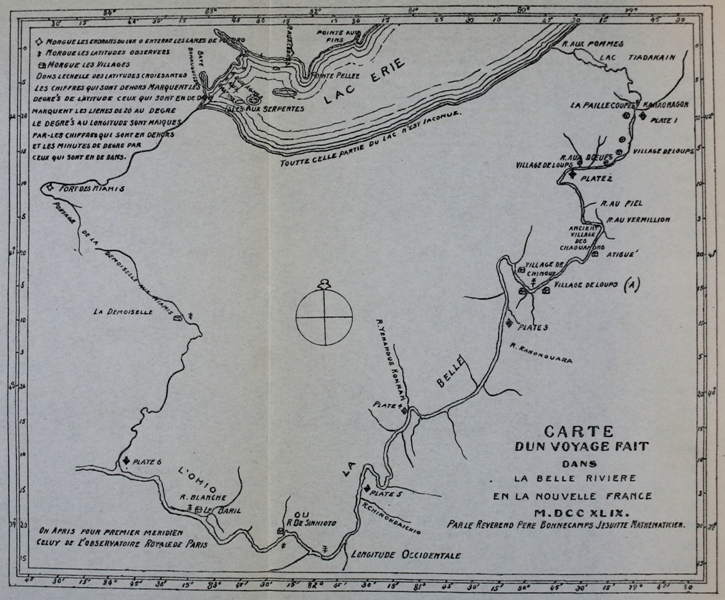
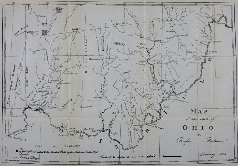
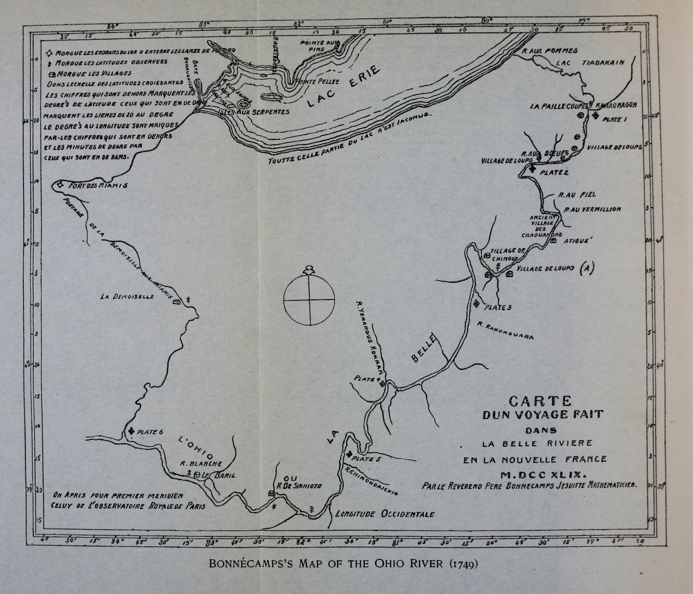
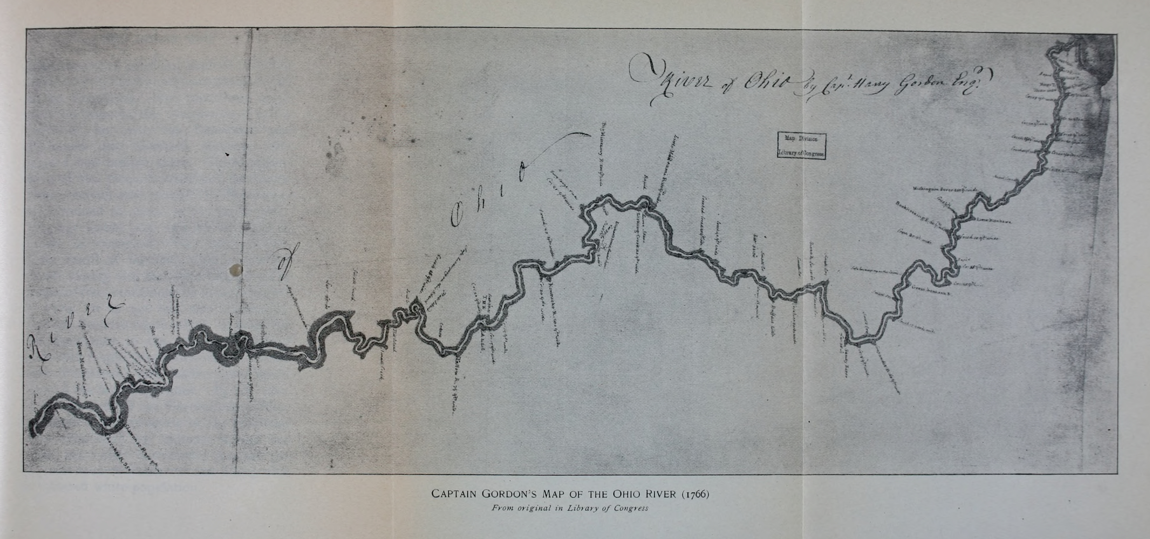
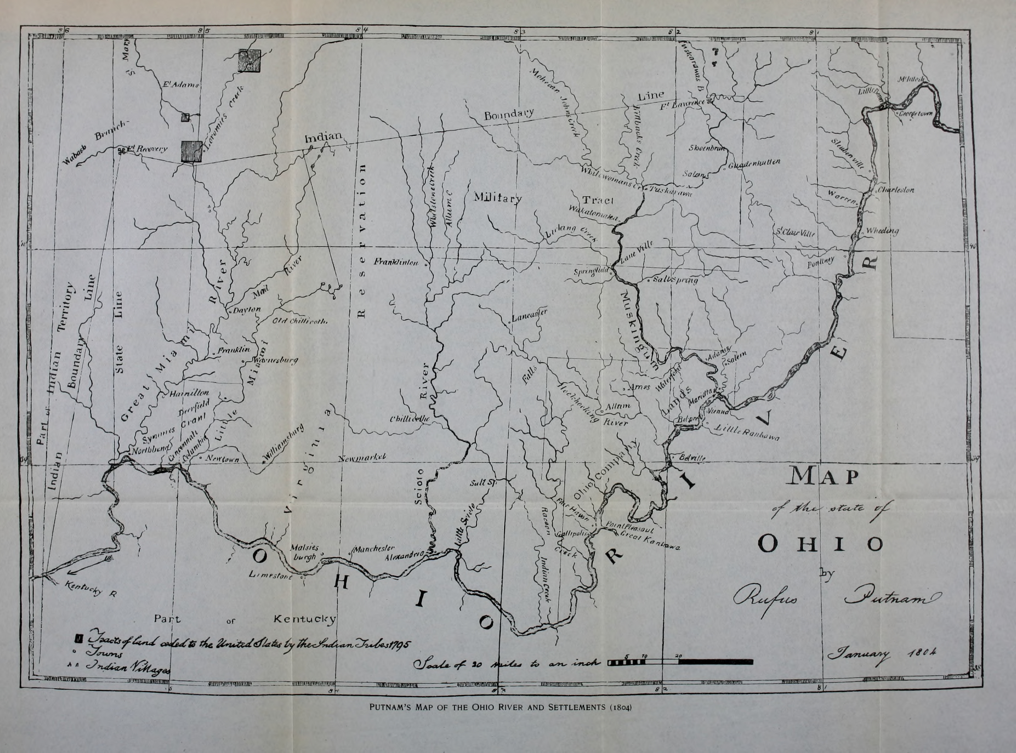