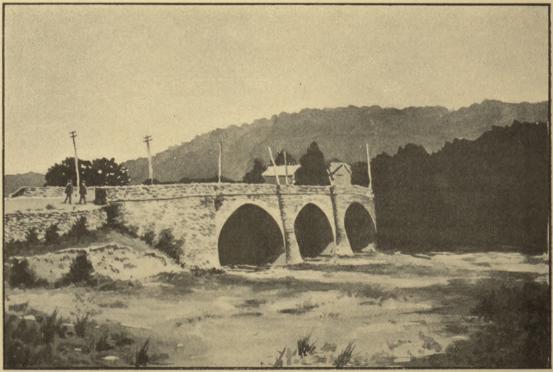
 Bridge at “Big Crossings”
Transcriber’s Note: Obvious errors in spelling and punctuation have been corrected. Footnotes have been moved to the end of the text body. Also images have been moved from the middle of a paragraph to the closest paragraph break, causing missing page numbers for those image pages and blank pages in this ebook.
Bridge at “Big Crossings”
THE ARTHUR H. CLARK COMPANY
CLEVELAND, OHIO
1904
COPYRIGHT, 1904
BY
The Arthur H. Clark Company
ALL RIGHTS RESERVED
| PAGE | ||
| Preface | 11 | |
| I. | Our First National Road | 15 |
| II. | Building the Road in the West | 71 |
| III. | Operation and Control | 91 |
| IV. | Stagecoaches and Freighters | 119 |
| V. | Mails and Mail Lines | 142 |
| VI. | Taverns and Tavern Life | 152 |
| VII. | Conclusion | 174 |
| Appendixes | 189 | |
| I. | Bridge at “Big Crossings” | Frontispiece |
| II. | Map of Cumberland Road in Pennsylvania and Maryland | 55 |
| III. | Chestnut Ridge, Pennsylvania | 65 |
| IV. | Map of Cumberland Road in the West | 79 |
| V. | A Culvert on the Cumberland Road in Ohio | 177 |
For material used in this volume the author is largely in the debt of the librarians of the State Libraries of Maryland, Pennsylvania, Ohio, Indiana, and Illinois. From the Honorable C. B. Galbreath, of the Ohio State Library, he has received much assistance covering an extended period. To the late Thomas B. Searight’s valuable collection of biographical and colloquial sketches, The Old Pike, the author wishes to express his great indebtedness. As Mr. Searight gave special attention to the road in Pennsylvania, the present monograph deals at large with the story of the road west of the Ohio River, especially in the state of Ohio.
The Cumberland Road was best known in some parts as the “United States” or “National” Road. Its legal name has been selected as the most appropriate for the present monograph which is revised [Pg 12]from a study of the subject The Old National Road formerly published by the Ohio State Archæological and Historical Society.
A. B. H.
Marietta, Ohio, May 15, 1903.
It is a monument of a past age; but like all other monuments, it is interesting as well as venerable. It carried thousands of population and millions of wealth into the West; and more than any other material structure in the land, served to harmonize and strengthen, if not to save, the Union.—Veech.
The middle ages had their wars and agonies, but also their intense delights. Their gold was dashed with blood, but ours is sprinkled with dust. Their life was intermingled with white and purple; ours is one seamless stuff of brown.—Ruskin.
A person cannot live in the American Central West and be acquainted with the generation which greets the new century with feeble hand and dimmed eye, without realizing that there has been a time which, compared with today, seems as the Middle Ages did to the England for which Ruskin wrote—when “life was intermingled with white and purple.”
This western boy, born to a feeble republic-mother, with exceeding suffering in those days which “tried men’s souls,” grew up as all boys grow up. For a long and doubtful period the young West grew slowly and changed appearance gradually. Then, suddenly, it started from its slum[Pg 16]bering, and, in two decades, could hardly have been recognized as the infant which, in 1787, looked forward to a precarious and doubtful future. The boy has grown into the man in the century, but the changes of the last half century are not, perhaps, so marked as those of the first, when a wilderness was suddenly transformed into a number of imperial commonwealths.
When this West was in its teens and began suddenly outstripping itself, to the marvel of the world, one of the momentous factors in its progress was the building of a great national road, from the Potomac River to the Mississippi River, by the United States Government—a highway seven hundred miles in length, at a cost of seven millions of treasure. This ribbon of road, winding its way through Maryland, Pennsylvania, Ohio, Indiana, and Illinois, toward the Mississippi, was one of the most important steps in that movement of national expansion which followed the conquest of the West. It is probably impossible for us to realize fully what it meant to this West when that vanguard of surveyors came down the western slopes of[Pg 17] the Alleghenies, hewing a thoroughfare which should, in one generation, bind distant and half-acquainted states together in bonds of common interest, sympathy, and ambition. Until that day, travelers spoke of “going into” and “coming out of” the West as though it were a Mammoth Cave. Such were the herculean difficulties of travel that it was commonly said, despite the dangers of life in the unconquered land, if pioneers could live to get into the West, nothing could, thereafter, daunt them. The growth and prosperity of the West was impossible, until the dawning of such convictions as those which made the Cumberland Road a reality.
The history of this famed road is but a continuation of the story of the Washington and Braddock roads, through Great Meadows from the Potomac to the Ohio. As outlined in Volumes III and IV of this series, this national highway was the realization of the youth Washington’s early dream—a dream that was, throughout his life, a dominant force.
But Braddock’s Road was for three score years the only route westward through[Pg 18] southwestern Pennsylvania, and it grew worse and worse with each year’s travel. Indeed, the more northerly route, marked out in part by General Forbes in 1758, was plainly the preferable road for travelers to Pittsburg until the building of the Cumberland Road, 1811-1818.
The rapid peopling of the state of Ohio, and the promise of an equal development in Indiana and Illinois caused the building of our first and only great national road. Congress passed an act on the thirtieth of April, 1802, enabling the people of Ohio to form a state government and seek admission into the Union. Section seven contained the following provision:
“That one-twentieth of the net proceeds of the lands lying within said State sold by Congress shall be applied to the laying out and making public roads leading from the navigable waters emptying into the Atlantic, to the Ohio, to the said state, and through the same, such roads to be laid out under the authority of Congress, with the consent of the several states through which the roads shall pass.”[1][Pg 19]
On the third of March, 1803 another act was passed which appropriated three of the five per cent to laying out roads in the state of Ohio, the remaining two per cent to be devoted to building a road from navigable waters leading into the Atlantic Ocean, to the Ohio River contiguous to the state of Ohio. A committee was appointed to review the matter and the conclusion of their report to the Senate on the nineteenth of December, 1805 was as follows:
“Therefore the committee have thought it expedient to recommend the laying out and making a road from Cumberland, on the northerly bank of the Potomac, and within the state of Maryland, to the Ohio river, at the most convenient place on the easterly bank of said river, opposite to Steubenville, and the mouth of Grave Creek, which empties into said river, Ohio, a little below Wheeling in Virginia, This route will meet and accommodate roads from Baltimore and the District of Columbia; it will cross the Monongahela at or near Brownsville, sometimes called Redstone, where the advantage of boating can be taken; and from the point where it will[Pg 20] probably intersect the river Ohio, there are now roads, or they can easily be made over feasible and proper ground, to and through the principal population of the state of Ohio.”[2]
Immediately the following act of Congress was passed, authorizing the laying out and making of the Cumberland Road:
AN ACT TO REGULATE THE LAYING OUT AND
MAKING A ROAD FROM CUMBERLAND,
IN THE STATE OF MARYLAND, TO THE STATE
OF OHIO
Section 1. Be it enacted by the Senate and House of Representatives of the United States of America in Congress assembled, That the President of the United States be, and he is hereby authorized to appoint, by and with the advice and consent of the Senate, three discreet and disinterested citizens of the United States, to lay out a road from Cumberland, or a point on the northern bank of the river Potomac, in the state of Maryland, between Cumberland and the place where the main road leading from Gwynn’s to Winchester, in Virginia, crosses[Pg 21] the river, to the state of Ohio; whose duty it shall be, as soon as may be, after their appointment, to repair to Cumberland aforesaid, and view the ground, from the points on the river Potomac hereinbefore designated to the river Ohio; and to lay out in such direction as they shall judge, under all circumstances the most proper, a road from thence to the river Ohio, to strike the same at the most convenient place, between a point on its eastern bank, opposite to the northern boundary of Steubenville, in said state of Ohio, and the mouth of Grave Creek, which empties into the said river a little below Wheeling, in Virginia.
Sec. 2. And be it further enacted, That the aforesaid road shall be laid out four rods in width, and designated on each side by a plain and distinguishable mark on a tree, or by the erection of a stake or monument sufficiently conspicuous, in every quarter of a mile of the distance at least, where the road pursues a straight course so far or further, and on each side, at every point where an angle occurs in its course.
Sec. 3. And be it further enacted, That the commissioners shall, as soon as may be,[Pg 22] after they have laid out said road, as aforesaid, present to the President an accurate plan of the same, with its several courses and distances, accompanied by a written report of their proceedings, describing the marks and monuments by which the road is designated, and the face of the country over which it passes, and pointing out the particular parts which they shall judge require the most and immediate attention and amelioration, and the probable expense of making the same possible in the most difficult parts, and through the whole distance; designating the state or states through which said road has been laid out, and the length of the several parts which are laid out on new ground, as well as the length of those parts laid out on the road now traveled. Which report the President is hereby authorized to accept or reject, in the whole or in part. If he accepts, he is hereby further authorized and requested to pursue such measures, as in his opinion shall be proper, to obtain consent for making the road, of the state or states through which the same has been laid out. Which consent being obtained, he is further authorized[Pg 23] to take prompt and effectual measures to cause said road to be made through the whole distance, or in any part or parts of the same as he shall judge most conducive to the public good, having reference to the sum appropriated for the purpose.
Sec. 4. And be it further enacted, That all parts of the road which the President shall direct to be made, in case the trees are standing, shall be cleared the whole width of four rods; and the road shall be raised in the middle of the carriage-way with stone, earth, or gravel or sand, or a combination of some or all of them, leaving or making, as the case may be, a ditch or water course on each side and contiguous to said carriage-way, and in no instance shall there be an elevation in said road, when finished, greater than an angle of five degrees with the horizon. But the manner of making said road, in every other particular, is left to the direction of the President.
Sec. 5. And be it further enacted, That said commissioners shall each receive four dollars per day, while employed as aforesaid, in full for their compensation, includ[Pg 24]ing all expenses. And they are hereby authorized to employ one surveyor, two chainmen and one marker, for whose faithfulness and accuracy they, the said commissioners, shall be responsible, to attend them in laying out said road, who shall receive in full satisfaction for their wages, including all expenses, the surveyor, three dollars per day, and each chainman and marker, one dollar per day, while they shall be employed in said business, of which fact a certificate signed by said commissioners shall be deemed sufficient evidence.
Sec. 6. And be it further enacted, That the sum of thirty thousand dollars be, and the same is hereby appropriated, to defray the expenses of laying out and making said road. And the President is hereby authorized to draw, from time to time, on the treasury for such parts, or at any one time, for the whole of said sum, as he shall judge the service requires. Which sum of thirty thousand dollars shall be paid, first, out of the fund of two per cent reserved for laying out and making roads to the state of Ohio, and by virtue of the seventh section of an act passed on the thirtieth day of April,[Pg 25] one thousand eight hundred and two, entitled, “An act to enable the people of the eastern division of the territory northwest of the river Ohio to form a constitution and state government, and for the admission of such state into the Union on an equal footing with the original states, and for other purposes.” Three per cent of the appropriation contained in said seventh section being directed by a subsequent law to the laying out, opening, and making roads within the said state of Ohio; and secondly, out of any money in the treasury not otherwise appropriated, chargeable upon, and reimbursable at the treasury by said fund of two per cent as the same shall accrue.
Sec. 7. And be it further enacted, That the President be, and he is hereby requested, to cause to be laid before Congress, as soon as convenience will permit, after the commencement of each session, a statement of the proceedings under this act, that Congress may be enabled to adopt such further measures as may from time to time be proper under existing circumstances.
Approved March 29, 1806.
Th. Jefferson.
President Jefferson appointed Thomas Moore of Maryland, Joseph Kerr of Ohio, and Eli Williams of Maryland commissioners. Their first report was presented December 30, 1806, as follows:
“The commissioners, acting by appointment under the law of Congress, entitled, ‘An act to regulate the laying out and making a road from Cumberland in the State of Maryland, to the State of Ohio,’ beg leave to report to the President of the United States, and to premise that the duties imposed by the law became a work of greater magnitude, and a task much more arduous, than was conceived before entering upon it; from which circumstance the commissioners did not allow themselves sufficient time for the performance of it before the severity of the weather obliged them to retire from it, which was the case in the first week of the present month (December). That, not having fully accomplished their work, they are unable fully to report a discharge of all the duties enjoined by the law; but as the most material and principal part has been performed, and as a communication of the progress[Pg 27] already made may be useful and proper, during the present session of Congress, and of the Legislatures of those States through which the route passes, the commissioners respectfully state that at a very early period it was conceived that the maps of the country were not sufficiently accurate to afford a minute knowledge of the true courses between the extreme points on the rivers, by which the researches of the commissioners were to be governed; a survey for that purpose became indispensable, and considerations of public economy suggested the propriety of making this survey precede the personal attendance of the commissioners.
“Josias Thompson, a surveyor of professional merit, was taken into service and authorized to employ two chain carriers and a marker, as well as one vaneman, and a packhorse-man and horse, on public account; the latter being indispensable and really beneficial in accelerating the work. The surveyor’s instructions are contained in document No. 1, accompanying this report.
“Calculating on a reasonable time for[Pg 28] the performance of the instructions to the surveyor, the commissioners, by correspondence, fixed on the first day of September last, for their meeting at Cumberland to proceed in the work; neither of them, however, reached that place until the third of that month, on which day they all met.
“The surveyor having, under his instructions, laid down a plat of his work, showing the meanders of the Potomac and Ohio rivers, within the limits prescribed for the commissioners, as also the road between those rivers, which is commonly traveled from Cumberland to Charleston, in part called Braddock’s road; and the same being produced to the commissioners, whereby straight lines and their true courses were shown between the extreme points on each river, and the boundaries which limit the powers of the commissioners being thereby ascertained, serving as a basis whereon to proceed in the examination of the grounds and face of the country; the commissioners thus prepared commenced the business of exploring; and in this it was considered that a faithful discharge of the discretionary powers vested by the law made it necessary[Pg 29] to view the whole to be able to judge of a preference due to any part of the grounds, which imposed a task of examining a space comprehending upwards of two thousand square miles; a task rendered still more incumbent by the solicitude and importunities of the inhabitants of every part of the district, who severally conceived their grounds entitled to a preference. It becoming necessary, in the interim, to run various lines of experiment for ascertaining the geographical position of several points entitled to attention, and the service suffering great delay for want of another surveyor, it was thought consistent with the public interest to employ, in that capacity, Arthur Rider, the vaneman, who had been chosen with qualification to meet such an emergency; and whose services as vaneman could then be dispensed with. He commenced, as surveyor, on the 22nd day of September, and continued so at field work until the first day of December, when he was retained as a necessary assistant to the principal surveyor, in copying field notes and hastening the draught of the work to be reported.[Pg 30]
“The proceedings of the commissioners are especially detailed in their general journal, compiled from the daily journal of each commissioner, to which they beg leave to refer, under mark No. 2.
“After a careful and critical examination of all the grounds within the limits prescribed, as well as the grounds and ways out from the Ohio westwardly, at several points, and examining the shoal parts of the Ohio river as detailed in the table of soundings, stated in their journal, and after gaining all the information, geographical, general and special, possible and necessary, toward a judicial discharge of the duties assigned them, the commissioners repaired to Cumberland to examine and compare their notes and journals, and determine upon the direction and location of their route.
“In this consultation the governing objects were:
1. Shortness of distance between navigable points on the eastern and western waters.
2. A point on the Monongahela best calculated to equalize the advantages of[Pg 31] this portage in the country within reach of it.
3. A point on the Ohio river most capable of combining certainty of navigation with road accommodation; embracing, in this estimate, remote points westwardly, as well as present and probable population on the north and south.
4. Best mode of diffusing benefits with least distance of road.
“In contemplating these objects, due attention was paid as well to the comparative merits of towns, establishments and settlements already made, as to the capacity of the country with the present and probable population.
“In the course of arrangement, and in its order, the first point located for the route was determined and fixed at Cumberland, a decision founded on propriety, and in some measure on necessity, from the circumstance of a high and difficult mountain, called Nobley, laying and confining the east margin of the Potomac, so as to render it impossible of access on that side without immense expense, at any point between Cumberland and where the road[Pg 32] from Winchester to Gwynn’s crosses, and even there the Nobley mountain is crossed with much difficulty and hazard. And this upper point was taxed with another formidable objection; it was found that a high range of mountains, called Dan’s, stretching across from Gwynn’s to the Potomac, above this point, precluded the opportunity of extending a route from this point in a proper direction, and left no alternative but passing by Gwynn’s; the distance from Cumberland to Gwynn’s being upward of a mile less than from the upper point, which lies ten miles by water above Cumberland, the commissioners were not permitted to hesitate in preferring a point which shortens the portage, as well as the Potomac navigation.
“The point of the Potomac being viewed as a great repository of produce, which a good road will bring from the west of Laurel Hill, and the advantages which Cumberland, as a town, has in that respect over an unimproved place, are additional considerations operating forcibly in favor of the place preferred.
“In extending the route from Cumber[Pg 33]land, a triple range of mountains, stretching across from Jening’s run in measure with Gwynn’s, left only the alternative of laying the road up Will’s creek for three miles, nearly at right angles with the true course, and then by way of Jening’s run, or extending it over a break in the smallest mountain, on a better course by Gwynn’s, to the top of Savage mountain; the latter was adopted, being the shortest, and will be less expensive in hill-side digging over a sloped route than the former, requiring one bridge over Will’s creek and several over Jening’s run, both very wide and considerable streams in high water; and a more weighty reason for preferring the route by Gwynn’s is the great accommodation it will afford travelers from Winchester by the upper point, who could not reach the route by Jening’s run short of the top of Savage, which would withhold from them the benefit of an easy way up the mountain.
“It is, however, supposed that those who travel from Winchester by way of the upper point to Gwynn’s, are in that respect more the dupes of common prejudice than judges[Pg 34] of their own ease, as it is believed the way will be as short, and on much better ground, to cross the Potomac below the confluence of the north and south branches (thereby crossing these two, as well as Patterson’s creek, in one stream, equally fordable in the same season), than to pass through Cumberland to Gwynn’s. Of these grounds, however, the commissioners do not speak from actual view, but consider it a subject well worthy of future investigation. Having gained the top of Alleghany mountain, or rather the top of that part called Savage, by way of Gwynn’s, the general route, as it respects the most important points, was determined as follows, viz:
“From a stone at the corner of lot No. 1, in Cumberland, near the confluence of Will’s creek and the north branch of the Potomac river; thence extending along the street westwardly, to cross the hill lying between Cumberland and Gwynn’s, at the gap where Braddock’s road passes it; thence near Gwynn’s and Jesse Tomlinson’s, to cross the big Youghiogheny near the mouth of Roger’s run, between the crossing of Braddock’s road and the confluence of the[Pg 35] streams which form the Turkey foot; thence to cross Laurel Hill near the forks of Dunbar’s run, to the west foot of that hill, at a point near where Braddock’s old road reached it, near Gist’s old place, now Colonel Isaac Meason’s, thence through Brownsville and Bridgeport, to cross the Monongahela river below Josias Crawfords’ ferry; and thence on as straight a course as the country will admit to the Ohio, at a point between the mouth of Wheeling creek and the lower point of Wheeling island.
“In this direction of the route it will lay about twenty-four and a half miles in Maryland, seventy-five miles and a half in Pennsylvania, and twelve miles in Virginia; distances which will be in a small degree increased by meanders, which the bed of the road must necessarily make between the points mentioned in the location; and this route, it is believed, comprehends more important advantages than could be afforded in any other, inasmuch as it has a capacity at least equal to any other in extending advantages of a highway; and at the same time establishes the shortest portage[Pg 36] between the points already navigated, and on the way accommodates other and nearer points to which navigation may be extended, and still shorten the portage.
“It intersects Big Youghiogheny at the nearest point from Cumberland, then lies nearly parallel with that river for the distance of twenty miles, and at the west foot of Laurel Hill lies within five miles of Connellsville, from which the Youghiogheny is navigated; and in the same direction the route intersects at Brownsville, the nearest point on the Monongahela river within the district.
“The improvement of the Youghiogheny navigation is a subject of too much importance to remain long neglected; and the capacity of that river, as high up as the falls (twelve miles above Connellsville), is said to be equal, at a small expense, with the parts already navigated below. The obstructions at the falls, and a rocky rapid near Turkey Foot, constitute the principal impediments in that river to the intersection of the route, and as much higher as the stream has a capacity for navigation; and these difficulties will doubtless be[Pg 37] removed when the intercourse shall warrant the measure.
“Under these circumstances the portage may be thus stated: From Cumberland to Monongahela, sixty-six and one-half miles. From Cumberland to a point in measure with Connellsville, on the Youghiogheny river, fifty-one and one-half miles. From Cumberland to a point in measure with the lower end of the falls of Youghiogheny, which will lie two miles north of the public road, forty-three miles. From Cumberland to the intersection of the route with the Youghiogheny river, thirty-four miles.
“Nothing is here said of the Little Youghiogheny, which lies nearer Cumberland; the stream being unusually crooked, its navigation can only become the work of a redundant population.
“The point which this route locates, at the west foot of Laurel Hill, having cleared the whole of the Alleghany mountain, is so situated as to extend the advantages of an easy way through the great barrier, with more equal justice to the best parts of the country between Laurel Hill and the Ohio. Lines from this point to Pittsburg and[Pg 38] Morgan town, diverging nearly at the same angle, open upon equal terms to all parts of the western country that can make use of this portage; and which may include the settlements from Pittsburg, up Big Beaver to the Connecticut reserve, on Lake Erie, as well as those on the southern borders of the Ohio and all the intermediate country.
“Brownsville is nearly equidistant from Big Beaver and Fishing creek, and equally convenient to all the crossing places on the Ohio, between these extremes. As a port, it is at least equal to any on the Monongahela within the limits, and holds superior advantages in furnishing supplies to emigrants, traders, and other travelers by land or water.
“Not unmindful of the claims of towns and their capacity of reciprocating advantages on public roads, the commissioners were not insensible of the disadvantage which Uniontown must feel from the want of that accommodation which a more southwardly direction of the route would have afforded; but as that could not take place without a relinquishment of the shortest passage, considerations of public benefit[Pg 39] could not yield to feelings of minor import. Uniontown being the seat of justice for Fayette county, Pennsylvania, is not without a share of public benefits, and may partake of the advantages of this portage upon equal terms with Connellsville, a growing town, with the advantage of respectable water-works adjoining, in the manufactory of flour and iron.
“After reaching the nearest navigation on the western waters, at a point best calculated to diffuse the benefits of a great highway, in the greatest possible latitude east of the Ohio, it was considered that, to fulfill the objects of the law, it remained for the commissioners to give such a direction to the road as would best secure a certainty of navigation on the Ohio at all seasons, combining, as far as possible, the inland accommodation of remote points westwardly. It was found that the obstructions in the Ohio, within the limits between Steubenville and Grave creek, lay principally above the town and mouth of Wheeling; a circumstance ascertained by the commissioners in their examination of the channel, as well as by common usage,[Pg 40] which has long given a decided preference to Wheeling as a place of embarkation and port of departure in dry seasons. It was also seen that Wheeling lay in a line from Brownsville to the centre of the state of Ohio and Post Vincennes. These circumstances favoring and corresponding with the chief objects in view in this last direction of the route, and the ground from Wheeling westwardly being known of equal fitness with any other way out from the river, it was thought most proper, under these several considerations, to locate the point mentioned below the mouth of Wheeling. In taking this point in preference to one higher up and in the town of Wheeling, the public benefit and convenience were consulted, inasmuch as the present crossing place over the Ohio from the town is so contrived and confined as to subject passengers to extraordinary ferriage and delay, by entering and clearing a ferry-boat on each side of Wheeling island, which lies before the town and precludes the opportunity of fording when the river is crossed in that way, above and below the island. From the point located, a safe[Pg 41] crossing is afforded at the lower point of the island by a ferry in high, and a good ford at low water.
“The face of the country within the limits prescribed is generally very uneven, and in many places broken by a succession of high mountains and deep hollows, too formidable to be reduced within five degrees of the horizon, but by crossing them obliquely, a mode which, although it imposes a heavy task of hill-side digging, obviates generally the necessity of reducing hills and filling hollows, which, on these grounds, would be an attempt truly quixotic. This inequality of the surface is not confined to the Alleghany mountain; the country between the Monongahela and Ohio rivers, although less elevated, is not better adapted for the bed of a road, being filled with impediments of hills and hollows, which present considerable difficulties, and wants that super-abundance and convenience of stone found in the mountain.
“The indirect course of the road now traveled, and the frequent elevations and depressions which occur, that exceed the limits of the law, preclude the possibility[Pg 42] of occupying it in any extent without great sacrifice of distance, and forbid the use of it, in any one part for more than half a mile, or more than two or three miles in the whole.
“The expense of rendering the road now in contemplation passable, may, therefore, amount to a larger sum than may have been supposed necessary, under an idea of embracing in it a considerable part of the old road; but it is believed that the contrary will be found most correct, and that a sum sufficient to open the new could not be expended on the same distance of the old road with equal benefit.
“The sum required for the road in contemplation will depend on the style and manner of making it; as a common road cannot remove the difficulties which always exist on deep grounds, and particularly in wet seasons, and as nothing short of a firm, substantial, well-formed, stone-capped road can remove the causes which led to the measure of improvement, or render the institution as commodious as a great and growing intercourse appears to require, the expense of such a road next becomes the subject of inquiry.[Pg 43]
“In this inquiry the commissioners can only form an estimate by recurring to the experience of Pennsylvania and Maryland in the business of artificial roads. Upon this data, and a comparison of the grounds and proximity of the materials for covering, there are reasons for belief that, on the route reported, a complete road may be made at an expense not exceeding six thousand dollars per mile, exclusive of bridges over the principal streams on the way. The average expense of the Lancaster, as well as Baltimore and Frederick turnpike, is considerably higher; but it is believed that the convenient supply of stone which the mountain affords will, on those grounds, reduce the expense to the rate here stated.
“As to the policy of incurring this expense, it is not the province of the commissioners to declare; but they cannot, however, withhold assurances of a firm belief that the purse of the nation cannot be more seasonably opened, or more happily applied, than in promoting the speedy and effectual establishment of a great and easy road on the way contemplated.
“In the discharge of all these duties, the[Pg 44] commissioners have been actuated by an ardent desire to render the institution as useful and commodious as possible; and, impressed with a strong sense of the necessity which urges the speedy establishment of the road, they have to regret the circumstances which delay the completion of the part assigned them. They, however, in some measure, content themselves with the reflection that it will not retard the progress of the work, as the opening of the road cannot commence before spring, and may then begin with making the way.
“The extra expense incident to the service from the necessity (and propriety, as it relates to public economy,) of employing men not provided for by law will, it is hoped, be recognized and provision made for the payment of that and similar expenses, when in future it may be indispensably incurred.
“The commissioners having engaged in a service in which their zeal did not permit them to calculate the difference between their pay and the expense to which the service subjected them, cannot suppose it the wish or intention of the government to[Pg 45] accept of their services for a mere indemnification of their expense of subsistence, which will be very much the case under the present allowance; they, therefore, allow themselves to hope and expect that measures will be taken to provide such further compensation as may, under all circumstances, be thought neither profuse nor parsimonious.
“The painful anxiety manifested by the inhabitants of the district explored, and their general desire to know the route determined on, suggested the measure of promulgation, which, after some deliberation, was agreed on by way of circular letter, which has been forwarded to those persons to whom precaution was useful, and afterward sent to one of the presses in that quarter for publication, in the form of the document No. 3, which accompanies this report.
“All which is, with due deference, submitted.
Eli Williams,
Thomas Moore,
Joseph Kerr.
December 30, 1806.”
Starting from Cumberland the general alignment of Braddock’s Road was pursued, until the point was reached where the old thoroughfare left the old portage trail, on the summit of Laurel Hill. The course was then laid straight toward Brownsville (Redstone Old Fort) probably along the general alignment of the old Indian portage path, and an earlier road. From Brownsville to Washington was an old road, possibly the course of the Indian trail.
As has already been suggested, there was a dispute concerning the point where the road would touch the Ohio River. The rivalry was most intense between Wheeling and Steubenville. Wheeling won through the influence of Henry Clay, to whom a monument was erected at a later date near the town on the old road. The commissioners rendered a second report on the fifteenth of January, 1808 as follows:
“The undersigned, commissioners appointed under the law of the United States, entitled ‘An act to regulate the laying out and making a road from Cumberland, in the State of Maryland, to the State of Ohio,’ in addition to the communications[Pg 47] heretofore made, beg leave further to report to the President of the United States, that, by the delay of the answer of the Legislature of Pennsylvania to the application for permission to pass the road through that state, the commissioners could not proceed to the business of the road in the spring before vegetation had so far advanced as to render the work of exploring and surveying difficult and tedious, from which circumstance it was postponed till the last autumn, when the business was again resumed. That, in obedience to the special instructions given them, the route heretofore reported has been so changed as to pass through Uniontown, and that they have completed the location, gradation, and marking of the route from Cumberland to Brownsville, Bridgeport, and the Monongahela river, agreeably to a plat of the courses, distances and grades in which is described the marks and monuments by which the route is designated, and which is herewith exhibited; that by this plat and measurement it will appear (when compared with the road now traveled) there is a saving of four miles of distance between[Pg 48] Cumberland and Brownsville on the new route.
“In the gradation of the surface of the route (which became necessary) is ascertained the comparative elevation and depression of different points on the route, and taking a point ten feet above the surface of low water in the Potomac river at Cumberland, as the horizon, the most prominent points are found to be elevated as follows, viz.:
| Feet | |
| Summit of Wills mountain | 581.3 |
| Western foot of same | 304.4 |
| Summit of Savage mountain | 2,022.24 |
| Savage river | 1,741.6 |
| Summit Little Savage mountain | 1,900.4 |
| Branch Pine Run, first Western water | 1,699.9 |
| Summit of Red Hill (afterwards called shades of death) | 1,914.3 |
| Summit Little Meadow mountain | 2,026.16 |
| Little Youghiogheny river | 1,322.6 |
| East Fork of Shade run | 1,558.92 |
| Summit of Negro mountain, highest point[3] | 2,328.12 |
| [Pg 49]Middle branch of White’s creek, at the west foot of Negro mountain | 1,360.5 |
| White’s creek | 1,195.5 |
| Big Youghiogheny river | 645.5 |
| Summit of ridge between Youghiogheny river and Beaver waters | 1,514.5 |
| Beaver Run | 1,123.8 |
| Summit of Laurel Hill | 1,550.16 |
| Court House in Uniontown | 274.65 |
| A point ten feet above the surfaceof low water in the Monongahela river, at the mouth of Dunlap’s creek | 119.26 |
“The law requiring the commissioners to report such parts of the route as are laid on the old road, as well as those on new grounds, and to state those parts which require the most immediate attention and amelioration, the probable expense of making the same passable in the most difficult parts, and through the whole distance, they have to state that, from the crooked and hilly course of the road now traveled, the new route could not be made to occupy any part of it (except an intersection on Wills[Pg 50] mountain, another at Jesse Tomlinson’s, and a third near Big Youghiogheny, embracing not a mile of distance in the whole) without unnecessary sacrifices of distances and expense.
“That, therefore, an estimate must be made on the route as passing wholly through new grounds. In doing this the commissioners feel great difficulty, as they cannot, with any degree of precision, estimate the expense of making it merely passable; nor can they allow themselves to suppose that a less breadth than that mentioned in the law was to be taken into the calculation. The rugged deformity of the grounds rendered it impossible to lay a route within the grade limited by law otherwise than by ascending and descending the hills obliquely, by which circumstance a great proportion of the route occupies the sides of the hills, which cannot be safely passed on a road of common breadth, and where it will, in the opinion of the commissioners, be necessary, by digging, to give the proper form of thirty feet, at least in the breadth of the road, to afford suitable security in passing[Pg 51] on a way to be frequently crowded with wagons moving in opposite directions, with transports of emigrant families, and droves of cattle, hogs, etc., on the way to market. Considering, therefore, that a road on those grounds must have sufficient breadth to afford ways and water courses, and satisfied that nothing short of well constructed and completely finished conduits can insure it against injuries, which must otherwise render it impassable at every change of the seasons, by heavy falls of rain or melting of the beds of snow, with which the country is frequently covered; the commissioners beg leave to say, that, in a former report, they estimated the expense of a road on these grounds, when properly shaped, made and finished in the style of a stone-covered turnpike, at $6,000 per mile, exclusive of bridges over the principal streams on the way; and that with all the information they have since been able to collect, they have no reason to make any alteration in that estimate.
“The contracts authorized by, and which have been taken under the superintendence of the commissioner, Thomas Moore (dupli[Pg 52]cates of which accompany this report), will show what has been undertaken relative to clearing the timber and brush from part of the breadth of the road. The performance of these contracts was in such forwardness on the 1st instant as leaves no doubt of their being completely fulfilled by the first of March.
“The commissioners further state, that, to aid them in the extension of their route, they ran and marked a straight line from the crossing-place on the Monongahela, to Wheeling, and had progressed twenty miles, with their usual and necessary lines of experiment, in ascertaining the shortest and best connection of practical grounds, when the approach of winter and the shortness of the days afforded no expectation that they could complete the location without a needless expense in the most inclement season of the year. And, presuming that the postponement of the remaining part till the ensuing spring would produce no delay in the business of making the road, they were induced to retire from it for the present.
“The great length of time already em[Pg 53]ployed in this business makes it proper for the commissioners to observe that, in order to connect the best grounds with that circumspection which the importance of the duties confided to them demanded, it became indispensably necessary to run lines of experiment and reference in various directions, which exceed an average of four times the distance located for the route, and that, through a country so irregularly broken, and crowded with very thick underwood in many places, the work has been found so incalculably tedious that, without an adequate idea of the difficulty, it is not easy to reconcile the delay.
“It is proper to mention that an imperious call from the private concerns of Commissioner Joseph Kerr, compelled him to return home on the 29th of November, which will account for the want of his signature to this report.
“All of which is, with due deference, submitted, this 15th day of January, 1808.
Eli Williams,
Thomas Moore.
It was necessary to obtain permission of[Pg 54] each state through which the Cumberland Road was to be built; Pennsylvania, only, made any condition, hers being that the road touch the towns of Washington and Uniontown.[4]
The first contracts were let on the eleventh and the sixteenth of April, 1811, for building the first ten miles west of Cumberland, Maryland. These contracts were completed in the year following. More were let in 1812, 1813, and 1815; and two years later contracts for all the distance to Uniontown, Pennsylvania were let. In 1818, United States Mail coaches were running between Washington, D. C. and Wheeling, Virginia. The cost of the road averaged $9,745 per mile between Cumberland and Uniontown, and $13,000 per mile for the entire division from the Potomac to the Ohio. Too liberal contracts is the reason given for the heavy expense between Uniontown and Wheeling.
A flood of traffic swept over the great highway immediately upon its completion. As [Pg 57] early as the year 1822 it is recorded that a single one of the five commission houses at Wheeling unloaded one thousand and eighty-one wagons, averaging three thousand five hundred pounds each, and paid for freightage of goods the sum of ninety thousand dollars.
But the road was hardly completed when a specter of constitutional cavil arose, threatening its existence. In 1822 a bill was passed by Congress looking toward the preservation and repair of the newly-built road. It should be stated that the roadbed, though completed in one sense, was not in condition to be used extensively unless continually repaired. In many places only a single layer of broken stone had been laid, and, with the volume of traffic which was daily passing over it, the road did not promise to remain in good condition. In order to secure funds for the constant repairs necessary, this bill ordered the establishment of turnpikes with gates and tolls. The bill was immediately vetoed by President Monroe on the ground that Congress, according to his interpretation of the constitution, did not have the power[Pg 58] to pass such a sweeping measure of internal improvement.
The President based his conclusion upon the following grounds, stated in a special message to Congress, dated May 4, 1822:
“A power to establish turnpikes, with gates and tolls and to enforce the collection of the tolls by penalties, implies a power to adopt and execute a complete system of internal improvements. A right to impose duties to be paid by all persons passing a certain road, and on horses and carriages, as is done by this bill, involves the right to take the land from the proprietor on a valuation, and to pass laws for the protection of the road from injuries; and if it exist, as to one road, it exists as to any other, and to as many roads as Congress may think proper to establish. A right to legislate for the others is a complete right of jurisdiction and sovereignty for all the purposes of internal improvement, and not merely the right of applying money under the power vested in Congress to make appropriations (under which power, with the consent of the states through which the road passes, the work was originally com[Pg 59]menced, and has been so far executed). I am of the opinion that Congress does not possess this power—that the states individually cannot grant it; for, although they may assent to the appropriation of money within their limits for such purposes, they can grant no power of jurisdiction of sovereignty, by special compacts with the United States. This power can be granted only by an amendment to the constitution, and in the mode prescribed by it. If the power exist, it must be either because it has been specially granted to the United States, or that it is incidental to some power, which has been specifically granted. It has never been contended that the power was specifically granted. It is claimed only as being incidental to some one or more of the powers which are specifically granted.
“The following are the powers from which it is said to be derived: (1) From the right to establish post offices and post roads; (2) from the right to declare war; (3) to regulate commerce; (4) to pay the debts and provide for the common defense and the general welfare; (5) from the power to make all laws necessary and proper for car[Pg 60]rying into execution all the powers vested by the constitution in the government of the United States, or in any department or officer thereof; (6) and lastly from the power to dispose of and make all needful rules and regulations respecting the territory and other property of the United States. According to my judgment it cannot be derived from either of these powers, nor from all of them united, and in consequence it does not exist.”[5]
During the early years of this century, the subject of internal improvements relative to the building of roads and canals was one of the foremost political questions of the day. No sooner were the debts of the Revolutionary War paid, and a surplus accumulated, than a systematic improvement of the country was undertaken. The Cumberland Road was but one of several roads projected by the general Government. Through the administrations of Adams, Jefferson, and Madison large appropriations had been made for numerous improvements. The bill authorizing the levying[Pg 61] of tolls was a step too far, as President Monroe held that it was one thing to make appropriations for public improvements, but an entirely different thing to assume jurisdiction and sovereignty over the land whereon those improvements were made. This was one of the great public questions in the first half of the present century. President Jackson’s course was not very consistent. Before his election he voted for internal improvements, even advocating subscriptions by the Government to the stock of private canal companies, and the formation of roads beginning and ending within the limits of certain states. In his message at the opening of the first congress after his accession, he suggested the division of the surplus revenue among the states, as a substitute for the promotion of internal improvements by the general Government, attempting a limitation and distinction too difficult and important to be settled and acted upon on the judgment of one man, namely, the distinction between general and local objects.
“The pleas of the advocates of internal improvement,” wrote a contemporary au[Pg 62]thority of high standing on economic questions, “are these: That very extensive public works, designed for the benefit of the whole Union, and carried through vast portions of its area, must be accomplished. That an object so essential ought not to be left at the mercy of such an accident as the cordial agreement of the requisite number of states, to carry such works forward to their completion; that the surplus funds accruing from the whole nation cannot be as well employed as in promoting works in which the whole nation will be benefited; and that as the interests of the majority have hitherto upheld Congress in the use of this power, it may be assumed to be the will of the majority that Congress should continue to exercise it.
“The answer is that it is inexpedient to put a vast and increasing patronage into the hands of the general Government; that only a very superficial knowledge can be looked for in members of Congress as to the necessity or value of works proposed to be instituted in any parts of the states, from the impossibility or undesirableness of equalizing the amount of appropriation[Pg 63] made to each; that useless works would be proposed from the spirit of competition or individual interest; and that corruption, coëxtensive with the increase of power, would deprave the functions of the general Government.... To an impartial observer it appears that Congress has no constitutional right to devote the public funds to internal improvements, at its own unrestricted will and pleasure; that the permitted usurpation of the power for so long a time indicates that some degree of such power in the hands of the general Government is desirable and necessary; that such power should be granted through an amendment of the constitution, by the methods therein provided; that, in the meantime, it is perilous that the instrument should be strained for the support of any function, however desirable its exercise may be.
“In case of the proposed addition being made to the constitution, arrangements will, of course, be entered into for determining the principles by which general are to be distinguished from local objects or whether such distinction can, on any principle, be[Pg 64] fixed; for testing the utility of proposed objects; for checking extravagant expenditure, jobbing, and corrupt patronage; in short, the powers of Congress will be specified, here as in other matters, by express permission and prohibition.”[6]
In 1824, however, President Monroe found an excuse to sign a bill which was very similar to that vetoed in 1822, and the great road, whose fate had hung for two years in the balance, received needed appropriations. The travel over the road in the first decade after its completion was heavy, and before a decade had passed the roadbed was in wretched condition. It was the plan of the friends of the road, when they realized that no revenue could be raised by means of tolls by the Government, to have the road placed in a state of good repair by the Government and then turned over to the several states through which it passed.[7]
The liberality of the government, at this juncture, in instituting thorough repairs on the road, was an act worthy of the road’s service and destiny.[Pg 65]
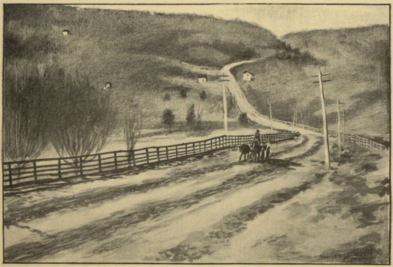 Chestnut Ridge, Pennsylvania
In order to insure efficiency and permanency these repairs[8] were made on the Macadam system; that is to say, the pavement of the old road was entirely broken up, and the stones removed from the road; the bed was then raked smooth, and made nearly flat, having a rise of not more than three inches from the side to the center in a road thirty feet wide; the ditches on each side of the road, and the drains leading from them, were so constructed that the water could not stand at a higher level than eighteen inches below the lowest part of the surface of the road; and, in all cases, when it was practicable, the drains were adjusted in such manner as to lead the water entirely from the side ditches. The culverts were cleared out, and so adjusted as to allow the free passage of all water that tended to cross the road.
Having thus formed the bed of the road, cleaned out the ditches and culverts, and adjusted the side drains, the stone was reduced to a size not exceeding four ounces in weight, was spread on with shovels, and[Pg 68] raked smooth. The old material was used when it was of sufficient hardness, and no clay or sand was allowed to be mixed with the stone.
In replacing the covering of stone, it was found best to lay it on in layers of about three inches thick, admitting the travel for a short interval on each layer, and interposing such obstructions from time to time as would insure an equal travel over every portion of the road; care being taken to keep persons in constant attendance to rake the surface when it became uneven by the action of wheels of carriages. In those parts of the road, if any, where materials of good quality could not be obtained for the road in sufficient quantity to afford a course of six inches, new stone was procured to make up the deficiency to that thickness; but it was considered unnecessary, in any part, to put on a covering of more than nine inches. None but limestone, flint, or granite were used for the covering, if practicable; and no covering was placed upon the bed of the road till it had become well compacted and thoroughly dried. At proper intervals, on the slopes[Pg 69] of hills, drains or paved catch-waters were made across the road, whenever the cost of constructing culverts rendered their use inexpedient. These catch-waters were made with a gradual curvature, so as to give no jolts to the wheels of carriages passing over them; but whenever the expense justified the introduction of culverts, they were used in preference, and in all cases where the water crossed the road, either in catch-waters or through culverts, sufficient pavements and overfalls were constructed to provide against the possibility of the road or banks being washed away by it.
The masonry of the bridges, culverts, and side-walls was ordered to be repaired, whenever required, in a substantial manner, and care was taken that the mortar used was of good quality, without admixture of raw clay. All the masonry was well pointed with hydraulic mortar, and in no case was the pointing allowed to be put on after the middle of October. All masonry finished after this time was well covered, and pointed early in the spring. Care was taken, also, to provide means for[Pg 70] carrying off the water from the bases of walls, to prevent the action of frost on their foundations; and it was considered highly important that all foundations in masonry should be well pointed with hydraulic mortar to a depth of eighteen inches below the surface of the ground.
By the year 1818, travel over the first great road across the Allegheny Mountains into the Ohio Basin had begun.
The tales of those who knew the road in the West and those who knew it in the East are much alike. It is probable that there was one important distinction—the passenger traffic of the road between the Potomac and Ohio, which gave life on that portion of the road a peculiar flavor, was doubtless not equaled on the western division.
For many years the center of western population was in the Ohio Valley, and good steamers were plying the Ohio when the Cumberland Road was first opened. Indeed the road was originally intended for the accommodation of the lower Ohio Valley.[9] Still, as the century grew old[Pg 72] and the interior population became considerable, the Ohio division of the road became a crowded thoroughfare. An old stage-driver in eastern Ohio remembers when business was such that he and his companion Knights of Rein and Whip never went to bed for twenty nights, and more than a hundred teams might have been met in a score of miles.
When the road was built to Wheeling, its greatest mission was accomplished—the portage path across the mountains was completed to a point where river navigation was almost always available. And yet less than half of the road was finished. It now touched the eastern extremity of the great state whose public lands were being sold in order to pay for its building. Westward lay the growing states of Indiana and Illinois, a per cent of the sale of[Pg 73] whose land had already been pledged to the road. Then came another moment when the great work paused and the original ambition of its friends was at hazard.
In 1820 Congress appropriated one hundred and forty-one thousand dollars for completing the road from Washington, Pennsylvania to Wheeling. In the same year ten thousand dollars was appropriated for laying out the road between Wheeling, Virginia and a point on the left bank of the Mississippi River, between St. Louis and the mouth of the Illinois River. For four years the fate of the road west of the Ohio hung in the balance, during which time the road was menaced by the specter of unconstitutionality, already mentioned. But on the third day of March, 1825, a bill was passed by Congress appropriating one hundred and fifty thousand dollars for building the road to Zanesville, Ohio, and the extension of the surveys to the permanent seat of government in Missouri, to pass by the seats of government of Ohio, Indiana, and Illinois.[10] Two years later, one hundred and seventy thousand dollars[Pg 74] was appropriated to complete the road to Zanesville, Ohio, and in 1829 an additional appropriation for continuing it westward was made.[11]
It has been noted that the Cumberland Road from Cumberland to Wheeling was built on a general alignment of a former thoroughfare of the red men and the pioneers. So with much of the course west of the Ohio. Between Wheeling and Zanesville the Cumberland Road followed the course of the first road made through Ohio, that celebrated route marked out, by way of Lancaster and Chillicothe, to Kentucky, by Colonel Ebenezer Zane, and which bore the name of Zane’s Trace. This first road built in Ohio was authorized by an act of Congress passed May 17, 1796.[12] This route through Ohio was a well worn road a quarter of a century before the Cumberland Road was extended across the Ohio River.
The act of 1825, authorizing the extension of the great road into the state of Ohio, was greeted with intense enthusiasm[Pg 75] by the people of the West. The fear that the road would not be continued beyond the Ohio River was generally entertained, and for good reasons. The debate of constitutionality, which had been going on for several years, increased the fear. And yet it would have been breaking faith with the West by the national Government to have failed to continue the road.
The act appropriated one hundred and fifty thousand dollars for an extension of the road from Wheeling to Zanesville, Ohio, and work was immediately undertaken. The Ohio was by far the greatest body of water which the road crossed, and for many years the passage from Wheeling to the opposite side of the Ohio, Bridgeport, was made by ferry. Later a great bridge, the admiration of the countryside, was erected. The road entered Ohio in Belmont County, and eventually crossed the state in a due line west, not deviating its course even to touch cities of such importance as Newark or Dayton, although, in the case of the former at least, such a course would have been less expensive than the one pursued. Passing due west the[Pg 76] road was built through Belmont, Guernsey, Muskingum, Licking, Franklin, Madison, Clark, Montgomery, and Preble Counties, a distance of over three hundred miles. A larger portion of the Cumberland Road which was actually completed lay in Ohio than in all other states through which it passed combined.
The work on the road between Wheeling and Zanesville was begun in 1825-26. Ground was broken with great ceremony opposite the Court House at St. Clairsville, Belmont County, July 4, 1825. An address was made by Mr. William B. Hubbard. The cost of the road in eastern Ohio was much less than the cost in Pennsylvania, averaging only about three thousand four hundred dollars per mile. This included three-inch layers of broken stone, masonry bridges, and culverts. Large appropriations were made for the road in succeeding years and the work went on from Zanesville due west to Columbus. The course of the road between Zanesville and Columbus was perhaps the first instance where the road ignored, entirely, the general alignment of a previous road between the same two[Pg 77] points. The old road between Zanesville and Columbus went by way of Newark and Granville, a roundabout course, but probably the most practicable, as anyone may attest who has traveled over the Cumberland Road in the western part of Muskingum County. A long and determined effort was made by citizens of Newark and Granville to have the new road follow the course of the old, but without effect. Ohio had not, like Pennsylvania, demanded that the road should pass through certain towns. The only direction named by law was that the road should go west on the straightest possible line through the capital of each state.
The course between Zanesville and Columbus was located by the United States commissioner, Jonathan Knight, Esq., who, accompanied by his associates (one of whom was the youthful Joseph E. Johnson), arrived in Columbus, October 5, 1825. Bids for contracts for building the road from Zanesville to Columbus were advertised to be received at the superintendent’s office at Zanesville, from the twenty-third to the thirtieth of June, 1829. The road[Pg 78] was fully completed by 1833. The road entered Columbus on Friend (now Main) Street. There was great rivalry between the North End and South End over the road’s entrance into the city. The matter was compromised by having it enter on Friend Street and take its exit on West Broad, traversing High to make the connection.
Concerning the route out of Columbus, the Ohio State Journal said:
“The adopted route leaves Columbus at Broad Street, crosses the Scioto River at the end of that street and on the new wooden bridge erected in 1826 by an individual having a charter from the state. The bridge is not so permanent nor so spacious as could be desired, yet it may answer the intended purposes for several years to come. Thence the location passes through the village of Franklinton, and across the low grounds to the bluff which is surrounded at a depression formed by a ravine, and at a point nearly in the prolongation in the direction of Broad Street; thence by a small angle, a straight line to the bluffs of Darby Creek; to pass the [Pg 81] creek and its bluffs some angles were necessary; thence nearly a straight line through Deer Creek Barrens, and across that stream to the dividing grounds, between the Scioto and the Miami waters; thence nearly down to the valley of Beaver Creek.”
The preliminary survey westward was completed in 1826 and extended to Indianapolis, Indiana. Bids were advertised for the contract west of Columbus in July 1830. During the next seven years the work was pushed on through Madison, Clark, Montgomery, and Preble Counties and across the Indiana line. Proposals for bids for building the road west of Springfield, Ohio, were advertised for, during August 1837; a condition being that the first eight miles be finished by January 1838. These proposals are interesting today. The following is a typical advertisement:
“National Road in Ohio.—Notice to contractors.—Proposals will be received by the undersigned, until the 19th of August inst., for clearing and grubbing eight miles of the line of National Road west of this place, from the 55th to the 62nd mile inclu[Pg 82]sive west of Columbus—the work to be completed on or before the 1st day of January, 1838.
“The trees and growth to be entirely cleared away to the distance of 40 feet on each side of the central axis of the road, and all trees impending over that space to be cut down; all stumps and roots to be carefully grubbed out to the distance of 20 feet on each side of the axis, and where occasional high embankments, or spacious side drains may be required, the grubbing is to extend to the distance of 30 feet on each side of the same axis. All the timber, brush, stumps and roots to be entirely removed from the above space of 80 feet in width and the earth excavated in grubbing, to be thrown back into the hollows formed by removing the stumps and roots.
“The proposals will state the price per linear rod or mile, and the offers of competent, or responsible individuals only will be accepted.
“Notice is hereby given to the proprietors of the land, on that part of the line of the National Road lying between Springfield and the Miami river, to remove all fences[Pg 83] and other barriers now across the line a reasonable time being allowed them to secure that portion of their present crops which may lie upon the location of the road.
G. Dutton,
Lieutenant U. S. Engineers Supt.
National Road Office, Springfield, Ohio.
August 2nd 1837.”[13]
Indianapolis was the center of Cumberland Road operations in Indiana, and from that city the road was built both eastward and westward. The road entered Indiana through Wayne County but was not completed until taken under a charter from the state by the Wayne County Turnpike Company, and finished in 1850. When Indiana and Illinois received the road from the national Government it was not completed, though graded and bridged as far west as Vandalia, then the capital of Illinois.
The Cumberland Road was not to Indiana and Illinois what it was to Ohio, for somewhat similar reasons that it was less to Ohio than to Pennsylvania, for the further west it was built the older the century[Pg 84] grew, and the newer the means of transportation which were coming rapidly to the front. This was true, even, from the very beginning. The road was hardly a decade old in Pennsylvania, when two canals and a railroad over the portage, offered a rival means of transportation across the state from Harrisburg to Pittsburg.[14] When the road reached Wheeling, Ohio River travel was very much improved, and a large proportion of traffic went down the river by packet. When the road entered Indiana, new plans for internal improvements were under way beside which a turnpike was almost a relic. In 1835-36, Indiana passed an internal improvement bill, authorizing three great canals and a railway.[15] The proposed railway, from the village of Madison on the Ohio River northward to Indianapolis, is a pregnant suggestion of the amount of traffic to Indiana from the east which passed down the Ohio from Wheeling, instead of going overland[Pg 85] through Ohio.[16] This was, undoubtedly, mostly passenger traffic, which was very heavy at this time.[17]
But the dawning of a new era in transportation had already been heralded in the national hall of legislation. In 1832 the House Committee on Roads and Canals had discussed in their report the question of the relative cost of various means of intercommunication, including railways. Each report of the committee for the next five years mentioned the same subject, until, in 1836, the matter of substituting a railway for the Cumberland Road between Columbus and the Mississippi was very seriously considered.
In that year a House Bill (No. 64) came back from the Senate amended in two particulars, one authorizing that the appropriations made for Illinois should be confined to grading and bridging only, and should not be construed as implying that Congress had pledged itself to macadamize the road.[Pg 86]
The House Committee struck out these amendments and substituted a more sweeping one than any yet suggested in the history of the road. This amendment provided that a railroad be constructed west of Columbus with the money appropriated for a highway. The committee reported, that, after long study of the question, many reasons appeared why the change should be made. It was stated to the committee by respectable authority, that much of the stone for the masonry and covering for the road east of Columbus had to be transported for considerable distances over bad roads across the adjacent country at very great expense, and that, in its continuance westward through Ohio, this source of expense would be greatly augmented. Nevertheless the compact at the time of the admission of the western states supposed the western termination of the road should be the Mississippi. The estimated expense of the road’s extension to Vandalia, Illinois, sixty-five miles east of the Mississippi, amounted to $4,732,622.83, making the total expense of the entire road amount to about ten millions. The committee said it[Pg 87] would have been unfaithful to the trust reposed in it, if it had not bestowed much attention upon this matter, and it did not hesitate to ground on a recent report of the Secretary of War, this very important change of the plan of the road. This report of the War Department showed that the distance between Columbus and Vandalia was three hundred and thirty-four miles and the estimated cost of completing the road that far would be $4,732,622.83, of which $1,120,320.01 had been expended and $3,547,894.83 remained to be expended in order to finish the road to that extent according to plans then in operation; that after its completion it would require an annual expenditure on the three hundred and thirty-four miles of $392,809.71 to keep it in repair, the engineers computing the annual cost of repairs of the portion of the road between Wheeling and Columbus (one hundred and twenty-seven miles) at $99,430.30.
On the other hand the estimated cost of a railway from Columbus to Vandalia on the route of the Cumberland Road was $4,280,540.37, and the cost of preservation[Pg 88] and repair of such a road, $173,718.25. Thus the computed cost of the railway exceeded that of the turnpike but about twenty per cent, while the annual expense of repairing the former would fall short more than fifty-six per cent. In addition to the advantage of reduced cost was that of less time consumed in transportation; for, assuming as the committee did a rate of speed of fifteen miles per hour (which was five miles per hour less than the then customary speed of railway traveling in England on the Liverpool and Manchester Railroad, and about the ordinary rate of speed of the American locomotives), it would require only twenty-three hours for news from Baltimore to reach Columbus, forty-two hours to Indianapolis, fifty-four to Vandalia, and fifty-eight to St. Louis.
One interesting argument for the substitution of the railway for the Cumberland Road was given as follows:
“When the relation of the general Government to the states which it unites is justly regarded; when it is considered it is especially charged with the common defense; that for the attainment of this[Pg 89] end the militia must be combined in time of war with the regular army and the state with the United States troops; that mutual prompt and vigorous concert should mark the efforts of both for the accomplishment of a common end and the safety of all; it seems needless to dwell upon the importance of transmitting intelligence between the state and federal government with the least possible delay and concentrating in a period of common danger their joint efforts with the greatest possible dispatch. It is alike needless to detail the comparative advantages of a railroad and an ordinary turnpike under such circumstances. A few weeks, nay, a very few days, or hours, may determine the issue of a campaign, though happily for the United States their distance from a powerful enemy may limit the contingency of war to destruction short of that by which the events of an hour had involved ruin of an empire.”
Despite the weight of argument presented by the House Committee their amendment was in turn stricken out, and the bill of 1836 appropriated six hundred thousand dollars for the Cumberland Road, both of[Pg 90] the Senate amendments which the House Committee had stricken out being incorporated in the bill.
The last appropriation for the Cumberland Road was dated May 25, 1838; it granted one hundred and fifty thousand dollars for the road in both Ohio and Indiana, and nine thousand dollars for the road in Illinois.
The Cumberland Road was built by the United States Government under the supervision of the War Department. Of its builders, whose names will ever live in the annals of the Middle West, Brigadier-general Gratiot, Captains Delafield, McKee, Bliss, Bartlett Hartzell, Williams, Colquit, and Cass, and Lieutenants Mansfield, Vance, and Pickell are best remembered on the eastern division. Nearly all became heroes of the Mexican or Civil Wars, McKee falling at Buena Vista, Williams at Monterey, and Mansfield, then major-general, at Antietam.
Among the best known supervisors in the west were Commissioners C. W. Weaver, G. Dutton, and Jonathan Knight.
The road had been built across the Ohio River but a short time when it was realized that a revenue must be raised for its sup[Pg 92]port from those who traveled upon it. As we have seen, a law was passed in both houses of Congress, in 1824, authorizing the Government to erect tollgates and charge toll on the Cumberland Road as the states should surrender this right.[18] This bill was vetoed by President Monroe, on grounds already stated, and the road fell into a very bad condition. But what the national Government could not do the individual states could do, and, consequently, as fast as repairs were completed, the Government surrendered the road to the states through which it passed. Maryland, Pennsylvania, Ohio, and Virginia, accepted completed portions of the road between 1831 and 1834.[19] The legislatures of Ohio and Pennsylvania at once passed laws concerning the erection of tollgates, Ohio authorizing one gate every twenty miles, February 4, 1831,[20] and Pennsylvania authorizing the erection of six tollgates by[Pg 93] an act passed April 11, of the same year.[21]
The gates in Pennsylvania were located as follows: Gate No. 1 at the east end of Petersburg, No. 2 near Mt. Washington, No. 3 near Searights, No. 4 near Beallsville, No. 5 near Washington, and No. 6 near West Alexander.
The Cumberland Road was under the control of commissioners appointed by the President of the United States, the state legislatures, or governors.[22] Upon these commissioners lay the task of repairing the road, which included the making of contracts, reviewing the work done, and rendering payment for the same. None of the work of building the road fell on the state officials. Therefore, in Ohio, two great departments were simultaneously in operation, the building of the road by the government officials, and the work of operating and repairing the road, under state officials. Two commissioners were appointed in Pennsylvania, in 1847, one acting east, and the other west, of the Monongahela River.[23] In 1836 Ohio placed[Pg 94] all her works of internal improvement under the supervision of a Board of Public Works, into whose hands the Cumberland Road passed.[24] Special commissioners were appointed from time to time by the state legislatures to perform special duties, such as overseeing work being done, auditing accounts, or settling disputes.[25] Two resident engineers were appointed over the eastern and western divisions of the road in Ohio, thus doing away with the continual employment and dismissal of the most important of all officials. These engineers made quarterly reports concerning the road’s condition.[26]
The road was conveniently divided by the several states into departments. East of the Ohio River, the Monongahela River was a division line, the road being divided by it into two divisions.[27] West of the Ohio the eighty-seventh mile post from Wheeling was, at one time, a division line between two departments in Ohio.[28] Later,[Pg 95] the road in Ohio was cut up into as many divisions as counties through which it passed.[29] The work of repairing was let by contract, for which bids had been previously advertised. Contracts were usually let in one-mile sections, sometimes for a longer space, notice of the length being given in the advertisement for bids. Contractors were compelled to give testimonials of good character and reliability; though one contract, previously quoted, professed to be satisfied with “competent or responsible individuals only.” A time limit was usually named in the contract, with penalties for failure to complete the work in time assigned.
The building of the road was hailed with delight by hundreds of contractors and thousands of laborers, who now had employment offered them worthy of their best labor, and the work, when well done, stood as a lasting monument to their skill. Old papers and letters speak frequently of the enthusiasm awakened among the laboring classes by the building of the great road, and of the lively scenes witnessed in those[Pg 96] busy years. Contractors who early earned a reputation followed the road westward, taking up contract after contract as opportunity offered. Farmers who lived on the route of the road engaged in the work when not busy in their fields, and for their labor and the use of the teams received good pay. Thus not only in its heyday did the road prove a benefit to the country through which it passed, but at the very beginning it became such, and not a little of the money spent upon it by the Government went into the very pockets from which it came by the sale of land.
The great pride taken by the states in the Cumberland Road is brought out significantly in the laws passed concerning it. Pennsylvania and Ohio legislatures passed laws as early as 1828, and within three days of each other (Pennsylvania, April 7,[30] and Ohio, April 11[31]), looking toward the permanent repair and preservation of the road. There were penalties for breaking or defacing the milestones, culverts, parapet walls, and bridges. A person found guilty of[Pg 97] such act of vandalism was “fined in a sum of not more than five hundred dollars, or be imprisoned in a dungeon of the jail of the county, and be fed on bread and water only, not exceeding thirty days, or both, at the discretion of the court.”[32] There were penalties for allowing the drains to become obstructed, for premature traveling on unfinished portions of the roadbed;[33] for[Pg 98] permitting a wagon to stand over night on the roadbed, and for locking wheels, except where ice made this necessary. Local authorities were ordered to build suitable culverts wherever the roads connected with the Cumberland Road. “Directors” were ordered to be set up, to warn drivers to turn to the left when passing other teams.[34] The rates of toll were ordered to be posted where the public could see them.[35] “Beacons” were erected along the margin of the roadbed to keep teams from turning aside. Laws were passed forbidding the removal of these.[36][Pg 99]
The operation of the Cumberland Road included the establishment of the toll system, which provided the revenue for keeping it in repair; and from the tolls the most vital statistics concerning the old road are to be obtained. Immediately upon the passing of the road into the control of the individual states, tollgates were authorized, as previously noted. Schedules of tariff were published by the various states. The schedule of 1831 in Pennsylvania was as follows:[Pg 100]
TOLLS ON THE CUMBERLAND ROAD IN PENNSYLVANIA (1831)
| Score of sheep or hogs | .06 |
| Score of cattle | .12 |
| Led or driven horse | .03 |
| Horse and rider | .04 |
| Sleigh or sled, for each horse or pair of oxen drawing the same | .03 |
| Dearborn, sulky, chair or chaise with one horse | .06 |
| Chariot, coach, coachee, stage, wagon, phaeton, chaise, with two horses and four wheels | .12 |
| Either of the carriages last mentioned with four horses | .18 |
| Every other carriage of pleasure, under whatever name it may go, the like sum, according to the number of wheels, and horses drawing the same. | |
| Cart or wagon whose wheels shall exceed two and one-half inches in breadth, and not exceeding four inches | .04 |
| Horse or pair of oxen drawing the same, and every other cart or wagon, whose wheels shall exceed four inches, and not exceed five inches in breadth | .03[Pg 101] |
| Horse or pair of oxen drawing the same, for every other cart or wagon, whose wheels shall exceed six inches, and not more than eight inches | .02 |
| Horse or pair of oxen drawing the same, all other carts or wagons whose wheels shall exceed eight inches in breadth | free |
The tolls established the same year in Ohio (see table, pp. 103-104) were higher than those charged in Pennsylvania.
The philosophy of the toll system is patent. Rates of toll were determined by the wear on the road. Tolls were charged in order to keep the road in repair, and, consequently, each animal or vehicle was taxed in proportion as it damaged the roadbed. Cattle were taxed twice as heavily as sheep or hogs, and, according to the tariff of 1845, hogs were taxed twice as much as sheep. The tariff on vehicles was determined by the width of the tires used, for the narrower the tire the more the roadbed was cut up. Wide tires were encouraged, those over six inches (later eight) went free, serving practically as rollers. The toll-rates in Ohio are exhibited in the following table:[Pg 103]
TOLLS ON THE CUMBERLAND ROAD IN OHIO (1831-1900)
| 1831 | 1832 | 1836 | 1837 | 1845[37] | 1900 | |
|---|---|---|---|---|---|---|
| Score sheep or hogs | .10 | .05 | .06¼ | .06¼ | .05 .10 | .12 |
| Score cattle | .20 | .10 | .12½ | .12½ | .20 | .25 |
| Horse, mule, or ass, led or driven | .03 | .01½ | .02 | .03 | .03 | .05 |
| Horse and rider | .06¼ | .04 | .06¼ | .06¼ | .05 | .06 |
| Sled or sleigh drawn by one horse or ox | .12½ | .06¼ | .08 | .06 | .05 | .12 |
| Horse in addition | .06¼ | .04 | .04 | .04 | .05 | .06 |
| Dearborn, sulky, chair, or chaise, one horse | .12½ | .08 | .12½ | .12½ | .10 | .12 |
| Horse in addition | .06¼ | .04 | .06¼ | .04 | .05 | .06 |
| Chariot, coach, coachee, horses | .18¾ | .12½ | .18¾ | .18¾ | ... | .30 |
| Horse in addition | .06¼ | .03 | .06¼ | .06¼ | ... | .12 |
| Vehicle, wheels under two and one-half inches in breadth | .12½ | ... | .12½ | .10 | ... | ...[Pg 104] |
| Vehicle, wheels under four inches in breadth | .06¼ | .06¼ | .08 | .08 | ... | ... |
| Horse drawing same | .03 | .02 | .04 | .05 | ... | ... |
| Vehicle, wheels exceeding four inches and not exceeding five inches | .04 | ... | ... | ... | ... | ... |
| Vehicle, wheels exceeding four inches and not exceeding six inches | ... | .02 | .04 | .06¼ | ... | ... |
| Horse or ox drawing same | .02 | .02 | .02 | .05 | ... | ... |
| Vehicle, wheels exceeding six inches | ... | ... | ... | .04 | ... | ... |
| Person occupying seat in mail stage | .04 | .03 | ... | ... | ... | ... |
Estimates differed in various states but averaged up quite evenly. To the rising generation, to whom tollgates are almost unknown, a study of the toll system affords novel entertainment, helping one to realize something of one of the most serious questions of public economics of two generations ago. Tollgates averaged one in eighteen or twenty miles in Pennsylvania, and one in ten miles in Ohio, with tolls a little higher than half the rate in Pennsylvania.
Tollgate-keepers were appointed by the governor in the early days in Ohio,[38] but, later, by the commissioners. These keepers received a salary which was deducted from their collections, the remainder being turned over to the commissioners. The salary established in Ohio in 1832 was one hundred and eighty dollars per annum.[39] In 1836 it was increased to two hundred dollars per annum, and tollgate-keepers were also allowed to retain five per cent of all tolls received above one thousand dollars.[40] In 1845 tollgate-keepers were[Pg 106] ordered to make returns on the first Monday in each month, and the allowance of their per cent on receipts over one thousand dollars was cut off, leaving their salary at two hundred dollars per annum.[41] Equally perplexing with the question of just tolls was found to be the question of determining what and who should have free use of the Cumberland Road. This list was increased at various times, and, in most states, included the following at one time or another: persons going to, or returning from public worship, muster, common place of business on farm or woodland, funeral, mill, place of election, common place of trading or marketing within the county in which they resided. This included persons, wagons, carriages, and horses or oxen drawing the same. No toll was charged school children or clergymen, or for passage of stage and horses carrying United States Mail, or any wagon or carriage laden with United States property, or cavalry, troops, arms, or military stores of the United States, or any single state, or for persons on duty in the military service[Pg 107] of the United States, or for the militia of any single state. In Pennsylvania, a certain stage line made the attempt to carry passengers by the tollgates free, taking advantage of the clauses allowing free passage of the United States mail by putting a mail sack on each passenger coach. The stage was halted and the matter taken into court, where the case was decided against the stage company, and persons traveling with mailcoaches were compelled to pay toll.[42] Ohio took advantage of Pennsylvania’s experience and passed a law that passengers on stagecoaches be obliged to pay toll.[43] Pennsylvania exempted persons hauling coal for home consumption from paying toll.[44] Many varied and curious attempts to evade payment of tolls were made, and laws were passed inflicting heavy fine upon all convicted of such malefaction. In Ohio, tollgate-keepers were empowered to arrest those suspected of such attempts, and, upon conviction, the fine went into the[Pg 108] road fund of the county wherein the offense occurred.[45]
Persons making long trips on the road could pay toll for the entire distance and receive a certificate guaranteeing free passage to their destination.[46] Compounding rates were early put in force, applying, in Ohio, for persons residing within eight miles of the road,[47] the radius being extended later to ten.[48] Passengers in the stages were counted by the tollgate-keepers and the company operating the stage charged with the toll. At the end of each month, stage companies settled with the authorities. Thus it became possible for the stage drivers to deceive the gate-keepers, and save their companies large sums of money. Drivers were compelled to declare the number of passengers in their stage, and in the event of failing to do so, gate-keepers were allowed to charge the company for as many passengers as the stage could contain.[49][Pg 109]
Stage lines were permitted to compound for yearly passage of stages over the road and the large companies took advantage of the provision, though the passengers were counted by the gate-keepers. It may be seen that gate-keepers were in a position to embezzle large sums of money if they were so minded, and it is undoubted that this was done in more than one instance. Indeed, with a score and a half of gates, and a great many traveling on special rates, it would have been remarkable if some employed in all those years during which the toll system was in general operation did not steal. But this is lifting the veil from the good old days!
As will be seen later, the amounts handled by the gate-keepers were no small sums. In the best days of the road the average amount handled by tollgate-keepers in Pennsylvania was about eighteen hundred dollars per annum. In Ohio, with gates every ten miles, the average (reported) collection was about two thousand dollars in the best years. It is difficult to reconcile the statement made by Mr. Searight concerning the comparative amount of[Pg 110] business done on various portions of the Cumberland Road, with the figures he himself quotes. He says: “It is estimated that two-fifths of the trade and travel of the road were diverted at Brownsville, and fell into the channel furnished at that point by the slackwater navigation of the Monongahela River, and a similar proportion descended the Ohio from Wheeling, and the remaining fifth continued on the road to Columbus, Ohio, and points further west. The travel west of Wheeling was chiefly local, and the road presented scarcely a tithe of the thrift, push, whirl and excitement which characterized it east of that point.”[50] On another page Mr. Searight gives the account of the old-time superintendents of the road in Pennsylvania in its most prosperous era, one dating from November 10, 1840 to November 10, 1841,[51] the other from May 1, 1843 to December 31, 1844.[52] In the first of these periods the amount of tolls received from the eastern division of the road (east of the Monongahela) is two thousand dollars less than the[Pg 111] amount received from the western division. Even after the amounts paid by the two great stage companies are deducted, a balance of over a thousand dollars is left in favor of the division west of the Monongahela River. In the second report, $4,242.37 more was received on the western division of the road than on the eastern, and even after the amounts received from the stage companies are deducted, the receipts from the eastern division barely exceed those of the western. How can it be that “two-fifths of the trade and travel of the road were diverted at Brownsville?” And the further west Mr. Searight goes, the more does he seem to err, for the road west of the Ohio River, instead of showing “scarcely a tithe of the thrift, push, whirl and excitement which characterized it east of that point,” seems to have done a greater business than the eastern portion. For instance, when the road was completed as many miles in Ohio as were built in Pennsylvania, the return from the portion in Ohio (1833) was $12,259.42-4 (in the very first year that the road was completed), while in Pennsylvania the receipts in 1840[Pg 112] were only $18,429.25, after the road had been used for twenty-two years. In the same year (1840) Ohio collected $51,364.67 from her Cumberland Road tollgates—about three times the amount collected in Pennsylvania. Again Mr. Searight gives a Pennsylvania commissioner’s receipts for the twenty months beginning May 1, 1843, as $37,109.11, while the receipts from the road in Ohio in only the twelve months of 1843 were $32,157.02. At the same time the tolls charged in Ohio were a trifle in excess of those imposed in Pennsylvania, therefore, Ohio’s advantage must be curtailed slightly. On the other hand it should be taken into consideration that the Cumberland Road in Pennsylvania was almost the only road across the portion of the state through which it ran, while in Ohio other roads were used, especially clay roads running parallel with the Cumberland Road, by drivers of sheep and pigs, as an aged informant testifies. As Mr. Searight has said, the travel of the road west of the Ohio may have been chiefly of a local nature, yet his seeming error concerning the relative amount of travel on the two divisions in his[Pg 113] own state, makes his statements less trustworthy in the matter. Still it can be readily believed that a great deal of continental trade did pass down the Monongahela after traversing the eastern division of the road and that increased local trade on the western division rendered the toll receipts of the two divisions quite equal. Local travel on the eastern division may have been light, comparatively speaking. Mr. Searight undoubtedly meant that two-fifths of the through trade stopped at Brownsville and Wheeling and one-fifth only went on into Ohio. The total amount of tolls received by Pennsylvania from all roads, canals, etc., in 1836 was about $50,000, while Ohio received a greater sum than that in 1838 from tolls on the Cumberland Road alone, and the road was not completed further west than Springfield.
A study of the amounts of tolls taken in from the Cumberland Road by the various states will show at once the volume of the business done. Ohio received from the Cumberland Road in forty-seven years nearly a million and a quarter dollars. An itemized list of this great revenue shows[Pg 114] the varying fortunes of the great road:
| Year | Tolls | Year | Tolls |
| 1831 | $ 2,777 16 | 1856 | $ 6,105 00 |
| 1832 | 9,067 99 | 1857 | 6,105 00 |
| 1833 | 12,259 42-4 | 1858 | 6,105 00 |
| 1834 | 12,693 65 | 1859 | 5,551 36 |
| 1835 | 16,442 26 | 1860 | 11,221 74 |
| 1836 | 27,455 13 | 1861 | 21,492 41 |
| 1837 | 39,843 35 | 1862 | 19,000 00 |
| 1838 | 50,413 17 | 1863 | 20,000 00 |
| 1839 | 62,496 10 | 1864 | 20,000 00 |
| 1840 | 51,364 67 | 1865 | 20,000 00 |
| 1841 | 36,951 33 | 1866 | 19,000 00 |
| 1842 | 44,656 18 | 1867 | 20,631 34 |
| 1843 | 32,157 02 | 1868 | 18,934 49 |
| 1844 | 30,801 13 | 1869 | 20,577 04 |
| 1845 | 31,439 38 | 1870 | 19,635 75 |
| 1846 | 28,946 21 | 1871 | 19,244 00 |
| 1847 | 42,614 59 | 1872 | 18,002 09 |
| 1848 | 49,025 66 | 1873 | 17,940 37 |
| 1849 | 46,253 38 | 1874 | 17,971 21 |
| 1850 | 37,060 11 | 1875 | 17,265 12 |
| 1851 | 44,063 65 | 1876 | 9,601 68 |
| 1852 | 36,727 26 | 1877 | 288 91 |
| 1853 | 35,354 40 | ——————— | |
| 1854 | 18,154 59 | Total | $1,139,795 30-4 |
| 1855 | 6,105 00 |
About 1850 Ohio began leasing portions of the Cumberland Road to private companies. In 1854 the entire distance from Springfield to the Ohio River was leased for a term of ten years for $6,105 a year. Commissioners were appointed to view the road continually and make the lessees keep it in as good condition as when it came into their hands.[53] Before the contract had half expired, the Board of Public Works was ordered (April, 1859) to take the road to relieve the lessees.[54] In 1870 the proper limits of the road were designated to be “a space of eighty feet in width, and where the road passed over a street in any city of the second class, the width should conform to the width of that street,” such cities to own it so long as it was kept in repair.[55]
Finally, in 1876, the state of Ohio authorized commissioners of the several counties to take so much of the road as lay in each county under their control. It was stipulated that tollgates should not average more than one in ten miles, and that no[Pg 116] toll be collected between Columbus and the Ohio Central Lunatic Asylum. The county commissioners were to complete any unfinished portions of the road.[56]
Later (1877) the rates of toll were left to the discretion of the county commissioners, with this provision:
“That when the consent of the Congress of the United States shall have been obtained thereto, the county commissioners of any county having a population under the last Federal census of more than fifteen thousand six hundred and less than fifteen thousand six hundred and fifty shall have the power when they deem it for the best interest of the road, or when the people whom the road accommodates wish, to submit to the legal voters of the county, at any regular or special election, the question, ‘Shall the National Road be a free turnpike road?’ And when the question is so submitted, and a majority of all those voting on said question shall vote yes, it shall be the duty of said commissioners to sell gates, tollhouses and any other property belonging to the road to the highest[Pg 117] bidder, the proceeds of the sale to be applied to the repair of the road, and declare so much of the road as lies within their county a free turnpike road to be kept in repair in the way and manner provided by law for the repair of free turnpikes.”[57]
The receipts from the Franklin County, Ohio, tollgate for the year 1899 were as follows:
| January | $36 00 |
| February | 32 80 |
| March | 39 90 |
| April | 80 75 |
| May | 67 25 |
| June | 54 85 |
| July | 47 15 |
| August | 35 75 |
| September | 29 27 |
| October | 29 26 |
| November | 35 05 |
| December | 34 05 |
| ———— | |
| Total | $522 08 |
It will be noted that April was the heaviest month of the year. The gate-keeper re[Pg 118]ceived a salary of thirty dollars per month.
It is hardly necessary to say that this great American highway was never a self-supporting institution. The fact that it was estimated that the yearly expense of repairing the Ohio division of the road was one hundred thousand dollars, while the greatest amount of tolls collected in its most prosperous year (1839) was a little more than half that amount ($62,496.10) proves this conclusively. Investigation into the records of other states shows the same condition. In the most prosperous days of the road, the tolls in Maryland (1837) amounted to $9,953 and the expenditures $9,660.51.[58] In 1839 a “balance” was recorded of $1,509.08, but a like amount was charged up on the debtor side of the account. The receipts reported each year in the auditor’s reports of the state of Ohio show that equal amounts were expended yearly upon the road. As early as 1832 the governor of Ohio was authorized to borrow money to repair the road in that state.[59]
The great work of building and keeping in repair the Cumberland Road, and of operating it, developed a race of men as unknown before its era as afterward. For the real life of the road, however, one will look to the days of its prime—to those who passed over its stately stretches and dusty coils as stage- and mail-coach drivers, express carriers and “wagoners,” and the tens of thousands of passengers and immigrants who composed the public which patronized the great highway. This was the real life of the road—coaches numbering as many as twenty traveling in a single line; wagonhouse yards where a hundred tired horses rested over night beside their great loads; hotels where seventy transient guests have been served breakfast in a single morning; a life made cheery by the echoing horns of[Pg 120] hurrying stages; blinded by the dust of droves of cattle numbering into the thousands; a life noisy with the satisfactory creak and crunch of the wheels of great wagons carrying six and eight thousand pounds of freight east or west.
The revolution of society since those days could not have been more surprising. The change has been so great it is a wonder that men deign to count their gain by the same numerical system. As Macaulay has said, we do not travel today, we merely “arrive.” You are hardly a traveler now unless you cross a continent. Travel was once an education. This is growing less and less true with the passing years. Fancy a journey from St. Louis to New York in the old coaching days, over the Cumberland and the old York Roads. How many persons the traveler met! How many interesting and instructive conversations were held with fellow travelers through the long hours; what customs, characters, foibles, amusing incidents would be noticed and remembered, ever afterward furnishing the information necessary to help one talk well and the sympathy[Pg 121] necessary to render one capable of listening to others. The traveler often sat at table with statesmen whom the nation honored, as well as with stagecoach-drivers whom a nation knew for their skill and prowess with six galloping horses. Henry Clays and “Red” Buntings dined together, and each made the other wiser, if not better. The greater the gulf grows between the rich and poor, the more ignorant do both become, particularly the rich. There was undoubtedly a monotony in stagecoach journeying, but the continual views of the landscape, the ever-fresh air, the constantly passing throngs of various description, made such traveling an experience unknown to us “arrivers” of today. How fast it has been forgotten that travel means seeing people rather than things. The age of sight-seeing has superseded that of traveling. How few of us can say with the New Hampshire sage: “We have traveled a great deal ‘in Concord.’” Splendidly are the old coaching days described by Thackeray, who caught their spirit:
“The Island rang, as yet, with the tooting horns and rattling teams of mail-coaches;[Pg 122] a gay sight was the road in merry England in those days, before steam-engines arose and flung its hostelry and chivalry over. To travel in coaches, to drive coaches, to know coachmen and guards, to be familiar with inns along the road, to laugh with the jolly hostess in the bar, to chuck the pretty chambermaid under the chin, were the delight of men who were young not very long ago. The Road was an institution, the Ring was an institution. Men rallied around them; and, not without a kind conservatism, expatiated upon the benefits with which they endowed the country, and the evils which would occur when they should be no more:—decay of English spirit, decay of manly pluck, ruin of the breed of horses, and so forth, and so forth. To give and take a black eye was not unusual nor derogatory in a gentleman; to drive a stage-coach the enjoyment, the emulation of generous youth. Is there any young fellow of the present time who aspires to take the place of a stoker? You see occasionally in Hyde Park one dismal old drag with a lonely driver. Where are you, charioteers? Where are you, O rat[Pg 123]tling ‘Quicksilver,’ O swift ‘Defiance?’ You are passed by racers stronger and swifter than you. Your lamps are out, and the music of your horns has died away.”[60]
In the old coaching days the passenger- and mail-coaches were operated very much like the railways of today. A vast network of lines covered the land. Great companies owned hundreds of stages operating on innumerable routes, competing with other companies. These rival stage companies fought each other at times with great bitterness, and competed, as railways do today, in lowering tariff and in outdoing each other in points of speed and accommodation.[61] New inventions and appliances were eagerly sought in the hope of securing a larger share of public patronage. This competition extended into every phase of the business—fast horses, comfortable coaches, well-known and companionable drivers, favorable connections.[Pg 124]
However, competition, as is always the case, sifted the competitors down to a small number. Companies which operated upon the Cumberland Road between Indianapolis and Cumberland became distinct in character and catered to a steady patronage which had its distinctive characteristics and social tone. This was in part determined by the taverns which the various lines patronized. Each line ordinarily stopped at separate taverns in every town. There were also found Grand Union taverns on the Cumberland Road. Had this system of communication not been abandoned, coach lines would have gone through the same experience that the railways have, and for very similar reasons.
The largest coach line on the Cumberland Road was the National Road Stage Company, whose most prominent member was Lucius W. Stockton. The headquarters of this line were at the National House on Morgantown Street, Uniontown, Pennsylvania. The principal rival of the National Road Stage Company was the “Good Intent” line, owned by Shriver, Steele, and Company, with headquarters at[Pg 125] the McClelland House, Uniontown. The Ohio National Stage Company, with headquarters at Columbus, Ohio, operated on the western division of the road. There were many smaller lines, as the “Landlords,” “Pilot,” “Pioneer,” “Defiance,” “June Bug,” etc.
Some of the first lines of stages were operated in sections, each section having different proprietors who could sell out at any time. The greater lines were constantly absorbing smaller lines and extending their ramifications in all directions. It will be seen there were trusts even in the “good old days” of stagecoaches, when smaller firms were “gobbled up” and “driven out” as happens today, and will ever happen in mundane history, despite the nonsense of political garblers. One of the largest stage companies on the old road was Neil, Moore, and Company of Columbus, which operated hundreds of stages throughout Ohio. It was unable to compete with the Ohio National Stage Company to which it finally sold out, Mr. Neil becoming one of the magnates of the latter company, which was, compared with cor[Pg 126]porations of its time, a greater trust than anything known in Ohio today.[62]
To know what the old coaches really were, one should see and ride in one. It is doubtful if a single one now remains intact. Here and there inquiry will raise the rumor of an old coach still standing on wheels, but if the rumor is traced to its source, it will be found that the chariot was sold to a circus or wild west show or has been utterly destroyed. The demand for the old stages has been quite lively on the part of the wild west shows. These old coaches were handsome affairs in their day—painted and decorated profusely without, and lined within with soft silk plush.[63] There were ordinarily three seats[Pg 127] inside, each capable of holding three passengers. Upon the driver’s high outer seat was room for one more passenger, a fortunate position in good weather. The best coaches, like their counterparts on the railways of today, were named; the names of states, warriors, statesmen, generals, nations, and cities, besides fanciful names, as “Jewess,” “Ivanhoe,” “Sultana,” “Loch Lomond,” were called into requisition.
The first coaches to run on the Cumberland Road were long, awkward affairs, without braces or springs, and with seats placed crosswise. The door was in front, and passengers, on entering, had to climb over the seats. These first coaches were made at Little Crossings, Pennsylvania.
The bodies of succeeding coaches were placed upon thick, wide leathern straps which served as springs and which were[Pg 128] called “thorough braces.” At either end of the body was the driver’s boot and the baggage boot. The first “Troy” coach put on the road came in 1829. It was a great novelty, but some hundreds of them were soon throwing the dust of Maryland and Pennsylvania into the air. Their cost then was between four and six hundred dollars. The harness used on the road was of giant proportions. The backbands were often fifteen inches wide, and the hip bands, ten. The traces were chains with short thick links and very heavy.
But the passenger traffic of the Cumberland Road bore the same relation to the freight traffic as passenger traffic does to freight on the modern railway—a small item, financially considered. It was for the great wagons and their wagoners to haul over the mountains and distribute throughout the west the products of mill and factory and the rich harvests of the fields. And this great freight traffic created a race of men of its own, strong and daring, as they well had need to be. The fact that teamsters of these “mountain ships” had taverns or “wagon houses” of their own,[Pg 129] where they stopped, tended to separate them into a class by themselves. These wagonhouses were far more numerous than the taverns along the road, being found as often as one in every mile or two. Here, in the commodious yards, the weary horses and their swarthy Jehus slept in the open air. In winter weather the men slept on the floors of the wagonhouses. In summer many wagoners carried their own cooking utensils. In the suburbs of the towns along the road they would pull their teams out into the roadside and pitch camp, sending into the village to replenish their stores.
The bed of the old road freighter was long and deep, bending upward at the bottom at either end. The lower broad side was painted blue, with a movable board inserted above, painted red. The top covering was white canvas drawn over broad wooden bows. Many of the wagoners hung bells of a shape much similar to dinner bells on a thin iron arch over the hames of the harness. Often the number of bells indicated the prowess of a teamster’s horses, as the custom prevailed, in certain parts, that when a team became[Pg 130] fast, or was unable to make the grade, the wagoner rendering the necessary assistance appropriated all the bells of the luckless team.
The wheels of the freighters were of a size proportionate to the rest of the wagon. The first wagons used on the old roads had narrow rims, but it was not long before the broad rims, or “broad-tread wagons,” came into general use by those who made a business of freighting. The narrow rims were always used by farmers, who, during the busiest season on the road, deserted their farms for the high wages temporarily to be made, and who in consequence were dubbed “sharpshooters” by the regulars. The width of the broad-tread wheels was four inches. As will be noted, tolls for broad wheels were less than for the narrow ones which tended to cut the roadbed more deeply. One ingenious inventor planned to build a wheel with a rim wide enough to pass the tollgates free. The model was a wagon which had the rear axle four inches shorter than the front, making a track eight inches in width. Nine horses were hitched to this wagon, three abreast. The team[Pg 131] caused much comment, but was not voted practicable.
The loads carried on the mountain ships were very large. An Ohio man, McBride by name, in the winter of 1848 went over the mountains with seven horses, taking a load of nine hogsheads weighing an average of one thousand pounds each.
The following description is from the St. Clairsville (Ohio) Gazette of 1835:
“It was a familiar saying with Sam Patch that some things can be done easier than others, and this fact was forcibly brought to our mind by seeing a six-horse team pass our office on Wednesday last, laden with eleven hogsheads of tobacco, destined for Wheeling. Some speculation having gone forth as to its weight, the driver was induced to test it on the hay scales in this place, and it amounted to 13,280 lbs. gross weight—net weight 10,375. This team (owned by General C. Hoover of this county) took the load into Wheeling with ease, having a hill to ascend from the river to the level of the town, of eight degrees. The Buckeyes of Belmont may challenge competition in this line.[Pg 132]”
Teamsters received good wages, especially when trade was brisk. From Brownsville to Cumberland they often received $1.25 a hundred; $2.25 per hundred has been paid for a load hauled from Wheeling to Cumberland.[64] The stage-drivers received twelve dollars a month with board and lodging. Usually the stage-drivers had one particular route between two towns about twelve miles apart on which they drove year after year, and learned it as well as trainmen know their “runs” today. The life was hard, but the dash and spirit rendered it as fascinating as railway life is now.
Far better time was made by these old conveyances than many realize. Ten miles an hour was an ordinary rate of speed. A stage-driver was dismissed more quickly for making slow time, than for being guilty of intoxication, though either offense was[Pg 133] considered worthy of dismissal. The way-bills handed to the drivers with the reins often bore the words: “Make this time or we’ll find some one who will.” Competition in the matter of speed was as intense as it is now in the days of steam. A thousand legends of these rivalries still linger in story and tradition. Defeated competitors were held accountable by their companies and the loads or condition of their horses were seldom accepted as excuses. Couplets were often conjured up containing some brief story of defeat with a cutting sting for the vanquished driver:
“If you take a seat in Stockton’s line
You are sure to be passed by Pete Burdine.”
or,
“Said Billy Willis to Peter Burdine
You had better wait for the oyster line.”
According to a contemporary account, in September, 1837, Van Buren’s presidential message was carried from Baltimore (Canton Depot) to Philadelphia, a distance of one hundred and forty miles, in four hours and forty-three minutes. Seventy miles of the journey was done by rail, three by boat, and eighty-seven by horse.[Pg 134] The seventy-three by rail and boat occupied one hundred and seventeen minutes and the eighty-seven by horse occupied the remaining two hundred and twenty-six minutes, or each mile in about two minutes and a half. This time must be considered remarkable. The mere fact that these figures are not at all consistent need occasion no alarm; they form the most consistent part of the story.
The news of the death of William the Fourth of England, which occurred June 20, 1837, was printed in Columbus, Ohio papers July 28. It was not until 1847 that the capital of Ohio was connected with the world by telegraph wires.
Time-tables of passenger coaches were published as railway time-tables are today. The following is a Cumberland Road time-table printed at Columbus for the winter of 1835-1836:
COACH LINES
WINTER ARRANGEMENT
The Old Stage Lines with all their different connections throughout the state, continue as heretofore.[Pg 135]
The Mail Pilot Line, leaves Columbus for Wheeling daily, at 6 A. M., reaching Zanesville at 1 P. M. and Wheeling at 6 A. M. next day, through in 24 hours, allowing five hours repose at St. Clairsville.
The Good Intent Line, leaves Columbus for Wheeling, daily at 1 P. M., through in 20 hours, reaching Wheeling in time to connect with the stages for Baltimore and Philadelphia.
The Mail Pilot Line, leaves Columbus daily, for Cincinnati at 8 A. M., through in 36 hours, allowing six hours repose at Springfield.
Extras furnished on the above routes at any hour when required.
The Eagle Line, leaves Columbus every other day, for Cleveland, through in 40 hours, via Mt. Vernon and Wooster.
The Telegraph Line leaves Columbus for Sandusky City, every other day at 5 A. M., through in two days, allowing rest at Marion, and connecting there with the line to Detroit, via Lower Sandusky.
The Phoenix Line, leaves Columbus every other day, for Huron, via Mt. Vernon and Norwalk, through in 48 hours.[Pg 136]
The Daily Line of Mail Coaches, leaves Columbus, for Chillicothe at 5 A. M., connecting there with the line to Maysville, Ky., and Portsmouth.
For seats apply at the General Stage Office, next door to Col. Noble’s National Hotel.
T. C. Acheson, for the proprietor.
The following advertisement of an opposition line, running in 1837, is an interesting suggestion of the intense spirit of rivalry which was felt as keenly, if not more so, as in our day of close competition:
OPPOSITION!
Defiance Fast Line Coaches
DAILY
From Wheeling, Va. to Cincinnati, O. via Zanesville, Columbus, Springfield and intermediate points.
Through in less time than any other line.
“By opposition the people are well served.”
The Defiance Fast Line connects at Wheeling, Va. with Reside & Co.’s Two[Pg 137] Superior daily lines to Baltimore, McNair and Co.’s Mail Coach line, via Bedford, Chambersburg and the Columbia and Harrisburg Rail Roads to Philadelphia, being the only direct line from Wheeling—: also with the only coach line from Wheeling to Pittsburg, via Washington, Pa., and with numerous cross lines in Ohio.
The proprietors having been released on the 1st inst. from burthen of carrying the great mail, (which will retard any line) are now enabled to run through in a shorter time than any other line on the road. They will use every exertion to accommodate the traveling public. With stock infinitely superior to any on the road, they flatter themselves they will be able to give general satisfaction; and believe the public are aware, from past experience, that a liberal patronage to the above line will prevent impositions in high rates of fare by any stage monopoly.
The proprietors of the Defiance Fast Line are making the necessary arrangements to stock the Sandusky and Cleveland Routes also from Springfield to Dayton—which will be done during the month of July.[Pg 138]
All baggage and parcels only received at the risk of the owners thereof.
Jno. W. Weaver & Co.,
Geo. W. Manypenny,
Jno. Yontz,
From Wheeling to Columbus, Ohio,
James H. Bacon,
William Rianhard,
F. M. Wright,
William H. Fife,
From Columbus to Cincinnati.
There was always danger in riding at night, especially over the mountains, where sometimes a misstep would cost a life. The following item from a letter written in 1837 tells of such an incident:
“One of the Reliance line of stages, from Frederick to the West, passed through here on its way to Cumberland. About ten o’clock the ill-fated coach reached a small spur of the mountain, running to the Potomac, and between this place and Hancock, termed Millstone Point, where the driver mistaking the track, reined his horses too near the edge of the precipice, and in the twinkling of an eye, coach,[Pg 139] horses, driver, and passengers were precipitated upward of thirty-five feet onto a bed of rock below—the coach was dashed to pieces, and two of the horses killed—literally smashed.
“A respectable elderly lady of the name of Clarke, of Louisville, Kentucky, and a negro child were crushed to death—and a man so dreadfully mangled that his life is flickering on his lips only. His face was beaten to a mummy. The other passengers and the driver were woefully bruised, but it is supposed they are out of danger. There were seven in number.
“I cannot gather that any blame was attached to the driver. It is said that he was perfectly sober; but he and his horses were new to this road, and the night was foggy and very dark.”
An act of the legislature of Ohio required that every stagecoach used for the conveyance of passengers in the night should have two good lamps affixed in the usual manner, and subjected the owner to a fine of from ten to thirty dollars for every forty-eight hours the coach was not so provided. Drivers of coaches who should drive in the[Pg 140] night when the track could not be distinctly seen without having the lamps lighted were subject to a forfeiture of from five to ten dollars for each offense. The same act provided that drivers guilty of intoxication, so as to endanger the safety of passengers, on written notice of a passenger on oath, to the owner or agent, should be forthwith discharged, and subjected the owner continuing to employ that driver more than three days after such notice to a forfeiture of fifty dollars a day.
Stage proprietors were required to keep a printed copy of the act posted up in their offices, under a penalty of five dollars.
Another act of the Ohio legislature subjected drivers who should leave their horses without being fastened, to a fine of not over twenty dollars.
As has been intimated, passengers purchased their tickets of the stage company in whose stage they embarked, and the tolls were included in the price of the ticket. A paper resembling a waybill was made out by the agent of the line at the starting point. This paper was given to the driver and delivered by him to the[Pg 141] landlord at each station upon the arrival of the coach. This paper contained the names and destinations of the passengers carried, the sums paid as fare and the time of departure, and contained blank squares for registering time of arrival and departure from each station. The fares varied slightly but averaged about four cents a mile.
The most important official function of the Cumberland Road was to furnish means of transporting the United States mails. The strongest constitutional argument of its advocates was the need of facilities for transporting troops and mails. The clause in the constitution authorizing the establishment of post roads was interpreted by them to include any measure providing quick and safe transmission of the mails. As has been seen, it was finally considered by many to include building and operating railways with funds appropriated for the Cumberland Road.
The great mails of seventy-five years ago were operated on very much the same principle on which mails are operated today. The Post Office Department at Washington contracted with the great stage lines for the transmission of the mails by yearly[Pg 143] contracts, a given number of stages with a given number of horses to be run at given intervals, to stop at certain points, at a fixed yearly compensation, usually determined by the custom of advertising for bids and accepting the lowest offered.
When the system of mailcoach lines reached its highest perfection, the mails were handled as they are today. The great mails that passed over the Cumberland Road were the Great Eastern and the Great Western mails out of St. Louis and Washington. A thousand lesser mail lines connected with the Cumberland Road at every step, principally those from Cincinnati in Ohio, and from Pittsburg in Pennsylvania. There were through and way mails, also mails which carried letters only, newspapers going by separate stage. There was also an “Express Mail” corresponding to the present “fast mail.”
It is probably not realized what rapid time was made by the old-time stage and express mails over the Cumberland Road to the Central West. Even compared with the fast trains of today, the express mails of sixty years ago, when conditions were[Pg 144] favorable, made marvelous time. In 1837 the Post Office Department required, in the contract for carrying the Great Western Express Mail from Washington over the Cumberland Road to Columbus and St. Louis, that the following time be made:
| Wheeling, Virginia | 30 | hours. |
| Columbus, Ohio | 45½ | “ |
| Indianapolis, Indiana | 65½ | “ |
| Vandalia, Illinois | 85½ | “ |
| St. Louis, Missouri | 94 | “ |
At the same time the ordinary mail-coaches, which also served as passenger coaches, made very much slower time:
| Wheeling, Virginia | 2 | days | 11 | hours. |
| Columbus, Ohio | 3 | “ | 16 | “ |
| Indianapolis, Indiana | 6 | “ | 20 | “ |
| Vandalia, Illinois | 9 | “ | 10 | “ |
| St. Louis, Missouri | 10 | “ | 4 | “ |
Cities off the road were reached in the following time from Washington:
| Cincinnati, Ohio | 60 | hours. |
| Frankfort, Kentucky | 72 | “ |
| Louisville, Kentucky | 78 | “ |
| Nashville, Tennessee | 100 | “ |
| Huntsville, Alabama | 115½ | “ |
The ordinary mail to these points made the following time:
| Cincinnati, Ohio | 4 | days | 18 | hours. |
| Frankfort, Kentucky | 6 | “ | 18 | “ |
| Louisville, Kentucky | 6 | “ | 23 | “ |
| Nashville, Tennessee | 8 | “ | 16 | “ |
| Huntsville, Alabama | 10 | “ | 21 | “ |
The Post Office Department had given its mail contracts to the steamship lines in the east, when possible, from Boston to Portland and New York to Albany. One mail route to the southern states, however, passed over the Cumberland Road and down to Cincinnati, where it went on to Louisville and the Mississippi ports by packet. The following time was made by this Great Southern Mail from Louisville:
| Nashville, Tennessee | 21 | hours. |
| Mobile, Alabama | 80 | “ |
| New Orleans, Louisiana | 105 | “ |
The service rendered to the south and southwest by the Cumberland Road, was not rendered to the northwest, as might have been expected. Chicago and Detroit were difficult to bring into easy communication with the east. Until the railway was[Pg 146] completed from Albany to Buffalo, the mails went very slowly to the northwest from New York. The stage line from Buffalo to Cleveland and on west over the terrible Black Swamp road to Detroit was one of the worst in the United States. When lake navigation became closed, communication with northwestern Ohio, Michigan, Wisconsin and northern Indiana and Illinois was almost cut off. Had the stage route followed that of the buffalo and Indian on the high ground occupied by the Mahoning Indian trail from Pittsburg to Detroit, a far more excellent service might have been at the disposal of the Post Office Department. As it was, stagehorses floundered in the Black Swamp with “mud up to the horses’ bridles,” where a half dozen mails were often congested, and “six horses were barely sufficient to draw a two-wheeled vehicle fifteen miles in three days.”[65]
The old time-tables of the Cumberland Road make an interesting study. One of[Pg 147] the first of these published after the great stage lines were in operation over the entire road and the southern branch to Cincinnati, appeared early in the year 1833. By this schedule the Great Eastern Mail left Washington daily at 7 P. M. and Baltimore at 9 P. M. and arrived in Wheeling, on the Ohio River, in fifty-five hours. Leaving Wheeling at 4:30 A. M., it arrived in Columbus at five the morning following, and in Cincinnati at the same hour the next morning, making forty-eight hours from one point on the river to the other, much better time than any packet could make. The Great Western Mail left Cincinnati daily at 2 P. M. and reached Columbus at 1 P. M. on the day following. It left Columbus at 1:30 P. M. and reached Wheeling at 2:30 P. M. the day following, thence Washington in fifty-five hours.[66][Pg 148]
At times the mails on the Cumberland Road were greatly delayed, taxing the patience of the public beyond endurance. The road itself was so well built that rain had little effect upon it as a rule. In fact, delay of the mails was more often due to inefficiency of the Post Office Department, inefficiency of the stage line service, or failure of contractors, than poor roads. Until a bridge was built across the Ohio River at Wheeling, in 1836, mails often became congested, especially when ice was running out. There were frequent derangements of cross and way mails which affected seriously the efficiency of the service. The vast number of connecting mails on the Cumberland Road made regularity in transmission of cross mails confusing, especially if the through mails were at all irregular.
To us living in the present age of telegraphic communication and the ubiquitous[Pg 149] daily paper, it may not occur that the mail stages of the old days were the newsboys of the age, and that thousands looked to their coming for the first word of news from distant portions of the land. In times of war or political excitement the express mailstage and its precious load of papers from Baltimore, Philadelphia, and New York, was hailed as the latest editions of our newspapers are today. Thus it must have been that a greater proportion of the population along the Cumberland Road awaited with eager interest the coming of the stage in the old days, than today await the arrival of the long mail trains from the east.
Late in the 30’s and in the 40’s, when the mailstage system reached its highest perfection, the mail and passenger service had been entirely separated, special stages being constructed for hauling the former. As early as 1837 the Post Office Department decreed that the mails, which heretofore had always been held as of secondary consideration compared with passengers, should be carried in specially arranged vehicles, into which the postmaster should put them[Pg 150] under lock and key not to be opened until the next post office was reached. These stages were of two kinds, designed to be operated upon routes where the mail ordinarily comprised, respectively, a half and nearly a whole load. In the former, room was left for six passengers, in the latter, for three. Including newspapers with the regular mail, the later stages which ran westward over the Cumberland Road rarely carried passengers. Indeed there was little room for the guards who traveled with the driver to protect the government property. Many old drivers of the “Boston Night Mail,” or the “New York Night Mail,” or “Baltimore Mail,” may yet be found along the old road, who describe the immense loads which they carried westward behind flying steeds. Such a factor in the mailstage business did the newspapers become, that many contractors refused to carry them by express mail, consigning them to the ordinary mails, thereby bringing down upon themselves the frequent savage maledictions of a host of local editors.[67][Pg 151]
Newspapers were, nevertheless, carried by express mailstages as far west as Ohio in 1837, as is proved by a newspaper account of a robbery committed on the Cumberland Road, the robbers holding up an express mailstage and finding nothing in it but newspapers.[68]
The mails on the Cumberland Road were always in danger of being assailed by robbers, especially on the mountainous portions of the road at night. Though by dint of lash and ready revolver the doughty drivers usually came off safely with their charge.
So distinctive was the character of the Cumberland Road that all which pertained to it was highly characteristic. Next to the race of men which grew up beside its swinging stretches, nothing had a more distinctive tone than the taverns which offered cheer and hospitality to its surging population.
The origin of taverns in the East was very dissimilar from their history in the West. The first taverns in the West were those which did service on the old Braddock’s Road. Unlike the taverns of New England, which were primarily drinking places, sometimes closing at nine in the evening, and not professing, originally, to afford lodging, the tavern in the West arose amid the forest to answer all the needs of travelers. It may be said that every cabin in all the western wilderness was a tavern,[Pg 153] where, if there was a lack of “bear and cyder” there was an abundance of dried deer meat and Indian meal and a warm fireplace before which to spread one’s blankets.[69]
The first cabins on the old route from the Potomac to the Ohio were at the Wills Creek settlement (Cumberland) and Gist’s clearing, where Washington stopped on his Le Bœuf trip on the buffalo trace not far from the summit of Laurel Hill. After Braddock’s Road was built, and the first roads were opened between Uniontown and Brownsville, Washington and Wheeling, during the Revolutionary period, a score of taverns sprang up—the first of the kind west of the Allegheny Mountains.
The oldest tavern on Braddock’s Road was Tomlinson’s Tavern near “Little Meadows,” eight miles west of the present village of Frostburg, Maryland.
At this point the lines of Braddock’s Road and the Cumberland Road coincide.[Pg 154] On land owned by him along the old military road Jesse Tomlinson erected a tavern. When the Cumberland Road was built, his first tavern was deserted and a new one built near the old site. Another tavern, erected by one Fenniken, stood on both the line of the military road and the Cumberland Road, two miles west of Smithfield (“Big Crossings”) where the two courses were identical.
The first taverns erected upon the road which followed the portage path from Uniontown to Brownsville were Collin’s Log Tavern and Rollin’s Tavern, erected in Uniontown in 1781 and 1783, respectively. These taverns offered primitive forms of hospitality to the growing stream of sojourners over the rough mountain path to the Youghiogheny at Brownsville, where boats could be taken for the growing metropolis of Pittsburg. Another tavern in the West was located on this road ten miles west of Uniontown. As the old century neared its close a score of taverns sprang up on the road from Uniontown to Brownsville and on the road from Brownsville to Wheeling. At least three old taverns[Pg 155] are still remembered at West Brownsville. Hill’s stone tavern was erected at Hillsboro in 1794. “Catfish Camp,” James Wilson’s tavern at Washington, the first tavern in that historic town, was built in 1781 and operated eleven years for the benefit of the growing tide of pioneers who chose to embark on the Ohio at Wheeling rather than on the Monongahela at Brownsville. Other taverns at Washington before 1800 were McCormack’s (1788), Sign of the White Goose (1791), Buck Tavern (1796), Sign of the Spread Eagle, and Globe Inn (1797). The Gregg Tavern and the famous old Workman House at Uniontown were both erected in the last years of the old century, 1797-1799. Two miles west of Rankintown, Smith’s Stone Tavern stood on the road to Wheeling, and the Sign of the American Eagle (1796) offered lodging at West Alexander, several years before the old century closed. West of the Ohio River, on Zane’s rough blazed track through the scattered Ohio settlements toward Kentucky, travelers found, as has been elsewhere noted, entertainment at Zane’s clearings, at the fords of the Muskingum[Pg 156] and Scioto, and at the little settlement at Cincinnati. Before the quarter of a century elapsed ere the Cumberland Road crossed the Ohio River, a number of taverns were erected on the line of the road which was built over the course of Zane’s Trace. On this first wagon-road west of the Ohio River the earliest taverns were at St. Clairsville and Zanesville. At this latter point the road turned southwest, following Zane’s Trace to Lancaster, Chillicothe, and Maysville, Kentucky. The first tavern on this road was opened at Zanesville during the last year of the old century, McIntire’s Hotel. In the winter of the same year, 1799, Green’s Tavern was built, in which, it is recorded, the Fourth of July celebration in the following year was held. Cordery’s Tavern followed, and David Harvey built a tavern in 1800. The first license for a tavern in St. Clairsville was issued to Jacob Haltz, February 23, 1802. Two other licenses were issued that year to John Thompson and Bazil Israel. Barnes’s Tavern was opened in 1803. William Gibson, Michael Groves, Sterling Johnson, Andrew Moore, and Andrew[Pg 157] Marshall kept tavern in the first half decade of this century. As elsewhere noted, there was no earlier road between Zanesville and Columbus which the Cumberland Road followed. West of Zanesville but one tavern was opened in the first decade of this century. Griffith Foos’s tavern at Springfield, which was doing business in 1801, prospered until 1814. The other taverns of the West, at Zanesville, Columbus, Springfield, Richmond (Indiana), and Indianapolis, are of another era and will be mentioned later.
The first taverns of the West were built mostly of logs, though a few, as noted, were of stone. They were ordinary wilderness cabins, rendered professionally hospitable by stress of circumstance. They were more often of but one or two rooms, where, before the fireplace, guests were glad to sleep together upon the puncheon floor. The fare afforded was such as hunters had—game from the surrounding forest and neighboring streams and the product of the little clearing, potatoes, and the common cereals.
At the beginning of the new century a[Pg 158] large number of substantial taverns arose beside the first western roads—even before the Cumberland Road was under way. The best known of these were built at Washington, The Sign of the Cross Keys (1801), the McClellan (1802); and at Uniontown the National and Walker Houses. At Washington arose The Sign of the Golden Swan (1806), Sign of the Green Tree (1808), Gen. Andrew Jackson (1813), and Sign of the Indian Queen (1815). These were built in the age of sawmills and some of them came well down through the century.
It is remarkable how many buildings are to be seen on the Cumberland Road which tell by their architectural form the story of their fortunes. Many a tavern, outgrowing the day of small things, was found to be wholly inadequate to the greater business of the new era. Additions were made as circumstances demanded, and in some cases the result is very interesting. The Seaton House in Uniontown was built in sections, as was the old Fulton House (now Moran House) also of Uniontown. A fine old stone tavern at Malden, Pennsylvania was erected in 1822 and an addition made[Pg 159] in 1830. A stone slab in the second section bears the date “1830,” also the word “Liberty,” and a rude drawing of a plow and sheaf of wheat. Though of more recent date, the well-known Four Mile House west of Columbus, Ohio displays, by a series of additions, the record of its prosperous days, when the neighboring Camp Chase held its population of Confederate prisoners.
Among the more important taverns which became the notable hostelries of the Cumberland Road should be mentioned the Black, American, Mountain Spring, and Pennsylvania Houses at Cumberland; Plumer Tavern and Six Mile House west of Cumberland; Franklin and Highland Hall Houses of Frostburg; Lehman and Shulty Houses at Grantsville; Thistle Tavern at the eastern foot of Negro Mountain, and Hablitzell’s stone tavern at the summit; The Stoddard House on the summit of Keyser’s Ridge; the stone tavern near the summit of Winding Ridge, and the Wable stand on the western slope; the Wentling and Hunter Houses at Petersburg; the Temple of Juno two miles[Pg 160] westward; the Endsley House and Camel Tavern at Smithfield (Big Crossings); a tavern on Mt. Augusta; the Rush, Inks, and John Rush Houses, Sampey’s Tavern at Great Meadows; the Braddock Run House; Downer Tavern; Snyder’s Tavern at eastern foot of Laurel Hill, and the Summit House at the top; Shipley and Monroe Houses and Norris Tavern east of Uniontown, and Searight’s Tavern six miles west; Johnson-Hatfield House; the Brashear, Marshall, Clark and Monongahela Houses at Brownsville; Adam’s Tavern; Key’s and Greenfield’s Taverns at Beallsville; Gall’s House; Hastings and the Upland House at the foot of Egg Nogg Hill; Ringland’s Tavern at Pancake; the Fulton House, Philadelphia, and Kentucky Inn and Travellers Inn at Washington; Rankin and Smith Taverns; Caldwell’s Tavern; Brown’s and Watkin’s Taverns at Claysville; Beck’s Tavern at West Alexander; the Stone Tavern at Roney’s Point and the United States Hotel and Monroe House at Wheeling.
West of the Ohio were Rhode’s and McMahon’s Taverns at Bridgeport; Hoo[Pg 161]ver’s Tavern near St. Clairsville; Chamberlain’s Tavern; Christopher Hoover’s Tavern, one mile west of Morristown; Taylor’s Tavern; Gleave’s Tavern and Stage Office; Bradshaw’s Hotel at Fairview; Drake’s Tavern at Middleton; Sign of the Black Bear at Washington; Carran’s, McDonald’s, McKinney’s and Wilson’s Taverns in Guernsey County and the Ten Mile House at Norwich, ten miles east of Zanesville. In Zanesville, Robert Taylor opened a tavern in 1805, and in 1807 moved to the present site of the Clarendon Hotel, situated on the Cumberland Road and hung out the Sign of the Orange Tree. Perhaps no tavern in the land can claim the honor of holding a state legislature within its doors, except the Sign of the Orange Tree, where, in 1810-12, when Zanesville was the temporary capital of Ohio, the legislature made its headquarters.[70] The Sign of the Rising Sun was another Zanesville tavern, opened in 1806, the name being changed by a later proprietor, without damage to[Pg 162] its brilliancy, perhaps, to the Sign of the Red Lion. The National Hotel was opened in 1818 and became a famous hostelry. Roger’s Hotel is mentioned in many old advertisements for bids for making and repairing the Cumberland Road. In 1811 William Burnham opened the Sign of the Merino Lamb in a frame building owned by General Isaac Van Horne. The Sign of the Green Tree was opened by John S. Dugan in 1817, this being remembered for entertaining President Monroe, and General Lewis Cass at a later date. West of Zanesville, on the new route opened straight westward to Columbus, the famous monumental pile of stone, the Five Mile House long served its useful purpose beside the road and is one of the most impressive of its monuments, today. Edward Smith and Usal Headley were early tavern-keepers at this point. Henry Winegamer built a tavern three miles west of the Five Mile House. Henry Hursey built and opened the first tavern at Gratiot. These public houses west of Zanesville were erected in the year preceding the opening of the Cumberland Road, which was built through[Pg 163] the forest in the year 1831.[71] The stages which were soon running from Zanesville to Columbus, left the uncompleted, line of the Cumberland Road at Jacksontown and struck across to Newark and followed the old road thence to Columbus. The first tavern built in Columbus was opened in 1813, which, in 1816, bore the sign “The Lion and the Eagle.” After 1817 it was known as “The Globe.” The Columbus Inn and White Horse Tavern were early Columbus hotels; Pike’s Tavern was opened in 1822, and a tavern bearing the sign of the Golden Lamb was opened in 1825. The Neil House was opened in the twenties, a transfer of it to new owners appearing in local papers in 1832. It was the headquarters of the Neil, Moore, and Company line of stages and the best known early tavern in the old coaching days in Ohio. Many forgotten taverns in Columbus can be found mentioned in old documents and papers, including the famous American House, Buckeye Hotel, on the present site of the Board of Trade building,[Pg 164] etc. West of Columbus the celebrated Four Mile House, which has been referred to previously, was erected in the latter half of the century. In the days of the great mail and stage lines Billy Werden’s Tavern in Springfield was the leading hostelry in western Ohio. At this point the stages running to Cincinnati, with mail for the Mississippi Valley, left the Cumberland Road. Across the state line, Neal’s and Clawson’s Taverns offered hospitality in the extreme eastern border of Indiana. At Richmond, Starr Tavern (Tremont Hotel), Nixon’s Tavern, Gilbert’s two-story, pebble-coated tavern and Bayle’s Sign of the Green Tree, offered entertainment worthy of the road and its great business, while Sloan’s brick stagehouse accommodated the passenger traffic of the stage lines. At Indianapolis, the Palmer House, built in 1837, and Washington Hall, welcomed the public of the two great political faiths, Democrat and Whig, respectively.
At almost every mile of the road’s long length, wagonhouses offered hospitality to the hundreds engaged in the great freight traffic. Here a large room with its fire[Pg 165]place could be found before which to lay blankets on a winter’s night. The most successful wagonhouses were situated at the outskirts of the larger towns, where, at more reasonable prices and in more congenial surroundings than in a crowded city inn, the rough sturdy men upon whom the whole West depended for over a generation for its merchandise, found hospitable entertainment for themselves and their rugged horses. These houses were usually unpretentious frame buildings surrounded by a commodious yard, and generous watering-troughs and barns. A hundred tired horses have been heard munching their corn in a single wagonhouse yard at the end of a long day’s work.
In both tavern and wagonhouse the fireplace and the bar were always present, whatever else might be missing. The fireplaces in the first western taverns were notably generous, as the rigorous winters of the Alleghenies required. Many of these fireplaces were seven feet in length and nearly as high, capable of holding, had it been necessary, a wagonload of wood. With a great fireplace at the end of the[Pg 166] room, lighting up its darkest corners as no candle could, the taverns along the Cumberland Road where the stages stopped for the night, saw merrier scenes than any of their modern counterparts witness. And over all their merry gatherings the flames from the great fires threw a softened light, in which those who remember them best seem to bask as they tell us of them. The taverns near some of the larger villages, Wheeling, Washington, or Uniontown, often entertained for a winter’s evening, a sleighing party from town, to whom the great room and its fireplace were surrendered for the nonce, where soon lisping footsteps and the soft swirl of old-fashioned skirts told that the dance was on.
Beside the old fireplace hung two important articles, the flip-iron and the poker. The poker used in the old road taverns was of a size commensurate with the fireplace, often being seven or eight feet long. Each landlord was Keeper-of-the-Poker in his own tavern, and many were particular that none but themselves should touch the great fire, which was one of the main features of their hospitality, after the quality[Pg 167] of the food and drink. Eccentric old “Boss” Rush in his famous tavern near Smithfield (Big Crossings) even kept his poker under lock and key.
The tavern signs so common in New England were known only in the earlier days of the Cumberland Road as many of the tavern names show. The majority of the great taverns bore on their signs only the name of their proprietor, the earliest landlord’s name often being used for several generations. The advancing of the century can be noticed in the origin of such names as the National House, the United States Hotel, the American House, etc. The evolution in nomenclature is, plainly, from the sign or symbol to the landlord’s name, then to a fanciful name. Another sign of later days was the building of verandas. The oldest taverns now standing are plain ones or the two story buildings rising abruptly from the pavement and opening directly upon it. Of this type is the Brownfield House at Uniontown and numerous half-forgotten houses which were early taverns in Pennsylvania and Ohio.
The kitchen of the old inn was an im[Pg 168]portant feature, especially as many of the taverns were little more than restaurants where stage-passengers hastily dined. The food provided was of a plain and nourishing character, including the famous home-cured hams, which Andrew Jackson preferred, and the buckwheat cakes, which Henry Clay highly extolled. In this connection it should be said that the women of the old West were most successful in operating the old-time taverns, and many of the best “stands” were conducted by them. The provision made in a license to a woman in early New England, that “she provide a fit man that is godly to manage the business,” was never suggested in the West, where hundreds of brave women carried on the business of their husbands after their decease. And their heroism was appreciated and remembered by the gallant aristocracy of the road.
The old Revolutionary soldiers who, quite generally, became the landlords of New England, did not keep tavern in the West. But one Revolutionary veteran was landlord on the Cumberland Road. The road bred and brought up its own landlords[Pg 169] to a large extent. The early landlords were fit men to rule in the early taverns, and provided from forest and stream the larger portion of food for the travelers over the first rough roads. It is said that these objected to the building of the Cumberland Road, through fear that more accelerated means of locomotion would eventually cheat them out of the business which then fell to their share.
But, like the New England landlord, the western tavern-keeper was a many-sided man. Had the Cumberland Road taverns been located always within villages, their proprietors might have become what New England landlords are reputed to have been, town representatives, councilmen, selectmen, tapsters, and heads of the “Train Band”—in fact, next to the town clerk in importance. As it was, the western landlord often filled as important a position on the frontier as his eastern counterpart did in New England. This was due, in part, to the place which the western tavern occupied in society. Taverns were, both in the East and in the West, places of meeting for almost any business. This[Pg 170] was particularly true in the West, where the public house was almost the only available place for any gathering whatever between the scattered villages. But while in the East the landlord was most frequently busy with official duties, the western landlord was mostly engaged in collateral professions, which rendered him of no less value to his community. The jovial host at the Cumberland Road tavern often worked a large farm, upon which his tavern stood. Some of the more prosperous on the eastern half of the road, owned slaves who carried on the work of the farm and hotel. He sometimes ran a store in connection with his tavern, and almost without exception, officiated at his bar, where he “sold strong waters to relieve the inhabitants.” Whiskey, two drinks for a “fippenny bit,” called “fip” for short (value six and a quarter cents) was the principal “strong water” in demand. It was the pure article, neither diluted nor adulterated. In the larger towns of course any beverage of the day was kept at the taverns—sherry toddy, mulled wine, madeira, and cider.[Pg 171]
As has been said, the road bred its own landlords. Youths, whose lives began simultaneously with that of the great road, worked upon its curved bed in their teens, became teamsters and contractors in middle life, and spent the autumn of their lives as landlords of its taverns, purchased with the money earned in working upon it. Several well-known landlords were prominent contractors, many of whom owned their share of the great six- and eight-horse teams which hauled freight to the western rivers.
The old taverns were the hearts of the Cumberland Road, and the tavern life was the best gauge to measure the current of business that ebbed and flowed. As the great road became superseded by the railways, the taverns were the first to succumb to the shock. In a very interesting article, a recent writer on “The Rise of the Tide of Life to New England Hilltops,”[72] speaks of the early hill life of New England, and the memorials there left “of the deep and sweeping streams of human history.” The[Pg 172] author would have found the Cumberland Road and its predecessors an interesting western example of the social phenomena with which he dealt. In New England, as in the Central West, the first traveled courses were on the summits of the watersheds. These routes of the brute were the first ways of men. The tide of life has ebbed from New England hilltops since the beginning. Sufficient is it for the present subject that the Cumberland Road was the most important “stream of human history” from Atlantic tide-water to the headwaters of the streams of the Mississippi. Its old taverns are, after the remnants of the historic roadbed and ponderous bridges, the most interesting “shells and fossils” cast up by this stream. This old route, chosen first by the buffalo and followed by red men and white men, will ever be the course of travel across the mountains. From this rugged path made by the once famous Cumberland Road, the tide of life cannot ebb. Here, a thousand years hence, may course a magnificent boulevard, the American Appian Way, to the commercial, as well as military, key of the eastern slopes of the[Pg 173] Mississippi Basin at the junction of the Allegheny and Monongahela Rivers. It is important that each fact of history concerning this ancient highway be put on lasting record.
It is impossible to leave the study of the Cumberland Road without gathering up into a single chapter a number of threads which have not been woven into the preceding record. And first, the very appearance of the old road as seen by travelers who pass over it today. One cannot go a single mile over it without becoming deeply impressed with the evidence of the age and the individuality of the old Cumberland Road. There is nothing like it in the United States. Leaping the Ohio at Wheeling, the Cumberland Road throws itself across Ohio and Indiana, straight as an arrow, like an ancient elevated pathway of the gods, chopping hills in twain at a blow, traversing the lowlands on high grades like a railroad bed, vaulting river and stream on massive bridges of unparalleled size. The farther one travels upon[Pg 175] it, the more impressed one must become, for there is, in the long grades and stretches and ponderous bridges, that “masterful suggestion of a serious purpose, speeding you along with a strange uplifting of the heart,” of which Kenneth Grahame speaks; “and even in its shedding off of bank and hedgerow as it marched straight and full for the open downs, it seems to declare its contempt for adventitious trappings to catch the shallow-pated.”[73] For long distances, this road “of the sterner sort” will be, so far as its immediate surface is concerned, what the tender mercies of the counties through which it passes will allow, but at certain points, the traveler comes out unexpectedly upon the ancient roadbed, for in many places the old macadamized bed is still doing noble duty.
Nothing is more striking than the ponderous stone bridges which carry the roadbed over the waterways. It is doubtful if there are on this continent such monumental relics of the old stone bridge builders’ art. Not only such massive bridges as those at Big Crossings (Smithfield, Penn[Pg 176]sylvania) and the artistic “S” bridge near Claysville, Pennsylvania, will attract the traveler’s attention, but many of the less pretentious bridges over brooks and rivulets will, upon examination, be found to be ponderous pieces of workmanship. A pregnant suggestion of the change which has come over the land can be read in certain of these smaller bridges and culverts. When the great road was built the land was covered with forests and many drains were necessary. With the passing of the forests many large bridges, formerly of much importance, are now of a size out of all proportion to the demand for them, and hundreds of little bridges have fallen into disuse, some of them being quite above the general level of the surrounding fields. The ponderous bridge at Big Crossings was finished and dedicated with great éclat July 4, 1818. Near the eastern end of the three fine arches is the following inscription: “Kinkead, Beck & Evans, builders, July 4, 1818.”
The traveler will notice still the mileposts which mark the great road’s successive steps. Those on the eastern portion of the [Pg 179] road are of iron and were made at the foundries at Connellsville and Brownsville. Major James Francis had the contract for making and delivering those between Cumberland and Brownsville. John Snowdan had the contract for those between Brownsville and Wheeling. They were hauled in six-horse teams to their sites. Those between Brownsville and Cumberland have recently been reset and repainted. The milestones west of the Ohio River are mostly of sandstone, and are fast disappearing under the action of the weather. Some are quite illegible though the word “Cumberland” at the top can yet be read on almost all. In central Ohio, through the Darby woods, or “Darby Cuttings,” the mileposts have been greatly mutilated by vandal woodchoppers, who knocked off large chips with which to sharpen their axes.
The bed of the Cumberland Road was originally eighty feet in width. In Ohio at least, property owners have encroached upon the road until, in some places, ten feet of ground has been included within the fences. This matter has been brought into notice[Pg 180] where franchises for electric railway lines have been granted. In Franklin County, west of Columbus, Ohio, there is hardly room for a standard gauge track outside the roadbed, where once the road occupied forty feet each side of its axis. When the property owners were addressed with respect to the removal of their fences, they demanded to be shown quitclaim deeds for the land, which, it is unnecessary to say, were not forthcoming from the state. Hundreds of contracts, calling for a width of eighty feet, can be given as evidence of the original width of the road.[74] In days when it was considered the most extraordinary good fortune to have the Cumberland Road pass through one’s farm, it was not considered necessary to obtain quitclaim deeds for the land.
It is difficult to sufficiently emphasize the aristocracy which existed among the old “pike boys,” as those most intimately connected with the road were called. This was particularly true of the drivers of the[Pg 181] mail and passenger stages, men who were as often noted for their quick wit and large acquaintance with men as for their dexterous handling of two hands full of reins. Their social and business position was the envy of the youth of a nation, whose ambition to emulate them was begotten of the best sort of hero-worship. Stage-drivers’ foibles were their pet themes, such as the use of peculiar kinds of whips and various modes of driving. Of the latter there were three styles common to the Cumberland Road, (1) The flat rein (English style), (2) Top and bottom (Pennsylvania adaptation), (3) Side rein (Eastern style). The last mode was in commonest use. Of drivers there were of course all kinds, slovenly, cruel, careful. Of the best class, John Bunting, Jim Reynolds, and Billy Armor were best known, after “Red” Bunting, in the east, and David Gordon and James Burr, on the western division. No one was more proud of the fine horses which did the work of the great road than the better class of drivers. As Thackeray said was true in England, the passing of the era of good roads and the mailstage has[Pg 182] sounded the knell of the rugged race of horses which once did service in the Central West.
As one scans the old files of newspapers, or reads old-time letters and memoirs of the age of the Cumberland Road, he is impressed with the interest taken in the coming and going of the more renowned guests of the old road. The passage of a president-elect over the Cumberland Road was a triumphant procession. The stage companies made special stages, or selected the best of their stock, in which to bear him. The best horses were fed and groomed for the proud task. The most noted drivers were appointed to the honorable station of Charioteer-to-the-President. The thousands of homes along his route were decked in his honor, and welcoming heralds rode out from the larger towns to escort their noted guests to celebrations for which preparations had been making for days in advance. The slow-moving presidential pageant through Ohio and Pennsylvania was an educational and patriotic ceremony, of not infrequent occurrence in the old coaching days—a worthy exhibition which hardly has its counterpart in these[Pg 183] days of steam. Jackson, Van Buren, Monroe, Harrison, Polk, and Tyler passed in triumph over portions of the great road. The taverns at which they were fêted are remembered by the fact. Drivers who were chosen for the task of driving their coach were ever after noted men. But there were other guests than presidents-elect, though none received with more acclaim. Henry Clay, the champion of the road, was a great favorite throughout its towns and hamlets, one of which, Claysville, proudly perpetuates his name. Benton and Cass, General Lafayette, General Santa Anna, Black Hawk, Jenny Lind, P. T. Barnum, and John Quincy Adams are all mentioned in the records of the stirring days of the old road. As has been suggested elsewhere, politics entered largely into the consideration of the building and maintenance of the road. Enemies of internal improvement were not forgotten as they passed along the great road which they voted to neglect, as even Martin Van Buren once realized when the axle of his coach was sawed in two, breaking down where the mud was deepest. Many[Pg 184] episodes are remembered, indicating that all the political prejudice and rancor known elsewhere was especially in evidence on this highway, which owed its existence and future to the machinations of politicians.
But the greatest blessing of the Cumberland Road was the splendid era of growth which it did its share toward hastening. Its best friends could see in its decline and decay only evidences of unhappiest fortune, while in reality the great road had done its noble work and was to be superseded by better things which owed to it their coming. Historic roads there had been, before this great highway of America was built, but none in all the past had been the means of supplanting themselves by greater and more efficient means of communication. The far-famed Appian Way witnessed many triumphal processions of consuls and proconsuls, but it never was the means of bringing into existence something to take its place in a new and more progressive era. It helped to create no free empire at its extremity, and they who traversed it in so much pride and power would find it today nothing but a ponderous memorial[Pg 185] of their vanity. The Cumberland Road was built by the people and for the people, and served well its high purpose. It became a highway for the products of the factories, the fisheries and the commerce of the eastern states. It made possible that interchange of the courtesies of social life necessary in a republic of united states. It was one of the great strands which bound the nation together in early days when there was much to excite animosity and provoke disunion. It became the pride of New England as well as of the West which it more immediately benefited; “The state of which I am a citizen,” said Edward Everett at Lexington, Kentucky, in 1829, “has already paid between one and two thousand dollars toward the construction and repair of that road; and I doubt not she is prepared to contribute her proportion toward its extension to the place of its destination.”[75]
Hundreds of ancient but unpretentious monuments of the Cumberland Road—the hoary milestones which line it—stand to perpetuate its name in future days. But[Pg 186] were they all gathered together—from Indiana and Ohio and Pennsylvania and Virginia and Maryland—and cemented into a monstrous pyramid, the pile would not be inappropriate to preserve the name and fame of a highway which “carried thousands of population and millions of wealth into the West; and more than any other material structure in the land, served to harmonize and strengthen, if not save, the Union.”
What of the future? The dawning of the era of country living is in sight. It is being hastened by the revolution in methods of locomotion. The bicycle and automobile presage an era of good roads, and of an unparalleled countryward movement of society. With this era is coming the revival of inn and tavern life, the rejuvenation of a thousand ancient highways and all the happy life that was ever known along their dusty stretches. By its position with reference to the national capital, and the military and commercial key of the Central West, Pittsburg, and both of the great cities of Ohio, the Cumberland Road will become, perhaps, the foremost of the great roadways of America. The bed is[Pg 187] capable of being made substantial at a comparatively small cost, as the grading is quite perfect. Its course measures the shortest possible route practicable for a roadway from tidewater to the Mississippi River. As a trunk line its location cannot be surpassed. Its historic associations will render the route of increasing interest to the thousands who, in other days, will travel, in the genuine sense of the word, over those portions of its length which long ago became hallowed ground. The “Shades of Death” will again be filled with the echoing horn which heralded the arrival of the old-time coaches, and Winding Ridge again be crowded with the traffic of a nation. A hundred Cumberland Road taverns will be opened, and bustling landlords welcome, as of yore, the travel-stained visitor. Merry parties will again fill those tavern halls, now long silent, with their laughter.
And all this will but mark a new and better era than its predecessor, an era of outdoor living, which must come, and come quickly, if as a nation we are to retain our present hold on the world’s great affairs.[Pg 188]
1. Act of March 29, 1806, authorizes the President to appoint a commission of three citizens to lay out a road four rods in width “from Cumberland or a point on the northern bank of the river Potomac in the State of Maryland, between Cumberland and the place where the main road leading from Gwynn’s to Winchester, in Virginia, crosses the river, ... to strike the river Ohio at the most convenient place between a point on its eastern bank, opposite the northern boundary of Steubenville and the mouth of Grave creek, which empties into the said river a little below Wheeling, in Virginia.” Provides for obtaining the consent of the states through which the road passes, and appropriates for the expense, to be paid from the reserve fund under the act of April 30, 1802, $30,000.00
2. Act of February 14, 1810, appropriates to be expended under the direction of the President in making the road between Cumberland and Brownsville, to be paid from fund act of April 30, 1802, $60,000.00
3. Act of March 3, 1811, appropriates to be expended under the direction of the President in making the road between Cumberland and Brownsville, and authorizes the President to permit deviation from a line established by the commissioners under the original act as may be expedient; Provided, that no deviation shall be made from the principal points established on said road between Cumberland and Brownsville; to be paid from fund act of April 30, 1802 $50,000.00
4. Act of February 26, 1812, appropriates balance of a former appropriation not used, but carried to surplus fund, $3,786.60
5. Act of May 6, 1812, appropriates to be expended under direction of the President, for making the road from Cumberland to Brownsville, to be paid from fund act of April 30, 1802 $30,000.00
6. Act of March 3, 1813 (General Appropriation Bill), appropriates for making[Pg 193] the road from Cumberland to the state of Ohio, to be paid from fund act of April 30, 1802 $140,000.00
7. Act of February 14, 1815, appropriates to be expended under the direction of the President, for making the road between Cumberland and Brownsville, to be paid from fund act of April 30, 1802, $100,000.00
8. Act of April 16, 1816 (General Appropriation Bill), appropriates for making the road from Cumberland to the state of Ohio, to be paid from the fund act April 30, 1802 $300,000.00
9. Act of April 14, 1818, appropriates to meet claims due and unpaid $52,984.60
Demands under existing contracts $260,000.00
(From money in the treasury not otherwise appropriated.)
10. Act of March 3, 1819, appropriates for existing claims and contracts $250,000.00
Completing road $285,000.00
(To be paid from reserved funds, acts admitting Ohio, Indiana, and Illinois.)
11. Act of May 15, 1820, appropriates for laying out the road between Wheeling, Virginia, and a point on the left bank of[Pg 194] the Mississippi River, between St. Louis and the mouth of the Illinois River, road to be eighty feet wide and on a straight line, and authorizes the President to appoint commissioners. To be paid out of any money in the treasury not otherwise appropriated $10,000.00
12. Act of April 11, 1820, appropriates for completing contract for road from Washington, Pennsylvania, to Wheeling, out of any money in the treasury not otherwise appropriated $141,000.00
13. Act of February 28, 1823, appropriates for repairs between Cumberland and Wheeling, and authorizes the President to appoint a superintendent at a compensation of three dollars per day. To be paid out of any money not otherwise appropriated $25,000.00
14. Act of March 3, 1825, appropriates for opening and making a road from the town of Canton, in the state of Ohio, opposite Wheeling, to Zanesville, and for the completion of the surveys of the road, directed to be made by the act of May 15, 1820, and orders its extension to the permanent seat of government of Missouri, and[Pg 195] to pass by the seats of government of Ohio, Indiana and Illinois, said road to commence at Zanesville, Ohio; also authorizes the appointment of a superintendent by the President, at a salary of fifteen hundred dollars per annum, who shall make all contracts, receive and disburse all moneys, etc.; also authorizes the appointment of one commissioner, who shall have power according to provisions of the act of May 15, 1820; ten thousand dollars of the money appropriated by this act is to be expended in completing the survey mentioned. The whole sum appropriated to be advanced from moneys not otherwise appropriated, and replaced from reserve fund provided in acts admitting Ohio, Indiana, Illinois, and Missouri $150,000.00
15. Act of March 14, 1826 (General Appropriation Bill), appropriates for balance due to the superintendent, $3,000; assistant superintendent, $158.90; contractor, $252.13 $3,411.03
16. Act of March 25, 1826 (Military Service), appropriates for the continuation of the Cumberland Road during the year 1825 $110,749.00
17. Act of March 2, 1827 (Military Service), appropriates for construction of road from Canton to Zanesville, and continuing and completing the survey from Zanesville to the seat of government of Missouri, to be paid from reserve fund, provided in acts admitting Ohio, Indiana, Illinois, and Missouri $170,000.00
For balance due superintendent, from moneys not otherwise appropriated, $510.00
18. Act of March 2, 1827, appropriates for repairs between Cumberland and Wheeling, and authorizes the appointment of a superintendent of repairs, at a compensation to be fixed by the President. To be paid from moneys not otherwise appropriated. The language of this act is: “For repairing the public road from Cumberland to Wheeling” $30,000.00
19. Act of May 19, 1828, appropriates for the completion of the road to Zanesville, Ohio, to be paid from fund provided in acts admitting Ohio, Indiana, Illinois, and Missouri $175,000.00
20. Act of March 2, 1829, appropriates for opening road westwardly, from Zanesville, Ohio, to be paid from fund provided[Pg 197] in acts admitting Ohio, Illinois, Indiana, and Missouri $100,000.00
21. Act of March 2, 1829, appropriates for opening road eighty feet wide in Indiana, east and west from Indianapolis, and to appoint two superintendents, at eight hundred dollars each per annum, to be paid from fund provided in acts admitting Ohio, Indiana, Illinois, and Missouri, $51,600.00
22. Act of March 3, 1829, appropriates for repairing bridges, etc., on road east of Wheeling $100,000.00
23. Act of May 31, 1830 (Internal Improvements), appropriates for opening and grading road west of Zanesville, Ohio, $100,000; for opening and grading road in Indiana, $60,000; commencing at Indianapolis, and progressing with the work to the eastern and western boundaries of said state; for opening, grading, etc., in Illinois, $40,000, to be paid from reserve fund provided in acts admitting Ohio, Indiana, Illinois, and Missouri; for claims due and remaining unpaid on account of road east of Wheeling, $15,000; to be paid from moneys in the treasury not otherwise appropriated $215,000.00
24. Act of March 2, 1831, appropriates $100,000 for opening, grading, and so forth, west of Zanesville, Ohio; $950 for repairs during the year 1830; $2,700 for work heretofore done east of Zanesville; $265.85 for arrearages for the survey from Zanesville to the capital of Missouri; and $75,000 for opening, grading, and so forth, in the state of Indiana, including bridge over White River, near Indianapolis, and progressing to eastern and western boundaries; $66,000 for opening, grading and bridging in Illinois; to be paid from the fund provided in acts admitting Ohio, Indiana, Illinois, and Missouri $244,915.85
25. Act of July 3, 1832, appropriates $150,000 for repairs east of the Ohio River; $100,000 for continuing the road west of Zanesville; $100,000 for continuing the road in Indiana, including bridge over east and west branch of White River; $70,000 for continuing road in Illinois; to be paid from the fund provided in acts admitting Ohio, Indiana, and Illinois $420,000.00
26. Act of March 2, 1833, appropriates to carry on certain improvements east of the Ohio River, $125,000; in Ohio, west[Pg 199] of Zanesville, $130,000; in Indiana, $100,000; in Illinois, $70,000; and in Virginia, $34,440 $459,440.00
27. Act of June 24, 1834, appropriates $200,000 for continuing the road in Ohio; $150,000 for continuing the road in Indiana; $100,000 for continuing the road in Illinois, and $300,000 for the entire completion of repairs east of Ohio, to meet provisions of the acts of Pennsylvania (April 4, 1831), Maryland (Jan. 23, 1832), and Virginia (Feb. 7, 1832), accepting the road surrendered to the states, the United States not thereafter to be subject to any expense for repairs. Places engineer officer of army in control of road through Indiana and Illinois, and in charge of all appropriations; $300,000 to be paid out of any money in the Treasury not otherwise appropriated, balance from that provided in acts admitting Ohio, Indiana and Illinois, $750,000.00
28. Act of June 27, 1837 (General Appropriation), for arrearages due to the contractors $1,609.36
29. Act of March 3, 1835, appropriates $200,000 for continuing the road in the state of Ohio; $100,000 for continuing road[Pg 200] in the state of Indiana; to be out of fund provided in acts admitting Ohio, Indiana and Illinois, and $346,186.58 for the entire completion of repairs in Maryland, Pennsylvania and Virginia; but before any part of this sum can be expended east of the Ohio River, the road shall be surrendered to and accepted by the states through which it passes, and the United States shall not thereafter be subject to any expense in relation to said road. Out of any money in the Treasury not otherwise appropriated $646,186.58
30. Act of March 3, 1835 (Repair of Roads), appropriates to pay for work heretofore done by Isaiah Frost on the Cumberland Road, $320; to pay late superintendent of road a salary, $862.87 $1,182.87
31. Act of July 2, 1836, appropriates for continuing the road in Ohio, $200,000; for continuing road in Indiana, $250,000, including materials for a bridge over the Wabash River; $150,000 for continuing the road in Illinois, provided that the appropriation for Illinois shall be limited to grading and bridging, and shall not be construed as pledging Congress to future appropriations[Pg 201] for the purpose of macadamizing the road, and the moneys herein appropriated for said road in Ohio and Indiana must be expended in completing the greatest possible continuous portion of said road in said states so that said finished part thereof may be surrendered to the states respectively; to be paid from fund provided in acts admitting Ohio, Indiana, Illinois, and Missouri $600,000.00
32. Act of March 3, 1837, appropriates $190,000 for continuing the road in Ohio; $100,000 for continuing the road in Indiana; $100,000 for continuing the road in Illinois, provided the road in Illinois shall not be stoned or graveled, unless it can be done at a cost not greater than the average cost of stoning and graveling the road in Ohio and Indiana, and provided that in all cases where it can be done the work to be laid off in sections and let to the lowest substantial bidder. Sec. 2 of the act provides that Sec. 2 of act of July 2, 1836, shall not be applicable to expenditures hereafter made on the road, and $7,183.63 is appropriated by this act for repairs east of the Ohio River; to be paid from fund provided[Pg 202] in acts admitting Ohio, Indiana, and Illinois $397,183.63
33. Act of May 25, 1838, appropriates for continuing the road in Ohio, $150,000; for continuing it in Indiana, including bridges, $150,000; for continuing it in Illinois, $9,000; for the completion of a bridge over Dunlap’s Creek at Brownsville; to be paid from moneys in the Treasury not otherwise appropriated and subject to provisions and conditions of act of March 3, 1837 $459,000.00
34. Act of June 17, 1844 (Civil and Diplomatic), appropriates for arrearages on account of survey to Jefferson, Missouri $1,359.81
Total $6,824,919.33
Sealed proposals will be received at Toll-gate No. 4, until the 6th day of March next, for repairing that part of the road lying between the beginning of the 23rd and end of the 42nd mile, and if suitable bids are obtained, and not otherwise, contracts will be made at Bradshaw’s hotel in Fairview, on the 8th. Those who desire contracts are expected to attend in person, in order to sign their bonds. On this part of the road three hundred rods or upwards (82½ cubic feet each) will be required on each mile, of the best quality of limestone, broken evenly into blocks not exceeding four ounces in weight, each; and specimens of the material proposed, must be furnished, in quantity not less than six cubic inches, broken and neatly put up in[Pg 204] a box, and accompanying each bid; which will be returned and taken as the standard, both as regards the quality of the material and the preparation of it at the time of measurement and inspection.
The following conditions will be mutually understood as entering into, and forming a part of the contract, namely: The 23, 24 and 25 miles to be ready for measurement and inspection on the 25th of July; the 26, 27 and 28 miles on the 1st of August; the 29, 30 and 31 miles on the 15th of August; the 32, 33 and 34 miles on the 1st of September; the 35, 36, 37 miles on the 15th of September; the 38, 39 and 40 miles on the 1st of October; and the 41 and 42 miles, if let, will be examined at the same time.
Any failure to be ready for inspection at the time above specified, will incur a penalty of five per cent. for every two days’ delay, until the whole penalty shall amount to 25 per cent. on the contract paid. All the piles must be neatly put up for measurement and no pile will be measured on this part of the work containing less than five rods. Whenever a pile is placed upon[Pg 205] deceptive ground, whether discovered at the time of measurement or afterward, half its contents shall in every case be forfeited for the use of the road.
Proposals will also be received at the American Hotel in Columbus, on the 15th of March for hauling broken materials from the penitentiary east of Columbus. Bids are solicited on the 1, 2 and 3 miles counting from a point near the Toll-gate towards the city. Bids will also be received at the same time and place, for collecting and breaking all the old stone that lies along the roadside, between Columbus and Kirkersville, neatly put in piles of not less than two rods, and placed on the outside of the ditches.
Proposals will also be received in Zanesville on Monday, the 1st day of May next, at Roger’s Tavern, for rebuilding the Bridge over Salt Creek, nine miles east of Zanesville. The structure will be of wood, except some stone work to repair the abutments. A plan of the Bridge, together with a bill for the timber, &c., can be seen at the place of letting after the 24th inst. Conditions with regard to proposals the same as above.
At the same time and place, proposals will likewise be received, for building three or four Toll-gates and Gate Houses between Hebron, east of Columbus, and Jefferson, west of it. The house of frame with stone foundations, and about 13 by 24 feet, one story high, and completely finished. Bills[Pg 207] of timber, stone, &c., will be furnished, and particulars made known, by calling on the undersigned, at Rodger’s Tavern, in Zanesville after the 24th inst. In making bids, conditions the same as above.
All letters must be post-paid, or no attention shall be given to them.
Thomas M. Drake, Superintendent.
P. S.—Proposals will also be received at Columbus, on Monday, the 17th of April, for repairing the National Road between Kirkersville and Columbus—by William B. Vanhook, superintendent.
April 12.
William Wall, A. C. B. P. W.
Tavern Stand for Sale or Rent.—A valuable Tavern Stand Sign of the Harp, consisting of 25½ acres of choice land partly improved, and a dwelling house, together with three front lots. This eligible and healthy situation lies 8 miles east of Columbus City, the capital of Ohio, on the National Road leading to Zanesville, at Big Walnut Bridge. The stand is well supplied with several elegant springs.
It is unnecessary to comment on the numerous advantages of this interesting site. The thoroughfare is great, and the growing prospects beyond calculation. For particulars inquire of
T. Armstrong, Hibernia.
Dec. 4-14.
[1] United States Statutes at Large, vol. ii, p. 173.
[2] Senate Reports, 9th Cong., 1st Sess., Rep. No. 195.
[3] Keyser’s Ridge.
[4] The dates on which the three states gave their permission were: Pennsylvania, April 9, 1807; Maryland, 1806; Ohio, 1824.
[5] Richardson (editor): Messages and Papers of the Presidents, vol. ii, p. 142.
[6] Harriet Martineau’s Society in America, vol. ii, pp. 31-35.
[7] See Appropriation No. 27, in Appendix A.
[8] For specimen advertisement for repairs see Appendix B.
[9] The early official correspondence concerning the route of the road shows plainly that it was really built for the benefit of the Chillicothe and Cincinnati settlements, which embraced a large portion of Ohio’s population. The opening of river traffic in the first two decades of the century, however, had the effect of throwing the line of the road further northward through the capitals of Ohio, Indiana, and Illinois. Zane’s Trace, diverging from the Cumberland Road at Zanesville, played an important part in the development of southwestern Ohio, becoming the course of the Lancaster and Maysville Pike. See Historic Highways of America, vol. xi.
[10] See Appropriation No. 14, in Appendix A.
[11] See Appropriations Nos. 20 and 21, in Appendix A.
[12] Private Laws of the United States, May 17, 1796.
[13] Springfield Pioneer, August 1837; also Ohio State Journal, August 8, 1837.
[14] Harriet Martineau’s Society in America, vol. i, p. 17.
[15] Wabash-Erie, Whitewater, and Indiana Central Canals and the Madison and Indianapolis Railway. Cf. Atwater’s Tour, p. 31.
[16] Illinois in ’37, pp. 766-767. This was probably passenger and freight traffic as the mails went overland from the very first, until the building of railways.
[17] Ohio State Journal, January 8, 1836.
[18] Laws of Pennsylvania (pamphlet), p. 500.
[19] See Appropriation No. 27, in Appendix A.
[20] Laws of Ohio, XXIX, p. 76. For specimen advertisement for bids for erection of tollgates in Ohio see Appendix D.
[21] Laws of Pennsylvania (pamphlet), p. 419.
[22] Id., p. 523.
[23] Id., p. 477.
[24] Laws of Ohio, XXXIV, p. 41; XXV, p. 7.
[25] Id., XXIII, p. 447.
[26] Id., XLIII, p. 89.
[27] Laws of Pennsylvania (pamphlet), p. 477.
[28] Laws of Ohio, XLIII, p. 140.
[29] Id., LVIII, p. 140.
[30] Laws of Pennsylvania (pamphlet), p. 500.
[31] Laws of Ohio, XXVI, p. 41.
[32] Id.
[33] Concerning the celerity of opening the road after the completion of contracts, Captain Weaver, Superintendent in Ohio, made the following statement in his report of 1827:
“Upon the first, second and third divisions, with a cover of metal of six inches in thickness, composed of stone reduced to particles of not more than four ounces in weight, the travel was admitted in the month of June last. Those divisions that lie eastward of the village of Fairview together embrace a distance of very nearly twenty-eight and a half miles, and were put under contract on the first of July, and first and thirty-first of August, 1825. This portion of the road has been, in pursuance of contracts made last fall and spring, covered with the third stratum of metal of three inches in thickness, and similarly reduced. On parts of this distance, say about five miles made up of detached pieces, the travel was admitted at the commencement of the last winter and has continued on to this time to render it compact and solid; it is very firm, elastic and smooth. The effect has been to dissipate the prejudices which existed very generally, in the minds of the citizens, against the McAdam system, and to establish full confidence over the former plan of constructing roads.
“On the first day of July, the travel was admitted upon the fourth and fifth divisions, and upon the second, third, fourth, and fifth sections of the sixth division of the road, in its graduated state. This part of the line was put under contract on the eleventh day of September, 1826, terminating at a point three miles west of Cambridge, and embraces a distance of twenty-three and a half miles. On the twenty-first of July the balance of the line to Zanesville, comprising a distance of a little over twenty-one miles, was let.”
[34] Laws of Pennsylvania (pamphlet), p. 419.
[35] Laws of Ohio, XXVI, p. 41; Laws of Pennsylvania (pamphlet), p. 102.
[36] Id., XXVI, p. 41.
[37] Tolls for 1845 were based on number of horses, each additional horse being taxed about .20. Tolls for 1900 (in Franklin County) were practically identical with tolls of 1845.
[38] Laws of Ohio, XXX, p. 321.
[39] Id., XXX, p. 8.
[40] Id., XXXIV, p. 111.
[41] Id., XLIII, p. 89.
[42] Laws of Pennsylvania (pamphlet), pp. 534, 164, 430-431.
[43] Laws of Ohio, XXXV, p. 7.
[44] Laws of Pennsylvania (pamphlet), p. 353.
[45] Laws of Ohio, XXX, p. 8.
[46] Id., XXIX, p. 76.
[47] Id., XXX, p. 8.
[48] Id., XXX, p. 7.
[49] Id., XXXII, p. 265; XXX, p. 7.
[50] Searight’s The Old Pike, p. 298.
[51] Id., pp. 362-366.
[52] Id., pp. 367-370.
[53] Laws of Ohio, LII, p. 126.
[54] Id., LVI, p. 159.
[55] Id., LXX, p. 194.
[56] Id., LXXIII, p. 105.
[57] Laws of Ohio, LXXIV, p. 62.
[58] Report of the Superintendent of the National Road, with Abstract of Tolls for the fiscal year (1837).
[59] Laws of Ohio, XXX, p. 8.
[60] Thackeray’s The Newcomes, vol. i, ch. x.
[61] In one instance a struggle between two stagecoach lines in Indiana resulted in carrying passengers from Richmond to Cincinnati for fifty cents. The regular price was five dollars.
[62] An old Ohio National Stage driver, Mr. Samuel B. Baker of Kirkersville, Ohio, is authority for the statement that the Ohio National Stage Company put a line of stages on the Wooster-Wheeling mail and freight route and “ran out” the line which had been doing all the business previously, after an eight months’ bitter contest.
[63] The following appeared in the Ohio State Journal of August 12, 1837: “A Splendid Coach—We have looked at a Coach now finishing off in the shop of Messrs. Evans & Pinney of this city, for the Ohio Stage Company, and intended we believe for the inspection of the Post-Master General, who sometime since offered premiums for models of the most approved construction, which is certainly one of the most perfect and splendid specimens of workmanship in this line that we have ever beheld, and would be a credit to any Coach Manufactory in the United States. It is aimed, in its construction, to secure the mail in the safest manner possible, under lock and key, and to accommodate three outside passengers under a comfortable and complete protection from the weather. It is worth going to see.”
[64] Before the era of the Cumberland Road the price for hauling the goods of emigrants over Braddock’s Road was very high. One emigrant paid $5.33 per hundred for hauling “women and goods” from Alexandria, Virginia, to the Monongahela. Six dollars per hundredweight was charged one emigrant from Hagerstown, Maryland, to Terre Haute, Indiana.
[65] Ohio State Journal, February 9, 1838. “The land mail between this and Detroit crawls with snails pace.”—Cleveland Gazette, August 31, 1837. Cf. Historic Highways of America, vol. i., p. 29.
[66] The northern and southern Ohio mails connected with the Great Eastern and Great Western mails at Columbus. They were operated as follows:
Northern Mail: Left Sandusky City 4 A. M., reached Delaware 8 P. M. Left Delaware next day 3 A. M., reached Columbus 8 A. M. Left Columbus 8:30 A. M., reached Chillicothe 4 P. M. Left Chillicothe next day 4 A. M., reached Portsmouth 3 P. M.
Southern Mail: Left Portsmouth 9 A. M., Chillicothe 5 P. M., Columbus 1 P. M., day following. Delaware 7 P. M., Sandusky City 7 P. M. day following. A Cleveland mail left Cleveland daily for Columbus via Wooster and Mt. Vernon at 3 A. M. and reached Columbus on the day following at 5 P. M., returning the mail left Columbus at 4 A. M. and reached Cleveland at 5 P. M. on the ensuing day.
[67] “The extreme irregularity which has attended the transmission of newspapers from one place to another for several months past has been a subject of general complaint with the editors of all parties. It was to have been expected that, after the adjournment of Congress, the evil would have ceased to exist. Such, however, is not the case. Although the roads are now pretty good, and the mails arrive in due season, our eastern exchange papers seem to reach us only by chance. On Tuesday last, for instance, we received, among others, the following, viz., The New York Courier and Enquirer of March 1, 5 and 19; the Philadelphia Times and Saturday Evening Post of March 2; the United States Gazette of March 6; and the New Jersey Journal of March 5 and 19. The cause of this irregularity, we have reason to believe, does not originate in this state.”—Ohio State Journal, March 30, 1833.
[68] Ohio State Journal, August 9, 1837
[69] It may be found upon investigation that the portions of our country most noted for hospitality are those where taverns gained the least hold as a social institution. Cf. Allen’s The Blue Grass Region of Kentucky, p. 38.
[70] The Virginian House of Burgesses met in the old Raleigh Tavern at Williamsburg, in 1773. (Woodrow Wilson’s George Washington, p. 146.)
[71] For advertisement of sale of a Cumberland Road tavern see Appendix D.
[72] Mr. Edward P. Pressey in New England Magazine, vol. xxii, no. 6 (August, 1900).
[73] Grahame’s The Golden Age, p. 155.
[74] “The proper limits of the road are hereby defined to be a space of eighty feet in width—forty feet on each side of the center of the graded road-bed.”—Law passed April 18, 1870, Laws of Ohio, LVIII, p. 140.
[75] Everett’s Speeches and Orations, vol. i, p. 202.
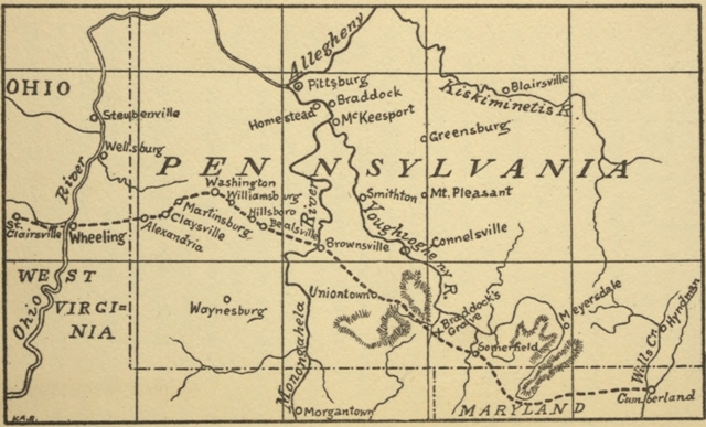
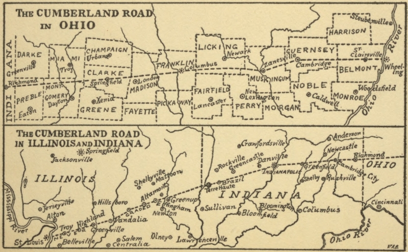
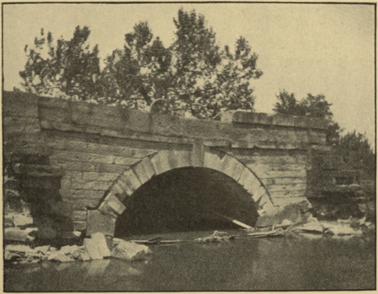
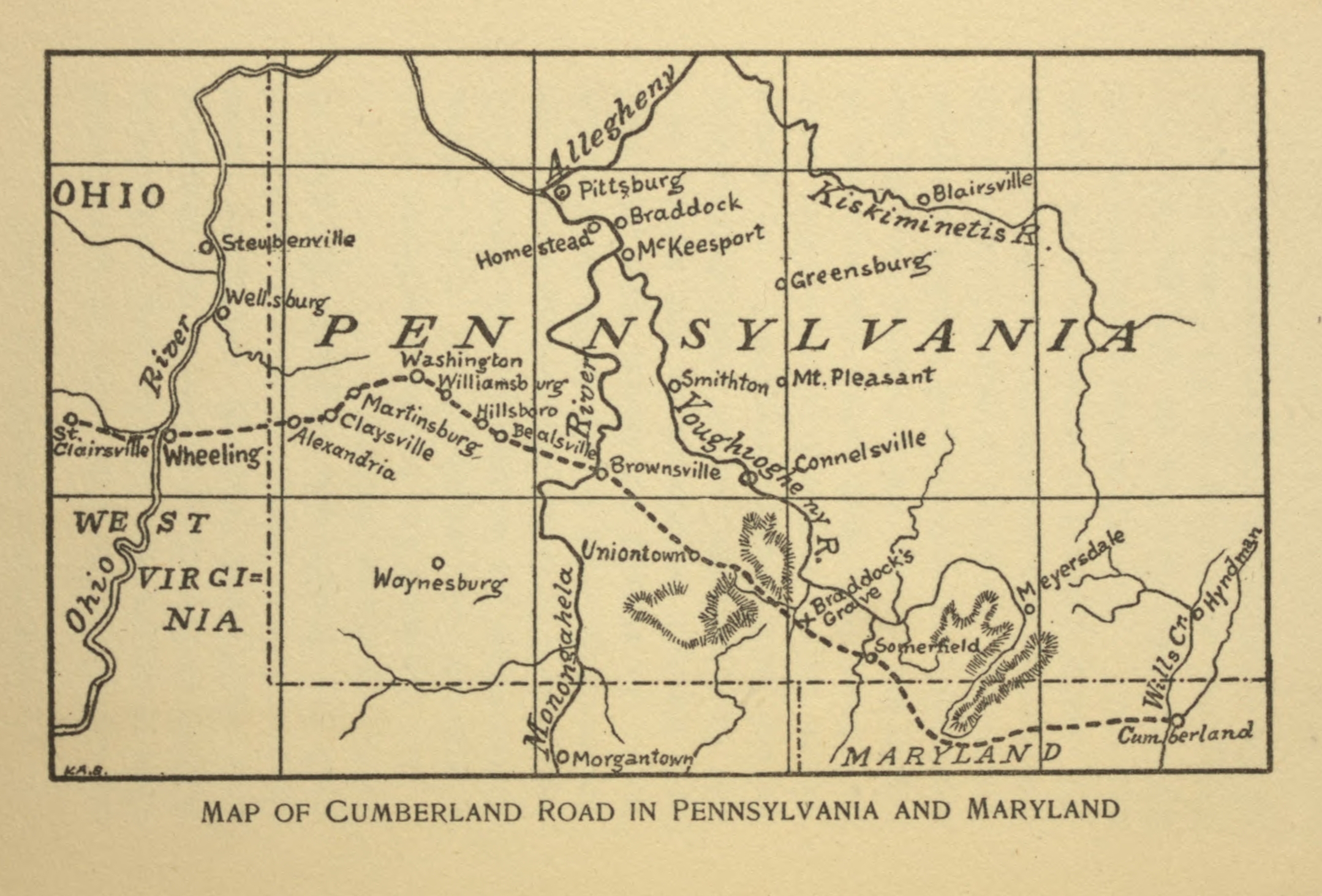
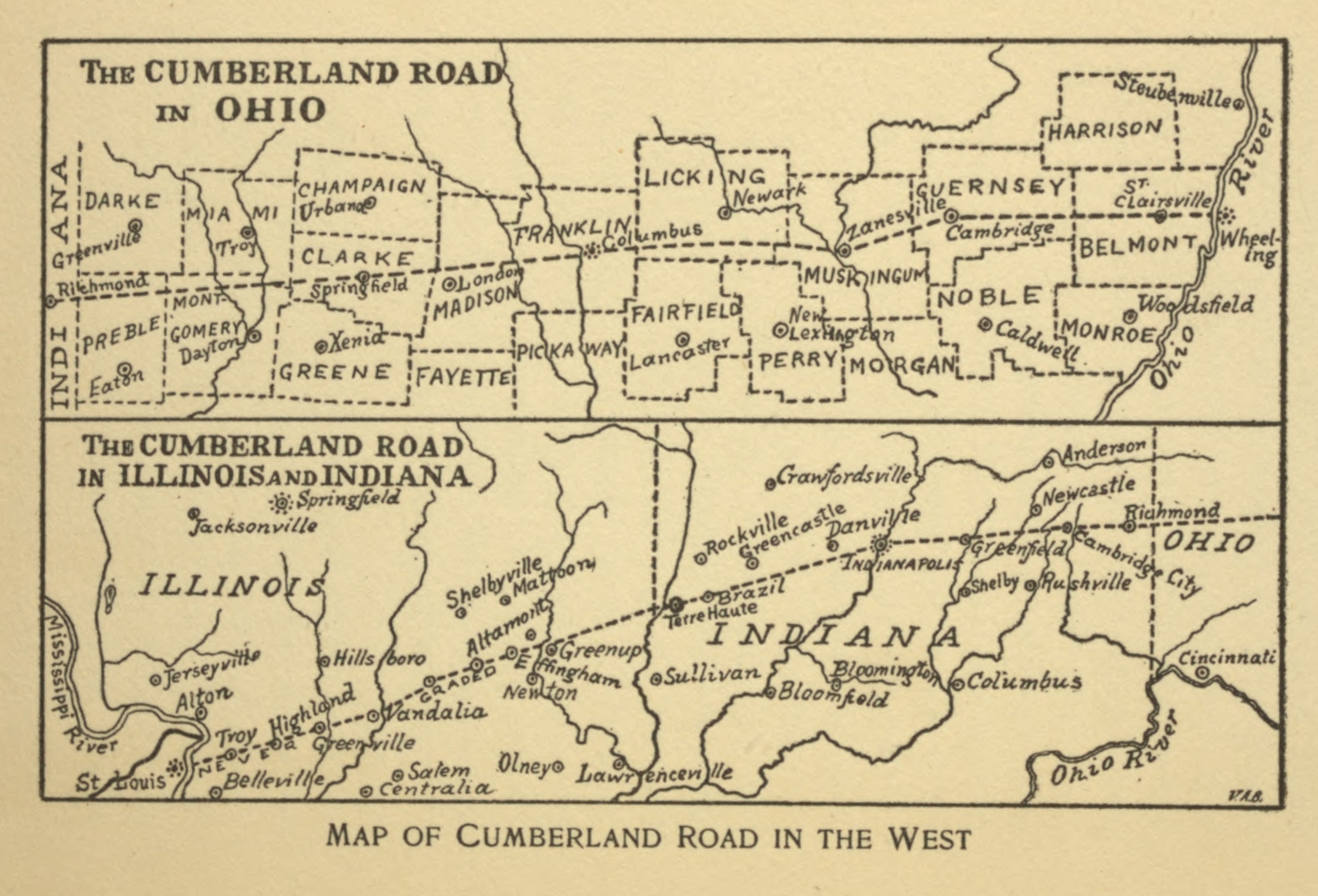