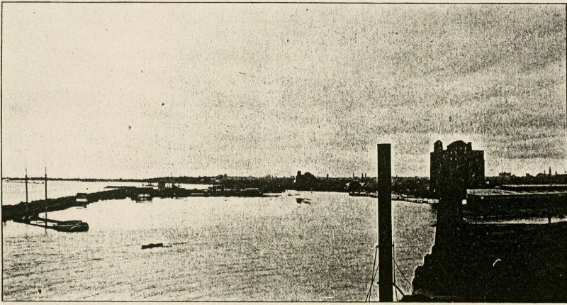
 View of Old Erie Canal Basin at Buffalo
Transcriber’s Note: Obvious errors in spelling and punctuation have been corrected. Footnotes have been moved to the end of the text body. Also images have been moved from the middle of a paragraph to the closest paragraph break, causing missing page numbers for those image pages and blank pages in this ebook.
View of Old Erie Canal Basin at Buffalo
THE ARTHUR H. CLARK COMPANY
CLEVELAND, OHIO
1904
COPYRIGHT, 1904
BY
The Arthur H. Clark Company
ALL RIGHTS RESERVED
| PAGE | ||
| Preface | 11 | |
| I. | The Mohawk and its Improvement | 15 |
| II. | Early Promoters and their Dreams | 43 |
| III. | Clinton’s Memorial | 62 |
| IV. | Planning, Building, and Opening | 104 |
| V. | Local Influences of the Canal | 152 |
| VI. | The Canal Fund and Enlargements | 178 |
| Appendixes | 211 | |
| I. | View of Old Erie Canal Basin at Buffalo | Frontispiece |
| II. | Map and Profile of the Erie Canal (from Poussin’s “Travaux d’améliorations intérieures ... des États-Unis d’Amérique de 1824 à 1831”—Paris, 1834) | 107 |
| III. | A Canal Lock at Rome, New York, Touching the Site of Fort Stanwix | 117 |
| IV. | View of Canal at Little Falls, New York, Showing Lock 37 in the Distance | 133 |
| V. | Map of Erie Canal, Showing Improvements Proposed (from report of February 12, 1901) | 205 |
This second monograph on the great American canals which played the part of important highways westward, is devoted to an outline of the Erie Canal. In the comparatively short space at our disposal for so great a theme, it has been possible only to sketch some of the leading features of our subject, namely, the early history of the Mohawk Valley route, the origin of the canal idea, its building, the celebration of its completion, a catalogue of its finances and enlargements, and its effect.
Our sources have been the state Reports, Sweet’s Documentary History, Hawley’s Origin of the Erie Canal, and the various state and local histories which treat of the subject. A monograph, in the form of a thesis, by Julius Winden, has been of great advantage, as will be indicated, in presenting the influence of the Erie Canal upon the population along its course.[Pg 12]
The author is under a debt of gratitude to Hon. A. R. Spofford of the Congressional Library, Hon. John S. Billings of the New York Public Library, and T. M. Ripley of Marietta, Ohio, for advice and assistance.
A. B. H.
Marietta, Ohio, March 4, 1904.
The “great western” route through New York State to the Lakes has come under consideration in our study of highways in three places: as an Indian trail, as a portage path, and as a pioneer road. The old Iroquois Trail, as we have called it, ran up the Mohawk, which it crossed at Nun-da-da-sis, “around the hill,” (Utica); thence it made for the Genesee River and the Niagara frontier; an important tributary pathway led down the Genesee to Swa-geh (Oswego) on Lake Ontario. This was the landward route from the Hudson to the Great Lakes. As a thoroughfare in its entirety, it meant much to the Indians, but very little to the white men before the nineteenth century. Though the lower Mohawk Valley was sparsely settled early in the eighteenth century, white men did not build their[Pg 16] cabins along the Iroquois Trail to the westward until nearly a century later, when the old Genesee Road was opened. Until then the country through which the Iroquois Trail ran had been a terra incognita where only Indian runners knew the way through the Long House of the Iroquois. Yet it was a pleasant country for all the forest shades; from Nun-da-da-sis the trail ran on, leaving the Mohawk River and Ole-hisk, “the place of nettles”—the famed battlefield of Oriskany—to the north, passing Ka-ne-go-dick (Wood Creek) and Ga-no-a-lo-hole (Lake Oneida), the “Lake of the Head on a Pole.”[1] To the southward, the path bore away toward Na-ta-dunk (Syracuse), the place of the “broken pine-tree,” and Ga-do-quat (Fort Brewerton). There were the silver lakes strung like white gems on wreaths of heaviest green. The low lands of the Genesee country, soon to see the great advances heralded by the famous purchases of land speculators, intervened; and straight be[Pg 17]yond, far away across the pine-tree tops, gleamed the Great Lakes and the plunging river between them; the deep growl of Niagara seemed to warn voyageurs away to the forest trails on either side. Those falls were the only interruption in a water highway which in many aspects is, today, the most stupendous in the world.
Had this winding trail been the only means of communication between the rapidly filling Hudson River valley and the chain of lakes to the northwest, it is very probable that a Braddock or a Forbes would have built a military road even through that bloody Long House; but the Mohawk River, and the Oswego, offered a waterway which, though difficult and uncertain, was the white man’s route from the Hudson to the Lakes—the western war route of which the portage at Rome was the key. A clear picture of the old Mohawk would be a precious possession. The records, however, are so few and so general in character that one would be at a loss to supply an artist with his material. It is only in the staid reports of old navigation companies that we get any definite de[Pg 18]scription of our old-time rivers. We know of the main obstructions to continuous navigation in the Mohawk; first there was the Ga-ha-oose Falls, or Cohoes Falls as we know them today. These were impassable for any craft, and made Schenectady the metropolis of the lower Mohawk Valley because it was the Mohawk terminus of the difficult portage to Albany through the pine barrens. Thus the old-time river traffic began at Schenectady. Proceeding northward by Te-hon-de-lo-ga, the famous lower castle of the Mohawks, and Ga-no-jo-hi-e, the middle castle, the traveler passed the present Fonda, which was Ga-na-wa-da, “over the rapids,” and came to the rocky confines of Ta-la-que-ga, the “place of small bushes”—the present Little Falls. Here the roaring rapids interrupted all navigation, empty boats not even being able to pass over them. The early portage of one mile here in sleds over the swampy ground has been described as it was in 1756, when enterprising Teutons residing here transferred all boats in sleds over marshy ground which would “admit of no wheel carriage.” In all of the military[Pg 19] operations in the Mohawk Valley in the French and Indian and Revolutionary wars this portage played a part. As early as 1768, Governor Sir Henry Moore suggested the improvement of the Mohawk at the Falls of Canajoharie. A route for a canal around Niagara Falls was surveyed in 1784. Travelers to Niagara with heavy baggage invariably went by way of the Mohawk batteaus. We have seen that in 1793 two of the commissioners to the western Indians, traveling light, went overland by horse to the Genesee, while General Lincoln went with the heavy baggage by way of the Mohawk.[2] From Schenectady to the Oneida Portage at Rome, Little Falls offered the only insurmountable obstruction; later on, about 1790, we find that the Germans’ sleds were out of use and that boats were transferred on wheeled vehicles appropriately fashioned to carry them without damage to their hulls. No great boats could be transferred by such means; this fact had a tendency to limit the carrying capacity of Mohawk batteaus to about one and a half tons. These boats were[Pg 20] operated by three men, and a journey from Rome to Schenectady and return—one hundred and twelve miles—required, at the least estimate, nine days. Such was the high rate of freight that, if no return freight was secured, the cost of sending a ton to Schenectady equaled one man’s wages for eighteen days, about fourteen dollars.
The improvement of the Mohawk before 1792 was, without doubt, of no real consequence. Ascending boatmen and forwarding companies here and there of necessity made the river passable, otherwise there could have been no traffic at all. As one of our maps shows, as early as 1730 a neck of land, in one instance, was cut through.[3] The batteaus which carried provisions and ammunition northward to Fort Stanwix or Fort Schuyler probably often broke a new way through the dams of forest driftwood which the flood tides left; and at high tide there was, we know, good downward navigation. Elkanah Watson must be remembered as one of the pioneers in the improvement of the central New York[Pg 21] waterway. In 1788 he made a western journey by way of the Mohawk, and his journal is full of observations which show him to have been a far-sighted man with correct ideas of the logical advance of commerce and the revolutions it would make.[4] Returning from his journey October, 1791, he prepared all the facts in favor of improving New York’s western waterway, in the form of a pamphlet which he presented to General Schuyler, then a member of the state senate. He also contributed an anonymous article to one of the papers in January, 1792, urging publicly the improvement of the Mohawk and Oswego Rivers.[5]
Public interest being awakened, in one way or another, as to the value of the river route westward, and the route up the Hudson and across to Lake George and Lake Champlain, a bill was presented to the New York legislature authorizing the formation of two companies to undertake the work of improving these strategic pas[Pg 22]sageways between the country east of the state and the country west. Accordingly, on the thirtieth day of March, 1792, the following act was passed by the legislature: An Act for establishing and opening Lock Navigation within this State.[6] The legal name of the company which was to operate on the Mohawk was the “president, directors, and company of the western inland lock navigation in the state of New-York.” The word “northern” was inserted in the legal name of the Hudson-Lake Champlain company, which was otherwise the same. The two companies were chartered by one and the same act, on exactly the same basis; we will consider, however, only the one under discussion.
The Western Inland Lock Navigation Company, to operate between the Hudson, and Lake Seneca and Lake Ontario, was to be capitalized at $25,000; one thousand shares of twenty-five dollars each, no stockholder being allowed more than ten shares. The subscription books were ordered to be opened at New York and[Pg 23] Albany on the first Tuesday of May, 1792, and kept open until the last Tuesday. If five hundred shares were taken the organization became effective. Thirteen directors were to control its affairs and they were to be elected annually. Article VII authorized “... each of the said corporations ... [to] enter into, and upon all and singular the land and lands covered with water, where they shall deem it proper to carry the canals and navigation hereinbefore particularly assigned to each....” The stipulations usually made in such cases, as to the company’s right to enter land by paying damages, were nominated. The controlling officers were empowered to name the per cent of stock the stockholders were to be required to pay. They were also to decide upon the rates of toll to be charged to boats for the enjoyment of benefits of navigation; the one restriction was that the charge for one ton of freight from Ontario or Seneca lakes to the Hudson should not exceed twenty-five dollars, and other tolls were to be pro rata. The directors were to be allowed to increase the capital stock at discretion, and[Pg 24] were ordered to make semiannual reports to the public. After ten years an abstract record was to be published for the inspection of the legislature, and if the profits were found to exceed fifteen per cent, the excess above this amount they were to turn over to the state treasurer. The act of incorporation also stipulated that the company’s charter became void if work was not undertaken in five years; if the work was not completed in fifteen years, all rights, so far as the residue was concerned, were to be forfeited. The state of New York promised to give, as a free gift, to both the Western and the Northern companies, $12,500 as soon as both had invested $25,000 in the work on which they were starting.
On December 22, 1792, the act was amended as the lessons of the season seemed to indicate that there was necessity. The principal amendments were that the locks built on the company’s works should have a breadth of not less than ten feet at the base and should have a length of not less than seventy feet between gates. The company was to be[Pg 25] allowed, in the future, to take up land without first having paid for it—settlement to be made afterward in proper legal form. The land under all locks was vested in the company owning the locks.[7]
It would seem from Elkanah Watson’s account that, when these subscription books were opened for signatures of prospective stockholders, there were absolutely no subscribers forthcoming. “They had been opened three days by the committee,” he wrote from New York where he happened to be in April (?), “at the old coffee-house, and not a share was subscribed. I considered the cause hopeless—called on my friend (I think it was) James Watson, Esq., and induced him, with much pursuasion, to subscribe twenty [?] shares; from that moment the subscriptions went on briskly. On my arrival in Albany, the commissioners had kept the books open several days, at Lewis’s old tavern, in State street, and no mortal had yet signed to exceed two shares. I immediately subscribed seven in each company....”[Pg 26] Watson also wrote to Schuyler of the low state of affairs; the latter ordered him to subscribe to ten shares in Schuyler’s name.[8]
A committee appointed by the directors of the Western Company, August 14, 1792, consisting of Philip Schuyler, Goldsbrow Bangar, and Elkanah Watson, to examine the Mohawk from Fort Schuyler (Rome) to Schenectady, reported in the following September. Accompanied by the surveyor Moses De Witt, and Mr. Lightall, a carpenter, and a Mr. Nesbit, the committee left Schenectady August 21 in a batteau, and reached Fort Schuyler on the twenty-ninth. Their itinerary gives us a picture of the old river, and preserves valuable facts for local historians.[9] The first day’s journey was six and one-half miles to John Mabey’s, half a mile above Jacobus Swart’s. Six rapids were passed, over which the[Pg 27] water ran, on the average, a foot and a half deep—the river then having the least water running “within the memory of the eldest person.” The night of the twenty-second was spent at John Fonda’s, seventeen and three-fourths miles up the river; in this distance were five sharp rapids and many small rapids with shallow water, as at Sir William Johnson’s “first settlement,” eight and one-half miles above Mabey’s. The night of the twenty-third was spent at Mr. Nellis’s, nineteen and three-fourths miles on; one mile above Fonda’s was “Caughnawaga rift, deep, incommoded with large rocks;” nine miles onward, lay Kettar’s rapid, and two and a half miles on was Colonel John Fry’s. A journey of four miles the next day brought the examiners to Fort Hendrick, four and a half miles below Little Falls. “From the landing at the foot [of Little Falls], to the landing at the head of the Falls, is about three-quarters of a mile, the height thirty-nine feet two inches, the ground stony, rocky and rough.” It will be seen that this was not the old-time portage over which boats were drawn on sleds. Two[Pg 28] days were spent examining this strategic fall. Proceeding on the twenty-seventh, Fort Schuyler, about fifty miles distant, was reached on the twenty-ninth. The navigation throughout this distance was good with but two rapids, Orendorff’s and Wolf’s.
The recommendations of the committee affirm that the work at Little Falls will be the most important and expensive single work, and would consist of a canal by which river craft can overcome the fall of nearly forty feet; in addition to the canal “a strong work ... to prevent the Canal and Locks from being overflowed, and damaged in high freshes; at this point two guard gates at the distance of seventy feet from each other must be placed; the surface of the ground here is eight feet eight inches above the level of the water in the river above the falls, and, as three feet ought to be given for the depth of the water in the Canal, the depth to be dug at this point will be nearly twelve feet.... Many large stones and rocks, and probably much solid rock will be found in all the distance ... which is 1666 feet; the[Pg 29] quantity of earth, stone, and rock to be removed in this space, if the Canal has ten feet base, will be about 242,200 cubic feet. [For] 422 feet the Canal must be confined by a double dyke, or embankment, about four feet high; [for] 123 feet the whole depth to be dug is about 4½ feet and contains 5,085 cubic feet; at various places to the water at the bottom of the falls about 100,000 cubic feet of earth must be removed, and about 1,200 feet of a dyke to be made. An estimate of the expense of this work with five Locks ... amounts to £10,500.”
The improvement of the river from Schenectady to the mouth of the Schoharie would call for an expenditure of £20,000 in dykes, dams, and small canals.
At Rome a canal 5,352 feet long was proposed as a substitute for the ancient portage path; “apparently the mean depth of the earth to be removed for forming the Canal would be about twelve feet at the greatest depth, hence about 642,240 cubic feet of earth must be removed. The ground though soft is so much interwoven with the roots of trees, and the work will[Pg 30] also be so much retarded by the influx of water into the Canal whilst digging, that it is supposed that one man could not remove above fifty cubic feet per day, hence 12,845 days for one man would be required; which at 4s. per day amounts to £2,569. In very dry times, such as the present, the water in the Mohawk is so little that none can be spared to increase the quantity in Wood Creek. A bulkhead must therefore be placed ... precisely of the height with the level of the water in the Mohawk, a boat then in this low state of the river coming up Wood Creek ... must unlade, and be drawn across the bulkhead into the Canal; there reloaded and proceed through the Canal into the Mohawk River; but when the Mohawk River rises so much as that a quantity of water equal to carry an empty boat is added to the water in the river, the water on the bulkhead will rise to nearly that height, and the empty boat will pass. If the rise be equal to the water drawn by a loaded boat, the boat and its cargo will pass the bulkhead into the Canal. It is evident by this arrangement the navigation of Wood[Pg 31] Creek will be much mended whenever the water in the Mohawk is higher than at present. The whole expence at this place will probably not exceed £3,000.”
Many of the general observations of this committee are important in the history of water transportation across New York.
“Having premised thus much your Committee beg leave to observe, That since (except in such an extraordinary dry season as the present) the river from Schenectady to Scohara Creek is capable of considerable navigation—is still better from thence to the Falls, and will be good to Fort Schuyler, especially if the trees and timber are removed, That therefore, except the removal of the trees and timber West of, and blowing a few rocks on, some of the rapids, East of the Falls, nothing further should be speedily attempted in the parts mentioned; but that the primary exertions should be directed to the Canal and Locks at the Falls; that when this is completed, the water in the river above, will probably be sufficiently low to clear away the timber which incommodes it, and to do the like by Wood-Creek down to the Oneida Lake,[Pg 32] and to remove the most dangerous rocks below the Falls. This accomplished, the next in degree of eligibility, appears to your Committee, to extend the navigation from Schenectady to the navigable waters of the Hudson—because when with the improvements above suggested, the river shall be rendered navigable in the greater part of its extent from Fort Schuyler to Schenectady, in all seasons not so dry as the present, for boats of considerable burthen; yet the portage from Schenectady to Albany, is not only a very heavy charge on the produce of the upper country, but attended with serious inconveniences to those who enter largely into the interior commerce. To prepare for the accomplishment of this apparently very necessary part of the navigation, your committee recommend, That accurate surveys should be made, as early in the ensuing spring as circumstances will permit, to enable the board to determine the direction in which Canals are to run, to take the necessary preliminary measures for providing the materials; that, if the works at the Falls, &c., should be completed before[Pg 33] the whole of the next operating season is expired, the residue may be appropriated to this important part of the navigation, and completed in the succeeding year;—Soon after this shall be accomplished, the company will be enabled to judge with precision, what farther is in their power, and if what they have done, should prove beneficial to the community at large, and the resources of the company be then found not competent to such a perfect completion of the whole internal navigation, as is contemplated by the act of incorporation, there can be little doubt but that an enlightened Legislature will extend its aid, to objects promising such extensive benefits to every class of citizens.
“It now remains for your Committee to venture an opinion on the mode of conducting the contemplated improvements. The observations already made will evince the necessity of strict economy in every operation. It will certainly occur to the Directors, that in a work so extensive, as that committed to them, much unnecessary expence, and much waste of time must be incurred, unless the executive part of the[Pg 34] business be properly conferred; and your committee, to avoid this evil as much as possible, recommend that the executive of the business should be committed to a single directing head, to a man of known and acknowledged abilities, of a mind so comprehensive, as to combine and form all the arrangements, with a minute detail of each part....
“A Person who has had practical experience in making canals and locks, would be a desirable and valuable acquisition, but such a person may not be attainable in this country; if so, it has occurred to your committee, that probably the defect might be supplied, if the person to whom the general direction shall be committed was to select two or three of our most ingenious and best informed carpenters, and repair with them to view the works in Pennsylvania and Virginia, with a critical and close attention. Canals and locks are already formed there, and little doubt can be entertained but that every information which gentlemen are capable of communicating will be afforded with alacrity; and your committee have too good an opinion[Pg 35] of their countrymen to apprehend, that if your superintendant is a man of genius, and the mechanics who accompany him men of approved reputation in their professions, they would not after such an inspection be able to fulfil the wishes of their employers with satisfaction and credit to both.”
Work on the Mohawk River improvements[10] was begun in April, 1793, by a force of three hundred men; the digging of the canal around the Little Falls was the most important item in the difficult undertaking. Soon the company’s funds gave out and work ceased. It was begun again feebly in January, 1794, in hopes that the next legislature would assist by grants, loans, or money, or by subscribing to stock in the company. In this the company was not disappointed, for the state subscribed to two hundred shares of stock in each of the improvement schemes. In May, 1795, work was again resumed, and in November of[Pg 36] that year boats could go about Little Falls in the canal. It was opened November seventeenth and on that day nine boats passed through gratis. In the next thirty days “eight large boats, and one hundred and two small boats, passed the little falls on the Mohawk, and paid toll in the aggregate of £80.10.”[11]
This famous little canal, for in its day it was a very significant piece of work, was 4,752 feet long; it contained five locks, each having a lift of about nine feet; the total rise of boats ascending was forty-four feet and seven inches. The locks were located at the lower end of the canal; “the pits, in which they are placed, have been excavated out of solid rock, of the hardest kind. The area of the chambers was 74×12 feet, admitting boats drawing 3½ feet; the depth of water in the canal above the locks was three feet and would float boats carrying 32 tons; the time of the passage was three quarters of an hour. Nearly one-half of the canal (2550 feet) was cut through solid rock and its total original cost was about $50,000.”[Pg 37]
At the same time, 1793, work was begun at other points, principally on a canal from the Mohawk to the Hudson (to avoid Cohoes Falls), but the work soon ceased because of lack of funds. In that summer the preliminary work on the water route down Wood Creek and the Onondaga to Lake Ontario was done. The little, winding creek was found to be almost incorrigible. It was so crooked that thirteen cuts were made across the points of land contained within its curving banks. The banks were lined with aged trees whose predecessors had fallen into the narrow waterway which they choked with their many huge, straggling branches. It was no less a task to remove the débris from the waterway than it was to remove from the banks the trees which would fall into the water during the next windstorm. Many have written gaily of the swift canoes of the olden days, gliding peacefully on the limpid surface of the old-time rivers; a study of the condition of the old Mohawk, Susquehanna, or Ohio would have corrected suggestions which are inherently misrepresentations. On such smaller[Pg 38] streams as Little River or Wood Creek, the havoc of the wind was even more noticeable. The company now at work on Wood Creek planned to clear the banks of timber for four rods back on each bank and, by the report of 1796, the contracts were actually proposed to that effect. The company had trouble with settlers along the rivers, for felling trees which grew along the banks into the water, thereby saving themselves the labor of burning them or hauling them away. The company expected to cut a canal from the Mohawk to Wood Creek near Rome, New York, to take the place of the famous portage path. In the report of 1796 it was proposed even to mortgage the works at Little Falls in order to secure funds for this portage canal.
The plan of the complete communication was outlined by the company’s engineer, Mr. Weston, December 23, 1795, and was embodied in the report of 1796. It called for a canal from the Hudson, above Lansing’s Mill, to the Mohawk above Cohoes Falls; these falls, seventy feet in height, had made necessary the portage path through the pine barrens from Schenectady[Pg 39] to Albany. The surveyor spoke hopefully of the rapids between Schenectady and Utica (Fort Schuyler) since rapids always indicated pools above and below. The rapids were to be overcome by small, low dams with oblique walls “to collect a greater quantity of water in the channel and pond above.” In the forty odd miles down Wood Creek and Lake Oneida to Fort Brewerton, the “chief impediment is occasioned by an old Indian ell wear [weir]—a wing wall to confine the channel into a narrow compass.”[12] At Oswego Falls (Rochester) a canal was proposed on the south side of the river, sixty-two chains in length, and with a fall of eighteen feet. Thence to Lake Ontario, twelve miles, the rapidity of the river necessitated a series of dams and locks. “Arrived at lake Ontario, it is almost superfluous to remark (what is so obvious to every person the least acquainted with the geography of the state) on the immense expanse of internal navigation, that opens upon our view—the extent of these lakes (with one obstruction only, that doubtless will be surmounted in[Pg 40] a few years) presents to the mind—a scene unequalled in any other part of the globe; offering to the enterprising and adventurous, sources of trade, rapidly advancing to an incalculable amount, ensuring a certain recompence to the individuals, who promote, and the state, that patronizes their important undertakings.” Thus Mr. Weston concluded his report.
Yet the projectors of this work were men ahead of their days; in a great measure public sympathy was not in favor of the undertaking, especially along the line of operation. Here the strongest objections were raised, some of them of a curious nature. One petition to the legislature read that the operations on the Hudson “will Cause the Fish to wit Shad, Herrin &c. Totally to Abandon the North River, a circumstance which would be felt not only by Your Petitioners but by thousands Residing between Fort Edward and as far Southward as the River Extends.”[13]
It was found to be all the company could do to keep things going on the eastern[Pg 41] division of their works; much less carry on the work in the west. In ten years the company spent $367,743 and, in the end, sank about $100,000 more. The greatest expense was in remedying faults and failures. “... hence the expenditures baffled all calculation,” frankly writes Watson; “—besides, we were all novices in this department.... Indeed we were so extremely deficient in a knowledge of the science of constructing locks and canals, that we found it expedient to send a committee of respectable mechanics, to examine the imperfect works then constructing on the Potowmac,[14] for the purpose of gaining information—we had no other resource but from books.”[15] Wooden locks were built at Little Falls, German Flats, and Rome at large expense, and these rotted in six years. It was wooden locks like these that the New Yorkers had found the Virginians building on the Potomac. The locks at German Flats and at Rome were rebuilt with brick, but the[Pg 42] mortar was poor and they fell to pieces. Finally, at all points, the locks were built of stone. This experimenting was extremely expensive work and explains why, for a long time, no dividends could be paid. Up to December, 1804, the company had received $232,000, which was paid on 2,630 shares of capital stock. It had received $25,494 on forfeited shares. The tolls at Little Falls since 1796, when the works there were completed, amounted to $58,346; at Rome, $15,037 had been taken in as tolls. The sum of $12,500 had been received as a gift from the state. Of the total stock the state held $92,000, and the private stockholders, $140,000. In 1798 a dividend of 3 per cent had been declared; in 1813, a dividend of 3½; in 1814, a dividend of 3; 4½ per cent dividend was paid in 1815, 8 per cent in 1816, 3 per cent in 1817, and 5½ per cent in 1818. All receipts from 1798 to 1813 had been absorbed in improvements and repairs.[16]
The honor of originating the plan of a canal from the Great Lakes to the Hudson will forever lie with the brilliant, visionary Gouverneur Morris. The idea must have suggested itself to other minds even if it occurred to Morris originally; this cannot be disproved; but Morris’s shoulders were broad enough for an honor too great for many, and his persistent labors in behalf of the project are altogether consistent with this verdict of a century. In 1777 Morris was known to have hinted of what we know as the Erie Canal. In that year he was sent to General Schuyler’s army at Fort Edward, then slowly retiring before Burgoyne’s advancing regiments. Morgan Lewis, then quartermaster, later governor of New York, leaves this testimony, in a letter dated May 26, 1828: “One evening in particular,[Pg 44] while describing in the most animated and glowing terms the rapid march of the useful arts through our country, when once freed from a foreign yoke; the spirit with which agriculture and commerce both external and internal would advance; the facilities which would be afforded them by the numerous water courses, intersecting the country, and the ease by which they might be made to communicate; he announced, in language highly poetic, and to which I cannot do justice, that at no very distant day the waters of the great western inland seas would, by the aid of man, break through their barriers and mingle with those of the Hudson. I recollect asking him how they were to break through these barriers. To which he replied, that numerous streams passed them through natural channels, and that artificial ones might be conducted by the same routes.”[17]
In his diary for October, 1795, Morris describes his feeling on viewing the Caledonian Canal in Scotland; “when I see this,” he writes, “my mind opens to a view[Pg 45] of wealth for the interior of America, which hitherto I had rather conjectured than seen.”[18] In a letter to Mr. Parish in January, 1801, he observes, after seeing a number of ships riding at anchor in Lake Erie, “Hundreds of large ships will, at no distant period, bound on the billows of these inland seas. At this point begins a navigation of more than a thousand miles [to the extremity of Lake Superior]. Shall I lead your astonishment up to the verge of incredulity? I will. Know then that one-tenth of the expense, borne by Britain in the last campaign, would enable ships to sail from London through Hudson’s River into Lake Erie.”[19]
“The merit of first starting the idea of a direct communication by water, between lake Erie and Hudson’s river,” wrote Simeon De Witt to William Darby, February 25, 1822, “unquestionably belongs to Mr. Gouverneur Morris. The first suggestion I had of it was from him. In 1803, I accidentally met with him at Schenectady. We put up for the night at the same inn[Pg 46] and passed the evening together. Among the numerous topics of conversation, to which his prolific mind, and excursive imagination, gave birth, was that of improving the means of intercourse with the interior of our state. He then mentioned the project of tapping Lake Erie, as he expressed it himself, and leading its waters, in an artificial river, directly across the country to Hudson’s river. To this I very naturally opposed the intervening hills and valleys as insuperable obstacles. His answer was in substance, labor improbus omnia vincit, and that the object would justify the labour and expense, whatever that might be. Considering this a romantic thing, and characteristic of the man, I related it on several occasions.”[20] J. Geddes wrote William Darby, February 22, 1822, as follows: “In the year of 1804, I learnt for the first time, from the surveyor-general [Simeon De Witt] that Mr Gouverneur Morris, in a conversation between them in the preceding autumn, mentioned the scheme of a canal from lake Erie across the coun[Pg 47]try to the Hudson river. The idea of saving so much lockage by not descending to lake Ontario made a very lively impression on my mind.”[21]
With canal building going on in other portions of the country, it was inevitable that the suggestion made by Morris could not down. The opportunity offered here in central New York was so favorable, that a people with only half the ambition and ability of New Yorkers would have profited sooner or later by it. Having studied the tremendous tasks undertaken by the Marylanders and Pennsylvanians, it can be understood why the Erie Canal was under consideration at a comparatively early date; the Mohawk offered a gateway through the northern foothills of the Alleghenies, and beyond lay lakes and rivers in the direct route to Lake Erie. There could be no question of water supply at the summit level; the waterways to be crossed, however, might cause the engineers no little trouble.
“I have not been able to trace,” Mr. Watson leaves record, “any measure, pub[Pg 48]lic or private, tending towards this great enterprize, till the 27th October, 1807, when an anonymous publication, under the signature of Hercules, appeared in the Genesee Messenger of Canandaigua, which is attributed to Jesse Hawley, Esq. now [1820] collector of the port of Rochester.”[22] It is affirmed that these communications were not inspired by the prophetic words of Morris;[23] they were fourteen in number,[Pg 49] and were contributed weekly from October, 1807, to March, 1808. Hawley had thought out his problem with great seriousness and detail, and had splendidly planned a canal from Buffalo to Utica, where improved navigation on the Mohawk was to be depended upon. The cost he estimated at five millions. It is not at all unlikely that Hawley’s attention was the more quickly attracted to this subject because of the celebrated message of President Jefferson to Congress in this fall of 1807, just when Hercules was writing his articles.
It was probably the general discussion of this great theme, more than the result of any one influence, which led to the crystallization of the movement, when on February 4, 1808, Joshua Forman, a member of the New York legislature, from Onondaga County, offered the following bill:
“Whereas the President of the United States by his message to Congress, delivered at their meeting in October last, did recommend that the surplus money in the treasury, over and above such sums as could be applied to the extinguishment of the national debt, be appropriated to the[Pg 50] great national objects of opening canals and making turnpike roads. And whereas the state of New York, holding the first commercial rank in the United States, possesses within herself the best route of communication between the Atlantic and western waters, by means of a canal, between the tide waters of the Hudson river and Lake Erie,—through which the wealth and trade of that large portion of the United States, bordering on the upper lakes, would for ever flow to our great commercial emporium. And whereas the legislatures of several of our sister states, have made great exertions to secure to their own states the trade of that wide extended country, west of the Alleganies, under natural advantages vastly inferior to those of this state. And whereas it is highly important that these advantages should as speedily as possible be improved, both to preserve and increase the commerce and national importance of this state:—Resolved, (if the honourable the senate concur herein) that a joint committee be appointed to take into consideration the propriety of exploring, and causing an[Pg 51] accurate survey to be made of the most eligible and direct route for a canal to open a communication between the tide waters of the Hudson river and Lake Erie; to the end that congress may be enabled to appropriate such sums as may be necessary to the accomplishment of that great national object.” In the general appropriation bill now passed the sum of $600 was allotted to a survey of this proposed canal and the work was done by James Geddes, whose report, at a later day, became important.[24]
Mr. Forman’s motion passed, but amounted to nothing. In 1810 Thomas Eddy, the treasurer of the old Western Inland Lock Navigation Company, called on General Platt, a member of the New York senate, and the two conversed seriously about the great plan which was slowly coming more and more to the front. Platt affirmed that he would offer a resolution in the legislature looking toward increasing public interest in the great dream of the farthest-seeing men of New York. Perhaps the two drafted this resolution; at least, the very next day Platt handed De[Pg 52] Witt Clinton a draft of a resolution. Clinton liked it. Its author thereupon offered it in the senate and Clinton supported it and it passed, March 13, 1810. It began: “Whereas, the agricultural and commercial interests of the state, require that the inland navigation from the Hudson river to lake Ontario and lake Erie, be improved and completed on a scale commensurate to the great advantages derived from the accomplishment of that important object: And whereas, it is doubtful whether the resources of the Western Inland Lock Navigation Company are adequate to such improvements:
“Therefore resolved, that if the honourable the assembly consent herein, that Gouverneur Morris, Stephen Van Rensselaer, De Witt Clinton, Simeon De Witt, William North, Thomas Eddy and Peter B. Porter, be and they are hereby appointed commissioners for exploring the whole route, examining the present condition of the said navigation, and considering what further improvements ought to be made therein; and that they be authorized to direct and procure such surveys as to them shall appear necessary and proper in rela[Pg 53]tion to these objects; and that they report thereon to the legislature, at their next session, presenting a full view of the subjects referred to them, with their estimates and opinion thereon.”[25] On April 5 following $3,000 was appropriated for the expenses of the surveys called for in the above resolution.[26]
Accordingly the commissioners named explored the country between the Hudson and Lake Erie through which the prospective waterway would run, in the summer of 1810 with Jesse Hawley’s contributions of 1807-08 in their hands. At the next meeting of the legislature they presented an elaborate report. It would seem that the committee had passed over the route of the Western Inland Lock Navigation Company from Schenectady to Lake Ontario; James Geddes, the experienced engineer who had given some little study to the region under survey, made a map and a few rough estimates. The report[Pg 54] opens with the declaration that the idea of making small rivers navigable had long ago been exploded in Europe; this was a polite way of saying that the days of the Lock Navigation Company were fairly numbered. The report affirms that a canal parallel with the rivers improved by the Navigation Company (Mohawk, Wood Creek, and Oswego) is practicable as far as Oswego Falls (Rochester). The twelve remaining miles to Lake Ontario might well be covered by a railway.
However, the committee had another plan, that of building the canal straight west from the Oswego to Lake Erie, avoiding Lake Ontario’s winds and waves entirely. Certain interesting commercial questions were here involved. Even with the advantages offered by the Western Inland Lock Navigation Company, New York and Albany could not hold their own in competition with Montreal. Freight rates down the St. Lawrence were marvelously cheap; fifty cents a hundredweight, only, was charged by descending boatmen from Kingston to Montreal—one-half the early rate from Buffalo to New York on the Erie[Pg 55] Canal when it was at last built. The rate of freight up the St. Lawrence was only one dollar per hundredweight. If any point east of Niagara Falls was made the terminus of New York’s canal, it was feared that Montreal would profit by it more, perhaps, than the cities it was intended to build up and benefit.
Mr. Geddes favored the direct route to Lake Erie by way of the “Tanawanta” River. He advanced the following rough estimate of distances in the direct route:
| Miles | Descent (feet) | |
| Mouth of Tanawanta | 10 | 5 |
| Genesee River (about) | 68 | 34 |
| Seneca Lake | 46 | 23 |
| Cayuga Lake | 6 | 3 |
| Rome (summit) | 66 | 33 |
| Little Falls | 38 | 19 |
| Schoharie | 38 | 19 |
| Summit between Schenectady and Albany (about) | 24 | 12 |
| Hudson River | 14 | 7 |
| —— | —— | |
| Totals | 310 | 155 |
The actual descent would be 525 feet. Mr. Geddes’s plan included aqueducts across the Genesee River twenty-six feet high and one hundred and fifty yards long, across the mouth of Seneca Lake eighty-three feet high, and across the mouth of Cayuga one hundred and thirty feet high. As a detailed survey had not been made, it was impossible to estimate accurately the expense.
Agitation of the great question was the only tangible result of this investigation. In 1811 Robert Livingston and Robert Fulton were added to the committee, and a report was made to the legislature, March, 1812. This report showed that the friends of the great waterway had resolved to exhaust all resources before relinquishing the work. They applied to Congress through Morris and De Witt Clinton for “Co-operation and aid in making a canal navigation between the great lakes and Hudson’s river, which, in the opinion of the Legislature of New-York, will encourage agriculture, promote commerce and manufacture, ficilitate [sic] a free and general intercourse between different parts[Pg 57] of the United States, tend to the aggrandizement and prosperity of the country, and consolidate and strengthen the Union.” The legislatures of the various states were likewise asked to lend sympathy and aid—to co-operate and aid New York in opening the communication between the Great Lakes and the Hudson. “... The general advantage to the whole nation,” it was urged, “is of such preponderating influence, as to render the present object of principal, if not exclusive, concern to the national legislature.” The ways of help suggested were pecuniary assistance in the form of loans or gifts, and a friendly voice in favor of the project in Congress. A letter to President Madison expressed the hope that in his annual message to Congress he would in every consistent way urge the plan of national assistance. Accordingly in Madison’s message, dated December 23, 1812, he enclosed the act of the New York legislature and said: “The particular undertaking contemplated by the state of New-York ... will recall the attention of Congress to the signal advantages to be derived to the United States,[Pg 58] from a general system of internal communication and conveyance.... As some of those advantages have an intimate connexion with arrangements and exertions for the general security, it is a period calling for these that the merits of such a system will be seen in the strongest lights.” Thomas Eddy wrote Simeon De Witt January 9, 1812 “... accounts from Washington this days post say that the expectations of our committee respecting aid from Congress are very flattering—the project of a Canal from Erie to the Hudson has many friends West of the Allegany—We are full of the news that De Witt Clinton will be president and Munro Vice p—— —this is the united wish of all parties in this City except Madisonians.”
A great, comprehensive plan of national aid to local improvements was proposed, by means of giving grants of land in Michigan to a large number of improvement schemes in various states. Article seven read: “And be it further enacted, That four million acres of land, part of the tracts above mentioned, shall vest in and belong to the said state of New-York, so soon as a[Pg 59] canal shall be opened from lake Erie to Hudson’s river, not less than sixty-three feet wide on the top, forty-five feet wide at the bottom, and five feet deep (and, if practicable, along an inclined plane, descending not more than six feet in a mile,) to Hudson’s river, or a bason within four miles thereof; on condition, nevertheless, that no tax, toll, or impost, shall be levied or taken for the passage of boats not exceeding sixty feet long, eighteen feet wide or drawing more than three feet of water on the same canal, other than such as may be needful to pay the annual expenses of superintending and keeping the same in repair.”[27]
The war which now came on drove all plans of internal improvement from men’s minds until the struggle for honor and independence was won. The bill quoted was never passed by Congress; a law passed by the New York legislature in 1812, authorizing the canal commissioners to borrow five million dollars on the credit of the state, was repealed in 1814.[28][Pg 60] These had been hard years for New York.
In the autumn of 1816, Judge Platt, while holding court in New York City, was in consultation with Clinton and Eddy concerning the canal project, which had temporarily dropped from public attention. Though the outlook was gloomy and discouraging, these men determined to revive public interest in the project if it was in their power. An advertisement was placed in the papers calling for a public meeting at the City Hotel to consider asking the New York legislature to attack the great problem anew. A similar call was issued at Albany for a meeting to be held February 7, 1816, at the Tontine Coffee House, signed by ten friends of the movement.
William Bayard was chosen chairman of the New York meeting, and the speakers were Platt, Clinton, and Swartwout; Clinton, Swartwout, and Thomas Eddy were appointed a committee to prepare a memorial for the legislature. This document was drafted by De Witt Clinton and marks a brilliant crisis in the long, wearing struggle this brave coterie of men had made for their favorite project. New York[Pg 61] was recovering from the devastation and prostration caused by the war. The awakening courage of a brave people was stirred by the appeal of Clinton’s; it was so “comprehensive a view of the immense advantages that would be produced to the state by the completion of the canal, that copies sent throughout the state were eagerly signed by thousands, and carried full conviction to every mind. The project immediately became popular, and it was the means of rousing the legislature, and produced several successive laws in prosecuting this great work. A system of finance was drawn up by De Witt Clinton which with some trifling alterations, was adopted by the legislature and is now [1825] in successful operation.”[29]
This memorial, in which the Erie Canal was born, and which throws much light on the whole problem of early transportation, is given in its entirety in the following chapter.
To the Legislature of the State of New-York.
The memorial of the subscribers, in favor of a canal navigation, between the great western lakes and the tidewaters of the Hudson, most respectfully represents: That they approach the legislature with a solicitude proportionate to the importance of this great undertaking, and with a confidence founded on the enlightened public spirit of the constituted authorities. If, in presenting the various considerations which have induced them to make this appeal, they should occupy more time than is usual on common occasions, they must stand[Pg 63] justified by the importance of the object. Connected as it is with the essential interest of our country, and calculated in its commencement to reflect honor on the state, and its completion, to exalt it to an elevation of unparalleled prosperity; your memorialists are fully persuaded, that centuries may pass away before a subject is again presented so worthy of all your attention, and so deserving of all your patronage and support.
The improvement of the means of intercourse between different parts of the same country, has always been considered the first duty and the most noble employment of government. If it be important that the inhabitants of the same country should be bound together by a community of interests, and a reciprocation of benefits; that agriculture should find a sale for its productions, manufacturers a vent for their fabrics; and commerce a market for its commodities; it is your incumbent duty, to open, facilitate, and improve internal navigation. The pre-eminent advantages of canals have been established by the unerring test of experience. They unite cheap[Pg 64]ness, celerity, certainty, and safety in the transportation of commodities.
It is calculated that the expense of transporting on a canal, amounts to one cent a ton per mile, or one dollar a ton for one hundred miles; while the usual cost by land conveyance, is one dollar and sixty cents per hundredweight, or thirty-two dollars a ton for the same distance. The celerity and certainty of this mode of transportation are evident. A loaded boat can be towed by one or two horses, at the rate of thirty miles a day. Hence, the seller or buyer can calculate with sufficient precision on his sales or purchases, the period of their arrival, the amount of their avails, and the extent of their value. A vessel on a canal is independent of winds, tides, and currents, and is not exposed to the delays attending conveyances by land: and with regard to safety, there can be no competition. The injuries to which commodities are exposed when transported by land, and the dangers to which they are liable when conveyed by natural waters, are rarely experienced on canals. In the latter way, comparatively speaking, no waste is in[Pg 65]curred, no risk is encountered, and no insurance is required. Hence, it follows, that canals operate upon the general interests of society, in the same way that machines for saving labor do in manufactures; they enable the farmer, the mechanic, and the merchant, to convey their commodities to market, and to receive a return, at least thirty times cheaper than by roads. As to all the purposes of beneficial communication, they diminish the distance between places, and therefore encourage the cultivation of the most extensive and remote parts of the country. They create new sources of internal trade, and augment the old channels, for, the cheaper the transportation, the more expanded will be its operation, and the greater the mass of the products of the country for sale, the greater will be the commercial exchange of returning merchandize, and the greater the encouragement to manufacturers, by the increased economy and comfort of living, together with the cheapness and abundance of raw materials; and Canals are consequently advantageous to towns and villages, by[Pg 66] destroying the monopoly of the adjacent country, and advantageous to the whole country; for though some rival commodities may be introduced into the old markets, yet many new markets will be opened by increasing population, enlarging old and erecting new towns, augmenting individual and aggregate wealth, and extending foreign commerce.
The prosperity of ancient Egypt, and China, may in a great degree be attributed to their inland navigation. With little foreign commerce, the former of those countries by these means attained and the latter possesses, a population and opulence in proportion to their extent, unequalled in any other. And England and Holland, the most commercial nations of modern times, deprived of their canals, would lose the most prolific sources of their prosperity and greatness. Inland navigation is in fact to the same community what exterior navigation is to the great family of mankind. As the ocean connects the nations of the earth, by the ties of commerce and the benefits of communication, so do lakes, rivers, and canals operate upon the inhabi[Pg 67]tants of the same country: and it has been well observed, that “were we to make the supposition of two states, the one having all its cities, towns, and villages upon navigable rivers and canals, and having an easy communication with each other; the other possessing the common conveyance of land carriage, and supposing both states to be equal as to soil, climate, and industry, commodities and manufactures in the former state, might be furnished thirty per cent. cheaper than in the latter: or in other words, the first state would be a third richer, and more affluent than the other.”
The general arguments in favor of inland navigation, apply with peculiar force to the United States, and most emphatically to this state. A geographical view of the country, will at once demonstrate the unexampled prosperity that will arise from our cultivating the advantages which nature has dispensed with so liberal a hand. A great chain of mountains passes through the United States, and divides them into eastern and western America. In various places, rivers break through those mountains, and are finally discharged into the[Pg 68] ocean. To the west, there is a collection of inland lakes exceeding in its aggregate extent, some of the most celebrated seas of the old world. Atlantic America, on account of the priority of its settlement, its vicinity to the ocean, and its favorable position for commerce, has many advantages. The western country, however, has a decided superiority in the fertility of its soil, the benignity of its climate, and the extent of its territory. To connect these great sections by inland navigation, to unite our Mediterranean seas with the ocean, is evidently an object of the first importance to the general prosperity. Nature has effected this in some measure; the St Lawrence emanates from the lakes, and discharges itself into the ocean in a foreign territory. Some of the streams which flow into the Mississippi, originate near the great lakes and pass around the chain of mountains. Some of the waters of this state which pass into Lake Ontario, approach the Mohawk; but our Hudson has decided advantages. It affords a tide navigation for vessels of 80 tons to Albany and Troy, 160 miles above New-York, and this peculiarity[Pg 69] distinguishes it from all the other bays and rivers in the United States, viz:
The tide in no other ascends higher than the Granite Ridge, or within thirty miles of the Blue Ridge, or eastern chain of mountains. In the Hudson, it breaks through the Blue Ridge, and ascends above the eastern termination of the Catskill, or great western chain; and there are no interrupting mountains to prevent a communication between it and the great western lakes.
The importance of the Hudson river to the old settled parts of the state, may be observed in the immense wealth which is daily borne on its waters, in the flourishing villages and cities on its banks, and in the opulence and prosperity of all the country connected with it, either remotely or immediately. It may also be readily conceived, if we only suppose that by some awful physical calamity, some overwhelming convulsion of nature, this great river was exhausted of its waters: Where then would be the abundance of our markets, the prosperity of our farmers, the wealth of our merchants? Our villages would be[Pg 70]come deserted; our flourishing cities would be converted into masses of mouldering ruins, and this state would be precipitated into poverty and insignificance. If a river or natural canal, navigable about 170 miles, has been productive of such signal benefits, what blessings might not be expected, if it were extended 300 miles through the most fertile country in the universe, and united with the great seas of the west! The contemplated canal would be this extension, and viewed in reference only to the productions and consumptions of this state, would perhaps convey more riches on its waters, than any other canal in the world. Connected with the Hudson, it might be considered as a navigable stream that extends 450 miles through a fertile country, embracing a great population, and abounding with all the productions of industry. If we were to suppose all the rivers and canals in England and Wales, combined into one, and discharged into the ocean at a great city, after passing through the heart of that country, then we can form a distinct idea of the importance of the projected canal; but it indeed com[Pg 71]prehends within its influence a greater extent of territory, which will in time embrace a greater population. If this work be so important, when we confine our views to this state alone, how unspeakably beneficial must it appear, when we extend our contemplations to the great lakes, and the country affiliated with them! Waters extending two thousand miles from the beginning of the canal, and a country containing more territory than all Great Britain and Ireland, and at least as much as France.
While we do not pretend that all the trade of our western world, will centre in any given place, (nor indeed would it be desirable if it were practicable, because we sincerely wish the prosperity of all the states,) yet we contend, that our natural advantages are so transcendant, that it is in our power to obtain the greater part, and put successful competition at defiance. As all the other communications are impeded by mountains, the only formidable rivals of New-York for this great prize, are New-Orleans and Montreal, the former relying on the Mississippi, and the latter on the St Lawrence.[Pg 72]
In considering this subject we will suppose the commencement of the canal somewhere near the out-let of Lake Erie. The inducements for preferring one market to another, involve a variety of considerations; the principal are the cheapness and facility of transportation, and the goodness of the market. If a cultivator or manufacturer can convey his commodities with the same ease and expedition to New-York, and obtain higher price for them than at Montreal or New-Orleans, and at the same time supply himself at a cheaper rate with such articles as he may want in return, he will undoubtedly prefer New-York. It ought also to be distinctly understood, that a difference in price may be equalized by a difference in the expense of conveyance, and that the vicinity of the market is at all times a consideration of great importance.
From Buffalo, at or near the supposed commencement of the canal, it is 450 miles to the city of New-York, and from that city to the ocean, 20 miles. From Buffalo to Montreal 350 miles; from Montreal to the Chops of the St Lawrence 450. From Buffalo to New Orleans by the great Lakes,[Pg 73] and the Illinois river, 2,250 miles; from New-Orleans to the Gulf of Mexico 100. Hence, the distance from Buffalo to the ocean by the way of New-York is 470 miles; by Montreal 800; and by New-Orleans 2,350.
As the upper lakes have no important outlet but into lake Erie, we are warranted in saying, that all their trade must be auxiliary to its trade, and that a favorable communication by water from Buffalo, will render New-York the great depot and warehouse of the western world. In order, however, to obviate all objections that may be raised against the place of comparison, let us take three other positions, Chicago near the southwest end of lake Michigan, and a creek of that name, which sometimes communicates with the Illinois, the nearest river from the lakes to the Mississippi; Detroit, on the river of that name, between lakes St Clair and Erie; and Pittsburgh, at the confluence of the Alleghany and Monongahela rivers, forming the head of the Ohio and communicating with Le Beuf by water, which is distant fifteen miles from lake Erie.[Pg 74]
The distance from Chicago to the ocean by New-York, is about 1200 miles. To the mouth of the Mississippi, by New-Orleans, near 1600 miles, and to the mouth of the St Lawrence, by Montreal, near 1600 miles.
The distance from Detroit to the ocean by New-York, is near 700 miles. From Detroit to the ocean by Montreal, is 1050 miles. From Detroit to the ocean, pursuing the nearest route by Cleveland, and down the Muskingum, 2400 miles. The distance from Pittsburgh to the ocean, by Le Beuf, lake, Buffalo, and New York, is 700 miles. The same to the ocean by Buffalo and Montreal, 1050 miles. The same to the ocean by the Ohio and Mississippi, 2150 miles.
These different comparative views show that New-York has, in every instance, a decided advantage over her great rivals. In other essential respects the scale preponderates equally in her favor. Supposing a perfect equality of advantages as to the navigation of the lakes, yet from Buffalo, as the point of departure, there is no comparison of benefits. From that place the voyager to Montreal has to en[Pg 75]counter the inconveniences of a portage at the cataract of Niagara, to load and unload at least three times, to brave the tempests of Lake Ontario and the rapids of the St Lawrence. In like manner the voyager to New-Orleans, has a portage between the Chicago and Illinois, an inconvenient navigation in the latter stream, besides the well known obstacles and hazards of the Mississippi. And until the invention of steamboats, an ascending navigation was considered almost impracticable. This inconvenience is, however, still forcibly experienced on that river, as well as on the St Lawrence between Montreal and lake Ontario.
The navigation from lake Erie to Albany, can be completed in ten days with perfect safety on the canal; and from Albany to New-York, there is the best sloop navigation in the world. From Buffalo to Albany, a ton of commodities could be conveyed on the intended canal, for three dollars, and from Albany to New-York, according to the present prices of sloop transportation, for $2.80, and the return cargoes would be the same. We have not sufficient data[Pg 76] upon which to predicate very accurate estimates with regard to Montreal and New Orleans; but we have no hesitation in saying, that the descending conveyance to the former, would be four times the expense, and to the latter, at least ten times, and that the cost of the ascending transportation would be greatly enhanced.
It has been stated by several of the most respectable citizens of Ohio, that the present expense of transportation by water from the city of New-York to Sandusky, including the carrying places, is $4.50 per hundred, and allowing it to cost two dollars per hundred for transportation to Clinton, the geographical centre of the state, the whole expense would be $6.50, which is only fifty cents more than the transportation from Philadelphia to Pittsburgh, and at least $2.50 less than the transportation by land and water from these places, and that, in their opinion, New-York is the natural emporium of that trade, and that the whole commercial intercourse of the western country north of the Ohio, will be secured to her by the contemplated canal.
In addition to this, it may be stated that[Pg 77] the St Lawrence is generally locked up by ice seven months in the year, during which time produce lies a dead weight on the hands of the owner; that the navigation from New-York to the ocean, is at all times easy, and seldom obstructed by ice, and that the passage from the Balize to New-Orleans is tedious; that perhaps one out of five of the western boatmen who descend the Mississippi, become victims to disease; and that many important articles of western production are injured or destroyed by the climate. New-York is, therefore, placed in a happy medium between the insalubrious heat of the Mississippi, and the severe cold of the St Lawrence. She has also pre-eminent advantages, as to the goodness and extensiveness of her market. All the productions of the soil, and the fabrics of art, can command an adequate price, and foreign commodities can generally be procured at a lower rate. The trade of the Mississippi is already in the hands of her merchants, and although accidental and transient causes may have concurred to give Montreal an ascendency in some points, yet the superiority of New-York is[Pg 78] founded in nature, and if improved by the wisdom of government, must always soar above competition.
Granting, however, that the rivals of New-York will command a considerable portion of the western trade, yet it must be obvious, from these united considerations, that she will engross more than sufficient to render her the greatest commercial city in the world. The whole line of canal will exhibit boats loaded with flour, pork, beef, pot and pearl ashes, flaxseed, wheat, barley, corn, hemp, wool, flax, iron, lead, copper, salt, gypsum, coal, tar, fur, peltry, ginseng, bees-wax, cheese, butter, lard, staves, lumber, and the other valuable productions of our country; and also, with merchandise from all parts of the world. Great manufacturing establishments will spring up; agriculture will establish its granaries, and commerce its warehouses in all directions. Villages, towns, and cities, will line the banks of the canal, and the shore of the Hudson from Erie to New-York. “The wilderness and the solitary place will become glad, and the desert will rejoice and blossom as the rose.”[Pg 79]
While it is universally admitted that there ought to be a water communication between the great lakes and the tide waters of the Hudson, a contrariety of opinion (greatly to be deplored, as tending to injure the whole undertaking) has arisen with respect to the route that ought to be adopted. It is contended on the one side, that the canal should commence in the vicinity of the outlet of lake Erie, and be carried in the most eligible direction across the country to the head waters of the Mohawk river at Rome: from whence it should be continued along the valley of the Mohawk to the Hudson. It is, on the other side, insisted, that it should be cut around the cataract of Niagara; that lake Ontario should be navigated to the mouth of the Oswego river; that the navigation of that river, and Wood creek, should be improved and pursued until the junction of the latter with the Mohawk at Rome. As to the expediency of a canal from Rome to the Hudson, there is no discrepance of opinion: the route from Rome to the great Lakes constitutes the subject of controversy.
If both plans were presented to the[Pg 80] legislature, as worthy of patronage, and if the advocates of the route by lake Ontario did not insist that their schemes should be exclusive, and of course, that its adoption should prove fatal to the other project, this question would not exhibit so serious an aspect. If two roads are made, that which is most accommodating will be preferred; but if only one is established, whether convenient or inconvenient to individuals, beneficial or detrimental to the public, it must necessarily be used. We are so fully persuaded of the superiority of the Erie canal, that although we should greatly regret so useless an expenditure of public money as making a canal round the cataract of Niagara, yet we should not apprehend any danger from the competition of Montreal, if the former were established.
The invincible argument in favor of the Erie canal is, that it would diffuse the blessings of internal navigation over the most fertile and populous parts of the state, and supply the whole community with salt, gypsum, and in all probability coal. Whereas the Ontario route would accommodate but an inconsiderable part of our[Pg 81] territory, and instead of being a great highway, leading directly to the object, it would be a circuitous by-road, inconvenient in all essential respects.
The most serious objection against the Ontario route, is, that it will inevitably enrich the territory of a foreign power, at the expense of the United States. If a canal is cut around the falls of Niagara, and no countervailing nor counteracting system is adopted in relation to lake Erie, the commerce of the west is lost to us for ever. When a vessel once descends into Ontario, she will pursue the course ordained by Nature. The British Government are fully aware of this, and are now taking the most active measures to facilitate the passage down the St Lawrence.
It is not to be concealed, that a great portion of the productions of our western country are now transported to Montreal, even with all the inconveniences attending the navigation down the Seneca and Oswego rivers; but if this route is improved in the way proposed, and the other not opened, the consequences will be most prejudicial. A barrel of flour is now trans[Pg 82]ported from Cayuga lake to Montreal for $1.50, and it cannot be conveyed to Albany for less than $2.50. This simple fact speaks a volume of admonitory instruction. But taking it for granted, that the Ontario route will bring the commerce of the west to New-York, yet the other ought to be preferred, on account of the superior facilities it affords.
In the first place, it is nearer. The distance from Buffalo to Rome, is less than 200 miles in the course of the intended canal: by lake Ontario and Oswego, it is 232.
2. A loaded boat could pass from Buffalo to Rome by the Erie route, in less than seven days, and with entire safety. By the Ontario route, it will be perfectly uncertain, and not a little hazardous. After leaving Niagara river, it would have to pass an inland sea to the extent of 127 miles, as boisterous and as dangerous as the Atlantic. And besides a navigation of at least twenty miles over another lake, it would have to ascend two difficult streams for 55 miles; no calculation could then be made, either on the certainty or safety of[Pg 83] this complicated and inconvenient navigation.
3. When a lake vessel would arrive at Buffalo, she would have to unload her cargo, and when this cargo arrived at Albany by the Erie canal, it would be shifted on board of a river-sloop, in order to be transported to New-York. From the time of the first loading on the great lakes, to the last unloading at the storehouses in New-York, there would be three loadings and three unloadings on this route. But when a lake vessel arrived with a view of passing the canal of Niagara, she would be obliged to shift her lading for that purpose, for it would be almost impracticable to use lake vessels on the Niagara river, on account of the difficulty of the ascending navigation. At Lewistown, or some other place of the Niagara, another change of the cargo on board of a lake vessel for Ontario would be necessary: at Oswego another, and at Albany another; so that on this route there would be five loadings and five unloadings before the commodities were stored in New York. This difference is an object of great consequence, and[Pg 84] presents the most powerful objections against the Ontario route; for to the delay we must add the accumulated expense of these changes of the cargo, the storage, the waste and damage, especially by theft (where the chances of depredation are increased by the merchandise passing through a multitude of hands) and the additional lake vessels, boats and men that will be required, thereby increasing in this respect alone, the cost two thirds above that attending the other course. And in general it may be observed, that the difference between a single and double freight forms an immense saving. Goods are brought from Europe for twenty cents per cubic foot; whereas the price from Philadelphia to Baltimore, is equal to ten cents. This shews how far articles once embarked, are conveyed with a very small addition of freight, and if such is the difference between a single and a double freight, how much greater must it be in the case under consideration! If the fall from lake Erie to lake Ontario be 450 feet, as stated in Mr secretary Gallatin’s report on canals, it will require at least 45 locks for a naviga[Pg 85]tion around the cataract. Whether it would be practicable to accommodate all the vessels which the population and opulence of future times will create in those waters, with a passage through so many locks accumulated within a short distance, is a question well worthy of serious consideration. At all events, the demurrage must be frequent, vexatious, and expensive.
When we consider the immense expense which would attend the canal proposed on the Niagara river; a canal requiring so many locks, and passing through such difficult ground; when we view the Oswego river from its outlet at Oswego to its origin in Oneida lake, encumbered with dangerous rapids and falls, and flowing through a country almost impervious to canal operations; and when we contemplate the numerous embarrassments which are combined with the improvement of Wood Creek, we are prepared to believe that the expense of this route will not greatly fall short of the other.
It is, however, alleged that it is not practicable to make this canal; and that if prac[Pg 86]ticable, the expense will be enormous, and will far transcend the faculties of the state.
Lake Erie is elevated 541 feet above the tide waters at Troy. The only higher ground between it and the Hudson is but a few miles from the lake: and this difficulty can be easily surmounted by deep cutting; of course no tunnel will be required. The rivers which cross the line of the canal, can be easily passed by aqueducts; on every summit level, plenty of water can be obtained; whenever there is a great rise or descent, locks can be erected, and the whole line will not require more than sixty-two; perhaps there is not an equal extent of country in the world, which presents fewer obstacles to the establishment of a canal. The liberality of Nature has created the great ducts and arteries, and the ingenuities of art can easily provide the connecting veins. The general physiognomy of the country is champaign, and exhibits abundance of water: a gentle rising from the Hudson to the lake; a soil well adapted for such operations: no impassable hills, and no insurmountable waters. As to distance, it is not to be con[Pg 87]sidered in relation to practicability. If a canal can be made for fifty miles, it can be made for three hundred, provided there is no essential variance in the face of the country; the only difference will be that in the latter case, it will take more time, and consume more money.
But this opinion does not rest for its support upon mere speculation. Canals have been successfully cut through more embarrassing ground, in various parts of the United States; and even in part of the intended route from Schenectady to Rome, locks have been erected at the Little Falls, and at other places; and short canals have been made, and all these operations have taken place in the most difficult parts of the whole course of the contemplated Erie navigation. Mr. William Weston, one of the most celebrated civil engineers in Europe, who has superintended canals in this state and Pennsylvania, and who is perfectly well acquainted with the country has thus expressed his opinion on the subject: “Should your noble but stupendous plan of uniting Lake Erie with the Hudson, be carried into effect, you have[Pg 88] to fear no rivalry. The commerce of the immense extent of country, bordering on the upper lakes, is yours for ever, and to such an incalculable amount as would baffle all conjecture to conceive. Its execution would confer immortal honor on the projectors and supporters, and would in its eventual consequences, render New-York the greatest commercial emporium in the world, with perhaps the exception, at some distant day of New-Orleans, or some other depot at the mouth of the majestic Mississippi. From your perspicuous topographical description and neat plan and profile of the route of the contemplated canal, I entertain little doubt of the practicability of the measure.”
With regard to the expense of this work, different estimates will be formed. The commissioners appointed for that purpose were of opinion that it would not cost more than five millions of dollars. On this subject we must be guided by the light which experience affords in analogous cases. The canal of Languedoc, or canal of the two seas in France, connects the Mediterranean and the Atlantic, and is 180 miles[Pg 89] in length: it has 114 locks and sluices, and a tunnel 720 feet long. The breadth of the canal is 144 feet, and its depth six feet: it was begun in 1666, and finished in 1681, and cost £540,000 sterling, or £3,000 sterling a mile.
The Holstein canal, begun in 1777, and finished in 1785, extends about fifty miles: is 100 feet wide at the top, and 54 at the bottom, and not less than ten feet deep in any part. Ships drawing nine feet four inches of water, pass through it from the German ocean, in the vicinity of Tonningen, into the Baltic. From two to three thousand ships have passed in one year. The expense of the whole work was a little more than a million and a half of dollars, which would be at the rate of 30,000 dollars a mile for this ship navigation.
The extreme length of the canal from the Forth to the Clyde, in Scotland, is 35 miles. It rises and falls 160 feet by means of 39 locks. Vessels pass drawing eight feet water, having 19 feet beam, and 73 feet length. The cost is calculated at £200,000 sterling, which is at the rate of about 23,000 dollars a mile. But this was a[Pg 90] canal for ships drawing eight feet of water, with an extraordinary rise for its length, and having more than one lock for every mile.
The following will give an idea of the money expended on such works in England:—
| Cost | Miles | |
| The Rochdale Canal | £291,900 | 31½ |
| Ellesmere | 400,000 | 57 |
| Kennet and Avon | 420,000 | 78 |
| Grand Junction | 500,000 | 90 |
| Leeds and Liverpool | 800,000 | 129 |
The miles of canal are 385½, and the cost is £2,411,900 sterling, or about 28,000 dollars per mile.
But in the estimation of the cost of these canals, unquestionably the price of the land over which they pass is included, and this is enormous. The land alone for one canal of 16 miles, is said to have cost £90,000 sterling. With us this would be but small. If we look at the history of the English canals, we shall see how many objects of great expense are connected with them, with which we should have nothing to do, and that most of them have encoun[Pg 91]tered and surmounted obstacles which we should not meet with. For instance, the Grand Junction canal passes more than once the great ridge which divides the waters of England; ours will pass over a country which in comparison is champaign.
But it is said that the price of labor in our country is so much above what it is in England, that we must add greatly to the cost of her canals in estimating the expense of ours. But that is certainly a false conclusion, for not only must the price of the land and the adventitious objects which have been before referred to, be deducted from the cost of the foreign canals, but we must consider that there will be almost as great a difference in our favor in the cost of the material and brute labor, as there is in favor of England as to human labor, and it is well known that so much human labor is not now required on canals as formerly. Machines for facilitating excavation have been invented and used with great success.
Mr. Gallatin’s report on canals contains several estimates of the cost of contemplated ones. From Weymouth to Taunton, in Massachusetts, the expense of a canal of[Pg 92] 26 miles, with a lockage of 260 feet, is set down at $1,250,000. From Brunswick to Trenton, 28 miles, with a lockage of 100 feet, 800,000 dollars. From Christiana to Elk, 22 miles with a lockage of 148 feet, 750,000 dollars. From Elizabeth river to Pasquotank, 22 miles, with a lockage of 40 feet, 250,000 dollars. These estimates thus vary from 48,000 to less than 12,000 dollars a mile, and furnish the medium of about 31,000 dollars a mile. But it must be observed that they are for small distances, are calculated to surmount particular obstacles, and contemplate an extraordinary number of locks, and that they do not therefore furnish proper data from which to form correct conclusions, with respect to the probable cost of an extensive canal, sometimes running over a great number of miles upon a level without any expense for lockage, or any other expense than the mere earthwork.
Mr. Weston, before mentioned, estimated the expense of a canal from the tide waters at Troy to lake Ontario, a distance of 160 miles, (exclusive of lake Oneida,) going around the Cohoes, and embracing 55 locks[Pg 93] of eight feet lift each, at 2,200,000 dollars, a little more than 13,000 dollars a mile. Fortunately, however, we have more accurate information than mere estimates.
In the appendix to Mr Gallatin’s report, it is stated by Mr Joshua Gilpin, that “by actual measurement, and the sums paid on the feeder, it was found that one mile on the Delaware and Chesapeake canal, the most difficult of all others, from its being nearly altogether formed through hard rocky ground, cost 13,000 dollars, and one other mile perfectly level, and without particular impediments, cost 2,300 dollars; from hence, the general average would be reduced to 7,650 dollars per mile.”
The Middlesex canal,[31] in Massachusetts,[Pg 94] runs over twenty-eight miles of ground, presenting obstacles much greater than can be expected on the route we purpose. This canal cost 478,000 dollars, which is about 17,000 dollars a mile. It contains 22 locks of solid masonry and excellent workmanship and to accomplish this work, it was necessary to dig in some places to the depth of 20 feet, to cut through ledges of rocks, to fill some vallies and morasses, and to throw several aqueducts across the intervening rivers. One of these across the river Shawshine is 280 feet long, and 22 feet above the river.
| From the Tonewanta creek to the Seneca river, is a fall of | 195 | feet |
| From thence to the Rome summit, is a rise of | 50 | “ |
| From thence to the Hudson river, is a fall of | 380 | “ |
| —— | ||
| The whole rise and fall | 625 | feet |
This will require 62 locks of ten feet lift each. The expense of such locks as experimentally proved in several instances in this state would be about 620,000 dollars.
We have seen that on the Middlesex canal, there are 22 locks for 28 miles, which is a lock for somewhat less than every mile, whereas, 62 locks for 300 miles is but about one lock for every five miles; and the lockage of the Middlesex canal, would alone cost 220,000 dollars. It would, therefore, appear to be an allowance perhaps too liberal, to consider the cost of it as a fair criterion of the expense of canals in general in this country, and of this in particular. Reservoirs and tunnels, are the most expensive part of the operation, and none will be necessary in our whole route. The expense of the whole earth work of excavating a mile of canal on level ground fifty feet wide and five feet deep, at 18 cents per cubic yard, and allowing for the cost of forming and trimming the banks, puddling, etc. will not exceed 4000 dollars per mile, and the only considerable aqueduct on the whole line, will be over the Genesee river. From a deliberate consid[Pg 96]eration of these different estimates and actual expenditures, we are fully persuaded that this great work will not cost more than 20,000 dollars a mile, or six millions of dollars in the whole; but willing to make every possible allowance; and even conceding that it will cost double that sum, yet still we contend that there is nothing which ought to retard its execution. The canal cannot be made in a short time. It will be the work perhaps of 10 or 15 years.
The money will not be wanted at once. The expenditure, in order to be beneficial ought not to exceed 500,000 dollars a year, and the work may be accomplished in two ways, either by companies, incorporated for particular sections of the route, or by the state. If the first is resorted to, pecuniary sacrifices will still be necessary on the part of the public, and great care ought to be taken to guard against the high tolls, which will certainly injure, if not ruin the whole enterprise.
If the state shall see fit to achieve this great work, there can be no difficulty in providing funds. Stock can be created and sold at an advanced price. The ways[Pg 97] and means of paying the interest will be only required. After the first year, supposing an annual expenditure of 500,000 dollars, thirty thousand dollars must be raised to pay an interest of six per cent; after the second year 60,000, and so on. At this rate of interest they will regularly increase with beneficial appropriation, and will be so little in amount that it may be raised in many shapes without being burdensome to the community. In all human probability, the augmented revenue proceeding from the public salt works, and the increased price of the state lands, in consequence of this undertaking, will more than extinguish the interest of the debt contracted for that purpose. We should also take into view, the land already subscribed by individuals for this work, amounting to 106,632 acres. These donations, together with those which may be confidently anticipated, will exceed in value a million of dollars, and it will be at all times in the power of the state to raise a revenue from the imposition of transit duties, which may be so light as scarcely to be felt, and yet the income may be so great, as in a short[Pg 98] time to extinguish the debt, and this might take effect on the completion of every important section of the work.
If the legislature shall consider this important project in the same point of view, and shall unite with us in opinion, that the general prosperity is intimately and essentially involved in its prosecution, we are fully persuaded that now is the proper time for its commencement. Delays are the refuge of weak minds, and to procrastinate on this occasion is to show a culpable inattention to the bounties of Nature; a total insensibility to the blessings of Providence, and an inexcusable neglect of the interests of society. If it were intended to advance the views of individuals, or to foment the divisions of party; if it promoted the interests of a few, at the expense of the prosperity of many; if its benefits were limited as to place, or fugitive as to duration, then indeed it might be received with cold indifference, or treated with stern neglect; but the overflowing blessing from this great fountain of public good and national abundance, will be as extensive as our country, and as durable as time.[Pg 99]
The considerations which now demand an immediate, and an undivided attention to this great object, are so obvious, so various, and so weighty, that we shall only attempt to glance at some of the most prominent.
In the first place, it must be evident, that no period could be adopted in which the work can be prosecuted with less expense. Every day augments the value of the land through which the canal will pass; and when we consider the surplus hands which have been recently dismissed from the army into the walks of private industry, and the facility with which an addition can be procured to the mass of our active labour, in consequence of the convulsions of Europe, it must be obvious that this is now the time to make those indispensable acquisitions.
2. The longer this work is delayed, the greater will be the difficulty in surmounting the interests that will rise up in opposition to it. Expedients on a contracted scale have already been adopted for the facilitations of intercourse. Turnpikes, locks, and short canals, have been resorted to, and in consequence of those establish[Pg 100]ments, villages have been laid out, and towns have been contemplated. To prevent injurious speculation, to avert violent opposition, and to exhibit dignified impartiality and fraternal affection to your fellow-citizens, it is proper that they should be notified at once of your intentions.
3. The experience of the late war has impressed every thinking man in the community, with the importance of this communication. The expenses of transportation frequently exceeded the original value of the article, and at all times operated with injurious pressure upon the finances of the nation. The money thus lost for the want of this communication, would have perhaps defrayed more than one half of its expense.
4. Events which are daily occurring on our frontiers, demonstrate the necessity of this work. Is it of importance that our honourable merchants should not be robbed of their legitimate profits; that the public revenues should not be seriously impaired by dishonest smuggling, and that the commerce of our cities should not be supplanted by the mercantile establishments of foreign countries? then it is essential that this[Pg 101] sovereign remedy for maladies so destructive and ruinous should be applied. It is with inconceivable regret we record the well known fact, that merchandise from Montreal has been sold to an alarming extent in our borders, for 15 per cent below the New-York prices.
5. A measure of this kind will have a benign tendency in raising the value of the national domains, in expediting the sale, and enabling the payment. Our national debt may thus, in a short time, be extinguished. Our taxes of course will be diminished, and a considerable portion of revenue may then be expended in great public improvements; in encouraging the arts and sciences; in patronising the operations of industry; in fostering the inventions of genius, and in diffusing the blessings of knowledge.
6. However serious the fears which have been entertained of a dismemberment of the Union by collisions between the north and the south, it is to be apprehended that the most imminent danger lies in another direction, and that a line of separation may be eventually drawn between the atlantic and the western states, unless they are[Pg 102] cemented by a common, an ever acting and a powerful interest. The commerce of the ocean, and the trade of the lakes, passing through one channel, supplying the wants, increasing the wealth, and reciprocating the benefits of each great section of the empire, will form an imperishable cement of connexion, and an indissoluble bond of union. New-York is both atlantic and western, and the only state in which this union of interest can be formed and perpetuated, and in which this great centripetal power can be energetically applied. Standing on this exalted eminence, with power to prevent a train of the most extensive and afflicting calamities that ever visited the world, (for such a train will inevitably follow a dissolution of the Union,) she will justly be considered an enemy to the human race, if she does not exert for this purpose the high faculties which the Almighty has put into her hands.
Lastly. It may be confidently asserted, that this canal, as to the extent of its route, as to the countries which it connects, and as to the consequences which it will produce, is without a parallel in the history of[Pg 103] mankind. The union of the Baltic and Euxine; of the Red Sea and the Mediterranean; of the Euxine and the Caspian; and of the Mediterranean and the Atlantic, has been projected or executed by the chiefs of powerful monarchies, and the splendor of the design has always attracted the admiration of the world. It remains for a free state to create a new era in history, and to erect a work, more stupendous, more magnificent, and more beneficial, than has hitherto been achieved by the human race. Character is as important to nations as to individuals, and the glory of a republic, founded on the promotion of the general good, is the common property of all its citizens.
We have thus discharged with frankness and plainness, and with every sentiment of respect, a great duty to ourselves, to our fellow-citizens, and to posterity, in presenting this subject to the fathers of the commonwealth. And may that Almighty Being, in whose hands are the destinies of states and nations, enlighten your councils and invigorate your exertions, in favour of the best interests of our beloved country.
By an act of the New York legislature of April 17, 1816,[32] the canal commissioners were ordered to send to the legislature “a plain and comprehensive Report of their proceedings;” their duty was to find a route for the projected canal, estimate the expense, ascertain on what terms the state of New York could secure loans, and to apply for donations of both land and money.[33]
The committee met at New York May 17, 1816, and organized. The proposed line of the canal was divided into three sections and an engineer was appointed for each.[Pg 105] The Western Section embraced the portion of the route between Lake Erie and the Seneca River; the Middle Section was that between the Seneca River and Rome on the Mohawk; the Eastern Section extended from Rome to Albany on the Hudson. The only point at which there was serious question as to the best route of the canal was between Lake Erie and the Genesee country; and the question was whether to pass south or north of the “mountain ridge” which lay south of the shore of Lake Ontario. Four engineers were sent to make an examination. Two commissioners and engineers were sent to inspect the Middlesex Canal in Massachusetts, “the best artificial navigation in the United States.”
The commissioners met again July 15, after which three of them went to inspect the important portions of a canal route which was now being marked out by the corps of surveyors from Lake Erie to the Mohawk. The size of the canal proposed was forty feet wide on water surface, twenty-eight feet wide at the base and four feet deep—capable of handling boats[Pg 106] of one hundred tons. The locks were to be ninety feet long, twelve feet in width in the clear. These would accommodate any lumber that was then being shipped from the regions tapped by the canal. The route of the canal survey was being marked by “bench marks, level pegs, and other fixtures; ... Shafts have been sunk into the earth in various places, to ascertain its nature, with a view to a just estimation of the labour required, and of the expense to be incurred.” The point of junction with Lake Erie, forever a doubtful point until the very last, was now planned at the mouth of Buffalo Creek; the water was higher there, of course, than at any point in the Niagara River, “and every inch gained in elevation will produce a large saving in the expense of excavation throughout the Lake Erie level.”
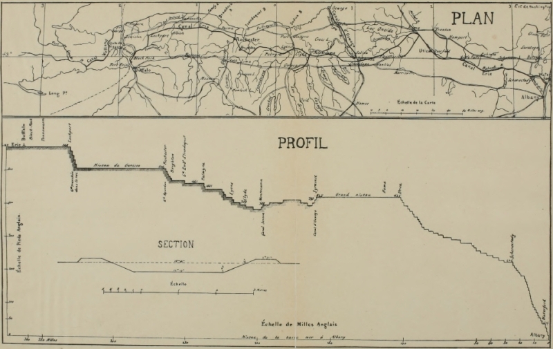
Click here for larger image size
Map and Profile of the Erie Canal[From Poussin’s “Travaux d’améliorations intérieures ... des États-Unis d’Amérique de 1824 à 1831” (Paris, 1834)]
The Western Section, from Buffalo to the eastern line of the Holland Purchase, was explored by Engineer William Peacock and Joseph Ellicott, commissioner. Their estimate for the sixty-two miles from Buffalo to the east end of the summit level west of the Genesee River, east of [Pg 109] the Great Tonawanda Swamp, was $450,000, and for the total distance to the Genesee River, $780,000. The absence of water on this route made reservoirs necessary, which formed a strong objection to pursuing that course. Anticipating this, Engineer James Geddes was sent over another course from a point twelve miles up the Tonawanda to the Seneca River. The distance was one hundred and thirty-six miles; the rise of one hundred and ninety-four feet from Seneca River to Lake Erie was to be overcome by twenty-five locks; the total expense was put at $1,550,985. The Middle Section extended from Seneca River to Rome, with a decline of forty-eight and one-half feet in seventy-seven miles. It was surveyed and laid out by Benjamin Wright; the estimate included $1,500 per mile for grubbing, so heavy were the forests, and reached a total of $853,186, which was considered liberal. The Eastern Section from Rome to Albany was surveyed in part by Engineer Charles C. Broadhead. The seventy odd miles to Schoharie Creek, with a descent of 132.85 feet, called for sixteen locks and forty-five[Pg 110] bridges—a total expenditure of $1,090,603. The forty-two miles to Albany were not now surveyed; the estimate for this distance was $1,106,087. The total descent of the canal from Lake Erie to the Hudson was 564.85 feet and its length was about 363 miles. The average estimated cost per mile was $13,800—by the route north of the Genesee River.
The Erie Canal was born in the Act of April 15, 1817.[34] After being passed by the legislature it went before the Council of Revision. “The ordeal this bill met with in the Council of Revision, came near being fatal to it; it could not have received a two-thirds vote after a veto. The Council was composed of Lieutenant-Governor John Tayler, acting Governor, as President of the Council, Chief Justice Thompson, Chancellor Kent, and Judges Yates and Platt. Acting Governor Tayler was openly opposed to the whole scheme. The Chief Justice was also opposed to this bill. Chancellor Kent was in favor of the canal, but feared it was too early for the State to undertake this gigantic work. Judges[Pg 111] Yates and Platt were in favor of the bill; but it was likely to be lost by the casting vote of the acting Governor. Vice President Tompkins (recently the Governor) entered the room at this stage of the proceedings, and, in an informal way, joined in conversation upon the subject before the Council, and in opposition to this bill. He said ‘The late peace with Great Britain was a mere truce, and we will undoubtedly soon have a renewed war with that country; and instead of wasting the credit and resources of the State in this chimerical project, we ought to employ all our revenue and credit in preparing for war.’
“‘Do you think so, sir?’ said Chancellor Kent.
“‘Yes, sir,’ replied the Vice President; ‘England will never forgive us for our victories, and, my word for it, we shall have another war, with her within two years.’
“The Chancellor, then rising from his seat, with great animation declared,
“‘If we must have war ... I am in favor of the canal and I vote for the bill.’[Pg 112]
“With that vote the bill became a law.”[35]
Preliminary work was immediately begun in the early spring of 1817 at the strategic summit level at Rome by conducting “a careful re-examination of the line of the canal, and of the levels of the preceding year.” This reconsideration seemed to indicate that a longer summit level at Rome than the one selected should be made, and Utica was chosen as the eastern extremity of this level rather than Rome. This decision was enforced by the fact that Mohawk navigation above Utica was always more uncertain than at any point below it; if the canal for instance should terminate at the Mohawk because of lack of means, or other cause, it would be advantageous to have its terminus on the Mohawk at a point where navigation was as uniformly reliable as possible. The Western Inland Lock Navigation Company had often found it necessary to make a portage from Utica to Rome, such was the low stage of water in the Mohawk. The summit level chosen,[Pg 113] therefore, ran from Utica to the salt-works at Salina (Syracuse). This was the eastern summit. The western was yet to be chosen between the Genesee and the Niagara tributaries in western New York.
Five lines of stakes were now driven into the ground from the eastern to the western boundaries of the state of New York—a circumstance which must be considered epoch-making in the history of America. For, look at it as you will, the beginning of the Erie Canal must be considered a greater marvel than the building of it. It would be difficult now to propose an engineering feat that is within the range of sanity that would provoke so much ridicule and debate as did the plan to build the Erie Canal through those hundreds of miles of dense forests and reeking swamps in 1816. A bridge across the Atlantic or a tunnel underneath it could scarcely provoke more sneers today. Yet the summer of 1817 saw the rows of stakes driven into the ground—over hill and vale, through densest forest and sickliest swamp, from east to west; the outer rows were sixty feet apart and indicated the space to be[Pg 114] grubbed; between these were two other rows forty feet apart which indicated the exact dimensions of the canal; a single row of stakes in the middle marked the exact center of the canal. Those who laughed at the stakes grew sober when men came on over the route boring with four inch augers into the ground every few rods to a depth of twelve feet; by this means the nature of the soil was tested all along the route and estimates could be made of the cost of the digging; thereupon profiles could be drawn by the engineers. Each of the three great sections of the canal was subdivided into very small sections which were to be let to contractors; each working section was bounded, when possible, by a brook or ravine, in order that each contractor might have the advantage of independent drainage. The plan of the state’s furnishing the tools for the work of digging the canal was soon changed, the contractors being expected to furnish their own tools. An instance of the skill of the old Erie Canal engineers, in a day when “surveying” was as loose a word as the dictionary contained, is interesting: “While[Pg 115] Benjamin Wright, Esquire, was re-examining and laying off sections from Rome, west along the canal line, it was deemed expedient, as a test to the accuracy of the work, that James Geddes, Esquire, should start, at a given point on the canal line at Rome, and carry a level along the road to the east end of Oneida Lake, marking on permanent objects the height of the surface of the water while the lake was tranquil, at various places from the east to the west end, along its southern shore; that he should then connect by a level, the Oneida with the Onondaga Lake; after which he was to carry a level from the last mentioned lake, at Salina, south about one and a fourth miles to the canal line, and from thence to work to the east, laying off sections along the canal line. This was accomplished, and nine miles at the west end of the summit level were laid out into sections. And the commissioners have the satisfaction to state, that when the level of Mr. Wright had been carried along the canal line, to the place where Mr. Geddes had terminated his line, the levels of these engineers, which embraced a circuit ...[Pg 116] of nearly one hundred miles, differed from each other less than one and an half inches.”
The first contract for work on the Erie Canal was signed June 27, 1817. Work was not begun until a formal inaugural celebration at Rome, New York, July 4, 1817.
The authorities of Rome arranged with the canal commissioners to unite the celebrations of the opening of the canal with the annual Fourth of July holiday. “At the appointed time and place, Judge Hathaway, President of the village, made a short address, adapted to the occasion, and then delivered the spade into the hands of the Commissioners. After a short but graphic speech by the Commissioner Young, he handed the spade to Judge Richardson, the first contractor, who then thrust it into the ground and made the first excavation for the construction of the canal. The example was immediately followed by his own laborers, and by the assembled citizens, all ambitious of the honor of participating in the labors of that memorable occasion. Thus amid the roar of artillery, and the [Pg 119] acclamations of the people, was begun that great work which has spread civilization, wealth and refinement....”[36]
Thousands were ready to jump at the chance of securing contracts on the great work; money was scarce along the countryside and means to make it proportionately few; as was the case in the building of the Cumberland Road, a great contemporary work to the south, so the Erie Canal was an immediate boon to hundreds in that long strip of country through which the lines of stakes were driven. Most of the contractors were well-to-do New York farmers, and three-fourths of the army of laborers which now attacked the long task were native born; the foreign element which played so large a part in making the Cumberland Road did not figure in the building of the Erie Canal. Angry gangs of mutinous foreign laborers did not menace the first travelers on the Erie Canal. The commissioners had the good sense to mark out the work to be done in such a way that worthy men of little[Pg 120] capital could secure contracts; accordingly the distances to be contracted for were divided up and men of small or no means at all were enabled to secure contracts as well as great contractors with armies of workmen in their employ. Money was frequently advanced to contractors in sums of from $200 to $2,000 according to the size of the contract. Good security was demanded. The commissioners, on the other hand, were warned to look out for rascally men who appear whenever any great work is to be undertaken. In building locks and embankments there was ample opportunity for deceit and dishonesty, which was an item to be reckoned with.
During the first season of work fifty-eight miles on the summit level were placed under contract, but most of the contractors were compelled to cease work when the frosts came. In December, 1817, from $200 to $1,000 each was advanced to contractors with which to buy provisions for their men; beef, pork, and flour were cheaper at this season than in the spring, and the roads over which they were to be trans[Pg 121]ported were likewise better in the winter season than at any other. This first year of work had brought its lessons; first and foremost it proved what a tremendous burden lay on the shoulders of the commissioners and engineers. Contracts innumerable were to be made and signed, calling for the provision of a hundred necessities: principally for stone, lumber, and lime; the proper quantities were to be deposited at the proper places—here in a heavy forest, there beside a swamp, and yonder at the foot of a hill. The country was quite innocent of anything that approached such a road as was needed everywhere along the line of work. It is difficult even to hint at the multitude of perplexing questions that the builders of the Erie Canal faced and somehow solved. The year had proved the advisability of discarding the spade and wheelbarrow—the European implements for canal building—for the plough and scraper. With the latter tools the work was more quickly done and better; the feet of the horses drawing them tended to solidify the earth along the embankments. Three Irishmen fin[Pg 122]ished three rods of the canal, four feet deep in five and one-half days. Sixteen and one-half days work accomplished 249½ cubic yards of canal, which at twelve and one-half cents per yard made $1.80 for each man per day. As the year progressed it was found that the contracts were inside of the figures of the estimates originally made.
When the season of 1818 was on, between two and three thousand men and half that number of horses and cattle were at work. Indeed some of the contractors had worked all winter, and many had transported the necessary provisions and tools for the summer’s campaign to the points of work on sleds during the winter. The Genesee Road between Utica and Syracuse, the most important of all, was useless for heavy loads in the summer season. During this season the entire Middle Section was put under contract; the only important change of route was at the Marl Meadows near Camillus; this swamp without an outlet was avoided by running a new route through the Salina plains, at an estimated saving of some $17,000.[Pg 123]
In all the romantic story of the building of this great work nothing is so picturesque as the forest scenes; the digging and scraping, the hauling and cementing, is all commonplace beside throwing the canal across the tremendous forests which were now, in 1818, to be met in that smiling country of which Utica, Syracuse and Rochester are the jewels of today. Nothing like this had been attempted in America before the Erie Canal; true the Cumberland Road was crawling away across the Alleghenies and was now in calling distance of Wheeling on the Ohio; yet this road was built largely on the route of older thoroughfares, and much of its new bed ran through open lands which pioneer fires had partially cleared. Moreover it was built on the surface of the ground. The Erie Canal forged straight on where no foot but the silent hunter’s had stepped; its course was marked in forests so dark that the surveyor’s stakes could hardly be distinguished in the gloom—where not even the smoke of a pioneer’s fire had ever penetrated; it was not built on the ground, but dug through the ground, and the vast network[Pg 124] above ground in those ancient woods was not less easily penetrated than was the straggling mass of root and fiber that was found for many feet below the surface. No work in America before its time began to compare in magnitude with grubbing that sixty-foot aisle from Lake Erie to the Hudson and the digging of a forty-foot canal in its center.
Since necessity is the mother of invention, it is not strange that here in the New York woods should have been perfected some strange machinery—great tugging monsters which should bodily haul down immense trees with a crash and pluck out green stumps with single groan. It may be these engines of forestry were imported from Europe; we know from the correspondence of that indefatigable promoter, Washington, that great engines for clearing trees from forest land were known in Europe and were probably imported to America not long after the Revolutionary War.[37] “Machinery has hitherto been used,” recorded the commissioners of the Erie Canal, “with most success, in the[Pg 125] heavy business of grubbing and clearing. By means of an endless screw, connected with a cable, a wheel and a crank, one man is able to bring down a tree of the largest size, without any cutting about its roots. For this purpose these means are all, except the cable, combined in a small but very strong frame of wood and iron.—This frame is immovably fastened on the ground, at a distance of perhaps one hundred feet from the foot of the tree, around the trunk of which fifty or sixty feet up, one end of the cable is secured, the other being connected with the roller. When this is done, the man turns the crank, which successively moves the screw, the wheel and the roller, on which, as the cable winds up, the tree must gradually yield, until, at length, it is precipitated by the weight of its top. The force which may be exerted in this way, upon a tree, is irresistible, as with the principle of the wheel and the screw, by the application of the cable at a point so far from the ground, it unites also that of the lever.” The machine for hauling stumps is thus described: “Two strong wheels, sixteen feet in diame[Pg 126]ter, are made and connected together by a round axle-tree, twenty inches thick and thirty feet long; between these wheels, and with its spokes inseparably framed into their axle-tree, another wheel is placed, fourteen feet in diameter, round the rim of which a rope is several times passed, with one end fastened through the rim, and with the other end loose, but in such a condition as to produce a revolution of the wheel whenever it is pulled. This apparatus is so moved as to have the stump, on which it is intended to operate, midway between the largest wheels, and nearly under the axle-tree; and these wheels are so braced as to remain steady. A very strong chain is hooked, one end to the body of the stump, or its principal root, and the other to the axle-tree. The power of horses or oxen is then applied to the loose end of the rope above-mentioned, and as they draw, rotary motion is communicated, through the smallest wheel, to the axle-tree, on which, as the chain hooked to the stump winds up, the stump itself is gradually disengaged from the earth in which it grew. After this disengagement[Pg 127] is complete, the braces are taken from the large wheels, which then afford the means of removing that stump out of the way, as well as of transporting the apparatus where it may be made to bear on another.”
A plough was invented for cutting the tangled meshes of roots below the turf “greatly superior to the one in common use. It is very narrow or thin, and consists of a piece of iron much heavier than a common plough, strongly connected, at its upper edge, with the beam, and in the rear, with the handle, both of which are of the usual construction. The front edge of the iron, where the cutting is to be done, is covered with steel, well sharpened and shaped like the front of a coulter, except that it retreats more as it rises to the beam. The lower edge is made smooth and gradually thickens as it extends back towards the handle, to about four inches. Two yoke of oxen will draw this utensile through any roots not exceeding two inches in diameter; and by moving it, at short intervals, through the surface of the ground to be excavated, the small roots and fibres are so cut up as to be easily picked and[Pg 128] harrowed out of the way of the shovel and scraper.”
During the season of 1818, all but five of the ninety-four miles of Middle Section were grubbed and cleared with these powerful machines; little the wonder, however, for one of the stump machines, costing two hundred and fifty dollars, operated by seven men and two horses, could grub from thirty to forty large stumps a day. Of the eighty-nine miles cleared, forty-eight miles of the line was dug, eight miles being completed and accepted. One ten-mile stretch was half done and one twenty-mile division was one-fourth done. The total estimated expense of the Middle Section was $1,021,851; up to January 25, 1819, $578,549 had been expended; the $443,302 remaining was considered sufficient to complete the section.
This division of the canal was completed in 1819; for twenty-seven miles it was navigable and had not the frost intervened, large boats could have traversed its entire length before the close of the year. The expense proved to total up to $1,125,983, an excess over the estimate of $104,132.[Pg 129] The explanation of this excess brings out some interesting facts concerning the progress of the work. For instance, the aqueducts over Oneida and Onondaga Creeks had been made of solid masonry instead of wood as stipulated in the estimate. Lack of snow during the winter of 1818-19 had prevented the hauling of much of the needed material. Sickness among the army of workmen had produced costly delays; pioneer conditions prevailed—the fever and ague of those who first invaded the sluggish morasses of the interior of a new continent. Special trouble had been experienced where the canal line approached the low-lying valley of the sluggish Seneca. For thirty-five miles the works paralleled this stream, and pioneers here suffered heavily every fall; of course the laborers on the canal were, to say the least, not more fortified against the miasma and fever than the pioneers who came more or less prepared for such drawbacks. At one time a thousand men on the Erie Canal were stricken down in this region, and in some instances the work on certain “jobs” was entirely abandoned for several weeks.[Pg 130]
But the work of the year was not confined to the Middle Section. Exploring parties had been sent to outline more specifically the canal line in the sections on either side. A portion of the Western Section, from the Genesee River to Palmyra, was put under contract, to be completed in September, 1821. The portion of the Eastern Section between Utica and Little Falls—a distance of twenty-six miles—was also put under contract. The expenses for the year amounted to over $100,000 ahead of the annual appropriation of $600,000. And heavier expenses yet were in sight; among these the claims of the Western Inland Lock Navigation Company had to be satisfied. This company had been carrying on its business and declaring greater dividends each year up to 1818. In that year the Erie Canal works at Wood Creek interrupted the operation of their system and the state was compelled to satisfy the claim. There had been, ever since 1812, a correspondence between the canal commissioners and the Western Company looking toward a purchase of the latter’s rights. The price asked in 1812, and[Pg 131] again in 1817, was $190,000. The matter was at last settled in 1820 by the payment of $152,718.52.[38] There was a moment just here when the canal came near pausing in its swift rush to completion. A recasting of the estimates was essayed, and the New York legislature demanded of the commissioner what portion of the canal was most important in case only a part could be completed. The reply was, of course, that the Western Section should be finished whether the Eastern could be or not. The estimated expense of completing the canal 254 miles from Utica to Lake Erie was $2,845,561; the Eastern Section, only ninety-eight miles long, would cost only $800,000 less, and for this distance the Mohawk River could be made to answer the purpose of a canal if necessary.
But as if pushed forward by the very momentum of its greatness, the canal went forward. The advances made in 1820 were rapid and important. In the Western Section the fifty odd miles between the Genesee and Montezuma were completed with the exception of nine. The route of 1816 was[Pg 132] hardly changed except at Irondequoit Creek, and between Palmyra and Lyons. The Middle Section rapidly became a busy avenue. Mile posts were erected throughout its length, the distance from Genesee Street in Utica to the lock into the Seneca River being a little more than ninety-six miles. Navigation began in May. Contracts were let for the Eastern Section that would insure the completion of the thirty miles from Utica to Minden within the year. The course of the canal through the Mohawk Valley was resurveyed, the experienced engineer Canvass White pushing it forward to Cohoes Falls. The great rock wall at Little Falls was now completed. At the close of the year ninety-eight miles of the Erie Canal was completed, and the promise was that as much more would be done within a twelvemonth. The point of difficulty now was in the Western Section in gaining a route well supplied with water between Lake Erie and the Middle Section. During the present year Mr. Thomas had surveyed the northern route, running seventy-two miles from the Tonawanda to the Genesee.[Pg 133]
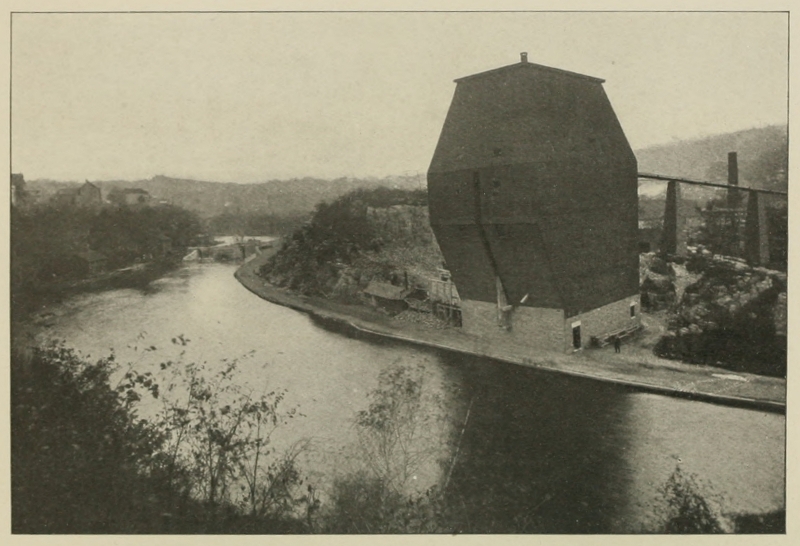 View of Canal at Little Falls, New York, Showing Lock 37 in the Distance
The contracts for this route were let in 1821, eighty miles being let in contracts. The fifty miles between the Genesee and Seneca were completed this year. Business was more brisk on the completed Middle Section than in the year previous, the tolls received amounting to $23,001.63. Contracts were let for the entire completion of the Eastern Section, and boats were already running from Utica to Little Falls. A large fraction of the excavating between Little Falls and Schenectady had been completed by the last of the year, and the difficult problem of a route from Cohoes Falls to Albany was now solved by Canvass White by crossing the Mohawk.
By June, 1823, the canal was open from Rochester to Schenectady, and when the season opened 220 miles were navigable. During 1822 all but ten miles of the route along the Niagara River had been put under contract and the great Genesee aqueduct had been erected. Toll to the extent of $3,286 was collected in this year on the eastern part of the Western Section—at Lyons, Palmyra, and Rochester. By the middle of November water had been ad[Pg 136]mitted into the Eastern Section and boats were afloat from Little Falls to Schenectady. Water was admitted into the stretch of canal between Brockport and Rochester, October 10, 1823. The forty-five miles from Brockport to the Mountain Ridge (Lockport) was well along; the four great embankments in this distance were nearly complete; that at Sandy Creek was the highest on the entire canal, running up seventy-six feet. The tolls in 1823 between the Genesee and Seneca amounted to $20,954.11, showing the large amount of business done.
As the last year before completion (1824) opened, all eyes were directed to two points in the west which were each difficult puzzles. One was the means of crossing the Mountain Ridge at Lockport and the other was the best way to get into Lake Erie. Finally the latter question was settled for better or for worse by letting the contracts for the Black Rock harbor. The work went slowly at the Mountain Ridge, but the contractors promised that the work there would be completed by May, 1825. The tolls this year between Mantz and[Pg 137] Utica amounted to $77,593.26, and the tolls on the Eastern Section totaled up to $27,444.09. Water was admitted into the canal between Schenectady and Albany in October; the work here, which included twenty-nine locks, had been found unexpectedly difficult. On October 8, 1823, the first boats passed from the West and the North (Lake Champlain canal) through the junction canal into the tide water of the Hudson at Albany. On September 8, 1824, water was sent into the canal from Brockport and Lockport; the line to Black Rock and the Black Rock harbor was completed nearly on scheduled time. Among improvements of the year must be named the hydrostatic locks built at Utica and Syracuse. The tolls of 1824 were $294,546.62. The grand canal was completed.
The completion was a signal for a royal celebration throughout the state of New York which is, in many aspects, of great historic interest.[39] Its unique details, the[Pg 138] non-participation of many, the violent rejoicings of others, the carrying out of symbolic ceremonies not unlike Roman pageants, all these and many other features of the great show have a deep significance. The political element entered largely into the matter.
Learning that the canal would be completed about October 26, the corporation of New York City entered into correspondence with the chief cities and towns along the line concerning the proper celebration of the event. Two aldermen, King and Davis, were sent to Buffalo from New York to participate in the festivities of the great occasion.
Buffalo was in gala dress on the day set for the pageant. The city was filled with yeomanry. At nine o’clock in the morning the grand procession formed before the court-house; the Buffalo band, squads of riflemen, and the committees took the lead and the vast throng moved to the head of the Erie Canal where the canal-boat “Seneca Chief” lay at anchor. Governor Clinton, the lieutenant-governor, and the committees were received on board, and[Pg 139] Jesse Hawley, who, nearly a generation before, had published in Pittsburg the first broadside in favor of the canal, delivered an address in behalf of the citizens of Rochester, “to mingle and reciprocate their mutual congratulations with the citizens of Buffalo on this grand effort.”
The “Seneca Chief” was bravely equipped and manned for the occasion. Two great paintings occupied conspicuous positions. One presented the scene which was at the moment being enacted, Buffalo Creek and harbor with the canal in the foreground and the “Seneca Chief” moving away. The other picture represented Governor Clinton as Hercules, in Roman costume resting from hard labor. Among the articles of freight to be carried by this boat, which should first pass from Buffalo to New York over the Erie canal, were two kegs filled with Lake Erie water. In addition to the governor of the state and his staff, the Buffalo committee embarked on the “Seneca Chief,” comprising Hon. Judge Wilkinson, Captain Joy, Colonel Potter, Major Burt, Colonel Dox, and Doctor Stagg. The flotilla, which was headed[Pg 140] by the “Seneca Chief,” consisted of the canal-boats “Chief,” “Superior,” “Commodore Perry” (a freight boat), and the “Buffalo” (of Erie, Pennsylvania). “Noah’s Ark” was the name of another craft which contained beasts, birds and creeping things—a bear, two eagles, two fawns, several fish, and two Indian boys, all traveling under the title of “products of the West.”
When the flotilla set sail a signal gun was discharged at Buffalo; the announcement was taken up by each gun in a long line from Buffalo to New York and the signal was passed throughout the entire distance.
As the pageant moved along through the state it was joined ever and anon by other craft and at almost every village exercises and illuminations were the order of the day and the much-feted governor and committees were hauled to the best hotel and feasted. The “Niagara” joined the squadron at Black Rock and “fell in behind.” At Lockport guns captured by Perry at the battle of Lake Erie were fired in salute to the guests and the occasion; a gunner who,[Pg 141] it was said, had fought under Napoleon, discharged them. At Holley an address was given on the twenty-seventh. At Brockport cannon welcomed the boats. There was a procession at Newport, as everywhere else where the guests were feted. At Rochester a feu de joie was fired from the aqueduct on the arrival of the triumphal flotilla, and here a fine boat, the “Young Lion of the West,” rode out to meet it.
“Who comes there?” cried the “Young Lion’s” sentinel as the strangers drew near.
“Your Brothers from the West, on the waters of the great Lakes.”
“By what means have they been diverted so far from their natural course?”
“By the channel of the Grand Erie Canal.”
“By whose authority, and by whom, was a work of such magnitude accomplished?”
“By the authority and by the enterprise of the patriotic People of the State of New York.”
The procession being formed, the vast throng marched to the Presbyterian church[Pg 142] where an address was delivered by Timothy Childs. General Matthews, assisted by Jesse Hawley, presided at a banquet which followed at one of the hotels. Grand illuminations and a ball concluded the day’s entertainment. The Rochester committee consisting of Messrs. E. B. Strong, Ward, Leavett, Rochester, Hulbert, Reynolds, A. Strong, R. Beach, Johnson, and E. S. Beach, embarked on the “Young Lion” for New York.
At Palmyra an arch across the canal welcomed the pageant on the twenty-eighth; it read “Clinton and the Canal” from one side, and “Internal Improvements” on the reverse. Another arch at Montezuma, which was reached late that evening, was a transparency displaying the words “De Witt Clinton and Internal Improvements” on one side, and “Union of the East and West” on the other.
Buckville was found brightly illuminated at midnight; Port Byron was reached on the twenty-ninth and Weedsport was illuminated. A twenty-four pounder was discharged, resulting in the death of only two. Syracuse was reached on the thir[Pg 143]tieth; Joshua Forman, the early champion of the canal in 1810, gave an address to which Governor Clinton made reply.
At Rome probably the first indication of ill-feeling was met; exercises had been held on the twenty-sixth to commemorate the opening of the canal, but dissatisfaction was felt over the fact that the Erie Canal did not follow the route of the old Western Inland Lock Navigation Company canal upon which the village of Rome had grown up. In consequence, at 11 A. M. on the twenty-sixth, a procession was formed bearing a black barrel filled with water from the old canal. Drums were muffled and the procession moved slowly out of town to the Erie Canal into which the barrel was emptied. The return march was made at quick step and at the hotel an appropriate celebration was held. The present flotilla arrived on Sunday, the thirtieth, and remained only an hour. Utica was reached at noon on this date; during the exercises held on the morrow, Governor Clinton took occasion to pay high tribute to Utica’s citizen, Judge Platt, who had long befriended the canal movement.[Pg 144] Little Falls was reached Monday evening; here, too, a change of route displeased some; the old Lock Company canal was on the north side of the Mohawk, and the Erie Canal was on the south side; a banquet was served the guests at one of the hotels. At three o’clock Tuesday afternoon, Schenectady was reached—two hours ahead of scheduled time. Here a grave reception awaited the enthusiastic voyageurs; a local paper had mentioned “a project of a funeral procession, or some other demonstration of mourning.” No preparation for the reception of the visitors had been made. The canal would, it was believed, be the ruin of Schenectady; as the terminus of the old overland portage of sixteen miles from Albany, the town had grown in size and wealth; a large part of all the freight from the south that passed up the Mohawk came by wagon to Schenectady and was there loaded on boats. The village was, on one hand, a Mecca for wagon lines and wagons, and on the other the terminus of Mohawk shipping. The Erie Canal overturned everything. A waterway was now opened straight through to[Pg 145] Albany; Cohoes Falls, which had been the making of Schenectady, was wiped out of existence by the Erie Canal and the Schenectady of the old days was a thing of the past. The students of Union College, however, were cosmopolitan, and the “College Guards” did the honors of the rainy day; the guests took dinner at a hotel and were off at four o’clock. On the following morning, above the patroon mansion of General Stephen Van Rensselaer, the flotilla was met by the aldermen of Albany and the last lock in the long canal was entered at 10:30 A. M. Twenty-four cannon announced the flotilla’s arrival. The procession that soon formed moved slowly to the capital; after a prayer and an ode, the address of the day was delivered by Philip Hone.
At nine o’clock on Thursday morning, November 3, the flotilla set sail from Albany on the broad Hudson; the canal boats were in tow of strong steamers, the “Chancellor Livingston” leading the way. Unfortunately “Noah’s Ark” with its bears and Indians had not kept up with the main procession and did not arrive in time to[Pg 146] start for New York. The steamers swept the boats rapidly onward; they were saluted at Catskill, West Point and Newburgh, and arrived at New York at daylight of November 4, anchoring near the state prison.
The steamer “Washington,” magnificently decorated, came alongside the “Chancellor Livingston” bearing the committees of the Corporation and the officers of the Governor’s Guard. Alderman Cowdrey made an address to which Clinton replied. At nine o’clock the fleet from Albany accompanied by a fleet bearing the Corporation set out for open sea. The spectacle was one to attract much attention. Salutes were fired from the Battery, from the forts on Governor’s Island, and from Forts Lafayette and Tompkins. The destination of the pageant was indicated by the U. S. schooner “Porpoise” which preceded the other craft and moored within the Hook, where the interesting ceremony of wedding the waters of the Atlantic and the Great Lakes was to be held. “... Never before,” wrote an enraptured beholder, “was there such a fleet collected, and so superbly decorated; and it is very[Pg 147] possible that a display so grand, so beautiful, and we may even add, sublime, will never again be witnessed. We know of nothing with which it can be compared.... The orb of day darted his genial rays upon the bosom of the waters, where they played as tranquilly as upon the natural mirror of a secluded lake. Indeed the elements seemed to repose, as if to gaze upon each other, and participate in the beauty and grandeur of the sublime spectacle.”[40] At the auspicious moment the Governor of New York permitted the water from Lake Erie to fall into the ocean, saying: “This solemnity, at this place, on the first arrival of vessels from Lake Erie, is intended to indicate and commemorate the navigable communication, which has been accomplished between our Mediterranean Seas and the Atlantic Ocean, in about eight years, to the extent of more than four hundred and twenty-five miles, by the wisdom, public spirit, and energy of the people of the state of New York; and[Pg 148] may the God of the Heavens and the Earth smile most propitiously on this work, and render it subservient to the best interests of the human race.”[41] Whereupon the “Young Lion of the West” gave a brave salute from “a pair of brazen lungs” which he had provided for himself at Rochester, and a collation was served on the fleet.
While these inspiriting scenes were being enacted, the greatest procession, it was said, that ever had been formed in America to date, was preparing in the city under the direction of Major-general Fleming; all classes were represented, the military and civil societies, educational institutions, the city departments, state artillery and benevolent and mechanical organizations, the whole enlivened by the playing of many bands. At 10:30 o’clock the line, one mile and a half in length, began its march. From Greenwich Street, the route was through Canal to Broadway, up Broadway to Broome, up Broome to the Bowery, down the Bowery to Pearl, down Pearl to the Battery, and thence to Broadway and[Pg 149] the City Hall. At night the illuminations were beautiful, the commonest being the letter “C” and “Grand Canal;” the New York Coffee House, the City Hotel, Peale’s Museum, Scudder’s Museum, Chatham and Park theaters had elaborate displays. The illuminations of the City Hall were “surpassingly beautiful.” The exhibition of fireworks in New York was said to be the greatest in its history. On Monday evening, November 7, the celebration was concluded by a grand ball at the Lafayette Amphitheatre in Laurens Street; in order to secure the necessary space required, the floor of the amphitheater was connected with the floors of an adjacent circus building on one side and the floor of a riding school on the other; as a result the largest ball room in America was temporarily formed, measuring two hundred feet in length and from sixty to one hundred feet in width. Above the proscenium were emblazoned the names of the engineers of the “Grand Canal”—Briggs, White, Geddes, Wright, and Thomas; also the names of the past and present canal commissioners—Hart, Bouck, Holly, De Witt,[Pg 150] Livingston, Fulton, Clinton, Van Rensselaer, Morris, Eddy, Young, Seymour, Porter, and Ellicott. In the ladies’ banquet room a boat made of maple sugar—the gift of Colonel Hinman of Utica to Governor Clinton—floated proudly on Lake Erie water.
At the conclusion of the great celebration the committee from the West departed for Lake Erie, carrying with them a keg of Atlantic water, ornamented with the arms of the city of New York and the following words in letters of gold: “Neptune’s return to Pan. New York, 4th Nov. 1825. Water of the Atlantic.”
And the last scene in this old pageant was enacted at Buffalo on November 23; at ten o’clock of the morning of that day the committee, accompanied by a band, were towed out into the basin of Lake Erie; the waters of the Atlantic were poured into the lake, Judge Wilkinson delivering an appropriate address. In the evening a concluding celebration was held at the Eagle Tavern. The waters of the ocean and the Great Lakes were at last united; how largely the celebration was inspired by[Pg 151] political interests it is impossible to say. The fact remains that the pageant was one of the most significant in American history and marked a new era in the commercial awakening of America.
A careful study of the influence of the Erie Canal upon the great commonwealth which built it has been made by Mr. Julius Winden, and the results of his investigation, important and interesting, have been placed at the disposal of the present writer.[42] The entire region affected by the canal, from New York City to Buffalo, is divided by Mr. Winden into three sections; the first covers the Hudson River valley from the mouth of the Mohawk to the sea; the second includes the Mohawk Valley from the Hudson to Utica where the canal left the valley; the third extends from the Mohawk to Lake Erie. The sections are designated, respectively, as Section A, Section B, and Section C.[Pg 153] Again, each section is divided into three classes; Class I includes the land within six miles of the canal route; Class II includes all land between six and twelve miles from the canal route; Class III includes all land within the counties tapped by the canal lying at a greater distance than twelve miles from its course. Mr. Winden first discusses the effect of the canal on the population of the counties through which it ran, and thus summarizes his results:
“Of the three sections considered, we have found one, Section A, with a certain condition of the population due to the influence of an old waterway, the Hudson river. Population was concentrated along the banks of the river and decreased as the distance from the river increased. The extension of this waterway into new and broader fields resulted in a very great increase of the concentration of population on the banks of the stream, but had little or no influence on the population at a distance of six or more miles from it.
“The second region, Section B, presented conditions very similar to the one preced[Pg 154]ing. It was influenced by an old waterway, the Mohawk River, but this waterway was not very serviceable. The population was concentrated along the course of the waterway, but not as markedly as in Section A. An increase in the serviceability of the waterway and an extension into new fields had the effect of concentrating the population along the course of the waterway much greater than in Section A. The region six or more miles from the waterway was little affected or none at all.
“In the third region, Section C, we found a new region, having no waterway and having less population per square mile where a waterway was to be made than the region a short distance from the future course of the waterway. The effect of the waterway was to increase the population very rapidly along its course and produce a great concentration of population there. In the remote region the population was also greatly increased. We also notice that this concentration of population in Class I along this watercourse tended to mass into cities.”
The per capita valuation of property[Pg 155] next engages attention and the result is thus outlined:
“As before mentioned Section A was an old well-settled region during this period, and although property had a tendency to mass along the banks of the Hudson and gradually to diminish as the distance from the river increased, still this increase of the valuation of property advanced much more slowly than the increase in population.
“Section B was an old and well settled region, but it was not as old as Section A. Here valuation massed along the canal but it did not increase as rapidly as the population, still it increased more rapidly in proportion to the increase of population than did Section A.
“Section C was a new region where the increase in valuation kept pace with the increasing population and even exceeded it.
“A re-invigoration of an old region by increased commercial advantages such as the Erie canal provided for in Sections A and B results in an increase of property within about six miles of that commercial route, but it has little effect outside of that limit. This increase of property, however,[Pg 156] does not keep pace with the increase in population, i.e. property in this case is more stable and unchangeable than population. On the other hand, in a new region never having felt the influence of a commercial route such as the Erie Canal, property within about six miles of the route increases as rapidly and even more rapidly than the population. This increase of property is not confined within the six mile limit, but extends much farther away from the route than it does in an old well-settled region having previously felt the influence of a commercial route. Thus the extension of a waterway into new fields is beneficial to the region along the banks of the old waterway, but affects the territory a distance from the route little or none at all; while a waterway extended into a new region is of very great benefit to the region immediately along the route and it is also beneficial, to a less degree, to the remote regions. It must be remembered that a waterway is different from a railroad, in that material can be shipped at almost any point, while a railroad has certain stations were material can be shipped; thus a[Pg 157] waterway’s influence is continuous along the line, while the influence of the railroad is at points where there are stations.
“In the distribution of real and personal property in 1835 very significant results are shown. In Class I of Section A the real property per capita was $150.22 and the personal property was $49.11; in Class II the real property was $195.96 and the personal $34.34; in Class III the real property was $166.49 and the personal was $37.22. The least real property per capita and the least personal property per capita was in Class II, and Class III was second in both. In Class I of Section B the real property was $133.81 per capita and the personal $49.71; in Class II the real property was $108.92 and the personal $17.41; in Class III the real property was $90.68 and the personal $13.34.
VALUATION PER CAPITA, 1835
| Real | Personal | |
| Section A | ||
| Class I | $150.22 | $49.11 |
| Class II | 195.96 | 34.34 |
| Classes I and II | 159.78 | 46.02 |
| Class III | 166.49 | 37.22 |
| Section B[Pg 158] | ||
| Class I | 133.81 | 49.71 |
| Class II | 108.92 | 17.41 |
| Classes I and II | 124.61 | 37.78 |
| Class III | 90.68 | 13.34 |
| Section C | ||
| Class I | 154.50 | 26.39 |
| Class II | 131.19 | 15.49 |
| Classes I and II | 146.94 | 22.85 |
| Class III | 103.90 | 14.02 |
“Both real and personal property were greatest in Class I, Class II was second in both, and Class III was third in both. Class I of Section C was first in both real and personal property; Class II was second and Class III was third in both real and personal property. This section shows the same relations that we find in Section B.
“The location of the real and personal property in the three sections considered indicates very clearly that the personal property was massed along the waterway; in Class I and as the distance increased from the waterway the personal property diminished.”
Of the improvement of land Mr. Winden remarks:[Pg 159]
“It may be stated that there was a slight tendency for the improvement of land to increase concomitantly with the increase in population; but the topography of the country and other elements entered in to such an extent as to nearly destroy this parallel growth. The improvement of land is much more stable and less likely to sudden and great changes than is the population. For this reason we would not expect to find as large a per cent of improved land in proportion to the population in Section C as we would find in Section B, nor as large a per cent in Section B as in Section A; because Section A is the oldest in settlement, and Section C the youngest. The per cent of improved land as a whole in the three sections supports this conclusion. But in comparing the various classes of each section with each other, however, we do not always find the greater per cent of improved land in the region of the most concentrated population. In Section A, in 1820 and 1825, a larger per cent of land was improved in Class II than in Class I, while the population in Class I was much greater than in Class II. In Section B in[Pg 160] 1835 Class II had a larger per cent of improved land than Class I while the population was nearly twice as great per square mile in the latter as in the former. A somewhat similar condition also existed in Section C. In 1820 and 1825 both the population and the per cent of improved land were greater in Class II than in Class I; in 1835 the per cent of improved land was still greater in Class II but the population was much less than in Class I. The above conditions indicate that the population and also the wealth increased with such remarkable rapidity in Class I along the entire watercourse independently of the topographical conditions and in spite of natural disadvantages. They also indicate that the concentration of population in Class I was much greater than the population per square mile taken alone would seem to indicate. This is especially true of Class I in 1835.”
The effect of the canal on live stock is thus summed up:
“During this entire period Classes II and III raised more stock in proportion to their population than did Class I. At the[Pg 161] beginning of the period in 1820, Class II in Sections A and B and Class III in Section C raised the greatest number of horses. Class III in Sections B and C and Class II in Section A raised the greatest number of cattle; Class III of Sections A and C and Class II of Section B raised the greatest number of sheep. At the close of the period in 1835, Class II in all three sections raised the greatest number of horses, Class III in Sections A and C and Class II in Section B raised the greatest number of cattle. Class III in all the sections raised the greatest number of sheep. It is thus clearly seen that the area of the least concentration of population was the region in which stock-raising was most extensively carried on. By this it is not meant that there is a smaller amount of stock raised in a given area, where the population is dense than in a sparsely settled region, but that there is a smaller proportion raised to the population.”
Mr. Winden’s summary in connection with the study of aliens and foreigners is most interesting:
“It is thus clearly seen that if New York[Pg 162] State received her just share of all the classes of emigrants arriving in the United States during this period, she would have added to her population, a strong, useful and able-bodied class of men who would aid her greatly in her development.
“Why this region of concentrated population, the towns along the Erie canal, should contain such a large part of the foreign element is probably due to numerous causes. This was a region of great activity and growth; a place where there was room for unskilled as well as skilled labor of all kinds; it was along a direct route of transportation and travel to the great and growing west and a foreigner knowing nothing about the country and having no definite destination would stop along the route wherever he could make a living. Although chance may have largely determined the location of the foreigners in this new country, his old environment was also an important factor in determining his place of settlement. He came from an old and well settled region in Europe where the population was concentrated and the country often overcrowded and in com[Pg 163]ing to America he would tend to seek a region of somewhat similar characteristics. He found these conditions with the exception of an overcrowded population in the densely settled country immediately along the Erie canal and the Hudson.
“In turning to the New Englander in New York we find a people of an entirely different education and character from that of the foreigner. This is seen most strikingly in the choice of their location. They were shrewd, frugal, and hardworking farmers who left their New England homes because they failed to supply their wants. In seeking a new home in the west they naturally followed their old occupation and for this reason we find the larger part of them in the rural region. In Class I of Section A, 4.1% was of New England birth; in Class II 2.7%, and in Class III, 5.2%; in Class I of Section B, 5.7%, in Class II, 9.7%, and in Class III, 10.1%; in Class I of Section C, 10.1%, in Class II, 10.3% and in Class III, 11.7%. The New Englander also tended to shun the large cities. In Albany 5.1% was of New England birth, and in Utica 7.8%, while in Class I of Sec[Pg 164]tion B, in which these two cities were situated, 5.7% was of New England birth. In Buffalo 9.3% was of this origin and in Rochester 9.6% while in Class I of Section C 10.1% originated in New England.
“The preceding discussion leads us to the conclusion that the foreigner was massed in the region of concentrated population and especially in the cities, and as the concentration of population diminished, the per cent of foreigners decreased. In other words, along the Erie Canal lay the larger part of the foreign population. Of this foreign population in New York State, the larger per cent was born in Great Britain and her dependencies, and this class was chiefly found where the population was thickest. The New Englander constituted a larger part of those born in other states of the Union and they were found chiefly in the rural regions.”
In his study of politics as presented in the territory traversed by the Erie Canal Mr. Winden raises most interesting questions. We quote him in full, appending his notes:
“Turning now to the political aspect in[Pg 165] New York State during this period we find a complicated problem. In the election of 1830 there were two important parties. Summing up the principles for which these two important political parties of New York stood in this election, we find that the Anti-Masonic or National Republican party opposed the Masonic order;[43] supported Clay’s American policy of protection and the extension of the internal improvement system;[44] catered to the workingmen[45] and opposed the administration of both the national and state government. In other words it was like all new parties, gathering to its fold all the radical elements by adopting some of their ideas.[46] In the campaign which followed they made an aggressive canvass, making the most of the Morgan outrage. The Republican, or[Pg 166] Masonic party, as it was called by the Anti-Masons, tried to be indifferent to the Masonic order and disavowed all support of it;[47] opposed the American system and did not advocate an extensive local improvement system[48] and supported the national and state administrations. They conducted a defensive campaign against the accusations of the Anti-Masons.
“Before considering the vote of the election it is necessary to take a hasty view of the social and economic conditions of the state at that time. Morgan had disappeared in western New York four years before and this had caused a great local opposition to the Masons which had spread throughout the state and even into neighboring states. The internal improvement movement had assumed stupendous proportions; the state had completed four canals within the last seven years; the Champlain in 1823, the Erie in 1825, the Oswego in 1828, and the Cayuga and Seneca in 1829. And the people were clamoring[Pg 167] for more. Just after the completion of the Erie canal in 1825, petitions for other canals had poured in from almost every county in the west.[49] Thus it can be safely said that the entire western part of the state was in favor of internal improvements at public expense.
“Now considering the vote, we find that Section A gave a large majority to Mr. Throop, the Republican candidate. In Section B he also received a majority but not as great as in Section A. In this section an important fact is noticeable, Classes II and III gave a smaller majority to Mr. Throop than Class I. These two classes having no canals thus expressed their desire for some means of communication. Section C cast a large majority in favor of Mr. Granger, the National Republican candidate. The result in Section C was just what we should expect. Class III of this[Pg 168] section which was in most need of some means of communication voted a much larger majority in favor of Mr. Granger than Classes I and II. The cities, however, gave a majority to Mr. Throop, Utica casting a larger and Albany a smaller majority than the class in which they are situated. Buffalo also cast a majority in favor of Mr. Throop, although the class in which it is situated cast a majority in favor of Mr. Granger. (See table.)
“Thus it is clearly shown that the people largely voted for the respective candidates because they stood for economic principles which were of direct interest to them.[50] The most densely populated east determined the election and Mr. Throop, the Republican candidate, was elected by[Pg 169] a vote of 128,842. Mr. Granger received 120,361 votes, mostly from the west and rural regions which were demanding internal improvements, while Mr. Williams, the candidate of the dissatisfied Working Men’s party, received 2,332 votes.[51]
ELECTION OF 1830
| Section A | Throop | Granger |
| Class I | 60% | 40% |
| Class II | 62 | 38 |
| Classes I and II | 60 | 40 |
| Class III | 60 | 40 |
| Section B | ||
| Class I | 58 | 42 |
| Class II | 54 | 46 |
| Classes I and II | 57 | 43 |
| Class III | 55 | 45 |
| Section C | ||
| Class I | 44 | 56 |
| Class II | 44 | 56 |
| Classes I and II | 44 | 56 |
| Class III | 39 | 61 |
| Cities | ||
| Albany | 54 | 46 |
| Buffalo | 52- | 48+ |
| Utica | 60+ | 40- |
[Pg 170]“In the presidential election of 1840, strictly economic principles were not prominent. The Whig National convention met at Harrisburg, Pennsylvania, December 4, 1839, and nominated William H. Harrison of Ohio and John Tyler of Virginia for President and Vice-president respectively. They conducted the campaign with unbounded enthusiasm, attacking Van Buren and his financial policy with great energy. Although they adopted no platform, they favored loose construction, the American system of protective tariff, and internal improvement by the national government.
“The Democratic national convention met at Baltimore, May 5, 1840, and adopted a strict constructionist platform, denying the power of Congress to carry on internal improvements,[52] to protect manufactures, to charter a National Bank, or to interfere with slavery in the states. It unanimously renominated President Van Buren, but left nominations for the Vice-presidency to be made by the various states. The simulta[Pg 171]neous appearance of the ‘Panic of 1837’ and Van Buren in the presidential chair produced the belief in the popular mind that he was the cause of that unfortunate financial distress. The vote in New York is likely to indicate the two following facts: where the financial distress was greatest and the region most favorable to internal improvements. Van Buren carried Section A, with the largest majority in Class III. Recalling that this was a rural region, very stable in its population and valuation, we see that it would be least affected by financial distress. Classes I and II of Section B were also carried by Van Buren, but the rural region, Class III, was carried by Harrison. Section C was also carried by Harrison, with the largest majority in Class III. The large cities also gave a majority to Harrison and although Albany and Utica are situated in a class which cast a larger vote for Van Buren they gave a majority to Harrison; and even Buffalo gave a greater per cent of its vote to Harrison than the class in which it is situated. The large majority in Class III of Section C may be accounted for by the enthusiasm[Pg 172] for internal improvements in this region and the majority in the cities by their opposition to Van Buren because of the great distress they were subject to during the Panic of 1837.
“We find the state issues and results of the election somewhat similar to those of the national election in the state. The Whigs nominated Governor W. H. Seward and the Democrats nominated Mr. Bouck. The Whigs advocated internal improvements upon a large scale, while the Democrats advocated retrenchment in this work. The Albany Argus of September 25, 1840, states of Mr. Seward, the Whig nominee for governor: Departing from the democratic policy of enlarging the Erie canal by means of its revenues only, he has urged upon the legislature, its ‘more speedy’ enlargement, at all hazards, and the creation of a debt for that purpose—a debt which alone will absorb all our revenues, leaving the principal to be paid by direct taxation. He has recommended that state work be undertaken, the cost of which will involve the people in debt of at least $40,000,000. In addition he has[Pg 173] urged upon the legislature loans to corporations—of the credit of the state to an indefinite amount—for almost every mad scheme speculators might suggest.[53]
“Summing up the most important internal improvement works for which Mr. Seward advocated state aid, we have, the enlargement of the Erie canal,[54] the Black River canal in the counties of Oneida and Lewis and joining the Black River with the Erie canal, the Genesee Valley canal in the counties of Broome, Chenango, Madison, and Oneida joining the Chenango river with the Erie Canal (the two canals last mentioned would unite Lake Ontario with[Pg 174] the Susquehanna River), and the Hudson and Erie Railroad previously mentioned. Turning to the results of the election we find that Section A gave a large majority to Mr. Bouck with the greatest per cent of the vote in Class I, and the least in Class III; Classes I and II of Section B also cast a majority for Mr. Bouck, but Class III and all of Section C gave a majority to Mr. Seward. Class III of the last mentioned section gave the largest per cent and Class II the next to the largest per cent of the vote to Mr. Seward. Recalling that the Hudson and Erie railroad was to pass through the entire length of the southern part of Class III of Section C and also through Class III of Section A, we see the cause of the increased vote above the neighboring classes for Mr. Seward. (See Table.) The conclusion to be drawn from the above fact that the rural region which was most desirous of obtaining some means of communication had cast the larger per cent for Mr. Seward who supported an extensive system of internal improvement, is that economic conditions largely determined the vote.[Pg 175]
ELECTION OF 1840
| For Governor | For President | |||
| Seward | Bouck | Harrison | Van Buren | |
| Section A | ||||
| Class I | 44% | 56% | 47% | 53% |
| Class II | 47 | 53 | 47 | 53 |
| Classes I and II | 48 | 52 | 47 | 53 |
| Class III | 46 | 54 | 46 | 54 |
| Section B | ||||
| Class I | 47 | 53 | 49 | 51 |
| Class II | 48 | 52 | 47 | 53 |
| Classes I and II | 48 | 52 | 49 | 51 |
| Class III | 50+ | 50- | 51 | 49 |
| Section C | ||||
| Class I | 53 | 47 | 53 | 47 |
| Class II | 54 | 46 | 52 | 48 |
| Classes I and II | 53 | 47 | 52 | 48 |
| Class III | 55 | 45 | 56 | 44 |
| Cities | ||||
| Albany | 54 | 46 | 55 | 45 |
| Buffalo | 55+ | 45- | 56 | 44 |
| Rochester | 55 | 45 | ||
| Utica | 52 | 48 | 52 | 48 |
“In conclusion it may be stated that the Erie Canal was a great stimulus to the growth of population and the increase in valuation of property along the entire[Pg 176] waterway of the Hudson and Erie Canal. The greatest activity, however, was felt west of the head waters of the Mohawk along the canal proper. This concentration of population tended to turn the attention of the people away from rural pursuits and resulted in their congregation in cities where they developed a commercial life. Along this line of dense population the immigrating foreign element gathered in large numbers while the New England settlers confined themselves to the rural regions. The political effect of the canal was to produce a great enthusiasm for internal improvements which was the main political issue in the state during the following years. The western part of the state and rural regions at a distance from the canal clamored for further improvements which would benefit them, and accordingly cast a majority of their votes for the candidates who stood for an extensive internal improvement system while the east opposed them. It should also be mentioned that in each section with the exception of Section A in the election of 1830 and the presidential election of 1840, the region with the[Pg 177] largest number of foreigners cast a greater per cent of its vote for the conservative candidate than the region containing the greatest number of New Englanders. Thus it is clearly seen that political life is largely influenced by economic conditions and the character of the people.”
No more important question was proposed to the commissioners in 1816 than the one which asked them to ascertain where the money that was to build the Erie Canal was coming from. Of course a loan must be made and the commissioners at once began casting about for information. William Bayard inquired for loans in Europe, but no answer was now at hand. “The Committee entertain no doubt,” was the tentative reply in 1817, “but that as much money can be obtained in this country, as may be required for the canal, on the credit of the state, at an interest of 6 per cent by the creation of a funded debt, and that ample funds may be appropriated for the payment of the interest, and the gradual extinguishment of the debt without the imposition of taxes.” The commissioners applied to those states which,[Pg 179] it seemed, would be most benefited by the canal, Vermont on one side and Ohio and Kentucky (!) on the other, and to the United States. “But if no extraneous aid should be afforded,” the commissioners concluded with threatening menace, “it will at all times be in the power of this state to levy high transit on the articles transported to and from those states and the territory of the United States, and thereby secure eventually, a greater fund than can possibly arise from any present contribution from those quarters.” In order to facilitate gifts in lands or money, the commissioners scattered blank forms of cession and bequest throughout the country; “one form relates to gratuitous grants of land for the ground through which the canal is to pass, and the other is a contribution to the fund for making it. Agents have also been appointed in Vermont and Ohio for the same purpose.” It was reported that nearly all the land necessary for the canal throughout its entire length would be ceded by the owners to the state for the purpose. In concluding their report for the year ending February 15, 1817, the commission[Pg 180]ers affirmed that “their investigations have shown the physical facility of this great internal communication, and a little attention to the resources of the state will demonstrate its financial practicability. And they may be permitted to remark, that unless it is established the greater part of the trade which does not descend the Mississippi, from all those vast and fertile regions west of the Seneca lake, will be lost to the United States.” This report is signed by De Witt Clinton, S. Van Rensselaer, Samuel Young, and Myron Holley.
The needs of the canal were of course outlined in the estimates of expense of building; the estimated cost of the Western Section, according to James Geddes, was $1,801,862; that of the Middle Section, by Benjamin Wright’s figures, was $853,186, and that of the Eastern Section, Charles C. Broadhead estimated at $2,271,690. The total amounted to $4,926,538 or five millions in round numbers. The committee of the legislature advised the organization of the Board of Commissioners of a Canal Fund, to borrow $1,500,000 at six per cent[Pg 181] interest. The annual revenue of the canal was estimated at $924,000 and the expenditure $547,000.
William Ford, chairman of the joint committee of the legislature, addressed De Witt Clinton on March 8, 1817, asking him to outline a financial system for a canal fund. Clinton’s scheme, which became the basis of all New York’s canal building, is thus sketched by Mr. Sweet:[55]
“1. Borrow $1,500,000 on the credit of the State, by the creation of a funded debt, with interest at six per cent, principal reimbursable in twenty years.
“2. The said Committee shall keep an account of all moneys received for the said fund, (which moneys shall be kept in the treasury), and shall pay over, from time to time, such moneys as shall be required for the execution of the powers committed to them.
“3. The said Committee of the fund shall, as soon as the whole or a part of the said works be completed, have power to establish and receive reasonable tolls.[Pg 182]
“4. The annual application of $60,000 of the moneys arising which the State may derive from the sale of unappropriated lands, shall be pledged for the payment of said debt and the interest thereof. And they shall have power to apply any unappropriated money in the treasury to make good any deficiency or suspension in the payment of said funds.
“5. The said Committee shall, at the opening of the next session of the Legislature, report a plan of finances for the execution of the whole of said canals, and also of a sinking fund for the extinguishment of the debt.
“In this same communication it was stated that 400,000 tons of freight were carried annually on the Hudson River.
“Thus De Witt Clinton laid the foundation of our canal financial system. He estimated that ten million tons annually would be carried upon the canals; that the cost of a ton for transportation from Buffalo to Albany would be $3.00.”
The expenses of the engineering department to April 2, 1817, had been $14,462, and the total for exploration and surveying[Pg 183] $42,957. The act to provide funds for the canal and also funds for the redemption of the funded debt of the state was passed April 21, 1818. This law authorized the comptroller to sell certain three per cent United States bonds, and to apply the proceeds to the redemption of the funded debt; the comptroller was ordered to borrow one million dollars at six per cent after advertising for proposals for the same. The governor was empowered to appoint a cashier of a New York bank to issue certificates of stock, the principal to be redeemable until 1823, taxed at one mill on the dollar; state deposits were to be made in any bank in New York that would loan one million dollars. The act of March, 1819, authorized the borrowing of $700,000 yearly for the building of the canal; on March 25 this was reduced to $600,000; an assessment of a tax upon all lands within twenty-five miles of the canal, formerly made, was at this time suspended. By a law of April 7, 1819, the commissioners were again authorized to borrow a sum not exceeding (together with the net income of the canal fund) $600,000. The board of[Pg 184] commissioners of the canal fund was now reduced to three members (January 20, 1820) at a salary of $2,500 each. To meet the extraordinary expenses of 1819, as previously detailed, the commissioners were empowered, April 12, 1820, to borrow $122,500 at six per cent interest; three fourths of this was to be equally divided between the Eastern and Western sections; the remainder was for the Champlain Canal. The first tolls were levied on the Erie Canal July, 1820; in that year $5,244 was collected, $450 of it from the old canal of the Western Inland Lock Navigation Company at Little Falls.
By a concurrent resolution in the legislature, the comptroller, A. McIntyre, was allowed to put into execution a plan for a sinking fund for the extinguishing of the canal debt, January 12, 1821. He took, as a basis of his calculation, a debt of $5,905,456 and a revenue of $210,000; the loan of $600,000, with revenues, was to be continued as heretofore. By this plan the debt was to be extinguished in 1842, at which time the revenue, it was estimated, would be about $580,000, and the canal tolls,[Pg 185] $150,000 beyond expenditures for repairs.
“If these estimates of revenue and of the expense of making the canals, be correct, it results that the canals will be completed in 1830, and that the canal loans will be discharged in 1843.” An act dated February 9, 1821, authorized the commissioners to borrow one million dollars in both 1821 and 1822. Nothing can be more interesting than the financial estimates, the fears and doubts and the staunch firmness of these directors of the Erie Canal. In almost every case the estimates of expenses fell far below the actual cost; often the expenses ran thirty per cent above estimates; on the other hand the most optimistic commissioner never, in his most enthusiastic moment, realized what a tremendous income was to be received from the Erie Canal when it should be completed. Far as expenses ran ahead of estimates, they never exceeded them so far as the actual income of the canal exceeded the estimated income. This cannot be more clearly indicated than by a table showing estimated tolls and those actually received, from 1826 to 1834:[Pg 186]
| Year | Estimated (1826) | Received |
| 1826 | $500,000 | $492,664.00 |
| 1827 | 550,000 | 786,244.64 |
| 1828 | 600,000 | 838,412.00 |
| 1829 | 650,000 | 861,302.00 |
| 1830 | 700,000 | 943,545.35 |
| 1831 | 750,000 | 1,091,714.26 |
| 1832 | 800,000 | 1,085,612.28 |
| 1833 | 850,000 | 1,290,136.20 |
| 1834 | 900,000 | 1,179,744.97 |
| ————— | —————— | |
| Totals | $6,300,000 | $8,539,377.70 |
In only these eight years, it will be seen, the receipts exceeded the estimates by nearly two and one-quarter millions. In many places these estimates had been laughed to scorn. It will be difficult to find in all the commercial history of America a more splendid success, and it will be quite as difficult to find an instance where success was more richly deserved.
Between June, 1817, and October, 1821, the sum of $2,893,500 was borrowed for canal work, the lenders advancing $91,202 in premiums; the yearly interest was $159,580. The tolls of 1821 amounted to $23,000. It will be interesting to notice[Pg 187] on what these tolls were levied; the list includes 44,723 barrels of flour, 17,068 barrels of salt, 43,078 bushels of wheat, 1,061,844 feet of lumber, 71,000 bushels of lime, 9,993 pounds of maple sugar, 85 tons of butter and lard, 772 tons of gypsum, 2,500 tons of merchandise, 47 wagons, and 10 coaches. The rates of toll per mile in 1821 were as follows:
| Article | Rate |
| Salt | 5 mills per ton. |
| Gypsum | 5 mills per ton. |
| Flour, meal, etc | 1 cent per ton. |
| Merchandise | 2 cents per ton. |
| Timber (square and round) | 5 mills per 100 solid feet. |
| Boards (planks, and reduced to one inch) | 5 mills per 1000 solid feet. |
| Shingles | 1 mill per 1000. |
| Bricks, sand, lime, iron ore, and stone | 5 mills per ton. |
| Fence rails and posts | 2 cents per 1000. |
| Wood for fuel | 1 cent per cord. |
| All fuel for manufacture of salt | free. |
| Boats for transportation of property | 1 mill per ton of capacity. |
| Boats for carriage of persons | 5 cents per mile of their passage. |
| Staves and heading for pipes | 1 cent per 1000. |
| Staves and heading for hogsheads | 7 mills per 1000. |
| Staves and heading for barrels | 5 mills per 1000. |
| All articles not named | 1 cent per ton.[56] |
The large amounts handled by the canal commissioners during the building of the canal will indicate the great responsibility that lay on their shoulders; between 1817 and 1822 the amount paid out by Myron Holley was $1,799,425.58; by H. Seymour, $833,335.70; by S. Young, $554,641.19.
By a law passed March 29, 1823, the commissioners were authorized to borrow $1,300,000 and also $120,000 to pay interest on the canal bonds. The tolls collected the year before amounted to $60,446.89; in this year they ran up to $125,991.76; $77,593.26 was collected between the Seneca and Utica, and $27,444.09 between Little Falls and Albany. On April 12, 1824, the commissioners were authorized to borrow one million dollars to complete the canals. In this year ten thousand boats passed the junction of the Erie and Champlain canals; 157,446 tons of freight were handled and $294,546.62 was received from tolls. The following table will show the exact number of miles that was completed in the years from 1820 to 1824 and the tolls received from the canal alone:[Pg 189]
| Year | Miles completed | Tolls |
| 1820 | 94 | $ 5,437.34 |
| 1821 | 94 | 23,000.00 |
| 1822 | 116 | 57,160.39 |
| 1823 | 160 | 105,037.35 |
| 1824 | 280 | 294,546.62 |
The expense of building in these years was:
| Year | Expense |
| 1817-21 | $2,004,523.53 |
| 1822 | 1,184,468.73 |
| 1823 | 1,941,962.37 |
| 1824 | 1,785,447.84 |
| —————— | |
| Total | $6,916,402.47 |
The debt incurred, including the amount required for completion and payment of all claims at the close of the year 1824, was $7,700,000.
This estimate proved approximately correct, the total cost being $19,255.49 per mile, a trifle over one-half of the cost per mile of the Chesapeake and Ohio Canal.
The success of the Erie Canal, shown by the tolls received from 1825 to 1834 ($8,539,377.70), was more than its promoters[Pg 190] had expected; indeed it was so great that the enlargement of the canal was rendered imperative within a decade. This was first urged by the citizens of one of the jewel-cities made by the great waterway—Utica. The memorial now reported to the legislature by E. F. Johnson called for a steamboat canal from Utica to Oswego (Lake Ontario) which was to be extended to Albany; the proposed depth was eight feet, width fifty-eight feet on the bottom and ninety feet on the surface, the locks one hundred and thirty feet long by thirty feet wide. “On the Erie Canal,” the memorial urged, “the cost of animal power is 12 per cent greater than steam power on the Hudson for flour, and 42 per cent greater for merchandize; agricultural products, including ashes, 21 per cent greater on the canal than on the Hudson river. The Erie canal is small, and the traction of boats that navigate it is from 30 to 45, and most usually 40 per cent greater than would occur on a canal of the most favorable size for the boat used.... That a canal boat, 104 feet long, 16 feet wide, drawing 7 feet water, would carry[Pg 191] 200 tons, and require a lock 115 feet long by 17 feet wide; the sectional area of boat below load water line 108 feet. The gross load of a schooner, with its own weight, would be 350 tons. Canal boats, constructed with reference to freight merely, will generally weigh in the ratio of their cargo as 4 to 9.”[57] Engineer N. S. Roberts in a report dated January 17, 1835, said: “The present canal admits boats 13½ feet wide, 3 feet draught, 80 feet long, displaces 80 tons water, weight of boat 30 to 35 tons, cargo 45 tons. Size of canal, 28 [26?] feet bottom, 40 feet surface, 4 feet depth cross sec[tion] = 136 [132?] sq. feet. Enlarged canal to reduce cost of transportation, 43¾ per cent must be 33 feet bottom, 48 feet top, and 5 feet deep, cross sec[tion]: 202.5; width and size of locks: 15×110 between gates, admitting a boat 102 feet long, 13½ feet wide, and 4 feet draught.”[58]
After examination, the canal board determined to make the canal seventy feet wide on the surface, seven feet deep; the[Pg 192] locks were to measure 110 feet between quoins and be eighteen feet deep. It was estimated that a canal of these proportions would save fifty per cent of transportation charges exclusive of tolls.[59] The enlargement construction law was passed May 11, 1835; the act called for the construction of “double locks thereon as soon as they should deem it for the public interest; the dimensions of the canals and locks to be fixed by the Canal Board.”[60]
The new canal, seventy feet wide by seven feet deep, was divided into four sections. The first was from Albany to the eastern end of the Rome summit; the estimated cost of this section for enlargement was $2,864,335.96. The second section ran from east end of Rome summit to Jordan; estimated cost, $1,194,804.74. The third lay between Jordan and Rochester; estimated cost $2,739,139.51. The portion from Rochester to Buffalo comprised the fourth section, its estimated cost being $4,518,575.85. The total estimated cost, after adding ten per cent for contingencies,[Pg 193] was $12,448,856.06.[61] Twenty-one double and three single locks were planned between Albany and Schenectady; one double and three single at Little Falls; two double and one single at Syracuse; one single lock at Lyons; two single at Lockville; one double and one single at Macedon. On January 1, 1838, these were all under contract, at a contract price of $3,035,087.[62] One year later contracts to the amount of ten and one-half millions for the whole work of enlargement had been signed. The commissioners were authorized by an act passed April 18, 1839, to borrow four millions.[63] The work went on rapidly. By April 1, 1842, the Rochester aqueduct was completed, at a cost of half a million; the north tier of the locks at Lockport was in use in April of the next year. The total cost of the works here was $610,978. In 1845 twenty-nine out of forty-nine double set of locks between Albany and Syracuse were completed and ninety-eight miles of the new enlarged[Pg 194] canal was open for use; the cost for this portion was $3,685,438. The total cost of enlargement contracted for prior to April 1, 1842, was $9,361,442. By 1850 the cost had run up to fifteen millions, which was distributed by years as follows:
| Year | Expense |
| 1835 | $31,810.70 |
| 1836 | 53,218.83 |
| 1837 | 636,312.17 |
| 1838 | 1,163,196.12 |
| 1839 | 2,237,785.74 |
| 1840 | 3,234,749.66 |
| 1841 | 2,518,309.72 |
| 1842 | 1,521,152.51 |
| 1843 | 530,801.54 |
| 1844 | $418,692.06 |
| 1845 | 155,130.43 |
| 1846 | 70,012.35 |
| 1847 | 62,331.30 |
| 1848 | 634,573.08 |
| 1849 | 1,000,323.97 |
| 1850 | 1,365,695.00 |
| ———————— | |
| Total | $15,634,095.18[64] |
This enlargement was completed in 1862 and is legally known as the “enlargement of 1862.” When completed the canal was 350½ miles long; it had seventy-two locks, measuring 110×18 feet, of which fifty-seven were double and fifteen single. The building of double locks did not cease until 1875.
Further enlargement of the Erie Canal has been almost constantly under discussion. In 1863 State Engineer Taylor suggested gunboat locks twenty-six feet wide[Pg 195] and two hundred and twenty-five feet long, with a depth of seven feet. What was known as the “Seymour Plan” was brought forward by State Engineer Seymour in 1878, which called for a deepening of the canal to eight feet by lowering the bottom in some places and raising the banks in others. State Engineer Sweet proposed a ship canal across New York, eighteen feet in depth, in 1884. In 1892 the subject of enlarging the canal was considered by Congress,[65] but nothing was done until 1895 when the “Nine Million” act was passed by the New York legislature, granting about half the sum asked for by the state engineer for improvement.
The work was begun in 1897 and consisted of deepening the canal to nine feet in the waterway and eight feet over structures. The work went on through 1898 when the appropriation gave out and it was suspended.
But before the passage of this act an effort was being made to secure recognition at Albany in order that the subject[Pg 196] of enlargement might be more thoroughly studied before the state should be committed to any policy; and even after the general assembly had voted for the expenditure of nine millions of dollars, yet the men behind the scenes were not dismayed, but with greater determination their work was carried on.
The story of initiative work, of the arousing of public sentiment, the obtaining of recognition of those in power at Albany, the years of work expended and of thousands of dollars obtained by voluntary subscription for the carrying on of the work can never be told in detail and could only be told by such men as Mr. George H. Raymond of Buffalo and his associates. But that their work was efficient time has already proved.
The first official recognition of the necessity for radical enlargement or total abandonment (this latter being a natural deduction from the former) was the passage of an act by the general assembly of the state[66] authorizing the governor to appoint a commission “to examine into the com[Pg 197]merce of New York, the cause of its decline and the means for its revival.”
Governor Black appointed Charles A. Schieren, Andrew H. Green, C. C. Shayne, Hugh Kelly, and Alexander R. Smith to constitute what was officially known as the New York Commerce Commission but was usually called the “Black Commission.” This body of men submitted a preliminary report to the legislature of 1899[67] and continued its investigations under authority of an amendment[68] making, in 1900, a most exhaustive report thereon.
Long before the final report of the “Black Commission”[69] was submitted Theodore Roosevelt was governor and taking active steps to assist in the solution of the “canal question.” A “Committee on Canals of the State of New York” was appointed. The following quotations from Governor Roosevelt’s letter of appointment written to Francis V. Greene on March 8, 1899, are self-explanatory:[Pg 198]
“I am very desirous of seeing the canal policy of the state definitely formulated. As you know, the nine million dollars designated to deepen the canal to the depth of nine feet has been practically expended, and it is reported that sixteen millions additional will be needed to carry this scheme through, while at the same time, certain experts have said that the scheme, when carried through, will not be satisfactory....
“I desire the opinion of a body of experts, ... I have decided to ask five of the citizens of New York, whose reputation in these respects stands highest, to act with the Superintendent of Public Works, Col. Partridge, and the State Engineer and Surveyor, Mr. Bond, to make the necessary investigations.... The other four gentlemen will be Major T. W. Symons, Hon. John N. Scatcherd, Hon. George E. Green and Hon. Frank S. Witherbee....
“The broad question of the proper policy which the State should pursue in canal matters remains unsolved, and I ask you to help me reach the proper solution.”
This committee submitted a report to the governor, under date of January 15, 1900, stating “That the canals connecting the Hudson River with Lake Erie, Ontario and Champlain should not be abandoned, but should be maintained and enlarged.” The report contained many maps, documents and tables, and offered convincing arguments. The consideration of the two reports, viz., the Black Commission and the Roosevelt Committee, by the next general assembly resulted in the passage of “an act directing the State Engineer and Surveyor to cause surveys, plans and estimates to be made for improving the Erie canal, the Champlain canal, and the Oswego canal and making an appropriation therefor.”[70]
The work thus authorized was carried out and a report, comprising a thousand pages of printed matter and thirty-four plates in atlas form, was submitted to the general assembly the following year.
One of the clearest statements of the conditions which led New York to face the great work of enlarging her canal is con[Pg 200]tained in a letter written to Governor Odell by William F. King, President of the Merchants’ Association of New York, as follows:
“I wish to call your attention to what, to my mind, is one of the most important public improvements that can be made for the benefit of the people of this State, namely, the improvement of the Erie Canal. It must not be forgotten that formerly the minerals, the products of the farm, the production of cotton, lumber, coal; in fact, all raw materials, were brought Eastward to be turned into manufactured goods, and shipped West. Today what are the conditions? The goods are manufactured ready for market right in the States where the raw material is found. The consequence is that these self-same States have grown so rapidly and so much in wealth that it behooves our people to realize the importance of the Erie Canal to the manufacturing industries, and the farming element of the State.
“The widening and deepening of the Erie Canal means continued prosperity to the manufacturing industries of this State.[Pg 201] It means that the raw material will come to our different towns, villages, and cities at an extremely low cost, and that we will then be able to compete with the manufacturing industries of the great Middle West. Unless this is done, there is but one alternative, that this great State lose its commercial supremacy, which would also mean a great loss in population. People must be employed. If they cannot secure work they will go to that market where their services can be utilized at good wages.
“The farmers of this State must remember that conditions have changed in regard to the products of the farm. Eastern farmers cannot, because of natural conditions, produce grain and meat products as well as Western farmers can. Therefore, Eastern farmers cannot profitably compete in these products. They think that cheap grain and provision freights from the West to the seaboard give Western farm products a still greater advantage, and therefore are opposed to them. That may be true; but will choking the Erie Canal, so that the New York Central Railroad Company can[Pg 202] maintain high local freight rates on manufactured products and high-class traffic, keep Western farm products from reaching the seaboard as cheaply as now? We can prevent Western grain and provisions from passing across the State of New York, and the present railroad policy is rapidly doing it; but the only effect will be to send the traffic through Canada and by rail routes to Boston, Philadelphia, Baltimore, Newport News, Charleston, and especially New Orleans and Galveston. That will greatly harm this city, but what good will it do to the New York State farmer?
“The true market for a large part of this State’s farm products must be local and the demand must come from the creation, development, and prosperity of local industries throughout the State, and these, in turn, depend upon cheap freight rates such as the Erie Canal will insure. Those cheap rates will enable the important cities of central New York to obtain iron ore, and coal as cheaply as the lake ports and the Pennsylvania towns now obtain those raw materials, and will give the manufacturers of those cities a considerable advan[Pg 203]tage in freight charges upon products intended for export. Factories in the midst of farms, with cheap freight outlets, is the ideal condition for industrial prosperity. This condition will reach its highest point by development of the Erie Canal.
“It is the duty of the people of the State to avail themselves of that which nature has provided, the greatest waterway in this country, if not in the world, the Great Lakes. The connection of the Erie Canal with the Hudson River also means a connection with the East River and turns Long Island Sound into an outlet of the Erie Canal, by which freight from the great West can be transported to the Eastern States. With the Erie Canal improved, New York would become the greatest harbor in the world. It would bring about a continuance of the enjoyment by this city of the import trade of the nation. It would also make New York the outlet for the export trade of the United States with other countries, making New York city not only the greatest financial center, but also the greatest commercial city. We have about 110 miles of water front available for[Pg 204] shipping. This water front should be made available for additional shipping, so that the export trade could be increased, making New York city the center for export trade the same as Liverpool is in England. This can only be done by the improvement of the Erie Canal.
“It is for you, if you are reëlected Governor of the State, to advocate a referendum to allow the people to vote for the building of a 1,000-ton barge canal. The party ignoring this issue is, to my belief, doomed to defeat. The people throughout the State are aroused to the importance of the question. They are determined to be allowed to vote on this question.”
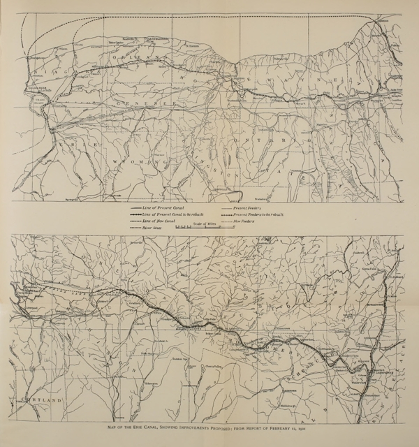
Click here for larger image size
Map of the Erie Canal, Showing Improvements Proposed; from Report of February 12, 1901The referendum was discussed, the necessary laws passed, the project submitted to the people and by a majority of nearly a quarter of a million the state voted to expend $101,000,000 for the rebuilding of its canals with a prism 12 feet deep, 75 feet wide on the bottom, and 123 feet at the surface of water, capable of floating economically a barge of 10 feet draft of 1,000 tons capacity; with locks 328 feet [Pg 207] long and 28 feet broad, capable of passing two boats, 150 feet long, 25 feet wide and 10 feet draft.
Thus, in brief, was inaugurated the largest work of its kind in our history, an artificial waterway to connect an inland lake and river, the entire expense to be borne by a single state.
For the very boldness of its conception and the magnitude of its realization it demands our respect. As the old Erie Canal heralded a new epoch in the commercial history of America, is it not possible that the new Grand Canal will be the beginning of another new epoch in this new century? A study of the map of the new canal appended will show, for one thing, that New York is going back to the old idea of canalizing rivers. Instead of building a canal beside the Mohawk, for instance, her engineers will canalize that river. This is in direct opposition to the advice sent by Benjamin Franklin from England to the Pennsylvania promoters of inland navigation at the close of the Revolutionary War;[71] it is an indication of the [Pg 208]great advances in engineering science since the days of Smeaton, and is made possible by the substitution of the screw propeller for the mule and tow-path. It is by this means that the Ohio River is to be made a great artery of commerce.[72] With steamers fitted out with low pressure engines it is estimated that freight can be transported profitably on the Ohio at an astonishingly low rate with which no land method of transportation can ever dare hope to compete. The new project of New York, therefore, brings back all the old-time dreams of early American promoters—of Washington’s for the Potomac, of Morris’s for the Mohawk, and of Robert Morris’s for the Susquehanna. If modern engineering can make the canalization of one river a success, it can of hundreds of rivers. No sooner was the Erie Canal a success in 1825 than Ohio, Pennsylvania, Maryland and other states began canal building. No sooner had New York voted in favor of her thousand-ton barge canal than Ohio again followed by passing an act looking toward the improvement of her canal from[Pg 209] the Ohio to Lake Erie. Does New York again lead the way to a new field of national development by means of canalization of rivers at the beginning of the twentieth century, as she did by means of canal-building at the beginning of the nineteenth?
I Be it enacted by the People of the State of New-York, represented in Senate and Assembly, That Stephen Van Rensselaer, De Witt Clinton, Samuel Young, Joseph Ellicott and Myron Holley, be and they are hereby appointed commissioners, to consider, devise and adopt such measures as may or shall be requisite, to facilitate and effect the communication, by means of canals and locks, between the navigable waters of Hudson’s river and lake Erie, and the said navigable waters and lake Champlain; and in case of the resignation or death of any of the said commissioners, the vacancy thereby occasioned, shall be supplied by the legislature, in the manner in which senators of the[Pg 214] United States, from this state, are directed to be chosen.
II And be it further enacted, That the said commissioners shall choose one of their number, to be president of their board, and shall appoint a fit person for their secretary, who shall be allowed and paid such salary as the said commissioners shall deem proper and reasonable: And the president of the said board of commissioners shall have power to call a meeting of the same whenever in his opinion, the public interests require it; and the said board may adjourn from time to time, to meet at any time and place they may deem most conducive to the public good: And further, the said commissioners shall have power to employ such and so many agents, engineers, surveyors, draftsmen and other persons, as in their opinion may be necessary to enable them to fulfil and discharge the duties imposed upon them by this act; and to allow and pay the said agents, engineers, surveyors, draftsmen and other persons, for their respective services, such sum or sums as may be adequate and reasonable.
III And be it further enacted, That it[Pg 215] shall be the duty of the said commissioners, as soon as may be after the passing of this act, to cause those parts of the territory of this state which may lie upon or contiguous to the probable courses and ranges of the said canals, to be explored and examined for the purpose of fixing and determining the most eligible and proper routes for the same, and to cause all necessary surveys and levels to be taken, and accurate maps, field books and drafts thereof to be made, and further to adopt and recommend proper plans for the construction and formation of the said canals, and of the locks, dams, embankments, tunnels and aqueducts which may be necessary for the completion of the same, and to cause all necessary plans, drafts and models thereof, to be executed under their direction.
IV And be it further enacted, That the said commissioners or a majority of them, shall be, and they are hereby authorized and required to make application in behalf of this state, to the government of the United States, and of such states and territories as may be benefited by the said canals or either of them, to the proprietors[Pg 216] of lands through or near which the said canals or either of them, may, or may be proposed to, pass, to all bodies politic and corporate, public or private, and all citizens or inhabitants of this or any other of the United States, for cessions, grants or donations of land or money, for the purpose of aiding in the constructing or completing of both or either of the said canals, according to the discretion of the several grantors or donors, and to take to the people of this state, such grants and conveyances as may be proper and competent to vest a good and sufficient title in the said people to the lands so to be ceded or granted as aforesaid, and for the purposes above-mentioned, it shall be the duty of the said commissioners to open books of subscription in such and so many places as they may think necessary and expedient, and under such rules and regulations as they may from time to time establish: And further, it shall be their duty to ascertain whether to any and to what amount, and upon what terms loans of money may or can be procured on the credit of this state, for the purpose aforesaid.[Pg 217]
V And be it further enacted, That it shall be the duty of the said commissioners to make, or cause to be made, with as much accuracy and minuteness as may be, calculations and estimates of the sum or sums of money which may or will be necessary for completing each of the said canals, according to the plan or plans which may be adopted and recommended by them, for the construction or formation of the same, and to cause the said calculations and estimates, and all surveys, maps, field books, plans, drafts and models authorised and directed by this act, or so many thereof as may be completed, together with a plain and comprehensive report of all their proceedings under and by virtue of this act, to be presented to the legislature of this state within twenty days after the commencement of the next regular annual session thereof.
VI And be it further enacted, That the treasurer shall, on the warrant of the comptroller, pay to the order of a majority of the said commissioners, out of any monies in the treasury, not otherwise appropriated, any sum or sums not exceeding[Pg 218] twenty thousand dollars, and for which the said commissioners shall account to the comptroller of this state.
VII And be it further enacted, That the act entitled “an act to provide for the improvement of the internal navigation of this state,” passed the 8th day of April, 1811, and the act, entitled “an act further to provide for the improvement of the internal navigation of this state,” passed June 19th 1812, be and the same are hereby repealed.
Whereas, navigable communications between Lakes Erie and Champlain, and the Atlantic ocean, by means of canals connected with the Hudson river, will promote agriculture, manufactures and commerce, mitigate the calamities of war, and enhance the blessings of peace, consolidate the union, and advance the prosperity and elevate the character of the United States:
And whereas, it is the incumbent duty of the people of this state, to avail themselves of the means which the Almighty has placed in their hands for the production of such signal, extensive and lasting benefits to the human race: Now, therefore, in full confidence that the congress of the United[Pg 220] States, and the states equally interested with this state in the commencement, prosecution and completion of those important works, will contribute their full proportion of the expense; and in order that adequate funds may be provided, and properly arranged and managed, for the prosecution and completion of all the navigable communications contemplated by this act:
I Be it enacted by the people of the state of New York, represented in Senate and Assembly, That there shall be constituted a fund to be denominated the canal fund, which shall consist of all such appropriations, grants and donations, as may be made for that purpose by the legislature of this state, by the congress of the United States, by individual states, and by corporations, companies and individuals; which fund shall be superintended and managed by a board of commissioners, to be denominated “the commissioners of the canal fund,” consisting of the lieutenant-governor, the comptroller, the attorney-general, the surveyor-general, secretary and treasurer, a majority of whom with the[Pg 221] comptroller shall be a quorum for the transaction of business; and that it shall be the duty of the said board to receive, arrange and manage to the best advantage all things belonging to the same fund, to borrow, from time to time, monies on the credit of the people of this state at a rate of interest not exceeding six per centum per annum, and not exceeding in any one year a sum which, together with the net income of the said fund, shall amount to four hundred thousand dollars; for which monies, so to be borrowed, the comptroller shall issue transferable certificates of stock, payable at such time or times as may be determined by said board; out of the said fund to pay to the canal commissioners hereafter mentioned, the monies so to be borrowed and the income of the said fund, reserving at all times sufficient to pay the interest of all monies that shall have been borrowed by the said board; to recommend from time to time to the legislature, the adoption of such measures as may be thought proper by the said board for the improvement of the said fund, and to report to the legislature, at the opening of[Pg 222] every session thereof, the state of said fund; and that the comptroller and treasurer shall open separate books, and keep the accounts of the said fund distinct from the other funds of the state.
II And be it further enacted, That the commissioners appointed by the act, entitled “an act to provide for the improvement of the internal navigation of this state” passed April 17, 1816, shall continue to possess the powers thereby conferred, and be denominated “the canal commissioners;” and they are hereby authorized and empowered, in behalf of this state, and on the credit of the fund herein pledged, to commence making the said canals, by opening communications by canals and locks between the Mohawk and Seneca rivers, and between Lake Champlain and the Hudson river; to receive from time to time from the commissioners of the canal fund, such monies as may be necessary for and applicable to the objects hereby contemplated; to cause the same to be expended in the most prudent and economical manner, in all such works as may be proper to make the said canals;[Pg 223] and on completing any part or parts of the works or canals contemplated by this act, to establish reasonable tolls and adopt all measures necessary for the collection and payment thereof to the commissioners of the canal fund; that a majority of the said commissioners shall be a board for the transaction of business, each of whom shall take an oath well and faithfully to execute the duties of his office, and shall report to the legislature at each session thereof, the state of said works and expenditures, and recommend such measures as they may think advisable for the accomplishment of the objects intended by this act; and in case of any vacancy in the office of commissioner, during the recess of the legislature, the person administering the government may appoint a person to fill such vacancy until the legislature shall act in the premises.
III And be it further enacted, That it shall and may be lawful for the said canal commissioners, and each of them, by themselves, and by every superintendent, agent, and engineer, employed by them, to enter upon, take possession of, and use all and[Pg 224] singular any lands, waters, and streams necessary for the prosecution of the improvements intended by this act, and to make all such canals, feeders, dykes, locks, dams, and other works and devices as they may think proper for making said improvements, doing nevertheless no unnecessary damage; and that in case any lands, waters or streams taken and appropriated for any of the purposes aforesaid, shall not be given or granted to the people of this state, it shall be the duty of the canal commissioners from time to time, and as often as they think reasonable and proper, to cause application to be made to the justices of the supreme court, or any two of them, for the appointment of appraisers; and the said justices shall thereupon, by writing, appoint not less than three, nor more than five discreet disinterested persons as appraisers, who shall, before they enter upon the duties of their appointment, severally take and subscribe an oath or affirmation, before some person authorised to administer oaths, faithfully and impartially to perform the trust and duties required of them by this act, which oath or affirmation shall[Pg 225] be filed with the secretary of the canal commissioners; and it shall be the duty of the said appraisers, or a majority of them, to make a just and equitable estimate and appraisal of the loss and damage, if any, over and above the benefit and advantage to the respective owners and proprietors or parties interested in the premises so required for the purposes aforesaid, by and in consequence of making and constructing any of the works aforesaid; and the said appraisers, or a majority of them, shall make regular entries of their determination and appraisal, with an apt and sufficient description of the several premises appropriated for the purposes aforesaid, in a book or books to be provided and kept by the canal commissioners, and certify and sign their names to such entries and appraisal, and in like manner certify their determination as to these several premises which will suffer no damages, or will be benefited more than injured by or in consequence of the works aforesaid; and the canal commissioners shall pay the damages so to be assessed and appraised, and the fee simple of the premises so appropri[Pg 226]ated shall be vested in the people of this state.
IV And be it further enacted, That whenever, in the opinion of the canal commissioners, it shall be for the interest of this state, for the prosecution of the works contemplated by this act, that all the interest and title (if any) in law and equity of the western inland lock navigation company should be vested in the people of this state, it shall be lawful for the said canal commissioners to pass a resolution to that effect, and that it shall then be lawful for the president of the canal commissioners to cause a copy of such resolution, with a notice signed by himself and the secretary of the said commissioners, to be delivered to the president or other known officer of the said company, notifying the president and directors of the said company that an application will be made to the justices of the supreme court, at a term thereof to be held not less than thirty days from the time of giving such notice, for the appointment of appraisers to estimate the damages to be sustained by the same company, by investing in the people of this state all the[Pg 227] lands, waters, canals, locks, feeders, and appurtenances thereto acquired, used and claimed by the said company, under its act of incorporation, and the several acts amending the same; and it shall be the duty of the justices aforesaid, at the term mentioned in the said notice, and on proof of the service thereof, to appoint, by writing under the seal of the said court, and the hands of at least three of the said justices, not less than three, nor more than five disinterested persons, being citizens of the United States, to estimate and appraise the damages aforesaid; and it shall be the duty of the said appraisers, or a majority of them, to estimate and appraise the damages aforesaid, and severally to certify the same under oath, before an officer authorised to take the acknowledgement of deeds, to be a just, equitable, and impartial appraisal to the best of their judgment and belief, and shall thereupon deliver the same to one of the canal commissioners, who shall report the same to the same court; and if the said court shall be of opinion that the said damages have been fairly and equitably assessed, the said jus[Pg 228]tices, or any three of them, may certify the same on the same report, and the amount of the said damages and the expenses of the said appraisal shall be audited by the comptroller, and paid on his warrant by the treasurer out of the canal fund; and the people of this state shall thereupon be invested with, and the said canal commissioners may cause to be used, all the lands, waters, streams, canals, locks, feeders, and appurtenances aforesaid, for the purposes intended by this act.
V And be it further enacted, That for the purposes contemplated by this act, and for the payment of the interest and final redemption of the principal of the sums to be borrowed by virtue hereof, there shall be, and hereby are appropriated and pledged, a duty or tax of twelve and a half cents per bushel upon all salt to be manufactured in the western district of this state; a tax of one dollar upon each steamboat passenger, for each and every trip or voyage such passenger may be conveyed upon the Hudson river on board of any steamboat over one hundred miles, and half that sum for any distance less than[Pg 229] one hundred miles and over thirty miles; the proceeds of all lotteries which shall be drawn in this state, after the sums now granted upon them shall be paid; all the net proceeds of this state from the western inland lock navigation company; all the net proceeds of the said canals and each part thereof when made; all grants and donations made or to be made for the purpose of making the said canals; all the duties upon sales at auction, after deducting thereout twenty-three thousand five hundred dollars, annually appropriated to the hospital, the economical school, and the orphan asylum society, and ten thousand dollars hereby appropriated annually for the support of foreign poor in the city of New York.
VI And be it further enacted, That from and after the first Tuesday of August next, there shall be paid and collected in the manner now directed by law, upon all salt to be manufactured in the county of Onondaga, a duty of twelve and a half cents per bushel, instead of the present duties, and the like tax or duty of twelve and a half cents per bushel upon all other[Pg 230] salt to be manufactured in the western district of this state, which shall be collected by the superintendent of the salt springs, until otherwise directed by the legislature; and for that purpose, he shall have a responsible deputy residing at each place where salt is or may be manufactured, with the like powers and subject to the like duties as his present deputies; and that all the provisions, forfeitures, penalties, and restrictions contained in the laws relative to the duties upon Onondaga salt, so far as the same may be applicable, shall be in force for the purposes of enforcing the payment and collection of the tax or duties upon salt hereby levied and imposed. And further, that the said superintendent, instead of a yearly report to the legislature, shall make a quarter yearly report to the commissioners of the canal fund, and pay into the treasury of this state, on the first Tuesday of February, May, August and November, in each year, all the monies collected by him during the quarter preceding each of those days, deducting in addition to what by law is now allowed to be deducted, five per cent of the duties collected[Pg 231] at all other salt works, not situated in the county of Onondaga, and two per cent of the duties upon Onondaga salt, as a compensation for collecting and paying over the same.
VII And be it further enacted, That it shall be the duty of the said canal commissioners, to raise the sum of two hundred and fifty thousand dollars, to be appropriated towards the making and completing of the said canals from the Mohawk river to the Seneca river, and from Lake Champlain to Hudson’s river, by causing to be assessed and levied in such manner as the said commissioners may determine and direct, the said sum of two hundred and fifty thousand dollars, upon the lands and real estate, lying along the route of the said canals, and within twenty-five miles of the same, on each side thereof: which sum so to be assessed and levied, shall be assessed on the said lands and real estate adjacent to the said several canals, in such proportion for each, as the said commissioners shall determine. And the said commissioners shall have power to make such rules and regulations, and[Pg 232] adopt such measures for the assessing, levying, and collecting the sum or sums of money, either by sale of the said lands or otherwise, as they shall deem meet, and the said assessment shall be made on said lands, according to the benefit which they shall be considered by the said commissioners, as deriving from the making of the said canals respectively: Provided, That such rules, regulations and measures, shall before they are carried into effect, be sanctioned and approved by the chancellor and judges of the supreme court, or a majority of them: And provided further, That if any company or individual subject for such tax, shall subscribe any money or other property towards the completion of the said canals, the amount of such donation or voluntary subscription, shall, if the same is less than the amount of the tax, be deducted therefrom, and if more, he or they shall be entirely discharged from the said tax.
And be it further enacted, That from and after the first day of May next, the aforesaid tax upon steamboat passengers, shall be demanded, taken and received, by each[Pg 233] captain or master of every steamboat navigating the Hudson river;[68] and that during each month thereafter, in which such boat shall be employed for the conveyance of passengers, it shall be the duty of such captain or master, to cause to be delivered to the comptroller of this state, a return or account, sworn to, before some officer authorized to administer oaths, stating the name of the boat, the number of trips made by such boat during such month, and the whole number of passengers conveyed on board such boat, at each of the said trips, over one hundred miles, and the number conveyed less than one hundred miles, and over thirty miles, and pay into the treasury of this state the amount of such tax collected during the time mentioned in the said return, deducting three per cent thereof, as a compensation for making such return, and collecting and paying over the said tax: And further, That in case of any neglect or refusal in making such return, or collecting and paying over the tax as directed in and by this section, the captain or master so neglecting, shall forfeit and[Pg 234] pay the sum of five hundred dollars, besides the amount of the tax so directed to be collected and paid over, to be recovered in an action of debt in the name of the people of this state, and for the use of the aforesaid fund.
[1] It is said that the strange name of the city on the Ohio River, Wheeling, is derived from a word Wheelen, also meaning “a head on a pole” in another dialect.
[2] Historic Highways of America, vol. viii, p. 184.
[3] Historic Highways of America, vol. xii, p. 97.
[4] Mr. Watson’s Journal is included in his History of the ... Western Canals in the State of New York (Albany, 1820).
[5] Id., pp. 20-21.
[6] Laws of the State of New-York (New York, 1792), vol. ii, ch. xl.
[7] Laws of the State of New-York (New York, 1793), pp. 13-17.
[8] History of the ... Western Canals in the State of New York, p. 85. It must be remembered that Watson was writing from memory in 1820; in general his authority may be considered excellent. We have indicated inconsistencies by interrogation points.
[9] The Report of a Committee appointed to explore the western waters ... for the purpose of prosecuting the Inland Lock Navigation (Albany, 1792).
[10] Our source of information on these early Mohawk improvements is Report of the Directors of the Western and Northern Inland Lock Navigation Companies in the State of New York to the Legislature, 1796.
[11] Id., p. 9, note.
[12] Id., p. 16.
[13] MS. Letters on Canals by Philip Schuyler and Simeon De Witt, 1793-94, Lenox Library.
[14] Historic Highways of America, vol. xiii, ch. 2.
[15] History of the ... Western Canals in the State of New York, pp. 92-93.
[16] Id., pp. 93-94.
[17] Sparks, Life of Gouverneur Morris (Boston, 1832), vol. i, pp. 497-498.
[18] Id., p. 498.
[19] Id., pp. 498-499.
[20] Laws of the State of New-York relative to the Canals (Albany, 1825), pp. 38-39.
[21] Id., p. 42.
[22] History of the ... Western Canals in the State of New York, p. 67.
[23] M. S. Hawley, Origin of the Erie Canal, p. 20. Clinton gave Hawley great credit for his part in promoting the Erie Canal idea—p. 21.
“He [Hawley] was at Colonel Mynderse’s office in 1805, attending to the shipment of some flour to market, by the circuitous and uncertain route then in use. Himself and Colonel Mynderse conversing upon the necessities for better facilities, Mr. Hawley said: ‘Why not have a canal extend direct into our country, and benefit all—merchants, millers, and farmers.’” Hawley then pointed out on a map that Lake Erie could be made a head of water. “A change having occurred in Mr. Hawley’s business, he spent the winter of 1806 and 1807 in Pittsburg, Pennsylvania, and not knowing when he would return to Ontario county, he sketched the first essay, and to preserve it from oblivion, as he said, he procured it to be published there, on the fourteenth day of January, 1807, in the newspaper called the Commonwealth.”—Origin of the Erie Canal, pp. 23-24.
[24] Id., pp. 69-70.
[25] Public Documents relating to the New-York Canals (New York, 1821), pp. xlix-l.
[26] Laws of the State of New-York relative to the Canals, p. 47.
[27] Id., p. 67.
[28] Laws of New York, 1814.
[29] Public Documents relating to Canals, pp. li-lii.
[30] “Memorial of the citizens of New-York, in favor of a Canal-Navigation between the great western Lakes and the tide-waters of the Hudson, presented to the Assembly February 21, 1816, and ordered to be printed.”—From Laws of the State of New-York relative to the Canals, p. 122.
[31] The Middlesex Canal was twenty-seven miles in length and joined Boston Harbor at Charlestown with the Merrimac River. It was incorporated in 1789, begun in 1790 and opened in 1804. Its cost to 1815 was over half a million. It was thirty feet wide at the top, twenty feet wide at the base and three feet deep. The rise from Boston to summit level was one hundred and four feet and the descent to the Merrimac, thirty-two feet. It included twenty locks, seventy-five feet long, ten feet wide at the base and eleven feet wide at the top, capable of locking a boat of fourteen tons. The income from tolls beginning with $7,000 in 1808 had increased to $25,000 in 1815; land beside the canal had increased in value one-third, and New Hampshire timber at once became worth from one to three dollars per ton standing, which before was worth nothing. The success of this canal must be considered as having something to do in the promotion of the Erie Canal.
[32] See appendix A.
[33] The material for the earlier portions of this chapter is largely from the annual reports of the canal commissioners from 1816 to 1825 contained in Public Documents relating to the New-York Canals (New York, 1821), pp. 103-185, 311-333, 344-365, 429-450, and Laws of the State of New-York relative to the Canals, vol. ii, pp. 60-78, 95-118, 150-180.
[34] Appendix B.
[35] M. S. Hawley, Origin of the Erie Canal, pp. 41-42; Hawley’s source of information was Judge Platt, one of the Council.
[36] Id., pp. 42-43. Cf. p. 143, referring to the change of route at Rome and consequent dissatisfaction.
[37] Sparks’s Writings of Washington, vol. ii, pp. 341, 342.
[38]Public Documents (1821), p. 403.
[39] For elaborate account of this celebration see W. L. Stone’s Narrative of the Festivities observed in honor of the Completion of the Grand Erie Canal (New York, 1825), and local histories.
[40] W. L. Stone, Narrative of the Festivities observed in honor of the Completion of the Grand Erie Canal, p. 321. This monograph has been used extensively in describing the celebration festivities.
[41] Id., pp. 320-321.
[42] The Influence of the Erie Canal upon the population along its course, bearing the imprint of the University of Wisconsin, 1901.
[43] Hammond, Political History of New York, vol. ii, pp. 369, 378. McMaster, History of U.S., vol. v, p. 109.
[44] Freeman’s Journal, Cooperstown, Otsego County, New York, September 20, 1830, p. 2, c. 2.
[45] Freeman’s Journal, August 16, 1830, p. 2, c. 6. Seward, Autobiography of W. H. Seward from 1801 to 1834, p. 78.
[46] Hammond, Political History of New York, vol. ii, p. 396.
[47] Hammond, Political History of New York, vol. ii, p. 397.
[48] Jenkins, Political History of New York, p. 363.
[49] The following counties sent petitions to the Legislature: Tioga, Steuben, Yates, Ontario, Wayne, Cayuga, Seneca, Tompkins, Chenango, Broome, Madison, Oneida, Onondaga, Herkimer, Lewis, Jefferson, and Chautauqua. (Laws of the State of New York, relative to Erie and Champlain canals, 1825, i, pp. 279-281.)
[50] This fact is supported by Mr. Jenkins in his Political History of New York. He says: “Mr. Granger received a very heavy vote in the sixth and eighth districts; and it is probable his friends had confidently expected that the Chenango canal interests would secure his election. “The sixth Senatorial district to which the feeling in favor of the Chenango canal was mainly confined, gave Mr. Granger more than 2,000 majority. Notwithstanding it had given 6,000 the other way in 1829.” The majority for Mr. Granger in the eighth district was nearly 13,000.
[51] Jenkins, Political History of New York, p. 372.
[52] W. N. Holland, Life and Political Opinions of Van Buren: Attitude toward internal improvements, pp. 269-274.
[53] This is probably a reference to such loans as were authorized to be made to the New York and Erie Railroad. The New York and Erie Railroad was incorporated in 1832 and in 1836 the legislature authorized a loan of the credit of the state to the company for the amount of $3,000,000 subject to certain restrictions, some of which were that the route of the road should be through the Southern tier of counties in the state, one-fourth was to be completed in ten years, one-half in fifteen years, and the whole of it in twenty years. The road was to begin at Tappan, Rockland County, on the Hudson, pass through Goshen, Oswego, Elmira, and other towns and end at Dunkirk on Lake Erie.—Tanner, Canals and Railroads of the United States, 1840, p. 74.
[54] Lossing, Empire State, p. 493.
[55] Documentary Sketch of New York State Canals by S. H. Sweet (Albany, 1863), p. 104.
[56] Laws of the State of New-York relative to the Canals (Albany, 1825), vol. ii, pp. 13-14.
[57] Sweet’s Documentary History, pp. 198-199.
[58] Id., p. 201.
[59] Id., p. 207-208.
[60] Id., p. 204.
[61] Id., p. 205.
[62] Id., p. 210.
[63] Id., p. 213.
[64] Id., p. 326.
[65] House Reports, No. 423, 54th Cong., 1st sess., 1896, also, No. 1023, 55th Cong., 1st sess.
[66] Laws of 1898, ch. 44.
[67] Senate Documents, no. 23.
[68] Laws of 1899, ch. 494.
[69] Report of the New York Commerce Commission, Albany, 1900.
[70] Laws of 1900, ch. 411.
[71] Historic Highways of America, vol. xiii, p. 25.
[72] Historic Highways of America, vol. ix, pp. 213-215.
[73] “An act to provide for the improvement of the internal navigation of this state,” passed April 17, 1816. From Laws of the State of New-York relative to the Canals, vol. ii, pp. 184-186.
[74] “An Act respecting Navigable Communications between the great western and northern lakes and the Atlantic ocean,” passed April 15, 1817. From Laws of the State of New-York relative to the Canals, vol. ii, pp. 358-364.
[68] Suspended. See act March 30, 1820.
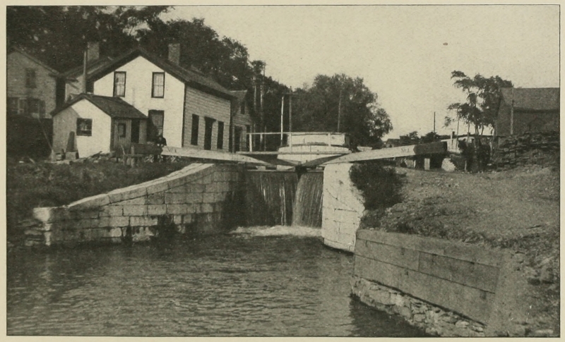
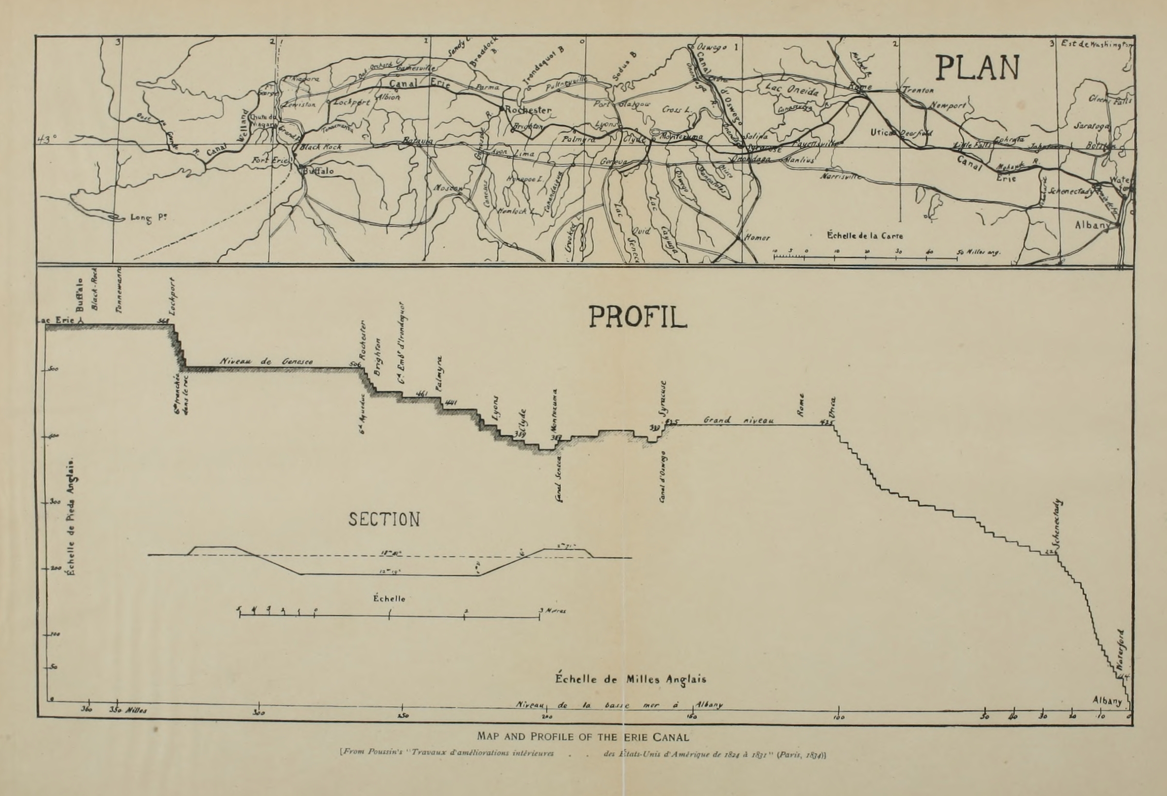
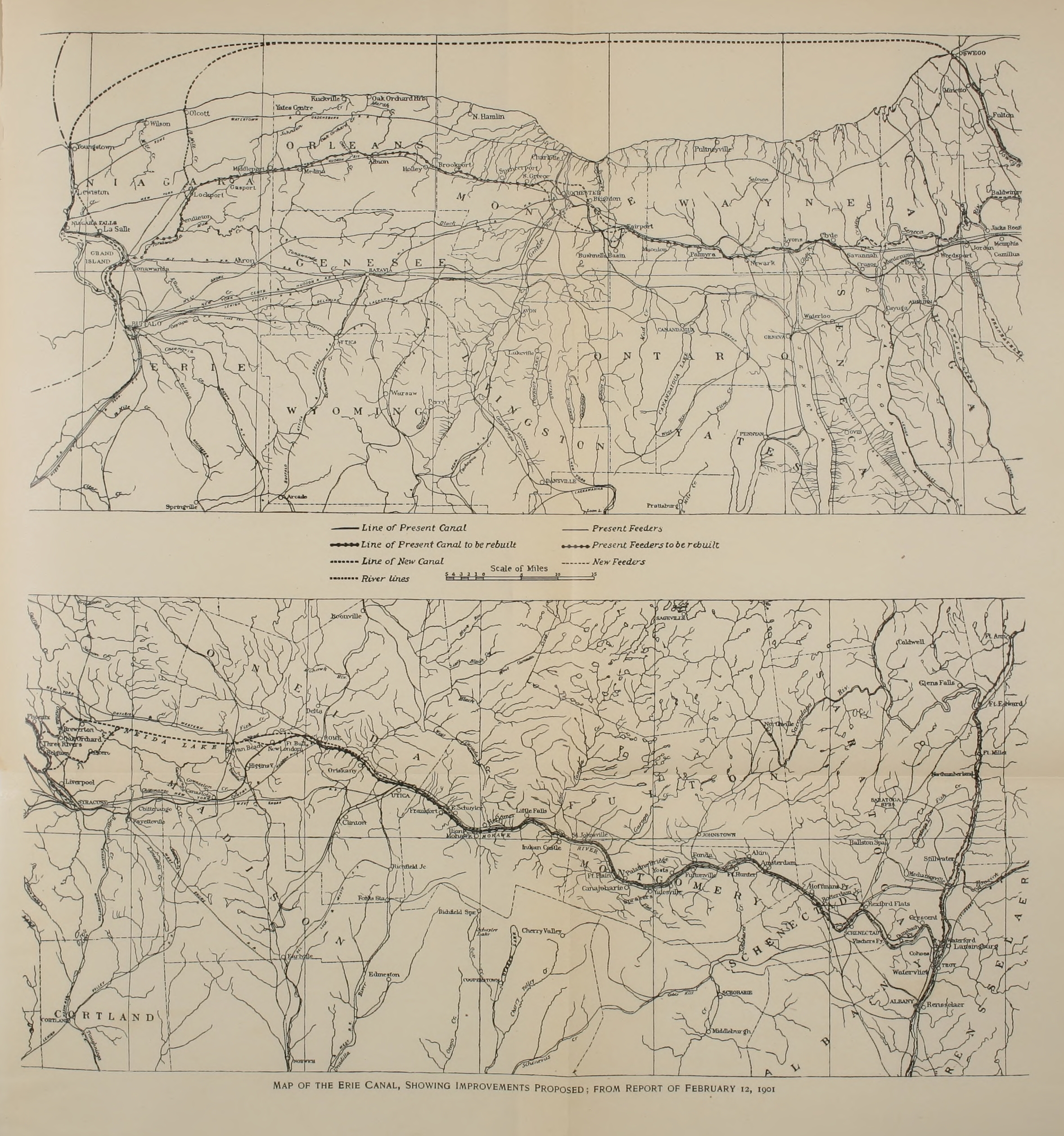