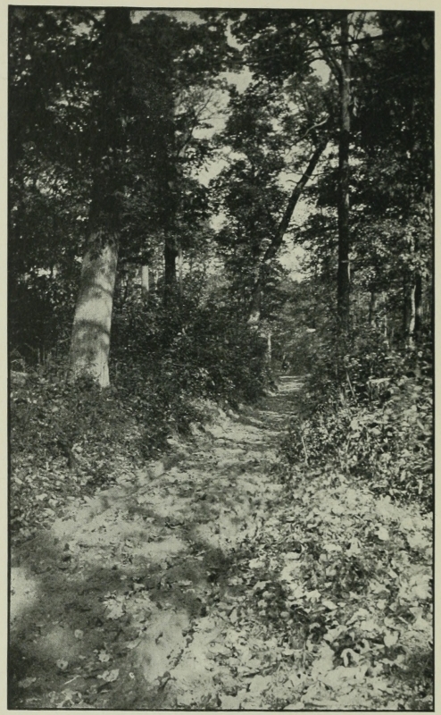
 Modern Road on Laurel Hill
[Follows track of Washington’s Road; near by, on the right, Washington found Jumonville’s “embassy” hidden in the Ravine]
Transcriber’s Note: Obvious errors in spelling and punctuation have been corrected. Footnotes have been moved to the end of the text body. Also images have been moved from the middle of a paragraph to the closest paragraph break, causing missing page numbers for those image pages and blank pages in this ebook.
Modern Road on Laurel Hill
[Follows track of Washington’s Road; near by, on the right, Washington found Jumonville’s “embassy” hidden in the Ravine]
THE ARTHUR H. CLARK COMPANY
CLEVELAND, OHIO
1903
COPYRIGHT, 1903
BY
The Arthur H. Clark Company
ALL RIGHTS RESERVED
| PAGE | ||
| Preface | 11 | |
| I. | Washington and the West | 15 |
| II. | The Hunting-Ground of the Iroquois | 40 |
| III. | The Arms of the King of France | 63 |
| IV. | The Virginian Governor’s Envoy | 85 |
| V. | The Virginia Regiment | 120 |
| VI. | The Chain of Federal Union | 189 |
| I. | Modern Road on Laurel Hill, (Follows Track of Washington’s Road) | Frontispiece |
| II. | Washington’s Road | 93 |
| III. | A Map of the Country between Wills Creek and Lake Erie (showing designs of the French for erecting forts southward of the lakes; from the original in the British Museum) | 109 |
| IV. | Ledge from which Washington Opened Fire upon Jumonville’s Party | 145 |
| V. | Site of Fort Necessity | 157 |
| VI. | Two Plans of Fort Necessity (A, Plan of Lewis’s survey; B, Sparks’s plan) | 175 |
| VII. | Diagrams of Fort Necessity | 179 |
The following pages are largely devoted to Washington and his times as seen from the standpoint of the road he opened across the Alleghanies in 1754. Portions of this volume have appeared in the Interior, the Ohio State Archæological and Historical Quarterly, and in a monograph, Colonel Washington, issued by Western Reserve University. The author’s debt to Mr. Robert McCracken, Mr. Louis Fazenbaker, and Mr. James Hadden, all of Pennsylvania, is gratefully acknowledged.
A. B. H.
Marietta, Ohio, November 17, 1902.
If you journey today from Cumberland, Maryland, on the Potomac, across the Alleghanies to Pittsburg on the Ohio, you will follow the most historic highway of America, through scenes as memorable as any on our continent.
You may make this journey on any of the three thoroughfares: by the Cumberland Road, with all its memorials of the gay coaching days “when life was interwoven with white and purple,” by Braddock’s Road, which was used until the Cumberland Road was opened in 1818, or by Washington’s Road, built over the famous Indian trail known during the first half of the eighteenth century as Nemacolin’s Path. In certain parts all three courses are identical, the two latter being generally so; and between these three “streams of [Pg 16]human history” you may read the record of the two old centuries now passed away.
Come and walk for a distance on the old Indian trail. We leave the turnpike, where it swings around the mountain, and mount the ascending ridge. The course is hard, but the path is plain before us. Small trees are growing in the center of it, but no large ones. The track, worn a foot into the ground by the hoofs of Indian ponies laden with peltry, remains, still, an open aisle along the mountain crest. Now, we are looking down—from the Indian’s point of vantage. Perhaps the red man rarely looked up, save to the sun and stars or the storm cloud, for he lived on the heights and his paths were not only highways, they were the highestways. As you move on, if your mind is keen toward the long ago, the cleared hillsides become wooded again, you see the darkling valley and hear its rivulet; far beyond, the next mountain range appears as it did to other eyes in other days—and soon you are looking through the eyes of the heroes of these valleys, Washington, or his comrades Stephen or Lewis, Gladwin, hero of [Pg 17]Detroit, or Gates, conqueror at Saratoga, or Mercer, who was to give his life to his country at Princeton. You are moving, now, with the thin line of scarlet uniformed Virginians; you are standing in the hastily constructed earthen fort; if it rains, you look up to the dim outlines of the wooded hills as the tireless young Washington did when his ignorant interpreter betrayed him to the intriguing French commander; you march with Braddock’s thin red line to that charnel ground beyond the bloody ford—you stand at Braddock’s grave while the army wagons hurry over it to obliterate its sight from savage eyes.
Explain it as you will, our study of these historic routes and the memorials which are left of them becomes, soon, a study of its hero, that young Virginian lieutenant-colonel. Even the battles fought here seem to have been of little real consequence, for New France fell, never to rise, with the capture of Quebec. But it is not of little consequence that here a brave training school was to be had for the future heroes of the Revolution. For in what did Washington, for instance, need a train[Pg 18]ing more than in the art of maneuvering a handful of ill-equipped, discouraged men out of the hands of a superior army? What lesson did that youth need more than the lesson that Right becomes Might in God’s own good time? And here in these Alleghany glades we catch the most precious pictures of the lithe, keen-eyed, sober lad, who, taking his lessons of truth and uprightness from his widowed mother’s knee, his strength hardened by the power of the mountain rivers, his heart, now thrilled by the songs of the mountain birds, now tempered by a St. Pierre’s hauteur, a Braddock’s rebuke, or the testy suspicions of a provincial governor, became the hero of Valley Forge and Yorktown, the immeasurable superior of St. Pierre, Dinwiddie, Forbes, Kaunitz, or Newcastle.
For consider the record of the Washington of 1775, beneath the Cambridge elm. Twenty-one years before, he had capitulated, with the first army he ever commanded, after the first day’s battle he ever fought. He marched with Braddock’s ill-starred army, in which he had no official position whatever, until defeat and[Pg 19] rout threw on his shoulders a large share of the responsibility of saving the army from complete annihilation. For the past sixteen years he had led a quiet life on his farms. Why, now, in 1775, should he have had the unstinted confidence of all men in the hour of his country’s great crisis? Why should his march from Mount Vernon to Cambridge have been a triumphal march? Professor McMaster asserts that the General and the President are known to us, “but George Washington is an unknown man.” How untrue this was, at least, in 1775! How the nation believed it knew the man! How much reputation he had gained, while those by his side lost all of theirs! What a hero—of many defeats! What a man to fight England to a standstill after many a wary, difficult retreat and dearly fought battle-field! Aye—but he had been to school with Gates and Mercer and Gladwin, Lewis and Boone, and Stephen, on Braddock’s twelve-foot swath of a road in the Alleghanies!
It was more than a century ago that George Washington died at Mount Vernon. “I die hard,” he said, “but I am not afraid[Pg 20] to go.” Motley’s true words of the death of William the Silent may be aptly quoted of Washington: “As long as he lived, he was the guiding-star of a whole brave nation, and when he died, the little children wept on the streets.”
If, as Professor McMaster has boldly said, “George Washington is an unknown man,” it is not, as might be inferred, because the man himself was an enigma to his own generation, or that which immediately succeeded him; it is because the General and the President have been remembered by us, and the man, forgotten. If this is true, it is because our school histories, the principal source from which the mass of the people receive their information, are portraying only one of the fractions which made the great man what he was. It is said: “He was as fortunate as great and good.” Do our school histories inform the youth of the land why he was “fortunate” to the exclusion of why he was “great and good?” If so, George Washington is, or soon will be, “an unknown man.”
One hundred years ago he was not unknown as a man. “Washington is dead,[Pg 21]” exclaimed Napoleon in the orders of the day, when he learned the sad news; “this great man fought against tyranny; he consolidated the liberty of his country. His memory will ever be dear to the French people, as to all freemen in both hemispheres.” Said Charles James Fox, “A character of virtues, so happily tempered by one another and so wholly unalloyed by any vices, is hardly to be found on the pages of history.” And these men spoke of whom—the General, the President, or the man? If, as legend states, “the Arab of the desert talks of Washington in his tent, and his name is familiar to the wandering Scythian,” what of other “fortunate” heroes, of William of Orange, Gustavus Adolphus, and Cromwell, who, like Washington, consolidated the liberties of their countries, and with an éclat far more likely to win the admiration of an oriental?
Half a century ago, the attention of multitudes was directed to the man Washington in the superb oratory of Edward Everett. Quoting that memorable extract from the letter of the youthful surveyor, who boasted of earning an honest dubloon[Pg 22] a day, the speaker set before his audiences “not an ideal hero, wrapped in cloudy generalities and a mist of vague panegyric, but the real, identical man.” And, again, he quoted Washington’s letter written to Governor Dinwiddie after Braddock’s defeat, that his hearers might “see it all—see the whole man.” Was Edward Everett mistaken, are these letters not extant today, or are they unread? Surely, the last supposition must be the true one, if the man Washington is being forgotten.
And look back to the school histories of Edward Everett’s time. The “reader” and “history” were one text-book in that day, and one of the best known, “Porter’s Rhetorical Reader,” lies before me, prefaced May, 1831. From it notice two quotations which must have influenced youthful ideas of Washington. One is the last verse of Pierpont’s “Washington:”
“God of our sires and sons,
Let other Washingtons
Our country bless,
And, like the brave and wise
Of by-gone centuries,
Show that true greatness lies
In righteousness.”
The other, from the address “America,” of the Irish orator Phillips; having exalted Washington as general, statesman, and conqueror, he continues:
“If he had paused there, history might have doubted what station to assign him; whether at the head of her citizens, or her soldiers, her heroes, or her patriots. But the last glorious act crowns his career, and banishes the hesitation. Who, like Washington, after having emancipated a hemisphere, resigned its crown, and preferred the retirement of domestic life to the adoration of a land he might be almost said to have created? Happy, proud America! The lightnings of heaven yielded to your philosophy! The temptations of earth could not seduce your patriotism!”
A candid review of the more popular school histories will bring out the fact that the man Washington is almost forgotten, in so far as the general and the statesman do not portray him. In one, “Young Folks’ History of the United States” (to name the production of an author whom criticism cannot injure), there seems to be but one line, of five words, which describes[Pg 24] the character of Washington. Could we not forego, for once, what the Indian chieftain said of the “charmed life” Washington bore at Braddock’s defeat, to make room for one little reason why Washington was “completer in nature” and of “a nobler human type” than any and all of the heroes of romance?
Mr. Otis Kendall Stuart has written a most interesting account of “The Popular Opinion of Washington” as ascertained by inquiry among persons of all ages, occupations, and conditions. He found that Washington was held to be a “broad,” “brave,” “thinking,” “practical,” man; an aristocrat, so far as the dignity of his position demanded, but willing to “work with his hands,” and with a credit that was “A1!” And “when he did a thing, he did it;” and, if to the question, “Was he a great general and statesman?” there was some hesitation, to the question, “Was he a great man?” the answer was an unhesitating “Yes.”
One may hold that such opinions as these have been gained from our school histories, but I think they are not so much from the[Pg 25] histories, as from the popular legends of Washington, which, true and false, will never be forgotten by the common people until they cease to represent the man—not the patient, brave, and wary general, or the calm, far-seeing statesman, but that “simple, stainless, and robust character,” as President Eliot has so aptly described it, “which served with dazzling success the precious cause of human progress through liberty, and so stands, like the sunlit peak of Matterhorn, unmatched in all the world.”
The real essence of that “simple, stainless, and robust character” is nowhere so clearly seen as on these Alleghany trails. In the West with Washington we may still “see it all—see the whole man.”
To us of the Central West, the memory of Washington and his dearest ambitions must be precious beyond that of any other American, whether statesman, general, or seer. Under strange providential guidance the mind and heart of that first American was turned toward the territories lying between the Alleghanies and the Mississippi, and it is to be doubted if any other[Pg 26] portion of his country received so much of his attention and study as this. Washington was the original expansionist—not for expansion’s sake, truly, but for country’s sake and duty’s. If Washington was the father of his country, he was in a stronger and more genuine sense the father of the West. It was begotten of him. Others might have led the Revolutionary armies through the valleys as deep and dark as those through which Washington passed, and have eventually fought England to a similar standstill as did Washington; at least Gates, Greene, and Putnam would never have surrendered up the cause of the colonies. But of the West, who knew it as Washington did? Who saw its possibilities, realized the advantages which would accrue to the colonies from its possession, understood the part it might play in the commercial development of the seaboard states? Who else had traversed Nemacolin’s little path before 1753?
If ever a finger was lifted by order of Providence it was the finger which fired the first gun of the French and Indian war in that Alleghany vale. And yet today[Pg 27] what would the Washington of 1754 be called—fighting redskins and foreigners with splendid relish in a far distant portion of the country to gain possession of an almost pathless wilderness?
Washington had, first, an extraordinary knowledge of the West which he championed. Into Lord Fairfax’s wild acres he went in his teens to earn an honest dubloon a day. Each step of the young Washington in those early years was fraught with the weight of destiny itself, and never has human life showed more plainly the very hand of God directing, preparing, guiding. These years were of incalculable value to the young surveyor, bringing to his cheeks the brown of the forest leaves, to his limbs the strength of the mountain rivers, and to his heart withal the sweetness of the songs of mountain birds—for all the University of Nature which he attended in the Alleghany mountains saw to it that her pupil was built up in a most holy strength, as he had in him the most holy faith—strength of limb, of mind, as well as soul.
Then the young man stepped upon the stage of history—not indirectly, or[Pg 28] obscurely, or undecidedly, but plain to the world and strong in his conviction of the right of his cause and its ultimate triumph. His mission to La Bœuf for Governor Dinwiddie marks the young Washington conspicuously as a man fully alive to the questions of the hour and their hidden meanings. In an unostentatious way he allowed the commander of Fort Venango to imbibe too freely and rail with many an oath at English presumption in hoping to oust France from the Ohio valley. Oh that we might know in detail the young man’s experience and feelings during that one night on the Allegheny! What an example to young men is this first public performance of Washington, to do as much more than their mere duty as lies in their power! Washington did far more than was expected of him, for, besides getting a clear idea of the genuineness of French hostility, did he not report the strategic value of the point of land at the junction of the Allegheny and Monongahela, the future sites of Fort Duquesne and Pitt, and the present Pittsburg? And that point of land has been, since Washington’s attention was turned to it, the[Pg 29] strategic military position of the Central West.
As in the first, so in the second act of the drama of 1750-1760, Washington was the chief figure. He signed the first treaty ever drawn up in the Central West, with old Van Braam and Villiers, in a misty rain at Fort Necessity. When, in quick succession, the French fortified the spot Washington’s genius had selected for a British fort, and the brave bulldog Braddock came to his grave in the Monongahela forests, Washington was perhaps the most conspicuous personage at the bloody ford and battle-field.
When, then, in 1759, the young colonel took his bride, Martha Custis, to Mount Vernon, he was well acquainted with the West, though it might seem that thereafter its destiny and his were to be far apart. But not so. The days that were passed in his early struggles for fame and fortune were not forgotten. In the quiet of his farm life, and in the drowsy halls of legislation the man could still hear the rippling of the Alleghany streams and the soughing of those great forests, and many of his day[Pg 30]dreams found their setting in the rough, free land on whose Indian trails and in whose meadow lands he had, as it were, found a new world. Washington’s seven or eight thousand acres near the Potomac were not his only landed possessions. He counted his estates in far western Pennsylvania, along the Ohio and the Great Kanawha. Something of his interest in and solicitation for the future of the West must be attributed to his interest in his own possessions. But his efforts for the West benefited every acre of land and every insignificant squatter, and no one can say with a shadow of reason that Washington’s hope for the West was a selfish hope. Yet his personal interest must not be forgotten by a fair narrator. Together with his personal interest must be mentioned the state pride which Washington had—and which every healthy, hopeful, patriotic man should have. Washington was a Virginian of Virginians and in view of the vast interests which his native state had in the West (granted by ancient charter), his state pride and ambition must have had large, appreciable influence in his contemplation of[Pg 31] western affairs. At times his prejudice made him a much criticized man. Prior to the Revolution it may be said that Washington’s interest in the West was largely a personal one. He visited it at various times in his own and in the interest of others. After the Revolution, his interest may be said to have broadened—proportionately with the broadening importance of the Central West to the new Republic whose best interests were ever nearest his patriotic heart. Early in the eighties, Washington’s correspondence shows that his attention was devoted as never before to the commercial aspect of the Central West. As we read those letters, how strangely do the problems of transportation, for instance, seem to us of this day! How the sight of a single fast freight speeding from Chicago to Pittsburg would have made a laughing-stock of the fondest theories of the great and wise men who were at the nation’s helm in those days! It is well known how the great transportation companies struggle to get and hold certain strategic acres of land only wide enough, it may be, for a[Pg 32] single railway track. Who can believe that any portion of this Central West, covered with swamps and primeval forests, could have been so greatly prized a century and a quarter ago? Yet this was true. It was not the river front at Cincinnati, nor the lake shore at Cleveland or Chicago. These spots then could have been bought for the shortest songs—and what was in that day considered of priceless value could today be bought for $30 an acre. These were the portages between the Cuyahoga and the Muskingum, the Scioto and the Sandusky, the Maumee and the Wabash, etc. So all-important were these strips of land in the eyes of Washington, that by the famous Ordinance of 1787 they were voted by Congress “common highways and forever free.” But this was one of Washington’s most determined ambitions, that the headwaters of the Virginia rivers and the headwaters of the Ohio rivers, both north and south, should be surveyed and made ready for the century when the West should pour its riches toward the Atlantic seaboard. “The navigation of the Ohio,” he wrote in 1784 to General Harrison, “being well[Pg 33] known, they will have less to do in examination of it; but, nevertheless, let the courses and distances be taken to the mouth of the Muskingum and up that river to the carrying place of the Cuyahoga; down the Cuyahoga to Lake Erie, and thence to Detroit. Let them do the same with Big Beaver Creek and with the Scioto. In a word, let the waters east and west of the Ohio which invite our notice by their proximity, and by the ease with which land transportation may be had between them and the lakes on the one side, and the rivers Potomac and James on the other, be explored, accurately delineated, and a correct and corrected map of the whole be presented to the public.... The object in my estimation is of vast commercial and political importance.” These words were written little over a century ago, but were they the plans for the canals from the Nile to the site of the pyramids they could hardly seem more antiquated. Nevertheless they cannot but seem precious to us of the Central West, for they portray the anxious, serious heart of the man, and honest, high ambitions for things which[Pg 34] seemed to many about him to be the idlest dreaming.
Had Washington not held far different views from many of his contemporaries, it is a moral certainty that the Central West would, at the close of the Revolutionary War, have been divided up among European powers, who for so long had been sending emissaries to Kentucky and the Mississippi valley to alienate the border settlements from the contemplated union with the colonies. England was ready at any moment to urge Joseph Brant into Pontiac’s old rôle of attempting to arouse the old northwest, and she defiantly kept her flag floating over Sandusky and Detroit and Fort Miami for twenty years after Cornwallis’s bands played The World’s Turned Upside Down at Yorktown. The world looked for a partition of our West among the powers in 1780 as the partition of the great hulk, China, is expected by many today. And indeed we escaped such monstrous catastrophe by a narrower margin than is commonly known. Spanish agents among high Kentuckians were looked upon with favor, and their plan of joining Ken[Pg 35]tucky to Spain (who then held all the trans-Mississippi realm) was not without advantages which the struggling, bankrupt, jealous colonies, “one nation today, thirteen tomorrow,” could not possibly offer. The Cumberland Road, of which Washington was the father, bound the East and West indissolubly together, and “more than any material structure in the land, served to harmonize and strengthen, if not to save, the Union.”
With this glimpse of this man’s ambitions for the commercial advancement of the Central West, let us not omit his subsequent interest in the military operations for its subjugation, an item which even the far-seeing Washington had not fully anticipated. At the time of Crawford’s campaign, Washington was fully in favor of the advance toward Sandusky, and it was through his influence or suggestion that the command was given to his old friend of Revolutionary days, Colonel William Crawford. True, Crawford was duly elected by the men he led, but his presence in the expedition was due to Washington’s influence. When the immortal ordinance[Pg 36] was under discussion, Washington’s attitude was strong in its favor, and it incorporated, as has already been shown, his idea of the value of the portages between the rivers as the future routes of commerce. During the long and bitter war with the western Indians, 1790-1795, Washington had a clearer vision than most of his advisers, and with better judgment and knowledge sought to gain the ends best for the nation. His “search for a man” was nearly as pathetic as was Lincoln’s in another century, but, despite the intense opposition of Kentucky with its seventy thousand inhabitants, he placed Mad Anthony Wayne in command, who, in the tall grass and felled trees of Fallen Timbers, justified his choice, as Appomattox justified Lincoln’s. After the campaign of 1791 under Harmar and the terrible defeat of the brave St. Clair, Washington was the hope of the West. To him the nation looked with that same confidence shown in the darker and more desperate days of the Revolution. He bore the brunt of criticism and carried on his great heart the sorrows of the bleeding frontier. No one knew better than he[Pg 37] the real meaning of the situation. No one saw with clearer eyes the despicable affiliation of British interests with Indian in the last hope of limiting the territories of the upstart colonies to the land east of the mountains. And, while Jay was heroically working for the treaty which at once quenched the dreams of certain British leaders in America, Washington wrote him the whole situation as follows: “All the difficulties we encounter with the Indians, their hostilities, the murder of helpless women and children along all our frontiers result from the conduct of the agents of Great Britain in this country.”
Truly, Washington was in a special sense the father of the Central West. It is impossible to tell what might have been its history had it not been championed from the earliest day by this great, far-seeing man in whom the people of the nation, as a people, believed and trusted as perhaps no leader in history, with the possible exception of William the Silent, has ever been trusted by his countrymen. Many of Washington’s plans seem strange to us, much as the times and customs of his day[Pg 38] are strange to our eyes. But his eye was clear; he saw greater possibilities than his advisers; his great heart warmed toward the new West, which in his day was sounding with axes, ringing a pioneer’s welcome to a new land. In his heart of hearts Washington was led foresee and to believe in the dispensation of Providence which has become the wonder of our time. And this belief appeared not in theorizing alone. What could he do toward creating right conceptions concerning the future of the Mississippi basin, Washington did; and if he had not so done and so believed, it is sure that the progress of these great empires between the Allegheny and the Mississippi, the Great Lakes and the Blue Ridge would not have been what it is.
Has this been sufficiently realized? Have we remembered and appreciated our debt to Washington? And when our united appreciation of the fact influences these imperial commonwealths to put on record in lasting form the gratitude which should be felt, let the monument rise tall and stately from whatever site may seem appropriate, but let it show at the summit[Pg 39] the young man Washington, as he was when he came to know the West best. Clothe him in the ranger’s costume that he first wore on Nemacolin’s Path to the Ohio. Place in his hand the old-time musket he bore to Fort La Bœuf, or carried in his canoe down the Ohio to the Great Kanawha. That is the WASHINGTON OF THE WEST—the fearless, dutiful, thoughtful youth, who came from his mother’s knee to the West that gave him a fame which he never could outgrow.
It must be next to impossible for one in this day to realize what a tangled wilderness this West was a century and a half ago. “The thing which puzzles us,” writes W. H. H. Murray, “is not the past but the future; not the door which has been shut, but the strange door which has never been opened.... For who, though knocking with reddened knuckles against it may start even an echo?” True words indeed; yet were the task put to us, it is to be seriously doubted if we of untrained imagination could not draw a truer picture of this land as it will appear a century hence than we could conjure up of the land as it appeared a century ago. Suppose the latter picture could be true to the dense growth of bush and tree, the wallowings of the plunging buffalo, the ways of the wild animals tunneled through the tangled[Pg 41] maze of bush and vine—true, in short, to the groundwork—would it faithfully picture the tangled tops of the giant trees, where a more intricate network of Nature’s handiwork might have been seen than on the ground? Who but one acquainted with primeval forests can picture the straggling branches of the giant trees reaching out into the etherial battle ground to a last death grapple with its hoary rivals, both weighed down by luxuriant masses of moss and tangled vine? Records of early pioneers affirm that when this forest was first invaded by the woodman’s ax it was found to be one thing to cut a tree’s trunk but quite another thing to dislodge its top from the network of forest overgrowth, from which giant trees have been known to hang suspended in mid-air after their trunks had been severed. Felling of trees often began at the top; boys were sent up to strip the branches before the trunk was cut. Where are the trees the like of which Washington found on the Ohio near the Great Kanawha with a diameter of over fourteen feet?
What a sight the woodland rivers must have presented! Think of the plunder of[Pg 42] the forests which the Wabash and Kentucky at flood-tide must have carried on their boiling bosoms. Picture the gigantic gorges of forest trees, blocked in their wild course down the Allegheny and piled in monstrous and grotesque confusion from bank to bank, forcing even the river itself to find a new course through the forests. And so the vistas seen on our rivers today could not have been so beautiful in the old days; perhaps they were never visible on the lesser streams. For the continuous falling of the solid walls of trees which lined both banks must have well-nigh roofed our smaller streams completely over, and the venturous trapper in his canoe must have found the fear of falling trees added to his other fears. When General Moses Cleaveland attempted to ascend the Cuyahoga in a boat from Lake Erie, the great quantity of fallen trees compelled him to desist from the undertaking. An early Kentucky pioneer, in giving directions to prospective voyagers down the Ohio river, warns them against rowing at night as the noise of the oars would prevent their hearing the “riffling” of the water about the[Pg 43] rocks and sunken logs which made river traveling, especially on swift streams, difficult and dangerous.
Nor have our rivers always held the position in respect to size which they relatively hold today. It is doubtful if one who knew the old Monongahela would recognize the placid, turbid, faithful river which bears that name today. As though these streams of ours recognize in some way that they must needs conform to the state of civilization which they see about them, and may not run wild and free as when amenable only to the caprice of savage aborigines! Of course the greater difference would be discoverable in such rivers as have been bound in locks and dams, and deepened by the dredge. Such was the rapidity of the current of many of our streams that the time now made by swift packets is more than double the time taken by canoes before slack-water navigation was introduced. With the damming of these streams, local history, in all our states, has lost many landmarks well known in the earliest days of navigation. On the Allegheny river, as on the Susquehanna[Pg 44] on the eastern side of the mountains, rocks, upon which the Indians inscribed their hieroglyphics, are now under water, so that these inscriptions are visible only at low tide, and indeed in some cases are never seen above the surface of the water. Of all streams the majestic Ohio, alone, moves on much as of old; and, though many islands have passed from sight, there is hardly a mile in all her course which does not recall, in name, the days when that river was the great highway through the hunting-ground of the Iroquois and of the race of “men who wore hats” who came upon its tide to found the empires which today exist along its sweeping shores. And yet the Ohio is soon to undergo great changes which will materially alter its aspect. Surveys for dams are being made, which, when completed, will give a minimum depth of six feet between locks.
The animal life of the forests one can fancy, perhaps, with more accuracy than any other characteristic, for the deer and turkey, the wolf and buffalo of that day have their antitypes in ours. And yet here one might fall short, for few recall the vast[Pg 45] flocks of pigeons that swarmed above the primeval forest, even darkening the heavens as though a cloud were passing, and blighting the trees in which they spent a night. Harris, an early Western traveler, has left record that from a single hollow tree several wagon loads of feathers have been extracted.
The history of this West is a long history of war, from the earliest days even to our own century. This territory between the Alleghanies and the Mississippi is one of the greatest battle-fields in the world. It is certainly the oldest and most renowned in our America. The first European to enter it looked with wondering eyes upon the monstrous earthen forts of a prehistoric race whom we have loosely named from the relics they left behind, the mound-builders. Of this race of early Indians the later red men knew nothing, save what the legends handed down by their fathers told of a race of giants which was driven out of the Central West, and sent flying down the Ohio and Mississippi to reappear no more in human history. Antiquarians find that these forts and mausoleums reveal little in[Pg 46] addition to the bloody story told by crude implements of war, of
“Old, unhappy, far-off things
And battles long ago.”
In certain instances, great piles of human bones are found at strategic revetment angles where heaviest attack was made and stoutest resistance encountered. Here bones are sometimes found pierced by death-dealing arrow-heads. What power hurled the flints of these warriors of prehistoric days? The Indian legend, that they were giants in strength, has been easily believed. Nowhere else on the continent are found such forts as were built by these ancient defenders of the Central West.
Throughout the eighteenth century this territory was a continual battle-ground. To it, both France and England, in turn, clung with equal determination, and both tried the foolish experiment of attempting to win it back, when once it was lost, by means of the Indians who made it their lair.
When the first explorers entered the West, early in the eighteenth century, it was found to be the princely hunting-ground of the Iroquois, better known as the[Pg 47] Six Nations. Of all American Indians the Iroquois were ever preëminent, invincible. The proud races of the furthest south had felt the weight of their tomahawks and the nations that camped about the shores of Lake St. John “kept their sentinels pushed well southward in dread of their fierce invasion.” As conquerors of half a continent, the choicest hunting-grounds were theirs, and so the forests, divided by the Oyo, Ohio, which took its rise in the Iroquois home-land south of Lake Ontario, was the nation’s choice.
Still, during Iroquois sovereignty over the Central West, it is not probable that they alone knew of the treasures of turkey, buffalo, and pike which the land and its streams contained. In the Far West the Iroquois left the Miami nation undisturbed in their old home between the Miami and Wabash. Ottawas, “traders” from the north, who had never built a fire beside more splendid streams than the Central West contained, were at times vagrant, frightened visitors to the lands between the great lakes and the Oyo. Other scattered remnants of Indian nations are[Pg 48] rumored to have built fires in the hunting-ground of the Iroquois; if so, they hid the charred embers of their camp fires in the leaves, to obliterate all proofs of their sly incursions.
Ever and anon, from the Iroquois home-land, came great armies into the West in search of game. Launching their painted canoes on the headwaters of the Oyo (now the Allegheny and Ohio), they came down with the flood-tides of the spring and fall and scattered into all the rivers of the forest—the Kanawha, Muskingum, Scioto, Kentucky, Miami, and Wabash. Other canoes came up Lake Ontario to Lake Erie and passed up the Cuyahoga and down the Muskingum, or up the Sandusky and down the Scioto, or up the Miami-of-the-Lakes and down the Wabash. Then were the forests filled with shouting, and a hundred great fires illuminated the primeval shadows. After the hunters came the warriors in brightly colored canoes, their paddles sweeping in perfect unison. And woe to the arrogant southern nation whose annual tribute had failed to come! Down to the south the warriors sped, to return with[Pg 49] terrible proofs of their prowess, leaving upon the rocks in the rivers haughty symbols of their victories.
But, at last, the supremacy of the arrogant Six Nations was challenged, and the territory over which they were masters began to grow smaller instead of greater. The white men came to America. Their “new” empires were being erected on the continent. “New Spain” arose to the south; “New Sweden” was spoken of, and “New Scotland,” “New Hampshire,” and “New Amsterdam;” “New England” was heard of between the St. Lawrence and the Atlantic Ocean, and “New France” was founded amid the Canadian snows, with its capital on the tumbling river St. Lawrence.
Though both came from beyond the same ocean, the Iroquois found that there was a great difference between the founders of “New England” and the founders of “New France.” The former settled down quietly, bought land, cleared it and raised crops. They treated the Indian very respectfully—paying little attention to him or his land. The French, however, were[Pg 50] different. There was no end to their running about. Their arrival was scarcely noised abroad before they were seen hurrying up the inland rivers on missions of various import.
And so the Iroquois came to hate the French, especially after their first encounter with them on the shores of Lake Champlain when the white captain, Champlain, fired a horrid arquebus which killed two chieftains and wounded another, and liked to have scared the whole Indian army to death. This hatred was augmented as the French made friends with the Algonquin tribes of the lower St. Lawrence, who, having fled from before the Iroquois warriors like dust before the wind, now, in revenge, piloted the French up the Ottawa and showed them a way to enter the Great Lakes of the Iroquois by the back door, Georgian Bay. Once acquainted with the five Great Lakes, the French were even less satisfied than before, and down into the hunting-grounds of the Iroquois they plunged in search of a great river and a sea which would lead to China. Already they had named the portage around one of the St. Lawrence[Pg 51] rapids La Chine, believing that the river led “to China”—a country of which the farthest western nations, the fierce Chippewas and Dacotahs, even, had never heard!
As the eighteenth century grew older, the Iroquois became too busy with affairs of war and diplomacy and trade to come each year to their western hunting-grounds and guard them with the ancient jealousy. Situated as they were between the French and English settlements they found a neutral rôle difficult to maintain and they became fitfully allied now with the Albany, now with the Quebec governments, as each struggled to gain possession of the great fur trade which was controlled by the Six Nations who claimed to control the Ottawa, St. Lawrence, and all the New York rivers.
But this hunting-ground was too delightful a land to remain long unoccupied. Had Providence willed that these forests in and west of the Appalachian mountain system should have continued to be unoccupied until the white man came to possess it, many of the darkest pages of American history would never have been written. But the reverse of this happened. Not only[Pg 52] was it filled with Indians, but there came to it from far distant homes, as if chosen by fate, three of the most desperate Indian nations on the continent, each having been made ready, seemingly, by long years of oppression and tyranny, for the bloody work of holding this West from the white man. The three nations found by the first explorers in the abandoned hunting-grounds of the Iroquois had been fugitives on the face of the earth for half a century, bandied about between the stronger confederacies like outcasts, denied refuge everywhere, pursued, persecuted, half destroyed. The story of any one of them is the story of the other two—a sad, desperate tale.
These nations were the Shawanese, Delawares, and Wyandots. The centers of population which they formed were on the Scioto, Muskingum, and Sandusky rivers, respectively. And, with the fierce Miamis and the remnants of the Iroquois, these tribes fought the longest and most successful war ever waged by the red race in the history of the continent. From their lairs on the Allegheny, Scioto, and Muskingum they defied the white man for half a cen[Pg 53]tury, triumphing at Braddock’s and St. Clair’s defeats, the greatest victories over the white man ever achieved by the red.
The first of these nations to enter the old hunting-ground of the Iroquois was the Wyandot. Their home was about Sandusky Bay, and along the shores of the Sandusky river. Originally the Wyandots dwelt on the upper St. Lawrence, and were neighbors of the Seneca tribe of the Six Nations. As the result of a quarrel over a maiden, as legend has it, but more likely as result of Iroquois conquest, the Wyandots were driven from their homes, vanishing westward into the land of the Hurons, who lived by the lake which bore their name. Here the brave Jesuit missionaries found them, where they were known as the Tobacco Nation. The confederation of the Iroquois as the Six Nations sounded the doom of the Hurons, and with the Senecas at the head of the confederacy, only ruin stared the fugitive Wyandots in the face. By the beginning of the eighteenth century they had again fled westward, hopelessly seeking a new refuge. Some of the nation continued journeying even beyond the[Pg 54] Sioux and Dacotahs to the “Back-bone of the World,” as they called the Rocky Mountains. There, tradition states, they found wanderers like themselves, who spoke a familiar language—Wyandots who had come hither long before to escape the revengeful Senecas! But the majority of the nation built great rafts and set float on the Detroit river. This was a reckless alternative to choose, but it brought the persecuted nation to their long-sought place of refuge. As they passed the present site of Detroit they saw with amazement an array of white tents and soldiers dressed in white, keeping watch. The Wyandots had found the French building a fort, and fear of the Senecas vanished. On the shores of neighboring Sandusky Bay on Lake Erie the Wyandots built their fires, and the relations between them and the French were most cordial. The year of this memorable Wyandot hegira is given as 1701, which, fortunately, corresponds with the founding of Detroit.
When Mad Anthony Wayne was waging his last campaign against the western Indians in 1794, he once summoned to him[Pg 55] a knowing frontiersman and asked him if he could not capture an Indian in order to get some information concerning the enemy.
“Can you not capture one near Sandusky?” asked the general, as the man hesitated.
“No, not Sandusky,” was the ready reply.
“And why not at Sandusky?”
“There are only Wyandots at Sandusky.”
“Well, why will not a Wyandot do?” insisted the irrepressible Wayne.
“Because, Sir,” replied the woodsman, “a Wyandot is never captured alive.”
The story is typical of the Wyandots throughout all their history for a century—for it lacked but five years of a century when they signed the treaty at Greenville after General Wayne’s campaign. Allied, in the beginning, as we have seen, to the French, the Wyandots fought sturdily for their cause until New France was abandoned. Under Pontiac they joined in the plot to drive out the English from the West and win back the land for France. In turn they became attached to the British interests at the breaking out of the Revolu[Pg 56]tionary War and they were as true to the very last to them as they had formerly been to the French. Through their aid England managed to retain forts Sandusky, Miami, and Detroit for twenty years after the close of the Revolution, despite the solemn pledges given in the Treaty of Paris.
The Wyandots came from the far north. The second nation to enter the Alleghany forests were the Shawanese who came from the far south. The Shawanese were the only American Indians who had even so much as a tradition of having come to this continent from across the ocean. Like that of the savage Wyandots, the history of the Shawanese before they settled down on the swift Scioto is a cheerless tale. Too proud to join one of the great southern confederacies, if, indeed, the opportunity was ever extended to them, they sifted northward through the forests from Florida until they settled between the Cumberland and Tennessee rivers. Here the earliest geographers found them and classified them as the connecting branch between the Algonquins of New England and the far northwest, so different were they from their southern[Pg 57] neighbors. They remained but a short time by the Cumberland, for the Iroquois swept down upon them with a fury never exceeded by the Cherokees or Mobilians, and the fugitives scattered like leaves eastward toward the Alleghanies. By permission of the government of Pennsylvania, seventy families, perhaps three hundred souls, settled down upon the Susquehanna at the beginning of the eighteenth century. By 1730 the number of Indian warriors in Pennsylvania was placed at seven hundred, one-half of whom were said to be Shawanese. This would indicate a total population of perhaps fifteen hundred Shawanese. With the approaching of the settlements of the white man and the opening of the French and Indian war, they left the Susquehanna and pushed straight westward to the Scioto River valley beyond the Ohio.
The Shawanese have well been called the “Bedouins of the American Indians.” The main body of the nation migrated from Florida to the Cumberland and Susquehanna and Scioto rivers. Fragmentary portions of the nation wandered elsewhere. Cadwallader Cobden said, in 1745, that one[Pg 58] tribe of the Shawanese “had gone quite down to New Spain.” When La Salle wished guides from Lake Ontario to the Gulf of Mexico in 1684, Shawanese were supplied him, it being as remarkable that there were Shawanese so far north (though they may have been prisoners among the Iroquois) as it was that they were acquainted with the Gulf of Mexico. In the Black Forest the Shawanese gained another and a well-earned reputation—of being the fiercest and most uncompromising Indian nation with which the white man ever dealt. They were, for the half century during which the Black Forest of Ohio was their home and the Wyandots their allies, ever first for war and last for peace. Under their two well known terrible chieftains, Cornstalk and Tecumseh, they were allied both with the French and with the British in the vain attempt to hold back the tide of civilization from the river valleys of the Central West. Missionary work among them proved a failure. They made treaties but to break them. Not an acre of all the land which lay south of them, Kentucky, but was drenched by blood they spilt. Incited by such hell[Pg 59]hounds as the Girty boys, there was no limit to which the Shawanese could not be pushed, and for it all they had been trained by instinct and tradition through numberless years of desperate ill fortune.
The Wyandots and Shawanese came from the North and South. The third nation which made the hunting-grounds of the Iroquois its home-land came from the eastern seaboard. The legendary history of the Lenni-Lenapes cannot be equaled, in point of romance, in Indian history. Tradition states that they lived at a very early period west of the Mississippi river. Uniting with their neighbors, the Iroquois, the two nations began an eastward conquest which ended in driving the giant Alleghans, the mound-builders, from the alluvial valleys of the Scioto, Miami, Muskingum, Wabash, Kaskaskia, Cahokia, and Illinois, where their mounds and ring forts were found, and dividing between them the Atlantic seaboard, the Iroquois taking the north and the Lenni-Lenapes settling in the valley of the Delaware, where they took the name of Delawares. But not long after this division had been effected the spirit[Pg 60] of jealousy arose. The Iroquois, receiving arms from the Dutch who founded New Amsterdam (New York), became expert in the accomplishments of war. The Delawares adapted themselves to peaceful modes of living, and their laden maize fields brought them rich returns for their labors. With the confederation of the Iroquois tribes into the Six Nations the doom of the Delawares was sealed. By treachery or by main force the upstart “uncles” from the north fell to quarreling with their southern “nephews.” Seeing that nothing but ruin stared them in the face, the Delawares began selling their land to the Dutch, the friends of their “good minion,” Penn. “How came you to take upon yourselves to sell land?” was the infuriated cry of the Iroquois, who sent, by their orator Cawassatiego, their ultimatum to the weakened Delawares; “you sell land in the dark. Did you ever tell us you sold land to them?... We find you are none of our blood. Therefore we charge you to remove instantly. We assign you two places to go, either to Ugoman or Shamokin. Go![Pg 61]”
Dismayed and disgraced, the Delawares retired from the green maize fields which they loved, and fell back, a crowd of disordered fugitives, into the Alleghany forests. Sifting through the forests, crowding the Shawanese before them, they at last crossed the Allegheny and settled down on the upper Muskingum, about 1740. Here they lived for half a century, fighting with Villiers and Pontiac and Little Turtle. Here they were visited by armies, and by missionaries who did noble work among them. The Delawares, later, fought against the armies of Harmar, St. Clair, and Wayne, after they abandoned the valley which was first their home, and then sank hopelessly into the general rout of the broken tribes moving westward after the battles of Fallen Timbers and Tippecanoe. On the Kansas river and its tributaries the remnant of the once powerful Lenni-Lenape range today over a territory of a million acres, still dreaming, it is said, of a time when they will again assume their historic position at the head of the Indian family. A great mass of tradition lives with them of their eastward conquest, the homes on[Pg 62] the Delaware, Allegheny, and Muskingum, where the poet had Evangeline visit them in her search of Gabriel. And still the massacre of Gnadenhutten is told to wondering children in Delaware wigwams which dot the Ozark mountains as they once dotted the Alleghany valleys.
The total number of Indians in the hunting-ground of the Iroquois would be difficult to estimate. During the Revolutionary War, when the Central West was filled with a hundred fugitive tribes, a United States commissioner reported the number of Indians affiliated with the Iroquois as 3,100, divided as follows: Wyandots, 300, Mingoes, 600, Senecas, 650, Mohawks, 100, Cuyahogas, 220, Onondagas, 230, Oneidas and Tuscarawas, 400, Ottawas, 600; the other nations were given as follows: Chippewas, 5,000, Pottawatomies, 400; scattering, 800. Considering the Indian family as consisting of four persons, the total Indian population east of the Mississippi would be 40,000, probably a very liberal estimate.
In the year fifteen hundred and forty, Jacques Cartier raised a white cross crowned with the fleur-de-lis of France upon an improvised altar of crossed canoe paddles at Quebec, bearing the inscription “Franciscus Primus, Dei gratia, Francorum Rex Regnat,” and formally took possession of a new continent. Two centuries later, in the dawn of early morning, British soldiers wrested from the betrayed Montcalm the mist-enshrouded height where that emblazoned cross had stood, and New France fell—“amid the proudest monuments of its own glory, and on the very spot of its origin.”
All the American Indians soon found, as the Iroquois had, that nothing would do but these newly come Frenchmen must run about over all the country. Each river must be ascended, the portages traversed,[Pg 64] and lakes crossed. Every hint of further rivers and lakes resulted forthwith in a thousand questions, if not in the immediate formation of an exploring expedition.
And yet there was method in the madness of this running about. In the first place log forts were founded at various points, and when the world came to know even a fraction as much as the French did about the West, it found that these forts were situated at the most strategic points on the continent. For instance, there was Fort Frontenac near the narrowing of Lake Ontario into the St. Lawrence. This fort commanded that river. Then there was Fort Niagara, which commanded the route to Lake Erie. There was Fort Detroit which commanded all access from Lake Erie to lakes Huron, Michigan, and Superior. There were forts La Bœuf, Venango, and Duquesne to hold the Ohio, Fort Sandusky to hold the Sandusky river, Fort Miami at the head of the rapids on the Miami-of-the-Lakes, to hold that river, and the portage to the Wabash, and Vincennes and Kaskaskia and other posts in the Illinois country.[Pg 65]
The Indians did not object to these forts because they found that they were really no forts at all, but rather depots and warehouses for the great fur trade, where their heavy stacks of otter and sable and beaver skins could be exchanged for such splendid colored ribbons and tinkling bells, and powder, lead, and whiskey. Each fort became a trading post where the Indians gathered frequently for entertainments—of various character.
Fancy if you can the emparadizing dreams which must have filled the head of many a governor of New France, as he surveyed with heaving breast the vast domains of the Mississippi valley, comprising four million square miles of delectable land, and pictured the mighty empire it would some day sustain—outrivaling the dreams of a Grand Monarque. Fancy, if you can, the great hopes of the builder of Quebec who could see the infant city holding in fee all the great system of lakes beside whose sea-outlet it stood—the Gibraltar of the new continent. Fancy the assemblies of notables which met when a returned Jesuit or forgotten coureur-de-bois came hurrying[Pg 66] down the Ottawa in his canoe and reported the finding of a mighty river, yet unchronicled, filled with beaver and otter; a new, bright gem for the Bourbon crown!
And so, we may suppose, such assemblies referred mockingly to the stolid Englishmen living along the Atlantic seaboard to the south. How the French must have scorned England’s conception of America. Long after the French had passed from Quebec to the Lakes and down the Mississippi to the Gulf of Mexico, the English had a boat built at home which could be taken apart on the upper waters of the James river, carried across the mountains on wagons, to be put together on the shores of the Pacific Sea. How the French must have laughed when they heard of this; can you not see them drinking hilariously to the portable boat stranded in the Alleghany forests three thousand miles from its destination?
And so it was that the wily emissaries of the Bourbon throne incorporated the fast filling hunting-ground of the Iroquois, with New France. It was an easily acquired country since they brought nothing[Pg 67] into it that was not wanted, and took nothing away—but furs! Though of these they were particular respecting the number and the quality, and especially that traders from the English settlements over the mountains should not come and get them.
But it turned out that the English not only came, but even claimed for themselves the Ohio country which lay beyond the Alleghany mountains! If Cabot and Drake discovered the continent, did they not discover its interior as truly as its seaboard? Moreover, the English had by treaty acquired certain rights from the Iroquois which held good, they maintained, wherever the Iroquois had carried their irresistible conquests from Labrador to the everglades of Florida. And who could then say that this did not hold good beyond the Alleghanies, where the Iroquois for so long had been the acknowledged masters?
Thus it was, slowly, naturally, and with the certainty of doom itself, there drew on the terrible war which decided whether the destiny of the new continent should be placed in the hands of a Teutonic or a Gaelic civilization—whether Providence[Pg 68] should hold the descendants of the founders of Jamestown or of Quebec responsible for its mighty part in the history of human affairs. This war has received the vague name of the “French and Indian” war. By this is meant the war England and her colonists in America fought against the French and Indians.
It is remarkable enough that this war, which was to settle so much, began from a spark struck in the West. The explanation of this is found in the fact that a great expanse of forest separated the English settlements on the Atlantic seaboard and the great line of French settlements, three thousand leagues in length, which stretched from the mouth of the St. Lawrence to the Gulf of Mexico. The nearest points of contact were in Virginia and Pennsylvania, for here the rivalry of French and English traders had been most intense.
Virginians found it a very acceptable part to play—this trying the test case with France to decide who was the real master of the land over the mountains. In 1749, a company of Virginian gentlemen received from the King of England a royal charter[Pg 69] granting them possession of two hundred thousand acres of the Black Forest between the Monongahela and Kanawha rivers.
The astonishment and anger of the French on the St. Lawrence knew no bounds. Immediately the French governor Galissonière set on foot plans which would result in the withdrawal of the English colonists.
Looking back through the years, it may seem very strange that the governors of New France never anticipated a clash with England on the Ohio and prepared for it, but it appears, that, of all the West, Lake Erie and the Ohio river were the least known to the French. This can be understood by following the romantic story of French exploration:
On a wild October day, Cartier, who raised the altar at Quebec and claimed the new continent, stood on Mt. Royal, looking wistfully westward. Behind him lay the old world throbbing with an intuition of a northwest passage to China and India. Before him shimmered in the sun two water-ways. As we know them now, the southern was the St. Lawrence, the western the Ottawa.[Pg 70]
It was a strange providence which compelled Cartier to set the tide of French trade and exploration over the Ottawa rather than up the St. Lawrence. By this France lost, we are told, the Hudson valley—the key to the eastern half of the continent—but gained the Great Lakes. This tide of trappers, merchants, Jesuits, and adventurers went up the western river, across into Georgian Bay, through the lakes, down the Allegheny, Wabash, Wisconsin, Illinois, and Mississippi. Some few braved the dangers of traveling in the domains of the Iroquois and went up the St. Lawrence to Lake Ontario, then across to Lake Simcoe and Georgian Bay. The important result was that Lake Erie was the last of all the Great Lakes to be discovered and the country south of it was the last to be explored and claimed by the French. Lakes Ontario and Huron were discovered in 1615, Lake Superior in 1629, Lake Michigan in 1634. Lake Erie was not discovered until 1669—half a century after the two lakes which it joins; and then for a hundred years it was a mystery. Champlain drew it on his map as a widened river; other maps of[Pg 71] the day make it a brook, river, strait, or lake, as their authors fancied. One drew it as a river, and, in perplexity over its outlet, ran it into the Susquehanna and down into Chesapeake Bay. And as late as 1750, in the map of Céloron, is written along the southern shore of Lake Erie, “This shore is almost unknown.”
It is a custom peculiar to the French to declare possession of a land by burying leaden plates, upon which their professions of sovereignty are incised, at the mouths of its rivers. This has been an immemorial custom, and has been done in recent times in the Pacific sea. La Salle buried a leaden plate at the mouth of the Mississippi in 1682, claiming possession of that river and all streams emptying into it and all lands drained by them. But, now, more plates were needed. And so Céloron de Bienville, a gallant Chevalier of St. Louis, departed from Quebec in the fall of the same year with a detachment of eight subaltern officers, six cadets, an armorer, twenty soldiers, one hundred and eighty Canadians, thirty friendly Iroquois, and twenty-five Abnakis, with a load of leaden[Pg 72] plates to be buried at the mouths of all the rivers in the Central West. Two plates were buried in what we now call the Allegheny river and one at the mouths of Wheeling creek, the Muskingum, Great Kanawha, and Miami rivers. At the burial of each plate a given formality was observed. The detachment was drawn up in battle array. The leader cried in a loud voice “Vive le Roi,” and proclaimed that possession was taken in the name of the king. In each instance, the Arms of the King, stamped upon a sheet of tin, were affixed to the nearest tree, and a Procès Verbal was drawn up and signed by the officers. Each plate bore the following inscription:
“In the year 1749, of the reign of Louis XV., King of France, We, Céloron, commander of a detachment sent by Monsieur the Marquis de la Galissonière, Governor General of New France, to reëstablish tranquillity in some Indian villages of these cantons, have buried [here a space was left for the date and place of burial] this plate of lead near the river Ohio otherwise Belle Rivière, as a monument of the renewal[Pg 73] of possession we have taken of the said river Ohio, and of all those which empty into it, and of all lands on both sides as far as the sources of said rivers, as enjoyed by the Kings of France preceding, and as they have there maintained themselves by arms and treaties, especially those of Ryswick, Utrecht, and Aix-la-Chapelle.”
Ah! but leaden bullets were more needed in the West than leaden plates! This Céloron found out before he had gone a dozen leagues. Suspicious savages dug up his first plate and hurried with it to the English at Albany. Is it strange that the Indians soon came to the conclusion that there was ever some fatal connection between the art of writing and their home-lands? At Logstown, near the present city of Pittsburg, he found some detested English traders, and a strong anti-French influence. He drove off the intruders with a sharp letter to their governor, but here his Iroquois and Abenaki Indians deserted him, and, on their way north, tore from the trees those sheets which contained yet more of that horrid writing. Céloron hurried homeward by the shortest route—up[Pg 74] the Miami river and down the Maumee and through the lakes—and rendered his alarming report. It was decided immediately to fortify Céloron’s route. The enterprising successor of Galissonière—Governor Duquesne—sent a detachment from Quebec with orders to proceed to Lake Erie and begin the building of a line of forts down the Ohio frontier, from Lake Erie to the Ohio river. This party, under the command of M. Marin, landed near the present site of Erie, Pennsylvania, and raised a fort.
The ruins of this fort in the West are still perceptible within the limits of the city of Erie. It was a strong work built of chestnut logs, fifteen feet high and one hundred and twenty feet square, with a blockhouse on each side. It had a gate to the south and one to the north, but no portholes. It was first called Fort Duquesne, but later was named Fort Presque Isle from the promontory which juts out into the lake. From Fort Presque Isle M. Marin hewed a road southward, a distance of thirteen miles, twenty-one feet in width, to the Rivière aux Bœufs—river of Buffa[Pg 75]loes—later named French creek by Washington. This was the first white man’s road—military or otherwise—ever made in the Central West. It was built in 1753, and though it has not been used over its entire length since that day, it marks, in a general way, the important route from the lakes to the Allegheny and Ohio, which became early in the century the great thoroughfare for freight to and from the Ohio valley and the east. For a distance of seven miles out of the city of Erie the old French road of a century and a half ago is the main road south. At that distance from the city the new highway leaves it, but the old route can be followed without difficulty until it meets the Erie-Watertown plank road, the new Shun pike. This plank road follows the road cut by the French general one hundred and forty-nine years ago. Those that traveled over the same road in 1795, speak of the trees which were growing up and blocking the thoroughfare. It seems to have been the first intention of the French to make this road a military road in the European sense, leveling hills and filling the val[Pg 76]leys. And for half the distance between Erie and French creek the road had been grubbed by hauling out the stumps of the trees. Travelers refer to the great cavities which were left open, for the road was never completed on the lines originally laid out. It was built with some care and served for the hauling of cannon to the forts along the Allegheny and Ohio. Cannon balls, accoutrements, and pieces of harness were found along the route as late as 1825. In the day of the pioneer, the route was lessened from Erie to French creek to thirteen miles. This Watertown turnpike was a principal thoroughfare for the great salt trade between the east and Pittsburg and Louisville. In return, iron, glass, and flour were freighted over it eastward from the Monongahela, and bacon from Kentucky. The tradition prevails in Erie that, when the French abandoned Fort Presque Isle, at the close of the French and Indian war, treasures were buried either on the site of the fort or on the old road. Spanish silver coins to the value of sixty dollars were found while plowing the site of the old fort within twenty-five years,[Pg 77] but these may not have been left by the French. Old walls have been excavated again and again but without extraordinary results. Pottery of singular kinds, knives, bullets, and human bones have been found. Thus, something of the air of romance of the old French days still lingers over this first pathway of the French in the Central West.
At the end of this road was erected Fort La Bœuf on the north bank of the west fork of Rivière aux Bœufs, at the intersection of High and Water streets in what is now the city of Watertown, Pennsylvania. Being an inland fort, it was not ranked or fortified as a first-class one; yet, as a trading fort, it was of much importance in the chain from Quebec to the Ohio. Of it Washington said, “The bastions were made of piles driven into the ground, standing more than twelve feet above it, and sharp at the top, with portholes cut for the cannon, and loopholes for the small arms to fire through. There are eight six-pound pieces mounted in each bastion, and one piece of four pounds before the gate. In the bastions are a guardhouse, chapel, doctor’s lodging,[Pg 78] and the commander’s private stores, round which are laid platforms for the cannon and the men to stand on. There are several barracks without the fort, for the soldiers’ dwellings, covered, some with bark, and some with boards, made chiefly of logs. There are also several other houses, such as stables, smith’s shop, etc.”
Late in the summer of 1753, M. Marin sent fifty men to erect a third fort in the chain from Lake Erie, at Venango, just below the junction of French creek and the Allegheny river, on the present site of Franklin, Pennsylvania. Possession was taken of the site by Captain Chabert de Joncaire, who spent the winter in the trader Frazier’s hut, having been opposed by the Delaware chieftain Half King who said “that the land was theirs, and that they would not have them build upon it.” In the spring, however, machinery for a sawmill was brought from Canada, and oak and chestnut trees were cut down and sawn into timbers for a new fort which was completed in April. It was not an elaborate work but answered its purpose as an entrepôt for goods going down to Fort Duquesne.[Pg 79] It was named Fort Machault, from Jean Baptiste Machault, a celebrated French financier and politician and favorite of La Pompadour. The fort was a parallelogram about seventy-five by one hundred and five feet with bastions in the form of polygons at the four angles. The gate fronted the river. It contained a magazine protected by three feet of earth, and five barracks two stories high furnished with stone chimneys. The soldiers’ barracks consisted of forty-four buildings erected around the fort on the north and east sides.
Thus, strong in her resources of military and civil centralization, France at last moved swiftly into the West. In this, her superiority over the English colonies was as marked as her success in winning her way into the good graces of the Indians. French and English character nowhere show more plainly than in the nature of their contact with the Indians as each met them along the St. Lawrence, Allegheny, and the Great Lakes. The French came to conciliate the Indians, with no scruples as to how they might accomplish their task. The coureur-de-bois threw himself into[Pg 80] the spirit of Indian life and very nearly adopted the Indian’s ideals. The stolid English trader, keen for a bargain, justly suspicious of his white rival, invariably distant, seldom tried to ingratiate himself into the friendship of the red man. The voyageur flattered, cajoled, entertained in his wild way, regaled at tables, mingled without stint in Indian customs. Sir Guy Carleton wrote, “France did not depend on the number of her troops, but on the discretion of her officers who learned the language of the natives ... distributed the king’s presents, excited no jealousy and gained the affections of an ignorant, credulous but brave people, whose ruling passions are independence, gratitude, and revenge.” The Englishman little affected the conceits of the red man, seldom opened his heart and was less commonly familiar. He ignored as much as possible Indian habits; the Frenchman feigned all reverence for them, with a care never to rupture their stolid complacency. The English trader clad like a ranger or trapper, made no more use of Indian dress than was necessary. The voyageur adopted[Pg 81] Indian dress commonly, ornamented himself with vermilion and ochre, and danced with the aborigines before the fires; he wore his hair long, crowned with a coronet of feathers; his hunting frock was trimmed with horse-hair fringe and he carried a charmed rattlesnake’s tail. “They were the most romantic and poetic characters ever known in American frontier life. Their every movement attracts the rosiest coloring of imagination. We see them gliding along the streams in their long canoes, shapely and serviceable as any water craft that man has ever designed, yet buoyant and fragile as the wind-whirled autumn leaf. We catch afar off the thrilling cadences of their choruses floating over the prairie and marsh, echoing from forest and hill, startling the buffalo from his haunt in the reeds, telling the drowsy denizens of the posts of the approach of revelry and whispering to the Indian village of gaudy fabrics, of trinkets and of fire water.” This was not alone true of the French voyageur, it was more or less true of French soldier and officer. Such deportment was not unknown among English[Pg 82] traders but it must have been comparatively rare. Few men of his race had such a lasting and honorable hold upon the Indian as Sir William Johnson and we cannot be wrong in attributing much of his power (of such momentous value to England through so many years) to the spirit of comradeship and familiarity which underlay his studied deportment.
“Are you ignorant,” said the French governor Duquesne to a deputation of Indians, “of the difference between the king of France and the English? Look at the forts which the king had built: you will find that under their very walls, the beasts of the forests are hunted and slain; that they are, in fact, fixed in places most frequented by you merely to gratify more conveniently your necessities. The English, on the contrary, no sooner occupy a post, than the woods fall before their hand—the earth is subjected to cultivation—the game disappears—and your people are speedily reduced to combat with starvation.” M. Garneau, the French historian, frankly acknowledges that the marquis here accurately described the chief differ[Pg 83]ence between the two civilizations. In 1757, M. Chauvignevie, Jr., a seventeen-year-old French prisoner among the English, said that at Fort La Bœuf the French plant corn around the fort for the Indians, “whose wives and children come to the fort for it, and get furnished also with clothes at the king’s expense.”
Horace Walpole, speaking of the French and English ways of seating themselves in America, said: “They enslaved, or assisted the wretched nations to butcher one another, instructed them in the use of firearms, brandy, and the New Testament, and at last, by scattered extension of forts and colonies, they have met to quarrel for the boundaries of empires, of which they can neither use nor occupy a twentieth part of the included territory.” “But,” he sneers elsewhere, “we do not massacre; we are such good Christians as only to cheat.”
But, while the French moved down the lakes and the Allegheny, and the English came across the mountains, what of the poor Indian for whose rich lands both were so anxious?
An old Delaware sachem did not miss[Pg 84] the mark widely when he asked the question: “The French claim all the lands on one side of the Ohio, and the English on the other: now, where does the Indian’s land lie?” Truly, “between their father the French and their brothers the English, they were in a fair way of being lovingly shared out of the whole country.”
In 1744, the English paid four hundred pounds to the representatives of the Six Nations for assuming to cede to them the land between the Alleghany Mountains. But, as we have seen, the Six Nations had practically given up their Alleghany hunting-grounds to the other nations who had swarmed in, the Delawares (known to the French as the Loups, “wolves” ), and the Shawanese. So, in a loose way, the confederacy of the Six Nations was friendly to the English, while the actual inhabitants of the land which the Six Nations had “sold” were hostile to the English and usually friendly to the French. Besides these (the Delaware and Shawanese nations), many fugitives from the Six Nations, especially Senecas, were found aiding the French as the momentous struggle drew on.
A thousand vague rumors came over the mountains to Governor Dinwiddie of Virginia in 1753, of French aggressions on the upper Ohio, the more alarming because vague and uncertain.
Orders were now at hand from London, authorizing the erection of a fort on the Ohio to hold that river for England and conciliate the Indians to English rule. But the governor was too much in the dark as to the operations of the French to warrant any decisive step, and he immediately looked about him for a person whom he could trust to find out what was really happening in the Ohio valley.
Who was to be this envoy? The mission called for a person of unusual capacity: a diplomat, a soldier, and a frontiersman. There were five hundred miles to be[Pg 86] threaded on Indian trails in the dead of winter. This was woodsman’s work. There were cunning Indian chieftains and French officers, trained in intrigue, to be met, conciliated, influenced. This, truly, demanded a diplomat. There were forts to be marked and mapped, highways of approach to be considered and compared, vantage sites on river and mountain to be noted and valued. This was work for a soldier and strategist.
After failing to induce one or two gentlemen to undertake this perilous but intrinsically important task, a youthful Major, George Washington, one of the four adjutant-generals of Virginia, offered his services, and the despairing Scotch governor, whose zeal always approached rashness, accepted them.
But there was something more to the credit of this ambitious youth than his temerity. The best of Virginian blood ran in his veins and he had already shown a taste for adventurous service quite in line with such a hazardous business. Acquiring, when a mere lad, a knowledge of mathematics, he had gone surveying in[Pg 87] Lord Fairfax’s lands on the south branch of the Potomac. There he spent the best of three years, far beyond the settled limits of Virginia, fortifying his splendid physique against days of stress to come. In other ways this life on his country’s frontier was of advantage. Here he met the Indian—that race over which no man ever wielded a greater influence than Washington. Here he came to know frontier life, its charms, its deprivations, its fears, and its toils—a life for which he was ever to entertain so much sympathy and so much consideration. Here he studied the Indian traders, a class of men of much more importance, in peace or war, than any or all others in the border land—men whose motives of action were as hard to read as an Indian’s, and whose flagrant and oft practiced deceptions on their fellow white men were fraught with disaster. It was of utmost fortune for his country that this youth went into the West in his teens, for he was to be, under Providence, a champion of that West worthy of its influence on human affairs. Thus he came to it early and loved it; he learned to know its value,[Pg 88] to foresee something of its future, to think for and with its pioneer developers, to study its roads and rivers and portages; thus he was fortified against narrow purposes, and made as broad in his sympathies and ambitions as the great West was broad itself. No statesman of his day knew and believed in the West as Washington did; and it is not difficult to think that had he not so known and loved it, the territory west of the Alleghany Mountains would never have become a portion of the United States of America. There were far too many serious men like Thomas Jefferson who knew little about the West and boasted that they cared less. Yet today the seaboard states are more dependent commercially and politically on the states between the Alleghanies and Mississippi than these central commonwealths are on them.
The same divine Providence which directed this youth’s steps into the Alleghanies had brought him speedily to his next post of duty, for family influence secured him an appointment as adjutant-general (with rank of major) over one of the four military districts into which Vir[Pg 89]ginia was now divided for purposes of defense, a position for which he was as fitted by inclination as by frontier experience.
This lad now received Dinwiddie’s appointment. As a practical surveyor in the wilderness he possessed frontiersman’s qualifications; as an apt and diligent student of military science, with a brother—trained under Admiral Vernon—as a practical tutor, he had in a degree a soldier’s qualifications; if not a diplomat he was as shrewd a lad as chivalrous old Virginia had within her borders, still, at twenty-one, that boy of the sixty maxims, but hardened, steadied and made exceeding thoughtful by his life on Virginia’s great black forest-bound horizon. All in all, he was far better fitted for this mission than any one could have known or guessed. His keen eye, quick perception, and daring spirit were now to be turned to something of more moment than links and chains or a shabby line of Virginian militia.
It is not to be doubted that George Washington knew the danger he courted, at least very much better than we can appreciate it today. He had not lived[Pg 90] three years on the frontier for nothing. He had heard of these French—of their bold invasion of the West, their growing trade, their cunning conciliation of the Indian, their sudden passion for fort building when they heard of the grant of land to the Ohio Company, to which his brothers belonged. Let who can doubt that he looked with envious eyes upon those fearless fleets of coureurs-de-bois and their woodland pilgrimaging. Who can doubt that the few stolid English traders who went over the mountains on poor Indian ponies made a sorry showing beside these roistering, picturesque, irrepressible Frenchmen who knew and sailed the sweet rivers of the great West? But the forests were filled with their sly, red-skinned proselytes. One swift rifle ball might easily be sent from a hidden covert to meet the stripling envoy from the English who was come to spy out the land and report both its giants and its grapes. Yet, after one day’s preparation, he was ready to leave a home, rich in comfort and culture, a host of warm friends, and bury himself five hundred miles deep in the[Pg 91] western forests, to sleep on the ground in the dead of winter, wade in rivers running with ice, and face a hundred known and a thousand unknown risks.
“Faith, you’re a brave lad,” broke out the old Scotch governor, “and, if you play your cards well, you shall have no cause to repent your bargain,” and Major Washington departed from Williamsburg on the last day of October but one, 1753. The first sentence in the Journal he now began suggests his zeal and promptness: “I was commissioned and appointed by the Honourable Robert Dinnwiddie, Esq; Governor, &c of Virginia, to visit and deliver a Letter to the Commandant of the French Forces on the Ohio, and set out on the intended Journey the same Day.” At Fredericksburg he employed his old fencing tutor Jacob van Braam as his interpreter and pushed on westward over the trail used by the Ohio Company to Wills Creek (Cumberland, Maryland) on the upper Potomac, where he arrived November 14.
Wills Creek was the last Virginian outpost, where Fort Cumberland was soon erected. Already the Ohio Company had[Pg 92] located a storehouse at this point. Onward the Indian trail wound in and out through the Alleghanies, over the successive ranges known as Wills, Savage, and Meadow Mountains. From the latter it dropped down into Little Meadows. Here in the open ground, covered with rank grasses, the first of the western water was crossed, a branch of the Youghiogheny river. From “Little Crossings,” as the ford was called, the narrow trail vaulted Negro Mountain and came down upon the upper Youghiogheny, this ford here being named “Big Crossings.” Another climb over Briery Mountain brought the traveler down into Great Meadows, the largest tract of open land in the Alleghanies. By a zigzag climb of five miles the summit of the last of the Alleghany ranges—Laurel Hill—was reached, where the path turned northward and followed the line of hills, by Christopher Gist’s clearing on what is known as Mount Braddock, toward the lower Youghiogheny, and forded at “Stewart’s Crossing.” Thence the trail ran down the point of land where Pittsburg now lies between the “Forks of the Ohio.”
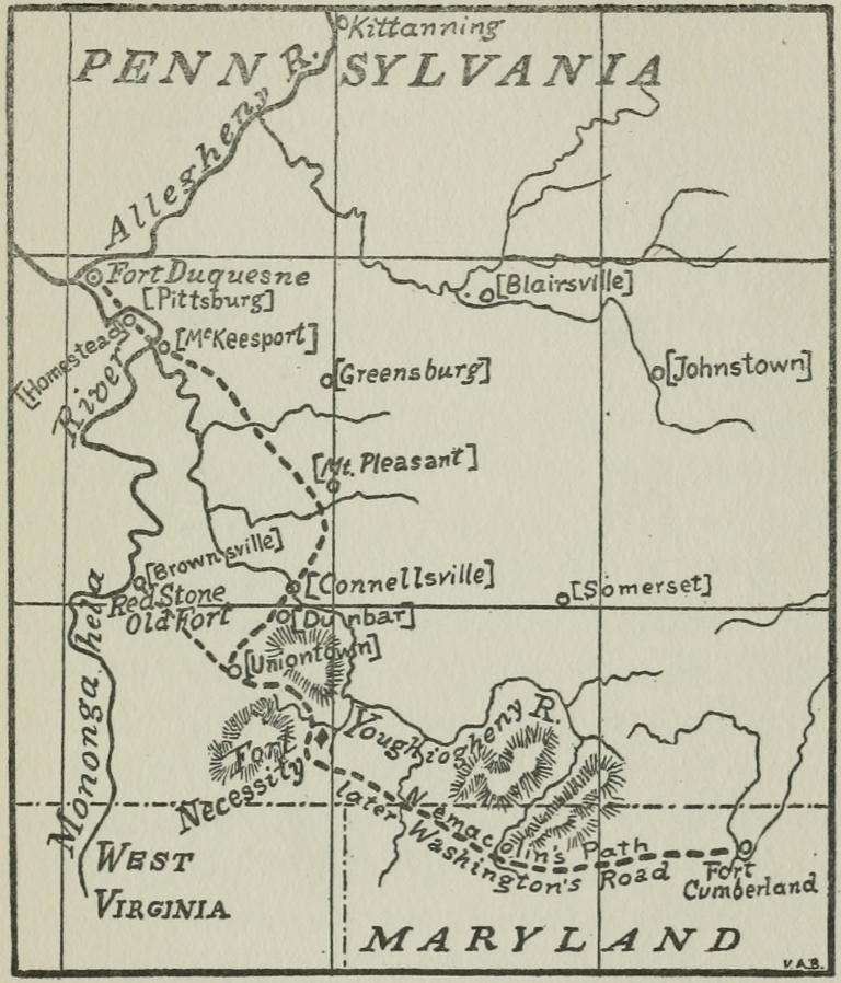 Washington’s Road
Christopher Gist, whom Washington engaged as guide, knew well this “Road of Iron” through the mountain, and perhaps was the first white man to travel it who left record of it. On July 16, 1751, he had been commissioned by the committee of the Ohio Company to visit their grant of land in the West, and, among other things, “to look out & observe the nearest & most convenient Road you can find from the Company’s Store at Will’s Creek to a Landing at Mohongeyela.”[1] The path started from the buildings Hugh Parker had erected for the Ohio Company in 1750 on land purchased from Lord Fairfax.[2] It followed the course outlined to Laurel Hill; here it left what was perhaps the main trail to the Ohio, and bore westward to the Monongahela river which it touched at Redstone Old Fort (Brownsville, Pa.) It was the course of the shortest portage between the Potomac and Monongahela.
It was the main trail to the Ohio over[Pg 96] which Gist now guided the young envoy. This path had no name until it took that of a Delaware Indian, Nemacolin, who blazed its course, under the direction of Captain Thomas Cresap, for the Ohio Company. To those who love to look back to beginnings, and read great things in small, this Indian path, with its border of wounded trees, leading across the first great divide into the Central West, is worthy of contemplation. Each tree starred white by the Indian’s ax spoke of Saxon conquest and commerce, one and inseparable. In every act of the great world-drama now on the boards, this little trail with its blazed trees lies in the foreground.
And the rise of the curtain shows the lad Washington and his party of seven horsemen, led by the bold guide Christopher Gist, setting out from Wills Creek on the 15th of November, 1753. The character of the journey is nowhere better described than in Washington’s words when he engaged Gist’s services: “I engaged Mr Gist to pilot us out.”
It proved a rough voyage! A fierce, early winter came out of the north, as[Pg 97] though in league with the French to intimidate, if not drive back, these spies of French aggression. It rained and snowed, and the little pathway became well-nigh impassable. The brown mountain ranges, which until recently had been burnished with the glory of a mountain autumn, were wet and black. Scarce eighteen miles were covered a day, a whole week being exhausted in reaching the Monongahela. But this was not altogether unfortunate. A week was not too long for the future Father of the West to study the hills and valleys which were to bear forever the precious favor of his devoted and untiring zeal. And in this week this youth conceived a dream and a purpose, the dearest, if not the most dominant, of his life—the union, commercial as well as political, of the East and the West. Yet he passed Great Meadows without seeing Fort Necessity, Braddock’s Run without seeing Braddock’s unmarked grave, and Laurel Hill without a premonition of the covert in the valley below, where shortly he should shape the stones above a Frenchman’s grave. But could he have seen it all[Pg 98]—the wasted labor, nights spent in agony of suspense, humiliation, defeat, and the dead and dying—would it have turned him back?
The first roof to offer Washington hospitable shelter was the cabin of the trader Frazier at the mouth of Turtle creek, on the Monongahela, near the death-trap where soon that desperate handful of French and Indians should put to flight an army of five times its own number. Here information was at hand, for it was none other than this Frazier who had been driven from Venango but a few weeks before by the French force sent there to build a fort. Joncaire was spending the winter in Frazier’s old cabin, and no doubt the young Virginian heard this irrepressible French officer’s title read clear in strong English oaths. Here too was a “Speech,” with a string of wampum accompanying, on its way from a few anti-French Indians on the Ohio to Governor Dinwiddie, bringing the ominous news that the Chippewas, Ottawas, and Wyandots had taken up the hatchet against the English.
Washington took the Speech and the[Pg 99] wampum—and pushed on undismayed. Sending the baggage down the Monongahela by boat, he traveled on overland to the “Forks,” where he chose a site for a fort, the future site, first, of Fort Duquesne, and later, Fort Pitt. But his immediate destination was the Indian village of Logstown, fifteen miles down the Ohio. On his way thither he stopped at the lodge of Shingiss, a Delaware king, and secured the promise of his attendance upon the council of anti-French (though not necessarily pro-English) Indians. For this was the Virginian envoy’s first task—to make a strong bid for the allegiance of the red men; it was not more than suggested in his instructions, but was none the less imperative, as he well knew whether his superiors did or not.
It is extremely difficult to construct anything like a clear statement of Indian affiliations at this crisis. This territory west of the Alleghanies, nominally purchased from the Six Nations, was claimed by the Shawanese and Delawares who, as we have seen, had come into it, and also by many fugitives from the Six Nations, known generally as[Pg 100] Mingoes, who had come to make their hunting ground their home. Though the Delaware king was only a “Half King” (because subject to the Council of the Six Nations) yet they claimed the land and had even resisted French encroachment. “Half King” and his Delawares believed the English only desired commercial intercourse and favored them as compared with the French who had already built forts in the West. The northern nations who were nearer the French soon surrendered to their blandishments; and soon the Delawares and the Shawanese were overcome by French allurements and were generally found about the French forts and forces. In the spring of the year Half King had gone to Presque Isle and spoken firmly though vainly to the French.
In so far as the English were more backward than the French in occupying the land, the unprejudiced Delawares and Mingoes were inclined to further English plans. When, a few years later, it became clear that the English cared not a whit for the rights of the red men, the latter hated and fought them as they never had the French.[Pg 101] Washington was well fitted for handling this delicate matter of sharpening Indian hatred of the French and of keeping very still about English plans—his past experiences were now of utmost value to him.
Here at Logstown unexpected information was had. Certain French deserters from the Mississippi gave the English envoy a description of French operations on that river between New Orleans and Illinois. The latter word “Illinois” was taken by Washington’s old Dutch interpreter to be the French words Isle Noire, and Washington speaks of Illinois as the “Black Islands” in his Journal. But this was not to be old Van Braam’s only blunder in the rôle of interpreter!
Half King was ready with the story of his recent journey to Presque Isle, which he affirmed Washington could not reach “in less than five or six nights’ sleep, good traveling.” Little wonder, at such a season, a journey was measured by the number of nights to be spent in the frozen forests. Marin’s answer to Half King had been no less spirited because of his own dying condition. The Frenchman had frankly stated[Pg 102] that two English traders had been taken to Canada to get intelligence of what the English were doing in Virginia. So far as Indian possession of the land was concerned, Marin was quickly to the point: “You say this Land belongs to you, but there is not the Black of my Nail yours. I saw that Land sooner than you did, before the Shannoahs and you were at War: Lead was the Man who went down, and took Possession of that River: It is my Land, and I will have it, let who will stand-up for, or say-against, it. I’ll buy and sell with the English, [mockingly]. If People will be ruled by me, they may expect Kindness, but not else.” La Salle had gone down the Ohio and claimed possession of it long before Delaware or Shawanese, Ottawa or Wyandot had built a single fire in the valley. The claim of the Six Nations only, antedated that of the French—but the Six Nations had sold their claim to the English for 400 pounds at Lancaster in 1744. This, however, did not settle the question.
At the council on the following day (26th) Washington delivered an address, asking for guides and guards on his trip up the Allegheny and Rivière aux Bœufs,[Pg 103] adroitly implying, in word and gesture, that his audience were the warmest allies of the English and equally desirous to oppose French aggression. The council was for granting each request, but the absence of the hunters necessitated a detention; undoubtedly, fear of the French also provoked delay and counseling. Little wonder: Washington would soon be across the mountains again and the rough Frenchman who claimed even the earth beneath his finger-nails, and had won over the Ottawas, Chippewas, and fierce Wyandots, would make short work with all who had housed and counseled with the English envoy! And—perhaps most ominous of all—Washington had not announced his business in the West, undoubtedly fearing the Indians would not aid him did they know it. When at last they asked the nature of his mission, he answered just the best an honest-hearted lad could; “this was a Question I had all along expected,” he wrote in his Journal, “and had provided as satisfactory Answers to, as I could; which allayed their Curiosity a little.” This youthful diplomat would have allayed[Pg 104] the burning curiosity of hundreds of others had he mentioned the reason he gave those suspicious chieftains for this five-hundred-mile journey in the wintry season to a miserable little French fort on Rivière aux Bœufs! It is safe to assume that, could he have given the real reasons, he would have been saved the difficulty of providing “satisfactory” ones.
For four days Washington remained, but on the 30th he set out northward, accompanied only by the faithful Half King and three other Indians, and on the 4th of December (after four “nights’ sleep” ) the party arrived at the mouth of Rivière aux Bœufs, where Joncaire was wintering in Frazier’s cabin. The seventy miles from Logstown were traversed at about the same poor rate as the 125 from Wills Creek. To Joncaire’s cabin, over which floated the French flag, the Virginian envoy immediately repaired. He was received with much courtesy, though, as he well knew, Legardeur de St. Pierre at Fort La Bœuf, the successor of the dead Marin, was the French commandant to whom his letter from Dinwiddie must go.[Pg 105]
However, Washington was treated “with the greatest Complaisance” by Joncaire. During the evening the Frenchmen “dosed themselves pretty plentifully,” wrote the sober, keen-eyed Virginian, “and gave a License to their Tongues. They told me, That it was their absolute Design to take Possession of the Ohio, and by G— they would do it: For that although they were sensible the English could raise two Men for their one; yet they knew, their Motions were too slow and dilatory to prevent any Undertaking of theirs.” For a true picture of this Washington (who is said to be forgotten) what one would be chosen before this: a youth from Virginia sitting before the log fire in a German’s cabin from which the French had driven its owner, on the Allegheny river; about him are sitting leering, tipsy Gauls, bragging with oaths of a conquest they were never to make: he is dressed for a five-hundred-mile ride through a wilderness in winter, and his sober eyes rest thoughtfully upon the crackling logs while the oaths and boasts and smell of foreign liquor fill the hot and heavy air. No picture could show better the[Pg 106] three commanding traits of this youth who was father of the man: hearty daring, significant homespun shrewdness, dogged, resourceful patience. Basic traits of character are often displayed involuntarily in the effervescence of youthful zest. These this lad had shown and was showing in this brave ride into a dense wilderness and a braver inspection of his country’s enemies, their works, their temper, and their boasts. Let this picture hang on the walls of every home where the lad in the foreground before the blazing logs is unknown save in the rôle of the general or statesman he became in later life.
How these French officers looked this tall, stern boy up and down! How they enjoyed sneering to his face at English backwardness in crossing the Alleghanies into the great West which their own explorers had honeycombed with a hundred swift canoes! As they even plotted his assassination, how, in turn, that young heart must have burned to stop their mouths with a clenched hand. Little wonder that when the time came, his voice first ordered “Fire!” and his finger first pulled[Pg 107] the trigger in the great war which won the West from France!
But with the boasts came no little information concerning the French operations on the Great Lakes, the number of their forts and men. But Washington did not get off for Fort La Bœuf the next day, as the weather was exceedingly rough. This gave the wily Joncaire a chance to tamper with his Indians, and the opportunity was not neglected. Upon learning that Half King was in the envoy’s retinue, he professed great regret that Washington had not “made free to bring him in before.” The Virginian was quick with a stinging retort: since he had heard Joncaire “say a good deal in dispraise of the Indians in general” he did not “think their company agreeable.” But Joncaire had his way and “applied the Liquor so fast” that, lo! the poor Indians “were soon rendered incapable of the Business they came about.”
In the morning Half King came to Washington’s tent hopefully sober but urging that another day be spent at Venango, since “the Management of the Indian Affairs was left solely to Monsieur Joncaire.” To[Pg 108] this the envoy reluctantly acquiesced. But on the day after, the embassy got on its way, thanks to Christopher Gist’s influence over the Indians. When Joncaire found them going, he forwarded their plans “in the heartiest way in the world” and detailed Monsieur La Force (with whom this Virginian was to meet in different circumstances within half a year) to accompany them. Four days were spent in floundering over the last sixty miles of this journey, the party being driven into “Mires and Swamps” to avoid crossing the swollen Rivière aux Bœufs. On the 11th of December, Washington reached his destination, having traveled over 500 miles in forty-two days.
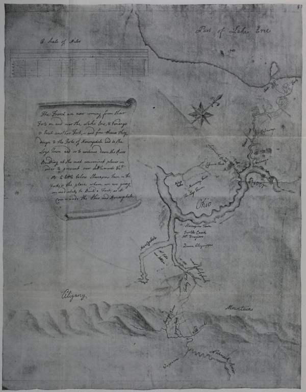
Click here for larger image size
A Map of the Country between Wills Creek and Lake Erie[Showing the designs of the French for erecting forts southward of the lake; drawn, before the erection of Fort Duquesne, evidently on the basis of Washington’s information secured in 1753. From the original in the British Museum]
Legardeur de St. Pierre, the one-eyed commander at Fort La Bœuf, had arrived but one week before Washington. To him the Virginian envoy delivered Governor Dinwiddie’s letter the day after his arrival. Its contents read:
“Sir,
“The lands upon the River Ohio, in the Western Parts of the Colony of Virginia, are so notoriously known to be the Property [Pg 111] of the Crown of Great-Britain; that it is a Matter of equal Concern and Surprize to me, to hear that a Body of French Forces are erecting Fortresses, and making Settlements upon that River, within his Majesty’s Dominions.
“The many and repeated Complaints I have received of these Acts of Hostility, lay me under the Necessity, of sending, in the Name of the King my Master, the Bearer hereof, George Washington, Esq; one of the Adjutants-General of the Forces of this Dominion; to complain to you of the Encroachments thus made, and of the Injuries done to the Subjects of Great-Britain, in open Violation of the Law of Nations, and the Treaties now subsisting between the two Crowns.
“If these Facts are true, and you shall think fit to justify your Proceedings, I must desire you to acquaint me, by whose Authority and Instructions you have lately marched from Canada, with an armed Force; and invaded the King of Great-Britain’s Territories, in the Manner complained of? that according to the Purport and Resolution of your Answer, I may act[Pg 112] agreeably to the Commission I am honoured with, from the King my Master.
“However, Sir, in Obedience to my Instructions, it becomes my Duty to require your peaceable Departure; and that you would forbear prosecuting a Purpose so interruptive of the Harmony and good Understanding, which his Majesty is desirous to continue and cultivate with the most Christian King.
“I persuade myself you will receive and entertain Major Washington with the Candour and Politeness natural to your Nation; and it will give me the greatest Satisfaction, if you return him with an Answer suitable to my Wishes for a very long and lasting Peace between us. I have the Honour to subscribe myself,
SIR,
Your most obedient,
Humble Servant,
Robert Dinwiddie.”
While an answer was being prepared, the envoy had an opportunity to take careful note of the fort and its hundred defenders. The fortress which Washington carefully described in his Journal was not[Pg 113] so significant as the great host of canoes along the river shore. It was French canoes the English feared more than French forts. The number at Fort La Bœuf at this time was over two hundred, and others were being made. And every stream flowed south to the land “notoriously known” to belong to the British crown.
On the 14th, Washington was planning his homeward trip. His horses, lacking proper nourishment and exhausted by the hard trip northward, were totally unfit for service, and were at once set on the road to Venango, since canoes had been offered the little embassy for the return trip. Anxious as Washington was to be off, neither his business nor that of Half King’s had been despatched with any celerity until now; but this day Half King secured an audience with St. Pierre and offered him the wampum which was promptly refused, though with many protestations of friendship and an offer to send a load of goods to Logstown. Every effort possible was being put forth to alienate Half King, and the Virginian lad frankly wrote: “I can’t say that ever in my Life I suffered so much[Pg 114] Anxiety as I did in this Affair.” This day and the next, the French officers outdid themselves in hastening Washington’s departure and retarding Half King’s. At last Washington complained frankly to St. Pierre, who denied his duplicity—and doubled his bribes. But on the day following Half King was gotten away, Venango being reached in six long days, a large part of the time being spent dragging the canoes over icy shoals.
Four days were spent with Joncaire, when, abandoning both horses and Indians, Washington and Gist set out alone and afoot by the shortest course to the Forks of the Ohio. It was a daring alternative but altogether the preferable one. At Murdering Town, a fit place for Joncaire’s assassin to lie in wait, some French Indians were come up with, one of whom offered to guide the travelers across to the Forks. At the first good chance he fired upon them and was disarmed and sent away. The two, building a raft, reached an island in the Allegheny after heroic suffering, but were unable to cross to the eastern shore until the following morning. They then passed[Pg 115] over on the ice which had formed and went directly to Frazier’s cabin. There they arrived December 29th. On the first day of the new year, 1754, Washington set out for Virginia on the little path over which he had come out. On the sixth he met seventeen horses loaded with materials and stores “for a fort at the Fork of the Ohio.” Governor Dinwiddie, indefatigable if nothing else, had commissioned Captain Trent to raise a company of a hundred men to erect a fort on the Ohio for the protection of the Ohio Company.
On the 16th of January the youthful envoy rode again into Williamsburg, one month from the day he left Fort La Bœuf. St. Pierre’s reply to Governor Dinwiddie’s letter read as follows:
“Sir,
“As I have the Honour of commanding here in Chief, Mr. Washington delivered me the Letter which you wrote to the Commandant of the French Troops.
“I should have been glad that you had given him Orders, or that he had been inclined to proceed to Canada to see our General; to whom it better belongs than to[Pg 116] me to set-forth the Evidence and Reality of the Rights of the King, my Master, upon the Lands situated along the River Ohio, and to contest the Pretensions of the King of Great-Britain thereto.
“I shall transmit your Letter to the Marquis Duguisne. His Answer will be a Law to me; and if he shall order me to communicate it to you, Sir, you may be assured I shall not fail to dispatch it to you forthwith.
“As to the Summons you send me to retire, I do not think myself obliged to obey it. What-ever may be your Instructions, I am here by Virtue of the Orders of my General; and I intreat you, Sir, not to doubt one Moment, but that I am determin’d to conform myself to them with all the Exactness and Resolution which can be expected from the best Officer.
“I don’t know that in the Progress of this Campaign any Thing passed which can be reputed an Act of Hostility, or that is contrary to the Treaties, which subsist between the two Crowns; the Continuation whereof as much interests, and is as pleasing to us, as the English. Had you been[Pg 117] pleased, Sir, to have descended to particularize the Facts which occasioned your Complaint, I should have had the Honour of answering you in the fullest, and, I am persuaded, most satisfactory Manner.
“I made it my particular Care to receive Mr Washington, with a Distinction suitable to your Dignity, as well as his own Quality and great Merit. I flatter myself that he will do me this Justice before you, Sir; and that he will signify to you in the Manner I do myself, the profound Respect with which I am,
SIR,
Your most humble, and
most obedient Servant,
Legardeur de St. Pierre.”
Washington found the Governor’s council was to meet the day following and that his report was desired. Accordingly he rewrote his Journal from the “rough minutes” he had made. From any point of view this document of ten thousand words, hastily written by this lad of twenty-one, who had long since left his school desk, is far more creditable and remarkable than any of the feats of physical en[Pg 118]durance for which the lad is idolized by the youthful readers of our school histories. It is safe to say that many a college bred man today could not prepare from rough notes such a succinct and polite document as did this young surveyor, who had read few books, and, it can almost be said, had studied neither his own nor any foreign language. The author did not “in the least conceive ... that it would ever be published.” Speaking afterward of its “numberless imperfections,” he said all that could recommend it to the public was its truthfulness of fact. Certain features of this first public service of Washington’s are worthy of remark: his frankness, as in criticizing Shingiss’s village as a site for a fort, as proposed by the Ohio Company; his exactness in giving details (where he could obtain them) of forts, men, and guns; his estimates of distances; his wise conforming to Indian custom; his careful note of the time of day of important events; his frequent observations of the character of the lands through which he passed; his knowledge of Indian character.
This mission prosecuted with such rare[Pg 119] tact and skill was an utter failure, considered from the standpoint of its nominal purpose. St. Pierre’s letter was firm, if not defiant. Yet Dinwiddie, despairing of French withdrawal, had secured the information he desired. Already Trent had reached the Forks of the Ohio where an English fort was being erected. Peaceful measures were exhausted with the failure of Washington’s embassy. England’s one hope was—war!
No literary production of a youth of twenty-one ever electrified the world as did the publication of the Journal of this dauntless envoy of the Virginian governor. No young man more instantly sprang into the notice of the world than George Washington. The journal was copied far and wide in the newspapers of the other colonies. It sped across the sea, and was printed in London by the British government. In a manly, artless way it told the exact situation on the Ohio frontier and announced the first positive proof the world had had of hostile French aggression into the great river valley of the West. Despite certain youthful expressions, the prudence, tact, capacity, and modesty of the author were recognized by a nation and by a world.
Without waiting for the House of Bur[Pg 121]gesses to convene, Governor Dinwiddie’s council immediately advised the enlistment of two hundred men to be sent to build forts on the Monongahela and Ohio rivers. The task of recruiting two companies of one hundred men each was given to the tried though youthful Major Washington, since they were to be recruited from the northern district over which he had been adjutant-general. His instructions read as follows:
“Instruct’s to be observ’d by Maj’r Geo. Washington,
on the Expedit’n to the Ohio.
“MAJ’R GEO. WASHINGTON: You are forthwith to repair to the Co’ty of Frederick and there to take under Y’r Com’d 50 Men of the Militia who will be deliver’d to You by the Comd’r of the s’d Co’ty pursuant to my Orders. You are to send Y’r Lieut. at the same Time to the Co’ty of Augusta, to receive 50 Men from the Comd’r of that Co’ty as I have order’d, and with them he is to join You at Alexandria, to which Place You are to proceed as soon as You have rec’d the Men in Frederick. Having rec’d the Detachm’t, You are to train and[Pg 122] discipline them in the best Manner You can, and for all Necessaries You are to apply Y’rself to Mr. Jno. Carlisle at Alex’a who has my Orders to supply You. Having all Things in readiness You are to use all Expedition in proceeding to the Fork of Ohio with the Men under Com’d and there you are to finish and compleat in the best Manner and as soon as You possibly can, the Fort w’ch I expect is there already begun by the Ohio Comp’a. You are to act on the Defensive, but in Case any Attempts are made to obstruct the Works or interrupt our Settlem’ts by any Persons whatsoever You are to restrain all such Offenders, and in Case of resistance to make Prisoners of or kill and destroy them. For the rest You are to conduct Y’self as the Circumst’s of the Service shall require and to act as You shall find best for the Furtherance of His M’y’s Service and the Good of His Dom’n. Wishing You Health and Success I bid you Farewell.”[3]
The general command of the expedition was given to Colonel Joshua Fry, formerly[Pg 123] professor of mathematics in William and Mary College and a geographer and Indian commissioner of note. His instructions were as follows:
“Instruction’s to Joshua Fry, Esqr., Colo. and
Com’r-in-Chief of the Virg’a Regiment.
March, 1754.
“SIR: The Forces under Y’r Com’d are rais’d to protect our frontier Settlements from the incursions of the French and the Ind’s in F’dship with them. I therefore desire You will with all possible Expedition repair to Alexandria on the Head of the Poto. River, and there take upon You the com’d of the Forces accordingly; w’ch I Expect will be at that Town the Middle of next Mo. You are to march them to will’s Creek, above the Falls of Poto. from thence with the Great Guns, Amunit’n and Provisions. You are to proceed to Monongahela, when ariv’d there, You are to make Choice of the best Place to erect a Fort for mounting y’r Cannon and ascertain’g His M’y the King of G. B’s undoubt’d right to those Lands. My Orders to You is to be on the Defensive and if any foreign Force sh’d[Pg 124] come to annoy You or interrupt Y’r quiet Settlem’t, and building the Fort as afores’d, You are in that Case to represent to them the Powers and Orders You have from me, and I desire they w’d imediately retire and not to prevent You in the discharge of your Duty. If they sh’d continue to be obstinate after your desire to retire, you are then to repell Force by Force. I expect a Number of the Southern Indians will join you on this expedit’n, w’ch with the Indians on the Ohio, I desire You will cultivate a good Understanding and Correspondence with, supplying them with what Provisions and other Necessaries You can spare; and write to Maj’r Carlyle w’n You want Provisions, who has my Orders to purchase and Keep a proper Magazine for Your dem’ds. Keep up a good Com’d and regular Discipline, inculcate morality and Courage in Y’r Soldiers that they may answer the Views on w’ch they are rais’d. You are to constitute a Court Martial of the Chief of Your Officers, with whom You are to advise and consult on all Affairs of Consequence; and as the Fate of this Expedition greatly depends on You, from[Pg 125] the Opinion I have of Your good Sense and Conduct, I refer the Management of the whole to You with the Advice of the Court Martial. Sincerely recommending You to the Protection of God, wishing Success to our just Designs, I heartily wish You farewell.”[4]
Dinwiddie’s expedition was in no sense the result of general agitation against French encroachment. And, as in Virginia, so it was in other colonies to which Governor Dinwiddie appealed; the governors said they had received no instructions; the validity of English title to the lands upon which the French were alleged to have encroached was doubted; not one of them wished to precipitate a war through rash zeal.
Before the bill voting ten thousand pounds “for the encouragement and protection of the settlers on the Mississippi,” as it was called, passed the House of Burgesses, Governor Dinwiddie had his patience well-nigh exhausted, but he overlooked both the doubts raised as to Eng[Pg 126]land’s rights in the West and personal slights, and signed the bill which provided for the expenses of the expedition of the Virginia Regiment.
Major Washington was located at Alexandria on the upper Potomac in February, where he superintended the rendezvous of his men, and the transportation of supplies and cannon. It was found necessary to resort to impressments to raise the required quota of men. As early as February 19th, so slow were the drafts and enlistments, Governor Dinwiddie issued a proclamation granting two hundred thousand acres of land on the Ohio, to be divided among the officers and men who would serve in the expedition. This had its effect.
By April 20th, Washington arrived at Wills Creek (Cumberland, Maryland) with three companies, one under Captain Stephen who had joined him on the way. The day previous, however, he met a messenger sent from Captain Trent on the Ohio announcing that the arrival of a French army was hourly expected. And on the day following, at Wills Creek, he was informed of the arrival of the French and[Pg 127] the withdrawal of the Virginian force under Trent from the junction of the Allegheny and Monongahela, where they had been sent to build a fort for the protection of the Ohio Company. Without any delay, he forwarded this information to the governors of Virginia, Pennsylvania, and Maryland.
Fancy the state of mind of this vanguard of the Virginian army at the receipt of this news. They were then at the last frontier fort with eleven companies of troops. Their orders were to push on to the Ohio, drive off the French army (which was then reported to number a thousand men), and build a fort there. Before them the only road was the Indian path, which was hardly wide enough to admit the passage of a packhorse.
A ballot was cast among Washington’s captains—the youngest of whom was old enough to have been his father—and the decision reached was to advance. The Indian path could at least be widened, and bridges built, as far as the Monongahela. There they determined to erect a fort and await orders and reinforcements. The[Pg 128] reasons for this decision are given as follows in Washington’s Journal of 1754:[5]
“1st. That the mouth of Red-Stone is the first convenient place on the River Monongahela.
“2nd. The stores are already built at that place for the provisions of the Com[Pg 129]pany, wherein the Ammunition may be laid up, our great guns may be also sent by water whenever we shall think it convenient to attack the Fort.
“3rd. We may easily (having all these conveniences) preserve our men from the ill consequences of inaction, and encourage the Indians our Allies, to remain in our interests.”[6]
Thus Washington’s march must be looked upon as the advance of a vanguard opening the road, bridging the streams, preparing the way for the commanding officer and his army. Nor was there, now, need for haste—had it been possible or advisable to hasten. The landing of the French at the junction of the Allegheny and Monongahela already thwarted Governor Dinwiddie’s object in sending out the expedition, “to prevent their [French] building any Forts or making any Settlem’ts on that river, [Ohio] and more particularly so nigh us as that of the Logstown [fifteen miles below the forks of the Ohio].” Now that a fort was building, with an army of a thousand[Pg 130] men (as Washington had been erroneously informed) encamped about it, nothing more was to be thought of than a cautious advance.
And so Washington gave the order on the 29th of April, three score men having been sent ahead to widen the Indian trail. The march was difficult and exceedingly slow. In the first ten days they covered but twenty miles. Yet each mile must have been anticipated seriously by the young commander. He knew not whether his colonel with reinforcements or the enemy were nearest. Governor Dinwiddie wrote him (May 4) concerning reinforcements, as follows:
“The Independ’t Compa from So. Car. arriv’d two days ago; is compleat; 100 Men besides Officers, and will re-embark for Alexa next Week, thence proceed imediately to join Colo. Fry and You. The two Independ’t Compa’s from N. York may be Expected in ab’t ten days. The N. Car. Men, under the Com’d of Colo. Innes, are imagin’d to be on their March, and will probably be at the Randezvous ab’t the [Pg 131]15th. Inst.”...
“I hope Capt. McKay who Com’ds the Independ’t Compa., will soon be with You And as he appears to be an Officer of some Experience and Importance, You will, with Colo. Fry and Colo. Innes, so well agree as not to let some Punctillios ab’t Com’d render the Service You are all engag’d in, perplex’d or obstructed.”[7]
Relying implicitly on Dinwiddie, Washington pushed on and on into the wilderness, opening a road and building bridges for a colonel and an army that was never to come. As he advanced into the Alleghanies he found the difficulty of hauling wagons very serious, and long before he reached the Youghiogheny he determined to test the possibility of transportation down that stream and the Monongahela to his destination at the mouth of Redstone creek.
May 11th, he sent a reconnoitering force forward to Gist’s, on Laurel Hill, the last spur of the Alleghanies, to locate a French party, which, the Indians reported, had left Fort Duquesne, and to find if there was[Pg 132] possibility of water transportation to the month of Redstone creek, where a favorable site for a fort was to be sought.
Slowly the vanguard of the army felt its way to Little Meadows and across the smaller branch of the Youghiogheny, which it bridged at Little Crossings. On the 16th, according to the French version of Washington’s Journal, he met traders who informed him of the appearance of French near Gist’s and expressed doubts as to the possibility of building a wagon road from Gist’s to the mouth of Redstone creek. This made it imperatively necessary for the young lieutenant-colonel to attempt to find a water passage down the Youghiogheny.
The day following, much information was received both from the front and the rear, perhaps most vividly stated in the Journal as follows:
“The Governor informs me that Capt. McKay, with an independent company of 100 men, excluding the officers, had arrived, and that we might expect them daily; and that the men from New-York would join us within ten days.[Pg 133]
“This night also came two Indians from the Ohio who left the French fort five days ago; They relate that the French forces are all employed in building their Fort, that it is already breast-high, and of the thickness of twelve feet, and filled with Earth, stones, &c. They have cut down and burnt up all the trees which were about it and sown grain instead thereof. The Indians believe they were only 600 in number, although they say themselves they are 800: They expect a greater number in a few days, which may amount to 1,600. Then they say they can defy the English.”[8]
Arriving on the eastern bank of the Youghiogheny the next day, the river being too wide to bridge and too high to ford, Washington put himself “in a position of defence against any immediate attack from the Enemy,” and went straightway to work on the problem of water transportation.
By the 20th, a canoe having been provided, Washington set out on the Youghiogheny with four men and an Indian. By nightfall they reached “Turkey Foot” [Pg 134](Confluence, Pennsylvania), which Washington mapped for the site of a fort. Below “Turkey Foot” the stream was found too rapid and rocky to admit of any sort of navigation and Washington returned to camp on the 24th, with the herculean hardships of an entire overland march staring him in the face. Information was now at hand from Half King concerning alleged movements of the French; thus the letter read:
“To any of his Majesty’s officers whom
this May Concern.
“As ’tis reported that the French army is set out to meet M. George Washington I exhort you my brethren, to guard against them, for they intend to fall on the first English they meet; They have been on their march these two days, the Half King and the other chiefs will join you within five days, to hold a council, though we know not the number we shall be. I shall say no more; but remember me to my brethren the English.
Signed, The Half King.”
At two o’clock of that same May day[Pg 135] (24th) the little vanguard came down the eastern wooded hills that surround Great Meadows, and looked across the waving grasses and low bushes which covered the field they were soon to make classic ground. Immediately upon arriving at the future battle-field, information was secured from a trader confirming Half King’s alarming letter. Below the roadway, which passed the meadow on the hillside, the lieutenant-colonel found two natural intrenchments near a branch of Great Meadows Run, perhaps old courses of the brook through the swampy land. Here the troops and wagons were placed.
Great Meadows may be described as two large basins, the smaller lying directly westward of the larger and connected with it by a narrow neck of swampy ground. Each is a quarter of a mile wide, and the two a mile and a half in length.
The old roadway descends from the southern hills, coming out upon the meadows at the eastern extremity of the western basin. It traverses the hillside south of the western meadow. The natural intrenchments or depressions behind which[Pg 136] Washington huddled his army on this May afternoon were at the eastern edge of the western basin. Back of him was the narrow neck of lowland which soon opened into the eastern basin. Behind him to his left on the hillside his newly made road crept eastward into the hills. The Indian trail followed the edge of the forest westward to Laurel Hill, five miles distant, and on to Fort Duquesne.
On this faint opening into the western forest the little band and its youthful commander kept their eyes as the sun dropped behind the hills, closing an anxious day and bringing a dreaded night. How large the body of French might have been, not one of the one hundred and fifty men knew. How far away they might be, no one could guess. Here in this forest meadow the little vanguard slept on their arms, surrounded by watchful sentinels, with fifty-one miles of forest and mountain between them and the nearest settlement at Wills Creek. The darkling forests crept down the hills on either side as though to hint by their portentous shadows of the dead and dying that were to be.[Pg 137]
But the night waned and morning came. With increasing energy, as though nerved to duty by the dangers which surrounded him, the twenty-two-year-old commander Washington gave his orders promptly. A scouting party was sent on the Indian trail in search of the coming French. Squads were set to threshing the forests for spies. Horsemen were ordered to scour the country and keep look-out for French from neighboring points of vantage.
At night all returned, none the wiser for their vigilance and labor. The French force had disappeared from the face of the earth. It may be believed that this lack of information did not tend to ease the intense strain of the hour. It must have been plain to the dullest that serious things were ahead. Two flags, silken emblems of an immemorial hatred, were being brought together in the Alleghanies. It was a moment of utmost importance to Europe and America. Quebec and Jamestown were met on Laurel Hill; and a spark struck here and now was to “set the world on fire.”
However clearly this may have been seen,[Pg 138] Washington was not the man to withdraw. Indeed, the celerity with which he precipitated England and France into war made him the most criticized man on both continents.
Another day passed—and the French could not be found. On the following day Christopher Gist arrived at Great Meadows with the information that M. la Force with fifty men (whose tracks he had seen within five miles of Great Meadows) had been at his house on “Mount Braddock,” fifteen miles distant. Acting on this reliable information, Washington at once dispatched a scouting party in pursuit.
The day passed and no word came to the anxious men in their trenches in the meadows. Another night, silent and cheerless, came over the mountains upon the valley, and with the night came rain. Fresh fears of strategy and surprise must have arisen as the cheerless sun went down.
Suddenly, at eight in the evening, a runner brought word that the French were run to cover. Half King, while coming to join Washington, had found La Force’s party in “a low, obscure place.[Pg 139]”
It was now time for a daring man to show himself. Such was the young commander at Great Meadows.
“That very moment,” wrote Washington in his Journal, “I sent out forty men and ordered my ammunition to be put in a place of safety, fearing it to be a stratagem of the French to attack our camp; I left a guard to defend it, and with the rest of my men set out in a heavy rain, and in a night as dark as pitch.”
Perhaps a war was never precipitated under stranger circumstances. Contrecœur, commanding at Fort Duquesne, was made aware by his Indian scouts of Washington’s progress all the way from the Potomac. The day before Washington arrived at Great Meadows, Contrecœur ordered M. de Jumonville to leave Fort Duquesne with a detachment of thirty-four men, commanded by La Force, and go toward the advancing English. To the English (when he met them) he was to explain he had come to order them to retire. To the Indians he was to pretend he was “traveling about to see what is transacting in the King’s Territories, and to take notice[Pg 140] of the different roads.” In the eyes of the English the party was to be an embassy. In the eyes of the Indians, a party of scouts reconnoitering. This is clear from the orders given by Contrecœur to Jumonville.
Three days later, on the 26th, this “embassy” was at Gist’s plantation, where, according to Gist’s report to Washington, they “would have killed a cow and broken everything in the house, if two Indians, whom he [Gist] had left in charge of the home, had not prevented them.”
From Gist’s, La Force had advanced within five miles of Great Meadows, as Gist ascertained by their tracks on the Indian trail. Then—although the English commander was within an hour’s march—the French retraced their steps to the summit of Laurel Hill, and, descending deep into the obscure valley on the east, built a hut under the lee of the precipice and rested from their labors! Here they remained throughout the 27th, while Washington’s scouts were running their legs off in the attempt to locate them, and the young lieutenant-colonel was in a fever of anxiety[Pg 141] at their sudden, ominous disappearance. Now they were found.
What a march was that! The darkness was intense. The path, Washington wrote, was “scarce broad enough for one man.” Now and then it was lost completely and a quarter of an hour was wasted in finding it. Stones and roots impeded the way, and were made trebly treacherous by the torrents of rain which fell. The men struck the trees. They fell over each other. They slipped from the narrow track and slid downward through the soaking, leafy carpet of the forest.
Enthusiastic tourists make the journey today from Great Meadows to the summit of Laurel Hill on the track over which Washington and his hundred men floundered and stumbled that wet May night a century and a half ago. It is a hard walk but exceedingly fruitful to one of imaginative vision. From Great Meadows the trail holds fast to the height of ground until Braddock’s Run is crossed near “Braddock’s Grave.” Picture that little group of men floundering down into this mountain stream, swollen by the heavy[Pg 142] rain, in the utter darkness of that night! From Braddock’s Run the trail begins its long climb on the sides of the foothills, by picturesque Peddler’s Rocks, to the top of Laurel Hill, two thousand feet above.
Washington left Great Meadows about eight o’clock. It was not until sunrise that Half King’s sentries at “Washington’s Spring” saw the vanguard file out on the narrow ridge, which, dividing headwaters of Great Meadow Run and Cheat river, makes an easy ascent to the summit of the mountain. The march of five miles had been accomplished, with great difficulty, in a little less than ten hours—at the rate of one mile in two hours!
Forgetting all else for the moment, consider the young leader of the floundering, stumbling army. There is not another episode in all Washington’s long, eventful life that shows more clearly his strength of personal determination and daring. Beside this all-night march from Great Meadows to Washington’s Spring, Wolfe’s ascent to the Plains of Abraham at Quebec was a pastime. A man in full daylight today can walk over Washington’s five-mile course[Pg 143] to Laurel Hill in one-fifth of the time that little army needed on that black night. If a more difficult ten-hour night march has been made in the history of warfare in America, who led it and where was it made? No feature of the campaign shows more clearly the unmatched, irresistible energy of this twenty-two-year-old boy. For those to whom Washington, the man, is “unknown,” there are lessons in this little path today, of value far beyond their cost.
Whether Washington intended to attack the French before he reached Half King, is not known; at the spring a conference was held and it was immediately decided to attack. Washington did not know and could not have known that Jumonville was an ambassador. The action of the French in approaching Great Meadows and then withdrawing and hiding was not the behavior of an embassy. Half King and his Indians were of opinion that the French party entertained evil designs, and, as Washington afterwards wrote, “if we had been such fools as to let them [the French] go, they would never have helped us to take any other Frenchmen.[Pg 144]”
Two scouts were sent out in advance; then, in Indian file, Washington and his men with Half King and a few Indians followed and “prepared to surround them.”
Laurel Hill, the most westerly range of the Alleghanies, trends north and south through western Pennsylvania. In Fayette county, about one mile on the summit northward from the Cumberland Road, lies Washington’s Spring where Half King encamped. The Indian trail coursed along the summit northward fifteen miles to Gist’s. On the eastern side, Laurel Hill descends into a valley varying from a hundred to five hundred feet deep. Nearly two miles from the spring, in the bottom of a valley four hundred feet deep, lay Jumonville’s “embassy.” The attacking party, guided by Indians, who had previously wriggled down the hillside on their bellies and found the French, advanced along the Indian trail and then turned off and began stealthily creeping down the mountainside.
Washington’s plan was, clearly, to surround and capture the French. It is plain he did not understand the ground. They [Pg 147] were encamped in the bottom of a valley two hundred yards wide and more than a mile long. Moreover, the hillside on which the English were descending abruptly ended on a narrow ledge of perpendicular rocks thirty feet high and a hundred yards long.
Coming suddenly out on the rocks, Washington leading the right division of the party and Half King the left, it was plain in the twinkling of an eye that it would be impossible to achieve a bloodless victory. Washington therefore gave and received first fire. It was fifteen minutes before the astonished but doughty French, probably now surrounded by Half King’s Indians, were compelled to surrender. Ten of their number, including the “ambassador” Jumonville, were killed outright and one wounded. Twenty-one were taken prisoners. One Frenchman escaped, running half clothed through the forests to Fort Duquesne with the evil tidings.
“We killed,” writes Washington, “Mr. de Jumonville, the Commander of that party, as also nine others; we wounded one and made twenty-one prisoners, among[Pg 148] whom were M. La Force, M. Drouillon and two cadets. The Indians scalped the dead and took away the greater part of their arms, after which we marched on with the prisoners under guard to the Indian camp.... I marched on with the prisoners. They informed me that they had been sent with a summons to order me to retire. A plausible pretence to discover our camp and to obtain knowledge of our forces and our situation! It was so clear that they were come to reconnoiter what we were, that I admired their assurance, when they told me they were come as an Embassy; their instructions were to get what knowledge they could of the roads, rivers, and all the country as far as the Potomac; and instead of coming as an Embassador, publicly and in an open manner, they came secretly, and sought the most hidden retreats more suitable for deserters than for Embassadors; they encamped there and remained hidden for whole days together, at a distance of not more than five miles from us; they sent spies to reconnoiter our camp; the whole body turned back 2 miles; they sent the two messengers[Pg 149] mentioned in the instruction, to inform M. de Contrecoeur of the place where we were, and of our disposition, that he might send his detachments to enforce the summons as soon as it should be given. Besides, an Embassador has princely attendants, whereas this was only a simple petty French officer, an Embassador has no need of spies, his person being always sacred: and seeing their intention was so good, why did they tarry two days at five miles’ distance from us without acquainting me with the summons, or at least, with something that related to the Embassy? That alone would be sufficient to excite the strongest suspicions, and we must do them the justice to say, that, as they wanted to hide themselves, they could not have picked out better places than they had done. The summons was so insolent, and savored of so much Gasconade, that if it had been brought openly by two men it would have been an excessive Indulgence to have suffered them to return.... They say they called to us as soon as they had discovered us; which is an absolute falsehood, for I was then marching at the head of the company[Pg 150] going towards them, and can positively affirm, that, when they first saw us, they ran to their arms, without calling, as I must have heard them had they so done.”[9]
In a letter to his brother, Washington wrote: “I fortunately escaped without any wound; for the right wing where I stood, was exposed to, and received all the enemy’s fire; and it was the part where the man was killed and the rest wounded. I heard the bullets whistle; and, believe me, there is something charming in the sound.” The letter was published in the London Magazine. It is said George II. read it and commented dryly: “He would not say so if he had been used to hear many.” In later years Washington heard too much of the fatal music, and once, when asked if he had written such rodomontade is said to have answered gravely, “If I said so, it was when I was young.” Aye, but it is memorials of that daring young Virginian, to whom whistling bullets were charming, that we seek in the Alleghanies today. We catch a similar glimpse of his ardent,[Pg 151] boyish spirit in a letter written from Fort Necessity later. Speaking of strengthening the fortifications, Washington writes: “We have, with nature’s assistance, made a good intrenchment, and by clearing the bushes out of these meadows, prepared a charming field for an encounter.” Over and above the anxieties with which he was ever beset, there shines out clearly the exuberance of boyish zest and valor—soon to be hardened and quenched by innumerable cares and heavy responsibilities.
Thus the first blow in the long bloody seven years’ war was struck by the red-uniformed Virginians under Washington at the bottom of that Alleghany valley. He immediately returned to Great Meadows, sent eastward to the belated Fry for reinforcements, and westward a scouting party to keep watch of the enemy. On the 30th, the French prisoners were sent eastward to Virginia and the construction of a fort was begun at Great Meadows, by erecting “small palisades.” This was completed by the following day, June 1st. Washington, in his Journal under the date of June 25th, speaks of this fort as “Fort-Neces[Pg 152]sity.”[10] The name suggests the exigencies which led to its erection: lack of troops and provisions. On June 2nd, Washington wrote in his Journal: “We had prayers in the Fort;”[11] the name Necessity may not have been used at first.
On the 6th, Gist arrived from Wills Creek, bringing the news of Colonel Fry’s death by injuries sustained from being thrown from his horse. Thus the command now devolved upon Washington who had been in actual command from the beginning. On the 9th, the remainder of the Virginian regiment arrived from Wills Creek, with the swivels, under Colonel Muse. On the day following, Captain Mackaye arrived with the Independent Company of South Carolinians.
The reinforcements put a new face on affairs and it is clear that the new colonel commanding secretly hoped to capture Fort Duquesne forthwith. Washington’s road was finished to Great Meadows. For two weeks, now, the work went on, completing it[Pg 153] as far as Gist’s, on Mount Braddock. In the mountains a sharp lookout for the French was maintained, and spies were continually sent to Fort Duquesne to report all that was happening there. Among all else that taxed the energies of the young colonel was the management of the Indian question. At one time he received and answered a deputation of Delawares and Shawanese which he knew was sent by the French as spies. Yet the answer of this youth to the “treacherous devils,” as he calls them in his private record of the day, was as bland and diplomatic as that of Indian chieftain bred to hypocrisy and deceit. He put little faith in the redskins but made good use of those he had as spies, did all in his power to restrain the nations from joining the French, and offered to all who came or would come to him a hospitality he could ill afford.
On the 28th, his road was completed to Gist’s and eight of the sixteen miles from Gist’s to the mouth of Redstone creek. On this day the scouts brought word of reinforcements at Fort Duquesne and of preparations for sending out an army.[Pg 154] Immediately Washington summoned Mackaye’s company from Fort Necessity and the building of a fort was begun by throwing up entrenchments on Mount Braddock. All outlying squads were called in. But on the 30th, fresher information being at hand, it was decided at a council of war to retreat to Virginia rather than oppose the strong force which was advancing up the Monongahela.
The consternation at Fort Duquesne upon the arrival of the single, barefoot fugitive from Jumonville’s company can be imagined. Relying on the pompous pretenses of the embassadorship and desiring to avoid an indefensible violation of the Treaty of Utrecht—though the spirit and letter were “already infringed by his very presence on the ground”—Contrecœur, one of the best representatives of his proud king that ever came to America, assembled a council of war and ordered each opinion to be put in writing. Mercier gave moderate advice; Coulon-Villiers, half-brother of Jumonville, burning with rage, urged violent recrimination. Mercier prevailed, and an army of five hundred French and as[Pg 155] many, or more, Indians, among whom were many Delawares, formerly friendly to the English, was raised to march and meet Washington. At his request the command was given to Coulon-Villiers—Le Grand Villiers, so-called from his prowess among the Indians. Mercier was second in command. This was the army before which Washington was now slowly, painfully, retreating from Mount Braddock toward Virginia.
It was a sad hour—that in which the Virginian retreat was ordered by the daring colonel, eager for a fight. But, even if he secretly wished to stay and defend the splendid site on Mount Braddock where he had entrenched his army, the counsel of older heads prevailed. It would have been better had the army stuck to those breastworks—but the suffering and humiliation to come was not foreseen.
Backward over the rough, new road the little army plodded, the Virginians hauling their swivels by hand. Two teams and a few packhorses were all that remained of horse-flesh equal to the occasion. Even Washington and his officers walked. For[Pg 156] a week there had been no bread. In two days Fort Necessity was reached, where, quite exhausted, the little army went into camp. There were only a few bags of flour here. It was plain, now, that the retreat was ill-advised. Human strength could not endure it. So there was nothing to do but send post-haste to Wills Creek for help. But, if strength were lacking—there was courage, and to spare! For after a “full and free” conference of the officers it was determined to enlarge the stockade, strengthen the fortifications, and await the enemy whatever his number and power.
The day following was spent in this work and famed Fort Necessity was completed. It was the shape of an irregular square situated upon a small height of land near the center of the swampy meadow. “The natural entrenchments” of which Washington speaks in his Journal may have been merely this height of ground, or old courses of the two brooks which flow by it on the north and on the east. At any rate the fort was built on an “island,” so to speak, in the wet lowland. A narrow neck of solid land connected it with the southern [Pg 159] hillside, along which the road ran. A shallow ditch surrounded the earthen palisaded sides of the fort. Parallel with the southeastern and southwestern palisades rifle-pits were dug. Bastion gateways offered entrance and exit. The works embraced less than a third of an acre of land. All day long skirmishers and double picket lines were kept out and the steady advance of the French force, three times the size of the army fearlessly awaiting it, was reported by hurrying scouts.
No army ever lay on its arms of a night surer of a battle on the morrow than did this first English army that ever came into the West. Le Grand Villiers, thirsting for revenge, lay not five miles off, with a thousand followers who had caught his spirit. And yet time was to show that this fiery temper was held in admirable control!
By earliest morning light on Wednesday, July 3, an English sentry was brought in wounded. The French were then descending Laurel Hill four miles distant. They had attacked the entrenchments on Mount Braddock the morning before, only to find their bird had flown, and now were pressing[Pg 160] after the retreating redcoats and their “buckskin colonel.” Little is known of the story of this day within the earthen triangle, save as it is told in the meager details of the general battle. There was great lack of food, but, to compensate for this, as the soldiers no doubt thought, there was much to drink. By eleven o’clock the French and Indians, spreading throughout the forests on the northwest, began firing at six hundred yards’ distance. Finally they circled to the southeast where the forests approached nearer to the English trenches. Washington at once drew his little army out of the fort and boldly challenged assault on the narrow neck of solid land on the south which formed the only approach to the fort.
But the crafty Villiers, not to be tempted, kept well within the forest shadows to the south and east—cutting off all retreat to Virginia. Realizing at last that the French would not give battle, Washington withdrew again behind his entrenchments, Mackaye’s South Carolinians occupying the rifle-pits which paralleled two sides of the fortification.[Pg 161]
Here the all-day’s battle was fought between the Virginians behind their breastworks and in their trenches, and the French and Indians on the ascending wooded hillsides. The rain which began to fall soon flooded Mackaye’s men out of their trenches. But no other change of position was made all day. And, so far as the battle went, the English doggedly held their own. In the contest with hunger and rain, however, they were fighting a losing battle. The horses and cattle escaped and were slaughtered by the enemy. The provisions were nearly exhausted and the ammunition was far spent. As the afternoon waned, though there was some cessation in musketry fire, many guns being rendered useless by the rain, the smoking little swivels were made to do double duty. They bellowed their fierce defiance with unwonted zest as night came on, giving to the English an appearance of strength which they were far from possessing. The hungry soldiers made up for the lack of food from the abundance of liquor, which, in their exhausted state had more than its usual effect. By nightfall half the little[Pg 162] doomed army, surrounded by the French and Indians, fifty miles from any succor, was in a pitiable condition! No doubt, had Villiers dared to rush the entrenchments, the English could have been annihilated. Their hopeless condition could not have been realized by the foe on the hills.
But it all was realized by the sober young colonel commanding. And as he looked about him in the wet twilight of that July day, what a dismal ending of his first campaign it must have seemed. Fifty-four of his three hundred and four men were killed or wounded. The loss among the ninety Carolinians is not known. At the same rate there were, in all, perhaps seventy-five killed or wounded in that little palisaded enclosure. Provisions and ammunition were about gone. Horses and cattle were lost. Many of the small arms were useless. The army was surrounded by Le Grand Villiers, watchfully abiding his time. And half the tired men were intoxicated by the only stimulant that could be spared. What mercy could be hoped for from the brother of the dead[Pg 163] Jumonville? For these four hundred Spartans, a fight to the death, or at least a captivity at Duquesne or Quebec was all that could be expected—Jumonville’s party having already been sent into Virginia as captives.
But at eight in the evening the French requested a parley. Washington refused to consider the suggestion. Why should a parley be desired with an enemy in such a hopeless strait as they? It was clear that Villiers had resorted to this strategy to gain better information of their condition. But the request was soon repeated, and this time for a parley between the lines. To this Washington readily acceded, and Captain van Braam went to meet Le Mercier, who brought a verbal proposition from Villiers for the capitulation of Fort Necessity. To this proposition Washington and his officers listened. Twice the commissioners were sent to Villiers to submit modifications demanded by Washington. They returned a third time with the articles reduced to writing—but in French. Washington depended upon Van Braam’s poor knowledge of French and mongrel English[Pg 164] for a verbal translation. Jumonville’s death was referred to as an assassination though Van Braam Englished the word “death”—perhaps thinking there was no other translation for the French l’assassinat. And by the light of a flickering candle, which the mountain wind frequently extinguished, the rain falling upon the company, George Washington signed this, his first and his last, capitulation. It read as follows:
“Article 1st. We permit the English Commander to withdraw with all the garrison, in order that he may return peaceably to his country, and to shield him from all insult at the hands of our French, and to restrain the savages who are with us as much as may be in our power.
“Art. 2nd. He shall be permitted to withdraw and to take with him whatever belongs to his troops, except the artillery, which we reserve for ourselves.
“Art. 3rd. We grant them the honors of war; they shall withdraw with beating drums, and with a small piece of cannon, wishing by this means to show that we consider them friends.[Pg 165]
“Art. 4th. As soon as these articles shall be signed by both parties, they shall take down the English flag.
“Art. 5th. Tomorrow at daybreak a detachment of French shall lead forth the garrison and take possession of the aforesaid fort.
“Art. 6th. Since the English have scarcely any horses or oxen left, they shall be allowed to hide their property, in order that they may return to seek for it after they shall have recovered their horses; for this purpose they shall be permitted to leave such number of troops as guards as they may think proper, under this condition, that they give their word of honor that they will work on no establishment either in the surrounding country or beyond the Highlands during one year beginning from this day.
“Art. 7th. Since the English have in their power an officer and two cadets, and, in general, all the prisoners whom they took when they murdered Lord Jumonville, they now promise to send them, with an escort to Fort Duquesne, situated on Belle River, and to secure the safe performance of this treaty article, as well as of the treaty,[Pg 166] Messrs. Jacob van Braam and Robert Stobo, both Captains, shall be delivered to us as hostages until the arrival of our French and Canadians herein before mentioned.
“We on our part declare that we shall give an escort to send back in safety the two officers who promise us our French in two months and a half at the latest.
“Copied on one of the posts of our block-house the same day and year as before.
(Signed.) Messrs. James Mackaye, Gc.
Go. Washington,
Coulon Villier.”[12]
The parts in italics were those misrepresented by Van Braam. The words pendant une année à compter de ce jour are not found in the articles printed by the French government, as though it repudiated Villier’s intimation that the English should ever return. But within sixty-three hours of a year, an English army, eight times as great as the party now capitulating, marched across this battle-field. The nice courtesy shown by the young colonel, in allowing[Pg 167] Captain Mackaye’s name to take precedence over his own, is significant, as Mackaye, a king’s officer, had never considered himself amenable to Washington’s orders, and his troops had steadily refused to bear the brunt of the campaign—working on the road or transporting guns and baggage. In the trenches, however, the Carolinians did their duty.
And so, on the morning of July 4th, 1753, the red-uniformed Virginians and king’s troops marched out from Fort Necessity between the files of French, with all the honors of war and tambour battant. Much baggage had to be destroyed to save it from the Indians whom the French could not restrain. Such was the condition of the men—the wounded being carried on stretchers—that only three miles could be made on the homeward march the first day. However glorious later July Fourths may have seemed to Washington, memories of the distress and gloom and humiliation of this day ever served to temper his joys. The report of the officers of the Virginia regiment made at Wills Creek, where they arrived July 9th, shows thirteen[Pg 168] killed, fifty-three wounded, thirteen left lame on the road, twenty-seven absent, twenty-one sick, and one hundred and sixty-five fit for duty.
On August 30th, the Virginian House of Burgesses passed a vote of thanks to “Colonel George Washington, Captain Mackaye of his Majesty’s Independent Company, and the officers under his command,” for their “gallant and brave Behaviour in Defense of their Country.” The sting of defeat was softened by the public realization of the odds of the contest and the failure of Dinwiddie to forward reinforcements and provisions. A characteristic scene was enacted in the House when, Colonel Washington having entered the gallery, the burgesses rose to express their respect for the young officer who had led the first English army across the Alleghanies. The colonel attempted to return thanks for the conspicuous recognition, but, though he had faced unflinchingly the French and the Indians, he was overcome with embarrassment at this involuntary, warm tribute of his friends. But the young hero was deeply chagrined at his[Pg 169] being duped to recognize Jumonville’s death as an assassination. Captain van Braam, being held in disrepute for what was probably nothing more culpable than carelessness, was not named in the vote of thanks tendered Washington’s officers.
But this chagrin was no more cutting than the obstinacy of Dinwiddie in refusing to fulfill the article of the treaty concerning the return of the French prisoners. For this there was little or no valid excuse, and Dinwiddie’s action in thus playing fast and loose with Washington’s reputation was as galling to the young colonel as it was heedless of his country’s honor and the laws of war.
Washington’s first visit to the Ohio had proven French occupation of that great valley. This, his second mission, had proven their power. With this campaign began his military career. “Although as yet a youth,” writes Sparks, “with small experience, unskilled in war, and relying on his own resources, he had behaved with the prudence, address, courage, and firmness of a veteran commander. Rigid in discipline, but sharing the hardships and[Pg 170] solicitous for the welfare of his soldiers, he had secured their obedience and won their esteem amidst privations, sufferings and perils that have seldom been surpassed.”
The few memorials of this little campaign are of great interest and value since it marked the beginning of the struggle of our national independence, and because of Washington’s prominence in it. Of the beginning of Washington’s fort on Mount Braddock nothing whatever remains save the record of it, which should be enough—though it is not—to silence all who, with gross ignorance of the facts, have imputed to the young commander a lack of military skill in choosing the site in Great Meadows for Fort Necessity. Criticisms of Washington on this score are ridiculous misrepresentations. The fact that Washington chose Mount Braddock for his fort and battle-ground has, unfortunately, never been emphasized by historians.
The Great Meadows, sunny and fair, lie quietly between their hills dreaming even yet of the young hero whose name is indissolubly linked with their own. The gently sloping hills are now quite cleared of for[Pg 171]ests—save on the southeast, where, as in the old days, the forests still approach nearest the bottom land. For half a century after Washington capitulated, his roadway from the Potomac was the great highway across the mountains, and thousands of weary pilgrims to the great West camped near the spot where the Father of the West fought his first battle for it. At the beginning of the nineteenth century, the Cumberland Road, the historic highway of America, was built through Great Meadows, and the northern hill—on which the French opened the first battle of the French and Indian War on that July morning—over which the great road was built is named Mount Washington.
On a plateau surrounded by low ground at the western extremity of classic Great Meadows, Fort Necessity was built, and there may be seen today the remains of its palisades.
The site was not chosen because of its strategic location, but because, late in that May day, a century and a half ago, a little army hurrying forward to find any spot where it could defend itself, selected it[Pg 172] because of the supply of water afforded by the brooks.
From the hill to the east the young commander no doubt looked with anxious eyes upon this well-watered meadow, and perhaps he decided quickly to make his resistance here. As he neared the spot his hopes rose, for he found that the plateau was surrounded by wet ground and accessible only from the southern side. Moreover the plateau contained “natural fortifications,” as Washington termed them, possibly gullies torn through it, sometime when the brooks were out of banks.
Here Washington quickly ensconced his men. From their trenches, as they looked westward for the French, lay the western extremity of Great Meadows covered with bushes and rank grasses. To their right—the north—the meadow marsh stretched more than a hundred yards to the gently ascending wooded hillside. Behind them lay the eastern sweep of meadows, and to their left, seventy yards distant, the wooded hillside to the south. The high ground on which they lay contained about forty square rods, and was bounded on the north by[Pg 173] Great Meadows brook and on the east by a brooklet which descended from the valley between the southern hills.
When, in the days following, Fort Necessity was raised, the palisades, it is said, were made by erecting logs on one end, side by side, and throwing dirt against them from both sides. As there were no trees in the meadow, the logs were brought from the southern hillside over the narrow neck of solid ground to their place. On the north the palisade was made to touch the waters of the brook. Without its embankments on the south and west sides, two trenches were dug parallel with the embankments, to serve as rifle-pits. Bastion gateways, three in number, were made in the western palisade.
The first recorded survey of Fort Necessity was made by Mr. Freeman Lewis, senior author, with Mr. James Veech, of The Monongahela of Old, in 1816. This survey was first reproduced in Lowdermilk’s History of Cumberland;[13] it is described by Mr. Veech in The Monongahela of Old,[14] and[Pg 174] has been reproduced as authoritative, by the authors of Frontier Forts of Pennsylvania, published in 1895 by the state of Pennsylvania.[15] The embankments are described thus by Mr. Veech on the basis of his collaborator’s survey: “It [Fort Necessity] was in the form of an obtuse-angled triangle of 105 degrees, having its base or hypothenuse upon the run. The line of the base was about midway, sected or broken, and about two perches of it thrown across the run, connecting with the base by lines of the triangle. One line of the angle was six, the other seven perches; the base line eleven perches long, including the section thrown across the run. The lines embraced in all about fifty square perches of land on [or?] nearly one third of an acre.”
This amusing statement has been seriously quoted by the authorities mentioned, and a map is made according to it and published in the Frontier Forts of Pennsylvania without a word as to its inconsistencies. How could a triangle, the sides of which measure six, seven, and eleven rods, contain fifty square rods or one-third of an [Pg 177] acre? It could not contain half that amount.
The present writer went to Fort Necessity armed with this two-page map of Fort Necessity in the Frontier Forts of Pennsylvania which he trusted as authoritative. The present owner of the land, Mr. Lewis Fazenbaker, objected to the map, and it was only in trying to prove its correctness that its inconsistencies were discovered.
The mounds now standing on the ground are drawn on the appended chart Diagrams of Fort Necessity as lines C A B E. By a careful survey of them by Mr. Robert McCracken C.E., sides C A and A B are found to be the identical mounds surveyed by Mr. Lewis, the variation in direction being exceedingly slight and easily accounted for by erosion. The direction of Mr. Lewis’s sides were N. 25 W. and S. 80 W.: their direction by Mr. McCracken’s survey are N. 22 W. and S. 80.30 W. This proves beyond a shadow of a doubt that the embankments surveyed in 1816 and 1901 are identical.
But the third mound B E runs utterly at variance with Mr. Lewis’s figure. By him its direction was S. 59¼ E.; its present[Pg 178] direction is S. 76 E. The question then arises: Is this mound the one that Mr. Lewis surveyed? Nothing could be better evidence that it is than the very egregious error Mr. Lewis made concerning the area contained within his triangular embankment. He affirms that the area of Fort Necessity was fifty square rods. Now take the line of B E for the third side of the triangle and extend it to F where it would meet the continuation of side A C. That triangle contains almost exactly 50 square rods or one-third of an acre! The natural supposition must be that some one had surveyed the triangle A F B and computed its area correctly as about fifty square rods. The mere recording of this area is sufficient evidence that the triangle A F B had been surveyed in 1816, and this is sufficient proof that mound B E stood just as it stands today and was considered in Mr. Lewis’s day as one of the embankments of Fort Necessity.
Now, why did Mr. Lewis ignore the embankment B E and the triangle A F B which contained these fifty square rods he gave as the area of Fort Necessity? For [Pg 181] the very obvious reason that that triangle crossed the brook and ran far into the marsh beyond. By every account the palisades of Fort Necessity were made to extend on the north to touch the brook, therefore it would be quite ridiculous to suppose the palisades crossed the brook again on the east. Mr. Lewis, prepossessed with the idea that the embankments must have been triangular in shape, drew the line B C as the base of his triangle, bisecting it at M and N, and making the loop M S N touch the brook. This design (triangle A B C) of Fort Necessity is improbable for the following reasons:
1. It has not one-half the area Mr. Lewis gives it.
2. It would not include much more than one-half of the high ground of the plateau, which was none too large for a fort.
3. There is no semblance of a mound B C nor any shred of testimony nor any legend of its existence.
4. The mound B E is entirely ignored though there is the best of evidence that it stood in Mr. Lewis’s day where it stands today and was considered an embankment[Pg 182] of Fort Necessity. Mr. Lewis gives exactly the area of a triangle with it as a part of the base line.
5. Loop M S N would not come near the course of the brook without extending it far beyond Mr. Lewis’s estimate of the length of its sides.
6. Its area is only about 5200 square feet which would make Fort Necessity unconscionably small in face of the fact that more high ground was available.
In 1759 Colonel Burd visited the site of Fort Necessity. This was only five years after it was built. He described its remains as circular in shape. If it was originally a triangle it is improbable that it could have appeared round five years later. If, however, it was originally an irregular square, it is not improbable that the rains and frosts of five winters, combined with the demolition of the fort by the French, would have given the mounds a circular appearance. Was Fort Necessity, then, built in the form of an irregular square? There is the best of evidence that it was.
In 1830—fourteen years after Mr. Lewis’s “survey”—Mr. Jared Sparks, a[Pg 183] careful historian and author of the standard work on Washington, visited Fort Necessity. According to him its remains occupied “an irregular square, the dimensions of which were about one hundred feet on each side.”[16] Mr. Sparks drew a map of the embankments which is incorporated in his Writings of Washington (see plate on page 175). This drawing has not been reproduced in any later work, the authors of both History of Cumberland and Frontier Forts of Pennsylvania preferring to reproduce Mr. Lewis’s inconsistent survey and speculation rather than Mr. Sparks’s more accurate drawing.
It is plain that Mr. Sparks found the embankment B E running in the direction it does today and not at all in the direction of the line B C, as Mr. Lewis drew it. By giving the approximate length of the sides as one hundred feet, Mr. Sparks gives about the exact length of the line B E in whatever direction it is extended to the brook. The fact that such an exact scholar as Mr. Sparks does not mention a sign or tradition of an embankment at B C, only fourteen years after Mr. Lewis “surveyed[Pg 184]” it, is evidence that it never existed, which cannot come far from convicting the latter of a positive intention to speculate. However, it is well known how loosely early surveying was done.
Mr. Sparks gives us four sides for Fort Necessity. Three of these have been described as C A, A B and the broken line B E D. Is there any evidence of the fourth side such as indicated by the line C D?
There is!
When Mr. Fazenbaker first questioned the accuracy of the map of Fort Necessity in Frontier Forts of Pennsylvania, he believed the fort was a four-sided construction and pointed to a small mound, indicated at O, as the remains of the fourth embankment. The mound would not be noticed in a hasty view of the field, but, on examination proves to be an artificial, not a natural, mound. It is in lower ground and nearer the old course of the brook than the remains of Fort Necessity. A mound here would suffer most when the brook was out of banks, which would account for its disappearance.
Excavations in the other mounds had been unsuccessful; nothing had been dis[Pg 185]covered of the palisades, though every mound gave certain proof of having been artificially made. But excavations at mound O gave a different result. At about four and one-half feet below the surface of the ground, at the water line, a considerable amount of bark was found, fresh and red as new bark. It was water-soaked and the strings lay parallel with the mound above and were not found at a greater distance than two feet from its center. It was the rough bark of a tree’s trunk—not the skin bark such as grows on roots. Large flakes, the size of a man’s hand, could be removed from it. At a distance of ten feet away a second trench was sunk, in line with the mound but quite beyond its northwestern extremity. Bark was found here entirely similar in color, position, and condition. There is little doubt that the bark came from the logs of the palisades of Fort Necessity, though nothing is to be gained by exaggerating the possibility. Bark, here in the low ground, would last indefinitely, and water was reached under this mound sooner than at any other point. No wood was found. It[Pg 186] is probable that the French threw down the palisades, but bark would naturally have been left in the ground. If wood had been left, it would not withstand decay so long as bark. Competent judges declare the bark to be that of oak. An authority of great reputation expresses the opinion that the bark found was probably from the logs of the palisades erected in 1754.
If anything is needed to prove that this slight mound O was an embankment of Fort Necessity, it is to be found in the result of Mr. McCracken’s survey. The mound lies in exact line with the eastern extremity of embankment C A, the point C being located seven rods from the obtuse angle A, in line with the mound C A, which is broken by Mr. Fazenbaker’s lane. Also, the distance from C to D (in line with the mound O) measures ninety-nine feet and four inches—almost exactly Mr. Sparks’s estimate of one hundred feet. Thus Fort Necessity was in the shape of the figure represented by lines K C, C A, A B, and B E, and the projection of the palisades to the brook is represented by E D K, E H K, or L W K (line B E being[Pg 187] prolonged to L). Mr. Sparks’s drawing of the fort is thus proven approximately correct, although Mr. Veech boldly asserts that it is “inaccurate”[17] (the quotation being copied in the Frontier Forts of Pennsylvania),[18] and despite the fact that two volumes treating of the fort, History of Cumberland, and Frontier Forts of Pennsylvania, refuse to give Mr. Sparks’s map a place in their pages. It is of little practical moment what the form of the fort may have been, but it is all out of order that a palpably false description should be given by those who should be authorities, in preference to Mr. Sparks’s description which is easily proven to be approximately correct.
Relics from Fort Necessity are rare and valuable, for the reason that no other action save the one battle of Fort Necessity ever took place here. The barrel of an old flint-lock musket, a few grape shot, a bullet mould and ladle, leaden and iron musket balls, comprise the few silent memorials of the first battle in which Saxon blood was shed west of the Alleghany Mountains.[Pg 188] The swivels, it is said, were taken to Kentucky to do brave duty there in redeeming the “dark and bloody ground” to civilization.
On the one hundredth anniversary of the battle of Fort Necessity a corner-stone for a monument was laid, but that has been displaced and rifled by vandals. Will the one hundred and fiftieth anniversary pass without suitable action? Is not the site of the first battle of the American Revolution worthy of a monument?
It is probable that, as early as 1753, after his return from his mission to the French forts, George Washington first introduced the subject of uniting the East and West by means of public highways. If England was to hold the West she must have a passageway to it.
The project involved very great expense and Governor Dinwiddie paid little heed to it. Had Virginia acted on the young Washington’s suggestion, how much life and treasure would have been saved! Braddock could not but have been successful, and that would have made Forbes’s expedition needless, and perhaps Bouquet’s also.
As it was, Braddock’s twelve-foot road was almost her only communication with the West. But Washington held to his boyhood dream of a highway over the mountains. As the years passed, his plans[Pg 190] matured gradually with the unparalleled growth of the West. Being a broad-minded Virginian of Virginians, he early conceived a picture of commercial grandeur, for the Old Dominion, the colony holding a golden West in fee. This was to be attained by building a highway over the mountains and connecting its eastern and western termini with navigable water-ways, natural or, if necessary, artificial. The building of the canals upon which the commerce from and to both east and west was to be brought to the great portage highway across the Alleghanies was the important coup of his plan, and to this he gave the best of his time and strength for many years.
When he first became a member of the House of Burgesses, in 1759, the subject of a highway connection between the East and the West was not formally introduced. But to the members Washington recommended the project as worthy of their consideration; he determined, before it should be formally brought before the legislature of the colony for definite action, to supply himself with all facts concerning the practicability of the undertaking, the[Pg 191] expense of the construction and the advantages to accrue. His plan contemplated the improvement of the navigation of the Potomac from tide-water to Fort Cumberland at the mouth of Wills Creek, or, to the highest practical point of the Potomac, and the building of a highway across the mountains to the nearest navigable western rivers, Cheat, Youghiogheny, Monongahela, or Ohio.
The selection of the best route was of primary importance, and Washington during his tours in the West studied carefully this question. Maps plotted by surveying parties were examined and materially aided in selecting the most advantageous communication. The colonies on the Potomac, Virginia and Maryland, would especially profit by the navigation of this river and the extension of the communication with the West. Certain of Washington’s letters to friends residing in Virginia and Maryland with extracts of his journal, including descriptions of the West, were published in the colonial Gazettes. The project was received with curiosity and interest. When Washington made his western tour in 1774,[Pg 192] he was surprised to find the change that had taken place in the valley of the Ohio. People, he affirmed, were immigrating “in shoals!”.
Believing now the time had come, Washington brought his plan of a grand system of communication before the House of Burgesses at its session in 1774. It met with much opposition on the grounds of impracticability and expense. Accordingly, Washington was forced to depart from his original intention. He introduced and moved the adoption of a bill which empowered individuals to subscribe toward such an enterprise and construct a communication at their own expense. Even this met with opposition, and, to appease the delegates from central Virginia, it was found necessary to introduce an amendment to include the improvement of the navigation of the James river.
In its amended form, the bill would probably have passed the House of Burgesses. A similar bill was brought before the Assembly of Maryland, though with discouraging prospects. Jealousies regarding western trade already existed between the[Pg 193] merchants of Baltimore and Georgetown, and efforts made in favor of the bill by one party were opposed by the other.
With matters in this doubtful condition, the Revolutionary War broke out and as commander-in-chief of the army, Washington was called to Cambridge. But he never forgot the dream of his youth and early manhood and at the close of the war, again took up the enterprise. The dream of the youth became the firm conviction of the man, and, next to his desire for the independence of his country, the chief ambition of his life. For, now, the project was of national importance—to bind the East and the West with the iron bands of commercial intercourse and sympathy. A new nation had been born, but it was divided by mountains, which, to European eyes, seemed imperative boundaries of empire.
On the first day of September, 1784, Washington left his home for another western tour. His purpose in making a western tour at this time was, chiefly, to look after his land, but a secondary consideration was to make a critical study of the[Pg 194] summit range which intervened between the headwaters of the Ohio and Potomac rivers.
Upon his return to Mt. Vernon he prepared an account of his investigations, setting forth his arguments in behalf of this momentous project. This report, together with a transcript of his journal, he forwarded to the governor of Virginia. These words were added to the report: “If you concur with me in the proposition I have suggested, and it is adopted by the legislature, it will signalize your administration as an important era in the history of this country.”
A new, yet old, consideration made the building of a highway to the West of utmost moment at this time. Now, as England found, in 1763, the trade of the Central West was slipping away down the Mississippi into the hands of Spaniards, and Washington was anticipating already a matter which was to prove a perplexing problem to the nation before it was solved. It is best treated in one of his letters to David Humphreys, written July 25th, 1785: “I may be singular in my ideas, but they are these: that, to open a door to, and make[Pg 195] easy the way for, those settlers to the westward (who ought to advance regularly and compactly) before we make any stir about the navigation of the Mississippi, and before our settlements are far advanced towards that river, would be our true line of policy. It can, I think, be demonstrated that the produce of the western territory (if the navigations which are in hand succeed, of which I have no doubt), as low down the Ohio as the Great Kanawha, and I believe to the Falls, and between the ports above the lakes, may be brought either to the highest shipping port on the Potomac or James rivers at a less expense, with more ease, including the return, and in a much shorter time, than it can be carried to New Orleans, if the Spaniards, instead of restrictions, were to throw open their ports and invite our trade. But if the commerce of that country should embrace this channel, and connections be formed, experience has taught us, and there is a very recent proof with Great Britain, how next to impracticable it is to divert it; and, if that should be the case, the Atlantic States, especially as those to the westward,[Pg 196] will in a great degree be filled with foreigners, will be no more to the present Union, except to excite perhaps very justly our fears, than the country of California is, which is still more to the westward, and belonging to another power.”
To Henry Lee he wrote: “Open all the communications which nature has afforded, between the Atlantic States and the western territory, and encourage the use of them to the utmost. In my judgment, it is a matter of very serious concern to the well-being of the former, to make it the interest of the latter to trade with them; without which the ties of consanguinity, which are weakening every day, will soon be no bond, and we shall be no more a few years hence, to the inhabitants of that country, than the British and Spaniards are at this day; not so much, indeed, because commercial connections, it is well known, lead to others, and united are difficult to be broken.” This view of the dependence of the seaboard states on those of the Central West, held by Washington, is as interesting as it was novel.
The bill authorizing the formation of a[Pg 197] company to open the navigation of the Potomac and James rivers passed the legislatures of Virginia and Maryland. It is difficult for us to realize how canals were viewed a century ago; how commercial prosperity seemed to depend upon their building. Already Washington, in fancy, had covered the West with a network of canals. As early as 1784, he wrote to Governor Harrison urging a survey of the Ohio; he added: “Let the courses and distances be taken to the mouth of the Muskingum and up that river to the carrying place of the Cuyahoga; down the Cuyahoga to Lake Erie, and thence to Detroit. Let them do the same with Big Beaver Creek and with the Scioto. In a word, let the waters east and west of the Ohio which invite our notice by their proximity, and by the ease with which land transportation may be had between them and the lakes on the one side, and the rivers Potomac and James on the other, be explored, accurately delineated, and a correct and connected map of the whole be presented to the public.... The object in my estimation is of vast commercial and political importance.[Pg 198]”
Washington’s laborious method of securing necessary information concerning the West, and his earnestness in not omitting any phase of the project are exemplified in a letter to Richard Butler, newly appointed superintendent of Indian affairs, written in 1786: “As I am anxious to learn the nature of the navigation of Beaver Creek, the distance, and what kind of a portage there is between it and Cayahoga, or any other nearer navigable water of Lake Erie, and the nature of the navigation of the latter; and also the navigation of the Muskingum, the distance and sort of portage across to the navigable waters of Cayahoga or Sandusky, and the kind of navigation therein; you would do me an acceptable favor to convey them to me, with the computed distances from the River Ohio by each of these routes to the lake itself.”
In a letter to Henry Lee Washington, again, he writes: “Till you get low down the Ohio, I conceive, that, considering the length of the voyage to New Orleans, the difficulty of the current, and the time necessary to perform it in, it would be the interest of the inhabitants to bring their[Pg 199] produce to our ports; and sure I am there is no other tie by which they will long form a link in the chain of federal union.”
Washington’s eagerness to gain every possible item of information concerning methods of internal improvement is displayed in a letter to Thomas Jefferson: “I was very much gratified ... by the receipt of your letter ... for the satisfactory account of the canal of Languedoc. It gives me great pleasure to be made acquainted with the particulars of that stupendous work, though I do not expect to derive any but speculative advantages from it.” To the Marquis of Chastellux he wrote: “I have lately made a tour through the Lakes George and Champlain as far as Crown Point, then returning to Schenectady, I proceeded up the Mohawk River to Fort Schuyler, crossed over the Wood Creek, which empties into the Oneida Lake, and affords the water communication with Ontario. I then traversed the country to the head of the eastern branch of the Susquehannah, and viewed the lake Otsego, and the portage between that lake and the Mohawk River at Canajo[Pg 200]harie. Prompted by these actual observations, I could not help taking a more contemplative and extensive view of the vast inland navigation of the United States.... Would to God we may have wisdom enough to improve them! I shall not rest contented until I have explored the western country, and traversed those lines (or a great part of them) which have given bounds to a new empire.”
To William Irvine, Washington wrote in 1788: “The letter with which you favored me ... inclosing a sketch of the waters near the line which separates your State from that of New York, came duly to hand.... The extensive inland navigation with which this country abounds and the easy communications which many of the rivers afford with the amazing territory to the west of us, will certainly be productive of infinite advantage to the Atlantic States.... For my part, I wish sincerely that every door to that country may be set wide open, that the commercial intercourse may be rendered as free and as easy as possible. This, in my judgment, is the best, if not the only[Pg 201] cement that can bind those people to us for any length of time; and we shall, I think, be deficient in forethought and wisdom if we neglect the means to effect it.... If the Chautauqua Lake, at the head of Conewango River, approximates Lake Erie as nearly as is laid down in the draft you sent me, it presents a very short portage indeed between the two, and an access to all those above the latter.”
“I need not remark to you, sir,” Washington writes to Harrison, in perhaps the most powerful appeal he ever made, “that the flanks and rear of the United States are possessed by other powers, and formidable ones too; nor how necessary it is to apply the cement of interest to bind all parts of the Union together by indissoluble bonds, especially that part of it which lies immediately west of us, with the Middle States. For what ties, let me ask, should we have upon those people? How entirely unconnected with them shall we be, and what troubles may we not apprehend, if the Spaniards on their right, and Great Britain on their left, instead of throwing stumbling blocks in their way, as they now do, should[Pg 202] hold out lures for their trade and alliance? What, when they get strength, which will be sooner than most people conceive (from the immigration of foreigners, who will have no particular predilection towards us, as well as from the removal of our own citizens), will be the consequence of their having formed close connections with both or either of those powers in a commercial way, it needs not, in my opinion, the gift of prophesy to foretell. The Western States (I speak now from my own observation) stand as it were upon a pivot. The touch of a feather would turn them any way. They have looked down the Mississippi until the Spaniards, very impolitically, I think, for themselves, throw difficulties in their way; and they looked that way for no other reason than because they could glide gently down the stream, without considering, perhaps, the difficulties of the voyage back again, and the time necessary to perform it in; and because they have no other means of coming to us but by long land transportations, and unimproved roads. These causes have hitherto checked the industry of the present settlers; for[Pg 203] except the demand for provisions, occasioned by the increase of population, and a little flour, which the necessities of the Spaniards compel them to buy, they have no incitements to labor. But smooth the road and make easy the way for them, and then see what an influx of articles will be poured upon us; how amazingly our exports will be increased by them, and how amply we shall be compensated for any trouble and expense we may encounter to effect it.... It wants only a beginning. The western inhabitants would do their part toward the execution. Weak as they are, they would meet us at least half way, rather than be driven into the arms of foreigners, or be dependent upon them.”
The navigation of the Potomac was not easily secured and the Potomac Company relinquished its charter in 1823 when the Chesapeake and Ohio Canal Company was formed. Yet in only one generation after Washington’s death the important features of his great plan of internal communications were realized. The Chesapeake and Ohio, Erie and Ohio canals made the exact connections desired by Washington half a[Pg 204] century before, and with the very results he prophesied. To crown all, within two years of Washington’s death, the great highway across the mountains for which he had pleaded for many years was assured, and for the next half-century the first National Road in the United States fulfilled to the letter Washington’s fondest dream of welding more firmly “the chain of federal union.”
True to his declared conviction, that “the western inhabitants would do their part,” the creation of the first state beyond the Ohio, was responsible for the building of this great road; and, also, true to Washington’s conviction, the commissioners appointed by President Jefferson to determine the best course for the road, decided in favor of Washington’s old roadway from Fort Cumberland through Great Meadows to the Monongahela and the Ohio, the course Washington always held to be the one practical route to the West and which he had had surveyed at his own expense.
For three score years Washington’s and Braddock’s roads answered all the impera[Pg 205]tive needs of modern travel, though the journey over it, at most seasons, was a rough experience. During the winter the road was practically impassable. Colonel Brodhead, commanding at Fort Pitt during the Revolutionary War, wrote Richard Peters: “The great Depth of Snow upon the Alleghany and Laurel Hills have prevented our getting every kind of Stores, nor do I expect to get any now until the latter End of April.”
But with the growing importance of Pittsburg, the subject of roads received more and more attention. As early as 1769, a warrant was issued for the survey of the Manor of Pittsburg, which embraced 5,766 acres. In this warrant an allowance of six per cent was made for roads.[19] Six years later, or the first year of the Revolutionary War, court met at Pittsburg, and viewers were appointed to report on a large number of roads, in the construction of which all males between the ages of sixteen and forty-five, living within three miles of the road, were required to work under the supervision of the commissioners. One of[Pg 206] these roads became, nearly half a century later, incorporated in the Cumberland Road.
The licensing of taverns by Youghiogheny county in 1778, and of ferries about the same time, indicate the opening and use of roads. Within ten years, the post from New York to Pittsburg was established over the treacherous mountain road. In 1794, the Pittsburg post-office was established, with mails from Philadelphia once in two weeks.[20]
Through all these years a stream of pioneers had been flowing westward, the current dividing at Fort Cumberland. Hundreds had wended their tedious way over Braddock’s Road to the Youghiogheny and passed down by water to Kentucky, but thousands had journeyed south over Boone’s Wilderness Road, which had been blazed through Cumberland Gap in 1775. All that was needed to turn the whole current toward the Ohio was a good thoroughfare.
The thousands of people who had gone, by one way or another, into the trans-Ohio[Pg 207] country, soon demanded statehood. The creation of the state of Ohio is directly responsible for the building of the Cumberland Road. In an act passed by Congress April 30, 1802, to enable the people of Ohio to form a state government and for admission into the Union, section 7 contained this provision:
“That one-twentieth of the net proceeds of the lands lying within said State sold by Congress shall be applied to the laying out and making public roads leading from the navigable waters emptying into the Atlantic, to the Ohio, to the said state, and through the same, such roads to be laid out under the authority of Congress, with the consent of the several states through which the roads shall pass.”[21]
Another law, passed March 3rd of the following year, appropriated three per cent of the five to laying out roads within the state of Ohio, and the remaining two per cent for laying out and making roads from the navigable waters, emptying into the Atlantic, to the river Ohio to the said state.[22][Pg 208]
A committee, appointed to review the question, reported to the Senate December 19, 1805. At that time, the sale of land from July, 1802, to September 30, 1805, had amounted to $632,604.27, of which two per cent, $12,652, was available for a road to Ohio. This sum was rapidly increasing. Of the routes across the mountains, the committee studied none of those north of Philadelphia, or south of Richmond. Between these points five courses were considered:
| 1. Philadelphia—Ohio river (between Steubenville and mouth of Grave creek) | 314 miles. |
| 2. Baltimore—Ohio river (between Steubenville and mouth of Grave creek) | 275 miles. |
| 3. Washington—Ohio river (between Steubenville and mouth of Grave creek) | 275 miles. |
| 4. Richmond | 317 miles. |
| 5. Baltimore—Brownsville | 218 miles. |
There were really but two courses to consider: Boone’s Road and Braddock’s Road. The former led through a thinly populated part of the country and did not[Pg 209] answer the prescribed condition, that of striking the Ohio at a point contiguous to the state of Ohio. Consequently, in the report submitted by the committee we read as follows:
“Therefore the committee have thought it expedient to recommend the laying out and making a road from Cumberland, on the northerly bank of the Potomac, and within the state of Maryland, to the Ohio river, at the most convenient place on the easterly bank of said river, opposite to Steubenville, and the mouth of Grave Creek, which empties into said river, Ohio, a little below Wheeling in Virginia. This route will meet and accommodate roads from Baltimore and the District of Columbia; it will cross the Monongahela at or near Brownsville, sometimes called Redstone, where the advantages of boating can be taken, and from the point where it will probably intersect the river Ohio, there are now roads, or they can easily be made over feasible and proper ground, to and through the principal population of the state of Ohio.”[23][Pg 210]
Immediately the following act of Congress was passed:
To Regulate the Laying out and Making a Road
from Cumberland in the State of Maryland,
to the State of Ohio.
In the execution of this act President Jefferson appointed Thomas Moore of Maryland, Joseph Kerr of Ohio, and Eli Williams of Maryland commissioners to lay out the Cumberland Road. Their first report was presented December 30, 1806. It is a document of great importance, throwing, as it does, many interesting side lights on the great task which confronted the builders of our first national highway.
Permission to build the road was gained of each of the states through which it passed, Pennsylvania making the condition that the route of the road should pass through the towns of Washington and Uniontown. On the fifteenth of January, 1808, the commissioners rendered a second report in which it appears that timber and brush had already been cleared from the proposed route and that contracts were already let for the first ten miles west of[Pg 211] Cumberland. This indicates that the Cumberland Road was not built on the bed of the old military routes. Though the two crossed each other frequently, the commissioners reported that the two roadbeds were not identical in the aggregate for more than one mile in the entire distance.
Braddock’s Road and the Cumberland Road were originally one as they left Cumberland. The course met again at Little Meadows near Tomlinson’s Tavern and again at eastern foot of Negro Mountain. The courses were identical at the Old Flenniken tavern, two miles west of Smithfield (Big Crossing), and on summit of Laurel Hill, at which point Braddock’s Road swung off northwesterly toward Pittsburg, following the old buffalo trail toward the junction of the Ohio and Allegheny, and the Cumberland Road continued westward along the course of the old portage path toward Wheeling on the Ohio.
Contracts for the first ten miles west of Cumberland were signed April 16 and May 11, 1811. They were completed in the following year. Contracts were let in 1812, 1813, 1815. In 1817, contracts brought the[Pg 212] road to Uniontown. In the same year a contract was let from a point near Washington to the Virginia line. In the following year United States mail coaches were running from Washington, D. C., to Wheeling, and 1818 is considered the year of the opening of the road to the Ohio river.
The cost of the eastern division of the road was enormous. The commissioners in their report to Congress estimated the cost at $6,000 per mile, not including bridges. The cost of the road from Cumberland to Uniontown was $9,745 per mile. The cost of the entire division east of the Ohio river was about $13,000 per mile. Too liberal contracts was given as the reason for this greater proportional expense.
As early as the year 1822, it is recorded that a single one of the five commission houses at Wheeling unloaded 1,081 wagons, averaging 3,500 pounds each, and paid for freightage of goods the sum of $90,000.
The subsequent history of this highway and all the vicissitudes through which it has passed, has, in a measure, perhaps, dimmed the luster of its early pride. The subject of transportation has undergone[Pg 213] such marvelous changes in these eighty years since the Cumberland Road was opened, that we are apt to forget the strength of the patriotism which made that road a reality. But compare it with the roadways built before it to accomplish similar ends, and the greatness of the undertaking can be appreciated.
Over the beginnings of great historical movements there often hangs a cloud of obscurity. Over the heroic and persistent efforts of George Washington, to make a feeble republic strong through unity, there is no obscurity. America won the West from England as England had won it from France—by conquest. Brave men were found who did what neither England nor France did do, settle the wilderness and begin the transformation of it. Large colonies of hardy men and women had gone into the Ohio valley, carrying in their hands the blessed Ordinance and guided by the very star of empire. Virginia had given the best of her sons and daughters to the meadow land of Ken-ta-kee, who were destined to clinch the republic’s title to the Mississippi river. The Old Bay State had[Pg 214] given her best blood to found the Old Northwest, at historic Marietta. New Jersey and Connecticut had sent their sons through vast wildernesses to found Cincinnati and Cleveland, names which today suggest the best there is in our American state. Without exaggeration, the building of the binding highway, which, through so many years, Washington championed, was the crowning act of all that had gone before. It embodied the prime idea in the Ordinance of 1787, and proved, finally, that a republic of loyal people could scorn the old European theory that mountains are imperative boundaries of empire.
It was a question whether the expansion of the United States was to conduce to national strength or national weakness. France and Germany and Italy have expanded to the injury of national vitality, England and the United States to its strengthening. The building of the Cumberland Road was a means of securing the West to the United States as it was never secured to France or England. The era of canals and national roads and steam navigation brought the farthest West into living[Pg 215] touch with the East, and each contributed to the other’s power and both were welded into one nation. The population of the three states west of the Ohio through which the Cumberland Road ran increased from 783,635 to 3,620,314 in the generation the road was in active use. The average increase of percentage of permanent population for the first five decades in these states was over 182 per decade. In the second decade of the century Indiana’s population increased over 500 per cent. This has been equaled but three times in all the phenomenal “rushes” of recent years into the western states. In all this making of “the young empire of the West” the Cumberland Road had a preponderating influence.
This “Chain of Federal Union,” forged, under God, by the hand of that first American in the hot fires of revolution, strengthened wisely by the same timely hand in those critical afterhours, has thrown its imperial links, one by one, across a continent. Historic Washington’s Road, with all the wealth of history and tradition which attaches to it, was the first and most important link.
[1] Darlington’s Christopher Gist’s Journals, p. 67.
[2] A very curious, and possibly the only, view of these buildings in existence will be found in an old “Map of Fort Cumberland,” Historic Highways of America, vol. iv.
[3] Toner’s Journal of Colonel George Washington, 1754, p. 16.
[4] Toner’s Journal of Colonel George Washington, 1754, p. 13.
[5] The private Journal kept by Washington on the expedition of the Virginia Regiment in 1754 was composed of rough notes only. It was lost with other papers at the battle of Fort Necessity and was captured by the French and sent to Paris. Two years later it was published by the French government, after being thoroughly “edited” by a French censor. It was titled “Memoire contenant le Precis des Faits, avec leurs Pieces Justificatives, pour servir de Reponse aux Observations envoyées, par les Ministres d’Angleterre, dans les Cours de l’Europe. A Paris; de l’Imprimerie Royale, 1756.”
In this Memoire, together with portions of Washington’s Journal appear papers, instructions, etc., captured at Braddock’s defeat in 1755. Of the portion of Washington’s Journal published, Washington himself said: “I kept no regular one (Journal) during the Expedition; rough notes of occurrences I certainly took, and find them as certainly and strangely metamorphised, some parts left out which I remember were entered, and many things added that never were thought of, the names of men and things egregiously miscalled, and the whole of what I saw Englished is very incorrect and nonsensical.” The last entry on the Journal is on June 27th, six days previous to the battle of Fort Necessity.
[6] Toner’s Journal of Colonel George Washington, 1754, pp. 43, 44.
[7] Toner’s Journal of Colonel George Washington, 1754, p. 65.
[8] Toner’s Journal of Colonel George Washington, 1754, p. 63.
[9] Toner’s Journal of Colonel George Washington, 1754, pp. 90-97.
[10] Toner’s Journal of Colonel George Washington, 1754, p. 127.
[11] Toner’s Journal of Colonel George Washington, 1754, p. 101.
[12] Toner’s Journal of Colonel George Washington, 1754, pp. 157-158.
[13] History of Cumberland, p. 76.
[14] The Monongahela of Old, p. 53.
[15] Frontier Forts of Pennsylvania, vol. ii., p. 32.
[16] Writings of Washington (1837), vol. i., p. 54.
[17] Monongahela of Old, pp. 52-53.
[18] Frontier Forts of Pennsylvania, vol. ii., p. 31.
[19] Craig’s History of Pittsburg, p. 104.
[20] Craig’s History of Pittsburgh, p. 226. It is interesting to note that Pittsburg was on the direct mail route to Kentucky—Boone’s old route through Cumberland Gap not being a mail route.
[21] United States Statutes at Large, vol. ii., p. 173.
[22] United States Statutes at Large, vol. ii., p. 226.
[23] Senate Reports, 9th Cong., Sess., Rep., No. 195.
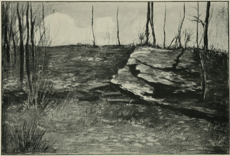
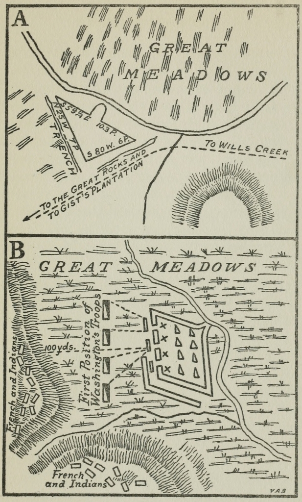
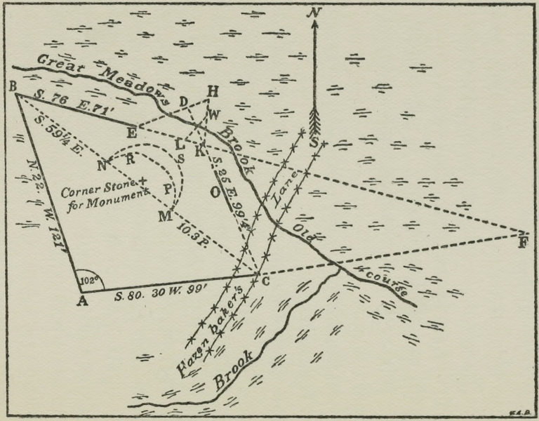
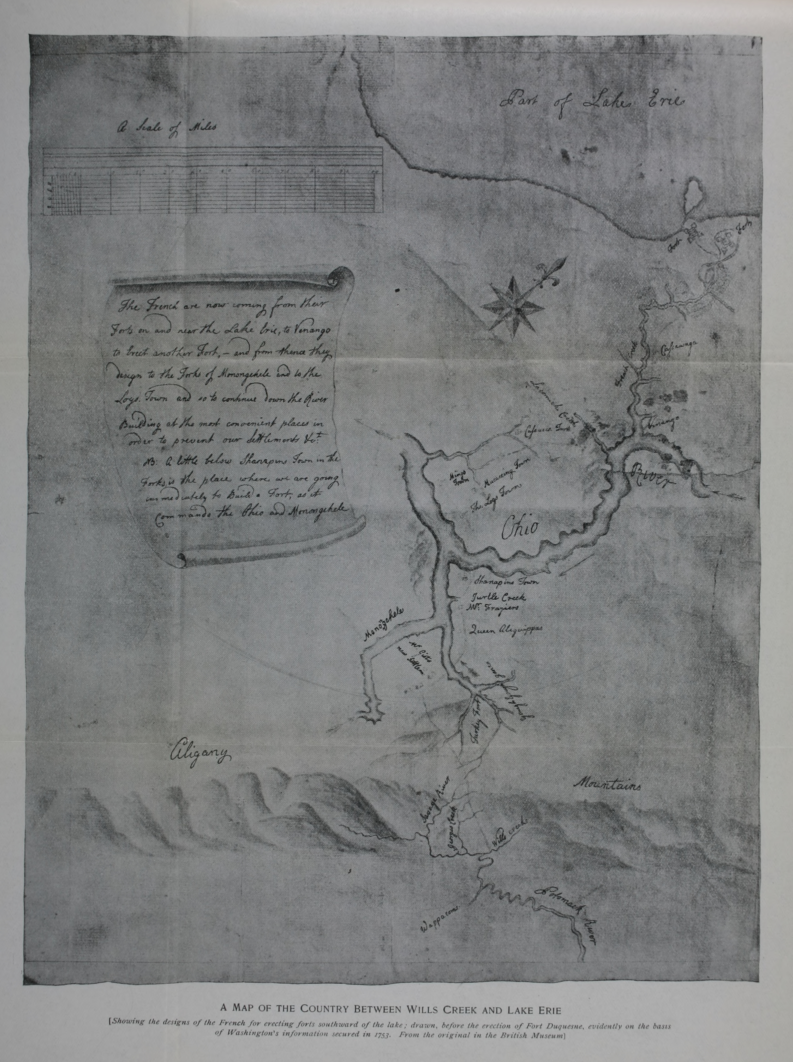