The Project Gutenberg EBook of Twenty-Five Years in a Waggon in South
Africa, by Andrew A. Anderson

This eBook is for the use of anyone anywhere at no cost and with
almost no restrictions whatsoever.  You may copy it, give it away or
re-use it under the terms of the Project Gutenberg License included
with this eBook or online at www.gutenberg.org


Title: Twenty-Five Years in a Waggon in South Africa
       Sport and Travel in South Africa

Author: Andrew A. Anderson

Illustrator: Andrew A. Anderson

Release Date: September 22, 2012 [EBook #40830]

Language: English

Character set encoding: UTF-8

*** START OF THIS PROJECT GUTENBERG EBOOK TWENTY-FIVE YEARS IN A WAGGON ***


Produced by Nick Hodson of London, England
Andrew A. Anderson
"Twenty-Five Years in a Waggon in South Africa"
"Sport and Travel in South Africa"
Preface.
My object in writing this work is to add another page to the physical geography of Africa. That region selected for my explorations has hitherto been a terra incognita in all maps relating to this dark continent. The field of my labour has been South Central Africa, north of the Cape Colony, up to the Congo region, comprising an area of 2,000,000 square miles; in length, from north to south, 1100 miles, and from east to west—that is, from the Indian to the South Atlantic Ocean—1800 miles, which includes the whole of Africa from sea to sea, and from the 15 degree to the 30 degree south latitude.
It has been my desire to make physical geography a pleasant study to the young, and in gaining this knowledge of a country, they may at the same time become acquainted with its resources and capabilities for future enterprise in commercial pursuits to all who may embark in such undertakings, and this cannot be accomplished without having a full knowledge of the people who inhabit the land; also its geological features, natural history, botany, and other subjects of interest in connection with it. Such information is imperative to a commercial nation like Great Britain, particularly when we look round and see such immense competition in trade with our continental neighbours, necessitates corresponding energy at home if we wish to hold our own in the great markets of the world, and this cannot be done unless the resources and capabilities of every quarter of the globe is thoroughly known. And for this purpose my endeavours have been directed, so far as South Central Africa is concerned, and to fill up the blank in the physical geography of that portion of the African Continent.
When I undertook this work in 1863 no information could be obtained as to what was beyond our colonial frontier, except that a great part was desert land uninhabited, except in parts by wild Bushmen, and the remaining region beyond by lawless tribes of natives. I at once saw there was a great field open for explorations, and I undertook that duty in that year, being strongly impressed with the importance, that eventually it would become (connected as it is with our South African possessions) of the highest value, if in our hands, for the preservation of our African colonies, the extension of our trade, and a great field for civilising and Christianising the native races, as also for emigration, which would lead to most important results, in opening up the great high road to Central Africa, thereby securing to the Cape Colony and Natal a vast increase of trade and an immense opening for the disposal of British merchandise that would otherwise flow into other channels through foreign ports; and, at the same time, knowing how closely connected native territories were to our border, which must affect politically and socially the different nationalities that are so widely spread over all the southern portion of Africa. With these advantages to be attained, it was necessary that some step should be taken to explore these regions, open up the country, and correctly delineate its physical features, and, if time permitted, its geological formation also, and other information that could be collected from time to time as I proceeded on my work. Such a vast extent of country, containing 2,000,000 square miles, cannot be thoroughly explored single-handed under many years’ labour, neither can so extensive an area be properly or intelligibly described as a whole. I have, therefore, in the first place, before entering upon general subjects, deemed it advisable to describe the several river systems and their basins in connection with the watersheds, as it will greatly facilitate and make more explicit the description given as to the locality of native territories that occupy this interesting and valuable portion of the African continent, in relation to our South African colonies. And, secondly, to describe separately each native state, the latitude and longitude of places, distances, and altitudes above sea-level, including those subjects above referred to. All this may be considered dry reading. I have therefore introduced many incidents that occurred during my travels through the country from time to time. To have enlarged on personal events, such as hunting expeditions, which were of daily occurrence, would have extended this work to an unusual length, therefore I have taken extracts from my journals to make the book, I trust, more interesting, and at the same time make physical geography a pleasant study to the young, who may wish to make themselves acquainted with every part of the globe. This is the first and most important duty to all who are entering into commercial pursuits, for without this knowledge little can be done in extending our commerce to regions at present but little known.
My travels and dates are not given consecutively, but each region is separately described, taken from journeys when passing through them in different years.
Chapter One.
In Natal—Preparing for my long-promised explorations into the far interior.
As a colonial, previous to 1860, I had long contemplated making an expedition into the regions north of the Cape Colony and Natal, but not until that year was I able to see my way clear to accomplish it. At that time, 1860, the Cape Colony was not so well known as it is now, and Natal much less; more particularly beyond its northern boundary, over the Drakensberg mountains, for few besides the Boers had ever penetrated beyond the Free State and Transvaal; and when on their return journey to Maritzburg, to sell their skins and other native produce, I had frequent conversations with them, the result was that nothing was known of the country beyond their limited journeys. This naturally gave me a greater desire to visit the native territories, and, being young and full of energy, wishing for a more active life than farming, although that is active during some part of the year, I arranged my plans and made up my mind to visit these unknown regions, and avail myself of such opportunities as I could spare from time to time to go and explore the interior, and collect such information as might come within my reach, not only for self-gratification, but to obtain a general knowledge of the country that might eventually be of use to others, and so combine pleasure with profit, to pay the necessary expenses of each journey. Such were my thoughts at the time, and if I could make what little knowledge I possessed available in pursuing this course, my journeys would not be wasted. My plans at first were very vague, but, eventually, as I proceeded they became more matured, and having a thorough knowledge of colonial life and what was necessary to be done to carry out my wishes, I had little difficulty in getting my things in order. Geology was one of my weaknesses, also natural history, which were not forgotten in my preparations. The difficulty was, there were no maps to guide me in the course to take over this wide and unknown region; I therefore determined to add that work also to my duties, and make this a book of reference on the Geography of South Central Africa, and so complete as I went on such parts visited, as time and opportunities permitted, as also a general description of the country, the inhabitants, botany, and other subjects, and incidents that took place on my travels through this interesting and important part of the African continent, and so cool down a little of the superabundant Scotch blood that would not let me settle down to a quiet life when there was anything to be done that required action; for we know perfectly well before we enter upon these explorations, that we shall not be living in the lap of luxury, or escape from all the perils that beset a traveller when first entering upon unknown ground—if any of these troubles should enter his mind, he had better stay at home. But, at the same time, it will be necessary to give some idea what an explorer has to undergo in penetrating these regions, and also the pleasures to be derived therefrom.
“There is a pleasure in the pathless woods,
There is a rapture by the lonely shore,
There is society where none intrudes
By the deep sea, and music in its roar.”
Byron.
It is a pleasure to be able to ramble unfettered by worldly ambition over a wild and new country, far from civilisation, where the postman’s knock is never heard, or shrieking railway-whistles, startling the seven senses out of your poor bewildered brain, and other so-called civilising influences, keeping up a perpetual nervous excitement not conducive to health. A life in the desert is certainly most charming with all its drawbacks, where the mind can have unlimited action. To travel when you please, eat and drink when so inclined, bunt, fish, sketch, explore, read or sleep, as the case may be, without interruption; no laws to curb your actions, or conventional habits to be studied. This is freedom, liberty, independence, in the full sense of the word. With these dreamy thoughts constantly before me, I determined to give such a life a trial; consequently, without more ado, I set to work to provide myself with the necessary means. Having heard, when travelling through Natal, that the country a few miles beyond the Drakensberg mountains was a terra incognita, where game could be counted by the million, and the native tribes beyond lived in primitive innocence, I was charmed with the thought of being the first in the field to enjoy Nature in all its forms, and bring before me, face to face, a people whose habits, customs, and daily life were the same to-day they were five thousand years ago. What a lesson for man! With what greed I looked upon my probable isolation from the outer world; craving for this visit to the happy hunting-ground.
The first thing to be done was to apply to an old friend, living a short distance from Maritzburg on a farm, who had been on several hunting expeditions, and returned a few weeks before, with his waggon-load of skins of various animals he had shot with his and his sons’ guns, which he spread out before me—one hundred and five—six lions, four leopards, seven otters, eight wolves, fourteen tiger-cats; the remainder made up of gnu, springbok and blesbok, and a variety of other antelopes, all shot within one hundred miles from the northern and western border of Natal, over the Drakensberg mountains, besides a heap of ostrich feathers of various kinds—a goodly bag of a seven months’ trip. The result of my cogitations with him was the procuring of a waggon and fourteen trek oxen, with the usual gear—a horse, saddle and bridle, with all sorts of odds and ends for cooking, water-casks, food of all kinds, flour, biscuits, bread, mealies for the Kaffirs, tea, coffee, sugar, preserves, and other necessaries needed for the road. A safe driver and forelooper, and an extra boy to cook and look after the horse, besides three rifles (not breechloaders, they were not known in Natal in 1860) and a double-barrel Westley Richards, and any quantity of ammunition. These three boys were all Zulus, with good characters, therefore could be depended on, which is a great thing.
Being a “Colonial” I was well up to African life and the Zulu language—a great advantage in that country. All things provided, I took several trips round the country in my waggon, up to August 1863, when I started north.
Twenty-five years ago!—a quarter of a century! What changes have come over South Africa in that time! Natal was little-known and scarcely heard of in England. The white population did not exceed one-half its present number of 30,000, and the greater part was overrun by Kaffirs, who were Zulus, similar to those of Zululand. Game of various kinds in plenty, lions were common, elephants, buffaloes, elands, wildebeests, quagga, and other antelopes, were numerous on the plains and long flats; leopards—here called tigers—wolves, jackals, and other beasts of prey, were heard nightly in the bush; and in the open rolling plains, under the Drakensberg range of mountains, that flank the western and northern boundary of the colony, springbok and blesbok, quagga and the gnu could be counted in thousands. Where are they now? Cleared from the face of the earth by the rifle, so that scarcely one is left, and those preserved that they should not be entirely exterminated. Beyond that magnificent and grand mountain range that rises in parts ten thousand feet above the sea-level, and extending several hundred miles in length, rearing its noble head far up in the clouds, and looking down as if guarding the beautiful and peaceful Natal at its feet. The scenery, especially on the western side, taking in the Giant and Champagne Castle and the lofty peaks to the north, few landscapes on earth can compare with it. Here the wild Bushmen lived in all their pristine glory; their home—the caves and kloofs in the gorges of mountains—far away from any other tribe, living by their poisoned arrows on game that comes within bowshot, and upon fruits and roots, which will be more particularly described in another chapter. Where are they now? Much like the game, exterminated by the rifle. They were then a great pest to the colonial people who kept stock near the foot of the mountain, for they would come down, after watching for days, mounted or on foot, and steal the cattle, killing all they could not carry off.
These Bushmen became such a pest that it was necessary to hunt them down. Two forces of a dozen men or more each were sent out under Captains Allison and Giles, and they got on their spoor after they had stolen a number of fine English-bred cattle and horses, many of which when they first escaped to the hills were found killed, when unable to keep up.
They tracked these Bushmen about on the hills in snow for some days, and at last the two parties met, and just before dark saw the Bushmen’s fires in caves. The parties slept on the ground, and in the morning saw a Bushman come out with a bridle to catch a horse. Suddenly, like Robinson Crusoe, he stood aghast seeing their spoor, threw down his bridle, and bolted to give the alarm. The Bushmen fought with their poisoned arrows, and as their sexes could not be distinguished in the bush, as they dress alike, all were killed, except one old woman, shot through the knee, who rode in as if nothing was wrong with her. She was cured, carried near to another tribe and turned out. No other Bushmen were ever seen after that in Natal. Previously one lad was shot through the shoulder and caught. He was never of any service, not even as an after-rider, though a splendid horseman, being quite unteachable. He never attempted to escape to his tribe, though he might easily have done so; and when taken out to track them, and coming on their caves, he broke their pots, a sign of displeasure among Kaffirs; and he said all he wanted was, to catch and kill his mother.
Starting.
Before starting on my memorable expedition, I procured some sail-cloth, to make a side-tent to my waggon, which formed a very comfortable retreat for my boys on wet nights. My driver, a fine young Zulu, could handle an ox-whip and give the professional crack to perfection. If not able to accomplish this feat, they are not considered efficient drivers. His name was Panda, after the great Zulu chief, and he was from all accounts a descendant of that renowned warrior, his father having fled into Natal some time before. He was now working to collect a sufficient number of heifers together to buy his first wife, a young Zulu maid living in a large kraal half a mile from his master’s farm. The forelooper, one who leads the two front oxen in dangerous places, and looks after the span when in the Veldt feeding and assists in inspanning, another fine young Zulu about eighteen, a handsome lad, was named Shilling. The other and third boy, younger, also a Zulu, I named Jim, as his other name was too long to use or recollect. After seeing some of my friends and saying good-bye, we make the first afternoon trek over the Town hill towards Howick, a very steep and stony road, full of ruts made by the heavy rains, and out on the rising ground beyond; where a magnificent view is obtained of the surrounding country and distant hills, of which Table Mountain, some twenty miles on the east of the city, stands out boldly in the landscape. There are several table mountains in Natal, so-called from their flat heads. My object when I commenced this journey was to push on with all speed to the foot of the Drakensberg Mountains, a distance of over 100 miles, cross the Berg at Van Reenen’s Pass, and make for Harrysmith in the Orange Free State, then determine where I should commence my journey of exploration. But I did not reach the foot of the mountain until the 12th of September, 1863, having deviated from the main transport road to visit some farmer friends, and take up one of the sons of an old “Colonial,” who had lived many years in the country as a stock-farmer, and who offered me his son as a guide, he being well acquainted with the country and people I proposed visiting. As he was a good driver and a good shot, as all colonials are, I was pleased to have his company, and being young, only seventeen, just the age to enjoy a rough and ready kind of life, it suited me exactly, so John Talbot was added to my little family. This detained me six days; as his mother wished to bake some biscuits for the road, also bread, and get some butter and other good things, I was quite agreeable to stay and go out with the old man to look up some game also, to supply my larder. So whilst the mother and her pretty daughter of true English blood, a year older than her brother John, were busy in the house, we men were also busy outside with our guns; besides large game, such as elands, koodoo, blesbok and springbok, we had excellent sport with the shot-guns, there being plenty of hares, partridges, pheasants, snipe, and ducks. The farm is situated on the Tugela river, and being some two miles from the foot of one of the spurs of the mountain, was out of the way of all traffic, and was as pretty a locality as any one could desire to live in; there was any quantity of fish, consequently there was no lack of fish, flesh, or fowl in this beautiful and quiet retreat.
The second morning of my arrival there, Mr Talbot and I, after taking coffee, saddled-up, as the sun was just peeping over the distant mountain tops in a blaze of gold and crimson light, with an atmosphere pure and clear, casting a brilliant reflection on all around,—a glorious sight to behold. This part of the world is famed for the lovely and varied tints which the sun produces in the sky in rising and setting, more particularly in the summer, forming celestial landscapes, marvellous to look upon, and grand in the extreme. On leaving the farm-house for our ride into the open plains to see if we could discover some elands, we met a Dutchman on horseback, with the usual companion rifle. After the morning greeting and shaking hands, he inquired if we had seen any stray calves about; finding we had not, he suspected the Bushmen had been down again from the mountains and had carried off two. He informed us that a neighbour of his, another Dutch farmer, a week or so before had lost some sheep, and he had traced them up into a deep kloof of the mountain, and came upon a family of Bushmen in the act of driving three of his sheep towards the hills, where he shot the two men and took a woman and two children, and brought them to his farm, making them drive the sheep back with them, and they were at his farm now.
Wishing to see them, we rode over, a distance of some seven miles, where we found them confined in an outhouse, squatting on the floor, looking anything but amiable; they were poor specimens of humanity. We had them brought out for a closer inspection. The woman was not old or young, of a yellowish-white colour, a few little tufts of wool on the head; eyes she had, but the lids were so closed they were not to be seen, although she could see between them perfectly; no nose, only two orifices, through which she breathed, with thin projecting lips, and sharp chin, with broad cheek-bones, her spine curved in the most extraordinary manner, consequently the stomach protruded in the same proportion, with thin, calfless legs, and with that wonderful formation peculiar to this Bushmen tribe, and slightly developed in the Hottentot and Korannas. The two little girls—the eldest did not seem more than ten or twelve—were of the same type, the woman measured four feet one inch in height. The old Boer wanted to shoot them, but his vrow wished to keep and make servants of them. Their language was a succession of clicks with no guttural sound in the throat, like that of the Hottentot and Koranna tribes, but both languages assimilated so closely that it is clear the Hottentot and Koranna have partly descended from this pure breed, for a pure breed they are, and may be the remnants of almost a distinct race that lived on the face of this earth in prehistoric ages.
The quarter of the globe in which they are found, at the extreme end of a large continent, in a rugged and mountainous country, a locality well adapted to preserve them from utter extinction, may be the cause of their preservation; at any rate, there are no other people in the world like them, and their having a language almost without words except clicks, is a most peculiar feature in connection with this entirely distinct race, and for anthropological science, these people should be preserved, that is the pure breed, unmixed by Hottentot or Koranna blood.
Leaving the Boer farm, after the usual cup of coffee, we skirted the hills which ran out in grand and lofty spurs, broken here and there by perpendicular cliffs, many hundred feet deep, clothed with subtropical plants and shrubs, with beautiful creepers climbing among the projecting rocks, and hanging in festoons, with crimson and yellow pods, contrasting so beautifully with the rich green around.
We reached the head of one of the Tugela branches, one of the most picturesque and lovely landscapes I have ever seen in Africa. The lofty mountain range, 10,000 feet in altitude, forming the background, with their peaked and rugged summits, fading away in the distance to a pale bluish pink tint, with the nearer mountains, and a glimpse of a pretty waterfall, with the richly-wooded foreground and placid stream at our feet, completed a picture seldom to be seen. My friend and host, Mr Talbot, proposed a halt at this spot, therefore, selecting a fine clump of trees to be in the shade, for although early in the spring, the sun shining down upon us from a cloudless sky was unusually warm; we were therefore glad to seek the shelter of the trees, off-saddle and knee-halter the horses to feed, whilst we stretched ourselves on the soft young grass to view the scene around and take our lunch.
As it was early in the day, we gave the horses a good rest, and then saddled-up for our return journey. There were many small herds of various kinds of antelopes, but too far away to follow. Springboks we could shoot, but being so many miles from the farm, we waited until we got within a reasonable distance to carry them on the horses, which as we approached home we had plenty of opportunities of doing, and secured three, two of which I made into biltong for the road. On arriving at the farm, my boy Panda showed me a large snake, one of those cobra de capello whose bite is very dangerous, sometimes causing death; it measured five feet in length, and was killed in the house, which was built with poles and reeds, called in the country a hartebeest house, with several outbuildings on the same plan. They are made very comfortable and snug within, but will not keep out snakes; most of the cooking is done out of doors, where a fire is constantly burning: early coffee about six, breakfast at eight, dinner at one, and supper at sundown. This is the general custom on the farms. After an outing of nearly twenty miles, we enjoyed our dinner of baked venison of eland, with stewed peaches to follow, and good home-baked bread. As lions were very plentiful, as also wolves and leopards, the farmers had to make secure kraals for their cattle, sheep, and goats; the horses were kept in sheds; and with these precautions it not unfrequently occurred that a leopard, which out here is called a tiger, leaped the enclosure and carried off a goat or sheep. A few weeks before my arrival here, some wolves and hyenas broke into the sheep-kraal, killing seven, carrying three half a mile away, where their remains were found next morning. They make these attacks mostly on dark and stormy nights, when it is difficult to hear any noise when shut in the house.
The next day my host, his son John, and myself, after breakfast saddled-up, and with our rifles, started for the native location, which is an extensive tract of country under the foot of the Berg, occupied by the Zulus, who have large kraals and plenty of cattle, in order to buy some young bullocks to break in for trek oxen. Visiting some on our way, at one of which we off-saddled to rest, the Kaffirs coming out to stare as usual, the young intombes (Kaffir maids), like their white sisters, curious to see the strangers, came to look also. John and his father being well known to them, we were asked in to have some Kaffir beer. Some of the girls were very pretty, and we told them so, which they took as a matter of course, and came forward that we might have a better look at them, and seemed pleased to be admired.
Beautifully formed, with expressive countenances, tall, and carrying themselves as well as if they had been drilled under a professional; their constant habit of carrying heavy Kaffir pots of water, which can only be done by walking erect, has produced this effect. One young Kaffir was very busy making a hut for himself, as he was going to be married. The care and attention he displayed on its erection, and the ingenuity with which he interweaved each green stick, which was tied with thin slips of skin, was most interesting, and he seemed quite proud when praised for his good workmanship. One of the girls was pointed out to us as his wife that was to be, a fine good-looking girl about seventeen, ornamented with plenty of brass bracelets and beads, the present of her fiancé. They are not encumbered with much clothing, being in a state of nature with the exception of an apology for an apron, or frequently only a string of beads, two or three inches long. Their huts and enclosures are kept clean and neat, and in every respect as far as order and quietness are concerned, the Zulus may set an example to many white towns. After purchasing a few Kaffir sheep, we returned to the farm.
The 3rd of September, a lovely bright morning, two beautiful secretary-birds came walking close past the farm,—they are preserved for the good they do in killing snakes, therefore a heavy fine is set upon any one shooting them; they are similar in shape to the crane, but much larger, with long and powerful legs. It is strange to see them kill a snake; one would think that with their strong horny legs and beaks, they need only tread on and kill him with their beaks, but they are evidently afraid to do this. They dart into the air and pound down violently upon him with their feet until he is dead.
Shortly after breakfast, a Zulu girl came for work; she had run away from her father’s kraal, to escape being married to an old Zulu Induna, living on the Bushman river, and had walked nearly forty miles across the country to Mrs Talbot’s to escape the match. She told, when pressed, that her father wanted to sell her for twenty heifers to the old man, and she did not like it, as she liked a young Zulu, therefore she fled from the kraal the previous day, and had walked that distance without food, avoiding other kraals, fearing the people, if they saw her, would send her back, and she begged the “misses” would let her stop and work for her. She was a very fine young girl, apparently about seventeen, tall, and well-made, and very good-looking, without ornaments or anything on her in the way of clothes. The “misses” soon found an old garment to cover her nakedness. Poor girl, she is not devoid of affection, as this action of hers shows. I fear there are many similarly situated, both white and black. So Mrs Talbot had compassion and employed her, and she turned out a very good and useful help. The Zulu war was caused by a similar occurrence, two girls having taken refuge in Natal, whence they were fetched out and killed by the Zulus, who refused to give up the murderers.
Some few days after, we were all sitting under the shade of the trees close to the house, taking coffee, when four young Zulu girls came, each carrying a bowl on her head, full of maize, to exchange for beads and brass wire to make bracelets, as all outlying farmers keep such things for payment. Their ages might be about fifteen. One of them had her woolly hair in long ringlets all over her head, and seemed to be a born flirt, her manner was so coquettish; all of them were very good-looking, as most of them are when young.
I told them if they would give us a dance, I would present each with a kerchief. This gave much satisfaction, and they commenced their Zulu dances, singing, laughing, and playing tricks, in their native way. When it was over the kerchiefs were given, which they fastened turban fashion round their heads, then marched up and down, much pleased with their appearance, showing they are not devoid of vanity. Savage or civilised, woman is woman all over the world. Most of the Kaffirs living in Natal belong to the Amalimga Zulus, those in Zululand to the Amazulu family. Sixty years ago there were cannibals in Natal, in the mountains. I was shown the spot and tree, by an old Zulu, where the last man was cooked and eaten. At that time the country was infested with hordes of wild Bushmen, of the type before described, who had their stronghold in those grand old mountains that skirt the northern and western boundary of this fair and beautiful little colony—the cannibals were not Bushmen; and also with wandering tribes of the Amagalekas, Amabaces, Amapondas, many of them travelling west, and who settled on the Unzimvobo river, and along the coast in Tambookie and other districts, and remained in a wild and savage state up to within thirty years of the present time; then it was a howling wilderness, swarming with lions, leopards, wolves, and other beasts of prey; only a few years ago lions were very numerous. The landlord of the Royal Hotel at Durban told me a lion came into his yard in the daytime, leaped into an open window and seized upon a fine hot sirloin of beef that was on the table with other good things prepared for a dinner-party, and quietly walked off with it. At the present time (1860) up in these parts they are to be seen daily, and great care is required to preserve the oxen and other animals from falling a prey to their nightly visits. Only three weeks back a farmer on the Tugela had one of his horses killed and partly eaten before morning. The horse was made fast in a shed, a short distance from the house; it appears there were several lions from the number of footprints to be seen in the morning. The Kaffirs forgot to fasten the door at night. Almost every evening we hear them.
A Lion in a Dog-cart.
As an instance of their boldness at times, for, generally speaking, they are cowardly, the following was related by Mr Botha, a respectable, educated Boer farmer, and is quite true. It happened to his uncle.
“Journal.—Apes river, between Pretoria and Waterborg. Arrived at the Outspan, remained until next night at twelve, then started the waggon off on the springbok flats (twenty miles without water). The party consisted of L. Botha, P. Venter, and the servants, one waggon with span of sixteen oxen, one cart and two horses. Venter and Botha remained at the Outspan place with the cart and horses and a bastard Hottentot boy called Mark, twelve years old.
“The waggon had been gone half-an-hour when they heard the rattling of wheels in a manner which made them think that the oxen must have had a ‘scrick’ (scare) from a lion, as that place is full of them. Mark, who was sleeping alongside the fire, was called up to bring the horses. The lazy fellows there won’t do anything themselves, not even when there is a ‘scrick’ from a lion. They were soon going to render assistance to the waggon, going at a jog trot (even then they did not hurry), when Mark, who was on the front seat, called out, ‘Baas, de esel byt de paarde’ (‘The donkey bites the horse’), and immediately the cart stopped, and a lion was seen clasped round the fore-quarters of the favourite horse. Before the gun was taken up, down went the horse; meanwhile the gun was levelled at the lion, but the cap missed. Another was searched for, but it would not fit, as it was small and the nipple a large military one (so like a Boer!). The lion now was making his meal off the horse, lying at his ease alongside the splash-board, eating the hind-quarter, Botha trying to split a cap to make it fit in vain; so Venter took the gun, and Botha made up powder with spittle to make it stick, and Venter was to take aim and Botha to do the firing with a match. Just as it ignited, the lion sprang right into the cart between them, and gave Venter a wound on the head and scratched his hand with his claw, and bit off a piece of the railing, sending the gun and Mark spinning out of the cart, and with that force that the lion fell down behind the cart. He then came round, as fast as he could, on to the dead horse, and continued his feed; but, not in the same cool manner, but making a growling, like a cat with meat when a dog is near, and now and then giving an awful roar, which made the cart, men, and all shake again. The other horse, which is a miracle, stood quite still, never attempting to budge an inch. After the lion had fed he went away, and Botha got out, intending to unharness the remaining horse, but no sooner was he on the ground than he heard the lion coming on again at full speed. He threw himself into the cart, and the lion stopped in front of the living horse, which tried to escape but was held fast by the pole-chain after breaking the swingle-trees. The lion gave one jump on to the horse, and with one bite behind the ears killed him. Botha was lying on the front seat, with his legs hanging down alongside the splash-board, when the lion came and licked the sweat of his horse off his trousers, but did not bite, Botha remaining quite still, which was the only chance, in the dog-cart from ten o’clock, when first attacked, until near daybreak, when the lion left; you may imagine what Botha felt as he looked at his two valuable hunters. Soon a waggon came along and took on the cart, when their driver told them that, soon after he left, suddenly the oxen bolted for some distance, but luckily in the track, by the driver cracking his whip on both sides of them, which, no doubt, kept off the lion also, who was galloping alongside.” This is a most remarkable case of boldness in a lion, when not wounded.
The South African lions are not nearly so fierce and plucky as the Syrian, and they are often very cowardly. A Hottentot relates that he once came on a lion asleep, and put his elephant “roer” at his ear, when before he fired, he heard klop! klop! and the bullet, which had been secured only by a loose paper wad, rolled down and dropped into the lion’s ear, who jumped up and bolted!
There are a few herds of buffaloes in the Bush, but they are very wild and dangerous to approach, having been so much hunted. I have seen them tamed and inspanned with oxen. Elephants are seen no more in Natal. The Berea, near Durban, which is an extensive Bush country, was a favourite resort for them, and the hippopotamus is becoming extinct in the rivers. There are five preserved in the Umgeni river near Durban, off a sugar estate; one had disappeared for some time, and then came back with a calf. This “Hero” must have swum 100 miles by sea into the Zulu country after her Leander. There are also a few in the Upper Umgeni, near Maritzburg. I have been told by many Zulus that they have seen them leave a river, go out to sea and follow the coast down until they arrive at another river and enter it, and some of the old settlers have confirmed it.
The coast is much more tropical than the up-country. Fruits, such as guava, citron, lime, tamarind, loquat, lemon, orange, banana, pineapple, figs, grow to perfection. Also peaches, and apples, and every kind of European vegetable. The coast is favourable for sugar, tea, coffee, tobacco, indigo, arrowroot, ginger, all kinds of spices, and the cotton-plant has just been introduced on the coast, but it failed, owing to the aphis fly; the castor-oil plant and the aloe grow to a great size. There is also some very fine timber, particularly in the kloofs amongst the hills. Coal, in seams eleven feet thick, exists in the Newcastle district, as the name denotes. Iron abounds all over the colony. Altogether, Natal is a very pleasant colony to settle in; the climate is everything that can be wished. The two principal drawbacks are the annual grass-fires, destroying everything as they sweep over the country, killing all young forest trees, and making the grass of a coarser texture; and there are sometimes many months of drought. But these are not confined to Natal; the same drawbacks pervade every part of South Africa, even up to the Zambese, and the long drought that lasts for months is more common towards the western portion of the continent than it is on the east coast. The summer being the rainy season makes it pleasant, though the lightning is terrible, and dangerous to a degree which, perhaps, does not exist anywhere else. The most dangerous are the dry storms.
Chapter Two.
My first start across the Drakensberg Mountains—Visit Harrysmith, Wakkerstroom, Utrich, Newcastle, Home.
Early in the morning of the fourth found me ready for a start for a four months’ trip before plunging into the unknown land. My little expedition consisted of a waggon and fourteen trek oxen, a young four-year-old Natal horse, my driver and two Zulu boys, myself and young Talbot, well provisioned for my journey. Leaving my kind friends, I took the road to Ladysmith, but turned off to the left before reaching that town, and took the Transport Road, leading to Harrysmith in the Free State, over the mountain, passing up by Van Reenen’s Pass, a very steep and long hill, the altitude being 7250 feet above sea-level, and arrived at Harrysmith on the 18th of September, 1863, where I outspanned close to the town. The country along the whole distance up to the berg is very pretty and picturesque. From the base of the berg to the summit the distance is about five miles, with a rise of 2000 feet, that being the difference in the altitude between the upper or northern part of Natal and the Orange Free State, consequently being so much higher and open, makes the winter much colder. From this elevation, and looking back upon Natal, a more lovely or extensive landscape can scarcely be imagined. To the right and left huge rocks stand out on the rugged summits in those grotesque forms from which descend perpendicular cliffs and deep kloofs clothed in subtropical vegetation, between which long spurs of the mountain are thrown out, terminating in rolling plains and beyond lofty hills and deep valleys. Far away, on the right, continues the Drakensberg, with its lofty and noble peaks rearing their heads far into the clouds that hang on their summits in loving embrace, until they are lost to view in the pale tints of the evening sky, leaving the central view open to the sea, 120 miles to the coast, where the bluff at Port Durban can be distinguished overlooking the intervening country with its plains and hills.
It was here, at the Bushman’s Pass, 9000 feet high, that the sad affair with Langalibalele’s tribe occurred. A number of them had been at the diamond-fields, where they had procured guns for wages. No Kaffirs in Natal are allowed to have guns, except a few hundred, by special licence, and the sale of gunpowder is all in the hands of the Government, white men even not being allowed more than ten pounds a year, and they cannot import guns without a special permission from the Government.
The entire immunity of Natal, from its first annexation, from Kaffir wars, which have caused so much waste of blood and treasure at the Cape, is owing chiefly to this wise law, which is so rigidly enforced that a number of guns were seized which had been made in Natal, at a cost of 2 pounds 10 shillings each. The barrels were gas-pipes, whilst good muskets could have been imported at 5 shillings each. All the Cape wars have been caused by the omission of this simple precaution.
The Natal border Zulu chief Langalibalele had been a rebel from his youth upwards. He rebelled against Panda, the Zulu king, and barely escaped into Natal with a few followers, leaving all his cattle behind. Shortly after he returned, killed the keepers of the cattle, and took them into Natal. There he was given about the best “location” on the beautiful spot here described in the Drakensberg. Many refugees from Zululand joined him, and his tribe became powerful. But they were always restless and contumacious. At last about 250 of them brought back from the diamond-fields the guns which they had received for wages, and when called upon to give them up refused to do so, or even—as subsequently allowed—to send them in to be registered, and they insulted the messengers sent by the Government. A force was consequently marched into the location, and as the whole tribe was about to depart into the Zulu country with the cattle, a proceeding which was against all Kaffir law, the passes of the mountains were occupied, to prevent their escape, by volunteers, and the soldiers were kept below. To the Bushman’s Pass a force of about twenty of the Natal carbineers (cavalry) was sent up. The pass, 9000 feet high, was so steep that they could not ride, but had to lead their horses, in doing which Colonel Durnford (killed at Isandhlwana), who commanded the party, was pulled down a rock by his horse, and his shoulder dislocated. It was pulled in at once, but being a delicate man the pain and fatigue overcame him entirely, and he was obliged to remain behind, while the rest went on and bivouacked on the pass. During the night, young Robert Erskine, son of the Colonial Secretary, went down twice to his assistance, taking brandy, etc., and eventually he got him on to his horse and up to his men. Early next morning a part of the tribe, with the cattle, came up, the rest having passed before, and occupied the rocks around, being armed with guns.
Unfortunately, the Governor of Natal had got it into his head that he was a born soldier, and had accompanied the soldiers who were below. As the captain of the volunteers knew no drill, and could not move the men, the Governor—who was weakly allowed by the colonel in command to dictate—sent Major Durnford, an engineer—who knew no more than the captain about manoeuvring men—in command, and to this folly added a mad injunction “not to fire first!” in obedience to which Durnford allowed the tribe to keep coming up. Erskine, who had been private secretary to the former governor, and who knew the tribe well, having lived among them sketching, and having had twenty-five of them working for him at the diamond-fields, offered to go down the pass and remonstrate with the chiefs who were below. Major Durnford would not allow it, saying that he had saved his life, and it was certain death. The tribe kept coming up and lining the rocks, calling out, “You’ll never see your mother again! That’s my horse! That’s my saddle!” etc.
At last a cowardly fellow, a drill-sergeant, formerly in the Cape Mounted Rifles, who had been allowed to join the force as dry-nurse, persuaded the men that they would all be killed, and they sent their captain to Durnford to say so, and that as he would not allow them to fire they would not stay. On which Durnford called out, “Will nobody stand by me?” when Erskine said, “I will, major,” and another, Bond, said so, as also did one more. Durnford then said, “If you will not stand by me you must go;” and not knowing the cavalry word, the drill-sergeant gave the word, “Fours right! right wheel! Walk! March!” As they filed past the rocks, the Zulu in command called, “Don’t fire until they have passed,” and they then fired and shot down the whole rear section, and the rest galloped off, except Durnford, who was drinking at the source of the Orange river. His bridle was seized by two Zulus, and one wounded him in the shoulder. Although one arm was disabled, with the other he shot them both, and escaped.
At the same time the Kaffir interpreter, who fought gallantly, was killed, and Erskine also, whose horse was shot down, was shot through the head and heart, in the source of the Orange river. One of the four, whose horse had been shot down, caught Erskine’s horse, which had got up again, and escaped on him for a space. The horse then fell dead, and two of the men dismounted and covered him, shooting some of the Zulus who were coming on. He caught Durnford’s spare horse running by, and after some delay and danger from a shower of bullets, succeeded in getting Erskine’s saddle on to the horse, and escaped. Durnford tried in vain to rally the men, and they went helter-skelter down the pass, the captain—afraid to ride down—being sledged down on his stern.
The bodies were allowed to remain there several days, although there was not a Zulu near, and then they were buried by Durnford under a large cairn, erected with rocks, interspersed with the beautiful heaths and flora growing around. Erskine’s body was found in the source itself of the Orange river. The people erected a handsome monument to their memory in the market-square at Maritzburg, and another to those who fell at Isandhlwana—about thirty. Thus, out of a troop of fifty, thirty-three of the Natal volunteer carbineers fell in these two affairs owing, on both occasions, to the grossest mismanagement. Ne sutor ultra crepidam!
The tribe was afterwards hunted for two months in these mountains by volunteers only, and captured with their chief, Langalibalele, who was sent to the Cape, and kept more comfortably than he ever was in his life, in a nice house and grounds, with entire freedom to move about, his only grievance being that he was not allowed more than three of his wives, the cause of this distressing privation being simply that the balance would not come. An absurd proposition was sent out by the Home Government lately that he should be allowed to return to Natal, but it was promptly quashed by that Government. Coelum non animum mutant qui trans mare currunt, as was proved in the case of Cetewayo’s restoration, “who had learnt and forgotten nothing.”
This, if it can be called one, is the only rebellion ever known, or likely to be known, in Natal, where the Kaffirs are thoroughly loyal. Shortly before this a little raid was made into Natal by one of Moshesh’s sons, when two natives were killed and some cattle lifted. A force was sent up, too late, and en route the Colonial Secretary and Secretary for Native Affairs, who were sitting in a waggon, were watching a tribe, when they diverted, and forming regularly into line their orator ran out, and running as they do up and down made an oration, “There’s the Government in the waggon! What’s the meaning of this? Why is this land invaded? Why are our people killed and our cattle stolen? Why were we not called out sooner? Was it that we are not trusted? Wow!! There sit under that waggon Langalibalele’s people! Who are they? Dogs! that we used to hunt down; and would again, if not prevented by the Government.”
Sir T. Shepstone did not even condescend to address them himself, but in a few words, through an interpreter, told them they were quite loyal, had the approval of the great Queen, and could pass on, which they did, moving off by companies from the right, like soldiers, and singing a war song, making the earth tremble with their stamping. (On such occasions extraordinary licence of speech is allowed by the Zulus.) All these tribes would fight well for us at first if there were to be a rising outside, but after a bit they would join their own kind, as they both feel and say that white and black blood can never mingle because we despise them.
The great change in climate and vegetation is very perceptible on leaving fair Natal for the cold, dreary, open, and inhospitable Free State. Harrysmith, in 1863, was a poor, dull, sleepy town, only supported and kept alive by a few transport riders on their way to the Transvaal and the small villages of the Free State. But after the annexation of the former State by the British Government in 1877, it soon became a town of importance, and being on the main road from Natal, large and well-built stores, houses, churches, and schools soon put life into its inhabitants. Thanks to British gold for turning a howling wilderness into a land of promise!
I remained two days to gain news and information about the locality, and the various roads to the north; game being plentiful in all directions, principally blesbok and springbok, wildebeest or gnu, quaggas, hartebeest, and others. The ostrich was also plentiful. I decided to follow the game up, taking the advice of my Natal friend, who had recently returned from his shooting excursion. I took the road leading east, and less frequented than the others, which eventually leads to the newly-formed town of Wakkerstroom, on the eastern border of the Transvaal, and also north from that town to Lydenburg, now the gold centre. Anxious to make the most of my time, as I had to return to Natal before starting on my grand explorations to obtain a fresh driver and two Kaffirs, I was constantly in the saddle after anything that crossed my path, travelling slowly on, shooting as much game as we required for the road. To shoot more would be mere waste, although the Boers make a practice of killing as many as they can for the sake of the skins, leaving the dead animals to be devoured by lions, wolves, or any other animal.
One night, as we were outspanned on the bank of a dry sluit, close to a small but thickly wooded koppie (hill) and large blocks of stone, we were disturbed by hearing the roar of two or more lions, within a very short distance of our camp. Not having made any preparation to receive visitors of this kind, we were all soon on our feet with rifles. The fire had gone out, but the stars gave some little light, sufficient to see all safe, particularly my horse. We were all on the watch, peering into the darkness, when we saw two lions cross over from the opposite bank and enter the near koppie. I was told before starting, by several old hunters, never to shoot at a lion when near, if it can be avoided, unless certain of killing; for if only wounded he would attack before you could reload.
Our anxiety was for the safety of our oxen and horse, fearing they might get away and be caught by the lions. I made the two Kaffirs collect a few sticks, and with what was left from last night made a fire, which threw a light into the bushes, where we saw our two friends enter, and shortly after I saw a pair of eyes shining like fire from out of the wood within thirty yards. If I could have depended on my Kaffirs, all being armed, he would certainly have had the contents of my rifle, but knowing them to be bad shots when cool, and that they would have been worse than useless in time of danger, to my great disgust was I obliged to stand and watch only. As they left the koppie, they made a circuit of my camp, but at a greater distance. Taking the two rifles from the young Kaffirs, placing them against the fore-wheel of the waggon, to be ready at a moment’s notice, I could not resist so fine a chance of a shot in the open, only fifty yards distant; the light of the fire giving out a good glare, I had a full view, and fired, and found I had wounded one—the thud of the bullet is sufficient to know that. My driver, a fine Zulu, and young Talbot, had their rifles ready in case he charged, which he did, in short bounds. As he neared, they both fired and both hit, but not sufficiently to kill him; but he was unable to move, as his hind-quarters were rendered powerless. Reloading, we walked up, and I gave him a bullet as near the heart as I could, when he fell over; the other we saw moving away into the darkness—a fine full-grown lion with dark mane. This was the third lion that had fallen by my rifle. The little affair detained us the following day, skinning and pegging out to dry in the sun, in addition to several other skins of the game shot on the road, eleven in all. When a skin is taken from an animal, I sprinkle a little salt over it, then roll it up, to be pegged out at a convenient opportunity.
The next day we made a fresh move towards a lofty isolated hill in the Free State, which we reached in two inspans, and crossing a stony sluit, outspanned under a few trees, close to some very ancient stone walls built without mortar. They were square and some twelve feet high. The open plains were full of game of many kinds. Wishing to explore this hill, early in the morning after coffee I took my rifle to climb to the topmost ridge, letting John have the horse to get a springbok. After rambling about the hill, scanning the country all round, I was coming down when I nearly stumbled on a wolf (hyena), which must have been asleep amongst the stones. I was within twenty feet when I fired, killing him at once. Not far away were two large black eagles; the report of the rifle seat them soaring away into space. About half-way down the hill I saw two stones that had evidently been cut into shape by a mason; they looked like coping-stones, with well-marked lines, and perfectly square. I took their measure and a sketch of each, both of them exactly a foot in length and six inches wide. They evidently belonged to some ancient building, but when? is a question not so easily solved. But other stone huts two days’ trek beyond were clearly erected by a race long since passed away; they were circular, with circular stone roofs, and nearly two feet thick, of partly hewn stone, beautifully made; a stone door with lintels, sills, and door-plates. Kaffirs have never been known to build in this way. Between each hut there was a straight stone wall, five feet in height, with doorways and lintels, communicating with each square enclosure, perfect specimens of art. They were, I believe, erected by the same people who worked the gold-mines, the remains of which we frequently find in the Transvaal and the Matabele, and beyond, where so many of their forts still remain. In the Marico district there are two extensive remains of these stone towns, which must, from their extent, have occupied many years to complete. The outer wall that encloses the whole is six feet thick, and at the present time five feet high. Several large trees are growing out and through the roof of some of them. They are how the abode of the leopard, jackal, and wolf, and so hidden by bush they, are not seen until you are close upon them. Broken pieces of pottery are the only things I have discovered. The present natives know nothing of them; they are shrouded in mystery. Many remains of old walls are standing, showing that at one time this upper part of the Free State must have been thickly populated. At this outspan I killed a yellow snake, three feet in length, with four legs, but not made for locomotion. I heard there were such in Natal, but this is the first I have seen. When he found he could not make his escape, he curled himself into a circle, with his head raised to strike similar to other snakes. I consigned him to a bottle of spirits. I also shot one of those beautiful blue jays, as there were many in this district.
I pass over my shooting exploits, as there is nothing worth recording, each daily trek being almost a repetition of the last, until we arrive in sight of Wakkerstroom, a poor village, a few houses, flat roofs, single floors, built in an open country near a lofty hill, which stands on the main road from Natal to Lydenburg; we remained only a few days, then went north, as far as Lake Crissie, an open piece of water, no trees or bushes near; a solitary sea-cow is the only occupant of this dismal-looking place. In this district the Vaal river rises, and many small branches meet, until the veritable river is formed. The elevation at the lake was 5613 feet, and on a hill a few miles north I found the altitude above sea-level to be 6110 feet, an open grass undulating country as far as the eye could see, except on the east, where the mountain range that forms the Quathlamba is seen in the distance. I retraced part of the road, and turned south-east, over the hills leading to where Lunenburg now stands, and on towards Swaziland, which is an independent native territory, thickly populated and very mountainous; there are rich gold-mines there now, and some of the mountains attain an altitude of 8000 feet.
The greater part of the summer months, a mist envelops the hills, but it is a very healthy part of Africa, and horse sickness is rarely known to exist, consequently many horses are bred here. Passing Kruger’s post, through Buffel forest, which is hilly, and splendid timber trees cover the entire country, the scenery is grand and wild; quartz reefs crop out in all directions, sandstone, shale, and in some places limestone overlap the granite formation, which compose these lofty ridges of the Drakensberg; shale, which indicates the existence of coal, is frequently seen in the valleys, and along the Pongola river and its several branches.
I left Harrysmith on the 20th September, 1863, arriving on the banks of the Pongola river on the 16th October. In that time I had treked 350 miles, being delayed on the road shooting and exploring.
The people at Wakkerstroom wanted to know what I was doing in the country, as I did not handel (trade), and was not a smouser, the term applied to those who went about the country in waggons to sell and buy. They would not believe I came into the country for pleasure and to shoot, but I was set down as an English spy, as I took notes and made sketches of the country. When I showed them a small drawing of the town with the hill at the backhand people walking about, they held it upside down, and said it was mooi (pretty). Most of the Boers are very slow in comprehending anything, the women are much quicker, and turned the picture round, and knew it at once, as also some Kaffir girls, pointing to the figures, naming whom they represented with expressions of delight. Some of the girls seem to have a natural gift for drawing and the beauties of nature, pointing out with their finger various objects, and explaining to those around what the drawing represented. I have often thought that many of these bright Kaffir girls might make good artists with proper training. Mrs Colenso taught some to draw, paint, and play and sing. When they were about sixteen their father came for them, and they, quite delighted, ran off, stripped off their clothes, and went off naked, and never returned, just like some wild pigeons I had once tamed. They are also quite alive to the ridiculous: in the sketch were two horses playing, one standing with his fore-feet in the air; this caught their attention at once, causing great amusement, and imitating their action. They belonged to the Mantatees or Mahowas tribe, which is divided into many kraals under various chiefs, all subject to the head chief Secocoene, who lives on the north of Lydenburg. The Pongola skirts the Swazi, or, as it is sometimes called, the Amaswasiland, a very mountainous country; the people are Zulus, their habits and mode of fighting being the same. Many of these people came to my waggon with milk, which I took in exchange for tobacco and beads. The men are a fine manly race, and the women, many of them, good-looking, but very scanty in their dress, which is only a little strip of beads an inch wide. The Swazi country is situated between the eastern boundary of the Transvaal and the Amatonga, which is the northern part of Zululand, up to the Portuguese settlement in Delagoa Bay on the east side. It is governed by an independent chief, their laws and language being the same as the Zulus. The country has every indication of being rich in gold, some specimens of quartz I obtained from reefs running through the country looked very promising. The Pongola Bush, as it is called, is a beautiful forest of fine timber trees. Some of the most valuable are the Bosch Gorrah, of a scarlet colour, fine grain; Ebenhout, a sort of ebony; Borrie yellow, Bockenhout, no regular grain; Assagaai, used for spear handles; Wild Almond, Grelhout, Saffraan, Stinkwood, Speckerhout, Wild Fig, Umghu, Witgatboom, Tambooti; White Ironwood, very hard, and many others of great use for many purposes. The Pongola river is very pretty; passing down through a richly-wooded district, with its tributaries, flowing east and then north it joins the beautiful river Usutu, which enters the south side of Delagoa Bay. The Usutu river drains the greater portion of the Amaswasiland with its many branches; it rises on the east side of the Veldt and Randsberg, that is the continuation of the watershed from Natal, already described, which separates the waters of the South Atlantic and the Indian Ocean, some of the springs of the Usutu rising within a few miles of the upper springs of the Vaal, near Lake Crissie. The principal tributaries of the former river are the Umtaloos, Lobombo, Assagaai, Impeloose, Umkonto, and Umkompies, all uniting in the Swazi country; then it flows east, through a beautiful break in the Lobombo Mountains, and enters Delagoa Bay, as before described. For beauty of scenery and picturesque views, with the deep glens, ravines, and thickly wooded kloofs of every variety of tint, few views in Africa will surpass them, and some day, when the country is prospected, if the Swazis will permit it, I believe it will be found to be a rich gold-bearing country, both alluvial and in the quartz. I went several times into the river-beds to prospect, the natives following me, watching my actions, but of course not knowing what I was looking for. As the time was drawing short I left the Pongola, and treked down to Eland’s Neck, where the country was more open, and on a small branch of that river, close to a very pretty waterfall, are many fine tree-ferns, that grow to a great size. Here we were again in the clouds on the Elandsberg, at an elevation of 6000 feet, and overlooking Zululand, with the distant mountain in the background. With my boys to feed—and no small quantity satisfies them—the rifles were in constant use, and in an unknown country it is never safe to go any distance from the waggon without one. The Zulus have no other weapons than the assagai or knobkerrie. Wolves were nightly visitors; several we shot, but not a lion was to be seen or heard. There were many leopards and panthers in the mountains, but they did not trouble us. My driver being a Zulu as well as the other boys, I got on very well with the people at the kraals I passed, and the girls came without any fear. In fact we always got on well with them, having provided myself with brass wire and beads, the principal articles in demand, as clothes they do not wear. They are exceedingly clean in their persons, and very fond of bathing. One afternoon I saddled-up, and started for the open to get a buck. Passing through the bush to the river, I came upon nearly fifty black women bathing in the stream. Some scampered out on the other side, then stood and looked at the white man; the greater number kept in the water splashing about, for it was not deep enough to swim, and laughing and cheering, showing their beautiful white teeth, not in the least afraid. It is true I had been nearly a week outspanned near their two separate kraals, and they were daily at my waggon with milk, so that I was to a certain extent known to them, few white men being seen down so far in that part of Zululand.
November 30th.—It was time to make a move homewards. I therefore prepared for a start, and the following morning took the road towards Natal, stopping at Deepkloof on my way, leaving on the right some very picturesque and lofty hills; not a farm-house to be seen. Having shot plenty of game for the road to last many days, by turning it into biltong, pushed on early the next morning, passing down one of the most stony and difficult passes to be met with in Africa, running against trees, which had to be cut down, breaking one of the oxen’s horns, which had got fixed in the branches of a tree, and with difficulty I saved the waggon from being smashed. The view from this hill, looking west, was very fine, an open plain beneath us with lofty hills on the right and left, open to the south and west, where a distant view of the lofty peaks of the Drakensberg could be seen; the distance in a straight line being over eighty miles; so clear is the atmosphere they did not seem more than half that distance.
The next day about noon I came to a Boer farm, where we procured some milk, a little butter, and some meal. The comfortless manner in which these people live is surprising, and the dirt displayed about the premises would shock many a poor labourer at home. The old Boer asked, which is always the first question put after shaking hands, “What’s your name? where from? what have I up to handel (sell)?” After replying, “Then what’s the news?” This is the usual salutation at every Boer farm, and considering their isolation, a very practical one. Coffee is then handed round, and the tobacco-bag produced, to fill your pipe, as a matter of course. The old Boer complained sadly of the heavy storms that had passed over the country, and loss of cattle from lightning, the old vrow putting in a word occasionally; their three buxom daughters sat on boxes, looking at the stranger as if he were some unknown kind of animal from a strange land.
We crossed a small branch of the Buffalo river, leaving the Belslaberg mountains, covered with bush, on our right. At the back of this range is a mineral spring on the White river, which is a tributary of the Pongola, the water being warm when it issues from the ground.
On the morning of the 4th of December, 1863, I started for Natal, on my backward journey, and treked over an open country in two inspans, and arrived in the evening on the banks of the Buffalo river, which divides Natal from the Zulu country, and outspanned for the night, as I never travel after dark for two reasons: the first, I cannot see the country, and the second, that I always meet with some accident in travelling a road not known—breaking desselboom, axle, or some part of the waggon, sticking in mud-holes that would be avoided in daylight. The Buffalo is a fine stream, rising in the Drakensberg, passing the town of Wakkerstroom, and falling into the Tugela twenty miles below the town of Weenen, where it forms a broad stream to the sea, dividing Zululand from Natal. At the outspan there was a Boer with his waggon waiting to go through, the water being too high to cross; but it was going down, having risen from the heavy rains, and an accident having happened to his waggon by the bullocks turning round when treking in the night, from fright probably by a wild beast, and breaking the desselboom; but on my arrival I found the young Boer and his vrow sitting by their camp-fire, taking their evening coffee, and after the usual shaking of hands was asked to sit, and a Bushman girl was told to give me a cup of coffee; afterwards, of course, a smoke.
Having made my waggon ready for the night, and looked after the boys and oxen, I took my evening meal with John; then walked over to the Boer waggon for a chat, where we remained until bed-time, which was nine o’clock. Sitting listening to the Boer’s various tales of Zulu fighting, and hunting, and other anecdotes, I found he lived on a farm some little distance beyond this outspan; his name was Uys, rather a pleasant kind of man for his class. Probably the father of Piet Uys, the hero of the Zulu war.
The next morning at sunrise I had a look at the river, which was not much lower; but an exciting scene was taking place; a flock of about 300 sheep was being swum through, which occupied all the first part of the morning. I was astonished to see how well they took to the water when they were in, the difficulty lay in getting them in: some would turn back, others go down the river; what with the bleating of the sheep, the shouting of a dozen Kaffir boys and their two Boer masters making a perfect din of sounds; however, with only the loss of two sheep, they got them safely over, and as the water was falling fast, everything was made ready to cross. My friend Uys took the lead. The banks on both sides being very steep, the breaks had to be screwed home to bring the waggons safely down to the water. Each waggon had a forelooper, a Kaffir, to take the fore-tow of the front oxen to keep them straight towards the opposite drift, otherwise they might take it into their heads to go down stream, and all would be lost. On his return from one of his expeditions on the east coast, Mr St. Vincent Erskine, the traveller, on reaching Natal bought a horse, and as he had to swim several rivers he put his journal for safety into a waggon. It was carried down a river, the oxen and a white girl lost, and his journal. Long searches were made for it by numbers of Kaffirs, when the river went down, in vain. Two years afterwards it was found in its tin case, quite legible, being in pencil. It was in a bush so far above the river that no one had thought of looking for it.
We reached the bank safely on the opposite side, which is Natal, and treked on in a westerly course for a few miles, where we outspanned, and then went on again for a long trek, as there was nothing further to delay us, and the next day we continued on to a very pretty opening, close to the river Ineandu; the lofty Drakensberg range on our right, with its beautiful rugged outline, and deep kloofs, was grand to look upon. Game was more plentiful here than we had seen for some time, and we also found lions were not wanting to keep up the excitement during the night-watch. As we arrived late, there was nothing to do but have our fires, cook some tea and a slice of a young springbok over the red embers, with a little salt, mustard, and pepper,—a supper not to be cast on one side. We were rightly informed, and cautioned not to let the oxen and horse stray in the bush, but kept them near and in sight, for lions had considerably increased of late and had done much damage in carrying off oxen when out in the Veldt. Mr Evans, the merchant, once saw forty all together. We therefore made everything fast before going to sleep, and collected wood for fires, if it were necessary to light them during the night. My horse would have been a great loss; he was excellent when out after game, for, on dismounting and throwing the rein over his head to hang on the ground, he would not move from the spot until you returned from following up game where a horse could not go. As there was no moon the night was getting dark, and while we were sitting round the camp-fire, listening to the boys’ tales of some hunting expeditions they had been in, we were reminded that our friends the lions were not far away. In the stillness of night, when all is silent, the sounds made by a lion close at hand in a thick bush surrounding the camp, the deep tones of his growls, make every one start, and look around to see if all is safe, and put more wood on the fires, to throw light into the bush, and take our rifles which had been left in the waggon. Although we could not see them, we knew they were close at hand; others were heard in the distance, and would no doubt come nearer; sleep was out of the question, as a vigilant watch was necessary, in case they might make an attack on our oxen. Wolves also began to enliven the night-air with their sounds, and occasionally a jackal was heard. With the exception of a few scares, when they came too close to the waggon, the night passed off very well, and a lovely bright morning succeeded. We inyoked the oxen, and treked at daylight—saddling up the horse, I rode into the bush, but could see nothing except their footprints in the sand.
From this outspan to Ladysmith occupied five days. The country over which we travelled was very pretty, and in many places hilly. Ladysmith is another small town, where we remained the morning, and then started for the farm, and arrived on the 20th of December, 1863, in time to spend the Christmas with the old people.
Ladysmith is now the terminus of the railway, 180 miles from D’Urban. It is to be continued at once to Newcastle, passing through a rich coal district 100 miles, where it will be only about fifty miles from the nearest gold-fields. Natal only asks the Imperial Government to enable it to borrow the money at three per cent, for this great strategical work, which besides reaching the Transvaal, would afford the only coaling-station in South Africa.
Chapter Three.
Final departure for the unknown land—The happy hunting-ground.
Christmas day, 1863; on the banks of the Tugela river, Natal; 96 degrees in the shade, 149 degrees in the sun; 9:30 a.m.; a cloudless sky, with scarcely a puff of air to relieve the oppressive heat. No greatcoats, thick gloves, mufflers, or snow-boots are needed on Christmas Day in these southern climes. The thinnest of thin clothes, and those but few, can be worn with comfort. I envy the native tribes their freedom from dress in such weather. But so it must be, I suppose; we are but children of circumstances, and must abide by the rules of society. Not always. The celebrated Mr Fynn went naked among the Kaffirs for years, as also did Gordon Cumming.
But with all this glorious sunshine, sultry and Oppressive atmosphere, Christmas is not Christmas as we know it in Old England, where friends meet friends in all the warmth of overflowing love and hospitality round the well-filled board, and the social gatherings round the hearth, with song and dance, and Christmas-tree. We live in its memory when it comes upon us in this far-away land, hoping against hope that at its next anniversary we may be united again with those dear to us, and join in the festivities of merry Christmas in our native land. Father Frost, with his snow-white mantle, is a welcome guest at this season of the year; without him we know not what real Christmas is.
In this warm clime we endeavour to realise that Christmas is upon us, but how can we reconcile the fact with the thermometer at noon standing 106 degrees in the shade, flies, ants, mosquitoes, and countless other insects buzzing round you, fighting after your food and filling the dishes, until you can scarcely make out what is in them! Such is Christmas in a subtropical land.
However, with all these drawbacks, my friends on the farm, who were colonists of eight years standing, did their best to keep up the old customs; their two daughters and one son—all born in England—with myself, and the old people, comprised our little family party. Plum-pudding, mince pies, venison, and fowls were served up in the old style, with good English bottled ale, and sundry fruits afterwards. We managed to pass away Christmas Day with many pledges of good luck and success to all absent friends in glasses of some real old whisky which I had in my waggon. Two Zulu girls attended, with a bunch of long ostrich feathers each, to keep off the flies during meals, otherwise flies as well as food would have passed into the mouth.
But the day was not to terminate as brightly as it commenced. Soon after four p.m. dense clouds were rising over the lofty Drakensberg mountains in heavy massive folds, rising one after the other in quick succession, spreading out, expanding over the clear sky above, enveloping the mountain tops, blending together earth and sky, a grand and beautiful sight, with the quick flashes of lightning and the distant rumble of the thunder. We watched with intense interest and admiration its rapid approach until we were warned by the hurricane that preceded it that the house was the safest place. Having made everything fast without, we waited its arrival. Those who have never witnessed a tropical thunderstorm can have but a faint idea of its violence, and in no place in Africa is it more so than in Natal. They are renowned for their rapid appearance and destructive effects.
(Fourteen soldiers were struck in one room in Natal, some men and two officers on parade another time; whole spans of oxen are often struck, the lightning running along the trek-chain. A woman woke up one morning, and found that her husband had been struck dead by her side without her knowing it.)
At half-past five it was at its height; the lightning was incessant and thunder continuous; the rain falling not in drops but in sheets, flooding everything. Shortly after six it was passing away to the east, the rumbling of the thunder growing fainter, until a calm succeeded, and the sun shone again in all its brightness, and the evening passed away as serenely and calm as if there were no such things as storms, the only evidence left being broken branches of trees, and every hollow full of water. However, this did not prevent our finishing up our Christmas amusements. I arranged to remain here until after the New Year, and prepare for my long journey to regions unknown. A driver and two boys had to be looked up.
On the farm was a middle-aged Hottentot, who had been a driver to a transport rider. Mr Talbot told me I could have him if he would go, being trustworthy as far as blacks can be trusted. When spoken to on the subject he was all eagerness to be engaged, as driving was his legitimate work. Consequently John was engaged forthwith, and told to look out two boys to go with us. He said he knew two good boys in Ladysmith if I would let him go and get them, which I agreed to, and in five days he returned with two very likely lads who were used to waggons and anxious to be engaged—ten shillings a month and food. So far all was settled. The next step was to get my things from Maritzburg; this entailed a waggon journey.
Nearly every day we had thunderstorms, coming on in the afternoon, lasting nearly two hours, but not quite so violent as the one described, though severe enough, in their passage over, to make us glad when they had left us, as the lightning is most destructive and dangerous. We had a very narrow escape on our return journey from Maritzburg. We were treking past Doornkop, a lofty hill on the left of the road. A thunderstorm was gathering; consequently, anxious to outspan before it burst upon us, we were whipping up the oxen to reach an open space, when a flash descended perpendicularly, striking the road not twenty feet behind the waggon, where a few seconds before we were passing over. If our pace had been the slightest slackened, our lives would have been lost; as it was we felt the effect of the electricity for some days afterwards. When storms are prevalent, never outspan near trees or stony koptjies; the latter seem to attract lightning more frequently; where it strikes on the stones it splits them into several pieces.
A slight description of my travelling-house may give greater insight into African travelling. My waggon measured seventeen feet in length and five feet in width. In front is a waggon-box for holding such things as are required for immediate use, and also for the driver and another to sit on. Six feet of the front I reserve for my own special use; boxes arranged on the bed-plant, full of grocery and other things, upon which, a thick mattress and bed-clothes. On one side boxes are arranged to form tables for writing or drawing. Around the sides of the tent are side-pockets for holding all kinds of useful articles—powder-flasks, shot, caps, brushes, books, tools, and other things required at a moment’s notice. On each side of the waggon my rifles, shot-guns, and revolvers are conveniently slung, that in a moment either of them can be in the hand, three on each side. The back part of the waggon is kept for bags of flour, meal, bread, water-casks, and everything needed for the road. My driver and boys sleep under the waggon or in the tent, as they may think fit. Such is my travelling-house. Therefore, when on the trek, I am independent, asking no favours of any one, and far from civilisation I am at home and want for nothing, a grand thing for one who is going to explore unknown regions, on the dark continent of Africa, where the white man’s foot has never trod. What a field is before me!
On the 18th of March, 1864, having everything prepared, I started from the farm, after many farewells and good wishes for my success. I left with regret, feeling I had departed from true and valued friends, who had, to their utmost ability, helped me in my undertaking.
My oxen well rested, and horse fat and saucy, I had nothing to wish for but health and fair weather. The first part of my journey was back to Ladysmith, then on to Newcastle, crossing the Biggarsberg range of hills, going over the same ground I had recently travelled, and I arrived there on the 28th. My object was to make for the upper source of the Vaal river and commence my work at that point, but I found so much opposition with the Boers against my taking drawings on this second trip, that I changed my plans and settled to proceed to the westward and commence my surveys beyond their boundary, and finish the upper portion of the Vaal at some future time. Therefore I retraced my steps back from the upper Vaal by the road. I took the former route to Harrysmith; from thence treked across the Free State, a most desolate and uninteresting country, and reached the Vaal river, which I crossed below Potchefstroom, where I began my work, arriving on its banks on the 25th of July 1864. I have therefore omitted any reference to the country through the Orange Free State because I have nothing to relate, except that a more bleak, cheerless region could not be found; always excepting Walwich Bay, Angra Pequina, and the back of them. Every day’s trek like the other, shooting game, inspanning and outspanning; most monotonous to one wanting to arrive at the unknown region.
At the Boer farms I came to the people were very civil, and supplied me with milk, eggs, and butter if they had any; but few made any; if they did, it was only sufficient for a meal, the churn being an ordinary glass bottle, which is bumped on the thigh until the butter comes.
At one Boer farm in Natal, very early in the morning, the old man was turning out of bed when he opened the door which led into their principal sitting-room; the family, sons and daughters, were still what may be termed in bed, if sleeping on skins on the floor with old blankets and skins covering them, and in thin day dresses, can be called so, except the boys minus their coats, and the girls their frocks, without shoes or stockings, because they never wear them, except they go a-visiting. The old man asked me in and to take a seat. After the usual questions put and answered, a tall, well-grown Zulu girl brought in a wooden bowl with some water, and placed it on the table, with a small rag beside it. The old Boer got up from his chair, went to the bowl, and began to rub his hands, then his face, wiping them with this rag, which I afterwards found out was called a feod-hook. After the Boer, his three sons went through the same operation, and then I was invited to do the same, from which I politely excused myself, stating I had washed at the waggon. The four girls and the rugs had disappeared into the inner room. I was then about going to my waggon, when the old man told me to “sit,” coffee was coming, and presently the same Zulu girl brought in a cup of coffee for each. She was as black as she well could be, and without a particle of covering of any sort. The Zulu girls, as a general rule, wear some little bit of rag at their kraals, but this one had nothing. I found the Boers do this on purpose to show them they are an inferior race, and to keep them under. At many of the Boer houses I found their female servants were in the same way, as they have a wonderful prejudice against the black races, and treat them as dogs; and I found out afterwards that all Boers’ servants were slaves, and received no pay, their food being mealie, Indian corn, and milk. And as the boys and girls grew old enough to marry, any number of children would be seen on a farm.
On the whole, the Boers are kind to the Kaffirs, and are liked by them, because, though strict and sometimes cruel, they treat them more familiarly than we do. There is not such a gulf fixed between them as with us. Then, as to slavery, the work is light, and they have enough food, all they care about. In short, it is very much the same as in America formerly; there are good and bad masters, and the Kaffirs who work are really happier than those who are idle. Slavery is really extinct in Natal and the Cape, and rapidly becoming so in the Boer States.
Chapter Four.
The native country north of the Vaal river.
26th July, 1864.—On the banks of the Vaal, north of the river, I outspanned at a very pretty open piece of ground; not a house, hut, or living thing to be seen, except geese and ducks in the river, very tame and easily shot. The banks are very steep and covered with fine timber and bush. The water might rise forty feet and not overflow its banks. There are many deep sluits along the banks, where waggons cannot cross, therefore we have to go a long way round.
After travelling down the river for two days, we came to an old drift on one of the small rivers which rises in the north, and nearly overturned the waggon in getting through. There are some beautiful stones mixed in the gravel on the banks, some of the agates are very perfect. On the opposite bank was a small Koranna village, consisting of seven huts; the men came out to stare, the women and children kept hid in their huts; here my driver John became an important individual, for being of the same tribe, although calling himself a Hottentot, he could speak the same language, which was a succession of clicks with guttural sounds in the throat, quite unique in the world’s languages. From these people I got my bearings, and found I was on the spruit called Scoon Spruit; here I took my first observation in the Vaal below the upper sources of the river.
The weather was very cold, sufficiently to wear great-coat. The Korannas informed me through my John that the grass was scarce lower down the river. How these poor miserable-looking people existed was a puzzle to me, a few goats was all they possessed; half-naked, and what covering they had was nothing but rags and skins.
The third day after my arrival I inspanned, and took a little exploring expedition to the north of the river, crossing several small streams where I could find a safe crossing, as there was no water in any of them, except here and there in pools; the country open and uninviting. In some places there were bushes and thorn trees, where I made a point of outspanning for the night to shelter the oxen, and procure wood for our fires; fortunately there were no cold winds, a perfect calm, and sometimes the days were warm, but the nights cold. I spent some weeks in going over the country, but as I proceeded westerly I found great difficulty in crossing the many spruits and small watercourses, causing much delay. At one of these where I was outspanned near a Kaffir kraal, my driver, by accident, had, in making a fire, ignited the grass, the only portion left from recent fires that had destroyed nearly every blade in the district, which gave a cheerless and desolate appearance to the country; but, before it had spread any distance, we managed to extinguish it. The Kaffirs came running down from their huts, shouting, but before they arrived the fire was out, otherwise it would have been a serious matter with me, as it was the only grass they had for their oxen and cattle; I might have lost all I had. When they came they saw it was an accident, as it had destroyed several ox-reims that were lying on the ground. To make all right, a present of tobacco and the purchase of some brayed skins made us friends; money is not known to them; barter is the medium of exchange.
(There are dreadful accidents at times from these fires, and, strange to say, loss of life, although you can pass unscathed through the fire anywhere, even on horseback, as the horses will face it. But in attempting to beat out the fire people become asphyxiated, and so fall and are burnt.)
Again I visit the Vaal, where I follow it down, keeping to good grass until the spring grass comes, taking long rides over the country with my rifle, as game was plentiful—blesboks and springboks, wildebeests, and steenbok, which is a small antelope, with horns six inches in length, very good eating when baked in an iron pot.
The country I have now treked over leads up to two very fine springs and large vleis, which I find is the source of the Hart river, where Lichtenburg now stands. I soon found lions and wolves were numerous; we could hear them in the evening and at night, but had not seen any. Our outspan on the Vaal is in a snug nook of the river, with plenty of trees and bush, below where Bloomhof is now built. Wild ducks and geese were so plentiful, that of the former I frequently at one shot brought down six and eight, on the islands, for there are several, covered with trees and bush, as also are both banks; the river is very pretty.
In the evening, after fishing a short time, I would return to the waggon with six or seven large barbel, the tails reaching the ground when carried over the shoulder on a stick; they are fat, with few bones; the white or yellow fish is better eating but full of bones; much as I like fish, I do not care for these. The Boers are very fond of them. They are soft and tasteless; the eels are better. They grow to forty or fifty pounds.
The river is about 150 yards broad when it is flooded, the water rises in the narrow parts from thirty and sometimes fifty feet in height, entirely submerging the tall trees growing on the banks; at these times the water is composed of one-third mud, but when low, as it is now, it is very clear; so much so, that I have frequently seen the iguana walking on its bed at a depth of five feet; some of them grow to a great size. I found three kinds, the very dark brown, the largest, measuring from head to end of tail five feet; they are very destructive in the farm-yards, visiting the fowl-roosts at night. I shot one a few nights ago, with legs a foot in length. Otters are also plentiful but difficult to find, their spoor was everywhere to be seen on the banks. Ant-bears and spring-hares which resemble very much the kangaroo. Meercats abound all over the Veldt; they are grey, some have very bushy tails, others long and smooth, but along the river-banks they are red with black tails. The armadillo is also found covered with large scales, and when disturbed curls up similar to our hedgehogs. Snakes are not visible yet, the weather is too cold. I have shot three varieties of kingfishers, one very large and of a light grey colour. There are many beautiful birds along the river-banks, also Guinea-fowl, partridges and pheasants, consequently I vary my dishes. And with such a variety of small game, such as jackals and tiger-cats, we find plenty of sport.
October 21st.—I made a move down the river in the afternoon. A thunderstorm came on in evening, and we had to outspan near a large Koranna station, the nights closing in so quickly, and the road being unsafe to travel in the dark. We made everything right before the storm broke over us. We were close on the high banks of the river, thick with trees and bush all round, not a safe place in a storm, but well protected from the wind. The night was fearfully dark and rough, and I had little sleep; the oxen breaking loose from the trektow, I had to wake the boys to secure them. Soon after breakfast the whole Koranna kraal turned out to come and stare at the white man; men, women, and children, about seventy in all, as motley a group as could well be found; some of a dark dirty drab, light-yellow, and blackish-brown, many of the younger ones almost white and with rather pleasing countenances; all of them in a half-nude state, the children entirely so. The grown-up females had old and dirty Kaffir sheets thrown over their shoulders and held in front; the men wear parts of what once were trousers, but are now in rags, made of skin. I began to think I had fallen into about as fine a nest of unwashed and half-starved rascals as I could meet with in my travels; my driver, John, knowing their language, could talk to them. My waggon was soon surrounded, each one begging for a piece of machuku (tobacco), the women and children forming a half-circle in front of the waggon, sitting down two and three deep, all asking for tobacco. I gave some to the men, who commenced smoking through bone pipes made out of the leg-bone of blesbok, about four inches in length, in which they put the weed at one end and drew from the other. One old shrivelled-up woman was persistent in her demand, and got quite cross because I took no notice, and abused me in her tongue, which I knew from her manner; I therefore would not give her any. Sitting on my waggon-box in front, I looked at her, and putting my thumb to my nose and extending my fingers in her direction, called forth a yell from all the women and young ones; every one imitating my action returned the compliment to me. Their action looked so ludicrous, I could not resist bursting out into a hearty laugh; this exasperated them the more; taking no notice of all this noise, they began to see it was no use, therefore one by one came holding out her hand asking quietly for a piece. I told John to tell them I would not give them any because they abused me; they then came and wanted to kiss my hand. Finding they could not do that, they kissed my coat, boots, anything they could touch of my clothes; at last, to get rid of them, each had a piece given them; then I was everything that was good, and blessings came tumbling down upon me wholesale. A large circle of the women was soon formed round the fire in a sitting position, smoking away, about thirty, old and young, the old Kaffir rags thrown on one side careless of results, modesty being unknown. The men standing round or sitting beyond the circle completed a group worthy a better artist than I am to give it full effect, and in the evening the bright glare of a large fire, bringing prominently into view the figures against the background beyond, and many of the large stems of the trees and branches showing out brightly, completed the picture. But the charm was broken by the din and noise of the people, all talking, laughing, singing, and some dancing. A happy people! no cares for the present or the future. This sort of amusement went on until ten o’clock, then I gave my John orders to clear them all off, for I wanted to sleep; any that remained behind were to have no tobacco to-morrow; this had a magical effect, they cleared at once, and silence reigned supreme, and the night passed away in peace.
I outspanned at a sharp bend of the Vaal, on the fifth day from the Koranna station, where there is a stony drift crossing the river to the missionary station at Pniel, where Bloom and his people lived. In 1869, extensive diamond-diggings were worked here, and many thousand people were employed at Pniel and Klip Drift; both were very extensive camps, the latter being the headquarters of the Provisional Government, previous to the annexation of Griqualand West, when it received the name of Barkly, and continued to be the headquarters up to 1875, when all the departments were transferred to Kimberley.
October 30th.—I went down early in the morning to the drift, with my span of oxen, to help a Boer, whose waggon had stuck in the middle of the river, and his small and poor span could not move it. Fortunately the water was very low, otherwise the great boulders that blocked the wheels could not have been removed. His vrow and kinder (children) were sitting in the waggon with their faces wrapped up, only their eyes visible, a common practice with them when on the road. They are always getting what they call sinkings (neuralgia). Having hooked on my trektow with my span of fourteen, the waggon was brought out and up the steep bank in safety, and outspanned a short distance from my camp. He informed me he had come from the Free State, and was on his way up-country for skins from the Kaffirs. The vrow was handed out of the waggon, a camp-stool put for her, a fire made, the kettle put on for coffee, and things made comfortable. We had some difficulty in landing the vrow, she being rather stout and short, quite a genteel figure, measuring, as correctly as my eye could judge, about five feet round her waist; rather “off-coloured” complexion. Her principal occupation seemed to be sitting on her camp-stool; she was not fit for active work. The whole family was suffering from inflamed eyes, a common complaint caused by dirt. So far as I have seen of the Boers, there is scarcely a family without one of its members being so afflicted. This is purely from never washing themselves; they have a natural horror of water touching their persons.
There are many Hottentot, Koranna, and Bushmen living along the river-banks; they have so intermixed by marriage that there is little difference between them. Some are of opinion that the Koranna is the true Hottentot, but the people, as a general rule, are taller and of a lighter colour than the real Cape Hottentot, but as I have stated, from their intermarriages it is difficult to draw the line. The Bushmen of the north are much more distinct from those in the south. There are also many of the Bechuana tribe living in small detached kraals, and Bastards, so-called from being born of Dutch fathers and Hottentot women in the early occupation of the Cape colony, and from the great increase in their number they have become an important tribe, and are found in all parts of South Africa. They do not differ from the Boers in habits and customs, and when able build their houses similar to those of the Boer. In fact there is but a slight difference between them, particularly those who are living in the Transvaal. It is interesting to study how the blood of a tribe or different nationality will show itself after many generations; as an instance, in one family I am well acquainted with, the grandfather is an old Boer, whose mother was a bushwoman; his son married a Boer girl, and their daughter married a German; the eldest son of this marriage was a half black; the second son very fair, with light hair and blue eyes; the eldest daughter very dark, black hair and eyes, quite half black; the second daughter very fair, light flaxen hair and light blue eyes; the third daughter and third son were both half black, black eyes and crisp black hair; the fourth son again was fair. This family was the fourth generation from the black and white marriage. I know of several other similar cases, and most of the Transvaal Boers are of this breed.
November 10th.—I returned from a five days’ trek down the river, where the junction of the Hart river falls into the Vaal, and close to a large Kaffir kraal, under the chief Jantze of the Bechuana tribe, and found the old Boer outspanned at the same place; he was afraid to proceed, having heard the Boers of the Transvaal were still fighting amongst themselves, which had been going on for a long time, and which was the reason of my leaving the country last October, causing me to alter my plans, and on the 29th of November, 1864, I left the Vaal at high drift for the north. Two days’ trek over a stony road, between low hills covered with vaal bush, which is in full bloom at this season of the year, giving out a pleasant perfume, the leaves also being strongly scented, and when boiled in water are sometimes used for tea.
Towards the Hart river the veldt is level, with several isolated ranges of hills. At the west end of one there is a conical hill, formed entirely of limestone and fossil bones, so blended together that it is impossible to separate them—teeth, jawbones, and other parts of animals, large and small, are found. The surrounding hills are of sandstone formation, with large boulders of a bluish colour that overlap them. I think there can be no doubt as to the origin of the formation of this chalk hill, viz. by the action of the water when submerged in the ocean. The bones and chalk, the latter being held in solution, would be brought together and deposited in comparative still water by the eddy formed by the current rounding the end of the adjacent hill, but from whence the immense mass of bones comes is a question not so easily solved; being of the same specific gravity they may have been deposited in the eddy. I visited the hill several times in passing, and spent many hours on its side and summit with my hammer breaking off pieces to ascertain if any human remains could be found, but not being an anatomist my labour was partly in vain. Of every piece of rock I detached from the hill nearly one-half was composed of bones, all perfectly white, the same as the limestone, and exceedingly hard. In many other localities I have found masses of bones imbedded in limestone; the former have been white, the latter of a dark greyish colour, forming extensive caves, from which beautiful springs of delicious water flow, showing that animal life existed prior to the general configuration of the present earth’s surface.
During my two days’ journey from the Vaal river large herds of game were seen in all directions, keeping me in the saddle all day to provide food for the road. Lions, wolves, and jackals were heard nightly, and came prowling round our camp at no great distance, but never came sufficiently close to be seen. A few miles beyond the bone hill, if I may so call it, we crossed the Harts river, a bad and muddy drift, where there were many Kaffir huts. Ascending the hill beyond, I came to “Great Boetsass,” where the chief would not allow me to outspan, as he said I had come for no good, being sent by the Boers of the Transvaal to take down on paper all the watering-places; therefore I was detained whilst he and his head-men held a kind of “raad” over me, to decide what they should do. Finally they decided to send me out of the country in the direction of Mahura’s kraal at Taungs, the head chief of the Bechuanas, with a guard of six men to see me clear, and put me in the road, following me up for several miles; they then left me in the middle of the veldt, without a road or anything to guide me. The chief would not believe my statement. To have resisted would have been folly, as I could do very little against a hundred Kaffirs. All the women and children kept to their huts, the men assembled quite in a nude state, except a small cloth in front, and were armed with assagais and knobkerries. When I was leaving, they came demanding some tobacco; I told them they should have none; if they had behaved well, I would have given them plenty.
Finding these Kaffirs had been so badly used by the Boers, and not knowing the English, they insulted every white man that came into their country; and having heard very bad accounts of the people at Taung and the villages around from the same cause, I determined, when the guard left me, to strike across the country and give them a wide berth, otherwise I might be detained again. Two years after, when visiting this kraal, the chief, when he found out who I was, told me he was very sorry he had turned me away.
After proceeding several miles we came to a single hut where a Bushman lived, looking after a few goats, who directed me what course to take. Giving him a little tobacco I proceeded a few miles to a thick forest of trees, close to a pan of water, where I outspanned for the night. At many of these pans, and when travelling over the country, I would pick up flint implements that were lying exposed on the surface. On some of the large rocks in out-of-the-way places, carvings of a variety of animals, snakes, and men are occasionally stumbled upon in the stone “koptjies,” quite artistic in execution. The instrument must have been of good steel to make any impression on the hard stone. I do not think they are the work of Bushmen, as some suppose, but those who once occupied this country in search of gold many hundred years ago, as there is such extensive evidence in this country, in the old pits remaining, of former workings.
December 4th.—Shot a fine hartebeest early in the morning from the saddle, and after breakfast started with waggon, following a track partly overgrown with bush, over an undulating country, sometimes through a thorn country and Kameel-doorn trees, where thousands of game were literally covering the open plains in every direction as far as the eye could see. Blue wildebeest, blesbok and springbok, quaggas and many other kinds; there was one drove of quaggas, at least a thousand, crossing the path I was travelling, only a few hundred yards in front, going at full speed, a beautiful sight.
Outspanning in the evening near a large pond, we disturbed, as we approached, several hundred ducks, which kept us employed until dark in adding to our larder. In the morning the Namaqua partridge in coveys of twenty to a hundred came to water. They are the size of a dove; the time to shoot them is when they are settling at the edge of the water and when they rise; in two shots I killed fifty-four; they are called also sand-grouse.
The next day I passed through a pretty country, well-wooded and low hills, noted as the lion veldt; therefore I treked on to get clear of the bush before night, and came to a very large brak pan, at least four miles in circumference, called Great Chue Pan. On the bank was a small spring of good water, and an open country, where we remained the night. The oxen were let loose, and the horse knee-haltered to feed, before making them fast for the night to the trektow, my invariable custom, to prevent their straying; the loss of your oxen is almost death to the traveller. They were feeding some distance from my camp, when they were seen in full gallop coming to the waggon, and did not stop until close home; we knew they were frightened by lions. At night, soon after dark, we heard the roar of several, in the direction where the oxen had been feeding. We made them fast round the waggon, and close in front collected wood for fires, which we kept up all night; and all of us on the watch with rifles, for they never ceased their roar, sometimes very near, but being very dark and cloudy I could not see them.
As a book of reference, describing the physical geography of South Central Africa, it is necessary in the first instance to give the several river systems or basins comprised within this region; and, secondly, to give the results of my explorations, not in consecutive journeys, but in a detailed description of each separate region visited from time to time, as I had frequent occasion to travel over the same ground for the purpose of completing my labours, so that no portion of any region should be left unexplored. For when such an immense area of nearly 2,000,000 square miles has to be visited, to survey the whole necessitates frequent visits to the same district, to be able to reach those parts beyond. Consequently I have passed through all this region many times.
Chapter Five.
On Griqualand West, the Griquas, Korannas, Bushmen, and Diamond-Fields.
Previous to the annexation of this country by the British Government, it was occupied by various tribes under petty chiefs, ruling each their separate kraals, the banks of the Vaal and Orange rivers being the most thickly populated districts. So far back as 1820 there were mission stations established at Griqua Town and Campbell, by the Rev.—Campbell, and Anderson and others. The country at that time was peopled by Korannas, Bushmen, Bechuanas, and Griquas, under the chiefs Choodeep, Keidebio, Siffonel, and Sebedare; the two latter were Bechuanas of the Baralong family, who had large kraals and many people. Soon after the country was overrun by hordes of Kaffirs living more to the east of what is now the Transvaal, of various tribes, some of the chiefs being the Bapedi, Makatee or Mantatees, afterwards called Basutu or Musutu, under Moshesh, whose habits and customs in war were similar to the Zulus—their weapons, the assagai and long oval shield, the shield of the Bechuana being square, hollowed out on the four sides.
(These Mantatees are so-called from the name of their queen, who was the widow of a petty chief and elected queen. The Kaffirs had a fancy for a queen, and the tribe became very powerful. At last she was deposed by her prime minister, Moshesh. She fled to Natal, and died there in obscurity. Moshesh had 20,000 horsemen, and gave us more trouble than any other chief. At last the Boers of the Orange River Free State wore him down.)
Soon after, the Rev. Robert Moffat and the Rev. — Campbell established the mission station at Kuruman, which was made the headquarters of the London Missionary Society in Bechuanaland, forty miles beyond the northern boundary of Griqualand West; and, at the same time, two other stations on the north and north-west of the latter station, Baclairis and Matelong; and, subsequently, the German mission was established at Pniel, on the banks of the Vaal, about fourteen miles to the north, where Kimberley now stands, and a missionary is now doing duty there.
At Griqua Town the mission house is in ruins, the church is still kept up, and the missionary from Kuruman goes over and holds service. At Campbell the mission house and church are both in ruins. Upper Campbell, which is a mile to the north of Lower Campbell, on the top of a range of hills called Campbell Randt, has only a few houses occupied by Griquas; a Mr Bartlett occupies the farm. Another mission station, established after Lower Campbell, was at Lekatlong, near the junction of the Harts and Vaal rivers, by the same London Society, under the Rev. Mr Ashton, but the church and house are in ruins. Mr Ashton lives now at Barkly, and goes over occasionally to hold service. It was a large Bechuana station under the chief Jantje, who has now removed with his people to Masupa, beyond the northern boundary of Griqualand West.
The Griquas many years ago settled down on both sides of the Vaal. Adam Kok settled at Normansland, on the borders of Natal, with his people. Andries Waterboer settled with his people at Griqua Town, occupying the whole of the western division of Griqualand West, dividing it into farms; and at the death of Andries, his son, Nicholas Waterboer, became chief, and it was with him the British Government arranged to annex the country to the British Empire in 1871.
Waterboer lived in a nice house, well furnished, and the family live as respectably as any Boer family. I was invited to a dance one evening by Waterboer, when the élite of the families were invited. All the fashionable dances were correctly and well performed to the music of the harmonium, which one of his sons played; his daughters were well-behaved, and I was much pleased to see such refinement in this out-of-the-way corner of the world among the natives. Since that time he has been made a prisoner, deprived of his chieftainship, and is now living in Hope Town, the principal portion of his people being driven from their lands. The Griquas are a religious and well-conducted people, kind and hospitable, but lazy, and they will only work when obliged. They plough and cultivate their lands, are fond of coffee and visiting; like their Boer brothers in habits and customs, being descended from Dutch and Bushmen, they retain the habits of the former. Many of the Boers of the Transvaal are descended from these people. In this province they are found in less numbers than formerly, but some are living along the Orange river and the western district.
The Korannas had large kraals along the Vaal and Orange before diamonds were found; since then they have gone more to the west into the Kalahara desert. They are, as I have before stated, a dirty and dishonest tribe, not to be trusted in any way; their main stronghold is at Maamuosa, on the Harts river, under the chief Moshoen. The Bushmen also have considerably decreased. When I first knew them, in 1864, these two tribes lived together with scarcely anything to cover them. At the present time they all wear clothes of some sort, and are in a better position in consequence of the Diamond-Fields bringing money into the country. I have had several of them for my servants at different times, but could make nothing of them. Speaking to my Koranna boys about their marriages, they tell me when a man and woman agree to be man and wife, as soon as that is settled between them, without asking any one’s permission or going through any ceremony, they are then and there married, so long as it suits them; if either wish to break off the engagement, they tell the other party that he or she can go and get another wife or husband, as the case may be; the children, if any, are divided by agreement. In 1867 I had a Koranna boy, about twenty, who got married when in my service; seven months after they got tired of each other, so he took another girl, and his old wife married the other boy I had. In 1877 I had another Koranna, who changed his wife three times when in my service. The Hottentots and Bushmen do the same; they never have more than one wife at a time.
All the other tribes can have as many wives as they are able to keep. They belong to the Bechuana family, and live more in the northern part of Griqualand West, near the Harts river, as all the lower parts are occupied by English, Dutch, and others in farms, allowing small native kraals to remain on them, that the occupiers may have the use of their labour when required, and they are allowed a piece of ground to cultivate and grazing for their cattle.
Diamond-digging first commenced in the latter end of 1869 at Hebron, on the Vaal river; then at Klip Drift early in 1870, now called Barkly, and on the opposite side of the river Pniel, where large camps were formed employing many thousand people at each place, all living under canvas. Then prospecting parties went down the river, forming large camps at Delporthope, Esterhanger, Blue Jacket, Forlorn Hope, Keisikamma, Union Coppie, Gong Gong, Webster’s Kops, Waldeck, Plant, and down the river from Barkly fifty-five miles to Siffonel. These composed the principal river diggings. Diamonds have been found much lower down in the Orange river at Priska, and 100 miles above Barkly, and at Bloemhofbut; no claims have been worked beyond those named. All these river diggings are now abandoned, with the exception of a few hundred, where thousands once occupied the ground. The discovery of diamonds at New Rush, now Kimberley, Old De Beers, Du Toit’s Pan, and Bultfontein, and from the great quantity of diamonds found, drew all the diggers from the river to take claims in those four rich and valuable mines, which are now being worked with expensive machinery at an enormous expense. The Kimberley mine is the largest, being nearly half a mile in diameter and 360 feet deep, with engine and hauling-gear round the whole distance. It is the same with the other mines; the population, including whites and blacks, must exceed 30,000. Kimberley is twenty-five miles south-east from Barkly, and is the great diamond centre, where the government of the province is carried on. These four principal mines cover an area of over six square miles, and are situated in a part of the country the most wretched, barren, and exposed I have ever been in; no trees, but open dreary plains, surround the mines in all directions. Up to 1884, the people and machinery were supplied with water from wells, which did not give sufficient for their wants. A company was established to draw the water from the Vaal river, distant some twelve miles, by an engine pumping the water into reservoirs and by pipes.
Kimberley is the great mining centre and the important town in Griqualand West, and in all this part of Africa roads branch off in all directions. It is the terminus of the Cape railway. From Bloemfontein, the capital of the Orange Free State, the distance is about 100 miles; from Kimberley to Bloemhof 90 miles, and from the latter to Pretoria, in the Transvaal, 210 miles. To Barkly it is 25 miles, and from that town to Taungs, in Bechuanaland, 80 miles, and to Kuruman, north-north-west from Barkly, 120 miles.
There is also a direct road from Kimberley, through the Free State to Maritzburg, in Natal; the distance is about 400 miles; besides many others to all parts of the country.
Barkly, up to 1875, was the seat of the government, when it was removed to Kimberley. It was then a busy and thriving town, several hotels, clubhouses, bank, high court, and other offices. The town, since this change, has fallen off considerably. It stands on the lofty bank of the Vaal, 100 feet above the river, with stone koppies surrounding it bare almost of vegetation, not an inviting locality to settle in. It has become now the frontier-town for the interior trade; the river being 500 feet broad, there is plenty of room for boating. Many of the inhabitants enjoy, in the summer, a sail on its waters, which is in many parts deep. The banks are well clothed with trees that add greatly to the beauty of the river. Two passenger-carts run daily between this town and Kimberley, passing over the pont, which is capable of taking a waggon and span of sixteen oxen on at one time. Since then a bridge has been erected.
The geological formation has many varieties of rocks:—The siliceous and crystalline limestone of the Campbell Rands, a range of hills that runs through the northern portion of this province, from the chief Monkuruan’s town at Taung, in a south-west direction, on the north side of the Harts river, down past Campbell Town to the Orange river, where it breaks up into many spurs, where are amygdaloidal and ancient conglomerates, and schistose rocks, with shale and sand, form the lofty hills along the Vaal, which is the same throughout the whole course of this river in Griqualand; and on the opposite side, at Puiel, Backhouse, Hebron, and the koppies on its banks, is jasper with magnetite along the Kuruman range which passes Griqua Town, and quartzite sandstone at the Langberg range of mountains, which runs north for several hundred miles into the Kalahara desert, and forms part of the western boundary of Griqualand West. Plumbago, shale, sandstone, and ferruginous breccia at these peculiar hills at Blauw Klip and Matsap. Limestone on the northern boundary and at Danielkuil. Felspathic rocks, olive shales, and gravels are seen in the hills on the river near Langberor mountain. The boundary of this province commences at Kheis on the Orange river, the extreme western point, opposite Scheurberg mountain, following the river up to Hope Town on to Ramah, the Cape Colony being on the south side, then in a north-north-east direction to Platberg, near the Vaal river; the Free State boundary also; thence in a north-north-west direction, crossing the Vaal, and Harts river, the joint boundary of the Transvaal by the last convention, and also the boundary of Monkuruan’s territory, then turns west-south-west to a tree, north of Nelson’s Fountain on to a point in Langberg, thence to Kheis on the Orange. This part of Griqualand West is wild and grand, lofty mountains broken up into isolated and perpendicular masses, a thousand feet high, with lofty projecting rocks jutting out from their sides; the dark colour of the stone gives additional grandeur to the landscape. This kind of scenery continues up and down the river from Kheis for nearly 100 miles.
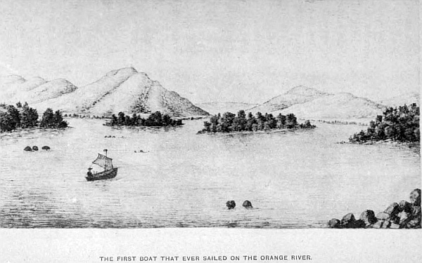
From Griqua Town to Bultfontein, over sixty miles, the country is of the same character, the road passing along from that town to Wittwater, Reedfontein, Modderfontein, Bluebush Kalk, to Bultfontein, on the Orange river, a pretty site for a town. It is a Kaffir station of several tribes.
At Modderfontein, nearly on the summit of one of the lofty hills, are several Bushmen’s caves. The largest is capable of holding 200 people; the rocks within show evidence of fire by their smoked appearance, and many years ago were occupied by that bloodthirsty tribe mentioned in my description of the Kalahara. The Griquas living here told me they have passed away, but the old man stated their fathers could remember them. The mountain road leaves Bultfontein and goes west no great distance from the river, over a very stony, road, on to the Pits, where several Griquas have comfortable houses, situated on a pleasant open space, rarely to be equalled for beautiful views in all directions. I remained here several days to ramble and explore the mountain tops. I took my driver in case of accidents, as leopards and lions were known to be there, as one old Griqua told me they frequently lost a goat by being taken from the kraal at night. Vegetation up the kloofs and on the slopes of the hills is very fine; beautiful tree-ferns, and every variety of other kinds, particularly the maiden-hair, which grows out amongst the rocks on the mountains, are very beautiful; also some very fine ground orchids, and a thorny bush with crimson flowers, as also many varieties of aloes.
This district contains copper and lead, and from the appearance of the quartz which crops out, I believe gold will be discovered when this part is prospected. One road from this place goes down to the river through a fearful valley; it is necessary to “reim” (tie) the four wheels of the waggon, otherwise it would go crash down into the precipice below, and then turn over and be smashed. This was the road I took to the river on a previous journey. The other passes on to Milk Stort Pass in the Langberg range, fifty miles more to the west, which I crossed on the western side, and outspanned under some fine old trees, close to a perpendicular rock at the foot of the Berg, where we found a small pool of water in the rocks, collected from the recent rains, and good grass. The pass over the mountains was a most difficult and dangerous road, large holes and boulders blocking the way. The scenery on both sides was grand, lofty and perpendicular rocks, 2000 feet high, with beautiful shrubs and flowers growing out from every crevice. The light and shadows thrown on the opposite hills by the setting sun gave beauty to the landscape.
At night some leopards paid my camp a visit; a few sheep I kept as a reserve for the road appear to have been the cause of their troubling me. A Bushman and his son came early in the morning and told my boys where the leopards could be found, and as their skins made splendid karosses, we arranged to hunt them down if possible, taking the Bushman as guide to point the way. Three of my boys, myself and two dogs, followed the spoor for several hundred yards. Up amongst the spurs of the mountain, the old Bushman pointed to a ledge of rocks overhanging others, surrounded by bush. We then sent the dogs to ascertain their whereabouts, for we knew there were at least two by their spoor on the sand. As soon as the dogs, by their barking and unmistakable fear, showed exactly where they were, we took up our position on separate rocks, forty yards distant from the tigers’ den. Two of my boys were to keep up a fire into where we knew them to be, myself and driver kept ready to overhaul any that might come out. We heard nothing but low growls from time to time; the affair began to be interesting. After nearly a dozen bullets had been sent in, out came a fine male leopard at one bound over some bushes, looking anything but amiable, and took a deliberate survey of his surroundings, his fine spotted skin shining in the sunlight—a beautiful animal. But this was only for a few moments; three bullets entered his body at once, when he gave a spring, and fell on one side, and as he did not appear quite dead I gave him another in the region of the heart, for I have known them drop like this, and then spring up and seize upon those near them. The other, which we concluded was the female, made her escape amongst the rocks. I then set the Bushman and my Hottentot boy to take off the skin, and the rest returned to the camp, where we found the dogs lying down by the fire, evidently ashamed of their desertion by their fawning manner to make friends. Animals have more sense than instinct; they knew perfectly well they had done wrong in leaving us.
This range of mountains, which runs due north, as I have stated, forms the south-eastern boundary of the Kalahara desert, and looking towards the west for thirty miles from the base the country is almost level, a few sand-dunes and gentle rises up to the Scheurberg mountain range, which looks one compact mass of lofty peaks. But on a close inspection, there are many detached and deep valleys running between. A native road passes about midway through on to the Koranna and Bastard stations on the Orange river. There are a great many lions in these hills, as it is uninhabited, except by Bushmen. On my previous exploration, where I outspanned near a Bushman kraal, one of them told my boys that a few days before our arrival a lion had entered one of the huts and carried off a young boy; they followed him in the dark with burning brands, but had to give up; they could only trace him by the screams of the lad, but they soon ceased. Across the desert from this point westward, it is 330 miles.
Leaving the camp the next morning after the leopard-hunt, we proceeded in a northerly direction for thirty-three miles along the west base of Langberg, and arrived, on the second day, opposite Speck Kopjie, where another pass crosses the mountain, which is a very stony and rough road, but the scenery grand on both sides, similar to that we passed through a few days ago, and arrived at a farm belonging to Potgieter, a Boer. From thence on to koppies, Mr Hyland’s farm, Blaaw Klip, is six miles beyond, where, in a hill, a soft stone is dug, which the natives form into pipes, plates, vases, and many other useful articles. And beyond, in a north-east direction, is Mount Hexley, Maremane and Coses, a Kaffir station. The formation of the hills is very peculiar, lofty, isolated koppies, covered, many of them, with thick bush, others almost bare, the naked rocks piled one upon another in grotesque forms. The dry river-bed passing through this part is a branch of the Kuruman river. We then crossed the Kuruman range, and arrived at the mission station 2nd April, 1865.
Before leaving this part of the Griqualand West, I should like to describe that peculiar sand-formation on the west side of the Landberg mountains, which is in fact part of it. I heard from many of the Griquas and Potgieter, living near it, that the lofty hills are constantly changing; that is, the sand-hills, 500 and 600 feet in height, in the course of a few years subside, and other sand-hills are formed where before it was level ground.
May 5th, Sunday.—Attended Mr Moffat’s church; the service is held in the Bechuana language. About 400 natives present. The singing is as well performed as it is in any English church at home. The Kaffirs, who are Bechuanas, have fine clear voices, and the women are well known to have sweet, musical voices. The service is well-conducted, and the natives as attentive as any white congregation in a civilised country. I first attended at this church in February 1868, when the Rev. Robert Moffat was living there, previous to his finally leaving for England. On 29th December, 1869, I was again there, detained for many weeks with a severe illness, and through the kind nursing of Mr and Mrs John Moffat, Mr and Mrs Levy, and other English residents, soon recovered. I remember well before leaving at that time they got up a little picnic party, to visit some ancient Bushmen caves, a few miles from the mission station towards the hills, taking a cart with provisions, the party riding, and a very enjoyable day we had. As we approached the hills the country became covered with bush and long grass, where I may safely say, several hundreds of baboons were busy seeking roots. The old men were very large, and to see the whole troop scuttle towards the hills with the babies on their mothers’ backs, with their little arms clinging round their necks, was a pretty and novel sight. Arriving at the caves, we found a long sand cliff projecting many yards over the lower part, affording shelter for several hundred families, perfectly secure and a safe retreat—but its ancient inhabitants are passed away and forgotten. We procured some very beautiful specimens of the trap-door spider; the workmanship of the door and its hinge, and the lining of the passage down to their nest is something marvellous. So far as I have discovered, there are three kinds of this species, distinguished by their size. The largest is a black spider, the body nearly an inch in length; the opening, or passage, and the door to their nest is the size of our English florin; the hole to the nest is perpendicular for from a foot to two feet, when an open space is beyond. The coating of this opening and the under side of the door is of a greyish white, and as soft and smooth as satin, and when the door is shut it fits so exactly as to be quite watertight. The top of the door is made to represent the ground round about, to be undistinguishable by an enemy. The second size trap-door is the size of a shilling, and the third the size of a fourpenny-bit. But the spiders are of the same type; where one kind is found in a district the others are not, showing they occupy separate localities. I have frequently found the door open and thrown back, showing the spider is abroad hunting up game to supply his larder. On several occasions when finding these doors open I have watched the return of the spider, sitting down a few feet from the door, and waited sometimes nearly half an hour. Presently he will be seen coming along in great haste. On arrival at the door he looks down for a few seconds, as if to listen if all is right below; then he makes a small circuit round, again approaching; this time he goes in a few inches, then out, and another inspection of the locality, back again, and down into his nest, where he remains about two minutes; out he comes on to the top, looks round, then goes in, turns round and puts out one of his fore-legs, takes hold of the door and pulls it close down over him, and when shut it is difficult to see where it is. Frequently I have watched these spiders (three kinds) when they have left their doors open, and invariably the same cautious movements have been adopted on returning home. There are other spiders very similar in form and size to the above; they make their nests and passages down after the same fashion, but with no trap-door, the entrance being quite open and exposed. Another peculiar spider, common in these parts, is the two-headed spider, with two mandibles; they are the largest I have seen, two inches in length, with six legs, and of a greenish-brown colour. They are night spiders, and the Bushmen tell me their bite is death. This may, or may not, be true; I had no desire to try. The number that must be hidden in the ground in the day must be legion. When I have had my camp-fire at night, on an open piece of ground near which I have been sitting, after hunting, hundreds of spiders and creeping things, as also moths, are drawn to it for warmth and light; amongst them are these two-headed monsters, seen running about, and finally become destroyed by rushing into the burning embers. I found their retreat during the day by a pet meercat, the long smooth-tailed kind, similar to the ichneumon. He would, on my outspanning, jump off the waggon and begin to smell the ground in all directions, and frequently stop, begin to scratch with his fore-feet down two or three inches, poke his long nose into the hole, and bring out one of these spiders and devour it with evident relish. The ground being perfectly smooth with no aperture exposed, I could not discover how they could conceal themselves so cleverly. In some cases, I counted the number this little animal would find in a given space, when roughly hunting over the ground; it would average seventeen, in a surface ten feet square, and leaving probably as many in the ground. The tarantula is also very common, some of them the size of the palm of one’s hand, well covered with long brown hair. A large camp-fire at night would draw the scorpions to it also, particularly if it should be made near a stone koppie. They grow to a great size. I have caught them from one inch to twelve inches in length. When young they are of a green colour, but full-grown they are black. The sting of the young ones, if on the arm or leg, causes a numbness with a burning heat that may last a day, with no other bad symptoms. The sting of the full-grown ones must be dangerous; the natives tell me it is death. The study of the insect-world is a lifelong study in Africa alone, consequently my attention was only drawn to those kinds that took my special attention.
There is every indication that this country is drying up. Fountains that gave out fine springs of water, so the old Kaffirs told me, in their fathers’ time, have not been known to flow for many years. This is a common remark all over the country, and there is evidence that it is so. Extensive pans, some more than a mile in circumference and 100 feet deep, with rocks or cliffs generally on the north-east side, with sandy bottoms, are now without water, when evidently they must have been full at some time. From the long drought, seven or eight months of the year, it cannot become a corn-growing country to any extent. The greater portion of the ground is of that stony and rocky nature it is incapable of growing anything but a coarse grass that suits cattle, but not sheep. A farm of 3000 morgan, or 6000 acres, will not maintain throughout the year more than 200 head. That is where water is on the farm, otherwise that number of cattle can only be maintained for seven months out of the year.
The northern border of Griqualand West, on the north of the Campbell Randt, is a fine country for grazing and keeping cattle. There is more permanent water, the district being limestone. From Daniel’s Kuil, where there is a singular cave, and between Neat’s fountain, Marsaipa and Boetsap, is now laid out into farms. Fourteen years ago I frequently hunted the ostrich all through that region. Lions and wolves would visit me every night. Bushmen also were found, but of late years they have disappeared. An old Bushman at that time told me one evening many tales of his escapes from lions, and one of his brothers, only a few months before, was seized by a lion in the arm, when he had the presence of mind to take a handful of sand and throw it in the lion’s eyes, when he let go, and the Bushman made his escape before the lion had recovered from the pain and surprise, then gave a roar and bounded away. I saw his brother a few days afterwards, and the marks of the teeth on the arm. A similar occurrence happened in the desert when I was there four years before. A lion had seized a Bushman in a similar way, when he could manage to reach the hind part and squeeze his leg, when the lion gave a roar and sprang away. Many other such tales I have heard from these children of the desert of lions leaving the victims they have seized. I have met with three kinds of wolves in these parts: the tiger-wolf, hyena striata, the largest kind, the striped hyena, a large animal, and the maned hyena, the small kind. The wolf-hyena is the most numerous.
Porcupine-hunting is very good sport at night when the moon gives a good light. They visit the Kaffir gardens, when the corn is getting forward. The plan is to go in with a few dogs, and several Kaffirs with sticks; the dogs drive the porcupines about; when they come near a good rap with the stick on their nose soon kills them, but care must be taken they do not run back and plant some of their quills into your legs, for they make dangerous wounds.
The old Bushmen tell me they recollect when all the large game was plentiful over the whole of this part of Griqualand West, north of the Vaal and Orange rivers, and also the hippopotami were found in them. The Blood Kaffirs, along the lower part of the Orange, also tell me there is one at the present time to be seen occasionally.
The flora in these parts, in the spring and through the summer, is an interesting study alone. Some of the flowers are perfectly crimson, others of a deep purple; the creepers, with their rich scarlet flowers, climbing up amongst the bushes, and long yellow pods, make the veldt interesting. The Vaal bush is the most common in this province; it flowers in the winter, and has a pleasant perfume; the tea made from its leaves is an excellent tonic. Many of the Bechuanas live in small kraals along the Campbell Randt, the Harts river, and at Great and Little Boetsap, and possess many waggons and spans of oxen, supplying the people at the Diamond-Fields with vegetables, corn, cattle, and also wood from their forests, to keep the machinery at work. The general altitude of this part of the country is 4300 feet above sea-level. This is the cause of grass being more coarse throughout the interior of South Africa than it is at a lower level, and why winters are colder than they would be, the south latitude being only 28 degrees.
Griqualand at the present time is as much occupied by a white population as any part of the Cape Colony, and, from its being the great diamond centre, has now become the most extensive and business part of South Africa; millions of pounds change hands annually, where fifteen years ago it was a howling wilderness.
Chapter Six.
The Bechuana family—Their division into tribes—Their past and present condition.
That portion of Bechuanaland between the territory belonging to the chief Montsoia, which is on the north, and Griqualand West, is occupied by several chiefs belonging to this family. Monkuruan claims to be the paramount chief over many of them, others claim their independence. When the British Government annexed the Diamond-Fields, they acknowledged this chief to be the head of the Bechuanas over all that country. Previous to that time, Mahura, uncle to Monkuruan, ruled; at his death his nephew became chief, and lived at his chief town, situated on one of the spurs of the Campbell Rantz, called Taung, or Toane, a large Kaffir station, close to a small branch of the Harts river, above its junction, containing a population, at the time I first visited the country, under 2000. Monkuruan and his people belong to the Batlapin tribe of the Bechuana family. He has several large kraals, where his people live. Another chief, Botlatsitsi, son of the old chief Gasebone, lives at Phokwane, about eighteen miles from Taung, on the south side of Harts river. He and his people belong to the same tribe as Monkuruan.
The town, or kraal, is very pleasantly situated amongst the hills, which are thickly covered with low underwood. The other petty captains, living within the country first described, are Moshette, of the Baralong tribe, who, with his people, live about nine miles from Taung, at Kunanna; the chief Matlabane, of the Bamairi branch of the Batlapiu tribe, whose kraal is six miles from Taung, on the hills about it.
The chief Matlibe and his people live at Taung, and they are of the Batlapin tribe also. The petty captain, Jantze, of the Batlapin, previous to the annexation of the Diamond-Fields, lived at a large kraal, Lekatlong, on the banks of the Harts river, near its junction with the Vaal, but afterwards he removed, with his people, to Myneering, about thirty miles south of Kuruman. Young Gasebone lived at Dekong, on the same branch as that passing Taung, which I recollect perfectly well, for he stole out of my waggon thirty pounds of coffee, on my third visit there, in 1869, and then politely offered to drive my waggon through a very stony drift on my leaving his station. At Kuruman is Moshette. At Bakelaris, which is eighteen miles on the north from Kuruman, is the chief Barhakie, and brother to Moshette. To the north, eighty miles from Bakelaris, is Morequerne, where there are three petty captains, Makobie, Makutse, and Marketchwar, an old blind man; his people told me he was more than 100 years old, but they did not understand age; he died shortly afterwards.
Eighteen miles to the north-west of Morequerne is Conge, another large station, which is on the border of the Kalahara desert; and to the west, and south, towards Kuruman, is the kraal at Mynyam, near Honey Vlei, a large sheet of water. Cooe station is to the west of the Vlei, but near it, forty miles south, is Tsinin station; Comopere twelve miles south of the last, and twelve miles west of Bakclaris. On the east again we come to several kraals—Matetong, Kopong, and Tokong are the principal. There are many others of less note, all with their head-men. On the west of Kurutnan, under the Langberg range of mountains, are Gamapoope, Molanwan, Kamasap, Puruhulu, Tuten, Lukin, and Zitburn. One of the chiefs is Tatu. Consequently, all this part of the country is thickly populated by the Bechuana family, all under petty chiefs and captains.
South of Kuruman is Kobis, Koning, Myneering, and Marseipa, and with their outlying posts for cattle, sheep, and bucks, make it an important and valuable region for the British Government to protect and secure from foreign invasion, as it is contiguous to Griqualand West along the whole of its northern border. The extent of this portion of Bechuanaland above-named, south of the chief Montsioa territory, is from the Transvaal on the east to Langberg on the west—200 miles by nearly 200 north and south, or 40,000 square miles. And when I first knew the country, twenty years ago, it was nearly unknown to the white man, except the missionaries, who had their stations at Kuruman, Lekatlong, Bakclaris, and Matetong, and some half-dozen traders passing through Kuruman, from Hope Town, in the Cape Colony, to the Bechuana chiefs living to the north. This little-known region then was one of the most pleasant and agreeable parts of Africa to visit and explore. The natives, more particularly at Kuruman and those to the north, were most friendly and kind. Like all native tribes, they do not forget to beg of the white man. Down towards the south, in Mahura’s time, the people were troublesome, and much less civil in their behaviour to strangers. I think I experienced more annoyance because they took me to be a Boer, noting down all their watering-places, and on one occasion I was in great danger in consequence. Skins well-brayed was the only material for their clothes; the men had long cloaks, which, when thrown over the shoulders, reached the ground. The women had short wrappers round their loins, hanging down behind and very scanty in front; in cold weather they also had leather mantles. But at the present time they have to a great extent adopted the European mode of dress, and deal extensively in almost every kind of English merchandise.
From cultivating little or no corn, which was the woman’s work, they now go in extensively for ploughs, which the men use, and instead of growing mealies, which is maize or Indian corn, and a few melons, they now produce wheat, barley, and oats, which they grow in their beautiful valleys and sell to traders for English goods, and in addition they breed herds of cattle, goats and sheep. Many of the men buy the best English clothing, and some of the women, particularly the young ones, indulge in cotton prints and even silk for their dresses, and are very proud if they can obtain stylish boots.
The schools also have greatly improved the people. The advance in civilisation within the last twenty years has been remarkable. They are, as a people, timid and for from being fond of war. Their language is Sechuanse, which is soft and pleasant to the ear. They have natural mechanical talent, and make good carpenters, smiths, and masons. Their houses show great ingenuity in their construction, particularly in the formation and design of their granaries for storing their winter corn, which are quite artistic in form. Many of these are built up in the centre of a large hut made of clay, shaped like our water-bottles, in diameter ten feet in the largest part, gradually reduced in size to three feet at the top, total height ten feet, which will hold many hundred bushels of corn. No mice, snakes, or other animal can get in to destroy the grain. A store is kept separate for each family, quite distinct from their living huts.
They are very expert in metal, melting the ore for the manufacture of ornaments, assagais, Kaffir picks, and such things as they require. They also make very neat mantles, karosses and other kinds of materials for the women, the men being the tailors and dressmakers for the tribe. Time being no object, their work is beautifully executed, as may be seen from the karosses brought to England; many of them sold as high as ten pounds. They are also very fond of music; they make various kinds of instruments which produce pleasing sounds. The young men form themselves into bands to the number of twenty to thirty, called the reed band—reeds from six to eight feet in length with holes similar to the flute, but held upright in front of each musician—forming a circle like our military bands, and perform tunes. The women and children walk round on the outside singing and clapping hands in time to the music. This performance generally begins about sundown, and is kept up for several hours.
The interior of their huts and yards outside where they cook, which are surrounded by a high fence made of sticks, are kept remarkably clean and tidy, and their iron utensils also receive their share of attention. Many of these Bechuanas are rich in cattle, sheep, and goats. They have their cattle-posts away in the bush, where the stock is looked after, cows milked, and once or twice a week a pack-ox is loaded up with skins of milk and taken to the kraal for use. These “vieh-posts” are in charge of their slaves, called Vaalpans. They are the Bushmen of the country kept in subjection by the Bechuana tribe, and are a very harmless and quiet people, the only drawback to their liberty being they cannot leave their masters’ service; otherwise they have full liberty of action. They are of a darker colour and different in form to the Cape Bushmen.
The Bechuanas throughout South Central Africa possess waggons, and have spans of oxen and everything complete like the colonists, and go trading with English goods amongst their neighbours like any white trader. They also bring down from their homes, wood, corn, and vegetables for sale to the Diamond-Fields, and are far more beneficial and useful in the country than the Boers. They are outstepping them in civilisation, and if they had white skins, would be looked upon as a superior race. They have been kept down for want of opportunity to rise above their present condition. This extensive race, as I have already stated, extends from the Cape Colony to the Zambese, throughout the whole of Bechuanaland, and are in habit and customs the same wherever they live, the same language and its dialects.
The females, like all other nations of the world, have their fashions, and vary according to the country in which they live. Some of the young girls shave all the wool from their heads except on the crown, leaving about three inches in diameter, which they anoint with red clay, plumbago, and grease, giving a very sparkling and shining appearance to it that is very becoming, and even makes the young girls look pretty, as many of them at that age have a pleasing and intellectual expression; their short kilt is so arranged that the upper and lower borders should have the white fringe of hair of the springbok skin to look like a border of deep lace, which against the light rich brown hair of the other part is very becoming, and sets the figure off to great advantage. They quite understand being complimented upon their good looks, and can carry on a flirtation with admirable tact. Where this is more perceptible, is far away from the demoralising influence of other tribes who have come in contact with the Boers and other white people. The more isolated they are from such influence, the more I have always found them respectful in their manner to strangers. I am referring to the Bechuana family in general.
The principal roads through this part of the country to the interior pass through Hope Town in the Cape Colony to Kuruman, the mission station where the Rev. Robert Moffat spent forty-five years of his life in missionary labour, which station has been largely increased by the addition of an extensive college erected of late years at a great expense for the teaching of native youths for missionary purposes. The site is admirably situated, having an unlimited supply of the purest water from a spring some few miles above the station, which issues from a cave in the side of the hill in a picturesque locality. The mission houses and church of the London Missionary Society are substantial and well-built, and have fine gardens well stocked with fruit trees, and the orange and lemon grow to great perfection. Mr Chapman, who has a large store, takes great interest in his garden, and grows every kind of vegetable known in England. Twenty years ago there were several stores; three at Upper Kuruman, about a mile from the mission station.
The bold outline of the lofty range of hills at the back of Kuruman, distant some six miles, adds greatly to the beauty of the adjoining country, which is undulating and well-wooded, with open plains and Kaffir gardens, and is one of the most healthy parts of South Central Africa. The roads from Kuruman branch off in every direction to the several natives’ towns. The main transport road from Kuruman and Diamond-Fields goes to Maceby Station on the Molapo, in the chief Montsoia territory, and very pretty roads to travel over. On leaving the station there are several small kraals on the road to Kopong, which is a large native town situated on the Matlarin, a tributary of the Kuruman river, which latter flows past Bakclaris, and then south, past Comopere, from thence through a wild uninhabited country for 180 miles, where it joins the Hygap river, which is the lower portion of the Molapo. The main road continues on from Kopong, through a fine forest of kameel-doorn trees for many miles, then enters upon open veldt, passing little and great brack-pans to the Setlakoole and Moretsane rivers, then bush again to Maceby’s station Pitsan; the distance between Kuruman and that town is 154 miles. Several roads branch off from it to different parts; one goes to Melemas on the Molapo, another to Marico, and also others to Monkuruan’s at Taungs. Maamuosa, where the Koranna Captain Moshoen and his people live, a bad and wicked tribe, who have been helping the Boers lately to make war on Monkuruan, and whose land the Boers have taken from him. The principal main transport road from the Cape Colony and Diamond-Fields runs direct to Taungs in a north-east direction to Maceby’s and then north, which has by the late Convention with the Transvaal been preserved. There are no very lofty hills in this part of Bechuanaland. The principal ones are those at Kuruman, those near Taungs and Swaatberg. The average elevation is about 4600 feet above the sea-level. The northern portion is more open, extensive plains and forests of the mimosa tree; and has many brack-pans, where in the summer wild geese and ducks come in great numbers.
The game when I first travelled through these parts swarmed on the open flats. Blesbok and springbok, hartebeest, quaggas, gnus or wildebeest, the black and the blue; the latter is a much finer animal, the skin is also of more value. The koodoo is found in the hills. Then there are several other antelopes, such as the steinbok, found all over Africa. These at the time I state, if it were possible to count them, would exceed 100,000 to be seen from the waggon at one time, a complete forest of horns, and as they feed off the grass until it is too short, they move away to another district. Of course lions, wolves, and jackals were very numerous and kept up their howls all night. The wild dog (Hyena venatica) could be seen in packs of several hundred, crossing the plains in pursuit of game—they are a pretty animal with large rounded ears, large bushy tail, whitish face, long black and white hair, tall and slender. They always hunt in packs. On one of my journeys, having to cross these plains, I came upon several hundred of them in one of the slight hollows. On nearing them, for the road ran directly past where they had been having a grand feast off springbok, as remains of them were still unconsumed, some of them were lying in the road I was travelling, and would hardly get out of my way, others stood looking as we passed between them. Fortunately they had been having their meal, otherwise I think my span of oxen would have fared badly, for there must have been over 300. With so many making an attack on a span of oxen, guns would have been of little use, if they were hungry. I have often seen forty and fifty in a pack in full cry, after blesbok or springbok, and a beautiful sight it is. Wolves also were seen, seven and eight together.
At a small pan on these plains, in a hollow, with high reeds surrounding it, I, one afternoon, outspanned, intending to remain there the night, as there was an extensive pan near, with very steep banks down to it, where I intended, the next day, to look for ancient implements, as I had previously found some there before. I sent one of my Kaffir boys down to this pan, only a short distance from the waggon, for water. He was very quickly back, looking quite scared, and cried out there were wolves in the pan.
Our rifles were soon out of the waggon, and cartridges for a few shots if necessary. I started with my Bushman and Hottentot driver, all armed. As he said, the pan seemed full of them; when within fifty yards, some of the wolves broke cover and were making for some bushes; two were shot, others escaped at the sound of our rifles. We could see them moving about in the long reeds, and fired at every opportunity, killing in all seven; four of them were the largest I had ever seen; their heads were immense, and between the ears measured seven inches. They are large and powerful animals, but great cowards. Lions would be heard nightly round the waggon, whenever I outspanned in one particular district near the Moretsane or Setlakoole rivers, which seemed a favourite resort for them.
All this state of things has passed away. The game has been shot and driven away more into the desert, wolves nearly all poisoned, and in crossing any of those extensive plains and open flats, a few hundred may be counted, where before tens of thousands covered the veldt in all directions. Then it was a great pleasure to travel through the country for sport alone, in addition to the enjoyment of passing through a beautiful country teeming with game. At the present time, to go over the same ground with not a living thing to be seen, it becomes monotonous. Close to that pretty isolated hill, Swaatberg, are the ruins of a very ancient town, Kunam: whether built by Kaffirs or the race that built the other stone huts, mentioned in a previous chapter, there is no history to prove. There are many strange tales handed down to the present generation of its being one large town, the seat of a powerful chief, and of some great battles having been fought there. The ruins indicate it to have been at some remote period a large town. Near it are extensive pans, that at one time must have held water to a great depth, as the banks and cliffs clearly prove; now only in the summer months water is found in them. Not far from them there are some dried-up springs, the water of which was conveyed away by a sluit passing into the Moretsane.
One day we had fixed our camp at a very pretty spot close to some fine trees and bush, had made all fast for the night, and were sitting by the fire before going to bed, the Kaffir boys having their supper, when we were startled by a rush of large animals passing close to our camp-fires, on both sides of us. The night being very dark, we could only distinguish, by the light from our fire, that an immense herd of blesbok was amongst us. We had our rifles in hand in a moment and fired into a dense mass of them. When they passed away we found three dead upon the ground. My Hottentot and boys ran to bring them in, when a solitary blesbok rushed up to the fire and there stood quite exhausted, and some thirty yards in the rear were several animals moving about, but I could not distinguish, from the flickering light, if wolves or wild dogs, that had chased the poor animal until it could run no more. We all ran out with our rifles, but with caution, in case any lions might be amongst them. As they did not go away, evidently exhausted also with the long chase, we had a good chance of getting some, and succeeded in killing two. The others in the mean time made off. Lighting the lantern to bring them in, we found them to be very fine and powerful wild dogs. By this time the blesbok had recovered from the hard run, and took himself off. My driver wanted to kill him, but I said, “No; he sought our protection, and he shall have it.” It is wonderful they should seek man’s protection when all other hope of self-preservation seems gone. I have known small birds fly to my waggon and into it, on several occasions when pursued by hawks. This is more than instinct; there is some reasoning power in animals when they seek shelter from foes where they know they will not follow them. Foxes we know act in the same manner.
In the morning, on examining the spoor, there must have been many wild dogs engaged in the chase, but they were stopped at the sight of the two fires and waggons, and our shots at the blesbok as they passed us. In the small grove of trees under which our camp was pitched, we founded several very large chameleons measuring fifteen inches in length. We discovered them by hearing a noise on one of the branches, caused by a fight between two of the largest, which we caught, but gave them their liberty before leaving. I also, during my explorations, made a collection of many kinds of the mantis family, commonly called in Africa, Hottentot gods, as they always appear to be praying, having their two arms held as if in that act; their four legs are used for locomotion. They feed themselves with their hands. I made a collection of forty-seven different kinds, those with wings and those wingless, both kinds having well-developed bodies. Then there is a third kind without bodies, called walking-sticks, each kind having four legs, two arms and hands. I made twenty-two collections of the winged; the largest measured eleven inches in length, brown bodies and lovely purple wings, two on each side, two horns on the head a little over an inch in length, large eyes, with a mouth similar to a wasp’s, with flat head and neck four inches in length, from the lower part of which the two arms spring. The four legs were fixed in the centre of the body; the smallest size with wings measured one and a half inches in length; each size differed somewhat in shape. I put one of these, which measured six inches, green on the back and yellow underneath, with silvery wings, into a paper-collar box. One afternoon, on looking at it half an hour afterwards, I found it had woven a nest on to the side, composed of silky and light-brown material, and the insect appeared quite dead or in a torpid state. Putting the box away, I forgot to look at it for several months; when I opened the box I found upwards of 200 young ones, all dead, each about one-eighth of an inch in length. The greater portion of my specimens I caught in my waggon at night when my candle was burning and my fore-sail up, being like the moths attracted by the light. The wingless ones I found on bushes or in the grass. The third kind, the walking-stick, I always found in the grass. The first time I caught one was when I was collecting some beetles. I saw, as I thought, a piece of live grass moving along. Sitting down on the ground to watch it, I found it had four legs, which moved very slowly, and two in front that stuck straight out in line with the body. Carefully observing its movements, I saw at once it was a very strange kind of insect. Taking a piece of grass to lift it from the ground, the thing showed fight at once by raising its head, opening and shutting its mouth, drawing up its two long arms from the straight position, and striking out at the grass I held to its head. The colour was exactly that of the long dry grass in which it was moving—yellow. Length of body and neck, fourteen inches, and the size of a small straw; the legs were very long—five inches; the knee-joint half-way up; the arms had two joints—the regular elbow, and two-thirds of the distance another that doubled up, so that it could pick the food and carry it to its mouth. These again vary in size and colour from one inch in length to the size above described. The female is much larger than the male, which is a light-brown, the former of a sea-green colour. I think the mantis and the trap-door spider the most curious of the insect-world in South Africa. Many specimens of moths I collected in my waggon after dark, some of them very beautiful; the larger kinds I mostly found in the long grass on the plains.
Butterflies were very plentiful in some parts, in others rarely any would be seen; each locality had its peculiar species. The wasps also amused me when standing in any particular locality for some time; the large black with purple wings was a constant visitor. When about making a nest to lay their eggs, they would fly into my waggon, examine every part minutely, and after fixing upon a particular corner, would fly away and return with a ball of mud the size of a pea, and commence to plaster the side of the waggon fixed upon. This would go on for two or three days, the two wasps, male and female, bringing in these little balls of mud, going and returning every minute until it was completed, leaving a little circular hole to each cavity in the clay nest, one-eighth of an inch in diameter when so completed. They would commence with one of the holes, there being five; the female would deposit the eggs, then the two would go out and return with a green caterpillar each, which they would push into the hole containing the eggs, then leave and return with balls of clay, and plaster up the hole so cleverly that it would be impossible to find it from the outside. The same labour was bestowed upon the other compartment of the nest, and when completed would be left for time to bring forth the young. Two other kinds of wasps were of quite a different shape, their slender bodies extended for half an inch, leaving a large egg-shaped ball at the end. These made exactly the same form of nest as the one described. A fourth kind, I noticed, would build their nest in the roofs of buildings; these would be suspended by a thin stem of a glutinous nature, upon which would be fixed from five to twenty cells similar to those of the bee. There have been eight and ten of all these kinds of nests in my waggon at one time, and during the intense heat of the weather, 106 degrees and sometimes 116 degrees in the shade, being too hot to move about, I have amused myself in watching the methodical way in which they so cleverly and beautifully completed their work, and in so short a time. The bees generally make their nests in old hollow trees, which we discovered through the honey-bird leading us to one. When one of these birds wants to attract attention, it soon makes its presence known, and becomes impatient, if not attended to, flying round about with its little twitter and call, which is well known. When it sees you are following it, it flies from branch to branch in a straight line to the nest; when there, it stops, and you soon see the nest. The Kaffir will go fearlessly to work, the bees buzzing about him when taking out the honeycomb, he rarely being stung.
The common black crow, with white about the neck, is also a friendly bird, of the same size as our English. They generally come and settle near the outspan, waiting for the camp to break up, then come and look for what may be left. They talk in their throat as well as caw, and can be taught like a parrot to speak. I tamed a young one; he would not sleep in the waggon, but early in the morning he would come and settle on the front part of the waggon, where he could raise the fore-sail to look in. On seeing me in bed he would come in, hop up to my face, take hold of my nose, or have a peck at my beard, look round to examine the things hanging on the sides, then hop out. On my getting up and leaving the waggon he would be seen flying from some tree, and come and settle on my hat or shoulder; if the latter, he would put his head round and rub his beak against my face.
There are other crows quite black, more like ravens, but not so large. Another time I was staying at a Boer farm for three weeks to have my waggon repaired; in the early day I walked over to a Boer farm, about a mile from my outspan, to examine some quartz reefs, where I found a few specks of gold on a former journey. At this farm there was a beautiful crane, belonging to old John Nell, the farmer. I tried to make friends by making the same kind of sounds that he kept repeating, but he took no apparent notice. On leaving to walk back to the waggon with my rifle, this crane followed me all the way, keeping about three yards behind, where he remained by my camp a short time, then flew home. Every day after he paid me a visit. One afternoon I took my rifle for a ramble round in the thick bush veldt to look for a waterbok. When about a mile from my waggon I heard a great rush. Looking round I found it was my friend the crane. He settled down in front, then came and walked on my left side, just beyond my reach, keeping close for some distance, then on a sudden he took flight and rose in the air, making long circular sweeps, until he passed behind some small clouds and became again visible, until he was lost in the distance. Thinking no more of him, I continued my walk for half an hour, and was returning home, when the same kind of rush was heard, and looking up I saw him pass close to me, and settle on the ground about thirty yards in front; he then took his place by my side as before, and accompanied me home, and then flew back to the farm. I mention these incidents to show there is something more than instinct in all living things.
The country round this part of Monkuruan territory, and in fact all Africa, swarms with every kind of ant, from the smallest size up to three-quarters of an inch in length, each kind having their own peculiar form of nest, more particularly the destructive white ant, which causes so much damage to buildings and furniture; the construction of their nests differs in different latitudes. In the Cape Colony, Natal, Orange Free State, and lower part of the Transvaal, the veldt is covered with these hills, in the shape of a ball cut in halves and placed on the ground; the average size is four feet in diameter by two feet in height; many of them have been scooped out by ant-bears.
The Dutch women, in travelling, frequently make use of these holes, by turning them into ovens to bake their bread for the road. More to the north, instead of being round, they form a kind of peak, with holes on the topmost points, some exceeding in height twenty feet. North of this again the ground is raised some two feet by ten to fifteen in diameter. On the centre part chimneys are built up, many exceeding four feet in height, by nearly three feet in circumference; the opening is nearly a foot in diameter, the top terminating in a cup-like form, in three distinct layers, one above the other, forming quite an ornamental termination to the chimney beautifully constructed. On looking down, hundreds of these tiny masons may be seen plastering and repairing the inside coating, which may have received damage from rain. There is always one large chimney, and sometimes one or two smaller ones close to it, and at the base some twenty or thirty small ones, three inches to a foot in height, and three and four inches in diameter, and many small holes round about, where the ants are busy taking in their food, small pieces of dried grass, and other things, never making use of the chimneys as a means for supplying their cells with food. They are, I believe, erected as ventilators to give air below, as the cavity beneath must be as large as a small room, and in some eases larger, as a waggon fell into one. A road had been made near Molapo, over one of these disused nests, and in 1877 a Boer waggon was travelling in the night, as is their usual practice. The front oxen had gone over it, the ground gave way with the after oxen, but they managed to get on firm ground; the weight of the waggon broke the top surface, and only the desselboom on the opposite side getting fixed, kept the two fore-wheels and waggon suspended over the hole, a Boer woman and three children narrowly escaping from falling into the pit. I followed up the next morning, when the Boer and others were getting the waggon mended; bushes were then put round the hole and the road turned. If I had passed over this road before that waggon I should have met the same fate. As a whole, the roads in all parts of Monkuruan territory, and in fact throughout South Central Africa, are very good, considering they are never repaired; many of them rough and stony, but as they are mere natural tracks made by waggons, it is surprising they are in such good condition.
The population of this district, including all the various tribes, does not exceed 20,000, exclusive of Bushmen, and they do not number more than 3000.
Chapter Seven.
Bechuanaland. The territory of the chief Montsioa, of the Baralongs.
This country is situated on the north of Monkuruan. The boundaries are common to both, from the Transvaal, down west to that range of mountains running north, the continuation of the Langberg; beyond is the Kalahara desert, of which this western portion forms part. Its northern boundary joins the chief Gaseitsive, and the Transvaal is on the east. The length from east to west is 200 miles, and from north to south seventy miles. The Malapo, or the Mafeking river, rises in the Transvaal, flows west, through the entire length of this territory, continuing on in the same direction, receiving the two dry rivers, the Nosop and Onp, then turns south at the great bend, under the name of Hygap, and enters the Orange at Kakaman’s Drift; there are but few branches in its course. The eastern portion of this country is valuable and productive, suitable for any kind of vegetation.
When the British Government settled the Keats award boundary, they confirmed Montsioa’s title to the ground on the west of it. At that time, 1871, Montsioa and many of his people were living at Moshanen, a Kaffir station in Gaseitsive’s territory, situated eighteen miles to the west of Kanya, the seat of that chief. But after the settlement of the award he removed down to his own country, and settled at his town, Sehuba, which has since been burnt by the Boers, and was six miles south of the Molapo river, and the same distance from the large kraal on its banks, under the petty chief Melema, on Molapo, who was his nephew; and eighteen miles below, and on the river, was the large kraal under Maceby.
The population numbered some 35,000 souls, including the Kuruman district; but since the Transvaal Boers have made war on these people, after the retrocession of that state, nearly half have been killed and made prisoners.
The country has fine grazing-lands, and some parts are well-wooded. There are extensive vleis and pans; the people cultivate corn extensively, use ploughs, and had large herds of cattle, sheep, and goats, now stolen by the Boers.
Montsioa belongs to the Baralong tribe of the Bechuana family; he and his people have always been loyal to the English Government, and during the Transvaal rebellion many loyal Boers fled to him for protection, and were hospitably received. The people are in their habits and customs similar to those in Monkuruan’s country. Montsioa is a quiet, well-disposed chief, and has been cruelly used by the Boers for his loyalty to England; one of his sons, and most of his brave men, have been shot down like dogs, and his women and their children killed in cold blood, and many of them taken into captivity, all for keeping true and loyal. He has been shamefully and disgracefully forsaken, and left to battle alone against these murdering freebooters, who were supported by the Transvaal Government, and supplied with guns and ammunition to carry on their unholy war, and now he has lost the greater portion of his people, and nearly all his cattle and property. The British Government, moved by the voice of the English people and our loyals at the Cape, at the eleventh hour sent out a force under Major-General Sir Charles Warren, to see justice done him. Will they compel the Boers to return the stolen property, and the women and children they have taken into the Transvaal as slaves, for they will be nothing less? Will they deliver up the murderers of Mr Bethel and others? Never was a more cruel and unjust war made against people than this, by a people professing Christianity, who have, by their cold-blooded and atrocious acts, stamped themselves as a nation of murderers and robbers, and for such acts they are not worthy of retaining the Transvaal as an independent country. It is useless for that Government to deny any complicity in these wars, they are well known to have been the promoters—there is evidence sufficient to prove this. I was told by some of the influential Boers in Pretoria, soon after peace was restored, and the first convention made, in July 1881, that they intended to go and punish Montsioa and Monkuruan, by driving them out of their territories and taking their land, for their loyalty to England in protecting loyal Boers. As they stated, “We will not have these natives on our border who have helped you English,” showing what their intention was as soon as they were confirmed in their republic. I have deemed it necessary to state these facts, that the English people may know in any future dealings with whom they have to meet.
In the settlement of the Keats award the land was confirmed to Montsioa. There is an extensive hill of metamorphic formation on his eastern boundary, but which may now be included in the Transvaal by the recent Convention, which has in its centre, on the summit, the remains of an extinct volcano; the vent is about 700 yards in diameter, the highest point is 5650 feet above sea-level, and stands on the central watershed. There is an opening for the escape of the lava, which appears to have travelled some miles down a valley on the south-east. This lava, or boiling mud, has several vents on the exterior, the central opening is level, and on one side many bones are embedded in the rock. It is an interesting formation.
The western division of Montsioa’s territory is more open on the south side of the Molapo river, but more wooded on the northern. It was one of my favourite hunting-grounds in my early visits, as game at that time swarmed over those extensive plains, and with a horse they were easily shot; but it was dangerous riding, as there are so many wolf-holes, ant-bear, porcupine, armadillo, spring-hare, and meercat, partly hidden by long grass, that a horse at full speed cannot always escape them, which frequently ends in a broken collarbone or a broken rifle. Many of the antelope species are very subject to bransick, and hundreds die; their bones may be seen lying about in every direction, consequently it is a great resort for vultures and eagles, who are constantly on the look-out for those who have not many days to live. If a wildebeest or blesbok has this complaint, and is not likely to live many days, he is found standing alone, and surrounded by half a hundred of these birds waiting patiently till he drops, then they commence upon him before he is quite dead, his eyes being first taken, and in less than half an hour there is very little left to be eaten. Many believe the vultures or eagles discover their food only by their splendid sight; my experience proves that scent has more to do with it. During my travels in these wilds I have had almost daily opportunity of observing their mode of discovering any dead animal that may be exposed in the open. These birds are almost constantly on the wing; the exception is when they have gorged until they can eat no more. Then they rest on the ground or some stone koppie, until they have to some extent digested their food, to enable them to fly. Many times I have ridden up to them and given them a cut with my riding-whip to make them fly, which they are incapable of doing from over-feeding. When an animal dies, the scent is driven by the wind and ascends many thousand feet, and is carried along with it. If any of these birds are to be seen on the wing, they almost always fly in circles, making long sweeps in their course; this will take up any scent that may be in the air. In watching them closely it is easy to see when they have got the scent, and when they lose it, as is often the case if they make too great a circle. There may be sometimes from 100 to 200 performing these graceful circular flights, some one way and some another. Being at a great altitude—1000 yards—when they smell the carrion, they are, if the wind is strong, more than a mile away from the animal, and as they fly round they gradually work up to windward, until the object is visible; then they do not come down at once, but appear to make a survey of the surroundings before coming down to feast on the carcass. I have may times seen them come down wind, pass directly over a dead beast unnoticed, until they have got into the current of air on the down side, when they have worked back until they could see the animal on the ground. Their splendid sight will lead them to the spot after a time, but their quick sense of smell is the first indication that there is a grand feast for them.
Of all birds I think the vulture is the most graceful in its flight, with its immense wings, which measure from tip to tip seven and sometimes nine feet, extended without a movement as they circle in the air. One day I was out on foot after some blue wildebeest, with my rifle, near the dry pan Bakillara; I came upon about 100 of these birds, who were too late for a feast upon a buck, the bones of which had already been picked quite clean, when they took flight and disappeared. Knowing their habits so well, and that more would shortly come, I walked about 100 yards away to a wildebeest hole, which that animal scrapes to sleep in. There I laid down as if dead, putting my rifle out of sight; I wanted to see what they would do if they saw me. In about ten minutes several flew overhead to the dead animal, eyeing me as they passed, with their heads on one side, and about fifty yards over me; many of them commenced their circular flight to have another look to see if I were dead. Nearly half an hour was passed in this way without the slightest movement on my part, when dozens of them began to settle on the ground forty yards away, but afraid to come nearer; others would make a swoop down within a dozen yards of me and pass on; when upwards of fifty had settled down, finding they would not come to pick my bones, and getting tired of my position, I jumped up with a great shout, when they took wing and in less than two minutes were out of sight.
The black eagle is more frequently seen here than in any other part of Africa, in consequence, I suppose, of food being plentiful. I shot one out of four that settled near my waggon one afternoon, when my driver was skinning a wolf he had shot. When sitting on the ground it measured two feet four inches to the shoulder, and its wings from tip to tip nine feet five inches. Two years ago I shot a white eagle; the wings measured nearly ten feet. I tried to preserve them, but did not succeed.
All kinds of hawks, some very large, and the large horned owl are common in this part of the desert, as also some of the smaller species. Snakes also are plentiful: the most common is the puffadder, which grows to a large size; two I killed measured three feet each. The cobra-de-capello and also the python are common. One I shot measured sixteen feet two inches, but there are some larger. This one had an entire steinbok in it; they are more numerous near Vleis. Lizards, salamanders, and many small snakes are seen amongst the stones and rocks. Scorpions of a dark colour have been killed eleven inches in length.
This part of the country the greater part of the year is short of water, but in the Molapo it can be obtained by digging a few feet in the bed of the river, which is sand. If proper attention is paid to improvements, this part may be made valuable and productive.
Many Bushman families live on the north side of the river, of the Bakillihara tribe, quite distinct from the Masare Bushman. They have small cattle-posts belonging to the Bechuanas, but others are free, seldom stationary.
The old mission station at Mosega, situate on a branch of the Klein Marico, was abandoned in 1852, as also Malatza, by the Revs. Ingles and Edwards, the Boers not allowing them to remain. All that portion of Montsioa’s territory is quite equal to any part of the Cape Colony for richness of soil and growth of corn and vegetables, splendid grazing-land for cattle, and well supplied with water from fountains, with good roads. Several lions were killed on the Molapo twelve years ago; two young ones were captured and brought up by M. Ludic, a Bastard, and afterwards sold for five pounds, and sent to England.
There were many Bastards at the time I first passed through, which I frequently had occasion to do on my journeys, and found them very civil and kind. Indeed, it would be difficult to find a class of people more attentive and well-disposed towards travellers than this class, so that it was quite a pleasure to meet them. They are good mechanics, and can repair a waggon as well as any colonial waggon-maker, as I have found when anything was required to be done to mine.
On the south of this territory, between it and the Transvaal, is that small slip of country under the petty captain Moshette, part of which is included in the Transvaal by the late Convention between the British Government and that Republic. This petty captain and the Koranna captain Moshoen have been the tools of the Transvaal Government to make war on Monkuruan and Montsioa, and it serves them right that they should lose their country. Moshoen lives at his large station at Maamuosa, situated on a white sandstone hill close to the Harts river; this stone is used by mill-owners for grinding their corn. The most unfrequented part of Montsioa’s country is that through which the river Molapo runs, to the westward of Maceby’s station, the course of which has already been described in the river system.
Eighteen years ago the plains swarmed with game, and lions also. I was travelling down from Kanya through the desert to Maceby, on my way to Conge kraal, north of Morequern. At Maceby’s there were Boers, each with a waggon, going to Morequern; the road I was travelling was the same. One of them, whom I had met before, asked if we should trek together, which was agreed to, until the roads separated seventy-five miles on, the distance to Conge being 125 miles; the only objection I had, was that they travelled at night, but as there were some very nasty places along the road and we could assist each other in case of accident, I agreed. On the third night from Maceby’s, we were travelling along over an open country, my waggon was the third in the line, and a Dutchman was the last; the night was stormy with a high wind, and very dark. Soon after inspanning in the evening, we knew lions were following us, but this occurs so often that we took no notice of it. But about eleven o’clock the oxen in all the waggons became very restless, and our foreloopers had difficulty to keep them on the road, calling out that lions were close.
The Boer behind my waggon had no forelooper, there was only himself with the waggon, which was empty. I was sitting on my waggon-box with my driver, and the forelooper leading the oxen. Soon after eleven we heard the after-waggon and oxen leave the road and make a rush across the veldt, towards a dry bed of a river, and heard the Boer call out to us to stop, which we did as soon as I could make those in front understand the case. We held to, and listened, but heard no sound of the Boer or anything else. The wind and rain coming on, we three, with our waggons, drew up in a line, and fastened the oxen to the trektow and waited until daylight, for it was useless and also very dangerous to go walking about in the veldt amongst low bushes, to look for the Boer or his waggon, where lions seemed to swarm; besides, we had as much as we could do to keep the lions from making an attack on our own oxen.
As soon as the first sings of daylight approached, the two Boers, a son, and myself, took our rifles and followed the spoor of the last waggon, which we found upset in the dry river, about 400 yards from the road, killing six of the oxen in the fall, and the other six had cleared themselves from their yokes, and strayed away out of sight, but no man was to be seen. Going back on the line the waggon took, we found the man’s hat and some distance beyond his long ox-whip, and a little blood, not far from it. There was then no doubt about his disappearance; the oxen had bolted, and the man to turn them on to the road had jumped off the waggon, when a lion had seized and carried him off. As the sun was now above the horizon, we gave orders for our boys to outspan, and then hastened on in the direction the lion’s spoor showed us he had gone. There was here and there blood on the grass, which led to a small clump of bushes and stones; here we found part of the remains and clothes, which were all torn to shreds, of the poor man, but no signs of the lions, for there must have been several by the footprints in the sand. We sent to the waggon for a spade and buried the remains of what small portion was left, and then took up the spoor,—to settle accounts with the lions,—which followed along a dry watercourse, which was crossed, and under a sand-bank with high grass we came upon them, a lion and lioness, and a young one, comfortably reposing. The two Boers and myself—all good shots—made very short work of the affair, knowing what they had done. It was arranged not to fire until we could make a dead shot, and all to fire at the lion; two in the first instance, the third to be ready if he showed fight, whilst the other two reloaded; but as the Dutchmen’s rifles carried heavy bullets,—eight to the pound,—their two shots did the work, for when the lion rose up to have a look at us, throwing back his ears and showing his teeth, both bullets entered his chest and he fell, but not quite dead; my third bullet in the region of his heart finished him. We then turned upon the lioness, who gave us much trouble before we could have an opportunity of a good shot; her endeavour was to escape, but this we could not quite agree to; however, a shot in the shoulder, and another in the neck, stopped her making any further attempt to get away, and enabled us to get up and complete the work. The Boers wanted the skins, which would delay us the day, therefore I went back to my waggon for breakfast, thinking it was no bad bag for so early in the morning. But before doing so we searched every bush and cover for the young lion without success; but in the afternoon, when the two Kaffir boys were skinning the lioness, the young one was seen not far off, and the Kaffir shot him. We then went down to the river to see what could be done with the waggon, the dead oxen, and those that had strayed away into the bush. After a time they were found and brought back; the waggon was too much smashed to remove. It had fallen over a steep bank fifteen feet deep. The Boers wanted to save the skins and the flesh of the dead oxen, which would take time, and as I could do no more good I arranged to start the next morning. We all took care to collect plenty of wood for great fires to be kept alight, and it was well we did, for we were serenaded with the lions’ music all the night; the surroundings seemed full of them, and also with wolves and jackals; the smell of the dead oxen brought them to our locality. However, bidding my friends good-bye, after breakfast I left for Conge. The second day after leaving them, we saw several lions as we passed along, but they were a long way from the waggon. In the afternoon, the next day, about 200 yards on our right from the road, we counted no less than seventeen large and small lions, some of them playing, others lying and sitting down; they took no notice of us, merely looked as we passed along, and we at them. We made a long trek after that, to get as far as we could from them before night, for however pretty they are to look at in their wild and native home, their proximity to the waggon on a dark night is not conducive to a good night’s rest. In four days after this we arrived at Conge, without seeing any more. I remained at this station two days, then left for Morequern. The chief and many of his people came to the waggon, with pumpkins, watermelons, milk, and eggs. I never met with a more quiet and orderly and well-behaved people than these Bechuanas. Very few traders visited these parts then. There was one after this who frequented this part of the country, and who blew himself up in his waggon, together with the missionary from Matetong and some twenty Kaffirs.
This was the last missionary that lived at that station, the house and grounds are in ruins, but there are some very fine willow trees still standing planted by Messrs Moffat and Campbell when the mission was first established.
Conge is eighteen miles from Morequern; the road the whole way is fearfully stony; a pan half-way is noted for guinea-fowl. The next day I arrived at Morequern, where I had to repair my waggon. A large pan divides two large kraals; on the east side an old blind chief lives, Makalawar or Makutse, a Baralong, and on the west, Maksetse.
As it would take some few days before the waggon would be ready, and as all the people at these large stations had always been kind to me whenever I came amongst them, I determined to send out an invitation to all the young Kaffir girls and young Kaffirs to a big dance. They were to come in their full dress costume. The reed band was engaged. The performance was to wind up with a large ox roasted whole, to be washed down with Kaffir beer. Three o’clock was the appointed time, at a large open space by my waggon. Long before that I had half the people round me, including little children. The young girls came decked out with a profusion of beads worked upon well-brayed leather, forming aprons, bracelets, necklaces, in every variety of form and design, very beautifully executed; bands of beads round their woolly heads and long pendants of beads for earrings setting them off to great advantage, each coming to me to show their finery, and seeming delighted to be praised for their good looks and fine ornaments, for invariably when young they have beautiful figures and expressive features. The young men also came dressed in their best clothes. The old people, with their chief and his counsellors, came to look on. In all about 500 assembled to do honour to the feast, and great rejoicings and fun characterised the meeting. Two reed bands came, thirty in each. Dancing and music commenced at four p.m. and continued up to feeding-time, when the ox was sufficiently roasted. Men were told off to cut up and divide it amongst the people. Nearly 100 little fires were made for parties to form round them, for Kaffirs can do nothing without a fire. Kaffir corn was cooked in pots in addition to the meat for their feast, and at nine p.m. dancing, music, and talking recommenced with undiminished joyousness, whilst, to complete the evening, I had a scramble from my waggon of a variety of articles of use to them—handkerchiefs, tinder-boxes, knives, beads, and other things, which caused an immense amusement. At twelve o’clock I told them to go home, for I must sleep; and in less than ten minutes all was quiet. Everything passed off pleasantly. This reed band is a great institution with these people. The following night the young men met as usual with the band at their large kraal. The night was not dark, as the stars give great light in this latitude. When they were in full play, and the women and children going round the performers, singing and clapping of hands, each one wearing a long kaross, which covered their figure, and a fur cap, their usual covering at night, I left my waggon, dressed like them, with a jackal kaross and tiger-skin cap, which concealed my figure and face, walked down and joined in the dance, which was maintained for some time, all the men sitting or standing beyond the circle looking on. A little girl caught a glimpse of my white face, which had become partly uncovered, when she screamed out and pointed to me. It was then no longer necessary to keep up the disguise; I therefore threw off my kaross. When they saw who it was, they joined in the fun, laughing and clapping of hands, and I was made to sit down and have a good drink of Kaffir beer. The next night or evening, before sundown, there was a dance of the married women, about seventy, dressed up in all kinds of strange figures. This was to celebrate the return of about thirty young girls to their homes, and about the same number of young men, who had passed through certain ceremonies after the Jewish custom, before the boys are admitted into the ranks with the men, and entitled to carry arms in war; and the girls before they are allowed to marry.
This custom is at a particular season. One or two old medicine-men will take those boys who are to be admitted to manhood into some secluded glen, where they remain for two or three months isolated from the rest of the people, no one being allowed to go near them during that time, the old men looking after their food; and at the appointed time they are allowed to return to the kraal. The young men are painted over with white clay for a certain number of days after the ceremony. Two or more old women take the girls also to some remote place, and when they return they also are covered with white clay, and, in addition, wear a short kilt made of reeds or grass, and a band of the same material crossing over the shoulders, meeting in front and behind, which are worn during a certain time at their kraals, when they assume their ordinary dress, and then are eligible to be chosen for wives. I was hunting one day near Cooe, and happened to ride down the river close upon a number of these girls and two old women, which caused a great commotion amongst them. I was told if they had caught me they were likely to kill me for trespassing into their sanctuary. All the Bechuana tribe have this ceremony. This region being far removed from any white people, the natives are much better behaved, and it was a pleasure to be amongst them. As a people they are quite alive to the ridiculous, and can understand a joke as well as any one. It was great fun to go out with the children and enter into games with them, which they so thoroughly enjoyed that when I arrived at their kraal again after many months, which I had frequently to do to pass through to other parts, my arrival was hailed with delight by the youngsters.
During my stay here I had a narrow escape from a lion. I was out with my rifle after some ostriches in the Kalahara, ten miles from Conge. Here and there were low bushes. I had run down one bird and fastened the feathers on the saddle before me. On my way home, on my right, about 300 yards, was what appeared to be a dead animal or an ostrich, I could not tell which, therefore I rode up and found it was a blue wildebeest or gnu, nearly half eaten. Turning my horse to the left to resume my journey, walking the horse past a bush close on my right, about fifty yards from the carcass, I came right upon a full-grown lion and lioness lying down. My horse caught sight of them first, made a spring which nearly threw me from the saddle, so sudden and unexpected was his movement. When he did this I saw the lion about to spring; but our movement was too sudden, and he lost his opportunity; in another moment the lion would have been upon us. When a couple of hundred yards was between us, I turned the horse round to have a good look at the splendid animal, as I knew he would not follow. Both were standing looking at me. It was now getting late in the day, therefore I lost no more time in looking after birds or lions. We were not ten feet from the lion when the horse made his spring, about as lucky an escape from the jaws of a lion as one could desire.
Treking through the country where there were no roads to Kuis, on the Molapo, in Montsioa country, I came upon a small Bushman kraal, six huts in all, evidently a permanent station. A few goats were feeding near them, and in the bushes were four bush girls collecting most beautiful caterpillars of red, yellow, blue, and green, about three inches in length. They told my Hottentot they cook them in milk, and they are very nice. As the people seemed very friendly, I remained the night with my waggon, and was much amused at the dancing and singing in the evening. Happy people! why should they be disturbed in their innocent life? There were old and young, in all eighteen; a quiet and inoffensive family. Far away from other kraals these people lived to themselves; not another family that I could see within fifty miles.
Walking round in the morning to collect some of these caterpillars to put into spirits, I observed many of the thorn trees covered with dead insects, small lizards, frogs, beetles, grasshoppers, locusts, and many other kinds, all beautifully spiked on the long mimosa thorns; nearly every bough had one or more on. I knew at once that it was the larder of the little cruel butcher-bird. The bush seemed to swarm with them, and I have watched them frequently take and spike insects. One caught a frog and carried it to a tree close to where I was concealed, to see how he managed to pierce them so securely. The frog made a kind of scream when he was being taken up, and almost a scream when the large thorn was put through him. But he was not long suspended; when the bird was gone he wriggled himself clear, and fell to the ground, and I put him out of his pain. This butcher-bird is about the size, rather larger than a sparrow, black and white. One killed two canary-birds; both were put on the thorns. They seem never at rest, always looking for game of some kind. They are known in every part of South Central Africa. The Wagt-een-beitje tree is their favourite for impaling their victims.
The mocking-bird is also common; two kinds, one black and white, the other brown. The latter is the most talkative. Both night and day I have watched them on the topmost branches of the lofty trees, and their persistent and energetic mode of keeping up their everlasting talk has kept me awake many nights, as in several parts, where the wood is thick, they seem to occupy every tree and bush.
Snakes are also plentiful down along the Molapo; being out one afternoon with my gun after wild ducks, walking along the banks, all of a sudden a large black mamba snake stood in my path, about ten feet distant; he had raised himself more than two feet from the ground and was coming at me; I had just time to fire into his head before he made his spring. He measured eleven feet seven inches. The poison-fangs are as long as a parrot’s claws. I put him into one of these chimneypot ant-hills to feed the ants; several more I saw the same day, and many puffadders: the largest measured three feet five inches.
All this part of the chief Montsioa’s territory, down past Kuis, and along the Mafeking river, which is his western division, is one of the driest portions of the Kalahara desert; in the winter months the only water to be obtained is in the sand of the river by digging; but in summer there is plenty. A road from Kuruman runs through the desert, down part of the way by the Kuruman river, crossing the Nosop and Oup to Meer, where the Bastards have formed a town: the distance is 240 miles. Before leaving this region I wish to explain the meteorological peculiarities of South Central Africa. When any great change in the atmosphere is about to take place, it has often been remarked by travellers, that in Africa there is lightning and thunder without clouds. I have often remarked this phenomenon, and wondered what could be the cause. Isolated from all society, thrown upon our own resources for occupation and amusement, in these solitary journeys through this vast unknown region, we are more prone to investigate the mysteries of nature than we should if thrown more amongst the busy world. So it was in my case, and knowing there must be some natural law unknown to me, I took my observations accordingly to find it out.
During the long dry season many years ago, when travelling in the central portion of this desert, where this strange lightning and thunder occurred almost every night at certain seasons of the year, when no clouds are visible, all I could discover was, that the flashes seemed to come from one quarter. I was outspanned one day near one of those singular isolated granite hills, so often to be seen in the Kalahara desert, that look more like a ruined temple than the works of nature. I started in the afternoon to climb to its summit, to take observations with my instruments, and found the elevation from base to top to be 278 feet. It would be difficult to find words to convey the exquisite pleasure I felt in standing alone on this lofty eminence, where no white man before ever placed his foot: alone, far from the busy world, its anxieties and troubles; to look at the fair scene beneath and around me, the rich vegetation on the plains (for it was in the month of November, when all is bright and fair), the distant mountains, their quaint outlines softened by space to lovely purple tints, as they fade away into the rosy sky on the horizon! Taking up a position under a huge block of granite, to be out of the sun’s influence, for the thermometer registered 106 degrees in the shade, to take observations, my attention was attracted to some heavy-looking clouds just perceptible above the topmost ridge of some lofty hills in the north-west some twenty miles distant. The sun was shining on them, giving them a pink massive outline. I remained in this position till nearly sundown, when I returned to the waggons; no clouds were visible above the hills when I reached my camp, nothing but the bright glow of the sky, which later on had changed to a purplish-blue, and as night approached came the usual lightning-flashes; my impression was we were going to have a storm, but there were no signs of clouds all night, and a clear sky the next day. On the following day we treked fifteen miles more to the north, and in the afternoon observed, just above the horizon, a line of clouds, similar to those I had seen the day before in the same position, and as evening advanced they appeared to have dispersed, as they became blended with the evening tints, and a casual observer would declare, with every appearance of truth, that there were no clouds to be seen in the sky, although he would see the lightning-flash only, as in no case when these apparently cloudless flashes come, is spark or electric fluid visible. I have been exploring constantly the whole of South Central Africa for twenty-five years, out in the open air nightly; not an evening escaped my observations, therefore I write with some degree of confidence when I state no electric spark is ever seen with this lightning, in consequence of the distance, and partly below the horizon, and occasionally, but very seldom, in the stillness and quiet that pervades everything, the air perfectly calm, the distant nimble of thunder may be heard, and the clouds before morning have vanished. I followed these observations for months, and whenever any clouds were seen just above the horizon before the sun went down, they appeared to vanish as the evening tints deepened. The same result followed year after year.
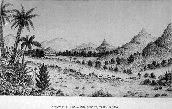
I once took up my quarters at a small spring flowing from some granite rocks, where I remained six weeks, near the range of hills already described, to hunt and explore; this was the following year, and strange to say, every afternoon heavy masses of clouds just showed their heads above the horizon, covering more than a quarter of a circle, that is, from the west of north to east-north-east, taking up the same position daily; their lovely pink tints faded as evening advanced, no clouds could be seen, and yet nightly we had these flashes. Some may say, surely these clouds must have passed over some portion of the desert, not a great distance from my outspan, and rain have fallen from these storm-clouds; the reply is, for months prior to the rainy season commencing, clouds are formed after mid-day, and follow certain strata in the air, drawn by the electric condition of that portion of the earth’s surface, and discharge the electricity they may contain without rain. I give this because I have on several occasions been stationary for some weeks in the line of country these clouds have taken, year after year, and at the same season. After the sun has passed the meridian, clouds have been collecting, generally from the north-east, and as evening advances, the vivid lightning and the heavy peals of thunder commence, and last for several hours, and then appear to evaporate, and a lovely starlight night succeeds; not a drop of rain has fallen during the storm, and a clear blue sky is seen over the whole of the horizon. In this part of the desert we are seldom below 3600 feet of sea-level, and, taking into consideration the clear and rarefied atmosphere, a flash of lightning and the thunder may be seen and heard at a greater distance than where the atmosphere is more dense. I may further observe, that owing to the rotundity of the earth, and the allowance to be made in every mile, it does not require that the clouds should be very far away to be partly below the horizon. When we place our eye on a level with the ground and look along a flat country, at ten miles’ distance a man must be seventy feet high for his head to be seen above the horizon; therefore, at twenty or thirty miles, a portion of the clouds would be beneath the horizon, not a great distance for sound to be heard on a still evening, or a flash of light to be seen as evening closed in. These storm-clouds, without rain, always precede the rainy season, as also the sand-storms, and those gigantic whirlwinds that may be seen passing over the desert by the dozen, and extending in some instances 1000 feet high, carrying up sand, sticks, and other articles that lie in their course; many of them measure 100 feet through. It is a strange sight to see many of these sand-columns passing along over a plain. I have observed, where the first passes, in the course of the day others follow exactly in the same line: they indicate a change in the weather. The mirage is also of daily occurrence. In travelling through the country, its general features appear to have entirely changed by imaginary lakes, looking so perfectly natural; lofty trees appear to be standing in water; long belts of bush and wood, which the traveller may be approaching, seem suspended in the air, showing their reflection in the vapoury atmosphere between them and the observer, which does not extend above a few feet from the ground: that apparently vanishes as you proceed, but you are passing through it; isolated hills look like islands, by their base being surrounded by this moist air, which is not confined to any particular time of day, but towards the afternoon they are more frequent. If there is any wind, of course there is no mirage, as it disperses the damp air which causes it.
Montsioa territory is rich in cattle, which is sold to colonial traders. The natives also are cultivating their lands for corn, and a great sale in ploughs is the consequence. They are improving in every way, but for the last three years the Boers have laid waste the country, killing the people by hundreds, robbing them of their property, and stealing from them 30,000 head of cattle, besides sheep and goats, causing untold misery amongst a people who never injured them by word or deed. I write this from my own personal knowledge, being there at the time, and having only just returned to this country. The only means of preserving these people, and improving their condition, which is essential also to the prosperity and advancement of the Cape Colony, is to annex their lands.
Chapter Eight.
The chief Gaseitaive’s territory of the Bangwaketse family of the Bechuanas.
The next and third Bechuana chief from the Cape Colony is the chief Gaseitsive, whose territory is more extensive than Montsioa’s; his southern boundary joins on to the latter, along the entire length from east to west. His chief town is at Kanya, sixty-five miles north of Sehuba, Montsioa’s town, situated on the summit of a lofty hill, the highest of any in this part of the country. The chief lives in a well-built house, furnished similar to any European residence. The hill where the main part of the town is built, slopes gradually down towards the north, on the east and west, more suddenly on the south by a cliff, 180 feet in height, composed of rounded and well water-worn stones, from the size of a marble to an ostrich egg, forming a hard conglomerate, with dark brown gritty sand, and it has every appearance of having once been a shore-line, and the back of an ancient harbour. At the bottom of this cliff the lower town is built, and is the mission station and church of the London Missionary Society, under the Rev. Mr Good. This lower town stands at the upper end of an extensive level opening, surrounded on three sides by hills, open to the south, where a small sluit drains the land upon which the lower town stands. The principal road from the colony after passing through Montsioa’s territory at Maceby’s station, runs due north to Kanya; the distance from the former is sixty miles, from Molapo river; half-way, at Vaalpan Fits, is the division between Montsioa and Gaseitsive. The country is thickly wooded and very pretty; all to the west of this road is part of the Kalahara desert belonging to these two chiefs. A road from Melemo’s station on the Molapo joins this, and at Vaalpan Pits a road branches off to the left, through the desert, to Lake N’gami, a distance of 420 miles to the chief Molemo at Leshubatabe’s station, east of that lake.
The principal watering-places along this road are Moshanen Kraal, thirty miles; Seletse, forty miles; Tans, twenty miles; Kaikai, 110, with small pits between; Makapolo Pans, 108, also small pans along the road; Goose Vlei, sixty-four miles beyond, and to Molemo’s station, near the lake, forty-eight. The country through which this road passes varies in character and scenery; the lower portion passes between isolated and picturesque hills, well-wooded to their summits with a variety of subtropical vegetation. Mokotontuane Hills are particularly noticeable for their beautiful flora. The plains and valleys have many Kaffir stations with their petty chiefs, under paramount chief Gaseitsive, who belongs to the Bangwaketse tribe of the Bechuana family. They are Moshanen, Montsioa’s old station; Seletse, Gabatane, Ses, Khokhochu, Lutlue, Tans, and several others, as also Bushman kraals where large herds of cattle are kept.
The people are quiet and inoffensive, living the same kind of life their forefathers lived, thousands of years before. The men have their skin mantle, the women also, with their short kilt, beads of ostrich eggs, also brass wire from Kanya, for feathers, karosses, skins, and other native produce.
The climate is almost perfect; no frosts in winter, which is the dry season, as rain rarely falls between April and October. Lions, wolves, leopards, and a host of the cat tribe, some of which are beautifully marked and make handsome karosses, which fetch a good price, are numerous over the whole of this part.
The main transport road, already described, from Maceby station on the Molapo, in Montsioa’s territory, to Kanya, is the only road now open from the Cape Colony to the interior, for carrying on the colonial trade with the native tribes beyond, as now settled by the late Transvaal Convention. All the others passing northwards go through that Republic and are subject to a heavy tax, consequently they are closed to us. Previous to the Transvaal rebellion, we had six different roads for conveying merchandise from our two colonies, Natal and Cape Colony, free from taxation. The interior trade from Natal is entirely closed against English traders, in consequence of the distance being too great to go round to the only one now left to us. The other main roads to Kanya, besides the one already described, pass through the Transvaal and Zeerust, which has been given to the Boer Government, since Keats’ award has been so unwisely abandoned and their north-west border extended, the result of ignorance on the part of the British Government as to the importance of keeping in our own hands so valuable a part of Montsioa’s territory, for the purpose of greater freedom of communication with that vast native region beyond. The transport over them would have been much easier and cheaper, in consequence of good roads and an unlimited supply of water. The only road we have willingly confined ourselves to, from Maceby’s to Kanya, has only one permanent water, at Vaal-pan-pits, for sixty miles with a heavy road, which for heavy transport-waggons is a loss to the trader. The roads which the colonial trade passed over, now closed to us by the extension of the Transvaal boundary beyond Keats’ award, which should have been maintained, are as follows: From Kimberley to Taungs. Melema on the Molapo to Rinokano, and the river road along the Limpopo or from Rinokano to Kanya by two routes; another is via Maamousa; a fourth passing along the open plains by the two salt-pans, and the other two, one to the north of Bloemhof, and from that town by the Vaal river roads—all concentrating on Molapo and Molmane, then through the new land given to the Transvaal by the Convention. This is the position in which the British Government has placed the two colonies with regard to the interior trade.
The country through which these roads pass to Kanya is very lovely, and superior to any part of the colony. One of these passes through a drift of the Molmane river, a branch of the Klein Marico, passing on past John Mentji’s farm; a small lake in front of the house, surrounded with beautiful trees, and a pretty fountain at the back, with rising ground in the distance, is a spot to be remembered. Beyond is the fountain at Ludic’s, passing between hills clothed in every variety of foliage, on to Kanya; the distance is eighty miles. The other principal transport road to Kanya from Rinokano passes through a more lovely country than the one just described, the rich alluvial soil of the valleys, well watered by fine springs, which are small branches of the Notuane river, fine grass-lands studded with beautiful groups of trees and bush. On every side of the road, well-wooded, lofty, and picturesque hills—they may be termed mountains; others in the distance rearing their lofty heads, visible between the openings of those near. The subtropical plants, scarlet creepers climbing up and between the isolated rocks, piled one upon another, complete a landscape seldom to be surpassed for the beauty of its scenery.
The distance to Kanya is fifty-four miles, ten miles from Rinokano, which is a large Kaffir station. When I first paid it a visit, an old chief Moelo lived there. It is a mission station of the German Mission Society, in charge of the Rev. Mr Jansen, who is noted for his hospitality to travellers; he has a beautiful garden well stocked with fruit, also orange and lemon trees. Monata, ten miles north of Rinokano, is the old station of the chief Marshelale, who, owing to the continual inroads of the Boers from the Transvaal stealing his cattle, removed to the other side of the mountains beyond Kanya, where Pelan lived. This old station has now been occupied by several Bastard families, who have built quite a town of good brick houses situated on a branch of the Notuane river, which runs through a pass in the mountain of great beauty. Above the poort near the springs are many Korannas; some spoke very good English, and gave me much information respecting the locality. Six miles beyond, the road takes a short turn to the left, passing between high hills for one mile, the road being very steep and stony, and a mile beyond you arrive at that singular and isolated hill called Moselekatze Kop, a lofty conical hill; the height from its base to summit is 275 feet, by my aneroid barometer. This is composed of hard sandstone and shale; great quantities of ironstone, and conglomerate in large boulders, cover the ground at the base, which appears to have fallen from the top; the rocks round about are blue and white metamorphic.
As my intention was to scale it the next day, I outspanned under some fine trees close to the hill for the night, that I might be on the topmost point at sunrise, which at that season of the year (April) is about five o’clock; and as the sun rose above the cloudless horizon, with the pure clear atmosphere, it threw out all the distant mountain peaks in bold and well-defined outlines, although some of them were more than sixty miles distant; and as the sun rose, casting the deep shadows of the surrounding hills, and bringing out the rich green foliage of the trees and shrubs, it was a sight seldom to be seen. There are many cattle and vieh-posts for sheep and goats in these valleys, that belong to the people at Kanya, and other kraals, in the country belonging to the chief Gaseitsive.
Leaving Moselekatze Kop, going to Kanya, the road turns west, then north-west for thirteen miles, to a deep and stony watercourse, that comes down from the mountain two miles distant, which is a branch of the river Tans and Sand, into the Notuane. Many picturesque sandstone hills of every variety of form, covered with rich subtropical vegetation to their summits, with gigantic rocks peeping out between the bushes, give a peculiar feature to the landscape. Some of the finest tree-aloes grow here to perfection, the stems measuring twenty-five feet, and in girth six feet, their long light-green pointed leaves measuring four feet, and when in bloom their many crimson flowers are beautiful objects. The country being so lovely, I remained at this stony river three days to sketch and prospect, and was rewarded by finding in the bed of the river, mixed up in the large stones, ancient flint implements, that had been washed down in heavy rains. Several of them were so jambed in between large boulders of many tons weight, that I had to get a crowbar to remove them. Some of these boulders measured over four feet in diameter, showing the force of the stream and quantity of water that falls in these thunderstorms.
The temperature at night in my waggon in April was 68 degrees, and at mid-day 84 degrees. No large game has been seen, although the natives tell me there are koodoos, blue wildebeest or gnu, hartebeest and springbok.
From this river the road winds through these beautiful valleys, passing a remarkable granite rock standing alone in the veldt, round like a Kaffir hut, twenty feet in height, continuing on through the same kind of country to Kanya. Another, in fact two other roads, leave Rinokano, and go direct to Molapololo, the chief Sechele’s station; one round by Ramoocha Khotla, named after an old chief, passing through Base Poort, a lovely spot, plenty of baboons and beautiful birds; we cross the Sand river four times, very stony, on to Sneyman’s farms, past the Spitz Kop, another remarkable hill, over an open flat, park-like, with beautiful clumps of trees, to Dwasberg, passing on the right Kolobekatze mountain, leaving on the left the Quagga and Kopani hills, and on to Ramoocha, where the chief Makose has a large station. These people belong to the Bamankitse tribe of the Bechuana family. It is a mission in charge of the Rev. Mr Schonenburg, of the Berlin Society. From this kraal the road divides, one going to Chene Chene, where the chief Maklapan lives on the bank of the Notuane, and then to Motsode, taking the Limpopo river road to Ba-Mangwato. The second goes direct to Molapololo; the third to the same town, through the Kaffir station Monope, under the chief Kuanette, of the Bahurutsi-Bamangane of the Bakatla tribe of the Bechuana family. Monope is also a Berlin Mission station, in charge of the Rev. Mr Tanson.
The large Kaffir station of Monope is well situated on elevated ground, a gentle rise from the river Coloben, a branch of the Notuane, being protected by several large stone koptjies. The people are very quiet and civil, cultivate extensively Kaffir corn, and make karosses, which they sell to traders. When I first knew the people, twenty years ago, there was not a man or woman that dressed in European clothes; at the present time most of them are getting into the way of dressing. The men wear clothes, and will have the best.
The Notuane river has many tributaries, that take their rise in this territory and at Rinokano, which drains the whole of this district, and falls into the Limpopo. The town of Kanya, as I have stated, stands on a hill, much higher by several hundred feet than the surrounding country. There are seven stores kept by colonial traders, who did, before the Transvaal rebellion, a good trade with the natives in corn, cattle, feathers, ivory, skins, karosses, and other native produce, but which have been almost destroyed through the Boer disturbances. The chief Gaseitsive is a quiet and peaceful man, and his son Bathoen is also well-disposed. All the men dress in European clothes, and the women are taking to them. It is one of the most difficult things to change the habits and customs of a people, but in my time great strides have been made in this direction up even to the Zambese. The large station at Mashonen, eighteen miles to the west of Kanya, is now occupied by this chief’s people, since Montsioa left to live on his own ground at Sehuba. The country between Kanya and Masepa station is very picturesque, lovely valleys, some well cultivated; many of the hills that surround them are clothed in lovely vegetation—the euphorbia, wild fig, and other subtropical plants; creepers of every variety climbing up between the large masses of sandstone rocks that stand out in grotesque forms, piled one upon another, add much to the beauty of the landscape. Such charming scenery could not be passed over in haste, particularly when surveying the country, which, detained me from time to time many weeks in treking through.
The different streams that drain this part rise to the west in the Kalahara desert and fall into the Sand, Tuns, and Coloben branches of the Notuane river. The climate is splendid, so far as perpetual sunshine for eight months of the year goes; the summer from December to April being the rainy season, when severe thunderstorms and a downpour of rain are almost of daily occurrence; but with such a long drought vegetation does not seem to suffer.
The natives are most friendly, bringing milk, green mealies, sugar-cane, pumpkins, anything they possess, to the waggon, in exchange for beads, tobacco, or such trifles as they might require.
At one of my outspans, close to the highest range of hills between Masepa and Coloben, I formed my camp under some fine trees, as it was my intention to ascend the highest hill, to take observations with my servant, the next day. During the night several wolves visited us; the smell of the fresh meat in the waggons brought them nearer than was prudent, for we shot two very large ones in the early part of the night. Their skins are very useful for many purposes. This occurred when few white men visited Africa; consequently, lions, wolves, and other animals were seen and heard daily, and therefore necessary precautions had to be taken to guard against any attack upon my oxen. In the early morning of the following day I saddled-up my horse, and with my rifle started for the hills. It is always a practice in such a country never to be without your rifle, for it is impossible to say when you may require to make use of it. Finding the hill much too steep to ride up, I led the horse along a winding path between bushes and trees, and reached the top, which was level and open. The view from this point repaid me for the trouble of ascending. The lofty and well-wooded hills in the immediate vicinity, the distant mountains with their rugged outlines, clothed in purple mist, with the rich valleys beneath, was a landscape worth looking at. The clear atmosphere brought out all the inequalities and projecting rocks of quaint forms into prominence. I was not, however, allowed to remain long in this peaceful solitude before I became aware I had invaded Mr Baboon’s stronghold and look-out station. Making a more minute survey of my surroundings, I observed that many of the trees and bushes concealed one or more of these monkeys, and others perched upon rocks not far off intently watching my movements. Not a sound escaped them; I believe the presence of my horse had much to do with keeping them quiet, for horses then were never seen in those parts. If I had been alone some of the old ones might have given me trouble; many of them appeared to be nearly my own size. To see what effect a shot would have, I fired one chamber of my revolver. Then the music commenced—barks, screams, half-human grunts sounded from a hundred different places as they scrambled from branch to branch to gain cover amongst the rocks and small caves in the side of the hill, which, in days long since passed away, were occupied by Bushmen. The height of this elevation was 4560 feet above sea-level.
On arriving at my waggon I found one of my oxen stuck in a mud-hole, and with difficulty released him and proceeded on to Masepa, the petty chief Pelan’s station, where the Kaffir women brought me thick milk, which is very good and acceptable in this hot weather. There are many Kaffir stations along these roads of the Bakwana and Bangweketse tribe of Bechuana, who live under their respective chiefs. From my earliest visits in this country, up to the present time, the Boers have been a murdering and unprincipled people, over all these parts, stealing the native cattle and encroaching on the land. In 1852 Dr Livingstone, in a letter to Sir John Pakington, states,—“Frequent attempts were made by the Transvaal Boers to induce the chief Sechele to prevent the English from passing him in their way north; and, because he refused to comply with this policy, a commando was sent against him by Mr Pretorius, which, on the 30th September last, attacked and destroyed his town, killing sixty of his people, and carried off upwards of 200 women and children. I can declare most positively that, except in the matter of refusing to throw obstacles in the way of English traders, Sechele never offended the Boers by either word or deed. They wished to divert the trade into their own hands. They also plundered my house of property which would cost in England at least 335 pounds. They smashed all the bottles containing medicine, and tore all the books of my library, scattering the leaves to the winds; and besides my personal property, they carried off or destroyed a large amount of property belonging to English gentlemen and traders. Of the women and children captured, many of the former will escape, but the latter are reduced to hopeless slavery. They are sold and bought as slaves; and I have myself seen and conversed with such taken from other tribes, and living as slaves in the houses of the Boers. One of Sechele’s children is amongst the number captured, and the Boer who owns him can, if necessary, be pointed out.” The above statement is perfectly true in every particular. This murderous attack on Sechele and his people took place at Monope, and the old men at the station took me up into one of the stone hills close to the town, and showed me the small cave, about ten feet square, in the side of the hill, where Sechele and his wife took refuge with several guns and ammunition, and were pursued by the Boers, who kept up a constant fire into the cave, whilst Sechele and his wife, protected by the projecting rock, kept them off, Sechele firing, whilst his wife loaded the pieces. And the Kaffirs called my attention to the bullet-marks on the opposite rocks, where portions of the bullets still remained. Finding that Sechele shot a Boer whenever he showed himself, killing five, they withdrew, and Sechele and his wife came out. After this affair Sechele went a few miles north with his people, and settled at Coloben, and then on to his present station, Molapololo. There is no denying the fact that the Boers, from the time they crossed the Vaal river into Transvaal, have been a greater curse to the country, wherever they have set foot, than Moselekatze ever was when he marched north from Zululand. Some think they are excellent pioneers in a new country. They advance into native territories, killing the people by thousands, enslaving women and children, robbing them of all their lands and cattle, and occupying their country, with no ulterior benefit to themselves or others, but merely as a field for further cruelties and spoliation of native races, so that the country may be cleared of them, but not for civilisation or improving the country, because they leave a dark spot wherever they settle from the ruthless cruelties they perpetrate upon unoffending and innocent people. Are they then good pioneers? All the sophistry in the world cannot make it right. To murder, enslave, and rob innocent human beings, living on their own lands, who have done no harm, and have as much right to live and enjoy their own as any other people, black or white, that they should be so ruthlessly treated by men who profess Christianity and to be a God-fearing people, is an anomaly, and cannot be tolerated by a just and upright people like the British nation. And yet these atrocities are at the present moment being carried on in Bechuanaland by the Boers of the Transvaal and Orange Free State and other scum of European nationality, who have lost all sense of honour and justice, for the purpose of gaining a footing in the country; and we allow them to commit these lawless and criminal acts unchecked. They do not even civilise or improve the country they take. Look at the Transvaal; for forty years the Boers have had possession of it. What is it now? No more civilised than when they entered it, but the contrary. The Boers are more demoralised, as we know, who know them. Their acts alone are a sufficient answer to this question, and South Africa will not advance in prosperity and wealth until the Boer element is brought to a sense of justice; and that will never be while the Boers hold an independent position in the Transvaal.
The population of the Bechuanas in Gaseitsive’s territory, including those under the chief Kuanette at Monope and Pelan at Masepa, does not exceed 35,000, exclusive of Bushmen; and against this the entire white population of the Transvaal at the present time does not exceed 40,000, including English and other nationalities. Then why should this handful of men be allowed to keep all South Africa in a perpetual state of disquietude, to the immense injury of the trade of the country? The gold re-discoveries, however, will settle this question, and that within the next year or two. The bulk of the most intelligent and influential Boers are determined to be annexed, and the hoisting of the British flag is only delayed by the savage, ignorant “Doppers,” with whom the diggers will make short work whenever they think fit to do so. The population now cannot be less than 50,000, of whom 20,000 are Europeans, and all fighting-men, whilst the Boers cannot muster more than 10,000, of whom the half are on our side.
Chapter Nine.
The chief Sechele of the Bakwana tribe of the Bechuana family.
On entering this chief’s territory from the south, that is from Kanya and Masepa, the country is undulating and densely wooded with trees and bush, the road stony and uneven. Approaching Molapololo, Sechele’s chief town, a long range of lofty hills comes in view, and as you near them a bold outline presenting many perpendicular and lofty cliffs, which gain in magnitude as you advance along the road with your waggon, passing between many Kaffir gardens. This range reminded me very forcibly of the Devonshire coast-line at Bolthead, and requires a short description to make more clear the general outline, as in no other region I have visited is there so singular a mountain, and one that conveys so plainly to the mind the history of remote times, and which appears so little changed from what it was at that period.
On leaving the low and level country to enter Molapololo, the entrance is in a break of these hills, which rise from their base several hundred feet. In this opening is the remains of a considerable river. On passing through this entrance, which is about 250 yards wide, we come into an open space, surrounded by lofty hills, with an opening on the west side where this ancient river enters from the Kalahara desert, passing through this open space and through the entrance just described. On the east side of this open space is another entrance, flanked with lofty and almost perpendicular cliffs. The open space itself is about half a mile both ways, of an irregular shape, and has every appearance of being at one time a splendid harbour, with two entrances, surrounded by lofty hills, leaving the opening on the west side, where the once ancient river passed in between a narrow opening of light sandstone rocks. The soil of this open space is clear light sand, and is now occupied by several hundred native huts, and is also the residence of the missionary, the Rev. Mr Price, of the London Missionary Society, and also traders who have six stores. The outer face of the range of hills above-named that faces the south, present a bold and perpendicular front many hundred feet in height, half-way down; then it slopes at an angle of fifty-five to the foot, which is the accumulation of soil fallen from the upper cliffs; at the base a level sandy space of some hundred feet, clear of bush, similar to our sea-coast sands; and beyond for thirty miles the country is almost level, but thickly wooded. The principal formation of these hills is sandstone, the stratification is almost horizontal, but dips towards the north. The entrance on the eastern side is most interesting, and showing the action of the sea on the outer face of the lofty cliffs, which were exposed to its force. Half-way up one of the faces, 400 feet above the base, is a large cave extending some distance into the hill; the entrance is shaped like the portal of a castle, with perpendicular sides fifty feet wide and seventy feet in height, the rock round and smooth on both sides of the entrance. The interior has several chambers, similar in form to many caverns along the rocky shores in various parts of the world formed by the action of the waves. The land-face of this ancient harbour, the hill, rises 400 feet at an angle of 30 degrees. On the summit is another extensive level space, surrounded on the west and east by lofty rocks; the north is open to the level country beyond. On this open ground the main portion of the town of Molapololo is situated, and the residence of the chief Sechele, who has two well-built houses furnished after European fashion: an entrance-hall, fitted up with weapons of war, a dining and drawing-room, bedrooms and offices, sideboards, tables, chairs, with the usual glasses, decanters, silver stands, and such things as are required in a dining-room. The drawing-room has sofas and lounging-chairs, pictures, and everything nice—quite as comfortable as any house I have ever been in in South Africa, except in the principal towns in the colony. Sechele dresses well in English clothes, and his eldest son, Sebele, is also a well-dressed, handsome Kaffir. In 1866, when I first saw Sechele, he was not so particular in his dress, and most of his people had skin dresses; now many wear English clothes of the best quality. I am describing now the state of the natives in 1880, my last visit. But now since the Transvaal has been handed back to the Boers, trade has become paralysed and little or nothing is doing with the colony, as the Transvaal Boers have closed all the interior roads, and not only done so, but robbed and burnt traders’ waggons on their way to the interior, and driven the traders out of Montsioa’s and Monkuruan’s territories, and by their lawless acts have devastated the country.
At my last visit but one, in 1877, I was received with great kindness, and as an old friend, by Sechele, who had on former occasions shown me great kindness and hospitality. I arrived at the town on Sunday afternoon, the 1st of September, after suffering much from want of water, and bad grass, since leaving Masepa. I called on the Rev. Mr J. Moffat, and then returned to my waggon, where I found Sechele’s brother, who had been sent by his chief, inviting me up to see him. On Monday morning I walked up to his house; he was sitting in his kotla with his councillors, then stood up, shook hands, took my arm without speaking, and walked to his house, a few steps from the kotla, as the enclosure is called where he and his councillors transact business, and took me into his drawing-room, seated me beside him on the sofa, still holding my hand, and ordered coffee. After giving him the particulars of my journey and the news of the country, he asked me to take dinner with him, and was pleased to see me. The table was laid similar to any white man’s—stewed beef and pumpkins, Kaffir beer, for which he is famous. Then had I to listen to all his troubles respecting the chief Linsey, who lives at Kgamanyane or Motsode, a station forty-two miles on the east of Molapololo, who had robbed him of all his cattle, and he was now a poor man. Having examined some papers he placed in my hands, I gave him an outline of my journey to the Matabeleland, and left him with a promise to see him on my return from up-country, to give the news. Such is the chief the British people look upon as a savage, and many out here call a wily old fox, because he is guarded in what he says and does; and can any one be surprised at his reticence when he has so many enemies in the Boers, who are watching for the first chance to make war on him and his people in their thirst for land and plunder? He has always been a good friend to the English, and recent events have taught him to be more than careful how he acts, seeing that no dependence can be placed on the English Government in relation to South African affairs; and such is the feeling of all the great chiefs from the Zambese down to the Cape Colony.
A more romantic position for a native town could not well be chosen, and with little labour this natural fortress could be made impregnable. Many of the women wear petticoats, others still retain their skin dresses with bead and brass ornaments; and if left alone, without fear of Boer invasion, these are the most happy people in the world. The English people have hitherto been looked upon as friends and protectors, and as one of them I felt proud of my country. But since the Transvaal rebellion and its retrocession, an Englishman is ashamed to travel the country, to be subject to the taunts of the chiefs and people at the boasted honour of England. As I have stated, the people are the most happy of the human race—having no cares, no great division of classes, no extravagant fashions or forms to keep up. Luxuries of civilised life are unknown. They have their amusements, their nightly music and dances, the usual reed band already described; the women and children sing, and keep excellent time to the music; their clear and musical voices are pleasant to hear. The duty of the men is to attend to the oxen and cows, make karosses and clothes, hunt and work with their waggon and spans, fetching in the corn when ripe, bringing in wood for the fires; the boys look after the calves and goats. The women cook, bring water, hoe the gardens, and keep the birds away, and cut the corn when ripe—the labour being so divided, all goes on pleasantly. Sechele assists the missionary in his services at the church, which is a large building in the upper town. A few days previous to my visit a troop of young elephants marched up to the kraal from the Kalahara desert, having lost themselves—a very unusual occurrence, as they seldom come down so far south. The natives turned out and shot them, causing great excitement.
In Sechele’s territory there are no other stations of any size; he has many smaller kraals in outlying districts, and several cattle-posts belonging to Kaffirs, some of whom are rich in stock. Four roads branch from Molapololo to the north, one passing through the desert to Lake N’gami, two direct to Ba-Mangwato through the Bush Veldt, a fourth via Motsode, by continuing down the Notuane river; another, making a fifth, taking the river road by the Limpopo. The distance by the direct roads to Mongwato is 133 miles. In the dry season most of the transport-waggons take the river road, as water is always to be obtained. In the direct roads, many of the pans dry up; only at Selene Pan can water be procured, which is eighty-eight miles from Sechele’s, and forty-five from Mongwato. All that part of the country is very pretty; there are no hills, small koptjies are numerous. The trees and bush that grow in such park-like clumps, of great variety, add to its charm. The first year I travelled that road, eighteen years ago, the whole country swarmed with game, lions, and wolves, that is, at the time I speak of. The koodoo, with fine spiral horns from three to four feet in length, is a noble animal, the size of an ordinary ox, of a dun colour; their fine action when trotting or on the gallop, carrying their heads well up, is a fine sight. Hartebeests, roibok, with their beautiful fat sides and sleek coats. Well-marked with black stripes and white is the zebra, and when a troop of a hundred or more pass, it is a picture in itself. The ostrich was then plentiful, but it was difficult to run them down where the trees grow so thick, with bush between.
I had a young and fleet horse who got quite used to hunting them; if he saw any, it was difficult to keep him in hand, and in a country of thick bush, wolf-holes, and ant-bears, it required great caution to prevent a tumble of both horse and man. The best plan I found was to stalk them between the bushes. I had a narrow escape with a lion on one of my ostrich hunts. When chasing them at full speed, I had to leap a low bush, no other opening being near; when half-way over, I saw a lion on the other side close under the branches, who raised himself as if he had been asleep—I partly passed over him. All I had time to see was his great head and mane as he jumped up, but I was off and away before he seemed to realise his position; at any rate he did not give chase, as I thought he might do. I think my horse had some inkling of the same, for he stretched out at his full speed. At night they became very troublesome, prowling round the waggon, keeping us awake to prevent them coming disagreeably close to the oxen and two horses fastened securely by reins to the trektow and waggon. Not being hunted, they were very bold. One night they killed a beautiful gemsbok within 100 yards of the waggon; the long straight horns I secured the next morning.
Several Bushmen and their families kept with me during my stay in these parts, and were of great assistance in fetching water, cutting up the flesh to make biltong by drying it in the sun, and bringing in the game when shot. Some of the Bushmen and women were well-made, the old ones poor specimens of humanity. One girl was a perfect model, with rounded, well-formed limbs, and in good condition from living on the game the men killed with their bows and arrows. These people were quite black and small, a different type altogether from the Bushmen of the south. They were of the same family as those who occupy a great portion of the Kalahara desert, of which this forms the eastern part. Their language is also different; they are called Mesere Bushmen from their small size; that word signifies woman. They were perfectly naked, the weather never being cold, at this time the thermometer being 102 degrees in the shade. Their long rough grass huts being a broken bough or a few sticks stuck up and long grass thrown over.
They have a very ingenious method of taking game by pitfalls. They dig four or five pits eight feet deep, ten long and four wide, fifty or sixty and sometimes 100 feet from each other, not in a straight line, but so placed that when they make a fence from one to the other it would form the letter V; at the point would be the pit, and no hedge, so that an animal wanting to pass through would walk down to the opening, and as the pit would be beautifully covered over with small sticks and grass, made a very inviting road to walk over. It was at one of these openings I had a very narrow escape of my life. Returning to my camp after a long day out after game, I came upon this fence, seeming an opening, and not having seen any before, I was going through, my dog in front, when I saw him disappear all at once, howling as dogs will howl when hurt or frightened. Dismounting, I pulled away some of the sticks to make the hole larger, and found one of these pits, with a large sharp-pointed pole stuck upright in the centre, and there was the dog at the bottom in a great state of mind; but how to get him out was a puzzle. As there were several long straight branches that formed the hedge, I got sufficient to put in that I might go down to take hold of the dog’s neck and lift him out, which took me an hour to perform. I took care to give these hedges a wide berth when I saw any afterwards. If a giraffe or elephant fell in he would be impaled and unable to move. Smaller game like my dog are caught alive. If I and my horse had gone in, he would have been impaled, and I should have been probably killed.
The Bechuanas have another method of catching game by pitfalls—at least many years ago it was in use, where instead of securing one, they trapped hundreds at one time. In those extensive open plains, where tens of thousands of the antelope species roam, a favourable spot would be selected, and from eight to twelve large pits dug, ranged in a row fifteen feet apart, the earth taken out to the depth of five feet, and thrown up between them, forming a steep bank; at the bottom of this pit, it would be divided into smaller pits, two feet in depth, leaving a wall of earth between each; these would be square, and three in a row. The full size of the opening would be about thirty by twelve feet, placed longways. These would occupy a considerable space; at the extreme ends a thick bush hedge would prevent the game leaping over, and several hundred men placed in addition to prevent the animals going round. When all was prepared, men would drive the game by thousands towards the pits, and as they were pressed on by those behind they made for the pits to escape, where they would fall in, and having no foothold in the small square pits above-named, had to remain. Hundreds passing over them, also got fixed, until the pits were full.
Then the grand slaughter commenced; as many as 1200 have been caught at one time. All the men, women, and children set to work; fires made, cooking begins, the skins taken off, and the meat cut up into lengths and hung up to dry in the sun for future use; not a marrow-bone is wasted, and it takes days to complete the work. This practice has been given over for years, but the pits still remain, some very perfect, which I measured. The Dutch name is “fungcut,” the Kaffir name “hopo.” The game driven into these pits would be composed of all kinds common to the country. The Bechuanas have guns and shoot the game, and have become very good shots.
At Molapololo when the people get short of meat, a hunt is got up to go out for weeks to shoot game. Thirty or forty men, each with a gun, and pack-oxen, with several waggons, proceed to the Kalahara, where game is always to be had, and when they have procured enough meat or biltong to load up the oxen, they return home. Many women and children go in the waggons with them; it is a grand picnic. I was with them on one occasion when we had a lion-hunt, and we killed three out of seven, but four of the Bechuanas got fearfully wounded.
I was outspanned about 100 miles on the north-west of Sechele’s, near a very pretty pan full of water, it being the rainy season in February, when one of these hunts came along, and outspanned a short distance from my waggon. The night previous we had been on the watch, as lions kept prowling about the waggons, but could not see any, the night being very dark. The next night the Kaffirs lost one of their largest pack-oxen, and as we saw by the spoor that there were several, the Kaffirs came to me, they knowing me very well, and asked if I would go with them and hunt up the lions, as we had several good dogs to drive them out of the bush. We mustered in all twenty-two guns—myself and my driver, a Hottentot, a capital shot, and twenty of the hunting party. Leaving the camp about two p.m., we took the lions’ spoor for nearly a mile into a small koppie with thick bush. The best part of the sport was to see the Kaffirs in their excitement, as if they had never seen a lion before; my fear was they might shoot me in their anxiety to have a shot and be the first to kill; every man had his place assigned him, but we could not draw the lions out of their cover; the dogs made a great noise, but would not go in. Finding they would not move, I placed three Kaffirs in a good position for them to keep firing with their rifles into the most likely part; this after a time brought four lions out, three others slunk away to the rear. Two had evidently been hit by the bullets, for they made for the nearest Kaffirs, whom they seized. Three were killed, having received seven to eight shots each; those that made their escape were young, only half-grown. This was a glorious day for the Kaffirs, to go home and tell their chief and friends of their bravery.
All this part of the Kalahara belongs to and is in Gaseitsive’s territory, a country nearly 200 miles square; the northern part from Molapololo is a complete forest, fine trees, bush and open glades, and is his hunting-ground, where his people procure ostrich feathers, skins, and game, and also ivory. It was, when I first knew it, full of game, but since the natives have obtained rifles, they have greatly reduced it. The Notuane river and its branches drain the country belonging to Sechele and Gaseitsive, and is a tributary of the Limpopo. Fifty miles to the east of Molapololo is a large Kaffir station, Chene Chene, within the latter territory, under the chief Maklapan. A beautiful and picturesque hill stands close to it, which is visible at a great distance. The whole country is forest and full of game. The town is twenty-nine miles south from Motsodie. The river road to the interior from Molapololo passes through a very pretty and interesting part of the country, a long range of low thickly wooded hills on the left. Twenty-two miles on the road from Molapololo is Clokan, a small stream, another branch of the Notuane, where water seldom fails.
On my last journey I found a trader, a Mr Okenshow, outspanned, who told me several lions had killed three blue wildebeest the previous night, and advised me not to let my oxen go out of my sight in the thick bush. This spot is famed for beautiful birds. After shooting some pheasants and four of these little beauties.
I went on and passed another small stream call Koopong, thirteen miles, and then to Motsodie, the large Kaffir station under the chief Linsey, which is forty-two miles distant from Molapololo; he cautioned me to look after my horses and oxen, for the country was full of lions, and they were so bold they came close up to the town. They follow the game, more particularly quaggas or zebras, and, as there were plenty of them, also koodoos, hartebeest, and wildebeest.
Previous to my first visit, a chief named Kgamanyane left his country on the east side of the Limpopo river, crossed over and settled at this station, with all his people, by permission of Sechele, and built a large station up among several hills, that it might be well protected in case of war with any tribe. At his death, his son Linsey ruled jointly with his uncle, and claimed the country as his own, and began stealing Sechele’s cattle and killing his herds; this led to war between them; several attacks were made by the latter on the town, but they were driven off, with a few killed, and so the war for a time was ended. This was the trouble Sechele told me of. The town is well selected for defence, the hills command every approach to it. Linsey lives in a brick house, and he and his people dress in European clothes. There is a mission station under the London Missionary Society. The people are very civil and ready to help strangers. Close up to the town are some very large ant-hills, fifteen feet in height, and forty feet in circumference at the base, terminating in a sharp point. They are the work of the small white ant that is so destructive to furniture and buildings; what motive they have for building them so lofty and pointed I have never been able to discover, because all their food supply is conveyed into it through little holes at the base. They are wonderful works for so small an insect. I remained here a week that I might explore the country, which is of sandstone formation, granite below, iron-conglomerate in large boulders on the slopes of the hills.
There are two roads to the Limpopo river, one on each side of the Notuane, and another through the Bush Veldt, to the Great Marico river, with branch roads to Chene Chene, Ramoocha, and Rinokano stations, the two former ones being very bad and crossing many sluits. I took the one through the Bush Veldt. Leaving Motsodie in the afternoon, I crossed the river, and as night would be dark, outspanned early, to be prepared for any nocturnal visits from our feline friends. Fixing upon a pretty little open space, the only one I could find along the road, as it was one dense bush on both sides, I outspanned, and made everything ready, collecting plenty of wood to make big fires. Having made a fire to cook our evening meal, my three Kaffirs, or rather my Hottentot driver and two Kaffirs, were sitting smoking over it, and having seen all secure, were ready to turn into bed, when my driver, a first-class boy, called out there were lions coming on. He was the first to hear them—their noise is not to be mistaken when once heard. Having listened some time, the sounds, which on a still night can be heard a long distance off, appeared to be approaching. Our first care was to replenish the fire and pile up wood for two more, bring the foremost oxen close up to the waggon, making them fast to the wheels; the horse was placed between the waggon and fire, fastened to the front wheels, and more wood collected. During this time the lions appeared to be nearing us. After lighting the other two fires, I gave the boys a rifle each; myself and driver took up our position on the front waggon-box, that we might have a better view. The night being very still, not a sound was heard, except occasionally from our friends, as they evidently were very near. When about one o’clock in the morning the sounds ceased altogether; then we knew they had discovered us, and meant mischief. The last sounds appeared to be about 300 yards distant. This was an exciting time, for at any moment we might expect them in our midst, and to seize some of the oxen or the horse. All was still as death, except when the Kaffirs threw more wood on the fires. After waiting nearly an hour, the first indication of their presence was the restlessness of the oxen and horse, having scented them in the still air; but with all the glare of the fires they were not visible, the bush being so thick. We each took our rifles and stood between the oxen and the wood. The first warning sound was from my Hottentot driver, Dirk, who called out, “Look sharp,” and the next moment the report of his rifle. I was standing by his side, and saw the lion, not thirty paces from us, turn round, when I gave him a second bullet. He appeared to be severely wounded, as he only retreated a little distance, when he received a third from my driver, which brought him to the ground, and another in the head to make sure: a fine, full-grown lion. The other we never saw, he must have made his escape at the first shot. Early in the morning, to save time, I had him skinned, and inspanned to make my morning trek before breakfast. Two treks a day, morning and evening, nine miles each, if possible, but in this country you must be guided by water. The smell of the lion-skin at the back of the waggon made the oxen trek so fast that it was difficult to keep them under command. It is a very strange fact that calves born in the colony, grown into oxen, that have never seen or smelt a lion, should be so frightened at even the smell. Instinct, I suppose, tells them they are no friends. Those who have never seen a lion in his wild state can have no idea what a noble-looking animal he is. My driver Dirk was elated at having given the first shot, being the first lion he ever shot at. Every night in these parts we heard them at a distance. Wolves came every night. A few nights after, one came close to the waggon about midnight, not thirty yards away. I merely took my rifle as I sat up in my bed and shot him in the chest—one of those large-spotted brown sort. They smelt the raw meat at the back of the waggon. Wild dogs also this year came in large packs; they may be seen in one district for a short time, then they disappear for months. It is the same with the lions. The tiger (leopard) seldom leaves his haunts.
The distance from Motsodie to the Great Marico river road is forty-seven miles, from thence to the junction of the Notuane river with the Limpopo, seventy-four miles. On the road from whence I crossed the Notuane river to the Great Marico road, the country is very dry and sandy, but the bush in places is very lovely. A great fire was raging on our right and coming down upon us with a strong wind; there was no means of escaping it, as high grass was in every direction, by trying to get past it; I therefore held still, set fire to the grass on our left of the road, which went blazing away at a great speed, that soon cleared a large extent of ground, where I brought my waggon into a safe position; if I had not done this, the waggon and all would have been destroyed.
These grass-fires are very injurious to vegetation, killing the young trees and causing grass of a very coarse kind. This transport river road in dry weather is splendid, level and free from stones; some of the sluits are bad to cross. At the junction of the Great Marico river with the Limpopo is a drift through the latter, and a pinkish granite crops up on its banks. Wishing to have a swim, I took my towels from the waggon, and walked towards the river. On arriving at the bank, which is some fifty feet above the water, I saw on the sand beneath me a fine crocodile, on the opposite sand-bank, for the water was very low, three others basking in the sun below me, and two in the water, with a part of their heads and backs out. Those on the opposite side saw me first, for they moved towards the water slowly, and entered it and disappeared, without making the slightest ripple in the water; their bright colours made them look anything but ugly. I thought it advisable to defer my bath to some more favourable opportunity. At this point Sechele’s territory terminates and the chief Khama’s begins.
At the junction of the Notuane and Limpopo there are two drifts. At the upper one I had to repair before I could take my waggon through, which caused me a day’s delay; I therefore fixed my camp under a very pretty clump of trees on the bank, where we were in the evening fully occupied in shooting wolves, this being a very noted place for them. Having shot a hartebeest in the morning, we employed the evening in making biltong of the flesh, and placed it on the branches of the trees to dry, as it was getting dark, for in this latitude (23 degrees 30 minutes), immediately under the Tropic of Capricorn, night sets in very soon after sundown. Several wolves came round the waggon; I thought at first in the dim light they were dogs, but soon discovered my mistake. We then made a plan to catch them, by placing two pieces of the raw meat about fifty yards from our camp, fastening them to a stump of a tree, just before the moon rose at ten o’clock, that we might see them when they came; then we all took up our position with our rifles, and waited. About eleven o’clock three large ones were seen coming from out of the wood towards the baits, which they soon found and seized, but the pieces were too firmly tied for them to take away, and then they began fighting over them, when two more made their appearance, creating quite a scene. It was then time to fire, and our four bullets settled two; the others before we could reload made off, although one was wounded as he made his escape. Bringing the two dead ones to the camp, we watched a short time longer, when another was seen coming on, and when in the act of trying to drag the meat away, we shot him also, and another soon afterwards, making four, and very large ones. The next day they were skinned, as they are very useful for many purposes, and the day after, I shot a crocodile as he seemed asleep on the bank. He measured eleven feet. Being only a short distance from the Limpopo river, which is broad and in places very deep, these reptiles seem to swarm; and its well-wooded banks give shelter to hundreds of monkeys, and also to many beautiful birds.
At the junction of the Notuane river with the Limpopo, the altitude is 2880 feet at the drift, which is one of the main roads from Pretoria in the Transvaal to the trading-station Mongwato, and the chief Khama’s capital; the distance by road from the drift is seventy-three miles. The territory of Sechele, which also includes those portions now claimed by the petty chiefs Linsey at Motsodie, and Maklapan at Chene Chene, are valuable and well-wooded districts, with many native kraals; the people cultivate the land, use ploughs, and grow corn which supplies largely the inhabitants on the border of the Transvaal, and is taken in exchange for English goods through traders from the Cape Colony, and they also rear large herds of cattle. If a settled form of government is established, and Boer invasions put down, the country will soon become highly valuable as a market for British merchandise, as the natives are very industrious, and quite alive to the importance of trade; most of the beautiful karosses that find such a ready sale in the home markets are made by the Bechuana people. In all these chiefs’ territories they are excellent mechanics, manufacturing tools and utensils from native iron, and good forges are now being introduced. They have hitherto used for heating their metal, air-bags, connected by a tube, one placed under each arm, which they press to their side, which causes a blast sufficient to melt or heat the metal, which they hammer into form with stones. But this primitive mode is going out of use, and the ordinary bellows is being adopted. They purchase extensively of colonial traders, iron pots, kettles, saucepans, and tin utensils, as also every kind of wearing apparel, and if the country is protected from Boer marauders, the British merchant may look forward at no distant date to an extension of trade in these regions, over and above the present sales, up to several millions annually, as the great stride towards civilisation during my time has been most satisfactory. Twenty years ago, where one trader’s waggon went in, in 1880 there were fifty, which was stopped on the retrocession of the Transvaal to the Boers, when a collapse took place, and has continued through the murderous attacks and robbery of the Boers on the natives, but which, I trust, will now be put an end to by the British Government proclaiming a protectorate over all this extensive and valuable region.
Chapter Ten.
The chief Khama’s territory of the Bakalihari tribe of the Bechuana family.
From the last outspan on the Notuane, at the junction of the Limpopo, mentioned in the last chapter, the road for eight miles is close to the bank of the Limpopo river, where I had some fishing, but instead of catching any fish, I caught a young iguana, two feet long, and had great difficulty to land him. It was necessary to kill the beast to release the hook. At the bend of the river the road turns north-west, and goes on to Ba-Mangwato. There are several cattle-posts at the bend belonging to Khama’s people and the traders at that station; and also immense ant-hills, of the same kind as those at Motsodie. I measured one, twenty feet high and nearly sixty feet in circumference, made by these little white ants; my waggon looked quite small beside it.
The climate here is very peculiar, hot sun, 99 degrees in the shade, with cold blasts of wind every four or five minutes in regular waves, reducing the heat to 70 degrees, which we feel very cold. This is one great cause of rheumatism and fever. To-day was almost melting with heat; I took shelter under the waggon, but had not been there three minutes when I had to get into the waggon, being so cold from the wind, which feels as if it came from a frozen region. If in a violent perspiration, fever comes on, if care is not taken to prevent a chill. The road from this place to Mongwato is fifty-five miles. In the dry season there are only three places where water can be obtained.
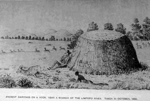
On one of the tributaries of the Limpopo is a circular rock in the veldt, no other stones near it, fifteen feet in diameter, and similar in shape to a ball cut through the centre, and placed on the ground, only it belongs to the rock beneath the soil. This rock has been covered with carvings, the greater portion of which is nearly smooth by large animals rubbing against it, giving it quite a polish. Sufficient lines are left to show it has been well cut with some sort of figures, and on one side where it curves in a little, and is out of the way of elephants, rhinoceros, and other animals, the carvings are nearly perfect. They represent paths with trees and fruit on each side; upon one is a snake crawling down with a fruit or round ball in its mouth, near it is a figure, and a little distance off another figure with wings, almost like an iguana, flying towards a man who is running away; his left foot is similar to that of a horse, the right one has two points—evidently Satan; the intermediate spaces have many stars. The upper part of the stone has, in the centre, a small hollow of a cup-shape, with two circles of the same round the centre one. It is a very interesting monument, and appears to be very old, from the fact of the other portions being partly obliterated by the rubbing of animals against it. The rock is very hard and similar to those geologists call igneous. There are many rocks of the same description, with carvings of animals, snakes, and figures on them, and from their position they have been preserved from animals defacing them. In several parts of the country many of them are well executed.
A few days previous to my arrival here in 1877, three Boers, with their waggons, were endeavouring to find a new drift in the Limpopo river, and went in to cross to the opposite side. They had nearly reached the bank, when the foremost looked round and saw a large crocodile come up from the water and seize the head of the last man between his jaws, and disappear with him. His name was Herman, a married man, twenty-six years of age. Nothing more was seen of him but blood in the water. His widow, a few months after, consoled herself with another husband. At this time, soon after the British Government had annexed the Transvaal, the Boers, wherever I met them, were always friendly—so much so, that I have often been invited to take one of their daughters for a wife. They were rather proud to have an Englishman for a son-in-law. I was outspanned not many weeks back at a very pretty pool of water, or spring, the water of which fell into the Notuane river, in what is termed the Bush Veldt, that I might have a little shooting. The second day an old Boer and his wife came to me to ask if I would buy some ostrich feathers, taking me to be a trader, for all Englishmen travelling through the country will do a little in the way of barter; therefore I told them if they were good I would. When coffee was handed to them as a matter of custom, they asked where my wife was. On stating I was single, the old vrow said I must have one of her daughters; she had two mooi (pretty) girls, and would bring them the next day for me to see when she brought the feathers. Accordingly, the next day, true to her promise, she came with the old man and her two girls to the waggon; both very young, the eldest not more than seventeen, and not bad-looking for Dutch girls, apparently very modest and shy, with a conscious look of what they were brought for. After settling about the feathers, the old mother pointed out her daughters to me, and told me, pointing to the eldest, she would make me a mooi vrow, and that she had a farm of her own and some stock. Both the girls, sitting together by their mother, looked down and giggled every now and again, giving me sly glances from beneath their cappies (the usual covering for the head for old and young), and then another giggle. They had evidently been got up for the occasion by their smart dresses, well-made English boots, and clean white stockings, to show off a pretty foot and ankle, which certainly they both possessed, and were not backward in showing. This is very unusual, they generally have clumsy feet. When at home these articles are never worn, only leather shoes called veldtscoons, which the men make. They say—which is quite true—that stockings are dirty when you walk about in a sandy country. However, after a long visit, coffee and biscuits, I arranged that on my return I would come and pay them a visit, and talk over the matter, as my opinion was either of them would make excellent vrows, and left the best of friends. The old woman’s last words were, “You can take my daughter as soon as you come for her,” and an encouraging glance from the daughter terminated this interesting meeting, enhanced, as it was, by the anticipation of having the felicity soon to possess so charming a young lady. I have had many such offers from Boers, who were favourable to Englishmen at that time. However, unfortunately my pursuits called me in another direction.
The country between the Limpopo and Ba-Mangwato, the chief Khama’s station, is very pretty, plenty of guinea-fowls, partridges, and pows. Far away from the road on the left, seven miles from the bend of the Limpopo, is a large pan where lions are always known to be, and beyond is Brakwater, where ten years before I lost an ox from out of my cattle kraal one dark night when outspanned. It is the custom, with all travellers when in the Lion Veldt to kraal their cattle at night. Seventeen miles beyond Brakwater are the Khamitsie Pits, where water seldom fails, and close to them is a large dry pan quite a mile in length. The road passing round at the upper end, and fifteen miles beyond, winds through the veldt into the ancient river-bed leading to Mongwato. The whole region for hundreds of miles is one continuation of wood, inhabited by a few Bushmen. The country for so many months without water is uninhabitable, except at the springs. The distance by this river road from Molapololo to Mongwato is 164 miles.
Ba-Mangwato, or Shoshong, is the chief town of Khama. The chief Sekomo ruled at this station, until Machin, his brother, drove him from the chieftainship, and at Machin’s death, after considerable fighting, Khama, son of Sekomo, became the chief of the people over this territory. They belong to the Bakalihari tribe of the Bechuana family. It is a very important station, situated at the foot of a long range of beautiful hills, and up an opening in the range, where an ancient river-bed passes through, and where the mission station and church are situated, it is one of the most romantic valleys in this part of the country. When I first knew the station, the Rev. Mr Mackenzie had charge, now the Rev. Mr Hepburn lives in a very comfortable house up this kloof. The hills are formed of various kinds of sandstone of a brown colour. At the back, some distance beyond the church, is a very singular hill, with a perpendicular cliff on the upper portion. The stratification makes it look like a regular wall, with its horizontal layers so regularly placed. In Sekomo’s and Machin’s time the town was much larger, but since the wars it is considerably diminished. The chief Khama lives in the lower town, and has only one wife, being a good Christian and a great help to the missionary. The traders’ stores are also in the lower town, and form quite a little village by themselves. Messrs Francis and Clark have a fine store, and a building which is occasionally used as a concert-hall by the traders, who sometimes muster in considerable numbers, and out of so many a good band is got together. Most of those stationed there are splendid musicians, both vocally and instrumentally, so that many an enjoyable evening is spent to break the monotony of a life so far removed from the outer world. They have also their cricket matches, horse races, lawn tennis, football, and other sports. Mr Hepburn is indefatigable in his mission labour in civilising the natives, combined with the good example set them by the traders at the station. The chief Khama is a gentleman in every sense of the word. I have met him and felt much pleasure in his society. He has prohibited spirits being sold to his people, and on my last visit but one he did me a great service, and helped me in the most kind way by taking charge of my oxen when I had been two days without water, having arrived at Mongwato expecting to obtain some, but there was not a drop, not sufficient even for the people. On hearing of my arrival, he came down and took my oxen in his charge, sent them with one of his herds to his cattle-post eighteen miles away on the river Mokalapse, to the north of the town, and kept them there for twelve days, until I could trek to Matabeleland. He requires all travellers who enter his territory to call upon him, that he may know who is passing through, in case they require any help he can give. Those who avoid doing so, if they get into trouble, must get out of it the best way they can. All the roads from the south meet at Mongwato; one goes to Lake N’gami, another to the Chobe, two to the Zambese, and one main road to the Matabeleland, with branches leading to the Victoria Falls.
The people at one time were very unruly and troublesome to travellers. In 1868 I was at the station when a trader came in with some brandy; we outspanned close together outside the town. The next day the traders at the station, and there were some fourteen, indulged too much; one in particular had so far forgotten himself as to take a leg of pork to the kotla or council enclosure, where the chief Machin was sitting with his councillors, and held the leg of pork in the chief’s face, and asked if he liked the smell. These Kaffirs are like the Jews with respect to pork. This created an uproar in the station; the trader was severely beaten, and the whole town turned out to kill all the white men. They, hearing of this, fortified themselves in their stores. Hundreds of Kaffirs paraded the town, visiting the waggons with their knobkerry and assagai, threatening destruction to all the white men. The course which I thought best to take was to sit on my front waggon-box and smoke my pipe; time after time hundreds surrounding my waggon, raising their assagais as if to hurl them at me, and brandishing their kerries. Knowing the Kaffir character pretty well, I went on smoking as if they were most friendly, and seeing they could make no impression, they rushed away to other parts of the town. At last the chief sent round some of his councillors to all white men, ordering them all out of the town, bag and baggage, by four o’clock the next day. Mr Mackenzie, the missionary, left the day before to go to England. Not having anything particular to do, I, with the trader who came in with me, inspanned in the evening to trek towards Selene Pan, forty-five miles on the road to Molapololo, which we reached the following afternoon, and all that night and the next day traders came treking in, until thirty-six waggons had assembled and nearly fifty span of oxen, which looked more like a commando than traders flying from the wrath of a powerful chief. It was a very pretty sight. The man who committed this insult was too ill to be removed, and was left behind. He recovered, and, I think, became a wiser man. If it had occurred a few years before, he would have been killed, and the traders also. He richly deserved the punishment he received. This will show that the Kaffirs at that time had been brought under great control, for no greater offence could be given than an insult to their chief. Some little time after this affair, the chief, when solicited, allowed the traders to return.
The chief Khama dresses well, and looks like a gentleman. Many of his people also dress, as well as the women. They are strong and well-made; some still wear their skin dresses and a profusion of beads and brass rings, but I think in a few years these will be abandoned for European clothes. Begging is still largely practised, particularly for tobacco. They cultivate corn, mealies, pumpkins, melons extensively, and have large herds of cattle of all kinds, which are kept at the different posts away from the town, and milk is brought in on pack-oxen to those who have no cows. They also make Kaffir beer from their Kaffir corn, and, if well-made, it is very nice. This is the only extensive interior trading-station in this region. There are other trading-stations beyond: at Tati gold-fields, and in Matabeleland, and also at Pontarnatinka, where Mr G. Westbeach has a large store, and others beyond, and also on the north side of the Zambese river, where a large and increasing trade is now being carried on by the English traders at the chief Secheke’s on the north side of the Zambese.
The main direct road from Molapololo to Mongwato runs north-north-east through a bush country with fine trees. The distance is 133 miles, and very pretty, the formation being argillaceous limestone; most of the hills are sandstone. At a fountain at Koopan, twenty miles on this road, are some large masses of sandstone rocks, standing out like walls of an old castle that cover an extensive area. In these rocks are many fossil remains of seeds, nuts, shells, ammonites, and one trilobite, also footprints of animals. As it was impossible to obtain them, I remained two days to make correct sketches and measurements, being most interesting specimens. In many parts of the interior, where this light sandstone has been exposed by denudation, particularly in the deep beds of those dry rivers in the Kalahara, footprints are very numerous, which I have taken great care to copy, and also all the carvings on the rocks. The other permanent waters on this road are Bartlanarme in the chalk-pits, and Lepepe; also Selene pan. Both are favourite localities for the giraffe, and here I have remained several days to hunt them, and was fortunate enough to shoot one out of five that were coming to drink. Eight miles from Bartlanarme we shot two out of seven, and at another time Mr Hume, of Port Elizabeth, a hunter, came upon several, and shot three from the saddle, from my horse, which I lent him. One we had brought to the waggon, and left the other two for the Bushmen. The flesh is very fine. It is a pity such beautiful animals should be destroyed merely for food and skins. In this part almost every variety of game is to be found. Such a vast extent of open country—where the white man is never seen beyond the transport road, and its inhabitants Bushmen only,—extending in an uninterrupted forest westward 500 miles, and the same in breadth, is no small hunting-ground to roam over for a hunter to pick his game. Twenty years ago, I may say up to 1875, game, as well as lions, wolves, and other beasts of prey, were much more numerous than at the present time. In the north and west of Khama’s country up to the Zambese, along the Zouga river, are the great Makarakara pans, and others; the large game, such as elephants, rhinoceros, buffalo, and giraffe, were plentiful, but of late years many hunters have been for months and scarcely met with any.
The country along the Zouga river is very level. This river enters, or, I may say, empties Lake N’gami, the altitude being 2813 feet, and flows to the great pan above-named in April and May, and in June and July flows into the lake. The only outlet for the surplus water of the Zouga is the Mababe river to the Chobe, one of the main streams of the Zambese, and the water in the Mababe flows either way according to the rainfall, showing the perfect level of the country. Gigantic trees grow along these rivers and the region adjoining; baobab, measuring 108 feet in girth, the palms, mapana, and other tropical trees and plants. A great portion of this country the chief Khama claims, where there are several kraals of the Makalaka, Batletle, Barutse, Bakalihari, and others, also many of the Mesere Bushmen, and a few Hottentots and Korannas. This region is a portion of the Zambese basin, and the northern part is infested with the tsetse-fly, the sting or bite of which is fatal to horses and cattle; but I have been told by the natives, that if calves and colts are bred in the fly-country, they are proof to the bite. We know that all the game in those districts are not affected by the bite, and that may be the reason.
The sickly season is from September to May. Many parts are open, with little bush; another part of the desert is thick bush, and very scarce of water in the dry season, and is a part of what is called thirst-land (thirst) from the dryness of the country, and where the trek Boers suffered so much in their journey to the westward in 1877. In that year I was at Mongwato, and came in for my share a few months later, when there in October of that year. Mr Harry Shelton, who had a large store at Leshulatebes station, Lake N’gami, was coming to Mongwato with several of his waggons for goods, and two saddle-horses he had with him, having treked 150 miles along the road which skirts the river Zouga; he was obliged to leave his waggons and oxen, as no water would be found between that place and Mongwato, a distance of 160 miles, and came on with his two horses, but on the road was obliged to leave one of them from exhaustion, and managed to come in with the other, and was obliged to be lifted from the saddle on his arrival, having been nearly four days without water. On his return fourteen days after, he expected, of course, to see the horse dead and eaten by lions; but he found him standing by the same bush he was left at, and he recovered. This shows how long a horse may live under such circumstances. Horses, however, knock up far sooner than oxen from thirst. The lions and wolves must have forsaken the country as well as the game, otherwise the horse would have been eaten. Most of his oxen had died on his return, principally from licking the moist mud in the pans and river. When so many days without water they cannot drink when brought to it. The only means then of preserving their lives is to throw buckets of water over them; but this does not always succeed. Such are the trials and hardships we have to put up with in a region so liable to long seasons of drought, and where the country is so destitute of springs or standing water. But with all these drawbacks there is a fascination that impels one on to explore these remote and little-known regions. The bright and clear atmosphere, the lovely mornings and evenings for travelling, the constant change of scene, the splendid tints of the sunsets, and variety of foliage of the vegetation, the calmness of everything around, and the constant excitement of strange game to be seen, is a pleasure we can seldom enjoy, and, as I have before stated, the only true enjoyment in Africa is waggon travelling in the interior, where time is not limited.
The watershed dividing the Zambese and the Limpopo basins runs to the east of the great Makarakara pans, in a north-east direction through the Mashona and Matabele country, and from the south-west to the Kalahara desert near Kaikai Pits, the elevation being 4260 feet above sea-level.
The principal antelopes of this region are the eland, koodoo, gemsbok, sable, and leechy or lechi, pallah, ourebi, bonte, rooy, reit, bush and steinboks, springbok, hartebeest, giraffes, and grysbok, and the zebra, and many other kinds, which are all to be found in different localities; and legions of the ant-bear, porcupine, earth-wolf, earth-pig, spring-hare, meercats, and other smaller animals; wild boar and wild dogs are seen in large packs, sometimes only a few are together; consequently with the larger game there is always plenty of sport to be found, if hunting is the sole amusement; but, combined with natural history, geology, and other sciences, an explorer has not much idle time on his hands. Locusts made this part their breeding-ground, depositing their eggs by the million, and in October there would be immense tracts of country covered with them several inches deep. Before their wings came, and as the waggons travelled along the roads, thousands were killed at every turn of the wheels. The natives eat them, and some cattle are very fond of them also. It is nearly seven years since any have been seen in South Africa. There are many kinds of wild teas found in the veldt, which I have used for months, and like them. Fine forests of timber occupy a large portion of this region, other parts are more properly termed bush, although many trees grow in them, and extensive open plains. The fine flat-topped kameel doom is very common, palms, baobab, bockenhout or African beech, zuikerbosh, acacia, Kaffir orange, ebenhout or ebony, yellow wood or yeelhout, knopjis, doorn or lignum-vitae, cabbage tree, mahogany, sneezewood, wild olive and fig, stinkwood, salicwood, Orlean wood or African oak, vittkut, mimosa thorn, wagt-een-beitje, the African name is mongharn, and a host of other trees; tuberous roots of many varieties, some eaten by the natives, and are used medicinally, and others would make good paper—an endless variety of herbs, of which we at present know but little.
The insect-world is legion; immense hairy spiders, and also the trap-door spider is a wonderful creature, the mechanism of hinge, door, and entrance are perfect works of art.
I was told by some of the people at Mongwato that there are in Khama’s territory over 200 cattle-posts, in addition to vieh-posts for sheep and bucks. The main and only transport road from Mongwato to the Matabeleland passes along by the east end of the range of hills by the town, through a thick bush to the Mokalapsie river, thirty miles, a large and broad stream in the rainy season. Upon its banks are many cattle-posts, and it is much visited by lions. From this river the road continues in a north-north-east direction, crossing the metley or sand river, Tuane, on to Chakani pan, distant from Mongwato fifty-four miles, one of the most lovely spots on this road, where I spent three weeks exploring. I outspanned under a clump of trees close to the pan, but had to shift my waggon into the open, the trees being full of tree-toads, and large lizards occupied every hole in them. The toads would drop down on to my waggon and make themselves very comfortable on my boxes and bed. The large lizard had every look of being a dangerous reptile to have a bite from. They were beautifully marked, the front of the head had a well-shaped heart of a silver grey, with a well-shaped letter Y of a rich red brown. I endeavoured to obtain a specimen, but could not get them to come out.
There are some very fine specimens of the euphorbia and lotus trees away in the bush, and also fine timber trees of other kinds. My delay here for three weeks was compulsory, as there was no water to be had beyond this point for 150 miles. This being part of the doorst land, and as the season had been very dry, all the pans were empty. I was compelled to wait until the storms, which are usual at this time of year (October), filled them. The last week of my stay severe thunderstorms were seen in the north every afternoon, which gave me hope of a good supply on the road, and occasionally we had severe storms at the pan, but not a drop of rain fell. The lightning was terrific; and the thunder following, rolling over the hills and forest trees, shaking the very ground, was grand. I always kept from three to four days’ supply of water in my waggons, in casks and iron cans, never leaving without having them filled, which I personally looked to. But in this case I omitted doing so, thinking my driver would attend to it, as I had been out early in the saddle after game, and arrived at the waggon as the oxen were inspanned ready to go forward, as I fully believed water would be plentiful; therefore, on leaving Chakani pan, I thought we were full up with water, instead of which we had only a day’s supply. To give a clearer insight what travelling is in a parched-up country like this, where rain has not fallen for six months, I will quote from my journal a week’s trek through it.
Tuesday, October 16th.—Left Chakani pan at 9 a.m. Travelled over very heavy sand for nine miles to a large open vlei called Lemonie, which, when full of water, is nearly a mile in length, a great resort for wild-fowl and that beautiful bird the berg swallow, the size of a dove, with a brilliant golden copper-colour plumage on the back, and light salmon colour and sky-blue breast. This pan is surrounded by gentle rising ground with bush, where I endeavoured to secure some of those small birds that are rare even here, being of a dark golden-purple, and less in size than our common wren at home. Finding no water, I proceeded on to Lotsane river, nine miles, and outspanned for the night; no water. Found for the first time all our water-casks empty, my driver having forgotten to fill them at Chakani pan. Having explored up and down the river without finding any, after one kettle of coffee being made, went to bed, with the hope of finding water to-morrow.
Wednesday, 17th, 4 a.m.—Sent my driver out and went myself to look for water; no signs of any. Treked three miles and outspanned to give oxen a feed on green young grass, as they have not had water since Monday afternoon. Went without coffee this morning to reserve what little we have for our mid-day meal, then it will be exhausted. This is the first time for twelve years I have been without water by my waggon.
Thursday, 18th.—Retraced my steps six miles, as I met a Boer with his two waggons, who told me he had got a Bushman to show him where the oxen could get water, about two miles off the road, in the bush. Sent my span and boys down to it, but the water was so muddy I could not drink it; filled two bottles, such as it was. The Boer told me I could get good water eight miles beyond Phalasque vlei, the pan being a mile to the right of the road, then I could get water along the road to carry me to the Tati river; consequently, shall start early to-morrow to reach it.
Friday, 19th.—Inspanned at 4 a.m. No sign of rain, although plenty of storms. Treked on to Phalasque vlei; no water. Then pushed on over a fearful sandy road at the rate of one and a half miles an hour. Thermometer 94 degrees in the waggon. This is a God-forsaken country, no people, no game, no birds, no water, nothing but hot sandy roads to travel over, but beautifully-wooded and fine grass. Reached the spot described by the Boer, saddled-up to look for the pan, found two, both dry. Treked on another five miles, and outspanned for the night; no water for man or beast; my forelooper drank up what little remained in the night. He is what is termed a Cape boy, a perfect beast in the way of eating and drinking. My driver, a Hottentot, is a fine fellow, good at everything.
Saturday, 20th.—Sent Dirk forward early to look for water; went as far as Suruly Kop, nine miles, where I had always found water in the pan, but it was dry and hard. It was now getting serious, as I knew if this pan failed, there was very little chance of getting any this side of Tati, so I turned back six miles and remained the night where I had previously slept. Fortunately the grass was young and green for the oxen, which relieved them to some extent. No water these last two days, not a drop in the waggon; I have brandy, but could not take any, a small teaspoonful the stomach would not retain. To eat is out of the question; I have tried several times, but cannot swallow.
Sunday morning, 21st.—Inspanned and retraced our steps six miles, as I intend to return to Chakani pan, where I know there is water. My driver asked for his rifle, as he would take a bushman-path through the bush, which he thought would lead to water. He left me about 11 a.m. All that day he never returned, which has given me great anxiety, knowing the country swarms with lions. All night kept firing off my rifle that he might know my whereabouts. At daybreak the wolves and jackals began to let me know they were not far off.
Monday, 22nd.—Dirk, my driver, not returned. I shall never see him any more! Passed a fearfully anxious night; my thirst is intense; fourth day without a drop of liquid passing my lips. To stay here is death! Set to work with my forelooper, inspanned the oxen, and travelled night and day to reach Chakani. Arrived at Phalasque vlei at 11 a.m. Outspanned to give them a little green grass before going on. No sooner were they free from the yoke than they started off through the bush, evidently after water. My loop-boy I sent after them to bring them back, but instead of following them, he went behind some bushes and sat down. There I remained alone with my waggon in the dry veldt, my driver, as I thought, killed by lions, and now my oxen gone, and my boy nearly dead. The weather intensely hot, 106 degrees in the shade. I have only one chance; leave the waggon and all my belongings to be plundered by the Bushmen, and walk to Chakani, a distance of thirty miles. Whilst revolving this plan in my head, a Bushman came from under the trees to me. I made him understand I wanted him to fetch me a small tin of water; I offered him powder, caps, and other things, worth about two pounds; but he said it was far, pointing with his finger in the direction, and left me. I never saw him again. Having made up my mind to start the next morning by daybreak, with my rifle and a few biscuits, for the water, as it would not be safe at night for lions, I heard some footsteps coming on; looking in the direction, saw my driver Dirk within, a hundred yards. Never was I more pleased to see a human being, and gave him a good shake of the hand, but he brought no water. He told me after he left the waggon, the day before, he walked on for hours until it got dark, and he wandered about looking for water, so that he lost the direction he came. Hearing several lions, he selected a nice tree and climbed up, where he spent the night, and shot two large wolves. At daybreak he climbed down and found five Bushmen looking about; when they saw him they came up. He asked for water, but they said there was none, which Dirk believes was not true. They wanted to look at the gun, but he was wise enough to keep it from them; seeing he was alone, they might have kept it. However, he left them by the two dead wolves, and managed to strike the road, and saw the spoor of my waggon, and followed it down to where I was outspanned. When I told him of the forelooper and the oxen he said he would go at once and follow their spoor, otherwise we should never see them again, and asked for a little brandy to wash his mouth out, for he, as well as myself, could not articulate plainly, and then started after them about 5 p.m. I was again left alone to pass another sleepless night, and the fifth day without water or food. I frequently rinsed my mouth out with brandy, which kept my tongue from swelling. It was a lovely moonlight night, and, under other circumstances, I should have enjoyed it amazingly, for the country round was peculiar for the many stone koptjies, 150 feet in height, large masses of granite, piled up in most grotesque forms, with flowering plants growing between them. To pass away this anxious time I took my rifles to inspect them; on my return I found my poor little terrier dog on the point of death. I took him up in my lap; and with a piteous shriek he fell dead. Poor little thing, he must have suffered acutely. My other dog, “Bull,” died on Sunday, so here I am alone, 150 miles from any white man. Once more passed the night smoking on my waggon-box, the only thing that I could do, and about 11 a.m., on Tuesday 23rd, as I was lying down in my waggon, I caught the sound of oxen’s feet on the road, which proved to be mine, with my driver and forelooper bringing them on, and holding up a can to show me they had water. What a relief! we are saved!—for I was far too weak to walk alone 150 miles, and carry a rifle and food for so long a journey. My driver told me after he left yesterday to follow up the spoor of the oxen, he found my boy asleep under a bush, about a mile from the waggon, and took him with him, and after six hours’ walk came upon the oxen, where they had been drinking at a kind of swamp in a valley, and some twelve miles from the road we had travelled a few days before. Five Bushmen were driving them over the brow of the hill to be out of sight of any one looking after them.—Dirk fired his rifle to give them notice that some one was near, when the Bushmen dispersed out of sight, and he brought back the oxen as before stated. Five minutes later, and it might have been too late. It was a most fortunate recovery for us all, and for me in particular. The water, about three pints brought, was worth much more to us than its weight in gold. I took a few tea-spoonsful at a time, and with the rest we made some tea, and soon after inspanned and treked to Chakani pan, there to wait again for rain. After we had been a week there a very singular affair occurred. It happened to be one of those dark stormy nights without rain; my driver and the boy were sleeping in a tent attached to the waggon. About 2 a.m. he woke me and said there was some kind of an animal wanted to get under the waggon, being pursued by two others. It had twice got under, and being disturbed by the driver, left, but kept going round, still followed by two others. I was up with my rifle, for in these parts we are soon ready for what may turn up. At last the poor beast, whatever it was, took safety between the two after oxen as they were fastened to the waggon, and stood there quite quiet; the other two that followed stood a little way off. By stooping low to get the animal above the horizon, we found it was a large rooi buck, and the others were wild dogs that had been chasing it, until all three were completely exhausted, and could run no more. Jumping from the waggon I tried to get a fair shot at the dogs, but the uncertain light prevented my making a good shot. While so engaged my driver shot the poor buck that had come to us for safety, which I was very sorry for, as I wished to shoot the dogs, which we could have done as daylight was near, and then I would have let the poor beast go. One dog I did shoot, the other made his escape. On looking round the waggon in the morning the whole ground was covered with their spoor, and close to the waggon it was completely trampled; they must have run at least twenty miles before they came to us, from the exhausted state they were in. The most remarkable circumstance was that a buck in a wild country like this, seldom seeing a waggon, should have had the sense to know, for it is not what is called instinct, and should feel if he could get under the waggon, his pursuers would be afraid to follow, and he would be safe, so came to us for protection. I was much annoyed that my driver shot him, for he should certainly have had his liberty in the morning.
The foregoing will give a slight idea of some of the trials explorers meet with in travelling through regions where water is so scarce. I remained at this pan up to 14th November; having consumed all the water in it, and still no rain, fearful thunderstorms without any, I was compelled to fall back on Mongwato, and retrace my steps fifty-four miles to procure it. During my long stay at this pan, I had very little sport, a few rooi bucks and guinea-fowl, also pheasants, partridges, and doves. I was always out with my gun, and my oxen grazed where they liked, knowing they would come for water once or twice a day, not thinking for a moment there were any dangerous animals near. But on the 14th, at 4 a.m., we were preparing coffee ready for a trek, when we saw two of the largest wild pigs I ever fell in with, come down to drink, not a hundred yards from the waggon, on the opposite side of the pan. One we soon secured, having received two shots, the other quickly escaped. This delayed us until 7 a.m., when we treked, and had not gone a quarter of a mile, passing a little stone kopjie, with beautiful euphorbia and other trees, when we saw, as we thought, six rooi bucks out on the outskirts of the wood, and 200 yards from the road. Finding they did not move, although they were looking at us, being in long grass we were deceived as to the nature of the animals, and when we were opposite we stopped. I and the driver jumped off the waggon with our rifles, with only one charge, and were walking up to them, when they seemed to be walking down towards us. I was about to fire when Dirk called out, “Don’t fire, they are tigers.” Lowering the rifle to have a better look, sure enough they were six beauties, with their sleek spotted coats, which made them look very handsome. As we were at least fifty yards from the waggon, if we had fired with no more ammunition, and they had come down upon us, it would have been very awkward. We therefore stood our ground, watching them stretch themselves on the ground, and then stand up, looking at us with heads erect, until they quietly turned into the wood; and we followed their example, and turned into the waggon. It was no use attempting to follow them up, we were only two, and could do very little, and they might have done a great deal to us. This hill is about a hundred and fifty feet high, and almost daily I have walked round and over it with my shot-gun, and saw nothing but guinea-fowl. And so ended this little leopard affair, and we proceeded on our way towards Mongwato, sadly inconvenienced for want of water for the oxen. But at Mokalapsie river, by digging two feet in the sand between the granite rocks in its bed, we obtained it in sufficient quantity to satisfy the oxen.
The lions have been a great trouble to those who keep cattle-posts on this river-bank; the night before my arrival, they killed a horse belonging to Mr Francis. Many singular isolated conical hills, over a hundred feet in height, add greatly to the beauty of the scenery, but are great covers for the lion and leopard. Very warm, thermometer 102 degrees in the shade. Everything very dry. Pushed on to Mongwato for water. On my arrival there was told there was no water for oxen, and if rain does not fall the people will have to leave the town and go down to the Limpopo river. The chief Khama came to me and said he would take charge of my oxen and horse, and send them to the same kraal he sent them before, if I would send a man to look after them, with one of his, and keep them until wanted. This kind offer was gladly accepted, consequently I had to wait for rain. On the 21st November a Boer came in and told me rain had fallen in the north, and that I could now trek up; but as the other Boer I had met on the road deceived me, I took no notice of the information, and it turned out he wilfully deceived me. I spent many pleasant evenings with the Rev. Mr Hepburn and the traders at the station, musical parties at Francis’ store, and cricket matches in the day. Bought a muid of Boer meal, that is, wheat ground, for 4 pounds 10 shillings the 200 lbs. A few days later we had a fine storm, with heavy rain, and on the 26th started again for the north, and arrived again at Chakani pan on the 30th, which was full of nice fresh water, and found a troop of ostriches drinking at it. From thence I pushed on, the grass being burnt up by the drought, and arrived at Gowkwe river, one of the tributaries of the Limpopo, as are all those I crossed from Mongwato. Two miles back from this, to the right of the road, is the first baobab tree, a young one, twenty-seven feet in circumference, with several large nests, each forming quite a town. The entire country is a thick wood, stretching in every direction hundreds of miles. The belief does not hold good in this region that forests bring rain, for it is one of the driest parts of Central South Africa, and has been named thirst-land, from its proverbial dryness, as my experience can also testify. From December to the following May water may be obtained; the rest of the year it is like what I have already described, consequently game is scarce in the dry season; it always follows the rain.
From Gowkwe river the road continues on to the river Shasha, the boundary the chief Khama claimed when he gave me his boundary-line, but this the Matabele king disputes, and claims down to the Macloutsie river, and, in fact, all Khama’s country, from previous conquest, but Khama holds possession. The road from Gowkwe crosses several rivers between it and the Shasha. The Sand river is broad and pretty, and falls into the Macloutsie, which is about the same size, tributaries of the Limpopo. They rise in the hill district of the watershed separating the Zambese basin from the Limpopo. The distance from Mongwato to the Shasha by road is 163 miles, crossing the Shasha river, where we find granite and gneiss rocks, the sand being very deep in its bed, which is about 100 yards broad, with very steep banks on both sides. No water is ever found in any of these rivers, except in the rainy season, and then it comes down with a rush, sometimes rising twenty feet, but lasts only a few days or weeks. This river, according to the chief Khama, is his northern boundary, but this Lo-Bengulu, the Matabele king, will not acknowledge. However, after crossing the river, the road continues north for six miles, and the Tati river is crossed, of the same size and character as the Shasha. On its northern bank is the Tati station, where there are a few houses occupied by English traders, and a few Boer families, and the ruins of the large building once the store of the Tati Gold Company, under Sir John Swinbourne, which will be more fully described in a future chapter. The road branches off from the Tati station, runs in a north-west direction nearly the entire way. The main road from Tati to Matabeleland runs nearly north. The roads through the western portion of Khama’s territory leave Ba-Mangwato station and go west for thirty-five miles, where the road branches off at Khabala sand-pits from the Lake N’gami road, and continues north for 129 miles until the large brak vlei Makarakara is reached. Thirty miles from Khabala pits there are two roads at Loata, which join again at Makwa pits, a distance of sixty-four miles between the two. Thirty five miles beyond is Berg fountain, close to the great vlei above-named. The road continues along the eastern shore sixty-six miles to the north-east point of the vlei, where the Nata falls into it. From the crossing of the Nata to Daka the road runs in a north-north-east direction, the distance being 167 miles, passing many vleis; the principal ones treking north are Veremoklane, twenty miles, great Ramakanyane, eighteen miles, Tamakanya vlei, seventeen miles, Juruka vlei, Tamafo pan, Tamasibu vlei, Stoffolds vlei, Henvicks vlei, Tabikies vlei, which is twenty miles south of Daka. The road to Panda-ma-Tenka is eighteen miles, where Mr George Westbeach has a large store, and is the principal trader for all that region, even to beyond the Zambese river at Seshekes and the country round. He has a store there, and another nearer the Victoria Falls, seven miles beyond his large store. All this part of the country is drained by sluits running to the Zimboya river, which is a small tributary of the Zambese, which it enters about sixty miles below the falls, together with another small branch, Lutuisi river, that falls into the great river about ten miles below the Zimboya at a great bend of the Zambese, both passing through Wankie’s territory, which now belongs to the Matabele king. From Mr Westbeach’s great store to the Victoria Falls is about thirty-two miles. At the falls, or above the fall, the river is nearly a mile in width, and is 2580 feet above sea-level. The perpendicular fall extends the whole way, falling into a narrow fissure to some 200 feet in depth, but the opposite or lower side is so close, and on nearly the same level with the upper fall, that it is impossible to see the bottom from the perpetual mist or spray that rises near the centre of the fall. The outlet of the water passes down a narrow gorge in a sort of zigzag shape, between lofty rocks, rushing down at a great speed until the river opens out. It is impossible to take any accurate drawings of the falls, there is no position in which an artist can take up a position to make an accurate drawing. I have seen many, but they are greatly deficient in portraying the falls as they are, or giving a correct idea of their magnificence. The island on the south side immediately on the brink of the fall adds much beauty to the scene. The tropical trees and plants growing everywhere about add an extra charm to the landscape. Thirty-seven miles above the falls the Chobe river, one of the main branches of the Zambese, comes in, which, as described in the river basin system, forms the northern boundary of the chief Khama’s territory, that is, from the Victoria Falls to the Chobe, up that river for forty-five miles, then crosses the desert to the Sira pan on south, crossing the Zouga or Bot-let-le river to Dorokarra kraal in a south-west direction to Makapolo vlei, which is the extreme western point, then turns south-east, crossing the desert to Selene pan, which is forty-five miles south of Mongwato, then down to the junction of the Notuane and Limpopo. South of this line belongs to the chief Sechele, and the western boundary to the chief Molemo at Lake N’gami. The road from Walfish Bay to the Victoria Falls passes south of this lake to Batuana town, where the chief Molemo rules, along the south side of the Zouga to the town of Dorokarra, where it crosses on to the north side, past the tree with feet, going east along by the pits and pools, salt-pan, seven palms, to Mahutu, then turns nearly north, and joins the other road from Mongwato, at Garuga, on to Panda-ma-Tenka, Mr Westbeach’s stores, and Victoria Falls, which are called Mosioatanga. The road to Mongwato from Molemo’s town is the same to Dorokarra, then turns south-east, following the river to Kumadua lake or vlei, which is part of the Zouga river, then strikes east to Nchokotsa, and from thence south-east to Mongwato, passing several pans, the most permanent waters being at Klakane and Inkotsanges lime-pits. Where the road leaves the Zouga there is a drift, and a road runs due north, passing through the western end of the great Salt vlei Ntwetwe, on past the great baobab letter-tree, passing a salt-pan on the left, crossing the road going to the Victoria Falls, on to Kamakama, through the sandy forest of mapani trees to the Mababe river and Linyanti on the Chobe, the chief Skeletu’s town. Several other roads cross this part of the desert from Panda-ma-Tenka. The distance by road from Lake N’gami is 335 miles, that is, 170 from the lake to Kumadua lake, and 165 from there to Mongwato, consequently in a very dry season there is no water to be obtained in this last distance, and where the trek Boers, in 1877, lost so many of their people, oxen, and waggons. There are many hundred pans, but dry in winter. There is game of every kind all over this region, but they follow the water. The great brak pan, Makarakara, is also dry at that time. When water is in, it is over fifty miles, both north and south, quite an inland sea. Sand is everywhere, the roads are fearful, quite up to the Mababe river.
Many of the mapani trees grow to a great size; the leaf has a sweet gummy sort of varnish, of which the elephants are very fond. The palm grows about forty feet in height; the wood is very hard, an axe with a hard blow will not penetrate. The gigantic tree, the baobab, grows extensively over all these regions. They are prominent objects in the country through which you pass. Many of the stems exceed in circumference 100 feet; their height is not in proportion to the bole; few exceed eighty feet. The tree spreads and covers a large extent of ground; the bark is used to make ropes, and blankets can be manufactured from it. I obtained one, which is exceedingly strong. Bags are also made to hold water or milk. The fruit is used to make a refreshing drink. This tree is also called the Cream of Tartar; the fruit is similar and much larger than an ostrich egg. These trees are calculated to be, the largest of them, nearly 5000 years old.
The country generally is flat; there are a few hills down by the Zimboya and Lutuisi rivers to Wankie’s, on the river, conical and flat-topped. But this part is out of Khama’s territory. All east of Panda-ma-Tenka now belongs to the Matabele king. Wankie’s people and town are now on the north side of the Zambese. To the west of that station is the Lechuma Valley. South of Daka the land rises gradually from the Victoria Falls, the falls being 2580 feet above sea-level, and the land south of Daka is 3900 feet at the highest point. The southern slopes gradually down to an altitude of 2813 feet near the great Salt vlei Makarakara. The sickly season is from September to May. South of the Zouga the land rises gradually until it reaches the central watershed, at an altitude of 4260 feet. At all the permanent waters and along the rivers are kraals occupied by many tribes, under the chief Khama, who, with the greater portion of his people, belongs to the Bakalihari tribe. The distance of the Victoria Falls from Ba-Mangwato is 400 miles, and the distance from Walfish Bay to the falls is 1150 miles.
Chapter Eleven.
The Chief Molemo.
(This chapter concludes the list of the Bechuana family in South Central Africa, and also of that portion lying to the north of this family, on to the Chobe and Zambese, which has not been fully described in the account given in the Kalahara desert.)
The territory claimed by this chief, a branch of the Bakalahari tribe of the Bechuana family, joins on to the chief Khama’s from the Makapolo Vlei, which is situated 110 miles south of the town of Batuana, where the chief Molemo lives, along the former chief’s boundary on to Sira pan, where it leaves Khama’s territory, and strikes west to Kabats Hill on to the Mababe river, where the continuation of the Okavango falls in; up that river to the Tonga, then due south to Omdraai, Ghanz lime-pits to Makapolo Vlei, Lake N’gami being nearly in the centre of this chief’s territory. All north and east of this lake is flat, and in many parts contains extensive swamps and lagoons, swarming with crocodiles, hippopotami, iguanas, snakes, and other creeping things. The miasma rising from these low-lying grounds, where the decomposition of all vegetation under the tropical sun brings on fever, is very fatal to Europeans. During the dry season, from May to September, there is very little danger in travelling through this region. The Tonga, or as some call it, the Teoghe, the continuation of the Cubango, or as it is sometimes called, the Okavango Quito. Down the Tonga from the northern boundary are many rapids. The water entering the north-west point of Lake N’gami, the principal portion of the waters of the above rivers is lost in those extensive swamps, and eventually falls into the Chobe. Natives live on some of the islands and along their borders. Very fine timber, particularly the baobab, grow along these banks. The Zouga or Bot-let-le river is the outlet of the waters of Lake N’gami, but the flow of water down the Tonga is not sufficient to keep even the lake full, consequently there is little surface-water to supply the Zouga. If there is at any time a great rush into the lake, the surplus water is carried to the Chobe, through the Mababe river, the southern portion of which is called the Tamabakan. The population is only to be found along the banks of the lake and rivers. Batuana is a large town with several traders who assisted me in many ways, and were very kind. Mr Skelton was doing an extensive business; he formerly kept a store at Secheles, but he is since dead. The huts are circular, made of mud with high thatched roofs. Some portion of the people dress in good English clothes. The father of Molemo, Leshulitebes, was very fond of dressing well, and very partial to patent leather boots and a tall hat.
Bell Valley is on the south-west of the lake, where there are many large baobab trees. Close to Mamahahuie, a kraal on the Walfish Bay road, is an outspanning station. Beyond is Quarantine Vlei, Mozelenza, Sebubumpie, Konies, all within a radius of ten miles, occupied by the Batuanas, a branch of the Bakalahari tribe of the Bechuana family; the same as the chief Khama who, sixty years ago, came and settled here, subjugating the former people, and intermarried with them. Twenty miles from Molemo’s town is Lesatsilebes, another large kraal, Ma Tabbin, opposite where the Mababe flows out of the Zouga. The country north of the last-named river is intersected with Langte, large and small pans in every direction; sand everywhere, but good grass in the rainy season. On the south of the river the Nyabisani flats extend a long way up to Goose Vleis, south of the Makkapolo hills, long open flats and thickly wooded in places, palms and every other tropical tree grow. Game of every kind is found in this region, but very wild. I shot a gemsbok early in the morning. They are pretty animals, rather larger than a zebra, nearly the colour of a donkey, with black marks down the back and along the flanks, whitish legs marked with black band, light face with black down the front, long black tail almost touching the ground, a stand-up mane, and a long bunch of hair on the chest, horns perfectly straight with sharp points, and this one had horns three feet eight inches in length. They have been known to transfix a lion, they being found both dead together.
Roads from the lake branch off to Linyanti on the Chobe, to the Victoria Falls 320 miles, to Ba-Mangwato 335 miles, to Secheles 350 miles, to Walfish Bay 680 miles, and to the Orange river 650 miles. The country over which this chief rules is comprised in the Kalahara desert.
This country is on the south of the Zambese, the eastern boundary joins up to the chief Khama’s, and south by the chief Molemo. The Chobe passes through the central part, from the west to where it enters the Zambese, thirty-seven miles above the Victoria Falls. It has often been a question which is the main stream of the Zambese, the Chobe, or the northern branch. Between these two streams is the Barutsie Valley, and on the north bank of the Chobe is a large kraal, Linyanti, where the chief Skeletu resided.
For many years there have been continual wars going on between the Makopolo or Makololo and the Barutsie tribe, who lived on the north bank of the northern branch of the Zambese, under the chief Sesheke, fighting for the chieftainship. Skeletu is dead, Wana Wana was killed, and Sesheke, or, as some spell his name, Shesheke, has been murdered by his subjects for his cruelties. The country supports an immense number of cattle, and it is also the elephant country; so no European has been allowed to hunt in that region. The Makopolos or Makololos, once the most powerful tribe in this part of Africa, have been dispersed and destroyed, a few only escaping, and they now live with the mixed races along the several rivers. There are many kraals along the various streams, and in the hill district of Ngwa, intersected by many watercourses; Sekelula, Linyanti, are some of the most noted. The Kabats Hill is on the southern border. It is thickly wooded, with the Mapani tree, palms, baobab, and nearly all kinds of tropical plants, as also the wild grape. In the northern portion of the Barutsie Valley, on the banks of the Zambese, are also many important native kraals: Mosamko, Nambewe, Konye, Nobombo, Nomite, and others. As I have already stated, Shesheke lived on the north bank, as also Sekhosi, thirty miles higher up the river. This entire country is now under the chief of the Barutsie tribe. There is also a large native location higher up the Chobe beyond Linyanti, Matambaya, and many villages on its bank.
Wild cotton is abundant all over this country, which is suitable for its growth, and may be, if properly cultivated, the finest cotton-field in the world. Wild game of every description abounds in this extensive and unhealthy portion of Africa.
The Chobe was followed up to 16 degrees 40 minutes, south latitude, where two branches come down from the north. The Chobe is a fine river, with many rapids and falls, and swarms with crocodiles and hippopotami, snakes and iguana.
The natives have many canoes and are great fishermen, using a kind of harpoon for the larger fish. The Mambo natives are very expert in this sport and lay traps for them. Bows and arrows and spears are the general weapons used, but many guns have been introduced into the country of late years. The arrows are poisoned with the seed of a plant that is a runner, very large, the petals long, flowers yellow, from which the poison is extracted.
I met with several of the Wayeiye natives on the Tonga, who hunt the hippopotamus and crocodile. When at my station on that river, opposite Nakane village, in 1867, a curious affair occurred, which shows the wonderful amount of sense and affection crocodiles possess. A little below my waggon, a native boy caught a young crocodile about a foot in length, and took it up to the huts, and put it into an old basket. About two hours afterwards, my driver called out there was a large crocodile crawling up the bank, and making for the hut where the young one was in the basket, the natives running away. On looking out of my waggon, sure enough, a large one, about eleven feet in length, was up to the basket, when my Kaffirs ran up with rifles and shot it. The distance of the hut from the river was over 100 yards. It was impossible to say how the mother found out the whereabouts of her baby; it might have been by smell, or she might have seen the boy put it into the basket. I have heard many similar statements from the natives, of the old ones following their young when taken, but put little faith in them until I absolutely saw for myself the truth of these statements. Crocodiles are also very tender over their eggs; they scratch a hole in the sand, lay about a dozen, then cover them with sand, and watch with great care until the young come forth.
The altitude of Linyanti above sea-level is 2813 feet, the same as the water-level of the Chobe, Lake N’gami, river Zouga, and the large brak vlei Makarakara, showing the perfect level of these points. This country is full of pans and vleis, dense bush, sand everywhere, not a stone to be seen in all this region. At a vlei called Sixteen Vlei, the road goes to the Victoria Falls; but with all its flatness, there is an indescribable charm in travelling through it; there are so many novel objects to take the attention of an explorer, in addition to hunting, and sometimes being hunted by the large game when stalking them in the dense bush or under lofty trees, far away from the human world. One may die and be forgotten, and no one may ever hear how. My death has been reported twice, at different times, to the Governor of the Cape, once by the Rev. Mr Thomas, of Shiloh in Matabeleland, in 1869, that I had been killed by the Makalakas, in the desert, my waggon destroyed, and property taken, and my friends in the Colony in duty bound were mourning my loss for several years, as I had not been down south, having treked far in beyond any white traders, and was never heard of.
I was pursuing my work in blissful ignorance of the many tears that had been shed for the lone traveller in savage lands. When I came south, after being buried three years, calmly treking along with my waggon, oblivious of the scare I should create amongst my friends, so fully convinced were they that the report of my death or murder was correct, that, on presenting myself in the flesh, many of them could not for some time realise they were looking upon a mortal man. Information was forwarded to his Excellency the Governor, that I had turned up from the far interior, in sound health and strength as man could wish to be.
The other occasion was when I was in the North Kalahara desert, away for nearly three years, over all those northern regions up to the Zambese, and in this particular region. Natives came down and reported to the missionary at Secheles, that the Karkabrio Bushmen had burnt my waggon, and that myself and people had been speared. Again the report was sent on to the Government at Cape Town, and again my second resurrection took place, much to the delight of my friends, who had given up all hope of my ever returning from a country so entirely beyond the limit of the hunter or the traveller. It is true, I have had some very narrow escapes in passing through regions where hostile tribes occupy the country; particularly in Damara and Ovampoland, and amongst the southern Bushmen who once infested the Cape Colony. Fever and the perils of hunting were never thought of. To avoid the former never take unboiled water; weak cold tea, if possible, or weak brandy and water, will in a great measure prevent it, with an occasional dose of quinine. Sunstroke can also be avoided by wearing a very high-crowned, broad-brimmed felt hat, with several holes as ventilators, with a light kerchief inside the hat on the head, which cuts off the fierce rays of the sun from the brain. Though I have spent so many years under a tropical sun, exposed daily and all day long to its perpendicular rays, I have never once felt the slightest indication of sunstroke, which I attribute to the above precaution.
Chapter Twelve.
The Kalahara Desert. The Northern Division in the Zambese Basin.
This region being the most extensive, and at the same time occupying the greater portion of the interior of South Central Africa, claims special attention in connection with the surrounding native tribes, all of whom claim a portion adjoining their respective territories as their exclusive hunting-ground.
In exploring an unknown country and meeting so many and such a variety of people whose languages differ, it is not easy on making their first acquaintance to grasp the different sounds that give meaning and expression to their words. I noticed this particularly with respect to the name of this desert region in connection with local names on its borders. In writing down names from native pronunciation I wrote them phonetically, using as few letters as possible.
The word Kalahara corresponds with Namaqualand, Damaraland, on the west coast, Zahara Desert on the north, Makarakara salt vlei, Makalakara pits, Kasaka Bushmen of the northern parts, and many others.
The boundary of this vast and interesting region comes down south to the Orange river 29 degrees South latitude, which is also the northern boundary of the Cape Colony, and extends north to the 15 degrees South latitude, the extent of my exploration. The western boundary is formed by Great Namaqua, Damara, and Ovampolands. On the east it is bounded by the Zambese to the Victoria Falls, then due south, skirts the eastern bank of the great Makarakara salt vlei, where five streams enter it from the watershed, viz. the Nata, Quabela, Shuari, Mia, and Tua; thence the boundary runs south to the Makalaka pits, a few miles to the west of Ba-Mangwato, from these pits due south to Molapololo (but that portion of Khama’s country south of Mongwato down to Sechele’s) to the Limpopo may be included, on to Kanya and to Maceby’s Station on the Molapo down that river to Conge, Honey vlei, on to the north of Langberg range of mountains to Cowie, and down that range to the Orange river, thirty miles above Kheis.
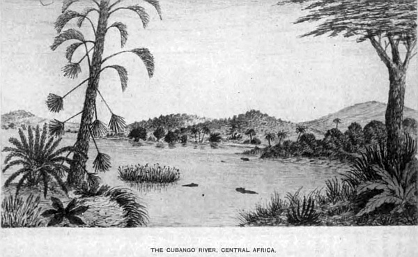
The length from north to south, as far as I have explored, is 970 miles; but, from information obtained from the Kasaka Bushmen on the spot, it may extend much further. The greatest breadth is about 500 miles from east to west, and contains within this area 280,000 square miles.
The northern and eastern portion is within the Zambese basin, except that part drained by the Notuane and its tributaries, which is in the Limpopo basin, all the rest and central part is in the Orange river basin.
The great watershed passes through, taking a diagonal course from the south-east corner to the north-west corner in Ovampoland. The greatest altitude above sea-level being 6100 feet, near the source of the Molapo, the lowest along the shed is 4000 feet, and in Ovampoland 3880 feet.
The river system of South Central Africa has already been described in a chapter to itself, so that the configuration of the country should be more clearly understood; but it is necessary to deal with them again to a certain extent in describing the different localities and native tribes within its boundary.
Lake N’gami is situated nearly in the centre of the desert, to which two of the most important northern rivers, Cubango and Quito, flow, uniting in one, the Tonga, which enters the lake at the north-west corner in 20 degrees 25 minutes South latitude, 24 degrees 45 minutes East longitude, at an altitude of 2813 feet above sea-level. The Cubango or Okavango river, the source of which is much farther north than my explorations extended, passes through a dense and impenetrable bush, extending on both banks far away in 15 degrees South latitude, where there are several tributaries falling in. Following the stream, which is broad and in many places deep, with rapids and waterfalls at different points, passing through forest and open country with native kraals situated on its left banks, occupied by various tribes who are great fishermen and have canoes, and where the hippopotami and crocodile abound, down to where the Quito enters it in 17 degrees 10 minutes South latitude, on to Debabe, a large native station, where the river turns south, branching off into the Chobe and Zambese. The other branch takes its course to Lake N’gami, and receives the Okayanka, which rises in Ovampoland and flows east. All to the north of this river the country varies much in character; the eastern portion is low with extensive swamps covered with bush and fine timber, the western portion rises in ridges with lofty plateaux covered with rich tropical plants and trees, including the giant baobab; there are also extensive plains, with dry watercourses crossing them towards the east; many of them have separate names under the general name Omuramba.
The country to the west of the upper part of the Cubango, which is also called the Okavango, is rich in timber and fine grasses, and game of every description known in South Central Africa; this region is known as Ombango, through which a road passes to the Cubango, and to the north is the land of the Ambuelas, where the tsetse-fly is very common; it is inhabited by the Kasaka and Ombango Bushmen. At the bend of the river, at 16 degrees 20 minutes South latitude, the country rises in ridges towards the north considerably, causing many rapids to be formed in the stream. Below, the country is more level, until my station is reached, where there is a hill on the right of the river, with many wherfs of Bushmen, the altitude being 3370 feet above sea-level, and on the opposite side of the river are many wherfs of the Ovampo, Karakeri, Kororo, Ojego, and others, each with their separate chiefs; the most important is the Ovakuenyami.
The river contains many varieties of fish, which the natives are very expert in catching from their canoes by spearing and setting traps, as also the hippopotami and crocodile.
The large station of the Ovokangari tribe of the Ovampo the chief or king Mpachi rules; and lower down is the Ovalmji tribe, ruled over by Queen Kapongo, and opposite a dry watercourse falls in; another, Omuramba Omapu, which passes through Ovambanquida country, under an Ovampo chief, and where the Kuka Bushmen live on the bank of the Omurambo and Sheshongo, and lower down come the Ovambanquedos tribe, to the west of the chief of the Ovarapo tribe, as also Chikonga, who lives on the banks, and above him the Ovampo chief Tjipangamore. To the east of the Ovokangari or Ovaquangari are various tribes, the Oyomboo and Bavickos at Libebe, who deal largely in ivory, feathers, skins, and slaves with the Portuguese traders. The Ovokangari cultivate the soil, grow corn, are good artificers, manufacture arms, picks, utensils of many kinds for their cooking, and ornaments for their women. They work in iron and copper, and sell many articles to the traders who visit them from the Portuguese settlement on the west coast, and are a superior race to those around them. North of Libebe the Amabomdi, Bakana, Makuka, and the Bavickos tribes reach as far north as the high table-land which divides the Chobe and the Quito rivers; therefore the waters of Cubango, Quito, and their tributaries have their outlet through the Chobe to the Zambese and the large swamp which is connected with the Mababe and Chobe by the Tamienkie and other streams. At the junction of the Quito and Cubango the Oshambio tribe of Ovampos live on a large island under a chief. Down the river is Debabe, and on many islands the Bakuka, Bamalleros, Bakaa, have large kraals, and on the north the Barico Bushmen. The river at Debabe is broad and navigable. Below that kraal at the bend is the cataract Nona and several rapids, and the stream continues down to Lake N’gami under the name of Tonga, receiving in its course several watercourses, under the names of Omaramba, Ovampo, Okayanka, Sheshonga, and others.
This extensive region in many parts along the watercourses is thickly populated, and game abounds, cotton is indigenous, and valuable products of various kinds. A great trade could be carried on if a proper system of communication were opened up through Walfish Bay, Lake N’gami, and down the broad and fine river Chobe to the English traders at all these places, and a great market found for British merchandise. The natives are well-disposed and quite alive to the advantages of trade; they are a well-made, strong people. I was told at Libebe that much further north there were a people of a yellowish-white colour, and also a savage tribe who are nomadic. I believe the former is a remnant of the white race that once occupied the country on the south side of the Lower Zambese who have left so many of their works behind them, and maybe a portion of this white race followed the river up and became mixed with the native tribes. There are also many scattered tribes living amongst these tribes between the Tonga river and Ovampoland, the Mesere, Kaikaibrio, Makololo, Papero, Ohiaongo, Majambi, and others. The Bakalahara Bushmen were once a powerful tribe, who it appears gave the name to this desert. The lion, leopard, panther, and wolves are met with daily. The leopard and panther are more to be feared than the lion when in the thick jungle after game, their form of attack is so cat-like in approaching their prey, taking advantage of every cover until the final spring is made. The many lagoons and swamps seem to be their favourite hunting-ground. In all the waters of these rivers fish abound, of many varieties. Crocodiles, hippopotami, iguanas, otters and snakes are plentiful everywhere along the streams. Unfortunately this region is very unhealthy. The sickly season lasts from September to May; the other months of the year it is very healthy. The malaria from the standing pools in the hot dry season causes fever, which is very difficult to get rid of.
Down the Tonga the natives build their huts in these island homes for safety; they are circular mud-huts with high thatched roofs; they are similar to those on the Upper Cubango, and they hunt the hippopotami. On the lower part of the Quito I shot one in the head, as he was poking his nose out of the water. The skin we use for several purposes, mostly for sjamboks. Large snakes seem to swarm in every part, particularly the python. In a small stream where I thought to be free from crocodiles, I took a daily bath during my stay at my station. On one occasion I was enjoying a swim at the foot of a small fall of beautiful clear water; hearing a great splashing behind me, I turned and saw an enormous snake passing me at great speed, lashing the water into my face, and a few seconds after he was lost in the tall reeds below. Expecting one or two more might follow, I was soon standing on the bank; but before I could dress, down came four others, large, and three small ones, and passed into the reeds below. The largest appeared to be twenty feet in length, and very large round the body; their skin was dark brown with dirty yellow marks. I knew them at once to be the python. A few days after I shot one that measured eighteen feet three inches in length, and three feet round the body, and three feet from the tail a large hook was fixed. I had a similar adventure some time before in Bechuanaland with one which measured sixteen feet two inches, and inside was a steinbok. At night they make a great noise.
Every kind of game is found here. Elephants may be seen in hundreds; four kinds of rhinoceros: the black boreli, with two horns of equal size; another black with one large and one small horn; a white with two; and another white with one long horn, which is the most rare; their native name is Chikooroo. I made a knobkerry out of the horn, which measured two feet eleven inches, from one I shot the previous year. Buffaloes, giraffe, blaawbok, elands, gnu, hartebeest, sassaybe, gemsbok, koodoos, pallah, and others; also wild boar which grow to a great size, wild dogs and a host of smaller animals. The ostrich may be seen on the plains in troops of hundreds; but as guns are now becoming more common with the natives, they will soon be thinned out. There are also many beautiful blue cranes, secretary-birds, mayhens, and legions of ducks, geese, and beautiful small birds; monkeys and baboons everywhere, mostly in the fine trees along the river-banks, and they are much hunted by the leopards and panthers.
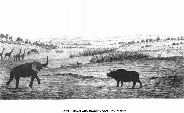
On returning to my camp one evening I had a very narrow escape from one of the former; walking along under the trees on the shore of the Cubango, I saw immediately over my head one of these leopards on the branch of the tree that overhung the river, not twenty feet from me. It was the act of a moment; I up with my rifle and fired at his chest, when down he fell a few paces from me; he seemed to be in the act of springing upon me—another second and I should have been too late. This makes the fourth leopard I have shot in this part. On all occasions I had narrow escapes. In a country like this, where in every turn in the thick bush we meet with one or other of these animals, we have to keep a good look-out and make our rifles our constant companions.
Next week will be Christmas—the height of summer. Thermometer in the shade, under the trees, 107 degrees; but I do not think the heat so oppressive as it is down in the colony, for the simple reason that we have a dense bush, magnificent trees, and long grass that absorbs the heat of the sun’s rays and keeps the earth much cooler by being in shade. In the colony it is open; no trees, scanty grass, and an immense open rocky country, so that the stones become so hot that they destroy the boots. I have frequently made my tea by placing the kettle with water on a stone for half an hour; then put in the tea, let it stand a few minutes, and it is as strong and hot as can be wished.
Most of the natives have been very quiet, but some of the Ovampo have been very troublesome, which has shortened my stay in this part, more particularly amongst the wherfs of the Ovokangari. My Bakuka and Batuana guides were invaluable and took me through without loss. Being the rainy season, water was plentiful, but I had great difficulty in crossing many of the watercourses, impeded by thick belts of jungle, although extensive tracts of country are very beautiful and park-like, lovely clumps of trees were so grouped that art could not improve them. Travelling for days without meeting with any native, on several occasions I was closely beset by lions, which my guide stated were the man-eating lions. Almost daily, thunderstorms came up in the afternoon, many of them terrific in violence; the sunsets also are beyond description for brilliancy of colour. The early morning is generally cloudless; clouds seldom gather before mid-day in summer, but in the winter months they are not visible; this is the healthy season.
There are several roads from Lake N’gami crossing this desert to Damara, Ovampo, and on to Libebe, and the other villages on the Cubango. Every day we went out to hunt up the game to supply the people with food, which I omit to describe as it becomes monotonous.
Very few inhabitants are scattered over this part of the desert, few hills are to be seen, until we arrive at Lake N’gami, when the Lubalo, Makkapola and Makabana hills come into view, and it is round the lake that the people under the chief Molemo live, and at his kraal and others along the river-banks of the Zouga or Bot-let-le. The people are composed of Betuana, Barutsie, Makolo, Bushmen, and several mixed races; each tribe has a petty chief ruling over them, but all subject to the chief Molemo as far as his territory east goes, where the chief Khama joins. The principal villages are Sebubumpie, Mokhokhotlo, Mamakahuie, Mozelenza, Samaai, and numerous others occupied by Bushmen.
The produce of the northern district is collected by the Ovampo traders and brought down to the Walfish Bay, and by Portuguese traders from the Portuguese settlement at Benguela. The trade of Lake N’gami and the Zambese region is carried on by English traders from the Cape Colony, having communication by roads from Ba-Mangwato, the chief Khama’s station, and roads from the lake to Walfish Bay, passing the Ghanze chalk-pits, situated on the watershed, where permanent water is obtained. Many thousand Bushmen live in the more unfrequented parts of the desert, having no settled abode, but remove from water to water as it becomes scarce; there are three separate tribes, the Mesere, Kasaka, and Kaikaibrio, and also some Bakalahara. The greater portion of this part of the Kalahara within the Zambese basin is limestone, covered in places with deep sand, but vegetation is very luxuriant—splendid grasses, and magnificent timber.
It is a good corn-growing country, a variety of valuable herbs come to great perfection, every kind of European plants and fruits thrive; water can be obtained by digging,—a splendid country for immigration.
The Southern and Western Portion of the Kalahara, within the Orange River Basin, the Waters of which fall into the South Atlantic Ocean.
The Orange river is the only outlet to the sea to convey the water brought down by the ancient river system that drains the south, the central, and the western divisions of this extensive and important portion of the Kalahara desert. The Orange for 250 miles forms the southern boundary. The rivers that drain the north-western and the central part of the Kalahara are the twin streams Nosop and Oup, appropriately called twins, as the two join for twenty miles and again separate, both running parallel to each other within a short distance, entering the Molapo close to the great bend, where that river takes the name Hygap, and flows south, and enters the Orange at Kakaman’s drift. The Nosop rises in the Waterberg of Damaraland in two head-waters called the Black and White Nosop, which unite north of Westly Vale and join the Oup at Narukus. The Oup rises in Damaraland in latitude 22 degrees, under the name Elephant river, and gathering the waters of other small branches, joins the Nosop at Narukus for twenty miles, then becomes an independent stream and, as I have stated, falls into the Molapo. Several shallow watercourses traverse the desert, but are not of sufficient importance to merit a description. The other river connected with the above system is the Molapo, which rises on the west slope of the central watershed at an altitude of 5350 feet, in 26 degrees 5 minutes South latitude, 26 degrees 25 minutes East longitude, where a plentiful supply of pure water flows throughout the year, and takes a westerly course to the great bend in latitude 25 degrees 50 minutes East, longitude 21 degrees 16 minutes, when it takes the name Hygap, as already stated, receiving in its course the small streams Moretsane and Setlakoola. The Kuruman river rises in the south of the Kuruman mission station, and with its small tributaries flows west and enters the Hygap below the great bend. The Back river commences in a range of the Brinus mountains, a beautiful and picturesque group, several thousand feet in height, of granite formation, well-wooded in the kloofs and ravines. The peculiar feature of the river is that it has two outlets, one to the east into the Hygap, the other to the west into the Great Fish river. South of this river three mountain streams drain the southern Kalahara, viz. the Nisbet, Aamo, and Keikab, which fall into the Orange to the west of the Hygap. The Great Fish river, which completes the river system of the Kalahara in the Orange river basin, rises in the Awas mountain in Damaraland, 22 degrees 40 minutes South latitude, 17 degrees 30 minutes East longitude, at an altitude of 6400 feet, and flows south for 430 miles, and enters the Orange river ninety miles from its mouth. The country through which it flows is very dry from the scarcity of rain. There are no important streams in the east, but on the west there are many tributaries that drain the high mountain country. The Chun rises in the Mitchell mountains, on the border of Great Namaqualand, receiving the Kurick branch, passing through a beautiful and wild country to the south of Nababis station. The three small tributaries of the Great Fish river to the north of the Chun in 22 degrees 32 minutes South latitude, are the Ganap, near Reheboth station; the Houra and Manabis; south of the Chun are the Huntop, Koros, and the Amhup, all receiving their water from the high lands of Great Namaqualand. The principal stations on these rivers are the Amhup, Bethany, Kachasa, Kawais, Reems, Hudenap, Brakhout, and a few others of recent date.
The inhabitants are of various tribes, called the Namaquas, Veld-Schoeners, Bundelswaarts, Hottentots, Korannas, Kaffirs, Gobabies, and Bushmen; some of the former cultivate the soil, use ploughs, and keep cattle and sheep; they live near the small fountains and along the river-banks, where they procure water by digging and permanent pits. They live under petty captains. There are several mission stations. Copper is found in many parts of the country, and copper-mines are worked in the south near the Orange river. The geological formation is granite, gneiss, trap, and amygdaloid. From the magnitude of this river, it is evident the country at one time must have been well supplied with rain, as it is a deep, broad, and stony stream, showing how rapid must have been the flow of water down it. Fine timber and bush grow in the kloofs and along the banks; many of the hills are very picturesque, and the country produces fine grasses for cattle.
The trade of the country is greatly improving and is supplied by colonial traders from Port Nolloth on the west coast in Little Namaqualand, which is in the Cape Colony; a railway from that port to the copper-mines on the Orange river has been for many years at work. In the Kalahara desert on the east of the Great Fish river, and the southern portion up to the Hygap river and south of the Brinus mountain and Back river, are several stations and kraals. Nisbet or Barth is the most important, where many Griquas are settled, also at Nabos, Luris, Akuris, Blydver-Wagh, Aams, Oribane, Ariam, and others. The Griquas cultivate the ground, and keep large herds of cattle and sheep, and trade largely with the Cape Colony. Hottentots, Korannas, Bushmen, Kaffirs, Namaquas, and small communities of other tribes live on the banks of the Orange and along the streams, with their cattle-posts, which of late years has greatly added to their wealth and enabled the people to trade largely with the colony.
The bold outline of the lofty hills with their thickly wooded slopes and kloofs add greatly to the beauty of the landscape, more particularly along the Orange river, where the rich vegetation, fine timber and bush, forming deep belts on both sides; the rugged and perpendicular rocks of many colours, which form its banks, clothed with lovely creepers hanging down in festoons with their scarlet pods, make the river scenery very beautiful; and to add to its charm the dense bush swarms with the grey monkey, baboons, and every variety of the cat tribe, even to the lion; pheasants, partridges, guinea-fowl, legions of snipes, ducks, geese, moor-hen, plovers, eagles, vultures, and a variety of hawks, some of them of great size, measuring from tip to tip eight feet; also the heron, crane, and stork, and a variety of others, in addition to the smaller tribes of birds with brilliant plumage.
The otter is very plentiful, the banks being covered with their spoor; also the porcupine. There are a great many islands, many of them large and thickly wooded, and about 300 miles up the stream the beautiful and picturesque waterfall, the Aukrabies, which has a fall of over ninety feet, is a grand sight when the flood-waters come down in their annual flow, rising above their ordinary level from twenty-five to thirty feet, bringing down large trees that go rolling and crashing as they are carried along by the rushing water.
I was outspanned on the north bank of this river in 1871, with two waggons and a cart, for the purpose of making a new tent to one of the waggons that had capsized and rolled over into a sluit a few days previously, and had sent the oxen, forty-eight, on to a neighbouring island to graze early in the morning, when the Griqua chief, living at his kraal not far from my camp, came and informed me the river was coming down. The herds were sent over immediately to bring them off, but before they could do so, the river had risen fifteen feet, consequently the oxen had to swim, passing down mid-stream with a small portion of their heads and horns only visible, the two herds swimming behind with blocks of wood under their arms, and they were carried down a mile and a half before they were able to land, and in less than two hours this river had risen thirty feet.
There are many beautiful stones and pebbles in the river-bed, agate, soap-stone, petrified gum and wood, which I have found of white, brown, black, and red. Diamonds also are found occasionally mixed up in the gravel that has been brought down by heavy floods.
On the north of the Back river and Brinus mountains, the country is more open, extensive grass plains and other portions well-wooded. At Liefdotes, Tobas, and Klopper vlei are large kraals, also at Swart and Hoali, on the north of the Brinus. Up along the east side of the Great Fish river to the Oup, the country is very pretty, splendid grasses and timber; the hills are well-wooded, in some places to their summits. Game abounds; ostriches I have seen in troops of 200.
Two hundred miles north of the Orange river and fifty miles west of the Hygap, in 25 degrees 50 minutes South latitude, 20 degrees 42 minutes East longitude, is Hogskin, a large vlei, thirty-three miles in length, and in some parts three miles in width; the greater portion is dry for nine months of the year. The road crosses it to the Griqua settlement at Meer, which is twenty miles to the north, where there are extensive vleis, 2710 feet above sea-level.
Three rivers flow into the Hogskin vlei, viz. the Snake, the Moi, and the Knaas. After heavy rains the vlei is full, and forms a fine sheet of water, which it retains for some months; wild-fowl and game frequent it at that time. These rivers rise in a hilly country; the Knaas is the largest, and retains water in portions of its bed through the year. Quassam, a large Bushman kraal, is situated on its banks; these Bushmen are distinct from the Bushmen of the desert; they were, many years ago, driven from the Cape Colony, by Sir Walter Currie, on account of their stealing the cattle, and robbing travellers. They first took refuge in the many islands in the Orange river, but were driven out and went north, where they settled at Quassam, and where I nearly lost all my waggons, oxen, and everything, being kept there for two days, and the oxen without grass. Coche Africanda was their captain, and I escaped only by threatening that if he or any of his men moved to detain me whilst I inspanned, I would shoot him dead, holding my rifle ready for action. There were nearly 100 well armed with guns; seeing my determination, they remained passive, and I left.
Eight miles below this kraal is a very pretty spot, a valley surrounded by sand-hills, with limestone between and a spring of water, where several roads meet going to Damara and Ovampo, Lake N’gami, Namaqualand, and the colony. The valley is about a mile in length, and half a mile in breadth, studded with very fine kameel-doorn trees. The sand in these rivers contains very fine particles of copper, and also garnet dust. On the south side of Hogskin vlei are two conical hills, which are very prominent objects, visible sixty miles off, and as they stand alone, surrounded by bush and the vleis, they add greatly to the beauty of the landscape. The highest is 415 feet from the base, the other measures 394 feet; they are called base kopts. A few miles south-west of them I procured several specimens of coal, which cropped out in a large sluit, and also from the side of a hill, and twenty miles beyond. Slate and shale form the beds of the rivers Suake and Moi.
Near Knaas river the formation in the valley is a conglomerate of limestone, greenstone, and garnets. This part of the desert is full of bush, kameel-doorns, mimosa, and other trees, and is diversified by long low ridges of sandstone, limestone, and many low hills of granite. During the rainy season vegetation is splendid, and the grass fine and beautiful, consequently game is abundant; it follows as a natural consequence that lions, leopards, and many other species of feline animals are numerous. This is truly the lion veldt; I have counted at one time in a troop, great and small, twenty-two, frequently six and seven in the middle of the day, and within a short distance from my waggons. The ostrich is becoming more scarce every day; when I first visited this country, in 1864, the Bushman would exchange a beautiful blood or prime white feather for a piece of tobacco worth sixpence, and less; now they are difficult to be found.
This desert has been considered a barren and uninteresting region, but it is not so. There are portions, it is true, that cannot be traversed during the dry season, several who have attempted to penetrate it having been obliged to come out and leave their waggons, their oxen all lost for want of water. But this was in a great measure their own fault, for if they had followed up the rivers and dug in their beds they would have obtained it.
There are many miles of limestone flats, some extending ten miles in length, bounded by extensive sand-dunes, and isolated koppies, with their pointed summits covered with bush. These sand-dunes cover an immense area, extending from east to west fifty miles, and thirty miles over, and in altitude from fifty to 200 feet. Their base is a dark limestone covered with sand, which varies in thickness from four to ten feet. Their sides are at an angle of about 30 degrees, and the topmost ridges so pointed that when a waggon and span of eighteen oxen arrive towards their tops, the whole span is descending on the other side as the waggon reaches the summit, and the driver on the box can only see the four after oxen; but from the great depth of sand in the road the waggon glides down with ease. To illustrate more clearly the shape of these dunes I can only compare them to a very stormy sea, with gigantic waves instantly turned into sand; many small trees and bushes grow on their slopes, and also beautiful grasses. From six to eight miles a day with an ox-waggon is considered a good trek. There are some small fountains and vleis in some of the hollows, otherwise no one could pass that way, as the road over these dunes from first entering them is thirty miles, then a flat of eight miles over limestone and sand-dunes again. There are also many isolated conical granite hills, that rise from the level plains to an altitude of 200 feet, formed of huge blocks; they more resemble artificial than natural monuments; many of them are so overgrown with trees and bush that grow between the blocks that scarcely any of the rock is to be seen. It is dangerous to inspect them too closely, as they are the lurking-places of lions, leopards, and other beasts of prey.
I discovered this on ascending one of them at Kanardas: when nearly half-way up, on looking into one of the small caverns, of which there are many, I saw at the end two large bright eyes glaring at me from the dark. After exchanging a good stare at each other I quietly took my departure down: knowing the nature of these animals, that they will not openly follow or attack, if not disturbed, I felt pretty safe. As to the nature of the beast I cannot say, but from the great size of the bright red eyes I concluded he was a lion,—at any rate, their expression did not appear very amiable. A few lessons like this make an explorer cautious before prying too closely into hidden and secluded spots in a wild country like this desert.
On the east of Hogskin vlei is a large salt-pan or vlei, twelve miles in length from north to south and two broad. It is worked only by the Griquas living at Meer. This settlement was established in 1870. I was told by an old Bushman, that they took the bush children and made them work, and would not give them back. In 1871 Meer had become quite a tidy village, of about twenty-five houses, some of them built of red brick. The chief was Dirk Falander, who held a magistrate’s court and tried prisoners; it is a little republic upon a small scale, not more than 100 all told, except the Bushmen slaves. There are close to the village two large ponds or pans; the banks on their sides are seventy feet in height. The country round is open grass veldt. Between Meer and Hogskin vlei is a large pan, surrounded by high sand-rocks, called Klein Meer, a very pretty and picturesque lake, two miles in length, with fine bushes and grass lining the banks; five months of the year it is dry. Sand-dunes are round it in every direction.
There is a considerable traffic and trade carried on by the Griquas and the Cape Colony. Roads cross the Orange river at Koran drift, Kakaman’s drift, and Orleans drift; the two latter meet at Kanardus, close to extensive lime-pits, where water is obtained, by the side of a dry river-bed, where there are some of the prettiest trees I have seen in Africa, spread over the veldt, park-like, and dense bush between lofty granite hills, which in consequence of water is the general outspanning place. I came here one evening after dark and nearly lost many of my trek oxen, in their eagerness to get at the water, which is twenty feet from the surface. They were supplied by sending my boys down with buckets, by that means filling a hole dug out for the oxen to drink.
These pits are fifty miles north of Kakaman’s drift, and twenty-five miles on is Swaat Modder, in the bed of the Hygap river, the road passing along its bed between sand-cliffs 150 feet in height. Between these two watering-places the Back river enters the Hygap; the sand in its bed is mostly composed of ruby sand, which I believe would make a fine red glass.
At Swaat Modder the right side of the river has cliffs 100 feet in height; the left bank has sand-dunes, where I found several flint borers, many of them in a finished state, for making holes in the shell of the ostrich egg to form beads. Under these cliffs, in an old Bushman cave, I built a stone house, where we remained six weeks waiting for the rains. All this country is under the Koranna chief Puffadder, and his people are spread over the country in small kraals. The road still continues north, past other pits in limestone at Bloomfontein, and at Kebeum, springbok, etc.; Abequas pits, a large Koranna kraal; then passes over sand-dunes for thirty miles, and arrives at Anoerogas, where there is another Kaffir station, also a store kept by a Mr Redman, of whom I bought some tobacco for five bags of gunpowder, and a medicine-chest, and a variety of goods I was much in want of. A captain of the Bundelswaarts is here, to give notice to the Bastards to clear out. Coal abounds in this part, garnets are found in all the river-beds, and in many parts mixed up in the sand of the desert. Lions are so plentiful here that it is dangerous to leave the waggon without your rifle. A Koranna man was killed and eaten last night, a short distance from the waggon. This station is 180 miles north from Kakaman’s drift, on the Orange river, and three miles south of Hogskin vlei; here the roads divide. One goes to the salt-pan, another to Meer station, a third to Quassam on to Damaraland, a fourth past Knaas, in a north-north-west direction to Ovampoland, and a fifth turns south-west, and leads to Barth, where the Bundelswaarts people live, besides others to different parts of the desert.
The other portion of the Kalahara takes in the southern part from the Orange river to the Molapo river, 190 miles to the north, and from the Hygap river to the Langberg range of mountains, which is the eastern boundary of the desert, 100 miles in width. The lower portion, near the Orange river, is better adapted for farming, as there is good grass, and the karroo bush, upon which sheep and bucks get fat. I purchased of Klass Lucas, the chief, living at his large kraal on the banks of the Orange, near Orleans drift, a large Africander sheep, for 2 lbs. of gunpowder. It weighed, without the tail, 62 lbs., and the tail produced 12 lbs. of pure fat.
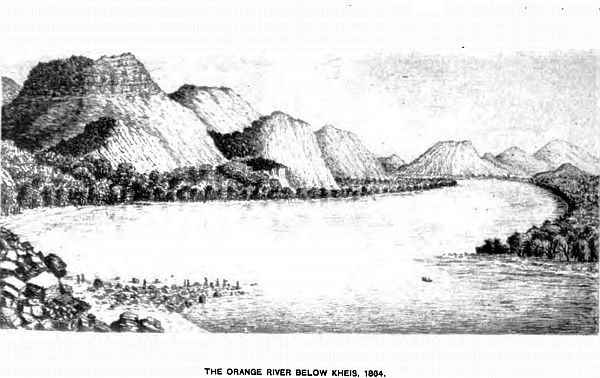
Between this station and sixty miles to the north, called Blue Busk Kalk, there is a fine fountain and large vlei, with a stone kopje on the north side, where the rocks stand out in grotesque forms of granite formation; there are in the intermediate distance several very peculiar granite koptjies; they average about 200 feet in height and 600 feet in circumference at the base, large masses of huge rocks, piled one upon another, and without any vegetation; the country round is perfectly level; they have the appearance of ruined pyramids; the highest I measured was 275 feet.
The mountain, called Scheurberg, is another peculiar range, with its many pointed peaks, with wood in the valleys and kloof; fifty miles in length and twelve in width, a road passing through the centre, a great resort of lions, wolves, and other beasts of prey. The continuation of the Orange river up from the junction of the Hygap is particularly picturesque, and in many places fearfully bold and rugged, with lofty and almost perpendicular cliffs, with fine timber, beautiful bushes, tree-ferns, and other subtropical plants, which add much to the landscape.
It was at the point of the Langberg, close to the river, where the berg seems split up into several magnificent hills, between which and the river is almost a level but thickly wooded space of several hundred yards in width, where we came to outspan, for the purpose of making a new tent to my waggon. My driver happened to capsize it into a sluit two days before, and, to complete my misfortune, I lost four of my best trek oxen in the river by sinking in the mud. The next day one died of the melt sickness, and I had to shoot another from lung-sickness.
The willow trees along the bank gave us plenty of wood, and in two days the tent was completed. Mr Staple, who was with me, suggested we should make a boat of wicker-work, after our Welsh coracles, which we soon completed, by small branches being bent the proper shape, with cross-pieces, each tied very carefully together, forming a strong and firm framework, over which we stretched two raw bullock-hides, well sewn together, and when dry painted it red,—two seats, two paddles, a mast, and lug-sail; the length was seven feet, and twenty inches deep, in shape like half an egg cut through lengthways. This little work occupied us a week. When perfectly dry we took it down to the river to launch it, not thinking of its lightness. As soon as it was floated I brought it close to the rock, and put one foot into the boat, and then made a spring in, when I was no sooner in than I was out on the other side into the water, a regular header—fortunately it was deep water. However, on landing, I took off my clothes to dry on the rocks, and Staples got some Koranna girls who were sitting on the bank watching our work, to bring some stones to put in as ballast, which took some time, as few were to be found.
I was better prepared for the second trial, being without clothes, but this time our boat was perfectly steady, and no wonder, for we had at least 200 lbs. of stones in the bottom as ballast. A fine breeze was blowing up-river, which was nearly a mile wide: fixing our little mast and lug, we started on our first voyage, steering by a paddle. This being the first boat that ever floated on the Orange river, I consider it worthy of recording. Our little craft acted splendidly. The astonishment of the Bushmen, Korannas, and the blood Kaffirs living on the bank, who came down to see the white man’s floating-house, was amusing; they shouted with delight as we sailed away up-stream; the women in particular were the loudest in their admiration. After spending some hours sailing up and down, exploring on the islands, shooting ducks and geese, we returned to our handing and carried our boat to camp, after taking out the ballast. As we were in a lovely spot, well sheltered by trees, and only a short distance from several small kraals, where we could obtain milk, we determined to remain some time to explore the neighbourhood, shoot and fish, and enjoy this wild, independent, and delightful free and easy life.
There were several families of blood Kaffirs who had permanently established themselves on the banks of this river. They originally came from the Cape Colony; the men were perfectly naked, and the women also, with the exception of a piece of skin round the loins, which was of very little service as a covering; the Korannas and Bushmen the same. In the evening we had two fires, one for us and one for our boys, having two waggons, a cart, and many oxen and sheep to look after. We had eight servants, composed of Hottentots, Korannas, Bushmen, and a Cape half-caste; consequently, when we were all assembled round the fires, with the addition of our neighbours, who never failed to visit us at feeding-time to come in for snacks, we formed a large gathering of as romantic and unique a party as could well be collected at any picnic. The ladies present were of all colours, from yellow to black; many of them well-formed and good-looking, others were of every type of ugliness.
The Kaffirs were models of symmetry, and a much superior class to the others. Having an unlimited supply of wood, our fires lighted up the trees, bush, and many of the near rocks, leaving the lofty mountains in shadow, looking black and grim against the sky,—a grand picture for a Turner. I made an attempt to portray it on canvas, but my humble efforts could not do justice to this beautiful and wild scene.
So enjoyable was this mode of life, what with sketching, exploring, fishing, and shooting, besides the daily sail on the river, visiting the islands, and the opposite shore, geologising and reading under the overhanging trees as the boat floated quietly with the gentle current, I determined to waste three or four months on its banks, as I was following the river down for 300 miles, which would occupy that time to thoroughly enjoy it, and give me ample opportunity of indulging in this wild and free life. The boat was fastened on to the back of my waggon, when treking down by the river. When outspanned, it was taken down to the water, sometimes crossing over to the Colony side to visit the blood Kaffirs, to obtain milk and purchase the large Africander sheep. The people would come down to see where we came from, and when they saw the boat and us getting into it and paddling away with our two sheep, their shouts of astonishment were amusing.
When travelling, it was always in the morning for a couple of hours; that was our day’s work, the rest being employed in various ways as described. At one outspan, close to a small Koranna village, we as usual took the boat down to the river that we might, in mid-stream, enjoy our daily swim, and crossed over to some Kaffirs. They were entirely naked, nothing whatever to cover them; the women brought us some thick milk. They had heard that some white men were coming down, and told us that the Korannas intended to stop us, and not allow us to proceed. On returning to the waggons, we found several of those people sitting round our fires, evidently come to overhaul us, but they were very civil; they had been getting out what information they could from our boys.
Forewarned is being forearmed; we looked up our rifles and ammunition, to be ready for any surprise, as we intended to fight our way down stream if opposed. But there was no sign of opposition on their part. They were much amused at a sketch I had been making of them as they were sitting round the fire in their half-naked state. They each wanted me to take them individually. Many I did, for practice, and to embellish my journal, for we do not meet with such picturesque groups every day. I therefore made the best use of my opportunity. Both sexes are great swimmers, and would follow me some distance. As I sailed from the shore, I took one or two out occasionally in the boat to help me in fishing and other work, when my own people were out hunting up game to keep my larder full. So that, from being shy at first, they became almost too friendly, which, under existing circumstances, I permitted. Their primitive mode of living is very simple. They marry at twelve years of age, if living together as long as it suits them is called marriage. No divorce courts are needed in these parts.
Our next trek was to avoid the high mountains which terminated on the river-bank in enormous cliffs. We therefore had to go round through the gorges and over steep and stony hills—no roads in this wild country—and outspanned for the night close to a mountain stream surrounded by lofty hills, covered with bush. As night advanced, the different wild animals began to move about; the red cat, a kind of panther, the wolf-jackals, and porcupine were very plentiful. At night when the camp-fires have burnt nearly out, and all the boys are rolled up in their blankets fast asleep, every sound is distinctly heard. The mountains contained many leopards, and they are very dangerous, and will not hesitate to attack if you are alone.
These hills were the home of the wild Bushmen, who war on all living things. They differ from other Bushmen; they are of a reddish-black colour, and stand four feet four inches in height. They live in the caves amongst most inaccessible parts of these mountains. They use the bow and arrow. Few are now left, as far as we know, for they never show themselves, and keep as much away from mankind as the beast of the forest.
Travelling on through mountain passes, we arrived at a native station where the chief, Klas Lucas, lived, who claimed all the country north, to the Kuruman river, which is a wild district, having several isolated hills, and being scarce of water, particularly towards the Kuruman and Molapo rivers. Large pans are distributed over this waste, but water is seldom found in them, except in the rainy season, from January to May. Large herds of game, and also the ostrich, are occasionally to be seen, but are difficult to approach, as they are constantly being hunted by the Korannas, Bushmen, and Griquas, living at the kraals near the Hygap and Orange rivers, and along the mountains of Scheurberg. Limestone and granite are the only rocks to be found over this extensive region.
The Kalahara, to the north of the Molapo, up to a short distance of Lake N’gami, the Langberg range of mountains continues northwards in broken and detached hills through a wild country, unfrequented, except by native hunters, who visit it from the Bechuana side on the east, and those living in the desert and the Bastards at Meer. The ostrich is less hunted here, and consequently more plentiful. Lions seem to have it all their own way, for they are more numerous here than in any part I have seen; not only at night, but in broad day, they make an attack on your oxen. One full-grown male lion seized one of my black oxen, not 300 yards from the waggon, in some low bush at mid-day. Our attention was called to the bellowing of the ox and the rush of the others towards us. The lion was on the ox, having seized him by the back of the neck; one hind-foot of the lion had torn open the flank, and the other across the back, when the ox dropped. In a few minutes I was at his side with my double-barrel rifle, and sent two bullets into his heart, when he rolled on the ground quite dead. The ox had to be shot also, for his bowels were protruding from his side; he was one of my best oxen. We saw several others a short distance off, but they disappeared after a few shots were fired at them. As we treked over the veldt, we came upon several remains of game on the ground, which the lions had killed and eaten.
There are many beautiful plants and flowers in these parts. We were frequently crossed by border tribes who go in to hunt, but they do not remain. They may be seen occasionally in small parties traversing the desert, with one or two pack-oxen loaded with dried game and such feathers as they may have obtained by the rifle or stolen from the Bushmen they may have surprised. If they catch a Bushman, they conclude he has feathers,—if not with him, he has them hid in the sand. They take from him what he has, and then, to make him give up what they believe he has concealed, they torture the poor wretch by putting a finger or a toe in the fire until the pain is so groat he tells where he has hidden them. If he has none, they believe he is telling them false, and go to such extremes, that they will burn the hand or foot until they are consumed, believing the victim is obstinate and will not tell where they are.
I have a Bushman I engaged to look after the waggon with one foot entirely burnt off, and a Bush boy with four fingers of the right hand served in the same way. The man came to me and asked to be employed, and said he would show me the waters. He brought his two daughters with him; their mother was dead. The girls’ ages, as well as I could guess, were fourteen and sixteen. I employed them on various duties about the waggons, and found them very willing to learn. I had now a large family to provide for; my own eight boys and seventeen Bushmen, including six women and girls, which was a great help, as they took me to watering-places unknown to hunters, and were my guides to places I should not otherwise have visited. I found if you treat these people well, they are willing to assist in any way. They are a very small race, seldom exceeding four feet ten inches in height. When old, which is at the age of forty, they are very ugly. Their food consists of game, which they kill with their bows and arrows, eggs, roots, mice, locusts, insects, frogs, land-turtle, and anything they may pick up.
When I was in the desert in 1872, I had one of the chief Bushmen captains engaged with many of his people to hunt for me. Hearing of the atrocities committed on these Bushmen by the border tribes, I told him to collect a few of the injured ones, and bring them to my waggon, that I might see them. In a week he collected fourteen, all, more or less, having lost a hand or fingers, a foot or a greater part of it. One Bushman had a red-hot iron ramrod forced through his body under the arm-pit and it came out on the other side. I saw the skeleton a few days after it occurred. Some are shot down, and the children stolen and taken for slaves. They are also tied to stakes and burnt to death, and I was taken to the places where these crimes had been committed, and saw the remains and the site of the fire. Having satisfied myself as to the correctness of all these statements from personal inspection and from more than fifty Bushmen who told me of others equally horrible, all of which I noted in my journal, I was frequently importuned by these people to become their chief, which I declined. I was then asked to write to the Great Mother (the Queen) to solicit Her Majesty’s protection, and take them over as her children. This, I saw, was impracticable. I then told the chief head-men to call all the Bushman families together near at hand, at a drift where I had had the bad luck to get my waggon capsized, and where there was plenty of water, and to meet me there at the full moon a fortnight hence.
True to the appointment, seventy-seven of the head-men and their families were there, forming a large camp, and as quiet and orderly as any assemblage of people could be. I took down the probable number there would be within a radius of seventy miles, from Klasson, the chief spokesman, which numbered 3986.
They stated, if the Great Mother could not be written to, would I write to the Great Chief at the Cape? This I agreed to, and told them I would write out a petition which they would sign, and I would forward it with a letter explaining the circumstances under which it was sent to his Excellency Sir Henry Barkly, detailing the atrocities, and praying to be taken under English protection, which was in due course forwarded, and some months afterwards I received a reply from his Excellency, stating “he had received the petition and my letter, but as the Kalahara desert was so far removed from the Cape Colony, he could not see how it could be done at present, but at some future time it might be considered.” And from that time these peacefully-disposed people have been left to the tender mercy of the border tribes. His Excellency, it appears, did not know that the Kalahara desert joined the northern border of the Cape Colony, which shows how little interest was taken to ascertain the true position of the country from which the petition was forwarded.
The country to the west of this region up to Damaraland, 200 miles, up to the mountain regions of that country and Great Namaqualand, is undulating, with vast stretches of wood and open plains; isolated hills of granite and limestone in other portions. One extensive district was covered with water-worn pebbles, garnets, agates, and other beautiful stones, also large broken pieces of stone of a rich crimson colour. When broken small cubes of iron pyrites like gold are embedded. The grain is very fine, and it would make splendid vases, cups, plates, or any other ornaments.
I had been foolish enough to collect specimens of every kind of stone, until my waggon became so full and heavy that I had to throw them away. I made a collection of 3000 agates of every variety of colour and shape, which had to be abandoned. Many cairns or graves are seen with heavy stones surrounding them.
Not far from them are several ancient stone huts, built upon a small hill, that must have belonged to a former race, and close to a dried-up river. Some of the stones are six feet in length, two feet wide, and one and a half thick. They were placed on end and covered in. None of them would hold more than four persons. They are in small clusters of seven and eight together, and some less. They were covered in with large stones, that have long since fallen. No account can be obtained of them from the Bushmen. Their huts are a few sticks stuck up with grass thrown over.
Several fresh Bushmen and women came to my camp this morning. Some of the young girls were very good-looking, and with a profusion of native ornaments upon them made entirely of ostrich eggs. A perfect set comprised a tiara, three inches in width, for the head; a broad necklace, six bracelets on each arm, and eight anklets or bangles to each leg, and finally, a rope of beads of sufficient length to go round the loins twice and fastened in front with a piece of rimpey. These constituted the entire dress of one of the girls. She looked like a young African queen, and it had the effect of making her look half pretty.
I bought two sets for six yards of print each. I think there cannot be less than 8000 beads in each set, between each bead a piece of leather of the same size, which becomes black, so that they look like black and white beads, which has a good effect upon their black skin. They were delighted with the exchange. When disrobed of their ornaments, they threw the print over their shoulders like a mantle. The ornament had the appearance of having been handed down from generation to generation. At Narukus, on the Nosop river, I came upon a family of Bushmen, ten in number, of a different type to those I had in my service, evidently a lower caste. They have no forehead; the wool on their heads comes close down to the eyes, and the head falling back like a baboon; projecting mouth, small nose, a sort of hair or wool all over the chest, arms, and legs; their eyes are small and restless, watching every movement that is going on; the tallest man did not exceed four feet four; their skin was of a reddish-brown. A few old skins, broken ostrich eggs, and bows and arrows, seemed all they possessed of worldly goods.
They would have decamped and hid in the bush, but I sent some of my Bushmen and brought them back. I asked my own boys, if they were their brothers, meaning of the same race; they repudiated the idea, and said they were monkeys not men, and told me there were very few ever seen, it was very seldom they ever came upon any; they eat carrion. They are evidently a distinct race from the Masara Bushmen who are largely distributed over the desert. One of the women had a baby not much bigger than a half-grown kitten; all of them were destitute of clothing.
The country through which the Oup and Nosop pass, in many places is very pretty and picturesque. At a fountain on the branch of the Oup, I remained several days to hunt, to supply so many people with food.
24th February, 1872. A terrific thunderstorm broke over us soon after midnight, and continued until six this morning, striking and splitting up some large trees a short distance from our camp, and it rent into three a large rock which stood out alone from the base of the hill. The country was swamped with water, the oxen at one time standing half knee-deep in it. My escort of Bushmen and their families for once in their lives had a good shower-bath. The baboons also in the hills must have felt its effects, for they could be heard far and near, with their half-human grunts.
My Bushman with the stump foot told me he could understand the baboon language, when, they are frightened or hungry, or are to meet together to defend themselves against an enemy, or to meet to play, and he knew well what they said and could talk to them. The old ones beat the young baboons with sticks if they do anything wrong, such as stealing the food from others. The Bushman’s language has a great many grunts in it similar to these animals.
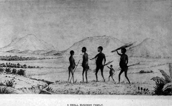
I find there are four types of Bushmen in this desert; the lowest is the one already described with no forehead and half wool and hair on their bodies and legs. The second is the wild Bushmen, who live in the mountains near the Orange river, also mentioned, who war on all men, but they are of good form, without hair. The third is the Masara Bush family, also of good proportions and of gentle dispositions, inoffensive and harmless, ready to help or do anything, and they make good servants. It was this tribe I had with me in my wanderings. The two girls I took in charge made good cooks, washed the clothes, and mended them. The fourth is much taller and well-formed, great rascals, who cannot be trusted with anything; they inhabit the eastern portion of the desert, and down by Langberg. A similar tribe were those Sir Walter Currie drove out of the colony, some of whom I fell in with at Quassam under Coche Africanda. The Bushmen of the northern Kalahara are much the same as the Masara, every one of them quite distinct from the Drakensberg Bushmen, whose form and colour differ entirely from the others, which I believe to be a distinct race, and which I described in the first chapter.
One amusing circumstance I omitted to mention in connection with one of these wild Bushman boys, when at Swaart-Modder in the Hygap river, where we had built a stone house under the cliff to keep our goods during our stay there. A young Bush boy came in the evening to the camp and made himself comfortable by the fire. After some time my boys asked him where he came from, but he would give no reply. At last they got from him that he had run away from his people, because his mother had burnt his fingers for stealing, and he came to get something to eat. This was his second visit, and as he had been well fed before, he came again, but managed at the same time to steal some of my boys’ food. On this evening, we had a young man from the colony to drive the cart and look after the boys, and as our stone house was infested with large mice, this young Hancock was catching them in an iron pot, and throwing them out amongst the boys for amusement. As one by one, up to seven, were thrown, this Bush boy picked them up, put them into the red-hot ashes to cook, and, when half-done, ate them as they were. Thinking he must be awfully hungry, I told my cook to put on a pot and cook some Boer meal, which is wheat ground but unsifted; two pints of this were cooked in water, and when ready it was set before him and soon disposed of.
After all the people were asleep, he stole the food they had left, and in the middle of the night, sucked three of my goats dry. The following morning he was not to be found, and for nearly a month we did not see him again; when we had travelled 100 miles north, and were outspanned, he presented himself again, as if it were his first visit. We found out he had lived in the bush, existing on a wild water-melon, called shama or kongive, and had kept us in sight as we travelled. I tried to tame him, but it was of no use; his age was about eleven years. He kept with us off and on for three months, then disappeared altogether; the lions would not let him remain long, without making a meal of him.
We were now travelling through a very pretty part of the desert, open glades and timber trees, lofty pyramidal hills, partly covered with bush, fine grass, with white feathery tops, no inhabitants; a wild and picturesque region, crossing open plains, then gentle rises with low bush; in the distance, mountains with their lofty peaks fading away into nothing. The perfect calm and silence that pervades everything around, the variety of game quietly grazing in all directions, the very loneliness of my position, being many hundred miles from any white man, surrounded only by my own Bushmen, and those who accompany me, living in all their natural innocence as their forefathers lived in prehistoric ages, add immensely to the pleasure one feels in viewing a scene so novel and so seldom to be enjoyed.
The country as we approach Damaraland becomes more wild and broken, lofty mountains come into view as we advance westward. We were nightly visited by lions and wolves, which kept us constantly on the watch, and our fires kept lighted. It is an anxious time, particularly when in the stillness of the night we hear their roar at no great distance, in answer to others far away. The roar of a lion in the still evening can be heard miles away.
One morning about eleven o’clock, as we were outspanned in an open plain about 300 yards from a small pool of water, our oxen, horse, and a few goats grazing on the opposite side of the waggons, several of my boys asleep, the Bushmen and the women cooking some flesh in the hot embers, we saw seven lions leisurely walking up to the water. After drinking, they went to a small rise, bare of grass and sandy, and commenced playing, some lying down, others jumping over them, growling in their deep bass voice, acting the same as cats at play. This lasted twenty minutes, when they as leisurely walked away, taking no notice of us whatever. If I had fired and wounded any, they might have come at us, which would have been dangerous to our oxen, by dispersing. When an ox or a horse smells a lion, they will bolt away anywhere, and some might have been lost, therefore we left them alone and enjoyed so unusual a sight, watching the movements of these beautiful but dangerous kings of the forest, in their wild and natural state in the wilds of Africa.
The Kalahara, that portion, on the borders of Damara and Ovampolands for 300 miles, becomes much more densely wooded and hilly. Some of the mountains attain a height of 8000 feet, in which lead, copper, iron, and coal, also limestone, both white and dark grey, crop up everywhere. Granite forms the hills. The Black and White Nosop and the Elephant river, and their several branches, drain all this region. The country is very dry, rain seldom falls, and when it does, it comes down with a rush, which soon passes away; but the vegetation is excellent, fine timber and thick bush predominate over this vast but little inhabited country. The road from Walfish Bay on the west coast passes through, in an easterly direction, to Lake N’gami, Zambese, Ba-Mangwato, and other territories on the east. The road is difficult to travel for want of water, but when the country is more opened up, means will be found for procuring it by well-sinking and pumps, to make it as easy to travel as any part of Africa. There are several permanent watering-places now along this route. In the dry season it is three and four days’ trek between them, but as it is limestone nearly all the way, water can be procured by digging wells. The country is subject to drought, more particularly in the southern portion of the desert, consequently there is more game to be found in the northern region. Elephants are seen in troops of two or three hundred, also the zebra, and the various antelopes, giraffes, rhinoceros, wild boar, and others.
The country is very favourable for rearing cattle; large numbers of horses are yearly taken through the desert from the Orange River Free State to Damaraland, and exchanged for Damara oxen, which are found to make the best trek oxen, having small hoofs and being nimble on their feet; they are compact and strong. Another advantage is that they are bred on sour grass; when they arrive in the colony, it is sweet, which improves their condition.
April 30th.—At Hoab, a lovely, calm morning, after a heavy rain last night, at a vlei; there are several large ones in this open grass country that contain water at this time of year, being the rainy season. This station is on the desert-track from the lake to Ovampoland.
Outspanned under a large tree; boys employed skinning a koodoo, killed early this morning by one of my Bushmen guides with his poisoned arrow. The arrow-head is of bone, very small, the shaft two feet in length, and the bow two feet six inches. The shaft, close to the head for four inches, is covered over with their poison, which, in penetrating the flesh, paralyses the animal; the flesh killed in this manner is very good, and has no bad effect on those who partake of it. Several Bush people have come to our camp begging for food; they look poor and miserable, their only covering being a few pieces of ragged skins thrown over their shoulders. Several of the grown-up boys and girls had not even that to cover them. They are complete wanderers in the desert; no home or fixed abode, but live on roots, berries, insects, and anything they may by chance shoot: I gave them some flesh, and a fire to cook it.
The hot winds, which are very oppressive, come in waves, and are very enervating, more particularly in the dry season, when they dry up everything. The wood-work of the waggons shrinks to such an extent, that the wheels are kept together by ropes of raw hide bound round them; and your own system becomes so dried-up, that the natural functions of your body partly cease to act; to remedy this, fat is absolutely necessary, and nature craves after it. You will see the desire after fat in the native tribes, not only to grease their skin, to protect it from the sun, but to use as medicine.
When treking, some days afterwards, we were overtaken by one of those gigantic whirlwinds so common in all tropical countries. We were entirely enveloped in it; everything that is loose in the way of clothes is carried up hundreds of yards. One of my boys had his hat taken by the current, and it fell nearly a quarter of a mile from where he lost it. Many of these whirlwinds may be seen at one time passing over the desert.
At this outspan, late in the afternoon, sitting on my camp-stool where my boys were skinning a buffalo I had shot, I saw in the distance a Bushman coming. When near enough to distinguish, I saw it was a Bush girl, tall and well-made, and for a wonder quite fat; she was marked over every part of her body—face, legs, and arms—with white stripes, like the stripes of the zebra, and had nothing else on. She came up, holding out an old piece of leopard-skin. My Bushman spoke to her, but could get no answer. I gave her some tobacco, when, dropping the skin, she walked to the fire and sat down. We gave her a piece of cooked meat, thinking she might be hungry, which she took, and after remaining some ten minutes, got up and walked away in the same direction she came; but no word could we get from her. She was even strange to my Bushman. It was a strange visit, and a strange mode of decorating herself. The only other occasion on which I fell in with Bushmen so marked was more to the cast, nearly 300 miles, when nearly a dozen came to my waggon, to tell me I had that day ridden over a grave where a few days before they had buried one of their people. The stripes may have something to do with death, but the Bushmen I have spoken to know nothing of such custom.
One of the vleis, which was full of water, appeared to be full of frogs, from the noise they made at night; going down, next morning, I found several small ones, having a peculiar appearance. Catching one, which was very narrow in its body compared to its length, and having a short tail, I concluded at once from its general shape that it was half-lizard and half-frog. It had all the action of the frog in its long leaps, without any attempt at running; all the others were of the same form, and with tails. I brought it to the waggon to take its measure, viz. from front of head to commencement of tail one and a half inch, length of tail three-quarters of an inch, beautifully marked with green and light-yellow spots. Not having any means of preserving it, I took it back to the vlei, where there were hundreds sitting on the bank; as I neared them they jumped into the water and disappeared. The Bushman brought in to-day several ostrich eggs, quite fresh from the nest, which we had cooked in our large iron pots, mixed with a little flour—a kind of omelet; one is sufficient for three persons. The Bushman took me to a nest that the old birds had been sitting on for some time; there were eighteen in the centre, and fourteen on the outside, formed into a circle round them, which are kept for food for the young birds, which lasts them a few days when hatched; the hen bird then takes and teaches the chicks to eat grass.
Thursday, 18th.—Our camp was visited by a party of traders and Korannas on their way from Meer down South—the chief Puffadder, old Mr Ryland, from Kopie’s farm and Low Blaat, four waggons, and a lot of cattle, horses, and sheep. They remained the afternoon and night, and started early the next day for Kebeum. They told me a trader on the border of Great Namaqualand, going down to Walfish Bay, had been shot, and his waggon and everything seized by the Gobabis Hottentots for plunder, and that the country was in a fearful state of tribal wars. I told them of my little affair with the Bushman Hottentot at Quassam; they said I was most fortunate to escape as I did, particularly with all my belongings, as they are noted as a nest of thieves, and have robbed traders of everything.
I left them for Abequis pita, which are in limestone; it is a Koranna station, under the chief Puffadder. The country is open and flat; the grass in many places was up to my chin with white feathery flowers; at a distance it looks like snow. The road is very good for waggon travelling, and around Springbok fountain the scenery is very pretty. At Abequis pits the Korannas have many huts, and seem to be doing well; they have flocks of goats, and a few Africander sheep. They brought me some very good feathers, which I took in exchange for powder and caps; many of them have the old flint gun, which would be a curiosity now in England.
The winters here are warm; it is now mid-winter, thermometer in the shade 68 degrees. The men wear old leather trousers, which constitute their dress, the women an old blanket thrown over the left shoulder, and brought round and held in front by the hand. Overmodesty is not a failing with them. They were very civil, supplied my people with goats’ milk, and I gave them what they much needed, tobacco, as the women are great smokers. Dozens of them will sit or be lying round my fire, having only two or three bone pipes between them, each taking a few puffs and passing it on to the next, until all have had a turn; then they begin again, the old ones keeping a pipe to themselves. My maids, Topsey and Nina, the daughters of my Piet, knew these people, therefore I got on very well, Piet also lived once with them. The country towards the south and west was a level plain as far as the eye could see.
The next morning after the second day, started to the northwards; we passed a large vlei on the left, six miles from the Koranna station, which is the commencement of the sand-dunes. The dunes are small until sixteen miles of country are passed, then they assume great proportions. A mile to the left is another vlei, where we filled our water-casks and gave the oxen water, and remained the night, to have a clear day to pass over them. There were three Griquas’ waggons outspanned, each waggon was full of women and children, each Jack had his Jill, and each a baby, plenty of little naked children of both sexes. They told me they were on the trek to the Orange river. These people are always quiet and civil, they exchanged a fat sheep for some tobacco. All the country, including the sand-dunes, is limestone with sand above, and full of low bush, many large and small land-shells are mixed up in the sand.
July 17th.—The Griquas left early in the morning, and we started to cross the sand-dunes. A fearful road, their sides are about at an angle of thirty, and every time we ascend one, we have to put two spans of twenty-eight oxen in, to pull one waggon up at a time, which causes much delay shifting them backwards and forwards, as each dune rises from 150 to 200 feet in height, with deep sand in the road, the wheels sinking nine inches into it. After struggling over these for five hours, the oxen were done up, and we outspanned for the day at another large dry vlei, but on the bank a small spring of water was issuing, sufficient for the oxen and ourselves, a grand discovery, as we did not expect to find any until we had got clear of this heavy road. A short distance from the water were several families of Bushmen, sitting round a large fire; some of them had most extraordinary figures, thin calfless legs, prominent chests and abdomen, altogether different from the other Bushmen of the desert, and the colour of their skin was much lighter. A thin band of leather round their loins, and a skin over their shoulders was their only covering; long bundles of skins rolled up with several spears were lying on the ground. The food they live on in a great measure gives them this peculiar formation. They had the short bow and arrow, and quivers made of skins, full of arrows, cleverly made with bone heads, all smeared with poison. They appear to be half-Bushman, half-Koranna.
I started the next morning, and after toiling for several hours, rested, and again went on, crossing those lofty ridges until dark, outspanned for the night in a deep hollow, where there was plenty of good grass, and trees, and dead wood for fire. Our trek this day was about eight miles; two great fires were made, and our little party of twenty-six all told, made themselves comfortable over their supper, and at ten all were fast asleep. But we did not get much rest, the lions kept round the camp making a great noise, and being surrounded by these hills and thick bush, we were the greater part of the night obliged to keep a sharp look-out that none of our animals were taken. Early the next morning I took my rifle and mounted one of these sand-dunes before inspanning, and found from the base to the summit registered 204 feet. But what a sight when I looked round; as far as the eye could see, nothing but these immense sand-dunes in every direction, here and there open patches of yellow sand and bush, a wild, rugged, and howling wilderness, that appeared interminable, the fit abode for savage man and more savage beast, and here we find them, man in primitive nature, as low a type as the world can produce, little removed from the beast, for it is here I have met those wild men which I have described elsewhere; they are partly covered with short woolly hair, and have no forehead, the scant wool reaching the eyes. They are rarely now seen, even by the Bushmen of the desert, as they have repeatedly told me, and here they may find a home for many years to come, for no other living man will fix his residence in such a region of desolation,—
“A wilderness howling and drear,
Forsaken by man from famine or fear.”
Pringle.
On our trek we started many head of game, which are easily killed by the Bushman arrow, and with these and the many wild fruits they manage to exist. It has taken four days to cross this wild and hilly region which extends over an area as far as I have explored it, fifty miles from east to west, and nearly forty north to south: the home of the leopard and a legion of wild tiger-cats, that are spotted or striped,—their skins make beautiful karosses. On leaving these dunes we come upon a level plain of limestone, which we have ten miles to cross, where there are several watering-places, fountains they may be called, and enter sand-dunes again for some fifteen miles, and then come upon a bush country, with gentle rises and low wooded bills with isolated conical hills of granite. Close to the hills, I outspanned near a swamp; the noise from the bull-frog kept us from sleep. They are monsters, a foot across the back and quite black. The Bushmen eat them; they would form a fine dish for our French neighbours.
The weather is very fine, like an English spring day, everything seems springing into life. Clouds begin to collect on the horizon, and the sunsets are most brilliant, purple and gold, forming celestial landscapes of the most gorgeous hues. There are many ostriches to be seen on the flats, but the country is so full of holes, partly covered with grass, that it is dangerous to follow them. Far and wide in every direction the character of the country is the same, which we pass through up to Meer, the Bastard station.
We passed several small Bushmen kraals; the women and children as we approached hid themselves in the bush, but when they found we were friendly, and giving presents to the men, they came forward. At one we remained a few days to buy feathers, during the time my Bushmen and the girls soon made friends with them, and dancing went on in their fashion every evening. These women daub their faces and bodies with black stripes, which they consider ornamental. Their natural colour is half black, consequently these stripes show out prominently; they are a mild, timid race, very good-natured, willing to do anything, and, if left alone by the border tribes and the Bastards, their lives would be happy; their wants are few and easily supplied, clothes they do not require, the climate at all seasons of the year is seldom colder than our English summer, and, as these children of the desert are constantly shifting their locations, huts are not required, or only of the most primitive kind, a few sticks stuck in the ground, and the long grass thrown over them. This is a portion of the central part of the Kalahara.
When we arrived at Meer, all the people were out ostrich-hunting close round the village, a great excitement, the birds running in all directions, and the Bastards after them on their horses; they managed to shoot seven; the others, about fifty, made their escape.
Meer is a straggling village, the soil is rich and grows good crops of corn, the two pans supply the people with water. Dirk Falander, the head-man, is supreme over the people. They possess several waggons and have large herds of cattle, and live very comfortably, sending down to the colony for what supplies they require. Coffee and sugar are in great demand.
After a delay of two days, I left for Chuane pits, distant one hundred miles; as the rains were very early, there was plenty of water to be had. This occupied me eleven days. I remained some time on the Oup and Nosop rivers, hunting, and it was necessary for one or two guns to be out every day to supply my little family with food, and as there was plenty of large game about, we had no difficulty in procuring it.
The wild aspect of the country, bush here, open plains there, with long ridges of low hills, no living soul to be seen until we arrived at the pits, and there we found a small family, who on our approach ran into the bush, but my own Bushmen called them back; they came very reluctantly, but soon became friends, some fifteen in all, a little dahka and a few beads as presents soon restored confidence amongst them.
I am much interested in the Bushmen of the desert, and also in the white Bushmen of the Drakensberg mountains, because they appear from their isolation from the outer world, and cut off as they have been from the tribes that now occupy the regions around them, to be the descendants of the people who occupied the lower end of this ancient continent before the tribes from the north came down, and pushed their way south, bringing with them their Asiatic and Hebrew customs, which all without exception now practise more or less, evidently proving from what regions they had migrated. Eventually they nearly penetrated to Cape Town. Not so with the white Bushmen of the Drakensberg, the Hottentots, or Bushmen of Cape Colony, and the Bushmen of the Kalahara Desert, each retaining up to the present time distinctive physical formations and distinctive dialects, so entirely different from those tribes that come down south and overrun the southern peninsula of the African continent. These ancient aborigines of South Africa are comparatively pigmy races to those above referred to, who are as tall, robust, well-formed specimens of the human race as can be found in any part of the world. Then again their language, if it can be called such, is entirely different from any other known tongue, their thoughts are described by certain clicks, four in number, the white Bushmen of the Drakensberg have only these clicks, the Hottentots or Bush men of the Cape have, in addition to the clicks, sounds which accompany the clicks which come from the throat like grunts. The Bushmen of the desert have also these clicks, showing, I think conclusively, that these early people were in existence before languages,—what we understand by language, words formed by the mouth, tongue, and lips, as the nations of the world now converse and talk. Some of the South African missionaries have committed to paper these clicks, and they state it is a most beautiful and expressive language. At any rate, my belief is, that the earliest formed language of man was by sounds such as clicks and grunts before they advanced so far as to express their ideas by forming words, and language has been progressive as man advanced in civilisation. In travelling over South Africa and listening to the sounds of the baboons as they move about the rocks above you, you can detect a great similarity in their guttural sounds and the Bushman language, and I could quite understand when my Bushman told me he could converse with, and knew much of what these said, showing a connecting link between them. Therefore I take much interest in watching their characteristic qualities, in connection with the general run of mankind. Anthropological study naturally embraces the study of their early implements, where, and how found, their artistic qualities, and for what purpose made, for peace or war, and this desert is particularly rich in these interesting relics of past ages.
The desert on the east and south of these Chuana pits, extends up to the chiefs Sechele, Montsioa, and Gaseitsive, that join on the eastern boundary 230 miles, unbroken by rivers or native towns, one immense tract of wood and plains, long flats, and in other parts undulating, with the exception of the detached mountain ranges, which run north and south—the continuation of the Langberg range—and they terminate 100 miles south of Lake N’gami. They are beautiful, picturesque and lofty hills, rising from their base 3000 feet; many of their sides and deep kloofs are thickly wooded with fine timber of great value, and in the extensive ravines are ancient caves, some of them now used by the Bushman tribe. This range is distant from these pits about twenty miles on the east. Game of every kind is plentiful; lions, also, we hear for hours every evening. Hawks, kites, vultures, eagles, locust-birds are almost always seen on the wing.
As there was good water at these pits, in consequence of several heavy thunderstorms having passed over the last few days, I have remained here to have a little exploration of the country and provide a good supply of dried meat, which is called biltong, for my people; and in the evenings, when all work is over, they amuse themselves dancing, singing, and shooting at targets with their arrows for small presents, which causes great fun; they are the most happy people in the world. To amuse them I made a kite about three feet in length, and with some string sent it flying, to the astonishment and delight of all.
Spring was now advancing fast, everything springing into life. The little, happy African lark flying up some thirty feet, where it remains a few seconds, then down it comes with such a sweet plaintive voice, and this is repeated every few minutes, and as there are many of them about, their little notes are constantly heard. Thunderstorms are now coming almost daily, and the evening sunsets are the most brilliant and gorgeous that can be imagined, portraying golden lakes, mountains and waterfalls, rivers and islands, with noble castles, and everything to perfect a landscape, and this remains long without alteration. It has been a source of much pleasure in this lonely region to endeavour to convey the like on canvas.
As we had now plenty of water and could go anywhere, I struck north, leaving these pits on the 30th October; but a few days previous to my leaving, I found several small quartz reefs of the right sort for gold. After spending three days with pickaxe and hammer, digging and breaking off nearly a ton of quartz, I was rewarded with one little speck of gold, finding, so far as I could see, that these reefs were not rich; and if they were, the distance is too great to make it pay to work them. On leaving, my friends, whom I found in possession of the pits, wanted to join my party. Treking due north, keeping west of these mountains, I outspanned, after four hours, close to one of the highest of the range for the night, as I wanted to make an excursion to the top the next day, to see the country and take observations, altitude, and get the difference in temperature at the highest part. The night passed off very quietly, except hearing in the stillness of the night an occasional roar of a lion and other wild beasts, to give us warning not to sleep too sound. The sun rose the next morning in a magnificent glow of crimson light. After breakfast I started with my driver and five Bushmen, each with a rifle and ammunition, all on foot, leaving the waggon at 6 a.m. I soon reached the foot of the mountain, when the difficult part of the journey commenced, passing round projecting rocks, crossing deep kloofs, thick with bush, where we had to keep a good look-out, having only one dog to tell if any lions were near. I managed, after three hours’ labour, to reach the highest summit about 10 a.m., a clear lovely morning, without a cloud. The view from this elevated position was grand. In all my wanderings I have never seen anything to equal it, no lofty hills to break the view for 150 miles. The outlook from this point extended both east and west over 200 miles; the lofty hills near Secheles could only be distinguished with the telescope, and then like a pale lavender cloud, the country between thickly wooded, and long stretches of open country, apparently a waterless region; the same on the western side, excepting that the country was more open, and the ancient river system could be distinctly traced by the trees and bushes that grew on their banks. The game in the open looked like ants. One of my Bushmen called the attention of the others to something they went to look at behind some bushes. Going to see what they were examining, I found the remains of four fires that had recently been alight, and several pieces of bone broken near some stones to extract the marrow, but nothing else could be discovered. Evidently there were Bushmen in these mountains, but no sign of them could we see. After exploring the ins and outs of the topmost ridges, I selected a good position for taking observation, after which we disposed ourselves for lunch; the walk up and pure air gave an edge to our appetites. Cold tea and a dash of brandy, which gives the tea the flavour of wine, was served to all alike, and they then disposed themselves on the grass for a smoke. I found the elevation at this point above sea-level to be 6470 feet, and from the base of the mountain to where we were 2795 feet.
At 3 p.m. we made a start for the return journey to camp, taking a different route down, which was much more difficult, the mountain being broken up into many almost perpendicular ravines, and gigantic rocks projecting in all directions. Half-way down my Bushmen called out in an excited tone that there were several Bushmen on a projecting spur making for cover. We counted eleven; how many more we could not tell. I told my boys to call to them to come, but they paid no attention, and suggested that some should go and bring them, but they refused, being afraid they should be shot by the poisoned arrows; and they informed me they were monkeys, not men, meaning they were of the same type as those I have mentioned previously as having woolly hair on their body, legs, and arms. As we wound round the mountain, it being too steep to come straight, we came suddenly upon three more, a man, a woman and child, quite naked, and of a reddish-brown colour. My Bushmen called to them in their language of clicks to stop, we were friends, but they seemed much alarmed. A present of beads to the woman gave them confidence. They appeared very young, not more than seventeen. The height of the man was about four feet two inches, large bodies for their size, thin legs, and small receding head, and disgustingly ugly.
Passing round one of the overhanging rocks, I came upon several caves, none of any great extent, but evidently made use of as dwellings from the numerous remains of fires in them and the smoked appearance of the roofs and sides, and heaps of broken bones lying about, but no one was in them. If I had had the means of sending this little family down to the colony, I should have done so. After a delay of nearly an hour looking about, we continued our downward movements, and reached camp soon after sundown.
During our absence one of our Bush girls went out with two other little ones to dig up inches, a small bulb like an onion growing in the veldt—good to eat—when a lion seized and carried her off. The screams of the girl and the two little ones brought several of the Bushmen with guns, but no trace of the girl could be found. This occurred just before our arrival, when I formed a party of seven and went to look for her, but night coming on and very dark, it was impossible to follow up the spoor. Early next morning by break of day all that could be spared started, but nothing could be seen, the bush being so thick. Many of the Bush people are carried off in this way. All last night the roar at intervals could be heard far and near; the man-eating lions are the only ones these people greatly fear.
To go through my daily routine from place to place, the same duty daily, would become too tedious. We therefore, after leaving this place, visited various localities. My Bushmen knew that water could be found at Hoodedoon, and the dry river where we managed to capsize the waggon. We reached Reitfontain and Wahlberg, my old station, at a pan situated at the north end of that mountain range; I had left five weeks back, and encamped once more for a rest. I call this my station in 22 degrees 10 minutes South latitude, 22 degrees 12 minutes East longitude. The whole of the country is high, 3880; at my pan the mountain registers 6880 above sea-level. After a stay of ten days I left for Lake N’gami.
The importance of this desert cannot be over-estimated in connection with our interior trade. Whatever nation secures it, secures all the trade to the Zambese, which would be an immense loss to England and the Cape Colony. It is capable of great improvement, and under a proper government will become a most valuable field for emigration.
Chapter Thirteen.
Great Namaqualand.
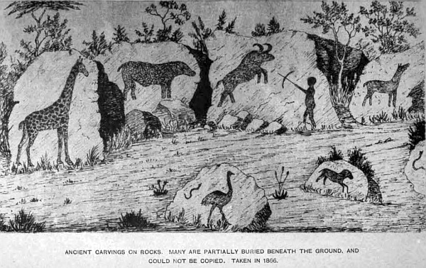
This country occupies the western shore of the South Atlantic, from the Orange river, which is the northern boundary of the Cape Colony, to Walfish Bay, a distance of 420 miles. The southern boundary follows up the Orange river for ninety miles, where the Great Fish river falls into it from the north. The native name of this river is the Garip. The breadth at its mouth is nearly four miles; the sand in its bed and the many shoals and sand-banks prevent its being navigable. Higher up there are long stretches of smooth water for miles, intersected by rapids and rocks,—some of them very beautiful, passing down between broad belts of rich vegetation, with splendid timber of many varieties: the willow, with its drooping branches kissing the water, adds greatly to the beauty of the scene.
It was on this river, some miles above, that I spent many delightful months, with my canoe, sailing on its placid waters,—some of the most pleasant of my life. Many beautiful stones, not in small quantities, but in cart-loads, can be shovelled up wherever the water has left them on the shore. The upper portion of the river I have already described.
Following the coast-line north from this river are several anchorages. The principal are Angra Juntas, Whale Bay, Possession Island, which is nearly three miles in length, and over one in breadth—once famous for guano; and if time be permitted will be again a valuable island for that manure. Seals frequent this coast at certain seasons of the year, and penguins are also abundant. Cape Voltas lies on the mainland. North of Possession Island is Angra Pequena (now German) Island and Bay, where the mouth of the little Orange river enters it, which rises in the highlands at the back. At Pedestal Point, Bartholomew Diaz in 1486 erected a marble pedestal, which has long since disappeared. It is a trading-station for supplying the natives of the interior, who trade in feathers, skins, karosses, cattle, and other products, and receive goods from the Cape in exchange. A road from the bay is over a dismal, barren, and heavy road for fifty miles, when it becomes better, with some herbage. In the bay there are several islands, viz. Penguin, Seal, Shark, and others, which give good shelter for ships visiting it. Copper has been found on the neighbouring coast. North of this bay is the Island of Ichaboe, which, although very small, is famous for once being noted for its superior guano, supplying England with thousands of tons annually. North of this island is Hottentot Bay, and beyond Spencer’s Bay, the cliffs rising 500 feet nearly perpendicular; and in the bay is Mercury Island, nearly a mile in circumference, rising to a height of 250 feet, in which is an immense cavern, divided into several lesser ones, through which the waves rush with fearful force and noise. This rock is bare of vegetation, many sea-birds find shelter upon it—gannet, penguin, gulls, and others. Seals and whales frequent it at certain seasons.
In latitude 24 degrees 30 minutes South is Hollam Bird Island, about half a mile in circumference. Seals and birds frequent it in large numbers; many turtles have been caught on the shore. In 24 degrees South latitude is Conception Bay, and to the northward is Sandwich Harbour, which is situated thirty miles south of Walfish Bay. Sandwich Harbour has a coast-line of sand-hills beyond; inland is pasturage for cattle, and on the beach is a spring of fresh water. A fishery was once established here by a Cape merchant. The River Kusip used to fall into this bay, but now flows into Walfish Bay. It rises in the uplands, near the Tans Mountains, but has no water in it, except when it happens to rain, which is very seldom. Great Namaqualand terminates about this point, and Damaraland begins.
From the sea-coast for many miles inland the country is barren and poor; as the highlands are reached vegetation improves. The Desert of Tans extends a long distance inland, nearly to Mitchell’s Mount, which is a lofty hill of 6000 feet, commanding most extensive views in every direction. On the tributaries of the Great Fish river, and the river itself, most of the natives live in small wherfs, at the mission stations belonging to the Rhenish Mission Society, Bethany, Bethesda, Reheboth, and others. The Isabella mines and Nabos copper-mines are on the Orange river. Some of the principal wherfs are Reheboth, Ames, Haochannas, Nababis, Kachasa, Amhup, Reems, Hudenass, Brokhout, Robaclip, and others, on the various branches.
As I have previously stated, the natives are greatly mixed; many of the women daub their faces and bodies with black stripes, and also dye their teeth black; they use a red berry that grows in the bush veldt. Jonga Africander, the head of the Hottentot tribe, living in the northern part of this region, has been constantly thieving from the Damaras, causing many petty wars between them. They are a lawless set. They drove out and threatened to kill the magistrate there lately.
Wood is plentiful in the kloofs and on the river-banks, where the water is procured. The larger game is found in the north-east corner, but has become very wild from constant hunting by the various tribes. The lofty hills are of granite formation and sand. The Bastards cultivate the land in favourable localities, plough, and have large herds of cattle, and carry on a good trade with the colony. They are hospitable and peaceable; each wherf has its head-man, with several cattle and vieh-posts attached. Copper, lead, and iron are found in several parts, not yet worked; at some future time it will become a valuable district. The summers are hot, and in winter it is sometimes very cold; rain seldom falls, but the dense fogs from the Atlantic, over all the western portion and on the highlands, cause such a moisture to fall that it has the effect of rain. The rainy season is from the end of November to May. In the northern part rain is more frequent. The Namaqua language is similar to the Hottentot and Koranna, with innumerable clicks, which make it sound very uncouth and strange to those who have heard it for the first time. In travelling through the country I met with great hospitality amongst the Bastards. At Nisbet Barth there is a Wesleyan Society. The missionary was away in the colony when I passed through. (Here is Germany’s first attempt at colonisation.) Being anxious to go on to the copper-mines on the river, where I could obtain a few things I needed, I did not delay.
The country is not a pleasant region to travel through, for several reasons—the scarcity of water, and that brackish; the want of grass; the native cattle, where it would be good, keep it short; and the wandering tribes are constantly annoying and worrying for something. On the banks of the Great Fish river, near the Brinus Mountains, I shot a black wolf, the first I had seen, and my people told me they were very rare. I had great difficulty in getting through the country—bad roads and dreadful drifts crossing the rivers.
I have little to relate of my explorations of this part of Africa, my time being taken up in surveying the country, and collecting specimens. The entire coast is a barren waste, not suitable for emigrants or anything else for fifty miles at least inland.
Chapter Fourteen.
Damaraland. South Central Africa.
The boundary of this region, adjoining Great Namaqualand, Kalahara, and Ovampo, is very undefined. The natives are unacquainted with the true divisions, and as each nationality is not confined to any particular line, living in a kind of mixed community, it is difficult to say where one country begins and the other ends; but from accounts of the people, it appears that the extinct river Kuisip, which enters Walfish Bay, is the correct boundary, and the coast-line to the north reaches to the Cunene river, which is also the Portuguese boundary of Bengulo, the distance being nearly 400 miles.
The first and only harbour is Walfish Bay, being an important trading-station, belonging to the Cape Colony. This port, where there are two trading establishments, supplies the whole of the northern part of Great Namaqualand, and also all Damara and Ovampolands, the central and northern Kalahara, as far as Lake N’gami. The great drawback to its prosperity is want of fresh water. In many cases the people are supplied with water in casks from Cape Town, but I believe if proper means are taken by sinking wells, a good supply can be procured. At present a considerable trade is carried on with the natives, and is on the increase. On the north of this bay the river Swakop enters the Atlantic, which is the main and principal stream that drains the eastern division of Damaraland, upon which are situated many natives’ wherfs. Some of the principal are Oekiep, thirty-six miles up the river, then Tineos, Oijimbinque, Otjimonjebba, Okandu, Little Barmen, Great Barmen, Otjithebba, Gous, Eikham Hot Springs, and Thames Mission Station. The distance of this last station by road to Walfish Bay is about 231 miles, which is one of the roads to Lake N’gami, and is on the north of Awas mountain, that attains an elevation of 6400 feet. The scenery in this region is wild and grand, and eastward of these points the Ealahara comes in, and is drained by the Black and White Nosops, Elephant river and branches. South of Swakop are several native kraals and wherfs; Wittwater, Reed Fontain, Tjobis, Platklip, Onanis Mission Station on the Kuisip, and others. The country is fearfully sandy and dry. The Canna river, a tributary of the Swakop, branches off thirty miles from the coast. It rises in the spurs of the Ketje mountains and flows south-west through a deep valley between some picturesque scenery. Upon and near this river are several Damara wherfs: Omaruru, Omapyu, and Evonga. A few miles inland from the junction of these rivers is the Canrans Quanwas, or Colquhoun Mount, 3100 feet above sea-level, a conspicuous object from the sea. Copper is found in its vicinity.
Forty miles along the coast, to the north of Swakop river, is the mouth of the Omaruru river, which evidently at some seasons must have a powerful current; the washing away of the banks of sand, and large timber trees brought down and left on the bank, is a good proof. Extensive copper works have been worked here for some time, but they do not seem to pay the company, long since abandoned. Twenty miles inland the lofty and barren hills give a desolate appearance to the country. The sea-coast to the north is bold, and has many projecting headlands. Inland, from Cape Cross, the land rises to an elevation of 3700 feet. All this hilly district is inhabited by Berg Damaras, who are rather scantily dressed. The women have a band round the head with lappets falling behind, a profusion of beads round their necks, with a band and large square apron folded round their loins, and bracelets. The men have a broad belt, leather apron, with parts of tails suspended behind; they have large bows five feet in length, and long arrows tipped with iron. Few iron utensils; wooden bowls are mostly used.
The upper source of the Amaruru rises in the Eshuamen mountains, which is a dense bush, and separates Damaraland from the Ovampo region. The river Omuramba, already described in the Kalahara, rises in the same mountain, Eshuamen, and also Mount Ketje, taking a north-east course, then flowing east, leaving the lofty range of the Omureraoom on the west. The upper part of the Swakop has many stations, and is thickly populated.
Limestone prevails over an extensive area; the peaks, which are composed of this rock, are 4444 feet high. The region to the east is the Kalahara desert and a thick bush country.
The principal road from Barmen Mission Station to Ovampoland runs along by the Omuramba river, between which and Damara the country is divided by an immense thorn district. Beautiful and picturesque scenery is to be found in Damaraland, where the granite hills stand out in bold and massive peaks. The mineral wealth of this region is little-known; copper, lead, and silver, also iron, abound in the mountains. The natives speak the Otjiherero language. There are many mixed races spread over the country, and great numbers of cattle, sheep, and goats are kept by them. Several mission stations are established in the country: Barmen, Otjimbinque, Schmelin’s Hope and others. The climate is very healthy. All the large game are found in these regions. The Damaras hunt them with the bow and arrow, but of late years guns have been introduced into the country. They are a stout and powerful people, very dirty in their habits, and seldom remain long in one locality, being pastoral, cultivating no corn, and always at war with the Berg Damaras, being of a different tribe, using the Hottentot language.
The Rhenish Missionary Society hold most of the stations, and have been great sufferers by these lawless tribes, being plundered, and several of them ruined, which has destroyed the trade of the country. (Illustrative of which, one of the missionary’s goats was being constantly milked. One Sunday evening he caught a man at it, who ran away, and he threw a piece of wood at him; and complained to the chief, who decided that the man was sufficiently punished by that, and the missionary was fined a goat for breaking the Sabbath.) Many English traders were robbed and some wounded. The mission stations were established about 1830, but scarcely anything has been done in civilising the people. The Namaquas live by plundering their neighbours, the Damaras. This was the state of affairs when I first visited that region. Since then they have been robbing the Damaras of their cattle. Several mission stations have been destroyed. Their store at Walfish Bay was broken open and everything stolen, and the manager, Mr Toerson, murdered. The Europeans in the country, numbering about thirty, made application for assistance at Cape Town. The governor sent a man-of-war to Walfish Bay, which returned without landing. Since then several British subjects have been murdered, and so things have gone on from bad to worse, and not until 1875 were any steps taken; then a commissioner was despatched to endeavour to settle matters, but his influence had little effect in restoring order, and eventually he returned to Cape Town. It is of the highest importance to the Cape Colony that Walfish Bay and the coast-line for fifty miles north and south of it should be annexed to that colony as being the principal outlet for the native trade of the interior. If it should fall into foreign hands an immense injury would accrue by the taking away the greater portion of that trade which rightly belongs to the Cape Colony. The chief, Kamaherero, is almost paramount in the country. The population of the Hereros is estimated at about 40,000, and the Berg Damaras nearly 30,000.
The importance of Walfish Bay is its having the command of all the interior trade of Ovampoland, the Kalahara desert, and also that extensive region at Lake N’gami, a great portion of which is brought across the desert, therefore its importance as a British port cannot be overrated. There is no field for emigration, as the country is too dry for agricultural purposes, and the natives at present are too lawless for any settled community to remain there; but as a trading-station to collect the produce of the interior, and barter with the natives, it is all important that it should be retained.
In the latter part of 1879 the country was in a lawless state. The Gobabis have been robbing waggons; the Gobabis are Hottentots. They robbed a Boer, one Van Zyl, of all he had, and he had to fly with one of his sons, leaving his wife and another woman with seven waggons, with horses, oxen, guns and ammunition in the hands of the Gobabis, who had taken all except the two women. Van Zyl went to Mr Palgrave, the Commissioner, for help, to get his wife and waggons from the Gobabis Hottentots, but Mr Palgrave did not assist him, which has caused some comment, and Mr Palgrave started away from Walfish Bay. The Hottentots released the two women who were prisoners, and kept everything. Nothing has been done to bring peace to the country, as where so many petty chiefs have separate rule in a country like this, it is impossible to have law and order. Mr Van Zyl was afterwards shot, and also his son some time later.
Chapter Fifteen.
Ovampoland. South Central Africa.
This extensive region is situated to the north of Damaraland, its eastern boundary is the Kalahara desert, already described, and on the north-west the Cunene river and the Portuguese settlement forms its boundary. The high table-land extends over the whole of this region, and is exceedingly healthy, the highest altitude being 5300 feet, as far as I have been able to take them.
The Ovampos have large herds of cattle and goats, and cultivate corn extensively. The people are very black, finely proportioned for strength, and are hardworking and industrious; they speak the Otjiherero tongue, and are very jealous of strangers.
The only river not yet described that drains Ovampoland is the Ovampo river, which commences on the west of the Central Watershed, at an altitude of 4200 feet, and in 19 degrees 20 minutes South latitude, 18 degrees 56 minutes East longitude, then passes north-west, through the Great Salt vlei, it falls into the Cunene river, and thence to the Atlantic.
The country is said to be rich in minerals, but no time was allowed for exploring. Ovampoland is one of the most beautiful parts of South Central Africa, with picturesque mountains, lovely open glades, well-wooded districts, a rich soil for corn, and a dry and healthy climate.
I left Otabengo on the 10th of September, 1869, and proceeded along the Okayanka, which passes east and enters the Tonka, already described; it rises in 17 degrees 48 minutes South latitude, 17 degrees 50 minutes East longitude. At Chambombo vlei, between this and the Ovampo river, we cross the Great Watershed, and get into the Zambese basin. Game of every kind is to be found here, the elephant, rhinoceros, giraffe, eland, sable-antelope, gemsbok, and a variety of other kinds; the ostrich, zebra, buffalo, wild boar, besides the lion, wolf, leopard, and other beasts of prey, which nightly visited our camp, causing at times great alarm. There are large open plains with palms, the mighty baobab, the giant of the forest, and other tropical trees and plants.
I halted at a small village of the Kasaka Bushmen, which I named my station, and followed up the river before commencing my return journey. Ondonga wherf is where the chief Nangaro lived, and was succeeded by Chipanga. The country is divided into small chieftainships. The chief Chikongo lived on the banks of the Cubango or Okavango, which is broad, and in the rainy season forms a fine sheet of water. The population is numerous, the villages are fortified, their language is similar to the Ovaherero tongue; many of the tribes call themselves Ovambuola. The Ovaquangari are a tall, well-made race, but very ugly, smeared over with fat and yellow clay; their huts are round, the roof going up into a peak.
It is a thickly populated country. Bushmen and poor Ovaheros are scattered over this region, which with the tribes have already been described. There are no mission stations, but the people are friendly, honest, and hospitable, and travelling through the country in the rainy season is not so difficult. In the dry season there are many parts which cannot be visited. The produce of Ovampoland is brought down by traders to Walfish Bay. Some few Portuguese travel through it from the Portuguese settlement, their merchandise and themselves being carried by slaves. Along the Ovampo river there are many extensive vleis; some retain their water throughout the year, others are partially dry. The Otjihero tribe have many wherfs along the river, and on the banks of the vleis, under petty chiefs, who are almost independent. Extensive open grass plains, and portions thickly wooded, fine timber trees, and beautiful flowers. The cotton-plant is indigenous, and if cultivated the country might become a valuable district. Between this and the Cubango the Batibe tribe is found. The natives hunt the leopard, panthers, and the lynx with dogs. Wild dogs or African wolves go in large droves and roam the country; they are seen in packs of 200 and upwards. In one of the low-lying swampy pans or pools I witnessed a novel sight late at night; nearly one hundred elephants came to drink, and seven giraffes. The latter have difficulty in bringing their heads down to water. To enable them to do this where the water is shallow they spread out their fore-legs as wide apart as possible, and then bring their long necks down to enable their mouths to reach the water. A full-grown bull-giraffe measures eighteen feet in height. The front legs six feet, six feet at the shoulder, and the neck six feet. When galloping, their unwieldy movements, throwing their heads on each side, give them a strange appearance. Although they seem to move slowly, they get over an immense extent of ground in a short time. I have had some difficulty when in the saddle to keep pace with them; they are as timid as lambs. I have ridden for some distance abreast of several at different times within a few yards before I could get a shot; that is the time when their size becomes apparent; and when they fall, after receiving a vital bullet, the sight is grand; but at the same time it is painful to think that such noble animals should be killed to keep the pot. Lions sometimes kill them, by springing on their back, seizing the upper part of their shoulder with their mouth, and with one of their hind legs bury their powerful claws into the flank, tearing open the side. This soon cripples them, and they fall with a crash, the lion still holding on; frequently their skeletons are found on the open plain.
The man-eating lions are a great terror to the natives. When once they have tasted human flesh they will procure it whenever they have the chance. Frequently they will enter the native huts and carry off the first victim within reach. Many districts have been abandoned by the people where these man-eaters are numerous. At one of my bivouacs, where I was watching for one of these lions, near a small pool north of the Otabengo vlei, there were seven human skeletons that had been brought there by lions, and eaten by them.
There are many fine euphorbia, aloes, acacias, mimosas, kameel-doorns, maparri trees, ningano, lotus, and palms, which give a novel appearance to the scenery to a northern eye. On nearing the Cubango we fell in with many herds of buffaloes. We shot two, but had a very narrow escape. A dense bush surrounded us, which enabled us to escape, with great difficulty. The next day I found a tree bearing yellow fruit similar to an orange, with a kernel in the centre, rather pleasant flavour, very similar to the marula tree in Matabeleland. Many kinds of beautiful birds, mocking-bird, swarms of the butcher-bird, namaqua-grouse. Along the banks near water thousands of butterflies are seen of many colours, particularly where the ground is moist they settle to suck.
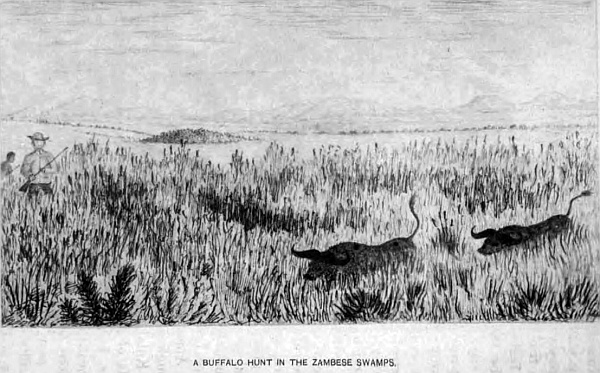
Almost daily I go in search of insects, and I made many valuable collections to be thrown away from being destroyed by worms and moths. I collected no less than five kinds of bats, some of them very large. These also fell to pieces. Although I was not molested by the Batibe tribe, I found a stay in the country would add to the suspicions they already entertained, I could see, of my presence, so I moved on, and, taking another route, passing Okayanka, crossed a desert through a bush and open country, guided by two Kasaka Bushmen, and returned to Westley Vale after a tedious and long journey. Although in the rainy season we had difficulty to find water, the soil being sandy, a heavy shower of rain soon soaks into the ground. Permanent water there is none. On our way we were caught in one of those extensive veldt fires that are so common all over Africa, and narrowly escaped. Following down along the great Salt vlei, Otjando, Otjikolo, skirting the Otjiokaka mountains, we reached the wells, and up the Omuramba, where water was plentiful, made for Barmen, where I remained a day, then to Eikham, Rhenoster vlei, Ames, to Westley Vale on the Nosop. The country through which I passed has already been described, in the Kalahara desert. On our way down we saw many herds of game, small troops of elephants, a few rhinoceros, koodoos, pallahs, wild boars and others. Lions we heard in plenty, but they did not come near. I was anxious to leave the country, as the rainy season was just past, and water was getting scarce, having great difficulty on several occasions to find water for man and beast, and it is refreshing to be able after a toilsome and hazardous journey to arrive at a safe haven, where rest and good water are procurable.
As a country Ovampoland is rich in game of every description, corn and native products. Cotton, if cultivated, would be a valuable product for exportation, but at the present time it is no country for emigration, being extensively occupied by too many uncivilised natives, who are averse to whites living in that country. It is only fit to be preserved at present to the British crown for its native produce and an outlet for British merchandise.
Before leaving Ovampo it will be necessary to give some short description of the ants and ant-hills which are in every conceivable form and size. First comes the lion-ant, that lives in the bottom of a little funnel-shaped hole in the sand, about four inches in depth and four inches in diameter. Any fly or small ant coming near falls down with the rolling sand, when out springs the ant, carries him under the sand where he has been watching for his prey, and, when devoured, waits for another. The largest specimen in my possession only measures half an inch in length. The smallest ant makes a little circular ring of sand formed by the ground brought out from a small hole just beneath the ground. They ate so small that when put upon a white sheet of paper they look like fine dust; and yet these little industrious insects form such beautiful and perfect nests with cells in the ground, the extent of which seldom exceeds the size of a small apple. There is a variety of ant-hills over the country, some of them seventeen feet in height and sixty feet in circumference, made by the small white ant, which is so destructive to buildings. Mosquitoes also infest the country near the swamps and lagoons. My Bushmen and Hottentots had a very ingenious method of being free from them at night by digging holes in the ground where they intended to sleep, covering themselves in their blankets in these holes, and throwing bushes over them as they disposed themselves to sleep. Sand-flies were also very annoying, and as evening closed in hundreds of fire-flies would be seen in all directions, not forgetting the crickets and frogs, which would keep up a perfect din of noises. Beetles of every description and size, particularly some very large rhinoceros-beetles, swarm all over the country. Then there is that small animal called the skunk, with black and white fur, but which gives out a most offensive smell, more pungent than the pole-cat. The swamps seem full of the water-tortoise, and the land-tortoise is also very common and grows to a great size. Tree-toads and tree-lizards may be seen in the old trees and on the branches. I have found many leaf insects in the desert of various kinds. They look very peculiar walking along; some of them are very pretty, many of a light-green colour, others like brown leaves. There are a great variety of beautiful birds, where water is not far away, and the goat-sucker is a constant visitor at the camp. But of all the most welcome birds is the turtle-dove. When we hear its call we know water is not far away. If proper means were adopted to procure water this region would be capable of supporting a large population, as the country is rich in almost everything that man requires, and is most healthy. The first step to take to open up this part of the desert is to improve the road from Walfish Bay to Lake N’gami, and open out the fountains. This would lessen the distance to our interior trade 800 miles.
Of late years the game of the country has been greatly reduced in consequence of the natives having guns.
Chapter Sixteen.
The Transvaal Republic.
In describing the geographical position of this Republic in relation to the adjoining colonies, Free State, and native territories, it will be necessary, before entering upon its physical formation, to give an outline of its boundaries, and the important position it holds in the future commerce of the country with the interior trade of South Central Africa. All the northern portion is situated in the Limpopo river basin, the southern in the basin of the Orange and Vaal rivers. The central watershed being the division which runs east and west from New Scotland, passing half-way between Potchefstroom and Pretoria, on to the western boundary near the village of Lichtenburg. The boundary from Griqualand West, east of “Fourteen-streams” on the Vaal river, up that river to Klip river (a tributary of the Vaal, up which it runs to Gans Spruit, to where it joins the northern point of Natal), is the division between this Republic and the Orange Free State. From thence along the Drakensberg for a few miles in an easterly direction to the Buffalo river, down that river south to the Blood river, a tributary of the Buffalo, which is the division between this Republic and Natal. From the Buffalo up the Blood river to its source in the Magidila mountain, from thence to the conical hill between the Pongola river and the Drakensberg mountain, is the Zulu boundary. The eastern boundary is separated from the Portuguese possessions by the Lobombo range, the Umzila country, and the Amatonga Kaffirs. The Limpopo river is the northern boundary, and the western and north-western by the chiefs Khama, Sechele, Gaseitsive, Montsoia, and Monkuruan territories, and Griqualand West, down to Fourteen-streams, on the Vaal river, before named. The Republic is situated between 22 degrees 15 minutes and 28 degrees 20 minutes South latitude, and 25 degrees 20 minutes and 32 degrees 10 minutes East longitude, and contains about 122,000 square miles.
The principal rivers are the Limpopo and the Vaal; the former rises in the high watershed, south of Pretoria, at an altitude of 6300 feet above sea-level, flowing in a north-north-west direction through a very pretty and picturesque part in the Magalisberg range of mountains, which run east and west, on to where the Great Marico river falls into it, in 24 degrees 15 minutes South latitude, 27 degrees 7 minutes East longitude, at an altitude of 2690 feet, passing through a thickly wooded country with many native kraals, skirting Dwaasberg and other lofty hills that add much to the beauty of the landscape. From the junction of the Marico, the river turns in a northerly direction for about forty miles, where the Notuane river joins it; from this point the Limpopo turns with many bends and curves in a north-easterly and easterly direction for some 400 miles, forming the boundary between the Transvaal and the chief Khama, and the Matabele nation, down to 31 degrees 54 minutes East longitude, being the north-east corner of the Transvaal, and where the chief Umzelas territory joins up; from this point, after flowing east for some twenty miles, it takes a south-south-east direction, through Umzelas country to the Indian Ocean. It is a fine, broad stream, increasing in width from the junction of the Great Marico, where it is about 150 yards; at the Mokalapsie river, it is 200 yards; at the junction of the Shasha, 220 yards; and increases in size as it passes on through the low, flat country to the sea, where it is three miles wide. It can be made without any difficulty navigable up to the Rubie river distant from its mouth nearly 300 miles, taking into consideration the sinuosity of its course, whence a good road could be made to the interior; above this point there are many falls and rapids, the two most important are the Impopomene and the Tolo, above-named, both beautifully situated between thickly wooded banks; and over the granite rocks in its bed the water falls, and where some of the bed rocks are exposed, in the dry season may be seen hundreds of deep circular holes from one foot to six feet in depth, and from one to three feet in diameter, that have been worn by loose stones in the first instance being revolved round in a depression in the rock, and in time, by the rushing of the waters upon them, have increased them to the present size; they are similar in shape to those on the banks of the Vaal, Orange, and Zambese rivers. The immensity of time it must have taken to wear away such deep and large holes in a granite rock, makes one pause to think of the period when this river was first formed, because it is only a portion of the year, when the floods come down, that the water acts upon the stones in these holes. The principal tributaries of the Limpopo that rise in the Transvaal are the Apies at Pretoria, Sand, Pinaars, Plat, Matlabatse, Pongola, Palala, Nylstroom, Houdt, Limvubu, and the Olifants river with its many tributaries, all flowing into the Limpopo on its right bank. The greater portion of the country which these branches pass through is called the Bush Veldt, Waterburg, Zoutpansberg, and is principally occupied by native tribes under their respective chiefs. Extensive districts are infested with the tsetse-fly, where a traveller cannot go in with horses or oxen, for one single bite is death.
Many parts of this bush country, now unoccupied, must at some remote time have been thickly inhabited, as many remains of cultivated ground are seen in all directions—and large heaps of stones thrown up when the ground was cleared for corn, as is the custom with all the natives when they prepare the land for cultivation—but it has long since been overgrown with timber and thick bush.
Nearly the whole of Waterberg and Zoutpansberg districts, up to the Limpopo, and down to the Magalisberg range, a little north of Pretoria, is a mountainous region; the latter mountains run in an easterly and westerly direction to the Marico district, the south face having perpendicular and rocky sides, the northern face slopes gradually, and this is the case with most of the mountains in this part of Africa. The Dwaasberg, through which the Great Marico river has forced a passage, joins on to Wittfontainberg. Pilandsberg is more to the east, north of which is the Karroo desert, where is the Marikele mountain, a long range running in an east-north-east direction to Hangklip mountain, with detached hills up to Marabas town, where gold has been found and a company has long been established, with quartz-crushing machines to extract it. A gold-mining company has been established at Nylstroom; copper has been found in many localities.
The Mural mountain range on the western border runs in a north-east direction for seventy miles, and terminates at the northern point of the Pongola river, and can be seen at Mongwato, nearly 100 miles distant. Makapan’s poort is a lofty mountain, a complete honeycomb of caves, where much fighting has taken place between the Boers and the chief Makapan. The Marico district is a continuation of hills and fine rich valleys, the Quaka, Kolobekatseberg, and to the north, Blaauwberg and many isolated hills, north of Marabas stad, in the Zoutpansberg district, with the mountain of the same name, reaches as far as the Limpopo, with the Pweede and Derdebergs. To the east of Marabas Stad are many detached ranges, the Matyatyeberg, Spelunken, and Murchisonsberg, situated on the north of the Olifants river; north and south-west of Lydenburg are the Magnet heights and Lolu mountains range—well known from the Secocoenes stronghold, stormed by Lord Wolseley when Secocoene was taken prisoner.
To the east of Lydenburg is the continuation of the Drakensberg or Quathlamba range, broken up into lofty mountains attaining a height of 7000 feet; some of the highest are Steen Kamps, Komati, Slangapies, Rands, and Verzamelberg. The whole of this part of the Transvaal is rich in minerals, wood, and water.
The climate is mild, mostly very healthy; some parts are fever districts. The native population exceeds 300,000, divided into various tribes, that are located to the north of Pretoria and Lydenburg, to the Limpopo, and are composed mostly of Mantatees or Makatees, and also are known as Mahowas, and are divided into several kraals under petty chiefs. These are the origin of the Basutus. Their queen was called Mantantezi, and Mosesh, her head-man, deposed and drove her out, and formed the Basutu nation, once so powerful that they endangered a large force of ours under Sir G. Cathcart. There are also what are termed Knobnoses, Basutos, Zulus, Pula Pula or goat tribe, Vaalpans or slaves, that have no resting-place, but roam the country. Then there are the two queens, Majaji and Maselaroon, also Albasini, a Portuguese at Zoutpansberg. Polygamy is common amongst all the tribes; a man may have as many wives as he can purchase and keep; they do the greater portion of the work, till the ground, gather in the corn, fetch wood and water, cook, and such other labour as is required.
The principal towns in the northern division are, Nylstroom, in Waterberg; Marabas Stad, in Zoutpansberg, with small villages of Upsal, Eersteling, and Hantbosch; Lydenburg, with the gold-diggers’ camps, in the Lydenburg district; Rustenberg, in the Rustenberg district; Middleburg, in the Middleburg district; and Pretoria, which is the capital of the Republic and a bishop’s see, is situated in 25 degrees 40 minutes South latitude, and 28 degrees 32 minutes East longitude.
The other rivers in the northern division, and within the Limpopo basin, are the Crocodile, with its many tributaries, rising in the Drakensberg or Quathlamba range, and, passing through the Lobombo mountain, receives the Umcomasi, Sabie, and other small streams, and enters the northern part of Delagoa Bay. The Umbelosi drains the country south of the Komati, and passing through the Lobombo range, enters Delagoa Bay, or inner harbour at Lozrenzo Marques; it is navigable from the bay some few miles from its mouth. South of this river is the Tembe, which rising in the Lobombo mountains, with its small tributaries, enters the inner harbour. The last of the rivers that drain the south-eastern portion of the Transvaal is the important Maputa or Usutu river, which rises in the New Scotland district, at an altitude of 5780 feet above sea-level, receiving the following tributaries—Impeloosi, Little Usutu, Umkompies, Umkonto, Umtaloos, and other small streams; flowing through the Lobombo it receives the Pongola river, which rises a few miles to the east of Wakkerstroom, and receiving (in its course down) many tributaries flowing east and north, joins the Usutu, where it turns in a north-east and north direction for fifty miles; when a broad and navigable river it enters the southern part of Delagoa Bay. The lower portion for twenty miles passes through the Portuguese possessions, and after crossing the Lobombo mountains, it leaves the Transvaal and Amaswasiland, and enters the northern part of Zululand or Amatonga country. This completes the river system on the east of the Limpopo basin. On the west there are a few branches of the Limpopo on the left bank, that will complete this western division, viz. the Great and Little Marico rivers, the Molmane, the upper portion of the Notuane, and the Franks and Elands rivers, that drain the Marico and Rustenburg districts; the Orange and Vaal river basin, which is separated from the Limpopo by the central watershed, already described, which is also called the Hooge or High Veldt. The Vaal river rises in the Quathlambe mountains on the eastern border of the Transvaal, called the New Scotland district, at an altitude of 5813 feet, near Lake Crissie, flowing south-west past the town of Stamlerton, which is on the main transport road from Natal to Pretoria, passing through an open country, receiving in its course many small feeders; from this town the river turns westerly to Klip river, which is the boundary between the Orange Free State and the Transvaal. From this point the Vaal forms the boundary between the two Republics, down to Griqualand West, taking many turns and twists in a westerly, then south-westerly direction, receiving in its course many streams on the right bank, within the Transvaal boundary, as under—Klip, Gans, Sand, Bushman, Kapok, Rand, Waterfal, Klite, Kalk, Eland, Ensel, all spruits, to the Moi river, upon which Potchefstroom is built. Following the river down we next come to Loop, Baken, Machave, and Kockemere spruits; Scoon spruit, upon which Klerksdarp is built. Crossing several other small spruits we come to Klip spruit, Lion, Wolf, Maquassie, and Bamber spruits. The Harts river, which is a tributary of the Vaal, enters it within the boundary of Griqualand West, rises on the central watershed at Lichtenburg village, in the Transvaal, at an elevation of 6100 feet above sea-level, and flows in a south-west direction, passing the Koranna kraal, Maamousa, and the Bechuana territory, under the chief Monkuruan, where it leaves the Transvaal Republic and enters Griqualand West. The boundary of this chief is now being arranged by General Sir Charles Warren. This completes the river system of the Transvaal in the Orange river basin.
The towns within this area are Utrich, Darby, Lunenberg, Wakkerstroom, Standerton, Heidelburg, Fentersdorp, Potchefstroom, Klerksdarp, Lichtenburg, Bloemhof, and Christiana. There are no hills of importance in this division, only a few isolated “kopjies” at Potchefstroom, Hartebeestfontein, and at Klerksdarp, which do not call for any particular description.
On the south-east boundary is a native territory called Swaziland, or the Amaswasi country, belonging to a Zulu tribe; it is situated between the Republic, Zululand, and the Portuguese possessions at Delagoa Bay. It is a very hilly and well-wooded district, thickly populated with a warlike race. The Transvaal Republic say it is within their boundary, but the natives deny it; at any rate the Boers at present have no authority over them, and the chief rules quite independent of the Transvaal. It has long been under our protection, and it was the main cause of the Zulu war, because we would not allow Cetewayo to “wash his spears” in them. Gold-fields are now there. The English and Boers have hired large tracts of their country as cattle-runs, and will never be got out.
There are many roads to the Transvaal from the Cape Colony and Natal; those most used are from Kimberley diamond-fields, passing up on both sides of the Vaal river; they are rough, sandy, and in places very stony; others pass through Bloemfontein in the Free State, crossing the Vaal at several drifts. From Natal there are two over the Drakensberg to Harrismith, on to Potchefstroom and Heidelburg; also two passing through Newcastle, one going to Standerton and Pretoria, the other to Wakkerstroom, Lydenburg, and the gold-fields; portions of them are very good, other parts rough and heavy travelling. It is the same with all others that traverse the country, as they are never repaired.
The country on the south side of the watershed or high veldt is open and uninteresting, long stretches of rolling plains, not a bush or tree to be seen for miles; except here and there, at long intervals, a Boer farm is seen, and near it occasionally a garden surrounded by the well known tall gum trees; no Kaffir locations are seen in any portion of this part, a few huts occupied by the Kaffir servants may be located near each farm. The country is suitable for cattle, but sheep do not thrive.
This country is divided into thirteen districts—seven in the Limpopo basin, and six in the Orange and Vaal basins.
The first contains Pretoria, Rustenburg, Marico, Waterburg, Zontpansberg, Lydenburg, and Middleburg.
The second Potchefstroom, Bloemhof, Heidelburg, Wakkerstroom, Utrecht, and Standerton.
The white population, which was estimated in 1882, did not exceed 45,000 of all nationalities. Since the retrocession of the Transvaal it has greatly diminished, probably not more than 40,000 at the present time; putting five to a family, on an average, there would be 8000 families, 2000 of which would be made up of English, French, Germans, Hollanders, and other Europeans, to occupy this extensive country, which, deducting for native tribes, leaves for each white individual, great or small, 700 acres, and yet the Boers are not content with this large share, but must make war on native tribes to possess themselves of more. If they were an industrious and well-disposed people, and cultivated their lands in a proper way, the Transvaal would, and ought to be, the most prosperous and well-to-do country in South Africa, having all the advantages of a subtropical climate, plenty of water (if properly utilised) for cultivation, abundance of coal and other minerals, splendid grazing for cattle, and many other advantages; but no, they would sooner expend their energies in fighting the native tribes and stealing their cattle, because it pays them better, than devote their time to peaceful pursuits. From the time the Boers have held the Transvaal they have pursued this policy—as is well known by every colonist in the country, and nothing but a firm Government will ever bring them into a civilised state, and prevent their atrocities from being further perpetrated, as has lately occurred on their north-west border and in Zululand.
The splendid position the Transvaal occupies in South Africa, with all the advantages above stated, the proximity to Natal, and the seaports of Durban and Delagoa Bay, and eventually a railroad from Newcastle to Pretoria, as also from Kimberley and Delagoa Bay, shows that this country has great facilities for supplying the native trade in the north-east of South Central Africa, where the population is great, and the country rich in all kinds of produce. The gold will soon bring all this.
Chapter Seventeen.
A brief historical sketch of the Transvaal from 1825 to 1877.
It will only be necessary to touch very lightly on the principal and most important events that have occurred from the commencement of the invasion of the Kaffir chief, Moselikatze (pronounced Umseligas), to the time when the country was taken over by the British Government, as it is my intention to go into the history of this Republic only so far as will throw light on its physical geography.
In 1820 the powerful chief Moselikatze fled from Chaka, the king of Zululand, with all his people, and crossed the Drakensberg mountains to the north, into what is now the southern portion of the Transvaal and Free State. There he found the country thickly populated by various native tribes, living independent of each other in large kraals along the river-banks, fountains, and pans—many of these stone kraals are still in existence, but in ruins—the principal tribes being Makatees or Mahows, Bapedi, Bakala, Basutos, and some Bechuanas, Bushmen, also Hottentots, where they must have lived in peace for many generations, from the remains of extensive gardens now grown over with grass, proving, I think, they were not a wandering tribe, but a peaceful people, as the country was most suitable for agricultural purposes, being free from bush and comparatively level, with numerous streams of good water flowing in every direction. Moselikatze, with his several hundred warriors, soon cleared the country by the death and flight of these people; and eventually spreading northwards and towards the west, crossed the Vaal river, and occupied all the south part of what is now the Transvaal. Moselikatze, in 1825, pushed on his conquests where he found the country occupied by the Bahurutse tribe of Bechuanas, on the west of what is now Klein Marico, and fought a great battle with them at their station named Mosega, situated on a small branch of the Klein Marico river, above where Sindling’s post is now built, and defeated them with great slaughter, occupying the country, and taking possession of the station—situated in 25 degrees 40 minutes South latitude, 26 degrees 26 minutes East longitude, south of several picturesque hills, that appear by every indication to have been a volcano—and there he collected his forces, and there he seems to have remained until he was, in 1836, attacked by the emigrant Boers under one Potgieter, who suffered a great defeat at the hands of the Zulu chief, who nearly destroyed the Boer commando. Those who escaped fled to the Orange Free State on to Thaba Nchu, then occupied by the Barolong tribe of Bechuanas under the great chief Moroka, who died in 1880.
When the Boers reached Moroka’s town, they were reduced to the greatest extremity, and were received with the greatest hospitality and kindness by the natives; they remained until the following year, getting supplies and fitting out another commando at Thaba Nchu. Again they started on an expedition to attack Moselikatze, accompanied by a large force of Moroka’s people under his own command, whilst Gert Maritz commanded the Boer contingent. The present chief Montsioa, then a young man, also aided the Boers in person with men, and a small Griqua force, under a petty chief Bloem, completed the little army. A great part of Moselikatze’s warriors were killed, and he had to fly north with the remnant of his army, and eventually settled in the country his people now occupy called Matabeleland, showing that the main success of the Boers in gaining a footing in the Transvaal was through the Barolong tribe, of which the chief Montsioa was a captain.
In the same year Potgieter took possession of the south part of the Transvaal, then, as it is now, an open uninteresting country—rolling grass plains, with a few isolated hills; and he laid out the town of Potchefstroom, in 1839, which is partly called after his name and partly after the river upon which it is built, on an extensive open plain, as all towns were then built, that no enemy could advance to it without being seen, and it became the capital of the country until the seat of Government was removed to Pretoria in 1860. At that time the country was full of large game—elephants, rhinoceros, and giraffe browsed on the banks of the Vaal, down to the Orange river.
Soon after, Potgieter left Potchefstroom and went north-east, and laid out the village of Origstad, now a gold-field. Other Boers in 1847 followed, and being mounted on horses with rifles, had no difficulty in destroying the natives, who had only the assagai and arrows, as they advanced into the country.
Another party went south from Origstad, and built the town of Lydenburg, that district being formed into a republic, separate from the republic at Potchefstroom; but, by common consent, in 1860 they were united into one.
In 1834 a party of Boers, numbering twenty-seven families, under the command of Rensburg and Trichard, endeavoured to reach the Indian Ocean. Passing down the Olifanta river, they crossed the mountains, after many hardships; where they divided. Rensburg went north, Trichard and his party travelled south-east towards Delagoa Bay. Many of them died on the road; the remainder were sent on to Natal by the Portuguese Governor. Rensburg’s party was never heard of again, showing the restless nature of these discontented Boers. They were all killed, or died of fever.
Although they had secured the fertile plains of the Transvaal, where there was more land than they could hope to occupy, their thirst for more land was still unsated.
After the battle of Boomplaats the rebel Boers crossed the Vaal, treked to Marico in 1850, where some of them are now occupying the land they laid out for themselves; and they still foster hatred against the English, and since this last rebellion it has greatly increased in intensity, and nothing but a strong Government and an influx of British emigrants will allay, or partly extinguish, that feeling, which their present isolated position is conducive to foster, and teach them to understand, as General Warren is now doing, that there must be a limit to their lawless acts.
From 1850 many Free State Boers and others from the Cape Colony, as also many English, Germans, Swedes, and other nationalities, came in and settled down in different parts of the country, making small villages and occupying farms over the whole of the more southern portion of the republic, leaving the northern part, which is thickly populated by the native tribes already described.
On the diamond-fields being discovered, diggers came flocking on to the banks of the Vaal, to open up the mines at Hebron and Klip Drift. In 1869 there was great demand for all kinds of produce, consequently prices went up quickly to 200 per cent., which brought money into the Transvaal, as the greater portion of the food supply was obtained from thence.
Pretorius was president, and made an attempt to annex all the country on the north side of the Vaal, but was opposed by the Cape Government and by the diamond-diggers, which led to the dispute as to the western boundary of the republic. A commission was formed, which ended in the Keats award; the map I made in 1864 was used for the occasion by the Colonial Government.
Soon after, in 1871, President Pretorius resigned, and Erasmus acted until Mr Burgers was elected by the people. The State all this time was getting into such confusion that people would not pay their taxes, and there was no law to make them.
The Secocoene war was going on, “commandeering” was at its height, general discontent prevailed, and matters arrived at such an unsatisfactory state in 1876 that hundreds of Boers sold their farms with the intention of leaving the country, as they could not live under their own Government.
I was constantly passing through the Transvaal with my waggon to distant parts, and every Boer who had not tied from the colony for misdeeds, hoped the British Government would take over the Transvaal under British rule. Hundreds expressed this wish; the rebels from the colony and their sons did not say a word.
Those Boers who sold their farms agreed to trek together, and make for Damaraland on the west coast.
One of the Boer’s statements for leaving his Transvaal home may give some idea of the feeling that pervaded these trek Boers at the time:—“I found myself among the commandeered. On my farm nothing had as yet been put in the ground, and as no one could be got to go as my substitute, there was nothing for me but to go on the commando. My waggons and cattle had also to be given up for the use of the commando. In my absence my wife had to plough, in order to obtain sufficient food for the year. I returned from the commando, having lost several of my cattle on the way. I went to the field-cornet of Moi river, in whose district I lived, with the view of obtaining compensation, but I was informed that nothing could be done in the matter. Under the old law compensation could be obtained for damage to what had been lent, but there was nothing mentioned about this in the new commando laws. It appeared the waggons and oxen were commandeered at the owner’s own risk. I was so struck with the unrighteousness of this mode of proceeding that I felt myself compelled, with all my belongings, to join the trek for which a party of Boers were already prepared, and with them I then threw in my lot; and on the 2nd of March, 1877, we left the Transvaal. Our party consisted of 600 souls, large and small, with 100 waggons, under the command of Du Plessis, and arrived at the Crocodile river or Limpopo, where we remained a fortnight, and then went forward into the wilderness.”
Very few ever reached their destination. They were attacked by the natives, and had constantly to form themselves into laager to defend themselves. Their cattle died of lung-sickness and thirst, many of them were stolen, some lost in the bush; waggons and property had to be abandoned; women had to inspan the waggons and drive them; to lighten them their household goods had to be thrown from the waggons. Some few reached Damaraland, and a few went more north into the Portuguese possessions, where small plots of land were given to them; those in Damaraland were taken to Cape Town from Walfish Bay, and sent back to the Transvaal at the Cape Government expense; and this occurred during the time the Boers had the Transvaal, and their own chosen president was at the head of the republic.
In a few months after I followed them up, and saw the graves of those who had died of fever; and a Kaffir told me one of the Boers had given him a good gun for a small bucket of water. Chairs, tables, cooking utensils, and other articles strewed the path through the desert; and the bones of the dead oxen, that the vultures, wolves, and jackals had picked clean, covered the ground where they fell—a melancholy sight; and all this suffering was caused because these Boers found their own republican Government unbearable to live under. And this is the best answer to be given as to why the British Government found it imperative to step in, and put an end to such a wretched state of affairs, which act was accomplished on the 12th of April, 1877.
The remnant of these trek Boers were in the Portuguese territory, at the back of Mossamedes on the west coast, perishing from starvation and misery, when a subscription was raised at Cape Town for them, and a ship-load of supplies and a man-of-war were sent down. They tried to land some hundreds of miles up the coast beyond Walfish Bay, so as to be nearer to the Boers, but were prevented by the surf; they returned, and the supplies were sent up with great difficulty, and many of the Boers came down, as stated, and went back by sea.
Chapter Eighteen.
The physical geography of the Transvaal, and other subjects, continued.
The altitude of the Transvaal above sea-level is one of its most important features in connection with its climate and vegetation; there is no portion below 2890 feet, except at the northern extremity along the Limpopo river, where the elevation is lowered on that river to 1560 feet. The other portions of the republic average 4000 feet between the mountain ranges that traverse the country. In the north-east division, north of the Olifants river, the Zoutpansberg range, the Tweedeberg, the Derd mountains, the latter being within a few miles on the south side of the Limpopo river, with the Matin hills, near which the Tave river flows, vary considerably in altitude from 3700 to 4500, mostly of sandstone formation. The eastern portion through which the Pafure river flows is called Basoetla, occupied by the Mantatees, Knobnoses, and other tribes, in large and numerous kraals along the streams; Albasini’s town being situated on the south side of Zoutpansberg.
The country is rich in corn-land and fine grasses, splendid forests of timber, of which the famous baobab tree is very common and of immense size, the bark of which is used for making sacks, blankets, and other useful articles; cobalt, iron, copper, and lead, are found in great quantities, and also gold in the more southern portion.
North of the Olifants river, and south of Albasinis, is the mountain range called Matzatzes mountain, 4700 feet above the sea-level. The district is called Splelunken, where sugar and coffee is cultivated, and fine farms occupy a large extent of country. South of this mountain is the district of Batlokoa, also occupied by the Mantatees, who are sometimes called Mahows. In the Bakhalaka district, south of the above, is Marabas Stad, Eersteling Gold Company, and many good farms. The tributaries, Lehtaba the Little, Lehtaba the Great, Letsitee, Sumbane, Salati, all branches of the Olifants river, rise in these two districts, passing through as wild and picturesque a country as an explorer can desire to visit—beautiful isolated hills of every form, particularly down near Pikiones Kop and the Nunkula hills, where copper and gold have been found. Game of every description roam these extensive and splendid forests. Lions, tigers, and wolves, besides a host of tiger-cats and other animals, are plentiful. The country has never been prospected, but there is every indication of extensive gold-fields some day being discovered.
On the north of this last-named district is the district of Baramapulana, which includes Schoemansdal, through which the Sand, Houdl, and Brack flow to the Limpopo. The hills are also of sandstone. To the west of this region is the Bamalitsi district, and to the east Bamapela, all within the Zoutpansberg division, and through nearly the central portion the tropic of Capricorn runs. The Maalaqueen or Nylstroom, an extensive river rising in the mountains round Nylstroom, flows north through Makapans Poort, past Potgieter Rust for eighty miles, and through Blaauwberg, a lofty range, and on through a dense and beautiful forest for nearly 100 miles, entering the Limpopo. The forest is full of game of every kind; the natives live on the river-banks. The tsetse-fly, being so common, prevents the country being occupied by the white man, as no horse or any description of cattle can live where they are.
South of this district is the Waterberg division, in which are situated the rivers Palala, Pongola or sand river, with its many branches, rising in the Waterberg and Hangklip mountains, a hilly and wild country, in which is situated Nylstroom, and the river Matlabatse rises in the Marikele mountains of 3970 feet, and is a continuation of the Makapan mountains from Makapans Poort, running in a west-south-west direction to Wittefontein and Dwaarsberg, crossing the Limpopo and Great Marico into Bechuanaland, and there spreads out into many spurs in that country. Granite is found at the junction of the Limpopo and Great Marico, and down those rivers, sandstone, limestone and slate are found in the last-named mountains.
South of Waterberg is the Rustenberg district, in which is situated the towns of Zeerust and Rustenberg, with many villages. To the north of the latter town is Pilansberg, where one of the upper branches of the Limpopo rises, forming the Elands river. The Great Marico rises in the Rustenberg district, on the central watershed at Doorm Kop, where there is a lovely waterfall of some seventy feet, falling down a steep bank into a deep kloof of most beautiful scenery. A few miles north of this is Bray’s lead-mine, which is very rich in silver, producing over fifty pounds to the ton. The mine is situated about twenty miles to the north-east of Lichtenberg, and about twenty-eight miles south-east of Zeerust. The country is very pretty and picturesque, with many fine fountains, beautiful grass-lands, and richly-wooded hills. Marico district is one of the most valuable portions of the Transvaal, being situated on the main transport roads to the interior from Cape Colony, Orange Free State, Transvaal, and Natal; besides being rich in lead, there is copper and gold, and any quantity of iron, oxide of iron, and many-coloured ochres.
The town of Zeerust, which is in the Marico district, is very pleasantly situated on the Little Marico river, on the south side of a pretty range of hills, close to a picturesque poort, through which the Little Marico runs to Great Marico, and where I have had many pleasant days’ sport in fishing and shooting, before Zeerust town was ever built. The first bricks were laid in the erection of an extensive laager by the Boers in 1865, and the town was commenced in 1868. It is now a considerable commercial centre, with many good stores. The rapid increase of the town after British annexation, and the extensive trade carried on by the English traders with the interior, made the town one of great importance to the Transvaal. Since, the retrocession nearly every store is closed, and the town is comparatively deserted. The last lion shot in this district was in the above-named poort in 1869. Eighteen miles to the north-west of Zeerust is the large Kaffir station, Rinokano, and a mission station under the Rev. Mr Jansen, pleasantly situated at the head of the Notuane river, between long ranges of hills that run at the back of Zeerust.
The old chief Moelo lived here for many years, and at his death, his son Moelo and his nephew Copane disputed the chieftainship. The people divided, and eventually it was settled by the British Government, in 1879, that one should rule at the station, and the other should form a kraal and rule more to the north. Forty years ago the elephant, rhinoceros, giraffe, and other large game were plentiful all over these hills and plains; now a few bush-buck, springbok, and other small game are found, but it is a hard day’s work to shoot one now. The beautiful springs that flow through this part of the country are utilised to some extent in irrigation, and for turning small mills for grinding the corn.
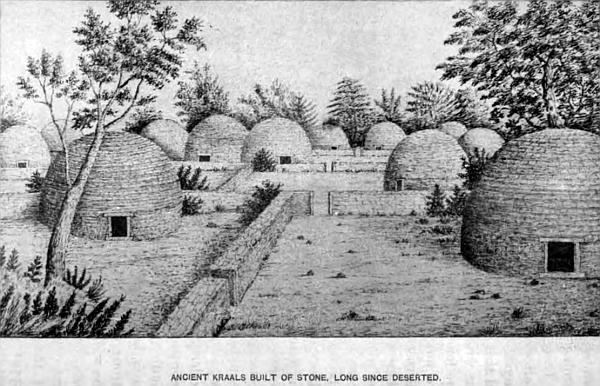
There are many extensive and valuable farms in the Marico district. Oranges, lemons, pomegranates, and all English fruit grow to perfection. Peaches are so plentiful that I have frequently fed the pigs with them. I am writing of the country twenty years ago, when not one-fourth of the population lived in the country that are now occupying the land. There was no town then; Zeerust, Jacobsdale, Lichtenberg, were not thought of. There were five Boers who possessed all the land round the country, and some of these farms contained 460,000 acres or 30,000 morgen; they were five of the Boers who fled from the Orange River sovereignty after Boomplaat’s affair, treked as far as Marico, where they divided the country between them, and which they or their descendants still hold. In this district are the ancient stone kraals mentioned in an early chapter; but it requires a fuller description to show that these extensive kraals must have been erected by a white race who understood building in stone and at right angles, with door-posts, lintels and sills, and it required more than Kaffir skill to erect the stone huts, with stone circular roofs, beautifully formed, and most substantially erected; strong enough, if not disturbed, to last 1000 years, as the walls and roofs of the huts were two feet in thickness, built of partly hewn stone. The divisional walls and outer wall were five and six feet in thickness, and at the present time five feet in height at places, the upper stones having fallen; and now large trees are growing through the walls. But in no case have I discovered any trace of mortar or any implements. Plenty of broken crockery is found in the ground when it is turned up, but none on the surface. Kaffirs have never been known to build their huts with stone, or make fences at right angles, everything with them is round; they will have stone walls round their huts, but nothing more.
There are extensive remains of ancient diggings to be found all over the country, which proves that at one time all this part of Africa has been prospected, and what favours this view is, that where there is a smooth natural rock exposed above the ground, extensive carvings of animals are cut deep into it, which nothing but a hard cold-chisel could make any impression on this igneous rock, that is as hard as steel, and which, I believe, were executed by the people who built those stone huts. There are also small furnaces still remaining in some of the remote nooks, out of the way of being destroyed by the people or oxen; but for what purpose they were made cannot be discovered, all we know is that large quantities of lead and copper are found in the neighbourhood; and close to them is a lofty hill in which are found thousands of perfect cubes, from an eighth of an inch to an inch square, which when broken show a bright colour between brass and gold, which, I conclude, is iron pyrites: they have a rich brown colour on the surface. Gold I have found in this locality when prospecting, which I well remember, as in consequence of a fall from a quartz reef I smashed a watch. I had occasion to go frequently to Marico, as there were many roads branching off in all directions—one called the river road to Mongwato, three to the Bechuana chief, others to Kuruman, the Colony, also to Pretoria and Potchefstroom.
Zeerust is about ninety miles to the west of Rustenberg; the latter is a small town surrounded by hills, and where some fifty of our troops were in a laager or small fort during the whole of the Boer rebellion. It is situated on the Hex river, a tributary of the Limpopo. About twenty miles south of Rustenberg, on the road to Potchefstroom, at Blaawabank, are gold-diggings, but it is not a paying affair. The country is wild and picturesque. Old remains of copper-mines are to be seen a little south of the town.
Forty miles to the east is Pretoria, the capital of the republic and seat of Government. It is pleasantly situated between low ranges of metamorphic hills that run east and west, and is south of the Magalisberg mountains seven miles. The city is built on an open plain, that gradually slopes towards the north, supplied with beautiful fountains that rise a few miles on the south of the town, the water falling into the Apes river. An isolated hill, about three miles on the east of the town, is a conspicuous object in the landscape. The streets run parallel; the market-square is open, with the Dutch church in the centre; there are several good hotels and a cathedral; Bishop Bousefield lives in a snug house, with very fine blue gum trees in front. Many large stores were erected during the British occupation; but at the retrocession the greater number were deserted, and a general exodus of the English took place, for it was impossible to live under the new state of affairs. The town in 1875 was not one-fourth the size it was when the Transvaal was returned to the Boers in 1881. Mr Burgers was then president, and he laboured hard to improve the country; but the people were not to be moved, and no advance in civilising them could be made. There was no money in the country, except a little English gold, everything was by barter until 1865, when paper money was issued, called bluebacks, to the extent of 10,000 pounds, and from time to time fresh issues were made to meet the expenses of the State. They varied in value, viz. in 2 shillings 6 pence, and 1 pound 5 shillings notes, but commercially the 1 pound 5 shilling notes were only worth two to three shillings. I had many of them, which I took at that price, and disposed of them for the same; but if you had to pay the Government tax the full price was allowed, for they could not refuse their own notes.
The country is open and free from any extensive wood, and the climate is suitable to produce every kind of vegetation. In the spring of the year the thick rose-hedges which divide the gardens give a very pleasing appearance to the town, when they are in full bloom. The extensive barracks and fortifications erected by the British Government on the south of the town, at a cost of over 100,000 pounds, have been made a present to the Boer Government for their disloyalty to British rule.
The Roman Catholics have a convent with several nuns, which at the outbreak of the rebellion was taken possession of and strongly fortified. The nuns and lady superior were placed in a corner of one of the buildings. All the rest of the establishment was taken, and converted into a kind of barrack for the volunteers of Pretoria, formed into four companies, of which I unfortunately belonged to Number 4, where we had to do sentry night and day. Our bed was a waterproof sheet on the bare stone floors, and as the convent swarmed with fleas of all sizes, from the heavy dragoon down to the light infantry, there was no fear of a sentry sleeping on his post. Every second night my company was ordered to occupy the interior of the convent during the night; each volunteer was assigned his particular post in the various compartments and passages, placing a sentry at different points, the rest to sleep—if the fleas would let them—fully armed, ready at a moment’s notice to defend our position. My post was generally at the entrance-passage to the priests’ quarters, which had been vacated by them, and on the bare stone floor I spread my waterproof sheet to get a little sleep; but the fleas, not one but millions, came down upon me in every quarter—poor things, they missed the nuns and the priests, for they were ravenous. Finding I should be sucked dry in a very short time, I took my rifle and sixty rounds of ball cartridge, made for the entrance, and passed the night on the door-sill, in about as happy a state of mind as a poor devil could be who had been marching up and down all day between the convent and the garrison. For fourteen days, from the 19th of December, 1880, to the 2nd of January, 1881, I had to put up with this sort of work, until I suffered so much from the excessive fatigue and want of sleep that I obtained three days’ leave of absence, as I felt unequal to the work and required rest; but at the expiration of that time I became dangerously ill from the overstrain on my system, and got a medical certificate which relieved me of any further military duty in Number 4 Company, and from that date to the end of the rebellion I lived in my waggon.
At the commencement of December, when we expected the Boers would make an attack on the town, all the males in the four wards of the city volunteered to protect the women and children in each ward, and as my waggon was outspanned in Number 4, I joined with the rest; but when the news came into Pretoria that the Boers, to the number of 1000, had been in ambush at Bronkhurst spruit for two days, waiting for the advance of a portion of the 94th Regiment from Lydenburg, which had been murdered by the Boers, a council was held, and on the 20th of December martial law was proclaimed, and all those who had formed themselves into volunteers to protect women and children were marched up to the barracks as regular volunteers. My waggon was drawn up to camp, and placed under the charge of the authorities during my soldiering.
The history of this rebellion has been so ably and graphically described by others, it will be useless for me to go more into the subject. I can merely state the first news of the British surrender that reached camp, of the war being concluded, and the retrocession of the Transvaal to the Boers, arrived on the 28th of March, 1881.
The principal portion of the Transvaal, north of Pretoria in the Zoutpansberg and Waterberg districts, is called the bush veldt, where most of the farmers living on the high veldt, between Potchefstroom and Pretoria, trek at the close of the autumn with all their family and stock, and remain the winter, where the cattle and sheep find warm shelter in the thorn forests; and return to their farms when the spring grass is sufficiently high for the stock to feed. The Boers make this trek a kind of picnic, and it is the only kind of life they enjoy.
This high land is also called Witwater rand; the elevation above sea-level is 5800 feet. Extensive seams of coal have been discovered about forty miles to the east-south-east of Pretoria. Roads in every direction traverse the country. The distances from Pretoria to the following places are: to the west, Rustenberg, 40 miles; north to Marabastadt, 160 miles; east to Middleberg, 100 miles; and to Lydenburg, 165 miles; south to Heidelburg, 55 miles; Standerton, 120 miles; and Newcastle, 190 miles; south-west to Potchefstroom, 110 miles; and to Kimberley diamond-fields, 334 miles. Middleberg is a small village on the road from Pretoria to Lydenburg, and the gold-field is in this district; a cobalt-mine has been discovered. Lydenburg is situated in the open country, on a branch of the Spekboom river. The country round is very hilly, some of them attain a height of 8000 feet above sea-level. The average height of the gold-diggings is 4200 feet.
The detachment of the 94th that was murdered at Bronkhurst spruit, for some months held possession of a small fort here, before they marched for Pretoria South of this town, some seventy miles, is a district called New Scotland, on the eastern boundary of the republic, which was in 1864 brought under the notice of a Mr McCorkindale for the purpose of forming a Scotch colony, but it fell to the ground. Klip Staple, already described, and the source of the Vaal river, spring from this locality. Wakkerstroom and Utrick have also been mentioned in the first chapter. The only portion requiring explanation in the district of Derby and Lunenburg, with its little colony of Germans who suffered great losses during the Zulu war.
Heidelburg is pleasantly situated on the south side of the watershed, containing many well-built houses. It was during the rebellion the headquarters of the rebels, and from which Captain Elliot was released and shot by the Boers when crossing the Vaal river. The road from Pretoria to Natal passes through this town, and also Standerton, another small town on the Vaal, and on to Newcastle. Standerton was also held by the British troops during the rebellion.
To the west of Heidelburg, seventy miles, is the town of Potchefstroom, the first town laid out by the Boers in taking possession of the country, situated on the Moi river; nearly half of the inhabitants were English, Germans, French, and other nationalities. It is 4007 feet above sea-level; there are some interesting limestone caves on the river, in which are imbedded many bones. The town is well laid out with fine fruit-gardens. Tobacco is extensively cultivated in the vicinity and all over the republic, and is well known for its fine quality.
Thirty miles to the west is Klerksdarp, on Schoon spruit, and to the north-west of Potchefstroom, seventy miles, is Lichtenburg, a village erected in 1868. There is also between these two the village of Hartebeestfontein. Potchefstroom from Kimberley is 224 miles. Following the Vaal down west is Bloomhof, a poor miserable village, and on towards Kimberley is Christiana, another poor and desolate place; they have been the rallying-points for the freebooters to attack the Bechuana chief. The whole of this division of the Transvaal is open and uninteresting.
Between Christiana and Lichtenburg is a farm called Gestop, situated in a very pretty valley, close to a picturesque hill. On the northern slope are some ancient carvings of animals on the rocks, which are composed of a close-grained kind of freestone; several of them are on rocks at the base of the bill, others half-way up, made no doubt by the people who made the others, the workmanship being similar. Up the valley by the side of the bill was, when I used to visit it, a favourite resort for the muscovy duck, and where I have frequently gone to shoot them, but they are most difficult to get near. The only way of getting a shot at them was to hide in the long reeds that grew on the banks of the stream and wait for them to fly over, which they did regularly about four o’clock in the afternoon, where they remained the night, and away in the morning to some other favourite locality. A few hundred yards from the farm-house is a stone or rather a kind of slate quarry. The stone is of a light colour, very soft; it can be sawn into any shape required, and is much used for grave-stones; slabs of any size and thickness can be obtained; it can also be used for mantelpieces, and any other kind of work. The hills and veldt on the farm have many valuable herbs, and two kinds of wild tea, equal in flavour to that from China,—in fact, I prefer it to the imported teas, and it is a splendid tonic.
The country round is more diversified with hill and dale, and thickly wooded with the mimosa and other trees and bush. Mr Van Zyl, who occupied the farm when I knew it, sold it some time after, and treked with his family and all his belongings out of the Transvaal to be free from the Boer Government, and went into the interior hunting, where the Namaquas robbed him of all his property, waggons, and everything, and shot him and his son.
A few miles to the north of Gestop are the famous salt-pans, and Barber’s pan, of which a description has been given, and a few miles to the south-east is Reid vlei, a pretty piece of water, a great resort of wild-fowl in those days long past. It is a wonder now to see a single duck; it is pretty nearly the same with the game. At that time they could be counted by the thousand, now it takes a long ride to meet with a few. I have had troop after troop pass in front of my oxen as I have been treking along the road, by the thousand, and not ten miles from this farm; and, as I camped out in the afternoon on the plains to remain the night, have been much interested in watching the old gnu-bull standing alone doing sentry duty, keeping guard over the cows and young ones when feeding a few hundred yards from him. He would always select an elevated piece of ground to have a good view round, and every few minutes he would change his position to all quarters of the compass, and the first sign of danger give several barks as warning to the others, and then, with a quick switch of his tail, head down, gallop off to his friends and remove them further away from any enemy that may be approaching.
In all these open flats there are always to be found large dried-up pans, all of them brack, which is very suggestive of sea-water. It is not only the pans but the entire soil that is brack, from one end of South Africa to the other, some parts more than others. It is only in small pools, or at fountains, where fresh water can be obtained. To one large dry pan, half a mile in diameter, and fifty feet deep, with very nice sloping sides, I gave the name of Chalcedony pan, from the immense quantity that covered the ground, not only round the pan but for miles in every direction; and on all these high flats, every variety of agate, flint, cornelian, and other kinds of every colour and form, as also splendid specimens of petrified woods, and in the stone hills, large shells, but empty of the snails, many of them beautifully marked, also small fresh-water shells of various sizes, and I have spent many pleasant days prospecting for some of these specimens.
Near Christiana, on the Vaal river, are two extensive dry brack-pans, the largest is two miles round. On the south side the ground forms a small hill with bush and trees upon it; this is between Christiana and Bloomhof, where there are several salt-pans a few miles to the north of that town, where a large quantity of salt is procured annually of good quality. The salt can only be obtained on certain occasions, which is very peculiar, showing there must be a vast quantity of salt below the pans’ beds.
These salt-pans are quite dry and free from water for some four or five months a year, when there is no salt to be seen, and it is not until the rainy season is over, and the water that has collected in the pans during that time (some two feet deep) has in the course of a few months evaporated, that the salt appears to have been drawn from the deposit below to the surface by the action of the water upon it, and a thick deposit is left, which is collected by the proprietor, and sold at various prices. I have paid for a sack containing 200 lbs. 3 shillings and sometimes 5 shillings, according to the supply and demand. Some salt-pans do not give a sufficient deposit to pay the cost of collecting. There is a great sale for it throughout the country; but table-salt is supplied from England, as there has been no means of cleaning the native salt from the impurities it contains. The Boers and natives use it. Some of these salt-pans will yield in the season nearly 1000 nuids of 200 lbs. each, and yet there appears to be no diminution in the supply, showing there must be extensive deposits beneath the pan beds. And so impregnated are some portions of these extensive grass plains that the grass that grows upon them is called the sour veldt, and other parts, where the surface-soil has been washed down from a higher level and deposited on the flats, is called the sweet veldt. The sour veldt is easily distinguishable by the white coating on the ground, which the oxen lick when they want salt.
I always kept my oxen in good condition by giving them salt, once or twice a week, from a supply kept in the waggon for them, and it is a great preventative also against that common sickness the lungsick, which is very fatal to oxen all through South Africa. There are several salt and brack-pans in the northern division of the republic, but the most numerous and the largest are to the south of New Scotland. Lake Cressie is the most extensive, in shape something like a horse-shoe, and nearly twenty miles round, lying in an open grass country with few bushes. The water in it is permanent, and cannot be very brackish, as a hippopotamus has been known to live in it since it was first discovered. The road from Lydenburg to Wakkerstroom passes on the east side of the head of Lake Cressie, where there is a store, and a more desolate-looking country to pass through is rarely to be found.
But Barber’s pan is the most picturesque of all I have visited; this also forms a kind of horse-shoe in shape. The outer banks are high on the west, with bush and trees; the inner side is much lower, and thick bush, and was always a favourite place for outspanning, and remaining a few days for duck-shooting—and also the black and white geese, being a secluded spot, seldom visited by the white or black man. Game as well as birds could always be obtained, and plenty of wolves also. In circumference it must be some fifteen miles. A few miles to the north-east is another extensive pan, long but narrow. They both hold water all the year round, as they are deep.
At Wolverfontein, where Mr John Dunn has a pleasant farm situated near the eye of the Moi river, upon which Potchefstroom is built, I visited the limestone cave, which Mr Dunn pointed out to me. This cave passes underground for several hundred yards, and terminates at an underground river, which flows to the north-east in a great stream, and is supposed to come out at the eye of the Moi river, three miles away. Close to the cave, in the high lime formation of a light-brown colour, the rock is composed of one-half bones, teeth, entire jaws with the teeth in them, belonging to some large animal, mixed with quartz rock. It is a strange fact to find quartz so intimately mixed up with this limestone and bones. I collected several fine specimens of bone imbedded in this quartz and limestone mixture. One of the specimens of part of a jaw I measured in situ. The bone, in which the teeth were perfect, measured twelve inches, perfectly straight, sharply pointed at both ends, and one and a quarter inch in the broadest part; the shape being exactly like a canoe or some of the fast river-skiffs. A single row of eight teeth down the middle, two of the centre ones being the largest, nearly an inch square; the other three on each side were smaller, until the two end ones measured a third of an inch square; they may have belonged to a ruminant animal. The peculiar form of the bone the teeth were fixed in I thought singular. I procured four similar specimens, two of the same size, and two smaller, with several other pieces of rock, half limestone, half quartz, in which are many perfect specimens of teeth and bone.
Over this interesting deposit there is a large wood with limestones cropping up above the soil. Upon one of them I saw several loose egg-shaped stones, and others perfectly round, the size of a sparrow’s egg, lying on the ground close to the rock. On stopping to pick them up I found the stone full of them, some half buried, others only holding by a small part of the ball fixed to the rock. Thinking it a very interesting specimen I went to my waggon for a hammer, and secured one of the projecting parts of the rock that had some of these balls imbedded in it, and a dozen of the loose balls, which have been carefully preserved to be examined by a geologist when time will permit, to ascertain if this singular formation is limestone or not, as every portion of this limestone formation is black except where the bones are found, and there it is of a light-brown colour. It is also found in all the dark rocks in the same locality. Extensive tracts of country in South Central Africa have similar rocks containing crystallised globules, which when broken are hollow, which leads me to suppose this rock is not a limestone formation. Dr Lyle, the geologist, at Pretoria, examined the rock with bones in it, and pronounced it a kind of lava impregnated with lime from the bones.
In the neighbourhood of Lydenburg, to the north, are many extensive caves, some extending for nearly a mile underground, that have been formed by the small stream of water that flows through most of them, with beautiful stalactite hanging from their roofs and sides. A short distance to the west of these were the strongholds of the chiefs Secoeme and Mampoer. These mountains are completely riddled with caves, and are places of great strength, and surrounded by many Kaffir kraals, under several petty chiefs. The most noted are Magali, Manpartella, Secocoene, Matebe, Maselaroon (Queen), Mapok, Mamalube, Umsoet, Moripi, Umlindola, Majaje (Queen), Maffafare, Mayaya, and others, numbering many thousands in all. During the Secocoene war, in 1878, I was through that country, travelling up from Pretoria with a detachment of the 80th Regiment, and visited the magnet heights, a range of hills composed entirely of loadstone of highly magnetic power. It is about forty miles to the north-west of Lydenburg.
The area of the present Lydenburg gold-fields may be included within a radius of 100 miles from that town, and contains some of the most magnificent scenery in Africa. Within it are the hot springs, six in number. They are situated among rocks, and close to them is one cold spring; they are becoming known as having very healing properties. The Komati river passing between beautiful mountains is most picturesque, and on the north the Waterfall river and other streams have lovely scenery, with the lofty mountains forming the background. A most charming effect is produced when the clouds are passing along their sides below their summits. It is a pity that a land so lovely and so rich in valuable minerals is not in better hands, where a firm Government would be able to properly develop the country. There are at present a few thousand people living near the various diggings, but many say they are not succeeding. Large sums of money have been expended in machinery, but few companies pay.
Before leaving the Transvaal I wish to call attention again to the white Bushmen, described in the early part of this work, which I omitted, viz. that they are only found in the mountain ranges on the west of the Drakensberg, and in that mountain. They have never been found in the lowlands or in any other part of Africa, and are distinct in form; that is, so remarkably thin, and their legs being more like sticks, without any appearance of a calf, pot-bellied to an enormous extent, with their spine curving in like a bow, and few exceed four feet in height; their colour is yellow white, quite as much so as Europeans brought up in a tropical country. This leads me to conclude they are a separate and distinct race, unless they are part of a tribe that live in Equatorial Africa, called the Akka or Tikku-Tikki race, under the king Munsa, the pigmy race described by Herodotus; but these appear to be of a much darker colour. When travellers state the age of any of these peculiar people it cannot be relied on, for I do not believe there is a black man in Africa who knows his own age. I have seen some exhibited whose age is stated to be twenty; this is mere guess, for it is impossible to tell, when they have no notion themselves whether they are five or fifty.
Chapter Nineteen.
General remarks on the Transvaal.
The two main roads from the Cape Colony to the Transvaal cross the Orange river at Hope Town, and a few miles north of Colesburg, both meeting at Kimberley, the diamond-field centre. Railways are open as far as Kimberley.
From Kimberley to Pretoria by road is 334 miles. The country, the whole distance, is open, and most uninteresting; grass-lands the entire distance, broken here and there with small patches of low mimosa bush. The only portion of the distance less monotonous than the rest is the road that skirts the bank of the Vaal river, as far as Bloemhof, where the pretty wooded banks and broad river relieve the eye from the everlasting rolling plains seen in every direction.
There was some pleasure in travelling these roads twenty years ago, as game being plentiful on the veldt, and wild-fowl of every kind in the rivers and pans, there was some excitement in looking out for a good dinner. At the present time I have travelled from Pretoria to Kimberley and never had occasion to take my gun or rifle out of my waggon.
The face of the country is entirely changed, farms now occupy the land, and many villages are built, supporting a considerable population that depend greatly for support by supplying the several markets on the fields with their produce. In all my experience of African travelling, I never passed through a region less interesting for picturesque scenery than the greater part of Griqualand West, and the southern portion of the Transvaal, up as far north as Lichtenburg and Pretoria. But it is not so on the eastern border and northern division of the Transvaal, where is fine mountain scenery and thickly wooded valleys, with the many rivers, the banks of which are clothed with thick vegetation, with timber of considerable size and variety covering the country in all directions. The Pongolo forest near Swaziland; the finely-wooded district of the Lobombo mountains; the wild region north of Lydenburg to the Limpopo river, an extent of country some 150 miles in length; and all to the north of the Magalisberg range, where the forest is more dense, containing much valuable timber; right up to the northern boundary, separating this republic from the Mashona or Matabeleland by the magnificent Limpopo river, a region extending 200 miles in length; more particularly in the northern division, where the unbroken range of forest that covers each bank of this noble river for hundreds of miles on the right and on the left, where the abrupt and almost perpendicular mountains rear their lofty heads far up in the clouds, clothed with every kind of tropical tree. This gives one an idea of eternal spring, the foliage displaying a charming variety of every shade and hue, from the pale and silvery to the darkest green and copper-purple; much of it covered with a profusion of lovely lily-like flowers, others with crimson bloom, fruits and seeds, creeping plants climbing to the topmost branches, and falling down in graceful festoons to the ground, forming numerous ropes, which the many monkey tribes use to ascend and descend with remarkable speed. Some of the giants of the forest—the noble baobab and others—blasted by storms and age, stand out in grim mockery of perpetual life, although they may number many thousand years, noble emblems of misfortune and decay.
“The rheum of age from Marlboro’s eyes to flow,
And swift expire a driveller and a show.”
In some of these African forests, so extensively covered with timber and beautiful underwood, where the white man’s foot has seldom trod, it is natural to look for some rare specimen in animal or vegetable life.
There is a charm in traversing these unknown forests that irresistibly draws the explorer on more into their recesses. The gloom pervades everything around, cut off from the bright sun above by the dense foliage, casting into shadow the gigantic boles of many trees that surround the traveller, giving a weird aspect to the scene, combined with the perfect silence that reigns around; for during the greater portion of the day, when the tropical sun is high, all nature is as it were dead, the birds retire into their homes, the wild animals crowd into some hidden nook and sleep, and everything is at rest, until the sun nears the western horizon, when one by one, both animals and birds begin to stir. A single antelope may be seen leisurely moving along, then two or three more; a jackal, a tiger-cat, or some other beast of prey makes a cautious advance among the bushes; the distant sound of branches being broken by elephants or giraffes; the twitter of many birds, and the shrill whistle of others calling to their mates, cooing of doves, and the tapping of the woodpecker on the decayed bark of trees seeking for insects beneath (which has a most peculiar effect upon the listener in the silent retreat), and as night advances, the roar of the lion, which startles all nature into silence, causes the intruder upon his preserves mechanically to look to his rifle to see all is right and fresh cartridge handy, for at any moment his proximity may be expected.
It was on one of these evening rambles in the noble forest that I was an eye-witness to a very rare and singular sight, and which, I believe, few explorers have ever witnessed.
Wandering on where the openings in the bushes allowed free access between the thick vegetation, admiring the splendid picture of vegetable life, I caught the sound of loud, deep, bass voices not so very far away, which appeared to be coming nearer. As I was under one of those splendid baobab trees, quite in shadow, I determined to wait and find out the cause of such unearthly sounds. Lying down on the grass, to be out of sight as much as possible, I waited with my rifle ready for action, if any animal should come disagreeably close. The sounds were continuous, and became louder every moment. At first I concluded there were several wolves fighting; then growls, similar to cats on the house-tops, but much louder; this continued for some twenty minutes. Crawling round the tree on my knees, I discovered the cause. About seventy yards from where I was concealed were two lions, that is, a lion and a lioness, apparently in a very quarrelsome mood, as the lioness kept throwing back her ears and showing her teeth, at the same time pawing the lion in the face with her huge paws, and lashing out with her tail, the lion taking it very quietly, but growling as if remonstrating. All this time they were coming nearer, until they stopped some forty yards from my retreat; all was quiet—I intently watching them all the time—for some ten minutes longer, when the lioness gave a few cat-like spits, and bounded into the bush, and the lion quickly walked off in another direction. A hunter relates being once in a tree watching a lioness and a lion. Another began roaring in the distance, when the lioness roared in reply, the lion trying to prevent her. But at last he began also, when the other lion appeared, and a terrible fight began, their strong bones cracking. At last the first lion was killed, and the lioness, with a whisk of her tail, went off with the last. “Oh, you jade!” said the hunter.
Evening was now falling fast, and as the nights here close in soon after sundown, it was time to strike for my waggon, where I had outspanned on the banks of the river, at a very pretty bend, where I could get plenty of sea-cow and crocodile shooting. On my way home, which took twenty minutes to reach, many kinds of game crossed my path, and I managed to bag a fine silver jackal. The lion and lioness were not seen any more.
My camp is 100 yards from the river, where several openings in the trees give me many pretty glimpses of the stream and the opposite bank, which is, from this near side, some 200 yards broad, with several sand-banks and rocks in mid-stream. Lofty reeds grow thick and strong upon their sides, full of nests belonging to the yellow and red finch, as also the larger kind with long black tails that greatly impede their flight.
Birds of all sizes, and of many colours, with brilliant plumage, swarm along the banks; several kind of kingfisher, honey-birds (not much larger than hummingbirds, with their long curved bills, mostly found where flowers are plentiful), bitterns, pelicans, Kaffir-cranes, flamingoes, geese, ducks, and other kind of water-fowl are seen in great numbers, and give plenty of occupation for rifle and shot-gun. The vultures, hawks, and eagles are daily seen on the wing. We stumble on snakes at every turn of the forest and along the river-bank. The python has been killed on the Limpopo, the natives tell me, longer than my waggon, which is sixteen feet, and some say that there are others that have been seen double that length.
About a mile below this camp I came upon their spoor, in the long grass, and from the beaten path they made, over two feet in width, there must be many of these monsters about. We have been out several times at night to look for them.
The largest snake I shot, next to the python, was when walking along a bank of sand, where there were several large holes. He was moving in the grass a short distance from me, a most vicious-looking reptile, quite black, and measuring nearly thirteen feet; there are others nearly as large in the Kalahara desert. I have killed many puffadders, but none exceeded in length three feet six inches. The long, thin yellow snake is mostly found in trees, after birds; they stretch themselves along the branches, and look like a portion of them. Those I have killed measured nearly five feet. When the little birds see them they fly round and near, making a great noise. I was walking along a river-bank that had several snake-holes in it; a short distance ahead was a small bird fluttering about in one spot. Standing to watch it for some time, and finding it still kept on in the same way, I walked up almost close to it, when I saw the head of a large snake sticking out of a hole; but on my making ready to fire he retreated into it, and the bird flew away. This was the first time I had seen a snake charm a bird. The variety I have killed may be called legion. Of several the names are unknown.
The iguana grows to a large size in these rivers; I have only seen the black one in this district. My boys killed one measuring five feet seven inches; they cooked and dished him up for their supper, and told me it was very good. The hedgehog, ant-bear, and armadillo are plentiful, as also many kinds of earth-animals, generally found in the more open parts. But the most disgusting thing, and which I have a horror of, are those tree-toads. Some trees seem to swarm with them; they fix themselves in the fork of a branch, and remain quite still all day, and at night they chirp like a bird—it may be called the singing-tree, I suppose the same kind mentioned in ‘Pilgrim’s Progress’—their colour so resembles the bark that it is difficult to distinguish them from it. I have stated in a former chapter that several dropped into my waggon when on my way up to Matabeleland.
Early the next morning, after my lion adventure, I prepared for a day’s shooting up-river, ready for any and everything that came within range of our rifles. My driver and a Cape boy, both very good shots, and myself with shot-gun, after an early breakfast, started soon after sun-up along the right bank of the river. We had not proceeded many hundred yards before a large flock of guinea-fowl flew up, when both barrels brought down five. This was a good beginning; they were sent back to the camp at once. It is no use pursuing these birds when they have been disturbed, they run like a race-horse, and keep to the ground. If you have a good dog to chase them they are compelled to find shelter in the trees, when they can be shot. My last dog was bitten by a puffadder and died.
Continuing along the bank for some little distance I came upon a deep pool in the river, where we could distinguish, just out of the water, part of the head of a large hippopotamus; but as we neared him to get a shot he prudently sank. On the opposite bank two half-grown crocodiles were enjoying the morning’s sun, and they also thought it desirable to clear for the water, but not before one of them received a bullet in the side, which made him turn and twist about, lashing his tail as he made for the water, where we lost sight of him. The river was too wide and deep, and too dangerous for any of us to cross, to attempt to follow him up; but we saw by his motion in the water he must have received a mortal wound. The river appeared about 200 yards wide, with thickly wooded banks, and fine timber trees. As we were watching his movements, several ducks flew past down stream; two I shot, but they fell in the water, and no one dare go in to get them, as our friends the sea-cows and crocodiles might lie there. Consequently, we left them floating on the water, but had not moved many paces away before they had disappeared, a dainty morsel for one of these monsters.
As we advanced along the bank we became aware that large game occupied the other side of the river. The dense forest prevented our seeing them, but there was no mistaking the sounds. Elephants were near, by the breaking of branches and the constant rumbling sound of their bowels. The river was too deep and dangerous to cross, therefore I had no choice left but to remain quiet and concealed in the shadow of the beautiful trees, the branches of which overhung the river. We knew they were approaching the river to drink. After waiting some twenty minutes, one by one they pushed themselves through the undergrowth that lined the steep bank, and made for the water, standing in a row close together, sucking up with their trunks the water into their immense throats, an operation that looks ridiculous, a sight seldom to be seen in daylight. To have fired upon them would have been cruel, as there was no possibility of getting their tusks even if we had killed them; we therefore watched with intense interest this interesting sight.
After satisfying their thirst, they walked into the river until they were half submerged, throwing water over their backs, and flapping their immense ears against their sides, making a peculiar noise, evidently enjoying the bath immensely, pawing the water with their huge legs; and then returned to the forest, to browse on the young and tender branches of their favourite trees. There were thirty-seven full-grown, and eleven young ones of various sizes. It was with difficulty I could restrain my boys from giving them a shot. To see elephants, the largest of all animals, in their native wilds roaming undisturbed, and note their habits and actions, is most interesting.
These gigantic animals care very little for crocodiles or hippopotami; but the rhinoceros often kills them. Their long legs, being six feet in length, and nearly three feet round, are very formidable when used in their own defence, either on land or water, without the aid of their five feet of tusks. At the present time these splendid animals are never seen in these parts, where formerly they were so plentiful. Mr John Viljoen, the Boer who came north after the Bloomplaats fight in 1848, thirty-seven years ago, and settled in Marico, told me that the whole of that district swarmed with elephants and every other kind of large game, as also in the neighbourhood of Rustenburg, Pretoria, and other localities more south; now they are seldom seen south of the Limpopo, except in the country to the east, under the chief Umzela.
In the trees on the opposite shore, and in the forest behind us, large grey monkeys, with black faces, were busy watching us. There appeared to be hundreds, and as they swung from branch to branch, with the young ones following their mothers, they made the forest look lively. They travel on the tops of the trees faster than you can run below.
As it was now getting on towards noon we pushed on up-stream, making excellent bags of guinea-fowls, pheasants, and ducks. In addition to this dainty food, my boys shot a quagga, which the black man prefers to any other game. It was now time to return, being pretty well loaded with provisions to last several days; but what avails that with a hunter, when surrounded by so many tempting opportunities of having a shot at animals or large reptiles, never to be met with out of these primeval forests? We wanted sjamboks, so much sought after by the colonists; the best are made from the skin of the hippopotamus, so we must bag some, if possible, before we left this fine and undisturbed hunting-ground.
We therefore searched the river carefully on our way back, directing the Kaffirs to peer into every nook and corner of the pools, and at last were rewarded by discovering a fine, large sea-cow moving about in long reeds in a small sand-island, only separated from the bank by some twenty yards of shallow water. This was a splendid chance not to be thrown away, as he was quietly feeding, unobservant of our presence. We took advantage of his turning towards us, and gave him three shots in the head, one entering the brain, and he fell without apparently a struggle; a most fortunate and lucky capture, as he was on a bank just above the water, where we could take his skin and tusks without any trouble. Slipping off my boots and socks, I tucked up my trousers, and was soon at the beast’s side. It occupied us the remainder of the day, until sundown, to take the skin, which was no easy task, and even then we did not secure the whole; only taking the best part, suitable for the renowned sjambok, and several pieces of the flesh, as it is excellent eating, similar to pork. It was now a puzzle how to get all to the waggon, being nearly a mile from it. I therefore determined to send all my three Kaffirs with as much as they could carry to the camp, and return with some empty sacks for the remainder, while I remained on guard.
It was some time before they returned, the sun had long gone under, but the bright starlight night enabled me to see distinctly some distance round. During their absence I enjoyed the perfect silence that pervaded everything, except occasionally the splashes in the water by crocodiles at play, or in their rush after fish, and the blows of the hippopotamus as it came up from the deep water. Not a breath of air stirred, or a leaf moved. Numerous fire-flies added a charm to the scene, for they are most brilliant, and even give light enough when caught and held near a book, in the darkest night, to read distinctly. Many glow-worms, of which there are legions here, will also give light to read from. We now set to work to cut up more of the sea-cow’s flesh, and after well loading all hands, started for the waggon, where we arrived about eleven o’clock in the evening, after a hard and an exciting day’s work.
Lions we heard from both sides of the river as we made for camp; also wolves and jackals, with the plunges in the water from the sea-cows, as we disturbed them in passing, where they were feeding along the bank, kept us on the alert from a surprise.
From a long and isolated life in the wilds of Africa how sensitive the hearing becomes to sounds of every kind, and the different calls or notes of birds or beasts, if danger is near! Birds will give warning much quicker than animals, from their being able to see a greater distance from the branches of the trees. Animals know the birds’ call of danger, as also do birds that of animals. The plover is the most annoying to a hunter, as they are persistent in following him up, giving the note of alarm. I have endeavoured to hide myself away many times from them; but they are not to be baffled in this way, but come flying round the bushes, prying everywhere, until you are discovered, and with renewed vigour they strike up their alarm-notes, making the game fly before you in every direction. Once let these birds fix their attention on a hunter, he must either shoot them, or give up hope of a good day’s sport.
The boy in charge of the waggon during the day informed me that a little before sundown nearly a hundred head of game had passed down the river, close to the waggon, but cleared when they discovered the camp. They were, from his description, the rooi or red antelope, the size of our fallow-deer.
We left this camping-ground the next day, and as there were no roads, had some difficulty in pushing our way through the forest, to avoid the tent of the waggon being smashed by the low branches of the trees. After proceeding some few miles we came upon the remains of a quagga that had evidently been killed and eaten by the lions the previous night, as their spoor on the sand was very fresh. We therefore hastened our departure to get clear of the dense bush before night, and after two inspans arrived at an open space close to a small brook of running water, where we fixed our camp for the night.
The weather is delightful, almost perfect; perpetual sun, which becomes monotonous when there is so much of it, scarcely sufficient wind to stir the leaves of the trees, the heat most agreeable, only 83 degrees in the shade at mid-day. After making all fast we prepared for supper: a guinea-fowl for myself, and quagga steaks for my boys, and then to bed at 9 p.m. During the night jackals and wolves annoyed us; lions we heard at a distance, but sufficiently near to cause us to keep a watchful guard in case they felt disposed to make an attack on our oxen.
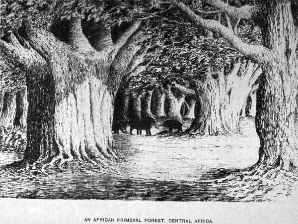
These grand old forest regions of Africa are full of interest, more particularly at the present season, when animal and vegetable life are springing into existence. Spring has far advanced, and summer is coming on apace. The birds are filling the woods with their notes,—although they do not sing they make the air ring with calls of many sounds, teaching their young to fly; the mocking-bird being the most persistent in keeping up his incessant chatter. The grey cockatoo, with his beautiful crest, is determined to make himself heard amidst the din of sounds; but of all the African birds I love, the best is the gentle ringdove; his welcome cooing notes have cheered my heart in many a weary day’s trek over a dry and parched-up region, where days have been passed without tasting a drop of water, when the notes of the ringdove have caught my ear, telling me water is near, for they are well known never to be far from it, which in every such case has been true. The croaking of frogs also is a welcome sound, for they never enlighten the air with their notes when the water has dried-up. Crickets and many other insects make the air ring with their chirps when water is plentiful.
A traveller, when roaming through this wild region, soon becomes acquainted with all forest sounds, and in many cases from necessity, when passing through a country where for six or eight months of the year rain never falls, not even dew, to moisten the atmosphere. During this dry time few insects are seen, but in the rainy season they swarm, and birds are scarce far from water; but along all the river-banks some with most beautiful plumage are to be seen, and many other kinds. Gorgeous flowers are not wanting to add beauty to the forest scenery, and a traveller must indeed be callous to all that is beautiful in nature who can traverse these woodland regions unobservant of their beauties. The charm lies not only in the magnificence of the scene around, beautiful as it is made by the Creator for man’s enjoyment, but it is also the book of nature, where man may learn wisdom away from the busy world. However much we may like the society of our fellow-man, there are times when it is very refreshing to be alone to think, particularly when surrounded by scenery rarely to be found out of these splendid old forests, where nature has been so bountiful in clothing the earth with such pleasant objects to look upon. I love the woods and their surroundings, where the mighty baobab, the king of the forest, reigns supreme above all other trees, whose age exceeds 5000 years, and is yet full of life and vigour—born a thousand years before the great pyramids of Egypt were even thought of—a living monument of the vitality of nature. Mighty nations have grown, flourished, and passed away into oblivion, since these vegetable monuments first took root, where they now stand and flourish, fit emblems of man’s littleness. We pace the galleries of our museums and look with admiration on those monuments brought from Nineveh, Babylon, Greece, Rome, and Egypt, which speak of the past history of the world, but not one of which can date as far back as these living trees, that had life before these nations had an existence.
Can we then pass these grand old trees with indifference, or look upon their huge trunks—which measure over 107 feet in circumference—without emotion, the branches of which at mid-day would shelter from the sun a regiment of soldiers? But these are not the only trees that grace the primeval forests of Africa; there are many varieties, dating back many thousand years from their birth, that are grand objects in the landscape, and complete a picture of forest scenery that few can realise who have not visited these ancient and glorious old forests, which, if they could speak, could tell wondrous tales of scenes unknown to man.
Chapter Twenty.
South Central Africa—Its territorial divisions and boundaries. The River System and their Basins.
This extensive region is bounded on the south by the Cape Colony and the Orange Free States; the Orange river by the former, and the Vaal river from the fountain-head down to where it enters the Orange, in 29 degrees 10 minutes South latitude, 23 degrees 47 minutes East longitude, by the latter State, with the exception of a portion of Griqualand West, which extends beyond those two rivers, and forms part of the above region. The Orange enters the South Atlantic in 28 degrees 40 minutes South latitude, 16 degrees 25 minutes East longitude, and up to the junction of the Vaal is the boundary of the Cape Colony and South Central Africa, which extends northwards up to the basin of the Congo, a distance of 1400 miles, and in width, from the South Atlantic to the Indian Ocean, in the northern part 1800 miles, the extreme south 1100 miles, an area of over 2,000,000 square miles, divided into divisions or territories, ruled over by independent chiefs, and will be dealt with under their respective heads. Great Namaqua and Damaralands embrace the whole of the west coast-line, from the Orange river northwards to the Qunene river, the boundary of the Portuguese settlement of Benguela and Angola, a coast-line of 730 miles. The remaining portion by the Portuguese settlement, the eastern coast, extends from the south side of Delagoa Bay, and the southern extremity of the Portuguese settlement, to the mouth of the Zambese river, on to Quilimain, a Portuguese port on the north, a distance of coast-line of 700 miles, up to the boundary of the Congo Confederation.
This vast area is divided into three separate watersheds, the most important one divides the waters of the South Atlantic from the Indian Ocean. This watershed commences at the extreme southern point on the Drakensberg mountain in Natal, 10,000 feet in altitude, following that range round to New Scotland, 6100 feet in altitude, in the Transvaal, then turns west, along the high veldt between Potchefstroom and Pretoria, 6300 feet, to the north of Lichtenburg, a town in the same State, 6100 feet, then in a north-west direction through a portion of Bechuanaland, the Kalahara desert, to Ovampoland, 4300 in altitude, on to Benguela, the Portuguese settlement on the west coast. All on the west of this shed the country is drained by the Orange and Vaal rivers and their tributaries, and the Swakop and other small streams in Damaraland, into the South Atlantic Ocean. The second watershed commences on the high land, 4260 feet in altitude, half-way through the desert, in 23 degrees 40 minutes South latitude, 23 degrees 20 minutes East longitude, takes a north-east direction, passing on the east side of the great brak vlei Makarakara, along the granite range of the Molopo in Matabeleland, on to the Lobolo mountain, 4500 feet in altitude, near the Zambese river, 300 miles from its mouth. The above river and its tributaries drain the country on the north of this watershed, and is called the Zambese basin; on the south side it is drained by the Limpopo river and its tributaries, called the Limpopo basin; both rivers discharge themselves into the Indian Ocean. These three large rivers, the Orange, Zambese, and Limpopo, with their branches, with the exception of a small portion of great Namaqua and Damaralands on the west coast, and also part of Umzela’s territory and the Transvaal by Delagoa Bay on the east coast, drain nearly 2,000,000 square miles of South Central Africa. The Orange, south of the above region, with its tributaries, drain the Orange Free State, and part of the Cape Colony, to the extent of 170,000 square miles in addition. Each of these river systems I propose to describe, as they form the principal geographical features, previous to going more into the detail of the several territories ruled over by independent chiefs.
The Zambese System, Covering an Area of 860,000 Square Miles.
The entire length of this river, from the fountain-head to its mouth in the Indian Ocean, south of Mozambique, is 1550 miles. The small lake Dilolo, in 11 degrees 30 minutes South latitude, 23 degrees 0 minutes East longitude, situated in the Lololala region, and within a few miles of the upper springs of the Kuana, a branch of the Congo; and from thence falls south and south-east, through Lui Banda, Barotsi, Makololo, Banyeti, and other tribes, with its many branches, to the Victoria Falls, and then on to the sea in an easterly direction. The other important tributaries, taking their rise in the region west of the above, are the Chobe, Quito, Cubango or Okavango, and many branches in the country of the Kimbandi and Bunda; the source of the Cubango or Okavango is but a short distance from the upper springs of the river Quanza, that passes through Angola to the South Atlantic, and belongs to the Portuguese. The Chobe takes a winding course south, through a level and swampy country, full of jungle, past a Kaffir kraal, Matambaya, to within seventy miles to the west of Linyanti; past that chief’s kraal, in an easterly and north-easterly direction, it enters the Zambese thirty-seven miles above the Victoria Falls. The Chobe is a large and broad river with several rapids. There are many streams and laagte which intersect this extensive and swampy region.
It is a most unhealthy and sickly country, whence it has obtained the name of the Fever District. The Cubango river: the source of this river also flows south 19 degrees 10 minutes South latitude, 15 degrees 0 minutes East longitude, the altitude was 3370 feet above sea-level; from that station the river runs in a south-east direction for fifty-five miles to Libebe kraal, then in an easterly course winding through the desert for sixty-five miles to Debabe’s kraal, 17 degrees 22 minutes South latitude, 21 degrees 30 minutes East longitude. Thirty miles below my station the river Quito joins, which forms a broad and fine stream. At Debabe’s the river turns south-south-east, and receives a new name, the Tonga; one portion flowing into the Chobe; the other continuing, with many turns and windings, for 220 miles, finally entering the north-west corner of Lake N’gami at an altitude of 2813 feet, receiving in its course the Laagte Okayanka that rises in Ovarapoland at Chambomba vlei, 3900 feet above sea-level, flowing east, and enters the Tonga 110 miles below Debabe town, where the country is full of swamps, with outlets into the Mababe river. Lake N’gami is forty-five miles long when full, and about ten miles in width, very shallow, and is getting less every year. The western end is in 20 degrees 25 minutes South latitude, 22 degrees 38 minutes East longitude. There are several small streams which flow into it in the rainy season. On the eastern side the Zouga river joins it, sometimes flowing into it, and sometimes out; the direction of the current depending on the rainfall. The Zouga, from the lake, winds easterly through a flat country for eighty miles, then turns south for 130 miles to Kumadua vlei, and then north-east for sixty miles, and joins the great Makarakara brak vlei, which is nearly fifty miles across, where five streams enter it on the eastern side from the watershed that passes through the Matabeleland, viz. the Nata, Quabela, Shuari, Mia, and Tua. The Zouga river having such a perfect level, the water in April and May flows easterly, in June and July westerly. The only outlet for the surplus water of the Zouga, lake, and vlei, is the Mababe into the Chobe; and when all are full, and no stream flowing, the water in the Mababe goes north or south according to the rain. If a great rush of water comes out of the lake or vlei, the Mababe is the outlet which connects the lake system with the Zambese, and the hippopotami find their way up from the latter river into the Zouga. The length of the Mababe from these two points is 200 miles, but there are several watercourses throughout this region, more particularly round the hilly district of Ngwa hills, traversing the country in all directions; pans and vleis intersect this extensive district, many of them extensive—the Sira and Etwetwe are considerable.
The tributaries to the east of the Victoria Falls to the coast comprise the following:—Daka, Zimboya, Gwaii with its many branches, Sebuana, Lohala, Sinyaki, Lozenza, Banyeka, Panyama, Zingisi, Nake, Luenya, Landeen, Sankatsi, Zangwe; all of them take their rise in the watershed of the Molopo and Lobolo mountains. The principal known tributaries on the north of the Zambese are the Shire, which enters it ninety miles from the mouth—it is a broad and extensive river, being the outlet to the waters of the Lake Shirwa—the Kewubue, Loangwa, Kafue, Majecla, Luamba, and many intervening branches not yet sufficiently surveyed. This comprises the Zambese basin, the most valuable and important region in South Central Africa.
The Limpopo River Basin, Covering an Area of 620,000 Square Miles.
This river, from the fountain-head to its mouth, where it enters the Indian Ocean, eighty miles up the coast from Delagoa Bay, in 25 degrees 25 minutes South latitude, 33 degrees 30 minutes East longitude, is 850 miles in length. Its configuration is nearly three parts of a circle. The chief fountains rise south of Pretoria in the Transvaal, on the watershed between Potchefstroom and Pretoria, 26 degrees 10 minutes South latitude, 28 degrees 40 minutes East longitude, taking a north-north-west course for 200 miles, then turns north-east, and then easterly for 400 miles, and then in a south-south-east direction for 250 miles over a flat country to the ocean.
The principal tributaries on the west and north are the Eland, Great Marico, Notuane, Makalapsie, Setuane, Serube, Pakwe, Maclutsie, Shasha, Makhae, Kubie, and the Nuanettie, and their several branches, which drain the country on the eastern side of the two watersheds. The Great Marico, with its branches of Little Marico and Molmane, drains a considerable extent of country in the Marico and Molmane district, and a large portion of Bechuanaland under the chiefs Gaseitsive, Sechele, Makose, and Lindsey. The remainder pass through the chief Khama’s country, and the Mashona country under the Matabele king, Lo-Bengulu. The eastern branches all rise in the Transvaal as under:—the Apies passes by Pretoria, Pienaar, Matlabas Sand, Palala, Magalaquen, Hout, Lovolo, and the Olifants river with its many branches.
Their fountains rise on the north side of the watershed, which passes east. The other rivers are the Manica, with its three principal branches, the Sabie, Crocodile, and Umcomati, that partly drain the Lydenburg gold-fields; the Umbolosi and the Maputa, with two main branches, the Uzutu and Pongola, that fall into Delagoa Bay. The eastern coast-line, north of the Limpopo, drains the territory under the chief Umzela; the two principals are the Sabie or Sabia, which rises in the northern watershed at Sakaloto kraal, 18 degrees 10 minutes South latitude, 32 degrees 8 minutes East longitude, at an altitude of 4210 feet above sea-level, and the Buzi river, which supplies Umzela’s kraal, and both rivers enter the Indian Ocean in Sofala Bay. These rivers complete the Limpopo basin, which drains the northern portion of the Transvaal, the Portuguese settlement, in addition to those already named.
The Orange and Vaal River System, and the Ancient River System of the Kalahara Desert, Covering an Area of 520,000 Square Miles.
The only portion of the Orange river which forms the south boundary of South Central Africa is that part from its mouth to the junction of the Vaal. The Orange above that junction turns south-east, and from Ramah, which is the point where the boundary between Griqualand West and the Orange Free State join, the river is the northern boundary of the Cape Colony up to Basutoland, where the head-fountains rise in the mountain regions of that territory, and it is the boundary of Natal near Giant’s Castle, at an altitude of 10,000 feet above sea-level.
The Caledon forms one of its tributaries, draining a portion of the Orange Free State. The Vaal river, which forms the south-east boundary of South Central Africa, rises in the Quathlamba mountain—a beautiful range of hills on the eastern division of the Transvaal, now called New Scotland—and Wakkerstroom district, and from Klip Staple, an isolated hill, 6110 feet in altitude above sea-level, also from Lake Cressie, a large sheet of water at an elevation of 5813 feet. Rensberg, a part of the Quathlamba, is 6800, and in 26 degrees 10 minutes South latitude, 30 degrees 32 minutes East longitude. From this point the river flows south-west, seventy miles, to Standerton, a town in the Transvaal, and on the main transport road from Natal to Pretoria, passing through an open country, receiving in its course many small feeders. From that town the river takes a winding course west for 120 miles, down to where the Moi river, upon which Potchefstroom is built, joins it; on the northern bank several small streams flow into it that rise in the watershed, running from Klip Staple westerly to Lichtenburg, the altitude averaging 5000 feet. The principal are Bushman, Kalk, and Rand. Heidelburg is situated on the latter, between the Kalk and Rand. On the south bank the river Wolga is one of the upper tributaries, rising in the Drakensberg above Harrysmith in the Orange Free State. It is an important stream draining a large extent of country. From the Moi river the Vaal flows south-west, with many bends and turns, for 240 miles, to the town of Barkly in Griqualand West, where the altitude is 3750 feet, and 28 degrees 30 minutes South latitude, 24 degrees 41 minutes East longitude. Between these two points there are several spruits falling into it from the north, and rising on the south slope of the watershed. The most noted are Scoon, rising in the Dwaasberg, a gold-bearing district, on which are situated the towns of Fenterdrop and Klarksdorp; Klip, Maquassie, and Bamber spruits. The other towns between Klarksdorp and Barkly are Bloemhof, Christiana, and Hebron, situated on its banks, the latter being the first town built on the river diggings after diamonds were discovered. The rivers on the south side drain the Orange Free State: the principal are the Rhinoster, Valsch, and Vet. The Vaal from Standerton down to Barkly, and beyond to its junction with the Orange, is very picturesque, well-wooded with fine timber, and bush on its banks, which are steep—the water has been known to rise forty feet without flooding its banks—many islands, with their rich foliage, particularly in the autumn, in April and May, when the lovely tints give great beauty to the river. Kimberley, the diamond centre, is twenty-five miles south-east from Barkly on the south side of the river. From Barkly the river flows for twenty-five miles in a north-westerly course, where the Harts river joins it. In this distance there were, and are now, several diamond-diggings, viz. Pniel, opposite Barkly, Waldick’s plant, Good Hope, Gong Gong, Kesi Kamma, and others. The Harts river rises in the Transvaal at two large fountains, with vleis at Lichtenburg, 26 degrees 22 minutes South latitude, 26 degrees 37 minutes East longitude, at an altitude of 6100 feet above sea-level, passing down south-west for 220 miles, enters the Vaal at Lekatlong Kaffir station, and also a mission station of the London Mission Society, passing through, in its winding course, an open grass country. On and near its banks are the native kraals Maamuosa, Taung, and Phokwane, as also Boetsap in Griqualand West. From the junction of the Harts to the junction of the Orange the Vaal flows south-west for sixty miles, through a hilly country, particularly at what is called the “Poort,” where the river enters a mountain district, and for seven miles the scenery is grand and wild, to within a short distance of Siffonel kraal, where formerly the chief Siffonello lived, and after 1869 it became a diamond-digging camp. At the junction of the Orange and Vaal the two rivers form a broad sheet of water, well-wooded on both banks, which is now the Orange, and flows west by south for eighty miles, through a hilly country, to the great bend near Prieska, which is on the colonial side of the river, then turns north-west for 120 miles, winding between lofty and rugged mountain scenery, with broad belts of wood on both banks, to a Griqua town, where Klaas Lucus lives, passing Bultfontein and Kheis, a Korunna village, and the extreme western boundary of Griqualand West. From Klaas Lucus the Orange flows in a westerly direction, with many extensive bends, for 380 miles, where it enters the South Atlantic Ocean, 28 degrees 40 minutes South latitude, 16 degrees 25 degrees East longitude. At Kakaman’s drift, thirty miles below the bend at Klaas Lucus, the ancient river Hygap enters it, which is the main stream that carries off the waters from the Kalahara desert, being the only outlet of the river system of that extensive region. At the junction of these two rivers a Korunna chief, Puffadder, had his head kraal—fifteen years ago.
The river from this point is very beautiful and grand; noble and lofty hills flank it on both sides. Many hundred islands, with dense bush, add immensely to the beauty of the country. Between the Hygap and the South Atlantic Ocean there are four rivers that drain the South Kalahara, the Nisbit, Aamo, Keikab, and the Great Fish river; the three former rise on the south side of the Brinus mountain, the latter is a large and extensive tributary of the Orange, being over 400 miles in length, rising in Damaraland in 22 degrees 10 minutes South latitude, flowing south through the desert, receiving in its course, on the western bank, many branches that rise in the mountain region of Great Namaqualand, the most important being the Amhup, Koros, Huntop, Chun, Oip, and Manobis, and enters the Orange river about ninety miles from its mouth. The total length of the Orange to the Vaal, and up that river to Lake Cressie, is 1110 miles. There are several cataracts and rapids on both the Orange and the Vaal, with long stretches of smooth water. The most extensive cataract is Aukrabies, below Kakaman’s drift, where there is a foil of nearly ninety feet. The ancient river system of the Kalahara desert, of which the Hygap is the outlet into the Orange, requires care to properly describe the peculiar formation of the several watercourses that intersect that extensive region, and from the magnitude of some of them show that at some remote period they were vast flowing rivers, whereas at the present time water is seldom seen in them. The upper or more northern fountains rise in Ovampoland, at an altitude of 3350 feet near the Omareru river, distant from the Orange river at the junction of the Hygap nearly 700 miles; 200 miles below the upper fountain of this river the elevation is 3200 feet; 130 miles to the south of this, at the junction of the Nosop river, the altitude is 2700 feet; and 160 miles following the course of the Nosop down south to the junction of the Molapo, along that river to the junction of the Kuruman river, the height is 2400 feet, which river receives the name of the Hygap; and 170 miles following that river due south to the junction of the Orange, the altitude is 1470 feet,—consequently there is a fall of 1880 feet from the fountains in Ovampoland to the Orange river. The Black and White Nosops join in the desert, forty miles to the east of Rhinoster vlei. They both rise on the eastern boundary of Damaraland, having many feeders from the mountain range 8000 feet above sea-level, flowing south and east to Narukus, where the Elephant river joins it, receiving its waters from the Limestone Peak, 4444 feet in altitude. Twenty miles below Narukus the river is called the Oup, which meanders in a south-east and south direction, and falls into the Molapo, twenty-four miles below the junction of that river and the Nosop. The distance of the upper springs of the Black and White Nosop to the Molapo is nearly 500 miles. Twenty miles below Narukus the Nosop separates from the Oup, and continues more to the east, which has already been described. Forty miles to the west of the junction of the Oup and Kuruman rivers is a large vlei, thirty-two miles in length, called Hogskin vlei, and in places from two to three miles broad. This vlei receives three small rivers, the Knaas, Snake, and Moi; their fountain-heads are in the hill district on the west, covered with bush and rugged in form. The country is very pretty and picturesque, with fine kameel-doorn trees, prickly thorns, and mimosa trees. On the east of this large vlei is an extensive salt-pan, but not used, as there are no inhabitants except Bushmen and Korannas. To the south is the Back river, which rises in those beautiful mountains known as the Brinus hills; from the topmost springs it flows in two directions, one to the Great Fish river, the other eastward past Liefdote, Tobas, and Klopper vlei, turns south-east, and enters the Hygap sixty miles above the Orange river, and seventeen miles below Swaart-Modder, where I built a stone house under the hanging cliff, in the dry bed of the Hygap. The other two rivers that complete this ancient river system are the Molapo or Mafeking, and the Kuruman. The former rises on the central watershed in the district of Molapo in Montsioa’s territory. The eye of this river is situated 26 degrees 7 minutes South latitude, 26 degrees 20 minutes East longitude, in a lovely wooded glen, 5350 feet above sea-level, and only ten miles from the main eye of the Molmane river that falls into the Limpopo basin; the watershed passing across the desert divides the two. From this fountain the Molapo turns westerly, passing Melemas and Macebe’s kraals, continuing in the same direction for 315 miles, joins the Nosop above described, and forms the main stream of which the Hygap is a continuation. The Setlakooly and Moretsane are the only branches of any size that drain the country in that long distance.
The Kuruman river rises south of the mission station of that name, flows west and enters the Hygap a few miles below the junction of the Oup, passing through a wild and broken country the last ninety miles of its course. The Hygap river from this point to the Orange is a broad and deep river, and from the lofty and perpendicular sandstone rocks, reaching in many places 200 feet in height at the bends, where the current acted upon them in its course down, it is evident that at a remote period it was a river of some magnitude; the force of water in many places has undermined the base of the cliffs, forming caves, that have been used by the early inhabitants as dwelling-places, and in one of which I erected a stone front to live in for a time when in that region many years ago.
At the fountain-heads of many of these desert rivers the springs are very powerful, but the water does not continue for any great distance above the sand in their beds, but sinks and percolates through the sand until it reaches the Orange river. Knowing this, I had very little difficulty in procuring water by digging a few feet into their beds, the sand in many places filling up the original beds eight to ten feet in depth. The water when procured was clear and cool. There are several rivers on the west coast that drain Damaraland, the country being so dry that rarely any water is found in them near the coast; Swakop is the most important, the mouth being in Walfish Bay, as also the Kuisip river, south of Swakop, which enters the south side of the above bay.
The rivers on the north are Omaruru, Ugab, Hubb. The northern boundary of Damaraland, the Cunene river, separates the Portuguese settlement, Benguela. And in Great Namaqualand is the Little Orange river which rises on the west slope of the mountain range, and enters the South Atlantic near Angra Peguena island, lately annexed by Germany, which completes the Orange and Vaal basin in South Central Africa. The rivers or branches of the south side of the Orange, which drain a large portion of the Cape Colony and Little Namaqualand west of the junction of the Vaal river, are the Ongar, which enters the Orange near Prieska, Hartebeest or Vish river, Pillans, and some small streams of no note. The country which these rivers pass through is wild and very hilly.
Chapter Twenty One.
The region north of the Transvaal under Lo-Bengulu, the Matabele king. Its physical geography and notes on my explanations. Within the Limpopo Basin.
This region is commonly known as Matabeleland, Maahona, and Makalaka country. It extends from the Limpopo river northwards to the Zambese river. The western boundary joins up to the Bechuanaland occupied by the chief Khama, and on the east by the territory belonging to the chief Umzela. The extent from north to south is 420 miles, and from east to west 340 geographical miles. The mountain range, Molopo, traverses it the whole length in a diagonal direction, from the north-east corner down to the south-west, which forms the watershed dividing the Zambese from the Limpopo basin, the northern portion of this kingdom being in the former, and the southern in the latter. The tributaries of the Limpopo take their rise from this watershed, all of them, without exception, flowing through a beautiful and well-wooded country, containing some of the most magnificent and valuable timber to be found in Africa: mahogany, ebony, and other useful woods suitable for building purposes and other work. The principal names of these rivers are the Shasha, being the southern, between the chief Khama and Lo-Bengulu, the Tati, Ramakaban, Mpakwe, Meksine, Rubi, and Nuanettie. The whole country drained by these rivers is granite, with lofty and picturesque hills covered with tropical vegetation of many flowering shrubs and trees, with the brilliant flowers everywhere peeping out between massive granite rocks, lying one upon another for several hundred feet in most grotesque forms. This gives to the landscape a peculiar and novel appearance, quite different from anything seen in the south. Many of the spurs of the Molopo range are free from bush, where the native cattle find fine grazing-land, and the gigantic baobab, palms, euphorbias, aloes of many kinds with their crimson flowers, and other tropical trees skirt the hills and mountain streams. The fallen masses of rock from the pyramidal-shaped hills strew the ground at their base, and give a peculiar and strange feature to the scenery around. This country gradually descends towards the south and east, until it reaches the Limpopo river, interrupted by many isolated hills and mountain ranges, thickly wooded; the most inaccessible points being selected by the Mashona natives for their kraals, to be secure from surprise by the Matabele warriors.
The population of the eastern division of the Mashona country is mostly composed of the Mashona tribe that occupied this region previous to the invasion of the dreaded Zulu chief Moselikatze, about the year 1840, when he advanced north with his army of wild Zulus, and took possession of all the country which is now included in the Matabele kingdom. There are also several other tribes living in this district, the most numerous being the Makalakas, Bakalahara, and the Mesere Bushmen, and many of the Banyai, Makloes, Makatse, and Mantatees, that have crossed the Limpopo from the Transvaal.
The Tati gold-fields occupy the western border on the north bank of the Tati river, which were first discovered by Mr H. Hartly, the well known and highly-respected elephant-hunter from the interior, in 1867, which soon became known, and a number of diggers from Australia and other parts came flocking to the scene. Amongst the number was Sir John Swinburne. A company was formed, and after spending much money in machinery and other works, it was abandoned, sufficient gold not being found to pay expenses. The stores and works fell into ruin, and the last of the powerful engines, weighing several tons, was washed down the river nearly two miles, and deposited on the bank some twenty feet above the river-bed, where I saw it when returning from Matabeleland in 1878.
The fact of the flood-waters carrying down such a huge and heavy mass as this engine two miles, and depositing it at so high a level, will give some idea of the force and quantity of the water that fills these rivers during that time. The rainy season varies as to time; sometimes it commences early in November, at others later, and lasts until February or March. In all these tributaries of the Limpopo that drain the above region, none retain water throughout the year, although they are large and broad streams with steep and lofty banks, but during the dry season water may be obtained from most of them by digging a few feet in their sandy beds; they are all at too sharp an angle to allow water to remain in them. The main road from Ba-Mangwato to Matabeleland crosses most of them, and frequently I have had to wait weeks on their banks until the flood-water had subsided to enable me to cross. On one occasion I was on the point of crossing the Bamakaban river, and was treking down the bank to enter it with my waggon, when my driver called my attention to a great roaring sound which came from the up-river side. Having previously had several days of storms, with heavy rains, we held still to listen, and from previous experience we too well knew the cause. There was not time to cross and reach the opposite side before the rush of water would be upon us, particularly with an ox-waggon, as the sand in these river-beds is very heavy for oxen to pull a waggon through, and sometimes they take it into their heads to come to a stand until they think proper to move on again, after a little coaxing with one or two South African waggon-whips, the handles of which are twelve feet long, and the lash twenty. Therefore, to prevent any catastrophe, we selected a pretty open grassy glade on the wooded bank, and outspanned; but before we had completed this operation, the water was in sight, coming down like a wall, bringing trees of considerable size, large stems of dead wood, sticks, and froth, rushing and tearing along with a roaring sound that could be heard miles away, and in a few minutes there was sufficient to float a large ship. Where would my waggon have been if I had attempted to cross?—Carried down into the Indian Ocean in splinters. Many a waggon and their owners have been caught in these flood-waters and lost in the rivers of Africa. Nevertheless, with all its inconveniences, it is a grand and imposing sight, and a novel one to those who are unaccustomed to African travelling in an ox-waggon.
(A waggon which contained the journal of St. Vincent Erskine, the traveller, of his third expedition in this country, was thus washed down a river. A white girl and a Kaffir and the oxen were drowned. A number of men searched the banks for the journal for days in vain, and it was only found accidentally two years afterwards in its tin case in a bush so high above the river that no one had thought of looking there.)
We were detained here eleven days before we were able to cross, the sand in the river-bed being very deep, and resting on the granite-bed rock beneath, which is not very smooth or level. The force of the flood sweeps away all the sand, leaving a rugged bed; therefore it is prudent to wait till the water has drained away, that we may pick a safe road across, otherwise an axle might break, or some damage be done to the waggon. In all cases it is wise not to be in a hurry. I have known fussy transport riders flounder into such rivers before the water has subsided, and break their waggon, which has detained them weeks to get repaired.
During our stay we had some excellent shooting, big game as well as small. The third afternoon of our stay seven giraffes were seen by my herd boy, who was looking after the oxen in the veldt, and he came and reported the same. Not having my shooting pony at hand, I had to send for him and saddle up, and started with my driver and forelooper to find these noble animals; but to do so it is necessary to be very slim, as it is called here, that is very sharp and clever in stalking your game, otherwise it will escape. It is surprising how keen and sensitive the eye and ear become to all woodland sounds and trifling incidents necessary for a hunter to observe and note, to lead him up to the game he is seeking; a broken stick, a crushed leaf or blade of grass, a broken twig where the game has passed, must be keenly looked for. We had proceeded but a short distance when we met three Mesere Bushmen with their bows and arrows, who told my driver they were coming to tell us of several giraffes that were feeding in a dense bush not far away. With the natives not far away means any distance, they being bad judges in such cases. We, however, secured them to show the way, one taking the lead, the rest of us following in Indian file, the pony being led by my driver. After winding in and out through the forest for nearly a mile as far as I could guess, the first Bushman called a halt, at the same time he advanced crawling along very cautiously, until we lost sight of him for some little time, when we saw him come crawling back in the same way. He told us there were, by counting on his fingers, eight giraffes quietly feeding a short distance in front. The bush being too dense to make use of the pony, he was left behind in charge of my boy, and we, with our two rifles, with our Bushman guide, had to adopt the same mode of advance, to get near enough for a shot, and crawl with the greatest caution, avoiding any dead and dry sticks, for at the least sound in breaking one they would be off and away in a moment. After proceeding on our hands and knees for some distance, the Bushman, who was in front, motioned with his hand that they were in sight. Crawling up with the greatest care, I could only distinguish their heads and long necks above the bushes which surrounded them on all sides, not one hundred yards away.
We waited until one of their bodies came into view, when we were to fire from both rifles at the same animal. The silence of death was around, not a puff of air to move a leaf, the bright tropical sun shining in all his glory, making the heat almost intolerable. In this position we waited some ten minutes before a chance occurred. One of them came more into the open, with his body in full view. Now was the moment to fire, and our two bullets entered his body with the well known sound which a ball makes in striking. He fell, but was up again in a moment.
It was a beautiful sight to see; the others leaping and bounding away, swaying their long necks from side to side, until lost in the bush. But we had no time to look after them; our attention was drawn to the one we had shot. After regaining his feet and attempting to follow the others, he only staggered a short distance, and then fell dead; a noble corpse, and a noble bag.
After our excitement was a little subsided, it was necessary to consider how we were to get such a huge beast to the waggon with the least trouble. It was arranged to inspan the waggon, and bring it round the best way we could through the forest to as near the dead giraffe as possible. It was now near upon ten o’clock in the morning. Despatching my boys and one of the Bushmen to carry this plan out, I remained with the other two Bushmen, who wanted no instructions. Giving them my hunting-knife, they were soon at work skinning this beautiful animal, which proved to be a young cow, but full-grown and the finest meat in Africa, very much like veal in flavour. In a short time the waggon was brought up to within fifty yards, and outspanned in the shade of some noble trees, for the sun’s rays were intense, and with the heat and fatigue, I was glad to throw myself on the grass, after a good drink of cold tea, to rest and smoke, whilst my Kaffirs and driver were making a fire for cooking, skinning the giraffe, and doing other household work. Being well supplied with good water, the casks being full, our contentment for the time was complete.
What a glorious thing is this wild life, where game and water are plentiful, with liberty to roam where one lists, with health and strength to enjoy it! The only surprise is that any one can be ill in such a country, pure air, plenty of exercise, good food and water, constantly moving, seeing fresh sights daily: I pity the man that cannot enjoy a life so free and so exciting as this. A giraffe lying at full length on the grass is a grand sight. This one measured fifteen feet seven inches, from hoof to the ears, and it was a work of much labour to skin and cut up such a large beast, but everything was done by 4 p.m. Bushmen are like vultures, they scent game afar off, for by the time everything had been cleared up and put straight, eight fresh Bushmen, their wives and several children, had put in an appearance, and were looking with longing eyes upon the remains of the giraffe. I was glad to see them, and told them they could take what was left. Poor things, their delight was complete. Knives were out, slashing and cutting up commenced, and divided out; a fire was made and cooking went on up to midnight. The night was fine, and as the fire lighted up the figures as they moved about, and shone upon the trees and shrubs, it was about as unique a picture as one could desire to see, and would have told well if the scene had been in Hyde Park or Kensington Gardens.
During the night we were much annoyed by lions round our camp, some of them coming so close that a Bushman caught up a burning piece of wood and threw it in the face of one, with such good aim, it fell on his shaggy mane, and made it smoke, when he cleared off. Bushmen seem to care very little for lions; they think nothing of walking through the forest with only a short spear. I was too tired to go after them, but two days afterwards had a narrow escape; as I was walking along up the river-bank looking for guinea-fowl, I came plump upon two. Having only my shot-gun I could do nothing. I was in a fix, and if they had known it, they could have made short work of my bones. As it was, we stood looking at each other, not with any pleasurable emotion on my part, and I think they participated in the same feeling, for after some five minutes had passed, the young lion slunk behind a thick bush, and soon after the old one followed. During the whole time I never moved hand or foot. If I had raised my gun to fire, or turned, the old one would have been down upon me in one spring, for I was within springing distance, we were so close. When the old one stood partly facing me, in an attitude of defence, his mane raised and his large glaring, fiery eyes fixed upon mine, he was a noble animal, appearing almost double the size of those caged at home. I never moved my position for some time after they disappeared; if I had they might have attacked; and when I did, it was for some twenty paces backwards, and then I turned and followed the river down to camp, after securing three guinea-fowl.
During the remainder of my stay here, we cut up and dried the giraffe, to make biltong, which will keep for years; in the day exploring the rivers and country, taking observations, collecting specimens of everything interesting, and writing up my journal. On the 15th we found the river dry, and sent the boys down with spades to make the drift good by filling in the holes between the granite rocks, for the waggon to pass over, and we arrived on the north bank in the evening, in time to make fast the oxen to the trektow before dark. Every night we heard lions and wolves, but this night we were infested with them: the scent of the raw flesh in the waggon seemed to draw them, for they gave us no peace. The bush was thick, and the night dark and cloudy. They gave us no chance for a shot; the only thing we could do was to keep up great fires all night and watch. We fired several shots into the darkness where we thought they were prowling about. Several times we thought they were fighting by the fierce growls and spits they made, but we found the spits came from the females, as lions are never known to do so. If it were not for the novelty of the affair in listening to and seeing lions in their own native wilds, I would prefer a good sound sleep in my waggon, but we do not meet with such noble game every day of our lives.
When Sir John Swinburne and his company were working for gold at Tati, other diggers followed up that river, some thirty and others forty miles, and worked claims near its banks at Todd’s Creek and Charley, but did not find sufficient gold to pay, and they were also abandoned. At the present time a new company has been formed to work the old diggings at Tati, and I believe find more than sufficient to pay expenses. Ancient workings in the district have been discovered, but when used, no history can inform us.
About a mile to the west of the Tati station, on the summit of a hill about 200 feet above the river, are some very interesting remains of an ancient fort, built of hewn stone. The outer walls, now standing, are four feet in height, with two courses running the whole length, about half-way up, with five regular courses between, built in the herring-bone fashion, similar to those in old Roman walls now preserved in England. These stones are very thin, not much thicker than common tiles; the other courses have stones in regular layers, three inches deep and about a foot in length. This wall is two feet thick, and encloses a space of about half an acre. The floor originally was concrete; large portions still remain, and nearly in the centre are portions of small furnaces for melting metal. At the south-west corner of this enclosure are several rooms, with walls dividing them seven feet in height. In the eastern room the walls are twenty feet high, and it appears to have been a tower, leaving a space of some four feet between the outer and inner wall; and, when in a perfect state, it must have been a strong place, of defence, standing, as it does, on the topmost ridge of the hill, overlooking the river and surrounding country. There is no evidence of any mortar being used; mud may have been a substitute, and from time to time been washed away. Trees are growing in many of these rooms of considerable size, as also bushes. This being a favourite lurking-place for lions, I had to explore it with a rifle in one hand, and book and rod in the other. It is a most interesting ruin and well constructed, evidently the work of a white race. There are no Kaffir tribes in this part of Africa or south that have ever been known to build their kraals square or with hewn stone. Other ancient and similar ruins are still preserved beyond these diggings higher up the river, the walls also square and fifteen feet in height. The country is dense bush, with fine timber. Lignum-vitae trees abound; the wood when cut is black and white, very hard, and used for waggon desselbooms and axles. It has been known to last almost as long as iron.
The Tati station is the only white man’s station between Ba-Mangwato and Gubuluwayo, the Matabele king’s military kraal. It is distant from the former 169 miles, and from the latter 126 miles. A few stores were opened by English traders, to supply the Bushmen who brought ostrich feathers for sale (but if known by the Matabele people they would have been killed), and also travellers and hunters passing up and down from the interior, as it is situated on the main and only transport road to that country. The range of mountains, “Mopolo,” forming the watershed above mentioned, averages in height 4320 feet above sea-level, there are some parts nearly 5000; it is of granite formation. Along some of the rivers, already described, may be seen some fine slate rocks.
The natives procure very fine gold-dust from the sand in some of the river-beds, and sell it. They preserve it in the quill of a feather from the wing of a vulture, where they deposit it for safety. Every kind of game is found in this region, but it is becoming more scarce every year. This part is known as the Makalakaland. Quartz intersects the country in several parts, and is rich in gold.
There are many military posts on the slopes of the watershed down to Makobi’s outpost, on the Mpakwe river, which is the frontier outpost, where all travellers and hunters have to stop, to obtain permission to enter the country before proceeding. On the arrival of any stranger, a messenger is sent to the king, and if he objects, he has to turn back, and if allowed to proceed, two Matabele warriors from the regiment stationed there take charge of the visitor, and conduct him to his majesty, who inquires his business, so that no one is allowed to enter his territory without his knowledge. Although the Matabele country comes down to the Shasha river, no one occupies that district, except a few wandering Bushmen, south of the military post at Makobi’s.
There are many ancient forts similar to those at and near the Tati, the ruins of which are still to be seen on commanding positions, but none of any great extent; a garrison of 100 men would be as many as could occupy them. Most of them are so concealed from view by trees and bush, that it is by mere accident they are discovered. I once outspanned in the centre of one without knowing it, thinking it an old Kaffir kraal, until my attention was called to the peculiar form of the stonework of hewn stone, and the square rooms.
At the Mpakwe river near the south side of the drift, and twenty-nine miles north from the Tati river, is another very interesting ruin, built of cut granite with regular courses, each stone nearly the same size, and regularly jointed. The walls are ten feet high, and two feet thick. The interior was a smooth granite concrete floor, and contained burnt earth similar to bricks, in great quantities. That portion facing the river was divided into several rooms. At the main entrance within the building is a small kind of sentry-box commanding the opening, capable of holding only two persons.
The situation is commanding, and must have been, when perfect, capable of holding out against an enemy. There is another very good specimen of these ancient forts a short distance from the Camarlo drift, on the river Umfulamokokgumala, which is a branch of the Mapui, that falls into the Gwaii, a tributary of the Zambese; this drift is on the topmost ridge of the watershed of the Mopolo, at an elevation of 4360 feet above sea-level.
The fort is 110 feet square, with rounded corners. In the centre is a fort thirty-five feet square, with walls two feet thick. All of them have large bushes growing in and through the walls. There are many other ancient forts similar in construction to those described in this region, and also many more to the east, within the southern division of Lo-Bengulu’s territory, and within the Limpopo basin.
Sixty-three miles north of the Tati gold-fields, on the transport road, is Lee’s farm, situated on the Mpakwe river, a branch of the Shasha, a grant of land which Lee obtained many years ago from the king Umseligasi, or better known as Moselikatze, the dreaded chief. It is situated a few miles south of Manyami’s outpost, on the south slope of the Matoppo mountain, the western spur of the Mopolo range. Lee, on his father’s side, is English, but he has married into a Boer family, and has great influence with Lo-Bengulu.
Sixty-three miles north of Lee’s farm is the great military station of Lo-Bengulu, situated on the summit of the watershed named Gubuluwayo or Gibbeklaik, a strong and well-laid-out town on the summit of a low hill; the king’s houses and his cattle kraal being in the centre, surrounded by strong fencing, leaving an open space, round which the town is built. It will be more particularly described in another chapter, as it belongs more to the Zambese basin.
An extract from my journal for a few days will give a clearer insight into African travelling than any other description.
From the Tati gold-fields to Gubuluwayo, the military kraal, distance 126 miles.
December 8th, 1877.—Inspanned at 4 p.m. for the interior. Treked about a mile, when my oxen, frightened by lions, turned suddenly round, and broke the desselboom of the waggon. I had to splice it, and return to Tati station in the evening.
9th.—Kept awake all night by lions. Out all day in the bush, looking for a suitable tree to cut down, to make desselboom; the knopjiesdoorn or lignum-vitae is the best. I went with rifle and Kaffir with axe all round the hills, and at last found a straight one, which we cut down and brought to camp.
10th, Sunday.—A very wet, stormy day; severe thunderstorm. Mr Scott returned from Macloutsie river, there being no water on the road to Mongwato.
11th, Monday.—Very hot day. Thermometer in shade 96 degrees. Barometer 26.75; altitude at this station 3740, and at the river 3100 feet above sea-level. Lions and wolves making noises all night. Mr Lee’s two married daughters came in from the hunting-veldt. We went out to examine an ancient fort, and look over old gold-diggings, Mr McArthur making my desselboom, 3 p.m. News brought in that camels and elephants are passing within four miles to the north-west. McArthur and self saddle up, and after a ride of three miles, fall in with four giraffes. Shot one, rode back, sent waggon on and followed, and brought back a waggon-load of meat. Arrived in camp, 9 p.m., thoroughly tired and hungry. Had a grand supper at McArthur’s store, a glass of toddy, and to bed at 11 p.m.
12th.—Out shooting all day with McArthur. Passed close to a lion in the bush, shot at him but missed, and he made off. A fearful storm in the night.
13th.—Two white men came in from Gubuluwayo, they tell us Lo-Bengulu will not allow any white men in the Mashona country, and has sent out a thousand Kaffirs to drive away the game, and annoy the hunters in the hunting-veldt. Scott, Kurton, and many others have been robbed by the Makalakas, and the king will give no satisfaction. Many of the traders have been threatened with the assagai, and one’s life is not safe in the country. Thermometer 98 degrees. Visited the ancient forts to take measurements, and procure some pretty birds, of which this country is full. Mr Brown, who has a store here, is very clever in preserving them.
14th.—McArthur making my desselboom. Thermometer 101 degrees. Four waggons have come down, some from Panda-ma-Tenka. The hunters up there have done nothing, the game having all been driven away by the natives. Trade is bad and everything in confusion. Those come in to-day are Wiltshire, Gordon, Fry, and four others.
15th.—Desselboom finished. Very warm, 104 degrees. Out exploring amongst the hills, and also on the 16th.
17th.—Three waggons left to-day for down country, with Palmer, Bray, and Gordon.
18th, Tuesday.—Scott left to-day with Thompson. Rain all day and last night. Lions came close up to waggon, but too dark to get a shot.
19th.—Kaffirs came in to tell us there are plenty of giraffes and buffalo between this and Ramakaban river. Saddle up, McArthur with me; go in pursuit. Come up with a herd of buffaloes, seventeen, but bush is so dense cannot get a good shot; and after several attempts to get round them, they make off for the hills, and we return to camp in time to escape a severe thunderstorm.
20th.—Out all day down the rivers. Very hot, 107 degrees. The rain makes the heat very trying.
21st, Longest day.—Thermometer 102 degrees. The river is coming down fast. In the morning there was no water in its bed. At 4 p.m. it had risen twelve feet, bringing down large trees.
22nd, Saturday.—Left the Tati station at 6:30 a.m. Travelled six miles, and outspanned at a pan for the day. Plenty of water, wooded country all the way; crossed three bad sluits. Buffaloes, giraffes, and elephants can be seen from the waggon as we trek along, but the bush is so thick we cannot follow them. Shot a bastard eland before reaching the pan, which we secured by sending my two boys to protect it whilst we outspanned, as the distance was only a few hundred yards from the pan. The flesh is very good eating. Inspanned at 5 p.m., and treked four miles, as it came on to rain with thunder, and outspanned for the night in the bush. Made three large fires round oxen, to keep off lions that were constantly prowling about the waggon. Very pretty country, and pleasant to travel through when water is plentiful. McArthur’s driver I find very useful; he is a Zulu and speaks English.
23rd.—Very warm, 105 degrees. Treked in two inspans to Mpakwe river, through a very pretty and picturesque country. Crossed the Mpakwe on the 24th, a bad drift, and outspanned on the north bank, two miles south of Makobi’s outpost, a military kraal of the Matabele king. Sent Dirk, my driver, to the head Induna, for permission to go in. During his absence a Zulu came to waggon. I gave him for a present some powder and bullets, also a kerchief. He then, while I was reading, stole an axe and my waggon-whip, and cleared. The river is very pretty, and the wooded hills, with the variety of trees and shrubs that grow on their sides, impart a richness to the landscape.
25th, Christmas Day.—Thermometer 108 degrees. Inspanned at six.
Treked up to Makobi’s outpost. Two Indunas came to me, and several hundred of the natives, men, women, and children, swarming round me, and under the waggon, ready to steal anything they could lay their hands on. I complained to the Induna respecting the theft last evening, and told him I should report it to the king if the whip and axe were not returned. In about an hour the axe was returned, but not the whip.
It was amusing to see all the Kaffir girls when they came to sell their milk, ground-nuts, pumpkins, and other things, when I told them I would not buy any of their things because of the theft. They immediately began to abuse the thief in no measured language, because they found they had lost the sale of their goods; and when they found I was firm, the Induna promised I should have the whip on my return, if it could not be found before I left. I therefore got into the waggon to get some beads to purchase milk and other things, followed by half-a-dozen Kaffir maids with their goods, filling the waggon, followed by others blocking up the front. There was scarcely room to move. I soon cleared them out; these naked Venuses were much better outside.
The heat was terrific, 108 degrees in the waggon, full of these wild children of nature, with several hundred naked people round and under the waggon; a regular Babel of sounds, men begging for everything they saw, even wanting the clothes I had on. The head Induna took a fancy to my waistcoat, and as I wanted to get on without sending a message to the king, I made a bargain with him, that if he would send two of his warriors as my guard to the king, I would give him the waistcoat and an old black coat. This settled the question. I gave him the coat and waistcoat, which he then put on his naked person, and strutted up and down full of pride and vanity to the admiration of all. He was a splendid specimen of humanity, standing at least six feet six inches, stout in proportion, with a handsome, expressive countenance. My coat looked ridiculously small, and the waistcoat would not meet in front by several inches, but that was of no consequence.
At last, after settling for pay to my two guards, I left at 4 p.m., thankful to get away. Up to this time a cup of coffee in the early morning, and a few biscuits, had been my Christmas fare. After travelling three miles over a very stony road I came to a stand. The only means of getting on was to make use of the screw-jack to raise the wheels over the enormous granite blocks in the road—first the front, then the after wheels. When clear of them I set to work to cut down trees, to make room for the waggon to pass. At last, when night came, I was too exhausted to do anything but lie down on my bed and go to sleep. Christmas Days in Africa have, from some cause, been unlucky with me in the way of good fare; monkeys, tiger-cats, meercats, porcupines, ant-bears, and such like dainties, have always fallen to my lot on Christmas Day.
26th, Wednesday.—Splendid morning. No disturbance all night. Rose by sun-up, hungry; had a broil of some eland on an iron ramrod, and coffee—meat fit for the gods. Lovely and cool, thermometer 78 degrees. Took a bath in a small stream close at hand, a luxury not always to be obtained. As it was a cloudy morning and cool, I gave the oxen a feed and drink before starting. As we were only a short distance from the military kraal, we soon had some thirty Kaffir girls with wooden bowls of milk for sale.
Of all people I think these black people are most alive to the ridiculous and fun; full of what is called banter and quizzing, and very observant. On their arrival my boys and the two Zulus began to chaff them, but they gave it back with interest, and evidently had the best of it. Their witty remarks were very clever, and my boys had to give in. Some of them were very good-looking, with beautiful figures and expressive faces. Having filled all our bottles, and my Kaffirs having had a good drink of milk, we inspanned, and after two treks arrived at Lee’s farm for the night, passing on the way many quaint granite hills covered with tropical vegetation. The country round was also very pretty. Great unbroken masses of granite stand out in all directions. Lee was from home; his wife gave us coffee and sold us some reims.
27th, Thursday.—Beautiful morning. Treked in two inspans through a lovely country, intersected by many lofty granite kopjies, 300 feet in height, masses of granite formations, as if placed there by the hand of man; passing the Manyami’s outpost, on to Matapola station at the foot of the mountain of the same name, and outspanned on a pleasant open piece of grass, near some fine trees, the Kaffirs coming down in hundreds, begging “Tusa, Tusa,” everlasting, until my head Zulu, guard ordered them off to their kraal, leaving the girls to sell their milk and ground-nuts. Without this guard I should have had much trouble to keep these sons of nature in subjection.
On our way to-day I was nearly having to pay a large sum. At our outspan my herd boy, who had charge of the oxen when feeding, allowed them to stray into a Kaffir garden, where a fine crop of Kaffir corn was growing. My head guard found it out, and told my boys that they must bring on the oxen at once, inspan, and be off. If the Kaffirs found their corn trampled and eaten it would be serious; so we lost no time to push on. If any damage of this kind occurs, if only to a trifling extent, they will demand many head of oxen as a quittance. The guards seemed as pleased to get away as we did. No game to be seen on this side of Makobi’s; there are too many Kaffirs in the country. Many thousand head of cattle grazing everywhere.
28th, Friday.—Made two treks to-day. Crossed several bad drifts, but the scenery is very grand and beautiful, passing between lofty and grotesque granite conical hills, beautifully covered with many varieties of tropical shrubs and flowers. Met Mr John Lee going home with Mr Byles the hunter, and Mr White, at our first outspan. Passed several pretty trees (of the cactus family) and the siequarre trees, which bear long leaves, and at this season of the year dead flowers. Wild cotton grows in this region, and a plant called obendly, another kind of cotton-plant. The natives work up the cotton into long strings, fasten many together, and use it for tinder, or for sale to traders and hunters. The fibre is very tough, and if cultivated would be a valuable article of commerce; the flower is very peculiar, having green leaves; the pod is five inches in length, has three sides with a rib between, each side being one and a quarter inches wide, and green; the leaf is light-green above and white beneath, and grows along the ground. It is not found to grow south of twenty-one degrees, south latitude. I have now in my service the Zulu engaged at Makobi’s (Dumaka) as forelooper; Jack, the driver; Dirk, second driver; Mack, the cook and general servant; Jacob, a Bechuana, and the two Zulu guards.
29th, Saturday.—Travelled to-day in three short inspans, through a fine open country, thickly populated, large kraals in all directions. People very troublesome, constantly asking for presents, “Tusa,” all day longitude. Weather pleasantly warm, thermometer 90 degrees, a strong east wind blowing. Bought Kaffir beer for my boys at the Amaboguana, a large Kaffir station, and outspanned for the night near the large military station Amagoquana. Bought two Kaffir sheep for three pounds of beads. The country is well adapted for grazing purposes; the sheep were in splendid condition, each tail produced from ten to fourteen pounds of fat.
30th, Sunday.—We crossed the Carmarlo drift, and went on to one of Lo-Bengulu’s country stations, Umcarno, which is situated about twelve miles on the west of Gubuluwayo, where I found the king sitting on his waggon-box in his kraal, and the Rev. Mr Sykes and Mrs Sykes at their waggon a short distance away.
The rivers that complete the drainage of the eastern portion of the Mashona country, south of the Mopolo watershed, are the tributaries of the Sabia river. The most important are the Ingwezi, Lunde, Tokwe, and several small ones to the north. The Sabia rises in the watershed at an elevation of 4210 feet above sea-level, flows south for nearly 250 miles, then turns east, then north-east, and enters the Indian Ocean thirty miles south of Sofala. This river is supposed to be the boundary between Lo-Bengulu and the chief Umzela on the east.
The country is similar in character to that already described of the western region, inhabited by the same people, thickly populated, with many large kraals, most of them perched upon elevated spurs of the Molopo range and isolated hills. The highest points reach 4780 feet in altitude. The greater portion of this region is granite, and contains fine springs. Many of the military kraals have powerful chiefs. From the watershed the country gradually descends from 4780 feet down to 1690 feet, where the Tokwe and Ingwezi unite, with hills intervening. The spurs from the watershed run in a south-east direction, the same as the rivers. There are rice plains and large tracts of wild cotton, which is indigenous. Many ancient forts are still standing in ruins. Umte, Piza, and Zimbo have gold-pits near them, as also many others, that would lead one to suppose that those who worked for gold in this country built these forts for protection against the natives and the wild animals, as the country at that time must have swarmed with them.
As a wood-producing country there is no part of Africa which contains finer or more valuable trees. Almost every kind known in Africa flourishes here in perfection, and grows to an immense size, mahogany and ebony being the two most important. The Sabia valley is most picturesque, and the land is capable of growing everything that is required; all kinds of grain, vegetables, fruits, rice, cotton, indigo, spices, oranges, lemons, besides the wild fruit. There are lofty mountain ranges towards the north, the native name of which is Luputa or Lobolo.
The climate in the summer is hot, but in winter mild. The lowlands are subject to fever, the other portions are healthy.
Gold and other minerals are found, the gold in quartz and alluvial, and if properly prospected would, from ill information obtained, become a most valuable gold-field; besides the copper and silver that are known to exist in great quantities along the spurs of the mountain. The natives state the gold was worked and the forts built by the white men that once occupied this country, whom they called Abberlomba (men who made everything), and there is every appearance that it is so, for I am quite of opinion no African race of these parts ever built these strongholds, or took the trouble to make such extensive excavations in the earth as we find all over the country.
Chapter Twenty Two.
The physical geography of that part of the Mashona and Matabeleland on the north of the watershed dividing the Zambese and Limpopo basins, under the rule of the Matabele king, with notes on my explorations in the Zambese basin.
This northern portion of Lo-Bengulu’s kingdom is separated from the southern by the watershed already described, dividing his territory into two equal parts. This division extends to the Zambese. The western boundary joins up to the chief Khama’s territory, and the eastern by the upper part of the Mazoe river, crossing the Lobolo mountain to the Zambese in 32 degrees East longitude. The northern face of the watershed is a rugged and mountainous country, broken up into many spurs with deep ravines thickly wooded. The country is drained by many tributaries of the Zambese, with their branches, the most important being the Gwaii. The altitude of the source of this river is 4800 feet. The rivers falling into it are the Inkokwasi, Umvungu, Chamgani, Kagane, Umkhosi, Kame, Mapui, Amatza, Amaboguana, and the Umfulamokokgumale, which supply the country with water.
Upon several are situated many of the most important military kraals, viz. Amaboguana, Inyatine, Umkano, Umganine, Umhalbatine, Umslaslantala, Gubuluwayo, Umzamala, Umbambo, Umshangiva, Manpangi, Inthlathlangela, and many others. The Gwaii enters the Zambese in 17 degrees 54 minutes South latitude, and 27 degrees 3 minutes East longitude, passing through the Abutua region, which is thickly wooded. The next important rivers are the Umnyaki, the Umvuli, and the Mazoe, and their several branches. The country is very hilly, clothed with dense bush towards the Zambese.
The scenery is grand in many parts; bold massive granite rocks standing out far above the surrounding country give a wildness to the landscape. The Lobolo mountain is the eastern termination of this watershed on the south of the Zambese river, in the Banyai region, a lofty range broken up into many spurs and detached hills, thickly populated, 4210 feet above the sea-level. The Leputa, which is a continuation of the Lobolo, takes a south-west course, through which the Umvuli flows, and several tributaries of the river Panyame, that flows into the Zambese a few miles below the old Jesuit mission station Zumbo, on the north bank of the river. The watershed from the Lobolo mountain takes a south course to 18 degrees 10 minutes South latitude, at an elevation of 4650 feet, continuing in the same course for sixty miles, where the altitude reaches 4780 feet; then turns south-west for 180 miles to Gubuluwayo, the king’s kraal, where it is 4800 feet above sea-level. This military station is in 20 degrees 19 minutes South latitude, 28 degrees 50 minutes East longitude. At this point the watershed is much broken up, taking a westerly course under the name of Matoppo range for 100 miles, at an elevation of 4500 feet, to Umsuaze kraal, where it considerably diminishes in height to 3700 feet. To the south of this station it rises to 3700 feet, where it takes a southern course, leaving the great brak pan Makarakara some twenty miles on the right, and passing east of it; then in a south-west direction to Kaikai in the Kalahara desert, where it joins the central watershed of South Central Africa. The country on the north for some considerable distance continues high table-land. At Sebenane kraal, near the source of the Natu river, it is 3600 feet, and on the Amatza river, thirty miles to the east, the elevation is 3800 feet. At Bobe, on the road to Inyatine, it is 4200 feet; at Sabaque kraal, on the river of the same name, the altitude is 3970 feet; at Maaschen kraal, on the Saturo river, it is 3850 feet; at the old gold-diggings on the Umvuli river, in 17 degrees 54 minutes South latitude, 30 degrees 15 minutes East longitude, the elevation is 3740 feet, and as the Zambese below the Victoria Falls, where the Zimboya river enters it, is 2210 feet, and continues to fall considerably down nearly to Tette, a Portuguese town on the south bank of the Zambese, above where the Mazoe enters, the fall in these rivers is not so great, and all the region between the watershed and that river is not lower in any part than 1300 feet above sea-level; so that the elevation of the watershed above the surrounding country on both sides of it is in no case more than 1700 feet, so that in travelling through the country the rise is almost imperceptible.
This northern region of Lo-Bengulu’s territory, known as Matabeleland, is thickly studded with large military kraals and villages occupied by the Mashona Kaffirs. Some of them are very powerful, so much so, that when they cause the king to be jealous of them, he sends an impi (army) composed of some of his bravest warriors, who make an attack on the station at night when all are fast asleep, and kill every soul except the very young, whom they bring back with them, together with the captured cattle and other booty to the king, which disposes of any anxiety he may have on the score of a rival to his authority.
Ancient gold-diggings and old forts are found in every locality, more particularly in the north and north-east direction towards the Zambese, some of them very extensive, and appear to have been worked for years. Most of the rivers contain gold-dust in their sandy beds, and many of the natives of the present time collect it for their head Indunas, and sell it to the Portuguese at Tette on the Zambese river, a considerable village with beautiful gardens and fruit of every description in perfection. It is now nearly twenty years since the well known elephant-hunter, Mr Hartly, when out hunting in the Mashona country, on the Umvuli river, discovered those ancient gold-diggings now so well known to most travellers who have penetrated so far in as the Northern Gold-Fields, and a hill near is known as Hartly Hill.
More recently they have been visited by Sir John Swinbourne in 1869, but at present nothing can be done to develop the country, from the insecurity of the present state of affairs in the territory. My impression is that gold is spread over the whole country, both in alluvial and in quartz. Reefs of this rock are seen in every direction, bordered by rich deposits of clay, shale, and other rocks, indicative of gold being close at hand. There are several small hills of igneous rocks to be met with, also metamorphic schists and other deposits that have no uniformity in their distribution over the country, which gives better hopes of rich gold deposits being discovered. At the present time no one is allowed in, even to prospect. No traveller enters the country without special permission from the king, and he must be accompanied by several Matabele warriors, professedly as guides and for protection, but absolutely as spies, to see what the white man is up to, and if found looking about on the ground or picking up any stones, he is quickly ordered out of the country, as in the case of St. Vincent Erskine, who was sent for by the king, because he was staying for a day or two at the site of an ancient mine.
It is a region full of interest in every sense of the word. To the mineralogist, geologist, botanist, naturalist, hunter, and others in search of the beauties of nature, this region offers as fine a field as any portion of the world. It is also of great interest to antiquaries, as being the supposed kingdom of the Queen of Sheba, and not without substantial foundation; for do we not find, in every turn we take, ruins of strongholds and extensive remains of gold-workings, the labour of former people who once occupied this land? Scenery more picturesque, grand, and wild cannot be found. Animals, the largest in the world, abound, and of every variety. To the horticulturist a new field is open for discovery.
Flowers and many beautiful trees rarely to be met with elsewhere, grow in great profusion; amongst them the grand old baobab, that has defied winds and storms. Palms grace the country with their presence; mapani, euphorbias, aloes, cacti of every variety and beauty, with crimson flowers, mahogany, ebony, mimosas, acacias, and the beautiful matchabela, the tints of which are of a lovely crimson when springing into leaf, and when they are fully blown turn to a rich green; then again, the leghondi, with its golden yellow leaves, and others equally beautiful but unknown, make up a landscape lovely to look upon. When they fringe the river-banks, beneath which the crocodile and hippopotamus are amusing themselves, and the water-fowl and cranes are busy seeking food, with the birds of rich plumage passing from tree to tree, as pretty a landscape is made up as can be desired, backed, as all the foreground is, by gigantic castellated granite hills and quaint rocks standing out as if representing some animals, so lifelike are their outlines. When first I looked upon one representing a wolf, I could scarcely believe it was so formed by nature. As a field for agriculture none can surpass it. Corn of every kind grows to perfection. Coffee, tea, cotton, indigo, all kinds of spices, india-rubber trees, oranges, and lemons, are found wild; vegetables of all sorts, sweet potato, and many other kinds of plants.
The climate is healthy away from the coast region, and water is plentiful; and, if in our hands, the land would support millions where it now keeps alive thousands of natives; and as a region for the cultivation of the cotton-plant it is the finest I may say in the world, for the cotton, which is indigenous without any cultivation, is superior to the cultivated cotton grown in America. Twenty-five thousand square miles of ground could with little trouble and expense produce as much as the British merchants require, and of superior quality. I forwarded samples to the Right Hon. the Earl of Carnarvon, then Secretary of State for the Colonies, in 1875, and I also left with Sir Bartle Frere, then Governor of South Africa, similar samples in 1877. As a rice-producing country, I know of no better. The Mashonas cultivate it on a small scale, and bring it to Gubuluwayo for sale to the traders and hunters on the station. The grain is larger than that which is brought to England, and less quantity is required for cooking. I have used it for years when opportunity allowed for getting it from the natives.
The missionary stations in this country are at Inyatine, where the Rev. Mr Sykes has for many years been doing duty. The late Rev. Mr Thomas formerly lived there, but he afterwards removed down to Shiloh. The former is sixty miles north of Gubuluwayo, the latter about thirty miles in a north-west direction. Hopefountain is four miles to the north of this military station, where the Rev. Mr Thompson formerly lived; afterwards the Rev. Messrs Elms and Elliott, all of whom are under the London Missionary Society.
Inyati, afterwards altered to Inyatine, was the first royal residence of the dreaded Umselekatze, who ruled his people with a rod of iron, and kept an army of over 8000 warriors, and could bring more into the field if required. He was a king who knew how to rule his people; a splendid warrior himself, he took care that his troops should be so likewise. He died in 1869, and at his death there was a dispute as to who should be his successor. Kuruman, his son by a royal wife, was supposed to be living in Natal, instead of being killed by order of his father; but on inquiry it was stated he had been killed.
Lo-Bengulu, on the 25th January, 1870, was proclaimed king with groat rejoicings. Warriors to the number of 10,000 assembled at the king’s kraal, dressed in full war costume, a helmet of black ostrich feathers, capes and epaulets of the same, strips of cat-skins for their kilts, and other ornamentations on their legs. Armed with short stabbing assagais and shields of oxhide, they formed a circle some twenty deep, paying homage to their new king, singing his praises, keeping time with their feet, and going through various performances, after which a great slaughter of oxen took place, with feasting and Kaffir beer, terminating the day’s proceedings. He has reigned up to the present time without any disturbance amongst his people.
The Mashonas are a separate race from the Matabele, who originally were pure Zulus when they came into this country with their chief Umselekatze, or as he was better known under the name of Moselikatze. Since then many of them have taken to wife the young girls of the Mashona tribe. The great men and high-caste Zulus take pride in keeping themselves pure from any mixture with other races, and in walking amongst them in their kraals a marked difference is seen. The pure Matabele is a fine specimen of the human race; tall, well-made, with regular features and an upright bearing. Lo-Bengulu allows these marriages, as it tends to unite the nation closer together. Generally they look upon the Mashonas as dogs.
The Mashonas are very clever workmen in wood and iron, and make very handsome bowls, snuff-boxes, spoons, daggers, assagais, and spears, which they ornament with carvings. Many of their figures so much resemble ancient Egyptians that it is difficult to distinguish any difference. Quaint musical instruments show great skill, having keys similar to a piano, bass and treble producing very sweet sounds. They make all their iron picks for preparing the ground for the seed. Blankets they make from the wild cotton, which they dye brown; also bags for holding milk or water of the bark of the baobab and other trees. Their bows and arrows are beautifully made. They are very clever in cutting out from a block of wood little stools, which are used for pillows by the young dandies, to preserve their hair from touching the ground when sleeping. The fashion with the young men is to allow their woolly hair to grow quite long, which they increase in length by tying it up with red bark from the trees (mimosa is preferred), and anoint it with fat.
The hair is so arranged that it forms ridges from the front to the back of the head. When sufficiently long, that is about a foot, it is dressed with fat mixed with charcoal, and then divided in the centre, that the curls may fall down on each side, with a band round the head to keep the curls in their place, and to preserve them from dirt or dust. Each dandy carries with him one of these wooden neck-pillows, which are in most cases elaborately carved, and are much prized. Many of their customs are similar to those we see in Egyptian paintings of those people, and when they are sitting down, their figures, face, and features, and mode of dress are in every way Egyptian. Their villages are almost always built on the most inaccessible parts of the mountain ridges, to be safe from any sudden attack of the Matabele warriors. Some of them are perched on the top of masses of granite rocks, so that the people themselves have difficulty to reach them. A pole or ox-reim is used to climb up. Other rocks are used to stow away their corn and food.
The tsetse-fly is common nearly all over the country, but there are certain districts clear of them. I have been told by the natives that cattle born in the country are free from any ill-effect of the bite.
The Mashona huts are very well-made, most of them with circular roofs. The Matabele build their huts very similar to the Bechuanas, but the Zulus of Natal have round roofs fenced in with a high stick fence, and kept very neat and clean.
The Mashonas are a well-made people, and some of the women very good-looking when young, but after twenty they begin to show age. A man may have as many wives as he can buy, but few men have large families.
Gubuluwayro up to recently has been the principal military kraal of Lo-Bengulu; latterly he has removed to another locality. It was on my last visit very extensive, containing several thousand people. His own residence was built similar to any English house, with a verandah, supported by posts. There were several rooms, but most of them were in dreadful disorder; boxes, elephants’ tusks, empty champagne and English beer bottles, karosses, old clothes, guns, shields, and assagais, all covered with dust and dirt. Elephants’ tusks strewed the verandah; there was no room to walk about or seats to sit upon. There were three other buildings, several waggons, an old cart, and rubbish everywhere. Close to the house was his principal cattle kraal, and another smaller one on the left.
The passage leading to the interior of the enclosure passed between; it is only wide enough for one to pass along at a time, and in wet weather is several inches deep in mud. This enclosure exceeded two acres in extent, enclosed by a high strong fence of poles placed double. Each cattle kraal was surrounded in the same way. Several thorn trees grow within the enclosure, under which the waggon stood. His sister Nina occupied one of the houses. She was unmarried, very stout like her brother, and a good friend to all the English visiting the country.
She had great influence with the king, but was a great beggar at the same time. I had not been outspanned half an hour before she sent down a Matabele for some linen; I sent up six yards. She then sent for some beads, and I sent up a pound of them. She sent again for some sugar; I sent about a pound. The next day she wanted more linen to cover over some Kaffir beer she had been making for her brother; I sent her only three yards. It is the same with all who go there.
There were many traders at the station who kept stores, some in brick houses, others in Kaffir huts, situated outside of the military station that surrounded the king’s kraal, leaving an open space of about 300 yards all round between the town and the king’s enclosure, where he reviews his troops on grand occasions. Several trees are growing upon it. The station commands a view in all directions.
The stream from which the town is supplied with water is at the foot of the hill, about a third of a mile from the nearest huts. The country round is very bare of trees. Kaffir gardens are situated on the rising ground beyond the hill, upon which the town is built.
Kaffir corn is the principal food of the people. The women cultivate the land and bring water to their houses, so that there is a constant stream of them with their Kaffir pots going up and down the hill on all sides, conveying it to their houses. Most of the women have little black babies on their backs, supported by well-worn skins of the wild animals killed by the men; with little naked urchins running by their mother’s side, hanging on to the skin worn similar to a kilt, happy as they can be, talking to their neighbours as they meet, singing with all the lightness of a happy heart. They continue to suck until five or six years old.
When we compare their habits with civilised life, there is very little difference. They have the same routine of duty to go through daily in their household affairs, so far as cooking, keeping their huts in order, attending to their gardens and such things. The men make the karosses and attend to their cattle. The Matabele race live precisely in the same way, and have the same habits as their neighbours, the Bechuanas. The king has several country kraals, which he visits at different times for a change.
The country cannot boast of many good roads; there is only one direct from the south. Others from Mongwato go round to the west by the great salt-pan Makarakara. There are also two from the Tati district, and two from Gubuluwayo, and other hunting roads from Inyatine to the Zambese, Victoria Falls, and military kraals in various parts of the territory, many of them very good, others stony and with bad drifts.
Inyatine during the lifetime of Moselikatze was an extensive military station. After his death it was destroyed, and the king removed south, and eventually settled at Gubuluwayo; but it appears that lately he has abandoned that station, and fixed his residence in another locality.
The road from the king’s kraal to Sebenane station, where several roads branch off, one going to Panda-ma-Tenka, Mr G. Westbeech’s large store, passes through a sandy country with numerous pans and vleis, dry in winter, but containing water in summer. In the Lechuma valley beyond, Wankies, a chief, a few years ago, had possession of the country until Lo-Bengulu took it from him, and Wankies and his people crossed the Zambese and settled on its northern bank.
The Victoria Falls are considered to be included in the Matabele kingdom. Although this part of the country is 3000 feet above sea-level, it is very unhealthy during the summer months. Mr G. Westbeech, who has lived and hunted in the country for the last thirteen years, told me in 1878 he had had the fever over thirty times, and when he took quinine the dose would be a small teaspoonful. The country generally through this part is very pretty, in many portions park-like, with clumps of trees in groups; but the roads are fearfully sandy, and the want of water for some six and seven months of the year is a great drawback to the country improving.
But when the time comes, and the people of the Cape Colony are more alive to their own interests, instead of living in their present dormant state, devoting their attention to subjects of no real importance to their prosperity, they will see how vital it is to their interests to have a central railway up through Africa to the Congo basin, and to draw a vast trade south, that would otherwise flow to the west coast, and all the country that is situated on the north side of the Zambese river, up to what is included in the Congo state, a region of untold wealth, teeming with elephants, ostriches, and every kind of large game; thickly populated by intelligent races, who are alive to the advantage of those comforts that civilisation brings into the country. From a want of forethought the colonists have lost the west coast, and as far inland as the 20 degrees East longitude, and they will find the Germans no mean competitors in the interior trade of that vast region.
The Barotse tribe, in particular, which is very numerous, has already received great benefit from the English trade introduced first into the country by Mr Westbeech at the chief’s kraal on the north side of the Zambese, and afterwards by other traders, when the chief Secheke was alive.
The extent of this region north of the river, within a reasonable distance of a railway at the Victoria Falls, is 150,000 square miles. The distance of railway carriage from the Zambese river to Kimberley is 770 miles, to where a railway is already being constructed. A single line could be made at a trifling cost, as the country through which it would pass is comparatively a dead level; and beyond the Vaal river at Barkly, where a bridge is now being erected, only a few small streams would have to be crossed.
The distance is less by several hundred miles from the above region to Kimberley over an easy route, than it is to the Congo river through a difficult and mountainous country, where large rivers would have to be bridged, making a line almost impracticable. Such a line would also open up the country on the south side of the Zambese river. Towns would spring up, and the advantages to the Cape Colony would be incalculable. If fifty miles at a time were laid down and completed, or more, if funds could be obtained, it would not take many years to accomplish this grand object. It would be far more to the advantage of the Colony and English trade in time than extending the railway from Kimberley to the Transvaal, although the commerce may be largely increased under the present Boer rule, with whom we should have trouble in the duties they would levy on every article entering or leaving the state.
I have explored the whole line of country from the Zambese river to Kimberley, and have no hesitation in stating that a better country could not be selected for a railway, or where the cost would be less. The country north of the Zambese river, already spoken of, is one of the most valuable portions of South Central Africa, intersected by large rivers, tributaries of the Zambese, the elevation being nearly 3000 feet above sea-level, with splendid open and extensive grass plains, most valuable for grazing all kinds of stock. It is also a fine corn-growing country. With a railway to the Zambese river, it would be easy for settlers to reach it, and a road for an outlet for their produce. The plan is feasible: it only requires a little more energy on the part of the colonists, whose interests in the trade of the Colony are important, to seriously consider this matter, and develop a plan for carrying it into effect. This would counteract in a great measure the loss the colonists must suffer in their trade with the interior, by the Delagoa Bay railway.
I have referred before to the wild cotton of that part of Africa the quality of which, as I have before stated, is superior to the cultivated American cotton. If the Manchester cotton princes had a little more vitality in their composition, and turned their attention to growing their own cotton, and had their own cotton-fields in the finest part of the world for cotton culture, instead of being dependent on foreign markets for their supply, when at any time that supply may be stopped, they would find that they could produce a better quality of cotton and at a cheaper rate than that now imported to England from the United States of America.
I have explored this extensive cotton-growing region, and have for years devoted much attention to the subject, and from my knowledge of the extent of the country in which the cotton-plant is indigenous, this region would, with proper attention, become the largest cotton-growing country in the world. It is useless to suppose that with the growing competition with other nations, that trade will be the same in the future as it has been in the past. If this idea prevails, the sooner we are disabused of it the better for those who are embarked, in it; and we must devise means whereby they may retain and improve the trade of this country, which must be increased if we are to find employment and food for the growing population, which is enormously increasing. Therefore it is the duty of those who have capital at command and are engaged in mercantile pursuit, to develop the British trade, not only for their own benefit, but for the general good of the nation; and here is a wide field in which their capital can be advantageously employed, and be of immense benefit to the Cape Colony and England.
There are three kinds of cotton indigenous to the regions above-named. The first and most important is that from which some of the natives make blankets. The yellow flower is cup-like in shape, eight inches in diameter, and the pod when ripe is six inches in length. The plant grows to the height of seven and eight feet, with light-green leaves. In the second specimen the flower was, when full blown, four inches in diameter, the pod two inches in length, the height of the tree three feet, with light-green leaves. The third kind is the obendly already described, viz. the flower is green, pod five inches in length, has three sides with a rib between, each side one and a quarter inches wide, and green; the leaf is light-green above and white under.
The Mashonas manufacture a coarse cloth made from the bark of the baobab tree, the size of blankets, and dye them brown; they are very strong and are used as mantles by the natives; they are made by hand without any machinery. This bark could, with machinery, be turned to valuable uses. They also make beautiful bags to hold milk or water, and sacks for general use, very strong and durable. Paper also could be made from this bark, and there are also millions of immense bulbous roots found everywhere, suitable for paper-making, besides other plants valuable for many purposes.
The importance of this railway for opening up the rich gold-fields known to exist in the Mashona country, must not be overlooked in calculating its advantages, for they far surpass in extent those in the Transvaal. Copper, lead, and silver are known to exist also, close to where the railway would go, which cannot now be profitably worked from the expensive carriage and the slowness of the transit to the Colony. Immense quantities of skins of all kinds of animals are now lost in consequence of the expense of bringing them down to the coast for shipment, as well as ivory, horns, feathers, and gums, without taking into consideration the valuable woods, such as mahogany, ebony, lignum-vitae, and others; and what is of the greatest importance in considering a railway, coal is known to exist in the country in any quantity required.
When I visited the Matabele country the last time, I came on a mission from Sir Bartle Frere, to report on the cotton-bearing country, and other matters that information was required on by the Government. On my arrival I reported myself to the king, where I found him on the 30th of December, at his country village, Umkano, or, as some term it, Umganine, a pretty situation with only a few huts beside the king’s, that numbered eight or ten, as before stated in a former part of this chapter.
Chapter Twenty Three.
Mashona and Matabeleland continued, with notes on the country and people, which is within the Zambese basin.
When I arrived at Umkano kraal on the 30th December, it was Sunday; when I had drawn up my waggon in a nice snug nook to be away from the native kraals, and outspanned, it was 4 p.m. Dinner was soon prepared and despatched, and then I sent my two warrior guards to the king to announce my arrival, and that I would call on his majesty to-morrow. A short distance from my camp, four waggons were drawn up abreast, no one to be seen, except a white lady sitting on the waggon-box of one of them. I therefore lost no time in going over, and found it was Mrs Sykes, wife of the Rev. Mr Sykes of Inyatine, who was then holding service in an adjoining hut to a few natives. The other waggons belonged to the Rev. Mr Coillard of the French Missionary Society, in Basutoland, who had come up to Matabeleland to endeavour to found a few native mission stations; and instead of coming up by the main transport road and reporting himself in the usual way, he passed through the Transvaal, crossed the Limpopo at Zoutpans drift, and entered the Mashona country as it were by the back door, and as he travelled north, he was seen to pick a few flowers, which was reported to Lo-Bengulu, when he sent immediately eighty of his warriors to bring him and his belongings prisoners to this station, and he arrived the day previous to my arrival. This brought Mr Sykes over from Inyatine to intercede and get him released, as also his waggons, wife, and wife’s sister, who were accompanying him; a rather dangerous journey for two ladies, when the husband had never been in before and knew not the country, to go exploring unknown regions, and it was a great surprise to us all that they came out safe. When gaining all this information from Mrs Sykes, the gentleman himself, his wife and sister came strolling in from a ramble, when we all made ourselves comfortable round Mrs Sykes’ waggon to enjoy a cup of tea, the most refreshing drink in a climate like this, thermometer standing at 92 degrees at six o’clock in the evening, and a cloudless sky. Mr Sykes soon joined us after the conclusion of his service. When Europeans meet in a region so remote as this from civilisation, surrounded by savage tribes, naked as when they were born, and as wild as nature can make them, knowing no law but that of their king, who rules at the point of his assagai, we at once become brothers and sisters, and friendship is then and there established; so it was with us, chatting and talking as if we had been old and dear friends. It is true, I had known Mr and Mrs Sykes a long time, when I first met them in 1867, and afterwards. Having spent a pleasant evening listening to Mr Coillard’s account of his adventures through that wild region, I returned to waggon and to bed at 10 p.m.; a calm hot night, flies by the million, mosquitoes by the thousand round my waggon. At all Kaffir stations it is the same; the cattle kraals breed the flies, and the water the mosquitoes. At the present time the water is so full of them, that it has to be strained through a piece of muslin before being used.
Mr Fairbourne from Gubuluwayo came in the evening to tell me that Lo-Bengulu intends leaving this station for Gubuluwayo to-morrow, as his great military dance comes off on Tuesday. He informed us all that the party at Ujiji had been laid up with the fever, except the Rev. Mr Price, and some had died. Most of them we all knew. Lo-Bengulu and his Indunas will not allow any white men in the country through which Mr Coillard proposed going, as they state, “If we permit them to reside there, where are we, the Matabele people, to go to, to get cattle and slaves?”—in other words, to rob the Mashona people of their property and cattle; if not peaceable, to slaughter them, take the young children as slaves, and bring them up to incorporate them in the army.
Early on Monday morning, Mr Phillips, old John Viljuen, and Mr Frewen rode over. The latter was going further in, and had proceeded some distance, when he was obliged to turn and come on to this station, and left this morning on his way down country, my two guards returning to Makobis with him.
Height of this station by aneroid barometer, 4970 feet above sea-level. The country round is well-wooded, but the trees are small. 20 degrees 25 minutes South latitude, 28 degrees 35 minutes East longitude.
I went to call on Lo-Bengulu; he was sitting on his waggon-box naked, all but his cat-tail kilt. After shaking hands and passing the compliments of the day, I told him, as he expected one of his regiments over to escort him to the military kraal, I would defer my talk with him until after the grand dance. He asked me to follow him when he started; that meant, I was to fall in with the other waggons of the white people composing the cavalcade.
We started about 11 a.m., Mr Sykes taking the lead behind the king’s waggons, which were surrounded by about twenty Zulu women and girls. One waggon held his sister Nina and the Kaffir beer; next followed Mr Coillard and his waggons, then my waggon, Phillips, Viljuen, and other white men on horseback, and about a hundred of the king’s body guard, about as unique a turn-out as one could desire to see—an African king on his travels—it would have graced Regent street.
After a seven-mile trek, we outspanned for the day at a small kraal, on the road to the military camp—as a messenger had been sent to say five regiments would be sent out the next morning, inviting the king home, being the usual custom on the king returning after a long absence; therefore we selected a suitable place to remain the night, away from the crowd of blacks, and made ourselves comfortable the remainder of the day.
Tuesday, January 1st, 1878.—A lovely bright morning. Thermometer at 9 a.m., 87 degrees. After breakfast the Matabele regiments came over, some four hundred, dressed in their war dress, black ostrich feathers for head-dress, a tippet and epaulets of the same, tigers’-tails in profusion round the loins and hanging down to the ground behind, with anklets of the shell of a fruit the size of an egg, with stones inside to make them jingle as they move their feet; armed with shield and several assagais. So they came on, singing their war songs, jumping up, striking their shields. With their black skins, white teeth, and the white part of their eyes, they were fit representations of imps issuing from a certain place known to the wicked. On arriving at the king’s waggon, where the king was sitting on his waggon-box, they went through a kind of dance, singing the king’s praise, Lo-Bengulu quietly looking on. The king’s wives, between thirty and forty, dressed only in black kilts down below the knee, open in front; the kilt is made of black sheep or goat-skin; some, I think, are made of otter-skin; others had mantles of the same; several had their heads shaved; many cut quite close. After the dance, we all inspanned, and followed the king’s waggons in the same order as yesterday; until we arrived at Gubuluwayo, the military kraal. I took my waggon and outspanned alongside of Mr Wood’s waggons, on the opposite rise to the kraal, to be free from the people, and have some peace; and remained the day. All round the kraal is open, every available piece of ground is under the hoe.
Wednesday, I went in the morning, with Mr and Mrs Sykes, Mr and Mrs Coillard and her sister, who seems to be about twenty, to the king’s kraal, to see the soldiers reviewed by the king, in the open space between the town huts and the king’s enclosure. It was a novel sight, and one seen in no other part of the world. The regiments formed an immense circle, eight and ten deep; there appeared to be about 4000, all dressed in their war dress similar to those of yesterday. Each regiment contains about sixty, and is distinguished by different coloured shields. When they sing their war songs in their deep bass voices, keeping time with stamping on the ground with their right and then left foot, striking their shields with their assagais, the effect is grand—the earth appears to tremble. Occasionally, one or two come out into the centre of the circle, and go through the performance of fighting the enemy, advancing, retreating, then in close combat, striking out with their assagai in imitation of stabbing his foe, and making as many stabs as he has killed victims; others come out when these retire, and this performance goes on during the war songs. It is considered a great feat if a warrior can jump high in the air, and strike his shield several times with both ends of his short stabbing assagai, before touching the ground and knocking his knees and feet together. Then come the king’s wives, old and young, and all the young royal girls, wearing a black goat-skin kilt down to the knee, dressed out with yellow handkerchiefs, the royal colour, profusion of many-coloured beads, many-coloured ribbons, long sashes of broad yellow ribbon, all entering the arena at the same time. Advancing to the centre with slow measured steps, they raise first the left then the right leg, and put it down, keeping excellent time, chanting native songs, the warriors remaining perfectly still and silent, they then turn and retire in the same way; all this time the king is not seen, he is in the cattle kraal with his medicine-man, examining the intestines of two bullocks that have been killed for that purpose. After a time, a clear road is made, and large baskets filled with the intestines are brought out from the kraal: it is death for a native to touch, it; or be near when it is passed away to the king’s enclosure. Then comes out the chief medicine-man, enveloped in long ox-tails that completely conceal his tall figure, reaching to the ground, with a little jockey cap on having fur in front and a long crane’s feather, when he marches up and down in the centre of the arena, and in front of where the king is known to be, singing his praise. After a time, the king makes his appearance, advancing from the kraal with a towering head-dress of black ostrich feathers, an immense cape of the same, a kilt of cats’-tails, with an assagai poised in his right hand, advancing slowly in a stooping position; his fat sister Nina, dressed out with a long kilt half-way down the leg, any number of yellow handkerchiefs over her shoulders, and gold chains hanging down in front and behind, with the feathers from the tail of the blue jay stuck into her woolly hair, and a knobkerry in her hand, also advances beside the king, until they both reach the centre of the arena. The warriors singing their war songs, stamping their feet to keep time, rattling their shields, the scene becomes quite exciting. Poor Nina becomes exhausted, has to kneel on the ground several times, supporting her body with her hands, also on the ground, and looks anything but an elegant figure. The five royal daughters, whose ages average from sixteen to six, advance again, and chant a native tune; then the king calls for silence; order is given that each regiment is to march out on to the open plain and have a sham fight, which lasts an hour, each army advancing, retreating, and fighting. They then return to the enclosure and form themselves in line, when forty black bullocks are brought in for the young braves to slaughter, by stabbing them behind the shoulder so that the skin should not be injured to make shields; some become maddened by the smell of blood, break loose and escape into the open country, the young braves following, and a regular race and uproar follows, creating quite a sensation; and when the night has come, great feasting takes place, and the sports of the day are at an end, and we return to our waggon, wondering what the people in England would think of such a sight of savage grandeur, as was never seen out of Africa. The young Intombies (girls) are all excitement to see their sweethearts so brave. These Zulu maids are most of them good-looking, with teeth as white as snow, well-made in every limb, and graceful in their movements, very scantily dressed, a slight fringe in front being their only covering, but it is the fashion of the country. For several days these dances go on; those who have paid their respects to the king retire to their distant kraals, and fresh regiments arrive to go through the same performance. The English who may be at the station are allowed to be present, but they must keep out of the way, not to be mixed up with the troops, but they can take up any position they like, to have a good view of the proceedings.
Thursday, a lovely day. Went up again to see the review with Mr and Mrs Sykes and the Coillards; found the king sitting on a chair in a bell-tent alone, facing the troops, who were in a circle as yesterday; he was naked with the exception of the tailed kilt. A few braves from his favourite regiment composed his bodyguard; the chief Indunas were with their respective regiments of which they held command; the medicine doctor, clothed in a tiger-skin kaross and a large fur cap with ears of the same, marched up and down before the tent, proclaiming to the warriors the greatness of the king. The English ladies were invited into the tent, and stood beside and behind this dreaded monarch of this dreaded nation, for all other native tribes fear him. The military performance was similar to that of yesterday; rain came on and we returned to our waggons.
Ironstone and iron-conglomerate are plentiful over this part of the country; blue metamorphic rocks crop up between slate shale and quartz, similar to that of the Tati gold-fields, in all directions. Fine gold-dust is found in the rivers to the north, but no one is allowed to prospect. There are at the present time thirty traders at this station, and many hunters both English and Boers are in the hunting-field, who must obtain permission from the king, and pay a licence in the form of a gun, horse, or any other article the king may accept. Several of the Boers have been abusing this privilege, which has caused the king to be very severe on the white man going in; some also have gone in under a shooting licence, and have been found prospecting for gold. This has offended Lo-Bengulu with the English, and makes him suspicious of all who visit his country. He is naturally partial to the English, and his sister Nina is their champion if any get into trouble; many have been robbed up-country lately by the natives; amongst the number are Byles, Kirton, Scott, Webster, Phillips, Jacobs, and many others.
Friday. I saw the Rev. Mr Sykes, showed him my official letter, and went with him to the king to ask permission to pass through his country to the eastern boundary. He was sitting on an old champagne box, leaning back against the cattle kraal fence in his usual undress; immensely fat and tall, he looks every inch an African king. He heard my statement, but made no remark. Mr Sykes sat on the ground by his side, and I took up my position in front, and began to smoke, waiting for an answer. Some ten minutes later a little Mashona boy brought on a piece of grass matting four large pieces of bullock’s lights, that had been broiled over a fire, and a fork, advancing on hands and knees to his dreaded master, and placed them on the grass in front of his majesty, who took the fork, transfixing one after the other as they disappeared from sight in his capacious mouth, asking at the same time many questions on down country news, and how the Queen was, and numerous other remarks.
Finding he did not intend to give any answer, I told Mr Sykes we would leave him to say yes or no at some future time, that I did not come begging, but only asked for what I had a right to expect he would grant, and shaking hands we departed from his sable majesty, who was enjoying the heat of the sun as he sat on his old wooden throne. It was a very hot morning. Thermometer 97 degrees in my waggon, and in the sun must have registered at least 140 degrees, but these black skins can stand any amount of heat; it seems to absorb it without creating any inconvenience. On my return I found Mr Wood, with his two waggons outspanned close to mine, had pushed two of the chief Indunas into a thorn hedge for calling him a dog; this has caused great commotion in the Kotla, the king’s kraal. Mr Wood went to see the king, but he would not say a word, but I expect to-morrow something will be done.
I visited some of the traders’ stores and met Mr and Mrs Elm there, who invited me over to visit them at their mission station, Hope Fountain, four miles distant, most pleasantly situated on the spur of the hill overlooking a vast stretch of country to the east; it is a most healthy locality.
Saturday, up all night, annoyed by wolves and dogs. Mr Wood’s affair came to nothing, as Lo-Bengulu would not interfere. He left this morning for Umcano, also Messrs Sykes and Coillard with him, as he has not yet released the latter. I received a letter from Rev. Mr Thomas, of Shiloh, enclosing letters for Messrs Elm and Coillard, and wishing me to visit him.
Three months ago Lo-Bengulu sent in an Impi into the Mashona country on a marauding expedition, where they attacked several kraals, killing the people, bringing back sixty slave children and all the cattle and goods belonging to them. A month previous a large Impi went into the same district, where, as far as it can be ascertained, they killed all the old people, making some of the women and big girls carry the plunder to the boundary; then they made them put the things down on the ground and then killed them, because they might run away if brought into Matabeleland; preserving the little children who were brought in because they soon forget the country they have left.
The weather is rather warm, 98 degrees, with heavy showers, storms round in every direction. Several euphorbia trees are close to my waggon, that make a nice shade, and not far away there is a tree where a few months back three women and five children were hung for witchcraft, because one of the king’s wives and two of his children had died the night previous, and a wolf was killed within the king’s enclosure by his dogs; a Kaffir supposed to have bewitched them was killed also. This occurred just before my arrival. At last year’s dance, when 7000 warriors met, a black bull had his shoulder cut off when alive; this is a custom with the tribe on some occasions, but I could not ascertain the particulars.
The king’s wives do not pick in the corn gardens, but his children do, and also carry water the same as others; his reason is they must learn to do such things; and his daughters go naked like the other girls, and frequently pay my waggon a visit for tufa or tusa (present); sometimes they are seen walking about with black skin kilts. Most of them are young, but they, as well as the women, wear few or no ornaments; very few beads are used, mostly pieces of leather strips round the neck and wrists, none on their legs or head, as is seen on other tribes. The Matabele women do not seem to take so readily to clothes as all the other tribes, who are eager to be dressed up in petticoats, because I presume it gives them greater liberty of action in their loins, from their present cramped and bound-up state in their leather coverings.
I was surprised one day, soon after my arrival here, on returning in the afternoon to my camp, to find four Zulu girls sitting under my waggon, chatting and laughing with my Hottentot driver and forelooper, having with them three fine bunches of beautiful ostrich feathers. When I looked under the waggon and they saw me, they all gave a yell of delight, and came out, when I recognised them as old friends who had frequently washed my clothes when I went to Barkly, in Griqualand West, two years back, and always admired their clean neat appearance in their white European clothes. They told me their mother, who was a widow woman, wanted to go back to her nation in Matabeleland, and they had only lately arrived, having been on the road six months; and having heard of my arrival, they came to see me, and had brought me some ostrich feathers as a present, and as they knew my two boys they seemed to be at home again.
I asked them what they had done with their clothes. They said they had them tied up in bundles and were in the hut occupied by their mother, where they lived, and as they were amongst their own people they dressed or undressed as the other girls. I found them to be very convenient, as they did my washing and other things for me. I took the feathers and paid them in beads, kerchiefs, tobacco for snuff, and such things they wanted as presents; they would not take them in payment, showing these people have some kind feeling; and during my stay at this station they remained with me the greater portion of every day, their old mother coming occasionally to pay me a visit. They could speak English perfectly; they told me they would like to go back with me if their mother would let them, but four grown-up girls in my waggon would have been too much of a good thing. I should occupy many months in returning, if I ever did, and it turned out that I did not visit Barkly again for three years. If there had been women at this station wearing clothes, these girls would have retained theirs; it only shows the force of example.
Thursday, 17th. I arrived yesterday from exploring the country round, much delayed by the wet weather and heavy thunderstorms, which have lowered the temperature of the atmosphere down to 67 degrees, and yet this is the height of summer up in the tropics, a difference of 30 degrees in a few days; a great-coat is comfortable. I obtained a Mashona blanket made of native cotton, also three battle-axes. Lo-Bengulu, last Tuesday, himself took a burning piece of wood and destroyed the eyes and nose of one of his men because he threw a stone at a child and knocked out its front teeth; this was witnessed by one of the traders. And a short time previous he had one of his chief Indunas and his three wives and three children killed, as it is stated, for witchcraft, but other reasons are supposed to have been the cause; their bones are lying a short distance from my waggon, having been picked clean by wolves; they are very plentiful here and visit us nightly, being on the look-out for human food, as all who are killed are thrown outside the station for them and the dogs to eat. Lo-Bengulu, at the same time, is very fond of children and will not allow them to be annoyed; he will not allow any milk to be sold by his people, but it is given to the slave children.
A curious custom prevails amongst these people at the death of a relative. When any member of a family dies, he or she is immediately taken out of the kraal to some adjacent land and buried, sometimes in a sitting position. Then for a week, and sometimes for a month, a fire is kept burning every night close to the grave, and two or more of the family have to remain there during that time. Another curious custom is in existence in the king’s kraal; there is a hut within the king’s enclosure which no one is allowed to touch, not even to pull a straw from the thatch. If any one commits such an offence the king tells some of his people to take him out of the kraal, which is tantamount to ordering him to be killed. A short time ago a young Kaffir was killed for committing this offence, and the wolves and dogs had a good feast that night.
Lo-Bengulu has no heir to take his place when he dies, not having a royal wife, but if one of his wives should have a son, and he does not take to wife a princess, she with the child, immediately after its birth, will be banished, and have to live in a distant country; but still a watch is kept upon her, and in the event of the king dying, the mother and child will be brought back, and the child adopted by the people as their king.
20th. Lo-Bengulu came into the station this morning, and about 500 warriors went out to meet him, dressed in all the pomp of war. His sister Nina came in, in a horse-waggon, and the king with three waggons and forty loose horses, men, women and children following on foot, as the great national dance takes place on Tuesday; all the other dances being rehearsals previous to this, which is the most important and imposing of all.
Tuesday, a very hot day. Many divisions of the Impi coming in from all quarters and marching up to the great camp; as this is the last day of the old year with this nation, they commemorate it by great national rejoicings. About twelve o’clock I walked up with several of the hunters and traders, and took up our position close to the entrance of the king’s private grounds, when regiment after regiment came marching up, dressed in their war dress as before described, with shield and assagai, and took up their position so as to form an immense circle of ten and twelve deep, within the enclosure close to the king’s kraal, who came out to show himself for a few minutes and retired. In the mean time, his wives, dressed in beads and bright yellow kerchiefs over their shoulders, and long black kilts or skirts down below the knees, young girls dressed in short kilts, and a profusion of ornaments round their loins, arms and heads, stepped into the open space within the circle of troops, and chanted songs, moving forward at the same time, the warriors singing and raising their shields up and down, keeping time with their feet. Nina, the king’s sister, came forward also, dressed in beads of many colours round her waist, back, and skirt, brass and gold chains, gold watch and chain. After a time Lo-Bengulu came forward with a dancing gait, and took the lead out of the station at the head of his own particular regiment or bodyguard, whose dress and shields are all black, each soldier not less than six feet, followed by the other regiments, when they formed into three sides of a square. Then the king came forward, surrounded by his bodyguard, and threw an assagai at an imaginary enemy, when all the troops were instantly in motion and returned to the open space in the enclosure, when the rain came down so fast that it put a stop to further proceedings. But previous to the king’s leaving, about 100 oxen were driven out of the circle where they had been kept by the whole of the Impi, and were soon slaughtered for the great feast that was to come off that night. Altogether it was a pretty and novel sight, and if the weather had been fine, the effect would have been most singular and striking. Some 500 women and girls stood in groups to witness the performances. The women who danced held sticks ten feet in length with the bark peeled off; the slave population looked on at a distance. I made the best of my way to Mr Peterson’s store, where I found Mr and Mrs Elm, Mr and Mrs Coillard and the sister, and took cake and coffee with them, and then to my waggon which was outspanned on the opposite hill. The programme for this review was upon a much grander scale than the former already described. The next day the troops returned to the respective military camps, and the last of the military dances ended in a downpour of rain, amidst crashing thunder and flash after flash of the most vivid lightning I have seen for a long time.
On the 27th January, I called on Lo-Bengulu for an answer to my request; he was sitting under his verandah on a chair. We shook hands, and he stated he could not allow me to cross his country, because if I attempted to do so the people would kill me and he would be blamed by the English for the cause of my death; that if I wanted the things I wished to go in for he would try and get them, and send them down to the Governor; that I should never return if I went in, for the Mashonas would destroy me and he could not help it.
This I saw was mere excuse; he had stated the same thing to others, but it was useless to argue the point with him, and to go in without his sanction would have been madness, as the country at the present time is in a very unsettled state, as Colonel Saltmarsh, whom I met on the Maclutsie river, as I was going in and he was coming out, told me how he had been treated by the people, and his boys became frightened, he was obliged to return; that he was disgusted with his trip and was glad to get away. He also told me Lo-Bengulu will not allow any one to go beyond his station. Messrs Bray and Wood took a letter from Sir Theophilus Shepstone, the administrator of the Transvaal, to the king, asking as a favour to allow them to go in, but the king refused point blank, and stated while he is king no one shall ever go into the Mashona country.
One hunter had his waggon turned over and all his things stolen, and when complaining to the king of his people’s conduct, his reply was he did not tell them to do it, and he got no satisfaction; not very encouraging for my success, therefore I was prepared in some degree for a refusal. I believe the Colonel had a gun stolen from him also. At any rate he did not intend to go without his Christmas pudding if he had proceeded, for on the banks of the Maclutsie where I met him, he was preparing a very fine one, and asked me to join him in disposing of it. The next day we parted, the Colonel for the South and I for the North, to try my luck with this powerful and despotic monarch. And as affairs turned out it was a lucky refusal for me, for a few months after, as I was exploring the western portion of the Mashona country, reports came to us by a native that three white men had been killed in the Mashona country, not so many miles away, by the natives, but they could not give the names. But afterwards, on my return to the Tati, I found they were Captain Patterson, Mr Sargeant, son of Sir W. Sargeant, the Crown Agent, and formerly Colonial Secretary of Natal, and a son of the Rev. Mr Thomas, of Shiloh, who had left the Transvaal a few months before with a letter from Sir Theophilus Shepstone on a mission from him to the Matabele king. At the time there was great mystery concerning their death; it was first reported they had been poisoned by drinking from a pond that had been poisoned by the Bakalahari Bushmen, but that was absurd. It appears that Captain Patterson had entered into some agreement with Lo-Bengulu which was not pleasing to the Indunas, therefore to put an end to the agreement it was arranged to put an end to them. Rumours of foul play got abroad, and young Mr Thomas, son of the missionary at Shiloh, who was one of the three, went as guide; he was warned, but would not believe the report. Mr Palmer, who was going to accompany them, also heard strange rumours, and he declined, which saved his life. The very fact of rumours of foul play going to be perpetrated was proof that their death had been planned before they were on their way to the Zambese to visit the Victoria Falls, and as confirmation of this, Lo-Bengulu said afterwards to some of the white people, “Now Captain Patterson is dead, the agreement goes for nothing.” It is supposed the three were killed when they were bathing, but no document was found amongst Captain Patterson’s effects to throw light on this matter, and Mr Thomas, the father, was afraid to express any opinion, or to have a full inquiry made in the affair, as he was living in the country and would have been killed if he had said what he thought. He died last year.
That they were murdered there is no question. Captain Patterson was in the employ of the British Government, and was in Matabeleland on official duties, therefore it was the duty of the Government to investigate the matter and to have sent up an officer competent to carry it out, instead of making inquiries of the British residents on the spot, who dare not speak what they knew, and to have given Lo-Bengulu to understand that British subjects were not to be murdered in his territory with impunity. It is this shirking of responsibilities that lead to dire results, and is unbecoming the dignity of a great nation like Great Britain. This has been the fatal policy of the British Government in South Africa, which has caused the misery and bloodshed that has swept over South Africa these last few years, and paralysed the whole trade of the country. It is not only detrimental to the Colony, but our British workmen at home suffer, from the stoppage of the trade to those regions that so largely consume British merchandise. If the people of England were to look a little more into these matters, instead of wasting their time in that petty party spirit which seems to be on the increase, and devote that time in improving and developing our trade in our colonies and elsewhere, it would be more conducive to their welfare than employing it in quibbling over who should have votes or not, and woman’s suffrage, that will not bring one penny more into the pockets of the people; and such other trifling matters, unprofitably employing the time of the House of Commons, which should be devoted to the general interests of our country abroad, and in our colonies, that are the main source of our prosperity and wealth, which means, in other words, full employment for our workpeople; for no other policy will put bread into their mouths. If this contemptible party spirit, which has now grown rampant, should increase, England’s greatness is on the wane, for where a house is divided against itself, it cannot stand. This spirit, of opposition in time becomes a mania, and the most vital interests of our country are sunk in the glory, as they imagine, of turning out their opponents from office. I hope all who wish for the prosperity of Great Britain will rise to the occasion and become what their forefathers were, staunch and determined upholders of British interests, which means prosperity to her people, where the weal of Great Britain is concerned, and sink that petty and unpatriotic spirit. My fate most probably would have been similar to those unfortunate men, as it was known I was on a mission into that country also. I might have gone and never been heard of more, a satisfactory conclusion to arrive at.
The Mashona country in the north is but little-known, from the difficulty thrown in the way of exploring it, particularly along the south side of the river Zambese; gold in large quantities is known to be there, as also other minerals. On the north side of the river gold has been found, but until some better mode of transit is adopted, such as a single line of railway, with shuntings at stated distances, the richness of these regions cannot be developed. A railway would revolutionise the whole country, to the immense advantage of our Cape Colony and Great Britain, and the civilisation of the native tribes.
When Lo-Bengulu became king, in January, 1870, it was supposed the rightful heir to the throne, “Kuruman,” born from a royal wife of Moselikatze, was dead, killed by order of his father, as it appears there was a conspiracy amongst the Indunas to dethrone him, and place Kuruman in his place. Moselikatze, hearing of this, as he was out with an army making conquest in the northern part of the Mashona country, immediately returned and made an attack on a kraal where these Indunas had assembled, Inthaba Inisduna, and slaughtered them and all the people, except Lo-Bengulu, who was his son by another wife, but made a royal child—and with those slaughtered, it was supposed Kuruman was one, but it was found afterwards he had escaped. Moselikatze sent for him, and ordered a Basuto to take him away and destroy him, but he was not to injure his person, that one belonging to royalty should not be mangled.
Kuruman’s servant was also commissioned to assist in the murder. When it was accomplished, as is supposed, these two men returned to the king and reported his death, but it is supposed by others that he was allowed to escape, and that he found his way down to Natal, and became a servant of the Honourable Theophilus Shepstone, the minister of native affairs in that colony, and nothing more was heard of him for some years. Still the Matabele were much divided respecting Lo-Bengulu becoming king, and many military stations would not acknowledge him; the consequence was, a general slaughter took place, and kraal after kraal were visited by the king’s troops, killing man, woman, and child, depopulating large districts, and after some time reduced the number of his opponents to a few, but still never entirely crushing them out, or destroying all who still clung to the hope of getting rid of Lo-Bengulu. Many of the men spared in these fights were incorporated in the army that remained true to the king. Soon after it was reported that Kuruman was alive in Natal; messengers were sent down to ascertain the fact; and also some refugees stated he was Kuruman. He denied he was the Kuruman, but afterwards, in 1871, acknowledged he was, and departed for the north to claim his rights. The last time I heard of him he was at Rustenburg in the Transvaal. The doubt that has hung over Lo-Bengulu, as to his really being the right man, has made him very watchful, and it seems this supposed Kuruman is still looking out for an opportunity to enter the Matabeleland and try his luck, but Lo-Bengulu is too securely settled on his throne to be easily deposed.
At the death of Moselikatze, waggon-loads full of presents of every description, presents from those who had visited his country, and payments for the privilege of hunting in his veldt, became the property of Lo-Bengulu, and were thatched to preserve them from the weather, never to be used, because the great king had ridden in them; the empty ones were destroyed at the burial of the king; taking those loaded to Gebbeklaiko, now called Gubuluwayo or Bulowaiyo, where the royal widow of Moselikatze went to reside after the death of her husband, and also where Lo-Bengulu took up his royal residence, which he has occupied up to the time when it was recently destroyed. He has several kraals in different parts of the country that he visits from time to time, for a change. Mr and Mrs Coillard are still here, not yet having obtained their release, but expect it daily. Mr Sykes has been indefatigable in the affair, and clearly explained the object of his visit to establish several French missionary stations throughout the Mashona country under native teachers. But Lo-Bengulu, although very kind to the English missionaries, is not a believer in their faith, and his people are very much of the same opinion, consequently there are few converts. All the districts are visited by them. Mr Sykes and also Mr Thomas have for the last twenty-eight years been at much trouble, but cannot convert them. They have their great spirit, Molemo, and with their medicine-men to make rain for them, they seem contented to remain.
In the afternoon I left for Thabo Induna, which is the place where the massacre of the Indunas took place under Moselikatze previously mentioned, and then on to Umzamalas town to Inzalion, but as Mr and Mrs Sykes were with the king, went on to Mr George Wood, an old traveller and hunter, who showed me several pieces of gold he had procured from the near quartz reef, and some gold-dust he had himself washed from the Changani river. The whole of this region down to the Zambese is a gold-bearing country.
But what seems very remarkable, no instruments or anything has been found to lead to the time when this part of the Mashona country was overrun by this supposed white race, but a time may come when prospecting may be allowed, that will throw more light upon this subject. These old diggings may have been worked by the Queen of Sheba’s people, and subsequently by a white race. It is very clear, there must have been a different race from the present, that worked the ground for gold in these parts, several hundred years ago; from the ruins now standing, I think proves they may have been the same under the name of Abbalomba.
Besides the gold-mines in other districts, which will be described in dealing with the adjoining kingdom of Umzela, there are other indications of the presence of a civilised people in remote times; throughout this region known as the Royaume du Quiteve, and Etats du Monomotapa, the residence of the Emperor Quiteve, and also to the north is the Ville Royal du Monomotapa, which is situated in ancient Portuguese maps as being in the northern division of the Mashona country, on the south side of the Zambese, under the name Monomotapa, in the Abutua and Banyai regions; the emperor of whom, in 1550, was conquered by the Portuguese, so they say, and ceded his dominion to them. Now it is an interesting question, what tribe or nation did these emperors spring from? It appears certain that they must have been in possession of the country long before the Portuguese rounded the Cape of Good Hope, and proceeded as far north up the east coast to Mozambique, including Quillimane and Delagoa Bay, in 1497, under Vasco de Gama; but he made no settlements on the coast at that time. Bartholomew Diaz, in 1486, rounded the Cape and proceeded as far east as Algoa Bay, and planted a cross on St. Croix Island, then on to the Great Fish river, and returned. Sofala was visited by a Portuguese traveller from Abyssinia in 1480. In 1500, the Portuguese began to form settlements on the west coast; 1506, town of Mozambique taken by the Portuguese under Tristan d’Acunha; 1507, Portuguese proceed with their conquests on east coast, and in 1508, conquer Sofaia. Therefore it was impossible for the Portuguese to establish themselves to any great extent on the coast-line, much before the time it is stated they conquered the Emperor of Mouomotapa.
A Venetian map published in 1546 gives an outline of the Zambese river and the Central African lakes, and I have an ancient map of Africa showing several lakes in that region, particularly Lake Tanganyika, which very correctly shows its true position, clearly proving that it was discovered long before Livingstone or any other modern explorer ever visited that central region.
Were these Monomotapa people black or white, and from whence did they come? They were evidently a separate people from those who now occupy the country. May not an Arab tribe have passed down along the east coast, and established themselves in the Mashona region, and formed a kingdom? for the word Emperor is not a word used by any African races south of the Zambese, and none, I believe, except they are of Arab blood, or closely connected with that race. There is at present that tribe mentioned in my description of the northern Kalahara desert, on the Quito and Cubango, to the north of my explorations, that are termed white; may not this remnant be descendants of the Monomotapa people, and those white the Mashonas call “Abbalamba,” who may also have formed a part of the Emperor Quiteve’s people?
The broad Zambese river would have been a very enticing stream for any tribe to follow up, who were coming down south to settle, and they may have introduced the Arab customs, and also Jewish customs, amongst the people. Now it is well known the Mashonas are excellent mechanics, workers in metals, excellent blacksmiths, and they manufacture blankets from the cotton fibre, which no other nation in the south of Central Africa does—may not this knowledge have been handed down from this white race? Give one of these Mashonas a piece of gold, and ask him to make you a ring; it will soon be done, and done well.
I am surprised no Englishman has ever thought of exploring the Zambese from its mouth to the Victoria Falls, with canoes; it could be accomplished without much difficulty, and a most interesting and pleasant trip it would be, returning by road to the Colony by the transport road the whole way; much valuable information would be obtained that might throw some light on this interesting subject. To do it by land would be much more difficult, the many rivers to cross, swamps and thick jungle to pass through, sleeping at night on the ground would cause fever, and as my map and others will show, it has never been explored. Livingstone followed it down part of the way, and there he lost his wife. The distance from the mouth to the falls is about 900 miles.
The old forts on the Umvuli, with the old gold-diggings, along the base of the Leputa and Lobolo mountains on the Mlebka river, Kambesa, Nuntigesa, Mandou, Zimbo, Piza and many others in the Mashona country on the east; and to the west of the Sabia river, near each, are extensive old diggings, and on the Ingwezi river there are very perfect ruins, but completely enclosed in bush; the walls are extensive and thick, all of them built of hewn granite, and laid in regular courses; another on the Nuanettie river, to the west of the Woohu mountain, is a very good specimen of these ancient forts, situated on a rocky eminence, well defended on all sides, and also covered in by trees and bush. The Zimbo, or Zimbase, ruins of an old fort are situated on a small branch of the Sabia river, in 20 degrees 16 minutes South latitude. A short distance from its banks there are several low walls on an open space, but the most extensive is that situated on a low granite hill; the walls are about eight feet thick and five feet in height in the lower portion, the upper part measures twenty feet, and forms a sort of round tower very similar to the ruins on the Tati, which have been described; the walls are built of hewn granite stone, and in regular layers; on the inside there are several beams inserted in the walls projecting eight feet, composed of a hard and fine-grained stone of a dark colour. Upon one of them are carvings, diamond-shaped, one within another, separated by wavy lines; they are much overgrown by shrubs and creepers, and seem to be of the same date, and erected by the same people as those already described. Several old gold-diggings are in the vicinity. Altogether these ancient forts, that are so largely distributed over these regions, are most interesting, and when this country is more developed and better understood, they may lead to discoveries that may throw more light upon the subject. That the Portuguese did deal largely with the natives in gold is clearly established, and if all these ruined forts were their work, they must have occupied the country in very considerable numbers, which seems hardly likely, because there is no record of their having done so to the extent which these ruins show.
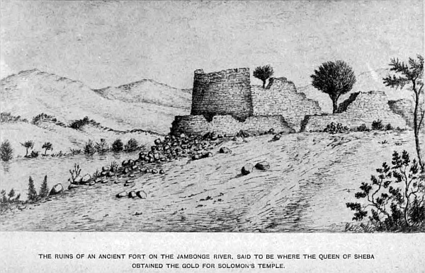
The kingdom of Tarva is supposed to have been in these regions. I have not met with any ruins yet that would lead me to suppose they were once the palace of the Queen of Sheba. I do not think that walls six or eight feet thick, built of small hewn stone without mortar, would stand as perfect as they are the wear and tear of four thousand years, in a country subject to such storms as sweep over this region in the rainy season.
The only relics I have found are broken pieces of pottery, containing much mica, and the well-worn stones the natives used to crush their corn, which must have been in use many years, as they are hollowed out almost like basins, and the round stone the size of a cricket-ball, much worn on one side in pounding the grain. One ancient grave I opened, but found nothing but a spear-head of iron, that crumbled to pieces when handled; the bones had disappeared. I may mention, when prospecting in the channels worn in the beds of the rivers by the water, I have found a great many copper beads mixed up in the gravel and sand, and a piece of silver, that looks like part of a bar, about half an inch square and an inch in length, that was also lying in the bed of the river close to the ruins of the old fort on the Ingwazi river.
The watershed that divides the Zambese and Limpopo basins runs in a north-east and south-west direction, like the backbone of an animal; the spurs representing the ribs, but in places the hill is broken up, as at Gubuluwayo and the country round. The rivers that drain each basin take their rise within a few yards of each other, on the south of the king’s kraal. All the elevated portions of the country are healthy, the lower parts are subject to fever to Europeans in the rainy season, but when the country is occupied by an industrious race, and cleared of bush and drained, it will become as healthy in time as any other portion of Africa, being so elevated above sea-level, viz. 3300 feet. It cannot be so very unhealthy, when Mr and Mrs Sykes have lived at Inyatine twenty-eight years, and have enjoyed good health; Mr and Mrs Thomas, also, for the same time; and at Hopefountain, the two missionaries and their families have enjoyed good health for many years, and at Gubuluwayo the traders have no more sickness than if they lived in any other part of the country considered healthy.
Since my last journey into Matabeleland, Lo-Bengulu has taken to himself a royal wife, the sister of the Zulu chief Umzela, whose territory adjoins the western boundary of the Matabele king, and occupies all the country down to the east African coast, not in the occupation of the Portuguese. This naturally was not very agreeable to his sister Nina, who ruled supreme in her brother’s court, during the time he had no royal wife, which must have made it unpleasant for both parties. I am not acquainted with the particulars, but I suppose the king deemed it expedient to get rid of this annoyance, adopted his usual plan, for he gave orders to some of his people to take his sister away, which is tantamount to ordering her to be killed, but no royal blood must be spilt or the body mutilated; consequently she was taken away and smothered. His royal residence at Gubuluwayo has been destroyed, and a new military camp formed at some distance from it. His new residence is built in the European style, much larger than the former, containing several fine rooms; the principal apartment is capable of holding over 100 people, substantially built of brick, with thatched roof, erected by Europeans. The Matabele who calls himself Kuruman, the son of Moselikatze, and was supposed to have been killed previous to his father’s death, has claimed the kingship, and has many followers, which may eventually lead to much bloodshed.
A railway will do more to civilise the people in the interior and increase trade than any other means that could be adopted to improve the natives and open up the country.
Lo-Bengulu is very favourably disposed towards the English, as I have before stated; what has made him severe on some, is his having lost confidence in many who have gone into his country, and abused the privileges granted to them, which naturally has shaken his good faith in all who visit Matabeleland. When he knows he can depend on any, he is exceedingly friendly, and will do much for them, as in the case of the late Mr Thomas Baines, the traveller, who from his honourable, upright, and straightforward conduct, gained the king’s confidence. The result was, he granted a large concession of his country to him, for working and exploring for gold, and signed a document to that effect, showing that if properly treated he will do good to those who act fair towards him. There are a few old hunters who have for years lived up in Matabeleland, and have the king’s confidence, from acting towards him in an upright and honest way, and have become almost natives of the country; they belong to the old stock of hunters that are fast passing away; only a few are now remaining that could be called hunters of the old days of Moselikatze time, and which formed a little community in themselves. Those were days of real enjoyment, when game was plentiful, and the country not overrun as it is now by a different class of people altogether. Those good old times were before the discovery of diamonds, when even Griqualand West was an unknown land to the colonist. Mr G. Westbeach is now living on the banks of the Zambese; Mr G. Phillips is, I believe, there also; Messrs Byles, Wood, Lisk are now in other parts, and one or two more are all that are left of the old stock of bonâ-fide hunters. At that time they formed a little society in themselves, hired a small farm called Little England, where they would meet once a year or as often as circumstances would call them down from the interior, to procure fresh stock in exchange for ivory, feathers, and other articles. Each member had to undergo fresh baptism in the way of a souse in a large bath made in the water sluit in front of the house, clothes and everything on, and pay his footing in the way of a certain quantity of brandy or square face (gin). When I entered the brotherhood I was suffering with a severe attack of influenza, and consequently was excused the bath, by paying double footing in spirits; keeping up commemoration night till late in the morning, which cured me of my cold.
All is changed now—the country has been of late overrun by traders from the diamond-fields; Boers from the Transvaal, who have unscrupulously abused the native laws of Matabeleland, and made the king doubly severe on all who enter his dominions, and caused the Indunas to look upon all white men as dogs, which has damaged the prestige of the white man in the eyes of the natives, and Lo-Bengulu, who is ruled to a certain extent by them, cannot always do as he would wish. Natives are very susceptible of insult, and as the Boers treat all black men as dogs, and in some way insult them, which they do not forget, this has frequently brought the English traveller or hunter into trouble.
Lo-Bengulu respects the English nation, and has a loyal feeling towards her Majesty the Queen, and as all Bechuanaland has been brought under her protection, now is the time for the British Government to show this sable monarch and his people, by our acts in Bechuanaland, that England’s policy is not to exterminate the black man, but to protect, assist, and benefit him, which policy is the only one to bring Lo-Bengulu and his people into a better frame of mind regarding England’s views towards them, and the only course to eventually open up that country to civilisation. At the present time they fear a Boer invasion, and as they are renowned for their political sagacity, they will be too wise to offend the English people, who may shortly be living on their borders. But if Boers are allowed to settle in Bechuanaland then we may say farewell to peace in that region.
All now depends on the course the British Government adopt in this new protectorate. Lo-Bengulu and his Indunas, I believe, will not interfere or be troublesome on the border of this protectorate, if they see we respect the rights of the black man in the future of that country, and, instead of having the Matabele in any way troublesome, they will become our friends. I see a great future open for that country, which will materially benefit the native races, and be the means of developing that vast region now closed to British merchandise, for that is the great civilising power by teaching the native mind the advantages they will derive from commerce. Whatever cruelty Lo-Bengulu may perpetrate in his own country, will not extend further; he was brought up under the dreaded chief, his father, who ruled his people through their blood, for no other mode of governing them would have availed. But the people are beginning to understand the English ways, in the same manner as the Zulus do in Zululand.
Thursday, 21st May. Walked over to old John Viljoen’s waggon, where he was outspanned under some large trees surrounded by a thick bush, completely concealing the waggons from view; his son and a Boer were making kameel biltong, having shot one yesterday. He is now waiting for the weather to clear up, to have some elephant shooting, his son having seen eight, about six miles away, in the morning. Talking of elephant shooting, he said he had shot seventy-nine at different times, and he told me, a Scotchman, Mr Thackery, had shot ninety-nine, and in shooting the hundredth, when the animal laid apparently dead, he climbed up him over his head, when the elephant gave him a blow with his tusk and killed him on the spot. We arranged to go out together on Monday. He also told me he shot a python, a few days ago, measuring eighteen feet in length, and twenty-eight inches round; he saw several others, but they got away. On returning to the waggon I found a trader, Mr Mussenden, with his waggon outspanned close to it, who was surprised to see me, having long ago heard that I had been murdered by Bushmen up in the interior, that it was reported throughout all the country, and everything stolen; he said he had often heard of my being in the interior, and through the Desert, when he was up-country, but never expected to see me alive again, and was very glad we had met, as he often wished to know me. Many such reports get about of explorers and hunters being murdered or lost in the bush; and it requires great care to avoid some of these dangers in so extensive a region, particularly to those who have not the bump of locality. When leaving your waggon, in the saddle or on foot, before starting, be particular to take bearings of mountains or any prominent objects. When the sun is perpendicular at mid-day, it is difficult to know the north from the south, and if you have left your compass behind, those unaccustomed to be in a wooded region soon become confused as to the direction to be taken to regain their waggon. Several, whom I knew, have lost their lives in this way, and were never heard of more. A young man, William Hancock, I had with me as my driver, when outspanned in a level country, with dense bush, took his gun early in the morning to look after game, and never returned all that day, and night coming on, I began to fear for his safety; the whole of that night I was in a fearful state of alarm, firing shot after shot to let him know our position, but no reply; I got no sleep that night. At daybreak I saddled-up and started in the direction he took, firing shots frequently, and I sent my loop-boy out in another direction. After calling and shouting until nearly losing my voice, up to 2 p.m., a distant report came to my last shot; starting off in the direction at as great a speed as I could make in the thick forest for at least a mile, I fired again, when a reply came at no great distance. Going towards it and shouting, I heard a faint voice in amongst the trees, and Hancock came towards me; he was nearly demented, and looked as if he had grown ten years older. Before asking any questions, I gave him a flask full of brandy and water, and some biscuits which I brought with me. He told me he had been in a pursuit of a koodoo he had wounded, and in the chase had lost the direction of the waggon, and in his endeavour to reach it had wandered in the opposite direction and became so confused that he did not know where he was, firing off his rifle at times to let us know, but the distance prevented the reports being heard, and as night came on he gave himself up as lost, and climbed a tree, where he passed the night, as many lions were about; some of them came almost under the tree. In the morning he got down, fired off several shots, until he had only two charges left. He said his anxiety made him lose his strength, and from want of water and food he was nearly exhausted, and when he heard the report of my rifle he felt he was saved from death, and obtained renewed strength and fired his last cartridge, which brought me to him. Mounting him in the saddle, we returned to the waggon, distant at least four miles. Now this young man, born in the Colony, accustomed all his life to being out in the open air after game, had no knowledge of taking bearings from time to time, to see the direction he was going; the poor boy—for he was only nineteen—felt he had gained a new life. I gave him a few lessons on woodcraft for his future guidance if placed in a similar position. He was a most willing lad and of great assistance to me in my wanderings; he was a son of one of the early settlers of 1820.
Finally, we may conclude, in leaving this region, that the knowledge already obtained of the richness of the Matabele and Mashona country by exploring parties that have been allowed to prospect, only in certain districts, and by others who have travelled through it in other parts, and from my own observations, there is not a shadow of a doubt that eventually this part of the continent will surpass all others in Southern Africa as a gold-producing district, in the cultivation of cotton, and other valuable products, that cannot but prove most beneficial to the power who may obtain it; and to the benefit of its people, instead of its remaining in its present barbarous state, where the slaughter of its inhabitants depends on the present whims of its despotic monarch.
From what has already been discovered of its richness, we see plainly the ancients, who extracted the gold, have only done so to a limited extent—what may be termed surface workings; for their numerous pits, after all, are mere scratches in the ground at places, but when they are properly worked and greater depth attained, the mines may be found almost inexhaustible. And if the gold-dust, found in the sand of the rivers, can be procured by a few single washings from a small dish, what may be expected when the whole of these rivers have been properly worked?
Chapter Twenty Four.
The physical geographical features of that region, lying between the Matabele and Mashona country, and the Indian Ocean, now under the rule of the chief Umzela and other chiefs.
This extensive portion of South Central Africa abuts on the north-east boundary of the Transvaal, the eastern boundary of the Mashona and Matabeleland, and the Zambese in the north, up to 29 degrees 50 minutes East longitude. On the east by the Indian Ocean, and on the south by the Portuguese possessions at Delagoa Bay. The main watershed passing through the Mashona country, which divides the Limpopo from the Zambese river, in 18 degrees 10 minutes South latitude, turns east and separates the waters flowing into the Zambese, through the Mazoe river, from that which flows into the Sabia, runs south down to 21 degrees 10 minutes South latitude, 32 degrees 5 minutes East longitude, when it turns easterly and north-east, and enters the south side of Sofala Bay. This river has many tributaries on the west, draining a portion of the Mashona country, but on the eastern bank there are few, and those but small. The most important river is the Buzi, taking its rise from many small tributaries in a hilly district, to the east of the Sabia in 20 degrees 30 minutes South latitude, 32 degrees 30 minutes East longitude, on a tributary of which the Umsweleze, the chief Umzela’s kraal, is situated; the Buzi from this point takes a sweep round in a north-east direction, and enters the Indian Ocean in 19 degrees 50 minutes South latitude, passing through the Sofala region, between this latter river and the Sabia. The Garogesi river enters Sofala Bay.
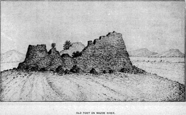
There are several small rivers north of the Buzi to the mouth of the Zambese, that drain the coast-line, which is very flat and marshy. The tributaries of the Zambese are the Zangwe, Sankatsi, Mowila—the main branch of the Mazoe enters the river below Tette—Nake, Zingesi, and Panyame. In the northern portion, between the Mashona and Zambese, are many isolated and extensive hills,—Vimga, Nadsu, and Vimiga, drained by the Nake and Zingesi. To the east of these hills is the Lobolo mountain, with its many spurs, and more to the east the Moltkeberg, drained by the Mazoe and its tributaries, Gaverese, Upa, Janhambe, Jankatse, and others of smaller note, all which are in the Zambese basin, which includes also—lower down that river—the Mowila, Sankatsi, and Zangwe.
The country towards the sea is flat and most uninteresting. There are several low ranges of hills in outlying districts. The country generally is dense bush, and full of game. The Portuguese possessions do not extend many miles beyond the south bank of the Zambese river. The chiefs in those districts claim up to that line.
The altitude of the Lombolo mountain is 4200 feet, and the Moltkeberg 3700 feet above sea-level. The general rise of the country is 1700 feet, gradually sloping towards the Zambese and coast. The northern division is divided into different tribes under their respective chiefs. The Banyai country is between the Mashona and Zambese, in which is situated the Portuguese town of Tette, on the banks of the Zambese. Pretty and picturesque country around, with fruit of every kind, melons, oranges, lemons, sweet potatoes, pines, and every kind of vegetable; but the Portuguese are so lazy that everything is left almost to nature. The river is navigable for small steamers for seventy miles above Tette, which is situated 260 miles from its mouth. Magnificent timber trees grow in the valleys, and on the slopes of the hills ivory palm, Mali palm, the palm that grows to the height of eighty feet; the seed of the fruit is eaten by the natives; it grows in the uplands, and down on the low-lying swampy country. Mashola, a tree that bears a round fruit similar to the Kaffir orange. The india-rubber tree is very common; the fruit can be eaten. The Umtonto tree is used for making baskets and other things. Large tracts of country are covered with the Mowasha bush, mahogany, and ebony up in the hill districts, and all similar trees found growing in the Mashona country are found there.
There are many native villages along the banks of the several streams, the country being very thickly populated, particularly in the hill districts, and the people are industrious and skilful workmen in all branches of trade, and they make their own blankets from the wild cotton and baobab tree, which they work by hand, the former by having the yarn spun by hand with a small stick, weighted at the end; four sticks are stuck in the ground to form a kind of loom, the yarn stretched tight, and being wound on a piece of wood, is passed backwards and forwards, the strands being threaded, to allow the woof to pass through and through by a backward movement of the hand. They can make blankets the usual size, and very white and strong. They also manufacture bands of various sizes for native uses. The blankets made from the bark of the tree, and bags to hold milk, are very strong and beautifully made. The females are fond of ornamenting their persons, wearing copper and brass rings round their necks, on their legs and arms, and some have silver, which I was told is got out of the mountains. Gold is found in all the mines in the Banyai country; the natives sell it to the Portuguese at Tette, and quartz reefs cross the country in many districts; several portions have not yet been visited, consequently the richness of this region is not known.
On the mountains and high lands the country is healthy, but the low-lying ground in the rainy season is very unhealthy. Portuguese native traders are the only ones that go into those extensive regions, and supply the population with beads, brass wire, and other things in exchange for the gold-dust they procure from the rivers. There is an old fort on the Mazoe river, under the Lobolo mountains, and several others higher up that have been partly destroyed by the natives for walls for their gardens, where they plant small fields of cotton to make their blankets; a little piece is so occupied adjoining their huts, and it is found to grow very well in elevated positions. I have found it wild as high as 4300 feet above the sea-level, in a light soil, where water is not found near, but in the low lands it is very plentiful.
South of the Banyai country is the Batoka, in which is the Moltkaberg, watered by the Upa river, a tributary of the Luenya. The source of the Mazoe rises on the watershed in this region, at the Sakaloko kraal, in 18 degrees 0 minutes South latitude. Another spring issues close to Mebka kraal, and at Gangwesi kraal, at an elevation of 4210 feet above the sea, and flows north, on which there are many villages, close to several large vleis, and towards the east is the large kraal of the chief Makombes on the Mewila river. There are also many other native kraals situated on all the branches of this river down to the Zambese, and along its banks, Senna being the most important, where there are several hills that skirt it. The Batoka tribe is numerous—a fine, powerful race. The country is full of bush and fine timber, the same which grows in the Banyai district.
On the east of Batoka is the Senna region, which reaches to the Zambese and to its mouth, and along the eastern coast, down to where the Sofala joins it. All that is known of this country is that it is very flat and low; and within its boundary, on the banks of the Zambese, Dr Livingstone’s wife was taken ill and died, and was buried on its banks under a baobab tree, a little below the town of Shupanga, and opposite to the town of Mulu. Forty miles above the great river Shire branches off, which flows from Lake Shirwa, in 15 degrees 0 minutes South latitude, 35 degrees 50 minutes East longitude. There are few hills in this part of the country of any note. Cotton grows abundantly, and vegetation is coarse and rank in the swamps.
On the south of Batoka is Birue. This region joins up to the Mashona country, the Sabia being the boundary, Senna on the east, and Sofala on the south. The Sabia river rises in 18 degrees 10 minutes South latitude, near the village of Sakalato, and flows south as before stated. Upon the banks are Kambesa, Gansuma, Umsosa, Kambiss, and others. The country is high, with hills of no great extent, thickly wooded, with abundance of large game of every kind; palms, baobab, mahogany, ebony, mapari, india-rubber, and a variety of other trees. The valley along the river is very pretty and picturesque, well cultivated by the natives, and produces every kind of vegetable. The people are civil, but very inquisitive, and great beggars. White cotton seems to be much in demand. The land gradually descends towards the ocean, until the flat and swampy country is reached.
To the south of Birue is the district of Quitive, a portion of Sofala that joins up to the Sabia, on the south by Umselayon region. This district is supposed to be the kingdom of the Queen of Sheba. Manica is the principal kraal, near which are several ancient ruins, and the remains of a tower a few miles to the north-west of Manica. It stands on high ground, 4100 feet above sea-level, which descends to the east, and not far from the ruins is a large sheet of water, also several plains on the south of Manica. The population is a mixed race, composed of Umgovis, who are part Zulus, Mandowas, Basigas, Batagas, Mashonas, and others, who are under the chief Umzela. There are extensive open grass-lands, and the low-lying country is healthy during five months of the winter, when there is no fear of taking the fever. Thirty miles south of Manica the land rises to 4458 feet.
To the east of this district is the Sofala region, in which the Portuguese town and port of Sofala are situated. The town is but a poor place, as all the Portuguese towns are on this coast; but they command all the trade of the up districts, which is considerable in ivory, skins, a few ostrich feathers, and other products of the country. It is situated in 20 degrees 10 minutes South latitude, 34 degrees 30 minutes East longitude. The country at the back of the town is hilly, occupied by the Mandowa tribe, and is more healthy. The river Bozi flows through it to the sea, well-wooded with fine timber and bush. Elephants, rhinoceros, and large game abound. Rice, cotton, spices of all kinds, oranges, lemons, citrons, bananas, figs, and wild fruit. I was told that Umzela, the chief who occupies the country south, claims as paramount chief all those districts in the north, down to the Mandanda region; but his claim is something similar to that of the Portuguese, who lay claim to all South Africa to the Atlantic Ocean, from Sofala. He must be content to put up with such regions as he now has power to govern; and those countries north of Birue are independent, except such portions along the coast and up the Zambese as the Portuguese have the power to rule, which is not much beyond the guns at their so-called forts. With respect to any extensive or strong stone remains of ancient cities, supposed to have belonged to the love-sick Queen, there are none, beyond those that have been erected without mortar. If this district formed part of her kingdom where she resided, her palace must have been small, and of no account. If substantial buildings had been erected, they would surely be there now, as the natives with the means at their disposal could not have destroyed them; but what is so remarkable is that no relics have been found of any kind, no rubbish left where they may have stood. The only one I discovered was in a stream of the Sabia, where the copper beads were found. It was an oval piece of copper, the size of a sixpence, and as thick, with much defaced marks on both sides that cannot be made out, being so much worn. To pronounce it a coin would be premature. When the country is properly prospected, there may be found sufficient evidence to settle this long-disputed question; but if extensive ruins existed, the natives would know, and it would soon have reached the ears of travellers that have passed through that country. There must be some foundation for these ancient traditional reports. The country shows that in remote times gold in large quantities has been extracted from the earth, and if it is so easily found in the rivers, why should not nuggets have been found lying on the surface, which first drew the attention of the ancients to look for it. The name of the river flowing through this region, the “Sabia,” may have been changed by time from “Sheba,” the same as “Sofala” for “S’Ophir.” There is also a ruin called Piza, and another Manica, two names foreign to the other names of the country; and the region of Monomotapa may have received its name from some early inhabitants, descendants of the people under this renowned queen. At present nothing is definite on this point, and the magnificence of her palaces have been, much overrated in ancient history. If this was the real Ophir of Solomon, the Arabs along the coast and at Sofala believe this to be the true Ophir, Umzela was the great chief of all that part of the country known as the Birue, Quitive, Sofala, and Mandanda regions. His chief kraal, Utshani, is situated in 20 degrees 27 minutes South latitude, 32 degrees 28 minutes East longitude, between lofty hills, the altitude being 3180 feet by aneroid barometer, and it is situated on the upper source of the Buzi river, which flows in a north-east direction and enters the Indian Ocean on the north of the town and port of Sofala. The country is very fertile, and the banks of the Sabia on the west of the town, through which that river meanders in a south direction, is flanked by high and picturesque hills, and clothed in all the beauty of tropical vegetation. Mahogany, ebony, untanto, palm, umchani, maparri, umsimbili, bananas, assagaai or lance wood, barrie, boschlemon, wild almond, kajaten (a fine black wood), knopjes doorn, wild olive, saffraan, fig, cabbage tree, makwakwe (the strychnine of the country), vitboom (quinine), india-rubber, and a host of other sorts that would fill a page if named, all most valuable for various purposes. Large flocks of sheep and goats and herds of cattle are reared. There is also the large game, such as elephants, rhinoceros, giraffes, buffaloes, koodoos, and other large antelopes, lions, tigers, wolves, jackals, tiger-cats in plenty, beside the various earth-animals, ant-bears, porcupines, armadillos, and many others. Umzela’s territory is called Umselayon, which embraces all those districts above described. The mountains which completely encircle the chief’s kraal are very picturesque and peculiar in their form, making the Sinika river a tributary of the Buzi; which forms in its course almost a circle, thickly studded with fine timber and bush, and they do not extend much beyond the river towards the east, which is a low, flat country to the sea. The Portuguese have no control over any part of Umzela’s territory; they only hold possession of narrow slips of land along parts of the coast. The natives offered no opposition to my visits, and were willing to barter food for articles of clothing, principally linen cloth; but in many other portions of the country I had to use great caution to prevent suspicion as to the object of my visits. In many cases I have passed through tribes who would have been troublesome, but as I took goods to barter I was considered a trader, and as such one can journey almost anywhere. Some considered also I was a doctor or medicine-man, because I caught and preserved insects, snakes, and other small reptiles, besides plants. When this idea takes possession of some of the African races, they leave you unmolested; any injury they might inflict would be considered unlucky to themselves. I used to carry representations of snakes of wood, that are sold in England, and masks with extensive noses, so that when the natives came round my waggon begging, as they frequently did, from two to three hundred at a time, I would draw down the front sail of the waggon, slip inside, put on one of these masks, and with the snake curling about in my hand jump out in their midst, when the women and children would rush away howling, the men after them, to their kraals, and I would be left free from annoyance. During my stay at their station, before I could obtain these things, I used a large burning-glass, and when any one troubled me, would burn their hand until it began to pain. Then I would run after others, which soon cleared them off. Travelling past their kraals so frequently they knew my waggon, and if they pestered me for presents I had only to get out my sun-glass, and they were away in no time.
The only rivers of consequence beside the Sabia and the Buzi in this portion of Umzela’s country are the Umkoni, Umswelise, Umtschomie, Gerongosi, the source of which rises not far from the Buzi, runs east, and enters the Indian Ocean, about twenty miles south of Sofala. The Lusuti rises with several branches about thirty miles to the north of Umzela’s kraal, and joins the Buzi sixty miles from its mouth. There is also the Haroni and its tributary the Lusiti, and the small river Donde that flows into the Sofala harbour. South of the Mandanda region are the districts of Sheshonga, Indobolini, Mashelbe, and Makalingi. To the east is the Manklin district, that takes the coast-line from Maramone Bay, down south to Cape Lady Grey, off which are the islands of Bazaruta, Benguela, Sigin, and a small group at Cape St. Sebastian. To the north of Maramone Bay, some thirty miles, are the two great islands of Chuluwan. All the coast-line is flat, infested with the tsetse-fly, and most unhealthy. The Mandowa tribe occupy the hill district and country inland from Sofala, and it is under the rule of Umzela, and is in charge of Imbasugwar, one of his chief men.
Manukuza, father of Umzela, is a Zulu from Zululand, who fled from Chaka, the great Zulu king. His followers are called Mongonis, and all the tribes under him, viz. Basigo, Kulu, Mandanda, Cholee, and Mandower, are called Tonges. Deloms, a chief of Umzela, is over the district of Mazibbe, and Sondaba, an Indian, over Sheshongi, which is on the south side of the Sabia. The country is flat and marshy, and full of game. Rhinoceros, elephants, koodoos, giraffes, wildebeest, wild hogs, and nearly all the antelope tribe, and zebras. Date and other palms, bananas, jute, and wild cotton, beside many native fruits abound.
A very poisonous plant grows on the flats, from which the natives extract, from the seed, poison to put on their assagais and arrows.
(This poison is the strongest known. An eminent toxicologist, who in distilling became inoculated with it through a slight scratch. He was nearly dying for six weeks, and said he had no idea that any poison could be so strong; it would kill a man in three minutes, and an elephant in one hour and a half. The flesh of animals killed by it is not poisonous. It loses its strength by evaporation in about a year.)
The country in places is noted for its immense ant-hills, almost as large as those I have described in another part of this work. The southern boundary of Umzela’s territory is not at present ascertained; the country south of that already described is known under the name of Umhlenga, where the Queen Mafussi, of Inhoxe, rules a portion, which is a vast, open, undulating country, through which the Limpopo flows for over 200 miles to the sea, at Port Alice. The Lundi river, a tributary of the Sabia, joins it in Umzela’s country. It is the continuation of the Ingwesi, mentioned in the Mashona description. To the south of this region, and inland from the town and port of Inhambane, is the region called Makwakwa or Marangwe—a strong, powerful race of the same tribe as the Chobis, Bala Kulu, Basiga, Mashongonini, and Mandandas. Inhambane is situated on the sea-coast. The territory is very narrow, not exceeding twenty miles inland, and eighty miles along the coast.
A small river, the Inyanombi, falls into the bay, and the river Zavara drains the country of the Makwakwa’s tribe—a low, flat region. There is still a tribe occupying a part of Umzela’s territory that call themselves the powerful Makololo race, of the same family that ruled an extensive region on the Zambese river above the Victoria Falls, and became a terror to the neighbouring tribes. The Barutse people fought and nearly exterminated them, scattering those left far and wide amongst other tribes, and broke up the race entirely. This Makololo nation on the Zambese extended as far as that white tribe mentioned, living on the Quito and upper portion of the Cubango—now become mixed with the black races, and from reports, a wild and savage race, eating human flesh. May not these two tribes have travelled up the Zambese together at some remote time? It seems singular that the Makololos in Umzela’s country should call themselves the once-powerful Makololo tribe; and we find them on the Upper Zambese, the most powerful tribe in all that central part of Africa, 400 miles away from those in Umzela’s land. It is an interesting study to trace the various periods, as they advanced south from Egypt, and to find at the present time many Arabian and Jewish customs amongst them; and another interesting feature of those races is that many names of places in Central Africa are precisely similar to many names in the islands of the South Pacific Ocean. So far as is known of this country, we come across limestone, slate shale, red sandstone, green stone, quartz, porphyritic rocks, gravel, and on the western slope of the highlands, granites.
Referring again to the land of Ophir, there are no black races in any other part of Africa that allow a woman to rule over them; but in the immediate neighbourhood of Sofala there are three queens, viz. Queen Mafussi over Inhoaxe, adjoining Umzela’s territory, and immediately on the south of her are the two Queens Majaji and Mescharoon. May not this be one identification, that it was right that woman should be a ruler as well as man, handed down from the Queen of Sheba’s time? Also a large portion of Madagascar is ruled over by an Arab race that must have settled there a very long time ago. Their language is Arabic, and queens of that island have and do now rule the greater portion of it.
Chapter Twenty Five.
The Portuguese possessions on the east coast, within South Central Africa.
The earliest records we have of this coast-line is from the Portuguese, who first sailed round the Cape to the north, as far as the Mozambique coast, in 1497, under Vasco de Gama. In 1508 they visited the coast again and conquered Sofala, and soon after Quilimane, Inhambane, and Delagoa Bay, where they built a fort at Lorenzo Marques in the inner harbour, and took possession of the coast northwards, including the mouth of the Zambese and both banks of that river beyond Tette, where they formed a town, claiming the country far in, up the river and along the coast, but at the present time they have no jurisdiction over it, beyond a few miles of the coast, the natives not allowing any interference with their rights beyond the reach of their guns at the forts.
Up to 1875 the Portuguese only held the northern portion of Delagoa Bay, down as far south as the 26 degrees South latitude, and half of the island of Inyack; the English Government disputing their claim to any territory south of the 26 degrees, and the southern portion of Inyack was held by the British Government. Much correspondence passed between the two Governments, when it was referred to arbitration, and Marshal MacMahon, then President of the French Republic, decided in July, 1875, that the Portuguese had a right to the country down to 26 degrees 30 minutes South latitude, which included the whole of the bay and island of Inyack—to the exclusion of British interests. The boundary then laid down as the southern limit of Portugal should follow that latitude up to the Lobombo mountain, which borders on Swaziland, an independent chief.
Following the mountain north to the middle of the lower part of the Comatie river, where it flows through that mountain, from thence in a north-east direction to Pokionies Kap, on the north side of the Olifant river, where it passes through the mountain north-west by north, to the nearest point of the Stricundo mountain, on the Umzim Voobo river, then in a straight line north to the junction of the Pafarie river with the Limpopo. All on the west of this line is the Transvaal boundary. This is the boundary on paper and maps, but the Portuguese have no more jurisdiction over the country north of 25 degrees between the sea and the Transvaal boundary, than they have over Umzela’s territory, with the exception of a small portion along the coast to the Zambese river, and up that river to Tette. The Barpeda tribes, east of the Transvaal, are divided into many classes, ruled over by independent chiefs.
The country at the back of Delagoa Bay is a flat unhealthy country for forty miles inland, when it begins to rise, until the summit of the Lobombo mountain is reached. The river Lorenzo Marques, which enters the inner harbour at Delagoa Bay, is navigable for small craft for forty miles up. The region to the north of that harbour, through which the lower portion of the river Limpopo passes, is a low flat country, full of bush, and most unhealthy. The tsetse-fly swarms. Large game is plentiful over all this region. The southern portion is called Gasa; the northern, Umhlenga—already described. The entrance of the Limpopo river is in 25 degrees 17 minutes South latitude, and about three miles broad, which it continues to be up to the junction of the Olifant river, gradually narrowing towards the north. It is full of hippopotami and alligators that grow to an enormous size, and several kinds of fish.
Lorenzo Marques is the capital of the Portuguese possessions in East Africa; for some distance along the coast it is a dirty unhealthy place. The fort mounts a few old guns, and is the governor’s residence. Several stores are kept by Portuguese natives and one or two English. The inner harbour, upon which the town is built on the north bank, is picturesque. Tropical trees of many varieties grow: cocoa-nuts, palms, bananas, lemons, oranges, beside vegetables; but the inhabitants are a lazy set of people, and the town or country will never improve under its present Government.
The islands of Imyack and Elephant command the entrance of the outer bay, and the islands at the mouth of the Uncomasi or King George’s river, Krocodil, and Sabia, that rise in the Transvaal south of Lydenburg, which has never been thoroughly explored. The coast-line from Delagoa Bay to Inhambane is likewise little-known, as also between that port and Sofala, and north to the Zambese river. The principal towns in the Portuguese possessions on the east coast are Lorenzo Marques, Inhambane, Sofala, and the two small river towns up the Zambese, Senna and Tette. Steamers occasionally touch at all the coast towns named, on their way to Zanzibar from Natal.
Quilimane is situated on the north of the Zambese river, upon one of its branches, where a Portuguese governor resides for that district.
Another Sabia flows into the ocean near Sofala.
Chapter Twenty Six.
A cursory glance at those ports of South Africa that occupy the extreme south of the African continent, south of South Central Africa.
South of South Central Africa, which has comprised my field, of exploration, is the Colony of the Cape of Good Hope, which takes in the whole of the southern peninsula of the African continent, from the Orange river to Cape Agulhas, and extends towards the east as far as Natal. It is divided into the eastern and western provinces and Griqualand West. Cape Town is the seat of Government and the capital, and is governed by a High Commissioner and Governor, a Ministry and Legislative Council, and a House of Assembly, both elected. The Governor is appointed by the British Government.
The principal ports are Table Bay at Cape Town, False Bay, including Simon’s Town, and the naval station of the colony, Mossel Bay, Algoa Bay at Port Elizabeth, East London, and a few small bays along the coast.
The principal rivers are the Orange, Caledon, Kraai, Zeekoe, Buffalo, draining Little Namaqualand, Olifant, Berg rivers draining the district of Malmesbury, Zout river draining Koeberg and neighbourhood. Easters river enters False Bay, Londerende river drains part of Swellendam and Worcester districts, Gawirtz and its tributaries drain the George, Worcester, and Beaufort districts, and several small streams up to Zwartkops, that enters the sea a few miles to the north-east of Port Elizabeth. Following up the coast are Samdays, Bushman, Kowie, Great Fish river, Kaga, Koonap, Kat, Keiskama, Buffalo, Great Kei, White Kei, Indwa, Tosmo (which drains the country round Queen’s Town and part of Kaffraria), Bashee, Umtata, Umzimvobo, and Umzimcula; not one of them is navigable from the great fall they take in their course to the sea, and they have deep water in them only after heavy rains, which is the case with all the rivers in this colony.
There are several mountain ranges, viz. Table mountain at the back of Cape Town, 3500 feet above sea-level. Stormberg, Zwagerskook, Winterberg, Amatola, and their spurs, and many others of less note. Some of them are 8000 feet above sea-level. On the eastern border in Noman’s-land is the Drakensberg, that divides this colony from Natal, having its lofty head 10,000 feet above sea-level, where the grand scenery is rarely to be equalled in any part of South Africa. Noman’s-land or Griqualand East, principally occupied by the Griqua tribe who left Camphill ground and took up their residence in that fine rich country.
Numerous vleis and pans, some extensive, many are dry the greater part of the year. The largest is Commissioner’s pan, in what is called Bushmanland, some twenty miles in circumference, and contains a crust of salt on the dry bed, where there is no water in it. There are salt-pans near Uitenhage, Cradock, and Betheldorp, beside many fresh-water pans of considerable extent, but they are becoming dryer every year, as also the fountains: many of them thirty years ago gave out a copious supply, and at the present time are small streams. Verkeerde vlei, close to the Karroo Port, water is generally found in it, as also Vogel vlei, no great distance from the Berg river. Nearly every other vlei may be termed pans, being so shallow, they are scarcely distinguishable from the surrounding country; so impregnated is the soil with salt that many springs and fountains have a brackish taste, and this is the case all over the southern part of the African continent, which indicates that at one time it had a close connection with the ocean.
Several mineral springs in the Cape Colony, both hot and cold. A chalybeate spring at the foot of the Kradoun mountain on the eastern slope with a temperature of 110 degrees. Hot springs at Montague, Winterberg, Caledon, Malmesbury, Olifant, and one near Breed river, which is found to rise to a temperature of 156 degrees.
The mineral wealth of the colony is not known. Copper is found in large quantities in Little Namaqualand, near the Orange river. Near Port Elizabeth lead has been found. Iron is largely distributed over many districts, and coal has of late years been found near Stormberg, Burghersdorp and other places, and conveyed to the diamond-fields, which turns out to be of better quality than was at first expected, and lately gold.
Very fine caves in the Zwarteberge range of mountains, a short distance from Oudtshoorn village, much resorted to, for their peculiar beautiful stalactites of limestone formation.
Many extensive forests in the colony, near the town of Clanwilliam, Outenigera, Zitzikamma; there is also the Adda bush, dense bush along the Amatola mountains, Kat river, and the Knysna. To the eastward we find the Kadoun forest, extending nearly eighty miles in length along the sea, and some fifteen miles in width.
Deep extensive kloofs along the mountain ranges are well-timbered. The Great Fish river bush is very extensive, and many others along the Buffalo mountain, Katberg, Chumie, and Boschberg, are densely wooded with fine timber, principally yellow wood that grow to a great size.
The great Karroo desert is situated more in the western division of the Cape Colony, lying between the mountains Bokkeveld, Wittebergen, and Swartebergen. In length it is from Mitchell’s Pass in the south nearly 400 miles, extending northwards to the Orange river, and from east to west over eighty, a most wretched and dried-up country; scarcely a blade of grass to be seen. The Karroo bush is plentiful, of which the sheep are very fond—a dreary waste. The main road from Cape Town to Hope Town and Kimberley passes diagonally through its entire length, through Mitchell’s Pass, a fearful gorge of seven miles, the road cut out of the solid sandstone rock on the left hand, with perpendicular cliffs, and on the right a precipice of some three and four hundred feet; the only safeguard to prevent carriages from falling over are a few large boulders placed at long distances apart to prevent any vehicle from going too close to the edge. The scenery along the seven miles of this pass is grand in the extreme, but it can only be enjoyed when on foot, when at every few steps a halt must be made to view the bold outline of this wild and picturesque pass. The railway from Cape Town to Hope Town avoids this singular formation, consequently the great traffic is carried round in another direction, more to the east, passing through Beaufort West and Victoria West, over a flat and barren part of the great Karroo. The mountain pass at Franschehoek is very fine, also Baiu’s Kloof, both possessing grand scenery.
The principal towns in the colony beside Cape Town, in degree of importance, are Port Elizabeth, Graham’s Town; the capital of the eastern province is pleasantly situated in a fertile valley. Victoria East, Ceres, Beaufort West, Hope Town, close to the Orange river, through which the railway runs to Kimberley diamond-fields. Somerset is situated at the foot of Boschberg mountain, one of the most picturesque towns in the colony; Bedford is built at the fort of Kagaberg, in a rich and valuable part of the country; Cradock, a town situated on the bank of the Great Fish river. Graaff Reinet is erected on the Sunday’s river, one of the most pleasant towns in the colony, situated in a mountain region, some of them are the highest in the colony. Compassberg is over 9200 feet above sea-level. Sneeunbergen is another prominent mountain range with beautiful scenery, and the town is well laid out; the streets have oranges and other trees planted along their sides, that add much to the general appearance of the town. Colesberg is situated on the main transport road from Port Elizabeth to the diamond-fields, Kimberley, Orange Free State, and the interior. The railway from Port Elizabeth runs to Colesberg, from thence passengers and goods are conveyed by passenger-carts and ox-waggons. (A railroad now runs through this country to Kimberley.) The town and country are not very inviting, a vast extent of barren open plains, that slope towards the Orange river, of which the town is distant some eleven miles. Richmond, Hanover, and Middleburg are rising towns. Aliwal North is situated on the Orange river on the main road to the Orange Free State and also to Kimberley. Burghersdorp is on the Stormberg river. Albert is another town in this district, and is on the road from East London to the Free State. King William’s Town, Grey Town, and East London are in the same division; the latter is a rising port, and will eventually be very important as a sea-port. Queen’s Town is situated on the Indwe river, and has several native locations belonging to the Tambookie tribe. There are several small villages situated throughout all these districts. To the east is what is termed British Kaffraria, in which the port of East London is situated on the Buffalo river. Its eastern boundary is the Great Kei river, separating it from Kaffirland proper; the country is picturesque, with lofty and well-wooded hills.
The native population in British Kaffraria are mostly of the Gaika and Amakosa Kaffirs.
The population of the Cape Colony is various. The western province has a greater proportion of the Boer element than the English, but in the eastern province the English predominate. Many Germans have settled in the colony since the German legion has been disbanded, and form a considerable portion of the population. French, Swedes, Americans, and many others from different countries, not forgetting the Chinaman.
Of the natives there are the Hottentot, whose pure breed is nearly extinct; a few are now living on the banks of St. John’s river. Korannas, who are closely allied to the Hottentot, and are found more to the north on the Orange river, as also the Bushman. Griquas, a bastard tribe, descendants of the Dutch and Hottentot women, who have their separate captains, and live much after the Boer in habits and customs. In the Cape Town district are many Malay from India; in fact I may say one-fourth of the population is made up of them. Those races that may be termed Kaffirs are the Gaika, Gonebi, Amakosa, Slambie (who occupy lands in British Kaffraria), Amagaleka, Amatembu in the eastern part of Queen’s Town, and the country to the east of this division on to Natal is Kaffirland proper, known under the name Tambookies.
Railroads have been extensively increased of late years, running through the country to all parts. One direct from Cape Town to Port Elizabeth, another direct to Kimberley, Worcester, Graham’s Town, King William and Queen’s Town, and many other parts.
The public transport roads are in most cases good, but many that wind over the steep mountain passes are very bad, and trying to oxen and mules when they have heavy loads.
Griqualand West forms a portion of the Cape Colony, and is situated on the north side of the Orange river, and as it has been fully described in the first part of this work, in consequence of the greater portion of it being included in South Central Africa, I have merely to state that Kimberley, Bulfontein, De Beers and De Toitspan, the four large mines, now form one considerable town, and may be considered the richest of any in the colony, with a population that is not living in a sleepy hollow, as the rest of the colony is, but showing some vitality and energy, which has in a great measure saved the colony from ruin.
The district of Cape Town is very pretty and picturesque, well planted with firs and other trees. The town is well supplied with fruit of almost every description and vegetables. Abundance of fish are caught in the bay.
The climate is mild and healthy; the rainy season commences in the autumn, about May, and lasts until August. In the summer months it is rare to have a storm.
Wild animals are becoming very scarce; a few of the large game such as the elephant and buffalo are preserved in the Addo, Kowie, and Zitzchkamma forests, and may be occasionally seen going down in troops of thirty and forty to the sea to have a bath. A few wild beasts; blesbok and many springbok may now be seen on the plains, and also the ostrich.
Tigers and tiger-cats are yet plentiful in the kloofs of the mountain ranges that extend so far through the colony. A few sea-cow, I believe, are still to be seen in the rivers on the eastern border, beyond East London.
Between the eastern division of the Cape Colony, that is Kaffraria proper, and the upper part of the Caledon river, is Basutoland, an extensive region that joins up to Natal or Drakensberg mountain as its eastern boundary, the north by the Caledon river and the Orange Free State, as also a portion of its western boundary. The country is very mountainous, with deep and thickly wooded kloofs, making the scenery very lovely. Some of the hills on the Drakensberg side are 9500 feet above sea-level. The Basutos are a branch of the Bechuana family, of the Barolong tribe, the same family as Montsioa, who left Basutoland when young, and occupied the country he now holds on the Molapo river. The small district of Thaba Nchu belonged to these people, which was separated from Basutoland by the Free State, and in fact that state surrounded it; and in consequence of a difference between the two chiefs, Samuel and Sepinare Moroka (the latter being killed), President Brand went with a force of Free State burghers and took possession of the town and territory of Thaba Nchu, and annexed it to that state. Samuel was the son of the old chief Moroka, the other his nephew. When Moroka died in 1880, the people were divided as to who should be the chief. There is no doubt the son had the greatest claim; he was an educated Kaffir, having spent several years at St. Augustine’s College, Canterbury, and was in every respect a gentleman in behaviour. He is now a wanderer amongst his tribe.
Thaba Nchu, in 1863, was the largest native town in British South Africa; the population then was about 9000, with mission houses and church schools.
It was from this station, in 1837, that the Boers who escaped from the fight with Moselikatze, joined the Barolongs to drive that chief from Mosega, and collected a force of 1000 men. Montsioa, the present chief, held command of part of the expedition, and through the Basuto assistance, the Boers managed to drive Moselikatze more to the north. We now see the return they get for this help: their country at Thaba Nchu taken from them, and Montsioa would have lost his, and himself and people been murdered, if the British Government had not stepped in at the eleventh hour and saved them. Basutoland, which is separated from Thaba Nchu, is now under British protection, and is one of the finest wheat-growing countries in South Africa, and the natives, if they had been let alone, would have remained at peace, as they were growing rich in supplying the diamond-fields with corn. But as their country joins for such a distance to the Free State, which is occupied by a Boer population, it is impossible for them to remain in peace for long, for no tribe, however peacefully inclined the people may be, can with Boers on their border remain so long, as the latter have many ways of causing a disturbance, which we have so frequently witnessed, as in the case of Montsioa and Monkuruan, and the only way to prevent any further trouble in that country was for the British Government to take it under their protection. Thaba Bosigo is their principal town and one of their mission stations.
The Orange Free State occupies the whole of that part of Africa lying between the Cape Colony, Basutoland, Natal, and the Transvaal. Bloomfontein is the capital and seat of Government. Mr Brand is the President, now Sir John Brand, with a Volksraad to carry on the Government, and contains within its area about 55,000 square miles.
The principal rivers are the Vaal, Orange, and Caledon, that form the boundary. The tributaries of the Vaal are the Likwa spruit, the north-east boundary, Klip, Welge, Rhenoster, Valsch, Vet, Modder, and Keit.
The principal towns are Harrismith, situated on the north-east portion of the State, about twenty-five miles north of the Drakensberg range, the boundary of Natal, and on the main transport roads from Natal to the diamond-fields, Bloomfontein, Potchefstroom, and Pretoria in the Transvaal; also Winburg, Cronstad, Boschof, Keckstad, Fauresmith, and many others of lesser note.
The country is almost one unbroken open grass plain, very scarce of wood; in some parts there are long stretches of thorn, principally mimosa bush, but the demand for wood at the diamond-fields is so great that in a few years there will be scarcely a stick worth cutting, as the price for a waggon-load of wood varies from ten to thirty pounds. A large proportion of the population in the various towns are English and other nationalities.
The climate in winter is cold, but dry. The elevation averages 4500 feet above sea-level, which is the cause. Fortunately the winters are dry. The rainy season is from November to April. In the summer months very severe thunderstorms pass over the country. Generally there is a great want of water previous to the rainy season, and many cattle die from cold and starvation. Game, twenty years ago, was plentiful, and also lions; but only a few blesbok, wildebeest, and springbok are to be met with. Some of the farmers have now begun to preserve them on their farms, otherwise they would have long since disappeared from the country. Lions have all been destroyed, but a few wolves are still left. In parts of the country there are some very pretty localities, where the woods are preserved, and occasionally may be seen several hundred baboons visiting those parts for the gum, of which they are very fond. Many of them are of great size; they may be heard a long distance, as they pass with their half-human grunts, and it would be dangerous for any single individual unarmed to come across their path.
It is impossible for any great improvement to be made in the present state of affairs in the State. The country is too poor, and with very little chance of its ever becoming richer, with such a lack of energy for advancing in civilisation as is in the Boer character.
The British colony of Natal is situated on the coast, and joins on to the Cape Colony at its extreme eastern boundary, called Kaffirland proper, and Griqualand East as also Basutoland. To the north it joins up to the Orange Free State, and the Transvaal, the Drakensberg mountain dividing it from them. On the eastern side, Zululand is separated from it by the Tugela and the Buffalo rivers. It has a coast-line of 150 miles. The extreme northern point is in 27 degrees 25 minutes South latitude, down to 31 degrees 10 minutes. The extreme western point is in 29 degrees 4 minutes, to 31 degrees 30 minutes, being the eastern point at the mouth of the Tugela, where Zululand joins it.
It is governed by a Lieutenant-Governor, and Executive and Legislative Councils. The principal town is Maritzburg, situated about fifty miles inland from the port of Durban. The latter has become an important town, where all the shipping trade is carried on for the colony and the interior. On the main transport road to the Free State and Transvaal are Howick, close to the Umgeni waterfall, Weston, Estcourt, Colenzo, Ladysmith, and Newcastle. East of Maritzburg is Richmond; north of Durban is Pinetown, and many others in various parts of the country.
The mountain range on the western boundary, and on its northern, called the Drakensberg, are the highest of any of the mountains of South Africa, and it possesses some of the finest scenery in this part of the world. The loftiest peaks are 10,000 feet above sea-level. The general elevation of the upper portion of the colony is 4000 feet, sloping gradually until it reaches the coast-line.
The climate is very healthy, both in summer and winter, and very mild. The coast region is more tropical from its being less elevated than the up-country; many extensive sugar plantations are cultivated, and the Natal sugar has become an important article of commerce. Coffee, tobacco, indigo, tea, arrowroot, various kinds of spices, all kinds of garden vegetables, tomato, yams, pineapple, and other tropical fruits. Cotton is cultivated also.
Maritzburg is the seat of Government, and the principal military station. Railways are now pushing their way up towards Newcastle. When I knew the colony in 1860 the principal mode of conveyance was by bullock-waggons and passenger-carts. The colonists are now going in for preserving fruits, which are highly prized for their delicious flavour.
There is some very fine building stone, particularly the marble found near Alfreda. Coal is found at Newcastle and Biggarsberg. Iron is distributed largely all over the country, and copper has also been discovered. Limestone has been found on the Bushman river and Upper Tugela. Slate is also found in several parts, and on the Bushman river, in which are beautiful specimens of fossil ferns. Altogether, Natal is a pleasant and healthy colony, but the native population being so large, now reaching to near 400,000, against a white population of something under 30,000, is a drawback to the whole of the country being profitably utilised, as it would otherwise be, if the colour was reversed. And one does not see what the end is to be, as Natal cannot carry a dense white population whilst the Kaffirs live and increase nearly as rapidly as the whites.
Gold will probably settle the question, as the bulk of the Kaffirs remaining will be crowded out, and a small population of white men will remain and feed the gold-diggers in the Transvaal and beyond.
The End.
End of the Project Gutenberg EBook of Twenty-Five Years in a Waggon in South
Africa, by Andrew A. Anderson

*** END OF THIS PROJECT GUTENBERG EBOOK TWENTY-FIVE YEARS IN A WAGGON ***

***** This file should be named 40830-h.htm or 40830-h.zip *****
This and all associated files of various formats will be found in:
        http://www.gutenberg.org/4/0/8/3/40830/

Produced by Nick Hodson of London, England

Updated editions will replace the previous one--the old editions
will be renamed.

Creating the works from public domain print editions means that no
one owns a United States copyright in these works, so the Foundation
(and you!) can copy and distribute it in the United States without
permission and without paying copyright royalties.  Special rules,
set forth in the General Terms of Use part of this license, apply to
copying and distributing Project Gutenberg-tm electronic works to
protect the PROJECT GUTENBERG-tm concept and trademark.  Project
Gutenberg is a registered trademark, and may not be used if you
charge for the eBooks, unless you receive specific permission.  If you
do not charge anything for copies of this eBook, complying with the
rules is very easy.  You may use this eBook for nearly any purpose
such as creation of derivative works, reports, performances and
research.  They may be modified and printed and given away--you may do
practically ANYTHING with public domain eBooks.  Redistribution is
subject to the trademark license, especially commercial
redistribution.


*** START: FULL LICENSE ***

THE FULL PROJECT GUTENBERG LICENSE
PLEASE READ THIS BEFORE YOU DISTRIBUTE OR USE THIS WORK

To protect the Project Gutenberg-tm mission of promoting the free
distribution of electronic works, by using or distributing this work
(or any other work associated in any way with the phrase "Project
Gutenberg"), you agree to comply with all the terms of the Full Project
Gutenberg-tm License available with this file or online at
  www.gutenberg.org/license.


Section 1.  General Terms of Use and Redistributing Project Gutenberg-tm
electronic works

1.A.  By reading or using any part of this Project Gutenberg-tm
electronic work, you indicate that you have read, understand, agree to
and accept all the terms of this license and intellectual property
(trademark/copyright) agreement.  If you do not agree to abide by all
the terms of this agreement, you must cease using and return or destroy
all copies of Project Gutenberg-tm electronic works in your possession.
If you paid a fee for obtaining a copy of or access to a Project
Gutenberg-tm electronic work and you do not agree to be bound by the
terms of this agreement, you may obtain a refund from the person or
entity to whom you paid the fee as set forth in paragraph 1.E.8.

1.B.  "Project Gutenberg" is a registered trademark.  It may only be
used on or associated in any way with an electronic work by people who
agree to be bound by the terms of this agreement.  There are a few
things that you can do with most Project Gutenberg-tm electronic works
even without complying with the full terms of this agreement.  See
paragraph 1.C below.  There are a lot of things you can do with Project
Gutenberg-tm electronic works if you follow the terms of this agreement
and help preserve free future access to Project Gutenberg-tm electronic
works.  See paragraph 1.E below.

1.C.  The Project Gutenberg Literary Archive Foundation ("the Foundation"
or PGLAF), owns a compilation copyright in the collection of Project
Gutenberg-tm electronic works.  Nearly all the individual works in the
collection are in the public domain in the United States.  If an
individual work is in the public domain in the United States and you are
located in the United States, we do not claim a right to prevent you from
copying, distributing, performing, displaying or creating derivative
works based on the work as long as all references to Project Gutenberg
are removed.  Of course, we hope that you will support the Project
Gutenberg-tm mission of promoting free access to electronic works by
freely sharing Project Gutenberg-tm works in compliance with the terms of
this agreement for keeping the Project Gutenberg-tm name associated with
the work.  You can easily comply with the terms of this agreement by
keeping this work in the same format with its attached full Project
Gutenberg-tm License when you share it without charge with others.

1.D.  The copyright laws of the place where you are located also govern
what you can do with this work.  Copyright laws in most countries are in
a constant state of change.  If you are outside the United States, check
the laws of your country in addition to the terms of this agreement
before downloading, copying, displaying, performing, distributing or
creating derivative works based on this work or any other Project
Gutenberg-tm work.  The Foundation makes no representations concerning
the copyright status of any work in any country outside the United
States.

1.E.  Unless you have removed all references to Project Gutenberg:

1.E.1.  The following sentence, with active links to, or other immediate
access to, the full Project Gutenberg-tm License must appear prominently
whenever any copy of a Project Gutenberg-tm work (any work on which the
phrase "Project Gutenberg" appears, or with which the phrase "Project
Gutenberg" is associated) is accessed, displayed, performed, viewed,
copied or distributed:

This eBook is for the use of anyone anywhere at no cost and with
almost no restrictions whatsoever.  You may copy it, give it away or
re-use it under the terms of the Project Gutenberg License included
with this eBook or online at www.gutenberg.org

1.E.2.  If an individual Project Gutenberg-tm electronic work is derived
from the public domain (does not contain a notice indicating that it is
posted with permission of the copyright holder), the work can be copied
and distributed to anyone in the United States without paying any fees
or charges.  If you are redistributing or providing access to a work
with the phrase "Project Gutenberg" associated with or appearing on the
work, you must comply either with the requirements of paragraphs 1.E.1
through 1.E.7 or obtain permission for the use of the work and the
Project Gutenberg-tm trademark as set forth in paragraphs 1.E.8 or
1.E.9.

1.E.3.  If an individual Project Gutenberg-tm electronic work is posted
with the permission of the copyright holder, your use and distribution
must comply with both paragraphs 1.E.1 through 1.E.7 and any additional
terms imposed by the copyright holder.  Additional terms will be linked
to the Project Gutenberg-tm License for all works posted with the
permission of the copyright holder found at the beginning of this work.

1.E.4.  Do not unlink or detach or remove the full Project Gutenberg-tm
License terms from this work, or any files containing a part of this
work or any other work associated with Project Gutenberg-tm.

1.E.5.  Do not copy, display, perform, distribute or redistribute this
electronic work, or any part of this electronic work, without
prominently displaying the sentence set forth in paragraph 1.E.1 with
active links or immediate access to the full terms of the Project
Gutenberg-tm License.

1.E.6.  You may convert to and distribute this work in any binary,
compressed, marked up, nonproprietary or proprietary form, including any
word processing or hypertext form.  However, if you provide access to or
distribute copies of a Project Gutenberg-tm work in a format other than
"Plain Vanilla ASCII" or other format used in the official version
posted on the official Project Gutenberg-tm web site (www.gutenberg.org),
you must, at no additional cost, fee or expense to the user, provide a
copy, a means of exporting a copy, or a means of obtaining a copy upon
request, of the work in its original "Plain Vanilla ASCII" or other
form.  Any alternate format must include the full Project Gutenberg-tm
License as specified in paragraph 1.E.1.

1.E.7.  Do not charge a fee for access to, viewing, displaying,
performing, copying or distributing any Project Gutenberg-tm works
unless you comply with paragraph 1.E.8 or 1.E.9.

1.E.8.  You may charge a reasonable fee for copies of or providing
access to or distributing Project Gutenberg-tm electronic works provided
that

- You pay a royalty fee of 20% of the gross profits you derive from
     the use of Project Gutenberg-tm works calculated using the method
     you already use to calculate your applicable taxes.  The fee is
     owed to the owner of the Project Gutenberg-tm trademark, but he
     has agreed to donate royalties under this paragraph to the
     Project Gutenberg Literary Archive Foundation.  Royalty payments
     must be paid within 60 days following each date on which you
     prepare (or are legally required to prepare) your periodic tax
     returns.  Royalty payments should be clearly marked as such and
     sent to the Project Gutenberg Literary Archive Foundation at the
     address specified in Section 4, "Information about donations to
     the Project Gutenberg Literary Archive Foundation."

- You provide a full refund of any money paid by a user who notifies
     you in writing (or by e-mail) within 30 days of receipt that s/he
     does not agree to the terms of the full Project Gutenberg-tm
     License.  You must require such a user to return or
     destroy all copies of the works possessed in a physical medium
     and discontinue all use of and all access to other copies of
     Project Gutenberg-tm works.

- You provide, in accordance with paragraph 1.F.3, a full refund of any
     money paid for a work or a replacement copy, if a defect in the
     electronic work is discovered and reported to you within 90 days
     of receipt of the work.

- You comply with all other terms of this agreement for free
     distribution of Project Gutenberg-tm works.

1.E.9.  If you wish to charge a fee or distribute a Project Gutenberg-tm
electronic work or group of works on different terms than are set
forth in this agreement, you must obtain permission in writing from
both the Project Gutenberg Literary Archive Foundation and Michael
Hart, the owner of the Project Gutenberg-tm trademark.  Contact the
Foundation as set forth in Section 3 below.

1.F.

1.F.1.  Project Gutenberg volunteers and employees expend considerable
effort to identify, do copyright research on, transcribe and proofread
public domain works in creating the Project Gutenberg-tm
collection.  Despite these efforts, Project Gutenberg-tm electronic
works, and the medium on which they may be stored, may contain
"Defects," such as, but not limited to, incomplete, inaccurate or
corrupt data, transcription errors, a copyright or other intellectual
property infringement, a defective or damaged disk or other medium, a
computer virus, or computer codes that damage or cannot be read by
your equipment.

1.F.2.  LIMITED WARRANTY, DISCLAIMER OF DAMAGES - Except for the "Right
of Replacement or Refund" described in paragraph 1.F.3, the Project
Gutenberg Literary Archive Foundation, the owner of the Project
Gutenberg-tm trademark, and any other party distributing a Project
Gutenberg-tm electronic work under this agreement, disclaim all
liability to you for damages, costs and expenses, including legal
fees.  YOU AGREE THAT YOU HAVE NO REMEDIES FOR NEGLIGENCE, STRICT
LIABILITY, BREACH OF WARRANTY OR BREACH OF CONTRACT EXCEPT THOSE
PROVIDED IN PARAGRAPH 1.F.3.  YOU AGREE THAT THE FOUNDATION, THE
TRADEMARK OWNER, AND ANY DISTRIBUTOR UNDER THIS AGREEMENT WILL NOT BE
LIABLE TO YOU FOR ACTUAL, DIRECT, INDIRECT, CONSEQUENTIAL, PUNITIVE OR
INCIDENTAL DAMAGES EVEN IF YOU GIVE NOTICE OF THE POSSIBILITY OF SUCH
DAMAGE.

1.F.3.  LIMITED RIGHT OF REPLACEMENT OR REFUND - If you discover a
defect in this electronic work within 90 days of receiving it, you can
receive a refund of the money (if any) you paid for it by sending a
written explanation to the person you received the work from.  If you
received the work on a physical medium, you must return the medium with
your written explanation.  The person or entity that provided you with
the defective work may elect to provide a replacement copy in lieu of a
refund.  If you received the work electronically, the person or entity
providing it to you may choose to give you a second opportunity to
receive the work electronically in lieu of a refund.  If the second copy
is also defective, you may demand a refund in writing without further
opportunities to fix the problem.

1.F.4.  Except for the limited right of replacement or refund set forth
in paragraph 1.F.3, this work is provided to you 'AS-IS', WITH NO OTHER
WARRANTIES OF ANY KIND, EXPRESS OR IMPLIED, INCLUDING BUT NOT LIMITED TO
WARRANTIES OF MERCHANTABILITY OR FITNESS FOR ANY PURPOSE.

1.F.5.  Some states do not allow disclaimers of certain implied
warranties or the exclusion or limitation of certain types of damages.
If any disclaimer or limitation set forth in this agreement violates the
law of the state applicable to this agreement, the agreement shall be
interpreted to make the maximum disclaimer or limitation permitted by
the applicable state law.  The invalidity or unenforceability of any
provision of this agreement shall not void the remaining provisions.

1.F.6.  INDEMNITY - You agree to indemnify and hold the Foundation, the
trademark owner, any agent or employee of the Foundation, anyone
providing copies of Project Gutenberg-tm electronic works in accordance
with this agreement, and any volunteers associated with the production,
promotion and distribution of Project Gutenberg-tm electronic works,
harmless from all liability, costs and expenses, including legal fees,
that arise directly or indirectly from any of the following which you do
or cause to occur: (a) distribution of this or any Project Gutenberg-tm
work, (b) alteration, modification, or additions or deletions to any
Project Gutenberg-tm work, and (c) any Defect you cause.


Section  2.  Information about the Mission of Project Gutenberg-tm

Project Gutenberg-tm is synonymous with the free distribution of
electronic works in formats readable by the widest variety of computers
including obsolete, old, middle-aged and new computers.  It exists
because of the efforts of hundreds of volunteers and donations from
people in all walks of life.

Volunteers and financial support to provide volunteers with the
assistance they need are critical to reaching Project Gutenberg-tm's
goals and ensuring that the Project Gutenberg-tm collection will
remain freely available for generations to come.  In 2001, the Project
Gutenberg Literary Archive Foundation was created to provide a secure
and permanent future for Project Gutenberg-tm and future generations.
To learn more about the Project Gutenberg Literary Archive Foundation
and how your efforts and donations can help, see Sections 3 and 4
and the Foundation information page at www.gutenberg.org


Section 3.  Information about the Project Gutenberg Literary Archive
Foundation

The Project Gutenberg Literary Archive Foundation is a non profit
501(c)(3) educational corporation organized under the laws of the
state of Mississippi and granted tax exempt status by the Internal
Revenue Service.  The Foundation's EIN or federal tax identification
number is 64-6221541.  Contributions to the Project Gutenberg
Literary Archive Foundation are tax deductible to the full extent
permitted by U.S. federal laws and your state's laws.

The Foundation's principal office is located at 4557 Melan Dr. S.
Fairbanks, AK, 99712., but its volunteers and employees are scattered
throughout numerous locations.  Its business office is located at 809
North 1500 West, Salt Lake City, UT 84116, (801) 596-1887.  Email
contact links and up to date contact information can be found at the
Foundation's web site and official page at www.gutenberg.org/contact

For additional contact information:
     Dr. Gregory B. Newby
     Chief Executive and Director
     gbnewby@pglaf.org

Section 4.  Information about Donations to the Project Gutenberg
Literary Archive Foundation

Project Gutenberg-tm depends upon and cannot survive without wide
spread public support and donations to carry out its mission of
increasing the number of public domain and licensed works that can be
freely distributed in machine readable form accessible by the widest
array of equipment including outdated equipment.  Many small donations
($1 to $5,000) are particularly important to maintaining tax exempt
status with the IRS.

The Foundation is committed to complying with the laws regulating
charities and charitable donations in all 50 states of the United
States.  Compliance requirements are not uniform and it takes a
considerable effort, much paperwork and many fees to meet and keep up
with these requirements.  We do not solicit donations in locations
where we have not received written confirmation of compliance.  To
SEND DONATIONS or determine the status of compliance for any
particular state visit www.gutenberg.org/donate

While we cannot and do not solicit contributions from states where we
have not met the solicitation requirements, we know of no prohibition
against accepting unsolicited donations from donors in such states who
approach us with offers to donate.

International donations are gratefully accepted, but we cannot make
any statements concerning tax treatment of donations received from
outside the United States.  U.S. laws alone swamp our small staff.

Please check the Project Gutenberg Web pages for current donation
methods and addresses.  Donations are accepted in a number of other
ways including checks, online payments and credit card donations.
To donate, please visit:  www.gutenberg.org/donate


Section 5.  General Information About Project Gutenberg-tm electronic
works.

Professor Michael S. Hart was the originator of the Project Gutenberg-tm
concept of a library of electronic works that could be freely shared
with anyone.  For forty years, he produced and distributed Project
Gutenberg-tm eBooks with only a loose network of volunteer support.

Project Gutenberg-tm eBooks are often created from several printed
editions, all of which are confirmed as Public Domain in the U.S.
unless a copyright notice is included.  Thus, we do not necessarily
keep eBooks in compliance with any particular paper edition.

Most people start at our Web site which has the main PG search facility:

     www.gutenberg.org

This Web site includes information about Project Gutenberg-tm,
including how to make donations to the Project Gutenberg Literary
Archive Foundation, how to help produce our new eBooks, and how to
subscribe to our email newsletter to hear about new eBooks.